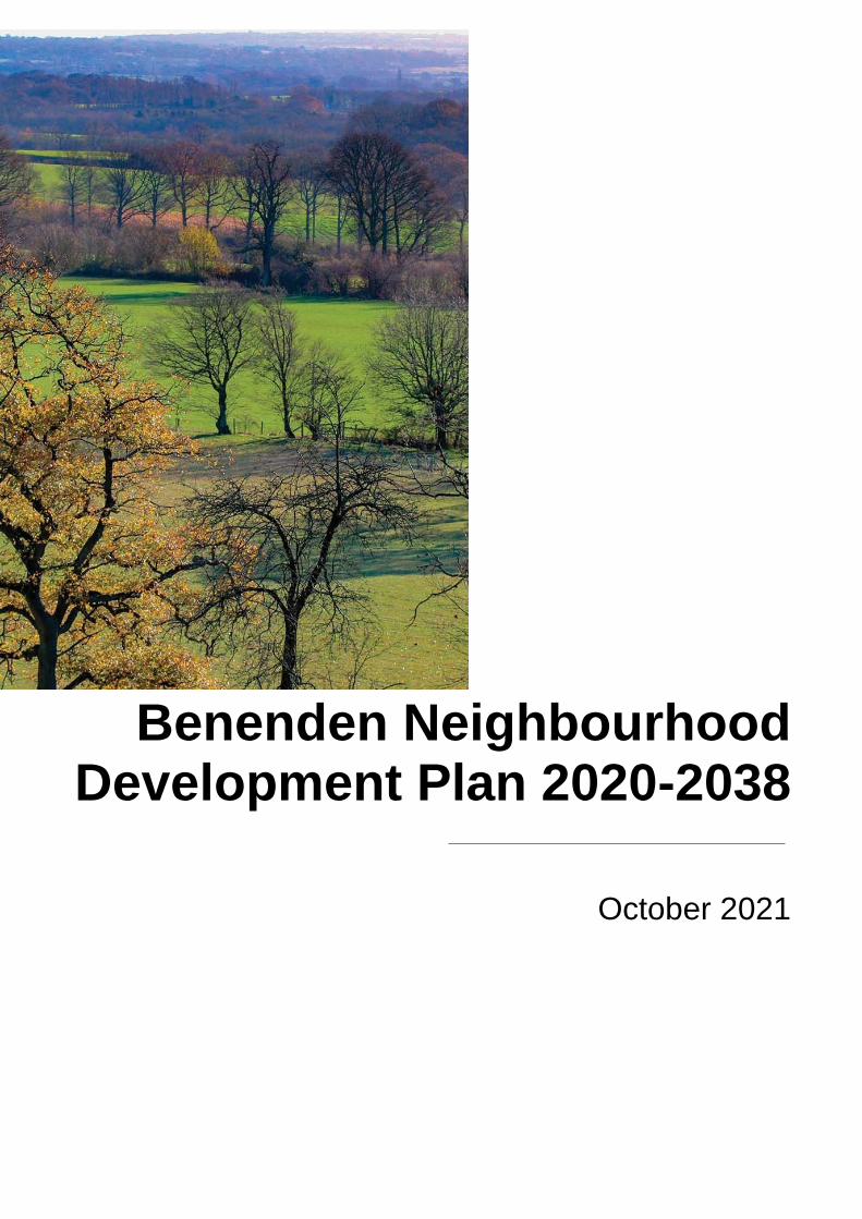
Benenden Neighbourhood Development Plan 2020-2038 October 2021

Welcome message from author
This document is posted to help you gain knowledge. Please leave a comment to let me know what you think about it! Share it to your friends and learn new things together.
Transcript
Benenden Neighbourhood Development Plan 2020-2038
October 2021

Page
2 of 114
Benenden Neighbourhood Development Plan 2020-2038
Date of publication – 29 November 2021
Final
Contents
Foreword to the Neighbourhood Development Plan for Benenden 2020-2038 .................................... 5
Introducing Benenden Neighbourhood Development Plan .................................................................. 7
The Historic Context of Benenden Parish .......................................................................................... 17
Chapter 1 Landscape and the Environment ...................................................................................... 24
Chapter 2 Housing Supply and Site Allocation .................................................................................. 42
Chapter 3 Design and the Built Environment ..................................................................................... 75
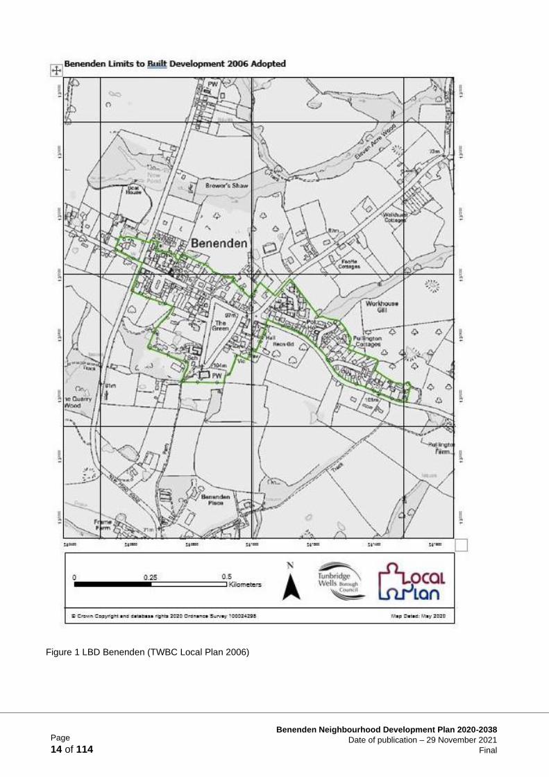
Chapter 4 Business and the Local Economy ..................................................................................... 86
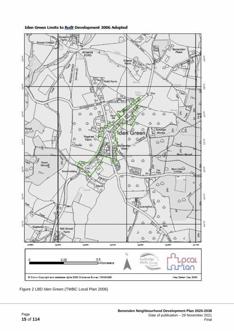
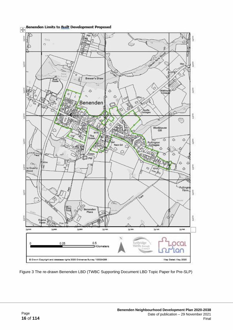
Chapter 5 Transport and Infrastructure ........................................................................................... 100
Chapter 6 Plan Review Process ...................................................................................................... 113
Glossary of Terms (in alphabetical order) ........................................................................................ 114
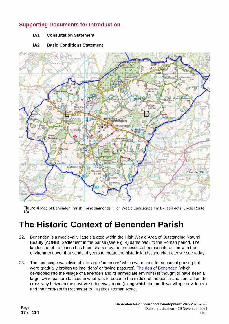
Supporting Documents
(Listed below available to view online at: http://www.benendenneighbourhoodplan.org/)
IA1 Consultation Statement IA2 Basic Conditions Statement
IA3 Intelligent Plans’ Health Check (Reg. 15 Draft) IA4 BNDP Equality Impact Assessment
IA5 TWBC Statement of Common Ground
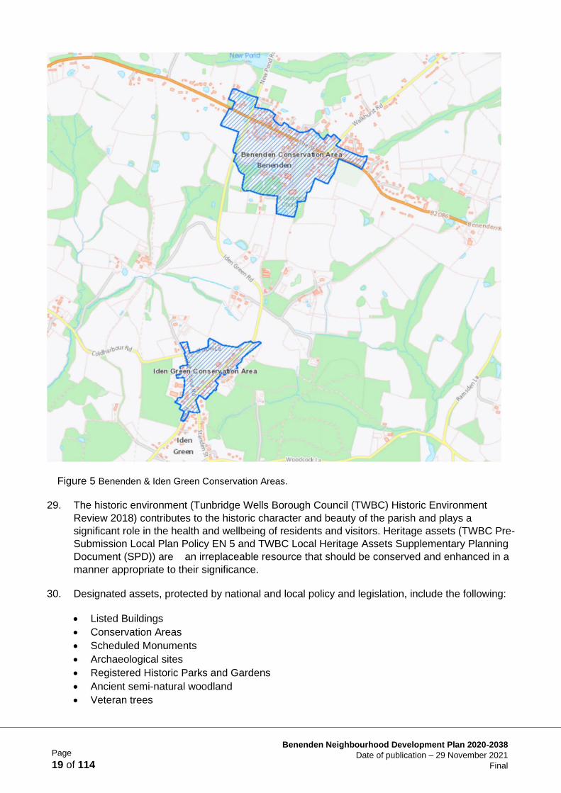
IA6 TWBC Habitats Regulation Assessment (HRA) Screening Final Report
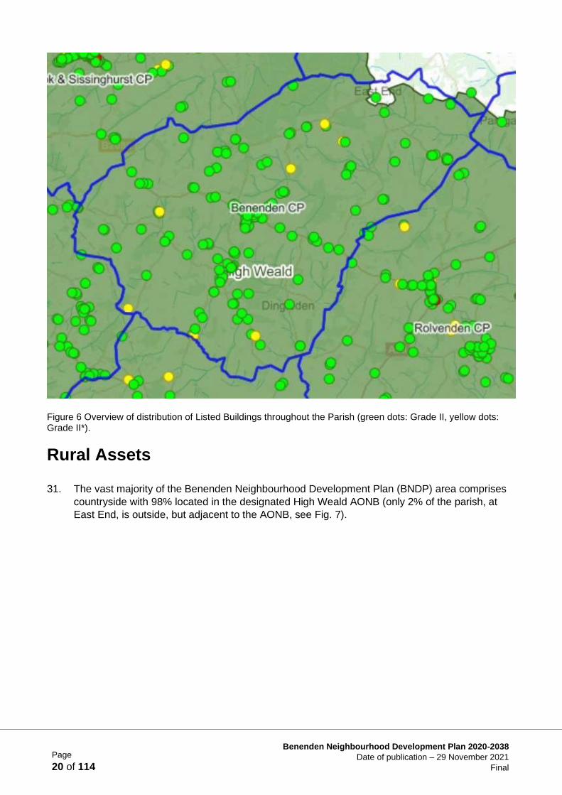
IA7 TWBC Strategic Environmental Assessment (SEA) Screening Final Report SEA1 AECOM
Strategic Environmental Assessment
Historic Context
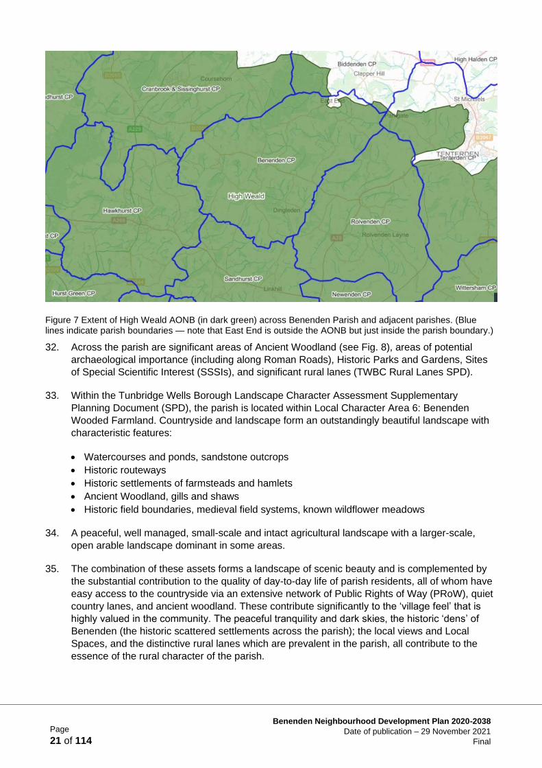
HCA1 Schedule of Listed Buildings in the Parish
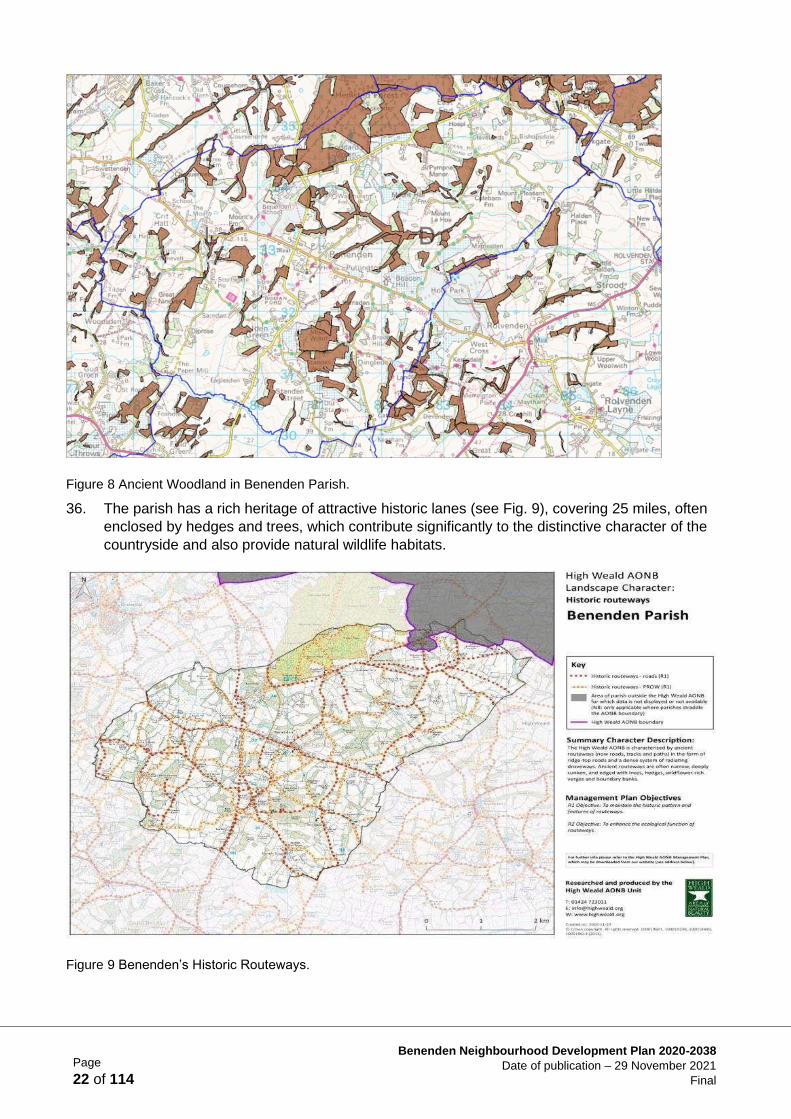
Landscape and the Environment
LEA1 SWOT Data Environment
LEA2 Landscape Character Assessments LEA3 List of source documents
LEA4 High Weald AONB Landscape Character Maps LEA5 View Assessments
LEA6 Local Green Space Assessments
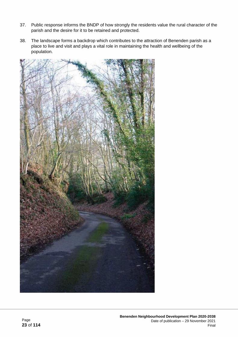
LEA7 Wildlife Summary
LEA8 List of Local Wildlife Sites & SSSI LEA9 Local Wildlife Site maps and citations
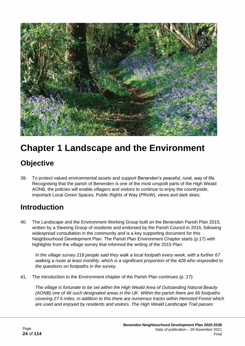
Housing Supply and Site Allocation
HSA1 Process/background information HSA2 SWOT Analysis
HSA3 Individual Site Assessments (ISAs)
HSA4 High Weald AONB Site Assessments HSA5 Sites submitted in the Call for Sites
Design and the Built Environment
BDA1 Survey Documentation BDA2 Conservation Area Appraisal BDA3 Character Area Assessments
BDA4 Summary of materials used in existing housing BDA5 Existing house styles in the Character
Areas BDA6 Residential Parking Survey Analysis
Page
3 of 114
Benenden Neighbourhood Development Plan 2020-2038
Date of publication – 29 November 2021
Final
Business and the Local Economy
BEA1 SWOT Analysis for Business/Local Economy BEA2 Employee Survey 2018
BEA3 Local Business Survey 2018
BEA4 Parish Magazine Article on Benenden Community Shop BEA5 Schedule of Community
Facilities
BEA6 Presentation to local businesses 2018
Transport and Infrastructure
TA1 SWOT Analysis for Transport and Infrastructure
TA2 Cycle Route Report
Page
4 of 114
Benenden Neighbourhood Development Plan 2020-2038
Date of publication – 29 November 2021
Final
Index of Policies
Landscape & The Environment
Policy LE1 Protect and Enhance the Countryside ............................................................................. 27 Policy LE2 Local Green Spaces (LGS) .............................................................................................. 34 Policy LE3 Public Rights of Way (PRoW) .......................................................................................... 36 Policy LE4 Trees, Woodland and Hedgerow ..................................................................................... 37 Policy LE5 New Green Spaces ......................................................................................................... 37 Policy LE6 Protection of Habitats Adjacent to Development .............................................................. 38 Policy LE7 On-going Involvement for Maintenance ........................................................................... 38 Policy LE8 Features to Encourage Wildlife ........................................................................................ 39 Policy LE9 Sustainable Drainage for New Housing or Commercial Development .............................. 39
Housing Supply & Site Allocation
Policy HS1 Delivering a Balanced Community .................................................................................. 47 Policy HS2 Almshouses .................................................................................................................... 47 Policy HS3 Windfall Sites .................................................................................................................. 48 Policy HS4 Housing Density .............................................................................................................. 49 Site Specific Policy 1 (SSP1) Land adjacent to Feoffee Cottages, Walkhurst Road, Benenden ........ 56 Site Specific Policy 2 (SSP2) Uphill, New Pond Road, Benenden ..................................................... 60 Site Specific Policy 3 (SSP3) Land at Benenden Hospital, South of Goddards Green Road, East End -
South East Quadrant (SEQ) .............................................................................................................. 66 Site Specific Policy 4 (SSP4) Land at Benenden Hospital, North of Goddards Green Road, East End -
North East Quadrant (NEQ) .............................................................................................................. 71
Design and the Built Environment
Policy BD1 General Design Policy ..................................................................................................... 77 Policy BD2 General Appearance ....................................................................................................... 79 Policy BD3 Layout ............................................................................................................................. 81 Policy BD4 Landscaping ................................................................................................................... 82 Policy BD5 Dark Skies ...................................................................................................................... 83 Policy BD6 Parking ........................................................................................................................... 84 Policy BD7 Footpaths ........................................................................................................................ 84 Policy BD8 Materials and Technology ............................................................................................... 85
Business and the Local Economy
Policy BE1 Major Employers in the Parish ......................................................................................... 92 Policy BE2 Retaining Existing Commercial Areas ............................................................................. 93 Policy BE3 Shops and Public Houses ............................................................................................... 96 Policy BE4 Community Facilities ....................................................................................................... 97 Policy BE5 Reuse of Redundant Buildings ........................................................................................ 97 Policy BE6 Encouraging the Right Future Business .......................................................................... 98
Transport and Infrastructure
Policy T1 Car-free Connectivity ....................................................................................................... 105 Policy T2 Improving Road Safety and the Impact of Traffic ............................................................. 106 Policy T3 Community Cohesion and Recreational Facilities ............................................................ 107 Policy T4 Renewable Energy and Low-emission Technology .......................................................... 107 Policy T5 Infrastructure, Broadband and Mobile .............................................................................. 108
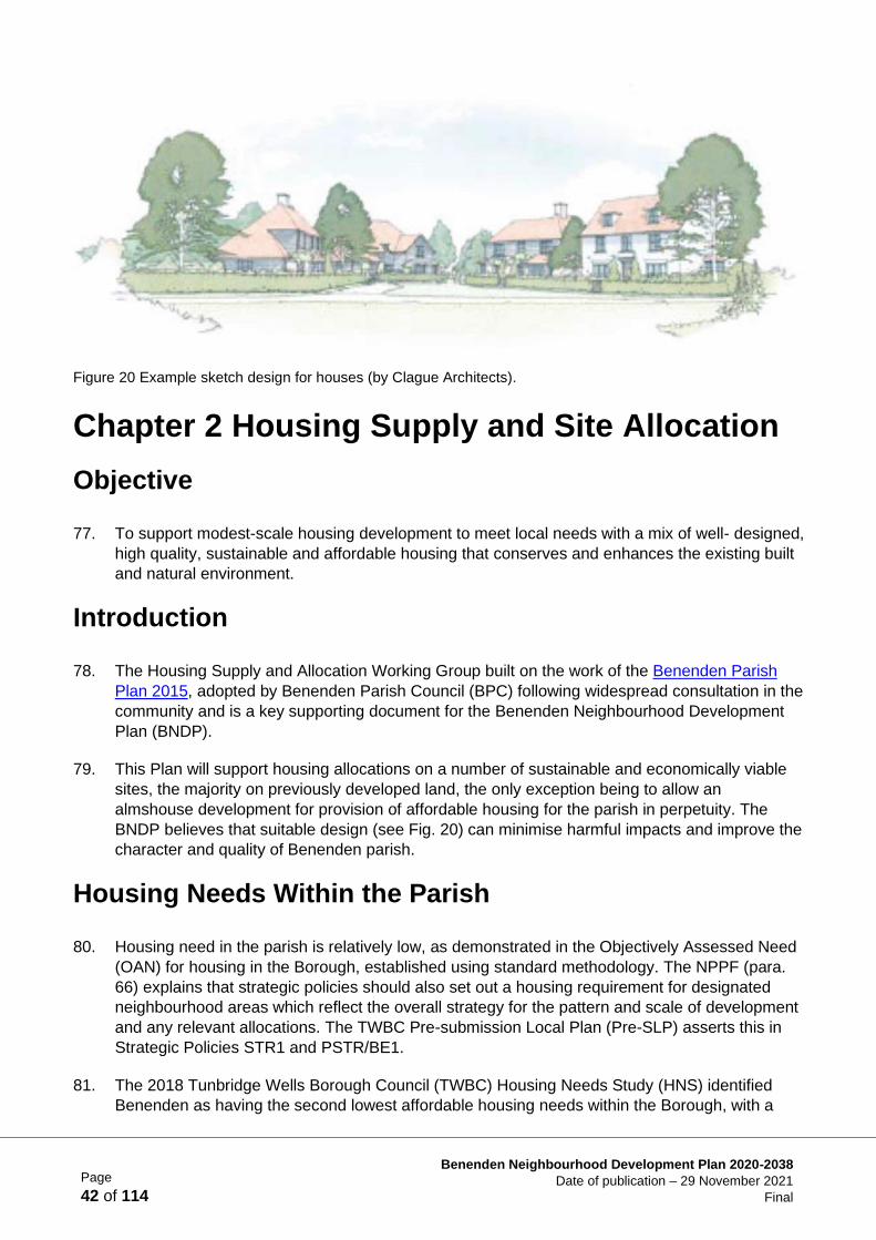
Page
5 of 114
Benenden Neighbourhood Development Plan 2020-2038
Date of publication – 29 November 2021
Final
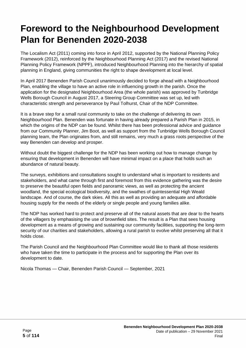
Foreword to the Neighbourhood Development
Plan for Benenden 2020-2038
The Localism Act (2011) coming into force in April 2012, supported by the National Planning Policy
Framework (2012), reinforced by the Neighbourhood Planning Act (2017) and the revised National
Planning Policy Framework (NPPF), introduced Neighbourhood Planning into the hierarchy of spatial
planning in England, giving communities the right to shape development at local level.
In April 2017 Benenden Parish Council unanimously decided to forge ahead with a Neighbourhood
Plan, enabling the village to have an active role in influencing growth in the parish. Once the
application for the designated Neighbourhood Area (the whole parish) was approved by Tunbridge
Wells Borough Council in August 2017, a Steering Group Committee was set up, led with
characteristic strength and perseverance by Paul Tolhurst, Chair of the NDP Committee.
It is a brave step for a small rural community to take on the challenge of delivering its own
Neighbourhood Plan. Benenden was fortunate in having already prepared a Parish Plan in 2015, in
which the origins of the NDP can be found. Whilst there has been professional advice and guidance
from our Community Planner, Jim Boot, as well as support from the Tunbridge Wells Borough Council
planning team, the Plan originates from, and still remains, very much a grass roots perspective of the
way Benenden can develop and prosper.
Without doubt the biggest challenge for the NDP has been working out how to manage change by
ensuring that development in Benenden will have minimal impact on a place that holds such an
abundance of natural beauty.
The surveys, exhibitions and consultations sought to understand what is important to residents and
stakeholders, and what came through first and foremost from this evidence gathering was the desire
to preserve the beautiful open fields and panoramic views, as well as protecting the ancient
woodland, the special ecological biodiversity, and the swathes of quintessential High Weald
landscape. And of course, the dark skies. All this as well as providing an adequate and affordable
housing supply for the needs of the elderly or single people and young families alike.
The NDP has worked hard to protect and preserve all of the natural assets that are dear to the hearts
of the villagers by emphasising the use of brownfield sites. The result is a Plan that sees housing
development as a means of growing and sustaining our community facilities, supporting the long-term
security of our charities and stakeholders, allowing a rural parish to evolve whilst preserving all that it
holds close.
The Parish Council and the Neighbourhood Plan Committee would like to thank all those residents
who have taken the time to participate in the process and for supporting the Plan over its
development to date.
Nicola Thomas — Chair, Benenden Parish Council — September, 2021
Page
6 of 114
Benenden Neighbourhood Development Plan 2020-2038
Date of publication – 29 November 2021
Final
Page
7 of 114
Benenden Neighbourhood Development Plan 2020-2038
Date of publication – 29 November 2021
Final
Introducing Benenden Neighbourhood
Development Plan
Background
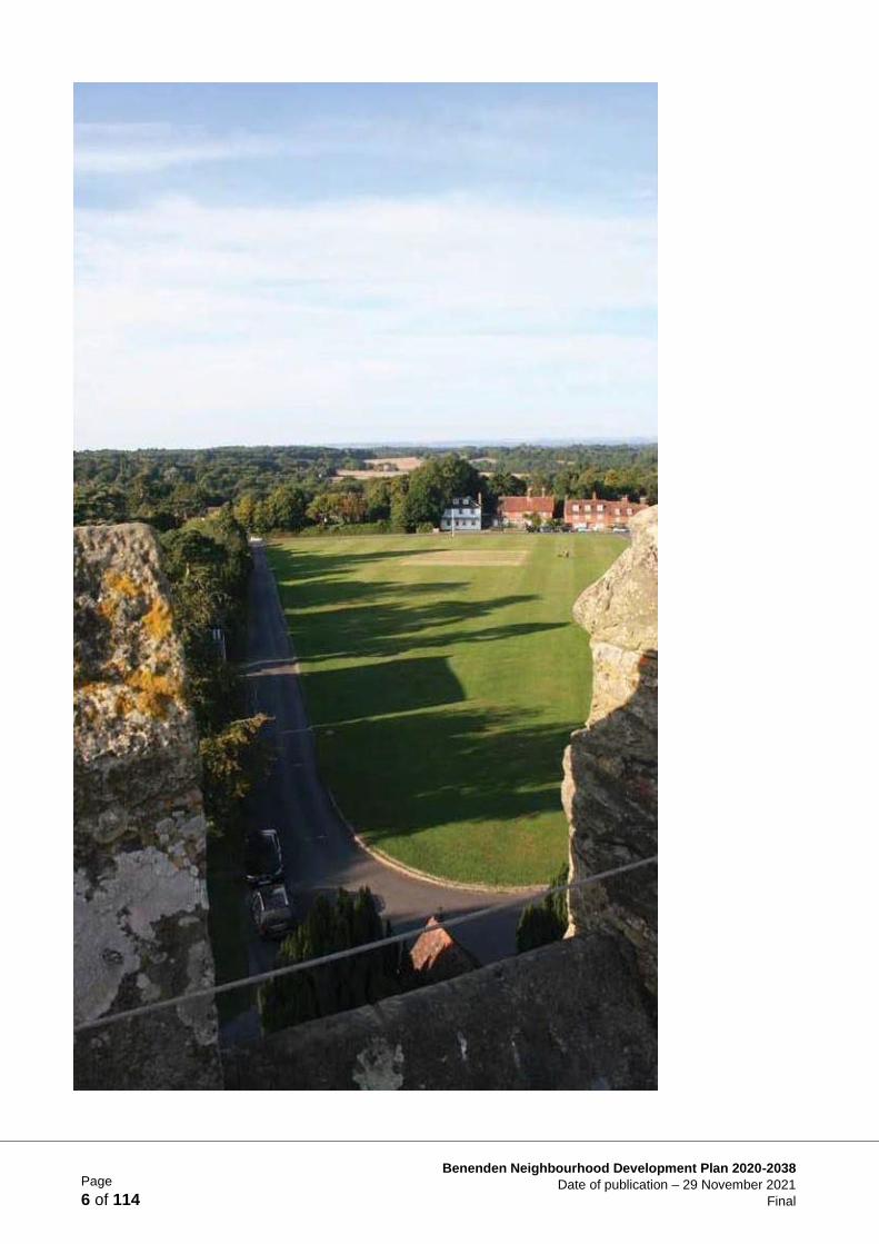
1. Benenden parish is some 2,600 hectares. The parish comprises three main settlements,
Benenden, Iden Green, and East End (dominated by Benenden Hospital), and a number of
smaller hamlets or ‘dens’. In 2011 there were 1,820 residents (excluding Benenden School
boarders), in 840 homes (National Census 2011). Benenden is broadly equidistant (35 – 45
minutes’ drive) from Maidstone, Ashford, Hastings, and Tunbridge Wells. The parish is not well-
served by public transport: the nearest train station (Staplehurst) is 7 miles north with no direct
connecting bus service. Benenden parish is deeply rural. Even in the centre of Benenden
housing density averages less than 10 dwellings per hectare (dph). Nearly 15% of housing is
Listed, and the centres of Benenden and Iden Green are designated Conservation Areas. Over
98% of the parish lies within the High Weald Area of Outstanding Natural Beauty (AONB).
Tourism, leisure, hospitality, and more traditional rural businesses such as farming and forestry,
dominate local employment, alongside Benenden School and Benenden Hospital.
2. Successive UK Governments have failed to meet the growth in demand for housing. The
Government has a current target to build 300,000 homes each year and has introduced
changes to planning policies and regulations to drive up the pace of building. Amongst the
changes was the introduction of Neighbourhood Development Plans (NDP). Neighbourhood
Plans were initiated in the Localism Act 2011 and reinforced in the National Planning Policy
Framework (NPPF).

Page
8 of 114
Benenden Neighbourhood Development Plan 2020-2038
Date of publication – 29 November 2021
Final
Integrating Local Aspiration with Planning Regulation
3. NDPs are a powerful tool that give communities statutory power to shape future development
(Localism Act 2011, NPPF 2019). They integrate local knowledge and aspiration with planning
regulations, to ensure the community gets the right type of development in the right place.
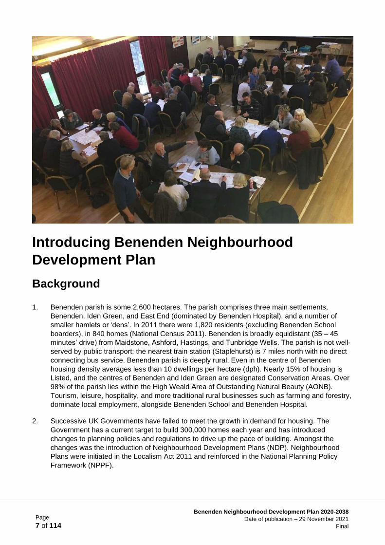
Benenden Neighbourhood Development Plan (BNDP) is the product of work started in April
2017. The plan responds to the national challenge of increased demand for housing, jobs and
transport. During extensive consultation (see Supporting Document IA1 Consultation
Statement), the local community provided a set of aspirations to those working on this plan:
• Protect the High Weald AONB and existing Conservation Areas
• Preserve and enhance the landscape, views and biodiversity of the countryside
• Maintain dark skies and tranquillity of the parish
• Provide affordable housing for local families
• Provide opportunities to downsize and remain in the parish
• Promote scattered, small scale and high-quality housing development
• Support working in the parish and promote local construction
• Support clubs, societies pubs and shops
• Improve infrastructure such as broadband and mobile phone access
• Improve road safety with changes to junctions, crossroads and speed limits
4. Summarising the aspirations of residents and local business the vision for Benenden 2038 was
drafted and adopted at a consultation meeting on 28 October 2017:
Vision
The Parish of Benenden in 2038 will be a thriving, peaceful and rural place to live, work and
rest. Its village feel and historic beauty will have been preserved through sympathetic and
managed growth. We, the community, will have retained our existing major employers.
Farming and other small businesses will be encouraged. We will offer everyone the chance to
be part of an inclusive and vibrant community.
We will support:
i. Locally led development with a mix of well-designed, high quality, sustainable and
affordable housing alongside other homes that enhance the existing built and natural
environment.
ii. Infrastructure enhancements; managing traffic growth, improving connectivity, and
enhancing community facilities for health & recreation.
iii. A balanced community; with small businesses and home working providing employment;
pubs, clubs and shops providing an active social scene, and quality of life retained
through existing green spaces, footpaths and dark skies.
Page
9 of 114
Benenden Neighbourhood Development Plan 2020-2038
Date of publication – 29 November 2021
Final
5. From the Vision the BNDP developed five detailed Objectives, each supported by Policies,
designed to deliver the vision for the parish:
• Landscape & the Environment: To protect valued environmental assets and support
Benenden’s peaceful, rural, way of life. Recognising that the parish of Benenden is one of the
most unspoilt parts of the High Weald AONB, the policies will enable villagers and visitors to
continue to enjoy the countryside, important Local Green Spaces, Public Rights of Way
(PRoW), views and dark skies.
• Housing Supply: To support modest-scale housing development to meet local needs with a
mix of well-designed, high quality, sustainable and affordable housing that enhances the
existing built and natural environment.
• Design & the Built Environment: New buildings shall be of good quality construction, using
local materials and designed to be sympathetic to the character of existing landscape and
buildings, with scale, form and density to be of similar proportions to the existing; the principal
aim is to protect and enhance the beauty of the parish.
• Business & the Local Economy: To support existing businesses and enterprises within the
parish and to encourage new areas of economic activity to nurture the parish’s economic
stability in the future, the aim being to sustain a thriving and integrated group of settlements.
• Transport & Infrastructure: To prioritise infrastructure improvements, minimise and mitigate
the impact of traffic growth, enhance connectivity within the parish, while embracing a low-
carbon future with green technologies, underpinning a strong rural economy and thriving
communities.
6. These objectives balance the need to conserve and enhance the scenic beauty and tranquillity
of the landscape; the historic character of Conservation Areas and protecting views, amenities
and biodiversity. They also promote appropriate business and job creation while recognising the
need to manage moderate housing growth and the impact that growth will have on amenities
and services within the parish. The objectives will be delivered through a series of Policies and
Projects.
7. Each Chapter of the Plan contains Policies and Projects designed to support the aspirations
and requirements for the development of the community of Benenden:
• Policies must be drafted within the competence of a Neighbourhood Plan; in other words, the
plan can only have policies on issues over which it has authority. Policies can be generic or
site-specific proposals that must be considered by developers or landowners when they create
planning proposals;
• Projects are specific proposals that fall outside the direct competence of a Neighbourhood
Plan but which may be delivered in partnership with other competent authorities such as Kent
County Council, or Tunbridge Wells Borough Council.
8. After the Neighbourhood Plan is made and if Tunbridge Wells adopt a CIL Policy, the Parish
Council will receive 25% of CIL contributions by right and may use such funds to complete the
projects set out within the BNDP.
9. National planning guidelines are contained within the National Planning Policy Framework
(NPPF). Tunbridge Wells Borough Council (TWBC) is the Local Planning Authority (LPA). The
Page
10 of 114
Benenden Neighbourhood Development Plan 2020-2038
Date of publication – 29 November 2021
Final
BNDP must be in general conformity with the policies of the NPPF and LPA adopted Local Plan.
The current TWBC Local Plan (TWBC LP) 2006, Core Strategy 2010 and the Site Allocations
10. Local Plan 2016, therefore, provide planning context. TWBC are updating their Local Plan which
is intended to cover the period 2016-2038. This emerging Local Plan will ultimately replace the
current adopted Local Plan. Where neighbourhood planning is undertaken before an up-to-date
Local Plan is in place, collaboration between the community and the Borough Council is critical.
11. In developing the BNDP, TWBC have taken an active role in advising and supporting the BNDP
team, sharing evidence and information and ensuring the BNDP fits with any relevant up-to-
date strategic needs. Alignment between the BNDP, TWBC Local Plan 2006, Core Strategy
2010, the emerging Local Plan and the NPPF is set out in the Basic Conditions Statement (see
Supporting Document IA2).
BNDP Strategic Approach
12. The key challenge for Benenden’s NDP team is the need to provide additional residential
dwellings; this is at the heart of the BNDP. Benenden is located in the populous south east of
England and within 50 miles of London; however, the sustainability of the parish is inadequate
in planning terms. Major centres of employment and commerce are over 45 minutes’ drive from
the parish. Public transport links are irregular and slow, without any direct bus routes to mainline
stations, which are a 20-minute drive away. The natural and built environment of the parish is
highly constrained. Therefore, sustainable growth is difficult to deliver within the parish. The
BNDP has addressed sustainability by:
• conserving the highest quality landscape and built heritage (Policies LE1, BD1 and BD8)
• supporting the vibrant rural local jobs and businesses of Benenden parish: local shops, pubs,
farming, light industry, tourism (Policies BE2, BE3 and BE6)
• specifically providing protection for local business and industrial sites from speculative
housing development (Policies BE2 and BE5)
• recognising changing work/life patterns and requiring developers to support and invest in
identified local business requirements, including access to broadband and better mobile
signals (Policy T5)
• prioritising the need to deliver a balanced community (Policy HS1) by requiring affordable
housing, and that designed for older residents and those with limited mobility (Site Specific
Policies SSP1 to SSP4). In particular, supporting long-term affordable housing for local
families, through the support for development by Benenden Almshouse Charities
• supporting community cohesion by encouraging the retention of existing community facilities
(Policy BE4), and requiring developers to contribute to new community facilities (Policy T3)
• providing measures to ensure new developments should be well-built and provide safe
environments for older people, children, and those with mobility issues (Policies BD3, BD6,
T1, T2 and T3)
• encouraging prudent use of natural resources (Policies BD8) with over 70% allocated
housing on previously developed land; at a density (Policy HS4) appropriate to the site
setting (Policy LE1) and existing land usage
• attempting to mitigate the adverse impact of additional traffic (Policy T1), slowing transit
through new developments (Policies BD3 and T2), providing adequate parking (Policy BD6),
encouraging alternatives to car-journeys (Policies BD7 and T1), and encouraging take-up of
electric vehicles (Policy T4)
Page
11 of 114
Benenden Neighbourhood Development Plan 2020-2038
Date of publication – 29 November 2021
Final
13. TWBC have a target for housing growth and have taken the decision to work with parishes to
establish appropriate levels of development. In collaborating with TWBC and aware of the
difficulty of finding suitable sites, the approach taken by the BNDP centres around the following
choices:
14. Benenden Parish Plan 2015 envisaged housing growth equating to around 1% per annum (or
an average of 9.2 dwellings each year). The parish currently has around 920 dwellings (Parish
Precept Receipts 2019) and this plan runs until 2038 (9.2 Dwellings per year x 15 years =
around 138 new dwellings during the plan period).
The BNDP proposes development of around 100 dwellings in addition to
existing planning permissions (currently a total of 24 dwellings on one site).
1) TWBC opened a ‘Call for Sites’ across the Borough in 2016 as they developed a new Local
Plan. Over the past 4 years landowners in Benenden offered 22 sites for residential
development. This process is on-going and the BNDP will continue to assess any new sites
that are submitted.
The BNDP focuses upon the 22 sites offered by local landowners in
response to the TWBC ‘Call for sites’ as the basis of its site allocation policy.
2) Neighbourhood plans offer the opportunity for communities to shape and control development.
The plan could simply set out policies which will influence the design, quality and general
thrust of development while leaving final decisions on site allocations to the Local Planning
Authority. Very few Neighbourhood Plans contain housing targets or site allocations (Lichfield
Insights May 2018: “Local Choices?”). However, Benenden NDP and the Parish Council
determined to allocate sites in order to better deliver the aspiration for control expressed by
the Parish.
The BNDP allocates sites in order to create a best fit with the aspirations of
the local community as expressed during local consultations.
3) Many approved development sites suffer from ‘mission creep’. Initial permission is granted for
a modest development on part of a site which does not have clear boundaries. As a result,
subsequent applications to extend the development onto adjacent land may prove difficult for
parish councils or Local Planning Authorities to resist.
The BNDP gives greater weight to sites with clearly defined boundaries and
assumes that any allocated site will be fully built out at a density in line with
the appropriate site-specific policy.
4) National Planning Policy Framework (NPPF) para. 119 seeks a clear strategy for
accommodating objectively assessed needs in a way that makes as much use as possible of
previously developed or ‘brownfield’ land. During consultation the Parish expressed a clear
preference for development on ‘brownfield’ sites.
The BNDP gives greater weight to previously developed or ‘brownfield’ sites,
provided development will not adversely impact on local employment.
5) NPPF paras. 176 & 177 says great weight should be given to conserving and enhancing
landscape and scenic beauty of the National Parks, the Broads and Areas of Outstanding
Page
12 of 114
Benenden Neighbourhood Development Plan 2020-2038
Date of publication – 29 November 2021
Final
National Beauty. Local consultation demonstrated considerable support for the protection of
the High Weald AONB. Around 98% of the parish lies within the High Weald AONB.
The BNDP particularly supports the development of sites which are outside
the AONB as long as any detrimental effect on the environment, the
landscape and recreational opportunities can be moderated.
6) TWBC LP 2006 places an obligation on developers under section 106 of the Town and
Country Planning Act 1990 to provide affordable housing as part of a development site
provided that 10 or more dwellings are being built. The village expressed a clear desire for
affordable housing for local villagers, and in particular those that are designed to remain
affordable.
The BNDP allocates sites that will provide more than 10 dwellings in order to
ensure affordable housing needs are met, and specifically supports the
Benenden Almshouse approach.
7) TWBC LP 2006 places an obligation on developers under section 106 of the Town and
Country Planning Act 1990, to provide financial contributions or works to enhance
infrastructure where the development will have a direct local impact. Local consultation
highlighted the need for investment within the parish.
The BNDP allocates sites that will provide more than 10 dwellings and
describes infrastructure enhancements required in its site-specific policies.
8) NPPF para. 85 suggests that, in rural areas, sites may have to be found beyond existing
settlements and in locations not well served by public transport. Where such sites are on
‘brownfield’ land, development will be encouraged, provided it is sensitive to its local
surroundings and does not have an unacceptable impact on local roads. Such development
should also be designed to make the location more sustainable.
The BNDP allocates 2 sites on ‘brownfield’ land beyond existing settlements.
Each site has specific policies designed to improve long term sustainability.
9) TWBC Pre-Submission Local Plan (Para. 4.49 & STR 1 (9) TWBC Pre-Submission Local
Plan) uses Limits to Built Development (LBD) as an indicator of location sustainability. It
encourages the development of sites close to local amenities while taking into account the
setting of the settlement.
This Plan allocates two sites close to Benenden village and its amenities.
Discussions between BNDP and TWBC have resulted in revisions to the
Benenden LBD proposed in the TWBC PSLP (PSTR/BE 1) to incorporate the
allocated sites.
Page
13 of 114
Benenden Neighbourhood Development Plan 2020-2038
Date of publication – 29 November 2021
Final
Impact of the BNDP Approach
15. The Benenden Neighbourhood Plan will not seek to avoid or discourage growth. In line with the
‘Vision’ (see page 8), it supports appropriate, sympathetic and high-quality development within
the parish.
The BNDP allocates four sites for development. Three sites are previously
developed or ‘brownfield’. Two sites are outside the AONB. One site is
‘greenfield’ and inside the AONB. This site is adjacent to existing amenities
and provides affordable housing for local residents, in perpetuity, through the
Benenden Almshouse Charities.
16. Although not every aspiration of every resident will be fully met, the BNDP will provide a
significant level of influence over development proposals within the parish. It will preserve and
enhance the character of local Conservation Areas while protecting the important landscape
and scenic beauty of the High Weald AONB.
Benenden Parish & Limits to Built Development (LBD)
17. Limits to Built Development are part of a national planning strategy intended to avoid
inappropriate development in the countryside, merging/coalescence of settlements and ribbon
development. LBD provides protection for rural areas because greater weight will be given to
potential sites within the LBD and development outside the LBD is discouraged. However, if an
LPA does not have a five-year supply of sites for development, the protection afforded by LBDs
within the LPA areas is reduced and development sites outside the LDB may be promoted and
approved.
18. The TWBC Local Plan 2006 and subsequent LPA site allocations do not provide a five-year
supply of residential housing, so sites outside existing LBDs have been the subject of significant
planning effort by both TWBC and Parish Councils. Once adopted, the emerging TWBC Local
Plan will secure a five-year supply of sites for residential development. This will secure the
protection of LBDs to settlements throughout the Borough.
19. TWBC Pre-SLP Policy PSTR/BE 1 sets out the plan for LBDs and the circumstances where
development will be permitted outside an LBD. The BNDP allocates sites which are outside the
existing LBDs at Benenden and Iden Green. However, the two allocated sites which abut
Benenden village will fall within the revised LBD proposed in the TWBC Pre-SLP.
20. Windfall sites, which emerge in the parish during the life of this plan, will need to meet the
conditions set out in both BNDP Policy HS3 and the policies of the adopted TWBC Local Plan.
21. Under the TWBC Local Plan 2006, both Benenden and Iden Green have a designated LBD
(see Figs. 1 & 2). The emerging TWBC Local Plan (TWBC Pre-SLP Policy PSTR/BE 1) omits
the LBD around the hamlet of Iden Green and re-draws the LBD tightly around Benenden
village only (see Fig. 3). The remainder of the parish outside the LBD is designated as
countryside. Most of the countryside falls within the High Weald AONB and receives the highest
level of protection from inappropriate development. The allocated sites at East End are outside
both the LBD and the AONB and consist almost entirely of previously developed land (PDL). A
masterplan setting out the intended future use of the PDL is required by both the BNDP (see
Chapter 2 — Housing Supply and Site Allocation) and the TWBC Pre-SLP.
Page
14 of 114
Benenden Neighbourhood Development Plan 2020-2038
Date of publication – 29 November 2021
Final
Figure 1 LBD Benenden (TWBC Local Plan 2006)
Page
15 of 114
Benenden Neighbourhood Development Plan 2020-2038
Date of publication – 29 November 2021
Final
Figure 2 LBD Iden Green (TWBC Local Plan 2006)
Page
16 of 114
Benenden Neighbourhood Development Plan 2020-2038
Date of publication – 29 November 2021
Final
Figure 3 The re-drawn Benenden LBD (TWBC Supporting Document LBD Topic Paper for Pre-SLP)
Page
17 of 114
Benenden Neighbourhood Development Plan 2020-2038
Date of publication – 29 November 2021
Final
Supporting Documents for Introduction
IA1 Consultation Statement
IA2 Basic Conditions Statement
Figure 4 Map of Benenden Parish. (pink diamonds: High Weald Landscape Trail, green dots: Cycle Route 18)
The Historic Context of Benenden Parish
22. Benenden is a medieval village situated within the High Weald Area of Outstanding Natural
Beauty (AONB). Settlement in the parish (see Fig. 4) dates back to the Roman period. The
landscape of the parish has been shaped by the processes of human interaction with the
environment over thousands of years to create the historic landscape character we see today.
23. The landscape was divided into large 'commons' which were used for seasonal grazing but
were gradually broken up into ‘dens’ or ‘swine pastures’. The den of Benenden (which
developed into the village of Benenden and its immediate environs) is thought to have been a
large swine pasture located in what was to become the middle of the parish and centred on the
cross way between the east-west ridgeway route (along which the medieval village developed)
and the north-south Rochester to Hastings Roman Road.
Page
18 of 114
Benenden Neighbourhood Development Plan 2020-2038
Date of publication – 29 November 2021
Final
24. Taking their names from the ‘dens’, small farmsteads were established as the land was
enclosed from the wood and wood pasture, forming the fields for cultivation. A church, recorded
in the Domesday Book, was founded in the den of Benenden before 1066, to provide spiritual
welfare to the scattered farmsteads across the parish. The medieval village of Benenden grew
up around the church which became the focus for ecclesiastical and secular activity, in
particular fairs and markets.
25. Iden Green is thought to have evolved around existing farmsteads which developed as part of
the medieval cloth industry. In contrast to Benenden, many of the buildings are modest in scale
and they are thought to have been occupied by cloth workers. In terms of population it was at
one time the larger settlement. Like Benenden, the village has a linear settlement form located
on elevated land built up sporadically along two crossing roads.
26. East End, once also known as East Ridden, remained a small and scattered settlement until the
fresh air and rural setting saw the arrival of Benenden Hospital. It was opened in 1907 by the
National Association for the Establishment and Maintenance of Sanatoria to treat postal workers
suffering from tuberculosis. The Association was a consortium founded by trade unions and
friendly societies and the Benenden Healthcare Society (formerly the Post Office and Civil
Service Sanatoria). With cases of TB declining, the Benenden Healthcare Society expanded
treatment to include chest complaints and cancer and shortly afterwards an operating theatre,
surgical wards and an x-ray department were introduced and today is a state-of-the-art modern
private hospital.
Historic Environment and Heritage Assets
27. The historic centres of both Benenden and Iden Green are designated as Conservation Areas
(see Fig. 5). Each Conservation Area comprises areas of different character and extends into
the surrounding countryside.
28. The National Planning Policy Framework (NPPF), (paras. 189-208), seeks to protect and
enhance the historic environment, including the character and setting of listed buildings and
Conservation Areas. Historic England’s register catalogues over 150 listed buildings in the
parish (see Fig. 6 and Supporting Document HCA1), of which eight are Grade II*. There is a
high incidence of listed buildings within the Conservation Areas.
Page
19 of 114
Benenden Neighbourhood Development Plan 2020-2038
Date of publication – 29 November 2021
Final
Figure 5 Benenden & Iden Green Conservation Areas.
29. The historic environment (Tunbridge Wells Borough Council (TWBC) Historic Environment
Review 2018) contributes to the historic character and beauty of the parish and plays a
significant role in the health and wellbeing of residents and visitors. Heritage assets (TWBC Pre-
Submission Local Plan Policy EN 5 and TWBC Local Heritage Assets Supplementary Planning
Document (SPD)) are an irreplaceable resource that should be conserved and enhanced in a
manner appropriate to their significance.
30. Designated assets, protected by national and local policy and legislation, include the following:
• Listed Buildings
• Conservation Areas
• Scheduled Monuments
• Archaeological sites
• Registered Historic Parks and Gardens
• Ancient semi-natural woodland
• Veteran trees
Page
20 of 114
Benenden Neighbourhood Development Plan 2020-2038
Date of publication – 29 November 2021
Final
Figure 6 Overview of distribution of Listed Buildings throughout the Parish (green dots: Grade II, yellow dots: Grade II*).
Rural Assets
31. The vast majority of the Benenden Neighbourhood Development Plan (BNDP) area comprises
countryside with 98% located in the designated High Weald AONB (only 2% of the parish, at
East End, is outside, but adjacent to the AONB, see Fig. 7).
Page
21 of 114
Benenden Neighbourhood Development Plan 2020-2038
Date of publication – 29 November 2021
Final
Figure 7 Extent of High Weald AONB (in dark green) across Benenden Parish and adjacent parishes. (Blue lines indicate parish boundaries — note that East End is outside the AONB but just inside the parish boundary.)
32. Across the parish are significant areas of Ancient Woodland (see Fig. 8), areas of potential
archaeological importance (including along Roman Roads), Historic Parks and Gardens, Sites
of Special Scientific Interest (SSSIs), and significant rural lanes (TWBC Rural Lanes SPD).
33. Within the Tunbridge Wells Borough Landscape Character Assessment Supplementary
Planning Document (SPD), the parish is located within Local Character Area 6: Benenden
Wooded Farmland. Countryside and landscape form an outstandingly beautiful landscape with
characteristic features:
• Watercourses and ponds, sandstone outcrops
• Historic routeways
• Historic settlements of farmsteads and hamlets
• Ancient Woodland, gills and shaws
• Historic field boundaries, medieval field systems, known wildflower meadows
34. A peaceful, well managed, small-scale and intact agricultural landscape with a larger-scale,
open arable landscape dominant in some areas.
35. The combination of these assets forms a landscape of scenic beauty and is complemented by
the substantial contribution to the quality of day-to-day life of parish residents, all of whom have
easy access to the countryside via an extensive network of Public Rights of Way (PRoW), quiet
country lanes, and ancient woodland. These contribute significantly to the ‘village feel’ that is
highly valued in the community. The peaceful tranquility and dark skies, the historic ‘dens’ of
Benenden (the historic scattered settlements across the parish); the local views and Local
Spaces, and the distinctive rural lanes which are prevalent in the parish, all contribute to the
essence of the rural character of the parish.
Page
22 of 114
Benenden Neighbourhood Development Plan 2020-2038
Date of publication – 29 November 2021
Final
Figure 8 Ancient Woodland in Benenden Parish.
36. The parish has a rich heritage of attractive historic lanes (see Fig. 9), covering 25 miles, often
enclosed by hedges and trees, which contribute significantly to the distinctive character of the
countryside and also provide natural wildlife habitats.
Figure 9 Benenden’s Historic Routeways.
Page
23 of 114
Benenden Neighbourhood Development Plan 2020-2038
Date of publication – 29 November 2021
Final
37. Public response informs the BNDP of how strongly the residents value the rural character of the
parish and the desire for it to be retained and protected.
38. The landscape forms a backdrop which contributes to the attraction of Benenden parish as a
place to live and visit and plays a vital role in maintaining the health and wellbeing of the
population.
Page
24 of 114
Benenden Neighbourhood Development Plan 2020-2038
Date of publication – 29 November 2021
Final
Chapter 1 Landscape and the Environment
Objective
39. To protect valued environmental assets and support Benenden’s peaceful, rural, way of life.
Recognising that the parish of Benenden is one of the most unspoilt parts of the High Weald
AONB, the policies will enable villagers and visitors to continue to enjoy the countryside,
important Local Green Spaces, Public Rights of Way (PRoW), views and dark skies.
Introduction
40. The Landscape and the Environment Working Group built on the Benenden Parish Plan 2015,
written by a Steering Group of residents and endorsed by the Parish Council in 2015, following
widespread consultation in the community and is a key supporting document for this
Neighbourhood Development Plan. The Parish Plan Environment Chapter starts (p.17) with
highlights from the village survey that informed the writing of the 2015 Plan:
In the village survey 218 people said they walk a local footpath every week, with a further 67
walking a route at least monthly, which is a significant proportion of the 428 who responded to
the questions on footpaths in the survey.
41. The introduction to the Environment chapter of the Parish Plan continues (p. 17):
The village is fortunate to be set within the High Weald Area of Outstanding Natural Beauty
(AONB) one of 46 such designated areas in the UK. Within the parish there are 66 footpaths
covering 27.5 miles, in addition to this there are numerous tracks within Hemsted Forest which
are used and enjoyed by residents and visitors. The High Weald Landscape Trail passes
Page
25 of 114
Benenden Neighbourhood Development Plan 2020-2038
Date of publication – 29 November 2021
Final
through the village and brings many walkers to the area. Route 18 of the National Cycle
Network which runs 61 miles from Canterbury to Tunbridge Wells, passes through the parish
along some of the quieter lanes. The lanes around the parish have previously been
recognised as being important in the Tunbridge Wells Supplementary Planning Guidance in
terms of visual amenity, nature conservation, historical/archaeological importance and
recreational amenity value.
42. In terms of new building the Parish Plan states (p. 19):
Careful consideration should be observed when planning where new buildings should be
located, brownfield sites should be used wherever possible.
43. 51.5% of respondents to the survey said they would be ‘willing to help with nature conservation
and footpaths’, the largest group of respondents.
44. Thirty‐six residents and stakeholders attended the Landscape and Green Environment
Workshop on 13th January 2018 which followed on from the original Visioning Workshop on
28th October 2017. After an introduction from a member of the working group, on some of the
key environmental facts about the parish and its landscape, a number of topics were discussed
using SWOT analysis (Strengths, Weaknesses, Opportunities and Threats — see Supporting
Document LEA1) including:
• PRoW, routeways, footpaths, bridleways and public open spaces
• Ancient Woodland, veteran trees, hedgerows and field patterns
• biodiversity
• views, dark skies and tranquility
• streams, ponds, ditches and flooding
• developer contributions to conserving wildlife
45. After discussion of these points, and subsequent consultation with the Neighbourhood Plan
Steering Group and the Parish Council, the objective for the Landscape and Environment
Working Group was agreed as representing the views of many parishioners.
Process
46. The working group started surveying Benenden’s natural assets in 2017 and, after training from
officers from TWBC, identified the landscape characteristics (see Landscape Character
Assessments Supporting Document LEA2), PRoW, environmental and historical features, Local
Green Spaces (LGS), Local Wildlife Sites (LWS) and notable views. The working group walked
all the PRoW, identifying key views, environmental and other features and met regularly to
discuss their findings. The group also studied a number of source documents (see Supporting
Document LEA3).
47. The initial findings were shared with the community at the April 2018 exhibition in the Village
Hall, and subsequently through the Parish Magazine and further engagement with the local
residents in September 2018, at the Iden Green Pavilion. The working group was given advice
and training on aspects of the BNDP by external specialists, especially in relation to policies,
identification of Local Green Spaces, notable views and their documentation. Additional
guidance and information was sought from and provided by Tunbridge Wells Borough Council
(TWBC) (TWBC Local Green Space Designation Methodology 2018) the High Weald AONB
Page
26 of 114
Benenden Neighbourhood Development Plan 2020-2038
Date of publication – 29 November 2021
Final
Unit, Natural England, Kent Wildlife Trust, Royal Society for the Protection of Birds (RSPB), the
Woodland Trust and the Kent & Medway Biological Records Centre.
Policy Context/Justification
48. The rural nature of the parish is of paramount importance to residents and visitors alike.
• Over 98% of the parish is within the High Weald AONB
• The landscape is characterised by medieval field systems, an SSSI and much Ancient
Woodland
• The pattern of dispersed historic farmsteads and hamlets; the ‘dens’, add important local
character
• Over 65 scenic footpaths
• 11 Local Green Spaces
• Historic Parks and Gardens (Benenden School, The Grange and the western area of Hole
Park)
• Roman Roads, ancient routeways and areas of potential archaeological importance
• The parish has two Conservation Areas (Benenden village and Iden Green)
• Over 150 Listed Buildings
49. The policies in this chapter seek to protect, enhance and preserve the rural landscape character
of the parish and have been drafted to complement those of the National Planning Policy
Framework (NPPF) 2021: paras. 174‐177; the TWBC Local Plan 2006, the TWBC Pre‐
Submission Local Plan (TWBC Pre‐SLP) policies relating to landscape: EN 16‐EN 19 together
with associated policies; the High Weald AONB Management Plan 2019‐2024: Objectives and
the principles of designation as an AONB; and TWBC Landscape Character Assessment 2017
— Character Area 6: Benenden Wooded Farmland.
The Policies
Landscape
50. The landscape is largely characterised as Wooded Farmland (Landscape Character
Assessment 2017; Historic Environment Review) The undulating ridges and valleys of the
parish define Benenden’s special combination of small irregular fields and wooded gills,
panoramic views and sheltered, hidden, ancient sunken ways. The landscape still reflects many
of its medieval origins in its field boundaries, numerous PRoW and historic routeways (see
Supporting Document LEA4). Much of the pasture is unimproved and together with large areas
of ancient woodland fosters a rich spectrum of bird, animal and insect species. The absence of
artificial lighting in the villages of Benenden and Iden Green ensure that dark skies prevail,
supporting and maintaining residents’ connection to the natural environment. Being so distant
from any large conurbations, major roads or mainline railway stations has kept Benenden
distinct and unspoilt by creeping development. This is reflected in the parish predominately
being designated as part of the High Weald AONB.
Page
27 of 114
Benenden Neighbourhood Development Plan 2020-2038
Date of publication – 29 November 2021
Final
51. Benenden is particularly rich in views because of its undulating geography and the landscape of
ancient woodland, juxtaposed with smaller, irregular fields and pockets of traditional buildings.
This has consequences for planning decisions as developments can be seen for long distances
and is a large component of Benenden’s environmental significance.
52. In the process of walking the parish a number of the many outstanding views were identified
and recorded. These were publicised at the BNDP meetings and in the Parish Magazine where
any additional suggested views were sought. These are identified in the maps overleaf (Figs. 10
& 11 and see also Supporting Document LEA5).
53. The High Weald AONB Management Plan states the need to identify and protect views (see
Supporting Document LEA5) as part of its objectives (The High Weald AONB Management Plan
2019‐2024 Objective OQ4, Page 63).
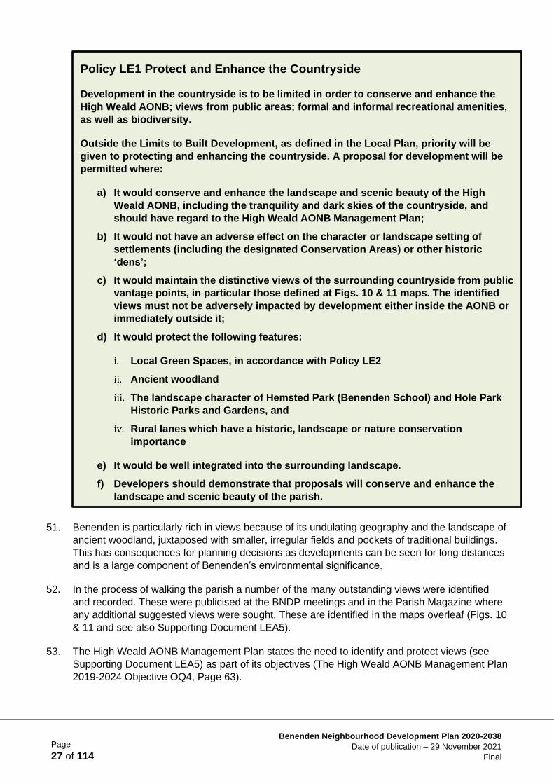
Policy LE1 Protect and Enhance the Countryside
Development in the countryside is to be limited in order to conserve and enhance the
High Weald AONB; views from public areas; formal and informal recreational amenities,
as well as biodiversity.
Outside the Limits to Built Development, as defined in the Local Plan, priority will be
given to protecting and enhancing the countryside. A proposal for development will be
permitted where:
a) It would conserve and enhance the landscape and scenic beauty of the High
Weald AONB, including the tranquility and dark skies of the countryside, and
should have regard to the High Weald AONB Management Plan;
b) It would not have an adverse effect on the character or landscape setting of
settlements (including the designated Conservation Areas) or other historic
‘dens’;
c) It would maintain the distinctive views of the surrounding countryside from public
vantage points, in particular those defined at Figs. 10 & 11 maps. The identified
views must not be adversely impacted by development either inside the AONB or
immediately outside it;
d) It would protect the following features:
i. Local Green Spaces, in accordance with Policy LE2
ii. Ancient woodland
iii. The landscape character of Hemsted Park (Benenden School) and Hole Park
Historic Parks and Gardens, and
iv. Rural lanes which have a historic, landscape or nature conservation
importance
e) It would be well integrated into the surrounding landscape.
f) Developers should demonstrate that proposals will conserve and enhance the
landscape and scenic beauty of the parish.
Page
28 of 114
Benenden Neighbourhood Development Plan 2020-2038
Date of publication – 29 November 2021
Final
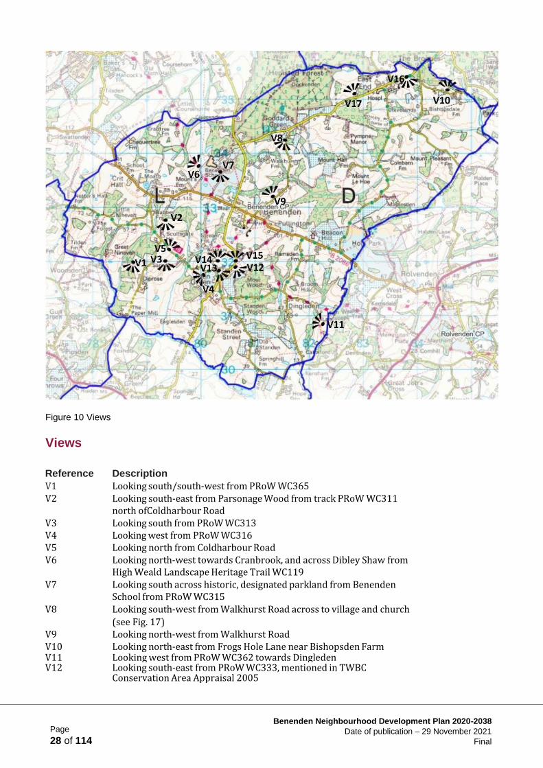
Figure 10 Views
Views
Reference Description
V1 Looking south/south‐west from PRoW WC365 V2 Looking south‐east from Parsonage Wood from track PRoW WC311
north of Coldharbour Road V3 Looking south from PRoW WC313 V4 Looking west from PRoW WC316 V5 Looking north from Coldharbour Road V6 Looking north‐west towards Cranbrook, and across Dibley Shaw from
High Weald Landscape Heritage Trail WC119 V7 Looking south across historic, designated parkland from Benenden
School from PRoW WC315
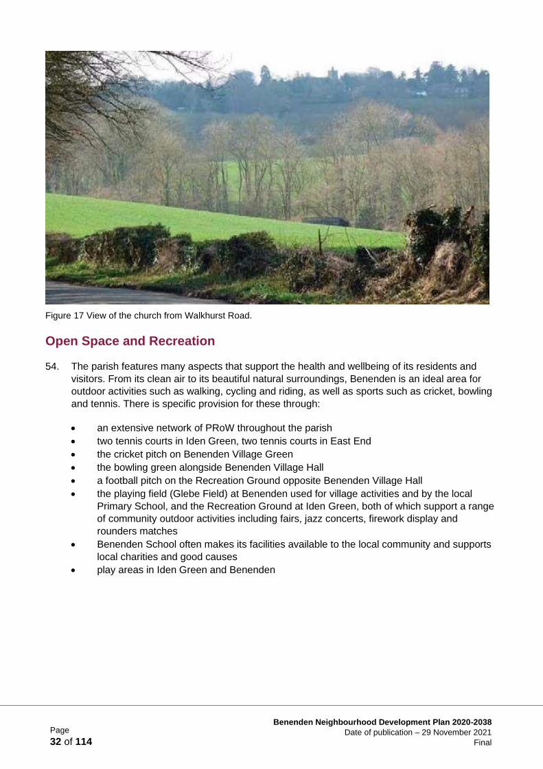
V8 Looking south‐west from Walkhurst Road across to village and church
(see Fig. 17) V9 Looking north‐west from Walkhurst Road V10 Looking north‐east from Frogs Hole Lane near Bishopsden Farm V11 Looking west from PRoW WC362 towards Dingleden V12 Looking south‐east from PRoW WC333, mentioned in TWBC
Conservation Area Appraisal 2005
Page
29 of 114
Benenden Neighbourhood Development Plan 2020-2038
Date of publication – 29 November 2021
Final
Reference Description
V13 Looking south‐east from Iden Green Recreation Ground, mentioned in TWBC Conservation Area Appraisal 2005
V14 Looking north from Chapel Lane towards Benenden, mentioned in TWBC Conservation Area Appraisal 2005
V15 Looking north towards Benenden from Iden Green Road, mentioned in TWBC Conservation Area Appraisal 2005
V16 View south from east side of East End towards Bexhill Farm V17 Looking north‐west from Goddards Green Road across to Hemsted
Forest
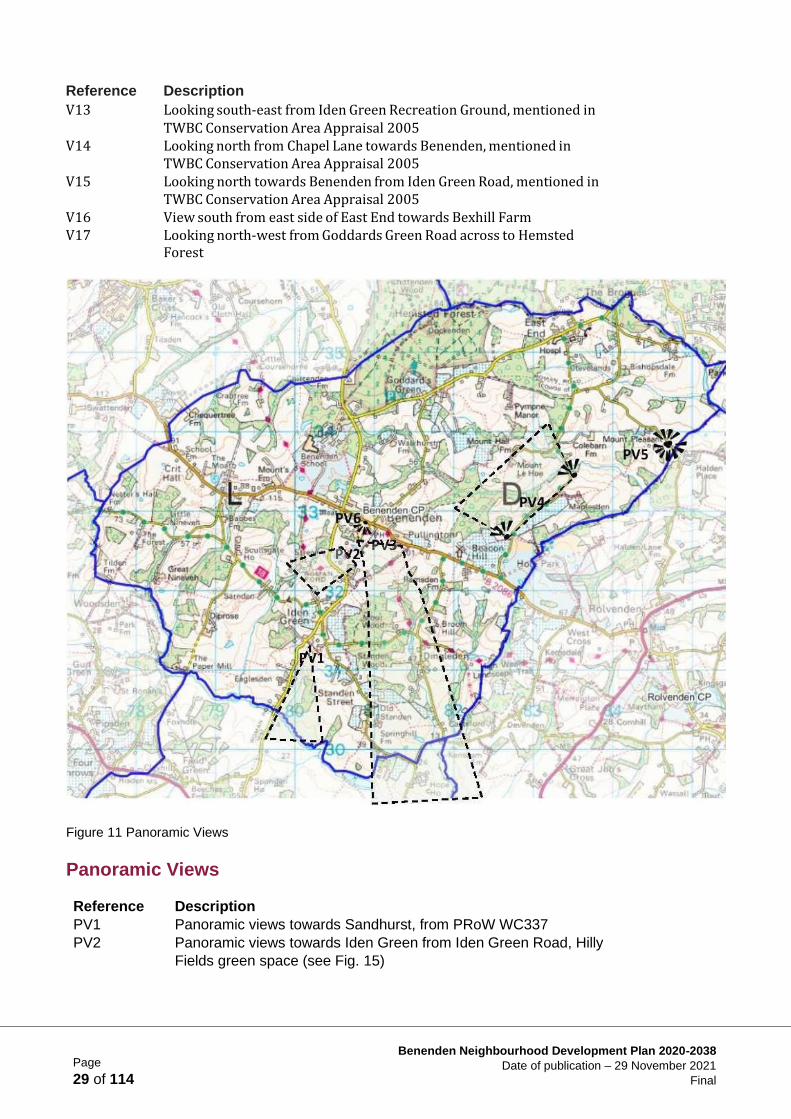
Figure 11 Panoramic Views
Panoramic Views
Reference Description
PV1 Panoramic views towards Sandhurst, from PRoW WC337
PV2 Panoramic views towards Iden Green from Iden Green Road, Hilly
Fields green space (see Fig. 15)
Page
30 of 114
Benenden Neighbourhood Development Plan 2020-2038
Date of publication – 29 November 2021
Final
Reference Description
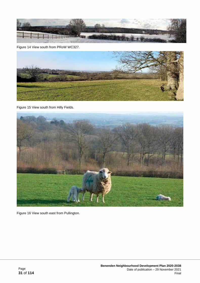
PV3 Panoramic views from ridgeline south across Weald, visible from
multiple points along PRoW WC325, WC327 (see Fig. 14), WC328
(see Fig. 16)
PV4 Set of westerly views along Stepneyford Lane
PV5 Panoramic views north and south from Halden Lane
PV6 Panoramic view of Benenden village green, mentioned in TWBC
Conservation Area Appraisal 2005
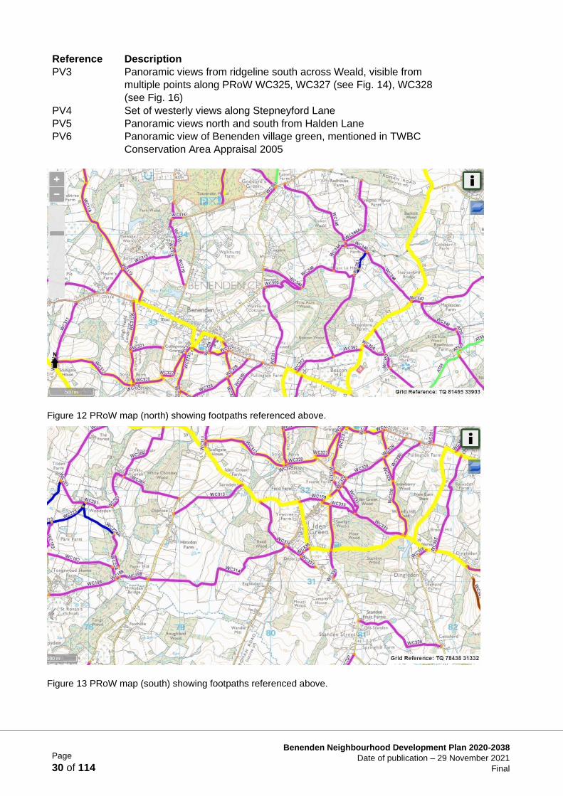
Figure 12 PRoW map (north) showing footpaths referenced above.
Figure 13 PRoW map (south) showing footpaths referenced above.
Page
31 of 114
Benenden Neighbourhood Development Plan 2020-2038
Date of publication – 29 November 2021
Final
Figure 14 View south from PRoW WC327.
Figure 15 View south from Hilly Fields.
Figure 16 View south east from Pullington.
Page
32 of 114
Benenden Neighbourhood Development Plan 2020-2038
Date of publication – 29 November 2021
Final
Figure 17 View of the church from Walkhurst Road.
Open Space and Recreation
54. The parish features many aspects that support the health and wellbeing of its residents and
visitors. From its clean air to its beautiful natural surroundings, Benenden is an ideal area for
outdoor activities such as walking, cycling and riding, as well as sports such as cricket, bowling
and tennis. There is specific provision for these through:
• an extensive network of PRoW throughout the parish
• two tennis courts in Iden Green, two tennis courts in East End
• the cricket pitch on Benenden Village Green
• the bowling green alongside Benenden Village Hall
• a football pitch on the Recreation Ground opposite Benenden Village Hall
• the playing field (Glebe Field) at Benenden used for village activities and by the local
Primary School, and the Recreation Ground at Iden Green, both of which support a range
of community outdoor activities including fairs, jazz concerts, firework display and
rounders matches
• Benenden School often makes its facilities available to the local community and supports
local charities and good causes
• play areas in Iden Green and Benenden
Page
33 of 114
Benenden Neighbourhood Development Plan 2020-2038
Date of publication – 29 November 2021
Final
Local Green Spaces
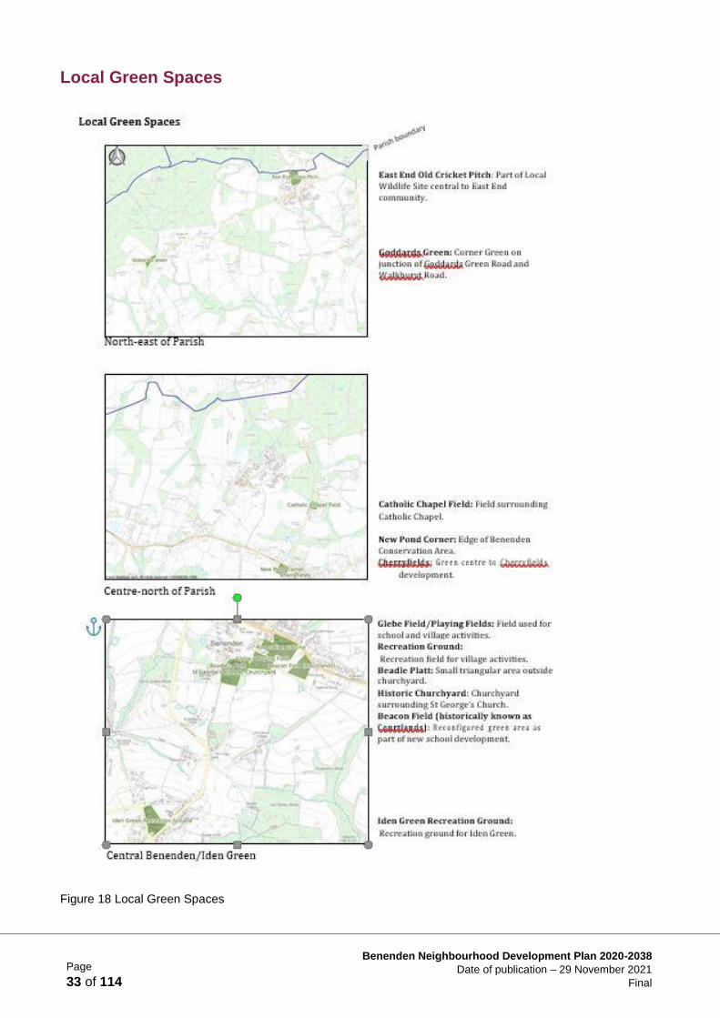
Figure 18 Local Green Spaces
Page
34 of 114
Benenden Neighbourhood Development Plan 2020-2038
Date of publication – 29 November 2021
Final
55. The working group identified the Local Green Spaces (LGS) that were perceived to be of
particular importance to the local community and in line with the significance attached to open
space and recreation in the NPPF (paras 101, 102 and 103). LGS designation provides special
protection consistent with that in respect of Green Belt. Guidance, in addition to training from
external consultants, was given by TWBC who also provided supporting documentation (TWBC
local Green Space Designation Methodology 2018). Local Green Spaces were publicised at the
public exhibitions and the opinions of landowners were also sought. TWBC was involved in
ratifying the selected areas as appropriate for protection.
56. These green areas are considered of particular importance to the residents of the parish,
through their attributes which may include beauty, historical significance, recreational value,
tranquility and richness of wildlife. The Local Green Spaces are identified in Fig. 18 and see
also Supporting Document LEA6.
57. A number of local green spaces were not included as they already had a high level of protection
or other protections were more appropriate.
58. These green spaces are:
Name Reason
Benenden Village
Green:
Designated as a registered village green.
Benenden School Park:
In part has ancient woodland protection and in whole a Historic Park and Garden designation.
The Grange Grounds:
Sufficiently protected by multiple TPOs and Historic Park and Garden designation.
Jubilee Plantation: More appropriate for TPO protection.
Policy LE2 Local Green Spaces (LGS)
The following green areas are designated as Local Green Spaces as shown on Fig.
18:
• East End Old Cricket Pitch
• Corner green at junction of Goddards Green Road and Walkhurst Road
• Catholic Chapel Field
• New Pond Corner
• Central green area, Cherryfields
• Glebe Field/Playing Fields
• Recreation Ground
• Beadle Platt
• St George’s Churchyard
• Beacon Field
• Iden Green Recreation Ground
Development on these areas will only be permitted under very special
circumstances.
Page
35 of 114
Benenden Neighbourhood Development Plan 2020-2038
Date of publication – 29 November 2021
Final
Public Rights of Way
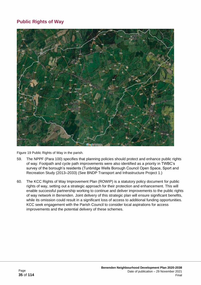
Figure 19 Public Rights of Way in the parish.
59. The NPPF (Para 100) specifies that planning policies should protect and enhance public rights
of way. Footpath and cycle path improvements were also identified as a priority in TWBC’s
survey of the borough’s residents (Tunbridge Wells Borough Council Open Space, Sport and
Recreation Study (2013–2033) (See BNDP Transport and Infrastructure Project 1.)
60. The KCC Rights of Way Improvement Plan (ROWIP) is a statutory policy document for public
rights of way, setting out a strategic approach for their protection and enhancement. This will
enable successful partnership working to continue and deliver improvements to the public rights
of way network in Benenden. Joint delivery of this strategic plan will ensure significant benefits,
while its omission could result in a significant loss of access to additional funding opportunities.
KCC seek engagement with the Parish Council to consider local aspirations for access
improvements and the potential delivery of these schemes.
Page
36 of 114
Benenden Neighbourhood Development Plan 2020-2038
Date of publication – 29 November 2021
Final
Allotments
61. An analysis by TWBC of all open spaces in the borough includes a summary for Benenden
(Tunbridge Wells Borough Council Open Space, Sport and Recreation Study (2013-2033) pp.
55‐56, 71, 90‐91) identities shortfalls and opportunities. It is notable that there is a lack of
provision for allotments in the parish.
62. The local community have expressed a strong interest in shared green amenities, having lost its
allotments over 40 years ago to new developments at the time. Research suggests that the
tending of allotments have many beneficial effects on people’s health and wellbeing and
provides an additional connection with the outdoors and nature. Opportunities should be sought
to provide these facilities in conjunction with new developments (see BNDP Landscape and
Environment Project 2).
Education
63. Given the increasing population of the parish and the consequences of climate change, it is vital
that incoming, as well as existing, residents are aware of the environment in which they live,
both to be part of its preservation, and for enjoyment and an appreciation of its importance.
64. Education about the natural environment is important in ensuring that the community itself
appreciates the value and importance of the natural world and is actively involved in its long‐
term care. Funding should be provided, where justified under NPPF para. 57, by developers to
meet this aim (see BNDP Landscape and Environment Project 3).
Peaceful and Rural Nature
65. The rural nature of Benenden is a fundamental feature identified in the 2015 Parish Plan and
encompassed in the overall vision of this NDP. New development should not impact this
important and distinctive characteristic of the parish. Keeping skies dark and the overall
environment peaceful are key to the rural ‘feel’ of the parish. The High Weald AONB
Management Plan includes proposed action for dark sky‐friendly lighting and for general noise
intrusion (The High Weald AONB Management Plan 2019-2024 Objective OQ4 p. 63).
66. There is minimal artificial lighting in the parish. New developments should not introduce
inappropriately bright lighting at night over paths/footways or other areas within the site. Artificial
lighting at night creates light pollution and is detrimental to wildlife and to the rural nature of the
parish. ‘Smart’ lighting or lighting on short timing devices are more environmentally friendly and
Policy LE3 Public Rights of Way (PRoW)
New development must preserve existing PRoW, rerouted where appropriate. Where
new housing or commercial development affects an existing PRoW, it must be
preserved, enhanced and maintained.
New PRoW should be created, where appropriate, to increase connectivity for non-
motorised users, if necessary using funding delivered by a Section 106 contribution.
Planning applications that would adversely affect the existing PRoW network will
not be permitted.
Page
37 of 114
Benenden Neighbourhood Development Plan 2020-2038
Date of publication – 29 November 2021
Final
would also be more efficient as suggested by the High Weald AONB Management Plan ((The
High Weald AONB Management Plan 2019-2024). TWBC Pre‐SLP Policy EN 8 and its
supporting text emphasises the need to limit and reduce light pollution (see BNDP Policy BD5).
Environmental Aspects of New Development
67. The parish’s rural environment of ancient woodland, unimproved pasture, wooded gills, streams
and ponds provides a favourable habitat for rare species of animal and plant. Notable recorded
sightings are listed in Supporting Document LEA7. The parish is also part of the Linkhill Turtle
Dove‐friendly Zone which is an important initiative to reverse the catastrophic decline in the
species.
68. There are ten Local Wildlife Sites (LWS) in the parish and one Site of Special Scientific Interest
(SSSI), Parsonage Wood, (see Supporting Documents LEA8 and LEA9) highlighting the wildlife‐
rich environment. The noted lichen‐rich flora is a particular feature indicative of the clean,
unpolluted air in the parish.
69. The NPPF emphasises the importance of the natural environment (NPPF paras. 174‐188). It is
especially important that new development pays special attention to this in an area so rich in
biodiversity. TWBC provides guidance notes for planning applications in relation to Landscape
and Nature Conservation and states that development should ‘seek to protect and enhance the
biodiversity of the site and the surrounding area’ (Landscape and Nature Conservation
Guidance Notes for Applicants August 2002 - Part 1 p. 1).
70. Development will be expected to comply with Policies EN1, EN 12 & EN 13 of TWBC Pre‐SLP.
71. Before any development starts, a formal independent survey should be carried out by an
independent expert, appropriately qualified to assess specific important environmental features
(such as acid grassland). Developers will be expected to take these findings into account.
Policy LE4 Trees, Woodland and Hedgerow
There will be a presumption in favour of the retention and enhancement of existing
trees, woodland and hedgerow cover on site and the restoration of lost trees,
woodland and hedgerows.
Any new tree or hedgerow establishment should avoid damaging valued areas such
as species rich grassland or medieval fields.
New development including building and hard surfacing shall be located at
sufficient distance from existing or new trees and hedgerows to avoid damaging
their health or future capacity for growth.
Policy LE5 New Green Spaces
Where green spaces are proposed, they should be located within the areas where
there are existing habitats, wherever possible, rather than creating new habitat.
Page
38 of 114
Benenden Neighbourhood Development Plan 2020-2038
Date of publication – 29 November 2021
Final
72. The Woodland Trust suggest a minimum buffer of 50m (Natural England state a lower minimum
of 15m.(Ancient Woodland and Veteran Trees Protection) Natural England also state that the
buffer zone should be a semi‐natural habitat itself and specifically should not include gardens,
access roads or sustainable drainage.
73. Developers will be expected to include plans for the long‐term care of the features which
encourage wildlife. This could include maintenance of woodland which remains on an
undeveloped part of the site, new verges which encourage wildflowers or specific habitat
features within the new development. TWBC’s Green Infrastructure Planning document
highlights the need for long‐term management and its financing (TWBC Green Infrastructure
Plan Supplementary Planning Document August 2014 - 6.2 p. 24).
Policy LE6 Protection of Habitats Adjacent to Development
Where new housing or commercial development is proposed, an appropriate depth
of buffer must be provided between the development and any protected habitat,
ancient woodland, any Local Wildlife Site or other areas of natural or ecological
importance and the size of that buffer shall be appropriate to safeguard the
significance of that habitat.
Where appropriate, the buffer itself must be kept as a natural wildlife haven and will
not be expected to be used as an amenity area unless it is demonstrated that such
use will not adversely affect that feature of natural importance.
Policy LE7 On-going Involvement for Maintenance
Where new housing or commercial development is proposed, developers, will be
expected, where appropriate, to include an on-going management plan for green
infrastructure elements of the site and provision for its funding.
Developers will be expected, where appropriate, to set up an environmental
management service contract to maintain public areas, particularly LWS, and shall
provide for long-term integration and enhancement of the environment.
Page
39 of 114
Benenden Neighbourhood Development Plan 2020-2038
Date of publication – 29 November 2021
Final
74. All new developments should include features within the development which are sympathetic to
Benenden’s character, its wildlife and flora.
75. Drainage should be structured in such a way as not to overwhelm the local ecosystem with the
quantity and quality of the water emanating from any new development. In order to minimise the
impact on the wildlife and plant habitats, it may be necessary to pump water off‐site and it is
expected that developers will provide independent surveys in order to satisfactorily achieve this
aim.
76. Developers should refer to KCC Surface Water Floor Maps as produced by the Environment
Agency and the adopted KCC Drainage & Planning Policy Statement which provides direction
for the incorporation of surface water drainage within new developments.
Landscape and the Environment Projects
1. Creation of New Habitat
Development should include provision for creating new wildlife habitat and joining up of
existing wildlife‐rich areas.
This could involve planting and other measures on an undeveloped part of the site, or funding
to achieve the policy elsewhere within the parish. Measures should be meaningful and long‐
lasting. The NPPF refers to the establishment of coherent ecological networks (NPPF para
174d) as part of the provision for net gains for biodiversity.
2. Allotments
Promote the creation of shared amenities such as allotments and a community compost area.
Policy LE8 Features to Encourage Wildlife
Plans for new housing or commercial developments must include elements that
encourage wildlife and plants:
a) Where it is practical to do so, schemes are encouraged to use native hedgerow
species for boundaries in preference to walls or fencing (see Policy BD4).
Planting of pollinator-friendly native wildflowers will also be encouraged.
b) Ensure common areas, boundaries and verges on new developments are wildlife
rich.
c) Include specific elements such as bird boxes, bat roosts and hedgehog
highways to encourage wildlife.
Policy LE9 Sustainable Drainage for New Housing or Commercial
Development
Developers will be expected to demonstrate that best practice sustainable drainage
will be incorporated into any development before construction commences.
Page
40 of 114
Benenden Neighbourhood Development Plan 2020-2038
Date of publication – 29 November 2021
Final
3. Education
Support on‐going education of children and adults about the countryside and the environment.
Primary school children are expected to spend a certain amount of time in the open air looking
at nature and the intention is to extend this to older children and adults with organised nature
trails, walks and encouragement to volunteer in the upkeep of Public Rights of Way and
habitats. Contact with nature contributes to health and wellbeing.
4. Public Rights of Way
Public Rights of Way provide a valuable amenity both for the existing local community and
new residents as well as for tourists or visitors. In order to encourage greater use of this
amenity there should be improved signage and access to the extensive Public Right of Way
network.
Supporting Documents for Landscape and the Environment
LEA1 SWOT Data — Landscape and the Environment
LEA2 Landscape Character Assessments 2018
LEA3 List of source documents
LEA4 High Weald AONB Landscape Character Maps
LEA5 View assessments
LEA6 Local Green Space assessments
LEA7 Wildlife Summary
LEA8 List of Local Wildlife Sites & SSSI
LEA9 Local Wildlife Site maps and citations
Page
41 of 114
Benenden Neighbourhood Development Plan 2020-2038
Date of publication – 29 November 2021
Final
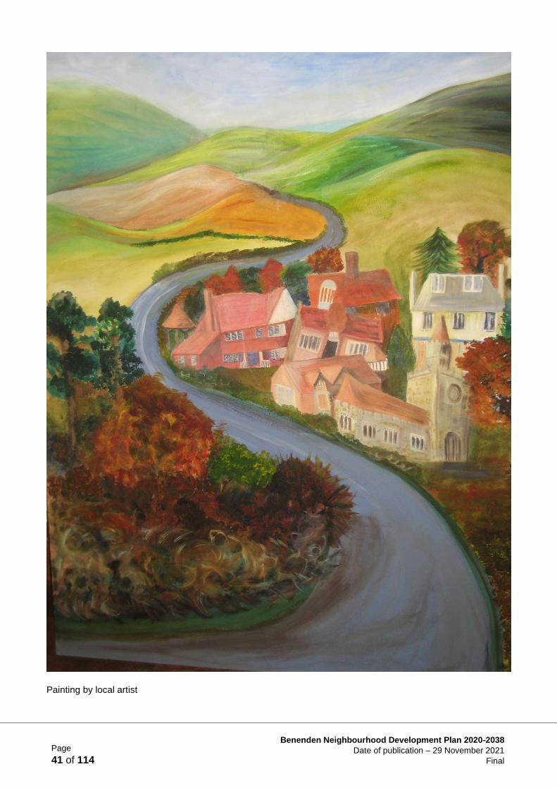
Painting by local artist
Page
42 of 114
Benenden Neighbourhood Development Plan 2020-2038
Date of publication – 29 November 2021
Final
Figure 20 Example sketch design for houses (by Clague Architects).
Chapter 2 Housing Supply and Site Allocation
Objective
77. To support modest-scale housing development to meet local needs with a mix of well- designed,
high quality, sustainable and affordable housing that conserves and enhances the existing built
and natural environment.
Introduction
78. The Housing Supply and Allocation Working Group built on the work of the Benenden Parish
Plan 2015, adopted by Benenden Parish Council (BPC) following widespread consultation in the
community and is a key supporting document for the Benenden Neighbourhood Development
Plan (BNDP).
79. This Plan will support housing allocations on a number of sustainable and economically viable
sites, the majority on previously developed land, the only exception being to allow an
almshouse development for provision of affordable housing for the parish in perpetuity. The
BNDP believes that suitable design (see Fig. 20) can minimise harmful impacts and improve the
character and quality of Benenden parish.
Housing Needs Within the Parish
80. Housing need in the parish is relatively low, as demonstrated in the Objectively Assessed Need
(OAN) for housing in the Borough, established using standard methodology. The NPPF (para.
66) explains that strategic policies should also set out a housing requirement for designated
neighbourhood areas which reflect the overall strategy for the pattern and scale of development
and any relevant allocations. The TWBC Pre-submission Local Plan (Pre-SLP) asserts this in
Strategic Policies STR1 and PSTR/BE1.
81. The 2018 Tunbridge Wells Borough Council (TWBC) Housing Needs Study (HNS) identified
Benenden as having the second lowest affordable housing needs within the Borough, with a
Page
43 of 114
Benenden Neighbourhood Development Plan 2020-2038
Date of publication – 29 November 2021
Final
requirement for 6 affordable dwellings per annum (4 for older residents and 2 for families) over a
five-year period.
82. This Plan will provide up to 38 affordable dwellings over the Plan period, with a further 12 being
provided by existing permissions.
Consultation
83. The Parish Plan and Housing Needs Study 2015 were used with other information collected in
the interim to inform the Visioning Workshop held on 28th October 2017 and subsequent
Housing and Design Workshop on 11th November 2017. Subsequent exhibitions, magazine
articles and a presentation took place in 2018-2019 (Supporting Documents HSA1 & HSA2).
Policy Context/Justification
• Over 98% of the parish is in the High Weald AONB designation
• Benenden parish has two Conservation Areas (Benenden village and Iden Green) and has
over 150 listed buildings, many Roman roads, medieval field systems, an SSSI and much
ancient woodland
• The facilities within the parish are focused on Benenden village and, whilst serving basic
needs, are limited in range and scale resulting in the need to drive to other towns such as
Cranbrook and Tenterden or further afield to the main centres
• Access to/from the parish is constrained by the distance from main centres: Tunbridge Wells
15m (24km), Maidstone 13m (22km), Ashford 14m (23km) and Hastings 14m (23km)
• Access within the parish is constrained by the width of the roads and rural lanes
• Poor infrastructure: broadband and mobile signal a particular concern
• The 2017 BNDP consultation highlighted local residents’ top priority was to protect the rural
nature of the parish
84. Historically, development has been scattered across 32 ‘dens’ which make up the parish (see
Fig. 21), with concentrations in the three main settlements of Benenden, Iden Green and East
End.
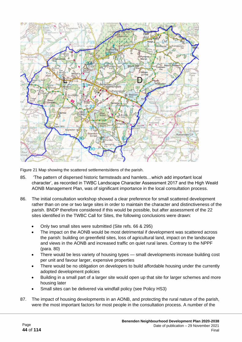
Page
44 of 114
Benenden Neighbourhood Development Plan 2020-2038
Date of publication – 29 November 2021
Final
Figure 21 Map showing the scattered settlements/dens of the parish.
85. ‘The pattern of dispersed historic farmsteads and hamlets…which add important local
character’, as recorded in TWBC Landscape Character Assessment 2017 and the High Weald
AONB Management Plan, was of significant importance in the local consultation process.
86. The initial consultation workshop showed a clear preference for small scattered development
rather than on one or two large sites in order to maintain the character and distinctiveness of the
parish. BNDP therefore considered if this would be possible, but after assessment of the 22
sites identified in the TWBC Call for Sites, the following conclusions were drawn:
• Only two small sites were submitted (Site refs. 66 & 295)
• The impact on the AONB would be most detrimental if development was scattered across
the parish: building on greenfield sites, loss of agricultural land, impact on the landscape
and views in the AONB and increased traffic on quiet rural lanes. Contrary to the NPPF
(para. 80)
• There would be less variety of housing types — small developments increase building cost
per unit and favour larger, expensive properties
• There would be no obligation on developers to build affordable housing under the currently
adopted development policies
• Building in a small part of a larger site would open up that site for larger schemes and more
housing later
• Small sites can be delivered via windfall policy (see Policy HS3)
87. The impact of housing developments in an AONB, and protecting the rural nature of the parish,
were the most important factors for most people in the consultation process. A number of the
Page
45 of 114
Benenden Neighbourhood Development Plan 2020-2038
Date of publication – 29 November 2021
Final
rural sites in the Call for Sites would, if developed, significantly harm the rural setting and be
contrary both to the High Weald AONB Management Plan (p. 20) and the protection afforded to
the AONB in the NPPF (NPPF para. 176 & 177). For this reason they are not considered
suitable for housing development in this Plan. Any housing built in, or adjacent to, the AONB will
be required to be sensitively designed and landscaped in order to mitigate the impact on the
rural setting (see Policy BD1).
The Policies
Quantity and Location of New Housing Development
88. Following the 2016 Call for Sites, landowners and their agents in Benenden put forward 20 sites
for consideration (see Supporting Document HSA5). Two further sites have recently been
submitted. BNDP has chosen to allocate four sites. These are in addition to those already
permitted but as yet undeveloped (Benenden Hospital).
89. The BNDP site allocation, made in close co-operation with TWBC, would meet the
Government’s requirement for sustainable and deliverable new housing (NPPF para. 8). This is
an extrapolation of the approach set out in the Benenden Parish Plan of 2015 (p. 7) which
outlined growth of 1% per annum up to 2025.
90. The selection of the most suitable sites for allocation for housing development in the parish, that
were submitted to the TWBC Call for Sites (during and since 2016), have been carefully
considered using appropriate methods following national policies, guidance and best practice.
This includes the consideration of a wide range of constraints such as the impact on the AONB,
conservation areas, other heritage assets and their setting and the proximity of sites to facilities,
together with the availability of sustainable transport links.
91. The parish at consultation supported priority being given to brownfield sites and previously
developed land (PDL). This accords with the NPPF (para. 119) stated preference for the use of
brownfield sites. The BNDP therefore gave extra weight to those sites which met these criteria,
making as much use as possible of previously developed or ‘brownfield’ land.’
92. In considering which sites should be allocated, attention was paid to the existing built
environment, as an integral part of landscape character, especially given the high proportion of
listed buildings in the parish (see Historic Context and HCA1) and following guidelines set out
by Historic England (Historic England The Setting of Heritage Assets Historic Environment
Good Practice Advice in Planning Note 3 (Second Edition) p. 2) and in the government’s
Planning Practice Guide.
93. Landscape Character Assessments have been carried out by the Environment Group (see
Supporting Document LEA2). The particular characteristics of the different areas of the parish
will be expected to be protected. The rare survival of the landscape that surrounds Benenden is
of particular interest and importance (The High Weald AONB Unit has carried out a number of
studies on the landscape character of the Benenden area, in particular: Historic Landscape
Characterisation of the Parishes of Hawkhurst, Cranbrook, Goudhurst & Benenden updated
2017; Case Study report: Benenden by footpath March 2017; Fields in the High Weald Case
Study Report Woodside Farm March 2017).
94. Building Design Character Assessments in the main areas of the parish (see Supporting
Document BDA3) were carried out by the Design and the Built Environment Group as a
Page
46 of 114
Benenden Neighbourhood Development Plan 2020-2038
Date of publication – 29 November 2021
Final
reference tool for future building design in the parish. In addition, the NPPF sets out the
importance of conserving the historic built environment (NPPF paras. 189, 190).
95. The environment is an important policy issue, both for the TWBC Pre-Submission Local Plan
(Pre-SLP) and in terms of the AONB Management Plan. Consequently, equal weight is given to
both the built environment and the rural environment in this Neighbourhood Plan.
96. Any new build housing development immediately adjacent to the AONB will have an impact
upon it and must therefore be taken into account. Any development should conserve and
enhance the landscape and scenic beauty, wildlife and cultural life of the AONB: major
development would need to satisfy the requirements of para. 177 c) of the NPPF.
97. Where a site is allocated within the AONB, the proposal should make a positive contribution
towards achieving the objectives of the AONB Management Plan, and show how relevant
guidance from the AONB Joint Advisory Committee has been considered, to meet the high
standards required of the policies in this Plan for the High Weald AONB landscape.
98. Sites allocated outside the AONB but within the High Weald Character Area, or close to the
boundary of the designated AONB landscape, will have similar characteristics and are likely to
contribute to the setting of the designated landscape. The AONB Management Plan and any
supporting guidance will be a material consideration for these sites.
99. In addition to existing planning permissions* and windfall development allowed under Policy
HS3, this Plan allocates four sites to accommodate approximately 90 additional new homes in
the parish.
SSP1 Feoffee 23-25 units
SSP2 Uphill 18-20 units
SSP3 Hospital South Up to 25 units
SSP4 Hospital North 22-25 units
*There is an existing planning consent at Benenden Hospital - South Site (24 units unimplemented).
Types of Housing – Achieving the Right Mix
100. Reflecting the findings of the initial consultation workshops in 2017/18, and the evidence
provided in the 2015 Parish Plan Housing Needs Survey, the BNDP will deliver a mix of different
types of well-designed, high quality, sustainable, and affordable housing that enhances the built
and natural environment (NPPF, para 62).
101. The 2015 Parish Plan identified a requirement for a range of house types in Benenden, whilst
the more recent TWBC Housing Needs Study 2018, which focused on affordable housing,
revealed a need for smaller 1-2 bed units. It is therefore considered important that the housing
‘mix’ should include some larger properties, suitable for families, as well as smaller units.
102. The BNDP considers it necessary to have an adequate supply of housing of different types and
sizes between which residents can move, within the parish, in order to help maintain an
enduring sense of community.
Page
47 of 114
Benenden Neighbourhood Development Plan 2020-2038
Date of publication – 29 November 2021
Final
Locally Led Housing Delivery
103. It is considered that the local aspirations of the community for the provision of affordable/local
needs housing, can often be best achieved by partnership-based and locally led development
initiatives. The Parish Council has a history of working with rural housing associations on a
number of locally based schemes by which affordable housing remains in the community (see
Housing Supply Project 1).
104. Benenden is unusual in having almshouses, a category of low-cost housing which remains in
the control of local trustees. Almshouses also comply with the parish’s requirement for locally
led, locally managed housing development. They therefore have the full backing of the BNDP,
and the scheme being considered for the Feoffee site (Call for Sites: ref. 277) will increase the
number of such units available in perpetuity to people, of all ages, with a connection to the
parish.
105. Almshouses provide low-cost rental available to individuals and families, of whatever age, with a
local connection and are administered and regulated by local trustees. These properties are
exempt from the Government’s ’Right to Buy’ scheme.
106. It is anticipated that approximately 50 affordable dwellings of different types will be provided
over the Plan period that conform to the definition of affordable housing as set out in the NPPF
paras. 62-64 and TWBC Pre-SLP.
107. The parish at consultation expressed an interest in setting up a Community Land Trust (CLT)
which could ensure that local housing remains genuinely affordable in perpetuity. However,
because of the existing Benenden Village Trust and the Benenden Almshouse Charities, it may
not be necessary to create a CLT. However, should land or assets be gifted to the community or
Policy HS1 Delivering a Balanced Community
Where developments trigger a requirement for the inclusion of affordable housing
alongside market housing in accordance with Local Plan policy, the design and
layout shall be such that the appearance of the affordable houses is
indistinguishable from the market housing.
All developments will be expected to deliver a mix of different house sizes and
housing types including, where appropriate, flats, maisonettes and bungalows, to
ensure the development meets the needs of the local community, including homes
capable of being suitable for the needs of an ageing population.
Policy HS2 Almshouses
The Neighbourhood Plan will support schemes that apply the almshouse
principle.
Benenden’s almshouses are administered by the Benenden Almshouse Charities
(see Feoffee site ref. SSP1) and the almshouses they provide will be treated as
affordable housing.
Page
48 of 114
Benenden Neighbourhood Development Plan 2020-2038
Date of publication – 29 November 2021
Final
made available at a reduced price, such as land for housing or for allotments, then it is
recommended that a CLT be investigated (see Housing Supply Project 2) to administer such
assets for the community.
Supporting a Sustainable Community
108. Working from home is becoming increasingly common and the BNDP encourages the provision
of facilities to enable sustainable homeworking which will improve locally based employment,
support local services, and reduce traffic movements. The BNDP supports the provision of office
space within new-build dwellings, provided the latter is compatible with residential amenity.
109. Small scale housing development, such as infilling; redevelopment or conversion, is expected to
come forward during the life of the BNDP, enabling windfall development and making a
contribution towards the housing land supply in the BNDP area.
110. Residential extensions will also come forward during the Plan period, but these do not add to
the overall number of dwellings in the parish.
111. Any development proposals must comply with national, local and BNDP policies.
Density
112. BNDP has argued for development to be kept at an appropriate density, in keeping with the
existing neighbouring pattern (see Policy HS4), while cognisant of the fact that the most efficient
use must be made of valuable land. This position is supported by CPRE in order to protect more
of the AONB, some sites nearer to built-up areas should be developed at greater density.
National guidelines are for 30 dwellings per hectare (dph) in rural areas though the TWBC Pre-
Submission Local Plan states ‘the density of residential development should have regard to the
character of the area, including landscape, topography and surrounding built form.’ (TWBC Pre-
Submission Local Plan Policy H 2).
113. The average density in the parish is much lower (Benenden village averages 10dph) and as a
result BNDP has argued that density should vary depending on the location of the site and its
impact on the AONB.
114. Sites which would increase the coalescence between major settlements, in particular between
Benenden and Iden Green, or Benenden and East End, thus reducing their separate identities,
Policy HS3 Windfall Sites
Windfall residential development such as infilling, reuse, redevelopment or
conversion will be permitted subject to the following criteria:
a) Within the LBD, as defined in the Local Plan, where such proposals do not
conflict with other policies in the Local Plan, or Neighbourhood Plan;
b) Outside the LBD, as defined in the Local Plan, on previously developed
land (PDL), or the conversion of appropriate rural buildings, which are not
currently in business use;
c) The scale, design and appearance comply with BNDP design policy.
Page
49 of 114
Benenden Neighbourhood Development Plan 2020-2038
Date of publication – 29 November 2021
Final
have not been allocated. This is a key characteristic in the AONB Management Plan (p. 31;
Objective S2 p. 33).
115. In the construction of new housing it is the BNDP’s view that one of the factors that contributes
most to the distinctiveness and character of the parish is housing density. New development
should take account of the density of neighbouring housing in order to maintain the distinctive
character of that settlement. Furthermore, the character of the development itself should comply
with the design requirements specified in the BNDP Design and the Built Environment chapter
and the policies contained therein.
New Housing Site Allocations
Overview
The Working Group:
• looked at and objectively assessed the 13 originally submitted sites, the 7 late submitted sites
and the 2 most recently submitted sites
• met regularly to discuss and debate their findings
• individual site assessments (ISAs) were based on site walks, addressing parish concerns (e.g.
access, traffic) and reviewing relevant local and national planning policies and AONB
guidelines (see Supporting Document HSA3)
Site Assessments made by the AONB Unit
116. The High Weald AONB Unit has carried out a separate assessment of the sites within the
Benenden AONB (see Supporting Document HSA4). Their conclusions underscore the
importance of the rural landscape in Benenden and the need to protect it as much as possible
by restricting development to previously developed land or sites outside the AONB. Their
assessment is considered a key supporting document.
Policy HS4 Housing Density
The layout of new housing should make efficient and effective use of the site as
long as it does not detract from the character and distinctiveness of the locality.

Page
50 of 114
Benenden Neighbourhood Development Plan 2020-2038
Date of publication – 29 November 2021
Final
The Allocated Sites
Figure 22 Map showing the two allocated sites (edged in red) at the Hospital (Ref. SSP3: SEQ & SSP4: NEQ).
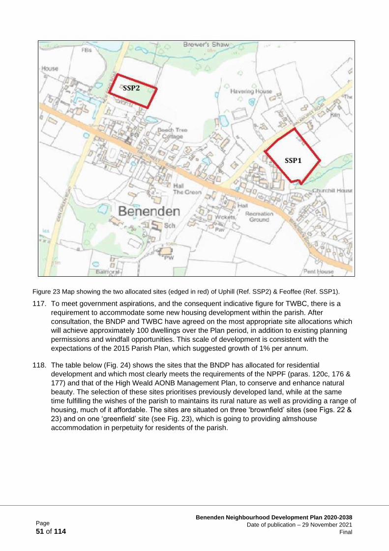
Page
51 of 114
Benenden Neighbourhood Development Plan 2020-2038
Date of publication – 29 November 2021
Final
Figure 23 Map showing the two allocated sites (edged in red) of Uphill (Ref. SSP2) & Feoffee (Ref. SSP1).
117. To meet government aspirations, and the consequent indicative figure for TWBC, there is a
requirement to accommodate some new housing development within the parish. After
consultation, the BNDP and TWBC have agreed on the most appropriate site allocations which
will achieve approximately 100 dwellings over the Plan period, in addition to existing planning
permissions and windfall opportunities. This scale of development is consistent with the
expectations of the 2015 Parish Plan, which suggested growth of 1% per annum.
118. The table below (Fig. 24) shows the sites that the BNDP has allocated for residential
development and which most clearly meets the requirements of the NPPF (paras. 120c, 176 &
177) and that of the High Weald AONB Management Plan, to conserve and enhance natural
beauty. The selection of these sites prioritises previously developed land, while at the same
time fulfilling the wishes of the parish to maintains its rural nature as well as providing a range of
housing, much of it affordable. The sites are situated on three ‘brownfield’ sites (see Figs. 22 &
23) and on one ‘greenfield’ site (see Fig. 23), which is going to providing almshouse
accommodation in perpetuity for residents of the parish.
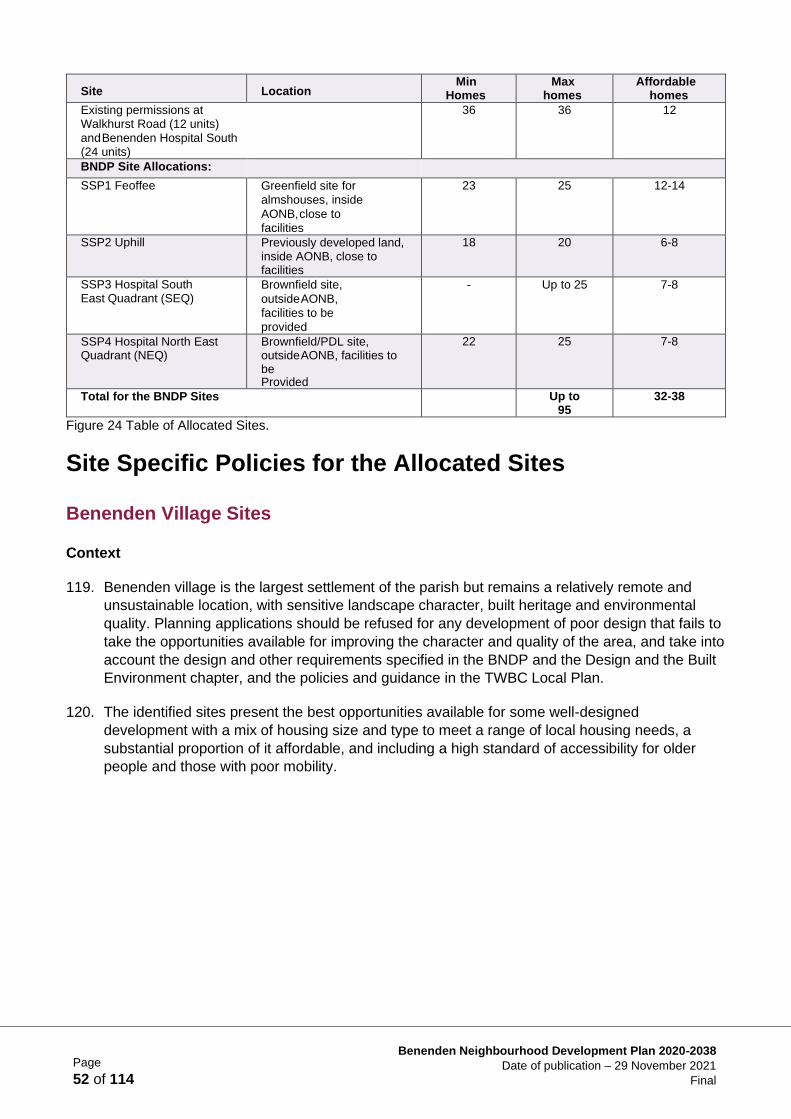
Page
52 of 114
Benenden Neighbourhood Development Plan 2020-2038
Date of publication – 29 November 2021
Final
Site Location Min
Homes Max
homes Affordable
homes
Existing permissions at Walkhurst Road (12 units)
and Benenden Hospital South (24 units)
36 36 12
BNDP Site Allocations:
SSP1 Feoffee Greenfield site for
almshouses, inside
AONB, close to
facilities
23 25 12-14
SSP2 Uphill Previously developed land, inside AONB, close to facilities
18 20 6-8
SSP3 Hospital South East Quadrant (SEQ)
Brownfield site,
outside AONB,
facilities to be
provided
- Up to 25 7-8
SSP4 Hospital North East Quadrant (NEQ)
Brownfield/PDL site, outside AONB, facilities to be Provided
22 25 7-8
Total for the BNDP Sites Up to 95
32-38
Figure 24 Table of Allocated Sites.
Site Specific Policies for the Allocated Sites
Benenden Village Sites
Context
119. Benenden village is the largest settlement of the parish but remains a relatively remote and
unsustainable location, with sensitive landscape character, built heritage and environmental
quality. Planning applications should be refused for any development of poor design that fails to
take the opportunities available for improving the character and quality of the area, and take into
account the design and other requirements specified in the BNDP and the Design and the Built
Environment chapter, and the policies and guidance in the TWBC Local Plan.
120. The identified sites present the best opportunities available for some well-designed
development with a mix of housing size and type to meet a range of local housing needs, a
substantial proportion of it affordable, and including a high standard of accessibility for older
people and those with poor mobility.
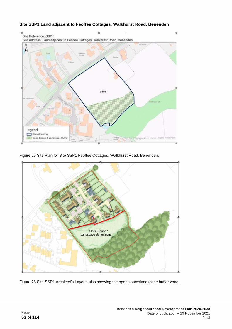
Page
53 of 114
Benenden Neighbourhood Development Plan 2020-2038
Date of publication – 29 November 2021
Final
Site SSP1 Land adjacent to Feoffee Cottages, Walkhurst Road, Benenden
Figure 25 Site Plan for Site SSP1 Feoffee Cottages, Walkhurst Road, Benenden.
Figure 26 Site SSP1 Architect’s Layout, also showing the open space/landscape buffer zone.
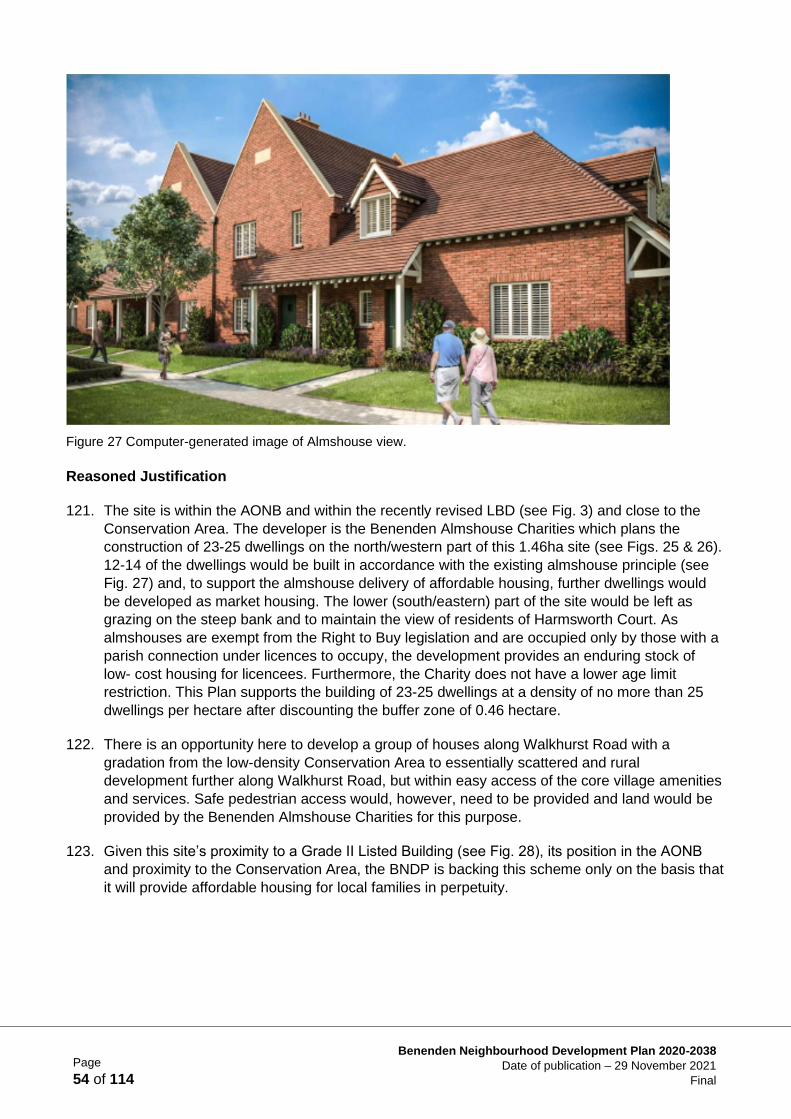
Page
54 of 114
Benenden Neighbourhood Development Plan 2020-2038
Date of publication – 29 November 2021
Final
Figure 27 Computer-generated image of Almshouse view.
Reasoned Justification
121. The site is within the AONB and within the recently revised LBD (see Fig. 3) and close to the
Conservation Area. The developer is the Benenden Almshouse Charities which plans the
construction of 23-25 dwellings on the north/western part of this 1.46ha site (see Figs. 25 & 26).
12-14 of the dwellings would be built in accordance with the existing almshouse principle (see
Fig. 27) and, to support the almshouse delivery of affordable housing, further dwellings would
be developed as market housing. The lower (south/eastern) part of the site would be left as
grazing on the steep bank and to maintain the view of residents of Harmsworth Court. As
almshouses are exempt from the Right to Buy legislation and are occupied only by those with a
parish connection under licences to occupy, the development provides an enduring stock of
low- cost housing for licencees. Furthermore, the Charity does not have a lower age limit
restriction. This Plan supports the building of 23-25 dwellings at a density of no more than 25
dwellings per hectare after discounting the buffer zone of 0.46 hectare.
122. There is an opportunity here to develop a group of houses along Walkhurst Road with a
gradation from the low-density Conservation Area to essentially scattered and rural
development further along Walkhurst Road, but within easy access of the core village amenities
and services. Safe pedestrian access would, however, need to be provided and land would be
provided by the Benenden Almshouse Charities for this purpose.
123. Given this site’s proximity to a Grade II Listed Building (see Fig. 28), its position in the AONB
and proximity to the Conservation Area, the BNDP is backing this scheme only on the basis that
it will provide affordable housing for local families in perpetuity.
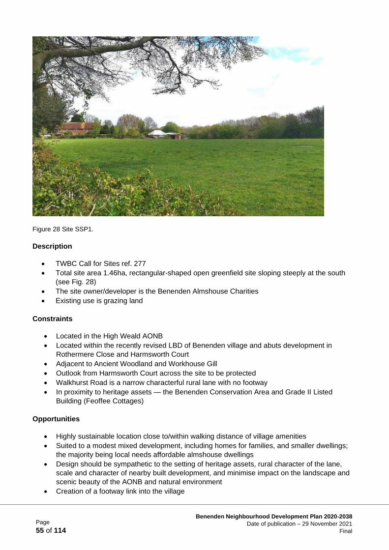
Page
55 of 114
Benenden Neighbourhood Development Plan 2020-2038
Date of publication – 29 November 2021
Final
Figure 28 Site SSP1.
Description
• TWBC Call for Sites ref. 277
• Total site area 1.46ha, rectangular-shaped open greenfield site sloping steeply at the south
(see Fig. 28)
• The site owner/developer is the Benenden Almshouse Charities
• Existing use is grazing land
Constraints
• Located in the High Weald AONB
• Located within the recently revised LBD of Benenden village and abuts development in
Rothermere Close and Harmsworth Court
• Adjacent to Ancient Woodland and Workhouse Gill
• Outlook from Harmsworth Court across the site to be protected
• Walkhurst Road is a narrow characterful rural lane with no footway
• In proximity to heritage assets — the Benenden Conservation Area and Grade II Listed
Building (Feoffee Cottages)
Opportunities
• Highly sustainable location close to/within walking distance of village amenities
• Suited to a modest mixed development, including homes for families, and smaller dwellings;
the majority being local needs affordable almshouse dwellings
• Design should be sympathetic to the setting of heritage assets, rural character of the lane,
scale and character of nearby built development, and minimise impact on the landscape and
scenic beauty of the AONB and natural environment
• Creation of a footway link into the village
Page
56 of 114
Benenden Neighbourhood Development Plan 2020-2038
Date of publication – 29 November 2021
Final
Site Specific Policy 1 (SSP1) Land adjacent to Feoffee Cottages,
Walkhurst Road, Benenden
Site Selection Approach:
To support a suitable development proposal for the site, as an exceptional opportunity
to provide a sustainable development to meet local needs for affordable housing
through the Benenden Almshouse Charities, in a location that is close to village
facilities. A suitable design must avoid or minimise harmful impacts of a development
within the AONB, and close to the Benenden Conservation Area, and improve the
character and quality of Benenden village.
Achieved by:
Supporting suitable proposals from the Benenden Almshouse Charities to maximise
local needs affordable housing on the site.
Proposals shall:
1) Provide a mixed residential development of 23-25 C3 dwellings, with at least 12
units provided for affordable housing adhering to the almshouse principle, and
with an element of market housing necessary to provide the financial basis for
the almshouse development. To include a mix of housing types including
affordable family housing as well as smaller units.
2) Be designed to conserve and enhance the character and distinctiveness of the
village. The density of housing should be sympathetic to local character
including the surrounding built housing density in the adjacent areas, the AONB
landscape, and the landscape and heritage setting of the Benenden
Conservation Area and nearby Listed Buildings. Density must not exceed 25dph
(see Reasoned Justification para. 2.9.1.1) after discounting the buffer zone of
0.46ha.
3) Protect the Ancient Woodland (and pond) lining Workhouse Gill, which should
include a buffer area adjacent to the designated area of a minimum of 50m free
from any form of built development, track or private garden space; the details
and planting of the buffer area, which will be expected to deliver biodiversity
enhancements, to be approved and thereafter maintained in accordance with
Policies LE5, LE6, LE7 & LE8. The proposal must secure the management of
the buffer in the long term.
4) Provide all dwellings with a suitable standard of shared semi-private and/or
private garden space. Landscaping of open areas and the means of enclosure
of all the site boundaries should be appropriately planted and screened with
native hedging species (see Policies LE5, LE8 and BD4); solid fencing and other
hard borders should be strictly minimised.
5) Provide on-site amenity/natural green space.
Continued/-
Page
57 of 114
Benenden Neighbourhood Development Plan 2020-2038
Date of publication – 29 November 2021
Final
Site Specific Policy 1 (SSP1) (continued)
6) Provide a vehicle access link with a footpath to Walkhurst Road and a direct footway
connection within the site to Rothermere Close to provide safe pedestrian access, on
one side of the road only, to the village centre (see Policy BD7). The footway shall be
designed having regard to the sensitive ‘edge of settlement’ character in this part of
Walkhurst Road.
7) Reflect the location of the site on the edge of the settlement in the layout and design of
the scheme and take into account the sensitive topography (see TWBC Pre-SLP EN 1:
Sustainable Design, EN18: Rural Landscape and EN 19: High Weald Area of
Outstanding Natural Beauty (AONB)). Development to be informed by a Landscape and
Visual Impact Assessment and heritage assessment. Design and materials should
comply with the design requirements specified in the BNDP Design and the Built
Environment chapter and the policies contained therein.
8) Minimise the impact of construction work on existing flora and fauna, in particular
retaining the hedging/mature trees on the site boundaries (see Policies LE4 and LE5)
and encourage wildlife by including features within the development which are
sympathetic to local wildlife and plants (see Policy LE8).
It is expected that contributions will be required towards the following to mitigate the impact of
the development:
i. Works to the junction of Walkhurst Road and the B2086 to include dropped kerbs
with tactile paving.
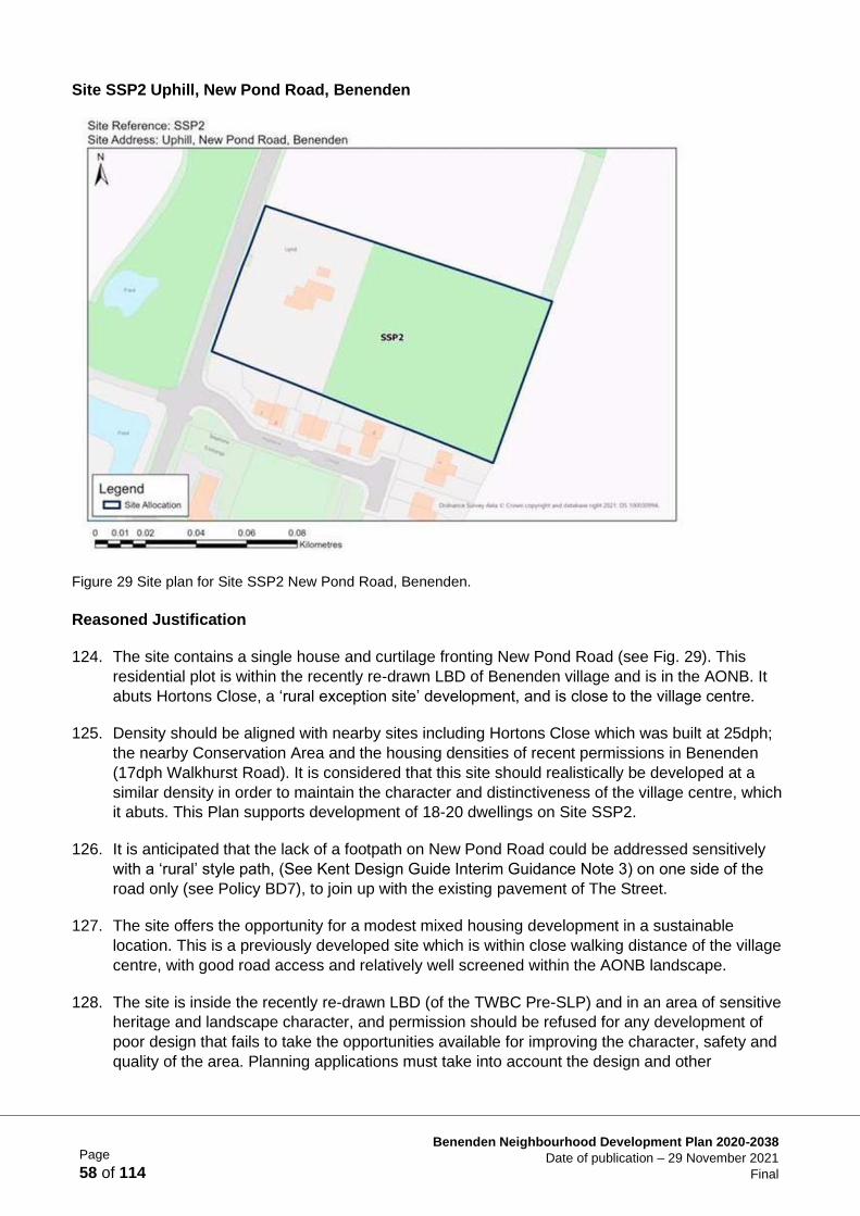
Page
58 of 114
Benenden Neighbourhood Development Plan 2020-2038
Date of publication – 29 November 2021
Final
Site SSP2 Uphill, New Pond Road, Benenden
Figure 29 Site plan for Site SSP2 New Pond Road, Benenden.
Reasoned Justification
124. The site contains a single house and curtilage fronting New Pond Road (see Fig. 29). This
residential plot is within the recently re-drawn LBD of Benenden village and is in the AONB. It
abuts Hortons Close, a ‘rural exception site’ development, and is close to the village centre.
125. Density should be aligned with nearby sites including Hortons Close which was built at 25dph;
the nearby Conservation Area and the housing densities of recent permissions in Benenden
(17dph Walkhurst Road). It is considered that this site should realistically be developed at a
similar density in order to maintain the character and distinctiveness of the village centre, which
it abuts. This Plan supports development of 18-20 dwellings on Site SSP2.
126. It is anticipated that the lack of a footpath on New Pond Road could be addressed sensitively
with a ‘rural’ style path, (See Kent Design Guide Interim Guidance Note 3) on one side of the
road only (see Policy BD7), to join up with the existing pavement of The Street.
127. The site offers the opportunity for a modest mixed housing development in a sustainable
location. This is a previously developed site which is within close walking distance of the village
centre, with good road access and relatively well screened within the AONB landscape.
128. The site is inside the recently re-drawn LBD (of the TWBC Pre-SLP) and in an area of sensitive
heritage and landscape character, and permission should be refused for any development of
poor design that fails to take the opportunities available for improving the character, safety and
quality of the area. Planning applications must take into account the design and other
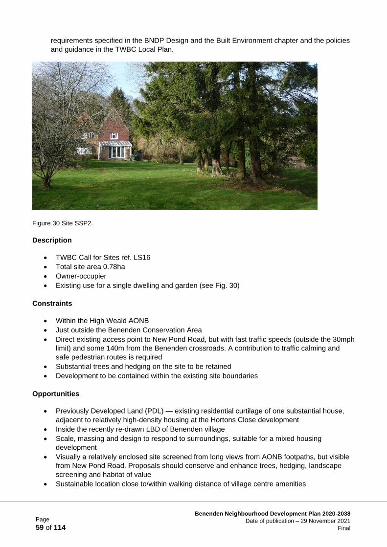
Page
59 of 114
Benenden Neighbourhood Development Plan 2020-2038
Date of publication – 29 November 2021
Final
requirements specified in the BNDP Design and the Built Environment chapter and the policies
and guidance in the TWBC Local Plan.
Figure 30 Site SSP2.
Description
• TWBC Call for Sites ref. LS16
• Total site area 0.78ha
• Owner-occupier
• Existing use for a single dwelling and garden (see Fig. 30)
Constraints
• Within the High Weald AONB
• Just outside the Benenden Conservation Area
• Direct existing access point to New Pond Road, but with fast traffic speeds (outside the 30mph
limit) and some 140m from the Benenden crossroads. A contribution to traffic calming and
safe pedestrian routes is required
• Substantial trees and hedging on the site to be retained
• Development to be contained within the existing site boundaries
Opportunities
• Previously Developed Land (PDL) — existing residential curtilage of one substantial house,
adjacent to relatively high-density housing at the Hortons Close development
• Inside the recently re-drawn LBD of Benenden village
• Scale, massing and design to respond to surroundings, suitable for a mixed housing
development
• Visually a relatively enclosed site screened from long views from AONB footpaths, but visible
from New Pond Road. Proposals should conserve and enhance trees, hedging, landscape
screening and habitat of value
• Sustainable location close to/within walking distance of village centre amenities
Page
60 of 114
Benenden Neighbourhood Development Plan 2020-2038
Date of publication – 29 November 2021
Final
• Creation of a footway link into the village
• Contribution to traffic calming on New Pond Road and at the Benenden crossroads
Site Specific Policy 2 (SSP2) Uphill, New Pond Road, Benenden
Site Selection Approach:
To support a modest scale development on a relatively enclosed and sustainable site
close to village amenities. A suitable design must avoid or minimise harmful impacts
and improve the character and quality of Benenden village.
Achieved by:
Supporting suitable development proposals and collaborating with the developer to
achieve a traffic calming scheme on New Pond Road and at Benenden crossroads
and create a new pedestrian footway to connect the site to Hortons Close and the
village centre.
Proposals shall:
1) Provide a residential development of 18-20 C3 dwellings, with 40% affordable
housing in accordance with TWBC policy and a mix of type and size integrated
throughout the development to help meet locally identified needs (see Policy
HS1).
2) Be designed to conserve and enhance the character and distinctiveness of the
village; the density of housing should be sympathetic to local character including
surrounding built housing density in the adjacent areas, the AONB landscape,
and the landscape and heritage setting of the Benenden Conservation Area.
Density must not exceed 25dph (see Reasoned Justification para 2.9.2.1).
3) Protect the natural environmental and landscape enclosure of the site. The trees
at the rear of the site and trees and hedging at all the site boundaries should be
assessed (See Policies LE4, LE5 & LE8) for the health of the trees, their
contribution to the landscape character of the AONB and biodiversity; the most
significant trees and hedges should be protected and incorporated into the
design of the development in order to maintain the rural nature of the
development and surroundings. Existing hedges and trees at the New Pond
Road frontage should be conserved and enhanced to screen the site and setting
of the nearby historic parkland; Hemsted Park (Benenden School).
4) This site lies within, or very close to, the relevant impact risk zone for Parsonage
Wood SSSI; hence an assessment of potential adverse effects on the SSSI as a
result of the development will be required as part of any application, and if
required the proposal shall include adequate mitigation measures, both during
construction and on completion, to the satisfaction of Natural England to ensure
no adverse effects on the SSSI as a result of the proposed development (see
TWBC Pre-SLP Policies EN 9: Biodiversity Net Gain and EN 10: Protection of
designated sites and habitats).
Continued/-
Page
61 of 114
Benenden Neighbourhood Development Plan 2020-2038
Date of publication – 29 November 2021
Final
Site Specific Policy 2 (SSP2) (continued)
5) The land has been identified with the potential for Woodpasture or Parkland, a BAP
priority habitat, to be within 25m of the site. This should be taken into consideration as
part of any detailed site-specific studies to inform development and any required
mitigation (see TWBC Pre-SLP Policy EN 10: Protection of designated sites and
habitats).
6) The submission of relevant and proportionate archaeological investigations is required
as part of the planning application process to demonstrate that the proposal will not
have a materially harmful impact on the archaeological environment (see TWBC Pre-
SLP Policy EN 5: Heritage Assets).
7) Protect important habitat; the site lies within the National Biodiversity Networks area for
Turtle Doves — a Priority Species in the UK post 2010 Biodiversity Framework, listed
on the Red list of Threatened Species. Mitigation is required to minimise the impact of
both construction work and the new housing on existing flora and fauna (see Policies
LE4 & LE5) and encourage wildlife by including features within the development which
are sympathetic to local wildlife and plants (see Policy LE8).
8) Provide all dwellings with a suitable standard of shared semi-private and/or private
garden space. Landscaping of open areas and the means of enclosure of all the site
boundaries should be appropriately planted and screened with native hedging species;
solid fencing and other hard borders should be strictly minimised (see Policy BD4).
9) The provision of a pedestrian footway from the site entrance, past Hortons Close, to the
junction of New Pond Road and the B2086 (on highways land). This shall be designed
having regard to the designation of this part of New Pond Road as an Important
Landscape Approach (see Policy BD7).
10) A single point of access for vehicles from New Pond Road should be designed to be
compatible with and support the implementation of approved plans for the improved
traffic calming and safety measures in New Pond Road.
11) Design and materials should comply with the design requirements specified in the
Benenden Neighbourhood Development Plan under the Design and the Built
Environment chapter and the policies contained therein.
12) Provide on-site amenity/natural green space.
It is expected that contributions will be required towards the following to mitigate the impact of
the development:
i. Works to the junction between New Pond Road and the B2086.
ii. The designation of a 30mph speed limit along New Pond Road to the north of the
site.
iii. Contribution towards children’s play areas within the parish
Page
62 of 114
Benenden Neighbourhood Development Plan 2020-2038
Date of publication – 29 November 2021
Final
Sites at East End, Benenden
Context
129. Benenden Hospital is the largest complex of buildings and employment site in the parish,
established for over 100 years. The nature and services of the hospital continue to change and
evolve.
130. Travelling west, Goddards Green Road links the settlement to Benenden village amenities and
towards the station at Staplehurst; travelling east, via Castleton Oak crossroads, towards the
town of Tenterden or the station at Headcorn.
131. TWBC has previously approved substantial redevelopment at the Hospital campus (planning
application reference 12/03130) and related consents for the relocation and redevelopment of
hospital buildings (now occupied) and construction of 24 dwellings, including 8 affordable
homes (6 Affordable Rent and 2 Shared Ownership). Construction of the dwellings has yet to
commence.
132. The Hospital Trust has now submitted three sites from its estate to the TWBC Call for Sites for
residential allocation. This Plan addresses the future use of the two sites that have been
allocated, in two parcels, north and south of Goddards Green Road, in Site Specific Policies 3
and 4 (below).
133. TWBC believe that the scale of potential development relative to the small, established
community at East End and the challenges of the location means that planning proposals
require the publication of a Masterplan to address the combined and cumulative impacts of
foreseeable future development of the Benenden Hospital estate. The Masterplan should be
prepared by the Benenden Hospital Trust in close collaboration with the local community,
Benenden Parish Council and TWBC in advance of any future planning application.
Justification:
• Large employment site
• Contributions required to mitigate impact of development
• Ensure control of future use of land
• Linked to a site with other competing needs
• Proposed density seen as delivering a good balance/use offered, taking into account the
site’s constraints
Further Buildings and Sites at East End
134. Redundant farm buildings, an old school house and chapel are all understood to be included in
the Hospital Trust’s ambitions for redeveloping redundant buildings on the Hospital estate. Any
further housing, office or other development would need to conform to BNDP and TWBC Local
Plan policy requirements and would be subject to agreement of a Masterplan before any
development across the site can commence.
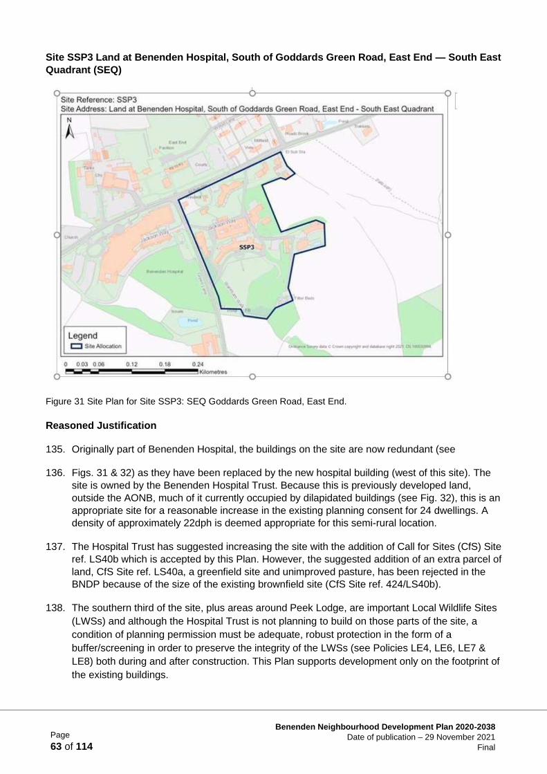
Page
63 of 114
Benenden Neighbourhood Development Plan 2020-2038
Date of publication – 29 November 2021
Final
Site SSP3 Land at Benenden Hospital, South of Goddards Green Road, East End — South East
Quadrant (SEQ)
Figure 31 Site Plan for Site SSP3: SEQ Goddards Green Road, East End.
Reasoned Justification
135. Originally part of Benenden Hospital, the buildings on the site are now redundant (see
136. Figs. 31 & 32) as they have been replaced by the new hospital building (west of this site). The
site is owned by the Benenden Hospital Trust. Because this is previously developed land,
outside the AONB, much of it currently occupied by dilapidated buildings (see Fig. 32), this is an
appropriate site for a reasonable increase in the existing planning consent for 24 dwellings. A
density of approximately 22dph is deemed appropriate for this semi-rural location.
137. The Hospital Trust has suggested increasing the site with the addition of Call for Sites (CfS) Site
ref. LS40b which is accepted by this Plan. However, the suggested addition of an extra parcel of
land, CfS Site ref. LS40a, a greenfield site and unimproved pasture, has been rejected in the
BNDP because of the size of the existing brownfield site (CfS Site ref. 424/LS40b).
138. The southern third of the site, plus areas around Peek Lodge, are important Local Wildlife Sites
(LWSs) and although the Hospital Trust is not planning to build on those parts of the site, a
condition of planning permission must be adequate, robust protection in the form of a
buffer/screening in order to preserve the integrity of the LWSs (see Policies LE4, LE6, LE7 &
LE8) both during and after construction. This Plan supports development only on the footprint of
the existing buildings.
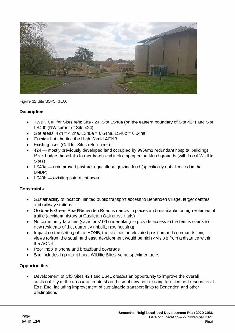
Page
64 of 114
Benenden Neighbourhood Development Plan 2020-2038
Date of publication – 29 November 2021
Final
Figure 32 Site SSP3: SEQ.
Description
• TWBC Call for Sites refs: Site 424, Site LS40a (on the eastern boundary of Site 424) and Site
LS40b (NW corner of Site 424)
• Site areas: 424 = 4.2ha, LS40a = 0.64ha, LS40b = 0.04ha
• Outside but abutting the High Weald AONB
• Existing uses (Call for Sites references):
• 424 — mostly previously developed land occupied by 9966m2 redundant hospital buildings,
Peek Lodge (hospital’s former hotel) and including open parkland grounds (with Local Wildlife
Sites)
• LS40a — unimproved pasture, agricultural grazing land (specifically not allocated in the
BNDP)
• LS40b — existing pair of cottages
Constraints
• Sustainability of location, limited public transport access to Benenden village, larger centres
and railway stations
• Goddards Green Road/Benenden Road is narrow in places and unsuitable for high volumes of
traffic (accident history at Castleton Oak crossroads)
• No community facilities (save for s106 undertaking to provide access to the tennis courts to
new residents of the, currently unbuilt, new housing)
• Impact on the setting of the AONB, the site has an elevated position and commands long
views to/from the south and east; development would be highly visible from a distance within
the AONB
• Poor mobile phone and broadband coverage
• Site includes important Local Wildlife Sites; some specimen trees
Opportunities
• Development of CfS Sites 424 and LS41 creates an opportunity to improve the overall
sustainability of the area and create shared use of new and existing facilities and resources at
East End, including improvement of sustainable transport links to Benenden and other
destinations
Page
65 of 114
Benenden Neighbourhood Development Plan 2020-2038
Date of publication – 29 November 2021
Final
• Development of land outside the AONB
• Previously developed land/redundant buildings, reducing the need to further encroach on new
greenfield sites in the parish
• Previously developed land/redundant buildings, reducing the need to further encroach on new
greenfield sites in the parish
• Site area includes an existing planning permission for 24 houses (Planning ref. 12/03130)
• Additional developable land (Peek Lodge added to the original site as submitted in 12/03130)
creates scope for a comprehensive revised scheme with additional development capacity for
mixed housing types
• Increased scale and comprehensive approach creates an opportunity to plan and improve the
overall functioning of the area and shared use of new and existing facilities and resources at
East End, including improvement of sustainable transport links to Benenden and other
destinations
Page
66 of 114
Benenden Neighbourhood Development Plan 2020-2038
Date of publication – 29 November 2021
Final
Site Specific Policy 3 (SSP3) Land at Benenden Hospital, South of
Goddards Green Road, East End - South East Quadrant (SEQ)
Site Selection Approach:
To support development on a brownfield site outside, but adjacent to, the High Weald
AONB. A suitable development must avoid or minimise harmful impacts on the setting
of the AONB and improve the character and quality of the location, while providing an
opportunity to improve amenities at East End (see Context bullet points page 60).
Achieved by:
This site is allocated for residential development (C3) to provide up to an additional 25
residential units. Planning permission has already been granted for 24 new dwellings
at this site; this allocation would result in a total of up to 49 dwellings on this site.
Comprehensive development proposals, in the form of a Masterplan, must be
submitted in respect of the land currently held in Benenden Healthcare Society estate
ownership at this location, to be delivered in accordance with a phased timetable,
which indicates land to the south of Goddards Green Road (SEQ) to be developed
prior to any other phases.
The Masterplan should be produced in close collaboration with the local community,
Benenden Parish Council and TWBC.
The Masterplan should ideally be completed and accepted by TWBC and BPC, before
any planning application can be submitted for the development of this area.
Proposals shall:
1) Provide a residential development of up to 25 additional C3 dwellings, which will
be in addition to the 24 dwellings already approved on part of this allocation site,
with 30% affordable housing in accordance with TWBC policy and a mix of type
and size integrated throughout the development to help meet locally identified
needs (see Policy HS1).
2) Ensure that design, scale, massing and overall density create a sense of place
and focus to the residential communities and reflect the character and rural
nature of the East End area adjacent to the AONB, whilst acknowledging the
scale of adjacent hospital buildings. Density must not exceed 22dph (see
Reasoned Justification para. 2.9.3.1). Building heights should generally be
restricted to two storeys.
Continued/-
Page
67 of 114
Benenden Neighbourhood Development Plan 2020-2038
Date of publication – 29 November 2021
Final
Site Specific Policy 3 (SSP3) (continued)
3) Have close regard to the design and materials requirements specified in the BNDP
under the Design and the Built Environment chapter and the policies contained therein.
4) Provide private garden space and/or shared semi-private spaces, all enclosure to be
appropriately planted and screened with native hedging species to protect the
occupiers’ privacy (see Policy BD4).
5) Regard to be given to existing hedgerows and mature trees on site (see Policy LE4),
with the layout and design of the development protecting those of most amenity value,
as informed by an arboricultural survey and landscape and visual impact assessment
(see TWBC Pre-SLP Policies EN 12: Trees, Woodlands, Hedges, and Development;
and criterion 4 of TWBC Pre-SLP Policy EN1: Sustainable Design).
6) Reflect existing trees and hedges on the site, and the complex topography (particularly
within the southern part of the site) (see criteria 1 and 4 of TWBC Pre-SLP Policy EN 1:
Sustainable Design.
7) A management plan shall be submitted outlining proposals for the ongoing protection
and enhancement of all the LWSs and once approved, the future management of the
site shall be carried out in accordance with that plan, to protect the significance of the
designated LWS in terms of its biodiversity.
8) In order to reduce the amount of construction traffic using local roads where possible
the disposal of earth spoil generated by construction works should be redistributed on
the wider site in landscape remodelling as set out in a Construction Management Plan.
9) The Construction Management Plan should address how to minimise the impact of
construction work on existing flora and fauna, valuable micro- wildlife habitats in
roadside verges, banks and ditches, in particular retaining the hedging which borders
the site/mature trees on the site (see Policies LE4, LE5, LE6, LE7 & LE8).
10) Any proposals shall include an assessment of the feasibility of retaining the Garland
Wing as part of the redevelopment of the site, which could include refurbishment and
conversion of this building to provide separate residential units.
11) An archaeological assessment of the site to be carried out.
12) The occupation of the development should be phased to align with the delivery of
improved sewerage infrastructure, in liaison with the service provider.
Continued/-
Page
68 of 114
Benenden Neighbourhood Development Plan 2020-2038
Date of publication – 29 November 2021
Final
Site Specific Policy 3 (SSP3) (continued)
It is expected that planning obligations will be required towards the following to mitigate the
impact of development and enhance the sustainability of the location:
i. Provision of an active travel link between the site and Benenden village (see BNDP
Supporting Document TA2 and Policies T1, T2 & T5).
ii. Include an area for sport and recreational use by the local community and a children’s
play area, in part repurposing the existing tennis courts located in the North East
Quadrant.
iii. The means to secure the public use of the hospital cafe and the provision of a small
publicly accessible retail outlet within the existing hospital building for a minimum of
10 years from the occupation of 50% of the residential units on the allocation site.
iv. Provide a community space for events and to provide amenities such as a pre-school
or play group. An appropriate building might be the existing old chapel building to the
west of the site.
v. Provide a financial contribution to fund the purchase and ongoing maintenance of a
minibus for the use of Benenden Primary School to run the minibus service to/from
Benenden village/Primary School, to serve school times, thus reducing traffic and
improving sustainability. This service to be for 10 years from the occupation of 50% of
the gross residential units on the allocation site.
vi. Promote and support the Kent County Council Hopper Bus trial and other DRT
initiatives.
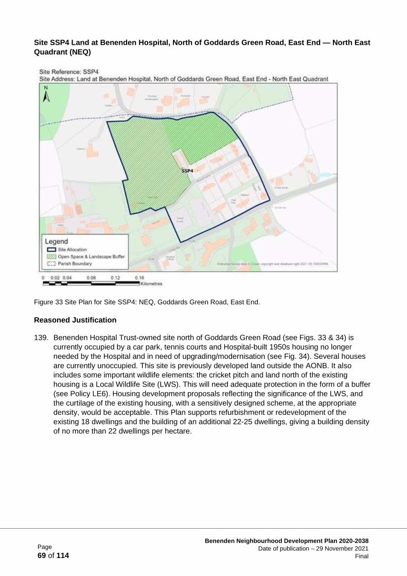
Page
69 of 114
Benenden Neighbourhood Development Plan 2020-2038
Date of publication – 29 November 2021
Final
Site SSP4 Land at Benenden Hospital, North of Goddards Green Road, East End — North East
Quadrant (NEQ)
Figure 33 Site Plan for Site SSP4: NEQ, Goddards Green Road, East End.
Reasoned Justification
139. Benenden Hospital Trust-owned site north of Goddards Green Road (see Figs. 33 & 34) is
currently occupied by a car park, tennis courts and Hospital-built 1950s housing no longer
needed by the Hospital and in need of upgrading/modernisation (see Fig. 34). Several houses
are currently unoccupied. This site is previously developed land outside the AONB. It also
includes some important wildlife elements: the cricket pitch and land north of the existing
housing is a Local Wildlife Site (LWS). This will need adequate protection in the form of a buffer
(see Policy LE6). Housing development proposals reflecting the significance of the LWS, and
the curtilage of the existing housing, with a sensitively designed scheme, at the appropriate
density, would be acceptable. This Plan supports refurbishment or redevelopment of the
existing 18 dwellings and the building of an additional 22-25 dwellings, giving a building density
of no more than 22 dwellings per hectare.
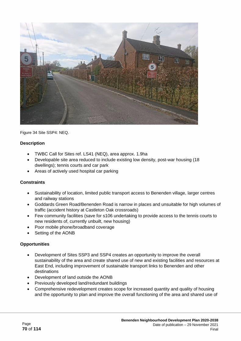
Page
70 of 114
Benenden Neighbourhood Development Plan 2020-2038
Date of publication – 29 November 2021
Final
Figure 34 Site SSP4: NEQ.
Description
• TWBC Call for Sites ref. LS41 (NEQ), area approx. 1.9ha
• Developable site area reduced to include existing low density, post-war housing (18
dwellings); tennis courts and car park
• Areas of actively used hospital car parking
Constraints
• Sustainability of location, limited public transport access to Benenden village, larger centres
and railway stations
• Goddards Green Road/Benenden Road is narrow in places and unsuitable for high volumes of
traffic (accident history at Castleton Oak crossroads)
• Few community facilities (save for s106 undertaking to provide access to the tennis courts to
new residents of, currently unbuilt, new housing)
• Poor mobile phone/broadband coverage
• Setting of the AONB
Opportunities
• Development of Sites SSP3 and SSP4 creates an opportunity to improve the overall
sustainability of the area and create shared use of new and existing facilities and resources at
East End, including improvement of sustainable transport links to Benenden and other
destinations
• Development of land outside the AONB
• Previously developed land/redundant buildings
• Comprehensive redevelopment creates scope for increased quantity and quality of housing
and the opportunity to plan and improve the overall functioning of the area and shared use of
Page
71 of 114
Benenden Neighbourhood Development Plan 2020-2038
Date of publication – 29 November 2021
Final
new and existing facilities and resources at East End, including improvement of sustainable
transport links to Benenden and other destinations
• Some of the existing dwellings may be suited to refurbishment rather than redevelopment
Site Specific Policy 4 (SSP4) Land at Benenden Hospital, North of
Goddards Green Road, East End - North East Quadrant (NEQ)
Site Selection Approach:
To support development on a brownfield site outside, but adjacent to the High Weald
AONB. A suitable development must avoid or minimise the harmful impacts on the
setting of the AONB and improve the character and quality of the location, while
providing an opportunity to improve amenities at East End (see para. 2.9.4.4).
Achieved by:
This site is allocated for residential development (C3) to provide 22-25 residential
units, in addition to the 18 dwellings currently on the site, which may also be
redeveloped or refurbished.
Comprehensive development proposals, in the form of a Masterplan, must be
submitted in respect of the land currently held in Benenden Healthcare Society estate
ownership at this location, to be delivered in accordance with a phased timetable,
which indicates land to the north of Goddards Green Road (NEQ) will be developed as
the second phase. No work to commence on phase two of the Masterplan until the
south site (SEQ) is fully built-out.
The Masterplan should be produced in close collaboration with the local community,
Benenden Parish Council and TWBC.
The Masterplan should ideally be completed and accepted by TWBC and BPC, before
any planning application can be submitted for the development of this area.
Proposals shall:
1) Provide a residential development of 22-25 C3 additional dwellings, with 30%
affordable housing in accordance with TWBC policy and a mix of type and size
integrated throughout the development to help meet locally identified needs (see
Policy HS1).
2) Ensure that design, scale, massing and overall density create a sense of place
and focus to the residential communities and reflect the character and rural
nature of the East End area adjacent to the AONB, whilst acknowledging the
scale of adjacent hospital buildings. Density must not exceed 22dph (See
Reasoned Justification para. 2.9.4.1). Building heights should generally be
restricted to two storeys.
3) Have close regard to the design and materials requirements specified in the
BNDP under the Design and the Built Environment chapter and the policies
contained therein
Continued/-
Page
72 of 114
Benenden Neighbourhood Development Plan 2020-2038
Date of publication – 29 November 2021
Final
Site Specific Policy 4 (SSP4) (continued)
4) Provide private garden space and/or shared semi-private spaces, all enclosure to be
appropriately planted and screened with native hedging species to protect the
occupiers’ privacy (see Policy BD4).
5) Regard to be given to existing hedgerows and mature trees on site (see Policy LE4),
with the layout and design of the development protecting those of most amenity value,
as informed by an arboricultural survey and landscape and visual impact assessment
(see TWBC Pre-SLP Policies EN 12: Trees, Woodlands, Hedges, and Development;
EN 13: Ancient Woodland and Veteran Trees; and criterion 4 of TWBC Pre-SLP Policy
EN 1: Sustainable Design).
6) In order to reduce the amount of construction traffic using local roads, where possible
the disposal of earth spoil generated by construction works should be redistributed on
the wider site in landscape remodelling as set out in a Construction Management Plan.
7) The Construction Management Plan should address how to minimise the impact of
construction work on existing flora and fauna, valuable micro-habitats in roadside
verges, bands and ditches, in particular retaining the hedging which borders the
site/mature trees on the site (see Policies LE4, LE5, LE6, LE7 & LE8).
8) Development on this site can only commence once construction is complete on the
SEQ site.
9) A Management Plan shall be submitted outlining proposals for the ongoing protection
and enhancement of the LWS and once approved, the future management of the site
shall be carried out in accordance with that plan, to protect the significance of the
designated LWS in terms of its biodiversity.
10) An archaeological assessment of the site to be carried out.
11) The occupation of the development should be phased to align with the delivery of
improved sewerage infrastructure, in liaison with the service provider.
Continued/-
Page
73 of 114
Benenden Neighbourhood Development Plan 2020-2038
Date of publication – 29 November 2021
Final
Housing Supply and Site Allocation Projects
1. Locally led housing initiatives
The parish council will encourage partnership-based, locally led housing scheme initiatives by:
• encouraging developers to partner with local housing associations who understand the
needs of rural residents
• supporting the marketing of help-to-buy schemes to existing residents and their families
• working alongside the Benenden Almshouse Charities
2. Community Land Trust Feasibility Study
Establish a group of interested volunteers to explore further the idea of setting up a Community Land
Trust (CLT) — see para. 2.3.4. The purpose of this group would be to establish if there are assets or
land holdings in the parish which might be acquired and run by a CLT to the benefit of the community.
The group would also undertake to find out about government funding for such a scheme and how it
would be administered.
Site Specific Policy 4 (SSP4) (continued)
It is expected that planning obligations will be required towards the following to mitigate the
impact of development and enhance the sustainability of the location:
i. Provision of an active travel link between the site and Benenden village (see BNDP
Supporting Document TA2 and Policies T1, T2 & T5).
ii. Include an area for sport and recreational use by the local community and a children’s
play area, in part repurposing the existing tennis courts on the site.
iii. The means to secure the public use of the hospital café and the provision of a small
publicly accessible retail outlet within the existing hospital building for a minimum of
10 years from the occupation of 50 % of the gross residential units on the allocation
site.
iv. Provide a community space for events and to provide amenities such as a pre-school
or play group. An appropriate building might be the existing old chapel building to the
west of the site.
v. Provide a financial contribution to fund the purchase and ongoing maintenance of a
minibus for the use of Benenden Primary School to run the minibus service to/from
Benenden village/Primary School, to serve school times, thus reducing traffic and
improving sustainability. This service to be continued for 10 years from the occupation
of 50% of the gross residential units on the allocation site.
vi. Promote and support the Kent County Council Hopper Bus trial and other DRT
initiatives.
Page
74 of 114
Benenden Neighbourhood Development Plan 2020-2038
Date of publication – 29 November 2021
Final
Supporting Documents for Housing Supply and Site Allocations
HSA1 Process/Background information HSA2 SWOT Analysis
HSA3 Individual Site Assessments
HSA4 High Weald AONB Site Assessments HSA5 Sites put forward in the Call for Sites
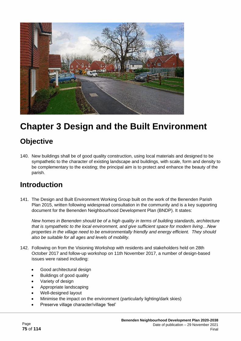
Page
75 of 114
Benenden Neighbourhood Development Plan 2020-2038
Date of publication – 29 November 2021
Final
Chapter 3 Design and the Built Environment
Objective
140. New buildings shall be of good quality construction, using local materials and designed to be
sympathetic to the character of existing landscape and buildings, with scale, form and density to
be complementary to the existing; the principal aim is to protect and enhance the beauty of the
parish.
Introduction
141. The Design and Built Environment Working Group built on the work of the Benenden Parish
Plan 2015, written following widespread consultation in the community and is a key supporting
document for the Benenden Neighbourhood Development Plan (BNDP). It states:
New homes in Benenden should be of a high quality in terms of building standards, architecture
that is sympathetic to the local environment, and give sufficient space for modern living…New
properties in the village need to be environmentally friendly and energy efficient. They should
also be suitable for all ages and levels of mobility.
142. Following on from the Visioning Workshop with residents and stakeholders held on 28th
October 2017 and follow-up workshop on 11th November 2017, a number of design-based
issues were raised including:
• Good architectural design
• Buildings of good quality
• Variety of design
• Appropriate landscaping
• Well-designed layout
• Minimise the impact on the environment (particularly lighting/dark skies)
• Preserve village character/village ‘feel’
Page
76 of 114
Benenden Neighbourhood Development Plan 2020-2038
Date of publication – 29 November 2021
Final
• Preserve rural character
• Developers to provide adequate parking to minimise on-street parking
• Varied types of buildings
143. After further discussions with the Parish Council and the Neighbourhood Plan Steering Group,
the above objective was agreed as representing the views of many parishioners and to provide
the basis for the working group.
Process
144. The working group set out to produce a series of policies, which prospective developers must
use to establish appropriate housing designs. The group reviewed current housing stock in the
parish. The group chose the three main settlements — Benenden village, Iden Green and East
End — to establish as ‘Character Areas’ for the parish. These Character Areas were then
assessed for their individual characteristics so that development could be designed in harmony
with the locality.
145. Common to all the main Character Areas is their remoteness and rural setting. Reference
should be made to the Design Group’s survey documentation (Supporting Document BDA1)
and to the Conservation Areas Appraisal (2005) produced by Tunbridge Wells Borough Council
(TWBC) as reviewed by the Neighbourhood Plan Design Group in 2018 — 2018 Review and
Factual Update of Benenden and Iden Green Conservation Areas Appraisal 2005 (Supporting
Document BDA2).
146. Using the data obtained from the surveys, the group was able to produce Character
Assessments (Supporting Document BDA3) for each Character Area and these Assessments
should be used by developers, together with the relevant policies in this Plan in order to
produce development designs which are sympathetic to adjacent settlements.
Policy Context/Justification
147. The design policies have been drafted to complement those of the National Planning Policy
Framework (NPPF) 2021 and the Tunbridge Wells current and emerging Local Plan (Pre- SLP).
148. Developers are required to have regard to the current and emerging TWBC Local Plan; High
Weald Housing Design Guide; High Weald AONB Unit’s Colour Study 2017; AONB
Management Plan 2019-24; Kent Design Guide. Under the Government’s Building Better,
Building Beautiful (2020) guidance document, developers are expected to consult with the
Parish Council and the local community to co-create the most suitable scheme for a particular
site.
The Policies
149. New housing developments must be designed in accordance with this Neighbourhood
Development Plan’s Building Design Policies BD1-BD8 inclusive.
150. The quality and safety of new build housing under the Building Regulations is of great concern
to the Neighbourhood Development Plan. The BNDP strongly supports the use by developers of
Page
77 of 114
Benenden Neighbourhood Development Plan 2020-2038
Date of publication – 29 November 2021
Final
Tunbridge Wells Building Control Department (other building control providers are available) for
carrying out inspections under the Building Regulations to ensure such quality and safety.
151. Benenden is located in an Area of Outstanding Natural Beauty (AONB) and as such, any new
development in this area must be designed so that it sits sensitively within its surroundings.
Developers are required to refer to the High Weald Housing Design Guide published by the
High Weald Joint Advisory Committee.
152. The Design Group assessed the predominant characteristics of the existing housing in each of
the Character Areas. Prospective developers must access these assessments to ensure that all
new development is sympathetically designed. A summary of the main characteristics of every
house in the Character Areas is noted in Supporting Document BDA4 and a percentage given
for each characteristic. Also, house styles existing in the three Character Areas have been
identified in Supporting Document BDA5. The BNDP believes that having an understanding of
the weighting that each characteristic holds, architects can begin to formulate their designs so
as to be sympathetic to the adjacent settlement.
Residential Developments: General Appearance
153. The following photographs show examples of a recently built, local development and the use of
good quality design and materials:
Policy BD1 General Design Policy
Proposals for all forms of new development must plan positively for the
achievement of high quality and inclusive building and landscaping design.
Developments will be expected to:
• be sympathetic to local distinctiveness
• protect and enhance heritage assets and their settings
• be sympathetic to the aesthetic qualities for traditional rural
settlements and buildings found in the High Weald AONB Design
Guide and the Benenden Character Assessment
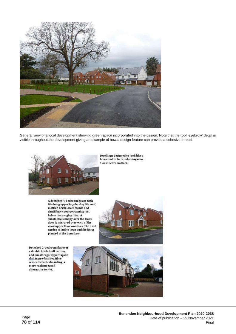
Page
78 of 114
Benenden Neighbourhood Development Plan 2020-2038
Date of publication – 29 November 2021
Final
General view of a local development showing green space incorporated into the design. Note that the roof ‘eyebrow’ detail is
visible throughout the development giving an example of how a design feature can provide a cohesive thread.
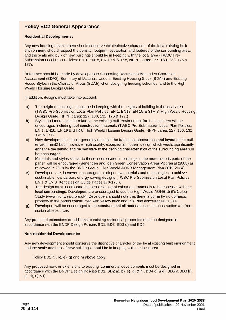
Page
79 of 114
Benenden Neighbourhood Development Plan 2020-2038
Date of publication – 29 November 2021
Final
Policy BD2 General Appearance
Residential Developments:
Any new housing development should conserve the distinctive character of the local existing built
environment, should respect the density, footprint, separation and features of the surrounding area,
and the scale and bulk of new buildings should be in keeping with the local area (TWBC Pre-
Submission Local Plan Policies: EN 1, EN18, EN 19 & STR 8, NPPF paras: 127, 130, 132, 176 &
177).
Reference should be made by developers to Supporting Documents Benenden Character
Assessment (BDA3), Summary of Materials Used in Existing Housing Stock (BDA4) and Existing
House Styles in the Character Areas (BDA5) when designing housing schemes, and to the High
Weald Housing Design Guide.
In addition, designs must take into account:
a) The height of buildings should be in keeping with the heights of building in the local area
(TWBC Pre-Submission Local Plan Policies: EN 1, EN18, EN 19 & STR 8. High Weald Housing
Design Guide. NPPF paras: 127, 130, 132, 176 & 177.).
b) Styles and materials that relate to the existing built environment for the local area will be
encouraged including roof construction materials (TWBC Pre-Submission Local Plan Policies:
EN 1, EN18, EN 19 & STR 8. High Weald Housing Design Guide. NPPF paras: 127, 130, 132,
176 & 177).
c) New developments should generally maintain the traditional appearance and layout of the built
environment2 but innovative, high quality, exceptional modern design which would significantly
enhance the setting and be sensitive to the defining characteristics of the surrounding area will
be encouraged.
d) Materials and styles similar to those incorporated in buildings in the more historic parts of the
parish will be encouraged (Benenden and Iden Green Conservation Areas Appraisal (2005) as
reviewed in 2018 by the BNDP Group. High Weald AONB Management Plan 2019-2024).
e) Developers are, however, encouraged to adopt new materials and technologies to achieve
sustainable, low-carbon, energy-saving designs (TWBC Pre-Submission Local Plan Policies
EN 1 & EN 3. Kent Design Guide Pages 170-173.).
f) The design must incorporate the sensitive use of colour and materials to be cohesive with the
local surroundings. Developers are encouraged to use the High Weald AONB Unit’s Colour
Study (www.highweald.org.uk). Developers should note that there is currently no domestic
property in the parish constructed with yellow brick and this Plan discourages its use.
g) Developers will be encouraged to demonstrate that all materials used in construction are from
sustainable sources.
Any proposed extensions or additions to existing residential properties must be designed in
accordance with the BNDP Design Policies BD1, BD2, BD3 d) and BD5.
Non-residential Developments:
Any new development should conserve the distinctive character of the local existing built environment
and the scale and bulk of new buildings should be in keeping with the local area.
Policy BD2 a), b), e), g) and h) above apply.
Any proposed new, or extensions to existing, commercial developments must be designed in
accordance with the BNDP Design Policies BD1, BD2 a), b), e), g) & h), BD4 c) & e), BD5 & BD8 b),
c), d), e) & f).
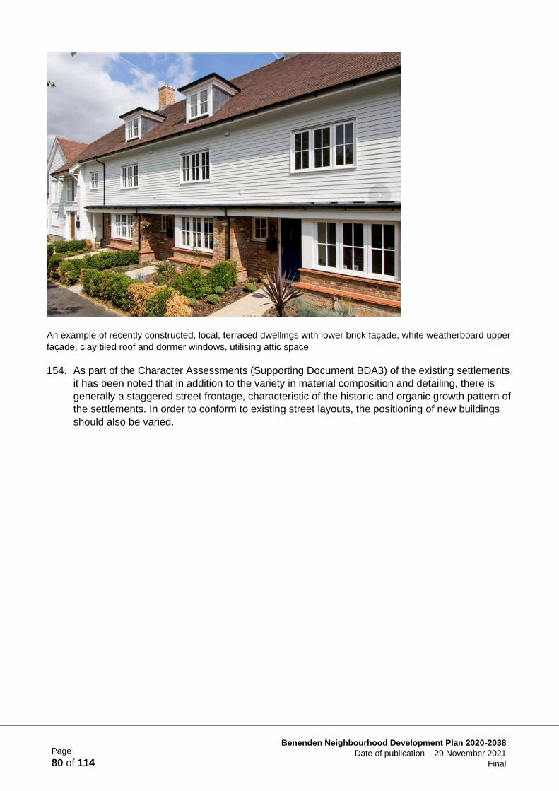
Page
80 of 114
Benenden Neighbourhood Development Plan 2020-2038
Date of publication – 29 November 2021
Final
An example of recently constructed, local, terraced dwellings with lower brick façade, white weatherboard upper
façade, clay tiled roof and dormer windows, utilising attic space
154. As part of the Character Assessments (Supporting Document BDA3) of the existing settlements
it has been noted that in addition to the variety in material composition and detailing, there is
generally a staggered street frontage, characteristic of the historic and organic growth pattern of
the settlements. In order to conform to existing street layouts, the positioning of new buildings
should also be varied.
Page
81 of 114
Benenden Neighbourhood Development Plan 2020-2038
Date of publication – 29 November 2021
Final
155. A mix of indigenous tree planting must be incorporated to give an aesthetically pleasing street
view, to reflect the rural locality and minimise the impact on the AONB. Attention should be paid
to the Character Assessment for each Character Area. Benenden’s designated important
landscape character as an Area of Outstanding Natural Beauty (AONB) (TWBC Pre-Submission
Local Plan Policies: EN 1, EN 18, EN, EN 19 & STR 8. NPPF para. 176 & 177. High Weald
AONB Management Plan 2019-2024) is of primary importance to residents of the parish, as
noted at consultation meetings. It is this landscape character that the High Weald AONB
Management Plan seeks to preserve and this Neighbourhood Development Plan contains
planning policies and objectives that are complementary to this work.
156. Native hedging (see Policies BD4 & LE8) should be planted to screen new developments from
the roadway and passing traffic and designed to shield the public from air pollution.
Policy BD3 Layout
Housing layouts will be expected to meet the following requirements:
a) The street scene should incorporate variations in form and detail; the positioning of
dwellings in relation to the road should be varied to create a stepped/staggered
street scene (NPPF paras. 127, 130, 132, 176 & 177).
b) Developers will be expected to ensure site permeability via roadways to allow
integration of the proposed development into existing areas of built development
(Kent Design Guide Para. 2.3 Designing for Movement. ‘Developments must be
easy to move through in all directions.’).
c) Designs should include open green spaces of appropriate scale and quality in
order to promote health and wellbeing.
d) Housing should be positioned to minimise the overlooking of adjacent properties
and to reduce the transference of air-borne sound between properties (Kent
Design Guide 2.2.6 Protection from noise and visual privacy).
e) The layout of any housing development should be such as to create an impression
of organic growth over time. To achieve this, a large variation in style and material
finishes in any one group of houses, or development, should be avoided.
f) A generally straight or gently curving road layout through developments is
preferred rather than meandering roads which do not reflect local character and
design (Kent Design Guide Para. 2.3 Designing for Movement. Page 130
Reference ‘Lane’ applicable to rural sites next to village centres or within small
village centres where these are not built up).
g) Road narrowing or other design features, including planting, to be put in place to
reduce traffic speeds, minimising the use of signs.
h) Development must be well integrated into the surrounding landscape.

Page
82 of 114
Benenden Neighbourhood Development Plan 2020-2038
Date of publication – 29 November 2021
Final
157. There is minimal artificial lighting in the parish. New developments must not introduce
inappropriately bright lighting at night over pathways or other areas within the site. Artificial
lighting at night creates light pollution and is detrimental to wildlife and to the rural nature of the
parish. Sites on top of a ridge or very open sites would be particularly impactful and low lighting
levels would be expected to be used. The parish has repeatedly stressed a wish to preserve
Benenden’s dark skies. (See Guidance Notes for the Reduction of Obtrusive Light, The
Institution of Lighting Engineers 2005, and any subsequent revisions.)
158. The Parish Council will work with the owners of existing exterior lighting schemes to modify
these to enhance the quality of the dark sky of the parish.
Policy BD4 Landscaping
Housing layouts will be expected to meet the following requirements:
a) Green spaces should be included within the development as amenity areas and
private gardens adjacent to properties (Kent Design Guide: 2.2.9 The Design of
Open Spaces).
b) Plot boundaries should be designed to complement the surrounding countryside,
using, for example, native hedging with mesh or stock fencing; solid fencing should
be avoided (TWBC Pre-Submission Local Plan Policy EN 1).
c) Sufficient landscaping will be required to reflect the existing rural streetscape
adjacent to the development.
d) Existing mature trees should be retained to provide open spaces within the
proposed development and are considered essential to maintain the rural nature of
the area (Kent Design Guide para. 2.2.1 Retaining existing buildings and features
(page 64)) as well as to provide adequate amenity space for each dwelling.
e) Creative landscaping to avoid the urbanising effect of car parking spaces will be
expected.
Page
83 of 114
Benenden Neighbourhood Development Plan 2020-2038
Date of publication – 29 November 2021
Final
159. Benenden is more or less equidistant from Tunbridge Wells, Ashford, Maidstone and Hastings
and so is remote from major towns. The likelihood of people using public transport is low with
people relying on private transport for travel anywhere within the area. Adequate parking within
new developments is therefore an absolute necessity as on-street parking is already a problem
in the main settlements in the parish. The BNDP would expect an increase in the numbers of
parking spaces, provided by developers, over and above the average parking guidance set out
in the Kent Design Guide and TWBC Pre-Submission Local Plan.
160. The BNDP carried out a residential parking survey the results of which provides the evidence
(Supporting Document BDA6) in determining the parking requirements of Policy BD6. Attention
should be paid to the Character Assessment for each Character Area. Garages or car barns
would be acceptable with a design appropriate to match the adjacent buildings.
Policy BD5 Dark Skies
In order to support the Benenden dark skies policy (TWBC Pre-Submission Local Plan
Policy EN 8: Outdoor Lighting and Dark Skies. NPPF para. 185c. High Weald Housing
Design Guide DG9 (Signage and Lighting)) and to preserve a key characteristic of
natural beauty defined in the High Weald AONB Management Plan as ‘intrinsically dark
landscapes with a sense of remoteness and tranquility’, all external lighting included in
any proposal must be carefully designed and strictly limited.
All proposals for external lighting should include:
a) full details of the proposed lighting to be installed and maintained for approval
b) any proposed lighting must not have a noticeable impact on the dark skies enjoyed
by the parish
c) lighting should be limited to that required for safe access and only where carefully
designed and justified, for security purposes
d) all lighting must be time limited and only low level (in terms of height and wattage);
no street lighting will be acceptable
e) floodlighting, to enable the use of sports and other facilities and for the activity and
security of some businesses, will need strong justification and will be required to
have time restrictions and automated controls for switch off and dimming;
reference should be made to the Guidance Notes for the Reduction of Obtrusive
Light, The Institute of Lighting Engineers 2005 and any subsequent revisions.
Page
84 of 114
Benenden Neighbourhood Development Plan 2020-2038
Date of publication – 29 November 2021
Final
161. Developers will be encouraged to ensure site permeability via footpaths/footways to increase
connectivity within new developments and to aid access to local amenities. The design of
footways should reflect the rural nature of the locality and be constructed with semi-permeable
surfaces. They should be constructed on one side of the road only to reflect the existing local
custom in Benenden, Iden Green and East End, to limit the amount of hard surfacing. In the
whole of the parish, there are only 2.5 miles of paved footway adjacent to public roads. Designs
should reflect the existing footway characteristics of the parish and reference made to the KCC
Design Guide and the High Weald Housing Design Guide.
162. Any new development, both residential and non-residential, should be shaped and influenced
by the traditional character and style of the existing settlements within the parish. All new
developments should reference the local context and demonstrate the use of high-quality
materials and styles appropriate to the location. Development around the edges of settlements
Policy BD6 Parking
a) Sufficient off-road parking must be incorporated in all new housing developments -
minimum car parking spaces to be provided:
i. 1 bed flat and 1 bed house - 1 car parking space per unit
ii. 2 bed flat and 2 bed house - 2 independently accessible car parking spaces per
unit
iii. 3 bed flat, 3 bed house } - 2 independently accessible and 4+ bed flat } car parking
spaces per unit
iv. 4+ bed house - 2.5 independently accessible car parking spaces per unit
Garages will be discounted as car parking spaces.
b) Additional visitor parking spaces must be provided at a minimum of 0.3 spaces per
unit.
c) In addition, there should be space for storage, refuse and recycling bins, and bicycle
parking to ensure a high quality, well-managed streetscape.
d) Driveways should have, as a minimum, semi-permeable surfaces.
e) On-road parking is discouraged to prevent the blocking of access roads and
endangering pedestrians.
f) Access roads should be of sufficient width to allow two vehicles to pass each other
(KCC Kent Design Guide Review: Interim Guidance Note 3: Residential Parking.
Guidance table for residential parking Suburban/Edge/Village/Rural. TWBC Pre-
Submission Local Plan Policy TP3 Parking Standards. NPPF para.107).
Policy BD7 Footpaths
All footways/footpaths in a new development should be constructed on one side of the
road only, to reflect the rural character of the local area. Materials used for the footway
are to be sensitive to the rural setting and preferably be semi-permeable in nature.
Page
85 of 114
Benenden Neighbourhood Development Plan 2020-2038
Date of publication – 29 November 2021
Final
should be sensitive to the rural and historic context by reflecting the character of buildings in
proximity to adjacent countryside.
Conclusion
163. The aim for all new developments is to leave a positive architectural legacy, to be sensitive to
their local context and environment and enhance the character of the Benenden parish.
Design and the Built Environment
Projects
• Reduce existing light pollution
164. The current excessive car park illumination at Benenden Hospital, lighting at Benenden School
and outside Benenden Village Hall until late into the night is contrary to the express wish of the
parish for ‘dark skies’, and is the cause of local grievance. Negotiations should be undertaken
by the Parish Council to see if the lighting could be timed or set to switch off earlier in the
evening.
Supporting Documents for Design & the Built Environment
BDA1 Survey Documentation
BDA2 2018 Review and Factual Update of Benenden and Iden Green Conservation Areas
Appraisal 2005
BDA3 Character Area Assessments
BDA4 Summary of materials used in existing housing
BDA5 Existing house styles in the Character Areas BDA6 Residential Parking Survey
Analysis
Policy BD8 Materials and Technology
a) All new development is encouraged to be of sustainable construction, with the
inclusion of measures to help conserve water (including the reuse of grey water) and
low energy solutions (TWBC Pre-Submission Local Plan Policy EN 24: Water Supply,
Quality and Conservation).
b) The use of renewable energy technologies, including air-source or ground-source
heating/cooling, solar thermal (solar water heating), photovoltaics (PV), will be
supported.
c) The reuse and recycling of building materials will be encouraged as will the use of
locally sourced materials (TWBC Pre-Submission Local Plan Policy EN 1: Sustainable
Design & its supporting text. NPPF para. 8).
d) Zero-carbon and low-emission development will be strongly supported, subject to all
other material considerations being acceptable (TWBC Pre-Submission Local Plan
Policy EN 3: Climate Change Mitigation and Adaptation).
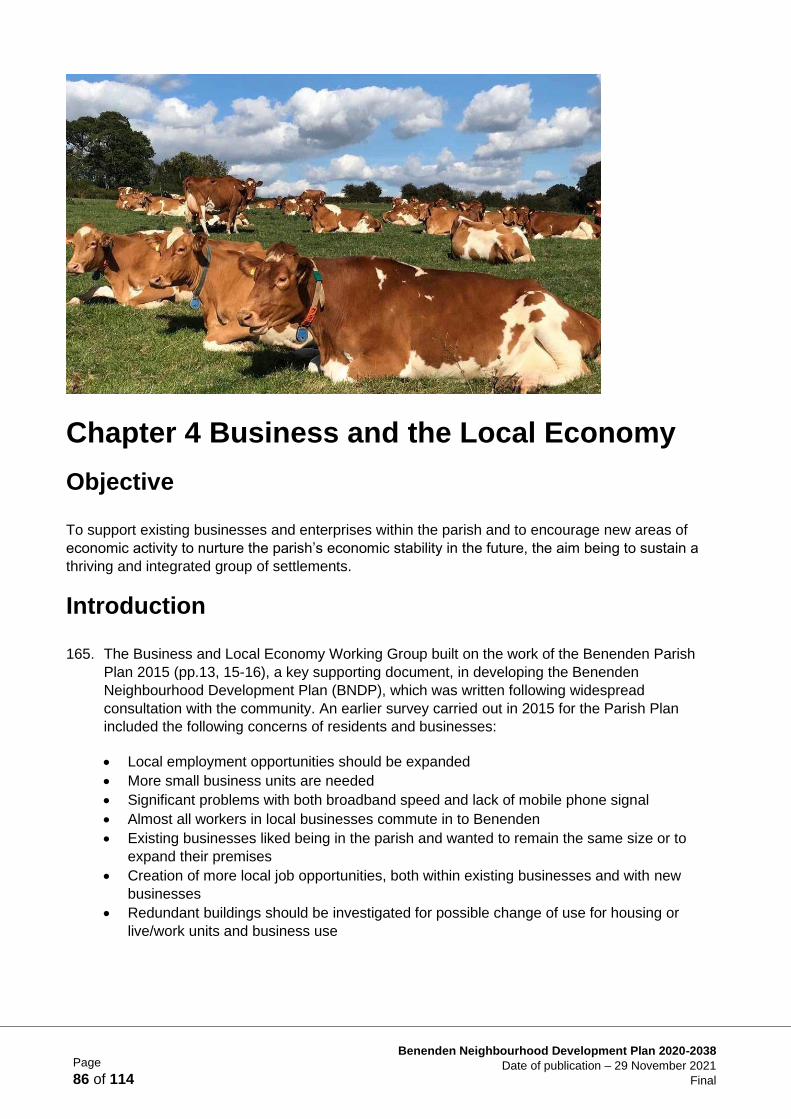
Page
86 of 114
Benenden Neighbourhood Development Plan 2020-2038
Date of publication – 29 November 2021
Final
Chapter 4 Business and the Local Economy
Objective
To support existing businesses and enterprises within the parish and to encourage new areas of
economic activity to nurture the parish’s economic stability in the future, the aim being to sustain a
thriving and integrated group of settlements.
Introduction
165. The Business and Local Economy Working Group built on the work of the Benenden Parish
Plan 2015 (pp.13, 15-16), a key supporting document, in developing the Benenden
Neighbourhood Development Plan (BNDP), which was written following widespread
consultation with the community. An earlier survey carried out in 2015 for the Parish Plan
included the following concerns of residents and businesses:
• Local employment opportunities should be expanded
• More small business units are needed
• Significant problems with both broadband speed and lack of mobile phone signal
• Almost all workers in local businesses commute in to Benenden
• Existing businesses liked being in the parish and wanted to remain the same size or to
expand their premises
• Creation of more local job opportunities, both within existing businesses and with new
businesses
• Redundant buildings should be investigated for possible change of use for housing or
live/work units and business use
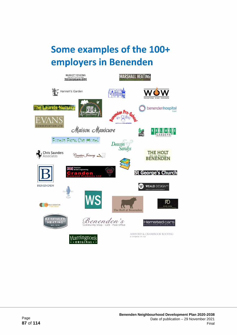
Page
87 of 114
Benenden Neighbourhood Development Plan 2020-2038
Date of publication – 29 November 2021
Final
Page
88 of 114
Benenden Neighbourhood Development Plan 2020-2038
Date of publication – 29 November 2021
Final
166. These concerns have been echoed in the surveys and meetings carried out as part of the
process of the BNDP (see below).
167. At the Visioning Workshop with residents and stakeholders held on 28th October 2017 a
‘SWOT’ (strengths, weaknesses, opportunities and threats) exercise (see Supporting Document
BEA1: SWOT Analysis from Visioning Workshop 28th October 2017) highlighted that:
• amongst the many businesses in the parish, Benenden has several large employers and it
was important to ensure these larger, established businesses continue to benefit the local
community and the economy
• tourism and leisure were important contributors to the local economy
• businesses suffered from poor infrastructure/transport
• lack of work opportunities for young people
• opportunity to improve childcare facilities to support local employment
• importance of agriculture in the parish/seasonal work
• better use of redundant buildings could enhance employment
• the community village shop was seen as a significant asset
• a significant proportion of self-employed people in the parish/working from home
• encouraging small businesses can create employment
• there could be a website to showcase local businesses/crafts/local shops
168. After further discussions with the Parish Council and the Neighbourhood Plan Steering Group,
the objective was agreed as representing the views of many parishioners and to provide a basis
for the working group.
Process
169. By undertaking two significant surveys (Supporting Documents BEA2: BNDP Employee Survey
2018 and BEA3: BNDP Local Business Survey 2018), conducting local and regional research
and consultations with parish residents, businesses (Supporting Document BEA6), employers
and employees, the BNDP Business and Local Economy Group has developed policies to
sustain and improve local economic development. They focus on supporting existing
businesses and encouraging new areas of economic activity to nurture the parish’s economic
stability through the Plan period.
Policy Context/Justification
170. These principles and the following policies are consistent with the National Planning Policy
Framework (NPPF) 2021 (NPPF para. 84) in which it is stated that planning policies and
decisions should enable:
• the sustainable growth and expansion of all types of business in rural areas, both through
conversion of existing buildings and well-designed new buildings
• the development and diversification of agricultural and other land-based rural businesses
• sustainable rural tourism and leisure developments which respect the character of the
countryside
• the retention and development of accessible local services and community facilities, such
as local shops, meeting places, sports venues, open space, cultural buildings, public
houses and places of worship

Page
89 of 114
Benenden Neighbourhood Development Plan 2020-2038
Date of publication – 29 November 2021
Final
Business Surveys
171. The Business Surveys conducted for this Plan indicate that there are approximately 100 small
businesses typically employing fewer than 5 people as well as a growing number of solo home
workers. For more detailed information on the majority of businesses across the parish see the
Local Business Survey 2018 (Supporting Document BEA3).
172. Over a quarter of the businesses in the Business Survey are likely to require larger premises in
the next 3 to 5 years, but most respondents stated that these are becoming increasingly difficult
to find.
173. The Business Survey indicated a rich variety of over 30 business types in the parish that provide
opportunities for symbiotic development. Almost half of the respondents of long- established
businesses stated that at the time of setting up their business, the availability of suitable
premises was an attraction to locate in the parish.
174. The Business Survey confirmed the findings of the 2015 Benenden Parish Plan (pp. 13-15) that
there are significant challenges that need addressing in the provision of good quality broadband
and mobile phone communication (see Policy T5). It also highlighted the requirement for safe
and well-maintained roads, local recycling of a full range of refuse, renewable energy sources,
utility and sewerage provision.
The Policies
175. Benenden parish has historically been sustained by economic activities dependent on its
location, such as farming and forestry (see Figs. 35 & 36), which are interdependent with the
associated rural trades and services. These activities remain significant employers within the
parish, with over 60% of the parish being farmland and over 20% managed woodland. The High
Weald AONB Management Plan is keen that these should continue:
In pursuing the primary purpose of (AONB) designation, account should be taken of the needs
of agriculture, forestry, other rural industries and of the economic and social needs of local
communities. Particular regard should be paid to promoting sustainable forms of social and
economic development that in themselves conserve and enhance the environment. (High
Weald AONB Management Plan 2019-24 p. 17)
176. The intention of all the policies is to complement the High Weald AONB Management Plan
2019-24 Objective S1 (p.33) which is ‘to reconnect settlements, residents and their supporting
economic activity with the surrounding countryside.’

Page
90 of 114
Benenden Neighbourhood Development Plan 2020-2038
Date of publication – 29 November 2021
Final
Figure 35 Harvest Time!
Figure 36 Forestry — Coppiced Woodland.
Business/Employer Locations
177. Businesses/employers are spread across the parish with, for example, Benenden Hospital at
East End, Benenden School at Hemsted, Laurels Nursery and Dingleden Vineyard at
Dingleden, a farm shop and The Woodcock Pub in Iden Green. The Street, at the centre of
Benenden, hosts several disparate enterprises including Wards the Butchers, St George’s
Social Club, Benenden pre-school playgroup, the community shop, post office and café, the Bull
pub and most recently Dream Lashes, Nails & Brows. In the centre of Benenden, the Grange
Care Home and the Primary School each employ over 25 people, as well as providing essential
community services.
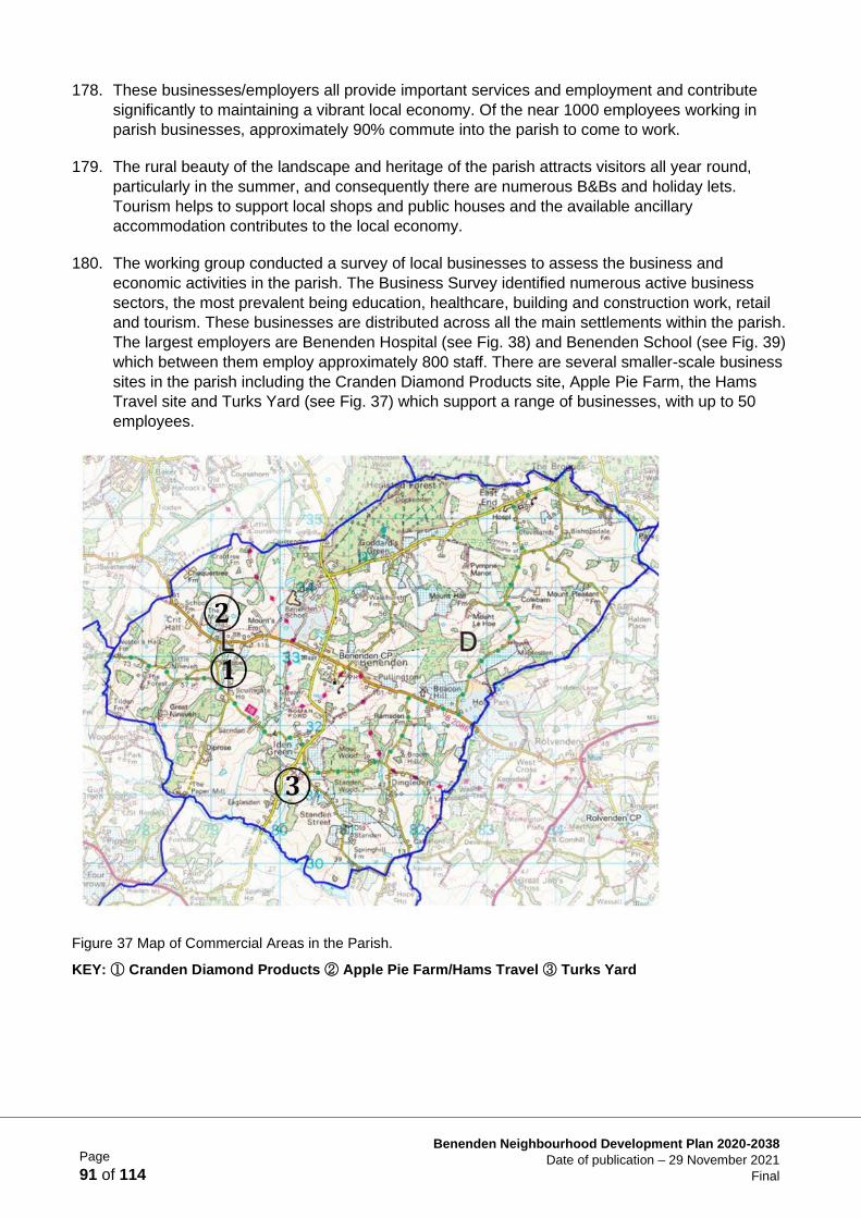
Page
91 of 114
Benenden Neighbourhood Development Plan 2020-2038
Date of publication – 29 November 2021
Final
178. These businesses/employers all provide important services and employment and contribute
significantly to maintaining a vibrant local economy. Of the near 1000 employees working in
parish businesses, approximately 90% commute into the parish to come to work.
179. The rural beauty of the landscape and heritage of the parish attracts visitors all year round,
particularly in the summer, and consequently there are numerous B&Bs and holiday lets.
Tourism helps to support local shops and public houses and the available ancillary
accommodation contributes to the local economy.
180. The working group conducted a survey of local businesses to assess the business and
economic activities in the parish. The Business Survey identified numerous active business
sectors, the most prevalent being education, healthcare, building and construction work, retail
and tourism. These businesses are distributed across all the main settlements within the parish.
The largest employers are Benenden Hospital (see Fig. 38) and Benenden School (see Fig. 39)
which between them employ approximately 800 staff. There are several smaller-scale business
sites in the parish including the Cranden Diamond Products site, Apple Pie Farm, the Hams
Travel site and Turks Yard (see Fig. 37) which support a range of businesses, with up to 50
employees.
Figure 37 Map of Commercial Areas in the Parish.
KEY: ① Cranden Diamond Products ② Apple Pie Farm/Hams Travel ③ Turks Yard
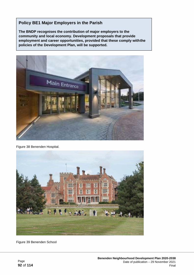
Page
92 of 114
Benenden Neighbourhood Development Plan 2020-2038
Date of publication – 29 November 2021
Final
Figure 38 Benenden Hospital.
Figure 39 Benenden School
Policy BE1 Major Employers in the Parish
The BNDP recognises the contribution of major employers to the
community and local economy. Development proposals that provide
employment and career opportunities, provided that these comply with the
policies of the Development Plan, will be supported.
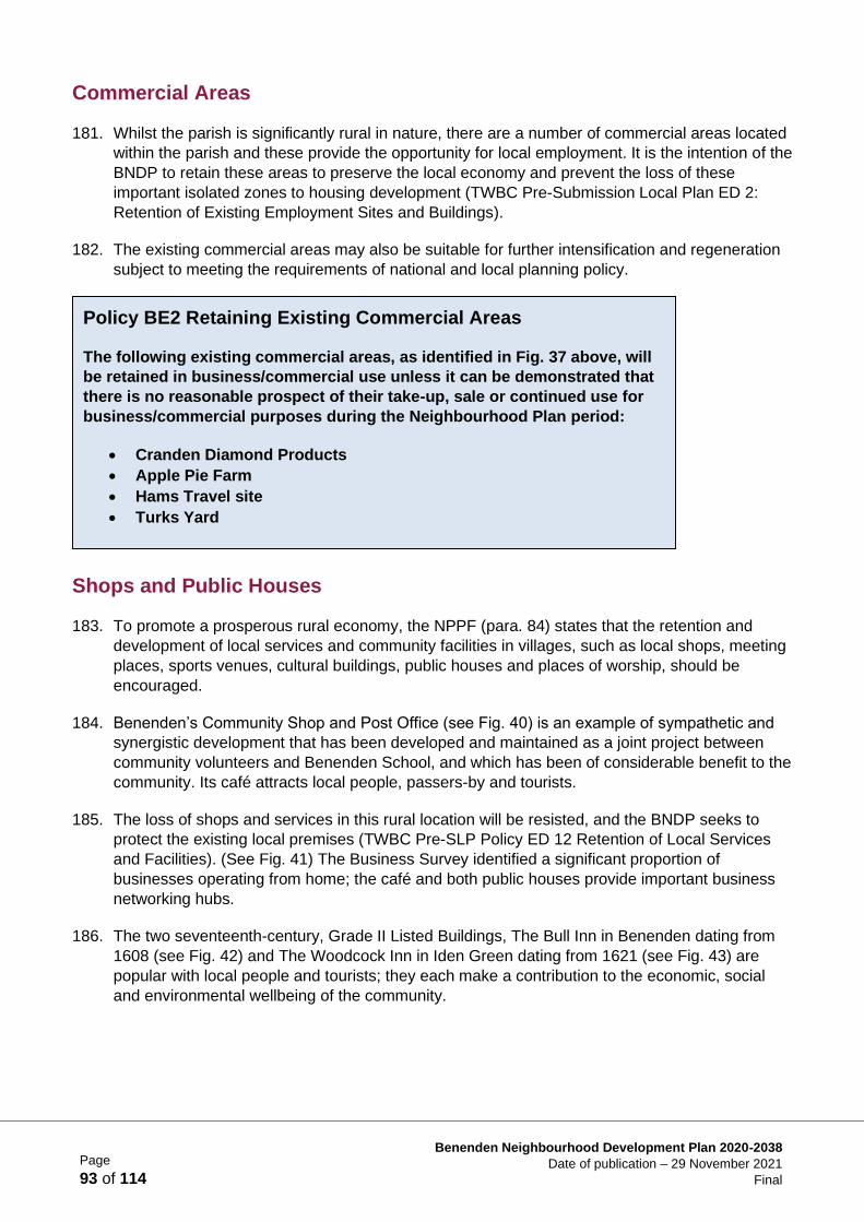
Page
93 of 114
Benenden Neighbourhood Development Plan 2020-2038
Date of publication – 29 November 2021
Final
Commercial Areas
181. Whilst the parish is significantly rural in nature, there are a number of commercial areas located
within the parish and these provide the opportunity for local employment. It is the intention of the
BNDP to retain these areas to preserve the local economy and prevent the loss of these
important isolated zones to housing development (TWBC Pre-Submission Local Plan ED 2:
Retention of Existing Employment Sites and Buildings).
182. The existing commercial areas may also be suitable for further intensification and regeneration
subject to meeting the requirements of national and local planning policy.
Shops and Public Houses
183. To promote a prosperous rural economy, the NPPF (para. 84) states that the retention and
development of local services and community facilities in villages, such as local shops, meeting
places, sports venues, cultural buildings, public houses and places of worship, should be
encouraged.
184. Benenden’s Community Shop and Post Office (see Fig. 40) is an example of sympathetic and
synergistic development that has been developed and maintained as a joint project between
community volunteers and Benenden School, and which has been of considerable benefit to the
community. Its café attracts local people, passers-by and tourists.
185. The loss of shops and services in this rural location will be resisted, and the BNDP seeks to
protect the existing local premises (TWBC Pre-SLP Policy ED 12 Retention of Local Services
and Facilities). (See Fig. 41) The Business Survey identified a significant proportion of
businesses operating from home; the café and both public houses provide important business
networking hubs.
186. The two seventeenth-century, Grade II Listed Buildings, The Bull Inn in Benenden dating from
1608 (see Fig. 42) and The Woodcock Inn in Iden Green dating from 1621 (see Fig. 43) are
popular with local people and tourists; they each make a contribution to the economic, social
and environmental wellbeing of the community.
Policy BE2 Retaining Existing Commercial Areas
The following existing commercial areas, as identified in Fig. 37 above, will
be retained in business/commercial use unless it can be demonstrated that
there is no reasonable prospect of their take-up, sale or continued use for
business/commercial purposes during the Neighbourhood Plan period:
• Cranden Diamond Products
• Apple Pie Farm
• Hams Travel site
• Turks Yard
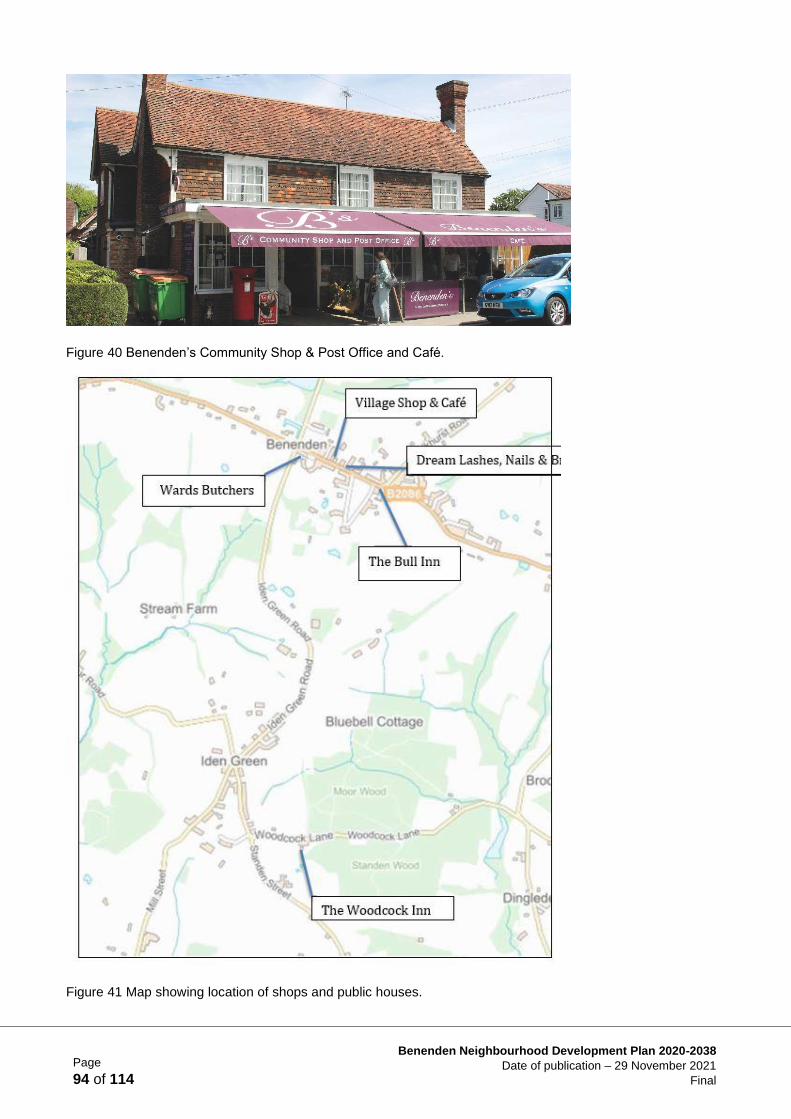
Page
94 of 114
Benenden Neighbourhood Development Plan 2020-2038
Date of publication – 29 November 2021
Final
Figure 40 Benenden’s Community Shop & Post Office and Café.
Figure 41 Map showing location of shops and public houses.
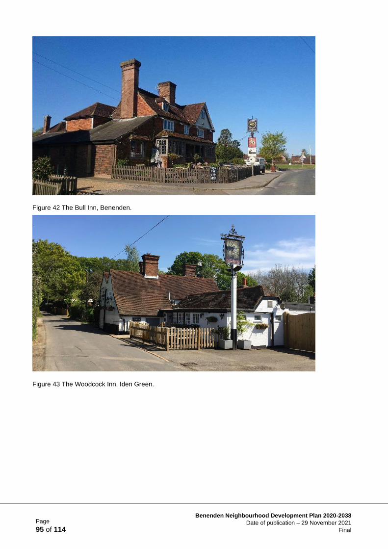
Page
95 of 114
Benenden Neighbourhood Development Plan 2020-2038
Date of publication – 29 November 2021
Final
Figure 42 The Bull Inn, Benenden.
Figure 43 The Woodcock Inn, Iden Green.
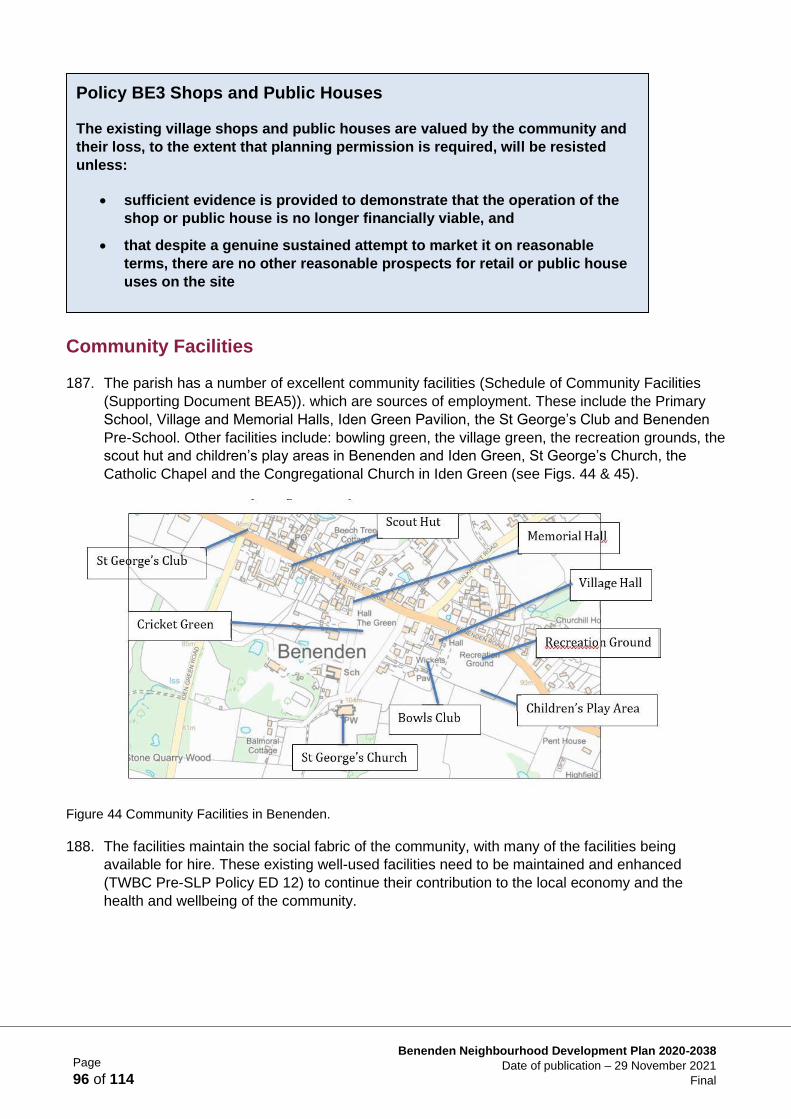
Page
96 of 114
Benenden Neighbourhood Development Plan 2020-2038
Date of publication – 29 November 2021
Final
Community Facilities
187. The parish has a number of excellent community facilities (Schedule of Community Facilities
(Supporting Document BEA5)). which are sources of employment. These include the Primary
School, Village and Memorial Halls, Iden Green Pavilion, the St George’s Club and Benenden
Pre-School. Other facilities include: bowling green, the village green, the recreation grounds, the
scout hut and children’s play areas in Benenden and Iden Green, St George’s Church, the
Catholic Chapel and the Congregational Church in Iden Green (see Figs. 44 & 45).
Figure 44 Community Facilities in Benenden.
188. The facilities maintain the social fabric of the community, with many of the facilities being
available for hire. These existing well-used facilities need to be maintained and enhanced
(TWBC Pre-SLP Policy ED 12) to continue their contribution to the local economy and the
health and wellbeing of the community.
Policy BE3 Shops and Public Houses
The existing village shops and public houses are valued by the community and
their loss, to the extent that planning permission is required, will be resisted
unless:
• sufficient evidence is provided to demonstrate that the operation of the
shop or public house is no longer financially viable, and
• that despite a genuine sustained attempt to market it on reasonable
terms, there are no other reasonable prospects for retail or public house
uses on the site
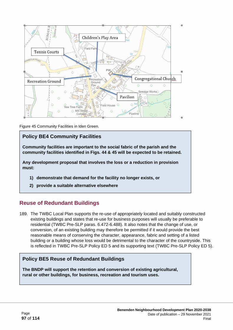
Page
97 of 114
Benenden Neighbourhood Development Plan 2020-2038
Date of publication – 29 November 2021
Final
Figure 45 Community Facilities in Iden Green.
Reuse of Redundant Buildings
189. The TWBC Local Plan supports the re-use of appropriately located and suitably constructed
existing buildings and states that re-use for business purposes will usually be preferable to
residential (TWBC Pre-SLP paras. 6.472-6.488). It also notes that the change of use, or
conversion, of an existing building may therefore be permitted if it would provide the best
reasonable means of conserving the character, appearance, fabric and setting of a listed
building or a building whose loss would be detrimental to the character of the countryside. This
is reflected in TWBC Pre-SLP Policy ED 5 and its supporting text (TWBC Pre-SLP Policy ED 5).
Policy BE4 Community Facilities
Community facilities are important to the social fabric of the parish and the
community facilities identified in Figs. 44 & 45 will be expected to be retained.
Any development proposal that involves the loss or a reduction in provision
must:
1) demonstrate that demand for the facility no longer exists, or
2) provide a suitable alternative elsewhere
Policy BE5 Reuse of Redundant Buildings
The BNDP will support the retention and conversion of existing agricultural,
rural or other buildings, for business, recreation and tourism uses.

Page
98 of 114
Benenden Neighbourhood Development Plan 2020-2038
Date of publication – 29 November 2021
Final
Encouraging the Right Future Business
190. The National Planning Policy Framework (NPPF para. 8) notes that although business
development sites in rural areas ‘may have to be found adjacent to or beyond existing
settlements, and in locations that are not well served by public transport…it will be important to
ensure that development is sensitive to its surroundings, does not have an unacceptable impact
on local roads and exploits any opportunities to make a location more sustainable’.
191. Land-based industry, tourism, sporting and craft-based businesses will be encouraged whilst
those attracting high volumes of vehicular traffic and that have potentially significant
environmental impact will not. Businesses and institutions that provide services required by the
whole community including older people and the disabled, such as medical facilities, care
provision, training and education, will be actively sought to support the economic objective of
the NPPF para. 8 a).
Business and the Local Economy
Projects
1. Technical Feasibility Study to Improve Broadband and Mobile Signal
In conjunction with operating companies, consultants and the community (asset owners) conduct a
technical and commercial feasibility study to improve broadband and mobile communications in the
parish.
2. Renewable Energy and Local Recycling
Engage with businesses to assess the potential for renewable energy and local recycling.
3. Increased Connectivity
Opportunities will continue to be sought to foster closer working relationships with and between all the
village businesses and enterprises where it is beneficial to the community and the environment. An
existing example of sympathetic and synergistic development is the community shop that has been
Policy BE6 Encouraging the Right Future Business
Continued economic stability and employment within the parish is critical to
maintain its vibrancy and diversity.
The BNDP:
a) encourages existing businesses to grow and will support new
development proposals for business in the designated commercial areas,
as shown in Fig. 37, where infrastructure links are more sustainable
b) will support appropriate types of new business development, provided
that the proposal causes a low environmental impact and generates low
volumes of traffic on the narrow lane infrastructure
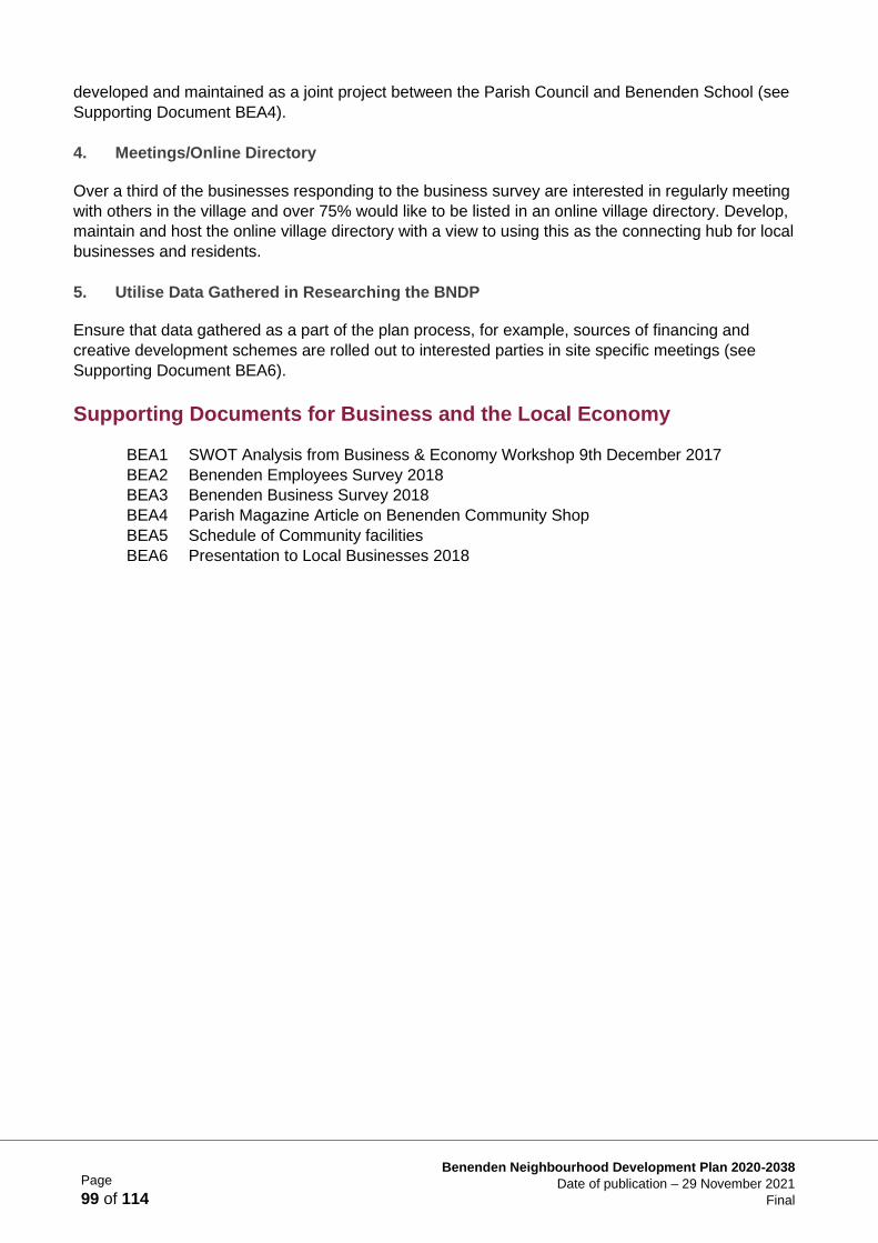
Page
99 of 114
Benenden Neighbourhood Development Plan 2020-2038
Date of publication – 29 November 2021
Final
developed and maintained as a joint project between the Parish Council and Benenden School (see
Supporting Document BEA4).
4. Meetings/Online Directory
Over a third of the businesses responding to the business survey are interested in regularly meeting
with others in the village and over 75% would like to be listed in an online village directory. Develop,
maintain and host the online village directory with a view to using this as the connecting hub for local
businesses and residents.
5. Utilise Data Gathered in Researching the BNDP
Ensure that data gathered as a part of the plan process, for example, sources of financing and
creative development schemes are rolled out to interested parties in site specific meetings (see
Supporting Document BEA6).
Supporting Documents for Business and the Local Economy
BEA1 SWOT Analysis from Business & Economy Workshop 9th December 2017
BEA2 Benenden Employees Survey 2018
BEA3 Benenden Business Survey 2018
BEA4 Parish Magazine Article on Benenden Community Shop
BEA5 Schedule of Community facilities
BEA6 Presentation to Local Businesses 2018
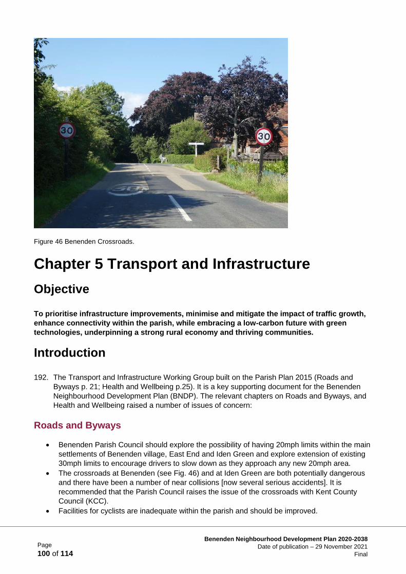
Page
100 of 114
Benenden Neighbourhood Development Plan 2020-2038
Date of publication – 29 November 2021
Final
Figure 46 Benenden Crossroads.
Chapter 5 Transport and Infrastructure
Objective
To prioritise infrastructure improvements, minimise and mitigate the impact of traffic growth,
enhance connectivity within the parish, while embracing a low-carbon future with green
technologies, underpinning a strong rural economy and thriving communities.
Introduction
192. The Transport and Infrastructure Working Group built on the Parish Plan 2015 (Roads and
Byways p. 21; Health and Wellbeing p.25). It is a key supporting document for the Benenden
Neighbourhood Development Plan (BNDP). The relevant chapters on Roads and Byways, and
Health and Wellbeing raised a number of issues of concern:
Roads and Byways
• Benenden Parish Council should explore the possibility of having 20mph limits within the main
settlements of Benenden village, East End and Iden Green and explore extension of existing
30mph limits to encourage drivers to slow down as they approach any new 20mph area.
• The crossroads at Benenden (see Fig. 46) and at Iden Green are both potentially dangerous
and there have been a number of near collisions [now several serious accidents]. It is
recommended that the Parish Council raises the issue of the crossroads with Kent County
Council (KCC).
• Facilities for cyclists are inadequate within the parish and should be improved.
Page
101 of 114
Benenden Neighbourhood Development Plan 2020-2038
Date of publication – 29 November 2021
Final
Health and Wellbeing
• Healthcare provision in the village is limited. Benenden Hospital offers limited NHS services
and some other services to members of its healthcare plan. District nurses and associated
staff visit the village but there is no clinic base. Family doctor services are provided to
parishioners from practices in Tenterden, Cranbrook and Hawkhurst. Other services, such as
dentistry and opticians, are also based in nearby towns.
• Over 40% of parishioners felt that access to healthcare services is a problem; with over 70%
stating that they would like to see a nurse-led clinic and chiropody services visit the village.
193. Following the initial Neighbourhood Plan Visioning Workshop on 28th October 2017, the
Transport and Infrastructure Workshop took place on 9th December 2017. As well as
addressing business and economic issues, this workshop also considered transport and
infrastructure. At the Visioning Workshop a ‘SWOT’ (strengths, weaknesses, opportunities and
threats) exercise (see Supporting Document TA1) explored issues including:
• improved infrastructure to cope with more houses/cars
• better maintained roads
• hazardous crossroads at Benenden and Iden Green
• poor broadband/mobile signal
• improve existing leisure amenities (tennis/bowls/football/cricket)
• a school minibus/community minibus
194. After further discussions with the Parish Council and the Neighbourhood Plan Steering Group,
the objective (above) was agreed as representing the views of many parishioners and to
provide a basis for the working group.
Process
195. The residents of Benenden have consistently supported managed housing growth (Parish Plan
2015 page 9: proposed housing growth of 1% per year would be an appropriate target).
However, they have real concerns about the impact of growth on the limited rural infrastructure
of the parish. Following the Transport & Infrastructure Workshop, a number of avenues were
explored to enhance the experience of living in the parish during the lifetime of the BNDP.
Policy Context/Justification
196. The High Weald Area of Outstanding Natural Beauty (AONB) Management Plan 2019-2024
seeks to preserve the character of both the landscape and its settlements but also stresses that
they should be economically viable i.e. not a museum. The BNDP contains planning policies
and projects that complement the High Weald AONB Management Plan.
197. The transport and infrastructure policies have been drafted to complement those of the National
Planning Policy Framework (NPPF) 2021 and the current and emerging Tunbridge Wells Local
Plan. Para. 104 of the NPPF demands that potential impacts of development on transport
networks is addressed and that opportunities to promote walking, cycling and public transport
are identified. Para. 106 of the NPPF requires planning policy makers to engage with highways
authorities and to provide high quality walking and cycling networks. NDP creators are asked to
produce policies that will support high quality communications. NPPF paras. 114-116 seek to
Page
102 of 114
Benenden Neighbourhood Development Plan 2020-2038
Date of publication – 29 November 2021
Final
discourage creation of new mobile phone masts by making maximum use of existing facilities
and encouraging wireless technology. However, if new facilities are required, they should be
camouflaged to minimise their adverse visual impact.
198. Landowners and developers must review the Infrastructure Policies set out in the BNDP and set
out within their plans how they will contribute to their delivery. Community Infrastructure Levies
(CIL), Section 106 contributions and other grants or donations made via Tunbridge Wells
Borough Council or direct to Benenden Parish Council will be used to enable the policies listed
below.
Neighbourhood Planning and Transport
199. A number of the transport/traffic concerns/issues raised at the workshops are outside the remit
of the BNDP. This Plan makes recommendations for infrastructure enhancements based on
local knowledge and requirements. These recommendations should be taken into account by
planners when outlining infrastructure requirements to support housing development in the
parish.
200. Locality, a government-funded planning advisory body, advises neighbourhood planners as
follows:
Many traffic matters fall outside the scope of planning. For example, changes to traffic
management on existing transport networks are usually a matter for the highways authority to
deal with. Changes to traffic lights, restrictions, speed limits, signage, traffic circulation, crossing
points and other traffic management devices usually fall outside the scope of neighbourhood
planning.
A possible exception to this may be where new development would impact on existing networks,
and this necessitates changes to those networks in order to accommodate such development.
However, even in cases like these, a neighbourhood plan cannot be prescriptive about the
actual solution. For example, planning policies could not include changes to the speed limit or
specific highway improvements.
201. However, the Plan could highlight localised traffic capacity and safety issues, or infrastructure
deficiencies that would need to be addressed.
Parish Infrastructure: Transport
202. Benenden Parish is one of the most remote parts of the Tunbridge Wells Borough, roughly
equidistant from centres of commerce and potential sources of work in Ashford, Hastings,
Maidstone and Tunbridge Wells. It comprises three main settlements (Benenden, Iden Green
and East End), and 29 smaller settlements or ‘dens’ connected by a network of narrow lanes.
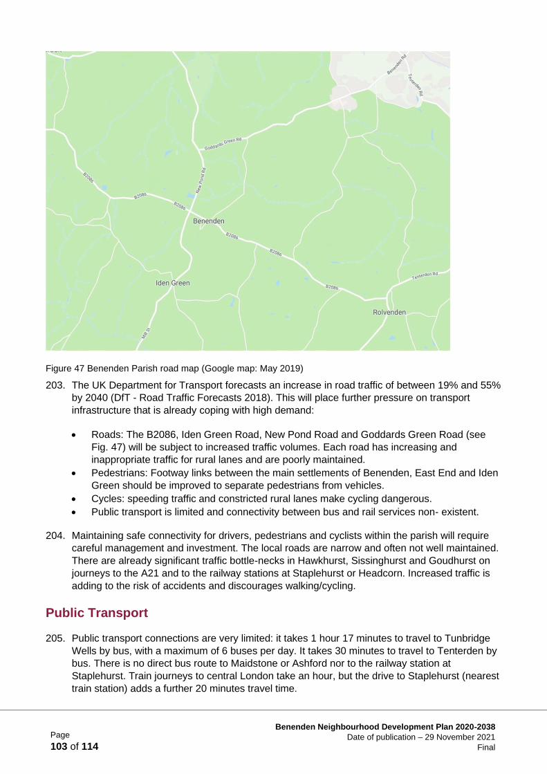
Page
103 of 114
Benenden Neighbourhood Development Plan 2020-2038
Date of publication – 29 November 2021
Final
Figure 47 Benenden Parish road map (Google map: May 2019)
203. The UK Department for Transport forecasts an increase in road traffic of between 19% and 55%
by 2040 (DfT - Road Traffic Forecasts 2018). This will place further pressure on transport
infrastructure that is already coping with high demand:
• Roads: The B2086, Iden Green Road, New Pond Road and Goddards Green Road (see
Fig. 47) will be subject to increased traffic volumes. Each road has increasing and
inappropriate traffic for rural lanes and are poorly maintained.
• Pedestrians: Footway links between the main settlements of Benenden, East End and Iden
Green should be improved to separate pedestrians from vehicles.
• Cycles: speeding traffic and constricted rural lanes make cycling dangerous.
• Public transport is limited and connectivity between bus and rail services non- existent.
204. Maintaining safe connectivity for drivers, pedestrians and cyclists within the parish will require
careful management and investment. The local roads are narrow and often not well maintained.
There are already significant traffic bottle-necks in Hawkhurst, Sissinghurst and Goudhurst on
journeys to the A21 and to the railway stations at Staplehurst or Headcorn. Increased traffic is
adding to the risk of accidents and discourages walking/cycling.
Public Transport
205. Public transport connections are very limited: it takes 1 hour 17 minutes to travel to Tunbridge
Wells by bus, with a maximum of 6 buses per day. It takes 30 minutes to travel to Tenterden by
bus. There is no direct bus route to Maidstone or Ashford nor to the railway station at
Staplehurst. Train journeys to central London take an hour, but the drive to Staplehurst (nearest
train station) adds a further 20 minutes travel time.
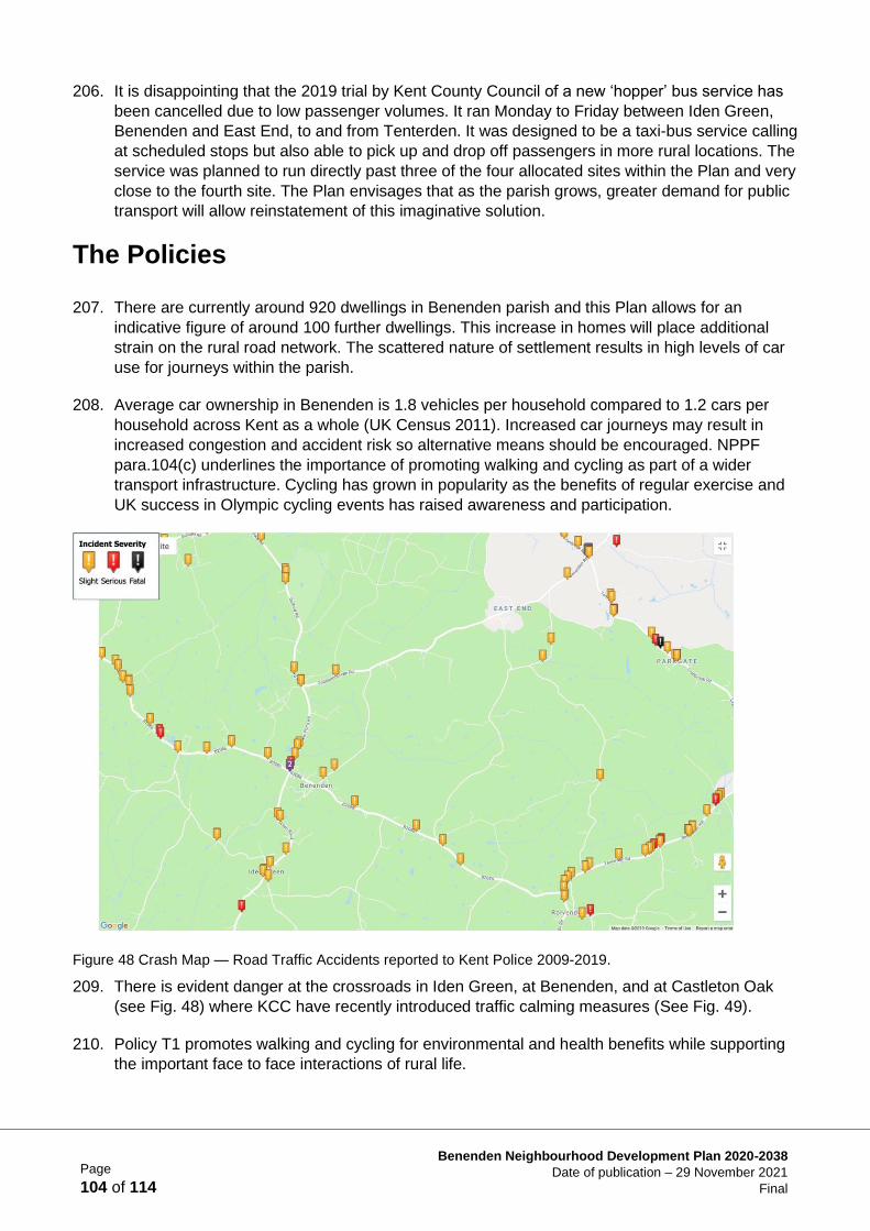
Page
104 of 114
Benenden Neighbourhood Development Plan 2020-2038
Date of publication – 29 November 2021
Final
206. It is disappointing that the 2019 trial by Kent County Council of a new ‘hopper’ bus service has
been cancelled due to low passenger volumes. It ran Monday to Friday between Iden Green,
Benenden and East End, to and from Tenterden. It was designed to be a taxi-bus service calling
at scheduled stops but also able to pick up and drop off passengers in more rural locations. The
service was planned to run directly past three of the four allocated sites within the Plan and very
close to the fourth site. The Plan envisages that as the parish grows, greater demand for public
transport will allow reinstatement of this imaginative solution.
The Policies
207. There are currently around 920 dwellings in Benenden parish and this Plan allows for an
indicative figure of around 100 further dwellings. This increase in homes will place additional
strain on the rural road network. The scattered nature of settlement results in high levels of car
use for journeys within the parish.
208. Average car ownership in Benenden is 1.8 vehicles per household compared to 1.2 cars per
household across Kent as a whole (UK Census 2011). Increased car journeys may result in
increased congestion and accident risk so alternative means should be encouraged. NPPF
para.104(c) underlines the importance of promoting walking and cycling as part of a wider
transport infrastructure. Cycling has grown in popularity as the benefits of regular exercise and
UK success in Olympic cycling events has raised awareness and participation.
Figure 48 Crash Map — Road Traffic Accidents reported to Kent Police 2009-2019.
209. There is evident danger at the crossroads in Iden Green, at Benenden, and at Castleton Oak
(see Fig. 48) where KCC have recently introduced traffic calming measures (See Fig. 49).
210. Policy T1 promotes walking and cycling for environmental and health benefits while supporting
the important face to face interactions of rural life.
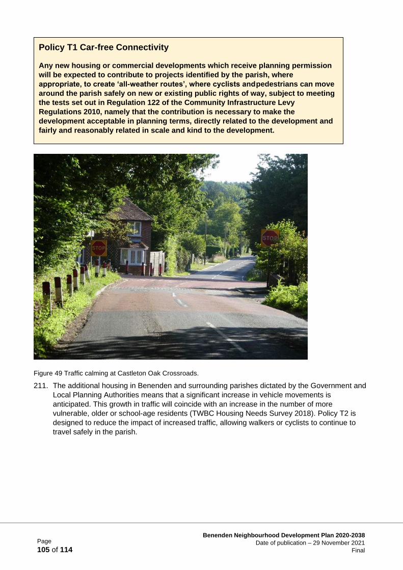
Page
105 of 114
Benenden Neighbourhood Development Plan 2020-2038
Date of publication – 29 November 2021
Final
Figure 49 Traffic calming at Castleton Oak Crossroads.
211. The additional housing in Benenden and surrounding parishes dictated by the Government and
Local Planning Authorities means that a significant increase in vehicle movements is
anticipated. This growth in traffic will coincide with an increase in the number of more
vulnerable, older or school-age residents (TWBC Housing Needs Survey 2018). Policy T2 is
designed to reduce the impact of increased traffic, allowing walkers or cyclists to continue to
travel safely in the parish.
Policy T1 Car-free Connectivity
Any new housing or commercial developments which receive planning permission
will be expected to contribute to projects identified by the parish, where
appropriate, to create ‘all-weather routes’, where cyclists and pedestrians can move
around the parish safely on new or existing public rights of way, subject to meeting
the tests set out in Regulation 122 of the Community Infrastructure Levy
Regulations 2010, namely that the contribution is necessary to make the
development acceptable in planning terms, directly related to the development and
fairly and reasonably related in scale and kind to the development.
Page
106 of 114
Benenden Neighbourhood Development Plan 2020-2038
Date of publication – 29 November 2021
Final
212. To ensure the safety of pedestrians and cyclists, traffic calming measures need to be put in
place to protect them from the increasing numbers of vehicles, many of them heavy goods
vehicles, travelling through the village.
213. An increasing number of visitors come to Benenden to enjoy village activities and the rural
environment; tourism is a key contributor to the local economy. To ensure that appreciation of
the village and the AONB is sustainable, adequate parking needs to be provided for visitors and
residents alike.
Parish Infrastructure: Amenities and Leisure
214. The parish has two village halls (Benenden and Iden Green), two village greens, community
recreation areas, sport facilities (bowls, cricket, football, tennis). Meeting places for local clubs
include the St. George’s Club, the Village Hall, Memorial Hall and the Iden Green Pavilion.
Benenden’s new Primary School opened in 2019. More recent community initiatives are the
Community Shop & Café and the formation of the Benenden Village Trust (which owns many of
the village amenities). There are a number of recreational clubs, ranging from the Benenden
Players, Benenden Bonfire Society and bellringing to the Ukulele Band, and village sports clubs
(bowls, cricket, darts, tennis). The village has lost two village pubs in the past 20 years, but still
retains a pub in the centre of the village (The Bull) and another in Iden Green (The Woodcock).
Churches include the congregational church in Iden Green, St George’s (CofE) at the top of the
village green, and the Catholic chapel in New Pond Road. Limited banking and cash
withdrawals can be made through the Post Office associated with the Community Shop, and
Benenden Hospital offers an ATM and café which are available for use by residents.
215. With new housing there will come increasing demand for sports and other recreational facilities.
Continued good provision is recognised as essential for both personal and community health
and well-being in both Borough (Tunbridge Wells Borough Council Open Space Study: June
2018) and National Planning (NPPF para. 93) guidance.
216. BNDP recognises the importance of community cohesion and with increased housing growth,
developers should enable the village to build strong, sustainable support networks.
Policy T2 Improving Road Safety and the Impact of Traffic
Proposals for any new housing or commercial development will be supported where
the Highway Authority is satisfied that the applicant has been able to demonstrate
that road access to and from developments provides safe access to, and transit
past, new housing: where necessary, this may include contributing to the
installation of measures which include slowing the flow of traffic. Such design
features must be in keeping with the rural nature of the parish.
The provision of appropriate footways to facilitate safe access to amenities is set
out in the Site Specific Polices (see Housing Supply Chapter 2) relevant to the
allocated sites.
Where a negative impact on non-motorised users is identified, for example within a
Transport Assessment, developers will be required to provide, or contribute
towards, appropriate mitigation measures.
Page
107 of 114
Benenden Neighbourhood Development Plan 2020-2038
Date of publication – 29 November 2021
Final
Contributions to meeting spaces, community clubs and community transport infrastructure will
be required.
217. The parish supports the provision of safe children’s play areas. Benenden Village Trust has
refurbished the children’s play area in Benenden. There is a smaller playground in Iden Green,
but there is currently no provision for younger children in East End. Funding for a play area
should be provided by the developer of Sites 424 and LS41.
218. East End currently has limited community facilities. Benenden’s Community Shop has
demonstrated that small, locally led projects can have a positive impact on community cohesion,
and this should be replicated with commercial and social facilities provided as an East End
Community Hub. Developer funding will be used to finance provision of similar facilities and a
meeting place to serve East End.
219. The impact of an increasing population and changing lifestyles on Climate Change is well
documented (For example: IPCC Global Warming of 1.5% October 2018 report.). Ample
evidence exists for the adverse impact of air pollution on children’s health in particular, as well
as adverse impacts on our ecosystem (For example: DEFRA’s most recent Air Quality Statistics
report April 2018). This Plan supports a focus on clean energy and low-emission technology.
Policy T3 Community Cohesion and Recreational Facilities
Proposals for any new housing or commercial development will be required, where
it meets the three tests set out in Regulation 122 of the Community Infrastructure
Levy Regulations 2010, to contribute to parish projects designed to improve
provision for children’s play areas in all three main settlements within the parish.
Developers will also be required to support projects designed to meet the health
and well-being needs of residents such as easily accessed healthcare facilities, a
shop & café and a community hub, again where the contributions will meet the
above three tests.
Policy T4 Renewable Energy and Low-emission Technology
Proposals for any new housing or commercial development must provide all new
properties with a minimum of 1 electric car-charging point and, where it meets the
Regulation 122 of the Community Infrastructure Levy Regulation tests, also
contribute to projects designed to reduce the impact of pollution emitted by cars, in
the following ways:
• Supplying and supporting a minibus for the Primary School
• Encouraging walking/cycling by providing safe paths
Developers will also be expected to contribute to projects that will provide pay-as-
you-go electric car-charging points for visitors to the parish in accessible places
such as Benenden Village Hall and Iden Green Pavilion car parks.

Page
108 of 114
Benenden Neighbourhood Development Plan 2020-2038
Date of publication – 29 November 2021
Final
Parish Infrastructure: Communications
220. Mobile data traffic has been growing at a rate of around 60% a year, boosted by technological
development, in both handsets and applications, allowing consumers to carry out ever more
activities wirelessly. It is clear that online interactions, both personal and commercial will
continue to grow. The digital economy offers Benenden opportunities to grow local enterprise
and reduce commuting miles.
221. However broadband speeds and mobile phone signals continue to be poor: infrastructure needs
to be enhanced to cope with both an increase in individual use and the increase in the local
population (Ofcom Mobile Data strategy 2016). The quality of mobile signal in particular is an
evident source of frustration (see Parish Plan 2015, BNDP Business Survey 2018 - Supporting
Document BEA3).
222. Improving rural connectivity aligns with Government policies for local businesses and
communities and Benenden aspires to meet Ofcom targets for broadband and mobile coverage
across the UK.
223. The Ofcom target for broadband is for every household and business to have ‘the right to
request a broadband service capable of a download speed of at least 10 megabits (Mb), and an
upload speed of at least 1 megabit (Mb).’ The Government’s target is for 95% of premises to
have access to superfast broadband.
224. Developers of the four allocated sites will be required to provide or fund an extension of existing
broadband access to hubs at each development, with speeds acceptable to a small, home-
based business. They will also be required to install boosters at each site to improve mobile
phone reception and enable 5G connectivity.
Parish Infrastructure: Essential Services
225. Research underpinning the BNDP suggests that core essential services are generally
considered to be adequate within the village. Wastewater and sewerage capacity is something
that will need careful attention from developers in order not to impact the environment (see
Policy LE9) but current systems have been assessed as adequate for the additional housing
under consideration (AECOM Sustainability Scoping Report April 2019).
226. The whole parish has access to mains electricity, however much of the parish does not have a
mains gas supply and many residents therefore use either wood, electricity or oil- fired heating.
Policy T5 Infrastructure, Broadband and Mobile
Proposals for any housing or commercial development will be required to
contribute to appropriate new amenities, new infrastructure and public transport
provision which arise as a direct result of the development in order to improve
connectivity within the parish and the wider community.
Specifically, developers will be expected to contribute to parish projects designed
to enhance broadband speed and also to enable the centre of East End to be
connected to superfast broadband.
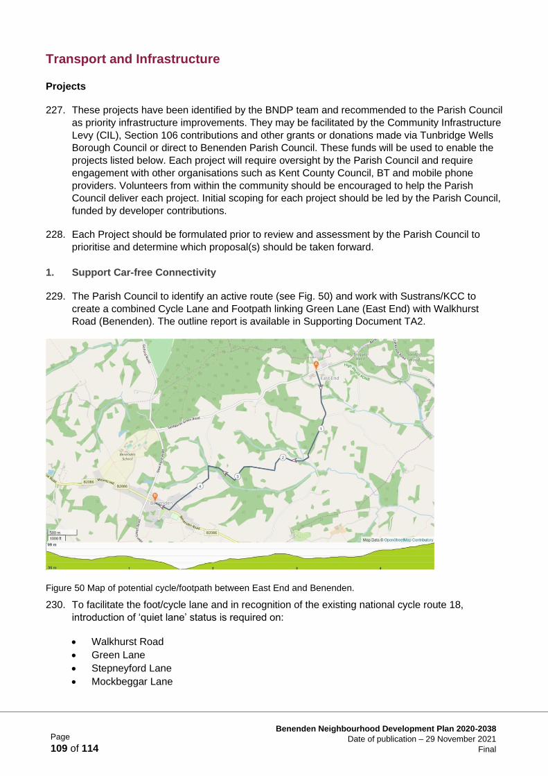
Page
109 of 114
Benenden Neighbourhood Development Plan 2020-2038
Date of publication – 29 November 2021
Final
Transport and Infrastructure
Projects
227. These projects have been identified by the BNDP team and recommended to the Parish Council
as priority infrastructure improvements. They may be facilitated by the Community Infrastructure
Levy (CIL), Section 106 contributions and other grants or donations made via Tunbridge Wells
Borough Council or direct to Benenden Parish Council. These funds will be used to enable the
projects listed below. Each project will require oversight by the Parish Council and require
engagement with other organisations such as Kent County Council, BT and mobile phone
providers. Volunteers from within the community should be encouraged to help the Parish
Council deliver each project. Initial scoping for each project should be led by the Parish Council,
funded by developer contributions.
228. Each Project should be formulated prior to review and assessment by the Parish Council to
prioritise and determine which proposal(s) should be taken forward.
1. Support Car-free Connectivity
229. The Parish Council to identify an active route (see Fig. 50) and work with Sustrans/KCC to
create a combined Cycle Lane and Footpath linking Green Lane (East End) with Walkhurst
Road (Benenden). The outline report is available in Supporting Document TA2.
Figure 50 Map of potential cycle/footpath between East End and Benenden.
230. To facilitate the foot/cycle lane and in recognition of the existing national cycle route 18,
introduction of ‘quiet lane’ status is required on:
• Walkhurst Road
• Green Lane
• Stepneyford Lane
• Mockbeggar Lane
Page
110 of 114
Benenden Neighbourhood Development Plan 2020-2038
Date of publication – 29 November 2021
Final
231. Each quiet lane would have speed limits of 20mph and appropriate signage.
2. Traffic Mitigation
232. The Parish Council will lobby and work with KCC Highways on the specific proposals resulting
from the development of this Plan listed below:
• Reduction of maximum speed limit to 20mph on B2086 from Benenden Crossroads to
Pullington Farm
• Reduction of maximum speed limit to 20mph on Goddards Green Road from East End
Chapel to Mockbeggar Lane
• Reduction of maximum speed limit to 20mph on Mill Lane from Little Weavers to Cotton
Cottage on Iden Green Road
• Extension of 30mph zones on the approach to the three main settlements of Benenden
village, East End and Iden Green to encourage drivers to slow before reaching residential
areas and rural crossroads
• Traffic calming scheme for Benenden Crossroads and Iden Green Crossroads and further
measures at Castleton Oak Crossroads
• Introduction of ‘Access Only’ restrictions on designated quiet lanes
3. Additional Car Parking
233. The Parish Council will arrange and manage meetings between landowners with a view to
improving both public and residential car parking provision; specifically looking at:
• Providing additional car parking spaces in Rothermere Close. Working with the housing
association and Benenden Almshouse Charities to see if additional car parking can be
designed to reduce congestion for residents
• Providing additional car parking spaces at Benenden Village Hall. Working with the
Benenden Village Trust to extend existing car parking, reducing the adverse impact on
village streets (see Figs. 51 & 52) when large events are held at the hall
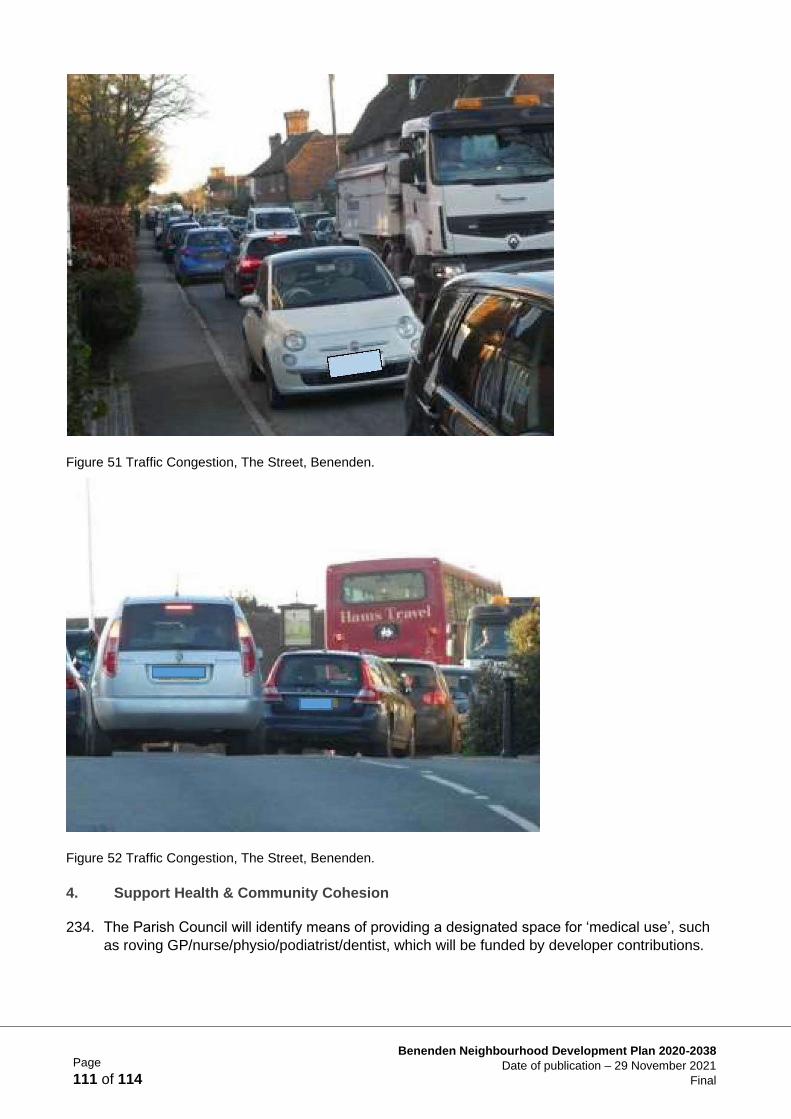
Page
111 of 114
Benenden Neighbourhood Development Plan 2020-2038
Date of publication – 29 November 2021
Final
Figure 51 Traffic Congestion, The Street, Benenden.
Figure 52 Traffic Congestion, The Street, Benenden.
4. Support Health & Community Cohesion
234. The Parish Council will identify means of providing a designated space for ‘medical use’, such
as roving GP/nurse/physio/podiatrist/dentist, which will be funded by developer contributions.
Page
112 of 114
Benenden Neighbourhood Development Plan 2020-2038
Date of publication – 29 November 2021
Final
5. Enhancing Play and Recreation Facilities
235. Existing playgrounds and recreational fields in Benenden village and Iden Green are owned and
maintained by the Benenden Village Trust (BVT). They are available for use by the community.
The Benenden playground underwent extensive renovation in 2019. The BVT is currently fund
raising for refurbishment of the Iden Green playground. In addition, land at East End will be
made available for recreational and playground facilities arising from site specific policies within
the NDP. The Parish Council will work with developers, BVT and other community groups to
enhance recreational and play facilities.
6. Public Electric Charging Points
236. As part of our commitment to embracing green technology the BNDP recommends that pay- to-
charge facilities are introduced in car parks at Benenden Village Hall and Iden Green Pavilion.
The Parish Council will work with developers, the Benenden Village Trust (BVT) and utility
providers on projects to provide charging points in each location.
7. Superfast Broadband in East End, Benenden
237. The Parish Council will work with Benenden Hospital Society, developers and BT Openreach to
ensure the existing Broadband infrastructure which serves the Hospital complex is enhanced.
The scope of any service extension to local dwellings will be determined via a feasibility study,
but it is expected that dwellings within 1000m of the hospital site should have access to
superfast broadband.
Supporting Documents
TA1 ‘SWOT’ data
TA2 Cycle route report
Page
113 of 114
Benenden Neighbourhood Development Plan 2020-2038
Date of publication – 29 November 2021
Final
Chapter 6 Plan Review Process
238. Following final consultation with the Local Planning Authority (TWBC) and local residents,
formal examination and a referendum held within the parish, the BNDP is expected to come into
force in spring 2022.
239. The Parish Council will monitor the BNDP, as necessary, and will formally review the BNDP, to
ensure that the Plan Policies remain unaffected following:
• Local Plan adoption or review
• major changes in National Planning Policy
• the receipt of updated evidence of housing need
240. At review stage the Parish Council will also assess the progress of the Plan, and identify
improvement opportunities using the following criteria:
• Seeking input from TWBC — assess changes to regulation and policy since adoption of
the Plan
• Assess the effectiveness of Plan policies
• Whether housing development has taken place
• Whether assessed housing needs are being addressed
241. In addition, using an evidence-based approach the Parish Council will monitor strengths and
weaknesses of Plan deployment taking each Plan Objective to structure their assessment:
• Landscape & the Environment: To protect valued environmental assets and support
Benenden’s peaceful, rural, way of life. Recognising that the parish of Benenden is one of
the most unspoilt parts of the High Weald AONB, the policies will enable villagers and
visitors to continue to enjoy the countryside, important Local Green Spaces, Public Rights
of Way (PRoW), views and dark skies.
• Housing Supply: To support modest-scale housing development, wherever possible
locally led, to meet local needs with a mix of well-designed, high quality, sustainable and
affordable housing that enhances the existing built and natural environment.
• Design & the Built Environment: New buildings shall be of good quality construction,
using local materials and designed to be sympathetic to the character of existing
landscape and buildings, with scale, form and density to be of similar proportions to the
existing; the principal aim is to protect and enhance the beauty of the parish.
• Business & the Local Economy: To support existing businesses and enterprises within
the parish and to encourage new areas of economic activity to nurture the parish’s
economic stability in the future, the aim being to sustain a thriving and integrated group of
settlements.
• Transport & Infrastructure: To prioritise infrastructure improvements, minimise and
mitigate the impact of traffic growth, enhance connectivity within the parish, while
embracing a low-carbon future with green technologies, underpinning a strong rural
economy and thriving communities.
242. Where a substantive change to the Plan is required, the Parish Council will follow the procedure
laid down by the legislation in force at the time.
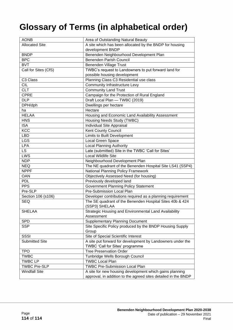
Page
114 of 114
Benenden Neighbourhood Development Plan 2020-2038
Date of publication – 29 November 2021
Final
Glossary of Terms (in alphabetical order)
AONB Area of Outstanding Natural Beauty
Allocated Site A site which has been allocated by the BNDP for housing
development BNDP
BNDP Benenden Neighbourhood Development Plan
BPC Benenden Parish Council
BVT Benenden Village Trust
Call for Sites (CfS) TWBC’s request to Landowners to put forward land for
possible housing development
C3 Class Planning Class C3 Residential use class
CIL Community Infrastructure Levy
CLT Community Land Trust
CPRE Campaign for the Protection of Rural England
DLP Draft Local Plan — TWBC (2019)
DPH/dph Dwellings per hectare
ha Hectare
HELAA Housing and Economic Land Availability Assessment
HNS Housing Needs Study (TWBC)
ISA Individual Site Appraisal
KCC Kent County Council
LBD Limits to Built Development
LGS Local Green Space
LPA Local Planning Authority
LS Late (submitted) Site in the TWBC ‘Call for Sites’
LWS Local Wildlife Site
NDP Neighbourhood Development Plan
NEQ The NE quadrant of the Benenden Hospital Site LS41 (SSP4)
NPPF National Planning Policy Framework
OAN Objectively Assessed Need (for housing)
PDL Previously developed land
PPS Government Planning Policy Statement
Pre-SLP Pre-Submission Local Plan
Section 106 (s106) Developer contributions required as a planning requirement
SEQ The SE quadrant of the Benenden Hospital Sites 40b & 424
(SSP3) SHELAA
SHELAA Strategic Housing and Environmental Land Availability
Assessment
SPD Supplementary Planning Document
SSP Site Specific Policy produced by the BNDP Housing Supply
Group
SSSI Site of Special Scientific Interest
Submitted Site A site put forward for development by Landowners under the
TWBC ‘Call for Sites’ programme
TPO Tree Preservation Order
TWBC Tunbridge Wells Borough Council
TWBC LP TWBC Local Plan
TWBC Pre-SLP TWBC Pre-Submission Local Plan
Windfall Site A site for new housing development which gains planning
approval, in addition to the agreed sites detailed in the BNDP
Related Documents