Studii de Preistorie 10, 2013, p. 89-117. In the memory of Professor Mihai Irimia Interdisciplinary investigations. The tell settlement from Vătaşi Măgura (Teleorman County, Romania) Căt ălin BEM * Andrei ASĂNDULESEI ** Constantin HAITĂ *** Carmen BEM **** Mihai FLOREA ***** Abstract: Discovered in 2011 by the Chronos team, the tell from Vătaşi Măgura is located at the limit between the floodplain and the lower left terrace of the Dâmbovnic river; in the vicinity, there are a few springs, at approximately 820 meters West from the village church. At the foot of the terrace, a small stream flows, a left tributary of the Dâmbovnic River. Through magnetometric scanning of the southern area of the tell, a delimitation trench was revealed, which was made at the base of the anthropic mound. The separation element was also identified based on aerial photographies. Also a series of soil corings made on two main transects, North-South and East-West oriented, showed the existence of a stratigraphy thicker than 2.50 meters. Moreover, in the areas between the inhabited space itself – which was central, and the delimitation ditch of the tell, a series of sediments were identified, which can be connected to the conscious action of erecting the anthropic mound. 100 meters North of the tell we have identified the exterior inhabitation, which was contemporaneous with one of the Gumelniţa moments. In the eastern proximity of the tell, a series of magnetic anomalies indicate the presence of another external occupation. The results of our non-destructing researches from Vătaşi confirm, without a doubt, the Gumelniţa tell construction patterns and preferred internal management of this type of settlement. Rezumat: Descoperit în vara anului 2011 de către echipa Chronos, tell-ul de la Vătaşi Măgura este amplasat la limita dintre lunca şi terasa joasă stânga a Dâmbovnicului, în zona unor izvoare, la aproximativ 820 m vest de biserica satului. La poalele terasei curge un mic fir de apă, afluent stânga al Dâmbovnicului. Scanarea magnetometrică parţială a zonei sudice a tell-ului a relevat existenţa unui şanţ de delimitare, săpat la baza movilei antropice, în terasă. Elementul de separare a fost identificat şi pe baza fotografiilor aeriene realizate. De asemenea, seria de carotaje practicate pe două aliniamente principale, nord-sud şi est-vest, a relevat existenţa unei stratigrafii cu o grosime mai mare de 2.50 m. În plus, în zonele dintre spaţiul efectiv locuit –central, şi şanţul de delimitare a tell-ului, au fost identificate o serie de sedimente care pot fi puse în legătură cu acţiunea conştientă de înălţare intenţionată a movilei antropice. La 100 m nord de tell, a fost identificată o locuire exterioară, contemporană cu cel puţin unul din momentele de ocupare Gumelniţa. În proximitatea estică a tell- ului, o serie de anomalii magnetice indică prezenţa unei alte locuiri exterioare. Rezultatele cercetărilor non-distructive de la Vătaşi confirmă întrutotul modelele de construcţie a tell- urilor Gumelniţa şi tipul predilect de organizare internă a acestei categorii de staţiuni. Keywords: Chalcholitic, Gumelniţa, tell, soil corings, aerial photogrammetry, magnetometry, delimitation ditch, dike. Cuvinte cheie: calcolitic, Gumelniţa, tell, carotaje de sol, fotografie aeriană, scanare magnetometrică, şanţ de delimitare, val/dig. * National Museum of Romania History, Bucureşti, [email protected] – mailing address ** University „Alexandru Ioan Cuza” Iaşi, [email protected] *** National Museum of Romania History, Bucureşti, [email protected] **** Romanian National Company of Motorways and National Roads, [email protected] ***** National Museum of Romania History, Bucureşti, [email protected]

Welcome message from author
This document is posted to help you gain knowledge. Please leave a comment to let me know what you think about it! Share it to your friends and learn new things together.
Transcript
Studii de Preistorie 10, 2013, p. 89-117.
In the memory of Professor Mihai Irimia
Interdisciplinary investigations. The tell settlement from Vătaşi Măgura
(Teleorman County, Romania)
Cătălin BEM*
Andrei ASĂNDULESEI** Constantin HAITĂ***
Carmen BEM**** Mihai FLOREA*****
Abstract: Discovered in 2011 by the Chronos team, the tell from Vătaşi Măgura is located at the limit between the floodplain and the lower left terrace of the Dâmbovnic river; in the vicinity, there are a few springs, at approximately 820 meters West from the village church. At the foot of the terrace, a small stream flows, a left tributary of the Dâmbovnic River.
Through magnetometric scanning of the southern area of the tell, a delimitation trench was revealed, which was made at the base of the anthropic mound. The separation element was also identified based on aerial photographies. Also a series of soil corings made on two main transects, North-South and East-West oriented, showed the existence of a stratigraphy thicker than 2.50 meters. Moreover, in the areas between the inhabited space itself – which was central, and the delimitation ditch of the tell, a series of sediments were identified, which can be connected to the conscious action of erecting the anthropic mound. 100 meters North of the tell we have identified the exterior inhabitation, which was contemporaneous with one of the Gumelniţa moments. In the eastern proximity of the tell, a series of magnetic anomalies indicate the presence of another external occupation.
The results of our non-destructing researches from Vătaşi confirm, without a doubt, the Gumelniţa tell construction patterns and preferred internal management of this type of settlement.
Rezumat: Descoperit în vara anului 2011 de către echipa Chronos, tell-ul de la Vătaşi Măgura este amplasat la limita dintre lunca şi terasa joasă stânga a Dâmbovnicului, în zona unor izvoare, la aproximativ 820 m vest de biserica satului. La poalele terasei curge un mic fir de apă, afluent stânga al Dâmbovnicului.
Scanarea magnetometrică parţială a zonei sudice a tell-ului a relevat existenţa unui şanţ de delimitare, săpat la baza movilei antropice, în terasă. Elementul de separare a fost identificat şi pe baza fotografiilor aeriene realizate. De asemenea, seria de carotaje practicate pe două aliniamente principale, nord-sud şi est-vest, a relevat existenţa unei stratigrafii cu o grosime mai mare de 2.50 m. În plus, în zonele dintre spaţiul efectiv locuit –central, şi şanţul de delimitare a tell-ului, au fost identificate o serie de sedimente care pot fi puse în legătură cu acţiunea conştientă de înălţare intenţionată a movilei antropice. La 100 m nord de tell, a fost identificată o locuire exterioară, contemporană cu cel puţin unul din momentele de ocupare Gumelniţa. În proximitatea estică a tell-ului, o serie de anomalii magnetice indică prezenţa unei alte locuiri exterioare.
Rezultatele cercetărilor non-distructive de la Vătaşi confirmă întrutotul modelele de construcţie a tell-urilor Gumelniţa şi tipul predilect de organizare internă a acestei categorii de staţiuni.
Keywords: Chalcholitic, Gumelniţa, tell, soil corings, aerial photogrammetry, magnetometry, delimitation ditch, dike.
Cuvinte cheie: calcolitic, Gumelniţa, tell, carotaje de sol, fotografie aeriană, scanare magnetometrică, şanţ de delimitare, val/dig.
* National Museum of Romania History, Bucureşti, [email protected] – mailing address ** University „Alexandru Ioan Cuza” Iaşi, [email protected] *** National Museum of Romania History, Bucureşti, [email protected] **** Romanian National Company of Motorways and National Roads, [email protected] ***** National Museum of Romania History, Bucureşti, [email protected]
Cătălin BEM et alii
90
Introduction. Background and site description Implemented in the years 2008-2011, The Chronos Project1 also had as a purpose the
necessity to outline a non-destructive research model of the Gumelnita tells. Archaeology, having a destructive nature in itself, inherently brings about an impact on the tells, during actual research on one hand, and on the other hand during the post-diggings period, from generally natural causes and, often the case in Romania, anthropic causes.
Very often the internal structure, the landscape, the connection of the tell with its geomorphological foundation are not quantified. Consequently, our endeavours were also focused on an evaluation of these elements.
One of the many field stages of the Chronos2 investigations targeted the Nordic extremity of Teleorman County, in the central-western area of Muntenia (fig. 1). The immediate objectives were to identify the Gumelnita sites that were mentioned in the literature, but also to discover new ones, to the extent to which they existed and were physically distinguishable in the landscape. The entire area is strongly affected by ample anthropic modifications because of the oil exploitation – drills, shafts, reservoirs, access roads and everything related to such activities, particularly on the Dâmbovnic, but also because of ponds set up through dams, especially on the Jirnov, a left branch of the former one.
In this delimited space the presence of two tells had been indicated. The first one, on the territory of Drăghineşti village (today embedded in Gratia, just as Ciurari-Deal – fig. 2), was mentioned to be placed in the Dâmbovnic meadow, without further details (I. Spiru 1996, p. 34, 81; I. Pătraşcu 2002, p. 22). Attempts to identify it failed, as not even the toponym by which it was identified in the literature – Măgura cu Pui (Mound with babies) – was known to the interviewed locals. It is highly likely that the tell was destroyed by the plants in the area. On the other hand, it is not impossible that this toponym is correspondent to the four mounds3 marked (1790) on the Specht Map (fig. 3), in this case more like mounds, but anyway, not quantifiable today4.
The second tell was just as scarcely remembered as being placed on the territory of Udeni village (Sârbeni Comm.), in the Jirnov meadow (I. Spiru 1996, p. 54, 60 şi 81; I. Pătraşcu 2002, p. 26). Also in this case our efforts to identify it were unsuccessfull. Instead, in one of the many dams or the ponds set in the area (between Udeni and Sârbenii de Jos) we have identified many Gumelniţa ceramic fragments from the Bronze Age. It is not impossible they should come from the fore mentioned tell, which, together with anthropic sediments, may have been entirely moved... On this occasion, we have identified in the same area a very simple settlement, placed on the right terrace of Jirnov, approximately 500 m West of Udeni School, from where we have recovered some Gumelniţa ceramic fragments.
As mentioned before, when asked of the existence of a Măgura on the territory of Drăghineşti (Gratia), all inhabitants negated this, instead pointing us to a Măgura from Vătaşi (Poeni Comm., Teleorman County)... The discovered settlement5 – a Gumelniţa tell (fig. 4-5) – is placed at the limit between the meadow and the low terrace of Dâmbovnic, near some springs – very present hydrographic element in the area (fig. 2), approximately 820 m West from the village church. At the bottom of the terrace there is a small water flow, a left branch of the Dâmbovnic (fig. 4; 6-8). The topographic survey together with stratigraphic information have shown (as will be detailed at the right time) an absolute
1 This intervention uses information resulted from the implementation of the Chronos Project. Two of its main objectives were to distinguish the spatial and temporal distribution of all the Gumelniţa sites in the current Romanian evolution space, also involving the way the tells were created, as well as the identification of probable inhabitancy patterns. 2 For the Dobrogea area, for example, C. Bem 2011a and C. Bem 2011b. 3 We do not insist, but the toponym in itself surely involves the existence of a large Măgura (=mound) and some smaller ones in the immediate proximity. As a first modern map of Muntenia, the Specht Map, made in the 1790-1791 period, has relativey detailed and exact planimetry elements, but scarce altimetry elements, the relief being presented through crosshatching. After these, the four mentioned knobs seem not to be placed on the Dâmbovnicu meadow. Moreover, being a military map, it has no legend, but the similitude of the symbol with those which, in other cases, really indicate knobs (as apprehended on a differet occasion – P. Mirea, A. Frînculeasa 2005, p. 55), seems sufficent in this context. 4 Maybe it is not unimportant that in the Great Geographic Dictionary of Romania (G.I. lahovari, C.I. Brătianu, Gr.G. Tocilescu, vol. 3, 1900, p. 241) there is no mention of any knob at Drăghineşti , a landscape details which is mentioned in most cases. The same mention is missing for Gratia (G.I. lahovari, C.I. Brătianu, Gr.G. Tocilescu, vol. 3, 1900, p. 624). 5 Mr. Marian Tudoran, Mr. Vasile Opriş and Mr. Tudor Hila also attended the field research. They are collaborators to the National Museum of Romania History.
Interdisciplinary investigations. The tell settlement from Vătaşi Măgura (Teleorman County, Romania)
91
thickness of anthropic deposits of approx. 3.70 m, the dimensions of the tell being approx. 58 m (on the North-East – South-West direction) and, respectively approx. 61 m (on the North-West – South-East direction). These values place it in the category of medium tells (C. Bem et alii 2012, p. 20).
The apparent isolation of the site within the Gumelniţa area of evolution is given by the contemporary landscape and its drastic changes. In fact, the Vătaşi tell is 8 km away (in straight line) to the one from Fierbinţi Măgura (Şelaru Comm., Dâmboviţa County) (Gh. Olteanu et alii 2003, p. 60) or at approx. 9.3 km from the ones at Glavacioc6 (Ştefan cel Mare Comm., Argeş County), situated towards the North-West, the same distances being towards the Southern tells – from Siliştea Măgura Mantolea (D. Popescu 1966, p. 712; G. Trohani, Al. Oancea 1981, p. 243) and Puranii de Sus Măgura din Vale (both from Siliştea Comm., Teleorman County) (G. Trohani, Al. Oancea 1981, p. 243). Regarding the Eastern area, it is only 5 m away from the fore mentioned destroyed tell from Udeni Măgura.
Methods In order to non-distructively evaluate the resort at Vătaşi Măgura statigraphic soil corings,
aerial photogrammetry and magnetometry were used. Topographic Surveys The measurements necessary for the topographic surveys had as a supporting point three
local landmarks that we set so as to provide total coverage for the area of interest. Subsequently, both these landmarks and soil corings and the corners of the surface that was scanned magnetometrically – for certification reasons – were determined with a total station Leica GPS 1200, from the IVth rank station La Cucui (fig. 2) (X = 532002.819, Y = 325255.391, Z = 139.487).
Each point was determined with a Leica Smart Rover GPS, which got RTK© Reference correction type, a fixed station positioned in the geodetic point that had well-known coordinates. These coordinates are in the projection system STEREO 70. The fixed station receives data from the satellite, data which is compared to the information present in its database (the known coordinates of La Cucui landmark) and continuously delivers corrected real time data to the Rover (the mobile device). In this way the precision of the determined points is of 2cm, thus eliminating errors caused by different factors (atmospheric, physical, etc.) even if the Rover is moving.
For the graphic display of the topographic survey of the Vătaşi tell and of the encompassed area (fig. 6) an equidistance of contour lines of 1 m was preferred, as the details they offered were considered sufficient.
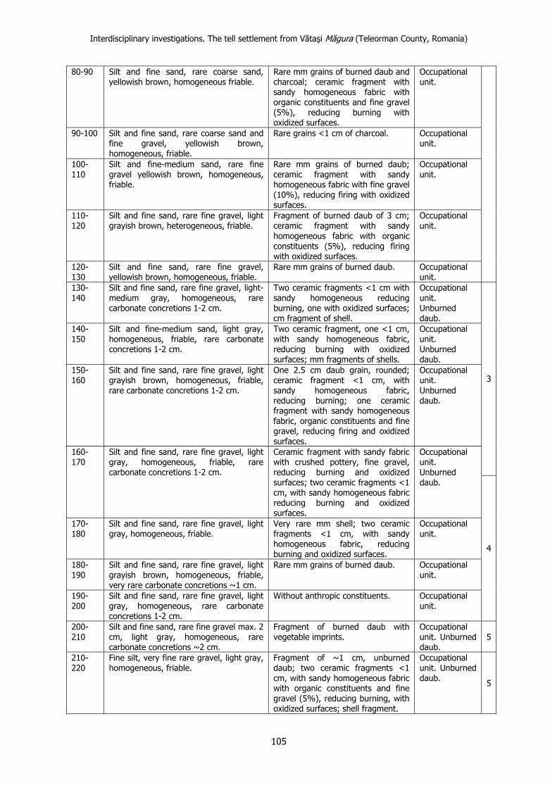
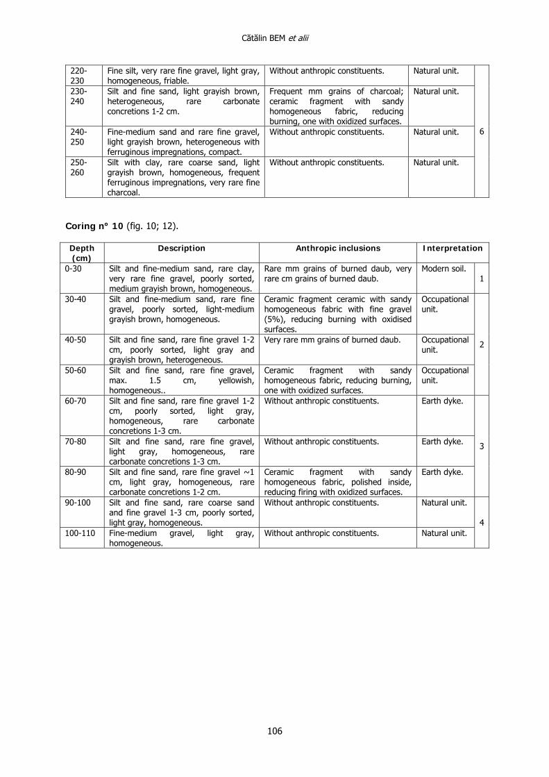
Stratigraphic soil corings 11 soil corings were carried, eight of which were placed on two preferential transects
approximately East-West and North-South, starting from the central area of maximum altitude of the tell (fig. 6). Handled manually, the core extractor – with a drill diameter of 7.5 cm – was used in successive altimetric steps of 10 cm. The recovered sediments were described on the spot (annex-tables), the archaeological material (especially Gumelniţa ceramic fragments –– and daub) being separated and the identification elements for each of them being sampled afterwards. The different depths where the stratigraphic interventions were stopped (fig. 10-12) are correspondent to the natural level areas where the tells were developed. Numbers from 1 to 10 of the soil corings are given by the order in which they were carried; therefore the sampling strategy is quite easy to follow by simply reading their placings.
Soil corings no. 1 and 1’ (the second being placed 1.5 m East of the first) have not been finalized – as at 0.40 m (relative local depth) an impenetrable layer probably made of concrete has interposed, probably remains of a contemporary intervention related to the fore mentioned oil plants. The area of soil corings no. 1 and 1’ is visible on aerial photographies (fig. 7-8), representing, in fact, a relatively rectangular large pit (cca 4x8 m).
The thickening of soil corings on the North-South axis (numbers 7, 8 and 9) was required by the novelty of the stratigraphic situation, as will be shown next. With regards to the soil coring no. 10, this was carried in order to have stratigraphic control over the eastern area of the tell. The resemblance with C7 has determined us to limit the interventions in this area to only one.
6 One of them, known and accidentally investigated before (S. Cristocea et alii 2005; P. Mirea, A. Frînculeasa 2005), the second one being discovered during one of the field research stages of Chronos, in the meadow area of Dâmbovnic.
Cătălin BEM et alii
92
Aerial photogrammetric analysis A quick review of the abundance of the use of Google Earth captions lately or the ones in
orthophotoplans reveal the fact that these are only used to mark sites. Generally, in Romanian archaeology, these replace the maps in the older presentations or articles. The examples are countless and don’t need further details.
A set of aerial photographies for the tell identified at Vătaşi was made on September 9th, 2011 between 16:51-16:58. The way the photographs were made was in a cant by describing a circle around the site in order to capture both the structure, the landscape and the ground control points which, afterwards, after the download of the images will make georeferencing possible. During the transformation, the oblique image overwrites the imagistic support delivered by Google Earth and allows the exact mapping of the site and other landscape elements. The aerial photographs were compared to the satellite images available on Google Earth in different days: 03.04.2012 (fig. 9/1) and, respectively, 31.10.2012 (fig. 9/2). The satellite images show differences due to the season in which they were taken as well as from the atmospheric conditions point of view. It can be seen that the image taken in October is much clearer and has a much better resolution than the one taken in April. The vegetation sections are more visible in the image from fig. 9/1, because of different climatic conditions and the differences in the use of the land, but in the second image (fig. 9/2) the site is better highlighted through the absence of vegetation, which accounts for an optimal visualization. Through the analysis of aerial and satellite images there can be identified tracks of recent activities, access roads to the drills around the tell and the pipes that service these pipes, which have affected the archaeological landscape (fig. 8).
Magnetometry The non-destructive Vătaşi investigations were carried with the help of a Caesium steam
magnetometer, the Geometrics G858G model. This was designed to provide high precision, superior to the one provided by protons magnetometers. The total magnetic field can be measured with this type of device with a precision of 0.01 nT (nanotesla or gamma) compared to the 0.5 – 1 nT precision of the proton magnetometer. Moreover, at high resolution, Geometrics G858G generates 10 counts every second. The measuring speed associated with other factors allows the achievement of a considerable number of counts (ex. over 8100 counts on a 20x20 m surface with a distance between lines of 0.5 m).
The main objective was to establish the existence of a ditch at the base of the tell, at the same time focusing, where possible, on the area in the close proximity of the settlement. Thus, a total surface of 2100 m2 was mapped out in a geodesically controlled environment (fig. 6; 13-14). It was not possible to cover the entire surface of the site, especially because of its very steep slopes and a muddy area in its western extremity.
The measurements were done in gradiometer, with two sensors placed horizontally, 1 m away from one another and 0.5 m distance from the ground. The collected signal was processed with the help of specialized software, discarding, where possible, potential interferences created by the daily variations of the total magnetic field and the background noise generated by the existence of massive geological formations. The result of the processing stage was a series of maps and graphics representing the magnetic field in our research area. All the fore mentioned deliverables were georeferenced and exploited through an integrating interpretation manner, correlated with other type of data in GIS environment.
Results and discussions Stratigraphy revealed by the soil corings is generally coherent, making possible an
interpretative delimitation of large stratigraphic units. We shall not present the stratigraphy of each soil coring, but we shall detail the tell´s general one from the point of view of the directly obtained results. Inherently, the assumed limits are generally within intervals with 10 cm multiple margins and can be placed within an acceptable margin error.
Because the correspondence between the annex-tables and the stratigraphic sketches of the drills (fig. 10-12) are illustrative we shall not dwell excessively on obvious elements. Several types of sedimentary associations can be distinguished, marked or suggested as such both in the explaining picture (fig. 11-12), and in the fore mentioned annex.
(1) The current ground is, obviously, a distinct ever-present component (with a thickness that varies between 15 and 30 cm).
(2) A generically named occupational level (whose sedimentary matrix is represented by fine and/or medium sand or silt, with different nuances of the brown colour) whose main anthropic
Interdisciplinary investigations. The tell settlement from Vătaşi Măgura (Teleorman County, Romania)
93
component is represented by burned clay bricks, millimeters and/or centimeters thick, sometimes 25%. This stratigraphic macro-unit, mostly present in the upper part of the tell, can be interpreted as the correspondent of the exterior spaces of some buildings that were destroyed by fire. As is the case of most multi-layered Gumelniţa sites – the list is too long to even remember some of them here – the last level of inhabitancy will end up by being burned. The few secondarily burned ceramic fragments that were recovered through the soil corings can point to the same extent to the existence of some burned dwellings. The presence of similarly positioned stratigraphic units in the stratigraphy of the Vătaşi tell prior to the last moment of inhabitancy is natural. The difference between the two groups is only dimensional, smaller in the case of the last one.
(3) An unburned clay brick level, representing the remains of an abandoned building (not a burned one), is generally defined by the lack of other anthropic constituents and by the frequency of the carbon concretions (which can include prints of wood and fine coal), in a sedimentary matrix particularly represented by silts, the colours being more towards greyish or yellowish brown. The presence of ceramic fragments or osteological remains can be intrusive.
(4) A generically named occupational level, similar to the second one, but having an important component of unburned clay bricks, which also modifies the chromatic element – from brown to yellowish. It is obviously different from the second mentioned category, but also from the third one, through the presence of anthropic constituents – from coal to ceramic fragments – and through the decrease in frequency of the carbon concretions. The immediate interpretation of such stratigraphic macro-units points to the presence of some former exterior spaces of unburned dwellings, the heterogeneousness coming from the probable mix in the coring of the component stratigraphic units – the residual type and the unburned buildings abandon/destruction type of level. Sometimes this blend can be attributed to some natural influences – alluvial or pluvial – whose action is immediately subsequent to the dwellings abandonment.
(5) The constructive layers (platform/floors) of destruction and abandonment of an burned building. They are “classic” and, therefore better known in Romanian archaeology.
(6) An occupational level with ferruginous impregnations. Also in the case of the Vătaşi tell, as in other situations, it is in the inferior part of the stratigraphy. Certainly, as a global interpretation, bearing in mind the characteristic (acc. to the annex-tables), the one of generic domestic character can be kept in mind. This one, as well as (2) and (4), may also indicate passage areas, recognizable in an archaeological digging.
(7) The natural level, formed here from sands and/or gravel – characteristic for terrace deposits, but also for alluvial bars – is as omnipresent as the modern soil.
These seven main types of stratigraphic elements that can be identified through the corings are present in all tells that were thus investigated within the Chronos Project7. Generalizing, they should be identifiable everywhere in similar sites. Of course, there can be small differences – far from noticeable- resulting from the multitude of sedimentary facies, but these are due to the degree of conservation of the stratigraphic expression of inhabitancy (lœss versus sands). An additional mention in this context refers to the interpretation of some of the stratigraphic units revealed by corings from the Taraschina tell (Maliuc Comm., Tulcea County) as being the probable expression of some paleosoils (L. Carozza et alii 2011, p. 270, fig. 5-6). This would very possibly infer that the respective deposits had enough time to transform themselves into paleosoil, an element which is missing in the present situation.
Exceptionally, in the case of the Vătaşi tell, from the way the corings were laid out, other two types of stratigraphic macro-units could be identified. From an interpretative point of view – a boundary ditch and, respectively, a bulwark – are also found in other cases. The stratigraphic and planimetric position (fig. 10), the quasi lack of anthropic constituents, the clear differentiation from the natural foundation on which the tell was developed (annex-tables), are just as many arguments of the presence of a surplus of material that cannot be attributed to natural factors. Regardless of the identification name – bulwark, barrier, dike, obstacle, etc. – its presence in the stratigraphy of the Vătaşi tell is beyond any doubt. It is also worth mentioning the similitude between the stratigraphic
7 Through the belonging to all dimensional and geomorphological categorieds and having a significant geographic, these are made into a representative sample – Greci (Greci Comm.) and Lunca (Ceamurlia de Jos Comm., both in Tulcea County) (C. Haită, C. Bem 2011), Gura Ialomiţei Popina (Gura Ialomiţei Comm., Ialomiţa County), Stoeneşti Măgura Tangâru – the small tell (Stoeneşti Comm.), Uzunu (Călugăreni Comm.), Petru Rareş (Izvoarele Comm.) and Schitu Măgura Bobocului (Schitu Comm., all in Giurgiu County), Țigănești Movila Calomfirescu (Țigănești Comm.) and Tătărăştii de Jos Tureşti (Tătărăştii de Jos Comm., both in Teleorman County), Moara din Groapă Măgura din Cornet şi Corbii Mari (both from Corbii Mari Comm., Dâmbovița County).
Cătălin BEM et alii
94
columns revealed by C7 and C10, placed at more than 25 m from one another. The maximum identified height in the corings is approx. 0.60 m, its width reaching up to 8 m. These dimensions are generally similar to those encountered in the Teiu tell (maximum height of 1 m and approx. 8 m width) (S. Morintz 1962, fig. 1) or in the case of the Bucşani Pod one, where the maximum height is only 0.45 m, the obstacle spreading to approx. 7.5 m width – in the southern area of the tell.
Regarding the boundary ditch – also identified (mostly through magnetometry) in all the investigations from the Chronos Project, we only mention that it was intercepted only in C6, in the immediate proximity of the magnetometrically scanned surface. It is not excluded that sediments resulting from the digging of the ditch were relocated in the obstacle nearby. The heterogeneousness of the sediments is due to their randomized mix.
The absolute thickness of the anthropic deposits (calculated from the Z0=0 point, represented by the superior part of, to the inferior one of C4) is of 3.70 m. If we only refer to the complete stratigraphic columns that we have obtained, the relative thickness of the same deposits is mostly around 2.50 m. The difference can be quantified through the gradient angle of the terrace bottom.
A necessary observation refers to the local geomorphological situation. Not only the topographic survey (fig. 6) and the aerial-photogrammetric analysis (fig. 4; 8), but also the stratigraphy revealed by the C5, C7 and C9 soil corings (fig. 10), converge towards the conclusion that the tell is initially reclining the inferior terrace, the first inhabitancy having been developed at its bottom, on a smooth slope towards the Dâmbovnic meadow. C9, C2, C3 and C4 are the only corings in which the stratigraphic expression of this first inhabitancy was intercepted. It is probably also the moment when de boundary ditch was dug (discovered in C6) and the obstacle (bulwark) was raised, revealed by C5, C6, in the northern area of the site, and by C10, in its eastern side. The successive accumulation of anthropic deposits made the inhabited surface reach the level of the terrace (C2, C9 and C8), and, towards the end of the inhabitancy, it would even outgrow it, physically covering the bulwark as well (C7 and, respectively, C10).
At least from the contour line 126.4 downwards, including it (fig. 6), all the contours should have been naturally relatively linear, the topographic accident represented by the western semicircle, being the exclusive result of anthropic deposits and, probably, of colluvium, subsequent to the inhabitancy. The continuity of the terrace, interrupted by the human prehistoric intervention is easily visualized on aerial photographs (fig. 4; 7-8). Similar situations – of initial inhabitancy reclining a terrace, which in time it equals in height, ending up by overgrowing it and covering it – also exists in the case of other tells – for example, Lunca Pensiune (Tulcea County) (C. Haită, C. Bem 2011, p. 89 and next).
A 3D visualization (fig. 9/3) of the area where the tell is placed, using as supporting layers for modeling a georeferenced aerial photographed which overlaps a satellite image provided by Google Earth and a set of altimetric data ASTER G DEM with a spatial resolution of 30 m, additionally allows the fore mentioned topographic accident.
Analyzing the aerial photographs from 2011 we were able to notice the outline of the ditch that bounds the tell to the North and East, in the lower western area of the tell where a watercourse can be found today, the limit of the ditch no longer being. It is not impossible that the watercourse may have made its way on the route of the former boundary ditch, just as the two springs (fig. 8) that border the tell, south-east and north-west, flow towards the same route today.
Coming back to the stratigraphic internal situation of the tell, it needs to be mentioned that the limits indicated in fig. 10 were drawn in relation to the results of the corings, but they don’t have absolute value. We do not insist here, but continuous inhabitancy fist assumes the lack of abrupt horizontal demarcations in stratigraphy. Our suggestions mostly refer to the possibilities offered by the correlation between the sediments recovered from the corings. Therefore, as mentioned before, the first inhabitancy (“I” – fig. 10) is reclining to the terrace, the superior limit of the natural levels revealed by corings C8, C9 and C2 (fig. 10-11) presumably indicating an attempt to level the slope from the meadow or at least a prior arrangement of the foundation. This first inhabitancy level is marked in corings only by occupational levels. This assumes that we have not intercepted construction leftovers, but these are present through the identification of burned daub, as well as unburned construction sediments. This situation is very often met in the Gumelniţa tells, in this case the fires not having been extended to all the dwellings.
The second stratigraphic level (“II” – fig. 10) revolves round the fired dwelling (D) intercepted in coring no. 3 (fig. 10-11) – which preserves the regular succession (from bottom to top): constructive level (floors)/destruction level/abandonment level (crumbly and formed to the prejudice
Interdisciplinary investigations. The tell settlement from Vătaşi Măgura (Teleorman County, Romania)
95
of the second one). Generally, the exterior occupational levels are from the ones that contain burned clay bricks, a consequence of the general fire and the post-depositional reworking.
Similarly, the third level (“III” – fig. 10) is marked by the remains of an unburned dwelling (D) – coring no. 3 (fig. 10-11). The extent to which the unburned daub (D?) identified in the group of corings no. C2, C9 and C8 (fig. 10; 12) exactly indicates the location of another non-fired building or its immediate exterior space, can only be determined through proper archaeological research. It is certain that in the area of the three corings the presence of a second dwelling, not fired and abandoned, is for sure.
Finally, the fourth level (the last stratigraphic one – “IV” – fig. 10) is singularized through the omnipresence of burned clay bricks fragments in all the seven corings (C7-C9, C2-C4 and C10 – fig. 10-12) that have intercepted it. Undoubtedly, it marks the existence of an inhabitancy moment that ended up in a general fired level, which is mostly the case, as mentioned above, in the case of the Gumelniţa tells that have been researched deeply enough – in Romania, Căscioarele Ostrovel (Vl. Dumitrescu 1965), Teiu (S. Morintz 1962), Bucşani Pod (S. Marinescu-Bîlcu et alii 1998; C. Bem 2002) or Bucşani Pădure-tell (C. Bem 2008), and Bulgaria, Ovčarovo (H. Todorova et alii 1983) or Goljamo Delčevo (H. Todorova et alii 1975).
Part of the results from the analysis of the corings and aerial photographies was confirmed and completed by the magnetometric scan. The interpretation of the results thus obtained was carried through the conjugation of several thematic layers with geophysical maps (eg. fig. 13/2). In this way, it was possible to detect the main magnetic abnormalities in our area of research.
The main distinct abnormality, at the same time the most widespread of all, which is clearly evident through an intense contrast of magnetic predisposition, is represented by the tell´s boundary ditch, as said before (fig. 13/1; 14). It was not possible to fully identify it because of the unfavourable weather conditions indicated in the former passages (extremely steep slopes and the muddy area nearby). Despite this, it was possible to recognize the course of this ditch, at the same time getting a series of dimensions – the measurable width on the scanned surface is approximately 3 m, the maximum length of the abnormality covering approximately 62 m from the tell base circumference. The generated abnormality is entirely a positive one, the value of the magnetic signal falling between 0 and 16 nT (nanoTesla); these characteristics can be considered as solid arguments in favour of the hypothesis according to which this abnormality is interpreted as being a ditch.
A second category of magnetic field disturbance in this area, also generated by some anthropic interventions, but in this case, of a recent date, is formed by several negative abnormalities, having linear shape, sometimes a little curved, and of different dimensions (fig. 13/1; 14/1). These are located in the eastern part of the tell and are mostly laid out in the north-south direction. Also identified on the aerial photographs, they can be considered as routes of the oil transport pipes.
The large dimension disturbance in the north-west of the site was caused by a massive iron object, of considerable dimensions, located near the case we mapped out (fig. 13/1; 14/1). The small dimension abnormalities can also be considered a series of disturbances, of bipolar type (negative+positive) spread almost on the entire measured surface (fig. 13/1; 14/1). Based on their shape and the characteristic dimensions, but also through the analysis of their magnetic field intensity (the signal exceeds 100 or even 150 nT), they could most probably be caused by small fragments of metallic objects.
The last type of detected characteristics appear on the magnetometric maps under different forms and dimensions. They are positive abnormalities, spread across the entire investigated section, without being able to distinguish a certain arrangement for them. They can be attributed to an exterior inhabitancy of the tell’s – dwellings and/or pits, either domestic or having other destinations (fig. 13/1; 14/1).
Conclusions The conjugated aerial-photogrammetric analysis and the magnetometric scan of the extreme
northern and eastern areas of the Vătaşi tell revealed the existence of a boundary ditch, dug at the bottom of the anthropic knob, in the terrace. Highly probable, its route closed in the meadow as it happened in numerous other cases – Stoeneşti Măgura Tangâru being the most impressive from this point of view (C. Bem et alii 2012). Moreover, the series of corings revealed the existence of a stratigraphy at least 2.50 m and maximum 3.70 m thick, at the same time confirming the existence of the delimitation ditch.
Cătălin BEM et alii
96
Moreover, in the areas between the central effectively inhabited space and the boundary ditch of the tell’s, there have been identified a series of sediments that can be linked to the conscious action of deliberate elevation of the future anthropic knob, slightly different from the situations of the tells from Teiu (S. Morintz 1962; I. Nania 1967) or Bucşani (C. Bem 2007, p. 84), both placed in the meadow. Whatever one may call it – bulwark, barrier, dike or obstacle – its large width (reaching even 8 m at Vătaşi) and the relatively insignificant height (only maximum 0.60 m in our corings) do not correspond to any defensive necessities.
100 m north from the tell we have also identified an exterior inhabitancy (fig. 4), contemporary to one of the Gumelniţa inhabitancy moments. The area – the clay pit of Vătaşi village – is extremely affected. In the profiles of the extraction clay pits8 there has been identified a sedimentary level (0.70 m thick) with numerous anthropic constituents. Together with the Gumelniţa ceramic material – similar from the point of view of the fabric with the ones recovered from the corings – there have been recovered some from the Bronze Age (Tei?) and La Tène. Either corresponding to a different inhabitancy moment from the multi-layer settlement, or contemporary9 to the northern inhabitancy (being an expression of the same manifestation) the exterior inhabitancy of the eastern areas is documented magnetometrically. The few ceramic fragments discovered in the area are atypical, not decorated, but the fabric is similar to that of the Gumelniţa ceramic material.
Paradoxically, an archaeological research in systematic parameters will contribute to the increase of interest for a mandatory interdisciplinary approach – multi-disciplinarity is nonsense in these circumstances – and in a first stage, a non-destructive approach of the Gumelniţa monuments, regardless of their current status of preservation. Increasing degradation through archaeological intervention which is harmful to their very principles should not be a Romanian reality.
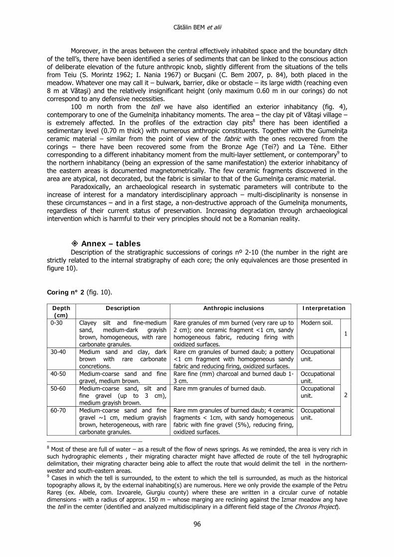
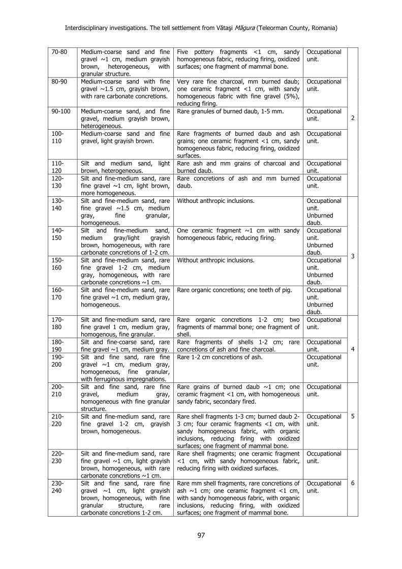
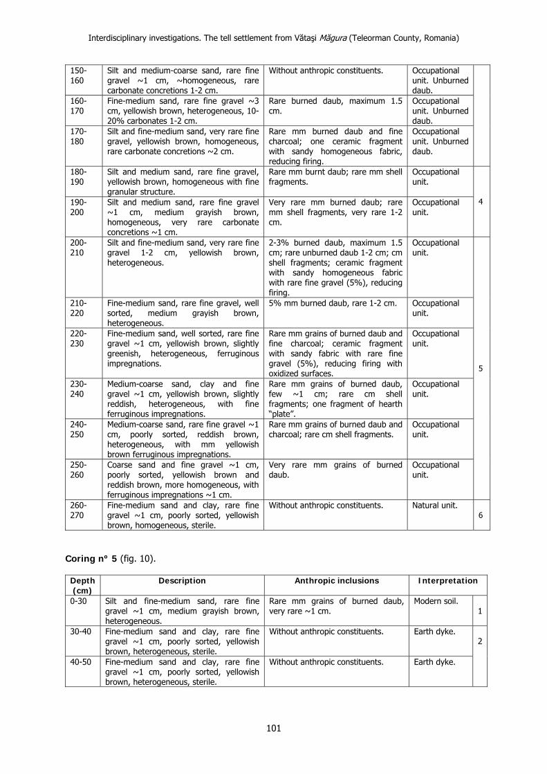
Annex – tables Description of the stratigraphic successions of corings nº 2-10 (the number in the right are
strictly related to the internal stratigraphy of each core; the only equivalences are those presented in figure 10). Coring nº 2 (fig. 10).
Depth (cm)
Description Anthropic inclusions Interpretation
0-30 Clayey silt and fine-medium sand, medium-dark grayish brown, homogeneous, with rare carbonate granules.
Rare granules of mm burned (very rare up to 2 cm); one ceramic fragment <1 cm, sandy homogeneous fabric, reducing firing with oxidized surfaces.
Modern soil. 1
30-40 Medium sand and clay, dark brown with rare carbonate concretions.
Rare cm granules of burned daub; a pottery <1 cm fragment with homogeneous sandy fabric and reducing firing, oxidized surfaces.
Occupational unit.
40-50 Medium-coarse sand and fine gravel, medium brown.
Rare fine (mm) charcoal and burned daub 1-3 cm.
Occupational unit.
50-60 Medium-coarse sand, silt and fine gravel (up to 3 cm), medium grayish brown.
Rare mm granules of burned daub. Occupational unit.
60-70 Medium-coarse sand and fine gravel ~1 cm, medium grayish brown, heterogeneous, with rare carbonate granules.
Rare mm granules of burned daub; 4 ceramic fragments < 1cm, with sandy homogeneous fabric with fine gravel (5%), reducing firing, oxidized surfaces.
Occupational unit.
2
8 Most of these are full of water – as a result of the flow of news springs. As we reminded, the area is very rich in such hydrographic elements , their migrating character might have affected de route of the tell hydrographic delimitation, their migrating character being able to affect the route that would delimit the tell in the northern-wester and south-eastern areas. 9 Cases in which the tell is surrounded, to the extent to which the tell is surrounded, as much as the historical topography allows it, by the external inahabiting(s) are numerous. Here we only provide the example of the Petru Rareş (ex. Albele, com. Izvoarele, Giurgiu county) where these are written in a circular curve of notable dimensions - with a radius of approx. 150 m – whose marging are reclining against the Izmar meadow ang have the tell in the cemter (identified and analyzed multidisciplinary in a different field stage of the Chronos Project).
Interdisciplinary investigations. The tell settlement from Vătaşi Măgura (Teleorman County, Romania)
97
70-80 Medium-coarse sand and fine gravel ~1 cm, medium grayish brown, heterogeneous, with granular structure.
Five pottery fragments <1 cm, sandy homogeneous fabric, reducing firing, oxidized surfaces; one fragment of mammal bone.
Occupational unit.
80-90 Medium-coarse sand with fine gravel ~1.5 cm, grayish brown, with rare carbonate concretions.
Very rare fine charcoal, mm burned daub; one ceramic fragment <1 cm, with sandy homogeneous fabric with fine gravel (5%), reducing firing.
Occupational unit.
90-100 Medium-coarse sand, and fine gravel, medium grayish brown, heterogeneous.
Rare granules of burned daub, 1-5 mm. Occupational unit.
100-110
Medium-coarse sand and fine gravel, light grayish brown.
Rare fragments of burned daub and ash grains; one ceramic fragment <1 cm, sandy homogeneous fabric, reducing firing, oxidized surfaces.
Occupational unit.
110-120
Silt and medium sand, light brown, heterogeneous.
Rare ash and mm grains of charcoal and burned daub.
Occupational unit.
120-130
Silt and fine-medium sand, rare fine gravel ~1 cm, light brown, more homogeneous.
Rare concretions of ash and mm burned daub.
Occupational unit.
2
130-140
Silt and fine-medium sand, rare fine gravel ~1.5 cm, medium gray, fine granular, homogeneous.
Without anthropic inclusions. Occupational unit. Unburned daub.
140-150
Silt and fine-medium sand, medium gray/light grayish brown, homogeneous, with rare carbonate concretions of 1-2 cm.
One ceramic fragment ~1 cm with sandy homogeneous fabric, reducing firing.
Occupational unit. Unburned daub.
150-160
Silt and fine-medium sand, rare fine gravel 1-2 cm, medium gray, homogeneous, with rare carbonate concretions ~1 cm.
Without anthropic inclusions. Occupational unit. Unburned daub.
160-170
Silt and fine-medium sand, rare fine gravel ~1 cm, medium gray, homogeneous.
Rare organic concretions; one teeth of pig. Occupational unit. Unburned daub.
3
170-180
Silt and fine-medium sand, rare fine gravel 1 cm, medium gray, homogenous, fine granular.
Rare organic concretions 1-2 cm; two fragments of mammal bone; one fragment of shell.
Occupational unit.
180-190
Silt and fine-coarse sand, rare fine gravel ~1 cm, medium gray.
Rare fragments of shells 1-2 cm; rare concretions of ash and fine charcoal.
Occupational unit.
190-200
Silt and fine sand, rare fine gravel ~1 cm, medium gray, homogeneous, fine granular, with ferruginous impregnations.
Rare 1-2 cm concretions of ash. Occupational unit.
4
200-210
Silt and fine sand, rare fine gravel, medium gray, homogeneous with fine granular structure.
Rare grains of burned daub ~1 cm; one ceramic fragment <1 cm, with homogeneous sandy fabric, secondary fired.
Occupational unit.
210-220
Silt and fine-medium sand, rare fine gravel 1-2 cm, grayish brown, homogeneous.
Rare shell fragments 1-3 cm; burned daub 2-3 cm; four ceramic fragments <1 cm, with sandy homogeneous fabric, with organic inclusions, reducing firing with oxidized surfaces; one fragment of mammal bone.
Occupational unit.
5
220-230
Silt and fine-medium sand, rare fine gravel ~1 cm, light grayish brown, homogeneous, with rare carbonate concretions ~1 cm.
Rare shell fragments; one ceramic fragment <1 cm, with sandy homogeneous fabric, reducing firing with oxidized surfaces.
Occupational unit.
230-240
Silt and fine sand, rare fine gravel ~1 cm, light grayish brown, homogeneous, with fine granular structure, rare carbonate concretions 1-2 cm.
Rare mm shell fragments, rare concretions of ash ~1 cm; one ceramic fragment <1 cm, with sandy homogeneous fabric, with organic inclusions, reducing firing, with oxidized surfaces; one fragment of mammal bone.
Occupational unit.
6
Cătălin BEM et alii
98
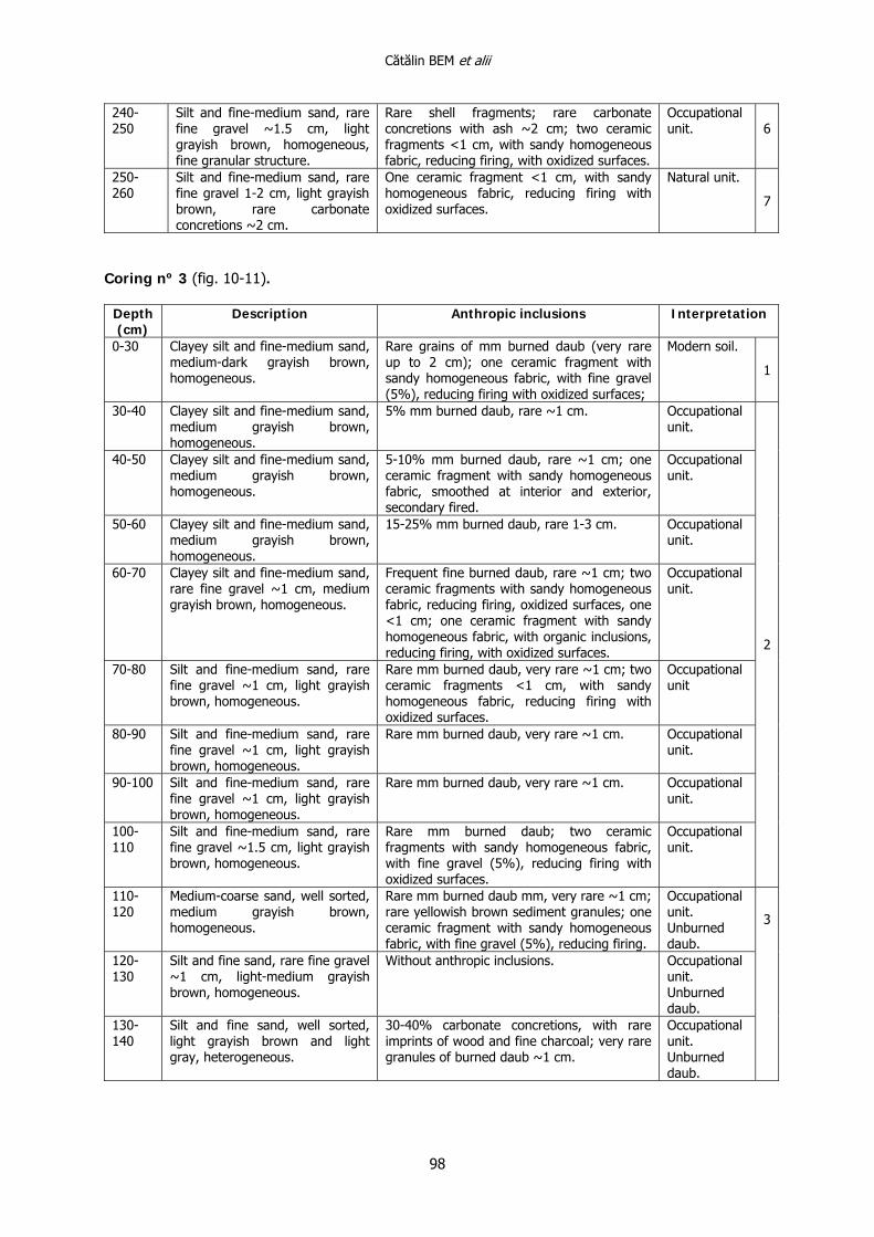
240-250
Silt and fine-medium sand, rare fine gravel ~1.5 cm, light grayish brown, homogeneous, fine granular structure.
Rare shell fragments; rare carbonate concretions with ash ~2 cm; two ceramic fragments <1 cm, with sandy homogeneous fabric, reducing firing, with oxidized surfaces.
Occupational unit.
6
250-260
Silt and fine-medium sand, rare fine gravel 1-2 cm, light grayish brown, rare carbonate concretions ~2 cm.
One ceramic fragment <1 cm, with sandy homogeneous fabric, reducing firing with oxidized surfaces.
Natural unit.
7
Coring nº 3 (fig. 10-11).
Depth (cm)
Description Anthropic inclusions Interpretation
0-30 Clayey silt and fine-medium sand, medium-dark grayish brown, homogeneous.
Rare grains of mm burned daub (very rare up to 2 cm); one ceramic fragment with sandy homogeneous fabric, with fine gravel (5%), reducing firing with oxidized surfaces;
Modern soil. 1
30-40 Clayey silt and fine-medium sand, medium grayish brown, homogeneous.
5% mm burned daub, rare ~1 cm. Occupational unit.
40-50 Clayey silt and fine-medium sand, medium grayish brown, homogeneous.
5-10% mm burned daub, rare ~1 cm; one ceramic fragment with sandy homogeneous fabric, smoothed at interior and exterior, secondary fired.
Occupational unit.
50-60 Clayey silt and fine-medium sand, medium grayish brown, homogeneous.
15-25% mm burned daub, rare 1-3 cm. Occupational unit.
60-70 Clayey silt and fine-medium sand, rare fine gravel ~1 cm, medium grayish brown, homogeneous.
Frequent fine burned daub, rare ~1 cm; two ceramic fragments with sandy homogeneous fabric, reducing firing, oxidized surfaces, one <1 cm; one ceramic fragment with sandy homogeneous fabric, with organic inclusions, reducing firing, with oxidized surfaces.
Occupational unit.
70-80 Silt and fine-medium sand, rare fine gravel ~1 cm, light grayish brown, homogeneous.
Rare mm burned daub, very rare ~1 cm; two ceramic fragments <1 cm, with sandy homogeneous fabric, reducing firing with oxidized surfaces.
Occupational unit
80-90 Silt and fine-medium sand, rare fine gravel ~1 cm, light grayish brown, homogeneous.
Rare mm burned daub, very rare ~1 cm. Occupational unit.
90-100 Silt and fine-medium sand, rare fine gravel ~1 cm, light grayish brown, homogeneous.
Rare mm burned daub, very rare ~1 cm. Occupational unit.
100-110
Silt and fine-medium sand, rare fine gravel ~1.5 cm, light grayish brown, homogeneous.
Rare mm burned daub; two ceramic fragments with sandy homogeneous fabric, with fine gravel (5%), reducing firing with oxidized surfaces.
Occupational unit.
2
110-120
Medium-coarse sand, well sorted, medium grayish brown, homogeneous.
Rare mm burned daub mm, very rare ~1 cm; rare yellowish brown sediment granules; one ceramic fragment with sandy homogeneous fabric, with fine gravel (5%), reducing firing.
Occupational unit. Unburned daub.
120-130
Silt and fine sand, rare fine gravel ~1 cm, light-medium grayish brown, homogeneous.
Without anthropic inclusions. Occupational unit. Unburned daub.
130-140
Silt and fine sand, well sorted, light grayish brown and light gray, heterogeneous.
30-40% carbonate concretions, with rare imprints of wood and fine charcoal; very rare granules of burned daub ~1 cm.
Occupational unit. Unburned daub.
3
Interdisciplinary investigations. The tell settlement from Vătaşi Măgura (Teleorman County, Romania)
99
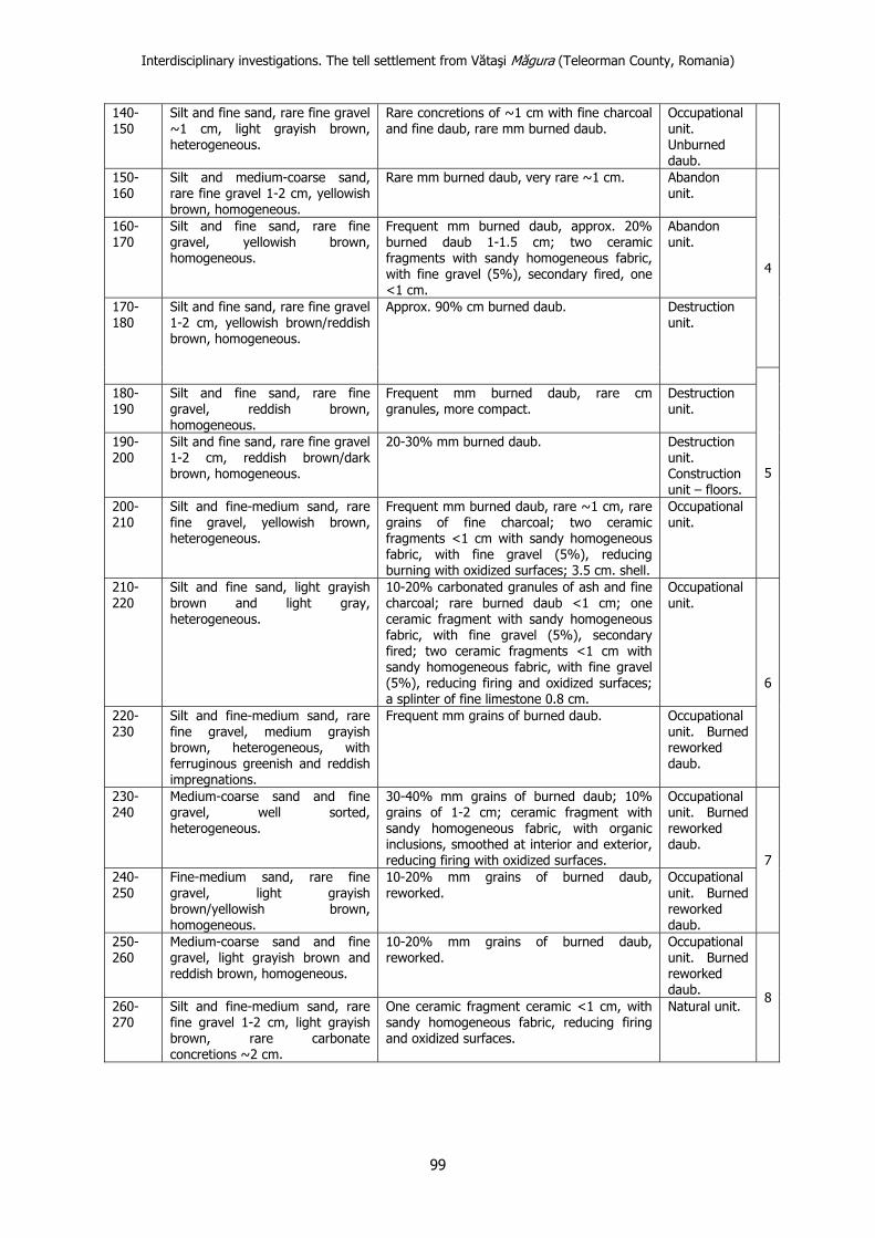
140-150
Silt and fine sand, rare fine gravel ~1 cm, light grayish brown, heterogeneous.
Rare concretions of ~1 cm with fine charcoal and fine daub, rare mm burned daub.
Occupational unit. Unburned daub.
150-160
Silt and medium-coarse sand, rare fine gravel 1-2 cm, yellowish brown, homogeneous.
Rare mm burned daub, very rare ~1 cm. Abandon unit.
160-170
Silt and fine sand, rare fine gravel, yellowish brown, homogeneous.
Frequent mm burned daub, approx. 20% burned daub 1-1.5 cm; two ceramic fragments with sandy homogeneous fabric, with fine gravel (5%), secondary fired, one <1 cm.
Abandon unit.
4
170-180
Silt and fine sand, rare fine gravel 1-2 cm, yellowish brown/reddish brown, homogeneous.
Approx. 90% cm burned daub. Destruction unit.
180-190
Silt and fine sand, rare fine gravel, reddish brown, homogeneous.
Frequent mm burned daub, rare cm granules, more compact.
Destruction unit.
190-200
Silt and fine sand, rare fine gravel 1-2 cm, reddish brown/dark brown, homogeneous.
20-30% mm burned daub. Destruction unit. Construction unit – floors.
200-210
Silt and fine-medium sand, rare fine gravel, yellowish brown, heterogeneous.
Frequent mm burned daub, rare ~1 cm, rare grains of fine charcoal; two ceramic fragments <1 cm with sandy homogeneous fabric, with fine gravel (5%), reducing burning with oxidized surfaces; 3.5 cm. shell.
Occupational unit.
5
210-220
Silt and fine sand, light grayish brown and light gray, heterogeneous.
10-20% carbonated granules of ash and fine charcoal; rare burned daub <1 cm; one ceramic fragment with sandy homogeneous fabric, with fine gravel (5%), secondary fired; two ceramic fragments <1 cm with sandy homogeneous fabric, with fine gravel (5%), reducing firing and oxidized surfaces; a splinter of fine limestone 0.8 cm.
Occupational unit.
220-230
Silt and fine-medium sand, rare fine gravel, medium grayish brown, heterogeneous, with ferruginous greenish and reddish impregnations.
Frequent mm grains of burned daub. Occupational unit. Burned reworked daub.
6
230-240
Medium-coarse sand and fine gravel, well sorted, heterogeneous.
30-40% mm grains of burned daub; 10% grains of 1-2 cm; ceramic fragment with sandy homogeneous fabric, with organic inclusions, smoothed at interior and exterior, reducing firing with oxidized surfaces.
Occupational unit. Burned reworked daub.
240-250
Fine-medium sand, rare fine gravel, light grayish brown/yellowish brown, homogeneous.
10-20% mm grains of burned daub, reworked.
Occupational unit. Burned reworked daub.
7
250-260
Medium-coarse sand and fine gravel, light grayish brown and reddish brown, homogeneous.
10-20% mm grains of burned daub, reworked.
Occupational unit. Burned reworked daub.
260-270
Silt and fine-medium sand, rare fine gravel 1-2 cm, light grayish brown, rare carbonate concretions ~2 cm.
One ceramic fragment ceramic <1 cm, with sandy homogeneous fabric, reducing firing and oxidized surfaces.
Natural unit. 8
Cătălin BEM et alii
100
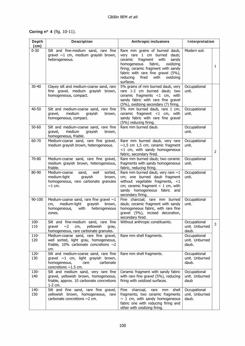
Coring nº 4 (fig. 10-11).
Depth (cm)
Description Anthropic inclusions Interpretation
0-30 Silt and fine-medium sand, rare fine gravel ~1 cm, medium grayish brown, heterogeneous.
Rare mm grains of burned daub, very rare 1 cm burned daub; ceramic fragment with sandy homogeneous fabric, oxidizing firing; ceramic fragment with sandy fabric with rare fine gravel (5%), reducing fired with oxidizing surfaces.
Modern soil.
1
30-40 Clayey silt and medium-coarse sand, rare fine gravel, medium grayish brown, homogeneous, compact.
5% grains of mm burned daub, very rare 1-2 cm burned daub; two ceramic fragments <1 cm, with sandy fabric with rare fine gravel (5%), oxidizing secondary (?) firing.
Occupational unit.
40-50 Silt and medium-coarse sand, rare fine gravel, medium grayish brown, homogeneous, compact.
5% mm burned daub, rare 1 cm; ceramic fragment <1 cm, with sandy fabric with rare fine gravel (5%) reducing firing.
Occupational unit.
50-60 Silt and medium-coarse sand, rare fine gravel, medium grayish brown, homogeneous, friable.
Rare mm burned daub. Occupational unit.
60-70 Medium-coarse sand, rare fine gravel, medium grayish brown, heterogeneous.
Rare mm burned daub, very rare ~1,5 cm 1,5 cm; ceramic fragment <1 cm, with sandy homogeneous fabric, secondary fired.
Occupational unit.
70-80 Medium-coarse sand, rare fine gravel, medium grayish brown, heterogeneous, friable.
Rare mm burned daub; two ceramic fragments with sandy homogeneous fabric, reducing firing.
Occupational unit.
80-90 Medium-coarse sand, well sorted, medium-light grayish brown, homogeneous, rare carbonate granules ~1 cm.
Rare mm burned daub, very rare ~1 cm; one burned daub fragment without vegetable fragments, <1 cm; ceramic fragment < 1 cm, with sandy homogeneous fabric and secondary firing.
Occupational unit.
90-100 Medium-coarse sand, rare fine gravel ~1 cm, medium-light grayish brown, homogeneous, with heterogeneous zones.
Fine charcoal; rare mm burned daub; ceramic fragment with sandy homogeneous fabric, with rare fine gravel (5%), incised decoration, secondary fired.
Occupational unit.
2
100-110
Silt and fine-medium sand, rare fine gravel ~2 cm, yellowish gray, homogeneous, rare carbonate granules.
Without anthropic constituents. Occupational unit. Unburned daub.
110-120
Medium-coarse sand, rare fine gravel, well sorted, light gray, homogeneous, friable, 10% carbonate concretions ~2 cm.
Rare mm shell fragments. Occupational unit. Unburned daub.
120-130
Silt and medium-coarse sand, rare fine gravel ~1 cm, light grayish brown, homogeneous, rare carbonate concretions ~1.5 cm.
Rare mm shell fragments. Occupational unit. Unburned daub.
130-140
Silt and medium sand, very rare fine gravel, yellowish brown, homogeneous, friable, approx. 10 carbonate concretions 1-2 cm.
Ceramic fragment with sandy fabric with rare fine gravel (5%), reducing firing with oxidized surfaces.
Occupational unit. Unburned daub
140-150
Silt and fine sand, rare fine gravel, yellowish brown, homogeneous, rare carbonate concretions ~2 cm.
Fine charcoal, rare mm shell fragments; two ceramic fragments ~ 1 cm, with sandy homogeneous fabric one with reducing firing and other with oxidizing firing.
Occupational unit. Unburned daub.
3
Interdisciplinary investigations. The tell settlement from Vătaşi Măgura (Teleorman County, Romania)
101
150-160
Silt and medium-coarse sand, rare fine gravel ~1 cm, ~homogeneous, rare carbonate concretions 1-2 cm.
Without anthropic constituents. Occupational unit. Unburned daub.
160-170
Fine-medium sand, rare fine gravel ~3 cm, yellowish brown, heterogeneous, 10-20% carbonates 1-2 cm.
Rare burned daub, maximum 1.5 cm.
Occupational unit. Unburned daub.
170-180
Silt and fine-medium sand, very rare fine gravel, yellowish brown, homogeneous, rare carbonate concretions ~2 cm.
Rare mm burned daub and fine charcoal; one ceramic fragment with sandy homogeneous fabric, reducing firing.
Occupational unit. Unburned daub.
180-190
Silt and medium sand, rare fine gravel, yellowish brown, homogeneous with fine granular structure.
Rare mm burnt daub; rare mm shell fragments.
Occupational unit.
190-200
Silt and medium sand, rare fine gravel ~1 cm, medium grayish brown, homogeneous, very rare carbonate concretions ~1 cm.
Very rare mm burned daub; rare mm shell fragments, very rare 1-2 cm.
Occupational unit.
4
200-210
Silt and fine-medium sand, very rare fine gravel 1-2 cm, yellowish brown, heterogeneous.
2-3% burned daub, maximum 1.5 cm; rare unburned daub 1-2 cm; cm shell fragments; ceramic fragment with sandy homogeneous fabric with rare fine gravel (5%), reducing firing.
Occupational unit.
210-220
Fine-medium sand, rare fine gravel, well sorted, medium grayish brown, heterogeneous.
5% mm burned daub, rare 1-2 cm. Occupational unit.
220-230
Fine-medium sand, well sorted, rare fine gravel ~1 cm, yellowish brown, slightly greenish, heterogeneous, ferruginous impregnations.
Rare mm grains of burned daub and fine charcoal; ceramic fragment with sandy fabric with rare fine gravel (5%), reducing firing with oxidized surfaces.
Occupational unit.
230-240
Medium-coarse sand, clay and fine gravel ~1 cm, yellowish brown, slightly reddish, heterogeneous, with fine ferruginous impregnations.
Rare mm grains of burned daub, few ~1 cm; rare cm shell fragments; one fragment of hearth “plate”.
Occupational unit.
240-250
Medium-coarse sand, rare fine gravel ~1 cm, poorly sorted, reddish brown, heterogeneous, with mm yellowish brown ferruginous impregnations.
Rare mm grains of burned daub and charcoal; rare cm shell fragments.
Occupational unit.
250-260
Coarse sand and fine gravel ~1 cm, poorly sorted, yellowish brown and reddish brown, more homogeneous, with ferruginous impregnations ~1 cm.
Very rare mm grains of burned daub.
Occupational unit.
5
260-270
Fine-medium sand and clay, rare fine gravel ~1 cm, poorly sorted, yellowish brown, homogeneous, sterile.
Without anthropic constituents. Natural unit. 6
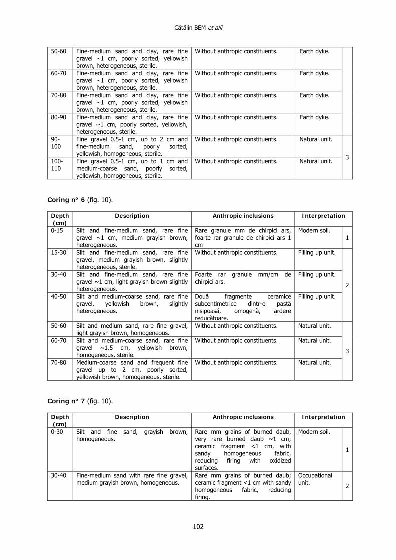
Coring nº 5 (fig. 10).
Depth (cm)
Description Anthropic inclusions Interpretation
0-30 Silt and fine-medium sand, rare fine gravel ~1 cm, medium grayish brown, heterogeneous.
Rare mm grains of burned daub, very rare ~1 cm.
Modern soil. 1
30-40 Fine-medium sand and clay, rare fine gravel ~1 cm, poorly sorted, yellowish brown, heterogeneous, sterile.
Without anthropic constituents. Earth dyke.
40-50 Fine-medium sand and clay, rare fine gravel ~1 cm, poorly sorted, yellowish brown, heterogeneous, sterile.
Without anthropic constituents. Earth dyke.
2
Cătălin BEM et alii
102
50-60 Fine-medium sand and clay, rare fine gravel ~1 cm, poorly sorted, yellowish brown, heterogeneous, sterile.
Without anthropic constituents. Earth dyke.
60-70 Fine-medium sand and clay, rare fine gravel ~1 cm, poorly sorted, yellowish brown, heterogeneous, sterile.
Without anthropic constituents. Earth dyke.
70-80 Fine-medium sand and clay, rare fine gravel ~1 cm, poorly sorted, yellowish brown, heterogeneous, sterile.
Without anthropic constituents. Earth dyke.
80-90 Fine-medium sand and clay, rare fine gravel ~1 cm, poorly sorted, yellowish, heterogeneous, sterile.
Without anthropic constituents. Earth dyke.
90-100
Fine gravel 0.5-1 cm, up to 2 cm and fine-medium sand, poorly sorted, yellowish, homogeneous, sterile.
Without anthropic constituents. Natural unit.
100-110
Fine gravel 0.5-1 cm, up to 1 cm and medium-coarse sand, poorly sorted, yellowish, homogeneous, sterile.
Without anthropic constituents. Natural unit. 3
Coring nº 6 (fig. 10).
Depth (cm)
Description Anthropic inclusions Interpretation
0-15 Silt and fine-medium sand, rare fine gravel ~1 cm, medium grayish brown, heterogeneous.
Rare granule mm de chirpici ars, foarte rar granule de chirpici ars 1 cm
Modern soil. 1
15-30 Silt and fine-medium sand, rare fine gravel, medium grayish brown, slightly heterogeneous, sterile.
Without anthropic constituents. Filling up unit.
30-40 Silt and fine-medium sand, rare fine gravel ~1 cm, light grayish brown slightly heterogeneous.
Foarte rar granule mm/cm de chirpici ars.
Filling up unit.
40-50 Silt and medium-coarse sand, rare fine gravel, yellowish brown, slightly heterogeneous.
Două fragmente ceramice subcentimetrice dintr-o pastă nisipoasă, omogenă, ardere reducătoare.
Filling up unit.
2
50-60 Silt and medium sand, rare fine gravel, light grayish brown, homogeneous.
Without anthropic constituents. Natural unit.
60-70 Silt and medium-coarse sand, rare fine gravel ~1.5 cm, yellowish brown, homogeneous, sterile.
Without anthropic constituents. Natural unit.
70-80 Medium-coarse sand and frequent fine gravel up to 2 cm, poorly sorted, yellowish brown, homogeneous, sterile.
Without anthropic constituents. Natural unit.
3
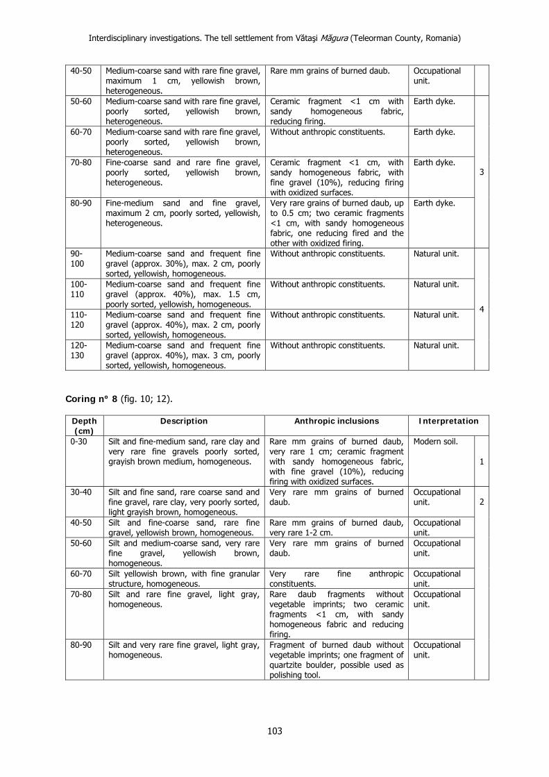
Coring nº 7 (fig. 10).
Depth (cm)
Description Anthropic inclusions Interpretation
0-30 Silt and fine sand, grayish brown, homogeneous.
Rare mm grains of burned daub, very rare burned daub ~1 cm; ceramic fragment <1 cm, with sandy homogeneous fabric, reducing firing with oxidized surfaces.
Modern soil.
1
30-40 Fine-medium sand with rare fine gravel, medium grayish brown, homogeneous.
Rare mm grains of burned daub; ceramic fragment <1 cm with sandy homogeneous fabric, reducing firing.
Occupational unit. 2
Interdisciplinary investigations. The tell settlement from Vătaşi Măgura (Teleorman County, Romania)
103
40-50 Medium-coarse sand with rare fine gravel, maximum 1 cm, yellowish brown, heterogeneous.
Rare mm grains of burned daub. Occupational unit.
50-60 Medium-coarse sand with rare fine gravel, poorly sorted, yellowish brown, heterogeneous.
Ceramic fragment <1 cm with sandy homogeneous fabric, reducing firing.
Earth dyke.
60-70 Medium-coarse sand with rare fine gravel, poorly sorted, yellowish brown, heterogeneous.
Without anthropic constituents. Earth dyke.
70-80 Fine-coarse sand and rare fine gravel, poorly sorted, yellowish brown, heterogeneous.
Ceramic fragment <1 cm, with sandy homogeneous fabric, with fine gravel (10%), reducing firing with oxidized surfaces.
Earth dyke.
80-90 Fine-medium sand and fine gravel, maximum 2 cm, poorly sorted, yellowish, heterogeneous.
Very rare grains of burned daub, up to 0.5 cm; two ceramic fragments <1 cm, with sandy homogeneous fabric, one reducing fired and the other with oxidized firing.
Earth dyke.
3
90-100
Medium-coarse sand and frequent fine gravel (approx. 30%), max. 2 cm, poorly sorted, yellowish, homogeneous.
Without anthropic constituents. Natural unit.
100-110
Medium-coarse sand and frequent fine gravel (approx. 40%), max. 1.5 cm, poorly sorted, yellowish, homogeneous.
Without anthropic constituents. Natural unit.
110-120
Medium-coarse sand and frequent fine gravel (approx. 40%), max. 2 cm, poorly sorted, yellowish, homogeneous.
Without anthropic constituents. Natural unit.
120-130
Medium-coarse sand and frequent fine gravel (approx. 40%), max. 3 cm, poorly sorted, yellowish, homogeneous.
Without anthropic constituents. Natural unit.
4
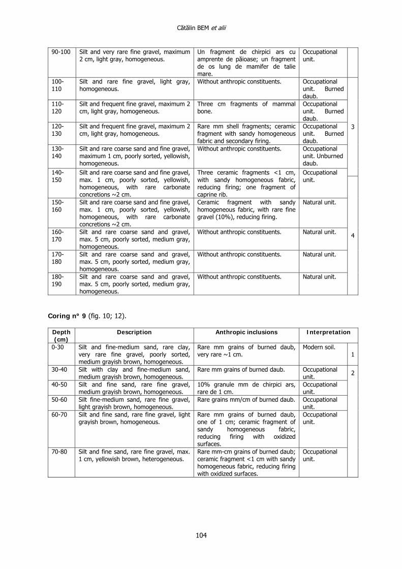
Coring nº 8 (fig. 10; 12).
Depth (cm)
Description Anthropic inclusions Interpretation
0-30 Silt and fine-medium sand, rare clay and very rare fine gravels poorly sorted, grayish brown medium, homogeneous.
Rare mm grains of burned daub, very rare 1 cm; ceramic fragment with sandy homogeneous fabric, with fine gravel (10%), reducing firing with oxidized surfaces.
Modern soil.
1
30-40 Silt and fine sand, rare coarse sand and fine gravel, rare clay, very poorly sorted, light grayish brown, homogeneous.
Very rare mm grains of burned daub.
Occupational unit.
40-50 Silt and fine-coarse sand, rare fine gravel, yellowish brown, homogeneous.
Rare mm grains of burned daub, very rare 1-2 cm.
Occupational unit.
50-60 Silt and medium-coarse sand, very rare fine gravel, yellowish brown, homogeneous.
Very rare mm grains of burned daub.
Occupational unit.
60-70 Silt yellowish brown, with fine granular structure, homogeneous.
Very rare fine anthropic constituents.
Occupational unit.
70-80 Silt and rare fine gravel, light gray, homogeneous.
Rare daub fragments without vegetable imprints; two ceramic fragments <1 cm, with sandy homogeneous fabric and reducing firing.
Occupational unit.
80-90 Silt and very rare fine gravel, light gray, homogeneous.
Fragment of burned daub without vegetable imprints; one fragment of quartzite boulder, possible used as polishing tool.
Occupational unit.
2
Cătălin BEM et alii
104
90-100 Silt and very rare fine gravel, maximum 2 cm, light gray, homogeneous.
Un fragment de chirpici ars cu amprente de păioase; un fragment de os lung de mamifer de talie mare.
Occupational unit.
100-110
Silt and rare fine gravel, light gray, homogeneous.
Without anthropic constituents. Occupational unit. Burned daub.
110-120
Silt and frequent fine gravel, maximum 2 cm, light gray, homogeneous.
Three cm fragments of mammal bone.
Occupational unit. Burned daub.
120-130
Silt and frequent fine gravel, maximum 2 cm, light gray, homogeneous.
Rare mm shell fragments; ceramic fragment with sandy homogeneous fabric and secondary firing.
Occupational unit. Burned daub.
130-140
Silt and rare coarse sand and fine gravel, maximum 1 cm, poorly sorted, yellowish, homogeneous.
Without anthropic constituents. Occupational unit. Unburned daub.
3
140-150
Silt and rare coarse sand and fine gravel, max. 1 cm, poorly sorted, yellowish, homogeneous, with rare carbonate concretions ~2 cm.
Three ceramic fragments <1 cm, with sandy homogeneous fabric, reducing firing; one fragment of caprine rib.
Occupational unit.
150-160
Silt and rare coarse sand and fine gravel, max. 1 cm, poorly sorted, yellowish, homogeneous, with rare carbonate concretions ~2 cm.
Ceramic fragment with sandy homogeneous fabric, with rare fine gravel (10%), reducing firing.
Natural unit.
160-170
Silt and rare coarse sand and gravel, max. 5 cm, poorly sorted, medium gray, homogeneous.
Without anthropic constituents. Natural unit.
170-180
Silt and rare coarse sand and gravel, max. 5 cm, poorly sorted, medium gray, homogeneous.
Without anthropic constituents. Natural unit.
180-190
Silt and rare coarse sand and gravel, max. 5 cm, poorly sorted, medium gray, homogeneous.
Without anthropic constituents. Natural unit.
4
Coring nº 9 (fig. 10; 12).
Depth (cm)
Description Anthropic inclusions Interpretation
0-30 Silt and fine-medium sand, rare clay, very rare fine gravel, poorly sorted, medium grayish brown, homogeneous.
Rare mm grains of burned daub, very rare ~1 cm.
Modern soil. 1
30-40 Silt with clay and fine-medium sand, medium grayish brown, homogeneous.
Rare mm grains of burned daub. Occupational unit.
40-50 Silt and fine sand, rare fine gravel, medium grayish brown, homogeneous.
10% granule mm de chirpici ars, rare de 1 cm.
Occupational unit.
50-60 Silt fine-medium sand, rare fine gravel, light grayish brown, homogeneous.
Rare grains mm/cm of burned daub. Occupational unit.
60-70 Silt and fine sand, rare fine gravel, light grayish brown, homogeneous.
Rare mm grains of burned daub, one of 1 cm; ceramic fragment of sandy homogeneous fabric, reducing firing with oxidized surfaces.
Occupational unit.
70-80 Silt and fine sand, rare fine gravel, max. 1 cm, yellowish brown, heterogeneous.
Rare mm-cm grains of burned daub; ceramic fragment <1 cm with sandy homogeneous fabric, reducing firing with oxidized surfaces.
Occupational unit.
2
Interdisciplinary investigations. The tell settlement from Vătaşi Măgura (Teleorman County, Romania)
105
80-90 Silt and fine sand, rare coarse sand, yellowish brown, homogeneous friable.
Rare mm grains of burned daub and charcoal; ceramic fragment with sandy homogeneous fabric with organic constituents and fine gravel (5%), reducing burning with oxidized surfaces.
Occupational unit.
90-100 Silt and fine sand, rare coarse sand and fine gravel, yellowish brown, homogeneous, friable.
Rare grains <1 cm of charcoal. Occupational unit.
100-110
Silt and fine-medium sand, rare fine gravel yellowish brown, homogeneous, friable.
Rare mm grains of burned daub; ceramic fragment with sandy homogeneous fabric with fine gravel (10%), reducing firing with oxidized surfaces.
Occupational unit.
110-120
Silt and fine sand, rare fine gravel, light grayish brown, heterogeneous, friable.
Fragment of burned daub of 3 cm; ceramic fragment with sandy homogeneous fabric with organic constituents (5%), reducing firing with oxidized surfaces.
Occupational unit.
120-130
Silt and fine sand, rare fine gravel, yellowish brown, homogeneous, friable.
Rare mm grains of burned daub. Occupational unit.
130-140
Silt and fine sand, rare fine gravel, light-medium gray, homogeneous, rare carbonate concretions 1-2 cm.
Two ceramic fragments <1 cm with sandy homogeneous reducing burning, one with oxidized surfaces; cm fragment of shell.
Occupational unit. Unburned daub.
140-150
Silt and fine-medium sand, light gray, homogeneous, friable, rare carbonate concretions 1-2 cm.
Two ceramic fragment, one <1 cm, with sandy homogeneous fabric, reducing burning with oxidized surfaces; mm fragments of shells.
Occupational unit. Unburned daub.
150-160
Silt and fine sand, rare fine gravel, light grayish brown, homogeneous, friable, rare carbonate concretions 1-2 cm.
One 2.5 cm daub grain, rounded; ceramic fragment <1 cm, with sandy homogeneous fabric, reducing burning; one ceramic fragment with sandy homogeneous fabric, organic constituents and fine gravel, reducing firing and oxidized surfaces.
Occupational unit. Unburned daub.
3
160-170
Silt and fine sand, rare fine gravel, light gray, homogeneous, friable, rare carbonate concretions 1-2 cm.
Ceramic fragment with sandy fabric with crushed pottery, fine gravel, reducing burning and oxidized surfaces; two ceramic fragments <1 cm, with sandy homogeneous fabric reducing burning and oxidized surfaces.
Occupational unit. Unburned daub.
170-180
Silt and fine sand, rare fine gravel, light gray, homogeneous, friable.
Very rare mm shell; two ceramic fragments <1 cm, with sandy homogeneous fabric, reducing burning and oxidized surfaces.
Occupational unit.
180-190
Silt and fine sand, rare fine gravel, light grayish brown, homogeneous, friable, very rare carbonate concretions ~1 cm.
Rare mm grains of burned daub. Occupational unit.
190-200
Silt and fine sand, rare fine gravel, light gray, homogeneous, rare carbonate concretions 1-2 cm.
Without anthropic constituents. Occupational unit.
4
200-210
Silt and fine sand, rare fine gravel max. 2 cm, light gray, homogeneous, rare carbonate concretions ~2 cm.
Fragment of burned daub with vegetable imprints.
Occupational unit. Unburned daub.
5
210-220
Fine silt, very fine rare gravel, light gray, homogeneous, friable.
Fragment of ~1 cm, unburned daub; two ceramic fragments <1 cm, with sandy homogeneous fabric with organic constituents and fine gravel (5%), reducing burning, with oxidized surfaces; shell fragment.
Occupational unit. Unburned daub. 5
Cătălin BEM et alii
106
220-230
Fine silt, very rare fine gravel, light gray, homogeneous, friable.
Without anthropic constituents. Natural unit.
230-240
Silt and fine sand, light grayish brown, heterogeneous, rare carbonate concretions 1-2 cm.
Frequent mm grains of charcoal; ceramic fragment with sandy homogeneous fabric, reducing burning, one with oxidized surfaces.
Natural unit.
240-250
Fine-medium sand and rare fine gravel, light grayish brown, heterogeneous with ferruginous impregnations, compact.
Without anthropic constituents. Natural unit.
250-260
Silt with clay, rare coarse sand, light grayish brown, homogeneous, frequent ferruginous impregnations, very rare fine charcoal.
Without anthropic constituents. Natural unit.
6
Coring nº 10 (fig. 10; 12). Depth (cm)
Description Anthropic inclusions Interpretation
0-30 Silt and fine-medium sand, rare clay, very rare fine gravel, poorly sorted, medium grayish brown, homogeneous.
Rare mm grains of burned daub, very rare cm grains of burned daub.
Modern soil. 1
30-40 Silt and fine-medium sand, rare fine gravel, poorly sorted, light-medium grayish brown, homogeneous.
Ceramic fragment ceramic with sandy homogeneous fabric with fine gravel (5%), reducing burning with oxidised surfaces.
Occupational unit.
40-50 Silt and fine sand, rare fine gravel 1-2 cm, poorly sorted, light gray and grayish brown, heterogeneous.
Very rare mm grains of burned daub. Occupational unit.
50-60 Silt and fine sand, rare fine gravel, max. 1.5 cm, yellowish, homogeneous..
Ceramic fragment with sandy homogeneous fabric, reducing burning, one with oxidized surfaces.
Occupational unit.
2
60-70 Silt and fine sand, rare fine gravel 1-2 cm, poorly sorted, light gray, homogeneous, rare carbonate concretions 1-3 cm.
Without anthropic constituents. Earth dyke.
70-80 Silt and fine sand, rare fine gravel, light gray, homogeneous, rare carbonate concretions 1-3 cm.
Without anthropic constituents. Earth dyke.
80-90 Silt and fine sand, rare fine gravel ~1 cm, light gray, homogeneous, rare carbonate concretions 1-2 cm.
Ceramic fragment with sandy homogeneous fabric, polished inside, reducing firing with oxidized surfaces.
Earth dyke.
3
90-100 Silt and fine sand, rare coarse sand and fine gravel 1-3 cm, poorly sorted, light gray, homogeneous.
Without anthropic constituents. Natural unit.
100-110 Fine-medium gravel, light gray, homogeneous.
Without anthropic constituents. Natural unit. 4
Interdisciplinary investigations. The tell settlement from Vătaşi Măgura (Teleorman County, Romania)
107
Bibliography
C. Bem 2002 Bucşani, com. Bucşani, jud. Giurgiu, Punct: Pod, La Pădure, in M. Angelescu, C. Borş, I. Oberländer-Târnoveanu, Fl. Vasilescu (eds.), CCA. Campania 2001, Bucureşti, Cimec, p. 67-69.
C. Bem 2007 Bucşani, com. Bucşani, jud. Giurgiu, Punct: La Pod, in M. Angelescu, Fl. Vasilescu (eds.), CCA. Campania 2006, Bucureşti, Cimec, p. 83-84.
C. Bem 2008 Bucşani, com. Bucşani, jud. Giurgiu, Punct: La Pod, Pădure, in M. Angelescu, Fl. Vasilescu (eds.), CCA. Campania 2007, Bucureşti, Cimec, http://cimec.ro/Arheologie/cronicaCA2008/cd/index.htm
C. Bem 2011a Le corpus des stations Gumelniţa entre Danube et Mer Noire (avec un regard sur Boian-Spanţov et Cernavoda I), in L. Carozza, C. Bem, C. Micu (eds.), Société et environnement dans la zone du Bas Danube durant le 5ème millénaire avant notre ère, Ed. Universităţii Al. I. Cuza Iaşi, p. 3-77.
C. Bem 2011b Vision d’ensemble de l’occupation Gumelniţa en Dobroudja, in L. Carozza, C. Bem, C. Micu (eds.), Société et environnement dans la zone du Bas Danube durant le 5ème millénaire avant notre ère, Ed. Universităţii Al. I. Cuza Iaşi, p. 131-197.
C. Bem et alii 2012 C. Bem, A. Asăndulesei, C. Bem, F.-A. Tencariu, V. Cotiugă, Şt. Caliniuc, Identity in diversity: photogrammetry, 3d laser scanning and magnetometric analysis of Gumelniţa tells from Muntenia (Romania), in V. Cotiugă, Şt. Caliniuc (eds.) Interdisciplinarity Research in Archaeology. Proceedings of the First Arheoinvest Congress, 10-11 June 2011, Iaşi, Romania, BAR (IS) 2433, p. 19-36.
L. Carozza et alii 2011 L. Carozza, J.-M. Carozza, C. Haită, F. Leveque, G. Opreanu, V. Radu, C. Mihail, Reconnaissances stratigraphiques par carottages de la micro-zone de Taraschina: apport des informations hors site et intra-site, in L. Carozza, C. Bem, C. Micu (eds.), Société et environnement dans la zone du Bas Danube durant le 5ème millénaire avant notre ère, Ed. Universităţii Al. I. Cuza Iaşi, p. 267-292.
S. Cristocea et alii 2005 S. Cristocea, R. Maschio, M. Păduraru, Cercetări arheologice în biserica Mănăstirii Glavacioc, judeţul Argeş (campania 2005), Argessis, 14, Piteşti, p. 231-241.
Vl. Dumitrescu 1965 Principalele rezultate ale primelor două campanii de săpătură din aşezarea neolitică târzie de la Căscioarele, SCIV, 16, 2, Bucureşti, p. 215-237.
C. Haită, C. Bem 2011 Données stratigraphiques des sites pluristratifiés, in L. Carozza, C. Bem, C. Micu (eds.), Société et environnement dans la zone du Bas Danube durant le 5ème millénaire avant notre ère, Ed. Universităţii Al. I. Cuza Iaşi, p. 89-99.
P. Mirea, A. Frînculeasa 2005
Locuirea eneolitică gumelniţeană de la Mănăstirea Glavacioc, jud. Argeş, Argessis, 14, Piteşti, p. 55-74.
S. Marinescu-Bîlcu et alii 1998
S. Marinescu-Bîlcu, R. Andreescu, C. Bem, T. Popa, M. Tănase, Şantierul arheologic Bucşani (jud.Giurgiu). Raport preliminar. Campania 1998, BMJTA, 2-4, Giurgiu, p. 93-114.
S. Morintz 1962 Tipuri de aşezări şi sisteme de fortificaţie şi de împrejmuire în cultura Gumelniţa, SCIV, 13, 2, p. 273-284.
I. Nania 1967 Locuitorii gumelniţeni în lumina cercetărilor de la Teiu, SAI, 9, Bucureşti, p. 7-23.
Gh. Olteanu et alii 2003 Gh. Olteanu, Ov. Cârstina, D. Căprăroiu, Repertoriul arheologic al judeţului Dâmboviţa. Volumul II (N-V), ed. Cetatea de Scaun, Târgovişte, 163 p.
Cătălin BEM et alii
108
I. Pătraşcu 2002 Aşezările culturii Gumelniţa din bazinul Vedei şi Teleormanului (partea I), Argessis, 11, Piteşti, p. 19-26.
D. Popescu 1966 Săpăturile arheologice din Republica Socialistă România în anul 1965, in SCIV, 17, 4, Bucureşti, p. 709-725.
I. Spiru 1996 File de istorie teleormăneană, Ed. Teleormanul Liber, Alexandria.
H. Тodorova et alii 1975 H. Todorova, St. Ivanov, V. Vasilev, M. Hopf, H. Quitta, G. Kohl, Голямо Делчево, Разкопки и Проучвания 5, Из. nа Българската Aкадемия, Софиа.
H. Тodorova et alii 1983 H. Todorova, V. Vasilev, Z. Ianucevici, М. Kovaceva, P. Vîlev, Овчарово, Разкопки и Проучвания 8, Из. nа Българската Aкадемия, София.
G. Trohani, Al. Oancea 1981
Cercetări arheologice pe Valea Glavaciocului, CA, 4, Bucureşti, p. 240-252.
Translation by Oana Gorgon (text) and Constantin Haită (annex-tables).
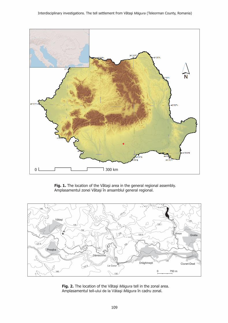
0 750 m
Jirnov
140
137.5
135 125
125
140
137.5 La Cucui
130
127.5
122.5
135
125
130
120
125122.5
Vătaşi
Preajba
Drăghineşti Ciurari-Deal
Gratia
Dâmbovnic
Fig. 1. The location of the VAmplasamentul zonei V
ătaăta
şi area in the general regional assembly.şi în ansamblul general regional.
Fig. 2.
Amplasamentul în cadru zonal.The location of the Văta tell in the zonal area.şi Măgura
Măguratell-ului de la Vătaşi
0 300 km
Interdisciplinary investigations. The tell settlement from Vătaşi (Teleorman County, Romania)aMăgur
109
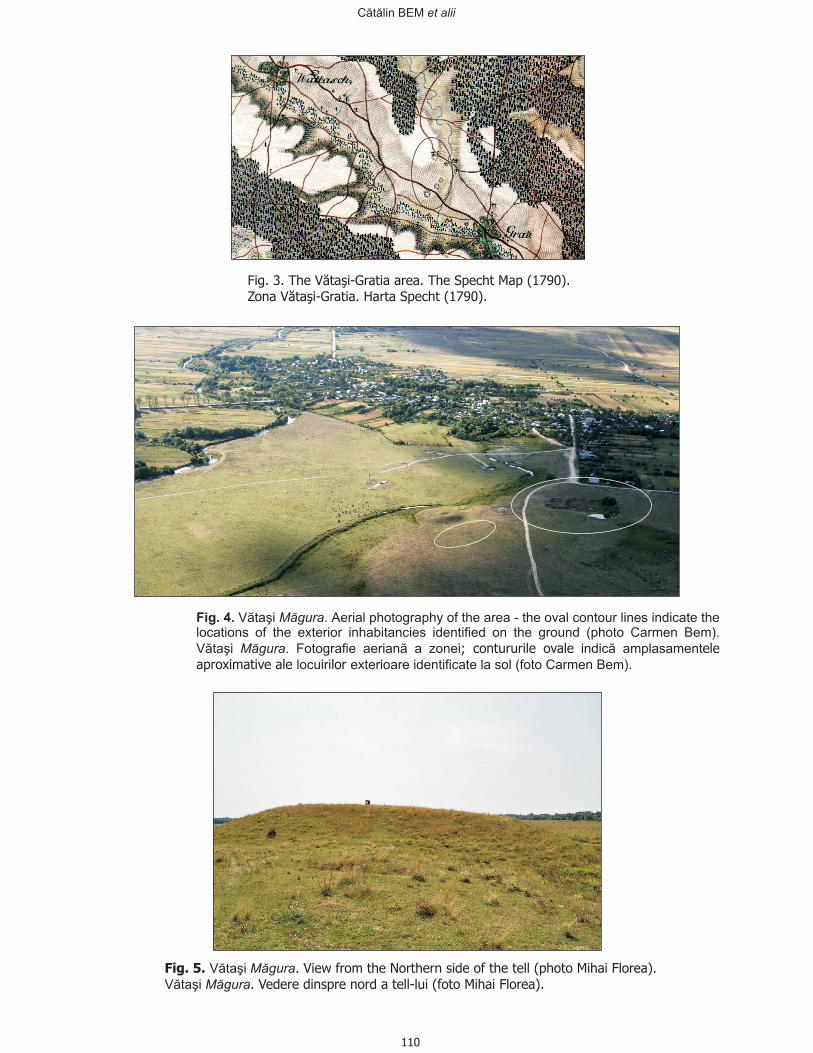
Fig. .4 Aerial photography of the area - the oval contour lines indicate thelocations of the exterior inhabitancies identified on the ground (photo Carmen Bem).
Vătaşi .
Vătaşi . Fotografie aeriană a zonei indică amplasament
locuiri exterioare (foto Carmen Bem).
Măgura
Măgura
identificate la sol
; contururile ovale eleaproximative ale lor
Fig. 5. Vătaşi
Vătaşi
Măgura
Măgura
.. Vedere dinspre nord a tell-lui (foto Mihai Florea).
View from the Northern side of the tell (photo Mihai Florea).
Fig. 3. ătaşi-Gratia area. The Specht Map (1790).The VZona V Harta Spechtătaşi-Gratia. (1790).
Cătălin BEM et alii
110
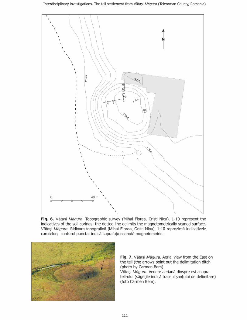
130.4
125.4
127.4
123.4
234
78
9
5
6
1 ’-1
10
0 40 m
N
Fig. 6. Vătaşi
Vătaşi idicare topografică (Mihai Florea, Cristi Nicu). reprezintă
ţa scanată magnetometric.
Măgura
Măgura
.; the dotted line delimits the magnetometrically scaned surface.
. R 1-10 indicativelecarotelor; conturul punctat indic suprafa
Topographic survey (Mihai Florea, Cristi Nicu). 1-10 represent theindicatives of the soil corings
ă
Fig. 7. . Aerial view from the East onthe tell (the arrows point out the delimitation ditch(photo by Carmen Bem).
. Vedere aerian(s )
(foto Carmen Bem)
Vătaşi
Vătaşi
Măgura
Măgura ă dinspre est asupratell-ului ăge ă traseulţile indic ţului de delimitare
.şan
Interdisciplinary investigations. The tell settlement from Vătaşi (Teleorman County, Romania)Măgura
111
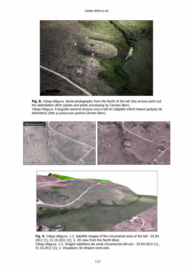
Fig. 8. Vătaşi Măgura. Aerial photography from the North of the tell (the arrows point outthe delimitation ditch (photo and photo processing by Carmen Bem).Vătaşi Măgura. Fotografie aeriană dinspre nord a tell-lui (săgeţile indică traseul şanţului dedelimitare) (foto şi prelucrare grafică Carmen Bem).
Fig. 9. Vătaşi Măgura. 1-2. Satellite images of the circumsized area of the tell - 03.04.2012 (1), 31.10.2012 (2); 3. 3D view from the North-West.Vătaşi Măgura. 1-2. Imagini satelitare ale zonei circumscrise tell-ului - 03.04.2012 (1),31.10.2012 (2); 3. Vizualizare 3D dinspre nord-vest.
1 2
3
Cătălin BEM et alii
112
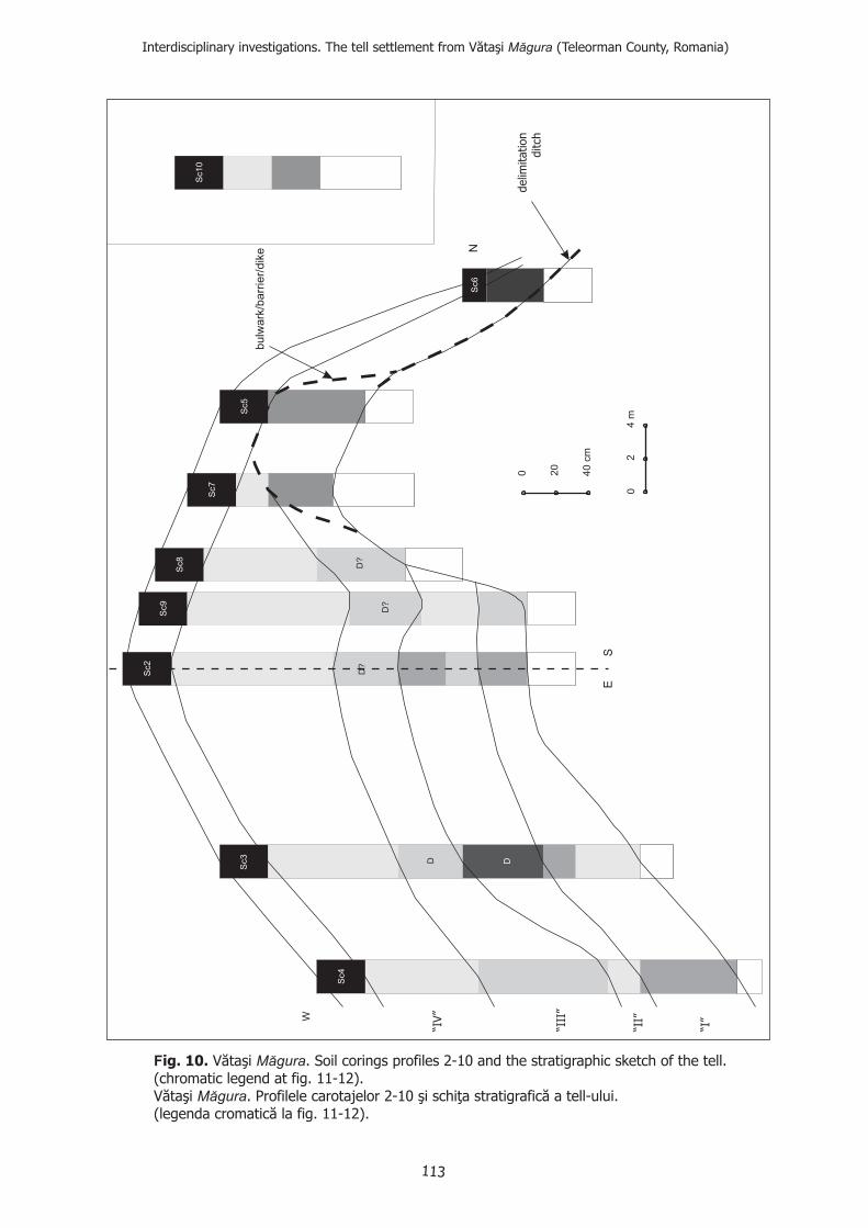
04
m
0 40
cm
20
2
D
D?
D?
D?
Sc2
D
N
W
Sc7
Sc8
Sc9
Sc5
Sc10
Sc6
Sc4
Sc3
SE
Fig. 10. Vătaşi .
Vătaşi . Profilele carot elor 2-10 şi schiţa stratigrafică ala fig. 11-12).
Măgura
Măgura
Soil corings profiles 2-10 and the stratigraphic sketch of the tell.(chromatic legend at fig. 11-12).
aj tell-ului.(legenda cromatică
delim
itation
ditch
“I”
“II”
“III
”
“IV”
Interdisciplinary investigations. The tell settlement from Vătaşi (Teleorman County, Romania)Măgura
bulw
ark
/barr
ier/
dik
e
113
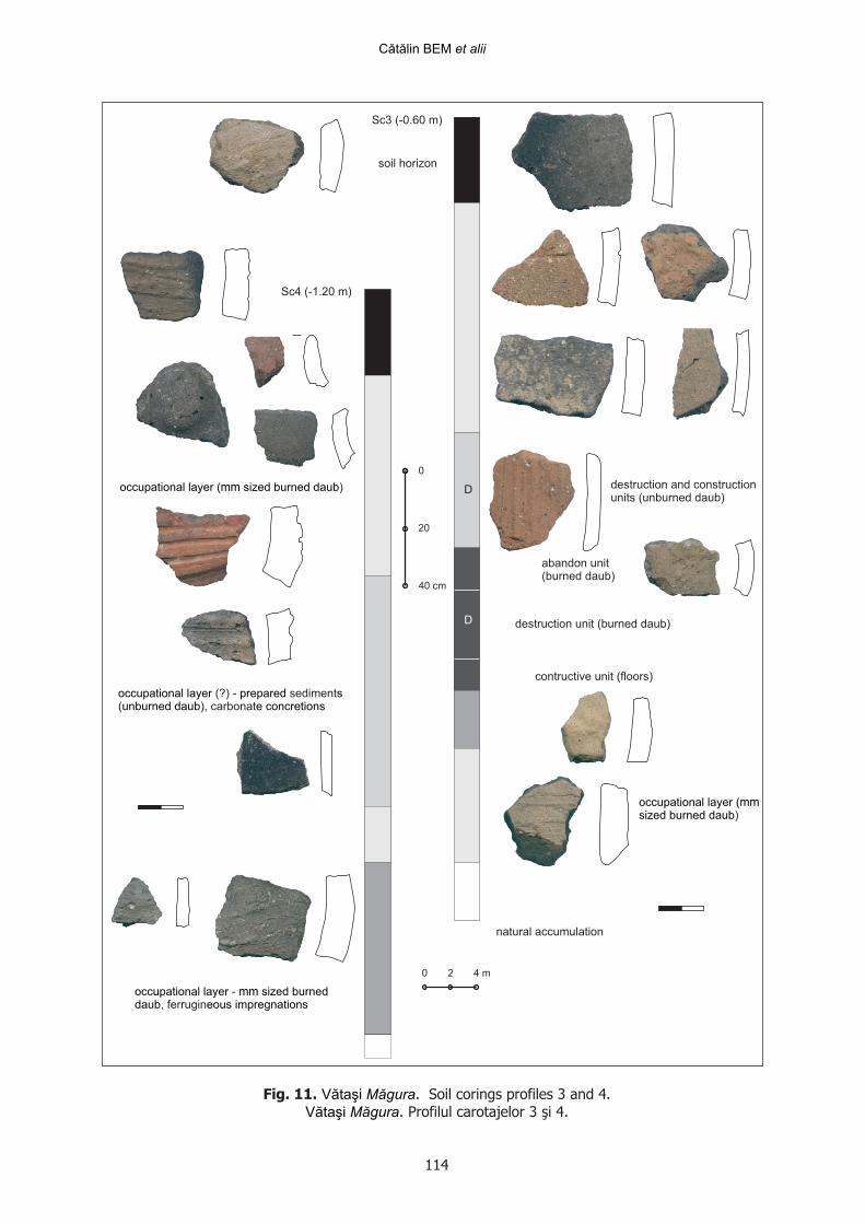
Sc3 (-0.60 m)
Sc4 (-1.20 m)
D
D
0
20
40 cm
0 2 4 m
destruction unit (burned daub)
destruction and constructionunits (unburned daub)
natural accumulation
occupational layer (mm sized burned daub)
occupational layer prepared s (?) - sediment( ), carbonatunburned daub e concretions
contructive unit (floors)
soil horizon
occupational layer mm sized burned - daub r eous impregnations, fer ugin
abandon unit(burned daub)
Fig. 11. . Soil corings profiles 3 and 4.Vătaşi Măgura. Profilul carotajelor 3 şi 4.Vătaşi Măgura
Cătălin BEM et alii
occupational layer (mmsized burned daub)
114
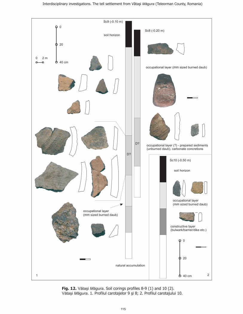
D?
D?
Fig. 1 .2 .. 1. Profilul carot elor 9
Soil corings profiles 8-9 (1) and 10 (2).aj ; ajuluişi 8 2. Profilul carot 10.
Vătaşi
Vătaşi
Măgura
Măgura
0
20
40 cm
0
20
40 cm
0 2 m
Sc10 (-0.50 m)
Sc8 (-0.20 m)
Sc9 (-0.10 m)
constructiv(bulwark/barrier/dike etc.)
e layer
1 2
Interdisciplinary investigations. The tell settlement from Vătaşi (Teleorman County, Romania)Măgura
soil horizon
occupational layer
( sized burned daubmm )
natural accumulation
occupational layer ( sized burned daubmm )
soil horizon
occupational layer
( sized burned daubmm )
occupational layer prepared sunburned daub e concretions
(?) - sediment( ), carbonat
115
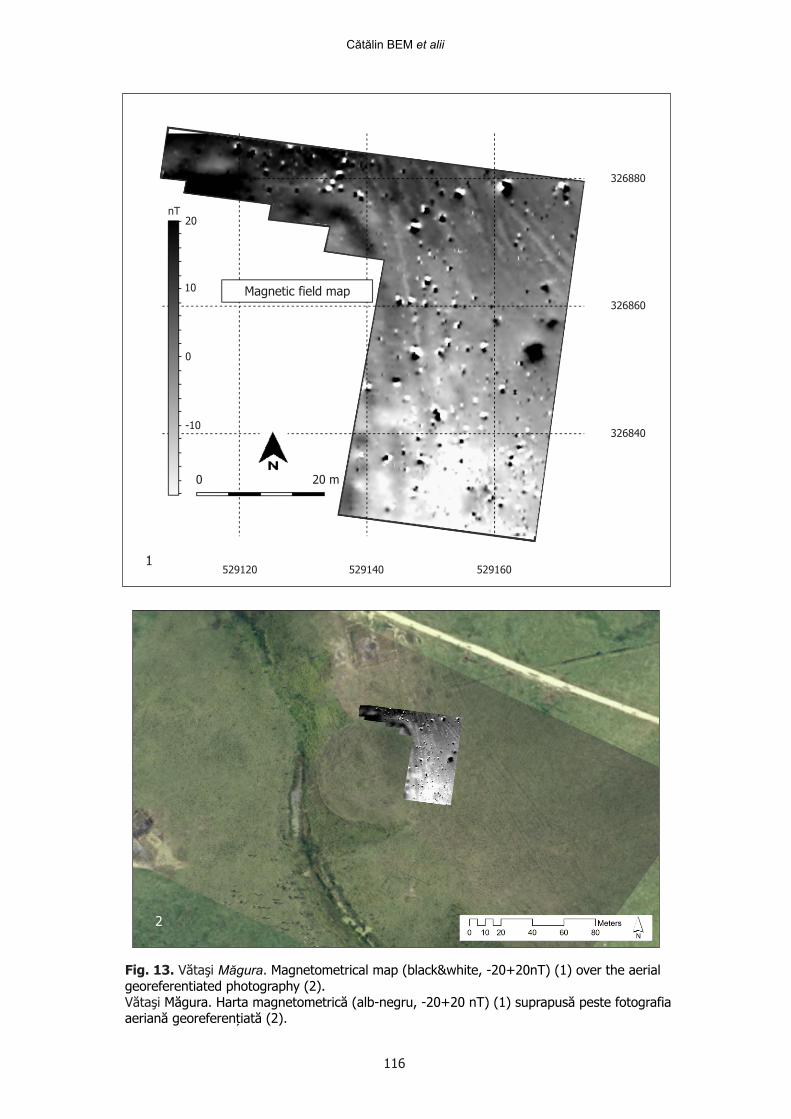
Fig. 13. Vătaşi . Măgura Magnetometrical map (black&white, -20+20nT) (1) over the aerialgeoreferentiated photography (2).
Măgura Harta magnetometrică (alb-negru, -20+20 nT) (1) suprapusă peste fotografiaVătaşi . .aeriană georeferențiată (2)
Magnetic field map
nT
326880
326860
326840
529120 529140 529160
0 20 m
20
10
0
-10
1
2
Cătălin BEM et alii
116
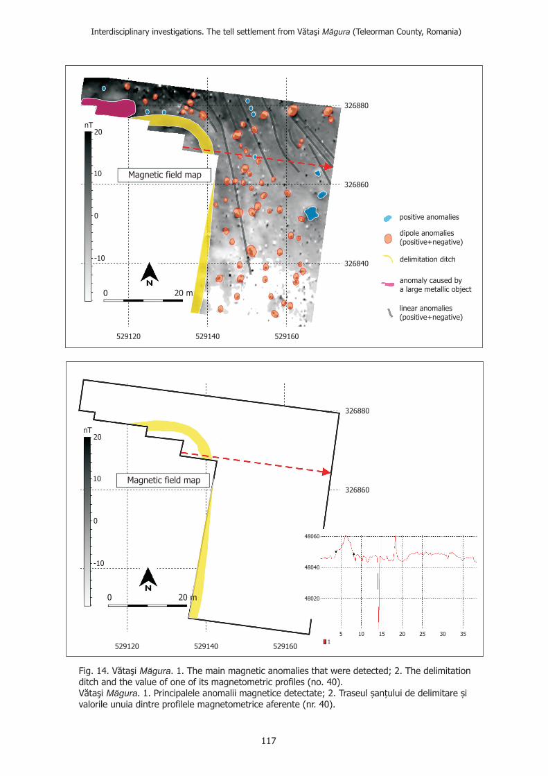
Fig. 14. V The main magnetic anomalies that were detected
V.
ăta .
ăta .
şi
şi
1. 2.
1. 2.
Măgura
Măgura
; The delimitationditch and the value of one of its magnetometric profiles (no. 40).
Principalele anomalii magnetice detectate; Traseul șan�ului de delimitare șivalorile unuia dintre profilele magnetometrice aferente (nr. 40)
326840
Magnetic field map
nT
326860
326880
20
10
0
-10
0 20 m
529120 529140 529160
positive anomalies
delimitation ditch
linear(positive+negative)
anomalies
dipole anomalies(positive+negative)
anomaly caused bya large metallic object
326840
Magnetic field map
nT
326860
326880
20
10
0
-10
0 20 m
529120 529140 5291601
5 10 15 20 25 30 35
48060
48040
48020
Interdisciplinary investigations. The tell settlement from Vătaşi (Teleorman County, Romania)Măgura
117
Related Documents


