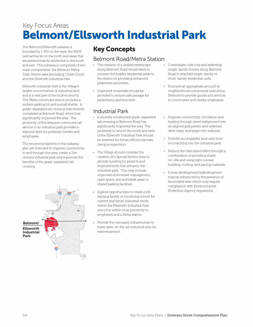
Belmont/ Ellsworth Industrial Park 355 355 88 34 34 The Belmont/Ellsworth subarea is bounded by I-355 on the west, the BNSF railroad tracks on the north and areas that are predominantly residential to the south and east. This subarea is comprised of two main components: the Belmont Metra Train Station area (including Chase Court) and the Ellsworth Industrial Park. Ellsworth Industrial Park is the Village’s largest concentration of industrial land and is a vital part of the local economy. The Metra commuter station includes a surface parking lot and a small shelter. A grade-separated rail crossing was recently completed at Belmont Road, which has significantly improved the area. The proximity of this frequent commuter rail service to an industrial park provides a regional draw for potential owners and employees. The recommendations in this subarea plan are intended to improve connectivity to and through this area, create a 21st century industrial park and maximize the benefits of the grade-separated rail crossing. • A recently constructed grade-separated rail crossing at Belmont Road has significantly improved the area. The proximity to land to the south and west of the Ellsworth Industrial Park should be reserved for future office/corporate campus expansion. • The Village should consider the creation of a Special Service Area to provide funding for projects and improvements that enhance the industrial park. This may include improved stormwater management, open space, rest and break areas or shared parking facilities. • Explore opportunities to create a job training facility or vocational school for current and future industrial needs within the Ellsworth Industrial Park since it is within close proximity to employers and a Metra station. • Provide the necessary infrastructure to foster state-of-the-art industrial sites for redevelopment . • Improve connectivity, circulation and loading through street realignment into an aligned grid pattern and widened drive ways, and larger turn radiuses. • Prohibit incompatible land uses from encroaching into the industrial park. • Reduce the heat island effect through a combination of providing shade on-site and using light colored building, roofing, and paving materials. • Future development/redevelopment may be influenced by the presence of brownfield sites which may require compliance with Environmental Protection Agency regulations. Belmont/Ellsworth Industrial Park Key Concepts Belmont Road/Metra Station • The creation of a unified streetscape along Belmont Road would serve to connect the nearby residential areas to the station by providing enhanced pedestrian amenities. • Improved crosswalks should be provided to ensure safe passage for pedestrians and bicyclists. • Consolidate curb cuts and redevelop single-family homes along Belmont Road to attached single-family or multi-family residential units. • Promote an appropriate amount of neighborhood commercial uses along Belmont to provide goods and services to commuters and nearby employees. Key Focus Areas Industrial Park 114 Key Focus Area Plans | Downers Grove Comprehensive Plan

Welcome message from author
This document is posted to help you gain knowledge. Please leave a comment to let me know what you think about it! Share it to your friends and learn new things together.
Transcript
Belmont/
EllsworthIndustrial Park
MAPLE
CURTISS
WISCONSIN
HITCHCOCK
BE
LMO
NT
WISCONSIN
BURLINGTON
ELMORE
HOWARD
ELI
NO
R
DURAND
LOM
ON
D
TH
AT
CH
ER
KA
TR
INE
INVERNESS
JAN
ES
PU
FFE
R
HIL
LCR
ESTTAMARACK
ASP
EN
ASHLEY
CH
ASE
CH
ASE
KA
TR
INE
INVERNESS
HITCHCOCK
WA
LNU
T
BURLINGTON NORTHERN SANTA FE RAILROAD
355
355 88
34
34
355
Decorative metal fencing should replace chainlink fencing within
the industrial park
Improve the appearance to the Interstate and maximize the exposure it provides
Rooftop mechanical equipmentshould be screened from view
Close Inverness west of Janes Ave to industrial park tra�c
Bu�er residential areas from negative impacts of the industrial park
Explore limiting access to Belmont Road
Promote lot consolidation
TO OGDEN AVENUE
TO 75TH STREET
Mile
0
0 5 minute walk2.5 minute walk
1/16 1/8 1/4 RecommendationsBelmont Underpass
Unified Streetscape
Gateway/DirectorySignage
Interstate Interchange
“Jog” in Street Grid
Potential Access Restrictions (right-in / right-out)
Improved Pedestrian Crossing
Metra Communter Station
Village-Proposed Bicycle Route
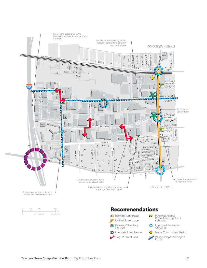
The Belmont/Ellsworth subarea is
bounded by I-355 on the west, the BNSF
railroad tracks on the north and areas that
are predominantly residential to the south
and east. This subarea is comprised of two
main components: the Belmont Metra
Train Station area (including Chase Court)
and the Ellsworth Industrial Park.
Ellsworth Industrial Park is the Village’s
largest concentration of industrial land
and is a vital part of the local economy.
The Metra commuter station includes a
surface parking lot and a small shelter. A
grade-separated rail crossing was recently
completed at Belmont Road, which has
significantly improved the area. The
proximity of this frequent commuter rail
service to an industrial park provides a
regional draw for potential owners and
employees.
The recommendations in this subarea
plan are intended to improve connectivity
to and through this area, create a 21st
century industrial park and maximize the
benefits of the grade-separated rail
crossing.
• A recently constructed grade-separated
rail crossing at Belmont Road has
significantly improved the area. The
proximity to land to the south and west
of the Ellsworth Industrial Park should
be reserved for future office/corporate
campus expansion.
• The Village should consider the
creation of a Special Service Area to
provide funding for projects and
improvements that enhance the
industrial park. This may include
improved stormwater management,
open space, rest and break areas or
shared parking facilities.
• Explore opportunities to create a job
training facility or vocational school for
current and future industrial needs
within the Ellsworth Industrial Park
since it is within close proximity to
employers and a Metra station.
• Provide the necessary infrastructure to
foster state-of-the-art industrial sites for
redevelopment .
• Improve connectivity, circulation and
loading through street realignment into
an aligned grid pattern and widened
drive ways, and larger turn radiuses.
• Prohibit incompatible land uses from
encroaching into the industrial park.
• Reduce the heat island effect through a
combination of providing shade
on-site and using light colored
building, roofing, and paving materials.
• Future development/redevelopment
may be influenced by the presence of
brownfield sites which may require
compliance with Environmental
Protection Agency regulations.
Belmont/Ellsworth Industrial ParkKey Concepts
Belmont Road/Metra Station• The creation of a unified streetscape
along Belmont Road would serve to
connect the nearby residential areas to
the station by providing enhanced
pedestrian amenities.
• Improved crosswalks should be
provided to ensure safe passage for
pedestrians and bicyclists.
• Consolidate curb cuts and redevelop
single-family homes along Belmont
Road to attached single-family or
multi-family residential units.
• Promote an appropriate amount of
neighborhood commercial uses along
Belmont to provide goods and services
to commuters and nearby employees.
Key Focus Areas
Industrial Park
114 Key Focus Area Plans | Downers Grove Comprehensive Plan
Belmont/
EllsworthIndustrial Park
MAPLE
CURTISS
WISCONSIN
HITCHCOCK
BE
LMO
NT
WISCONSIN
BURLINGTON
ELMORE
HOWARD
ELI
NO
R
DURAND
LOM
ON
D
TH
AT
CH
ER
KA
TR
INE
INVERNESS
JAN
ES
PU
FFE
R
HIL
LCR
ESTTAMARACK
ASP
EN
ASHLEYC
HA
SE
CH
ASE
KA
TR
INE
INVERNESS
HITCHCOCK
WA
LNU
T
BURLINGTON NORTHERN SANTA FE RAILROAD
355
355 88
34
34
355
Decorative metal fencing should replace chainlink fencing within
the industrial park
Improve the appearance to the Interstate and maximize the exposure it provides
Rooftop mechanical equipmentshould be screened from view
Close Inverness west of Janes Ave to industrial park tra�c
Bu�er residential areas from negative impacts of the industrial park
Explore limiting access to Belmont Road
Promote lot consolidation
TO OGDEN AVENUE
TO 75TH STREET
Mile
0
0 5 minute walk2.5 minute walk
1/16 1/8 1/4 RecommendationsBelmont Underpass
Unified Streetscape
Gateway/DirectorySignage
Interstate Interchange
“Jog” in Street Grid
Potential Access Restrictions (right-in / right-out)
Improved Pedestrian Crossing
Metra Communter Station
Village-Proposed Bicycle Route
The Belmont/Ellsworth subarea is
bounded by I-355 on the west, the BNSF
railroad tracks on the north and areas that
are predominantly residential to the south
and east. This subarea is comprised of two
main components: the Belmont Metra
Train Station area (including Chase Court)
and the Ellsworth Industrial Park.
Ellsworth Industrial Park is the Village’s
largest concentration of industrial land
and is a vital part of the local economy.
The Metra commuter station includes a
surface parking lot and a small shelter. A
grade-separated rail crossing was recently
completed at Belmont Road, which has
significantly improved the area. The
proximity of this frequent commuter rail
service to an industrial park provides a
regional draw for potential owners and
employees.
The recommendations in this subarea
plan are intended to improve connectivity
to and through this area, create a 21st
century industrial park and maximize the
benefits of the grade-separated rail
crossing.
• A recently constructed grade-separated
rail crossing at Belmont Road has
significantly improved the area. The
proximity to land to the south and west
of the Ellsworth Industrial Park should
be reserved for future office/corporate
campus expansion.
• The Village should consider the
creation of a Special Service Area to
provide funding for projects and
improvements that enhance the
industrial park. This may include
improved stormwater management,
open space, rest and break areas or
shared parking facilities.
• Explore opportunities to create a job
training facility or vocational school for
current and future industrial needs
within the Ellsworth Industrial Park
since it is within close proximity to
employers and a Metra station.
• Provide the necessary infrastructure to
foster state-of-the-art industrial sites for
redevelopment .
• Improve connectivity, circulation and
loading through street realignment into
an aligned grid pattern and widened
drive ways, and larger turn radiuses.
• Prohibit incompatible land uses from
encroaching into the industrial park.
• Reduce the heat island effect through a
combination of providing shade
on-site and using light colored
building, roofing, and paving materials.
• Future development/redevelopment
may be influenced by the presence of
brownfield sites which may require
compliance with Environmental
Protection Agency regulations.
Belmont/Ellsworth Industrial ParkKey Concepts
Belmont Road/Metra Station• The creation of a unified streetscape
along Belmont Road would serve to
connect the nearby residential areas to
the station by providing enhanced
pedestrian amenities.
• Improved crosswalks should be
provided to ensure safe passage for
pedestrians and bicyclists.
• Consolidate curb cuts and redevelop
single-family homes along Belmont
Road to attached single-family or
multi-family residential units.
• Promote an appropriate amount of
neighborhood commercial uses along
Belmont to provide goods and services
to commuters and nearby employees.
Key Focus Areas
Industrial Park
115Downers Grove Comprehensive Plan | Key Focus Area Plans
A5
A4
A6
A3
A2A1
TO OGDEN AVENUE
TO 75TH STREET
355
MAPLE
CURTISS
WISCONSIN
HITCHCOCK
BE
LMO
NT
WISCONSIN
BURLINGTON
ELMORE
HOWARD
ELI
NO
R
DURAND
LOM
ON
D
TH
AT
CH
ER
KA
TR
INE
INVERNESS
JAN
ES
PU
FFE
R
HIL
LCR
ESTTAMARACK
ASP
EN
ASHLEY
CH
ASE
CH
ASE
KA
TR
INE
INVERNESS
KA
TR
INE
HITCHCOCK
WA
LNU
T
BURLINGTON NORTHERN SANTA FE RAILROAD
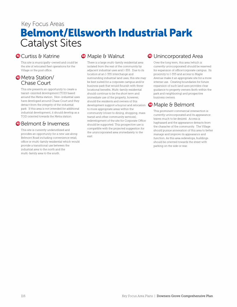
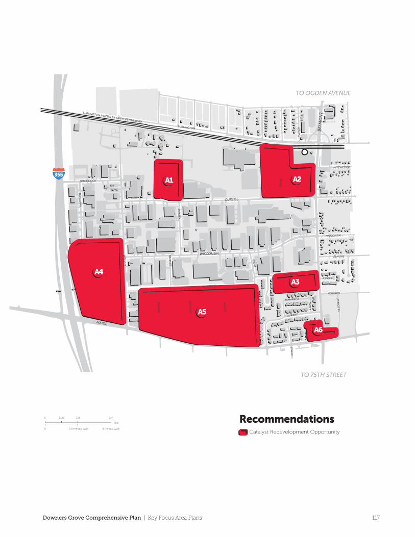
Curtiss & KatrineThis site is municipally-owned and could be
the site of relocated fleet operations for the
Village or the post o�ce.
Metra Station/Chase CourtThis site presents an opportunity to create a
transit-oriented development (TOD) based
around the Metra station. Non-industrial uses
have developed around Chase Court and they
detract from the integrity of the industrial
park. If this area is not intended for additional
industrial development, it should develop as a
TOD oriented towards the Metra station.
Belmont & InvernessThis site is currently underutilized and
provides an opportunity for a new use along
Belmont Road including convenience retail,
o�ce or multi-family residential which would
provide a transitional use between the
industrial area to the north and the
multi-family area to the south.
Maple & WalnutThere is a large multi-family residential area
isolated from the rest of the community by
adjacent industrial uses and I-355. Due to its
location at an I-355 interchange and
surrounding industrial land uses, this site may
be best suited for a corporate campus and/or
business park that would flourish with these
locational benefits. Multi-family residential
should continue to be the short term and
immediate use of the property, however,
should the residents and owners of this
development support a buyout and relocation
to more appropriate areas within the
community (closer to dining, shopping, mass
transit and other community services),
redevelopment of the site for Corporate O�ce
should be supported. This prospective use is
compatible with the projected suggestion for
the unincorporated area immediately to the
east.
Unincorporated AreaOver the long term, this area (which is
currently unincorporated) should be reserved
for expansion of o�ce/corporate campus. Its
proximity to I-355 and access to Maple
Avenue make it an appropriate site for a more
intense use. Creating boundaries for future
expansion of such land uses provides clear
guidance to property owners (both within the
park and neighboring) and prospective
business owners.
Maple & BelmontThis prominent commercial intersection is
currently unincorporated and its appearance
leaves much to be desired. Access is
haphazard and the appearance detracts from
the character of the community. The Village
should pursue annexation of this area to better
manage and improve its appearance and
function. As this area redevelops, buildings
should be oriented towards the street with
parking on the side or rear.
Belmont/Ellsworth Industrial ParkCatalyst Sites
Key Focus Areas
A1
A2
A3
A6
A4 A5
RecommendationsCatalyst Redevelopment Opportunity
Mile
0
0 5 minute walk2.5 minute walk
1/16 1/8 1/4
116 Key Focus Area Plans | Downers Grove Comprehensive Plan
A5
A4
A6
A3
A2A1
TO OGDEN AVENUE
TO 75TH STREET
355
MAPLE
CURTISS
WISCONSIN
HITCHCOCK
BE
LMO
NT
WISCONSIN
BURLINGTON
ELMORE
HOWARD
ELI
NO
R
DURAND
LOM
ON
D
TH
AT
CH
ER
KA
TR
INE
INVERNESS
JAN
ES
PU
FFE
R
HIL
LCR
ESTTAMARACK
ASP
EN
ASHLEYC
HA
SE
CH
ASE
KA
TR
INE
INVERNESS
KA
TR
INE
HITCHCOCK
WA
LNU
T
BURLINGTON NORTHERN SANTA FE RAILROAD
Curtiss & KatrineThis site is municipally-owned and could be
the site of relocated fleet operations for the
Village or the post o�ce.
Metra Station/Chase CourtThis site presents an opportunity to create a
transit-oriented development (TOD) based
around the Metra station. Non-industrial uses
have developed around Chase Court and they
detract from the integrity of the industrial
park. If this area is not intended for additional
industrial development, it should develop as a
TOD oriented towards the Metra station.
Belmont & InvernessThis site is currently underutilized and
provides an opportunity for a new use along
Belmont Road including convenience retail,
o�ce or multi-family residential which would
provide a transitional use between the
industrial area to the north and the
multi-family area to the south.
Maple & WalnutThere is a large multi-family residential area
isolated from the rest of the community by
adjacent industrial uses and I-355. Due to its
location at an I-355 interchange and
surrounding industrial land uses, this site may
be best suited for a corporate campus and/or
business park that would flourish with these
locational benefits. Multi-family residential
should continue to be the short term and
immediate use of the property, however,
should the residents and owners of this
development support a buyout and relocation
to more appropriate areas within the
community (closer to dining, shopping, mass
transit and other community services),
redevelopment of the site for Corporate O�ce
should be supported. This prospective use is
compatible with the projected suggestion for
the unincorporated area immediately to the
east.
Unincorporated AreaOver the long term, this area (which is
currently unincorporated) should be reserved
for expansion of o�ce/corporate campus. Its
proximity to I-355 and access to Maple
Avenue make it an appropriate site for a more
intense use. Creating boundaries for future
expansion of such land uses provides clear
guidance to property owners (both within the
park and neighboring) and prospective
business owners.
Maple & BelmontThis prominent commercial intersection is
currently unincorporated and its appearance
leaves much to be desired. Access is
haphazard and the appearance detracts from
the character of the community. The Village
should pursue annexation of this area to better
manage and improve its appearance and
function. As this area redevelops, buildings
should be oriented towards the street with
parking on the side or rear.
Belmont/Ellsworth Industrial ParkCatalyst Sites
Key Focus Areas
A1
A2
A3
A6
A4 A5
RecommendationsCatalyst Redevelopment Opportunity
Mile
0
0 5 minute walk2.5 minute walk
1/16 1/8 1/4
117Downers Grove Comprehensive Plan | Key Focus Area Plans
Butterfield
355
355
88
34
34
FIN
LEY
LAC
EY
HIG
HLA
ND
BROOK
31ST
FRONTAGE
WO
OD
CREEK
DO
WN
ER
S
OPU
S
CE
NT
RE
SCH
ELD
RU
P
OA
K G
RO
VEBUTTERFIELD
BUTTERFIELD
CE
NT
RE
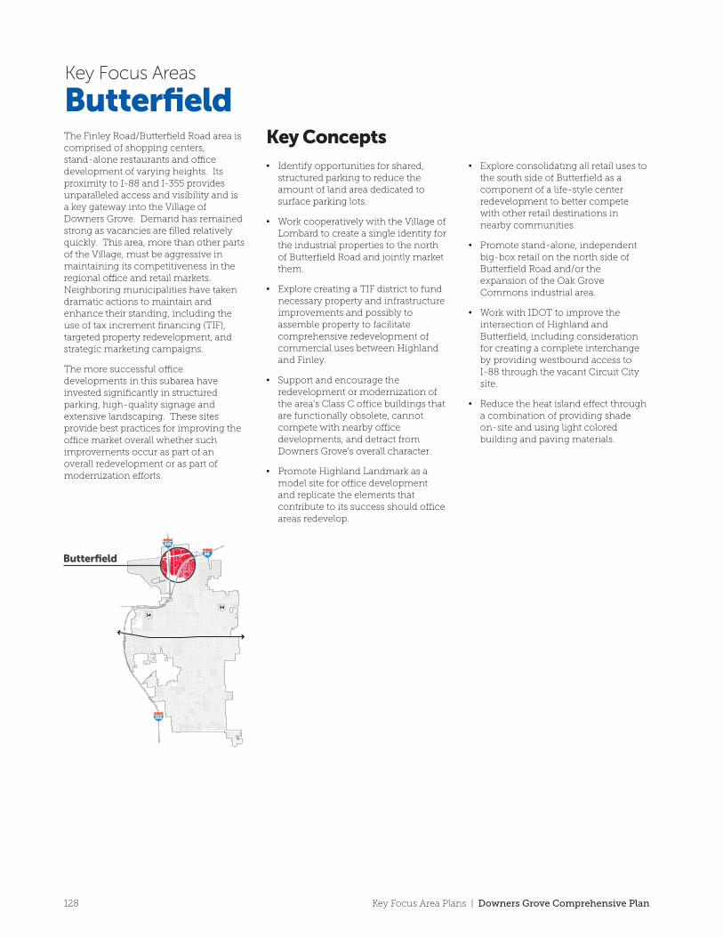
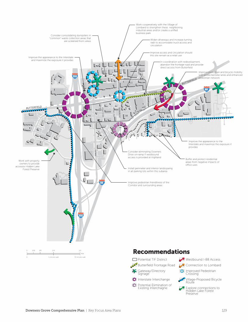
The Finley Road/Butterfield Road area is comprised of shopping centers, stand-alone restaurants and o�ce development of varying heights. Its proximity to I-88 and I-355 provides unparalleled access and visibility and is a key gateway into the Village of Downers Grove. Demand has remained strong as vacancies are filled relatively quickly. This area, more than other parts of the Village, must be aggressive in maintaining its competitiveness in the regional o�ce and retail markets. Neighboring municipalities have taken dramatic actions to maintain and enhance their standing, including the use of tax increment financing (TIF), targeted property redevelopment, and strategic marketing campaigns.
The more successful o�ce developments in this subarea have invested significantly in structured parking, high-quality signage and extensive landscaping. These sites provide best practices for improving the o�ce market overall whether such improvements occur as part of an overall redevelopment or as part of modernization e�orts.
ButterfieldKey Concepts• Identify opportunities for shared,
structured parking to reduce the amount of land area dedicated to surface parking lots.
• Work cooperatively with the Village of Lombard to create a single identity for the industrial properties to the north of Butterfield Road and jointly market them.
• Explore creating a TIF district to fund necessary property and infrastructure improvements and possibly to assemble property to facilitate comprehensive redevelopment of commercial uses between Highland and Finley.
• Support and encourage the redevelopment or modernization of the area’s Class C office buildings that are functionally obsolete, cannot compete with nearby office developments, and detract from Downers Grove’s overall character.
• Promote Highland Landmark as a model site for office development and replicate the elements that contribute to its success should office areas redevelop.
• Explore consolidating all retail uses to the south side of Butterfield as a component of a life-style center redevelopment to better compete with other retail destinations in nearby communities.
• Promote stand-alone, independent big-box retail on the north side of Butterfield Road and/or the expansion of the Oak Grove Commons industrial area.
• Work with IDOT to improve the intersection of Highland and Butterfield, including consideration for creating a complete interchange by providing westbound access to I-88 through the vacant Circuit City site.
• Reduce the heat island effect through a combination of providing shade on-site and using light colored building and paving materials.
Key Focus Areas
355
355
88
88
RecommendationsPotential TIF District
Butterfield Frontage Road
Gateway/Directory Signage
Interstate Interchange
Potential Elimination of Existing Interchagne
Westbound I-88 Access
Connection to Lombard
Improved Pedestrian Crossing
Village-Proposed Bicycle Route
Explore connections to Hidden Lake Forest Preserve
Mile
0
0 10 minute walk5 minute walk
1/16 1/8 1/4 1/2
Bu�er and protect residential areas from negative impacts of o�ce uses
Install perimeter and interior landscpaing in all parking lots within this subarea
Improve pedestrian friendliness of the Corridor and surrounding areas
Improve access and circulation should this site remain as a retail use
Widen driveways and increase turning radii to accomodate truck access and circulation
Consider consolidating dumpsters in “common” waste collection areas that
are screened from views
Work with property owners to provide
accessto Hidden Lake Forest Preserve
In coordination with redevelopment, abandon the frontage road and provide direct access from Butterfield
Improve pedestrian and bicycle mobility with protected bike lanes and enhanced pedestrian network
Consider eliminating Downers Drive on-ramp if westbound access is provided at Highland
Improve the appearance to the Interstate and maximize the exposure it provides
Improve the appearance to the Interstate and maximize the exposure it provides
Work cooperatively with the Village of Lombard to strengthen these neighboring industrial areas and/or create a unified business park
128 Key Focus Area Plans | Downers Grove Comprehensive Plan
Butterfield
355
355
88
34
34
FIN
LEY
LAC
EY
HIG
HLA
ND
BROOK
31ST
FRONTAGE
WO
OD
CREEK
DO
WN
ER
S
OPU
S
CE
NT
RE
SCH
ELD
RU
P
OA
K G
RO
VEBUTTERFIELD
BUTTERFIELD
CE
NT
RE
The Finley Road/Butterfield Road area is comprised of shopping centers, stand-alone restaurants and o�ce development of varying heights. Its proximity to I-88 and I-355 provides unparalleled access and visibility and is a key gateway into the Village of Downers Grove. Demand has remained strong as vacancies are filled relatively quickly. This area, more than other parts of the Village, must be aggressive in maintaining its competitiveness in the regional o�ce and retail markets. Neighboring municipalities have taken dramatic actions to maintain and enhance their standing, including the use of tax increment financing (TIF), targeted property redevelopment, and strategic marketing campaigns.
The more successful o�ce developments in this subarea have invested significantly in structured parking, high-quality signage and extensive landscaping. These sites provide best practices for improving the o�ce market overall whether such improvements occur as part of an overall redevelopment or as part of modernization e�orts.
ButterfieldKey Concepts• Identify opportunities for shared,
structured parking to reduce the amount of land area dedicated to surface parking lots.
• Work cooperatively with the Village of Lombard to create a single identity for the industrial properties to the north of Butterfield Road and jointly market them.
• Explore creating a TIF district to fund necessary property and infrastructure improvements and possibly to assemble property to facilitate comprehensive redevelopment of commercial uses between Highland and Finley.
• Support and encourage the redevelopment or modernization of the area’s Class C office buildings that are functionally obsolete, cannot compete with nearby office developments, and detract from Downers Grove’s overall character.
• Promote Highland Landmark as a model site for office development and replicate the elements that contribute to its success should office areas redevelop.
• Explore consolidating all retail uses to the south side of Butterfield as a component of a life-style center redevelopment to better compete with other retail destinations in nearby communities.
• Promote stand-alone, independent big-box retail on the north side of Butterfield Road and/or the expansion of the Oak Grove Commons industrial area.
• Work with IDOT to improve the intersection of Highland and Butterfield, including consideration for creating a complete interchange by providing westbound access to I-88 through the vacant Circuit City site.
• Reduce the heat island effect through a combination of providing shade on-site and using light colored building and paving materials.
Key Focus Areas
355
355
88
88
RecommendationsPotential TIF District
Butterfield Frontage Road
Gateway/Directory Signage
Interstate Interchange
Potential Elimination of Existing Interchagne
Westbound I-88 Access
Connection to Lombard
Improved Pedestrian Crossing
Village-Proposed Bicycle Route
Explore connections to Hidden Lake Forest Preserve
Mile
0
0 10 minute walk5 minute walk
1/16 1/8 1/4 1/2
Bu�er and protect residential areas from negative impacts of o�ce uses
Install perimeter and interior landscpaing in all parking lots within this subarea
Improve pedestrian friendliness of the Corridor and surrounding areas
Improve access and circulation should this site remain as a retail use
Widen driveways and increase turning radii to accomodate truck access and circulation
Consider consolidating dumpsters in “common” waste collection areas that
are screened from views
Work with property owners to provide
accessto Hidden Lake Forest Preserve
In coordination with redevelopment, abandon the frontage road and provide direct access from Butterfield
Improve pedestrian and bicycle mobility with protected bike lanes and enhanced pedestrian network
Consider eliminating Downers Drive on-ramp if westbound access is provided at Highland
Improve the appearance to the Interstate and maximize the exposure it provides
Improve the appearance to the Interstate and maximize the exposure it provides
Work cooperatively with the Village of Lombard to strengthen these neighboring industrial areas and/or create a unified business park
129Downers Grove Comprehensive Plan | Key Focus Area Plans
C1
C2
C3
C4C5
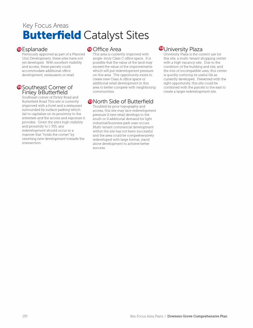
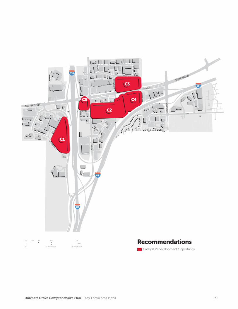
EsplanadePreviously approved as part of a Planned Unit Development, these sites have not yet developed. With excellent visibility and access, these parcels could accommodate additional o�ce development, restaurants or retail.
Southeast Corner of Finley &ButterfieldSoutheast corner of Finley Road and Butterfield Road This site is currently improved with a hotel and a restaurant surrounded by surface parking which fail to capitalize on its proximity to the interstate and the access and exposure it provides. Given the site’s high visibility and proximity to I-355, any redevelopment should occur in a manner that “holds the corner” by orienting new development towards the intersection.
O�ce AreaThis area is currently improved with single-story Class C o�ce space. It is possible that the value of the land may exceed the value of the improvements which will put redevelopment pressure on this area. The opportunity exists to create new Class A o�ce space or additional retail development in this area to better compete with neighboring communities.
North Side of ButterfieldTroubled by poor topography and access, this site may face redevelopment pressure if new retail develops to the south or if additional demand for light industrial/business park uses occurs. Multi-tenant commercial development within the site has not been successful and the area could be comprehensively redeveloped with large format, stand alone development to achieve better success.
University PlazaUniversity Plaza is the current use for this site, a multi-tenant shopping center with a high vacancy rate. Due to the condition of the building and site, and the mix of incompatible uses, this center is quickly outliving its useful life as currently developed. Presented with the right opportunity, this site could be combined with the parcels to the east to create a larger redevelopment site.
Butterfield Catalyst SitesKey Focus Areas
C1
C5
C2
C3
C4
RecommendationsCatalyst Redevelopment Opportunity
FIN
LEY
LAC
EY
HIG
HLA
ND
BROOK
31ST
FRONTAGE
WO
OD
CREEK
DO
WN
ER
S
OPU
S
CE
NT
RE
BUTTERFIELD
BUTTERFIELD
CE
NT
RE
Mile
0
0 10 minute walk5 minute walk
1/16 1/8 1/4 1/2
355
355
88
88
130 Key Focus Area Plans | Downers Grove Comprehensive Plan
C1
C2
C3
C4C5
EsplanadePreviously approved as part of a Planned Unit Development, these sites have not yet developed. With excellent visibility and access, these parcels could accommodate additional o�ce development, restaurants or retail.
Southeast Corner of Finley &ButterfieldSoutheast corner of Finley Road and Butterfield Road This site is currently improved with a hotel and a restaurant surrounded by surface parking which fail to capitalize on its proximity to the interstate and the access and exposure it provides. Given the site’s high visibility and proximity to I-355, any redevelopment should occur in a manner that “holds the corner” by orienting new development towards the intersection.
O�ce AreaThis area is currently improved with single-story Class C o�ce space. It is possible that the value of the land may exceed the value of the improvements which will put redevelopment pressure on this area. The opportunity exists to create new Class A o�ce space or additional retail development in this area to better compete with neighboring communities.
North Side of ButterfieldTroubled by poor topography and access, this site may face redevelopment pressure if new retail develops to the south or if additional demand for light industrial/business park uses occurs. Multi-tenant commercial development within the site has not been successful and the area could be comprehensively redeveloped with large format, stand alone development to achieve better success.
University PlazaUniversity Plaza is the current use for this site, a multi-tenant shopping center with a high vacancy rate. Due to the condition of the building and site, and the mix of incompatible uses, this center is quickly outliving its useful life as currently developed. Presented with the right opportunity, this site could be combined with the parcels to the east to create a larger redevelopment site.
Butterfield Catalyst SitesKey Focus Areas
C1
C5
C2
C3
C4
RecommendationsCatalyst Redevelopment Opportunity
FIN
LEY
LAC
EY
HIG
HLA
ND
BROOK
31ST
FRONTAGE
WO
OD
CREEK
DO
WN
ER
S
OPU
S
CE
NT
RE
BUTTERFIELD
BUTTERFIELD
CE
NT
RE
Mile
0
0 10 minute walk5 minute walk
1/16 1/8 1/4 1/2
355
355
88
88
131Downers Grove Comprehensive Plan | Key Focus Area Plans
Ogden
Avenue
SEE
LEY
WIL
SON
DO
WN
ER
SLEE
STO
NE
WA
LL
WA
LNU
T
CR
OSS
CO
MM
ER
CE
CR
OSS
AU
TH
OR
ITY
HIG
HLA
ND
ELM
DO
UG
LAS
LAKE
FOXFIRE
SHERMAN
41ST
SAR
AT
OG
A
CU
MN
OR
OGDEN
WARRENVILLE
FINLEY
BE
LMO
NT
MA
IN
OGDEN
FAIR
VIE
W
355
35588
355
355 88
34
34
Consolidate curb cuts and promote cross access between adjacent uses
Connect any gaps that exist along public
sidewalks
This recently constructed McDonald’s location is a model
development for access and appropriate landscaping
Dumpsters and utilities should be
screened along the Corridor
Cross access should be improved along the
Corridor
Maximize views and access to adjacent highways for businesses
and business signage
Continue to support a concentration of auto dealerships within this section
of the corridor.
Continue to seek opportunities to cul de sac streets and eliminate access to Ogden.
The installation of continuous sidewalks should remain a priority to improve pedestrian
circulation and allow shared use by bicycles
Install perimeter and interior landscaping in all parking lots
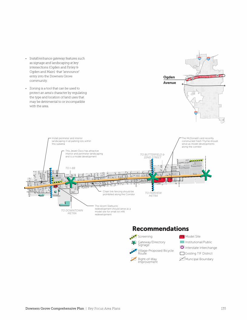
Install perimeter and interior landscaping in all parking lots within this subarea
The McDonald’s and recently constructed Fresh Thyme should serve as model developments along the corridor
Chain link fencing should be prohibited along the Corridor
The recent Starbucks redevelopment should serve as a model site for small lot infill redevelopment.
TO DOWNTOWNMETRA
TO I-88
TO BUTTERFIELD
TO BELMONTMETRA
TO FAIRVIEWMETRA
TO BUTTERFIELD & 22ND STREET
This Jewel-Osco has attractive interior and perimeter landscaping and is a model development
Mile
0
0 10 minute walk5 minute walk
1/16 1/8 1/4 1/2
RecommendationsScreening
Gateway/Directory Signage
Village-Proposed Bicycle Route
Right-of-Way Improvement
Model Site
Institutional/Public
Interstate Interchange
Existing TIF District
Muncipal Boundary
Key Focus Areas
Ogden Avenue
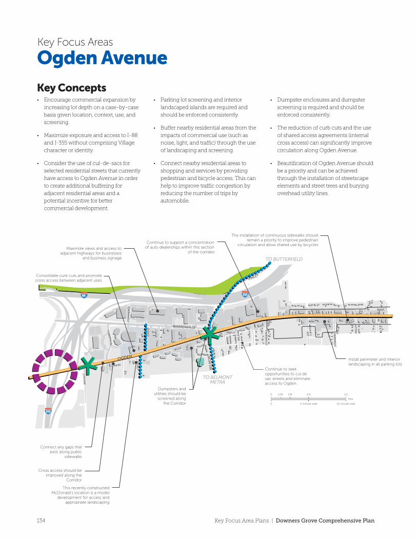
Key Concepts• Encourage commercial expansion by
increasing lot depth on a case-by-case
basis given location, context, use, and
screening.
• Maximize exposure and access to I-88
and I-355 without comprising Village
character or identity.
• Consider the use of cul-de-sacs for
selected residential streets that currently
have access to Ogden Avenue in order
to create additional buffering for
adjacent residential areas and a
potential incentive for better
commercial development.
• Parking lot screening and interior
landscaped islands are required and
should be enforced consistently.
• Buffer nearby residential areas from the
impacts of commercial use (such as
noise, light, and traffic) through the use
of landscaping and screening.
• Connect nearby residential areas to
shopping and services by providing
pedestrian and bicycle access. This can
help to improve traffic congestion by
reducing the number of trips by
automobile.
• Dumpster enclosures and dumpster
screening is required and should be
enforced consistently.
• The reduction of curb cuts and the use
of shared access agreements (internal
cross access) can significantly improve
circulation along Ogden Avenue.
• Beautification of Ogden Avenue should
be a priority and can be achieved
through the installation of streetscape
elements and street trees and burying
overhead utility lines.
• Install/enhance gateway features such
as signage and landscaping at key
intersections (Ogden and Finley &
Ogden and Main) that "announce"
entry into the Downers Grove
community.
• Zoning is a tool that can be used to
protect an area's character by regulating
the type and location of land uses that
may be detrimental to or incompatible
with the area.
134 Key Focus Area Plans | Downers Grove Comprehensive Plan
Ogden
Avenue
SEE
LEY
WIL
SON
DO
WN
ER
SLEE
STO
NE
WA
LL
WA
LNU
T
CR
OSS
CO
MM
ER
CE
CR
OSS
AU
TH
OR
ITY
HIG
HLA
ND
ELM
DO
UG
LAS
LAKE
FOXFIRE
SHERMAN
41ST
SAR
AT
OG
A
CU
MN
OR
OGDEN
WARRENVILLE
FINLEY
BE
LMO
NT
MA
IN
OGDEN
FAIR
VIE
W
355
35588
355
355 88
34
34
Consolidate curb cuts and promote cross access between adjacent uses
Connect any gaps that exist along public
sidewalks
This recently constructed McDonald’s location is a model
development for access and appropriate landscaping
Dumpsters and utilities should be
screened along the Corridor
Cross access should be improved along the
Corridor
Maximize views and access to adjacent highways for businesses
and business signage
Continue to support a concentration of auto dealerships within this section
of the corridor.
Continue to seek opportunities to cul de sac streets and eliminate access to Ogden.
The installation of continuous sidewalks should remain a priority to improve pedestrian
circulation and allow shared use by bicycles
Install perimeter and interior landscaping in all parking lots
Install perimeter and interior landscaping in all parking lots within this subarea
The McDonald’s and recently constructed Fresh Thyme should serve as model developments along the corridor
Chain link fencing should be prohibited along the Corridor
The recent Starbucks redevelopment should serve as a model site for small lot infill redevelopment.
TO DOWNTOWNMETRA
TO I-88
TO BUTTERFIELD
TO BELMONTMETRA
TO FAIRVIEWMETRA
TO BUTTERFIELD & 22ND STREET
This Jewel-Osco has attractive interior and perimeter landscaping and is a model development
Mile
0
0 10 minute walk5 minute walk
1/16 1/8 1/4 1/2
RecommendationsScreening
Gateway/Directory Signage
Village-Proposed Bicycle Route
Right-of-Way Improvement
Model Site
Institutional/Public
Interstate Interchange
Existing TIF District
Muncipal Boundary
Key Focus Areas
Ogden Avenue
Key Concepts• Encourage commercial expansion by
increasing lot depth on a case-by-case
basis given location, context, use, and
screening.
• Maximize exposure and access to I-88
and I-355 without comprising Village
character or identity.
• Consider the use of cul-de-sacs for
selected residential streets that currently
have access to Ogden Avenue in order
to create additional buffering for
adjacent residential areas and a
potential incentive for better
commercial development.
• Parking lot screening and interior
landscaped islands are required and
should be enforced consistently.
• Buffer nearby residential areas from the
impacts of commercial use (such as
noise, light, and traffic) through the use
of landscaping and screening.
• Connect nearby residential areas to
shopping and services by providing
pedestrian and bicycle access. This can
help to improve traffic congestion by
reducing the number of trips by
automobile.
• Dumpster enclosures and dumpster
screening is required and should be
enforced consistently.
• The reduction of curb cuts and the use
of shared access agreements (internal
cross access) can significantly improve
circulation along Ogden Avenue.
• Beautification of Ogden Avenue should
be a priority and can be achieved
through the installation of streetscape
elements and street trees and burying
overhead utility lines.
• Install/enhance gateway features such
as signage and landscaping at key
intersections (Ogden and Finley &
Ogden and Main) that "announce"
entry into the Downers Grove
community.
• Zoning is a tool that can be used to
protect an area's character by regulating
the type and location of land uses that
may be detrimental to or incompatible
with the area.
135Downers Grove Comprehensive Plan | Key Focus Area Plans
TO DOWNTOWNMETRA
TO I-88
TO BUTTERFIELD
TO BELMONTMETRA
TO FAIRVIEWMETRA
TO BUTTERFIELD & 22ND STREET
SEE
LEY
WIL
SON
DO
WN
ER
S
LEE
STO
NE
WA
LL
WA
LNU
T
CR
OSS
CO
MM
ER
CE
CR
OSS
AU
TH
OR
ITY
HIG
HLA
ND
ELM LAKE
FOXFIRE
SHERMAN
41ST
SAR
AT
OG
A
CU
MN
OR
OGDEN
WARRENVILLE
FINLEY
BE
LMO
NT
MA
IN
OGDEN
FAIR
VIE
W
355
355
88
D1
D3
D2
D4
D6
D7 D8
D9
D5
D10
D11
Mile
0
0 10 minute walk5 minute walk
1/16 1/8 1/4 1/2 RecommendationsCatalyst Redevelopment Opportunity
Key Focus Areas
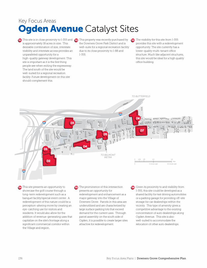
This site is in close proximity to I-355 and
is approximately 18 acres in size. This
desirable combination of size, interstate
visibility and interstate access provides an
unparalleled opportunity for a
high-quality gateway development. This
site is important as it is the first thing
people see when exiting the expressway.
The land south of the site would be
well-suited for a regional recreation
facility. Future development on this site
should complement this.
This property was recently purchased by
the Downers Grove Park District and is
well-suite for a regional recreation facility
due to its close proximity to I-88 and
I-355.
The visibility for this site from I-355
provides this site with a redevelopment
opportunity. The site currently has a
lower-quality multi-tenant o�ce
structure. Much like adjacent structures,
this site would be ideal for a high quality
o�ce building.
D1 D2 D3
This site presents an opportunity to
showcase the golf course through a
long-term redevelopment such as a
banquet facility/special event center. A
redevelopment of this nature could be a
perception-altering move by creating an
eye-catching use for visitors and
residents. It would also allow for the
addition of revenue-generating uses that
capitalize on the site’s frontage along a
significant commercial corridor within
the Village and region.
The prominence of this intersection
presents an opportunity for
redevelopment and enhancement as a
major gateway into the Village of
Downers Grove. Parcels in this area are
underutilized and are characterized by
large surface parking lots that exceed
demand for the current uses. Through
parcel assembly on the south side of
Ogden, it is possible to create larger sites
attractive for redevelopment.
Given its proximity to and visibility from
I-355, this site could be developed as a
shared facility for test driving automobiles
or a parking garage for providing o�-site
storage for car dealerships within the
vicinity. This type of amenity gives a
competitive advantage to the existing
concentration of auto dealerships along
Ogden Avenue. This site is also
well-suited to accommodate the
relocation of other auto dealerships.
D4 D5 D6 The existing medical o�ce uses on this
site are an important component that can
remain. However, aesthetic and
functional improvements (e.g. shared
parking) should be implemented in order
to strengthen these uses. Additional
medical o�ce and related uses should be
concentrated in this area. Consolidation
of parcels at this corner and east to
Washington Street would allow for in
improved, functional corner at this major
intersection. Cross access between
buildings on this site would improve
accessibility.
Should the car dealerships relocate to the
west end of Ogden Avenue, the site has
the opportunity to be redeveloped into a
commercial center. Any future center
here should have cross access to the
newer commercial space at the northeast
corner of Fairview Avenue and Ogden
Avenue.
D9
D11D10
Given its proximity to and visibility from
I-355, this site could accommodate a
large single-tenant user who would
benefit from the site’s access and size.
This site is also well-suited to
accommodate the relocation of other
auto dealerships from the east end of
Ogden Avenue. For example, this site
(approximately 9.8 acres) could
accommodate: 1) an expansion of local
universities or medical facilities or 2) the
relocation of an automobile dealership
from the eastern end of Ogden Avenue.
The Village recently established water
and sewer service to the site.
Throughout the corridor, lack of
su�cient parcel depth hampers
redevelopment. At this location, the
middle school establishes an acceptable
commercial depth that the existing
shallow-lot commercial uses have failed
to utilize. Development in this area
should go south to the middle school to
foster better, more contemporary
development. Should the auto dealership
currently located on this site move to the
western end of Ogden Avenue, there is
an opportunity to bring the buildings
closer to the street as occurs on the north
side. Uses appropriate for this site include
service uses, educational facilities or
medical o�ce or related uses.
Parcel assembly and improvements to
the aesthetics and function of this site
could have dramatic results for
enhancing this intersection as a gateway
by complementing the recent
construction of a Walgreens and a BP gas
station.
D7 D8
Ogden Avenue Catalyst Sites
136 Key Focus Area Plans | Downers Grove Comprehensive Plan
TO DOWNTOWNMETRA
TO I-88
TO BUTTERFIELD
TO BELMONTMETRA
TO FAIRVIEWMETRA
TO BUTTERFIELD & 22ND STREET
SEE
LEY
WIL
SON
DO
WN
ER
S
LEE
STO
NE
WA
LL
WA
LNU
T
CR
OSS
CO
MM
ER
CE
CR
OSS
AU
TH
OR
ITY
HIG
HLA
ND
ELM LAKE
FOXFIRE
SHERMAN
41ST
SAR
AT
OG
A
CU
MN
OR
OGDEN
WARRENVILLE
FINLEY
BE
LMO
NT
MA
IN
OGDEN
FAIR
VIE
W
355
355
88
D1
D3
D2
D4
D6
D7 D8
D9
D5
D10
D11
Mile
0
0 10 minute walk5 minute walk
1/16 1/8 1/4 1/2 RecommendationsCatalyst Redevelopment Opportunity
Key Focus Areas
This site is in close proximity to I-355 and
is approximately 18 acres in size. This
desirable combination of size, interstate
visibility and interstate access provides an
unparalleled opportunity for a
high-quality gateway development. This
site is important as it is the first thing
people see when exiting the expressway.
The land south of the site would be
well-suited for a regional recreation
facility. Future development on this site
should complement this.
This property was recently purchased by
the Downers Grove Park District and is
well-suite for a regional recreation facility
due to its close proximity to I-88 and
I-355.
The visibility for this site from I-355
provides this site with a redevelopment
opportunity. The site currently has a
lower-quality multi-tenant o�ce
structure. Much like adjacent structures,
this site would be ideal for a high quality
o�ce building.
D1 D2 D3
This site presents an opportunity to
showcase the golf course through a
long-term redevelopment such as a
banquet facility/special event center. A
redevelopment of this nature could be a
perception-altering move by creating an
eye-catching use for visitors and
residents. It would also allow for the
addition of revenue-generating uses that
capitalize on the site’s frontage along a
significant commercial corridor within
the Village and region.
The prominence of this intersection
presents an opportunity for
redevelopment and enhancement as a
major gateway into the Village of
Downers Grove. Parcels in this area are
underutilized and are characterized by
large surface parking lots that exceed
demand for the current uses. Through
parcel assembly on the south side of
Ogden, it is possible to create larger sites
attractive for redevelopment.
Given its proximity to and visibility from
I-355, this site could be developed as a
shared facility for test driving automobiles
or a parking garage for providing o�-site
storage for car dealerships within the
vicinity. This type of amenity gives a
competitive advantage to the existing
concentration of auto dealerships along
Ogden Avenue. This site is also
well-suited to accommodate the
relocation of other auto dealerships.
D4 D5 D6 The existing medical o�ce uses on this
site are an important component that can
remain. However, aesthetic and
functional improvements (e.g. shared
parking) should be implemented in order
to strengthen these uses. Additional
medical o�ce and related uses should be
concentrated in this area. Consolidation
of parcels at this corner and east to
Washington Street would allow for in
improved, functional corner at this major
intersection. Cross access between
buildings on this site would improve
accessibility.
Should the car dealerships relocate to the
west end of Ogden Avenue, the site has
the opportunity to be redeveloped into a
commercial center. Any future center
here should have cross access to the
newer commercial space at the northeast
corner of Fairview Avenue and Ogden
Avenue.
D9
D11D10
Given its proximity to and visibility from
I-355, this site could accommodate a
large single-tenant user who would
benefit from the site’s access and size.
This site is also well-suited to
accommodate the relocation of other
auto dealerships from the east end of
Ogden Avenue. For example, this site
(approximately 9.8 acres) could
accommodate: 1) an expansion of local
universities or medical facilities or 2) the
relocation of an automobile dealership
from the eastern end of Ogden Avenue.
The Village recently established water
and sewer service to the site.
Throughout the corridor, lack of
su�cient parcel depth hampers
redevelopment. At this location, the
middle school establishes an acceptable
commercial depth that the existing
shallow-lot commercial uses have failed
to utilize. Development in this area
should go south to the middle school to
foster better, more contemporary
development. Should the auto dealership
currently located on this site move to the
western end of Ogden Avenue, there is
an opportunity to bring the buildings
closer to the street as occurs on the north
side. Uses appropriate for this site include
service uses, educational facilities or
medical o�ce or related uses.
Parcel assembly and improvements to
the aesthetics and function of this site
could have dramatic results for
enhancing this intersection as a gateway
by complementing the recent
construction of a Walgreens and a BP gas
station.
D7 D8
Ogden Avenue Catalyst Sites
137Downers Grove Comprehensive Plan | Key Focus Area Plans
SEE
LEY
WIL
SON
DO
WN
ER
S
LEE
STO
NE
WA
LL
WA
LNU
T
CR
OSS
CO
MM
ER
CE
CR
OSS
AU
TH
OR
ITY
HIG
HLA
ND E
LM LAKE
FOXFIRE
SHERMAN
41ST
SAR
AT
OG
A
CU
MN
OR
OGDEN
WARRENVILLE
FINLEY
BE
LMO
NT
MA
IN
OGDEN
FAIR
VIE
W
355
35588
TO DOWNTOWNMETRA
TO I-88
TO BUTTERFIELD
TO BELMONTMETRA
TO FAIRVIEWMETRA
TO BUTTERFIELD & 22ND STREET
Future Land Use PlanSingle Family Detached
Single Family Attached
Multi Family
Corridor Commercial
O�ce/Corporate Campus
Light Industrial/Business Park
Institutional/Public
Park & Open Space
Existing TIF District
Municpoal BoundaryMile
0
0 10 minute walk5 minute walk
1/16 1/8 1/4 1/2
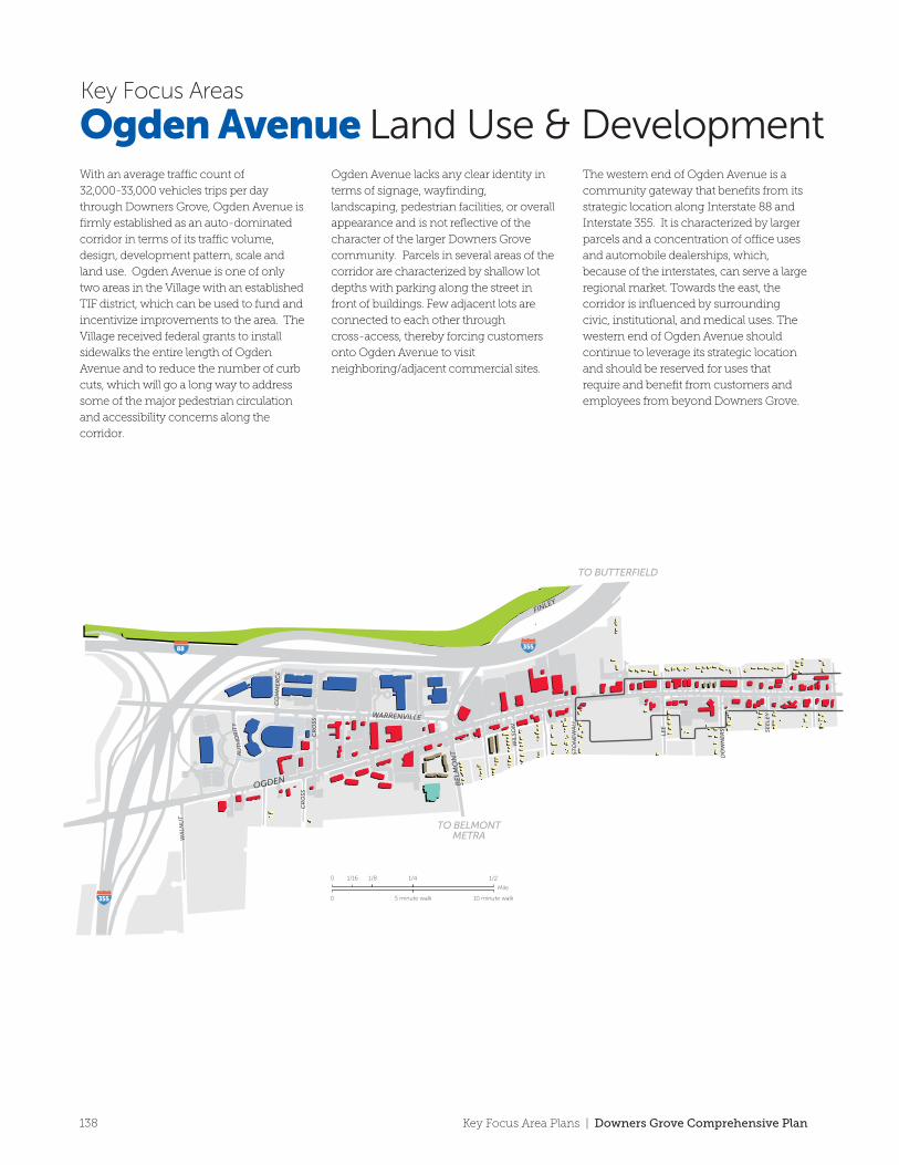
With an average tra�c count of
32,000-33,000 vehicles trips per day
through Downers Grove, Ogden Avenue is
firmly established as an auto-dominated
corridor in terms of its tra�c volume,
design, development pattern, scale and
land use. Ogden Avenue is one of only
two areas in the Village with an established
TIF district, which can be used to fund and
incentivize improvements to the area. The
Village received federal grants to install
sidewalks the entire length of Ogden
Avenue and to reduce the number of curb
cuts, which will go a long way to address
some of the major pedestrian circulation
and accessibility concerns along the
corridor.
Ogden Avenue lacks any clear identity in
terms of signage, wayfinding,
landscaping, pedestrian facilities, or overall
appearance and is not reflective of the
character of the larger Downers Grove
community. Parcels in several areas of the
corridor are characterized by shallow lot
depths with parking along the street in
front of buildings. Few adjacent lots are
connected to each other through
cross-access, thereby forcing customers
onto Ogden Avenue to visit
neighboring/adjacent commercial sites.
The western end of Ogden Avenue is a
community gateway that benefits from its
strategic location along Interstate 88 and
Interstate 355. It is characterized by larger
parcels and a concentration of o�ce uses
and automobile dealerships, which,
because of the interstates, can serve a large
regional market. Towards the east, the
corridor is influenced by surrounding
civic, institutional, and medical uses. The
western end of Ogden Avenue should
continue to leverage its strategic location
and should be reserved for uses that
require and benefit from customers and
employees from beyond Downers Grove.
Key Focus Areas
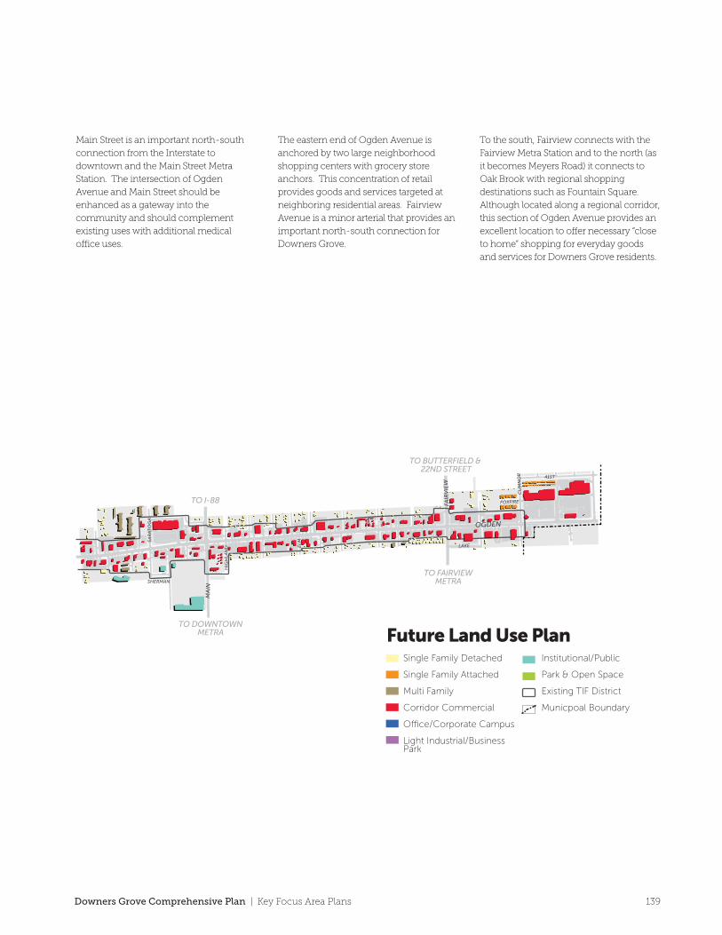
Ogden Avenue Land Use & DevelopmentMain Street is an important north-south
connection from the Interstate to
downtown and the Main Street Metra
Station. The intersection of Ogden
Avenue and Main Street should be
enhanced as a gateway into the
community and should complement
existing uses with additional medical
o�ce uses.
The eastern end of Ogden Avenue is
anchored by two large neighborhood
shopping centers with grocery store
anchors. This concentration of retail
provides goods and services targeted at
neighboring residential areas. Fairview
Avenue is a minor arterial that provides an
important north-south connection for
Downers Grove.
To the south, Fairview connects with the
Fairview Metra Station and to the north (as
it becomes Meyers Road) it connects to
Oak Brook with regional shopping
destinations such as Fountain Square.
Although located along a regional corridor,
this section of Ogden Avenue provides an
excellent location to o�er necessary “close
to home” shopping for everyday goods
and services for Downers Grove residents.
138 Key Focus Area Plans | Downers Grove Comprehensive Plan
SEE
LEY
WIL
SON
DO
WN
ER
S
LEE
STO
NE
WA
LL
WA
LNU
T
CR
OSS
CO
MM
ER
CE
CR
OSS
AU
TH
OR
ITY
HIG
HLA
ND E
LM LAKE
FOXFIRE
SHERMAN
41ST
SAR
AT
OG
A
CU
MN
OR
OGDEN
WARRENVILLE
FINLEY
BE
LMO
NT
MA
IN
OGDEN
FAIR
VIE
W
355
35588
TO DOWNTOWNMETRA
TO I-88
TO BUTTERFIELD
TO BELMONTMETRA
TO FAIRVIEWMETRA
TO BUTTERFIELD & 22ND STREET
Future Land Use PlanSingle Family Detached
Single Family Attached
Multi Family
Corridor Commercial
O�ce/Corporate Campus
Light Industrial/Business Park
Institutional/Public
Park & Open Space
Existing TIF District
Municpoal BoundaryMile
0
0 10 minute walk5 minute walk
1/16 1/8 1/4 1/2
With an average tra�c count of
32,000-33,000 vehicles trips per day
through Downers Grove, Ogden Avenue is
firmly established as an auto-dominated
corridor in terms of its tra�c volume,
design, development pattern, scale and
land use. Ogden Avenue is one of only
two areas in the Village with an established
TIF district, which can be used to fund and
incentivize improvements to the area. The
Village received federal grants to install
sidewalks the entire length of Ogden
Avenue and to reduce the number of curb
cuts, which will go a long way to address
some of the major pedestrian circulation
and accessibility concerns along the
corridor.
Ogden Avenue lacks any clear identity in
terms of signage, wayfinding,
landscaping, pedestrian facilities, or overall
appearance and is not reflective of the
character of the larger Downers Grove
community. Parcels in several areas of the
corridor are characterized by shallow lot
depths with parking along the street in
front of buildings. Few adjacent lots are
connected to each other through
cross-access, thereby forcing customers
onto Ogden Avenue to visit
neighboring/adjacent commercial sites.
The western end of Ogden Avenue is a
community gateway that benefits from its
strategic location along Interstate 88 and
Interstate 355. It is characterized by larger
parcels and a concentration of o�ce uses
and automobile dealerships, which,
because of the interstates, can serve a large
regional market. Towards the east, the
corridor is influenced by surrounding
civic, institutional, and medical uses. The
western end of Ogden Avenue should
continue to leverage its strategic location
and should be reserved for uses that
require and benefit from customers and
employees from beyond Downers Grove.
Key Focus Areas
Ogden Avenue Land Use & DevelopmentMain Street is an important north-south
connection from the Interstate to
downtown and the Main Street Metra
Station. The intersection of Ogden
Avenue and Main Street should be
enhanced as a gateway into the
community and should complement
existing uses with additional medical
o�ce uses.
The eastern end of Ogden Avenue is
anchored by two large neighborhood
shopping centers with grocery store
anchors. This concentration of retail
provides goods and services targeted at
neighboring residential areas. Fairview
Avenue is a minor arterial that provides an
important north-south connection for
Downers Grove.
To the south, Fairview connects with the
Fairview Metra Station and to the north (as
it becomes Meyers Road) it connects to
Oak Brook with regional shopping
destinations such as Fountain Square.
Although located along a regional corridor,
this section of Ogden Avenue provides an
excellent location to o�er necessary “close
to home” shopping for everyday goods
and services for Downers Grove residents.
139Downers Grove Comprehensive Plan | Key Focus Area Plans
Fairview
ROGERS
AUSTIN
BURLINGTON
BURLINGTON
FLO
RE
NC
E
CU
MN
OR
VIC
TO
R
WIL
LIA
MS
WIL
CO
X
PR
OSP
EC
T
FLO
RE
NC
E
GR
AN
D
BLO
DG
ET
T
ELMW
OO
D 2ND
3RD
4TH
SHELDON
To ChicagoVia WestmontTo Aurora
Via Main Street
FAIR
VIE
WFA
IRV
IEW
MAPLE
BURLINGTON NORTHERN SANTA FE RAILROAD
355
355 88
34
34
TO DOWNTOWN
TO OGDEN AVENUE
Signage and improvements should enhance this important and highly visible gateway to Downers Grove
Maintain and enhance the Fairview Metra Station as an important community asset and a gateway to Downers Grove
Realignment of Maple Avenue would improve circulation and connectivity
Warren Avenue right-of-way provides an excellent opportunity for a safe
o�-street pedestrian connection between Fairview and Downtown
Nearby residential areas should be appropriately bu�ered and screened from
adjacent incompatible usesWork with Pepperidge Farm to maximize the public benefit of their open space on the south side of their facility
Reconfigure Metra Station’s parking lot to have improved access to Fairview Avenue and cross access to nearby retail.
Reduce glare/spillover of parking lot lighting
Mile
0
0 5 minute walk2.5 minute walk
1/16 1/8 1/4
RecommendationsVillage-Proposed Bike Route
Gateway/Directory Signage
Improved Pedestrian Crossing
Park/Open Space
Metra Station
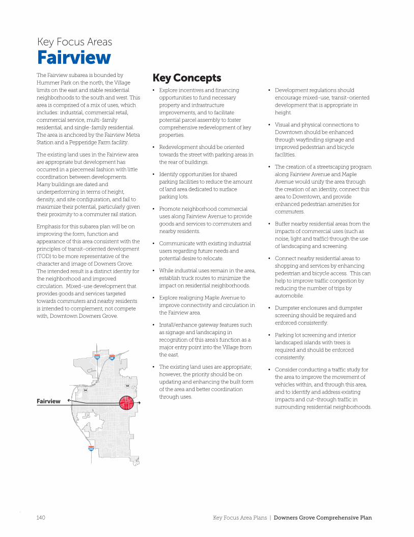
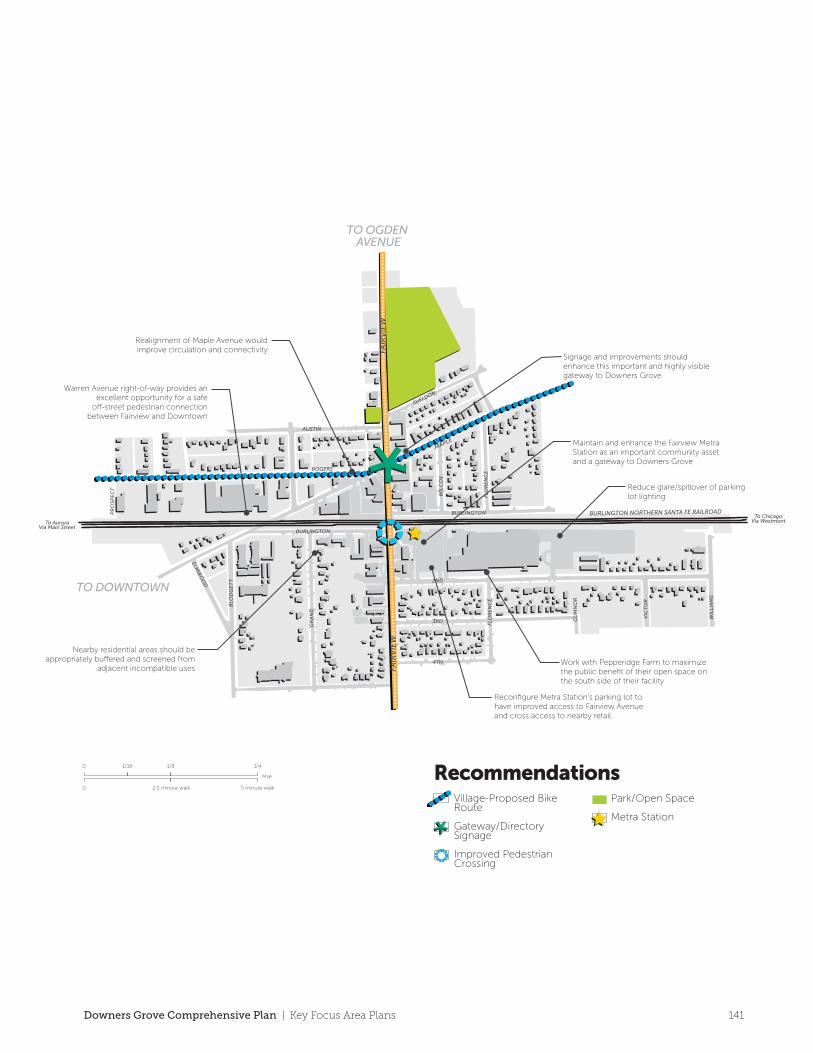
The Fairview subarea is bounded by
Hummer Park on the north, the Village
limits on the east and stable residential
neighborhoods to the south and west. This
area is comprised of a mix of uses, which
includes: industrial, commercial retail,
commercial service, multi-family
residential, and single-family residential.
The area is anchored by the Fairview Metra
Station and a Pepperidge Farm facility.
The existing land uses in the Fairview area
are appropriate but development has
occurred in a piecemeal fashion with little
coordination between developments.
Many buildings are dated and
underperforming in terms of height,
density, and site configuration, and fail to
maximize their potential, particularly given
their proximity to a commuter rail station.
Emphasis for this subarea plan will be on
improving the form, function and
appearance of this area consistent with the
principles of transit-oriented development
(TOD) to be more representative of the
character and image of Downers Grove.
The intended result is a distinct identity for
the neighborhood and improved
circulation. Mixed-use development that
provides goods and services targeted
towards commuters and nearby residents
is intended to complement, not compete
with, Downtown Downers Grove.
• Explore incentives and financing
opportunities to fund necessary
property and infrastructure
improvements, and to facilitate
potential parcel assembly to foster
comprehensive redevelopment of key
properties.
• Redevelopment should be oriented
towards the street with parking areas in
the rear of buildings.
• Identify opportunities for shared
parking facilities to reduce the amount
of land area dedicated to surface
parking lots.
• Promote neighborhood commercial
uses along Fairview Avenue to provide
goods and services to commuters and
nearby residents.
• Communicate with existing industrial
users regarding future needs and
potential desire to relocate.
• While industrial uses remain in the area,
establish truck routes to minimize the
impact on residential neighborhoods.
• Explore realigning Maple Avenue to
improve connectivity and circulation in
the Fairview area.
• Install/enhance gateway features such
as signage and landscaping in
recognition of this area’s function as a
major entry point into the Village from
the east.
• The existing land uses are appropriate;
however, the priority should be on
updating and enhancing the built form
of the area and better coordination
through uses.
• Development regulations should
encourage mixed-use, transit-oriented
development that is appropriate in
height.
• Visual and physical connections to
Downtown should be enhanced
through wayfinding signage and
improved pedestrian and bicycle
facilities.
• The creation of a streetscaping program
along Fairview Avenue and Maple
Avenue would unify the area through
the creation of an identity, connect this
area to Downtown, and provide
enhanced pedestrian amenities for
commuters.
• Buffer nearby residential areas from the
impacts of commercial uses (such as
noise, light and traffic) through the use
of landscaping and screening.
• Connect nearby residential areas to
shopping and services by enhancing
pedestrian and bicycle access. This can
help to improve traffic congestion by
reducing the number of trips by
automobile.
• Dumpster enclosures and dumpster
screening should be required and
enforced consistently.
• Parking lot screening and interior
landscaped islands with trees is
required and should be enforced
consistently.
• Consider conducting a traffic study for
the area to improve the movement of
vehicles within, and through this area,
and to identify and address existing
impacts and cut-through traffic in
surrounding residential neighborhoods.
FairviewKey Concepts
Key Focus Areas
140 Key Focus Area Plans | Downers Grove Comprehensive Plan
Fairview
ROGERS
AUSTIN
BURLINGTON
BURLINGTON
FLO
RE
NC
E
CU
MN
OR
VIC
TO
R
WIL
LIA
MS
WIL
CO
X
PR
OSP
EC
T
FLO
RE
NC
E
GR
AN
D
BLO
DG
ET
T
ELMW
OO
D 2ND
3RD
4TH
SHELDON
To ChicagoVia WestmontTo Aurora
Via Main Street
FAIR
VIE
WFA
IRV
IEW
MAPLE
BURLINGTON NORTHERN SANTA FE RAILROAD
355
355 88
34
34
TO DOWNTOWN
TO OGDEN AVENUE
Signage and improvements should enhance this important and highly visible gateway to Downers Grove
Maintain and enhance the Fairview Metra Station as an important community asset and a gateway to Downers Grove
Realignment of Maple Avenue would improve circulation and connectivity
Warren Avenue right-of-way provides an excellent opportunity for a safe
o�-street pedestrian connection between Fairview and Downtown
Nearby residential areas should be appropriately bu�ered and screened from
adjacent incompatible usesWork with Pepperidge Farm to maximize the public benefit of their open space on the south side of their facility
Reconfigure Metra Station’s parking lot to have improved access to Fairview Avenue and cross access to nearby retail.
Reduce glare/spillover of parking lot lighting
Mile
0
0 5 minute walk2.5 minute walk
1/16 1/8 1/4
RecommendationsVillage-Proposed Bike Route
Gateway/Directory Signage
Improved Pedestrian Crossing
Park/Open Space
Metra Station
The Fairview subarea is bounded by
Hummer Park on the north, the Village
limits on the east and stable residential
neighborhoods to the south and west. This
area is comprised of a mix of uses, which
includes: industrial, commercial retail,
commercial service, multi-family
residential, and single-family residential.
The area is anchored by the Fairview Metra
Station and a Pepperidge Farm facility.
The existing land uses in the Fairview area
are appropriate but development has
occurred in a piecemeal fashion with little
coordination between developments.
Many buildings are dated and
underperforming in terms of height,
density, and site configuration, and fail to
maximize their potential, particularly given
their proximity to a commuter rail station.
Emphasis for this subarea plan will be on
improving the form, function and
appearance of this area consistent with the
principles of transit-oriented development
(TOD) to be more representative of the
character and image of Downers Grove.
The intended result is a distinct identity for
the neighborhood and improved
circulation. Mixed-use development that
provides goods and services targeted
towards commuters and nearby residents
is intended to complement, not compete
with, Downtown Downers Grove.
• Explore incentives and financing
opportunities to fund necessary
property and infrastructure
improvements, and to facilitate
potential parcel assembly to foster
comprehensive redevelopment of key
properties.
• Redevelopment should be oriented
towards the street with parking areas in
the rear of buildings.
• Identify opportunities for shared
parking facilities to reduce the amount
of land area dedicated to surface
parking lots.
• Promote neighborhood commercial
uses along Fairview Avenue to provide
goods and services to commuters and
nearby residents.
• Communicate with existing industrial
users regarding future needs and
potential desire to relocate.
• While industrial uses remain in the area,
establish truck routes to minimize the
impact on residential neighborhoods.
• Explore realigning Maple Avenue to
improve connectivity and circulation in
the Fairview area.
• Install/enhance gateway features such
as signage and landscaping in
recognition of this area’s function as a
major entry point into the Village from
the east.
• The existing land uses are appropriate;
however, the priority should be on
updating and enhancing the built form
of the area and better coordination
through uses.
• Development regulations should
encourage mixed-use, transit-oriented
development that is appropriate in
height.
• Visual and physical connections to
Downtown should be enhanced
through wayfinding signage and
improved pedestrian and bicycle
facilities.
• The creation of a streetscaping program
along Fairview Avenue and Maple
Avenue would unify the area through
the creation of an identity, connect this
area to Downtown, and provide
enhanced pedestrian amenities for
commuters.
• Buffer nearby residential areas from the
impacts of commercial uses (such as
noise, light and traffic) through the use
of landscaping and screening.
• Connect nearby residential areas to
shopping and services by enhancing
pedestrian and bicycle access. This can
help to improve traffic congestion by
reducing the number of trips by
automobile.
• Dumpster enclosures and dumpster
screening should be required and
enforced consistently.
• Parking lot screening and interior
landscaped islands with trees is
required and should be enforced
consistently.
• Consider conducting a traffic study for
the area to improve the movement of
vehicles within, and through this area,
and to identify and address existing
impacts and cut-through traffic in
surrounding residential neighborhoods.
FairviewKey Concepts
Key Focus Areas
141Downers Grove Comprehensive Plan | Key Focus Area Plans
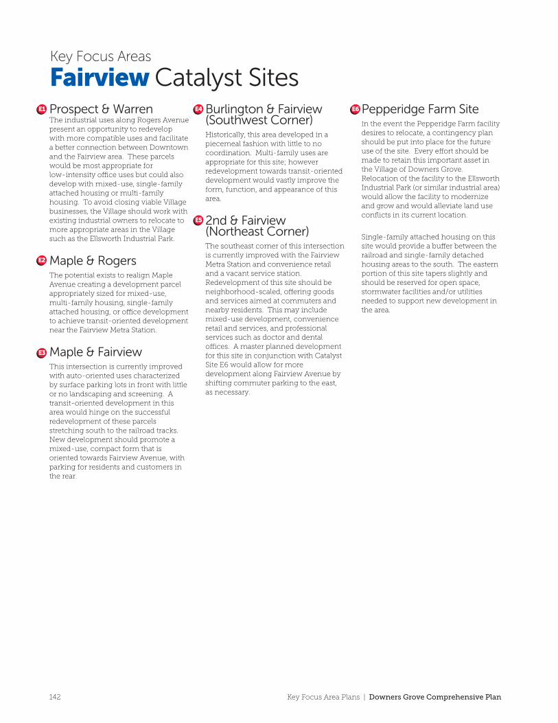
TO DOWNTOWN
TO OGDEN AVENUE
ROGERS
AUSTIN
BURLINGTON
BURLINGTON
FLO
RE
NC
E
VIC
TO
R
WIL
LIA
MS
WIL
CO
X
PR
OSP
EC
T FLO
RE
NC
E
GR
AN
D
BLO
DG
ET
T
ELMW
OO
D 2ND
3RD
4TH
SHELDON
To ChicagoVia WestmontTo Aurora
Via Main Street
FAIR
VIE
WFA
IRV
IEW
MAPLE
BURLINGTON NORTHERN SANTA FE RAILROAD
E1 E2 E3
E4
E5 E6
Fairview Catalyst SitesKey Focus Areas
E1
E2
E4
E3
E5
E6Prospect & WarrenThe industrial uses along Rogers Avenue present an opportunity to redevelop with more compatible uses and facilitate a better connection between Downtown and the Fairview area. These parcels would be most appropriate for low-intensity o�ce uses but could also develop with mixed-use, single-family attached housing or multi-family housing. To avoid closing viable Village businesses, the Village should work with existing industrial owners to relocate to more appropriate areas in the Village such as the Ellsworth Industrial Park.
Maple & RogersThe potential exists to realign Maple Avenue creating a development parcel appropriately sized for mixed-use, multi-family housing, single-family attached housing, or o�ce development to achieve transit-oriented development near the Fairview Metra Station.
Maple & Fairview This intersection is currently improved with auto-oriented uses characterized by surface parking lots in front with little or no landscaping and screening. A transit-oriented development in this area would hinge on the successful redevelopment of these parcels stretching south to the railroad tracks. New development should promote a mixed-use, compact form that is oriented towards Fairview Avenue, with parking for residents and customers in the rear.
Burlington & Fairview (Southwest Corner)Historically, this area developed in a piecemeal fashion with little to no coordination. Multi-family uses are appropriate for this site; however redevelopment towards transit-oriented development would vastly improve the form, function, and appearance of this area.
2nd & Fairview (Northeast Corner)The southeast corner of this intersection is currently improved with the Fairview Metra Station and convenience retail and a vacant service station. Redevelopment of this site should be neighborhood-scaled, o�ering goods and services aimed at commuters and nearby residents. This may include mixed-use development, convenience retail and services, and professional services such as doctor and dental o�ces. A master planned development for this site in conjunction with Catalyst Site E6 would allow for more development along Fairview Avenue by shifting commuter parking to the east, as necessary.
Pepperidge Farm SiteIn the event the Pepperidge Farm facility desires to relocate, a contingency plan should be put into place for the future use of the site. Every e�ort should be made to retain this important asset in the Village of Downers Grove. Relocation of the facility to the Ellsworth Industrial Park (or similar industrial area) would allow the facility to modernize and grow and would alleviate land use conflicts in its current location.
Single-family attached housing on this site would provide a bu�er between the railroad and single-family detached housing areas to the south. The eastern portion of this site tapers slightly and should be reserved for open space, stormwater facilities and/or utilities needed to support new development in the area.
Mile
0
0 5 minute walk2.5 minute walk
1/16 1/8 1/4
RecommendationsCatalyst Redevelopment Opportunity
142 Key Focus Area Plans | Downers Grove Comprehensive Plan
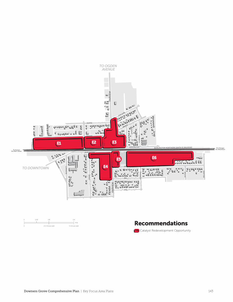
TO DOWNTOWN
TO OGDEN AVENUE
ROGERS
AUSTIN
BURLINGTON
BURLINGTON
FLO
RE
NC
E
VIC
TO
R
WIL
LIA
MS
WIL
CO
X
PR
OSP
EC
T FLO
RE
NC
E
GR
AN
D
BLO
DG
ET
T
ELMW
OO
D 2ND
3RD
4TH
SHELDON
To ChicagoVia WestmontTo Aurora
Via Main Street
FAIR
VIE
WFA
IRV
IEW
MAPLE
BURLINGTON NORTHERN SANTA FE RAILROAD
E1 E2 E3
E4
E5 E6
Fairview Catalyst SitesKey Focus Areas
E1
E2
E4
E3
E5
E6Prospect & WarrenThe industrial uses along Rogers Avenue present an opportunity to redevelop with more compatible uses and facilitate a better connection between Downtown and the Fairview area. These parcels would be most appropriate for low-intensity o�ce uses but could also develop with mixed-use, single-family attached housing or multi-family housing. To avoid closing viable Village businesses, the Village should work with existing industrial owners to relocate to more appropriate areas in the Village such as the Ellsworth Industrial Park.
Maple & RogersThe potential exists to realign Maple Avenue creating a development parcel appropriately sized for mixed-use, multi-family housing, single-family attached housing, or o�ce development to achieve transit-oriented development near the Fairview Metra Station.
Maple & Fairview This intersection is currently improved with auto-oriented uses characterized by surface parking lots in front with little or no landscaping and screening. A transit-oriented development in this area would hinge on the successful redevelopment of these parcels stretching south to the railroad tracks. New development should promote a mixed-use, compact form that is oriented towards Fairview Avenue, with parking for residents and customers in the rear.
Burlington & Fairview (Southwest Corner)Historically, this area developed in a piecemeal fashion with little to no coordination. Multi-family uses are appropriate for this site; however redevelopment towards transit-oriented development would vastly improve the form, function, and appearance of this area.
2nd & Fairview (Northeast Corner)The southeast corner of this intersection is currently improved with the Fairview Metra Station and convenience retail and a vacant service station. Redevelopment of this site should be neighborhood-scaled, o�ering goods and services aimed at commuters and nearby residents. This may include mixed-use development, convenience retail and services, and professional services such as doctor and dental o�ces. A master planned development for this site in conjunction with Catalyst Site E6 would allow for more development along Fairview Avenue by shifting commuter parking to the east, as necessary.
Pepperidge Farm SiteIn the event the Pepperidge Farm facility desires to relocate, a contingency plan should be put into place for the future use of the site. Every e�ort should be made to retain this important asset in the Village of Downers Grove. Relocation of the facility to the Ellsworth Industrial Park (or similar industrial area) would allow the facility to modernize and grow and would alleviate land use conflicts in its current location.
Single-family attached housing on this site would provide a bu�er between the railroad and single-family detached housing areas to the south. The eastern portion of this site tapers slightly and should be reserved for open space, stormwater facilities and/or utilities needed to support new development in the area.
Mile
0
0 5 minute walk2.5 minute walk
1/16 1/8 1/4
RecommendationsCatalyst Redevelopment Opportunity
143Downers Grove Comprehensive Plan | Key Focus Area Plans
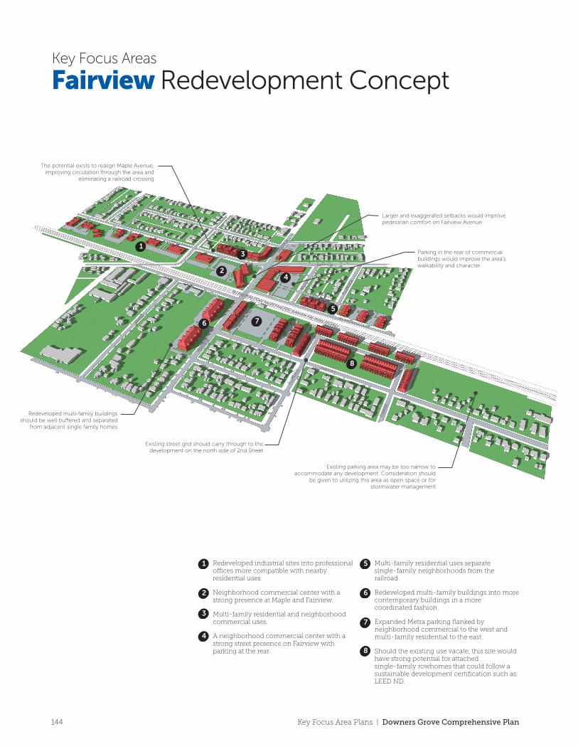
MAPLE
BURLINGTON
FAIR
VIE
W
2ND
CU
MN
OR
3RD
4TH
FLO
RE
NC
E
GR
AN
D
BLO
DG
ET
T
ELMW
OO
D
ROGERS
AUSTIN
SHELDON
WIL
CO
X
FLO
RE
NC
E
To Downtown Via Warren Avenue
To Downtown Via Rogers Street
TO DOWNTOWN
TO OGDEN AVENUE
Redeveloped multi-family buildings should be well buered and separated
from adjacent single family homes
The potential exists to realign Maple Avenue, improving circulation through the area and
eliminating a railroad crossing
Parking in the rear of commercial buildings would improve the area’s walkability and character.
Existing street grid should carry through to the development on the north side of 2nd Street
Existing parking area may be too narrow to accommodate any development. Consideration should
be given to utilizing this area as open space or for stormwater management
Larger and exaggerated setbacks would improve pedestrian comfort on Fairview Avenue
1
1
2
2
3
3
4
4
5
5
6
6
7
7
8
8
Redeveloped industrial sites into professional o�ces more compatible with nearby residential uses.
Neighborhood commercial center with a strong presence at Maple and Fairview.
Multi-family residential and neighborhood commercial uses.
A neighborhood commercial center with a strong street presence on Fairview with parking at the rear.
Multi-family residential uses separate single-family neighborhoods from the railroad.
Redeveloped multi-family buildings into more contemporary buildings in a more coordinated fashion.
Expanded Metra parking flanked by neighborhood commercial to the west and multi-family residential to the east.
Should the existing use vacate, this site would have strong potential for attached single-family rowhomes that could follow a sustainable development certification such as LEED ND.
West Bound Route
East Bound Route
Alt East Bound Route
Vacated Right-of-Way
Downtown Pedestrian Connection
Map Legend
Transit Oriented Development (TOD) is a
type of development that prioritizes mass
transit as a mode of transportation in its
orientation and built form. TODs are
typically compact, dense and located in
close proximity to transit facilities.
Mixed-use development is emphasized
and uses may include a mix of housing
types, convenience retail (such as co�ee
shops, dry cleaners and shoe repair), and
public spaces. A TOD is walkable, and
clusters appropriate land uses within
one-quarter to one-half mile of a transit
stop or station.
The Fairview area provides an opportunity for a demonstration project using LEED-ND (Neighborhood Development) criteria, the U.S. Green Building Council’s metrics and rating system applicable to neighborhood-scale development. LEED-ND places emphasis on site selection, design and the construction elements of buildings and infrastructure.
Redevelopment within the Fairview area could employ techniques to create a self-sustaining, walkable town center unrivaled in the western suburbs. The presence of transit, the existing street network and the diversity of uses in this area all contribute to the possibility of such a project.
Achieving LEED-ND may increase the time and cost of a particular development project. The Village may encourage parcels to strive to adhere to the requirements of LEED-ND even if certification is not sought.
A potential realignment of Maple Avenue could occur to improve safety and circulation in the area by making this area less of a “cut-through” for east-west tra�c. A tra�c study would need to be conducted in order to fully assess the impacts on nearby streets, especially residential streets. Additional street improvements (e.g., widening) for other streets may be necessary as a result.
• An emphasis on infill development
• Improvements to open space and
stormwater facililties
• Buildings oriented towards the street
(parking in the rear )
• Increased density and an emphasis on
mixed-use within 1/4 mile of the station
• Shared parking facilities/minimize
surface parking lots
• Continuation of the street grid
• Improved pedestrian and bicycle
connections
• Avoid developing in floodplains and
environmentally-sensitive land
Fairview Redevelopment ConceptKey Focus Areas
Maple Avenue Realignment
The recommendations included within
this Key Focus Area Plan provide an
opportunity to create a cohesive
neighborhood with a distinct identity.
Neighborhood commercial uses along
Fairview Avenue are proposed to be
surrounded by contemporary
multi-family housing options (both
standalone and as part of mixed-use
developments). Improvements to
circulation, land use, aesthetics, open
space and gateways are proposed to
create Downers Grove’s newest
neighborhood. Assisting with this e�ort,
include appropriate applications of the
principles of TOD and LEED for
Neighborhood Development.
Guiding PrinciplesLEED ND
TOD
Identity & Placemaking
144 Key Focus Area Plans | Downers Grove Comprehensive Plan
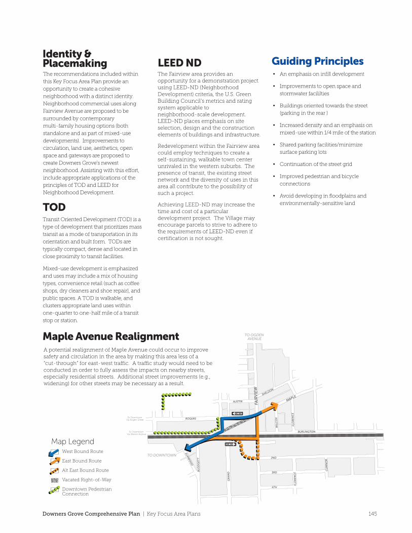
MAPLE
BURLINGTON
FAIR
VIE
W
2ND
CU
MN
OR
3RD
4TH
FLO
RE
NC
E
GR
AN
D
BLO
DG
ET
T
ELMW
OO
D
ROGERS
AUSTIN
SHELDON
WIL
CO
X
FLO
RE
NC
E
To Downtown Via Warren Avenue
To Downtown Via Rogers Street
TO DOWNTOWN
TO OGDEN AVENUE
Redeveloped multi-family buildings should be well buered and separated
from adjacent single family homes
The potential exists to realign Maple Avenue, improving circulation through the area and
eliminating a railroad crossing
Parking in the rear of commercial buildings would improve the area’s walkability and character.
Existing street grid should carry through to the development on the north side of 2nd Street
Existing parking area may be too narrow to accommodate any development. Consideration should
be given to utilizing this area as open space or for stormwater management
Larger and exaggerated setbacks would improve pedestrian comfort on Fairview Avenue
1
1
2
2
3
3
4
4
5
5
6
6
7
7
8
8
Redeveloped industrial sites into professional o�ces more compatible with nearby residential uses.
Neighborhood commercial center with a strong presence at Maple and Fairview.
Multi-family residential and neighborhood commercial uses.
A neighborhood commercial center with a strong street presence on Fairview with parking at the rear.
Multi-family residential uses separate single-family neighborhoods from the railroad.
Redeveloped multi-family buildings into more contemporary buildings in a more coordinated fashion.
Expanded Metra parking flanked by neighborhood commercial to the west and multi-family residential to the east.
Should the existing use vacate, this site would have strong potential for attached single-family rowhomes that could follow a sustainable development certification such as LEED ND.
West Bound Route
East Bound Route
Alt East Bound Route
Vacated Right-of-Way
Downtown Pedestrian Connection
Map Legend
Transit Oriented Development (TOD) is a
type of development that prioritizes mass
transit as a mode of transportation in its
orientation and built form. TODs are
typically compact, dense and located in
close proximity to transit facilities.
Mixed-use development is emphasized
and uses may include a mix of housing
types, convenience retail (such as co�ee
shops, dry cleaners and shoe repair), and
public spaces. A TOD is walkable, and
clusters appropriate land uses within
one-quarter to one-half mile of a transit
stop or station.
The Fairview area provides an opportunity for a demonstration project using LEED-ND (Neighborhood Development) criteria, the U.S. Green Building Council’s metrics and rating system applicable to neighborhood-scale development. LEED-ND places emphasis on site selection, design and the construction elements of buildings and infrastructure.
Redevelopment within the Fairview area could employ techniques to create a self-sustaining, walkable town center unrivaled in the western suburbs. The presence of transit, the existing street network and the diversity of uses in this area all contribute to the possibility of such a project.
Achieving LEED-ND may increase the time and cost of a particular development project. The Village may encourage parcels to strive to adhere to the requirements of LEED-ND even if certification is not sought.
A potential realignment of Maple Avenue could occur to improve safety and circulation in the area by making this area less of a “cut-through” for east-west tra�c. A tra�c study would need to be conducted in order to fully assess the impacts on nearby streets, especially residential streets. Additional street improvements (e.g., widening) for other streets may be necessary as a result.
• An emphasis on infill development
• Improvements to open space and
stormwater facililties
• Buildings oriented towards the street
(parking in the rear )
• Increased density and an emphasis on
mixed-use within 1/4 mile of the station
• Shared parking facilities/minimize
surface parking lots
• Continuation of the street grid
• Improved pedestrian and bicycle
connections
• Avoid developing in floodplains and
environmentally-sensitive land
Fairview Redevelopment ConceptKey Focus Areas
Maple Avenue Realignment
The recommendations included within
this Key Focus Area Plan provide an
opportunity to create a cohesive
neighborhood with a distinct identity.
Neighborhood commercial uses along
Fairview Avenue are proposed to be
surrounded by contemporary
multi-family housing options (both
standalone and as part of mixed-use
developments). Improvements to
circulation, land use, aesthetics, open
space and gateways are proposed to
create Downers Grove’s newest
neighborhood. Assisting with this e�ort,
include appropriate applications of the
principles of TOD and LEED for
Neighborhood Development.
Guiding PrinciplesLEED ND
TOD
Identity & Placemaking
145Downers Grove Comprehensive Plan | Key Focus Area Plans
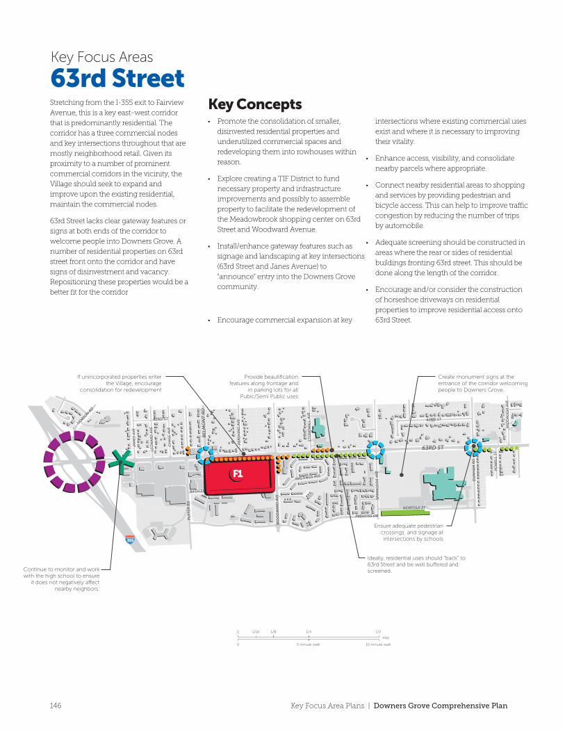
355
355 88
34
34
63rd Street
RecommendationsScreening
Gateway/Directory Signage
Landscaping/Site Beautification
Interstate Interchange
Improved Pedestrian Crossing
Institutional/Public
Park/Open Space
Municipal Boundary
Catalyst Site
63rd StreetKey Focus Areas
Stretching from the I-355 exit to Fairview
Avenue, this is a key east-west corridor
that is predominantly residential. The
corridor has a three commercial nodes
and key intersections throughout that are
mostly neighborhood retail. Given its
proximity to a number of prominent
commercial corridors in the vicinity, the
Village should seek to expand and
improve upon the existing residential,
maintain the commercial nodes.
63rd Street lacks clear gateway features or
signs at both ends of the corridor to
welcome people into Downers Grove. A
number of residential properties on 63rd
street front onto the corridor and have
signs of disinvestment and vacancy.
Repositioning these properties would be a
better fit for the corridor
• Promote the consolidation of smaller,
disinvested residential properties and
underutilized commercial spaces and
redeveloping them into rowhouses within
reason.
• Explore creating a TIF District to fund
necessary property and infrastructure
improvements and possibly to assemble
property to facilitate the redevelopment of
the Meadowbrook shopping center on 63rd
Street and Woodward Avenue.
• Install/enhance gateway features such as
signage and landscaping at key intersections
(63rd Street and Janes Avenue) to
"announce" entry into the Downers Grove
community.
• Encourage commercial expansion at key
intersections where existing commercial uses
exist and where it is necessary to improving
their vitality.
• Enhance access, visibility, and consolidate
nearby parcels where appropriate.
• Connect nearby residential areas to shopping
and services by providing pedestrian and
bicycle access. This can help to improve traffic
congestion by reducing the number of trips
by automobile.
• Adequate screening should be constructed in
areas where the rear or sides of residential
buildings fronting 63rd street. This should be
done along the length of the corridor.
• Encourage and/or consider the construction
of horseshoe driveways on residential
properties to improve residential access onto
63rd Street.
Key Concepts Catalyst SitesMeadowbrookShopping CenterThis site is not located on a significant
commercial corridor and is underutilized.
The site could be split into two parts, with
the northern half providing convenience
retail, o�ce or service uses. The south half
could provide new single family attached
or multi-family residential in the form of
townhouses or low-rise apartment
buildings.
F1• Beautify and/or enhance at major
intersections on 63rd street.
• Promote and permit the construction of
multi-family or single family attached at
major nodes.
• Ensure parkways trees are preserved and
enhanced for the entire length of the corridor.
• Reduce the heat island effect through a
combination of providing shade on-site and
using light colored building and paving
materials.
Mile
0
0 10 minute walk5 minute walk
1/16 1/8 1/4 1/2
DU
NH
AM
RD
CH
ASE
AV
E
PE
RSH
ING
AV
E
PRENTISS DR
NORFOLK ST
HOBSO
N RD
SPR
ING
SID
E A
VE
LEO
NA
RD
AV
E
62ND ST
PO
WE
LL S
T
HASTINGS AVE
64TH ST
PU
FFE
R R
D
JAN
ES
AV
E
MID
DA
UG
H A
VE
STO
NE
WA
LL A
VE
62ND ST
WO
OD
WA
RD
AV
E
65TH ST
PO
WE
LL S
T
OSA
GE
AV
E
62ND PL
ADELIA ST
DA
VA
NE
CT
BA
RR
ET
T S
T
MEADOWLAWN AVE
BLO
DG
ET
T C
T
BR
OO
KB
AN
K R
D
GR
AN
D A
VE
62ND ST
SAR
AT
OG
A A
VE
MID
DA
UG
H A
VE
WA
SHIN
GT
ON
ST
BLO
DG
ET
T A
VE
FAIR
MO
UN
T A
VE
62ND ST
LYM
AN
AV
E PA
RK
AV
E
62ND ST
MA
IN S
T
BE
LMO
NT
RD
63RD ST
63RD ST
FAIR
VIE
W A
VE
Ensure adequate pedestrian crossings and signage at intersections by schools
Continue to monitor and work with the high school to ensure
it does not negatively a�ect nearby neighbors.
If unincorporated properties enter the Village, encourage
consolidation for redevelopment
Ensure dumpster enclosure regulations are enforced
Use Low Impact Design (LID) in commercial parking lots for stormwater management
Encourage horseshoe turn arounds in front yards
Commercial centers should have beautification features along frontage and in parking lots
Ideally, residential uses should “back” to 63rd Street and be well bu�ered and screened.
Provide beautification features along frontage and
in parking lots for all Pubic/Semi Public uses
Create monument signs at the entrance of the corridor welcoming people to Downers Grove.
Auto access and movement should be carefully considered in site planning to
minimize vehicle collisions
Encourage townhome development along the corridor where appropriate. Allow for vehicle access o� of the corridor from the rear.
355
F1
146 Key Focus Area Plans | Downers Grove Comprehensive Plan
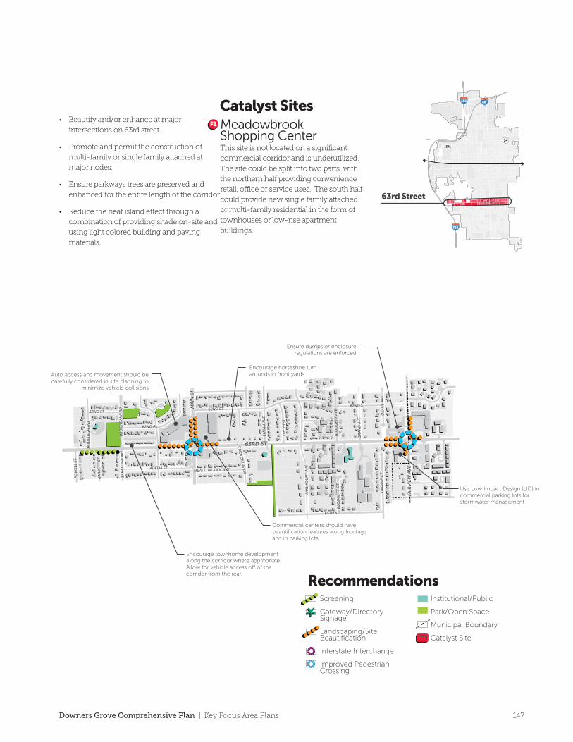
355
355 88
34
34
63rd Street
RecommendationsScreening
Gateway/Directory Signage
Landscaping/Site Beautification
Interstate Interchange
Improved Pedestrian Crossing
Institutional/Public
Park/Open Space
Municipal Boundary
Catalyst Site
63rd StreetKey Focus Areas
Stretching from the I-355 exit to Fairview
Avenue, this is a key east-west corridor
that is predominantly residential. The
corridor has a three commercial nodes
and key intersections throughout that are
mostly neighborhood retail. Given its
proximity to a number of prominent
commercial corridors in the vicinity, the
Village should seek to expand and
improve upon the existing residential,
maintain the commercial nodes.
63rd Street lacks clear gateway features or
signs at both ends of the corridor to
welcome people into Downers Grove. A
number of residential properties on 63rd
street front onto the corridor and have
signs of disinvestment and vacancy.
Repositioning these properties would be a
better fit for the corridor
• Promote the consolidation of smaller,
disinvested residential properties and
underutilized commercial spaces and
redeveloping them into rowhouses within
reason.
• Explore creating a TIF District to fund
necessary property and infrastructure
improvements and possibly to assemble
property to facilitate the redevelopment of
the Meadowbrook shopping center on 63rd
Street and Woodward Avenue.
• Install/enhance gateway features such as
signage and landscaping at key intersections
(63rd Street and Janes Avenue) to
"announce" entry into the Downers Grove
community.
• Encourage commercial expansion at key
intersections where existing commercial uses
exist and where it is necessary to improving
their vitality.
• Enhance access, visibility, and consolidate
nearby parcels where appropriate.
• Connect nearby residential areas to shopping
and services by providing pedestrian and
bicycle access. This can help to improve traffic
congestion by reducing the number of trips
by automobile.
• Adequate screening should be constructed in
areas where the rear or sides of residential
buildings fronting 63rd street. This should be
done along the length of the corridor.
• Encourage and/or consider the construction
of horseshoe driveways on residential
properties to improve residential access onto
63rd Street.
Key Concepts Catalyst SitesMeadowbrookShopping CenterThis site is not located on a significant
commercial corridor and is underutilized.
The site could be split into two parts, with
the northern half providing convenience
retail, o�ce or service uses. The south half
could provide new single family attached
or multi-family residential in the form of
townhouses or low-rise apartment
buildings.
F1• Beautify and/or enhance at major
intersections on 63rd street.
• Promote and permit the construction of
multi-family or single family attached at
major nodes.
• Ensure parkways trees are preserved and
enhanced for the entire length of the corridor.
• Reduce the heat island effect through a
combination of providing shade on-site and
using light colored building and paving
materials.
Mile
0
0 10 minute walk5 minute walk
1/16 1/8 1/4 1/2
DU
NH
AM
RD
CH
ASE
AV
E
PE
RSH
ING
AV
E
PRENTISS DR
NORFOLK ST
HOBSO
N RD
SPR
ING
SID
E A
VE
LEO
NA
RD
AV
E
62ND ST
PO
WE
LL S
T
HASTINGS AVE
64TH ST
PU
FFE
R R
D
JAN
ES
AV
E
MID
DA
UG
H A
VE
STO
NE
WA
LL A
VE
62ND ST
WO
OD
WA
RD
AV
E
65TH ST
PO
WE
LL S
T
OSA
GE
AV
E
62ND PL
ADELIA ST
DA
VA
NE
CT
BA
RR
ET
T S
T
MEADOWLAWN AVE
BLO
DG
ET
T C
T
BR
OO
KB
AN
K R
D
GR
AN
D A
VE
62ND ST
SAR
AT
OG
A A
VE
MID
DA
UG
H A
VE
WA
SHIN
GT
ON
ST
BLO
DG
ET
T A
VE
FAIR
MO
UN
T A
VE
62ND ST
LYM
AN
AV
E PA
RK
AV
E
62ND ST
MA
IN S
T
BE
LMO
NT
RD
63RD ST
63RD ST
FAIR
VIE
W A
VE
Ensure adequate pedestrian crossings and signage at intersections by schools
Continue to monitor and work with the high school to ensure
it does not negatively a�ect nearby neighbors.
If unincorporated properties enter the Village, encourage
consolidation for redevelopment
Ensure dumpster enclosure regulations are enforced
Use Low Impact Design (LID) in commercial parking lots for stormwater management
Encourage horseshoe turn arounds in front yards
Commercial centers should have beautification features along frontage and in parking lots
Ideally, residential uses should “back” to 63rd Street and be well bu�ered and screened.
Provide beautification features along frontage and
in parking lots for all Pubic/Semi Public uses
Create monument signs at the entrance of the corridor welcoming people to Downers Grove.
Auto access and movement should be carefully considered in site planning to
minimize vehicle collisions
Encourage townhome development along the corridor where appropriate. Allow for vehicle access o� of the corridor from the rear.
355
F1
147Downers Grove Comprehensive Plan | Key Focus Area Plans
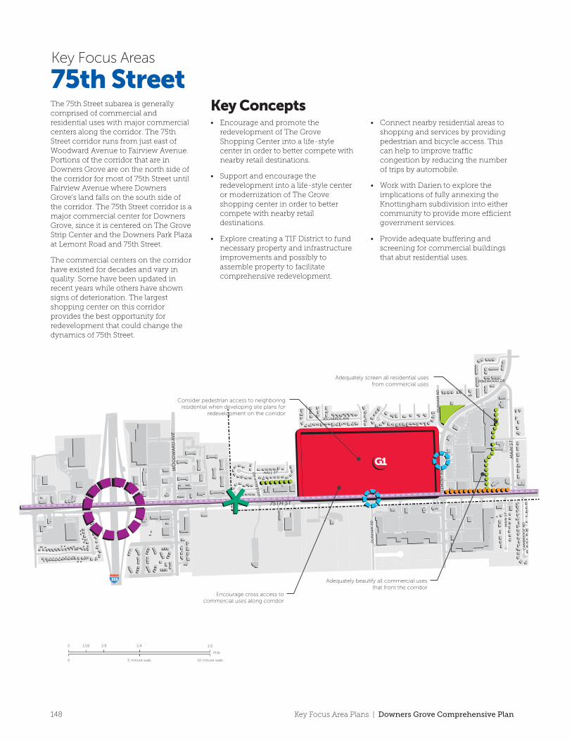
75th Street
RecommendationsScreening
Gateway/Directory Signage
Landscaping/Site Beautification
Interstate Interchange
Improved Pedestrian Crossing
Existing Trail
Proposed Trail
Institutional/Public
Park/Open Space
Municipal Boundary
Catalyst Site
G1
75th StreetKey Focus Areas
The 75th Street subarea is generally comprised of commercial and residential uses with major commercial centers along the corridor. The 75th Street corridor runs from just east of Woodward Avenue to Fairview Avenue. Portions of the corridor that are in Downers Grove are on the north side of the corridor for most of 75th Street until Fairview Avenue where Downers Grove’s land falls on the south side of the corridor. The 75th Street corridor is a major commercial center for Downers Grove, since it is centered on The Grove Strip Center and the Downers Park Plaza at Lemont Road and 75th Street.
The commercial centers on the corridor have existed for decades and vary in quality. Some have been updated in recent years while others have shown signs of deterioration. The largest shopping center on this corridor provides the best opportunity for redevelopment that could change the dynamics of 75th Street.
• Encourage and promote the redevelopment of The Grove Shopping Center into a life-style center in order to better compete with nearby retail destinations.
• Support and encourage the redevelopment into a life-style center or modernization of The Grove shopping center in order to better compete with nearby retail destinations.
• Explore creating a TIF District to fund necessary property and infrastructure improvements and possibly to assemble property to facilitate comprehensive redevelopment.
• Connect nearby residential areas to shopping and services by providing pedestrian and bicycle access. This can help to improve traffic congestion by reducing the number of trips by automobile.
• Work with Darien to explore the implications of fully annexing the Knottingham subdivision into either community to provide more efficient government services.
• Provide adequate buffering and screening for commercial buildings that abut residential uses.
Key Concepts Catalyst SitesThe GroveShopping CenterThe Grove Shopping CenterThis site has great redevelopment potential due to its size and location at a prominent intersection in Downers Grove. Given that there are notable large vacancies and an abundance of underutilized parking, the Village should explore redeveloping this site into a life-style center. This center could consist of retail, restaurants and residential in the form of apartments and townhomes. Any business types that are targeted should complement the Downers Park Plaza shopping center just east of the site. This could allow for additional tax revenue generation and could help this node be more competitive with other commercial centers nearby.
G1• Dumpster enclosures and dumpster
screening are required and should be enforced consistently.
• Reduce the heat island effect through a combination of providing shade on-site and using light colored building and paving materials.
Mile
0
0 10 minute walk5 minute walk
1/16 1/8 1/4 1/2
WIL
LIA
MS
ST
GIG
I LN
WE
BST
ER
ST
KN
OT
TIN
GH
AM
LN
74TH ST
LYM
AN
AV
E
FLO
RE
NC
E A
VE
ELIZABETH LN
STOCKLEY RD
BA
YB
UR
Y R
D
CA
MB
RID
GE
RD
YO
RK
RD
HA
RT
FOR
D R
D
74TH ST
73RD ST
FAIR
MO
UN
T A
VE
73RD ST
MA
IN S
T
DU
NH
AM
RD
LEM
ON
T R
D
DE
VE
RE
UX
RD HALL ST
RICHARDS AVE
CA
MB
RID
GE
RD
PINEWOOD DR
DU
NH
AM
RD
75TH ST75TH ST
MA
IN S
T
WO
OD
WA
RD
AV
E
FAIR
VIE
W A
VE
MA
IN S
T
355
355 88
34
34
355
Ensure dumpster enclosure regulations are enforced
Consider Low Impact Design (LID) features fir stormwater managementConsider pedestrian access to neighboring
residential when developing site plans for redevelopment on the corridor
Adequately beautify all commercial uses that front the corridor
Encourage cross access to commercial uses along corridor
Adequately screen all residential uses from commercial uses
148 Key Focus Area Plans | Downers Grove Comprehensive Plan
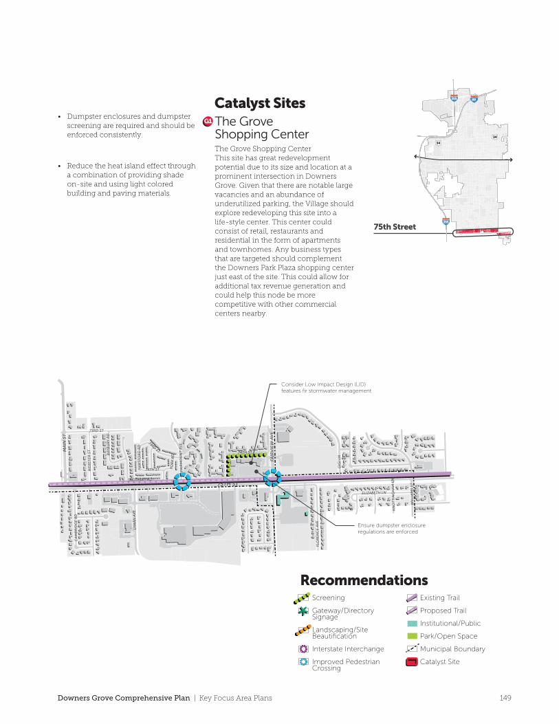
75th Street
RecommendationsScreening
Gateway/Directory Signage
Landscaping/Site Beautification
Interstate Interchange
Improved Pedestrian Crossing
Existing Trail
Proposed Trail
Institutional/Public
Park/Open Space
Municipal Boundary
Catalyst Site
G1
75th StreetKey Focus Areas
The 75th Street subarea is generally comprised of commercial and residential uses with major commercial centers along the corridor. The 75th Street corridor runs from just east of Woodward Avenue to Fairview Avenue. Portions of the corridor that are in Downers Grove are on the north side of the corridor for most of 75th Street until Fairview Avenue where Downers Grove’s land falls on the south side of the corridor. The 75th Street corridor is a major commercial center for Downers Grove, since it is centered on The Grove Strip Center and the Downers Park Plaza at Lemont Road and 75th Street.
The commercial centers on the corridor have existed for decades and vary in quality. Some have been updated in recent years while others have shown signs of deterioration. The largest shopping center on this corridor provides the best opportunity for redevelopment that could change the dynamics of 75th Street.
• Encourage and promote the redevelopment of The Grove Shopping Center into a life-style center in order to better compete with nearby retail destinations.
• Support and encourage the redevelopment into a life-style center or modernization of The Grove shopping center in order to better compete with nearby retail destinations.
• Explore creating a TIF District to fund necessary property and infrastructure improvements and possibly to assemble property to facilitate comprehensive redevelopment.
• Connect nearby residential areas to shopping and services by providing pedestrian and bicycle access. This can help to improve traffic congestion by reducing the number of trips by automobile.
• Work with Darien to explore the implications of fully annexing the Knottingham subdivision into either community to provide more efficient government services.
• Provide adequate buffering and screening for commercial buildings that abut residential uses.
Key Concepts Catalyst SitesThe GroveShopping CenterThe Grove Shopping CenterThis site has great redevelopment potential due to its size and location at a prominent intersection in Downers Grove. Given that there are notable large vacancies and an abundance of underutilized parking, the Village should explore redeveloping this site into a life-style center. This center could consist of retail, restaurants and residential in the form of apartments and townhomes. Any business types that are targeted should complement the Downers Park Plaza shopping center just east of the site. This could allow for additional tax revenue generation and could help this node be more competitive with other commercial centers nearby.
G1• Dumpster enclosures and dumpster
screening are required and should be enforced consistently.
• Reduce the heat island effect through a combination of providing shade on-site and using light colored building and paving materials.
Mile
0
0 10 minute walk5 minute walk
1/16 1/8 1/4 1/2
WIL
LIA
MS
ST
GIG
I LN
WE
BST
ER
ST
KN
OT
TIN
GH
AM
LN
74TH ST
LYM
AN
AV
E
FLO
RE
NC
E A
VE
ELIZABETH LN
STOCKLEY RD
BA
YB
UR
Y R
D
CA
MB
RID
GE
RD
YO
RK
RD
HA
RT
FOR
D R
D
74TH ST
73RD ST
FAIR
MO
UN
T A
VE
73RD ST
MA
IN S
T
DU
NH
AM
RD
LEM
ON
T R
D
DE
VE
RE
UX
RD HALL ST
RICHARDS AVE
CA
MB
RID
GE
RD
PINEWOOD DR
DU
NH
AM
RD
75TH ST75TH ST
MA
IN S
T
WO
OD
WA
RD
AV
E
FAIR
VIE
W A
VE
MA
IN S
T
355
355 88
34
34
355
Ensure dumpster enclosure regulations are enforced
Consider Low Impact Design (LID) features fir stormwater managementConsider pedestrian access to neighboring
residential when developing site plans for redevelopment on the corridor
Adequately beautify all commercial uses that front the corridor
Encourage cross access to commercial uses along corridor
Adequately screen all residential uses from commercial uses
149Downers Grove Comprehensive Plan | Key Focus Area Plans
Related Documents