BEFORE WINTER COMES: ARCHAEOLOGICAL INVESTIGATIONS OF SETTLEMENT AND SUBSISTENCE IN HARNEY VALLEY, HARNEYCOUNTY,OREGON by PATRICK WARREN O'GRADY A DISSERTATION Presented to the Department of Anthropology and the Graduate School of the University of Oregon in partial fulfillment of the requirements for the degree of Doctor of Philosophy December 2006

Welcome message from author
This document is posted to help you gain knowledge. Please leave a comment to let me know what you think about it! Share it to your friends and learn new things together.
Transcript
•
BEFORE WINTER COMES: ARCHAEOLOGICAL INVESTIGATIONS OF
SETTLEMENT AND SUBSISTENCE IN HARNEY VALLEY,
HARNEYCOUNTY,OREGON
by
PATRICK WARREN O'GRADY
A DISSERTATION
Presented to the Department of Anthropologyand the Graduate School of the University of Oregon
in partial fulfillment of the requirementsfor the degree of
Doctor ofPhilosophy
December 2006
11
"Before Winter Comes: Archaeological Investigations of Settlement and Subsistence in
Harney Valley, Harney County, Oregon," a dissertation prepared by Patrick Warren
O'Grady in partial fulfillment of the requirements for the Doctor of Philosophy degree in
the Department of Anthropology. This dissertation has been approved and accepted by:
Committee in Charge:
Accepted by:
Dr. C. Melvin Aikens, ChairDr. Dennis L. JenkinsDr. Douglas J. KennettDr. Esther Jacobson-Tepfer
Dean of the Graduate School
3
111
An Abstract of the Dissertation of
Patrick Warren O'Grady for the degree of
In the Department ofAnthropology to be taken
Doctor of Philosophy
December 2006
Title: BEFORE WINTER COMES: ARCHAEOLOGICAL INVESTIGATIONS OF
SETTLEMENT AND SUBSISTENCE IN HARNEY VALLEY, HARNEY
COUNTY, OREGON
Approved:, r. C. Melvm Alkens
-
Many archaeological researchers that have conducted investigations in the Harney
Valley of southeastem Oregon use the ethnographic description of the seasonal round of
the Harney Valley Paiute reported by Beatrice Blyth Whiting in her 1950 work Paiute
Sorcery as a framework for discussions of prehistoric human use of the area.
Archaeological investigations of seven sites, situated in areas identified as having been
utilized by the Harney Valley Paiutes, were conducted to test the relationship between
Whiting's ethnographic account and the archaeological record. Data recovery
excavations occurred at the Hoyt (35HA2422), Morgan (35HA2423) and Hines
(35HA2692) sites near Burns, and test excavations occurred at the Knoll (35HA2530)
site in the Silvies Valley, the RJ site (35HA3013) in the Stinkingwater Mountains, and
the Broken Arrow (35HA2735) and Laurie's (35HA2734) sites near Malheur Lake.
f*
IV
Studies of the cultural materials recovered during the excavations were undertaken
to evaluate the content and complexity of each site. Analyses included typological
considerations of the chipped stone tools, ground stone, bone tools, and shell, bone, and
stone beads. Radiocarbon dating, obsidian sourcing and hydration, and
zooarchaeological and paleobotanical analyses were also conducted when possible.
Based on the results of the analyses, the seven sites reported herein were primarily used
during the past 2000 years, with periods of less intensive use extending beyond 4000 BP.
The results of the archaeological investigations indicate that there is a strong
correlation between the late Holocene prehistoric record and Whiting's ethnographic
description. However, the relationship between human use ofthe centrally-located lakes
and wetlands and the neighboring uplands is clearly more complex than the ethnographic
record suggests. Patterns of settlement and mobility revealed through the archaeological
record indicate that central places, located closer to wetlands and lacustrine settings but
within relatively easy reach of the uplands, may have figured more prominently in the
behavior of prehistoric populations than the seasonal round as described by Whiting.
Future research will benefit from explorations of central place foraging, emphasizing the
role of behavioral ecology in the placement of sites and patterns of site use within the
Harney Valley and the northern Great Basin at large.

p 1p
CURRICULUM VITAE
NAME OF AUTHOR: Patrick Warren O'Grady
PLACE OF BIRTH: Medford, Oregon
DATE OF BIRTH: March 23,1959
GRADUATE AND UNDERGRADUATE SCHOOLS ATTENDED:
University of OregonLane Community College
DEGREES AWARDED:
Doctor of Philosophy, 2006, University of OregonMaster of Science, 1999, University of OregonBachelor of Science, 1996, University of Oregon
AREAS OF SPECIAL INTEREST:
Hunter-Gatherer Settlement and Subsistence SystemsZooarchaeologyPaleoenvironments
PROFESSIONAL EXPERIENCE:
Graduate Teaching Fellow, Department of Anthropology, University of Oregon1997-2001
Supervisor, University of Oregon Archaeological Field School,1995, 1997-2001
Research Assistant, Oregon State Museum of Anthropology.1998-2002
v
¥
VI
Archaeologist, Oregon Department of Transportation2002-2005
Archaeologist, Oregon State Museum of Anthropology,2005-2006
GRANTS, AWARDS AND HONORS:
Star Award, Bums District Bureau of Land Management, 2002Edna English Trust, University of Oregon, 2000Graduate School Research Award, University of Oregon, 1998Starr General Scholarship, University of Oregon, 1997Magna Cum Laude, University of Oregon, 1996Junior Scholar Award, University of Oregon, 1995
PUBLICATIONS:
O'Neill, Brian L., Dennis L. Jenkins, Charles M. Hodges, PatrickO'Grady, and Thomas J. Connolly
2006 Housepits in the Chewaucan Marsh: Investigations at the Gravelly FordBridge Site. In Beads, Points, and Pit Houses: A Northern Great BasinMiscellany, edited by Brian L. O'Neill, pp. 93-136. University ofOregon Anthropological Papers No. 66, Eugene.
O'Grady, Patrick2005 Report'on the Activities ofthe 2005 Redmond Caves Field School.
Current Archaeological Happenings in Oregon 30(3): 8-10.
O'Grady, Patrick2004 Zooarchaeological Analysis of Cultural Features from Four Early to
Middle Holocene Sites in the Fort Rock Basin. In Early and MiddleHolocene Archaeology o/the Northern Great Basin, edited by Dennis L.Jenkins, Thomas J. Connolly, and C. Melvin Aikens, pp.187-208.University of Oregon Anthropological Papers No. 62, Eugene.
Kramer, George, Patrick O'Grady, and Thomas J. Connolly2002 Cultural Resource Investigations for the Cold Springs Highway-SW
Court Place Segment, U.S. Highway 30, Pendleton, Umatilla County.State Museum of Anthropology Report No. 2002-2, University ofOregon, Eugene.
p
Vll
O'Grady, Patrick2001 Reptile and Amphibian Remains from Houses 1-8. In Carlon Village:
Land, Water, Subsistence and Sedentism in the Northern Great Basin,edited by George F. Wingard, pp. 561-563. University of OregonAnthropological Papers No. 57, Eugene.
Thomas, Scott, Patrick O'Grady, Dan Braden, Margaret Helzer, LaurieThompson, and Emily Mueller2001 35HA3055: A Prehistoric Jackrabbit Roasting Site in Southeastern
Oregon. Current Archaeological Happenings in Oregon 25(4):17-22
O'Grady, Patrick2000 Zooarchaeological Analysis of Vertebrate and Invertebrate Remains from
the Gravelly Ford Sites, Lake County, Oregon. In The Chewaucan RiverBridges Project: .L4rchaeological Investigations at Three Localities in theLower Chewaucan Marsh Along the La Pine-Valley Falls Highway(OR31), Lake County, Oregon, by Brian L. O'Neill, Dennis L. Jenkins,Charles M. Hodges, Patrick O'Grady, and Thomas J. Connolly, pp. 7196. Oregon State Museum of Anthropology Report No. 2000-4, Eugene.
O'Grady, Patrick1999 Obsidian Sources from Playa Villages in the Fort Rock Uplands, Lake
County, Oregon. Current Archaeological Happenings in Oregon24(3):12-19.

Vlll
ACKNOWLEDGEMENTS
A tremendous number of people were involved in this project, but above all I
would like to thank Dr. C. Melvin Aikens, whose careful guidance and patient soul
helped me in innumerable ways. Dr. Dennis L. Jenkins gave me every opportunity to
engage in the world of Great Basin archaeology, and gave freely of his time and attention
as only a true mentor would. Scott Thomas has also been played an invaluable part in all
of this, both as a colleague and friend, and his knowledge of the archaeology of Harney
Valley is unsurpassed. Dr. Thomas J. Connolly has always been a trusted advisor and his
commitment to the archaeology of Oregon sets an example to live by. I have gained
much from the counsel of these four men. Thanks also to Dr. Douglas J. Kennett and Dr.
Esther Jacobson-Tepfer for serving on my committee.
Thanks to the University of Oregon Department of Anthropology and Museum of
Natural and Cultural History, the Burns District Bureau of Land Management, the
Oregon Department of Transportation, the Edna English Trust, and the United States
Forest Service: Malheur National Forest, for funding this effort. The Harney County
School District, Crane School District and Dave Courtney deserve thanks for "putting us
up" during our field operations.
My 2000 and 2001 field school crews included Rachael Bendis, Tobin Bortman,
Deanna Dartt, Ian Goss, Rose Gunn, Jessica Lisicki, Emily Mueller, Jaime Sheppard,
Ann Marie Southey, Laurie Thompson, and Debbie Todd.

ji ¥
IX
Volunteers included Bethel and Larry Asmussen, Dan Braden, Marty Boyesen
Diane Browning, Kelly Edmundson, Scott Meissner, Dianne Ness, Bud Rice, Jim Rice,
Joe Rickman, Ray Temple, Whitney Temple, Wilda Toussaint, and Frank and Pam
Turner. You all made a huge difference.
Artifact drawings are by Eric Carlson, and Tom Connolly and Carolyn Armstrong
made the maps seen in the Hoyt, Morgan, and Hines chapters.
I would also like to thank Marge Helzer and Suzann Henrikson, who provided
much emotional support during the grad school process. Georgia Crow helps keep "story
time" alive. Cecil and Emory Coons have always given freely of their knowledge of tool
stone sources in the Harney Valley. The warmth and friendliness of the people of Bums
and Hines always made our field sessions more enjoyable.
My son Jack has always been a willing and helpful participant in the field school
effort. His presence during these projects brings me great joy.
Finally, I extend my thanks to the Bums Paiute Tribe, who have been supportive
of my efforts and given freely of their knowledge. This project would not have been
possible without ongoing collaboration between the Bums Paiute Tribe, the University of
Oregon Department of Anthropology, and the Bums District Bureau of Land
Management.

...
*'
To Sarah, who contributed tremendously to this effort and always kept me grounded.
x
Xl
TABLE OF CONTENTS
Chapter Page
I. WTRODUCTION 1
Development of the Study Objectives 1Land, Resources, Ethnography, and Archaeology 6The Ethnohistoric Record 16Archaeological Surveys 20Summary 38
II. THEORETICAL CONSIDERATIONS: THE ETHNOGRAPHIC MODEL .41
Research Beginnings 42Mobility and Settlement 46
III. MORGAN" SITE (35HA2423) 62
Excavation Strategies 62Excavation Units 64Analytical Components 65Radiocarbon Dates 71Features 72Artifact Assemblage 77Faunal Remains 101Botanical Remains 106Summary 108
IV. HOYT SITE (35HA2422) 110
Excavation Strategies 11 0Features 123Radiocarbon Dates 125Artifact Assemblage 126Botanical Remains 158Faunal Remains 159Summary 163
V. HWES SITE (35HA2692) 165
Excavation Strategies 165Features 178Artifact Assemblage 179Faunal Remains 209
Xll
Chapter Page
Botanical Remains 213Summary 220
VI. KNOLL SITE (35HA2530) 223
Excavation Strategies 224Analytical Components 227Radiocarbon Dates 236Artifact Assemblage 237Faunal Remains 250Botanical Remains 253Summary 259
VII. RJ SITE (35HA3013) 262
Excavation Strategies 264Excavation Units 266Analytic Components 267Artifact Assemblage 275Faunal Remains 297Botanical Remains 297Summary 306
VIII. LAURIE'S SITE (35HA3074) 310
Excavation Strategies 314Excavation Units 315Analytic Components 316Artifact Assemblage 333Botanical Remains 370Faunal Remains 374Summary 374
IX. BROKEN ARROW SITE (35HA3075) 378
Excavation Strategies 382Excavation Units 383Analytic Components 384Features 397Artifact Assemblage 404Botanical Remains 454Faunal Remains : 457Summary 458
Chapter
Xlll
Page
x. SUMMARY AND CONCLUSIONS .460
Research Topics 461Regional Culture History: Site Summaries .461Regional Culture History: Radiocarbon and Obsidian HydrationDates, and Lithic Technology Comparisons .465Paleoclimatic, Environmental, and Cultural Change .469Settlement and Subsistence 473Cultural Relations and Ethnic Group Territories .477The Sites in Relationship to Harney Valley Patterns of Mobility .489Future Research in Harney Valley .497
APPENDIX: GEOCHEMICAL SOURCING AND OBSIDIAN HYDRATIONSTUDIES AT THE HOYT, MORGAN, AND HINES SITES 502
BIBLIOGRAPHY 522
XIV
LIST OF FIGURES
Figure Page
1.1. Hydo1ogic Map of the Harney Basin 9
1.2. Selected Harney Basin Archaeological Sites 22
3.1. Plan View of Morgan Site Test Pits 63
3.2. The Morgan Site West Locus 65
3.3. Plan View ofMorgan Site Excavation Area 67
3.4. Profile ofUnit N99, E8 68
3.5. Morgan Site East Locus 70
3.6. Feature 1, Unit D 73
3.7. Feature 2 Milling Stone Cluster 74
3.8. Feature 3, a Hearth in Unit W 75
3.9. Feature 4, a Hearth in Unit U 76
3.10. Selected Projectile Points from the Morgan site 79
3.11. Selected Bifaces from the Morgan Site 87
3.12. Debitage Distributions at the Morgan Site 94
3.13. Specimen 977-23-P-A-11-2 98
3.14. Mano, Pestle, and Stone Bead 99
3.15. Animal Bone Distributions at Morgan Site 102
4.1. Locations ofProbes and Test Units at the Hoyt Site 111
4.2. Plan View ofData Recovery Excavation Units at the Hoyt Site 112
4.3. The Hoyt Site North Locus 113
4.4. Hoyt Site Profile, Unit E 115
4.5. The Hoyt Site South Locus 119
4.6. Hoyt Site Unit S Profile 120
4.7. Feature 1, a Metate 123
4.8. Projectile Points 127
4.9. Selected Biface Fragments 139
4.10. Distribution ofDebitage, All Units 149
4.11. Selected Manos from the Hoyt Site 150
... +
xv
Figure Page
4.12. Selected Artifacts from the Hoyt Site 151
4.13. Abrading Stones from the Hoyt Site 154
4.14. Distribution of Faunal Remains 160
5.1. Location of the Hines Site 166
5.2. Hines Site Trenches, Probes, and Excavation Units 167
5.3. North Block of the Hines Site 173
5.4. South Block, Facing North 175
5.5. North Block of the Central Locus 177
5.6. Selected Projectile Points 181
5.7. Bifaces, ShOV,,'ll..LAl..ctllal Size 192
5.8. Drills, Shown Actual Size 196
5.9. Bone Too11070-92-E-b-5-2 208
6.1. South Locus of the Knoll Site 224
6.2. Knoll Site Excavation Units 226
6.3. Feature 1, Leve13 232
6.4. Units 1 and 3 at the North Locus 232
6.5. Unit 4 at the North Locus 233
6.6. Feature 2, Northern Portion ofUnit 2, Quad A 234
6.7. Unit 2 at the Knoll Site 235
6.8. Projectile Points and Selected Bifaces 238
6.9. Specimen 2530-4-A-1-1 249
6.10. Specimen 2530-2-B-2-2 250
6.11. Obsidian Hydration Readings from Units 1 and 2 254
7.1. View ofRJ Site 263
7.2. RJ Site Excavation Units 265
7.3. Unit 1, Locations of In Situ artifacts 268
7.4. Plan View of Unit 2 271
7.5. Unit 3, Locations of Artifacts and Samples 272
7.6. Unit 4, Locations of Artifacts and Samples 274
7.7. Projectile Points and Other Hafted Too1s 277
¥
XVI
Figure Page
7.8. Selected Drill Fragments 287
7.9. Large core and Flake Tools 290
7.10. Ecofacts Recovered from the Surface 296
7.11. Obsidian Hydration Readings from RJ Excavation Units 301
8.1. Laurie's Site, with Depression in Foreground 311
8.2. Laurie's Site in Topographic Context.. 313
8.3. Detail Map of House Pits 314
8.4. Laurie' Site House Pit 1 Debitage Counts 318
8.5. Laurie's Site House Pit 1 Bone Counts 318
8.6. Laurie's Site House 1, Units 1 and 2 323
8.7. Laurie's Site, House 1 Profile 324
8.8. Laurie's Site, House 2 Profile 328
8.9. Debitage Counts for House Pit 2 329
8.10. Bone Counts for House Pit 2 329
8.11. Laurie's Site Unit SP-l Profile 331
8.12. Laurie's Site Unit SP-l Bone and Debitage Counts 331
8.13. Selected Projectile Points from Laurie's Site 334
8.14. Selected Artifacts from Laurie's Site 337
8.15. Selected Bifaces From Laurie's Site 346
8.16. Artifacts from Laurie's Site, including beads, drills, graver and stone bal1... 351
8.17. Bone Objects from Laurie's Site 363
8.18. Obsidian Hydration Measurements 366
9.1. Broken Arrow, Unit 2 in Foreground 379
9.2. Broken Arrow Topography and Excavation Units 380
9.3. Broken Arrow Unit 1 386
9.4. Broken Arrow Unit 1 Debitage and Bone Counts 387
9.5. Broken Arrow Unit 2 389
9.6. Debitage and Bone Counts for Unit 2 390
9.7. Broken Arrow Unit 3 392
9.8. Debitage and Bone Counts for Unit 3 393
•
XVII
Figure Page
9.9. Broken Arrow Positions of Units 2, 4, and 5 394
9.10. Broken Arrow Units 2, 4, and 5 395
9.11. Broken Arrow Temporal Distributions ofDiagnostic Point Types .405
9.12. Broken Arrow Projectile Points .408
9.13. Broken Arrow Projectile Points and Hafted Tools .4l0
9.14. Broken Arrow Projectile Points, Elko-Great Basin Stemmed .412
9.15. Broken Arrow Bifaces 421
9.16. Additional Bifaces from Broken Arrow .424
9.17. Selected Drills and Awls 430
9.18. Broken Arrow Abraders and Decorated Pipe Fragment.. .438
9.19. Pipe Fragment, with Incised Decorations Highlighted .439
9.20. Broken Arrow Bone Tools and Decorative Objects .441
9.21. Broken Arrow Shell and Stone Beads .446
9.22. Obsidian Hydration Measurements from Broken Arrow .453
10.1. Radiocarbon Dates as Related to Climatic Inferences .47l
10.2. Obsidian Sources for Knoll, RJ, Laurie's and Broken Arrow .479
10.3. Obsidian Sources for Hoyt, Morgan, and Hines .480
10.4. Relationship Between Study Sites and Dominant Obsidian Sources .48l
10.5. Relationship of Mass Analysis Results to Experimental Means .487
10.6. Scatter Plot ofFlake Weight and Percentage .488
10.7. Pie Charts Showing Variability at the Seven Sites .49l
.....~------------------------------------- -
XVlll
LIST OF TABLES
Table Page
3.1. Radiocarbon Dates for the Morgan Site 71
3.2. Projectile Points:Morgan Site 81
3.3. Morgan Site Projectile Point Fragments 84
3.4. Morgan Site Bifaces 90
3.5. Mass Analysis ofMorgan Site Debitage 95
3.6. Ground Stone from Morgan Site 97
3.7. Bone/Animal Size Classes 103
3.8. Inventory ofFaunal Remains from Morgan Site 105
3.9. Botanical Remains at Morgan Site 107
4.1. Artifact Distributions in the North Locus, Hoyt Site 116
4.2. Artifact Distributions in the South Locus, Hoyt Site 121
4.3. Vertical Distributions ofTools 122
4.4. Radiocarbon Dates from Hoyt Site 125
4.5. Projectile Point Attributes: Hoyt Site 130
4.6. Hoyt Site Projectile Point Fragments 135
4.7. Hoyt Site Drills and Awls 137
4.8. Hoyt Site Bifaces and Fragments 140
4.9. Cores from the Hoyt Site 144
4.10. Core and Flake Tools from Hoyt Site 146
4.11. Mass Analysis ofHoyt Debitage 148
4.12. Ground Stone Tools and Fragments from Hoyt 152
4.13. Bone Tool Fragments from Hoyt Site 157
4.14. Plant Remains at the Hoyt Site 159
4.15. Inventory ofFaunal Remains 162
5.1. Artifact Distributions in the North Block 172
5.2. Artifact Distributions in the South Block 176
5.3. Projectile Points from Hines Site , 184
5.4. Diagnostic Artifacts by Unit and Level 186
p
XIX
Table Page
5.5. Metric Attributes of Projectile Point Fragments 190
5.6. Hines Biface Fragments 198
5.7. Metric Attributes ofHines Cores 202
5.8. Mass Analysis of Hines Site Debitage 203
5.9. Hines Ground Stone Fragments 206
5.10. Faunal Remains from Hines Site 211
5.11. Pollen Recorded at the Hines Site 214
5.12. Macrofloral Remains from the Hines Site 216
5.13. Soil Samples and Associated Materials 219
6.1. Artifacts from Knoll Site Excavation Units 228
6.2. Knoll Site: All Faunal Remains 230
6.3. Radiocarbon Dates from the Knoll Site 236
6.4. Knoll Site Projectile Points 237
6.5. Knoll Site Biface and Nondiagnostic Projectile Point Fragments 241
6.6. Knoll Site Flake Tools 244
6.7. Knoll Site Edge-Modified Flakes 245
6.8. Knoll Site Cores 246
6.9. Knoll Site Ground Stone 247
6.10. Faunal Remains from the Knoll Site 251
6.11. Botanical Remains from the Knoll Site 253
6.12. Obsidian Sourcing and Hydration Results 255
6.13. Values for Mass Analysis Variables 258
6.14. Mass Analysis Results for Units 1 and 2 259
7.1. Radiocarbon Dates from the RJ Site 267
7.2. Summary ofArtifacs from RJ 269
7.3. RJ Site Projectile Points and Hafted Tools 276
7.4. RJ Site Bifaces and Fragments 284
7.5. Drills from the RJ Site 288
7.6. RJ Site Basalt Core and Flake Tools 289
7.7. RJ Site Utilized Flakes 293
,.. v
xx
Table Page
7.8. RJ Site Cores 294
7.9. Paleobotanical Remains from the RJ Site 298
7.10. Obsidian Sourcing and Hydration Results 300
7.11. Values for RJ Site Mass Analysis 305
7.12. Mass Analysis Results for Units 1-4 306
8.1. Radiocarbon Dates from Laurie's Site 317
8.2. Summary ofArtifacts from Laurie's Site 320
8.3. Laurie's Site Projectile Points 338
8.4. Laurie's Site Bifaces and Fragments 343
8.5. Drills and Awls from Laurie's Site 350
8.6. Laurie's Site Edge-Modified Flakes 353
8.7. Metric Attributes of Lam1e's Site Cores 354
8.8. Laurie's Site Ground Stone 356
8.9. Ochre Samples recovered at Laurie's Site 359
8.10. Metric Attributes of Laurie's Site Beads 361
8.11. Laurie's Site Bone Tools 362
8.12. Obsidian Sourcing and Hydration Results from Laurie's Site 365
8.13. Values for Mass Analysis Variables 369
8.14. Mass Analysis Results for Units 1 and 2 369
8.15. Paleobotanical Remains from Laurie's Site 372
8.16. Charcoal Analysis Results 373
9.1. Results of Broken Arrow Preliminary Testing 381
9.2. Radiocarbon Dates from Broken Arrow 384
9.3. Summary of Artifacts from Broken Arrow .400
9.4. Broken Arrow Projectile Points .414
9.5. Projectile Points Found as Isolates .415
9.6. Broken Arrow Bifaces and Fragments .425
9.7. Metric Attributes of Drills from Broken Arrow 431
9.8. Broken Arrow Utilized Flakes , .432
9.9. Broken Arrow Cores 434
XXI
~~ P~
9.10. Broken Arrow Ground Stone 435
9.11. Broken Arrow Bone Tools 442
9.12. Broken Arrow Beads 444
9.13. Broken Arrow Mass Analysis Variables .450
9.14. Broken Arrow Mass Analysis Results .450
9.15. Obsidian Sourcing and Hydration Results .452
9.16. Charcoal Analysis Results 455
9.17. Macrobotanical Analysis Results .456
10.1. Radiocarbon Dates from Harney Valley Sites .467
......
1
CHAPTER IINTRODUCTION
This dissertation is conceived as the beginning of a long term research program in the
Harney Basin of east-central Oregon. We know from data already in hand that the area has been
occupied since terminal Pleistocene times, but detailed information about its environmental and
cultural history is still spotty. We also know a good deal about 19th and 20th Century Northern
Paiute peoples' economic and social adaptations to the region from ethnographic work conducted
by Whiting (1950) Couture (1978), and others. This local ethnographic information offers an
important guide to the study of deeper human time in the region, and the present work focuses on
recent archaeological site occupation patterns near Ma1heur Lake to show how they relate to the
historically recent pattern of human land use and mobility. It reports original fieldwork at seven
sites, and draws on available information for others in the vicinity. A good correspondence is
found between the ethnographic model and the archaeological record of the last 2000 years. An
important problem defined for future investigation is that significant, climatically-induced
environmental changes about 2000 years ago seem to have had a significant effect on human
occupation in the vicinity of Ma1heur and Harney Lakes, and on the archaeological record of
earlier times in the same area. The remainder of this chapter provides essential context for the
reporting and analysis that follow, offering needed background on the research objectives, natural
environment, and previous investigations in the study area.
Development of the Study Objectives
The Harney Valley is a large, internally draining basin in southeastern Oregon that falls
within the confines of the Great Basin of western intermontane North America. The valley has
been the subject ofnumerous archaeological investigations beginning in the 1960s (Atherton
1966) and it was the focus of ethnographic work by Beatrice Blyth Whiting (1950) between 1936
and 1938. Whiting (1950: 17-19) collected a brief, but salient description of the lifeways of the
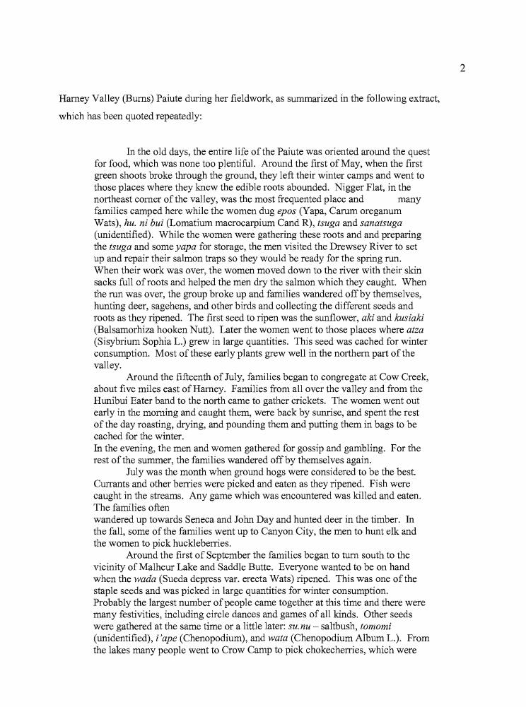
F
Harney Valley (Bums) Paiute during her fieldwork, as summarized in the following extract,
which has been quoted repeatedly:
In the old days, the entire life of the Paiute was oriented around the questfor food, which was none too plentiful. Around the first ofMay, when the firstgreen shoots broke through the ground, they left their winter camps and went tothose places where they knew the edible roots abounded. Nigger Flat, in thenortheast comer ofthe valley, was the most frequented place and manyfamilies camped here while the women dug epos (Yapa, Carum oreganumWats), hu. ni bui (Lomatium macrocarpium Cand R), tsuga and sanatsuga(unidentified). While the women were gathering these roots and and preparingthe tsuga and some yapa for storage, the men visited the Drewsey River to setup and repair their salmon traps so they would be ready for the spring run.When their work was over, the women moved down to the river with their skinsacks full of roots and helped the men dry the salmon which they caught. Whenthe run was over, the group broke up and families wandered offby themselves,hunting deer, sagehens, and other birds and collecting the different seeds androots as they ripened. The first seed to ripen was the sunflower, aki and kusiaki(Balsamorhiza hooken Nutt). Later the women went to those places where atza(Sisybrium Sophia L.) grew in large quantities. This seed was cached for winterconsumption. Most ofthese early plants grew well in the northern part ofthevalley.
Around the fifteenth of July, families began to congregate at Cow Creek,about five miles east of Harney. Families from all over the valley and from theHunibui Eater band to the north came to gather crickets. The women went outearly in the morning and caught them, were back by sunrise, and spent the restof the day roasting, drying, and pounding them and putting them in bags to becached for the winter.In the evening, the men and women gathered for gossip and gambling. For therest ofthe summer, the families wandered off by themselves again.
July was the month when ground hogs were considered to be the best.Currants and other berries were picked and eaten as they ripened. Fish werecaught in the streams. Any game which was encountered was killed and eaten.The families oftenwandered up towards Seneca and John Day and hunted deer in the timber. Inthe fall, some ofthe families went up to Canyon City, the men to hunt elk andthe women to pick huckleberries.
Around the first of September the families began to turn south to thevicinity of Malheur Lake and Saddle Butte. Everyone wanted to be on handwhen the wada (Sueda depress var. erecta Wats) ripened. This was one of thestaple seeds and was picked in large quantities for winter consumption.Probably the largest number ofpeople came together at this time and there weremany festivities, including circle dances and games of all kinds. Other seedswere gathered at the same time or a little later: sU.nu - saltbush, tomomi(unidentified), i'ape (Chenopodium), and wata (Chenopodium Album L.). Fromthe lakes many people went to Crow Camp to pick chokecherries, which were
2
3
made into cakes and and sun dried for winter. At this time there were alsocommunal antelope and rabbit drives.
By the first of November the families started to collect their cachedfoods and to move into their winter camps. Sites were selected which had aspring or some other source of water, a good supply of wood, and where it wasknown that there was not likely to be a heavy snowfall. Most of the camps wereat the foot of hills or in protected regions near the lakes. Here tule mat houseswere set up. (During the summer sagebrush enclosures were the only types ofstructures used.)
The passage is useful for archaeological purposes because it provides an account of
seasonal subsistence activities, the locations where such activities occurred, and the food items
that were sought. In the context of another project, I had begun working on the analysis and
reporting of three sites (the Hoyt, Morgan, and Hines sites) located along the northern edge ofthe
Harney Valley, and Whiting's description seemed to be a suitable starting point for further
consideration of past subsistence and settlement patterns in the Harney Valley, working from the
"known to the unknown" in a sense, to determine if the behaviors noted during historic times
might illuminate information gleaned from the archaeological record. Since most of the
radiocarbon dates so far obtained from Harney Valley sites fall within the last 2000 years,
including those from the Hoyt, Morgan, and Hines sites, it seemed possible that some degree of
continuity might be established between the ethnographic record and the late Holocene
archaeological record. A straightforward means of determining this would be to conduct
archaeological investigations at locations described in Whiting's account.
Between 1995 and 1997, the University of Oregon Museum of Natural and Cultural
History completed excavations at the above three sites near Burns, Oregon, which are included as
a part of this dissertation. The three projects were carried out as data recovery in advance of
highway projects, and all were financed by the Oregon Department of Transportation. The Hoyt
and Morgan sites are located on the northern edge of Harney Valley approximately 0.7 km apart,
and the Hines site is 10 km to the west between Bums and Hines. Laboratory analysis revealed
considerable variation at the three sites and they are certainly interesting of their own accord, but
they could not be placed directly into the pattern of use that Whiting described in terms of their
geographic locations. I felt that a dissertation project could be developed which would
incorporate sites from Whiting's ethnographically documented locations, in association with the
Hoyt, Morgan, and Hines sites, to establish a more coherent context for the Harney Valley at
..... ,.4
large. Possible research sites could include winter villages, as well as camps utilized for
collecting upland roots, riverside and lakeside fishing, cricket collecting, hunting (groundhogs,
large game, and rabbit drives), chokecherry and berry picking, and harvesting of wetland
resources.
I began discussing the possibilities with Scott Thomas of the Bums District Bureau of
Land Management, and four sites from areas discussed by Whiting were selected for work as part
of the University of Oregon Archaeological Field School during the 2000, 2001, and 2002 field
seasons. The Knoll site, located in the Silvies Valley north of Bums, was selected both because
of its location along a known travel route between the Harney Valley and deer and elk hunting
grounds near John Day, and as a location where huckleberries and currants were picked at various
times. The RJ site is located in the root grounds of the Stinkingwater Mountains. Both Broken
Arrow and Laurie's sites are located adjacent to Malheur Lake, where a variety of
ethnographically recorded activities could have taken place. The addition of the four sites
allowed me to report on a total of seven archaeological sites in this study of prehistoric settlement
and subsistence patterns in the Harney Valley drainage system.
Analyses conducted in association with the excavations included radiocarbon dating,
typological analysis of projectile points, obsidian sourcing and hydration, paleobotanical and
faunal analysis, and mass analysis of lithic debitage. Descriptions of artifacts recovered from the
excavations are also included, as are soil descriptions. What resulted was an evaluation of seven
sites primarily utilized from 650 BP to 2000 BP, calculated in radiocarbon years. The sites were
used for a variety of purposes, as was made evident through differences in the material remains at
each site. Several of the sites, including the Hoyt, Broken Arrow, and Laurie's sites, are believed
to have served as "central places" from which logistical forays were mounted to obtain plant
resources, tool stone, and large and small game. The other four sites, including the RJ, Knoll,
Morgan, and Hines sites, all appear to have been more task-specific in nature; the kinds of places
that would have been visited during outings from the base camps, or central places mentioned
above. None of the sites studied here are believed to have served as winter camps, due of their
lack of complex stratigraphy, storage features, and burials, but sites of this character come into
the discussion of previous research in the Harney Valley.
Although this study would focus on establishing a material record for sites in
ethnographically known use areas, as described above, climatic and cultural changes that
occurred in the late Holocene had also to be considered. Wigand's (1987) work at Diamond
5
Pond, southeast ofMalheur Lake, indicates that climatic fluctuations, including at least two
significant droughts, occurred during the last 2000 years. The arrival ofbow and arrow
technology took place within the last 2000 years as well, and the Numic expansion, extensive
movements within the Great Basin by people speaking Paiute, Shoshoni, and related languages,
probably occurred during the last 1000 years (Aikens 1994; Bettinger and Baumhoff 1982; Lamb
1958). Changes in the patterns of use at each site might include less evidence of human
occupation during droughts, a transition from atlatl darts to arrow points when the bow and arrow
arrived, and the appearance of sites containing Desert Side-notched points as a part of the
material record of the Numic expansion.
What might have happened around 2000 BP to cause a dramatic increase in radiocarbon
dated sites after that time? The Harney Valley has been used at least since Clovis times (Thomas
and O'Grady 2006), and the presence of all recognized Great Basin projectile point styles
indicates that the valley was probably utilized continuously thereafter, though at times there may
have been periods of reduced use due to long term drought episodes (Fagan 1973). There have
also been times of population increase such as during the Neopluvial period of greater effective
moisture from 5000 BP to 3000 BP, and possibly after 2000 BP, by which time Jenkins (1994)
believes increasing populations and more circumscribed territories were responsible for
intensified use of upland roots in the highlands surrounding Fort Rock. The arrival ofbow and
arrow technology may have opened new areas to exploitation through hunting, leading to a
broader dispersal of sites across the landscape. It may also be true that much of the
archaeological record prior to 2000 BP was "erased" through the dynamics of lake expansion and
contraction due to fluctuating water levels. The era of greater effective moisture that led to the
Neopluvial period between 5000 and 3000 BP, which created conditions favorable to plant and
animal populations and, by extension, human populations, might also have destroyed or obscured
earlier archaeological sites in the central Harney Valley basin. Although I have seen intriguing
evidence of some very old sites at elevated margins along the shore of Malheur Lake, many of the
sites that were once situated at lower elevations adjacent to the lakeshore may now be re
deposited in the form of extensive lag deposits on relict shorelines.
Obsidian sourcing information had already revealed some intriguing relationships within
the Harney Valley and with points beyond. Jenkins and Connolly (1990: 112) first reported on the
relationship between the resource area of the Harney Valley Paiutes and sources of obsidian
recovered from the Indian Grade Spring site on the Stinkingwater Mountains, noting that sources
.....
6
used were comparable to those of the Bums Paiute foraging area. O'Grady (1999) noted that
obsidian sources for projectile points recovered from upland villages at the Silver Lake/Summer
Lake divide further west and south included high quantities of material from the western edge of
Harney Valley, but virtually none from the central or eastern portion ofthe same valley.
Relationships of the western Harney Valley people seemed to be more evident with the Fort
Rock, Warner Valley, and Lake Abert areas than with the inhabitants of nearby Malheur and
Harney lakes, despite high frequencies oflocal obsidian found in both areas. Lyons et al.
(2001:286) suggest that a limited obsidian resource area was operational at Lost Dune, south
of Malheur Lake, between about 2000 BP and 500 BP, identifying an area they refer to as the
Western Malheur/Catlow area of resource procurement. They noted that people near the lake
gained access to more distant sources less often than central ones, and interpreted the correlation
as indicating that "people using a particular low-lying wetland community foraged only so far as
the surrounding upland areas having the resources they needed (2001:286-287)."
Clearly, there is much to consider in terms of climatic and cultural transitions over time,
but the chronological focus for this project is the last 2000 years of Harney Valley prehistory.
The present work is the starting point of a much more extensive project that will seek to establish
an archaeological context for the entire Holocene, but for now, we begin at the end of prehistory.
Land, Resources, Ethnography, and Archaeology
ill the next portion of this introductory chapter I present an overview of the natural
resources that would have been available to the human inhabitants of Harney Valley, and in the
concluding portion I review the main outlines ofthe regional culture history. It is clear that
throughout human history, a variety of floral and faunal resources could have been obtained at
different times of the year, and reconnaissance and strategic planning would have been necessary
to insure that the most was made of each procurement opportunity. Seasonal availability and
travel time would have been influential factors in the choices made about residential and
logistical mobility patterns.
....
7
Geology, Land Fonns, and Water
The Harney Valley lies within eastern Oregon's High Lava Plains, which extend from the
Deschutes River Valley to the eastern edge of the Harney Valley (Baldwin 1981: 131). The High
Lava Plains are comprised of a series ofboth old and relatively new volcanic deposits, including
basalt flows and cinder cones, along with vegetation that is uniquely characteristic of the xeric
environment. To the north is the Blue Mountains physiographic province, a rugged region
blanketed with forests and well watered. The Owyhee Uplands east of the divide created by the
Stinkingwater Mountains. The Malheur River and the Owyhee River flow northeast through the
Owyhee Uplands to meet the Snake River, which eventually enters the Columbia. To the
south of Harney Basin is the Basin and Range physiographic province; a series of upthrust fault
blocks that extend eastward from the Cascades to the Owyhee Uplands. These four
physiographic provinces, closely juxtaposed, have provided a broad range ofplant and animal
resources for the indigenous peoples ofthe region.
In broadest context, the Harney Valley consists of two kinds of terrain; an alluvial
lowland and a surrounding volcanic upland (McDowell 1992:13). The uplands have a base of
Late Miocene ash flow tuffs that are approximately 12 million years old, and contain some
sedimentary rocks, along with andesite, basalt, pumice, and rhyodacite. Capping this base are
Pliocene basalts (5-2 million years old) and related sedimentary rocks, including tuffaceous
sandstone, siltstone, and conglomerate rock ofboth fluvial and lacustrine origin (Greene, et al.
1972). The valley floor consists of Quaternary alluvium deposited over the past 2 million years,
which forms two primary lobes surrounding Harney Lake and Malheur Lake (McDowell
1992:13).
The geology of the Hamey Basin has been dominated by deposition from volcanic flows
or by volcanically derived sedimentary rock for more than 16 million years (McDowell 1992).
The oldest known volcanic deposits in the Harney Valley are outcrops of silicic material that
were the result ofboth intrusive and extrusive volcanic activity during the Oligocene and Early
Miocene, more than 16 million years ago. A series ofbasalt flows flooded the existing landscape
between 16 and 11 million years ago (Middle Miocene). The Harney Valley basalt flows
occurred at about the same time that the better known Columbia River basalt flows were
emerging to the north. While the Harney basalts were generally thin, accumulations as deep as
2000 feet have been noted. Approximately half of the eastern portion of Harney Valley is
8
composed of these basalts. Between 12 million and 2 million years ago during the Late Miocene
and Pliocene eras, extrusive silicic materials found their way to the surface through vents in and
around the valley, forming both domes and flows. Burns Butte is one example of this extrusive
activity, which provided a valuable source of obsidian for the local inhabitants. During the Late
Miocene, from 10 to 6 million years ago, a series of explosive volcanic eruptions deposited
mantles of ash-flow tuffs across broad areas of the basin (McDowell 1992). Three major flows
occurred during this time, erupting from calderas within Harney Valley and burying portions of
the basin with 30 to 60 meters of ash-flow tuffs per episode. The calderas that were formed
during the eruptions may have played an important part in developing the present shape of the
Harney and Malheur lake basins.
Volcanic and sedimentary activity that took place in the Pliocene (from 5 to 2 million
years ago) resulted in a geologic sequence that is up to 150 meters thick in some places. Lava
cones, shield volcanoes, and cinder cones were the principal products of volcanism during this
time, and the presence of subaqueous tuff cones indicates the existence of at least one large lake.
This was also a time of sedimentary in-filling, with deposits up to 60 meters thick in some areas,
possibly deeper in parts of the basin that are yet to be explored.
The early Pleistocene (2 million years ago) was a time of deep erosional episodes that
appear to have been associated with exterior drainage of the basin. A drainage point between the
Harney basin and the headwaters of the Malheur River (Malheur Gap) has opened and closed
periodically as a result of movement along a nearby fault line, and erosion caused on occasion by
overflow from Pleistocene Malheur Lake. The drainage gap is currently closed and Harney
Valley is filling with fluvial, lacustrine, and some eolian deposits, especially around the Harney
Lake and Malheur Lake basins (Figure 1.1). Pleistocene basalt flows are responsible for the
current blockage ofMalheur Gap, and basalts and andesitic cinder cones have formed south of
Malheur Lake. The most recent volcanism in Harney Valley occurred at Diamond Craters
between approximately 15,000 and 1,000 years ago. The Diamond Crater events spanned at least
several thousand years, consisting ofbasaltic flows and explosions oftephra.
Hm"ne~' B'l!liin(Hydrologk)
Hm"n... '· ('Ol,mt",. .Ort"gon
II
III,,
)I,,
"j',. ._~_.~._"O< __
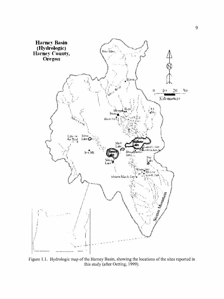
Figure 1.1. Hydrologic map ofthe Harney Basin, showing the locations of the sites reported inthis study (after Oetting, 1999).
9
10
Geologic faulting has altered the landscape in significant ways. McDowell (1992: 17)
states that "Virtually all of the relief and geomorphic features of the present landscape were
created by faulting and erosion since the eruption ofMiocene basalts." Mid-Miocene basalt flows
in particular show the dramatic effects ofblock faulting in association with the Brothers fault
zone, which crosses both Harney and Malheur lake basins, extends at least as far north as
Bend, Oregon, and may even cross the Cascades to join the Clackamas River-Portland Hills fault
near Portland, Oregon (Baldwin 1981: 131). The Brothers fault zone includes a number ofnorth
trending faults south of Harney Lake that have continued to be active into the Holocene.
McDowell (1992: 18) notes that a structural downwarping towards the center of Harney
Valley seems to be suggested by the tilt of Tertiary rocks in the northern uplands. She also notes
that the limited amount of faulting observed around the margins of the Harney and Malheur
alluvial basins may possibly be due to the formation of calderas during the eruption of ash-flow
tuffs in the late Miocene (McDowell 1992:18). Faulting is responsible for the creation of the
Basin and Range physiographic province to the south and west of Harney Basin. Steens
Mountain is a fault block formation that provides a substantial water drainage into the southern
end of Harney Valley.
High precipitation between 1981 and 1984 greatly increased the amount of water entering
the Harney Valley, leading to flooding at an historically unparallelled level. Malheur, Mud, and
Harney lakes fused into a single body ofwater approximately 33 miles in length by 12 miles in
width, more than doubling the normal surface area (Oetting 1990a). Oetting noted that the
combined shorelines of the pre-flood lakes were about 106 miles long, of which two-thirds were
within Malheur National Wildlife Refuge boundaries. At the peak water level, the shoreline was
170 miles long, the water was eight feet deeper than pre-flood levels, and only 25% ofthe
shoreline remained within the Refuge. Flooding periodically flushes mineral salts from Malheur
Lake and maintains a water chemistry suitable for the maintenance ofhigh populations of aquatic
plants and invertebrates (Duebbert 1969). These, in turn, attract numerous species of water and
shore birds in large numbers.
Indicating the volatility ofthis lacustrine environment, Duebbert (1969) reports that Malheur
Lake dried completely in 1934, and Bailey (1936) reported that the skeletal remains ofnumerous
bison were collected from the dry lake bed during that period. With consideration of long term
wetland stability, periodic drying of the marshes may be vital to "...maintain a proper balance
between oxygen and other elements in the soil so essential to the growth of marsh plants and
•
11
animals (Weller and Spatcher 1965 in Duebbert 1969)". In terms of human behavior, the growth
or subsidence ofthe lake level surely must have affected prehistoric population levels, settlement
patterns, and resource availability over extensive portions of the basin.
Economic and Industrial Plants
The project area is situated in the shrub-steppe region; an area that encompasses the
majority of southeastern Oregon and includes portions ofthe High Lava Plains, Owyhee Upland,
and Basin and Range physiographic provinces. The vegetation is dominated by sagebrush
(Artemisia), which occurs as four principal species, each of which occupies a particular habitat
(Franklin and Dyrness 1988). Big sagebrush (Artemisia tridentata), which prefers relatively deep
soils, is the primary species found at the archaeological sites and through much of the Harney
Valley. The other species include Artemisia arbuscula, which inhabits shallower, rocky soils; A.
rigida, found on very shallow lithosols common to the uplands; and A. cana, which inhabits
moister locations such as seasonally ponded valley floors (Franklin and Dyrness 1988). These
Artemisia species are part of broader plant communities which share similar moisture, mineral,
and elevation requirements. Because of the variation in topography and soil quality (often over
relatively short distances), plant communities can be quite mixed and would have provided a
variety of subsistence opportunities for indigenous peoples.
Other plants common to the shrub-steppe zone include greasewood (Sarcobatus
vermiculatis), green (Chrysothamnus viscidiflorus) and gray rabbitbrush (Chrysothamnus
nauseosus), and bitterbrush (Purshia tridentata) Grasses include giant wild rye (Elymus
cinereus), Idaho fescue (Festuca idahoensis), Thurber needlegrass (Stipa thurberiana), Sandbergs
Bluegrass (Poa sandbergii) and bluebunch wheatgrass (Agropyron spicatum). A belt of western
juniper (Juniperus occidentalis) surrounds the upper limits of the big sagebrush zone, and
mountain mahogany (Cercocarpus ledifolius) is generally found in the upper elevations ofthe
juniper belt (Ferguson and Ferguson 1978). Camas (Camassia quamash), biscuit-root (Lomatium
sp.), and wild buckwheat (Eriogonum sp.) are also common in the uplands, and provided an
important food source early in the spring. Couture (1978: 29) reports that the Northern Paiute
collected a total of 18 plant species at the Pine Creek camp during that season.
12
The wetlands support a wide variety of plant life. Willow (Salix sp.), and black
cottonwood (Populus trichocarpa) are relatively common along the rivers and streams in the area.
Cattail (Typha latifolia), hardstem bulrush (Scirpus acutus), sedge (Carex sp.), Baltic rush
(Juncus balticus), and burreed (Sparaganium eurycarpum) are the dominant emergent varieties of
the marshlands. Hardstem bulrush occupies the deepest portion of the emergent zone, with
burreed, cattail, and Baltic rush found in shallow water. The separation of these vegetation zones
increases the value of the marshland as a waterfowl habitat (Duebbert 1969). Small pondweed
(Potamogeton pusillus) and sago (Potamogeton pectinatus) are common open water plant species,
and water milfoil (Miriophyllum exalbescens) is the most abundant submergent. Sago is the
most valuable waterfowl food plant in the marshes, and Duebbert (1969: 13) notes that the use of
the lake by migratory birds directly depends on its availability. Moist soil plants include alkalai
ryegrass (Elymus triticoides), meadow barley (Hordeum brachyantherum), spike rush (Eleocharis
palustris), water plantain (Alisma plantagoaquatica), broadleaved arrowhead (Sagittaria
latifolia), hoary nettle (Urtica holosericea), and flixweed (Descurainia sophia). The lakeshore
margin where seasonally receding waters left mudflats was a home for chenopods
(Atriplex sp., Chenopodium sp., Suaeda sp.) including seepweed, or wada (Sueda depressa), for
which the Harney Basin Paiute bands were named the Wadatika, or "wada eaters" (Blyth 1938;
Duebbert 1969).
Fowler (1986) documents Native use of346 food plants in the Great Basin. Of these, 83
were attributed to either the Nevada Northern Paiute or Northern Paiute in general, and 50 were
attributed specifically to the Oregon Northern Paiute. Fowler (1986) does not consider her list to
be complete, nor does it take into account the wide variety of plant species that were used for
clothing, basketry, and the construction of dwellings. Couture (1978) describes 47 "useful" plants
that are still collected by the Bums Paiutes for food, medicine, basketry, and for use as tools (e.g.
digging sticks).
Mammals
The environmental setting of the Harney Valley provided a variety of habitats for a
diverse assortment of mammals, birds, and fish. More than 85 species of mammals, 290 species
ofbirds, and 41 species of fish are known to inhabit the Northern Great Basin (Ferguson and
13
Ferguson 1978). Some species inhabit the region year round, while many others, particularly
birds, are seasonal visitors. In addition, some species have limited ranges constrained by water,
vegetation, or elevational requirements, while others roam freely across the landscape. High
biological productivity at Malheur Lake led to the establishment of the Malheur National Wildlife
Refuge in 1908, and, even today, the basin teems with wildlife particularly during the spring and
fall.
The largest animals currently found in the Harney Basin are Artiodactyls, such as mule
deer (Odicoileus hemionus), white-tailed deer (Odicoileus virginianus leucurus) and pronghorn
antelope (Antilocapra americana). Rocky Mountain elk (Cervus canadensis) were once common
throughout the Blue Mountain physiographic province, and elk antlers have been collected along
the Silvies River (Bailey 1936:78). Bailey (1936:57) reports that bison (Bison bison) were once
abundant in southeastern Oregon, northeastern California, and northern Nevada. Peter Skene
Ogden recorded the presence ofbison remains at Harney Lake in 1826 (Eliot 1910:207), and
bison bones have been collected from dried lake beds and cave floors throughout southeastern
Oregon. Recent work by Stutte (2004) to clarify bison geographic and temporal distributions
indicated that Bison bison were present east of the Cascades between 800 BP and 170 BP. Once
plentiful, mountain sheep (Ovis canadensis) fell victim to diseases imported to the region with
domestic sheep species. Mountain sheep have been reintroduced to the area from distant
populations.
Wolves (Canis lycaon) were once common in eastern Oregon, found in association with
bison throughout their former range. By 1931, wolves had been hunted to extinction across the
state (Bailey 1936:272-275), although Ferguson and Ferguson (1978:47) report that a gray wolf
was killed in nearby Malheur County in 1974. More recently, a gray wolf that crossed the Snake
River in February, 1999, was captured near the headwaters of the John Day River and returned to
Idaho. Other members of the Canidae family present in the region include the red fox (Vulpes
vulpes), the kit fox (Vulpes velox) and the ubiquitous coyote (Canis latrans).
The skeletal remains of grizzly bears (Ursus mirus) have been collected along the Silvies
River and at Malheur Lake. Yakima Jim, a Paiute chief interviewed by William Schnabel in 1916
commented that long ago there were so many bears on Steens Mountain that Indians never went
there alone, but always in groups of two or more. Grizzlies were largely eradicated at an early
date by settlers and ranchers in the area (Bailey 1936:330), but the last known grizzly in Oregon
was killed in 1931.

tr
14
The family Felidae is represented by bobcats (Lynx rufus), lynx (Lynx lynx) and mountain
lions (Felis concolor). Lynx are extremely rare in the region today, inhabiting forested areas on
the northern edge of the basin (Ferguson and Ferguson 1978).
Ten species ofmustelids are found in the Harney Valley. Martens (Martes americanus)
and fishers (Martes pennanti) are found in forested areas near deserts, but weasels (Mustela sp.),
skunks (Spilogale putorius, Mephitis mephitis), minks (Lutreola lutreola), and badgers (Taxidea
taxus) are common. River otters (Lutra canadensis) are now extinct in the basin, and wolverines
(Gulo luscus) were thought to be until an individual was recorded on Steens Mountain in 1975
(Ferguson and Ferguson 1978:49).
Numerous small mammal species were economically important to the native populations
in the area. Leporids, including blacktailedjackrabbits (Lepus californicus), mountain cottontails
(Sylvilagus nuttalli), and pygmy cottontails (Sylvilagus idahoensis) were vital as a source offood
and material for fur robes. Woodrats (Neotoma sp.), chipmunks (Eutamias sp.), ground squirrels
(Citellus sp.), yellow-bellied marmots (Marmotaflaviventris), voles (Microtus sp.), gophers
(Thomomys sp.), and mice and rats (Family Cricetidae) were hunted or trapped whenever
possible. Muskrats (Ondatra zibethica) were an important faunal resource at some
archaeological sites around Malheur Lake, comprising over 45% of the total mammalian faunal
assemblage (Aikens and Greenspan 1986; Botkin and Carambelas 1992; Elston et al. 1993).
Duebbert (1969: 19) reported that muskrat populations can exceed 50,000 during good years.
Beavers (Castor canadensis), raccoons (Procyon lotor), and porcupines (Erethizon dorsatum)
were taken when available.
All of the species above were hunted when the opportunity presented itself, but Steward
(1938:33) commented that in the Great Basin generally, only the bison and the antelope were
subjects of "important hunts." Rabbit drives were also conducted, however, with the use of long
(150-200 yard) nets to corral the animals. Occasionally, "surrounds" were created with the use of
fire (Steward 1938:38-39).
Birds
Approximately 290 species of birds have been recorded in the Northern Great Basin
(Ferguson and Ferguson 1978). Some of these species are accidental wanderers blown off course
15
by storms, and others are strays that inhabit areas mainly peripheral to the Great Basin. None the
less, Malheur Lake is considered to be among the best waterfowl producing habitats in North
America (Duebbert 1969: 14), particularly for shallow water (or surface feeding) species. Up to
22 species of ducks, three species of geese, and two species of swans (all Anatidae) occur at the
lake during peak migration periods of the spring and fall. Of these, twelve species of ducks, one
species of goose, and one species of swan nest at the lake on a regular basis. In areas that contain
prime waterfowl habitat, duck production can reach 500 birds per square mile.
Of course, other water birds and shore birds benefit from the fine habitat, including egrets
and herons (Ardeidae), cranes (Gruidae), grebes (Podicipedidae), pelicans (Pelecanidae), and
ibises (Threskiornithidae), to name a few. Birds ofprey include hawks and eagles (Accipitridae),
falcons (Falconidae), and owls (Tytonidae and Strigidae), all of which take advantage of the
abundant rodent and leporid populations in the area. Several species ofblackbirds (Icteridae)
inhabit the reedy margins surrounding the open water, congregating by the
thousands during the breeding season. Sage grouse (Centrocercus urophasianus) inhabit the
upland regions that surround the marsh.
Fishes
The Northern Great Basin is home to over 40 species of fish, belonging to nine families
(Ferguson and Ferguson 1978). Cold, swift upland streams become slower and warmer as they
wind across the basin floor and into the marshes, providing a variety of habitats for different
species. Temperature, water alkalinity, and evaporation all playa part in the distribution offish
in the Harney Valley.
Archaeological evidence suggests that at least three species offish were economically
important to the indigenous peoples of the area. The remains oftui chub (Gila bicolor), suckers
(Catostomus sp.) and northern pike minnows (previously known as northern squawfish
[Ptychocheilus oregonensisJ) were recovered during archaeological excavations at the
Headquarters site (Aikens and Greenspan 1986:42). Large salmon runs (probably Oncorhynchus
tshawytscha; "chinook") were present in the Malheur River by early summer, and ethnographic
accounts describe Northern Paiutes moving across the mountains from the spring root grounds to
16
trap them at various locales (Couture 1978:34). Also, several species of trout (Oncorhynchus sp.)
were available in the larger streams throughout Harney Valley.
The Ethnohistoric Record
In 1826, Peter Skene Ogden became the first known Euro-American observer to
document the lifeways of indigenous people in the Harney Valley. On November 1, 1826, Ogden
and a party of Hudson's Bay Company fur trappers entered a "country ofrivers and lakes," that
they characterized as empty of wildlife, although an abundance of wild fowl was noted, as well as
the remains ofbison. The cited journal passage seems to be paradoxical, but, as fur trappers,
Ogden and his party no doubt had very specific ideas about which wildlife species were important
and which were not. Ogden (Eliot 1910:208) made the following entry in his journal on
November 3, 1826, while camped near Malheur and Harney Lakes: "It is incredible the number
of indians in this quarter. We cannot go 10 yards without finding them. Huts generally of grass of
a size to hold 6 or 8 persons. No Indian nation so numerous as these in all North America."
Although Ogden's description of the indigenous population is surely exaggerated, the account
does offer insight into the degree ofhuman concentration that occurred at lakeside villages in the
Harney Valley.
John Work led another party of Hudson's Bay Company trappers into the Harney Valley
during September and October of 1832. Work saw few Indians as his party passed through the
area (although he felt his party was constantly being followed), and those he did encounter
seemed reluctant to associate with the trappers (Maloney 1945). Perhaps this was a result of
violent encounters with other whites following Ogden's more hospitably met forays into the
region. Work's own efforts to keep relations with the Native Americans on a friendly basis
evaporated after the attempted ambush of one of his trappers was thwarted only by the arrival of
reinforcements. This encounter took place near Abert Lake, southwest of Harney Valley.
Ogden, Work, and other explorers loosely referred to the Indians over a relatively large region as
"Snakes", presumably with reference to the Snake River country northeast ofthe Harney Valley.
17
Northern Paiute territorial bands were generally named with regard to a favored resource or a
geographic location (many of which were already named for specific resources that were
collected there). The culture group that Ogden had encountered during his 1826 explorations are
properly known as the Wada'tika (wada eaters) band ofNorthern Paiutes and now commonly
referred to as the Harney Valley, or Burns Paiutes. Northern Paiutes belong to the Numic
division of the Uto-Aztecan family oflanguages.
Wada (Suaeda depressa), also known as seepweed, is a marsh-edge perennial from which
large quantities of tiny black seeds were harvested in late summer, then stored for use during the
winter (Couture 1978:91). Couture (1978) feels that groups named after food resources, such as
the Wada'tika, did not necessarily derive their names from the most significant resource in their
territories, but more from the fact that the resource occurred in the area in which they were
associated. On the other hand, Fowler (1982:127), is of the opinion that food names refer to
... "what the local groups had most to share" (her emphasis), implying that the resource was
plentiful and available for the asking.
Few of the economic pursuits of the Northern Paiutes required the aid ofpersons outside
of the extended family (Whiting 1950:20), but camp groups of three to ten families were known
to forage together for much of the year, and, at the very least, winter together at a fixed location
within their home territory (Fowler 1982: 117). In the Harney Valley, subsistence and settlement
patterns would have centered around Harney and Malheur Lakes, with trips into surrounding
areas as both plant and animal resources became available at varying times of the year.
The territory of the Wada'tika extended to Silvies and Drewsey in the north, west to Wagontire,
and included Beaty's Butte, Catlow Valley, and Alvord Lake as its southernmost extensions
(Blyth 1938:403). The boundaries were not distinct, and people regularly traveled outside of their
normal range for a variety of reasons. Populations were quite fluid and families were known to
winter with relatives in bands well outside of their common territory.
The Seasonal Round
At the time ofhistoric contact, the Wada'tika band ofNorthern Paiutes were the principal
occupants of the Harney Valley, although they regularly came together with other groups both
inside and outside of the basin (Couture et al. 1986). Archaeologically, Northern Paiutes have
18
been considered by some to be late arrivals to the Northern Great Basin (Lamb 1958; Madsen et
al. 1994). It is speculated that they may have replaced ancestral Klamath populations in some
areas (Kelly 1932), or perhaps replaced these populations when either drought or disease
encouraged a withdrawal from the area (Aikens and Jenkins 1994b). In any case, Northern Paiute
ethnographies provide the best examples of settlement and subsistence patterns in the region, and
the following information has been drawn from such sources.
The seasonal round is best picked up in the early spring, when winter stores were
depleted and the first shoots, indicating the location ofprized roots, began to appear in the
uplands. It was common for food supplies to run very low in the late winter, and sometimes a
camp group would run completely out of food. In such cases, the starving group would join with
another that still had supplies to share, even though they may not have belonged to the same band
(Whiting 1950:20). Pine Creek, in the vicinity of Stinkingwater Pass, was a major root collecting
location for the Wada'tika. Couture (1978:29) notes the collection of 17 plant varieties at this
locality, including camas (Camassia quamash), biscuit root (Lomatium sp.), bitterroot (Lewisia
rediviva), epos (Perideridia oregana), and wild onion (Allium madidum), along with other
varieties also used as food, or for medicinal purposes.
Another important function of the root camp was to re-establish social ties with other
culture groups that traveled to Pine Creek. Among these were Bannocks, Umatillas, Yakimas,
Shoshones, and Gidu'tika (Groundhog eaters) from Surprise Valley. For approximately six weeks
beginning in late April, people met at this location to exchange news, arrange marriages, trade,
gamble, and play games (Couture et al. 1986:153).
The spring run of salmon entered the Malheur and Drewsey Rivers around the same time
as root gathering began to wane in the uplands. The men left the upland camps to repair and set
up their salmon traps while the women finished gathering and preparing roots for storage. After
the women finished with this work, they moved down to the rivers and began to help the men
process salmon (Whiting 1950:17). The end of the salmon run led to the breakup of the various
camp groups. Bands dispersed across the landscape in extended families to hunt, and to collect
various roots and seeds as they became available. These included aki (Wyethia amplexicaulis),
kusiaki (Balsamorhiza hookeri), and camas (Camassia quamash) (Couture 1978:30, Couture et
al. 1986:153-154). Whiting (1950:19) reports that crickets were collected around the middle of
July, then roasted, dried and pounded into a protein-rich paste that was cached for winter use.
Cricket gathering occurred near Cow Creek, with the Hunibui-Eaters from the northjoining the
19
Wada-Eaters to lay in supplies, socialize, and gamble. After the crickets were harvested, families
once again dispersed, hunting game and gathering plant materials at familiar locations. Currants
(Ribes sp.), hawthorn berries (Crataegus douglasii), and rose hips (Rosa woodsii), were collected
around this time. Groundhogs (Yellow-bellied Marmots) and fish were procured during the
summer and deer and elk were hunted when the opportunity arose.
Large numbers ofpeople gathered at Malheur Lake in the late summer, when the wada
seeds began to ripen. Wada was an important winter resource and large quantities of the seeds
were harvested and stored. Indian rice grass (Oryzopsis hymenoides), giant wild rye (Elymus
cinereus), saltbush (Atriplex sp.), and chokecherries (Prunus virginiana) also matured during this
time and were harvested for later use. The wada gatherings were a time for festivities as well;
games and dancing were an important part of the late summer rendezvous (Whiting 1950: 19).
Communal rabbit and antelope drives occurred at this time ofyear, when many hands were
available for pushing game toward confining fences or nets.
In the fall, special trips were made to Dixie Butte (near John Day) where men hunted elk
while the women collected huckleberries (Couture et al. 1986: 154). Other plants collected in the
fall included guuha (Mentezelia laevicaulis), and tyba (Pinus ponderosa) from which pine nuts
and cambium bark were harvested.
Sometime around the first ofNovember, the people collected their cached foods and
established winter camps near Harney and Malheur Lakes. Winter camps were constructed
adjacent to springs or other sources of water, where firewood was plentiful and snow did not
accumulate (Whiting 1950: 19). Such camps were reported by Blyth (1938:402) at the marshes
near Silver Creek, Harney, Diamond, Blitzen, Catlow Valley, and possibly Wild Horse Creek.
The winter dwellings were constructed of a willow pole framework, gathered at the top, which
was then covered with tule mats. The houses were conical or dome-shaped structures, and it is
believed that the dome shaped house was more popular in earlier times (Fowler and Liljeblad
1986:423-424). Food was cached in pits outside of the dwelling, or in bags that were stored
inside. Wada, tsuga, yapa, crickets, dried meat, dried fish, and chokecherries were winter staples.
The stored provisions were supplemented with fresh meat and fish whenever possible. Rabbits
were snared or captured in communal drives even during winter, with 200 to 300 foot long nets
stretched across the snow (Whiting 1950:20).
The availability of seasonally collected resources could not be counted on from year to
year. A shortage of any resource could mean increased hardship during the already difficult
20
winter months when people were reliant on foods stored from spring and summer collecting.
Whiting (1950:20) reported a famine that occurred when Tagu Eaters from Jordan Valley ran out
of winter stores, then joined with the Wada Eaters, whose supplies were quickly exhausted.
Regarding the Harney Valley Paiutes, Ogden (Eliot 1910:208) comments in his journal entry of
November 3, 1826: "Many a day they pass without food and without a murmur." Considering
that the entry was made at the beginning of the winter months, the comment suggests that the
people may have begun rationing their supplies early, in preparation for the hard times that were
ahead. As winter once again gave way to spring, the Wada'tika broke camp and converged on the
Pine Creek root collecting grounds to begin the annual round anew.
The seasonal round described above has been gleaned from researchers who collected
their ethnographic information well after the Wada'tika had been in contact with Euro-Americans.
The degree to which contact may have altered prehistoric lifeways will never be fully known, but
it seems likely that the effect was considerable. A remarkable change in the relations between the
Harney Valley Paiutes and Hudson's Bay Company trappers becomes evident through reading the
entries of Peter Skene Ogden's November, 1826, journal, and John Work's September, 1832,
journal. In the course of less than six years, attitudes toward the trappers had changed from the
open and seemingly unconcerned reception that Ogden's party had encountered to the standoffish
and occasionally hostile behavior that Work reported. Whatever interactions occurred between
Harney Valley Paiutes and Euro-Americans in that short period of time are currently lost to
history, but they may have dramatically altered the behavior of the indigenous people.
Encroachment by whites, introduced diseases, conflicts with the military, and eventual removal to
reservations in the 1870's all surely contributed to the alteration of Wada'tika traditionallifeways.
Archaeological Surveys
Archaeological research in the Harney Basin has primarily been limited to surface
surveys and occasional subsurface testing, with block excavation at sites either being rare or
unreported. The majority of the work has occurred on or adjacent to Malheur National Wildlife
Refuge, where there has been financial support for satisfying federally mandated cultural resource
management requirements. Survey and testing projects have generally been oriented simply
21
towards determining the presence and significance of archaeological sites on public lands, leaving
the addressing of more complex issues about human occupation in the area to later research.
Surveys
Following Cressman's (1937) rock art studies in the early 1930s, the next
archaeo10gica1investigation in the basin occurred at the Riley obsidian source, on the
northwestern edge of Harney Valley. A surface survey and subsequent analysis of the collected
tools was reported by Atherton in 1966. The site appears to have been used primarily as an
obsidian quarrying locale. Atherton noted the presence of quarry "blanks" and possible scraping
or carving tools. All of the artifacts collected at Riley were percussion flaked; no pressure flaked
points were observed and it may be that tools were being roughly shaped at the source, then
transported to other localities for use.
In 1970, archaeologists from Portland State University began a three year survey of lands
surrounding Harney and Malheur Lakes, and portions of the Blitzen Valley (Newman et al. 1974;
O'Brien 2002). The 166 sites that were recorded included open sites, rock art (pictographs and
petrog1yphs), rock shelters, stone rings, house depressions, and burials. Some excavations were
made during the course of the project, but reporting of the results has been limited.
Thomas et al. (1983) reported that a dune site containing pottery had been discovered
during a BLM survey near Diamond Craters, south ofMa1heur Lake. Pottery is rarely found in
Northern Great Basin sites. An intensive surface survey at the Lost Dune site (Figure 1.2)
produced 189 pottery sherds attributed to the Shoshoni Tradition, along with bison bone.
Temporally diagnostic tools included Humboldt Concave Base and E1ko Series points from the
Middle Holocene, and Desert Side-notched, Cottonwood Triangular, and Rosegate projectile
points, indicating late Holocene occupations. Lyons (2001) reported that pottery and sandstone
artifacts from the site originated near the Oregon-Idaho border and chert and obsidian tools were
from sources near the Oregon-Nevada border.
Toepel and Minor (1983a) conducted a survey following the Eagle's Nest Bum on the
west side of Ma1heur National Wildlife Refuge. Fourteen lithic scatters were recorded, including
three which contained groundstone. A second survey was conducted in Diamond Valley (Toepe1
and Minor 1983b), where six lithic scatters were noted. Four of these sites were returned to later
for testing. Two of the sites yielded significant cultural deposits and data recovery was carried
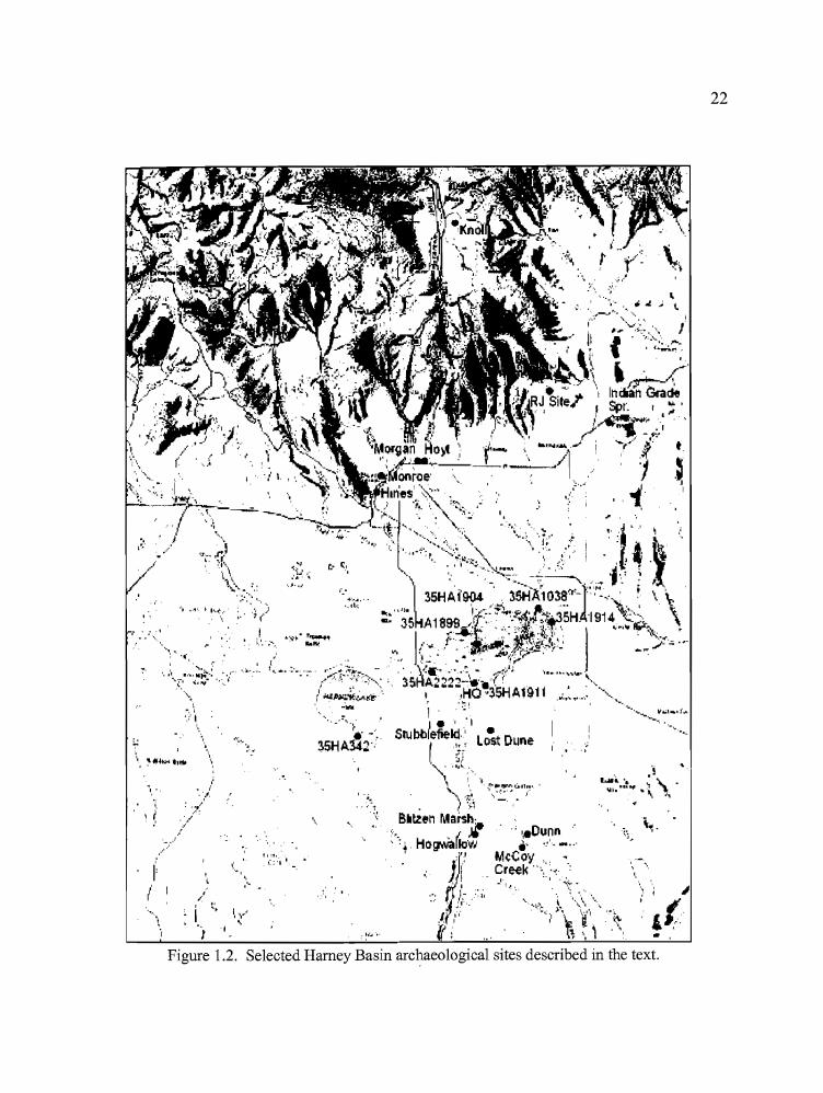
. .', . I.
.. , ._'t. I I"~ ..
...
..~, .".
.\,
". ~/
. ., ... ~,/ .
,..,
I~
('
I.', . .I:::' '.
I..
' . . ':'-:-.. -"35HA342····
, "".....
0.,.
, ., ".
'.
22
z
Figure 1.2. Selected Harney Basin archaeological sites described in the text.
23
out at the Dunn Site (35HA1261), and the McCoy Creek Site (35HA1263) in 1988 (see Musil
1995). Tools recovered during the surveys included Desert Side-notched, Rosegate, and Elko
Series projectile points, and occupations are thought to have intensified during the last 4000 years
(Toepel and Minor 1983a:28).
Extensive flooding in the Malheur and Harney lake basins occurred in the early 1980's,
prompting an investigation into possible flood control mechanisms to avoid future damage to
homes and property. The proposal of a drainage canal linking Malheur Lake to the south fork of
the Malheur River was taken into consideration, and a 51 mile corridor was archaeologically
surveyed from the east edge of Malheur Lake through Voltage Divide, Virginia Valley, and
finally to the Malheur River. A total of 130 archaeological sites were recorded, 97 of which were
located along the Malheur River and 33 in either the Virginia Valley or Voltage Divide areas
(Chatters 1986). The sites included multiple activity sites, lithic scatters, and rock shelters.
Relative dates for the diagnostic artifacts collected ranged from the early to late Holocene
(approximately 10,000 years). The artifacts included Western Stemmed, Lanceolate, Northern
Side-notched, Gatecliff, Elko Series, Rosegate, Cottonwood Triangular, and Desert Side-notched
projectile points. Desert Side-notched and Cottonwood Triangular points were found only in the
Malheur River sites during the course of this survey.
Erosion caused by the rise and fall of floodwaters at Harney and Malheur Lakes exposed
numerous archaeological sites, providing an excellent opportunity for archaeologists to observe
and record sites that were previously unknown. Unfortunately, this opportunity did not pass
unnoticed by artifact collectors and, because their continued presence on refuge lands became
detrimental to nesting shorebirds as well as archaeological sites, Heritage Research Associates
was contracted to conduct a survey and collect surface artifacts on behalf of the Malheur National
Wildlife Refuge in 1988 and 1989. An additional survey for the State Historic Preservation
Office (SHPO) was conducted on adjacent private lands in 1989 (Oetting 1990, 1992).
The initial survey occurred along the southern shore ofMalheur Lake, and included 28
islands, all within the refuge boundary. A total of 28 archaeological sites was recorded, and 1940
artifacts were collected. The artifacts included 593 classifiable projectile points, 43 distinctive
bifaces, 560 other bifaces, 228 pieces of ground stone, and 132 net weights. Rosegate points
made up 50% of the temporally diagnostic artifacts, followed by Elko Series points (20%), with
slightly less than 15% of the assemblage composed ofMiddle and Early Holocene points each
(Oetting 1990:18-19). The SHPO surveys covered 26 miles of the 1989 shoreline level on both
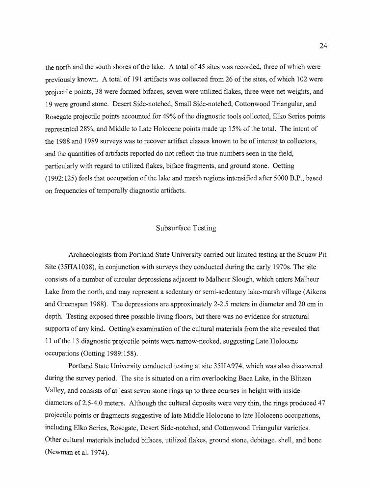
24
the north and the south shores ofthe lake. A total of 45 sites was recorded, three of which were
previously known. A total of 191 artifacts was collected from 26 of the sites, ofwhich 102 were
projectile points, 38 were formed bifaces, seven were utilized flakes, three were net weights, and
19 were ground stone. Desert Side-notched, Small Side-notched, Cottonwood Triangular, and
Rosegate projectile points accounted for 49% ofthe diagnostic tools collected, Elko Series points
represented 28%, and Middle to Late Holocene points made up 15% of the total. The intent of
the 1988 and 1989 surveys was to recover artifact classes known to be of interest to collectors,
and the quantities of artifacts reported do not reflect the true numbers seen in the field,
particularly with regard to utilized flakes, biface fragments, and ground stone. Oetting
(1992: 125) feels that occupation ofthe lake and marsh regions intensified after 5000 B.P., based
on frequencies of temporally diagnostic artifacts.
Subsurface Testing
Archaeologists from Portland State University carried out limited testing at the Squaw Pit
Site (35HAI038), in conjunction with surveys they conducted during the early 1970s. The site
consists of a number of circular depressions adjacent to Malheur Slough, which enters Malheur
Lake from the north, and may represent a sedentary or semi-sedentary lake-marsh village (Aikens
and Greenspan 1988). The depressions are approximately 2-2.5 meters in diameter and 20 cm in
depth. Testing exposed three possible living floors, but there was no evidence for structural
supports of any kind. Oetting's examination of the cultural materials from the site revealed that
11 of the 13 diagnostic projectile points were narrow-necked, suggesting Late Holocene
occupations (Oetting 1989: 158).
Portland State University conducted testing at site 35HA974, which was also discovered
during the survey period. The site is situated on a rim overlooking Baca Lake, in the Blitzen
Valley, and consists of at least seven stone rings up to three courses in height with inside
diameters of 2.5-4.0 meters. Although the cultural deposits were very thin, the rings produced 47
projectile points or fragments suggestive oflate Middle Holocene to late Holocene occupations,
including Elko Series, Rosegate, Desert Side-notched, and Cottonwood Triangular varieties.
Other cultural materials included bifaces, utilized "flakes, ground stone, debitage, shell, and bone
(Newman et al. 1974).
25
Gehr (1980) studied the geomorphology and archaeology of six sites that were associated with
high stand beach terraces on the south shore of Harney Lake. The terraces are the product of
erosion and deposition from pluvial lakes that have been radiocarbon dated between 32,000 and
8680 BP. The highest terrace (approximately 4100 meters in elevation) was dated on
mollusc shell to 8680±55 BP at Site 35HA342 (The Fenceline Site). A large biface was
recovered from within the dated deposit and a blade fragment was found beneath it, but above a
lake bottom deposit that had been dated on mollusc shells to 9620±50 BP. The mollusc shell date
of 961 0 BP is currently the oldest in the Harney Valley associated with an artifact, though it is
true that the dated shell fragments were actually collected from below the biface. Of course,
diagnostic artifacts that are known to be older have been collected from surface sites. Excavation
at 35HA342 failed to produce additional cultural materials. Surface collection at the five other
sites in the study produced crescents (at three sites), a Lind Coulee point base, leaf shaped points,
and "true" lamellor blades. Ground stone was absent in all of the sites.
Wriston (2003) working on behalf of the University ofNevada, Reno (UNR), and
Sundance Archaeological Research Fund (SARF) conducted excavations at 35HA341 near
Gehr's Fenceline site during the 2000 - 2002 field seasons. The project was undertaken after a
Haskett point was observed in the wall of Weed Lake Ditch during reconnaissance. The Haskett
point was found in the ditch cut near Gehr's earlier stemmed point discovery and an examination
ofthe area suggested that there were actually two sites that intersected at Weed Lake Ditch; the
multi-component (early to late Holocene) 35HA342, and 35HA34l, which is entirely early
Holocene. Wriston recommended that the artifacts Gehr recovered from the ditch cut be
considered part of35HA34l based on point typology and stratigraphic position. Excavations at
35HA341 over a three-year period included eight backhoe trenches, eight lxl m units, and three
auger holes. Wriston's (2003) efforts yielded four Haskett Stemmed points, three untyped
stemmed points, a crescent, a bone bead perform, 32 bifaces, eight unifaces, seven utilized flakes,
11 cores, 14,504 bone fragments and 16,242 pieces of debitage. She also collected charcoal
samples and gastropod shell. The charcoal was not suitable for radiocarbon dating, but the
gastropod shell returned radiocarbon dates of9860±80 BP, 9540±60 BP, 9820±60 BP, and
9550±60 BP (Cal BP dates range from 11,540 to 10,670). Pedestrian surveys of 400 acres
centered on the excavation site resulted in the recovery of 200 hundred tools that included 34
stemmed points, six concave base points, four crescents, and nine others consisting of Elko series,
Rosegate, and typologically unidentifiable specimens.
___rAP _
26
Researchers from UNR/SARF have also conducted excavations at other early Holocene
sites in recent years, including the Nials site and the Biting Fly site. The Nials site (35HA2828)
is situated on the south shore of Harney Lake approximately 2.5 km from 35HA341.
Excavations that occurred from 1997 through 1999 produced evidence ofa single component site
approximately 8000 years old (Bonstead 2000). A total of20 1x1 m units, three 1/2 xl m units
and five backhoe trenches resulted in the recovery of five Great Basin Stemmed points, two
crescents, a worked bone object, 63 bifaces, over 26,000 pieces of debitage, and 5680 bone
fragments that included fish (65%), leporids (21 %), and waterfowl (3%). No dateable organic
materials were collected, but the cultural stratum is bracketed by aeolian-borne tephra believed to
be from the Mazama eruptions ( ca. 6900 BP) and gravels deposited during the last high stand of
Pluvial Lake Malheur (ca. 9900 BP) below (Bonstead 2000). The Biting Fly site (35HA1260)
was first recorded by UNR/SARF researchers in 1997 on the eastern portion of the beach bar that
holds 35 HA341. Limited testing occurred at the site in 1997 and 2000, and surface collection
took place in 1998, 1999, and 2000. Only one diagnostic artifact (a crescent) was recovered
during the excavations and it became apparent that the artifact laden deposit was, at best,
shallowly buried (Branigan 2000). Artifacts indicating a time depth from early to late Holocene
were noted during surveys of the area, with the majority of the tools consisting of stemmed points
and crescents. The statigraphy at Biting Fly appears to be similar to that of the Nials site,
suggesting that occupation(s) may have occurred there sometime around 8000 years ago (Wriston
2003).
Intermountain Research investigated the geomorphology and archaeology of two sites on
the south shore of Malheur Lake (35HA1028 and 35HA1911) in October of 1991 (Raven and
Elston 1992). Seven units were excavated at 35HA1911 and the majority ofthe cultural materials
were recovered in the first 20 cm. Oetting (1990:91-95) reports that 147 artifacts were collected
at the site during surveys in 1988 and 1989, including Elko Series, Small Side-notched, Rosegate,
and Desert Side-notched projectile points. A total of 51 isolated human bones and three burials
were noted, including two that were associated with large ground stone metates and hopper
mortars. Chronologically diagnostic artifacts recovered during the excavation included one Great
Basin Stemmed point and three Rosegate points (Botkin and Carambelas 1992:75). Rosegate
points account for 35 ofthe 46 diagnostic points collected during both surveys and excavation at
the site. In addition, seven bifaces, seven flake tools, and 13 ground stone artifacts were
collected.
27
At 35HAI028, the cultural assemblage was more diverse. Like 35HA1911, projectile
points from the latter site indicate the presence ofhumans throughout the Holocene. Surface
reconnaissance along with excavation in eight units produced 24 chronologically diagnostic
artifacts, including Great Basin Stemmed, Humboldt, Large Side-notched, Elko, Rosegate, and
Desert Side-notched varieties. Also, 27 bifaces, 13 flake tools, two groundstone fragments, an
Olivella shell bead, one bone tool fragment, and nine historic fragments of glass and crockery
were collected (Botkin and Carambelas 1992:103-116).
Intermountain Research conducted surface and subsurface investigations of four sites on
dune islands in Malheur Lake during August of 1992 (Elston and Dugas 1993). Trenching and
subsequent hand excavations were conducted to examine the archaeological and
geomorphological properties at each site. Surface surveys at all of the sites concentrated on
artifacts considered to be of interest to artifact collectors, so the amount of ground stone,
debitage, cores, and utilized flakes of obsidian and basalt that were actually present at the sites is
not reflected in the materials that were reported. Three of the sites (35HA2222, 35HA1899, and
35HA1904) are located on the northwest edge ofMalheur Lake, and one site (35HAI914) is
located on the eastern side.
Site 35HA1914 consisted of a light scatter of artifacts from which two cores, one piece of
ground stone, and a Cottonwood Triangular point were recovered during surface surveys in 1988
and 1989 (Oetting 1990a). A hearth was seen eroding from the surface at that time and charcoal
samples were taken, but have not been dated. Two excavation units produced a biface, one flake
tool, one core, and two pieces of debitage. All of the cultural material was recovered from above
strata dating between 720 and 760 BP (Elston et al. 1993a).
Site 35HA2222 was unknown until 1990, when Malheur National Wildlife Refuge
personnel apprehended artifact collectors there (Elston et al. 1993b). A surface survey occurred
shortly after that time, but the detailed results of the survey are currently not available. Surface
collection over a 5 x 30 meter plot and the excavation of four 1 x 0.5 meter units produced 26
projectile points including Elko Series, Rosegate, and Desert Side-notched types (Elston and
Dugas 1993). A total of 17 bifaces, 15 flake tools, 17 pieces of ground stone, four beads (two
stone, 1 shell, and 1 bone), a grooved net weight, and three lead shot fragments was collected.
The excavation produced one cultural feature; a 1 x 1 meter cluster of artifacts which included a
Rosegate projectile point, one biface, three pieces' of ground stone, and six pieces of fire-cracked
rock.
-~ ""';;;'~iiiiiiiiiiii""" "<Prz _
.....
28
The Dune Island site (35HA1899) was surveyed in 1988 and1989. Of the 205 projectile
points that were collected during the survey of the ca. 38,500 m2 site, 100 were Rosegate points,
suggesting primarily late Holocene occupations (Elston and Dugas 1993; Oetting 1990). A total
of373 artifacts were surface collected during the surveys. Other diagnostic points from the site
included Great Basin Stemmed, Elko, Malheur Stemmed, Cottonwood Triangular, and Desert
Side-notched varieties. Excavations at 35HA1899 consisted of trenching, followed by hand
excavation of three 1 x 0.5 m units and three 1 x 1 m units. During the surveys, a possible house
feature had been noted, but subsequent erosion removed all trace of it. The excavation ofTrench
A revealed Feature 1, a dish shaped stain 1.80 cm in width that was explored through two units.
The feature was not dated, and its function remains unknown. Also recovered in the excavations
were nine bifaces, eight flake tools, two Elko and three Rosegate projectile points, a core, three
pieces of ground stone, and two beads; one of stone and one ofbone. Two of the three burials
that were found at 35HA1899 were radiocarbon dated. One burial produced a date of 1730 BP,
and the other was dated to 510 BP (Elston et al. 1993c).
At the Dune Island site (35HA1904), 150 artifacts were surface collected in 1988 and
1989 (Oetting 1990). The majority of the projectile points were Rosegate, followed by Elko,
Malheur Stemmed, and Desert Side-notched varieties. Excavation consisted of trenching,
followed by hand excavation of four 1 x 0.5 m units and one 0.5 x 0.5 ill unit. One of the
excavation units encountered Feature 1, a hearth that was radiocarbon dated to 950BP (Elston
et al. 1993d). A second feature (Feature 2) consisted of a dark stain that was not dated or
described in detail. Other artifacts that were recovered during the testing included four
bifaces, five flake tools, four projectile points believed to be late Holocene, 30 ground stone
tools, a core, and a drilled and polished bone tool believed to have been used on matting.
Aside from the poorly represented 35HA1914, the above sites appear to have been most
intensively occupied during the late Holocene, and the abundance of ground stone at each site
suggests that a great deal ofplant processing was occurring during the occupations.
Blitzen Marsh
John Fagan (1973, 1974) conducted test excavations at Hogwallow Spring (35HA8),
Blitzen Marsh (35HA9), and 10 sites outside of the Harney Basin during the summer of 1970.
......
b
29
The research was carried out in an effort to test Stephen Bedwell's (1970:217) hypothesis that
indigenous people of the Northern Great Basin did not abandon the region during a warm, dry
period associated with the Altitherma1 climatic episode (Antevs 1948). Bedwell believed that
settlement patterns shifted to higher elevation spring sites as water sources dried on the valley
floors. Fagan was unable to collect radiocarbon dates of a suitable age to test Bedwell's
hypothesis, but his work provided important data about upland habitations in the region.
Hogwallow Spring and the Blitzen Marsh site are located on the east edge of Blitzen
Marsh, south ofMa1heur, Mud, and Harney Lakes. The Hogwallow Spring site is adjacent to
the perennial spring, and testing revealed the presence of three cultural features at the
location. The features included a living floor that was associated with both human and
animal bone, an E1ko point, and a mano; a concentration of bone tools and debitage; and a
separate cluster ofpartially articulated animal bone associated with a large triangular knife
fragment and a bone awl. Projectile points included Rosegate, E1ko Series, Northern Side
notched, and Humboldt varieties (Fagan 1973:86-87). Other artifacts included bifaces, drills,
groundstone, utilized flakes, scrapers and bone tools; among which were pieces of worked
bone and antler, shaped bone tools of unknown usage, awls, and a tubular bone bead. The
majority of the faunal remains were of small mammals and birds (46%), followed by fish
(35%), large mammal bone (15%), and minute quantities of musselshell, and eggshell (Fagan
1973:88). No radiocarbon dates were reported from the Hogwallow Spring site.
The Blitzen Marsh site is approximately 2.5 kilometers from the Hogwallow Spring
site, and appears to have been an area of intense occupation. Fagan (1973:96) suggested that
Blitzen Marsh may have been a winter village site (also see Aikens and Greenspan 1988:45),
such as was described ethnographically by Whiting (1950). The rich cultural deposits at
Blitzen Marsh consisted of four strata, which yielded a varied and abundant assemblage of
artifacts. Nine features were reported at the site, including three living floors, two house pits
(one of which was lined with a clay floor), a storage pit, a rock oven, a rock cluster that was
associated with ground stone and chipped stone tools, and a human burial. Eight radiocarbon
dates from the site ranged in age from 150 to 2350 BP (Fagan 1974). Projectile point
varieties included Humboldt, Northern Side-notched, E1ko Series, Rosegate, Desert Side
notched, and Cottonwood Triangular. A diverse assemblage of other artifacts were
recovered, including bifaces, drills, utilized flakes, formed scrapers, ground stone, tobacco
pipe fragments, and a Dentalium bead. A bone flute, polished bone tubes, tubular beads, and
30
shaped tools of unknown usage comprised the bone tool assemblage. Almost 83% of the
faunal remains were small animal bones (including birds), with large mammal bones, fish,
eggshell, and mussel shell making up the remainder.
The Stubblefield Lookout Tower site (35HA53) is located on the west side of Blitzen
Marsh, and south of Harney, Mud, and Malheur Lakes. Testing occurred at the site in 1994.
Intensive surface collection preceded the excavation of two backhoe trenches, thirteen 1 x 1
m units and one 1 x 0.5 m unit (Dugas et al. 1995). Artifact types at the site span the
Holocene, but the majority ofprojectile point types in the assemblage are late Holocene
varieties. Chronologically diagnostic points include Great Basin Stemmed, Humboldt,
Northern Side-notched, Elko, Gatecliff, Malheur Stemmed, Rosegate, and Desert Side
notched varieties. Other artifacts collected at 35HA53 included 55 bifaces, 27 flake tools, 76
pieces of ground stone and a bone awl. Four features at the site were radiocarbon dated.
Feature 1 was a hearth located approximately 30 cm below the surface that dated to 550 BP.
Feature 2, another hearth located 15 cm below the surface, was dated to 130 BP. Feature 4, a
burial covered by cobbles, was excavated until obvious human bones were revealed
(approximately 45 cm below the surface). Charcoal from the uppermost deposits produced a
date of 610 BP, and an Elko Eared point was seen in the rock cluster overlying the burial
(Dugas et alI995). Feature 5, a small hearth located 20 cm below the surface, was dated to
650 BP. The site is considered to have initially been a short term hunting camp, but the
presence of ground stone and constructed hearths may indicate extended periods of plant
processing in the late Holocene.
The Headquarters Site
The Malheur National Wildlife Refuge Headquarters (HQ) Site (35HA403) was
originally recorded by Ruth McGilvra in 1973, but the site has been known to U.S. Fish and
Wildlife personnel since the 1930s when excavations for the headquarters buildings yielded
artifacts and human remains (Aikens and Greenspan 1986). The majority of the site is
located on the northeastern slope of a small volcanic cone adjacent to the south edge of
Malheur Lake (Dugas and Bullock 1994). The Donner und Blitzen (Blitzen) River enters
Malheur Lake nearby, and Sod House Spring is adjacent to the site, providing an excellent
.....
31
source of fresh water. The HQ site has been tested episodically since 1979 in response to a
variety of construction projects requiring subsurface excavations. These projects have
included the addition of new water systems and septic tanks, the construction of a storage
yard, and actual repositioning of the headquarters buildings as a result of flooding in the mid
1980s.
In 1979,20 auger holes and a 1 x 1 meter test pit were dug along the route of
proposed water lines near the observation pond. The test pit was excavated to 175 cm, with
cultural materials encountered 20 cm below the surface that continued beyond the level at
which the unit was terminated. The overall boundaries of the site were not determined.
Recovered artifacts included Rosegate and Elko Series points, ground stone, utilized flakes,
and debitage (Thomas 1979).
Charlotte Benson conducted additional testing at the HQ site in 1979, which
consisted ofnine auger holes and four 1 x 1 meter test pits (Minor and Greenspan 1985). Her
work expanded the estimated boundaries of the site from 22 acres to 128 acres, although the
study remains unreported and the exact locations of the test pits are unknown. Testing
occurred again in 1979 in association with a trench that was excavated for the installation of
new water lines. The work consisted of continuously profiling 278 meters of the trench
walls, column profiling along 843 additional meters of trench, and limited screening of the
backdirt. A variety of artifacts were recovered from rich, deep cultural deposits.
Chronologically diagnostic artifacts included Great Basin Stemmed, Humboldt, Northern
Side-notched, Elko Series, Rosegate, and Desert Side-notched points. Foliate points were
also collected, as were bone tools, fragments ofCatlow Twine basketry, knives, awls, drills,
and ground stone (Campbell n.d.). Faunal remains included small birds and mammals, fish,
and a few large mammal bones.
In 1984, Heritage Research Associates excavated 27 probes and two lxl m test pits
along the northeastern periphery of the site in an area under consideration for construction of
a septic drainfield and a storage yard. Recovered artifacts included two Elko Series points,
nine bifaces (including three projectile point tips), scrapers, utilized flakes, ground stone,
abraders, and a hammerstone (Minor and Greenspan 1985). Three species offish were
represented in the faunal remains, as were large and small mammals, and birds. Although
portions of the test area proved to have high densities of cultural material, a low density
location was identified for construction purposes.
32
In 1985, C. Melvin Aikens monitored the installation of waterlines at the HQ site.
Aikens' project consisted of systematic screening of the backhoe backdirt, and profiling the
trench walls at 10 meter intervals. The 48 resulting profiles spanned 350 meters ofpipeline
trenches at depths averaging 50-60 cm (Aikens and Greenspan 1986). A culturally-laden silt
layer was encountered from 10 to 30 cm below surface, beneath various layers of fill. A total
of 6351 artifacts were collected, of which 172 were formed tools, and 6179 were either
unworked flakes or debitage. Chronologically diagnostic tools included three Humboldt
Series, two Northern Side-notched, one Elko Series, two Rosegate, and one Desert Side
notched projectile point. A variety ofbifaces, unifaces, cores, and ground stone made up the
remaining tool types. Fish composed over 40% of the faunal remains at the site, with Tui
chub bones representing 70% of that total. Muskrats accounted for 55% of the mammalian
remains, and hares (Lepus sp.) 30%. Surprisingly, waterfowl account for less than 2% ofthe
faunal remains at the HQ site. One human burial was encountered, which was covered over
in its original position after the trench was redirected.
The flooding that occurred in the mid-1980s exposed cultural deposits to the west of
Sod House Springs, prompting an intensive surface survey of a 45,000 square meter area
(Minor and Toepel 1988). Surface artifacts were mapped and collected. A total of 1360
lithic artifacts and 230 animal bones were collected during the survey, of which 35 were
temporally diagnostic projectile points. These included Northern Side-notched, Elko Series,
and Rosegate varieties. Other collected artifacts included bifaces, scrapers, one drill, utilized
flakes, debitage, cobble tools, and a variety of groundstone implements, including small
palettes and an atlatl weight. Notched net weights were also recovered, the first reported
from the Harney Basin.
Some of the most recent work at the Headquarters site was conducted by
Intermountain Research in 1993 to assess the affects ofa proposed visitor's center. The
results were reported by Dugas and Bullock in 1994, and the following information is
excerpted from their report. Geomorphic testing was carried out first, consisting of a series of
soil cores which included six in the parking lot, eight in the shoreline below the parking lot,
six in the lawn, and three in the grove. Two backhoe trenches were excavated, one on the
shoreline below Sod House Spring, and one in the visitor's parking lot. Cultural materials
were then obtained through the excavation of ten hI meter units. One was excavated in the
lawn, one in the grove, four at the backhoe trenches, and three west of the observation pond
33
along the shoreline. Radiocarbon dates included seven charcoal dates ranging from 370±70
to 4760±240 BP, one soil-organics date of 8070±80 BP, and two tephra dates (23,400 BP and
ca.120,000 BP). A total of 127 projectile points and preforms was recovered from seven
units at the HQ site. Of these, 43 were chronologically diagnostic, including three Desert
Series, 15 Rosegate, five Gunther, eight Elko, one Humboldt, one Malheur Stemmed, and ten
Northern Side-notched. Dugas and Bullock (1994) observed a pattern of reworking and
resharpening of tools and fragments coupled with a lack of cores that was first noted by
Aikens and Greenspan (1986), and which may indicate a lack of raw lithic materials at the
HQ site. Because the pattern is not consistent with other refuge sites, Dugas and Bullock
(1994) believe that HQ occupations may have occurred in the winter, when snowfall masked
lithic materials from view. Other artifacts included bifacial tools, flake tools, ground stone,
and bone tools of various kinds, including beads, awls, one tube, one matting tool, one antler
tool, and one bone harpoon toggle or barb. Faunal materials included approximately 10,000
specimens, of which almost 75% was determined to be fish bone. The faunal material was
not identified to taxa, but waterfowl, muskrats, leporids, canids, pronghorn, and mountain
sheep remains were noted. Charred botanical remains included species primarily from
grassland and marshland settings.
In aggregate, the frequent, but limited test excavations at the Headquarters site have
exposed long term and culturally rich occupations, possibly in accordance with Whiting's
(1950) description of winter villages. The presence of Great Basin Stemmed projectile points
suggests occupational episodes dating to the early Holocene, as the presence of Desert Side
notched points reveals that indigenous peoples were using the site at, or very near, the Euro
American contact period. Unfortunately, some excavation work that occurred at the
Headquarters site has been reported inadequately, at best.
Diamond Swamp
In 1983, Heritage Research Associates (HRA) surveyed the area of the proposed
Dunn and McCoy Creek land exchanges, properties administered by the Malheur National
Wildlife Refuge which were to be exchanged for private holdings near Mud Lake. The
surveys identified the Dunn and McCoy Creek sites, among others.
34
In 1984, test excavations carried out at the Dunn site (35HA1261) were comprised of
a series of test probes, three test pits, and two 2 x 10 meter grids for recovering a sample of
the surface artifacts. Diagnostic artifacts recovered from the deposits included one Elko
Comer-notched point and one Humboldt Concave Base projectile point. In addition, large
biface fragments, utilized flakes and scrapers, manos, metates, hammerstones, choppers,
cores, debitage, and bone fragments were collected during the test excavations. Analysis of
the test excavations suggested that the Dunn site was a two component site that was primarily
used for plant processing and as a base for hunting large mammals over a period extending
from approximately 7500 to 1000 BP (Musil 1995).
Data recovery excavations began at the Dunn site in 1988 consisted of a three stage
process. First, a backhoe trench 47.5 meters in length was excavated across the site just north
of the densest cultural deposits, with an additional five meter long trench placed offsite to the
south. Second, a series of 15 auger holes were dug across the site at five meter intervals to
determine the locations of high concentrations of cultural materials. Finally, 13 unit
excavations consisting of five 2 x 2s, five 1 x 2s, two 1 xIs, and one 1 x 0.5 were placed at
select locations within the site grid.
Musil (1995) identified three components at the Dunn site. The earliest was the
stemmed point component in which a single stemmed point and 10 pieces ofdebitage were
found. This was followed by a house pit component which returned a radiocarbon date of
3470 BP from a sample derived from the floor fill and an associated storage pit. Features
noted in the housepit included a central hearth, a metate in situ, postholes, a flake
concentration, and the previously mentioned storage pit. Chronologically diagnostic artifacts
included eight Elko Series points and one Gatecliff Split-stem. Other tools included bifaces,
drills, scrapers, utilized flakes, cores, manos, metates, pestles, bone tools and bone and shell
beads. The ground stone tools were not easily transportable, suggesting at least a semi
sedentary occupation of the site. The faunal remains from the housepit reveal the use of both
terrestrial and aquatic species, with a higher proportion oflarge mammals than is usually
present at similar occupations in the Harney Valley (Musil 1995). Musil (1995) interprets the
house pit as representative of a small village oriented towards the use of a variety of plant and
animal resources. The latest component was associated with an ashfall cinder layer overlying
the house pit component, which has been attributed to the Diamond Craters eruption (Musil
1995). A variety of diagnostic projectile points were recovered which included two
35
Humboldt bases, a Northern Side-notched base, an Elko Series point, and three Rosegate
points. Their locations in deposits above the house pit suggest continued occupation of the
site, though on a reduced level.
The 1984 test excavations at the McCoy site (35HA1263) were similar to those at the
Dunn site, consisting of 16 probes, three 1 x 1 meter test units and two 2 x 10 meter surface
collection grids. Test excavations resulted in the recovery of 19 diagnostic projectile points,
including Rosegate, Elko Series, Northern Side-notched and Humboldt varieties, along with
bifaces, scrapers, gravers, utilized flakes, manos, a metate fragment, and a hammer stone.
Charcoal associated with the metate fragment and three Rosegate points yielded a
radiocarbon date of 1350 BP (Musil 1995).
Data recovery consisted of backhoe trenching, and unit excavations. Seven backhoe
trenches were excavated, of which three were offsite, one adjacent to the historic house
foundation located on the site deposits, and three situated along the east and west edges of the
site deposits. A total of 64 1 x 1 meter excavation units were excavated in six large blocks at
the McCoy site. Block A revealed a deep component composed predominantly of chert lithic
materials overlying a duripan deposit, which lacked diagnostic artifacts but produced one
obsidian and four chert bifaces. A composite charcoal sample taken just above the chert
component was radiocarbon dated to 1830 BP. This date is believed to reflect the oldest
occupations of the upper deposits. The lower chert component is thought to be much older,
possibly early Holocene in age (Musil 1995). Block B consisted of three components and
two house features. House Floor #1 contained a rock-lined hearth that was radiocarbon dated
to 1220 BP, and the remnants of what may have been a clay-lined house floor. House Floor
#2 provided radiocarbon dates from a hearth (930 BP), a lithic feature (1060 BP), and a
storage pit (1280 BP). A pit containing a human burial cut through the east edge of House
Floor 2. Block C contained no distinct components. Block D was set up directly over a
house feature that contained a hearth and portions of a burned superstructure primarily
comprised of thin willow poles (Musil 1995). A composite charcoal sample from the house
floor yielded a radiocarbon date of 510 BP. Blocks E and F were not productive.
Chronologically diagnostic projectile points recovered during the excavations
included Great Basin Stemmed, Humboldt, Northern Side-notched, Gatecliff Series, Elko
Series, Rosegate, Small Stemmed, Cottonwood Triangular, and Desert Side-notched varieties.
Despite their broad temporal range, the projectile points were recovered exclusively from
-
36
Component 2, which yielded C-14 dates only from 1900 to 900 BP. Other tools included
bifaces, drills, gravers, scrapers, cores, metates, manos, hopper mortars, grooved abraders, a
pestle, and a bowl fragment. In addition, a grooved plummet stone, a stone pipe bowl, and
bone tools; including beads, a bone flute, a pendant, and an incised rodent tooth were
collected from the deposits. Musil (1995) attributed three basic components to the site as
well: an early layer of chert lithic material just above the duripan, a much later second
component dated between 1900 and 900 BP, which contained primarily Elko and Rosegate
points, and a third component that dated after 900 BP and included Small Stemmed points,
the burned wickiup, and generally lighter, more portable artifacts.
Stinkingwater Mountains
Archaeological survey and testing was conducted by the Oregon State Museum of
Anthropology (OSMA) at five sites in the Stinkingwater Mountains, initially by David Cole
in 1975, followed by Richard Pettigrew in 1984 and 1985 . The purpose of the project was to
locate sites which might be affected by highway improvements proposed by the Oregon
Department of Transportation. The Stinkingwater Mountains are the eastern divide between
the internally draining Harney Basin and the Malheur River drainage, which is a tributary of
the Snake River. Ethnographically, the Stinkingwaters were identified as an important
upland root collecting area, and people from as far away as the Columbia River to the north
and Surprise Valley to the south came to gather roots, trade, and socialize with the Harney
Valley Paiutes (Couture 1978:29).
Testing at the Indian Grade Spring site (35HA1421) in 1985 revealed the presence of
a significant buried cultural deposit on a slope overlooking Indian Grade Spring (Oetting
1987). The testing consisted of sixteen 5x5 meter surface collection squares, three auger
holes, and two 1 x 1 meter test pits. A total of 72 tools were recovered during the testing
phase, none of which were temporally diagnostic. These consisted of formed and unformed
bifaces, utilized flakes, cores, and a flaked cobble, which were manufactured primarily from
basalt or obsidian (Oetting 1987).
Data recovery efforts were conducted at the site in 1987 to sample cultural deposits
in the proposed highway construction zone. US Highway 20 bisects the site into a North and
37
South Locus. Excavations revealed that the strata in the North Locus did not match those of
the South Locus, and the North Locus was much less productive in terms of cultural
materials. All five features identified at the site (four hearths and a stone-lined roasting pit)
were located in the South Locus. A total of six 2x2 meter units were excavated in the North
Locus, while seventeen 2x2s, one lxi, and four lx2 meter units were excavated in the South
Locus.
Jenkins and Connolly (1990) identified three major components in the South Locus
at Indian Grade Spring. The first, Component I, represents occupations at the site between
500 and approximately 1100 BP. A single roasting pit feature radiocarbon dated to 540 BP
was found in otherwise badly disturbed and stratigraphically mixed deposits. The component
contained more basalt cores, but fewer core and flake tools than the earlier components. The
debitage is primarily basalt. Use of the site was probably less intensive then during the
previous occupations. Diagnostic tools included two Large Side-notched points, one Elko
Eared point and a Rose Spring point.
Component II dates from approximately 1100 to 1400 BP, and a single radiocarbon
date of 1060 BP was returned on a composite charcoal sample. Component II showed an
increase in expedient basalt flake and core tools and a decrease in tools assignable to formal
classes. The function of the site is believed to have shifted from an earlier pattern of
generalized hunting and gathering during this time. Unfortunately, despite the abundance of
fire-cracked rock, no intact features were present in the component. Diagnostic projectile
points recovered from Component II included one Side-notched, a Gatecliff Split Stem, two
Elko Eared and six Rose Spring points. Component III produced four radiocarbon dates from
four hearths. The dates range from 1400 to 2000 BP (Table 3.2), and cultural materials from
this component reflect a generalized hunting and gathering lifeway.
The lithic assemblage from Component III appears to be oriented towards the
reduction ofbifaces. Chronologically diagnostic tools collected from Component III
included one Large Side-notched point, one Humboldt Series point, one Gatecliff Split Stem,
one Elko Comer-notched, and two Rose Spring points. Finally, a single radiocarbon date of
2940 BP was derived from charcoal at the bottom of the cultural deposits in the Northern
Locus, and is believed to mark the earliest occupations at the Indian Grade Spring site
(Jenkins and Connolly 1990).
38
The function of the Indian Grade Spring site seems to have changed over time; from
an early pattern of generalized subsistence activities between 2000 to 1400 BP, to what may
have been an ".. .intensified collector subsistence-settlement strategy.", marked by an increase
in the production of wooden tools with expedient flake tools (Jenkins and Connolly 1990).
Northwestern Harney Valley
Archaeological Investigations Northwest, Inc. conducted excavations at the West
Monroe-Old Camp site in 1996 (Ozbun, Chapman and Fagan 1996). Located on a hill top
overlooking the city of Bums, Oregon, the West Monroe site exceeds 30 acres in size and
contains a number of spatially discrete activity areas identified as either camping or obsidian
quarrying sites. Naturally occurring nodules and pebbles of Bums Butte obsidian were
present in the colluvial deposits. A total of 20 50x50 cm probes and 67 1x1 m test pits was
excavated at the location. Units seldom exceeded 10 cm in depth due to the shallowness of
the cultural deposits. Seven projectile points (including one Rose Spring, three Elko, and two
Gatecliff) were recovered from excavations at the site, all of which showed evidence of
curation and reuse prior to replacement. No charcoal was available for radiocarbon dating
but typological cross-referencing indicates site use may have occurred in the last 5000 years,
with the most intensive use of the site between approximately 4000 to 5000 BP. Ozbun,
Chapman, and Fagan (1996) were the first researchers in the region to comment on the rapid
hydration of Bums Butte obsidian, proposing a tentative calculation of approximately
4).!m2/1000 years. The Old Camp is a historic site partially located within the West Monroe
site which originally served as an occupation area for Bums Paiutes returning from
internment after the Bannock Uprising of 1878. Occupations continued at Old Camp until the
1930s.
Summary
Harney Valley, with its wide array of physiological and ecological settings, was an
attraction for humans throughout the Holocene. The combination of high elevation "big
39
game" country on Steens Mountain to the south and middle elevation mountains and root
grounds surrounding well supplied shallow water marshes and lakes provided all of the
necessary elements for sustaining human life, and supporting substantial populations
operating from semi-sedentary lakeshore villages during times when resources were plentiful.
The volcanic highlands, created through flow and faulting ofbasalts and ashes, probably
originated from calderas now mantled under millions of years of erosion and deposition.
Hydrologically, the basin was once connected to the Columbia River system through an
outlet at Ma1heur Gap, but now is internally draining. Precipitation that has collected in the
highlands as winter snow is released as spring runoff and flows into the centra11ake basins to
collect and foster broad, shallow lakes that teem with wildlife. Almost 300 bird species,
more than 85 mammal species and 41 species of fish either inhabit or migrate through the
northern Great Basin.
Fowler (1986) identifies 50 food plants utilized by the Oregon Northern Paiutes and
Couture (1978) catalogued 47 useful plants that are still gathered by the Burns Paiutes for
food, medicine, basketry, and tools. The region is dominated by shrub-steppe that includes
sagebrush, rabbitbrush, giant wild rye, and other grasses. A belt of western juniper blankets
the upper limits of the steppe. Greasewood concentrates on the a1ka1ai 1akeshores
surrounding wetlands that contain cattails, bulrush, sedge, and rush among other prominent
and economically important marshland species. The uplands are home to camas, biscuitroot,
bitterroot, chokecherry, bitter cherry, serviceberry, wild plum and currant. Aspen and
mountain mahogany are found at higher elevations.
Fluctuating shorelines might signal periodic hardship for early human populations,
tied as they are to drought or flooding. Changes were likely to occur rapidly in the Great
Basin and the ebb and flow of climatic cycles is probably best visualized as the jagged
sawtoothed pattern portrayed by Mehringer (1986:38 and 49) and Wigand (1987) with abrupt
transitions over tens ofyears rather than the smooth oscillations envisioned by Antevs (1948)
as having occurred during the course of millennia. The ways in which such transitions
affected human populations is grist for the mill of theoretical reconstruction of past behaviors
and has been for a considerable length of time in the Great Basin. In many ways, the
theoretical body of material has gained substance and heft. However, it is my feeling that
much is yet to be done in terms of identifying how the ecological and physiological settings
____aPn _
•
40
of prominent drainage basins within the Great Basin and their respective environmental
benefits or constraints affected the human populations that operated within them.
Archaeological investigations in the Harney Valley have not been extensive, yet they
have revealed a wealth of knowledge about site complexity, ranging from ephemeral lithic
scatters to well established pit house villages that reflect episodic occupations throughout the
Holocene. The indigenous inhabitants made use of a variety of plant, animal and lithic
resources throughout the basin, which (at least in historic times) took them from lakeside
resource procurement villages to upland root gathering and processing camps, to scattered
basalt, obsidian and CCS quarries, and on to big game hunting and salmon fishing localities
well outside of Harney Valley. At times, such travels brought the people to areas where there
was an abundance of localized resources, and temporary camps were established to take
advantage of them. It is striking that much of what we know about the inhabitants of the
Harney Valley from buried contexts is limited to the last 2000 years of occupation, even
though diagnostic artifacts span the entire Holocene era. Perhaps the rise and fall of lake
levels over the milennia have done much to either mask or obliterate the earlier sites near the
lake shores, and archaeologists need to identify and study areas less affected by lacustrine
geomorphic activity to come to a better understanding of Middle to Late Holocene
archaeological sites in the Harney Valley. As will be discussed further in following sections,
this is a very important consideration for future research.
The information presented above provides context in terms of the environmental,
ethnographic, and archaeological setting for my research. In Chapter 2, an overview of
theoretical issues pertaining to both the northern Great Basin and the Great Basin at large is
offered to illuminate both the historic and contemporary realms of archaeological thought
about human use of the region. Chapters 3 through 9 are reports ofthe seven sites excavated
for this study, and Chapter 10 summarizes the results of the research.
b
41
CHAPTER II
THEORETICAL CONSIDERATIONS:THE ETHNOGRAPHIC MODEL
The enthnographic model that has been provided by Whiting (1950), based on field
research and the testimony of Harney Valley Paiute elders, informs our view of historic and
protohistoric resource acquisition in the Harney Valley. It is an example that probably holds true
well back through time. At this point, however, other views need to be considered, particularly
theoretical viewpoints drawn from archaeological research, which allow the consideration of
those times that occurred prior to recorded history and informed memory. These periods are best
approached through exploration of human behavioral patterns as reflected through variations in
the material culture over time, and in the placement of particular kinds of sites on the landscape.
A number of researchers, operating in and outside of the Great Basin setting, have
approached sedentism, mobility, resource acquisition, and the effects of climate change on
human behavior with great vigor and remarkable insight. In pursuing this research, it is
recognized that the degree to which mobility and sedentism played a part in the lives of the early
human inhabitants was influenced not only by cultural values, but also by climate and the effect
that variables such as temperature, precipitation, and landforms had on the distribution ofplant
and animal resources. Anthropological studies in the Great Basin began early to focus on factors
of social group composition, mobility, and cultural ecology, due to the opportunity the setting
provides for studying elemental human societies that retained a surprising level of stability over
the course of the Holocene and exhibited clear relationships between culture and environment
(Aikens 1978). Early Great Basin researchers contemplated the role of mobility in considerable
detail, developing theoretical frameworks that attempted to set humans, landforms, climate, and
available resources in coherent relationships. Sedentism was viewed to some degree as a
behavior that became necessary in the winter months when resources were scarce and reliance on
stored resources took precedent. It was only later that sedentism became a central topic of Great
Basin archaeology, following the discovery of sites with evidence of substantial dwellings and
storage features that indicated human adaptations to the environment exceeded the tenets of
simple collecting and foraging rounds.
42
Theoretical approaches to these topics are examined here to provide context for the seven
sites explored in this volume and their relationship to each other and the general setting of the
Harney Valley. The work of early Great Basin research pioneers will first be considered,
followed by the efforts of researchers who focused their attention more specifically in the Fort
Rock Basin, the Harney Basin, and the Carson Desert; the latter is a comparator region of
particular usefulness to the present study. The emphasis in this review will primarily be on the
late Holocene, because human activity at the sites reported herein is limited to this period. It is
also important to remember that my emphasis, as I discuss resource availability in the northern
Great Basin, is weighted towards floral resources. While the importance of both large and small
game of all kinds in the aboriginal human diet is unquestionable, I feel that the structurally most
important focus of resource acquisition involved roots, fruits, berries and seeds. These were
subsistence items that offered a lower caloric return rate and greater processing costs than game
animals, but were more readily scheduled from a logistical standpoint, were storable, and which
offered a greater level of consistency in preparations for the winter lean season.
Research Beginnings
The earliest anthropological forays into the Great Basin began in the 1870s, seeking to
amass collections of artifacts for the Smithsonian and Peabody museums. These were artifact
procurement expeditions as much as they were scientific endeavors, but much emphasis was
given to developing a culture history for the region. Loud's excavations at Lovelock Cave,
Nevada, where artifacts were being scattered and destroyed by guano miners in 1912-1913, and
Judd's surveys and excavations along Utah's Wasatch front in 1915 are notable early 20th
Century archaeological projects in the Great Basin. M.R. Harrington carried out excavations at
various locations in the 1920s and 30s, including Gypsum Cave, Borax Lake, and Little Lake
(reported in 1933, 1948, and 1957, respectively). Interest in the region was building, but the
theoretical underpinnings for archaeological and ethnographic explorations of the Great Basin
were yet to be developed.
In the 1930s and 40s, archaeological programs were being developed at a number of
academic institutions in the western United States. Cressman began his work at the University of
Oregon in 1932, and Steward at the University ofUtah in 1930. Jennings joined the University
ofUtah in 1948, the same year that Heizer started the California Archaeological Survey at
.....
43
Berkeley. These four researchers in particular developed hypotheses that would be central to the
direction of current archaeological theory in the Great Basin region.
Julian Steward began conducting archaeological research at cave sites in the Great Salt
Lake region after being hired on at the University ofUtah in 1930. He stayed for only a brief
period before moving on to the University of California at Berkeley, then to the Bureau of
American Ethnology in Washington D.C. in 1935. In 1938, he published Basin-Plateau
Aboriginal Sociopolitical Groups, which documented ethnographic work conducted during his
employment at the latter two institutions. Steward noted the relationship between human
inhabitants of the Great Basin and the availability of floral and faunal resources; a kind of
"Cultural Ecology" based on the need to procure certain types ofresources during periods of
availability, with contingency plans for times when shortages might occur. Shortages might be
countered by caching of supplies or by withdrawal to locations where kinship ties would assure
some measure of assistance in times ofhardship.
Steward felt that Basin populations were constrained by the availability of resources at
any given time, and that, for most of the year, the sustainable unit of economic activity was the
nuclear family. Small, highly mobile family groups would be less likely to deplete resources in a
given area and have the flexibility to move quickly as other resources became available. Families
might converge during certain times of the year for jackrabbit and antelope drives in the fall and
winter, at pinyon camps in the winter, and occasionally for festivals or ceremonies ofvarious
kinds. Sedentism was practiced in the winter months when resources were difficult to obtain and
activities were focused around winter villages strategically located near stored resources with
access to water and firewood. Steward identified a generalized pattern ofbehavior in the Great
Basin, while at the same time recognizing that exceptions existed in the form ofmore organized
tribal governance, some degree ofland ownership (particularly in relation to pinyon pine groves),
and substantial villages that did not reflect a pattern ofcontinuous mobility.
At the time that Steward was crafting his assessment of Great Basin lifeways, issues
relating to sedentism and mobility were not bolstered by an understanding of the sophistication in
house construction and storage technology that that would be revealed in later archaeological
research throughout the area. It was clear to Steward that, although culture was not wholly
determined by the environment, it was deeply affected by the options that were available in the
sense that greater environmental severity meant fewer adaptational alternatives. People needed
44
to move across broad expanses in pursuit of limited resources that kept populations at a minimum
and limited choices regarding settlement patterns and social development.
Jesse Jennings developed the view that human behavior in arid regions of the
intermountain west could be typified as a "Desert Culture" (Jennings and Norbeck 1955).
Jennings was struck by the remarkably consistent nature of artifact assemblages spanning almost
7,000 years ofcultural history in Danger Cave (Jennings 1957). He posited that activities
relating to the procurement of resources and patterns of settlement must have remained fairly
consistent over time, with minor adjustments for changing climatic patterns and availability of
some kinds of resources. Life during those times was nomadic, with people moving about the
countryside in pursuit of various resources, without specialization and without establishing
sedentary villages or substantial structures.
The Desert Culture hypothesis was in many ways the archaeological expression of
Steward's (1938) ethnographic descriptions of Shoshonean lifeways. Cultural stability was a
hallmark of Jennings' hypothesis, and, though he identified exceptions to his concept
(particularly with regard to the Owens Valley Paiutes) he felt that Great Basin cultures largely fit
into the Desert Culture framework. As is true for most pioneering treatises the early works of
both Steward and Jennings have had their share of supporters and detractors over the years, but it
is now completely clear the patterns ofbehavior they described are broadly reflective of the
nature of human occupations in the Great Basin. Both felt that sedentism was an issue oflimited
utility in understanding the lifeways of the region; thus they would have benefited greatly from
the knowledge of settlement patterns that has been developed by researchers over the years.
Jennings (1973) acknowledged that the usefulness of the Desert Culture as a theoretical model
was waning by the early 1970s when evidence for lacustrine-based cultures appeared to be on the
nse.
In the northern Great Basin, Luther Cressman began his pioneering archaeological
research in 1932 upon arrival at the University of Oregon. Beginning with a survey of rock art
east of the Cascades, he went on to conduct archaeological research in the Klamath Basin,
Catlow Valley, Summer Lake Basin, Fort Rock Basin, and Guano Valley, among other locations.
Cressman initially sought to test whether the cultures of the northern Great Basin preceded the
Southwestern Basketmaker culture, and his work at Catlow, Paisley Five-mile Point, and Fort
Rock caves seemed to indicate occupations of considerable antiquity, especially at Paisley and
•
45
Fort Rock, where artifacts were found buried under volcanic ash from the eruptions that created
Crater Lake. Radiocarbon dating methods were still unknown at the time of the discoveries and
many of his chronological assertions were called into question. The advent of such dating
techniques confirmed, however, that human occupations in the Great Basin clearly preceded the
Basketmaker period in the southwest and, more importantly, spanned the Holocene epoch.
Cressman brought a pioneering emphasis on interdisciplinary scholarship to his work in the
northern Great Basin, involving researchers such as the geologists Ernst Antevs and Howel
Williams, and the palynologist Henry P. Hansen to contextualize archaeological sites in broad
environmental terms. Interdisciplinary studies became the norm, following examples like his.
Robert Heizer founded the California Archaeological Survey at the University of
California, Berkeley, in 1948. This followed a period beginning in the mid 1930s during which
he conducted archaeological work at various sites around western Nevada's Humboldt Sink.
Heizer took issue with Jennings' Desert Culture concept, believing instead that early human
populations were focused on a "limnosedentary" pattern of subsistence (Heizer 1967). The
limnosedentary specialization was one in which subsistence pursuits would be focused on
wetland and lacustrine resources, which Heizer felt to be generally abundant and reliable. He
argued that such resources may have allowed a greater degree of sedentism than would be
possible through the nomadic pursuit of plant and animal resources as suggested by Jennings.
Heizer pointed to the significant archaeological evidence for lacustrine adaptations at Lovelock
and Humboldt caves (Loud and Harrington 1929, Heizer and Napton 1969) that included duck
decoys, nets, and fish hooks. Evidence for a marshland subsistence regime was apparent in
human coprolites also obtained at Lovelock Cave (Cowan 1967, Heizer and Napton 1969) in
which tui chub bones, bulrush seeds, and cattail seeds and pollen were encapsulated. Heizer
believed the Northern Paiutes who occupied the Humboldt Sink later in time were culturally tied
to the inhabitants of Lovelock Cave, but that connection has not been generally agreed upon.
Heizer also criticized the Desert Culture concept for minimizing the significance of local cultural
and environmental variations in archaeological patterning, but it was his early emphasis on
wetland adaptations that stood out in contrast to common perceptions of the time.
46
Mobility and Settlement
A shift in focus from individual sites to settlement-subsistence systems occurred around
the beginning of the 1970s (Fowler and Jennings 1982) and it was also during this time that the
first early archaeological evidence of substantial house structures became apparent in Surprise
Valley (O'Connell 1975). Researchers began to grapple with new concepts of sedentism,
mobility, and population growth within the context ofbasin or valley-wide systems, recognizing
that such systems were subject to modification over the course of time and climatic change.
Binford (1980) described two strategies ofhunter-gatherer mobility. Residential moves
were made by an entire group, including men, women, and children. Logistical moves are those
made by task groups which depart from the residential base for specific purposes such as hunting,
collecting roots, or exploring nearby territory, then return back to the residential base. Binford
(1980) felt that the economy and mobility ofhunter-gatherer cultures around the world could be
categorized as variations along a continuum, with foraging at one end and collecting at the other.
Foragers, who have high residential mobility and low logistical mobility, are best suited to
regions where resources are consistently distributed across the landscape and movement en masse
occurs after resources are exhausted in an area. Collectors, who have low residential mobility,
will transport resources collected in the field back to the residential base through a series of
logistical forays. Binford noted that the collector strategy is more important in regions of low
annual temperature, as resources may be less frequent, more seasonal, and scattered across
greater distances. Storage technologies may reinforce collector behavior by necessitating
reduced residential mobility while at the same time increasing the need for more logistical
mobility to enhance stores over time. Binford (1980) was careful to stress that logistical and
residential mobility may be used in various mixes as organizational alternatives, but are not part
of a mobility continuum in the same way that foraging and collecting behavior may be.
Insights regarding the issues ofmobility and the role of wetlands in the northernmost
portion ofthe Great Basin, particularly the Fort Rock Basin, have benefited considerably in
recent years from the researches of Helzer (2001), Jenkins (1994), Oetting (1989), and Wingard
(2001).
Helzer (2001) analyzed the paleobotanical remains from the Bergen site. Helzer's
analysis included two multiple component house floors, each four meters in diameter, situated on
47
a lunette dune in the Fort Rock Valley. Evidence from test probing indicated that other such
houses were present in the area, and cultural materials associated with the the site extend for
almost two kilometers along the lunette. Earliest occupations of the houses date to ca. 5200 BP
and later use occurred between 4000 and 3500 BP.
Occupations at the Bergen site began during a time of increased effective moisture
throughout the northern Great Basin. Paleo Lake Beasley is located west of the lunette, the
terminus of an extensive overflow system of channels, ponds, and sloughs that began at Silver
Lake to the south. The presence of bulrush seeds and willow in the house floor deposits indicate
the lakeshore setting. The diversity ofplant remains found within the houses is striking. Fuel
wood utilized at the site include sagebrush, saltbush, rabbitbrush, bitterbrush, mountain
mahogany, willow, greasewood, and juniper. Edible plant species include Cheno-ams, wada,
sedge, saltbush, and bulrush. Bulrush was also an important material for house construction and
for interior matting. Evidence of discernable activity areas within the structures is also present.
High densities ofbulrush seeds and plant fragments, and freshwater snail shells (fastened to the
plant stalks) in the northern interior of the house may suggest the presence of sleeping mats
(Helzer 2001:175). The highest concentrations of edible seeds were found in the area of the
central hearth, declining dramatically at the edge of the house floor except on the east side
probably in association with the entrance. Other discernable areas included the pathway from the
entrance, and eating, food preparation and tool manufacturing loci.
Plant and animal remains recovered from the excavations provide compelling evidence
that the houses were occupied in the winter. The presence of goosefoot and sedge seeds which
are harvested from late summer to winter, and the absence of spring roots and summer-ripening
grasses is telling, as is the high frequency of faunal remains from large game animals that are
absent from the area in the summer months. The spatial patterning apparent from Helzer's study
will guide sampling for other studies of this type, and the need for high resolution sampling at
even the richest sites has become apparent. Most important to this discussion, however, her study
indicated that lowland and wetland resources were significant components of the middle
Holocene diet, and that such resources were being consumed in substantial houses occupied
during the winter months.
Turning to another large Fort Rock Basin village, Wingard (2001) recently explored the
possibility that Carlon Village, situated on a peninsula at the south end of Silver Lake, was a
48
regional center poised between Penutian and Uto-Aztekan spheres of influence that exhibited
evidence of social stratification through the scale and technique of house construction. Carlon
Village consists of eight large house rings (between 4.6 to 7.0 meters in diameter) whose
foundations are shaped from boulders weighing between 200 to 5,500 kilograms (Wingard
2001:93). The large house rings are the most prominent habitation features at Carlon Village, but
there are others of lesser bearing that were revealed through the process of test excavations across
the breadth of the peninsula. These smaller habitations may have belonged to people of lower
economic stature. Occupations occurred from 2300 to 230 BP at Carlon Village, but a bimodal
distribution of dates is evident, primarily clustered between 2350-1500 BP, and 700-500 BP
(Wingard 2001:141).
Evidence of plant and animal use at Carlon Village is weighted heavily toward wetland
and lowland resources, but lomatium and onion collected from the nearby upland root grounds
near Boulder Village, and pine, which also comes from upland forests a minimum of 2.5
kilometers from Carlon Village, are also present. Wingard (2001: 142) believes the pine to be
associated with structural elements of the large houses, probably roof beams.
Wingard (2001:143) envisions Carlon Village as a defensive and ceremonial center for
the surrounding region because of its prominence both from a physiographic and economic
standpoint. As he puts it: "It could have drawn on local occupants of Paulina Marsh and other
dune and wetland localities to the north as well as including some to the south at Ana River and
Summer Lake Marsh during times of celebration, ceremony, strife, or economic stress
(2001: 143)."
In support of his viewpoint regarding the economic importance of the site, Wingard
observes that some of the shell beads found at the site are either rare or unknown elsewhere in the
Great Basin (2001 :142) and are suggestive of high status occupations. Also, the number ofbone
beads is three times the total for all other Fort Rock Basin sites combined, and the specimens are
similar in type to those found in Klamath country, as are other finely wrought bone tools and
decorative items (2001:142). Then, of course, there are the massive house structures. Wingard
(2001:142) notes the high quality of wood, twine and basketry artifacts recovered from the site by
collectors that included Catlow Twining, known to have been utilized by Penutian speakers. He
sees these as: "strong indications that Penutian Klamath-Modoc influences at Carlon Village
were operant over the past 2,500 years. Since no known contemporary settlements in the Fort
Rock Basin have similar economic advantages to·those that Carlon Village residents held
prehistorically, they may have been at the top of the social echelon in the area (2001:143)."
49
As for what processes drew inhabitants to the site, the geographic position of the site; at
the edge of a substantial marsh but adjacent to uplands that are separated by rapid elevation
changes and multiple compacted ecozones provided a broad economic base that would have
allowed easy acquisition of a variety ofresources for subsistence, and for trade with neighbors to
the north and south (Wingard 2001:143). According to Wingard (2001:148-149), it is not
particularly vital to elaborate whether the attraction was based on the "push" to settle near
wetland resources because of a lack of sufficient terrestrial resources, or the "pull" of the rich
wetland resources themselves. He feels that there were probably numerous reasons why people
settled at Carlon Village based in part on cultural preference and economic necessity, among
other things. In any case, Wingard believes that Carlon Village operated as a highly successful
regional center during much of the last 2500 years as well as one of the best examples of a
sedentism in the Great Basin.
Jenkins (1994 a and b, 2000, 2004; also Jenkins, Aikens, and Cannon 1999; Jenkins,
Connolly, and Aikens 2004) has considered northern Great Basin subsistence and settlement
patterns from the vantage point of over 15 years of research in all settings within the Fort Rock
Basin. In his 1994 proposed model which elaborates on patterns of human activity over the last
5000 years (1994a:599-618), Jenkins points out significant clustering of radiocarbon dates that
has occurred during that time, suggesting that human populations were more concentrated at
some times than others, that populations in neighboring physiographic regions may have ebbed
and flowed in relationship to population shifts occurring in the northern Great Basin, and that
cultural boundaries were permeable in response to changing environmental conditions
(1994a:610). He views large scale population and settlement changes in the Fort Rock Basin
during the middle to late Holocene as being fueled by wetland instability, increasing populations,
and the need to utilize the region's upland and lowland resources more intensively as a result.
Three premises are considered to hold true during this time: first, that human populations
continued to increase over the last 5000 years, though climatic variation caused rapid fluctuations
of the population at times; second, that some population increases were the result ofpeople
moving into the Fort Rock Basin from elsewhere, including the Klamaths and other Penutian
speakers; and, finally, that shifts in settlement patterns were responses to environmental and
cultural changes that occurred both within and outside of the Fort Rock Basin (Jenkins
1994a:612).
50
Between 5000 and 3500 BP, a lowland subsistence focus occurred that was oriented
towards concentrated wetland resources. Jenkins (1994a:614) sees the time between 3500 and
3000 BP as relatively moist, but with less climatic stability, perhaps experiencing broadly
fluctuating temperature and moisture levels. There may have been a dispersal of the Fort Rock
Basin population to other areas, with a greater emphasis placed on the use of upland roots. As
lowland resources became less reliable between 3000 and 2000 BP, Jenkins (1994a) hypothesizes
that a shift from lowland to upland resources began to occur, but that populations in general
remained relatively low. In the time between 2000 BP and the contact period, Jenkins
(1994a:615) believes that there was an in-filling of populations in the surrounding basins,
prompting those in the Fort Rock Basin to intensify their use of upland root crops to a greater
degree than they had previously. After the spring and early summer root harvest, people returned
to the lowlands for grass seed harvesting, the acquisition of wetland resources, small game, and
fishing. The winter months were spent in the lowlands, with a return to the uplands in the early
spring to be on hand as the first roots of the season became available. This pattern was well
established by 1500 BP and Jenkins sees a major increase in populations between 1500 and 1000
BP, probably as a result of precipitation changes favoring seed and fish production (1994a:616).
After 1000 BP, conditions were not as favorable, with drought conditions probably occurring
around 900 BP and between 500 to 300 BP. Jenkins (1994a:616) notes clustered radiocarbon
dates in the uplands between 600 to 500 BP indicating favorable conditions were once again in
place at least in the Boulder Village area. General reductions in human populations after 400 BP
may be attributable to worsening environmental conditions or possibly the onset of European
borne diseases that are known to have decimated Native American populations throughout the
Americas.
Jenkins (1994a:616), like Wingard (2001), sees indications of a Klamath or Modoc
presence in the Fort Rock Basin through settlement patterns, subsistence practices, and
technologies, and the suggestion is made that the period of Penutian occupation may have
spanned from 4000 BP to the Historic period in the region (Jenkins, Aikens, and Cannon
1999:69). No matter who occupied the Fort Rock Basin, Jenkins has recognized a middle
Holocene wetland/grassland orientation that progressed over time to include a greater emphasis
on upland resources as increasing populations necessitated intensified use of all available
subsistence items. Populations were highly mobile and Jenkins stresses the rapid intra-regional
movement of people in response to short term climatic fluctuations throughout his proposed
model. When possible, the occupants ofthe Fort Rock Basin located their villages near the edges
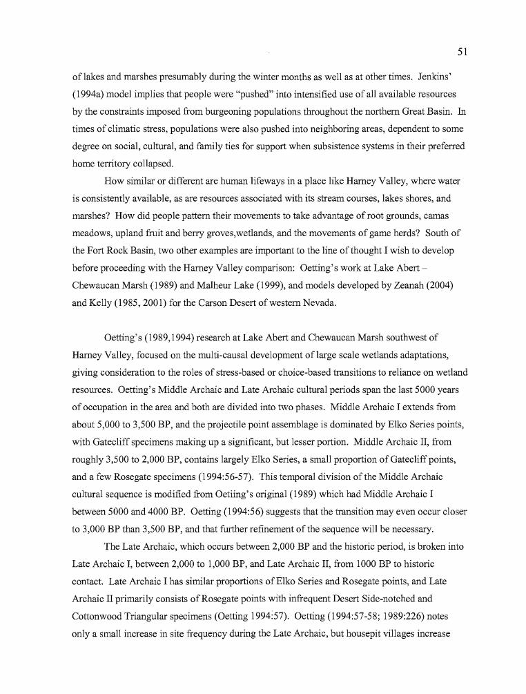
51
oflakes and marshes presumably during the winter months as well as at other times. Jenkins'
(1994a) model implies that people were "pushed" into intensified use of all available resources
by the constraints imposed from burgeoning populations throughout the northern Great Basin. In
times of climatic stress, populations were also pushed into neighboring areas, dependent to some
degree on social, cultural, and family ties for support when subsistence systems in their preferred
home territory collapsed.
How similar or different are human lifeways in a place like Harney Valley, where water
is consistently available, as are resources associated with its stream courses, lakes shores, and
marshes? How did people pattern their movements to take advantage of root grounds, camas
meadows, upland fruit and berry groves,wet1ands, and the movements of game herds? South of
the Fort Rock Basin, two other examples are important to the line of thought I wish to develop
before proceeding with the Harney Valley comparison: Oetting's work at Lake Abert
Chewaucan Marsh (1989) and Ma1heur Lake (1999), and models developed by Zeanah (2004)
and Kelly (1985, 2001) for the Carson Desert of western Nevada.
Oetting's (1989,1994) research at Lake Abert and Chewaucan Marsh southwest of
Harney Valley, focused on the multi-causal development oflarge scale wetlands adaptations,
giving consideration to the roles of stress-based or choice-based transitions to reliance on wetland
resources. Oetting's Middle Archaic and Late Archaic cultural periods span the last 5000 years
of occupation in the area and both are divided into two phases. Middle Archaic I extends from
about 5,000 to 3,500 BP, and the projectile point assemblage is dominated by Elko Series points,
with Gatecliff specimens making up a significant, but lesser portion. Middle Archaic II, from
roughly 3,500 to 2,000 BP, contains largely E1ko Series, a small proportion of Gatecliffpoints,
and a few Rosegate specimens (1994:56-57). This temporal division of the Middle Archaic
cultural sequence is modified from Oetiing's original (1989) which had Middle Archaic I
between 5000 and 4000 BP. Oetting (1994:56) suggests that the transition may even occur closer
to 3,000 BP than 3,500 BP, and that further refinement of the sequence will be necessary.
The Late Archaic, which occurs between 2,000 BP and the historic period, is broken into
Late Archaic I, between 2,000 to 1,000 BP, and Late Archaic II, from 1000 BP to historic
contact. Late Archaic I has similar proportions ofE1ko Series and Rosegate points, and Late
Archaic II primarily consists of Rosegate points with infrequent Desert Side-notched and
Cottonwood Triangular specimens (Oetting 1994:57). Oetting (1994:57-58; 1989:226) notes
only a small increase in site frequency during the Late Archaic, but housepit villages increase
..
52
substantially and are generally located near wetlands. Also, Oetting observed a trend toward
more houses per village and an increase in house size during the Late Archaic Period. According
to Oetting (1989:226): "The population of the lastl,OOO or 2,000 years was more sedentary than
at any time in the past. Currently there are no data that conclusively demonstrate full sedentism
(year round occupation of the site), but the substantial nature of the cultural features, the density
of tools and debitage, and comparisons with ethnographic Klamath suggest these villages were
semi-sedentary ..."
The Klamath connection is not left trailing. Oetting (1989:232-234) considers the
inhabitants of the Lake Abert - Chewaucan Marsh region over the last 4,000 years to be
representative of a single cultural tradition, "the direct predecessors of ethnographically known
Penutian-speaking people.," and those of the Late Archaic II Phase were prehistoric Klamath,
culturally affiliated with the Klamath people of the Klamath Lake and Marsh region. To support
this contention, Oetting (1989:232-236) highlights the wetland-based economy of the Klamath;
patterning of annual movements; timing of the development of large pithouse villages between
1,700 and 1,250 BP in accordance with Cressman's work at Klamath sites; the resemblance of
Lake Abert house pits to Klamath houses; the presence of handled manos, well formed mortars,
and Catlow Twined basketry (from Chewaucan Cave); and oral traditions handed down by
Northern Paiutes.
Oetting (1989:273-274) sees the development of pithouse villages in the Lake Abert
Chewaucan Marsh region as a response to the opportunities offered by wetland resources, not a
stress-related "push" to use low quality subsistence items. He does not see evidence that large
scale environmental stress forced the abandonment of the basin at any time during the last 4,000
years, nor that it had other archaeologically discernable affects on patterns of habitation. Had
occupations been stress-induced, they would have also been "transitory with changes in the local
site patterns occurring when the operating stress was removed (Oetting 1989:273)" In essence,
wetland resources were both diverse and reliable and the ethnographic pattern was already in
place for utilizing settlement and subsistence systems in that way. If Oetting's hypothesis is
correct, then a difference is clearly apparent between the archaeological pattern of human activity
seen by Jenkins in the Fort Rock Basin, and that identified by Oetting in the Lake Abert
Chewaucan Marsh area. The important difference is water, which was available even in drought
years at springs located on the west side of the lake, and it may be the case that human
populations ebbed and flowed as increased effective moisture enhanced landscapes where
53
resources were otherwise limited, but remained stable and semi-sedentary in locations where
water was readily available.
Oetting (1989:273) felt that "Rather than applying a reductionist optimal foraging model
of strict resource use and sequent use of ranked plants and animals, one must consider resources
as they occur on the landscape." Wetlands may not have the highest ranking resources, but they
are "abundant, concentrated, diverse, and reliable (1989:273)". He argued that such resources in
a limited area, in association with processing, storage and a reduced need for transportation,
could foster a reduction in residential mobility and lead to a settlement pattern that he termed
"semi-sedentary." Writing with reference to the Chewaucan Marsh and Abert Lake setting,
Oetting noted that people could continue to apply collector-like strategies and return to
the same winter villages every year; and do so not because they were forced into the wetland
circumstance by stress, but because of the opportunities that existed in such locations. Wetlands
would have become more attractive at times of climate stress, because resource diversity there
would have been greater than in surrounding basins and uplands, but they would have always
been attractive regardless of regional stress levels, for the resources they contained. The same
would be true if populations were on the rise - a broader array of resources would have been
available for intensive processing in the wetlands than in any other environmental setting during
times of demographic stress. Oetting felt that, given time and increasing dependence on nearby
wetland resources, a shift to a fully sedentary lifestyle was not out ofthe question although he
does not appear to believe that it was ever fully realized in the Chewaucan MarshlLake Abert
setting.
Oetting (1990 a and b, 1999) also offers a perspective on cultural dynamics in the Harney
Basin, in reporting the results of surveys at Malheur Lake following the extensive flooding in the
mid 1980s. He noted that at least several of the sites observed held " ... spectacular arrays of
hundreds to thousands of tools from a wide range of artifact classes. (1999:206)." Almost 100
sites were recorded that included many projectile points, large bifaces, well made ground stone
tools, net weights, ornaments, and, in some cases, burials. House floors were observed eroding
out of cutbanks. Utilizing the flood survey data along with other sources, Oetting notes an
intensification in use of Harney Valley beginning around 5,000 years ago that may be tied to
greater effective moisture and redevelopment of wetland systems that began at the onset of the
Medithermal (1999:208). Oetting feels that human use of the valley increased significantly
around 2,000 BP, a trend marked by the dominance of Rosegate points in sites as well as by
numerous radiocarbon ages.
...
54
As was the case in the Lake Abert - Chewaucan Marsh region, Oetting (1999:213) finds
the Klamath-Modoc ethnographic model to be the most appropriate for human activity in the
Harney Valley between 5,000 to 1,000 or 500 BP, based on the examples provided by the Dunn,
McCoy Creek, Blitzen Marsh, and Headquarters sites. After 500 BP, he considers the Wada'tika
model to be a better fit. As is my belief, he is of the opinion that several large sites recorded on
the Malheur Lake shoreline during the post-flood surveys are also villages, and that wetland
resources were key to Harney Valley subsistence practices. The presence of housepit villages
and dense concentrations of artifacts at lakeside settings are unlikely attributes of highly mobile
populations, as Oetting points out (1999:214), nor are they hallmarks of locations where wetland
resources are being utilized as secondary or fallback food sources. However, wetland resource
utilization would require that village populations engage in some labor-intensive plant processing
or procurement activities (fishing), periodic transportation of resources to the village, the
establishment of storage facilities and the presence of equipment needed to process the resources
for consumption, such as grinding stones. The presence of features and artifacts related to these
activities should be visible in the archaeological record. Artifacts such as net weights, ground
stone, and other task specific tools, bone tools, decorative items, house floor remains and storage
pits have all been recorded in Harney Valley archaeological sites.
Archaeologically, Oetting (1999:216) finds Harney Valley associations with Columbia
River Plateau people and possibly the Klamath-Modoc, through the surviving remnants of
material culture that include large bifaces, decorated ground stone, decorated bone tools and
"head scratchers or sweat scrapers," and pit houses. He does not consider pre 500 BP ancestral
populations to be specifically from the Klamath-Modoc area, but finds their lifeway to be the best
analog for archaeological manifestations in Harney Valley. Oetting is careful to keep to a
broader association that includes both Klamath and Columbia River groups (or Plateau at times)
when he discusses the Harney Valley, and points out that while the artifacts are suggestive of
those cultures, they are by no means conclusive evidence, nor are wetland oriented subsistence
practices exclusive to plateau groups. It is unclear whether he is backing away from his earlier
stance that ancestral Klamath populations were the probable occupants in the lake basins of
southeastern Oregon (specifically Lake Abert), or ifhe is simply uncomfortable in extending the
possible scope of Klamath cultural influence as far to the east as Harney Valley without
consideration that other Plateau groups may have held influence there. He certainly sees the
transition from Penutian influence to Uto-Aztecan with the advent of Desert Side-notched and
Cottonwood Triangular points after 1,000 BP.
b
55
David Zeanah's 2004 exploration ofthe role that sexual division oflabor plays in the
placement of hunter-gatherer base camps brings a behavioral ecology perspective to this
discussion. Utilizing data from the Carson Desert in western Nevada, Zeanah (2004:2-4) points
out that subsistence roles for men and women were not necessarily as cooperative as was once
believed and that men and women may have foraged to achieve different goals, with women
gathering resources to feed children and men hunting because the sharing of meat led to more
opportunities for mating.
Zeanah (2004:6-7) uses a model that combines 41 soil based habitat maps designed to
identify pre -1850 vegetation patterns with data indicating the carrying capacity for 14 varieties
of game, generated from modem wildlife management inventories. Reasonable estimations of
return rates for various floral and faunal resources were derived from the two sources, then
divided into men's and women's prey sets. Men focused on resources with the highest return
rates (large game), but with greater search costs. Women's (plant) resources are easier to find,
but caloric return rates can be considerably lower for the effort involved in both gathering and
processing. Calculated on an annual basis, however, it is apparent that women had higher
foraging returns at all times of the year except late summer when cattail pollen is out of season in
the marshes. For men to show an equivalent rate of return from hunting strategies, herds would
have to attain population levels that would be in excess of the carrying capacity of the region by a
substantial margin (2004:24). Despite the efficient returns that may have come from
concentrating on wetland resources, it seems clear that, whenever possible, men focused their
efforts on hunting and women gathered plants.
The questions from Zeanah's behavioral ecology perspective are: where did the
prehistoric inhabitants of the Carson Desert position their base camps, and what concessions
would have to be made for men and women to operate effectively within their preferred
catchment areas? As Zeanah (2004:21) puts it: "if male and female foragers in a camp pursue
different sets of prey to achieve different objectives, whose individual interests are served by
positioning camps to minimize travel and transport costs?" He feels that hunter-gatherers who
establish camps in areas where combined return rates are high benefit from a selective advantage
over those who position their camps in favor of either men's or women's preferred resources,
thus camp placement would be where the intake of food into camp would offer the highest return
rates after transport. Based on the generally smaller return rates for hunters versus wetland
gatherers, and the fact that meat can be dried to reduce transport weight, the band or family unit
would be better served by positioning camps closer to the women's best foraging habitat near the
56
wetlands. Hunting success would have to be high, and game populations much greater than
modeling based on the late Holocene climate would suggest, for central place foraging camps to
have shifted from the lowlands to better hunting territories in the uplands.
According to Zeanah (2004:21) even during the Neoglacial, when conditions would have
improved in favor of large game populations, wetland resources would still be accessible in
many of the same places and game herds would have been available in a wider variety of
ecozones, offering greater availability with less travel investment and search time. As a result,
the most effective residential bases over time and through periods of climatic variability would
have been those positioned near the wetlands ofthe Carson Desert.
Kelly (1985 :2001) reported on changes in mobility strategies over the last 5000 years in
the Carson Desert and Stillwater Marsh. In his analysis, a mobility strategy describes the ways in
which resources were obtained by group movement, whereas a seasonal round is characterized by
the resources and locations utilized by a particular band. Kelly, incorporating mobility models
from Binford's (1980) work, attempted to identify tool sets and archaeological features that might
be associated with residential or logistical behaviors. He noted that human use of the Carson
Desert shifted over time, but sedentism did not appear to be a sustained activity either in the
desert or at Stillwater Marsh. Caching and storage, which is more common in the archaeological
record after 1500 BP, was interpreted as a stress-based response to increased winter severity.
Kelly reasoned that as winter severity increased, die-offs of large mammals became more
common, and forced hunter-gatherer groups to become less mobile, concentrate on processing
and storing lower-ranked resources near wetland settings, and send small parties from residential
bases to pursue big game. The implication he drew was that big game would always be the first
choice in resource selection and marshland resources were less important because they required
too much investment of energy for their caloric yield. Kelly subsequently revised his viewpoint
on hunter-gatherer sedentism, mobility, and resource selection after the exposure of substantial
pithouse villages at Stillwater Marsh by extensive flooding in the 1980s.
As Kelly noted in 1985, the seasonal round provides information about places and
resources that come into playas populations move around a given basin or valley, but such
descriptions are usually not mindful of the patterns of fusion and fission that occurred at
residential base camps, what personnel were included in logistical outings, or what significance
sedentism played in the overall scheme of resource acquisition and management. Was sedentism
an aspect of human behavior simply because the concentrations of varied resources in wetland
57
settings, and their increased processing and storage needs made residential mobility less
attractive? Was residential mobility actually more attractive than sedentism, which became a
necessary alternative only in times of climatic stress? Was sedentism utilized only in the winter
months because it reduced energy expenditures during periods oflimited resource availability, or
was it a favored pattern ofbehavior during other times of the year too because it allowed high
yield resource acquisition in the manner described by Zeanah (2004) for "central places?" Were
patterns of human behavior relatively stable over many thousands of years? The answers to some
of these questions are approachable through in-depth examinations of the seven Harney Valley
archaeological sites here reported, and these analyses will also suggest future research directions
for the years to come.
The pioneering work ofthe above researchers provides a theoretical context for the
evaluation ofthe seven Harney Basin sites that is to follow. In the Fort Rock Basin, Helzer
(2001) provided insights regarding human occupations in the Fort Rock Basin at the intra-site
level. Wingard (2001) has taken us a step further into investigations of Carlon Village and its
place in a regional context, and Jenkins (1994) provides a broad-scale evaluation of overall
settlement and subsistence systems that extend beyond the Fort Rock Basin, into other basins and
physiographic provinces. The work that has been carried out in the Fort Rock Basin is recent,
intensive, insightful and important for considering the roles that physiographic settings, and
population movements may have played in the lives ofthe human inhabitants of the northern
Great Basin. One key element that may differentiate the lifeways ofthe Fort Rock inhabitants
from those in other nearby drainage basins is its comparative paucity of water, except during
climatic periods where greater effective moisture was available. Oetting (1989, 1999) has
documented human use patterns in both the Lake Abert - Chewaucan Marsh and Harney Valley
settings, supplying broad-scale perspectives for the two well watered regions, while Zeanah
(2004) and Kelly (1985) have done the same for the Carson Desert region. Their insights are
important to consider in relation to the seven sites that are being reported here. Two large scale
studies carried out earlier in the Harney Valley and adjacent areas deserve mention as well. They
are described below, along with a brief discussion of important resources that may have affected
decisions regarding settlement and subsistence strategies in the area.
Considering the circumstances in the northern Great Basin, human behavioral patterns in
the Harney Valley may have been similar to those of Lake Abert from the standpoint that
perennial water sources ofhigh quality were available and populations may have practiced semi
sedentary modes of residence and resource procurement. Some semi-sedentary village locations
J ...
....58
may have moved with the fluctuating shorelines of Malheur and Harney lakes, while others like
the Headquarters site were situated in elevated places where repeated occupations could have
occurred, building a substantial archaeological record over time. The shallow nature of the
centrally located lakes supports a lush growth of wetland plant species, emergent shorelines offer
the preferred habitat for wada production, and fish, waterfowl, and muskrats would have been
available on a regular basis. One of the earliest large scale research projects in Harney Valley
addressed the possibility that human populations abandoned broad areas during the Altithermal
Period around 7,000 BP (Antevs 1948).
Fagan (1974) looked at the possibility of Altithermal abandonment of the Harney Valley
through the examination of 11 spring sites and one lake shore site that are located in the Harney
Valley or its neighboring drainages to the east. The sites were typically situated at high
elevations (above 1525 meters [5000 ftJ) and exhibited evidence of repeated occupations ranging
from early to late Holocene. Fagan found that the spring sites were occupied during all cultural
periods and ten of twelve were used during the Altithermal, indicating that full abandonment of
southeastern Oregon did not occur even during the driest times. Although full abandonment
seems to be an unlikely option except in the most dire of circumstances, Fagan's effort was
hindered by the fact that radiocarbon dates from the excavations were scarce and never exceeded
3000 years in age, so that dating of the Altithermal component had to be based on the recovery of
Large Side-notched and Elko Series points (among other, non-diagnostic implements). These
types are known today to cover a time depth between 7000 to 1000 BP, a considerably longer
period than was realized at the time of Fagan's study.
The Steens Mountain Prehistory Project (Aikens, Grayson, and Mehringer 1982) was a
large scale project designed to test the hypothesis that human occupation patterns in the area
encompassing the Alvord Desert, Steens Mountain, and the Catlow Valley changed over time.
Utilizing extensive surveys, pollen coring, and large-scale collection procedures to explore
possible changes, they discovered that all artifact types diagnostic of the past 10,000 years of
human use were regularly found in the study area. They also determined that there was no simple
correlation between the size of an archaeological site and its possible use at any given time in its
history. Simply put, a wider variety of artifacts are found in larger accumulations and small sites
had less diverse assemblages simply because they were not as well situated and were therefore
used less.
-
59
Although the study area was continuously used by aboriginal peoples over time,
population increases were apparent at certain times. Aikens (1993:69) reported that site
frequencies showed a bimodal distribution over time: low from 10,000 to 6000 BP and higher
thereafter, peaking between 4000 to 3000 BP, declining between 3000 and 2500 BP, then
increasing again after that time. Site area does not correlate well with intensive periods of
occupation. Sites dated between 10,000 to 6000 BP and 4000 to 2500 BP, tended to cover large
areas, and sites dated between 6000 and 4000 BP and after 2500 BP were smaller in size. The
Steens Project research revealed that there was little use of the uplands from 10,000 to 6000 BP,
a greater variety oflocalities were used from 6000 to 3000 BP, fewer, but larger sites were used
from 3000 to 2500 BP, and site numbers increased but sites were smaller after 2500 BP.
Associations can be made between these trends and the climatic record, with drier conditions
occurring from 10,000 to 7500 BP, greater effective moisture after 5000 BP, and fluctuating
conditions after 2500 BP. Fewer sites may have been used more regularly during drier
conditions, becoming larger in size as a result of repeated use. Moist climate conditions, leading
to higher production of floral and faunal resources, were associated with a greater dispersal of
smaller sites as more resource patches became available. A higher degree of sedentism may have
also resulted from improved moisture conditions. The period from 3000 to 2500 BP, when sites
are found to be larger, may be the outcome ofpeople staying in one place for longer periods of
time.
Finally, where does the Harney Valley fit in terms of all the issues outlined above? What
kinds of mobility options were in use in the Harney Valley, and can the archaeological record
provide insights about such behavior? To begin with, the basin has several kinds of resources
which would have been important factors in the placement of sites and the movements ofpeople
during the last 4000 years. First, Malheur, Mud and Harney lakes lie near the center of the valley
in relatively level terrain. Fluctuations in the water levels from year to year would have
enhanced productivity for some resources such as wada and other species that benefit from an
emergent shoreline. Today, when water levels at The Narrows between Malheur and Harney
Lake draw down, a rich black fringe of wada covers the area between the old and new shorelines.
The lake basins are not deep, and considerable rise and considerable lateral movement of the
shorelines can occur with the only result being the expansion or contraction of wetland plant
communities like the wada. Drowning of emergent cattails, bulrush, and other species would
require flooding on a massive scale. Minor flooding would cause the shoreline to broaden and
marshland plant communities would occupy the newly acquired wetland in short order. Drying
..
60
would reduce resource availability to some degree, but plants such as wada would still exist near
the water's edge, and Malheur Lake is such a large body of water that conditions would have to
change markedly to cause habitat loss on a scale that would be detrimental to sustaining human
populations. Of course, that has happened over the millennia, but the important point is that
water would have been available in the region with enough regularity to allow patterned
settlement and subsistence activities to occur over prolonged periods, which should be visible in
the archaeological record.
The second important resource zone that was available to human populations were the
root grounds on the north and east edges of the Hamey Valley, particularly in the Crow Camp
Hills, Stinkingwater Mountains, and Pine Creek Divide. The quality and quantity of the roots
available there attracted people from throughout the northern Great Basin and Plateau, and spring
and early summer gathering at these camps were important times for re-establishing social ties
with distant neighbors and relatives, arranging marriages, and participating in contests, games,
and gambling. Again, roots were resources that, like the water, offered some degree ofreliability
for the inhabitants of the valley.
The third resource that deserves consideration is camas, which even today grows in
startling abundance on the northern edge of the valley floor. Although camas is a resource that
has not been well documented from archaeological sites in the region, it was (and is) a known
dietary staple for many aboriginal people and was surely important to the people of Harney
Valley in the past. Finally, numerous varieties of wildlife are found in a variety of ecozones in
Harney Valley. Large game herds inhabited the mountains and foothills of the region,
tremendous flights of waterfowl take advantage of the lakes during migratory stopovers, and
thousands ofmuskrat lodges can be found in the northeast quadrant ofMalheur Lake during the
winter. The grasslands and sagebrush steppe support high numbers of rabbits and hares, upland
fowl, and rodents, and provide an important source of grain for winter use. Other resources were
also available, but the key point is that at least several important resources were available in large
quantities and at different times of the year. From our distant viewpoint, it is easy to discount the
amount oflabor that was involved in gathering, processing, and storing enough different kinds of
resources to last a winter, and do it consistently from year to year. Undoubtedly, winters in
which everything went just right and families had "enough" were few, and treasured memories.
The fact remains that Hamey Valley had a number of resources that could have been used in
winter provisioning, they were available on a scale that would have buffered the failure of some
or all of one kind of resource, and they would have been consistent producers which human
..
61
inhabitants could factor into logistical planning and residential mobility decisions. The
archaeological record should reflect the use of these items.
The following seven chapters report a series of sites, all of which are situated in the
Harney Valley drainage system, that are germane to the issues which have been brought up in the
preceding chapters. The organization and treatment ofthe data in the site chapters has been
guided by the issues raised above.
.L ....
62
CHAPTER IIIMORGAN SITE (35HA2423)
Data recovery excavations at the Morgan site were carried out in August of 1995. The site
is located on Sand Hill, approximately 10 km (6 miles) from the community of Bums, Oregon.
The excavations were guided by a data recovery plan developed after testing at the site occurred in
March of that same year (Jenkins and Connolly 1995). In the data recovery plan, it was
recommended that up to 60 square meters of the deposits at the site be excavated at two locations
on the north side of the highway; the West and East Loci, as they will be referred to in the
following report. The two loci were established where peaks in the quantities and varieties of
cultural materials occurred during the testing phase. The total area excavated was 58 square
meters, resulting in the removal of 31.68 cubic meters of fill. Connolly (1994) originally recorded
the site as John Logan Lane 2 (JLL-2), consisting of a sparse scatter of obsidian flakes and one
utilized flake exposed by the recent installation of a fiber-optic telephone cable.
Excavation Strategies
Test excavations at the site occurred from February 28 to March 7, 1995, and included
two 1 x 1 meter test pits and thirty-seven 50 x 50 cm test probes averaging 50 cm in depth (Figure
3.1). Recovered artifacts included a projectile point fragment, two biface fragments and five
groundstone fragments, along with charcoal, 559 pieces of debitage, and 90 bone fragments (Tasa
1995). No temporally diagnostic artifacts were recovered during the testing phase. It was
determined that significant cultural deposits were in the path ofproposed highway safety
improvements, which would involve widening both sides of the highway. Tasa (1995) called for
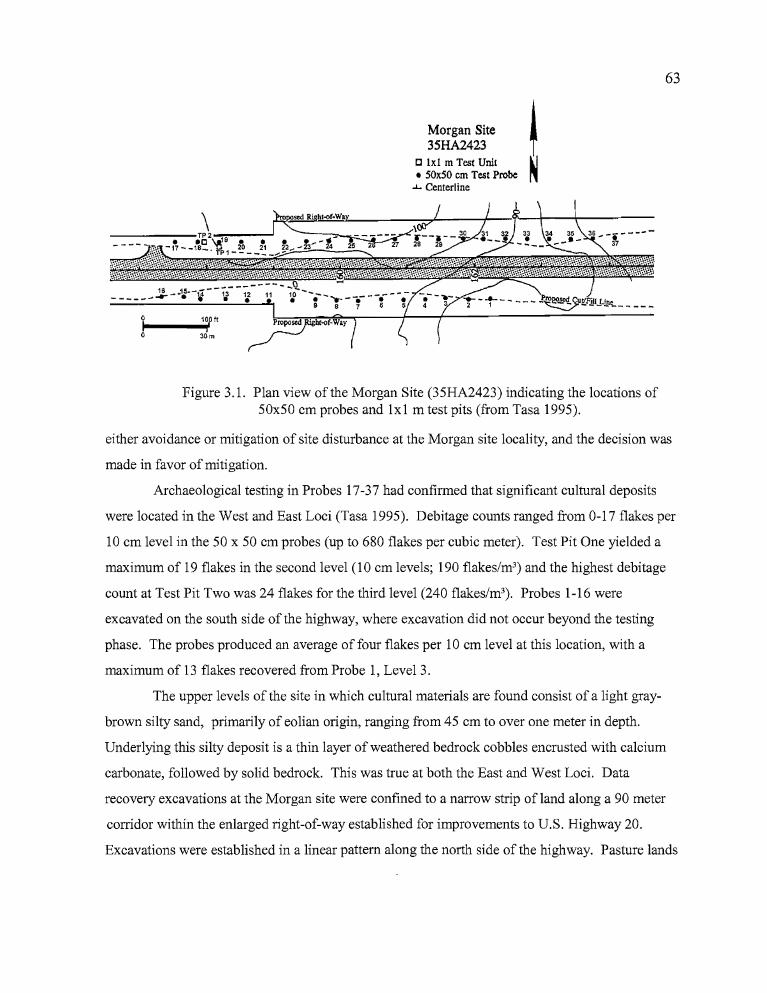
II'
63
Morgan Site !35HA2423 f
[J lxl m Test Unit ~• SOxSO em Test Probe ~
..J.. Centerline
12 11•10pft ~roPOStd. ht-<>f-Wayi
30m
\----.-:t/~-1,...9-._.....J
.~., -17~_18_. TP1-~
Figure 3.1. Plan view of the Morgan Site (35HA2423) indicating the locations of50x50 em probes and lxl m test pits (from Tasa 1995).
either avoidance or mitigation of site disturbance at the Morgan site locality, and the decision was
made in favor of mitigation.
Archaeological testing in Probes 17-37 had confirmed that significant cultural deposits
were located in the West and East Loci (Tasa 1995). Debitage counts ranged from 0-17 flakes per
10 em level in the 50 x 50 em probes (up to 680 flakes per cubic meter). Test Pit One yielded a
maximum of 19 flakes in the second level (10 em levels; 190 flakes/m3) and the highest debitage
count at Test Pit Two was 24 flakes for the third level (240 flakes/m3). Probes 1-16 were
excavated on the south side of the highway, where excavation did not occur beyond the testing
phase. The probes produced an average of four flakes per 10 em level at this location, with a
maximum of 13 flakes recovered from Probe 1, Level 3.
The upper levels of the site in which cultural materials are found consist of a light gray
brown silty sand, primarily of eolian origin, ranging from 45 em to over one meter in depth.
Underlying this silty deposit is a thin layer of weathered bedrock cobbles encrusted with calcium
carbonate, followed by solid bedrock. This was true at both the East and West Loci. Data
recovery excavations at the Morgan site were confined to a narrow strip of land along a 90 meter
corridor within the enlarged right-of-way established for improvements to U.S. Highway 20.
Excavations were established in a linear pattern along the north side of the highway. Pasture lands
..
64
belonging to the Morgan Ranch are located to the north of the right-of-way. The south side was
bordered by a drainage ditch and the highway. The original site was estimated to have been
approximately 1.5 acres in size, but previous highway construction destroyed approximately 40%
of the site and the excavation of two trenches for fiber-optic telephone cable damaged an
additional portion of the site. It was expected that the next round ofsafety improvements to the
highway would cause the destruction of an additional 20% of the site.
Excavation Units
Prior to excavation, an arbitrary datum was established on a nearby high point from which
a grid system could be created for the entire site. Using a Topcon GTS-203 total station,
coordinates for the datum were set at 100 N!O E, with an elevation established for the site
(recorded in meters) based on actual elevations from nearby bench marks. The individual
excavation units were then tied into the grid system. Unit coordinates have been replaced by letter
designations for this report. Individual elevation datums were shot in for the excavation units and
vertical control was maintained by the use of level lines attached to the datum stakes.
The basic unit of excavation was a 2 x 2 meter square, divided into 1 x 1 meter quadrants
oriented towards magnetic north. Each quadrant was excavated in order beginning with Quad A in
the northwest and continuing on to Quad B in the northeast, Quad C in the southwest, then Quad
D in the southeast. Paperwork was maintained for each level which included drawings, artifact
counts, the locations of in situ artifacts and various physical features, and written descriptions of
soil types observed in the unit. Chronologically diagnostic artfacts and other formed tools,
features, utilized flakes, and noteworthy bone fragments were recorded in situ when possible.
Drawings were made of selected stratigraphic profiles and photographs were taken of
representative walls in some excavation units. In situ artifacts and potential features were also
photographed. Fill was removed in five centimeter contour intervals. All of the fill was passed
through 1/8 inch mesh hardware cloth and cultural materials were sorted from the remaining
portion. Debitage, bone, and other overlooked artifacts were retrieved during the screening
process, counted, and added to the level record.
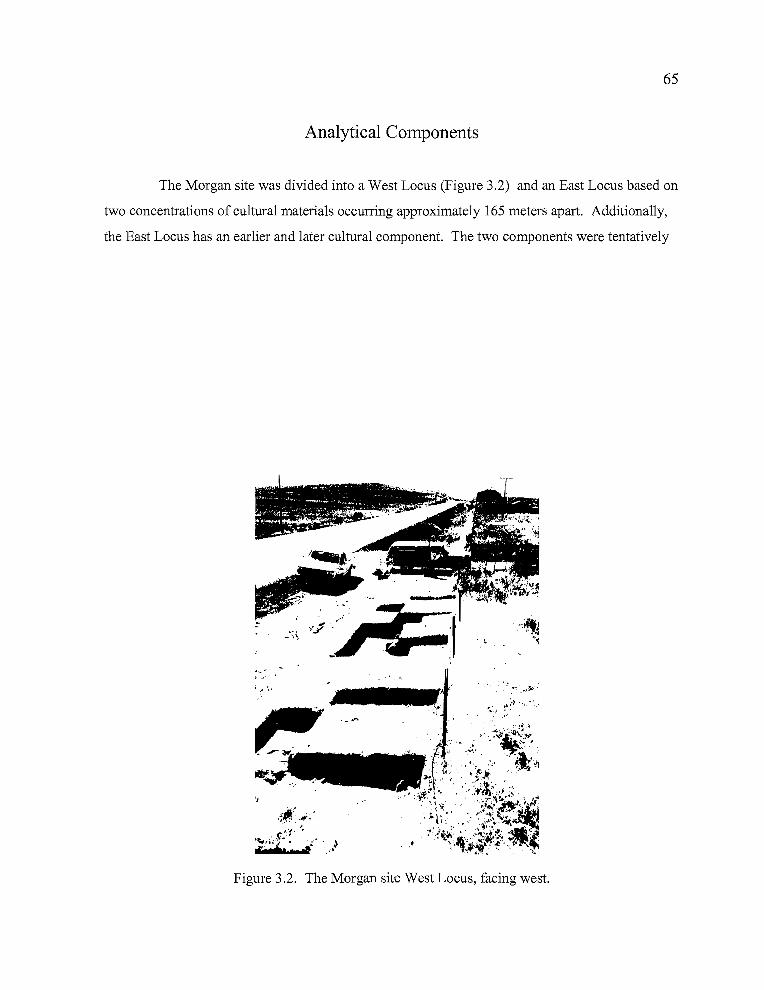
65
Analytical Components
The Morgan site was divided into a West Locus (Figure 3.2) and an East Locus based on
two concentrations of cultural materials occurring approximately 165 meters apart. Additionally,
the East Locus has an earlier and later cultural component. The two components were tentatively
"ii+ I, ~""; ..~~'~"".'1-';~
- ,<
... ~.
••
Figure 3.2. The Morgan site West Locus, facing west.
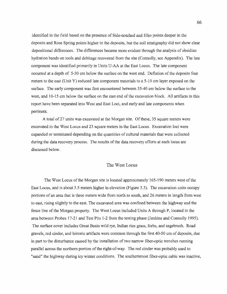
","
66
identified in the field based on the presence of Side-notched and Elko points deeper in the
deposits and Rose Spring points higher in the deposits, but the soil stratigraphy did not show clear
depositional differences. The differences became more evident through the analysis of obsidian
hydration bands on tools and debitage recovered from the site (Connolly, see Appendix). The late
component was identified primarily in Units U-AA at the East Locus. The late component
occurred at a depth of 5-30 cm below the surface on the west end. Deflation of the deposits four
meters to the east (Unit Y) reduced late component materials to a 5-10 cm layer exposed on the
surface. The early component was first encountered between 35-40 cm below the surface to the
west, and 10-15 cm below the surface on the east end of the excavation block. All artifacts in this
report have been separated into West and East Loci, and early and late components when
pertinent.
A total of27 units was excavated at the Morgan site. Of these, 35 square meters were
excavated in the West Locus and 23 square meters in the East Locus. Excavation loci were
expanded or terminated depending on the quantities of cultural materials that were collected
during the data recovery process. The results of the data recovery efforts at each locus are
discussed below.
The West Locus
The West Locus of the Morgan site is located approximately 165-190 meters west of the
East Locus, and is about 3.5 meters higher in elevation (Figure 3.3). The excavation units occupy
portions of an area that is three meters wide from north to south, and 26 meters in length from west
to east, rising slightly to the east. The excavated area was confined between the highway and the
fence line of the Morgan property. The West Locus included Units A through P, located in the
area between Probes 17-21 and Test Pits 1-2 from the testing phase (Jenkins and Connolly 1995).
The surface cover includes Great Basin wild rye, Indian rice grass, forbs, and sagebrush. Road
gravels, red cinder, and historic artifacts were common through the first 40-50 em of deposits, due
in part to the disturbance caused by the installation of two narrow fiber-optic trenches running
parallel across the northern portion of the right-of-way. The red cinder was probably used to
"sand" the highway during icy winter conditions. The southernmost fiber-optic cable was inactive,
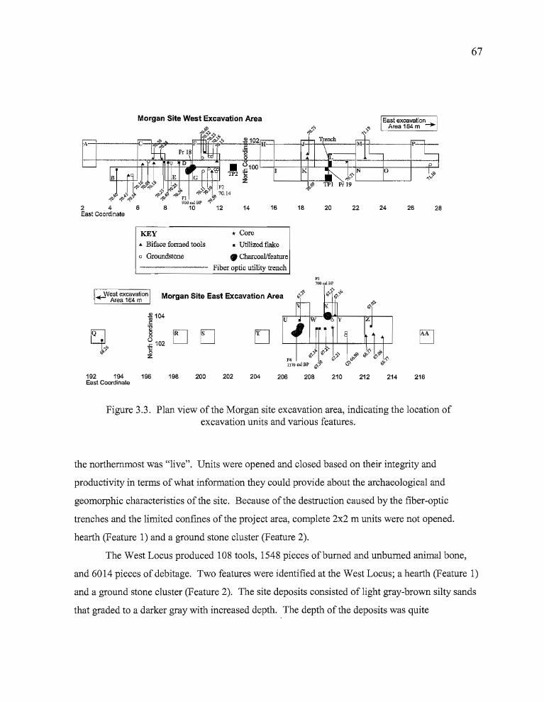
JIIf1I'
67
2826
East excavationArea 164m .....
242220181614128
Morgan Site West Excavation Area
2 4 6East Coordinate
KEY.. Biface fonned tools
o Groundstone
* Core
• Utilized flake
• CharcoaVfeature
------- Fiber optic utility trenchF3760 calBP
~West excavation Morgan Site East Excavation AreaArea 164 m
fil104c~
g [J Ds~ 1021:'oZ
[]
192 194 196East Coordinate
198 200 202 204 206 208 210 212 214 216
Figure 3.3. Plan view of the Morgan site excavation area, indicating the location ofexcavation units and various features.
the northernmost was "live". Units were opened and closed based on their integrity and
productivity in terms of what information they could provide about the archaeological and
geomorphic characteristics of the site. Because of the destruction caused by the fiber-optic
trenches and the limited confines of the project area, complete 2x2 m units were not opened.
hearth (Feature 1) and a ground stone cluster (Feature 2).
The West Locus produced 108 tools, 1548 pieces ofburned and unburned animal bone,
and 6014 pieces of debitage. Two features were identified at the West Locus; a hearth (Feature 1)
and a ground stone cluster (Feature 2). The site deposits consisted of light gray-brown silty sands
that graded to a darker gray with increased depth. The depth of the deposits was quite
.l..__ ..
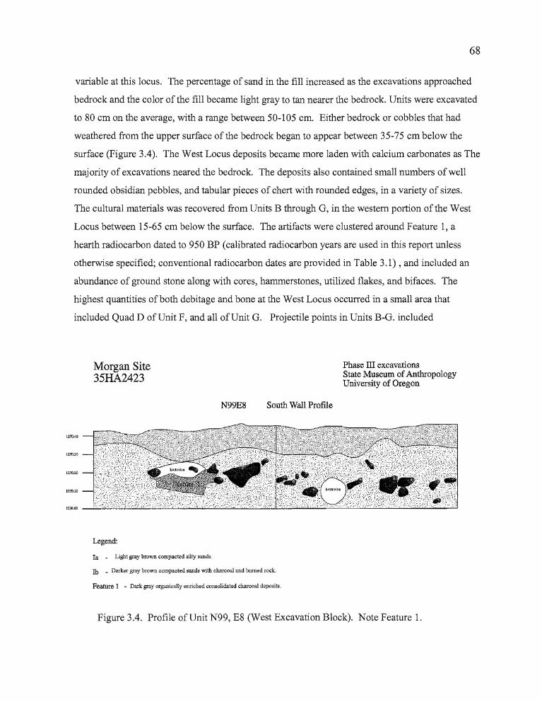
r'
68
variable at this locus. The percentage of sand in the fill increased as the excavations approached
bedrock and the color of the fill became light gray to tan nearer the bedrock. Units were excavated
to 80 cm on the average, with a range between 50-105 cm. Either bedrock or cobbles that had
weathered from the upper surface of the bedrock began to appear between 35-75 cm below the
surface (Figure 3.4). The West Locus deposits became more laden with calcium carbonates as The
majority of excavations neared the bedrock. The deposits also contained small numbers of well
rounded obsidian pebbles, and tabular pieces of chert with rounded edges, in a variety of sizes.
The cultural materials was recovered from Units B through G, in the western portion of the West
Locus between 15-65 cm below the surface. The artifacts were clustered around Feature 1, a
hearth radiocarbon dated to 950 BP (calibrated radiocarbon years are used in this report unless
otherwise specified; conventional radiocarbon dates are provided in Table 3.1) , and included an
abundance of ground stone along with cores, hammerstones, utilized flakes, and bifaces. The
highest quantities of both debitage and bone at the West Locus occurred in a small area that
included Quad D of Unit F, and all of Unit G. Projectile points in Units B-G. included
Morgan Site35HA2423
N99E8 South Wall Profile
Phase ill excavationsState Museum ofAnthropologyUniversity of Oregon
...
Legend:
Ia - Light gray brown compacted silty sands.
Ib _ Darker gray brown compacted sands with charcoal and burned rock.
Feature 1 - Dark gray organically enriched consolidated charcoal deposits.
Figure 3.4. Profile of Unit N99, E8 (West Excavation Block). Note Feature 1.
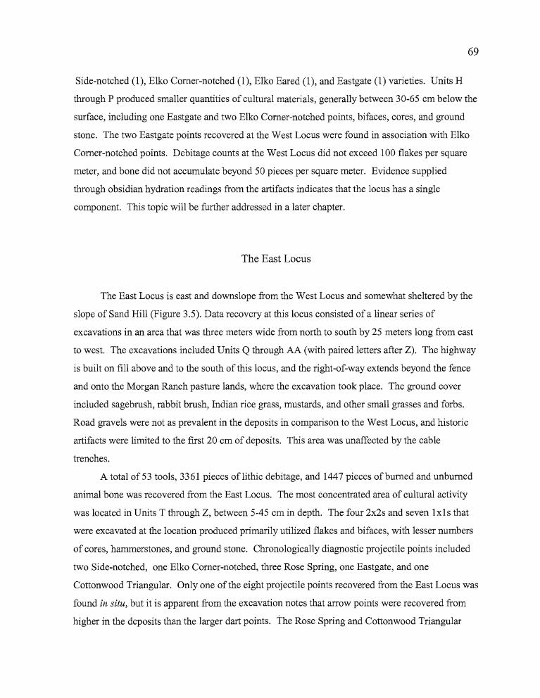
r'O ~
69
Side-notched (1), Elko Comer-notched (1), Elko Eared (1), and Eastgate (1) varieties. Units H
through P produced smaller quantities of cultural materials, generally between 30-65 cm below the
surface, including one Eastgate and two Elko Comer-notched points, bifaces, cores, and ground
stone. The two Eastgate points recovered at the West Locus were found in association with Elko
Comer-notched points. Debitage counts at the West Locus did not exceed 100 flakes per square
meter, and bone did not accumulate beyond 50 pieces per square meter. Evidence supplied
through obsidian hydration readings from the artifacts indicates that the locus has a single
component. This topic will be further addressed in a later chapter.
The East Locus
The East Locus is east and downslope from the West Locus and somewhat sheltered by the
slope of Sand Hill (Figure 3.5). Data recovery at this locus consisted of a linear series of
excavations in an area that was three meters wide from north to south by 25 meters long from east
to west. The excavations included Units Q through AA (with paired letters after Z). The highway
is built on fill above and to the south of this locus, and the right-of-way extends beyond the fence
and onto the Morgan Ranch pasture lands, where the excavation took place. The ground cover
included sagebrush, rabbit brush, Indian rice grass, mustards, and other small grasses and forbs.
Road gravels were not as prevalent in the deposits in comparison to the West Locus, and historic
artifacts were limited to the first 20 cm of deposits. This area was unaffected by the cable
trenches.
A total of 53 tools, 3361 pieces oflithic debitage, and 1447 pieces ofburned and unburned
animal bone was recovered from the East Locus. The most concentrated area of cultural activity
was located in Units T through Z, between 5-45 cm in depth. The four 2x2s and seven 1x1s that
were excavated at the location produced primarily utilized flakes and bifaces, with lesser numbers
of cores, hammerstones, and ground stone. Chronologically diagnostic projectile points included
two Side-notched, one Elko Comer-notched, three Rose Spring, one Eastgate, and one
Cottonwood Triangular. Only one of the eight projectile points recovered from the East Locus was
found in situ, but it is apparent from the excavation notes that arrow points were recovered from
higher in the deposits than the larger dart points. the Rose Spring and Cottonwood Triangular
...
70
points were found in levels 1-4, while the Elko and Northern Side-notched varieties came from
levels 5-8. As was true at the West Locus, the single Eastgate point found at the East Locus was
associated with an Elko Comer-notched point, in Level 9 of Unit U.
The fill generally consisted of light grayish-brown silty sands to an average depth of 35-45
ems, followed by a layer of calcium carbonate-encrusted cobbles weathering free of the bedrock
beneath. A statistical analysis of hydration rinds on various obsidian artifact types from the
Morgan site revealed that there are two possible components at the East Locus, which fits well
with the typological evidence. The upper component is situated at approximately 0-50 em in
depth, and appears to angle downslope to the east. The component is believed to be comparable in
age to the single component of the West Locus. Feature 3, a 760 BP hearth, is associated with this
stratigraphic layer as is Feature 4, the hearth dated to 1170 BP. The lower component is not
clearly defined due to some mixing oflate projectile points and the possible intrusion of shallow
hearths into the earlier deposits. The early component appears to be situated approximately
,- .., ..--..."r
...
Figure 3.5. The Morgan Site, East Locus, facing northwest.
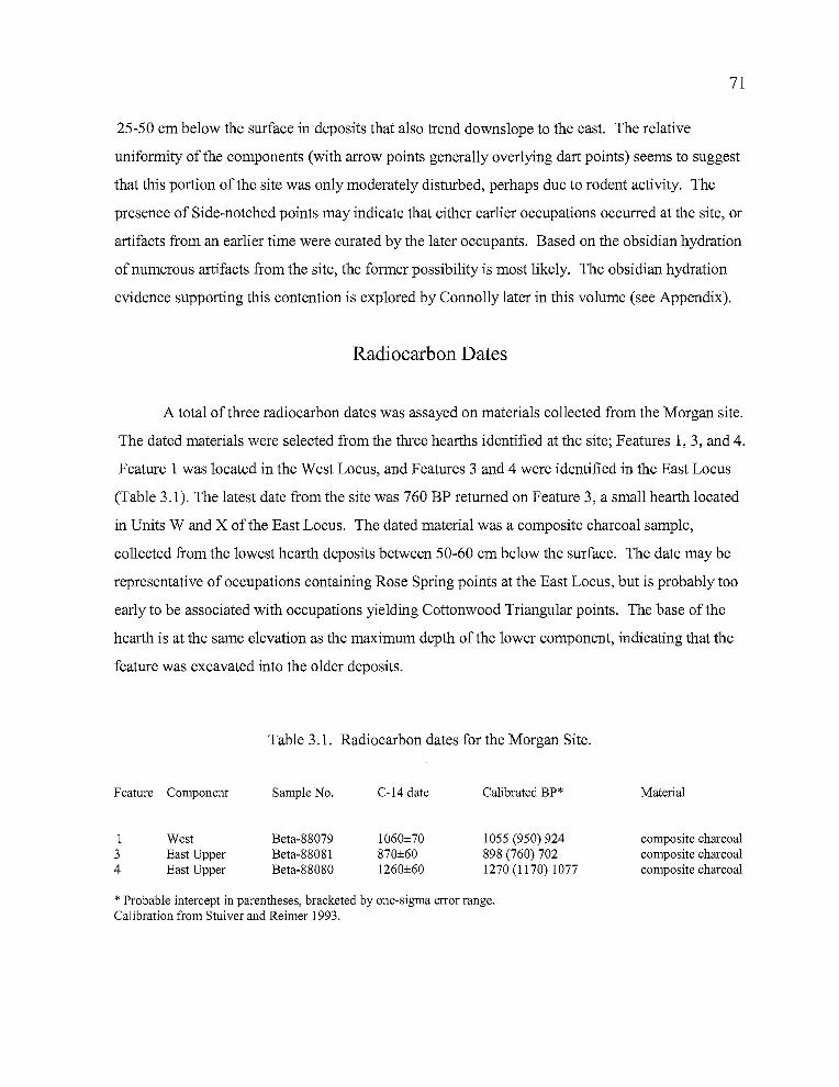
71
25-50 cm below the surface in deposits that also trend downslope to the east. The relative
uniformity of the components (with arrow points generally overlying dart points) seems to suggest
that this portion of the site was only moderately disturbed, perhaps due to rodent activity. The
presence of Side-notched points may indicate that either earlier occupations occurred at the site, or
artifacts from an earlier time were curated by the later occupants. Based on the obsidian hydration
of numerous artifacts from the site, the former possibility is most likely. The obsidian hydration
evidence supporting this contention is explored by Connolly later in this volume (see Appendix).
Radiocarbon Dates
A total of three radiocarbon dates was assayed on materials collected from the Morgan site.
The dated materials were selected from the three hearths identified at the site; Features 1,3, and 4.
Feature 1 was located in the West Locus, and Features 3 and 4 were identified in the East Locus
(Table 3.1). The latest date from the site was 760 BP returned on Feature 3, a small hearth located
in Units Wand X of the East Locus. The dated material was a composite charcoal sample,
collected from the lowest hearth deposits between 50-60 cm below the surface. The date may be
representative of occupations containing Rose Spring points at the East Locus, but is probably too
early to be associated with occupations yielding Cottonwood Triangular points. The base of the
hearth is at the same elevation as the maximum depth of the lower component, indicating that the
feature was excavated into the older deposits.
Table 3.1. Radiocarbon dates for the Morgan Site.
Feature Component Sample No. C-14 date Calibrated BP* Material
I34
WestEast UpperEast Upper
Beta-88079Beta-88081Beta-88080
1060±70870±601260±60
lOSS (950) 924898 (760) 7021270 (1170) 1077
composite charcoalcomposite charcoalcomposite charcoal
* Probable intercept in parentheses, bracketed by one-sigma error range.Calibration from Stuiver and Reimer 1993.
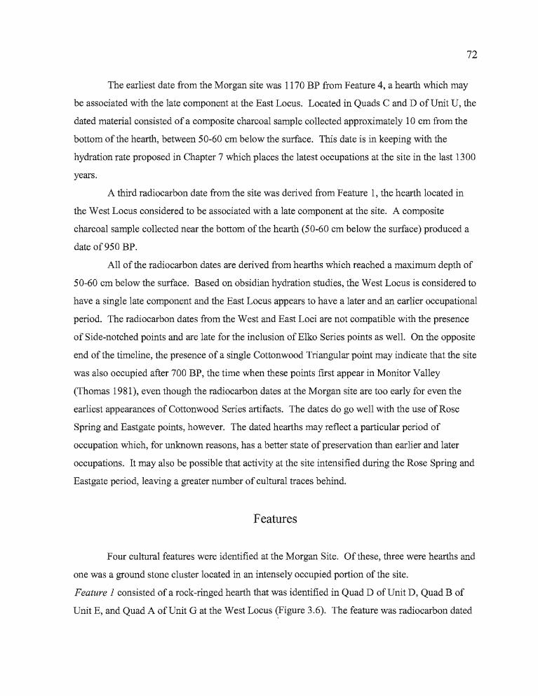
72
The earliest date from the Morgan site was 1170 BP from Feature 4, a hearth which may
be associated with the late component at the East Locus. Located in Quads C and D of Unit U, the
dated material consisted of a composite charcoal sample collected approximately 10 cm from the
bottom of the hearth, between 50-60 cm below the surface. This date is in keeping with the
hydration rate proposed in Chapter 7 which places the latest occupations at the site in the last 1300
years.
A third radiocarbon date from the site was derived from Feature 1, the hearth located in
the West Locus considered to be associated with a late component at the site. A composite
charcoal sample collected near the bottom of the hearth (50-60 cm below the surface) produced a
date of950 BP.
All of the radiocarbon dates are derived from hearths which reached a maximum depth of
50-60 cm below the surface. Based on obsidian hydration studies, the West Locus is considered to
have a single late component and the East Locus appears to have a later and an earlier occupational
period. The radiocarbon dates from the West and East Loci are not compatible with the presence
of Side-notched points and are late for the inclusion of Elko Series points as well. On the opposite
end of the timeline, the presence of a single Cottonwood Triangular point may indicate that the site
was also occupied after 700 BP, the time when these points first appear in Monitor Valley
(Thomas 1981), even though the radiocarbon dates at the Morgan site are too early for even the
earliest appearances of Cottonwood Series artifacts. The dates do go well with the use of Rose
Spring and Eastgate points, however. The dated hearths may reflect a particular period of
occupation which, for unknown reasons, has a better state of preservation than earlier and later
occupations. It may also be possible that activity at the site intensified during the Rose Spring and
Eastgate period, leaving a greater number of cultural traces behind.
Features
Four cultural features were identified at the Morgan Site. Of these, three were hearths and
one was a ground stone cluster located in an intensely occupied portion of the site.
Feature 1 consisted of a rock-ringed hearth that was identified in Quad D of Unit D, Quad B of
Unit E, and Quad A of Unit G at the West Locus (Figure 3.6). The feature was radiocarbon dated
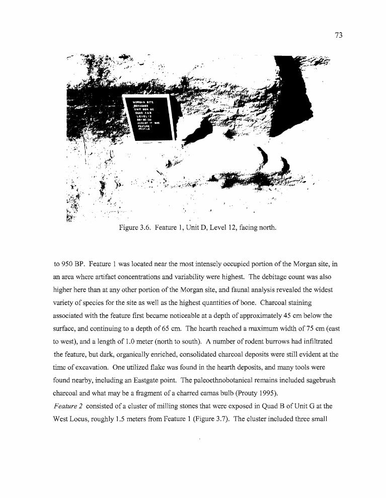
73
..
','
~:~-/
"., .. "': ..... I "
,- • "'_:' • \,. ";..>< • ~.' ~~x:i;~~ '.. I' .; • ',.
."'.. '»f, .. ', ....j- • .:t,.~'
. ~.: '
-~ ...~..- ---
Figure 3.6. Feature 1, Unit D, Level 12, facing north.
to 950 BP. Feature 1 was located near the most intensely occupied portion of the Morgan site, in
an area where artifact concentrations and variability were highest. The debitage count was also
higher here than at any other portion of the Morgan site, and faunal analysis revealed the widest
variety of species for the site as well as the highest quantities of bone. Charcoal staining
associated with the feature first became noticeable at a depth of approximately 45 cm below the
surface, and continuing to a depth of65 cm. The hearth reached a maximum width of75 cm (east
to west), and a length of 1.0 meter (north to south). A number of rodent burrows had infiltrated
the feature, but dark, organically enriched, consolidated charcoal deposits were still evident at the
time of excavation, One utilized flake was found in the hearth deposits, and many tools were
found nearby, including an Eastgate point. The paleoethnobotanical remains included sagebrush
charcoal and what may be a fragment of a charred camas bulb (Prouty 1995).
Feature 2 consisted ofa cluster ofmilling stones that were exposed in Quad B of Unit G at the
West Locus, roughly 1.5 meters from Feature 1 (Figure 3.7). The cluster included three small
1._._.
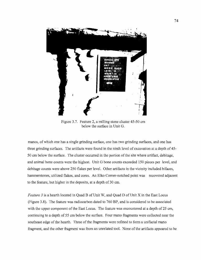
rt.r
74
Figure 3.7. Feature 2, a milling stone cluster 45-50 embelow the surface in Unit G.
manos, of which one has a single grinding surface, one has two grinding surfaces, and one has
three grinding surfaces. The artifacts were found in the ninth level of excavation at a depth of 45
50 em below the surface. The cluster occurred in the portion of the site where artifact, debitage,
and animal bone counts were the highest. Unit G bone counts exceeded 150 pieces per level, and
debitage counts were above 250 flakes per level. Other artifacts in the vicinity included bifaces,
hammerstones, utilized flakes, and cores. An Elko Comer-notched point was recovered adjacent
to the feature, but higher in the deposits, at a depth of 30 em.
Feature 3 is a hearth located in Quad B of Unit W, and Quad D of Unit X in the East Locus
(Figure 3.8). The feature was radiocarbon dated to 760 BP, and is considered to be associated
with the upper component of the East Locus. The feature was encountered at a depth of 25 em,
continuing to a depth of 55 em below the surface. Four mano fragments were collected near the
southeast edge of the hearth. Three of the fragments were refitted to form a unifacial mano
fragment, and the other fragment was from an unrelated tool. None of the artifacts appeared to be
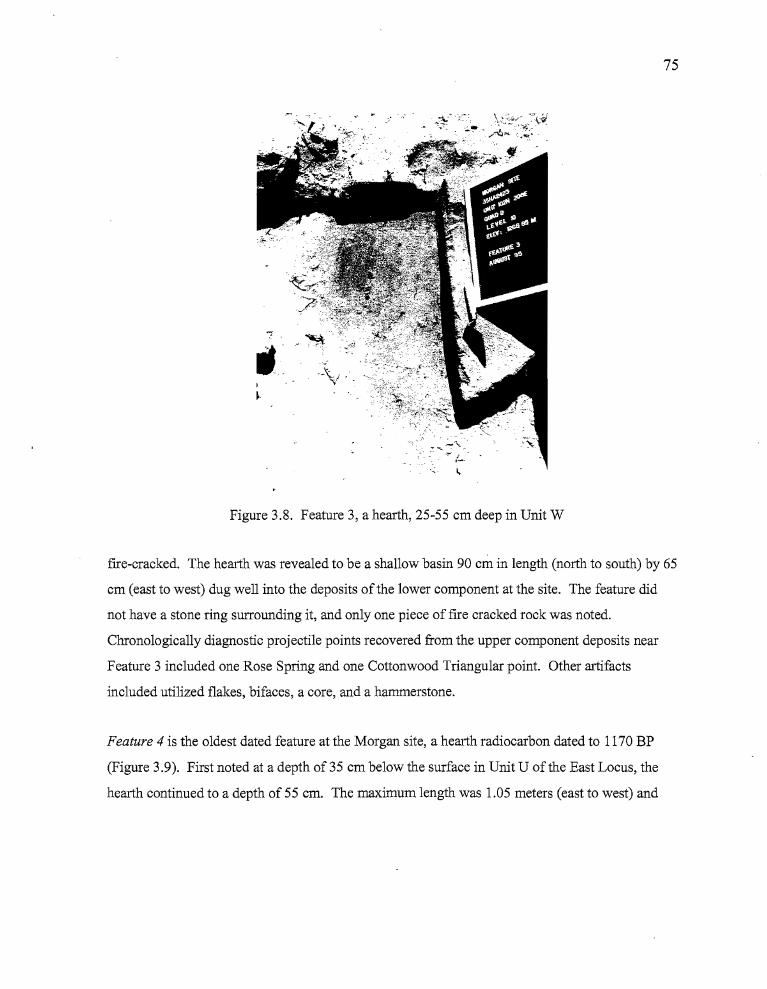
r
...-_. -,,-
--\: '.J •~: -
75
Figure 3.8. Feature 3, a hearth, 25-55 cm deep in Unit W
fIre-cracked. The hearth was revealed to be a shallow basin 90 cm in length (north to south) by 65
cm (east to west) dug well into the deposits of the lower component at the site. The feature did
not have a stone ring surrounding it, and only one piece of fIre cracked rock was noted.
Chronologically diagnostic projectile points recovered from the upper component deposits near
Feature 3 included one Rose Spring and one Cottonwood Triangular point. Other artifacts
included utilized flakes, bifaces, a core, and a hammerstone.
Feature 4 is the oldest dated feature at the Morgan site, a hearth radiocarbon dated to 1170 BP
(Figure 3.9). First noted at a depth of 35 cm below the surface in Unit U of the East Locus, the
hearth continued to a depth of 55 cm. The maximum length was 1.05 meters (east to west) and
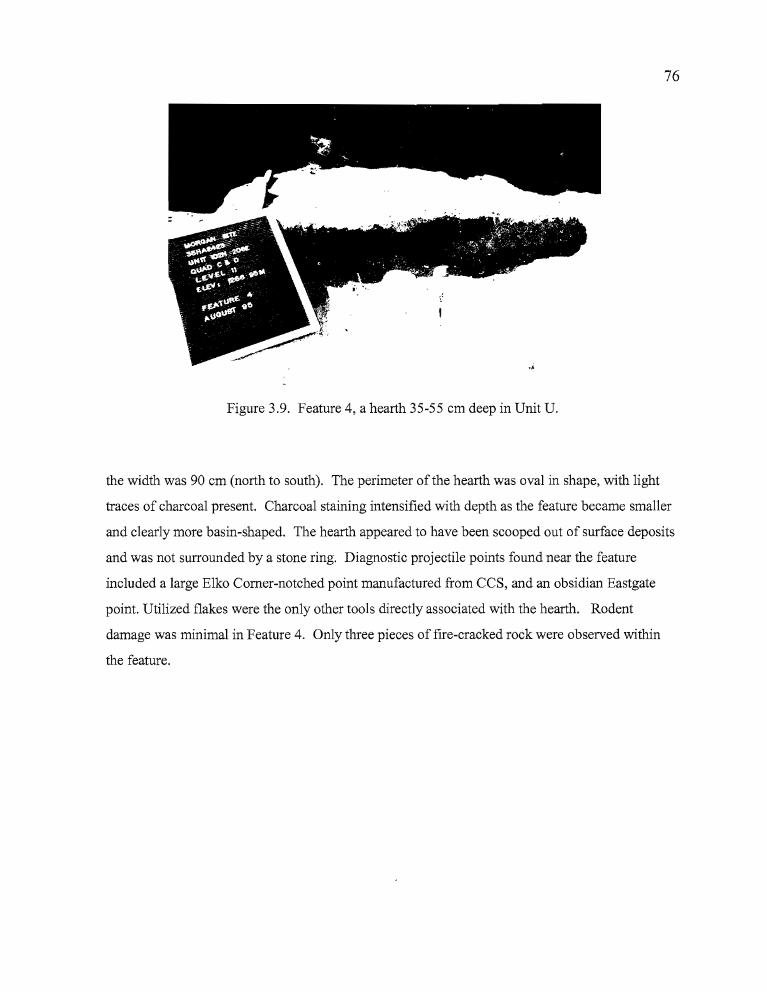
76
Figure 3.9. Feature 4, a hearth 35-55 cm deep in Unit U.
the width was 90 cm (north to south). The perimeter of the hearth was oval in shape, with light
traces of charcoal present. Charcoal staining intensified with depth as the feature became smaller
and clearly more basin-shaped. The hearth appeared to have been scooped out of surface deposits
and was not surrounded by a stone ring. Diagnostic projectile points found near the feature
included a large Elko Comer-notched point manufactured from CCS, and an obsidian Eastgate
point. Utilized flakes were the only other tools directly associated with the hearth. Rodent
damage was minimal in Feature 4. Only three pieces of fire-cracked rock were observed within
the feature.
br
----------.
77
Artifact Assemblage
This section treats all of the flaked stone tools recovered during the excavations,
including bifacial and unifacial tools. Bifacial tools have been subdivided into two categories;
shaped and unshaped bifaces. Shaped specimens show evidence of having been reduced through
percussion and pressure flaking to a distinct form, such as an oval or leaf-shaped preform (among
others), or further into typologically defined tools such as projectile points. The shaped bifacial
tools have been classified according to a system based on five stages of manufacture that was
employed by Jenkins and Connolly (1990). Their system will be outlined in greater detail below.
Unshaped bifaces have bifacial modification of at least one edge of a flake, but have not been
further worked into a more defined shape.
Unifacial tools are those which exhibit intentional edge modification to a single side of
the flake, and generally show a clear pattern of wear from extensive use. Scrapers and notched
spokeshaves fall into this category, reflecting use at an angle transverse to the material being
processed (Jenkins and Connolly 1990).
Edge-modified flakes are those which have been applied to expedient cutting and
scraping tasks. They exhibit wear patterns reflective of systematic use, but have not been
purposefully shaped or modified for use other than by the activity to which they were applied.
Research has shown that trampling of lithic materials can produce patterns of flaking similar to
what has been seen on utilized flakes (McBrearty et al. 1998), so only those flakes with uniform
patterns of flake removal along the edges have been considered for this analysis.
Projectile Points
A total of 16 diagnostic projectile points was recovered from the Morgan site; of which
15 were manufactured from obsidian and one from CCS (Table 3.2, Figure 3.10). The projectile
points have been classified according to the system established by Thomas (1981) for the Monitor
Valley region of central Nevada, with consideration also given to Columbia Plateau typological
sequences proposed by Dumond and Minor (1983). Researchers have suggested possible cultural
78
associations between the Northern Great Basin region and Columbia Plateau populations based
on the lengthy archaeological record of occupations in the basin and a possible late arrival of
Numic speakers into the area (Aikens 1985; Aikens and Witherspoon 1986). The Klamath and
Modoc tribes are both linguistically and culturally tied to the Columbia Plateau and currently
occupy areas adjacent to the Northern Great Basin. Because of this, and the fact that artifacts are
regularly seen in the Northern Great Basin that suggest connections to Plateau cultures, Plateau
typologies need to be considered when Harney Basin projectile points are being analyzed.
Obsidian was the principal material used at the Morgan site. Only one diagnostic point
was made of CCS and none of the points were made from basalt. The projectile points include one
Cottonwood Triangular (6.3%), three Eastgate (19%), three Rose Spring (19%), one Elko Eared
(6.3%), four Elko Comer-notched (25%), and three side-notched (19%). Temporal associations
between these artifact types and radiocarbon dated features across Northern Great Basin
archaeological sites suggest that the Morgan site may have been occupied over the past four
thousand years, several millenia longer than is suggested by the radiocarbon dates. Elko and
Northern Side-notched points were designed for use with the atlatl, or throwing stick, and
Rosegate and Cottonwood Series points were manufactured for use with the bow and arrow, which
probably did not arrive in the region until sometime after 1900 BP (Wegener 1998:17) The
presence ofNorthern Side-notched and Elko points stratigraphically separated from Rose Spring,
Eastgate, and Cottonwood Triangular arrow points in portions ofthe Morgan assemblage probably
indicates that the site was occupied both before and after the arrival ofbow and arrow technology
though the earlier occupation has not been dated.
Cottonwood Series. Cottonwood Series projectiles consist of small unnotched points that occur
after 700 BP. There are two varieties; Cottonwood Triangular, which are small triangular points
that have either a flat or slightly concave base, and Cottonwood Leaf-shaped, which have a
rounded base. Both varieties weigh < 1.5 grams, are not longer than 30 rom, and no thicker than
4.0 rom (Thomas 1981: 16). The Cottonwood Series points are not comparable to any of the
Columbia Plateau artifacts classified by Dumond and Minor (1983). The single obsidian
Cottonwood Triangular point (Specimen 977-23-Y-C-2-1) recovered at the Morgan site has a flat
base with a base width of 12.2 rom, and a thickness of 2.1 rom. The point was broken just above
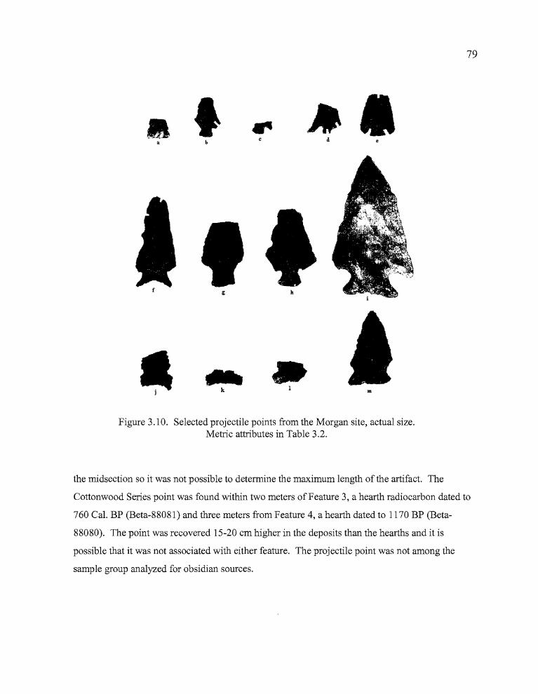
•at ~.
d
79
m
g h
•I
Figure 3.10. Selected projectile points from the Morgan site, actual size.Metric attributes in Table 3.2.
the midsection so it was not possible to determine the maximum length of the artifact. The
Cottonwood Series point was found within two meters of Feature 3, a hearth radiocarbon dated to
760 Cal. BP (Beta-88081) and three meters from Feature 4, a hearth dated to 1170 BP (Beta
88080). The point was recovered 15-20 cm higher in the deposits than the hearths and it is
possible that it was not associated with either feature. The projectile point was not among the
sample group analyzed for obsidian sources.
"!"''' ,
•
80
Rosegate Points. A total of six projectile points can be classified as Rosegate, characterized by
their small size (weight <1.5 grams), expanding stems, and a basal width < 10 mm (Table 3.2).
Thomas (1981:19) lumped the Rose Spring (Lanning 1963) and Eastgate (Heizer and Baumhoff
1961) point types together under one classification, but the two types are clearly dissimilar in both
form and distribution, and in this report, Rose Spring and Eastgate are analyzed separately.
Three Eastgate points were recovered from the Morgan site. Of these, two occurred in the
West Locus between 25 to 80 cm in depth (Specimens 977-23-E-B-6-1 and 977-23-L-A-16-1),
and one in Level 9 (Specimen 977-23-U-D-9-l) of the East Locus. The Eastgate points are
scattered vertically through the cultural deposits, but occur primarily in association with Elko
Comer-notched points both in proximity and elevation, which may suggest that the two projectile
point styles were used concurrently. Two of the Eastgate points were recovered near features. At
the West Locus, an Eastgate point was recovered less than half a meter from Feature 1. At the
East Locus, an Eastgate was collected a similar distance from Feature 4. Both of the Eastgate
points located near features were analyzed for their obsidian sources. The point found near Feature
1 originated from the Bums source, and the point found with Feature 4 is from Dog Hill, near
Bums Butte. The other Eastgate found at the West Locus was not located near a feature.
Three Rose Spring projectile points were collected from the East Locus of the Morgan
site, all from the late component. Two of the points came from depths of 5 to 20 cm in Unit T
(Specimens 977-23-T-B-2-l and 977-23-T-B-4-l)), a lxllocated approximately two meters from
Feature 4. Specimen 977-23-T-B-2-1 was too small for obsidian source characterization.
Specimen 977-23-T-B-4-1 was manufactured from Dog Hill obsidian; a source located near Bums
Butte. The third point (977-23-Y-B-1-1) was found in the first level of Unit Y, approximately two
meters from Feature 3 and about one meter from the Cottonwood Triangular point. This Rose
Spring point is made of obsidian from the nearby Bums source. It is noteworthy that all of the
geochemically identified Rosegate artifacts are from sources that are very close to the site. It is
also interesting that the Rose Spring points were recovered from the first four levels (0-20 cm)
while the Eastgate points, which are generally considered coeval with Rose Spring artifacts, were
not encountered above ca. 30 cm depths.

81
Table 3.2. Metric attributes ofprojectile points: Morgan Site.
Type Catalog no. Length Width Thickness Weight Base Neck Source(977-23) (mm) (mm) (mm) (gr.) Width Width
West LocusEE A-A-4-1 43.3(C) 20.6 5.4 4.2 18.2 12.8 BSSN B-A-1-1 20.3 15.9 3.7 1.2 15.9 11.6 WWREG E-B-6-1 20.9 1.71 3.4 1.2 7.3 6.3 BSSN F-D-6-1 10.5 18.0 4.7 0.8 12.3ECN G-B-6-1 32.9 21.6 6.5 4.2 12.0 11.1 UNECN J-C-7-1 40.0 26.1 4.9 4.1 12.1 8.4 WCEG L-A-16-1 13.3 12.0 3.3 0.4 0.0 0.0ECN M-C-13-1 14.2 22.3 4.5 1.4 0.0 9.4 V
East LocusUpper ComponentRS T-B-2-1 10.8 5.6 2.1 0.2 0.0 0.0RS T-B-4-1 6.8 10.9 2.6 0.2 0.0 0.0 DHRS Y-B-1-1 20.5 13.9 2.3 0.5 7.3 5.8 BCT Y-C-2-1 10.1 11.9 2.1 0.2 11.9 0.0Lower ComponentECN U-B-8-17 1.4(C) 42.1 9.1 23.5 28.3 19.0EG U-D-9-1 16.0 18.0 2.8 0.5 4.7 4.3 DHLSN Y-A-5-1 37.5(C) 21.6 5.6 3.7 22.4 16.5 00
Y-D-8-1 6.5 18.4 4.1 0.4 18.4 9.8 B
CT= COTTONWOODRS= ROSE SPRlNGEG= EASTGATEEE= ELKO EAREDSSN= SMALL SIDE-NOTCHEDLSN= LARGE SIDE-NOTCHED
B=BURNSDH=DOGHILL00= DOUBLE 0UN=UNKNOWNV=VENATORWC= WOLF CREEKWWR= WHITEWATER RIDGE
(C)=COMPLETE
Elko Series Points. There were five Elko Series points collected from the Morgan site; one Elko
Eared and four Elko Comer-notched. All five can be categorized as Elko points, based on the
classification system established by Thomas (1981), or Side Notched-5 under the system
developed by Dumond and Minor (1983: 171). Elko Series points functioned as dart points used
with the atlatl, or throwing stick. Elko Eared points are large, comer-notched dart points with a
deeply indented base that, in conjunction with the comer-notching, form "ears" for hafting the
projectile on to a wooden dart shaft. Elko Corner-notched points are similar in size, weight and
overall morphology to Eared points except that they lack the deep basal indentation that gives the
b
82
eared appearance. The widest portion of the projectile point in both varieties is just forward of the
base. One Elko Comer-notched point collected at the Morgan site was made from CCS, the Eared
point and the rest of the Comer-notched points were made of obsidian.
The Elko Eared tool (977-23-A-A-4-l) and three of the four Comer-notched points
(Specimens 977-23-G-B-6-l, 977-23-J-C-7-l, and 977-23-M-C-13-l) were recovered from the
West Locus, while a single Elko Comer-notched point (977-23-U-B-8-l) came from the East
Locus. As was mentioned previously, Elko Comer-notched points and Eastgate points seem to be
closely associated in the deposits. This is true in both the West and East Loci. The Elko Eared
point was manufactured from Bums obsidian. The Comer-notched points that were analyzed for
their obsidian sources included one from an unknown source, one from Wolf Creek, to the north,
and one from Venator, to the east (see Table 2). Although the sample is very small, Elko Comer
notched points seem to originate further from the Morgan site than Rosegate points, particularly
from the north and east. The fragmented nature of all but one of the points does not permit a
discussion of general morphological attributes.
Side-notched (Large and Small). Thomas (1981: 19) established a single classification for all side
notched points that were not attributable to the Desert Series. This scheme was based on only 15
points available (from the Monitor Valley in central Nevada) at the time of his study. Typological
distinctions between Large Side-notched versus Desert Side-notched points involve a weight that
is > 1.5 grams and a proximal shoulder angle> 150 degrees. This typology is limiting for the
purposes of this report, since the three small projectile points recovered from the Morgan site can
not be comfortably attributed to Northern Side-notched, Thomas' Large Side-notched, or the very
small Desert Side-notched categories. The large side-notched point, on the other hand, does not fit
the Northern Side-notched typology. As a result, the points here are categorized as either large or
small side-notched points, without further attempt to tie them to a Great Basin classification.
The large side-notched point (977-23-Y-A-5-l) was recovered in LevelS of Unit Y at the
East Locus of the Morgan site. It was found less than two meters from Feature 3, a hearth dated to
760 BP, between 30-35 cm in depth. The obsidian point was manufactured from a triangular
preform, with shallow notches placed just above the comers of the base providing almost a comer
83
notched appearance similar to an E1ko point. The point originated from the Double 0 obsidian
source, approximately 50 km southwest of the Morgan Site.
One of the three Small Side-notched points (977-23-Y-D-8-1) was collected from Leve18
ofUnit Y in the East Locus within three meters of Feature 3. The artifact is an obsidian side
notched point base, snapped off at the neck, which appears to have the deeply incised side-notches
and concave base that is characteristic of a "classic" Northern Side-notched point. However, the
fragment is much smaller than would be expected for a Northern Side-notched projectile point,
and the absence of the majority of the artifact restricts further interpretation. The point was
determined to have originated from the Bums obsidian source. The second Small Side-notched
point (977-23-B-A-1-1) was made from Whitewater Ridge obsidian. This fragmentary artifact
consists of the base and a good portion of the midsection. It has a concave base, shallow notches
placed between 0.6-0.7 rom above the base, and serrated edges along the entire length ofboth
sides. The tool was an isolate recovered approximately five meters west from Feature 1, and about
two meters from an E1ko Eared point. The third Small Side-notched base (977-23-F-D-6-1) was
about the same width as the other two, but is thicker in cross section and appears to have been of a
heavier construction. The point fragment was recovered from the screen in Quad D ofUnit F and
it is unclear whether it originated in the reworked trench deposits or the compacted silts adjacent to
the trench. It is noteworthy that Quad D is less than two meters from Feature 1.
Point Fragments
Projectile point fragments consist of finely worked bifacia1 tool fragments that are not
recognizeab1e as diagnostic tools, yet are clearly portions of finished projectile points. A total of
eight projectile point fragments were recovered from the Morgan Site, consisting of six tips, one
midsection and one base (Table 3.3). A midsection and three tips were collected in the West
Locus, and a base and three tips from the East Locus. Only one fragment was manufactured from
CCS (a tip from either a point or a drill); the others were made of obsidian. The tool fragments
found at the Morgan site appear to have been constructed for use with both atlatl and bow and
arrow technology. The six point tips from the Morgan site show considerable variation in size and
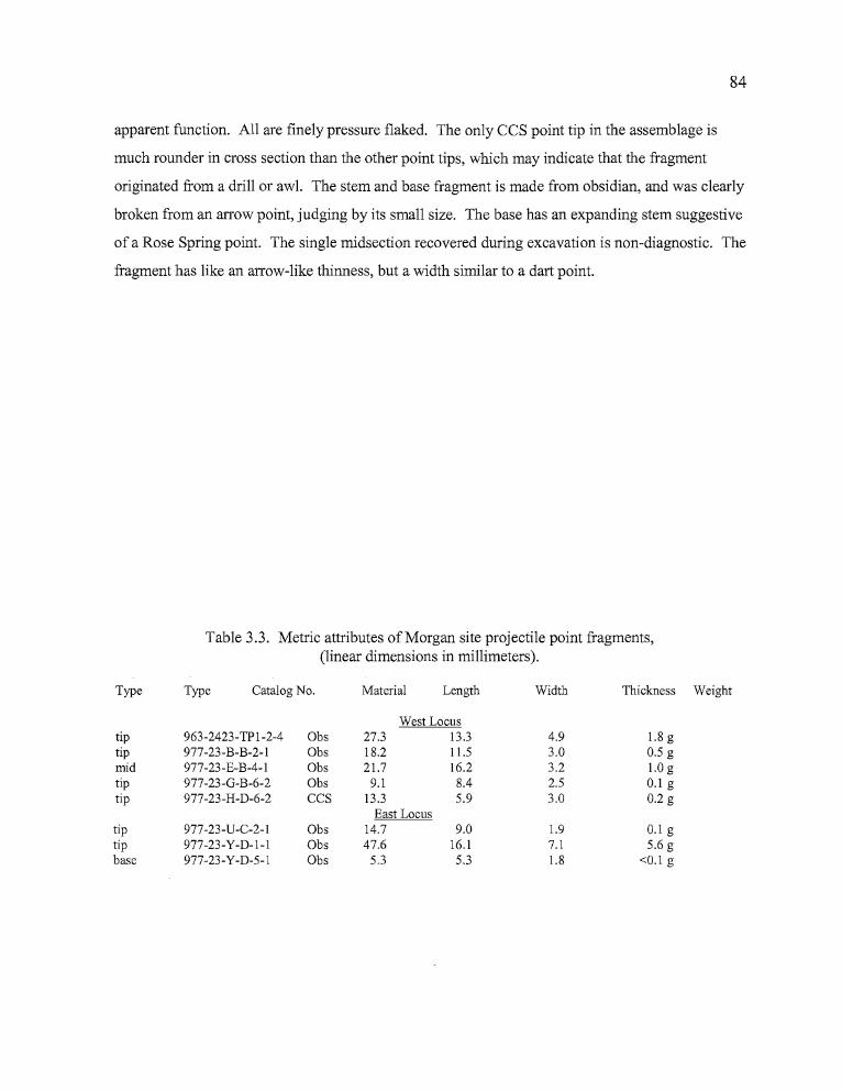
,"I
hh
84
apparent function. All are finely pressure flaked. The only CCS point tip in the assemblage is
much rounder in cross section than the other point tips, which may indicate that the fragment
originated from a drill or awl. The stem and base fragment is made from obsidian, and was clearly
broken from an arrow point, judging by its small size. The base has an expanding stem suggestive
of a Rose Spring point. The single midsection recovered during excavation is non-diagnostic. The
fragment has like an arrow-like thinness, but a width similar to a dart point.
Table 3.3. Metric attributes of Morgan site projectile point fragments,(linear dimensions in millimeters).
Type Type Catalog No. Material Length Width Thickness Weight
West Locustip 963-2423-TP 1-2-4 Obs 27.3 13.3 4.9 1.8 gtip 977-23-B-B-2-1 Obs 18.2 11.5 3.0 0.5 gmid 977-23-E-B-4-1 Obs 21.7 16.2 3.2 1.0 gtip 977-23-G-B-6-2 Obs 9.1 8.4 2.5 0.1 gtip 977-23-H-D-6-2 CCS 13.3 5.9 3.0 0.2 g
East Locustip 977-23-U-C-2-1 Obs 14.7 9.0 1.9 0.1 gtip 977-23-Y-D-l-l Obs 47.6 16.1 7.1 5.6 gbase 977-23-Y-D-5-1 Obs 5.3 5.3 1.8 <0.1 g
itr hz
85
Drills
A single obsidian artifact (977-23-Y-C-4-l) collected from the East Locus may have
functioned as a drill or awl. Either hafted or held between thumb and forefinger, the tool was
twisted back and forth to bore holes in moderately resistant materials.
The artifact consists of the midsection of what originally appears to have been a projectile
point that was broken across the midsection, then flaked on both sides of the tip to create a finer,
narrower point than previously existed. The artifact is smaller and thinner than drills or awls more
commonly seen in similar site assemblages (length 11.1 mm, width 11.5 mm, thickness 3.1 mm),
and it seems more likely that this tool functioned either as a graver for incising, or as an awl for
use with materials less resistant than wood or bone.
Shaped Bifaces
This analysis employs a multistage biface classification system developed by Jenkins and
Connolly (1990, Table 3.4). Since most of the artifacts considered here are large fragmentary
bifaces that may have been preforms for other tools, the individual specimens are classified in
terms of the portion they equate to on a leaf-shaped biface. Tips have pointed ends, and are
thought to be the distal end of the artifact. Bases have rounded or squared convex ends and are
thought to be the proximal portion of the artifact. Not all bifaces have rounded bases and pointed
tips, of course, but it seems most appropriate to emphasize the most common shapes in the artifact
category when only fragments exist (Figure 3.11). The functions of the fragments can only be
implied.
Stage 1 bifaces. These bifaces have thick cross-sections and large, unpatterned flake
scars. The artifacts exhibit only the most rudimentary shaping, with either rounded or lenticular
profiles. The flaking pattern reflects use of the hard hammer percussion technique. Two crude
obsidian biface fragments fit this classification. One fragment is the midsection of a large biface
(Specimen 977-23-M-C-5-1) with a roughly lenticular cross section. One of the fractured ends of
the artifact has a high degree of patination and the other does not, suggesting that the artifact may
have been utilized during two separate episodes. The other fragment (Specimen 977-23-X-D-5-1)
86
is the rounded base of a very crudely shaped medium-sized biface which appears to have been
broken during the initial reduction process.
Stage 2 bifaces. Bifacial thinning was continued on these artifacts through the removal of
contiguous hard hammer percussion flakes. The removal of the flakes resulted in the development
of an artifact, which, although still crudely shaped, has a more pronounced form than Stage 1
artifacts. Stage 2 bifaces are considered to be quarry blanks. A total of seven artifacts fit this
classification; four of obsidian and three of CCS. The four obsidian artifacts are all fragmentary,
consisting of a base, a midsection, and two tips. The base (977-23-U-B-6-6) originally was part of
a large, lanceolate blade with convex edges and a slightly convex base. It has retouched edges that
have been shaped to give the base a squared appearance. The midsection (963-2423-P17-3-l) is
missing the proximal and distal ends and one edge. The removal of broad, thin flakes across the
body resulted in a well-thinned tool, and the single remaining edge appears to have been
retouched. The two obsidian tips (Specimens 963-2423-P33-2-1 and 977-23-Z-C-4-1) have thick,
lenticular profiles and were broken early in the reduction process. The CCS tool is made of brick
red material that is bipointed and has a thin but lenticular shape (Specimen 977-23-C-C-13-1).
The tool has extremely sinuous edges formed by the removal of deep percussion flakes and the
presence of bulbous areas where step-fracturing prevented further removal of lithic material. The
broader of the ends has evidence of rounding and crushing that may be associated with usewear,
but the remainder of the artifact does not appear worn.
Stage 3 bifaces These bifaces exhibit little or no evidence of pressure flaking and have
sinuous edges characteristic of large percussion flake scars created during the initial stages of
bifacial reduction. The entire artifact surface has been modified through the removal of flakes
which can reach the middle of the artifact. Seven obsidian artifacts from the Morgan site fit this
classification, including four bases and three complete artifacts. All of the bases are from large
bifaces and include one which is rounded and two that are rectangular, with straight sides leading
to sharp comers and flat bases. The rounded base (Specimen 977-23-S?-?-1 Backdirt) appears to
have been manufactured using a series of both hard and soft hammer percussion strokes. A
portion of the base is unworked cortex, oval in cross section, and extending slightly outward from
the body of the artifact. The two rectangular bases (Specimens 977-23-Z-C-8-1 and
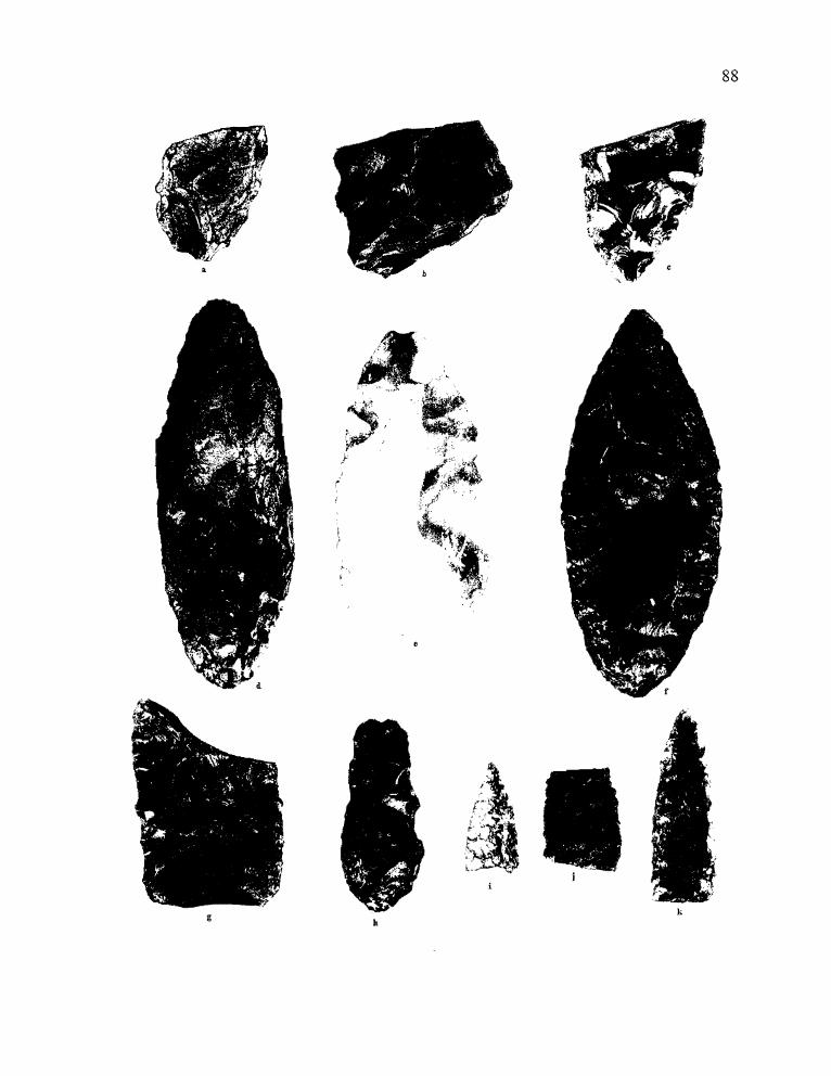
87 88
a
kh
•
'd't 1"['"
- ......,":':;' -~",',
>."
g
Figure 3.11. Selected bifaces from the Morgan site, shown actual size.a. 977-23-X-D-5-1 b. 977-23-M-C-5-1 c. 977-23-Z-C-4-1d. 977-23-C-C-13-1 e. 977-23-U-B-9-1 f. 977-23-F-D-12-1g. 977-23-Z-C-8-1 h. 977-23-C-D-13-1 i. 963-2423-TPI-2-4j. 977-23-J-A-6-1 k. 977-23-Y-D-I-I
*'
89
977-23-Z-D-4-1) are primarily percussion flaked, although some portions of the edges have been
modified through the removal of a series of parallel pressure flakes on both artifacts.
The two CCS tools include a complete tool and a base fragment. The two appear to have
been made from the same deposit of tool stone; a beige colored material with medium-brown
mottling. The artifacts were located within six meters of each other at the East Locus. The
fragmentary piece (Specimen 977-23-Z-D-l 0-1) appears to have been a roughly oval artifact,
broken during the thinning process. The complete biface (Specimen 977-23-U-B-9-1) has a
lanceolate shape with convex edges and a slightly concave base. It is randomly flaked but thin in
cross section, with slightly sinuous edges. The edges show strong evidence of usewear. This
artifact was recovered from Quad B, Level 9, of Unit U, in association with the Elko Comer
notched and Eastgate points adjacent to the 1170 BP hearth.
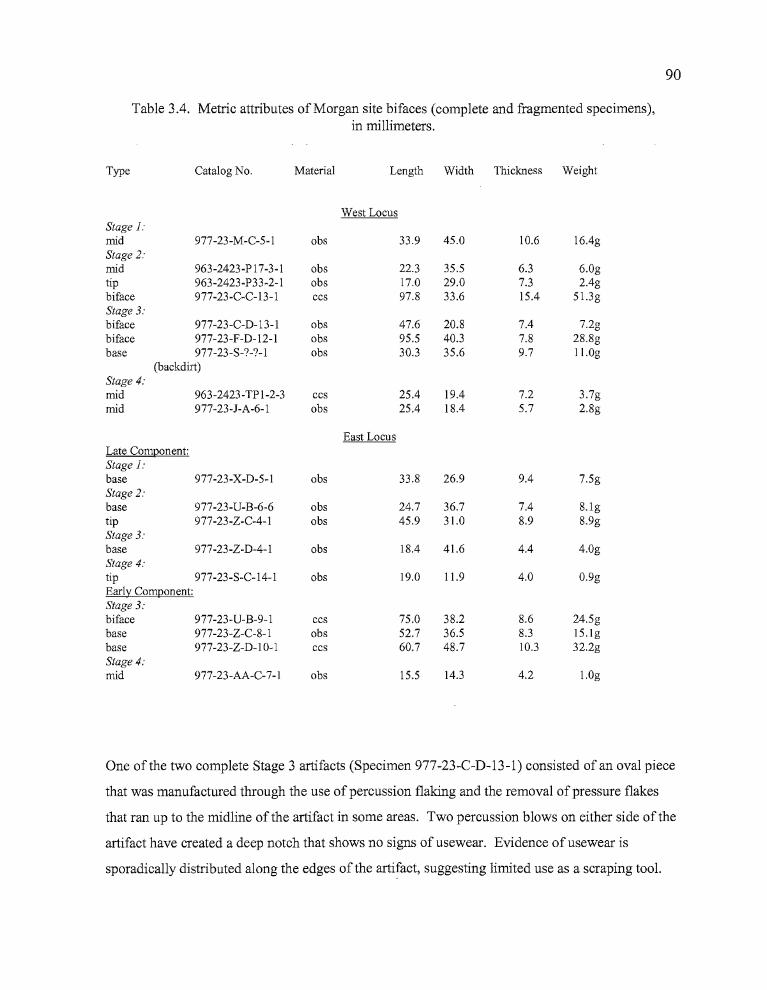
90
Table 3.4. Metric attributes of Morgan site bifaces (complete and fragmented specimens),in millimeters.
Type Catalog No. Material Length Width Thickness Weight
West LocusStage J:mid 977-23-M-C-5-1 obs 33.9 45.0 10.6 16.4gStage 2:mid 963-2423-P 17-3-1 obs 22.3 35.5 6.3 6.0gtip 963-2423-P33-2-1 obs 17.0 29.0 7.3 2.4gbiface 977-23-C-C-13-1 ccs 97.8 33.6 15.4 51.3gStage 3:biface 977-23-C-D-13-1 obs 47.6 20.8 7.4 7.2gbiface 977-23-F-D-12-1 obs 95.5 40.3 7.8 28.8gbase 977-23-S-?-?-1 obs 30.3 35.6 9.7 11.0g
(backdirt)Stage 4:mid 963-2423-TPI-2-3 ccs 25.4 19.4 7.2 3.7gmid 977-23-J-A-6-1 obs 25.4 18.4 5.7 2.8g
East LocusLate Component:Stage J:base 977-23-X-D-5-1 obs 33.8 26.9 9.4 7.5gStage 2:base 977-23-U-B-6-6 obs 24.7 36.7 7.4 8.lgtip 977-23-Z-C-4-1 obs 45.9 31.0 8.9 8.9gStage 3:base 977-23-Z-D-4-1 obs 18.4 41.6 4.4 4.0gStage 4:tip 977-23-S-C-14-1 obs 19.0 11.9 4.0 0.9gEarly Component:Stage 3:biface 977-23-U-B-9-1 ccs 75.0 38.2 8.6 24.5gbase 977-23-Z-C-8-1 obs 52.7 36.5 8.3 15.lgbase 977-23-Z-D-IO-l ccs 60.7 48.7 10.3 32.2gStage 4:mid 977-23-AA-C-7-1 obs 15.5 14.3 4.2 LOg
One of the two complete Stage 3 artifacts (Specimen 977-23-C-D-13-1) consisted of an oval piece
that was manufactured through the use of percussion flaking and the removal of pressure flakes
that ran up to the midline of the artifact in some areas. Two percussion blows on either side of the
artifact have created a deep notch that shows no signs of usewear. Evidence of usewear is
sporadically distributed along the edges of the artifact, suggesting limited use as a scraping tool.
91
Specimen 977-23-F-D-12-1 is a nicely crafted blade that may have served as a knife. Long, thin
flakes driven across the body of the artifact have created a uniformly thin tool with a pointed tip,
broadly convex sides, and a sharply rounded base. The removal ofpressure flakes around the
entire perimeter of the knife has resulted in a strong uniform edge that has signs ofusewear on all
portions. The artifact was found near Feature 2 (the groundstone cluster).
Stage 4 hifaces The use ofboth percussion and pressure flaking techniques results in
bifaces with a more "finished" appearance than Stage 3 items. Flakes can reach the midline of the
artifact or beyond, and frequently eliminate the large percussion scars from earlier reduction
processes. Edges are strengthened by the removal ofpressure flakes which increase the edge
angle. Four Stage 4 artifacts were collected from the Morgan site, including one obsidian tip and
three midsections; one of which was CCS, the other two obsidian. Two of the midsections,
including the CCS fragment (963-2423-TPl-2-3), were tool fragments that had been broken across
the body of the artifact and at the midline, leaving a single edged remnant. The third midsection
(Specimen 977-23-J-A-6-1) was missing the tip and base. It had a thin, lenticular cross-section,
with diagonal pressure flaking running across the artifact on one side, and a combination of
pressure and percussion flaking on the other. The tip (977-23-S-C-14-1) was haphazardly pressure
flaked and clearly not a completed tool at the time it was broken. All five stages ofbiface
reduction were apparent at the West Locus, and in the late component at the East Locus. In the
early component at the East Locus, only Stage 3 and 4 artifacts were present, which seems to
indicate that initial reduction practices were occurring at a location removed from the Morgan site.
Edge-Modified Flakes
A total of 51 artifacts exhibit use wear characteristic of utilized flakes. Of these, seven are
bifacially worked specimens and three can be classified as spokeshaves. There were seven CCS,
one basalt, and 42 obsidian tools in the assemblage. One of the CCS tools was bifacially worked.
The other six CCS tools and the single basalt tool were unifaces.
r"
92
The highest concentrations of utilized flakes were found in the units of the East Locus, particularly
from the area nearest to Feature 4. Unit W produced eight, ofwhich one was a steep-edged
scraping tool.
Two of the three spokeshaves are manufactured from obsidian. Specimen (977-23-Q-C-2
1) has a single crescent-shaped indentation that is unifacial, with very few use-generated pressure
flakes removed from the edge, suggesting that the artifact was used only for a short time.
Specimen (977-23-J-C-6-1) has two indentations located along the longest edge of the tool. The
notches are unifacial, with the two worn edges on opposite sides of each other. A third tool 977
23-C-D-12-2, is manufactured from an orangish-brown tabular CCS cobble 145.1 mm in length,
67.2 mm in width, and 18.5 mm thick. The spokeshave has a single notch that is approximately
38.5 mm wide by 12.7 mm deep and large flakes have been driven off of one side only, suggesting
that scraping occurred in only one direction. This artifact would be suitable for the manufacture or
maintenance of digging sticks.
Two artifacts (Specimens 977-23-N-B-7-1 and 977-23-W-A-5-1) are steep-edged scrapers,
both of which are bifacially flaked. The steep side has an edge angle that was initially established
by pressure flaking, then enhanced through repeated use. The opposite side has incidental,
unpatterned flaking that appears to be the result of use wear. The tools have obviously been
prepared to some degree, but lack the deliberate shaping and edge modification of scrapers from
other sites in the region, such as those reported from the Headquarters Site (Dugas and Bullock
1994:40
Cores
Five cores were collected at the site; three in the West Locus and two in the East Locus.
Of these, three are CCS, one is obsidian, and one is basalt. Two of the CCS cores were excavated
from adjoining units and appear to have originated from the same deep brown source material.
One of these, Specimen 977-23-B-B-9-1, is a small triangular core which has had six flakes
removed from one side. The second core is a large tabular specimen that was broken into at least
three pieces, ofwhich two were recovered (Specimens 977-23-C-D-ll-l, and 977-23-D-D-12-l).
Small flakes were removed around the sides, and larger flakes at an oblique angle to one of the
------- ----------
93
planar surfaces. Specimen 977-23-L-D-7-l is roughly half of a broken obsidian nodule, with
flakes removed across the exposed surface and perpendicular along one edge. Specimen 977-23
Y-C-7-3 is a fine grained basalt nodule from which at least four large flakes have been removed at
varying angles. Specimen 977-23-W-B-3-l is a six-sided core made ofa light orange-colored
CCS. Flakes have been removed from all sides of the artifact.
Debitage
A total of 51 08 pieces of obsidian debitage was analyzed; comprising the entire obsidian
sample from the Morgan site (Figure 3.12). Mass analysis (Ahler 1986, 1989) was conducted by
passing the debitage through a series ofnested screens. The apertures of the screens were G1,
1"(35.9 mm); G2, Yz" (18.0 mm); G3, W' (8.0 mm), and G4, 1/8" (3.6 mm). The flakes from each
screen were counted, weighed, and examined for the presence of exterior cortex (Table 3.5). The
data derived through the mass analysis process permits interpretations regarding lithic reduction
activities ocurring at an archaeological site primarily through the quantification of size grades (see
Ahler 1989; or Connolly 1999 for more detailed explication). The greatest quantity of debitage
was recovered in the G4 screen, accounting for 78.1 % of the total (3987 flakes). Grade G3 yielded
882 flakes, or 17.3%, and 227 flakes were collected in the G2 screen for 4.4 % of the total. A total
of 12 flakes was recovered from the Size G1 screen, representing 0.2% of the debitage. Cortex
flakes were limited in number (143 flakes, or 2.6% of the sample.
As can be seen in Tables 3.5 and 4.11, the percentage distributions of debitage counts and
cortex flakes are quite similar between the Hoyt and Morgan sites. The percentage of debitage
weight for the G1 class is considerably higher at the Morgan site than at the Hoyt site, but the
disparity decreases in the G3 and G4 classes. The Morgan site G1 artifacts average 22.85 g/flake
while those from the Hines site average 15.24 g/flake. In the G2 and G3 classes, Morgan flakes
average 2.7 g and 0.36 g respectively, while Hoyt flakes average 1.94 g and 0.26 g respectively.
The G4 flakes from both sites average 0.04 g. Because the G1 total is 12 flakes (a small sample
size), the difference may simply mean that a few large nodules, cores, or quarry blanks were
transported to the Morgan site for use.
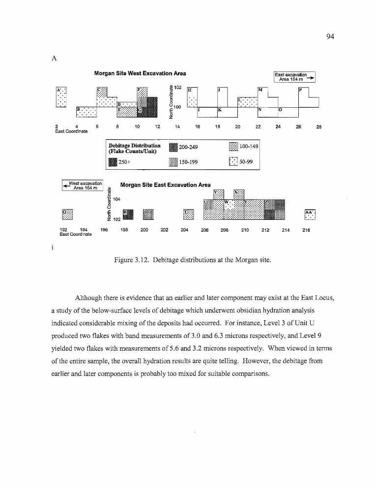
94
A
Morgan Site West Excavation Area
flU
J
K
M
L.·.·.·.N
246East Coordinate
8 10 12 14 16 18 20 22 24 26 28
Debitage Distribution(Flake CountslUnit)
111 250+
111200-249
1m 150-199
EllOO-149
0 50-99
[ill..........:.:.:.:
+-West excavationArea 164 m
~~
Morgan Site East Excavation Area*l<::
'E 104o8
~ 102;1 [III192 194 196East Coordinate
198 200 202 204 206 208 210 212 214 216
Figure 3.12. Debitage distributions at the Morgan site.
Although there is evidence that an earlier and later component may exist at the East Locus,
a study of the below-surface levels of debitage which underwent obsidian hydration analysis
indicated considerable mixing of the deposits had occurred. For instance, Level 3 of Unit U
produced two flakes with band measurements of 3.0 and 6.3 microns respectively, and Level 9
yielded two flakes with measurements of5.6 and 3.2 microns respectively. When viewed in terms
of the entire sample, the overall hydration results are quite telling. However, the debitage from
earlier and later components is probably too mixed for suitable comparisons.
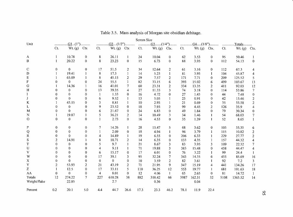
Table 3.5. Mass analysis of Morgan site obsidian debitage.
Screen SizeUnit ...............Gl ...(I")........... ..............G2....(l/2")........... ..............G3 .......(1/4")........ ..............G4.....(1/8").......... ..............Totals..........
Ct. Wt. (g) Ctx Ct. Wt. (g) Ctx Ct. Wt. (g) Ctx. Ct. Wt. (g) Ctx. Ct. Wt. (g) Ctx.
A 1 10.78 0 8 26.11 1 24 10.04 0 62 3.53 0 95 50.46 1B I 20.22 0 8 23.23 0 15 6.73 0 88 3.95 0 112 54.13 0
C 0 0 0 17 51.5 2 34 12.64 2 61 3.16 0 112 67.3 4D I 19.41 I 8 17.3 I 14 5.23 1 81 3.93 1 104 45.87 4E I 65.09 1 8 45.15 2 29 7.57 2 171 7.71 0 209 125.52 5F 0 0 0 24 55.5 I 82 33.15 6 393 15.02 6 499 103.67 13G I 14.36 I 16 41.01 7 60 23.31 2 334 13.35 2 411 92.03 12H 0 0 0 13 39.35 4 27 11.33 3 74 3.18 0 114 53.86 7I 0 0 0 1 1.33 0 16 4.72 0 27 1.43 0 44 7.48 0J 0 0 0 6 9.52 I 13 5.03 I 23 0.91 0 42 15.46 2K 1 43.15 0 3 8.81 1 10 2.93 I 21 0.69 0 35 55.58 2L 0 0 0 9 23.52 0 18 7.93 2 99 4.45 2 126 35.9 4M. 0 0 0 6 21.67 0 24 6.83 0 49 1.84 0 79 30.34 0N I 19.87 I 5 36.21 2 14 10.49 3 34 1.46 1 54 68.03 70 0 0 0 I 2.73 0 16 4.53 0 35 1.39 I 52 8.65 1
P 0 0 0 7 14.26 I 28 15.47 5 68 3.62 0 103 33.35 6
Q 0 0 0 I 2.09 0 18 4.94 1 96 3.79 1 115 10.82 2R 0 0 0 4 14.89 I 19 6.55 0 206 6.33 1 229 27.77 2S 2 14.91 1 8 18.71 2 14 6.35 0 133 4.35 I 157 44.32 4T 0 0 0 5 9.7 I 21 8.67 3 83 3.95 3 109 22.32 7U 0 0 0 4 9.11 1 71 19.88 3 383 15.48 0 458 44.47 4V 0 0 0 6 15.17 0 17 6.01 0 76 3.22 1 99 24.4 IW 0 0 0 17 39.1 3 95 32.24 7 343 14.35 6 455 85.69 16X 0 0 0 0 0 0 10 3.59 2 82 3.61 I 92 7.2 3y 2 53.93 2 21 43.19 2 71 21.95 9 347 15.19 4 441 134.26 17Z I 12.5 0 17 33.11 5 110 36.25 12 553 19.77 I 681 101.63 18AA 0 0 0 4 8.01 0 12 4.06 I 65 2.65 0 81 14.72 1Totals 12 274.22 7 227 610.28 38 882 318.42 66 3987 162.31 32 5108 1365.52 14Weightlflake 22.85 2.7 0.36 0.04
Percent 0.2 20.1 5.0 4.4 44.7 26.6 17.3 23.3 46.2 78.1 11.9 22.4\DVI
1
96
Ground Stone Tools
A total of 18 ground stone tools were collected at the Morgan site, accounting for 16% of
the tool assemblage (Table 3.6). The abundance of ground stone is one the most distinctive
features of the Morgan site. In comparison, ground stone accounted for only 6 % of the tools at
both the Hoyt and Hines sites.
The tools included 13 manos (68%), three metate fragments (16%), two abraders (11 %),
and one unidentified cylindrical tool fragment (5%). Eleven of the artifacts (58%) have substantial
use wear in the form of well-polished grinding surfaces. Seven of the tools exhibit additional
workmanship in the forms of multi-faceted, well shaped grinding surfaces on the manos, and
pecked, symmetrical edges associated with flat, polished grinding surfaces on two of the three
metates. The abundance and quality of the ground stone at the Morgan site may reflect periodic
occupations of the camp for activities requiring the intensive use of milling stones; perhaps for
either root or seed processing.
Seven complete manos were recovered from the Morgan site. The three manos from Unit
G have already been described as Feature 2 above. An additional three manos (963-2423-SF2,
977-23-C-C-15-l, and 977-23-P-D-9-1) exhibited bifacial grinding surfaces, and like the manos
from Feature 2, had edges shaped by pecking (Figure3.14). Specimen 963-2423-SF2 is a large
mano with a unifacial grinding surface stained by reddish and gray materials along its leading
edge. The gray staining appears as a discoloration of the worked surface that dissipates without a
clear boundary. The reddish material has a granular texture and occupies a small, well defined
area of the grinding surface, overlapping a portion of the gray staining.
Two edge fragments and one interior fragment of metates were collected. Specimen 977
23-P-A-11-2 was from a bifacial milling stone with an apparently symmetrical, rounded rim
(Figure 3.13). Specimen 963-2423-TP2-3-2, another bifacial metate fragment, had a squared edge
that was quite symmetrical. The interior fragment (977-23-Y-C-7-1) appears to be from a second
bifacial metate, and one side has been worn concave through use.
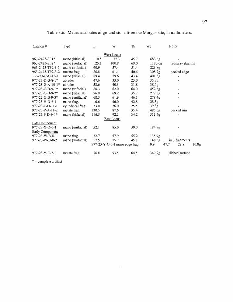
br
97
Table 3.6. Metric attributes of ground stone from the Morgan site, in millimeters.
Catalog # Type L W Th Wt Notes
West Locus963-2423-SFI * mano (bifacial) 110.5 77.3 45.7 683.6g963-2423-SF2* mana (unifacial) 125.1 100.8 69.0 1180.6g red/gray staining963-2423-TP2-3-1 mana (trifacial) 60.9 57.4 51.4 223.8g963-2423-TP2-3-2 metate frag. 86.8 61.1 40.6 308.7g pecked edge977-23-C-C-15-1 mana (bifacial) 89.4 79.6 43.4 401.5g977-23-D-B-8-1 * abrader 47.6 33.0 25.0 35.8g977-23-G-A-IO-l * abrader 58.6 40.3 31.8 38.6g977-23-G-B-9-1 * mana (trifacial) 88.3 62.0 64.0 452.6g977-23-G-B-9-2* mana (bifacial) 76.9 69.2 35.7 277.5g977-23-G-B-9-3* mana (unifacial) 68.5 61.9 46.1 278.4g977-23-H-D-6-1 mana frag. 16.6 46.0 42.8 28.3g977-23-L-D-II-I cylindrical frag. 33.0 26.0 25.5 39.3g977-23-P-A-II-2 metate frag. 130.5 87.6 35.4 485.0g pecked rim977-23-P-D-9-1 * mana (bifacial) 116.5 92.3 34.2 553.6g
East LocusLate Component977-23-X-D-6-1 mana (unifacial) 52.1 85.0 39.0 184.7gEarly Component977-23-W-B-8-1 mana frag. 32.7 57.9 55.2 135.9g977-23-W-B-8-2 mana (unifacial) 57.5 75.7 45.1 148.6g in 3 fragments
977-23-Y-C-5-1 mano edge frag. 9.9 47.7 29.8 10.Og
977-23-Y-C-7-1 metate frag. 76.8 53.5 64.5 349.9g dished surface
* = complete artifact
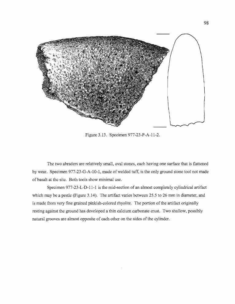
~.I
D
98
Figure 3.13. Specimen 977-23-P-A-1l-2.
The two abraders are relatively small, oval stones, each having one surface that is flattened
by wear. Specimen 977-23-G-A-10-1, made of welded tuff, is the only ground stone tool not made
ofbasalt at the site. Both tools show minimal use.
Specimen 977-23-L-D-11-1 is the mid-section of an almost completely cylindrical artifact
which may be a pestle (Figure 3.14). The artifact varies between 25.5 to 26 mm in diameter, and
is made from very fine grained pinkish-colored rhyolite. The portion of the artifact originally
resting against the ground has developed a thin calcium carbonate crust. Two shallow, possibly
natural grooves are almost opposite of each other on the sides of the cylinder.
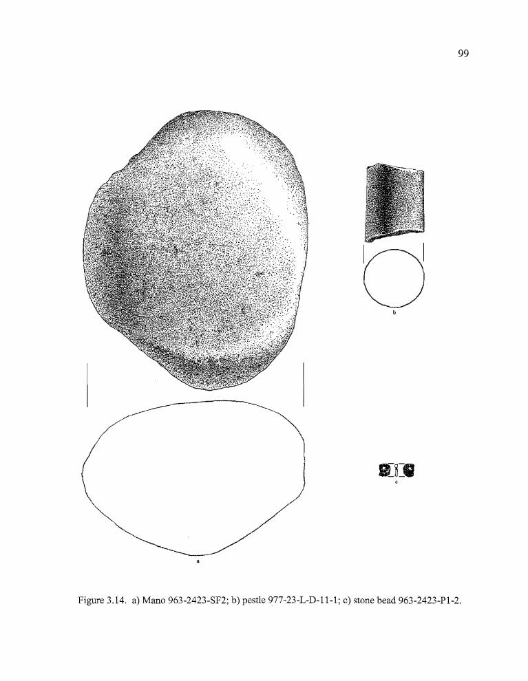
99
b
Figure 3.14. a) Mana 963-2423-SF2; b) pestle 977-23-L-D-11-1; c) stone bead 963-2423-Pl-2.
> •
100
Miscellaneous Lithic Artifacts
Stone Bead
A single stone disc bead (963-2423-Pl-2) was recovered from a depth of 10-20 cm in
Probe 1 during the testing phase (Figure 3.14). The bead has a generally oval shape, excepting a
portion which has been broken from one side above the perforation. The type of stone that was
used in its manufacture has not been identified. The artifact is 5.5 mm long, by 4.8 mm wide (the
broken side), by 0.9 mm thick. The biconically drilled hole is approximately 1.7 mm in diameter.
Probe 1 was located on the south side of the highway, in an area where artifact concentrations were
minimal and excavations were not pursued beyond the testing phase. Elston et al. (1993:33)
reported two stone disc beads from 35HA2222, a site on the west edge of Malheur Lake. One was
manufactured from a "schist-like" material and the other from sandstone. Raymond (1994:77)
noted a stone disc bead at Harney Dune, on the east side of Harney Lake. No radiocarbon dates
were assayed on the cultural components at either site.
Hammer Stones
Two artifacts from the Morgan site appear to be hammerstones. They were collected in
Unit F, quad D, less than two meters from Feature 1. Both are large cobbles with one or more
surfaces that show evidence of abrading, chipping, and battering possibly related to lithic
reduction or plant and animal processing activities. Specimens 977-23-F-D-11-1 (CCS) and 977
23-F-D-11-2 (basalt) were found in close association and may be related to a specific activity area
located near Feature 1.
• •
101
Choppers
One large, roughly half-moon shaped fragment of a CCS nodule (Specimen 977-23-G-D
2-1) exhibits flaking consistent with short term use as a chopping tool. The artifact essentially has
four sides. The top and bottom are planar surfaces of the exposed nodule interior, and one side is
a wide, straight band of the interior rock with sharply angled edges. The fourth side is a thick,
rounded band of cortex. One of the long edges shows light percussion flaking that was most likely
caused by chopping activity with an up and down motion of the hand. The other straight edge has
a high degree of edge rounding that may also be associated with use wear.
Faunal Remains
Faunal remains from the Morgan site were analyzed by Vivien Singer of the Oregon State
Museum of Anthropology. A total of 3010 vertebrate remains and five pieces of eggshell were
identified (Figure 3.15), utilizing the comparative collection housed at the Museum and the
comparative bird collection at the offices of Heritage Research Associates in Eugene. All faunal
remains were identified to the lowest possible taxanomic level. Some of the mammalian remains
were identifiable only to broad size classes due to their highly fragmented state (see Table 3.7).
Singer categorized all postcranial rodent remains as "Unidentified Rodentia" because of the
difficult, labor intensive nature of identifying an abundance of small rodent remains to a variety of
similar species. The specimens were quantified through the use of the number of identifiable
specimens per taxon (NISP) as described in Grayson (1984) and taxonomic designations are based
on Corbet and Hill (1991). The specimens were examined further for cultural evidence of burning
and/or butchering and skinning marks, and natural alterations caused by rodent and carnivore
gnawmarks, weathering, and natural attrition. Such evidence may provide information about both
the taphonomic history of the remains and possible subsistence practices of the occupants at the
site.
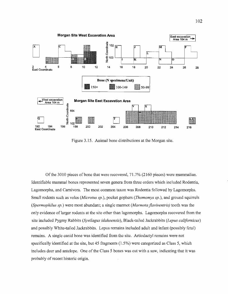
102
Morgan Site West Excavation Area East excavationArea 164m -..
28262422201812108246East Coordinate
[
Bone (N specimenslUnit)
II 150+ III 100-149 00 5099tliliill -
Morgan Site East Excavation Area
216214212210208206D
204202200
~t:
'E 104o8~mZ 102 m
196 198
~VVestexcavationArea 164 m
EJ192 194East Coordinate
Figure 3.15. Animal bone distributions at the Morgan site.
Of the 3010 pieces of bone that were recovered, 71.7% (2160 pieces) were mammalian.
Identifiable mammal bones represented seven genera from three orders which included Rodentia,
Lagomorpha, and Carnivora. The most common taxon was Rodentia followed by Lagomorphs.
Small rodents such as voles (Microtus sp.), pocket gophers (Thomomys sp.), and ground squirrels
(Spermophilus sp.) were most abundant; a single marmot (Marmota jlaviventris) tooth was the
only evidence of larger rodents at the site other than lagomorphs. Lagomorphs recovered from the
site included Pygmy Rabbits (Syvilagus idahoensis), Black-tailed Jackrabbits (Lepus cali/omicus)
and possibly White-tailed Jackrabbits. Lepus remains included adult and infant (possibly fetal)
remains. A single canid bone was identified from the site. Artiodactyl remains were not
specifically identified at the site, but 45 fragments (1.5%) were categorized as Class 5, which
includes deer and antelope. One of the Class 5 bones was cut with a saw, indicating that it was
probably of recent historic origin.
• •
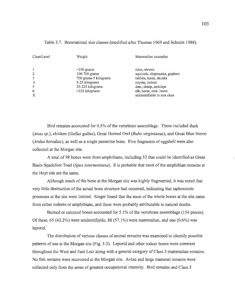
rrI
103
Table 3.7. Bone/animal size classes (modified after Thomas 1969 and Schmitt 1988).
Class/Level
123456X
Weight
<100 grams100-700 grams700 grams-5 kilograms5-25 kilograms25-225 kilograms>225 kilograms
Mammalian examples
mice, shrewssquirrels, chipmunks, gophersrabbits, hares, skunkscoyote, bobcatdeer, sheep, antelopeelk, horse, cow, bisonunidentifiable to size class
D •
Bird remains accounted for 0.5% of the vertebrate assemblage. These included duck
(Anas sp.), chicken (Gallus gallus), Great Homed Owl (Bubo virginianus), and Great Blue Heron
(Ardea herodias), as well as a single passerine bone. Five fragments of eggshell were also
collected at the Morgan site.
A total of 98 bones were from amphibians, including 53 that could be identified as Great
Basin Spadefoot Toad (Spea intermontana). It is probable that most of the amphibian remains at
the Hoyt site are the same.
Although much ofthe bone at the Morgan site was highly fragmented, it was noted that
very little destruction of the actual bone structure had occurred, indicating that taphonomic
processes at the site were limited. Singer found that the most of the whole bones at the site came
from either rodents or amphibians, and these were probably attributable to natural deaths.
Burned or calcined bones accounted for 5.1 % of the vertebrate assemblage (154 pieces).
Of these, 65 (42.2%) were unidentifiable, 88 (57.1 %) were mammalian, and one (0.6%) was
leporid.
The distribution of various classes of animal remains was examined to identify possible
patterns of use at the Morgan site (Fig. 3.3). Leporid and other rodent bones were common
throughout the West and East Loci along with a general category of Class 3 mammalian remains.
No fish remains were recovered at the Morgan site. Avian and large mammal remains were
collected only from the areas of greatest occupational intensity. Bird remains and Class 5
R b
104
mammalian remains were found in Units C-G surrounding Feature 1 in the West Locus, and Class
5 remains came from Units U, W, and Y of the east Locus where Features 3 and 4 were located.
Bird bones were recovered from a depth of 15 to 45 cm in Unit C, and 10 to 55 cm in Unit D of
the West Locus. Only four bird bones were identified at the East Locus. Class 5 bones were
recovered from 20 to 80 cm in depth in Unit F, and 20-50 cm in depth in Unit G at the West
Locus. Large mammal bone was found at a depth of 15 to 30 cm in Unit U, and 20 to 40 cm
below the surface in Unit W of the East Locus. Two fragments were recovered 10 to 15 cm in
depth from Unit Y. The large mammal bone appears to be associated with the late component in
Unit U, and with the early component in Units Wand Y.
The highest concentrations ofbone at the Morgan site occurred in Unit G and Quad D of
Unit F, where the total amount ofbone per quadrant exceeded 150 pieces (Figure 3.7). Bone
counts at the East Locus never surpassed 50 pieces per quadrant.
For the most part, the varieties and quantities of animal remains were quite similar
between the Early and Late Component at the East Locus. Lepus (Hare) remains are the one
exception, with 62 of the 63 specimens (98%) having been recovered from the Late Component.
Verts and Carroway (1998) note that, while Black-tailed Jackrabbits (Lepus californicus) can be
found in a variety of environments, they commonly inhabit locations which provide a combination
of open grasslands for night time foraging and dense cover (such as Artemesia tridentata) for
daytime refuge. The possible inclusion of recent bone in the sample may account for some of the
increase in Lepus remains, but it seems evident that the area became more attractive to Lepus
populations late in the Holocene.
In summary, the faunal assemblage at the Morgan site suggests that a variety of small
mammal species (particularly rodents and lagomorphs) were being taken during all periods of
occupation even if the possible presence of modem bone and naturally deposited remains are taken
into account. Fish were not a component in the diet of the inhabitants at any time, and bird
remains were very limited. Seasonal indicators included five pieces of eggshell and the presence
of immature leporid specimens, which may be indicative of late spring to early summer use.
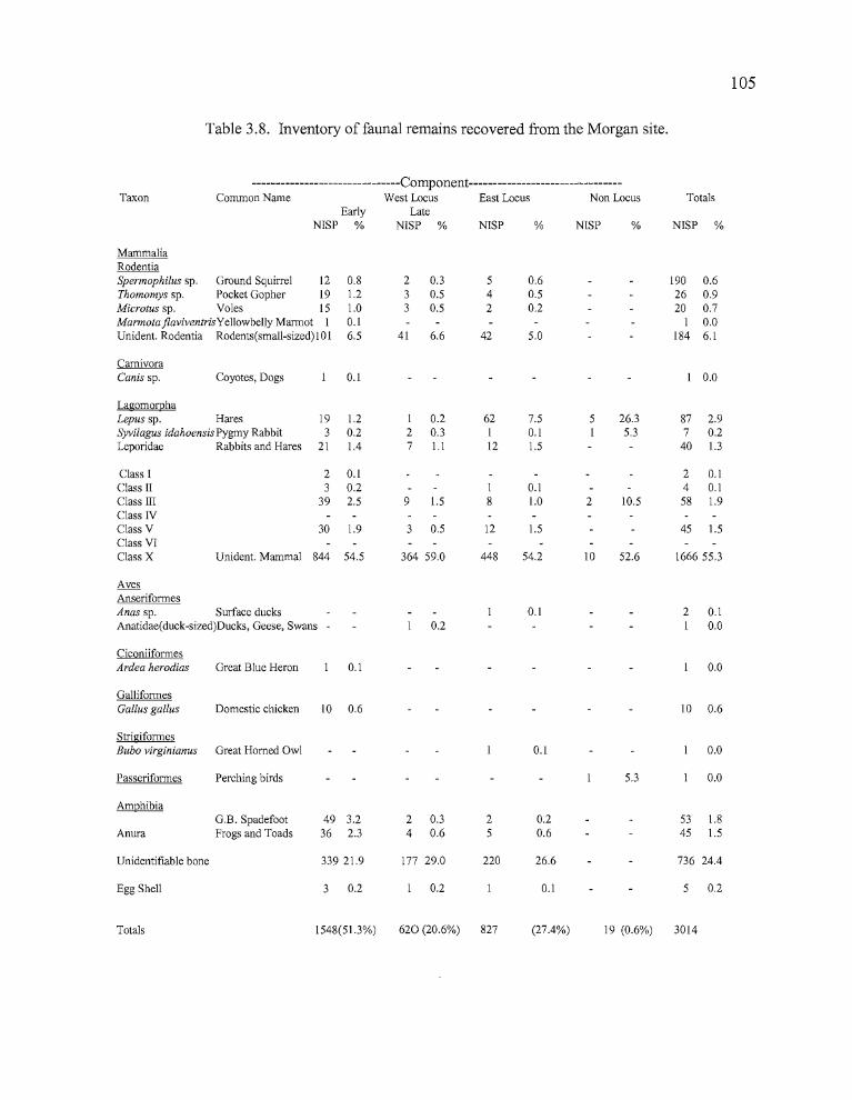
105
Table 3.8. Inventory of faunal remains recovered from the Morgan site.
-------------------------------Component--------------------------------Taxon Common Name West Locus East Locus Non Locus Totals
Early LateNISP % NISP % NISP % NISP % NISP %
MammaliaRodentiaSpermophilus sp. Ground Squirrel 12 0.8 2 0.3 5 0.6 190 0.6Thomomys sp. Pocket Gopher 19 1.2 3 0.5 4 0.5 26 0.9Microtus sp. Voles 15 1.0 3 0.5 2 0.2 20 0.7Marmota jlaviventrisYellowbelly Marmot I 0.1 I 0.0Unident. Rodentia Rodents(small-sized) IaI 6.5 41 6.6 42 5.0 184 6.1
CarnivoraCanis sp. Coyotes, Dogs 0.1 I 0.0
LagomorphaLepus sp. Hares 19 1.2 I 0.2 62 7.5 5 26.3 87 2.9Syvilagus idahoensis Pygmy Rabbit 3 0.2 2 0.3 I 0.1 I 5.3 7 0.2Leporidae Rabbits and Hares 21 1.4 7 l.l 12 1.5 40 1.3
Class I 2 0.1 2 0.1Class II 3 0.2 I 0.1 4 0.1Class III 39 2.5 9 1.5 8 1.0 2 10.5 58 1.9Class NClass V 30 1.9 3 0.5 12 1.5 45 1.5Class VIClass X Unident. Mammal 844 54.5 364 59.0 448 54.2 10 52.6 1666 55.3
AvesAnseriformesAnas sp. Surface ducks 0.1 2 0.1Anatidae(duck-sized)Ducks, Geese, Swans 0.2 I 0.0
CiconiiformesArdea herodias Great Blue Heron 0.1 0.0
GalliformesGallus gallus Domestic chicken 10 0.6 10 0.6
StrigiformesBubo virginianus Great Horned Owl 0.1 0.0
Passeriformes Perching birds 5.3 0.0
AmphibiaG.B. Spadefoot 49 3.2 2 0.3 2 0.2 53 1.8
Anura Frogs and Toads 36 2.3 4 0.6 5 0.6 45 1.5
Unidentifiable bone 339 21.9 177 29.0 220 26.6 736 24.4
Egg Shell 3 0.2 0.2 0.1 5 0.2
Totals 1548(51.3%) 620 (20.6%) 827 (27.4%) 19 (0.6%) 3014
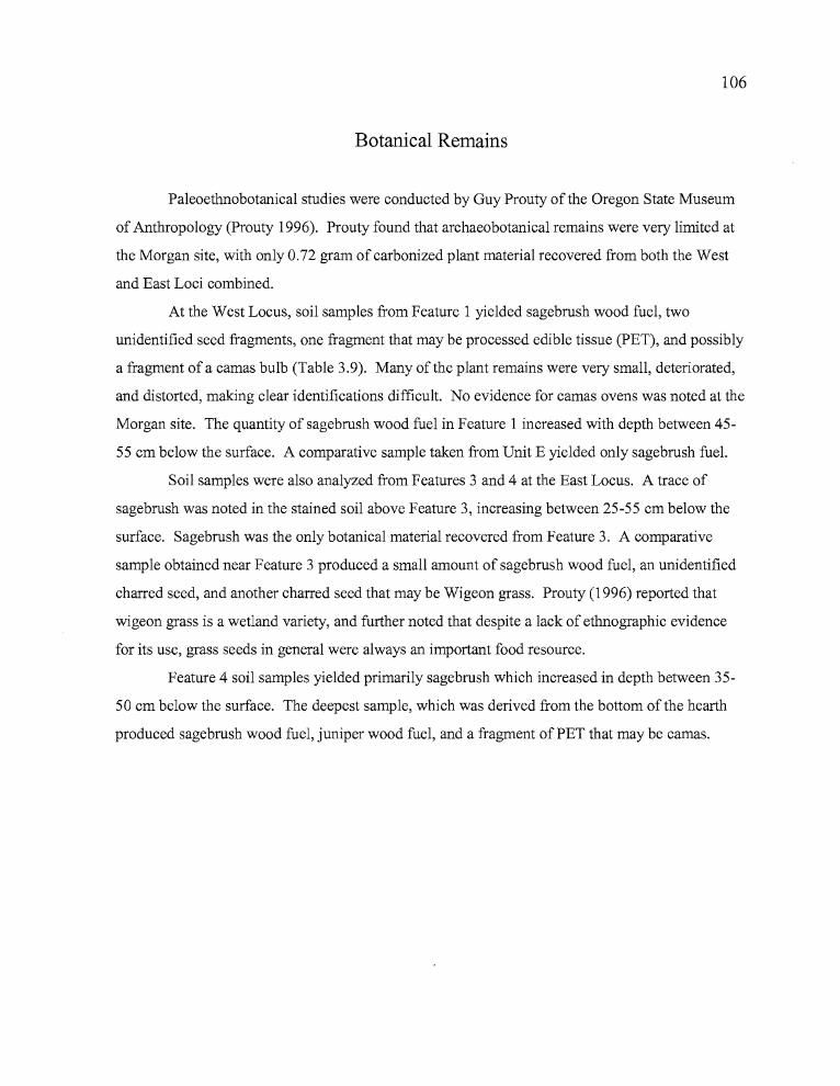
106
Botanical Remains
Paleoethnobotanical studies were conducted by Guy Prouty of the Oregon State Museum
of Anthropology (Prouty 1996). Prouty found that archaeobotanical remains were very limited at
the Morgan site, with only 0.72 gram of carbonized plant material recovered from both the West
and East Loci combined.
At the West Locus, soil samples from Feature 1 yielded sagebrush wood fuel, two
unidentified seed fragments, one fragment that may be processed edible tissue (PET), and possibly
a fragment of a camas bulb (Table 3.9). Many of the plant remains were very small, deteriorated,
and distorted, making clear identifications difficult. No evidence for camas ovens was noted at the
Morgan site. The quantity of sagebrush wood fuel in Feature 1 increased with depth between 45
55 cm below the surface. A comparative sample taken from Unit E yielded only sagebrush fuel.
Soil samples were also analyzed from Features 3 and 4 at the East Locus. A trace of
sagebrush was noted in the stained soil above Feature 3, increasing between 25-55 cm below the
surface. Sagebrush was the only botanical material recovered from Feature 3. A comparative
sample obtained near Feature 3 produced a small amount of sagebrush wood fuel, an unidentified
charred seed, and another charred seed that may be Wigeon grass. Prouty (1996) reported that
wigeon grass is a wetland variety, and further noted that despite a lack of ethnographic evidence
for its use, grass seeds in general were always an important food resource.
Feature 4 soil samples yielded primarily sagebrush which increased in depth between 35
50 cm below the surface. The deepest sample, which was derived from the bottom of the hearth
produced sagebrush wood fuel, juniper wood fuel, and a fragment of PET that may be camas.
107
Table 3.9. Botanical remains at the Morgan site.
Unit Description Flot. Volume Carbon Wt. (Grams) Taxa
West LocusE, Quad A non-feature, comparative 1000 0.01 sagebrush wood fuel-0.01Level9/l0
E, Quad B Feature 1, hearth 825 trace sagebrush-traceunidentified seed-trace
G, Quad A Feature 1 1000 0.07 camas-possible traceLevel 10 sagebrush-0.07
G, Quad A Feature 1 1000 0.10 processed edible tissue?-traceLevel 11 sagebrush-0.10
unidentified seed-trace
East Locus
W, QuadB charcoal st. above Feature 3 825 trace sagebrush-traceLevel 3
X, Quad D Feature 3 hearth 1000 0.04 sagebrush-0.04LevelS
X, Quad D Feature 3 825 0.10 sagebrush-0.10Level 6
X, Quad D Feature 3 825 0.10 sagebrush-O.lOLevel 10
X, QuadD Feature 3 800 0.11 sagebrush-O.llLevel 11
U, Quad A non-feature compo sample 1000 trace sagebrush-traceLevel 9 unidentified seed-trace
Widgeon grass?-trace
U, Quad C Feature 4 hearth 1000 0.02 sagebrush-0.02Level 7
U, QuadC Feature 4 1000 0.05 sagebrush-0.05Level 8
U, QuadD Feature 4 1000 0.09 Juniper-O.O 1Level 10 processed edible tissue-0.02
sagebrush-0.07
~ ...
108
Summary
The Morgan site, about 11 kilometers east ofthe Hines site and 3/4 kilometer west of the
Hoyt site, is located on the south slope of Sand Hill, a promontory that projects southward onto the
Harney Basin floor overlooking the marshlands surrounding Poison Creek Slough. The site was
topographically divided into two loci, an upper locus to the west which overlooks the marshland,
and a lower one to the east that is tucked into a sheltered fold of Sand Hill. Cultural features in the
West Locus included a hearth that was radiocarbon dated to 950 BP and a ground stone cluster
located less than a meter to the east of the hearth. Two hearths were identified in the East Locus,
one radiocarbon dated to 760 BP, the other to 1170 BP. The three dates appear to be associated
with occupations occuring at the site between approximately 4000 years ago (based on the
presence of Northern Side-notched points) and perhaps after 700 BP or later. The deposits in the
West Locus were heavily disturbed by the excavation of cable trenches during two different
episodes in the past. The East Locus was not disturbed.
A total of 15 diagnostic projectile points was recovered at the Morgan site, of which 7%
were Cottonwood Triangular, 20% were Rose Spring, 20% were Eastgate, 33% were Elko series,
and 20% were Large Side-notched. The high proportion of Elko and Large Side-notched points
suggests that the site's first occupations may have occurred several millenia earlier than is
indicated by the dated hearths. Eastgate and Elko Corner-notched points were found near each
other throughout the site. Unfortunately, these associated points either originated from unknown
obsidian sources or were not sourced. Rosegate points were of obsidian from Burns Butte and
nearby Dog Hill, located approximately 10 kilometers to the northwest. Elko Series and Northern
Side-notched points originated from several sources to the north, east, and south of the site. Edge
modified flakes comprised the largest category of tools at the site, at 40%. Formed tools
(including projectile points and bifaces) accounted for 34%, ground stone 16%, cores 6%,
hammerstones 4%, and a single stone disc bead was recovered as well.
The faunal assemblage at the Morgan site appear to reflect a marshland/grassland
environmental setting. A total of 3010 bones were recovered from the site, of which the most
abundant taxon was Rodentia, composing 8% of the total assemblage, followed by
Lagomorphs at 4%. The difficulty of separating c.ultural from intrusive rodent remains may
> •
109
have affected these results. Large mammal bones accounted for 1.5% of the total assemblage,
probably originating from Artiodactyls but not identifiable as such. Avian remains (including
waterfowl) represented only 0.5% of the total. No fish remains were recovered at the Morgan site,
and eggshell accounted for 0.1 % of the assemblage.
The pa1eoethnobotanical evidence from the Morgan site was very limited. Sagebrush,
probably used as fuel, was the dominant charred plant material in the cultural deposits. The 950
year old hearth contained small amounts of sagebrush charcoal and what may be a fragment of a
charred camas bulb, although camas ovens were not identified at the site. The 1170 year old
hearth yielded sagebrush charcoal, the only juniper charcoal found at the site, and another PET
fragment that may be camas. The 760 year old hearth contained only sagebrush charcoal.
Although there were several charred seed fragments found in the assemblage, none of these were
identifiable. It does appear that seed harvesting and processing were important at the site,
however, considering the relatively high quantities of ground stone at the site and its location
adjacent to what once was a broad, marshy plain where a variety of floral resources could have
been obtained.
Obsidian hydration analysis was conducted on 56 Bums Butte and Dog Hill artifacts,
which comprised the two major sources for obsidian artifacts at the site. Hydration measurements
revealed that two distinct occupation episodes probably occurred at the site. They consist of a late
component associated with the 1170 BP radiocarbon date in the East Locus and with the 760 BP
and 950 BP dates in West Locus, and an early component that is not represented by radiocarbon
dates. The projectile point typologies - including both arrow points and dart points of earlier types
- support this contention in both vertical associations and hydration measurements, and two peaks
in measured artifacts occurred at 4.5 and 5.5 microns respectively.
In sum, the Morgan site appears to have been a multiple occupation site used both before
4000 BP and again between 1200 to 700 BP. Lithic reduction occurred at the site and it was also
used as a temporary camp for processing marsh and grassland resources and for hunting small
game. Although botanical evidence is limited, the presence of an abundance of ground stone (in
excess of 16%) suggests that plant procurement and processing was a significant aspect of the site
usage.
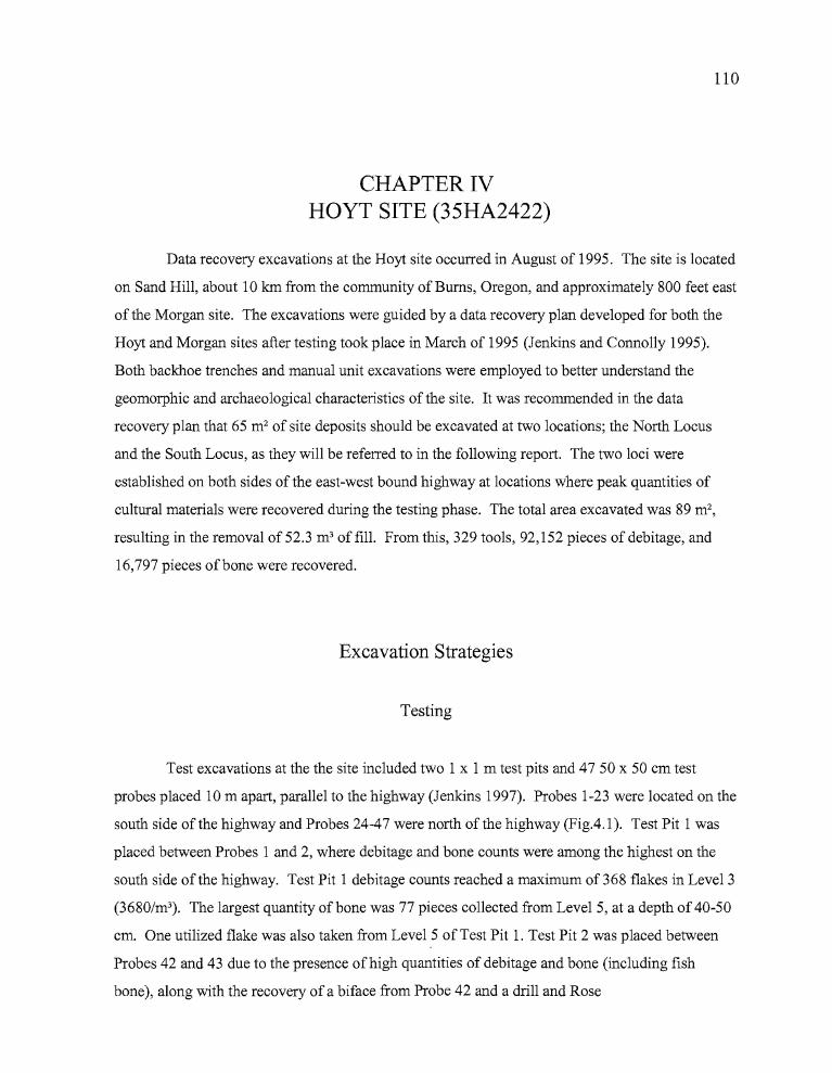
D •
110
CHAPTER IVHOYT SITE (35HA2422)
Data recovery excavations at the Hoyt site occurred in August of 1995. The site is located
on Sand Hill, about 10 Ian from the community of Bums, Oregon, and approximately 800 feet east
of the Morgan site. The excavations were guided by a data recovery plan developed for both the
Hoyt and Morgan sites after testing took place in March of 1995 (Jenkins and Connolly 1995).
Both backhoe trenches and manual unit excavations were employed to better understand the
geomorphic and archaeological characteristics of the site. It was recommended in the data
recovery plan that 65 m2 of site deposits should be excavated at two locations; the North Locus
and the South Locus, as they will be referred to in the following report. The two loci were
established on both sides of the east-west bound highway at locations where peak quantities of
cultural materials were recovered during the testing phase. The total area excavated was 89 m2 ,
resulting in the removal of 52.3 m3 of fill. From this, 329 tools, 92,152 pieces of debitage, and
16,797 pieces of bone were recovered.
Excavation Strategies
Testing
Test excavations at the the site included two 1 x 1 m test pits and 4750 x 50 cm test
probes placed 10 m apart, parallel to the highway (Jenkins 1997). Probes 1-23 were located on the
south side of the highway and Probes 24-47 were north of the highway (Fig.4.1). Test Pit 1 was
placed between Probes 1 and 2, where debitage and bone counts were among the highest on the
south side of the highway. Test Pit 1 debitage counts reached a maximum of 368 flakes in Level 3
(3680/m3). The largest quantity of bone was 77 pieces collected from Level 5, at a depth of 40-50
cm. One utilized flake was also taken from Level 5 of Test Pit 1. Test Pit 2 was placed between
Probes 42 and 43 due to the presence ofhigh quantities of debitage and bone (including fish
bone), along with the recovery of a biface from Probe 42 and a drill and Rose
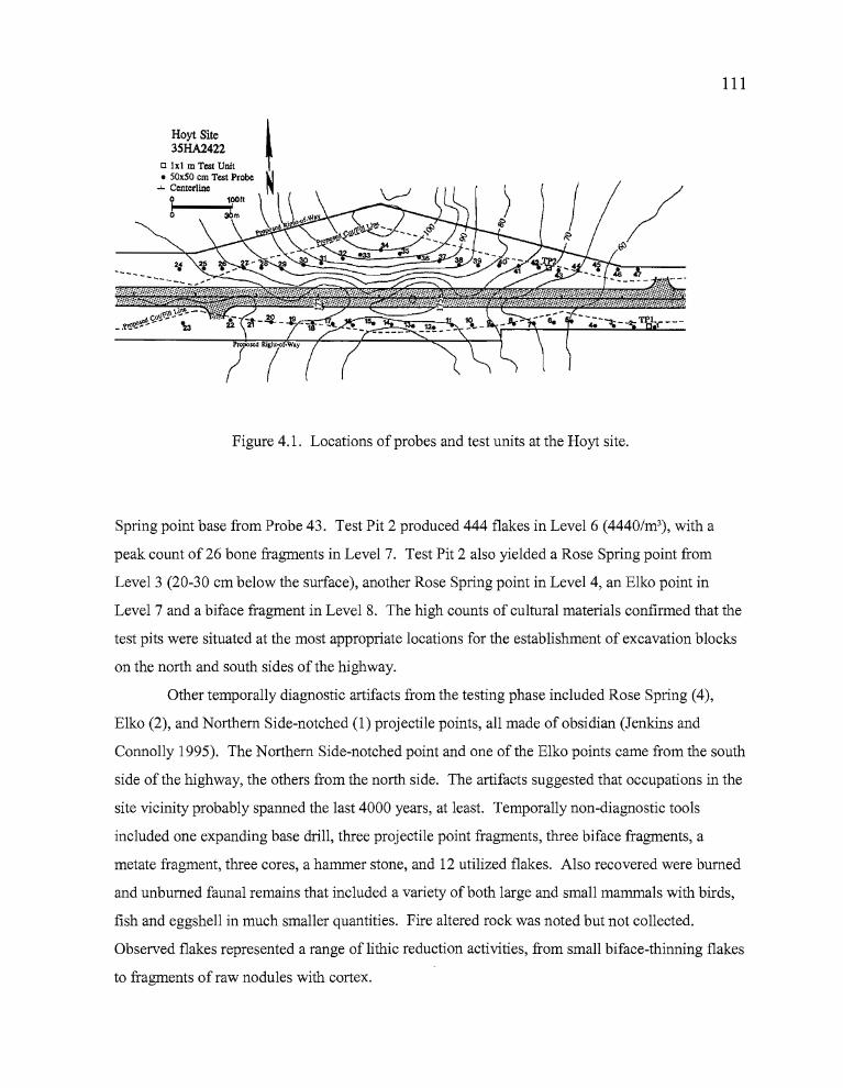
111
Hoyt Site3SHA2422
Figure 4.1. Locations of probes and test units at the Hoyt site.
Spring point base from Probe 43. Test Pit 2 produced 444 flakes in Level 6 (4440/m3), with a
peak count of 26 bone fragments in Level 7. Test Pit 2 also yielded a Rose Spring point from
Level 3 (20-30 cm below the surface), another Rose Spring point in Level 4, an Elko point in
Level 7 and a biface fragment in Level 8. The high counts of cultural materials confirmed that the
test pits were situated at the most appropriate locations for the establishment of excavation blocks
on the north and south sides of the highway.
Other temporally diagnostic artifacts from the testing phase included Rose Spring (4),
Elko (2), and Northern Side-notched (1) projectile points, all made of obsidian (Jenkins and
Connolly 1995). The Northern Side-notched point and one of the Elko points came from the south
side of the highway, the others from the north side. The artifacts suggested that occupations in the
site vicinity probably spanned the last 4000 years, at least. Temporally non-diagnostic tools
included one expanding base drill, three projectile point fragments, three biface fragments, a
metate fragment, three cores, a hammer stone, and 12 utilized flakes. Also recovered were burned
and unburned faunal remains that included a variety of both large and small mammals with birds,
fish and eggshell in much smaller quantities. Fire altered rock was noted but not collected.
Observed flakes represented a range of lithic reduction activities, from small biface-thinning flakes
to fragments of raw nodules with cortex.
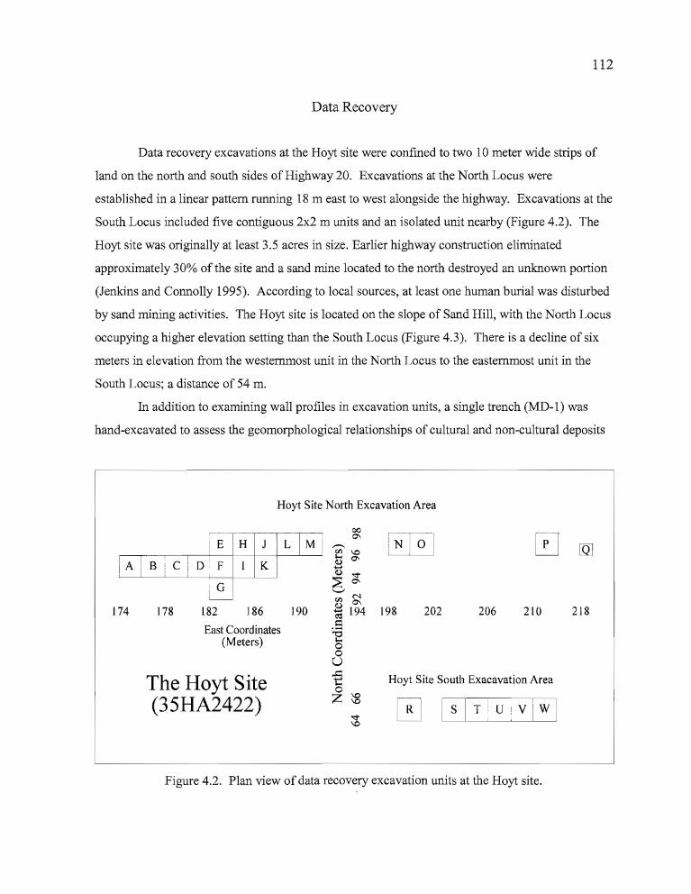
112
Data Recovery
Data recovery excavations at the Hoyt site were confined to two 10 meter wide strips of
land on the north and south sides of Highway 20. Excavations at the North Locus were
established in a linear pattern running 18 m east to west alongside the highway. Excavations at the
South Locus included five contiguous 2x2 m units and an isolated unit nearby (Figure 4.2). The
Hoyt site was originally at least 3.5 acres in size. Earlier highway construction eliminated
approximately 30% of the site and a sand mine located to the north destroyed an unknown portion
(Jenkins and Connolly 1995). According to local sources, at least one human burial was disturbed
by sand mining activities. The Hoyt site is located on the slope of Sand Hill, with the North Locus
occupying a higher elevation setting than the South Locus (Figure 4.3). There is a decline of six
meters in elevation from the westernmost unit in the North Locus to the easternmost unit in the
South Locus; a distance of 54 m.
In addition to examining wall profiles in excavation units, a single trench (MD-1) was
hand-excavated to assess the geomorphological relationships of cultural and non-cultural deposits
-
218210206202198
Hoyt Site NOlth Excavation Area
~----E H
F K !
G
174 178 182 186 190
East Coordinates(Meters)
The Hoyt Site(35HA2422)
--v; 1.0[) 0-
......(I.) "<t
::E 0-'-'v; ~*194l::::
]o
~ Hoyt Site South Exacavation Area I
"-----:z_~__r-;;lR__1 S_[2T~~:_-__ Ii
~ UVi W~ I
Figure 4.2. Plan view of data recovery excavation units at the Hoyt site.
D ...
~ ..
, '.\ ~"
s;:. ''.1'
--J, '.
J / .....
",";0
113
Figure 4.3. The Hoyt site North Locus, facing eastward.
at the site. The trench was situated south of Unit B in the North Block, at a location adjacent to
the road cut made by construction of the highway.
Prior to excavation, an arbitrary datum was established on a point from which a grid
system could be created for the entire site. Using a Topcon GTS-203 total station, coordinates for
the datum were set at 1OON/1 OOE, then the individual excavation units were tied into the overall
grid system. The fortuitous location of a nearby U.S.G.S. benchmark allowed the use of actual,
rather than arbitrary elevations during the excavation process. Unit coordinates have been replaced
by letter designations for this report. Individual elevation datums were shot in for the excavation
units and vertical control was maintained by the use of level lines attached to the datum stakes.
The total area excavated included 65 m2 at the North Locus and 24 m2 at the South Locus.
Excavation units were expanded or terminated depending on the quantities of cultural materials
collected during the data recovery process. Excavations were carried out following the natural
topography of the landscape. Fill was removed in 5 cm increments. The results ofthe data
recovery efforts at each locus are discussed below.
> b
114
North Locus
One lxl and sixteen 2x2 meter units represent the extent of data recovery in the North
Locus. These units have been given the letter designations A-Q for the purposes of this report. A
series of five adjoining units was initially established near the location of Test Pit 2 (TP2) on the
west (upslope) end of the Northern Locus and an additional four units were placed at locations of
interest downslope to the east. As it became apparent that the excavations at the west end were of
greater integrity and higher productivity, efforts became more focused at that locale. The west
block ultimately grew to include a total of thirteen 2 x 2s.
Although excavators attained a depth of 1.2 m in one unit, the average depth of the
excavations was 80 cm. Artifacts were most concentrated in Levels 5-16 of the block excavation;
spanning approximately 60 cm of fill (Tables 4.1 and 4.3). Individual units had artifact
concentrations ranging between 25-40 cm in thickness. Units not associated with the block
excavation (downslope) showed less consistency in artifact concentrations, with cultural materials
dispersed from the surface to approximately 65 cm in depth, and artifact concentrations ranging
between 10-35 cm in thickness.
The upper stratigraphic layer at the site consists of a light grayish-brown silty sand,
primarily of eolian origin, continuing to a depth of 25-40 cm below the surface (Figure 4.4).
Underlying this silty deposit is a compacted deposit of dark grayish-brown silty sands with an
increased content of small gravels. This layer is the primary source of cultural deposits at the site
and the fill can range in thickness from 25-80 cm. Underlying this is a transitional zone where the
lower portion of the cultural material-bearing deposit meets a zone of weathering sandstone
bedrock, with occasional ventifacted cobbles from earlier surface deposits that are primarily
volcanic in origin. At the juncture between these strata, the fill becomes a light tannish-gray sand
mixed with small to medium sized sandstone cobbles. As the excavators approached bedrock,
larger cobbles and slabs of sandstone marked the exfoliating rind of the underlying bedrock. The
sandstone appears to be lacustrine in origin. Where the bedrock surface was found intact, it was
pocked with vents created through the bioturbation of animals burrowing into the
PliocenelPleistocene lake bed.
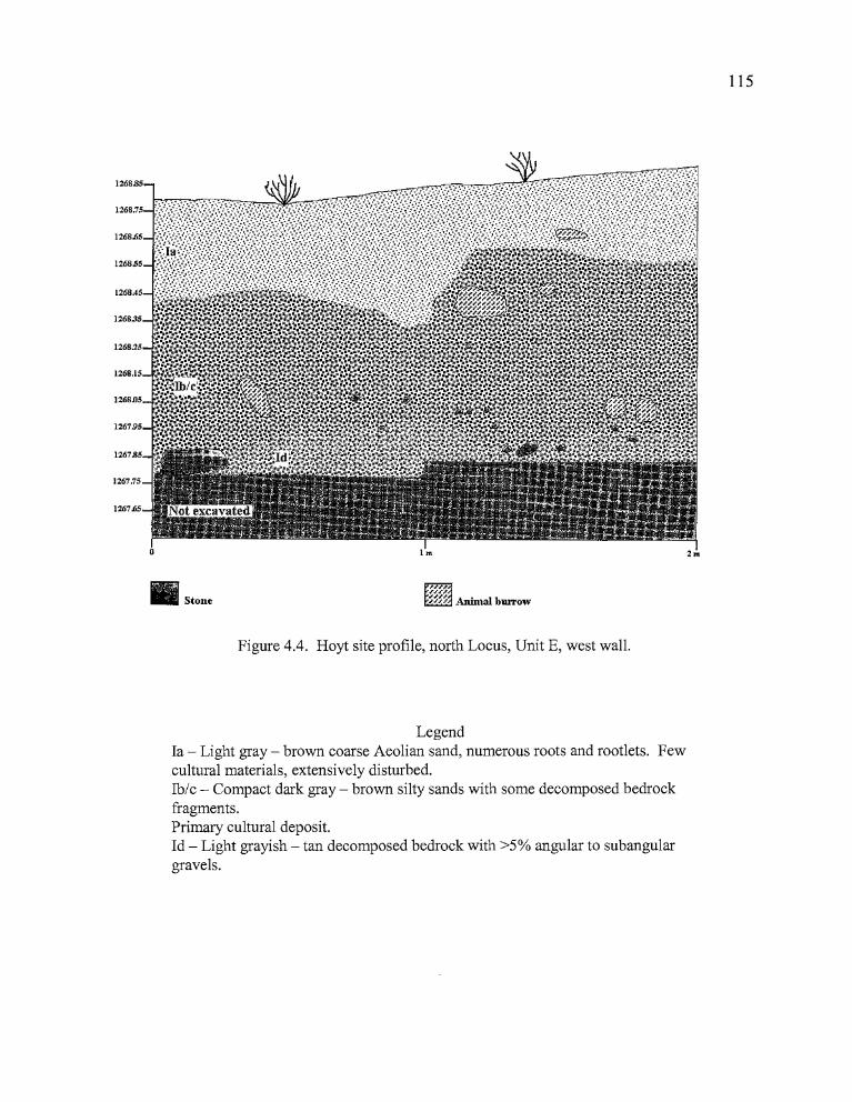
2m
~f'
1268.85
1268.75
1268.65
126855
1268.35
1268.25
1268.15
1268D5
126795
1267.85
1267.75
1267.65
II Stone
1m
115
• .,
Figure 4.4. Hoyt site profile, north Locus, Unit E, west wall.
LegendIa - Light gray - brown coarse Aeolian sand, numerous roots and rootlets. Fewcultural materials, extensively disturbed.Ib/c - Compact dark gray - brown silty sands with some decomposed bedrockfragments.Primary cultural deposit.Id - Light grayish - tan decomposed bedrock with >5% angular to subangulargravels.
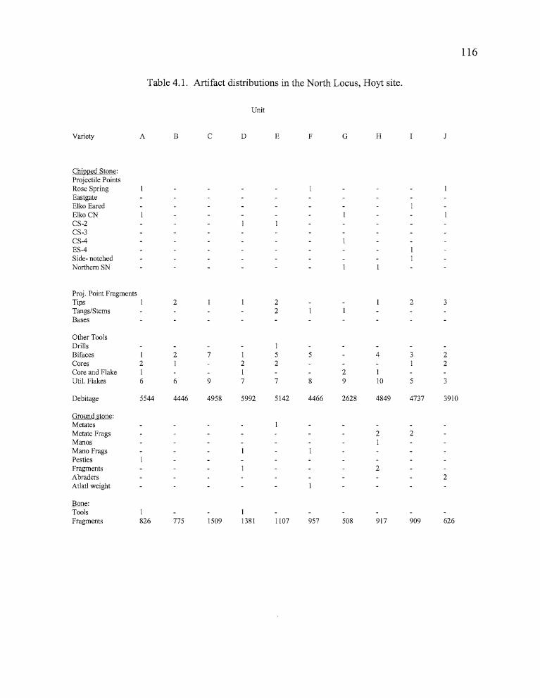
• •
116
Table 4.1. Artifact distributions in the North Locus, Hoyt site.
Unit
Variety A B C D E F G H
Chipped Stone:Projectile PointsRose SpringEastgateElko EaredElkoCNCS-2CS-3CS-4ES-4Side- notchedNorthern SN
Proj. Point FragmentsTips 2 2 2 3
Tangs/Stems 2
Bases
Other ToolsDrills 1
Bifaces 1 2 7 1 5 5 4 3 2
Cores 2 1 2 2 1 2
Core and Flake 1 1 2 1
Uti!. Flakes 6 6 9 7 7 8 9 10 5 3
Debitage 5544 4446 4958 5992 5142 4466 2628 4849 4737 3910
Ground stone:MetatesMetate Frags 2 2
Manos 1
Mana FragsPestlesFragments 2
Abraders 2
At1atl weight
Bone:Tools 1 IFragments 826 775 1509 1381 1107 957 508 917 909 626
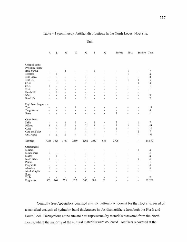
n •
117
Table 4.1 (continued). Artifact distributions in the North Locus, Hoyt site.
Unit
K L M N a P Q Probes TP-2 Surface Total
Chipped Stone:Projectile PointsRose Spring 7Eastgate 2Elko Eared 2Elko CN 5CS-2 4CS-3 IES-4 IHumboldt INSN 3Small SN 2
Proj. Point FragmentsTips 14Tangs/stems 4Bases I
Other ToolsDrills I I 2 I 7Bifaces 2 I 4 I 2 2 2 48Cores 4 3 I I 19Core and Flake 2 7Uti!. Flakes 6 6 4 4 92
Debitage 4261 3828 3757 2410 2202 2383 631 2706 68,850
Groundstone:Metates 2Metate frags 5Manos 2Mana Frags 3Pestles IFragments 3Abraders 3Atlatl Weights IBone:Tools 2Fragments 852 266 575 327 346 385 59 12,325
Connolly (see Appendix) identified a single cultural component for the Hoyt site, based on
a statistical analysis ofhydration band thicknesses in obsidian artifacts from both the North and
South Loci. Occupations at the site are best represented by materials recovered from the North
Locus, where the majority ofthe cultural materials were collected. Artifacts recovered at the
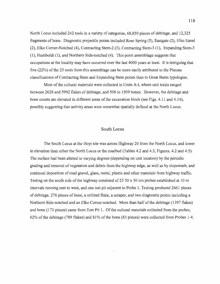
bn •
118
North Locus included 242 tools in a variety of categories, 68,850 pieces of debitage, and 12,325
fragments of bone. Diagnostic projectile points included Rose Spring (5), Eastgate (2), Elko Eared
(2), Elko Corner-Notched (4), Contracting Stem-2 (3), Contracting Stem-3 (1), Expanding Stem-3
(1), Humboldt (1), and Northern Side-notched (4). This point assemblage suggests that
occupations at the locality may have occurred over the last 4000 years at least. It is intriguing that
five (22%) of the 23 tools from this assemblage can be more easily attributed to the Plateau
classifications of Contracting Stem and Expanding Stem points than to Great Basin typologies.
Most of the cultural materials were collected in Units A-I, where unit totals ranged
between 2628 and 5992 flakes of debitage, and 508 to 1509 bones. However, the debitage and
bone counts are elevated in different areas of the excavation block (see Figs. 4.11 and 4.14),
possibly suggesting that activity areas were somewhat spatially defined at the North Locus.
South Locus
The South Locus at the Hoyt site was across Highway 20 from the North Locus, and lower
in elevation than either the North Locus or the roadbed (Tables 4.2 and 4.3, Figures. 4.2 and 4.5).
The surface had been altered to varying degrees (depending on unit location) by the periodic
grading and removal of vegetation and debris from the highway edge, as well as by slopewash, and
continual deposition of road gravel, glass, metal, plastic and other materials from highway traffic.
Testing on the south side of the highway consisted of23 50 x 50 cm probes established at 10 m
intervals running east to west, and one test pit adjacent to Probe 1. Testing produced 2661 pieces
of debitage, 276 pieces of bone, a utilized flake, a scraper, and two diagnostic points including a
Northern Side-notched and an Elko Corner-notched. More than half of the debitage (1397 flakes)
and bone (173 pieces) came from Test Pit 1. Of the cultural materials collected from the probes,
62% of the debitage (789 flakes) and 81% of the bone (83 pieces) were collected from Probes 1-4.
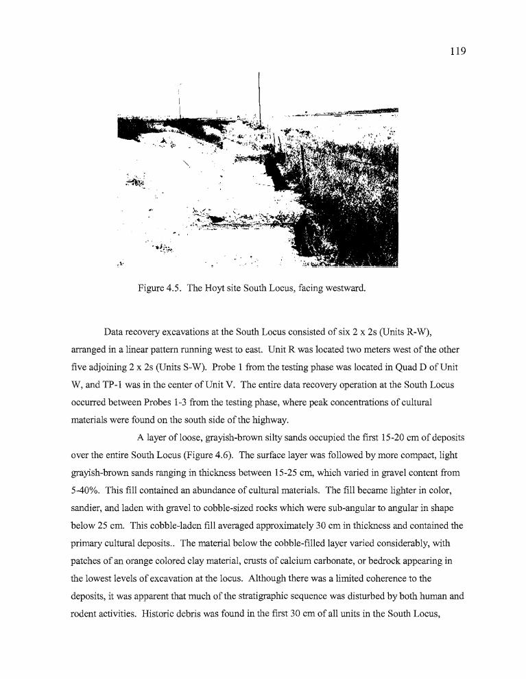
• •
119
Figure 4.5. The Hoyt site South Locus, facing westward.
Data recovery excavations at the South Locus consisted of six 2 x 2s (Units R-W),
arranged in a linear pattern running west to east. Unit R was located two meters west of the other
five adjoining 2 x 2s (Units S-W). Probe 1 from the testing phase was located in Quad D of Unit
W, and TP-1 was in the center of Unit V. The entire data recovery operation at the South Locus
occurred between Probes 1-3 from the testing phase, where peak concentrations of cultural
materials were found on the south side of the highway.
A layer ofloose, grayish-brown silty sands occupied the first 15-20 cm of deposits
over the entire South Locus (Figure 4.6). The surface layer was followed by more compact, light
grayish-brown sands ranging in thickness between 15-25 cm, which varied in gravel content from
5-40%. This fill contained an abundance of cultural materials. The fill became lighter in color,
sandier, and laden with gravel to cobble-sized rocks which were sub-angular to angular in shape
below 25 cm. This cobble-laden fill averaged approximately 30 cm in thickness and contained the
primary cultural deposits.. The material below the cobble-filled layer varied considerably, with
patches of an orange colored clay material, crusts of calcium carbonate, or bedrock appearing in
the lowest levels of excavation at the locus. Although there was a limited coherence to the
deposits, it was apparent that much of the stratigraphic sequence was disturbed by both human and
rodent activities. Historic debris was found in the first 30 cm of all units in the South Locus,
z •
Ia - Grayish-brown fine grained Aeolian sand. Few cultural materials.Ib - Light gray - brown coarse grained sand with slope washed gravels. Someroots and rootlets. Abundant cultural material.Ic - Light brown-gray fine grained sand with few gravels, few rootlets. Primarycultural deposits.Id - Very light brown-gray fme sand, decomposing in place from underlyingbedrock. Few cultural materials.II - Very light cream colored overburden deposited by ODOT, gravels, roots,decomposing lake bed sand and silts. Abundant prehistoric and historic artifacts.III - Cream colored sandstone bedrock covered with calcium carbonate crust, verysoft.
Figure 4.6. Hoyt site, South Locus, Unit S, east wall profile.
120
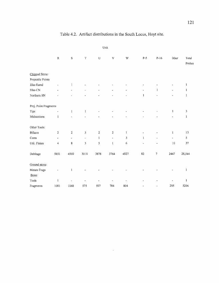
121
Table 4.2. Artifact distributions in the South Locus, Hoyt site.
Unit
R S T U V W P-5 P-16 Other Total
Probes
Chipped Stone:
Projectile Points
Elko Eared
Elko CN
Northern SN
Proj. Point Fragments
Tips 3
Midsections
Other Tools:
Bifaces 2 2 3 2 2 13
Cores 3 5
Uti!. Flakes 4 8 3 5 6 10 37
Debitage 5851 4569 3019 3878 3764 4927 82 7 2447 28,544
Ground stone:
Metate Frags
Bone:
Tools
Fragments 1081 1068 575 597 784 804 295 5204
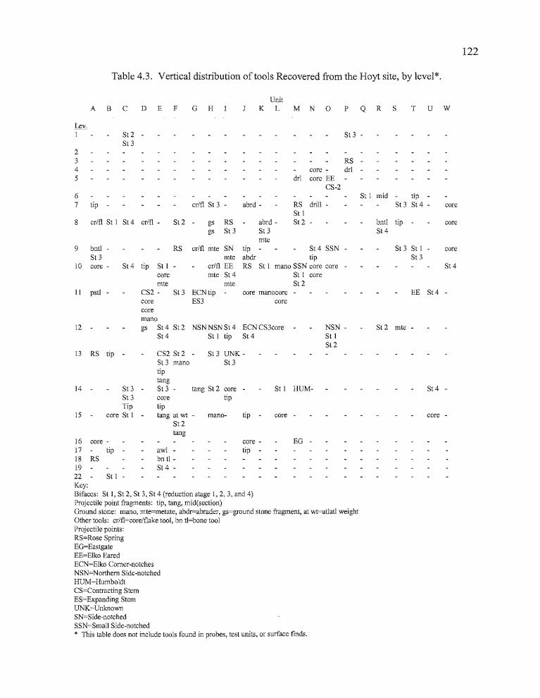
122
Table 4.3. Vertical distribution of tools Recovered from the Hoyt site, by level*.
UnitA B C D E F G H K L M N 0 P Q R S T U W
Lev.I St 2 - St 3 -
St 323 RS -4 core - drl -5 drl core EE
CS-26 St 1 mid tip -7 tip - crlfl St 3 abrd - RS drill - St 3 St 4 - core
St 18 crlfl St 1 St4 crlfl St 2 - gs RS abrd - St 2 bntl tip - core
gs St 3 St 3 St4mte
crlfl mte SN tip - St4 SSN St 3 St 1 coremte abdr tip St 3
cr/fl EE RS St 1 mana SSN core core St 4mte St 4 St I core
mte St 2ECNtip core manacore EE St4 -ES3 core
9 bnt! - RSSt 3
10 core - St 4 tip St 1coremte
11 pst! - CS2 - St 3corecoremana
12 gs St 4 St 2St4
NSN NSN St 4 ECN CS3coreSt 1 tip St 4
NSN St 1St 2
St 2 mte -
St 4 -
core -
EG -
St 1 HUM-
core -tip -
core tip -
St 3 UNKSt 3
mano-
tang St 2 core tipcore
tiptang at wt
St 2tang
CS2 St 2St 3 manatiptangSt 3 -
awl bn tl St 4
St 1 -
13 RS tip -
14 - St 3St3Tip
15 core St 1
16 core-17 tip-18 RS1922Key:Bifaces: St 1, St 2, St 3, St 4 (reduction stage 1,2,3, and 4)Projectile point fragments: tip, tang, mid(section)Ground stone: mana, mte=metate, abdr=abrader, gs=ground stone fragment, at wt=atlatl weightOther tools: crlfl=corelflake tool, bn t!=bone toolProjectile points:RS=Rose SpringEG=EastgateEE=Elko EaredECN=Elko Comer-notchesNSN=Northem Side-notchedHUM=HumboldtCS=Contracting StemES=Expanding StemUNK=UnknownSN=Side-notchedSSN=Small Side-notched* This table does not include tools found in probes, test units, or surface finds.
D •
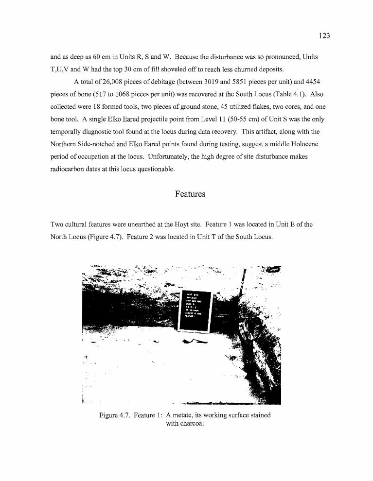
123
and as deep as 60 em in Units R, Sand W. Because the disturbance was so pronounced, Units
T,U,V and W had the top 30 cm offill shoveled off to reach less churned deposits.
A total of 26,008 pieces of debitage (between 3019 and 5851 pieces per unit) and 4454
pieces ofbone (517 to 1068 pieces per unit) was recovered at the South Locus (Table 4.1). Also
collected were 18 formed tools, two pieces of ground stone, 45 utilized flakes, two cores, and one
bone tool. A single Elko Eared projectile point from Level 11 (50-55 cm) of Unit S was the only
temporally diagnostic tool found at the locus during data recovery. This artifact, along with the
Northern Side-notched and Elko Eared points found during testing, suggest a middle Holocene
period of occupation at the locus. Unfortunately, the high degree of site disturbance makes
radiocarbon dates at this locus questionable.
Features
Two cultural features were unearthed at the Hoyt site. Feature 1 was located in Unit E of the
North Locus (Figure 4.7). Feature 2 was located in Unit T of the South Locus.
. r * -o.?1b nr1.ftn >s
. ~ '~'"
z _•
Figure 4.7. Feature 1: A metate, its working surface stainedwith charcoal
7 •
124
Feature 1 consisted of a basalt metate surrounded by a sandy fill containing high concentrations of
charcoal, which may have been a shallow hearth (Figure 4.7). The feature was located in the south
portion ofQuadD, Unit E between Levels 7 - 9, at an elevation of 1268.07-1268.18 ill. A fire
cracked rock fragment was located 50 cm northeast of the metate, in Quad D. The triangular
shaped metate, measuring 34.2 cm in length, 33.7 cm in width, and 11.6 cm in thickness, was
found with the faceted side upright. The working surface was darkened by charcoal staining, but
the margins surrounding the faceted area were much lighter in color, providing a clear contrast
between used and unused surfaces. Fill recovered from the possible hearth was analyzed for
evidence of paleo-ethnobotanical remains by Guy Prouty. The analysis yielded high quantities of
" ...sagebrush wood fuel, ...a trace of unidentified bark, and ...two unidentified grass seed
fragments ..." (Prouty 1996:18). The metate was located roughly in the center of the principal
occupation area at the site, identified during the course of excavations. The area includes high
concentrations of debitage, bone, and a variety of artifacts which are outlined in detail below.
Feature 2 consisted of a circular charcoal stain, 25 cm in length by 20 cm in width, located in
Quad B of Unit T. The stained earth was encountered approximately 40 cm below the surface,
between 1262.67-1262.71 meters in elevation. The feature was not radiocarbon dated.
Paleoethnobotanical analysis of the feature revealed the presence of small amounts of sagebrush
wood fuel, five unidentified seed fragments, and questionable evidence ofprocessed edible tissue
fragments (Prouty 1996: 19).
r,
125
Radiocarbon Dates
The Hoyt site yielded two radiocarbon dates, both of which were accelerator mass
spectrometry assays (AMS) on charcoal collected from units in the North Block (Table 4.4).
Because of the high degree of disturbance noted in the South Locus, no radiocarbon assays were
attempted there. Specimen 977-22-E-D-7-F1 was a charcoal sample collected from Feature 1,
(Level 7 of Unit E) in the area where a large metate was recovered in association with a possible
hearth. The charcoal was collected in situ from fill surrounding the metate found at an elevation of
1268.11 meters (approximately 35 cm below the surface). The sample of sagebrush charcoal
returned an AMS radiocarbon date of 1890±60 BP (Beta-88082), calibrated to ca. 1830 BP.
Specimen 977-22-C-C-14 was a small, composite charcoal sample collected in Level 14
ofUnit C, at an elevation of 1268.25 meters (approximately 70 cm below the surface). The
sample was collected in an area where two utilized flakes, a CCS biface fragment, fire-cracked
rock, and an abundance of burned bone was noted. An AMS radiocarbon date of 220±60 BP was
returned on the material, calibrated to 280 BP at the one sigma level. The date is not consistent
with the 1830 BP date from Feature 1, which is much earlier, but much higher in the deposits.
There were no diagnostic artifacts found in direct association with the material dated to 280 BP.
Variable deflation and deposition episodes on the hillside where the site is located may have
contributed to the burial of late-dating materials under deeper deposits than those covering the
1830 BP sample. It seems more likely that the late date is anomalous, probably due to intrusive
rodent activity.
Table 4.4. Radiocarbon dates from the Hoyt site.
Lab. # Radiocarbon date Dendrocalibrated Years Ago Material
1879(1825)1727 BP composite charcoal (OAg)Beta-88082
AMS-LL
Beta-88083
AMS-LL
1890±60 BP
220±60 BP 303(284)0 BP composite charcoal (0.2g)
AMS-LL = Accelerator mass spectrometry-Lawrence Livermore Laboratories
= •
126
Artifact Assemblage
Chipped Stone
This category includes all of the flaked stone tools recovered during excavations at the
Hoyt site. Bifacial tools have been subdivided into two categories; shaped and unshaped bifaces.
Shaped specimens show evidence of having been reduced through percussion and pressure flaking
to a distinct form, such as oval or leaf-shaped preforms (among others), or further into
typologically defined tools such as projectile points. The shaped bifacial tools have been classified
according to the system based on five stages of manufacture that was employed by Jenkins and
Connolly (1990) for Indian Grade Spring, and also used for the Morgan and Hines sites.
Unshaped bifaces have bifacial modification of at least one edge of a flake, but have not been
further worked into a more defined shape.
Unifacial tools are those which exhibit edge modification to a single side of the flake,
generally with a clear pattern of wear from extensive use. Scrapers and notched spokeshaves fall
into this category, reflecting use at an angle transverse to the material being processed (Jenkins and
Connolly 1990). Edge-modified flakes are those which have been applied to expedient cutting and
scraping tasks. They exhibit wear patterns reflective of systematic use, but have not been
purposefully shaped or modified for use other than by the activity to which they were applied.
Research has shown that trampling of lithic materials can produce patterns of flaking similar to
what has been seen on utilized flakes (Mc Brearty et al. 1998), so only those flakes with uniform
patterns ofnibbling along the edges have been considered for this analysis.
Projectile Points
A total of 32 diagnostic projectile points were recovered from the Hoyt site. Of these, 28
were manufactured from obsidian, two from basalt and two from CCS (Table 4.5, Figure 4.8).
The projectile points have been classified according to the system established by Thomas (1981)
for the Great Basin region of central Nevada, with consideration given to Columbia Plateau
typological sequences proposed by Dumond and Minor (1983). Researchers have suggested
,I
127
• ~ ~ .. " !a d e gb c h
k ••••••••
. .
':
m n
qpo
w
Figure 4.8. Projectile points from the Hoyt site: Rose Spring, a-f; Eastgate, g-h; ElkoSeries, ion; CS-2, o-q; CS-3, r; ES-4, s; Small side-notched, t; Large side-notched, u-w (a.977-22-Ad-13-1;b. 977-22-Fa-9-1; c. 977-22-Jc-lO-l; d. 977-22-Mc-7-1; e. 977-22-Pa-3-1;f. 963-2422-TP2-4-1; g. 977-22-La-16-1; h. 963~2422-TP2-3-1; 1. 977-22-Ad-18-1;j. 97722-Ic-lO-l; k. 977-22-0d-5-1; 1. 977-22-Sb-ll-l; m. 977-22-Gc-11-2; n. 977-22-Jc-12-1; o.977-22-Db-11-2; p. 977-22-0a-5-1; q. 977-22-Ec-13-1; r. 977-22-Kb-12-1; s. 977-22-Gc11-1; 1. 977-22-Ma-lO-l;u. 977-22-0a-9-1; v. 977-22-Ha-12-2; w. 977-22-0c-12-l).
n bz
128
possible cultural associations between Northern Great Basin region and Columbia Plateau
populations based on the lengthy archaeological record of occupations in the basin and a possible
late arrival ofNumic speakers into the area (Aikens 1985; Aikens and Witherspoon 1986;
Connolly 1999). The Klamath and Modoc tribes are both linguistically and culturally tied to the
Columbia Plateau. They currently occupy areas adjacent to the northern Great Basin, and may
have inhabited portions of the Harney Valley in the past (Kelly 1932:186). For these reasons, and
the fact that artifacts are occasionally seen in the Northern Great Basin which suggest connections
to Plateau cultures, Plateau typologies need to be considered when Harney Basin projectile points
are being analyzed.
Obsidian was the principal material used for manufacturing projectile points at the Hoyt
site. Only two diagnostic points were made of CCS and two from basalt. The projectile points
include two Eastgate (6%), seven Rose Spring (22%), three Elko Eared (9%), five Elko Corner
notched (16%), one Humboldt Concave Base (3%), four Northern Side-notched points (13%), two
small side-notched points (6%), and one indeterminate side-notched point base (3%). Three point
types were designated in Plateau terminology, including one Expanding Stem-3 (3%), four
Contracting Stem-2 points (13%) and one Contracting Stem-3 (3%). An additional large, notched
point fragment could not be identified with certainty as either side-notched or comer-notched.
Temporal associations between these artifact types and radiocarbon dated features across
Northern Great Basin archaeological sites generally suggest that the Hoyt site may have been
occupied over the past four thousand years or more. E1ko, Humboldt, Contracting Stem-2,
Expanding Stem-3, and Northern Side-notched points were designed for use with the at1atl, or
throwing stick. Rose Spring and Eastgate points were manufactured for use with the bow and
arrow, which probably did not arrive in the region until sometime after 1900 BP (Wegener
1998:17). The high numbers of dart points (18) in relation to arrow points (8) in the Hoyt
assemblage seems to indicate that the site was occupied before and after the arrival ofbow and
arrow technology, but with greater intensity prior to that time.
Rosegate Series Points. A total ofnine projectile points collected at the Hoyt site can be classified
under the Great Basin Rosegate typology. They are characterized by their small size (weight <1.5
grams), expanding stems, and a basal width less than 10 rom (Thomas 1981: 19). The Rosegate
class ofprojectile points can also be placed in the Expanding Stem 1 and Expanding Stem 2
""","'
D
129
categories proposed by Dumond and Minor (1983) for the Plateau. Rose Spring and Eastgate
projectile point types are treated separately in this report (see the Rosegate section in the Hines
chapter for a brief explanation).
Two Eastgate points were recovered from the North Locus of the Hoyt site. The Eastgate
points are vertically separated through the cultural deposits, with one specimen (963-2422-TP2-3
1) occurring between 20-30 cm in Test Pit 2 (Units F and G), and one in Level 16 (75-80 cm) in
Unit L (977-22-L-A-16-l). Neither ofthe points are directly associated with features, but both
occur near the locations where the highest amounts of debitage and bone were identified. The
Eastgate collected from Unit L was made from Whitewater Ridge obsidian and the point in Test
Pit 2 was from the Burns obsidian source.
Seven Rose Spring projectile points were also collected from the North Locus of the Hoyt
site, occurring between 15 and 65 cm in depth. Six of these points were recovered from the block
excavation at the North Locus, including four that came out of units surrounding Feature 1 (963
2422-TP2-3-l, 977-22-F-A-9-l, 977-22-I-D-8-1, and 977-22-J-C-10-1). One point came from
Unit P, at the eastern end of the North Locus (977-22-P-A-3-1). Rose Spring projectiles from the
Hoyt site represent five obsidian sources, two of which are currently unidentified. The three
identified sources are Burns, Dog Hill, and Wolf Creek, all of which are located to the north and
west of the Hoyt site.
Elko Series Points. There were eight Elko Series points collected from the Hoyt site; three Elko
Eared and five Elko Corner-notched. All eight can be categorized as Elko points based on the
classification system established by Thomas (1981). Under Dumond and Minor's (1983: 171)
Plateau classification system, the corner-notched points would be considered Side Notched-5, and
the eared points would be ESI-2, ESI-3, or ESI-4 (Expanding Stem, Indented).
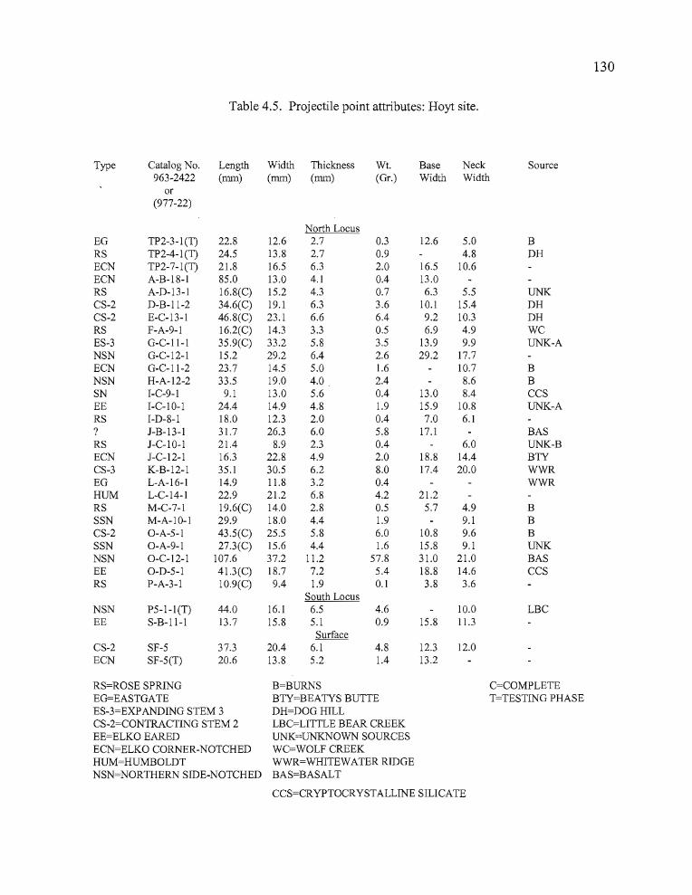
- •
Table 4.5. Projectile point attributes: Hoyt site.
Type Catalog No. Length Width Thickness Wt. Base Neck Source963-2422 (nun) (nun) (nun) (Gr.) Width Width
or(977-22)
North LocusEG TP2-3-1(T) 22.8 12.6 2.7 0.3 12.6 5.0 BRS TP2-4-1(T) 24.5 13.8 2.7 0.9 4.8 DHECN TP2-7-1(T) 21.8 16.5 6.3 2.0 16.5 10.6ECN A-B-18-1 85.0 13.0 4.1 0.4 13.0RS A-D-13-1 16.8(C) 15.2 4.3 0.7 6.3 5.5 UNKCS-2 D-B-II-2 34.6(C) 19.1 6.3 3.6 10.1 15.4 DHCS-2 E-C-13-1 46.8(C) 23.1 6.6 6.4 9.2 10.3 DHRS F-A-9-1 16.2(C) 14.3 3.3 0.5 6.9 4.9 WCES-3 G-C-ll-l 35.9(C) 33.2 5.8 3.5 13.9 9.9 UNK-ANSN G-C-12-1 15.2 29.2 6.4 2.6 29.2 17.7ECN G-C-II-2 23.7 14.5 5.0 1.6 10.7 BNSN H-A-12-2 33.5 19.0 4.0 2.4 8.6 BSN I-C-9-1 9.1 13.0 5.6 0.4 13.0 8.4 CCSEE I-C-I0-l 24.4 14.9 4.8 1.9 15.9 10.8 UNK-ARS I-D-8-1 18.0 12.3 2.0 0.4 7.0 6.1? J-B-13-1 31.7 26.3 6.0 5.8 17.1 BASRS J-C-I0-l 21.4 8.9 2.3 0.4 6.0 UNK-BECN J-C-12-1 16.3 22.8 4.9 2.0 18.8 14.4 BTYCS-3 K-B-12-1 35.1 30.5 6.2 8.0 17.4 20.0 WWREG L-A-16-1 14.9 11.8 3.2 0.4 WWRHUM L-C-14-1 22.9 21.2 6.8 4.2 21.2RS M-C-7-1 19.6(C) 14.0 2.8 0.5 5.7 4.9 BSSN M-A-IO-1 29.9 18.0 4.4 1.9 9.1 BCS-2 O-A-5-1 43.5(C) 25.5 5.8 6.0 10.8 9.6 BSSN O-A-9-1 27.3(C) 15.6 4.4 1.6 15.8 9.1 UNKNSN O-C-12-1 107.6 37.2 11.2 57.8 31.0 21.0 BASEE O-D-5-1 41.3(C) 18.7 7.2 5.4 18.8 14.6 CCSRS P-A-3-1 10.9(C) 9.4 1.9 0.1 3.8 3.6
South LocusNSN P5-1-1(T) 44.0 16.1 6.5 4.6 10.0 LBCEE S-B-ll-l 13.7 15.8 5.1 0.9 15.8 11.3
SurfaceCS-2 SF-5 37.3 20.4 6.1 4.8 12.3 12.0ECN SF-5(T) 20.6 13.8 5.2 1.4 13.2
RS=ROSE SPRING B=BURNS C=COMPLETEEG=EASTGATE BTY=BEATYS BUTTE T=TESTING PHASEES-3=EXPANDING STEM 3 DH=DOGHILLCS-2=CONTRACTING STEM 2 LBC=LITTLE BEAR CREEKEE=ELKO EARED UNK=UNKNOWN SOURCESECN=ELKO CORNER-NOTCHED WC=WOLF CREEKHUM=HUMBOLDT WWR=WHITEWATER RIDGENSN=NORTHERN SIDE-NOTCHED BAS=BASALT
CCS=CRYPTOCRYSTALLINE SILICATE
130
R
UcwP
•
131
Elko Eared points are large, corner-notched dart points with a deeply indented base that, in
conjunction with the corner-notching, fonn "ears" for hafting the projectile on to a dart shaft.The
Elko Eared points found at the Hoyt site came from deposits occurring between 25 and 55 cm in
depth. Elko Corner-notched points are similar in size, weight and overall morphology to Elko
Eared points except that they lack the deep basal indentation that gives the eared appearance. Elko
Corner-notched points primarily occurred 55 to 90 centimeters below the surface (cmbs), and one
was surface collected during the testing phase. The widest portion of the projectile point in both
varieties occurs across the tangs of the point above the neck. One Elko Eared point collected at the
Hoyt site was made from CCS, the two additional Eared points and the five Corner-notched points
were made of obsidian.
Two of the Elko Eared points were collected from the North Locus. A single Elko Eared
point came from the South Locus. The only Elko Eared point analyzed geochemically was
manufactured from "Unknown A" obsidian, meaning that obsidian from this source, still not
identified on the ground, has appeared with enough frequency at archaeological sites to be
recognized as a distinctive variety. All of the Elko Corner-notched projectile points were
recovered from the North Locus. The Corner-notched points that were analyzed for their obsidian
sources included one from the local Burns source and one from Beaty's Butte, approximately 135
kilometers to the south. One Elko Eared (977-22-I-C-10-1) and two Elko Corner-notched points
(977-22-G-C-11-2 and 977-22-J-C-12-1) were collected from the most concentrated area of
cultural materials at the North Locus; just east of Feature 1. These three tools were found at 45-60
cm depth, in association with ES-3, CS-2, and CS-3 points.
Expanding Stem - 4. Having no equivalent typological designation in the northern Great Basin, a
single projectile point was more readily classifiable under the Expanding Stem-4 (ES-4) typology
established for the Columbia Plateau by Dumond and Minor (1983). The ES-4 type is
characterized by a neck width 2': 10 mm, a stem length of 4-9 mm, a length of 28-58 mm, and a
width of 19-38 mm (Dumond and Minor 1983:170). The length divided by width should be 1.2
2.0 mm, which is a condition not met by the Hoyt specimen. None the less, the Hoyt specimen
meets the criteria for ES-4 projectiles in all but the last condition and is too large for the smaller,
but similar ES-3 classification. This dart-sized point with basal-notching resembles an Eastgate
point, but for its size. Jenkins (1994) notes the presence ofES-4 points in the Fort Rock Basin
from contexts dated between 5000 and 4000 BP. The ES-4 point was recovered from Unit G,
» •
132
Level1lin the North Locus, adjacent to an Elko Comer-notched point. It came from the same
general depth where the majority ofthe Elko points were collected (45-60 cmbs).
Contracting Stem Points. Contracting Stem projectile points are another of the Columbia Plateau
classifications developed by Dumond and Minor (1983). These include a series of dart-sized
points which lack the expanding stems and bases more common among Great Basin assemblages.
Two varieties of Contracting Stem points have been identified from the Hoyt site, including
Contracting Stem-2 (CS-2) and Contracting Stem-3 (CS-3). The following descriptions are
derived from Dumond and Minor (1983:172).
CS-2 (4 specimens). Stem is less than 2/5 of the total length, less than Yz of the total width.
The butt is squared, with a stem that is forcefully set off from the blade element by either sharp
shoulders or barbs.
L=26-48 mm
W=9-26mm
L/W= 1.3-2.2 mm
CS-3 (1 specimen). Stem is 2/5 (or less) of the total length and more than Yz of the total
width. The butt is squared and the stem is forcefully set off from the blade by pronounced
shoulders or sharp barbs.
L=50-89 mm
W=28-35mm
L/W= 1.5-3.0 mm
The nearest Great Basin typological equivalent would be the Gatecliff Contracting Stem
points first described by Thomas (1981 :23). Gatecliff points are generally comer-notched with
distinct barbs, however, while the Hoyt site artifacts have the squared shoulders and an
appearance ofbasal-notching that is evident in the CS Series point typology.
Two CS-2 points (Specimens 977-22-D-B-11-2 and 977-22-E-C-13-1) and one CS-3
(977-22-K-B-12-1) point were recovered in the North Locus. An additional CS-2 point (977-22
SF-5) was surface collected in the same general vicinity. Two CS-2 and one CS-3 points were
recovered within three meters of each other in a roughly circular area surrounding Feature 1, the
133
radiocarbon dated 1830 year old hearth. These artifacts were located in Levels 11-13, in close
vertical proximity with ES-4 and Elko Series points. The fourth Contracting Stem point (977-22
0-A-5-1) collected during excavations was taken from a depth of 20-25 cm in Unit 0; associated
with an Elko Eared projectile point. Two side-notched points were also collected at a depth of 45
60 cm in the unit, well below the two later points. The obsidian sources for the Contracting Stem
points included the nearby Burns (1) and Dog Hill (2) sources, and Whitewater Ridge (1) to the
north (Connolly, Appendix A).
Humboldt Series. These points are described by Thomas (1981: 17) as "...unnotched, lanceolate,
concave-base projectile points of variable size...",. The single Humboldt Series point fragment
was collected in Unit L near Feature 1, in Level 14 at the Hoyt site where the most intensive
occupations seem to have occurred. The artifact was found at about the same depth as the Elko
Series, Expanding Stem Series, and Contracting Stem Series dart points. The point was not
geochemically analyzed for its obsidian source.
Side-notched Points (including Small Side-notched and Northern Side-notched). A total of seven
Side-notched points were recovered at the Hoyt site, including four Northern Side-notched (NSN),
two of the Small Side-notched variety (SSN), and one side-notched base that could not be
classified further because its overall dimensions could not be determined.
While Northern Side-notched points are well known in the northern Great Basin, the two
Small Side-notched points do not fit the classification system developed by Thomas (1981). They
are well suited for classification through the SN-4 typology established by Jenkins and Connolly
for the Heath Cliffs site (1996:86), which is located to the north on the Southern Columbia
Plateau: "...the basal element ("stem") is narrower in proportion to the blade element, with the butt
significantly narrower than the barbs". One Small Side-notched point was encountered in Unit M
of the North Locus in an area that was 6-7 meters from the 1830 BP hearth. The point was derived
from the Burns obsidian source, located to the west of the site. A second SSN point was recovered
in Unit 0, Quad A, at a depth of 40-45 cm, some distance from the main excavation block at the
Northern Locus. This specimen consisted of a small complete point with narrow, but deep
notches, and was manufactured from an unknown obsidian source (977-22-0-A-9-l).
» •
134
The four Northern Side-notched points were collected from both the North and South
Loci. The Northern Side-notched point collected from Unit 0 (between 45-50 cm in depth in
Quad D), consisted ofa large basalt midsection and base which measured 107.6 mm in length
despite its fragmentary state (977-22-0-C-12-1). The Unit 0 points were located approximately
one meter apart. Unfortunately, their provenience is suspect due to the presence of a domestic dog
cranium and cervical vertebrae 25-30 cm in depth, and plastic bag fragments as deep as 60 cm in
the same quad. Two NSN points came from the main excavation block at the North Locus. One
was from Unit G (977-22-G-C-12-l) and one from Unit H (977-22-H-A-12-2). Both were
recovered between 55-60 cm in depth. The Unit G artifact was not analyzed for obsidian source,
but the Unit H NSN was made from Bums obsidian. A fourth Northern Side-notched point (963
2422-P5-l-1) was encountered in the first level of Probe 5 (South Locus) during the testing phase.
Probe 5 was located approximately 30 m west of the Phase 3 excavation block in the South Locus.
The point was not found in association with other evidence of cultural activity, and further
excavation was not deemed necessary at that particular location. This artifact was made from
Little Bear Creek obsidian.
One base was also recovered which could be attributed to the general category of side
notched points, but could not be identified as either Small Side-notched or Northern Side-notched
because only a small fragment was found. Both SSN and NSN points can have broad bases and
wide necks, so it is often necessary for side-notched fragments to include both the base and a
portion of the body to enable specific determinations. Specimen 977-22-I-C-9-1 is a white CCS
base with a small portion of the stem attached. The artifact is clearly side-notched, and its size
suggests that it may be a Small Side-notched point.
Projectile Point Fragments. The 17 point tips recovered from the Hoyt site show
considerable variation in size (Table 4.6). Many are quite large, suggesting that they may have
originated from dart points. A total of 13 tips could be reasonably attributed to dart points, two to
arrow points, and two were too fragmentary for assignment. The majority of the tips originated
from units surrounding the Feature 1 hearth. All are finely pressure flaked. One artifact consisted
of the midsection of a finely flaked basalt dart point (977-22-J-B-13-1) from which the tip and the
stem and base were broken. The barbs are still intact but jut only slightly out from the body of the
projectile point and give no clear indication about whether the artifact was comer-notched or side-
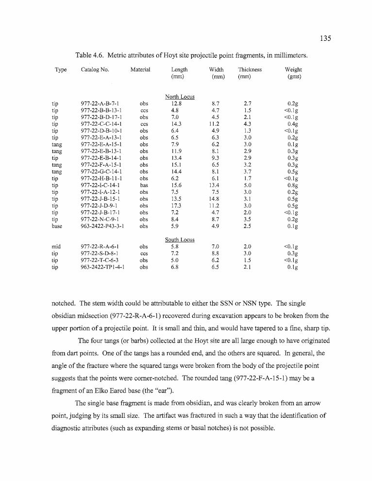
........----------------------
"'II'
135
Table 4.6. Metric attributes of Hoyt site projectile point fragments, in millimeters.
Type Catalog No. Material Length Width Thickness Weight(rnm) (rnm) (rnm) (grns)
North Locustip 977-22-A-B-7-1 obs 12.8 8.7 2.7 0.2gtip 977-22-B-B-13-1 ccs 4.8 4.7 1.5 <O.lgtip 977-22-B-D-17-1 obs 7.0 4.5 2.1 <O.lgtip 977-22-C-C-14-1 ccs 14.3 11.2 4.3 O.4gtip 977-22-D-B-IO-I obs 6.4 4.9 1.3 <O.lgtip 977-22-E-A-13-1 obs 6.5 6.3 3.0 0.2gtang 977-22-E-A-15-1 obs 7.9 6.2 3.0 O.lgtang 977-22-E-B-13-1 obs 11.9 8.1 2.9 0.3gtip 977-22-E-B-14-1 obs 13.4 9.3 2.9 0.3gtang 977-22-F-A-15-1 obs 15.1 6.5 3.2 0.3gtang 977-22-G-C-14-1 obs 14.4 8.1 3.7 0.5gtip 977-22-H-B-II-I obs 6.2 6.1 1.7 <O.lgtip 977-22-I-C-14-1 bas 15.6 13.4 5.0 0.8gtip 977-22-I-A-12-1 obs 7.5 7.5 3.0 0.2gtip 977-22-J-B-15-1 obs 13.5 14.8 3.1 0.5gtip 977-22-J-D-9-1 obs 17.3 11.2 3.0 0.5gtip 977-22-J-B-17-1 obs 7.2 4.7 2.0 <O.lgtip 977-22-N-C-9-1 obs 8.4 8.7 3.5 0.2gbase 963-2422-P43-3-1 obs 5.9 4.9 2.5 O.lg
South Locusmid 977-22-R-A-6-1 obs 5.8 7.0 2.0 <O.lgtip 977-22-S-D-8-1 ccs 7.2 8.8 3.0 0.3gtip 977-22-T-C-6-3 obs 5.0 6.2 1.5 <O.lgtip 963-2422-TP 1-4-1 obs 6.8 6.5 2.1 O.lg
notched. The stem width could be attributable to either the SSN or NSN type. The single
obsidian midsection (977-22-R-A-6-1) recovered during excavation appears to be broken from the
upper portion of a projectile point. It is small and thin, and would have tapered to a fine, sharp tip.
The four tangs (or barbs) collected at the Hoyt site are all large enough to have originated
from dart points. One of the tangs has a rounded end, and the others are squared. In general, the
angle of the fracture where the squared tangs were broken from the body of the projectile point
suggests that the points were comer-notched. The rounded tang (977-22-F-A-15-1) may be a
fragment of an Elko Eared base (the "ear").
The single base fragment is made from obsidian, and was clearly broken from an arrow
point, judging by its small size. The artifact was fractured in such a way that the identification of
diagnostic attributes (such as expanding stems or basal notches) is not possible.
136
Drills and Awls
Seven tools from the Hoyt site may be classified as drills, punches, or awls, based on
either diagnostic or functional attributes (Table 4.7). Two ofthe artifacts are quite clearly shaped
for the purpose of either being hafted or held between thumb and forefinger and twisted back and
forth to bore holes in materials such as wood, bone, or leather. The remaining
five artifacts are elongated, shaft-like tools that would have served well for boring or punching
holes in various materials. The drills and punches were recovered across the Northern Locus, and
were not identified in discrete activity areas or work stations.
Specimen 977-22-SF-2 is a well-made drill manufactured from white CCS. The artifact
has a wide, thin base that has been corner-notched; ostensibly to create spurs for lashing the tool to
a handle. The base contracts to a narrow, ovate tip which is broken. This drill was surface
collected at the eastern-most portion of the North Locus. Specimen 963-2422-P43-2-1 is a
complete drill manufactured from obsidian. It has a thick, lenticular base that tapers to an almost
cylindrical drill tip 18.8 mm in length. Because of its thick, rounded construction, the base seems
more suited for gripping than for hafting.
Specimen 977-22-P-C-4-1 is a beige colored CCS drill tip, probably broken from an
expanding base. The artifact consists of a 24 mm long tip fragment that is almost cylindrical in
cross-section, and would have been well suited for boring holes in wood, bone or other hard
materials.
Specimen 963-2422-P42-4-1 is a thin, lenticular biface with a squared base that tapers
slightly towards the distal end of the artifact. The distal portion is missing, but it seems likely that
the artifact would have tapered to a point possibly useful as an awl for piercing holes in leather and
other relatively soft materials.
Specimen 977-22-E-A-17-1 is a "triface" created by (probably unintentional) snapping off
the edge of a large biface to create a long obsidian tool with a triangular cross-section. A
combination ofpercussion flaking and use wear have contributed to shaping the third face ofthe
artifact, and it appears to have served well as an awl.
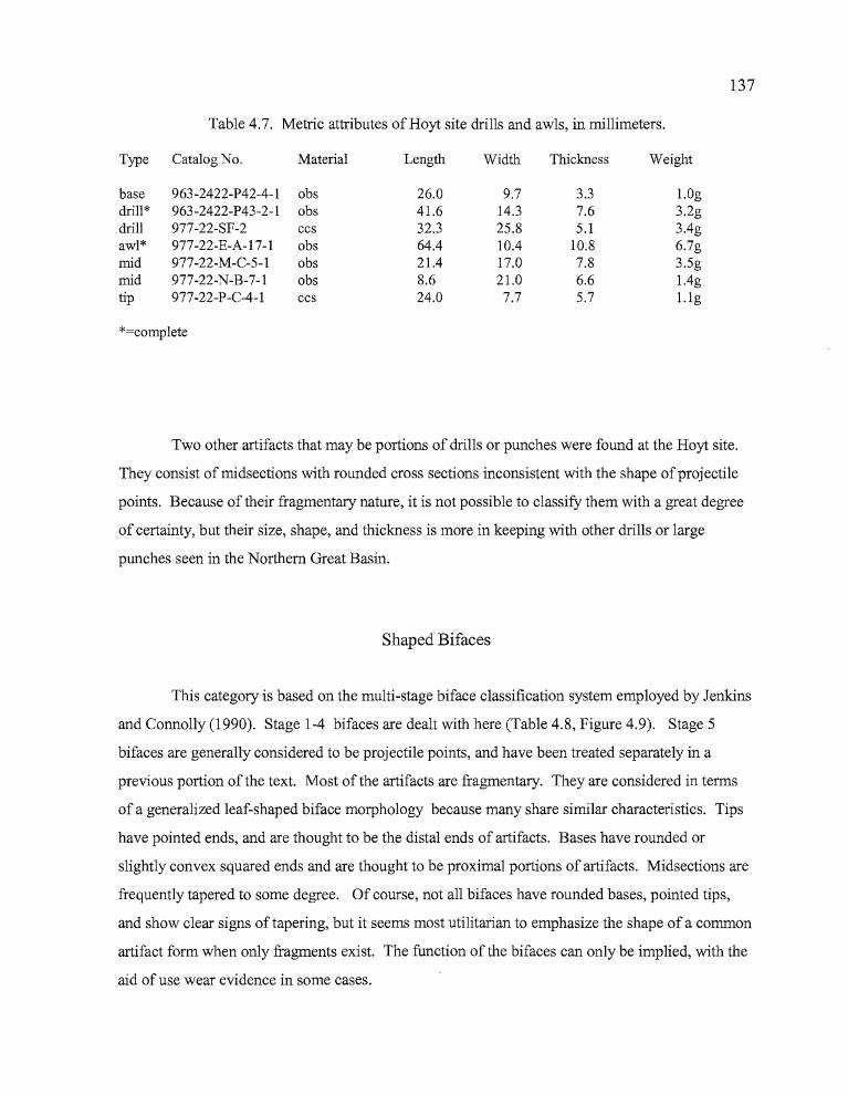
137
Table 4.7. Metric attributes of Hoyt site drills and awls, in millimeters.
Type Catalog No. Material Length Width Thickness Weight
base 963-2422-P42-4-l obs 26.0 9.7 3.3 LOgdrill* 963-2422-P43-2-l obs 41.6 14.3 7.6 3.2gdrill 977-22-SF-2 ccs 32.3 25.8 5.1 3Agawl* 977-22-E-A-17-l obs 6404 lOA 10.8 6.7gmid 977-22-M-C-5-l obs 21.4 17.0 7.8 3.5gmid 977-22-N-B-7-l obs 8.6 21.0 6.6 lAgtip 977-22-P-C-4-l ccs 24.0 7.7 5.7 1.lg
*=complete
Two other artifacts that may be portions of drills or punches were found at the Hoyt site.
They consist of midsections with rounded cross sections inconsistent with the shape ofprojectile
points. Because of their fragmentary nature, it is not possible to classifY them with a great degree
of certainty, but their size, shape, and thickness is more in keeping with other drills or large
punches seen in the Northern Great Basin.
Shaped Bifaces
This category is based on the multi-stage biface classification system employed by Jenkins
and Connolly (1990). Stage 1-4 bifaces are dealt with here (Table 4.8, Figure 4.9). Stage 5
bifaces are generally considered to be projectile points, and have been treated separately in a
previous portion of the text. Most of the artifacts are fragmentary. They are considered in terms
of a generalized leaf-shaped biface morphology because many share similar characteristics. Tips
have pointed ends, and are thought to be the distal ends of artifacts. Bases have rounded or
slightly convex squared ends and are thought to be proximal portions of artifacts. Midsections are
frequently tapered to some degree. Of course, not all bifaces have rounded bases, pointed tips,
and show clear signs of tapering, but it seems most utilitarian to emphasize the shape of a common
artifact form when only fragments exist. The function of the bifaces can only be implied, with the
aid of use wear evidence in some cases.
138
Stage 1 hi/aces. These bifaces have thick cross-sections and large, unpatterned flake
scars. They exhibit only the most rudimentary development, with rounded or thick lenticular
shapes and cross-sections. The flaking pattern reflects use of the hard hammer percussion
technique, and the edges of these tools can be very sinuous. A total of one CCS and 11 obsidian
bifaces and fragments fit this classification. Two are complete, roughly leaf-shaped tools that
exhibit unpatterned flaking with numerous deep flake scars and step fractures. One of these,
Specimen 977-22-H-C-12-l is very thick in cross section (12.2 mm), with cortex showing on one
side and areas of heavy use wear along the edges. The other, Specimen 977-22-0-C-12-2 is
thinner, with more sinuous edges that also show use wear. A total of two pointed end fragments
(tips), six rounded end fragments (bases), and two midsections (both are edge fragments) account
for the remaining Stage 1 artifacts.
Stage 2 hi/aces. Bifacial thinning is continued on these artifacts through the removal of
contiguous hard hammer percussion flakes. The removal of the flakes results in the development
of an artifact, which, although still crudely shaped, has a more pronounced form than stage 1
artifacts. Stage 2 bifaces are considered to be quarry blanks. A total of 13 artifacts fit this
classification; 12 of obsidian and one ofbasalt. All of the artifacts are fragmentary. Specimen
977-22-H-A-14-1 is missing a large portion of one side, but retains enough of its overall integrity
to determine that it was an ovoid biface 59.3 mm in length with strong evidence of use wear on all
of its remaining edges. The other Stage 2 artifacts consisted of five rounded base fragments, two
midsections, and five tips. The bases are primarily short, wide fragments of large convex-sided
bifaces. The flaking is unpatterned percussion flaking, though considerable thinning generally
occurred prior to breakage. One of the two midsection fragments is a single edged portion which
probably originated from a large biface. The five tips include four of obsidian and one ofbasalt.
The basalt tool (Specimen 977-22-R-C-12-1) is a relatively narrow (maximum width 27.3 mm)
and long (61.3 mm) fragment tapering to a flattened tip that was broken through utilization. The
tool displays unpatterned flaking which produced a deeply notched, sinuous edge. The edges of
the artifact are very rounded, possibly indicating heavy use. The four obsidian tips appear to be
derived from large bifaces. Three of the four tips show moderate to heavy use wear, and one does
not appear to have been used. A noteworthy concentration of Stage 2 bifacial fragments occurs in
Quad B ofUnit F in the main concentration of cultural materials, between Levels 8-15. Four
Stage 2 artifacts were recovered from the location, none of which can be joined together.
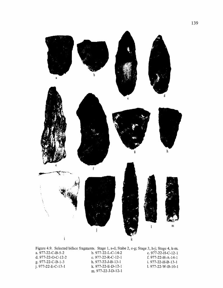
139
m
hg
f
a
k
Figure 4.9. Selected biface fragments. Stage 1, a-d; Stabe 2, e-g; Stage 3, h-j; Stage 4, k-m.a.977-22-C-B-5-2 b.977-22-L-C-14-2 c.977-22-H-C-12-1d.977-22-0-C-12-2 e.977-22-R-C-12-1 f.977-22-H-A-14-1g.977-22-C-B-1-3 h.977-22-J-B-13-1 i. 977-22-H-B-13-1j.977-22-E-C-13-1 k. 977-22-E-D-12-1 1. 977-22-W-B-10-1
m.977-22-J-D-12-1
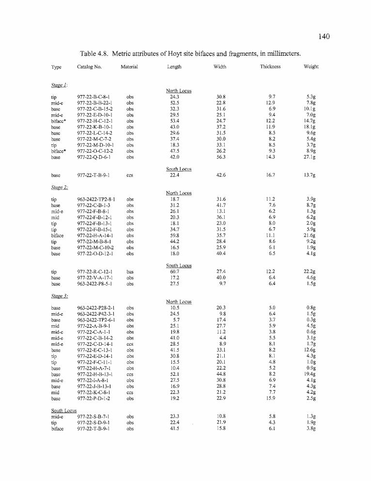
n •
140
Table 4.8. Metric attributes of Hoyt site bifaces and fragments, in millimeters.
Type Catalog No. Material Length Width Thickness Weight
Stage 1:North Locus
tip 977-22-B-C-8- I obs 24.3 30.8 9,7 5.3gmid-e 977-n-B-B-22- I obs 52.5 22.8 12,9 7.8gbase 977-22-C-B-15-2 obs 32.3 31.6 6.9 10.lgmid-e 977-22-E-D-IO-I obs 29.5 25.1 9.4 7.0gbiface* 977-22-H-C-12-1 obs 53.4 24.7 12.2 14.7gbase 977-22-K-B-IO-I obs 43.0 37.2 11.9 18.lgbase 977-22-L-C-14-2 obs 29.6 31.5 8.5 9.6gbase 977-22-M-C-7-2 obs 37.4 30.0 8.2 5.4gtip 977-22-M-D-IO-I obs 18.3 33.1 8.5 3.7gbiface* 977-22-0-C- I2-2 obs 47.5 26.2 9.3 8.9gbase 977-22-Q-D-6-1 obs 42.0 56.3 14.3 27.lg
South Locusbase 977-22-T-B-9-1 ccs 22.4 42.6 16.7 13.7g
Stage 2:North Locus
tip 963-2422-TP2-8- I obs 18.7 31.6 11.2 3.9gbase 977-22-C-B-I-3 obs 31.2 41.7 7.6 8.7gmid-e 977-22-F-B-8- I obs 26.1 13,1 6.2 I.3gmid 977-22-F-B-12-1 obs 20.3 36.1 6.9 6.2gtip 977-22-F-B-I3-1 obs 18. I 23.0 8.0 2.0gtip 977-22-F-B-15-1 obs 34.7 31.5 6.7 5.9gbiface 977-22-H-A-14-1 obs 59.8 35.7 11.1 21.6gtip 977-22-M-B-8-1 obs 44.2 28.4 8.6 9.2gbase 977-22-M-C-IO-2 obs 16.5 25.9 6.1 1.9gbase 977-22-0-D-12-1 obs 18.0 40.4 6.5 4.lg
South Locustip 977-22-R-C-12-1 bas 60.7 27.4 12.2 22.2gbase 977-22-V-A-17-1 obs 17.2 40.0 6.4 4.6gbase 963-2422-P8-5- I obs 27.5 9.7 6.4 I.5g
Stage 3:North Locus
base 963-2422-P28-2- I obs 10.5 20.3 5.0 0.8gmid-e 963-2422-P42-3- I obs 24.5 9.8 6.4 1.5gbase 963-2422-TP2-6-I obs 5.7 17.4 3.7 0.3gmid 977-22-A-B-9-1 obs 25.1 27.7 5.9 4.5gmid-e 977-22-C-A-I-I obs 19.8 11.2 3.8 0.6gmid-e 977-22-C-B-14-2 obs 41.0 4.4 5.5 3.lgmid-e 977-22-C-D-14-1 ccs 28.5 8.9 8.1 1.7gbase 977-22-E-C- I3- I obs 41.5 33.1 8.2 12.6gtip 977-22-E-D-14-1 obs 30.8 21.1 8. I 4.3gtip 977-22-F-C-II-1 obs 15.5 20.1 4.8 1.0gbase 977-22-H-A-7-1 obs 10.4 22.2 5.2 0.9gbase 977-22-H-B-I3-I ccs 52.1 44.8 8.2 19.4gmid-e 977-22-I-A-8-1 obs 27.5 30.8 6.9 4.lgbase 977-22-J-B-I3-1 obs 16.9 28.8 7.4 4.3gmid 977-22-K-C-8-1 ccs 22.3 21.2 7.7 4.2gbase 977-22-P-D-1-2 obs 19.2 22.9 15.9 2.5g
South Locusmid-e 977-22-S-B-7-1 obs 23.3 10.8 5.8 I.3gtip 977-22-S-D-9-1 obs 22.4 21.9 4.3 1.9gbiface 977-22-T-B-9-1 obs 41.5 15.8 6.1 3.8g
141
Table 4.8, (continued). Metric attributes of Hoyt site bifaces and fragments, in millimeters.
Type Catalog No. Material Length Width Thickness Weight
b b
Stage 4:North Locus
tip 977-22-SF-4 obs 32.5 26.1 10.3 7.2g977-22-C-B-8-2 obs 9.4 8.4 2.3 O.lg
tip 977-22-C-B-10-1 obs 13.5 10.8 4.8 O.4gbase 977-22-D-D-19-1 obs 12.3 27.8 5.3 1.9gtip 977-22-E-C-12-1 obs 15.5 18.6 5.1 LOgbiface 977-22-E-D-12-1 obs 59.8 17.7 8.5 7.7gbase 977-22-I-A-10-1 obs 10.6 17.2 4.6 0.6gbase 977-22-I-D-12-1 obs 22.3 21.9 4.8 2.8gbase 977-22-J-D-12-1 obs 36.3 15.1 5.4 3.5gbase 977-22-N-A-9-1 obs 9.8 14.0 4.5 0.5g
South Locustip 977-22-R-D-8-1 obs 14.4 11.3 3.6 0.5gmid 977-22-T-A-7-1 obs 14.7 14.2 4.6 0.8gmid 977-22-U-B-11-1 obs 10.3 13.9 4.1 0.6gmid 977-22-U-D-14-1 obs 33.5 15.7 9.9 5.8gmid 977-22-W-B-1 0-1 obs 38.4 15.2 6.8 4.2g
key: e=midsection edge fragmentc=comp1ete
Stage 3 bifaces. These bifaces exhibit little to no evidence of pressure flaking and have
the slightly sinuous edges characteristic of large percussion flake scars created by the initial stages
of bifacial reduction. The entire artifact surface has been modified through the removal of flakes
which can reach the middle of the artifact. It is at this stage that major thinning of the artifact
occurs, often leading to breakage. A total of 19 biface fragments fit this classification, of which 16
are obsidian and three are CCS. All of the artifacts exhibited fine pressure flaking along some
edges, with varying degrees of percussion flaking along other edges and across the body of the
artifact.
Three of the fragments are tips. All of the tips are made of obsidian and have broadly
convex edges tapering to a sharp point. Two of the tips are well-thinned in cross-section; the third
has a rather thick, plano-convex cross-section. The eight midsections included six edge fragments.
Two of the midsection fragments were manufactured from a brownish-tan CCS, including one of
the edge fragments. The rest are made from obsidian. The base fragments include five rounded
bases, two squared bases (977-22-I-C-13-l and 977-22-P-D-1-2), and an almost complete
142
rectangular biface. The rounded bases included one large, semi-translucent, tannish-white CCS
fragment (977-22-H-B-13-1). The biface 977-22-T-B-9-1 is plano-convex in cross-section, with
the convex surface displaying a combination ofpressure and percussion flaking, and the flat
surface entirely pressure flaked. The flat surface shows patination, and evidence ofrounding
along the ridges between flake scars, suggesting that weathering due to surface exposure may have
affected the artifact. The roughly rectangular biface was slightly tapered on one end, and evidence
of use wear was most pronounced on the tapered portion.
Stage 4 bifaces. The continuation ofpercussion and pressure flaking techniques after
Stage 3 results in bifaces with a more "finished" appearance than Stage 3 tools. Pressure flakes
can reach the midline of the artifact or beyond, and frequently eliminate the large percussion flake
scars from earlier reduction. Edges are strengthened by the removal ofpressure flakes which
increase the edge angle. Fifteen Stage 4 artifacts were collected from the Hoyt site, including five
tips, four midsections, five bases, and an almost complete biface. The biface is a long (59.8 mm)
and narrow (17.7 mm) leaf-shaped artifact that is missing the tip and a small portion of the base. It
is almost entirely pressure flaked, with parallel flake scars meeting at the midline. The slightly
serrated edges show minimal use wear on the peaks between flake scars. The five tips included
three relatively small fragments that may have originated from dart-sized projectile points, one
medium sized fragment, and one large fragment. The latter artifact (977-22-SF-4) has a thick,
lenticular cross-section and is almost entirely pressure flaked, with flake scars running diagonally
across the body on one side, and meeting at the midline on the other. Use wear is almost uniform
along the edges of the tool; in part due to the straight, well prepared edge angles. The three "dart
like" tips are not flaked with the refinement of a Stage 5 biface, but the combination of thinning,
edge preparation, and sharply pointed tips suggest that these artifacts would have made suitable
projectile points. The four midsection fragments include one edge fragment from a very large
biface and a substantial portion of a long, thick tool that may have been a drill or an awl (977-22
W-B-lO-l). Among the four bases are two fragments which appear to be partial stem and base
portions of comer-notched points (977-22-I-A-1O-l and 977-22-N-A-9-1), a fragment of a large,
square-based biface, and a long, thin, square-based tool fragment that tapers slightly towards the
distal end (977-22-J-D-12-1). This tool has diagonal flaking across the body, and evidence of use
wear increases away from the proximal end.
143
Edge-modified Flakes
These artifacts include expedient flake tools, spokeshaves, and flakes that have prepared
edges suited to a variety of cutting and scraping tasks. The former commonly have unifacial
chipping on one side of the artifact which is the result of unintentional modification through use,
with flakes being removed from the far side of the tool as it is held perpendicular to the worked
object and drawn towards the user (Kiigemagi 1989: 148). In some cases, bifacial chipping is
exhibited due to the use ofboth sides of the flake for such tasks. This type of edge modification
can occur along the same edge or at separate locations on the artifact. Artifacts with prepared
edges include scrapers with at least one edge strengthened by steep pressure-flaking for long term
use. Spokeshaves generally have a narrow crescentic notch ideal for scraping curved or rounded
surfaces.
A total of 129 artifacts exhibit use wear characteristic of edge-modified flakes. Of these,
96 are unifaces, 15 are bifacially worked specimens, 14 are transversely flaked, and four can be
classified as spokeshaves. There were four CCS, five basalt, and 120 obsidian tools in the
assemblage. The CCS tools included two transversely flaked specimens and two unifaces. Basalt
tools included two spokeshaves, two unifaces and one bifacially flaked specimen. The highest
concentrations of utilized flakes were found in the units of the North Locus, particularly from the
area surrounding Feature 1.
Two of the four spokeshaves are manufactured from obsidian. Specimen 977-22-H-D-13
1 has a slight, crescent-shaped indentation 15.9 mm long and 2.9 mm deep. The worked surface is
unifacial, and the few use-generated pressure flakes removed from the edge suggests that the
artifact was used for only a short time. Additional flakes removed from elsewhere along the
notched edge seem to indicate that the artifact was initially a flake tool which saw secondary use as
a spokeshave. Specimen 963-2422-TP2-9-1 has a deep, well rounded notch which tapers to a
sharp spur on one side that may have been used for incising material such as wood or bone. The
curved surface is 18.7 mm long and 7.8 mm deep.
The two basalt spokeshaves were made on substantially larger and thicker modified flakes
than the obsidian tools. Because basalt is such dense material and holds an edge better than
obsidian, it is possible that these artifacts were being used in the manufacture of larger tools or
perhaps tools constructed of a denser material for which obsidian was not suitable. Specimen 977-
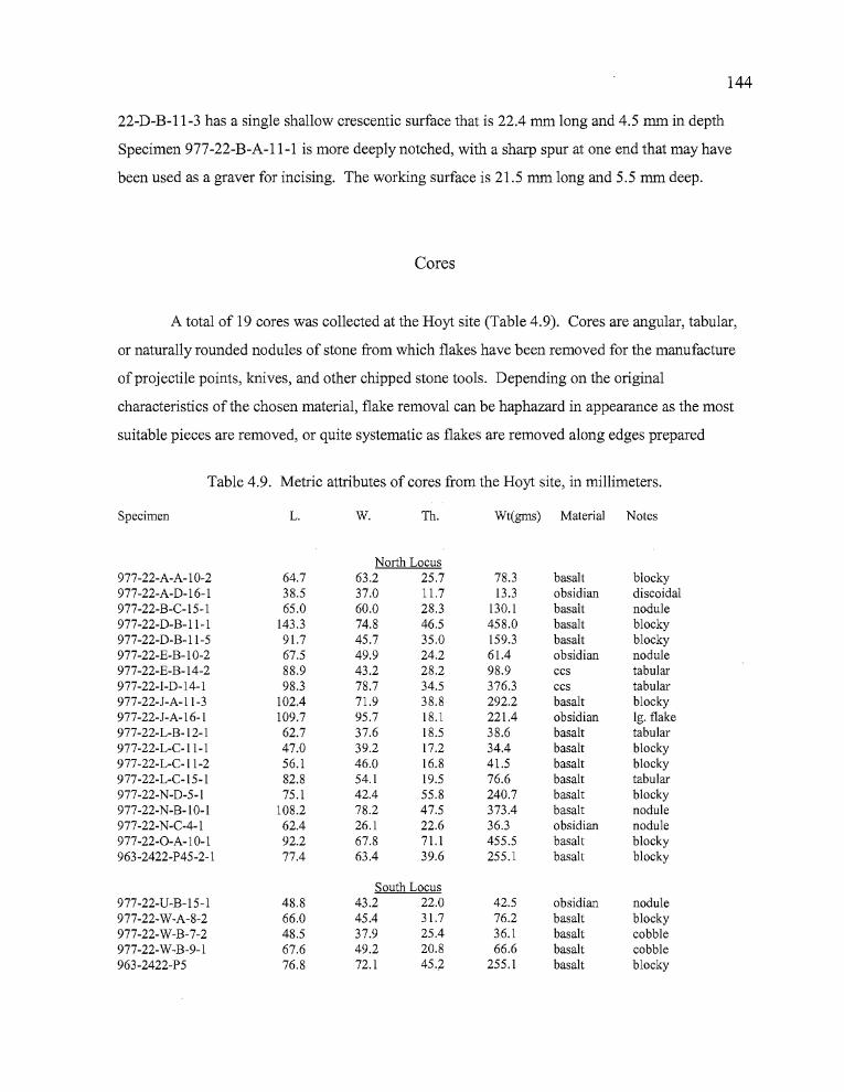
....~----------------------------------_._--_._.,,",I '
144
22-D-B-11-3 has a single shallow crescentic surface that is 22.4 mm long and 4.5 mm in depth
Specimen 977-22-B-A-11-1 is more deeply notched, with a sharp spur at one end that may have
been used as a graver for incising. The working surface is 21.5 mm long and 5.5 mm deep.
Cores
A total of 19 cores was collected at the Hoyt site (Table 4.9). Cores are angular, tabular,
or naturally rounded nodules of stone from which flakes have been removed for the manufacture
ofprojectile points, knives, and other chipped stone tools. Depending on the original
characteristics of the chosen material, flake removal can be haphazard in appearance as the most
suitable pieces are removed, or quite systematic as flakes are removed along edges prepared
Table 4.9. Metric attributes of cores from the Hoyt site, in millimeters.
Specimen L. W. Th. Wt(gms) Material Notes
North Locus977-22-A-A-IO-2 64.7 63.2 25.7 78.3 basalt blocky977-22-A-D-16-1 38.5 37.0 11.7 13.3 obsidian discoidal977-22-B-C-15-1 65.0 60.0 28.3 130.1 basalt nodule977-22-D-B-Il-I 143.3 74.8 46.5 458.0 basalt blocky977-22-D-B-II-5 91.7 45.7 35.0 159.3 basalt blocky977-22-E-B-IO-2 67.5 49.9 24.2 61.4 obsidian nodule977-22-E-B-14-2 88.9 43.2 28.2 98.9 ccs tabular977-22-I-D-14-1 98.3 78.7 34.5 376.3 ccs tabular977-22-J-A-II-3 102.4 71.9 38.8 292.2 basalt blocky977-22-J-A-16-1 109.7 95.7 18.1 221.4 obsidian Ig. flake977-22-L-B-12-1 62.7 37.6 18.5 38.6 basalt tabular977-22-L-C-II-I 47.0 39.2 17.2 34.4 basalt blocky977-22-L-C-II-2 56.1 46.0 16.8 41.5 basalt blocky977-22-L-C-15-1 82.8 54.1 19.5 76.6 basalt tabular977-22-N-D-5-1 75.1 42.4 55.8 240.7 basalt blocky977-22-N-B-IO-1 108.2 78.2 47.5 373.4 basalt nodule977-22-N-C-4-1 62.4 26.1 22.6 36.3 obsidian nodule977-22-0-A-I0-l 92.2 67.8 71.1 455.5 basalt blocky963-2422-P45-2-1 77.4 63.4 39.6 255.1 basalt blocky
South Locus977-22-U-B-15-1 48.8 43.2 22.0 42.5 obsidian nodule977-22-W-A-8-2 66.0 45.4 31.7 76.2 basalt blocky977-22-W-B-7-2 48.5 37.9 25.4 36.1 basalt cobble977-22-W-B-9-1 67.6 49.2 20.8 66.6 basalt cobble963-2422-P5 76.8 72.1 45,~ 255.1 basalt blocky
145
in advance. Cores may be disposed of when exhausted, but can also be utilized as tools for other
purposes with the removal of additional flakes to enhance their suitability for cutting and chopping
tasks. Concentrations of cores occurred at one location in the North Locus and one in the South
Locus. Six cores were recovered in adjoining Units J and L, to the east of Feature 1. Other units
in the North Locus produced one or two cores, but the presence of six between 50-80 cm in depth
in an eight square meter area suggests that a lithic reduction activity area may have existed at that
location, somewhat removed from the principal occupation area. At the South Locus, three cores
were collected in Unit W, indicating that similar activities may have occurred there.
Core and Flake Tools
Core and flake tools are large, unshaped to roughly shaped tools exhibiting unpattemed
flaking and edge damage associated with the performance of tasks such as cutting, scraping, and
chopping (Table 4.10). The used edges may exhibit additional modification to improve cutting
ability, but often the edges are altered only by wear associated with use. Core and flake tools can
be either unifacial or bifacial. As a group, large core and flake tools differ from either utilized
flakes or Stage 1 bifaces in two ways. First, their overall size and mass suit them best for work
that would damage thinner, more refined tools, suggesting that they were designed for hard use in
tasks such as shaping wood, scraping hides, or butchering large game animals. Second, they are
frequently made of very dense lithic materials including CCS and basalt, capable of holding an
edge under heavy use conditions. There are characteristics which core and flake tools share with
other tool categories such as edge-modified flakes, but, as a whole, they belong to a distinct class
of tools designed for specific activities. All seven of the tools were recovered from the North
Locus. Four of the seven tools were recovered from Units D, G, and H, surrounding Feature 1.
These include a chopper from Unit D, two flake tools from Unit G, and a scraper from Unit H.
Three specimens are basalt flake tools which were probably used for various cutting tasks.
Specimen 977-22-A-C-8-1 is bifacial, rectangular, and has cutting edges on three of its four sides.
Microflakes have been removed bifacially through use, and one edge has a crescentic-shaped
notch rounded by use as a spokeshave. Specimen 977-22-G-B-7-1 is also roughly rectangular in
shape, with use wear visible on both of its shorter sides. One of the used edges is bifacial, and the
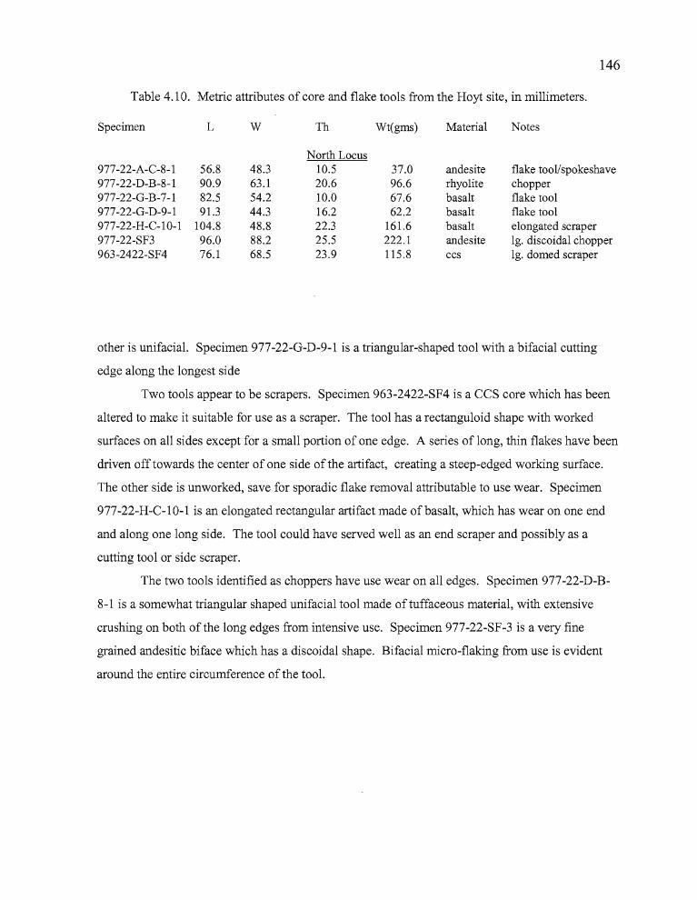
146
Table 4.10. Metric attributes of core and flake tools from the Hoyt site, in millimeters.
Specimen L W Th Wt(gms) Material Notes
North Locus977-22-A-C-8-l 56.8 48.3 10.5 37.0 andesite flake tool/spokeshave977-22-D-B-8-l 90.9 63.1 20.6 96.6 rhyolite chopper977-22-G-B-7-l 82.5 54.2 10.0 67.6 basalt flake tool977-22-G-D-9-l 91.3 44.3 16.2 62.2 basalt flake tool977-22-H-C-lO-l 104.8 48.8 22.3 161.6 basalt elongated scraper977-22-SF3 96.0 88.2 25.5 222.1 andesite 19. discoidal chopper963-2422-SF4 76.1 68.5 23.9 115.8 ccs 19. domed scraper
other is unifacial. Specimen 977-22-G-D-9-l is a triangular-shaped tool with a bifacial cutting
edge along the longest side
Two tools appear to be scrapers. Specimen 963-2422-SF4 is a CCS core which has been
altered to make it suitable for use as a scraper. The tool has a rectanguloid shape with worked
surfaces on all sides except for a small portion of one edge. A series of long, thin flakes have been
driven off towards the center of one side of the artifact, creating a steep-edged working surface.
The other side is unworked, save for sporadic flake removal attributable to use wear. Specimen
977-22-H-C-10-l is an elongated rectangular artifact made of basalt, which has wear on one end
and along one long side. The tool could have served well as an end scraper and possibly as a
cutting tool or side scraper.
The two tools identified as choppers have use wear on all edges. Specimen 977-22-D-B
8-1 is a somewhat triangular shaped unifacial tool made of tuffaceous material, with extensive
crushing on both of the long edges from intensive use. Specimen 977-22-SF-3 is a very fine
grained andesitic biface which has a discoidal shape. Bifacial micro-flaking from use is evident
around the entire circumference of the tool.
,."
• •
147
Debitage
A total of 89,473 pieces of obsidian debitage were analyzed for this study. Mass analysis
(Ah1er 1989) was conducted by passing the debitage through a series ofnested screens which were
1",1/2",1/4", and 1/8" (GI-G4 respectively); metrically sized at 35.9 mm, 18.0 mm, 8.0 mm, and
3.6 mm. The contents of each screen were counted, weighed, and examined for the presence of
exterior cortex (Figure 4.10, Table 4.11).
The data derived through the mass analysis process permits interpretations regarding lithic
reduction activities ocurring at an archaeological site primarily through the quantification of size
grades. Early tool production strategies such as core reduction and the preparation of quarry
blanks commonly involves the removal of larger flakes through percussion flaking. Late stage
lithic reduction may require the use ofboth percussion and pressure flaking, but flake size tends to
decrease as the emphasis shifts from bulk removal to thinning and final shaping of the artifact. In
terms of size-graded artifacts, early stage lithic reduction would be evident through an emphasis on
Gland G2 flakes in the assemblage while late stage reduction activities would be apparent by a
shift to grades G3 and G4.
The Gl and G2 classes accounted for four percent of the obsidian debitage at the Hoyt
site, with G1 providing only 0.08% and 3.2% identified as G2. The G3 material comprised
20.4%, and the vast majority ofthe debitage was of the G4 class, accounting for 76.3 % of the
total. Less than three percent (2.84 %) of the flakes had cortex, most of which (2.1%) were
identified as G3 or G4. Overall, the limited quantities of Gland G2 flakes and cortex flakes in
any size grade, in conjunction with the high quantities of G3 and G4 debitage seems to indicate
that late stage reduction activities were most prevalent at the Hoyt site.
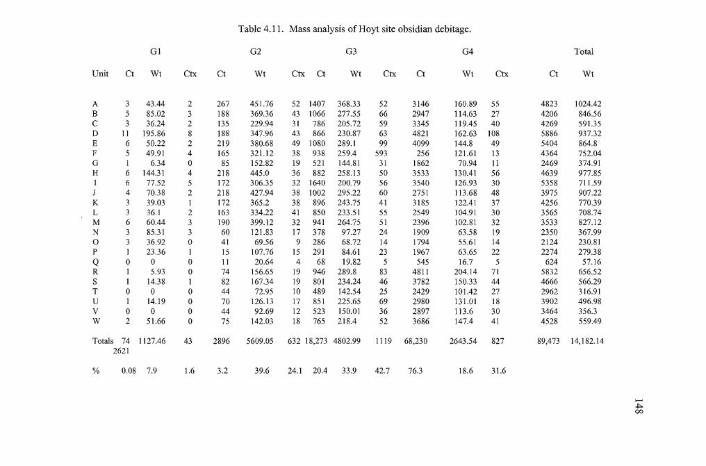
Table 4.11. Mass analysis of Hoyt site obsidian debitage.
Gl G2 G3 G4 Total
Unit Ct Wt Ctx Ct Wt Ctx Ct Wt Ctx Ct Wt Ctx Ct Wt
A 3 43.44 2 267 451.76 52 1407 368.33 52 3146 160.89 55 4823 1024.42B 5 85.02 3 188 369.36 43 1066 277.55 66 2947 114.63 27 4206 846.56C 3 36.24 2 135 229.94 31 786 205.72 59 3345 119.45 40 4269 591.35D 11 195.86 8 188 347.96 43 866 230.87 63 4821 162.63 108 5886 937.32E 6 50.22 2 219 380.68 49 1080 289.1 99 4099 144.8 49 5404 864.8F 5 49.91 4 165 321.12 38 938 259.4 593 256 121.61 13 4364 752.04G I 6.34 0 85 152.82 19 521 144.81 31 1862 70.94 11 2469 374.91H 6 144.31 4 218 445.0 36 882 258.13 50 3533 130.41 56 4639 977.85I 6 77.52 5 172 306.35 32 1640 200.79 56 3540 126.93 30 5358 711.59J 4 70.38 2 218 427.94 38 1002 295.22 60 2751 113.68 48 3975 907.22K 3 39.03 1 172 365.2 38 896 243.75 41 3185 122.41 37 4256 770.39L 3 36.1 2 163 334.22 41 850 233.51 55 2549 104.91 30 3565 708.74M 6 60.44 3 190 399.12 32 941 264.75 51 2396 102.81 32 3533 827.12N 3 85.31 3 60 121.83 17 378 97.27 24 1909 63.58 19 2350 367.990 3 36.92 0 41 69.56 9 286 68.72 14 1794 55.61 14 2124 230.81P I 23.36 1 15 107.76 15 291 84.61 23 1967 63.65 22 2274 279.38Q 0 0 0 II 20.64 4 68 19.82 5 545 16.7 5 624 57.16R I 5.93 0 74 156.65 19 946 289.8 83 4811 204.14 71 5832 656.52S 1 14.38 1 82 167.34 19 801 234.24 46 3782 150.33 44 4666 566.29T 0 0 0 44 72.95 10 489 142.54 25 2429 101.42 27 2962 316.91U I 14.19 0 70 126.13 17 851 225.65 69 2980 131.01 18 3902 496.98V 0 0 0 44 92.69 12 523 150.01 36 2897 113.6 30 3464 356.3W 2 51.66 0 75 142.03 18 765 218.4 52 3686 147.4 41 4528 559.49
Totals 74 1127.46 43 2896 5609.05 632 18,273 4802.99 1119 68,230 2643.54 827 89,473 14,182.142621
% 0.08 7.9 1.6 3.2 39.6 24.1 20.4 33.9 42.7 76.3 18.6 31.6
........~00
.~
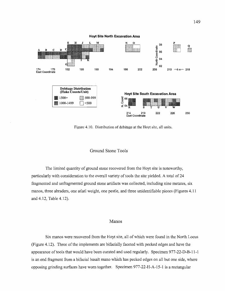
149
Hoyt Site North Excavation Area
210 ~8 m~ 218174 178East Coordinate
182 186 190 194
N 0
[illEJ
198 202
OJ 98
~'E 96g~ 94'5z 92
206
p
IT] Q
!ill
Debitage Distribution(Flake CountslUnit)
l1li 1500+ D 500-999
!.W 1000-1499 D <500
Hoyt Site South Excavation Area
~ 66aU
:i 64 R
214 218East Coordinate
222 226 230
Figure 4.10. Distribution of debita.e;e at the Hoyt site, all units.
Ground Stone Tools
The limited quantity of ground stone recovered from the Hoyt site is noteworthy,
particularly with consideration to the overall variety of tools the site yielded. A total of 24
fragmented and unfragmented ground stone artifacts was collected, including nine metates, six
manos, three abraders, one atlatl weight, one pestle, and three unidentifiable pieces (Figures 4.11
and 4.12, Table 4.12).
Manos
Six manos were recovered from the Hoyt site, all of which were found in the North Locus
(Figure 4.12). Three of the implements are bifacially faceted with pecked edges and have the
appearance of tools that would have been curated and used regularly. Specimen 977-22-D-B-11-1
is an end fragment from a bifacial basalt mano which has pecked edges on all but one side, where
opposing grinding surfaces have worn together. Specimen 977-22-H-A-15-1 is a rectangular
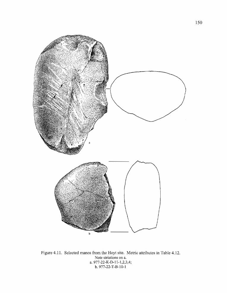
150
Figure 4.11. Selected manos from the Hoyt site. Metric attributes in Table 4.12.Note striations on a.
a.977-22-K-D-li-l,2,3,4;b.977-22-T-B-1O-l
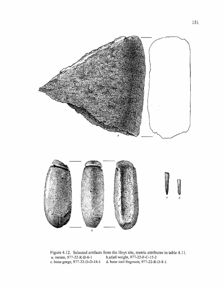
151
b
C d
Figure 4.12. Selected artifacts from the Hoyt site, metric attributes in table 4.11.a. metate, 977-22-R-B-8-1 b.atlatl weight, 977-22-F-C-15-2
c. bone gorge, 977-22-D-D-18-1 d. bone tool fragment, 977-22-R-D-8-1
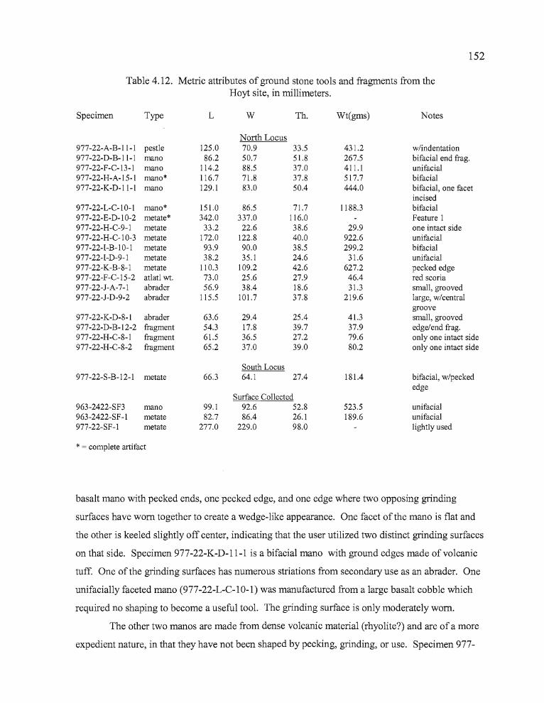
~;
152
Table 4.12. Metric attributes of ground stone tools and fragments from theHoyt site, in millimeters.
Specimen Type L W Th. Wt(gms) Notes
North Locus977-22-A-B-11-1 pestle 125.0 70.9 33.5 431.2 w/indentation977-22-D-B-11-1 mana 86.2 50.7 51.8 267.5 bifacia1 end frag.977-22-F-C-13-1 mana 114.2 88.5 37.0 411.1 unifacia1977-22-H-A-15-1 mana* 116.7 71.8 37.8 517.7 bifacia1977-22-K-D-11-1 mana 129.1 83.0 50.4 444.0 bifacia1, one facet
incised977-22-L-C-10-1 mana* 151.0 86.5 71.7 1188.3 bifacia1977-22-E-D-10-2 metate* 342.0 337.0 116.0 Feature I977-22-H-C-9-1 metate 33.2 22.6 38.6 29.9 one intact side977-22-H-C-10-3 metate 172.0 122.8 40.0 922.6 unifacial977-22-I-B-10-1 metate 93.9 90.0 38.5 299.2 bifacial977-22-I-D-9-1 metate 38.2 35.1 24.6 31.6 unifacia1977-22-K-B-8-1 metate 110.3 109.2 42.6 627.2 pecked edge977-22-F-C-15-2 atlatl wt. 73.0 25.6 27.9 46.4 red scoria977-22-J-A-7-1 abrader 56.9 38.4 18.6 31.3 small, grooved977-22-J-D-9-2 abrader 115.5 101.7 37.8 219.6 large, w/central
groove977-22-K-D-8-1 abrader 63.6 29.4 25.4 41.3 small, grooved977-22-D-B-12-2 fragment 54.3 17.8 39.7 37.9 edge/end frag.977-22-H-C-8-1 fragment 61.5 36.5 27.2 79.6 only one intact side977-22-H-C-8-2 fragment 65.2 37.0 39.0 80.2 only one intact side
South Locus977-22-S-B-12-1 metate 66.3 64.1 27.4 181.4 bifacia1, w/pecked
edgeSurface Collected
963-2422-SF3 mana 99.1 92.6 52.8 523.5 unifacia1963-2422-SF-I metate 82.7 86.4 26.1 189.6 unifacia1977-22-SF-1 metate 277.0 229.0 98.0 lightly used
* = complete artifact
basalt mano with pecked ends, one pecked edge, and one edge where two opposing grinding
surfaces have worn together to create a wedge-like appearance. One facet of the mano is flat and
the other is keeled slightly off center, indicating that the user utilized two distinct grinding surfaces
on that side. Specimen 977-22-K-D-11-1 is a bifacial mano with ground edges made of volcanic
tuff. One of the grinding surfaces has numerous striations from secondary use as an abrader. One
unifacially faceted mano (977-22-L-C-1O-1) was manufactured from a large basalt cobble which
required no shaping to become a useful tool. The grinding surface is only moderately worn.
The other two manos are made from dense volcanic material (rhyolite?) and are of a more
expedient nature, in that they have not been shaped by pecking, grinding, or use. Specimen 977-
pro
153
22-F-C-13-l is a naturally rounded, hand-sized cobble which has minimal evidence of use on one
side. Light striations are visible, but grinding activity did not penetrate the calcium carbonate crust
covering the surface to the stone below. The striations run perpendicular to the length of the
artifact. Specimen 963-2422-SF3 is a portion of an oval to rectangular shaped rhyolitic cobble that
was broken along one end, removing much of one side in the process. The unbroken side shows
limited evidence of use, probably as a mano. The broken portion of the opposite side has been
darkened either by proximity to a hearth or by a processing activity involving materials which were
later baked on by heat.
Metates
The nine metates found at the Hoyt site show considerable variation in size, shape and
manufacture. All but one were collected in the North Locus. Four are fragmentary (977-22-F-B
10-1, 977-22-H-C-9-l, 977-22-I-D-9-l, and 977-22-S-B-12-l), and little can be said about them
other than they all are basalt and have flat, well worn grinding surfaces. Specimens 963-2422
SFl, 977-22-H-B-8-l and 977-22-H-C-lO-3 are all large fragments which have pecked, rounded
edges. These fragments are made of scoria, basalt, and welded tuff, respectively. Two metates
were fashioned from large bedrock slabs. Specimen 977-22-E-D-lO-2 is a large basalt metate
with a well worn grinding surface, identified as the principal component in Feature 1 at the North
Locus. Specimen 977-22-SFl, made from reddish-colored welded tuff was surface collected at
the North Locus. The artifact shows limited grinding use. The surface patination has been
removed from a lOx12 cm area, though the worn area shows minimal polishing. A small
depression in one comer of the faceted surface may be evidence of occasional use as a hopper
mortar.
Abraders
Abraders are implements used for a variety of tasks involving the shaping and sharpening
of wood, bone, and stone tools. Four abraders were collected at the Hoyt site (Fig. 4.13); three of
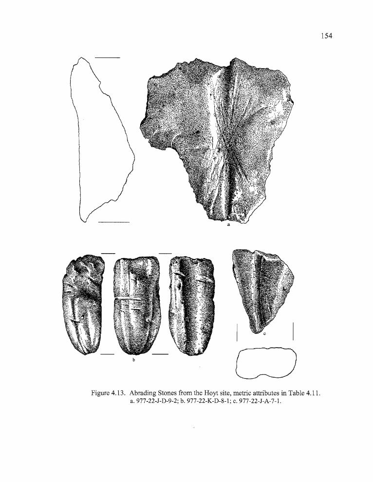
Ir'154
b
Figure 4.13. Abrading Stones from the Hoyt site, metric attributes in Table 4.11.a. 977-22-J-D-9-2; b. 977-22-K-D-8-1; c. 977-22-J-A-7-1.
155
which were used specifically for abrading tasks, and one which was a mano that had a series of
striations across one of its faceted surfaces. All abrading tools were manufactured from light,
relatively soft tuffaceous material. Specimen 977-22-J-A-7-1 is a roughly triangular shaped
fragment of welded tuff, unshaped except for a single smoothed surface with a V-shaped groove
11 mm wide and 2.5 mm deep running longitudinally across the artifact. The tool appears to have
been hand-held, with abrading activities being conducted in a bidirectional motion. Specimen 977
22-J-D-9-2 is a relatively broad, flat fragment of tuffaceous material which has not been shaped by
any means other than through abrading activities. The worked surface consists of a series of deep
striations which have created a broad, shallow trough extending longitudinally across the surface
of the artifact. Additional striations cross the main groove diagonally, overlapping it and creating
an X-like pattern. The juncture where the striations meet is worn more deeply than the rest of the
surface, perhaps suggesting that abrading activities were performed from the edge of the artifact
inward and involved the sharpening or smoothing of small tool surfaces.
Specimen 977-22-K-D-8-1 is a narrow, tapered abrader with a longitudinal groove that is
approximately 11.5 mm in width and 3 mm in depth. A narrow, incised notch runs transverse to
the groove approximately 9 mm from the distal end. The grooved surface is smooth and level.
The distal end of the abrader is a relatively flat, rough surface incised by three grooves crossing
each other at varying angles. The remaining portion of the artifact is rounded, tapering toward the
proximal end. Two crudely incised grooves extend longitudinally along both sides of the abrader,
radiating from the proximal end and continuing to the distal end of the artifact. A single groove
cuts perpendicularly across the longitudinal grooves on one side near the midline of the artifact.
The other side is too battered to detect the presence of a similar mark. A mano (977-22-K-D-11
(1-4)), is mentioned here because it has striations on one surface that correspond to marks seen on
more conventional abrading tools. The striations extend diagonally across the length of the
artifact, radiating outward from a more concentrated area at one end of the mano Fig. 4.11). The
mano was well made, with bifacia1 faceting and pecked and ground edges. Abrading was clearly a
secondary use for this artifact.
p
- •
156
Pestle
A single pestle fragment was recovered from Level 11 (50-55 cm) of Unit A in the North
Locus. It is from a pestle that probably broke in half, then cracked lengthwise, leaving a fragment
that may be representative of slightly more than a quarter of the original artifact. One end of the
artifact is battered and flattened, the other end has an uneven surface due to unintentional fracture,
with an edge that has either been pecked or worn to a slightly rounded smoothness. The surface of
the pestle fragment has an indentation approximately 80 mm long, 45 mm wide, and 5-9 mm in
depth, created by wear unrelated to its function as a pestle. The wear may have occurred after the
artifact was broken. Pestles of a similar nature have been found at other locations in the Northern
Great Basin and Plateau, including the Heath Cliffs site (Jenkins and Connolly 1996) Wildcat
Canyon (Dumond and Minor 1983) and Lake Abert (Oetting 1989). Oetting (1989) noted the
presence of red ochre on a similar pestle at Lake Abert, but does not specify if the pigment was
found in relation to the surface depression.
Atlatl Weight
A single atlatl weight (977-22-F-C-15-2) was recovered from the North Locus, in Level
15 (elevation 1267.84 m) of Unit F (Fig. 4.12). The artifact is made ofa reddish-orange welded
tuff which has been fashioned into a somewhat cylindrical form through grinding and abrading.
The atlatl weight has a ventral groove that extends the entire length of the artifact, varying between
1-3 mm in depth and 10-11 mm in width. The groove would have been positioned against the
surface of the atlatl, with lashing around the rounded artifact exterior to hold it in place. The
surface of the non-grooved portion has a smooth, almost polished appearance in places and fine
striations run lengthwise. An incised notch is located 6 mm from the proximal end of the artifact.
The notch is 3.3 mm wide and approximately 2 mm deep, and is the only demarcated lashing point
on the weight. Two utilized flakes and three biface fragments were the only artifacts recovered in
close proximity to the artifact.
157
Fragments
Three pieces are too fragmentary for classification to a particular category of ground
stone. Specimen 977-22-D-B-12-2 is a well smoothed basalt fragment with a rounded edge and a
flattened end. Specimens 977-22-H-C-8-l and 977-22-H-C-8-2 are conjoining fragments of the
same artifact which share one rounded edge and a flat, smooth surface.
Bone Tools
Three artifacts recovered from the Hoyt site appear to be bone tools (Table 4.13, Figure
4.12). Two of them are quite similar. Specimens 977-22-A-B-9-2 and 977-22-R-D-8-1 are small,
thin fragments of very light-colored bone that have been shaped into tools of an indeterminate use.
Both are highly polished and have rounded tips as well as rounded edges, which seems to indicate
that they were not crafted for use as fish gorges.
The third tool is a fragment of a sharply pointed cylindrical artifact that has the appearance
of a very large fish gorge. Manufactured from antler, the tool has a number of deep striations
running primarily along the length of the artifact, but others which have the appearance of cut
marks are incised diagonally across the artifact.
Table 4.13. Metric attributes ofbone tool fragments from the Hoyt site.
Specimen L W Th Wt(gms) Notes
977-22-A-B-9-2 10.6 2.8 1.0 <0.1 light colored polished bone977-22-D-D-18-l 23.8 4.5 4.0 0.5 antler, gorge?977-22-R-D-8-l 15.8 3.3 1.8 0.1 light colored polished bone

p
158
Botanical Remains
An analysis ofbotanical remains from the Hoyt site was conducted by Guy Prouty
(Prouty 2006). The following information has been adapted from his original report. The sample
was derived through the flotation of 12 bulk soil samples that were collected during excavation of
the site as feature and column samples.
Preservation ofbotanical remains was considered to be poor in all portions of the site.
Prouty attributes this to the effects of deflation, erosion, bioturbation, and other natural site
formation processes, but also suggests that sporadic occupations may have limited the amount of
material initially deposited. Sagebrush fuel wood was the only clearly identified material from the
site. Bark, grass seeds, and other seeds were fragmentary or distorted, and thus were not
identifiable to the species level. Potential food items such as processed edible plant tissues (PET)
and biscuit root were not identified with certainty, only at trace levels (Table 4.14).
Feature 1, the hearth around which the majority of the cultural materials are concentrated,
produced small amounts of sagebrush fuel wood. A bark fragment and two grass seeds were also
noted in the hearth samples, but were not identified as clearly being cultural material. Although
sporadic occupation of the site is considered as a possible reason for the general lack ofplant
materials, the abundance and diversity of cultural materials, including the recovery of over 17,000
pieces ofbone at the Hoyt site suggests otherwise. Plant processing tools were found in limited
quantities at Hoyt, but were relatively abundant at the nearby Morgan site where botanical remains
were similarly low. It is possible that the Hoyt site was occupied at a time when plant species were
not being targeted, but that does not explain the lack of those materials at the Morgan Site, where a
considerable number of ground stone fragments were collected. It seems more plausible that the
preservation qualities of the Sand Hills are not good for long term deposition ofplant remains.
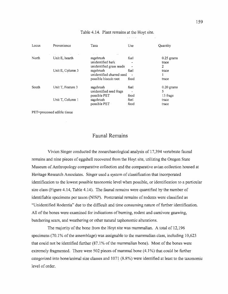
159
Table 4.14. Plant remains at the Hoyt site.
Locus Provenience Taxa Use Quantity
North
South
Unit E, hearth
Unit E, C()lumn 3
Unit T, Feature 3
Unit T, Column I
sagebrush fuelunidentified barkunidentified grass seedssagebrush fuelunidentified charred seedpossible biscuit root food
sagebrush fuelunidentified seed fragspossible PET foodsagebrush fuelpossible PET food
0.25 gramstrace2traceItrace
0.20 grams513 fragstracetrace
PET=processed edible tissue
Faunal Remains
Vivien Singer conducted the zooarchaeological analysis of 17,394 vertebrate faunal
remains and nine pieces of eggshell recovered from the Hoyt site, utilizing the Oregon State
Museum of Anthropology comparative collection and the comparative avian collection housed at
Heritage Research Associates. Singer used a system of classification that incorporated
identification to the lowest possible taxonomic level when possible, or identification to a particular
size class (Figure 4.14, Table 4.14). The faunal remains were quantified by the number of
identifiable specimens per taxon (NISP). Postcranial remains of rodents were classified as
"Unidentified Rodentia" due to the difficult and time consuming nature of further identification.
All of the bones were examined for indications ofburning, rodent and carnivore gnawing,
butchering scars, and weathering or other natural taphonomic alterations.
The majority of the bone from the Hoyt site was mammalian. A total of 12,196
specimens (70.1 % of the assemblage) was assignable to the mammalian class, including 10,623
that could not be identified further (87.1 % of the mammalian bone). Most of the bones were
extremely fragmented. There were 502 pieces of mammal bone (4.1 %) that could be further
categorized into bone/animal size classes and 1071 (8.8%) were identified at least to the taxonomic
level of order.
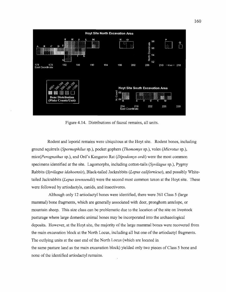
160
Figure 4.14. Distributions of faunal remains, all units.
Rodent and leporid remains were ubiquitous at the Hoyt site. Rodent bones, including
ground squirrels (Spermophilus sp.), pocket gophers (Thomomys sp.), voles (Microtus sp.),
mice(Perognathus sp.), and Ord's Kangaroo Rat (Dipodomys ordi) were the most common
specimens identified at the site. Lagomorphs, including cotton-tails (Syvilagus sp.), Pygmy
Rabbits (Syvilagus idahoensis), Black-tailed Jackrabbits (Lepus califomicus), and possibly White
tailed Jackrabbits (Lepus townsendii) were the second most common taxon at the Hoyt site. These
were followed by artiodactyls, canids, and insectivores.
Although only 12 artiodactyl bones were identified, there were 361 Class 5 (large
mammal) bone fragments, which are generally associated with deer, pronghorn antelope, or
mountain sheep. This size class can be problematic due to the location of the site on livestock
pasturage where large domestic animal bones may be incorporated into the archaeological
deposits. However, at the Hoyt site, the majority of the large mammal bones were recovered from
the main excavation block at the North Locus, including all but one of the artiodactyl fragments.
The outlying units at the east end of the North Locus (which are located in
the same pasture land as the main excavation block) yielded only two pieces of Class 5 bone and
none of the identified artiodactyl remains.
---
161
Avian remains included surface-feeding ducks (Anas sp.), diving ducks (Aythya sp.),
grebes (Podiceps sp.), and passerines (passeriforms). Bird remains were never concentrated, but
they were recovered from all units in the main excavation block at the North Locus, and from four
of the six units at the South Locus. No bird bones were collected from Units N-Q; the outlying
units at the North Locus.
Only 20 fish bones were recovered from deposits at the Hoyt site, half of which were
identified as Tui Chub (Gila bieolor). Fish remains were concentrated in the main excavation
block at the North Locus, particularly in Units B, C, and D. The South Locus produced only a few
speCImens.
Over half of the 492 amphibian remains were identified as Great Basin Spadefoot Toad
(Spea intermontana), and the rest of the amphibian bones were probably the same. Two reptile
bones could not be identified further.
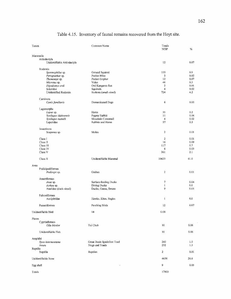
rTable 4.15. Inventory of faunal remains recovered from the Hoyt site.
162
Taxon
MammaliaArtiodactyla
Unidentifiable Artiodactyla
RodentiaSpermophi/us sp.Perognathus sp.Thomomys sp.Microtus sp.Dipodomys ordiSciuridaeUnidentified Rodentia
CarnivoraCanis familiaris
LagomorphaLepus sp.Syvilagus idahoensisSyvilagus nuttalliLeporidae
InsectivoraScapanus sp.
Class IClass IIClass IIIClass IVClass V
Class X
AvesPodicipediformes
Podiccps sp.
AnseriformesAnas sp.Aythya sp.Anatidae (duck-sized)
FalconiformesAccipitridae
Passeriformes
Unidentifiable Bird
PiscesCyprinifonnes
Gila bic%r
Unidentifiable Fish
AmphibiSpea intermontanaAnura
ReptiliaReptilia
Unidentifiable Bone
Egg shell
Totals
Common Name
Ground SquirrelPocket MicePocket GopherVolesOrd Kangaroo RatSquirrelsRodents (small-sized)
Domesticated Dogs
HaresPygmy RabbitMountain CottontailRabbits and Hares
Moles
Unidentifiable Mammal
Grebes
Surface-feeding DucksDiving DucksDucks, Geese, Swans
Hawks, Kites, Eagles
Perching Birds
14
Tui Chub
Great Basin Spadefoot ToadFrogs and Toads
Reptiles
TotalsNISP
12
1533
1246
24
724
6
35II4
57
2
216
1176
361
10623
2
719
12
0.08
10
10
260232
2
4638
9
17403
%
0.07
0.90.020.070.30.010.024.2
0.03
0.20.060.020.3
0.01
0.010.090.70.032.1
61.0
0.01
0.040.00.05
0.0
0.07
0.06
0.06
1.51.3
0.01
26.6
0.05
163
Summary
The Hoyt site is located on the south side of Sand Hill. Its placement provides a
commanding view of the marshland surrounding Poison Creek Slough, facing southward and
continuing from near the crest of the hill downslope to the east and south. Excavations at the site
included an upslope North Block and downslope South Block, which were examined for possible
differences in occupation functions based on their topographical locations. None were found, and
it appears that the site has a single major component. Calibrated radiocarbon dates of 280 BP
from a charcoal stain in the South Block, and 1830 BP from a hearth associated with a blackened
metate may reflect the major period ofpossible occupation episodes at the site, though these dates
probably do not reflect the entire range of occupations.
A total of 32 projectile points was collected, which included 27% Rose Spring, 6%
Eastgate, 22% Side-notched points (including both large and small side-notched), 25% Elko
Series, and 3% Humboldt Concave Base. Two types ofprojectile points fit more readily in
Columbia Plateau typologies, including an Expanding Stem-3 which comprised 3% of the total,
four Contracting Stem-2 points (13%), and one Contracting Stem-3 at 3%. All of the diagnostic
points were collected in the North Block except for one Northern Side-notched and one Elko
Eared point. Projectile types were vertically mixed, especially around the hearth (Feature 1). All
of the sourced Rose Spring, Side-notched, and Contracting Stem-2 obsidian artifacts originated
from the Bums source or from sources further north. The Elko Series points came from the Bums
source, two unidentified sources, and from the Beaty's Butte and Massacre Lake/Guano Valley
sources far to the south.
Utilized flakes were the most abundant tool category at the Hoyt site, accounting for 40%
of the assemblage. Formed tools comprised 38%, followed by ground stone at 7%, cores at 6%,
and abraders at 1%. Bone tools accounted for 1% of the total, and one atlatl weight was collected.
The diversity of tools, especially the inclusion of bone tools and abraders along with well-formed
ground stone fragments, suggests that the Hoyt site may have hosted occupational episodes that
were more prolonged in duration than the other temporary camps included in this report.
Obsidian hydration analyses conducted on 108 Bums Butte and Dog Hill artifacts from
the Hoyt site revealed a similar pattern to those analyzed from the Morgan site. Hydration
occurred much faster at these locations in comparison to other similarly aged Northern Great Basin
r164
sites due to the rapid adsorption characteristic of obsidian from the two sources. Rim
measurements ranged from 3.2 to 6.2 microns, with peaks at 4.5 and 5.5 microns, and a mean
frequency of 4.9 microns.
The Hoyt site faunal assemblage is characterized by an orientation towards primarily
terrestrial species and big game, with a lesser emphasis on marshland and aquatic species. A total
of 17,394 animal bones were collected at the Hoyt site, along with nine pieces of eggshell. Rodent
remains were the largest category of identified remains at the site, making up 63% of the total,
followed by artiodactyl and large mammal bones at 25%. Lagomorphs comprised 7%, and birds,
including both surface feeding and diving ducks made up 3% of the assemblage. Fish remains
were recovered in small quantities «1%), of which half were tui chub. Eggshell accounted for
<1 % of the remains, and may indicate some use of the site during the spring. The vast majority of
the large mammal, bird, and fish bones were recovered in the North Block, while rodent and
leporid bones dominated the South Block.
Botanical remains from the site were very limited. Feature 1, the 1890 year old hearth
associated with a metate, produced an abundance of sagebrush charcoal probably used as fuel and
a few unidentifiable seed fragments. The charcoal stain dated to 220 BP produced similar
materials. A fragment of what appears to be charred biscuitroot was the only other identifiable
material recovered from the macrobotanical samples.
Overall, the Hoyt site appears to have been occupied primarily for the exploitation of both
large and small game, with an emphasis on terrestrial species. Aquatic species were very limited,
but included both surface and diving ducks, and some fish. The diversity of both projectile point
types and formed tools, the high quantities of large mammal bone, the limited assemblage of
ground stone and the lack of identifiable plant food remains all seem to support the notion that the
Hoyt site served as a foraging base camp from which forays for the procurement of animal and (to
a lesser degree) plant resources originated.
~'I!
.......
165
CHAPTER VHINES SITE (35HA2692)
Data recovery excavations at the Hines site (Fig. 5.1) occurred in September of 1997.
Pettigrew (1986) recorded two sites in the vicinity; H-1 and H-2. The Hines site is H-2 under
Pettigrew's designation. The H-1 locality, approximately 0.4 km to the north, was destroyed by
commercial developments. The data recovery excavations reported here were guided by a data
recovery plan based on the results of testing at the site in May of 1997 (O'Grady et al. 1997).
Backhoe trenches and unit excavations permitted archaeologists and geomorphologists to interpret
the site in both cultural and physical contexts. It was recommended in the data recovery plan that
up to 60 m2 of deposits be excavated at three locations; the North, Central, and South Loci, as they
will be referred to in the following report. The three loci were established in concentrations of
cultural materials identified by the testing phase. Cultural materials proved to be limited vertically
in the North and South loci. Consequently, efforts were concentrated on two excavation blocks in
the Central Locus, termed the North and South Blocks. The total area excavated was 54 m2,
resulting in the removal of 24.0 m3 of fill.
Excavation Stategies
Testing
Test excavations at the the site in May, 1997 included three 1 x 1 meter test pits and
twenty-six 50 x 50 em probes (Jenkins 1997). The surface and upper 5-10 em of deposits had
been previously disturbed when shrubs and other vegetation were removed and the surface of the
site leveled with a grader to create a parking lot used for observing Fourth of July fireworks
displays over the sewage treatment ponds in the 1970s.
The remaining upper levels of the site, in which most cultural materials were found,
consist of a medium gray to brown sandy silt, ranging from 35 to 70 em in depth. Underlying this
silty deposit is a very compact, sterile deposit of light colored, bedded layers of gravelly,
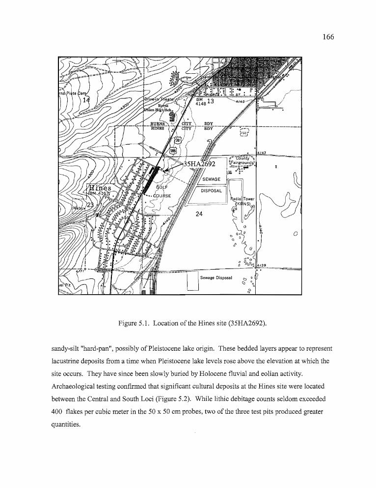
166
4/43
gO; =C-oUrlfy-~,\
1~F'airground~J~:;;a~~~':- •
qp IJ CI"/_ 0
Figure 5.1. Location of the Hines site (35HA2692).
o
sandy-silt "hard-pan", possibly of Pleistocene lake origin. These bedded layers appear to represent
lacustrine deposits from a time when Pleistocene lake levels rose above the elevation at which the
site occurs. They have since been slowly buried by Holocene fluvial and eolian activity.
Archaeological testing confirmed that significant cultural deposits at the Hines site were located
between the Central and South Loci (Figure 5.2). While lithic debitage counts seldom exceeded
400 flakes per cubic meter in the 50 x 50 em probes, two of the three test pits produced greater
quantities.
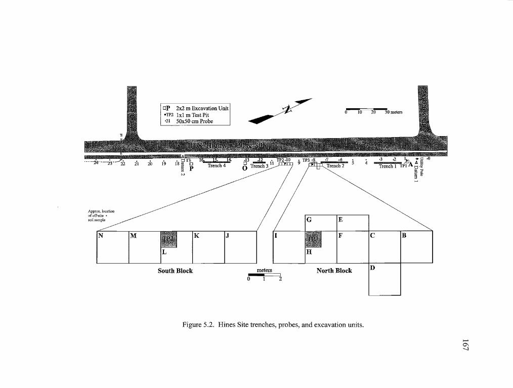
,
op 2x2 m Excavation Unit'TP2 Ixl m Test Pit'21 SOXSO cm Probe
Bc
D
10 20 30 meters
F
()
E
North Block2
meters
~
o
JK
South Block
M
Approx. locationof off~site •soil sample
N
Figure 5.2. Hines Site trenches, probes, and excavation units.
>-'01-.....l
168
Test Pit Two yielded 322 flakes in Level 6 (up to 3220 flakes/m3) and Test Pit Three produced 109
pieces of debitage (up to 1090 flakes/m3), a CCS projectile point tip, and a CCS utilized flake in
Level 2 alone.
Temporally diagnostic artifacts from the testing phase included one Rose Spring and one
Eastgate projectile point made of obsidian, and one basalt Elko Eared projectile point. Another
Elko Eared point made of obsidian was collected from the surface. It was found in an area where
the soil had been amended with fill from a motel development 0.4 km to the north, and the point
may have been transported from that location. The projectile points suggest that occupations in
the site vicinity may have spanned the last several thousand years. Other artifact types included
one obsidian biface fragment, one CCS projectile point tip, one obsidian and one basalt uniface,
two obsidian utilized flakes, one core, and 1332 pieces oflithic debitage. Also recovered were
burned and unburned faunal remains, including bones of various small mammals and birds.
Charcoal from an apparent hearth that was collected and submitted for radiocarbon dating yielded
an age determination of 1160 ± 50 BP (Beta-l05663). Fire altered rock was noted but not
collected. Observed flakes from lithic reduction activities ranged from small biface-thinning
flakes to fragments of raw nodules with cortex.
Data Recovery
Data recovery excavations at the Hines site were located in the right-of-way established
for improvements to U.S. Highway 20. The right-of-way consisted ofa 10 meter wide strip of
land that paralleled Highway 20 and the adjacent bicycle path. Trenching and excavations were
established in a linear pattern alongside the bike path. A vacant lot is located east of the site
between the highway and the golf course. The majority of the site deposits are believed to lie to
the west, covered by the bike path, highway, and the parking lot of a motel.
Four backhoe trenches were excavated to assess geomorphological relationships between
cultural and non-cultural deposits at the site (Figure 5.2). The trenches were established at
selected locations between the excavation blocks and more isolated excavation units. A small
.....
169
amount of debitage was evident in the backhoe backdirt piles, but there was no evidence that
trenching had affected obvious cultural features at the site. Trench 1 was the northern-most,
extending 2S meters between Unit A and Trench 2. Trench 2 was 20 meters south of Trench 1
and 20 meters in length, with its south end adjacent to Unit B in the North Block of the Central
Locus. Trench 3, nine meters south of the South Block of the Central Locus, was nine meters in
length. Trench 4 was 17 meters south of Trench 3 between Unit 0 and Unit P, extending for 20
meters. All trenches were dug four meters south of the bike path, following the path of the test
probes.
The four trenches cut across the toe of a substantial alluvial fan upon which the Hines site
is situated, originating on the slopes ofnearby Bums Butte. Gravel lenses within the deposits
suggest that a small channelized stream now located approximately 0.8 km to the north once
passed through the location. The site also appears to be situated at the edge of an ancient lake
shoreline (according to Pettigrew [1986] Pluvial Lake Malheur filled Harney Basin as recently as
9000 years ago), but fluctuations in precipitation levels over the course of the Holocene make it
difficult to determine what the lake level might have been at the time of site occupation.
Prior to excavation, an arbitrary datum was established on the bike path, a high point from
which a grid system could be controlled for the entire site. Using a Topcon GTS-203 total station,
coordinates for the datum were set at SOON/SOOE, with an initial elevation of 100 meters. The
individual excavation units and backhoe trenches were then tied into the overall grid system. Unit
coordinates have been replaced by letter designations for this report. Individual elevation datums
were shot in for the excavation units and vertical control during excavation was maintained by the
use of level lines attached to the datum stakes.
A total of 16 units was excavated during data recovery at the Hines site, including thirteen
2x2s meter pits, two lx2s, and one lxl. A single 2x2 was dug at the Northern Locus. The
Central Locus was composed of both the North Block, a cluster of six 2x2s and two lx2s, and the
South Block, which consisted of five 2x2s. The South Locus included one 2x2 and one lxl meter
unit. Excavation loci were expanded or terminated depending on the quantities of cultural
materials that were collected during the process of excavation. The investigation of peaks in
artifact quantities noted at the North and South Loci during the testing phase revealed thin deposits
containing no diagnostic artifacts. Units at these loci were consequently terminated so that efforts
170
could be concentrated on the more productive excavation blocks in the Central Locus. The results
of the data recovery efforts at each locus are described in detail below.
The Northern Locus
The North Locus was sampled by three probes and a lxl test pit during the testing phase
(Fig. 5.2). A Rose Spring projectile point was recovered from Probe 1. The upper 5-10 cm of
deposits were heavily compacted due to the unit's location in a driveway leading on to the property
and historic materials infiltrated the first 20 cm offill. The subsequent excavation of Test Unit 1,
adjacent to Probe 1, resulted in the recovery of 96 pieces of lithic debitage scattered through one
cubic meter of deposits. Probe 0, 10 meters north of Probe 1, yielded the third highest peak in
debitage during testing. Probe Nl was located 90 meters north of Probe 0, where a light scattering
of debitage was observed. No formal artifacts were recovered from the excavation. The results
from the above mentioned test excavations led to the determination that data recovery was
necessary in the vicinity of Probe 1.
A 2 x 2 designated Unit A represents the extent of the data recovery excavations in the
Northern Locus. The previously excavated Test Unit 1 was incorporated into Unit A as Quad C,
thus only Quads A, B, and D were removed during data recovery. Excavations in these three
quads continued into the seventh level (30-35 cm), with only Quad A dug deeper thereafter, due to
declining quantities of cultural materials in the other quadrants. The upper 25 cm of deposits
consisted of light gray-brown silts that contained an abundance of small angular gravel and red
cinder derived from the nearby highway. The red cinder was probably used to "sand" the highway
during icy winter conditions, and fine grains of the material cast a pinkish hue throughout the first
15 cm of deposits. Historic debris occurred only in the first 15 cm at the North Locus. Rounded,
water-borne gravels increased after 25 cm, and the light gray-brown fill took on a darker, more
uniformly brown coloration. The fill became more compact, and the presence of subangular
gravels, sand, and obsidian nodules became more pronounced with increased depth. The
coloration of the fill lightened, changing from pale brown to tan at approximately 55 to 60 cm
below the surface as the excavators approached the basal hardpan. Test Unit 1 was the only unit in
171
the Northern Locus that cut into the hardpan. The hardpan itself was an extremely compact,
cemented layer of calcium carbonates, gravels, and cobbles primarily ofvolcanic origin. The
matrix was very dense and resisted all but the most concerted efforts to break it up with pickaxes.
The calcium carbonate-bound fill continued past one meter in depth, at which point the test unit
was terminated. No artifacts were found in the hardpan.
Cultural materials recovered from Unit A included 46 pieces ofbone and 221 pieces of
lithic debitage, of which 97.3% was obsidian, 1.4% was CCS, and 1.4% was basalt. No tools were
collected from Unit A, and no cultural features were encountered. Only a trace of charcoal was
noted, which occurred in Level 5, 20-25 cm below the surface. The Rose Spring projectile point
found in Probe 1, just east of the unit, may be an isolate, though an obsidian core was also
recovered from Probe 0, ten meters to the north. Debitage was first encountered in Level 3 (10-15
cms) and peaked in Level 7 at 28 flakes. Debitage counts declined after Level 7, but a few flakes
were recovered in every level through Level 12, when the unit was discontinued upon
encountering the hardpan layer. Debitage recovered from the hardpan boundary had to be
carefully examined for percussion platforms or patination because the pickaxe used on the
hardened earth frequently shattered obsidian nodules imbedded in the matrix, creating new flakes.
The Central Locus
The Central Locus yielded the highest concentrations of artifacts at the site during the
testing phase and again during data recovery. Two excavation blocks were established to explore
the issue ofpossible multiple components at this locus. The North Block was situated at a location
believed to contain a single cultural component at approximately 99.80 to 99.60 elevation 15-35
cm below the surface (Table 5.1). The South Block (Table 5.2) appeared to contain a cultural
component approximately 15-30 cm below the surface (elev. 99.40 to 99.10), as well as a lower
component 40-60 cm below the surface (elev. 99.10 to 98.85).
Connolly (see Appendix) conducted a statistical analysis of obsidian hydration rinds on
artifacts from the North and South Blocks. He found that artifacts from the North Block had on
average thinner hydration bands (approximately 2.7 fJ,) than those from the deeper deposits of the
South Block (over 5.0 fJ,), indicating that an earlier occupation had taken place in the area of the
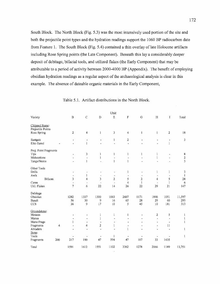
172
South Block. The North Block (Fig. 5.3) was the most intensively used portion ofthe site and
both the projectile point types and the hydration readings support the 1060 BP radiocarbon date
from Feature 1. The South Block (Fig. 5.4) contained a thin overlay oflate Holocene artifacts
including Rose Spring points (the Late Component). Beneath this lay a considerably deeper
deposit of debitage, bifacia1 tools, and utilized flakes (the Early Component) that may be
attributable to a period of activity between 2000-4000 BP (Appendix). The benefit of employing
obsidian hydration readings as a regular aspect of the archaeological analysis is clear in this
example. The absence of dateable organic materials in the Early Component,
Table 5.1. Artifact distributions in the North Block.
UnitVariety B C D E F G H Total
Chipped Stone:Projectile PointsRose Spring 2 4 3 4 2 18
Eastgate 2 3Elko Eared
Proj. Point FragmentsTips 3 8Midsections 2Tangs/Stems 3
Other ToolsDrills 3Awls I I
Bifaces 3 4 3 2 5 2 4 5 28Cores 4 I I 6Uti!. Flakes 7 6 22 14 26 22 29 21 147
DebitageObsidian 1282 1337 1300 1003 2607 1171 1846 1051 11,597Basalt 56 30 9 16 65 28 29 60 293CCS 36 9 l7 10 5 45 10 181 313
Groundstone:Metates 2 5ManosMano FragsFragments 4 4 2 IIAbradersBone:Tools IFragments 200 217 190 47 594 47 107 33 1435
Total 1591 1612 1551 1102 3362 1278 2066 1189 13,751
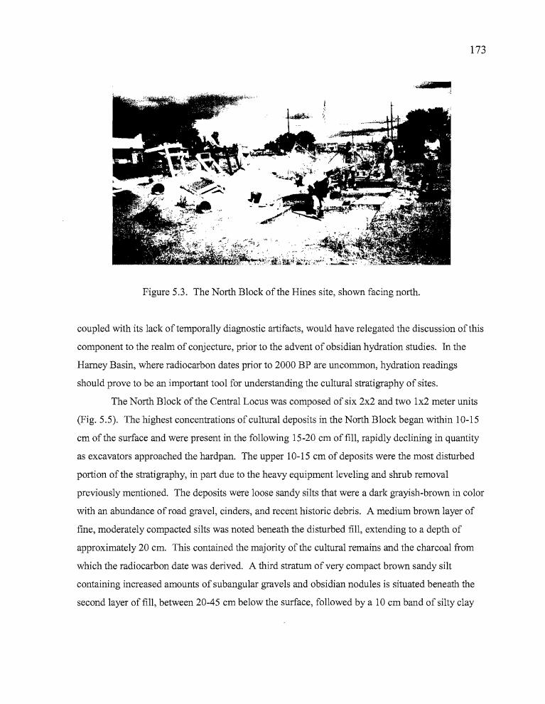
- •
173
Figure 5.3. The North Block of the Hines site, shown facing north.
coupled with its lack of temporally diagnostic artifacts, would have relegated the discussion of this
component to the realm of conjecture, prior to the advent of obsidian hydration studies. In the
Harney Basin, where radiocarbon dates prior to 2000 BP are uncommon, hydration readings
should prove to be an important tool for understanding the cultural stratigraphy of sites.
The North Block of the Central Locus was composed of six 2x2 and two 1x2 meter units
(Fig. 5.5). The highest concentrations of cultural deposits in the North Block began within 10-15
cm of the surface and were present in the following 15-20 cm offill, rapidly declining in quantity
as excavators approached the hardpan. The upper 10-15 cm of deposits were the most disturbed
portion of the stratigraphy, in part due to the heavy equipment leveling and shrub removal
previously mentioned. The deposits were loose sandy silts that were a dark grayish-brown in color
with an abundance of road gravel, cinders, and recent historic debris. A medium brown layer of
fine, moderately compacted silts was noted beneath the disturbed fill, extending to a depth of
approximately 20 cm. This contained the majority of the cultural remains and the charcoal from
which the radiocarbon date was derived. A third stratum of very compact brown sandy silt
containing increased amounts of subangu1ar gravels and obsidian nodules is situated beneath the
second layer of fill, between 20-45 cm below the surface, followed by a 10 cm band of silty clay
--
174
just above the hardpan. Excavations in the North Block varied in depth from 30 to 60 cm
depending either on time constraints or the abundance of cultural remains.
The excavations initially focused around Unit H, which contained the test pit where a
small temporary hearth feature dating to 1060 BP was located. The abundance of cultural remains
encountered in Unit H encouraged the further exposure of deposits to the north and east. Although
28 square meters of deposits were exposed, no additional cultural features were identified.
However, there appears to be at least one and possibly two associated concentrations of artifacts at
this location. These concentrations center around areas of charcoal-flecked soil that may represent
the ephemeral remains of temporary fire hearths. Items recovered here include Rose Spring and
Eastgate projectile points, one Elko Eared point, drills, a CCS awl, bifaces and biface fragments,
utilized flakes, mano fragments, a metate and metate fragments, and fire-cracked rocks. A total of
12,071 pieces of debitage was recovered from the North Block, including obsidian (96.1 %), basalt
(2.4%), and CCS (1.5%). Analysis of the animal remains from the North Block showed high
concentrations of rodent, bird and fish bones (the only fish bones present at the entire site).
The South Block of the Central Locus consisted of five 2 x 2 meter units that were
conjoined to form a linear trench running north to south. The impetus for excavation at this
location was provided by the recovery of 322 pieces of debitage in Level 6 of Test Pit 2, 50-60 cm
below the surface. The flakes indicated the presence of relatively deep, potentially rich deposits.
Unit L was positioned over the location of Test Pit 2, with the test pit occupying the location of
Quad C. Units were established to the north and south ofUnit L in anticipation of following
whatever features might be present there. The surface elevations at South Block sloped gently to
the south, losing 20 cm of elevation over the course of eight meters. The initial 10 to 20 cm of
deposits at the South Block were affected by recent human activity, and bioturbation due to rodent
and possibly badger activity was more extensive here than at any other portion of the site.
The surface deposit at the South Block consisted of a thin (5 cm), and very disturbed band
ofbrownish-gray sandy silts composed of as much as 30% angular road gravels and cinder. This
deposit covered a second layer (20-25 cm thick) that was a light gray-brown and similar to the
overlying fill, but composed of more compacted silts mixed with subangular gravels which
increased in concentration with depth. Historic debris was present to an depth of 45 cm in most
units, reaching 60 cm in Unit J and 65 cm in Unit L. A transition occurred at approximately 30
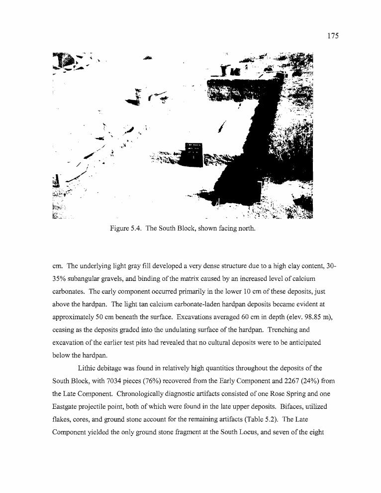
175
~;;.::
~L,,·
,/
.~
( ~ .
.'.
~.:.
Figure 5.4. The South Block, shown facing north.
...... •
cm. The underlying light gray fill developed a very dense structure due to a high clay content, 30
35% subangular gravels, and binding of the matrix caused by an increased level of calcium
carbonates. The early component occurred primarily in the lower 10 cm of these deposits, just
above the hardpan. The light tan calcium carbonate-laden hardpan deposits became evident at
approximately 50 cm beneath the surface. Excavations averaged 60 cm in depth (elev. 98.85 m),
ceasing as the deposits graded into the undulating surface of the hardpan. Trenching and
excavation of the earlier test pits had revealed that no cultural deposits were to be anticipated
below the hardpan.
Lithic debitage was found in relatively high quantities throughout the deposits of the
South Block, with 7034 pieces (76%) recovered from the Early Component and 2267 (24%) from
the Late Component. Chronologically diagnostic artifacts consisted of one Rose Spring and one
Eastgate projectile point, both of which were found in the late upper deposits. Bifaces, utilized
flakes, cores, and ground stone account for the remaining artifacts (Table 5.2). The Late
Component yielded the only ground stone fragment at the South Locus, and seven of the eight
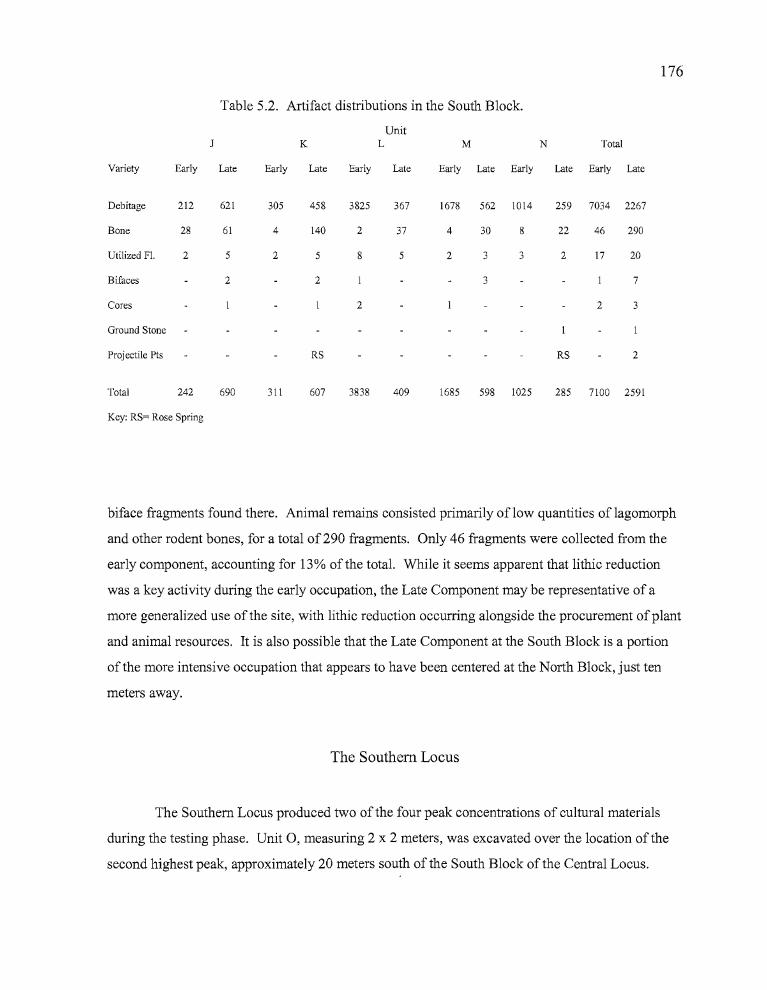
176
Table 5.2. Artifact distributions in the South Block.
UnitJ K L M N Total
Variety Early Late Early Late Early Late Early Late Early Late Early Late
Debitage 212 621 305 458 3825 367 1678 562 1014 259 7034 2267
Bone 28 61 4 140 2 37 4 30 8 22 46 290
Utilized Fl. 2 5 2 5 8 5 2 3 3 2 17 20
Bifaces 2 2 3 7
Cores 2 2 3
Ground Stone
Projectile Pts RS RS 2
Total 242 690 311 607 3838 409 1685 598 1025 285 7100 2591
Key: RS= Rose Spring
biface fragments found there. Animal remains consisted primarily oflow quantities oflagomorph
and other rodent bones, for a total of 290 fragments. Only 46 fragments were collected from the
early component, accounting for 13% of the total. While it seems apparent that lithic reduction
was a key activity during the early occupation, the Late Component may be representative of a
more generalized use of the site, with lithic reduction occurring alongside the procurement ofplant
and animal resources. It is also possible that the Late Component at the South Block is a portion
of the more intensive occupation that appears to have been centered at the North Block, just ten
meters away.
The Southern Locus
The Southern Locus produced two of the four peak concentrations of cultural materials
during the testing phase. Unit 0, measuring 2 x 2 meters, was excavated over the location of the
second highest peak, approximately 20 meters south of the South Block of the Central Locus.
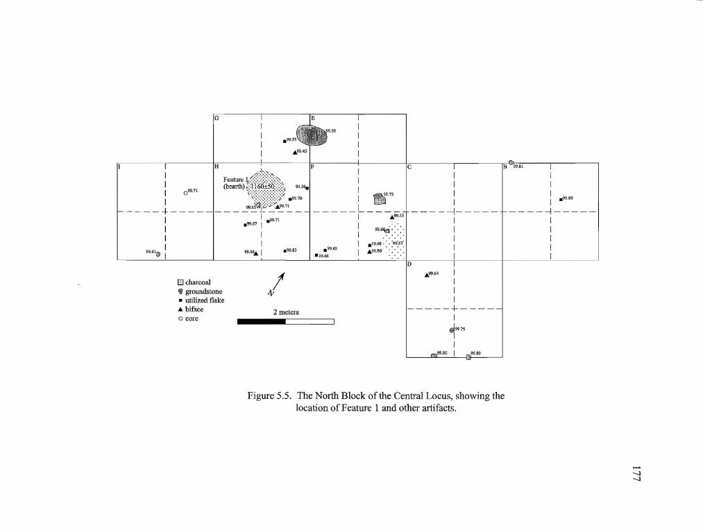
G
6,P9.45
.99.83
IIII .99.80
------1---IIIII
B -99.81
IIII
-----1- ----IIII1
c
99.~ -: -:.
.99.65
·99.66
IIII ~9.73
____ I1- - -.99.S;
III .99.68 ... '99:6S'
I A\'9.80····
F
H Feature J,;(Jt>~:,(hearth) i::1160±50:::::::1 99.56"
I
I 099.71 \(~}}}} .99.70
99.6?@i8:;;::~9.71----+---------------
I I .99.71.99.67 I
I II II
99.61® I 99.6~ I
E3 charcoal~ groundstone• utilized flake• bifaceo core
/2 meters
D
.99.64 IIII
-----+----I
~99.75II
99.80 I _99.80
Figure 5.5. The North Block of the Central Locus, showing thelocation of Feature 1 and other artifacts.
>--'-....l-....l
TI
..
178
Unit P, a 1 x 1 located 35 meters south of Unit 0, was placed just west of the probe that
yielded the fourth highest concentration. Neither of the units contained features, tools, or datable
cultural debris. The sparse quantities of cultural materials at this location did not warrant an
expansion of excavations beyond the two units. At both units, the fill graded from a gray-brown
sandy silt in the upper levels to more compact light brown silts lower in the deposits. Disturbance
was evident from earlier leveling of the site and road gravels were found intruded down into the
fourth level (20-25 em). The quantity and size variation in the natural gravels and cobbles initially
increased with depth, but dropped off rapidly as excavators reached the hardpan. It is noteworthy
that gravels and cobbles increased nearer the hardpan at the Northern and Central Loci, but not in
the South Locus.
A total of two bone fragments and 764 pieces of lithic debitage was removed from Unit 0
including 45 flakes recovered from Probe 13 (in Quad C). Obsidian represented 94.2% of the
debitage, followed by basalt (5.4%) and CCS (0.4%). The debitage count peaked in Level 5 (elev.
98.95-98.90) at 117 flakes, but counts were almost as high between levels 4 through 8 (elev.
98.95-98.75). Historic debris was noted from the surface through Level 8. Excavation was ended
at Level 10 (elev. 98.70-98.65) as cultural materials declined in number. Unit P produced three
bone fragments and 55 pieces of debitage, almost half (23) of which were recovered from Level 6
(elev.98.40-98.35). Obsidian accounted for 89.1 %, basalt 9.1 %, and CCS 1.8% of the lithic
debris. Rodent activity was noted through Level 7 (30-35 cms), and historic artifacts were
collected in all levels. The unit was terminated at Level 9 (elev. 98.25-98.20) as the excavators
approached the hardpan.
Features
A single radiocarbon date was derived from Feature 1, a hearth in the North Block of the
Central Locus (Figure 5.5). The composite charcoal sample used for radiocarbon dating was
extracted from soil collected in the hearth, which was the only cultural feature identified at the
Hines site. It was located in Quads A and C of Unit H, occupying a shallow basin that had been
scooped from surface deposits. The hearth was faintly defined by a slight darkening of the soil.
The hearth was roughly oval in shape; approximately 80 cm in length (north-south) by 50 cm in
,,
II'
I
b
~
•
179
width. It was first encountered about 20 cm below the surface at an elevation of 99.70 m. In
profile, the charcoal stain was basin-shaped, attaining a depth of 10-15 cm. There were a number
of artifacts recovered within a two meter radius of the hearth, including 10 projectile points, 10
bifaces or biface fragments, 76 utilized flakes, six cores, two pieces of ground stone, and one drill.
The hearth feature contained little animal bone, which suggests that it was used for only a short
time.
The charcoal flecking present in the hearth was visible during testing in May, when the fill
was still moist from winter and spring precipitation. The soil sample was collected at that time
from the third level (20-30 cm) of Test Pit 3. In September, when data recovery occurred, the soil
was considerably drier and the feature was barely discemable as a faint gray coloration against the
prevailing medium brown fill. After an initial treatment of alkalai and acid washes at Beta
Analytic Inc., the charcoal sample was shipped to Lawrence Livermore National Laboratory where
it underwent accelerator mass spectrometry, producing the date of 1060 BP reported above.
Figure 7.5 shows the location of the feature amidst a concentration of artifacts, which lend further
weight to the argument that the dated feature was indeed a hearth.
Artifact Assemblage
A total of 22,595 pieces of debitage was collected during the Phase III excavations.
Obsidian was the primary tool stone employed at the site, comprising 97% (21,919 pieces) of the
total assemblage. Basalt accounted for 2% (458 pieces), and CCS 1% (218 pieces) of the chipping
waste. In all, 298 lithic tools and one bone tool were recovered from the Hines site. Utilized
flakes were the largest tool category represented at the site, comprising 63.3% (n=189) of the total.
Other tool categories included bifaces in varying stages of manufacture at 12% (n=36), diagnostic
projectile points at 7.4% (n=23) and projectile point fragments at 5.7% (n=17), cores of obsidian
and basalt at 3.3% (n=10), drills at 1.3% (n=4), ground stone at 6.4% (n=19), an abrader (0.3%)
and a bone tool (0.3%).
I
I
180
Proj ectile Points
A total of 28 chronologically diagnostic projectile points and non-diagnostic projectile
point fragments was recovered from the excavations at the Hines Site (Fig. 5.6, Table 5.3). The
projectile points have been typologically classified according to a system established by Thomas
(1981) for Monitor Valley in central Nevada.
Obsidian was the primary material used at the Hines site. One diagnostic point (3.6%)
was made of chert and no points were made from basalt. A total of 19 points were Rosegate Series
(67.8%), five were Small Stemmed points (17.9%), three were Elko Series points (10.7%) and one
was Northern Side-notched (3.6%). Only one of the Elko Series points was recovered from the
excavation deposits; the remaining two Elko points and the Northern Side-notched point were
surface collected in the general site location.
Small Stemmed Points. Five small comer-notched points lack the expanding stems characteristic
of Rosegate Series points. Dumond and Minor (1983:170) characterize a "pinstem" point for the
Columbia Plateau, which they describe as being straight stemmed and "...virtually round in cross
section". Thomas (1981) does not include a category of this kind for the Great Basin. Four of the
five points have straight stems and also have a neck width of <5mm; another hallmark of
pinstemmed points under the classification scheme of Dumond and Minor (Table 5.3). However,
the stems of these four points vary considerably in the degree of roundness that they exhibit. The
remaining point has a slightly contracting stem. Although Dumond and Minor (1983) also
describe a series of small contracting stem points in their Plateau typology, the presence of only
one point matching this description prompts the placement of the two relatively similar point types
into a single category of small stemmed points, rather than splitting them into distinct categories.
The Small Stemmed points co-occur with Rose Spring points in the upper levels of the
North Block. Small Stemmed points were found in levels 2 through 6, while Rose Spring points
were recovered from levels 1 through 7. Small Stemmed points were absent from deposits
elsewhere at the Hines site, but three Rose Spring points were recovered north and south of the
North Block. The limited spatial occurrence of Small Stemmed points within the larger site
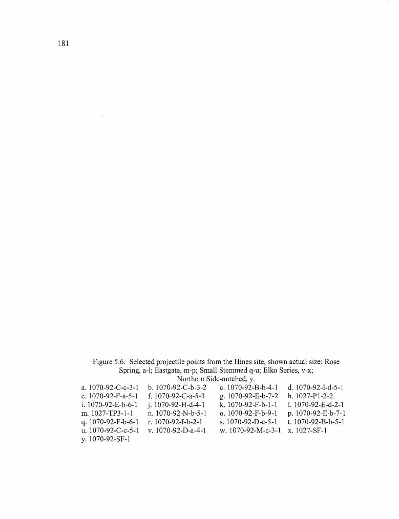
181 182
~ .' ~"
ab c d
, .-e f g
,h
Ai •i J m n
p q
,
x•wu...d. 1070-92-I-d-5-1
h. l027-Pl-2-21. l070-92-E-d-2-1p.1070-92-E-b-7-1t. l070-92-B-b-5-1x.1027-SF-l
Figure 5.6. Selected projectile points from the Hines site, shown actual size: RoseSpring, a-I; Eastgate, m-p; Small Stemmed q-u; Elko Series, v-x;
Northern Side-notched, y.b. l070-92-C-b-3-2 c. l070-92-B-b-4-1f. l070-92-C-a-5-3 g. l070-92-E-b-7-2j. l070-92-H-d-4-1 k. l070-92-F-b-l-ln. l070-92-N-b-5-1 o. l070-92-F-b-9-1r. l070-92-I-b-2-1 s. l070-92-D-c-5-1v. 1070-92-D-a-4-1 w. 1070-92-M-c-3-1
a. l070-92-C-c-3-1e. l070-92-F-a-5-1i. l070-92-E-b-6-1m. l027-TP3-1-1q. l070-92-F-b-6-1u. 1070-92-C-c-5-1y. l070-92-SF-l

181 182
ab d g
k m n
p q
xu
d. I070-92-I-d-5-1h.1027-PI-2-21. I070-92-E-d-2-1p. l070-92-E-b-7-1t. I070-92-B-b-5-1x. I027-SF-l
Figure 5.6. Selected projectile points from the Hines site, shown actual size: RoseSpring, a-I; Eastgate, m-p; Small Stemmed q-u; Elko Series, v-x;
Northern Side-notched, y.b. I070-92-C-b-3-2 c. I070-92-B-b-4-1f. 1070-92-C-a-5-3 g. I070-92-E-b-7-2j. I070-92-H-d-4-1 k. I070-92-F-b-I-1n. 1070-92-N-b-5-1 o. l070-92-F-b-9-1r. l070-92-I-b-2-1 s. l070-92-D-c-5-1v. l070-92-D-a-4-1 w. I070-92-M-c-3-1
a. I070-92-C-c-3-1e. 1070-92-F-a-5-1i. I070-92-E-b-6-1m.1027-TP3-1-1q. l070-92-F-b-6-1u. I070-92-C-c-5-1y. l070-92-SF-l
",
. :.,: :
.. •
183
boundaries suggests that these points may have been limited to a particular episode during the
site's occupational history.
The obsidian sources for the Small Stemmed points are either adjacent to or west of the
Hines site. The contracting stem point is from the Chickahominy source, which is located
approximately 40 kilometers west of the site. One of the pinstem points is from the Riley source,
some 30 kilometers to the west. The remaining three points came from sources very near the site;
two from Bums Butte and one from Rimrock Springs, slightly to the northwest of Bums Butte.
Rose Spring and Eastgate Points A total of 18 projectile points can be classified as Rosegate,
characterized by their small size (weight <1.5 grams), expanding stems, and a basal width less than
10 mm (Table 5.3). Thomas (1981:19) lumped the Rose Spring (Lanning 1963) and Eastgate
(Heizer and Baumhoff 1961; Lanning 1963) point types together under one classification, but the
two types are clearly dissimilar in both form and distribution, and in this report, Rose Spring and
Eastgate are analyzed separately.
A total offour Eastgate points were recovered from the Hines site. Ofthese, three
occurred in the North Block between 0-45 cm in depth; and one at a depth of 20-25 cm in the
South Block. The Eastgate points were interspersed among both Rose Spring and Small Stemmed
varieties in the cultural deposits, which suggests that the three projectile point styles were used
concurrently. Two of the Eastgate point's obsidian tool stone (Specimens 1070-92-E-B-7-1 and
1070-92-N-B-5-1) originated from the Buck Springs source, associated with the Rattlesnake Tuff
Formation. Rattlesnake Tuffs are widespread ash flows that originated from vents south of Harney
Lake and continue north as far as the Blue Mountains (Skinner et. al 1998). One of the Eastgate
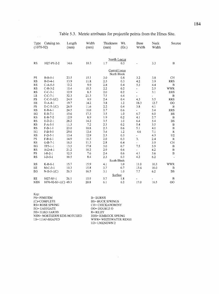
.'1',,'r·" ,
Dr ..
184
Table 5.3. Metric attributes for projectile points from the Hines Site.
Type Catalog no. Length Width Thickness Wt. Base Neck Source(1070-92) (nun) (nun) (nun) (Gr.) Width Width
North LocusRS 1027-PI-2-2 14.6 10.3 1.7 0.3 3.3 B
Central LocusNorth Block
PS B-B-5-1 23.5 15.1 3.0 0.8 3.2 3.8 CHRS B-D-4-1 13.9 1l.8 2.5 0.3 4.2 3.9 RRSRS C-A-5-3 12.2 9.9 2.8 0.4 5.3 4.4 BRS C-B-3-2 10.4 10.3 2.2 0.2 2.5 WWRRS C-C-3-1 12.9 8.3 2.0 0.2 3.1 RRSLS C-C-7-1 32.3 21.3 7.5 6.4 BPS C-C-5-1(C) 24.9 9.9 2.4 0.4 4.3 3.5 RRSEE D-A-4-1 19.7 14.2 3.8 1.2 18.3 12.7 00PS D-C-5-I(C) 26.9 11.6 2.2 0.4 3.8 4.1 BRS E-B-6-1 24.5 10.0 2.7 0.6 3.4 RRSEG E-B-7-1 19.6 17.3 3.5 1.0 6.7 6.0 BSRS E-B-7-2 12.9 8.9 1.9 0.2 4.1 2.7 BRS E-D-2-1 28.2 14.2 3.5 1.0 6.4 5.4 BSRS F-A-5-1 11.3 7.2 2.3 0.2 5.4 3.5 BRS F-B-I-I 23.0 10.8 2.3 0.6 5.1 4.1 BEG F-B-9-1 29.6 12.4 3.4 1.2 4.6 7.1 RRS F-D-5-1 13.4 12.9 2.3 0.3 4.3 U2PS F-B-6-1 14.9 10.3 2.0 0.3 3. 2.4 RRS G-B-7-1 16.5 11.3 2.8 0.4 3.9 CHEG TP3-1-1 13.5 17.8 3.0 0.7 7.5 5.9 BRS H-D-4-1 21.2 10.2 2.9 0.6 4.2 BPS I-B-2-1 12.5 7.6 2.4 0.6 4.1 3.6 BRS I-D-5-1 10.5 8.4 2.3 0.3 4.2 6.2
South BlockRS K-B-6-1 15.7 15.9 4.1 1.0 11.0 10.3 WWREE M-C-3-1 10.3 15.8 3.7 0.7 13.6 10.0 BEG N-B-5-I(C) 26.3 16.5 3.1 1.0 7.7 6.2 BS
SurfaceEE 1027-SF-I 26.1 15.9 5.7 1.8 BNSN 1070-92-SF-I(C) 49.3 20.8 6.1 6.2 17.0 16.5 00
Key:PS=PINSTEM B=BURNS(C)=COMPLETE BS= BUCK SPRINGSRS= ROSE SPRING CH= CHICKAHOMINYEG= EASTGATE 00= DOUBLE 0EE= ELKO EARED R=RILEYNSN= NORTHERN SIDE-NOTCHED RRS= RIMROCK SPRINGLS= LEAF-SHAPED WWR= WHITEWATER RIDGE
U2= UNKNOWN 2
If"II"
185
points is obsidian from the Riley source (l070-92-F-B-9-l), to the west, and one (l027-TP3-l-1)
is from the Burns source, adjacent to the Hines site. This seems to indicate that Eastgate points,
like the Small Stemmed points, were either being manufactured at the site or transported to the site
from the west.
The remaining 15 diagnostic points can all be clearly assigned to the Rose Spring type.
All but one of the Rose Spring points were recovered from the North Block, with the remaining
point collected in Unit A, between 5-10 cm in depth, at the Northern Locus (Tables 5.3 and 5.4).
Rose Spring points were found between 0-35 cm in depth at the North Block. Only one diagnostic
point was found lower in the deposits; an Eastgate in Level 9 (40-45 cmbs) of Unit F.
There are three basic variations among the Rose Spring points that were recovered. The
three variations all fit the morphological characteristics of either the Rosegate typology for the
Great Basin (Thomas 1981) or the ES-1 category for the Columbia Plateau (Dumond and Minor
1983). The variations are not of a nature to suggest functional or technological enhancements in
projectile point production, but perhaps may say more about the type of flake chosen for
manufacturing a point, or the flaking technique of the flintknapper.
One Rose Spring variation (RS-1) includes small, corner-notched points with expanding
stems that extend well below shoulders that either taper toward the stem of the point or terminate
even with the beginning of the stem. In cross section, they are fat-bodied relative to their width
and range from lenticular to oval in shape. There are five Rose Spring points that match this
description. Four of the points are made of obsidian (Specimens 1070-92-C-A-5-3, 1070-92-C-C
3-1, 1070-92-E-D-2-1, and 1070-92-F-A-5-1) and one is CCS (l070-92-I-D-5-1).
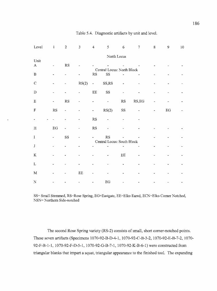
~I! I
b
186
Table 5.4. Diagnostic artifacts by unit and level.
Level 2 3 4 5 6 7 8 9 10
North LocusUnitA RS
Central Locus: North BlockB RS SS
C RS(2) SS,RS
D EE SS
E RS RS RS,EO
F RS RS(2) SS EO
RS
H EO RS
I SS RSCentral Locus: South Block
J
K EE
L
M EE
N EO
SS= Small Stemmed, RS=Rose Spring, EO=Eastgate, EE=E1ko Eared, ECN=Elko Comer Notched,NSN= Northern Side-notched
The second Rose Spring variety (RS-2) consists of small, short corner-notched points.
These seven artifacts (Specimens 1070-92-B-D-4-1 1070-92-C-B-3-2 1070-92-E-B-7-2 1070-, , ,
92-F-B-l-l 1070-92-F-D-5-1 1070-92-G-B-7-1 1070-92-K-B-6-1) were constructed from, , ,
triangular blanks that impart a squat, triangular appearance to the finished tool. The expanding
~r~!l' I" I
187
bases are bracketed by barbs that extend past the neck, sometimes to a length that is even with the
base. The points are generally quite thin in relation to their width and finely flaked.
The third (RS-3) Rose Spring variety (1027-Pl-2-2, l070-92-E-B-6-1, 1070-92-H-D-4-l)
are similar to RS-2 points, but more elongated. The points tend to be at least twice as long as they
are wide, and show fine, delicate workmanship. None of the three points in this category have
intact bases, but it appears that the barbs are quite shallow, and would not extend as far back as the
base.
X-ray Fluorescence analysis was used to determine the origin of the obsidian used to make
14 of the 15 recovered Rose Spring projectile points (all of the obsidian artifacts). The single CCS
point could not be sourced. Of those geochemically characterized, six (43%) were manufactured
from nearby Bums Butte obsidian. The second most common source was Rimrock Spring,
adjacent to the Bums source, of which three (21.5%) of the points were produced. Two Rose
Spring points (14.2%) were of Whitewater Ridge obsidian. The Chickahominy and Buck Springs
sources each accounted for one point (7.1 %), as did a source called Unknown 2 (Skinner et. al
1998). With the exception of the source which has yet to be identified, the obsidian sources for
the Rose Spring points are all north and west of the Hines site. The most distant of them is
Whitewater Ridge, approximately 65 km to the northeast. Since nine (64.5%) of the Rose Spring
points were derived from sources very close to the site, it is not unreasonable to suggest that the
site was occupied at least in part to manufacture and refurbish tools used in nearby hunting forays
with the obsidian readily available from Bums Butte and nearby Rimrock Springs. In addition, the
people who were using Rose Spring points appear to have traveled to the location from the north
or west, the points presumably have been made at or near the obsidian sources there.
Leafshaped Points. A single leaf-shaped point base (1070-92-C-C-7-1) was collected in the
North Block. This large, finely flaked artifact is broken approximately at the midsection and is
also missing a small portion of the base. One side of the artifact exhibits a diagonal flaking
pattern, with flake scars meeting at the midsection. The opposite side is more randomly flaked,
with flake scars extending across the tool at times.
...188
Elko Series. Only three of the 28 projectile points recovered from the Hines site were identified as
Elko Series points. All three can be categorized as Elko Eared points, based on the classification
system adopted by Thomas (1981), or Side Notched 5 under the system developed by Dumond and
Minor (1983: 171). Elko Eared points are large, comer-notched dart points with a deeply indented
base that, in conjunction with the comer-notching, form "ears" for hafting the projectile on to a
dart shaft. The widest portion of the projectile point is just above the base. All of the Elko Series
points collected at the Hines site are fragmentary, consisting ofbases broken off at the top of the
neck.
The Elko points were distributed across the Central Locus, with one collected in Unit D of
the North Block (15-20 cm), one from Unit M in the South Block (10-15 cm), and the third point
surface-collected to the east. Although the tools were recovered near Rosegate Series artifacts,
obsidian hydration analysis has shown that Elko points have thicker hydration rinds, except for one
Roasgate with a hydration rind comparable in thickness to the Elko points. Although the sample
size is limited, this shows that most of the Elko artifacts are not coeval with the Rosegate points. It
is likely that both types were dropped on a stable, non-accreting surface at widely separated times.
The three Elko points have been analyzed to determine the origin of the obsidian from
which they were manufactured. One of the points has been traced to the Bums source, and two
originated from the Double 0 source, which is located approximately 40 km south of the Hines
site. The Eastgate, Rose Spring, and Elko projectile point types all include specimens from the
Bums source, as would be expected with the obsidian available in such close proximity. However,
the Elko Series points are the first from the Hines site to include obsidian sources originating to the
south.
189
Northern Side-notched Points. A single Northern Side-notched (NSN) point was surface-collected
from the Hines site. It was found 16 meters east of the Central Locus. Northern Side-notched
points were designed for use with an atlatl, and are characterized by their elongated triangular
shape, straight to slightly convex sides, and a base that is generally flat or concave, but can be
convex as well. They are heavy-bodied points with notches that angle either upward or straight in
to the sides of the tool, and the maximum width of the point is at the base. Under the Plateau
classification system of Dumond and Minor (1983: 171), the Hines site NSN point would also fit
the Side Notched 1 category.
The NSN point is obsidian that has been identified as originating at the Double 0 source,
approximately 40 kilometers to the south. The Northern Side-notched point is comparable in size
and age to the Elko points, and it is interesting that three of the four dart points found at Hines
(two Elko Eared and one NSN) can be traced to southern obsidian sources. Not one of the late
Holocene arrow points can be directly linked to a southern source of obsidian. The Buck Spring
source has its origin near Harney Lake, but the flow extends to the north as far as the Ochocos and
obsidian could have been collected at many points in between. The geographical distribution may
suggest that Buck Spring obsidian was collected at a more northerly location, in keeping with the
other Rosegate sources.
Point Fragments
Projectile point fragments consist of finely worked bifacial tool fragments that are not
recognizeable as diagnostic tools, yet are clearly portions of finished projectile points. A total of
17 projectile point fragments were recovered from the Hines site consisting of eight tips, three
midsections, two bases, and four tangs (Table 5.5). All but one of the 17 fragments were collected
from the North Block of the Central Locus, with a single tang, or barb, originating from the South
Block. Only one point fragment was manufactured from CCS (a tip), the others being made of
obsidian.
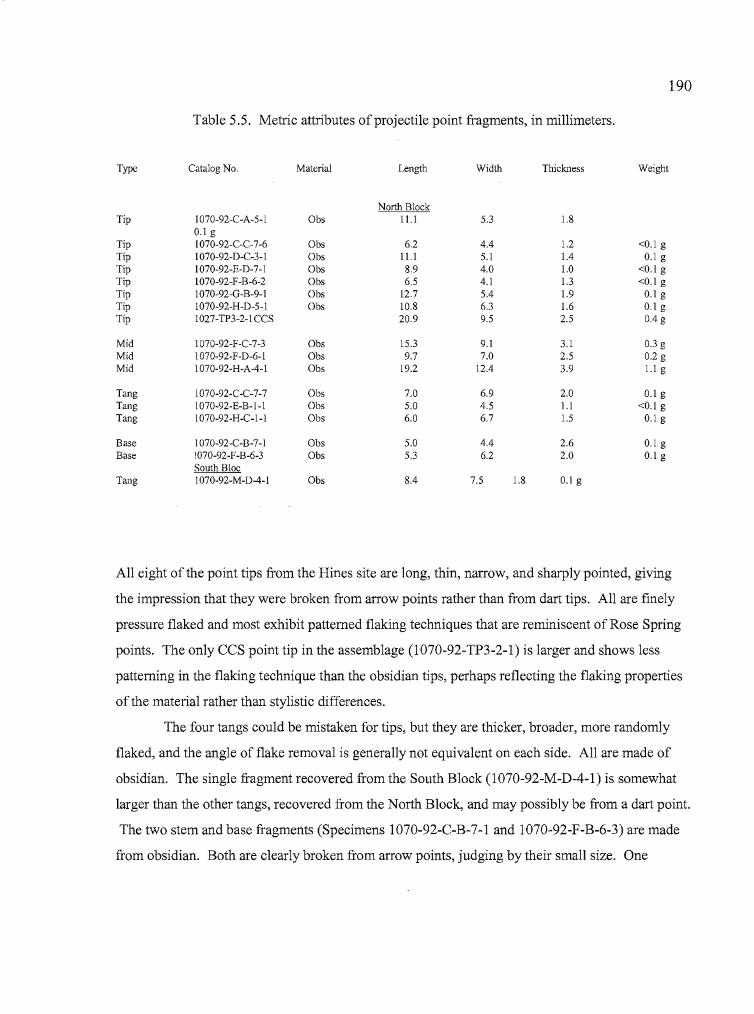
r·,.
',;-, .
; ,
190
Table 5.5. Metric attributes of projectile point fragments, in millimeters.
Type Catalog No. Material Length Width Thickness Weight
Tip 1070-92-C-A-5-1 Obs0.1 g
Tip 1070-92-C-C-7-6 ObsTip 1070-92-D-C-3-1 ObsTip 1070-92-E-D-7-1 ObsTip 1070-92-F-B-6-2 ObsTip 1070-92-0-B-9-1 ObsTip 1070-92-H-D-5-1 ObsTip 1027-TP3-2-ICCS
Mid 1070-92-F-C-7-3 ObsMid 1070-92-F-D-6-1 ObsMid 1070-92-H-A-4-1 Obs
Tang 1070-92-C-C-7-7 ObsTang 1070-92-E-B-I-I ObsTang 1070-92-H-C-I-I Obs
Base 1070-92-C-B-7-1 ObsBase !070-92-F-B-6-3 Obs
South BlocTang 1070-92-M-D-4-1 Obs
North Block11.1
6.211.18.96.5
12.710.820.9
15.39.7
19.2
7.05.06.0
5.05.3
8.4
5.3 1.8
4.4 1.2 <0.1 g5.1 1.4 0.1 g4.0 1.0 <0.1 g4.1 1.3 <0.1 g5.4 1.9 0.1 g6.3 1.6 0.1 g9.5 2.5 0.4 g
9.1 3.1 0.3 g7.0 2.5 0.2 g
12.4 3.9 l.lg
6.9 2.0 0.1 g4.5 l.l <0.1 g6.7 1.5 0.1 g
4.4 2.6 0.1 g6.2 2.0 0.1 g
7.5 1.8 0.1 g
All eight of the point tips from the Hines site are long, thin, narrow, and sharply pointed, giving
the impression that they were broken from arrow points rather than from dart tips. All are finely
pressure flaked and most exhibit patterned flaking techniques that are reminiscent of Rose Spring
points. The only CCS point tip in the assemblage (1070-92-TP3-2-1) is larger and shows less
patterning in the flaking technique than the obsidian tips, perhaps reflecting the flaking properties
of the material rather than stylistic differences.
The four tangs could be mistaken for tips, but they are thicker, broader, more randomly
flaked, and the angle of flake removal is generally not equivalent on each side. All are made of
obsidian. The single fragment recovered from the South Block (1070-92-M-D-4-I) is somewhat
larger than the other tangs, recovered from the North Block, and may possibly be from a dart point.
The two stem and base fragments (Specimens 1070-92-C-B-7-1 and I070-92-F-B-6-3) are made
from obsidian. Both are clearly broken from arrow points, judging by their small size. One
191
of the bases has an expanding stem and the other is a straight, or pinstemmed base. One of the
three midsections recovered during excavation is clearly non-diagnostic (1 070-92-H-A-4-l).
Although the fragment is quite thin and narrow like an arrow point, it is missing the tip and the
entire base. The tool was made of obsidian from the Bums source. Another midsection (1070-92
F-D-6-l) is missing its tip, base, and one tang, but retains the other tang, a distinct scar where the
base snapped free from the body of the point, and an overall shape suggests it was either a
Rosegate or Small Stemmed point. It is manufactured from Rimrock Spring obsidian. The third
midsection (1070-92-F-C-7-3) also appears to derive from an arrow point. It originates from
Bums source obsidian.
Shaped Bifaces
Most of the biface tools are fragmentary but bear enough characteristics to enable
determinations of both general appearance and the lithic reduction methods employed in their
manufacture. Shapes vary from rounded to polygonal, and flaking methods can range from the
rough percussion flaking of quarry blanks to fine pressure flaking associated with the manufacture
of knives and projectile points (Figure 5.7). The stage classification developed by Jenkins and
Connolly (1990) is used in this analysis.
Stage 1. Four obsidian artifacts fit the Stage 1 classification, three of which are bases and
the fourth complete. The complete biface (1070-92-C-C-4-l) is a crude, triangular-shaped tool
with one slightly concave side that has been employed as a scraper. The scraping edge has been
straightened and strengthened by additional flake removal, but the other sides are very sinuous.
The entire tool shows evidence of use-wear. The three biface bases (Specimens l070-92-B-A-3-l,
1070-92-I-D-3-2, and 1070-92-L-D-5-l) are rounded. The first two are manufactured from Bums
obsidian, the latter artifact has not been identified to source. The biface is derived from the Dog
Hill source, near Bums Butte.
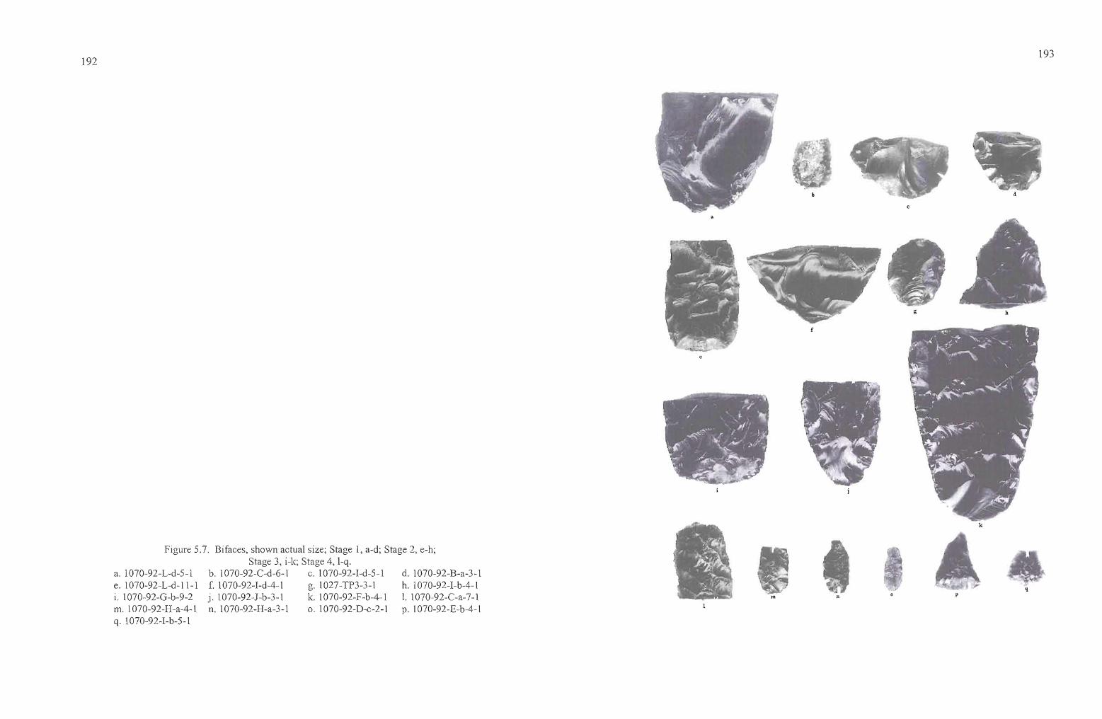
192 193
d
q
h
k
g
nm
d. 1070-92-B-a-3-1h. 1070-92-I-b-4-11. 1070-92-C-a-7-1p. 1070-92-E-b-4-1
Figure 5.7. Bifaces, shown actual size; Stage 1, a-d; Stage 2, e-h;Stage 3, i-Ie; Stage 4, I-q.
b. 1070-92-C-d-6-1 c. 1070-92-I-d-5-1f. 1070-92-I-d-4-1 g. 1027-TP3-3-1j. 1070-92-J-b-3-1 k. 1070-92-F-b-4-1n. 1070-92-H-a-3-1 o. 1070-92-D-c-2-1
a. 1070-92-L-d-5-1e. 1070-92-L-d-ll-li. 1070-92-G-b-9-2m. 1070-92-H-a-4-1q. 1070-92-I-b-5-1
,, I
I·f
•
194
Stage 2. A total of nine obsidian bifaces fit into the Stage 2 classification, including four bases,
four tips, and a complete discoidal biface. Three of the bases are rounded (Specimens 1070-92-A
B-2-1, 1070-92-C-D-6-1, and 1070-92-J-B-3-1) and one is squared (1070-92-L-D-11-1). All are
well-thinned, but one (1070-92-C-D-6-1) retains cortex. The three tips vary considerably in size
and degree of thinning. The discoid (1070-92-TP3-3-1) is oval with broad, deep percussion
flaking scars across both sides and no evidence of pressure flaking. The edges are well worn from
use. All of the Stage 2 bifaces were analyzed for obsidian sources. Seven originated at the Burns
source (including the disc), one at Dog Hill, and one at Rimrock Spring. All of these sources are
in close proximity to each other and to the Hines site.
Stage 3. All nine of the Stage 3 biface fragments were manufactured from obsidian. These
included three tips, three bases, and three midsections, including two edge fragments. The three
tips are primarily percussion flaked, with pressure flaking working in from the edges towards the
center of the artifact. The bases include one very large rounded base that was found in Unit Fin
association with a metate fragment (1070-92-F-B-4-1), one small rounded base (1070-92-H-C-5
1), and one squared base (1070-92-G-B-9-2). All are well-thinned, have relatively straight edges,
and show fine flaking and crushing of the edges associated with use wear. Prior to breakage, any
of these tools could have been utilized without further treatment. The midsection fragments are
derived from large bifaces with thick cross-sections. Four of the Stage 3 bifaces are from the
Burns source, two are from Dog Hill, and one is from Buck Springs, approximately 55 kilometers
to the west. An additional artifact was not identified to source.
Stage 4. There were two categories of Stage 4 bifaces at Hines. The first category includes
fragments derived from triangular to oval shaped preforms which may have been intended for use
as projectile points. The six specimens of this group included two bases, one midsection, and
three tips. Most of the artifacts were manufactured of obsidian from the Bums or Rimrock Springs
sources, along with one tool that was not identified to source. An examination of the biface
fragments revealed that a tip (1070-92-F-A-4-1) and a base (1070-92-C-D-4-1) were the
195
conjoinable fragments of a complete, small point preform with a total length of 28.3 rom, width of
13.7 rom, thickness of2.7 rom, and weight of 1.2 g. Both tool fragments were found in Level 4 of
adjoining Units C and F, approximately one meter apart. The biface has a squared base, convex
sides, and a somewhat rounded tip. The other base fragment was rounded, tapering toward the
distal end. The other two tips have the broad dimensions oflarge projectile points or preforms.
The midsection is entirely pressure flaked, with diagonal flake scars meeting at the center. It has a
slight taper, and its overall dimensions suggest a complete, or nearly complete dart point.
The second category of Stage 4 bifaces includes four small, well-thinned and finely
pressure-flaked obsidian bifaces. Each will be described separately. Specimen 1070-92-D-C-2-1
is a narrow but a relatively thick tabular biface with rounded ends, of which one is broader than
the other. The broad end exhibits strong evidence of use wear, while the smaller end exhibits very
limited use. Its small size and use wear patterns suggest that the tool was gripped between thumb
and forefinger and used either for incising or perhaps boring out holes that were started by the use
of a drill or awl. The degree ofpressure flaking and overall shaping of this small biface indicate
that the tool was not of an expedient nature. The obsidian was derived from an unknown source.
The remaining three artifacts were derived from the Bums obsidian source. Specimen 1070-92-E
B-4-1 is a triangular biface with a plano-convex cross-section. The convex side was shaped by a
series ofpressure flakes driven from the perimeter towards the interior of the artifact. The flat
surface on the other side has minimal pressure flaking around the edges. The artifact exhibits
evidence of very light use that may be attributed to edge preparation, and the tool may be an
unfinished preform. Specimen 1070-92-H-A-3-1 is a tabular artifact with a shaped stem extending
from one end. The tip is broken from the stem and its intended use is unclear, but it is possible
that the tool may have served as a graver or perforator, held between thumb and forefinger. The
edges of the artifact have been strengthened by the removal of small pressure flakes, and the
artifact may have had a secondary use as a small scraper. Specimen 1070-92-I-B-5-1 appears to
have been a small, triangular preform that was broken toward the distal end, then retouched for use
as a small scraper similar to one reported by Musil (1995: 134). However, there is little evidence
of use wear. The proximal end has a small spur which may have been the beginning ofa base or
stem prior to breakage.
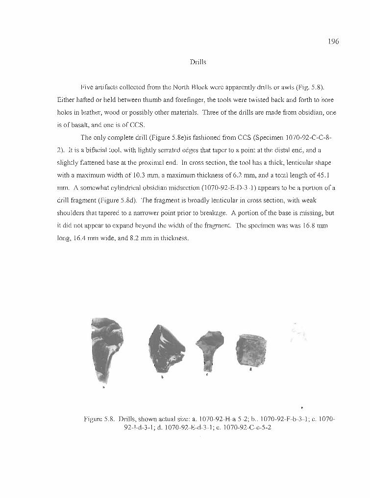
196
Drills
Five artifacts collected from the North Block were apparently drills or awls (Fig. 5.8).
Either hafted or held between thumb and forefinger, the tools were twisted back and forth to bore
holes in leather, wood or possibly other materials. Three of the drills are made from obsidian, one
is of basalt, and one is of CCS.
The only complete drill (Figure 5.8e)is fashioned from CCS (Specimen 1070-92-C-C-8
2). It is a bifacial tool, with lightly serrated edges that taper to a point at the distal end, and a
slightly flattened base at the proximal end. In cross section, the tool has a thick, lenticular shape
with a maximum width of 10.3 mm, a maximum thickness of 6.2 mm, and a total length of 45.1
mm. A somewhat cylindrical obsidian midsection (1 070-92-E-D-3-1) appears to be a portion of a
drill fragment (Figure 5.8d). The fragment is broadly lenticular in cross section, with weak
shoulders that tapered to a narrower point prior to breakage. A portion of the base is missing, but
it did not appear to expand beyond the width of the fragment. The specimen was was 16.8 mm
long, 16.4 mm wide, and 8.2 mm in thickness.
Figure 5.8. Drills, shown actual size: a. 1070-92-H-a-5-2; boo 1070-92-F-b-3-1; c. 107092-I-d-3-1; d. 1070-92-E-d-3-1; e. 1070-92-C-c-5-2
197
Three drills with expanding bases were recovered. One obsidian drill (l070-92-H-A-5-2)
is missing the tip and appears to be broken lengthwise, but was actually manufactured from an
expedient flake that has a naturally formed taper from stem to base. A minimal number of flakes
were struck from each side of the flared base to taper the edges, and the remaining stem has
limited evidence of usewear. The tool was manufactured from Bums obsidian. The second
obsidian drill (l070-92-F-B-3-l) was crafted from a large obsidian flake, of which one portion was
reduced to create a cylindrical stem. The drill stem was broken almost even with the expanding
base. The total length of the broken tool is 26.5mm, the base width is 20.0 mm, the stem width is
6.8 mm and the stem thickness is 5.2 mm. The tool was manufactured from Bums obsidian. A
third expanding base drill (l070-92-I-D-3-l) is made of very fine-grained basalt that has a
somewhat shiny appearance as though the material borders on vitrophyre. This small artifact is
missing its tip and a portion of the base. The stem flares to create a t-shaped base that would have
provided a suitable purchase for either hafting or holding. In cross-section, the drill stem appears
almost round. The total length of the broken tool is 22.2 mm, the maximum width of the base is
15.8 mm, the width of the stem is 5 mm, and the maximum stem thickness is 4.2 mm.
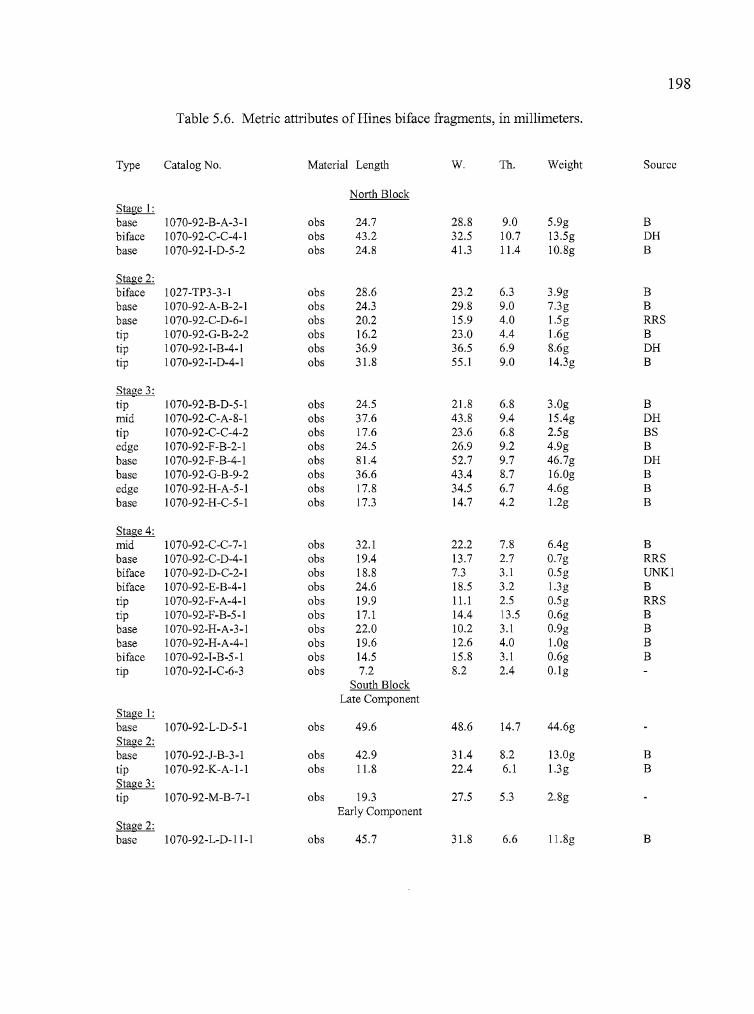
, i. ,Ii
198
Table 5.6. Metric attributes of Hines biface fragments, in millimeters.
Type Catalog No. Material Length W. Th. Weight Source
North BlockStage I:base 1070-92-B-A-3-I obs 24.7 28.8 9.0 5.9g Bbiface 1070-92-C-C-4-1 obs 43.2 32.5 10.7 13.5g DHbase 1070-92-1-D-5-2 obs 24.8 41.3 11.4 1O.8g B
Stage 2:biface 1027-TP3-3-I obs 28.6 23.2 6.3 3.9g Bbase 1070-92-A-B-2-1 obs 24.3 29.8 9.0 7.3g Bbase 1070-92-C-D-6-1 obs 20.2 15.9 4.0 1.5g RRStip 1070-92-G-B-2-2 obs 16.2 23.0 4.4 1.6g Btip 1070-92-1-B-4-1 obs 36.9 36.5 6.9 8.6g DHtip 1070-92-1-D-4-1 obs 31.8 55.1 9.0 14.3g B
Stage 3:tip 1070-92-B-D-5-1 obs 24.5 21.8 6.8 3.0g Bmid 1070-92-C-A-8-1 obs 37.6 43.8 9.4 15.4g DHtip 1070-92-C-C-4-2 obs 17.6 23.6 6.8 2.5g BSedge 1070-92-F-B-2-1 obs 24.5 26.9 9.2 4.9g Bbase 1070-92-F-B-4-1 obs 81.4 52.7 9.7 46.7g DHbase 1070-92-G-B-9-2 obs 36.6 43.4 8.7 16.0g Bedge 1070-92-H-A-5-1 obs 17.8 34.5 6.7 4.6g Bbase 1070-92-H-C-5-1 obs 17.3 14.7 4.2 1.2g B
Stage 4:mid 1070-92-C-C-7-1 obs 32.1 22.2 7.8 6.4g Bbase 1070-92-C-D-4-1 obs 19.4 13.7 2.7 0.7g RRSbiface 1070-92-D-C-2-1 obs 18.8 7.3 3.1 0.5g UNKIbiface 1070-92-E-B-4-1 obs 24.6 18.5 3.2 1.3g Btip 1070-92-F-A-4-1 obs 19.9 11.1 2.5 0.5g RRStip 1070-92-F-B-5-1 obs 17.1 14.4 13.5 0.6g Bbase 1070-92-H-A-3-I obs 22.0 10.2 3.1 0.9g Bbase 1070-92-H-A-4-1 obs 19.6 12.6 4.0 1.0g Bbiface 1070-92-1-B-5-1 obs 14.5 15.8 3.1 0.6g Btip 1070-92-1-C-6-3 obs 7.2 8.2 2.4 O.lg
South BlockLate Component
Stage I:base 1070-92-L-D-5-1 obs 49.6 48.6 14.7 44.6gStage 2:base 1070-92-J-B-3-I obs 42.9 31.4 8.2 13.0g Btip 1070-92-K-A-I-I obs 11.8 22.4 6.1 1.3g BStage 3:tip 1070-92-M-B-7-1 obs 19.3 27.5 5.3 2.8g
Early ComponentStage 2:base 1070-92-L-D-II-I obs 45.7 31.8 6.6 ll.8g B
•
199
Unshaped Bifaces
Two artifacts are classifiable as unshaped bifaces. Specimen 1070-92-B-B-5-3b is a
crescentic-shaped biface exhibiting deep, unpatterned percussion flake scars on both sides, with an
area of cortex on one side. Both ends have areas of crushing associated with use wear, and
additional, but limited, flaking possibly due to scraping activities. The artifact has a maximum
length of51.8 mm, a width of32.7 mm, a thiclmess of 14.9 mm, and weight of23.3 grams. It is
made from Rimrock Springs obsidian. Specimen 1070-92-I-A-5-6a is a plano-convex, oval to
rectangular-shaped artifact with unpatterned percussion flaking on both sides. It has the
appearance of a small core which has been utilized as a scraper along one of the thicker curved
edges. The used edge shows bifacial flaking and crushing associated with heavy use. The tool is
41 mm in length and 38.5 mm in width, with a thiclmess of 13.8 mm, and a weight of 18.3 grams.
Edge-modified Flakes
Although utilized flakes constituted the largest artifact category at all three of the Hines,
Morgan, and Hoyt sites, there was a much greater variety and quantity of this tool type at the Hines
site. Utilized obsidian, basalt or CCS flakes have at least one edge that shows patterned flaking
from cutting or scraping activities. Contiguous unidirectional flake removal results from scraping
an object in a single direction (either toward or away from the user), while holding the flake
transverse to the object. Noncontiguous bifacial flake removal results from using a flake in a
sawing motion perpendicular to the worked material (Kiigemagi 1989).
At the Hines site, most utilized flakes seem to have been used for scraping activities,
based on a unidirectional pattern of flake removal. A total of 189 flake tools was recovered from
the cultural deposits at the site. Of these, 154 (81 %) displayed evidence of unifacial edge
modification. An additional 15 (9%) flakes were bifacially flaked and 10 were transversely flaked
(5%). Nine other flakes were identified as spokeshaves, and one as an expedient drill, or
perforating tool. On average, 17 % of the edge modified tools from the Hines site exhibited
cortex, indicating that the tools were probably removed from obsidian nodules present at the site
200
location. A total of 20% of the spokeshaves and bifacially flaked tools showed cortex, as did 17%
of the unifacia1 tools and 9% of the transverse bifacia1 tools.
Of the 154 unifacially modified flakes, 119 were recovered from the North Block and 31
from the South Block of the Central Locus. Four additional artifacts were collected from Unit 0,
located in the South Locus. All tools but one (CCS) were manufactured from obsidian. Of the
artifacts collected from the North Block, the majority (84%) were found in levels 2-8 of Units D-I.
Unit H, the location of Feature 1, contained 21 uniface tools, Units D and F yielded 18 unifaces,
Unit G produced 19, and Unit I produced 20. Utilized flakes in the South Block were more
dispersed. Unit L contained 13 unifacially modified flakes (eight Early Component, five Late
Component), Units J and K each contained five (both with two Early and three Late), and Units M
and N both had four (M two Early, two Late; N three Early, one Late).
A total of 15 flakes showing bifacia1 edge modification was collected at the Hines site. Of
these, 13 were made from obsidian, one from CCS, and one from basalt. Bifacially modified
flakes at the Hines site were characterized as having one side with substantial, contiguous flaking,
and the reverse side non-contiguously flaked, with a more limited degree of flake removal. It
appears that these flakes were used initially for unidirectional scraping activities followed by either
bidirectional scraping or sawing. Eleven of the bifacia1 flake tools were collected from the North
Block of the Central Locus; five from Unit H alone. The four recovered from the Late Component
at the South Block included two obsidian tools, one CCS tool, and one ofbasalt. All bifacia1
flakes occurred between 10-55 cm in depth, with over 70% recovered between 10-25 cm.
There were 10 tools which displayed transverse bifacia1 flaking, having flakes removed
from opposite sides at two distinct locations. Of these, five were flaked on non-opposing sides of
the tool, while the other five were flaked on opposite sides of a contiguous edge. All tools of this
type were recovered from the North Block of the Central Locus and were vertically distributed
throughout the deposits.
Spokeshaves are tools which have a crescentic or concave edge used for scraping curved
or round surfaces, and may show evidence of unifacia1 or bifacia1 flake removal. Only one of the
nine Hines spokeshaves exhibited bifacia1 modification (Specimen 1070-92-E-D-4-4). Aperture
sizes ranged from 5.9 - 17.2 mm in width. Of the nine spokeshaves recovered at the Hines site,
eight were collected in the North Block of the Central Locus. Units D, E and F each produced two
,I
'I,
Ii
III
201
and Units G and H one apiece. These units contain some of the highest concentrations of artifacts
at the site and includes Feature 1 (in Unit H). All of the spokeshaves from the North Block were
collected from levels 4-7 (15 to 35 cm). The South Block of the Central Locus produced one
spokeshave from the Late Component. Specimen 1070-92-K-B-2-l is a unifacially flaked tool
manufactured from a small obsidian nodule. The artifact was recovered from Level 2, and may be
associated with the Late Component at that location.
There is a strong pattern in the distribution of utilized flakes at the Hines site. Almost all
of the tools were recovered from the Central Locus, with the majority coming from Units C - I of
the North Block (12.1/m3). At the North Block, artifacts were concentrated in levels 3-8. Those of
the South Block were more dispersed, with just over half (19, or 2.6/m3) occurring in the Late
Component and 17 (3.7/m3) in the Early Component. The North Block is distinguished by the
presence of both a hearth and a metate and other groundstone fragments that may represent activity
areas in association with the hearth. The abundance of utilized flakes also found in this location
seems to indicate that they were used in food preparation, perhaps for processing plant resources in
conjunction with the ground stone metate.
Cores
There were 12 obsidian cores collected at the Hines site (Table 5.7). One was recovered
from the North Locus, five from the North Block and six from the South Block of the Central
Locus. None were collected from the South Locus. Specimen 1027-PO-2-l was collected at the
North Locus during the testing phase. It is a nodule fragment with cortex on one side and
unpatterned flake removal on the other portions. The five cores from the North Block include one
large tabular core with unpatterned flake removal (Specimen l070-92-I-A-3-1), and four smaller,
blocky specimens, of which three (Specimens 1070-92-E-B-5-2, 1070-92-F-C-6-1 , and l070-92-F
C-7-2) show evidence of edge modification through usage. The six cores from the South Block
include three that are tabular with unpatterned flaking, and three that are plano-convex. These
latter cores have flakes struck from along the edges of the flat portion of the artifact which taper
downward and inward, creating a convex appearance.
202
Table 5.7. Metric attributes of Hines cores, in millimeters.
I' Catalog No. Material Length Width Thickness WeightI','II:(, ,
I' North LocusI
1027-PO-2-l obs 68.1 35.4 53.2 l42.7g
'ICentral Locus:
North Block:1070-92-E-B-5-2 obs 35.7 35.0 15.8 l7.7g1070-92-F-C-6-l obs 51.6 41.5 17.3 29.3g1070-92-F-C-7-2 obs 40.0 36.6 13.3 17.0g1070-92-F-D-4-1 obs 55.0 27.8 22.8 28.8g1070-92-I-A-3-1 obs 89.3 76.3 24.2 155.2g
South Block:Late Component
1070-92-J-B-5-1 obs 40.5 38.3 12.0 16.1g1070-92-J-D-5-1 obs 83.5 43.6 24.1 79.4g1070-92-K-C-6-1 obs 72.8 36.5 27.9 49.2g
I Early Component
L 1070-92-L-D-7-1 obs 86.9 70.6 46.9 258.7g1070-92-L-D-8-1 obs 94.0 68.4 25.7 123.5g
I 1070-92-M-D-l 0-1 obs 66.8 42.9 16.5 56.4gI11! '
Debitage
Debitage associated with the Early and Late Components of the Hines site was also
separated and analyzed for comparative purposes (Table 5.8). The comparison was accomplished
by analyzing the characteristics of the debitage most closely associated with peaks in cultural
deposition for each component; usually involving the material collected from 15 to 20 cm of fill
surrounding that which contained peak numbers of flakes. As with the other sites, the debitage
was processed through a series ofnested screens with dimensions of 1", 1/2:" W', and 1/8". The
flakes from each size grade were counted, weighed, and examined for the presence of cortex.
...
,. ----- --~._--_._---~--_._------- - -._-- - --------:-:-c_" ,__ __ __ _ ~_.. -- - .
--- - -------
I
Table 5.8. Mass analysis of Hines site obsidian debitage.
Unit ...............QlJJ.:.).............. ..............G2.(1/2").............. ..............G3 (1/4")............... ..............G4 (1/8")............... ...............Tota1s........Ct. Wt. (g)Ctx Ct. Wt. (g) Ctx Ct. Wt. (g) Ctx. Ct. Wt. (g) Ctx. Ct. Wt. (g) Ctx.
A 3 75.9 3 1 3.9 1 17 8.3 7 81 6.9 23 102 95.0 34B 3 62.0 3 44 141.7 8 378 102.3 27 941 51.7 37 1366 357.7 75C 6 95.9 4 120 414.4 29 443 193.8 33 1040 65.3 26 1609 769.4 92
D 3 63.8 1 44 157.2 10 304 116.6 8 912 43.7 13 1263 381.3 32E 3 33.9 2 62 189.7 15 213 95.6 24 496 29.1 19 774 348.3 60F 7 187.7 3 139 407.1 26 529 200.9 16 1547 78.4 29 2222 874.1 74G 1 15.7 1 44 128.9 8 268 102.1 15 709 40.8 26 1022 287.5 50H 4 88.3 2 54 176.0 11 322 110.9 23 1223 63.6 37 1603 438.8 731 2 58.7 0 47 139.2 10 271 92.5 13 714 43.7 21 1034 334.1 44J 1 28.7 1 26 66.0 2 198 85.1 15 521 32.2 22 746 212.0 40K 1 39.0 1 19 96.5 5 212 79.2 19 418 26.9 23 650 241.6 48L 2 47.2 1 67 126.9 4 433 152.4 23 3097 148.0 80 3599 474.5 108M 6 130.9 2 57 159.4 7 381 153.2 27 1494 86.7 97 1938 530.2 133N 3 82.9 2 33 104.8 6 233 88.5 21 796 48.8 62 1065 325.0 910 2 23.0 1 47 153.2 10 228 96.4 15 372 27.1 17 649 299.7 43
P 1 29.9 0 4 18.7 0 15 4.8 0 23 1.5 0 43 54.9 0
Totals 48 1063.5 27 808 2483.6 152 4445 1682.6 286 14,384 794.4 532 19,685 6024.1 997
Weight/flake 22.16 3.07 0.38 0.06
Percent 0.2 17.7 0.1 4.1 41.2 0.7 22.6 27.9 1.5 73.1 13.2 2.7
tvow
i.
204
The debitage size distributions were very similar to those at the Hoyt and Morgan sites,
with small percentages of Gland G2 material, higher quantities of G3 flakes, and the majority of
the debitage occurring in the G4 class. A few large GI and G2 flakes account for 58.9% of the
total debitage weight at the site, but less than 5% of the total number of flakes. This is comparable
to the distribution at the Morgan site but different from the Hoyt site, where more than 50% of the
debitage weight came from the G3 and G4 classes. Cortex flakes were found in small quantities at
all three sites. The Hines site produced almost double the amount of cortex flakes yielded by the
other two Harney Basin sites (5%, as opposed to 2.6% at Morgan and 2.84% at Hoyt). The
abundance of cortex flakes from the G4 class is the most striking difference between the Hines site
and the other two sites. Over half of the cortex flakes (532, or 2.7%) were from the G4 class,
perhaps suggesting that small cobbles were being utilized on site for the production of formed
tools.
The identification of Early and Late Components in the South Block at the Hines site is
demonstrated by both obsidian hydration measurements and bimodal distributions in debitage
counts. Mass analysis indicates differences between the components that include both size grade
and weight distributions. Some of these differences are due in part to an abundance of G4
debitage in the Early Component deposits ofUnit L. There, several thousand flakes were
concentrated in the lower 20 cm of deposits. The Early Component debitage considered here
included 4335 flakes, of which 181 showed the presence of cortex. The total debitage weight was
423.0 g. The Late Component consisted of 1838 flakes, including 146 cortex flakes, for a total
weight of 677.5 grams.
The G4 class yielded the highest quantities of debitage in both Early and Late Components,
but the G1-G3 classes provided a much higher percentage of the Late Component material. Only
1% of the Early Component material came from Gland G2 size grades, while 10 % was G3 and
89% was G4-sized. The G4 class comprised 64% of the Late Component material 31 % was G3,
and 4.8% was from the G1 or G2 classes. Debitage weight was concentrated in the G3 and G4
categories of the Early Component, at 76% of the total. The Late Component was divided almost
evenly with 52% in G1 and G2, and 48% in G3 and G4. Cortex flakes (Table 7.7)were almost
absent from the Gland G2 categories of the Early Component, but accounted for over 86% of the
G4 material. Cortex flakes were present in all 4 size grades from the Late Component, becoming
I,I
I,
Ii I
I:
205
more concentrated in the G3 and G4 categories. The frequencies of cortex parallel the quantities
of debitage for each size grade in each component, perhaps suggesting that lithic reduction
activities followed similar paths in both components with limited (or no) initia11ithic reduction
occurring on site.
Ground Stone Tools
Ground stone tools exhibit shaping or wear that is usually associated with the processing
ofbotanical resources, particularly roots, bulbs, and seeds. Ground stone tools at the Hines site
include manos, metates and abrading stones (Table 5.9). Most of the tools are quite fragmentary
and often appear to have been used for a limited duration judging by the minimal amount ofpolish
on the worked surfaces.
All of the ground stone artifacts were recovered from the North Block of the Central
Locus. The artifacts consisted of seven metate fragments, one complete metate, six mano
fragments and one abrader (Table 5.8).
Metates
Six small fragments appear to be portions of small, unshaped, unifacially worked slab
metates. Three were recovered in Unit B, and one each in Units D, G, and 1. Specimens 1070
92-B-B-4-2, 1070-92-D-D-5-1, and 1070-92-I-D-5-3 each have a single rounded edge on the
faceted side. Specimens 1070-92-B-B-4-1, 1070-92-B-C-5-1, and 1070-92-G-D-3-1 are medial
fragments. Specimen 1070-92-B-C-5-1 has a deeply dished surface, perhaps indicating intensive
use.
Two large block metates were recovered at the Hines site. Specimen 1070-92-F-A-4-2 is a
fragment of a large metate that was located less than a meter from the fire hearth in the southeast
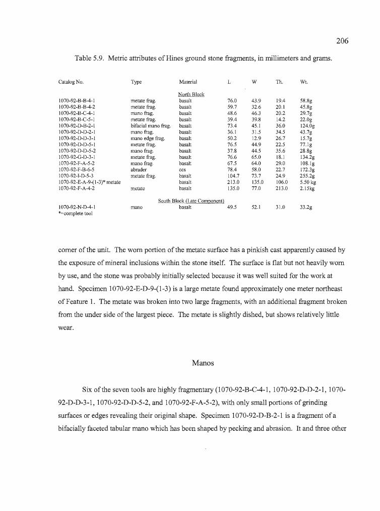
206
Table 5.9. Metric attributes of Hines ground stone fragments, in millimeters and grams.
Catalog No. Type Material L W Th. WI.
North Block1070-92-B-B-4-1 metate frag. basalt 76.0 43.9 19.4 58.8g1070-92-B-B-4-2 metate frag. basalt 59.7 32.6 20.1 45.8g1070-92-B-C-4-1 mana frag. basalt 48.6 46.3 20.2 29.7g1070-92-B-C-5-1 metate frag. basalt 39.4 39.8 14.2 22.0g1070-92-D-B-2-1 bifacial mana frag. basalt 73.4 45.1 36.0 124.0g1070-92-D-D-2-1 mana frag. basalt 36.1 31.5 34.5 43.7g1070-92-D-D-3-1 mana edge frag. basalt 50.2 12.9 26.7 15.7g1070-92-D-D-5-1 metate frag. basalt 76.5 44.9 22.5 77.1g1070-92-D-D-5-2 mana frag. basalt 37.8 44.5 35.6 28.8g1070-92-G-D-3-1 metate frag. basalt 76.6 65.0 18.1 134.2g1070-92-F-A-5-2 mana frag. basalt 67.5 64.0 29.0 108.1g1070-92-F-B-6-5 abrader ccs 78.4 58.0 22.7 172.3g1070-92-I-D-5-3 metate frag. basalt 104.7 73.7 24.9 255.2g1070-92-E-A-9-(l-3)* metate basalt 213.0 135.0 106.0 5.50 kg1070-92-F-A-4-2 metate basalt 135.0 77.0 213.0 2.15kg
South Block (Late Component)1070-92-N-D-4-1 mano basalt 49.5 52.1 31.0 33.2g*=complete tool
comer of the unit. The worn portion of the metate surface has a pinkish cast apparently caused by
the exposure ofmineral inclusions within the stone itself. The surface is flat but not heavily worn
by use, and the stone was probably initially selected because it was well suited for the work at
hand. Specimen 1070-92-E-D-9-(l-3) is a large metate found approximately one meter northeast
of Feature 1. The metate was broken into two large fragments, with an additional fragment broken
from the under side of the largest piece. The metate is slightly dished, but shows relatively little
wear.
Manos
Six of the seven tools are highly fragmentary (l070-92-B-C-4-l, 1070-92-D-D-2-l, 1070
92-D-D-3-1, 1070-92-D-D-5-2, and 1070-92-F-A-5-2), with only small portions ofgrinding
surfaces or edges revealing their original shape. Specimen 1070-92-D-B-2-l is a fragment ofa
bifacially faceted tabular mano which has been shaped by pecking and abrasion. It and three other
207
mano fragments were recovered from Unit D. None of the fragments were determined to be from
the same artifact, although possibly some are. Another blocky, unshaped unifacial metate
fragment was collected in the Late Component of the South Block (l070-92-N-D-4-1)
Abrader
A single artifact from the Hines site has been identified as an abrader. Specimen 1070-92
F-B-6-5 is a tabular stone 79.2 mm long, 58.7 mm wide and 23.7mm thick. The material is basalt,
covered with a reddish-brown coating of an unknown composition. The flat side is covered with
innumerable incised lines and scratches running in all directions across the surface. The opposite
side shows no such use wear. The actual use of the artifact is unknown, but it has the appearance
of a sharpening stone used for shaping and maintaining a point or edge on materials of a softer
composition, such as bone or wood.
Miscellaneous Artifacts
Stone Bead
A fragment of a stone bead (Specimen 1070-92-H-A-5-4a) was collected in Unit H, Quad
A, adjacent to Feature 1. The artifact was recovered in Level 5, which also contained two biface
fragments, two utilized flakes, and the peak debitage count for the unit, at 445 pieces. The
fragment fractured both laterally and longitudinally, appears to have been a tubular bead. It is
made of steatite, with at least one beveled end and a barrel-shaped cross section. The bead
fragment is 6.6 mm in length, has a maximum width of5.1 mm, and a thickness of 1.2 mm.
Bone Tool
A single bone tool fragment (l070-92-E-B-5-1) was recovered from Unit E, Quad B, Level 5 in
the North Block of the Central Locus (Fig. 5.9). The artifact is a small bone fragment from a
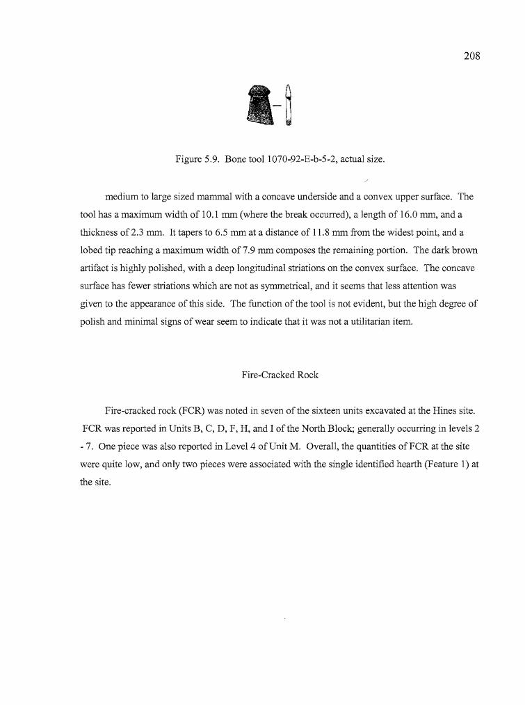
208
Figure 5.9. Bone tooll070-92-E-b-5-2, actual size.
medium to large sized mammal with a concave underside and a convex upper surface. The
tool has a maximum width of 10.1 mm (where the break occurred), a length of 16.0 mm, and a
thickness of2.3 mm. It tapers to 6.5 mm at a distance of 11.8 mm from the widest point, and a
lobed tip reaching a maximum width of7.9 mm composes the remaining portion. The dark brown
artifact is highly polished, with a deep longitudinal striations on the convex surface. The concave
surface has fewer striations which are not as symmetrical, and it seems that less attention was
given to the appearance of this side. The function of the tool is not evident, but the high degree of
polish and minimal signs of wear seem to indicate that it was not a utilitarian item.
Fire-Cracked Rock
Fire-cracked rock (FCR) was noted in seven of the sixteen units excavated at the Hines site.
FCR was reported in Units B, C, D, F, H, and I of the North Block; generally occurring in levels 2
- 7. One piece was also reported in Level 4 of Unit M. Overall, the quantities ofFCR at the site
were quite low, and only two pieces were associated with the single identified hearth (Feature 1) at
the site.
I
I:,
i·
209
Historic Artifacts
Being adjacent to a busy highway corridor, the Hines site had the usual array of modern
historic debris, including objects manufactured from cellophane, plastic, metal, and glass. These
materials were collected and catalogued along with the prehistoric artifacts as a component of the
overall site assemblage.
One historic artifact deserves a more specific description. A cylindrical brass rifle
cartridge was surface-collected at the Hines site during the data recovery phase. It is a center-fire
cartridge (primer cap located in the center of the cartridge head). The cartridge has been fired; the
primer has been indented by the impact of a rifle firing-pin, the bullet is absent, and the neck of the
cartridge has been crimped almost completely closed by compression from either vehicle or foot
traffic. This cartridge was identified by Robin Kesler, a local small-arms expert, as .50
Government caliber (also known as 50170 Government) through casing and head diameter
measurements. The cartridge was used by the U.S. military from 1863 to 1873, and is among
calibers manufactured for use with early repeating rifles such as the 1866 Henry. The cartridge is
not head-stamped with information regarding either caliber or manufacturer, indicating that it is
government-issued ammunition. However, rifles were chambered for the .50 Government caliber
until 1940, and it is unclear how long government ammunition was available after the round was
discontinued from military use. The cartridge is 46.3 mm in total length. The casing is 14.7 mm
in diameter and 0.2 mm in thickness, while the head has a diameter of 16.5 mm and a thickness of
1mm.
Faunal Remains
The faunal assemblage from the Hines site consisted of 39 bones collected during the testing
phase and 1780 specimens from the data recovery phase, for a total of 1819 complete bones and
fragments. Most of the faunal remains were highly fragmented and often very light in color,
unlike the darkly stained bones associated with sites that have been intensively occupied. Heavily
occupied sites often develop rich, dark anthropic soils that alter the appearance of bones through
r
I•
f
Iii'ItIII
210
prolonged contact. The overall preservation of bone was good, with many small and delicate fish,
rodent, and bird bones recovered during the excavations (Table 5.10). Burned bone was
uncommon.
Of the 1819 bones recovered during the Hines excavations, 303 were identifiable to a
series of size classes which ranged from Class 1 (mice, shrews, voles) to Class 6 (elk, bison,
horse). Some of the 303 bones were further classifiable to order, family, or genus/species based on
the completeness of whole elements or distinguishing characteristics ofbone fragments. For
instance, the tibia and fibula configuration of various rodent families is much more distinctive than
are vertebral elements, especially when a complete set of comparative specimens is lacking. The
variety of species recovered from the site was quite diverse, considering the relatively small size of
the faunal assemblage. The good preservation qualities of the site provided a number of easily
identifiable specimens.
Because much of the bone was lightly colored, it was sometimes difficult to determine
which bones were culturally deposited, and which were the result of natural deposition,
particularly in the case of rodent remains. Several species of rodents were noted at the site over
the course of the excavations there, and evidence ofrodent burrowing was common throughout the
excavated units. The identification of cultural versus non-culturally deposited remains was based
on the determination that non-cultural bones would most often (but not exclusively) be the remains
ofrodents, were often lighter in color than the culturally deposited material, contained more
complete elements in a concentrated area (as would occur in a burrow death), or otherwise did not
seem to fit with the general characteristics of other bones being recovered from the same context in
terms ofpreservation, appearance, and types of species. The location of the site adjacent to a busy
highway where animals are frequently struck by vehicles may have contributed to the variety and
quantity of fragmented animal remains. The possibility that the first 10-20 cm of deposits may
have been altered by the removal of vegetation and leveling by heavy equipment may also have
altered the faunal composition to a degree. Despite these potential problems, several trends were
apparent in the faunal assemblage, which will be described below.
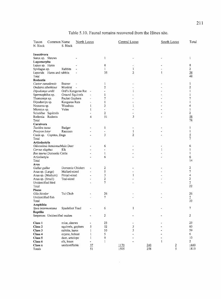
---------------------------------~ -~
T
211
Table 5.10. Faunal remains recovered from the Hines site.
Taxon Common Name North Locus Central Locus South Locus TotalN. Block S. Block
InsectivoraSorex sp. ShrewsLagomorphaLepus sp. Hares 8 8Syvilagus sp. Rabbits I I 2Leporids Hares and rabbits 35 2 ~Total 48RodentiaCastor canadensis Beaver I IOndatra zibethicus Muskrat 2 2Dipodomys ordii Ord's Kangaroo Rat - ISpennophilus sp. Ground Squirrels I IThomomys sp. Pocket Gophers 7 7Dipodomys sp. Kangaroo Rats I INeotomasp. Woodrats 3 4Microtus sp. Voles ISciuridae Squirrels 2 2Rodentia Rodents 4 51 3 58Total 78CarnivoraTaxidea taxus Badger IProcyon lotor Raccoon I ICanis sp. Coyotes, Dogs 3 2 ~
Total 7ArtiodactylaOdoeoileus hemionusMule Deer 6 6Cervus elaphus Elk IBos taurus Domestic Cattle I IArtiodactyla 6 6-Total 14AvesGallus gallUS Domestic Chicken 2 2Anas sp. (large) Mallard-sized 5 7Anas sp. (Medium) Pintail-sized 3 4
Ii Anas sp. (Small) Teal-sized 2 2
I Unidentified Bird 7 1Total 22PiscesGila bieolor Tui Chub 26 26Unidentified fish 7 1Total 33AmphibiaSpea intermontana Spadefoot Toad 6 7ReptiliaSerpentes Unidentified snakes 2 2
Class 1 mice, shrews 23 23Class 2 squirrels, gophers 5 52 3 60Class 3 rabbits, hares I 55 3 59Class 4 coyote, bobcat I 5 6Class 5 deer, antelope I 9 10Class 6 elk, bison I 2Class x unidentifiable 37 1170 240 ~ 1449Totals 51 1505 258 5 1819
:/''IIll..-
T
212
The mammalian faunal assemblage accounted for the highest number of animal remains at
the Hines site, and included species from the Orders Insectivora, Lagomorpha, Rodentia,
Carnivora, and Artiodactyla. Rodents (21 %) and lagomorphs (13%) were the most commonly
identified mammal species, with artiodactyls (4%), carnivores (2%), and insectivores «1%) less
common in the deposits. Identified species include Ord's Kangaroo Rat, Beaver, Muskrat,
Badger, Raccoon, Mule Deer, and Elk. Hares may have included either Black-tailed or White
tailed Jackrabbits, but the White-tailed species is less common, and occupies more scattered
habitats (Verts and Carraway 1998). The canid remains may include both coyotes and domestic
dogs. The highly fragmented material did not permit clear identifications. One small second
molar may have been that of a fox.
Other animal remains included fish (9%), of which the majority were Tui Chub; birds (6%),
including a variety of waterfowl; and reptiles and amphibians (2%), of which the amphibian
remains were exclusively Great Basin Spadefoot Toad. The insectivore and the reptiles and
amphibians are not related to the cultural deposits, but are included because they provide examples
of the range of species that are present at the site.
The largest concentration of faunal remains occurred in Units C and F of the North Block,
with the total bone count at Unit F accounting for 29% of the site total (529 specimens). Bone
counts at units surrounding C and F decreased rapidly (Figure _), possibly indicating that a
processing or butchering activity area was located where the two units were established, or a
favored discard area. The North Block alone produced 80% of the bone recovered at the Hines
site, and almost all of the artiodactyl, bird, and fish bones came from this location. The only
exceptions were an unidentified artiodactyl bone fragment recovered from Unit A at the North
Locus, and a medium-sized duck humerus found in Unit L at the South Block. Diversity was high
at the North Block, with a total of 20 species, families, orders, or classes of animals represented in
the deposits. The South Block contained nine taxa, the North Locus had four, and the South
Locus had three.
Unfortunately, the limited quantities of animal bone recovered at the South Block did not
permit an analysis of the potential differences between the earlier and later components at the
Hines site. The bone from the South Block was highly fragmented and decreased rapidly in
quantity as depth increased.
.',i~
ij
"
II
Il
213
Botanical Remains
Pollen and macrofloral analyses were conducted by Linda Scott Cummings, Kathryn
Puseman, Thomas E Montoux and Laura L. Ruggiero of Paleo Research Laboratories (Cummings
et al. 1998). One offsite sample, four column samples, and eleven additional soil samples were
submitted for study. Of these, one modern surface sample (l070-92-0ffsite) was submitted for
both pollen and macrobotanical analysis. A column sample (TR3-1 through TR3-3) that was taken
from Trench 3 between 1.0 - 1.75 meters in depth, was submitted for pollen analysis alone. The
remaining samples underwent macrofloral analysis only. A summary of the results is presented
here, along with tables listing the materials that were recovered (Tables 5.11, 5.12).
Pollen Analysis
The surface pollen sample contained an abundance of Artemesia pollen produced by the
sagebrush surrounding the site on the valley floor and hillsides, and smaller amounts of juniper
and pine pollen from higher elevations to the northwest. Quercus (oak) and Salix (willow) pollen
were transported from nearby sources. Small amounts of Cheno-am (amaranth or pigweed),
Sarcobatus (Greasewood), Poaceae (grasses), Leptodactylon-type, and indeterminate types of
pollen were also noted from the modern surface sample.
The surface sample was collected away from the excavation, at a location that was free of
debitage and other obvious evidence of cultural materials. Approximately 1000 cm3 of fill was
collected after several centimeters of surface material containing twigs, and rootlets were removed.
The sample was apparently taken from an area containing unseen subsurface cultural deposits,
which included a burned camas bulb, sagebrush and serviceberrry charcoal, and a number of
debitage flakes in addition to the above-mentioned pollen. Some or all of the charred plant
materials may have been the result of natural fires, but the presence of debitage suggests that they
may also be cultural in origin. As a result, the sample can not be considered truly representative of
non-cultural deposits in the vicinity of the Hines site.
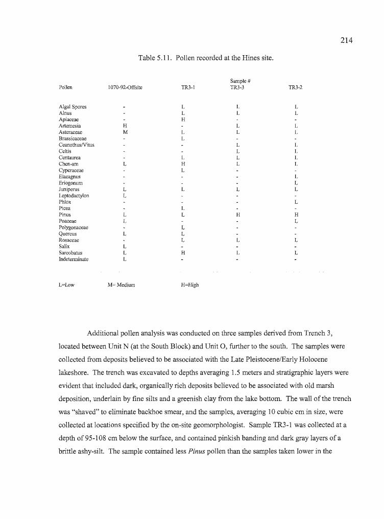
214
Table 5.11. Pollen recorded at the Hines site.
H=High
Pollen I070-92-0ffsite TR3-1
Algal Spores LAlnus LApiaceae HArtemesia HAsteraceae M LBrassicaceae LCeanothusNitusCeltisCentaurea LChen-am L HCyperaceae LElaeagnusEriogonumJuniperus L LLeptodactylon LPhloxPicea LPinus L LPoaceae LPolygonaceae LQuercus L LRosaceae LSalix LSarcobatus L HIndeterminate L
L=Low M=Medium
Sample #TR3-3
LL
LL
LLLL
L
H
L
L
TR3-2
LL
LL
LLLL
LLL
L
HL
L
L
..
Additional pollen analysis was conducted on three samples derived from Trench 3,
located between Unit N (at the South Block) and Unit 0, further to the south. The samples were
collected from deposits believed to be associated with the Late Pleistocene/Early Holocene
lakeshore. The trench was excavated to depths averaging 1.5 meters and stratigraphic layers were
evident that included dark, organically rich deposits believed to be associated with old marsh
deposition, underlain by fine silts and a greenish clay from the lake bottom. The wall of the trench
was "shaved" to eliminate backhoe smear, and the samples, averaging 10 cubic em in size, were
collected at locations specified by the on-site geomorphologist. Sample TR3-l was collected at a
depth of 95-1 08 em below the surface, and contained pinkish banding and dark gray layers of a
brittle ashy-silt. The sample contained less Pinus pollen than the samples taken lower in the
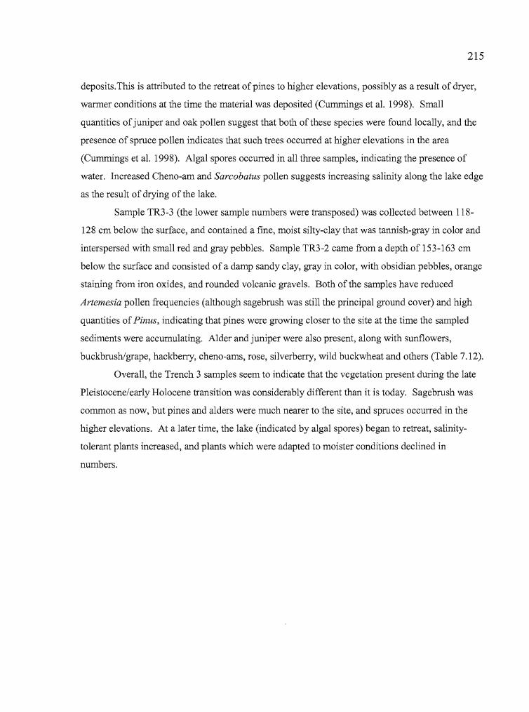
y---------- -
215
deposits.This is attributed to the retreat ofpines to higher elevations, possibly as a result of dryer,
warmer conditions at the time the material was deposited (Cummings et al. 1998). Small
quantities ofjuniper and oak pollen suggest that both ofthese species were found locally, and the
presence of spruce pollen indicates that such trees occurred at higher elevations in the area
(Cummings et al. 1998). Algal spores occurred in all three samples, indicating the presence of
water. Increased Cheno-am and Sarcobatus pollen suggests increasing salinity along the lake edge
as the result of drying of the lake.
Sample TR3-3 (the lower sample numbers were transposed) was collected between 118
128 cm below the surface, and contained a fine, moist silty-clay that was tannish-gray in color and
interspersed with small red and gray pebbles. Sample TR3-2 came from a depth of 153-163 cm
below the surface and consisted of a damp sandy clay, gray in color, with obsidian pebbles, orange
staining from iron oxides, and rounded volcanic gravels. Both of the samples have reduced
Artemesia pollen frequencies (although sagebrush was still the principal ground cover) and high
quantities of Pinus, indicating that pines were growing closer to the site at the time the sampled
sediments were accumulating. Alder and juniper were also present, along with sunflowers,
buckbrush/grape, hackberry, cheno-ams, rose, si1verberry, wild buckwheat and others (Table 7.12).
Overall, the Trench 3 samples seem to indicate that the vegetation present during the late
Pleistocene/early Holocene transition was considerably different than it is today. Sagebrush was
common as now, but pines and alders were much nearer to the site, and spruces occurred in the
higher elevations. At a later time, the lake (indicated by algal spores) began to retreat, salinity
tolerant plants increased, and plants which were adapted to moister conditions declined in
numbers.
...
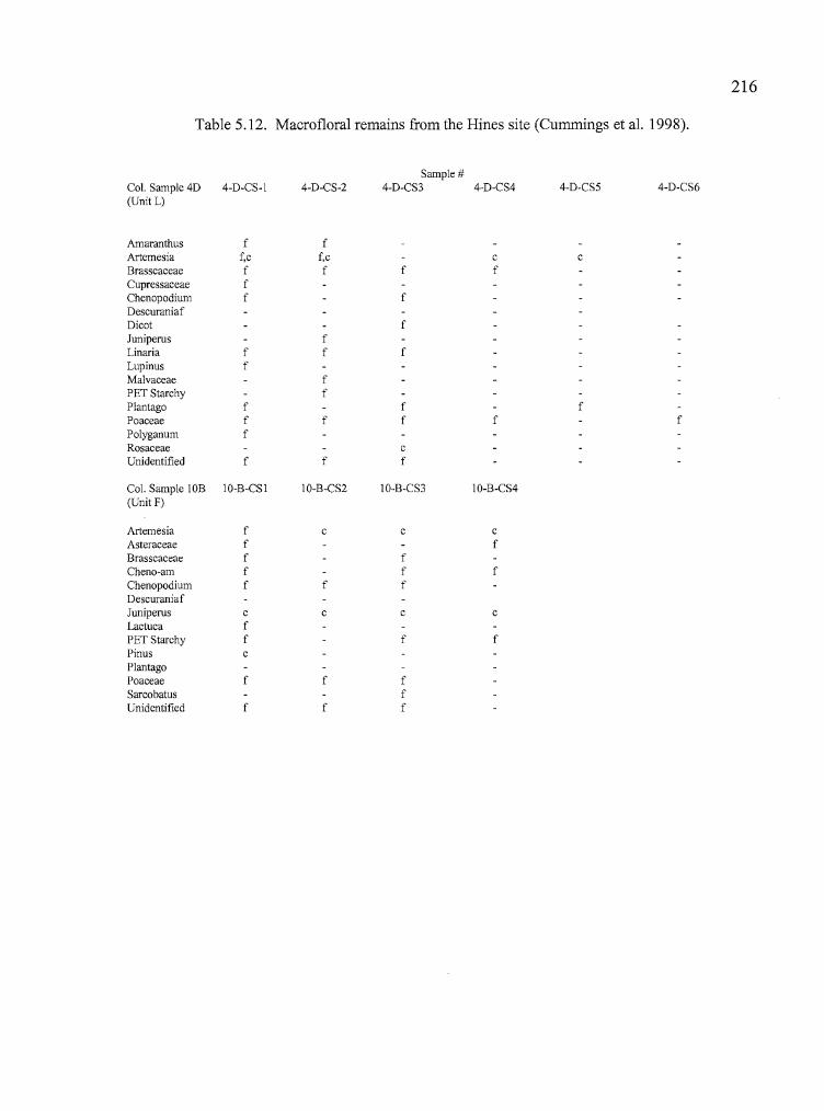
216
Table 5.12. Macrofloral remains from the Hines site (Cummings et al. 1998).
Sample #Col. Sample 40 4-D-CS-l 4-D-CS-2 4-D-CS3 4-D-CS4 4-D-CS5 4-D-CS6(Unit L)
Amaranthus f fArtemesia f,c f,c c cBrasscaceae f f f fCupressaceae fChenopodium f fDescuraniafDicot fJuniperus fLinaria f f fLupinus fMalvaceae fPET Starchy fPlantago f f fPoaceae f f f f fPolyganum fRosaceae cUnidentified f f f
Col. Sample lOB lO-B-CS 1 IO-B-CS2 10-B-CS3 10-B-CS4(Unit F)
Artemesia f c c cAsteraceae f fBrasscaceae f fCheno-am f f fChenopodium f f fDescuraniafJuniperus c c c cLactuca f
.' PET Starchy f f f:iI:. Pinus cII, Plantago
Poaceae f f fSarcobatus fUnidentified f f f
j!I.. bn
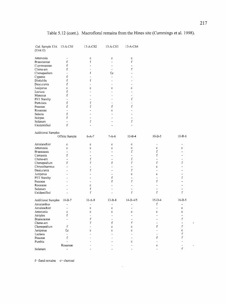
11Iii
j"
'I
!!",. 217
Table 5.12 (cont.). Macrofloral remains from the Hines site (Cummings et al. 1998).
Col. Sample l3A l3-A-CSI 13-A-CS2 l3-A-CS3 13-A-CS4(Unit G)
Artemesia c c cBrasscaceae f f fCupressaceae fCheno-am f fChenopodium f f,cCyperus fDistichlis f fDescurania fJuniperus c c c cLactuca fMonocot fPET Starchy fPortulaca f fPoaceae f f f fRosaceae cSalsola fScirpus f
j:, Solanum f fI Unidentified f,
i Additional Samples,,{I'll~:
Offsite Sample 6-A-7 7-A-6 IO-B-4 IO-B-5 IO-B-6
Amalanchier c c c cArtemesia c c c c c cBrasscacea f fCamassia f fCheno-am f fChenopodium f f f f f fChrysothamnus cDescurania f fJuniperus c cPET Starchy f fPoaceae f f fRosaceae cSolanum fUnidentified f f f f
Additional Samples IO-B-7 IO-A-8 l3-B-8 l4-B-4/5 l5-D-4 16-B-5
Amaranthus fAmalanchier c c cArtemesia c c c c c cAtriplex fBrasscaceae f fCheno-am f f fChenopodium f c c f fJuniperus f,c c c c cLactuca fPoaceae f f fPurshia c
Rosaceae cSolanum f
f= floral remains c= charcoal
:,I
iIiI...
1I'
I1....
------ -
218
Macrofloral Analysis
Three column samples were submitted for macrofloral analysis, along with 11 soil samples
from various parts of the excavations (Table 5.13). The column samples were taken in Unit L
(1070-92-4-D-CSI through 1070-92-4-D-CS6), Unit F (1070-92-l0-B-CSI through 1070-92-l0-B
CS4), and Unit G (1070-92-13-A-CSI through 1070-92-13-A-CS4).
The Unit L column was taken in an area where both Late and Early Component deposits
were identified. The upper sample from Unit L contained charred specimens from the mustard
family, plantain, and grasses. These may be attributable to either human or natural fires. Sample 2
(10-20 cm) originated in the Late Component fill and botanical remains included charred grass
seeds, PET starchy tissue that may be from a bulb, and sagebrush charcoal. Column Sample (CS) 3
(20-30 cm), also from Late Component fill, contained both Chenopodium and grass seeds that were
charred and charcoal from small Rosacaea (rose family) twigs. Plant remains identified from the
Early Component included charred grass seeds and sagebrush charcoal (Table 7.12).
The Unit F column was chosen because the highest concentration of cultural materials
occurred there and debitage and charred bone were present in the first 30 cm offill. Charred grass
seeds were present to a depth of 30 cm. Charred PET starchy tissue fragments were recovered from
CS 1 (0-10 cm), CS 3 (20-30 cm), and CS 4 (30-40 cm); and Chenopodium or Cheno-ams were
present in CS 3 and 4. Charcoal remains included both juniper and pine in CS 1, and sagebrush
and juniper in CS 2,3, and 4. Unidentified fruit and seed fragments, and Sarcobatus (greasewood)
were collected in CS3.
The Unit G column came from an area where a large metate was recovered, and the
possibility was high that plant materials might be associated with it. Modem plant remains were
common in the first sample along with Russian thistle, an introduced species. Column Sample 1
also produced charred grass seeds and juniper charcoal. Charred Chenopods and Cheno-ams, and
grass seeds were identified in CS 2 and CS 3 as were sagebrush and juniper charcoal. Charred
bone fragments and lithic debitage were noted in all samples. No increases in either the amount or
diversity ofplant remains were noted despite the fact that plant processing equipment was
recovered nearby.
i
j
ifl~
219
Additional soil samples were taken at various locations during the course of excavations to
serve as "spot checks" for botanical remains in areas where charcoal stains were evident, cultural
remains were dense, or clusters of ground stone were present (Table 5.13). The soil samples
included one from Unit B (l070-92-l4-B-4/5), one from Unit D (l 070-92-1 5-D-4), one from Unit
E (l 070-92-l6-B-5), five from Unit F (l 070-92-1 0-B-4 through 1070-92-10-B-7, and 1070-92-10
A-8), one from Unit G (l070-92-13-B-8), one from Unit H (l070-92-7-A-6), and one from Unit N
(l070-92-6-A-7). The analysis revealed that the number and variety of charred edible plant remains
closely resembled the materials recovered from the column samples. No apparent concentrations of
edible species were identified at anyone location, including the sample collected from Feature 1
hearth deposits.
The quantity and diversity of botanical remains at the Hines site do not provide clear
evidence that particular families or species of plants were being targeted for collection and
processing at the location. Charred remains of edible plant species are present along with the
ground stone tools needed to process them, making it likely that some of these species were being
used by the inhabitants of the site. However, Cummings (et al. 1998) caution that: "Plant remains
might have been charred through processing, through people burning vegetation to encourage
production of certain plants, or even through natural burning".
Table 5.13. Soil samples and associated materials.
II'l
Sample #
1070-92-offsite1070-92-14-B-4/5 (Unit B)1070-92-15-D-4 (Unit D)1070-92-16-B-5 (Unit E)1070-92-10-B-4 (Unit F)1070-92-10-B-5 (Unit F)1070-92-10-B-6 (Unit F)1070-92-10-B-7 (Unit F)1070-92-IO-A-8 (Unit F)1070-92-13-B-8 (Unit G)1070-92-7-A-6 (Unit H)1070-92-6-A-7 (Unit N)
Association
For comparative purposes, 28 paces east and 40 paces south of Unit PLocation of 4 ground stone fragments and other toolsFrom area where projectile point and three flake tools were collectedLocation near bone tool flake tool, and elevated bone and debitage countsLocation where ground stone and a large biface were recoveredLocation where tools, FCR and elevated quantities of debitage were notedCharcoal flecking and possible bisqueIncreased debitage and boneStratigraphic transition zoneCharcoal flecking and increased debitageFeature I fillCharcoal flecking
,'Ij
220
Summary
The Hines site is located on an alluvial fan adjacent to the shoreline of Pleistocene Lake
Malheur, within the present-day city of Hines, Oregon. The alluvial fan originates on the slopes of
nearby Burns Butte, which is a prominent source of good quality obsidian. The deposits of the site
are rich with obsidian nodules of varying sizes, many of which would have been adequate for the
manufacture of a variety of tools and small projectile points and may in part have been an
attraction to the site occupants. Most of the data recovery efforts centered around the Central
Locus, which was divided into a North Block and a South Block based on peaks in artifact
concentrations identified during testing. The recovered tool assemblage included 63% utilized
flakes, 26% formed tools, 6% ground stone, 3% cores, 1% drills, and less than 1% for both
abraders and bone tools. The only cultural feature identified at the Hines site was located in the
North Block and consisted ofa small hearth radiocarbon dated to 1160 BP. Concentrations of
bifaces, utilized flakes, cores, and drills, as well as an awl and an abrader, were encountered near
this hearth. In addition, 22 projectile points were recovered from the area surrounding the hearth,
of which 58% were Rose Spring, 14% were Eastgate, 23% were straight stemmed or "pin
stemmed" points more common to Columbia Plateau assemblages, and 5% were Elko Eared. A
single Northern Side-notched point was also found. All ofthe types named, except for Elko Eared
and Northern Side-notched, are consistent with the 1160 BP radiocarbon date.
Two small concentrations of ground stone were found at the site. The first was located
about one meter northeast of the hearth, the other approximately 2.5 meters to the east. Two
Rosegate and one Elko Eared point were recovered from the South Block. A Rose Spring, an Elko
Eared, and a Northern Side-notched point were collected from the surface of the site. The
Rosegate Series and Pinstem artifacts were of obsidian either derived from the Burns Butte source,
or from obsidian sources located to the north and west of the Hines site. Elko and Northern Side-
notched points originated either at the Burns obsidian source or at the Double 0 source to the
south.
In all, 119 obsidian artifacts from the Hines site were measured for hydration rims. The
resulting frequency distribution of rim values suggests that there were two major periods of
,i>11
1\
,I,.
:!
221
occupation at this site. Although the hydration rims span a range of 1.4 to 9.5 microns, most ofthe
values range between 2 and 8 microns, with peaks at approximately 3 and 6 microns. A clearer
pattern emerges when hydration rims from the North Block are compared with those from the
South Block. The majority of rims in the North Block range between 1.5 and 4 microns, while
most rims from the South Block are between 5 and 7.5 microns in width. This clearly suggests
that occupations in the South Block are generally older than those in the North Block. The Early
Component lies directly over a hardpan layer associated with a Pleistocene lakebed. Because the
Early Component is probably mid-Holocene in origin, this indicates that one or more erosional
episodes are likely to have been responsible for the removal of deposits dating between the early to
middle Holocene, and that the Early Component materials are laying on a depositional
unconformity. The presence of a nearby stream channel and gravel deposits associated with fluvial
activities in some portions of the site are in keeping with this idea. Unfortunately dateable
materials were not available in the South Block and diagnostic artifacts were found only in the
upper deposits, so hydration rims and the single radiocarbon date offer our only clues about the
full occupational chronology of the site.
The zooarchaeological assemblage from the site suggests that faunal resources were
derived from a marshland and grassland setting. A total of 1819 faunal remains was identified
from the site, of which 370 were identified at least to the taxonomic level of class. Of the
identified remains, rodents were the most abundantly identified taxon at the Hines site, accounting
for 21 % of the assemblage, followed by lagomorphs at 13%. Some of the rodent bones may have
been the result of burrow deaths, rather than human activity. Fish remains, particularly those of tui
chubs accounted for the third largest category of identified bones at 9% of the total and birds,
especially waterfowl, comprised the fourth largest category, at 6%. Only 4% ofthe remains from
the site were identified as large mammals, such as artiodactyls. The presence of eggshell and the
unfused bones of immature animals indicates that the site was used, at least in part, during the
spring and summer months.
Macrofloral analysis ofthree column samples taken in different portions ofthe site reveal
the presence of sagebrush, juniper, and possibly rose and serviceberry as potential fuel woods. All
columns contained PET starchy fragments and grass seeds (Poaceae), and Mustard family seeds
were generally found in the upper levels. Less frequent were Cheno-ams, goose foot, plantain, and
1
Ij

222
serviceberry, among others. A bulb fragment that may be camas was recovered from the only
portion of the site where fire-cracked rock was found.
The Hines site appears to have been a location well suited for the procurement of both
obsidian toolstone and marshland food resources. Site occupation is best documented for a period
around 1000 BP, but obsidian hydration data and Elko and Northern Side-notched points also
indicate an earlier occupation in mid-Holocene times, perhaps around 4000 - 5000 BP.
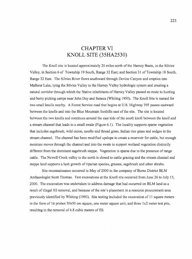
i·!
223
CHAPTER VIKNOLL SITE (35HA2530)
The Knoll site is located approximately 20 miles north of the Harney Basin, in the Si1vies
Valley, in Section 6 of Township 19 South, Range 32 East; and Section 31 of Township 18 South,
Range 32 East. The Si1vies River flows southward through Devine Canyon and empties into
Ma1heur Lake, tying the Si1vies Valley to the Harney Valley hydrologic system and creating a
natural corridor through which the Native inhabitants of Harney Valley passed en route to hunting
and berry picking camps near John Day and Seneca (Whiting 1950). The Knoll Site is named for
two small knolls nearby. A Forest Service road that begins at U.S. Highway 395 passes eastward
between the knolls and into the Blue Mountain foothills east of the site. The site is located
between the two knolls and continues around the east side of the south knoll between the knoll and
a stream channel that leads to a small swa1e (Figure 6.1). The locality supports sparse vegetation
that includes sagebrush, wild onion, needle and thread grass, Indian rice grass and sedges in the
stream channel. The channel has been modified upslope to create a reservoir for cattle, but enough
moisture moves through the channel and into the swa1e to support wetland vegetation distinctly
different from the dominant sagebrush steppe. Vegetation is sparse due to the presence ofrange
cattle. The Newell Creek valley to the north is closed to cattle grazing and the stream channel and
steppe land supports a lush growth of riparian species, grasses, sagebrush and other shrubs.
Site reconnaissance occurred in May of2000 in the company of Bums District BLM
Archaeologist Scott Thomas. Test excavations at the Knoll site occurred from June 26 to July 13,
2000. The excavation was undertaken to address damage that had occurred on BLM land as a
result of illegal fill removal, and because of the site's placement in a resource procurement area
previously identified by Whiting (1950). Site testing included the excavation of 11 square meters
in the form of 16 probes 50x50 cm square, one meter square unit, and three lx2 meter test pits,
resulting in the removal of4.8 cubic meters offill.
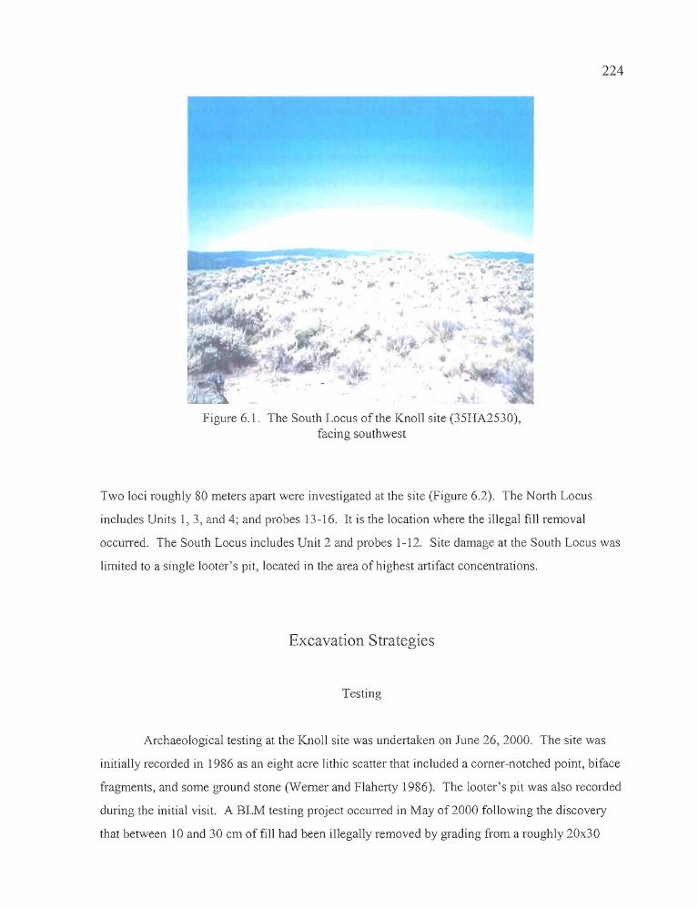
t
224
Figure 6.1. The South Locus of the Knoll site (35HA2530),facing southwest
Two loci roughly 80 meters apart were investigated at the site (Figure 6.2). The North Locus
includes Units I, 3, and 4; and probes 13-16. It is the location where the illegal fill removal
occurred. The South Locus includes Unit 2 and probes 1-12. Site damage at the South Locus was
limited to a single looter's pit, located in the area of highest artifact concentrations.
Excavation Strategies
Testing
Archaeological testing at the Knoll site was undertaken on June 26, 2000. The site was
initially recorded in 1986 as an eight acre lithic scatter that included a corner-notched point, biface
fragments, and some ground stone (Werner and Flaherty 1986). The looter's pit was also recorded
during the initial visit. A BLM testing project occurred in May of 2000 following the discovery
that between 10 and 30 cm of fill had been illegally removed by grading from a roughly 20x30
225
meter area within the portion of the site that would become the North Locus. The destruction
exposed cultural remains that included formed tool fragments, debitage, an apparent
hearth that was subsequently designated as Feature 1, and charcoal. Although three distinct
charcoal concentrations were identified, only one had sufficient integrity to warrant excavation.
The 50xl00 cm BLM test pit dug there reached a depth of40 cm, revealing a cluster of fire
blackened tuffaceous stones surrounded by pale brown sandy clay infused with sagebrush
charcoal.
The University of Oregon testing effort began with the pinflagging of all cultural materials
visible on the surface of the site, most of which were situated in the South Locus between the
southernmost knoll and the stream channel (identified in Figure 6.2). Probes 1 - 8 were
established to explore this concentration. The probes ran east to west, beginning on the floor of
the stream channel, crossing a bench where most of the cultural materials were deposited, and
continuing well upslope on the south knoll. All of the probes produced debitage, but Probe 5 was
exceptional, yielding 3372 flakes from nine excavation levels. Unit 2, a lx2, was established over
Probe 5 to explore the debitage concentration further. The results of that work are described in
detail below. Probes 9 - 12 were excavated north of the Probe 5IUnit 2 excavation through an
area of concentrated debitage.
At the same time the work was occurring in the South Locus, Unit 1 was established at the
North Locus just north of the previously mentioned 50xl00 cm test unit excavated by BLM
personnel. Unit 1 was established to explore the Feature 1 hearth earlier discovered. Unit 3, also a
lx2, was an expansion ofthe Feature 1 study. Aside from the Feature 1 hearth explorations, a
series of four 50x50 cm probes, designated 13 -16 (from east to west), were also excavated. A
pestle uncovered in the southeast corner of Probe 16 led to the excavation of Unit 4, a lxl meter
unit that also produced an obsidian core and a large, pointed basalt tool, along with 456 pieces of
debitage.
i'
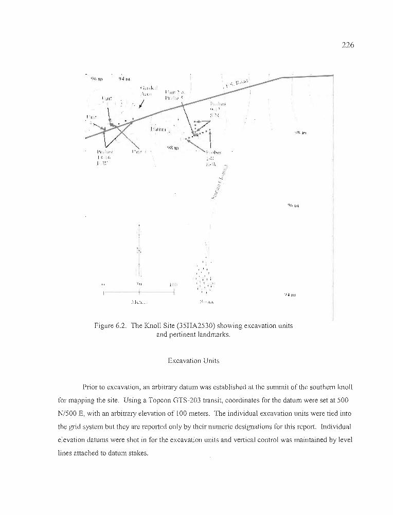
226
)",,11"1""
• j"ln) IJ;J III
1'1" -
1"1" ,,-"I.; I.
I ~ , '
I ;~; ~h... ".~ ... ;
I
"..1'1" - .
I: I'· ... ....1'1 ,-,
, ,, ,, I,
;.:.
'-:
IIII III
"1--
loll
i' ~, 'I '1'\' -
.' I.
, ,'.'.1111
Figure 6.2. The Knoll Site (35HA2530) showing excavation unitsand pertinent landmarks.
Excavation Units
Prior to excavation, an arbitrary datum was established at the summit of the southern knoll
for mapping the site. Using a Topcon GTS-203 transit, coordinates for the datum were set at 500
N/500 E, with an arbitrary elevation of 100 meters. The individual excavation units were tied into
the gTid system but they are reported only by their numeric designations for this report. Individual
elevation datums were shot in for the excavation units and vertical control was maintained by level
lines attached to datum stakes.
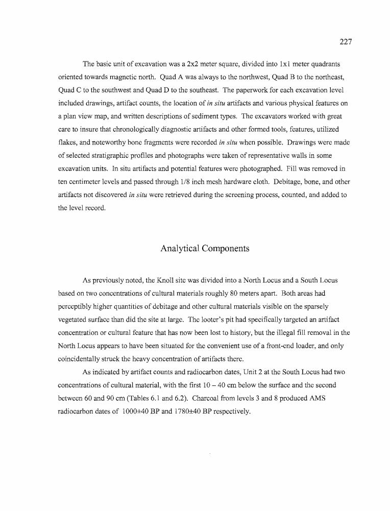
, ,
I~
I
il
227
The basic unit of excavation was a 2x2 meter square, divided into 1x1 meter quadrants
oriented towards magnetic north. Quad A was always to the northwest, Quad B to the northeast,
Quad C to the southwest and Quad D to the southeast. The paperwork for each excavation level
included drawings, artifact counts, the location of in situ artifacts and various physical features on
a plan view map, and written descriptions of sediment types. The excavators worked with great
care to insure that chronologically diagnostic artifacts and other formed tools, features, utilized
flakes, and noteworthy bone fragments were recorded in situ when possible. Drawings were made
of selected stratigraphic profiles and photographs were taken of representative walls in some
excavation units. In situ artifacts and potential features were photographed. Fill was removed in
ten centimeter levels and passed through 1/8 inch mesh hardware cloth. Debitage, bone, and other
artifacts not discovered in situ were retrieved during the screening process, counted, and added to
the level record.
Analytical Components
As previously noted, the Knoll site was divided into a North Locus and a South Locus
based on two concentrations of cultural materials roughly 80 meters apart. Both areas had
perceptibly higher quantities of debitage and other cultural materials visible on the sparsely
vegetated surface than did the site at large. The looter's pit had specifically targeted an artifact
concentration or cultural feature that has now been lost to history, but the illegal fill removal in the
North Locus appears to have been situated for the convenient use of a front-end loader, and only
coincidentally struck the heavy concentration of artifacts there.
As indicated by artifact counts and radiocarbon dates, Unit 2 at the South Locus had two
concentrations of cultural material, with the first 10 - 40 cm below the surface and the second
between 60 and 90 cm (Tables 6.1 and 6.2). Charcoal from levels 3 and 8 produced AMS
radiocarbon dates of 1000±40 BP and 1780±40 BP respectively.
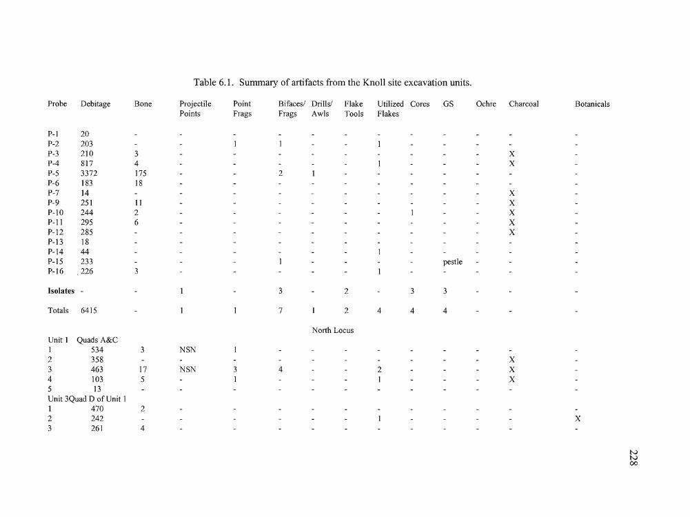
,. ~------,-.- -_.. ~.:..:--:::~ ~---=~~---::-:'=--- --
Table 6.1. Summary of artifacts from the Knoll site excavation units.
Probe Debitage Bone Projectile Point Bifaces! Drills! Flake Utilized Cores GS Ochre Charcoal BotanicalsPoints Frags Frags Awls Tools Flakes
P-I 20P-2 203P-3 210 3 XP-4 817 4 I XP-5 3372 175 2P-6 183 18P-7 14 XP-9 251 II XP-IO 244 2 I XP-II 295 6 XP-12 285 XP-13 18P-14 44P-15 233 I pestleP-16 .226 3
Isolates - 1 3 2 3 3
Totals 6415 1 1 7 1 2 4 4 4
North LocusUnit 1 Quads A&C1 534 3 NSN2 358 X3 463 17 NSN 3 4 2 X4 103 5 1 1 X5 13Unit 3Quad D of Unit 11 470 22 242 1 X3 261 4
NN00
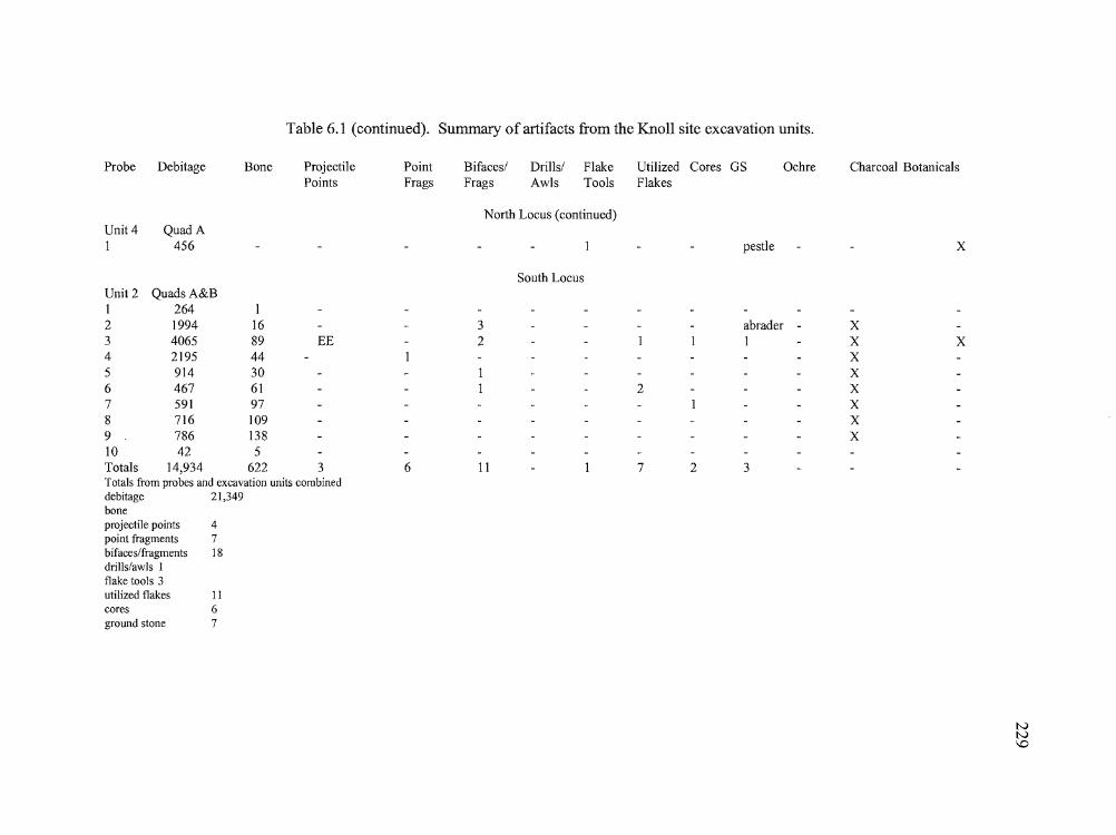
r _.-:-'::"'---~';:"'--~-~_._.~'-"'--='-----__'_·-~r
Table 6.1 (continued). Summary of artifacts from the Knoll site excavation units.
Probe Debitage Bone Projectile Point Bifaces/ Drills/ Flake Utilized Cores OS OchrePoints Frags Frags Awls Tools Flakes
North Locus (continued)Unit 4 Quad A1 456 I pestle
South Locus
Charcoal Botanicals
x
Unit 2 Quads A&BI 264 I2 1994 163 4065 89 EE4 2195 445 914 306 467 617 591 978 716 1099 786 13810 42 5Totals 14,934 622 3Totals from probes and excavation units combineddebitage 21,349boneprojectile points 4point fragments 7bifaces/fragments 18drills/awls Iflake tools 3utilized flakes IIcores 6ground stone 7
6
32
11
abrader - X1 X X
XX
2 XXXX
7 2 3
tvtv\D
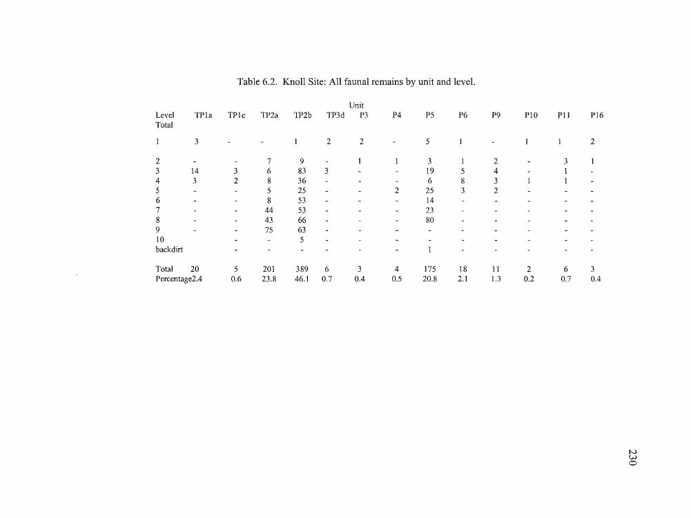
----==--_::=-_- ~:-=~---- -
NWo
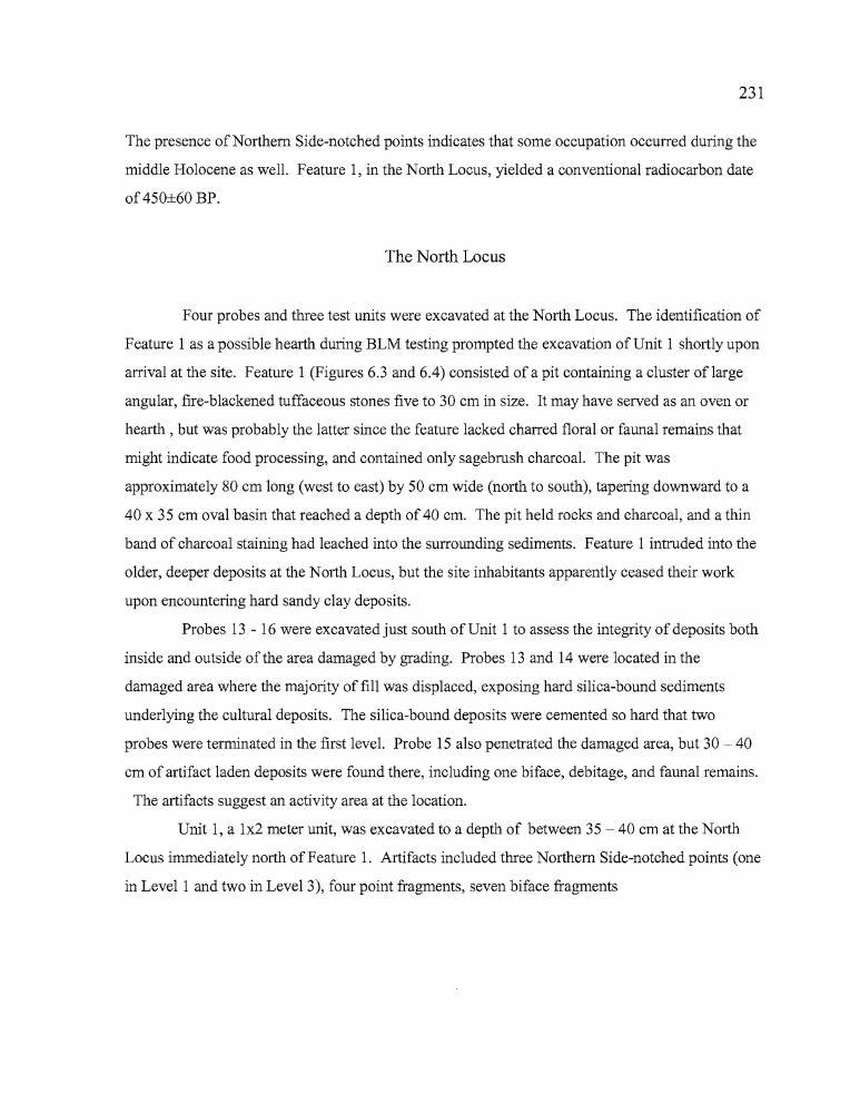
"., "
231
The presence of Northern Side-notched points indicates that some occupation occurred during the
middle Holocene as well. Feature 1, in the North Locus, yielded a conventional radiocarbon date
of 450±60 BP.
The North Locus
Four probes and three test units were excavated at the North Locus. The identification of
Feature 1 as a possible hearth during BLM testing prompted the excavation of Unit 1 shortly upon
arrival at the site. Feature 1 (Figures 6.3 and 6.4) consisted of a pit containing a cluster of large
angular, fire-blackened tuffaceous stones five to 30 cm in size. It may have served as an oven or
hearth, but was probably the latter since the feature lacked charred floral or faunal remains that
might indicate food processing, and contained only sagebrush charcoal. The pit was
approximately 80 cm long (west to east) by 50 cm wide (north to south), tapering downward to a
40 x 35 cm oval basin that reached a depth of 40 cm. The pit held rocks and charcoal, and a thin
band of charcoal staining had leached into the surrounding sediments. Feature 1 intruded into the
older, deeper deposits at the North Locus, but the site inhabitants apparently ceased their work
upon encountering hard sandy clay deposits.
Probes 13 - 16 were excavated just south of Unit 1 to assess the integrity of deposits both
inside and outside of the area damaged by grading. Probes 13 and 14 were located in the
damaged area where the majority offill was displaced, exposing hard silica-bound sediments
underlying the cultural deposits. The silica-bound deposits were cemented so hard that two
probes were terminated in the first level. Probe 15 also penetrated the damaged area, but 30 - 40
cm of artifact laden deposits were found there, including one biface, debitage, and faunal remains.
The artifacts suggest an activity area at the location.
Unit 1, a lx2 meter unit, was excavated to a depth of between 35 - 40 cm at the North
Locus immediately north of Feature 1. Artifacts included three Northern Side-notched points (one
in Level 1 and two in Level 3), four point fragments, seven biface fragments
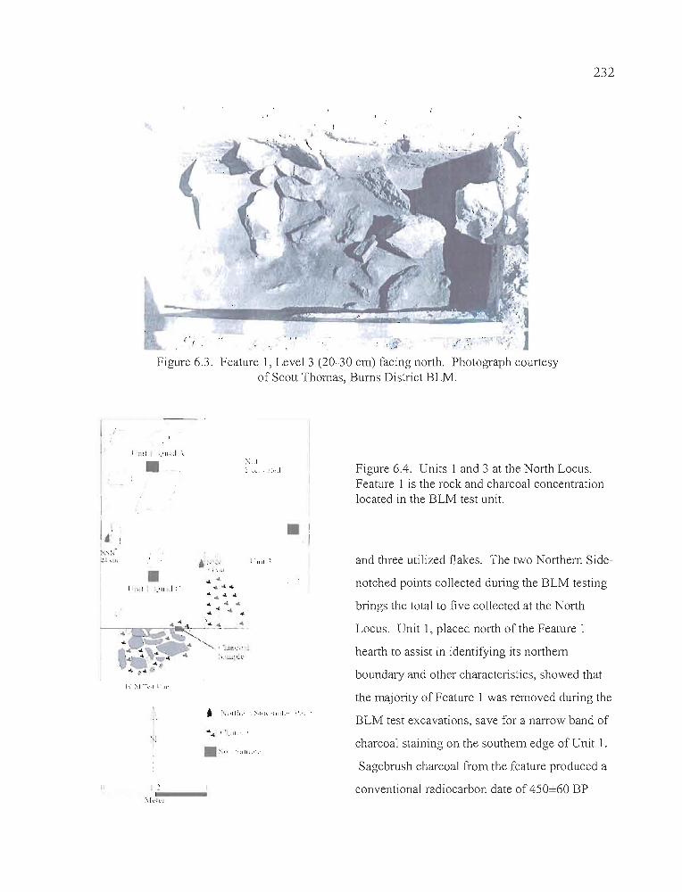
232
(' '{
Figure 6.3. Feature 1, Level 3 (20-30 cm) facing north. Photograph courtesyof Scott Thomas, Burns District BLM.
I
Ii!>",,~I..:.; \ ~l •
>'-.:1;:...... ··.::.:.1
I . 1111 ~
.1Figure 6.4. Units 1 and 3 at the North Locus.Feature 1 is the rock and charcoal concentrationlocated in the BLM test unit.
and three utilized flakes. The two Northern Side-
11·>.1···..:·11'111
...." ,'.;11;",.'
notched points collected during the BLM testing
brings the total to five collected at the North
Loclls. Unit 1, placed north of the Feature 1
hearth to assist in identifying its northern
boundary and other characteristics, showed that
the majority of Feature 1 was removed during the
BLM test excavations, save for a narrow band of
charcoal staining on the southem edge of Unit 1.
Sagebrush charcoal from the feature produced a
conventional radiocarbon date of 450±60 BP
.. '11.·.1 "I ',I
... ..................... 04
... .. ...
.... ." .... ."
f---,-__,.....--........,,-,-~-~ -~
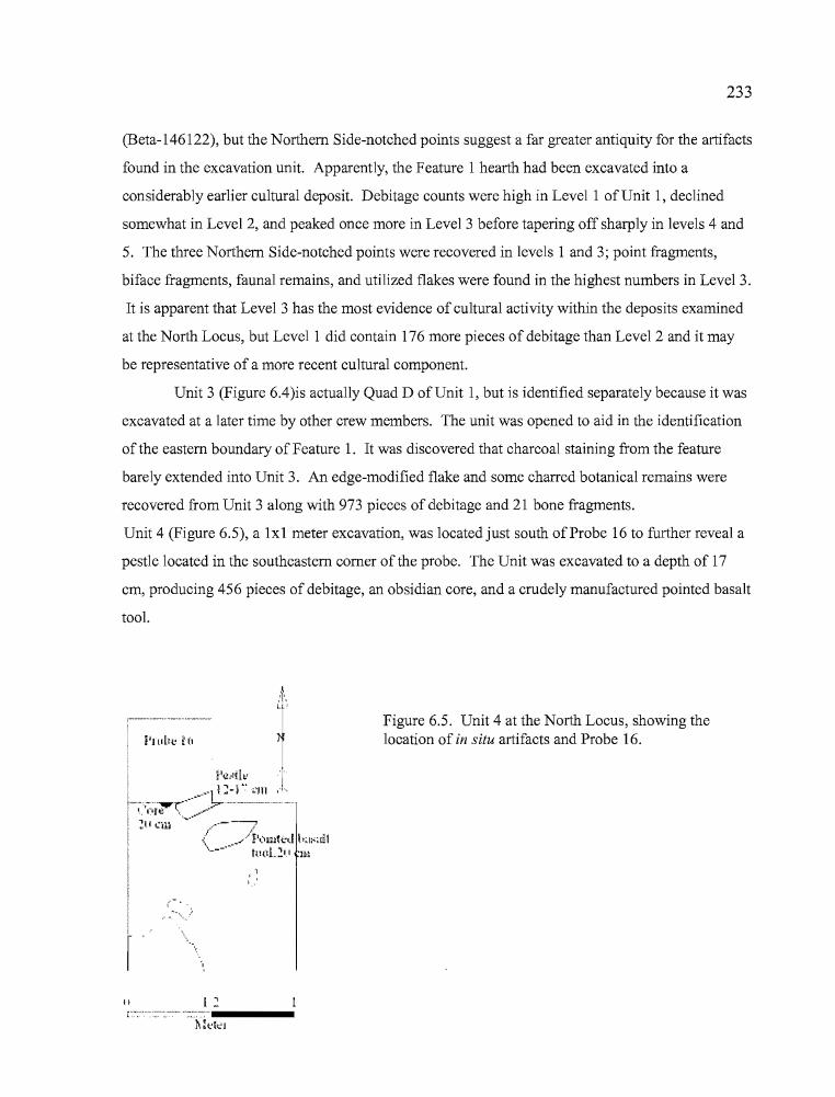
233
(Beta-146122), but the Northern Side-notched points suggest a far greater antiquity for the artifacts
found in the excavation unit. Apparently, the Feature 1 hearth had been excavated into a
considerably earlier cultural deposit. Debitage counts were high in Level 1 of Unit 1, declined
somewhat in Level 2, and peaked once more in Level 3 before tapering off sharply in levels 4 and
5. The three Northern Side-notched points were recovered in levels 1 and 3; point fragments,
biface fragments, faunal remains, and utilized flakes were found in the highest numbers in Level 3.
It is apparent that Level 3 has the most evidence of cultural activity within the deposits examined
at the North Locus, but Level 1 did contain 176 more pieces of debitage than Level 2 and it may
be representative of a more recent cultural component.
Unit 3 (Figure 6.4)is actually Quad D of Unit 1, but is identified separately because it was
excavated at a later time by other crew members. The unit was opened to aid in the identification
of the eastern boundary of Feature 1. It was discovered that charcoal staining from the feature
barely extended into Unit 3. An edge-modified flake and some charred botanical remains were
recovered from Unit 3 along with 973 pieces of debitage and 21 bone fragments.
Unit 4 (Figure 6.5), a lxl meter excavation, was located just south of Probe 16 to further reveal a
pestle located in the southeastern corner of the probe. The Unit was excavated to a depth of 17
cm, producing 456 pieces of debitage, an obsidian core, and a crudely manufactured pointed basalt
tool.
Figure 6.5. Unit 4 at the North Locus, showing thelocation of in situ artifacts and Probe 16.
..
rII
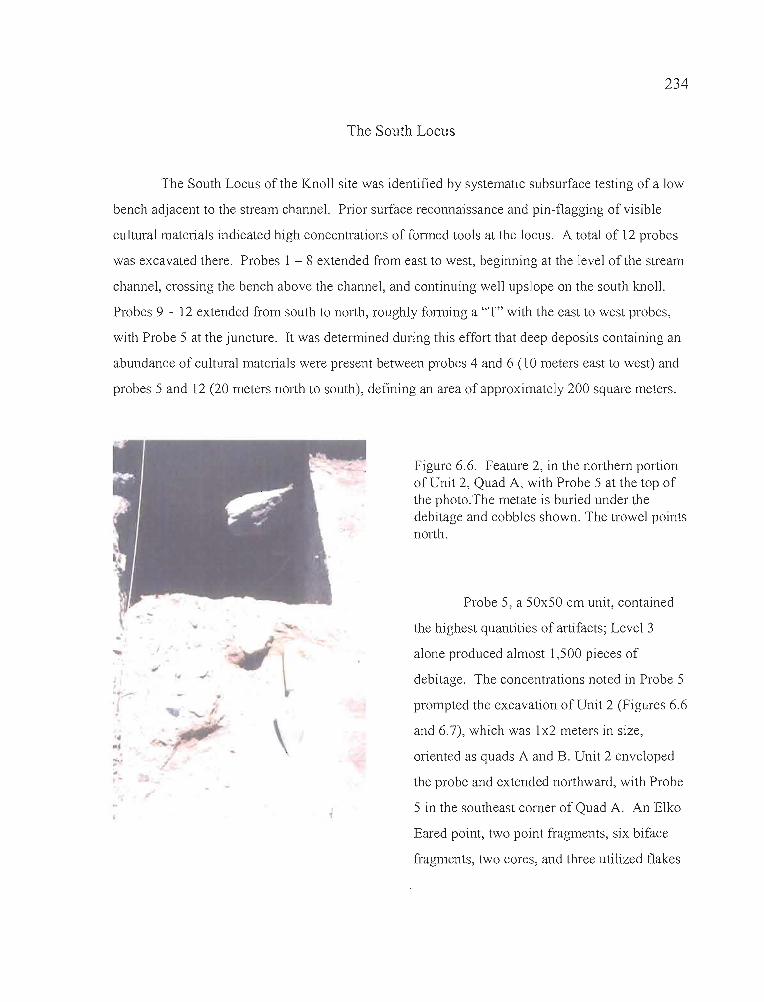
234
The South Locus
The South Locus of the Knoll site was identified by systematic subsurface testing of a low
bench adjacent to the stream channel. Prior surface reconnaissance and pin-flagging of visible
cultural materials indicated high concentrations of formed tools at the locus. A total of 12 probes
was excavated there. Probes 1 - 8 extended from east to west, beginning at the level of the stream
channel, crossing the bench above the channel, and continuing well upslope on the south knoll.
Probes 9 - 12 extended from south to north, roughly forming a "T" with the east to west probes,
with Probe 5 at the juncture. It was determined during this effort that deep deposits containing an
abundance of cultural materials were present between probes 4 and 6 (10 meters east to west) and
probes 5 and 12 (20 meters north to south), defining an area of approximately 200 square meters.
.,"
.'
\
Figure 6.6. Feature 2, in the northern portionof Unit 2, Quad A, with Probe 5 at the top ofthe photo.The metate is buried under thedebitage and cobbles shown. The trowel pointsnorth.
Probe 5, a 50x50 cm unit, contained
the highest quantities of artifacts; Level 3
alone produced almost 1,500 pieces of
debitage. The concentrations noted in Probe 5
prompted the excavation of Unit 2 (Figures 6.6
and 6.7), which was 1x2 meters in size,
oriented as quads A and B. Unit 2 enveloped
the probe and extended northward, with Probe
5 in the southeast corner of Quad A. An Elko
Eared point, two point fragments, six biface
fragments, two cores, and three utilized flakes
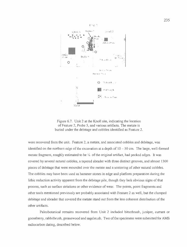
•
:lll,ll'.
o~. I.. \' .1 1 . I
I .. ·'....· ",1.1'1
'·n.· ...I.I· 'I". I
, I'1'1' •
235
Figure 6.7. Unit 2 at the Knoll site, indicating the locationof Feature 2, Probe 5, and various artifacts. The metate is
buried under the debitage and cobbles identified as Feature 2.
were recovered from the unit. Feature 2, a metate, and associated cobbles and debitage, was
identified on the northern edge of the excavation at a depth of 10 - 50 cm. The large, well-formed
metate fragment, roughly estimated to be /4 of the original artifact, had pecked edges. It was
covered by several natural cobbles, a tapered abrader with three distinct grooves, and almost 1300
pieces of debitage that were mounded over the metate and a scattering of other natural cobbles.
The cobbles may have been used as hammer stones in edge and platform preparation during the
lithic reduction activity apparent from the debitage pile, though they lack obvious signs of that
process, such as surface striations or other evidence of wear. The points, point fragments and
other tools mentioned previously are probably associated with Feature 2 as well, but the clumped
debitage and abrader that covered the metate stand out from the less coherent distribution of the
other artifacts.
Paleobotanical remains recovered from Unit 2 included bitterbrush, juniper, currant or
gooseberry, rabbitbrush, greasewood and sagebrush. Two of the specimens were submitted for AMS
radiocarbon dating, described below.
236
Radiocarbon Dates
In the South Locus, the samples drawn for radiocarbon dating were correlated to peak
concentrations in debitage and bone in levels 3 and 8 ofUnit 2, and clearly indicate two distinct
periods of occupation (Table 6.3). A greasewood twig, recovered from the Feature 2 concentration
in Level 3 of Quad B, produced a date of 1000±40 BP (Beta-158860). Rabbitbrush charcoal,
collected from Level 8 of Quad A within the deepest concentration of artifacts, yielded a date of
1780±40 BP (Table 6.3.). The late component, dating to ca. 1,000 BP and associated with Feature
2, included a single Elko Series point and a variety of other tools that are not temporally
diagnostic. The early component, dating to ca. 1,700 BP, consisted only of increased debitage and
bone counts in Level 8 and below. Diagnostic projectile points and other tools were absent from
the early component deposits in Unit 2.
Sagebrush charcoal from the Feature 1 hearth in the North Locus produced a conventional
radiocarbon date of450±60 BP (Beta-146122). The Northern Side-notched points recovered from
the deposits into which the Feature 1 hearth pit was intruded are not consistent with those from
other late Holocene occupations, but the obsidian hydration data indicate at least some use of the
site during the late Holocene (see below). Five Northern Side-notched projectile points indicate
that most use of the site occurred approximately 3,500 years before Feature 1 was created.
Table 6.3. Radiocarbon dates from the Knoll site.
Sampleno.
2530-BLM-I-4-9119625302B35119625302B83
Beta ID Provenience Radiocarbon age Cal. at Methodintercept
Beta-146122 Unit 1, L4 450±60 BP 510 BP RadiometricBeta-158860 Unit 2, QB, L 3 1000±40 BP 940 BP AMSBeta-158861 Unit 2, QB, L8 1780±40 BP 1710 BP AMS
i, ,
T
237
Artifact Asserrlblage
Chipped Stone Tools
Projectile Points
Eight projectile points were recovered at the Knoll site, seven of which were of
temporally diagnostic types (Table 6.4, Figure 6.8). All are manufactured from obsidian. They
have been classified according to the system established by Thomas (1981) for the Monitor Valley
in central Nevada and Heizer and Hester (1978) for the Great Basin at large. They include one
Elko Eared point (12.5%), one Humboldt point (12.5%), and five Northern Side-notched points
(62.5%). One fragmented point base is not typologically assignable. Temporal associations
between the Northern Side-notched points and radiocarbon-dated features at other sites in the
northern Great Basin suggest that the Knoll site was inhabited at least 4,000 years ago and perhaps
earlier, although radiocarbon dates at the site itself fall well short of that assessment. Northern
Side-notched and Elko points were designed for use with the atlatl, although Fowler and Matley
(1979:151) provide evidence that Elko Series points were occasionally mounted on arrow shafts
during the protohistoric period. The presence ofNorthern Side-notched and Humboldt points at
the North Locus and Elko Series Points at the South Locus also seems indicative of a temporal
difference between the two loci.
Table 6.4. Metric attributes of Knoll site projectile points, in millimeters.
Artifact Type L W Th NeckW Wt Source Hydration
2530-BLM-1 NSN 24.5 19.3 4.8 12.3 2.43 Tu1e Sp. 4.42530-BLM-5 NSN 13.3* 18.9* 4.2* 16.4 1.24 Wo1fCr. 5.02530-1-A-1-2 NSN 10.3* 14.9* 3.9* 10.7 0.59 Whitewater 4.82530-1-C-3-1 NSN 17.8* 15.9 4.1 10.4 1.04 Whitewater2530-1-C-3-2 NSN 7.9* 17.7* 3.9* 11.4 0.54 Wo1fCr. 4.82530-1-C-3-4 pt base 6.9* 9.7* 3.2 0.17 Whitewater 4.12530-2-B-3-1 ECN 31.8 16.8 4.2 10.2 1.67 Whitewater 3.12530-4-B-5-2 Hum 32.4* 12.4 4.1 1.97
* indicates breakage, incomplete artifact
1
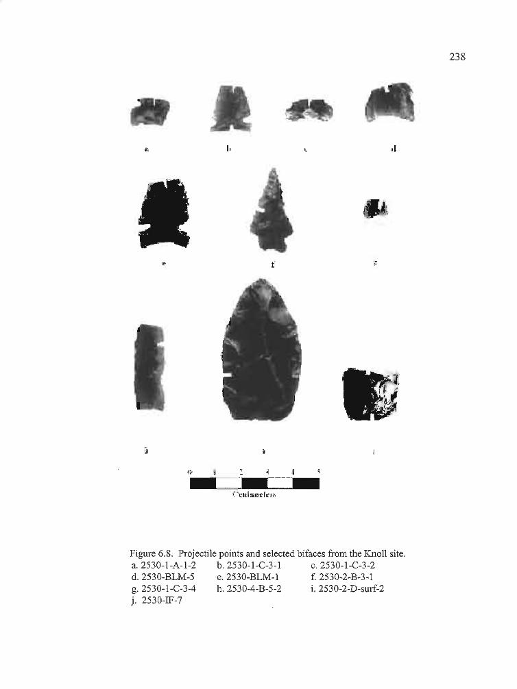
238
,I
•
li t (.:~J
. '.
(,
f
I,
~I
Figure 6.8. Projectile points and selected bifaces from the Knoll site.a.2530-1-A-1-2 b.2530-1-C-3-1 c.2530-1-C-3-2d. 2530-BLM~5 e.2530-BLM-l f. 2530-2~B-3-1g. 2530-1-C-3-4 h. 2530-4-B-5-2 i. 2530-2-D-surf-2j. 2530-IF-7
.-.'
--------------- d'tz _
I.!'II
IiI,
T
239
Elko Series Points. A single, complete Elko Eared point (Fig. 4,f) was collected from Unit 2,
Quad B, Level 3 of the South Locus. Elko Eared points are large, comer-notched points with a
deeply indented base that, in conjunction with the comer-notching, form "ears" for hafting
purposes. Elko Comer-notched points are morphologically similar to Elko Eared points, but lack
the deep basal indentation that produces the eared appearance. The widest portion of either point
is just forward of the base. Specimen 2530-2-B-3-l is manufactured from Whitewater obsidian
and has a hydration thickness of 3.1±0.1 micron. The point was recovered at a depth of 20 cm
near the east edge of Quad B, in a scatter ofbifaces and cobbles that may be associated with the
Feature 2 metate. The radiocarbon date of 1000±40 BP for Feature 2 is in keeping with the later
period of use for Elko Series points (Oetting 1994:45).
Large Side-notched. Large side-notched projectile points have been identified by various regional
appellations or morphological attributes in the northern Great Basin and southern Columbia
Plateau. The side-notched points recovered from the Knoll site fit well in the Northern Side
notched category established by Heizer and Hester (1978) for the Great Basin, having straight to
concave bases and notches that are deep and either perpendicular to the long axis or angled
upward toward the distal end ofthe point (Fig. 4, b, d, e). Oetting (1994) places Northern Side
notched points between 7,000 and 4,000 years in age in the northern Great Basin. The five points,
all manufactured from obsidian, were recovered from the Northern Locus of the Knoll site. Two
were collected during the BLM testing and three during the University of Oregon excavations. All
were in association with the Feature 1 hearth, either found in the BLM test unit or in Unit 1,
adjoining to the north. Two each originate from the Wolf Creek and Whitewater Ridge obsidian
sources to the north, and one is from the Tule Springs source, which is located in the
Stinkingwater Mountains southeast of the Silvies Valley. The obsidian hydration readings range
between 4.4 and 5.0 microns, much wider than the 3.1 micron reading from the Elko point and
well suited to their greater antiquity.
Humboldt Series. These points are described as "...unnotched, lanceolate, concave-base projectile
points of variable size...", by Thomas (1981 :17). The single Humboldt Series point fragment was
collected from Unit 4 and was not found in situ. The point base (Fig. 4, c) was recovered from the
debitage during analysis, and was not submitted for obsidian sourcing and hydration analysis.
_........------------------------------------- -- ---
240
Unknown. One point fragment, collected from Unit 1, Quad C, Level 3, is a projectile point base
(Fig. 4, a). The artifact appears to be a portion of an Elko Comer-notched base that is slightly
concave. The obsidian from which it is made originated at Whitewater Ridge to the north, and the
hydration reading is 4.1 microns, placing it between the hydration readings for the known Elko
Series and Northern Side-notched points at the Knoll site.
Shaped Bifaces
This category is based on the multi-stage biface classification system employed by Jenkins
and Connolly (1990) at the nearby Indian Grade Spring site. Stage 1-5 bifaces are discussed here
(Table 6.5). Stage 5 bifaces are generally classified as projectile points, and all diagnostic point
fragments have been treated separately in a previous portion of the text. Most of the artifacts are
fragmentary. They are considered in terms of a generalized leaf-shaped biface morphology
because many share similar characteristics. Tips are pointed and are thought to be the distal ends
of the artifacts. Bases usually have rounded or slightly convex squared ends and are thought to be
the proximal portions of the artifacts. Midsections are frequently tapered to some degree, but can
be straight-sided. Certainly not all bifaces have rounded bases, pointed tips, and show clear signs
of tapering, but it seems most utilitarian for descriptive purposes to emphasize the shape of a
common artifact form when only fragments exist. Bifaces often served multiple purposes, ranging
from cutting implements to cores for the manufacture of projectile points and other tools.
Stage J bi/aces. These bifaces have thick cross-sections and large, unpattemed flake
scars. They exhibit only the most rudimentary development, with rounded or thick lenticular
shapes and cross-sections. The flaking pattern reflects use of the hard hammer percussion
technique, and the edges of these tools can be very sinuous. None of the bifaces recovered from
the Knoll excavations reflected Stage 1 reduction, though a number of specimens seen on the
surface but not collected fit this level of categorization. Most such bifaces were present at the
South Locus in areas where quarrying of stream borne obsidian and basalt cobbles was evident.
Stage 2 bi/aces. Bifacial thinning is continued on these artifacts through the removal of
contiguous hard hammer percussion flakes. The removal of the flakes results in the development
of an artifact, which, although still crudely shaped, has a more pronounced form than stage 1
T
I
!i241
Table 6.5. Metric attributes of Knoll Site biface and nondiagnostic projectile point fragments.I
Artifact Type L W Th Wt Notes
2530-BLM-4 S1. 3 51.3 33.2 9.7 15.10 yellow banded CCSedge frag
2530-1S-3 S1. 3 27.0 26.5 8.7 4.56 pointed base, red CCS2530-IF-7 S1. 3 20.9 21.9 7.4 3.87 square base, obs2530-IF-9 S1. 5 31.0 24.7 6.1 5.59 obs. pt or drill
midsection2530-IF-13 S1. 4 33.3 30.7 7.1 6.24 midsection, obs2530-P2-1-1 S1. 3 7.1 7.7 2.7 0.11 tip,obs2530-P2-1-2 S1. 3 27.3 25.1 7.8 5.58 midsection, obs2530-P5-5-1 S1. 3 18.8 36.8 8.7 5.86 rounded base frag,obs2530-P5-8-1 S1. 3 24.1 36.0 12.2 11.08 rounded brown CCS
base frag2530-P 15-2-1 S1. 3 33.9 79.5 11.0 27.57 19 rounded base frag,
obs2530-1-A-1-1 S1. 4 6.4 9.8 3.1 0.17 small edge fragment,
obs2530-1-C-2-? S1. 2 26.2 34.9 6.8 6.35 square crude base frag,
obs,2530-1-C-3-? S1. 4 8.1 7.5 3.5 0.28 obs. small edge
fragment2530-1-C-3-3 S1. 4 11.5 15.2 4.4 0.55 small edge fragment,
obs2530-1-C-3-5 S1. 3 31.5 31.9 5.1 5.03 midsection, obs2530-1-C-3-6 S1. 5 11.9 12.8 4.1 0.61 proj point midsection,
obs2530-1-C-3-7 S1. 5 8.9 13.4 3.7 0.38 proj pt midsection,
obs2530-1-C-3-8 S1. 3 34.3 31.7 7.5 7.20 square base, obs2530-1-C-4-1 S1. 5 14.1 9.5 2.2 0.21 proj pt tip, obs2530-2-A-2-1 S1. 4 51.7 35.5 8.0 10.89 knife tip, obs2530-2-A-2-2 S1. 2 26.5 41.9 11.5 12.74 tapered base wi cortex
knob,obs2530-2-A-3-1 St. 3 13.7 26.3 6.9 2.67 edge fragment, obs2530-2-A-4-1 S1. 5 28.4 21.7 3.8 1.80 finely wrought point tip,
dart,obs2530-2-B-2-1 S1. 3 40.1 36.5 10.9 13.92 pointed base frag, obs2530-2-D-surf-2 S1. 3 55.4 31.2 6.8 11.84 complete, rounded base,
obs2530-2-B-3-2 St. 3 46.2 33.9 12.0 13.7 edge fragment, obs2530-2-B-3-sa1v-1 S1. 3 21.2 35.9 4.4 2.91 pointed base, obs2530-2-B-5-1 S1. 3 31.1 39.2 8.1 8.47 rounded base, obs2530-2-B-9-? S1. 5 7.0 7.8 1.9 0.06 proj. p1. tip, obs2530-2-D-surf-1 S1. 3 39.8 51.0 10.0 18.97 rounded base, obs2530-3-D-2-1 S1. 4/5 37.0 15.7 6.4 2.19 It brown edge frag, CCS
artifacts. Stage 2 bifaces are considered to be quarry blanks. Two artifacts fit this classification.
The Stage 2 biface from the North Locus (2530-1-C-2-?) is a square base fragment. The biface
from the South Locus (2530-2-A-2-2) is somewhat rounded but a bulb of intact cortex situated at
the proximal end appears to have been left in place intentionally.
242
Stage 3 bifaces. The most common reduction stage at the Knoll site, these bifaces exhibit
little to no evidence of pressure flaking and have the slightly sinuous edges characteristic of large
percussion flake scars created by the initial stages ofbifacial reduction. The entire artifact surface
has been modified through the removal of flakes the scars of which can reach the middle of the
artifact. It is at Stage 3 that major thinning of a biface occurs, often leading to breakage. A total
of 17 biface fragments fit this classification, 14 of which are of obsidian and three of CCS. Most
of the artifacts exhibited fine pressure flaking along some edges, with varying degrees of
percussion flaking along other edges and across the body of the artifact. Four of the biface
fragments were collected at the North Locus and 13 were from the South Locus.
One fragment is a tip (2530-P2-1-1), two are midsections (2530-1-C-3-5 and 2530-P2-1
2), three are edge fragments (2530-BLM-4, 2530-2-A-3-1, and 2530-2-B-3-2) and 11 are
fragments of bases. The bases can be categorized into round, square, and pointed varieties. The
square-based bifaces included 2530-IF7 and2530-1-C-3-8, both of which were made from
obsidian. Pointed bases lend the biface a willow leaf shape, though the base is more broadly
convex than the distal end, or point tip. Three bases, including 2530-IS-3, 2530-2-B-2-1, and
2530-2-B-3-salv-l fit this description. Specimen 2530-IS-3 is manufactured from red CCS. The
six round-based bifaces would have originally been teardrop-shaped and exhibit considerable
variety in size. They include 2530-P5-5-1, 2530-P5-8-1 (made of brown CCS), 2530-PI5-2-1,
2530-2-D-surf-l, 2530-2-D-surf-2 (the only complete biface recovered from the site), and 2530-2
B-5-1
Stage 4 bifaces. The continuation of percussion and pressure flaking techniques after
Stage 3 results in bifaces with a more "finished" appearance than Stage 3 tools. Pressure flake
scars can reach the midline of the artifact or beyond, and frequently eliminate the large percussion
flake scars from earlier reduction. Edges are strengthened by the removal of pressure flakes,
which increases the edge angle. Six Stage 4 artifacts were collected from the Knoll site, including
"i'i
:
I
243
one tip (2530-2-A-2-1), one midsection (2530-!F-13), and four edge fragments (2530-1-A-1-1,
2530- 1-C-3-?, 2530-1-C-3-3, and 2530-3-D-2-1). All but one edge fragment are of obsidian. The
CCS fragment (2530-3-D-2-1) is manufactured from brown semi-translucent material. All but one
(2530-2-A-2-1) of the Stage 4 bifaces were recovered at the North Locus.
Point Fragments. Most of the six point fragments recovered from the Knoll site could
reasonably be attributed to dart points, with the possible exception of 2530-2-B-3-? which is so
small and fine that it may be the tip of an arrow point. Three fragments are
midsections and three are tips. Two midsections and one tip were recovered from Unit 1, two
point tips were collected in Unit 2, and one straight-sided midsection fragment reminiscent of a
drill or awl was collected as an isolate (2530-IF-9) in the South Locus.
Large Core and Flake Tools
Large core and flake tools are unshaped to roughly shaped artfacts exhibiting unpattemed
flaking and edge damage associated with the performance of tasks such as cutting, scraping, and
chopping. The used edges may exhibit additional modification to improve cutting ability, but
often the edges are altered only by wear associated with use. Some of these tools are not made on
flakes per se, but on large broken chunks of stone. Such tools can be either unifacial or bifacial.
As a group, large core and flake tools differ from either utilized flakes or Stage 1 bifaces in two
ways. First, their overall size and mass suit them best for work that would damage thinner, more
refined tools, suggesting that they were designed for hard use in tasks such as
shaping wood, scraping hides, or butchering large game animals. Second, they are frequently
made of very dense lithic materials including CCS and basalt, which are capable of holding an
edge under heavy use conditions. There are characteristics which large core and flake tools share
with other tool categories such as edge-modified flakes, but, as a whole, they belong to a distinct
class of tools designed for specific activities.
Several basalt tools collected at the Knoll site were distinctive because of their robust
proportions and edge preparation, indicative of specialized heavy-duty cutting or chopping
activities (Table 6.6). Specimens 2530-1S-4 and 2530-IF-11 are large, single-edged tools that
appear to have been utilized as hand-held choppers. The two artifacts were collected as surface
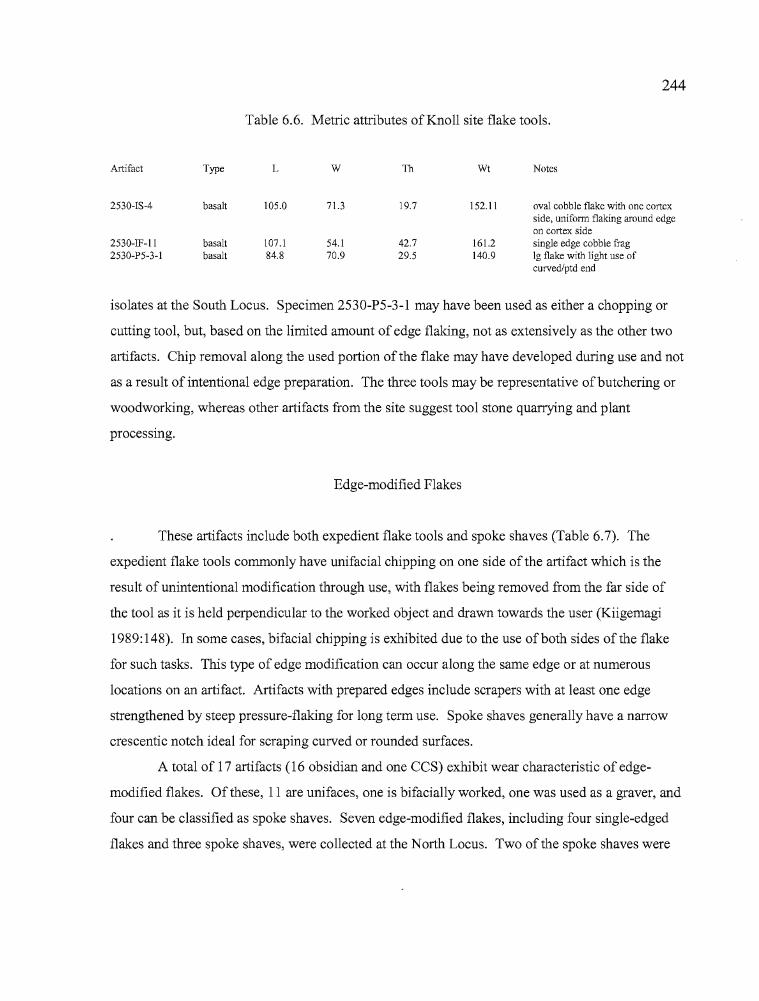
244
Table 6.6. Metric attributes of Knoll site flake tools.
Artifact Type L W Th Wt Notes
2530-1S-4 basalt 105.0 71.3 19.7 152.11 oval cobble flake with one cortexside, unifonn flaking around edgeon cortex side
2530-IF-II basalt 107.1 54.1 42.7 161.2 single edge cobble frag2530-P5-3-1 basalt 84.8 70.9 29.5 140.9 Ig flake with light use of
curved/ptd end
isolates at the South Locus. Specimen 2530-P5-3-l may have been used as either a chopping or
cutting tool, but, based on the limited amount of edge flaking, not as extensively as the other two
artifacts. Chip removal along the used portion of the flake may have developed during use and not
as a result of intentional edge preparation. The three tools may be representative ofbutchering or
woodworking, whereas other artifacts from the site suggest tool stone quarrying and plant
processmg.
Edge-modified Flakes
These artifacts include both expedient flake tools and spoke shaves (Table 6.7). The
expedient flake tools commonly have unifacial chipping on one side of the artifact which is the
result of unintentional modification through use, with flakes being removed from the far side of
the tool as it is held perpendicular to the worked object and drawn towards the user (Kiigemagi
1989:148). In some cases, bifacial chipping is exhibited due to the use ofboth sides of the flake
for such tasks. This type of edge modification can occur along the same edge or at numerous
locations on an artifact. Artifacts with prepared edges include scrapers with at least one edge
strengthened by steep pressure-flaking for long term use. Spoke shaves generally have a narrow
crescentic notch ideal for scraping curved or rounded surfaces.
A total of 17 artifacts (16 obsidian and one CCS) exhibit wear characteristic of edge
modified flakes. Of these, 11 are unifaces, one is bifacially worked, one was used as a graver, and
four can be classified as spoke shaves. Seven edge-modified flakes, including four single-edged
flakes and three spoke shaves, were collected at the North Locus. Two of the spoke shaves were
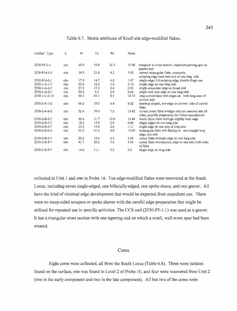
245
Table 6.7. Metric attributes of Knoll site edge-modified flakes.
Artifact Type L W Th Wt Notes
2530-P5-1-1 ccs 49.9 19.8 11.5 10.96 triangular in cross section, expedient graving spur attapered end
2530-P 14-1-1 obs 34.9 21.0 4.2 3.02 curved rectangular flake, crescenticscraping edge inset near end of one long side
2530-P16-2-1 obs 17.9 14.7 4.0 1.07 single edge, 9.8 scraping edge, thumb-finger use2530-1-A-1-? obs 52.0 16.2 5.9 3.16 single edge on one long side2530-1-A-2-? obs 23.3 17.2 2.6 0.93 single crescentic edge on broad end2530-1-A-2-? obs 20.8 9.4 2.9 0.64 single well won edge on one long side2530-1-C-3-1O obs 60.3 29.1 8.5 14.73 long curved flake with edges on both long axes of
convex side, 2530-2-A-3-2 obs 66.2 35.0 4.4 8.62 teardrop shaped, one edge on convex side of curved
!I, flake2530-2-A-6-2 obs 52.4 39.0 7.2 13.02 curved ovoid flake w/edges only on concave side all
sides, possible preparation for biface manufacture
! 2530-2-B-2-? obs 50.4 31.7 10.0 15.48 ovoid, thick flake w/single slightly inset edge2530-2-B-3-? obs 18.2 12.9 2.0 0.44 single edged on one long side2530-2-B-4-? obs 33.5 14.8 2.6 1.11 single edge on one side oflong axis2530-2-B-6-4 obs 53.2 41.6 8.0 19.04 rectangular flake wilt flaking on one straight long
edge, one side2530-2-B-6-? obs 20.2 16.4 4.4 1.64 cortex flake w/single edge on one long side2530-2-B-8-? obs 41.7 20.2 5.6 5.06 cortex flake w/crescentic edge on one end, both sides
of flake2530-2-B-9-? obs 14.6 11.1 2.2 2.6 single edge on long side
collected in Unit 1 and one in Probe 14. Ten edge-modified flakes were recovered at the South
Locus, including seven single-edged, one bifacially-edged, one spoke shave, and one graver. All
have the kind of minimal edge development that would be expected from expedient use. There
were no steep-sided scrapers or spoke shaves with the careful edge-preparation that might be
utilized for repeated use in specific activities. The CCS tool (2530-P5-1-1) was used as a graver.
It has a triangular cross section with one tapering end on which a small, well-worn spur had been
created.
Cores
Eight cores were collected, all from the South Locus (Table 6.8). Three were isolates
found on the surface, one was found in Level 2 of Probe 10, and four were recovered from Unit 2
(two in the early component and two in the late component). All but two of the cores were
)
•
246
Table 6.8. Metric attributes of Knoll site cores.
Artifact Type L W Th Wt Notes
2530-1S-5 bas 66.9 50.1 47.5 200+ tabular basalt cobble frag w/flakesstruck from three planes
2530-IF-6 obs 61.4 55.7 41.4 137.9 obsidian cobble frag with flakesstruck on five planes
2530-IF-8 bas 71.7 54.5 38.9 187.86 cobble frag, flakes struck on twoopposite sides
2530-PlO-2- lobs 32.8 26.3 24.0 23.75 small cobble with flakes struckfrom 5 planes (half ofthe round)
2530-2-A-3-3 obs 34.2 31.1 14.1 10.7 spent core, flakes struck on at least7 planes, polygonal
2530-2-A-6-1 obs 47.8 47.7 15.7 30.25 round cobble frag, flakes struckfrom 3 planes on one side, othercurved cortex
2530-2-A-7-1 obs 41.6 41.3 18.2 32.71 small cobble cracked as test2530-2-B-3-salv-l obs 53.0 48.2 20.8 33.64 polygonal core with flakes struck
on at least 7 planes
cobbles of obsidian or basalt readily available from the nearby stream bed, and had two or more
flakes stuck from them. Two cores were more carefully prepared for flake removal, having been
fashioned into tabular or polyhedral forms, from which multiple flakes of relatively uniform size
could be struck for manufacture into projectile points or other artifacts.
In addition to the cores, a variety of broken cobbles "tested for their flaking qualities by
the removal of a few flakes littered the stream bed and the bench at the South Locus.
Concentrations of medium to large stream rounded cobbles suitable for testing were present on the
stream bed and as lenses in cutbanks. It is apparent that the location served as a convenient source
for both obsidian and basalt tool stone, and it is likely that other stream channels in the vicinity,
including Newell Creek and the Silvies River, provided easy access to those resources. The
debitage recovered from the Feature 1 and 2 excavations was dominated by the Whitewater Ridge
source, undoubtedly also the origin of the stream-borne cobbles present at the site.
247
Ground Stone
Ground stone tools are those which exhibit shaping or wear by abrasion that is usually
associated with the processing of botanical resources, particularly roots, bulbs, and seeds, but can
also result from the preparation of faunal resources. Ground stone tools include manos, metates
and abrading stones. The ground stone artifacts were collected at the Knoll site as surface isolates
and from excavation at the North and South loci. The ground stone artifacts consisted of three
metate fragments, one mano, and one abrader (Table 6.9).
Metates
Three fragments are portions of metates. One fragment recovered from the BLM testing at
Feature 1 (2530-BLM-2) has wear on both sides and appears to be from a relatively thin, well
formed grinding slab ofbasalt. Specimen 2530-IF-2, collected as a surface artifact at the South
Locus, is also from a thin basalt grinding slab, which has a uniformly pecked edge indicating some
care went in to the crafting of the artifact. A third basalt metate fragment (2530-2/P5-3) was
collected from Unit 2 in association with Feature 2. This metate fragment was roughly one quarter
of a large, non-portable specimen with grinding facets on both sides and a rim that was pecked to
soften sharp edges. The metate has a symmetrical appearance,
Table 6.9. Metric attributes of Knoll site ground stone.
Artifact Type L W Th Notes
2530-BLM-2 metate 77.4 60.2 40.7 fine grained basalt, two sided interior fragment2530-IF-2 metate 89.2 58.8 44.8 basalt edge fragment, two-sided, with well-formed
pecked edge.2530-IF-IO mano 68.5 64.0 40.8 two sided basalt roughly pecked to oval shape, end
fragment, lichen growth2530-2/P5-3 metate 195.0 143.6 100.6 large edge fragment with pecked edges, faceted onboth sides2530-4-A-I-I pestle 164.2 70.7 51.0 used for grinding, pounding, and as a hammerstone2530-2-B-2-2 abrader 83.4 32.6 18.9 roughly triangular, two grooves lengthwise, one
transverse notch, series of diagonal striations onnon-grooved side
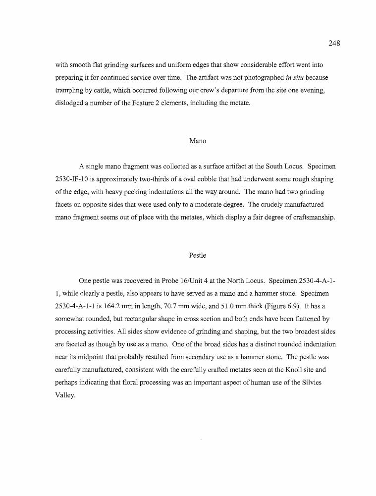
r'II':1
248
with smooth flat grinding surfaces and uniform edges that show considerable effort went into
preparing it for continued service over time. The artifact was not photographed in situ because
trampling by cattle, which occurred following our crew's departure from the site one evening,
dislodged a number of the Feature 2 elements, including the metate.
Mano
A single mano fragment was collected as a surface artifact at the South Locus. Specimen
2530-IF-10 is approximately two-thirds of a oval cobble that had underwent some rough shaping
of the edge, with heavy pecking indentations all the way around. The mano had two grinding
facets on opposite sides that were used only to a moderate degree. The crudely manufactured
mano fragment seems out of place with the metates, which display a fair degree of craftsmanship.
Pestle
One pestle was recovered in Probe 16IUnit 4 at the North Locus. Specimen 2530-4-A-1
1, while clearly a pestle, also appears to have served as a mano and a hammer stone. Specimen
2530-4-A-1-1 is 164.2 mm in length, 70.7 mm wide, and 51.0 mm thick (Figure 6.9). It has a
somewhat rounded, but rectangular shape in cross section and both ends have been flattened by
processing activities. All sides show evidence of grinding and shaping, but the two broadest sides
are faceted as though by use as a mano. One of the broad sides has a distinct rounded indentation
near its midpoint that probably resulted from secondary use as a hammer stone. The pestle was
carefully manufactured, consistent with the carefully crafted metates seen at the Knoll site and
perhaps indicating that floral processing was an important aspect of human use of the Silvies
Valley.
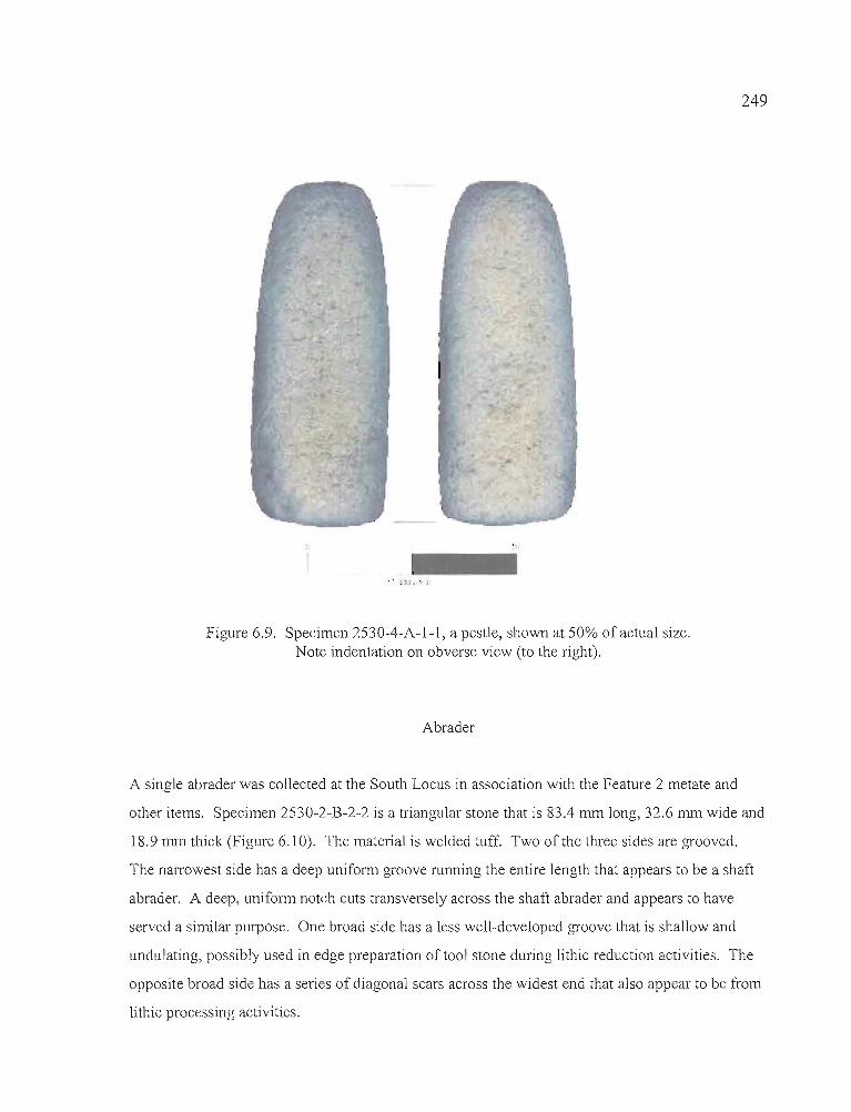
249
Figure 6.9. Specimen 2530-4-A-l-l, a pestle, shown at 50% of actual size.Note indentation on obverse view (to the right).
Abrader
A single abrader was collected at the South Locus in association with the Feature 2 metate and
other items. Specimen 2530-2-B-2-2 is a triangular stone that is 83.4 mm long, 32.6 mm wide and
18.9 mm thick (Figure 6.10). The material is welded tuff. Two of the three sides are grooved.
The narrowest side has a deep uniform groove running the entire length that appears to be a shaft
abrader. A deep, uniform notch cuts transversely across the shaft abrader and appears to have
served a similar purpose. One broad side has a less well-developed groove that is shallow and
undulating, possibly used in edge preparation of tool stone during lithic reduction activities. The
opposite broad side has a series of diagonal scars across the widest end that also appear to be from
lithic processing activities.
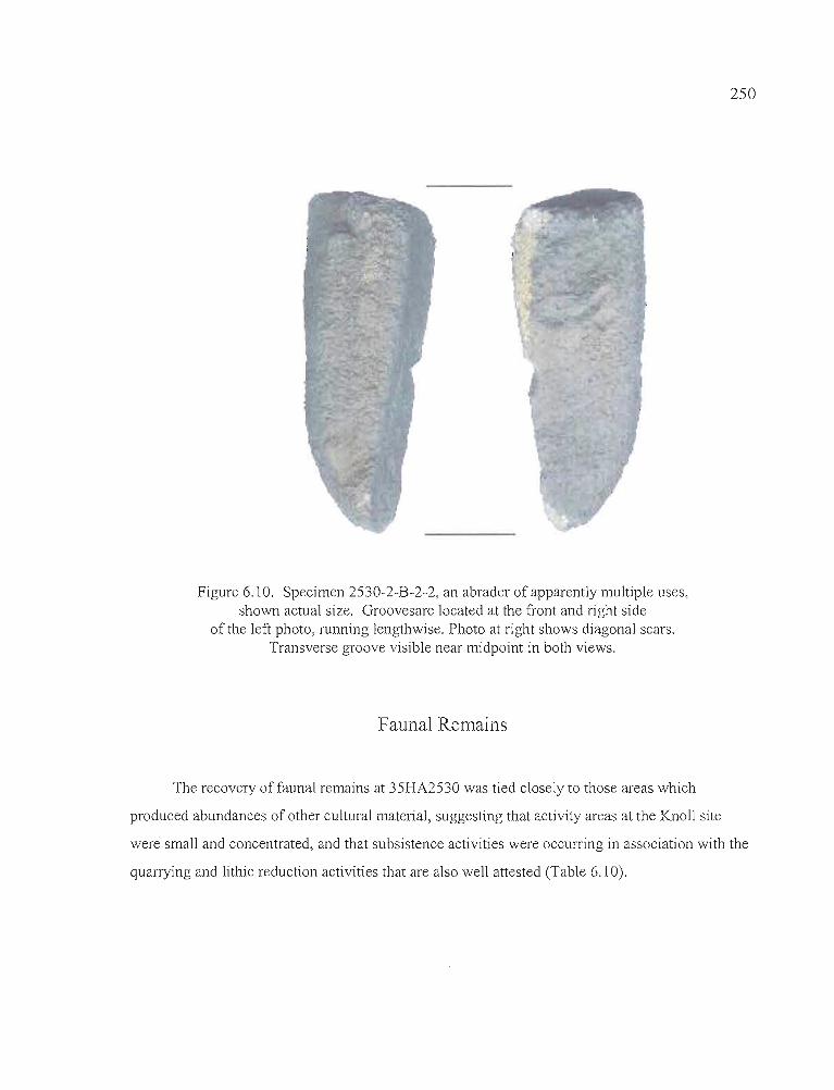
250
Figure 6.10. Specimen 2530-2-B-2-2, an abrader of apparently multiple uses,shown actual size. Groovesare located at the front and right side
of the left photo, running lengthwise. Photo at right shows diagonal scars.Transverse groove visible near midpoint in both views.
Faunal Remains
The recovery offaunal remains at 35HA2530 was tied closely to those areas which
produced abundances of other cultural material, suggesting that activity areas at the Knoll site
were small and concentrated, and that subsistence activities were occurring in association with the
quarrying and lithic reduction activities that are also well attested (Table 6.10).
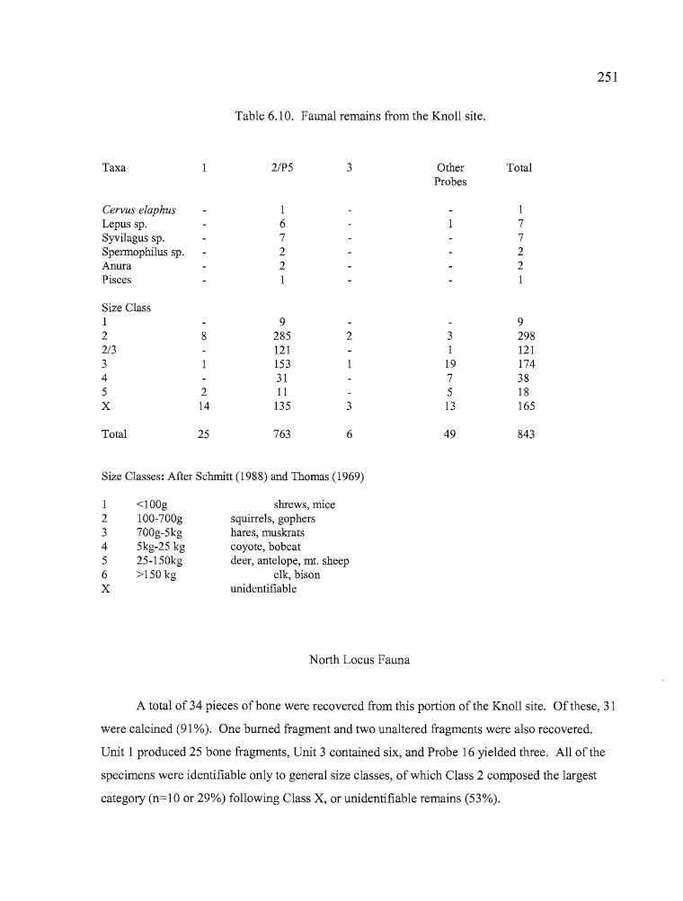
T
251
Table 6.10. Faunal remains from the Knoll site.
Taxa 2/P5 3 Other TotalProbes
Cervus elaphus 1 1Lepus sp. 6 7Syvilagus sp. 7 7Spermophilus sp. 2 2Anura 2 2Pisces 1 1
Size Class1 9 92 8 285 2 3 2982/3 121 1 1213 153 19 1744 31 7 385 2 11 5 18X 14 135 3 13 165
Total 25 763 6 49 843
Size Classes: After Schmitt (1988) and Thomas (1969)
1 <lOOg shrews, mice2 100-700g squirrels, gophers3 700g-5kg hares, muskrats4 5kg-25 kg coyote, bobcat5 25-l50kg deer, antelope, mt. sheep6 >150 kg elk, bisonX unidentifiable
North Locus Fauna
A total of 34 pieces ofbone were recovered from this portion of the Knoll site. Of these, 31
were calcined (91 %). One burned fragment and two unaltered fragments were also recovered.
Unit 1 produced 25 bone fragments, Unit 3 contained six, and Probe 16 yielded three. All of the
specimens were identifiable only to general size classes, of which Class 2 composed the largest
category (n=10 or 29%) following Class X, or unidentifiable remains (53%).
,...
252
South Locus Fauna
The South Locus produced 808 animal bone fragments, of which 66.5% were unaltered,
16.8% were darkened, or stained for reasons that are unclear, 11.1% were calcined, and 5.6% were
burned. Unit 2 and Probe 5 yielded 87% of the faunal remains, the rest were recovered from
Probe 6 and from Probes 9 - 11. Animal bone counts peaked in conjunction with debitage and
artifact counts in Unit 2, indicating that subsistence and lithic reduction activities were occurring
at the same time, and that the stratigraphic integrity of the site is fairly good. Calcined bone counts
also peaked in both early and late period components at the Knoll site, with 28% ofthe calcined
bone recovered from levels 2 and 3, and 17% from levels 8 and 9, associated with the early
component (n=90). The burned bone was more dispersed, with 8% found in both early and late
components (n=45).
Most faunal remains were too fragmented or deteriorated to identify to species. Only one
bone specimen, of Lepus, was altered from human use. This radius fragment, found in Level 7 of
Unit 2, was blackened and polished, probably from cooking. Other bones identifiable to order,
family, genus, or species level included an elk (Cervus elaphus) tooth enamel fragment, and
various fragmentary bones of cottontail rabbit (Syvilagus sp.), jackrabbit (Lepus sp.), ground
squirrel (Spermophilus sp.), frog (Anura), and fish (pisces). None showed clear evidence of
having been altered through cooking or consumption by the Knoll site occupants, though their
presence at the site suggests they were deposited as a result of such activities. All of the animals
found in the Knoll site are known to have been utilized by Great Basin cultural groups (see Fowler
1986). One Class 5 (large mammal) fragment associated with Feature 2 did have cut marks from
the butchering process.
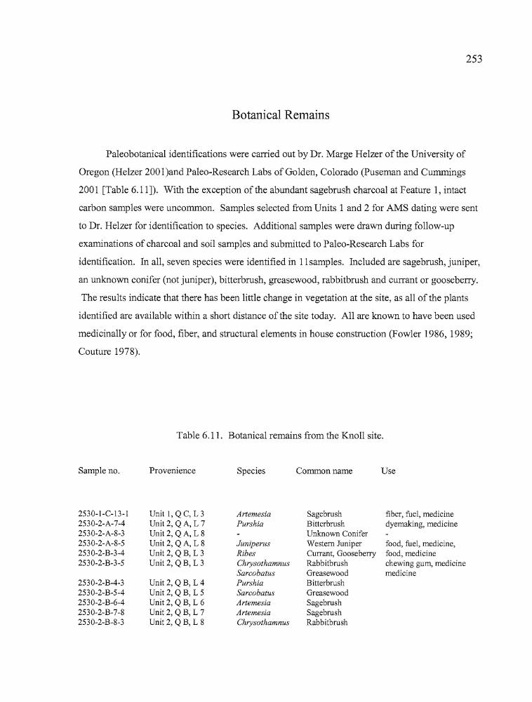
F' '4f'
253
Botanical Remains
Paleobotanical identifications were carried out by Dr. Marge Helzer of the University of
Oregon (Helzer 2001 )and Paleo-Research Labs of Golden, Colorado (puseman and Cummings
2001 [Table 6.11]). With the exception of the abundant sagebrush charcoal at Feature 1, intact
carbon samples were uncommon. Samples selected from Units 1 and 2 for AMS dating were sent
to Dr. Helzer for identification to species. Additional samples were drawn during follow-up
examinations of charcoal and soil samples and submitted to Paleo-Research Labs for
identification. In all, seven species were identified in 11samples. Included are sagebrush, juniper,
an unknown conifer (not juniper), bitterbrush, greasewood, rabbitbrush and currant or gooseberry.
The results indicate that there has been little change in vegetation at the site, as all of the plants
identified are available within a short distance of the site today. All are known to have been used
medicinally or for food, fiber, and structural elements in house construction (Fowler 1986, 1989;
Couture 1978).
Table 6.11. Botanical remains from the Knoll site.
Sample no. Provenience Species Common name Use
2530-1-C-13-1 Unit 1, QC, L 3 Artemesia Sagebrush fiber, fuel, medicine2530-2-A-7-4 Unit 2, QA, L 7 Purshia Bitterbrush dyemaking, medicine2530-2-A-8-3 Unit 2, QA, L 8 Unknown Conifer2530-2-A-8-5 Unit 2, QA, L 8 Juniperus Western Juniper food, fuel, medicine,2530-2-B-3-4 Unit 2, QB, L 3 Ribes Currant, Gooseberry food, medicine2530-2-B-3-5 Unit 2, QB, L 3 Chrysothamnus Rabbitbrush chewing gum, medicine
Sarcobatus Greasewood medicine2530-2-B-4-3 Unit 2, QB, L 4 Purshia Bitterbrush2530-2-B-5-4 Unit 2, QB, L 5 Sarcobatus Greasewood2530-2-B-6-4 Unit 2, QB, L 6 Artemesia Sagebrush2530-2-B-7-8 Unit 2, QB, L 7 Artemesia Sagebrush2530-2-B-8-3 Unit 2, QB, L 8 Chrysothamnus Rabbitbrush
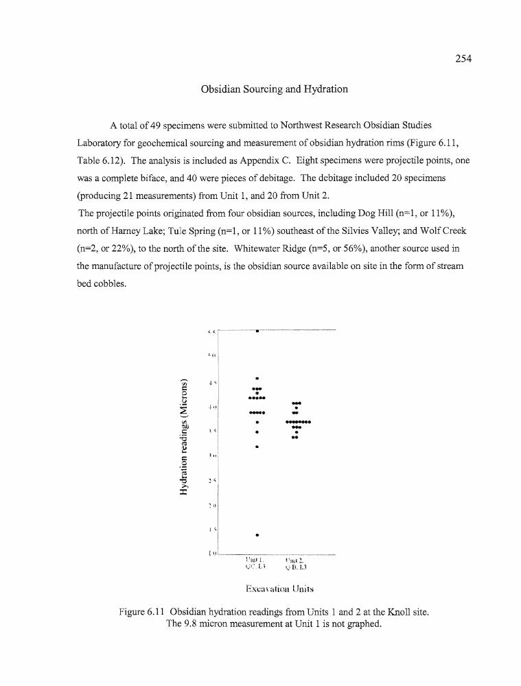
,...
254
Obsidian Sourcing and Hydration
A total of 49 specimens were submitted to Northwest Research Obsidian Studies
Laboratory for geochemical sourcing and measurement of obsidian hydration rims (Figure 6.11,
Table 6.12). The analysis is included as Appendix C. Eight specimens were projectile points, one
was a complete biface, and 40 were pieces of debitage. The debitage included 20 specimens
(producing 21 measurements) from Unit 1, and 20 from Unit 2.
The projectile points originated from four obsidian sources, including Dog Hill (n=l, or 11 %),
north of Harney Lake; Tule Spring (n=l, or 11 %) southeast ofthe Silvies Valley; and WolfCreek
(n=2, or 22%), to the north of the site. Whitewater Ridge (n=5, or 56%), another source used in
the manufacture ofprojectile points, is the obsidian source available on site in the form of stream
bed cobbles.
, ,
" t,"1
~ •,·TJ
=0.....;:!
·llJ~
(/j
~J) ,:::: 1;:;;;
Q
~
.91 1,1
~..... .,""0
;;..,:t
~H
! i
1 IJ
---..... ---- -- ---- -..
-11 1ll ( 1. ~ 1mt ~.
<.i1:' Ll <..' B. L.1
r:':.\t.:'l\'\liOIl Units
Figure 6.11 Obsidian hydration readings from Units 1 and 2 at the Knoll site.The 9.8 micron measurement at Unit 1 is not graphed.
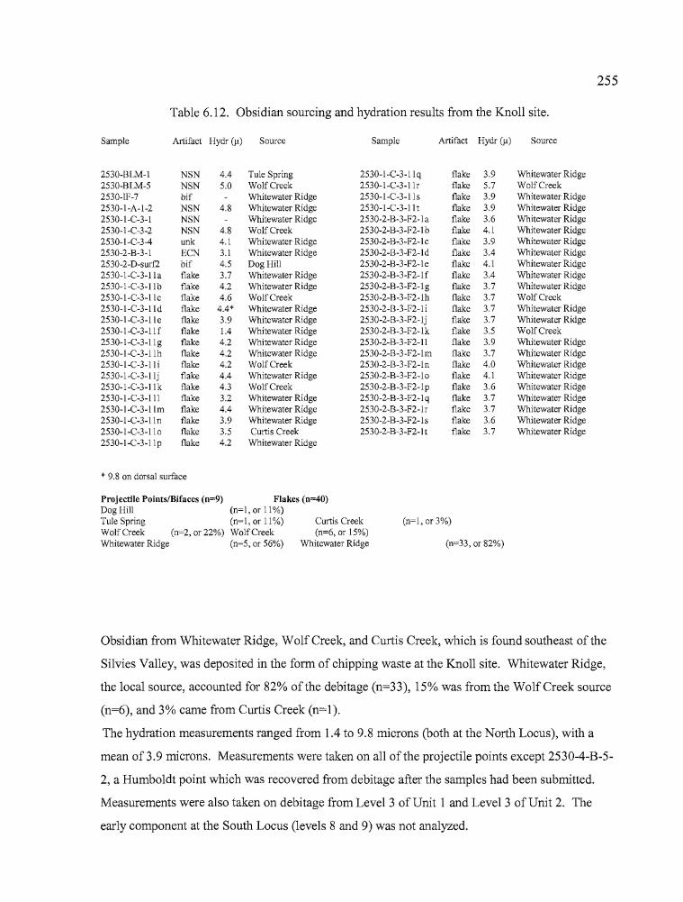
255
Table 6.12. Obsidian sourcing and hydration results from the Knoll site.
Sample Artifact Hydr (~) Source Sample Artifact Hydr (~) Source
2530-BLM-I NSN 4.4 Tule Spring 2530-I-C-3-llq flake 3.9 Whitewater Ridge2530-BLM-5 NSN 5.0 WolfCreek 2530-I-C-3-11r flake 5.7 WolfCreek2530-IF-7 bif Whitewater Ridge 2530-I-C-3-11s flake 3.9 Whitewater Ridge2530-I-A-I-2 NSN 4.8 Whitewater Ridge 2530-1-C-3-11t flake 3.9 Whitewater Ridge2530-I-C-3-1 NSN Whitewater Ridge 2530-2-B-3-F2-1 a flake 3.6 Whitewater Ridge2530-I-C-3-2 NSN 4.8 WolfCreek 2530-2-B-3-F2-1b flake 4.1 Whitewater Ridge2530-1-C-3-4 unk 4.1 Whitewater Ridge 2530-2-B-3-F2-lc flake 3.9 Whitewater Ridge2530-2-B-3-1 ECN 3.1 Whitewater Ridge 2530-2-B-3-F2-1d flake 3.4 Whitewater Ridge2530-2-D-surf2 bif 4.5 Dog Hill 2530-2-B-3-F2-1 e flake 4.1 Whitewater Ridge2530-1-C-3-1Ia flake 3.7 Whitewater Ridge 2530-2-B-3-F2-lf flake 3.4 Whitewater Ridge2530-1-C-3-11b flake 4.2 Whitewater Ridge 2530-2-B-3-F2-lg flake 3.7 Whitewater Ridge2530-I-C-3-llc flake 4.6 WolfCreek 2530-2-B-3-F2-lh flake 3.7 WolfCreek2530-I-C-3-lld flake 4.4* Whitewater Ridge 2530-2-B-3-F2-1 i flake 3.7 Whitewater Ridge2530-1-C-3-11 e flake 3.9 Whitewater Ridge 2530-2-B-3-F2-lj flake 3.7 Whitewater Ridge2530-I-C-3-11 f flake 1.4 Whitewater Ridge 2530-2-B-3-F2-lk flake 3.5 WolfCreek2530-I-C-3-llg flake 4.2 Whitewater Ridge 2530-2-B-3-F2-11 flake 3.9 Whitewater Ridge2530-I-C-3-llh flake 4.2 Whitewater Ridge 2530-2-B-3-F2-lm flake 3.7 Whitewater Ridge2530-I-C-3-lli flake 4.2 WolfCreek 2530-2-B-3-F2-ln flake 4.0 Whitewater Ridge2530-I-C-3-11j flake 4.4 Whitewater Ridge 2530-2-B-3-F2-lo flake 4.1 Whitewater Ridge2530-I-C-3-llk flake 4.3 WolfCreek 2530-2-B-3-F2-1 p flake 3.6 Whitewater Ridge2530-1-C-3-lll flake 3.2 Whitewater Ridge 2530-2-B-3-F2-1 q flake 3.7 Whitewater Ridge2530-I-C-3-llm flake 4.4 Whitewater Ridge 2530-2-B-3-F2-lr flake 3.7 Whitewater Ridge2530-I-C-3-11n flake 3.9 Whitewater Ridge 2530-2-B-3-F2-ls flake 3.6 Whitewater Ridge2530-I-C-3-llo flake 3.5 Curtis Creek 2530-2-B-3-F2-1 t flake 3.7 Whitewater Ridge2530-I-C-3-llp flake 4.2 Whitewater Ridge
* 9.8 on dorsal surface
Projectile Points/Bifaces (n~9) Flakes (n~40)
Dog Hill (n~l, or 11%)Tule Spring (n~l, or 11%) Curtis Creek (n~l, or 3%)WolfCreek (n~2, or 22%) WolfCreek (n~6, or 15%)Whitewater Ridge (n=5, or 56%) Whitewater Ridge (n=33, or 82%)
Obsidian from Whitewater Ridge, Wolf Creek, and Curtis Creek, which is found southeast of the
Silvies Valley, was deposited in the form of chipping waste at the Knoll site. Whitewater Ridge,
the local source, accounted for 82% of the debitage (n=33), 15% was from the WolfCreek source
(n=6), and 3% came from Curtis Creek (n=l).
The hydration measurements ranged from 1.4 to 9.8 microns (both at the North Locus), with a
mean 00.9 microns. Measurements were taken on all of the projectile points except 2530-4-B-5
2, a Humboldt point which was recovered from debitage after the samples had been submitted.
Measurements were also taken on debitage from Level 3 of Unit 1 and Leve13 of Unit 2. The
early component at the South Locus (levels 8 and 9) was not analyzed.
..
256
Figure 7 reveals that hydration bands at Unit 1 cover a broader range (1.4 - 5.7 microns with one
outlier at 9.8 microns) than those in Unit 2, but are generally thicker and indicate that earlier
occupations occurred there. The hydration readings at Unit 2 are tightly clustered between 3.4 and
4.1 microns with the majority (70%) falling between 3.4 and 3.7 microns. Only 19% of the Unit 1
measurements fall within this range.
The obsidian hydration results appear to indicate that our sampling at the North Locus
captured a broad array of flakes from occupations that were dispersed across the slope or became
mixed as the result of down slope movement. The sample from Unit 2 was recovered from a
relatively discrete occupation that experienced little mixing. It seems unlikely that the North
Locus experienced occupations that were exclusive of the South Locus, considering that the
primary water feature for the area is situated at the latter locality.
Lithic Debitage Mass Analysis
Mass analysis utilizes population means including counts and weights of size-graded
debitage in a replicable, quantitative manner to examine relationships of debitage in both inter
and intra-site contexts (Ah1er 1989, Connolly 1999). Flake attributes such as size, weight,
quantity, and the presence of cortex vary with each stage of lithic reduction, as early core and
biface production yield larger flakes with more cortex than later stage biface reduction and
pressure flaking. The system used here is adopted from an analysis developed for the Newberry
Volcano obsidian source by Connolly and Byram (2001:68). By quantifying chipping waste
through the previously mentioned variables, the characteristics of a site assemblage can be
compared to those from other sites and to an experimental lithic reduction data set established for
all five reduction stages (core reduction = Stage 1, biface pressure flaking = Stage 5) collected
from the Newberry Volcano obsidian source (Connolly and Byram 2001:69). The mass analysis
results should reflect the most dominant lithic reduction activities at a given location and,
depending on other factors such as stratigraphic mixing, should allow comparisons between early
and late components within a site.
Debitage from the Knoll site was processed through a series ofnested screens with
dimensions of 1" (G1), 1/2" (G2), 1/4" (G3), and 1/8" (G4). The flakes from each size grade were
rIiI
257
counted, weighed, and examined for the presence of cortex. The results were then compared with
those from the other Harney Valley sites reported here, from the Bon site in Deschutes County
(Connolly and Byram 2001), and with the overall results from the Newberry Crater project
(Connolly 1999). This information is presented below in Tables 6.13 and 6.14, and summarized
in the final chapter. Debitage collections from Units 1 and 2 are examined separately and together,
and Unit 2 is divided into Early and Late components for comparative purposes. The inter
component comparison for Unit 2 was accomplished by analyzing the debitage most closely
associated with peaks in cultural deposition for each component; levels 2-4 for the late component
and levels 8 and 9 for the early component.
The presence of early and late components at the Knoll site is supported through obsidian
hydration thicknesses, revealing temporal differences in occupations at the North and South loci,
and bimodal distributions in debitage counts, which indicate that an early and late component are
present at the South Locus. Mass analysis indicates differences between the North and South loci
as well, particularly with regard to reduction stage (Tables 6.13 and 6.14). Connolly (1999)
developed a formula for determining stages of lithic reduction activities at archaeological sites
based on three variables: Stage = 6.048 - 0.124 (F) - 0.023 (P) - 0.091 (Q), where F is the
percent count ofG2 over G1 - G4, P is the mean weight ofG2 (G2 weight/G2 count) in
decigrams, and J is the mean weight of G3 (G3 weight/G3 count) in centigrams. The values
produced from the archaeological data were inserted into this formula and the numeric result is an
indicator of the relative stage oflithic reduction that occurred at the site, whether it be for the
entire site or for components of the site.
Utilizing Connolly's (1999) mass analysis formula for the aggregate ofboth the North and
South loci (Units 1 and 2) debitage resulted in a predicted stage value of2.75 (Table 6.14), placing
the Knoll site among the Bon site (35DS608), a base camp located north of Newberry Caldera, and
other base camps within the Newberry Caldera (Connolly and Byram 2001 :71). When the Unit 1
(North Locus) obsidian is examined separately, the stage value is found to be 2.04, similar to near
quarry lithic reduction stations examined by Connolly and Byram (2001) and anticipated at a site
where obsidian cobbles are present. Collectively, the South Locus (Unit 2) material has a
predicted stage value of2.82, while the late component debitage produces a value of2.6 and the
early component material has a value of2.72. All of these South Locus (Unit 2) results are values
indicative ofbase camps and suggest that activities at the South Locus may not have been focused
on lithic reduction activities alone.
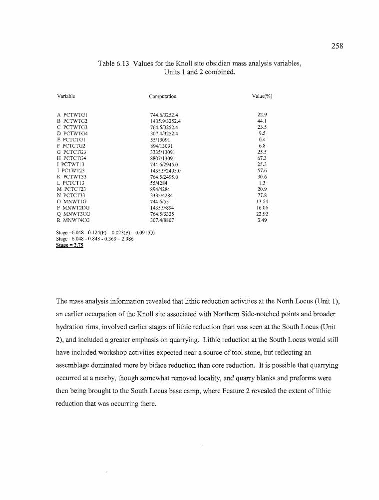
258
Table 6.13 Values for the Knoll site obsidian mass analysis variables,Units 1 and 2 combined.
Variable
A PCTWTGIB PCTWTG2C PCTWTG3o PCTWTG4E PCTCTGIF PCTCTG2G PCTCTG3H PCTCTG4I PCTWT13J PCTWT23K PCTWT33L PCTCT13M PCTCT23N PCTCT33o MNWT1GP MNWT2DGQ MNWT3CGR MNWT4CG
Computation
744.6/3252.41435.9/3252.4764.5/3252.4307.4/3252.455/1309189411309133351130918807113091744.6/2945.01435.9/2495.0764.5/2495.055/4284894/42843335/4284744.6/551435.9/894764.5/3335307.4/8807
Value(%)
22.944.123.59.50.46.8
25.567.325.357.630.61.3
20.977.813.5416.0622.923.49
Stage =6.048 - 0.124(F) - 0.023(P)·- 0.091(Q)Stage =6.048 - 0.843 - 0.369 - 2.086Stage = 2.75
The mass analysis information revealed that lithic reduction activities at the North Locus (Unit 1),
an earlier occupation of the Knoll site associated with Northern Side-notched points and broader
hydration rims, involved earlier stages oflithic reduction than was seen at the South Locus (Unit
2), and included a greater emphasis on quarrying. Lithic reduction at the South Locus would still
have included workshop activities expected near a source of tool stone, but reflecting an
assemblage dominated more by biface reduction than core reduction. It is possible that quarrying
occurred at a nearby, though somewhat removed locality, and quarry blanks and preforms were
then being brought to the South Locus base camp, where Feature 2 revealed the extent oflithic
reduction that was occurring there.
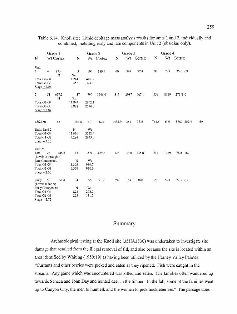
Summary
Archaeological testing at the Knoll site (35HA2530) was undertaken to investigate site
damage that resulted from the illegal removal of fill, and also because the site is located within an
area identified by Whiting (1950:19) as having been utilized by the Harney Valley Paiutes:
"Currants and other berries were picked and eaten as they ripened. Fish were caught in the
streams. Any game which was encountered was killed and eaten. The families often wandered up
towards Seneca and John Day and hunted deer in the timber. In the fall, some of the families went
up to Canyon City, the men to hunt elk and the women to pick huckleberries." The passage does
260
not specifically identify the Silvies Valley, but the Silvies River would have served as a natural
travel corridor for those en route to the present day Seneca, Canyon City, and John Day areas.
Fishing, berry picking, and hunting could all have occurred in the vicinity of the Knoll site along
with the quarrying of obsidian and basalt. The Silvies Valley, while outside of the Harney Valley,
is within the Harney drainage basin and thus fits into the organizational scheme of this report in
both geographic and ethnographic contexts.
Archaeological evidence, including radiocarbon and obsidian hydration analysis,
indicates that site use occurred earlier at the North Locus than at the South Locus. An early and
late period of occupation occurred at the South Locus, supported by radiocarbon dates of ca. 1780
and 1000 BP, respectively. At the North Locus, a radiocarbon date of 450 BP documents later use
ofthe site, and the presence of Northem Side-notched points suggests that site use also occurred as
early as 4000 years ago. No radiocarbon dates support this contention, however, and the illegal
removal of approximately 30 cm offill at the North Locus made it impossible to determine
stratigraphically whether both early and late components may have occurred there.
Features identified at the Knoll site included the Feature 1 rock and charcoal
concentration dated to 450 BP at the North Locus, and a 1000 BP concentration of obsidian flakes
and other artifacts at the South Locus identified as Feature 2. Feature 1 is difficult to assess
because of the lack of faunal or floral remains that would aid in determining if the fire there was
used for processing certain kinds of resources. Also, the substantial rock and charcoal
concentration is not like other hearth features known in the region. It may be a rock-filled oven.
There are no late Holocene projectile points around it, with the exception of a possible Elko base
fragment, and late period obsidian hydration measurements are uncommon generally at the North
Locus. It is possible that most associated artifacts were hauled away with the fill that had been
illegally removed from the site. Feature 2 includes a tight cluster of obsidian debitage, an abrader,
a metate fragment, and a number ofbiface fragments and other tools scattered in a loose arc
around the debitage. The feature seems to be a work station oriented to lithic reduction activities
and dating to ca. 1000 years ago. The Feature 2 surface is considered the late component of the
South Locus (Unit 2), with a second, earlier component dating to 1780 BP beginning 30 cm below
it. The early component is marked only by increased amounts of bone and debitage.
Activities carried out at both the North aI).d South loci include lithic reduction, faunal
processing, floral processing and possibly woodworking activities (represented by the abrader and
T
261
spokeshaves). Obsidian geochemistry reflects local sources as well as the import of tool stone
from the Stinkingwater Mountains, southeast of the site. Cut and calcined faunal remains indicate
that processing and cooking of game animals occurred at both loci though more intensively at the
South Locus. Grinding stones were limited in quantity but the degree of workmanship, including
symmetrical shaping, pecked rims and edges, and high polish on grinding surfaces suggests that
floral processing played a prominent role at the site. The presence of large metate fragments
suggests that the metates were "site furniture," left there and returned to seasonally for seed, bulb,
or berry processing. The pestle at the North Locus shows wear indicating that it was utilized with
a mortar, as a mano, and occasionally as a hammerstone, all of which are applications useful in the
processing of plant remains. A charred twig from a currant or gooseberry plant was identified at
the South Locus along with species that are commonly found at the site today.
Activities at the two loci varied as well. At the North Locus, debitage mass analysis
indicated that lithic reduction activities were oriented toward early stage (Stage 2) core preparation
processes expected at or near quarrying sites. At the South Locus, early Stage 3 biface reduction
was more common, similar to what Connolly (1999) encountered at base camps and off-quarry
lithic reduction workshops at Newberry Crater and the Bon site. As mentioned above, early stage
lithic processing could have occurred at the North Locus portion of the site and Stage 3 bifaces
could then have been carried to the base camp at the South Locus for more refined work. Cores,
bifaces, utilized flakes and paleobotanical remains were found in higher quantities at the South
Locus, as were both identifiable and unidentifiable bone fragments. The sheer volume of artifacts
recovered at the South Locus, especially in Unit 2 and Probe 5, indicate that use of that portion of
the site was much more intensive than at the North Locus, especially around 1000 years ago.
Debitage and bone were particularly well represented, but regrettably one can only speculate about
what was removed from the looter's pit near Unit 2.
In summary, the Knoll site has characteristics that fit the pattern of activity expected from
Whiting's (1950) ethnographic account of Burns Paiute economic practices, in which hunting,
fishing and berry picking all figured into the seasonal round of that area. She specifically named
currants as desirable resources, and currant or gooseberry remains were identified at the site along
with the equipment to process them. Both small and large mammal remains were recovered,
although not in quantities that would indicate that hunting played a prominent role at the site.
Only one fish bone was recovered, in the South Locus, so fishing was perhaps incidental to other
favored activities such as floral and lithic processing.
BEFORE WINTER COMES: ARCHAEOLOGICAL INVESTIGATIONS OF
SETTLEMENT AND SUBSISTENCE IN HARNEY VALLEY,
HARNEY COUNTY, OREGON
by
PATRICK WARREN O'GRADY
A DISSERTATION
Presented to the Department of Anthropologyand the Graduate School of the University of Oregon
in partial fulfillment of the requirementsfor the degree of
Doctor ofPhilosophy
December 2006
11
"Before Winter Comes: Archaeological Investigations of Settlement and Subsistence in
Harney Valley, Harney County, Oregon," a dissertation prepared by Patrick Warren
O'Grady in partial fulfillment of the requirements for the Doctor of Philosophy degree in
the Department of Anthropology. This dissertation has been approved and accepted by:
Date
Committee in Charge:
Accepted by:
Dr. C. Melvin Aikens, ChairDr. Dennis L. JenkinsDr. Douglas J. KennettDr. Esther Jacobson-Tepfer
Dean of the Graduate School
111
An Abstract of the Dissertation of
Patrick Warren O'Grady for the degree of
In the Department ofAnthropology to be taken
Doctor ofPhilosophy
December 2006
...
Title: BEFORE WINTER COMES: ARCHAEOLOGICAL INVESTIGATIONS OF
SETTLEMENT AND SUBSISTENCE IN HARNEY VALLEY, HARNEY
COUNTY, OREGON
Many archaeological researchers that have conducted investigations in the Harney
Valley of southeastern Oregon use the ethnographic description of the seasonal round of
the Harney Valley Paiute reported by Beatrice Blyth Whiting in her 1950 work Paiute
Sorcery as a framework for discussions ofprehistoric human use of the area.
Archaeological investigations of seven sites, situated in areas identified as having been
utilized by the Harney Valley Paiutes, were conducted to test the relationship between
Whiting's ethnographic account and the archaeological record. Data recovery
excavations occurred at the Hoyt (35HA2422), Morgan (35HA2423) and Hines
(35HA2692) sites near Bums, and test excavations occurred at the Knoll (35HA2530)
site in the Silvies Valley, the RJ site (35HA3013) in the Stinkingwater Mountains, and
the Broken Arrow (35HA2735) and Laurie's (35HA2734) sites near Malheur Lake.
-
IV
Studies of the cultural materials recovered during the excavations were undertaken
to evaluate the content and complexity of each site. Analyses included typological
considerations of the chipped stone tools, ground stone, bone tools, and shell, bone, and
stone beads. Radiocarbon dating, obsidian sourcing and hydration, and
zooarchaeological and paleobotanical analyses were also conducted when possible.
Based on the results of the analyses, the seven sites reported herein were primarily used
during the past 2000 years, with periods ofless intensive use extending beyond 4000 BP.
The results of the archaeological investigations indicate that there is a strong
correlation between the late Holocene prehistoric record and Whiting's ethnographic
description. However, the relationship between human use of the centrally-located lakes
and wetlands and the neighboring uplands is clearly more complex than the ethnographic
record suggests. Patterns of settlement and mobility revealed through the archaeological
record indicate that central places, located closer to wetlands and lacustrine settings but
within relatively easy reach of the uplands, may have figured more prominently in the
behavior ofprehistoric populations than the seasonal round as described by Whiting.
Future research will benefit from explorations of central place foraging, emphasizing the
role of behavioral ecology in the placement of sites and patterns of site use within the
Harney Valley and the northern Great Basin at large.
-.-------------------------------- - ----
CURRICULUM VITAE
NAME OF AUTHOR: Patrick Warren O'Grady
PLACE OF BIRTH: Medford, Oregon
DATE OF BIRTH: March 23,1959
GRADUATE AND UNDERGRADUATE SCHOOLS ATTENDED:
University of OregonLane Community College
DEGREES AWARDED:
Doctor of Philosophy, 2006, University of OregonMaster of Science, 1999, University of OregonBachelor of Science, 1996, University of Oregon
AREAS OF SPECIAL INTEREST:
Hunter-Gatherer Settlement and Subsistence SystemsZooarchaeologyPaleoenvironments
PROFESSIONAL EXPERIENCE:
Graduate Teaching Fellow, Department ofAnthropology, University of Oregon1997-2001
Supervisor, University of Oregon Archaeological Field School,1995, 1997-2001
Research Assistant, Oregon State Museum ofAnthropology.1998-2002
v
--
h
VI
Archaeologist, Oregon Department of Transportation2002-2005
Archaeologist, Oregon State Museum of Anthropology,2005-2006
GRANTS, AWARDS AND HONORS:
Star Award, Burns District Bureau of Land Management, 2002Edna English Trust, University of Oregon, 2000Graduate School Research Award, University of Oregon, 1998Starr General Scholarship, University of Oregon, 1997Magna Cum Laude, University of Oregon, 1996Junior Scholar Award, University of Oregon, 1995
PUBLICAnONS:
O'Neill, Brian L., Dennis L. Jenkins, Charles M. Hodges, PatrickO'Grady, and Thomas J. Connolly
2006 Housepits in the Chewaucan Marsh: Investigations at the Gravelly FordBridge Site. In Beads, Points, and Pit Houses: A Northern Great BasinMiscellany, edited by Brian L. O'Neill, pp. 93-136. University ofOregon Anthropological Papers No. 66, Eugene.
O'Grady, Patrick2005 Report'on the Activities of the 2005 Redmond Caves Field School.
Current Archaeological Happenings in Oregon 30(3): 8-10.
O'Grady, Patrick2004 Zooarchaeological Analysis of Cultural Features from Four Early to
Middle Holocene Sites in the Fort Rock Basin. In Early and MiddleHolocene Archaeology ofthe Northern Great Basin, edited by Dennis L.Jenkins, Thomas J. Connolly, and C. Melvin Aikens, pp.187-208.University of Oregon Anthropological Papers No. 62, Eugene.
Kramer, George, Patrick O'Grady, and Thomas J. Connolly2002 Cultural Resource Investigations for the Cold Springs Highway-SW
Court Place Segment, U.S. Highway 30, Pendleton, Umatilla County.State Museum of Anthropology Report No. 2002-2, University ofOregon, Eugene.
..
tz
Vll
O'Grady, Patrick2001 Reptile and Amphibian Remains from Houses 1-8. In Carlon Village:
Land, Water, Subsistence and Sedentism in the Northern Great Basin,edited by George F. Wingard, pp. 561-563. University of OregonAnthropological Papers No. 57, Eugene.
Thomas, Scott, Patrick O'Grady, Dan Braden, Margaret Helzer, LaurieThompson, and Emily Mueller2001 35HA3055: A Prehistoric Jackrabbit Roasting Site in Southeastern
Oregon. Current Archaeological Happenings in Oregon 25(4):17-22
O'Grady, Patrick2000 Zooarchaeological Analysis ofVertebrate and Invertebrate Remains from
the Gravelly Ford Sites, Lake County, Oregon. In The Chewaucan RiverBridges Project: Archaeological Investigations at Three Localities in theLower Chewaucan Marsh Along the La Pine-Valley Falls Highway(OR31), Lake County, Oregon, by Brian L. O'Neill, Dennis L. Jenkins,Charles M. Hodges, Patrick O'Grady, and Thomas J. Connolly, pp. 7196. Oregon State Museum ofAnthropology Report No. 2000-4, Eugene.
O'Grady, Patrick1999 Obsidian Sources from Playa Villages in the Fort Rock Uplands, Lake
County, Oregon. Current Archaeological Happenings in Oregon24(3):12-19.
- .
Vlll
ACKNOWLEDGEMENTS
A tremendous number of people were involved in this project, but above all I
would like to thank Dr. C. Melvin Aikens, whose careful guidance and patient soul
helped me in innumerable ways. Dr. Dennis L. Jenkins gave me every opportunity to
engage in the world of Great Basin archaeology, and gave freely of his time and attention
as only a true mentor would. Scott Thomas has also been played an invaluable part in all
of this, both as a colleague and friend, and his knowledge of the archaeology ofHarney
Valley is unsurpassed. Dr. Thomas J. Connolly has always been a trusted advisor and his
commitment to the archaeology of Oregon sets an example to live by. I have gained
much from the counsel ofthese four men. Thanks also to Dr. Douglas J. Kennett and Dr.
Esther Jacobson-Tepfer for serving on my committee.
Thanks to the University of Oregon Department ofAnthropology and Museum of
Natural and Cultural History, the Burns District Bureau ofLand Management, the
Oregon Department of Transportation, the Edna English Trust, and the United States
Forest Service: Malheur National Forest, for fimding this effort. The Harney County
School District, Crane School District and Dave Courtney deserve thanks for "putting us
up" during our field operations.
My 2000 and 200 I field school crews included Rachael Bendis, Tobin Bottman,
Deanna Dartt, Ian Goss, Rose Gunn, Jessica Lisicki, Emily Mueller, Jaime Sheppard,
Ann Marie Southey, Laurie Thompson, and Debbie Todd.

-- '
$
IX
Volunteers included Bethel and Larry Asmussen, Dan Braden, Marty Boyesen
Diane Browning, Kelly Edmundson, Scott Meissner, Dianne Ness, Bud Rice, Jim Rice,
Joe Rickman, Ray Temple, Whitney Temple, Wilda Toussaint, and Frank and Pam
Turner. You all made a huge difference.
Artifact drawings are by Eric Carlson, and Tom Connolly and Carolyn Armstrong
made the maps seen in the Hoyt, Morgan, and Hines chapters.
I would also like to thank Marge Helzer and Suzann Henrikson, who provided
much emotional support during the grad school process. Georgia Crow helps keep "story
time" alive. Cecil and Emory Coons have always given freely of their knowledge of tool
stone sources in the Harney Valley. The warmth and friendliness of the people ofBums
and Hines always made our field sessions more enjoyable.
My son Jack has always been a willing and helpful participant in the field school
effort. His presence during these projects brings me great joy.
Finally, I extend my thanks to the Bums Paiute Tribe, who have been supportive
ofmy efforts and given freely of their knowledge. This project would not have been
possible without ongoing collaboration between the Bums Paiute Tribe, the University of
Oregon Department of Anthropology, and the Burns District Bureau of Land
Management.

• •
•
To Sarah, who contributed tremendously to this effort and always kept me grounded.
x
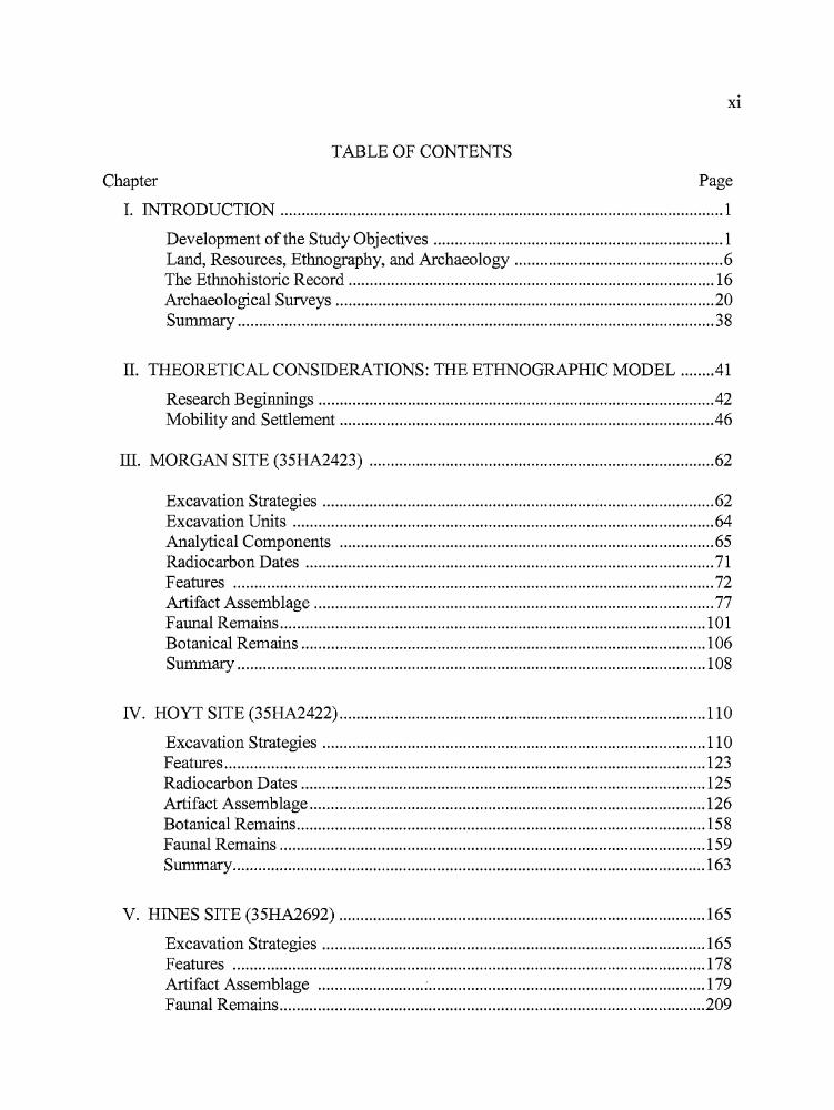
r.
Xl
TABLE OF CONTENTS
Chapter Page
>
I. INTRODUCTION 1
Development ofthe Study Objectives 1Land, Resources, Ethnography, and Archaeology 6The Ethnohistoric Record 16Archaeological Surveys 20Summary 38
II. THEORETICAL CONSIDERATIONS: THE ETHNOGRAPHIC MODEL .41
Research Beginnings 42Mobility and Settlement 46
III. MORGAN SITE (35HA2423) 62
Excavation Strategies 62Excavation Units 64Analytical Components 65Radiocarbon Dates 71Features 72Artifact Assemblage 77Faunal Remains 101Botanical Remains 106Summary 108
IV. HOYT SITE (35HA2422) 110
Excavation Strategies 110Features 123Radiocarbon Dates 125Artifact Assemblage 126Botanical Remains 158Faunal Remains 159Summary 163
V. HINES SITE (35HA2692) 165
Excavation Strategies 165Features 178Artifact Assemblage ; 179Faunal Remains 209
...
•
XlI
Chapter Page
Botanical Remains 213Summary 220
VI. KNOLL SITE (35HA2530) 223
Excavation Strategies 224Analytical Components 227Radiocarbon Dates 236Artifact Assemblage 237Faunal Remains 250Botanical Remains 253Summary 259
VII. RJ SITE (35HA3013) 262
Excavation Strategies 264Excavation Units 266Analytic Components 267Artifact Assemblage 275Faunal Remains 297Botanical Remains 297Summary 306
VIII. LAURIE'S SITE (35HA3074) 310
Excavation Strategies 314Excavation Units 315Analytic Components 316Artifact Assemblage 333Botanical Remains 370Faunal Remains 374Summary 374
IX. BROKEN ARROW SITE (35HA3075) 378
Excavation Strategies 382Excavation Units 383Analytic Components 384Features 397Artifact Assemblage 404Botanical Remains 454Faunal Remains 457Summary 458
cays
Chapter
Xlll
Page
•
X. SUMMARY AND CONCLUSIONS .460
Research Topics 461Regional Culture History: Site Summaries .461Regional Culture History: Radiocarbon and Obsidian HydrationDates, and Lithic Technology Comparisons .465Paleoclimatic, Environmental, and Cultural Change .469Settlement and Subsistence 473Cultural Relations and Ethnic Group Territories .477The Sites in Relationship to Harney Valley Patterns ofMobility .489Future Research in Harney Valley .497
APPENDIX: GEOCHEMICAL SOURCING AND OBSIDIAN HYDRATIONSTUDIES AT THE HOYT, MORGAN, AND HINES SITES 502
BIBLIOGRAPHY 522
>
XIV
LIST OF FIGURES
Figure Page
1.1. Hydologic Map of the Harney Basin 9
1.2. Selected Harney Basin Archaeological Sites 22
3.1. Plan View ofMorgan Site TestPits 63
3.2. The Morgan Site West Locus 65
3.3. Plan View ofMorgan Site Excavation Area 67
3.4. Profile of Unit N99, E8 68
3.5. Morgan Site East Locus 70
3.6. Feature 1, UnitD 73
3.7. Feature 2 Milling Stone Cluster 74
3.8. Feature 3, a Hearth in Unit W 75
3.9. Feature 4, a Hearth in Unit U 76
3.10. Selected Projectile Points from the Morgan site 79
3.11. Selected Bifaces from the Morgan Site 87
3.12. Debitage Distributions at the Morgan Site 94
3.13. Specimen 977-23-P-A-11-2 98
3.14. Mano, Pestle, and Stone Bead 99
3.15. Animal Bone Distributions at Morgan Site 102
4.1. Locations ofProbes and Test Units at the Hoyt Site 111
4.2. Plan View ofData Recovery Excavation Units at the Hoyt Site 112
4.3. The Hoyt Site North Locus 113
4.4. Hoyt Site Profile, Unit E 115
4.5. The Hoyt Site South Locus 119
4.6. Hoyt Site Unit S Profile 120
4.7. Feature 1, a Metate 123
4.8. Projectile Points 127
4.9. Selected Biface Fragments 139
4.10. Distribution of Debitage, All Units 149
4.11. Selected Manos from the Hoyt Site 150
.- '
•
xv
Figure Page
4.12. Selected Artifacts from the Hoyt Site 151
4.13. Abrading Stones from the Hoyt Site 154
4.14. Distribution ofFaunal Remains 160
5.1. Location ofthe Hines Site 166
5.2. Hines Site Trenches, Probes, and Excavation Units 167
5.3. North Block of the Hines Site 173
5.4. South Block, Facing North 175
5.5. North Block ofthe Central Locus 177
5.6. Selected Projectile Points 181
5.7. Bifaces, Shown Actual Size 192
5.8. Drills, Shown Actual Size 196
5.9. Bone TooI1070-92-E-b-5-2 208
6.1. South Locus of the Knoll Site 224
6.2. Knoll Site Excavation Units 226
6.3. Feature 1, Level 3 232
6.4. Units 1 and 3 at the North Locus 232
6.5. Unit 4 at the North Locus 233
6.6. Feature 2, Northern Portion of Unit 2, Quad A 234
6.7. Unit 2 at the Knoll Site 235
6.8. Projectile Points and Selected Bifaces 238
6.9. Specimen 2530-4-A-1-1 249
6.10. Specimen 2530-2-B-2-2 250
6.11. Obsidian Hydration Readings from Units 1 and 2 254
7.1. View ofRJ Site 263
7.2. RJ Site Excavation Units 265
7.3. Unit 1, Locations ofIn Situ artifacts 268
7.4. Plan View ofUnit 2 271
7.5. Unit 3, Locations ofArtifacts and Samples 272
7.6. Unit 4, Locations ofArtifacts and Samples 274
7.7. Projectile Points and Other Hafted Tools 277
XVI
Figure Page
7.8. Selected Drill Fragments 287
7.9. Large core and Flake Tools 290
7.10. Ecofacts Recovered from the Surface 296
7.11. Obsidian Hydration Readings from RJ Excavation Units 301
8.1. Laurie's Site, with Depression in Foreground 31 1
8.2. Laurie's Site in Topographic Context 313
8.3. Detail Map ofHouse Pits 314
8.4. Laurie' Site House Pit 1 Debitage Counts 318
8.5. Laurie's Site House Pit 1 Bone Counts .318
8.6. Laurie's Site House 1, Units 1 and 2 .323
8.7. Laurie's Site, House 1 Profile .324
8.8. Laurie's Site, House 2 Profile 328
8.9. Debitage Counts for House Pit 2 329
8.10. Bone Counts for House Pit 2 329
8.11. Laurie's Site Unit SP-1 Profi1e 331
8.12. Laurie's Site Unit SP-1 Bone and Debitage Counts 331
8.13. Selected Projectile Points from Laurie's Site .334
8.14. Selected Artifacts from Laurie's Site 337
8.15. Selected Bifaces From Laurie's Site .346
8.16. Artifacts from Laurie's Site, including beads, drills, graver and stone ball .351
8.17. Bone Objects from Laurie's Site .363
8.18. Obsidian Hydration Measurements 366
9.1. Broken Arrow, Unit 2 in Foreground 379
9.2. Broken Arrow Topography and Excavation Units 380
9.3. Broken Arrow Unit 1 386
9.4. Broken Arrow Unit 1 Debitage and Bone Counts 387
9.5. Broken Arrow Unit 2 389
9.6. Debitage and Bone Counts for Unit 2 .390
9.7. Broken Arrow Unit 3 : 392
9.8. Debitage and Bone Counts for Unit 3 393
XVll
Figure Page
9.9. Broken Arrow Positions ofUnits 2, 4, and 5 394
9.10. Broken Arrow Units 2,4, and 5 395
9.11. Broken Arrow Temporal Distributions ofDiagnostic Point Types .405
9.12. Broken Arrow Projectile Points .408
9.13. Broken Arrow Projectile Points and Hafted Tools .410
9.14. Broken Arrow Projectile Points, Elko-Great Basin Stemmed .412
9.15. Broken Arrow Bifaces 421
9.16. Additional Bifaces from Broken Arrow .424
9.17. Selected Drills and Awls 430
9.18. Broken Arrow Abraders and Decorated Pipe Fragment.. .438
9.19. Pipe Fragment, with Incised Decorations Highlighted .439
9.20. Broken Arrow Bone Tools and Decorative Objects .441
9.21. Broken Arrow Shell and Stone Beads .446
9.22. Obsidian Hydration Measurements from Broken Arrow .453
10.1. Radiocarbon Dates as Related to Climatic Inferences .471
10.2. Obsidian Sources for Knoll, RJ, Laurie's and Broken Arrow .479
10.3. Obsidian Sources for Hoyt, Morgan, and Hines .480
10.4. Relationship Between Study Sites and Dominant Obsidian Sources .481
10.5. Relationship ofMass Analysis Results to Experimental Means .487
10.6. Scatter Plot ofFlake Weight and Percentage .488
10.7. Pie Charts Showing Variability at the Seven Sites .491
XV111
LIST OF TABLES
Table Page
3.1. Radiocarbon Dates for the Morgan Site 71
3.2. Projectile Points:Morgan Site 81
3.3. Morgan Site Projectile Point Fragments 84
3.4. Morgan Site Bifaces 90
3.5. Mass Analysis ofMorgan Site Debitage 95
3.6. Ground Stone from Morgan Site 97
3.7. Bone/Animal Size Classes 103
3.8. Inventory of Faunal Remains from Morgan Site 105
3.9. Botanical Remains at Morgan Site 107
4.1. Artifact Distributions in the North Locus, Hoyt Site 116
4.2. Artifact Distributions in the South Locus, Hoyt Site 121
4.3. Vertical Distributions of Tools 122
4.4. Radiocarbon Dates from Hoyt Site 125
4.5. Projectile Point Attributes: Hoyt Site 130
4.6. Hoyt Site Projectile Point Fragments 135
4.7. Hoyt Site Drills and Awls 137
4.8. Hoyt Site Bifaces and Fragments 140
4.9. Cores from the Hoyt Site 144
4.10. Core and Flake Tools from Hoyt Site 146
4.11. Mass Analysis ofHoyt Debitage 148
4.12. Ground Stone Tools and Fragments from Hoyt 152
4.13. Bone Tool Fragments from Hoyt Site 157
4.14. Plant Remains at the Hoyt Site 159
4.15. Inventory ofFaunal Remains 162
5.1. Artifact Distributions in the North Block. l72
5.2. Artifact Distributions in the South Block 176
5.3. Projectile Points from Hines Site 184
5.4. Diagnostic Artifacts by Unit and Level 186
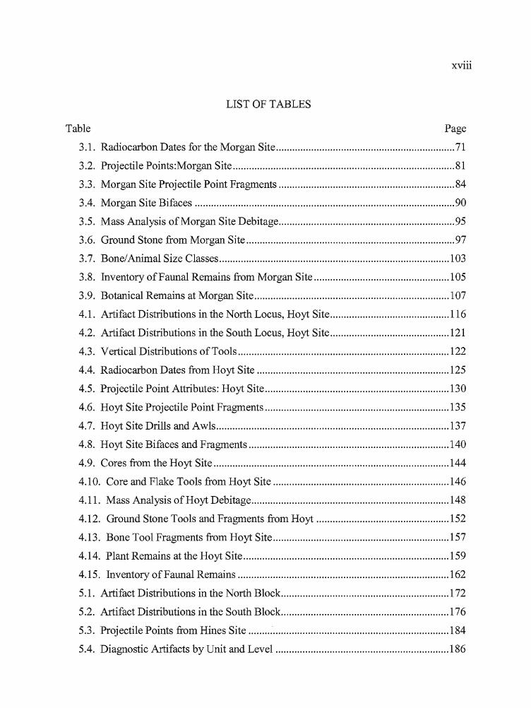
*",
s
XV111
LIST OF TABLES
Table Page
3.1. Radiocarbon Dates for the Morgan Site 71
3.2. Projectile Points:Morgan Site 81
3.3. Morgan Site Projectile Point Fragments 84
3.4. Morgan Site Bifaces 90
3.5. Mass Analysis ofMorgan Site Debitage 95
3.6. Ground Stone from Morgan Site 97
3.7. Bone/Animal Size Classes 103
3.8. Inventory ofFaunal Remains from Morgan Site 105
3.9. Botanical Remains at Morgan Site 107
4.1. Artifact Distributions in the North Locus, Hoyt Site 116
4.2. Artifact Distributions in the South Locus, Hoyt Site 121
4.3. Vertical Distributions ofTools 122
4.4. Radiocarbon Dates from Hoyt Site 125
4.5. Projectile Point Attributes: Hoyt Site 130
4.6. Hoyt Site Projectile Point Fragments 135
4.7. Hoyt Site Drills and Awls 137
4.8. Hoyt Site Bifaces and Fragments 140
4.9. Cores from the Hoyt Site 144
4.10. Core and Flake Tools from Hoyt Site 146
4.11. Mass Analysis ofHoyt Debitage 148
4.12. Ground Stone Tools and Fragments from Hoyt 152
4.13. Bone Tool Fragments from Hoyt Site 157
4.14. Plant Remains at the Hoyt Site 159
4.15. Inventory ofFaunal Remains 162
5.1. Artifact Distributions in the North Block. l72
5.2. Artifact Distributions in the South Block 176
5.3. Projectile Points from Hines Site 184
5.4. Diagnostic Artifacts by Unit and Level 186
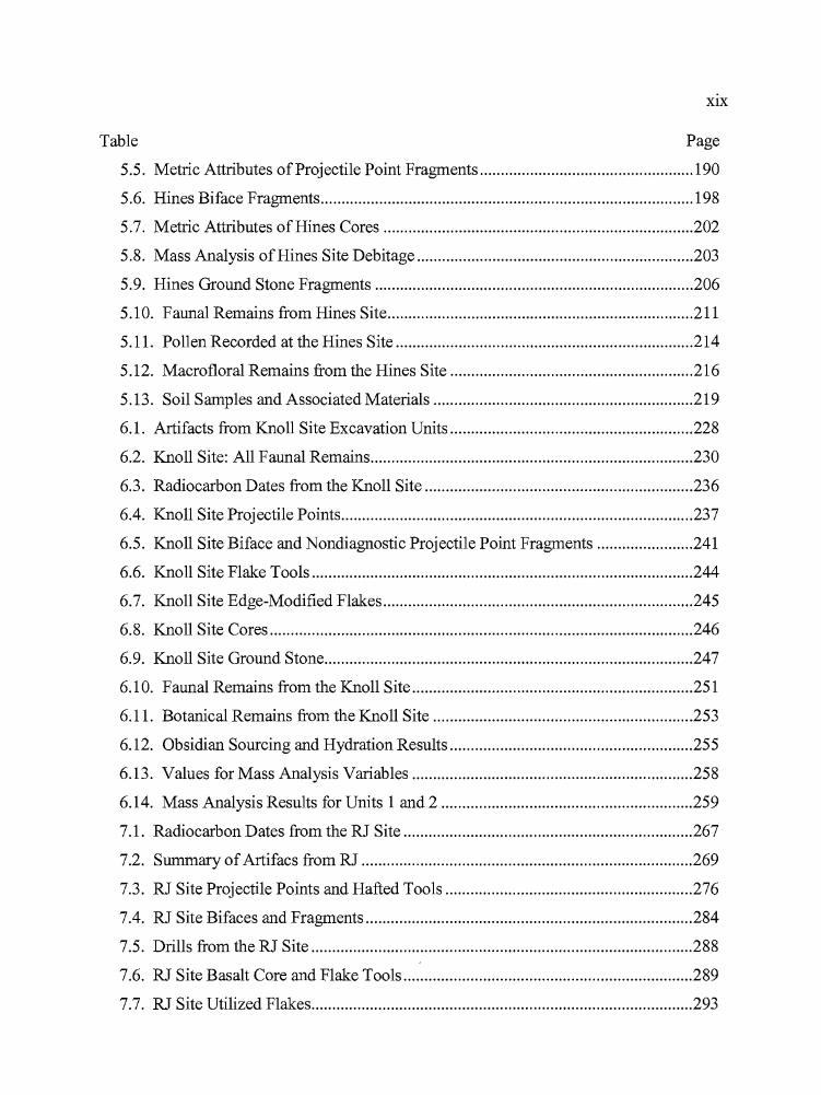
•
XIX
~~ P~
5.5. Metric Attributes ofProjectile Point Fragments 190
5.6. Hines Biface Fragments 198
5.7. Metric Attributes of Hines Cores 202
5.8. Mass Analysis of Hines Site Debitage 203
5.9. Hines Ground Stone Fragments 206
5.10. Faunal Remains from Hines Site 211
5.11. Pollen Recorded at the Hines Site 214
5.12. Macrofloral Remains from the Hines Site 216
5.13. Soil Samples and Associated Materials 219
6.1. Artifacts from Knoll Site Excavation Units 228
6.2. Knoll Site: All Faunal Remains 230
6.3. Radiocarbon Dates from the Knoll Site 236
6.4. Knoll Site Projectile Points 237
6.5. Knoll Site Biface and Nondiagnostic Projectile Point Fragments 241
6.6. Knoll Site Flake Tools 244
6.7. Knoll Site Edge-Modified Flakes 245
6.8. Knoll Site Cores 246
6.9. Knoll Site Ground Stone 247
6.10. Faunal Remains from the Knoll Site 251
6.11. Botanical Remains from the Knoll Site 253
6.12. Obsidian Sourcing and Hydration Results 255
6.13. Values for Mass Analysis Variables 258
6.14. Mass Analysis Results for Units 1 and 2 259
7.1. Radiocarbon Dates from the RJ Site 267
7.2. Summary ofArtifacs from RJ 269
7.3. RJ Site Projectile Points and Hafted Tools 276
7.4. RJ Site Bifaces and Fragments 284
7.5. Drills from the RJ Site 288
7.6. RJ Site Basalt Core and Flake Tools 289
7.7. RJ Site Utilized Flakes 293
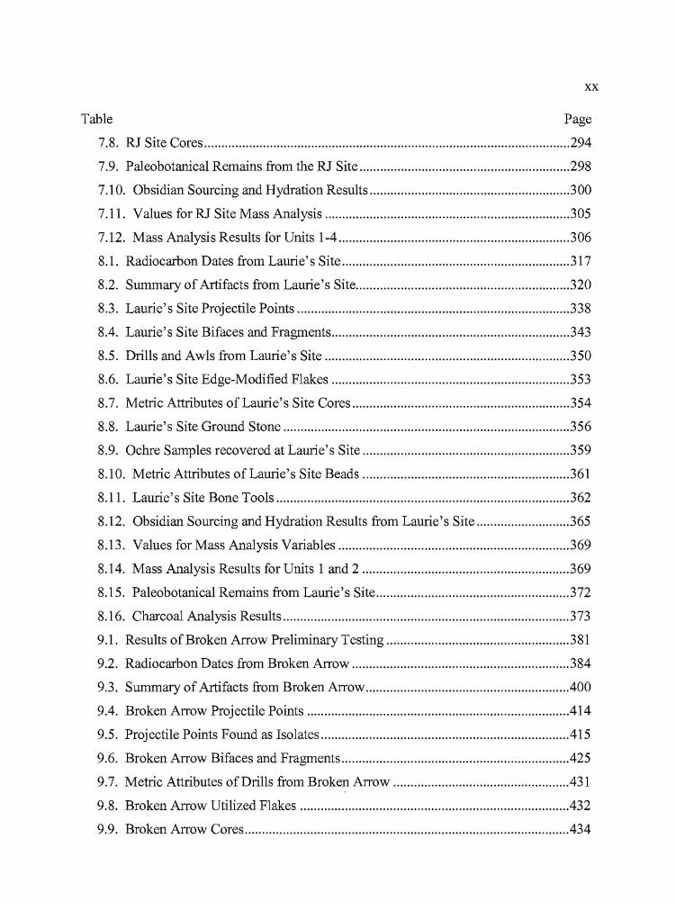
... ,
•
xx
~~ P~
7.8. RJ Site Cores 294
7.9. Paleobotanical Remains from the RJ Site 298
7.10. Obsidian Sourcing and Hydration Results 300
7.11. Values for RJ Site Mass Analysis 305
7.12. Mass Analysis Results for Units 1-4 306
8.1. Radiocarbon Dates from Laurie's Site 317
8.2. Summary of Artifacts from Laurie's Site 320
8.3. Laurie's Site Projectile Points 338
8.4. Laurie's Site Bifaces and Fragments 343
8.5. Drills and Awls from Laurie's Site 350
8.6. Laurie's Site Edge-Modified Flakes 353
8.7. Metric Attributes of Laurie's Site Cores 354
8.8. Laurie's Site Ground Stone 356
8.9. Ochre Samples recovered at Laurie's Site 359
8.10. Metric Attributes of Laurie's Site Beads 361
8.11. Laurie's Site Bone Tools 362
8.12. Obsidian Sourcing and Hydration Results from Laurie's Site 365
8.13. Values for Mass Analysis Variables 369
8.14. Mass Analysis Results for Units 1 and 2 369
8.15. Paleobotanical Remains from Laurie's Site 372
8.16. Charcoal Analysis Results 373
9.1. Results of Broken Arrow Preliminary Testing 381
9.2. Radiocarbon Dates from Broken Arrow 384
9.3. Summary of Artifacts from Broken Arrow 400
9.4. Broken Arrow Projectile Points 414
9.5. Projectile Points Found as Isolates .415
9.6. Broken Arrow Bifaces and Fragments .425
9.7. Metric Attributes of Drills from Broken Arrow .431
9.8. Broken Arrow Utilized Flakes .432
9.9. Broken Arrow Cores 434
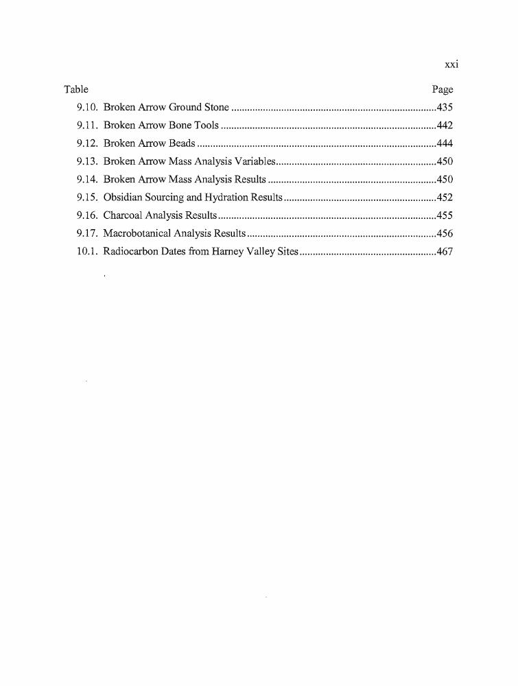
r,
•
XXI
Table Page
9.10. Broken Arrow Ground Stone 435
9.11. Broken Arrow Bone Tools 442
9.12. Broken Arrow Beads 444
9.13. Broken Arrow Mass Analysis Variables .450
9.14. Broken Arrow Mass Analysis Results .450
9.15. Obsidian Sourcing and Hydration Results 452
9.16. Charcoal Analysis Results 455
9.17. Macrobotanical Analysis Results .456
10.1. Radiocarbon Dates from Harney Valley Sites .467
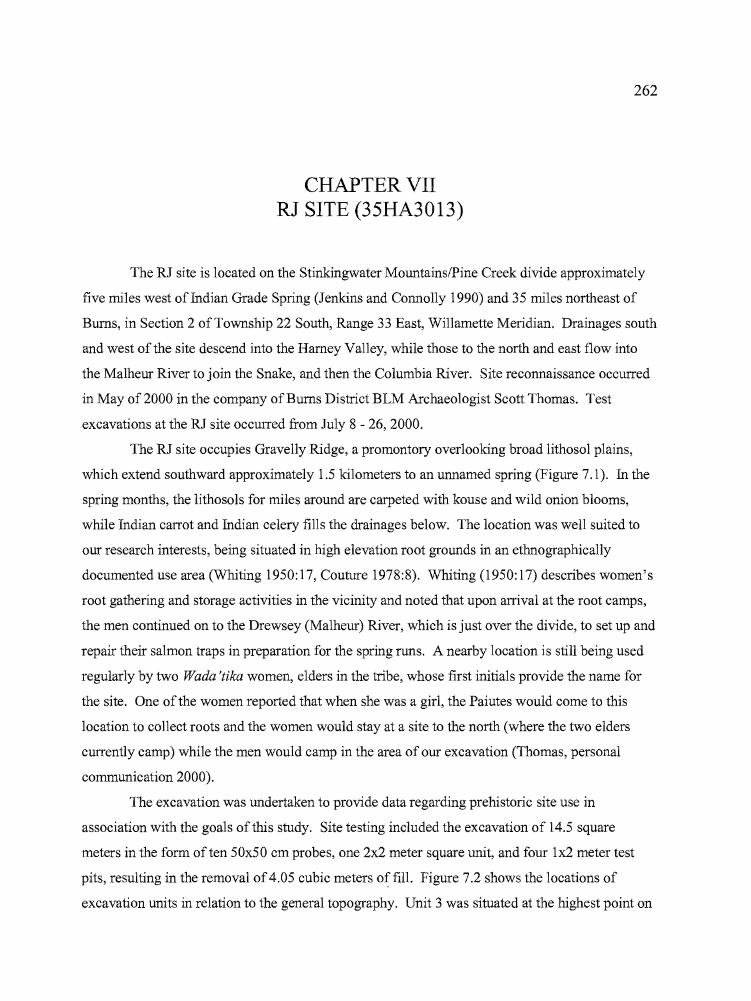
262
CHAPTER VIIRJ SITE (35HA3013)
The RJ site is located on the Stinkingwater MountainslPine Creek divide approximately
five miles west of Indian Grade Spring (Jenkins and Connolly 1990) and 35 miles northeast of
Burns, in Section 2 of Township 22 South, Range 33 East, Willamette Meridian. Drainages south
and west of the site descend into the Harney Valley, while those to the north and east flow into
the Ma1heur River to join the Snake, and then the Columbia River. Site reconnaissance occurred
in May of2000 in the company of Bums District BLM Archaeologist Scott Thomas. Test
excavations at the RJ site occurred from July 8 - 26, 2000.
The RJ site occupies Gravelly Ridge, a promontory overlooking broad lithoso1 plains,
which extend southward approximately 1.5 kilometers to an unnamed spring (Figure 7.1). In the
spring months, the lithoso1s for miles around are carpeted with kouse and wild onion blooms,
while Indian carrot and Indian celery fills the drainages below. The location was well suited to
our research interests, being situated in high elevation root grounds in an ethnographically
documented use area (Whiting 1950:17, Couture 1978:8). Whiting (1950: 17) describes women's
root gathering and storage activities in the vicinity and noted that upon arrival at the root camps,
the men continued on to the Drewsey (Ma1heur) River, which is just over the divide, to set up and
repair their salmon traps in preparation for the spring runs. A nearby location is still being used
regularly by two Wada'tika women, elders in the tribe, whose first initials provide the name for
the site. One of the women reported that when she was a girl, the Paiutes would come to this
location to collect roots and the women would stay at a site to the north (where the two elders
currently camp) while the men would camp in the area of our excavation (Thomas, personal
communication 2000).
The excavation was undertaken to provide data regarding prehistoric site use in
association with the goals of this study. Site testing included the excavation of 14.5 square
meters in the form often 50x50 cm probes, one 2x2 meter square unit, and four 1x2 meter test
pits, resulting in the removal of4.05 cubic meters of fill. Figure 7.2 shows the locations of
excavation units in relation to the general topography. Unit 3 was situated at the highest point on
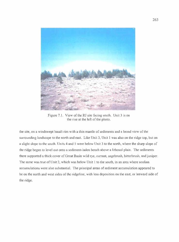
....
•
263
Figure 7.1. View of the RJ site facing south. Unit 3 is onthe rise at the left of the photo.
the site, on a windswept basalt rim with a thin mantle of sediments and a broad view of the
surrounding landscape to the north and east. Like Unit 3, Unit 1 was also on the ridge top, but on
a slight slope to the south. Units 4 and 5 were below Unit 3 to the north, where the sharp slope of
the ridge began to level out onto a sediment-laden bench above a lithosol plain. The sediments
there supported a thick cover of Great Basin wild rye, currant, sagebrush, bitterbrush, and juniper.
The same was true of Unit 2, which was below Unit 1 to the south, in an area where aeolian
accumulations were also substantial. The principal areas of sediment accumulation appeared to
be on the north and west sides of the ridgeline, with less deposition on the east, or leeward side of
the ridge.
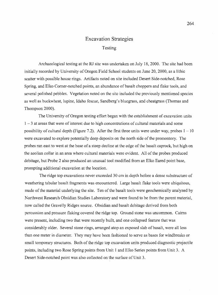
b
264
Excavation Strategies
Testing
Archaeological testing at the RJ site was undertaken on July 18, 2000. The site had been
initially recorded by University of Oregon Field School students on June 20, 2000, as a lithic
scatter with possible house rings. Artifacts noted on site included Desert Side-notched, Rose
Spring, and Elko Comer-notched points, an abundance of basalt choppers and flake tools, and
several polished pebbles. Vegetation noted on the site included the previously mentioned species
as well as buckwheat, lupine, Idaho fescue, Sandberg's bluegrass, and cheatgrass (Thomas and
Thompson 2000).
The University of Oregon testing effort began with the establishment of excavation units
1 - 3 at areas that were of interest due to high concentrations of cultural materials and some
possibility of cultural depth (Figure 7.2). After the first three units were under way, probes 1 - 10
were excavated to explore potentially deep deposits on the north side of the promontory. The
probes ran east to west at the base of a steep decline at the edge of the basalt caprock, but high on
the aeolian collar in an area where cultural materials were evident. All of the probes produced
debitage, but Probe 2 also produced an unusual tool modified from an Elko Eared point base,
prompting additional excavation at the location.
The ridge top excavations never exceeded 30 cm in depth before a dense substructure of
weathering tabular basalt fragments was encountered. Large basalt flake tools were ubiquitous,
made of the material underlying the site. Ten of the basalt tools were geochemically analyzed by
Northwest Research Obsidian Studies Laboratory and were found to be from the parent material,
now called the Gravelly Ridges source. Obsidian and basalt debitage derived from both
percussion and pressure flaking covered the ridge top. Ground stone was uncommon. Cairns
were present, including two that were recently built, and one collapsed feature that was
considerably older. Several stone rings, arranged atop an exposed slab ofbasalt, were all less
than one meter in diameter. They may have been fashioned to serve as bases for windbreaks or
small temporary structures. Both of the ridge top excavation units produced diagnostic projectile
points, including two Rose Spring points from Unit 1 and Elko Series points from Unit 3. A
Desert Side-notched point was also collected on the surface ofUnit 3.
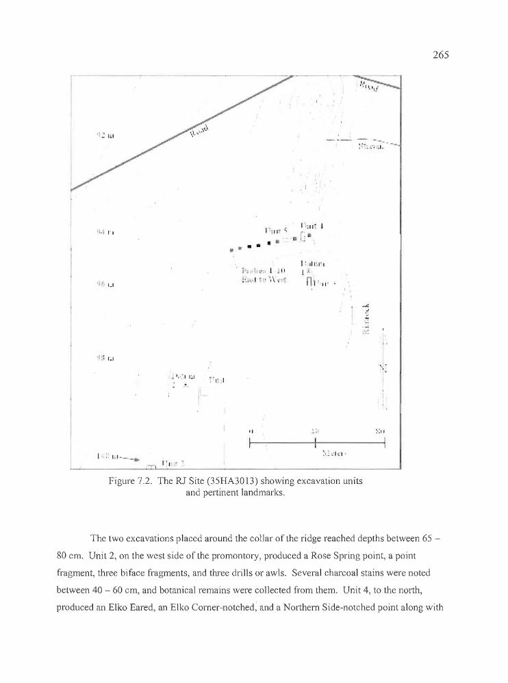
265
.-,' .. '; .1-
IL 1'1
I" 1,1
~ ";"::' 1:';1
.-t.
I • ~~ I~I .._-..
- 1'1'"
:'!' I
1" II; •
• •... ..~ i .... I t::. J II
:':;\.., ~.'" \ ~~
'I
I·
I: ,11:,1'1
l
nl' II-
I'
'00.:'
,I
:';11
•
Figure 7,2. The RJ Site (35HA30 13) showing excavation unitsand pertinent landmarks.
The two excavations placed around the collar of the ridge reached depths between 65
80 em. Unit 2, on the west side of the promontory, produced a Rose Spring point, a point
fragment, three biface fragments, and three drills or awls. Several charcoal stains were noted
between 40 - 60 em, and botanical remains were collected from them. Unit 4, to the north,
produced an Elko Eared, an Elko Corner-notched, and a Northern Side-notched point along with
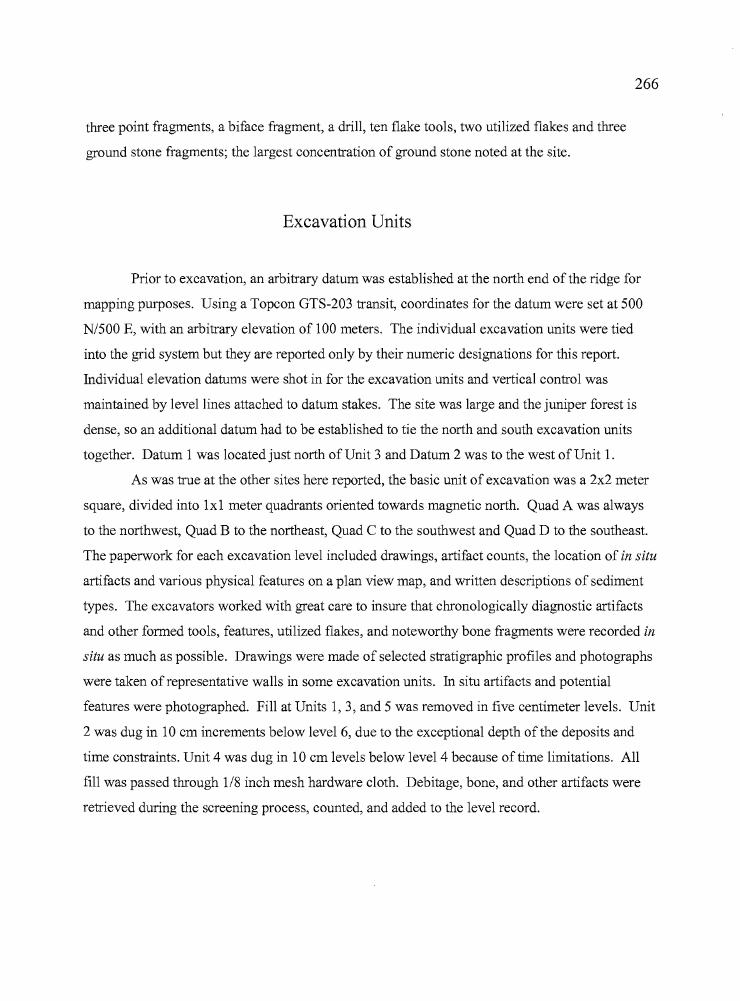
e
266
three point fragments, a biface fragment, a drill, ten flake tools, two utilized flakes and three
ground stone fragments; the largest concentration of ground stone noted at the site.
Excavation Units
Prior to excavation, an arbitrary datum was established at the north end of the ridge for
mapping purposes. Using a Topcon GTS-203 transit, coordinates for the datum were set at 500
N/500 E, with an arbitrary elevation of 100 meters. The individual excavation units were tied
into the grid system but they are reported only by their numeric designations for this report.
Individual elevation datums were shot in for the excavation units and vertical control was
maintained by level lines attached to datum stakes. The site was large and the juniper forest is
dense, so an additional datum had to be established to tie the north and south excavation units
together. Datum 1 was located just north of Unit 3 and Datum 2 was to the west of Unit 1.
As was true at the other sites here reported, the basic unit of excavation was a 2x2 meter
square, divided into 1x1 meter quadrants oriented towards magnetic north. Quad A was always
to the northwest, Quad B to the northeast, Quad C to the southwest and Quad D to the southeast.
The paperwork for each excavation level included drawings, artifact counts, the location of in situ
artifacts and various physical features on a plan view map, and written descriptions of sediment
types. The excavators worked with great care to insure that chronologically diagnostic artifacts
and other formed tools, features, utilized flakes, and noteworthy bone fragments were recorded in
situ as much as possible. Drawings were made of selected stratigraphic profiles and photographs
were taken of representative walls in some excavation units. In situ artifacts and potential
features were photographed. Fill at Units 1,3, and 5 was removed in five centimeter levels. Unit
2 was dug in 10 em increments below level 6, due to the exceptional depth ofthe deposits and
time constraints. Unit 4 was dug in 10 em levels below level 4 because of time limitations. All
fill was passed through 1/8 inch mesh hardware cloth. Debitage, bone, and other artifacts were
retrieved during the screening process, counted, and added to the level record.
267
Analytic Components
Unit 2 produced two radiocarbon dates that were 580 years apart (Table 7.1). One date of
1000±40 BP was assayed on a charcoal fragment recovered in Level 4 and a second date of
1590±BP was collected on a charcoal fragment from Level 7. The artifact counts from Unit 2
indicate a single peak, reached in Level 3 (Note in Table 7.2 below that levels 7 and 8 were 10 cm
thick, while the previous levels were five cm thick). The discrepancy does not seem to cause any
interpretive problem, however. Two Rose Spring points were collected from levels 1 and 3 and
were temporally consistent with both of the Unit 2 radiocarbon dates.
Unit 4 also has a single peak in cultural materials, which occurred in Leve14 (again, 10
cm levels were dug thereafter) and a single radiocarbon date of 2920±40 BP came from Level 4.
Two Elko Series points and one Northern Side-notched point were recovered from the unit. One
of the Elko points and the Northern Side-notched point was found in the radiocarbon dated level.
The Elko points would be expected with a ca. 3,000 year date, but the Northern Side-notched
point is commonly associated with dates between 4,000 -7,000 years in age. The radiocarbon
date from Unit 4 is the oldest date for any ofthe seven sites reported in this study.
No samples were submitted from the ridge top units for radiocarbon dating. Units 1 and
3 were situated in an erosional environment and the thin sediments covering the bedrock may
have blown away repeatedly over time, to be replaced with more recent deposits.
Because discrete concentrations of cultural material were not apparent, the RJ site though
extensive, was not subdivided into distinct loci in the same way as other sites reported in this
study.
Table 7.1. Radiocarbon dates from the RJ site.
Sample no.
3013-2-A-4-23013-2-A-7-33013-4-D-5-9
Beta ID
Beta 155981Beta 146123Beta 155982
Provenience
Unit 2, L4Unit 2, L 7Unit 4, L 5
Radiocarbon age
1000±40 BP1590±40 BP2920±40 BP
Cal. atintercept
930 BP1510 BP3060 BP
Method
AMSAMSAMS
268
The Excavations
Unit 1
I ..·,I
I
1... :1) ,:
, \)I~ ,,_. 1~:I··"i11 i'" .• ':.C'
:d,· .. - ,.~..'.: :1- h
I ~
".kl.:.
Unit I (Figure 7.3) was
located on the ridge top in the area
where the initial recording of the site
occurred on June 20. The unit was a
2x2 meter square situated on a lithosol
surface underlain by basalt bedrock.
It was anticipated that the excavation
would be surficial, not exceeding IS
to 20 cm, but the presence of biface
fragments, basalt flake tools, cores,
and highly polished pebbles believed
to be manuports made the location
worthy of investigation. Excavations
were carried out by two of the field
school students with volunteers
providing screening support, and the
final depth reached almost 25 cm.
Broad expanses of bedrock were
Figure 7.3. Unit I, indicating the locations of in situartifacts
exposed in the west half of the unit after 10 cm of excavation, but a number of tools and a
surprising amount of lithic debitage (4357 pieces) was recovered from the fill surrounding the
bedrock and from within its crevices. The tools included five projectile point tips and one
midsection, three utilized flakes, three biface fragments, two cores, two basalt cobble tools and
one awl fragment (Table 7.2). Two Rose Springs points were recovered, one from the debitage in
Quad A, Levell, and one from Level 2 of Quad D. Red ochre was found in Level 4 of Quad B.
A basalt cobble tool was recovered from a crevice between two bedrock slabs in Level 3 and
appeared to have been intentionally stored there for later use.
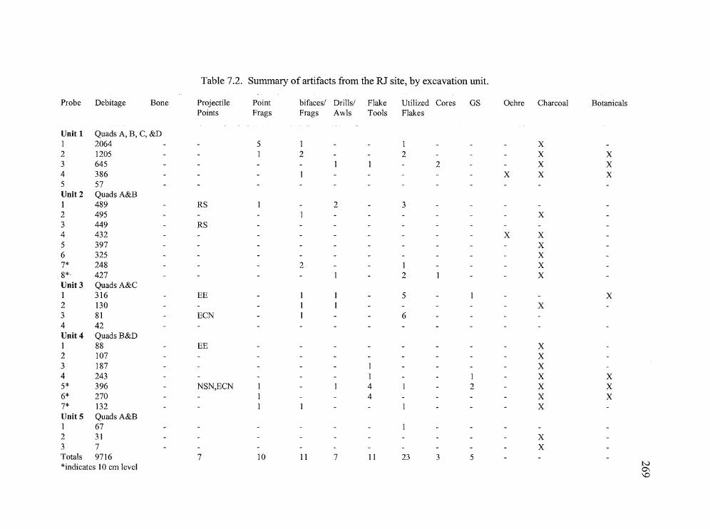
Table 7.2. Summary of artifacts from the RJ site, by excavation unit.
Probe Debitage Bone Projectile Point bifaces/ Drills/ Flake Utilized Cores GS Ochre Charcoal BotanicalsPoints Frags Frags Awls Tools Flakes
Unit 1 Quads A, B, C, &DI 2064 5 I I X2 1205 I 2 2 X X3 645 1 1 2 X X4 386 1 X X X5 57Unit 2 Quads A&B1 489 RS 1 2 32 495 I X3 449 RS4 432 X X5 397 X6 325 - - X7* 248 2 1 X8*' 427 1 2 I XUnit 3 QuadsA&C1 316 EE 1 1 - 5 I X2 130 1 1 X3 81 ECN 1 64 42Unit 4 Quads B&D1 88 EE X2 107 X3 187 1 X4 243 1 1 X X5* 396 NSN,ECN 1 1 4 1 2 X X6* 270 I 4 X X7* 132 1 1 1 XUnit 5 QuadsA&B1 672 31 X3 7 - XTotals 9716 7 10 11 7 11 23 3 5*indicates 10 cm level tv
0\\0
-.,
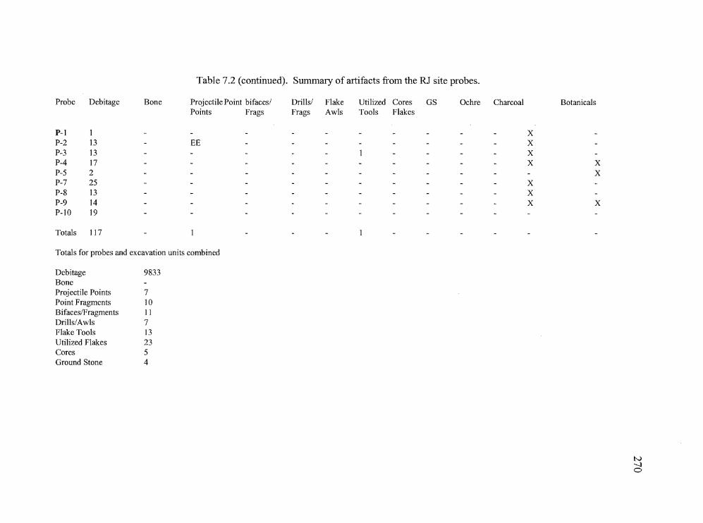
Table 7.2 (continued). Summary of artifacts from the RJ site probes.
1
Probe Debitage Bone
P-I IP-2 13P-3 13P-4 17P-5 2P-7 25P-8 13P-9 14P-IO 19
Totals 117
Projectile Point bifaces/Points Frags
EE
Drills/Frags
FlakeAwls
Utilized Cores GSTools Flakes
Ochre Charcoal
xXXX
XXX
Botanicals
XX
X
Totals for probes and excavation units combined
Debitage 9833BoneProjectile Points 7Point Fragments 10Bifaces/Fragments IIDrills/Awls 7Flake Tools 13Utilized Flakes 23Cores 5Ground Stone 4
tv--Jo

271
Unit 2
Unit 2 was located approximately 50 meters southwest of Unit 1, below the ridgetop in a
sheltered area where fill was believed to have reached a considerable depth due to airborne
sediments accumulating against the basalt promontory (Figure 7.4). An obsidian awl was noted
on the surface and the detritus on a nearby anthill included a number of tiny obsidian pressure
flakes. Excavation of the 1x2 unit was initiated by two volunteers and brought to completion by
three students. Because of time constraints, the last two levels were dug in 10 cm increments
while levels one through six were dug in five cm increments. Artifacts included three biface
fragments, one core, six utilized flakes, three awl fragments, and one point fragment. Two Rose
Spring points were collected, one in Level 1 of Quad A and one in Level 3 of Quad B. Ochre was
collected in Level 4 of Quad A. A total of 3262 pieces of debitage was taken from the two
quadrants. The fill was primarily a sandy silt with tabular basalt slabs appearing around 20 cm
and increasing with depth. Three concentrations of charcoal appeared in levels 5 through 8, the
first along the southwest edge of Quad A (Level 5) in a concentration of naturally occurring
basalt slabs at 24 cm, the second in the northeast corner of Quad B at approximately 30 cm, and
the third in the northwest corner of Quad A (Level 8) at a depth of 50 cm. Debitage was collected
in consistent quantities throughout the deposits, but tools were recovered in levels 1 through 3 of
, .• 1 '•
•.. .1
!
: •• ; I. , .~ ; IIII ) I.
I ,.~.:.:
t. .. ': ::J :,1:1111
•
~'. I \:1 ': J
Figure 7.4. Plan view of Unit 2, indicating locations of artifacts,samples, and charcoal staining.
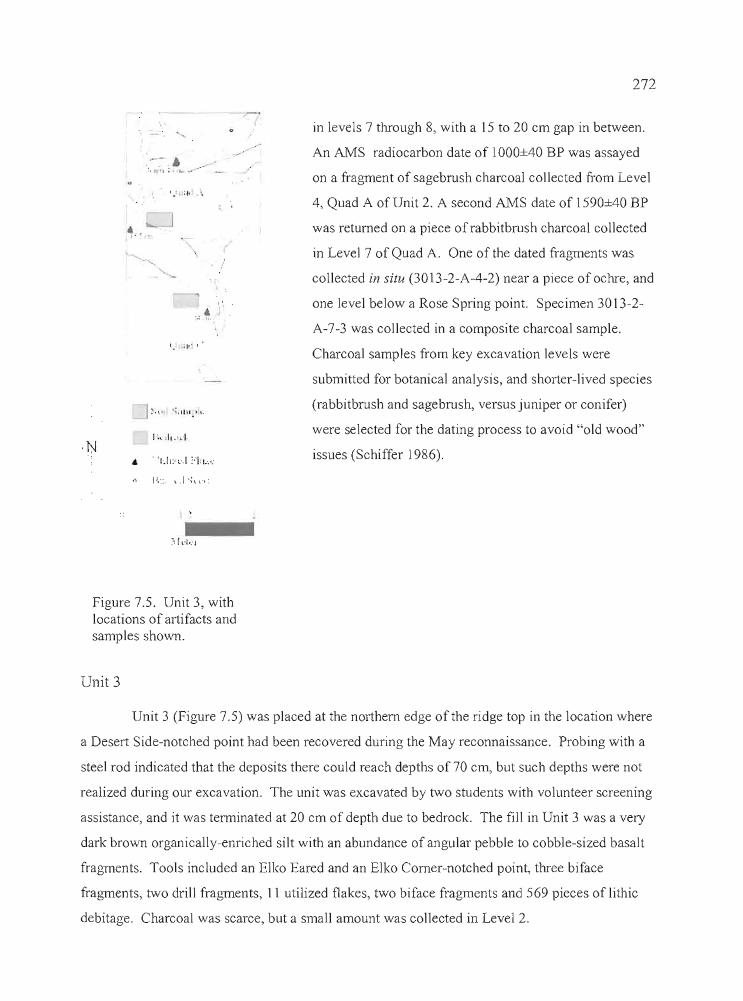
,~
-"":':;h.1 I .
,;/....
•).,
--...- .....
"."",: 1"
I, "J ;. '. I, ),1111. I ~.
272
in levels 7 through 8, with a 15 to 20 cm gap in between.
An AMS radiocarbon date of 1000±40 BP was assayed
on a fragment of sagebrush charcoal collected from Level
4, Quad A of Unit 2. A second AMS date of 1590±40 BP
was returned on a piece ofrabbitbrush charcoal collected
in Level 7 of Quad A. One of the dated fragments was
collected in situ (30 13-2-A-4-2) near a piece of ochre, and
one level below a Rose Spring point. Specimen 3013-2
A-7-3 was collected in a composite charcoal sample.
Charcoal samples from key excavation levels were
submitted for botanical analysis, and shorter-lived species
(rabbitbrush and sagebrush, versus juniper or conifer)
were selected for the dating process to avoid "old wood"
issues (Schiffer 1986).
tr
Figure 7.5. Unit 3, withlocations of artifacts andsamples shown,
Unit 3
Unit 3 (Figure 7.5) was placed at the northern edge of the ridge top in the location where
a Desert Side-notched point had been recovered during the May reconnaissance. Probing with a
steel rod indicated that the deposits there could reach depths of 70 cm, but such depths were not
realized during our excavation. The unit was excavated by two students with volunteer screening
assistance, and it was terminated at 20 cm of depth due to bedrock. The fill in Unit 3 was a very
dark brown organically-enriched silt with an abundance of angular pebble to cobble-sized basalt
fragments. Tools included an Elko Eared and an Elko Corner-notched point, three biface
fragments, two drill fragments, 11 utilized flakes, two biface fragments and 569 pieces of lithic
debitage. Charcoal was scarce, but a small amount was collected in Level 2.
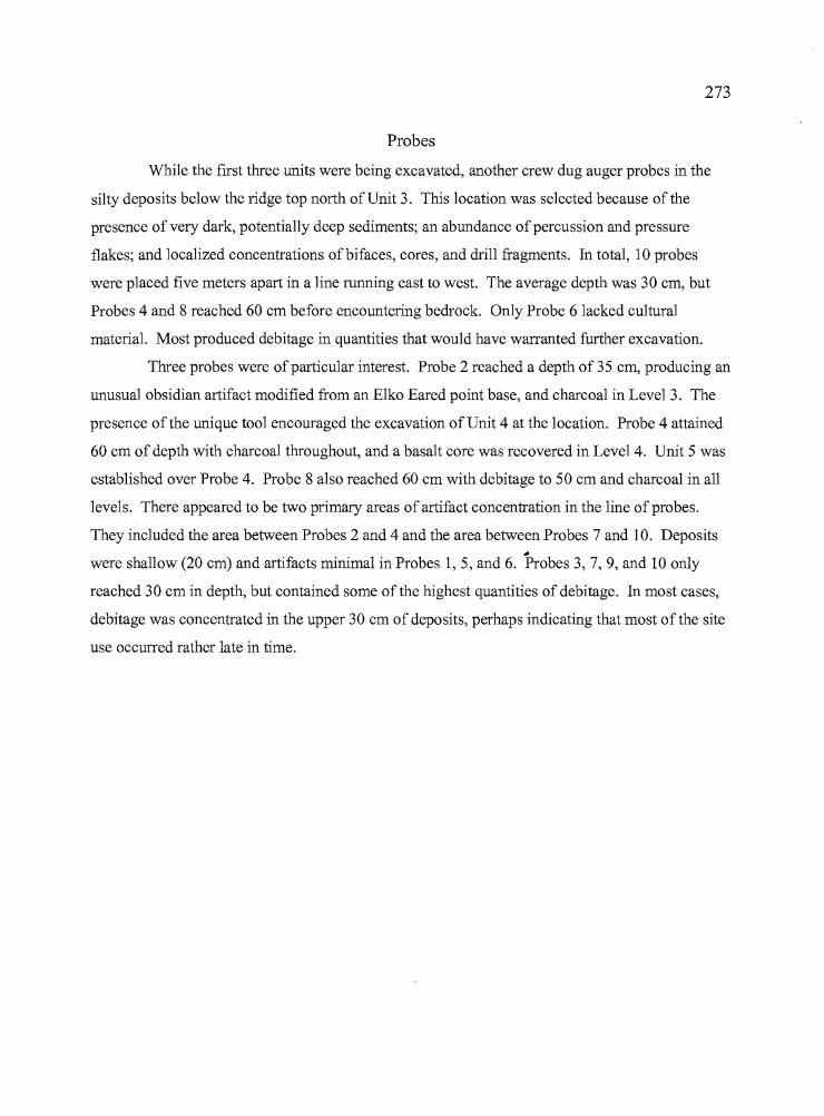
---rAr----
273
Probes
While the first three units were being excavated, another crew dug auger probes in the
silty deposits below the ridge top north of Unit 3. This location was selected because of the
presence of very dark, potentially deep sediments; an abundance ofpercussion and pressure
flakes; and localized concentrations ofbifaces, cores, and drill fragments. In total, 10 probes
were placed five meters apart in a line running east to west. The average depth was 30 cm, but
Probes 4 and 8 reached 60 cm before encountering bedrock. Only Probe 6 lacked cultural
material. Most produced debitage in quantities that would have warranted further excavation.
Three probes were ofparticular interest. Probe 2 reached a depth of 35 cm, producing an
unusual obsidian artifact modified from an E1ko Eared point base, and charcoal in Leve13. The
presence ofthe unique tool encouraged the excavation of Unit 4 at the location. Probe 4 attained
60 cm of depth with charcoal throughout, and a basalt core was recovered in Level 4. Unit 5 was
established over Probe 4. Probe 8 also reached 60 cm with debitage to 50 cm and charcoal in all
levels. There appeared to be two primary areas of artifact concentration in the line of probes.
They included the area between Probes 2 and 4 and the area between Probes 7 and 10. Deposits#
were shallow (20 cm) and artifacts minimal in Probes 1, 5, and 6. Probes 3, 7, 9, and 10 only
reached 30 cm in depth, but contained some of the highest quantities of debitage. In most cases,
debitage was concentrated in the upper 30 cm of deposits, perhaps indicating that most of the site
use occurred rather late in time.
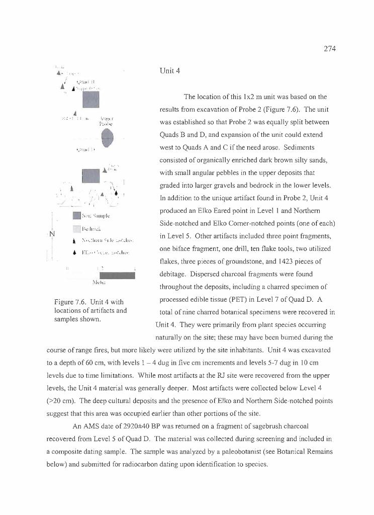
274
.... Unit 4·
The location of this Ix2 m unit was based on the
results from excavation of Probe 2 (Figure 7.6). The unit
was established so that Probe 2 was equally split between
Quads Band D, and expansion of the unit could extend
west to Quads A and C if the need arose. Sediments
consisted of organically enriched dark brown silty sands,
with small angular pebbles in the upper deposits that
graded into larger gravels and bedrock in the lower levels.
In addition to the unique artifact found in Probe 2, Unit 4
produced an Elko Eared point in Level I and Northern
Side-notched and Elko Corner-notched points (one of each)
in Level 5. Other artifacts included three point fragments,
one biface fragment, one drill, ten flake tools, two utilized
flakes, three pieces of groundstone, and 1423 pieces of
debitage. Dispersed charcoal fragments were found
throughout the deposits, including a charred specimen of
processed edible tissue (PET) in Level 7 of Quad D. A
total of nine charred botanical specimens were recovered in
4:""
"''''''.''1'
'.,
!\ .• •) ",
, I
1;,_,.1,,,.· ..
I... : ';1' I
i, I
Figure 7.6. Unit 4 withlocations of artifacts andsamples shown.
N
Unit 4. They were primarily from plant species occurring
naturally on the site; these may have been burned during the
course of range fires, but more likely were utilized by the site inhabitants. Unit 4 was excavated
to a depth of 60 em, with levels 1 - 4 dug in five em increments and levels 5-7 dug in 10 em
levels due to time limitations. While most artifacts at the RJ site were recovered from the upper
levels, the Unit 4 material was generally deeper. Most artifacts were collected below Level 4
(>20 em). The deep cultural deposits and the presence ofE1ko and Northern Side-notched points
suggest that this area was occupied earlier than other portions of the si teo
An AMS date of 2920±40 BP was returned on a fragment of sagebrush charcoal
recovered from Level 5 of Quad D. The material was collected during screening and included in
a composite dating sample. The sample was analyzed by a paleobotanist (see Botanical Remains
below) and submitted for radiocarbon dating upon identification to species.
275
Unit 5
This 1x2 m unit was established to investigate the high quantities of debitage and
charcoal noted in Probe 4. The unit was placed directly over the probe location and the auger
hole was in the northern half of Quad A. Excavation of the unit was carried out by three
volunteers. Three 5 cm levels were dug, resulting in the recovery of one utilized flake and 105
pieces of debitage. The unit was initiated late in the project and could not be completed because
of time constraints.
Artifact Assemblage
Chipped Stone Tools
Projectile Points and Hafted Tools
A total of 20 projectile points or tools made from projectile points was recovered at the
RJ site, sixteen of which are temporally diagnostic (Table 7.3, Figure 7.7). Two hafted tools of
other kinds are also described in this section. The majority of points are of obsidian (n=18 or
82%) and two each are made ofbasalt and CCS. The projectile points have been classified
according to the system established by Heizer and Hester (1978) for the Great Basin at large, as
modified by Thomas (1981) for the Monitor Valley in central Nevada. The points include one
Cottonwood Triangular (6%), two Desert Side-notched (12%), five Rose Spring (29%), two Elko
Eared (12%), four Elko Comer-notched (23%), one Northern Side-notched (6%), one Humboldt
(6%), and one Malheur Stemmed (Oetting 1990). Several fragmented point bases are not
typologically classifiable. They include a large obsidian dart point that appears to be side
notched (3013-ISO-3), an eared base (3013-4-D-1-1) that has been modified through retouching
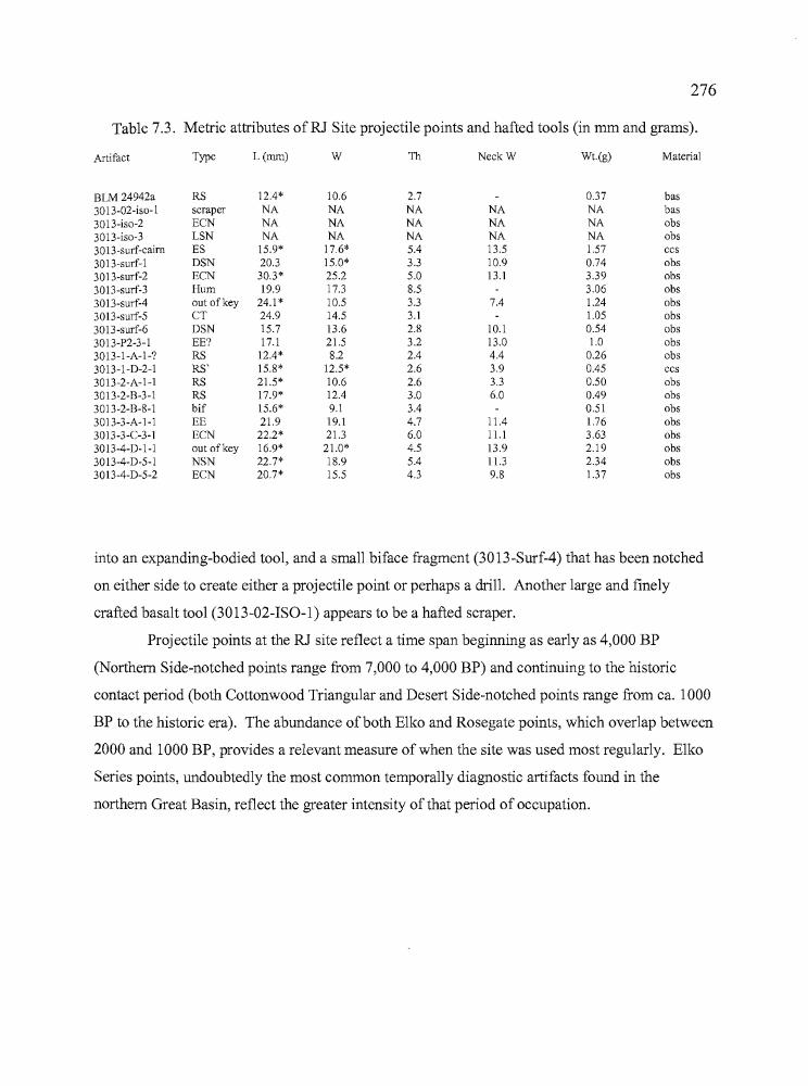
t
276
Table 7.3. Metric attributes ofRJ Site projectile points and hafted tools (in mm and grams).
Artifact Type L(mm) W Th NeckW Wt.(g) Material
BLM 24942a RS 12.4* 10.6 2.7 0.37 bas3013-02-iso-1 scraper NA NA NA NA NA bas3013-iso-2 ECN NA NA NA NA NA obs3013-iso-3 LSN NA NA NA NA NA obs3013-surf-cairn ES 15.9* 17.6* 5.4 13.5 1.57 ccs3013-surf-1 DSN 20.3 15.0* 3.3 10.9 0.74 obs3013-surf-2 ECN 30.3* 25.2 5.0 13.1 3.39 obs3013-surf-3 Hum 19.9 17.3 8.5 3.06 obs3013-surf-4 out of key 24.1* 10.5 3.3 7.4 1.24 obs3013-surf-5 CT 24.9 14.5 3.1 1.05 obs3013-surf-6 DSN 15.7 13.6 2.8 10.1 0.54 obs3013-P2-3-1 EE? 17.1 21.5 3.2 13.0 1.0 obs30l3-1-A-1-? RS 12.4* 8.2 2.4 4.4 0.26 obs3013-1-D-2-1 RS' 15.8* 12.5* 2.6 3.9 0.45 ccs3013-2-A-1-1 RS 21.5* 10.6 2.6 3.3 0.50 obs3013-2-B-3-l RS 17.9* 12.4 3.0 6.0 0.49 obs3013-2-B-8-1 bif 15.6* 9.1 3.4 0.51 obs3013-3-A-l-l EE 21.9 19.1 4.7 11.4 1.76 obs3013-3-C-3-1 ECN 22.2* 21.3 6.0 ILl 3.63 obs3013-4-D-l-1 out of key 16.9* 21.0* 4.5 13.9 2.19 obs3013-4-D-5-1 NSN 22.7* 18.9 5.4 11.3 2.34 obs30l3-4-D-5-2 ECN 20.7* 15.5 4.3 9.8 1.37 obs
into an expanding-bodied tool, and a small biface fragment (30 13-Surf-4) that has been notched
on either side to create either a projectile point or perhaps a drill. Another large and finely
crafted basalt tool (3013-02-1SO-1) appears to be a hafted scraper.
Projectile points at the RJ site reflect a time span beginning as early as 4,000 BP
(Northern Side-notched points range from 7,000 to 4,000 BP) and continuing to the historic
contact period (both Cottonwood Triangular and Desert Side-notched points range from ca. 1000
BP to the historic era). The abundance ofboth E1ko and Rosegate points, which overlap between
2000 and 1000 BP, provides a relevant measure of when the site was used most regularly. Elko
Series points, undoubtedly the most common temporally diagnostic artifacts found in the
northern Great Basin, reflect the greater intensity of that period of occupation.
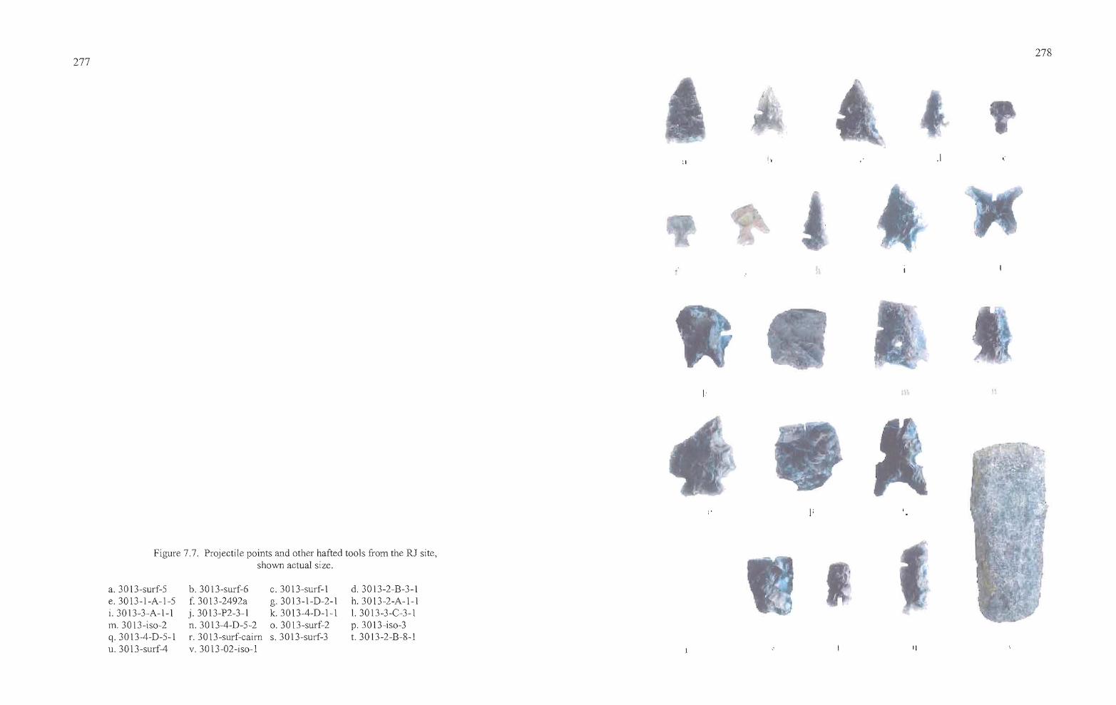
•
277 278
:1 .1
d. 3013-2-B-3-1h.3013-2-A-l-l1. 3013-3-C-3-1p.3013-iso-3t. 3013-2-B-8-1
c. 30 13-surf-lg.3013-1-D-2-1k.3013-4-D-l-lo. 3013-surf-2s.3013-surf-3
b. 3013-surf-6f. 3013-2492aj. 3013-P2-3-1n.3013-4-D-5-2r. 30 13-surf-cairnv.3013-02-iso-l
a. 3013-surf-5e.3013-1-A-1-5i. 3013-3-A-l-lm.3013-iso-2q. 3013-4-D-5-1u. 30 13-surf-4
Figure 7.7. Projectile points and other hafted tools from the RJ site,shown actual size.
II
279
Desert Series Points. The Desert series includes both Cottonwood Triangular and Desert Side
notched varieties. Both are small points formed on a triangular blank, and both date between 750
BP and the historic contact period. All three of the Desert series points were surface finds.
Cottonwood Triangular points (Lanning 1963:252-253) are 1.5 grams in weight or less,
less than 30 cm in length, and less than 4.0 mm thick (Thomas 1981:16). Cottonwood points can
also include leaf shaped (Lanning 1963:252-253) and bipointed variations (Heizer and Clewlow
1968), neither of which were present at the RJ site. One triangular specimen (3013-surf-5) was
collected from the surface at the RJ site.
Desert Side-notched points were described by Lanning (1963:253) as small triangular
points with notches high on the sides, and Thomas (1981: 18) indicates that the weight should be
less than or equal to 1.5 grams with a basal width/maximum width exceeding 0.90. Two Desert
Side-notched points were collected at the RJ site (30 13-surf 1 and 30 13-surf-6). The latter was
basally notched in the Sierra variant (Baumhoff and Byrne 1959), and made of obsidian that
originated from the Venator source. It had a hydration band of 1.3 microns. Artifact 3013-surf-1
originated from the Bums obsidian source and had a hydration band of 1.4 microns.
Rose Spring, Eastgate, and "Rosegate" Points. Five points identifiable to the Rosegate series
were collected from the RJ site; two from Unit 1, two from Unit 2, and one from the surface.
Rosegate is a derivative term incorporating points previously identified as Rose Spring (Lanning
1963) and Eastgate (Heizer and Baumhoff 1961). Thomas (1981: 19) lumped the Rose Spring
(Lanning 1963) and Eastgate (Heizer and Baumhoff 1961) point types together under one
classification, but the two types are clearly dissimilar in both form and distribution, and in this
report, Rose Spring and Eastgate are analyzed separately. Rose Spring points are small comer
notched points that commonly have expanding stems, while Eastgate points are basally notched
on a triangular or slightly rounded preform, producing barbs or tangs that are even with the base.
According to Thomas (1981: 19) Rosegate points have a basal width of 10 mm or less, a proximal
shoulder angle between 90° and 130°, and a neck width less than or equal to [basal width plus 0.5
mm.] The redefinition is not particularly useful at the RJ site, since all but point 3013-1-D-2-l fit
comfortably into the original Rose Spring classification.
Specimen 3013-1-A-1-5 was recovered from debitage during mass analysis studies and
was not submitted for sourcing and hydration studies. This point is the most problematic of the
five designated as Rosegate due to the fact that it lacks an expanding stem, but also lacks the
--acftp_-._-~
280
stem "virtually round in cross section" that is expected of a plateau-style pin stem point (Dumond
and Minor 1983:170). The point seems to have been expediently manufactured and lacks the
careful crafting of some of the other points, thus the base may not have gotten the same attention
it would have in other circumstances. Specimen 3013-1-D-2-1 has an expanding stem and may
have been basally notched on a rounded flake. The point is manufactured from reddish CCS
which has been heat-treated, as is evident by the large "pot-lid" fracture in the body of the point
visible in Figure 7. Specimen 3013-2492a was surface-collected by BLM personnel.
Manufactured of basalt, the point fits well with the previous two by virtue of its elongated base.
Specimen 3013-2-A-1-1 is a Rosegate point lacking its base and barbs. Made of Round Top
Butte obsidian, from a source located southwest of Harney Valley, the point has a hydration rim
of 1.8 microns. Specimen 3013-2-B-3-1, with pronounced comer-notching and a broadly
expanding base in comparison to the others, is made of Whitewater Ridge obsidian. It has a
hydration reading of 1.3 microns.
Elko Series Points. Six Elko series points were collected from the RJ site, including one Elko
Eared, one variant tool on an Elko Eared base, two Elko Comer-notched points, and two
fragmented points that can only be attributed broadly to the Elko series. All Elko points should
have a basal width of 10 mm or more, and a proximal shoulder angle between 110° and 150°
(Thomas 1981:20-21). Two Elko points were surface collected, two were excavated from Unit 3,
and two were recovered in Unit 4.
Elko Eared points are large, comer-notched points with a deeply indented base that, in
conjunction with the comer-notching, forms "ears" for hafting purposes. The basal indentation
ratio should be less than or equal to 0.93 (Thomas 1981:21). Elko Comer-notched points are
included in the Elko Series and morphologically similar to Elko Eared points, but lack the deep
basal indentation that produces the eared appearance, with a basal indentation ratio exceeding
0.93 (Thomas 1981 :21). The widest portion of either point is just forward of the base. The two
types are coeval.
Two tools can be classified as Elko Eared points by the previously mentioned
characteristics, although one specimen, 3013-P2-3-1, was subsequently modified into a different
tool. While the base is that of an Elko Eared, the"proximal end ofthe point has been formed into
a concave scraper, presumably hafted in the manner of a projectile point. The artifact is
___Jrn _
281
manufactured from Wolf Creek obsidian and has a hydration thickness of 1.6 microns. It was
recovered from Probe 2 between 40 - 50 cm in depth, in association with small quantities of
debitage and charcoal. Radiocarbon dating of charcoal from the same level in Unit 4, excavated
as a result of the discovery in Probe 2, produced a date of 2920±40 BP. The date seems
inconsistent with the obsidian hydration band on the artifact, which would be better suited to a
post-2000 BP date of occupation, but is appropriate to the period of use for Elko series points.
Specimen 3013-3-A-l-l appears to have been resharpened from a broken point. It is made from
Gregory Creek obsidian and lacked a measurable hydration rind.
The four remaining Elko points display a considerable range in both size and form.
Specimen 3013-3-C-3-l is a midsection with evidence of the neck, notches, and barbs still
present. The point was identified during debitage analysis and was not submitted for obsidian
sourcing and analysis. It is appropriate to designate the point simply as Elko series because the
missing base allows no finer distinction. Specimen 3013-iso-2, also missing its base, has long
barbs, deeply inset comer notching, and a finely finished appearance. Originating from the Burns
obsidian source, the projectile point has a hydration rind of 4.4 microns. It, too, can only be
attributed to the Elko series.
Specimen 3013-surf-2 is a large Elko Comer-notched base missing its tip and barbs. The
point has a hydration thickness of 1.3 microns and the material originates at the nearby Tule
Springs source. Specimen 3013-4-D-5-2 is a comer-notched point which, based on the size of
the base relative to the body of the artifact, appears to have been resharpened at least once. The
point is also made ofTule Springs obsidian, with a hydration reading of2.8 microns.
Large Side-notched. Large side-notched projectile points have been identified by various
regional appellations or morphological attributes in the northern Great Basin and southern
Columbia Plateau. Specimen 3013-4-D-5-l, the side-notched point recovered from the RJ site,
fits well in the Northern Side-notched classification established by Heizer and Hester (1978) for
the Great Basin, having a straight to concave base and notches that are deep and perpendicular to
the long axis. Oetting (1994) places Northern Side-notched points between 7,000 to 4,000 years
in age in the northern Great Basin. The point, manufactured from obsidian, was recovered from
Level 5 of Unit 4, which produced a radiocarbon date of ca. 2920 BP (Table 1). The date is
about 1,000 years later than normally expected for Northern Side-notched points and it is
__srttn _
___cOz _
282
possible that the point was once lower in the deposits and has been displaced over time. It is
made of Tank creek obsidian and has a hydration rim of 3.5 microns.
A second artifact (3013-iso-3) appears to be a side-notched point based on the angle of
the notches, but the degree ofbreakage makes further assessment difficult. Thus, the midsection
is classified simply as a large side-notched point. It is manufactured from Big Stick obsidian and
it has a hydration reading of 1.7 microns, less than half that of the Northern Side-notched point
described above.
Humboldt Series. These points are described as "...unnotched, lanceolate, concave-base
projectile points of variable size...", by Thomas (1981:17). The single Humboldt Series point
fragment (3 013-surf-3) was a surface find. It has a weakly indented base and is broadly
lenticular in cross section. The point is made of Curtis Creek obsidian, with a hydration band
measuring 3.5 microns.
Unknown. Three point fragments, both ofwhich were collected from the surface of the RJ site,
defy classification into known typologies. Specimen 3013-4-D-1-l initially appears to be either
an Elko Eared or Humboldt base, but, the proximal portion of the tool expands into a bifacially
edged scraper. The basal element is straight-sided, unlike Elko Series points. The degree of
flare above the base is inconsistent with the remanufacture of a broken point into a new tool; the
maximum width of the body (and/or barbs) would have been well beyond the expected range for
all but the largest, nontypical projectiles. The artifact was probably manufactured to be used as a
hafted scraper, utilizing a fragment of a broken biface that was modified as a scraper with the
hafting element added at the same time. The artifact is made ofBig Stick obsidian and has a
hydration reading of 3.3 microns.
Specimen 3013-surf-4 is a long, thin biface fragment which may once have been part of
a projectile point or drill. The fragment has been expediently modified through strategic
retouching and notching to create a new hafting element. As a result, the artifact is
unclassifiable. Specimen 3013-surf-4 is made of Tule Springs obsidian and it has a hydration
thickness of 3.3 microns.
T
....-----
283
Specimen 3013-surf-caim is a white CCS base suggestive ofa Malheur Stemmed point.
Twenty-eight of these points were collected during the post-flood surveys of Malheur Lake and
were first described by Oetting (1990:139-144) as lanceolate points with distinctive expanding
stems. The length of the basal element is short in comparison with the blade and the stem
expands toward the base (Oetting 1990:140). Neck widths range between 7.9 and 19.3 mm.
Although some attributes of these points are suggestive of Great Basin Stemmed and other large
point types, Oetting (1990: 144) noted that most Malheur Stemmed points were found on sites
dominated by Rosegate points.
Like the Malheur Lake points described by Oetting, the point found at the RJ site has a
distinct expanding stem and shoulders. Unfortunately, the specimen is fragmentary and it is
troubling to assign the artifact to a type that is rare around Malheur Lake, let alone other parts of
Harney Valley, based on a fragment alone. Perhaps the base belongs to a large Elko series point,
or a Side Notched 4 in the Columbia Plateau typology described by Dumond and Minor
(1983:171).
Hafted Tools
Two additional artifacts (30 13-2-B-8-1 and 3013-02-iso-1) are the only other hafted
tools found at the RJ site (Table 7.3, Figure 7.7). They exhibit characteristics in their basal
morphology that indicate they were specialized tools. Specimen 3013-2-B-8-1 is a small square
bottomed base, broken approximately at midpoint, manufactured from Curtis Creek obsidian.
Edge preparation along the basal portion of the artifact is slightly inset in a manner that suggests
it was attached to a handle of some kind, probably bone or wood, possibly for use as a drill or
awl. The artifact had a hydration reading of 1.5 microns, placing it among the more recent
artifacts found at the site.
Specimen 3013-02-iso-1 is a large finely crafted basalt tool that is reminiscent of a wood
chisel in its width, length, and thinness. The distal end of the tool has a broad, thin edge well
suited for scraping or shaping wood, set off from the long, slightly tapered base by weak
shoulders. The base may have been wrapped with material to create a handle, or possibly hafted
into a socket ofbone or wood.
284
Shaped Bifaces
This account uses the multi-stage biface classification system employed by Jenkins and
Connolly (1990) at the Indian Grade Spring site. Stage 1-5 bifaces are discussed here (Table
7.4). Stage 5 bifaces are generally classified as projectile points, and all diagnostic point
fragments have been treated separately in a previous portion of the text. All of the RJ shaped
biface artifacts are fragmentary. They are considered in terms of a generalized leaf-shaped biface
morphology because many share similar characteristics. Tips are pointed and are thought to be
the distal end of the artifact. Bases usually have rounded or slightly convex squared ends and are
thought to be the proximal portion of the artifact. Midsections are frequently tapered to some
Table 7.4. Metric attributes ofRJ site bifaces and fragments, in mm and grams.
Artifact Type L W Th Wt Notes
30l3-ISO-1 St. 4 50.2 19.5 7.8 8.39 obs drill or awl base?, straightsided
30l3-1-A-l-1 St. 4/5 19.8 14.9 5.4 1.52 small obs rounded biface base30l3-1-B-1-1 St. 4/5 14.5 11.1 2.8 0.40 obs projectile point tip30l3-1-B-1-2 St. 5 9.3 6.5 2.3 0.13 obs projectile point barb30l3-1-C-1-1 St. 4 16.5 15.1 3.0 0.66 obs biface tip30l3-1-C-1-? St. 5 5.2 3.6 1.4 0.02 obs proj pt midsection, near tip30l3-1-D-1-1 St. 5 23.7 17.4 4.0 1.30 obs proj pt tip, modified for reuse
as pt30l3-1-D-2-3 St. 3 18.5 8.4 3.5 0.63 obs basal biface edge [rag3013-2-A-1-5 St. 5 7.2 7.0 1.5 0.08 ccs proj pt tang3013-2-A-2-1 St. 5 26.0 17.5 4.3 2.13 obs proj pt midsection, near tip3013-2-A-6 St. 5 5.1 4.3 1.8 0.03 obs proj pt midsection, near tip3013-2-A-7-1 St. 2 21.6 30.4 7.6 5.02 obs pointed base3013-2-B-4-? St. 5 4.4 2.9 0.6 0.06 obs RG pt barb3013-2-B-4-? St. 5 7.3 6.5 1.8 0.03 obs proj pt edge frag3013-2-B-7-1 St. 3 15.0 29.2 7.4 3.40 ccs biface midsection3013-2-B-8-13013-3-A-1-2 St. 3 16.6 29.9 8.2 5.98 bas biface midsection3013-3-C-2-2 St. 3 15.7 16.5 5.4 2.11 obs biface edge fragment30l3-3-C-3-1 St. 5 7.3 9.5 2.1 0.13 obs biface edge fragment3013-4-B-5-23013-4-B-6-1 St. 5 12.0 6.3 2.1 0.18 midsection of tip of finely tapered
obs point3013-4-B-6-? St.4 16.5 17.5 5.8 1.26 brown ccs biface edge fragment30 13-4-B-7-1 St. 4 8.5 10.0 2.8 0.21 obs, possible proj pt tip3013-4-D-7-1 St. 4 22.8 12.1 5.6 0.95 obs biface edge fragment
~-.....----_.
....,
285
degree, but can be straight-sided. Certainly not all bifaces have rounded bases, pointed tips, and
show clear signs oftapering, but it seems most utilitarian for descriptive purposes to emphasize
the shape of a common artifact form when only fragments exist. The function ofthe bifaces can
only be implied, but they evidently served multiple purposes ranging from cutting implements to
cores for the manufacture of projectile points and other tools.
A total of22 biface fragments was recovered from the RJ site, all but one (3013-iso-1)
from the excavations. They include one Stage 2, four Stage 3, five Stage 4, two Stage 4/5, and
ten Stage 5 bifaces. All but four of the fragments are obsidian. One midsection is made ofbasalt
and three CCS artifacts include an edge fragment, a midsection, and a small projectile point tang.
The isolate is the base of a drill or awl.
Unit 1 produced one Stage 3 biface, one Stage 4, two Stage 4/5 (either well made
preforms or less refined projectile points), and three Stage 5 fragments. Unit 2 contained one
Stage 2, one Stage 3, and five Stage 5 bifaces. Unit 3 contained two Stage 3 and one Stage 5
artifact, and Unit 4 yielded three Stage 4 and one Stage 5 fragment.
In summary, the majority ofthe tool fragments were pieces of projectile points. They
included one edge fragment, three tangs or barbs, four midsections, and three tips for a total of
eleven specimens. Other bifaces included three bases, two midsections, one tip and five edge
fragments for a total of ten specimens.
Stage 1 bifaces. These bifaces have thick cross-sections and large, unpatterned flake
scars. They exhibit only the most rudimentary development, with rounded or thick lenticular
shapes and cross-sections. The flaking pattern reflects use of the hard hammer percussion
technique, and the edges of these tools can be very sinuous. None of the bifaces recovered from
the RJ excavations reflected Stage 1 reduction, though a number of basalt artifacts interpreted to
have been utilized for specific tasks (see core and flake tools below) were noted on site that may
fit this level of categorization.
Stage 2 bifaces. Bifacial thinning is continued on these artifacts through the removal of
contiguous hard hammer percussion flakes. The removal of the flakes results in the development
of an artifact, which, although still crudely shaped, has a more pronounced form than stage 1
artifacts. Stage 2 bifaces are considered to be quarry blanks. One artifact fits this classification.
Specimen 3013-2-A-7-1 is a fragment of a slightly pointed base, manufactured from obsidian.
286
Pointed bases lend the biface a lenticular shape similar to a willow leaf, though the base is more
broadly convex than the distal end, or point tip.
Stage 3 hifaces. These bifaces exhibit little to no evidence ofpressure flaking and have
the slightly sinuous edges characteristic of large percussion flake scars created by the initial
stages ofbifacial reduction. The entire artifact surface has been modified through the removal of
flakes which can reach the middle of the artifact. It is at this stage that major thinning of the
artifact occurs, often leading to breakage. A total of four biface fragments fit this classification,
two of which are obsidian, one is CCS, and one is basalt. Stage 3 artifacts often exhibit fine
pressure flaking along some edges, with varying degrees ofpercussion flaking along other edges
and across the body of the artifact, but this was not as obvious with the current specimens
because two were small edge fragments in which such characteristics were not readily apparent.
One Stage 3 biface was collected from Unit 1, one from Unit 2, and two from Unit 3.
Two specimens (3013-1-D-2-3 and 3013-3-C-2-2) are edge fragments manufactured of obsidian,
the former a basal fragment. Two fragments (3013-2-B-7-1 and 3013-3-A-1-2) are midsections,
the former made of CCS and the latter basalt.
Stage 4 hifaces. The continuation of percussion and pressure flaking techniques after
Stage 3 results in bifaces with a more "finished" appearance than Stage 3 tools. Pressure flakes
can reach the midline of the artifact or beyond, and frequently eliminate the large percussion
flake scars from earlier reduction. Edges are strengthened by the removal ofpressure flakes
which increase the edge angle. Five Stage 4 artifacts were collected from the RJ site, including
two obsidian tips (3013-1-C-1-1 and 3013-4-B-7-1), one obsidian edge fragment (3013-4-D-7-1)
and one CCS edge fragment (3013-4-B-6-?). An additional Stage 4 biface, made of obsidian, is
interpreted to be a drill or awl base. Specimen 3013-iso-? was surface collected. It has straight
sides with no discernable taper and a squared base.
____st"4tz _
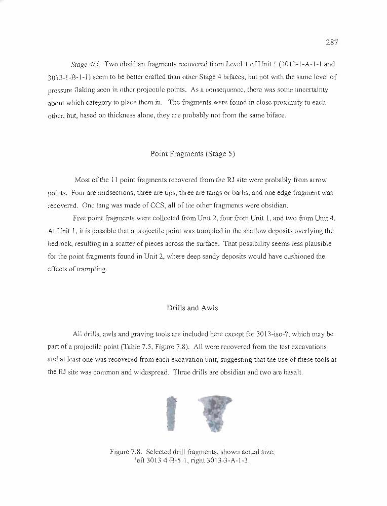
287
Stage 4/5. Two obsidian fragments recovered from Level I of Unit I (30 13-I-A-I-l and
30 13-I-B-l-l) seem to be better crafted than other Stage 4 bifaces, but not with the same level of
pressure flaking seen in other projectile points. As a consequence, there was some uncertainty
about which category to place them in. The fragments were found in close proximity to each
other, but, based on thickness alone, they are probably not from the same biface.
Point Fragments (Stage 5)
Most of the II point fragments recovered from the RJ site were probably from arrow
points. Four are midsections, three are tips, three are tangs or barbs, and one edge fragment was
recovered. One tang was made of CCS, all of the other fragments were obsidian.
Five point fragments were collected from Unit 2, four from Unit 1, and two from Unit 4.
At Unit 1, it is possible that a projectile point was trampled in the shallow deposits overlying the
bedrock, resulting in a scatter of pieces across the surface. That possibility seems less plausible
for the point fragments found in Unit 2, where deep sandy deposits would have cushioned the
effects of trampling.
Drills and Awls
All drills, awls and graving tools are included here except for 30 13-iso-?, which may be
pmt of a projectile point (Table 7.5, Figure 7.8). All were recovered from the test excavations
and at least one was recovered from each excavation unit, suggesting that the use of these tools at
the RJ site was common and widespread. Three drills are obsidian and two are basalt.
Figure 7.8. Selected drill fragments, shown actual size;left 30 13-4-B-5-1, right 30 13-3-A-1-3.
---'*'------
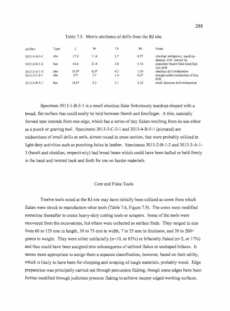
--.
___sr+z _
288
Table 7.5. Metric attributes of drills from the RJ site.
Artifact Type L W 111 Wt Notes
3013-1-B-3-1 obs 17.9 11.6 3.7 0.57 obsidian awl/graver, teardrop-shaped, with curved tip
3013-2-B-I-2 bas 44.6 21.8 3.8 4.16 expedient basalt flake modifiedinto drill
3013-3-A-I-3 obs 19.5* 8.0* 4.3 1.09 obsidian drill midsection3013-3-C-2-1 obs 9.5 3.7 1.4 0.07 straight-sided midsection of tiny
drill3013-4-B-5-1 bas 18.6* 5.3 3.1 0.32 small diameter drill midsection
Specimen 3013-1-B-3-1 is a small obsidian flake fortuitously teardrop-shaped with a
broad, flat surface that could easily be held between thumb and forefinger. A thin, naturally
formed spur extends from one edge, which has a series of tiny flakes resulting from its use either
as a punch or graving tool. Specimens 3013-3-C-2-1 and 3013-4-B-5-1 (pictured) are
midsections of small drills or awls, almost round in cross section, that were probably utilized in
light-duty activities such as punching holes in leather. Specimens 3013-2-B-1-2 and 3013-3-A-1
3 (basalt and obsidian, respectively) had broad bases which could have been hafted or held firmly
in the hand and twisted back and forth for use on harder materials.
Core and Flake Tools
Twelve tools noted at the RJ site may have initially been utilized as cores from which
flakes were struck to manufacture other tools (Table 7.6, Figure 7.9). The cores were modified
sometime thereafter to create heavy-duty cutting tools or scrapers. Some of the tools were
recovered from the excavations, but others were collected as surface finds. They ranged in size
from 60 to 125 mm in length, 30 to 75 mm in width, 7 to 25 mm in thickness, and 20 to 200+
grams in weight. They were either unifacially (n=10, or 83%) or bifacially flaked (n=2, or 17%)
and thus could have been assigned into subcategories of utilized flakes or unshaped bifaces. It
seems more appropriate to assign them a separate classification, however, based on their utility,
which is likely to have been for chopping and scraping of tough materials, probably wood. Edge
preparation was principally carried out through percussion flaking, though some edges have been
further modified through judicious pressure flaking to achieve steeper edged working surfaces.
289
Table 7.6. RJ Site Basalt Core and Flake tools.
48.7 38.7 15.6 26.48
64.5 30.3 13.8 21.67
61.3 63.2 17.6 89.26
86.7 69.0 22.6 137.08
60.3 47.2 6.9 27.05
125.1 62.1 22.2 200+
87.3 72.2 12.4 90.67
71.7 29.3 9.8 23.0985.8 60.3 15.7 88.32
73.9 67.4 9.3 50.96
78.6 64.6 16.3 86.3
Artifact Type
3013-1-A-3-1 bas
3013-3-A-1-4 obs
3013-3-C-1-l bas
3013-3-C-3-2 bas
3013-4-8-5-5 bas
3013-4-D-5-3 bas
3013-surf-7 bas
3013-surf-8 bas
3013-surf-9 bas30l3-surf-10 bas
3013-surf-II bas
3013-surf-12 bas
L
71.6
W
66.6
Th
23.4
Wt
158.39
Notes
possible spent core, oval, with.flakes struck on two planes andheavy bifacial edge opposite athick cortex-covered basespent oval core with heavy edge onone end and spokeshave on oneside, unifacialtriangular fragment of a once largerflake tool, unifacial edge onlong sidespent oval core with steep-edgedscraper on one endspent rectangular core with heavyedge on three sides, fourth side hasthick cortex, used as handletriangular flake with steep-edgedscrapers on each face, bifacialheavy-bodied flake with cuttingedge on one long side, oppositeside is thick for handholdtriangular flake, longest sideunworked, unifacial edge on othertwo sideslenticular flake, bifacially worked,possibly spent core, with chisellike edge on one endovate flake tool with unifacial edgeon rounded end, thick baseoppositeovate flake tool with unifacial edgeon rounded end, thick baseopposite
Additional flaking has occurred from use, evident through the bifacial removal of many small
flakes and smoothing of the sharp edges of percussion flake scars along the working surfaces.
Based on the location of the RJ site and known activities that occurred in the site vicinity, the
core and flake tools may have been utilized in the manufacture of digging sticks from juniper or
mountain mahogany during forays to collect roots and tubers.
---...----
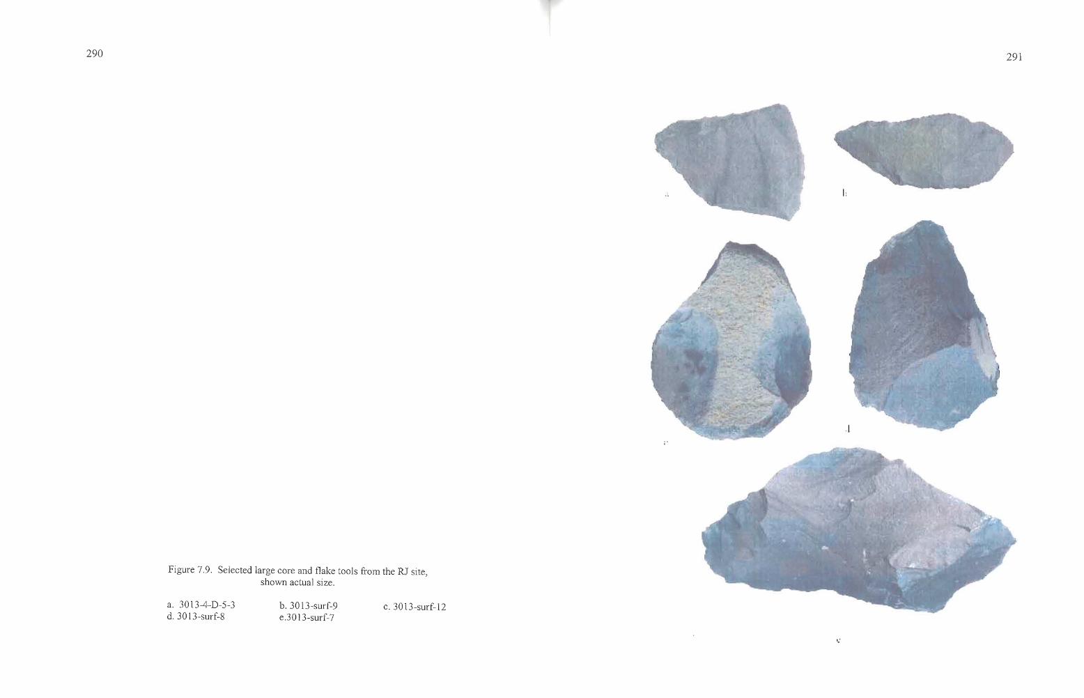
Figure 7.9. Selected large core and flake tools from the RJ site,shown actual size.
290
a. 3013-4-D-5-3d. 30 13-surf-8
b. 3013-surf-9e.30 13-surf-7
c. 3013-surf-12
-----'*'----
291
':
292
Six of the tools were collected from the excavations, including one in Unit 1, three in
Unit 3, and one in Unit 4. Six more were collected from the surface across the portion of the site
where excavations took place. Ten of the tools were submitted to Northwest Research Obsidian
Studies Laboratories for geochemical sourcing of the basalt ( 3013-1-A-3-1, 3013-3-C-3-2, 3013
4-B-5-5, 3013-4-D-5-3, 3013-surf-6, 7, 8, 9,11,12). All were found to originate from the same
(on site) source, named Gravelly Ridge for the feature on which the RJ site rests.
Edge Modified Flakes
A total of 17 flakes exhibited edge modification that was consistent with use for various
cutting and scraping tasks (Table 7.7). These artifacts include both expedient flake tools and a
single spoke shave. Flakes that have carefully prepared edges suited to a variety of cutting and
scraping tasks, such as end scrapers, were not present at RJ. Edge-modified flakes commonly
have unifacia1 chipping on one side of the artifact which is the result of unintentional
modification through use, with flakes being removed from the far side of the tool as it is held
perpendicular to the worked object and drawn towards the user (Kiigemagi 1988:3). ill two
cases, bifacia1 chipping is exhibited due to the use ofboth sides of the flake for such tasks. This
type of edge modification was found on the same edge in one case (3013-2-A-5-1) or at
numerous locations on the artifact (3013-1-A-l). Artifacts with prepared edges include scrapers
with at least one edge strengthened by steep pressure-flaking for long term use. Spoke shaves
generally have a narrow crescentic notch ideal for scraping curved or rounded surfaces.
Of the 17 artifacts (10 obsidian and seven basalt flakes) that are classified as edge
modified flakes, 14 are unifaces, two (3013-1-A-l-?, and 3013-2-A-5-1) are bifacially worked,
and one uniface was used as a spoke shave (3013-1-D-2-?). Five were collected in Unit 1, five in
Unit 2, three in Unit 3, and four in Unit 4. The artifacts are found in abundance across the site,
although they were not systematically surface collected in the same manner as other formed tools
and tool fragments. Care was taken to avoid confusion between utilized flakes and those which
had been trampled on the exposed basalt bedrock, or flakes with prepared edges resulting from
lithic reduction activities.
--_..._---
,.,..!
293
Table 7.7. Metric attributes ofRJ site utilized flakes.
Artifact Type L W Th Wt Notes
3013-l-A-l-? obs 31.6 23.4 5.7 3.21 triangular flake with curvedscraping edges on opposite longsides, bifacial
3013-l-A-2-l bas 54.3 25.8 7.9 8.04 long narrow flake w/unifacenear end of longest side, possiblecutting edge
3013-l-D-2-4 obs 34.5 19.0 6.4 6.02 uniface on longest side of threesided flake
3013-l-D-2-? bas 41.8 34.0 6.0 8.73 triangular flake with inset unifacialspokeshave
3013-l-D-3-l obs 22.6 18.6 2.6 1.03 unifacial with edges on threesides
3013-2-A-1-4 obs 20.4 15.3 4.5 1.17 triangular flake with unifacial edgeon longest side
3013-2-A-3-l bas 64.7 33.4 7.8 27.64 rectangular tabular flake withunifacial edge on long side and oneend
3013-2-A-5-l obs 40.3 32.6 12.4 11.51 triangular frag, with bifacial edgeon longest side, possible crudebiface as origin
3013-2-B-7-2 bas 27.5 15.4 4.3 1.87 unifacial on longest side3013-2-B-8-2 bas 53.9 35.9 15.2 31.82 two separate unifacial edges of
polygonal flake, for heavy work3013-3-A-1-5 obs 27.7 27.4 7.3 8.02 square flake with unifacial edge on
one side3013-3-C-1-2 bas 40.4 19.7 6.8 5.64 lenticular flake with unifacial edge
on one long side3013-3-C-3-4 obs 17.8 9.9 2.6 0.38 unifacial, with 1t flaking on
both long sides3013-4-B-3-2 bas 54.8 48.1 9.3 23.93 rectangular flake with unifacial
edge on longest side3013-4-B-5-? bas 26.1 25.1 4.0 2.22 polygonal flake with one unifacial
edge on longest side3013-4-B-5-? bas 59.5 22.0 13.8 7.18 unifacial, one worn scraping
edge and one fresh edge3013-4-B-7-2 bas 33.0 19.6 4.3 2.57 crescentic flake with unifacial edge
on curved (broadest) edge
Cores
Eight cores were collected at the RJ site (Table 7.8). Four were isolates found on the
surface, one was found in Levell of Unit 1, one was collected from Level 6 ofUnit 4, and two
were recovered from LevelS of Unit 2. All ofthe cores are basalt that is readily available on
Gravelly Ridge. The cores found in the excavation units were generally more carefully prepared
for flake removal than those collected on the surface. They had been fashioned into tabular or
polyhedral forms, from which multiple flakes of relatively uniform size could be struck for
,.a,,---
....._---
294
Table 7.8. Metric attributes ofRJ site cores.
Artifact Type L W Th Wt Notes
3013-1-D-l-? bas 72.4 61.1 26.9 82.8 triangular core with flakes struckfrom two planes
3013-2-A-5-? bas 50.2 41.8 35.7 74.99 wedge-shaped, flakes struck fromtwo planes
30l3-2-A-5-? bas 75.8 48.0 46.2 158.7 tabular, with flakes struck fromfive planes
3013-4-D-6-? bas 91.2 80.5 21.6 147.57 tabular, with flakes struck fromtwo planes
3013-surf-wp69 bas 92.2 63.0 49.3 200+ fine-grained basalt cobble, flakesstruck on 5 planes E 369,41lfN4,838,005
3013-surf-wp70 bas 105.3 78.6 45.8 200+ basalt cobble fragment, flakesstruck from two planes E 369360fN4,837,950
30l3-surf-wp73 bas 64.4 58.1 31.8 146.48 fine-grained basalt nodule, crackedin half, with flakes struck on 3planes E369,417fN 4,837,961
30l3-tot st-RJ2 bas 91.7 68.1 44.8 200+ fine-grained basalt cobble, flakesstruck on 4 planes recorded as"total station RJ-2"
manufacture into projectile points. The cores collected from the surface were primarily cobbles
or nodules with some cortex visible.
It seems surprising that there were so few formed tools manufactured from basalt on the
site, given the ready availability of the material. Apparently the material was being used on site
for certain purposes, such as heavy chopping and scraping tasks, and to some degree for edge
modified flakes used in other manufacturing and processing activities. Some of the material was
fashioned into drills or awls, and a few bifaces were found to be made from basalt. Overall, the
recovery ofbasalt implements, especially those broken in the early stages ofmanufacturing, was
limited. This suggests that the tool stone may not have been of particularly good quality for
manufacturing into finely flaked tools such as bifaces and projectile points, but it did prove
suitable for processes such as chopping, cutting, and scraping, where roughly shaped, durable
edges were needed. According to Thomas (personal communication 2006), high quality basalt
suitable for manufacturing projectile points can be found in the Pine Creek drainage just north of
the RJ site.
295
Ground Stone
Ground stone tools were virtually absent from the RJ site, limited to three metate
fragments and one mano fragment. The three metate fragments were recovered in levels 4 and 5
ofUnit 4, and the mano fragment was surface collected on Unit 3. The small numbers of these
tools attests to the use of the site mainly for the initial procurement of certain kinds of resources,
with additional processing either unnecessary or occurring elsewhere.
Couture et al. (1986:156-157) describes modem root gathering in the same area: "Roots
are gathered in the morning, peeled at midday, cleaned at a water source, and spread to dry in the
wind and sun while the harvesters share a picnic lunch and socialize. Those camping overnight
may dig roots again in the late afternoon or early evening...After gathering the plants, the women
often will find a shady spot near a stream, then spend the warm part of the afternoon peeling and
washing the roots they gathered in the morning...The primary method ofpreserving roots is air
drying, preferably in a sunny spot out of doors, exposed to breezes." The implication from
Couture et al. (1986: 157) is that further processing is often unwarranted and unnecessary,
although they also mention that dried roots may be ground into flour using mortars and pestles
and that some of these tools have been collected from the root camps. It may be that usable
ground stone tools have already been packed off the RJ site for that very purpose, been taken by
looters, or were seldom used at the site. The latter seems to be the most likely explanation, since
there were so few fragments found on the site and even in other looted sites where ground stone
tools were used, fragmented specimens are generally common.
Other Artifacts
Ecofacts
Several stream pebbles that are rounded and highly polished were recovered on the
surface of Unit 1 during the site recording, and, in part, led to the decision to establish excavation
Unit 1 at the location. Two of the pebbles are dark reddish-brown in color and the third is a light
greenish color (Figure 7.10). The specimens are so distinct from any other artifacts at the site
that they were clearly brought to the site as manuports. The artifacts range from 13.1 to 21.7 cm
in size. They may have served a utilitarian purpose or they were carried there for other reasons.
--~-----
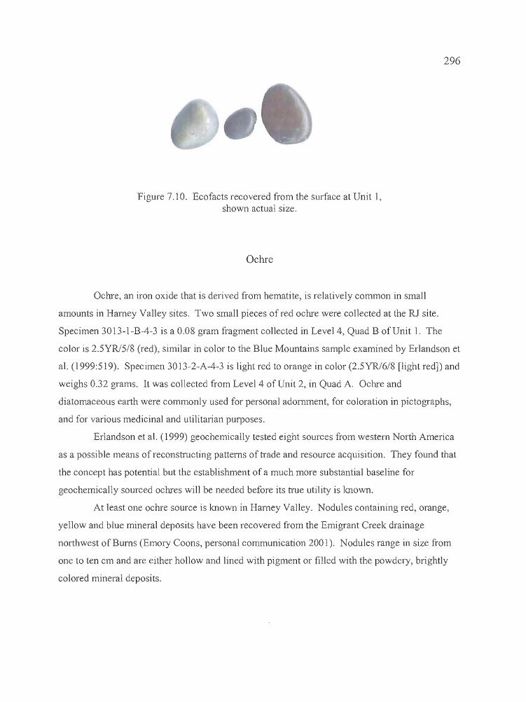
296
Figure 7.10. Ecofacts recovered from the surface at Unit I,shown actual size.
Ochre
Ochre, an iron oxide that is derived from hematite, is relatively common in small
amounts in Harney Valley sites. Two small pieces of red ochre were collected at the RJ site.
Specimen 3013-I-B-4-3 is a 0.08 gram fragment collected in Level 4, Quad B of Unit I. The
color is 2.5YRJ5/8 (red), similar in color to the Blue Mountains sample examined by Erlandson et
al. (1999:519). Specimen 3013-2-A-4-3 is light red to orange in color (2.5YR16/8 [light red]) and
weighs 0.32 grams. It was collected from Level 4 of Unit 2, in Quad A. Ochre and
diatomaceous earth were commonly used for personal adornment, for coloration in pictographs,
and for various medicinal and utilitarian purposes.
Erlandson et al. (1999) geochemically tested eight sources from western North America
as a possible means of reconstructing patterns of trade and resource acquisition. They found that
the concept has potential but the establishment of a much more substantial baseline for
geochemically sourced ochres will be needed before its true utility is known.
At least one ochre source is Imown in Harney Valley. Nodules containing red, orange,
yellow and blue mineral deposits have been recovered from the Emigrant Creek drainage
northwest of Burns (Emory Coons, personal communication 2001). Nodules range in size from
one to ten cm and are either hollow and lined with pigment or filled with the powdery, brightly
colored mineral deposits.

T---------~~~~~~~~ ~~.-~
297
Faunal Remains
The recovery of faunal remains at 35HA3013 was limited only to recently deposited
specimens, found as small mammal burrow deaths or scattered across the surface as a result of
predator capture or other natural causes. The specimens were limited to an unidentifiable small
mammal bone fragment found on the surface of Unit 1, a distal rodent humerus from Level 7,
Quad B of Unit 2, and a concentration of 45 rodent bones from Level 5 of Quad D, Unit 4. The
absence ofbones at the RJ site may be attributable to taphonomic processes affecting the
preservation of the remains. Soil chemistry, temperature extremes, and moisture resulting from
both seasonal precipitation and a perched water table may have all played a part in the
deterioration of faunal material. Although the RJ site is largely a root camp, acquisition of large
and small game would have occurred as the opportunity arose, so some animal bone should be
expected.
Botanical Remains
Paleobotanical identifications were carried out by Dr. Marge Helzer of the University of
Oregon (Helzer 2001) and by Paleo-Research Labs of Golden, Colorado (Puseman and
Cummings 2001 [Table 7.9]). Samples selected from Units 2 and 4 for AMS dating were sent to
Dr. Helzer for identification to species prior to radiocarbon assay. Additional samples were
drawn from Units 2 and 4 and from Probes 1, 4 and 8 during follow-up examinations of charcoal
and soil samples, and submitted to Paleo-Research Labs for identification. In all, three species
were identified in 13 samples. Included are bitterbrush, juniper, and currant. In addition to the
identified species, fragments of both starchy and fruity processed edible tissue (PET) were
recovered from the site along with unidentified fruit and berry tissue. The results indicate that
there has been little change in vegetation since the time of site occupation. All of the plants
identified are available at the site. All are known to have been used in the Great Basin generally,
either medicinally, or for food, fiber, and structural elements in house construction (Fowler 1986,
1989; Couture 1978).
b
298
Table 7.9. Paleobotanical remains from the RJ site.
Sample no. Provenience Species Common name Weight
>
30l3-2-A-5-3 Unit 2, Q A, L 5 Juniperus Juniper berry 0.042 gPurshia tridentata Bitterbrush seed 0.008 g
3013-2-B-7-5 Unit 2, Q B, L 7 Juniperus Juniper seed 0.007 g3013-2-B-8-4 Unit 2, Q B, L 8 PET, fruity processed edible tissue 0.009 g3013-4-B-6-7 Unit 4, Q B, L 6 Purshia tridentata Bitterbrush 0.006 g3013-4-D-3-2 Unit 4, Q D, L 3 Purshia tridentata Bitterbrush 0.010 g
Unidentified Fruit w/seed 0.030 g3013-4-D-4-3 Unit 4, Q D, L 4 Purshia tridentata Bitterbrush seed 0.003 g3013-4-D-5-9 Unit 4, Q D, L 5 Purshia tridentata Bitterbrush seed 0.013 g3013-4-D-5-10 Unit 4, Q D, L 5 Juniperus Juniper seed 0.010 g
cf. Ribes currant fruit/seed 0.014 g3013-4-D-6-4 Unit 4, Q D, L 6 Juniperus Juniper seed 0.014 g3013-4-D-7-3 Unit 4, Q D, L 7 PET starchy processed edible tissue 0.003 g3013-Pl-1-2 Probe 1, L 1 PET Fruity processed edible tissue 0.002 g3013-P4-4-3 Probe 4, L 4 PET Fruity processed edible tissue 0.002 g3013-P8-5-3 Probe 8, L 5 Unidentified fruit/berry 0.011 g
All but one ofthe PET specimens were recovered from Unit 4 or nearby probes. An
unidentified fruit and seed fragment was collected from Unit 4, Quad D, Level 3. A currant fruit
and seed fragment were collected in Level S of Quad D, Unit 4. PET fruity tissue was recovered
from Probe 1, Levell; and Probe 4, level 4; and an unidentified fragment of fruit or berry was
found in Probe 8, levelS. Currant shrubs are common in the vicinity of Unit 4. Other fruits or
berries that may be represented by the PET fruity material include serviceberry, juniper,
chokecherry, bitter cherry, and wild plum, all of which were available near the site in the late
summer and fall. They were generally eaten fresh, or dried for long term storage. They were
dried whole or formed into cakes which were sun-dried (Puseman and Cummings 2001.
PET starchy tissues are identified through starchy storage cells and are most likely from
edible roots (Puseman and Cummings 2001) such as biscuitroot, yampa, onion, balsam root,
bitterroot, camas, and sego lily. Puseman and Cummings (2001) found that the one fragment of
PET starchy tissue recovered from Level 7, Quad D, Unit 4 is most similar to bitterroot, though
the identification is not certain. Botanical remains recovered at the nearby Indian Grade Spring
site (Jenkins and Connolly 1990) included four charred camas bulbs. Camas was not present at
t
299
the RJ site during our visit in the spring, but it could have been found there in the past, and it is
certainly a possible source for the PET starchy material. Roots and tubers were eaten fresh, dried
for winter use, boiled whole, or ground into flour. Digging sticks were utilized in the collection
of roots, and the on-site preparation of these tools may account for the high quantities of heavy
basalt core and flake tools at the RJ site.
Obsidian Sourcing and Hydration Analysis
A total of 67 specimens were submitted to Northwest Research Obsidian Studies
Laboratory for geochemical sourcing and measurement of obsidian hydration rims (Table 7.10,
Figure 7.11). Fifteen items were projectile points (n=14) or hafted tools (n=l), two were shaped
bifaces, and 40 were pieces of debitage. The debitage included 28 specimens from Unit 2, and
12 from Unit 4. Additionally, ten basalt core and flake tools were submitted for geochemical
sourcing and all were found to originate from Gravelly Ridge, a name newly coined for the on
site material source.
The 14 projectile points were of obsidian from ten different obsidian sources, including
Big Stick, (n=2, or 14%), west of Harney Lake; Bums, (n=2, or 14%) north of Bums; Curtis
Creek, (n=l, or 7%) east ofBuchanan in the Stinkingwater Mountains; Gregory Creek, (n=l, or
7%) east of Juntura; Round Top Butte, (n=l, or 7%) near Glass Butte; Tank Creek, (n=l, or 7%)
near Wagontire; Tule Spring (n=3, or 21 %) southeast of the Silvies Valley in the Stinkingwater
Mountains; Whitewater Ridge, (n=l, or 7%) near Seneca; and WolfCreek (n=l, or 7%), to the
north of the site. As might be expected of tools that are part of the day-to-day hunting kit of
people on the move, the obsidian sources for projectile points reflect a broad area of use, roughly
encompassing the northern half of the Harney Valley west to Wagontire, east to Juntura and
Venator, and north to the Silvies Valley. None of the sources are located to the south of Malheur
and Harney lakes.
The two bifaces that were analyzed are from Curtis Creek (3013-2-B-8-1) and Wolf
Creek (3013-4-B-5-2). Both have similar hydration readings, at 1.5 and 1.6 microns,
respectively, and both are Stage 5 bifaces, possibly fragments of non-diagnostic projectile points.
The large basalt scraper (3013-iso-1) is from the Unknown Basalt 3 source.
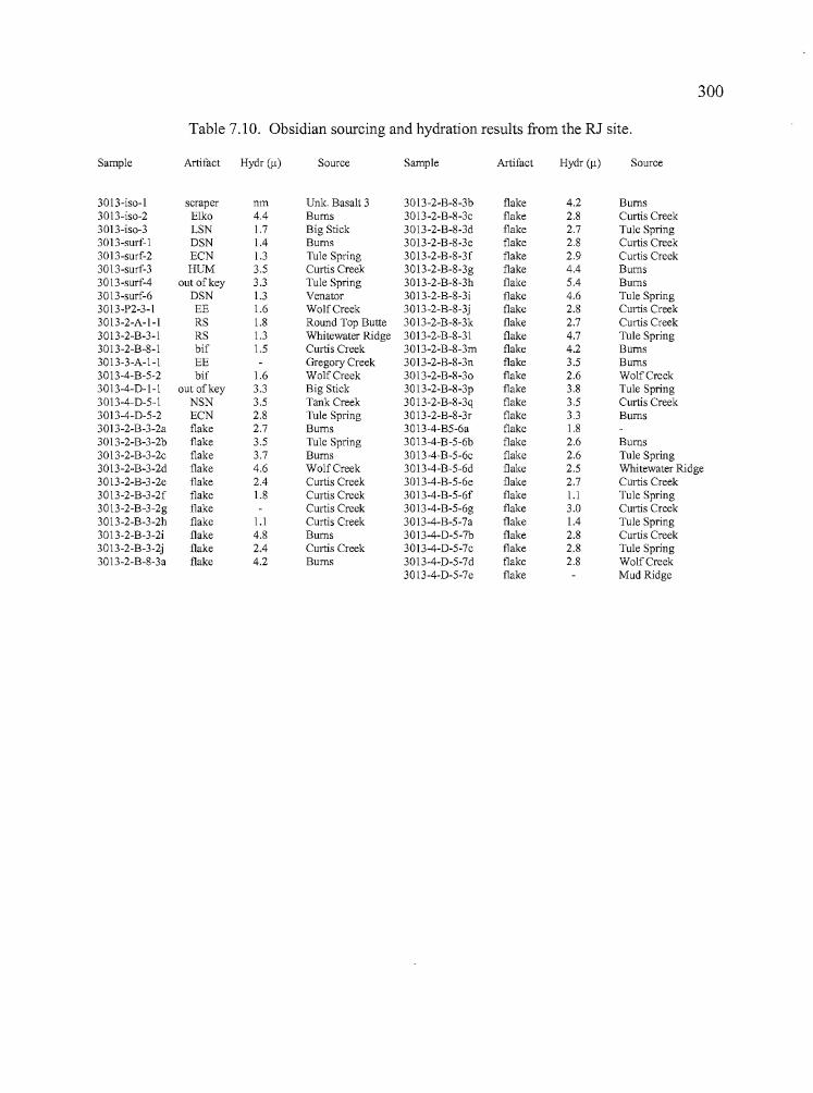
.....
•
300
Table 7.10. Obsidian sourcing and hydration results from the RJ site.
Sample Artifact Hydr (11) Source Sample Artifact Hydr (11) Source
30I3-iso-1 scraper nm Unk. Basalt 3 30I3-2-B-8-3b flake 4.2 Bums30I3-iso-2 Elko 4.4 Bums 30I3-2-B-8-3c flake 2.8 Curtis Creek30I3-iso-3 LSN 1.7 Big Stick 30I3-2-B-8-3d flake 2.7 Tule Spring30 I3-surf- I DSN 1.4 Bums 3013-2-B-8-3e flake 2.8 Curtis Creek3013-surf-2 ECN I.3 Tule Spring 3013-2-B-8-3f flake 2.9 Curtis Creek30 13-surf-3 HUM 3.5 Curtis Creek 3013-2-B-8-3g flake 4.4 Bums3013-surf-4 out of key 3.3 Tule Spring 30 I3-2-B-8-3h flake 5.4 Bums3013-surf-6 DSN I.3 Venator 30 I3-2-B-8-3i flake 4.6 Tule Spring3013-P2-3- I EE 1.6 WolfCreek 30 13-2-B-8-3j flake 2.8 Curtis Creek3013-2-A- I -I RS 1.8 Round Top Butte 30 13-2-B-8-3k flake 2.7 Curtis Creek3013-2-B-3-1 RS I.3 Whitewater Ridge 3013-2-B-8-31 flake 4.7 Tule Spring30 I3-2-B-8-1 bif 1.5 Curtis Creek 3013-2-B-8-3m flake 4.2 Bums3013-3-A-I-I EE Gregory Creek 3013-2-B-8-3n flake 3.5 Bums3013-4-B-5-2 bif 1.6 WolfCreek 30 I3-2-B-8-30 flake 2.6 WolfCreek30 13-4-D-I-I out of key 3.3 Big Stick 30 13-2-B-8-3p flake 3.8 Tule Spring3013-4-D-5-1 NSN 3.5 Tank Creek 3013-2-B-8-3q flake 3.5 Curtis Creek3013-4-D-5-2 ECN 2.8 Tule Spring 3013-2-B-8-3r flake 3.3 Bums3013-2-B-3-2a flake 2.7 Bums 3013-4-B5-6a flake 1.83013-2-B-3-2b flake 3.5 Tule Spring 3013-4-B-5-6b flake 2.6 Bums3013-2-B-3-2c flake 3.7 Bums 3013-4-B-5-6c flake 2.6 Tule Spring3013-2-B-3-2d flake 4.6 WolfCreek 3013-4-B-5-6d flake 2.5 Whitewater Ridge30 13-2-B-3-2e flake 2.4 Curtis Creek 3013-4-B-5-6e flake 2.7 Curtis Creek3013-2-B-3-2f flake 1.8 Curtis Creek 30 13-4-B-5-6f flake 1.1 Tule Spring3013-2-B-3-2g flake Curtis Creek 30 13-4-B-5-6g flake 3.0 Curtis Creek3013-2-B-3-2h flake 1.1 Curtis Creek 3013-4-B-5-7a flake 1.4 Tule Spring3013-2-B-3-2i flake 4.8 Bums 3013-4-D-5-7b flake 2.8 Curtis Creek30 13-2-B-3-2j flake 2.4 Curtis Creek 3013-4-D-5-7c flake 2.8 Tule Spring30 13-2-B-8-3a flake 4.2 Bums 3013-4-D-5-7d flake 2.8 WolfCreek
3013-4-D-5-7e flake Mud Ridge
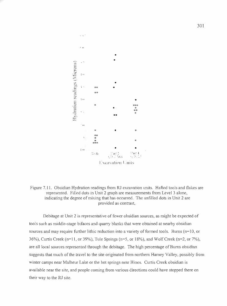
301
..; II
••
....
•••.. .•••
--'.'J)
,5b
I "~~.
'F-:-'Jj ;C ••
":;; ••<";
2 ; "t:::::;. •,;:.l-•J
;;.-,
" ..•••••••
I "~ ,'. ,1;·
••
..
•~ . Ill' :
~ ~. : ~. \: :-.;
I :'Cl\ alitll] l.lllh
..
..
..•
~--".,----
Figure 7.11. Obsidian Hydration readings from RJ excavation units. Hafted tools and flakes arerepresented. Filled dots in Unit 2 graph are measurements from Level 3 alone,
indicating the degree of mixing that has occurred. The unfilled dots in Unit 2 areprovided as contrast,
Debitage at Unit 2 is representative of fewer obsidian sources, as might be expected of
tools such as middle-stage bifaces and quarry blanks that were obtained at nearby obsidian
sources and may require further lithic reduction into a variety of formed tools. Burns (n=10, or
36%), Curtis Creek (n=ll, or 39%), Tule Springs (n=5, or 18%), and WolfCreek (n=2, or 7%),
are all local sources represented through the debitage. The high percentage of Burns obsidian
suggests that much of the travel to the site originated from northern Harney Valley, possibly from
winter camps near Malheur Lake or the hot springs near Hines. Curtis Creek obsidian is
available near the site, and people coming from various directions could have stopped there on
their way to the RJ site.
•
302
The Unit 4 debitage produced six distinct geochemical sources and one that was
unidentifiable. Burns (n=l, or 8%), Curtis Creek (n=3, or 25%), Mud Ridge (n=l, or 8%), Tule
Spring (n=4, or 33%), Whitewater Ridge (n=l, or 8%), and WolfCreek (n=l, or 8%), again are
all sources available north of Harney Valley. Mud Ridge is located north of Burns Butte. Most
of the obsidian came from Tule Springs, which is a locally available source.
The broadest range of hydration measurements was found on debitage recovered from
Unit 2, (1.1 microns and 5.4 microns) with a mean on.4 for 27 flakes (one flake was
unmeasureable). Hydration readings at Unit 4 ranged from 1.1 to 3.0 microns, with a mean of
2.4 for 11 flakes (one flake was unmeasureable). Figure 7.11 graphically demonstrates the
difference in hydration readings between the two units. The majority of measurements from Unit
2 are concentrated between 2.4 and 4.8 microns, while the majority of Unit 4 measurements are
between 2.5 and 3.0 microns. There is a clear overlap of readings in both units between 1 and 3
microns, but Unit 2 also has a significant set of measurements between 3 and 5 microns,
indicating a significantly longer period of use. The hydration samples from Unit 2 were drawn
from levels 3 (Level 4 produced an AMS date of 1000±BP) and 8 (Level 7 produced an AMS
date of 1590±40 BP) and there is a stratigraphic difference between the levels, with Level 3
readings generally smaller than those from Level 8 (Figure 7.11) but with some overlap. Unit 4
samples were obtained from LevelS, the same level from which an AMS date of2920±40 was
returned.
The sourcing and hydration results provided an opportunity to examine patterns of
obsidian use by inhabitants of the RJ site. Sourcing of the projectile points suggests that people
had ranged over a broad expanse of Harney Valley and northward as far as the Silvies Valley
before arriving at the site, and were not carrying any tool stone from the area south of Malheur
and Harney lakes. Although much of the debitage found on site was from nearby sources, there
also appeares to be a strong trend towards the use of material from the northern portion of Harney
Valley. The geochemical results also indicate that source frequency is not necessarily similar
from one part of the site to another, and hydration readings indicate that some portions of the site
may have been used for longer periods than others. The southern exposure of the Unit 2 area
may have been more desirable than the northern exposure of the Unit 4 area, particularly if the
site was occupied during the late spring and early summer. The hydration results are also useful
in showing that the integrity of the deposits at Unit 2 is good, with older, broader hydration
measurements situated deeper in the strata than later and thinner hydration bands. This ties in
b
303
well with the radiocarbon dates for Unit 2, but the correlation is less good in Unit 4. Both
radiocarbon dates and obsidian hydration analysis show a significant time range of site
occupation, with the radiocarbon dates confirming at least 2000 years of use. The Northern Side
notched point indicates that at least occasional use of the site extended beyond 4000 BP.
Lithic Debitage Mass Analysis
Mass analysis utilizes population means including counts and weights of size-graded
debitage in a replicable, quantitative manner to examine relationships of debitage in both inter
and intra-site contexts (Abler 1989, Connolly 1999). Flake attributes such as size, weight,
quantity, and the presence of cortex vary with each stage of lithic reduction, as early core and
biface production yield larger flakes with more cortex than later stage biface reduction and
pressure flaking (Connolly and Byram 2001:68). By quantifying chipping waste through the
previously mentioned variables, a given site assemblage can be compared to those from other
sites, and to an experimental lithic reduction data set established for all five reduction stages
(core reduction = Stage 1, biface pressure flaking = Stage 5) collected from the Newberry
Volcano obsidian source (Connolly and Byram 2001:69). The mass analysis results should
reflect the most dominant lithic reduction activities at a given location and, depending on other
factors such as strtagraphic mixing, may allow comparisons between early and late components
within a site.
Debitage from the RJ site was processed through a series ofnested screens with
dimensions of 1" (G1), 112" (G2), 1/4" (G3), and 1/8" (G4). The flakes from each size grade
were counted, weighed, and examined for the presence of cortex. The results were then
compared with those from the other Harney Valley sites, the Bon site in Deschutes County
(Connolly and Byram 2001), and with the overall results from the Newberry Crater project
(Connolly 1999). This comparative information is presented below as Tables 7.11 and 7.12, and
summarized in the final chapter. Here, debitage from Units 1 - 4 at the RJ site is examined.
Connolly (1999) developed a formula for determining stages of Iithic reduction activities
at archaeological sites based on three variables: Stage = 6.048 - 0.124 (F) - 0.023 (P) - 0.091
(Q), where F is the percent count ofG2 over G1 - G4, P is the mean weight ofG2 (G2 weight/G2
count) in decigrams, and J is the mean weight of G3 (G3 weight/G3 count) in centigrams. The
values produced from the archaeological data were inserted into the formula and the numeric
• b
--------------~~~~--~-- -
304
result is an indicator of the relative stage of lithic reduction that occurred at the site, either for the
entire site or for components ofthe site.
Utilizing Connolly's (1999) formula for the aggregate offour units at the RJ site resulted
in a predicted stage value of 2.68 (Tables 7.11 and 7.12), placing the site slightly below the Bon
site (35DS608) in terms of lithic reduction stages. The Bon site is a residential base camp
located north of Newberry Caldera. Other base camps located within the Newberry Caldera
(Connolly 1999, Connolly and Byram 2001 :71) have values similar to the RJ site, and the value
equates well with the Hoyt and Knoll sites from this study. When the obsidian is examined by
unit, the stage values are found to vary to some degree. Unit 1 has a stage value of 2.66, Unit 2 is
2.68, Unit 3 is 2.58, and Unit 4 is 2.90. All fall below a stage value of 3.0 but above 2.5, placing
lithic reduction activities on a par with base camps occurring away from tool stone sources
(Connolly and Byram 2001 :71) where activities are not focused on lithic reduction alone.
Lithic reduction activities occurring at Unit 4 are somewhat different than those at other
portions of the site, more in keeping with the late stages of production noted at the Bon site. The
other three units are more closely grouped with each other than anyone unit is with Unit 4.
Aboriginal use of the area around Unit 4 may have been shorter in duration and oriented to a
different set of activities than the evidence from the other RJ units would suggest, but it is
noteworthy that sample sizes for Units 3 and 4 are considerably smaller than for Units 1 and 2
(Unit 1, n=2197; Unit 2, n=1273; Unit 3, n=143; Unit 4, n=378). Sample size may account for
some of the difference, since both of the units with small obsidian debitage counts had the widest
range of variability in stage values.
To summarize, the RJ site overall appears to have been a base camp. Occupation ofthe
area around Unit 4 may have been more ephemeral than is seen elsewhere in the site.
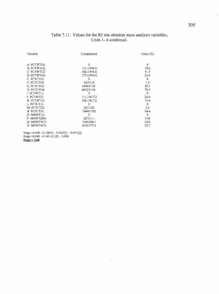
~',
Table 7.11. Values for the RJ site obsidian mass analysis variables,Units 1- 4 combined.
305
Variable
A PCTWTGIB PCTWTG2C PCTWTG3D PCTWTG4E PCTCTGlF PCTCTG2G PCTCTG3H PCTCTG4I PCTWTl3J PCTWT23K PCTWT33L PCTCTl3M PCTCT23N PCTCT33o MNWTlGP MNWT2DGQ MNWT3CGR MNWT4CG
Computation
o111.1/594.8306.1/594.8177.6/594.8
o62/5134
1040/51344032/5134
o111.1/417.2306.1/417.2
o62/1102
1040/1102o
62/111.11040/306.14032/177.6
Value (%)
o18.651.529.9o
1.220.378.5o
26.673.4o
5.694.4o
5.5834.022.7
Stage =6.048 - 0.124(F) - 0.023(P) - 0.091(Q)Stage =6.048 - 0.149- 0.128 - 3.094Stage = 2.68
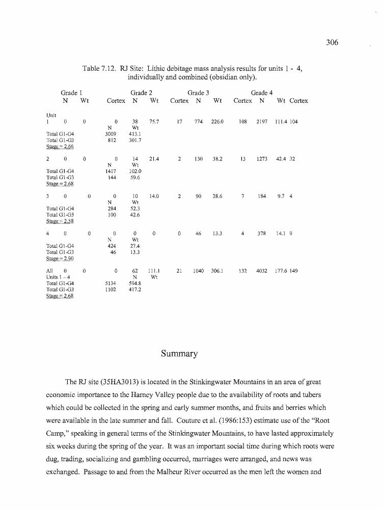
b
306
Table 7.12. RJ Site: Lithic debitage mass analysis results for units I - 4,individually and combined (obsidian only).
Grade 1 Grade 2 Grade 3 Grade 4N Wt Cortex N Wt Cortex N Wt Cortex N Wt Cortex
Unit1 0 0 0 38 75.7 17 774 226.0 108 2197 111.4 104
N WtTotal 01-04 3009 413.1Total 01-03 812 301.7Stage = 2.66
2 0 0 0 14 21.4 2 130 38.2 13 1273 42.4 32N Wt
Total 01-04 1417 102.0Total 01-03 144 59.6Stage = 2.68
3 0 0 0 10 14.0 2 90 28.6 7 184 9.7 4N Wt
Total 01-04 284 52.3Total 01-03 100 42.6Stage = 2.58
4 0 0 0 0 0 0 46 13.3 4 378 14.1 9N Wt
Total 01-04 424 27.4Total 01-03 46 13.3Stage = 2.90
All 0 0 0 62 111.1 21 1040 306.1 132 4032 177.6 149Units 1- 4 N WtTotal 01-04 5134 594.8Total 01-03 1102 417.2Stage = 2.68
Summary
The RJ site (35HA3013) is located in the Stinkingwater Mountains in an area of great
economic importance to the Harney Valley people due to the availability ofroots and tubers
which could be collected in the spring and early summer months, and fruits and berries which
were available in the late summer and fall. Couture et al. (1986:153) estimate use of the "Root
Camp," speaking in general terms of the Stinkingwater Mountains, to have lasted approximately
six weeks during the spring of the year. It was an important social time during which roots were
dug, trading, socializing and gambling occurred, marriages were arranged, and news was
exchanged. Passage to and from the Malheur River occurred as the men left the women and
•
307
children separately at the upland root camps and continued on to repair and set salmon traps.
Women and children began collecting and processing roots, laying in stores for the lean winter
months, and continued on to join the men fishing on the Malheur, after the root harvest was
secured.
Archaeological investigations at the RJ site were undertaken to explore the degree to which
the material remains correspond or vary from the ethnographic record. According to Whiting
(1950:17): "Around the first of May, when the first green shoots broke through the ground, they
left their winter camps and went to those places where they knew the edible roots abounded.
Nigger Flat, in the northeast comer of the valley, was the most frequented place and many
families camped here while the women dug epos (Yapa, Carum oreganum Wats), hu ni bui
(Lomatium macrocarpium Cand R), tsuga and sanatsuga (unidentified). While the women were
gathering these roots and and preparing the tsuga and some yapa for storage, the men visited the
Drewsey River to set up and repair their salmon traps so they would be ready for the spring run.
When their work was over, the women moved down to the river with their skin sacks full ofroots
and helped the men dry the salmon which they caught."
Couture (1978) and Couture et al. (1986), have added to this record through interviews
with modem practitioners, documenting recent use of the area that is consistent with Whiting's
account from over 65 years ago and which seems apparent through the archaeological record as
well.
The RJ site could be divided roughly into two kinds of settings. Units 1 and 3 were
situated on the ridgetop with good sun and wind exposure, important for processing and drying
roots. Because of their exposed locations, the two units had little sediment deposition and
excavations there were shallow. Units 2 and 4 were located below the ridge top, in sheltered
areas that offered better cover from the wind and sun and which served as sediment traps for
aeolian borne particles of silt and sand. Sediment accumulations were deep and stable, and
organics sent for radiocarbon dating were submitted with confidence.
Archaeological evidence, including radiocarbon dates and obsidian hydration
measurements, indicates that site use occurred earliest in the area ofUnit 4 on the north side of
the site. The span of obsidian hydration measurements suggests that occupations in the vicinity
ofUnit 2 began almost as early and extended over a longer period than those around Unit 4.
AMS dates from Unit 2 are 1000±40 BP and 1580±40 BP, taken from levels 3 and 7 of the unit.
A single date of 2920±40 BP from Unit 4, Level 5 indicates that human use of the RJ site has
b
308
been going on for a long time and it is among the oldest of the seven sites reported in the current
study.
No cultural features were definitively identified at the RJ site although several rock and
charcoal concentrations near the bottom of Unit 2 were intriguing and provided the C-14 sample
that was dated to ca.1580 BP. Two circular stone rings, arranged on basalt bedrock exposures
between units 1 and 3, were also noted at the site, but the absence of cultural material in
association made them difficult to assess. Conjecturally, the stones may have functioned as
anchors for windbreak supports or to hold down matting for drying roots.
Activities carried out at the RJ site are best viewed holistically because of the generalized
distribution of tools across the site. Activities included middle to late stage lithic reduction, floral
processing and possibly woodworking, as represented by the large core and flake tools, drills, and
awls. Obsidian geochemistry reflects the use of local sources as well as the import of tool stone
from the northern perimeter of Harney Valley. The obsidian sources represented among the
projectile points indicate a broad ranging population which traveled about the northern half of the
Harney Valley, the Malheur River, the Silvies Valley, and possibly northward to the John Day
area. The absence of faunal remains at the RJ site may indicate that taphonomic processes
eliminated any food bones that might have been brought there, but other evidence suggests that
use of the site was in any event oriented more towards other kinds of resources. Grinding stones
were limited in quantity, but present. Seed grinding may not have been utilized to the same
extent as in other plant procurement sites, but it is evident that the natural setting of the RJ site
qualifies it pre-eminently as a root -gathering locality. The presence of large, rough-edged core
and flake tools may be a distinct aspect of sites located in root camp country. Fine-grained basalt
is readily available in the vicinity of the RJ site and ideal for use in fashioning locally available
juniper and mountain mahogany into digging sticks for the root crop harvest. Similar tools were
noted at Indian Grade Spring, a short distance southeast of the site (Jenkins and Connolly
1990:77-80).
Debitage mass analysis indicated that lithic reduction activities were oriented toward the
kinds of middle to late stage (Stage 3) processes to be expected at base camps away from
quarrying sites. Later stage (almost Stage 3) biface reduction was more common, similar to what
Connolly (1999) encountered at base camps and off-quarry lithic reduction workshops at
Newberry Crater and the Bon site (Connolly and Byram 2001).
......309
In summary, the RJ site fits very well with the pattern of activity expected from
Whiting's (1950) account of the spring root camp forays. The obsidian source data are
particularly telling, showing that obsidian was generally brought to the area from the northern
perimeter of Harney Valley. This probably occurred as people arrived at the root grounds in the
spring. Some obsidian came from sources near the salmon fishing grounds to the north of the RJ
encampment, where people would also have been at this season. The absence of faunal remains
and grinding tools, the presence of large core and flake tools, and an abundance of edge modified
flakes are all consistent with an orientation toward making digging sticks for the root harvest and
collecting and peeling roots and tubers, to the exclusion of other activities such as hunting and
other kinds ofplant processing. The botanical remains indicate a variety of fruits, berries, and
roots may have been utilized, including juniper berries and bitterbrush seeds, although most are
unidentifiable beyond the level of processed edible tissues (PET).
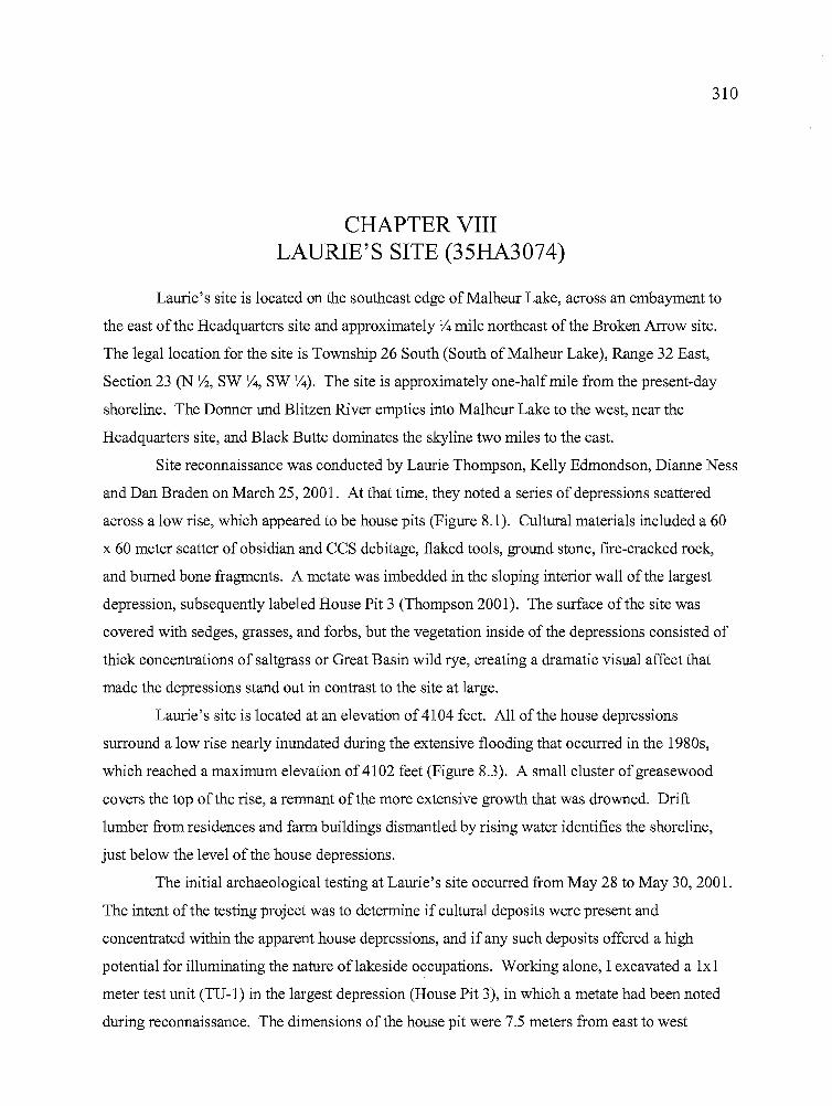
310
CHAPTER VIIILAURIE'S SITE (35HA3074)
Laurie's site is located on the southeast edge of Malheur Lake, across an embayment to
the east of the Headquarters site and approximately Y4 mile northeast of the Broken Arrow site.
The legal location for the site is Township 26 South (South of Malheur Lake), Range 32 East,
Section 23 (N Yz, SW Y4, SW Y4). The site is approximately one-half mile from the present-day
shoreline. The Donner und Blitzen River empties into Malheur Lake to the west, near the
Headquarters site, and Black Butte dominates the skyline two miles to the east.
Site reconnaissance was conducted by Laurie Thompson, Kelly Edmondson, Dianne Ness
and Dan Braden on March 25, 2001. At that time, they noted a series of depressions scattered
across a low rise, which appeared to be house pits (Figure 8.1). Cultural materials included a 60
x 60 meter scatter of obsidian and CCS debitage, flaked tools, ground stone, fire-cracked rock,
and burned bone fragments. A metate was imbedded in the sloping interior wall of the largest
depression, subsequently labeled House Pit 3 (Thompson 2001). The surface of the site was
covered with sedges, grasses, and forbs, but the vegetation inside of the depressions consisted of
thick concentrations of saltgrass or Great Basin wild rye, creating a dramatic visual affect that
made the depressions stand out in contrast to the site at large.
Laurie's site is located at an elevation of4104 feet. All of the house depressions
surround a low rise nearly inundated during the extensive flooding that occurred in the 1980s,
which reached a maximum elevation of4102 feet (Figure 8.3). A small cluster of greasewood
covers the top of the rise, a remnant of the more extensive growth that was drowned. Drift
lumber from residences and farm buildings dismantled by rising water identifies the shoreline,
just below the level of the house depressions.
The initial archaeological testing at Laurie's site occurred from May 28 to May 30,2001.
The intent of the testing project was to determine if cultural deposits were present and
concentrated within the apparent house depressions, and if any such deposits offered a high
potential for illuminating the nature oflakeside occupations. Working alone, I excavated a lxl
meter test unit (TV-I) in the largest depression (House Pit 3), in which a metate had been noted
during reconnaissance. The dimensions of the house pit were 7.5 meters from east to west
311
Figure 8.1. Laurie's site, with depression in foreground. Note greasewoodwhich was above maximum flood stage, and drift lumber, which marks the
1980s lake high stand.
by 4.5 meters from north to south. There appeared to be two overlapping depressions, with the
smaller and shallower of the two to the west. TU-I was established at the overlap to detennine if
two separate occupation floors were present should the depression tum out to be a cultural
feature. The question of occupation floors was never fully addressed due to time limitations, but
the depression was clearly determined to be an archaeological feature.
TU-l was excavated deep enough to reveal that debitage, bone, and tool fragments were
highly concentrated, increased with depth, and were situated in homogenous charcoal laden
deposits suggestive of an occupation surface. No pebbles or gravels other than those of cultural
origin were present. The fill in the upper two levels consisted of light gray to medium brown
sandy silts and clays. A pronounced transition occurred in level 3. In the upper two to three
centimeters of the level, the fill changed from light, crumbly, soft, sandy clay-silts to sediments
that were darker and more compact and contained higher quantities of charcoal flecking.
Debitage and bone counts increased sharply, and chipped-stone tools, ground stone, and fire
cracked rock began to appear in the deposits. No temporally diagnostic artifacts were recovered
during the testing phase, but the presence of
bn
312
compacted sediments and artifacts all near the same elevation provided convincing evidence that
the beginning of a cultural surface had been reached. Dark, mottled deposits gave way to
substantially darker and more charcoal-infused deposits near level 4, at approximately 45 cm
below the surface. Formed artifacts were common along the southwest margin oflevel 3 but
were more concentrated toward the northwest comer oflevel 4, perhaps suggesting that they were
resting on a cultural surface that became depressed from the west to the east and mirrored the
surface relief. Aside from the compacted sediment layer, no obvious cultural features were
visible in the lx1. Small pressure flakes appeared to be more common in the upper deposits, with
larger flakes of obsidian, basalt, and CCS increasing in proximity to the compact surface. Burned
bone fragments increased near that surface, correlating well with increases in charcoal and fire
cracked rock fragments.
The excavation was time consuming due to the amount of material being recovered and
the inclement weather, and I was only able to remove 45 cm of fill in the time allotted for the
testing phase. Once the archaeological potential of the site had been established, plans were
made to return to the site and excavate House Pit 1, a smaller depression six meters west of
House Pit 3. Based on the surface dimensions, the depression appeared to be an individual
habitation of a size that should permit a thorough cross-sectioning of the feature deposits given
the limitations of a small field crew. Such determinations would not be as easy to make in House
Pit 3 due to due to its large size and the possibility ofmultiple overlapping features.
A University of Oregon Archaeological Field School testing project was conducted from
July 5 through August 2,2001. Additional work was carried out with the assistance ofpersonnel
from the Burns District Bureau of Land Management from June 17 to July 2, 2002. During this
later work, two auger probes, one lxI, and three lx2 meter units were excavated at Laurie's site,
resulting in the removal of 6.8 cubic meters offill. Figures 8.2 and 8.3 show the locations of the
site, possible house depressions, the shore line associated with the 1980s flooding, and the
general topography. Table 8.1 summarizes the results of the excavations.
House Pit 1 was excavated in 2001, utilizing two lx2 meter units joined to create a lx4
meter trench spanning the length of the house pit. House Pit 2 was excavated in 2002 to explore
high concentrations of cultural material that were recovered during auger probing in 2001. House
Pit SP-l, also excavated in 2001, was chosen initially because it had surface dimensions
consistent in size with storage pits seen elsewhere in wetland settings of the Great Basin.
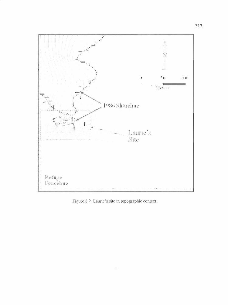
~'
.' ."-
~ ,:.1
.,..;'- .~
-'
313
.,"" ... ""i
_ •• _. I_a • ,/"••~
-..... ~.. ;r"'/
+'":,, f' /'"..;..
",;,.-,"1: I
II
I,;'. L '-,
>: I l ~
:"
'\ I ,... ~ . .y
,1111
Figure 8,2 Laurie's site in topographic context.
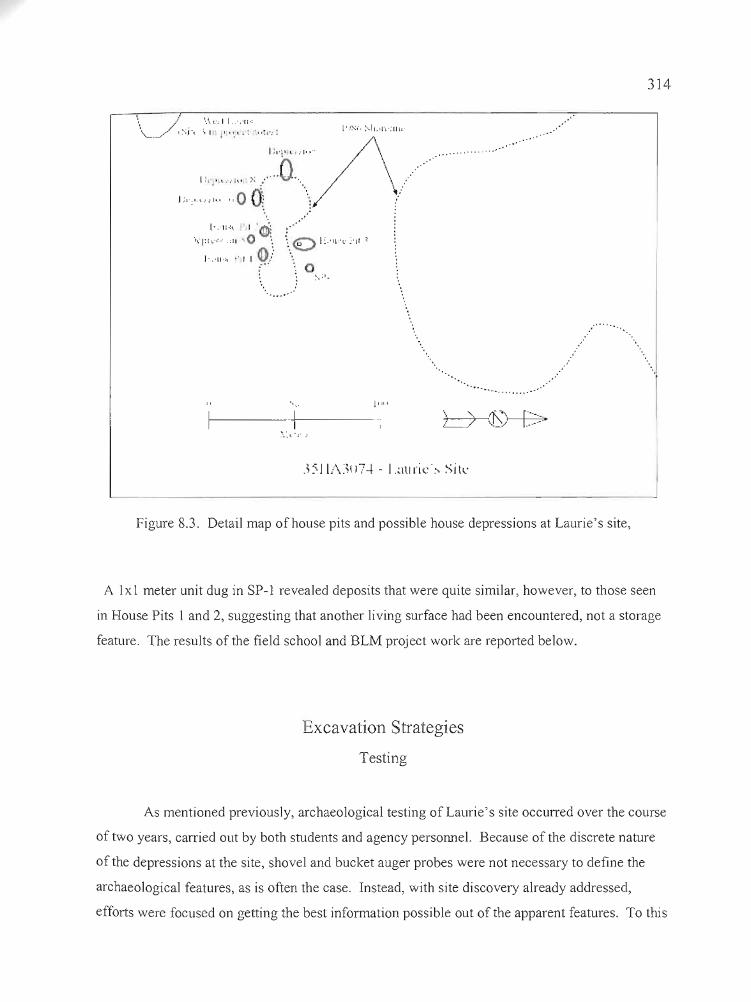
314
)"" .. .. 0 Oi
, .....
[',11'" I ~
"~'I:l \.:-:.' .:11 .. 0 ". :. '€) I :.'Il'·v ~'Jt ~
,'11", "II~)
....
1------1f---->.:, -;' :
11111
L>
Figure 8.3. Detail map of house pits and possible house depressions at Laurie's site,
A 1x I meter unit dug in SP-l revealed deposits that were quite similar, however, to those seen
in House Pits 1 and 2, suggesting that another living surface had been encountered, not a storage
feature. The results of the field school and BLM project work are reported below.
Excavation Strategies
Testing
As mentioned previously, archaeological testing of Laurie's site occurred over the course
of two years, carried out by both students and agency personnel. Because of the discrete nature
of the depressions at the site, shovel and bucket auger probes were not necessary to define the
archaeological features, as is often the case. Instead, with site discovery already addressed,
efforts were focused on getting the best information possible out of the apparent features. To this
315
end, two 1x2 meter units were established over House Pit 1, extending in a north to south
direction across the feature to create a 1x4 meter exposure with Unit 1 to the north and Unit 2 to
the south.
Excavation Units
During the course of the excavations, an arbitrary datum was established on the rise
between the housepits for mapping purposes. Using a Topcon GTS-203 transit, coordinates for
the datum were set at 500 N/ 500 E, with an arbitrary datum of 100 meters. The individual
excavation units were tied into the grid system, but they are identified only by numeric
designations here. Individual elevation datums were shot in for the excavation units and vertical
control was maintained by level lines attached to datum stakes. A single site datum provided
adequate coverage for recording the depressions, topography, and 1980s shoreline, but the
distance between the Broken Arrow site and Laurie's site proved too great for tying the two sites
together.
As in the case of the other sites reported here, the basic unit of excavation was the 2x2
meter square, divided into 1x1 meter units oriented towards magnetic north. Quad A was always
to the northwest, Quad B to the northeast, Quad C to the southwest, and Quad D to the southeast.
Paperwork for each level included drawings, artifact counts, the location of in situ artifacts and
various physical features on a plan map, and written descriptions of sediment types. The
excavators worked with great care to insure that chronologically diagnostic artifacts and other
formed tools, features, utilized flakes and noteworthy bone fragments were recorded in situ as
often as possible. Drawings were made of selected stratigraphic profiles and photographs were
taken of representative walls in some excavation units. In situ artifacts and potential features
were photographed. Fill was removed in 10 cm increments and passed through 1/8 inch mesh
hardware cloth. Debitage, bone, and other artifacts were retrieved during the screening process,
counted, and added to the level record. A total of 6.8 cubic meters of fill was excavated, resulting
in the recovery of 34,510 artifacts, or 5,075 artifacts per cubic meter.
•
316
Analytic Components
A total offour AMS dates were obtained from the Laurie's site excavations (Table 8.2).
A date of 1890±40 BP (Beta-167133) came from House Pit 1, Unit 2, Quad A, Level 7,
associated with a cluster of artifacts including Elko points, biface fragments, ground stone, and
ochre on a compacted occupation surface. House Pit 2 produced a date of 1580±40 BP (Beta
214673) from Level 9 of Unit 1, Quad C, also associated with artifacts on an occupation surface
which included Elko points, a shell bead, ground stone, a stone ball, and muskrat mandibles. A
second sample submitted from LevelS ofthe same unit, associated with Rose Spring points,
ground stone fragments, and a hearth identified as Feature 1 returned a date of 140±40 BP (Beta
214672) which is considered to be out ofplace in relation to other dates at the site and possibly
the result of vertical displacement of more recent material by rodents. It is possible that a later
hearth feature, overlooked during the course of the excavation, was intruded into the earlier
deposits. Unit SP-1 produced a more plausible date of 1770±50 BP (Beta-214671) from Level 4.
Organic material suitable for radiocarbon dating was scarce in the unit. A sample was drawn
from 20 cm above the primary artifact-bearing sediments, which included ground stone
fragments, a decorated bone tube, a muskrat mandible, and evidence of a compacted clay floor.
The dated material was associated with Elko and Eastgate points.
Putting aside the very late date of 140 BP as an anomaly, the radiocarbon dates indicate
that Laurie's site was utilized between 1450 and 1850 BP. Evidence for multiple occupations of
the house pits during that time is not apparent, with debitage and bone counts varying by unit and
quadrant, and no discernable patterns to indicate later occupational surfaces overlying the house
pit floor (Figures 8.4 and 8.5) which could have 40-50 cm of cultural deposits.
House Pit 2 and SP-1 deposits may have evidence ofmultiple occupations. Projectile
points were also mixed in the deposits and Elko and Rose Spring or Eastgate points were
regularly found together. Considering the range of radiocarbon dates at Laurie's site, it might be
expected that both atlatl and bow and arrow technology would be found in association between
1450 and 1850 years ago. The fact that both technologies are represented at Laurie's site in
relation to cultural features (described below) is interesting but not unusual.
III"!""'...'
Atnn__~
317
Table 8.1 Radiocarbon dates from Laurie's site.
Sample no. Beta ID Provenience Radiocarbon age Cal. Atintercept
3074-2-A-7 Beta 167133 House I, Unit 2, QA L 7 I 890±40 BP 1840 Cal BP3074-SPI-A-4 Beta 214671 Unit SPI, L4 I 770±50 BP 1700 Cal BP3074-C-I-5-C Beta 214672 House 2, Unit I, QC, L5 140±40 BP 0,20,140,220,260 Cal BP3074-2-1-9-C Beta 214673 House 2, Unit I, QC, L9 I 580±40 BP 1430,1470,1480 Cal BP
House Pit 1
Units 1 and 2 were excavated at House Pit 1 in 2001 (Figures 8.4 - 8.7). The units
incorporated Quads A and C of a 2x2 meter square, and were conjoined to create a 1x4 meter
exposure running north to south. Had time permitted, quads Band D could have been opened to
the east to expose approximately one-third of a living floor, but the long excavation trench
worked well to reveal a good-sized portion ofthe floor, a possible entrance, and boundaries of
the house pit on both the north and south sides. Figure 8.6 identifies the locations of all artifacts
recovered in situ during the course of the excavations. The majority of the cultural materials
were recovered from levels 4 through 8 and artifacts were most concentrated in Level 6. Areas
of particular interest include the possible division between the interior and exterior house pit
deposits identified by the dashed line on the northeastern side of the map (Unit 1, Quad A). Less
sediment compaction, and deposits suggestive of clay floor remnants, are situated to the west of
the dashed line, while the sediments to the east were lighter in color, bonded by calcium
carbonates, and lacked the concentration of artifacts seen on the interior. The definition between
interior and exterior is not as distinct as was seen at the south end of the excavation (Unit 2, Quad
C), where interior and exterior deposits are separated by a definite texture and color change and
an absence of cultural materials. In Figure 8.6, the change is from light to dark for
representational purposes, but sediment tints seen in the field were actually the opposite. The
difference in stratigraphic boundaries from north to south may be attributable to an entrance
having once been located at the northeast edge of the excavation. The numerous artifacts located
outside of the opening could have been deposited during the course of activities outside of the
structure or by foot traffic in and out of it.
In the interior of the house pit, a cluster of artifacts located in Quad A of Unit 2 is
defined as Feature1, and a dark hearth stain overlapping quads A and C of Unit 1 has been
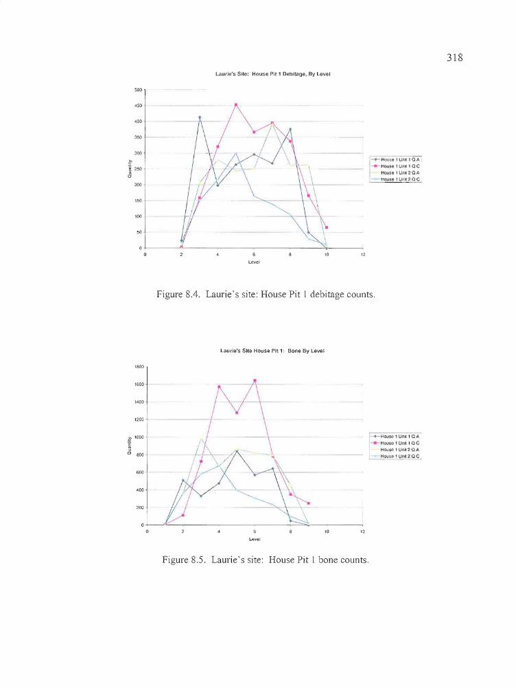
318
Laurie's Site: House Pit 1 Debitage, By Level
500
450
400
350
300
.~ I~ 250 ~
a200
150+-----
100 1------1
50
Hoose 1UM 1 a A
House I Unll 1a cHouse 1 Un,t 2 a A
House I unll 2 Q C
1210
o·l-----A.- .,..- --.:>,~---
oLevel
Figure 8.4. Laurie's site: House Pit 1 debitage counts.
Laurie's Site House Pit 1: Bone By Level
1800
1600
1400
1200
fJo 800.
600+----
400
200
' ......... House 1 Unll1 QA___ House 1 Unit 1Q C
House 1 Unit 2 Q A--House 1 Unit 2 Q C
1210
o.L-_,~ __..--------...,....:=;;:,..-~---~
oLevel
Figure 8.5. Laurie's site: House Pit 1 bone counts.
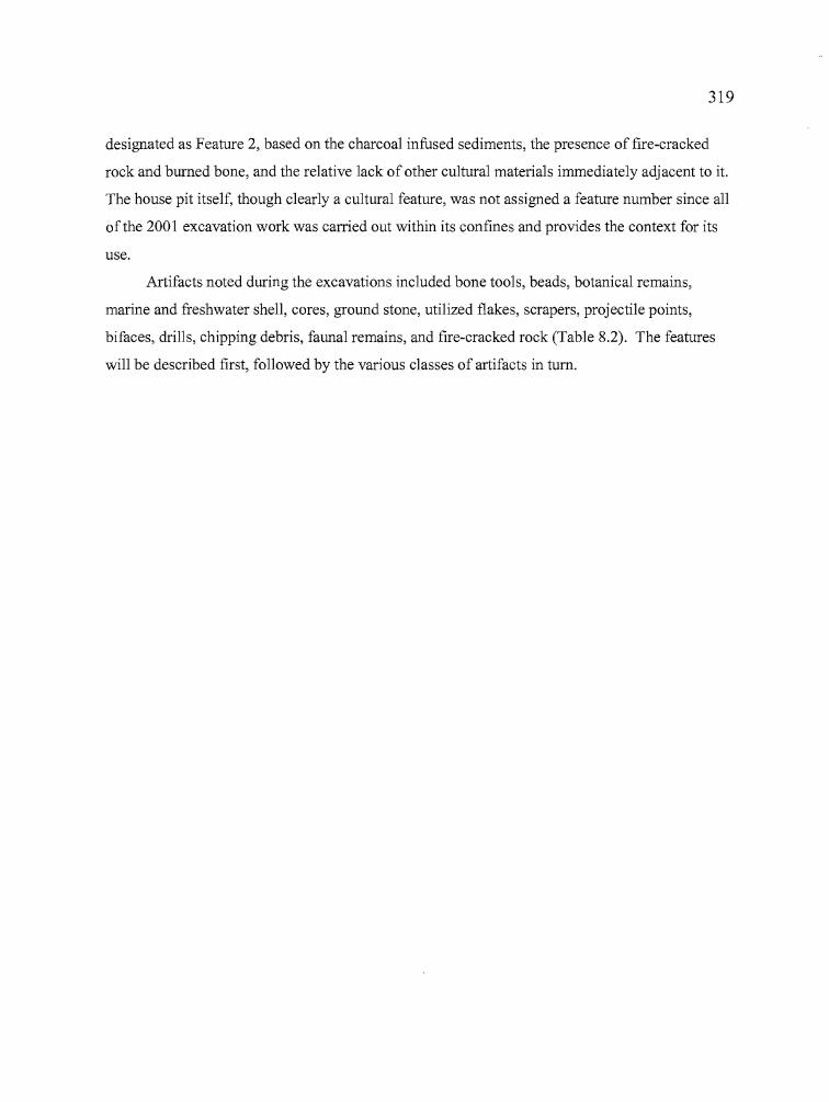
t
319
designated as Feature 2, based on the charcoal infused sediments, the presence of fire-cracked
rock and burned bone, and the relative lack of other cultural materials immediately adjacent to it.
The house pit itself, though clearly a cultural feature, was not assigned a feature number since all
of the 2001 excavation work was carried out within its confines and provides the context for its
use.
Artifacts noted during the excavations included bone tools, beads, botanical remains,
marine and freshwater shell, cores, ground stone, utilized flakes, scrapers, projectile points,
bifaces, drills, chipping debris, faunal remains, and fire-cracked rock (Table 8.2). The features
will be described first, followed by the various classes of artifacts in tum.
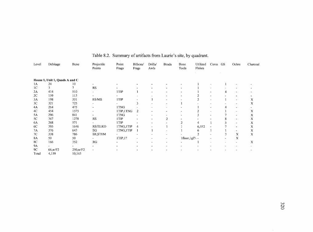
Table 8.2. Summary of artifacts from Laurie's site, by quadrant.
Level Debitage Bone Projectile Point Bifacesl Drillsl Beads Bone Utilized Cores GS Ochre CharcoalPoints Frags Frags Awls Tools Flakes
House 1, IJnit 1, Quads A and CIA 24 10 IIC 3 7 RS 12A 414 510 ITIP I I 42C 159 113 23A 198 331 ES/MS ITIP I 2 1 X3C 321 725 3 1 X4A 264 475 lTNG I 44C 454 1575 lTIP,ITNG 2 2 I X5A 296 841 ITNG 3 7 X5C 367 1278 RS ITIP 2 8 X6A 268 571 lTIP 2 4 I 5 X6C 395 1646 RS/ELKO 1TNG,ITIP 4 I 1 6,IF2 7 X7A 376 643 EG lTNG,lTIP I I I 6 I I X7C 338 786 EE,STEM 2 3 X X8A 50 50 !TIP,1 ? Ifloor,lg1?- - X8C 166 352 RG I X9A9C 66,w/F2 250,w/F2Total 4,159 10,163
wtvo
,
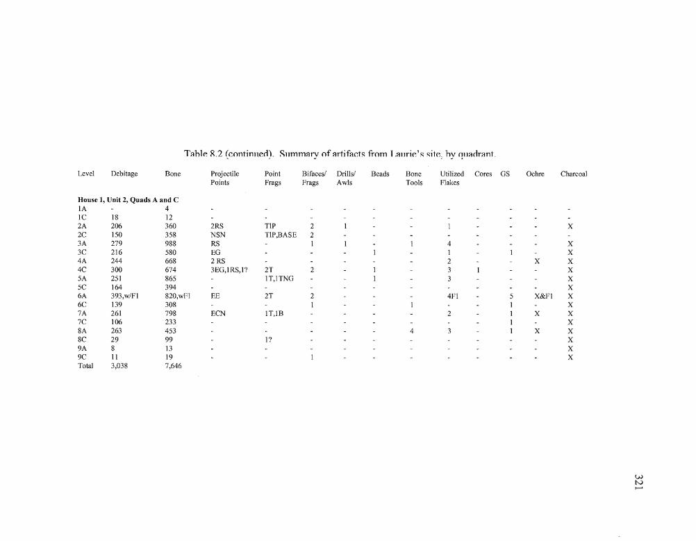
T::Ihle R.2 (Contimlerl). Sllmm::lry of ::IrtifactR fi-om L::IlIrie'R Rite; hy f!.ll::lrlr::lnt.
Level Debitage Bone Projectile Point Bifaces/ Drills/ Beads Bone Utilized Cores GS Ochre CharcoalPoints Frags Frags Awls Tools Flakes
House 1, Unit 2, Quads A and CIA 4Ie 18 122A 206 360 2RS TIP 2 I 1 X2C 150 358 NSN TIP,BASE 23A 279 988 RS I I 1 4 X3C 216 580 EG I I I X4A 244 668 2 RS 2 X X4C 300 674 3EG,IRS,I? 2'1' 2 I 3 I X5A 251 865 IT,ITNG I 3 X5C 164 394 X6A 393,w/FI 820,wFl EE 2'1' 2 4FI 5 X&FI X6C 139 308 I 1 I X7A 261 798 ECN IT,1B 2 I X X7C 106 233 I X8A 263 453 4 3 I X X8C 29 99 I? X9A 8 13 X9C II 19 I XTotal 3,038 7,646
wtv>-'
1
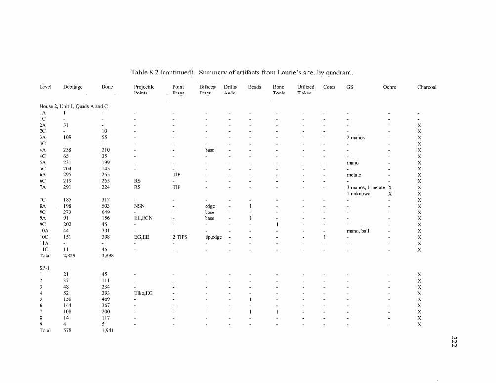
Tahle R.2 kontinlleci). Sllmmarv of artifacts from Laurie's site. hv ollacirant.
Level Debitage Bone Projectile Point Bifaces/ Drills/ Beads Bone Utilized Cores GS Ochre CharcoalPnintc PrQOC Pr!:loc Aurlc Tnnlc P1Q1cpc
House 2, Unit I, Quads A and CIA IIC2A 31 X2C 10 X3A 109 55 2 manos X3C X4A 238 210 base X4C 65 35 X5A 231 199 mana X5C 204 145 X6A 295 255 TIP metate X6C 219 265 RS X7A 291 224 RS TIP 3 manos, I metate X X
I unknown X X7C 185 312 X8A 198 503 NSN edge I X8C 273 649 base X9A 91 156 EE,ECN base I X9C 202 45 I XlOA 44 391 mana, ball X10C 151 398 EG,EE 2 TIPS tip,edge I XIIA XIIC II 46 XTotal 2,839 3,898
SP-II 21 45 X2 37 III X3 48 234 X4 52 393 Elko,EG X5 150 469 I X6 144 367 X7 108 200 I I X8 14 117 X9 4 5 XTotal 578 1,941
wNN
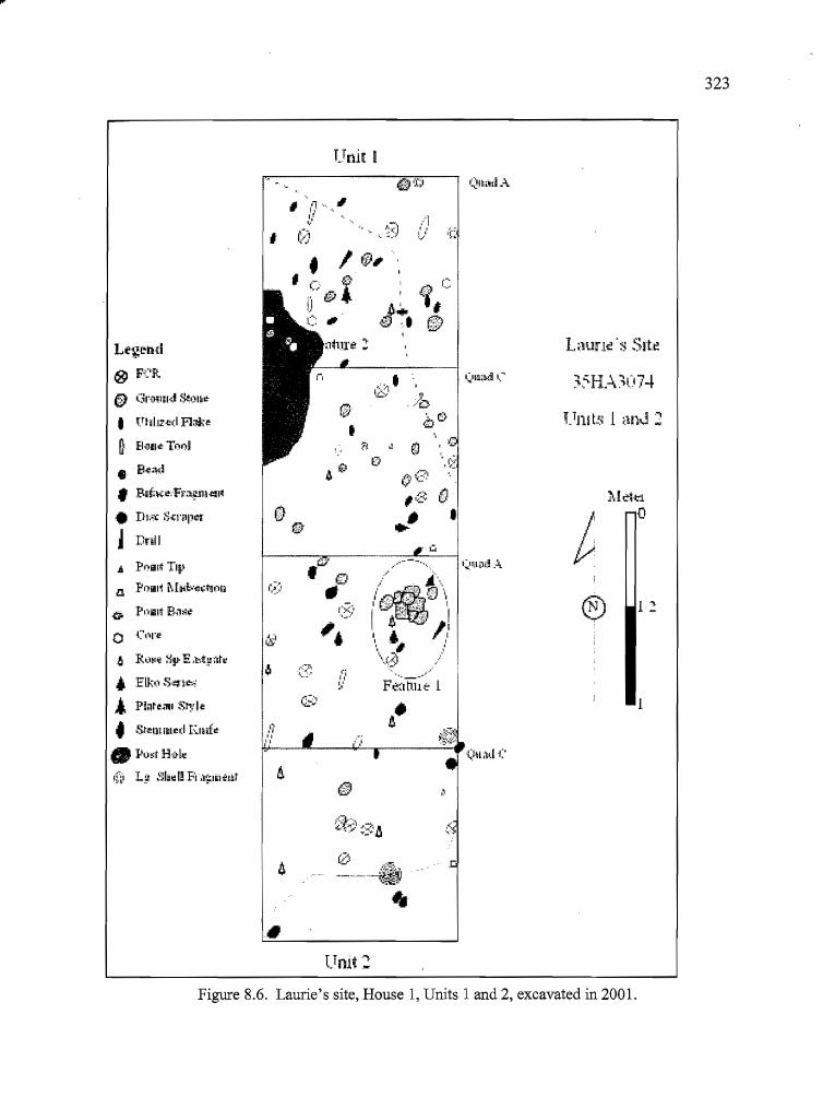
323
Unit I
1 2
:M~.J:'l
o
®
Lmnt! 's S!t~
, I1/
"
,9,/0
"b C:}
.----....
.,.Ii::} ..
'"jI,I'.'
•
.6 PI')ii1ll TIJ~
lL POlill MI'I.~<;~~!On
,
Le-g~nd
@ F{'R
f)) Gnrllnd S.~I)'lr
• VhlJZed A:Jk-e
~ E!<'AI': Tnol
• B{:;l;l~• P;i5;!t(:r'!F;;t~Jll{:J!l
• Dt;.", S-4;I"ilpct
j Dnll
o ('('1"':
6 R;j~~ ~E ,h~:,:;lt~
.;. Elkt) S''''flr:<,:
... Pi.lt~"l'll S~: I.:
• St-em Ikl.:d E.llifr
• Plj~i Hil-l~
,n, L! mad! FI;I~lalt'.Jlt
•Umt2
Figure 8.6. Laurie's site, House 1, Units 1 and 2, excavated in 2001.
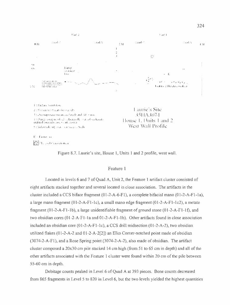
II ,\1',:,1,1,1.'
',:: :.:~
l. 11-': ::: '. : .... ~ •';' ..1;:'; . '''l ..
•,:: ..,,:,.:~:.. t.: . .:
l:lll"lp. ;.;~ I ,:..... I~
IT,-'
.. ,1",.1,',. :.... 1.1'1 :'
, .7' y' .'
'f . y)"
- L
'.1.1,1 ".
y t' J .~. 'f V Y •
324
l .\1
I : :-:.I~:.k'" ·I ... :.:di-J~,q.
~ : ~·":':"I.IJ!":::"'I:': "t':: :11·. ~l_i ~:.:I~id~' .II~..I i_r· - :;"1,1:.
'I,LL',:. :."l~l·:.l... ·.,:d:_~~· .L...·.L~ .... ·.II·. "~1. ~·oI·\·~,ju ... l.l.:1.1 .•1'.1::..1 ~.,.'L\"1·1.~II .. 1"1.· , ..111, .:~ •• ·.·.~I .
'" 1:,.".1,,'· 1,1
G'''J '1".. , •• ,,1, ·,:.I .• ·.I~I.III .. I
I ami L"S ~ i \L(') I L·\31:07 I
IlollSL I. llrlils 1 ;lud .2\.VL'~;l \OVa II I)l'nJ'i k
t
Figure 8.7. Laurie's site, House 1, Units 1 and 2 profile, west wall.
Feature 1
Located in levels 6 and 7 of Quad A, Unit 2, the Feature 1 artifact cluster consisted of
eight artifacts stacked together and several located in close association. The artifacts in the
cluster included a CCS biface fragment (01-2-A-6-F1), a complete bifacial mano (01-2-A-F1-1a),
a large mano fragment (01-2-A-Fl-1c), a sma]] mano edge fragment (01-2-A-F1-1c2), a metate
fragment (0 1-2-A-F 1-1 b), a large unidentifiable fragment of ground stone (0 1-2-A-Fl-l f), and
two obsidian cores (0 1-2-A-F1-1a and 0 1-2-A-F1-1 b). Other artifacts found in close association
included an obsidian core (0 1-2-A-F1-1 c), a CCS drill midsection (0 1-2-A-2), two obsidian
utilized flakes (0 1-2-A-2 and 0 1-2-A-2[2]) an E1ko Corner-notched point made of obsidian
(3074-2-A-F1), and a Rose Spring point (3074-2-A-2), also made of obsidian. The artifact
cluster composed a 20x30 em pile stacked 14 em high (from 51 to 65 em in depth) and all of the
other artifacts associated with the Feature 1 cluster were found within 20 em of the pile between
55-60 em in depth.
Debitage counts peaked in Level 6 of Quad A at 393 pieces. Bone counts decreased
from 865 fragments in Level 5 to 820 in Level 6, but the two levels yielded the highest quantities
325
in Unit 2. Muskrat mandibles, in this case two matching sides, were also collected from Level 6
in the vicinity of Feature 1 and tend to be associated with dense cultural layers at Laurie's site.
A fragment of willow recovered from Level 7 was submitted for radiocarbon dating, yielding a
date of 1890±40 BP. Although the sample was not directly associated with Feature 1, it does
provide a context for the artifacts found at or above that level within the house pit.
Feature 2
The Feature 2 hearth was encountered near the bottom of Quad A, Level 7 at a depth of
79 cm and extended over into Quad C. Approximately half of the feature was exposed during the
excavation, with dimensions of 65 cm from north to south by 25 cm east to west. The hearth is
roughly semi-circular in shape with a saucer-shaped profile, and though a few pieces offire
cracked rock were found in its interior, the feature is not stone-ringed. The maximum depth of
the feature was 92 cm (Level 9), terminating in the sterile sediments that underlie the floor of
House Pit 1. Substantial quantities of artifacts were found in the surrounding deposits, including
ground stone, beads, large flake tools, utilized flakes, bifaces, cores, bone tools, and Elko and
Rose Spring projectile points. Relatively few were found in close proximity, however.
The Feature 2 hearth appears to be built directly on the floor of House Pit 1, the surface
of which has considerable topography either as a result ofnatural processes or excavation by the
inhabitants. A total of 66 pieces of debitage and 250 bone fragments was recovered from the
hearth deposits. Debitage and bone counts peak in levels above the hearth (bone in Level 5 of
Quad A, debitage in Level 6), but the undulating floor has both deep pockets and elevated
mounds that distort the relationship between the floor surface and associated features. It may be
that the area discerned as the Feature 1 hearth is a portion of a larger feature that was deposited in
shallow depressions of the house pit floor, thus avoiding mixture with the other cultural deposits
from foot traffic.
Aside from the Feature 1 artifact cluster and the Feature 2 hearth, there were other
concentrations of cultural materials that also deserve mention at this time to provide a backdrop
for the artifact descriptions that follow. Two dark circular stains containing laminations from in
filling may be evidence ofpost-holes related to the house pit structure. One is located in the
southeast corner of Quad A, Unit 2, and the second is in the south-central portion of Quad C, in
the same unit. Both are situated at appropriate locations for structural supports, near transitional
areas between interior and exterior deposits. Internally, the two stains contained light and dark
326
bands of sediments that were deposited in much the same way as tree rings, and it is thought that
in-filling of different sediments occurred around structural elements that had been thrust into the
ground during house construction. Wind or human activity may have caused the supports to
move around and widen openings into which nearby sediments fell, with subsequent movement
of the supports creating sharply angled or almost vertical (rather than horizontal) sediment
deposition. Unfortunately, botanical analysis of the sediments recovered in the Unit 2, Quad C
stain failed to produce evidence of willow or other possible structural materials.
Two bone tubes that were recovered at the bottom of the cultural deposits in Quad A of
Unit 1 were pieced together in the laboratory and identified to be parts of a broken bird bone
whistle or game call. The two pieces were separated by approximately 50 cm and both had
settled into relatively protected pockets in the floor of the house where they were spared further
damage.
Three bone tools were also recovered in Quad A of Unit 2. Collected in Level 8 between
82 and 86 cm, the artifacts consist of a finely crafted awl, a spatulate tool, and a bone awl or
point that was collected from the screen. The artifacts were found at the bottom of the cultural
deposits near the transition to sterile sediments, and also appear to have settled into, or were
placed within, a sheltered depression in the house floor. The application for the awl and spatulate
tool is unknown, but the fine degree of workmanship exercised in their construction suggests that
they were probably not created for hard use such as flintknapping; they are better suited to
clothing or basketry manufacture. The bone awl or point is not as finely wrought as the other two
artifacts. The specimen was recovered from the screen at the same time that the other two
artifacts were being uncovered, so it is from the same general area and elevation.
As Figure 8.6 (above) suggests, a dense accumulation of cultural materials blankets the
floor of House Pit 1. Beads were common but never concentrated, debitage and bone were
recovered in great numbers, and fire-cracked rock, utilized flakes, and ground stone were
scattered across the house floor. It seemed clear that many of the ground stone fragments found
in House Pit 1 had seen secondary use as either hearth or cooking stones, although there was also
an abundance of mano and metate fragments that would have been serviceable for plant
processing. Rodent activity undoubtedly had a significant impact on the integrity of the pit house
deposits and multiple burrow traces were recorded on each level record during the excavation.
Concerns regarding the redistribution of artifacts in House Pit 1 due to rodent activity are offset
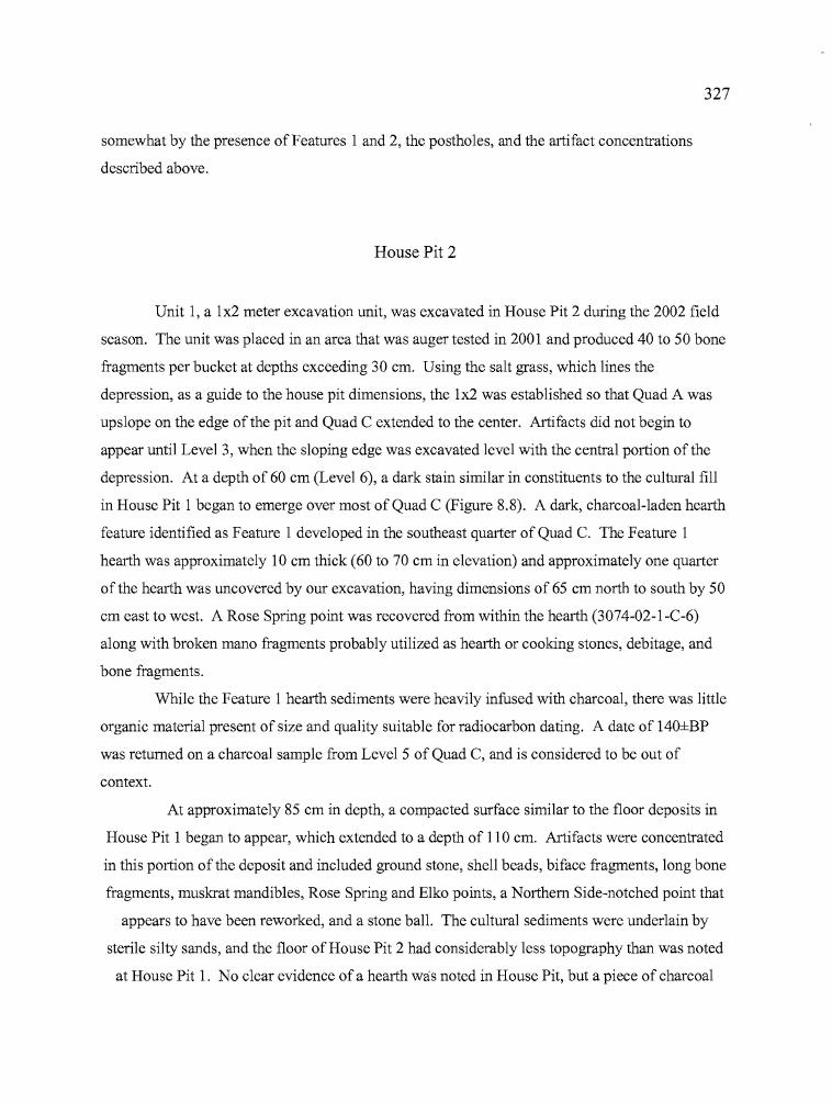
b
327
somewhat by the presence of Features 1 and 2, the postholes, and the artifact concentrations
described above.
House Pit 2
Unit 1, a 1x2 meter excavation unit, was excavated in House Pit 2 during the 2002 field
season. The unit was placed in an area that was auger tested in 2001 and produced 40 to 50 bone
fragments per bucket at depths exceeding 30 cm. Using the salt grass, which lines the
depression, as a guide to the house pit dimensions, the 1x2 was established so that Quad A was
upslope on the edge of the pit and Quad C extended to the center. Artifacts did not begin to
appear until Level 3, when the sloping edge was excavated level with the central portion of the
depression. At a depth of 60 cm (Level 6), a dark stain similar in constituents to the cultural fill
in House Pit 1 began to emerge over most of Quad C (Figure 8.8). A dark, charcoal-laden hearth
feature identified as Feature 1 developed in the southeast quarter of Quad C. The Feature 1
hearth was approximately 10 cm thick (60 to 70 cm in elevation) and approximately one quarter
of the hearth was uncovered by our excavation, having dimensions of 65 cm north to south by 50
cm east to west. A Rose Spring point was recovered from within the hearth (3074-02-1-C-6)
along with broken mano fragments probably utilized as hearth or cooking stones, debitage, and
bone fragments.
While the Feature 1 hearth sediments were heavily infused with charcoal, there was little
organic material present of size and quality suitable for radiocarbon dating. A date of 140±BP
was returned on a charcoal sample from Level 5 of Quad C, and is considered to be out of
context.
At approximately 85 cm in depth, a compacted surface similar to the floor deposits in
House Pit 1 began to appear, which extended to a depth of 110 cm. Artifacts were concentrated
in this portion of the deposit and included ground stone, shell beads, biface fragments, long bone
fragments, muskrat mandibles, Rose Spring and Elko points, a Northern Side-notched point that
appears to have been reworked, and a stone ball. The cultural sediments were underlain by
sterile silty sands, and the floor of House Pit 2 had considerably less topography than was noted
at House Pit 1. No clear evidence of a hearth was noted in House Pit, but a piece of charcoal
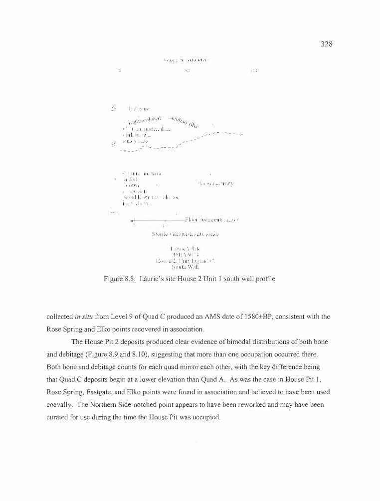
i;:
\".1.\':' :1:. .:\.I.I,.udn··
I ~ '.... I' '.. - I', . I ~ '..
I .. ,', I.: I,1"·1 '" ,'- •
I ~ I,' .' •.: :. : 1111 - 1,1..: ;II.: I .
:·'::III_~ \'~'.J~
:') ~': II ~".: " t'._,· ',', ~ .,' __ ;.... 1'" ;.. ·.•• 1. ;.
,..;... ~-_ ::1.',:1 .. ,', _"_"111:, '..." ,
" """11
',X,I ",'
""" .,; 1,1, ,"1' I.::'i ,," ,L,,',',
• ' •. 1111 .. III. '\'lli\
I. ,I ,Ii
....: I.;: ,1 ,~,: Ill"
, ' '.1 .:1. 1I1'1~ C':.: d ..._':IIL !:J.",',._
.70- ,';1:.,:-' ;_.1;·
328
. - .-.~
11 111
Figure 8,8, Laurie's site House 2 Unit 1 south wall profile
collected in situ from Level 9 of Quad C produced an AMS date of 1580±BP, consistent with the
Rose Spring and Elko points recovered in association,
The House Pit 2 deposits produced clear evidence of bimodal distributions of both bone
and debitage (Figure 8.9 and 8.10), suggesting that more than one occupation occurred there.
Both bone and debitage counts for each quad mirror each other, with the key difference being
that Quad C deposits begin at a lower elevation than Quad A. As was the case in House Pit 1,
Rose Spring, Eastgate, and Elko points were found in association and believed to have been used
coevally. The Northern Side-notched point appears to have been reworked and may have been
curated for use during the time the House Pit was occupied.
•
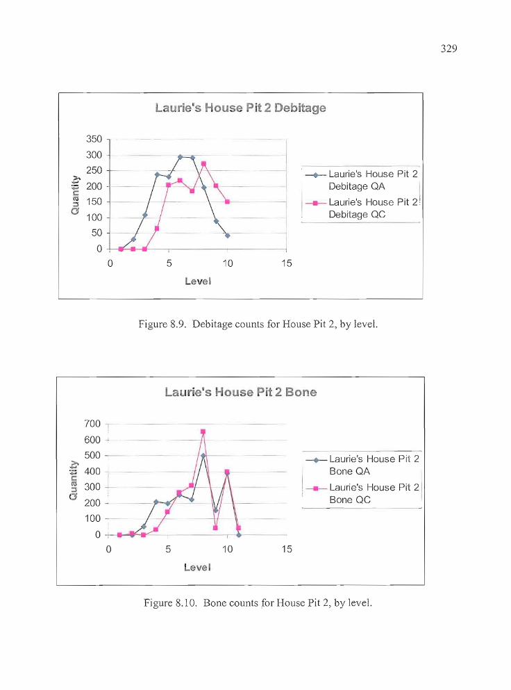
329
Lurie's House Pit 2 Debitage
~ Laurie's House Pit 2Debitage QA I
1 Laurie's House Pit 2!Debitage QC
---
15
l105
350
300
250>.~ 200-c~ 150o 100
50
0+---l~~1-----,----------j
oevel
Figure 8.9. Debitage counts for House Pit 2, by level.
Laurie's House Pit 2 Bone
--_._------
~ Laurie's House Pit 2Bone QA
i--- Laurie's House Pit 21Bone QC
15105
700
600
500 -~:.... 400 J~ 300-,
(3 200-
100
o -:- ......F-t~-- -------r--+---
olevel
Figure 8.10. Bone counts for House Pit 2, by level.
•
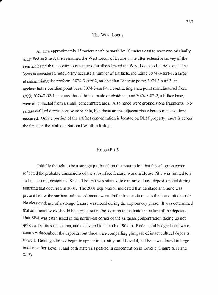
330
The West Locus
An area approximately 15 meters north to south by 10 meters east to west was originally
identified as Site 3, then renamed the West Locus of Laurie's site after extensive survey ofthe
area indicated that a continuous scatter of artifacts linked the West Locus to Laurie's site. The
locus is considered noteworthy because a number of artifacts, including 3074-3 -surf-I, a large
obsidian triangular preform; 3074-3-surf-2, an obsidian Eastgate point; 3074-3-surf-3, an
unclassifiable obsidian point base; 3074-3-surf-4, a contracting stem point manufactured from
CCS; 3074-3-02-1, a square-based biface made of obsidian, and 3074-3-02-2, a biface base,
were all collected from a small, concentrated area. Also noted were ground stone fragments. No
saltgrass-filled depressions were visible, like those on the adjacent rise where our excavations
occurred. Only a portion of the artifact concentration is located on BLM property; more is across
the fence on the Malheur National Wildlife Refuge.
House Pit 3
Initially thought to be a storage pit, based on the assumption that the salt grass cover
reflected the probable dimensions of the subsurface feature, work in House Pit 3 was limited to a
1x1 meter unit, designated SP-1. The unit was situated to explore cultural deposits noted during
augering that occurred in 2001. The 2001 exploration indicated that debitage and bone was
present below the surface and the sediments were similar in constituents to the house pit deposits.
No clear evidence of a storage feature was noted during the exploratory phase. It was determined
that additional work should be carried out at the location to evaluate the nature of the deposits.
Unit SP-1 was established in the northwest comer of the saltgrass concentration taking up not
quite half of its surface area, and excavated to a depth of 90 cm. Rodent and badger holes were
common throughout the deposits, but there were compelling glimpses of intact cultural deposits
as well. Debitage did not begin to appear in quantity until Level 4, but bone was found in large
numbers after Levell, and both materials peaked in concentration in Level 5 (Figure 8.11 and
8.12).
___.-.ca.. _
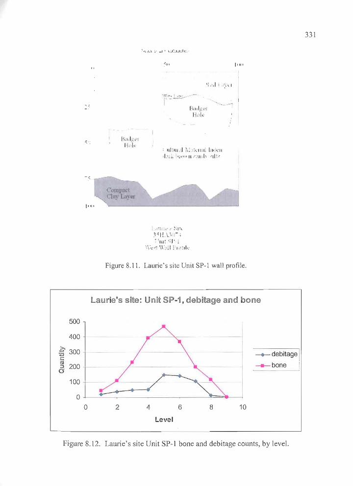
"
:0,., ,
-'.
11 11 1
1",:1, I. ,'.rf"I
.'·.'~,I~\. ~. _I I \.~(~L1dc·
~-: I I
',;,:,1 ".' I
j'\':': L::::...-- -
f' ".r,C' "~II . [.
: ,1I~1I1 . .1 ;'.:. kll;l~ l:io ,:11
<1:':._ "."" Il.···:·.I[.I" "11>
t • ~ ~'," >: 1'\
.~ -; I:. \.':, ,- ,. 'Ill: ';J' .
","",.".,. '.,\':'.1 !'I ::2110:
I'"'
331
Figure 8.11. Laurie's site Unit SP-1 wall profile.
Laurie's site: Unit SP~1l debitage and bone
500
400 1>- 300 ---.....
:.;::C
::i 200
100
00 2 4
level
6 8
~
-I
10
--+- debitage I____ bone
Figure 8,12. Laurie's site Unit SP-1 bone and debitage counts, by level.
332
As was the case in the other house pits, muskrat mandibles were common, as were small
fragments of ground stone believed to have secondary use as hearth or cooking stones. Areas of
thin, compacted clay that may be similar to those described by Musil (1995: 103, 167) at the
McCoy Creek site were noted at the beginning of Level 7 (70 cm) and continued through Level
9. The compacted clay was not identifiable as a coherent feature such as a house floor, at SP-l,
and no other features were identified at Unit SP-l. A decorated bone tube was recovered from
Level 7, and an E1ko and Rose Spring point were found in Level 4. An AMS date of 1770±50
BP was returned on charcoal collected in situ from Level 4.
It appears that the three units were all excavated into house pits at Laurie's site, although
the salt grass concentration covering the surface of House Pit 3 did not seem as true to the buried
dimensions ofthe cultural features as was seen in House Pits 1 and 2. The 2001 excavation at
House Pit 1 uncovered the east side of what is believed to be a brush wickiup, including the
probable entrance, a portion of the floor, a hearth identified as Feature 2, and post holes relating
to the superstructure. The Feature 1 artifact cluster was found on the occupation surface, and
clusters of bone tools were concentrated in protected areas ofthe house floor. The 2002 work at
House Pit 2 revealed the Feature 1 hearth and an associated occupation surface, overlying the
north edge of an earlier house floor. At House Pit 3, no cultural features were apparent, but clay
deposits were found in levels 7 through 9, with high concentrations of artifacts perched above
them in levels 4 through 6. It is reasonable to propose, based on the quantities and variety of
cultural materials and the presence of the unique decorated bone tube, that SP-1 was excavated
within a house pit, with the majority of the cultural material resting on a degraded clay floor.
All ofthe house pits contain small and highly fragmented animal bone fragments, most
from small mammals, fish, and birds, and clusters of unaltered muskrat mandibles on the
occupation surfaces. Ground stone is plentiful, but largely found in small fragments that are
suggestive of their use as hearth or cooking stones. In all cases, E1ko, Rose Spring, and Eastgate
points are found in association. Beads were recovered only in House Pit 1.
____crtIIk _
n
333
Artifact Assemblage
Chipped Stone Tools
Projectile Points
A total of 41 projectile points was recovered at Laurie's site; 36 of which are
temporally diagnostic (Table 8.3, Figures 8.13 and 8.14). Five artifacts (13%) that are considered
to have characteristics strongly consistent with projectile points but lack diagnostic attributes,
including a large knife-like point, a preform, a biface base and two unclassifiable points are also
described in this section. The majority of points are manufactured from obsidian (n=340r 88%),
two are made of CCS (5%), and three are basalt (7%). The projectile points have been classified
according to the system established by Thomas (1981) for the Monitor Valley in central Nevada
and Heizer and Hester (1978) for the Great Basin at large. The points include 11 Rose Spring (28
%), eight Eastgate (20 %), one Rosegate (2 %), five Elko Eared (12 %), three Elko Corner
notched (7 %), two Elko Series (5 %), two Northern Side-notched (5 %), one Contracting Stem
(2 %) two stemmed points (5%), and one Malheur Stemmed (2 %). The two typologically
unclassifiable points recovered from the excavations include a portion of an obsidian base that
could be from a Humboldt point (3074-2-C-4-1c). No Cottonwood or Desert series points were
collected at Laurie's site.
____",a. _
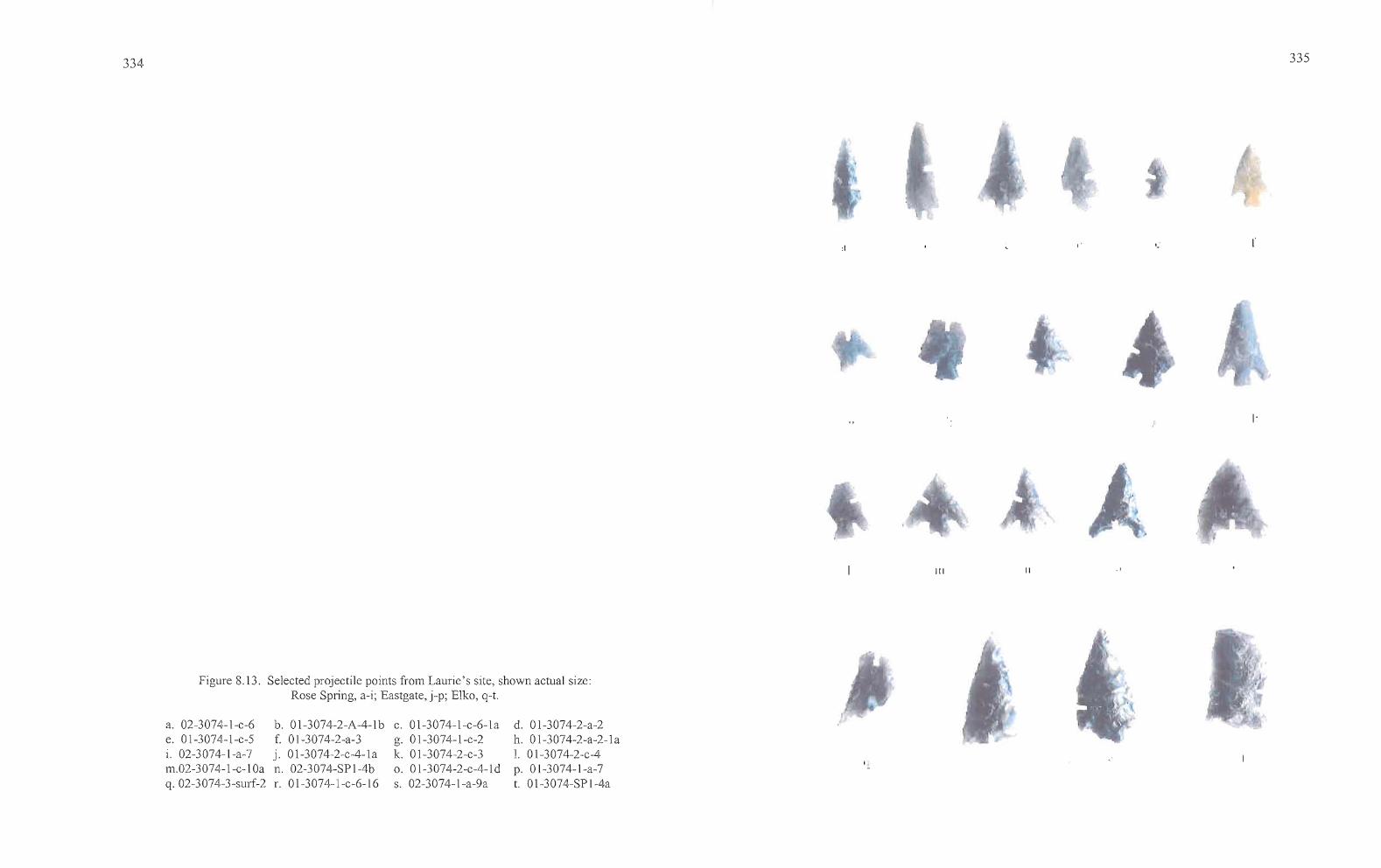
334
:1 ..'
335
III II ..
Figure 8.13. Selected projectile points from Laurie's site, shown actual size:Rose Spring, a-i; Eastgate, j-p; Elko, q-t.
a. 02-3074-I-c-6e. 01-3074-I-c-5i. 02-3074-l-a-7m.02-3074-l-c-lOaq. 02-3074-3-surf-2
b. 01-3074-2-A-4-lbf. 01-3074-2-a-3j. 01-3074-2-c-4-lan. 02-3074-SP lAbr. 01-3074-l-c-6-l6
c. 01-3074-l-c-6-lag. 01-3074-I-c-2k. 01-3074-2-c-3o. 01-3074-2-c-4-lds. 02-3074-I-a-9a
d. 01-3074-2-a-2h. 01-3074-2-a-2-la1. 01-3074-2-c-4p. 01-3074-I-a-7t. 0 l-3074-SP l-4a
•
336
Rose Spring and Eastgate, (or "Rosegate" Points). Rosegate is a derivative term incorporating
points previously identified as Rose Spring (Lanning 1963) and Eastgate (Heizer and Baumhoff
1961) into a single classification. Thomas (1981: 19) lumped the Rose Spring (Lanning 1963)
and Eastgate (Heizer and Baumhoff 1961) point types together under one classification, but the
two types are clearly dissimilar in both form and distribution, and in this report, Rose Spring and
Eastgate are analyzed separately. Rose Spring points are small comer-notched points that
commonly have expanding stems, while Eastgate points are basally notched on a triangular or
slightly rounded preform, producing barbs or tangs that are even with the base. According to
Thomas (1981 :19) Rosegate points have a basal width of 10 mm or less, a proximal shoulder
angle between 90° and 130°, and a neck width less than or equal to [basal width plus 0.5 mm.]
There is a substantial contingent of researchers who utilize the Rosegate designation in the
Harney Valley and Great Basin at large, but here the preference is to continue the use of the
designations Rose Spring and Eastgate except when breakage or retouching limits the ability to
discern differences between the two varieties. Twenty points identifiable as Rose Spring (n=ll,
or 55 %), Eastgate (n=8, or 40 %) or Rosegate (n=l, or 5 %) were collected from Laurie's site
(Figures 8.13 and 8.14). They included nine Rose Spring, five Eastgate, and one Rosegate
recovered from House Pit 1; two Rose Spring and one Eastgate recovered from House Pit 2, one
Eastgate recovered from House Pit 3, and one Eastgate recovered at the West Locus.
Rose Spring and Eastgate points were found scattered throughout most excavation levels
in Unit 1 of House Pit 1, but were concentrated in the upper levels of Unit 2. A total of four Rose
Spring and three Eastgate points were found in levels 2 through 4 of both quadrants, and three
Elko Comer-notched points were collected from levels 6 through 7 of Quad A. No diagnostic
points were recovered from Level 5.
t --_...._----
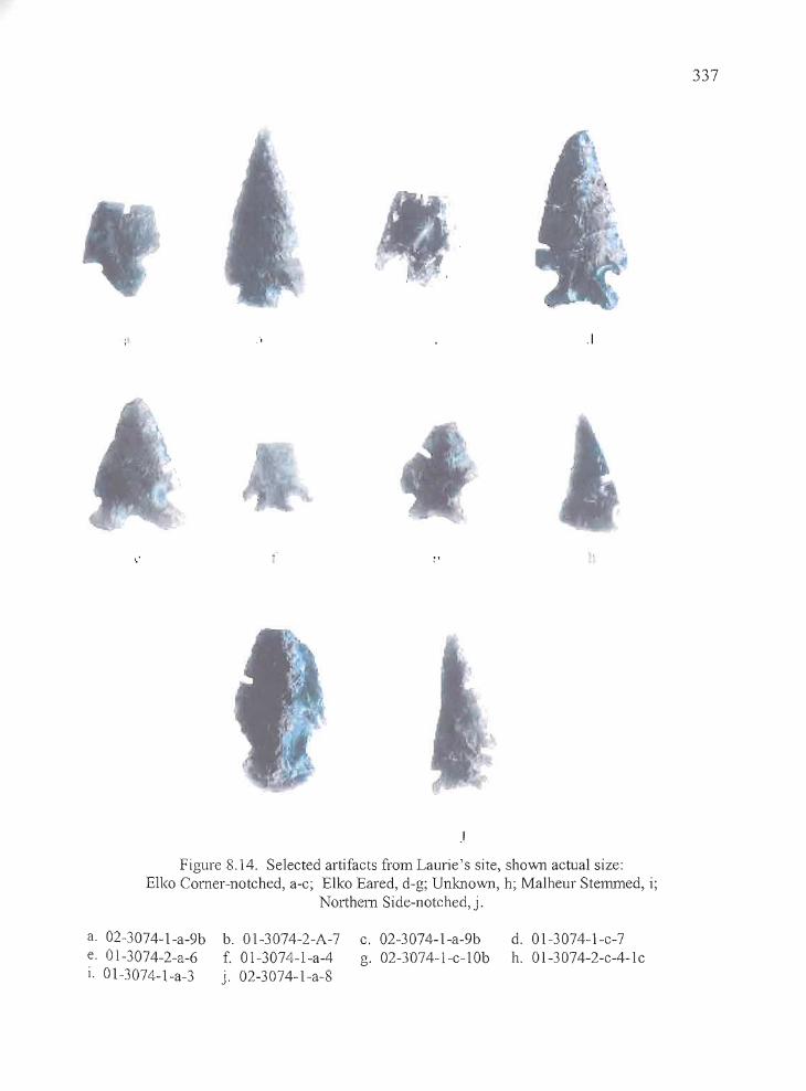
.',
.'
.1
337
Figure 8.14. Selected artifacts from Laurie's site, shown actual size:Ell<o Corner-notched, a-c; Elko Eared, d-g; Unknown, h; Malheur Stenuned, i;
Northern Side-notched, j.
a. 02-3074-1-a-9b b. 01-3074-2-A-7e. 01-3074-2-a-6 f. 01-3074-1-a-4i. 01-3074-1-a-3 j. 02-3074-1-a-8
c. 02-3074-1-a-9bg. 02-3074-1-c-l0b
d. 01-3074-1-c-7h. OI-3074-2-c-4-1c
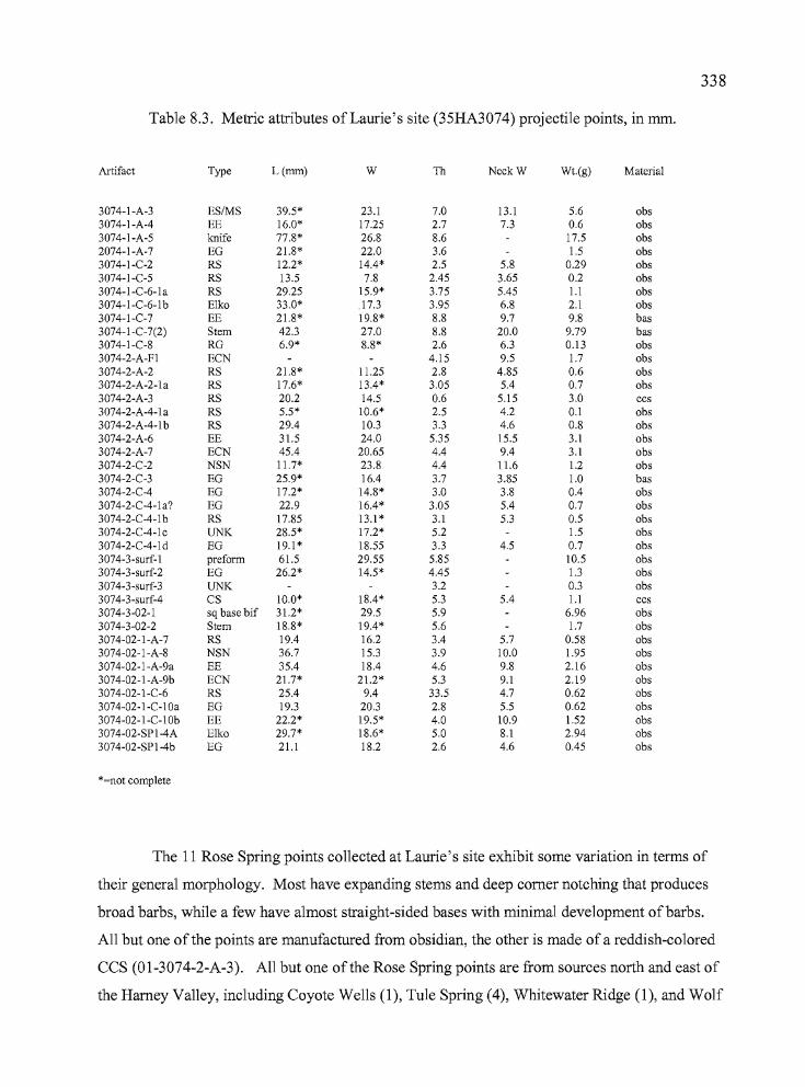
.. A'trn _
338
Table 8.3. Metric attributes of Laurie's site (35HA3074) projectile points, in rom.
Artifact Type L(mm) W Th NeckW Wt.(g) Material
3074-1-A-3 ES/MS 39.5* 23.1 7.0 13.1 5.6 obs3074-1-A-4 EE 16.0* 17.25 2.7 7.3 0.6 obs3074-1-A-5 knife 77.8* 26.8 8.6 17.5 obs2074-1-A-7 EG 21.8* 22.0 3.6 1.5 obs3074-1-C-2 RS 12.2* 14.4* 2.5 5.8 0.29 obs3074-1-C-5 RS 13.5 7.8 2.45 3.65 0.2 obs3074-1-C-6-la RS 29.25 15.9* 3.75 5.45 1.1 obs3074-1-C-6-lb Elko 33.0* .17.3 3.95 6.8 2.1 obs3074-1-C-7 EE 21.8* 19.8* 8.8 9.7 9.8 bas3074-1-C-7(2) Stem 42.3 27.0 8.8 20.0 9.79 bas3074-1-C-8 RG 6.9* 8.8* 2.6 6.3 0.13 obs3074-2-A-Fl ECN 4.15 9.5 1.7 obs3074-2-A-2 RS 21.8* 11.25 2.8 4.85 0.6 obs3074-2-A-2-la RS 17.6* 13.4* 3.05 5.4 0.7 obs3074-2-A-3 RS 20.2 14.5 0.6 5.15 3.0 ccs3074-2-A-4-la RS 5.5* 10.6* 2.5 4.2 0.1 obs3074-2-A-4-1 b RS 29.4 10.3 3.3 4.6 0.8 obs3074-2-A-6 EE 31.5 24.0 5.35 15.5 3.1 obs3074-2-A-7 ECN 45.4 20.65 4.4 9.4 3.1 obs3074-2-C-2 NSN 11.7* 23.8 4.4 11.6 1.2 obs3074-2-C-3 EG 25.9* 16.4 3.7 3.85 1.0 bas3074-2-C-4 EG 17.2* 14.8* 3.0 3.8 0.4 obs3074-2-C-4-la? EG 22.9 16.4* 3.05 5.4 0.7 obs3074-2-C-4-lb RS 17.85 13.1 * 3.1 5.3 0.5 obs3074-2-C-4-lc UNK 28.5* 17.2* 5.2 1.5 obs3074-2-C-4-ld EG 19.1 * 18.55 3.3 4.5 0.7 obs3074-3-surf-l preform 61.5 29.55 5.85 10.5 obs3074-3-surf-2 EG 26.2* 14.5* 4.45 1.3 obs3074-3-surf-3 UNK 3.2 0.3 obs3074-3-surf-4 CS 10.0* 18.4* 5.3 5.4 1.1 ccs3074-3-02-1 sq base bif 31.2* 29.5 5.9 6.96 obs3074-3-02-2 Stem 18.8* 19.4* 5.6 1.7 obs3074-02-1-A-7 RS 19.4 16.2 3.4 5.7 0.58 obs3074-02-1-A-8 NSN 36.7 15.3 3.9 10.0 1.95 obs3074-02-1-A-9a EE 35.4 18.4 4.6 9.8 2.16 obs3074-02-1-A-9b ECN 21.7* 21.2* 5.3 9.1 2.19 obs3074-02-1-C-6 RS 25.4 9.4 33.5 4.7 0.62 obs3074-02-1-C-I0a EG 19.3 20.3 2.8 5.5 0.62 obs3074-02-1-C-I0b EE 22.2* 19.5* 4.0 10.9 1.52 obs3074-02-SPI-4A Elko 29.7* 18.6* 5.0 8.1 2.94 obs3074-02-SPI-4b EG 21.1 18.2 2.6 4.6 0.45 obs
*=not complete
The 11 Rose Spring points collected at Laurie's site exhibit some variation in terms of
their general morphology. Most have expanding stems and deep corner notching that produces
broad barbs, while a few have almost straight-sided bases with minimal development ofbarbs.
All but one of the points are manufactured from obsidian, the other is made of a reddish-colored
CCS (OI-3074-2-A-3). All but one of the Rose Spring points are from sources north and east of
the Harney Valley, including Coyote Wells (l), Tule Spring (4), Whitewater Ridge (l), and Wolf
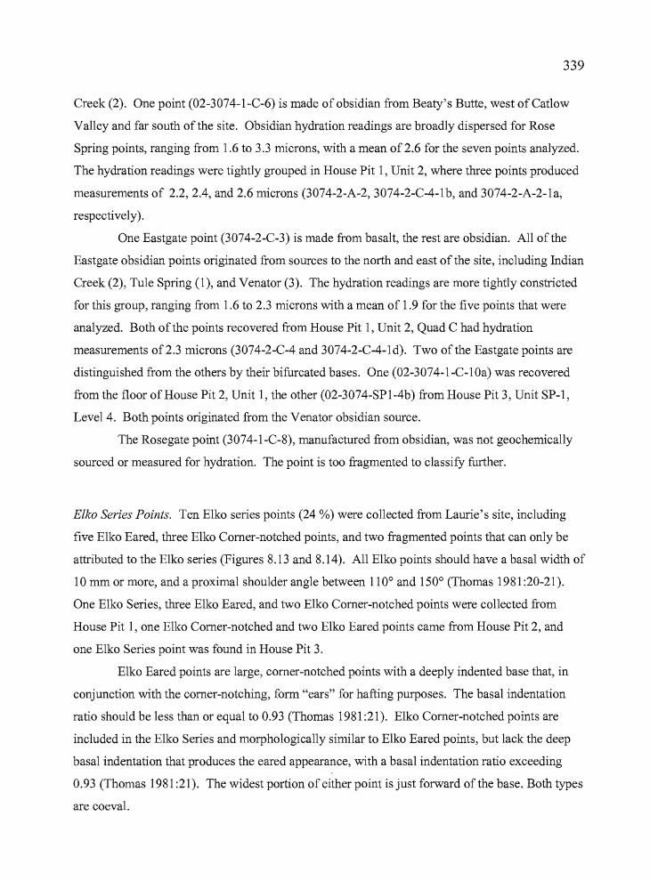
b
339
Creek (2). One point (02-3074-1-C-6) is made of obsidian from Beaty's Butte, west of Catlow
Valley and far south of the site. Obsidian hydration readings are broadly dispersed for Rose
Spring points, ranging from 1.6 to 3.3 microns, with a mean of 2.6 for the seven points analyzed.
The hydration readings were tightly grouped in House Pit 1, Unit 2, where three points produced
measurements of 2.2,2.4, and 2.6 microns (3074-2-A-2, 3074-2-C-4-1b, and 3074-2-A-2-1a,
respectively).
One Eastgate point (3074-2-C-3) is made from basalt, the rest are obsidian. All of the
Eastgate obsidian points originated from sources to the north and east of the site, including Indian
Creek (2), Tule Spring (1), and Venator (3). The hydration readings are more tightly constricted
for this group, ranging from 1.6 to 2.3 microns with a mean of 1.9 for the five points that were
analyzed. Both ofthe points recovered from House Pit 1, Unit 2, Quad C had hydration
measurements of2.3 microns (3074-2-C-4 and 3074-2-C-4-1d). Two of the Eastgate points are
distinguished from the others by their bifurcated bases. One (02-3074-1-C-10a) was recovered
from the floor of House Pit 2, Unit 1, the other (02-3074-SPl-4b) from House Pit 3, Unit SP-1,
Level 4. Both points originated from the Venator obsidian source.
The Rosegate point (3074-1-C-8), manufactured from obsidian, was not geochemically
sourced or measured for hydration. The point is too fragmented to classify further.
Elko Series Points. Ten Elko series points (24 %) were collected from Laurie's site, including
five E1ko Eared, three Elko Comer-notched points, and two fragmented points that can only be
attributed to the Elko series (Figures 8.13 and 8.14). All Elko points should have a basal width of
10 mm or more, and a proximal shoulder angle between 110° and 150° (Thomas 1981:20-21).
One Elko Series, three Elko Eared, and two E1ko Comer-notched points were collected from
House Pit 1, one Elko Comer-notched and two Elko Eared points came from House Pit 2, and
one Elko Series point was found in House Pit 3.
Elko Eared points are large, comer-notched points with a deeply indented base that, in
conjunction with the comer-notching, form "ears" for hafting purposes. The basal indentation
ratio should be less than or equal to 0.93 (Thomas 1981 :21). Elko Comer-notched points are
included in the Elko Series and morphologically similar to Elko Eared points, but lack the deep
basal indentation that produces the eared appearance, with a basal indentation ratio exceeding
0.93 (Thomas 1981 :21). The widest portion of either point is just forward of the base. Both types
are coeval.
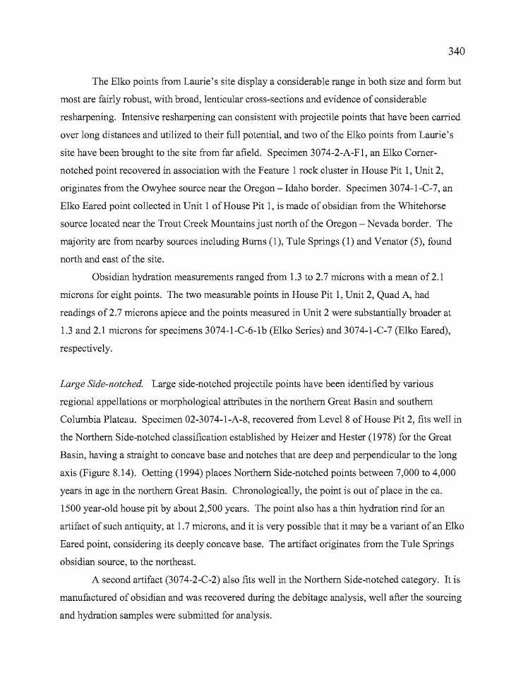
tt •
340
The Elko points from Laurie's site display a considerable range in both size and form but
most are fairly robust, with broad, lenticular cross-sections and evidence of considerable
resharpening. Intensive resharpening can consistent with projectile points that have been carried
over long distances and utilized to their full potential, and two ofthe Elko points from Laurie's
site have been brought to the site from far afield. Specimen 3074-2-A-FI, an Elko Corner
notched point recovered in association with the Feature 1 rock cluster in House Pit 1, Unit 2,
originates from the Owyhee source near the Oregon - Idaho border. Specimen 3074-1-C-7, an
Elko Eared point collected in Unit 1 of House Pit 1, is made of obsidian from the Whitehorse
source located near the Trout Creek Mountains just north of the Oregon - Nevada border. The
majority are from nearby sources including Burns (1), Tule Springs (1) and Venator (5), found
north and east of the site.
Obsidian hydration measurements ranged from 1.3 to 2.7 microns with a mean of2.1
microns for eight points. The two measurable points in House Pit 1, Unit 2, Quad A, had
readings of2.7 microns apiece and the points measured in Unit 2 were substantially broader at
1.3 and 2.1 microns for specimens 3074-1-C-6-1b (Elko Series) and 3074-1-C-7 (Elko Eared),
respectively.
Large Side-notched. Large side-notched projectile points have been identified by various
regional appellations or morphological attributes in the northern Great Basin and southern
Columbia Plateau. Specimen 02-3074-1-A-8, recovered from Level 8 of House Pit 2, fits well in
the Northern Side-notched classification established by Heizer and Hester (1978) for the Great
Basin, having a straight to concave base and notches that are deep and perpendicular to the long
axis (Figure 8.14). Oetting (1994) places Northern Side-notched points between 7,000 to 4,000
years in age in the northern Great Basin. Chronologically, the point is out ofplace in the ca.
1500 year-old house pit by about 2,500 years. The point also has a thin hydration rind for an
artifact of such antiquity, at 1.7 microns, and it is very possible that it may be a variant of an Elko
Eared point, considering its deeply concave base. The artifact originates from the Tule Springs
obsidian source, to the northeast.
A second artifact (3074-2-C-2) also fits well in the Northern Side-notched category. It is
manufactured of obsidian and was recovered during the debitage analysis, well after the sourcing
and hydration samples were submitted for analysis.
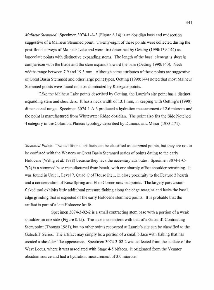
341
Malheur Stemmed. Specimen 3074-1-A-3 (Figure 8.14) is an obsidian base and midsection
suggestive of a Ma1heur Stemmed point. Twenty-eight of these points were collected during the
post-flood surveys ofMa1heur Lake and were first described by Oetting (1990:139-144) as
lanceolate points with distinctive expanding stems. The length of the basal element is short in
comparison with the blade and the stem expands toward the base (Oetting 1990:140). Neck
widths range between 7.9 and 19.3 mm. Although some attributes of these points are suggestive
of Great Basin Stemmed and other large point types, Oetting (1990: 144) noted that most Malheur
Stemmed points were found on sites dominated by Rosegate points.
Like the Malheur Lake points described by Oetting, the Laurie's site point has a distinct
expanding stem and shoulders. It has a neck width of 13.1 mm, in keeping with Oetting's (1990)
dimensional range. Specimen 3074-1-A-3 produced a hydration measurement of2.6 microns and
the point is manufactured from Whitewater Ridge obsidian. The point also fits the Side Notched
4 category in the Columbia Plateau typology described by Dumond and Minor (1983: 171).
Stemmed Points. Two additional artifacts can be classified as stemmed points, but they are not to
be confused with the Western or Great Basin Stemmed series ofpoints dating to the early
Holocene (Willig et al. 1988) because they lack the necessary attributes. Specimen 3074-1-C
7(2) is a stemmed base manufactured from basalt, with one sharply offset shoulder remaining. It
was found in Unit 1, Level 7, Quad C of House Pit 1, in close proximity to the Feature 2 hearth
and a concentration of Rose Spring and Elko Comer-notched points. The largely percussion
flaked tool exhibits little additional pressure flaking along the edge margins and lacks the basal
edge grinding that is expected of the early Holocene stemmed points. It is probable that the
artifact is part of a late Holocene knife.
Specimen 3074-3-02-2 is a small contracting stem base with a portion of a weak
shoulder on one side (Figure 8.15). The size is consistent with that of a GatecliffContracting
Stem point (Thomas 1981), but no other points recovered at Laurie's site can be classified to the
Gatecliff Series. The artifact may simply be a portion of a small biface with flaking that has
created a shoulder-like appearance. Specimen 3074-3-02-2 was collected from the surface of the
West Locus, where it was associated with Stage 4-5 bifaces. It originated from the Venator
obsidian source and had a hydration measurement of3.0 microns.
F¢
342
Unknown. Several biface fragments have characteristics that are consistent with projectile points,
but morphological attributes that are not classifiable into known typologies. Specimen 3074-2-C
4-lc (Figure 8.14) appears to be a projectile point base. However, the tool has a "waisted"
appearance and a slightly convex base that can not be associated with known point types. The
artifact originates from Quad C, Level 4 of House Pit 1, Unit 2, and it was found in close
association with Rose Spring and Eastgate points. It is made of obsidian from the Venator source
and produced a hydration measurement of 2.5 microns, well in keeping with the other artifacts
recovered from Unit 2.
Specimen 3074-l-A-5 is a large biface, broken distally, that appears to have weak
shoulders. It was recovered from Quad A, Level 5 of House Pit 1, Unit 1 in association with
Rose Spring, Elko, and Eastgate points. The obsidian artifact is 77.8 mm in length by 26.8 mm in
width and it is considered to be a knife fragment, although the shoulders create some uncertainty
about that assessment. It is manufactured from Tule Spring obsidian and has a hydration
measurement of 2.4 microns. Although large bifaces with weak shoulders may be indicative of
some early Holocene projectile points, that is not considered to be the case here. The association
with late Holocene point styles in deposits with good context, the thin hydration reading, and the
absence of basal edge grinding all argue in favor of its use as a late Holocene knife or spear point
rather than an early Holocene projectile point. Specimen 3074-3-Surf-3 is a projectile point base
fragment that is broken in such a manner that some uncertainty exists regarding its appropriate
classification. It appears to have "ears" similar to an Elko Eared point, but the base is larger than
is commonly seen in the Elko Series. The artifact is made of Beatys Butte obsidian and has a
hydration measurement of 2.8 microns.
Shaped Bifaces
This category is based on the multi-stage biface classification system employed by
Jenkins and Connolly (1990) at the Indian Grade Spring site. Stage 1-5 bifaces are discussed
here. A total of 66 bifaces was collected from the excavations at Laurie's site, including 56 from
the 2001 House Pit 1 excavations and 10 from the 2002 House Pit 2 excavations (Table 8.4,
Figure 8.15). The majority ofthe bifaces consist ofprojectile point fragments that include tips,
midsections, edge fragments, tangs, barbs, and bases. The determination that the artifacts are
projectile point fragments is based on the amount of fine flaking observed (Stage 4 or 5, see
---~.",.._.._----
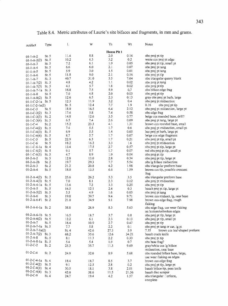
343
Table 8.4. Metric attributes afLaurie's site bifaces and fragments, in mm and grams.
Artifact Type L W 111 Wt Notes
House Pit 1
01-I-A-2 S1. 5 11.4 8.8 2.0 0.16 obs proj pt tip
01-I-A-2(2) St.5 10.2 6.3 3.2 0.2 wnite ccs proj pt edge
01-I-A-3 St. 5 7.2 6.1 1.9 0.05 obs proj pt tip, small pt
01-I-A-4 S1. 5 6.6 6.0 2.1 0.07 obs proj pt tang
01-I-A-5 S1. 5 5.9 3.0 1.5 0.01 obs proj pt tang
01-I-A-6 S1. 5 1l.8 9.0 2.1 0.16 obs proj pt tip
01-I-A-7 S1. 3 40.7 31.0 5.5 7.04 obs triangular quarry blank
01-I-A-7(2) S1. 5 4.8 4.2 l.l 0.02 obs proj pt tangOI-I-A-7(3) S1. 5 4.1 5.7 1.8 0.02 obs proj pt tip
01-I-A-7-1a S1. 3 18.8 7.5 5.9 0,7 obs biface edge frag01-I-A-8 S1. 5 7.0 4.8 2.0 0.03 obs proj pt tip01-I-A-8(2) S1. 5 12.6 6.5 2.3 0.13 gray obs proj pt barb, large01-I-C-2-la S1. 5 12.3 11.9 3.2 0.4 obs proj pt midsection01-I.C-2-la(2) S1. 5 12.4 7.7 1.9 0.16 obs proj pt tip01-I-C-3 S1. 5 18.0 16.5 6.4 2.12 obs proj pt midsection, large pt01-I-C-3(2) S1. 3 17.4 5.8 7.4 0.58 obs edge frag01-1-C-3(3) S1. 2 14.8 12.6 3.5 0.77 beige ccs rounded base, drill?01-1-C-3(4) S1. 5 6.5 7.4 2.6 0.09 obs proj pt tang, large pt01-1-C-4 S1. 2 15.2 23.3 4.1 1.31 brown ccs rounded base, smalloI-1-C-4(2) S1. 5 7.4 5.5 1.7 0.6 obs proj pt midsection, small pt01-I-C-4(3) St.5 6.9 5.5 1.4 0.05 bas proj pt barb, large pt01-I-C-4(4) S1. 5 8.7 5.7 1.7 0.07 beige ccs edge fragment01-I-C-5 S1. 5 22.9 6.3 1.7 0.21 obs proj pt tip, small pt01-I-C-6 S1. 5 18.2 16.2 3.3 1.6 obs proj pt midsection01-1-C-6-la S1. 4 13.4 17.5 2.7 0.57 obs proj pt tip, large pt01-1-C-6(2) S1. 5 9.1 5.7 1.7 0.07 red obs proj pt tip, small pt01-1-C-6(3) S1. 5 4.7 8.9 1.9 0.04 obs proj pt tip01-2-A-2 S1. 5 12.8 13.0 2.8 0.34 obs proj pt tip, large pt01-2-A-2b S1. 2 19.7 29.3 7.7 5.54 obs 19 biface midsection01-2-A-3 S1. 2 21.2 20.8 4.2 1.98 obs triangular preform base01-2-A-4 S1. 5 18.0 13.5 6.6 1.59 brown ccs tip, possible crescent
frag01-2-A-4(2) S1. 2 25.6 26.2 5.3 3.5 obs triangular preform base01-2-A-4(3) S1. 5 7.0 8.1 2.3 0.12 obs proj pt midsection01-2-A-4-la S1. 5 13.6 7.2 3.3 0.25 obs proj pt tip01-2-A-5 S1. 5 14.5 12.1 2.4 0.3 basalt proj pt tip, large pt01-2-A-5(2) S1. 5 5.5 4.9 1.6 0.03 obs proj pt tang01-2-A-6 S1. 3 19.8 39.7 9.4 9.71 brown ccs midsect, 19, near base01-2-A-6-FI S1. 2 21.0 34.9 9.1 7.98 brown ccs edge frag, rough
flaking01-2-A-6-la S1. 2 38.8 28.9 8.3 5.63 obs edge frag, use wear flaking
on broken/unbroken edges01-2-A-6-1 b St. 5 16.5 18.7 3.7 0.8 obs proj pt tip, large pt01-2-A-6(2) S1. 5 12.2 6.1 2.3 0.13 obs proj pt tip, small pt01-2-A-7 S1. 5 18.4 10.9 2.7 0.47 obs proj pt tip01-2-A-7-la S1. 5 7.7 5.8 2.2 0.1 obs proj pt tang or ear, 19 pt01-2-A-7-la(2) S1. 4 42.6 27.3 5.9 7.35 brown ccs leaf-shaped preform01-2-A-7(2) S1. 3 68.2 35.6 12.6 34.21 basalt crude knife01-2-A-8 S1. 5 8.1 11.3 2.2 0.33 obs proj pt tip01-2-A-8-la S1. 5 5.4 5.4 1.9 0.7 obs base frag?01-2-C-2 S1. 2 25.3 35.7 11.3 9.69 gray/white ccs 19 biface
midsection, near base01-2-C-4 S1. 2 24.9 32.0 8.9 5.68 obs rounded biface base, large,
use wear flaking on edgeso1-2-C-4-1a S1. 4 18.4 18.7 8.5 3.7 brown ccs edge frag01-2-C-4(2) S1. 5 9.1 12.5 2.8 0.2 obs proj pt tip, large pt01-2-C-4(3) S1. 4 30.5 18.1 3.8 2.01 basalt biface tip, poss knife01-2-C-4(4) S1. 3 42.0 38.6 11.5 21.56 basalt disc scraper01-2-C-9 S1. 4 24.7 19.4 4.2 1.57 obs triangular =erform,
complete
---..,,-----
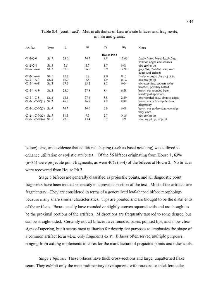
• e
344
Table 8.4. (continued). Metric attributes of Laurie's site bifaces and fragments,in mm and grams.
Artifact Type L W Th Wt Notes
House Pit 201-2-C-6 St. 5 38.0 24.3 8.8 12.46 finely flaked basalt knife frag,
wear on edges and amsses01-2-C-8 St. 5 5.5 2.7 1.7 0.01 obs proj pt tip02-2-l-A-4 St. 3 37.8 36.9 8.9 12.99 gray obs, rounded base, worn
edges and arrisses02-2-l-A-6 St. 5 13.2 6.8 2.0 0.13 finely wrought obs proj pt tip02-2-l-A-7 St. 5 10.0 7.8 1.9 0.12 obs proj pt tip02-2-l-A-8 St. 3 27.7 33.2 8.2 6.04 obs edge frag, appears to be
notched, possibly hafted02-2-l-A-9 St. 3 23.0 27.8 8.4 6.28 brown ccs rounded base,
teardrop-shaped tool02-2-l-C-8 St. 2 18.1 27.6 5.8 2.29 obs rounded base, sinuous edges02-2-I-C-1O(l ) St. 2 46.9 26.8 7.9 8.88 brown ccs biface tip, broken
diagonally02-2-I-C-1O(2) St. 4 26.7 24.0 6.9 6.08 brown ccs midsection, one edge
very worn02-2-I-C-IO(3) St. 5 11.3 9.3 2.7 0.16 obs proj pt tip02-2-I-C-IO(4) St. 5 22.0 13.4 3.7 0.9 obs proj pt tip, large pt
below), size, and evidence that additional shaping (such as basal notching) was utilized to
enhance utilitarian or stylistic attributes. Of the 56 bifaces originating from House 1,63%
(n=35) were projectile point fragments, as were 40% (n=4) of the bifaces at House 2. No bifaces
were recovered from House Pit 3.
Stage 5 bifaces are generally classified as projectile points, and all diagnostic point
fragments have been treated separately in a previous portion of the text. Most of the artifacts are
fragmentary. They are considered in terms of a generalized leaf-shaped biface morphology
because many share similar characteristics. Tips are pointed and are thought to be the distal ends
of the artifacts. Bases usually have rounded or slightly convex squared ends and are thought to
be the proximal portions of the artifacts. Midsections are frequently tapered to some degree, but
can be straight-sided. Certainly not all bifaces have rounded bases, pointed tips, and show clear
signs of tapering, but it seems most utilitarian for descriptive purposes to emphasize the shape of
a common artifact form when only fragments exist. Bifaces often served multiple purposes,
ranging from cutting implements to cores for the manufacture ofprojectile points and other tools.
Stage 1 bi/aces. These bifaces have thick cross-sections and large, unpattemed flake
scars. They exhibit only the most rudimentary development, with rounded or thick lenticular
345shapes and cross-sections. The flaking pattern reflects use of the hard hammer percussion
technique, and the edges of these tools can be very sinuous. None of the bifaces recovered from
Laurie's site reflect Stage 1 reduction.
Stage 2 bi/aces. Bifacial thinning is continued on these artifacts through the removal of
contiguous hard hammer percussion flakes. The removal of the flakes results in the development
of an artifact, which, although still crudely shaped, has a more pronounced form than Stage 1
artifacts. Stage 2 bifaces are considered to be quarry blanks. Eleven artifacts fit this
classification, including two from Unit 1, Quad C; five from Unit 2 Quad A, and two from Unit
2, Quad C of House Pit 1. No Stage 2 bifaces were collected from Unit 1, Quad A. House Pit 2
produced two in Quad C. Of the 11 Stage 2 bifaces, five were made from CCS and six were
obsidian. A limited degree of patterning is evident in the distribution of the two types of tool
stone. Unit 1 Quad C produced two bifaces made of CCS. Unit 2, Quad A had four obsidian
bifaces and one ofCCS. The CCS biface was recovered in association with the Feature 1 artifact
cluster. The small number of Stage 2 bifaces at Laurie's site limits any conclusions that can be
drawn regarding their distribution.
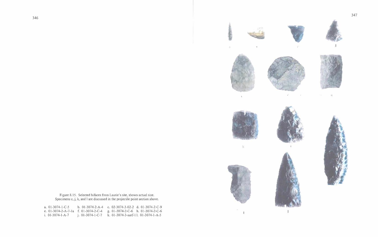
p
346347
.1
Figure 8.15. Selected bifaces from Laurie's site, shown actual size.Specimens c, j, Ie, and 1are discussed in the projectile point section above.
Ic. 02-3074-3-02-2 d. 01-3074-2-C-9g. 01-3074-2-C-6 h. 01-3074-2-C-61<. 01-3074-3-surf-ll. 01-3074-1-A-5
a. 01-3074-1-C-5 b. 01-3074-2-A-4e. 01-3074-2-A-7-1a f. 01-3074-2-C-4i. 01-3074-1-A-7 j. 01-3074-1-C-7
-- •
.. Jtn _
348
Stage 3 bi/aces. The second-most common reduction stage at Laurie's site, these bifaces
exhibit little to no evidence of pressure flaking and have the slightly sinuous edges characteristic
oflarge percussion flake scars created by the initial stages ofbifacial reduction. The entire
artifact surface has been modified through the removal of flakes, the scars of which can reach the
middle of the artifact. It is at Stage 3 that major thinning of a biface occurs, often leading to
breakage. Most of the artifacts exhibited fine pressure flaking along some edges, with varying
degrees ofpercussion flaking along other edges and across the body of the artifact. A total of
nine biface fragments fit this classification, five of which are of obsidian and two each of CCS
and basalt. They include two from Quad A and one from Quad C, of Unit I of House Pit 1; and
two from Quad A and one from Quad C, of Unit 2. House Pit 2 produced three in Quad A, none
in Quad C, and there were none from House Pit 3.
The Stage 3 bifaces included four edge fragments, a midsection, a crude knife, a quarry
blank, two bases, and a disc-shaped scraper. Specimen 01-2-C-4(4), the basalt disc, was
collected from Level 4, Quad C ofUnit 2, House Pit 1. The object may have originally served as
a core, from which flakes were struck to create other tools. The artifact was also utilized as a
scraper with additional flake removal that was a by-product of heavy use and from pressure
flaking of some edges. The scraper was used with enough intensity to cause smoothing of
exterior edges as well as on interior flake scars across the body of the disc.
Stage 4 bi/aces. The continuation ofpercussion and pressure flaking techniques after
Stage 3 results in bifaces with a more "finished" appearance than Stage 3 tools. Pressure flake
scars can reach the midline ofthe artifact or carry further, frequently eliminating the large
percussion flake scars from earlier reduction. Edges are strengthened by the removal of pressure
flakes, which increases the edge angle. Six Stage 4 artifacts were collected from Laurie's site,
including one obsidian point tip, one CCS midsection, one CCS and one obsidian preform, a CCS
edge fragment, and a basalt biface tip. House Pit 1 contained one Stage 4 biface in Quad C of
Unit 1, as well as one in Quad A and three in Quad C ofUnit 2. House Pit 2 produced one in
Quad C. The CCS midsection from House Pit 2 (02-2-1-C-10[2]) is manufactured from brown
semi-translucent material and one edge has a substantially greater degree of wear than the
opposite. Both of the preforms would have been utilized to manufacture small tools such as
tz b
349
arrow points. Specimen 01-2-a-7-1 a(2), made from brown CCS, is a leaf -shaped preform.
Specimen 01-2-C-9 is a triangular preform that is made of obsidian.
Projectile Point Fragments (Stage 5). The 40 Stage 5 biface fragments found at Laurie's site can
be divided into two groups, projectile points composing the largest group with 37 specimens
(93%) and other finely finished tools accounting for the remainder. Of the 37 projectile point
fragments, 23 (62%) are believed to be point tips, followed by six tangs (16%), five midsections
(14%), two barbs (5%), and one edge fragment (3%). One to three point fragments were found in
most levels of each quad at House Pit 1 for a total of 36. Four were found in House Pit 2 and
none were reported from House Pit 3. The probable reason for the low numbers in House Pits 2
and 3 is because debitage analysis was not carried out there, and many of the point fragments
from House Pit 1 were only identifiable after thorough cleaning prior to the analysis. A total of
34 ofthe Stage 5 bifaces was made of obsidian and three each are basalt and CCS.
Among the more noteworthy Stage 5 bifaces recovered during the excavation (aside from
the diagnostic projectile points) was a brown CCS biface tip that is reminiscent of a Great Basin
Transverse point (Clewlow 1968, Tadlock 1966). The robustly proportioned tip fragment has
one straight edge and the opposite is convex in the form of a crescent. Both edges are either
heavily worn or ground. While the artifact could also easily be the tip of a well-worn and slightly
asymmetrical biface, the combination ofthickness, edge wear, and shape combine to suggest
otherwise. It is similar in morphology to others collected from around Malheur and Harney lakes
that I have studied in various private collections.
The 66 bifaces reported here equate to almost ten per cubic meter of excavation (66/6.8
m3= 9.7) at Laurie's site. The fact that 61 % of the bifaces are Stage 5 is striking and suggests
that much of the lithic reduction at the site involved the use of preforms or quarry blanks that
were nearly finished by the time they were brought to the site. It is not clear whether projectile
point breakage is occurring during flint knapping or in relation to other activities such as during
the procurement of game. Large bifacial cores are not present to any great degree, and the
evidence from obsidian sourcing suggests that most ofthe early stage lithic reduction activities
was occurring at tool stone sources to the north and east ofthe site.
350
Drills and Awls
Four drill and awl fragments came from the House 1 excavations, with three collected in
Levels 2 and 3, and one collected in Level 7 (Table 8.5, Figure 8.16). One complete specimen of
brown and cream colored CCS, (3074-01-1-A-3) has a base that expands to a bulbous shape
presumably for hand held use. One CCS tip (3074-01-1-A-7) is lenticular in cross section and
straight-sided, culminating in a tip with little taper. The midsection (3074-01-2-A-2) is also
lenticular in cross section and straight-sided, but more roughly flaked that the other straight-sided
specimens. The basalt tool (3074-01-2-A-3) has a thin, diamond shape and fine, chevron
patterned flaking extending to the midline ofthe artifact. It does not appear to be a projectile
point fragment and is too thin in cross section to have served effectively as a drill. The artifact
would have functioned well as an awl, or perforator, utilized for punching holes in leather or
other low density materials.
Edge-modified Flakes
A total of 21 edge-modified flakes was collected at Laurie's site, all from House Pit 1.
Those artifacts meeting the classification of an edge-modified flake must exhibit regular,
patterned, flaking on at least one edge that is clearly intentional, excluding the possibility that
flaking has resulted from trampling or other agents of edge-damage. As was the case for the
projectile point fragments above, many ofthe artifacts identified as edge-modified were
discovered during debitage analysis after the flakes had been thoroughly cleaned. The lack of
such artifacts from House Pits 2 and 3 may be directly attributable to this factor.
Table 8.5. Metric attributes of drills and awls from Laurie's site.
Artifact Type L W Th Wt Notes
01-1-A-3 CCS 61.7 11.6 5.6 4.07 complete straight-sided, wlbase01-1-A-7 CCS 14.8 8.2 4.9 0.6 tip, straight-sided01-2-A-2 CCS 16.2 6.5 3.8 0.42 midsection, straight-sided01-2-A-3 BAS 26.5 11.0 4.6 1.01 basalt, tapered perforator
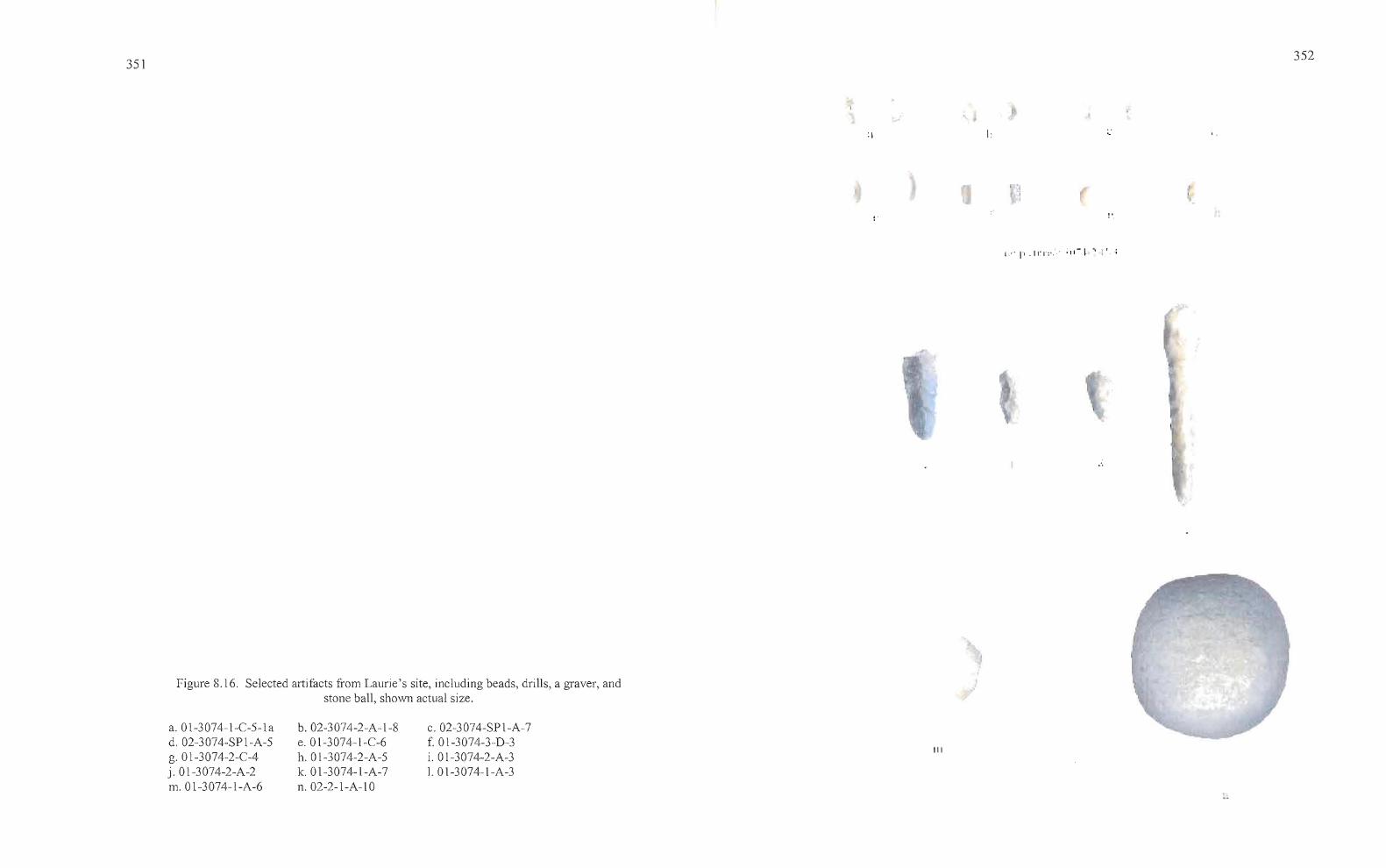
351
I:
I,'" I"' .Irl":·"·· ;,,- ~ " !' ;
o.
352
Figure 8.16. Selected artifacts from Laurie's site, including beads, drills, a graver, andstone ball, shown actual size.
-
a. 0 1-3074-1-C-5-1 ad. 02-3074-SP I-A-5g. Ol-3074-2-CAj.Ol-3074-2-A-2m.Ol-3074-1-A-6
b. 02-3074-2-A-I-8e.Ol-3074-1-C-6h. Ol-3074-2-A-5k. Ol-3074-1-A-7n.02-2-1-A-10
c.02-3074-SP1-A-7f. Ol-3074-3-D-3i. Ol-3074-2-A-31. Ol-3074-1-A-3
>
III
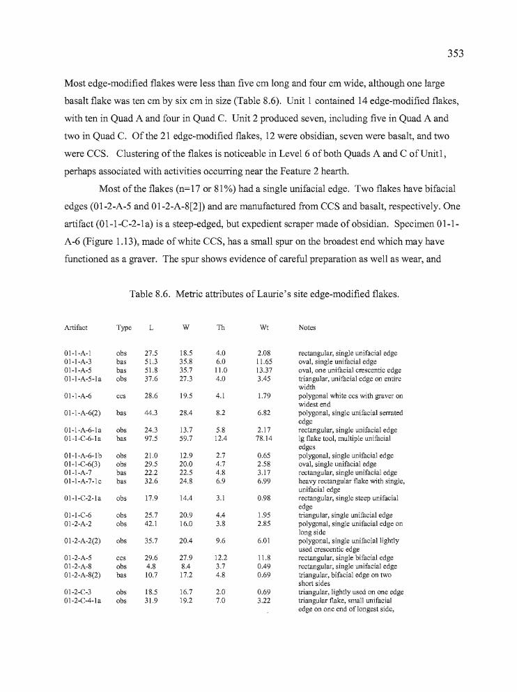
353
Most edge-modified flakes were less than five cm long and four cm wide, although one large
basalt flake was ten cm by six cm in size (Table 8.6). Unit 1 contained 14 edge-modified flakes,
with ten in Quad A and four in Quad C. Unit 2 produced seven, including five in Quad A and
two in Quad c. Ofthe 21 edge-modified flakes, 12 were obsidian, seven were basalt, and two
were CCS. Clustering of the flakes is noticeable in Level 6 ofboth Quads A and C ofUnit1,
perhaps associated with activities occurring near the Feature 2 hearth.
Most ofthe flakes (n=17 or 81 %) had a single unifacial edge. Two flakes have bifacial
edges (01-2-A-5 and 01-2-A-8[2]) and are manufactured from CCS and basalt, respectively. One
artifact (01-I-C-2-1a) is a steep-edged, but expedient scraper made of obsidian. Specimen 01-1
A-6 (Figure 1.13), made of white CCS, has a small spur on the broadest end which may have
functioned as a graver. The spur shows evidence of careful preparation as well as wear, and
Table 8.6. Metric attributes of Laurie's site edge-modified flakes.
Artifact Type L W Th Wt Notes
Ol-l-A-l obs 27.5 18.5 4.0 2.08 rectangular, single unifacial edge01-1-A-3 bas 51.3 35.8 6.0 11.65 oval, single unifacial edge01-1-A-5 bas 51.8 35.7 11.0 13.37 oval, one unifacial crescentic edge01-1-A-5-la obs 37.6 27.3 4.0 3.45 triangular, unifacial edge on entire
width01-1-A-6 ccs 28.6 19.5 4.1 1.79 polygonal white ccs with graver on
widest end01-1-A-6(2) bas 44.3 28.4 8.2 6.82 polygonal, single unifacial serrated
edge01-1-A-6-la obs 24.3 13.7 5.8 2.17 rectangular, single unifacial edge01-1-C-6-la bas 97.5 59.7 12.4 78.14 19 flake tool, multiple unifacial
edges01-1-A-6-lb obs 21.0 12.9 2.7 0.65 polygonal, single unifacial edge01-1-C-6(3) obs 29.5 20.0 4.7 2.58 oval, single unifacial edge01-1-A-7 bas 22.2 22.5 4.8 3.17 rectangular, single unifacial edge01-1-A-7-lc bas 32.6 24.8 6.9 6.99 heavy rectangular flake with single,
unifacial edge01-1-C-2-la obs 17.9 14.4 3.1 0.98 rectangular, single steep unifacial
edge01-1-C-6 obs 25.7 20.9 4.4 1.95 triangular, single unifacial edge01-2-A-2 obs 42.1 16.0 3.8 2.85 polygonal, single unifacial edge on
long sideol-2-A-2(2) obs 35.7 2004 9.6 6.01 polygonal, single unifaciallightly
used crescentic edge01-2-A-5 ccs 29.6 27.9 12.2 11.8 rectangular, single bifacial edge01-2-A-8 obs 4.8 804 3.7 0.49 rectangular, single unifacial edgeol-2-A-8(2) bas 10.7 17.2 4.8 0.69 triangular, bifacial edge on two
short sides01-2-C-3 obs 18.5 16.7 2.0 0.69 triangular, lightly used on one edge01-2-C-4-la obs 31.9 19.2 7.0 3.22 triangular flake, small unifacial
edge on one end of longest side,
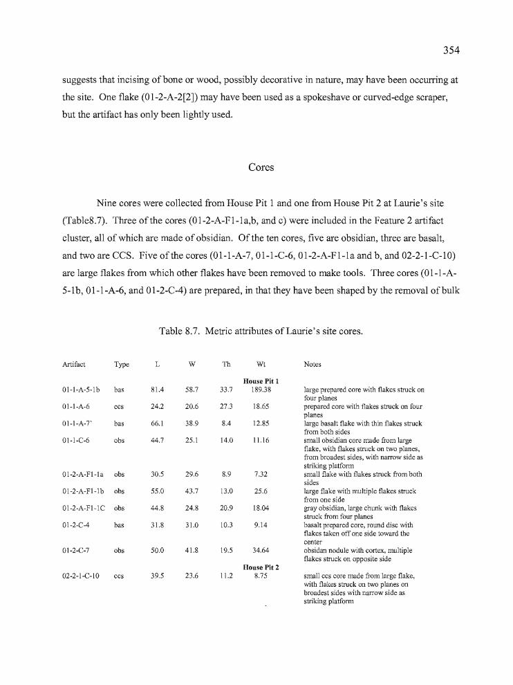
354
suggests that incising of bone or wood, possibly decorative in nature, may have been occurring at
the site. One flake (Ol-2-A-2[2]) may have been used as a spokeshave or curved-edge scraper,
but the artifact has only been lightly used.
Cores
Nine cores were collected from House Pit 1 and one from House Pit 2 at Laurie's site
(Tab1e8.7). Three of the cores (Ol-2-A-Fl-la,b, and c) were included in the Feature 2 artifact
cluster, all of which are made of obsidian. Of the ten cores, five are obsidian, three are basalt,
and two are CCS. Five of the cores (Ol-1-A-7, Ol-1-C-6, Ol-2-A-Fl-la and b, and 02-2-1-C-IO)
are large flakes from which other flakes have been removed to make tools. Three cores (Ol-l-A
5-1b, Ol-1-A-6, and Ol-2-C-4) are prepared, in that they have been shaped by the removal of bulk
Table 8.7. Metric attributes of Laurie's site cores.
Artifact Type L W TIl Wt Notes
House Pit 101-1-A-5-lb bas 81.4 58.7 33.7 189.38 large prepared core with flakes struck on
four planes01-1-A-6 ccs 24.2 20.6 27.3 18.65 prepared core with flakes struck on four
planesOl-l-A-T bas 66.1 38.9 8.4 12.85 large basalt flake with thin flakes struck
from both sides01-1-C-6 obs 44.7 25.1 14.0 11.16 small obsidian core made from large
flake, with flakes struck on two planes,from broadest sides, with narrow side asstriking platform
ol-2-A-Fl-la obs 30.5 29.6 8.9 7.32 small flake with flakes struck from bothsides
01-2-A-Fl-lb obs 55.0 43.7 13.0 25.6 large flake with multiple flakes struckfrom one side
01-2-A-Fl-lC obs 44.8 24.8 20.9 18.04 gray obsidian, large chunk with flakesstruck from four planes
01-2-C-4 bas 31.8 31.0 10.3 9.14 basalt prepared core, round disc withflakes taken off one side toward thecenter
01-2-C-7 obs 50.0 41.8 19.5 34.64 obsidan nodule with cortex, multipleflakes struck on opposite side
House Pit 202-2-l-C-10 ccs 39.5 23.6 11.2 8.75 small ccs core made from large flake,
with flakes struck on two planes onbroadest sides with narrow side asstriking platform
tt •
355
to create striking planes for maximum flake yield. One of these, Specimen Ol-2-C-4, is a basalt
disc pictured in Figure 1.12 and described in the biface section (Stage 3), because
it was later modified for use as a scraper. Two cores (Ol-2-A-Fl-lc and Ol-2-C-7) are expedient,
the former being a large obsidian fragment from which flakes were struck without apparent
pattern or edge preparation, the latter simply a broken obsidian nodule that has flakes removed
from the side lacking cortex.
Ground Stone
Ground stone tools are those which exhibit shaping or wear by abrasion that is usually
associated with the processing of botanical resources, particularly roots, bulbs, and seeds, but can
also result from the preparation of faunal resources. Ground stone tools include manos, metates,
stone balls, and abrading stones. Few of the 37 pieces of ground stone recovered from Laurie's
site (Table 8.8) are either complete or of a size useful for their original purpose. Much of the
material is broken into small fragments, often charred, and probably utilized in a secondary
fashion for hearth rocks or cooking stones. The ground stone fragments are primarily from
metates (n=2l, or 57%), followed by manos (n=12, or 32%), bowls (n=1, or 3%), and
unidentifiable fragments (n=2, or 5%). One complete stone ball (02-2-1-A-10[2]) was also
recovered from House Pit 2 (Figure 8.16) and an abrader was collected from the surface nearby.
Despite their fragmented state, all but two of the artifacts have enough characteristics to
determine whether they are parts of either manos or metates. The mano fragments are generally
bifacial, somewhat lenticular in cross section with convex grinding surfaces, and have pecked
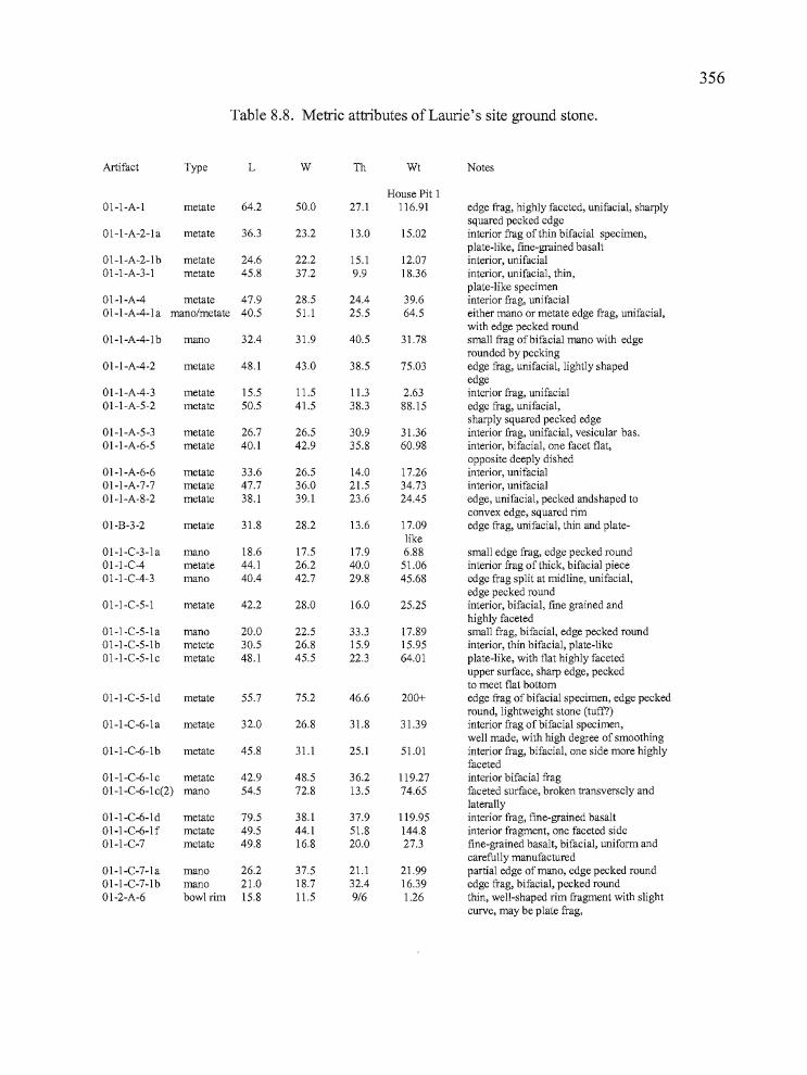
356
Table 8.8. Metric attributes of Laurie's site ground stone.
Artifact Type L W Th Wt Notes
House Pit 1Ol-l-A-l metate 64.2 50.0 27.1 116.91 edge frag, highly faceted, unifacial, sharply
squared pecked edge01-I-A-2-la metate 36.3 23.2 13.0 15.02 interior frag of thin bifacial specimen,
plate-like, fine-grained basalt01-I-A-2-1b metate 24.6 22.2 15.1 12.07 interior, unifacial01-1-A-3-l metate 45.8 37.2 9.9 18.36 interior, unifacia1, thin,
plate-like specimen01-I-A-4 metate 47.9 28.5 24.4 39.6 interior frag, unifacial01-I-A-4-la mano/metate 40.5 51.1 25.5 64.5 either mano or metate edge frag, unifacial,
with edge pecked round01-1-A-4-lb mano 32.4 31.9 40.5 31.78 small frag ofbifacial mano with edge
rounded by pecking01-I-A-4-2 metate 48.1 43.0 38.5 75.03 edge frag, unifacial, lightly shaped
edge01-I-A-4-3 metate 15.5 11.5 11.3 2.63 interior frag, unifacia101-I-A-5-2 metate 50.5 41.5 38.3 88.15 edge frag, unifacia1,
sharply squared pecked edge01-1-A-5-3 metate 26.7 26.5 30.9 31.36 interior frag, unifacial, vesicular bas.01-1-A-6-5 metate 40.1 42.9 35.8 60.98 interior, bifacia1, one facet flat,
opposite deeply dished01-1-A-6-6 metate 33.6 26.5 14.0 17.26 interior, unifacial01-1-A-7-7 metate 47.7 36.0 21.5 34.73 interior, unifacial01-1-A-8-2 metate 38.1 39.1 23.6 24.45 edge, unifacia1, pecked andshaped to
convex edge, squared rim01-B-3-2 metate 31.8 28.2 13.6 17.09 edge frag, unifacial, thin and plate-
like01-1-C-3-! a mano 18.6 17.5 17.9 6.88 small edge frag, edge pecked round01-1-C-4 metate 44.1 26.2 40.0 51.06 interior frag of thick, bifacial piece01-I-C-4-3 mano 40.4 42.7 29.8 45.68 edge frag split at midline, unifacia1,
edge pecked round01-1-C-5-l metate 42.2 28.0 16.0 25.25 interior, bifacial, fine grained and
highly faceted01-1-C-5-la mano 20.0 22.5 33.3 17.89 small frag, bifacia1, edge pecked round01-I-C-5-lb metete 30.5 26.8 15.9 15.95 interior, thin bifacia1, plate-like01-I-C-5-lc metate 48.1 45.5 22.3 64.01 plate-like, with flat highly faceted
upper surface, sharp edge, peckedto meet flat bottom
01-I-C-5-ld metate 55.7 75.2 46.6 200+ edge frag ofbifacia1 specimen, edge peckedround, lightweight stone (tuff?)
01-I-C-6-la metate 32.0 26.8 31.8 31.39 interior frag ofbifacia1 specimen,well made, with high degree of smoothing
01-1-C-6-lb metate 45.8 31.1 25.1 51.01 interior frag, bifacia1, one side more highlyfaceted
01-1-C-6-lc metate 42.9 48.5 36.2 119.27 interior bifacial fragol-l-C-6-1 c(2) mano 54.5 72.8 13.5 74.65 faceted surface, broken transversely and
laterally01-I-C-6-1d metate 79.5 38.1 37.9 119.95 interior frag, fine-grained basaltoI-I-C-6-lf metate 49.5 44.1 51.8 144.8 interior fragment, one faceted side01-I-C-7 metate 49.8 16.8 20.0 27.3 fine-grained basalt, bifacial, uniform and
carefully manufacturedo1-1-C-7-1 a mano 26.2 37.5 21.1 21.99 partial edge of mano, edge pecked round01-1-C-7-lb mano 21.0 18.7 32.4 16.39 edge frag, bifacia1, pecked round01-2-A-6 bowl rim 15.8 11.5 9/6 1.26 thin, well-shaped rim fragment with slight
curve, may be plate frag,
"'I"'
357
Table 8.8 (continued). Metric attributes of Laurie's site ground stone.
Artifact Type L W Th Wt Notes
House Pit 201-2-A-7 mana 58.6 74.1 28.3 170.08 edge frag, bifacial, with well shaped
rounded edge01-2-C-3 metate 98.9 49.1 12.9 68.47 interior fragment with one faceted side,
thin, plate-like piece01-2-C-7 metate 31.6 18.4 17.4 11.95 edge fragment. Bifacia1, flat, smooth-
pecked edge02-2-1-A-3 mana 40.0* 45.7* 39.3 78.82 edge fragment, with pecked edge, bifacia102-2-1-A-3(2) mana 35.0* 37.1* 25.0* 30.8 pecked edge frag, broken at midline02-2-1-A-5 mana 61.6 46.7 43.2 123.52 comer fragment of large thick mana with
pecked edges, bifacia102-2-1-A-6 metate 47.6 41.4 18.7 42.23 small interior fragment of thin, bifacially
utilized metate, one side ground moresubstantially
01-2-A-F1-1a mana 110.2 88.3 52.7 200+ complete, bifacia1, all edges pecked round,one end wedge-shaped, no evidence ofhammer blows
01-2-A-F1-1b metate 42.5 40.2 31.6 72.57 interior frag, unifacial01-2-A-FI-Ic mana 78.4 87.0 48.6 200+ well made, 2/3, entirely shaped and ground
bifacial specimen01-2-A-F1-lc(2) mana 29.3 47.9 43.8 55.22 small edge fragment, unifacial, pecked edge01-2-A-F1-lf unknown 75.6 50.2 46.0 112.87 Ig fragment with one curved ground surface02-2-1-A-IO mana 88.7* 88.8 32.0 200+ large bifacial mana with pecked edges,
both ends broken02-2-1-A-10(2) ball 52.3 51.9 45.4 186.83 medium-grained basalt, roughly shaped and
flattened on two sidesSurface
02-surf-1 abrader 38.7 19.9 19.5 14.93 single grooved abrader, groove 6 mm by 1.5mm deep, collected near House 2
and rounded edges that are easily distinguished from metate rims. All but one of the mano
specimens are edge fragments, the single interior mano fragment has bifacial faceting. Five of
the metate specimens are rim fragments. The metate fragments are often thinner than the manos,
almost plate-like in some cases, and the edges can be pecked either square or round, but the
thinner specimens can have sharply defined edges similar to a platter. Interior fragments
compose the majority of the specimens. Many of these have bifacial working surfaces which are
either concave or flat.
House Pit 1 produced 32 ground stone fragments, including 23 from Unit 1 and nine from
Unit 2. They include 19 metate fragments and 10 mano fragments, one piece that may be a bowl
rim, and two that are unidentifiable. The Unit 1 specimens were recovered from levels 1 through
4 in Quad A, and from levels 3 through 7 in Quad C. In Quad A, Level 1 yielded one metate
fragment, there were two metate fragments in Level 2, two mano fragments in Level 3, and a
mano fragment, a metate fragment, and an unidentifiable fragment in Level 4. In Quad C, one
358
piece (a mano fragment) was found in Level 3, a metate fragment in Level 4, a mano and three
metate fragments in Level 5, five metate fragments and a mano fragment in Level 6, and three
metate fragments in Level 7. Unit 2 produced the bowl rim and a mano fragment in Quad A,
levels 6 and 7 respectively. In Quad C, a metate fragment was found in Level 3, and Level 7. A
complete mano, two mano fragments, a metate fragment, and an unknown ground stone fragment
were collected from the Feature I artifact cluster.
The manos collected in association with the Feature 1 artifact cluster included a complete
bifacial specimen (01-2-A-Fl-la) that is 11 cm long, 8.8 cm wide, and 5.3 cm thick. The mano
has one broad end and the opposite tapers to a wedge-shape. Specimen 01-2-A-Fl-lc is
approximately two-thirds of a mano that would have been very similar in size to the former. The
artifact is ground on all sides in the same manner as a pestle, but clearly has two faceted surfaces.
The third ground stone artifact associated with the Feature 1 artifact cluster is a small mano edge
fragment (01-2-A-Fl-lc[2]) with a portion of one grinding surface remaining. The metate
fragment (0 1-2-A-Fl-l [b]) is a small interior piece that is unifacially faceted and has an
unfinished surface opposite. Specimen 01-2-A-Fl-l f is a large fragment of ground stone broken
in such a manner that it is unclear if it a metate or mano fragment. The object has one convex
curved grinding surface suggestive of a mano.
The possible bowl rim, Specimen 01-2-A-6, is a thin piece ofbasalt with a sharply
defined but rounded edge that has a slight curve suggestive of a stone bowl. The object could be
the edge of a platter but the curve is more pronounced than one might expect from such an
artifact.
House Pit 2 had few fragments of ground stone in comparison to House Pit 1. They
included one metate fragment, two mano fragments, and the stone ball. All of the ground stone
items were collected from levels 5 through 10 of Quad A.
Stone Ball
The stone ball, Specimen 02-2-1-A-l 0(2), is made of a medium-grained basalt and is
ground smooth but is slightly asymmetrical (Figure 8.16). It is approximately 5.2 cm in
diameter, except where one side is slightly flatter -and the diameter is 4.5 cm. It was found on the
359
compacted floor of House Pit 2, in LevellO of Quad A. An AMS date of 1580±40 BP was
returned on charcoal from Level 9 of Quad C, just above the stone ball.
Abrader
One abrader was collected from the surface of Laurie's site approximately five meters
from the north edge of House Pit 2. Specimen 02-surf-1 is a small, single grooved abrader 3.9
cm long 1.99 cm wide and 1.95 cm thick, with a groove that is 6 mm wide and 1.5 mm deep. It
is made of gray pumiceous material akin to welded tuff, but with greater porosity.
Other Artifacts
Ochre
Two ochre fragments were collected from House Pit 1 (Table 8.9). One piece (OI-2-A
F10was collected from the deposits directly associated with the Feature 1 artifact cluster. A
second piece (OI-I-C-7) was in quad C ofUnit 1 at the same elevation as the feature. The pieces
are very small and it was not possible to tell if the ochre had been modified by grinding or the
addition ofbinders (Erlandson et aI., 1999:524) after collection. Coloration was determined
through the use of a Munsell color chart. Both pieces are red, but the Unit 1 specimen is slightly
lighter in color. Erlandson et al. (1999) document the utility of ochre sourcing and identify
several sources in Oregon. Naturally-occurring ochre nodules have been collected near Laurie's
site, in the Emigrant Creek drainage north of Harney Valley.
Table 8.9. Ochre Samples recovered at Laurie's site.
Sample
Ol-1-C-7Ol-2-A-Fl
Provenience
Unit I, Quad C, 73 cm bsUnit 2, Quad A, Feature I
color
I OYR/6/8, light red2.5YR/5/8, red
360
Beads
Ten beads were collected from Laurie's site, including seven manufactured from shell,
one of stone, and two made of small mammal bone fragments (Table 8.10, Figure 8.16 and 8.17).
The shell beads include three Olivella saucer beads (Bennyhoff and Hughes 1987), of which two
(01-2-C-4 and 01-2-A-5) are Type G2a, Small Saucer, and one (01-1-C-5-1a) is Type G2b,
Large Saucer; one Oval Saddle Type F1 (01-1-C-6), an unidentified carbonized shell bead
fragment (01-2-C-3), and two unidentified shell disc fragments.
Beads recovered during the 2001 field season were analyzed by Leah Largaespada of the
University of Oregon (Largaespada 2001). The shell beads were identified utilizing
Largaespada's comparative collection, and measurements were taken with the use of an Olympus
petrographic microscope mounted to a Sony video monitor equipped with a digital micrometer.
Beads collected during the 2002 season were identified by the author utilizing the beads
previously analyzed by Largaespada (2001)and Bennyhoffand Hughes (1987) as an
identification guide, and measured with handheld calipers.
The shell beads were manufactured from clam and Olivella. The Olivella beads include
several varieties identified by Bennyhoff and Hughes (1987) as having temporal significance.
Specimen 01-1-C-6, recovered from Quad C, Level 6 of Unit 1, is a Type F1 (Oval Saddle)
originating from central California. Bennyhoff and Hughes (1987: 127-128) consider Type F1
beads to be a marker for the Early/Middle period Transition phase in the Alameda, Napa, and
Cosumnes districts of central California (Bennyhoffand Hughes 1987:129), placing them
between 3300 to 3100 BP there. Two Olivella Type G2a (Small Saucer) beads were recovered
from Unit 2, and a G2b (Large Saucer) bead was recovered from Unit 1. Bennyhoff and Hughes
(1987: 132) consider the most common source for the large and small saucer beads to be central
or southern California, associated with the early phase of the Middle period, from ca. 3300 BP to
2700 BP.
Northern Paiute informants reported in recent times, that Olivella beads were obtained in
California, near San Francisco (Park, in Fowler 1989:114). They reported that the shells were
picked up at the sea shore and not purchased. It is possible that beads were traded northward into
Harney Valley following such collecting events.
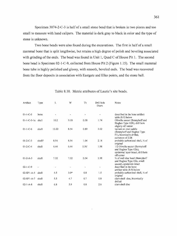
361
Specimen 3074-2-C-3 is half of a small stone bead that is broken in two pieces and too
small to measure with hand calipers. The material is dark gray to black in color and the type of
stone is unknown.
Two bone beads were also found during the excavations. The first is half of a small
mammal bone that is split lengthwise, but retains a high degree of polish and beveling associated
with grinding ofthe ends. The bead was found in Unit 1, Quad C of House Pit 1. The second
bone bead is Specimen 02-l-C-9, collected from House Pit 2 (Figure 1.15). The small mammal
bone tube is highly polished and glossy, with smooth, beveled ends. The bead was recovered
from the floor deposits in association with Eastgate and Elko points, and the stone ball.
Table 8.10. Metric attributes of Laurie's site beads.
Artifact Type L W Th Drill hole NotesDiam.
01-I-C-5 bone described in the bone artifacttable (8.9) below
oI-I-C-5-1 a shell 10.2 9.18 0.58 1.74 Olivella saucer (Bennyhoff andHughes Type G2b), drill holeslightly off center
01-I-C-6 shell 10.22 8.54 0.89 3.62 variant on oval saddle(Bennyhoff and Hughes TypeFI), biconically drilled,curvature of 2.08
01-2-C-3 shell? 8.54 8.54 1.04 2.18 probably carbonized shell, Y2 oforiginal
01-2-C-4 shell 6.44 6.44 0.56' 1.98 1/2 Olivella saucer (Bennyhoffand Hughes Type G2a),epidermal layer intact, drill holeoff center
01-2-A-5 shell 7.32 7.32 0.54 1.98 Y2 of wall disc bead (Bennyhoffand Hughes Type G2a, smallsaucer), epidermis intact
02-I-C-9 described in the boneartifact table (8.9) below
02-SPI-A-5 shell 5.5 3.0* 0.8 1.5 probably carbonized shell, Y2 oforiginal
02-SPI-A-7 shell 5.5 4.7 0.7 0.8 clam shell disc, biconicallydrilled
02-I-A-8 shell 6.8 5.9 0.8 2.6 clam shell disc
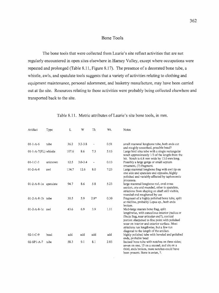
362
Bone Tools
The bone tools that were collected from Laurie's site reflect activities that are not
regularly encountered in open sites elsewhere in Harney Valley, except where occupations were
repeated and prolonged (Table 8.11, Figure 8.17). The presence of a decorated bone tube, a
whistle, awls, and spatulate tools suggests that a variety of activities relating to clothing and
equipment maintenance, personal adornment, and basketry manufacture, may have been carried
out at the site. Resources relating to those activities were probably being collected elsewhere and
transported back to the site.
Table 8.11. Metric attributes of Laurie's site bone tools, in mm.
Artifact Type L W Th Wt. Notes
01-I-A-6 tube 36.2 3.2-3.8 0.51 small mammallongbone tube, both ends cutand roughly smoothed, possible bead?
01-I-A-7(FL) whistle 107.6 8.6 7.3 5.13 Large bird ulna tube with a single rectangularnotch approximately 1/3 of the length from thebit. Notch is 6.8 mm wide by 13.0 mm long.
01-I.C-3 unlmown 12.5 3.0-3.4 0.13 Possibly a large gorge or small septumornament, (?) fragment.
01-2-A-8 awl 134.7 12.6 8.0 7.23 Large mammallongbone frag with awl tip onone side and spatulate end opposite, highlypolished and variably affected by taphonomicprocesses.
01-2-A-8-la spatulate 94.7 8.6 5.8 5.23 large mammallongbone rod, oval crosssection, one end rounded, other is spatulate,striations from shaping on shaft still visible,rounded end roughened by use
01-2-A-8-lb tube 30.5 5.9 2.8* 0.30 Fragment of a highly polished bone tube, splitat midline, probably Lepus sp., both endsbroken.
01-2-A-8-lc awl 43.6 6.9 3.9 1.11 Med-Iarge mamm bone frag, splitlengthwise, with cancellous interior (radius orfibula frag, near articular end?), corticalportion sharpened to fine point with polishedwear on interior and exterior surface. Moststriations run lengthwise, but a few rundiagonal to the length of the artifact.
02-I-C-9 bead add add add add highly polished tube with beveled and polishedends, probable bead
02-SPI-A-7 tube 58.3 9.1 8.1 2.83 Incised bone tube with notches on three sides;seven on one, IS on a second, and six on athird, ends broken, more notches could havebeen present. Bone is avian, ?
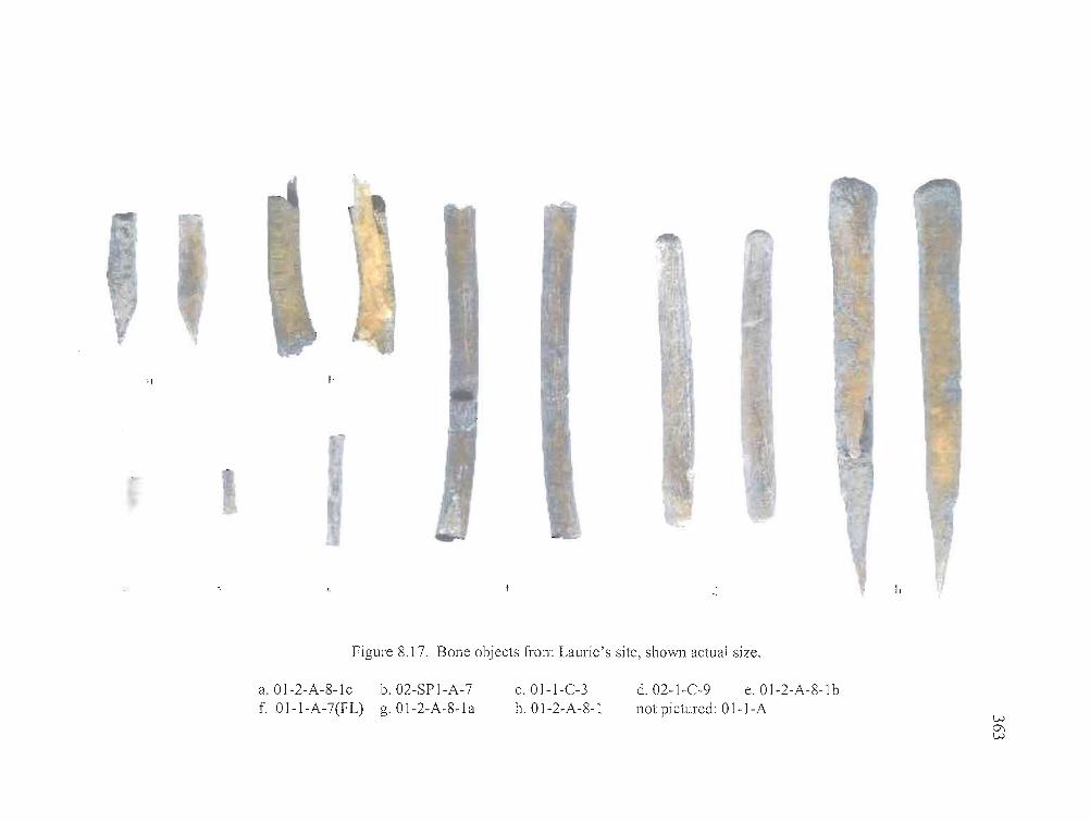
I,
I·
f
"
Figure 8.17. Bone objects from Laurie's site, ShO\Vl1 actual size.
a.Ol-2-A-8-lc b.02-SP1-A-7f. Ol-1-A-7(FL) g.Ol-2-A-8-la
c.Ol-l-C-3h. Ol-2-A-8-1
d.02-l-C-9 e.Ol-2-A-8-lbnot pictured: Ol-l-A
W0\W
364
Of particular interest are the spatulate tool and the awl that were recovered from Level 8
of House Pit 1, Unit 2, Quad A along with two other bone tools. Specimen 01-2-A-8-1 is a large
mammallongbone fragment that has been carefully fashioned into a fine-tipped awl on one end
and a spatulate tool on the opposite end. The awl would have been useful for a variety of tasks,
particularly involving the manufacture of clothing. The awl combined with the spatulate tool
suggests some other kind of use, perhaps in basketry manufacture. The awl tip would have
proven useful in creating openings between the basketry elements for the passage of fibers as the
basket is woven and the spatulate end could have been utilized to compress the woven elements
as the work progresses. Specimen 01-2-A-8-1 a was found near the awl also at floor level.
Spatulate tools are often associated with pressure flaking stone tools and this artifact has the
dimensions of such a tool, but the degree of wear is not consistent with flintknapping. Specimens
o1-2-A-8-1 (b and c) are a small bone awl and polished bone tube that were found in close
association with the other two tools. The awl is fashioned from a large mammal bone fragment
and the tube appears to be a longbone fragment from a lagomorph, probably a jackrabbit. The
four bone tools may have been components of a set.
The bone whistle (Ol-1-A07[FLJ) is made from the ulna ofa large bird. Broken in half,
the whistle was recovered at the transitional zone between the artifact laden house floor and the
sterile sediments underneath. It has a single rectangular notch that is 6.8 mm wide by 13 mm in
length and approximately one-third of the length of the artifact from the mouthpiece, which has
been smoothed.
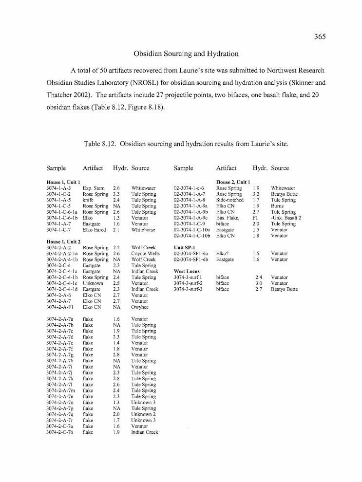
__11""'""---------------------------..----..
365
Obsidian Sourcing and Hydration
A total of 50 artifacts recovered from Laurie's site was submitted to Northwest Research
Obsidian Studies Laboratory (NROSL) for obsidian sourcing and hydration analysis (Skinner and
Thatcher 2002). The artifacts include 27 projectile points, two bifaces, one basalt flake, and 20
obsidian flakes (Table 8.12, Figure 8.18).
Table 8.12. Obsidian sourcing and hydration results from Laurie's site.
Sample Artifact Hydr. Source Sample Artifact Hydr. Source
House 1, Unit 1 House 2, Unit 13074-l-A-3 Exp. Stem 2.6 Whitewater 02-3074-l-c-6 Rose Spring 1.9 Whitewater3074-l-C-2 Rose Spring 3.3 Tule Spring 02-3074-l-A-7 Rose Spring 3.2 Beatys Butte3074-l-A-5 knife 2.4 Tule Spring 02-3074-l-A-8 Side-notched 1.7 Tule Spring3074-1-C-5 Rose Spring NA Tule Spring 02-3074-l-A-9a Elko CN 1.9 Bums3074-1-C-6-1 a Rose Spring 2.6 Tule Spring 02-3074-l-A-9b Elko CN 2.7 Tule Spring3074-1-C-6-1b Elko 1.3 Venator 02-3074-1-A-9c Bas. Flake, Fl -Unk. Basalt 23074-1-A-7 Eastgate 1.6 Venator 02-3074-1-C-9 biface 2.0 Tule Spring3074-l-C-7 Elko Eared 2.1 Whitehorse 02-3074-l-C-10a Eastgate 1.5 Venator
02-3074-l-C-10b Elko CN 1.8 VenatorHouse 1, Unit 23074-2-A-2 Rose Spring 2.2 WolfCreek Unit SP-l3074-2-A-2-l a Rose Spring 2.6 Coyote Wells 02-3074-SPl-4a Elko? 1.5 Venator3074-2-A-4-lb Rose Spring NA WolfCreek 02-3074-SP l-4b Eastgate 1.6 Venator3074-2-C-4 Eastgate 2.3 Tule Spring3074-2-C-4-la Eastgate NA Indian Creek West Locus3074-2-C-4-l b Rose Spring 2.4 Tule Spring 3074-3-surf 1 biface 2.4 Venator3074-2-C-4-lc Unknown 2.5 Venator 3074-3-surf-2 biface 3.0 Venator3074-2-C-4-l d Eastgate 2.3 Indian Creek 3074-3-surf-3 biface 2.7 Beatys Butte3074-2-A-6 Elko CN 2.7 Venator3074-2-A-7 Elko CN 2.7 Venator3074-2-A-Fl Elko CN NA Owyhee
3074-2-A-7a flake 1.6 Venator3074-2-A-7b flake NA Tule Spring3074-2-A-7c flake 1.9 Tule Spring3074-2-A-7d flake 2.3 Tule Spring3074-2-A-7e flake 1.4 Venator3074-2-A-7f flake 1.8 Venator3074-2-A-7g flake 2.8 Venator3074-2-A-7h flake NA Tule Spring3074-2-A-7i flake NA Venator3074-2-A-7j flake 2.3 Tule Spring3074-2-A-7k flake 2.8 Tule Spring3074-2-A-7l flake 2.6 Tule Spring3074-2-A-7m flake 2.4 Tule Spring3074-2-A-7n flake 2.3 Tule Spring3074-2-A-70 flake 1.3 Unknown 33074-2-A-7p flake NA Tule Spring3074-2-A-7q flake 2.0 Unknown 23074-2-A-7r flake 1.7 Unknown 33074-2-C-7a flake 1.6 Venator3074-2-C-7b flake 1.9 Indian Creek
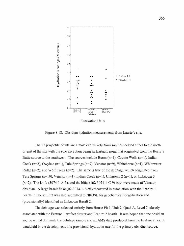
p-------------------------------------r"': .
366
~ (i
•
•
••••••
Exea'atinn I Jnits
Figure 8.18. Obsidian hydration measurements from Laurie's site.
The 27 projectile points are almost exclusively from sources located either to the north
or east of the site with the sole exception being an Eastgate point that originated from the Beaty's
Butte source to the southwest. The sources include Bums (n=l), Coyote Wells (n=l), Indian
Creek (n=2), Owyhee (n=l), Tule Springs (n=7), Venator (n=9), Whitehorse (n=l), Whitewater
Ridge (n=2), and Wolf Creek (n=2). The same is true of the debitage, which originated from
Tule Springs (n=10), Venator (n=1), Indian Creek (n=1), Unknown 2 (n=1), or Unknown 3
(n=2). The knife (3074-1-A-5), and the biface (02-3074-1-C-9) both were made of Venator
obsidian. A large basalt flake (02-3074-1-A-9c) recovered in association with the Feature 1
hearth in House Pit 2 was also submitted to NROSL for geochemical identification and
(provisionally) identified as Unknown Basalt 2.
The debitage was selected entirely from House Pit 1, Unit 2, Quad A, Level 7, closely
associated with the Feature 1 artifact cluster and Feature 2 hearth. It was hoped that one obsidian
source would dominate the debitage sample and an AMS date produced from the Feature 2 hearth
would aid in the development ofa provisional hydration rate for the primary obsidian source.
367
This did not turn out to be the case. Half of the debitage came from the Tu1e Spring source and
the other half from three other sources, and the range of hydration measurements was too broad
(from 1.3 to 2.8 microns, with a range of 1.9 to 2.8 microns for Tu1e Spring alone). The results
of the debitage hydration analysis does cast light on the perception that the location of Rose
Spring and Eastgate points in levels 2 through 4 might be representative of an occupation that is
distinct and separate from the underlying deposits (levels 6 and 7) containing E1ko Comer
notched points. It appears now that, based on both the projectile point types and the range of
obsidian hydration measurements from house floor deposits underlying the Rose Spring and
Eastgate points, the house was used and re-used, perhaps in repeated episodes, over a
considerable period of time.
Lithic Debitage Mass Analysis
Mass analysis utilizes counts and weights of size-graded debitage in a replicable,
quantitative manner to examine implications of debitage assemblages in both inter and intra-site
contexts (Ah1er 1989, Connolly 1999). Flake attributes such as size, weight, quantity, and the
presence of cortex vary with each stage of lithic reduction, as early core and biface production
yield larger flakes with more cortex than later stage biface reduction and pressure flaking
(Connolly and Byram 2001:68). By quantifying chipping waste through the previously
mentioned variables, a given site assemblage can be compared to those from other sites, and to an
experimental lithic reduction data set established for all five reduction stages (core reduction =
Stage 1, biface pressure flaking = Stage 5) collected from the Newberry Volcano obsidian source
(Connolly and Byram 2001 :69). The mass analysis results should reflect the most dominant
lithic reduction activities at a given location and, depending on other factors such as stratigraphic
mixing, may allow comparisons between early and late components within a site.
Debitage from Laurie's site was processed through a series ofnested screens with
dimensions of 1" (G1), 1/2" (G2), 1/4" (G3), and 1/8" (G4). The flakes from each size grade
were counted, weighed, and examined for the presence of cortex. The results were then
compared with those from the other Harney Valley sites, the Bon site in Deschutes County
368
(Connolly and Byram 2001), and with the overall results from the Newberry Crater project
(Connolly 1999). This information is presented below as Tables 8.13 and 8.14, and summarized
in the final chapter. Here, debitage from Units 1 and 2 is examined.
Connolly (1999) developed a formula for determining stages oflithic reduction activities
at archaeological sites based on three variables: Stage = 6.048 - 0.124 (F) - 0.023 (P) - 0.091
(Q), where F is the percent count of G2 over G 1 - G4, P is the mean weight of G2 (G2 weightlG2
count) in decigrams, and J is the mean weight of G3 (G3 weight/G3 count) in centigrams. The
values produced from the archaeological data were inserted into the formula and the numeric
result is an indicator of the relative stage oflithic reduction that occurred at the site, either for the
entire site or for components of the site.
Utilizing Connolly's (1999) formula for the aggregate of the four units at Laurie's site
resulted in a predicted stage value of2.43 (Tables 8.13 and 8.14), placing the site below the Bon
site (35DS608) in terms of lithic reduction stages. The Bon site is a residential base camp
located north of Newberry Caldera. Component 34-2, at the Paulina Lake site (35DS34), which
functioned as a base camp located within the Newberry Caldera (Connolly 1999, Connolly and
Byram 2001:69) has values similar to Laurie's site, and the value equates well with the Hoyt and
Broken Arrow sites from this study. When the obsidian is examined by unit, the stage values are
found to vary to a substantial degree. Unit 1 has a stage value of2.02 and Unit 2 is 3.7. The Unit
2 value is in keeping with residential bases at a distance from the tool stone quarries, where
activities are not focused on lithic reduction alone.
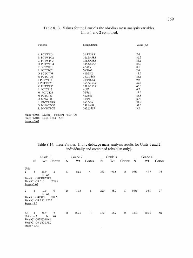
Table 8.13. Values for the Laurie's site obsidian mass analysis variables,Units 1 and 2 combined.
369
Variable
A PCTWTGIB PCTWTG2C PCTWTG3D PCTWTG4E PCTCTGIF PCTCTG2G PCTCTG3H PCTCTG4I PCTWTI3J PCTWT23K PCTWT33L PCTCTI3M PCTCT23N PCTCT33o MNWTlGP MNWT2DGQ MNWT3CGR MNWT4CG
Stage =6.048 - 0.1 24(F) - 0.023(P) - 0.091(Q)Stage =6.048 - 0.248- 0.504 - 2.87Stage = 2.43
Computation
34.9/458.8166.5/458.8151.8/458.8105.6/458.84/386576/3863482/38633303/386334.9/353.2166.5/353.2151.8/353.24/56276/562482/56234.9/4166.5/76151.8/482105.63303
Value (%)
7.636.333.123.00.12.012.585.59.947.143.00.713.585.88.7321.9131.53.2
b_~__d"tn _
Table 8.14. Laurie's site: Lithic debitage mass analysis results for Units 1 and 2,individually and combined (obsidian only).
Grade 1 Grade 2 Grade 3 Grade 4N Wt Cortex N Wt Cortex N Wt Cortex N Wt Cortex
UnitI 3 21.9 2 47 92.0 4 262 95.6 18 1638 48.7 31
N WtTotal Gl-G41948258.2Total Gl-G3 310 209.5Stage =2.02
2 13.0 0 29 74.5 6 220 38.2 17 1665 56.9 27N Wt
Total GI-G41915 182.6Total GI-G3 250 125.7Stage = 3.7
All 4 34.9 2 76 166.5 10 482 66.2 35 3303 105.6 58Units I - 2 N WtTotal GI-G43863440.8Total GI-G3 560335.2Stage = 2.43

370
Botanical Remains
Paleobotanical identifications were carried out by Dr. Marge Helzer ofthe University of
Oregon. (Helzer 2002). Samples were selected from both units of House Pit 1 (Tables 8.15 and
8.16). None of the samples from House Pits 2 or 3 were submitted for analysis. Botanical
analysis occurred in two stages. The first stage involved the identification of charcoal specimens
for radiocarbon dating purposes, and the material was derived either from composite samples
obtained during screening, or from in situ specimens when possible. The intent of the charcoal
analysis was to obtain specimens from short-lived plant species for greater accuracy in dating the
site. Soil flotation analysis was undertaken to determine the variety and nature ofplant remains
that might have been utilized by the inhabitants of House Pit 1. The results of the analyses are
summarized below.
Charcoal samples from Unit 1, Quad A, included specimens from levels 5 and 8 and the
samples from Quad C included material from levels 5 through 8 and the Feature 2 hearth. Those
from Unit 2, Quad A, originated from levels 6 through 9, including a floor sample and the
Feature 1 artifact cluster. The Unit 2 Quad C sample included four samples from Level 4. The
flotation samples were derived from Unit 1, Quad C, levels 3 through 6, and one sample collected
from the posthole in Quad C of Unit 2.
The botanical remains identified in the charcoal samples included chenopods,
greasewood, juniper, mountain mahogany, rabbitbrush, sagebrush, saltbush, and willow; a total
of eight varieties. All but mountain mahogany can be found in the vicinity of the site today.
Mountain mahogany was clearly imported to the site from the uplands. Willow was utilized in
basketry and wickiup construction, mountain mahogany was a favored material for atlatl, bow,
and digging stick construction. All of the other plant materials are known to have been used
medicinally or for food and fiber (Fowler 1986, 1989; Couture 1978). The Feature 1 artifact
cluster sample yielded sagebrush, saltbush, greasewood, and mountain mahogany charcoal, and
the Feature 2 hearth contained sagebrush and charcoal. Charcoal submitted from the Unit 2,
Quad C floor deposits (Level 9) contained only sagebrush.
The plant material recovered from the soil flotations had all of the previously mentioned
varieties of charcoal, plus a wide variety of economically important seeds. Included were the
seeds ofbluegrass, buckwheat, bulrush, cattails, chenopod/amaranths (cheno-ams), greasewood,
rr, I
371
rabbitbrush, and wada (for which the Wada'tika are named). All are known to have been used
for food or medicinal purposes (Fowler 1986, 1989; Couture 1978), and all would have been
readily available in the nearby lake and marshland setting. The plant seeds were distributed
throughout the samples, with the exception that buckwheat and bluegrass were only recovered
from Level 3 and wada was only absent from that same level. The post hole sample was the only
flotation sample that produced juniper charcoal. It is notable that uniper was present in all of the
Unit 2 samples that were submitted and absent from the Unit 1 material.
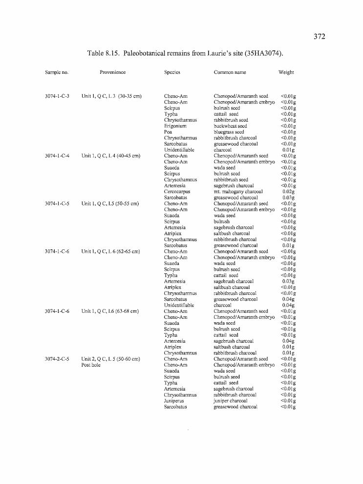
,,----------------372
Table 8.15. Paleobotanical remains from Laurie's site (35HA3074).
Sample no. Provenience Species Common name Weight
3074-I-C-3 Unit I, Q C, L 3 (30-35 cm) Cheno-Am Chenopod/Amaranth seed <O.OlgCheno-Am Chenopod/Amaranth embryo <O.OlgScirpus bulrush seed <O.OlgTypha cattail seed <O.OlgChrysothamnus rabbitbrush seed <O.OlgErigonium buckwheat seed <O.OlgPoa bluegrass seed <O.OlgChrysothamnus rabbitbrush charcoal <O.OlgSarcobatus greasewood charcoal <O.OlgUnidentifiable charcoal O.Olg
3074-I-C-4 Unit I, Q C, L 4 (40-45 cm) Cheno-Am Chenopod/Amaranth seed <O.OlgCheno-Am Chenopod/Amaranth embryo <O.OlgSuaeda wada seed <O.OlgScirpus bulrush seed <O.OlgChrysothamnus rabbitbrush seed <O.OlgArtemesia sagebrush charcoal <O.OlgCercocarpus mt. mahogany charcoal 0.02gSarcobatus greasewood charcoal 0.03g
3074-I-C-5 Unit I, Q C, L5 (50-55 cm) Cheno-Am Chenopod/Amaranth seed <O.OlgCheno-Am Chenopod/Amaranth embryo <O.OlgSuaeda wada seed <O.OlgScirpus bulrush <O.OlgArtemesia sagebrush charcoal <O.OlgAtriplex saltbush charcoal <O.OlgChrysothamnus rabbitbrush charcoal <O.OlgSarcobatus greasewood charcoal O.Olg
3074-I-C-6 Unit I, Q C, L 6 (62-65 cm) Cheno-Am Chenopod/Amaranth seed <O.OlgCheno-Am Chenopod/Amaranth embryo <O.OlgSuaeda wada seed <O.OlgScirpus bulrush seed <O.OlgTypha cattail seed <O.OlgArtemesia sagebrush charcoal 0.03gAtriplex saltbush charcoal <O.OlgChrysothamnus rabbitbrush charcoal <O.OlgSarcobatus greasewood charcoal 0.04gUnidentifiable charcoal 0.04g
3074-I-C-6 Unit I, Q C, L6 (63-68 cm) Cheno-Am Chenopod/Amaranth seed <O.OlgCheno-Am Chenopod/Amaranth embryo <O.OlgSuaeda wada seed <O.OlgScirpus bulrush seed <O.OlgTypha cattail seed <O.OlgArtemesia sagebrush charcoal 0.04gAtriplex saltbush charcoal O.OlgChrysothamnus rabbitbrush charcoal O.Olg
3074-2-C-5 Unit 2, Q C, L 5 (50-60 cm) Cheno-Am Chenopod/Amaranth seed <O.OlgPost hole Cheno-Am Chenopod/Amaranth embryo <O.Olg
Suaeda wada seed <O.OlgScirpus bulrush seed <O.OlgTypha cattail seed <O.OlgArtemesia sagebrush charcoal <O.OlgChrysothamnus rabbitbrush charcoal <O.OlgJuniperus juniper charcoal <O.OlgSarcobatus greasewood charcoal <O.Olg
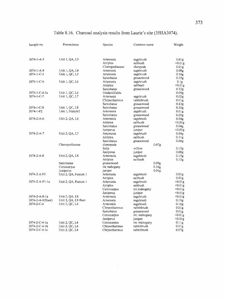
373
Table 8.16. Charcoal analysis results from Laurie's site (35HA3074).
Sample no. Provenience Species Common name Weight
3074-I-A-5 Unit I, QA, L5 Artemesia sagebrush O.OlgAtriplex saltbush <O.OlgChenopodiaceae chenpods O.Olg
3074-I-A-8 Unit I, QA, L8 Artemesia sagebrush 0.08g3074-I-C-5 Unit I, QC, L5 Artemesia sagebrush 0.16g
Sarcobatus greasewood 0.25g3074-I-C-6 Unit I, QC, L6 Artemesia sagebrush O.lg
Atriplex saltbush <O.OlgSarcobatus greasewood 0.32g
3074-I-C-6-1 a Unit I, QC, L6 Unidentifiable 0.09g3074-I-C-7 Unit I, QC, L7 Artemesia sagebrush 0.02g
Chrysothamnus rabbitbrush O.OlgSarcobatus greasewood 0.43g
3074-I-C-8 Unit I, QC, L8 Sarcobatus greasewood 0.30g3074-I-F2 Unit I, Feature2 Artemesia sagebrush O.Olg
Sarcobatus greasewood 0.09g3074-2-A-6 Unit 2, QA, L6 Artemesia sagebrush 0.04g
Atriplex saltbush <O.OlgSarcobatus greasewood 0.04gJuniperus juniper <O.Olg
3074-2-A-7 Unit 2, QA, L7 Artemesia sagebrush 0.04gAtriplex saltbush O.llgSarcobatus greasewood 0.04g
Chenopodiaceae chenopods 0.07gSalix willow O.l5gJuniperus juniper 0.08g
3074-2-A-8 Unit 2, QA, L8 Artemesia sagebrush 0.15gAtriplex saltbush O.l5g
Sarcobatus greasewood 0.09gCercocarpus mt mahogany 0.16gJuniperus juniper O.Olg
3074-2-A-FI Unit 2, QA, Feature I Artemesia sagebrush O.OlgAtriplex saltbush O.Olg
3074-2-A-FI-Ia Unit 2, QA, Feature I Artemesia sagebrush <O.OlgAtriplex saltbush <O.OlgCercocarpus mt.mahogany <O.OlgJuniperus juniper <O.Olg
3074-2-A-8-la Unit 2, QA, L8 Artemesia sagebrush <O.Olg3074-2-A-9(floor) Unit 2, QA, L9 floor Artemesia sagebrush O.l9g3074-2-C-4 Unit 2, QC, L4 Artemesia sagebrush 0.16g
Chrysothamnus rabbitbrush O.OlgSarcobatus greasewood O.OlgCercocarpus mt. mahogany <O.OlgJuniperus juniper <O.Olg
3074-2-C-4-la Unit 2, QC, L4 Cercocarpus mt. mahogany O.llg3074-2-e-4-1 b Unit 2, QC, L4 Chrysothamnus rabbitbrush O.Olg3074-2-C-4-1 c Unit 2, QC, L4 Chrysothamnus rabbitbrush 0.07g
Ir'374
Faunal Remains
Faunal remains recovered from Laurie's site were identified by the author. The
specimens were generally very small fragments of small mammals fish, and birds including
muskrat, jackrabbit, Tui chub, sucker, and waterfowl. Large mammals such as deer and antelope
were also represented, although much of the highly fragmented large mammal bone was
unidentifiable to species. Other species noted in the assemblage included bobcat, beaver, badger,
and raccoon. Few of the bones were unfused at Laurie's site, suggesting that the site was not
inhabited during the peak birthing season during the late spring and summer months when
immature animals would have been available in abundance. Unfortunately, all of the files related
to the faunal analysis have been lost, so this summary will have to suffice until the faunal
remains can be re-analyzed and reported elsewhere.
Summary
It was anticipated that the information available from house pit villages adjacent to
Malheur Lake would be useful for considering Whiting's descriptions of activities there:
"Around the first of September the families began to turn south to the vicinity ofMalheur Lake and Saddle Butte. Everyone wanted to be on hand when the wada (Suedadepress var. erecta Wats) ripened. This was one of the staple seeds and was picked inlarge quantities for winter consumption. Probably the largest number of people cametogether at this time and there were many festivities, including circle dances and gamesof all kinds. Other seeds were gathered at the same time or a little later: sU.nu - saltbush,tomomi (unidentified), i'ape (Chenopodium), and wata (Chenopodium Album L.). Fromthe lakes many people went to Crow Camp to pick chokecherries, which were made intocakes and sun dried for winter. At this time there were also communal antelope andrabbit drives.
By the first ofNovember the families started to collect their cached foods and tomove into their winter camps. Sites were selected which had a spring or some othersource of water, a good supply of wood, and where it was known that there was notlikely to be a heavy snowfall. Most of the camps were at the foot of hills or in protectedregions near the lakes. Here tule mat houses were set up. (During the summersagebrush enclosures were the only types of structures used.[Whiting 1950: 19])"
PrJ
375
Based on Whiting's description, Laurie's site, at least under current environmental
conditions, does not seem suitable as a winter village location. There is an absence of good water
and firewood sources nearby, and the unprotected site would have stood exposed to the brunt of
passing winter storms. The nearby Headquarters site would have been much better suited to a
winter occupation, having all of the requirements identified above. Laurie's site could have been
a likely location for wada collection in the fall considering its placement adjacent to the
fluctuating shoreline of Malheur Lake. Other seed plants noted at the site include salt bush,
chenopods-amaranths, Great Basin wild rye and Indian rice grass. In any case, artifacts
recovered from the site should provide clues to the time and intensity of occupation.
A total of 6.8 cubic meters offill was excavated at Laurie's site over the course oftwo
seasons, resulting in the recovery of 5074 artifacts per cubic meter. The site is located
approximately a quarter-mile from the existing shoreline ofMalheur Lake. The 1979 drought
shoreline would have been one half mile west of the site, and water rose approximately nine feet
to envelop all but the highest portion of the site during the mid-1980s flooding. The site may not
have been a suitable location for habitation during periods of highest effective moisture because
of its vulnerability to flooding.
House Pit 1was AMS dated to 1890±40 BP (Unit 2, Quad A, Level 7). Unit SP-1 was
AMS dated to 1770±50 BP (Level 4). House Pit 2 returned an AMS date of 1580±40 BP (Unit 1,
Quad C, Level 9). These dates indicate that people occupied the location a number of times over
a 400 year span. A fourth date of 140±40 BP, from House Pit 2 (Unit 1, Quad C, Level 5) seems
out ofplace because the charcoal was collected just two levels above the 1580 BP date. It may
be indicative of displaced charcoal associated with rodent or badger activity. It is also possible
that a much later occupation occurred in the house pit, and digging associated with that period of
use resulted in the close association of older and newer charcoal.
The cultural deposits in each of the house pits can reach depths between 60 to 100 em,
and may reflect a series of occupations, though evidence for this is somewhat limited by the
effects ofbioturbation. House Pit 2 produced clear evidence of a bimodal distribution in both
debitage and bone, but the unfortunate radiocarbon date of l40±40 BP was produced from Level
5 of the unit, thwarting efforts to determine the range of use within the house pit. Stratigraphic
complexity was generally limited to a single, broad, dark brown sandy silt cultural layer situated
over yellowish sterile silty sands that indicate lakebed deposits. I was not able to subdivide the
P'
-- "...,,----
376
cultural layer into multiple components with confidence, due to presumed bioturbation and the
apparent homogeneity of the silty deposits.
A total of 41 projectile points was recovered at Laurie's site, 36 of which are temporally
diagnostic. The points include 11 Rose Spring (28 %), eight Eastgate (20 %), one Rosegate (2
%), five Elko Eared (12 %), three Elko Comer-notched (7 %), two Elko Series (5 %), two
Northern Side-notched (5 %), one Contracting Stem (2 %) two stemmed points (5%), and one
Malheur Stemmed (2 %). All but two of the points were made of obsidian that originated from
sources to the north and east of the site and indicate a strong relationship exists between Laurie's
site and the uplands to the north of Harney Valley.
Biifaces were the most abundant tool category at Laurie's site, accounting for 34% of the
assemblage. Utilized flakes, at 10% were fewer than projectile points at 20%, followed by
ground stone at 17%, cores at 4%, bone tools at 4%, and drills and awls at 2%. Beads constituted
5% of the assemblage and one abrader, graver, and stone ball were collected. The diversity of
tools, especially the inclusion of bone tools, drills, and abraders, along with well-formed ground
stone fragments, suggests that the site may have hosted occupational episodes that were more
prolonged in duration than other temporary camps included in this report except the Broken
Arrow and Hoyt sites.
Faunal remains recovered from Laurie's site included small fragments of small mammals
fish, and birds including muskrat, jackrabbit, Tui chub, sucker, and waterfowl. Large mammals
such as deer and antelope were also represented, although much of the highly fragmented large
mammal bone was unidentifiable to species. Other species noted in the assemblage included
bobcat, beaver, badger, and raccoon. Few unfused animal bones are present at the site, indcating
that it was probably not occupaied during the peak birthing months of spring and early summer
The botanical remains identified in the charcoal samples included chenopods,
greasewood, juniper, mountain mahogany, rabbitbrush, sagebrush, saltbush, and willow; a total
of eight varieties. Economically important seeds included bluegrass, buckwheat, bulrush,
cattails, chenopod/amaranths, greasewood, rabbitbrush, and wada.
Laurie's site is considered to be a residential base camp, probably inhabited in the late
summer and fall months. Although cultural deposits at the site are deep and rich, the site lacks
stratigraphic complexity consistent with multiple long term occupations and it would not have
been a favorable location during perilous winter weather, or at times when water levels had the
potential of increasing. The site would have been a suitable choice during warmer months, when

377
multiple logistical forays could have been mounted for the procurement of seeds and marshland
resources in the lowlands, and fruits, berries, and large game in the uplands. Activities occurring
in this manner would have positioned the inhabitants for large and small mammal game drives,
and for the collection ofwada when the seeds finally ripened.
jiiS
378
CHAPTER IXBROKEN ARROW SITE (35HA3075)
The Broken Arrow site is located on the southeast edge ofMalheur Lake, across an
embayment to the east of the Headquarters site and approximately Y4 mile southwest of Laurie's
site. The legal location for the site is Township 26 South (South of Malheur Lake), Range 32
East, Section 27 (N 112, SE 1/4, NE IJ4 and SE Y4, SE Y4, NE 1/4). The site is located on Bureau of
Land Management property approximately one-quarter mile from the present-day shoreline, and
adjacent to the Malheur National Wildlife Refuge (Figure 9.1). The Donner und Blitzen River
empties into Malheur Lake near the Headquarters site, and Black Butte dominates the skyline
approximately two miles to the east. Broken Arrow and Laurie's site are so close to each other
that they share many characteristics in terms of regional setting, but the land forms they occupy
are considerably different. The Broken Arrow site occupies an outcrop of basalt, a low peninsula
that has a dune feature of aeolian and lacustine sediments covering it. The land form rises two
feet higher than Laurie's site. This small change in topography is significant in such a broad
basin, where a considerable volume of water is needed to raise lake levels as little as an inch.
Standing at the top of the peninsula, one can look to the south and pick out a series of low
shorelines marking significant rises in lake levels, including the 1980s flood event that almost
inundated Laurie's site and rose to the edge of Broken Arrow (Figure 9.2).
Site reconnaissance was conducted by Laurie Thompson, Kelly Edmondson, Dianne Ness
and Dan Braden on March 25, 2001. At that time, they were aware that the site was of interest to
artifact collectors and the elevated land form was a high probability location for encountering an
archaeological site. The surface of the site was covered with saltgrass, sedges, Great Basin wild
rye, sagebrush and greasewood. One circular depression was filled with Great Basin wild rye, in
sharp contrast to the surrounding sagebrush and greasewood.
Cultural materials covered a 300 meter (northwest to southeast) by 120 meter (southwest
to northeast) area and consisted of obsidian and CCS debitage, several circular depressions,
flaked tools, ground stone, fire-cracked rock, charcoal, and burned bone fragments (Thompson
2001). Diagnostic projectile points collected on the surface included Rose Spring (8), Elko
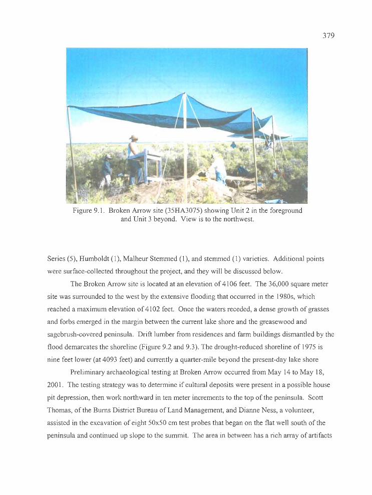
379
Figure 9.1. Broken Arrow site (35HA3075) showing Unit 2 in the foregroundand Unit 3 beyond. View is to the northwest.
Series (5), Humboldt (1), Malheur Stemmed (1), and stemmed (1) varieties. Additional points
were surface-collected throughout the project, and they will be discussed below.
The Broken Arrow site is located at an elevation of 41 06 feet. The 36,000 square meter
site was surrounded to the west by the extensive flooding that occurred in the 1980s, which
reached a maximum elevation of 41 02 feet. Once the waters receded, a dense growth of grasses
and forbs emerged in the margin between the current lake shore and the greasewood and
sagebrush-covered peninsula. Drift lumber from residences and farm buildings dismantled by the
flood demarcates the shoreline (Figure 9.2 and 9.3). The drought-reduced shoreline of 1975 is
nine feet lower (at 4093 feet) and currently a quarter-mile beyond the present-day lake shore
Preliminary archaeological testing at Broken Arrow occurred from May 14 to May 18,
2001. The testing strategy was to determine if cultural deposits were present in a possible house
pit depression, then work northward in ten meter increments to the top of the peninsula. Scott
Thomas, of the Burns District Bureau of Land Management, and Dianne Ness, a volunteer,
assisted in the excavation of eight 50x50 cm test probes that began on the flat well south of the
peninsula and continued up slope to the summit. The area in between has a rich array of artifacts
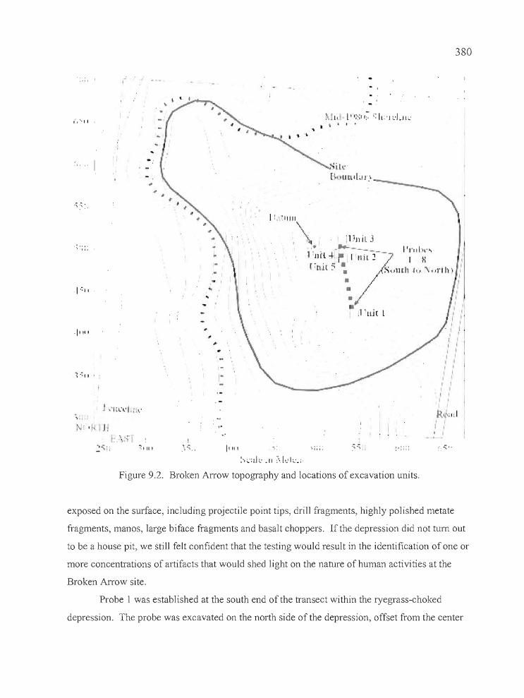
: '.. J~
(,', I I
~'. -',
-,':::
.1 1111
~:: II •
\'1'
t" ~ l' • I' I~" ,~ ': IL:' I ,:LJL;,:• , I I •
'ilt'B )UUd,;IJ'.'
..
- I..
I . .
I'"' .,: ',,,.:··.~·:dl:.11 \lo:k.;·
Figure 9.2. Broken Arrow topography and locations of excavation units.
380
I,,,Ii)II
I I,
I "I 'II '., I
, " II' I II " II I, I
II II II II ,I ,i I
R~·;"II I
I I, I
--
exposed on the surface, including projectile point tips, drill fragments, highly polished metate
fragments, manos, large biface fragments and basalt choppers. If the depression did not tum out
to be a house pit, we still felt confident that the testing would result in the identification of one or
more concentrations of artifacts that would shed light on the nature of human activities at the
Broken Arrow site.
Probe 1 was established at the south end of the transect within the ryegrass-choked
depression. The probe was excavated on the north side of the depression, offset from the center
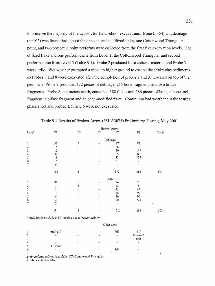
381
to preserve the majority ofthe deposit for field school excavations. Bone (n=54) and debitage
(n=102) was found throughout the deposits and a utilized flake, one Cottonwood Triangular
point, and two projectile point preforms were collected from the first five excavation levels. The
utilized flake and one perform came from Levell, the Cottonwood Triangular and second
preform came from Level 5 (Table 9.1). Probe 2 produced little cultural material and Probe 3
was sterile. Wet weather prompted a move to higher ground to escape the sticky clay sediments,
so Probes 7 and 8 were excavated after the completion ofprobes 2 and 3. Located on top of the
peninsula, Probe 7 produced 172 pieces of debitage, 215 bone fragments and two biface
fragments. Probe 8, ten meters north, contained 388 flakes and 286 pieces of bone, a bone tool
fragment, a biface fragment and an edge-modified flake. Continuing bad weather cut the testing
phase short and probes 4,5, and 6 were not excavated.
Level
1234567
1234567
Table 9.1 Results of Broken Arrow (35HA3075) Preliminary Testing, May 2001.
Broken ArrowPI P2 P3 P7 P8 Total
Debitage32 5 17 8315 28 7613 39 1198 25 8313 32 *2715 316
102 5 172 388 667
Bone32 14 20I 2 13 81 43 42
10 36 996 39 932 70 *242
54 2 215 286 563
* includes levels 5, 6, and 7--mixing due to badger activity
Other tools
1 pref, utfl2345 CT,pref67pref=preforrn, utfl=utilized flake, CT=Cottonwood Triangularbif=biface, unif=uniface
bif
bif
bifbonetool
unif
9

T382
The University of Oregon Archaeological Field School testing project at Broken Arrow
occurred from June 28 through July 14,2001, with additional work at the site sporadically
through August 2 when the field school ended. More work was carried out with the assistance of
personnel from the Bums District Bureau of Land Management from July 2 through July 11,
2002. The field school excavations consisted of three 2x2 meter units situated in locations where
preliminary testing indicated high concentrations of cultural material. Unit 1 was located just
south of Probe 1, Unit 2 incorporated Probe 7 as its northwest comer, and Unit 3 was placed
north of Probe 8. In 2002, Scott Thomas, Laurie Thompson, Diane Browning and Dan Braden of
the Bums District Bureau of Land Management excavated units 4 and 5, located directly west of
Unit 2 to explore the possibility of a house floor initially identified in the 2001 excavations.
Excavation Strategies
Testing
Archaeological testing of the Broken Arrow site occurred over the course of two years,
utilizing the efforts of both students and federal agency personnel. Test excavations utilizing
50x50 cm shovel probes were used to identify high concentrations of cultural material within the
site, then 2x2 meter units were excavated over or adjacent to the most productive probes. The
test probes targeted an area where a wide variety of cultural material was scattered across the
surface, more so than in other areas, and where the landforms suggested that long term deposition
might have occurred. It became apparent after the excavation of probes 1, 7, and 8 that the field
school efforts would be best utilized nearby. It was anticipated that the information available
from large sites adjacent to Malheur Lake with possible evidence ofpit house structures would be
vital for considering Whiting's descriptions of activities there (see Chapter 8, pp. 367-368):
Based on Whiting's description, neither Broken Arrow or Laurie's site seem particularly
suitable as winter village locations, at least under current environmental conditions. There is an
absence of good water and firewood sources nearby, and the unprotected site would have stood
exposed to the full force ofpassing winter storms. Other nearby locations such as the
Headquarters site across the bay would have offered better shelter from storms, firewood, and
water. Broken Arrow is a good location for the acquisition of marsh and lake resources. Seed
h_-. _
383
plants noted at the site include salt bush, chenopods-amaranths, Great Basin wild rye, and Indian
rice grass. Wada would be expected along the fluctuating shoreline, and bulrush and cattail
occupy the shallow lake margins. The largest colony of muskrats in Malheur Lake occupies the
area nearby, and muskrats would have also been an important resource (Carla Burnside, personal
communication 2001).
Excavation Units
During the course of the excavations, an arbitrary datum was established on top of the
peninsula for mapping purposes. Using a Topcon GTS-203 transit, coordinates for the datum
were set at 500 NI 500 E, with an arbitrary datum of 100 meters. The individual excavation units
were tied into the grid system, but they are identified only by numeric designations here.
Individual elevation datums were shot in for the excavation units and vertical control was
maintained by level lines attached to datum stakes. The units were excavated in 10 cm levels
excepth when strata associated with cultural features was encountered, at which time the cultural
material was excavated separately. A single site datum provided adequate coverage for recording
the site, but the distance between the Broken Arrow site and Laurie's site proved too great for
tying the two together with the total station.
As in the case of the other sites here reported, the basic unit of excavation was the 2x2
meter square, divided into 1x1 meter units oriented towards magnetic north. Quad A was always
to the northwest, Quad B to the northeast, Quad C to the southwest, and Quad D to the southeast.
Paperwork for each level included drawings, artifact counts, the location of in situ artifacts and
various physical features on a plan map, and written descriptions of sediment types. The
excavators worked with great care to insure that chronologically diagnostic artifacts and other
formed tools, features, utilized flakes and noteworthy bone fragments were recorded in situ as
often as possible. Drawings were made of selected stratigraphic profiles and photographs were
taken of representative walls in some excavation units. In situ artifacts and potential features
were photographed. Fill was removed in 10 cm increments and passed through 1/8 inch mesh
hardware cloth. Debitage, bone, and other artifacts were retrieved during the screening process,
counted, and added to the level record. A total of 11.8 cubic meters of fill was excavated,
resulting in the recovery of 60,946 artifacts, or 5,165 per cubic meter.
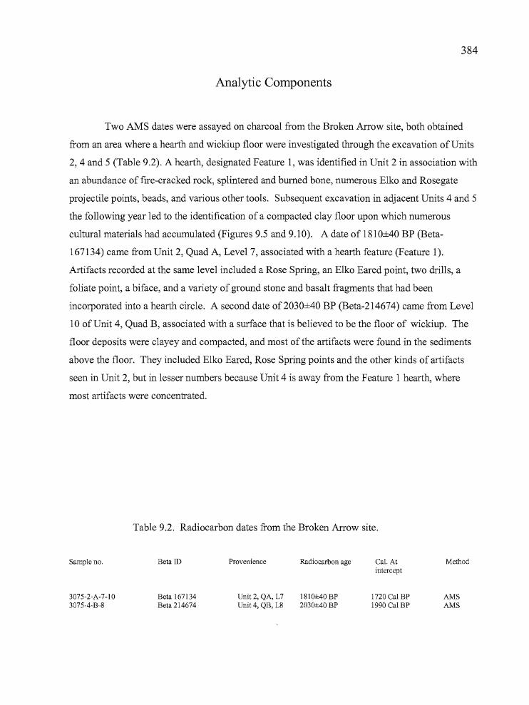
,..I
384
Analytic Components
Two AMS dates were assayed on charcoal from the Broken Arrow site, both obtained
from an area where a hearth and wickiup floor were investigated through the excavation ofUnits
2,4 and 5 (Table 9.2). A hearth, designated Feature 1, was identified in Unit 2 in association with
an abundance of fire-cracked rock, splintered and burned bone, numerous Elko and Rosegate
projectile points, beads, and various other tools. Subsequent excavation in adjacent Units 4 and 5
the following year led to the identification of a compacted clay floor upon which numerous
cultural materials had accumulated (Figures 9.5 and 9.10). A date of 1810±40 BP (Beta
167134) came from Unit 2, Quad A, Level 7, associated with a hearth feature (Feature 1).
Artifacts recorded at the same level included a Rose Spring, an Elko Eared point, two drills, a
foliate point, a biface, and a variety of ground stone and basalt fragments that had been
incorporated into a hearth circle. A second date of2030±40 BP (Beta-214674) came from Level
10 of Unit 4, Quad B, associated with a surface that is believed to be the floor of wickiup. The
floor deposits were clayey and compacted, and most of the artifacts were found in the sediments
above the floor. They included Elko Eared, Rose Spring points and the other kinds of artifacts
seen in Unit 2, but in lesser numbers because Unit 4 is away from the Feature 1 hearth, where
most artifacts were concentrated.
Table 9.2. Radiocarbon dates from the Broken Arrow site.
Sample no.
3075-2-A-7-103075-4-B-8
Beta ID
Beta 167134Beta 214674
Provenience Radiocarbon age
Unit 2, QA, L7 1810±40 BPUnit 4, QB, L8 2030±40 BP
Cal. Atintercept
1720 Cal BP1990 Cal BP
Method
AMSAMS
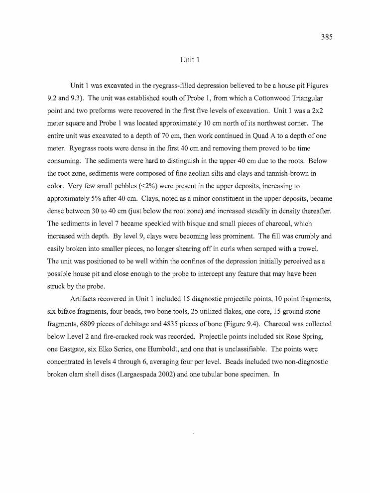
b
385
Unit 1
Unit 1 was excavated in the ryegrass-filled depression believed to be a house pit Figures
9.2 and 9.3). The unit was established south of Probe 1, from which a Cottonwood Triangular
point and two preforms were recovered in the first five levels of excavation. Unit 1 was a 2x2
meter square and Probe 1 was located approximately 10 cm north of its northwest comer. The
entire unit was excavated to a depth of 70 cm, then work continued in Quad A to a depth of one
meter. Ryegrass roots were dense in the first 40 cm and removing them proved to be time
consuming. The sediments were hard to distinguish in the upper 40 cm due to the roots. Below
the root zone, sediments were composed of fine aeolian silts and clays and tannish-brown in
color. Very few small pebbles «2%) were present in the upper deposits, increasing to
approximately 5% after 40 cm. Clays, noted as a minor constituent in the upper deposits, became
dense between 30 to 40 cm (just below the root zone) and increased steadily in density thereafter.
The sediments in level 7 became speckled with bisque and small pieces of charcoal, which
increased with depth. By level 9, clays were becoming less prominent. The fill was crumbly and
easily broken into smaller pieces, no longer shearing off in curls when scraped with a trowel.
The unit was positioned to be well within the confines of the depression initially perceived as a
possible house pit and close enough to the probe to intercept any feature that may have been
struck by the probe.
Artifacts recovered in Unit 1 included 15 diagnostic projectile points, 10 point fragments,
six biface fragments, four beads, two bone tools, 25 utilized flakes, one core, 15 ground stone
fragments, 6809 pieces of debitage and 4835 pieces of bone (Figure 9.4). Charcoal was collected
below Level 2 and fire-cracked rock was recorded. Projectile points included six Rose Spring,
one Eastgate, six Elko Series, one Humboldt, and one that is unclassifiable. The points were
concentrated in levels 4 through 6, averaging four per level. Beads included two non-diagnostic
broken clam shell discs (Largaespada 2002) and one tubular bone specimen. In
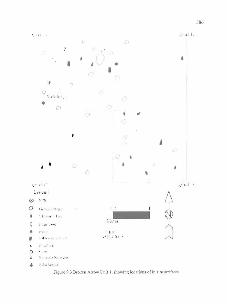
,.. '
, .'..
' •• :11. J;
386
~, •.' °11 '.. .• I
• 0- I
•
,
,
. ,
••
, . "
,: I' :1.1 :'
• o I, ,
,:,.'11 .1
,go
o•I:
,o • •
; I .. I ... I" '.
.. : '; ~
'111.":' .. ' r, O' I"
I,
, .:', .. :.:. ~'J
I I1II .
\ '.. I ... ~ii'
,1'1
I"", ,. ,
'\J"t I
cn() to
~ •...:'. ·r' '''1"1 -:,' ."'.' -!'
.. •·..1 .. 1' ""'~ I .:
Figure 9.3 Broken Arrow Unit 1, showing locations of in situ artifacts
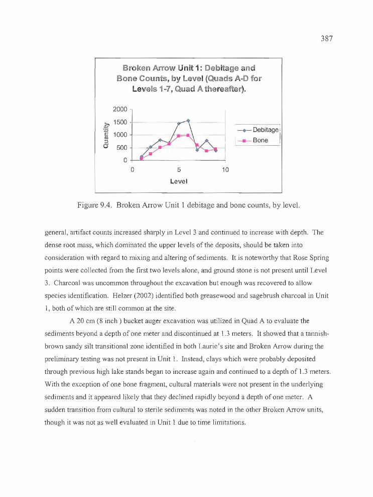
387
Broken Arrow nii: 1: Debi age nBone Coun s, by Level (Quads A-D for
Levels 1-7, Quad A thereafter).
2000
>. 1500 -+"':.;:;s:: 1000lU::l0 500
00 5 10
Level
-+- Debitage '
j Bone !
Figure 9.4. Broken Arrow Unit 1 debitage and bone counts, by level.
general, artifact counts increased sharply in Level 3 and continued to increase with depth. The
dense root mass, which dominated the upper levels of the deposits, should be taken into
consideration with regard to mixing and altering of sediments. It is noteworthy that Rose Spring
points were collected from the first two levels alone, and gTound stone is not present until Level
3. Charcoal was uncommon throughout the excavation but enough was recovered to allow
species identification. Helzer (2002) identified both greasewood and sagebrush charcoal in Unit
1, both of which are still common at the site.
A 20 cm (8 inch) bucket auger excavation was utilized in Quad A to evaluate the
sediments beyond a depth of one meter and discontinued at 1.3 meters. It showed that a tannish
brown sandy silt transitional zone identified in both Laurie's site and Broken Arrow during the
preliminary testing was not present in Unit 1. Instead, clays which were probably deposited
through previous high lake stands began to increase again and continued to a depth of 1.3 meters.
With the exception of one bone fragment, cultural materials were not present in the underlying
sediments and it appeared likely that they declined rapidly beyond a depth of one meter. A
sudden transition from cultural to sterile sediments was noted in the other Broken Arrow units,
though it was not as well evaluated in Unit 1 due to time limitations.
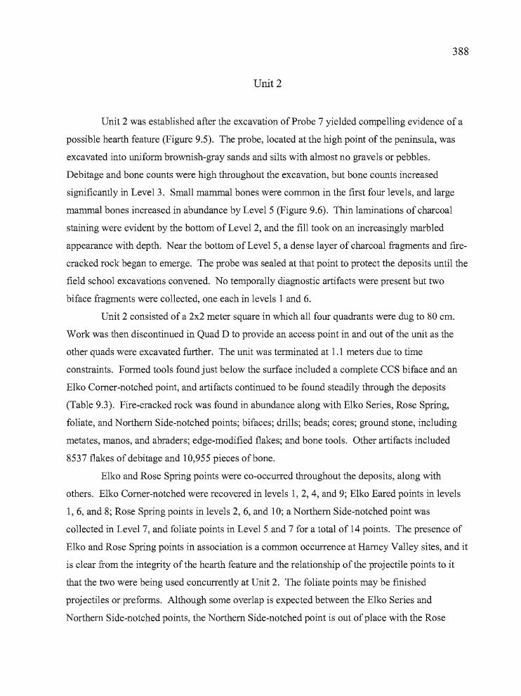
388
Unit 2
Unit 2 was established after the excavation of Probe 7 yielded compelling evidence of a
possible hearth feature (Figure 9.5). The probe, located at the high point of the peninsula, was
excavated into uniform brownish-gray sands and silts with almost no gravels or pebbles.
Debitage and bone counts were high throughout the excavation, but bone counts increased
significantly in Level 3. Small mammal bones were common in the first four levels, and large
mammal bones increased in abundance by Level 5 (Figure 9.6). Thin laminations of charcoal
staining were evident by the bottom of Level 2, and the fill took on an increasingly marbled
appearance with depth. Near the bottom of Level 5, a dense layer of charcoal fragments and fire
cracked rock began to emerge. The probe was sealed at that point to protect the deposits until the
field school excavations convened. No temporally diagnostic artifacts were present but two
biface fragments were collected, one each in levels 1 and 6.
Unit 2 consisted of a 2x2 meter square in which all four quadrants were dug to 80 cm.
Work was then discontinued in Quad D to provide an access point in and out ofthe unit as the
other quads were excavated further. The unit was terminated at 1.1 meters due to time
constraints. Formed tools found just below the surface included a complete CCS biface and an
Elko Comer-notched point, and artifacts continued to be found steadily through the deposits
(Table 9.3). Fire-cracked rock was found in abundance along with Elko Series, Rose Spring,
foliate, and Northern Side-notched points; bifaces; drills; beads; cores; ground stone, including
metates, manos, and abraders; edge-modified flakes; and bone tools. Other artifacts included
8537 flakes of debitage and 10,955 pieces ofbone.
Elko and Rose Spring points were co-occurred throughout the deposits, along with
others. Elko Comer-notched were recovered in levels 1,2,4, and 9; Elko Eared points in levels
1, 6, and 8; Rose Spring points in levels 2, 6, and 10; aNorthern Side-notched point was
collected in Level 7, and foliate points in Level 5 and 7 for a total of 14 points. The presence of
Elko and Rose Spring points in association is a common occurrence at Harney Valley sites, and it
is clear from the integrity of the hearth feature and the relationship of the projectile points to it
that the two were being used concurrently at Unit 2. The foliate points may be finished
projectiles or preforms. Although some overlap is expected between the Elko Series and
Northern Side-notched points, the Northern Side-notched point is out ofplace with the Rose
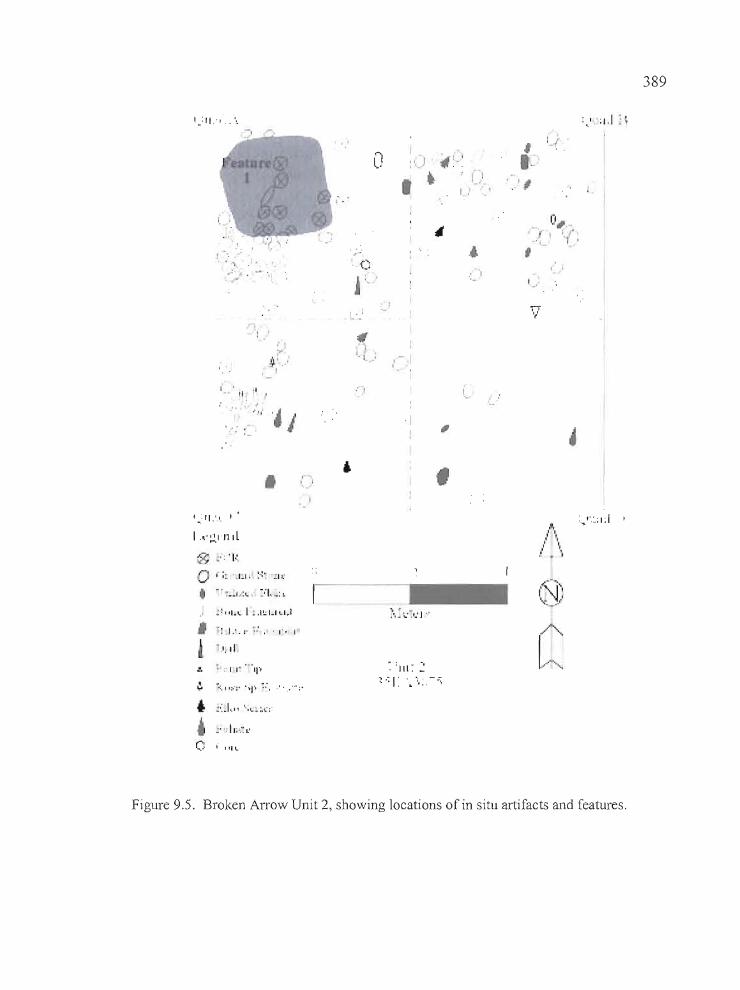
I,.: II:, .. \
I, "., ,I •
.. .; ~ .
, I~(
'-1 -'. I
"l., , ' .
•• , !,"r I
0,II"
" ',.
: I : 1,1 ~;
389
,I...
.f,• I· ,
• I
" "l .. '.
:'~'·,:.;I.I
~ :'11'" •.. ·11"'
::. :', I """ "'I" ~:.
... ~:.I"" ".,;;(::
, .~ I:.:
~I, II
:,," "',~ L'
(:I .. "IL
. ,', I
:"': :"~'~'I "
~ : III ': ::
~ .~ I: '. \: -.::;
/~:.(I '",:..~.;/
Figure 9.5. Broken Arrow Unit 2, showing locations of in situ artifacts and features,
390
Broken Ar w Unit 2: Debitage andBo Counts, by Level (Qua A-D for
Levels 1- ,Quads A-C thereafter).
2000 -
Z' 1500 :;:;l:l'll:::lo 500
o .1 -,-- ,-- _
-.- Debitage
---.- Bone
o 5
Level
10 15
b
Figure 9.6. Debitage and bone counts for Unit 2, by level.The Feature I hearth developed in Level 7.
Spring points and the ca. 1800 BP hearth, by a minimum of 2,000 years (Oetting 1994).
Considering the typological range of projectile points scattered across the surface of the Broken
Arrow site (see the projectile point section, below), the deposition of the Northern Side-notched
point could have been an isolated occurrence.
The concentration of fire-cracked rock, charcoal, and bone fragments that were initially
observed in Probe 7 emerged as a fire hearth, designated as Feature l, in Level 6 of Quad A
(between 65 to 90 cm). The Feature 1 hearth deposits were situated in the northwest comer of
Quad A, and a concentration of fire-cracked rock, charcoal, splintered large mammal bone
fragments and smaller bones, and tools were scattered in an arc surrounding it. It appears that
our excavation caught most, if not all, of the hearth, and approximately one quarter of the activity
area around it, assuming that people utilized the entire circumference of the hearth. During
excavation, the light brown sandy silts began to darken with charcoal staining beginning in Level
4. The sediments continued to darken and charcoal became more concentrated over the next two
levels approaching the hearth. By Level 7, the excavators noted the Feature 1 hearth, bands of
charcoal staining, concentrations of charcoal, and dark brown clayey, greasy soil. By the bottom
of Level 8 at approximately 90 cm, the Feature I hearth was completely removed except for
errant fragments of fire-cracked rock. Cultural materials were still being collected in high
r -"
,'." .
..._------ -~_.-_".,
391
numbers, but a decline in formed tools became apparent and ground stone fragments, debitage,
and bone became the primary materials recovered.
The artifact counts remained strong, but declined to a small degree by Level 12 (120-130
cm). A layer of tannish-brown sediments became apparent at the bottom of the level and artifact
counts began to drop at this contact zone. Previous work during the preliminary testing phase
helped to identify this contact zone as a transition between cultural and sterile layers of sediment.
With time constraints becoming an issue for work at Broken Arrow, we decided to discontinue
hand excavation in Unit 2 and utilize a 20 cm (8 inch) bucket auger to explore the underlying
deposits of Quad A. Augering to a depth of 2.1 meters, it became apparent that the cultural
deposits dissipated quickly after Level 13, with only four pieces of debitage and ten pieces of
bone recovered in 80 cm.
Unit 3
Unit 3 was excavated 10.5 meters north ofUnit 2, and just north of Probe 8 (Figure 9.7).
Small flecks of charcoal were present after Level 1 and continued throughout the excavation, but
the dark charcoal-stained laminations seen in Probe 7 were absent. The probe was excavated to
70 cm, but levels 5 through 7 were heavily disturbed by overnight badger activity and they were
removed as one unit. Artifact counts were remarkably high for a 50x50 cm probe and included
388 pieces of debitage (primarily small pressure flakes), 286 pieces ofbone, a biface fragment, a
uniface, and a polished piece ofbone.
All four quads of Unit 3 were excavated to a depth of 70 cm, then Quad B alone was
excavated to a depth of one meter. Work continued in Quad B with a 20 cm (8 inch) bucket
auger to a depth of 1.6 meters. Cultural materials were recovered to a depth of 1.4 meters in
Quad B, followed by 20 cm of sterile deposits (Figure 9.8) .
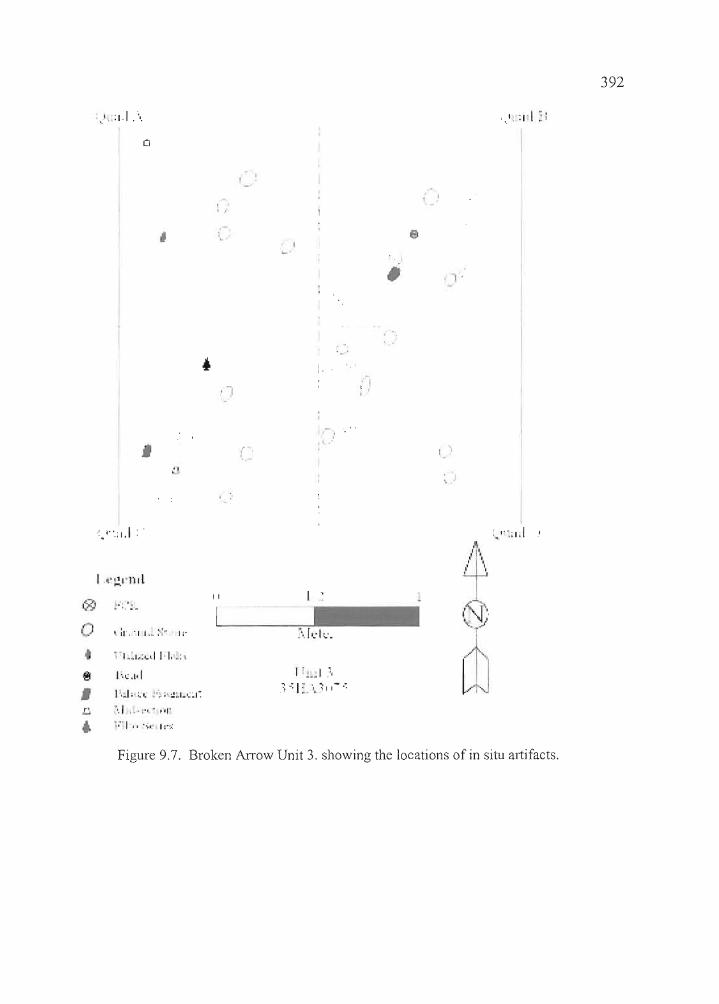
'.'. :1.1 .....
o
392
,
.:. '''.: 1.1
"~I'l'Ill
, 1
;:.
. I, ,I
e
I I
AI'I ,
, I
" "" ,
@ .. ' .
• " ••1,:... 0.1 I I,.:
1:,,;.1,1
L,j ".1 .. ' :"," ,',.... ;:'1" ..;, I:':·;
II
Figure 9.7. Broken Arrow Unit 3. showing the locations of in situ artifacts.
-
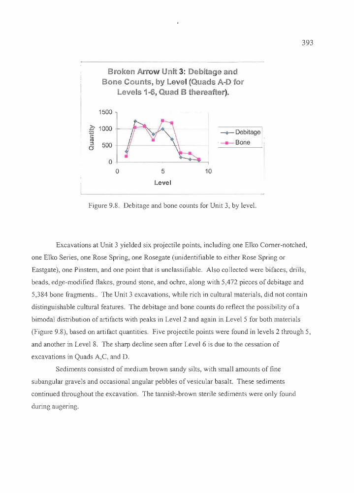
393
Figure 9.8. Debitage and bone counts for Unit 3, by level.
- ~
--+- Debitage
·--.-Bone
105
o+.---------=--~_,o
500
1500
Level
.c 1000 ...r:t\'l::lo
Broken Arrow Unit 3: Debitage anBone aunts, by Level (Quads A-D for
Levels 1-6, Quad B hereafter).
Excavations at Unit 3 yielded six projectile points, including one Elko Comer-notched,
one Elko Series, one Rose Spring, one Rosegate (unidentifiable to either Rose Spring or
Eastgate), one Pinstem, and one point that is unclassifiable. Also collected were bifaces, drills,
beads, edge-modified flakes, ground stone, and ochre, along with 5,472 pieces of debitage and
5,384 bone fragments .. The Unit 3 excavations, while rich in cultural materials, did not contain
distinguishable cultural features. The debitage and bone counts do reflect the possibility of a
bimodal distribution of artifacts with peaks in Level 2 and again in Level 5 for both materials
(Figure 9.8), based on artifact quantities. Five projectile points were found in levels 2 through 5,
and another in Level 8. The sharp decline seen after Level 6 is due to the cessation of
excavations in Quads A,C, and D.
Sediments consisted of medium brown sandy silts, with small amounts of fine
subangular gravels and occasional angular pebbles of vesicular basalt. These sediments
continued throughout the excavation. The tannish-brown sterile sediments were only found
during augering.
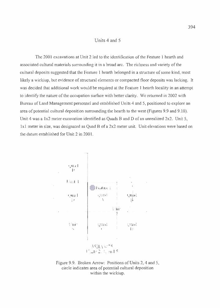
394
Units 4 and 5
The 2001 excavations at Unit 2 led to the identification of the Feature 1 hearth and
associated cultural materials surrounding it in a broad arc. The riclmess and variety of the
cultural deposits suggested that the Feature 1 hearth belonged in a structure of some kind, most
likely a wickiup, but evidence of structural elements or compacted floor deposits was lacking. It
was decided that additional work would be required at the Feature 1 hearth locality in an attempt
to identify the nature of the occupation surface with better clarity. We returned in 2002 with
Bureau of Land Management personnel and established Units 4 and 5, positioned to explore an
area of potential cultural deposition surrounding the hearth to the west (Figures 9.9 and 9.10).
Unit 4 was a 1x2 meter excavation identified as Quads Band D of an unrealized 2x2. Unit 5,
1x1 meter in size, was designated as Quad B of a 2x2 meter unit. Unit elevations were based on
the datum established for Unit 2 in 2001.
','11.1:1
I ~
I • I
"'. ,II,I~ c
'.'11.1 I
III"
",
1.,-.! .... j
]..::;~ I. .... ',;' -~:I •~.J.' 2. :: . .'111 .::;
',.,'111',.. !.1'
..,,~:.: '.
•b F7"'I1t'tt
Figure 9.9. Broken An-ow: Positions of Units 2, 4 and 5,circle indicates area of potential cultural deposition
within the wickiup.
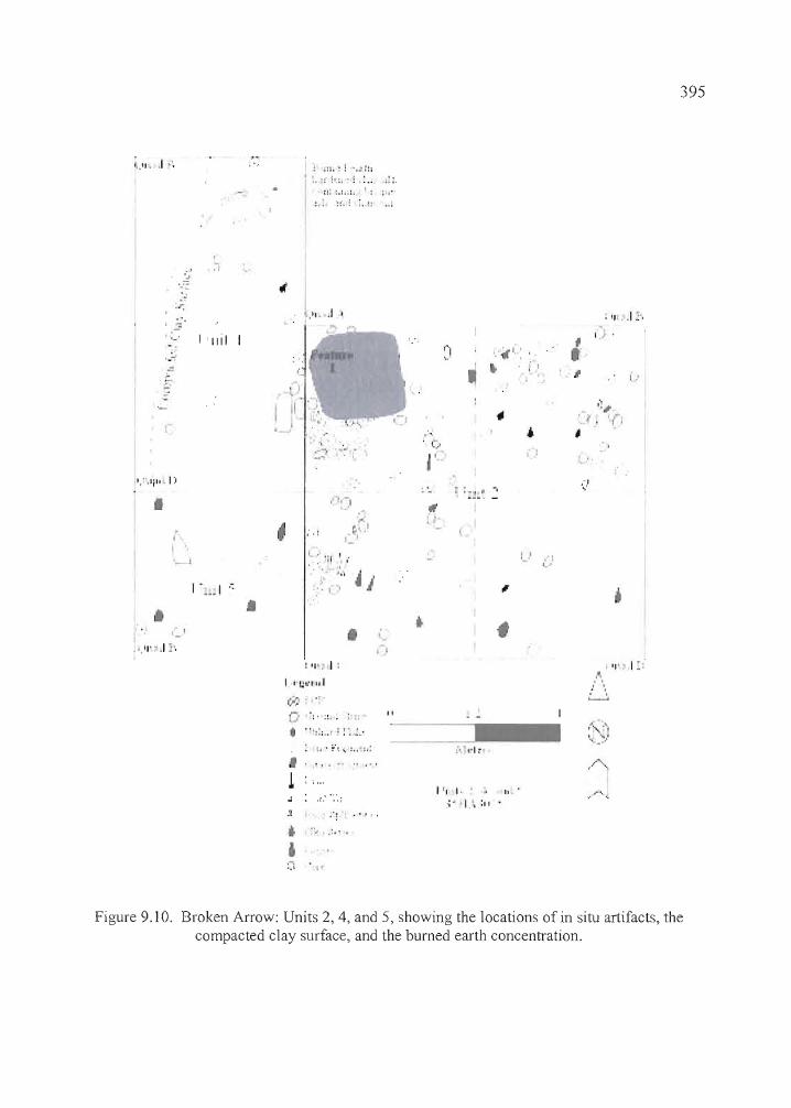
1._11- .1·'.
.''.,
:r:.'
j ,~
'- I' II iI'.~
1.. ·.Ii". I)
I
~ .::.:: '.': i:l
• :.::' i·:.-! : ......;':: :.: .. ~. I: i ..
I'I, . .I "
'.
I "~-I
."
: II' ,I :',
"1 I,' 0
,.. "•
,~
395
:. I
_I
I ...... ! '.
'-'','I" ,I j'.
•
~ .'1_'
L, '11 I ..
,'" 4,
• ,.,: "'. I:
•,
f
1_' ,'1l.."
I .; .... j-L'."',:; ..'; :'.~,'
II
{-..... j"I, _~.,
! ,;",
• •
.-,,,'
.'J ••
I f l I· '-~ II
..;. ·1.\ :11
Figure 9.10. Broken Arrow: Units 2, 4, and 5, showing the locations of in situ artifacts, thecompacted clay surface, and the burned earth concentration.
----".,----
~-._----
396
Excavations at the two units led to the recovery of seven projectile points, including four
from Unit 4 and three from Unit 5. The Unit 4 points consisted of four Elko Eared, three
Eastgate, one Humboldt, and one Rose Spring, collected in levels 4 through 7. The Unit 5 points
included two Elko Eared, an Eastgate, one unclassifiable point fragment, and one Rose Spring
from levels 1 through 8. Most artifacts in Units 4 and 5 were similar to those in Unit 2, consisting
of ground stone fragments, fire-cracked rock, debitage and bone, edge-modified flakes, cores,
and biface fragments. Drills were recovered in Unit 4, Level 3 of Quad D and in Level 4 of Unit
5. Two shell beads were found in Unit 4, Quad B, Level 4; and three in Unit 5, including two
shell beads in Levell, one shell bead in Level 2, and an unusual bone bead (or pendant) in Level
4 (Figure 9.20). Charcoal staining became evident in Level 5 ofboth units and large mammal
bones, one with cut marks, started to appear in the same level. The sediments remained similar,
dark brown sandy silts with charcoal staining, until Level 7, when a hard-packed surface
consisting of yellowish silty sands and clays began to appear. The surface was a transitional zone
between the cultural surface above and the sterile aeolian and lacustrine- deposited materials
below. Just below the transitional zone, a layer of yellowish clay several centimeters thick is
present that identifies either a prepared house floor or an avenue where foot traffic around the
Feature 1 hearth (Figures 9.5 and 9.10) either compacted clay-rich sediments or drew the clays
out of the surrounding matrix, creating a harder surface in the process. The layer is situated
between 85 and 103 cm in elevation and undulates, with numerous small depressions and
hummocks. The overlying cultural sediments were removed from the yellow clay layer, but no
artifacts were hidden in the depressions, as they were at Laurie's site. Beyond the clay surface
was a layer of sterile tannish-brown sediments of an unknown depth.
In Quad B of Level 7, a portion ofthe clay surface had been heat altered, creating a
roughly crescent-shaped oxidized and discolored surface of bisque, ash, and charcoal. The area
around it is hard-packed and several mano and fire-cracked rock fragments were found in
association. Obvious hearth constituents were absent, aside from those materials that were
trapped in the bisque itself; no lenses containing charcoal, ash, or burned animal bones were
accumulated adjacent to the bisque surface.
The utility of excavating Units 4 and 5 was proven by the discovery of the compacted
clay surface, which provides context for the Feature 1 hearth and the rich accumulation of
artifacts surrounding it. The surface appears to indicate a structural floor that was either
--=------------------- ---,,+,,---
397
deliberately prepared with a clay lining or perhaps compacted by foot traffic. No evidence of
structural supports was encountered during the excavation, so determining the physical nature of
the super structure itself is not possible.
Features
Although a number of individual artifacts were mapped in situ and their dispersal in the
individual excavation units has been well documented (Table 9.3), there were only two
associations of artifacts at the Broken Arrow site that were identified as distinct features. They
included the hearth designated as Feature 1 and the compacted clay surface known as Feature 2.
Both were found in the excavation block consisting of Units 2, 4, and 5, and they are described in
detail in the unit excavation descriptions above. Additional attention will be paid to dimensions
and sediment profiles in the feature descriptions below.
Feature 1
A large hearth, designated as Feature 1, covered the northwest comer of Unit 2
beginning in the bottom of Level 6 (Figures 9.9 and 9.10). The hearth was first apparent at a
depth of 65-70 cm, and continued through Level 8 to a depth of almost 90 cm. The feature was
surrounded by a scatter of ground stone fragments, fire-cracked rock fragments and an abundance
of splintered large mammal bone. The shape of the hearth could not be defined because of the
high quantities of camp rock around it and the permeation of the hearth charcoal outward into the
surrounding loose sediments. While the primary concentration of charcoal covered an area
between 50 to 60 cm in diameter, primarily in Quad A, the associated ground stone, fire-cracked
rock, and bone fragments extended over an area that was 150 to 200 cm wide, covering much of
Unit 2. An AMS date of 1810±40 BP was returned on a charcoal sample (Specimen 3074-2-A
7) taken directly from the interior of the hearth. The sample wood was identified as willow by
Dr. Marge Helzer, paleobotanist at the University of Oregon.
The sediments surrounding the hearth were described in the excavator's note as "dark
brown, clayey, and greasy, with bands of charcoal stains." In general, the sediments were largely
sandy silts with few, to no pebbles. A few small, angular to subangular pebbles were present in
398
the area of the hearth, as was the dense concentration of camp rock. Clays were noted around the
feature, but an actual layer of clay suggestive of a lined house floor was not evident. Substantial
quantities of cultural material, other than the items mentioned previously, included debitage,
small fragments of small mammal bone, diagnostic projectile points, edge-modified flakes, and a
wide variety of specialized tools such as drills, bone awls, and abraders, and decorative items like
beads, were found in close association with the hearth.
Feature 2
A compacted clay surface was encountered in Units 4 and 5 during the 2002 excavations
(Figure 9.10). The surface extended westward from the approximate midpoint of the east wall of
Unit 5, curved sharply northward through Quads Band D of Unit 4 with a width of 60 to 90 cm,
and continued beyond the Unit 4 excavations for an unknown distance. As is shown in Figure
9.10, the clay surface is a portion ofa wickiup floor that is approximately 2.5 meters in length by
60 to 90 cm in width, with the Feature 1 hearth near it's center. The Feature 2 floor surface
appears to be roughly oval in shape. Taking the area east of the Feature 2 floor, including the
Feature 1 hearth and the surrounding artifact concentration into consideration, it appears that the
wickiup was approximately three meters in diameter with a centrally located hearth.
The Unit 4 and 5 excavations produced clear evidence of the feature, which was not
apparent during the excavation of Unit 2 the previous year. Large quantities of charcoal and
refuse deposited during the use of the Feature 1 hearth may have altered the underlying floor to
the point where the clays, though noted as a constituent in the sediments during the excavation of
Unit 2, were not as coherent in the vicinity of the hearth as they are further from it. It may be
possible that clays already existing in native sediments were separated out of those sediments
during the course of activities at the dwelling, particularly foot traffic, but the surface has the
appearance of one that has been prepared to some degree. Cultural materials that were found in
abundance on and above the surface dissipated as excavations surpassed the floor deposits.
Concentrations of debitage, bone and formed tools decreased sharply in the Feature 2 floor
sediments. A crescent-shaped area ofbumed earth and charcoal was found in Quad B ofUnit 4,
between 30 to 50 cm south of the north wall (Figure 9.9). No deposits were evident to indicate
the original purpose of the fire-altered area.
1Ib _ _ critz _

399
The Feature 2 floor first became evident in Level 8 of Unit 5, at a depth of between 80 to
90 cm, and the deposits continued into Unit 4 at the same elevation. Sediments around the
feature consisted of the yellowish to tannish silty sands that characterize sterile deposits in both
the Laurie's and Broken Arrow sites. The Feature 2 floor consisted of hard-packed dark brown
silty sands in the upper deposit where contact between the feature and overlying cultural deposits
occurred. The underside ofthe floor was bounded by a thin layer of yellowish silty sand with
some sub-angular to angular pebbles, then a pronounced increase in clay at the contact zone with
the sterile deposits. The deposits ranged between 10 and 15 cm in thickness, and the floor
surface, once cleared of the overlying cultural deposits, was found to be undulating.
An AMS date of2030±40 BP was assayed on sagebrush charcoal recovered directly
from the upper portion ofthe floor deposits in Level 8 of Unit 4, Quad B. The sample was
identified by Dr. Marge Helzer, a paleobotanist with the University of Oregon.
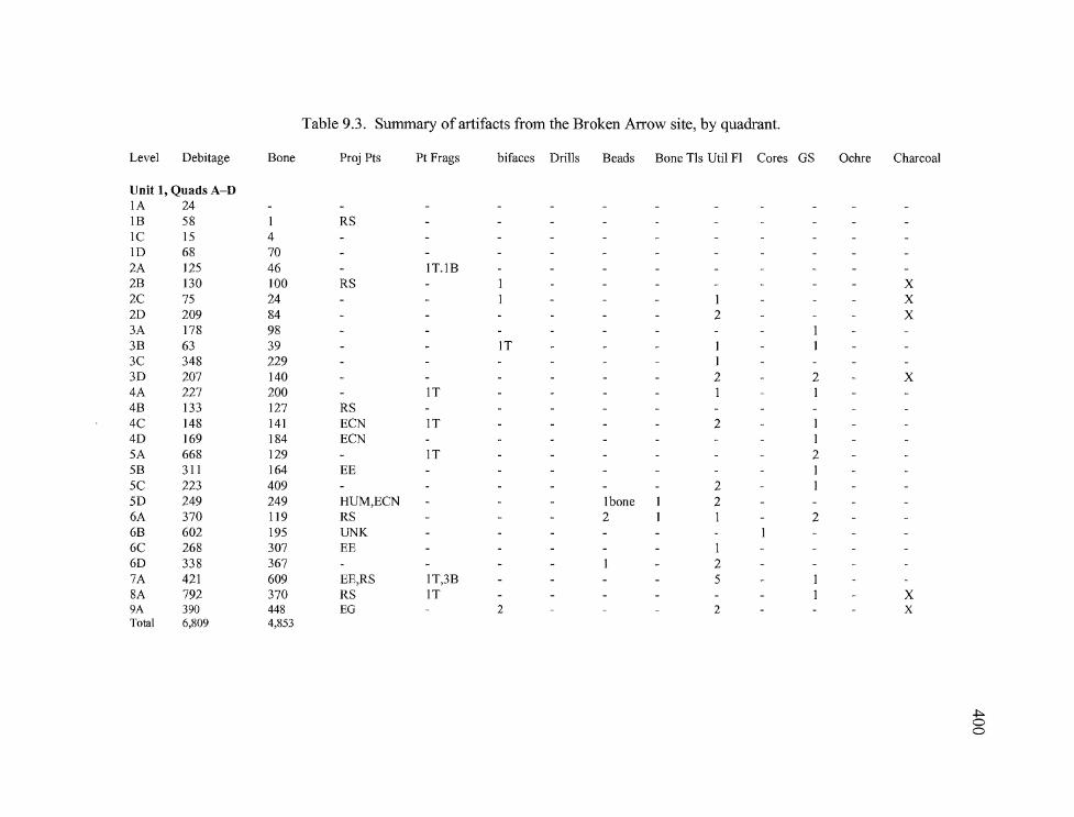
Table 9.3. Summary of artifacts from the Broken Arrow site, by quadrant.
Level Debitage Bone Proj Pts Pt Frags bifaces Drills Beads Bone TIs Util FI Cores GS Ochre Charcoal
Unit 1, Quads A-DIA 24IB 58 I RSIC 15 41D 68 702A 125 46 IT.IB2B 130 100 RS I X2C 75 24 I I X2D 209 84 2 X3A 178 983B 63 39 IT I3C 348 229 I3D 207 140 2 2 X4A 227 200 IT I I4B 133 127 RS4C 148 141 ECN IT 2 I4D 169 184 ECN I5A 668 129 IT 25B 311 164 EE I5C 223 409 2 I5D 249 249 HUM,ECN Ibone I 26A 370 119 RS 2 I I 26B 602 195 UNK6C 268 307 EE I6D 338 367 I 27A 421 609 EE,RS IT,3B 58A 792 370 RS IT I X9A 390 448 EG 2 2 XTotal 6,809 4,853
~oo
Table 9.3 (continued). Summary of artifacts from the Broken Arrow site, by quadrant.
Level Debitage Bone Proj Pts Pt Frags Bifaces Drills Beads Bone TIs Uti!. FI Cores GS Ochre Charcoal
Unit 2, Quads A-DlA 109 23 1 knifeIB 149 23 ECNlC 190 4310 115 292A 136 1042B 350 213 RS,ELKO2C 222 194 1 1 X2D 258 358 1 X3A 176 115 X3B 300 386 1 X3C 267 311 X3D 390 3314A 292 310 IB 1 1 X4B 180 568 ECN4C 324 3624D 312 40SA 202 219 IT 1 1 X5B 272 296 1 25C 275 305 1 1 15D 267 310 IT 36A 159 294 2 X6B 317 380 RS,EE I I X6C 223 371 IT I I X6D 330 324 IT I X7B 371 720 I 3 X7C 269 337 I I X7D 123 165 I X8A 144 934 I X8B 203 388 2 2 6 X8C 206 416 ELKO 1 3 X9A 125 303 1 X9B 304 345 ECN 1 I 2 I X9C 67 229 2 I 4 XlOA 232 317 XlOB 148 171 RS I 3 XlOC 140 95 I 3 XI ]/12A 190 333 I 6 X
.J:>.8,537 10,955 0,.....
Table 9.3 (continued). Summary of artifacts from the Broken Arrow site, by quadrant.
Level Debitage Bone Proj Pts Pt Frags Bifaces Drills Beads Bone TIs UtiI FI Cores GS Ochre Charcoal
Unit 3, Quads A-DIA 93 40IB 95 54 2IC 101 29 ITID 97 512A 281 272 1M I X2B 306 217 ELKO2C 299 259 1M 2 X2D 354 297 2 X3A 178 176 3 X3B 280 277 RS,I? I X3C 329 348 RS I X3D 311 274 X4A 165 215 2T,I? 3 X4B 195 239 I X4C 233 21 ELKO X4D 249 193 2 X X5A 221 227 2 X5B 245 406 I I X5C 224 362 X X5D 305 255 I I X6A 233 323 I I X6B 179 298 IT,I? 2 X6C 156 254 IT X6D 119 297 IT,I? 3 X7B 144 280 X X8B 88 261 ECN I X X9B 52 91 I X
5,532 6,016
~oIV
Table 9.3 (continued). Summary of artifacts from the Broken Arrow site, by quadrant.
Level Debitage Bone Proj Pt Pt Frags Bifaces. Drills Beads Bone TIs Util Fl Cores GS Ochre Charcoal
Unit 4, Quads Band DIB 97 16ID 115 53 X2B 176 158 IT X2D 225 295 IT,IBARB IB X3B 635 377 1M X3D 413 IT 1 1 I X4B 356 259 2 EG, 1 HUM - 3 X4D 377 390 EG IT I? X5B 414 436 IT 2B,IM - X5D 657 648 I 1 X6B 606 703 2 EE I BARB X6D 501 670 EE,RS I X7B 345 419 EE I X70 425 530 IE - X·8B 146 78 X8D 100 92 X
5,173 5,537
Unit 5, Quad
BI 88 22 EG 3B2 434 431 IB3 467 581 XB4 490 506 RS, UNK 1M PRE I I 2 XB5 649 740 IB,IM 2B I XB6 650 801 XB7 455 539 IE XB8 200 177 2 EE IT, 1M IE XB9 IKNIFE IE XBIO I X
3,433 3,797
~0w
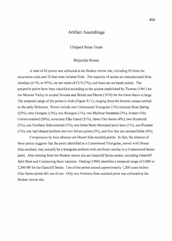
~.
404
Artifact Assemblage
Chipped Stone Tools
Projectile Points
A total of 82 points was collected at the Broken Arrow site, including 50 from the
excavation units and 32 that were isolated finds. The majority of points are manufactured from
obsidian (n=76, or 93%), six are made of CCS (7%), and there are no basalt points. The
projectile points have been classified according to the system established by Thomas (1981) for
the Monitor Valley in central Nevada and Heizer and Hester (1978) for the Great Basin at large.
The temporal range of the points is wide (Figure 9.11), ranging from the historic contact period
to the early Holocene. Points include one Cottonwood Triangular (1 %) nineteen Rose Spring
(23%), nine Eastgate (12%), one Rosegate (1 %), two Malheur Stemmed (3%), sixteen Elko
Comer-notched (20%), seventeen Elko Eared (21 %), three Elko Series (4%), two Humboldt
(3%), one Northern Side-notched (1 %), one Great Basin Stemmed point base (1 %), one Pinstem
(1 %), one leaf-shaped preform and two foliate points (3%), and five that are unclassifiable (6%).
Conspicuous by their absence are Desert Side-notched points. ill fact, the absence of
these points suggests that the point identified as a Cottonwood Triangular, coeval with Desert
Side-notched, may actually be a triangular preform with attributes similar to a Cottonwood Series
point. Also missing from the Broken Arrow site are Gatecliff Series points, including Gatecliff
Split Stem and Contracting Stem varieties. Oetting (1994) identifies a temporal range of 5,000 to
2,200 BP for the GatecliffSeries. Use of the points ceased approximately 1,200 years before
Elko Series points fell out of use. Only one Northern Side-notched point was collected at the
Broken Arrow site.
---,,+,---
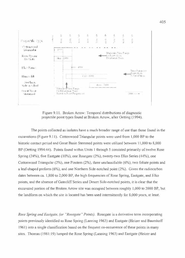
,''-:1''1,','''''".1·"II.LI~.d:1I
- . . -,. - -;
- - - - - - - - -- - - - - - . - -= = ~ - ,- i r-~-'---- --i If •• : :
405
l~., ,,'c :·:~'_.I ~
;,.,'.' ~,IIL'
I LI~I~ , ,1•.11
.Lt. 111111
.1 _ I rllHII.I
'f,ru.:r .rr_Or !. r
'-~" It:" ·r~~:;:", ..··.·1.1 ,,:Ll~. I~
';.,/" 1.'.1',·,1
:- ,:'11 ":." I'
",1:'1'11'1:,,1
r; ,n:) fInn, . 'I""1'1'" H'" j,'fl'iflll:
i'"i I;' 'f, :'. "il r·o, rIO III .11/1
b
Figure 9.11. Broken Arrow: Temporal distributions of diagnosticprojectile point types found at Broken Arrow, after Oetting (1994).
The points collected as isolates have a much broader range of use than those found in the
excavations (Figure 9.11). Cottonwood Triangular points were used from 1,000 BP to the
historic contact period and Great Basin Stemmed points were utilized between 11,000 to 8,000
BP (Oetting 1994:44). Points found within Units 1 through 5 consisted primarily of twelve Rose
Spring (24%), five Eastgate (10%), one Rosegate (2%), twenty-two Elko Series (44%), one
Cottonwood Triangular (2%), one Pinstem (2%), three unclassifiable (6%), two foliate points and
a leaf-shaped prefonn (6%), and one Northern Side-notched point (2%). Given the radiocarbon
dates between ca. 1,800 to 2,000 BP, the high frequencies of Rose Spring, Eastgate, and Elko
points, and the absence of Gatecliff Series and Desert Side-notched points, it is clear that the
excavated portion of the Broken Arrow site was occupied between roughly 1,000 to 2000 BP, but
the landform on which the site is located has been used intennittently for 8,000 years, at least.
Rose Spring and Eastgate, (or "Rosegate" Points), Rosegate is a derivative term incorporating
points previously identified as Rose Spring (Lanning 1963) and Eastgate (Heizer and Baumhoff
1961) into a single classification based on the frequent co-occurrence of these points in many
sites. Thomas (1981: 19) lumped the Rose Spring (Lanning 1963) and Eastgate (Heizer and
r····:. ..
..
___c+n _
406
Baumhoff 1961) point types together under one classification, but the two types are clearly
dissimilar in both form and distribution, and in this report, Rose Spring and Eastgate are analyzed
separately. Rose Spring points are small comer-notched points that commonly have expanding
stems, while Eastgate points are basally notched on a triangular or slightly rounded preform,
producing barbs or tangs that are even with the base. The term "Rosegate" will be reserved for
those points where breakage or retouching limits the ability to discern differences between the
two varieties. According to Thomas (1981: 19) Rosegate points have a basal width of 10 mm or
less, a proximal shoulder angle between 90° and 130°, and a neck width less than or equal to
[basal width plus 0.5 mm.]. Twenty-nine points identifiable as Rose Spring (n=19, or 23%),
Eastgate (n=9, or 11%) or Rosegate (n=l, or 1 %) were collected from the Broken Arrow site.
Included were five Rose Spring, and one Eastgate recovered in Unit 1; four Rose Spring and one
Eastgate recovered from Unit 2; one Rose Spring and one Rosegate recovered from Unit 3, one
Rose Spring and three Eastgate in Unit 4, and one each of Rose Spring and Eastgate points in
Unit 5. Seven Rose Springs and four Eastgates were collected as isolates (Tables 9.4 and 9.5,
Figure 9.12)
Rose Spring points were recovered from all of the units and in most excavation levels.
Fewer were found in Units 4 and 5, but the two units were considerably smaller than Units 1,2,
or 3. It is interesting to note that Unit 1 had more Rose Spring points and as many Eastgate
points as Unit 2, despite the dense concentration of artifacts surrounding the Feature 1 hearth.
This pattern held true for all types of projectile points except Northern Side-notched; Unit 1 had
as many or more points than Unit 2, and no discernable feature was identified there. The picture
changes when Units 4 and 5 are added, particularly with regard to Eastgate points.
Eastgate points were concentrated in the upper levels of Units 1,4, and 5, with none
found deeper than LevelS (50-60 cm). One was found in Unit 1, three in Unit 4 and one in Unit
5. The point is reiterated here because it is noteworthy that four Eastgate points were recovered
from Units 4 and 5, and none from the Unit 2 excavation, indicating that the points represent a
localized deposition at the perimeter ofthe Feature 1 hearth. As was true at Laurie's site,
Eastgate points account of40% of the arrow points recovered from the excavation units.
The degree of variability was similar for both point styles. Most had expanding stems
but a few had relatively straight stems. The stems terminated with a variety of basal elements,
including some of each that were concave, convex, flat, and bifurcated. The size range was
r.. ··~, . i
407
considerable for both Rose Spring and Eastgate points, All of the points were manufactured from
obsidian.
Of those that were geochemically sourced, Rose Spring points originated from six
obsidian sources which included Indian Creek and Indian Creek "B", Double 0 , Tule Springs,
Venator, Eldorado, and Whitewater Ridge. All but the Double 0 source are located to the north
and east ofthe site. Hydration measurements ranged from 1.2 to 3.9 microns, with a mean of2.3
microns for 16 measureable specimens. Most ofthe hydration measurements were grouped
between 2.1 and 2.8 microns and the range of measurements differed little between the points
collected on the surface and those from the excavations.
Eastgate points came from five sources, including Venator, Indian Creek and Indian
Creek "B", Double 0, and Whitewater Ridge. The range ofhydration measurements is similar to
those of Rose Spring points, between 1.2 to 3.3 microns, with a mean of 2.2 microns for ten
specimens. One Eastgate point (Specimen 3075-4-B-4a) has two hydration rims of 2.3 and 4.2
microns, presumably due to the manufacture ofthe point from a curated flake. Only the 2.3
micron rim was used in establishing the mean that is reported above. Eastgate points collected
from the surface have a broader range of measurements than those from the excavation units but
this is most likely a quirk of sampling, considering that all other point types showed little
variation between the measurements for surface artifacts and those collected from the
excavations.
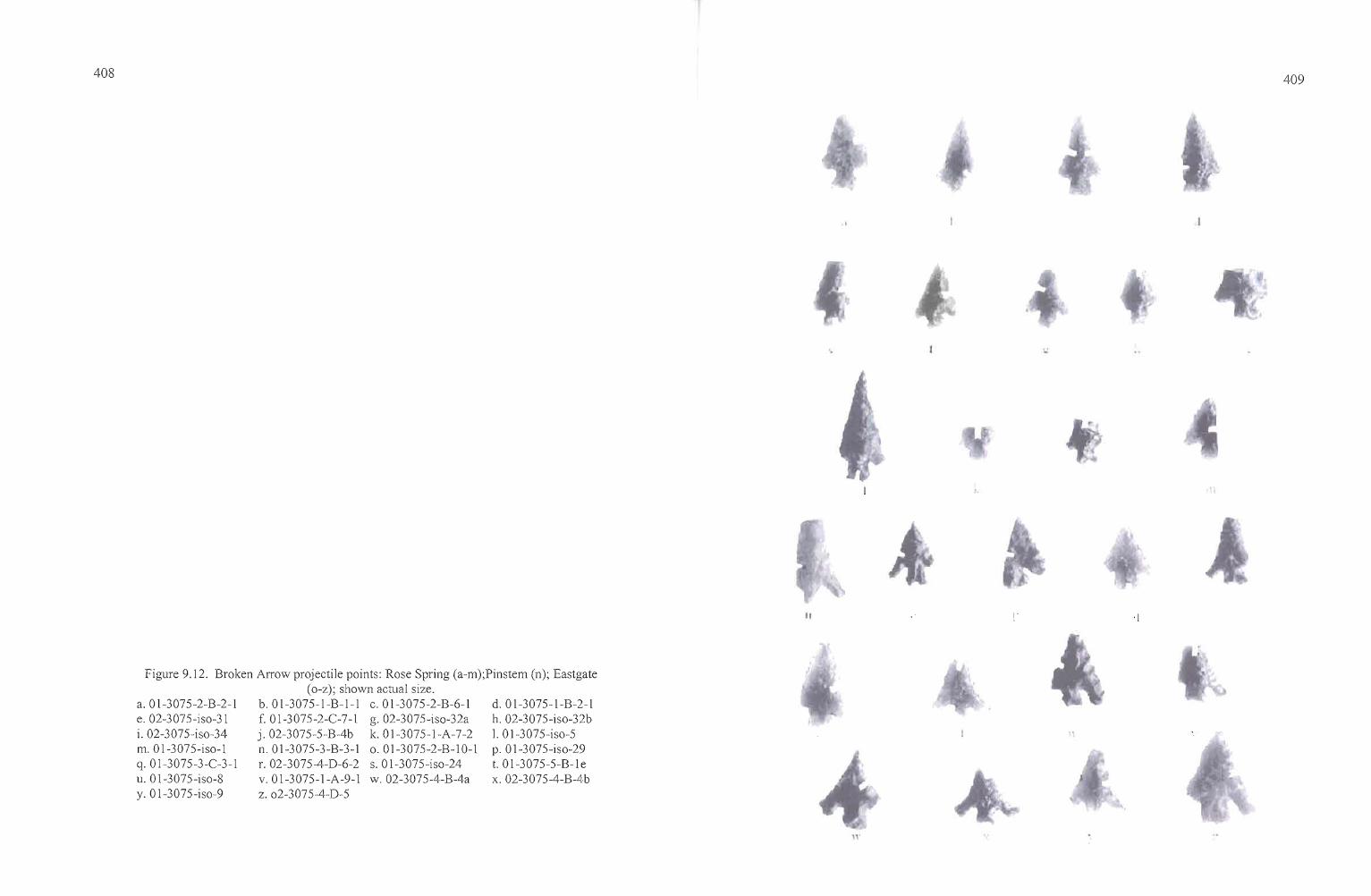
408 409
'. ''':'
II .\
d.Ol-3075-1-B-2-1h. 02-3075-iso-32b1. Ol-3075-iso-5p.Ol-3075-iso-29t. Ol-3075-5-B-lex. 02-3075-4-B-4b
Figure 9.12. Broken Arrow projectile points: Rose Spring (a-m);Pinstem (n); Eastgate(o-z); shown actual size.
b.OI-3075-1-B-l-l c.OI-3075-2-B-6-1f. 01-3075-2-C-7-l g.02-3075-iso-32aj.02-3075-5-B-4b k. Ol-3075-1-A-7-2n.Ol-3075-3-B-3-1 o.Ol-3075-2-B-IO-lr. 02-3075-4-D-6-2 s.Ol-3075-iso-24v.Ol-3075-1-A-9-1 w.02-3075-4-B-4az.o2-3075-4-D-5
a.Ol-3075-2-B-2-1e. 02-3075-iso-31i. 02-3075-iso-34m.Ol-3075-iso-lq.OI-3075-3-C-3-1u. Ol-3075-iso-8y. Ol-3075-iso-9
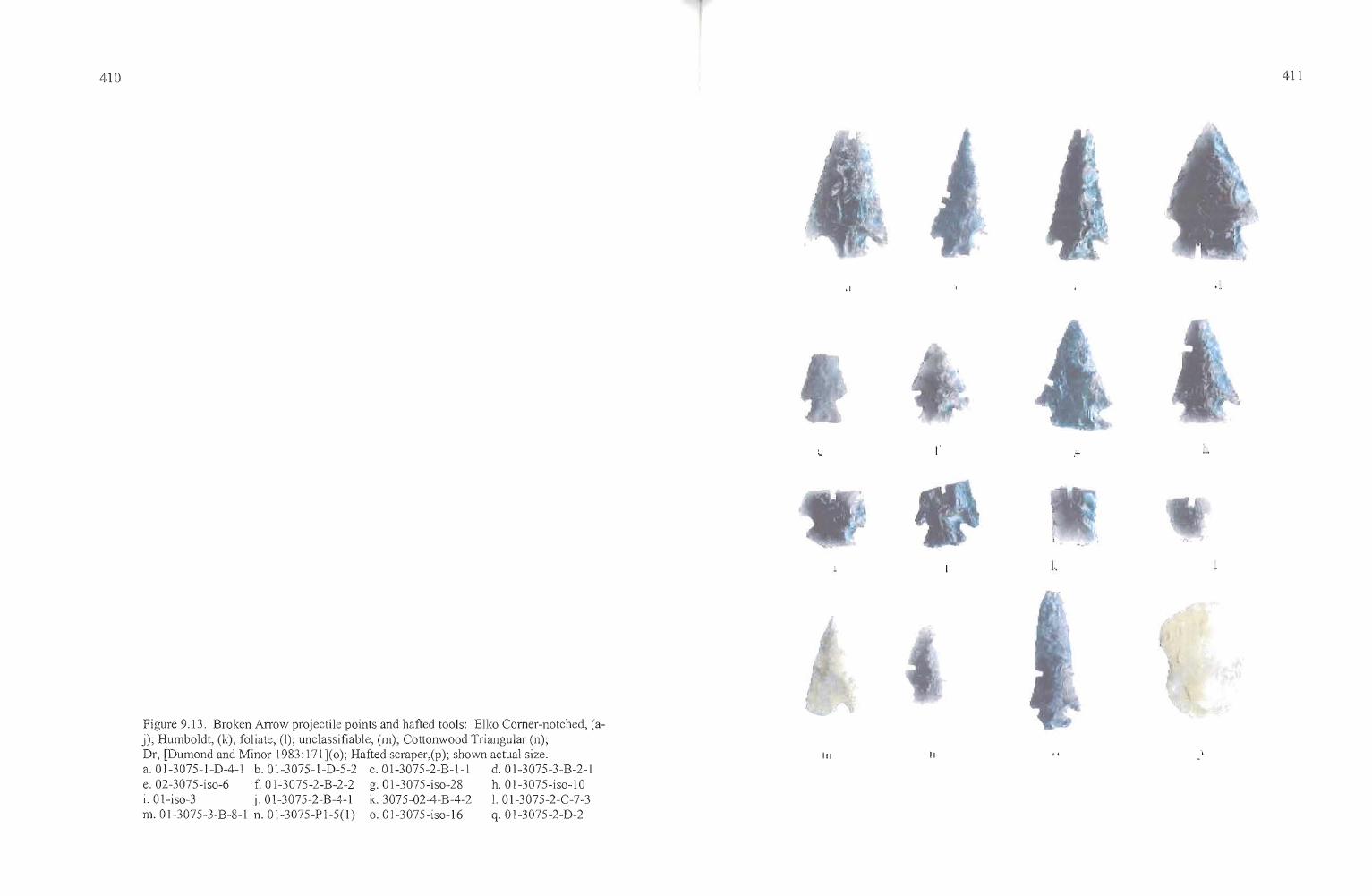
410
Figure 9.13. Broken Arrow projectile points and hafted tools: Elko Corner-notched, (aj); Humboldt, (k); foliate, (I); unclassifiable, (m); Cottonwood Triangular (n);Dr, [Dumond and Minor 1983: 171](0); Hafted scraper,(p); shown actual size.a.01-3075-1-D-4-1 b.01-3075-1-D-5-2 c.01-3075-2-B-l-l d.01-3075-3-B-2-1e.02-3075-iso-6 f. 01-3075-2-B-2-2 g.01-3075-iso-28 h.01-3075-iso-l0i.Ol-iso-3 j.01-3075-2-B-4-1 Ie. 3075-02-4-B-4-2 l. 01-3075-2-C-7-3m. 01-3075-3-B-8-1 n.01-3075-PI-5(l) 0.01-3075-iso-16 q.01-3075-2-D-2
III II
I.
411
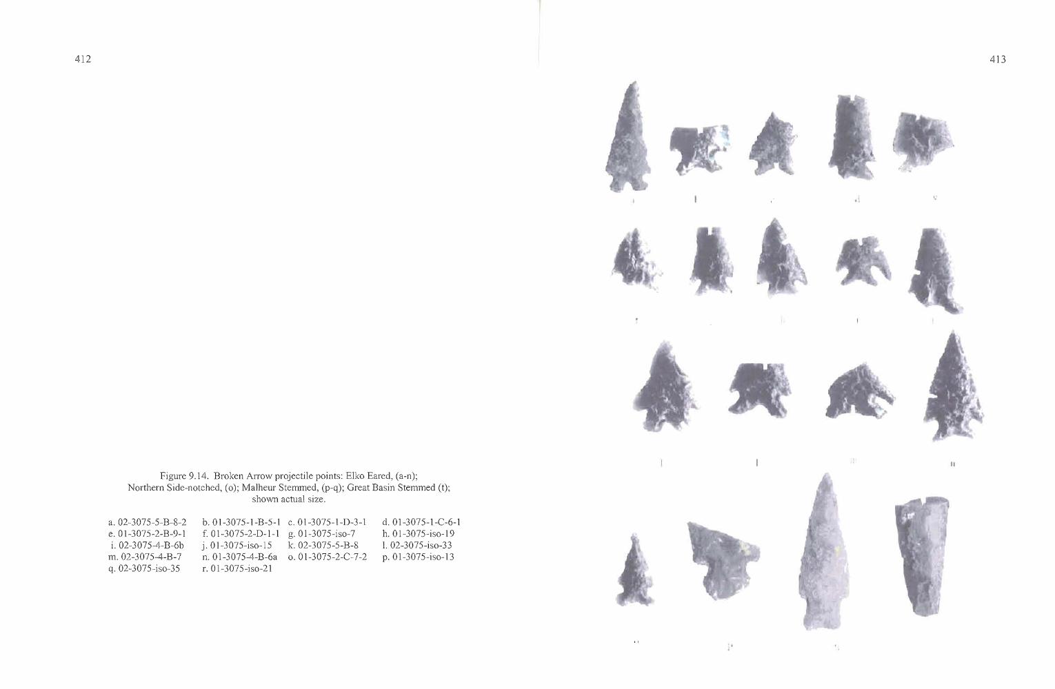
412
':
413
II
Figure 9.14. Broken Arrow projectile points: Elko Eared, (a-n);Northern Side-notched, (0); Malheur Stemmed, (p-q); Great Basin Stemmed (t);
shown actual size.
a. 02-3075-5-B-8-2e. 01-3075-2-B-9-1i. 02-3075-4-B-6b
m.02-3075-4-B-7q.02-3075-iso-35
b.01-3075-1-B-5-1f. 01-3075-2-D-l-lj.01-3075-iso-15n.01-3075-4-B-6ar. 01-3075-iso-21
c.01-3075-1-D-3-1g.01-3075-iso-7k. 02-3075-5-B-8o. 0 1-3075-2-C-·7-2
d.01-3075-1-C-6-1h. 01-3075-iso-191. 02-3075-iso-33p.01-3075-iso-13
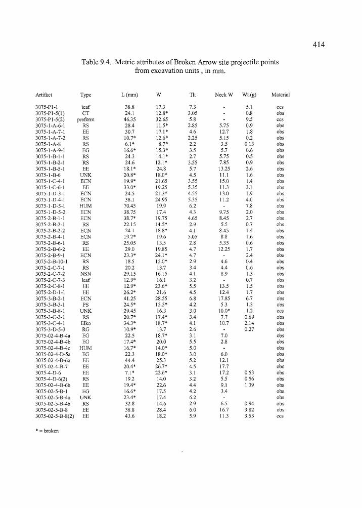
"
414
Table 9.4. Metric attributes of Broken Arrow site projectile pointsfrom excavation units, in mm.
Artifact Type L(rum) W Th NeckW Wt(g) Material
3075-Pl-l leaf 38.8 17.3 7.3 5.1 ccs3075-PI-5(l) CT 24.1 12.8* 3.05 0.8 obs3075-PI-5(2) preform 46.35 32.65 5.8 9.5 ccs3075-I-A-6-1 RS 28.4 11.5* 2.85 5.75 0.9 obs3075-1-A-7-1 EE 30.7 17.1 * 4.6 12.7 1.8 obs3075-1-A-7-2 RS 10.7* 12.6* 2.25 5.15 0.2 obs3075-1-A-8 RS 6.1 * 8.7* 2.2 3.5 0.13 obs3075-1-A-9-1 EO 16.6* 15.3* 3.5 5.7 0.6 obs3075-1-B-l-l RS 24.3 14.1 * 2.7 5.75 0.5 obs3075-I-B-2-1 RS 24.6 12.1 * 3.55 7.85 0.9 obs3075-I-B-5-1 EE 18.1 * 24.8 5.7 13.25 2.6 obs3075-I-B-6 UNK 20.8* 18.0* 4.5 11.1 1.6 obs3075-I-C-4-I ECN 19.9* 21.65 3.55 15.0 1.4 obs3075-I-C-6-1 EE 33.0* 19.25 5.35 11.3 3.1 obs3075-1-0-3-1 ECN 24.5 21.3* 4.55 13.0 1.9 obs3075-1-0-4-1 ECN 38.1 24.95 5.35 11.2 4.0 obs3075-1-0-5-1 HUM 70.45 19.9 6.2 7.8 obs3075-1-0-5-2 ECN 38.75 17.4 4.3 9.75 2.0 obs3075-2-B-l-l ECN 38.7* 19.75 4.65 8.45 2.7 obs3075-2-B-2-1 RS 22.15 14.5* 2.9 5.5 0.7 obs3075-2-B-2-2 ECN 24.1 18.8* 4.1 8.45 1.4 obs3075-2-B-4-1 ECN 19.2* 19.6 5.05 8.8 1.6 obs3075-2-B-6-1 RS 25.05 13.5 2.8 5.35 0.6 obs3075-2-B-6-2 EE 29.0 19.85 4.7 12.25 1.7 obs3075-2-B-9-1 ECN 23.3* 24.1 * 4.7 2.4 obs3075-2-B-I0-l RS 18.5 15.0* 2.9 4.6 0.4 obs3075-2-C-7-1 RS 20.2 13.7 3.4 4.4 0.6 obs3075-2-C-7-2 NSN 29.15 16.15 4.1 8.9 1.3 obs3075-2-C-7-3 leaf 12.9* 16.1 3.2 0.7 obs3075-2-C-8-1 EE 12.9* 23.6* 5.5 13.5 1.5 obs3075-2-0-1-1 EE 26.2* 21.6 4.5 12.4 1.7 obs3075-3-B-2-1 ECN 41.25 28.55 6.8 17.85 6.7 obs3075-3-B-3-1 PS 24.5* 15.5* 4.2 5.3 1.3 obs3075-3-B-8-1 UNK 29.45 16.3 3.0 10.0* 1.2 ccs3075-3-C-3-1 RS 20.7* 17.4* 3.4 7.7 0.69 obs3075-3-C-4-1 Elko 34.3* 18.7* 4.1 10.7 2.14 obs3075-3-0-5-3 RO 10.9* 13.7 2.6 0.27 obs3075-02-4-B-4a EO 22.5 18.7* 3.1 7.0 obs3075-02-4-B-4b EO 17.4* 20.0 5.5 2.8 obs3075-02-4-B-4c HUM 16.7* 14.0* 5.0 obs3075-02-4-0-5a EO 22.3 18.0* 3.0 6.0 obs3075-02-4-B-6a EE 44.4 25.3 5.2 12.1 obs3075-02-4-B-7 EE 20.4* 26.7* 4.5 17.7 obs3075-4-0-6 EE 7.1 * 22.6* 3.1 17.2 0.53 obs3075-4-0-6(2) RS 19.2 14.0 3.2 5.5 0.56 obs3075-02-4-B-6b EE 19.4* 22.6 4.4 9.1 1.39 obs3075-02-5-B-I EO 16.6* 17.5 4.2 3.4 obs3075-02-5-B-4a UNK 23.4* 17.4 6.2 obs3075-02-5-B-4b RS 32.8 14.6 2.9 6.5 0.94 obs3075-02-5-B-8 EE 38.8 28.4 6.0 16.7 3.82 obs3075-02-5-B-8(2) EE 43.6 18.2 5.9 11.3 3.53 ccs
* = broken
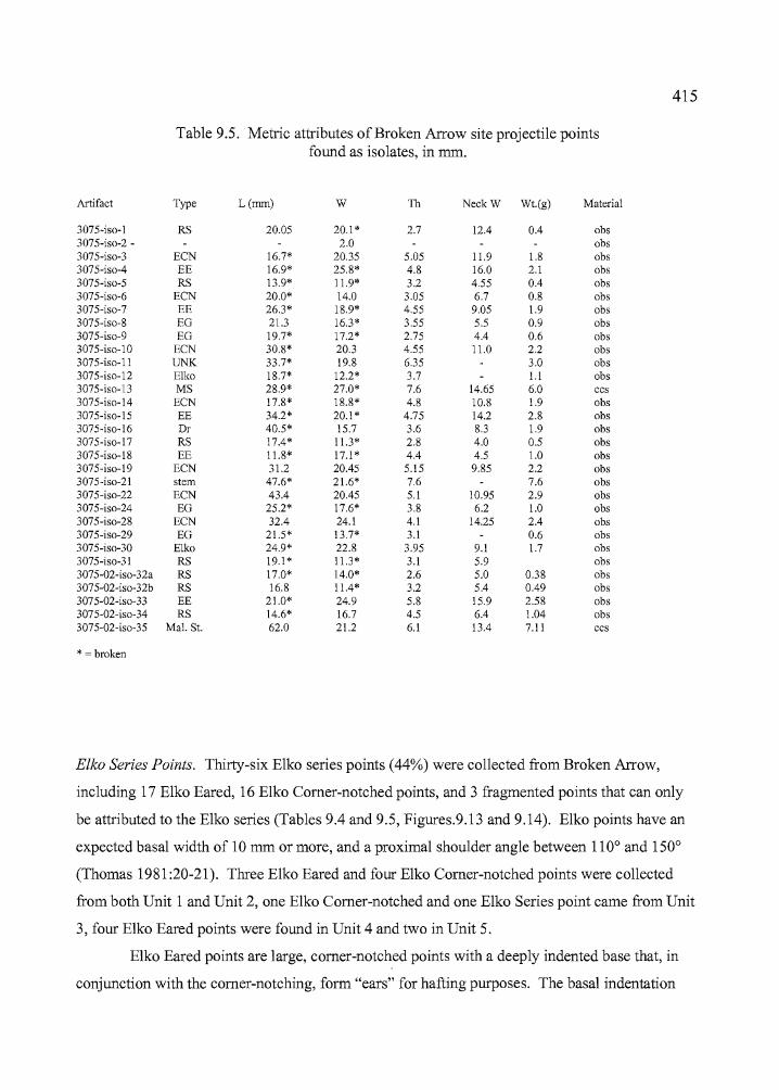
1 415r
Table 9.5. Metric attributes of Broken Arrow site projectile pointsfound as isolates, in mm.
Artifact Type L(mm) W Th NeckW Wt.(g) Material
3075-iso-l RS 20.05 20.1 * 2.7 12.4 0.4 obs3075-iso-2 - 2.0 obs3075-iso-3 ECN 16.7* 20.35 5.05 11.9 1.8 obs3075-iso-4 EE 16.9* 25.8* 4.8 16.0 2.1 obs3075-iso-5 RS 13.9* 11.9* 3.2 4.55 0.4 obs3075-iso-6 ECN 20.0* 14.0 3.05 6.7 0.8 obs3075-iso-7 EE 26.3* 18.9* 4.55 9.05 1.9 obs3075-iso-8 EG 21.3 16.3* 3.55 5.5 0.9 obs3075-iso-9 EG 19.7* 17.2* 2.75 4.4 0.6 obs3075-iso-l0 ECN 30.8* 20.3 4.55 11.0 2.2 obs3075-iso-l1 UNK 33.7* 19.8 6.35 3.0 obs3075-iso-12 Elko 18.7* 12.2* 3.7 1.1 obs3075-iso-13 MS 28.9* 27.0* 7.6 14.65 6.0 ccs3075-iso-14 ECN 17.8* 18.8* 4.8 10.8 1.9 obs3075-iso-15 EE 34.2* 20.1 * 4.75 14.2 2.8 obs3075-iso-16 Dr 40.5* 15.7 3.6 8.3 1.9 obs3075-iso-17 RS 17.4* 11.3* 2.8 4.0 0.5 obs3075-iso-18 EE 11.8* 17.1 * 4.4 4.5 1.0 obs3075-iso-19 ECN 31.2 20.45 5.15 9.85 2.2 obs3075-iso-21 stem 47.6* 21.6* 7.6 7.6 obs3075-iso-22 ECN 43.4 20.45 5.1 10.95 2.9 obs3075-iso-24 EG 25.2* 17.6* 3.8 6.2 1.0 obs3075-iso-28 ECN 32.4 24.1 4.1 14.25 2.4 obs3075-iso-29 EG 21.5* 13.7* 3.1 0.6 obs3075-iso-30 Elko 24.9* 22.8 3.95 9.1 1.7 obs3075-iso-31 RS 19.1 * 11.3* 3.1 5.9 obs3075-02-iso-32a RS 17.0* 14.0* 2.6 5.0 0.38 obs3075-02-iso-32b RS 16.8 11.4* 3.2 5.4 0.49 obs3075-02-iso-33 EE 21.0* 24.9 5.8 15.9 2.58 obs3075-02-iso-34 RS 14.6* 16.7 4.5 6.4 1.04 obs3075-02-iso-35 Mal.St. 62.0 21.2 6.1 13.4 7.11 ccs
* = broken
Elko Series Points. Thirty-six Elko series points (44%) were collected from Broken Arrow,
including 17 Elko Eared, 16 Elko Comer-notched points, and 3 fragmented points that can only
be attributed to the Elko series (Tables 9.4 and 9.5, Figures.9.13 and 9.14). Elko points have an
expected basal width of 10 mm or more, and a proximal shoulder angle between 110° and 150°
(Thomas 1981:20-21). Three Elko Eared and four Elko Comer-notched points were collected
from both Unit 1 and Unit 2, one Elko Comer-notched and one Elko Series point came from Unit
3, four Elko Eared points were found in Unit 4 and two in Unit 5.
Elko Eared points are large, comer-notched points with a deeply indented base that, in
conjunction with the comer-notching, form "ears" for hafting purposes. The basal indentation
"
416
ratio should be less than or equal to 0.93 (Thomas 1981:21). Elko Comer-notched points are
included in the Elko Series and morphologically similar to Elko Eared points, but lack the deep
basal indentation that produces the eared appearance, with a basal indentation ratio exceeding
0.93 (Thomas 1981 :21). The widest portion of either point is just forward of the base. Both types
are coeval.
Like those at Laurie's site, Broken Arrow Elko points display a considerable range in
both size and form but most are fairly robust, with broad, lenticular cross-sections. Many have
breakage patterns consistent with impact damage. Elko points originate from 11 obsidian
sources, and the greatest variation is among the Elko Eared specimens, originating from seven
sources. They include three from Indian Creek and two from Indian Creek "B", three from
Venator, one from Dog Hill, two from Bums, one from Beatys Butte to the southwest, and one
from Whitewater Ridge, originating near Seneca. Two Elko Comer-notched points came from
Indian Creek, six from Tule Spring, five from Venator, and one apiece from Double 0, Wolf
Creek, and Whitewater Ridge. Elko Series points included one each from Indian Creek, Tule
Spring, Venator, and Buck Springs. Two clear distinctions were apparent: the high number of
Elko Comer-notched points from Tule Springs but the absence ofthis source in the Elko Eared
specimens, and the manufacture of Elko Eared points from Dog Hill and neighboring Bums
obsidian, while no Elko Comer-notched points were made ofthis obsidian.
Obsidian hydration measurements vary considerably for both types of Elko points. The
range for Elko Comer-notched points is between 1.5 to 6.4 microns, with a mean of 3.1 microns
for 15 specimens. Elko Eared points range from 1.4 to 5.7 microns, and the mean is 3.1 microns
for 13 specimens. Some variation was observed when sourcing and hydration information for
Elko points was considered for each excavation block. In Unit 1, the mean for all seven Elko
points is 3.2 microns and the origins of the obsidian sources are all to the north and east. For
Units 2, 4, and 5 combined, the mean ofthe hydration measurements is 2.8 microns and the
sources are primarily northern and eastern with one Double 0 artifact from west of Harney Lake.
Only two Elko points were gathered from Unit 3 for a mean of 2.5, and the two sources were
from the north and east
____.c+n _
417
Northern Side-notched. Large side-notched projectile points have been identified by various
regional appellations or morphological attributes in the northern Great Basin and southern
Columbia Plateau. Specimen 3075-2-C-7-2, recovered from Level 7 of Unit 2, fits the Northern
Side-notched classification established by Heizer and Hester (1978) for the Great Basin, having a
straight to concave base and notches that are deep and perpendicular to the long axis (Figure
9.14). The typological designation of this point is somewhat troubling because ofthe substantial
degree ofresharpening to which it has been subjected. The point could also be an Elko Eared
that has been retouched, lending the appearance of side notching as the body of the artifact was
modified. Oetting (1994) places Northern Side-notched points between 7,000 to 4,000 years in
age in the northern Great Basin. Chronologically, the point is out ofplace in the ca. 2,000 year
old house pit by about 2,000 years. The point has a hydration rind of 3.9 microns and it
originates from the Burns obsidian source, to the northwest.
Pinstem. A single point collected in Unit 3, Quad B, Level 3 can be attributed to the Pinstem
series, described by Dumond and Minor as " ...characterized by a straight stem that is virtually
round in cross-section. The points are contemporary with Rose Spring and Eastgate points and
Dumond and Minor (1983:162) associate Pinstem points with the Quinton phase (1000 BP to
historic contact) at the Wildcat Canyon site, on the John Day River near its confluence with the
Columbia.
Specimen 3075-3-B-3-1 (Figure 7.11) was found in Level 3 of Quad B, Unit 3. The point
was recovered in association with Rose Spring, Elko, and Eastgate points. Elko points were
utilized until approximately 1000 BP, so it is probable that the Pinstem was deposited at the early
end of its time range. The point is manufactured from obsidian originating at the Venator source
to the east, and it lacks a measureable hydration reading.
i.c, _ _ c+... ..... _
~'I
i418
Malheur Stemmed. One complete point (3075-iso-35) and one point base (3075-iso-13) are
consistent with Oetting's (!990) guidelines for designation as Malheur Stemmed points (Figure
9.14). Twenty-eight of these points were collected during the post-1980s flood surveys of
Malheur Lake and were first described by Oetting (1990:139-144) as lanceolate points with
distinctive expanding stems. The length of the basal element is short in comparison with the
blade and the stem expands toward the base (Oetting 1990:140). Neck widths range between 7.9
and 19.3 mm. Although some attributes of these points are suggestive of Great Basin Stemmed
and other large point types, Oetting (1990:144) noted that most Malheur Stemmed points were
found on sites dominated by Rosegate points.
Like the Malheur Lake points described by Oetting (1990), the Broken Arrow site points
have distinct expanding stems and shoulders. Specimen 3075-iso-13 has a neck width of 14.65
mm and 3075-iso-35 has a neck width of 13.4 mm, both in keeping with Oetting's (1990:140)
dimensional range. Both of the points were collected as isolates and both are manufactured of
CCS. Malheur Stemmed points have not been recovered in a radiocarbon-dateable context to
date, though 3075-iso-35 was collected six meters south of Unit 5 and it may be associated with
the occupation there. The presence of these points at late sites has already been made apparent
(Oetting 1990: 144) The points also fit the Side Notched 4 category in the Columbia Plateau
typology described by Dumond and Minor (1983:171).
Stemmed. One artifact can be classified as a Stemmed point in the tradition of the Western or
Great Basin Stemmed series ofpoints dating to the early Holocene (Willig et al. 1988).
Specimen 01-3075-iso-21 (Figure 9.14) is a stemmed base manufactured from Venator obsidian.
It was found as an isolate.
The lanceolate point has a long, tapering stem leading to a slightly convex bas e, and
the artifact exhibits considerable wear that is probably the result of weathering. The edges of the
stem appear to be ground, but erosional process may have also had something to do with this
alteration. The artifact was submitted for obsidian hydration and was found to have an
unreadable hydration rind.
Another artifact has the appearance of a stemmed point, but is believed to be a middle to
late Holocene knife. Specimen 02-3075-5-D-9 is a large obsidian biface with weak shoulders
offsetting a tapered base. The biface lacks edge grinding of the basal element and it was
419
recovered from the ca. 2000 BP floor deposits in Unit 5, Level 9. The object is made of Dog Hill
obsidian and it has a hydration measurement of 4.6 microns.
Humboldt Series. These points are described as "...unnotched, lanceolate, concave-base
projectile points of variable size...," by Thomas (1981: 17). Two Humboldt Series point
fragments were recovered from the Broken Arrow excavations, one in level 5 of Quad D, Unit 1
(3075-1-D-5-1),and the second in Level 4, Quad B, ofUnit 4 (3075-02-4-B-4c [Figure 9.13]).
The Unit 1 point is a large specimen with a slightly concave base, which originates from the Tule
Spring obsidian source. The hydration band is 4.6 microns in width; only ten other projectile
points at Broken Arrow have hydration readings exceeding four microns. The Unit 4 Humboldt
has a base that appears almost flat, although a slight concavity can be discerned upon closer
examination. The point is made of Wolf Creek obsidian and it has a hydration reading of2.5
microns.
Unknown. Four artifacts recovered from Broken Arrow are clearly projectile points, but lack the
diagnostic attributes that would make them typologically classifiable. They include specimens
3075-1-B-6, 3075-3-B-8-1, 3075-02-5-B-4a, and 3075-iso-11. All are Stage 5 bifaces and they
were clearly designed for hafting, but they are either resharpened fragments ofbroken points
utilized expediently, or they are points that were simply manufactured without attention to
characteristic hafting elements or common design touches.
At least one "unknown" point came from each excavation block and one was collected
as an isolate. Specimen 3075-iso-11, the isolate, appears to be a reworked waste flake that is
somewhat amorphously shaped but has a small projection for hafting purposes. The artifact has a
hydration reading of 4.5 microns and it is manufactured from Whitewater Ridge obsidian.
Specimen 3075-1-B-6-1 is believed to be part of a large projectile point base that was modified
into a projectile point and either broken during the process or during use. The Unit 3 point, 3075
3-B-8-1, is a small, foliate point akin to Thomas' (1981:16) Cottonwood Leaf-shaped points with
a flat base. Obsidian sourcing and hydration analysis was conducted on the artifact but the
results are not available at this time. Specimen 3o.75-5-B-4a is an obsidian base with a broad,
·f
,
l
420
lenticular cross-section. It may be the basal element of a heavy projectile point or possibly a drill
or awl base. The artifact came from the Venator obsidian source and it has a hydration
measurement of2.0 microns.
Shaped Bifaces
This treatment uses the multi-stage biface classification system employed by Jenkins and
Connolly (1990) at the Indian Grade Spring site in the Stinkingwater Mountains near Buchanan.
Stage 1-5 bifaces are discussed here (Table 9.6). Stage 5 bifaces are generally classified as
projectile points, and all diagnostic point fragments have been treated separately in a previous
portion ofthe text. Few of the Broken Arrow site bifaces are complete, and those which are
broken are considered in terms of a generalized leaf-shaped biface morphology. With this
template in mind, tips are pointed and are thought to be the distal end of the artifact. Bases
usually have rounded or slightly convex squared ends and are thought to be the proximal portion
of the artifact. Midsections are frequently tapered to some degree, but can be straight-sided.
Certainly not all bifaces have rounded bases, pointed tips, and show clear signs of tapering, but it
seems most utilitarian for descriptive purposes to emphasize the shape of a common artifact form
when only fragments exist. The function of the bifaces can only be implied, but they often
served multiple purposes ranging from cutting implements to cores for the manufacture of
projectile points and other tools.
A total of 125 biface fragments was recovered from the Broken Arrow site, all but one
(3075-iso-1) from the excavations. They include two Stage 1, eighteen Stage 2, fourteen Stage 3,
thirteen Stage 4, and seventy-eight Stage 5 bifaces (Table 9.6, Figures 9.15 and 9.16). Obsidian
tools account for 106 of the 124 bifaces (85%) and 9 are made of CCS and ten of basalt. The
421 422
I.:
I:
_____c+. _
Figure 9.15. Broken Arrow bifaces, shown actual size.a.01-3075-3-C-6-1 b.01-3075-2-D-5-1 c.01-3075-2-A-I-1 d.02-3075-4-D-6e. 02-3075-iso-6 f. 02-3075-5-D-9 g. 02-3075-5-B-5 h. 02-3075-4-D-5b
423
Stage 5 artifacts consist almost entirely of projectile point fragments, of which 32 are tips (41 %),
10 are midsections (13%), 12 are barbs (15%),9 arebase fragments (11 %),8 are edge fragments
(10%),2 are tangs (3%), 2 are unidentifiable fragments (3%) and 3 are complete, but
nondiagnostic bifaces (4%).
The only two Stage 1 bifaces found at Broken Arrow were collected in Unit 5, a lxl
meter unit. Although more variation occurred when sample sizes were smaller, the frequency of
the various biface stages remained fairly consistent from unit to unit across the site. Stage 5
bifaces composed between 58% to 65% in any unit, Stage 2 bifaces were generally the second
most common, with frequencies ranging between 7% to 20%, and Stage 3 and 4 bifaces generally
occurred in similar frequencies. When Units 2, 4, and 5 totals are combined, the frequencies of
the biface stages in the three dispersed excavation blocks (Unit 1; Units 2,4,and 5; and Unit 3) are
very similar. The high frequency of Stage 2 bifaces may be due to their utility as bifacial cores,
easily carried from the quarry to the lakeside site and capable of serving multiple purposes.
Stage 1 hifaces. These bifaces have thick cross-sections and large, unpatterned flake
scars. They exhibit only the most rudimentary development, with rounded or thick lenticular
shapes and cross-sections. The flaking pattern reflects use of the hard hammer percussion
technique, and the edges of these tools can be very sinuous. Two ofthe bifaces recovered from
Unit 5 excavations reflected Stage 1 reduction. One base fragment made of red CCS was
collected in Quad B, Level 5 (02-5-B-5[3]), associated with one Stage 2 and two Stage 5 bifaces.
An obsidian Stage 1 base fragment was collected from the Level 9 floor deposits.
Stage 2 hifaces. Bifacial thinning is continued on these artifacts through the removal of
contiguous hard hammer percussion flakes. The removal ofthe flakes results in the development
of an artifact, which, although still crudely shaped, has a more pronounced form than stage 1
artifacts. Stage 2 bifaces are considered to be quarry blanks. Seventeen artifacts fit this
classification. Four were collected from Unit 1, five from Unit 2 and Unit 3, one from Unit 4 and
424
1·1
Figure 9.16. Additional bifaces from the Broken Arrow site, shown actual size.
a.OI-3075-1-A-9-2 b.OI-3075-Pl-l c.02-3075-2-A-l d. 0 1-3075-P 1-5-2
•
two from Unit 5. Two of the Unit 1 bifaces were made of basalt and the other two were obsidian;
the Unit 2 artifacts included one of basalt, one CCS, and three of obsidian; the Unit 3 tools
consisted of four of obsidian and one of CCS; and all but one ofthe artifacts in Units 4 and 5 are
obsidian. The exception is a large basalt bifacial core (02-3075-4-D-5b) which has also been
utilized as a Imife (Figure 7.14). The artifact was geochemically sourced to explore a possible
relationship between it and the basalt tools of the RJ site (35HA30 13). The Unit 4 Imife is not
related, and the geochemical source is provisionally identified as Unknown Basalt 1. Stage 2 and
Stage 5 artifacts exhibit the greatest variety in tool stone, a fitting relationship if the former was
being transported to the site for manufacture of the latter.
Stage 3 bi/aces A total of 14 bifaces and fragments fit this classification, 11 of which are
obsidian, two are CCS, and one is basalt. These bifaces exhibit little evidence of pressure flaking
and have the slightly sinuous edges characteristic of large percussion flake scars created by the
initial stages of bifacial reduction. The entire artifact surface has been modified through the
removal of flakes which can reach the middle of the artifact. It is at this stage that major thinning
of the artifact occurs, often leading to breakage. A majority of the Stage 3 tools (n=12, or 86%)
are broken and include edges, midsections and bases. Stage 3 artifacts often exhibit fine pressure
flaking along some edges, with varying degrees of percussion flaking along other edges and
across the body of the artifact.
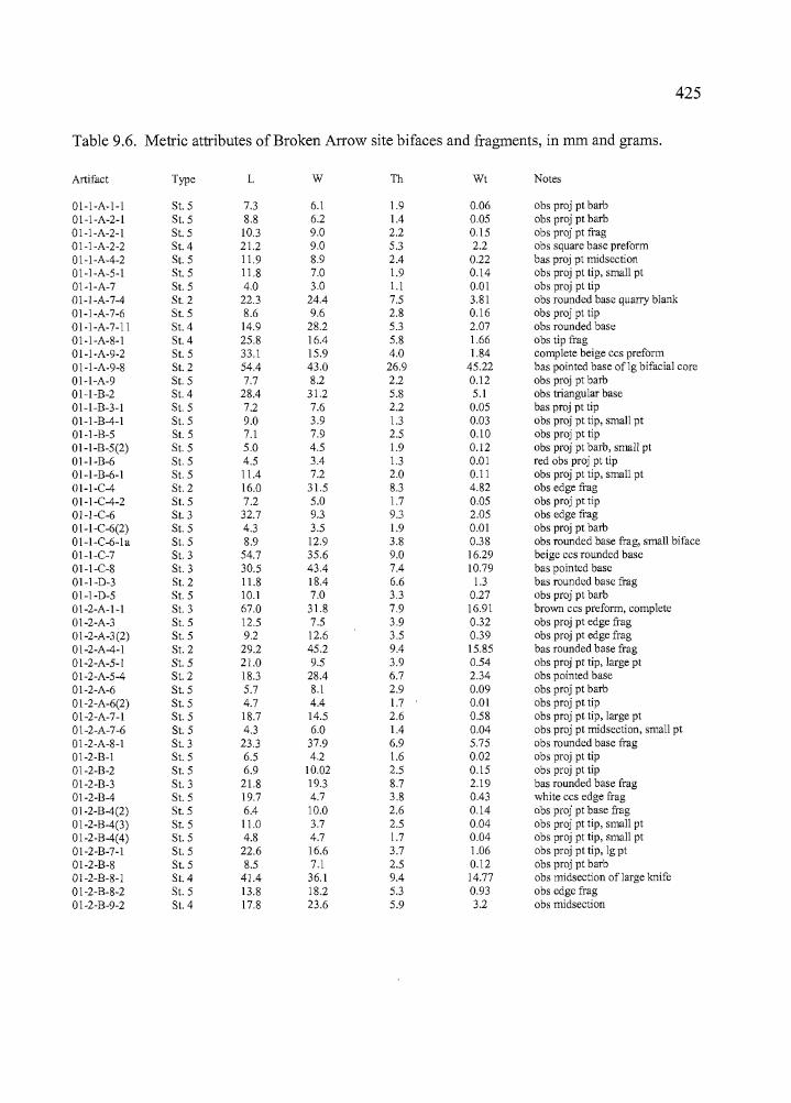
1Ire ~ _ _ cr+tn _
425
Table 9.6. Metric attributes of Broken Arrow site bifaces and fragments, in rom and grams.
Artifact Type L W Th Wt Notes
01-1-A-1-1 S1. 5 7.3 6.1 1.9 0.06 obs proj pt barb01-1-A-2-1 S1. 5 8.8 6.2 1.4 0.05 obs proj pt barb01-1-A-2-1 S1. 5 10.3 9.0 2.2 0.15 obs proj pt frag01-1-A-2-2 S1. 4 21.2 9.0 5.3 2.2 obs square base preform01-1-A-4-2 S1. 5 11.9 8.9 2.4 0.22 bas proj pt midsection01-1-A-5-1 S1. 5 11.8 7.0 1.9 0.14 obs proj pt tip, small pt01-1-A-7 S1. 5 4.0 3.0 1.1 0.01 obs proj pt tip01-1-A-7-4 S1. 2 22.3 24.4 7.5 3.81 obs rounded base quarry blank01-1-A-7-6 S1. 5 8.6 9.6 2.8 0.16 obs proj pt tip01-1-A-7-11 S1. 4 14.9 28.2 5.3 2.07 obs rounded base01-1-A-8-1 S1.4 25.8 16.4 5.8 1.66 obs tip frag01-1-A-9-2 S1. 5 33.1 15.9 4.0 1.84 complete beige ccs preform01-1-A-9-8 S1. 2 54.4 43.0 26.9 45.22 bas pointed base oflg bifacial core01-1-A-9 S1. 5 7.7 8.2 2.2 0.12 obs proj pt barb01-1-B-2 S1. 4 28.4 31.2 5.8 5.1 obs triangular base01-1-B-3-1 S1. 5 7.2 7.6 2.2 0.05 bas proj pt tip01-1-B-4-1 S1. 5 9.0 3.9 1.3 0.03 obs proj pt tip, small pt01-1-B-5 S1. 5 7.1 7.9 2.5 0.10 obs proj pt tip01-1-B-5(2) S1. 5 5.0 4.5 1.9 0.12 obs proj pt barb, small pt01-1-B-6 S1. 5 4.5 3.4 1.3 0.01 red obs proj pt tip01-1-B-6-1 S1. 5 11.4 7.2 2.0 0.11 obs proj pt tip, small ptOl-l-C-4 S1. 2 16.0 31.5 8.3 4.82 obs edge frag01-1-C-4-2 S1. 5 7.2 5.0 1.7 0.05 obs proj pt tip01-1-C-6 SI. 3 32.7 9.3 9.3 2.05 obs edge frag01-1-C-6(2) S1. 5 4.3 3.5 1.9 0.01 obs proj pt barbo1-1-C-6-1 a St.5 8.9 12.9 3.8 0.38 obs rounded base frag, small biface01-1-C-7 SI. 3 54.7 35.6 9.0 16.29 beige ccs rounded base01-1-C-8 S1. 3 30.5 43.4 7.4 10.79 bas pointed base01-1-D-3 SI. 2 11.8 18.4 6.6 1.3 bas rounded base frag01-1-D-5 S1. 5 10.1 7.0 3.3 0.27 obs proj pt barb01-2-A-1-1 S1. 3 67.0 31.8 7.9 16.91 brown ccs preform, complete01-2-A-3 SI. 5 12.5 7.5 3.9 0.32 obs proj pt edge frago1-2-A-3(2) SI. 5 9.2 12.6 3.5 0.39 obs proj pt edge frag01-2-A-4-1 S1. 2 29.2 45.2 9.4 15.85 bas rounded base frag01-2-A-5-1 S1. 5 21.0 9.5 3.9 0.54 obs proj pt tip, large pt01-2-A-5-4 S1. 2 18.3 28.4 6.7 2.34 obs pointed base01-2-A-6 S1. 5 5.7 8.1 2.9 0.09 obs proj pt barbo1-2-A-6(2) SI. 5 4.7 4.4 1.7 0.01 obs proj pt tip01-2-A-7-1 SI. 5 18.7 14.5 2.6 0.58 obs proj pt tip, large pt01-2-A-7-6 S1. 5 4.3 6.0 1.4 0.04 obs proj pt midsection, small pt01-2-A-8-1 St.3 23.3 37.9 6.9 5.75 obs rounded base frag01-2-B-1 S1. 5 6.5 4.2 1.6 0.02 obs proj pt tip01-2-B-2 SI. 5 6.9 10.02 2.5 0.15 obs proj pt tip01-2-B-3 S1. 3 21.8 19.3 8.7 2.19 bas rounded base frag01-2-B-4 S1. 5 19.7 4.7 3.8 0.43 white ccs edge frago1-2-B-4(2) SI. 5 6.4 10.0 2.6 0.14 obs proj pt base frago1-2-B-4(3) SI. 5 11.0 3.7 2.5 0.04 obs proj pt tip, small pt01-2-B-4(4) S1. 5 4.8 4.7 1.7 0.04 obs proj pt tip, small pt01-2-B-7-1 S1. 5 22.6 16.6 3.7 1.06 obs proj pt tip, 19 pt01-2-B-8 SI. 5 8.5 7.1 2.5 0.12 obs proj pt barb01-2-8-8-1 SI.4 41.4 36.1 9.4 14.77 obs midsection of large knife01-2-B-8-2 S1. 5 13.8 18.2 5.3 0.93 obs edge frag01-2-B-9-2 S1. 4 17.8 23.6 5.9 3.2 obs midsection
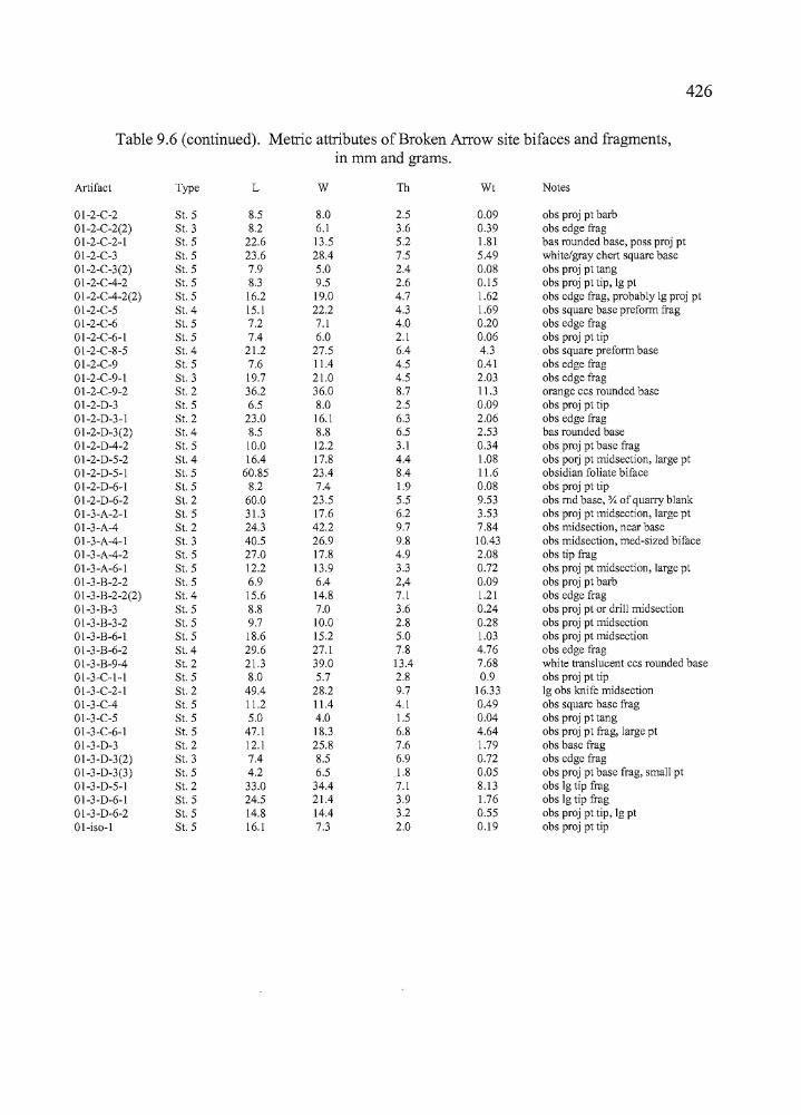
~--sr1Ptnn-~
426
Table 9.6 (continued). Metric attributes of Broken Arrow site bifaces and fragments,in mm and grams.
Artifact Type L W Th Wt Notes
01-2-C-2 St. 5 8.5 8.0 2.5 0.09 obs proj pt barb01-2-C-2(2) St. 3 8.2 6.1 3.6 0.39 obs edge trag01-2-C-2-1 St. 5 22.6 13.5 5.2 1.81 bas rounded base, poss proj pt01-2-C-3 St. 5 23.6 28.4 7.5 5.49 white/gray chert square base01-2-C-3(2) St. 5 7.9 5.0 2.4 0.08 obs proj pt tang01-2-C-4-2 St. 5 8.3 9.5 2.6 0.15 obs proj pt tip, 19 pto1-2-C-4-2(2) St. 5 16.2 19.0 4.7 1.62 obs edge frag, probably 19 proj pt01-2-C-5 St.4 15.1 22.2 4.3 1.69 obs square base prefonn trag01-2-C-6 St. 5 7.2 7.1 4.0 0.20 obs edge frag01-2-C-6-1 St. 5 7.4 6.0 2.1 0.06 obs proj pt tip01-2-C-8-5 St.4 21.2 27.5 6.4 4.3 obs square prefonn base01-2-C-9 St. 5 7.6 11.4 4.5 0.41 obs edge trag01-2-C-9-1 St. 3 19.7 21.0 4.5 2.03 obs edge frag01-2-C-9-2 St. 2 36.2 36.0 8.7 11.3 orange ccs rounded base01-2-D-3 St. 5 6.5 8.0 2.5 0.09 obs proj pt tip01-2-D-3-1 St. 2 23.0 16.1 6.3 2.06 obs edge trag01-2-D-3(2) St.4 8.5 8.8 6.5 2.53 bas rounded base01-2-D-4-2 St. 5 10.0 12.2 3.1 0.34 obs proj pt base frag01-2-D-5-2 St. 4 16.4 17.8 4.4 1.08 obs POlj pt midsection, large pt01-2-D-5-1 St. 5 60.85 23.4 8.4 11.6 obsidian foliate biface01-2-D-6-1 St. 5 8.2 7.4 1.9 0.08 obs proj pt tip01-2-D-6-2 St. 2 60.0 23.5 5.5 9.53 obs md base, % of quarry blank01-3-A-2-1 St. 5 31.3 17.6 6.2 3.53 obs proj pt midsection, large pt01-3-A-4 St. 2 24.3 42.2 9.7 7.84 obs midsection, near base01-3-A-4-1 St. 3 40.5 26.9 9.8 10.43 obs midsection, med-sized biface01-3-A-4-2 St. 5 27.0 17.8 4.9 2.08 obs tip frag01-3-A-6-1 St. 5 12.2 13.9 3.3 0.72 obs proj pt midsection, large pt01-3-B-2-2 St. 5 6.9 6.4 2,4 0.09 obs proj pt barb01-3-B-2-2(2) St. 4 15.6 14.8 7.1 1.21 obs edge frag01-3-B-3 St. 5 8.8 7.0 3.6 0.24 obs proj pt or drill midsection01-3-B-3-2 St. 5 9.7 10.0 2.8 0.28 obs proj pt midsection01-3-B-6-1 St. 5 18.6 15.2 5.0 1.03 obs proj pt midsection01-3-B-6-2 St. 4 29.6 27.1 7.8 4.76 obs edge trag01-3-B-9-4 St. 2 21.3 39.0 13.4 7.68 white translucent ccs rounded base01-3-C-1-1 St. 5 8.0 5.7 2.8 0.9 obs proj pt tip01-3-C-2-1 St. 2 49.4 28.2 9.7 16.33 19 obs knife midsection01-3-C-4 St. 5 11.2 11.4 4.1 0.49 obs square base trag01-3-C-5 St. 5 5.0 4.0 1.5 0.04 obs proj pt tang01-3-C-6-1 St. 5 47.1 18.3 6.8 4.64 obs proj pt frag, large pt01-3-D-3 St. 2 12.1 25.8 7.6 1.79 obs base frag01-3-D-3(2) St. 3 7.4 8.5 6.9 0.72 obs edge frag01-3-D-3(3) St. 5 4.2 6.5 1.8 0.05 obs proj pt base frag, small pt01-3-D-5-1 St. 2 33.0 34.4 7.1 8.13 obs 19 tip frag01-3-D-6-1 St. 5 24.5 21.4 3.9 1.76 obs 19 tip frag01-3-D-6-2 St. 5 14.8 14.4 3.2 0.55 obs proj pt tip, 19 pt01-iso-1 St. 5 16.1 7.3 2.0 0.19 obs proj pt tip

[,
427
Table 9.6 (continued). Metric attributes of Broken Arrow site bifaces and fragments,in nun and grams.
Artifact Type L W Th Wt Notes
02-4-B-2 St. 5 18.2 5.8 1.8 0.14 obs proj pt tip02-4-B-3 St. 5 20.4 17.2 6.8 1.81 obs midsection02-4-B-5 St. 2 21.0 30.4 8.7 4.3 obs rounded base frag02-4-B-5(2) St.5 10.4 6.5 2.6 0.01 obs proj pt tip, small pt02-4-B-5(3) St. 3 12.9 26.2 4.7 1.73 obs midsection02-4-B-5(4) St. 4 25.2 20.7 6.4 2.69 beige ccs square base02-4-B-6 St. 5 6.0 7.3 2.8 0.09 obs proj pt barb02-4-0-2 St. 3 28.6 17.0 5.3 3.22 obs rounded base and edge frag02-4-0-2(2) St. 5 10.7 6.9 2.2 0.12 obs proj pt tip02-4-0-2(3) St. 5 6.9 3.7 1.8 0.05 obs proj pt barb02-4-0-3 St. 5 5.3 5.1 2.2 0.05 obs proj pt tip02-4-0-4 St. 5 17.5 8.8 3.3 0.36 obs proj pt tip02-4-0-5b St. 2 lost before measurement02-4-0-7 St. 3 29.8 28.9 6.3 6.27 obs edge frag02-5-B-4 St. 3 35.9 16.7 4.6 3.0 obs preform frag,02-5-B-4(2) St. 5 17.0 3.8 4.0 0.74 obs proj pt midsection, Ig pt02-5-B-5 St. 5 8.1 13.7 4.4 0.37 obs proj pt base frag02-5-B-5(2) St. 2 35.9 37.6 8.3 11.73 obs rounded base edge frag02-5-B-5(3) St. 1 22.1 55.9 16.4 19.61 red ccs rounded base frag02-5-B-5(4) St.5 27.7 16.4 5.5 2.60 obs midsection02-5-B-7 St. 5 10.3 15.0 6.2 0.66 obs edge frag02-5-B-8 St. 5 12.8 10.0 2.8 0.31 obs proj pt midsection, Ig pt02-5-B-8(2) St.5 17.2 10.7 2.4 0.41 obs proj pt tip, Ig pt02-5-B-8(3) St. 2 22.6 31.2 8.4 5.43 obs edge frag02-5-B-9 St. I 25.5 28.3 9.6 6.38 obs pointed base frag02-5-B-9 St. 5 69.7* 31.9 8.8 18.98 obs knife, broken base
Stage 3 bifaces were collected from all of the units including three from Unit 1, five from Unit 2,
two from Unit 3, three from Unit 4 and one from Unit 5. Most appear to be knife fragments
rather than bifacial cores, and two were brought to the site as preforms to be made into other
tools (specimens 01-2-A-1-1 [Figure 9.15]and 02-5-B-4). The tools are scattered through the
deposits enveloping the Feature 1 hearth and Feature 2 compacted clay surface. Those found in
association with the two features consist of small fragments. Stage 3 bifaces are concentrated in
the lower levels of Unit 1 (levels 6 through 8) and in the upper levels of Unit 3 (levels 3 and 4).
None ofthe Stage 3 artifacts were submitted for obsidian sourcing and hydration studies.
Stage 4 hifaces. The continuation of percussion and pressure flaking techniques after
Stage 3 results in bifaces with a more "finished" appearance than Stage 3 tools. Pressure flakes
can reach the midline of the artifact or beyond, and frequently eliminate the large percussion
flake scars from earlier reduction. Edges are strengthened by the removal of pressure flakes
____c+t _
__.-.c6n _
428
which increase the edge angle. Thirteen Stage 4 artifacts were collected from the Broken Arrow
site, including seven bases, one tip, two edge fragments, and three midsections. The Stage 4
bifaces from the Broken Arrow site also included a fragment from a large projectile point (01-2
D-5-2) and a preform (01-2-C-8-5). The majority ofthe bifaces were collected from the lower
deposits (LevelS and below) in Units 2, 4 and 5, and several (01-2-C-8-5, a square preform base
of CCS; 01-2-B-8-1, an obsidian knife midsection; and 01-2-B-9-2, a midsection of obsidian) are
associated with the Feature 1 hearth.
Projectile Point Fragments (Stage 5)
Most of the Stage 5 bifaces and fragments recovered from the Broken Arrow site were
probably from arrow and dart points. The projectile points discussed earlier are Stage 5 bifaces
that have diagnostic attributes. This section deals primarily with fragments (Table 9.6). The
numerous broken fragments probably resulted during manufacturing or resharpening of tools. Of
the 78 artifacts, only two were complete, including a large, foliate biface (0 1-2-D-5-1 [Figure
9.15]) and a small CCS triangular preform (01-1-A-9-2[Figure 9.16]). A shouldered knife, 02-5
D-9, is missing a portion of the base (Figure 9.14).
Most of the Stage 5 fragments (n=63, or 81 %) were recovered from Levels 1 through 6
in all of the excavation units. Most of the fragments were tips (n=32, or 41 %), followed by barbs
(n=12, or 15%), midsections (n=ll, or 14%), edge fragments (n=8, or 10%), tangs (n=2, or 3%),
unidentifiable fragments (n=2, or 3%) and bases (n=8, or 10%). Edge fragments were only found
in the three excavation units associated with the Feature 1 hearth and Feature 2 compacted clay
surface (Units 2, 4, and 5). The Unit 4 and 5 artifacts may be under-represented to some degree
because lithic mass analysis was not conducted on debitage from the two units. Many of the
small tool fragments from Units 1, 2, and 3 were encountered during close analysis of the
debitage.
The large, shouldered knife and the foliate biface mentioned previously were submitted
for obsidian sourcing and hydration analysis. The knife, Specimen 02-5-D-9, originated from the
Dog Hill source near Bums and produced a hydration reading of 4.6 microns. Both the Dog Hill
and Bums sources are fast hydrators (Appendix #), so the relatively large hydration band is not
necessarily indicative of an early occupation at the site.
____st'fttn _
429
The foliate biface, 01-2-D-5-1, was made of tool stone from the Venator obsidian source, to the
east. The hydration reading is 4.6 microns.
Drills or Awls
The eight drills included six recovered from the excavations at Units 2, 4 and 5 and two
that were isolated finds. There is considerable variety among the eight specimens and some
appear to have been utilized as hafted tools while others were probably hand held (Figure 9.17,
Table 9.7). One specimen (01-3075-iso-23) is made ofbasalt, two (01-3075-iso 20 and 02-3075
iso-4) are made of obsidian, and the other five are CCS.
Three of the drills are relatively straight-stemmed. Artifact 01-3075-2-C-7-4 is a
complete awl, made of CCS, with considerable wear apparent on the tip. The basalt awl, 01
3075-iso-23, is also complete and has a narrow base that tapers distally towards the tip. The third
specimen, 01-3075-3-B-5-1, is a large CCS awl that appears to be broken at midpoint. The basal
element expands slightly and has two shallow notches on opposing sides that may either be for
hafting or for gaining better purchase during heavy-duty activities.
Two broad-based drills also appear to have been hand-held tools. Specimen 01-3075-2
A-7-2 is manufactured ofCCS and missing a small portion of the tip, but is otherwise complete.
Specimen 02-3075-4-D-3 is missing part of the base and tip, but it is quite similar to the
previously mentioned artifact. It has "potlids" at various places which may be evidence that the
tool stone was heat-treated prior to manufacture.
Two drills were clearly designed for hafting. Specimen 02-3075-5-B-4 is an obsidian
tool that is very similar to a white CCS drill surface-collected at the Hoyt site, and found with
some regularity at long term campsites throughout the Northern Great Basin. The other obsidian
drill, Specimen 3075-iso-20 was collected as an isolate and may have been fashioned from a
concave-based projectile point. The artifact was submitted for obsidian sourcing and hydration
and was found to originate from Indian Creek obsidian, with a hydration measurement of 6.6
microns. One other artifact (3075-iso 28), an E1ko Comer-notched point also made of Indian
Creek obsidian, had a measurement of 6.4 microns. The two are the only artifacts found at
Broken Arrow with hydration rims exceeding six.microns, and they may both relate to a single
occupation event.
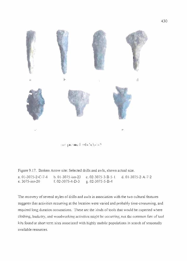
I· :1
430
Figure 9.17. Broken Arrow site: Selected drills and awls, shown actual size.
a.Ol-3075-2-C-7-4e. 3075-iso-20
b. OI-3075-iso-23f. 02-3075-4-D-3
c. 02-3075-3-B-5-1g. 02-3075-5-B-4
d.Ol-3075-2-A-7-2
The recovery of several styles of drills and awls in association with the two cultural features
suggests that activities occurring at the location were varied and probably time-consuming, and
required long duration occupations. These are the kinds of tools that would be expected where
clothing, basketry, and woodworking activities might be occurring, not the common fare of tool
kits found at short tenn sites associated with highly mobile populations in search of seasonally
available resources.
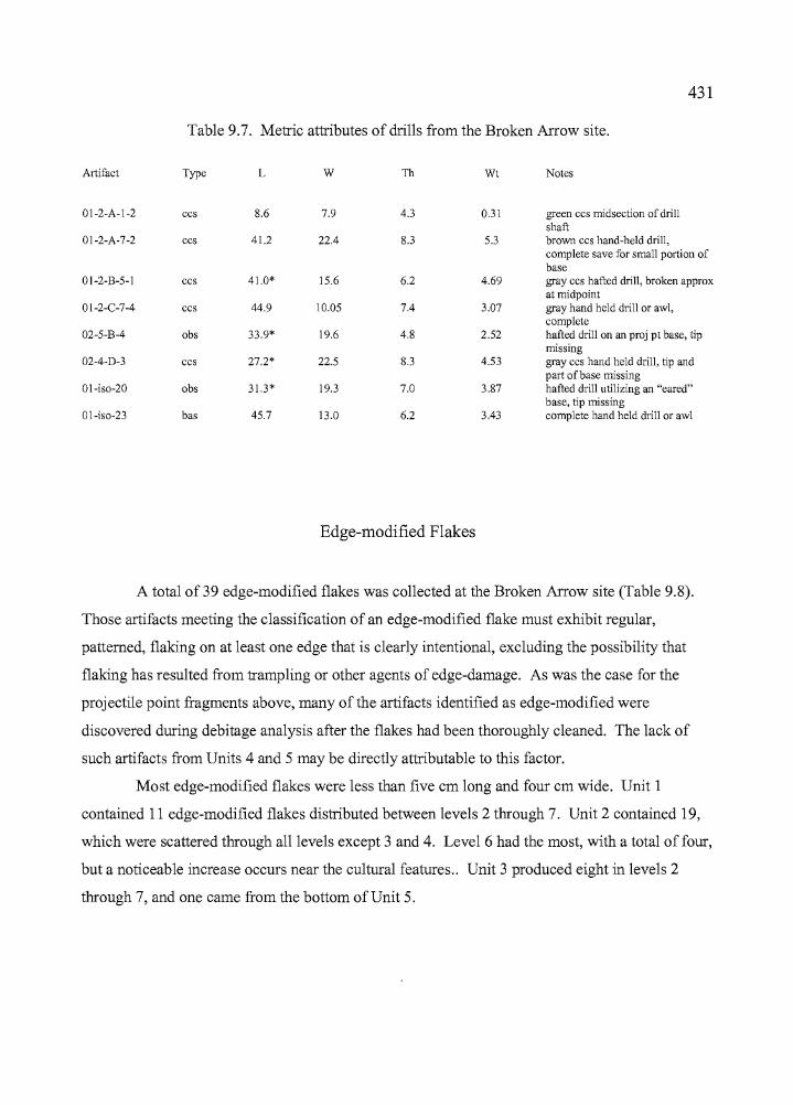
.,
i,I
I.,
------------------~---------_.- _._--
431
Table 9.7. Metric attributes of drills from the Broken Arrow site.
Artifact Type L W Th Wt Notes
01-2-A-I-2 ccs 8.6 7.9 4.3 0.31 green ccs midsection of drillshaft
01-2-A-7-2 ccs 41.2 22.4 8.3 5.3 brown ccs hand-held drill,complete save for small portion ofbase
01-2-B-5-1 ccs 41.0* 15.6 6.2 4.69 gray ccs hafted drill, broken approxat midpoint
01-2-C-7-4 ccs 44.9 10.05 7.4 3.07 gray hand held drill or awl,complete
02-5-B-4 obs 33.9* 19.6 4.8 2.52 hafted drill on an proj pt base, tipmissing
02-4-D-3 ccs 27.2* 22.5 8.3 4.53 gray ccs hand held drill, tip andpart of base missing
01-iso-20 obs 31.3* 19.3 7.0 3.87 hafted drill utilizing an "eared"base, tip missing
01-iso-23 bas 45.7 13.0 6.2 3.43 complete hand held drill or awl
Edge-modified Flakes
A total of 39 edge-modified flakes was collected at the Broken Arrow site (Table 9.8).
Those artifacts meeting the classification of an edge-modified flake must exhibit regular,
patterned, flaking on at least one edge that is clearly intentional, excluding the possibility that
flaking has resulted from trampling or other agents of edge-damage. As was the case for the
projectile point fragments above, many of the artifacts identified as edge-modified were
discovered during debitage analysis after the flakes had been thoroughly cleaned. The lack of
such artifacts from Units 4 and 5 may be directly attributable to this factor.
Most edge-modified flakes were less than five cm long and four cm wide. Unit 1
contained 11 edge-modified flakes distributed between levels 2 through 7. Unit 2 contained 19,
which were scattered through all levels except 3 and 4. Level 6 had the most, with a total offour,
but a noticeable increase occurs near the cultural features .. Unit 3 produced eight in levels 2
through 7, and one came from the bottom of Unit 5.
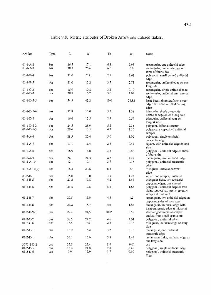
432
Table 9.8. Metric attributes of Broken Arrow site utilized flakes.
Artifact Type L W Th Wt Notes
01-1-A-2 bas 26.5 17.1 6.3 2.95 rectangular, one unifacial edge01-1-A-7 bas 38.3 25.6 6.6 6.6 rectangular, unifacial edges on
three of four sides01-1-B-4 bas 31.0 2.8 2.9 2.62 polygonal, small curved unifacial
edge01-1-B-5 obs 21.0 12.2 3.7 0.73 rectangular, unifacial edge on one
long side01-1-C-2 obs 15.9 10.8 3.4 0.70 rectangular, single unifacial edge01-1-D-2 ccs 28.9 10.2 3.6 1.04 rectangular, unifacial inset curved
edge01-1-D-5-5 bas 54.3 43.2 10.0 24.82 large basalt thinning flake, steep-
edged unifacial serrated cuttingedge
01-1-D-5-6 bas 32.8 13.0 3.3 1.38 niangular, single crescenticunifacial edge on one long side
01-1-D-6 obs 16.6 13.5 2.3 0.59 tJiangular, unifacial edge onlongest side
01-1-D-6-2 obs 24.5 25.9 5.2 2.35 polygonal bifacial scraper01-1-D-6-3 obs 29.6 13.5 4.7 2.15 polygonal steep-edged unifacial
scraper,r 01-2-A-6 obs 28.5 20.4 5.0 3.06 polygonal, single unifacial
crescentic edge01-2-A-7 obs 11.1 11.4 2.8 0041 square, with unifacial edge on one
side01-2-A-8 obs 16.9 18.0 3.3 0.88 polygonal, unifacial edge on three
of four sides01-2-A-9 obs 24.1 24.3 4.2 2.27 rectangular, inset unifacial edge01-2-A-10 obs 12.1 19.1 3.7 0.78 polygonal, unifacial crescentic
edge01-2-A-10(2) obs 16.3 20.6 8.2 2.3 tJiangular unifacial convex
edge01-2-B-l obs 15.0 18.0 3.3 1.22 square end scraper, unifacial01-2-B-5 obs 21.5 17.8 4.2 1.56 tJiangular flake, two unifacial
opposing edges, one curved01-2-B-6 obs 21.5 17.5 5.3 1.65 polygonal, unifacial edge on two
sides, longest has inset crescenticscraper at midpoint
01-2-B-7 obs 29.5 13.0 4.3 1.2 rectangular, two unifacial edges onopposing sides oflong axes
01-2-B-8 obs 24.2 15.7 4.0 1.81 rectangular, unifacial edge withinset crescentic edge at midpoint
01-2-B-9-3 obs 22.2 24,5 10.05 5.58 steep-edged unifacial scrapercrafted from small spent core
01-2-C-2 bas 38.5 24.2 4.6 4.04 polygonal, unifacial edge01-2-C-6 obs 15.5 9.5 2.3 0.38 triangular, unifacial edge on long
side01-2-C-lO obs 15.9 16.4 3.2 0.75 rectangular, one unifacial
crescentic edge01-2-D-l obs 33.1 15.6 3.8 2.45 rectangular flake, unifacial edge on
one long side3075-2-D-2 ccs 35.3 27.4 8.9 9.01 ccs01-2-D-5 obs 13.0 21.0 2.0 0.45 polygonal, single unifacial edge01-2-D-6 ccs 0.9 12.9 1.7 0.19 polygonal, unifacial crescentic
Edge
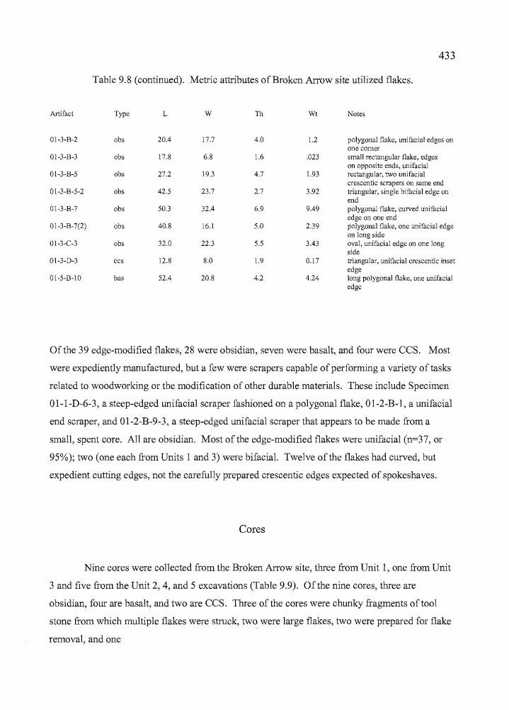
--_..._--
433
Table 9.8 (continued). Metric attributes of Broken Arrow site utilized flakes.
Artifact Type L W 111 Wt Notes
01-3-B-2 obs 20.4 17.7 4.0 1.2 polygonal flake, unifacial edges onone comer
01-3-B-3 obs 17.8 6.8 1.6 .023 small rectangular flake, edgeson opposite ends, unifacial
01-3-B-5 obs 27.2 19.3 4.7 1.93 rectangular, two unifacia1crescentic scrapers on same end
01-3-B-5-2 obs 42.5 23.7 2.7 3.92 triangular, single bifacia1 edge onend
01-3-B-7 obs 50.3 32.4 6.9 9.49 polygonal flake, curved unifacialedge on one end
01-3-B-7(2) obs 40.8 16.1 5.0 2.39 polygonal flake, one unifacia1 edgeon long side
01-3-C-3 obs 32.0 22.3 5.5 3.43 oval, unifacia1 edge on one longside
01-3-D-3 ccs 12.8 8.0 1.9 0.17 triangular, unifacia1 crescentic insetedge
01-5-B-1O bas 52.4 20.8 4.2 4.24 long polygonal flake, one unifacia1edge
Ofthe 39 edge-modified flakes, 28 were obsidian, seven were basalt, and four were CCS. Most
were expediently manufactured, but a few were scrapers capable of performing a variety oftasks
related to woodworking or the modification of other durable materials. These include Specimen
Ol-1-D-6-3, a steep-edged unifacia1 scraper fashioned on a polygonal flake, Ol-2-B-l, a unifacia1
end scraper, and 01-2-B-9-3, a steep-edged unifacia1 scraper that appears to be made from a
small, spent core. All are obsidian. Most of the edge-modified flakes were unifacia1 (n=37, or
95%); two (one each from Units 1 and 3) were bifacial. Twelve ofthe flakes had curved, but
expedient cutting edges, not the carefully prepared crescentic edges expected of spokeshaves.
Cores
Nine cores were collected from the Broken Arrow site, three from Unit 1, one from Unit
3 and five from the Unit 2,4, and 5 excavations (Table 9.9). Of the nine cores, three are
obsidian, four are basalt, and two are CCS. Three ofthe cores were chunky fragments oftoo1
stone from which multiple flakes were struck, two were large flakes, two were prepared for flake
removal, and one
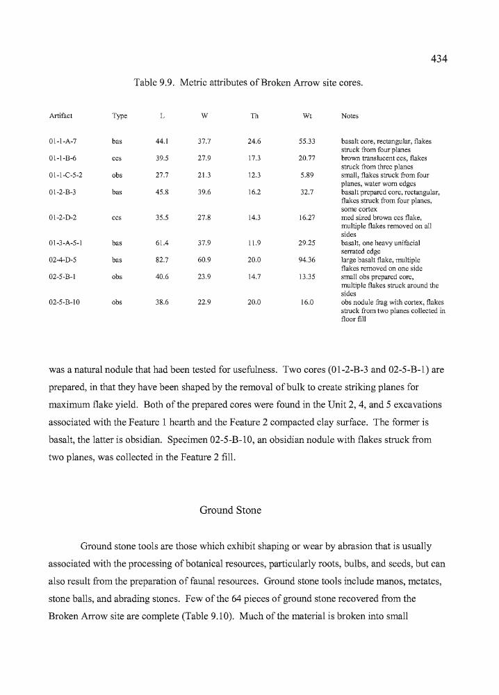
rf, '
434
Table 9.9. Metric attributes of Broken Arrow site cores.
Artifact Type L W Th Wt Notes
01-I-A-7 bas 44.1 37.7 24.6 55.33 basalt core, rectangular, flakesstruck from four planes
01-I-B-6 ccs 39.5 27.9 17.3 20.77 brown translucent ccs, flakesstruck from three planes
01-I-e-5-2 obs 27.7 21.3 12.3 5.89 small, flakes struck from fourplanes, water worn edges
o1-2-B-3 bas 45.8 39.6 16.2 32.7 basalt prepared core, rectangular,flakes struck from four planes,some cortex
01-2-0-2 ccs 35.5 27.8 14.3 16.27 med sized brown ccs flake,multiple flakes removed on allsides
01-3-A-5-1 bas 61.4 37.9 11.9 29.25 basalt, one heavy unifacialserrated edge
02-4-0-5 bas 82.7 60.9 20.0 94.36 large basalt flake, multipleflakes removed on one side
02-5-B-I obs 40.6 23.9 14.7 13.35 small obs prepared core,multiple flakes struck around thesides
02-5-B-IO obs 38.6 22.9 20.0 16.0 obs nodule frag with cortex, flakesstruck from two planes collected infloor fill
was a natural nodule that had been tested for usefulness. Two cores (01-2-B-3 and 02-5-B-l) are
prepared, in that they have been shaped by the removal ofbulk to create striking planes for
maximum flake yield. Both ofthe prepared cores were found in the Unit 2, 4, and 5 excavations
associated with the Feature 1 hearth and the Feature 2 compacted clay surface. The former is
basalt, the latter is obsidian. Specimen 02-5-B-10, an obsidian nodule with flakes struck from
two planes, was collected in the Feature 2 fill.
Ground Stone
Ground stone tools are those which exhibit shaping or wear by abrasion that is usually
associated with the processing of botanical resources, particularly roots, bulbs, and seeds, but can
also result from the preparation of faunal resources. Ground stone tools include manos, metates,
stone balls, and abrading stones. Few ofthe 64 pieces of ground stone recovered from the
Broken Arrow site are complete (Table 9.10). Much of the material is broken into small
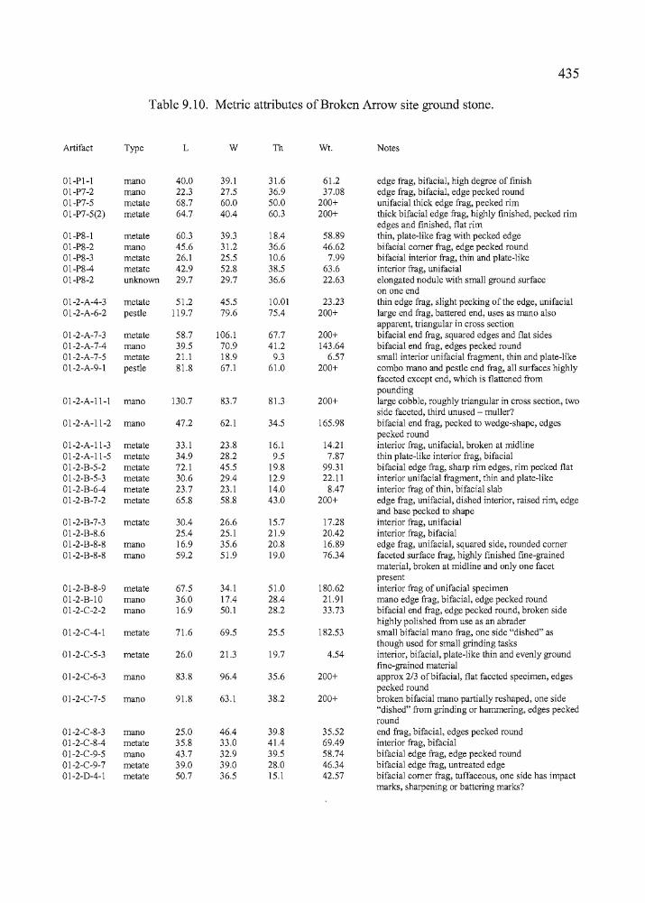
---c+n--
435
Table 9.10. Metric attributes of Broken Arrow site ground stone.
Artifact Type L W Th Wt. Notes
Ol-Pl-l mano 40.0 39.1 31.6 61.2 edge frag, bifacial, high degree of finish01-P7-2 mano 22.3 27.5 36.9 37.08 edge frag, bifacial, edge pecked round01-P7-5 metate 68.7 60.0 50.0 200+ unifacial thick edge trag, pecked rim01-P7-5(2) metate 64.7 40.4 60.3 200+ thick bifacial edge trag, highly finished, pecked rim
edges and finished, flat rim01-P8-l metate 60.3 39.3 18.4 58.89 thin, plate-like frag with pecked edge01-P8-2 mano 45.6 31.2 36.6 46.62 bifacial comer frag, edge pecked round01-P8-3 metate 26.1 25.5 10.6 7.99 bifacial interior trag, thin and plate-like01-P8-4 metate 42.9 52.8 38.5 63.6 interior mg, unifacial01-P8-2 unknown 29.7 29.7 36.6 22.63 elongated nodule with small ground surface
on one end01-2-A-4-3 metate 51.2 45.5 10.01 23.23 thin edge trag, slight pecking of the edge, unifacial01-2-A-6-2 pestle 119.7 79.6 75.4 200+ large end trag, battered end, uses as mano also
apparent, triangular in cross section01-2-A-7-3 metate 58.7 106.1 67.7 200+ bifacial end trag, squared edges and flat sides01-2-A-7-4 mano 39.5 70.9 41.2 143.64 bifacial end trag, edges pecked round01-2-A-7-5 metate 21.1 18.9 9.3 6.57 small interior unifacial fragment, thin and plate-like01-2-A-9-l pestle 81.8 67.1 61.0 200+ combo mano and pestle end trag, all surfaces highly
faceted except end, which is flattened frompounding
01-2-A-ll-l mano 130.7 83.7 81.3 200+ large cobble, roughly triangular in cross section, twoside faceted, third unused - muller?
01-2-A-11-2 mano 47.2 62.1 34.5 165.98 bifacial end frag, pecked to wedge-shape, edgespecked round
01-2-A-11-3 metate 33.1 23.8 16.1 14.21 interior trag, unifacial, broken at midline01-2-A-11-5 metate 34.9 28.2 9.5 7.87 thin plate-like interior frag, bifacial01-2-B-5-2 metate 72.1 45.5 19.8 99.31 bifacial edge trag, sharp rim edges, rim pecked flat01-2-B-5-3 metate 30.6 29.4 12.9 22.11 interior unifacial fragment, thin and plate-like01-2-B-6-4 metate 23.7 23.1 14.0 8.47 interior trag of thin, bifacial slab01-2-B-7-2 metate 65.8 58.8 43.0 200+ edge frag, unifacial, dished interior, raised rim, edge
and base pecked to shape01-2-B-7-3 metate 30.4 26.6 15.7 17.28 interior trag, unifacial01-2-B-8.6 25.4 25.1 21.9 20.42 interior trag, bifacial01-2-B-8-8 mano 16.9 35.6 20.8 16.89 edge frag, unifacial, squared side, rounded comer01-2-B-8-8 mano 59.2 51.9 19.0 76.34 faceted surface frag, highly finished fine-grained
material, broken at midline and only one facetpresent
01-2-B-8-9 metate 67.5 34.1 51.0 180.62 interior trag of unifacial specimen01-2-B-lO mano 36.0 17.4 28.4 21.91 mano edge trag, bifacial, edge pecked round01-2-C-2-2 mano 16.9 50.1 28.2 33.73 bifacial end frag, edge pecked round, broken side
highly polished trom use as an abrader01-2-C-4-l metate 71.6 69.5 25.5 182.53 small bifacial mano trag, one side "dished" as
though used for small grinding tasks01-2-C-5-3 metate 26.0 21.3 19.7 4.54 interior, bifacial, plate-like thin and evenly ground
fine-grained material01-2-C-6-3 mano 83.8 96.4 35.6 200+ approx 2/3 ofbifacial, flat faceted specimen, edges
pecked round01-2-C-7-5 mano 91.8 63.1 38.2 200+ broken bifacial mano partially reshaped, one side
"dished" trom grinding or hammering, edges peckedround
01-2-C-8-3 mano 25.0 46.4 39.8 35.52 end frag, bifacial, edges pecked round01-2-C-8-4 metate 35.8 33.0 41.4 69.49 interior trag, bifacial01-2-C-9-5 mano 43.7 32.9 39.5 58.74 bifacial edge trag, edge pecked round01-2-C-9-7 metate 39.0 39.0 28.0 46.34 bifacial edge trag, untreated edge01-2-D-4-l metate 50.7 36.5 15.1 42.57 bifacial comer frag, tuffaceous, one side has impact
marks, sharpening or battering marks?
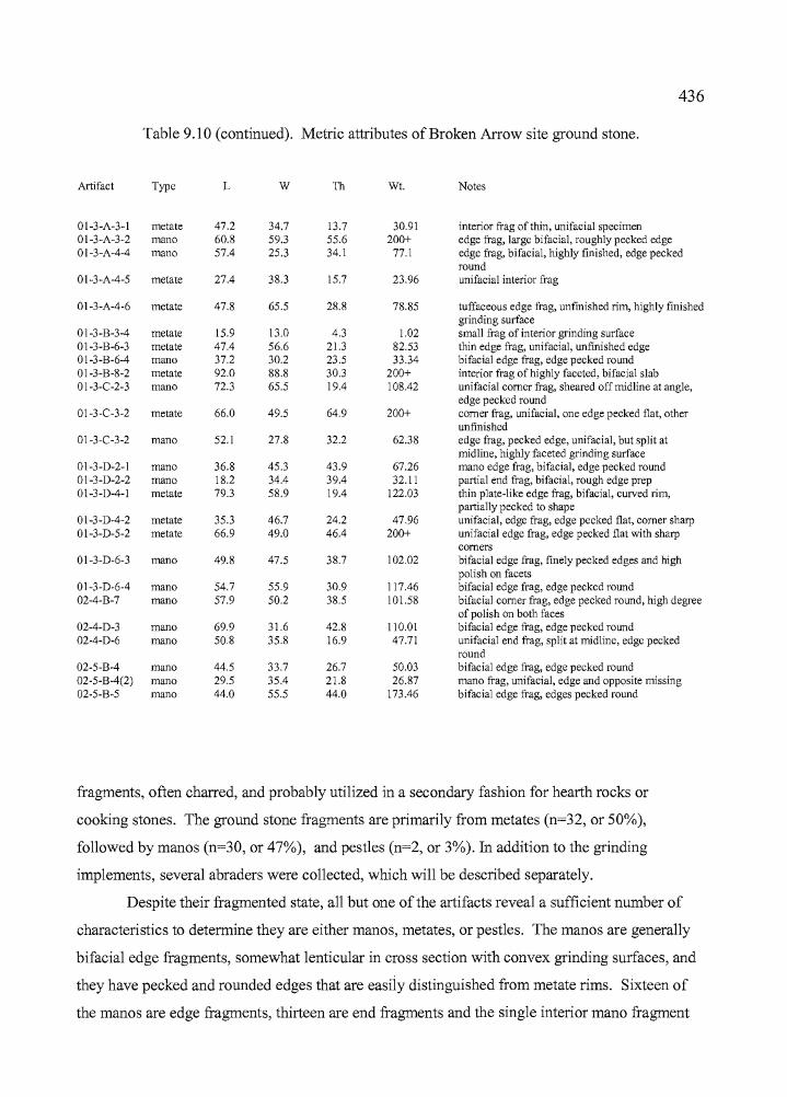
.....
436
Table 9.10 (continued). Metric attributes of Broken Arrow site ground stone.
Artifact Type L W Th Wt. Notes
01-3-A-3-1 metate 47.2 34.7 13.7 30.91 interior !Tag of thin, unifacial specimen01-3-A-3-2 mano 60.8 59.3 55.6 200+ edge !Tag, large bifacial, roughly pecked edge01-3-A-4-4 mano 57.4 25.3 34.1 77.1 edge frag, bifacial, highly finished, edge pecked
round01-3-A-4-5 metate 27.4 38.3 15.7 23.96 unifacial interior !Tag
01-3-A-4-6 metate 47.8 65.5 28.8 78.85 tuffaceous edge !Tag, unfinished rim, highly finishedgrinding surface
01-3-B-3-4 metate 15.9 13.0 4.3 1.02 small !Tag of interior grinding surfaceo1-3-B-6-3 metate 47.4 56.6 21.3 82.53 thin edge !Tag, unifacial, unfinished edge01-3-B-6-4 mano 37.2 30.2 23.5 33.34 bifacial edge frag, edge pecked round01-3-B-8-2 metate 92.0 88.8 30.3 200+ interior frag of highly faceted, bifacial slab01-3-C-2-3 mano 72.3 65.5 19.4 108.42 unifacial comer frag, sheared off midline at angle,
edge pecked round01-3-C-3-2 metate 66.0 49.5 64.9 200+ comer frag, unifacial, one edge pecked flat, other
unfinished01-3-C-3-2 mano 52.1 27.8 32.2 62.38 edge frag, pecked edge, unifacial, but split at
midline, highly faceted grinding surface01-3-D-2-1 mano 36.8 45.3 43.9 67.26 mano edge frag, bifacial, edge pecked roundo1-3-D-2-2 mano 18.2 34.4 39.4 32.11 partial end frag, bifacia1, rough edge prep01-3-D-4-1 metate 79.3 58.9 19.4 122.03 thin plate-like edge frag, bifacia1, cUlved rim,
partially pecked to shape01-3-D-4-2 metate 35.3 46.7 24.2 47.96 unifacial, edge frag, edge pecked flat, comer sharp01-3-D-5-2 metate 66.9 49.0 46.4 200+ unifacial edge frag, edge pecked flat with sharp
comers01-3-D-6-3 mano 49.8 47.5 38.7 102.02 bifacia1 edge frag, finely pecked edges and high
polish on facets01-3-D-6-4 mano 54.7 55.9 30.9 117.46 bifacial edge frag, edge pecked round02-4-B-7 mano 57.9 50.2 38.5 101.58 bifacial comer frag, edge pecked round, high degree
of polish on both faces02-4-D-3 mano 69.9 31.6 42.8 110.Ql bifacia1 edge !Tag, edge pecked round02-4-D-6 mano 50.8 35.8 16.9 47.71 unifacia1 end frag, split at midline, edge pecked
round02-5-B-4 mano 44.5 33.7 26.7 50.03 bifacia1 edge !Tag, edge pecked round02-5-B-4(2) mano 29.5 35.4 21.8 26.87 mano !Tag, unifacial, edge and opposite missing02-5-B-5 mano 44.0 55.5 44.0 173.46 bifacia1 edge !Tag, edges pecked round
fragments, often charred, and probably utilized in a secondary fashion for hearth rocks or
cooking stones. The ground stone fragments are primarily from metates (n=32, or 50%),
followed by manos (n=30, or 47%), and pestles (n=2, or 3%). In addition to the grinding
implements, several abraders were collected, which will be described separately.
Despite their fragmented state, all but one of the artifacts reveal a sufficient number of
characteristics to determine they are either manos, metates, or pestles. The manos are generally
bifacial edge fragments, somewhat lenticular in cross section with convex grinding surfaces, and
they have pecked and rounded edges that are easily distinguished from metate rims. Sixteen of
the manos are edge fragments, thirteen are end fragments and the single interior mano fragment
437
has bifacial faceting which aided its identification. Sixteen of the metate specimens are rim
fragments. The metate fragments are often thinner than the manos - almost plate-like in some
cases - and the edges can be pecked either square or round, but the thinner specimens often have
more sharply defined edges. Interior fragments account for 16 of the specimens. Most of the
metate fragments have unifacial working surfaces (n=18) which are either concave or flat. The
bifacially worked artifacts are a close second, represented by a total of 14. Refitting was not
attempted of the mano or metate fragments, so it is unclear whether there are multiple fragments
of a few specimens, or many different grinding stones represented. The latter is probably true,
because there is such a high density of fragmented specimens scattered across the entire site.
Handling of the larger fragments and complete specimens has been kept to a minimum, in case
future researchers should wish to submit manos or metates for pollen analysis. In some cases, the
artifacts were transferred directly into bags, sealed on site, and have not been handled since.
Two pestle fragments were included among the ground stone artifacts, both ofwhich
were recovered in Quad A of Unit 2. Specimen Ol-2-A-6-2 is a large end fragment that was
apparently used secondarily as a mano. The artifact has a triangular cross section and these
surfaces have faceting from use. The end is battered and may have served as a hammer stone.
Specimen 01-2-A-9-1, another end fragment, was also utilized as a mano. This specimen is
much more polished from use and the end has been flattened from pounding, presumably in a
mortar.
Two other ground stone fragments have been reused for other tasks. Specimen 01-2-C-4
1 is a small metate recovered from Level 4, Quad C, ofUnit 2, that has been fashioned from a
discarded bifacial mano fragment. One side has a shallow basin ground into it from use and the
other side retains its original appearance. A similar artifact was found in Level 7 of the same
quadrant. Specimen 01-2-C-7-5 is a bifacial mano fragment that has been partially reshaped,
including rounding of some broken edges. One side of the artifact has a basin ground into it that
may result from use with a mano or from pounding with a pestle or hammer stone.
Almost half of the ground stone objects were found in Unit 2, closely associated with the
Feature 1 hearth. Like numerous fragments found at Laurie's site, many of the Broken Arrow
artifacts were probably being used as hearth or cooking stones. It is clear that reuse ofbroken
manos and metates was occurring on a regular basis at the site. Some curiosity is inevitable
about why we found none of the complete specimens one would expect to see at a site where
ground stone is so prominent in the assemblage.
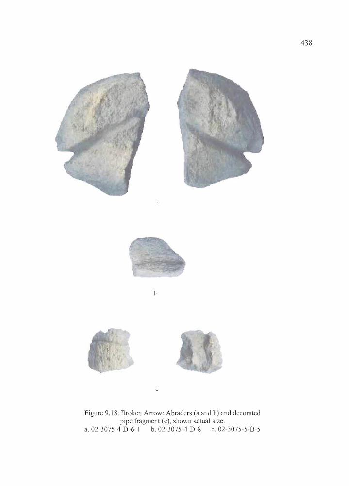
438
I·
Figure 9.18. Broken Arrow: Abraders (a and b) and decoratedpipe fragment (c), shown actual size.
a.02-3075-4-D-6-1 b.02-3075-4-D-8 c.02-3075-5-B-5
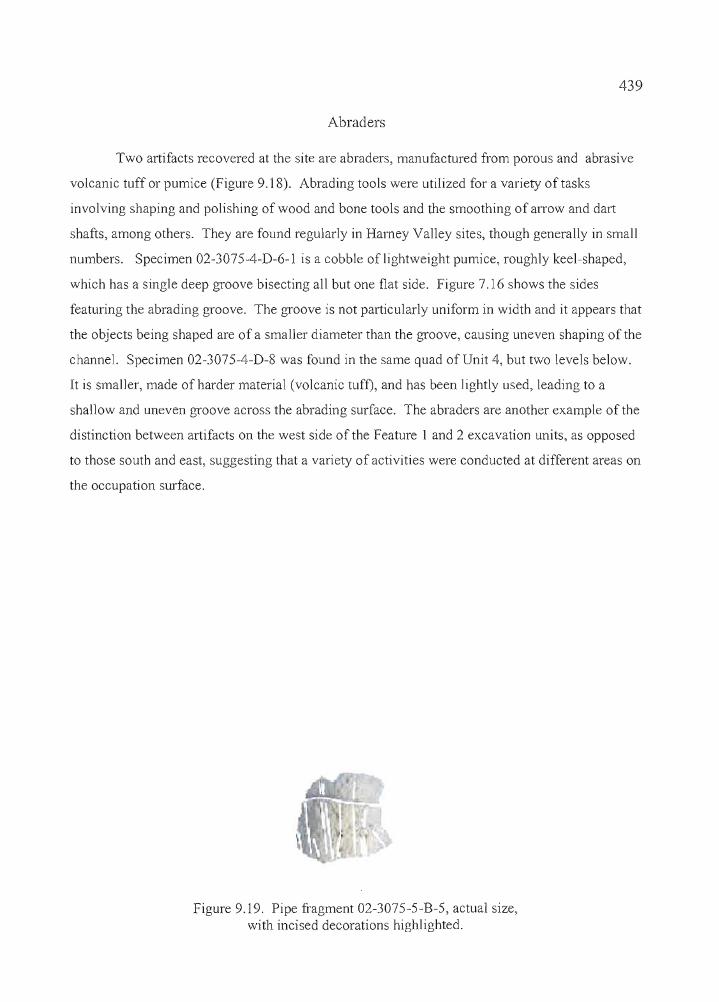
,....
439
Abraders
Two artifacts recovered at the site are abraders, manufactured from porous and abrasive
volcanic tuff or pumice (Figure 9.18). Abrading tools were utilized for a variety oftasks
involving shaping and polishing of wood and bone tools and the smoothing of arrow and dart
shafts, among others. They are found regularly in Harney Val1ey sites, though general1y in smal1
numbers. Specimen 02-3075-4-D-6-1 is a cobble of lightweight pumice, roughly keel-shaped,
which has a single deep groove bisecting al1 but one flat side. Figure 7.16 shows the sides
featuring the abrading groove. The groove is not particularly uniform in width and it appears that
the objects being shaped are of a smaller diameter than the groove, causing uneven shaping of the
channel. Specimen 02-3075-4-D-8 was found in the same quad of Unit 4, but two levels below.
It is smaller, made of harder material (volcanic tufD, and has been lightly used, leading to a
shal10w and uneven groove across the abrading surface. The abraders are another example of the
distinction between artifacts on the west side of the Feature 1 and 2 excavation units, as opposed
to those south and east, suggesting that a variety of activities were conducted at different areas on
the occupation surface.
Figure 9.19. Pipe fragment 02-3075-5-B-5, actual size,with incised decorations highlighted.
I'
----""""'"
440
Pipe Fragment
A fragment of a decorated pipe was collected from the fifth level of Unit 5 (Figures 9.18
and 9.19). The pipe is manufactured from coarse-grained volcanic tuff. The interior, or bowl,
has undergone rough shaping and there is no clear evidence of use, such as darkening or
discoloration of the interior from burning. The lack ofburning, coupled with the roughly shaped
and seemingly unfinished interior, may indicate that the pipe was broken prior to completion. A
series of ten longitudinal grooves and a single, deep, transverse grove were etched on the exterior
surface of the pipe for decoration (Figure 7.17). The pipe was recovered from the screen and its
original location in Unit 5 is unknown.
Other Artifacts
Bone Artifacts
Seven bone artifacts were recovered at the Broken Arrow site, including four tools and
three decorative objects (Figure 9.20, Table 9.11). The bone tools include a flaker utilized in
lithic reduction activities, a spatulate tip of unknown utility, and two awls that could have been
used for a variety of tasks. This is a workmanlike assemblage of tools that would have been
needed for the repair and replenishment of hunting gear, clothing and other day-to-day items.
One awl (01-3075-2-A-5-3) was probably an expedient tool, fashioned for immediate use. The
artifact is simply a small splinter of large mammal bone that was picked up by the fireside and
had one already pointed end sharpened lightly to create a fine tip. The specimen has been darkly
stained by contact with occupation-stained sediments and possibly heat. The other awl fragment
(01-3075-2-B-9-6) consists ofa small, finely sharpened tip that is slightly rounded from use. The
object has a lenticular cross-section and a symmetry that suggests it originates from a well
crafted bone tool. The flaker (01-3075-2-C-5-2) is the midsection ofa large mammal rib, of
which both ends have been roughened and rounded by pressure and abrasion, presumably from
the pressure flaking of tool stone. The interior (concave) section of the tool has been deeply
gouged in two locations from contact with

441
I:
•
:1
Figure 9.20. Broken Arrow: Bone tools and decorative objects, shown actual size; spatulate tool,a; awls, band c; £laker, d; pendant, e; beads, f and g.
a. 02-3075-1-A-6-4 b. 01-3075-2-B-9-6 c. 01-3075-2-A-5-3 d. 01-3075-2-C-5-2e.02-3075-5-B-4 f. 02-3075-4-D-3 f. 01-3075-3-D-2
442
ol-3075-l-A-6-4 spatulate 21.3 9.2 1.7 0045 19 mamm. frag, high polish,rounded spatulate end, no roughareas associated with flaking toolstone
01-3075-2-A-5-3 awl 71.5 7.2 3.2 1047 large mammal bone splinter withsharpened tip, expedient
01-3075-2-B-9-6 awl 9.6 2.8 0.05 tip, highly polished, lenticularcross-section
01-3075-2-C-5-2 flaker 104.7 10.5 4.7 3.64 19 mammal rib midsection, curved,roughened ends, gouges onconcave (interior) surface
01-3075-3-D-2 bead 6.1 3.5 0.9 0.20 approx. Y. of one side, one edgebeveled, polished
02-3075-4-D-3 bead 7.7 304 0040 small mamm. or bird longbonesection with beveled ends, highlypolished
02-3075-5-B-4 pendant 16.5 5.7 1.8 0.26 polished, lenticular, drilled atbroadest end, which is worn andchipped
Table 9.11. Metric attributes of Broken Arrow site bone tools, in mm.
NotesWt.ThWLTypeArtifact
stone tools. The finish is lightly polished and darkened from extensive handling, but the artifact
is otherwise unmodified. The spatulate tool (Ol-3075-1-A-6-4) is a thin and relatively delicate
piece oflarge mammal cortical bone that has a lobed tip and a high degree of polish. The object
is worn smooth along a thin margin at the interior edge of the lobe, indicating light duty, but
intensive use. Like the spatulate bone tools at Laurie's site, the thought comes to mind that it
could have been utilized in basketry making, although the function it might have served is
unclear.
---c+.
The decorative objects include a teardrop-shaped pendant (02-3075-5-B-4) that has been
drilled for suspension on a cord. The bone probably originates from a large mammal and it is
entirely cortical. The pendant was ground on both sides to shape, it is highly polished but
otherwise undecorated, and it is drilled from only one side. Specimen Ol-3075-3-D-2 is a
fragment of a bead with a rectangular, symmetrical appearance. It is approximately one-quarter
of one side of a tube that has broken lengthwise, and it has a single beveled edge diagnostic of
bone tube beads in the northern Great Basin. Another, complete bead (02-3075-4-D-3) is
manufactured from a small mammal or bird longbone midsection and has beveled edges at both
ends. A portion of one beveled end was broken during use, and there is additional wear on the
i,iI,
"
443
broken surface indicating that it continued to be worn for some time thereafter. It has a high
degree ofpolish, and it was recovered from the faunal remains during the zooarchaeo10gica1
analysis.
Most of the bone artifacts were recovered from Units 2, 4 and 5 in association with the
cultural features there. The exceptions were the spatulate tool, collected from Unit 1 and the
bead fragment, which came from Unit 3.
Beads
The Broken Arrow site produced 26 beads, including 2 bone beads that are discussed in
the bone artifiact section above, 19 shell beads, four stone beads, and one that is unidentifiable
(Figure 9.21). Only the shell and stone beads are discussed here and in Table 9.12, below.
Fifteen of the beads came from the Unit 2,4 and 5 excavations (63%), four were recovered from
Unit 1, and five were found in Unit 3. All but one of the beads came from the first six levels of
excavation.
Beads recovered during the 2001 field season were analyzed by Leah Largaespada of the
University of Oregon (Largaespada 2001). They were identified utilizing Largaespada's
comparative collection, and measurements were taken with the use of an Olympus petrographic
microscope mounted to a Sony video monitor equipped with a digital micrometer. Beads
collected during the 2002 season were identified by the author utilizing the beads analyzed by
Largaespada, and measured with handheld calipers.
The shell beads were manufactured from clam, dentalium, limpet, and Olivella. Clam
disc beads are the most common, accounting for nine of the 19 shell beads, followed by three
Olivella and two Dentalium. The Olivella beads include several varieties identified by
Bennyhoff and Hughes (1987) as having temporal significance. Specimen 01-2-A-5-2, recovered
from Quad A, Leve15 of Unit 2, is a Type E1a (Round Thin Lipped) originating from central or
southern California. Bennyhoffand Hughes (1987:127-128) consider Type E1a beads to be a
marker for early Phase 2 of the Late period in central California and most common around the
beginning of the Protohistoric, ca. AD 1500-1600. These beads have been associated with limpet
rings, one of which was recovered in Unit 4 and another (possibly) in Unit 3. An Olivella Type
G3b (Large Ring) was recovered in Leve16 of Quad C, Unit 2 (Specimen 01-2-C-6-2).
Bennyhoff and Hughes (1987: 132) consider the most common source to be the Marin district of
central California, associated with the early phase of the Middle period, from ca. 1000 BP to 750
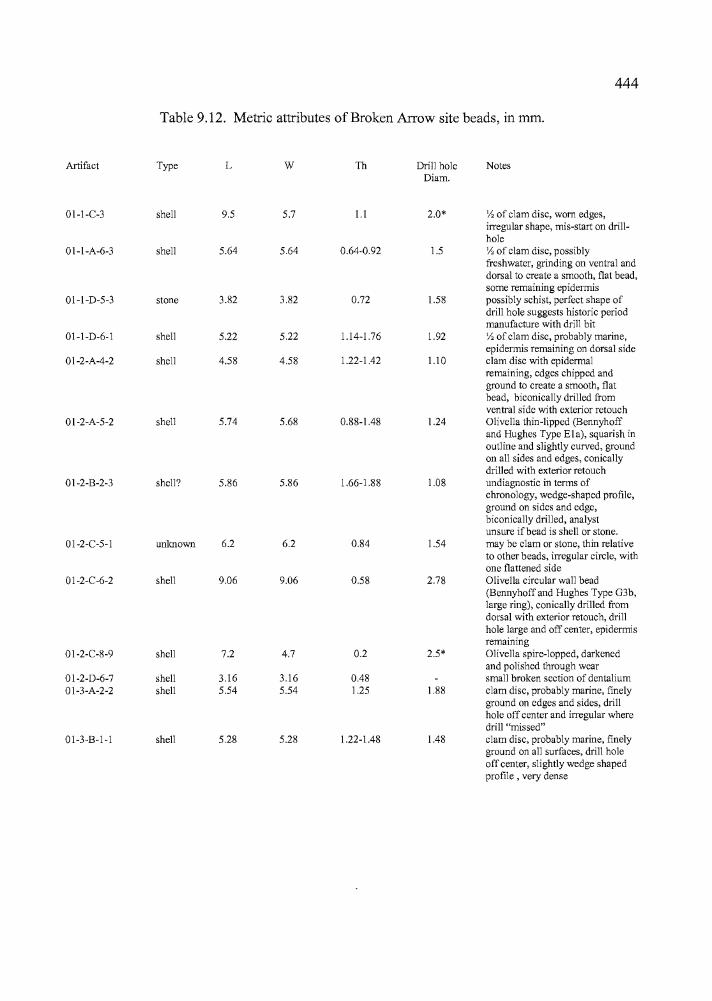
444:f
': I Table 9.12. Metric attributes of Broken Arrow site beads, in mm.
Artifact Type L W Th Drill hole NotesDiam.
01-I-C-3 shell 9.5 5.7 1.1 2.0* Vz of clam disc, worn edges,irregular shape, mis-start on drill-hole
01-I-A-6-3 shell 5.64 5.64 0.64-0.92 1.5 Vz of clam disc, possiblyfreshwater, grinding on ventral anddorsal to create a smooth, flat bead,some remaining epidermis
01-I-D-5-3 stone 3.82 3.82 0.72 1.58 possibly schist, perfect shape ofdrill hole suggests historic periodmanufacture with drill bit
01-I-D-6-1 shell 5.22 5.22 1.14-1.76 1.92 Vz of clam disc, probably marine,epidermis remaining on dorsal side
01-2-A-4-2 shell 4.58 4.58 1.22-1.42 1.10 clam disc with epidermalremaining, edges chipped andground to create a smooth, flatbead, biconically drilled fromventral side with exterior retouch
01-2-A-5-2 shell 5.74 5.68 0.88-1.48 1.24 Olivella thin-lipped (Bennyhoffand Hughes Type Ela), squarish inoutline and slightly curved, ground
~on all sides and edges, conicallydrilled with exterior retouch
01-2-B-2-3 shell? 5.86 5.86 1.66-1.88 1.08 undiagnostic in terms ofchronology, wedge-shaped profile,ground on sides and edge,
i biconically drilled, analyst
! unsure ifbead is shell or stone.01-2-C-5-1 unlulOwn 6.2 6.2 0.84 1.54 may be clam or stone, thin relative
to other beads, irregular circle, withone flattened side
01-2-C-6-2 shell 9.06 9.06 0.58 2.78 Olivella circular wall bead(Bennyhoff and Hughes Type G3b,large ring), conically drilled fromdorsal with exterior retouch, drillhole large and off center, epidermisremaining
01-2-C-8-9 shell 7.2 4.7 0.2 2.5* Olivella spire-lopped, darkenedand polished through wear
I 01-2-D-6-7 shell 3.16 3.16 0.48 small broken section of dentalium
" 01-3-A-2-2 shell 5.54 5.54 1.25 1.88 clam disc, probably marine, finelyground on edges and sides, drill
, hole off center and irregular where
~ :drill "missed"
~ i 01-3-B-l-l shell 5.28 5.28 1.22-1.48 1.48 clam disc, probably marine, finely
\ ground on all surfaces, drill holer: off center, slightly wedge shaped, profile, very dense:1:~ '
-----".,
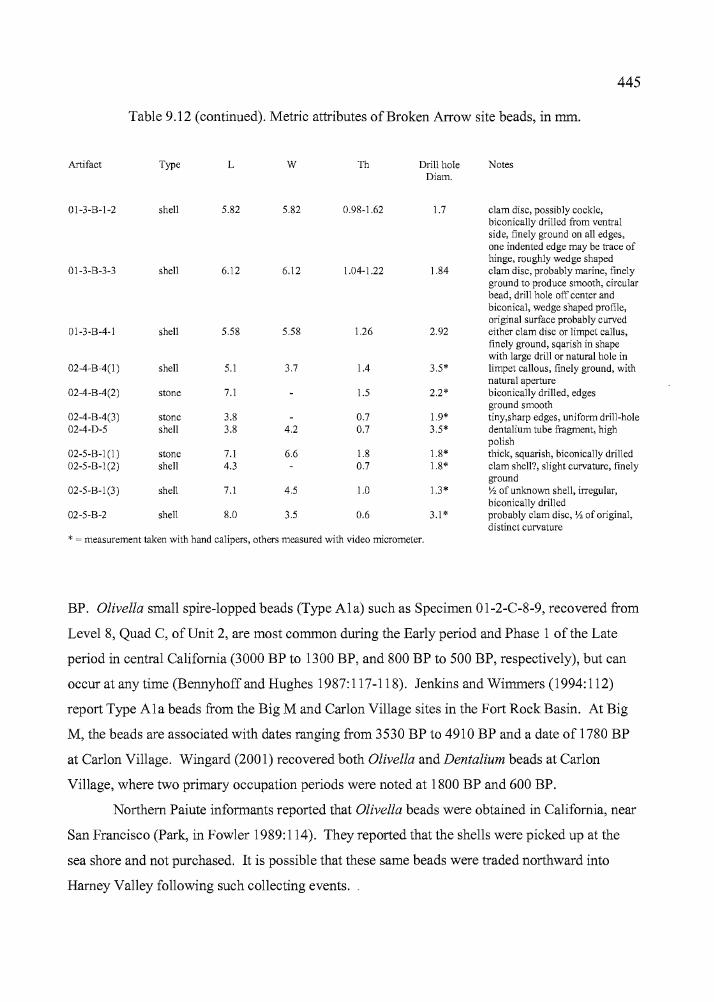
,"
f445
Table 9.12 (continued). Metric attributes of Broken Arrow site beads, in mm.
01-3-B-4-1 shell 5.58 5.58 1.26 2.92
02-4-B-4(1 ) shell 5.1 3.7 1.4 3.5*
02-4-B-4(2) stone 7.1 1.5 2.2*
02-4-B-4(3) stone 3.8 0.7 1.9*02-4-D-5 shell 3.8 4.2 0.7 3.5*
02-5-B-1 (I ) stone 7.1 6.6 1.8 1.8*~ 02-5-B-I(2) shell 4.3 0.7 1.8*
02-5-B-I (3) shell 7.1 4.5 1.0 1.3*
02-5-B-2 shell 8.0 3.5 0.6 3.1 *
* = measurement taken with hand calipers, others measured with video micrometer.
"
Artifact
01-3-B-I-2
01-3-B-3-3
Type
shell
shell
L
5.82
6.12
w
5.82
6.12
Th
0.98-1.62
1.04-1.22
Drill holeDiam.
1.7
1.84
Notes
clam disc, possibly cockle,biconically drilled from ventralside, finely ground on all edges,one indented edge may be trace ofhinge, roughly wedge shapedclam disc, probably marine, finelyground to produce smooth, circularbead, drill hole off center andbiconica1, wedge shaped profile,original surface probably curvedeither clam disc or limpet callus,finely ground, sqarish in shapewith large drill or natural hole inlimpet callous, finely ground, withnatural aperturebiconically drilled, edgesground smoothtiny,sharp edges, uniform drill-holedenta1ium tube fragment, highpolishthick, squarish, biconically drilledclam shell?, slight curvature, finelygroundy, of unknown shell, irregular,biconically drilledprobably clam disc, Y, of original,distinct curvature
BP. Olivella small spire-lopped beads (Type Ala) such as Specimen 01-2-C-8-9, recovered from
Level 8, Quad C, ofUnit 2, are most common during the Early period and Phase 1 ofthe Late
period in central California (3000 BP to 1300 BP, and 800 BP to 500 BP, respectively), but can
occur at any time (Bennyhoffand Hughes 1987:117-118). Jenkins and Wimmers (1994:112)
report Type Ala beads from the Big M and Carlon Village sites in the Fort Rock Basin. At Big
M, the beads are associated with dates ranging from 3530 BP to 4910 BP and a date of 1780 BP
at Carlon Village. Wingard (2001) recovered both Olivella and Dentalium beads at Carlon
Village, where two primary occupation periods were noted at 1800 BP and 600 BP.
Northern Paiute informants reported that Olivella beads were obtained in California, near
San Francisco (Park, in Fowler 1989:114). They reported that the shells were picked up at the
sea shore and not purchased. It is possible that these same beads were traded northward into
Harney Valley following such collecting events.
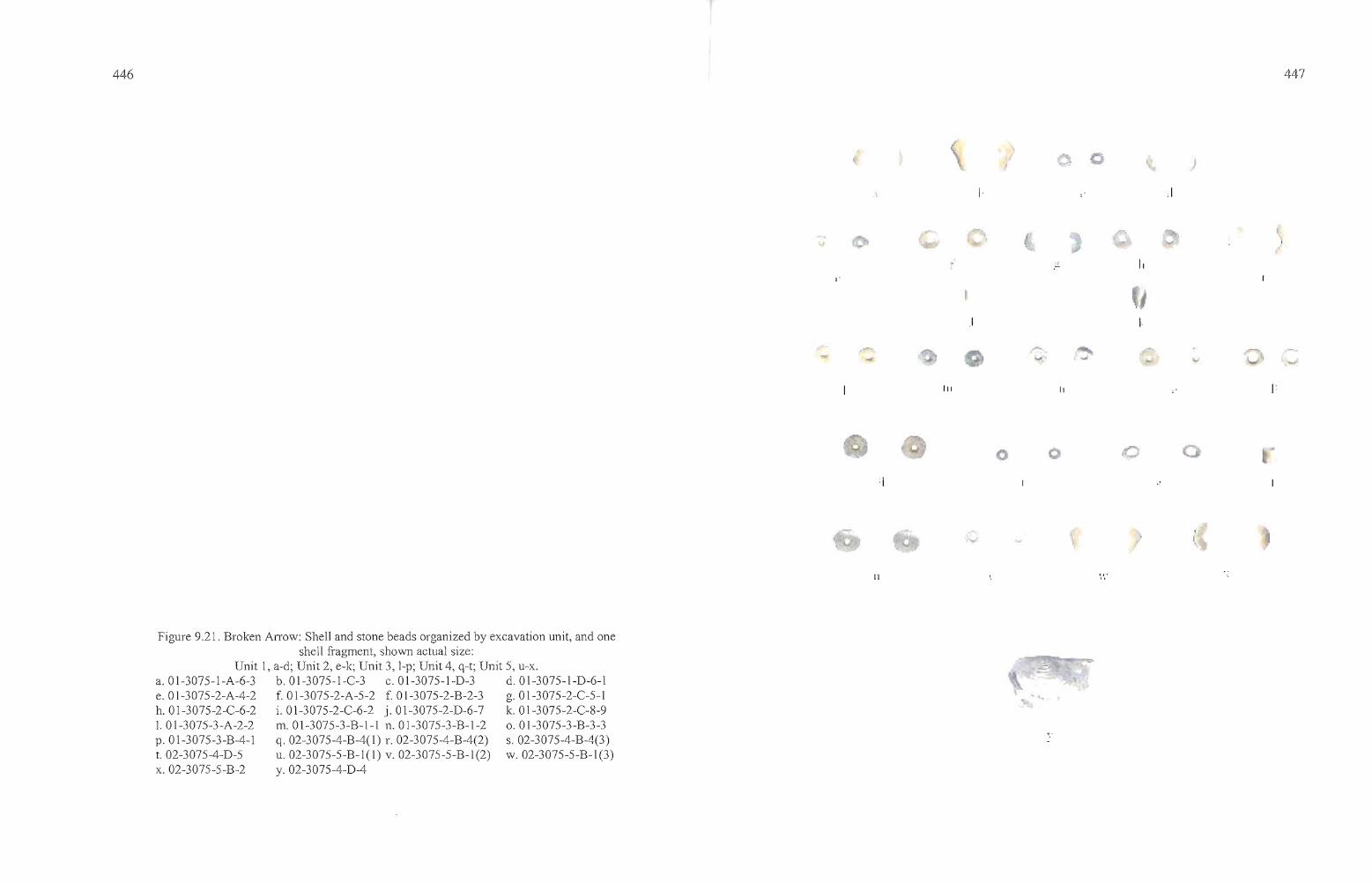
446
Figure 9.21. Broken Arrow: Shell and stone beads organized by excavation unit, and oneshell fragment, shown actual size:
Unit 1, a-d; Unit 2, e-k; Unit 3, l-p; Unit 4, q-t; Unit 5, u-x.a.Ol-3075-l-A-6-3 b.Ol-3075-l-C-3 c.Ol-3075-l-D-3 d.Ol-3075-l-D-6-le. Ol-3075-2-A-4-2 f. Ol-3075-2-A-5-2 f. Ol-3075-2-B-2-3 g. Ol-3075-2-C-5-lh.Ol-3075-2-C-6-2 i.Ol-3075-2-C-6-2 j.Ol-3075-2-D-6-7 k. Ol-3075-2-C-8-91. Ol-3075-3-A-2-2 m. Ol-3075-3-B-l-l n.Ol-3075-3-B-1-2 o.Ol-3075-3-B-3-3p.Ol-3075-3-B-4-1 q. 02-3075-4-B-4(1) r. 02-3075-4-B-4(2) s.02-3075-4-B-4(3)t. 02-3075-4-D-5 u. 02-3075-5-B-l(1) v. 02-3075-5-B-l(2) w.02-3075-5-B-l(3)x. 02-3075-5-B-2 y. 02-3075-4-D-4
II
III
I
I
II
"
,I
447
l. ___.?1"'ft.t.
448
Shell
Although freshwater snail shell was ubiquitous throughout the Broken Arrow site, large
shell fragments originating from freshwater bivalves such as mussels (Margaretifera) were
uncommon. One fragment, Specimen 02-3075-4-D-4, was collected from Level 4, Quad D, of
Unit 2 (Figure 7.17). The shell is deteriorated, with portions delaminating into the surrounding
deposits, and it is not possible to determine how the specimen may have been utilized.
Lithic Debitage Mass Analysis
Mass analysis utilizes population means including counts and weights of size-graded
debitage in a replicable, quantitative manner to examine relationships of debitage in both inter
and intra-site contexts (Ahler 1989, Connolly 1999). Flake attributes such as size, weight,
quantity, and the presence of cortex vary with each stage of lithic reduction, as early core and
biface production yield larger flakes with more cortex than later stage biface reduction and
pressure flaking (Connolly and Byram 2001:68). By quantifying chipping waste through the
previously mentioned variables, a given site assemblage can be compared to those from other
sites, and to an experimental lithic reduction data set established for all five reduction stages
(core reduction = Stage 1, biface pressure flaking = Stage 5) collected from the Newberry
Volcano obsidian source (Connolly and Byram 2001:69). The mass analysis results should
reflect the most dominant lithic reduction activities at a given location and, depending on other
factors such as stratigraphic mixing, may allow comparisons between early and late components
within a site.
Debitage collections from the Broken Arrow site were processed through a series of
nested screens with dimensions of 1" (G1), 1/2" (G2), 1/4" (G3), and 1/8" (G4). The flakes from
each size grade were counted, weighed, and examined for the presence of cortex. The results
were then compared with those from the other Harney Valley sites, the Bon site in Deschutes
County (Connolly and Byram 2001), and with the overall results from the Newberry Crater
project (Connolly 1999). This information is presented below in Tables 9.13 and 9.14, and
summarized in the final chapter. Here, debitage from Units 1, 2, and 3 is examined.
i1i Iit I
i
:1
449
Connolly (1999) developed a formula for determining stages of lithic reduction activities
at archaeological sites based on three variables: Stage = 6.048 - 0.124 (F) - 0.023 (P) - 0.091
(Q), where F is the percent count of G2 over G1 - G4, P is the mean weight of G2 (G2 weight/G2
count) in decigrams, and J is the mean weight ofG3 (G3 weight/G3 count) in centigrams. The
values produced from the archaeological data were inserted into the formula and the numeric
result is an indicator of the relative stage of lithic reduction that occurred at the site, either for the
entire site or for components of the site.
Utilizing Connolly's (1999) formula for the aggregate of the three units at the Broken
Arrow site resulted in a predicted stage value of 2.62 (Tables 9.13 and 9.14), placing the site
below the Bon site (35DS608) in terms of lithic reduction stages, but at a similar reduction stage
to other base camps some distance from the tool stone source where activities are not focused on
lithic procurement and reduction. The Bon site is a residential base camp located north of
Newberry Caldera. Component 34-2, at the Paulina Lake site (35DS34), which functioned as a
base camp located within the Newberry Caldera (Connolly 1999, Connolly and Byram 2001:69)
has values similar to the three units at the Broken Arrow site, and the value equates well with the
Hoyt and Laurie's sites from this study. When the obsidian is examined by unit, the stage values
are found to vary to a limited degree. Unit 1 has a stage value of 2.50 and Unit 2 is 2.62, and
Unit 3 is 2.68.
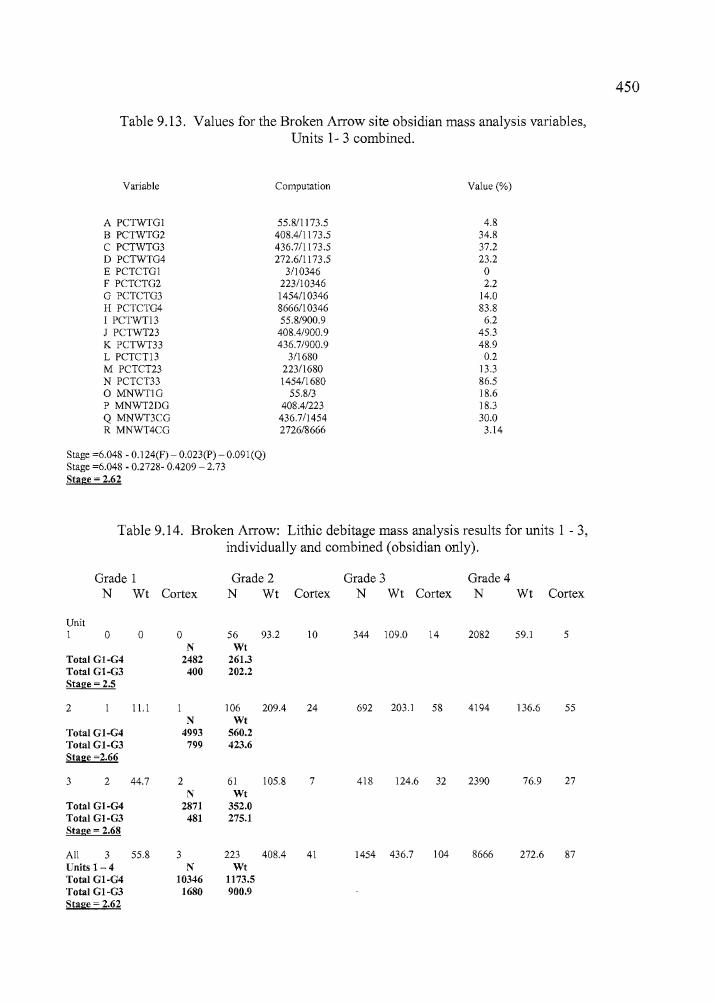
Table 9.13. Values for the Broken Arrow site obsidian mass analysis variables,Units 1- 3 combined.
Variable
A PCTWTGIB PCTWTG2C PCTWTG3o PCTWTG4E PCTCTGIF PCTCTG2G PCTCTG3H PCTCTG4I PCTWT13J PCTWT23K PCTWT33L PCTCTl3M PCTCT23N PCTCT33o MNWTIGP MNWT2DGQ MNWT3CGR MNWT4CG
Stage =6.048 - 0.124(F) - 0.023(P) - 0.091(Q)Stage =6.048 - 0.2728- 0.4209 -2.73Stage = 2.62
Computation
55.811173.5408.4/1173.5436.7/1173.5272.611173.5
3/103462231103461454/103468666/1 034655.8/900.9
408.4/900.9436.7/900.9
3/1680223/16801454/1680
55.8/3408.4/223
436.7/14542726/8666
Value (%)
4.834.837.223.2o2.2
14.083.8
6.245.348.9
0.213.386.518.618.330.0
3.14
450
I,1i
Table 9.14. Broken Arrow: Lithic debitage mass analysis results for units 1 - 3,individually and combined (obsidian only).
Grade 1N Wt Cortex
Grade 2N Wt
Grade 3Cortex N Wt Cortex
Grade 4N Wt Cortex
272.6 87
UnitI 0 0 0 56 93.2 10
N WtTotal GI-G4 2482 261.3Total GI-G3 400 202.2Stage = 2.5
2 11.1 106 209.4 24N Wt
Total GI-G4 4993 560.2Total GI-G3 799 423.6Stage =2.66
3 2 44.7 2 61 105.8 7N Wt
Total GI-G4 2871 352.0Total GI-G3 481 275.1Stage = 2.68
All 3 55.8 3 223 408.4 41Units 1-4 N WtTotal GI-G4 10346 1173.5
ITotal GI-G3 1680 900.9
IStage = 2.62
I
~II~,
344 109.0 14
692 203.1 58
418 124.6 32
1454 436.7 104
2082
4194
2390
8666
59.1
136.6
76.9
5
55
27
i"I
,iiIi,
451
Obsidian Sourcing and Hydration
A total of97 artifacts recovered from the Broken Arrow site was submitted to Northwest
Research Obsidian Studies Laboratory (NROSL) for obsidian sourcing and hydration analysis
Cfable 9.15, Figure 9.22). The artifacts include 70 projectile points, one biface, two preforms,
two obsidian knives and two basalt knives, and 20 obsidian flakes (Skinner and Thatcher 2002).
The projectile points and formed tools, with few exceptions, are from sources located
either to the north or east of the site. One Rose Spring and two Eastgate points originated from
the Double 0 source, west of Harney Lake, as did one Elko Comer-notched point. An Elko
Eared point came from Beatys Butte, to the south. The sources include Burns (n=2), Indian
Creek (n=ll), Indian Creek B (n=6), Tule Springs (n=15), Venator (n=24), Double 0 (n=4),
Whitewater Ridge (n=5), Eldorado (n=l), Buck Springs (n=l), Dog Hill (n=2), Burns (n=3),
Beatys Butte (n=l), and WolfCreek (n=2).
The debitage largely originated from local sources to the north and east, including Tule
Springs (n=4), Venator (n=9), and Indian Creek (n=2), but also included Unknown 1 (n=l), Riley
(n=l), Black Bull Spring (n=l), Mud Ridge (n=l), and Beatys Butte (n=l). The knife (3074-1
A-5), and the biface (02-3074-I-C-9) both were made of Venator obsidian. A large basalt flake
tool and a basalt knife were also submitted to NROSL for geochemical identification and
(provisionally) identified as Unknown Basalt 1.
The debitage was selected entirely from Unit 2, including 20 artifacts from Quads A
(n=14), Quad B (n=5), and Quad D (n=l) of Level 7, closely associated with the Feature 1
hearth. It was hoped that one obsidian source would dominate the debitage sample and an AMS
date produced from the Feature 2 hearth would aid in the development of a provisional hydration
rate for the primary obsidian source. This did not turn out to be the case. Half of the debitage
came from the Tule Spring source and the other half from three other sources, and the range of
hydration measurements was too broad (from 1.3 to 2.8 microns, with a range of 1.9 to 2.8
microns for Tule Spring alone). The results of the debitage hydration analysis does cast light on
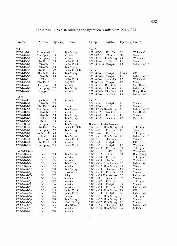
452
Table 9.15. Obsidian sourcing and hydration results from 35HA3075.
Sample Artifact Hydr·(Il) Source Sample Artifact Hydr. (11) Source
Unit 1 Unit 33075-PI-5-1 Cottonwood 2.1 Tule Spring 3075-3-B-2-1 Elko CN 3.0 WolfCreek3075-I-B-I-I Rose Spring 1.9 Venator 3075-3-B-3-1 Pinstem NA Venator3075-I-B-2-1 Rose Spring 1.5 Venator 3075-3-C-3-1 Rose Spring 2.4 Whitewater3075-I-D-3-1 Elko Eared 2.8 Indian Creek 3075-3-C-4-1 Elko 1.9 Venator3075-I-C-4-1 Elko CN 2.1 Indian Creek 3075-3-D-5-3 Eastgate 2.1 Indian Creek B3075-I-D-4-1 ElkoCN 2.8 Tule Spring3075-I-B-5-1 Elko Eared 5.7 Indian Creek B Unit 43075-I-D-5-1 Humboldt 4.6 Tule Spring 3075-4-B-4a Eastgate 2.3/4.2 003075-I-D-5-2 Elko CN 3.9 Venator 3075-4-B-4b Eastgate 1.9 Indian Creek 83075-I-B-6 Elko 2.1 Indian Creek 3075-4-B-4c Humboldt 2.5 WolfCreek3075-I-C-6-1 Elko Eared 2.2 Dog Hill 3075-4-D-5a Eastgate 1.8 Venator3075-I-A-7-1 Unknown 1.9 Venator 3075-4-D-5b Bas. Knife Unk. Basaltl3075-I-A-7-2 Rose Spring 2.2 Tule Spring 3075-4-B-6a Elko Eared 2.8 Indian Creek3075-I-A-9-1 Eastgate 1.2 Venator 3075-4-B-6b Elko Eared 2.7 Beatys Butte
3075-4-D-6 preform 2.4 Indian CreekUnit 23075-2-A-I preform 1.9 Venator UnitS3075-2-B-I-I ElkoCN 2.5 00 3075-5-B-I Eastgate 2.0 Venator3075-2-D-I-I Elko Eared 4.3 Bums 3075-5-8-4a biface 2.0 Venator3075-2-B-2-1 Rose Spring 1.2 Tule Spring 3075-5-B-4b Rose Spring 2.8 Indian Creek B3075-2-8-2-2 Elko CN NA Venator 3075-5-B-5 bas. tool Unk. Basalt I3075-2-B-4-1 Elko CN 2.8 Tule Spring 3075-5-B-8 ElkoCN 1.8 Venator3075-2-D-4-2 Elko 2.8 TuJe Spring 3075-5-D-9 Stemmed 4.6 Dog Hill3075-2-D-5-1 Knife 2.8 Venator3075-2-B-6-1 Rose Spring NA Tule Spring Surface-collected Isolates3075-2-B-6-2 Elko Eared 2.6 Indian Creek 8 3075-iso-1 Rose Spring 2.4 Tule Spring3075-2-C-7-1 Rose Spring 2.2 Tule Spring 3075-iso-3 Elko CN 1.5 Venator3075-2-C-7-2 Northern SN 3.9 Bums 3075-iso-4 ElkoCN 3.3 Tule Spring3075-2-C-7-3 Leaf 5.9 Tule Spring 3075-iso-5 Rose Spring 2.8 Indian Creek B3075-2-C-8-1 Unknown 2.8 Indian Creek 3075-iso-7 Elko Eared 2.8 Venator3075-2-B-9-1 Elko Eared 1.8 Venator 3075-iso-8 Eastgate 3.3 003075-2-B-IO-1 Rose Spring 2.5 Indian Creek 3075-iso-9 Eastgate 1.6 Whitewater
3075-iso-IO Elko CN 3.2 Tule SpringUnit 2 debitage 3075-iso-ll UNK 4.5 Whitewater3075-2-B-7-5a flake 2.8 Tule Spring 3075-iso-12 Elko 5.4 Buck Spring3075-2-B-7-5b flake NA Venator 3075-iso-14 Elko CN 3.9 Tule Spring3075-2-B-7-5c flake 2.3 Venator 3075-iso-15 Elko Eared 3.5 Whitewater3075-2-B-7-5d flake NA Tule Spring 3075-iso-16 Columbia type 3.5 Indian Creek3075-2-B-7-5e flake 1.5 Venator 3075-iso-17 Rose Spring 2.1 Venator3075-2-A-7-5f flake 2.8 Tule Spring 3075-iso-18 Elko Eared 4.2 Venator3075-2-A-7-5g flake 2.3 Unknown 1 3075-iso-19 Elko CN 2.4 Venator3075-2-A-7-5h flake 2.7 Riley 3075-iso-20 Concave Base 6.6 Indian Creek3075-2-A-7-5i flake NA Venator 3075-iso-21 Stemmed NA Venator3075-2-A-7-5j flake 3.2 Venator 3075-iso-22 Elko CN 3.0 Tule Spring3075-2-A-7-5k flake 1.6 Venator 3075-iso-24 Eastgate 2.7 Venator3075-2-A-7-51 flake 1.6 Venator 3075-iso-28 Elko CN 6.4 Indian Creek3075-2-A-7-5m flake 2.8 Indian Creek 3075-iso-29 Rose Spring 2.7 003075-2-A-7-5n flake 2.9 Indian Creek 3075-iso-30 Eastgate 2.8 Indian Creek3075-2-A-7-50 flake NA Beatys 3075-iso-31 Rose Spring 3.9 Tule Spring3075-2-A-7-5p flake 2.8 Tule Spring 3075-iso-32a Rose Spring 1.6 Venator3075-2-A-7-5q flake NA Black Bull Sp. 3075-iso-32b Rose Spring 2.3 Venator3075-2-A-7-5r flake 3.3 Mud Ridge 3075-iso-33 Elko Eared 1.4 Indian Creek3075-2-A-7-5s flake 1.7 Venator 3075-iso-34 Rose Spring 2.7 Eldorado3075-2-D-7-2 flake 2.0 Venator
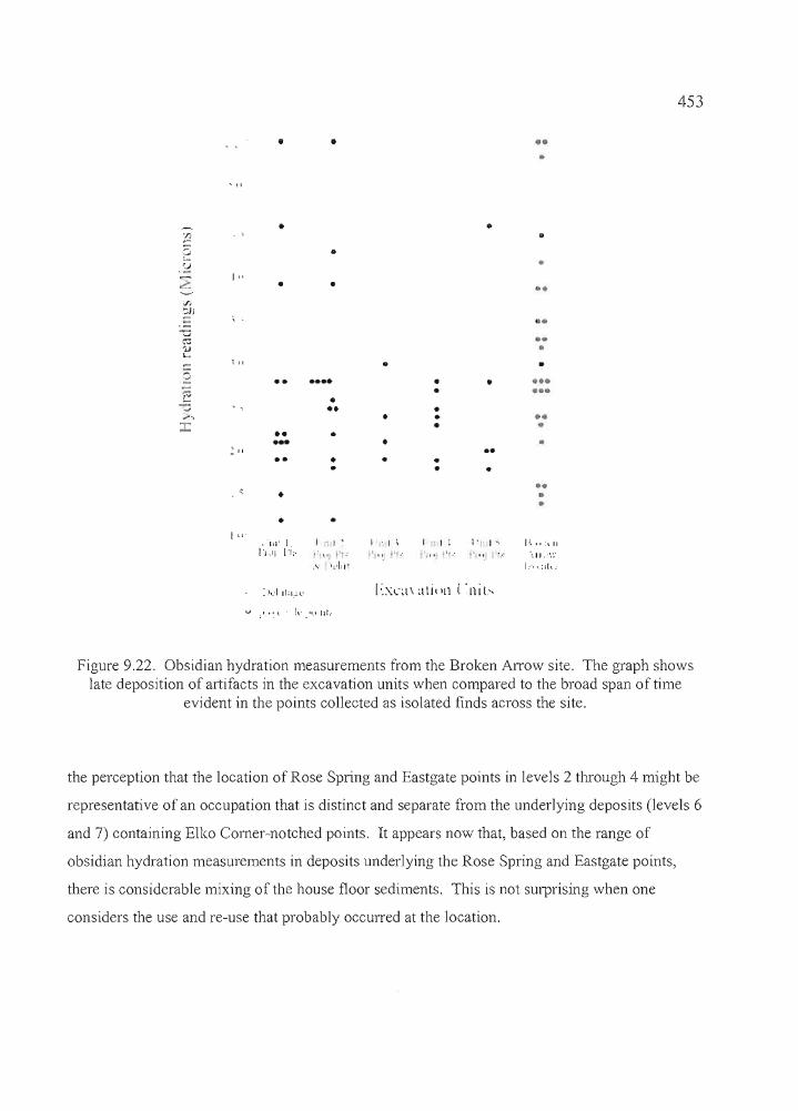
• • •••
453
Figure 9.22. Obsidian hydration measurements from the Broken Arrow site. The graph showslate deposition of artifacts in the excavation units when compared to the broad span of time
evident in the points collected as isolated finds across the site.
the perception that the location of Rose Spring and Eastgate points in levels 2 through 4 might be
representative of an occupation that is distinct and separate from the underlying deposits (levels 6
and 7) containing Elko Corner-notched points. It appears now that, based on the range of
obsidian hydration measurements in deposits underlying the Rose Spring and Eastgate points,
there is considerable mixing of the house floor sediments. This is not surprising when one
considers the use and re-use that probably occurred at the location.
•
454
Botanical Remains
Paleobotanical identifications were carried out by Dr. Marge Helzer ofthe University of
Oregon. Samples were selected only from Unit 2, Quads A and B, in association with the
Feature 1 hearth. Botanical analysis occurred in two stages. The first stage involved the
identification of charcoal specimens for radiocarbon dating purposes, and the material was
derived either from composite samples obtained during screening, or from in situ specimens
when possible. The intent ofthe charcoal analysis was to obtain specimens from short-lived
plant species for greater accuracy in dating the site. Soil flotation analysis was undertaken to
determine the variety and nature ofplant remains that might have been utilized by the inhabitants
ofthe occupation area. The results of the analyses are summarized below in Tables 9.16 and
9.17.
Charcoal samples from Unit 2, Quad A, included specimens from levels 3 through 11 for
a total of five samples and the samples from Quad B included material from levels 3 and 8, for a
total of two samples. The botanical remains identified in the charcoal samples included
greasewood, juniper, rabbitbrush, sagebrush, pine, an unidentified variety of conifer and willow;
a total of seven varieties. All but conifers can be found in the vicinity of the site today. Willow
was an impOltant source of material for basketry and wickiup construction. All ofthe other plant
materials are known to have been used medicinally or for food and fiber (Fowler 1986, 1989;
Couture 1978).
The plant material recovered from the soil flotations had all of the previously mentioned
varieties of charcoal, plus a wide variety of economically important seeds. Included were the
seeds of bulrush, cattails, chenopod/amaranths (cheno-ams), greasewood, rabbitbrush, and wada
(for which the Wada'tika are named). All are known to have been used for food or medicinal
purposes (Fowler 1986, 1989; Couture 1978), and all would have been readily available in the
nearby lake and marshland setting. Several species that were recovered at Laurie's site are
absent from this assemblage, including bluegrass and buckwheat seeds and Mountain mahogany.
The presence of Mountain mahogany establishes an important link between the uplands and
Laurie's site, and the absence of this material from the densest cultural concentrations at Broken
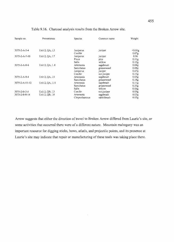
---"""'"
455
Table 9.16. Charcoal analysis results from the Broken Arrow site.
Sample no. Provenience Species Common name Weight
3075-2-A-3-4 Unit 2, QA, L3 Juniperus juniper <O.OlgConifer 0.07g
3075-2-A-7-10 Unit 2, QA, L7 Juniperus juniper 0.96Pinus pine O.llgSalix willow 0.12g
3075-2-A-8-6 Unit 2, QA, L 8 Artemesia sagebrush 0.04gSarcobatus greasewood 0.08gJuniperus juniper 0.67gConifer not juniper 0.13g
3075-2-A-9-4 Unit 2, QA, L9 Artemesia sagebrush 0.05gSarcobatus greasewood 0.18g
3075-2-A-II-12 Unit 2, QA, Lll Artemesia sagebrush O.llgSarcobatus greasewood 0.35gSalix willow 0.06g
3075-2-B-3-5 Unit 2, QB, L3 Conifer not juniper 0.09g3075-2-B-8-14 Unit 2, QB, L8 Artemesia sagebrush 0.03g
Chrysothamnus rabbitbrush 0.05g
Arrow suggests that either the direction of travel to Broken Arrow differed from Laurie's site, or
some activities that occurred there were of a different nature. Mountain mahogany was an
important resource for digging sticks, bows, atlatls, and projectile points, and its presence at
Laurie's site may indicate that repair or manufacturing ofthese tools was taking place there.
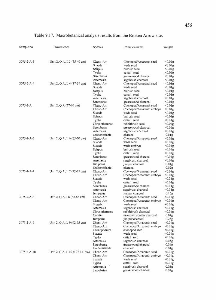
Ii 456I
Table 9.17. Macrobotanical analysis results from the Broken Arrow site.
Sample no. Provenience Species Common name Weight
3075-2-A-3 Unit 2, Q A, L 3 (35-40 cm) Cheno-Am Chenopod/Amaranth seed <O.OlgSuaeda wada seed <O.OlgScirpus bulrush seed <O.OlgTypha cattai1 seed <O.OlgSarcobatus greasewood charcoal <O.OlgArtemesia sagebrush charcoal <O.Olg
3075-2-A-4 Unit 2, Q A, L 4 (37-39 cm) Cheno-Am Chenopod/Amaranth seed <O.OlgSuaeda wada seed <O.OlgScirpus bulrush seed <O.OlgTypha cattail seed <O.OlgArtemesia sagebrush charcoal <O.OlgSarcobatus greasewood charcoal <O.Olg
3075-2-A Unit 2, Q A (57-60 cm) Cheno-Am Chenopod/Amaranth seed <O.OlgCheno-Am ChenopodlAmaranth embryo <O.OlgSuaeda wada seed <O.OlgScirpus bulrush seed <O.OlgTypha cattail seed <O.OlgChrysothamnus rabbitbrush seed <O.OlgSarcobatus greasewood charcoal <O.OlgArtemesia sagebrush charcoal <O.OlgUnidentifiable charcoal O.Olg
3075-2-A-6 Unit 2, Q A, L 6 (65-70 cm) Cheno-Am ChenopodlAmaranth seed <O.OlgSuaeda wada seed <O.OlgSuaeda wada embryo <O.OlgScirpus bulrush seed <O.OlgTypha cattail seed <O.OlgSarcobatus greasewood charcoal <O.OlgArtemesia sagebrush charcoal <O.OlgJuniperus juniper charcoal O.OlgUnidentifiable charcoal 0.02g
3075-2-A-7 Unit 2, Q A, L 7 (72-75 cm) Cheno-Am Chenopod/Amaranth seed <O.OlgCheno-Am ChenopodlAmaranth embryo <O.OlgSuaeda wada seed <O.OlgTypha cattail seed <O.OlgSarcobatus greasewood charcoal <O.OlgArtemesia sagebrush charcoal <O.OlgJuniperus juniper charcoal 0.16g
3075-2-A-8 Unit 2, Q A, L8 (82-86 cm) Cheno-Am Chenopod/Amaranthseed <O.OlgCheno-Am Chenopod/Amaranth embryo <O.OlgSuaeda wada seed <O.OlgArtemesia sagebrush charcoal <O.OlgChrysothamnus rabbitbrush charcoal <O.OlgConifer unknown conifer charcoal 0.04gJuniperus juniper charcoal 0.25g
3075-2-A-9 Unit 2, Q A, L 9 (92-95 cm) Cheno-Am Chenopod/Amaranth seed <O.OlgCheno-Am Chenopod/Amaranth embryo <O.OlgChenopodium chenopod seed <O.OlgSuaeda wada seed <O.OlgTypha cattail seed <O.OlgArtemesia sagebrush charcoal 0.05gSarcobatus greasewood charcoal Q.OlgUnidentifiable charcoal 0.04g
3075-2-A-IO Unit 2, Q A, L 10 (l07-lllcm) Cheno-Am Chenopod/Amaranthseed <O.OlgCheno-Am Chenopod/Amaranth embryo <O.OlgSuaeda wada seed <O.OlgTypha cattail seed <O.OlgArtemesia sagebrush charcoal 0.05gSarcobatus greasewood charcoal O.Olg
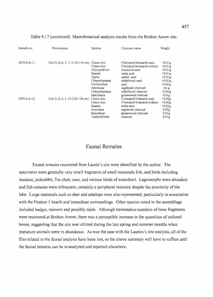
457
Table 9.17 (continued) Macrobotanica1 analysis results from the Broken Arrow site.
Sample no. Provenience Species Common name Weight
3075-2-A-II Unit 2, QA, L II (112-116 em) Cheno-Am Chenopod/Amaranth seed <O.OlgCheno-Am Chenopod/Amaranth embryo <O.OlgChenopodium chenopod seed <O.OlgSuaeda wada seed <O.OlgTypha cattail seed <O.OlgChrysothamnus rabbitbrush seed <O.OlgUnidentified seed <O.OlgArtemesia sagebrush charcoal 0.6 gChrysothamnus rabbitbrush charcoal <O.OlgSarcobatus greasewood charcoal O.Olg
3075-2-A-12 Unit 2, Q A, L 12 (122-126 em) Cheno-Am Chenopod/Amaranth seed <O.OlgCheno-Am Chenopod/Amaranth embryo <O.OlgSuaeda wada seed <O.OlgArtemesia sagebrush charcoal 0.05gSarcobatus greasewood charcoal O.OlgUnidentifiable charcoal O.Olg
Faunal Remains
Faunal remains recovered from Laurie's site were identified by the author. The
specimens were generally very small fragments of small mammals fish, and birds including
muskrat, jackrabbit, Tui chub, coot, and various kinds of waterfowl. Lagomorphs were abundant
and fish remains were infrequent, certainly a peripheral resource despite the proximity of the
lake. Large mammals such as deer and antelope were also represented, particularly in association
with the Feature 1 hearth and immediate surroundings. Other species noted in the assemblage
included badger, raccoon and possibly mink. Although tremendous numbers of bone fragments
were recovered at Broken Arrow, there was a perceptible increase in the quantities of unfused
bones, suggesting that the site was utilized during the late spring and summer months when
immature animals were in abundance. As was the case with the Lauries's site analysis, all of the
files related to the faunal analysis have been lost, so the above summary will have to suffice until
the faunal remains can be re-ana1yzed and reported elsewhere.
•
458
Summary
Archaeological investigations at the Broken Arrow site consisted of work at three
excavation areas based on guidance provided through preliminary testing. The southernmost unit
was designated Unit 1. Unit 2 was dug 60 meters to the north. The northernmost unit was 10
meters from Unit 2 and identified as Unit 3. A hearth feature that was identified in Unit 2 led to
the excavation of Units 4 and 5 to better explore the nature of the occupation and resulted in the
identification ofthe Feature 2 compacted clay surface. The two features together suggest that a
wickiup or similar type of structure was present. Spatial patterning of artifacts within the
excavation units and in association with the two features indicates that a structure approximately
3 meters in diameter was situated there. Artifact accumulations were high across the site, but
particularly so in Units 2, 4, and 5 in association with the hearth and floor. Distinct patterning of
artifacts was also present within the units, as it became apparent that the variety and nature of the
artifacts being recovered from Units 4 and 5, at the western portion ofthe excavation block, was
different from those in Unit 2, to the east. Bone tools, abraders, cores, and Stage 2 bifaces are
examples of artifacts represented in the western units that are either not present in Unit 2, or
present in smaller numbers. It is likely that some items were being stored near the wall of the
structure, or that discrete activities were occurring in that portion ofthe wickiup.
Obsidian sourcing and hydration studies indicated that the primary travel routes to
Broken Arrow originated from the north or east, particularly in association with Rose Spring and
Eastgate points. Elko points indicate a slightly wider range of travel with more western sources
represented, but, overall, the emphasis is mainly on the sources to the north and east. Elko, Rose
Spring, and Eastgate points were being used concurrently at the site and the absence of Gatecliff
Series and Desert Series points indicates that occupations were probably occurring after 2200BP
and before 1000 BP, a range that is supported by the radiocarbon dates. Isolated projectile points
that were recovered at Broken Arrow indicate that use of the site occurred in some capacity
throughout the course of the Holocene, although Gatecliff, Northern Side-notched, and Desert
Side-notched points were not found as isolates, either. The botanical remains emphasize nearby
resources with the exception of two specimens of conifer, and the faunal remains indicate that
small mammals, birds, fish and large game, all locally available, were being utilized at the site.
Fish seem under-represented with regard to the proximity ofthe lake and marsh.
Whiting (1950: 19) noted that human activity at Malheur Lake intensified near the
beginning of September when the wada seeds ripened and when saltbush and chenopod seeds
...._------------------- •
459
were also available for harvest. The time was marked with festivities, there were side trips to
harvest fruit, and communal game drives took place as well. There is evidence at Broken Arrow
to support the ethnographic documentation provided by Whiting. Chenopod and wada seeds are
present in the cultural deposits of the site and bulrush seeds may provide evidence of subsistence
as well as the presence ofmat houses constructed from bulrush stalks. Coniferous plant materials
could have been acquired during forays into the foothills to collect fruit for winter storage, then
brought back to the site for the manufacture oftools. There are large quantities ofleporid bones,
particularly those ofjackrabbits, as well as large game and waterfowl. Muskrats are present, but
not in the numbers that were seen at Laurie's site. There is a considerable amount of immature
unfused small mammal bone, suggesting that site use may have occurred in the summer months
when immature muskrats were more readily available.
While there is plenty of support for the descriptions ofactivities provided by Whiting
(1950), the Broken Arrow site does not seem particularly well suited for a winter camp location.
Fresh water would not be readily available during the winter, firewood would be limited to
localized supplies of greasewood and sagebrush, and the site is not sheltered. The Headquarters
site across the bay or the Crow Ranch near Voltage would have been much better suited for
winter habitations, having all the amenities listed above. Chenopod and wada seeds that were
identified in the Broken Arrow deposits could have been stored previously and transported to the
site for use. The presence of waterfowl and immature mammal remains suggests occupations
occurred during the warm months when both would have been available in quantity.
In summary, archaeological evidence supports the activities identified by Whiting (1950)
as having occurred at Malheur Lake, but the location of the Broken Arrow site does not seem
appropriate for a winter occupation, nor do some kinds of resources that are present within the
cultural deposits. The same is true for Laurie's site as well. It is intriguing that the Broken
Arrow and Laurie's sites are situated in such close proximity, yet each reflects a different set of
activities that occurred at about the same time, and neither produced evidence that seems
particularly appropriate for winter camp occupations. This estimation may be colored to some
degree by the author's knowledge of currently unreported sites near Malheur Lake that are
extensive, tremendously rich in cultural materials, and occupy settings with abundant supplies of
firewood, water, and shelter.
460
CHAPTER XSUMMARY AND CONCLUSIONS
The genesis of this study was in the Hoyt, Morgan, and Hines sites, at data recovery
excavations undertaken by the Oregon State Museum of Anthropology as mitigation for highway
modifications proposed by the Oregon Department ofTransportation. Each of the three sites
exhibited characteristics that were distinct, and suggestive of ethnographic land use patterns as
recorded by Whiting (1950), though none were situated in locations she had specifically
identified. My work at the three sites prompted curiosity about the relationship of the
archaeological record to the ethnographic record. I felt that a study of other sites within the area
utilized by the Harney Valley Paiute might shed light on the prehistoric behavioral patterns of the
Wada'tika, and other inhabitants of the region through time, particularly if they targeted locations
mentioned in Whiting's account. It might be possible through such a study to either confirm or
negate the patterns described by Whiting and help to enhance the archaeological record in either
case. To that end, a search was undertaken to identify additional sites that might be suitable for
such an effort. It led ultimately to the excavation of the Knoll and RJ sites, located in the
highlands north of the Harney Valley in 2000, and the Broken Arrow and Laurie's sites, near
Malheur Lake, in 2001 and 2002. These four sites were excavated by the University of Oregon
Archaeological Field School under my direction.
Excavations at the Hoyt, Morgan, and Hines sites were undertaken with guidance from
data recovery plans developed for the Hoyt and Morgan sites (Jenkins and Connolly 1995), and
for the Hines site (O'Grady et al. 1997). The strategy outlined in these data recovery plans also
guided the work at the Knoll, RJ, Laurie's, and Broken Arrow sites, although at a considerably
reduced scale. The research designs identified five principal topics including regional culture
history; paleoclimatic, environmental and cultural change; settlement-subsistence patterns;
cultural relations and ethnic group territories; and prehistoric technologies. Research questions
were developed within these
" ,
461
five topical areas to address key issues on more specific levels. Questions were generally the
same for the Hoyt, Morgan, and Hines sites on the northern perimeter of the Harney Valley,
because their proximity to one another subjected them to similar climatic, cultural, and
environmental influences. The Knoll, RJ, Broken Arrow and Laurie's sites are more widely
distributed through the Harney Basin drainage system, but climatic, cultural, and environmental
processes at work in these sites would probably also have been similar. In this chapter I will
discuss seven sites in terms of the principal research topics originally set out, then continue the
discussion in relation to Whiting's (1950) ethnographic account. Finally I conclude by
discussing future research needs in the Hamey Valley, bringing to bear the role of current
archaeological theory in planning for the next phase of research.
Research Topics
Regional Culture History: Site Summaries
The Hoyt site is treated as a single component occupation because of evident mixing of
early and late artifacts in the deposits, but there was also clear evidence that the deposits as a
whole had accumulated over a significant period of time. The site yielded a radiocarbon date of
1830 BP from Feature 1, and another assay of 220 BP was obtained from organic material
recovered in an area where FeR and burned bones were noted. The latter date seems out of
place, since the material was collected approximately 35 cm deeper in the deposits than the 1830
BP sample. Some degree of mixing between older and more recent cultural materials at the Hoyt
site is apparent through the occasional finding oflate point types in lower levels, and earlier point
types in upper levels. Hydration rims on both formed tools and debitage showed both earlier and
later clusters of hydration rinds, but thin rims were occasionally found in lower deposits and
thick rims in higher deposits. Despite these instances, the bulk of specimen proveniences show
that there were culturally significant differences between the earlier and later occupations at the
site.
The Morgan site produced three radiocarbon dates, including one of 950 BP at the West
Locus where a single late Holocene component was noted, and two dates at the East Locus, 760
BP and 1170 BP (Feature 4) associated with late Holocene occupations. These three radiocarbon
~------- •
r462
dates were from hearths located in the late (upper) component. No dateable organic materials
were recovered from a stratigraphically distinct, older component at the East Locus, but the
presence of Elko and Large Side-notched points suggest that site use there extended back into the
middle Holocene. The association of middle and late Holocene projectile point types in deposits
at both loci may indicate some degree of stratigraphic mixing, but it may also indicate that these
points were being used concurrently over a long period of time up to 1000 years ago. At the East
Locus, located on the leeward side of a lobe of Sand Hill, the preservation of an early component
may be in part due to the site's sheltered location away from the year round prevailing winds
emanating from the southwest.
At the Hines site, a single radiocarbon date of 1060 BP was returned on charcoal
recovered from a hearth in the North Block. Recovery efforts were largely focused around the
Central Locus, where excavations were divided between a North and South Block. The North
Block contained a single late Holocene component. The South Block contained an upper Late
component that was probably the same age as the North Block component, and a lower Early
component consisting of concentrated lithic debitage, a biface, utilized flakes and three cores.
No temporally diagnostic artifacts were recovered in the Early component. The Early component
was identified statistically through the use of obsidian hydration rims and by the presence of two
peaks in the debitage counts; one between 25 and 30 cm and one between 50 and 55 cm. Organic
cultural materials suitable for radiocarbon dating were almost nonexistent in the Late component
of the site. None were recovered from the Early component. Artifacts in the Late component
displayed clear evidence for spatial variation in site use, whereas the Early component artifacts
seemed to cluster in shallow depressions that may have had more to do with deflation and the
settling of heavier materials into eroded pockets than with human utilization of the site.
The Knoll site was divided into North and South loci based on two concentrations of
cultural material roughly 80 meters apart. Unit 2, in the South Locus, had two concentrations of
cultural material. The Early component was found between 60 and 90 cm and an AMS date of
1780 BP was returned on charcoal from Level 8, between 70 and 80 cm. The Late component
was noted between 10 and 40 cm and included a metate and chipping debris designated as
"",,------------------------------- •
463
Feature 2, an Elko point, and a variety of other tools that were not temporally diagnostic. An
AMS date of 1000 BP was associated with the Feature 2 metate in the Late component. A single
radiocarbon date of450 BP was assayed on charcoal recovered from the Feature 1 hearth in the
North Locus. The artifacts recovered from the deposits into which the Feature 1 hearth was
intruded included five Northern Side-notched points. The points predate the Feature 1 hearth by
ca. 3500 years or more. Obsidian hydration data indicate that at least some site use occurred
during the late Holocene.
The RJ site is extensive and our efforts consisted of sampling a small area at its north
end. Units 1 and 3 were situated in an erosional environment on the ridgetop, and the thin
sediments covering the bedrock may have been blown away repeatedly over time to be replaced
with more recently deposited material. The RJ site yielded three radiocarbon dates on samples
from Units 2 and 4, both ofwhich were located below the ridge top in sheltered areas where
sediment accumulation was apparent over time. Unit 2 produced an AMS date of 1000 BP on
charcoal from Level 4 of Quad A, and a second date of 1590 BP was produced from charcoal in
Level 7 of the same quad. The artifact counts indicated a single peak in Level 3 ofboth quads,
and two Rose Spring points were collected from Levels 1 and 3, temporally consistent with the
Unit 2 radiocarbon dates. Unit 4 also revealed one peak in cultural materials in Level 4 and a
single radiocarbon date of2920 BP came from the same level. One Elko and one Northern Side
notched point were also collected in Level 4; another Elko was collected higher in the deposits.
The Elko points would be expected in association with a ca. 3000 year old date, but the Northern
Side-notched type is commonly associated with a time depth of 4000 to 7000 years BP, so the
point found is probably either out ofplace or curated for re-use. The radiocarbon date from Unit
4 is the oldest date returned for the seven sites reported in this study. A single peak in artifact
concentrations was present in Units 2 and 4, indicating only one apparent archaeological
component, but considering the range of artifacts present on the RJ site, the artifact concentration
may be attributable to limited use of that portion of the site or geomorphic processes at work.
The Broken Arrow site yielded two AMS dates, one of 1810 BP from Level 7 ofUnit 2
and one of2030 BP from Unit 4. The Unit 2 date was on charcoal collected from the Feature 1
hearth, which was a cluster of fire-cracked rock, large and small mammal bones, and very dark
charcoal-laden sediments. Other artifacts associated with the hearth included Elko and Rose
Spring points, biface fragments, projectile point fragments, a drill, several shell beads, cores,
utilized flakes, and ground stone, some of which was incorporated into the hearth ring. Unit 4
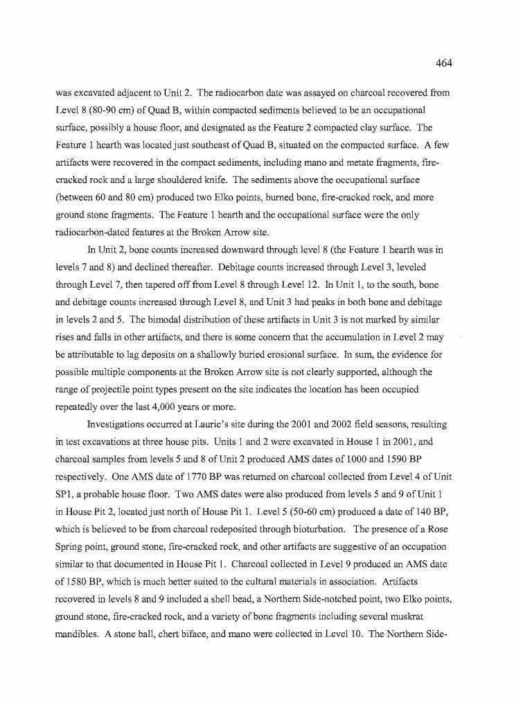
II
l I
464
was excavated adjacent to Unit 2. The radiocarbon date was assayed on charcoal recovered from
Level 8 (80-90 cm) of Quad B, within compacted sediments believed to be an occupational
surface, possibly a house floor, and designated as the Feature 2 compacted clay surface. The
Feature 1 hearth was located just southeast of Quad B, situated on the compacted surface. A few
artifacts were recovered in the compact sediments, including mano and metate fragments, fire
cracked rock and a large shouldered knife. The sediments above the occupational surface
(between 60 and 80 cm) produced two Elko points, burned bone, fire-cracked rock, and more
ground stone fragments. The Feature 1 hearth and the occupational surface were the only
radiocarbon-dated features at the Broken Arrow site.
In Unit 2, bone counts increased downward through level 8 (the Feature 1 hearth was in
levels 7 and 8) and declined thereafter. Debitage counts increased through Level 3, leveled
through Level 7, then tapered off from Level 8 through Level 12. In Unit 1, to the south, bone
and debitage counts increased through Level 8, and Unit 3 had peaks in both bone and debitage
in levels 2 and 5. The bimodal distribution of these artifacts in Unit 3 is not marked by similar
rises and falls in other artifacts, and there is some concern that the accumulation in Level 2 may
be attributable to lag deposits on a shallowly buried erosional surface. In sum, the evidence for
possible multiple components at the Broken Arrow site is not clearly supported, although the
range of projectile point types present on the site indicates the location has been occupied
repeatedly over the last 4,000 years or more.
Investigations occurred at Laurie's site during the 2001 and 2002 field seasons, resulting
in test excavations at three house pits. Units 1 and 2 were excavated in House 1 in 2001, and
charcoal samples from levels 5 and 8 of Unit 2 produced AMS dates of 1000 and 1590 BP
respectively. One AMS date of 1770 BP was returned on charcoal collected from Level 4 of Unit
SP1, a probable house floor. Two AMS dates were also produced from levels 5 and 9 of Unit 1
in House Pit 2, located just north of House Pit 1. Level 5 (50-60 cm) produced a date of 140 BP,
which is believed to be from charcoal redeposited through bioturbation. The presence of a Rose
Spring point, ground stone, fire-cracked rock, and other artifacts are suggestive of an occupation
similar to that documented in House Pit 1. Charcoal collected in Level 9 produced an AMS date
of 1580 BP, which is much better suited to the cultural materials in association. Artifacts
recovered in levels 8 and 9 included a shell bead, a Northern Side-notched point, two Elko points,
ground stone, fire-cracked rock, and a variety ofbone fragments including several muskrat
mandibles. A stone ball, chert biface, and mano were collected in Level 10. The Northern Side-
r.",:~II!
,I, !
T
•
465
notched point is out of place, considering the ca. 1600 year-old age of the deposits in House 2,
but it could well be an isolate or have been curated for use by the later occupants. Bone and
debitage counts from both units of House 1 indicate that depositional characteristics differed for
these two types of artifacts. In Unit 1, debitage counts increased downward through Level 4, and
tapered off slightly through levels 5 and 6 before increasing again in Level 7. The same was true
in Unit 2, where counts increased through Level 4, decreased slightly in Level 5, and increased
again in Level 6. Bone counts showed individual peaks in Level 6 ofUnit I and Level 3 of Unit
2. The debitage alone could be indicative of a bimodal distribution, but, taken in conjunction
with the single peak in bone counts, the aggregate distribution seems to indicate that a single 30
40 cm component is present at House 1 of Laurie's site.
Regional Culture History: Radiocarbon and Obsidian Hydration Dates,
and Lithic Technology Comparisons
The existence of clearly defined cultural features less than 2000 years in age, which are
preceded by scattered materials of greater antiquity, is exemplified by the sites described above,
and is common to sites in certain kinds of settings in the Harney Valley at large. A compilation
of 60 radiocarbon dates from Harney Valley sites (Table 10.1) reveals that 55 sites (91%) date
between 100 and 2000 BP, three (5%) date between 2000 and 3000 BP, one (2%) dates to 3470
BP, and one (2%) dates to 9610 BP. Oetting (1990a, 1990b) reported that diagnostic projectile
points collected during surveys along the northern shore of Malheur Lake seemed to indicate a
period of intensive occupation during the last 4000 years, with only about 11% of the sample
originating before that time. Oetting (1990a, 1990b) noted that using data obtained from surface
collecting at partially eroded sites may have introduced a bias by mixing temporally discrete
occupations, creating the appearance of one long-term continuously intergrading occupational
sequence. In any case, the typological evidence seems clearly to indicate that human use of the
Harney Basin intensified in the latter portion of the Holocene, at least along the Malheur
lakeshore. It is a pattern that fits well with evidence from other wet basins in south-central
Oregon including the Fort Rock Basin (Aikens and Jenkins 1994; Jenkins 1994; O'Grady
i
f,;
~~---~--- •
466
1999; Wingard 2001) the Chewaucan Basin (Oetting 1989) and Warner Valley (Eiseldt 1998;
Tipps 1998; Weide 1968).
The limited quantities of early to middle Holocene artifacts found so far in intact deposits
probably reflects the concealment of earlier artifacts by fluvial, lacustrine, and aeolian
geomorphic processes in wet basin settings, and the relative lack of archaeological excavations
away from such lakeside settings where the likelihood of finding earlier, intact deposits may be
better. Oetting (1990a: 120) noted that all of the early to middle Holocene points found during
the Malheur Lake surveys were recovered from the northwest shore. Clifford (1997), reporting
on a survey conducted south of Harney Lake, found that 14 of the 27 sites (52%) identified
during his survey contained Great Basin Stemmed points, which date between 11,000 and 7,000
BP (Oetting 1994:54). She further noted that Great Basin Stemmed points accounted for 78% of
the temporally diagnostic artifacts found during that survey. These two examples seem to
indicate that geomorphic processes have exposed early artifacts in some areas, and concealed
them in others, suggesting that there are more early sites in Harney Valley than current research
results show. If the circumstances of the sites reported in my study are any indication, finding
intact, datable deposits older than 2000 BP in central Harney Valley may always prove difficult
(Table 10.1).
~ .. I
467
Table 1O.l. Radiocarbon dates from Harney Valley archaeological sites.
Site Name Sample No. C-14 Date Calib. Date BP* Location Reference
Stubblefield Beta-76974 130±120 290 (260,230,130, 20, 0) 0 Feature 2, Dugas et al. 199535HA975* 150±70 280 (260, 210,140,20,0) 0 Ring 15 Burnside 1998 pers. com.35HA2095 Beta-49697 160±50 280(270,210,140,20,0)0 Burial 1 Burnside 1998 pers.com.Blitzen Marsh Gak-3294 170±80 290 (270,200, 150, 10, 0) 0 Test pit 2 Fagan 1974Blitzen Marsh Gak-3296 220±80 310 (280)0 Test pit 2 Fagan 1974Hoyt Beta-88083(AMS) 220±60 300 (280) 0 FCR/bone O'Grady 2006Lost Dune WSU-4807 260±50 310(300)0 Hearth 335HA1906 Beta-49253 280±50 430 (300) 290 Buria14 Burnside 1998 pers. com.35HA2095 Beta-49696 300±50 440 (310) 290 Buria120 Burnside 1998 pers. com.35HA1906 Beta-46963 310±60 460 (310) 290 Burial 1 Burnside 1998 pers. com.35HA2095 Beta-49695 310±50 440 (310) 290 Burial 9 Burnside 1998 pers. com.Lost Dune QL-4801 320±22 430(420,410,320)310 Hearth 1 Lyons and Mehringer 1996Lost Dune QL-4800 330±14 430(420,390,320)310 Hearth 2 Lyons and Mehringer 1996Lost Dune NSRL-264? 330±50 470 (430, 390, 320) 300 bone clust. Lyons and Mehringer 1996Lost Dune NSRL-2648 350±60 490(430,360,330)310 near Hearth 1 Lyons and Mehringer 199635HA975 350±80 430 (360) 330 Ring 17 Burnside 1998 pers. com.Headquarters Beta-66634 370±70 460 (340) 340 charcoal lens Dugas and Bullock 1994Headquarters Beta-66630 400±50 510 (480) 330 hearth Dugas and Bullock 1994Headquarters Beta-66632 430±80 530 (500) 330 cache pit Dugas and Bullock 199435HA1899 Beta-49698 460±60 530 (510) 480 burial 2 Elston et al. 1993McCoy Creek Beta-31736 480±70 540 (510) 490 Feature 11 Musi11995Indian Grade Beta-22608 530±60 550 (540) 510 oven, Comp I Jenkins and Connolly 1990Stubblefield Beta-76972 580±50 640 (550) 530 Feature 1 Dugas et al. 1993Stubblefield Beta-77124 610±40 650 (630, 610, 560) 550 burial, Feat. 4 Dugas et al. 1993Headquarters Beta-66628 670±80 670 (650) 550 midden Dugas and Bullock 1994Stubblefield Beta-76973 670±60 660 (650) 560 hearth, Feat. 5 Dugas et al. 199335HA1906 Beta-49694 700±60 670 (660) 570 Buria13 Burnside 1998 pers. com.35HA1914 Beta-57831 820±100 890 (720) 660 hearth Dugas et al. 1993Morgan Beta-88081 870±60 900 (760) 700 hearth O'Grady 2006Blitzen Marsh Gak-3297 930±150 970(900,870,830,790)670 Test pit 2 Fagan 1974
IHeadquarters Beta-66629 960±100 950 (910) 670 Stratum 3 Dugas and Bullock 1994McCoy Creek Beta-28037 990±90 970 (930) 790 hearth, floor 2 Musil 1995
I:Headquarters Beta-66631 1040±70 980 (940) 920 Stratum 20 Dugas and Bullock 199435HA1904 Beta-58183 1050±70 1050 (950) 920 hearth, Feat. 1 Elston et al. 1993
,-
35HA1905 Beta-49692 1050±70 1050 (950) 920 Burial 1 Burnside 1998 pers. com. I,Morgan Beta-88079 1060±70 1050 (950) 920 hearth O'Grady 2006 Ii
"35HA1911 Beta-49699 1070±70 1060 (960) 930 surface bone Raven and Elston 1992 I:Paiute Spring Gak-3304 1090±130 1160 (970) 910 Test pit 5 Fagan 1974 I'
I;Blitzen Marsh Gak-3299 1110±80 1070 (980) 940 Test pit 2 Fagan 1974 I'
McCoy Creek Beta-35150 1140±60 1080 (1060) 970 House floor 2 Musil 1995 IIndian Grade Beta-26254 I 150±90 1170 (1060) 950 Component II Jenkins and Connolly 1990 IHines Beta-105663(ams) 1160±50 1130 (1060) 980 hearth, Feat. 1 O'Grady 2006 IMorgan Beta-88080 I260±60 1270 (1170) 1080 hearth, Feat. 4 O'Grady 2006
,i
McCoy Creek Beta-31734 1270±70 1280 (1220,1220,1180) 1080 House floor 1 Musil1995 !
Blitzen Marsh Gak-3295 1280±90 1290 (1230,1210,1180) 1070 Test pit 1 Fagan 1974McCoy Creek Beta-31735 1340±60 1300 (1280) 1180 pit, floor 2 Musi11995Blitzen Marsh Gak-3300 1400±100 1360 (1300) 1260 Test Pit 2 Fagan 1974Indian Grade Beta-22605/Eth-32351410±100 1390 (1300) 1270 hth. Compo III Jenkins and Connolly 1990Indian Grade Beta-22609 1440±110 1410 (1320) 1270 hth., Compo III Jenkins and Connolly 1990McCoy Creek Beta-9573 1480±110 1505 (1350) 1290 charcoal band Musil 1995Indian Grade Beta-22606 1670±80 1690 (1550) 1500 hth., Compo III Jenkins1990Blitzen Marsh Gak-3301 1820±110 1870 (1720) 1580 Test pit 2 Fagan 197435HA1899 Beta-49691 1830±60 1830 (1730) 1640 burial I Elston et al. 1993Hoyt Beta-88082(AMS) 1890±60 1880 (1830) 1730 cache/feature O'Grady 2006McCoy Creek Beta-31737 1900±100 1940 (1830) 1710 over chrt compo Musil 1995Indian Grade Beta-22607 2000±90 2040 (1940) 1840 hth., Compo III Jenkins and Connolly 1990Blitzen Marsh Gak-3302 2350±80 2430 (2350) 2320 Test pit 2 Fagan 1974Indian Grade Beta-22604 2840±220 3260 (2940) 2750 North Locus Jenkins and Connolly 1Dunn Site Beta-31537/Eth-56603255±65 3560 (3470) 3390 house floor Musil199535HA342 USGS-461B 8680±55 9820(9640,9610,9580)9530 beach shell Gehr 1980*Ca1ibrated dates BP at 1a (Stuiver and Reimer 1993).

rI!
T
468
Thus, the presence ofmiddle Holocene occupations at many sites may seldom be confirmed by
any other evidence than obsidian hydration measurements and projectile point cross-correlation.
Obsidian sourcing and hydration dating was conducted on 628 artifacts recovered from
the seven sites reported here. Obsidian recovered from the sites generally reflected the use of
nearby sources. The Hoyt, Morgan, and Hines sites, located near Bums Butte, were dominated
by the Bums Butte and Dog Hill sources, for both of which provisional hydration rates have been
established. Ozbun (et al. 1996) and Connolly (Appendix) noted an accelerated rate of hydration
for these sources (up to 10)..1,211000 years) in comparison with other source specific rates from
central and southern Oregon. A comparison of the hydration bands on diagnostic projectile
points from these three sites confirmed that the rapid hydration rate is characteristic of Bums
Butte and Dog Hill obsidians in the Hoyt, Morgan and Hines depositional settings, and that band
thicknesses widen on earlier temporally diagnostic points. Hydration analysis based on the
hydration rate of 1O)J?/1000 years indicates that a major period of artifact deposition occurred
between 4500 and 1500 years ago, with the greatest intensity between 2000 and 3000 BP. Based
on the few relevant radiocarbon dates at the study sites (1820 BP at Hoyt, 2920 at RJ, and 2000
BP at Laurie's), the fairly intense 2000 to 3000 BP period of site use would have been barely
visible through radiocarbon dating, and would have been most noticeable through peaks in
debitage at the Hines South Block and Morgan East Locus.
Lithic technology comparisons between earlier and later components at the Morgan,
Hines, and Knoll sites add to our knowledge ofhow the sites may have been used over time.
Debitage, utilized flakes, a Stage 2 biface, and three cores constituted the Early component at the
Hines site recovered in the South Block. The cores and an abundance of debitage indicate that
lithic reduction was an important activity during the early occupations, in keeping with the site's
location at the base of a sizeable obsidian source. Broken projectile point fragments, bifaces in
all stages of reduction, and cores attest to the continued importance of lithic reduction during late
occupations as well. High quantities of ground stone fragments and paleobotanical remains
further suggest that plant gathering and processing increased in importance around that time
(1500 BP - historic).
At the East Locus of the Morgan site, the Early component included Large and Small
Side-notched, Elko Comer-notched, and Eastgate projectile points; Stage 3 and Stage 4 biface
fragments; a metate fragment; and three mano fragments. The Late component of the East Locus
produced Rose Spring and Cottonwood Triangular points, all stages ofbiface reduction, and one
~------------- •
469
mano fragment. The West Locus of the Morgan site (considered to be late component materials)
contained Small Side-notched, Elko series, and Eastgate points; all stages ofbiface reduction;
and an abundance of ground stone, including manos, metates, and abrading stones. The presence
of only late stage biface fragments in the Early component is important, suggesting that the site
was a temporary stopping point where Stage 3 preforms prepared at the adjacent quarry
continued to be shaped along the route from the quarry site to the next destination. Ground stone
was present in all components at the site, indicating that plant processing was a regular activity
during all periods of site use. Small mammals accounted for most ofthe faunal remains during
both earlier and later periods of site use. Very few birds and no fish were recovered in the
cultural strata.
An additional item of interest is the temporal variation in projectile point assemblages
between the West Locus and the East Locus of the Morgan site. Similar projectile points were
recovered in the Early Component of the East Locus and the single component of the West
Locus, but the Late Component of the East Locus produced the only Rose Spring and
Cottonwood Triangular points found at the site, suggesting that it also saw a later period of use
than is seen at the West Locus. Obsidian hydration evidence supports this finding. Two Rose
Spring points produced hydration rims ranging from 2.3 to 2.7 microns. An additional reading of
3.7 microns on one ofthe points (977-23-Y-B-l-l) could be residual to the initial production of
the flake from which the point was manufactured. Two Eastgate points had rims measuring 3.2
and 3.7 microns in width. One Elko point had a readable hydration rim of 3.61l, and a Side
notched point had rims measuring 5.3 and 5.6 microns in width.
Paleoclimatic, Environmental, and Cultural Change
The Hoyt, Morgan, and Hines sites are similar in terms of their general setting, being
situated on elevated locations overlooking the marshy floor of Pleistocene Malheur Lake. The
Broken Arrow and Laurie's sites are also similar to one another, being situated lower and
adjacent to the modem lake shore. The RJ site is located in the Stinkingwater Mountains, and the
Knoll site is in the Silvies Valley to the north, both occupying more upland settings. During the
time these sites were occupied, waterways crossing the Hamey Valley floor were probably broad

•
470
and marshy, with numerous sloughs, channels, and low energy stream channels threading their
way across, depending on the time of year and amount ofprecipitation falling annually. The
uplands to the north of Harney Valley rise sharply from the valley floor, providing a very
different environmental setting. This ecological borderland would have allowed the human
occupants of the region a variety of opportunities for obtaining different kinds of resources over a
relatively short distance and may have been an important factor in the positioning of the Hoyt
and Morgan sites. The same is true for the Hines site, although the nearby obsidian source was
surely an important factor at its location. The positioning of the Broken Arrow and Laurie's sites
near the lake shore, the Hoyt, Morgan and Hines sites at mid-elevation settings, and the Knoll
and RJ sites in upland settings afforded their occupants different opportunities for the acquisition
of subsistence items and other kinds of resources necessary for the manufacture of equipment
such as basketry, matting, and weaponry.
The placement of the seven sites investigated at different elevations within the Harney
drainage basin provides opportunities to examine climatic, environmental, and cultural changes
in the area over time. The relationship of the changing climatic conditions during the last 4000
years is demonstrated in Figure 10.1. Radiocarbon dates from the seven study sites are compared
with the results of Wigand's (1987) pollen analysis at Diamond Pond, located on the east side of
Blitzen Marsh. All of the sites were occupied during the period defined by Oetting (1994) as
Late Archaic 1, from 2,000 BP to 1,000 BP, which was characterized by dryer conditions during
the time between 2000 BP to 1400 BP, and wetter conditions from 1400 BP to 1000 BP. It is
interesting to note that human use of the Harney Valley was more dispersed during the wetter
period, and more focused on the lakeside setting during drier conditions.
Pollen analysis was conducted by Cummings (et al. 1998) on undated, though probably
late Pleistocene - early Holocene soil samples recovered from lake deposits underlying the Hines
site. Cummings (et al 1998) noted higher quantities of Pinus pollen in the lower two lake
samples, suggesting that pines grew closer to the site than they do currently. Sagebrush, as now,
was the principal vegetation on the basin floor. The upper lake sample showed a decline in Pinus
pollen, while plants bearing saline soil-tolerant pollens increased, indicating that the lake was
drying and pines were no longer found near the site. Juniper and oaks occurred during this later
period, and spruce occupied higher elevations nearby. The macrobotanical analysis indicated
that many of the shrubs, grasses, and forbs that were present
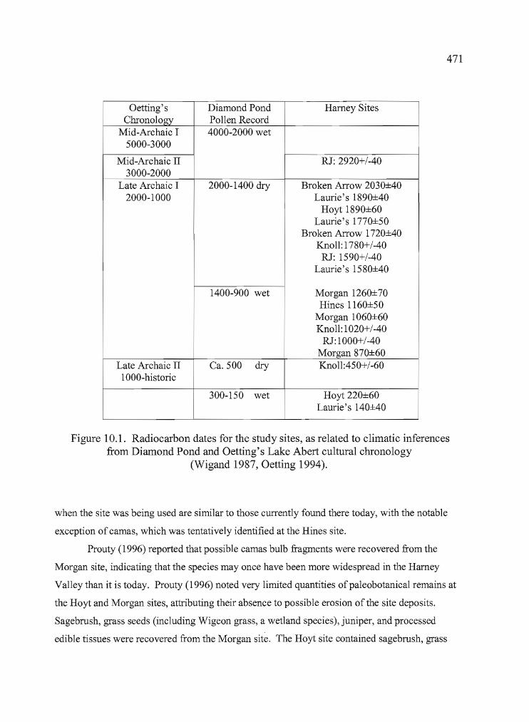
t
~~--------- •
471
Oetting's Diamond Pond Harney SitesChronology Pollen Record
Mid-Archaic I 4000-2000 wet5000-3000
Mid-Archaic II RJ: 2920+/-403000-2000
Late Archaic I 2000-1400 dry Broken Arrow 2030±402000-1000 Laurie's 1890±40
Hoyt 1890±60Laurie's 1770±50
Broken Arrow 1nO±40Knoll: 1780+/-40
RJ: 1590+/-40Laurie's 1580±40
1400-900 wet Morgan 1260±70Hines 1160±50
Morgan 1060±60Knoll: 1020+/-40
RJ:1000+/-40Morgan 870±60
Late Archaic II Ca. 500 dry Knoll:450+/-601000-historic
300-150 wet Hoyt 220±60Laurie's 140±40
Figure 10.1. Radiocarbon dates for the study sites, as related to climatic inferencesfrom Diamond Pond and Oetting's Lake Abert cultural chronology
(Wigand 1987, Oetting 1994).
when the site was being used are similar to those currently found there today, with the notable
exception of camas, which was tentatively identified at the Hines site.
Prouty (1996) reported that possible camas bulb fragments were recovered from the
Morgan site, indicating that the species may once have been more widespread in the Harney
Valley than it is today. Prouty (1996) noted very limited quantities ofpaleobotanical remains at
the Hoyt and Morgan sites, attributing their absence to possible erosion of the site deposits.
Sagebrush, grass seeds (including Wigeon grass, a wetland species), juniper, and processed
edible tissues were recovered from the Morgan site. The Hoyt site contained sagebrush, grass
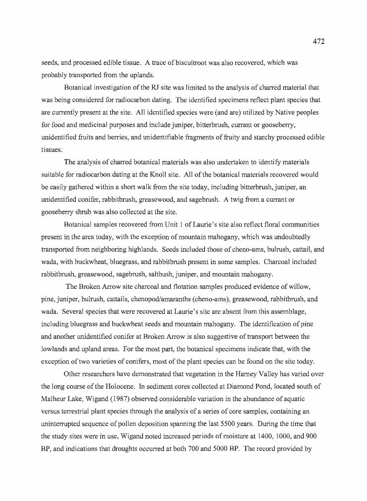
, I
L
472
seeds, and processed edible tissue. A trace ofbiscuitroot was also recovered, which was
probably transported from the uplands.
Botanical investigation ofthe RJ site was limited to the analysis of charred material that
was being considered for radiocarbon dating. The identified specimens reflect plant species that
are currently present at the site. All identified species were (and are) utilized by Native peoples
for food and medicinal purposes and include juniper, bitterbrush, currant or gooseberry,
unidentified fruits and berries, and unidentifiable fragments of fruity and starchy processed edible
tissues.
The analysis of charred botanical materials was also undertaken to identify materials
suitable for radiocarbon dating at the Knoll site. All of the botanical materials recovered would
be easily gathered within a short walk from the site today, including bitterbrush, juniper, an
unidentified conifer, rabbitbrush, greasewood, and sagebrush. A twig from a currant or
gooseberry shrub was also collected at the site.
Botanical samples recovered from Unit 1 of Laurie's site also reflect floral communities
present in the area today, with the exception ofmountain mahogany, which was undoubtedly
transported from neighboring highlands. Seeds included those of cheno-ams, bulrush, cattail, and
wada, with buckwheat, bluegrass, and rabbitbrush present in some samples. Charcoal included
rabbitbrush, greasewood, sagebrush, saltbush, juniper, and mountain mahogany.
The Broken Arrow site charcoal and flotation samples produced evidence of willow,
pine, juniper, bulrush, cattails, chenopod/amaranths (cheno-ams), greasewood, rabbitbrush, and
wada. Several species that were recovered at Laurie's site are absent from this assemblage,
including bluegrass and buckwheat seeds and mountain mahogany. The identification of pine
and another unidentified conifer at Broken Arrow is also suggestive of transport between the
lowlands and upland areas. For the most part, the botanical specimens indicate that, with the
exception of two varieties of conifers, most of the plant species can be found on the site today.
Other researchers have demonstrated that vegetation in the Harney Valley has varied over
the long course of the Holocene. In sediment cores collected at Diamond Pond, located south of
Malheur Lake, Wigand (1987) observed considerable variation in the abundance of aquatic
versus terrestrial plant species through the analysis of a series of core samples, containing an
uninterrupted sequence ofpollen deposition spanning the last 5500 years. During the time that
the study sites were in use, Wigand noted increased periods of moisture at 1400, 1000, and 900
BP, and indications that droughts occurred at both 700 and 5000 BP. The record provided by
,II
Ii
I!r,l'
I
I I
i
L,I
473
Diamond Pond reveals that climatic fluctuations could occur rather quickly, with transitions of 25
to 40 years between wet or dry periods. The Diamond Pond sequence is the most detailed to
emerge from the northern Great Basin and serves as a very useful marker for climatic events that
surely affected human occupants. The paleobotanical record from the seven sites reported here is
not fine~grainedenough, however, to provide supportive evidence for site use during a specific
climatic event.
The faunal record from the seven sites is limited, due in part to the loss of files containing
the zooarchaeological analysis of the Broken Arrow and Laurie's sites, and the absence of faunal
remains at the RJ site. The zooarchaeological results from the Hoyt Morgan, and Hines sites
provide evidence for the use of animal resources from specific habitats. The most common
remains are from small terrestrial mammals, e.g. rodents and lagomorphs, which could readily be
found in the marshland!grassland settings to the south or the upland setting to the north.
However, small numbers ofwaterfowl elements were identified in all of the sites, a few fish
remains were recovered from the Hines and Hoyt sites, and beaver and muskrat bones were
identified at the Hines site, all of which are common in wetland settings. No species that are
common only in upland habitats were identified in any of the sites. Small quantities ofeggshell
may be indicators of site use during the late spring or early summer months.
In sum, the floral and faunal assemblages recovered from the sites suggest that conditions
during the last 2000 years supported similar plant and animal communities to those seen today.
The influences of modem human activity such as livestock grazing and the draining of some
areas and irrigation of others have certainly affected the modem distribution and frequency of
some resources, and may have contributed to the retreat of the wetland southward towards the
Harney and Malheur lake basins. Despite human alterations, the hydrologic system of Harney
Basin remains quite dynamic, with widespread flooding occurring during the mid-1980s and
again at the time of this writing.
Settlement and Subsistence
Judging by the artifact assemblages, it is evident that the various sites under investigation
were utilized for different purposes. An abundance of ground stone at the Morgan site suggests
i,IilI!
iII
474
an orientation toward plant processing. At the Hines site, high quantities of formed tools, cores,
and debitage, along with naturally occurring obsidian nodules, indicate an emphasis on quarrying
and lithic reduction. The wide variety ofbotanical remains and relatively large quantities of
ground stone may indicate additional use ofthe Hines site for the procurement ofplant resources.
The Hoyt site yielded an abundance of faunal remains (including high percentages of large game
animals) and formed tools, which suggest an orientation towards hunting or the processing of
faunal resources. The Knoll site contained an abundance of large bifaces in a variety of reduction
stages, and direct access to basalt and obsidian tool stone which created an attraction to the site.
The acquisition of various kinds of food resources is evident at the site, though no one resource
appears to have been targeted. The RJ site was clearly associated with root collecting both
through location and artifacts found in the assemblage. Laurie's site and the Broken Arrow site
are in close proximity to each other, yet the artifacts and subsistence remains indicate that
activities at the two sites were quite different. Both were intensively occupied, both contained
evidence of dwellings and both produced rich tool assemblages. Laurie's site had an abundance
of muskrat bone and concentrated areas of fish bone, while Broken Arrow contained few fish
remains, an abundance ofjackrabbit and bird bone, and significant amounts of immature small
mammal bone. Both sites contained evidence that a variety of seeds were being utilized as well.
At each site, one late Holocene activity area or temporary camp was identified, along
with evidence for earlier occupations extending back as far as 4000 BP. The sheer abundance of
radiocarbon dates from Harney Valley falling after 2000 BP supports the argument that human
occupation intensified after that time, but it will be prudent to reserve judgement on this matter
until additional research occurs away from the erosion-prone lakeside settings.
By using the basic inferences suggested by the artifact assemblages and comparing them
to ethnographic descriptions of human movement in and around the Harney Valley, it is possible
to consider how the seven sites might fit into a generalized pattern of site use. Couture (1978)
and Whiting (1950) documented root collecting in the Stinkingwater Mountains and surrounding
areas in early May, followed by dispersal of family groups in the summer to collect seeds and
other resources. Ground stone tools found in quantity at the Hines and Morgan sites indicate
plant processing activities. The recovery ofbulb fragments and grass seeds at these sites further
supports this interpretation. It is doubtful that either of the sites were destination points for the
collection ofbulbs, given the small quantities recovered and the highly productive grounds
known to exist elsewhere in the hills to the northeast. However, root collection and preparation
aL _ •
475
at temporary camps en route to Pine Creek and the Stinkingwater Mountains is plausible. The
abundance of grass seeds recovered suggests that the sites were probably more important for seed
processing during the summer months, and prolonged periods of site use might have occurred
then. In either case, the Hines and Morgan sites would have provided only temporary stopping
points as people moved from one area to another in pursuit of other resources.
At the Hoyt site, the emphasis on hunting and the processing of animal resources may fit
the seasonal ethnographic pattern. Game could be taken at any time of year, but hunting as an
organized subsistence activity generally took place in the late summer and fall. The Blue
Mountains near Seneca and John Day were favored locations, especially for elk, while rabbit and
antelope drives were conducted near the Crowcamp Hills, in the northern portion of Harney
Valley (Couture 1978). When viewed in terms of the known winter habitations at or near the
lakes and general seasonal ethnographic rounds, it appears that the Hoyt and Morgan sites
probably served as temporary camps for people leaving the winter lake side villages and traveling
toward (ethnographically) known upland destinations in the spring and early summer. The Hoyt
site may have been used by those coming back toward the lake side in the fall, and the range of
artifacts and density of cultural materials suggests that it may have also served more in the
capacity of a base camp, from which subsistence and resource procurement activities were
staged.
According to patterns of movement described by Whiting, the Knoll site could have been
visited by Harney Valley travelers during the summer and early fall months, as they moved en
route toward Seneca and John Day to hunt, collect berries, and fish. The site provides evidence
of quarrying, the acquisition and processing of game -- particularly small mammals -- and
utilization of currants and other plant products. The site has been utilized over the last 4000
years, at least.
The RJ site fits well in Whiting's framework of seasonal passages to important resource
areas. The root camps of the Stinkingwater Mountains and Pine Creek divide are well reported
and they have served as an attraction for generations of Native peoples, including some from well
outside of the Harney Valley. Archaeologically, evidence of root-collecting is difficult to
identify and the thin sediments of the root grounds offer little protection for organic remains.
Nevertheless, traces of faunal remains and fragments of burned seeds, processed edible tissue,
and unidentifiable fruit tissues were identified at the RJ site. The abundance of large basalt
chopping tools suggests that some activity related to wood working, probably the manufacture of
I I
U
476
digging sticks, was also occurring at the site. The annual seasonal round would have begun at
spring root camps such as the RJ site, and evidence from obsidian sourcing indicates that tools
were either being brought to the site from the northern edge ofthe Harney Valley or from a
variety of sources to the north and east of the site. One possibility is that people were bringing
obsidian to the site from the Burns area, then bringing other material back from areas to the north
and east as they fished along the Malheur River or collected other resources nearby.
Laurie's site has abundant evidence of plant processing, including large quantities of
fragmented ground stone and a variety of seeds from grasses and shrubs. The faunal evidence
indicates that aquatic and terrestrial species were being utilized including both large and small
game. At least three house pits were identified by testing at the site, producing evidence that a
small lakeside village stood at the location between ca. 1500 to 2000 years ago. The houses and
diversity of tools suggests that use of the village occurred over a lengthy period of time
possibly for weeks (or longer) instead of days - and that a variety of activities took place there,
ranging from subsistence practices to the possible repair and replenishment of basketry, clothing,
and weaponry. The site fits well within Whiting's description ofhuman activities at Malheur
Lake, which she identified as the main residential zone. Plant remains found at Laurie's site
indicate that marshland plant seeds, wada and other seeds were being collected, or at least stored,
there, and the presence ofmountain mahogany establishes a tie with the uplands. That fits well
with the trips into the Crowcamp Hills to pick chokecherries, described by Whiting (1950:19) as
having occurred around the same time as the September gatherings to await the ripening of the
wada.
The Broken Arrow site, close to Laurie's site, is a location that shares much in common
with the latter, but also differs in significant ways. Broken Arrow was occupied at least between
ca. 1800 BP to 2000 BP. There is evidence that a dwelling, probably a wickiup, once stood near
the summit of the dune, and numerous artifacts suggest that it was occupied for a longer duration
than are many of the open sites scattered around the Harney Valley. The site also has evidence of
seed acquisition, including seeds of emergent marshland vegetation and wada. In addition, a
variety of large and small game species are represented in the faunal assemblage though fish does
not appear to be a key dietary item. The site fits well into the ethnographic pattern of resource
acquisition in the summer or early fall, as described by Whiting.
t'
477
Cultural Relations and Ethnic Group Territories
The temporary nature of the sites examined here limits their potential for providing
information about ethnic group territories and long term changes. First, the sites are temporary,
meaning that the artifact assemblages, though substantial in some cases, are limited in scope
when compared with what might be found in a pit house village occupied for six months or so,
and less likely to include ethnic markers such as fancy ground stone. Also, temporary camps are
somewhat unsuited for answering questions of ethnicity because they are common to both highly
mobile groups such as the Paiutes, and semi-sedentary groups like the Klamaths. Second, the
sites are exposed to the elements. Perishable items like basketry and matting, which provide
clues to ethnicity through both construction and artistic motifs, seldom survive long term
exposure. Third, the sites were occupied infrequently during the last 4000 years, providing only
a patchwork glimpse of use.
The most compelling currently known example of the archaeological expression of ethnic
affiliation in Harney Valley prehistory was presented by Lyons (2001) in his analysis of the Lost
Dune site, located south of Malheur Lake. Dating to ca. 500 years BP, the site yielded pottery,
chert, and sandstone abraders that originated near the Owyhee River and eastward into Idaho, as
well as opaline silicates from the Tosawihi source in northern Nevada. Based on the ceramic
evidence, the site reveals that Shoshones were active in the Harney Valley during that time and
traveled a circuitous route to get there. The Lost Dune site is one of very few with evidence of
ceramic technology in the northern Great Basin of Oregon. The Lost Dune site is also important
because it contains an abundance of Desert Side-notched projectile points, considered by many as
a key marker for Numic-speaking peoples and a diagnostic indicator of late Holocene occupation
of archaeological sites.
One of the best indicators ofpossible ethnic affiliations from the seven sites studied was
their chronologically diagnostic projectile points. The Hines and Hoyt sites produced some
points that were not readily assignable to Great Basin typologies, but are well-documented from
Columbia Plateau sites such as Wildcat Canyon (Dumond and Minor 1983) and Pacquet Gulch
(Jenkins and Connolly 1994). These included Pinstem points at the Hines and Broken Arrow
sites, and Expanding Stem-3 and Contracting Stem types 2 and 3 at the Hoyt site (Dumond and
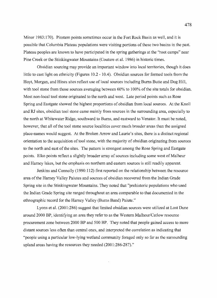
J
478
Minor 1983: 170). Pinstem points sometimes occur in the Fort Rock Basin as well, and it is
possible that Columbia Plateau populations were visiting portions ofthese two basins in the past.
Plateau peoples are known to have participated in the spring gatherings at the "root camps" near
Pine Creek or the Stinkingwater Mountains (Couture et al. 1986) in historic times.
Obsidian sourcing may provide an important window into local territories, though it does
little to cast light on ethnicity (Figures 10.2 - lOA). Obsidian sources for formed tools from the
Hoyt, Morgan, and Hines sites reflect use of local sources including Burns Butte and Dog Hill,
with tool stone from those sources averaging between 60% to 100% ofthe site totals for obsidian.
Most non-local tool stone originated to the north and west. Late period points such as Rose
Spring and Eastgate showed the highest proportions of obsidian from local sources. At the Knoll
and RJ sites, obsidian tool stone came mainly from sources in the surrounding area, especially to
the north at Whitewater Ridge, southward to Burns, and eastward to Venator. It must be noted,
however, that all of the tool stone source localities cover much broader areas than the assigned
place-names would suggest. At the Broken Arrow and Laurie's sites, there is a distinct regional
orientation to the acquisition oftool stone, with the majority of obsidian originating from sources
to the north and east of the sites. The pattern is strongest among the Rose Spring and Eastgate
points. Elko points reflect a slightly broader array of sources including some west of Malheur
and Harney lakes, but the emphasis on northern and eastern sources is still readily apparent.
Jenkins and Connolly (1990: 112) first reported on the relationship between the resource
area of the Harney Valley Paiutes and sources of obsidian recovered from the Indian Grade
Spring site in the Stinkingwater Mountains. They noted that "prehistoric populations who used
the Indian Grade Spring site ranged throughout an area comparable to that documented in the
ethnographic record for the Harney Valley (Bums Band) Paiute."
Lyons et al. (2001:286) suggest that limited obsidian sources were utilized at Lost Dune
around 2000 BP, identifying an area they refer to as the Western MalheurlCatlow resource
procurement zone between 2000 BP and 500 BP. They noted that people gained access to more
distant sources less often than central ones, and interpreted the correlation as indicating that
"people using a particular low-lying wetland community foraged only so far as the surrounding
upland areas having the resources they needed (2001:286-287)."
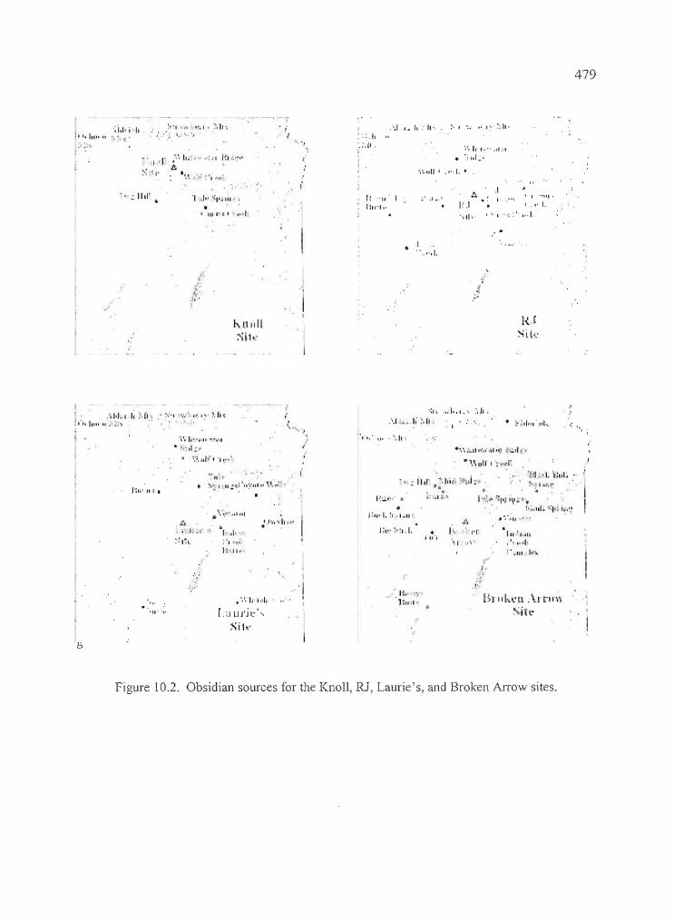
479
',', ,-,II I ., ", I. ~
11·11'"1'"';1,1-;·" :··1 .... 1'.1. -:'.11',
·t. '-
... I.' I' . ,.',', I•.. , ... ~ . I I~I .... ,,".A
-,- i,
.' ::.1,:',1',
....1 ,.1, '11" I '..; "". I ~., :', It '
',', II' I ~., .11 ~·I
• :i hi
" ; IIII' J •. SII';til
•t 111"'=' ',•• 1:
,.: "11' IHII~I, . 1·:.1
"oll'·
I I "III'
I ," I.•...• ··,::'·.··1:
.... ,.• 1.
~-
~.j •. '
•
H.JSih:
I . .'1.1''-1 I; ~. ('" . ~""l W' I'" I:" :', h l:
1"""11'"' II.' .... •• .,
":' , .....1.".·. :',11,...1 I, :·.f,.. • -' ••1".',."
",
II '" .':'1": I'll :,:i '11:: ..1,' '.':,: ,I t't I:.:.",;"
111'1,111
.. •· .....1:: • ~IJJ I,',)"
I'. ;-,.
: 1'111' -fI!.II·I.~·, • ):"
• •! .1 :'1" f~':"" t: l "t iy _0: 'It
. :,•. 111 .. \:1111.,<',,'0 ·~Il .•.
I'~:"'I" •
•1:11,1.:1 1.. 11'
~ ",..,'.-h,1"
.'1·,,"
,.\.'.... 011 .. 1
'1'•. 1••• 1. 11 .... ,.'
" ';" d:,.II ' •• " I'~ I '1 ,....
'j',
'11"',-
.·.·.·1'·'.·1.[.<IUJ'jl:'·,
Sih'
'j,I
B..'1:11 :1-
.~
,t'•.
BI'IIl-.~·Cl Art'I'·..·,;,,;j ~ l."
Figure 10.2. Obsidian sources for the Knoll, RJ, Laurie's, and Broken Arrow sites.
b
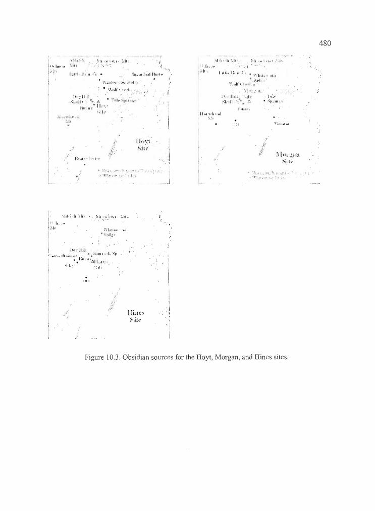
',. -11,1'." .IlJ I·'..... • ·..··1.· :-·Il~;::.!
J"ill' II':· II .... ".... j,.
480
. '.
rll~"-':p.1l1
: \ ~ I ... 0', ,I .. "
:::1
. ,
11,1. ' .•h::1.' r "."" .:..
I IlL, J:, II ' - • ·, ... ·11 ..1. I 1111
• .. ·.ltI .'·'I.-'. lI lf I.' , ...1:.
>: .. ~.IL·
"
- ...
':II:.!."J...,II:II-t,..',·, •. I:'·,·'.!'.:.....,,1·
~1.1 r, . ,',_ I' ~. II ..',,', ....
", .;'.In
1;.1:1 • .:1 111
:,1'
I::: I,u' u
....."."I
\j.,.:.:l">ill' i."
~i, [11L"L!,~'ltl
Sil,·
1··'1!• '.11" ....,'.• l.
.,".'11" I
!".',.'. I ,',': •
.':"""," ','
',Ill'; II "', II.; ~, : I • I'" ". I' ~, It ,. . !
" I...,.1'
II
',',I" """,'1.. OJ',l =
..... ,'.~j.:.. :.1- <II • .:-tlllli • _I. '.:" '..••• 1· ... ,1. _
_. • .':ll .. lI"'~II ....1r::
'1'1,,:,- :-:.1,
0"
[ [lJl t'~
Sit"
\'j. ,
Figure 10.3. Obsidian sources for the Hoyt, Morgan, and Hines sites.
y
481
.!ohn Day River John Day•-Canyon City
Ato \1\tHL'
\\':11,
oRiverside
Juntura
CastleRock..
A Indian (. r~ck11,llIe,
Cro\\'CalllplIills
~/-vlalhellr \
Lakenro"~li Arrow
• Lilllrie'sI kauquarters
Riley
IronMl
SilverLake I.akeonIheTrail
* = Ar~haCl)logi~al Sites
A = Ol"'iclian Sources
Figure IOA. The relationship between the study sites (stars), the dominant obsidian sources(triangles), and patterns of movement (arrows) described by Whiting (1950).
'\II
~.!1I'i
ij'i :
482
Musil (2002: 73-79) reported the obsidian sourcing results from archaeological testing at
the Headquarters site in 2001. He identified Upper and Lower components at the site, the lower
dating between ca. 6900 BP and 7200 BP, the upper undated. Twenty-five obsidian flakes from
the lower component were geochemically sourced, with 84% originating from the Glass Butte
source to the west. Sources represented in the 23 flakes analyzed from the Upper Component
were largely from north and east of Harney Valley, including Bums (39%) Venator (30%), Tule
Springs (13%), Glass Buttes (4%) and Indian Creek Buttes (9%). Clearly we must entertain the
possibility of considerable change over time in patterns of obsidian procurement in the Harney
Valley.
Some observations important to the topic of resource use and group territories arise from
the examination of obsidian source distributions seen at the study sites (Figures 10.1 - 10.3):
First, the relationship between the area described as having been utilized in the Harney Valley
seasonal round, as described by Whiting (1950), and the distribution of obsidian sources at the
Knoll, RJ, Laurie's, and Broken Arrow sites (dating from 2000 BP to historic contact) is strong.
The connection between the ethnographic record and the archaeological record apparently is one
that extends well back in time. Second, the Hoyt, Morgan and Hines sites produced substantial
quantities of Burns and Dog Hill obsidian, yet neither of these sources are well represented in the
formed tools found at the Knoll, RJ, Laurie's, and Broken Arrow sites. Bums obsidian seems to
have a very localized range, even though the tool stone quality is high. Third, the area which
produced low percentages of obsidian tool stone, from the west edge of Harney Valley southward
to Steens Mountain, is roughly equivalent to a territorial boundary zone historically disputed by
the Burns Paiute and Klamath Tribes. Other factors such as the availability of resources in this
zone, including tool stone, may have a part in this, but the distinction is apparent in this data set.
Fourth, very little obsidian from sources in other important surrounding basins, including Catlow
Valley, the Chewaucan Basin, Fort Rock Valley, and Warner Valley is perceptible through the
obsidian from the seven Harney Valley sites reported herein, at least for the last 2000 years of
occupation. Investigations of this matter in future research may go far towards providing insights
into ethnicity and the territorial borders that separated aboriginal populations in central Oregon.
i.i,
i'I
!I'
i.I .
;, l
Ii
:1
•
483
Prehistoric Technologies
The most prominent representation ofprehistoric technology at the seven sites is through
chipped stone projectile points, bifaces, drills, scrapers, gravers, cores, large flake tools, edge
modified flakes, and debitage, the by-product of their manufacture. Chipped stone tools were
manufactured from obsidian, basalt, or CCS, with obsidian accounting for the vast majority of all
items. Typological categorization and attribute analysis ofboth tools and debitage was
undertaken, and some obsidian artifacts were further analyzed through the use of geochemical
sourcing (X-ray fluorescence) and hydration rim measurement. Radiocarbon dates indicated that
the seven sites were primarily occupied within the last 2000 years, during the time of overlap
between Elko and Rosegate projectile point technologies. The presence of older projectile point
types such as Northern Side-notched reveals that the sites (or localities) were also used before
4000 years ago.
Other artifact categories included ground stone, abrading stones, hammer stones, atlatl
weights, bone tools, and beads. Variation in the types of tools, along with the frequency and
variety of floral and faunal remains, all contributed in the determination of what kinds of
activities were occurring at each site.
The Hoyt site yielded 32 projectile points which were classifiable under the established
Great Basin typology (Thomas 1981). They included 7 Rose Spring, 2 Eastgate, three Elko
Eared, five Elko Comer-notched, four Northern Side-notched and two Small Side-notched, and
one Humboldt Concave-base. Six projectile points were more appropriately classified through
the Columbia Plateau typology developed by Dumond and Minor (!983). These included one
Expanding Stem-3, four Contracting Stem-2, and one Contracting Stem-3 point. One point was
typologically unclassifiable, and one was classifiable only as side-notched. The remaining tool
assemblage included 129 edge-modified flakes, 23 projectile point fragments, 7 drills or awls, 58
biface fragments, 24 pieces of ground stone, 24 cores, 7 core and flake tools, 3 bone tools, 4
abraders, and a single atlatl weight.
At the Morgan site one Cottonwood Triangular, three Eastgate, three Rose Spring, one
Elko Eared, four Elko Comer-notched and three Side-notched points were recovered. Other
artifacts consisted of 8 projectile point fragments, 1 drill, 18 bifaces or biface fragments, 51 edge-
484
modified flakes, 5 cores, 18 ground stone tools, 1 stone bead, 2 hammer stones, and 1 CCS
chopper.
The Hines site produced 28 chronologically diagnostic projectile points, including 15
Rose Spring, four Eastgate, five Small Stemmed points, one E1ko Comer-notched, two E1ko
Eared, and one Northern Side-notched point. Also collected were 17 point fragments, 34 bifaces
or fragments, five drills, 189 edge-modified flakes, 12 cores, 14 ground stone tools, one abrader,
one stone bead, and one bone tool.
Eight projectile points were found at the Knoll site, including five Northern Side-notched,
one E1ko Comer-notched, one Humboldt, and an unclassifiab1e point base. Also collected were
31 bifaces or fragments, 3 large flake tools ofbasalt, 17 edge modified flakes, and 8 cores.
Ground stone included a triple-grooved abrader, three metate fragments, a mano fragment, and a
pestle.
The RJ site produced 20 projectile points or hafted tools developed on a projectile point
base, including 1 Cottonwood Triangular, 2 Desert Side-notched, 5 Rose Spring, 2 E1ko Eared, 4
E1ko Comer-notched, 1 Northern Side-notched, 1 Humboldt, 1 Ma1heur Stemmed, a large
obsidian dart point that appears to be side-notched, an eared base that has been modified through
retouching, a crude drill fashioned from a biface fragment, and a hafted scraper ofbasalt.
Twenty-two bifaces in all stages oflithic reduction were collected, as were five drills or awls,
twelve core and flake tools, seventeen edge- modified flakes, and eight cores. Three metate
fragments and one mano fragment were also found.
Artifact counts were dramatically higher at the lakeside sites. Laurie's site yielded 41
projectile points from 3 house pit features. They include eleven Rose Spring, eight Eastgate, one
Rosegate, five E1ko Eared, three Elko Comer-notched, two undifferentiab1e E1ko Series, two
Northern Side-notched, one Contracting Stem, two Stemmed, and one Ma1heur Stemmed. Two
points that were typologically unassignable, one knife, sixty-eight bifaces and fragments, a
graver, four drills and awls, twenty-one edge-modified flakes, and nine cores compose the
remainder of the chipped stone assemblage at Laurie's site. Other tools consisted of one abrader,
one stone ball, 21 metate fragments, 12 manos, one bowl fragment, and two unidentifiable pieces
of ground stone. Also found were ten beads of stone bone, and shell; and nine bone artifacts that
include three bone tubes, a bead, a whistle, two awls, a spatulate tool, and a bone object of
unknown use.
~.!
I,,
485
The Broken Arrow site produced 82 projectile points, including 16 Rose Spring, 14
Eastgate, 15 Elko Eared, nine Elko Comer-notched, four unclassifiable Elko Series points, one
Pinstem, two Malheur Stemmed, two Northern Side-notched, one Humboldt, one Stemmed, and
11 typologically unclassifiable points. Other artifacts included 26 stone, bone, and shell beads; a
hafted scraper; eight drills; 121 bifaces and biface fragments; 62 ground stone objects (28 mano
fragments, 31 metate fragments, two pestle fragments, and one unknown object); 39 edge
modified flakes; eight cores; four bone tools and one bone pendant; two abraders; and a pipe
bowl fragment.
The above inventory of artifacts is quite redundant, and that alone is of interest. The
typologically classifiable projectile points comprise a core group of Rose Spring, Eastgate, and
Elko points which is consistent for all but the Knoll site and indicates that the three point types
were used concurrently, primarily between 2000 BP and 1000 BP. Often found with these three
prominent point types are Desert Side-notched and Cottonwood Triangular points after 1000 BP,
and Northern Side-notched points prior to 4000 BP. Desert Side-notched, Cottonwood
Triangular, and Northern Side-notched points are incidental in many respects to the other
evidence of site use and suggestive of isolated deposition or brief stopovers at the sites.
Humboldt, Malheur Stemmed, and some Plateau types are also present, though infrequent, and
Gatecliff points are virtually absent, although they are common in many areas of the Hamey
Valley. Desert Side-notched points are surprisingly uncommon given the ubiquity of other kinds
of arrow points on prominent and stable late Holocene land forms in the area. One would expect
that a site like Broken Arrow, where a sheet deposit of diagnostic projectile points spans the
entire Holocene, would have also proven an attractive location for populations carrying the
Desert Side-notched tool kit.
Other artifacts were clearly indicative of the kinds ofactivities occurring at each site and
some were of such a specific nature that the implications of their presence are quite clear. The RJ
site provides a good example of this, in that the presence of heavy duty basalt choppers in a root
collecting area suggests that digging sticks were also manufactured there. Similarly, at the
Hines and Knoll sites, heavy concentrations of debitage, cores, and readily available tool stone
signal that lithic reduction was a key activity. The Hoyt site has a wide array of tool types,
strongly suggesting that the site served as a stopover for foraging and collecting groups on the
northern edge of the valley just as the lakeside sites did in that locale. At the Laurie's and
Broken Arrow sites, varied and prolonged site use is indicated by the broad range of utility
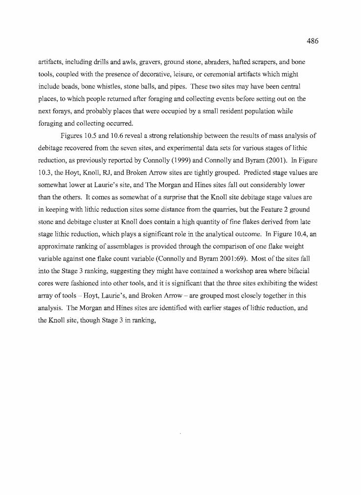
i. '
1:i'II'II
j ,
"
l .• I..
. I
,'j
,II!
iI.l
486
artifacts, including drills and awls, gravers, ground stone, abraders, hafted scrapers, and bone
tools, coupled with the presence of decorative, leisure, or ceremonial artifacts which might
include beads, bone whistles, stone balls, and pipes. These two sites may have been central
places, to which people returned after foraging and collecting events before setting out on the
next forays, and probably places that were occupied by a small resident population while
foraging and collecting occurred.
Figures 10.5 and 10.6 reveal a strong relationship between the results of mass analysis of
debitage recovered from the seven sites, and experimental data sets for various stages of lithic
reduction, as previously reported by Connolly (1999) and Connolly and Byram (2001). In Figure
10.3, the Hoyt, Knoll, RJ, and Broken Arrow sites are tightly grouped. Predicted stage values are
somewhat lower at Laurie's site, and The Morgan and Hines sites fall out considerably lower
than the others. It comes as somewhat of a surprise that the Knoll site debitage stage values are
in keeping with lithic reduction sites some distance from the quarries, but the Feature 2 ground
stone and debitage cluster at Knoll does contain a high quantity of fine flakes derived from late
stage lithic reduction, which plays a significant role in the analytical outcome. In Figure lOA, an
approximate ranking of assemblages is provided through the comparison of one flake weight
variable against one flake count variable (Connolly and Byram 2001:69). Most of the sites fall
into the Stage 3 ranking, suggesting they might have contained a workshop area where bifacial
cores were fashioned into other tools, and it is significant that the three sites exhibiting the widest
array of tools ~ Hoyt, Laurie's, and Broken Arrow - are grouped most closely together in this
analysis. The Morgan and Hines sites are identified with earlier stages of lithic reduction, and
the Knoll site, though Stage 3 in ranking,
487
.l;':
I
.......,.. .'1-Q)~
"i. .;: :j.
: 10 ", ~
-', ':, 0 •• 1
• ;r::\.: ,".11 .... ",,.
"
:j.
::.• .:1. .:t':·
• j'.'., ,'.:111
• ·1 Ill',
. •
Expel'l l1cntal .... tageFigure 10.5. The relationship of mass analysis results from the seven sites, to lithic
debris generated through staged experimental means(after Connolly andByram 2001). The graph indicates that lithic reduction at the Morgan
and Hines sites involved recently quarried tool stone

488
I', .
r
r:: -, .... 0'., '.
• lIlt: .
.=.:1 1111:.. .
•. : I ' ,I .. :..· "•.• I ...
.,-..",..-
...."
I'
.', .
0,:- : '.( I
(. ~ .
-',
'i
:. '_' I ~';': •• : . ! 11111 .::: ". ", :"'J ; ,
Figure 10.6. Scatter plot of flake weight and percentage,showing the relationship of thestudy site assemblages to lithic reduction stagesestablished with experimental data (after
Connolly andByram 2001). Laurie's, Broken Arrow, and Hoyt (base camps)are moreclosely associated in comparison to the task-specific sites.
is seen to have lithic reduction results that are distinct from other site assemblages in the same
category. The RJ site, though associated with a fairly specific range of activities, was also
inhabited for prolonged periods in conjunction with the root harvests, and may reflect a more
residential lithic assemblage as a result.
,I'I
l.
"• t
]1
489
The Sites in Relationship to Harney Valley Patterns ofMobility
As discussed previously, the seven sites reported in this study have site setting and
artifact assemblage characteristics that provide unique glimpses into the past 2000 years of
Harney Valley prehistory. The characteristics of each site also allow for comparisons on inter
and intra-site levels, and, upon the completion of such comparisons, allow researchers to begin
considering the sites in terms of subsistence and settlement systems and the possible behaviors
that motivate the spatial patterning of sites across the landscape.
The seven sites I have documented fit into a settlement pattern that includes task-specific
camps, male-dominated hunting sites, female-dominated broad-spectrum central base camps, and
winter sites positioned to take advantage of local amenities such as shelter, water, and fuel, as
well as stored foods. I believe the Hoyt, Laurie's, and Broken Arrow sites to be "central places",
or base camps positioned to better serve the needs of women and children. Despite dense and
varied accumulations ofartifacts at each of the three sites, I do not believe that they are winter
camps for reasons that are outlined below. The other four sites are more specific to certain kinds
of activities, quarrying, small game hunting, and some berry processing at the Knoll site; lithic
reduction, small game hunting, and plant processing at the Hines and Morgan sites; and root
collecting at the RJ site.
Whiting (1950), Couture (1978), and Couture et al. (1986), make it clear that a variety of
food items, both floral and faunal, factored into the diet of the Harney Valley native inhabitants.
Floral resources in particular played a prominent role in decisions that were made regarding the
allocation of labor and time. Because of the role that climatic vicissitudes played in the
availability of certain kinds of resources, even those which were often abundant, such as
geophytic roots, could be found in short supply when weather took a tum for the worse.
According to Couture, "it was explained to me that the Indian way oflife was patterned after the
lifestyIe of ants: It was proper to work from spring until fall, collecting food and wood, and store
it away in preparation for winter. Those that didn't do that would suffer the consequences
(Couture 1978:35)." As for the division oflabor, Couture (1978:37-38) offers the following:
"Hunting was the province ofmen, but women assisted in communal drives andalso took small game such as groundhogs. Men made the equipment for thehunt including the manufacture of stone tools, nets, and twisted the bark fiber
I
490
for cordage (Stewart 1941:389). They also prepared the willow trap for fishingwhile women cooperated in retrieving fish from the trap and prepared it fordrying. Women's role centered on domestic tasks, the gathering of wild plantsfor food, and the gathering of insects. The preparation of food for storage,hauling of wood and water, cooking, sewing, hide dressing, weaving of rabbitskin blankets, basketry, and cradleboard manufacturing were preeminently awoman's work. House building was a cooperative venture, with men setting theframe and women applying the covering.
The division of labor extended to children. Boys learned to hunt, maketheir own bows, arrows and sling shots, while girls learned to dress hides, sew,cook, prepare meat for drying, gathered roots tended small children, all inpreparation for a productive adult life."
It appears then, that productive roles among the Harney Valley Paiute were well
established and probably followed a pattern ofbehavior that had proven successful for thousands
ofyears. Even in good times, one had to be prepared for the worst that winter might bring. As
Aikens (1993:18) put it: "The natural setting to which Oregon's Great Basin peoples were
adapted was a rich one, extreme and demanding, yet generous to those who knew it well." One
reflection of that "knowing" is the variability in the artifact assemblages of the sites reported
here. In some instances, people came to places at certain times, for specific purposes. At other
times, it may be the case that they came to a particular area and positioned themselves to take
advantage of a suite of resources in the surrounding area. The south edge ofMalheur Lake is a
place where a variety ofresources are available within close range. Open lake, shallow marshes,
greasewood flats, dunes and grasslands, sagebrush steppe, and juniper-cloaked uplands are all
within a half day's walk. A day or more on foot will put people well on their way to areas of
major ecological transition; Duck Butte, Barren Valley, and the Stinkingwater Mountains to the
east, Steens Mountain to the south, thousands of square kilometers ofwetlands in Blitzen Marsh,
and many thousands more north of Malheur Lake. To the north beyond that were the great
expanses of upland root grounds, hunting areas, the streams from which salmon were taken, and
thousands of acres of camas between the lake and the foothills.
Do the seven archaeological sites reflect short term use for specific purposes, with limited
variation in tool kits, or longer term use with broad assemblages of tools (Figure 10.7) for a
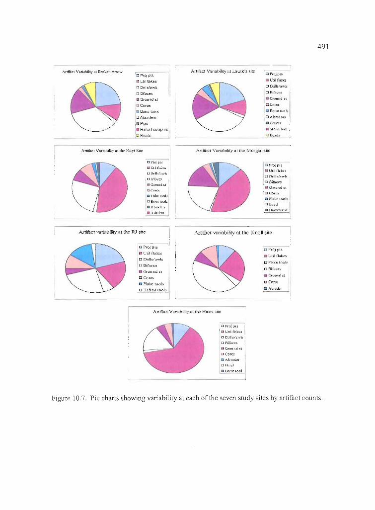
491
Artifuci Variability al Broken AITOw'0 PrOf piS
Utd flakes
o Dnlls/aYl.s
o Bilaces
Ground sl
o Cores
(J Bone lools
o Abraders
I PIpe
• t-iafted scrapers
o Beads
Allifucl Variability at Laurie's site o Projpls
C Util O(lkes
DDlill'\/<Iwls
.0 Bifact!>
• G:-ound $1
10 Cores
Bolle tools
:0 Abrndcrs
G-:lver
• SIOIlC b,IU
o Be.d,
Artimcl VariabIlity at the Hoyt Sile Artifact Variability at the Morgan site
o l'mJ piS
o l;lilllJkC:-i
o Drills/:Iwls
,0 Blfaccs
."mundSI
o Cores
Fl.lkc wol-.;
o Bone loob
• "br.:tdcr.-;
.Allall~
o PrOJ).lIS
o Util n<:lkc~
OOrills/awls
o girllecs
• Ground SI
. 0 Cores
Flake too Is
o Bcad
H;lITUTCr sl !
Artifact variability at the RJ site Arrifuct variability at the KnoU site
Anifac[ Variability at rhe Hines sire
o Proj pes
I Util fl~lkes
OOrillshlWls'
o Bifaccs
_Ground Sl
(] Cores
• Abr<ldcr
(:) SCOld
• Bone 1001
1
0 Proj pIS
UtilOOlkcs
o FI<lke 100ls
!O Bifaces
• Ground SI
o Cores
[] Abr;.ldefa Flake lools
o H:lftcu 100):..
----.!o Projpl5
I elilOakes
10 Drills/awls
,0 Bifaccs
.11 Ground st
:0 Cores
Figure 10.7. Pie charts showing variability at each of the seven study sites by artifact counts.
- •
r,
t
I1-
II.I
jiLd~ ; I,.
492
variety of tasks? The answer is, "both". As shown in Figure 10.7, the Hines, Morgan, Knoll and
RJ sites certainly contain a more limited range of tools than the Hoyt, Laurie's, or Broken Arrow
sites, and inferences drawn from the site setting, available resources, and associations of tools
indicate that fairly specific activities were occurring at these four sites, augmented, of course,
through other kinds of resource acquisition as permitted by time and opportunity. The Morgan
and Hines sites have an emphasis on lithic reduction activities, along with some small game
hunting and plant collecting. The RJ site is a substantial root camp, and the Knoll site is a
quarrying location at which some hunting and berry collecting may have occurred. The Knoll,
Morgan, and Hines sites reflect more male-dominated activities including lithic reduction and
hunting, though plant acquisition does factor into the use of each. The RJ site, as a root camp, is
considered to be dominated by female activities, though it is clear from Whiting's and other
accounts that entire families occupied the root camp during certain periods.
At the Hoyt, Laurie's, and Broken Arrow sites, a much broader range of artifacts are
present and artifact concentrations are significantly richer, indicating that occupations were
longer in duration and a variety of activities could have been taking place during stays there.
Based on the variation in artifacts and the richness of site deposits, among other aspects, I believe
that the Hoyt, Laurie's, and Broken Arrow sites fit the pattern of "central places" as described
initially by Raven (1990) and elaborated upon by Zeanah (2004) for the Carson Desert region.
These are sites that are either positioned by Malheur Lake and its associated marshlands, or in
areas where access to varied resources is assured. The activities at such places can be said to be
female-dominated by virtue of their placement, with access to a variety ofmarshland resources in
close proximity, and by the need for males to conduct logistical forays to areas more suitable for
hunting, tool stone acquisition, and other resources.
The Laurie's and Broken Arrow sites are located in an area fully exposed to the buffeting
of storms, and anyone who has camped near that part of the lake even as late as May can attest to
the ferocity of the winds there. At both sites, the archaeological deposits are rich and
concentrated, and they can exceed half a meter in depth. The stratigraphy at both sites indicates
that these are not complex accumulations, and radiocarbon dating indicates that there are
hundreds ofyears of deposition at best, not thousands. If the sites are winter villages, they
denote a relatively limited era of occupation, perhaps during a specific period of time when
climatic conditions were mild, and favorable to the widespread dispersal of village sites. At the
same time, a site does not necessarily have to be a winter village just because it is near the lake,
r493
and habitations where people stayed for more than a few weeks are bound to have considerable
accumulations of artifacts, especially if intensive resource procurement and processing is taking
place.
A better explanation is offered through the concept of central place foraging. The Broken
Arrow, Laurie's, and Hoyt sites are positioned at locations where a wide variety of floral and
faunal resources would have been available within a relatively short distance, and it may be the
case that a core group of inhabitants maintained a steady population at these locations while
others ventured out on a series of logistical forays in pursuit of various resources. As resource
productivity declined, a move could be made to the next location where such activities again
occurred or different strategies were employed. Central place foraging accounts for a variety of
situations which are otherwise not as readily explained, sexual division oflabor among them.
Zeanah's (2004) study of the Carson Desert region focuses on the sexual division of
labor, and suggests how different men's and women's roles lead to different kinds of
assemblages at sites used primarily by men or primarily by women. He utilizes information
derived from soils maps to identify the prehistoric range of various kinds of vegetation and, by
extension, available resources prior to landscape changes affected by the arrival of
Euroamericans. Recognizing a total of 41 soil-based habitats, he defined a series ofmen's and
women's prey sets from such habitats based on ethnographic information. He then examined the
foraging return rates for each prey set, including both floral and faunal resources, to determine
optimal prey sets for different men's and women's activites that can be categorized through
seasonal availability. Zeanah (2004:4) felt that hunting by males may not have been a
particularly efficient way ofprovisioning families and that the distribution of meat among the
village community probably served a purpose that was not focused on simple sustenance. As he
put it: "These questions arouse suspicion that Great Basin men and women foraged to achieve
different ends; men hunted because of the mating opportunities they gained by sharing meat,
whereas women gathered to provision their children (2004:4)."
Zeanah realizes that the subsistence efforts of a hunting and gathering band may not
exclusively be focused on optimal caloric returns, although the more efficient the return of
resources, the more natural selection benefits are conveyed to the population. Optimizing the
l ..\
j.
494
ability ofboth men and women to contribute to the common good while minimizing travel and
transport costs is not going to be entirely possible. Zeanah (2004:26) observes:
"It is clear that men's foraging returns are not crucial to determiningwhen and where hunting oriented settlement strategies may have occurred.Instead, the critical factor concerns women's requirement to reliably feed theirchildren. This was often best achieved by residing in women's best foragingpatches in the Late Holocene Great Basin, where temporal fluctuations inresource abundance often made food storage mandatory. Hunting must besufficiently productive and reliable to overcome women's provisioningconstraint for a hunting-oriented strategy to be favored. Otherwise, men shouldhunt logistically. Mere demonstration that higher hunting returns were feasiblein the past is insufficient basis for expecting a hunting-oriented economy tohave occurred. This is an important lesson in the Great Basin wherearchaeologists have often constructed models in which men's subsistencechoices either explicitly or implicitly drive prehistoric subsistence-settlementstrategies."
In Harney Valley, the best foraging patches for women would be near the marsh, at sites
such as Hoyt, Laurie's and Broken Arrow, where small mammals, waterfowl, and both xeric and
mesic plant species would be available within close range. At various times, the entire
population could be congregated there. At other times, groups could split away to carry out
hunting forays in the highlands, acquire tool stone in various places, or partake in a variety of
activites and tasks related to the day-to-day business of life. Resources that were being acquired
may not necessarily have been stored at the sites where they were initially obtained, but they may
have been processed there prior to storage elsewhere in preparation for winter.
In the case ofthe study sites, we can not look directly to the archaeological record to
identify items that tie the uplands and lowlands together except at Laurie's site, where mountain
mahogany was recovered among the botanical remains. Mountain mahogany was an important
resource for the manufacture ofhighly valued tools -- ranging from digging sticks, bows, and
atlatls, to projectile points -- that would have been transported over considerable distances and
kept for long periods of time. The deposition ofthis plant species in the house pits indicates
people who camped at Laurie's site had also visited the uplands on previous occasions.
We can also look at the range of variability within the site assemblages and the possible
implications regarding length and season of occupation to determine if the study sites might be
central places. Considering the variety of artifacts at the Hoyt, Laurie's and Broken Arrow sites,
,.r."r..
jl
•
495
the richness of the deposits, and the absence of complex stratigraphy that would show repeated
occupations occurring over extensive periods of time, I suggest that they represent central places
that served as residential bases for foraging populations. These populations transported a variety
of plant and animal resources to the sites, carried out a variety of processing activities in
association with the replenishment and maintenance of clothing, basketry, and weaponry, then
moved on to carry out other kinds of resource acquisition in preparation elsewhere for the coming
winter.
Centrally located base camps are not the expectation at all times of the year. The
correlation between Whiting's account of the seasonal round and the results of this
archaeological study, including the findings from the Hines, Morgan, Knoll, and RJ sites, prove
that. They are locations that would have been effective at certain times of the year, and
Whiting's description of the September congregations at Malheur Lake offer an example of such
behavior. The people arrived in time to wait for the ripening of the wada, and the collection of
other seeds occurred during that time, along with trips to the Crowcamp Hills to collect
chokecherries for processing in preparation for winter. The archaeological evidence at the
Laurie's and Broken Arrow sites attests to the collection of various seeds, and the faunal
evidence also indicates the availability of immature small mammals and waterfowl, which would
not have been have been so prevalent in winter game harvests. The Hoyt site, which also
operated as a central base camp, appears to have had a greater focus on the acquisition of faunal
resources, both large and small terrestrial species. The summer and late fall would have been the
best time for operating out of central places because of the potentially wide range of available
resources during that time of the year. Such places satisfy the likely need for a centralized
location where food and material stores coming in from afield could be accumulated, processed,
and watched over, as well as the need for a stable location where less mobile members of the
population, young and old, would remain while others traveled about.
In the spring, the entire population may have mobilized to participate in the upland root
gatherings, followed by passage northward to the Malheur River fishing camps. In the late
summer and fall, some went northward towards John Day for hunting and berry picking and
others would have moved toward the lake. As winter came on, people congregated in protected
areas where the essentials oflife were within easy reach, food stores were accumulated, and snow
did not get too deep.
I,
!i
JI
l.~~ :
IiIII1I
I''IIII,'II,
IiII'!I.
•
496
Why may Laurie's and Broken Arrow, though centrally located, not be winter village
sites? Because of their patterns of deposition, resource richness, and stratigraphic simplicity, as
well as ethnographically demonstrated requirements which they do not meet. A winter village
should be a place that has access to fresh water, fuel, and shelter from storms. There are some
locations that fulfill this set of standards on the margins ofMalheur Lake, of which the
Headquarters site is a particularly noteworthy example. The location of the site adjacent to Sod
House Spring and the Donner und Blitzen River provided fresh and abundant water and
supported the growth ofplant species needed for fuel. The topographic reliefprovided protection
from storms as well as campsites above flood stage. One would expect to find a complex
superposition of archaeological evidence indicating that aboriginal camps were revisited over
many millennia in such a place, given the appropriate geomorphic circumstances. That has
proven to be the case, as was shown through the numerous archaeological investigations that
have taken place there, particularly those of Thomas (1979), and Dugas and Bullock (1994).
Stratigraphic complexity was not as evident in other excavations at the Headquarters site,
probably due to the location of the work and the degree ofhistoric alteration that had occurred in
some places.
Undoubtedly, other locations in the vicinity ofMalheur Lake were also used as winter
camps. The McCoy Creek site (35HAI263) in Diamond Swamp has evidence of storage pits,
clay-lined house floors, deeply stratified deposits, and substantial quantities of ground stone
(Musil 1995), as does the Blitzen Marsh site (35HA9) reported by Fagan (1973). Another
probable winter village site was reported to me by property owners during the 2000 and 2001
field seasons. Located on the south shore ofMalheur Lake, the Mahoney site (known locally as
"Indian Town") is situated on a high shoreline adjacent to a spring, and artifacts recovered from
cultural deposits there span the Holocene. Specimens include one Clovis point, stemmed points,
crescents, a variety ofmiddle and late Holocene point types, and historic trade beads. The owner
reported that artifact bearing deposits in one place exceeded the reach ofhis backhoe
(approximately 12 feet) during utility trenching. The Crow Ranch, located just east ofthe
Headquarters site, is also situated near an artesian spring and may also be the site of a winter
camp. Artifacts found there range from at least one Clovis point to historic trade beads and
deposits there are reported to be deep and stratified.
497
Future Research in Harney Valley
This dissertation has evaluated seven prehistoric sites in the Harney Valley that were
occupied for various reasons during the last 2000 years. While it has elaborated on a period of
human activity that occurred primarily between 2000 BP and 650 BP, it has also provided a
broader evaluation, identifying areas of future archaeological research that will greatly benefit
our understanding of human behavior in the region.
Continuing research in later sites will further fill out our understanding of land use and
settlement. Large-scale archaeological investigations in the primary deposits ofknown winter
village locations such as the Headquarters or Blitzen Marsh sites would be immensely helpful for
developing a greater sense of scale regarding the archaeological constituents of such a site, and
the relationship of seasonally occupied central places and task-specific camps to them. Work at
task-specific camps where the likelihood exists of encountering evidence relating to the
processing of camas, grasses, fruits, nuts, and berries would also be useful for building a
balanced perspective on the kinds of artifact assemblages that should be expected in such places.
The same is true for sites where fishing occurred, both in lake and riverside settings, sites where
evidence of rabbit and antelope drives might be present, as well as those relating to bighorn
sheep, deer, and elk hunting, and perhaps places where crickets were once gathered.
The pre-2000 BP record ofhuman activity needs to be clarified by focused additional
research. The most productive approach in the near term will be quantitative distributional
studies ofprojectile point types across the Harney region, as a way of showing the kinds of
places favored by people at earlier periods. Targeted research in promising buried sites of earlier
periods will be key to filling out our understanding of these periods.
Establishing a context for the late Pleistocene-early Holocene period is vital to
understanding long term changes in human use of the area. Thomas and O'Grady (2006) already
have research under way to develop an overview of early sites and isolated finds that will
incorporate information from site forms, reports, and recorded isolates to build on this theme.
There are areas within the Harney Valley such as the "lakes district" northwest of Harney Lake
that have considerably higher frequencies of stemmed and fluted points, but the available
information has not yet been synthesized to date to provide insights about site placement on the
landscape, possible relationships of sites to ancient shorelines, and whether or not site placement
498
may convey infonnation about the effects of geomorphic processes or early patterns of human
land use. It is well known that large scale climatic changes occurred during the course ofthe
Holocene and even greater changes took place during the transition from the Pleistocene to the
Holocene. This knowledge factors into the decisions that Great Basin archaeologists make in
their search for early sites. Shorelines, terraces, and concentrations of dunes can all be traced to
geomorphic processes that were spawned from changing climatic events, some earlier and some
later, and a greater emphasis needs to be placed on testing sites located on such landfonns to get
a better grasp of the activities and specific dates during which they were occupied.
The middle Holocene, for the purposes of this discussion, encompasses a period ranging
from 7000 BP to 2000 BP and Northern Side-notched and Elko points are key diagnostic artifacts
found during the period. Important climatic events were at work in the Great Basin during the
middle Holocene, including a transition from dry conditions around 7000 BP, a sustained period
of greater effective moisture and abundant resources from 5000 to 3000 BP, then fluctuating
conditions until approximately 2000 BP. Large scale climatic changes undoubtedly affected
human use of the Harney Valley to a considerable degree, but how those transitions are
manifested in the archaeological record is not understood with sufficient depth. Infonnation
about the distributions of Northern Side-notched points within Harney Valley would be an
effective means oflooking at the patterns ofland use between 7000 and 4000 BP. Northern
Side-notched points are regular finds at all of the sites reported here, but there is little systematic
understanding of where sites that are dominated by this type ofpoint are situated.
Elko points are everywhere in the Harney Valley, a testimony to the attractiveness of the
region beginning around 5000 years ago. Considering that a period of greater effective moisture
was developing before that time and that lake levels would have been higher as a result, it is
expected that substantial village sites with dense concentrations of Elko points should be
encountered in association with high shorelines or other elevated land features. Oetting (1990 a
and b, 1999) witnessed concentrations of artifacts, including Elko points, on a previously
unprecedented scale during post flood surveys of Malheur National Wildlife Refuge lands in the
late 1980s, and he suggested that human use intensified in the region about 5000 BP. Significant
gains in our understanding of human use of the Harney Valley could be made by conducting test
excavations at sites dominated by Elko points located on shorelines well above modem lake
levels. Identifying and evaluating "Elko-specific" components, particularly components dating
between 4000 and 2000 BP, would shed light on the archaeology of the region after the use of
.....499
Northern Side-notched points had declined, and before the arrival ofbow and arrow technology.
Many Elko sites would have been positioned in relation to ever-changing shorelines, and were
likely affected to a great degree by lacustrine erosional processes.
Desert Side-notched points, which occur in the northern Great Basin after ca. 1000 BP,
are interesting from the standpoint that little geomorphic change has occurred since the points
were deposited, but the artifacts appear to be irregularly distributed within Harney Valley. Sites
dominated by these late Holocene points should tell us about aboriginal use of the area just prior
to historic contact.
Four periods could be evaluated through studies of the distributions of the temporally
diagnostic artifacts mentioned above: (ca. 12,000 - 8,000 BP for Paleo-Indian points, 7,000
4,000 BP for Northern Side-notched points, 6000 - 1000 BP for Elko points, and 1,000 BP to the
historic period for Desert Side-notched points). Systematic knowledge of the Paleo-Indian and
Northern Side-notched point distributions in particular will go far toward answering questions
regarding the effect that the dynamic lake system had on sites dating before 2,000 BP.
The concept of central places -- as described earlier utilizing concepts outlined in
Zeanah's (2004) work in the Carson Desert -- which has been used in the foregoing to identify
the principal reasons for the positioning of the Hoyt, Broken Arrow, and Laurie's sites, is one
that can also be expanded upon by studies of the diagnostic categories of artifacts listed above.
Identifying key sites that may have served as central places and task-specific sites that were
satellites, then conducting test excavations at each, will directly address the importance of central
place foraging over time.
If the distribution of sites containing Desert Side-notched points is markedly different
from sites pre-dating that period, and if the kinds of sites differ from the pattern ofwinter
villages, central places, and task specific sites suggested herein, then there is additional weight
behind the concept ofpopulation replacement and a pattern ofbehavior that reflects use of the
Harney Valley by people adapted to drier conditions after 1000 BP but operating in the same
general region.
This dissertation is focused on the 2000 to 650 BP period, in which Elko, Rose Spring,
and Eastgate points are found concurrently. Shifting the focus to Elko-specific sites occurring
between 4000 to 2000 BP will be necessary to expand the archaeological time depth of the region
with greater detail. Because of the ubiquity of Elko points throughout Harney Valley, it may be
more realistic to identify components ranging from 4000 to 2000 BP within multi-component
1
II
IiI
I
•
500
sites that would be suitable for the purpose, but identifying sites dating to that period alone would
be ideal.
The same is true for the distribution of sites containing Northern Side-notched points.
Northern Side-notched site distributions may suggest patterns ofbehavior based on adaptations to
a different suite of landforms and resources. It is true that all of the sites in this study contained
the points, but the Knoll site was the only location where they composed the majority of the
projectile point assemblage. A literature search of existing site forms and survey reports can be
carried out at the Bums District Bureau of Land Management to identify promising site locations.
Test excavations targeting Northern Side-notched sites in varied geographic settings will help to
address the utility of the central place foraging model for humans operating in the Harney Valley
during the early middle-Holocene period from 7000 to 4000 BP.
Only 11 fluted points have been recovered from Bums District Bureau of Land
Management property over the years, including several from the south shore of Malheur Lake
(Thomas and O'Grady 2006). None have been found in stratified deposits, but all are associated
with lakes, playas, and other hydrologic features. Efforts are currently underway to identify and
survey hydrologic features, including old shorelines, which might prove to be suitable locations
for Clovis-era sites. Five Western Clovis or Clovis variant points have been recovered in the last
six years of these surveys. Paleo-Indian sites containing Stemmed points are more common and
they are regularly encountered during surveys in the Harney Valley, particularly in association
with old playa shorelines. An inventory of Stemmed point sites and isolates, and Clovis isolates,
is being developed to explore the distribution of such artifacts across Bums District BLM lands
(O'Grady and Thomas 2006). The lack of stratified Paleo-Indian sites in the Harney Valley and
the limited number of studies that have been conducted on such sites (Bonstead 2000, Gehr 1980,
Wriston 2003) make this a challenging temporal category for exploring the concept of central
places, but our continuing efforts to discover and record early Holocene sites and isolates will
prove useful in building a framework for well informed discussions of long term human use of
the Harney Valley. The data indicate that people have been in the Harney Valley over a long
span of time, and they probably favored a few kinds oflocations. More work is needed to define
their presence more fully and allow consideration of what their early lifeway was like. It may be
that their "central places" were lakeshores and playas, but searching varied land surfaces in other
kinds of settings as well will be needed to show if that impression is likely to be correct.
501
The rich data base of obsidian sourcing and hydration data that has been constructed by
the Burns District Bureau of Land Management will be a tremendous resource for achieving a
better understanding of possible travel and transport routes through the region at different periods
of time, and possibly shed light on prehistoric territories. A more widespread study will be
helpful in understanding the relationship of populations in neighboring valleys and drainage
basins of archaeological importance -- such as the Catlow Valley, Warner Valley, Lake Abert
Chewaucan Marsh, Alkalai Lake, and Fort Rock Basin -- to the population residing in the Harney
Valley. Obsidian sourcing research has great potential for expanding our knowledge of intra
regional movements and extra-regional connections, and it is an area of research that yields high
returns in knowledge for the effort expended.
There is still considerable new research and much synthesis of the existing literature to be
done before we are in a position to speak confidently of long term archaeological trends in the
region, but the present research shows that continued efforts will yield fruitful and perhaps
occasionally surprising results.
ApPENDIX
GEOCHEMICAL SOURCING AND OBSIDIAN HYDRATIONSTUDIES AT THE HOYT, MORGAN, AND HINES SITES
A STUDY REPORT BY THOMAS J. CONNOLLY,MUSEUM OF NATURAL AND CULTURAL HISTORY,
UNNERSITY OF OREGON.USED WITH PERMISSION FROM THE AUTHOR
502
! ?
503
OBSIDIAN STUDIES
Obsidian Source Analysis
Each geologic source of obsidian tends to be quite homogeneous in its trace element composition,and distinct from other geologic sources; as a result, individual sources can be identified by trace elementgeochemistry. A number of techniques have been used to "fingerprint" obsidian sources, but x-rayfluorescence spectroscopy (XRF) is most commonly used because it is non-destructive, accurate, andrelatively inexpensive (Harbottle 1982; Rapp 1985; Williams-Thorpe 1995; Glascock et al. 1998; Herz andGarrison 1998). Patterns of obsidian source use in archaeological studies may help to identify specificactivity areas or tool manufacturing events at a site level, and, on a regional level, can inform onprocurement ranges, boundaries, travel routes, the curational value ofparticular formal artifact types, andthe presence of trade and exchange systems (Ericson 1981; Hughes 1978, 1990; Hughes and Bettinger1984).
Sourcing Results
A total of365 obsidian specimens from the Hoyt (35HA2422), Morgan (35HA2423), and Hines(35HA2692) sites were submitted for XRF analysis to Geochemical Research Laboratory in Portola Valley,California (Hughes 1996) or Northwest Research Obsidian Studies Laboratory in Corvallis, Oregon(Skinner et al. 1996, 1998). This number includes 20 projectile points and 108 pieces of flake debitagefrom the Hines site, 11 projectile points and 59 flakes from the Morgan site, and 29 projectile points, 28other bifaces, and 110 flakes from the Hines site. Geochemical source assignments are identified in Tables1 through 3.
In some cases, the precision of geochemical source typing exceeds the practical reality of obsidiandistributions, especially in the case of overlapping secondary deposits of obsidian that originally derivedfrom separate vents. A number of distinct geochemical source types represented in the present data set aremembers of such proximate and geochemically related source groups (Figure 1).
The Dog Hill, Skull Creek (also known as the Mud Ridge source), Rimrock Spring, and BurnsButte (also known as the Bums or Radar Hill source) sources all derive from the hills west and northwest ofthe modem community of Bums. These distinct geochemical types generally occur from north to south aslisted (i.e., the Dog Hill source is centered ca. 15 km northwest of Bums and the Bums Butte source iscentered immediately west of Bums), but obsidian from these sources occur as float cobbles over broadlyoverlapping areas, and along the drainage of Silvies River.
A number of distinct geochemical types occur along the drainage of Silver Creek, at a distance ofca. 40 to 50 km west and southwest of Bums including, from north to south, the Chickahominy, Riley, BuckSpring, and Double 0 obsidian types. These obsidians occur as local outcrops, but also occur as floatmaterial over broad areas. Buck Spring obsidian, in particular, appears to be associated with thewidespread Rattlesnake ashflow tuff, which covers a vast area from Warner Valley to the John Day Riverbasin. Despite the widespread occurrence of this material, it is not common in archaeological contexts,possibly due to its variable toolstone qualities.
A large complex of obsidian sources is found in and around Bear Creek Valley east of Seneca,Oregon, an obsidian source area ca. 60 to 70 km north of Bums, including obsidian of theWhitewater Ridge, Little Bear Creek, and WolfCreek geochemical types identified in the present data set.These geochemical types also occur in the gravels of the Silvies River to the south of the source area.
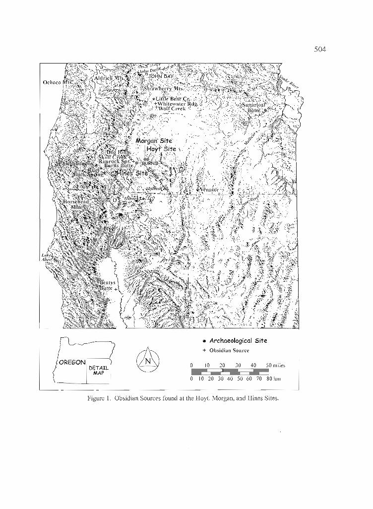
504
• Archaeological Site
®+ Obsidian Soul·ce
DETAIL 0 10 20 10 40 50 miles
MAP0 10 20 30 40 50 60 70 80 kill
Figure 1. Obsidian Sources found at the Hoyt, Morgan, and Hines Sites.
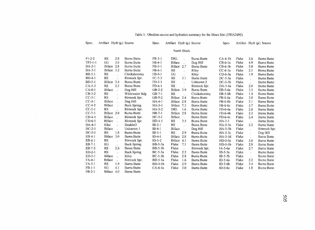
• .- - - ._.. Oq_ no'. • • == . On • 1
Table I. Obsidian source and hydration summary for the Hines Site (35HA2692).
Spec. Artifact Hydr (IJ.) Source Spec. Artifact Hydr (IJ.) Source Spec. Artifact Hydr (IJ.) Source
North Block
PI-2-2 RS 2.8 Bums Butte FB-3-1 DRL Bums Butte CA-6-lb Flake 2.6 Bums ButteTP3-1-1 EG 3.0 Bums Butte FB-4-1 Biface Dog Hill CB-6-la Flake 4.9 Bums ButteBA-2-1 Biface 2.8 Bums Butte FB-5-1 Biface 2.7 Bums Butte CB-6-lb Flake 5.0 Bums ButteBA-3-1 Biface 3.2 Bums Butte FB-6-1 RS Riley CC-6-la Flake 2.1 Burns Butte1313-5-1 RS Chickahominy FB-9-1 EG Riley CD-6-3a Flake 1.9 Bums Butte130-4-1 RS Rimrock Spr. FC-7-3 RS 3.1 Bums Butte DC-3-3a Flake Bums Butte130-5-1 Biface 3.4 Bums Butte FD-5-1 RS Unknown 2 DC-3-3b Flake Bums ButteCA-5-3 RS 2.3 Bums Butte FD-6-1 RS Rimrock Spr. DA-3Aa Flake 2.0 Bums ButteCA-8-1 Biface Dog Hill GB-2-2 Biface 3.9 Bums Butte EB-5-6a Flake 3.3 Bums ButteCB-3-2 RS Whitewater Rdg GB-7-1 RS Chickahominy EB-5-6b Flake 1.4 Bums ButteCC-3-1 RS Rimrock Spr. GB-9-2 Biface 2.4 Bums Butte FB-6-6a Flake 3.0 Bums ButteCC-4-1 Biface Dog Hill HAA-I Biface 2.8 Bums Butte FB-6-6b Flake 3.1 Bums ButteCC-4-2 Biface Buck Spring HA-5-1 Biface 7.3 Bums Butte FB-6-6c Flake 3.7 Bums ButteCC-5-1 RS Rimrock Spr. HA-5-2 DRL 1.6 Bums Butte FD-6-4a Flake 2.6 Bums ButteCC-7-1 Biface 2.0 Bums Butte HB-7-1 Biface 2.8 Bums Butte FD-6-4b Flake 2.3 Burns ButteCD-4-1 Biface Rimrock Spr. HC-5-1 Biface Bums Butte FD-6-4c Flake 2.4 Bums ButteCD-6-1 Biface Rimrock Spr. HD-4-1 RS 3.5 Bums Butte HA-3-1 Flake Bums ButteDAA-I Elko DoubleD 18-2-1 RS Bums Butte HA-5-3a Flake 2.2 Bums ButteDC-2-1 Biface Unknown I 18-4-1 Biface Dog Hill HA-5-3b Flake Rimrock Spr.DC-5-1 RS 1.8 Bums Butte 18-5-1 RS 2.9 Bums Butte HA-5-3c Flake Dog HillEBA-I Biface 3.0 Bums Butte 10-4-1 Biface 2.8 Bums Butte HA-5-3d Flake Bums ButteEB-6-1 RS Rimrock Spr. 1D-5-2 Biface 4.1 Bums Butte HD-5-3a Flake 3.6 Bums ButteEB-7-1 EG Buck Spring BB-5-3a Flake 7.1 Bums Butte HD-5-3b Flake 2.8 Bums ButteEB-7-2 RS 2.6 Bums Butte BB-5-3b Flake Rimrock Spr. IA-5-6a Flake 2.7 Bums ButteED-2-1 RS Buck Spring BC-5-3a Flake 2.5 Bums Butte 18-5-3a Flake Bums ButteED-3-1 Biface Riley BC-5-3b Flake 2.8 Bums Butte 18-5-3b Flake Bums ButteFAA-I Biface Rimrock Spr. BD-5-la Flake 1.6 Bums Butte 1D-5-6a Flake 2.2 Bums ButteFA-5-1 RS 1.9 Bums Butte BD-5-lb Flake 2.9 Bums Butte 1O-5-6b Flake 3.4 Bums ButteFB-I-I EG 4.1 Bums Butte CA-6-la Flake 3.0 Bums Butte 1D-5-6c Flake 1.8 Bums ButteFB-2-1 Biface 4.0 Bums Butte
VIoVI
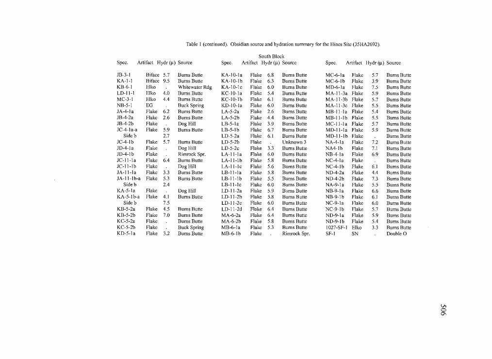
r----- n_._ _ .. __ ' .C_~
Table I (continued). Obsidian source and hydration summary for the Hines Site (35HA2692).
South BlockSpec. Artifact Hydr (11) Source Spec. Artifact Hydr (11) Source Spec. Artifact Hydr (11) Source
JB-3-1 Biface 5.7 Bums Butte KA-IO-Ia Flake 6.8 Bums Butte MC-6-la Flake 5.7 Burns BulleKA-l-l Biface 9.5 Bums BUlle KA-10-lb Flake 6.3 Bums Butte MC-6-lb Flake 3.9 Bums BulleKB-6-1 Elko Whitewater Rdg KA-10-1c Flake 6.0 Bums Butte MD-6-la Flake 7.5 Bums ButteLD-II-1 Elko 4.0 Bums Butte KC-1O-1a Flake 5.4 Bums Butte MA-11-3a Flake 5.9 Bums BUlteMC-3-1 Elko 4.4 Bums Butte KC-lO-Ib Flake 6.1 Bums Butte MA-11-3b Flake 5.7 Bums BulleNB-5-1 EO Buck Spring KD-IO-la Flake 6.0 Bums Butte MA-11-3c Flake 5.5 Bums BulleJA-4-la Flake 6.2 Bums Butte LA-5-2a Flake 2.6 Bums Butte MB-l1-1a Flake 5.4 Bums BulleJB-4-2a Flake 2.6 Bums Butte LA-5-2b Flake 4.4 Bums Butte MB-Il-Ib Flake 5.5 Bums BulleJB-4-2b Flake Dog Hill LB-5-la Flake 3.9 Bums Butte MC-II-Ia Flake 5.7 Bums ButteJC-4-la-a Flake 5.9 Bums Butte LB-5-lb Flake 6.7 Bums Butte MD-ll-1a Flake 5.9 Bums Bulle
Sideb 2.7 LD-5-2a Flake 6.1 Bums Butte MD-ll-lb Flake Bums BulleJC-4-lb Flake 5.7 Bums Butte LD-5-2b Flake Unknown 3 NA-4-1a Flake 7.2 Bums BulleJD-4-la Flake Dog Hill LD-5-2c Flake 3.3 Bums Bulle NA4-lb Flake 7.1 Bums ButteJD-4-lb Flake Rimrock Spr. LA-ll-Ia Flake 6.0 Bums Bulle NB-4-la Flake 6.9 Bums BulteJC-l1-1a Flake 6.4 Bums Butte LA-ll-1b Flake 5.8 Bums Bulle NC-4-la Flake Bums ButteJC-ll-Ib Flake Dog Hill LA-ll-lc Flake 5.6 Bums Butte NC-4-lb Flake 6.1 Bums BulleJA-II-Ia Flake 3.3 Bums Butte LB-ll-la Flake 5.8 Bums Bulle ND-4-2a Flake 4.4 Bums BulleJA-ll-Ib-a Flake 5.3 Bums Butte LB-l1-1b Flake 5.5 Bums Butte ND-4-2b Flake 7.3 Bums Butte
Sideb 2.4 LB-II-lc Flake 6.0 Bums Butte NA-9-1a Flake 5.5 Bums BulleKA-5-1a Flake Dog Hill LD-Il-2a Flake 5.9 Bums Butte NB-9-la Flake 6.6 Bums BulleKA-5-1 b-a Flake 4.1 Burns Butte LD-11-2b Flake 5.8 Bums Butte NB-9-1b Flake 6.1 Bums Butte
Sideb 7.5 LD-11-2c Flake 6.0 Bums Butte NC-9-la Flake 6.0 Bums BulleKB-5-2a Flake 4.5 Bums Butte LD-11-2d Flake 6.4 Bums Bulle NC-9-lb Flake 5.7 Bums ButteKB-5-2b Flake 7.0 Bums Butte MA-6-2a Flake 6.4 Bums Butte ND-9-1a Flake 5.9 Bums BulleKC-5-2a Flake Bums BUlte MA-6-2b Flake 5.8 Bums Bulle ND-9-lb Flake 5.4 Bums BulleKC-5-2b Flake Buck Spring MB-6-1a Flake 5.3 Bums Butte 1027-SF-l Elko 3.3 Bums ButteKD-5-1 a Flake 3.2 Bums Butte MB-6-lb Flake Rimrock Spr. SF-l SN Double 0
VIo0\
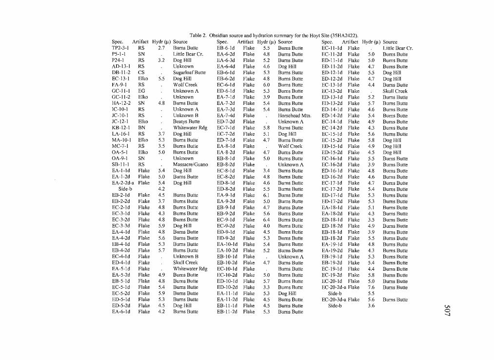
~---------
I
--------.-----
Table 2. Obsidian source and hydration summary for the Hoyt Site (35HA2422).Spec. Artifact Hydr (11) Source Spec. Artifact Hydr (11) Source Spec. Artifact Hydr (11) SourceTP2-3-1 RS 2.7 Bums Butte EB-6-ld Flake 5.5 Burns Butte EC-II-Id Flake Little Bear Cr.P5-1-1 SN Little Bear Cr. EA-6-2d Flake 4.8 Bums Butte EC-II-2d Flake 5.0 Bums ButteP24-1 RS 3.2 Dog Hill EA-6-3d Flake 5.2 Bums Butte ED-11-ld Flake 5.0 Bums ButteAD-13-1 RS Unknown EA-6-4d Flake 4.6 Dog Hill ED-II-2d Flake 4.7 Bums ButteDB-II-2 CS Sugarloaf Butte EB-6-ld Flake 5.3 Bums Butte ED-12-1d Flake 5.5 Dog HillEC-13-1 Elko 5.5 Dog Hill EB-6-2d Flake 4.8 Bums Butte ED-12-2d Flake 4.7 Dog HillFA-9-1 RS WolfCreek EC-6-ld Flake 6.0 Bums Butte EC-13-ld Flake 4.4 Bums ButteGC-11-1 EG Unknown A ED-6-ld Flake 5.3 Bums Butte EC-13-2d Flake Skull CreekGC-II-2 Elko Unkno\'/n EA-7-1d Flake 3.9 Bums Butte ED-13-ld Flake 5.2 Bums ButteHA-12-2 SN 4.8 Bums Butte EA-7-2d Flake 5.4 Bums Butte ED-13-2d Flake 5.7 Bums ButteIC-IO-1 RS Unknown A EA-7-3d Flake 5.4 Bums Butte ED-14-1d Flake 4.6 Bums ButteJC-lO-I RS Unknown B EA-7-4d Flake Horsehead Mm. ED-14-2d Flake 5.4 Bums ButteJC-12-1 Elko Beatys Butte ED-7-2d Flake Unknown A EC-14-1d Flake 4.9 Burns ButteKB-12-1 BN Whitewater Rdg EC-7-1d Flake 5.8 Bums Butte EC-14-2d Flake 4.3 Bums ButteLA-16-1 RS 3.7 Dog Hill EC-7-2d Flake 5.1 Dog Hill EC-15-ld Flake 5.6 Bums ButteMA-IO-I Elko 5.3 Burns Butte ED-7-ld Flake 4.7 Burns Butte EC-15-2d Flake 5.8 Dog HillMC-7-1 RS 3.5 Bums Butte EA-8-ld Flake WolfCreek ED-15-ld Flake 4.9 Dog HillOA-5-1 Elko 5.0 Bums Butte EA-8-2d Flake 4.7 Bums Butte ED-15-2d Flake 4.5 Dog HillOA-9-1 SN Unknown EB-8-1 d Flake 5.0 Bums Butte EC-16-ld Flake 5.5 Bums ButteSB-ll-I RS Massacre/Guano EB-8-2d Flake Unknown A EC-16-2d Flake 3.9 Bums ButteEA-I-Id Flake 5.4 Dog Hill EC-8-ld Flake 3.4 Bums Butte ED-16-ld Flake 4.8 Bums ButteEA-1-2d Flake 5.0 Bums Butte EC-8-2d Flake 4.8 Bums Butte ED-16-2d Flake 4.6 Bums ButteEA-2-2d-a Flake 5.4 Dog Hill ED-8-1d Flake 4.6 Bums Butte EC-17-ld Flake 4.7 Bums Butte
Side-b 4.2 ED-8-2d Flake 5.5 Bums Butte EC-17-2d Flake 5.4 Bums ButteEB-2-ld Flake 4.5 Burns Butte EA-9-ld Flake 6.1 Bums Butte ED-17-1 d Flake 5.3 Bums ButteEB-2-2d Flake 3.7 Bums Butte EA-9-2d Flake 5.0 Burns Butte ED-17-2d Flake 5.3 Bums ButteEC-2-ld Flake 4.8 Bums Butte EB-9-ld Flake 4.7 Burns Butte EA-18-ld Flake 5.1 Burns ButteEC-3-ld Flake 4.3 Bums Butte EB-9-2d Flake 5.6 Bums Butte EA-18-2d Flake 4.3 Burns ButteEC-3-2d Flake 4.8 Bums Butte EC-9-1d Flake 6.4 Bums Butte ED-18-1 d Flake 3.5 Bums ButteEC-3-3d Flake 5.9 Dog Hill EC-9-2d Flake 4.0 Bums Butte ED-18-2d Flake 4.9 Bums ButteEA-4-1d Flake 4.8 Bums Butte ED-9-1d Flake 4.5 Bums Butte EB-18-1d Flake 3.9 Bums ButteEA-4-2d Flake 5.6 Bums Butte ED-9-2d Flake 5.3 Bums Butte EB-18-2d Flake 5.5 Burns ButteEB-4-ld Flake 5.3 Burns Butte EA-lO-ld Flake 5.4 Bums Butte EA-19-ld Flake 4.8 Bums ButteEB-4-2d Flake 5.7 Bums Butte EA-lO-2d Flake 5.2 Bums Butte EA-19-2d Flake 4.3 Bums ButteEC-4-1d Flake Unkno\'/Il B EB-lO-ld Flake Unkno\'/Il A EB-19-ld Flake 5.3 Bums ButteED-4-1d Flake Skull Creek EB-10-2d Flake 4.7 Bums Butte EB-19-2d Flake 5.4 Bums ButteEA-5-1d Flake Whitewater Rdg EC-IO-ld Flake Bums Butte EC-19-1d Flake 4.4 Bums ButteEA-5-2d Flake 4.9 Bums Butte EC-10-2d Flake 5.0 Bums Butte EC-19-2d Flake 5.8 Bums ButteEB-5-1d Flake 4.8 Bums Butte ED-IO-ld Flake 5.7 Burns Butte EC-20-1d Flake 5.0 Bums ButteEC-5-1d Flake 5.4 Bums Butte ED-10-2d Flake 3.3 Bums Butte EC-20-2d-a Flake 7.6 Bums ButteEC-5-2d Flake 5.9 Bums Butte EA-ll-ld Flake 5.3 Dog Hill Side-b 5.5ED-5-ld Flake 5.3 Burns Butte EA-II-2d Flake 4.5 Bums Butte EC-20-3d-a Flake 5.6 Bums ButteED-5-2d Flake 4.5 Dog Hill EB-II-ld Flake 4.5 Burns Butte Side-b 3.6 VIEA-6-1d Flake 4.2 Bums Butte EB-11-2d Flake 5.3 Bums Butte 0
--...l
-. -----=2!IIII!l
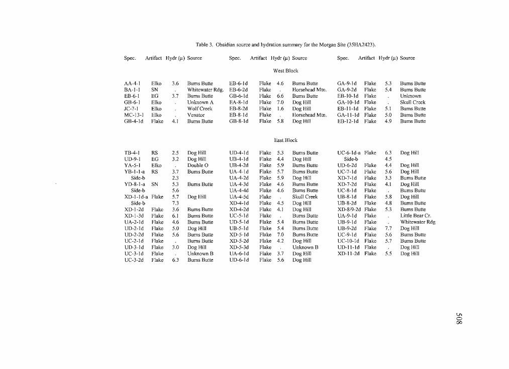
----_..._---- ----=-~-._.---.--. -... --.---.-------- ._.~:=~__'.__ .c 4
Table 3. Obsidian source and hydration summary for the Morgan Site (35HA2423).
Spec. Artifact Hydr (~) Source Spec. Artifact Hydr (~) Source Spec. Artifact Hydr (~) Source
West Block
AA-4-1 Elko 3.6 Bums Butte EB-6-1 d Flake 4.6 Bums Butte GA-9-ld Flake 5.3 Bums ButteBA-I-I SN Whitewater Rdg. EB-6-2d Flake Horsehead Mtn. GA-9-2d Flake 5.4 Bums ButteEB-6-1 EG 3.7 Bums Butte GB-6-ld Flake 6.6 Bums Butte EB-IO-Id Flake UnknownGB-6-1 Elko Unknown A EA-8-ld Flake 7.0 Dog Hill GA-IO-Id Flake Skull CreekJC-7-1 Elko WolfCreek EB-8-2d Flake 1.6 Dog Hill EB-Il-Id Flake 5.1 Bums ButteMC-13-1 Elko Venator EB-8-ld Flake Horsehead Mtn. GA-II-Id Flake 5.0 Bums ButteGB-4-ld Flake 4.1 Bums Butte GB-8-ld Flake 5.8 Dog Hill EB-12-ld Flake 4.9 Bums Butte
East Block
TB-4-1 RS 2.5 Dog Hill UD-4-ld Flake 5.3 Bums Butte UC-6-ld-a Flake 6.3 Dog HillUD-9-l EG 3.2 Dog Hill UB-4-ld Flake 4.4 Dog Hill Side-b 4.5YA-5-1 Elko Double 0 UB-4-2d Flake 5.9 Bums Butte UD-6-2d Flake 4.4 Dog HillYB-I-I-a RS 3.7 Bums Butte UA-4-ld Flake 5.7 Bums Butte UC-7-ld Flake 5.6 Dog Hill
Side-b 2.3 UA-4-2d Flake 5.9 Dog Hill XD-7-ld Flake 3.3 Bums ButteYD-8-I-a SN 5.3 Bums Butte UA-4-3d Flake 4.6 Bums Butte XD-7-2d Flake 4.1 Dog Hill
Side-b 5.6 UA-4-4d Flake 4.6 Bums Butte UC-8-ld Flake Bums ButteXD-I-I d-a Flake 5.7 Dog Hill UA-4-5d Flake Skull Creek UB-8-ld Flake 5.8 Dog Hill
Side-b 7.3 XD-4-ld Flake 4.5 Dog Hill UB-8-2d Flake 4.8 Bums ButteXD-I-2d Flake 3.6 Bums Butte XD-4-2d Flake 4.1 Dog Hill XD-8/9-2d Flake 5.3 Bums ButteXD-1-3d Flake 6.1 Bums Butte UC-5-ld Flake Bums Butte UA-9-ld Flake Little Bear Cr.UA-2-ld Flake 4.6 Bums Butte UD-5-ld Flake 5.4 Bums Butte UB-9-ld Flake Whitewater RdgUD-2-ld Flake 5.0 Dog Hill UB-5-ld Flake 5.4 Bums Butte UB-9-2d Flake 7.7 Dog HillUD-2-2d Flake 5.6 Bums Butte XD-5-ld Flake 7.0 Bums Butte UC-9-ld Flake 5.6 Bums ButteUC-2-ld Flake Bums Butte XD-5-2d Flake 4.2 Dog Hill UC-IO-ld Flake 5.7 Bums ButteUD-3-ld Flake 3.0 Dog Hill XD-5-3d Flake Unknown 13 UD-II-Id Flake Dog HillUC-3-ld Flake Unknown 13 UA-6-ld Flake 3.7 Dog Hill XD-II-2d Flake 5.5 Dog HillUC-3-2d Flake 6.3 Bums Butte UD-6-ld Flake 5.6 Dog Hill
Vlo00
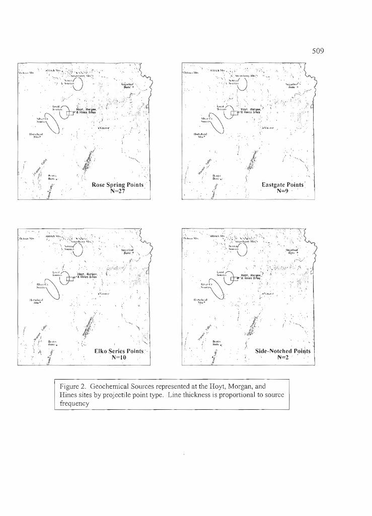
509
.J
···.\I,' .. i..h.\lh
,.O....,J...;'.ur..·.. '
\j~"l~ ..:~.~-'~a~;nc~\~~~~ t.<
(,;Ih ... (,. ~ ._
""""\ \ -"" ... \,,,.c"r
Illlr-,hlld\II,,+-
. i
,(
'\ ;'\ .. J
{
Rose Spring Points'N=27 .
I' t~', 7~.' -to
• .', • I' .f-------------'
/}
~$C'
.\ :~
.:f";'~~ -
rk'll."OUll'·.:
Eastgate Points:N=9 '
'j •.."
'iUl.:,JrI..~"1l~11.· ~
.....
I ' .:~(. I'. ',.''o .1. : .'
\j~':;r~:t~~;~nt~~r~1 ~ ....
S,h."(1" ~ , ~.,.. u.... ..... \,".1"
Il,r.rh,,,l\!B.+-
<,
",.\Ui~l1Il!lf
!lull,· •
~'..~•. i/."'. . 'J;-,I;::;I::(P' ..HO'fl. Mc-rga"
..... & ~lncs Situ
"',,,C\' .'""""\j
II"ro.h,"1.\1"'+
" ,.'
. 0.1l".·.. \\r'
Side-Notched Poi~tsN=2 ' .
, \......
"
Elko Series Points'N=IO
"'"
(
Figure 2. Geochemical Sources represented at the Hoyt, Morgan, andHines sites by projectile point type. Line thickness is proportional to sourcefrequency
11
!1
J:,jIiii
I I
I i!
I
II, iI
I:Ii
I!
I
l~ _ •
510
These geochemical types have overlapping distributions, and in some cases are geochemicallysimilar to one another. Skinner (1999) notes that initial trace element studies suggested that WhitewaterRidge and Little Bear Creek geochemical types were distinguishable based on Strontium values (Hughes1995; Skinner 1995), but analysis of additional source samples has resulted in the grouping of these types,and has led Skinner to consider these a single chemical source, albeit one with a considerable range ofcompositional variability.
The other sources represented in the obsidian record from the Hoyt, Morgan, and Hines sites aredistant, located outside of the Harney Basin. Horsehead Mountain is located ca. 65 km southwest of Burns,and the Venator source is ca. 65 miles (108 km) southeast of Bums in the upper Malheur River drainagebasin. The other identified sources, all well over 100 km distant from the project area, include SugarloafButte (ca. 135 km northeast), Beatys Butte (135 km south), and the Massacre Lake/Guano Valley source(ca. 175 km south).
Mobile hunting and gathering people generally carried with them a tool kit ofportable hunting andfood processing tools, including bifaces, finished projectile points and other equipment. Such tools weremade at base camps, and could be carried considerable distances before being lost or replaced. In areaswhere quality tool stone was available in abundance, as in the vicinity of the Hoyt, Morgan, and Hinessites, quantities of exotic tool stone material in unfinished form would not be transported far. Sourcinginformation for formed tools and debitage are tabulated separately (Table 4), and exhibit an expectedpattern; obsidian from the local sources accounts for 96% or more of all sourced debitage in eachcomponent, while the proportion of exotic material ranges from 14% to 60% of the formed toolassemblage.
One of the main reasons for geochemically sourcing a quantity ofdebitage, given the expectedpredominantly local profile, is to confirm a large sample of specimens from a single source to control forthe effects of geochemical variability in obsidian hydration analysis. The formed tool assemblage is muchmore useful for identifying changing patterns of source use variability and direction, and is the focus of thefollowing discussion. It should be noted that projectile point sample sizes in all components are relativelysmall, so the patterns discussed below should be considered tentative.
Three of the five analytic units shown in Table 4-Hines South, Morgan West, and the Hoytsite-have Elko and side-notched projectile points representing 50% or more of the point assemblage. It isthese same three components that exhibit the highest proportions of non-local tool stone, 43% or greater.The two components containing a predominance oflate period Rose Spring and Eastgate points-MorganEast and Hines North-also have the smallest proportions (20% or less) exotic tool stone material.
This pattern is upheld by examining source location by projectile point types from all components,as shown in Table 5. At least 50% of all Elko and side-notched projectile points derive from distantsources, and the average distance to source for both types is greater than 30 km. Although the sample sizesare relatively small for these types, the diversity of obsidian types, including a number of distant sources, isnotable. The source location of side-notched points made from exotic obsidian is exclusively to the north.Elko points were made from exotic material deriving from diverse areas to the north, and throughout theHarney and adjacent basins to the south and southeast.
In contrast to the earlier point styles, 65% ofRose Spring projectile points were made from localobsidian. A surprising number ofRose Spring and Eastgate points derive from the Silver Creek sources tothe west, sources not represented in the Elko and side-notched types. Average source distance for RoseSpring and Eastgate points is less than 30 km.
These patterns suggest somewhat greater mobility over larger ranges in the earlier period, prior toabout 1500 years ago when side-notched and Elko dart points were predominant. The greater reliance onlocal tool stone sources during the last 1500 years suggests the possible presence of a more local residentpopulation, and regular use of the sources along the Silver Creek drainage.
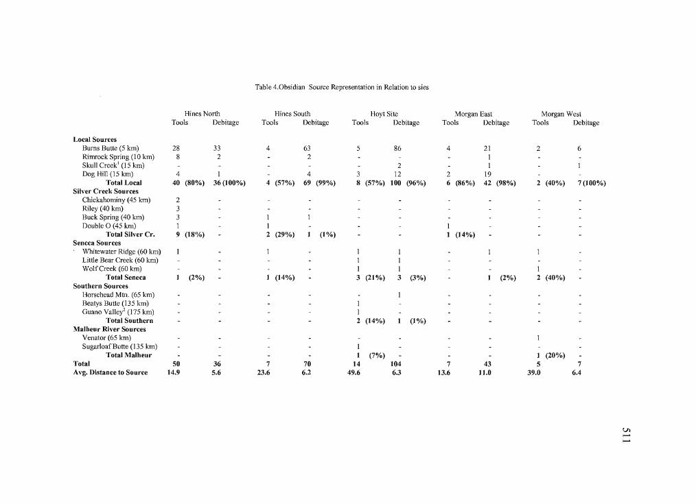
---------------_.. ~~~-- - ~- 1M __• __ • __ • •
Table 4.0bsidian Source Representation in Relation to sies
Hines North Hines South Hoyt Site Morgan East Morgan West
Tools Debitage Tools Debitage Tools Debitage Tools Debitage Tools Debitage
Local SourcesBums Butte (5 km) 28 33 4 63 5 86 4 21 2 6Rimrock Spring (10 km) 8 2 2 1Skull Creek' (15 km) 2 1Dog Hill (15 km) 4 1 4 3 12 2 19
Total Local 40 (80%) 36 (100%) 4 (57%) 69 (99%) 8 (57%) 100 (96%) 6 (86%) 42 (98%) 2 (40%) 7(100%)
Silver Creek SourcesChickahominy (45 km) 2Riley (40 km) 3Buck Spring (40 km) 3 1Double 0 (45 km) 1 1
Total Silver Cr. 9 (18%) - 2 (29%) I (1%) - I (14%)Sencca Sources
Whitewater Ridge (60 km) 1 1 I 1Little Bear Creek (60 km) 1 IWolfCreek (60 km) 1 1 1
Total Seneca I (2%) I (14%) - 3 (21%) 3 (3%) I (2%) 2 (40%)
Southern SourcesHorsehead Mm. (65 km)Beatys Butte (135 km) 1Guano Vallei (175 km) 1
Total Southern - 2 (14%) I (1%)Malheur River Sources
Venator (65 km)Sugarloaf Butte (135 km) 1
Total Malheur I (7%) - I (20%)
Total 50 36 7 70 14 104 7 43 5 7Avg. Distance to Source 14.9 5.6 23.6 6.2 49.6 6.3 13.6 11.0 39.0 6.4
VI,......,......
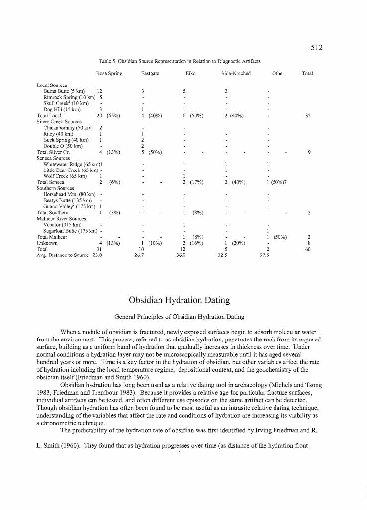
512
Table 5 Obsidian Source Representation in Relation to Oiagnostic Artifacts
Rose Spring Eastgate Elko Side-Notched Other Total
Local SourcesBums Butte (5 km) 12 3 5 2Rimrock Spring (10 km) 5Skull Creek! (10 krn)Dog Hill (15 km) 3 1 I
Total Local 20 (65%) 4 (40%) 6 (50%) 2 (40%)- 32Silver Creek Sources
Chickahominy (50 km) 2Riley (40 krn) 1 1Buck Spring (40 km) 1 2Double 0 (50 km) 2
Total Silver Cr. 4 (13%) 5 (50%) 9Seneca Sources
Whitewater Ridge (65 km)1Little Bear Creek (65 km) -WolfCreek (65 km) 1 I
Total Seneca 2 (6%) 2 (17%) 2 (40%) 1 (50%)7Southern Sources
Horsehead Mtn. (80 km) -Beatys Butte (135 km)
ilGuano ValleY' (175 km)
Total Southern (3%) (8%) 2
11
Malheur River SourcesVenator (015 km)Sugarloaf Butte (175 km) -
:1Total Malheur I (8%) (50%) 2Unknown 4 (13%) 1 (10%) 2 (16%) 1 (20%) 8Total 31 10 12 5 2 60Avg. Distance to Source 23.0 26.7 36.0 32.5 97.5
Obsidian Hydration Dating
General Principles of Obsidian Hydration Dating
When a nodule ofobsidian is fractured, newly exposed surfaces begin to adsorb molecular waterfrom the environment. This process, refened to as obsidian hydration, penetrates the rock from its exposedsurface, building as a unifonn band of hydration that gradually increases in thickness over time. Undernonnal conditions a hydration layer may not be microscopically measurable until it has aged severalhundred years or more. Time is a key factor in the hydration of obsidian, but other variables affect the rateof hydration including the local temperature regime, depositional context, and the geochemistry of theobsidian itself (Friedman and Smith 1960).
Obsidian hydration has long been used as a relative dating tool in archaeology (Michels and Tsong1983; Friedman and Trembour 1983). Because it provides a relative age for particular fracture surfaces,individual artifacts can be tested, and often different use episodes on the same artifact can be detected.Though obsidian hydration has often been found to be most useful as an intrasite relative dating technique,understanding of the variables that affect the rate and conditions of hydration are increasing its viability asa chronometric technique.
The predictability of the hydration rate ofobsidian was first identified by Irving Friedman and R.
L. Smith (1960). They found that as hydration progresses over time (as distance of the hydration front
•
Ii'I1
IIIJ.III
IIIiilI:
iiI!
III,
jl,I,t
III!
513
from the fracture surface increases), the rate of hydration slows exponentially. Thus, when hydrationthickness is plotted against time, the relationship is curvilinear.
Temperature is also a key variable in the rate ofhydration. Friedman and Long (1976; cf.Ambrose 1976:104) found that the rate of hydration increases by 10% with an increase in temperature of 1degree 0 C. In central Oregon, elevation is one of the most important factors affecting temperature, andthus hydration rates. Site specific temperature variations are also important; effective hydrationtemperature may vary significantly by depth within a site deposit (Ridings 1991), and may changethroughout the depositional history of a site (Byram 1995). Obsidian artifacts exposed to direct sunlighton the ground surface may hydrate at a rate that is several times faster than obsidian buried at the samelocality (Friedman 1977:339). Exposure to extreme temperatures from burning of surface vegetation mayalso cause the hydration layer to become diffuse or dissipate, effectively resetting the hydration clock(Linderman 1991).
Another key factor in the rate of hydration is obsidian geochemistry (Hughes 1986; Skinner 1983).Although the role of specific compositional elements has not been established, pieces of obsidian from asingle source hydrate at the same rate, given temperature and other environmental variables are equal(Friedman and Long 1986). Because obsidian sources are often geochemically homogeneous, hydrationrate variability due to geochemistry can be accounted for by comparing hydration readings from specimensknown to be from a single geochemical source.
Sample Parameters
Of the 364 obsidian altifacts (tools and waste flakes) submitted for geochemical source analysis,324 (89%) were identified from the Burns Butte (n=277, 76%) or Dog Hill (n=47, 13%) obsidian sources(see Tables 1 through 3). To control for variation in obsidian geochemistry, only specimens that matchedthe geochemical profiles of these two sources were submitted for hydration analysis. In the present samplea simple difference of means test showed no significant difference in mean values between hydrationvalues from these two sources, so they are considered together for the present obsidian hydration analysis.
Ten of the submitted specimens exhibited two distinct bands of hydration on different surfaces,indicating that older tools were sometimes scavenged and reused by later visitors (Table 5). From the 276artifacts yielding readable hydration rinds, a total of 286 hydration readings were made. The distribution ofhydration values is shown in Figure 2, along with the previously reported hydration results from the nearbyWest Momoe site, 35HA2555 (Ozbun et al. 1996).
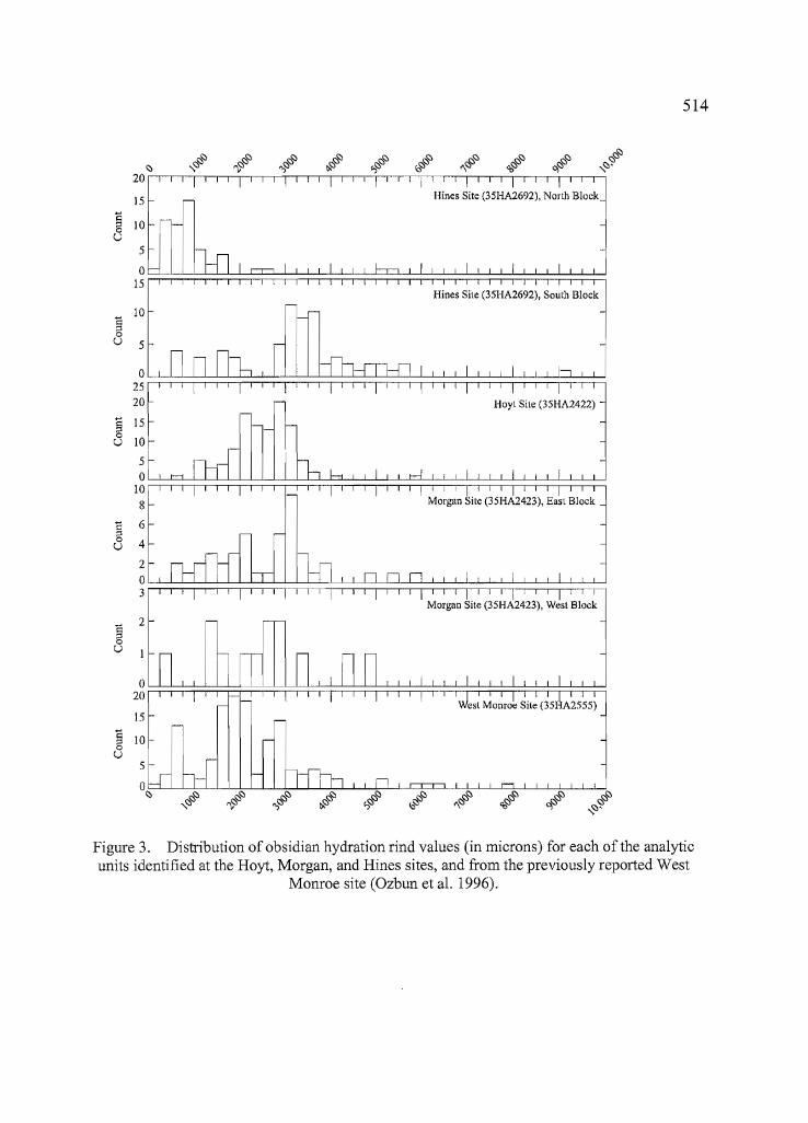
514
Hines Site (35HA2692), South Block""""""" J
i::10
;:l0u 5
02520
§ 150
10u50
108
i:: 6;:l0 4u
203
Morgan Site (35HA2423), West Block
i:: 2;:l0U
020
15
§ 100U
5
Rl~
,,~~
~
20
15
rIl,§ 100u
5
0 =15
Figure 3. Distribution of obsidian hydration rind values (in microns) for each of the analyticunits identified at the Hoyt, Morgan, and Hines sites, and from the previously reported West
Monroe site (Ozbun et al. 1996).
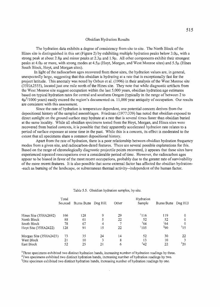
T
515
Obsidian Hydration Results
The hydration data exhibits a degree of consistency from site to site. The North Block of theHines site is distinguished in this set (Figure 2) by exhibiting multiple hydration peaks below 3.01l, with astrong peak at about 2.81l and minor peaks at 2.31l and 1.91l. All other components exhibit their strongestpeaks at 4.01l or more, with strong modes at 4.51l (Hoyt, Morgan, and West Monroe sites) and 5.51l (HinesSouth Block, Hoyt, and Morgan sites).
In light of the radiocarbon ages recovered from these sites, the hydration values are, in general,unexpectedly large, suggesting that this obsidian is hydrating at a rate that is exceptionally fast for theproject latitude. This anomaly was noted by Ozbun et al. (1996) in their analysis of the West Monroe site(35HA2555), located just one mile north of the Hines site. They note that while diagnostic artifacts fromthe West Monroe site suggest occupation within the last 5,000 years, obsidian hydration age estimatesbased on typical hydration rates for central and southern Oregon (typically in the range of between 2 to41l2/lOOO years) easily exceed the region's documented ca. 11,000 year antiquity of occupation. Our resultsare consistent with this assessment.
Since the rate ofhydration is temperature dependent, one potential concern derives from thedepositional history of the sampled assemblages. Friedman (1977:339) has noted that obsidian exposed todirect sunlight on the ground surface may hydrate at a rate that is several times faster than obsidian buriedat the same locality. While all obsidian specimens tested from the Hoyt, Morgan, and Hines sites wererecovered from buried contexts, it is possible that their apparently accelerated hydration rate relates to aperiod of surface exposure at some time in the past. While this is a concern, its effect is moderated to theextent that all specimens share a common depositional history.
Apart from the rate of hydration, there is a poor relationship between obsidian hydration frequencymodes from a given site, and radiocarbon-dated features. There are several possible explanations for this.Based on the range of chronologically diagnostic projectile points recovered, it appears that these sites haveexperienced repeated reoccupations over a considerable period of time. However, the radiocarbon agesappear to be biased in favor of the most recent occupations, probably due to the greater rate of survivabilityof the more recent features. It is also possible that some external factor has affected the obsidian hydration-such as burning of the landscape, or subterranean thermal activity--independent of the human factor.
Table 5.5. Obsidian hydration samples, by site.
Total HydrationSourced Bums Butte Dog Hill Other Sample Bums Butte Dog Hill
Hines Site (35HA2692) 166 128 9 29 1116 119 0North Block 88 61 5 22 52 52 0South Block 78 67 4 7 164 164 0Hoyt Site (35HA2422) 128 91 15 22 1105 290 315
Morgan Site (35HA2423) 73 35 24 14 52 30 22West Block 21 10 3 8 13 10 3East Block 52 25 21 6 342 22 320
IThree specimens exhibited two distinct hydration bands, increasing number of hydration readings by three.2Two specimens exhibited two distinct hydration bands, increasing number of hydration readings by two.30ne specimen exhibited two distinct hydration bands, increasing number of hydration readings by one.
II (,
516
Figure 4. Estimated age ranges of chronologically diagnostic projectile points,based on a hydration rate of 1O,u2/l 000 years.
Table 6. Obsidian hydration summary statistics for projectile points from the Hoyt, Morgan, and Hines sites.
Age Estimates @IOf.!."flOOO yearsPoint Type N Mean std. dey. Range Mean Age Age Range
Rose Spring 14 2. 8f.!. 0.6f.!. 1.8f.!.-3.7f.!. ca. 800 BP ca. 300-1400 BP
Eastgate 4 3.5f.!. 0.5f.!. 3.0f.!.-4.1 f.!. ca. 1200 BP ca. 900-1700 BP
Elko Series 9 4.4f.!. 0.9f.!. 3.3f.!.-5.5f.!. ca. 1900 BP ca. 1000-3000 BP
Side "!otched 3 5.2f.!. OAf.!. 4. 8f.!.-5.6f.!. ca. 2700 BP ca. 2300-3200 BP
517To test the latter assumption, hydration values for all tested projectile points were examined
by chronological type. If some external factor has affected the hydration at these sites, it is likely that theexpected chronological ordering of diagnostic projectile points would be affected. If the expected order isconfIrmed, we can assume a measure of validity in the hydration values. The projectile point hydrationresults shown in Table 6 and Figure 3 confIrm the expected chronological order, a result that allows us todismiss external processes and concentrate on the cultural meaning implied by the obsidian hydration data.
One pattern that is evident in the projectile point data, when compared to the overall hydrationprofIle, is a discrepancy between summary hydration modes (Figure 2) and projectile point hydrationmodes (Table 6). The combined mean hydration value of debitage from all three sites is 4.9~ (standarddeviation=1.3~, n=237), while the combined mean hydration value of all projectile points is 3.6~ (s.d=1.1,n=29). A difference of means test tells us that these populations are statistically different at the .05 level.Like the radiocarbon dating, the chronologically diagnostic projectile points are biased in favor of the lateroccupations at the site. For example, the Rose Spring and Eastgate points, which are probably limited toabout the last 1500 years, represent nearly 60% of the projectile points recovered from allcomponentsexplanations for this
Determination of a hydration rate is useful for calculating estimated ages from hydration rindvalues. There are two common ways of determining a rate of hydration. One method is induced hydration,where obsidian is hydrated by elevated heat and pressure under controlled conditions. The laboratory ratecan then be adjusted algebraically to the local effective hydration temperature of a sample locality Meighan1976; Michels et al. 1983). The second method is to pair hydration values with associated radiocarbonages, and to calculate a regression equation to relate hydration rind values to calendar ages. Since noinduced hydration rate is available for Burns Butte obsidian, we employ the latter technique here.
As noted, the relationship between hydration modes and radiocarbon ages from the sitesconsidered here is imperfect. The most reliable pairs are from the Hoyt site and the northern block at theHines site. The hydration profIle from the Hoyt site shows a strong peak in hydration values at 4.7~ and aradiocarbon age of 1820 cal BP on charcoal collected from below a metate on an old activity surface. Theradiocarbon age from the Hines site (1060 cal BP) is from a hearth centered in an activity cluster thatexhibited a strong hydration mode at 2.7~. These two data pairs suggest a hydration rate of approximately1O~2/1000 years, an exceptionally fast rate as noted above.
We can test the appropriateness of this rate by returning to the projectile point data, for which weknow approximate age ranges from stylistic cross-dating. Table 6 summarizes calculated age means andranges for hydration values measured on groups of distinct projectile point types, calculated at a hydrationrate of 1O~2/1000 years. These ranges fall comfortably within the expected age parameters, with RoseSpring points estimated to be 300 to 1400 years old, Eastgate from 900 to 1700 years old, Elko series pointsfrom 1000 to 3000 years old, and side-notched points from 2300 to 3200 years old. The side-notchedpoints are noteworthy, as they are neither classic Northern Side-Notched dart points nor small Desert SideNotch arrow points. These specimens appear to be, on average, slightly older than the Elko series points,but they appear to post-date the peak period of occurrence of the classic Northern Side-Notch variety.
Recognizing that this hydration rate will undoubtedly benefIt from future adjustment when moreand better data are available, the projectile point age estimates show that it provides reasonable agecalculations. Figure 3 provides a distribution of age estimations based on the rate of 10/-1,2/1000 years. It isnoteworthy that two outlier hydration values at 9.01-l and 9.51-l produce age estimates between 7500 and9500 years ago, estimates compatible with the earliest documented occupations in the Harney Basin (Faganand Sage 1974; Gehr 1980).
•
•
518Conclusions
The Bums Butte and Dog Hill obsidian, which predominates at the Hoyt, Morgan, and Hines sites,appears to hydrate at a rate that is considerably faster than most obsidians at the project latitude, ananomaly first noted by Ozbun et al. (1996) at the nearby West Monroe site. At present it is not known
whether this relates to the geochemistry of the local sources, or to an unusual depositional history that iscommon to sites in the northern Harney Basin. Based on the best radiocarbon age associations from thepresent project, an obsidian hydration rate of 1Of!2/1000 years was estimated for the three sites, and testedagainst expected age ranges for chronologically diagnostic projectile points recovered from the sites. Thisrate, while considered very tentative, appears to serve as a satisfactory age predictor for the present data set,based on the projectile point test.
With the exception ofthe North Block of the Hines site, obsidian hydration values from the Hines,Hoyt, and Morgan sites (and the West Monroe site reported by Ozbun et al.) cluster between ca. 3.8f! and6.5f!, with notable peak values at about 4.5f! and 5.5f!. These hydration values suggest occupationsbracketed between ca. 4500 and 1500 years ago, with periods ofnotable intensity at about 2000 and 3000years ago. Although nearly 70% (195 of283) ofall hydration values from the three sites fall within thisperiod, only one of the five clearly cultural radiocarbon ages from the sites falls within this range (acalibrated age of 1820 years BP from the Hoyt site). It seems clear that the radiocarbon ages reflect thelatest of multiple occupations at these sites, while the earlier occupations are better represented by theobsidian hydration profile.
The North Block at the Hines site exhibits a range of hydration values from about 3.8f! to 1.5f!,with a dominant peak at 2.7f! and minor peaks at 3.3f!, 2.3f!, and 1.8f!. This suggests occupations from1600 BP to contact, with possible occupation episodes at 1100 BP, 700 BP, 500 BP, and 300 BP. Someobsidian hydration values within this latter range «3.8f!), as well as a small number of Rose Spring andEastgate projectile points, are present at all sites, suggesting that at least ephemeral occupations occurred atall sites within the last 1500 years. Additionally, fOUf of the five clearly cultural radiocarbon ages from thethree sites fall within this period. All four are from apparent hearth features. If we were to base sitechronology only on radiocarbon evidence and the frequency of chronologically diagnostic projectile points,we might conclude that the area was little used prior to 1500 years ago.
The discrepancy between the radiocarbon and obsidian hydration age profiles for these sites isreflected in the significant difference between estimated obsidian hydration ages ofprojectile points andlithic debitage from the sites. It is possible that these sites may have been used in different ways before andafter ca. 1500 years ago. Prior to this time early and middle stage lithic reduction activities appear to havebeen more important, possibly reflecting the regular quarrying of the local obsidian float cobbles scatteredacross the landscape, in conjunction with opportunistic hunting and gathering activities. After this timegreater numbers ofprojectile points appear in the assemblages, but accompanied by significantly less lithicdebitage.
It is possible, too, that it is not a significant change in site functions that are indicated, but areflection of a changed technological system. Dart points, such as Elko series points, are typically reducedfrom larger bifacial preforms. Production of each point requires production of a symmetrical preform froma larger tool blank, a process requiring a considerable amount oflithic raw material. The introduction ofthe bow and arrow is estimated to have occurred in this area ca. 1700 years ago, marked by the appearanceand predominance of small Eastgate and Rose Spring projectile points. These small points can be made onflakes much smaller than the bifacial blanks required for larger dart points, and are thus far more materialefficient. It is further possible that a change in the dominant weapons system, from dart-and-atlatl to bowand-arrow, may account for a significant change in lithic assemblages-the dominant element of thearchaeological record-apart from the basic food collecting activities undertaken at these sites. It ispossible that smaller, more fragile arrow points, which can quickly be made from a relatively small flake,were more readily replaced, while the larger dart points were more often reworked into usable forms.
•
519However, this technological explanation may not be adequate to explain why domestic features such asfire hearths are under-represented in earlier components.
Finally, a word of caution. The chronological biases inherent in the present data set wererecognized by noting the discrepancies between radiocarbon and obsidian hydration age profiles, andbetween projectile point and debitage hydration profiles. These are biases that, to a considerable degree,are introduced by the limitations of our analytical procedures. On one hand, it is possible to conductobsidian hydration studies on small pressure flakes, and if small flakes had been systematically selected in
the present sample it is possible that the hydration profiles would have more faithfully reflected theoccupation histories of these sites. However, reliable determinations of obsidian geochemistry requiresamples of about dime-size specimens (ca. 10 mm diameter, 2 mm thick; Hughes 1986; Skinner 1998), andsince this chemistry can potentially effect the rate of hydration, geochemical source studies will continue torestrict the minimum size of hydrated specimens.
References Cited
Ericson, Jonathon E.1981 Exchange and Production Systems in Californian PrehistOly: The Results ofHydration
Dating and Chemical Characterization ofObsidian Sources. BAR International Series 110,Oxford, England.
Fagan, John L. and Gary L. Sage1974 New Windust Sites in Oregon. Tebiwa 16(2):68-71.
Friedman, Irving and Robert L. Smith1960 A New Dating Method Using Obsidian: Part I, The Development of the Method. American
Antiquity 25:476-522.
Gehr, Keith D.1980 Late Pleistocene and Recent Archaeology and Geomorphology of the South Shore ofHamey
Lake, Oregon. Master's Thesis, Department of Anthropology, Portland State University,Portland, Oregon.
Glascock, Michael D., Geoffrey E. Brasswell, and Robert H. Cobean1998 A Systematic Approach to Obsidian Source Characterization. In Archaeological Obsidian
Studies: Method and Theory, edited by M. Steven Shackley, pp. 15-65. Advances inArchaeological and Museum Science Series. Plenum Publishing Co., New York, New York.
Harbottle, Garman1982 Chemical Characterization in Archaeology. In Contexts for Prehistoric Exchange, edited by
Jonathon E. Ericson and Timothy K. Earle, pp. 13-51. Academic Press, New York, NewYork.
Herz, Norman and Ervan G. Garrison1998 Geological Methods for Archaeology. Oxford University Press, New York, New York.
Hughes, Richard E.1978 Aspects of Prehistoric Wiyot Exchange and Social Ranking. Journal of California
Anthropology 5(1):53-66.
520Hughes, Richard E.
1986. Diachronic Variability in Obsidian Procurement Patterns in NortheasternCalifornia and Southcentra1 Oregon. University ofCalifornia Publications in Anthropology17, Berkeley,California.
Hughes, Richard E.1990 The Gold Hill Site: Evidence for a Prehistoric Socioceremonial System in Southwestern
Oregon. In Living With the Land: The Indians of Southwest Oregon, edited by Nan Hannonand Richard K. Olmo, pp. 48-55. Southern Oregon Historical Society, Medford.
Hughes, Richard E.1998. On Reliability, Validity, and Scale on Obsidian Sourcing Research. In Unit Issues in
Archaeology: Measuring Time, Space, and Material, edited by Ann F. Ramenofsky andAnastasia Steffen,pp. 103-114. University of Utah Press, Salt Lake City, Utah.
Hughes, Richard E. and R. L. Bettinger1984 Obsidian and Prehistoric Cultural Systems in California. In Exploring the Limits: Frontiers
and Boundaries in Prehistory, edited by Suzanne P. DeAtley and Frank J. Findlow, pp. 153172. BAR International Series 223, Oxford, England.
Hughes, Richard E. and Robert L. Smith.1993 Archaeology, Geology, and Geochemistry in Obsidian Provenance Studies, in Effects of Scale
on Archaeological and Geoscientific Perspectives, edited by J. K.Stein and A. R. Linse, pp.79-91. Geological Society ofAmerica Special Paper 283, Boulder, Colorado.
Meighan, Clement W.1976 Empirical Determination of Obsidian Hydration Rates from Archaeological Evidence. In
Advances in Obsidian Glass Studies, edited by R. E. Taylor, pp. 106-119. Noyes Press, ParkRidge, New Jersey.
Michels, Joseph W., Ignatius S. T. Tsong, and G. A. Smith1983 Experimentally Derived Hydration Rates in Obsidian Dating. Archaeometry 25: 107-117.
Norrish, K. and B. W. Chappell.1967. X-Ray Fluorescence Spectrography. In Physical Methods in Determinative Mineralogy,
edited by J. Zussman, pp. 161-214. Academic Press, New York, New York.
Potts, Philip J. and Peter C. Webb.1992. X-Ray Fluorescence Spectrometry. Journal of Geochemical Exploration 44:251-296.
Rapp, George, Jr.1985 The Provenience of Artifactual Raw Materials. In Archaeological Geology, edited by George
Rapp, JI. and John A. Gifford, pp. 353-375. Yale University Press, New Haven, Connecticut.
Skinner, Craig E.1999 Malheur National Forest Obsidian Sources, Oregon. Results of geochemical source analysis
posted at internet address http://www.obsidianlab.com/or malnfhtml.
- ..,...
521Skinner, Craig E.
1983. Obsidian Studies in Oregon: An Introduction to Obsidian and An Investigation of SelectedMethods of Obsidian Characterization Utilizing Obsidian Collected at Prehistoric QuarrySites in Oregon. Unpublished Master's Terminal Project, Interdisciplinary Studies, Universityof Oregon, Eugene, Oregon.
Skinner, Craig E.1995. Obsidian Characterization Studies. In Archaeological Investigations, PGT-PG&E Pipeline
Expansion Project, Idaho, Washington, Oregon, and California, Volume V: Technical Studies,by Robert U. Bryson, Craig E. Skinner, and Richard M. Pettigrew, pp. 4.1-4.54. Reportprepared for Pacific GasTransmission Company, Portland, Oregon, by INFOTEC Research,Inc., Fresno, California, and Far Western Anthropological Research Group, Davis, California.
Williams, K. L.1987. An Introduction to X-Ray Spectrometry: X-Ray Fluorescence and Electron Microprobe
Analysis. Allen & Unwin, Boston, Massachusetts.
Williams-Thorpe, O.1995 Obsidian in the Mediterranean and the Near East: A Provenancing Success Story.
Archaeometry 37:217-248.
--
522
BIBLIOGRAPHY
Ahler, Stanley. A.1989 Mass Analysis of Flaking Debris: Studying the Forest Rather Than the Trees. In
Alternative Approaches to Lithic Analysis, edited by Donald O. Henry and George H.Odell, pp. 85-118. Archaeological Papers of the American Anthropological AssociationNo.1, American Anthropological Association, Arlington, Virginia.
Aikens, C. Melvin1978 Archaeology of the Great Basin. Annual Review ofAnthropology 7:71-87.
1993 Archaeology ofOregon. U.S. Department of the Interior, Bureau of Land Management,Portland, Oregon.
1994 Adaptive Strategies and Environmental Change in the Great Basin and its Peripheriesas Determinants in the Migrations of Numic-Speaking Peoples. In Across the West:Human Population Movement and the Expansion ofthe Numa, edited byDavid B. Madsen and David Rhode, pp. 35-43. University of Utah Press, Salt LakeCity.
Aikens, C. Melvin, Donald K. Grayson, and Peter J. Mehringer, Jr.1982 Final Report to the National Science Foundation on the Steens Mountain Prehistory
Project. Department ofAnthropology, University of Oregon, Eugene.
Aikens, C. Melvin, and Ruth L. Greenspan1986 Archaeological Investigations at the Headquarters Site, Malheur National Wildlife
Refuge, Harney County, Oregon. Report to U.S. Fish and Wildlife Service, MalheurNational Wildlife Refuge, Bums, Oregon.
1988 Ancient Lakeside Culture in the Northern Great Basin: Malheur Lake, Oregon.Journal ofCalifornia and Great Basin Anthropology 10(1):32-61.
Aikens, C. Melvin, and Dennis L. Jenkins (editors)1994 Archaeological Researches in the Northern Great Basin: Fort Rock Archaeology Since
Cressman. University of Oregon Anthropological Papers No. 50, Eugene.
Aikens, C. Melvin, and Dennis L. Jenkins1994 Environment, Climate, Subsistence, and Settlement: 11,000 Years of Change in the
Fort Rock Basin, Oregon. In Archaeological Researches in the Northern Great Basin:Fort Rock Archaeology Since Cressman, edited by C. M. Aikens and D. L. Jenkins,pp. 1-19. University of Oregon Anthropological Papers No. 50, Eugene.
-
•
523
Aikens, C. Melvin, and Rick Minor1978 Obsidian Hydration Dates for Klamath Prehistory. Tebiwa: Miscellaneous Papers of
the Idaho State University Museum of Natural History 11, Pocatello.
Aikens, C. Melvin, and Younger T. Witherspoon1986 Great Basin Numic Prehistory: Linguistics, Prehistory, and Environment. In
Anthropology o/the Desert West: Essays in Honor 0/Jesse D. Jennings, edited by CarolCondie and Don D. Fowler, pp 7-20. University ofUtah Anthropological Papers No.110, Salt Lake City.
Allison, Ira S.1979 Pluvial Fort Rock Lake, Lake County, Oregon. Oregon State Monographs, Studies in
Geology 7, Corvallis.
Allison Ira S., and Carl. E. Bond1983 Identity and Probable Age of Salmonids from Surface Deposits at Fossil Lake,
Oregon. Copeia 1983(2): 563-564.
Ames, Kenneth M., and Alan G. Marshall1980 Villages, Demography, and Subsistence Intensification on the Southern Columbia
Plateau. North American Archaeologist 2(1): 25-52.
Antevs, Ernst1948 Climatic Changes and Pre-White Man. In The Great Basin With Emphasis on Glacial
and Post-glacial Times. Biological Series 10(7), University ofUtah Bulletin 38(20):168-191, Salt Lake City.
1955 Geologic-Climatic Dating in the West. American Antiquity 20(4): 317-335.
Aschmann, Homer G.1958 Great Basin Climates in Relation to Human Occupance. In Current Views on Great
Basin Archaeology. University of California Archaeological Survey Reports 42: 2340, Berkeley.
Atherton, J. H.1966 Prehistoric Manufacturing Sites at North American Stone Quarries. Master's thesis,
Department ofAnthropology, University of Oregon, Eugene.
Bailey, Vernon1936 The Mammals and Life Zones o/Oregon. North American Fauna, No. 55. U.S.
Department of Agriculture, Washington D.C.
Barrett, Samuel A.1910 The Material Culture o/the Klamath Lake and Modoc Indians o/Northeastern
California and Southern Oregon. University of California Publications in AmericanArchaeology and Ethnology 5(4): 239-292. Berkeley.
!II
-
524
Baldwin, Ewart M.1981 Geology ofOregon. KendalllHunt Publishing, Dubuque, Iowa
Baumhoff, Martin A., and J. S. Byrne1959 Desert Side-Notched Points as a Time Marker in California. University of California
Archaeological Survey Reports 48(72):32-65, Berkeley.
Bedwell, Stephen F.1970 Prehistory and Environment of the Pluvial Fort Rock Lake Area of South-central
Oregon. Ph.D. Dissertation, Department ofAnthropology, University of Oregon,Eugene.
1973 Fort Rock Basin Prehistory and Environment. University of Oregon Books, Eugene.
Bennyhoff, James A., and Richard E. Hughes1987 Shell Bead and Ornament Exchange Networks Between California and the Western
Great Basin. Anthropological Papers of the American Museum ofNatural History64(2). New York
Bettinger, Robert L, and Martin A. Baumhoff1982 The Numic Spread: Great Basin Cultures in Competition. American Antiquity 47(3):
485-503
Binford, Lewis R.1980 Willow Smoke and Dog's Tails: Hunter-gatherer Settlement Systems and
Archaeological Site Formation. American Antiquity 45(1):4-20.
Blyth, Beatrice1938 The Northern Paiute Bands in Oregon. American Anthropologist 40: 402-405.
Bonstead, Leah2000 The Nia1s Site: An Early Holocene Occupation in the Harney Basin, Oregon.
Master's thesis, Department ofAnthropology, University ofNevada, Reno.
Botkin, Steve, and Kristopher R. Carambe1as1992 35HA1911 and 35HA1028. In Land and Life at Malheur Lake, edited by Christopher
Raven and Robert Elston, pp. 57-121. U.S. Department of the Interior Fish and WildlifeService Region 1, Cultural Resource Series Number 8. Portland
Branigan, Alyce2000 Preliminary Report ofTest Excavations at the Biting Fly Site (35HA1260) Harney
County, Oregon. Report on file at the Bums District Bureau of Land Management,Hines, Oregon.
-525
Brashear, Ann1994 Assemblage Variation, Site Types, and Subsistence Activities in the Boulder Village
Uplands, Fort Rock Basin, Oregon. In Archaeological Researches in the NorthernGreat Basin: Fort Rock Archaeology Since Cressman, edited by C. M. Aikens and D.L. Jenkins, pp. 385-430. University of Oregon Anthropological Papers No. 50, Eugene.
Bryan, Allen L., and Ruth Gruhn1964 Problems Relating to the Neothermal Climatic Sequence. American Antiquity 29(3):
307-315.
Burnside, Carla D.1987 Interim Report: Archaeological Survey and Excavations in the Gerber Reservoir
Quadrangle. Report on file at the University of Oregon Department of Anthropology,Eugene.
1996 Prehistoric Use ofMalheur Refuge, Northern Great Basin. Paper presented at the 25 th
Great Basin Anthropological Conference, Kings Beach, California.
Byram, R. Scott1994 Holocene Settlement Change in the Boulder Village Uplands. In Archaeological
Researches in the Northern Great Basin: Fort Rock Archaeology Since Cressman,edited by C. Melvin Aikens and D. L. Jenkins, pp. 385-430. University of OregonAnthropological Papers No. 50, Eugene.
Callahan, Errett1979 The Basics of Biface Knappers in the Eastern Fluted Point Tradition: A Manual for
Flint Knappers and Lithic Analysts. Archaeology ofEastern North America 7(1) 1-179.
Campbell, Sarah K.n.d. Untitled Report on Field Work at the Headquarters Site (Draft). Ms. on file, Malheur
National Wildlife Refuge Headquarters, Princeton, Oregon.
Cannon, William J.1983 Cultural Resource Survey and Site Testing of Zane Church Trespass. Report on file
at the Lakeview District Bureau of Land Management, Lakeview, Oregon.
Chatters, James C.1986 Overview and Inventory ofCultural Resources in the Malheur Basin Project,
Southeastern Oregon. Central Washington Archaeological Survey ArchaeologicalReport 86-3.
1989 Resource Intensification and Sedentism on the Southern Plateau. Archaeology inWashington 1:3-19.
Clewlow, C. W., Jr.1968 Surface Archaeology ofthe Black Rock Desert, Nevada. University of California
Archaeological Survey Reports 73: 1-94.' Berkeley
'+
526
Clifford, Laura1997 Preliminary Report on 1997 Field Activity in the Ma1heur/Harney Lake Basin, Oregon.
Report on file at the Bums District Bureau of Land Management, Hines, Oregon.
Connolly, Thomas J.1991 Archaeological Survey of the Kah-Nee-Ta Junction-Pelton Dam Road Section, Warm
Springs Highway (U.S. 26), Jefferson County. Report on file at the Oregon StateHistoric Preservation Office, Salem.
1993 Pre-Mazama Occupations at the Paulina Lake Site (35DS34), Newberry Crater,Central Oregon. Current Archaeological Happenings in Oregon 18(1):6-12.
1994 Archaeological Survey of Portions of the U.S. 395-JoOO Logan Lane Section, CentralOregon Highway (U.S. 20), and Selected Material Source Sites, Harney County.Report on file at the Oregon State Historic Preservation Office, Salem.
1999 Human and Environmental Holocene Chronology in Newberry Crater, CentralOregon. Report on file at the Oregon State Historic Preservation Office, Salem.
Connolly, Thomas J., and R. Scott Byram2001 The Bon Site (35DS608), Middle to Late Holocene Land Use in the Upper Deschutes
River Basin, Central Oregon. State Museum of Anthropology Report No. 2001-3,University of Oregon, Eugene.
Connolly, Thomas J., Dennis L. Jenkins, and Jane E. Benjamin1993 Archaeology ofMitchell Cave (35WH122): A Late Period Hunting Camp in the
Ochoco Mountains, Wheeler County, Oregon. University of Oregon AnthropologicalPapers No.46. Eugene.
Connolly, Thomas J., and Robert L. Musil1994 Patterns of Lithic Procurement and Reduction at the Newberry Crater Obsidian
Quarries. In Contributions to the Archaeology ofOregon 1989-1994, edited by P. W.Baxter, pp. 89-117. Association of Oregon Archaeologists Occasional Papers 5.Eugene.
Corbet, G. B., and J. E. Hill1991 A World List ofMammalian Species. Oxford University Press, Oxford, England.
Couture, Marilyn D.1978 Recent and Contemporary Foraging Practices of the Harney Valley Paiute. Master's.
thesis, Department of Anthropology, Portland State University, Portland, Oregon.
Couture, Marilyn D., Mary F. Ricks, and Lucile Housley1986 Foraging Behavior of a Contemporary Northern Great Basin Population. Journal of
California and Great Basin Anthropology 8(2): 150-160.
....
527
Cowan, Ruth A.1967 Lake Margin Econimic Exploitation in the Great Basin as Demonstrated by an Analysis
of Coprolites from Lovelock Cave, Nevada. University of California ArchaeologicalSurvey Reports 70: 21-35, Berkeley.
Davis, Jonathan O.1982 Bits and Pieces: The Last 35,000 years in the Lahontan Area. In Man and
Environment in the Great Basin, edited by David B. Madsen and James F. O'Connell.SAA Papers 2: 53-75, Washington, D. C.
Dugas, Daniel P. and Margaret Bullock1994 Headquarters Site: An Archaeological and Stratigraphic Assessment ofHA403. U.S.
Department of the Interior Fish and Wildlife Service Region 1, Cultural ResourceSeries 10. Portland.
Dugas, Daniel P., Robert G. Elston, James A. Carter, Kathryn Ataman, and Margaret Bullock1995 An Archaeological and Stratigraphic Assessment ofthe Stubblefield Lookout
Tower Site (35HA53) Malheur National Wildlife Refuge. U.S. Department of theInterior Fish and Wildlife Service Region 1, Cultural Resource Series 11, Portland.
Duebbert, H. F.1969 The Ecology of Malheur Lake and Management Implications. U.S. Fish and Wildlife
Service, Malheur National Wildlife Refuge, Princeton. Oregon.
Eiseldt, B. Sunday1997 Defining Ethnicity in Warner Valley: An Analysis of House and Home. University of
Nevada, Reno Department of Anthropology Technical Report 97-2, Reno.
Elliot, T. C.1910 The Journals of Peter Skene Ogden 1826-1827. Oregon Historical Society
Quarterly 11 :201-222.
Elston, Robert G., and Daniel P. Dugas (editors)1993 Dune Islands and the Archaeological Record in Malheur Lake. U.S. Department of
the Interior, Fish and Wildlife Service Region 1, Cultural Resource Series 7, Portland.
Elston Robert G., Daniel P. Dugas, Kathryn Ataman, Eric Ingbar, and Margaret Bullock1993aThe Archaeology of 35HA1914. In Dune Islands and the Archaeological Record in
Malheur Lake. U.S. Department of the Interior, Fish and Wildlife Service Region 1,Cultural Resource Series 7, Portland.
1993bThe Archaeology of 35HA2222. In Dune Islands and the Archaeological Record inMalheur Lake. U.S. Department of the Interior, Fish and Wildlife Service Region 1,Cultural Resource Series 7, Portland.
1993cThe Archaeology of 35HA1899. In Dune Islands and the Archaeological Record inMalheur Lake. U.S. Department of the Interior, Fish and Wildlife Service Region 1,Cultural Resource Series 7, Portland.
528
1993dThe Archaeology of 35HA1904. In Dune Islands and the Archaeological Recordin Malheur Lake. U.S. Department of the Interior, Fish and Wildlife ServiceRegion 1, Cultural Resource Series 7, Portland.
Erlandson, Jon M., J.D. Robertson, and Christopher Descantes1999 Geochemical Analysis of Eight Red Ochres from Western North America. American
Antiquity 64(3): 517-526
Fagan, John L.1973 A1titherma1 Occupation of Spring Sites in the Northern Great Basin. Ph.D.
dissertation, Department of Anthropology, University of Oregon, Eugene.
1974 Altithermal Occupation ofSpring Sites in the Northern Great Basin. University ofOregon Anthropological Papers 6. Eugene.
Ferguson, Denzel, and Nancy Ferguson1978 Oregon's Great Basin Country. Gail Graphics, Bums, Oregon
Flenniken, Jeffrey1985 Reduction Techniques as Cultural Markers. In Stone Tool Analysis: Essays in Honor
ofDon Crabtree, edited by M. G. P1ew, J. C. Woods and M. G. Pavesic, pp.275-276.University ofNew Mexico Press, Albuquerque.
Flenniken, J. J., and Anan W. Raymond1986 Morphological Projectile Point Typology: Replication Experimentation and
Technological Analysis. American Antiquity 51 (3): 603-614.
Fowler, Catherine S.1982 Food-Named Groups Among Northern Paiute in North America's Great Basin: An
Ecological Interpretation. In Resource Managers: North American and AustralianHunter-Gatherers, edited by Nancy W. Williams and Eugene S. Hunn, pp. 113-129.American Association for the Advancement of Science 67, Boulder, Colorado.
1986 Subsistence. In, Great Basin, edited by Warren L.d'Azevedo, pp. 64-97. Handbook ofNorth American Indians, Volume 11. Smithsonian Institution, Washington D.C.
1989 Willard Z. Park's Ethnographic Notes on the Northern Paiute ofWestern Nevada, '1933-1940, Volume 1. University of Utah Anthropological Papers No. 114, Salt LakeCity.
1992 In the Shadow ofFox Peak: An Ethnography ofthe Cattail-Eater Northern PaiutePeople ofStillwater Marsh. U.S. Department of the Interior Fish and Wildlife Service,Region 1, Stillwater National Wildlife Refuge, Cultural Resource Series No.5. Fallon,Nevada.
9
529Fowler, Catherine S., and Sven Liljeblad
1986 Northern Paiute. In Great Basin, edited by Warren L. d'Azevedo. pp.435-465.Handbook ofNorth American Indians, Volume 11, Smithsonian Institution, WashingtonD.C.
Fowler, Don. D., and Jesse D. Jennings1982 Great Basin Archaeology: A Historical Overview. In Man and Environment in the Great
Basin, edited by David B. Madsen and James F. O'Connell. Society of AmericanArchaeology Papers No.2: 105-120, Washington, D. c..
Franklin, Jerry F., and C. T. Dymess1988 Natural Vegetation ofOregon and Washington. USDA Forest Service Technical
Report PNW-8, Portland
Friedman, Irving1977 Hydration Dating of Volcanism at Newberry Crater, Oregon. u.s. Geological Survey
Journal ofResearch 5(3): 337-342.
Frison, George C., and Bruce A. Bradley1980 Folsom Tools and Technology at the Hanson Site, Wyoming. University of New
Mexico Press, Albuquerque.
Gehr, Keith1980 Late Pleistocene and Recent Archaeology and Geomorphology of the South Shore of
Harney Lake, Oregon. Master's thesis, Depertment ofAnthropology, Portland StateUniversity, Portland, Oregon.
Goddard, L., and Thomas M. Newman1974 Field Notes of Excavations at the Squaw Pit Site, MNWR-98 (35HA1038), Malheur
National Wildlife Refuge, July 16-18, 1974. Manuscript on file at the Oregon StateMuseum of Natural and Cultural History, University of Oregon, Eugene.
Grayson, Donald K.1979 Mount Mazama, Climatic Change, and Fort Rock Basin Archaeofaunas. In Volcanic
Activity and Human Ecology, edited by P. D. Sheets and D. G. Grayson, pp. 427-457.Academic Press, New York.
1984 Quantitative Zooarchaeology. Academic Press, New York.
Greene, R. C., G. W. Walker, and R. E. Corcoran1972 Geologic Map of the Bums Quadrangle, Oregon. United States Geological Survey,
Miscellaneous Geologic Investigations, Map 1680, Washington, D.C.
Greenspan, Ruth L.1994 Archaeological Fish Remains in the Fort Rock Basin. In Archaeological Researches in
the Northern Great Basin: Fort Rock Archaeology Since Cressman, edited by C.Melvin Aikens and Dennis L. Jenkins, pp. 485-504. University of OregonAnthropological Papers No. 50, Eugene..
530
Harrington, Mark R.1933 Gypsum Cave, Nevada. Southwest Museum Papers 8, Los Angeles.
1948 An Ancient Site at Borax Lake, California. Southwest Museum Papers 16, LosAngeles.
1957 A Pinto Site at Little Lake, California. Southwest Museum Papers 17, Los Angeles.
Heizer, Robert F.1967 Analysis of Human Coprolites from a Dry Nevada Cave. University of California
Archaeological Survey Reports 70(1): 1-20, Berkeley
Heizer Robert F., and Martin A. Baumhoff1961 The Archaeology of Wagon Jack Shelter. University of California Anthropological
Records 20(4): 119-138, Berkeley.
Heizer, Robert F., and C. William C1ewlow, Jr.1968 Projectile Points from Site NV-CH-15, Churchill County. Nevada. JnPapers on
Great Basin Prehistory. University of California Archaeological Survey ReportsNo. 71, pp. 59-88, Berkeley
Heizer, Robert F., and Thomas R. Hester1978 Great Basin Projectile Points: Forms and Chronology. Ballena Press Publications in
Archaeology, Ethnology, and History 10, Socorro, New Mexico.
Heizer Robert F., and Lewis K. Napton1969 Biological and Cultural Evidence from Prehistoric Human Coprolites. Science
165(3893):563-568.
1970 Archaeological Investigations in Lovelock Cave, Nevada. University of CaliforniaArchaeological Research Facility Contributions 10(1), Berkeley
Helzer, Margaret M.2001 Paleoethnobotany and Household Archaeology at the Bergen Site: A Middle Holocene
Occupation in the Fort Rock Basin, Oregon. Ph.D. dissertation, Department ofAnthropology, University of Oregon, Eugene.
2001 Results ofthe Analysis of Charcoal from the Knoll (35HA2530) and RJ (35HA3013)sites. Report on file at the University of Oregon Museum of Natural and CulturalHistory, Eugene.
2002 Charcoal and Mactobotanical Analyses at the Laurie's Site (35HA3074) and the BrokenArrow Site (35HA3075). Report on file at the University of Oregon Museum of Naturaland Cultural History, Eugene.
531
Housley, Lucile A.1994 Its in the Roots: Prehistoric Plants and Plant Use in the Fort Rock Basin. In
Archaeological Researches in the Northern Great Basin: Fort Rock Archaeology SinceCressman, edited by C. Melvin Aikens and Dennis L. Jenkins, pp. 561-572.University of Oregon Anthropological Papers No. 50, Eugene.
Hughes, Richard E.1996 Letter Report Regarding X-Ray Fluorescence Analysis of Artifacts from the Hoyt
and Morgan Sites. Geochemical Research Laboratory Letter Report 96-29, Riverside,California.
Hunn, Eugene S.1990 Nch'i-i-Wana, "The Big River": Mid-Columbia Indians and Their Land. University of
Washington Press, Seattle.
Jenkins, Dennis L.1994aSettlement-Subsistence Patterns in the Fort Rock Basin: a Cultural-Ecological
Perspective on Human Responses to Fluctuating Wetlands Resources of the Last 5000Years. In Archaeological Researches in the Northern Great Basin: Fort RockArchaeology Since Cressman, edited by C. M. Aikens and D. L. Jenkins, pp. 599-628.University of Oregon Anthropological Papers No. 50, Eugene.
1994bArchaeologica1 Investigations at Three Wetlands Sites near Silver Lake in the FortRock Basin. In Archaeological Researches in the Northern Great Basin: Fort RockArchaeology Since Cressman, edited by C. M. Aikens and D. L. Jenkins, pp. 213-258.University of Oregon Anthropological Papers No. 50, Eugene.
1997 Preliminary Report on Archaeological Testing at the Hines Site (35HA2692) in theCity ofHines, Central Oregon Highway (U.S. 20) Harney County, Oregon. Letterreport on file at the Oregon State Historic Preservation Office, Salem.
2000 Early to Middle Holocene Cultural Transitions in the Northern Great basin of Oregon:The View from Fort Rock. In Archaeological Passages: A Volume in Honor ofClaudeNelson Warren, edited by Joan S. Schneider, Robert M. Yohe II, and Jill Gardner, pp.69-109. Publications in Archaeology Volume 1. Western Center for Archaeology andPaleontology, Hemet, California.
2004 The Grasshopper and the Ant: Middle Holocene Occupations and Storage Behavior atthe Bowling Dune Site in the Fort Rock Basin, Oregon. In Early and Middle HoloceneArchaeology ofthe Northern Great Basin, edited by Dennis L. Jenkins, Thomas J.Connolly, and C. Melvin Aikens, pp. 123-156. University of Oregon AnthropologicalPapers No. 62, Eugene.
Jenkins, Dennis L., C. Melvin Aikens, and William Cannon1999 University ofOregon Northern Great Basin Prehistory Project Research Design.
Department of Anthropology and Museum ofNatural and Cultural History, University ofOregon, Eugene
532
Jenkins, Dennis L. and Ann Brashear1994 Excavations at Four Habitation Sites in the Boulder Village Uplands: A Preliminary
Report. In Archaeological Researches in the Northern Great Basin: Fort RockArchaeology Since Cressman, edited by C. M. Aikens and D. L. Jenkins, pp. 431484. University of Oregon Anthropological Papers No. 50, Eugene.
Jenkins, Dennis L. and Thomas J. Connolly1990 Archaeology ofIndian Grade Spring: a Special Function Site on Stinkingwater
Mountain, Harney County, Oregon. University of Oregon Anthropological Papers No.42, Eugene.
1994 Archaeological Investigations at the Paquet Gulch Bridge Site: A Pithouse Village inthe Deschutes River Basin,Southwestern Columbia Plateau, Oregon. University ofOregon Anthropological Papers No. 49, Eugene.
1996 Mid-Holocene Occupations at the Heath Cliffs Site, Warm Springs Reservation, Oregon.University of Oregon Anthropological Papers No. 53, Eugene.
Jenkins, Dennis L., Thomas J. Connolly, and C. Melvin Aikens (editors)2004 Early and Middle Holocene Archaeology ofthe Northern Great Basin. University of
Oregon Anthropological Papers No. 62, Eugene.
Jenkins, Dennis L., and Nina Wimmers1994 Beads as Indicators of Cultural and Chronological Change in the Fort Rock Basin. In
Archaeological Researches in the Northern Great Basin: Fort Rock Archaeology SinceCressman, edited by C. M. Aikens and D. L. Jenkins, pp. 213-258. University ofOregon Anthropological Papers 50, Eugene.
Jennings, Jesse D.1957 Danger Cave. University ofUtah Anthropological Papers No. 27, Salt Lake City.
1973 The Short, Useful Life of a Simple Hypothesis. Tebiwa: Journal of the Idaho StateUniversity Museum 13(1): 1-9, Pocatello.
Jennings, Jesse D., and Edward Norbeck1955 Great Basin Prehistory: A Review. American Antiquity 21(1): 1-11
Johnson, Gregory A.1982 Organizational Structure and Scalar Stress. In Theory and Explanation in Archaeology,
edited by C. Renfrew, M. J. Rowlands, and B. A. Segraves, pp. 389-422. AcademicPress, New York.
Johnson, LeRoy Jr.1968 Obsidian Hydration Rate for the Klamath Basin of Oregon and California. Science
165: 1354-1356.
533
Kelly, Isabel T.1932 Ethnography ofthe Surprise Valley Paiute. University of California Publications in
American Archaeology and Ethnology 31 :67-210, Berkeley.
Kelly, Robert L.1985 Hunter-Gatherer Mobility and Sedentism: A Great Basin Study. Ph.D. dissertation,
University of Michigan, Ann Arbor.
2001 Prehistory ofthe Carson Desert and Stillwater Mountains: Environment, Mobility,and Subsistence in a Great Basin Wetland. University of Utah Anthropological PapersNo. 123, Salt Lake City.
Kiigemagi, Peter1989 Testing the Root-Processing Hypothesis through Use-Wear Analysis of Basalt Flakes
From Indian Grade Spring, East-Central Oregon. In Contributions to the Archaeology ofOregon, 1987-1988, edited by Rick Minor, pp 145-156. Association of OregonArchaeologists Occasional Papers No.4, Eugene.
Lamb, S.1958 Linguistic Prehistory in the Great Basin. International Journal ofAmerican
Linguistics. 24(2): 95-100.
Loud, Llewellyn L., and Mark R. Harrington1929 Lovelock Cave. University of California Publications in American Archaeology and
Ethnology No. 25(1):1-183, Berkeley
Lyons, William H.2001 Where the Lost was Found: Geologic Sources of Artifact Raw Materials from Lost Dune
(35HA792), Harney County, Southeastern Oregon. Ph.D. dissertation, Department ofAnthropology, Washington State University, Pullman.
Lyons, William H. and Peter J. Mehringer, Jr.1996 Archaeology of the Lost Dune Site (35HA792), Blitzen Valley, Harney County,
Oregon: A Report of Excavations by the 1995 WSU Field School. Submitted toBums District Bureau of Land Management, Hines, Oregon.
Lyons, William H., Scott P. Thomas, and Craig E. Skinner2001 Changing Obsidian Sources at the Lost Dune and McCoy Creek Sites, Blitzen Valley,
Southeast Oregon. Journal ofCalifornia and Great Basin Anthropology 23:273-296.
Madsen, David B., and David Rhode (editors)1994 Across the West: Human Population Movement and the Expansion ofthe Numa.
University of Utah Press, Salt Lake City.
Maloney, Alice Bay1945 Fur Brigade to the Bonaventura. California Historical Society, San Francisco.
534
McBrearty, S., L. Bishop, T. Plummer, R. Dewar, and N. Conard1998 Tools Underfoot: Human Trampling as an Agent of Artifact Edge Modification.
American Antiquity 63(2): 108-130
McDowell, Patricia1992 An Overview of Harney Basin Geomorphic History, Climate, and Hydrology. In
Land and Life at Malheur Lake, edited by Christopher Raven and Robert G. Elston.U.S. Department of the Interior Fish and Wildlife Service Region 1, Cultural ResourceSeries Number 8, Portland
Mehringer, Peter J., Jr.1977 Great Basin Late Quaternary Environments and Chronology. In Models and Great
Basin Prehistory: A Symposium, edited by D. D. Fowler, pp. 113-167. University ofNevada Desert Research Institute Publications in the Social Sciences 12. Reno.
1986 Prehistoric Environments. In Great Basin, edited by Warren L. d'Azevedo, pp. 31-50.Handbook ofNorth American Indians, Volume 11, Smithsonian Institution,Washington D.C.
Mehringer, Peter J. Jr., and William J. Cannon1994 Volcaniclastic Dunes of the Fort Rock Valley, Oregon: Stratigraphy, Chronology, and
Archaeology. In Archaeological Researches in the Northern Great Basin: Fort RockArchaeology Since Cressman, edited by C. M. Aikens and D. L. Jenkins, pp. 283-328.University of Oregon Anthropological Papers No. 50, Eugene.
Miller, R. F., P. Doescher, and T. Purrington1991 Dry-wet Cycles and Sagebrush in the Great Basin. In Management in the Sagebrush
Steppe, Special Report 880. pp.8-15. Agricultural Experiment Station, Oregon StateUniversity and Agricultural Research Service, U.S. Department of Agriculture,Corvallis, Oregon.
Minor, Rick, and Ruth L. Greenspan1985 Archaeological Testing in the Southeast Area ofthe Headquarters Site, Malheur
National Wildlife Refuge, Harney County, Oregon. Heritage Research AssociatesReport 36, Eugene, Oregon.
Minor, Rick, and Kathryn A. Toepe11988 Surface Investigations in the Northwest Area ofthe Headquarters Site (35HA403),
Malheur NationalWildlife Refuge, Harney County, Oregon. Heritage ResearchAssociates Report 72, Eugene, Oregon.
Musil, Robert R.1990 Archaeological Investigations at the Dunn Site (35HA1261), Harney County, Oregon.
Heritage Research Associates Report 95, Eugene, Oregon.
1992 Adaptive Transitions and Environmental Change in the Northern Great Basin: A ViewFrom Diamond Swamp. Ph.D. dissertation, Department of Anthropology, Universityof Oregon, Eugene.
535
1995 Adaptive Transitions and Environmental Change in the Northern Great Basin: A ViewFrom Diamond Swamp. University of Oregon Anthropological Papers No. 51,Eugene.
n.d. The Archaeology of Quartz Valley. An interim draft for the Oregon State Museumof Anthropology, Eugene.
2002 Archaeological Testing and Stratigraphic Assessment in the Southeast Area oftheHeadquarters Site (35HA403), Malheur National Wildlife Refuge, Harney County,Oregon. Heritage Research Associates Report No. 250, Eugene, Oregon.
Muto, GuyR1971 A Stage Analysis of the Manufacture of Stone Tools. In Great Basin Anthropological
Conference 1970: Selected Papers, edited by C. Melvin Aikens, pp. 109-118.University of Oregon Anthropological Papers 1. Eugene.
Newman, T.M., R Bogue, C.D. Carley, RD. McGilvra, and D. Moretty1974 Archaeological Reconnaissance of the Malheur National Wildlife Refuge, Harney
County, Oregon: 1974. Report on file at the Oregon State Historic Preservation Office,Salem.
O'Brien, Mark M.2002 The Newman Collection: Projectile Points, Chronology, and Land Use Patterns in the
Malheur National Wildlife Refuge, Oregon. Report Submitted to the Oregon StateMuseum ofAnthropology, University of Oregon, Eugene
O'Connell, James F.1975 The Prehistory ofSurprise Valley. Ballena Press Anthropological Papers 4, Ramona,
California.
O'Connell, James F., and David B. Madsen1982 Man and Environment in the Great Basin. In Man and Environment in the Great
Basin, edited by David B. Madsen and James F. O'Connell. Society ofAmericanArchaeology Papers 2:1-7, Washington, D. C.
Oetting, Albert C.1987 Archaeological Testing at Five Sites in the Stinkingwater Mountains, Harney County,
Oregon. Oregon State Museum of Anthropology Report No. 87-4. University ofOregon, Eugene.
1989 Villages and Wetland Adaptations in the Northern Great Basin: Chronology and LandUse in the Lake Abert-Chewaucan Marsh Basin, Lake County, Oregon. Ph.D.dissertation, Department ofAnthropology, University of Oregon, Eugene.
1990aThe Malheur Lake Survey: Lacustrine Archaeology in the Harney Basin, CentralOregon. Heritage Research Associates Report 96, Eugene, Oregon.
536
1990bAn Archaeological Survey on the Recently Flooded Shores ofMalheur Lake, HarneyCounty, Oregon. Heritage Research Associates Report 97, Eugene, Oregon.
1992 Lake and Marsh-Edge Settlements on Malheur Lake, Harney County, Oregon.Journal ofCalifornia and Great Basin Anthropology 14(1): 110-129.
1994aChronology and Time Markers in the Northwestern Great Basin: the Chewaucan BasinCultural Chronology. In Archaeological Researches in the Northern Great Basin:Fort Rock Archaeology Since Cressman, edited by C. Melvin Aikens and Dennis L.Jenkins. pp.41-62. University of Oregon Anthropological Papers No. 50, Eugene.
1994bEarly Holocene Rabbit Drives and Prehistoric Land Use Patterns on Buffalo Flat,Christmas Lake Valley, Oregon. Archaeological Researches in the NorthernGreat Basin: Fort Rock Archaeology Since Cressman, edited by C. MelvinAikens and Dennis L. Jenkins. pp. 155-170. University of OregonAnthropological Papers No. 50, Eugene
1999 An Examination of Wetland Adaptive Strategies in Harney Basin ComparingEthnographic Paradigms and the Archaeological Record. In Prehistoric Lifeways in theGreat Basin Wetlands: Bioarchaeological Reconstruction and Interpretation, edited byBrian E. Hemphill and Clark Spencer Larsen, pp. 203-218. University of Utah Press,Salt Lake.
O'Grady, Patrick1999 Human Occupation Patterns in the Uplands: An Analysis of Sourced Obsidian
Projectile Points from Playa Villages in the Fort Rock Uplands, Lake County, Oregon.Master's paper, Department of Anthropology, University of Oregon, Eugene.
O'Grady, Patrick, Dennis L. Jenkins, and Thomas J. Connolly1997 Data Recovery Plan for The Hines Archaeological Site (35HA2692). Report Prepared
for the Oregon Department of Transportation, Salem.
O'Grady, Patrick, and Scott P. Thomas2006 Late Pleistocene/Early Holocene Sites and Isolates on Lands Administered by the Bums
District Bureau of Land Management, Harney County, Oregon: A Prospectus.Manuscript on file at the University of Oregon Museum of Natural and Cultural History,Eugene.
Ozbun, Terry Lee, Judith S. Chapman, and John L. Fagan1996 Archaeological Data Recovery at the West Monroe Site (35HA2555) and Old Camp
(OR-HA-4), Burns, Oregon. Archaeological Investigations Northwest, Report 125.Portland, Oregon.
Pettigrew, Richard M.1979 Archaeological Investigations at Stinkingwater Pass, Harney County, Oregon.
University of Oregon Anthropological Papers No. 15, Eugene.
537
1985 Archaeological Investigations on the East Shore ofLake Abert, Lake County, Oregon,Volume 1. University of Oregon Anthropological Papers No. 32, Eugene.
1986 Report on the Archaeological Survey of the Proposed Improvements of the HinesSection, Central Oregon Highway, Harney County. Letter report on file at theOregon State Historic Preservation Office, Salem.
Prouty, Guy L.1995 Roots and Tubers: Prehistoric Plant Use, Settlement and Subsistence Identification, and
Storage in the Fort Rock Basin, Northern Great Basin, Oregon. Ph.D. dissertation,Department of Anthropology, University of Oregon, Eugene.
Puseman, Kathryn, and Linda Scott Cummings2001 Identification of Botanic Remains from the Knoll Site (35HA2530) and the RJ Site
(35HA3013) in the Harney Basin, Southeastern Oregon. Paleo Research Labs TechnicalReport 00-90, Golden, Colorado.
Raven, Christopher1990 Prehistoric Human Geography in the Carson Desert Part II' Archaeological Field
Tests and Model Predictions. U. S. Department of the Interior, Fish and WildlifeService Region 1, Cultural Resource Series 4, Portland, Oregon.
Raven, Christopher, and Robert G. Elston (editors)1992 Land and Life at Malheur Lake. U. S. Department of the Interior, Fish and Wildlife
Service Region 1, Cultural Resource Series 8, Portland, Oregon.
Ray, Verne F.1963 Primitive Pragmatists, the Modoc Indians ofNorthern California. University of
Washington Press, Seattle.
Raymond, Anan W.1994 The Swface Archaeology ofHarney Dune (35HA718), Malheur National Wildlife
Refuge, Oregon. U. S. Department of the Interior, Fish and Wildlife Service Region 1,Cultural Resource Series 9. Portland, Oregon.
Sampson, C. Garth1985 Nightfire Island: Later Holocene Lake-Marsh Adaptation on the Western Edge of
the Great Basin. University of Oregon Anthropological Papers No. 33. Eugene.
Schiffer, Michael B.1986 Radiocarbon dating and the "old wood" problem: the case of the Hohokam
Chronology. Journal ofArchaeological Science 13:13-30.
Schmitt, David N.1988 Mammalian Fauna. In Preliminary Investigations in Stillwater Marsh: Human
Prehistory and Geoarchaeology, edited by C. Raven and R. G. Elston, pp. 262-291.U.S. Fish and Wildlife Service Cultural Resource Series No.1, Region 1, Portland,Oregon.
538
Silvermoon, Jon Massoglia1994 Archaeological Investigations at the Peninsula Site, 35KL87, Gerber Reservoir, South
central Oregon. U. S. Department of the Interior, Bureau of Land ManagementCultural Resource Series 11. Portland, Oregon.
Singer, Vivien1997 Faunal Analysis. Report on file at the University of Oregon Museum ofNatural and
Cultural History, Eugene.
Skinner, Craig E., and Jennifer J. Thatcher1997 Obsidian Hydration Rim Measurement ofArtifact Obsidianfrom the Hines Site
(35HA2692), Harney County, Oregon. Northwest Research Obsidian StudiesLaboratory Report 98-05, Corvallis, Oregon.
1998 X-Ray Fluorescence Analysis and Obsidian Hydration Rim Measurement ofArtifactObsidian from the Hoyt (35HA2422), and Morgan (35HA2423) Sites, Harney County,Oregon. Northwest Research Obsidian Studies Laboratory Report 98-05, Corvallis,Oregon.
2002 X-Ray Fluorescence Analysis and Obsidian Hydration Rim Measurement ofArtifactObsidian from the Broken Arrow (35HA3075), Laurie's (35HA3074), RJ (35HA3013)and 35HA3038 Sites, Harney County, Oregon. Northwest Research Obsidian Studies,Corvallis, Oregon.
2002 X-Ray Fluorescence Analysis and Obsidian Hydration Rim Measurement ofArtifactObsidian from the Knoll (35HA2530), and RJ (35HA3013) Sites, Harney County,Oregon. Northwest Research Obsidian Studies, Corvallis, Oregon.
Skinner, Elizabeth, and Peter Ainsworth1990 Problems at the Casa Diablo Quarry: Challenging the Biface Reduction Paradigm.
Paper Presented at the 22nd Great Basin Anthropological Conference, Reno.
Spier, Leslie1930 Klamath Ethnography. University of California Publications in American Archaeology
and Ethnography 30. Berkeley.
Stenholm, Nancy A.1994 Paleoethnobotanical Analysis of Archaeological Samples Recovered in the Fort Rock
Basin. In Archaeological Researches in the Northern Great Basin: Fort RockArchaeology Since Cressman, edited by C. M. Aikens and D. L. Jenkins, pp. 531-560.University of Oregon Anthropological Papers No. 50, Eugene.
Steward, Julian H.1938 Basin-Plateau Aboriginal Socio-Political Groups. Smithsonian Institution Bureau
of American Ethnology Bulletin 120, Washington D.C.
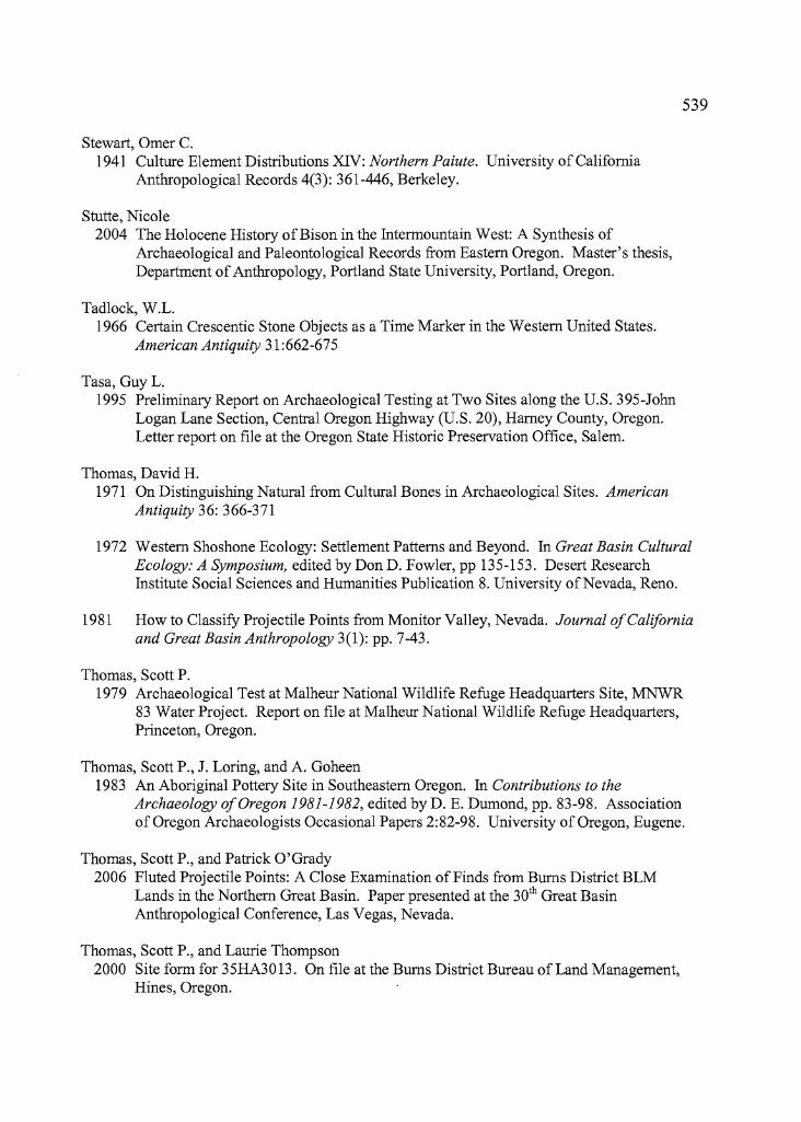
539
Stewart, Orner C.1941 Culture Element Distributions XN: Northern Paiute. University of California
Anthropological Records 4(3): 361-446, Berkeley.
Stutte, Nicole2004 The Holocene History ofBison in the Intermountain West: A Synthesis of
Archaeological and Paleontological Records from Eastern Oregon. Master's thesis,Department of Anthropology, Portland State University, Portland, Oregon.
Tadlock, W.L.1966 Certain Crescentic Stone Objects as a Time Marker in the Western United States.
American Antiquity 31 :662-675
Tasa, GuyL.1995 Preliminary Report on Archaeological Testing at Two Sites along the U.S. 395-JoOO
Logan Lane Section, Central Oregon Highway (U.S. 20), Harney County, Oregon.Letter report on file at the Oregon State Historic Preservation Office, Salem.
Thomas, David H.1971 On Distinguishing Natural from Cultural Bones in Archaeological Sites. American
Antiquity 36: 366-371
1972 Western Shoshone Ecology: Settlement Patterns and Beyond. In Great Basin CulturalEcology: A Symposium, edited by Don D. Fowler, pp 135-153. Desert ResearchInstitute Social Sciences and Humanities Publication 8. University ofNevada, Reno.
1981 How to Classify Projectile Points from Monitor Valley, Nevada. Journalo/Californiaand Great Basin Anthropology 3(1): pp. 7-43.
Thomas, Scott P.1979 Archaeological Test at Ma1heur National Wildlife Refuge Headquarters Site, MNWR
83 Water Project. Report on file at Malheur National Wildlife Refuge Headquarters,Princeton, Oregon.
Thomas, Scott P., J. Loring, and A. Goheen1983 An Aboriginal Pottery Site in Southeastern Oregon. In Contributions to the
Archaeology o/Oregon 1981-1982, edited by D. E. Dumond, pp. 83-98. Associationof Oregon Archaeologists Occasional Papers 2:82-98. University of Oregon, Eugene.
Thomas, Scott P., and Patrick O'Grady2006 Fluted Projectile Points: A Close Examination of Finds from Bums District BLM
Lands in the Northern Great Basin. Paper presented at the 30th Great BasinAnthropological Conference, Las Vegas, Nevada.
Thomas, Scott P., and Laurie Thompson2000 Site form for 35HA3013. On file at the Bums District Bureau of Land Management,
Hines, Oregon.
......~---------------------------- ...
--
540
Thompson, Laurie2001 Site form for 35HA3074. On file at the Burns District Bureau of Land Management,
Hines, Oregon.
2001 Site form for 35HA3075. On file at the Burns District Bureau of Land Management,Hines, Oregon
Thoms, Alston V.1989 The Northern Roots ofHunter-gatherer Intensification: Camas and the Pacific
Northwest. Ph. D. dissertation. Department of Anthropology, Washington StateUniversity, Pullman.
Toepel, Kathryn Ann, and Rick Minor1983aCultural Resources Survey ofthe Eagles Nest Burn, Malheur National Wildlife
Refuge, Harney County, Oregon. Heritage Research Associates Report 24, Eugene,Oregon.
1983bCultural Resources Survey ofthe Proposed Dunn Land Exchange, Malheur NationalWildlife Refuge, Harney County, Oregon. Heritage Research Associates Report 23,Eugene, Oregon.
1994 100 Sites, 1000 Isolates, 10,000 Acres: A Summary Perspective on Prehistoric LandUse Patterns in the Fort Rock Basin. In Archaeological Researches in the NorthernGreat Basin: Fort Rock Archaeology Since Cressman, edited by C. M. Aikens andDennis L. Jenkins, pp. 125-154. University of Oregon Anthropological Papers No. 50,Eugene.
Toepe1, Kathryn Ann, Rick Minor, and Ruth Greenspan1984 Archaeological Testing in Diamond Valley, Malheur National Wildlife Refuge,
Harney County, Oregon. Heritage Research Associates Report 30, Eugene, Oregon.
Toepe1, Kathryn Ann, Rick Minor, and William F. Willingham1980 Human Adaptations in the Fort Rock Basin: A Class II Cultural Resources Inventory
ofBLM Lands in Christmas Lake Valley, South-central Oregon. Report on file,Department of Anthropology, University of Oregon, Eugene and U.S. Department ofthe Interior, Bureau of Land Management, Lakeview District Office, Lakeview,Oregon.
Verts, B.J., and Leslie N. Carraway1998 Land Mammals ofOregon. University of California Press, Berkeley.
Wegener, Robert M.1998 Late Holocene Stone Technology and Seed and Faunal Remains from Shull Creek Dunes
Locality 6, Catlow Valley, Southeastern Oregon. Masters thesis, Department ofAnthropology, Washington State University, Pullman.
--
541
Werner, R., and J. Flaherty.1986 Site Form for the Knoll Site (35HA2530). On file at the Burns District BLM Office,
Hines, Oregon.
Weide, Margaret L.1968 Cultural Ecology of Lakeside Adaptation in the Western Great Basin. Ph.D. dissertation,
Department of Anthropology, University of California, Los Angeles.
Weller, M. W., and C. S. Spatcher1965 Role ofHabitat in the Distribution and Abundance ofMarsh Birds. Special Report No.
43, Department ofZoology and Entomology, Iowa State University, Ames.
Whiting, Beatrice B.1950 Paiute Sorcery. Viking Fund Publications in Anthropology 15, New York.
Wigand, Peter E.1987 Diamond Pond, Harney County, Oregon: Vegetation History and Water Table in the
Eastern Oregon Desert. Great Basin Naturalist 47(3): 427-458.
Willig, Judith A.1988 Paleo-archaic Adaptations and Lakeside Settlement Patterns in the Northern A1ka1ai
Basin. In Early Human Occupation in Far Western North America: The ClovisArchaic Interface, edited by Judith A. Willig, C. Melvin Aikens, and John L. Fagan, pp.417-482. Nevada State Museum Anthropological Papers 21, Carson City.
Wingard, George F.2001 Carlon Village: Land, Water, Subsistence, and Sedentism in the Northern Great Basin.
University of Oregon Anthropological Papers No. 57, Eugene
Wriston, Teresa A.2003 The Weed Lake Ditch Site: An Early Holocene Occupation on the Shore ofPluvial
Lake Ma1heur, Harney Basin, Oregon. Master's thesis, Department of Anthropology,University ofNevada, Reno.
Zeanah, David W.2004 Sexual Division of Labor and Central Place Foraging: A Model for the Carson Desert
of Western Nevada. Journal ofAnthroplogical Archaeology 23:1-32.
Related Documents