Channel Tunnel Rail Link London and Continental Railways Oxford Wessex Archaeology Joint Venture The prehistoric and Roman landscape at Beechbrook Wood, Westwell, Kent, by Kate Brady edited by Alistair Barclay and Andrew Fitzpatrick CTRL Integrated Site Report Series 2006 ©London and Continental Railways All rights including translation, reserved. No part of this publication may be reproduced, stored in a retrieval system, or transmitted in any form or by any means electronic, mechanical, photocopying, recording or otherwise without the prior written permission of London and Continental Railways.

Welcome message from author
This document is posted to help you gain knowledge. Please leave a comment to let me know what you think about it! Share it to your friends and learn new things together.
Transcript
Channel Tunnel Rail Link
London and Continental Railways
Oxford Wessex Archaeology Joint Venture
The prehistoric and Roman landscape at Beechbrook
Wood, Westwell, Kent, by Kate Brady
edited by Alistair Barclay and Andrew Fitzpatrick
CTRL Integrated Site Report Series
2006
©London and Continental Railways
All rights including translation, reserved. No part of this publication may be reproduced, stored in a retrieval system, or
transmitted in any form or by any means electronic, mechanical, photocopying, recording or otherwise without the prior written
permission of London and Continental Railways.

CTRL Integrated Site Report Series Beechbrook Wood, Westwell, Kent
LIST OF CONTENTS
1 INTRODUCTION .........................................................................................................................1
1.1 PROJECT BACKGROUND................................................................................................................1
1.2 GEOLOGY AND TOPOGRAPHY (FIGS 1-2) ......................................................................................1
1.3 ARCHAEOLOGICAL AND HISTORICAL BACKGROUND (FIG. 1)........................................................2
2 AIMS...............................................................................................................................................4
3 METHODS.....................................................................................................................................5
4 RESULTS.......................................................................................................................................6
4.1 PHASE SUMMARY .........................................................................................................................6
4.2 HUNTER-FORAGERS-(C 400,000 -4,500 BC) ................................................................................9
4.2.1 Late Mesolithic (c 6,500-4,000 BC)....................................................................................9
4.2.2 Early Neolithic (c 4,000 BC-c 3000 BC) .........................................................................11
4.3 EARLY AGRICULTURISTS (2,500-1,600 BC) ...............................................................................12
4.3.1 Late Neolithic to early Bronze Age/Beaker (c 2500 BC - c 1,600 BC) (Figs 5-6) ............12
4.4 FARMING COMMUNITIES (C 2,000-100 BC)................................................................................18
4.4.1 Middle Bronze Age (1500-1150 BC) and transitional mid-late Bronze Age (1150-950 BC)
18
4.4.2 Late Bronze Age to early Iron Age (1100-300 BC) ..........................................................23
4.4.3 Early Iron Age (700-400 BC) ...........................................................................................25
4.4.4 Middle Iron Age (300-50 BC)...........................................................................................25
4.5 TOWNS AND THEIR RURAL LANDSCAPES I - THE LATER PRE-ROMAN IRON AGE AND ROMANO-
BRITISH LANDSCAPES II (C 100 BC-AD 410) ......................................................................................31
4.5.1 Late Iron Age to early Roman (100 BC-AD 100) (Figures 6, 11 and 21) ........................31
4.5.2 Early Romano-British (AD 43-100)..................................................................................38
4.5.3 Early to middle Romano-British (AD 43-270) (Figures 11 and 12) .................................41
4.6 TOWNS AND THEIR RURAL LANDSCAPES III - THE EARLY MEDIEVAL PERIOD (AD 1100 - 1300).44
4.7 UNPHASED FEATURES ................................................................................................................45
5 GUIDE TO THE ARCHIVE ......................................................................................................46
6 CATALOGUE OF ILLUSTRATED FINDS.............................................................................50
7 BIBLIOGRAPHY........................................................................................................................56
i

CTRL Integrated Site Report Series Beechbrook Wood, Westwell, Kent
LIST OF CONTENTS
LIST OF FIGURES
Fig 1: Beechbrook Wood: Site location : Overview and Geology
Fig 2: Beechbrook Wood: Site location and topography
Fig 3: Beechbrook Wood: Excavated areas
Fig 4a: Beechbrook Wood: Early and later prehistoric
Fig 4b: Beechbrook Wood: Late Iron Age - Romano-British and Post Roman activity
Fig 5: Beechbrook Wood: NW area C phase plan
Fig 6: Beechbrook Wood: NE area C
Fig 7: Beechbrook Wood: East area C phase plan
Fig 8 : Beechbrook Wood: Middle NE area C phase plan
Fig 9: Beechbrook Wood: Activity area 1952 phase plan
Fig 10: Beechbrook Wood: Area A phase plan.
Fig 11: Beechbrook Wood: Middle Iron Age enclosure and ARC BWD98 phase plan
Fig 12: Beechbrook Wood: Far north of area C phase plan
Fig 13: Beechbrook Wood: Tree throw hole 1623
Fig 14: Beechbrook Wood: Early Neolithic pit 1910
Fig 15: Beechbrook Wood: Ring ditches 851 and 1021
Fig 16: Beechbrook Wood: Ring ditch 1682
Fig 17: Beechbrook Wood: Beaker pottery and flints from pit 1374
Fig 18: Beechbrook Wood: Pits 1716, 1288 and 1220
Fig 19: Beechbrook Wood: Waterhole 245
Fig 20: Beechbrook Wood Middle Iron Age enclosure 3072
Fig 21a: Beechbrook Wood; pottery from context 2213 (middle Iron Age enclosure ditch
2150)
Fig 21b: Beechbrook Wood: pottery from context 2213 (middle Iron Age enclosure ditch
2150)
Fig 22: Beechbrook Wood: Plan of Beechbrook Wood middle Iron Age enclosure and
reconstruction drawing of Mingies Ditch middle Iron Age enclosure.
Fig 23: Beechbrook Wood: Cremation burials outside enclosure 3072
Fig 24: Beechbrook Wood: Pottery from cremation graves 173 and 175
Fig 25: Beechbrook Wood: Close-up of metal-working enclosures
Fig 26: Beechbrook Wood: Pottery from cremation burial 730 and ditch 1750
ii

CTRL Integrated Site Report Series Beechbrook Wood, Westwell, Kent
LIST OF TABLES
Table 1: Fieldwork events
Table 2: Radiocarbon dating results
Table 3: General quantification of pottery by phase
Table 4: Struck flint by type from late Mesolithic pit 1623, Beechbrook Wood (ARC
BBW00)
Table 5: Quantities (g) and types of ironworking debris present in features relating to
enclosure 1022
Table 6: Digital report and archive components
Table 7: Artefactual and environmental archive index
Table 8: Fieldwork and research paper archive
iii
CTRL Integrated Site Report Series Beechbrook Wood, Westwell, Kent
ABSTRACT
As part of an extensive programme of archaeological investigation carried out in advance of
the construction of the Channel Tunnel Rail Link (CTRL), Oxford Archaeology (formerly
Oxford Archaeological Unit) was commissioned to undertake a watching brief at Beechbrook
Wood in Kent . In the course of the watching brief, a concentration of archaeological features
was exposed and subjected to detailed excavation.
The features recorded range in date from the late Mesolithic through to the middle
Roman.
A brief period of occupation during the late Mesolithic period is demonstrated by a
utilised tree throw hole, which contained a large lithic assemblage. A single radiocarbon date
on charred material derived from a second tree throw hole indicates broadly contemporaneous
activity involving burning on the site.
Early Neolithic activity includes an isolated flint rich pit deposit, which also
contained a complete quern and the remains of at least two plain bowls. Other early Neolithic
material was recovered as redeposited material from the ring ditches of two round barrows.
The ring ditches of four barrows were excavated, although no direct evidence for
human burial or extant earthworks survived. A complete Beaker was found in a pit within
one of these ring ditches and is interpreted as a possible votive offering. A radiocarbon date
on a deposit of charred hazelnuts indicates that at least one of the remaining ring ditches is of
similar Beaker period date. A very similar Beaker vessel was recovered from a pit deposit
that was rich in pottery, flint and charred plant remains. Given the similarity between these
vessels, it is possible that the two depositional events are linked in some way.
During the middle Bronze Age, two spatially separate activity areas developed. One,
situated in the east of Area C was a group of cremation burials and pits and a possible
building, possibly enclosed on two sides by ditches. Activity in the area included
metalworking. In the northern part of Area A, a group of pits contained large amounts of fired
clay, mainly from ovens or hearths, indicating cooking or cereal drying.
The late Bronze Age saw the development of an E-W and N-S aligned field system.
Pottery was recovered from only a few of the ditch segments, but several others have been
assigned to this phase by their alignment and spatial relationships. Several pits were also sited
along these boundaries. A cremation burial dating to this phase was also cut into the fill of the
Mesolithic pit.
Middle Iron Age activity was concentrated in the far south east of the site. A double
ditched concentric settlement enclosure was constructed, the fills of which contained a very
important middle Iron Age pottery assemblage. A group of pits was situated c. 100 m to the
east of the entrance. This type of settlement evidence is very rare for Kent at this date.
iv
CTRL Integrated Site Report Series Beechbrook Wood, Westwell, Kent
Activity in the west of the site is demonstrated by a fragmentary rectilinear enclosure, the
function of which is not clear, but it may have been an animal corral.
Two contemporaneous industrial enclosures containing features such as furnaces and
pits related to metalworking activity are assigned to the late Iron Age to early Roman phase.
This activity may possibly be associated with a natural spring. A small cremation burial
cemetery was established just outside the entrance of the middle Iron Age enclosure, marking
a change in the function of it or the end of its use. Subsequently, the expansion and extended
use of the area to the south west of the middle Iron Age enclosure during this phase included
possible drove-ways and was probably now functioning as a pastoral enclosure.
Activity continued to the south west of the middle Iron Age enclosure and included
the construction of a new enclosure in the Roman period. Small scale land division, cremation
burial and pit digging was undertaken in area A. Use of the site probably ceased at around AD
250.
Sherds of medieval pottery, recovered from the subsoil, suggest peripheral activity
related to the nearby Parsonage Farm and Yonsea Farm manorial complexes.
RÉSUMÉ
Oxford Archaeology (anciennement l’Oxford Archaeological Unit) fut chargé d’entreprendre
une surveillance archéologique à Beechbrook Wood, dans le Kent, dans le cadre d’un
programme de recherches archéologiques préventives de grande envergure, exécuté en avance
de la construction de la ligne ferroviaire du Tunnel sous la Manche (CTRL). Au cours de la
surveillance archéologique, une concentration de structures archéologiques fut exposée et
firent l’objet de fouilles approfondies.
La datation des faits archéologiques enregistrés s’échelonnait entre la fin du
mésolithique jusqu’au milieu de l’époque romaine.
Une brève période d’occupation de la fin du mésolithique est démontrée par
l’utilisation de la cavité d’un arbre déraciné, laquelle contenait un large assemblage de silex
taillés. Une seule datation au radiocarbone, obtenue à partir de matériel carbonisé et
provenant d’une seconde cavité d’arbre déraciné, indique une occupation généralement
contemporaine. Celle-ci semble être liée à une activité de combustion.
L’activité du néolithique ancien comprend un remplissage de fosse isolée riche en
silex taillés, qui contenait également une meule complète et les restes d’au moins deux bols
simples. D’autre matériel du néolithique ancien fut récupéré sous la forme de mobilier
résiduel provenant des fossés annulaires de deux tumulus circulaires.
Les fossés annulaires de quatre tumulus furent fouillées, cependant aucune trace
directe d’inhumation humaine ou bien d’ouvrage de terre ne semble avoir survécu. Un gobelet
intact fut retrouvé dans une fosse située à l’intérieur de l’un des fossés annulaires et fut
v

CTRL Integrated Site Report Series Beechbrook Wood, Westwell, Kent
interprété comme une possible offrande votive. Une datation au radiocarbone réalisée à partir
d’un dépôt de noisettes carbonisées indique qu’au moins un des fossés annulaires subsistants
date également de l’époque campaniforme. Un vase campaniforme tout à fait similaire fut
retrouvé dans le remplissage d’une fosse, riche en céramique, silex taillés et graines
carbonisées. Étant donné la similarité entre les deux vases, il est possible que les évènements
qui président à ces deux dépôts soient liés d’une certaine façon.
Au cours de l’âge du Bronze moyen, deux aires d’activités séparées dans l’espace se
développèrent. La première, située à l’est du secteur C, comprenait un groupe d’incinérations
et de fosses ainsi qu’un éventuel bâtiment, peut-être enclos de deux côtés par des fossés.
L’activité enregistrée dans cette zone incluait également le travail du métal. L’autre zone,
dans la partie nordique du secteur A, révéla un groupe de fosses contenant de larges quantités
d’argile cuite, provenant essentiellement de fours et de foyers et résultant de la cuisine ou du
séchage des céréales.
L’âge du Bronze récent vit le développement d’un réseau fossoyé aligné nord-sud.
Seuls quelques segments de fossés fournirent de la céramique, mais plusieurs autres furent
attribués à cette phase sur la base de leur alignement et de leurs relations spatiales. Plusieurs
fosses étaient également situées le long de cette délimitation. Une sépulture à incinération,
également datée de cette phase, recoupait une fosse mésolithique.
L’activité de l’âge du Fer moyen était concentrée à l’extrémité sud-est du site. Une
enceinte d’habitat à double fossés concentriques fut construite, dont le remplissage contenait
un assemblage très important de céramique de l’âge du Fer moyen. Un groupe de fosses était
situé à environs 100 m à l’est de l’entrée. Ce type de vestiges d’habitat est très rare dans le
Kent pour cette période. L’occupation à l’est du site est représentée par une enceinte
rectilinéaire partielle, dont la fonction n’est pas évidente, mais qui aurait pu être un corral.
Deux enceintes industrielles contemporaines l’une de l’autre, contenant des faits
archéologiques tels que des fourneaux et des fosses associées au travail du métal, sont datées
de la phase de la fin de l’âge du Fer au début de l’époque romaine. Cette activité pourrait être
associée avec une source naturelle. Une petite nécropole à incinération fut établie juste en
dehors de l’entrée de l’enceinte de l’âge du Fer moyen, marquant ainsi soit un changement
dans sa fonction ou bien la cessation de son utilisation. Par la suite, l’expansion et l’usage
prolongé du secteur au sud-ouest de l’enceinte de l’âge du Fer moyen comprenaient des
chemins éventuels et fonctionnaient probablement désormais comme enceinte pastorale.
L’occupation se poursuivit au sud-est de l’enceinte de l’âge du Fer moyen sous la forme
d’une nouvelle enceinte à l’époque romaine. Une division de terrain à petite échelle, une
sépulture à incinération et des terrassements de fosse furent entrepris dans le secteur A.
L’utilisation du site cessa probablement aux alentours de 250 ap.-JC.
vi
CTRL Integrated Site Report Series Beechbrook Wood, Westwell, Kent
Des tessons de céramique médiévale, récupérés dans le substrat, suggèrent une activité
périphérique associée au complexes seigneuriaux avoisinants de Parsonage Farm et de
Yonsea Farm.
ZUSAMMENFASSUNG
Im Rahmen umfangreicher archäologischer Untersuchungen im Vorfeld des Baus der
Bahnstrecke durch den Kanaltunnel (Channel Tunnel Rail Link, CTRL) wurde Oxford
Archaeology (vormals Oxford Archaeological Unit) mit der Baustellenbeobachtung am
Beechbrook Wood in Kent beauftragt. Im Verlauf dieser Beobachtung wurde eine
Konzentration archäologischer Strukturen entdeckt und einer gründlichen Ausgrabung
unterzogen.
Die verzeichneten Befunde reichten vom späten Mesolithikum bis in die mittlere
Römerzeit.
Eine durch Baumwurf entstandene benutzte Mulde, die umfangreiche Steinartefakte
aufwies, diente als Beleg für eine kurzzeitige Besiedlung im späten Mesolithikum. Eine
einzelne Radiokarbonmessung an verkohltem Material aus einem zweiten Baumwurf deutete
auf etwa zeitgleiche Aktivitäten hin, zu denen auch Verbrennungen an der Fundstelle
gehörten.
Frühneolithische Aktivitäten wurden durch eine isolierte feuersteinreiche Grube
belegt, die einen kompletten Mahlstein und Reste von mindestens zwei undekorierten Schalen
enthielt. Weitere Funde aus dem frühen Neolithikum traten als umgelagertes Material in den
Ringgräben zweier Rundhügelgräber auf.
Die Ringgräben um vier Grabhügel wurden ausgegraben, allerdings wurden dabei
keine direkten Belege für menschliche Bestattungen oder bestehende Erdwerke gefunden. In
einer Grube in einem dieser Ringgräben fand sich ein kompletter Glockenbecher, der als
mögliche Votivgabe gedeutet wurde. Eine Radiokarbondatierung verkohlter Haselnüsse
ergab, dass mindestens einer der anderen Ringgräben ebenfalls aus der Glockenbecherzeit
stammte. Ein sehr ähnlicher Glockenbecher wurde aus einer Grube geborgen, die
umfangreiche Ton-, Feuerstein- und verkohlte Pflanzenreste enthielt. Aufgrund der
Ähnlichkeit der Gefäße erscheint es möglich, dass die beiden Deponierungen auf irgendeine
Weise miteinander verknüpft waren.
In der mittleren Bronzezeit entwickelten sich zwei räumlich getrennte
Aktivitätszonen. Die eine, im Osten von Bereich C, bestand aus einer Gruppe von
Brandgräbern und Gruben sowie einem möglichen Gebäude, das vermutlich an zwei Seiten
von Gräben eingefasst war. In diesem Bereich fanden sich auch Hinweise auf Metallarbeiten.
Im Nordteil von Bereich A war eine Gruppe von Gruben mit großen Mengen an gebranntem
vii
CTRL Integrated Site Report Series Beechbrook Wood, Westwell, Kent
Lehm, vorwiegend von Öfen oder Feuerstellen, zu verzeichnen, die auf die Zubereitung von
Nahrungsmitteln oder die Trocknung von Getreide hinwiesen.
In der späten Bronzezeit wurden Felder in Ost-West- sowie Nord-Süd-Richtung
angelegt. Nur in einigen Grabenabschnitten wurden Keramikgegenstände gefunden, mehrere
andere wurden aufgrund ihrer Ausrichtung und räumlichen Beziehung allerdings derselben
Siedlungsphase zugeordnet. Entlang dieser Begrenzungslinien waren mehrere Gruben
angelegt. In der Verfüllung der mesolithischen Grube wurde außerdem ein Brandgrab aus
dieser Siedlungsphase entdeckt.
Die Nutzung in der mittleren Eisenzeit war auf den äußersten Südosten des
Ausgrabungsortes konzentriert. Zur Siedlungsbefestigung wurde ein konzentrischer
Doppelgraben angelegt, in dessen Verfüllung ein bedeutsamer Keramikkomplex aus der
mittleren Eisenzeit zutage trat. Etwa 100 m östlich des Eingangs fand sich eine Gruppe von
Gruben. Siedlungsbefunde dieser Art sind für diese Periode in der Grafschaft Kent höchst
selten. Im Westen der Ausgrabungsstätte fanden sich Fragmente einer geradlinigen
Grabenanlage, deren Funktion ungeklärt ist, die jedoch als Tiergehege gedient haben könnte.
Zwei zeitgleich um industriell genutzte Bereiche angelegte Einhegungen, die
Merkmale wie Schmelzöfen und Gruben umschlossen, die mit Metallarbeiten in Verbindung
standen, wurden der späten Eisenzeit bis frühen Römerzeit zugeordnet. Diese Tätigkeiten
standen womöglich mit einer natürlichen Quelle in Zusammenhang. Direkt vor dem Eingang
der Einhegung aus der mittleren Eisenzeit lag ein kleines Brandgräberfeld, woraus sich
schließen lässt, dass die Einhegung eine Funktionsänderung erfuhr oder nicht länger genutzt
wurde. Der Bereich südwestlich dieser mitteleisenzeitlichen Einhegung, der in dieser Phase
ausgeweitet und verstärkt genutzt wurde, enthielt möglicherweise Viehwege und diente nun
vermutlich als Weideland.
Die Aktivitäten im Gebiet südwestlich der Einhegung aus der mittleren Eisenzeit
hielten weiter an; in der Römerzeit entstand hier eine neue Einhegung. Im Bereich A waren
vereinzelte Fluraufteilungen, Brandgräber und Arbeiten zur Aushebung von Gruben zu
erkennen. Die Nutzung der Stätte kam vermutlich um 250 n. Chr. zum Erliegen.
Mittelalterliche Tonscherben aus dem Unterboden deuten auf periphere Aktivitäten in
Verbindung mit den nicht weit entfernten Höfen Parsonage Farm und Yonsea Farm hin, die
zu größeren Anwesen gehörten.
RESUMEN
Como parte de un extenso programa de investigación arqueológica realizada con anterioridad
a la contrucción del Channel Tunnel Rail Link (CTRL), Oxford Archaeology (antes Oxford
Archaeological Unit) fue encargado de realizar un seguimiento de obra en Beechbrook Wood
viii
CTRL Integrated Site Report Series Beechbrook Wood, Westwell, Kent
en Kent. Durante el seguimiento, se reveló un grupo de estructuras arqueológicas que fueron
excavadas en detalle.
Las estructuras excavadas varían en fechas desde el período Mesolítico tardío hasta
mitad del período romano.
Un agujero de árbol conteniendo un conjunto lítico grande, indica un breve tiempo de
ocupación durante el período Mesolítico tardío. Una única fecha de radiocarbono de un
material carbonizado derivado de otro agujero de árbol indica, a grandes rasgos, una actividad
contemporánea de quema en el yacimiento.
La actividad de comienzos del Neolítico incluye un depósito de un hoyo rico en sílex,
conteniendo también un molino de piedra completo y los restos de al menos dos cuencos
lisos. Otros restos Neolíticos fueron recuperados como material re-depositado de dos zanjas
anulares de dos túmulos circulares.
Se excavaron las zanjas anulares de cuatro túmulos aunque no se encontró evidencia
directa de enterramiento humano o movimiento de tierra. Un cuenco Campaniforme se
encontró en un hoyo dentro de una de las zanjas anulares y se ha interpretado como posible
ofrenda votiva. La fecha de radiocarbono de un depósito de avellanas carbonizadas indica que
al menos una de las zanjas anulares es de una fecha similar Campaniforme. Otro recipiente
Campaniforme similar se encontró en un depósito de un hoyo rico en cerámica, sílex y restos
de plantas carbonizadas. Dada la similitud de estos recipientes, es posible que los dos eventos
sedimentarios estén ligados de alguna manera.
Durante la mitad de la Edad del Bronce se desarrollaron dos áreas de actividad
separadas espacialmente. Una, situada al Este del Área C, era un grupo de enterramientos de
cremación, hoyos y un posible edificio cercado en dos de sus lados por zanjas. La actividad en
el área incluía el trabajo del metal. Al Norte del Área A, un grupo de hoyos contenían grandes
cantidades de cerámica cocida, principalmente de hornos u hogares, sugiriendo el secado de
cereal o cocinado de alimentos.
El final de la Edad del Bronce vio el desarrollo de un sistema de campos con alineación
E-O y N-S. La cerámica apareció únicamente en algunos segmentos de las zanjas, pero
algunas otras se han asignado a esta fase por su relación espacial y su alineación. También
algunos hoyos fueron localizados a lo largo de estos límites. Un enterramiento de cremación
fechado en esta fase cortaba también el relleno del hoyo Mesolítico.
La actividad de mediados de la Edad del Hierro se concentró al Sureste del yacimiento.
Se construyó un recinto de doble zanja concéntrica, cuyos rellenos contenían un importante
conjunto de cerámica de mitad del la Edad del Hierro. Un grupo de hoyos apareció a unos 100
metros al Este de la entrada. La aparición de este tipo de asentamiento es muy raro en Kent
ix

CTRL Integrated Site Report Series Beechbrook Wood, Westwell, Kent
para esta fechas. La actividad en el Oeste del yacimiento se muestra por un recinto rectilíneo
fragmentado, cuya función no está clara, pero podría haber sido un corral para animales.
Dos recintos industriales contemporáneos, con estructuras de hoyos y hornos
relacionados con el trabajo del metal, se han atribuido al final de la Edad del Hierro y
comienzos de la fase Romana. Esta actividad pudo estar asociada con una fuente natural. Un
pequeño cementerio de cremación se estableció justo al exterior de la entrada del recinto de la
Edad del Hierro, marcando un cambio en su función o el final de su uso. De esta modo,
durante esta fase la expansión y amplio uso del área al Suroeste del recinto de mediados de la
Edad del Hierro incluyó posibles caminos y posiblemente funcionó como cercado para pasto.
La actividad continuó al Suroeste del recinto de mitad de la Edad del Hierro e incluyó
la construcción de un nuevo recinto en el período Romano. En el Área A se establecieron
divisiones de terreno a pequeña escala, enterramientos de cremación y hoyos. El uso del suelo
probablemente cesó alrededor del año 250 d.C.
Fragmentos de cerámica medieval, recuperados del subsuelo, sugiere una actividad
periférica asociada a los complejos señoriales de Parsonage Farm y Yonsea Farm.
x
CTRL Integrated Site Report Series Beechbrook Wood, Westwell, Kent
xi
ACKNOWLEDGEMENTS
The investigations at Beechbrook Wood were undertaken principally by staff from Oxford
Archaeology (OA), with support and overall management framework during the post-
excavation phase provided by the Oxford Wessex Archaeology Joint Venture (OWA). The
work was supervised throughout by an archaeological team from Rail Link Engineering
(RLE), on behalf of the employer, London and Continental Railways.
The author would like to thank all those whose efforts contributed to the success of the
excavation, including the principal contractor for CTRL Project Area 430, Balfour Beatty
Major Projects and Mark Turner of Rail Link Engineering (RLE). The fieldwork was
supervised by Brigitte Buss and managed by Stuart Foreman, who also prepared the post-
excavation assessment report. The full field team and specialist contributors to the
assessment report are credited in the main project acknowledgements in the digital archive
(ADS 2006).
The following specialists contributed to this report: Diane Aldritt (Charcoal), Kate
Cramp (lithics) Valerie Diez (metalwork), Emily Edwards (early prehistoric pottery), John
Giorgi (charred plant remains), Grace Perpetua Jones (later prehistoric pottery), Malcolm
Lyne (Late Iron Age and Roman pottery) and Annsofie Witkin (human remains). The
submission and calibration of radiocarbon dates was co-ordinated by Michael J Allen, in
discussion with Alex Bayliss of the English Heritage Scientific Dating Service. The
illustrations were prepared by Anne Stewardson. The abstract was translated by Mercedes
Planas (Spanish), Gerlinde Krug (German) and Valerie Diez (French).
The Beechbrook Wood report was edited by Alistair Barclay (OWA early prehistoric
period team leader), Andrew Fitzpatrick (OWA late prehistoric period team leader) and Julie
Gardiner (OWA senior editor). Stuart Foreman and Valerie Diez were the OWA senior
project managers. Thanks are also extended to all those who contributed to the management
of the CTRL post-excavation project, in particular Leigh Allen (OWA finds manager), Mike
Allen (radiocarbon dating co-ordinator) Niall Donald (OWA data manager), Rob Goller
(OWA CAD manager), Simon Skittrell (CAD draughtsman) and Liz Stafford (environmental
manager).
Thanks are also extended to Helen Glass, Steve Haynes, Jay Carver and Mark Turner
from RLE, to John Williams, Lis Dyson and Simon Mason of Kent County Council, and to
Peter Kendall and Dominique de Moulins of English Heritage.

CTRL Integrated Site Report Series Beechbrook Wood, Westwell, Kent
1 INTRODUCTION
1.1 Project background
The site of Beechbrook Wood, Hothfield, Kent (OS NGR TQ 9752 4660) was discovered and
excavated as part of an extensive programme of archaeological investigation carried out in
advance of the construction of the Channel Tunnel Rail Link (CTRL). Oxford
Archaeology(OA), (formerly the Oxford Archaeological Unit) was commissioned to monitor
all earthworks within CTRL Project Area 430, which extended for 14.5 km from East of
Lenham Heath to Ashford. The work was project managed by Rail link Engineering on behalf
of Union Railways (South) Limited (subsequently CTRL UK Limited). The site originally
formed part of the general watching brief maintained in Project Area 430. However,
following the discovery of extensive significant remains part of this area was subsequently
designated as a targeted watching brief. The location of the site is shown in Figure 1 and the
details of the archaeological works are given in Table 1.
Table 1: Fieldwork events (see Fig 3) Fieldwork Event Name Type Fieldwork Event Code Contractor Dates of
Fieldwork
Beechbrook Wood Targeted watching brief ARC BBW00 OAU 13/10/200-
17/08/2001
South of Beechbrook
Wood
Excavation ARC BWD98 MoLAS 01/09/199-
30/09/1998
The total area investigated in which archaeological features were visible was c 38.9 ha.
The adjacent sections of the CTRL trace were stripped under variable watching brief
conditions, but with a high degree of confidence that significant concentrations of features
would be identified. The targeted watching brief and excavation of the site was undertaken in
two parts, as an excavation by The Museum of London Archaeology Service (MoLAS) in
September 1998 and as a targeted watching brief by OAU from October 2000 to August 2001.
1.2 Geology and topography (Figs 1-2)
The Beechbrook Wood site lies on the Folkestone beds, near to their northern boundary with
the Gault Clay. The local drift geology comprises Atherfield Clay, overlain by the Cretaceous
Lower Greensand Hythe beds to the north (Fig. 1). The geological substrate is overlain by
silty clay soils. The site is located c. 2 km north west of the limits of the town of Ashford, in
the Great Stour river valley. The site stretches from north west to south east for just over 1 km
1
CTRL Integrated Site Report Series Beechbrook Wood, Westwell, Kent
with the valley escarpment approximately 2.5 km to the east and the river c. 2.5 km to the
west.
The topography of the site itself rises from south to north, from approximately 56 m to
68 m OD. A distinct E-W oriented undulation crossing the site south of the woodland is likely
to represent a dried up water course. Beechbrook Wood, a small pocket of ancient coppice
woodland, is situated to the west of the site, and a spring was identified in the south of the site
during construction. The site was under pasture and arable cultivation before the CTRL works
started.
1.3 Archaeological and historical background (Fig. 1)
The site is located in a geological zone, the Lower Greensand, which appears from past
studies to have seen limited activity during the later prehistoric period compared with other
parts of Kent. However, recent excavations, including the CTRL, have begun to suggest that
this may reflect a lack of research rather than a genuine absence.
Very little is known about the Mesolithic of Kent as only a small number of sites have
been studied in detail. However, find spots and small pit sites are found throughout the
county, including many along the greensand ridge (Harding 2006).
Despite the difficulty in identifying the antiquity of trackways in general, and
consequently those that might have traversed Kent in the prehistoric period, it is almost
certain that many such routeways existed. The Pilgrim’s Way trackway is likely to have been
a route utilised at this time, perhaps suggested by the siting of Neolithic long barrows,
Bronze Age round barrows and Iron Age hill-forts close to it. The site of Beechbrook Wood is
situated just under 2 km to the south-west of this path. Approximately 7 km to the east of
Beechbrook Wood, adjacent to the River Stour and the Pilgrim’s Way track way at Boughton
Aluph, is the nearest of a group of three Neolithic long barrows in the Stour Valley (Kent
County Council Sites and Monuments Record (SMR)). Along with one further north-east
along the Stour at Julliberrie Downs, and one also close to the Pilgrim’s Way at Elmsted, this
long barrow indicates significant ritual activity in the area during the Neolithic. Occasional
small settlement sites of Neolithic date have been identified, including one just to the west of
the long barrow at Elsted but mainly on the north and east coasts of Kent (Ashbee 2004) Find
spots of Neolithic artefacts have been made across the county (Ashbee 2004).
Bronze Age round barrows and ring ditches are concentrated mainly on the chalk
downland to the east of the Beechbrook Wood site (Field 1998). These are slightly set back
from the River Stour but still aligned along it. The greensand belt on which the Beechbrook
Wood site is located has comparatively few barrow sites, but some have been found,
demonstrating that the area was not completely avoided. It is possible that this pattern is the
2

CTRL Integrated Site Report Series Beechbrook Wood, Westwell, Kent
result of a research bias rather than a real trend as many sites have been found by aerial
photography, and ring ditches are seen more clearly on the chalk than they are on the
greensand (Field 1998).
The immediate vicinity of the Beechbrook Wood site has revealed pockets of
prehistoric activity, all of which were excavated in advance of the CTRL.
Finds of prehistoric flints have been recorded at various sites in the surrounding area,
including Westwell (OAU no. 1352), Lenham (OAU no. 1346), and Potters corner
(mesolithic), situated approximately 0.25 km south east of Beechbrook Wood (URS 2003a).
An evaluation undertaken at Beechbrook Wood in 1998 for two proposed borrow pit
quarries (ARC BBW 98) revealed two possible settlement enclosure ditches to the north and
east of the site. One possible curvilinear enclosure ditch was revealed at the northern end of
the site (ARC BGO 98). Four Romano-British ditches were discovered close to the limits of
the aforementioned ARC BBW98 during the watching brief in 1998/1999.
Excavations at the CTRL site of Tutt Hill, approximately 1.5 km to the north west of the
Beechbrook Wood site, revealed four large ring ditches and several isolated cremation burials.
Pottery assemblages comparable to those from Beechbrook Wood were also found.
3
The evidence for Iron Age activity in Kent is also scarce, particularly when compared
with the wealth of sites such as hillforts, enclosed settlements, and field systems found in
some parts of southern England. The majority of sites that have been found are east of the
Medway, in particular on the chalk downs towards the coast. These are mainly settlements,
and occasionally cemeteries or burials. Despite being in the hillfort dominated zone of
southern Britain, only six hillfort sites have been identified in Kent. Among these, Bigbury
hillfort is situated approximately 18 km to the east of the Beechbrook Wood site and the
hillfort of Oldbury is some 20 km to the west. The greensand belt, and generally the whole of
the central region of Kent contains only occasional cemeteries or burial sites. Hothfield
Common, approximately 3 km to the south west of the Beechbrook Wood site, is suggested as
the site of an Iron Age cemetery (Jessup 1996; URS 2003a) and cremation burials have been
found at both Charing and Potter’s Corner (URS 2003a). In the 18th century a hoard of gold
coins was found at Lenham, c 10 km north of Beechbrook Wood (URS 2003a). This find
occurred in an area otherwise still virtually devoid of Iron Age sites. At Parsonage Farm (Hill
2006 ) the remains of a wooden jetty, next to the River Stour were preserved under a layer of
peat, and dated to the Iron Age. The rare discovery demonstrates the use of the river and
probably canoes or coracles during this time, probably to transport people and products. The
nearest settlement site to Beechbrook Wood is situated over 10 km to the east, on the edge of
the Downs. Philp (1994) suggests the existence of many more sites identified by fragments of
ditches and pottery. However, detailed investigation of such sites is yet to be carried out. Few
Iron Age settlement sites in Kent have been examined in detail, but those that have include

CTRL Integrated Site Report Series Beechbrook Wood, Westwell, Kent
Farningham Hill near Dartford, an enclosed farmstead, dating to the 1st century BC (Philp
1984). White Horse Stone (Hayden 2006), near Maidstone was also excavated as part of the
CTRL project and adds to the small dataset for this period. Evidence for land division such as
field systems, is notably absent for the Iron Age of Kent. Therefore, we have little evidence
for how they produced food. Sites such as Mill Hill, Deal (Parfitt 1995) and Highstead
(Tatton-Brown 1976) have provided artefactual evidence demonstrating that Kent was in
close contact with the continent at least in the early part of the 1st millennium BC.
The Beechbrook Wood site was located approximately 15 km north-east of the Weald,
the most important iron-making area in Roman Britain. Ashford, 5 km to the south east of the
site was an important centre for Iron Age and Roman pottery production. As part of the CTRL
project, watching brief activity at Leda cottages, approximately 3 km to the north of
Beechbrook Wood, revealed a small scale iron working site of early Romano-British date.
The main concentrations of Romano-British settlements and burial sites occur in the
north and east of Kent, although the area within a 5 km radius of Beechbrook Wood contains
at least eight burial sites and two occupation sites (Kent County Council Sites and
Monuments Record (SMR)). The site is situated just under 10 km north west of a known
Roman road between Canterbury (Durovernum) and Lympne (Portus Lemanis).
Along with the place name, finds of pottery wasters dating to the 13th century from
Potter’s Corner, suggest a manufacturing site (URS 2003a). Buildings at Godinton Park and
Chapel Farm can be traced to 13th century manorial origins (URS 2003a). Part of the
medieval moat at Parsonage Farm was excavated as part of the CTRL mitigation work. (URS
2003a).
To the west of Beechbrook Wood the remains of the ancient coppice woodland survive.
The cultivation of chestnut coppicing was historically a widespread way of utilising the poor
acidic soils of the area. Further remains of ancient woodland nearby include Ripple Wood to
the north, and Balls Wood, Lodge Wood and Godinton Park to the south. An active spring
appears on the 1876 Tithe Map, midway between Parsonage Farm and Beechbrook Farm
(URS 2003a).
The medieval (13th century) settlements of Parsonage Farm (Hill 2006) and Yonsea
Farm held land adjacent to the north and the south of the site respectively. Parsonage Farm
was demolished in the 14th century.
2 AIMS
4
The aim of this report is to present synthesised data at an interpretative scale that can be easily
assimilated into complementary studies. This synthetic report is supported by the fieldwork
and research archive which is freely available as a web-based digital archive.

CTRL Integrated Site Report Series Beechbrook Wood, Westwell, Kent
In support of the CTRL Project Monograph, the Beechbrook Wood report integrates
key assemblages and stratigraphic data into a site sequence secured on key dating evidence
from artefact groups. The report includes a discursive narrative describing the sequence of
activity and reasoning evidence (URS 2003a, 15-16).
The following aims are extracted from the CTRL Section 1 Updated Project Design
(URS 2003a):
Early Agriculturalists
• Define ritual and economic landscapes and their relationships (UPD Vol. 1, 2.11.3);
Farming Communities
• Determine spatial organisation of the landscape in terms of settlement location in relation
to fields, pasture, woodland, enclosed areas and ways of moving between these (UPD Vol. 1,
2.17.2);
• Determine how settlements were arranged and functioned over time (UPD Vol. 1, 2.17.3);
Towns and their rural landscapes
• How were settlements and rural landscapes organised and how did they function? (UPD
Vol. 1, 2.22.3);
• How did the organisation of the landscape change through time (UPD Vol. 1, 2.22.4)?
The research aims specific to Beechbrook Wood focus on its potential to provide rare
evidence for early Bronze Age residential architecture (UPD Vol. 1, 2.14.6); the examination
of the differences in cremation rites (UPD Vol. 1, 2.15.1); distinctions between ritual and
domestic activity; the causes and consequences of agricultural intensification (UPD Vol.1,
2.15.4) and material deposits in relation to monument histories (UPD Vol. 1, 2.14.9). The
middle Iron Age pottery assemblage has potential to refine the ceramic chronology for the
period as it includes a very important new regional fabric series.
The multiple ditched Iron Age enclosure is a rare find for Kent and although poorly
preserved it has potential for expansion of our settlement knowledge for this region by
comparison with other known examples from southern and eastern England and perhaps the
continent (UPD Vol. 1, 2.20.4). As a whole, the site has potential to help examine the changes
in land use and organisation through time (UPD Vol.1, 2.22.4).
3 METHODS
The site was discovered during the scheme-wide watching brief. This report encompasses two
fieldwork events: Beechbrook Wood targeted watching brief (ARC BBW00) and South of
Beechbrook Wood strip, map and sample excavation (ARC BWD98). ARC BBW00 was
5

CTRL Integrated Site Report Series Beechbrook Wood, Westwell, Kent
divided into four areas chosen for excavation. Areas B and C were in contract Area 430 and
Area A and D within contract 570. An expansion of the original Area C, eventually joined it
with original Area D, these combined areas were renamed Area C. Area B was preserved in
situ under the temporary earthworks of the railway loop embankment. These main areas
chosen for excavation were stripped by a 360° excavator fitted with a toothless bucket. All
fieldwork comprising ARC BBW 00, from site stripping to recording and sampling, was
conducted by OAU, and by MoLAS on ARC BWD98 in accordance with the Written Scheme
of Investigation (URS 2000) prepared by the Project Manager (RLE).
The post-excavation analysis and report were carried out by Oxford Wessex
Archaeology Joint Venture (OWA JV) following the methodology set out by the Updated
Project Design for archaeological analysis and publication (URS 2003a). All project design
documents are available in the digital archive:
http://ads.ahds.ac.uk/catalogue/projArch/ctrl/index.cfm.
4 RESULTS
4.1 Phase summary
The overall phase plan is shown on Figures 5 to 12. In some instances, features have been
assigned to phases by spatial relationships alone. However, this method was used only when
these relationships were sufficiently convincing. The fills of all archaeological features were
of a similar nature (mainly clayey silt), and in most cases did not help in phasing the site. For
this reason, they are discussed in the narrative only when needed for the understanding of the
site sequence. Full details of the radiocarbon dates can be found in Table 2. The following
phases were recorded:
1. Late Mesolithic (6500-4000 BC) (Fig. 5): a brief period of occupation during this
period is demonstrated by a utilised tree throw hole, which was associated with a large lithic
assemblage. A radiocarbon date (6020-5840 cal BC NZA-20049) on redeposited charcoal
indicates an episode of burning (hearth or tree-clearance) of broadly contemporaneous date.
2. Earlier Neolithic (4000-3000 BC) (Fig. 5): activity of this date is represented by an
isolated pit deposit and residual finds recovered from the ditches of two later round barrows.
The pit contained a rich flint assemblage, two fragmentary Plain Bowls and a complete
saddle quern..
6

CTRL Integrated Site Report Series Beechbrook Wood, Westwell, Kent
3. Late Neolithic/Early Bronze Age (Beaker period) (2600-1800 BC) (Figs 5-6): activity
during the Beaker period is represented by two pit deposits one of which produced a large
finds assemblage, and the ring ditches of four probable round barrows. Two of the ring
ditches intercut and appear to have had a more complex history of development. One of the
other ring ditches had an internal pit that contained a complete Beaker. No funerary deposits
were identified, perhaps as a result of poor preservation and truncation of the original ground
surface.
4. Middle Bronze Age (1500-1100 BC) (Figs 7 and 9): Middle Bronze Age activity on
site is represented by two spatially separate activity areas. One, situated in the east of Area C
was a group of cremation burials and pits, possibly enclosed on two sides by ditched
boundaries. The features in this group also provided evidence of metalworking and the
remains of a possible structure. In the northern part of Area A, a group of pits provided large
amounts of fired clay from oven or hearth structures.
5. Late Bronze Age (1100-700 BC) (Fig. 8): during the late Bronze Age an E-W and N-
S aligned field system was laid out. Pottery was recovered from only a couple of the ditch
segments, but several others have been assigned to this phase by their alignment and spatial
relationships. Several pits were also placed along these boundaries. A cremation burial dating
to this phase was also cut into the fill of the Mesolithic pit.
6. Middle Iron Age (300-50 BC) (Fig.11): during the middle Iron Age, activity was
concentrated in the far south east of the site. A double concentric ditched settlement enclosure
was constructed, the fills of which contained a very important new Middle Iron Age pottery
assemblage. A ring ditch and nearby pit group, probably the remains of a roundhouse
settlement, were situated c 100m to the east. This type of settlement evidence is very rare for
Kent in this phase. Activity during this phase in the west of the site is demonstrated by a
fragmentary rectilinear enclosure, the function of which is not clear, but may have been an
animal corral.
7
7. Late Iron Age to early Romano-British (100 BC-AD 100) (Figs 6 and 11): Two
contemporaneous industrial enclosures containing features such as furnaces and pits related to
metalworking activity are assigned to this phase. There is a possible association of this
activity with a natural spring. A small cremation cemetery was established just outside the
entrance of the Middle Iron Age enclosure, marking a change in the function of it.
Subsequently, the expansion and extended use of the area to the south west of the middle Iron
Age enclosure during this phase included possible drove-ways and it was probably now
functioning as a pastoral enclosure.

CTRL Integrated Site Report Series Beechbrook Wood, Westwell, Kent
7.1 Middle Romano-British (AD 150-250) (Figs 11-2): activity continued to the south
west of enclosure 3072, including the construction of a new enclosure. Small scale land
division and occasional cremation burials and pit deposition was undertaken in area A. Use of
the site probably ceased at around AD 250.
Tables 2-3 provide details of the radiocarbon dating programme and a summary of the
quantities of pottery recovered per phase.
Table 2: Radiocarbon dating results Feature context sample context details Material result no. δ C13 result BP cal
pit 1374 1377 279 dump of nuts Hazelnut shells NZA-21170 -22.22 3864±35 2470-2200BC
pit 1374
1377 279 dump of
hazelnuts and
charred material
Charcoal Corylus NZA-22739 -20.5 3762±35 2290-2030BC
pit 1374
1377 279 dump of
hazelnuts and
charred material
charred crab apple NZA-22738 -26.2 3747±35 2280-2030BC
ring ditch
1021
944 243 lower secondary
fill
charcoal Alnus/Corylus NZA-20049 -24.05 7072±35 6020-5840BC
ring ditch 851
899 229 dump in ditch Hazelnut shells NZA-20027 -23.9 3774±40 2310-2030BC
[LP] pit 245 244 Primary pit fill of
pit
PRN 1017, fabric 3 NZA-22877 -29.5 3081±30 1410-1260BC
[LP] pit 1220 1201 last pit fill, dump PRN 1053, fabric 10 NZA-22878 -27.8 3112±30 1430-1260BC
cremation
burial 1294
1293 272 cremation debris Parenchyma+
roundwood bark
NZA-20050 -26.48 2921±40 1270-990BC
cremation
burial 1290
1289 271 cremation debris onion couch grass NZA-21507 -25.64 2870±30 1190-920BC
cremation
burial 1344
1345 276 cremation debris charcoal Alnus/Corylus NZA-20051 -25.15 1728±40 AD 220-420BC
pit 504 525 218 deliberate dump charcoal Quercus rw NZA-21171 -24.85 2155±45 360-50BC
enclosure
ditch 3072
2346 384 ditch fill charcoal Ilex NZA-20052 -24.77 2207±40 390-170BC
enclosure
ditch 1022
505 208 charcoal dump in
ditch
charcoal Betulaceae (cf
Betula pendula/
pubescens)
NZA-21220 -25.37 1989±45 100BC-AD130
Table 3: General quantification of pottery by phase Phase Count Weight (g) Count % Weight %
Early to Middle Neolithic 51 386 0.72 0.39
Late Neolithic to Early Bronze Age/ Beaker 118 1910 1.68 1.9
Middle Bronze Age 370 8698 5.28 8.85
8

CTRL Integrated Site Report Series Beechbrook Wood, Westwell, Kent
9
Phase Count Weight (g) Count % Weight %
Late Bronze Age 122 1341 1.7 1.36
Early Iron Age 243 1259 3.46 1.28
Middle Iron Age 2,327 31,489 33.22 32.06
Late Iron Age to early Roman 3,231 46,789 46.13 47.64
Roman 542 6,339 7.73 6.45
Total 7,004 98,211
4.2 Hunter-foragers-(c 400,000 -4,500 BC)
4.2.1 Late Mesolithic (c 6,500-4,000 BC)
Evidence for Mesolithic activity at the Beechbrook Wood site includes the utilised tree throw
hole 1623 (Fig. 5) that produced an assemblage of flint and a small quantity of redeposited
finds from other features (eg early Neolithic pit 1910: Fig. 14:7). Feature 1623 was relatively
wide (5 m diameter), shallow (0.35 m deep) and filled with many thin layers. It was excavated
in quadrants (1674-5, 1624 and 1643) (Fig. 13). A 1 m square within quadrant 1643 was
excavated in 50 mm spits (1637, 1639-42) in order to examine any patterning in the vertical
distribution of the flints. Analysis of the flint distribution revealed that there was an increased
concentration of flintwork in the western quadrant. Examination of the flintwork from the 50
mm spits revealed that it was evenly distributed with only a slight decrease in numbers with
depth (see Table 4).
The fill of the pit contained a large late Mesolithic flint assemblage consisting of 1393
struck flints, including 311 chips, as well as 219 burnt worked flints and 205 pieces (295 g) of
burnt, unworked flint (see Table 4; Cramp 2006). The worked flint assemblage is in an
extremely fresh condition, and includes blades, bladelets and blade-like flakes (155 pieces),
comprising 27 % of the assemblage (Table 4). Technological analysis has revealed that a
mainly soft-hammer strategy was used, with careful preparation, removal and platform
maintenance indicated by the presence of two core rejuvenation flakes. Five of the nine cores
in the assemblage were used to yield blades or bladelets (Fig. 13: 8-9), clearly indicating a
blade oriented industry. A total of 30 microliths (dominated by the narrow bladed scalene
microtriangle: Fig. 13:2-6) was recovered, along with considerable evidence of manufacture
using the microburin technique in the form of 58 microburins. The 2:1 ratio of microburins to
microliths supports the suggestion that the deposit contains manufacturing waste. Analysis
also failed to identify any refitting pieces, which again indicates that material may well have
been dumped in this feature as secondary refuse, albeit perhaps from the immediate area.
Decortication of the flint probably took place elsewhere, evidenced by the lack of corticated
material in the assemblage. Other tools recovered from the pit included six retouched flakes
and blades, three piercers (eg Fig. 13:10) and one truncated blade (see Table 4).

CTRL Integrated Site Report Series Beechbrook Wood, Westwell, Kent
Table 4: Struck flint by type from late Mesolithic pit 1623, Beechbrook Wood (ARC BBW00). Quadrants Spits
1674 1675 1624 1643 1637 1638 1639 1640 1641 1642 Category
N. quadrant
S. quadrant
E. quadrant
W. quadrant
0.0- 0.5m
0.5-0.10m
0.10-0.15m
0.15-0.20m
0.20-0.25m
0.25-0.30m
Total:
Flake 117 56 34 85 12 1 12 8 7 6 337 Blade 8 7 5 16 - - - - - - 36 Bladelet 14 9 - 24 1 2 1 3 - 3 55 Bladelike flake 18 23 5 22 - 1 - - - 1 69 Core face/edge rejuvenation flake
- - 1 1 - - - - - - 2
Irregular waste 8 - 2 8 - 1 1 2 3 24 Chip 120 22 48 22 6 9 13 10 5 1 247 Sieved Chips 10-4mm 170 146 - 178 2 4 12 1 3 1 513 Multi-platform flake core
2 - - - - - - - - - 2
Core on a flake - - 1 - - - - - - - 1 Single platform blade core
- - 1 1 - - - - - - 2
Opposed platform bladelet core
1 - - - - - - - - - 1
Bladelet core on a flake
2 - - - - - - - - - 2
Unclassifiable/fragmentary core
- - - 1 - - - - - - 1
Retouched flake 1 - 1 - - - - - - - 2 Retouched blade - 2 - 1 - - - 1 - - 4 End scraper - - - 1 - - - - - - 1 Microlith 4 9 4 8 1 - 1 1 2 - 30 Microburin 20 9 - 22 1 - 2 2 2 - 58 Truncated blade - 1 - - - - - - - - 1 Piercer - 1 - 2 - - - - - - 3 Unclassifiable retouch 1 1 - - - - - - - - 2 Total: 486 286 102 392 23 18 42 28 19 15 1393 Total excluding chips: 196 118 54 192 15 5 17 17 11 13 Total no. burnt struck flints:
79 37 11 70 2 2 6 7 1 6 219
Total no. broken struck flints:
250 158 61 202 9 7 22 17 9 11 739
This pit did not contain any material suitable for radiocarbon dating (Mike Allen pers comm).
However, a calibrated radiocarbon date of 6020-5840 BC [NZA-20049;7072±35] has been
obtained on charcoal recovered from a probable tree throw hole at the base of a ring ditch
near to this pit, dating the earliest activity in this area to the early part of the late Mesolithic
(Allen and Brady 2006).
The nature of the Mesolithic activity at Beechbrook Wood is likely to have been in the
form of a single temporary camp, where activities such as tool manufacture for use in a
hunting expedition were performed along with other general tasks. The hollow appears to
have been utilised for the discard of the knapping waste, broken tools and burnt flint from
hearths. The tiny amount of charcoal noted in the fill of tree throw hole 1623 may have
originated from fires lit in these temporary camps, further demonstrated by the 367 burnt
worked flints, which along with other unworked burnt flint had perhaps been scraped from a
hearth (Cramp 2006).
10
CTRL Integrated Site Report Series Beechbrook Wood, Westwell, Kent
4.2.2 Early Neolithic (c 4,000 BC-c 3000 BC)
Early Neolithic activity was represented by an isolated pit deposit and a scatter of redeposited
finds. The latter were mostly recovered from the ditch fills of a Bronze Age Barrow.
Early Neolithic Pit
Evidence for early Neolithic activity at Beechbrook Wood consisted of a bowl shaped pit
(1910), situated in the far west of the site (Fig. 5). It contained a large flint assemblage, a
saddle quern and early Neolithic Plain Bowl pottery.
This pit measured 1.8 m in width and 0.5 m in depth and contained a single very dark
brown silty sand fill. A total of 671 worked flints were distributed evenly throughout its single
fill as well as 131 pieces (506 g) of burnt, unworked flint (Cramp 2006). This assemblage
consisted of mainly unretouched debitage, including a substantial amount of flakes and chips.
Blades, bladelets and bladelike flakes were also recovered. The percentage of blade type
debitage (28%) is typical for an early Neolithic assemblage (see Ford 1987, 79-80), and
slightly below the range (30% for feature 1623) that would be expected for a Mesolithic one
(Cramp 2006). Six cores were recovered (eg Fig 14: 11), which were used to produce flakes
and blades, and as with the Mesolithic cores, were carefully worked using soft-hammer
percussion. They also showed clear signs of core maintenance. As with the Mesolithic
assemblage, decortication of the nodules seems to have taken place elsewhere. This
assemblage indicates a collection of knapping waste. Retouched tools include flakes, a blade,
and a scraper. The assemblage also includes a few serrated blades (eg Fig. 12:12), include at
least one example with edge gloss, probably a result of use on silica-rich plant materials and
relating to cereal cultivation in the area (Cramp 2006). Rim sherds recovered from this pit
derive from two early Neolithic Plain Bowls, a large open vessel and a small cup or bowl. It
is possible that the vessels were of carinated form as suggested by the slightly concave necks.
However, this suggestion remains inconclusive as no shoulder sherds were present (Edwards
2006). The pit also contained an ironstone saddle quern, not particularly shaped, with one
well used concave surface, worn very smooth and with signs of polish towards the edges
(Shaffrey 2006).
The quern was situated at the very bottom of the pit, on its side and is likely to have
been formally placed unlike the flintwork that was distributed throughout the pit fill (what
about the pottery??). This recalls a similar deposit from Mill Road, Upper Deal where a
rubber or grinding stone (‘grain crusher’) was recovered from the inside of an early Neolithic
vessel, one of five that had apparently been placed at the base of a pit (Dunning 1966, 1-2).
The deliberate placing of the quernstone has a close parallel with a site at Pamphill in Dorset
(Shaffrey 2006). Given the presence of the quern in this pit, it is surprising that no charred
11
CTRL Integrated Site Report Series Beechbrook Wood, Westwell, Kent
cereal grain was recovered. The only other indirect evidence for possible cereal cultivation is
a serrated blade with edge-gloss (Cramp 2006).
The placing of the quern, the broken fragments of pottery and the backfilling of the
pit with soil that contained much flintwork almost certainly represents a deliberate and
symbolic act perhaps to do with notions of fertility and regeneration (Thomas 2004).
4.3 Early agriculturists (2,500-1,600 BC)
4.3.1 Late Neolithic to early Bronze Age/Beaker (c 2500 BC - c 1,600 BC) (Figs 5-6)
This phase at the Beechbrook Wood site is represented by a single pit and four ring ditches,
again in the north west part of the site.
Pit 1716 (Figure 5)
Pit 1716 was oval in shape with concave, moderately sloping sides and a flat base. A
complete Beaker vessel lay on its side on the base of the pit. No finds or cremated human
remains were recovered from the fill of the pot and therefore the function of the pit remains
unclear. A similar vessel was found in pit 1374 and the significance of this is discussed
below. A firing blemish, in the form of a spalling patch, is also paralleled in other vessels
from the CTRL route. The contexts in which these pots were found were all sepulchral
(Edwards 2005), and despite the absence of bone, the context may be the same here. Bone
survival on the site is very rare, due to the acidic soil conditions and bone not completely
burnt is unlikely to have survived. There is no evidence in this case that the Beaker was made
specifically for funerary use, and it is more likely that the pot was selected because it was of a
type that the deceased had used during life (Edwards 2005). The pit may have been cut into
the lower slope on the south side of a barrow mound.
Round barrows (Figs15-6)
The ring ditches of four barrows were identified, three (851, 1021 and 1682) were situated in
the northern part of the site and the other (2025) was located 700 m to the south (Fig. 4a).
Ring ditches 851 and 1021 were originally a pair of discrete monuments that became
conjoined through rebuilding and enlargement. All of the ring ditches formed continuous
circuits, with the notable exception of 1021, which may have had an opening in its primary
phase. In its larger secondary phase there were at least three openings. It is not certain that
this ring ditch was really a barrow and it could have been hengiform. It is also not certain that
the inner C-shaped ditch is the earlier.
12
CTRL Integrated Site Report Series Beechbrook Wood, Westwell, Kent
Ring ditch 851 (Fig. 6) was c. 9 m in diameter and had a U-shaped profile that
measured approximately 1 m in width and 0.4 m in depth. It contained at least three fills, the
middle of which contained sherds of early to middle Neolithic pottery in a re-deposited
natural fill, eroded from the feature sides and ground surface and possibly originating from
the outside edge of the ring ditch. The fills showed no sign of erosion from an internal
mound.. A single radiocarbon date (2310-2030 cal BC: NZA-20027) on charred hazelnut
shells from the middle fill (899) place its construction and use firmly within the early Beaker
period and broadly contemporary with the date from pit 1374 (see Table 2). This suggests that
the early Neolithic pottery and flintwork contained within the fills are almost certainly
redeposited. It is possible that a leaf-shaped arrowhead recovered from one of the ditch
terminals is a curated item that was deliberately placed. However, it was noted that most of
the early Neolithic flintwork was in a fresh condition and it is just as likely that all of this
material derives from a feature that was destroyed during the construction of the barrow.
Where the larger ditch 1007 continued into the inside of 851 the ditch is at its most
shallow, suggesting that there may have been an earthwork present corresponding to 851
when 1007 was constructed. This is further suggested by the gap in ditch 1007 where it
intrudes upon 851.
Ring ditch 1021/1007
Situated just to the south of ring ditch 851, was a C-shaped length of ditch of similar
character. It was inside and concentric with the interrupted ditch 1007. Its actual original
extent was uncertain as its northern extent was destroyed by ditch 1020 and its southern end
was not recorded. Its incomplete nature could be the result of either differential truncation
(see sections of outer ditch Fig. 15), or an incomplete build that was abandoned before
completion. Alternatively the plan and extent of the ditch could have been intentional. Note
that the outer ditch could have been constructed in three segments and these could have been
dug sequentially.
No artefacts were recovered from the ditch fills of 1021. A radiocarbon determination
on charcoal recovered from near to the ditch base yielded a calibrated date (NZA-20049) of
6020-5840 BC (late Mesolithic) (see Table 2). It is most likely that the ditch cut through a
feature such as a tree throw hole, in which charcoal had collected from Mesolithic activity in
the area, although one was not noted or recorded on excavation. The similarity in size and
form of ring ditches 851 and 1021 suggests that they were contemporary.
13

CTRL Integrated Site Report Series Beechbrook Wood, Westwell, Kent
Ring ditch 1007
A larger ring ditch (1007) encircled 1021 and truncated the southern side of 851. Two sherds
of abraded and probably residual early Neolithic pottery were recovered from the fill, along
with a worked flint point of a knife. It is not clear whether 1007 represents a single slightly
later ring ditch perhaps still related to 1021 and effectively disregarding 851, or if 1021 and
1007 represent concentric contemporary ring ditches, part of a monument constructed after
851 went out of use.
This suggests that at Beechbrook Wood there is evidence for round barrow
construction, perhaps with one enlargement.
Hengiform monuments?
Alternative functions are suggested by the form of ditch 1007 (the outer and largest of the ring
ditches). This ditch encloses an area with a diameter of 20 m, large enough to be the remains
of a hengiform monument. This is further suggested by a gap in the west side of the ditch,
perhaps a causeway. Two other gaps in the ditch can be explained as follows: The gap in the
north can be explained by the possibility that here, the ditch was cut into a mound over 851 .
In the south east the gap is too small (0.12 m) to have once been a causeway into the central
area and is probably the result of the ditch being constructed in segments, which would have
joined if the full depth of the ditch remained. The gap in the west, however, remains at nearly
2 m and even allowing for horizontal truncation is wide enough to have been a causeway
through a hengiform monument ditch. The rareity of henge monuments in Kent could simple
reflect a lack of fieldwork. However, this is just as likely to be a causewayed round barrow
ditch.
On balance the presence of probable earlier barrows indicates that ring ditch 1007
represents the enlargement of the barrow indicated by ring ditch 1021, suggesting that 1021
and 851 were contemporaneous. Ring ditch 1007 would therefore be later, but by how much
is unknown, as only one very abraded early Neolithic pottery sherd was recovered from the
fill and was almost certainly residual. Barrow enlargement was a fairly common practice. For
example, barrow G71 at Amesbury, Wiltshire (Christie 1964) was extended twice. Its original
form, constructed in the late Neolithic, was enlarged in the Beaker period and then again in
the early Bronze Age. Each time, more burials were added. The ring ditches at Beechbrook
Wood show no traces of internal burials, and the only internal feature seems most likely to
have been a tree throw hole. However, the site has suffered from horizontal truncation, which
may have removed any internal features. The phenomenon of ‘empty’ barrows is discussed in
subsequent sections.
14
CTRL Integrated Site Report Series Beechbrook Wood, Westwell, Kent
Ring ditch 1682 (Figure 16)
It is highly likely that the excavation and use of pit 1374 described below was related to
activity connected with a ring ditch (1682) found 45 m to the North. This ring ditch was 6 m
in diameter and possibly had two postholes in its base. It was fairly shallow, with a concave
profile and measured an average of 0.08 m in depth and 0.2 m in width and had one remaining
fill.. The ditch contained one comb impressed Beaker sherd (11 g) and two early Neolithic
sherds (12 g) (Edwards 2006, 9 and fig P10). The small flint assemblage consisted mainly of
burnt chips and was undiagnostic. Pit 1716 truncated part of the southern section of the ditch
and contained a complete Beaker vessel. This pit clearly cut through the partly infilled ring
ditch. The relationship between the pit and the ring ditch demonstrates that the ring ditch was
either Beaker or earlier in date, the most likely date being Beaker.
Empty barrows?
Despite the lack of any remaining mound associated with the ring ditches, it is likely that they
represent the remains of round barrows. As with the four at Tutt Hill (Brady 2006),
approximately 1 km to the north-west, the only internal features associated with these ring
ditches are very irregular and are most likely to be tree throw holes. No burials have been
identified in any of these cases, and this might indicate that round barrows, at least in the late
Neolithic to early Bronze Age period, may have had a different function to that commonly
thought. Some barrows have been found not to cover a burial even when the mound still
exists. Barrows are often uncritically considered to be burial monuments, but re-evaluation of
their function and place in Neolithic and Bronze Age society is now taking place. Ann
Woodward (2000) has mentioned that in some cases barrows have been found to cover
spreads of domestic material, perhaps a temporary settlement, and that the barrow may have
represented the ‘closing’ of the site, covering and therefore marking the place of extant
settlement. Julian Thomas (2004) has recently suggested a similar theory in relation to cursus
monuments, sealing post marked routes through the landscape of Scotland and effectively
removing them from the realm of the living. A similar act may have been practised here on
the Greensand ridge of Kent. Perhaps these ‘empty’ barrows covered special places or
perhaps the burial remains have simply not survived due to the acidity of the soil. These may
have been either temporary settlements or sites of ritual activity, effectively sealing their place
in memory. They may have been used to seal a variety of events, activities or places.
Sometimes these were burials, sometimes not. Pit 1716, dug into the probable barrow
represented by ring ditch 1682 and the whole vessel contained within it was then surely
placed here in recognition of the special nature of this place, and with the aim of connecting
with the past. Whether or not 1716 once contained a cremation burial, or represented one (or
15

CTRL Integrated Site Report Series Beechbrook Wood, Westwell, Kent
neither) is not clear, but the beaker pot was buried here with a recognition of the sacred nature
of the place.
Ring ditch 2025
This ring ditch, which was 15 m in diameter, was situated in the far south-east of the site (Fig.
10). Three sherds of pottery were recovered from context 2091, but these were very abraded
and could only be very broadly dated to the prehistoric period (Edwards 2006).
Beaker Pits 1374 (Figure 17)
Pit 1374 was located 44 m south of ring ditch and 90 m west of ring ditch (Fig. 12). A second
similar sized pit, with a similar ashy fill, was located some 5 m to the north-west of pit 1374
and could have been contemporaneous despite containing no cultural material.
Pit 1374 was sub-circular in plan (1.7 m by 1.3 m) and 0.3 m deep. It had four fills:.
Two of which (1376-7) were dark brownish black ashy deposits and contained an abundance
of domestic refuse, including 111 pottery sherds (1616 g), a large flint assemblage, a possible
stone pestle and charred plant remains. It is possible that the fills represent separate episodes
of dumping or pit filling.
Two fragments of cremated human bone weighing 1 g each were recovered from the
lower fills 1376-7 (Witkin 2006), one of which was identified as a small fragment of long
bone shaft. The presence of cremated bone is of interest and its significance is discussed
below, although such small fragments could easily be residual or intrusive.
A fired clay object was recovered from fill 1376 (Poole 2006). This lump of
deliberately moulded clay showed impressions of small fingers and nails. One end appears to
have been pulled out into a point and the object naturally rests on one flat side. The small
finger impressions suggest that this was shaped by a child, and was perhaps intended to
resemble a hedgehog (fig. 14). Two fired clay objects were recovered from fill 1377, one of
which may be the curved rim of a flue edge (Poole 2006).
16
The assemblage of Beakers recovered from the four fills is of interest and of some
importance as very few large groups of material have been recovered from single features in
Kent (Barclay and Edwards 2006). The pit group includes a minimum of 14 vessels in a
range of forms (cup/small bowl, taller globular vessels, carinated and sherds from larger ‘pot’
Beakers) in a wide variety of fabrics (sand, flint and grog tempered) and decoration is diverse
(incised, impressed ‘barbed wire’). In short the assemblage is strikingly heterogeneous. One
explanation for this diversity in style is that the pots (pottery deposit) could be the result of a
gathering of people from a wide area. Also of interest is the similarity between one of the
pots (almost complete) and a complete vessel recovered from the pit 1716 within ring ditch
1682. The latter provides an interesting link between the two deposits.
CTRL Integrated Site Report Series Beechbrook Wood, Westwell, Kent
The flint assemblage (Cramp 2006), mostly from dump deposit 1377, consists of 1370
worked flints, including nearly 1000 chips, debitage and burnt and broken pieces, mostly
flakes, as well as 44 pieces (152 g) of burnt, unworked flint, again mostly from context 1377.
Three thumbnail scrapers and a barbed-and-tanged arrowhead, all in a fresh condition, are
typical Beaker associated items. The presence of burnt worked and unworked flint indicates
that knapping had taken place around fires and hearths, and that the whole lot had been
incorporated into a temporary dump or midden prior to burial in the pit. The flint assemblage
was dominated by flakes (some 205 broad, squat flakes were retrieved) and typically there is a
high flake to blade ratio (30:1). The flake-based industry and the use of hard hammer
percussion (evidenced by the recovery of a small hammerstone) is in contrast to what was
noted for the Mesolithic and Neolithic assemblages (see above; Cramp 2006). There is only
occasional evidence of platform and core maintenance and the presence of cortical pieces
indicates that at least some nodules were being decorticated on site.
Use-wear is present on nearly 44 % of the flints, including edge damage, and their
presence in this dump of burnt domestic material suggests that they had been discarded in a
hearth or just burnt as refuse.
Analysis of environmental samples taken from the pit revealed a large amount of
charred plant remains spread throughout all four fills. Two fills (1376 and 1377) were
probably individual dumps and contained large amounts of crab apple (both pips and fruit),
some hazelnut shells, an acorn and a hawthorn fruit but little evidence for cereals (of which
one from 1376 could be Barley).These fruits are known archaeo-botanical finds in both
Neolithic and Bronze Age contexts in the British Isles (Giorgi 2006) including a number of
sites in Kent, and show exploitation of wild food resources from the surrounding area. A
single acorn was also recovered, which was probably brought onto the site with the oak wood,
which made up the majority of the charcoal on the site (Giorgi 2005).
17
A C14 date (NZA-22738) was obtained from the charred crab apple and provided a
date of 2747±35 (2280-2030BC).The early date of the context in which they were found
makes it unlikely that they were cultivated. Only two cereal grains were found in the pit, one
of which was identified as barley, which has been recorded on other sites of this period in
southern England. A small amount of cremated human bone (5 g) was also found in fill 1377,
of which only a small fragment of long bone shaft was identifiable. The burnt fruits, in
conjunction with these possible human remains, may represent the residues of burnt food
offerings although deposition as domestic waste is also possible. This pit truncated an earlier
one, of which only a small section remained and from which no finds were recovered. This
means that some of the environmental evidence may also have derived from the earlier
feature, and is therefore insecure, but the charred crab apple at least can be associated by C14
date with the early Neolithic pottery..
CTRL Integrated Site Report Series Beechbrook Wood, Westwell, Kent
The vast majority of the pottery was recovered from the second fill (1377) which appears to
have been a dump of domestic refuse. Fill 1376 above it, was more like a dump of heavily
burnt and ashy hearth debris.
4.4 Farming communities (c 2,000-100 BC)
4.4.1 Middle Bronze Age (1500-1150 BC) and transitional mid-late Bronze Age (1150-950 BC)
Settlement Areas and possible houses(Figures 7, 9 and 10)
Middle Bronze Age activity on the Beechbrook Wood site is concentrated in three areas;
1952, 2440 and 2442. All three areas produced pottery assemblages of middle Bronze Age
and middle to late Bronze Age transitional date.
Activity area 1952 (Figures 7 and 8)
The earliest activity in this area is represented by a large number of tree throw holes. There is
a greater concentration of them to the east of area 1952 (Fig. 9), but a few have stratigraphic
relationships with pits and postholes, demonstrating that at least some of these tree throw
holes were earlier. Therefore, a period of tree clearance appears to have taken place before
settlement commenced, and the effort involved in this activity suggests a certain amount of
permanence to the habitation, although only a general date before the middle Bronze Age can
be given for this. A concentration of pits and postholes was situated in an area measuring
approximately 50 m by 50 m. It may be that three of the features (237, 204 and 231) were
slightly earlier than the rest. All three contained sherds of Deverel-Rimbury pottery of the
middle Bronze Age, which dates to the period 1500 to 1150 cal BC (Needham 1992), and
were the only dated features in the area that did not contain pottery of transitional middle to
late Bronze Age type (Jones 2006). Rubbish pit 231 contained two sherds of middle Bronze
Age date and small fragments of an oven or hearth base, in a charcoal rich fill. Near to this, a
small circular pit (204) contained an in situ pottery vessel. Circular pit 237 was bigger than
those discussed above, measuring 1.2 m in diameter and 0.33 m in depth, and was one of the
features that cut through a tree throw hole. The fill (238) contained 35 sherds (378 g) of
middle Bronze Age pottery, one of which had been burnt. Fragments of a cylindrical fired
clay object were also recovered, which may have been part of a pedestal support for an oven
floor. A tiny amount of cremated human remains (less than 1 g) and an unidentified copper
alloy object were also recovered from this pit. This small amount was probably an accidental
18
CTRL Integrated Site Report Series Beechbrook Wood, Westwell, Kent
inclusion. This pit also contained a large amount of charred plant remains. The cereal remains
constituted 90% of the assemblage, and have been identified as emmer, spelt, wheat, barley
and oats. The remaining 10% were seeds from weeds and grasses common on disturbed
(including cultivated) or waste ground and were probably accidentally harvested with the
grain. ‘The assemblage represents an almost fully cleaned cereal crop of (de-husked) emmer
and barley, possibly accidentally burnt while being prepared for milling, before storage, or
during the cooking of whole grains’ (Giorgi, 2006). This feature may have been a cereal drier.
Pit
Feature 245 (Fig. 9) was a large pit, 4 m in diameter and 0.8 m deep. This feature contained
pottery of both middle Bronze Age date and transitional type, some of which was burnt.
These forms and fabrics are less typical of middle Bronze Age assemblages but not quite the
same as the late Bronze Age plain wares recovered from some features (Jones 2005).
However, their recovery from the same context indicates that their use was broadly
contemporary. One transitional form is more convex in profile than the Deverel-Rimbury
pottery from the same context and was made from a grog and flint tempered fabric rather than
the usual flint ones (Jones 2005). A small coarse ware vessel from the pit was also of this
transitional type (Jones 2005). Fragments of vitrified hearth lining and hearth bottom were
also recovered from the primary fill (244).
Shallow feature 1220 (Fig. 9), to the west of the activity area was sub-rectangular in
shape. The fill, was dark reddish purple in colour, and consisted of material burnt in situ
forming a heavily fired oven or hearth base. Fragments of clay oven lining were also found.
Pottery recovered from the fill consisted of 27 sherds (1081 g) of late Bronze Age flint
tempered plain ware type. Other finds included burnt flint from the lower part of the fill and a
quern fragment from the upper part. The pit was sampled for environmental remains, and a
small amount of charred plant remains have been identified as emmer, oat and charred weed
seeds, but these may have been incidentally incorporated into the fill or wind blown
fragments and had not necessarily been burnt in the hearth.
Structure
19
Five postholes formed an arc in the centre of this area (Fig. 9) suggesting the form of an
elongated oval shaped structure measuring c 20 m north to south and 7 m east to west. One of
these postholes (651), which was cut into the fill of a tree throw hole, contained 21 sherds
(296 g) of middle Bronze Age Deverel-Rimbury pottery. An unfinished copper alloy object
(Diez et al 2006) was also found in this posthole. It is possible that the postholes represent
part of a post-built roundhouse or a semi-circular shaped structure (eg Thorny Down – Ellison
1987, fig 1).

CTRL Integrated Site Report Series Beechbrook Wood, Westwell, Kent
A pit or utilised tree throw hole (649) was situated just to the north of this possible
structure (Fig. 9). The fill contained 3 sherds of pottery of probable transitional type. As
transitional sherds in waterhole 245 were found in the same context as Deverel-Rimbury
sherds, it is possible that the use of this pit was contemporary with the use of the structure.
Approximately 100 m north-west of activity area 1952 a single dated feature (551) was
found (Fig. 7), the fill of which included 28 sherds (91 g) of Deverel-Rimbury pottery. The
feature, perhaps a posthole, was circular and the single fill (550) was notably charcoal rich. A
similar, but undated, feature (562) was located nearby. It contained a moderate amount of
charcoal and some burnt animal bone fragments (76 g), some of which were identified as
sheep. The proximity of this feature to activity area 1952 and its contemporaneity with several
of the features there strongly suggests that this feature and 551 represents ancillary activity
related to the main settlement.
Undated structures adjacent to area 1952
To the west of activity area 1952, several features recorded as small tree throw holes (1272,
577, 554, 553, 549, 548 and 546; Fig. 7) form the outline of a possible structure of remarkably
similar size and shape to the others assigned to this phase (see Fig 7). These features were
almost certainly postholes, and although not dated their arrangement justifies their assignment
to this phase of activity. The structure would have measured at least 30 m in length and 11 m
in diameter) and was orientated N-S.
Postholes (1305, 2505, 2504, 1326, 2507, 2506, 2509, 2510, 1317) suggest a similarly
shaped structure aligned NE-SW, situated approximately 100 m to the west of activity area
1952 (Figs 7 and 9). The structure measured at least 15 m in length and 9 m in width. None of
the postholes was dated, but the size and shape of the possible structure and its similarity to
the others suggests that these features part of the same phase of activity. Pit 1331 situated just
to the west of the possible structure contained 49 sherds (400 g) of both flint and grog
tempered late Bronze Age pottery and some fired clay, possibly part of an oven lining, and
may have been related to the use of the structure.
Activity area 2440 (Fig. 10)
20
This group of features was in the north-eastern part of the site and consisted of at least 7 and
possibly 11 postholes, which form the southern part of a possible sub rectangular structure
aligned N-S. It measured 7.4 m in width and comparable in size to the possible structure in
area 1952. The northern extent may have continued beyond the northern limit of excavation.
Seven of the postholes form an arc around a curved line of three features in the interior.
Adjacent postholes 419, 418, and 410 formed part of the arc of the arrangement and contained
pottery. Posthole 418 contained the in situ base (1916 g) of a quartzite-tempered vessel (pot

CTRL Integrated Site Report Series Beechbrook Wood, Westwell, Kent
403) dated to the middle Bronze Age, the fabric of which was unique to the site, and may
have been a ‘special’ deposit (Jones 2006). The fill (420) also contained a moderate amount
of charcoal and 21 flint-tempered Deverel-Rimbury body sherds (227 g) and 8 sherds made of
a sandy fabric. Two sherds were the same fabric as those from pot 403. Posthole 419
contained three sherds (90 g) of middle Bronze Age flint-tempered pottery along with a small
amount of charcoal and burnt clay, perhaps suggesting that a post was burnt in situ here.
Posthole 410 contained one very small sherd of pottery of probable late Bronze Age plain
ware type (Jones 2006).
Of the three internal features, one was dated. Pit 404 contained one fill (405), from
which contained two sherds (147 g) of pottery that was typologically between the middle and
late Bronze Age traditions (transitional). The two small features to the south of this pit were
not excavated, but may have been postholes.It is likely that the features in this area constitute
a sub rectangular structure, the function of which is not entirely clear but may have been an
animal shelter or pen. One feature forming the outline of the structure and one of the internal
features each contained the remains of a broken, in situ pot. Perhaps intentionally deposited in
these features as damaged or broken pottery at the end of the use of the structure. The unique
fabric of one of these vessels further suggests this.
Activity Area 2442 (Figure 10)
A group of features in area A, approximately 70 m to the south west of activity area 2440
include two pairs of pits, the remains of a structure, and several ditch fragments.
Four features, most likely small pits, were situated in an arc, curving on a broad N-S
alignment. Two of these contained pottery. The northernmost pit (456) contained one pottery
sherd (29 g) from the fill, dating to the middle Bronze Age. A large amount of fired clay oven
or hearth structure was also recovered from the fill weighing over 10 kg. Much of this
material had wattle impressions and probably originated from an oven wall or oven plate or
floor. This pit cut a smaller one (458) which did not contain finds and is not dated but did
contain 4613 g more of the fired clay material recovered from pit 456. The degree of firing of
this material suggests that it came from a structure use for domestic activity such as cooking
or drying grain. Just south of this, a circular posthole (452) contained a moderate amount of
charcoal. The next feature in the line (449) was also a posthole and again did not contain any
pottery, but yielded a large amount of fired clay (923 g), including fragments of a thick block,
probably from an oven wall (Poole 2006). The southernmost feature (450) was a pit, the fill of
which contained 6 sherds (37 g) of pottery of both transitional (grog and flint tempered) and
late Bronze Age (flint tempered) Plain Ware type.
21

CTRL Integrated Site Report Series Beechbrook Wood, Westwell, Kent
The function of these features in combination is not clear, but the pottery and fired clay
finds suggest that they are contemporary. They may have been post pits supporting a
structure, or pits into which debris from cooking or cereal drying was dumped.
Just to the south of this structure was feature 436, a sub-circular and irregular feature
measuring 0.74 m in diameter and 0.32 m in depth, the edges of the feature appeared to have
been scorched, suggesting burning in situ. Although no datable material was recovered from
this feature, its proximity to the fired clay filled pits suggests that it may have been
contemporary, and was perhaps a hearth.
Two pits situated to the east of this possible structure (440 and 444) contained a small
amount of fired clay, possibly brick fragments from an oven (444), and 29 sherds (192 g) of
transitional type and late Bronze Age flint tempered plain ware pottery, suggesting a smooth
transition between these transitional and later wares (Jones 2006).
Middle into late Bronze Age Settlement
The possible settlement areas discussed above share several traits. Three areas produced
evidence of domestic activity; and all had post arrangements suggesting the presence of
structures of an elongated sub-rectangular form, possibly with one open side or an entrance.
Further, all five possible structures were aligned N-S or NE-SW. Fired clay was recovered
from features in the three dated areas, sometimes in very large amounts, suggesting that these
structures were used for cooking or cereal drying. Various activities took place in each of
these areas, including cereal processing, evidenced by cereal grains and small amounts of
chaff from two pits in area 1952, found in association with a possible fragment of quernstone.
Small-scale metalworking activity may have occurred in area 1952, suggested by an
unfinished copper alloy object, recovered from pit 237. An in situ vessel was found in pit 404,
associated the structure in activity area 2440.
The evidence suggests that two areas of activity were located approximately 1 km
apart. Each consisted of at least two sub-rectangular north-south aligned structures with
associated pits, containing evidence of domestic activity and small-scale metalworking. The
ceramic evidence suggests that these settlements straddle the middle to late Bronze Age
transition, with a possible closing deposit of an in situ vessel recovered from area 2440. The
absence of roundhouses is difficult to explain and could simply reflect that settlement was
located elsewhere or that dwellings were of a type of construction that left little
archaeological trace.
Other middle Bronze Age features
22
Pit 1047 was situated 40 m to the west of activity area 1952 (Fig. 9). This small pit was oval-
shaped and concave in profile measuring 0.74 m in diameter and 0.9 m in depth. The fill

CTRL Integrated Site Report Series Beechbrook Wood, Westwell, Kent
contained lots of charcoal and burnt clay. One sherd of pottery recovered from the fill has
been dated to the middle to late middle Bronze Age.
Pit 175 was situated in an area isolated from the rest of the Bronze Age activity, in the
area excavated as ARC BWD98 (Fig. 3, 11). One of three pits in close proximity, it contained
25 sherds (417 g) of Deverel-Rimbury pottery, and is therefore much earlier than at least one
of the other two pits in the group, which contained pottery dated to the early Romano-British
period. The excavator described the feature as a cremation burial, with the sherds forming a
complete vessel. However, while Deverel-Rimbury pots were often used in cremation
contexts, no cremated human remains were identified in the fill, and therefore this conclusion
cannot be drawn. It may also have been a storage vessel, which it is quite common to find
buried on middle Bronze Age sites (Jones 2006).
Approximately 80 m to the west of pit 175 (Fig. 11), ditch 207 contained one sherd of
Deverel-Rimbury pottery.
The slight evidence for Middle Bronze Age activity in this area could be used to
suggest that this was also an area of small-scale isolated activity, possibly related to the
activity areas to the north-east in the area of targeted watching brief ARC BBW 00 or maybe
to a settlement area beyond the excavation area. In the far south-west of Area C, three sherds
of Deverel-Rimbury pottery were recovered from one of a sequence of inter-cutting ditches,
perhaps part of a field system on the same alignment as the ditches constituting field system
3018 discussed below.
Pit 1709 (not on plan) (was possibly a later insertion into the monument represented by
ring ditch 1682, which it partially cut. Later ditch 1955 (possibly late Bronze Age in date) had
truncated and disturbed it but at least demonstrated that the pit was earlier than this late
Bronze Age - early Iron Age ditch. The pit was an irregular oval shape. It was filled with
deposit 1710, a loose dark grey silty sand and charcoal. It was suggested on excavation that
this deposit may have derived from material ignited to ‘smoke out’ an animal burrow.
Disturbance to the edges of the cut could be attributed to animal action, and this is certainly a
feasible explanation. This combined with the lack of anthropogenic material or remains
recovered from the feature means its function remains uncertain.
4.4.2 Late Bronze Age to early Iron Age (1100-300 BC)
It is likely that during the late Bronze Age, a NW-SE aligned co-axial field system was laid
out (Fig. 8). However, the date of the constituent ditches is by no means clear, and is based on
a number of indirect factors and a single sherd of LBA pottery.
Analysis of the stratigraphic relationships between sections of the field system ditches
has narrowed their possible date margin. For example, ditch 1974 was cut through middle to
23

CTRL Integrated Site Report Series Beechbrook Wood, Westwell, Kent
early late Bronze Age activity area 1952, and truncated a posthole forming part of a possible
structure there. Another of the field system ditches (1392), had been truncated by Late Iron
Age-early Romano-British ditch 1022. Ditch 1955 was aligned NE-SW and contained some
residual sherds of Bronze Age pottery and fragments of a late Iron Age bead-rimmed jar. The
ditch truncated middle Bronze Age pit 1709. Therefore, the field system must have been
constructed some time between the early part of the late Bronze Age and late Iron Age. The
ditches varied in width and depth (but not greatly) but were generally concave and could be
described as gullies, with a maximum depth of 0.26 m. It is possible that these field ditches
would have been defined by hedges not necessitating deep ditches. Late Bronze Age pottery
was recovered from a similarly aligned field system at the site of Tutt Hill (Brady 2006),
approximately 1 km to the NW. It is likely that these field systems were constructed as part of
the same episode of large scale landscape reorganisation as a response to the need for
agricultural intensification or a change in farming practices or land ownership as discussed by
Yates (1999).
Several scattered features dating to the late Bronze Age seem to have been positioned
along these boundaries. Pit 1288 was situated on the north side of NW-SE aligned ditch 1164.
It was roughly oval shaped in plan, with very steep sides and a flat base, 1.6 m in diameter
and 0.45 m in depth. The top of the feature was substantially truncated by plough marks, and
therefore the iron slag found concentrated near to the top of the pit is likely to have been
intrusive. The fill of the pit (1287) contained 11 sherds (313 g) of late Bronze Age flint
tempered pottery. Some iron slag, fired clay, and charcoal was concentrated at the base.
Situated on the south side of the same ditch, pit 1294 was circular shaped in plan. It measured
0.33 m in diameter but only 0.06 m in depth. The fill was mostly charcoal, from which a C14
date of 1270-990 cal BC was obtained [NZA-20050;2921±40] (see Table 2). The sample was
taken from the undisturbed part of the fill. A further feature (1290), also situated on the south
side of this ditch, yielded charred plant remains including wheat, spelt and corn spurrey.
Radiocarbon analysis was undertaken on charred onion couch grass from the fill and provided
a date of 1190-920 cal BC [NZA-21507;2870±30], which also falls within the late Bronze
Age. Field system ditch 1391 was aligned perpendicular (NE-SW) to ditch 1164, discussed
above. Situated just to the east of it, late Bronze Age pit 1331 may have been related to this
field boundary, or to a mid to late Bronze Age structure to its east.
Pit 1192 was situated close to the boundary represented by ditch segments 1197 and
1972, which itself contained two sherds of late Bronze Age pottery. Pit 1192 also contained
two sherds. The function of these pits is ambiguous. They may have served some function in
relation to activities taking place in the fields, such as tethering or marker posts, or may have
contained votive deposits deposited on a boundary.
24

CTRL Integrated Site Report Series Beechbrook Wood, Westwell, Kent
4.4.3 Early Iron Age (700-400 BC)
Ditch 2019
Only one feature on the site contained pottery dated to this phase. Ditch 2019 was situated in
the south-eastern part of the site, but only a short section measuring 4.5 m in length remained.
Consequently, it is difficult to relate it spatially to any of the undated ditches in the vicinity.
The ditch was aligned NW-SE and was a wide V-shape in profile. Both of the sides were
slightly convex, and the SW side was steeper than the NE one. The ditch measured 0.7 m in
width and 0.15 m in depth. Pottery from the fill (2018) numbered 243 sherds (1259 g), and
consisted of mixed sandy wares. One of these was a rim sherd of a convex profiled vessel
with finger-cabling decoration. Nearby pit group 3044 has been dated to the middle Iron Age
(discussed below). A small area of undated ditches and pits just to the east was excavated
which may have been related to ditch 2019. The alignment of these three ditches was E-W
(2446, 2003) and N-S (2448). The junction of 2003 and 2448 was truncated by a tree throw
(2449).
4.4.4 Middle Iron Age (300-50 BC)
Iron Age Farmstead (Fig. 20)
In the middle Iron Age an enclosure (3072) was established in the south-eastern part of the
site. At around 59 m OD, it lay 10 m below the average height of the area of the far west of
the site, but it was situated on top of a slight elevation among the gentle undulations of the
area. The area had been truncated, most likely removing shallow features that may have been
associated with the enclosure.
The enclosure was exposed in full, and consisted of two concentric ditches, with a
complex entrance in the east. The outside ditch enclosed a total area measuring 89.5 m E-W
and 95.8 m N-S. The outward expansion of the enclosure consisted of three main phases of
construction with some remodelling of the entrance area in between. The earliest ditch (2149
and the associated 2152) was succeeded by a double-ditched concentric enclosure, the inner
ditch of which (2150) cut it. This inner ditch had an entrance in the east. Outer ditch 2151 was
broken by an inward turning entrance aligned with that through 2150. The enclosure was
extended in the late Iron Age to early Roman period and this phase of development is
discussed below (section 4.5).
The first phase of the enclosure
The earliest phase of enclosure consisted of two sections of curving ditch (2149 and 2152)
(Fig. 11). No pottery was recovered from the two silty fills, but the eastern end of 2149 was
25
CTRL Integrated Site Report Series Beechbrook Wood, Westwell, Kent
cut by the inner ditch of the main enclosure (2150). The northern end terminated before it
reached ditch 2150. There was no sign of the northern eastern side of this enclosure, which
may have been removed in the construction of inner ditch 2150. However, this explanation
attributes enclosure 3062 with a rather irregular shape, with a sharp turn when the main body
of ditch 3062 is more curving. The most likely explanation is that although ditch 3062 was
dug first, it was part of the same phase of construction as ditch 2150. This interpretation
suggests an internal division of the area just inside the entrance, contemporary with the use of
the enclosure. A gap in the southern side of ditch 3062 measuring 7 m was identified and
would have allowed movement through it and into the main part of the enclosure. The small
size and slightly irregular profile of this ditch suggests that it may represent the position of a
hedge or fence-line.
Alternatively, it is possible that what appears to be the earliest enclosure may have
been a sub division of the main enclosure and only appears to be earlier because the main
ditches were re-cut.
Ditch 2150 (the inner ditch)(Fig. 11)
This ditch was the inner of the two concentric ditches that formed enclosure 3072 and
enclosed a broadly circular area that measured 50 m N-S and 54 m E-W. A gap in the ditch
formed an eastern entrance 4.5 m in width. The sections at the ‘front’ (the east) of the
enclosure either side of the entrance were wider and deeper than the sections at the ‘back’ (the
west). Middle Iron Age pottery was recovered from nearly all of the interventions through the
ditch, but the greatest concentrations were recovered from the sections of ditch nearest the
northern side of the entrance. Approximately 10 m to the north of the entrance a particularly
rich assemblage of mainly S-profile jars and saucepan pots was recovered from the tertiary fill
(2213) of the original (pre modification) ditch (2212), consisting of 1094 sherds (18369 g) of
pottery. These represent at least 30 well preserved vessels that have been assigned a fourth to
second century or even fourth to third century BC date range (Jones 2005). Fourteen of these
vessels demonstrated external sooting or internal burnt residue, indicating their use as cooking
vessels (Jones 2005). At least two of these vessels were saucepans, and had large capacities
(around 12.8 litres) and had been used to cook a large amount of food, indicating communal
eating, possibly a feast (Jones 2005). These types of vessel are a rare find in Kent, but similar
assemblages have been recovered from the Farningham Hill settlement site, Oldbury Hillfort
and Crayford (Philp 1984). There are also parallels for several jars from the third century BC
assemblage from Mingies Ditch, Oxfordshire (Allen and Robinson 1993; Jones 2005), where
a similar concentric enclosure was excavated and is remarkably similar in many aspects to
that at Beechbrook Wood.
26
CTRL Integrated Site Report Series Beechbrook Wood, Westwell, Kent
The Mingie’s ditch settlement enclosure was situated on the floodplain of the river
Windrush in Oxfordshire and consisted of ditches lined with hedges and an elaborate eastern
entrance. The interior contained the remains of five roundhouses, five four-post structures and
barriers dividing the interior into activity areas. The occupants of this low status settlement
site probably carried out activities such as weaving, grinding corn and a little metalwork. A
radiocarbon date of c 380-110 BC for the enclosure was obtained, remarkably similar to that
of 390-170 BC obtained from Beechbrook Wood. The enclosures were also very similar in
size measuring approximately 80 m from the entrance to the back of the enclosure (Mingie’s
Ditch) and the same at Beechbrook Wood. The entrance at Mingie’s Ditch as at Beechbrook
Wood was remodelled and also had a gateway. It is likely that very similar activities were
taking place at Beechbrook Wood as were at Mingie’s ditch. The fact that no remains of
houses were identified at Beechbrook Wood is almost certainly a result of poor preservation.
In contrast, the remains at Mingie’s Ditch were well preserved beneath the alluvium.
At Beechbrook Wood key context 2213, from the earliest cut of the inner enclosure
ditch was sampled for charred plant remains. Cereal remains were poorly preserved, but those
identified were wheat, six row hulled barley and oat grains. Emmer and spelt glume bases
were also present, indicating some cultivation and processing in the area. This small amount
of material was probably accidentally deposited in the ditch through natural windblown
deposition (Giorgi 2006). A small amount of cremated human bone (29 g) was also recovered
from this context, and some of the grasses (such as onion couch grass) that were identified in
the sample may have been used as pyre tinder and also been blown in. It is likely that this
deposit does not represent a very rare example of a middle Iron Age cremation burial and is
most likely residual.
Fired clay oven lining or wall fragments from an above ground superstructure were
recovered from ditch 2150 at the front of the enclosure on both sides of the entrance and may
have originated from a domestic or cereal drying oven, perhaps within the enclosure.
Fragments of triangular brick were also recovered and may have been oven furniture such a
pedestal or support for an oven floor (Poole 2006).
The entrance re-cut
27
From both entrance terminals, extending for approximately 15 m, the ditch was re-cut (Fig.
11). This re-cut (7040) widened the ditch but was slightly shallower than the original cut
(2150). The fills of the re-cut also produced a significant amount of middle Iron Age pottery,
again on the northern side of the entrance. Many of these sherds were of the same fabrics and
forms as those from the original cut. A charcoal sample from the earliest fill (2346) of the re-
cut of 2212 produced a radiocarbon date of 390-170 cal BC [NZA-20052; 2207±40] (see
Table 2). This lens of charcoal was present on both sides of the entrance and in most of the

CTRL Integrated Site Report Series Beechbrook Wood, Westwell, Kent
interventions where it was noted it was the second fill and indicates a deliberate dumping of
burnt material into the ditch terminus. This may have resulted from the burning down of an
entrance structure. The remodelling of ditch 2150 either side of the entrance probably took
place less than 200 years after the enclosure was constructed, and perhaps after a much
shorter period of time than this.
Ditch 2151 (the outer ditch)
The outer ditch of enclosure 3072 was much less substantial than the inner ditch (2150) (Fig.
11). All of the pottery recovered from this outside ditch was from the ‘front’ of the enclosure,
deposited around the entrance, further demonstrating the importance of this part of the
boundary. The quantity of pottery recovered from this outside ditch was much smaller,
consisting of only 33 sherds (153 g) which were of similar date and fabric to those from the
inner ditch (2151).
The function of this ditch is not entirely clear; it was too shallow to have prevented
animals or people wandering in or out, so was likely to have had an associated hedge or fence
alongside it to greater define the boundary it marked. A hedge may not have left any definable
trace. However, charcoal samples from the original inner ditch contained a large amount of
Rosaceae types, including Prunoideae. This may indicate the presence of a spiky hedge,
which may have been used as kindling which was blown into the ditch. A fire at the entrance,
as suggested above, could also have been the cause of this. Such a fire could also have pre-
empted the remodelling of the entrance (discussed below).
The entrance remodelling (Fig. 20: inset)
The entrance through the outer enclosure ditch 2151 was situated in the east and was a fairly
elaborate one. Analysis of a complex sequence of re-cuts has revealed that there were three
phases. Each of these comprised a different form, and the entrance became more complex
with each change. The pottery from each phase cannot be separated chronologically,
suggesting that these changes took place over a period of 200 years or less.
Some difficulty in phasing was encountered during excavation, and the relationships
between the different ditch cuts was not clearly identified or recorded, mainly due to the
similarity of the fills of all the cuts. The entrance phasing has been based on stratigrahic
relationship, where they were clear, the shape of the ditch profiles and an hypothesis of
increased complexity of the entrance-way.
Entrance phase 1
28
The earliest entrance was created by the simple termini of the ditch (ditches 2433 and 2431),
leaving a gap 6.7 m wide. These terminals had a distinctive, squared shape. This simple

CTRL Integrated Site Report Series Beechbrook Wood, Westwell, Kent
entrance mirrors that through the inner ditch (2150). The front of the enclosure was clearly
singled out for a more impressive ditch cut. Small cut marks at the base probably represent
the cleaning out of silt with a spade as it began to accumulate. The four fills contained a small
amount (10 sherds) of very abraded middle to late Iron Age pottery.
Entrance phase 2
The second phase was of an inward turning funnel shaped design (ditches 2435 and 2249).
Where a full profile was exposed, the ditch was concave in profile. This new funnel entrance
would have functioned as an elaboration of the original, directing movement into the inner
enclosure and controlling the access to the outer part. It is possible that the central area
(defined by ditch 2150) was the main focus of a small farming settlement, with the outer
space between 2150 and 2151 used as an animal corral, perhaps to contain and protect
livestock overnight. Alternatively, this space may have been utilised for garden plots. This
concave re-cut is similar in profile to the re-cut of the inner ditch (2150) and these phases may
have been contemporary.
This second phase of entrance would have allowed more control over increased
numbers of livestock. Pottery was recovered in small amounts from these second phase
ditches and was again dated to the middle to late middle Iron Age (Jones 2005).
Entrance phase 3
In the third phase of remodelling (ditches 7000 and 2432) the inward turning curved ditches
of the previous phase were straightened, and extended out to the terminals of the earliest
enclosure phase. These ditches were V-shaped in profile.
Entrance structure
At least three postholes were situated in the area of the entrance. One of these was situated
centrally and to the north of ditch 7000, and cut through the fill of second phase ditch 2435.
This demonstrates that this posthole was contemporary with the final and most elaborate
phase of the entrance. The remaining two postholes were in a pair, situated in the entrance
passage and parallel with the western termini of the third phase ditches. Spatial and
stratigraphic relationships indicate that if these postholes represented an entrance structure
such as a gateway, then they were associated with the second phase funnel ditches, and one
single posthole (2394) with the third phase straightening.
29
CTRL Integrated Site Report Series Beechbrook Wood, Westwell, Kent
Internal features
Very few internal features were identified. The site had been significantly damaged by
machining and a high degree of horizontal truncation had occurred. Therefore the paucity of
features inside the enclosure is not an indicator that none existed.
A group of four irregularly spaced postholes situated in the north eastern part of the
area enclosed by the inner ditch were fairly shallow. This suggests that more may have
existed and been removed by horizontal truncation. One of these postholes was contemporary
with the enclosure and contained one sherd (7 g) of middle Iron Age pottery.
On the eastern side of the enclosure within 2150, just to the south of the entrance, a
structure of four or possibly five posts was identified (2203). The postholes produced 13
sherds of pottery, which were all dated to the middle to late middle Iron Age. The function of
this possible structure is not clear, although if it was a square four-post structure, it may have
been a grain store. The lack of animal bone preserved on this site indicates that the ground is
very acidic, which may have made above ground storage more favourable. At Mingie’s ditch,
Oxfordshire (Figure 21), the postholes of several four-post structures situated inside a middle
Iron Age enclosure very similar to the one at Beechbrook Wood had been sealed under a layer
of alluvium resulting in excellent preservation (Allen and Robinson 1993). In several
examples the postholes comprising the structures were joined by shallow gullies.
Unfortunately, the horizontal truncation at Beechbrook Wood has resulted in the removal of
the ground level at which such gullies might have been present. Interestingly, at Mingie’s
Ditch the four-posters were clearly associated with houses, and this may also have been the
case at Beechbrook Wood and other similar sites. Further, it is very likely that the interior of
the Beechbrook Wood enclosure was the scene of very similar activities to those that took
place at Mingie’s Ditch.
Pit 2366 was located in the northern part of the central enclosure and yielded 15 sherds
of middle Iron Age pottery (221 g). The pit measured 3 m in diameter and 1 m in depth, with
steeply sloping sides, breaking to a V-shaped base. The fills seem to have accumulated over a
long period of time, representing silting rather than deliberate backfill. These types of fills in
a pit, combined with the size of the feature, may suggest that it functioned as a small
waterhole.
Discussion: The Iron Age Farmstead
30
Despite the paucity of evidence for definite structures and therefore activity within the
enclosure, the elaborate entrance and particularly the two episodes of remodelling suggest that
this enclosure had a function partly concerned with display and the outward projection of
status. It is likely that enclosure 3072 represents the heavily truncated remains of a middle
Iron Age enclosed farmstead. No Iron Age settlement of this type has been found in Kent

CTRL Integrated Site Report Series Beechbrook Wood, Westwell, Kent
before and the enclosure is comparable to examples elsewhere in Britain such as Tattershall
Thorpe in Lincolnshire, Mingie’s Ditch in Oxfordshire and sites in Powys, such as Collfryn
Hill (Britnell 1989).
Any structures that may have existed inside the enclosure would only have left
ephemeral traces, even without the substantial truncation that has occurred here. Of particular
interest was the evidence from Mingie’s Ditch that identified the existence of banks
associated with the enclosure ditches (Allen and Robinson 1993). If such banks had existed at
Beechbrook Wood, they would have remained visible and may have still functioned as
boundaries even after the ditches had been filled.
4.5 Towns and their rural landscapes I - The later pre-Roman Iron Age and Romano-
British landscapes II (c 100 BC-AD 410)
4.5.1 Late Iron Age to early Roman (100 BC-AD 100) (Figures 6, 11 and 21)
Two main areas of activity dated to this period. In the south-east part of the site, the probably
extant boundaries defining enclosure 3072 were added to and the enclosure used in a different
capacity. Ditches and a possible causeway were identified to the south and a cremation burial
cemetery was sited just outside the entrance. In the northern part of the site, approximately
650 m away in Area C, some metalworking activity took place, and was identified by the
remains of two sub-rectangular enclosures, bowl furnaces and numerous pits containing
smelting waste.
Enclosure 3019 (Fig. 7)
In area C, the fragmentary remains of a sub-rectangular enclosure were identified. Two
fragments of ditch formed an out-turning funnel entrance in the south. The enclosure would
have measured c 80 m N-S and 84 m E-W. The section of the ditch that formed the eastern
side of the entrance (1957) contained two sherds (18 g) of middle to late middle Iron Age
pottery and one sherd dating to the late Iron Age. This section of ditch also contained slag and
fired clay. This included a rare Iron Age example of a slag block, produced in a furnace with a
pit below, common in north-eastern Europe but only recently identified in England in this
period at the other CTRL sites of Leda Cottages (just to the north of Beechbrook Wood) and
White Horse Stone, near Maidstone (Keys 2006). It might be tempting to suggest that this
enclosure was a precursor to the ironworking enclosures to its north-west (1020 and 1022)
that were developed in the late Iron Age to early Romanano-British period, but the evidence is
not sufficient to draw this conclusion. Alternatively it may have been a simple animal corral.
31

CTRL Integrated Site Report Series Beechbrook Wood, Westwell, Kent
Occasional isolated pits and postholes were situated in the area defined by the
enclosure, but these either belonged to a different phase or were not dated by finds
Iron-making area (enclosures 1022 and 1020)
The late Iron age also saw the beginnings of enclosure activity in the western part of the site,
and similarities between the pottery assemblage here, and that from the extension of enclosure
3072 suggest that the activity was contemporary.
An area of activity of an industrial nature is indicated by the development of two
enclosures that contained numerous pits and postholes. The enclosures developed in three
stages, and analysis of the pottery recovered from the ditches suggests that these changes took
place over a relatively short space of time, perhaps two or more generations (50 to 100 years).
The presence of a possible spring (1028), if it was active at the time, may have aided the
establishment of a small scale iron-working site. A large group of pits in this area contained
late Iron Age to early Roman pottery. During this early period of use, it is possible that
ditches to the north (1027) and south (1024) were constructed. Ditch 1024, one of the earliest
of the ditches defining the area, yielded a pottery assemblage comprising 40 sherds of grog
tempered pottery, dated 25 BC-AD 25-30. Ditch 1024 was re-cut at least three times during
this early phase of use, almost certainly because of the waterlogged conditions caused by the
presence of the spring (1028), which was still the case when the archaeological excavation
took place, and it was presumably for drainage. The selection of this area may have been
because of presence of the spring, but this necessitated control of the natural feature in order
to utilise it. The fills of the various phases of this ditch cut were silty, and that of the latest re-
cut also contained slag (Keys 2006).
Enclosures 1020 and 1022
Perhaps within the next 50 years, two adjacent sub-rectangular enclosures (1020 and 1022)
were constructed, probably to contain the industrial activity and the natural spring. Neither
plot was very regular in plan and the northern-most part of enclosure 1022 was obscured
beneath the existing London to Folkestone railway line, so its full extent is not known. The
very close ceramic dates from both enclosure ditches (AD 25 to 50 or 60 for enclosure 1022,
and AD 25 to 100 for enclosure 1020) demonstrate that their use was broadly contemporary,
and the features and finds recovered suggest that related activity was taking place in these
adjacent areas.
One stratigraphic relationship between the enclosure demonstrates that 1022 was
constructed slightly earlier than 1020 to its west. A gap measuring 4.5 m in width was created
by the eastern terminus of 1020 and the northern terminus of 1022. This suggests that
32

CTRL Integrated Site Report Series Beechbrook Wood, Westwell, Kent
movement occurred between the interior of the two enclosures, and that they may have been
in use at the same time.
Enclosure 1022 (Fig. 6)
The main mid brown silty fill of the enclosure ditch contained dumps of burnt clay and slag,
and was rich in charcoal and ash. Fragments of iron were also recovered from the ditch,
including a fragment of a socketed implement. Scorching of the sides of the ditch indicates
that some of this waste material was dumped into the ditch while it was still hot. The weight
of the slag recovered from this ditch totalled 16.76 kg, sufficient to indicate that metal
working was carried out within the enclosure. Also recovered from the ditch were a possible
cylindrical weight and fragments of briquetage, smithing hearth base, oven or kiln furniture
and furnace lining.
Several features within the enclosure suggest the origin of this material. A large pit
(504) (Fig. 25) was situated 2 m inside the southern enclosure ditch and measured 3.5 m in
diameter and 0.8 m in depth. The seven fills consisted of mid brownish yellow sandy material,
probably originating from erosion of the feature sides and surrounding ground surface,
interspersed with dumps of what seems to be industrial waste, including charcoal (oak, alder
and hazel), burnt clay and slag. Oak charcoal from fill 525 was radiocarbon dated and
produced a date of 360-50 cal BC [NZA-21171;2155±45] (see Table 2). It is possible that this
pit was used to dump waste from furnaces situated in the south west corner of the enclosure.
Alternatively, pit 504 may have been used to make charcoal for use in the furnaces (Alldritt
2006), using mature heartwood, which would explain the discrepancy in dates (Allen and
Brady 2006).
33
In the south-west corner two possible bowl furnace bases were identified (figure 23
25), each with a similar sized pit beside it. The function of these adjacent pits could be for
tapping the slag from the furnace. The southernmost pair of features (262 and 260) were both
circular in shape, bowl shaped, and measured 0.7 m in diameter and 0.12-0.14 m in depth.
Both were filled with charcoal rich primary fills, the remains of fuel, and above this slag rich
material. There was much scorching around the edges. More of another pair (257 and 255)
remained. Feature 255 contained a sequence of seven fills. Again, at the base a rich charcoal
fill (776) almost certainly represented the remains of the fuel and the primary phase of firing
and use. Above this, the relined clay base of the furnace (775) was scorched red towards the
top. Deposit 518, part of the furnace base along with 775 had been vitrified to a hard blueish
state and indicates use over a period of time resulting in a congealed mass (Poole 2006).
Above this, two charcoal rich fills (517 and 516) also contained slag and fragments that
probably came from the exterior of the furnace superstructure, including a piece possibly
perforated for the tuyère. Much of the collapsed structure was contained in the upper fills.

CTRL Integrated Site Report Series Beechbrook Wood, Westwell, Kent
Charcoal from this furnace was identified as oak, alder and hazel, identical to those species
found in pit 504, suggesting that the features were used in tandem, waste material from the
furnace being deposited in the pit. Fragments of fired clay in a smoky grey colour were
recovered from the nearby part of ditch 1022 and probably represent remains of the
superstructure of the smelting furnaces, the walls of which were at least 35 mm thick (Keys
2006).
A group of five postholes (7006) situated near to pit 504 may have supported a
structure, the function of which may have been related to the ironworking activity, perhaps a
smithing shelter. The form of the structure is not certain but the component posts suggest a
simple rectlinear plan. However, the lack of finds or other material in the fills makes
definitive dating and interpretation impossible. In light of the abundance of material in the
features that were part of the enclosure, it is possible that the structure belonged to a different
phase.
Enclosure 1020
This sub-rectangular enclosure ditch appears to have been re-cut at least twice, and the final
re-cut may have truncated the north-western side of enclosure 1022 to its east. These re-cuts
were identified both on the northern and southern sides of the enclosure. At the south side or
‘front’ of the enclosure the final re-cut did not extend as far as it had in previous phases, and
this part of the ditch seems to have been substituted for a smaller boundary (1936) on the
same alignment approximately 13.5 m to the south. This exterior boundary turned north wards
at its eastern end, and along with the western side of enclosure 1022 formed an entrance into
the interior of enclosure 1020.
All of the internal features identified were in the south-western corner of the enclosure
and consisted of 15 pits and 13 postholes. Several contained grog tempered jar sherds of the
type recovered from the enclosure ditches (and those of enclosure 1022). A particularly large
assemblage was found in pit 1440, to the north west of the group. This rubbish pit also
contained burnt flint and burnt clay fragments and also some briquetage, reinforcing the
economic function of these enclosures. Six of the pits (1523, 1521, 1519, 1517, 1515, 1513)
were inter-cutting, but no great difference in date is discernible by the finds recovered from
them. Their curved alignment may indicate that they were excavated around a standing
structure, although the remains of one was not identified
34
The evidence suggests that in both of these enclosures, smelting and a small amount of
smithing was taking place. The spring (1028) may have been instrumental in the choice of
location for ironworking. The presence of the spring would have been particularly desirable
for smithing as the repetition of heating and cooling of the metal to remove the remains of the
slag would have necessitated ready access to water.

CTRL Integrated Site Report Series Beechbrook Wood, Westwell, Kent
Other manufacturing activity is suggested by a pair of postholes (1509 and 1508),
which were situated 2 m apart, just to the north of the pits. Posthole 1509 contained pottery
contemporary with that from the rest of the enclosure, and a fragment of fired clay, possibly
from a furnace wall. Two pottery kiln or clamp wasters were also recovered from enclosure
ditch 1022, one of which had a hole blown in its side, and one which had been misfired. This
certainly suggests pottery manufacture nearby, although no pottery kilns were identified. The
pottery from these enclosures is dominated by grog tempered wares that were probably
manufactured locally in the Ashford area (Lyne 2005). However, a few of the simpler forms
may have been made at Beechbrook Wood itself, probably only on a scale sufficient to satisfy
the needs of the settlement (Lyne 2005). Roman wheel-turned vessels were few but included
fragments of a South Gaulish samian ware open vessel, fine Upchurch ware beakers and at
least one Gallo-Belgic white ware flagon dating to before AD 70. This dominance of local
grog tempered vessels probably reflects the low status of the settlement. Fragments from three
tournette-finished and lid-seated jars in fine quality grog tempered fabric (AD 50-170) were
also found (Lyne 2005).
These plots may also have seen other economic activity at times. Fragments of
briquetage and salt containers recovered from ditch 1022 suggest trade in salt. A very small
amount of cremated human bone was recovered from pit 504 and ditch 1022, but the
deposition was probably not deliberate and may have originated from funerary activity in the
vicinity.
Table 5: Quantities (g) and types of ironworking debris present in features relating to
enclosure 1020. Type Posthole
1508
Pit 1517 Pit 1513 Pit 1528 Pit 1499 Ditch 1020
Tap slag 146 224 92 499
Run slag 894 101
Smithing hearth bottom 1124
Furnace slag 4447 622
Undiagnostic slag 594 18 320 46 3418
Fired clay/ hearth learning or vitrified
hearth lining
1 200
Cinder
Roasted ore
Hammerscale
TOTAL 740 243 4859 46 894 5964
35
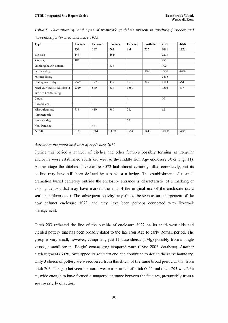
CTRL Integrated Site Report Series Beechbrook Wood, Westwell, Kent
Table:5 Quantities (g) and types of ironworking debris present in smelting furnaces and
associated features in enclosure 1022 Type Furnace
255
Furnace
257
Furnace
262
Furnace
260
Posthole
272
ditch
1021
ditch
1023
Tap slag 148 4614 2275
Run slag 183 985
Smithing hearth bottom 336 702
Furnace slag 1057 2907 4404
Furnace lining 2455
Undiagnostic slag 2572 1270 4371 1615 385 9113 664
Fired clay/ hearth learning or
vitrified hearth lining
2520 640 684 1560 1594 417
Cinder 4 16
Roasted ore
Micro-slags and
Hammerscale
714 410 390 365 62
Iron rich slag 50
Non-iron slag 44
TOTAL 6137 2364 10395 3594 1442 20109 5485
Activity to the south and west of enclosure 3072
During this period a number of ditches and other features possibly forming an irregular
enclosure were established south and west of the middle Iron Age enclosure 3072 (Fig. 11).
At this stage the ditches of enclosure 3072 had almost certainly filled completely, but its
outline may have still been defined by a bank or a hedge. The establishment of a small
cremation burial cemetery outside the enclosure entrance is characteristic of a marking or
closing deposit that may have marked the end of the original use of the enclosure (as a
settlement/farmstead). The subsequent activity may almost be seen as an enlargement of the
now defunct enclosure 3072, and may have been perhaps connected with livestock
management.
Ditch 203 reflected the line of the outside of enclosure 3072 on its south-west side and
yielded pottery that has been broadly dated to the late Iron Age to early Roman period. The
group is very small, however, comprising just 11 base sherds (174g) possibly from a single
vessel, a small jar in ‘Belgic’ coarse grog-tempered ware (Lyne 2006, database). Another
ditch segment (6026) overlapped its southern end and continued to define the same boundary.
Only 3 sherds of pottery were recovered from this ditch, of the same broad period as that from
ditch 203. The gap between the north-western terminal of ditch 6026 and ditch 203 was 2.36
m, wide enough to have formed a staggered entrance between the features, presumably from a
south-easterly direction.
36

CTRL Integrated Site Report Series Beechbrook Wood, Westwell, Kent
Situated approximately 30 m west of this boundary, ditch 2452 was aligned NW-SE
and consisted of two fragments with a gap of some 40 m between them. Despite the gap, this
feature defined the western limit of detected activity in this part of the site and may have been
to all intents and purposes an enclosure boundary. The northern segment of 2452 was
particularly rich in pottery. This assemblage consisted mainly of jars dated AD 25-50/60 and
was similar to the material recovered from the metalworking enclosures 1022 and 1023, 650
m to the north at the other end of the site. The south-eastern stretch of ditch was associated
with two pairs of postholes. In each pair, one cut the fill of ditch 2452 (243 and 124) and one
was situated to the north east of it (244 and 112). Two sherds of pottery from posthole 124
were dated 50 BC-AD 150. Two small ditches (6020 and 6022) were situated parallel to each
other, aligned NNE-SSW and extended 10 m and 12 m respectively from the boundary
defined by ditches 203 and 6026. No finds were recovered from either ditch, but their
positioning strongly suggests that they were related to the use of the enclosure in this phase.
However, their exact function is not clear.
South of 6022 several features suggest a more concentrated area of activity, the
southern limit of which was defined by ditch 6025, running north-east from and perpendicular
to late Iron Age to early Roman ditch 2452. Ditch 6025 contained a pottery assemblage dating
to the period AD 90-270, but is likely to have been in origin an integral part of the ‘enclosure’
arrangement south-west of enclosure 3072. The ditch measured 1.4 m in width and 0.9 m in
depth, suggesting its function as a boundary. Circular pit 139 was situated on the northern
side of ditch 6025. Although it contained no dateable material it is dated by its stratigraphic
position, sealed by a spread of material (137), which also extended over the edge of filled
ditch 6025. This material was 0.06 m thick and consisted of a lightly compacted greyish
brown silty sand with moderate charcoal inclusions and occasional pebbles. It contained one
sherd of pottery, dated 50 BC to AD 50.
Four-post structures
Two four-post structures were situated approximately 10 m apart, to the north-east and south-
west of pit 139 and to the north of ditch 6025 (Fig. 11). The westernmost of the two, structure
6044 had sides measuring 1.5 m in length and consisted of postholes 143, 157, 159 and 161,
of which 143 and 161 were excavated. Two sherds dating to the period 50 BC to AD 70 were
recovered from posthole 157, which also contained charcoal and some burnt clay.
37
The second four-poster (6043) lay 10 m east of 6044, and was larger, with sides
measuring 1.8 m in length. The postholes (130, 145, 147 and 149) were also larger, measuring
0.65-0.68 m in diameter. In posthole 154 a dark brown post-pipe ‘shadow’ was visible, which
measured 0.15 m in diameter and extended to the base of the cut where the stain had a
concave shape, suggesting that the post had a rounded end. Posthole 147 contained a larger

CTRL Integrated Site Report Series Beechbrook Wood, Westwell, Kent
amount of charcoal and one pottery sherd, dated to 50 BC to AD 50. Three sherds of pottery
recovered from posthole 149 could only be dated to between 50 BC and AD 270. Direct
evidence for the function of these probable post structures was lacking, but their conventional
interpretation as grain stores (eg Gent 1983) is feasible.
Separating the four-post structures and cutting the material spread, a possible beamslot
(6052) or gully was aligned N-S. Three sherds of pottery recovered from the fill dated
between 50 BC and AD 270. Again, this broad date means it is impossible to say which
features in this area it was related to. Cutting into the fill of this feature, the post in feature
151 had been burnt in situ. Pottery recovered from the posthole was also dated to this broad
late Iron Age to middle Roman period.
Several fragments of ditches extended east-north-eastwards from the northern side of
enclosure 3072 (6016, 6014 and 2443) and may have formed a field boundary containing the
activity to its south. Pottery from these ditches dated between 50 BC and AD 150.
4.5.2 Early Romano-British (AD 43-100)
Cremation Burials (Figs 11, 23)
During the late Iron Age to early Roman period a small cremation cemetery was established
just east of middle Iron Age enclosure 3072, a little to the north of the entrance,
demonstrating its continued recognition. Two graves (containing three urned cremation
burials) and three urned cremation burials without visible grave cuts were made between AD
43 and 80. Machining of this area (under watching brief conditions) inadvertently damaged
many of the cremation burials and artefacts, and in many cases only the bases of the vessels
remained. Grave 2029, and the urn contained within it, were also truncated by a SW-NE
aligned plough furrow.
Grave 2029 (Fig. 23)
Grave cut 2029 (subgroup 2034 on Fig. 11) was sub-circular and measured 0.6 m in diameter
and 0.12 m in depth. Urned burial 2031 was situated in the northern part of the grave and was
a rough surfaced jar of uncertain type in a grog tempered fabric. Contained within the vessel
was a fill with a high charcoal content and 367 g of cremated remains of an individual
tentatively aged as sub-adult of unknown sex. The fill also contained grave goods in the form
of six copper alloy strip fragments, possibly from a small pair of tweezers. Situated either side
of the funerary urn were two vessels. Pot 2033 was a black vessel of grog tempered ware.
Vessel 2032 was the lower half of a beaker of uncertain type in a fine Upchurch grey ware
fabric. Both these vessels were filled with the same yellowish brown silty clay as the rest of
the grave.
38
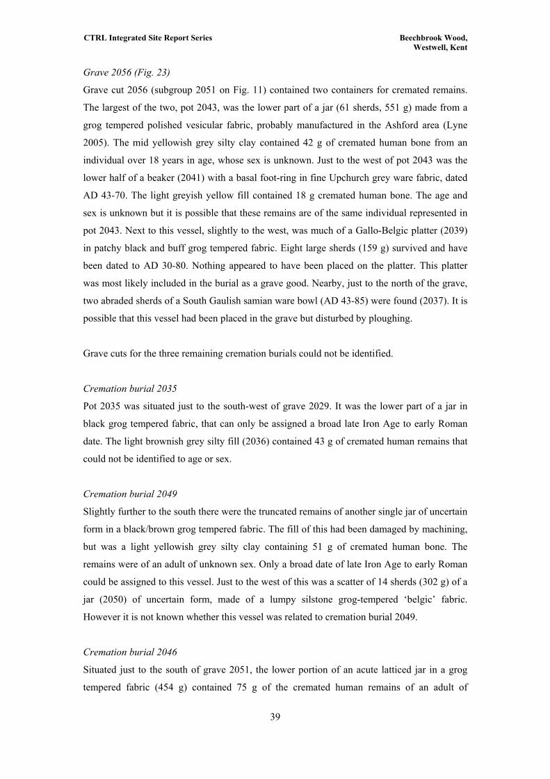
CTRL Integrated Site Report Series Beechbrook Wood, Westwell, Kent
Grave 2056 (Fig. 23)
Grave cut 2056 (subgroup 2051 on Fig. 11) contained two containers for cremated remains.
The largest of the two, pot 2043, was the lower part of a jar (61 sherds, 551 g) made from a
grog tempered polished vesicular fabric, probably manufactured in the Ashford area (Lyne
2005). The mid yellowish grey silty clay contained 42 g of cremated human bone from an
individual over 18 years in age, whose sex is unknown. Just to the west of pot 2043 was the
lower half of a beaker (2041) with a basal foot-ring in fine Upchurch grey ware fabric, dated
AD 43-70. The light greyish yellow fill contained 18 g cremated human bone. The age and
sex is unknown but it is possible that these remains are of the same individual represented in
pot 2043. Next to this vessel, slightly to the west, was much of a Gallo-Belgic platter (2039)
in patchy black and buff grog tempered fabric. Eight large sherds (159 g) survived and have
been dated to AD 30-80. Nothing appeared to have been placed on the platter. This platter
was most likely included in the burial as a grave good. Nearby, just to the north of the grave,
two abraded sherds of a South Gaulish samian ware bowl (AD 43-85) were found (2037). It is
possible that this vessel had been placed in the grave but disturbed by ploughing.
Grave cuts for the three remaining cremation burials could not be identified.
Cremation burial 2035
Pot 2035 was situated just to the south-west of grave 2029. It was the lower part of a jar in
black grog tempered fabric, that can only be assigned a broad late Iron Age to early Roman
date. The light brownish grey silty fill (2036) contained 43 g of cremated human remains that
could not be identified to age or sex.
Cremation burial 2049
Slightly further to the south there were the truncated remains of another single jar of uncertain
form in a black/brown grog tempered fabric. The fill of this had been damaged by machining,
but was a light yellowish grey silty clay containing 51 g of cremated human bone. The
remains were of an adult of unknown sex. Only a broad date of late Iron Age to early Roman
could be assigned to this vessel. Just to the west of this was a scatter of 14 sherds (302 g) of a
jar (2050) of uncertain form, made of a lumpy silstone grog-tempered ‘belgic’ fabric.
However it is not known whether this vessel was related to cremation burial 2049.
Cremation burial 2046
Situated just to the south of grave 2051, the lower portion of an acute latticed jar in a grog
tempered fabric (454 g) contained 75 g of the cremated human remains of an adult of
39

CTRL Integrated Site Report Series Beechbrook Wood, Westwell, Kent
unknown sex. Three sherds (32 g) of a South Gaulish samian ware platter (AD 43-50) were
also recovered from this burial.
Discussion: The Cemetery
The characteristics of this group of urned cremation burials make them typical for the period
with the beakers and platters representing tableware placed as grave goods. One burial may
have had a toilet implement placed with the dead. This small cremation cemetery was situated
close to the entrance of the disused middle Iron Age enclosure 3072. The four-post structures
and the occupation layer (137) to the south of the enclosure contained pottery of pre-conquest
to Roman date, and the cremation burial cemetery has been assigned a date of AD 43 - 80. It
is therefore possible that the deposition of cremation burials in this location functioned as an
act of closure, making the reuse of a defunct enclosure possible.
Other cremation burials and postholes
A small group of features was situated approximately 43 m to the north of the industrial
enclosures and within an area of fragmentary ditches. Two cremation pits and two postholes
were situated in a slight arc, near to the north-eastern site boundary.
Pits 730 and 737 (Fig. 12).
The northern terminal of a possible spring (1971) was marked by an oval pit (730) containing
a small amount of cremated human bone, comprising three rib pieces, undiagnostic
metalworking debris, fired clay fragments and the largest quantity of carbonised grain
recovered from the site, alongside late Iron Age and early Roman pottery. This charred grain
included little processing waste, but examples of de-husked emmer and spelt wheat, six row
hulled barley and oat, which was probably of the cultivated variety rather than a weed.
Seventeen sherds in grog tempered fabric may be from a funerary urn, similar to those used in
the cemetery near to enclosure 3072. Situated 10.3 m to the east of pit 730, pit 737 was also
oval shaped and with a similar dark charcoal-rich fill. Small pieces of furnace slag were
recovered from this fill along with a small amount of re-deposited cremated human bone as
part of the pit fill.
Also dated to this phase, and situated between the two pits (730 and 737) discussed
above, were two postholes. Posthole 796 had steep sides and a V-shaped base, and measured
0.25 m in diameter and 0.11 m in depth. Undated posthole 802, just to its west was very
similar in size and form and it is likely that the two were contemporary. The postholes may
have represented markers related to the function of the pits.
40
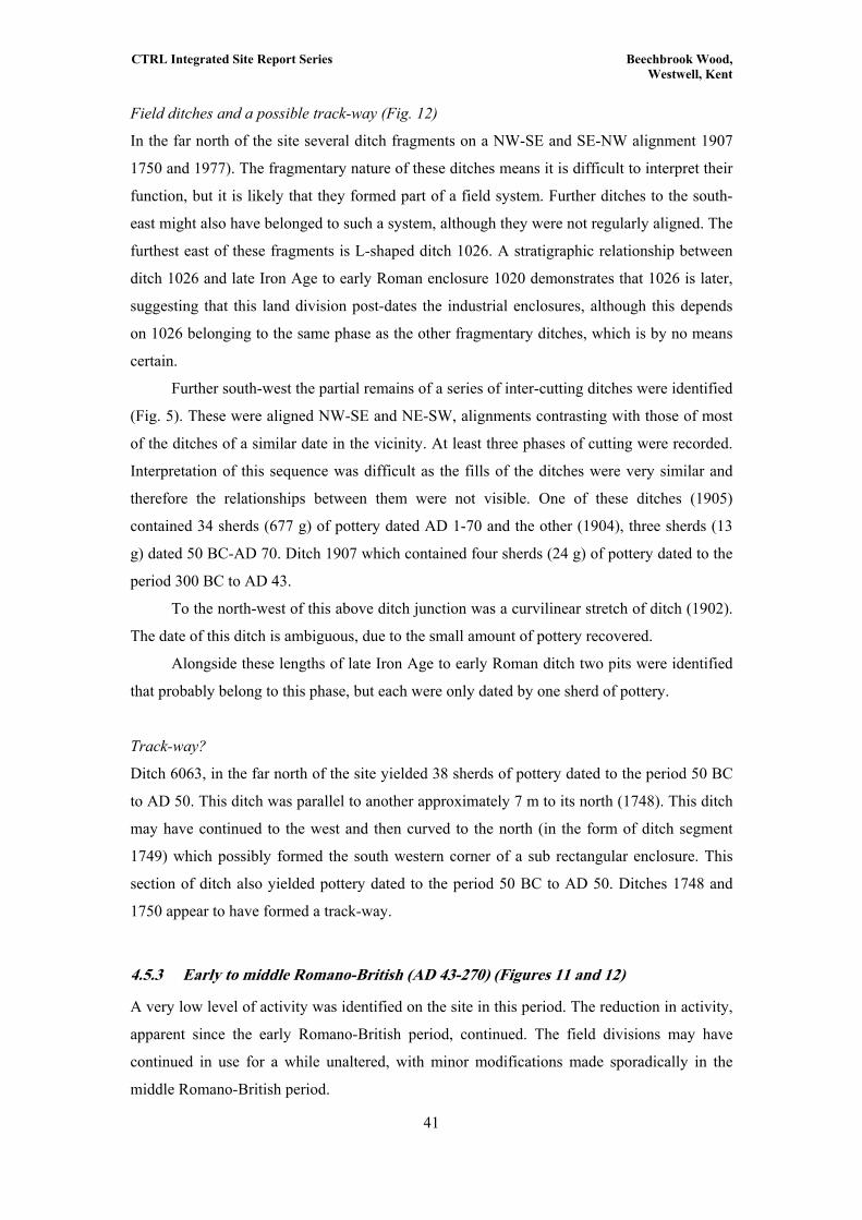
CTRL Integrated Site Report Series Beechbrook Wood, Westwell, Kent
Field ditches and a possible track-way (Fig. 12)
In the far north of the site several ditch fragments on a NW-SE and SE-NW alignment 1907
1750 and 1977). The fragmentary nature of these ditches means it is difficult to interpret their
function, but it is likely that they formed part of a field system. Further ditches to the south-
east might also have belonged to such a system, although they were not regularly aligned. The
furthest east of these fragments is L-shaped ditch 1026. A stratigraphic relationship between
ditch 1026 and late Iron Age to early Roman enclosure 1020 demonstrates that 1026 is later,
suggesting that this land division post-dates the industrial enclosures, although this depends
on 1026 belonging to the same phase as the other fragmentary ditches, which is by no means
certain.
Further south-west the partial remains of a series of inter-cutting ditches were identified
(Fig. 5). These were aligned NW-SE and NE-SW, alignments contrasting with those of most
of the ditches of a similar date in the vicinity. At least three phases of cutting were recorded.
Interpretation of this sequence was difficult as the fills of the ditches were very similar and
therefore the relationships between them were not visible. One of these ditches (1905)
contained 34 sherds (677 g) of pottery dated AD 1-70 and the other (1904), three sherds (13
g) dated 50 BC-AD 70. Ditch 1907 which contained four sherds (24 g) of pottery dated to the
period 300 BC to AD 43.
To the north-west of this above ditch junction was a curvilinear stretch of ditch (1902).
The date of this ditch is ambiguous, due to the small amount of pottery recovered.
Alongside these lengths of late Iron Age to early Roman ditch two pits were identified
that probably belong to this phase, but each were only dated by one sherd of pottery.
Track-way?
Ditch 6063, in the far north of the site yielded 38 sherds of pottery dated to the period 50 BC
to AD 50. This ditch was parallel to another approximately 7 m to its north (1748). This ditch
may have continued to the west and then curved to the north (in the form of ditch segment
1749) which possibly formed the south western corner of a sub rectangular enclosure. This
section of ditch also yielded pottery dated to the period 50 BC to AD 50. Ditches 1748 and
1750 appear to have formed a track-way.
4.5.3 Early to middle Romano-British (AD 43-270) (Figures 11 and 12)
A very low level of activity was identified on the site in this period. The reduction in activity,
apparent since the early Romano-British period, continued. The field divisions may have
continued in use for a while unaltered, with minor modifications made sporadically in the
middle Romano-British period.
41

CTRL Integrated Site Report Series Beechbrook Wood, Westwell, Kent
Later ditches
One of the parallel ditches described above (6063) was re-cut along at least half its length.
This shallow, slightly V-shaped re-cut (1750) yielded four sherds of pottery dating to AD 43 -
130, putting the re-cutting of the ditch in the early Romano-British period. It is highly likely
that this represents the evolution of the field boundaries established during the late Iron Age.
Middle Romano-British features in the far north-west of the site
Perpendicular to ditch 1750, ditch 1747 extended from the northern side of ditch 1748 and
contained an assemblage of 69 pottery sherds suggesting that the ditch remained open
between AD 150 and AD 270. This pottery assemblage included sherds of two everted rim
jars with horizontal shoulder grooves, sherds of an everted rim bowl and of an everted rim jar
in a polished black fabric, fragments from a latticed cooking pot and 29 sherds of a Cologne
white ware beaker. This ditch appears to mirror a linear feature of natural origin.
Ovens?
In the north-west of the site, north of the field ditches, two pits were identified as belonging to
this phase. The natural surrounding pit 1234 was burnt a purplish colour, presumably from
activity that took place in the pit. The three fills contained large amounts of charcoal and the
lower fills (1231 and 1232) contained fired clay, probably originating from the burnt edges of
the feature (Poole 2006). The upper fill (1233) contained smaller amounts of burnt material.
The three fills contained a small pottery assemblage dated AD 150-270. No slag or
metalworking debris was recovered from the feature. It may be the base of an oven for
domestic use or cereal drying as the edges of the feature were intensely burnt over a period of
time and are not the result of merely the tipping of hot cinders (Poole 2006).
Approximately 18 m further north was another feature (1039) that may have had a
similar function. Succeeding a primary fill (1040) of possible up-cast material was a thin layer
of a dark brownish black and orange charcoal rich deposit. Above this, fill 1042 was a dump
of material containing 32 sherds (635 g) of pottery dated AD 170-250 and was therefore
broadly contemporary with pit 1234. This assemblage included sherds from two refired plain
‘pie-dishes’, a neck cordoned jar and one everted jar along with fragments of Roman brick
and tegulae and a fragment of oven wall or floor. These fairly isolated pits situated near to the
limit of excavation may have been related to activity beyond the excavation area. Finds of
tegulae and a lava rotary quern from this area during the stripping of the subsoil suggest that a
building was situated in the vicinity, but post-medieval building material (brick and peg tiles)
was also recovered from this area.
42
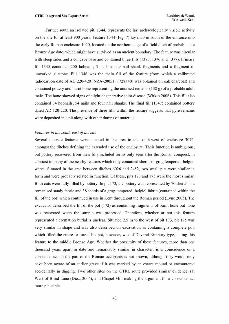
CTRL Integrated Site Report Series Beechbrook Wood, Westwell, Kent
Further south an isolated pit, 1344, represents the last archaeologically visible activity
on the site for at least 900 years. Feature 1344 (Fig. 7) lay c 50 m south of the entrance into
the early Roman enclosure 1020, located on the northern edge of a field ditch of probable late
Bronze Age date, which might have survived as an ancient boundary. The feature was circular
with steep sides and a concave base and contained three fills (1375, 1376 and 1377). Primary
fill 1345 contained 200 hobnails, 7 nails and 9 nail shank fragments and a fragment of
unworked siltstone. Fill 1346 was the main fill of the feature (from which a calibrated
radiocarbon date of AD 220-420 [NZA-20051; 1728±40] was obtained on oak charcoal) and
contained pottery and burnt bone representing the unurned remains (138 g) of a probable adult
male. The bone showed signs of slight degenerative joint disease (Witkin 2006). This fill also
contained 34 hobnails, 54 nails and four nail shanks. The final fill (1347) contained pottery
dated AD 120-220. The presence of three fills within the feature suggests that pyre remains
were deposited in a pit along with other dumps of material.
Features in the south-east of the site
Several discrete features were situated in the area to the south-west of enclosure 3072,
amongst the ditches defining the extended use of the enclosure. Their function is ambiguous,
but pottery recovered from their fills included forms only seen after the Roman conquest, in
contrast to many of the nearby features which only contained sherds of grog tempered ‘belgic’
wares. Situated in the area between ditches 6026 and 2452, two small pits were similar in
form and were probably related in function. Of these, pits 173 and 175 were the most similar.
Both cuts were fully filled by pottery. In pit 173, the pottery was represented by 70 sherds in a
romanised sandy fabric and 38 sherds of a grog-tempered ‘belgic’ fabric (contained within the
fill of the pot) which continued in use in Kent throughout the Roman period (Lyne 2005). The
excavator described the fill of the pot (172) as containing fragments of burnt bone but none
was recovered when the sample was processed. Therefore, whether or not this feature
represented a cremation burial is unclear. Situated 2.5 m to the west of pit 173, pit 175 was
very similar in shape and was also described on excavation as containing a complete pot,
which filled the entire feature. This pot, however, was of Deverel-Rimbury type, dating this
feature to the middle Bronze Age. Whether the proximity of these features, more than one
thousand years apart in date and remarkably similar in character, is a coincidence or a
conscious act on the part of the Roman occupants is not known, although they would only
have been aware of an earlier grave if it was marked by an extant mound or encountered
accidentally in digging. Two other sites on the CTRL route provided similar evidence, (at
West of Blind Lane (Diez, 2006), and Chapel Mill making the argument for a conscious act
more plausible.
43

CTRL Integrated Site Report Series Beechbrook Wood, Westwell, Kent
Enclosure
In the far south-east of the site, to the south-west of middle Iron Age enclosure 3072, part of a
middle Roman enclosure was identified. Two ditches (6019 and 6021) formed the northern
and eastern sides of an enclosure which extended beyond the limits of the excavation and
whose overall shape is not known. An entrance to the north-east was defined by the terminals
of the ditches. North-south aligned ditch 6021 formed the eastern side. Pottery recovered from
the charcoal flecked greyish brown clay silt fill (197) numbered only 2 sherds (7 g) but date
the infilling of the ditch to after AD 160-270. Ditch 6019 formed the northern side. The fill
(200) was identical to that of ditch 6021. The four sherds of pottery recovered dated the fill to
after AD 43 to 270.
A probable entrance into this enclosure was identified in the north-eastern corner, the
only corner within the excavation area. This was defined by a T-shaped section of ditch (232)
and a group of three postholes (224, 226 and 228) which may have supported a gate. The T-
shaped ditch did not contain finds, but two of the three postholes contained sherds dating from
50 BC to AD 150. The earlier date of these sherds, compared with those from the enclosure
ditch suggest that either the postholes predate the enclosure or that the pottery has been
redeposited.
Three discrete features in the same general area were dated to this phase. A large oval
shaped possible rubbish pit (210) lay in the interior of enclosure 6019/6021, approximately 9
m from the entrance. It was 1.6 m in diameter and 0.4 m deep and contained within its fill
charcoal and 14 sherds of pottery, all of which were in romanised sandy fabrics dated AD
170-270. Pit 216 was situated just west of enclosure 3072. Three large sherds of pottery
dating to between AD 70 and 270 were recovered from the fill (217). A layer of burnt
material (220) was recorded, concentrated in a roughly circular spread in the top of ditch 2151
on the western side of the enclosure. This material contained pottery dating to the period AD
170 to 230 and probably represented the dumping of burnt material into the top of the
partially filled enclosure ditch. This demonstrates that the ditches were still visible at this
time.
4.6 Towns and their rural landscapes III - The early medieval period (AD 1100 - 1300)
Archaeologically visible activity on the site finishes in the mid third century AD. No evidence
was identified for the use of the site until the 13th century, comprising a few isolated lengths
of ditch (77 and 1783) and finds of pottery from the subsoil. Most of the pottery recovered
was concentrated in the extreme north and south of the site. Two documented farms
(Parsonage Farm and Yonsea Farm) bordered the site at these locations and these finds most
likely represent manuring or peripheral use of the site in relation to these settlements. Further,
44
CTRL Integrated Site Report Series Beechbrook Wood, Westwell, Kent
a substantial amount of the ceramic building material recovered from the subsoil can be traced
by fabric type to the demolition of Parsonage Farm in the 14th century. The excavation of the
site of Parsonage Farm is the subject of a separate report (Hill 2005).
4.7 Unphased features
In the absence of stratigraphic relationships most features were dated by artefactual evidence.
Unfortunately, a large number of features could not be phased, because of the absence of
pottery, or in the case of ditches a lack of stratigraphic relationships or similar alignments
with other ditches. A total of 73 anthropogenic features were recorded on site (this total
excludes all tree boles and other natural features). Of these, only 16% could be attributed to a
specific phase, leaving 84% of the features unphased. This included ditch sections and
numerous pits and postholes. These unphased features were distributed throughout the site
and were in all areas of phased archaeology. Activity in each phase is generally focused in
specific areas, and unphased features may be contemporary with nearby activity, but of course
it is entirely possible that they are not, and subsequently such conclusions cannot be drawn.
An unurned cremation burial (1603) was cut into the fill of Mesolithic pit 1623, and
although it did not contain any dateable finds its position close to one of the late Bronze Age
field system ditches suggests that it may be late Bronze Age or Roman in date, due to the
presence of similar Bronze Age and Romano-British cremation burials, (described in earlier
sections). It contained the unurned remains (102 g) of an adult of unknown sex.
45

CTRL Integrated Site Report Series Beechbrook Wood, Westwell, Kent
5 GUIDE TO THE ARCHIVE
The site has been analysed and published as part of the Channel Tunnel Rail Link Section 1
Post-excavation project. This Integrated Site Report is one of 20 publication level site reports
available to download from the Archaeology Data Service website:
http://ads.ahds.ac.uk/catalogue/projArch/ctrl.
These present synthesised data from key site sequences at an interpretative level that
can be assimilated into complementary studies. The ADS site also includes five schemewide
specialist reports, which provide synthetic overviews of the specialist data from CTRL
Section 1 in its regional context. Underpinning the site reports and overviews, is a
comprehensive archive of individual specialist reports and databases, which are also available
to download. The CTRL reports and data can be accessed through the ‘Project Archives’
section of the ADS website.
Hard copy publication of the CTRL Section 1 results comprises a single volume
synthetic overview of the excavated results in their regional context, which includes a
complete site gazetteer and guide to the archive (Booth et al 2007).
Table 13 below details all available digital data for the Beechbrook Wood site. The
Post-excavation Assessment Report is included in the digital archive, but assessment
databases have only been included for categories of material which were not subsequently
subject to full analysis. All reports and accompanying figures are presented as downloadable,
print-ready Adobe Acrobat files (.pdf). ADS also maintain archivally stable versions of report
image pages (.tiff), sometimes available at higher resolution than the pdf versions. Report
texts and databases are also available as text files (.rtf and .csv respectively). The digitised site
plan is available as an Arcview shapefile (.shp).
46
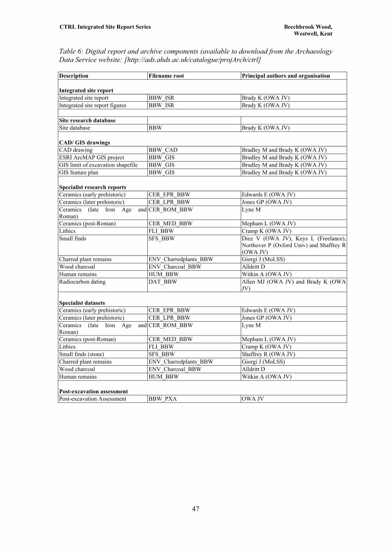
CTRL Integrated Site Report Series Beechbrook Wood, Westwell, Kent
Table 6: Digital report and archive components (available to download from the Archaeology Data Service website: [http://ads.ahds.ac.uk/catalogue/projArch/ctrl] Description Filename root Principal authors and organisation Integrated site report Integrated site report BBW_ISR Brady K (OWA JV) Integrated site report figures BBW_ISR Brady K (OWA JV) Site research database Site database BBW Brady K (OWA JV) CAD/ GIS drawings CAD drawing BBW_CAD Bradley M and Brady K (OWA JV) ESRI ArcMAP GIS project BBW_GIS Bradley M and Brady K (OWA JV) GIS limit of excavation shapefile BBW_GIS Bradley M and Brady K (OWA JV) GIS feature plan BBW_GIS Bradley M and Brady K (OWA JV) Specialist research reports Ceramics (early prehistoric) CER_EPR_BBW Edwards E (OWA JV) Ceramics (later prehistoric) CER_LPR_BBW Jones GP (OWA JV) Ceramics (late Iron Age and Roman)
CER_ROM_BBW Lyne M
Ceramics (post-Roman) CER_MED_BBW Mepham L (OWA JV) Lithics FLI_BBW Cramp K (OWA JV) Small finds SFS_BBW Diez V (OWA JV), Keys L (Freelance),
Northover P (Oxford Univ) and Shaffrey R (OWA JV)
Charred plant remains ENV_Charredplants_BBW Giorgi J (MoLSS) Wood charcoal ENV_Charcoal_BBW Alldritt D Human remains HUM_BBW Witkin A (OWA JV) Radiocarbon dating DAT_BBW Allen MJ (OWA JV) and Brady K (OWA
JV) Specialist datasets Ceramics (early prehistoric) CER_EPR_BBW Edwards E (OWA JV) Ceramics (later prehistoric) CER_LPR_BBW Jones GP (OWA JV) Ceramics (late Iron Age and Roman)
CER_ROM_BBW Lyne M
Ceramics (post-Roman) CER_MED_BBW Mepham L (OWA JV) Lithics FLI_BBW Cramp K (OWA JV) Small finds (stone) SFS_BBW Shaffrey R (OWA JV) Charred plant remains ENV_Charredplants_BBW Giorgi J (MoLSS) Wood charcoal ENV_Charcoal_BBW Alldritt D Human remains HUM_BBW Witkin A (OWA JV) Post-excavation assessment Post-excavation Assessment BBW_PXA OWA JV
47

CTRL Integrated Site Report Series Beechbrook Wood, Westwell, Kent
Table 7: Artefactual and environmental archive index
Item Number of fragments
Weight (g) if appropriate
Number of boxes
Flint (total) 4535 - 1 size 6 Pottery (total)
Late Iron Age and Roman pottery (hand collected)
Sieved Roman pottery Medieval pottery Post-medieval pottery Ceramic Building material (total)
Metalwork Small Finds (total)
-
Iron - Copper Alloy - Coins - Glass Small Finds (total) - Fired Clay (total) Slag (total) - Unburnt Human Bone (total) - Cremation burial (total) - Cremated Human bones (total)
-
Cardboard boxes
Size 1 = Bulk box 391mm x 238mm x 210mm 0.020 m3
Size 2 = Half box 391mm x 238mm x 100mm 0.009 m3
Size 3 = Quarter box 386mm x 108 mm x 100mm 0.004 m3
Size 4 = Eighth box 213 mm x 102 mm x 80 mm 0.002 m3
Plastic boxes
Size 8 = Medium 260mm x 184mm x 108mm 0.005 m3
48

CTRL Integrated Site Report Series Beechbrook Wood, Westwell, Kent
Table 8: Fieldwork and research paper archive
Record Group
Contents Comments Box/File Number (add when finalised)
B Final report B Site Diary Daily journal B Primary Context records Levels registers Context checklists Context record sheets B Synthesised context records Matrices B Survey Reports Printout of survey data Survey request sheets and data B Catalogue of drawings Plan record sheets Section record sheets List of A1 plans List of sections B Primary drawings Plans Sections C Primary finds data Small finds record sheets Finds context checklist C Finds Box and bag lists Finds compendium Box contents sheets D Catalogue of photographs Black & white photo record sheets Colour photo record sheets E Primary environmental records Sample collecting sheets Plan showing location of soil
samples
49

CTRL Integrated Site Report Series Beechbrook Wood, Westwell, Kent
6 CATALOGUE OF ILLUSTRATED FINDS
The catalogue numbers below follow the numbers used in the Beechbrook Wood specialist
pottery reports, hence they do not run in continuous sequence.
Ceramics
Early prehistoric pottery
Figure 18
P1. Context 1725. Complete Beaker vessel (220 g). Form: East Anglian style vessel, Fabric:
A1. Firing: exterior; yellow-brown, core; black, interior; yellow-brown. Surface Treatment:
exterior; smoothed, burnished and slipped, interior; smoothed, burnished and slipped.
Thickness 6 mm. Dec: exterior; Neatly applied groove spiralling around the vessel from top to
bottom. Rim Diameter: 90-80 mm. Base Diameter: 50 mm. Belly Diameter: 100 mm. Vessel
Height: 78 mm. Spalled patch. Simple base (rounded inside) with a slightly everted rim,
otherwise a completely rounded vessel (although not spherical, uneven diameter).
Figure 14
P12. Context 1909. One large rim and shoulder sherd (46 g) from an early Neolithic vessel.
Plain or Carinated Bowl. Form: Either baggy profile or carinated bowl. Open vessel. Slightly
rolled and everted rim with long flared neck Fabric: FA3, Firing: exterior; brown-grey, core;
grey, interior; grey. Surface Treatment: smoothed, interior; smoothed. Thickness 10 mm. Rim
Diameter: 230 mm. There is a fire cloud or unoxidised patch near the rim of the vessel.
P13. Context 1909. Small rim and shoulder sherd (7 g) from a total of four sherds, from an
early Neolithic cup or bowl. Form: Closed. Small, flattened rolled rim - baggy or carinated
vessel. Fabric: F1, Firing: exterior; brown-grey, core; grey, interior; brown-grey. Surface
Treatment: smoothed, interior; smoothed. Thickness 6 mm.
Figure 17
P4. Context 1377. Three sherds (27 g) of a Beaker vessel including rim, similar to P3. Form:
Possibly East Anglian style vessel. Fabric: AF1. Firing: exterior; yellow-brown, core; yellow-
brown, interior; yellow-brown. Surface Treatment: exterior; smoothed, interior; smoothed.
Thickness 5.5 mm. Dec: exterior; horizontal bands, possibly created using lightly impressed
comb, some incomplete and uneven. Possible spiralling.
50

CTRL Integrated Site Report Series Beechbrook Wood, Westwell, Kent
P5. Context 1377. Three sherds (183 g) of a Beaker vessel including a foot ring type base
with high pedestal. Fabric: FG1. Firing: exterior; red-brown, core; red-brown, interior; red-
brown. Surface Treatment: exterior; smoothed, interior; smoothed. Thickness 5 mm. Base
Diameter: 51 mm. Dec: exterior; short horizontal lines of comb impression, applied in panels
down the vessel as vessel turned. Like decoration on P2 & P3. Some fire clouds and three
finger nail impressions on base. Comb teeth are 2 mm wide and the comb may be about 16 -
18 teeth wide.
P6. Context 1377. One illustrated Beaker sherd from a total of 11 sherds (138 g). Fabric:
GAF3. Firing: exterior; red-brown, external subsurface; grey-red-brown, internal subsurface;
grey-red-brown, interior; grey-red-brown. Surface Treatment: exterior; smoothed, interior;
smoothed. Thickness 8 mm. Dec: Vertically applied ‘Crows feet’ or Paired Fingernail
impressions.
P7. Context 1377. Three illustrated Beaker sherds from a total of 8 belly sherds (111 g).
Form: Possibly a late Southern Style Beaker. Fabric:. Firing: exterior; yellow-brown, Core;
yellow-brown to black, interior; yellow-brown to brown. Surface Treatment: exterior;
smoothed, interior; smoothed. Thickness 6 mm. Dec: Barbed Wire, a panel comprising of
three horizontal bands above a set of diagonal lines, with four bands below. Below the panel,
may be more bands leading to the base of the vessel.
P8. Context 1377. One illustrated Beaker sherd, from a total of 6 belly sherds (24 g). Fabric:
FAG3. Firing: exterior; yellow-brown, Core; yellow-brown, interior; yellow-brown. Surface
Treatment: exterior; smoothed, interior; smoothed. Thickness 6 mm. Dec: A panel of incised
horizontal bands with finger nail impressions below, at the point where the sherd thickens.
P9. Context 1377. One sherd (21 g) of a Beaker vessel. Fabric: FAG3. Firing: exterior;
yellow-brown, Core; yellow-brown, interior; yellow-brown. Surface Treatment: exterior;
smoothed, interior; smoothed. Thickness 6 mm. Dec: finger nail impressions and shallow,
diagonal grooves which appear to have been created using plant fibres.
Later prehistoric pottery
Figure 21b
31. S-profile jar; R16; Q8; burnished both surfaces; patches of burnt residue on vessel
interior; PRN 1124, vessel 14, context 2213, intervention 2212, ditch 2150.
51
CTRL Integrated Site Report Series Beechbrook Wood, Westwell, Kent
21. S-profile jar; R16; I2; burnished upper vessel interior and exterior, smoothed in other
areas; traces of soot on upper vessel exterior; PRN 1109, vessel 4, context 2213, intervention
2212, ditch 2150.
41. S-profile jar; R26; Q5; burnished upper vessel exterior and interior, and top of rim,
roughened lower exterior, all other areas have been smoothed; sooting on exterior, burnt
residue on interior; PRN 1138, vessel 24, context 2213, intervention 2212, ditch 2150.
37. Everted rim cup: R24; I4; smoothed exterior, burnished interior; PRN 1132, vessel 20,
context 2213, intervention 2212, ditch 2150.
34. S-profile bowl; R22, B4; Q5; burnished exterior, smoothed interior; PRN 1128, vessel 17,
context 2213, intervention 2212, ditch 2150.
20. Large jar with thickened rim; R14; F14; wiped exterior, smoothed interior; sooted
exterior; PRN 1106, vessel 3, context 2213, intervention 2212, ditch 2150.
19. Round-bodied jar; R13 and B1; I1; wiped upper vessel interior and exterior; smoothed
lower vessel exterior and interior; sooted upper vessel exterior, burnt residue on interior; PRN
1099 and 1100, vessel 2, context 2213, intervention 2212, ditch 2150.
18. High-shouldered jar; R12; G3; traces of external wiping, smoothed interior; sooted
exterior; abraded lower interior; PRN 1097, vessel 1, context 2213, intervention 2212, ditch
2150.
Figure 21a
35. High-shouldered bowl; R23; Q13; burnished upper vessel exterior, roughened lower
vessel exterior, smoothed interior; PRN 1129, vessel 18, context 2213, intervention 2212,
ditch 2150.
36. High-shouldered bowl; R23; Q12; burnished upper vessel interior and exterior, roughened
lower vessel exterior, smoothed interior; burnt residue on interior; PRN 1131, vessel 19,
context 2213, intervention 2212, ditch 2150.
39. Medium-necked jar; R27; G2; smoothed both surfaces, finger-wiping on exterior; PRN
1136, vessel 22, context 2213, intervention 2212, ditch 2150.
52

CTRL Integrated Site Report Series Beechbrook Wood, Westwell, Kent
24. Bucket-shaped vessel; R18; Q12; burnished exterior; PRN 1116, vessel 7, context 2213,
intervention 2212, ditch 2150.
33. Flower-pot style vessel; R15; Q10; finger-wiping on exterior; burnt residue on interior;
PRN 1127, vessel 16, context 2213, intervention 2212, ditch 2150.
30. Saucepan pot; R19; I5; traces of burnish on upper vessel exterior, traces of wiping on
lower vessel interior; PRN 1123, vessel 13, context 2213, intervention 2212, ditch 2150.
25. Saucepan pot; R19; Q6; sooted exterior, burnt residue on interior; PRN 1117, vessel 8,
context 2213, intervention 2212, ditch 2150.
32. Saucepan pot; R21; Q8; burnished exterior; PRN 1126, vessel 15, context 2213,
intervention 2212, ditch 2150.
26. Saucepan pot; R21; I4; wiped exterior, smoothed interior; PRN 1118 and 1119, vessel 9,
context 2213, intervention 2212, ditch 2150.
Figure 19
5. Convex-profile neutral form; R1; GF1; burnished exterior; PRN 1006, context 244,
waterhole 245.
6. Convex-profile vessel with incurving rim; R2; F6; PRN 1019; context 244, waterhole 245.
7. Small, convex profile vessel; R20; F4; PRN 1012, context 244, waterhole 245.
Figure 18
10. Straight-sided jar; R6 and B3; F8; finger-wiped exterior, wiped interior; traces of soot on
exterior; PRN 1049, context 1200, pit 1220.
Late Iron Age to Romano British pottery
Figure 24
31. Everted rim jar with neck cordon cf. Thompson type B3-5 in fabric B2. Ext. rim diameter
c 140 mm. 50 BC-AD 70. Context BWD98. 172.
53
CTRL Integrated Site Report Series Beechbrook Wood, Westwell, Kent
32. Everted rim jar similar to No. 31 in fabric B2. Ext. rim diameter 140 mm. c 50 BC-AD 70.
Context BWD98.173.
33. Base in fine grey Upchurch fabric R16. c AD 50-100. Context BWD98.173.
Figure 25
4. Bead rim jar of Thompson Class C4 in black fabric B2. Ext. rim diameter 180 mm. c AD
30-80. Context BBW00.210.
7. Bead-rim jar of Thompson type B2-2 with corrugated shoulder in fabric B2 with polished
exterior. Ext. rim diameter 140 mm. 50 BC-AD 50. Context BBW00.214.
9. Everted-rim jar of Thompson type B2-1 with corrugated shoulder in fabric B2 with
polished exterior. Ext. rim diameter 120 mm. c 25 BC-AD 50. Context BBW00.277.
11. Large part of plain butt-beaker of Thompson type G5-1 in grey fabric B2.1 fired polished
patchy black/brown externally. Ext. rim diameter 100 mm. Context BBW00.514.
14. Bowl of Monaghan form 5B1.1 in fine grey Upchurch fabric R16 imitating Central
Gaulish samian form Drag 38. Ext. rim diameter 140 mm. c AD 150-250. Context
BBW00.277.
Figure 26
20. Spalled waster jar of Thompson type B5-4 in pink misfired fabric B2. Ext. rim diameter
120 mm. c AD 1-50. Context BBW00.725.
29. Everted rim bowl of Pollard (1988) type 34 in patchy black/red fabric B2. Ext. rim
diameter 180 mm. c AD 50-100. BBW00.718.
Lithics
Figure 13
2. L. Mesolithic tree throw hole 1623 cxt 1637 AG-3486 Microlith.
3. L. Mesolithic tree throw hole 1623 cxt 1624 AG-3474 Microlith.
4. L. Mesolithic tree throw hole 1623 cxt 1640 AG-3537 Rod microlith
5. L. Mesolithic tree throw hole 1623 cxt 1639 AG-3533 Microlith.
546. L. Mesolithic tree throw hole 1623 cxt 1624 AG-3475 Microlith.

CTRL Integrated Site Report Series Beechbrook Wood, Westwell, Kent
8. L. Mesolithic tree throw hole 1623 cxt 1674 AG-3872 Bladelet core on a flake.
9. L. Mesolithic tree throw hole 1623 cxt 1643 AG-3579 Single platform blade core.
10. L. Mesolithic tree throw hole 1623 cxt 1643 AG 3769 Piercer.
Figure 14
7. E. Neolithic pit 1910 cxt 1909 AG-4406 Microlith
11. E. Neolithic pit 1910 cxt 1909 AG-4300 Single platform blade core
12. E. Neolithic pit 1910 cxt 1909 AG-4395 Serrated blade
Figure 17
13. E. Bronze Age ring ditch 851 cxt 865 AG-147 SF 210 Leaf shaped arrowhead.
14. Beaker pit 1374 cxt 1377 AG-4848 Multi-platform flake core
15. Beaker pit 1374 cxt 1377 AG-341 Thumbnail scraper
16. Beaker pit 1374 cxt 1377 AG-308 Thumbnail scraper
17. Beaker pit 1374 cxt 1377 AG-364 AG-4950 Conjoining end and side scraper.
18. Beaker pit 1374 cxt 1377 AG-269 End and side scraper
19. Beaker pit 1374 cxt 1377 AG-325 Barbed-and-tanged arrowhead
55
CTRL Integrated Site Report Series Beechbrook Wood, Westwell, Kent
7 BIBLIOGRAPHY
ADS, 2006 CTRL digital archive, Archaeology Data Service, http://ads.ahds.ac.uk/catalogue/projArch/ctrl Allen, T G and Robinson, M A, 1993 The prehistoric landscape and Iron Age enclosed settlement at Mingies Ditch, Hardwick-with-Yelford, Oxon, Oxford Archaeological Unit Thames Valley Landscapes monograph, Oxford Allen, M, and Brady, K, 2006 Radiocarbon dates from Beechbrook Wood, Hothfield, Kent in Radiocarbon dates from Section 1 of the Channel Tunnel Rail Link, Kent, CTRL scheme-wide specialist report series, ADS 2006 Alldritt, D, 2006 The wood charcoal from Beechbrook Wood, Hothfield, Kent, in Giorgi and Stafford (eds), ADS 2006
Ashbee, P, The Neolithic in Kent, in Lawson and Killingray (eds) 2004 Barclay, A, and Edwards, E, ‘Chapter 2: Earlier prehistoric pottery’ in Booth, P (ed) ADS 2006 Booth, P (ed) 2006 Ceramics from Section 1 of the Channel Tunnel Rail Link, Kent, CTRL scheme-wide specialist report series, ADS 2006 Brady, K, 2006a The prehistoric landscape at Tutt Hill, Westwell, Kent, CTRL integrated site report series, ADS 2006 Britnell, W J, 1989 The Collfryn hillslope enclosure, Llansantffraid Deuddwr, Powys: excavations 1980-1982, Proc Prehist Soc 55, 89-134 Champion, T C, forthcoming, Settlement in Kent from 1500 to 300 BC Christie, P M, 1964 A Bronze Age round barrow on Earls Farm Down, Amesbury, Wiltshire Archaeol Natur Hist Mag 59, 30-45 Cramp, K, 2006 The worked flint from Beechbrook Wood, Hothfield, in Harding, P (ed), ADS 2006 Cunliffe, B, 1991 Iron Age societies in southern Britain, 3 edn, London Diez, V, Northover, P, and Shaffrey, R, 2006 Small finds from Beechbrook Wood, CTRL specialist report series, ADS 2006 Diez, V, 2006 The late Iron Age and Roman settlement at Leda Cottages, Ashford, Kent, CTRL Integrated Site Report Series, ADS 2006 Edwards, E, 2006 The early prehistoric pottery from Beechbrook Wood, Hothfield, in Booth, P (ed), 2006, ADS 2006 Ellison, A, 1987 The Bronze Age Settlement at Thorny Down: pots, post-holes and patterning, Proc Prehist Soc 53, 385-92 English Heritage, 1988 Monument class descriptions:
56http://www.eng-h.gov.uk/mpp/mcd/intro2.htm

CTRL Integrated Site Report Series Beechbrook Wood, Westwell, Kent
Field, D 1998 Round barrows and the harmonious landscape: placing Early Bronze Age burial monuments in south-east England Oxford J Archaeol, 17, 309–326 Gent, H 1983 Centralized storage in later prehistoric Britain: four-post structures in hillforts as granaries for buffer supplies Proc Prehist Soc, 49, 243-67 Giorgi, J, and Stafford, E (eds) 2006 Palaeoenvironmental evidence from Section 1 of the Channel Tunnel Rail Link, Kent, CTRL scheme-wide specialist report series, ADS 2006 Giorgi, J, 2006, Charred plant remains from Beechbrook Wood, in Giorgi and Stafford (eds), ADS 2006 Harding, P (ed) 2006 Prehistoric worked flint from Section 1 of the Channel Tunnel Rail Link, Kent, CTRL scheme-wide specialist report series, ADS 2006 Hayden, C, 2006a The prehistoric landscape at White Horse Stone, Aylesford, Kent, CTRL integrated site report series, ADS 2006 Hill, J, 2006 The medieval manor at Parsonage Farm, Westwell, Kent, CTRL integrated site report series, in ADS 2006 Jessup, F W 1967 Kent History Illustrated Kent Education Committee Jones, G, 2006 The later prehistoric pottery from Beechbrook Wood, Hothfield, in Booth, P (ed), ADS 2006 Keys, L, 2006 Metalworking slags and residues from Beechbrook Wood, Hothfield, CTRL specialist report series, ADS 2006 Lyne, M, 2006 The late Iron Age and Roman pottery from Beechbrook Wood in Booth, P (ed) 2006 Lawson, T, and Killingray, D, 2004 An Historical Atlas of Kent Phillimore, West Sussex Mckinley, J, I (ed) 2006 Human remains from Section 1 of the Channel Tunnel Rail Link, Kent, CTRL Scheme-wide specialist report series, ADS 2006 Needham, S, 1992 The structure of settlement and ritual in the late Bronze Age of South-East Britain, in L'habitat et l'occupation du sol à l'Âge du Bronze en Europe (C Mordant, and R Annick), Actes du colloque international de Lons-le-Saunier 16-19 mai 1990 Parfitt, K, 1995 Iron Age burials from Mill Hill, Deal, British Museum Press, London Philp, B, 1984 Excavations in the Darenth Valley, Kent: the detailed reports on the discovery and excavation of a complete Iron Age farmstead at Farningham Hill, KARU, Dover Philp, B, 1994 The Iron Age and Romano-British site at Lenham, Kent, Kent Special Subjects Ser 7, West Wickham Poole, C, 2006 Fired clay from Beechbrook Wood, Hothfield, Kent, in Booth, P (ed) ADS 2006
57
Diez, V, Northover, P, and Shaffrey, R, 2006 Small finds from Beechbrook Wood, CTRL specialist report series, ADS 2006

CTRL Integrated Site Report Series Beechbrook Wood, Westwell, Kent
58
Tatton-Brown, T, 1976 Excavations in 1976 by the Canterbury Archaeological Trust: Highstead, near Chislet, Archaeol Cantiana, 92, 236-8 Thomas, J, 2004 Monuments: their lives and times, paper given at ‘The Neolithic in the British isles, new interpretations’ conference, Oxford URS, 2000 CTRL Section 1 Archaeology: Post-excavation assessment instructions, RLE technical report 000-RMA-RLEVC-00030-AB, ADS 2006 URS, 2003a CTRL Section 1 Updated Project Design for archaeological analysis and publication Volume 1, Rail Link Engineering, ADS 2006 URS, 2003 Beechbrook Wood, Hothfield, Kent (ARC BBW00): Targeted watching brief assessment report, unpubl. report prepared by OAU for Union Railways (South) Limited, ADS 2006, Witkin, A, 2006 Human remains from Beechbrook Wood, Hothfield, in Mckinley, J I (ed) in ADS 2006 Woodward, A, 2000 British barrows: a matter of life and death, Stroud Yates, D 1999 Bronze Age field systems in the Thames Valley, Oxford Journal of Archaeology 18 (2) 157–170
Related Documents