Glacial lake evolution and glacier-lake interactions in the Poiqu River basin, central Himalaya, 1964−2017 GUOQING ZHANG 1 , TOBIAS BOLCH 2,3 , SIMON ALLEN 2 , TANDONG YAO 1 1 Institute of Tibetan Plateau Research, Chinese Academy of Sciences (CAS), Beijing, China; E-mail: [email protected] 2 Department of Geography, University of Zurich, 8057 Zürich, Switzerland 3 School of Geography and Sustainable Development, University of St Andrews, St Andrews, KY16 9AL, UK. THE SPECIFIC OBJECTIVES OF THIS STUDY • examine the detailed evolution of glacial lakes since 1964 in the Poiqu River basin; • investigate glacier-lake interactions, i.e. glacier area, surface velocity and surface lowering and their relationship to glacial-lake changes; • simulate possible future lake development, with an emphasis on lakes that are considered as being potentially dangerous. ABSTRACT Despite previous studies, glacier-lake interactions and future lake development in the Poiqu River basin,central Himalaya, are still not well understood. We mapped glacial lakes, glacier outlines, their frontal positions and ice flow from optical remote sensing data, and calculated glacier surface elevation change from digital terrain models. During 1964−2017, the total glacial-lake area increased by ~110%. Glaciers retreated with an average rate of ~1.4 km 2 a -1 between 1975 and 2015. Based on rapid area expansion (> 150%), and information from previous studies, eight lakes were considered potentially dangerous glacial lakes. Corresponding lake-terminating glaciers showed an overall retreat of 6.0±1.4 to 26.6±1.1 m a -1 and accompanying lake expansion. The regional mean glacier elevation change was -0.39±0.13 m a -1 from 1974−2017 while glaciers associated with the eight potentially dangerous lakes lowered by -0.71±0.05 m a -1 . The mean ice flow speed of these glaciers was ~10 m a -1 from 2013−17; about double the mean for the entire study area. Analysis of these data along with climate observations suggests that ice melting and calving processes play the dominant role in driving lake enlargement. Modelling of future lake development shows how new lakes might emerge and existing lakes could expand with projected glacial recession. CONCLUSIONS • The total area of glacial lakes between 1964 and 2017 has greatly increased, predominantly from large lakes (area ≥0.02 km 2 ) and moraine- dammed lakes. • We revealed a mean shrinkage rate of -0.56±0.02% a -1 in glacier areas, and a thinning rate of -0.39±0.13 m a -1 in glacier thickness over the whole Poiqu River basin for the period 1974−2017. A larger ice-front position retreat (258±61 to 1410±58 m), shrinkage rate (-0.62±0.01% a-1) and thinning rates (-0.71±0.05 m a -1 ) are found for eight PDGLs. • Modelling of future glacial-lake developments reveals 74 potential new lakes (>0.01 km 2 ) and expansion of lake boundaries. Because of topographic controls, four of eight dangerous lakes have already reached their maximum extents and have stopped expanding, even though their parent glaciers are still retreating. Two lakes should soon reach their maximum extents; and the remaining two will continue to expand to reach their maximum topographically-controlled. • The state-of-the-art evaluation of glacier-lake interactions in the Poiqu River basin presented here emphasizes that the examination of coupled glacier and lake change is necessary to understand how catchment scale processes are evolving. Beyond the hazard potential from the eight PDGLs considered in this study, it should also be recognized that rapidly evolving glacial lakes can represent opportunities, as attractive landscape features for tourism, and as a water resource. Fig. 1. Glacier and lake distribution in the Poiqu River basin, central Himalaya. The IDs and names of 23 lakes (≥0.1 km 2 ) in 2017 are indicated. The inset indicates the location of the Poiqu River basin on the Tibetan Plateau. Study period Data source Resolution (m) Swath (km) Numbe r Purpose 26 Nov 1964 KH-4A ~2.7 19.7×267 2 Lake area 23 Nov 1974 KH-9 6–9 250×125 2 Lake area, glacier surface elevation 1988–2017 Landsat TM/OLI 30 185 107 Lake area 2015 Landsat TM 30 185 5 Glacier area 2013–17 Landsat OLI 15 185 7 Glacier surface velocity Feb 2000 SRTM DEM 30 225 - Glacier surface elevation 5 Mar 2014, 11 Apr 2017 TanDEM-X 1.7–3.5 ~30×50 4 Glacier surface elevation DATA USED Fig. 2. Spatial patterns of lake area changes (lakes with area ≥0.02 km 2 ) between 1964 and 2017. a) Area change between 1964 and 2017. b) area change between 1964 and 2017 for moraine-dammed lakes. c) area change between 1988 and 2000 for moraine-dammed lakes. d) area change between 2000 and 2017 for moraine- dammed lakes. Fig. 3. Time series of area for eight PDGLs with rapid area change between 1964 and 2017. Fig. 4. Ground and 3D views of eight PDGLs. Fig. 5. Glacier elevation changes in the Poiqu River basin. a) Glacier elevation change in 1974−2017. b) Rate difference of glacier elevation change between 2000−17 and 1974−2000. c) Changes in surface lowering for eight lake- terminating glaciers from 1974 to 2017. Fig. 6. Future glacial-lake development. a) Modelled ice thickness using GlabTop. b) Modelled bed overdeepenings. c) Potential future new lakes or expansion of lake boundaries. Five new lakes larger than 1 km2 are labeled a−e. d) Future lake development in scenarios with an increase rate of -50%, same rate, 50% and 100% (relative to rates measured from 1964–2017). Source: Zhang, G., T. Bolch, S. Allen, A. Linsbauer, W. Chen, and W. Wang (2019), Glacial lake evolution and glacier-lake interactions in the Poiqu River basin, central Himalaya, 1964−2017 J Glaciol, 65(251), 347-365, doi: 10.1017/jog.2019.13 RESULTS • Changes in glacial lake area between 1964 and 2017 • Potentially dangerous glacial lakes (PDGLs) • Glacier-lake interactions • Glacier-bed overdeepening and future lake development

Welcome message from author
This document is posted to help you gain knowledge. Please leave a comment to let me know what you think about it! Share it to your friends and learn new things together.
Transcript
Glacial lake evolution and glacier-lake interactions in the Poiqu River basin, central Himalaya, 1964−2017
GUOQING ZHANG1, TOBIAS BOLCH2,3, SIMON ALLEN2, TANDONG YAO1
1 Institute of Tibetan Plateau Research, Chinese Academy of Sciences (CAS), Beijing, China; E-mail: [email protected] Department of Geography, University of Zurich, 8057 Zürich, Switzerland3 School of Geography and Sustainable Development, University of St Andrews, St Andrews, KY16 9AL, UK.
THE SPECIFIC OBJECTIVES OF THIS STUDY
• examine the detailed evolution of glacial lakes since 1964 in the Poiqu
River basin;
• investigate glacier-lake interactions, i.e. glacier area, surface velocity and
surface lowering and their relationship to glacial-lake changes;
• simulate possible future lake development, with an emphasis on lakes
that are considered as being potentially dangerous.
ABSTRACT
Despite previous studies, glacier-lake interactions and future lake
development in the Poiqu River basin,central Himalaya, are still not well
understood. We mapped glacial lakes, glacier outlines, their frontal positions
and ice flow from optical remote sensing data, and calculated glacier surface
elevation change from digital terrain models. During 1964−2017, the total
glacial-lake area increased by ~110%. Glaciers retreated with an average rate
of ~1.4 km2 a-1 between 1975 and 2015. Based on rapid area expansion (>
150%), and information from previous studies, eight lakes were considered
potentially dangerous glacial lakes. Corresponding lake-terminating glaciers
showed an overall retreat of 6.0±1.4 to 26.6±1.1 m a-1 and accompanying
lake expansion. The regional mean glacier elevation change was -0.39±0.13
m a-1 from 1974−2017 while glaciers associated with the eight potentially
dangerous lakes lowered by -0.71±0.05 m a-1. The mean ice flow speed of
these glaciers was ~10 m a-1 from 2013−17; about double the mean for the
entire study area. Analysis of these data along with climate observations
suggests that ice melting and calving processes play the dominant role in
driving lake enlargement. Modelling of future lake development shows how
new lakes might emerge and existing lakes could expand with projected
glacial recession.
CONCLUSIONS
• The total area of glacial lakes between 1964 and 2017 has greatly
increased, predominantly from large lakes (area ≥0.02 km2) and moraine-
dammed lakes.
• We revealed a mean shrinkage rate of -0.56±0.02% a-1 in glacier areas,
and a thinning rate of -0.39±0.13 m a-1 in glacier thickness over the
whole Poiqu River basin for the period 1974−2017. A larger ice-front
position retreat (258±61 to 1410±58 m), shrinkage rate (-0.62±0.01%
a-1) and thinning rates (-0.71±0.05 m a-1) are found for eight PDGLs.
• Modelling of future glacial-lake developments reveals 74 potential new
lakes (>0.01 km2) and expansion of lake boundaries. Because of
topographic controls, four of eight dangerous lakes have already reached
their maximum extents and have stopped expanding, even though their
parent glaciers are still retreating. Two lakes should soon reach their
maximum extents; and the remaining two will continue to expand to
reach their maximum topographically-controlled.
• The state-of-the-art evaluation of glacier-lake interactions in the Poiqu
River basin presented here emphasizes that the examination of coupled
glacier and lake change is necessary to understand how catchment scale
processes are evolving. Beyond the hazard potential from the eight
PDGLs considered in this study, it should also be recognized that rapidly
evolving glacial lakes can represent opportunities, as attractive landscape
features for tourism, and as a water resource.
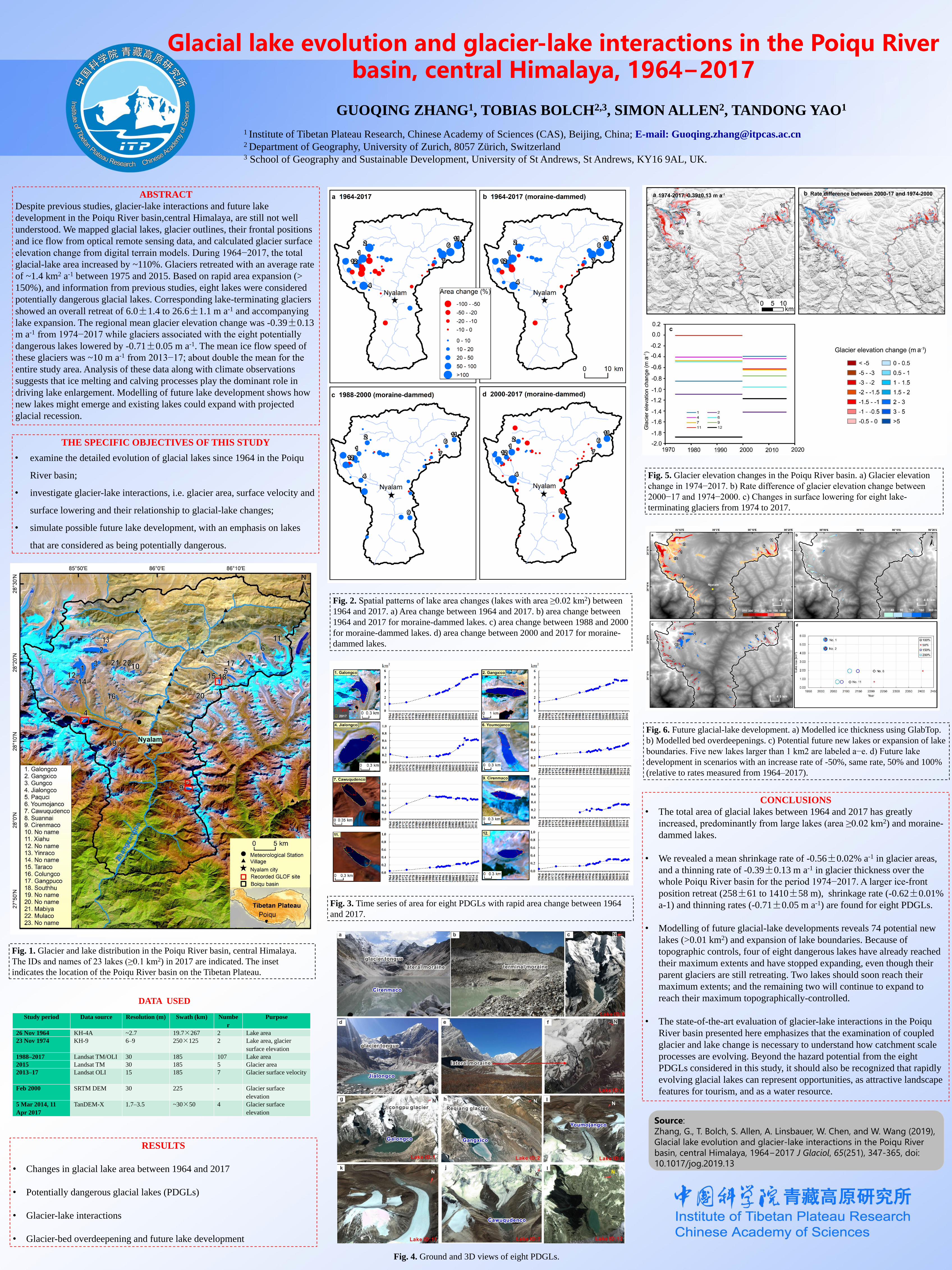
Fig. 1. Glacier and lake distribution in the Poiqu River basin, central Himalaya.
The IDs and names of 23 lakes (≥0.1 km2) in 2017 are indicated. The inset
indicates the location of the Poiqu River basin on the Tibetan Plateau.
Study period Data source Resolution (m) Swath (km) Numbe
r
Purpose
26 Nov 1964 KH-4A ~2.7 19.7×267 2 Lake area
23 Nov 1974 KH-9 6–9 250×125 2 Lake area, glacier
surface elevation
1988–2017 Landsat TM/OLI 30 185 107 Lake area
2015 Landsat TM 30 185 5 Glacier area
2013–17 Landsat OLI 15 185 7 Glacier surface velocity
Feb 2000 SRTM DEM 30 225 - Glacier surface
elevation
5 Mar 2014, 11
Apr 2017
TanDEM-X 1.7–3.5 ~30×50 4 Glacier surface
elevation
DATA USED
Fig. 2. Spatial patterns of lake area changes (lakes with area ≥0.02 km2) between
1964 and 2017. a) Area change between 1964 and 2017. b) area change between
1964 and 2017 for moraine-dammed lakes. c) area change between 1988 and 2000
for moraine-dammed lakes. d) area change between 2000 and 2017 for moraine-
dammed lakes.
Fig. 3. Time series of area for eight PDGLs with rapid area change between 1964
and 2017.
Fig. 4. Ground and 3D views of eight PDGLs.
Fig. 5. Glacier elevation changes in the Poiqu River basin. a) Glacier elevation
change in 1974−2017. b) Rate difference of glacier elevation change between
2000−17 and 1974−2000. c) Changes in surface lowering for eight lake-
terminating glaciers from 1974 to 2017.
Fig. 6. Future glacial-lake development. a) Modelled ice thickness using GlabTop.
b) Modelled bed overdeepenings. c) Potential future new lakes or expansion of lake
boundaries. Five new lakes larger than 1 km2 are labeled a−e. d) Future lake
development in scenarios with an increase rate of -50%, same rate, 50% and 100%
(relative to rates measured from 1964–2017).
Source:
Zhang, G., T. Bolch, S. Allen, A. Linsbauer, W. Chen, and W. Wang (2019),
Glacial lake evolution and glacier-lake interactions in the Poiqu River
basin, central Himalaya, 1964−2017 J Glaciol, 65(251), 347-365, doi:
10.1017/jog.2019.13
RESULTS
• Changes in glacial lake area between 1964 and 2017
• Potentially dangerous glacial lakes (PDGLs)
• Glacier-lake interactions
• Glacier-bed overdeepening and future lake development
Related Documents