Basics Satellite Meteorology (An Introduction to RS of MSG) Joseph Kagenyi Kenya Meteorological Department

Welcome message from author
This document is posted to help you gain knowledge. Please leave a comment to let me know what you think about it! Share it to your friends and learn new things together.
Transcript
Basics Satellite Meteorology(An Introduction to RS of MSG)
Joseph Kagenyi Kenya Meteorological Department

Objective
• Channel properties• Signal source• Discrimination of Ice / Water/ clouds• Summary of channels applications
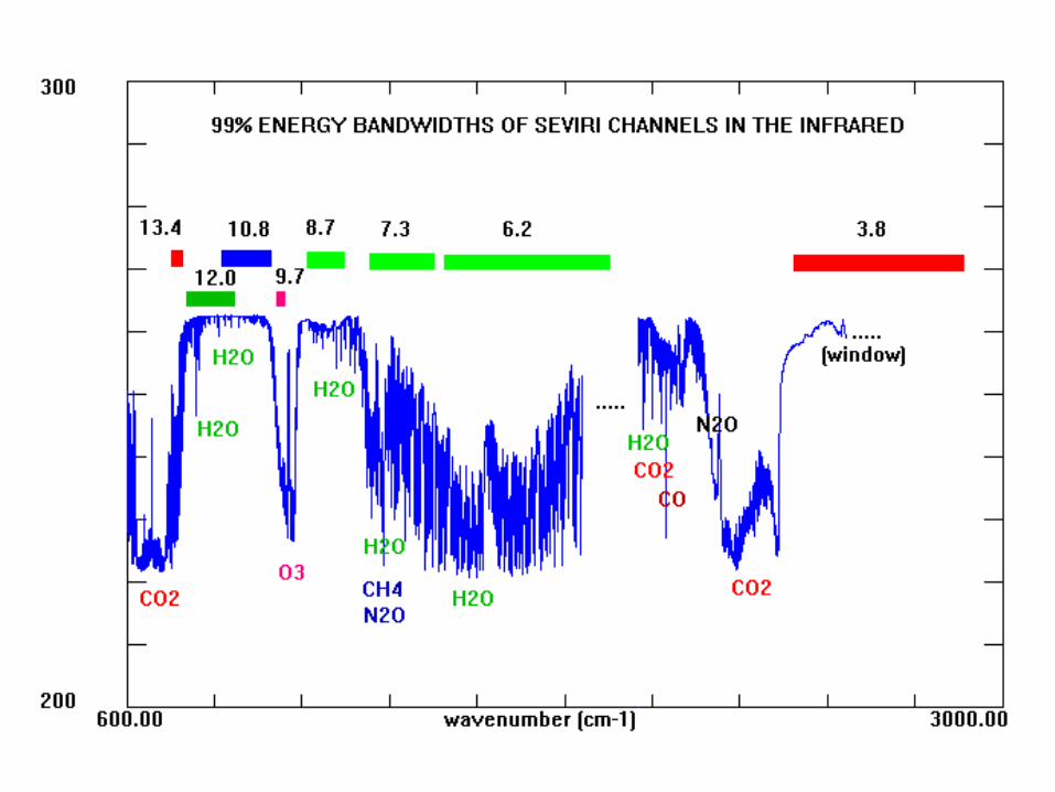
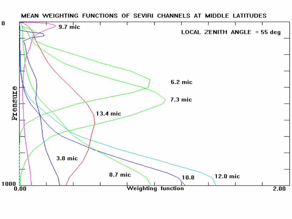
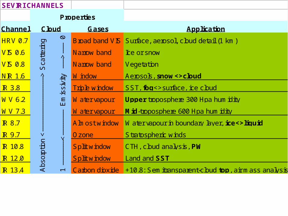
SEVIRI CHANNELS
Channel Gases Application
HRV 0.7 Broad band VIS Surface, aerosol, cloud detail (1 km)
VIS 0.6 Narrow band Ice or snow
VIS 0.8 Narrow band Vegetation
NIR 1.6 Window Aerosols, snow<>cloud
IR 3.8 Triple window SST, fog<>surface, ice cloud
WV 6.2 Water vapour Upper troposphere 300 Hpa humidity
WV 7.3 Water vapour Mid-troposphere 600 Hpa humidity
IR 8.7 Almost window Water vapour in boundary layer, ice<>liquid
IR 9.7 Ozone Stratospheric winds
IR 10.8 Split window CTH, cloud analysis, PW
IR 12.0 Split window Land and SST
IR 13.4 Carbon dioxide +10.8: Semitransparent-cloud top, air mass analysis
Properties
Cloud
Abs
orpt
ion
<--
----
----
----
----
----
----
> S
catt
erin
g
1 --
----
----
--<
----
----
----
E
mis
sivi
ty
----
->--
---
0

12 channels data RGBs
• Exploiting channel combinations to understand the observation products
• Making multichannel approach relevant and applicable: – (MFG) 3 channels,– (MSG) 12 channels and – (MTG) 39 channels
PART 3:
RECOMMENDEDRED-GREEN-BLUE (RGB) COLOUR COMPOSITESFOR MONITORING CONVECTION
DAY-TIME
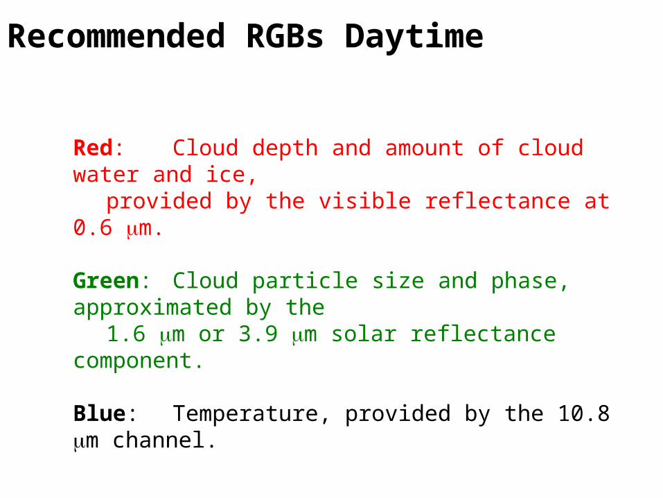
Recommended RGBs Daytime
Red: Cloud depth and amount of cloud water and ice,provided by the visible reflectance at 0.6 mm.
Green: Cloud particle size and phase, approximated by the1.6 mm or 3.9 mm solar reflectance component.
Blue: Temperature, provided by the 10.8 mm channel.
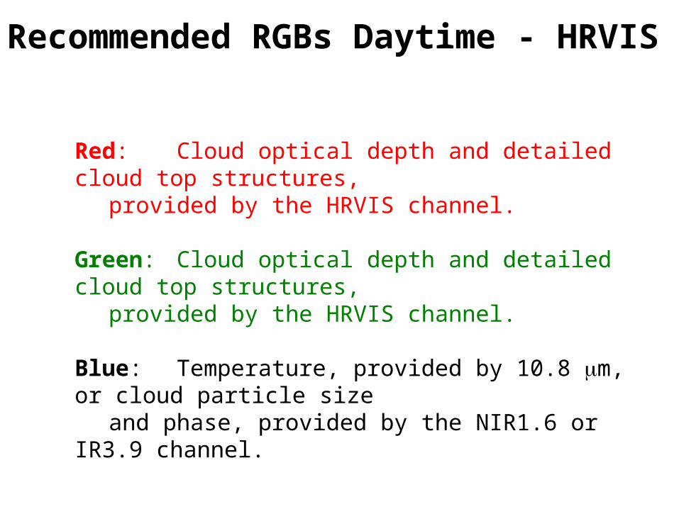
Recommended RGBs Daytime - HRVIS
Red: Cloud optical depth and detailed cloud top structures,
provided by the HRVIS channel.
Green: Cloud optical depth and detailed cloud top structures,
provided by the HRVIS channel.
Blue: Temperature, provided by 10.8 mm, or cloud particle size
and phase, provided by the NIR1.6 or IR3.9 channel.
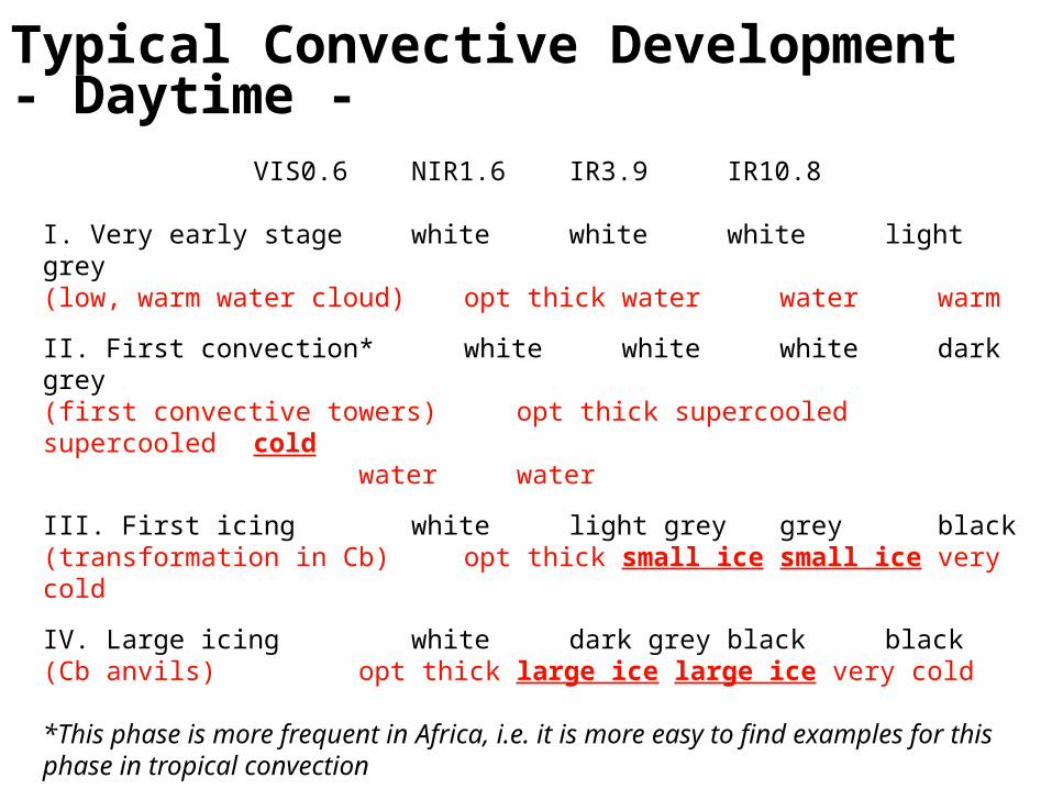
Typical Convective Development- Daytime -
VIS0.6 NIR1.6 IR3.9IR10.8
I. Very early stage white white whitelight grey(low, warm water cloud) opt thick water waterwarm
II. First convection* white white whitedark grey(first convective towers) opt thick supercooled supercooledcold
water water
III. First icing white light grey greyblack(transformation in Cb) opt thick small ice small ice very cold
IV. Large icing white dark grey blackblack(Cb anvils) opt thick large ice large ice very cold
*This phase is more frequent in Africa, i.e. it is more easy to find examples for this phase in tropical convection

Red Green BlueVIS0.6 IR3.9 IR10.8 RGB
I. Very early stage 255 255 200 white-light yellow
II. First convection 255 255 100 yellow
III. First icing 255 150 0 orange
IV. Large icing 255 0 0 red
RGB 01-04-09

RGB 0.6 / 3.9 / 10.8
I. Very early stagewhite-light yellow
II. First convection yellow
III. First icing orange
IV. Large icing red
I
II
III
IV
RGB 01-04-09
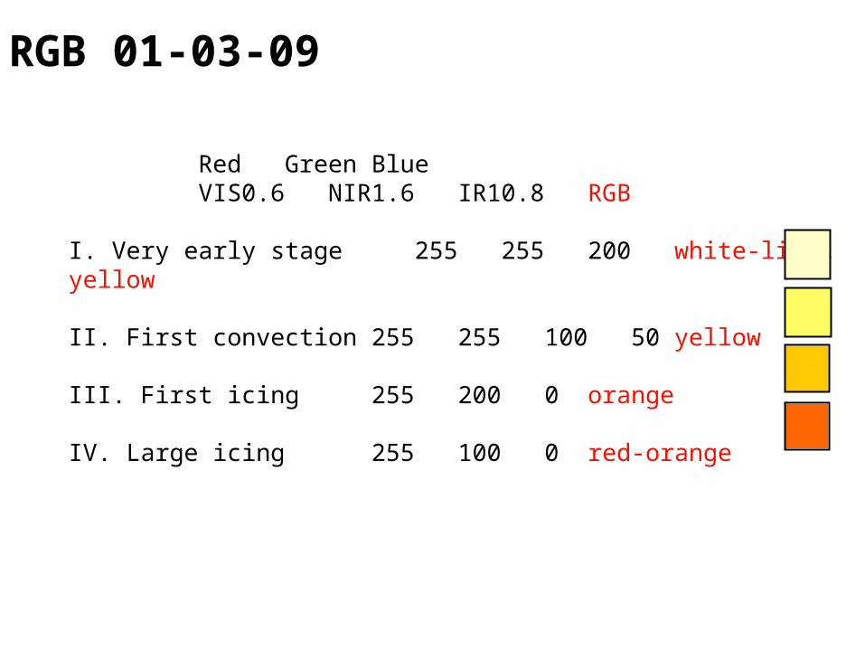
Red Green BlueVIS0.6 NIR1.6 IR10.8 RGB
I. Very early stage 255 255 200 white-light yellow
II. First convection 255 255 100 50 yellow
III. First icing 255 200 0 orange
IV. Large icing 255 100 0 red-orange
RGB 01-03-09
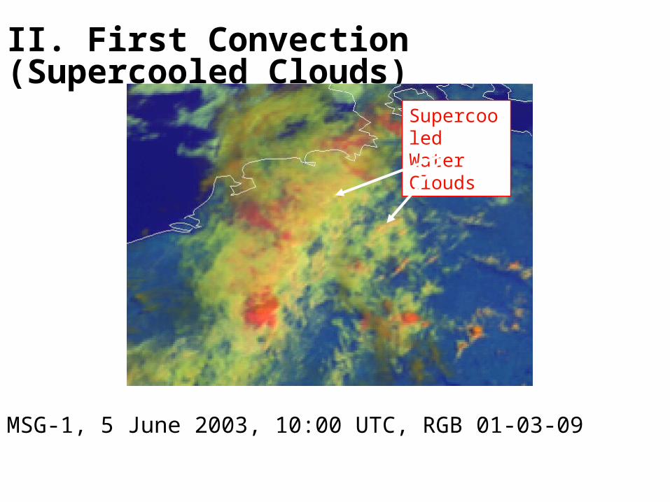
II. First Convection (Supercooled Clouds)
MSG-1, 5 June 2003, 10:00 UTC, RGB 01-03-09
Supercooled Water Clouds

III. First Icing
MSG-1, 5 June 2003, 10:30 UTC, RGB 01-03-09
Cb Icing
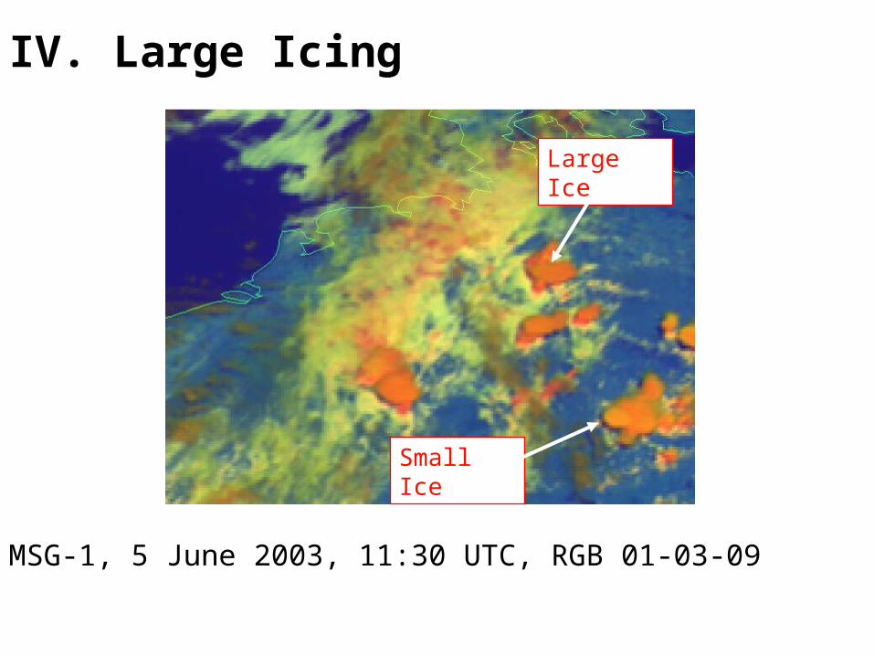
IV. Large Icing
MSG-1, 5 June 2003, 11:30 UTC, RGB 01-03-09
Large Ice
Small Ice

V. Very Large Icing
MSG-1, 5 June 2003, 13:30 UTC, RGB 01-03-09
Large Ice

PART 2:
CHANNEL DIFFERENCESUSEFUL TOMONITOR CONVECTION
NIGHT-TIME
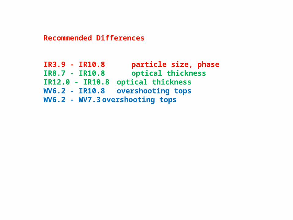
Recommended Differences
IR3.9 - IR10.8 particle size, phaseIR8.7 - IR10.8 optical thicknessIR12.0 - IR10.8 optical thicknessWV6.2 - IR10.8 overshooting topsWV6.2 - WV7.3 overshooting tops
PART 3:
RECOMMENDEDRED-GREEN-BLUE (RGB) COLOUR COMPOSITESFOR MONITORING CONVECTION
NIGHT-TIME
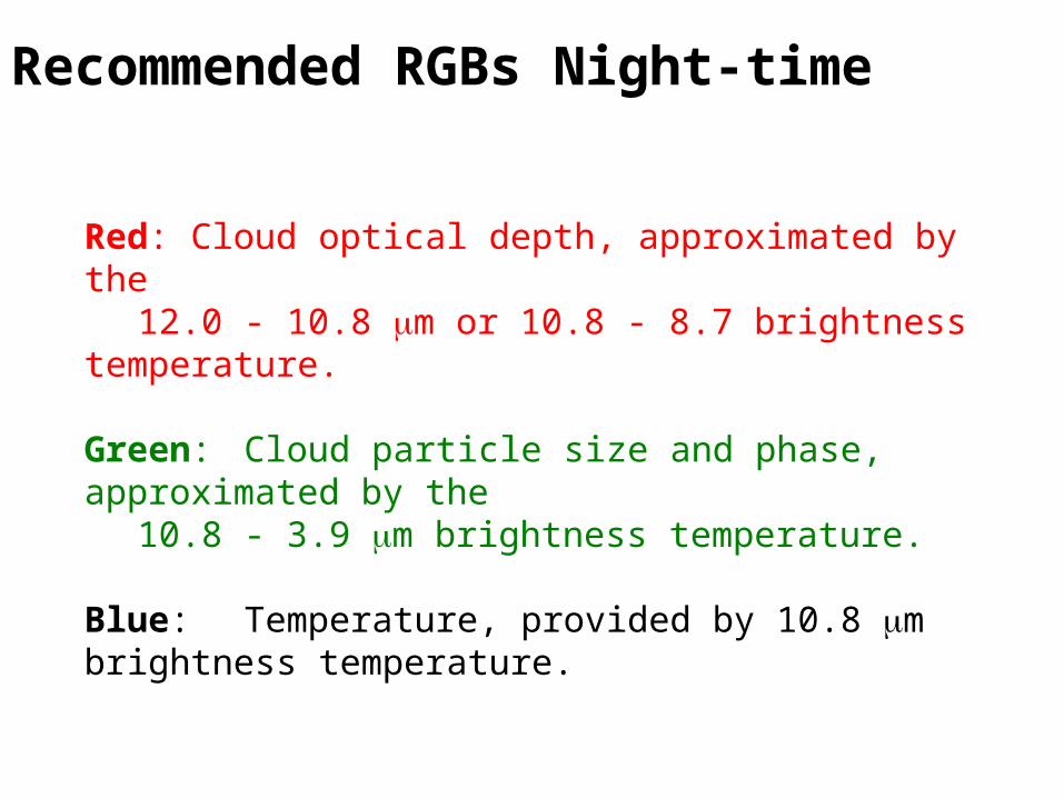
Recommended RGBs Night-time
Red: Cloud optical depth, approximated by the12.0 - 10.8 mm or 10.8 - 8.7 brightness temperature.
Green: Cloud particle size and phase, approximated by the10.8 - 3.9 mm brightness temperature.
Blue: Temperature, provided by 10.8 mm brightness temperature.
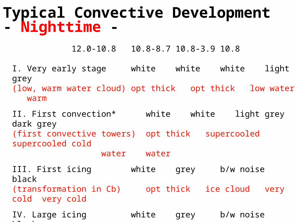
Typical Convective Development- Nighttime -
12.0-10.8 10.8-8.7 10.8-3.9 10.8
I. Very early stage white white white light grey(low, warm water cloud) opt thickopt thicklow water warm
II. First convection* white white light greydark grey
(first convective towers) opt thicksupercooled supercooled coldwater water
III. First icing white grey b/w noiseblack
(transformation in Cb) opt thickice cloud very cold very cold
IV. Large icing white grey b/w noiseblack
(Cb anvils) opt thickice cloud very cold very cold
*This phase is more frequent in Africa, i.e. it is more easy to find examples for this phase in tropical convection
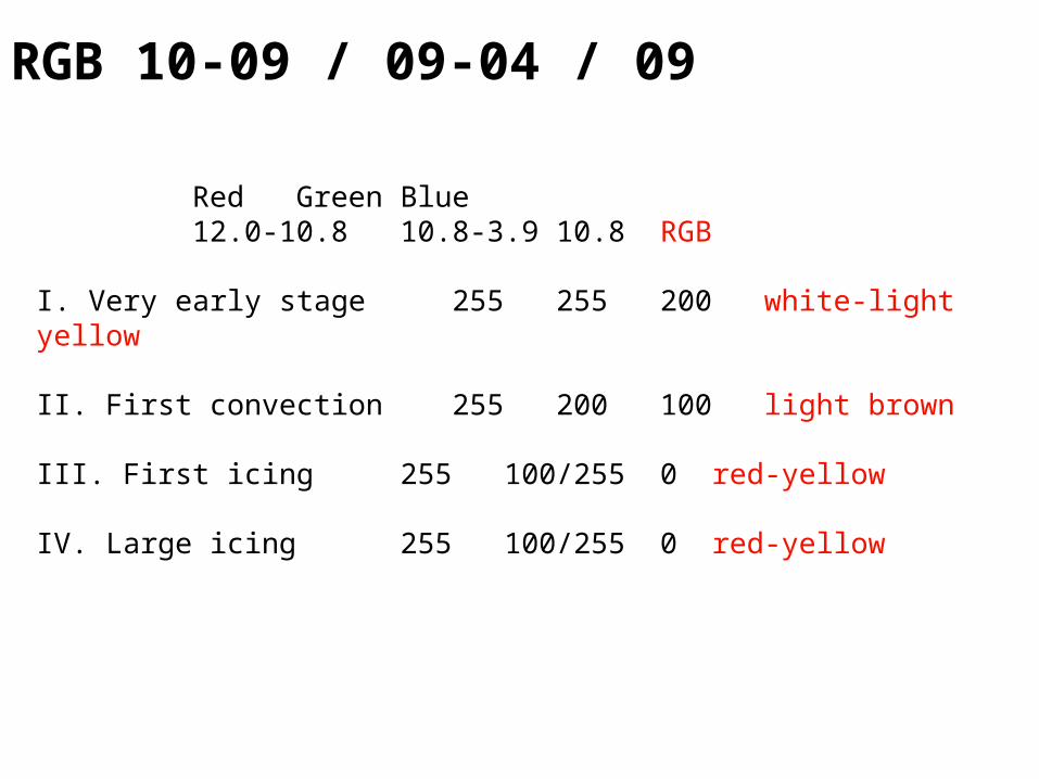
Red Green Blue12.0-10.8 10.8-3.9 10.8 RGB
I. Very early stage 255 255 200 white-light yellow
II. First convection 255 200 100 light brown
III. First icing 255 100/255 0 red-yellow
IV. Large icing 255 100/255 0 red-yellow
RGB 10-09 / 09-04 / 09
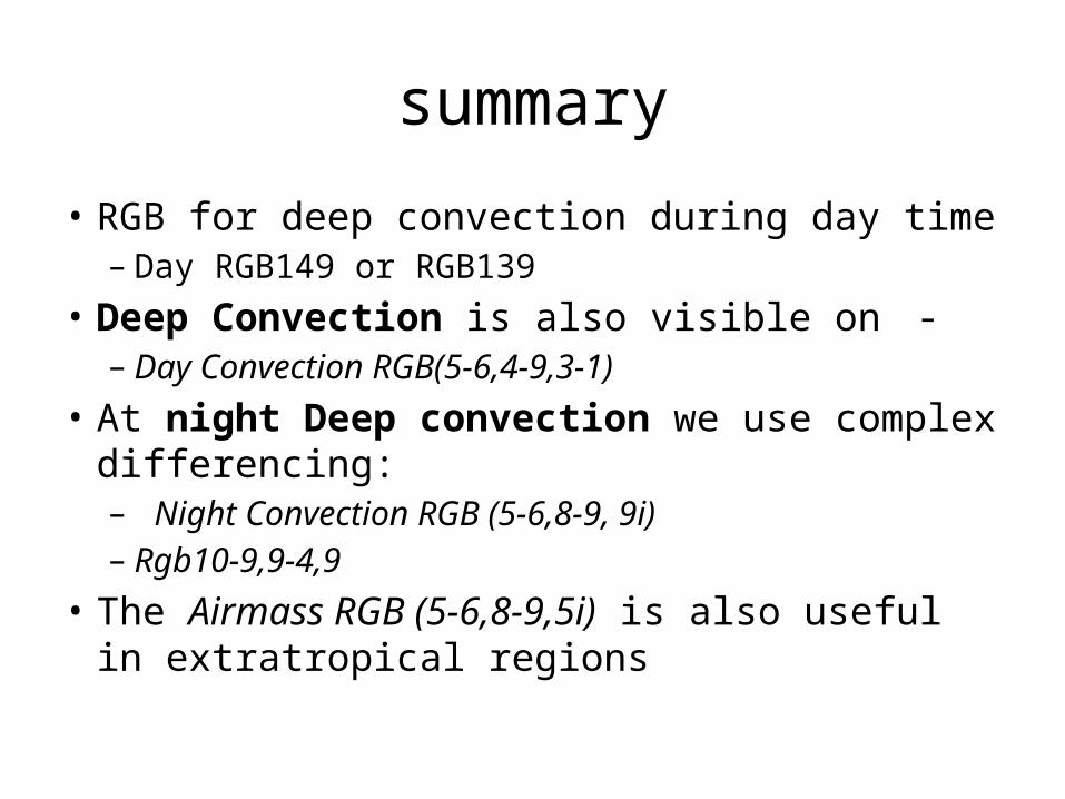
summary
• RGB for deep convection during day time– Day RGB149 or RGB139
• Deep Convection is also visible on -– Day Convection RGB(5-6,4-9,3-1)
• At night Deep convection we use complex differencing:– Night Convection RGB (5-6,8-9, 9i)– Rgb10-9,9-4,9
• The Airmass RGB (5-6,8-9,5i) is also useful in extratropical regions
Related Documents