Basic Water Environment Management and EIA System in Myanmar Introduction The water quality survey targeting the Hlaing River basin and the Doke Hta Waddy River basin was conducted as one of activities of the Project for Capacity Development in Basic Water Environment Management and EIA System. This report summarizes the water quality survey results which are to be utilized to interpret the water quality status in the target areas and develop the pollution control measures.

Welcome message from author
This document is posted to help you gain knowledge. Please leave a comment to let me know what you think about it! Share it to your friends and learn new things together.
Transcript

Basic Water Environment Management and EIA System in Myanmar
Introduction
The water quality survey targeting the Hlaing River basin and the Doke Hta Waddy River basin was
conducted as one of activities of the Project for Capacity Development in Basic Water Environment
Management and EIA System. This report summarizes the water quality survey results which are to be
utilized to interpret the water quality status in the target areas and develop the pollution control
measures.

Outline of water quality survey
The surveys were implemented in total five times in the dry season and rainy season from 2016 to 2018.
This Water Quality Survey Report summarized the results from 4th and 5th water quality surveys. The
sampling points of the surveys are shown in the Figure ES-1.
Figure ES-1 Main Sampling Points of Water Quality Surveys in the Hlaing River Basin

Findings from water quality survey in the Hlaing River basin
The main findings from the surveys in the Hlaing River basin are desctibed below.
(1) Water quality in the Hlaing River and the Pan Hlaing River
The levels of organic pollution in the Hlaing River did not appear to be very high in the rainy season,
though the river water was highly turbid and had localized pollution due to discharged wastewater from
various source. The water quality was obviously deteriorated in the dry season. However, the water
quality for most parameters in the Hlaing River is considered to be acceptable for conservation of
aquatic life, irrigation, and water transportation. The elevated level of toxic pollutants was not confirmed
in the Hlaing River within the scope of survey. One concern is a hypoxic water area with higher COD
and suspended solid was observed at some points downstream in the dry season. It is important to check
how the hypoxic water is formulated and how it moves forward or downward in the river by obtaining
more monitoring data including the water quality in different-depth points and in other tide condition.
(2) Spatial distribution of pollution in the flow direction of Hlaing River
The result did not show the marked deterioration of surface water quality in the flow direction of the
Hlaing River and Pan Hlaing River in the rainy season. In the dry season, the COD level increased from
middle stream to downstream in the survey area, while there was no significant difference in BOD level
among the locations. This implies that the high COD in the dry season in the downstream area was
largely due to organic matter associated with suspended solid in the water and not soluble organic
substance. More monitoring data is required to identify the spatial and temporal changes of surface water
quality in the Hlaing River.
(3) Pollution impact from industrial wastewater to the Hlaing River
One small creek flowing through the Shwe Phy That IZ to the Hlaing River was selected as a target
creek in IZ to be investigated. In the creek, the water quality was significantly deteriorated by industrial
wastewater when the highly-polluted industrial wastewater was discharged from factories to the creek.
The water pollution was indicated by low DO as well as high concentrations of COD, BOD, oil and
grease, nutrients and others. The pollution impact on the Hlaing River by this creek seemed limited
currently because a large amount of water flow in the Hlaing River could alleviate such impact by
dilution of pollutants at this moment. However, dilution capacity in the river is limited or even reduced
in the dry season and the environmental risk in the main river could be higher. The regular water quality
monitoring is required to clarify the water quality status and mechanism of distribution of water
pollution.
Conclusions
The surface water quality in main rivers and creeks was investigated in the Hlaing River basin. The
Hlaing River receives domestic wastewater and industrial wastewater from the river basin of Yangon
City. The surveys confirmed that the Hlaing River still maintains the water quality desirable for each
water as far as the receiver water bodies have a certain level of water flow. On the other hand, the survey
results pointed out several issues and concerns on surface water quality in target areas. First, the Hlaing
River or/and Pan Hlaing River could have a localized dysoxic water area in the brackish water area. It is
generally formulated associated with hydrological behavior of brackish water area and depending on the
organic pollution level. In case of such dysoxic environment, the river water quality is not suitable
especially in terms of conservation of aquatic life.
Sampling schedule
The sampling work for Hlaing River basin was conducted by the following schedule. It was planned to
target the spring tide period. The sampling time in the Hlaing River was arranged to take water samples
in the ebb tide time when the water flows from upstream to downstream to check the pollution impact
from the upstream river basin.
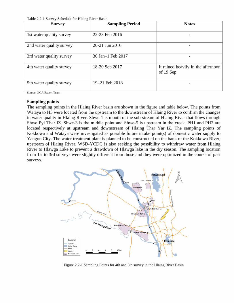
Table 2.2-1 Survey Schedule for Hlaing River Basin
Survey Sampling Period Notes
1st water quality survey 22-23 Feb 2016 -
2nd water quality survey 20-21 Jun 2016 -
3rd water quality survey 30 Jan–1 Feb 2017 -
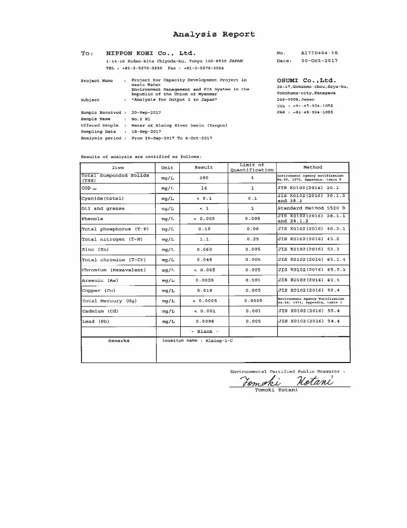
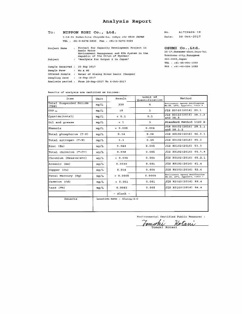
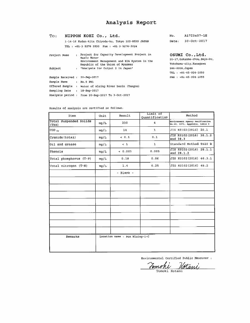
4th water quality survey 18-20 Sep 2017 It rained heavily in the afternoon
of 19 Sep.
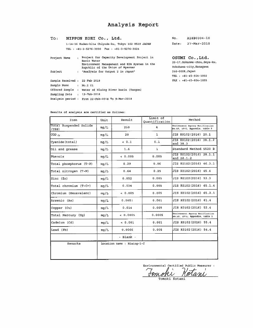
5th water quality survey 19–21 Feb 2018 -
Source: JICA Expert Team
Sampling points
The sampling points in the Hlaing River basin are shown in the figure and table below. The points from
Wataya to H5 were located from the upstream to the downstream of Hlaing River to confirm the changes
in water quality in Hlaing River. Shwe-1 is mouth of the sub-stream of Hlaing River that flows through
Shwe Pyi Thar IZ. Shwe-3 is the middle point and Shwe-5 is upstream in the creek. PH1 and PH2 are
located respectively at upstream and downstream of Hlaing Thar Yar IZ. The sampling points of
Kokkowa and Wataya were investigated as possible future intake point(s) of domestic water supply to
Yangon City. The water treatment plant is planned to be constructed on the bank of the Kokkowa River,
upstream of Hlaing River. WSD-YCDC is also seeking the possibility to withdraw water from Hlaing
River to Hlawga Lake to prevent a drawdown of Hlawga lake in the dry season. The sampling location
from 1st to 3rd surveys were slightly different from those and they were optimized in the course of past
surveys.
Figure 2.2-1 Sampling Points for 4th and 5th survey in the Hlaing River Basin

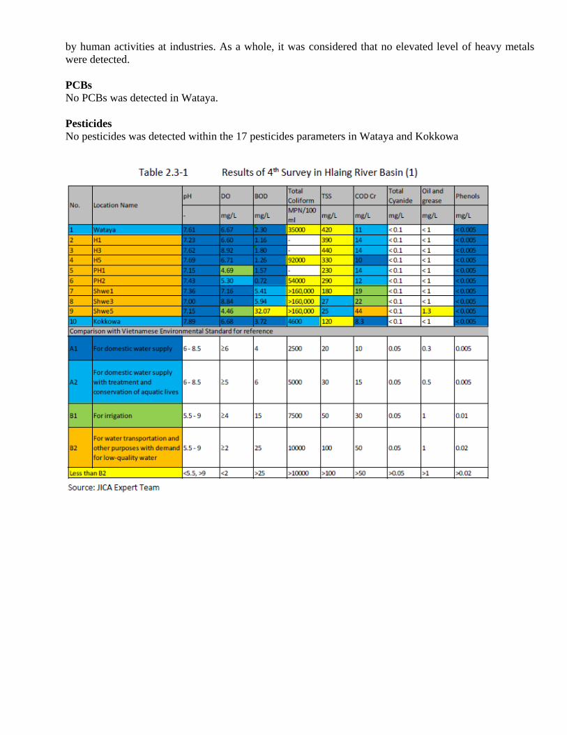
Water quality results
The water quality survey results were firstly evaluated with respect to each analytes compared with the
surface water quality guideline of Vietnam for surface water quality (QCVN 08-MT 2015/BTNMT). The
water quality guideline value of Vietnam is specified for water usage. Tentatively in the surveys, the
purpose of water usage in each water body was considered to be:
i) domestic water supply with treatment and conservation of aquatic life for sampling points of
Wataya and Kokkowa, and
ii) domestic supply water transportation and other purposes with demand for low-quality water
for other sampling points. The results area listed in Table 2.3-1 - Table 2.3-5.
pH
The pH level is neutral in target rivers within the desirable range between 6 and 8.5. On the other hand,
in the creek that flows through the Shwe Pyi Thar IZ to the Hlaing River, the pH level was decreased to
around pH 5 and showed mild acidity in the 5th survey (dry season).
DO
The water contained enough dissolved oxygen necessary for aquatic life in the 4th survey (rainy season).
However, in the 5th survey, the DO values were decreased to less than 1 or 2 mg/L: dysoxic level in PH1
and the creek in Shwe Pyi Thar IZ, where the higher BOD and COD were observed. It implied the
following possibility; the oxidation rate of organic matter by bacteria was greater than the supply of
dissolved oxygen and the high amounts of organic matter would cause the dysoxic status.
BOD and COD
BOD and COD represent the organic substances in the water. Those values in the 4th survey (rainy
season) satisfied the target water quality level desirable for each water usages. For example in the Hlaing
River, BOD was less than 3 mg/L and COD was less than 14 mg/L, which is appropriate for water
transportation, irrigation and conservation of aquatic life and even for domestic water supply with
ordinary treatment. The level of organic pollution in rivers did not appear to be high though the impact
of localized pollution such as a pollution plume from discharged wastewater or oil leakage from ships
would be a concern. On the other hand in the 5th survey (dry season), most sampling points except
Kokkowa did not satisfy the target water quality level of BOD or/and COD and showed the deterioration
of water quality. For example at the H3 and H5 in the downstream of Hlaing River, COD level increased
to more than 50 mg/L.

Total coliform
At Kokkowa, total coliform level was adequate for domestic water supply in the both 4th and 5th
surveys. In the Hlaing River, Pan Hlaing River and creek in Shwe Pyi Thar IZ, total coliform level was
more than 10, 000 MPN/100ml except at Wataya in the 5th survey, which indicated these water body is
presumably contaminated by sewage, livestock wastewater and other pollution sources. The parameter of
total coliform is generally used as an indicator of the sanitary condition of environmental water and is
used for an environmental water quality standard. Total coliform includes various species of bacteria not
only derived from human or animal waste, but also from other sources. Testing for E coliform or/and
fecal coliform should be added if the public health rick such as contamination by feces needs to be
checked.
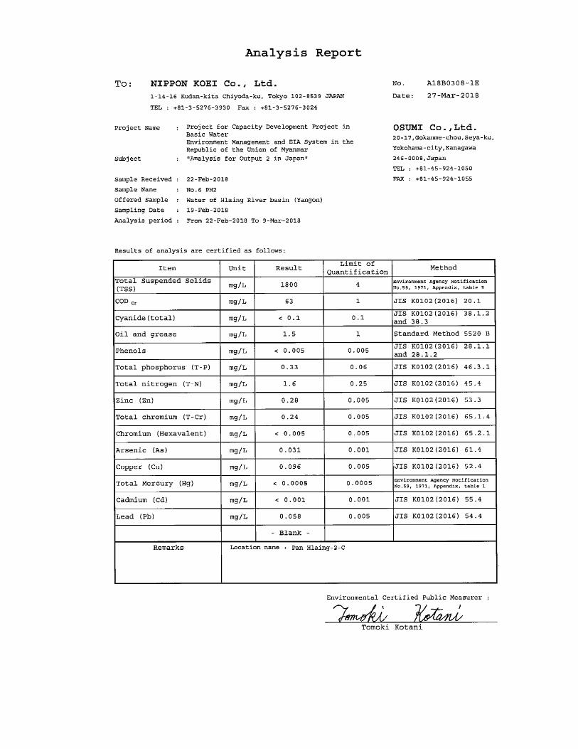
TSS
High levels of suspended solids were observed in the targeted water area except at the mostupper point
of creek in Shwe Pyi Thar IZ. The river water flowing for long distance from upper direction to Yangon
City seems to be originally significantly turbid. In February 2018, TSS level increased to more than 1,
000 mg/L in the downstream of Haling River and Pan Hlaing River, namely H3, H5, PH1 and PH2. The
river water of PH1 was extremely muddy.
Total cyanides
Cyanides were not detected at any points.
Oil and grease
While oil and grease were not detected except at upper stream of creek in Shwe Pyi Thar IZ (Shwe5) in
September 2017, moderate levels of oil and grease were observed at every point in February 2018.
Phenols
1.1 mg/L of phenols at maximum was detected only in the creek in Shwe Pyi Thar IZ in February 2017.
It was not detected at other rivers.
Nutrients
Total phosphorus level ranged between 0.16 and 0.19 mg/L in September 2017 and between 0.15 and
0.32 mg/L in February 2018. Total nitrogen level ranged between 1.0 and 1.2 mg/L in September 2017
and between 0.64 and 1.2 mg/L in February 2018. In general, nitrate, nitrite and ammonia among various
forms of nitrogen and phosphate as one of phosphorus forms are important determinants to evaluate the
environmental water quality in rivers. However, these specific forms were not surveyed in 4th and 5th
surveys. The reason was firstly because the analytical precision for these parameters in local laboratories
were not good enough. Secondly, the samples for these parameters could not be preserved appropriately
for long time necessary for transportation to other countries’ laboratory since the concentration of each
form substance can be easily changed due to oxidation or reductive reaction, biological degradation and
any other reasons. Reliable analysis is a challenge currently in Myanmar but expected to be available in
the near future to get the reliable data of nitrate, nitrite and ammonia as well as phosphate for
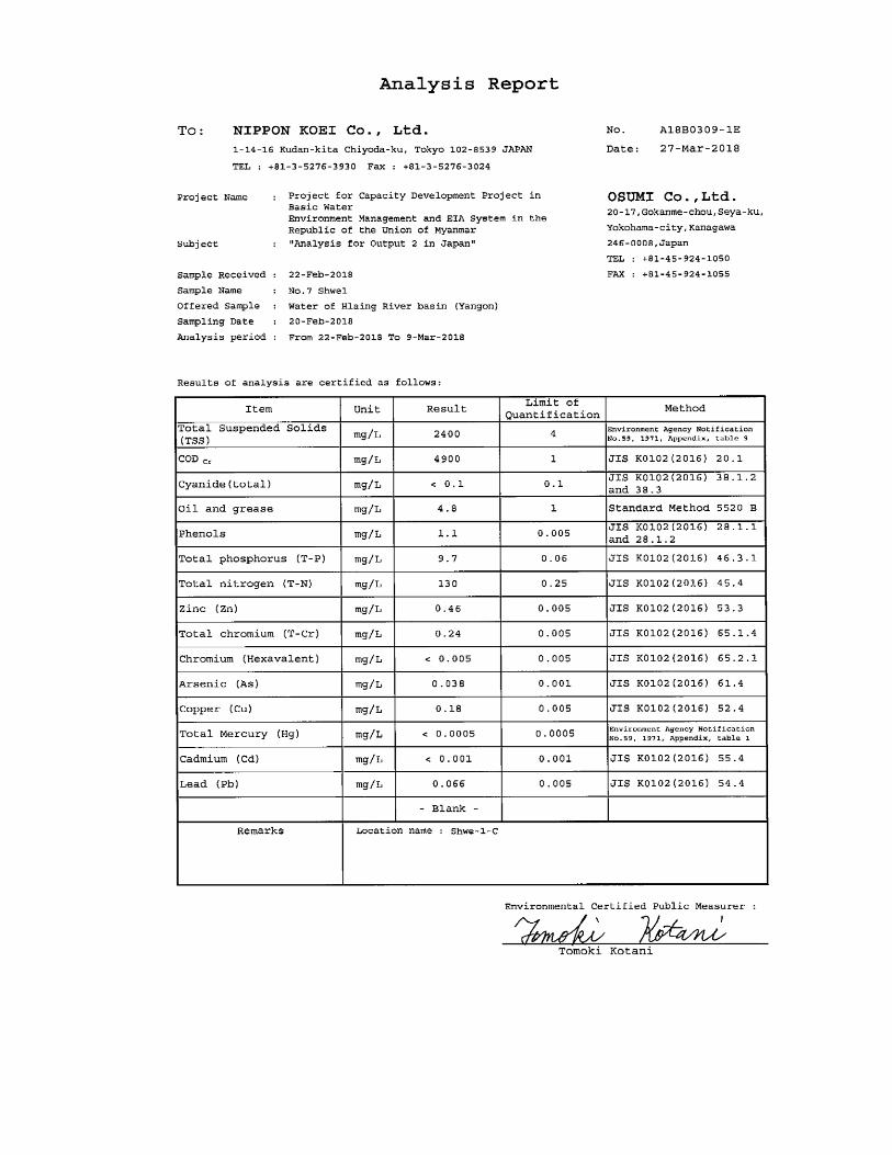
environmental water sample. In February 2018, total nitrogen and total phosphorus levels in the creek in
Shwe Pyi Thar IZ were quite high: 9.7 mg/L of total nitrogen and 140 mg/L of total phosphorus at
maximum. It was mainly caused by the wastewater from distilleries.
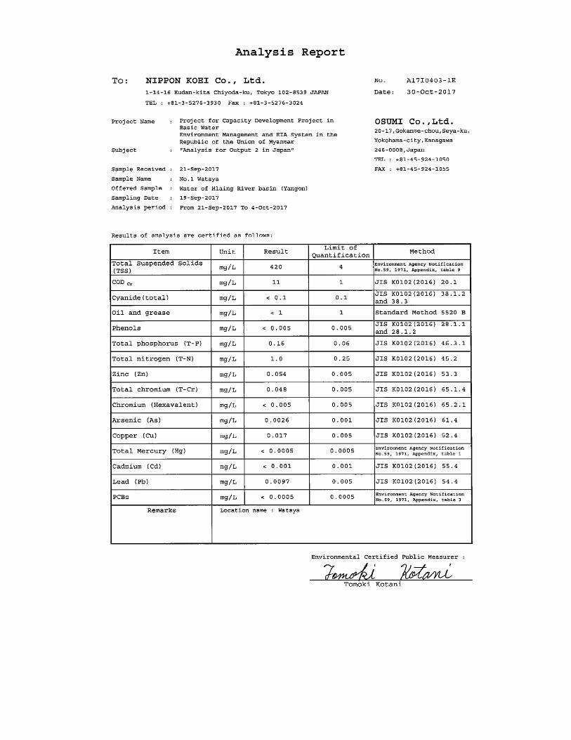
Heavy metals
In September 2017, heavy metals level was less than the reference water quality guideline value for
usage of domestic water supply. In February 2018, some heavy metal parameters showed slightly higher
concentration apparently due to higher level of suspended solids. Total chromium result (0.11 mg/L) at
Wataya as well as lead result at Wataya (0.024 mg/L) and PH2 (0.058 mg/L) were slightly higher than
desirable water quality level for water usage according to the reference standard value of Vietnam.
However, it was hypothesized that the origin is from natural heavy metals in the ground and not caused
by human activities at industries. As a whole, it was considered that no elevated level of heavy metals
were detected.
PCBs
No PCBs was detected in Wataya.
Pesticides
No pesticides was detected within the 17 pesticides parameters in Wataya and Kokkowa


Evaluation of Water Quality
The water quality survey in the Hlaing River basin was evaluated for each survey purpose as shown
below.
(1) Pollution levels in the Hlaing River and Pan Hlaing River
As represented by Table 2.3-6 summarizing the organic pollution level in each water area, except for
TSS (Total Suspended Solid) and total coliform, the water quality in the Hlaing River and Pan Hlaing
River in the rainy season (September 2017) was acceptable for conservation of aquatic life, irrigation
and water transportation according to the Vietnamese surface water quality guideline values. In the dry
season (February 2018), the water quality was deteriorated as indicated by high COD at some points and
slight oil and grease at all sampling points. Only the upstream area of Hlaing River (upstream of Shwe
Pyi Thar Bridge) still kept the good water quality desirable for irrigation and water transportation except
for the above-mentioned TSS, total coliform and oil and grease. In the middle-stream of the Pan Hlaing
River (upstream of Hlaing Bridge), the river water was extremely muddy in February 2018 resulting in
very low DO and high BOD and COD (Figure 2.3-2), presumably due to the effect of sediment in the
water stirred by a surging tide flow or other reasons. There was a dam appeared around 3.5 km upstream
of PH2 and it seems to interfere with the flowing current in the Pan Haling River. The reason of hypoxic
water area is exactly not clear. In some cases in other tidal river, the hypoxic water mass in the lower
water column layer is observed and can be one of the general water quality issue. Thus, it will be
important to check how the hypoxic water is formulated and how it is moved forward or downward
affected by saltwater instruction in the river by obtaining more monitoring data including the water
quality in different depth and in other tide conditions. The results in these rivers did not exhibit levels of
toxic pollutants harmful to human health. Only slight lead (0.058 mg/L) was detected in downstream
area in the Pan Hlaing River in February 2018, but it is considered to be originally contained in the
natural sediment.
Source: JICA Expert Team
Figure 2.3-2 DO vs BOD and COD in the 5th survey

(2) Spatial distribution of pollution in the Hlaing River: difference in water quality from
upstream to downstream
The result did not show marked deterioration of surface water quality in the flow direction of Hlaing
River and Pan Hlaing River in the rainy season. In the dry season, the COD level increased from upper-
stream to downstream while there was no significant difference in BOD level among the locations (see
Figure 2.3-3). This implies that the high COD in the dry season in the downstream area was largely due
to organic matter associated with suspended solid in the water and not soluble organic substance. The
spatial and temporal changes of surface water quality in the Hlaing River need to be investigated.
Source: JICA Expert Team
Figure 2.3-3 Water Quality Distribution in the Hlaing River
(3) Seasonal changes of water quality
The concentration of pollutants in the dry season was higher than one in the rainy season for most
sampling points and for most parameters as represented by BOD and COD (see Figure 2.3-4). It
indicated that in the rainy season the storm water diluted such pollutants and alleviated the pollution
impact in the river. On the other hand, it can be considered that the pollution impact of industrial
wastewater and domestic wastewater from the basin could be bigger when the water flow is lower,
making it difficult to fully maintain the desired water quality in the Hlaing River in the dry season.

(4) Pollution impact from IZs to the Hlaing River
In the creek that flows through the Shwe Pyi Thar IZ to the Hlaing River, the water quality in the past
surveys until February 2017 was significantly worse due to inflow of wastewater, which was indicated
by low DO as well as several hundreds mg/L of BOD add COD as well as high concentrations of oil and
grease, nutrients, phenol and others. The water quality of this creek was improved in September 2017
probably because the operation of distilleries along the creek was suspended. This order was given by
Yangon Region Government to six distilleries in the IZ in July or August 2017. However, after the new
pipeline from distilleries was constructed in the creek, the water quality again deteriorated. The creek
water in the vicinity of discharging point indicted 263 mg-BOD/L and 5,700 mg-COD/L as well as
lower DO and higher nutrients, oil and grease and others as shown in Figure 2.3-5. The water quality in
the creek hinges on the impact of wastewater from these factories. It is important to continue to monitor
the wastewater from these pollution sources, which could improve or deteriorate depending on the
factories’ operation and performance of wastewater treatment. There was not enough data to assure to
say there is a significant water deterioration in the downstream compared with upstream among
sampling points except for COD and TSS (see BOD distribution in Figure 2.3-5 for example). Overall,
the pollution impact on the Hlaing River by this creek seemed limited currently because a large amount
of water flow in the main stream can alleviate such impact by dilution of pollutants. However, dilution
capacity in the river is limited or even reduced in the dry season and the environmental risk in the main
river could be higher.

Source: JICA Expert Team
Figure 2.3-6 BOD Distribution in the Hlaing River in Feb 2018
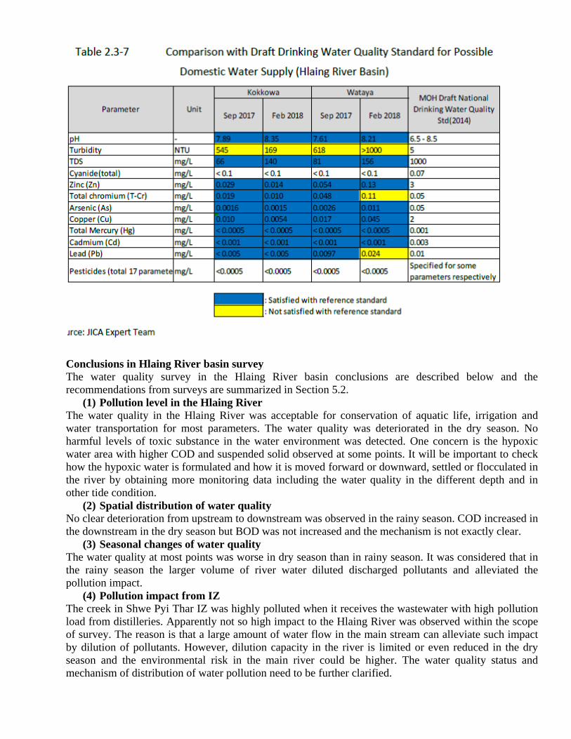
(5) Water quality for future domestic water supply at the Kokkowa River and Wataya
The sampling points of Kokkowa and Wataya were investigated as possible future intake points of
domestic water supply to Yangon City. Judging from the results, the water quality at Kokkowa and
Wataya in the rainy season seem good enough for water supply for domestic water supply if the water is
treated at a water treatment facility using filters and other ordinary means. It satisfied the draft national
drinking water guideline value (MOH superseded by MOHS, 2014) with respect to the measured
parameters except turbidity at both sampling points in September 2017 and February 2018 as well as
total chromium and lead at Wataya point in February 2018 (see Table 2.3-7). It was hypothesized that
chromium and lead, whose concentrations were not very high, were contained in the suspended sediment
and are of natural origin. Whether they can be removed during water treatment or not should be
confirmed. The pesticides were not detected in the surveys both in September 2017 and February 2018,
but need to be investigated in other seasons including the farming season. Although the survey results
did not reveal a specific environmental risk, there are some potential pollution sources along the Hlaing
River in the surrounding of Wataya. The water samples in these surveys were taken in the spring tide
time and when the water was flowing downward after high-tide. However, the pollution level might
change in a farming season, or when the water flows upward after low-tide. However, it should be noted
that these surveys were conducted as part of environmental monitoring under the water environmental
management project, and the results do not guarantee safety of waters for drinking and other purposes.
The measurement parameter in these surveys was limited and did not cover all the guideline values.
Thus it is crucial to continue to check the water quality throughout the year for wider range of
parameters and with continuous monitoring in one tide cycle per day and between spring tide and neap
tide.
Conclusions in Hlaing River basin survey
The water quality survey in the Hlaing River basin conclusions are described below and the
recommendations from surveys are summarized in Section 5.2.
(1) Pollution level in the Hlaing River
The water quality in the Hlaing River was acceptable for conservation of aquatic life, irrigation and
water transportation for most parameters. The water quality was deteriorated in the dry season. No
harmful levels of toxic substance in the water environment was detected. One concern is the hypoxic
water area with higher COD and suspended solid observed at some points. It will be important to check
how the hypoxic water is formulated and how it is moved forward or downward, settled or flocculated in
the river by obtaining more monitoring data including the water quality in the different depth and in
other tide condition.
(2) Spatial distribution of water quality
No clear deterioration from upstream to downstream was observed in the rainy season. COD increased in
the downstream in the dry season but BOD was not increased and the mechanism is not exactly clear.
(3) Seasonal changes of water quality
The water quality at most points was worse in dry season than in rainy season. It was considered that in
the rainy season the larger volume of river water diluted discharged pollutants and alleviated the
pollution impact.
(4) Pollution impact from IZ
The creek in Shwe Pyi Thar IZ was highly polluted when it receives the wastewater with high pollution
load from distilleries. Apparently not so high impact to the Hlaing River was observed within the scope
of survey. The reason is that a large amount of water flow in the main stream can alleviate such impact
by dilution of pollutants. However, dilution capacity in the river is limited or even reduced in the dry
season and the environmental risk in the main river could be higher. The water quality status and
mechanism of distribution of water pollution need to be further clarified.


Related Documents


