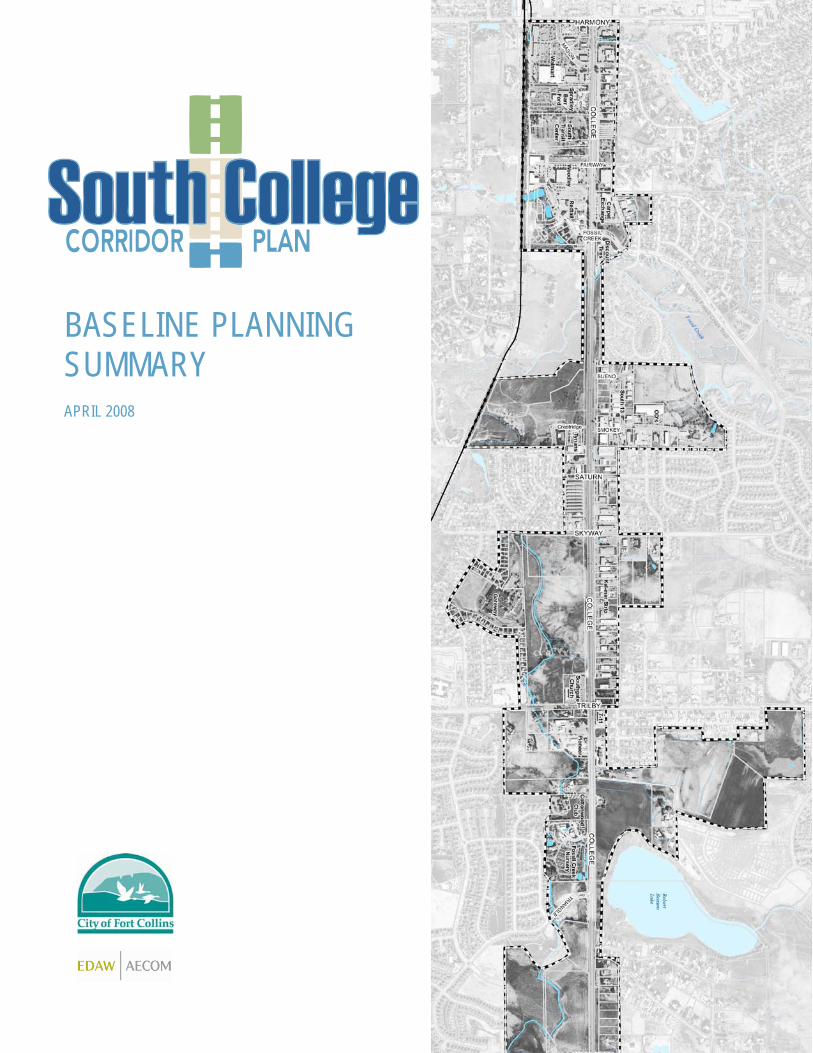
BASELINE PLANNING SUMMARY APRIL 2008

Welcome message from author
This document is posted to help you gain knowledge. Please leave a comment to let me know what you think about it! Share it to your friends and learn new things together.
Transcript
BASELINE PLANNING SUMMARY APRIL 2008
Table of Contents Preface
Section 1: Plan Foundations Introduction South College Avenue Annexation Existing Foundations
Section 2: Existing Conditions and Issues Introduction District Identity Land Use Building and Property Appearance Transportation Trails and Sidewalks Transportation Financing Views and Natural Features Sustainability Utilities
Preface This Baseline Planning Summary highlights key findings collected during Phase I of the South College corridor planning process. This document’s purpose is to assist the community, project team, and City Council to make informed decisions during the planning process. It is informational in nature and not a policy document. The first section, Plan Foundations, provides a synopsis of previous plans or decisions. The second section, Existing Conditions and Issues, catalogs the corridor’s existing physical characteristics and issues identified to date by stakeholders through the Public Kick-off Event (Nov 2007), Stakeholder Interviews (Dec 2007 – Jan 2008), and the Business Forum (April 2008). Your involvement is critical in defining an appropriate vision and policies for South College! As shown on the following graphic, there are many ways you can have your say and contribute to the plan: 1) Call Timothy Wilder, City Planner, at 970-221-6376 2) Email Timothy Wilder at [email protected] 3) Come to upcoming meetings and events 4) Fill out comment forms at events 5) Check fcgov.com/southcollege for the latest information 6) Request a meeting
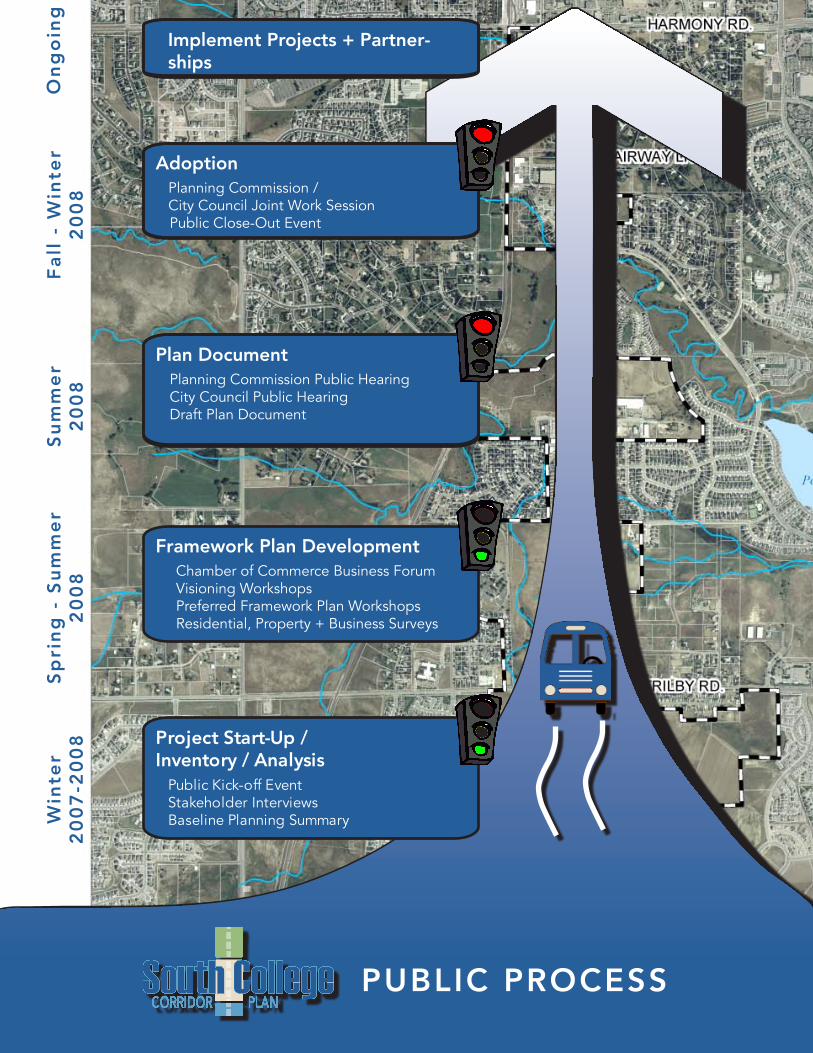
Framework Plan DevelopmentChamber of Commerce Business ForumVisioning WorkshopsPreferred Framework Plan WorkshopsResidential, Property + Business Surveys
Adoption Planning Commission /City Council Joint Work SessionPublic Close-Out Event
Plan DocumentPlanning Commission Public HearingCity Council Public HearingDraft Plan Document
Project Start-Up / Inventory / Analysis
Public Kick-off EventStakeholder InterviewsBaseline Planning Summary
PUBLIC PROCESS
Win
ter
20
07
-20
08
Fa
ll -
Win
ter
20
08
Su
mm
er
20
08
Sp
rin
g -
Su
mm
er
20
08
Implement Projects + Partner-ships
On
go
ing
1
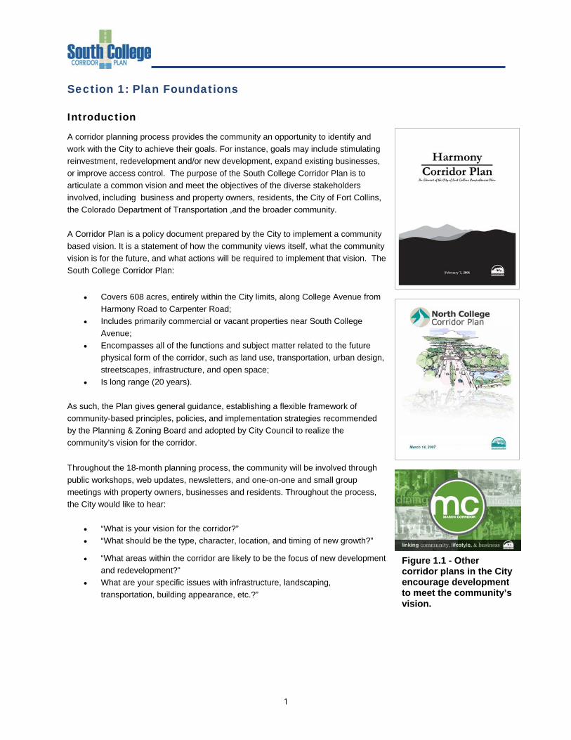
Figure 1.1 - Other corridor plans in the City encourage development to meet the community’s vision.
Section 1: Plan Foundations Introduction
A corridor planning process provides the community an opportunity to identify and work with the City to achieve their goals. For instance, goals may include stimulating reinvestment, redevelopment and/or new development, expand existing businesses, or improve access control. The purpose of the South College Corridor Plan is to articulate a common vision and meet the objectives of the diverse stakeholders involved, including business and property owners, residents, the City of Fort Collins, the Colorado Department of Transportation ,and the broader community. A Corridor Plan is a policy document prepared by the City to implement a community based vision. It is a statement of how the community views itself, what the community vision is for the future, and what actions will be required to implement that vision. The South College Corridor Plan:
• Covers 608 acres, entirely within the City limits, along College Avenue from Harmony Road to Carpenter Road;
• Includes primarily commercial or vacant properties near South College Avenue;
• Encompasses all of the functions and subject matter related to the future physical form of the corridor, such as land use, transportation, urban design, streetscapes, infrastructure, and open space;
• Is long range (20 years). As such, the Plan gives general guidance, establishing a flexible framework of community-based principles, policies, and implementation strategies recommended by the Planning & Zoning Board and adopted by City Council to realize the community’s vision for the corridor. Throughout the 18-month planning process, the community will be involved through public workshops, web updates, newsletters, and one-on-one and small group meetings with property owners, businesses and residents. Throughout the process, the City would like to hear:
• “What is your vision for the corridor?” • “What should be the type, character, location, and timing of new growth?”
• “What areas within the corridor are likely to be the focus of new development and redevelopment?”
• What are your specific issues with infrastructure, landscaping, transportation, building appearance, etc.?”
2
South College Avenue
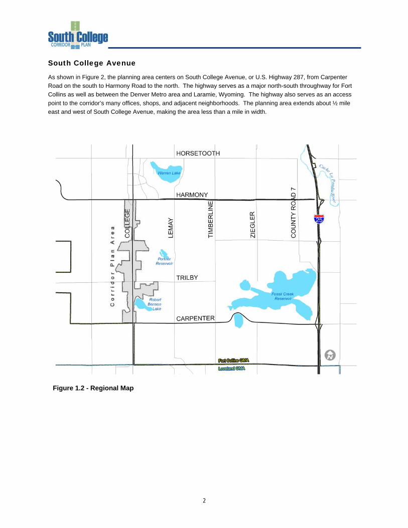
As shown in Figure 2, the planning area centers on South College Avenue, or U.S. Highway 287, from Carpenter Road on the south to Harmony Road to the north. The highway serves as a major north-south throughway for Fort Collins as well as between the Denver Metro area and Laramie, Wyoming. The highway also serves as an access point to the corridor’s many offices, shops, and adjacent neighborhoods. The planning area extends about ½ mile east and west of South College Avenue, making the area less than a mile in width.
Figure 1.2 - Regional Map
3
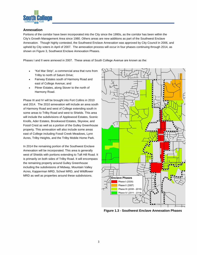
Annexation Portions of the corridor have been incorporated into the City since the 1990s, as the corridor has been within the City’s Growth Management Area since 1980. Others areas are new additions as part of the Southwest Enclave Annexation. Though highly contested, the Southwest Enclave Annexation was approved by City Council in 2006, and upheld by City voters in April of 2007. The annexation process will occur in four phases continuing through 2014, as shown on Figure 3, Southwest Enclave Annexation Phases.
Phases I and II were annexed in 2007. These areas of South College Avenue are known as the:
• “Kel Mar Strip”, a commercial area that runs from Trilby to north of Saturn Drive;
• Fairway Estates south of Harmony Road and east of College Avenue; and
• Pitner Estates, along Stover to the north of Harmony Road.
Phase III and IV will be brought into Fort Collins in 2010 and 2014. The 2010 annexation will include an area south of Harmony Road and west of College extending south in some areas to Trilby Road and west to Shields. This area will include the subdivisions of Applewood Estates, Scenic Knolls, Ader Estates, Brookwood Estates, Skyview, and Fossil Crest as well as a portion of the Gulley Greenhouse property. This annexation will also include some areas east of College including Fossil Creek Meadows, Lynn Acres, Trilby Heights, and the Trilby Mobile Home Park. In 2014 the remaining portion of the Southwest Enclave Annexation will be incorporated. This area is generally west of Shields with portions extending to Taft Hill Road. It is primarily on both sides of Trilby Road. It will encompass the remaining property around Gulley Greenhouse including the subdivisions of Midway, Mountain Valley Acres, Kapperman MRD, Scheel MRD, and Wildflower MRD as well as properties around these subdivisions.
Figure 1.3 - Southwest Enclave Annexation Phases
4
Existing Foundations
As one of the City’s southern gateway’s, the future of South College has been discussed since the 1990s. Early planning efforts began with A Plan for the Region Between Fort Collins and Loveland in the early 1990s, to the City Plan, which proposed a structured land use pattern in 2002 and again in 2005. The Master Street Plan was also updated with City Plan in 2005, reinforcing the corridor’s importance. City Plan was followed by the Land Use Code which applied current zoning and development standards to the area. As a U.S. Highway, the Colorado Department of Transportation has studied the corridor regularly, most recently through the South College Avenue (US 287) Access Control Plan Update Report. Still, no planning process has examined the area's land use trends, constraints, and opportunities. Through the Southwest Enclave Annexation process, City Council recognized the need to coalesce all previous plans into a comprehensive vision, and incorporate new information and issues that had been emerging over the years. The South College Corridor Plan provides this vision and builds upon relevant plans wherever possible. This section summarizes these previous planning efforts. City Plan
In 2005, the City of Fort Collins adopted City Plan, a forward-thinking, 20-year plan for the community that encourages infill and compact development, establishment of community separators, and interconnectivity of multi-modal transportation options. City Plan is premised on discouraging sprawl while encouraging infill development, redevelopment, open space, diversity of housing options, and high quality development. Structure Plan City Plan speaks to 4 basic place types, which comprise the structure of the community. The places include:
• Neighborhoods • Districts • Corridors • Edges
According to City Plan, “the organization of these places -- their ‘structure’ -- gives meaning and form to our community’s vision. These are not intended to be thought of as single-use ‘zones’ in the sense of traditional land use zoning patterns, but rather as distinct and diverse places that contain mixtures of uses and activities.”
Date Plan 1989 South College Avenue (US 287) Access Control Plan 1990s A Plan for the Region Between Fort Collins and Loveland 1998, 2000 Mason Corridor Plan 1999 Northern Colorado Separator Study 2002 South College Avenue (US 287) Access Control Plan Update 2004 US 287 South College Avenue Bicycle Lane Project 2005 City Plan 2005 Master Street Plan 2006 Land Conservation and Stewardship Plan 2007 287 Environmental Overview Study Ongoing North I-25 Environmental Impact Statement
5
The South College Corridor falls into two of these place types: Districts and Corridors. Clearly, as its moniker suggests, the area is a major transportation corridor. While it is known primarily as a highway, it will also become increasingly important as an avenue for multi-modal transportation options through trail linkages and transit stops. The South College Corridor is also a distinct commercial district. The Structure Plan specifically addresses these two roles, and how the Corridor will evolve following City Plan’s Vision. South College Corridor as a District and Corridor The Structure Plan introduced a number of Key Choices that illustrate the Community Vision. The Plan uses the South College Corridor as a specific example of how the City favors a new philosophy on traditional commercial development, by stating: “Commercial Districts -- now typically strip commercial development such as along parts of South College Avenue, will continue to accommodate a full range of commercial uses, including auto-related uses, but will be transformed over time. The shift will be from exclusively auto-oriented places, to places that are more walkable destinations, with a mix of activities.” The Structure Plan also includes Key Choices related to transportation that will directly impact the future of the South College Corridor. While cars will remain the primary means for transportation, the Plan promotes transit, bikes, and walking as becoming more viable options for residents. City Plan states: “ ‘Activity centers’ in our neighborhoods and districts -- including our places of work and shopping -- will be designed to support a variety of modes of transportation. Our transportation corridors will link our destinations and activities, making it easier and more enjoyable to move around our city. Enhanced Travel Corridors uniquely designed and reserved for high frequency transit, bicycling, and walking, will link our major activity centers.” Relevant Policies The Structure Plan sets forth a map and overview of Key Choices that provide a framework to achieve the Community Vision of City Plan; the Principles and Policies add the next level of detail. The Principles and Policies either adhere to the Community Vision or to the place types included in the Structure Plan. While many of the community-wide Principles and Policies relate in a general sense to the South College Corridor, this summary will elaborate only on those included in the Districts, Corridor and Growth Management sections, as provide more specific guidance for the area. Districts City Plan envisions Districts acting to promote sense of place within the community, and adding to the overall quality of life that Fort Collins offers to residents. Because of the emphasis that City Plan places on infill and redevelopment, the South College Corridor is a district where the City’s new planning philosophy will be set into motion. There are seven types of districts included in City Plan. The South College Corridor is considered to be a Commercial District. City Plan states: “Commercial Districts include a wide range of community and regional retail uses, as well as offices, business and personal services, and to a lesser extent, residential uses. While these districts are typically the location for highway business and auto-related uses, they also offer opportunities to create new areas and transform existing developed areas, over time, from being exclusively auto-oriented places to being a series of mixed use, multi-modal centers which relate better to the community as a whole and to surrounding residential neighborhoods.”
6
The Principles and Policies pertaining to Commercial Districts focus on promoting commercial areas that have a mix of uses, pedestrian-oriented design, and accessibility for a variety of multi-modal options. As Structure Plan indicates, the South College Corridor presents promising redevelopment opportunities, where these new planning philosophies can be infused. Corridors Corridors serve the community on many levels; as arteries for the movement of goods and people, as water and drainage ways, and as environmental and recreation refuges. City Plan includes four types of corridors, two of which pertain to the South College Corridor: Transportation Corridors and Water Corridors. Transportation Corridors are founded on existing roadways, with cars being the primary vehicle. City Plan states: “Transportation Corridors are developed primarily to increase mobility, provide transportation options, enhance efficiency, improve the aesthetics of the pedestrian/transit interface, and accommodate the flow of goods and people.” The Principles and Policies under Transportation Corridors are aimed at establishing a well-functioning transportation network for the community that not only provides efficient vehicle movement, but safe and convenient pedestrian and transit access. The Principles and Policies also speak to aesthetics to ensure context-sensitive design of Transportation Corridors that are adjacent to open lands, and the continuation of design elements when surrounded by existing development. Targeted Redevelopment and Infill An important additional set of Principles and Policies compliment District and Corridor guidance, Targeted Redevelopment and Infill areas. The purpose of targeted redevelopment areas is to channel growth where it will be beneficial and can best improve access to jobs, housing and services with fewer and shorter auto trips. A major goal is to increase economic activity in the area to benefit existing residents and businesses. City Plan encourages additional planning efforts to define key redevelopment and infill areas. Key criteria that help identify these areas include:
• Underutilized land • Areas already undergoing positive change, which is expected to continue • Areas where infrastructure capacity exists • Areas where public investment is warranted from a policy perspective • Areas with special opportunities, such as where major public or private investment is already planned • Transportation opportunities: • Along travel corridors • Along enhanced travel corridors
You may download a copy of the Plan at City Plan: http://fcgov.com/cityplanning/city-plan.php
7
South College Avenue Access Control Plan Update The South College Avenue Access Control Plan (ACP) is the community’s most familiar policy reference for the South College Corridor. The ACP Update took place in 2002 to revise the original 1989 ACP, and included extensive public involvement through a cooperative effort of the City of Fort Collins, Larimer County and the Colorado Department of Transportation. As such, the City cannot make changes to the plan without the consent of the other jurisdictions and agencies. If the Corridor Plan proposes significant land use changes or uncovers new information affecting transportation, the City will work with the jurisdictions and agencies to find out if changes to the Access Control Plan are needed. To restate the ACP’s purpose in the simplest form, it is to provide good mobility and a safe operating environment for all modes of transportation to preserve the Corridor’s vitality as development and traffic demands increase. The ACP recommends short-term and long-term access improvements, and subsequent direction for funding and implementation. The Short-Term and Long-Term access plans for this corridor are directly related to redevelopment and new development opportunities. Key short-term improvements that the ACP recommends at select locations along the Corridor include:
• Raised medians • Parallel streets • Redefined frontage roads • Potential Bike/Pedestrian connections
Long-term improvements recommended by the ACP are intended to reflect the projected transportation infrastructure necessary to accommodate the expected traffic volumes related to land use changes as well as due to regional traffic growth. Corridor-wide long-term improvements include:
• Construction of the City of Fort Collins Arterial cross-section between Carpenter and Harmony Roads • Construction of parallel streets to provide circulation alternatives for local residents and businesses,
connecting to existing public streets where possible • Provision of gated openings in the new median along South College Ave to accommodate emergency
response vehicles The Plan is used to help guide long-term transportation improvements along these corridors. The planning horizon for these plans is 20 years, or in other words, it considers the growth in traffic and development that is projected to take place along these corridors over the next 20 years. Therefore, some of the recommended access and roadway improvements are likely to not happen for many years – or until traffic conditions and growth in this part of the community increase enough to warrant the improvements. There may be the case however where safety related improvements are needed sooner based upon existing conditions such as traffic crash data/accident history, traffic volumes, sight distance problems, etc. In that case, the City of Fort Collins, Larimer County, and CDOT would work together to develop either interim and/or long-term safety solutions. Property owners, businesses, and residents in the affected area would be consulted with in the decision making process at the time of the necessary improvements. At this point in time, no public funding has been identified for these types of access-related improvements along South College Avenue. It is most likely that changes will occur over time in conjunction with future development or redevelopment - or potentially through a publicly funded capital improvement project. You may download a copy of the Plan at www.fcgov.com/transportationplanning/downloads.php
8
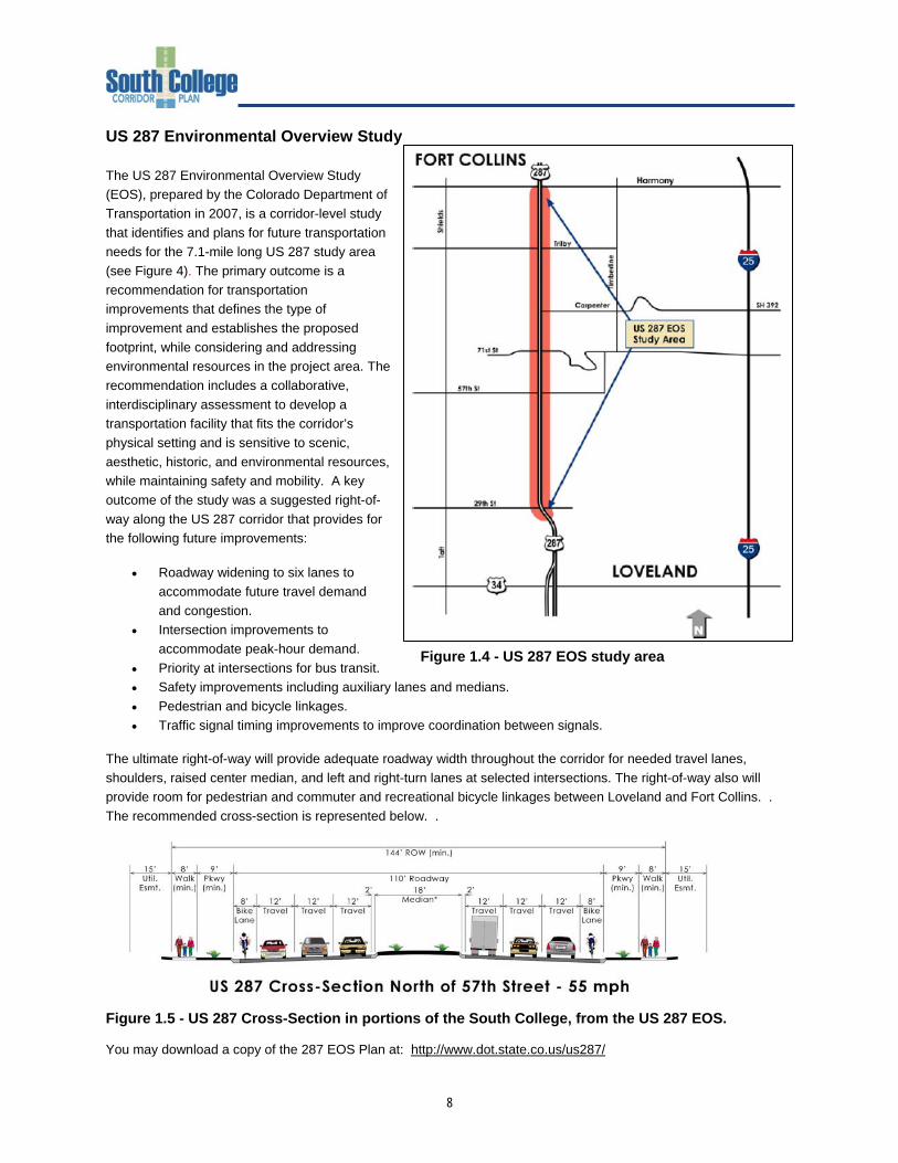
US 287 Environmental Overview Study The US 287 Environmental Overview Study (EOS), prepared by the Colorado Department of Transportation in 2007, is a corridor-level study that identifies and plans for future transportation needs for the 7.1-mile long US 287 study area (see Figure 4). The primary outcome is a recommendation for transportation improvements that defines the type of improvement and establishes the proposed footprint, while considering and addressing environmental resources in the project area. The recommendation includes a collaborative, interdisciplinary assessment to develop a transportation facility that fits the corridor’s physical setting and is sensitive to scenic, aesthetic, historic, and environmental resources, while maintaining safety and mobility. A key outcome of the study was a suggested right-of-way along the US 287 corridor that provides for the following future improvements:
• Roadway widening to six lanes to accommodate future travel demand and congestion.
• Intersection improvements to accommodate peak-hour demand.
• Priority at intersections for bus transit. • Safety improvements including auxiliary lanes and medians. • Pedestrian and bicycle linkages. • Traffic signal timing improvements to improve coordination between signals.
The ultimate right-of-way will provide adequate roadway width throughout the corridor for needed travel lanes, shoulders, raised center median, and left and right-turn lanes at selected intersections. The right-of-way also will provide room for pedestrian and commuter and recreational bicycle linkages between Loveland and Fort Collins. . The recommended cross-section is represented below. .
Figure 1.5 - US 287 Cross-Section in portions of the South College, from the US 287 EOS. You may download a copy of the 287 EOS Plan at: http://www.dot.state.co.us/us287/
Figure 1.4 - US 287 EOS study area
9
Master Street Plan (2005) The Master Street Plan (MSP) is a map-based representation of the City of Fort Collins' long-range vision of its major street network. First implemented and adopted in 1981, the MSP is intended to reflect the functional class (the category of street, e.g. arterial, collector, etc.) of the ultimate street network in the City of Fort Collins. The MSP also helps to guide the development of the future street system for the City and its Growth Management Area (GMA). The MSP provides a reference for planning and layout of existing and future development's key transportation and circulation connections. The City of Fort Collins has designated South College Avenue as a Major Arterial in their Master Street Plan. The cross-section for the typical Major Arterial consists of six through lanes (three in each direction), a raised and landscaped center median and 8-foot bike lanes. A 10-foot parkway and 7-foot sidewalk are also included. This section currently exists between Harmony Road and Swallow Road minus the 8-foot bike lanes. South of Harmony Road, South College Avenue consists of only four through lanes; however, it is planned to be consistent with the City’s standard for a Major Arterial between Carpenter Road (LCR 32) and Harmony Road. The lane and median widths meet or exceed CDOT requirements. You may download a copy of the Plan at Master Street Plan: http://fcgov.com/transportation/msp-new.php Mason Corridor Plan The Mason Corridor is a five mile north-south byway within the city of Fort Collins which extends from Cherry Street on the north to south of Harmony Road. The corridor is centered along the Burlington Northern Santa Fe (BNSF) Railway property, located a few hundred feet west of College Avenue (US 287). The southern terminus, the Fort Collins South Transit Center, is located against the BNSF Railway between Woodley’s Furniture and Spradley Barr Ford. The Mason Corridor includes a new bicycle and pedestrian trail as well as a planned Bus Rapid Transit (BRT) system in a fixed guideway for the majority of the corridor. The Mason Corridor will link major destinations and activity centers along the corridor including the Downtown commercial, cultural, and business centers, Colorado State University, Foothills Mall, and South College retail areas. Additionally, future regional transit connections will link to the Mason Corridor. The vision of the Mason Corridor was approved by Fort Collins voters and City Council in 1998 and 2000, but only recently funded. 80% of the total funding is coming from the Federal Transit Administration’s Small Starts program. The remaining 20% of the project costs will be from the State's SB-1 Transit program as well as local contributions provided by the City of Fort Collins and the Downtown Development Authority. Approximately 3-1/2 miles of a multi-purpose trail has already been constructed, from the Fossil Creek Trail to Spring Creek Trail. To encourage land uses, densities and design that enhance and support transit stations along the Mason Corridor, a Transit-Oriented Development (TOD) Overlay Zone was incorporated into the City’s Land Use Code in 2007. This means that the underlying zoning districts now allow for a greater mix of goods and services within convenient walking distance of transit stations; encourage the creation of stable and attractive residential and commercial environments; and provide for a desirable transition to the surrounding existing neighborhoods. You may download a copy of the Plan at Mason Corridor Plan: http://fcgov.com/mason/ Development Standards for the TOD Overlay Zone (Division 3.10) can be viewed through the City of Fort Collins Land Use Code at http://fcgov.com/cityclerk/codes.php
10
Northern Colorado Separator Study As development continuously pushes urban development further into rural areas, community separators in the form of open lands are increasingly important in maintaining the identity and distinct boundary of a community. The majority of northern Colorado’s communities entered into a cooperative planning agreement intended to maintain separation in a manner that is fair and equitable to landowners. The Northern Colorado Separator Study, completed in 1999, is a result of that agreement, and sets forth a plan to establish a regional system of community separators. The Plan emphasizes the existing Fort Collins – Loveland Community separator (Longview Farms) which is located at the southwestern intersection of US 287 and Carpenter Road. You may download a copy of the Plan at http://fcgov.com/cityplanning/documents.php US 392/Carpenter Road Environmental Overview Study In 2006, an Environmental Overview Study (EOS) was prepared for Carpenter Road. The EOS provides the basis for long-term roadway improvements and also provides support for local planning decisions. The outcome of the process is the preservation of a corridor for future transportation improvements. The study concluded that CDOT needs to continue to focus administrative, planning, operations, and maintenance efforts on the existing SH 392 corridor. The roadway needs to be widened to four lanes to accommodate the travel demand expected to be placed on it by 2030. The improved corridor will be a key connection to and from South College. You may download a copy of the Plan at http://www.dot.state.co.us/sh392EOS/ US 287 South College Avenue Bicycle Lane Project In August of 2004, the City of Fort Collins and CDOT began the “US 287/South College Avenue Bicycle Lane Project”. This project developed a Vision Plan and Conceptual Design for bicycling facilities along US 287/South College Avenue that includes the design and construction of bike lanes and trail connections between Carpenter Road and Harmony Road, an approximate three-mile segment of state highway. The main goals of the project were to provide facilities for both commuter and recreational cyclists and to provide a safe and user-friendly addition to the City’s and the region’s integrated system of on-street bike lanes and off-street trails. This project will also result in improved bicyclist access to transit routes along US 287/South College Avenue. You may download a copy of the Plan at Bike Lane Project at http://fcgov.com/transportationplanning/scbl.php
11
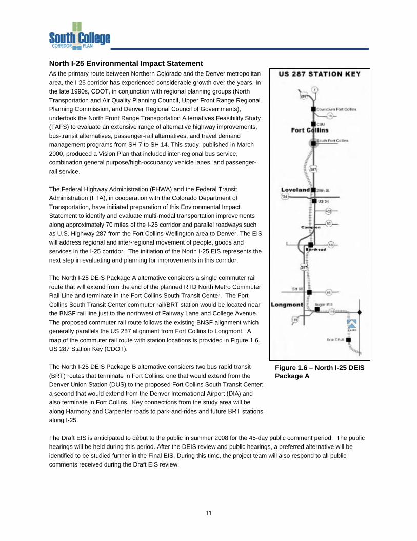
Figure 1.6 – North I-25 DEIS Package A
North I-25 Environmental Impact Statement As the primary route between Northern Colorado and the Denver metropolitan area, the I-25 corridor has experienced considerable growth over the years. In the late 1990s, CDOT, in conjunction with regional planning groups (North Transportation and Air Quality Planning Council, Upper Front Range Regional Planning Commission, and Denver Regional Council of Governments), undertook the North Front Range Transportation Alternatives Feasibility Study (TAFS) to evaluate an extensive range of alternative highway improvements, bus-transit alternatives, passenger-rail alternatives, and travel demand management programs from SH 7 to SH 14. This study, published in March 2000, produced a Vision Plan that included inter-regional bus service, combination general purpose/high-occupancy vehicle lanes, and passenger-rail service. The Federal Highway Administration (FHWA) and the Federal Transit Administration (FTA), in cooperation with the Colorado Department of Transportation, have initiated preparation of this Environmental Impact Statement to identify and evaluate multi-modal transportation improvements along approximately 70 miles of the I-25 corridor and parallel roadways such as U.S. Highway 287 from the Fort Collins-Wellington area to Denver. The EIS will address regional and inter-regional movement of people, goods and services in the I-25 corridor. The initiation of the North I-25 EIS represents the next step in evaluating and planning for improvements in this corridor. The North I-25 DEIS Package A alternative considers a single commuter rail route that will extend from the end of the planned RTD North Metro Commuter Rail Line and terminate in the Fort Collins South Transit Center. The Fort Collins South Transit Center commuter rail/BRT station would be located near the BNSF rail line just to the northwest of Fairway Lane and College Avenue. The proposed commuter rail route follows the existing BNSF alignment which generally parallels the US 287 alignment from Fort Collins to Longmont. A map of the commuter rail route with station locations is provided in Figure 1.6. US 287 Station Key (CDOT).
The North I-25 DEIS Package B alternative considers two bus rapid transit (BRT) routes that terminate in Fort Collins: one that would extend from the Denver Union Station (DUS) to the proposed Fort Collins South Transit Center; a second that would extend from the Denver International Airport (DIA) and also terminate in Fort Collins. Key connections from the study area will be along Harmony and Carpenter roads to park-and-rides and future BRT stations along I-25. The Draft EIS is anticipated to début to the public in summer 2008 for the 45-day public comment period. The public hearings will be held during this period. After the DEIS review and public hearings, a preferred alternative will be identified to be studied further in the Final EIS. During this time, the project team will also respond to all public comments received during the Draft EIS review.
12
The Final EIS will go through an internal review and comment process followed by FHWA, FTA, and a public and agency review period similar to the DEIS. Comments received during the public review will be addressed in a Record of Decision (ROD) that describes the project or phase to be constructed, minor changes and clarification addressing comments. The ROD will identify funding for the approved action consistent with regional transportation plans included in the Metropolitan Planning Organization's planning documents. The final decision on the transportation improvements will be determined by the lead agencies, FHWA and FTA. You may download a copy of the Plan at http://www.dot.state.co.us/northI25eis/index.cfm LAND CONSERVATION AND STEWARDSHIP PLAN Within the South College Corridor are key open space lands and natural areas such as Long View Farm, Pelican Marsh, Prairie Dog Meadow, Two Creeks and Redtail Grove. Completed in 2004, the Land Conservation and Stewardship Master Plan is the long-range visioning document of the City of Fort Collins Natural Areas Program. The mission of the Natural Areas Program is to protect and enhance lands with existing or potential natural areas values, lands that serve as community separators, agricultural lands, and lands with scenic values. The plan outlines the vision for two key areas that bisect the South College area: Fossil Creek Corridor The purpose: To expand protection in the ecologically sensitive Fossil Creek area. Land conservation will help protect rare species and riparian/wetland areas by expanding upon the existing Fossil Creek natural areas/open spaces, provide recreation opportunities, and extend the Fossil Creek trail. Additional land protection in this area contributes to community separation between Fort Collins and Loveland/Windsor and preserves views to the foothills and mountains along the I-25 corridor. Fort Collins – Loveland Separator Purpose: To protect and expand the City’s current inventory of Natural Areas in this area. Most of this area that is available for conservation has already been conserved and has thus protected scenic views, wildlife habitat, and the agricultural way of life. The open character between Loveland and Fort Collins on the western and eastern arterials helps give each community its own sense of character. You may download a copy of the Plan at http://fcgov.com/naturalareas/masterplan/
13
Section 2: Existing Conditions and Issues Introduction
Constraints and challenges for the South College area are numerous: lack of business unity, sub-standard infrastructure, the controversial nature of annexation, auto-oriented uses, multiple mid-block driveway accesses, little or no landscaping, few pedestrian access safety features and amenities, and accident rates nearly twice that of North College Avenue. At the same time, the area benefits from many unique opportunities and assets, including niche retail shops, commercial development, expansive views, healthy neighborhoods, the Fossil Creek Trail, the future Mason Corridor South Transit Center, creeks, open space and natural areas, and neighborhood interest and involvement. This document highlights both technical findings and issues identified by the community to date through the Public Kick-off Event (Nov 2007), Stakeholder Interviews (Dec 2007 – Jan 2008), and the Business Forum (April 2008). Additional issues will identified through the community surveys, Visioning Workshop, and other public events as the planning process continues. The many issues and technical findings identified to date are organized by the following headings:
• District Identity • Land Use • Building and Property Appearance • Transportation • Trails and Sidewalks • Transportation Financing • Views and Natural Features • Sustainability • Utilities
Again, this report is not a policy document and makes no policy recommendations. District Identity
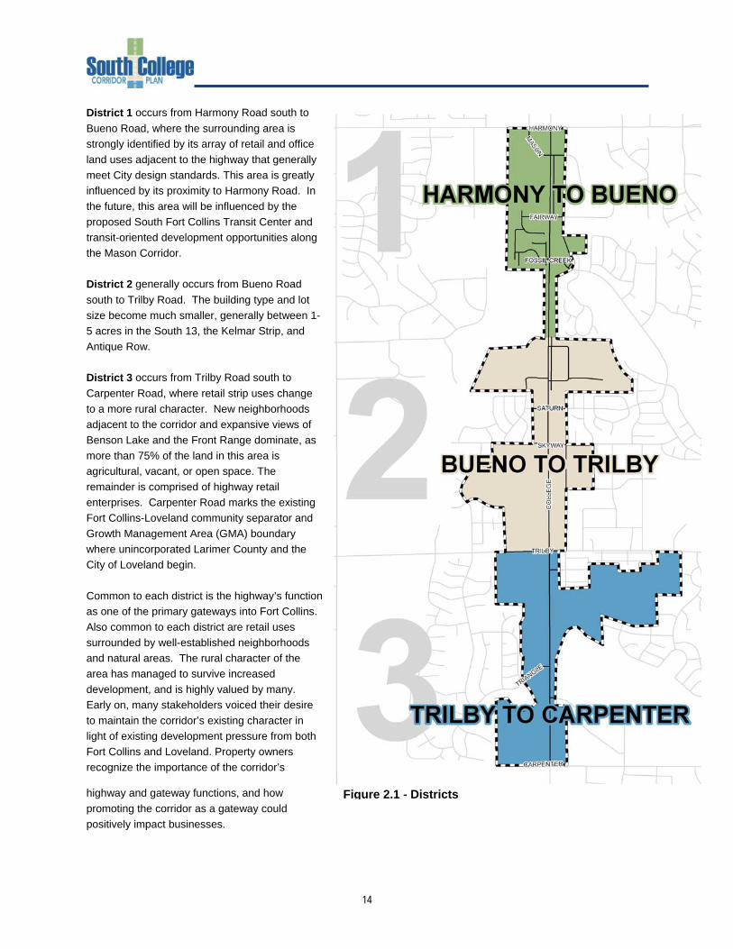
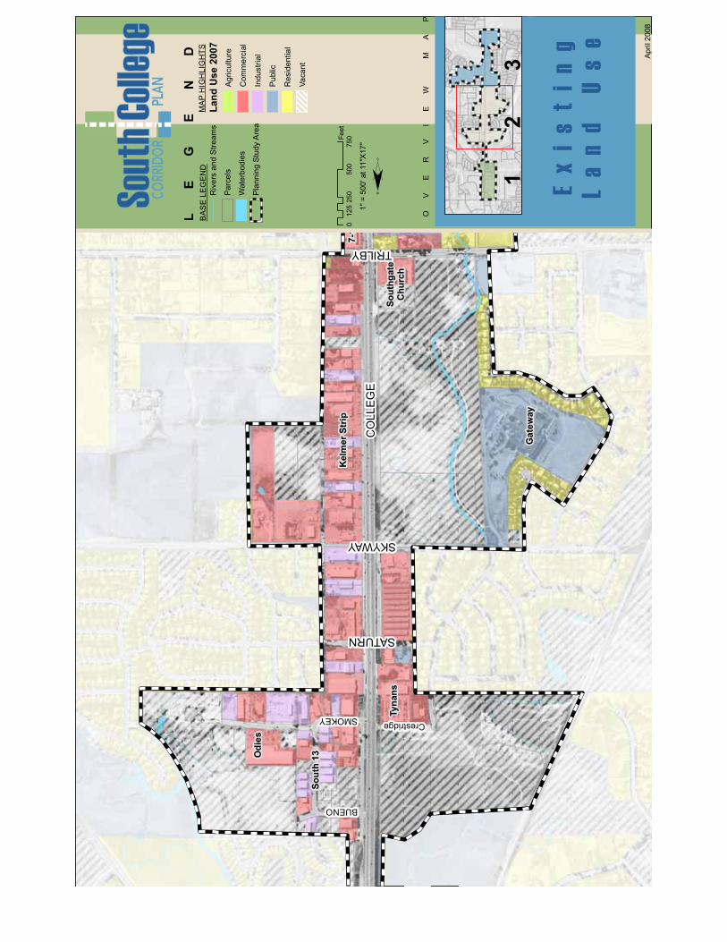
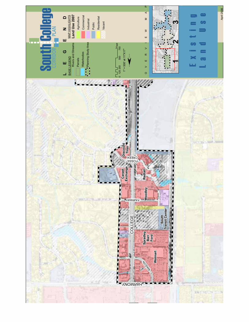
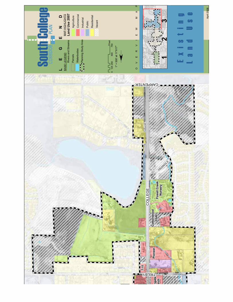
Existing Conditions – The corridor’s identity, or image, is vital to considerations about the long-term feasibility of existing land uses, or the redevelopment or establishment of new land uses. Identity for an area is largely community-driven and arises from public involvement and visioning processes. Establishing a strong identity for an area reinforces its economic vitality, sense of place, and integration into the greater community. Currently, the South College Corridor is comprised of three geographically specific identities, labeled as districts for discussion purposes. While all share common characteristics and blend into one another, each district possesses unique opportunities and constraints.
14
District 1 occurs from Harmony Road south to Bueno Road, where the surrounding area is strongly identified by its array of retail and office land uses adjacent to the highway that generally meet City design standards. This area is greatly influenced by its proximity to Harmony Road. In the future, this area will be influenced by the proposed South Fort Collins Transit Center and transit-oriented development opportunities along the Mason Corridor. District 2 generally occurs from Bueno Road south to Trilby Road. The building type and lot size become much smaller, generally between 1-5 acres in the South 13, the Kelmar Strip, and Antique Row. District 3 occurs from Trilby Road south to Carpenter Road, where retail strip uses change to a more rural character. New neighborhoods adjacent to the corridor and expansive views of Benson Lake and the Front Range dominate, as more than 75% of the land in this area is agricultural, vacant, or open space. The remainder is comprised of highway retail enterprises. Carpenter Road marks the existing Fort Collins-Loveland community separator and Growth Management Area (GMA) boundary where unincorporated Larimer County and the City of Loveland begin. Common to each district is the highway’s function as one of the primary gateways into Fort Collins. Also common to each district are retail uses surrounded by well-established neighborhoods and natural areas. The rural character of the area has managed to survive increased development, and is highly valued by many. Early on, many stakeholders voiced their desire to maintain the corridor’s existing character in light of existing development pressure from both Fort Collins and Loveland. Property owners recognize the importance of the corridor’s
highway and gateway functions, and how promoting the corridor as a gateway could positively impact businesses.
Figure 2.1 - Districts
15
Issues – There are distinct differences in streetscapes, landscaping, and building appearances between properties developed under City and County standards. The corridor’s current identities are undoubtedly a springboard for opportunity and offer one of the strongest avenues to increase the area’s economic strength and community-wide appeal. Community questions that should be addressed through the planning process include: What are the desirable characteristics of each district, how do they differ from other districts, and how can unity along the corridor be maintained while emphasizing each district’s uniqueness? As the entrypoint into south Fort Collins, what City gateway features are desired, what is the cost of those improvements, and who will pay and maintain them? How does the plan address the growing magnetism between Fort Collins and Loveland, and can the City’s goal for community separation and the market’s demand for growth both be achieved? What are appropriate streetscape, site, and architectural styles? What is the role of this area relative to other similar economic development corridors, such as South College between Harmony Road and Drake Road, US 287 in Loveland, North College? How can the plan capitalize on unique market niches, such as antique stores, that can give this area its current identity?
16
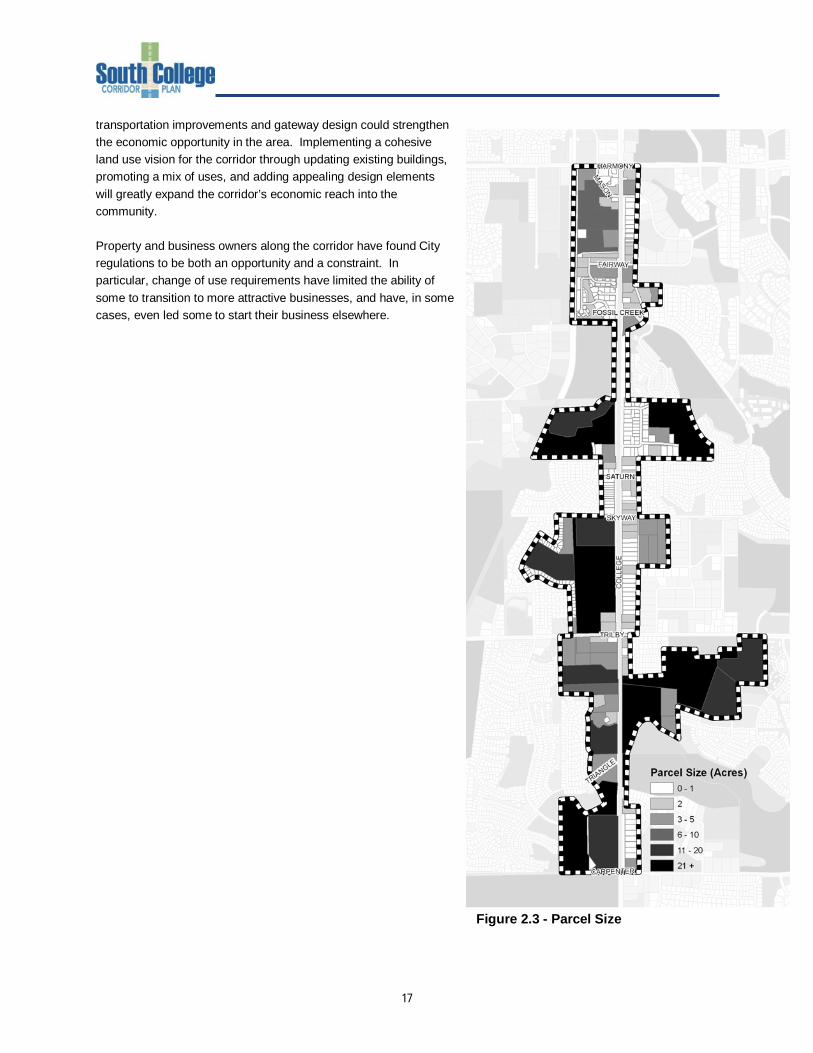
Land Use
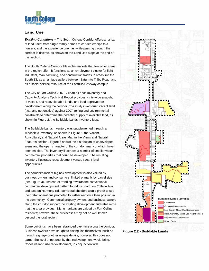
Existing Conditions – The South College Corridor offers an array of land uses; from single family homes to car dealerships to a nursery, and the experience one has while passing through the corridor is diverse, as shown on the Land Use Maps at the end of this section. The South College Corridor fills niche markets that few other areas in the region offer. It functions as an employment cluster for light industrial, manufacturing, and construction trades in areas like the South 13; as an antique gallery between Saturn to Trilby Road; and as a social service resource at the Foothills Gateway campus. The City of Fort Collins 2007 Buildable Lands Inventory and Capacity Analysis Technical Report provides a city-wide snapshot of vacant, and redevelopable lands, and land approved for development along the corridor. The study inventoried vacant land (i.e., land not entitled) against 2007 zoning and environmental constraints to determine the potential supply of available land, as shown in Figure 2, the Buildable Lands Inventory Map. The Buildable Lands Inventory was supplemented through a windshield inventory, as shown in Figure 6, the Vacant, Agricultural, and Natural Areas Map in the Views and Natural Features section. Figure 6 shows the distribution of undeveloped areas and the open character of the corridor, many of which have been entitled. The inventory illustrates a number of smaller vacant commercial properties that could be developed. The resulting inventory illustrates redevelopment versus vacant land opportunities. The corridor’s lack of big box development is also valued by business owners and consumers, limited primarily by parcel size (see Figure 3). Instead of trending towards the conventional commercial development pattern found just north on College Ave. and east on Harmony Rd., some stakeholders would prefer to see their retail operations promoted to further reinforce their position in the community. Commercial property owners and business owners along the corridor support the existing development and retail niche that the area provides. Niche markets are valued by Fort Collins residents; however these businesses may not be well known beyond the local region. Some buildings have been rebranded over time along the corridor. Business owners have sought to distinguish themselves, such as through signage or other unique details; however, this does not garner the level of opportunity that redevelopment would bring. Cohesive land use redevelopment, in conjunction with
Figure 2.2 - Buildable Lands
17
transportation improvements and gateway design could strengthen the economic opportunity in the area. Implementing a cohesive land use vision for the corridor through updating existing buildings, promoting a mix of uses, and adding appealing design elements will greatly expand the corridor’s economic reach into the community. Property and business owners along the corridor have found City regulations to be both an opportunity and a constraint. In particular, change of use requirements have limited the ability of some to transition to more attractive businesses, and have, in some cases, even led some to start their business elsewhere.
Figure 2.3 - Parcel Size
SKYWAY
SATURN
SMOKEY
BUENO
COLLEGE
Crestridge
TRILBY
7-1
Southgate
Church
Gateway
KelmerStrip
Tynans
Odies
South13
April2008
OV
ER
VI
EW
MA
P
LE
GE
ND
BASELEGEND
PlanningStudyArea
Parcels
Waterbodies
RiversandStreams
MAPHIGHLIGHTS
Land
Use2007
Agriculture
Commercial
Industrial
Public
Residential
Vacant
Existing
LandUse
¨
0250
500
750
125
Feet
1"=500'at11"X17"
32
1
FOSSILCREEK
FAIRWAY
HARMONY
MASON
COLLEGE
Discount
Tires
Carpet
Exchange
Redtail
Woodley
South
TransitCenter
Spradley
Barr
Ford
Walmart
April2008
OV
ER
VI
EW
MA
P
LE
GE
ND
BASELEGEND
PlanningStudyArea
Parcels
Waterbodies
RiversandStreams
MAPHIGHLIGHTS
Land
Use2007
Agriculture
Commercial
Industrial
Public
Residential
Vacant
Existing
LandUse
¨
0250
500
750
125
Feet
1"=500'at11"X17"
32
1
TRILBY
COLLEGE
CARPENTER
TRIANGLE
FossilCreek
Nursery
Cottonwood
Club
Pioneer
7-11
hgate
urch
April2008
OV
ER
VI
EW
MA
P
LE
GE
ND
BASELEGEND
PlanningStudyArea
Parcels
Waterbodies
RiversandStreams
MAPHIGHLIGHTS
Land
Use2007
Agriculture
Commercial
Industrial
Public
Residential
Vacant
Existing
LandUse
¨
0250
500
750
125
Feet
1"=500'at11"X17"
32
1
18
Building and Property Appearance
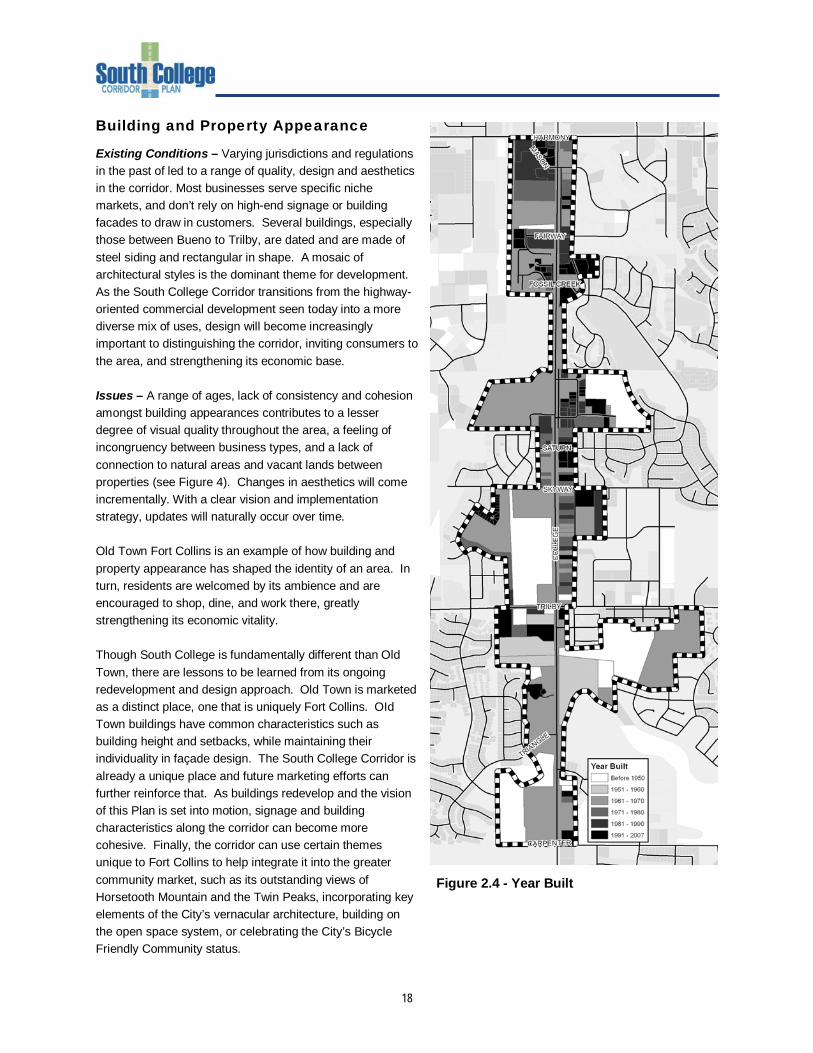
Existing Conditions – Varying jurisdictions and regulations in the past of led to a range of quality, design and aesthetics in the corridor. Most businesses serve specific niche markets, and don’t rely on high-end signage or building facades to draw in customers. Several buildings, especially those between Bueno to Trilby, are dated and are made of steel siding and rectangular in shape. A mosaic of architectural styles is the dominant theme for development. As the South College Corridor transitions from the highway-oriented commercial development seen today into a more diverse mix of uses, design will become increasingly important to distinguishing the corridor, inviting consumers to the area, and strengthening its economic base. Issues – A range of ages, lack of consistency and cohesion amongst building appearances contributes to a lesser degree of visual quality throughout the area, a feeling of incongruency between business types, and a lack of connection to natural areas and vacant lands between properties (see Figure 4). Changes in aesthetics will come incrementally. With a clear vision and implementation strategy, updates will naturally occur over time. Old Town Fort Collins is an example of how building and property appearance has shaped the identity of an area. In turn, residents are welcomed by its ambience and are encouraged to shop, dine, and work there, greatly strengthening its economic vitality. Though South College is fundamentally different than Old Town, there are lessons to be learned from its ongoing redevelopment and design approach. Old Town is marketed as a distinct place, one that is uniquely Fort Collins. OId Town buildings have common characteristics such as building height and setbacks, while maintaining their individuality in façade design. The South College Corridor is already a unique place and future marketing efforts can further reinforce that. As buildings redevelop and the vision of this Plan is set into motion, signage and building characteristics along the corridor can become more cohesive. Finally, the corridor can use certain themes unique to Fort Collins to help integrate it into the greater community market, such as its outstanding views of Horsetooth Mountain and the Twin Peaks, incorporating key elements of the City’s vernacular architecture, building on the open space system, or celebrating the City’s Bicycle Friendly Community status.
Figure 2.4 - Year Built
19
Transportation
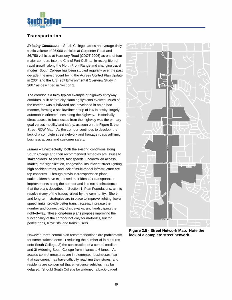
Existing Conditions – South College carries an average daily traffic volume of 26,000 vehicles at Carpenter Road and 36,750 vehicles at Harmony Road (CDOT 2006) as one of four major corridors into the City of Fort Collins. In recognition of rapid growth along the North Front Range and changing travel modes, South College has been studied regularly over the past decade, the most recent being the Access Control Plan Update in 2004 and the U.S. 287 Environmental Overview Study in 2007 as described in Section 1. The corridor is a fairly typical example of highway entryway corridors, built before city planning systems evolved. Much of the corridor was subdivided and developed in an ad hoc manner, forming a shallow linear strip of low intensity, largely automobile-oriented uses along the highway. Historically, direct access to businesses from the highway was the primary goal versus mobility and safety, as seen on the Figure 5, the Street ROW Map. As the corridor continues to develop, the lack of a complete street network and frontage roads will limit business access and customer safety. Issues – Unexpectedly, both the existing conditions along South College and their recommended remedies are issues to stakeholders. At present, fast speeds, uncontrolled access, inadequate signalization, congestion, insufficient street lighting, high accident rates, and lack of multi-modal infrastructure are top concerns. Through previous transportation plans, stakeholders have expressed their ideas for transportation improvements along the corridor and it is not a coincidence that the plans described in Section 1, Plan Foundations, aim to resolve many of the issues raised by the community. Short- and long-term strategies are in place to improve lighting, lower speed limits, provide better transit access, increase the number and connectivity of sidewalks, and landscaping the right-of-way. These long-term plans propose improving the functionality of the corridor not only for motorists, but for pedestrians, bicyclists, and transit users.
However, three central plan recommendations are problematic for some stakeholders: 1) reducing the number of in-out turns onto South College, 2) the construction of a central median, and 3) widening South College from 4 lanes to 6 lanes. As access control measures are implemented, businesses fear that customers may have difficulty reaching their stores, and residents are concerned that emergency vehicles may be delayed. Should South College be widened, a back-loaded
Figure 2.5 - Street Network Map. Note the lack of a complete street network.
20
frontage road and reconfigured parking would be necessary for certain businesses and property owners are concerned about effects these improvements might have to property values and business functions. As a result, property and business owners have expressed their desire to be closely involved with any future transportation projects. Business owners are concerned about how they will be affected by design decisions, and how they can be more involved in those decisions. At the time of any necessary improvement, the City and CDOT would include the property owners, businesses, and residents in the affected area in the decision-making process. The City, County, and CDOT are committed to working closely with land owners to develop interim and long-term solutions to transportation issues. Some questions regarding transportation along the corridor include: What are the impediments that need to be resolved in order to accelerate implementation of the Access Control Plan Update? To what extent can the Access Control Plan Update be modified, and under what criteria? Will the community’s shared vision differ from the ACP’s land use assumptions? What transportation and urban design issues need to be considered to maximize safe and convenient east-west and north-south pedestrian circulation? What is the future of transit and transit-oriented development south of Harmony? Trails and Sidewalks
Because of the diversity of land uses found within and adjacent to the corridor, pedestrian and bicycle access is important. Business owners noted that it is difficult for consumers to walk between stores and that sidewalks are needed. Additionally, there are nearby trails that could connect the Mason Street Corridor, the South College Corridor, and adjacent neighborhoods to offer improved bicycle or pedestrian access throughout the area. Opportunity – The South College Corridor presents promising opportunities to connect existing trail networks with transit and proposed trail corridors, such as the Mason Corridor. These improvements could be developed in conjunction with an overall streetscape improvement program which would improve the character of the area. Apart from infrastructure changes, many stakeholders are concerned about the poor quality of local streets, potholes and the need for repaving, and snow removal. Where private roads do not meet City standards, business owners are responsible to maintain their roads. If roads are upgraded to City standards, then the City will maintain the roads in perpetuity. An exception is that the City will respond to health and safety needs, like filling major potholes. For example, the City filled potholes in December 2007 as a result of what was heard at the November kick-off event. The South College Corridor Plan attempts to build on and implement existing studies, where these studies are consistent with the community’s vision. The Access Control Plan Update and Environmental Overview Study were completed through a cooperative effort of the City of Fort Collins, Larimer County and the Colorado Department of Transportation. As such, the City cannot make changes to the plan without the consent of the other jurisdictions. If the Corridor Plan proposes significant land use changes or uncovers new information affecting transportation, the City will work with the jurisdictions to find out if changes to the Access Control Plan are needed. Transportation Financing
A frequently asked question regarding transportation plans is “Who will pay for it?” At this point in time, there is no identified public funding available for planned access-related or widening improvements along South College Avenue. Four options exist for financing short-term transportation projects, such as street widening, intersection reconstruction, sidewalks and street lighting, or access control improvements. First, as development or
21
redevelopment occurs, each development proposal will be evaluated for its effects to existing infrastructure and improvements made accordingly. Second, businesses within a given area could form a Special Improvement District (SID). If a SID funds the improvements, the work would be completed by the City, generally at a lower cost that local contractors could perform the work. The City would bill the owners and could amortize the costs over 10-15 years. The City can help facilitate the SID creation process, but it depends on property and business owner initiative. A majority of those property and business owners would also have to support the SID. Third, a specific project could become part of a city-wide funded initiative, such as Building On Basics (BOB). City-funded initiatives are determined through grassroots advocacy, competing priorities, and voter approval. Fourth, long-term projects, like widening South College from 4 lanes to 6 lanes will depend on state funding. Views and Natural Features
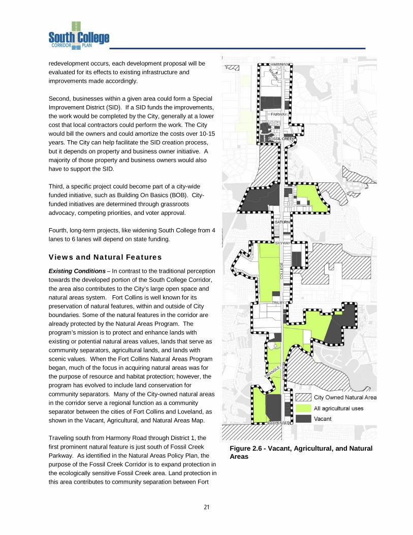
Existing Conditions – In contrast to the traditional perception towards the developed portion of the South College Corridor, the area also contributes to the City’s large open space and natural areas system. Fort Collins is well known for its preservation of natural features, within and outside of City boundaries. Some of the natural features in the corridor are already protected by the Natural Areas Program. The program’s mission is to protect and enhance lands with existing or potential natural areas values, lands that serve as community separators, agricultural lands, and lands with scenic values. When the Fort Collins Natural Areas Program began, much of the focus in acquiring natural areas was for the purpose of resource and habitat protection; however, the program has evolved to include land conservation for community separators. Many of the City-owned natural areas in the corridor serve a regional function as a community separator between the cities of Fort Collins and Loveland, as shown in the Vacant, Agricultural, and Natural Areas Map. Traveling south from Harmony Road through District 1, the first prominent natural feature is just south of Fossil Creek Parkway. As identified in the Natural Areas Policy Plan, the purpose of the Fossil Creek Corridor is to expand protection in the ecologically sensitive Fossil Creek area. Land protection in this area contributes to community separation between Fort
Figure 2.6 - Vacant, Agricultural, and Natural Areas
22
Collins and Loveland and preserves views to the foothills and mountains. Fossil Creek Park, Redtail, and Two Creeks Natural Areas create the heart of this system in the study area. Fossil Creek Trail also runs through this area. Fossil Creek is centered in the Redtail Natural Area on the western side of the corridor, which contains wetlands, steep slopes, riparian forests and small waterbodies. The dramatic viewshed here carries across private, vacant properties. Approaching Bueno Road, the viewshed continues over vacant land comprised of grasslands, floodplains, wetlands, streams, areas of geologic interest, and small areas of steep slope. Driving further south through District 2, between Skyway Road and Trilby Road, is another important viewshed to the west. A north-south ditch has been undergrounded along the western property line of the vacant properties, accompanied by floodplains, wetlands, mature cottonwoods, potential raptor nesting areas and small areas of steep slopes. Prairie Dog Meadow Natural Area is located on the eastern side of College Avenue, behind retail properties. Heading south of Trilby through District 3, development on the east is broken by Robert Benson Lake and the Fossil Creek Nursery to the west. The corridor terminates with a large piece of vacant land north of the Long View Farms Open Space. The southern area of the property includes floodplains and wetland systems. Foreseeable issues in the corridor include the loss and degradation of natural systems centered on existing creeks and drainages. Additional issues include the impact of future development on existing open space and natural areas. Opportunities include the reinforcement of two existing east-west natural systems bisecting the corridor - the Fossil Creek Corridor and the Fort Collins / Loveland Community Separator. Additional opportunities include the creation of two additional east-west systems centered on Fossil Creek/Prairie Dog Meadow Natural Area and Robert Benson Lake/Pelican Marsh Natural Area. These natural breaks create views and reinforce natural systems, and could provide recreational opportunities. Sustainability
Existing Conditions – Sustainability is evermore an important issue for Fort Collins. The City works to ensure that new development keeps natural systems intact, incorporates energy efficient design, and promotes walkability and access to transit and trails. These concepts combined not only protect the environment, but strengthen the community, the economy, and build better places. Discussions regarding economic, social, and environmental sustainability are integral to the South College Corridor planning process. Social sustainability is accomplished through a democratic process of defining and creating real, livable places. Economic sustainability results from a combination of attracting viable uses and balancing the cost equation over a sustained period. Redevelopment is a key element of sustainability. Studies suggest that for every acre of urban redevelopment, several acres of open space are indirectly preserved because of decreased urban sprawl. Infill and redevelopment is critical in achieving a compact growth pattern and help avoid areas becoming economically depressed. Compact development also promotes an efficient transportation system and walkable urban form. Issues – The City’s motto, “Where renewal is a way of life,” is certainly befitting South College. South College is a place where entrepreneurs can start up an operation at low cost, where existing small business owners continually reinvigorate their businesses, and where buildings are repeatedly reused to meet a changing market. Redevelopment is not occurring however, constrained by what some stakeholders say as:
23
• “I-25” - businesses are only looking at relocating along the I-25 corridor, or to other more strategic locations elsewhere due to the market and/or vendor accessibility, such as Centerra.
• “Too much red tape.” As newly annexed property owners are introduced to the City’s development process, many have said that red tape, development fees, and change of use requirements are disadvantages of doing business in Fort Collins. Property approvals seem much easier to obtain in communities like Windsor and Loveland, where development fees are perceived to be lower and attitudes are more welcoming towards growth.
The central question about sustainability to address in the South College Corridor Plan is how to stimulate renewal in ways that meet the community’s environmental, social, and economic goals while not placing businesses at a disadvantage. Related to that is which Best Management Practices (BMPs) are applicable to the corridor’s unique building type and parcel arrangements, and how constrained sites can be reasonably developed. Utilities
An assessment of the corridor’s existing utility systems (gas, electric, water, sewer, stormwater, cable, phone) found that there are no limitations to accommodate new development or redevelopment. Water transmission lines and sanitary sewer trunk lines are in place and should be able to service development as presently proposed. Smaller water distribution and sanitary sewer collection lines to specific developments may have to be installed to connect these developments to existing mains, as is typical for any proposed project. There is adequate water pressure to serve new developments. The City of Fort Collins Fossil Creek Master Plan and other site-specific hydrologic and hydraulic assessments have delineated floodplain and floodways within the corridor, and provide a reasonable representation of the impacts that could be expected during various frequency storm events. Detention and stormwater requirements constrain some vacant properties west of College Avenue, as the highway acts as an impoundment to east-draining water. As a result, several small wetlands to the west of College Avenue would need to be incorporated or mitigated into future development plans, and no new pipes are anticipated under College Avenue. The City of Fort Collins Utilities Department is converting the Poudre Valley Rural Electric Association's power delivery system to meet City requirements, and this effort will likely be finished before the Corridor Plan is completed. The City of Fort Collins should continue to coordinate closely with the independent utility providers as the Corridor Plan is finalized and future developments are proposed, reviewed and approved by the City. While no major utility impacts are foreseen at this time, condition of the systems will deteriorate over time, new methodologies for delivery of services may develop, and direction by future Boards and governing bodies may require significant additions and/or improvements to these utility system; hence the need for continuous coordination.
Related Documents