Bankstown Station Precinct Sydenham to Bankstown Urban Renewal Corridor Strategy CHAPTER 12

Welcome message from author
This document is posted to help you gain knowledge. Please leave a comment to let me know what you think about it! Share it to your friends and learn new things together.
Transcript
Bankstown Station PrecinctSydenham to Bankstown Urban Renewal Corridor Strategy
CHAPTER 12

Sydenham to Bankstown Urban Renewal Corridor Strategy Bankstown © SaltyDingo 2016Sydenham to Bankstown Urban Renewal Corridor Strategy
Bankstown 1
CONTENTS
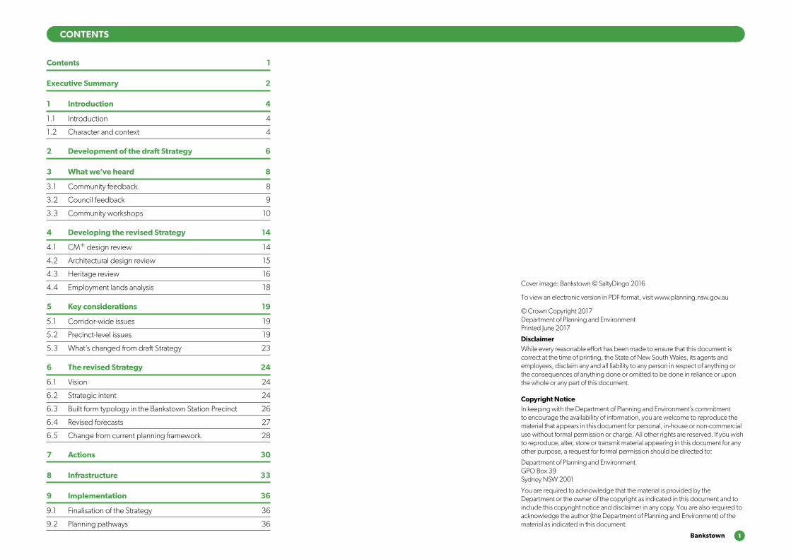
Cover image: Bankstown © SaltyDingo 2016
To view an electronic version in PDF format, visit www.planning.nsw.gov.au
© Crown Copyright 2017 Department of Planning and Environment Printed June 2017
DisclaimerWhile every reasonable effort has been made to ensure that this document is correct at the time of printing, the State of New South Wales, its agents and employees, disclaim any and all liability to any person in respect of anything or the consequences of anything done or omitted to be done in reliance or upon the whole or any part of this document.
Copyright NoticeIn keeping with the Department of Planning and Environment’s commitment to encourage the availability of information, you are welcome to reproduce the material that appears in this document for personal, in-house or non-commercial use without formal permission or charge. All other rights are reserved. If you wish to reproduce, alter, store or transmit material appearing in this document for any other purpose, a request for formal permission should be directed to:
Department of Planning and Environment GPO Box 39 Sydney NSW 2001
You are required to acknowledge that the material is provided by the Department or the owner of the copyright as indicated in this document and to include this copyright notice and disclaimer in any copy. You are also required to acknowledge the author (the Department of Planning and Environment) of the material as indicated in this document.
Contents 1
Executive Summary 2
1 Introduction 4
1.1 Introduction 4
1.2 Character and context 4
2 Development of the draft Strategy 6
3 What we’ve heard 8
3.1 Community feedback 8
3.2 Council feedback 9
3.3 Community workshops 10
4 Developing the revised Strategy 14
4.1 CM+ design review 14
4.2 Architectural design review 15
4.3 Heritage review 16
4.4 Employment lands analysis 18
5 Key considerations 19
5.1 Corridor-wide issues 19
5.2 Precinct-level issues 19
5.3 What’s changed from draft Strategy 23
6 The revised Strategy 24
6.1 Vision 24
6.2 Strategic intent 24
6.3 Built form typology in the Bankstown Station Precinct 26
6.4 Revised forecasts 27
6.5 Change from current planning framework 28
7 Actions 30
8 Infrastructure 33
9 Implementation 36
9.1 Finalisation of the Strategy 36
9.2 Planning pathways 36
2 Sydenham to Bankstown Urban Renewal Corridor Strategy
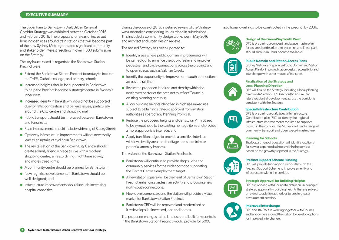
The Sydenham to Bankstown Draft Urban Renewal Corridor Strategy was exhibited between October 2015 and February 2016. The proposals for areas of increased housing densities around train stations that will become part of the new Sydney Metro generated significant community and stakeholder interest resulting in over 1,800 submissions on the Strategy.
The key issues raised in regards to the Bankstown Station Precinct were:
●● Extend the Bankstown Station Precinct boundary to include the TAFE, Catholic college, and primary school;
●● Increased heights should be supported in Bankstown to help the Precinct become a strategic centre in Sydney’s inner west;
●● Increased density in Bankstown should not be supported due to traffic congestion and parking issues, particularly around the City centre and shopping mall;
●● Public transport should be improved between Bankstown and Parramatta;
●● Road improvements should include widening of Stacey Street;
●● Cycleway infrastructure improvements will not necessarily lead to an uptake of cycling in Bankstown;
●● The revitalisation of the Bankstown City Centre should create a family-friendly place to live with a modern shopping centre, alfresco dining, night time activity and more street lights;
●● A community centre should be planned for Bankstown;
●● New high rise developments in Bankstown should be well-designed; and
●● Infrastructure improvements should include increasing hospital capacities.
During the course of 2016, a detailed review of the Strategy was undertaken considering issues raised in submissions. This included a community design workshop in May 2016 and architect and urban design reviews.
The revised Strategy has been updated to:
●● Identify areas where public domain improvements will be carried out to enhance the public realm and improve pedestrian and cycle connections across the precinct and to open space, such as Salt Pan Creek;
●● Identify the opportunity to improve north-south connections across the rail line;
●● Revise the proposed land use and density within the north-west sector of the precinct to reflect Council’s existing planning controls;
●● Allow building heights identified in high rise mixed use subject to obtaining strategic approval from aviation authorities as part of any Planning Proposal.
●● Reduce the proposed heights and density on Vimy Street to be sympathetic to the existing heritage items and provide a more appropriate interface; and
●● Apply transition edges to provide a sensitive interface with low density areas and heritage items to minimise potential amenity impacts.
The vision for the Bankstown Station Precinct is:
●● Bankstown will continue to provide shops, jobs and community services for the wider corridor, supporting the District Centre’s employment target.
●● A new station square will be the heart of Bankstown Station Precinct enhancing pedestrian activity and providing new north-south connections.
●● New development around the station will provide a visual marker for Bankstown Station Precinct.
●● Bankstown CBD will be renewed and modernised as it redevelops for increased jobs and homes.
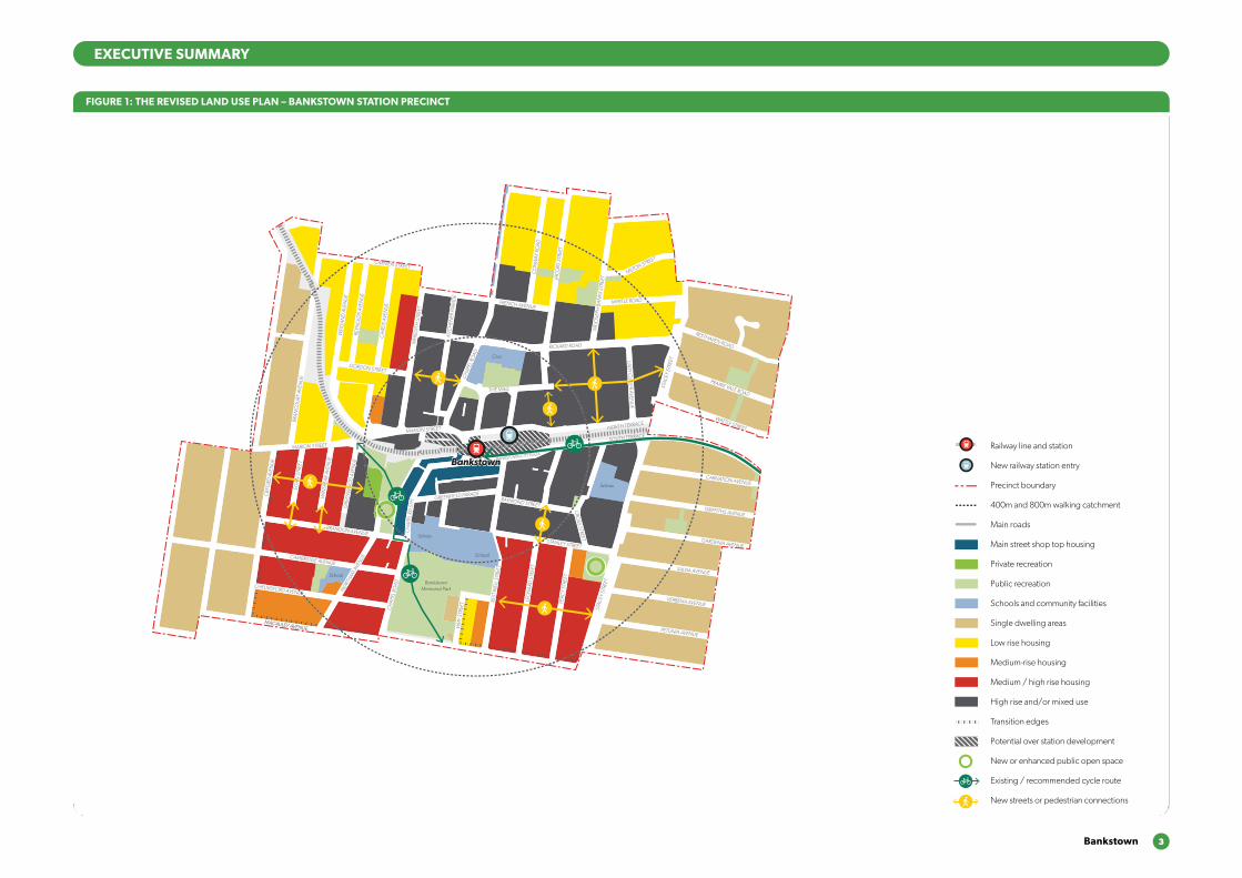
The proposed changes to the land uses and built form controls in the Bankstown Station Precinct would provide for 6000
additional dwellings to be constructed in the precinct by 2036.
EXECUTIVE SUMMARY
Design of the GreenWay South WestDPE is preparing a concept landscape masterplan for a shared pedestrian and cycle link and linear park should surplus rail land become available.
Public Domain and Station Access PlansSydney Metro are preparing a Public Domain and Station Access Plan for improved station design, accessibility and interchange with other modes of transport.
Finalisation of the Strategy and Local Planning DirectionDPE will finalise the Strategy including a local planning direction (a Section 117 Direction) to ensure that future residential development across the corridor is consistent with the Strategy.
Special Infrastructure ContributionDPE is preparing a draft Special Infrastructure Contribution plan (SIC) to identify the regional infrastructure improvements required to support growth in the corridor. The SIC levy will fund a range of community, transport and open space infrastructure.
Planning for SchoolsThe Department of Education will identify locations for new or expanded schools within the corridor based on the growth proposed in the Strategy.
Precinct Support Scheme FundingDPE will provide funding to Councils through the Precinct Support Scheme to improve amenity and infrastructure within the corridor.
Strategic Approval for Building HeightsDPE are working with Council to obtain an ‘in-principle’ strategic approval for building heights that are subject of referral to aviation authorities to create greater development certainty.
Improved InterchangeDPE and TfNSW are working together with Council and landowners around the station to develop options for improved interchange.
Bankstown 3
EXECUTIVE SUMMARY
FIGURE 1: THE REVISED LAND USE PLAN – BANKSTOWN STATION PRECINCT
800m
400m
800m
400m
800m
400m
BRANDON AVENUE
OXF
ORD
AVE
NU
E
GRE
ENW
OO
D A
VEN
UE
CH
APEL
RO
AD
PERC
Y ST
REET
STAC
EY S
TREE
T
STANLEY STREET
RAYMOND STREET
CRO
SS STREET
CARNATION AVENUE
NORTH TERRACE
RICKARD ROAD
LAD
Y CU
TLER AVENU
E
JAC
OBS
STR
EET
GRIFFITHS AVENUE
GARDENIA AVENUE
SALVIA AVENUE
VERBENA AVENUE
PETUNIA AVENUE
LEO
NA
RD S
TREE
T
REST
WEL
L STR
EET
VIM
Y ST
REET
NO
RTHAM
AVE
NUECAMBRIDGE AVENUE
CHELMSFORD AVENUE
EGA
N S
TREE
T
WIN
SPEA
R AV
ENU
E
GRE
ENW
OO
D A
VEN
UE
EGA
N S
TREE
T
WIN
SPEA
R AV
ENU
E
MARION STREET
BRA
NC
OU
RT A
VEN
UE
WEI
GA
ND
AVE
NU
E
REYN
OLD
S AV
ENU
E
CA
IRD
S AV
ENU
E
GORDON STREET
CARMEN STREET
FRENCH AVENUE
THE MALL
CH
APEL
RO
AD
KITC
HEN
ER P
ARA
DE
MER
EDIT
H S
TREE
T
SOUTH TERRACE
STAC
EY S
TREE
T
PRAIRIE VALE ROAD
RESTHAVEN ROAD
MYRTLE ROAD
MILTON STREET
SIR
JOSE
PH B
AN
KS S
TREE
T
CO
NW
AY R
OA
D
CH
APE
L RD
STH
GREENFIELD PARADE
MARION STREET
BANKSTOWN CITY PLAZA
MACAULEY AVENUEMACAULEY AVENUE
WATTLE STREET
ACAC
IA A
VEN
UE
HIG
HC
LERE
AVE
NU
E
BROADW
AY
MATTH
EWS STREET
RICKARD ST
ROSEM
ON
T STREET
CARRISBROOK AVENUE
WARATAH STREET
CAT
HER
INE
STR
EET
ARTHUR STREET
CAMPBELL STREET
KELLY STREET
MYALL STREET
SCOTT STREET
SOUTH TERRACE
WATTLE STREET
WARWICK STREET
HEN
RY S
TREE
T
MO
UN
T LE
WIS
AVE
NU
E
NO
BLE
AVEN
UE
NOCKOLDS AVENUE
GRIFFITHS AVENUE
YARRAN STREETMULGA STREET
TURNER STREET
TURNER STREET
PUNCHBOWL ROAD
PUNCHBOWL ROAD
THE BOULEVARDE
VICTORIA RO
AD
VIOLA STREET
LIND
EN AVEN
UE
LIND
EN AVEN
UE
LANCELOT STREETLANCELOT STREET
ROSSM
ORE AVEN
UE
ROSSM
ORE AVEN
UE
HILLCREST STREET
HILLCREST STREET
DUDLEY STREET ROSEM
OUN
T STREET SOUTH
WATTLE STREET
PUN
CH
BOW
L RO
AD
LAN
CAS
TER
AVEN
UE
URUNGA PARADE
THE BOULEVARDE
LAKEMBA STREET
FAIRMO
UNT STREET
BELLEVUE AVENUE
THE BOULEVARDE
ROBIN
SON
STREET NO
RTH
CORN
ELIA STREET
McCO
URT STREET
HILLARD STREET
KING
GEO
RGES RO
AD
KING
GEO
RGES RO
AD
BEAUCHAM
P STREET
RENO
WN
AVENUE DEN
MAN
AVENUE
FAUX STREET
URUNGA PARADE
TUCKER STREET
HILLCREST STREET
HILLCREST STREET
LAKEMBA STREET
LAKEMBA STREET
GILLIES STREET DENN
IS STREET
QUIG
G STREET
CROYDO
N STREET
SPROULE STREET
ERNEST STREET
HALDO
N STREET
ONEATA STREET
MYEE STREET
QUIG
G STREET
HALDO
N STREET
MO
RETON
STREET
MO
RETON
STREET
THE BOULEVARDE RAILWAY PARADE
HAM
DEN RO
AD
GARRO
NG
ROAD
BENARO
ON
ROAD
PUNCHBOWL R
OAD
PUNCHBOWL R
OAD
DENN
IS STREET
TAYLOR STREET
CHALMERS STREET
COLLIN
S STREET
CROYDO
N STREET
WAN
GEE RO
AD
WAN
GEE RO
AD
YANGOORA ROAD
YANGOORA ROAD
THE BOULEVARDE
RAILWAY PARADE
BRIDGE ROAD
COLLINS STREET LEYLANDS PARADE
YORK STREET
CHALMERS STREET
CANTERBURY ROAD
WILSON AVENUE
BURW
OO
D RO
AD
DRUMM
ON
D STREET
ANDERSO
N STREET
SHARP STREET
SHARP STREET
WAVERLEY STREET
TUDOR STREET
PLIMSOLL STREET
COBDEN STREET
RYDGE STREET
EDISON STREET
EDISON STREET
REGINALD AVENUE
BURWO
OD RO
AD
REDMAN PARADE
ST CLAIR STREET
SUDBURY STREET
CECILIA STREET
PASSEY AVENUE
HALL STREET
CLEARY AVENUE
BELMO
RE AVENUEPEEL STREET
CHAPEL STREET
CHAPEL STREET
BENARO
ON
ROAD
DRUMM
ON
D STREET
ANDERSO
N STREET
PEEL STREET
YANGOORA ROAD
YANGOORA ROAD
OXFO
RD STREET
OXFO
RD STREET
BRAND STREET
BRAND STREET
LAKEMBA STREET KENNEDY AVENUE
ALLAN AVENUE
MINNIE STREET
HUGH STREET
KNOX STREET
LUCERNE STREET
BURWO
OD RO
AD
BURWO
OD RO
AD
BURWO
OD RO
AD
PAXTON AVENUE
ETELA STREET
ISABEL STREET
BENARO
ON
ROAD
GLADSTONE STREET
MYALL STREET
ACACIA STREET
CLISSOLD PARADE
BELLOMBI STREET
FREDERICK STREET
NORTH PARADE SOUTH PARADE
EVALINE STREET
CLAREMONT STREET
AMY STREET
ANZAC MALL
HILL STREET
CLAREMONT STREET
HILL STREET
CANTERBURY ROAD
EIGHTH AVENUE
SEVENTH AVENUE
SEVENTH AVENUE
BROW
NIN
G STREET
SHAKESPEARE STREET
NINTH AVENUE
CAMPSIE STREET
WILFRED AVENUE
WILFRED AVENUE
ANZAC SQUARE
CARRINGTON SQ
MA
RLOW
E STREET
STAN
LEY STREET
ORISSA STREET
ORISSA STREET
THO
RNCRAFT PARADE
THO
RNCRAFT PARADE
THO
RNCRAFT PARADE
MCKERN STREET
BEAUMONT STREET
LOCH
STREET
LOCH
STREET
LOCH
STREET
LOCH
STREET
LOFTUS STREET
LOFTUS STREET
BEAM
ISH STREET
BEAM
ISH
HARO
LD STREET
DUKE STREET
PARK STREET
GO
ULD STREET
UNARA STREET
PERRY STREET
REDMAN STREET
SOUTH PARADE
STAN
LEY STREET
PARK STREET
UNARA STREET
REDMAN STREET
BRIGHTON AVENUE
DRYD
EN STREET
BURNS STREET
SHELLEY STREET
BYRON STREETBYRON STREET
MO
ORE STREET
COW
PER STREET
SIXTH AVEN
UE
FIFTH AVEN
UE
FOU
RTH AVEN
UE
THIRD
AVENU
E
SECO
ND
AVENU
E
SECO
ND
AVENU
E
FIRST AVENU
E
FIRST AVENU
E
BRUCE AVENUE
ALBERT STREET
OMAHA STREET
BALTIMO
RE STREET
LINCO
LN STREET
STREET
HIGH STREET
CANTERBURY ROAD
CANTERB
URY RO
AD
JEFF
REY
STRE
ET
CH
URC
H S
TREE
T
FLOSS STREET
MELF
ORD
STREET
HUTTON STREET
FORE STREET
BERNA STREET
CANTON STREET
HOWARD STREET
HIGH STREET
IVY STREET
EMU STREET
WARATAH STREET
WO
NG
A STREET
EMU STREET
WO
NG
A STREET
PHILLIPS AVEN
UE
WAIRO
A STRE
ET
NAPIER STREETNAPIER STREET
CHARLES STREET
BROUGHTO
N STREET
ROBERT STREET
JOHN STREET
JOHN STREET
MIN
TER
STRE
ET
MIN
TER
STRE
ET
TINCOMBE STREET
CLOSE STREETCLOSE STREET
BROUGHTO
N STREET
KING STREET
KING STREET
FREDERICK ST
PRINCESS STREET
CANTERBURY ROAD
FORE STREET
CANTERBURY ROAD
CH
URC
H S
TREE
T
TINCOMBE STREET
CRINAN STREET
MELF
ORD
STREET
MELF
ORD
STREET
DU
NST
AFF
ENAG
E ST
REET
FERN
HILL
STR
EET
DU
NTR
OO
N S
TREE
T
DU
NTR
OO
N S
TREE
T
HAMPDEN STREET
BARTON AVE
MARCIA STREET
WALLACE AVENUE
BARRE STREET
WOODSIDE AVE
THE AVENUE
FLOSS STREET
DU
NST
AFF
ENAG
E ST
REET
DU
NTR
OO
N S
TREE
T
BARTON AVE
MARCIA STREET
WALLACE AVENUE
BARRE STREET
WOODSIDE AVE
THE AVENUE
NEW CANTERBURY ROAD NEW CANTERBURY ROAD
GA
RNET STREET
FLOSS STREET
KEIR
AVE
NU
E
TENNENT PARADE
STA
RKEY
STR
EET
EUSTON ROAD
GOWER STREET
COMMONS STREETCOMMONS STREET
HO
PETO
UN
STR
EET
RAILW
AY S
T
CANTERTON STREET
ACTON STREET
KILBRIDE STREET
HURLSTONE AVENUE
FLOSS STREETFLOSS STREET
FOO
RD A
VEN
UE
FOO
RD A
VEN
UE
KEIR AVENUEKEIR AVENUE
HURLSTONE AVENUE
TENNYSON STREET
RIVERSID
E CRESCENT
WARDELL ROAD
DIBBLE AVENUE
RIVERSIDE CRESCENT
EWART STREET
BRUCE STREET
BRUCE STREET
BAYLEY STREET
WICKS AVENUE
DUDLEY STREET
DUDLEY STREET
SCHOOL PARADE
WARDELL
ROAD
CANONBURY
GROVE
KEITH STREET
MACARTHUR PA
RADE
LIVIN
GSTONE ROAD
LIVIN
GSTONE ROAD
HOLLANDS AVENUE
ROBERT STREET
DAVID ST
REET
MARRICKVILLE ROAD
THE PARADETHE PARADE
MYRA
ROA
D
TERR
ACE
ROA
D
HER
CU
LES
STRE
ETH
ERC
ULE
S ST
REET
NEW CANTERBURY ROAD
KINTO
RE STREET
HERCULES STREET
HERCULES STREET
BEACH ROAD
BEACH ROAD
DURHAM STREET
DURHAM STREET MARRICKVILLE ROAD
PINE STREET
LOFTUS STREET M
ARRICKVILLE ROAD
LOFTUS STREET
JERSEY STREET
JERSEY STREET
SCHWEBEL STREETHARRIET STREET
RUBY STREET
GROVE STREET
WARREN ROADRENWICK STREET
LEOFRENE AVENUE
CHARLOTT
E AVEN
UE
IVANHO
E STR
EET
ILLAW
ARRA ROAD
RICHARDSONS CRESCENT
HILL STREET
GLE
N ST
REET
LIVIN
GST
ON
E RO
AD
LIVIN
GST
ON
E RO
AD
VIEW
STRE
ET
PREMIER STREET
CARY STREET
EXCEL
SIO
R PARA
DE
THORNLEY STREET
CARRIN
GTON
ROAD
CARRIN
GTON
ROAD
ARTHUR STREET
ARTHUR STREET
FRANCIS STREET
ANN STREET
ILLAW
ARRA ROAD
MONCUR STREET
MONCUR STREET
CHURCH STREET
CHURCH STREET
GREENBANK STREET
GREENBANK STREET
MYRTLE STREET
MYRTLE STREET
PETE
RSH
AM
RO
AD
PETE
RSH
AM
RO
AD
FLETC
HER STR
EET
LIVIN
GST
ONE R
OAD
LIVIN
GST
ONE R
OAD
MARRICKVILLE ROAD
MARRICKVILLE ROAD
SILVER
STRE
ET
SILVER
STRE
ETG
LADST
ONE S
TREE
T
CENTRAL AVENUE CALVERT STREET
GARNERS
AVENUE
DESPOIN
TES STR
EET
MALA
KOFF
STREET
SYDENHAM ROAD
SYDENHAM ROAD
NORTH
COTE ST
STANLEY STREET
YABSLEY AVEYABSLEY AVE
LILYD
ALE
STR
EET
O’H
ARA ST
REET
JUNCTIO
N STRE
ETHIGH ST
REET
HAMPD
EN A
VENUE
RIVER
DALE A
VE
MARRICKVILLE ROAD
MEE
KS RO
AD
MEE
KS RO
AD
GER
ALD ST
REET
GER
ALD ST
REET
RAILWAY ROAD
PRINCES HIG
HWAY
UNWINS BRIDGE ROAD
RAILWAY PARADE
BUCKLEY STR
EET
GLEESO
N AVE
BARCLA
Y STREET
SYDNEY STR
EET
SYDNEY STR
EET
VIN
CENT S
TREE
T
VICTO
RIA RO
AD
SYDENHAM ROAD
FAVERSHAM
STREET
SAYWELL STREET
LILIAN FOWLER PLACE
CADOGAN STREET
CADOGAN STREETSLO
ANE STREET
SLOANE STREET
SHIRLOW STREET
SHIRLOW STREETGARDEN STREET
GEORGE STREETFREDERICK STREET
HENRY STREET
HENRY STREET
PARK ROAD
SAMUEL STREET
ROBERT STREET
SILVER STREET
EDINBURGH ROAD
EDINBURGH ROAD
FOREMAN STREET
FOREMAN STREET
FITZROY STREET
HO
PETO
UN
STR
EET
FITZROY STREET
SydenhamSydenham
MarrickvilleMarrickville
Dulwich HillDulwich HillHurlstone ParkHurlstone Park
CanterburyCanterbury
BelmoreBelmore
LakembaLakemba
Wiley ParkWiley Park
BankstownBankstown
Dulwich GroveDulwich Grove
ArlingtonArlington
CampsieCampsie
PunchbowlPunchbowl
ShoppingCentre
School
School
School
Fraser Park
Wicks Park
Tillman Park
School
School
School
School
School
School
Church
School
Fire station & Townhall
School
School
School
Mackey Park
Gough Whitlam Park
McNeilly Park
Marrickville Golf Club
Marrickville Golf Club
Canterbury Park
Tasker Park
School
School
School
Canterbury Park RacecourseCanterbury Park RacecourseCanterbury Park RacecourseCanterbury Park Racecourse
Ewen Park
Beaman Park
Church
Civic
School
School
School
BankstownMemorial Park
School
School
School
School
School
School
Punchbowl Park
School
School
Library
School
School
School
School
School
Wiley Park
School
School
School
Police
School
Canterbury Hospital
School
Church
Belmore Sportsground
Railway line and station
New railway station entry
Precinct boundary
400m and 800m walking catchment
Main roads
Main street shop top housing
Private recreation
Public recreation
Schools and community facilities
Single dwelling areas
Low rise housing
Medium-rise housing
Medium / high rise housing
High rise and/or mixed use
Transition edges
Potential over station development
New or enhanced public open space
Existing / recommended cycle route
New streets or pedestrian connections
4 Sydenham to Bankstown Urban Renewal Corridor Strategy
1.1 IntroductionThis chapter builds on the themes and visions developed for the revised Sydenham to Bankstown Urban Renewal Corridor Strategy and looks specifically at the Bankstown Station Precinct. The introduction of the Sydney Metro will provide the opportunity for additional homes near the station but this will be balanced with retaining existing areas of community value.
This chapter will provide a summary of the issues raised during community and stakeholder consultation along with some of the findings of the urban design review carried out by CM+ and an architectural review by Aileen Sage Architects.
A revised vision statement and land use plan is presented along with updated housing and employment forecast data showing how the proposed changes will deliver new homes and jobs. Finally the chapter will conclude with a schedule of the infrastructure required in Bankstown to support this growth and the key actions for the Strategy to be implemented.
1.2 Character and contextThe Bankstown Station Precinct is located within the Canterbury-Bankstown Local Government Area and is approximately 17km from the Sydney CBD. The precinct borders the suburbs of Yagoona and Greenacre to the north, Punchbowl to the east, Padstow to the south and Condell Park to the west.
Bankstown is a major district centre and its key features are extensive retail, community and civic services within a CBD precinct focused on the northern and southern sides of Bankstown Station. Development in Bankstown CBD includes older style shop fronts with office space or residential development above, larger commercial office buildings
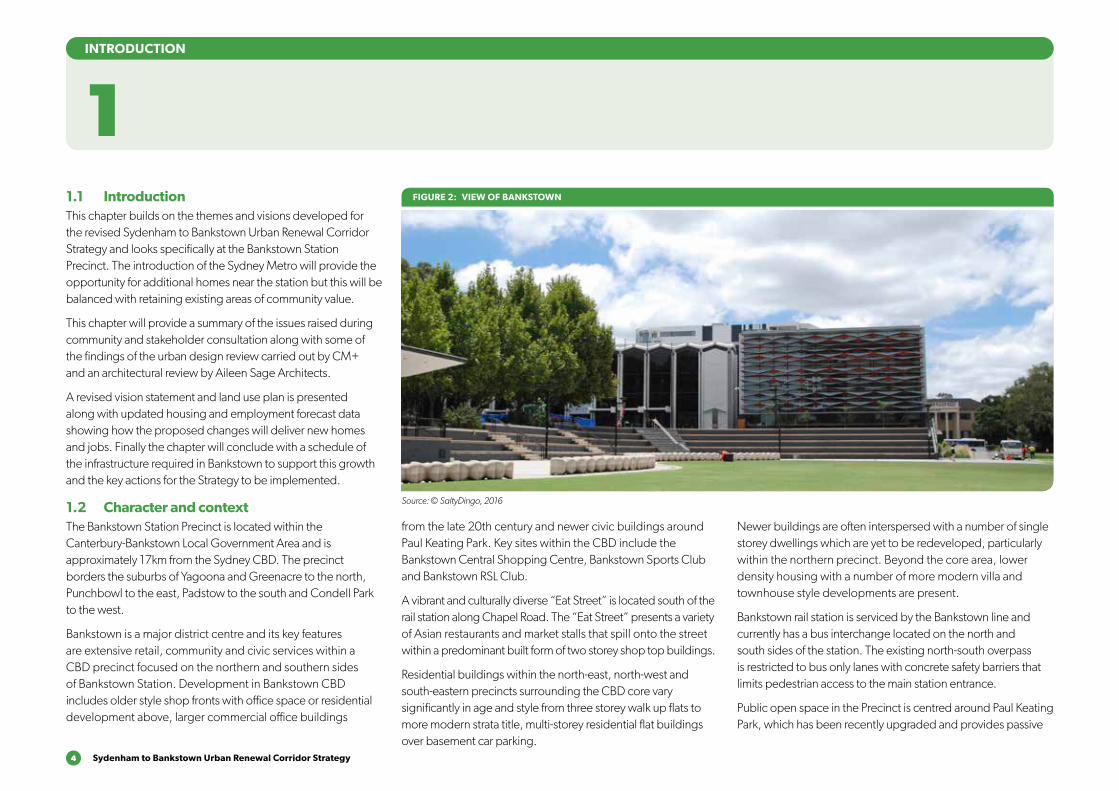
FIGURE 2: VIEW OF BANKSTOWN
Source: © SaltyDingo, 2016
1INTRODUCTION
from the late 20th century and newer civic buildings around Paul Keating Park. Key sites within the CBD include the Bankstown Central Shopping Centre, Bankstown Sports Club and Bankstown RSL Club.
A vibrant and culturally diverse “Eat Street” is located south of the rail station along Chapel Road. The “Eat Street” presents a variety of Asian restaurants and market stalls that spill onto the street within a predominant built form of two storey shop top buildings.
Residential buildings within the north-east, north-west and south-eastern precincts surrounding the CBD core vary significantly in age and style from three storey walk up flats to more modern strata title, multi-storey residential flat buildings over basement car parking.
Newer buildings are often interspersed with a number of single storey dwellings which are yet to be redeveloped, particularly within the northern precinct. Beyond the core area, lower density housing with a number of more modern villa and townhouse style developments are present.
Bankstown rail station is serviced by the Bankstown line and currently has a bus interchange located on the north and south sides of the station. The existing north-south overpass is restricted to bus only lanes with concrete safety barriers that limits pedestrian access to the main station entrance.
Public open space in the Precinct is centred around Paul Keating Park, which has been recently upgraded and provides passive
Bankstown 5
FIGURE 3: VIEWS OF BANKSTOWN
Source: © SaltyDingo, 2016
SECTION 1: INTRODUCTION
BANKSTOWNBANKSTOWN
4
14
1211
10313
21
16
6
9
5
7
15
8
FIGURE 4: CONTEXT MAP
1 Chapel Road ‘Eat Street’
2 Bankstown Arts Centre
3 Bankstown Central
4 TAFE NSW – Bankstown Campus
5 Bankstown Public School
6 Bankstown Girls High School
7 Bankstown Memorial Park
8 Salt Pan Creek
9 Bankstown Sports Club
10 Paul Keating Park
11 Bankstown Library and Knowledge Centre
12 Bankstown PCYC
13 Bankstown RSL
14 RM Campbell Reserve
15 Stevens Reserve
16 St Brendan’s Primary School
Bankstown Station is identified as a local heritage item. There are a number of other local items are located within Bankstown City Plaza, including the Parcels Office, the Bankstown Hotel and shops on the northern side of the railway line on North Terrace.
Bankstown Public School to the south of the CBD is also heritage listed. However, there are no Heritage Conservation Areas located within the Bankstown Precinct.
Bankstown Airport is located 3km from the Bankstown CBD. As a result of the precinct’s proximity to the airport, any development application proposing to exceed 55m Australian Height Datum (AHD) in the Inner Horizontal Surface area
(and 72m AHD in the Conical Surface Area in the north east of the Precinct) needs to be submitted to Bankstown Airport for additional approval to ensure that it will not impact upon the continued operation of the airport.
Due to the topography in the Bankstown Precinct and the airport restrictions, this means buildings are generally not over eight storeys. A building exceeding this height could be deemed acceptable by Bankstown Airport if an aeronautical study determines that it will not adversely affect the safety or regularity of the airport operations.
recreation areas, seating and gardens. To the south of the CBD behind Bankstown Public School is the Bankstown Memorial Park and Gardens.
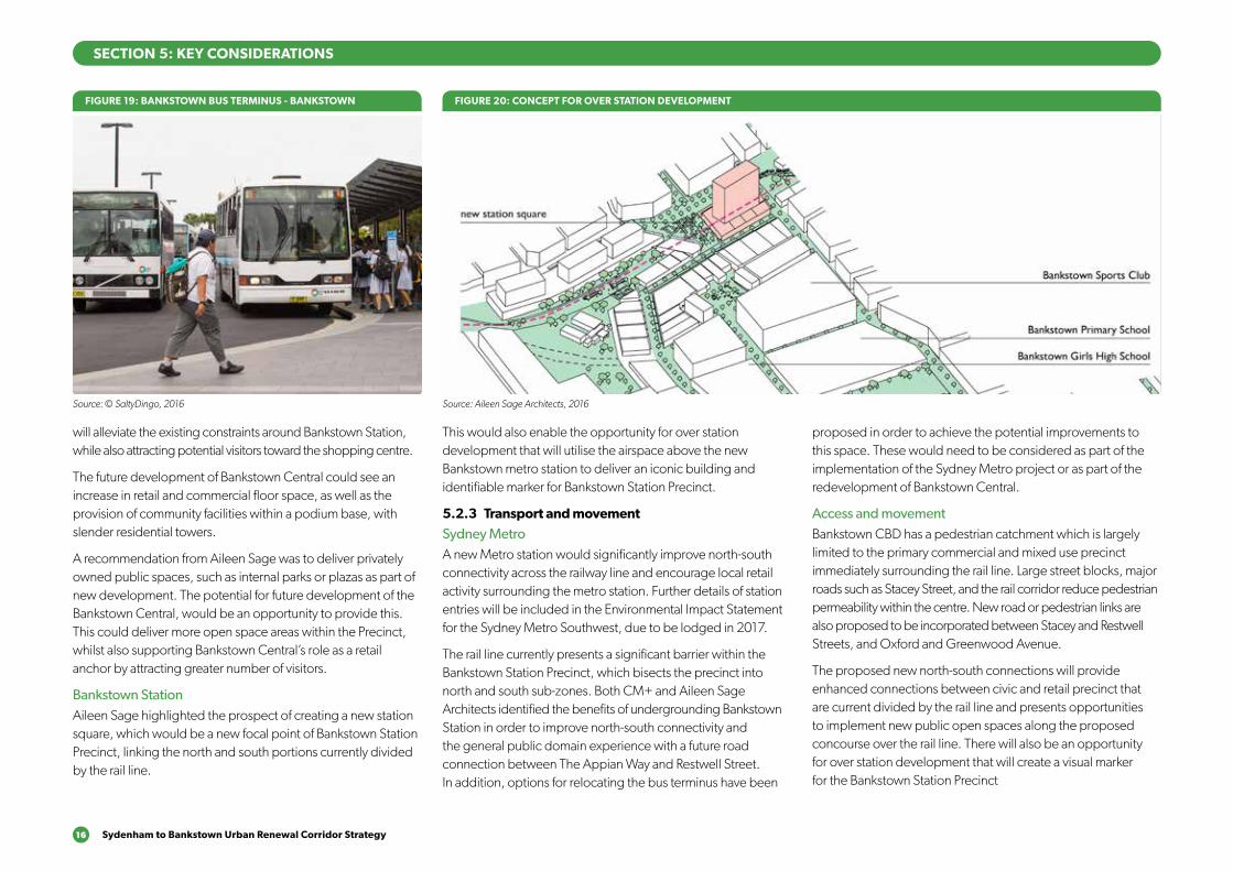
The precinct contains numerous private and government educational facilities including the Southern Sydney Institute of TAFE – Bankstown. The precinct also has extensive community and civic facilities, including the Bankstown Library and Knowledge Centre and the council offices located around Paul Keating Park, the Bankstown Arts Centre and Bankstown Memorial Oval sporting facilities.
6 Sydenham to Bankstown Urban Renewal Corridor Strategy
2 DEVELOPMENT OF THE DRAFT STRATEGY
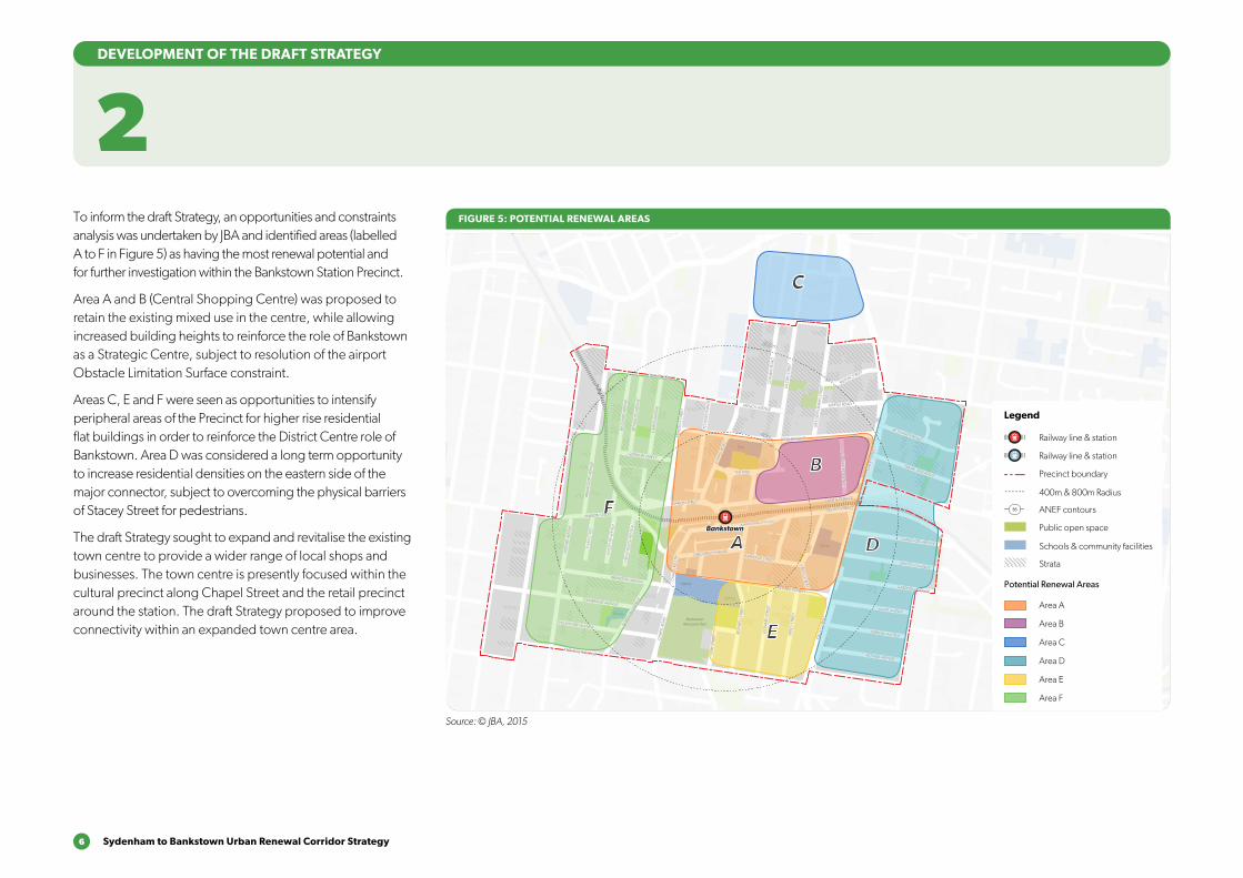
To inform the draft Strategy, an opportunities and constraints analysis was undertaken by JBA and identified areas (labelled A to F in Figure 5) as having the most renewal potential and for further investigation within the Bankstown Station Precinct.
Area A and B (Central Shopping Centre) was proposed to retain the existing mixed use in the centre, while allowing increased building heights to reinforce the role of Bankstown as a Strategic Centre, subject to resolution of the airport Obstacle Limitation Surface constraint.
Areas C, E and F were seen as opportunities to intensify peripheral areas of the Precinct for higher rise residential flat buildings in order to reinforce the District Centre role of Bankstown. Area D was considered a long term opportunity to increase residential densities on the eastern side of the major connector, subject to overcoming the physical barriers of Stacey Street for pedestrians.
The draft Strategy sought to expand and revitalise the existing town centre to provide a wider range of local shops and businesses. The town centre is presently focused within the cultural precinct along Chapel Street and the retail precinct around the station. The draft Strategy proposed to improve connectivity within an expanded town centre area.
FIGURE 5: POTENTIAL RENEWAL AREAS
Civic
School
School
School
BankstownMemorial Park
School
School
School
School
School
School
B
C
D
F
E
A
800m
400m
BankstownBankstown
BRANDON AVENUE
OXF
ORD
AVE
NU
E
GRE
ENW
OO
D A
VEN
UE
CH
APEL
RO
AD
PERC
Y ST
REET
STAC
EY S
TREE
T
STANLEY STREET
RAYMOND STREET
CRO
SS STREET
CARNATION AVENUE
NORTH TERRACE
RICKARD ROAD
LAD
Y CU
TLER AVENU
E
JAC
OBS
STR
EET
GRIFFITHS AVENUE
GARDENIA AVENUE
SALVIA AVENUE
VERBENA AVENUE
PETUNIA AVENUE
LEO
NA
RD S
TREE
T
REST
WEL
L STR
EET
VIM
Y ST
REET
NO
RTHAM
AVE
NUECAMBRIDGE AVENUE
CHELMSFORD AVENUE
EGA
N S
TREE
T
WIN
SPEA
R AV
ENU
E
GRE
ENW
OO
D A
VEN
UE
EGA
N S
TREE
T
WIN
SPEA
R AV
ENU
E
MARION STREET
BRA
NC
OU
RT A
VEN
UE
WEI
GA
ND
AVE
NU
E
REYN
OLD
S AV
ENU
E
CA
IRD
S AV
ENU
E
GORDON STREET
CARMEN STREET
FRENCH AVENUE
THE MALL
CH
APEL
RO
AD
KITC
HEN
ER P
ARA
DE
MER
EDIT
H S
TREE
T
SOUTH TERRACE
STAC
EY S
TREE
T
PRAIRIE VALE ROAD
RESTHAVEN ROAD
MYRTLE ROAD
MILTON STREET
SIR
JOSE
PH B
AN
KS S
TREE
T
CO
NW
AY R
OA
D
CH
APE
L RD
STH
GREENFIELD PARADE
MARION STREET
BANKSTOWN CITY PLAZA
MACAULEY AVENUE
Source: © JBA, 2015
Railway line & station
Legend
Potential Renewal Areas
Precinct boundary
400m & 800m Radius
Public open space
Schools & community facilities
Area A
Area B
Area C
Area D
ANEF contours
Strata
Area E
Area F
Railway line & station
35
Bankstown 7
PETUNIA AVENUE
School
School
School
School
Civic
BankstownMemorial Park
Ruse Park
BANKSTOWNBANKSTOWN
BRANDON AVENUE
OX
FOR
D A
VEN
UE
GR
EEN
WO
OD
AV
ENU
E
CH
APE
L R
OA
D
PER
CY
STR
EET
STA
CEY
STR
EET
STANLEY STREET
RAYMOND STREETC
RO
SS
STR
EET
CARNATION AVENUE
NORTH TERRACE
RICKARD ROAD
LAD
Y C
UT
LER
AV
EN
UE
JAC
OB
S S
TREE
T
GRIFFITHS AVENUE
GARDENIA AVENUE
SALVIA AVENUE
VERBENA AVENUE
PETUNIA AVENUE
LEO
NA
RD
STR
EET
RES
TWEL
L S
TREE
T
VIM
Y S
TREE
T
NO
RTH
AM
AVE
NU
E
CAMBRIDGE AVENUE
CHELMSFORD AVENUE
EGA
N S
TREE
T
WIN
SPE
AR
AV
ENU
E
MARION STREET
BR
AN
CO
UR
T A
VEN
UE
WEI
GA
ND
AV
ENU
E
REY
NO
LDS
AV
ENU
E
CA
IRD
S A
VEN
UE
GORDON STREET
CARMEN STREET
FRENCH AVENUE
RICKARD ROAD
THE MALL
CH
APE
L R
OA
D
KIT
CH
ENER
PA
RA
DE
MER
EDIT
H S
TREE
T
SOUTH TERRACE
STA
CEY
STR
EET
PRAIRIE VALE ROAD
WATTLE STREET
RESTHAVEN ROAD
MYRTLE ROAD
MILTON STREET
SIR
JO
SEP
H B
AN
KS
STR
EET
CO
NW
AY
RO
AD
HEATH STREET
GREENACRE ROAD
HIL
LCR
EST
AV
ENU
E
CH
APE
L R
OA
D S
OU
TH GREENFIELD PARADE
MARION STREET
BANKSTOWN CITY PLAZA
MACAULEY AVENUE
DAPHNE AVENUE
Railway line & station
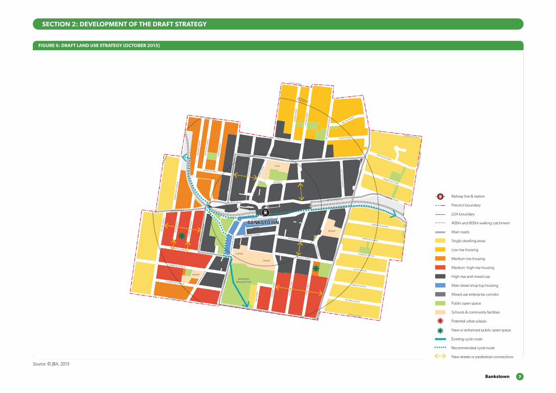
Precinct boundary
LGA boundary
400m and 800m walking catchment
Main roads
Single dwelling areas
Low rise housing
Medium rise housing
Medium -high rise housing
High rise and mixed use
Main street shop top housing
Mixed use enterprise corridor
Public open space
Schools & community facilities
Potential urban plazas
New or enhanced public open space
Existing cycle route
Recommended cycle route
New streets or pedestrian connections
SECTION 2: DEVELOPMENT OF THE DRAFT STRATEGY
FIGURE 6: DRAFT LAND USE STRATEGY (OCTOBER 2015)
Source: © JBA, 2015
8 Sydenham to Bankstown Urban Renewal Corridor Strategy
3WHAT WE’VE HEARD
3.1 Community feedbackThe draft Strategy was publicly exhibited from 14 October 2015 to 7 February 2016. Over 1,800 submissions were received of which 15 related to the Bankstown Station Precinct.
Key issues raised included:
●● Extend the Bankstown Station Precinct boundary to include the TAFE, Catholic college, and primary school;
●● Increased heights should be supported in Bankstown to help the Precinct become a strategic centre in Sydney’s inner west;
●● Increased density in Bankstown should not be supported due to traffic congestion and parking issues, particularly around the City centre and shopping mall;
●● Public transport should be improved between Bankstown and Parramatta;
●● Road improvements should include widening of Stacey Street;
●● Cycleway infrastructure improvements will not necessarily lead to an uptake of cycling in Bankstown;
●● The revitalisation of the Bankstown City Centre should create a family-friendly place to live with a modern shopping centre, alfresco dining, night time activity and more street lights;
●● A community centre should be planned for Bankstown;
●● New high rise developments in Bankstown should be well-designed; and
●● Infrastructure improvements should include increasing hospital capacities.
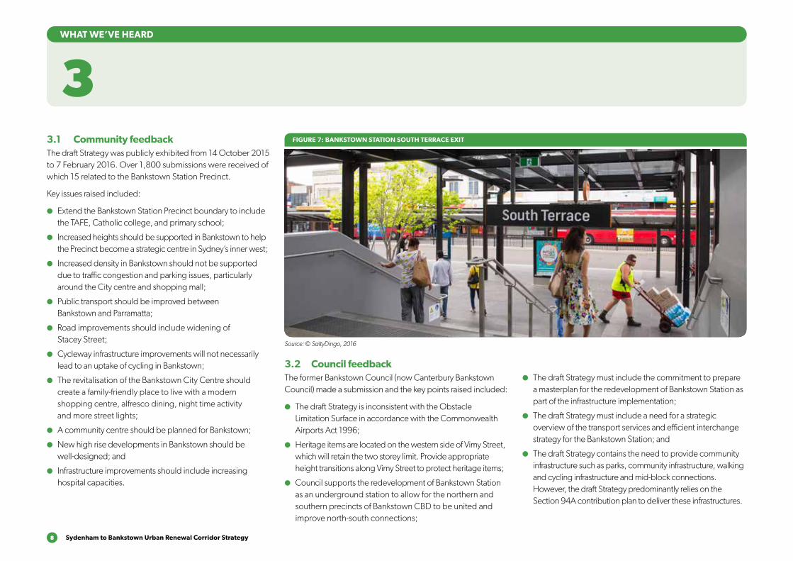
3.2 Council feedback The former Bankstown Council (now Canterbury Bankstown Council) made a submission and the key points raised included:
●● The draft Strategy is inconsistent with the Obstacle Limitation Surface in accordance with the Commonwealth Airports Act 1996;
●● Heritage items are located on the western side of Vimy Street, which will retain the two storey limit. Provide appropriate height transitions along Vimy Street to protect heritage items;
●● Council supports the redevelopment of Bankstown Station as an underground station to allow for the northern and southern precincts of Bankstown CBD to be united and improve north-south connections;
FIGURE 7: BANKSTOWN STATION SOUTH TERRACE EXIT
Source: © SaltyDingo, 2016
●● The draft Strategy must include the commitment to prepare a masterplan for the redevelopment of Bankstown Station as part of the infrastructure implementation;
●● The draft Strategy must include a need for a strategic overview of the transport services and efficient interchange strategy for the Bankstown Station; and
●● The draft Strategy contains the need to provide community infrastructure such as parks, community infrastructure, walking and cycling infrastructure and mid-block connections. However, the draft Strategy predominantly relies on the Section 94A contribution plan to deliver these infrastructures.
Bankstown 9
A detailed review process was undertaken following the exhibition of the Strategy. A summary of the findings are provided below and the full reports can be found on the Department’s website.
4.1 CM+ design reviewConybeare Morrison (CM+) are a leading architectural and urban design practice with extensive experience in masterplanning, place making and urban transformation. DPE engaged CM+ to review the land use plans publicly exhibited and identify areas where improvements could be made to provide a better outcome for residents, future residents and businesses in the Station Precinct.
CM+ recommended a number of modifications to the land use Strategy including:
●● Provide upper level setbacks on Stacey Street above four storey podium, subject to shadow study assessment;
●● Improve connectivity from the mixed use area to core of the centre;
●● Provide appropriate transitional height provisions within vicinity of heritage items along Vimy Street;
●● Consider development of the airspace above and improvements to north-south connectivity;
●● Provide more open space and recreation facilities adjacent to Bankstown railway station;
●● Improve connectivity through improved north-south connections over the rail line;
●● Consider a three to six storey retail street with setback along Chapel Road; and
●● High rise residential proposed to keep a compact commercial area.
DEVELOPING THE REVISED STRATEGY
4FIGURE 8: URBAN DESIGN PEER REVIEW RECOMMENDATIONS
Conybeare Morrison
16021 Sydenham to Bankstown Urban Renewal Corridor Strategy - Peer Review | October 2016 | 27
Under Construction
New Development +Shopping Centre
6
6
6
64
1
2
4
6
5
3
6
1
1
1
8 88
8
1 Provide upper level setbacks on residential street (Stacey St) above four storey podium, subject to shadow study assessment.
2 Improve connectivity from mixed use area to core of the centre.
3 Appropriate transitional height provisions within vicinity of heritage items along Vinny St.
4 Consider undergrounding of station to allow development of the airspace above to improve connectivity.
5 Provide more open space and recreation facilities.
6 Improve connectivity.
7 3-6 stories retail street with setback.
8 High rise residential proposed to keep a compact commercial area (as per Council’s vision).
Heritage
7
8
8
Cap height to be determined after OLS study
11.0 Bankstown
Source: Conybeare Morrison, 2016
10 Sydenham to Bankstown Urban Renewal Corridor Strategy
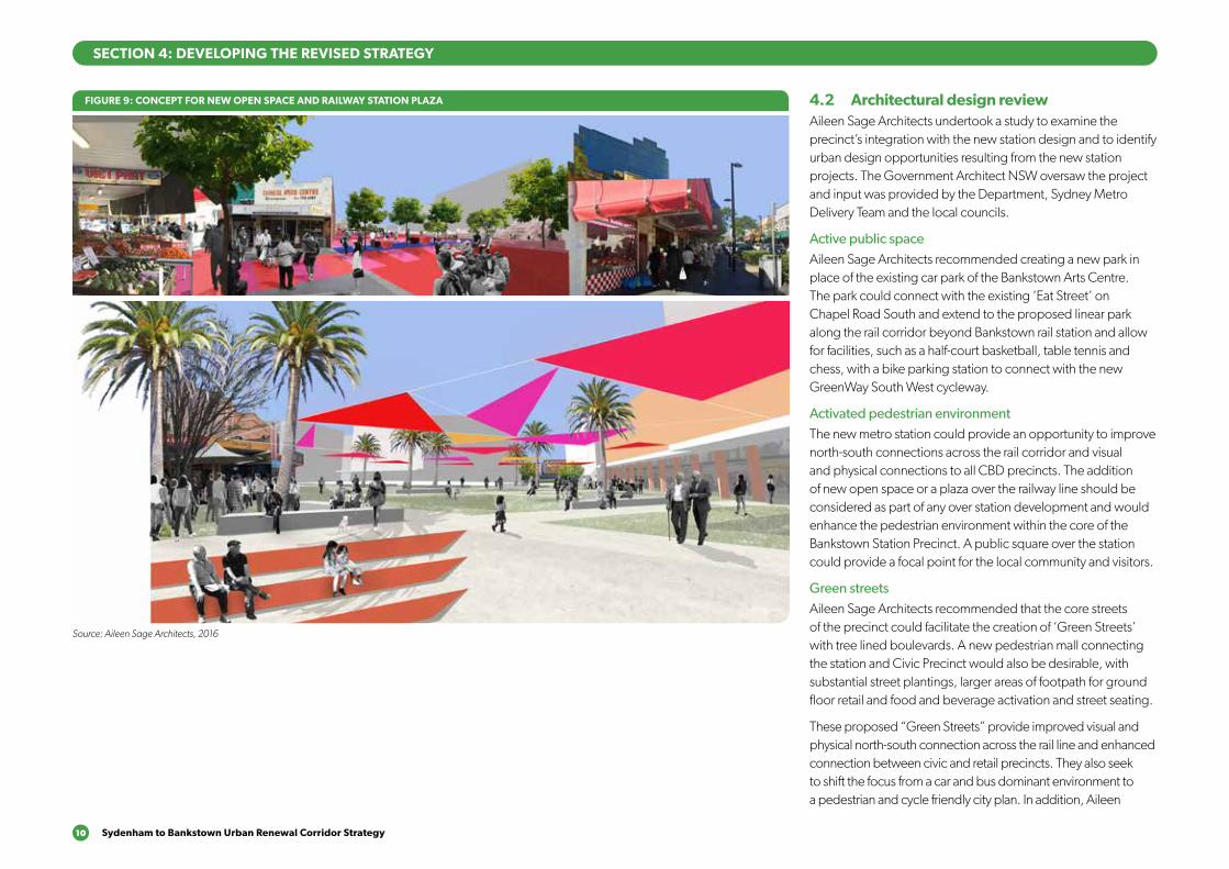
4.2 Architectural design reviewAileen Sage Architects undertook a study to examine the precinct’s integration with the new station design and to identify urban design opportunities resulting from the new station projects. The Government Architect NSW oversaw the project and input was provided by the Department, Sydney Metro Delivery Team and the local councils.
Active public spaceAileen Sage Architects recommended creating a new park in place of the existing car park of the Bankstown Arts Centre. The park could connect with the existing ‘Eat Street’ on Chapel Road South and extend to the proposed linear park along the rail corridor beyond Bankstown rail station and allow for facilities, such as a half-court basketball, table tennis and chess, with a bike parking station to connect with the new GreenWay South West cycleway.
Activated pedestrian environmentThe new metro station could provide an opportunity to improve north-south connections across the rail corridor and visual and physical connections to all CBD precincts. The addition of new open space or a plaza over the railway line should be considered as part of any over station development and would enhance the pedestrian environment within the core of the Bankstown Station Precinct. A public square over the station could provide a focal point for the local community and visitors.
Green streetsAileen Sage Architects recommended that the core streets of the precinct could facilitate the creation of ‘Green Streets’ with tree lined boulevards. A new pedestrian mall connecting the station and Civic Precinct would also be desirable, with substantial street plantings, larger areas of footpath for ground floor retail and food and beverage activation and street seating.
These proposed “Green Streets” provide improved visual and physical north-south connection across the rail line and enhanced connection between civic and retail precincts. They also seek to shift the focus from a car and bus dominant environment to a pedestrian and cycle friendly city plan. In addition, Aileen
FIGURE 9: CONCEPT FOR NEW OPEN SPACE AND RAILWAY STATION PLAZA
Source: Aileen Sage Architects, 2016
SECTION 4: DEVELOPING THE REVISED STRATEGY
Bankstown 11
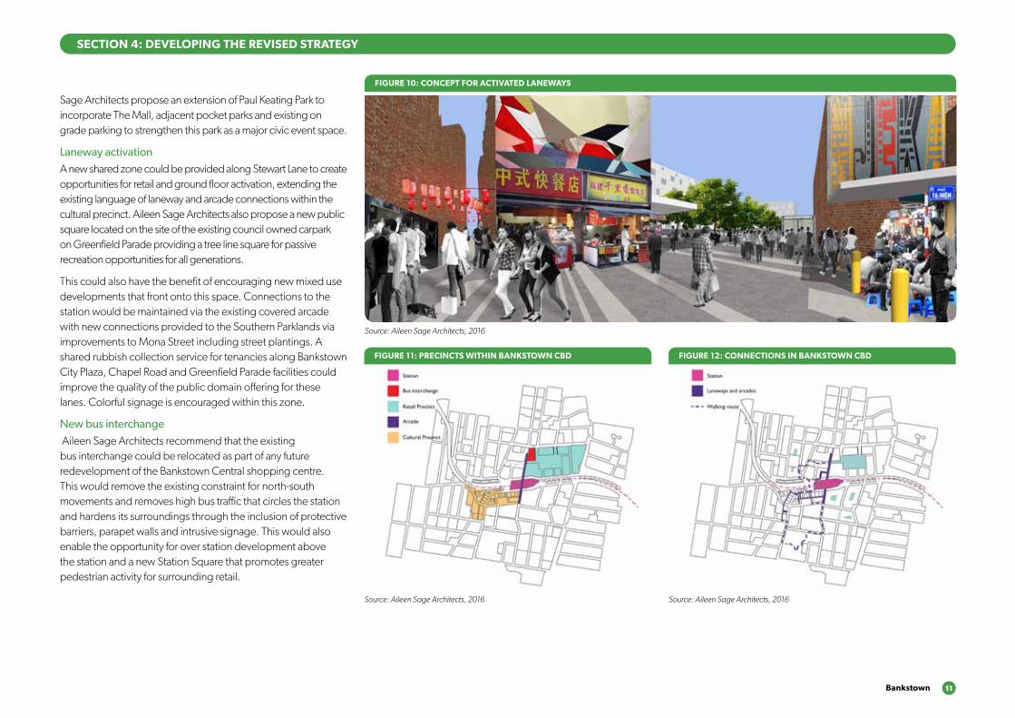
Sage Architects propose an extension of Paul Keating Park to incorporate The Mall, adjacent pocket parks and existing on grade parking to strengthen this park as a major civic event space.
Laneway activationA new shared zone could be provided along Stewart Lane to create opportunities for retail and ground floor activation, extending the existing language of laneway and arcade connections within the cultural precinct. Aileen Sage Architects also propose a new public square located on the site of the existing council owned carpark on Greenfield Parade providing a tree line square for passive recreation opportunities for all generations.
This could also have the benefit of encouraging new mixed use developments that front onto this space. Connections to the station would be maintained via the existing covered arcade with new connections provided to the Southern Parklands via improvements to Mona Street including street plantings. A shared rubbish collection service for tenancies along Bankstown City Plaza, Chapel Road and Greenfield Parade facilities could improve the quality of the public domain offering for these lanes. Colorful signage is encouraged within this zone.
New bus interchange Aileen Sage Architects recommend that the existing bus interchange could be relocated as part of any future redevelopment of the Bankstown Central shopping centre. This would remove the existing constraint for north-south movements and removes high bus traffic that circles the station and hardens its surroundings through the inclusion of protective barriers, parapet walls and intrusive signage. This would also enable the opportunity for over station development above the station and a new Station Square that promotes greater pedestrian activity for surrounding retail.
FIGURE 10: CONCEPT FOR ACTIVATED LANEWAYS
Source: Aileen Sage Architects, 2016
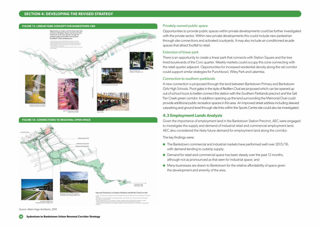
FIGURE 11: PRECINCTS WITHIN BANKSTOWN CBD FIGURE 12: CONNECTIONS IN BANKSTOWN CBD
Source: Aileen Sage Architects, 2016 Source: Aileen Sage Architects, 2016
SECTION 4: DEVELOPING THE REVISED STRATEGY
12 Sydenham to Bankstown Urban Renewal Corridor Strategy
Privately owned public spaceOpportunities to provide public spaces within private developments could be further investigated with the private sector. Within new private developments this could include new pedestrian through site connections and activated courtyards. It may also include air-conditioned arcade spaces that attract footfall to retail.
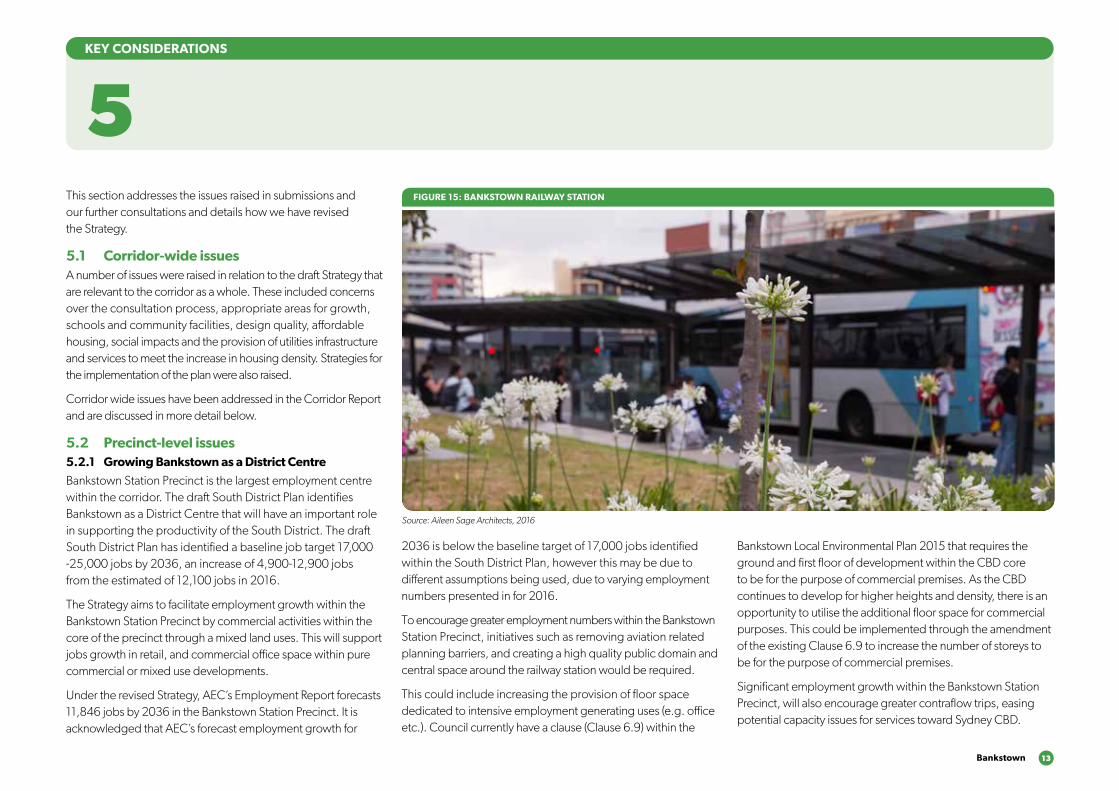
Extension of linear parkThere is an opportunity to create a linear park that connects with Station Square and the tree lined boulevards of the Civic quarter. Weekly markets could occupy this zone connecting with the retail quarter adjacent. Opportunities for increased residential density along the rail corridor could support similar strategies for Punchbowl, Wiley Park and Lakemba.
Connection to southern parklandsA new connection is proposed through the land between Bankstown Primary and Bankstown Girls High Schools. Pivot gates in the style of Redfern Oval are proposed which can be opened up out of school hours to better connect the station with the Southern Parklands precinct and the Salt Pan Creek green corridor. In addition opening up the land surrounding the Memorial Oval could provide additional public recreation spaces in this area. An improved street address including sleeved carparking and ground level through site links within the Sports Centre site could also be investigated.
4.3 Employment Lands AnalysisGiven the importance of employment land in the Bankstown Station Precinct, AEC were engaged to investigate the supply and demand of industrial retail and commercial employment land. AEC also considered the likely future demand for employment land along the corridor.
The key findings were:
●● The Bankstown commercial and industrial markets have performed well over 2015/16, with demand tending to outstrip supply;
●● Demand for retail and commercial space has been steady over the past 12 months, although not as pronounced as that seen for industrial space; and
●● Many businesses are drawn to Bankstown for the relative affordability of space given the development and amenity of the area.
FIGURE 13: LINEAR PARK CONCEPT FOR BANKSTOWN CBD
FIGURE 14: CONNECTIONS TO REGIONAL OPEN SPACE
Source: Aileen Sage Architects, 2016
SECTION 4: DEVELOPING THE REVISED STRATEGY
Bankstown 13
This section addresses the issues raised in submissions and our further consultations and details how we have revised the Strategy.
5.1 Corridor-wide issues A number of issues were raised in relation to the draft Strategy that are relevant to the corridor as a whole. These included concerns over the consultation process, appropriate areas for growth, schools and community facilities, design quality, affordable housing, social impacts and the provision of utilities infrastructure and services to meet the increase in housing density. Strategies for the implementation of the plan were also raised.
Corridor wide issues have been addressed in the Corridor Report and are discussed in more detail below.
5.2 Precinct-level issues 5.2.1 Growing Bankstown as a District Centre
Bankstown Station Precinct is the largest employment centre within the corridor. The draft South District Plan identifies Bankstown as a District Centre that will have an important role in supporting the productivity of the South District. The draft South District Plan has identified a baseline job target 17,000 -25,000 jobs by 2036, an increase of 4,900-12,900 jobs from the estimated of 12,100 jobs in 2016.
The Strategy aims to facilitate employment growth within the Bankstown Station Precinct by commercial activities within the core of the precinct through a mixed land uses. This will support jobs growth in retail, and commercial office space within pure commercial or mixed use developments.
Under the revised Strategy, AEC’s Employment Report forecasts 11,846 jobs by 2036 in the Bankstown Station Precinct. It is acknowledged that AEC’s forecast employment growth for
2036 is below the baseline target of 17,000 jobs identified within the South District Plan, however this may be due to different assumptions being used, due to varying employment numbers presented in for 2016.
To encourage greater employment numbers within the Bankstown Station Precinct, initiatives such as removing aviation related planning barriers, and creating a high quality public domain and central space around the railway station would be required.
This could include increasing the provision of floor space dedicated to intensive employment generating uses (e.g. office etc.). Council currently have a clause (Clause 6.9) within the
5KEY CONSIDERATIONS
Bankstown Local Environmental Plan 2015 that requires the ground and first floor of development within the CBD core to be for the purpose of commercial premises. As the CBD continues to develop for higher heights and density, there is an opportunity to utilise the additional floor space for commercial purposes. This could be implemented through the amendment of the existing Clause 6.9 to increase the number of storeys to be for the purpose of commercial premises.
Significant employment growth within the Bankstown Station Precinct, will also encourage greater contraflow trips, easing potential capacity issues for services toward Sydney CBD.
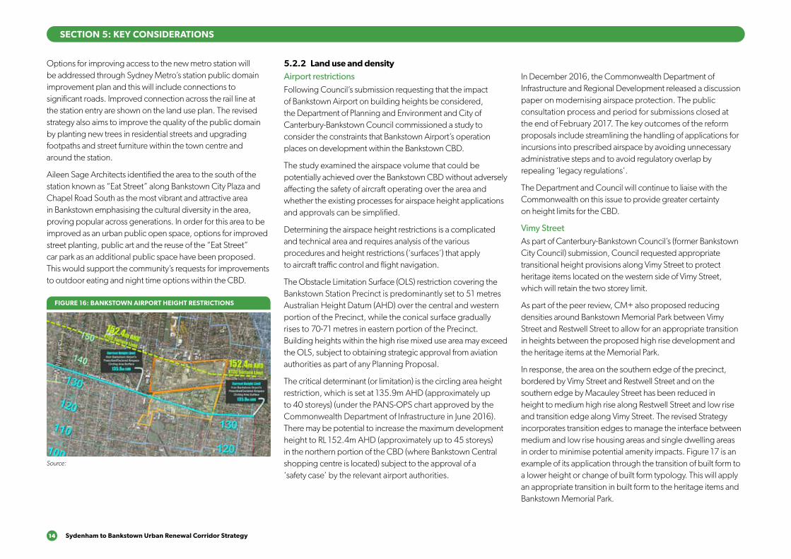
FIGURE 15: BANKSTOWN RAILWAY STATION
Source: Aileen Sage Architects, 2016
14 Sydenham to Bankstown Urban Renewal Corridor Strategy
Options for improving access to the new metro station will be addressed through Sydney Metro’s station public domain improvement plan and this will include connections to significant roads. Improved connection across the rail line at the station entry are shown on the land use plan. The revised strategy also aims to improve the quality of the public domain by planting new trees in residential streets and upgrading footpaths and street furniture within the town centre and around the station.
Aileen Sage Architects identified the area to the south of the station known as “Eat Street” along Bankstown City Plaza and Chapel Road South as the most vibrant and attractive area in Bankstown emphasising the cultural diversity in the area, proving popular across generations. In order for this area to be improved as an urban public open space, options for improved street planting, public art and the reuse of the “Eat Street” car park as an additional public space have been proposed. This would support the community’s requests for improvements to outdoor eating and night time options within the CBD.
5.2.2 Land use and density
Airport restrictionsFollowing Council’s submission requesting that the impact of Bankstown Airport on building heights be considered, the Department of Planning and Environment and City of Canterbury-Bankstown Council commissioned a study to consider the constraints that Bankstown Airport’s operation places on development within the Bankstown CBD.
The study examined the airspace volume that could be potentially achieved over the Bankstown CBD without adversely affecting the safety of aircraft operating over the area and whether the existing processes for airspace height applications and approvals can be simplified.
Determining the airspace height restrictions is a complicated and technical area and requires analysis of the various procedures and height restrictions (‘surfaces’) that apply to aircraft traffic control and flight navigation.
The Obstacle Limitation Surface (OLS) restriction covering the Bankstown Station Precinct is predominantly set to 51 metres Australian Height Datum (AHD) over the central and western portion of the Precinct, while the conical surface gradually rises to 70-71 metres in eastern portion of the Precinct. Building heights within the high rise mixed use area may exceed the OLS, subject to obtaining strategic approval from aviation authorities as part of any Planning Proposal.
The critical determinant (or limitation) is the circling area height restriction, which is set at 135.9m AHD (approximately up to 40 storeys) (under the PANS-OPS chart approved by the Commonwealth Department of Infrastructure in June 2016). There may be potential to increase the maximum development height to RL 152.4m AHD (approximately up to 45 storeys) in the northern portion of the CBD (where Bankstown Central shopping centre is located) subject to the approval of a ‘safety case’ by the relevant airport authorities.
In December 2016, the Commonwealth Department of Infrastructure and Regional Development released a discussion paper on modernising airspace protection. The public consultation process and period for submissions closed at the end of February 2017. The key outcomes of the reform proposals include streamlining the handling of applications for incursions into prescribed airspace by avoiding unnecessary administrative steps and to avoid regulatory overlap by repealing ‘legacy regulations’.
The Department and Council will continue to liaise with the Commonwealth on this issue to provide greater certainty on height limits for the CBD.
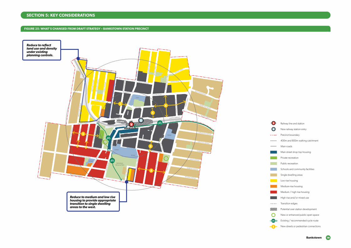
Vimy StreetAs part of Canterbury-Bankstown Council’s (former Bankstown City Council) submission, Council requested appropriate transitional height provisions along Vimy Street to protect heritage items located on the western side of Vimy Street, which will retain the two storey limit.
As part of the peer review, CM+ also proposed reducing densities around Bankstown Memorial Park between Vimy Street and Restwell Street to allow for an appropriate transition in heights between the proposed high rise development and the heritage items at the Memorial Park.
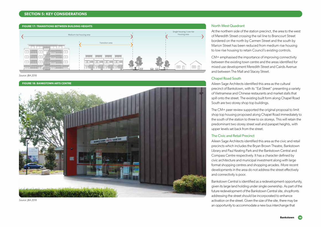
In response, the area on the southern edge of the precinct, bordered by Vimy Street and Restwell Street and on the southern edge by Macauley Street has been reduced in height to medium high rise along Restwell Street and low rise and transition edge along Vimy Street. The revised Strategy incorporates transition edges to manage the interface between medium and low rise housing areas and single dwelling areas in order to minimise potential amenity impacts. Figure 17 is an example of its application through the transition of built form to a lower height or change of built form typology. This will apply an appropriate transition in built form to the heritage items and Bankstown Memorial Park.
SECTION 5: KEY CONSIDERATIONS
FIGURE 16: BANKSTOWN AIRPORT HEIGHT RESTRICTIONS
Source:
Bankstown 15
North West QuadrantAt the northern side of the station precinct, the area to the west of Meredith Street crossing the rail line to Brancourt Street bordered on the north by Carmen Street and the south by Marion Street has been reduced from medium rise housing to low rise housing to retain Council’s existing controls.
CM+ emphasised the importance of improving connectivity between the existing town centre and the areas identified for mixed use development Meredith Street and Cairds Avenue and between The Mall and Stacey Street.
Chapel Road SouthAileen Sage Architects identified this area as the cultural precinct of Bankstown, with its “Eat Street” presenting a variety of Vietnamese and Chinese restaurants and market stalls that spill onto the street. The existing built form along Chapel Road South are two storey shop top buildings.
The CM+ peer review supported the original proposal to limit shop top housing proposed along Chapel Road immediately to the south of the station to three to six storeys. This will retain the predominant two storey street wall and parapet heights, with upper levels set back from the street.
The Civic and Retail PrecinctAileen Sage Architects identified this area as the civic and retail precincts which includes the Bryan Brown Theatre, Bankstown Library and Paul Keating Park and the Bankstown Central and Compass Centre respectively. It has a character defined by civic architecture and municipal investment along with large format shopping centres and shopping arcades. More recent developments in the area do not address the street effectively and connectivity is poor.
Bankstown Central is identified as a redevelopment opportunity, given its large land holding under single ownership. As part of the future redevelopment of the Bankstown Central site, shopfronts addressing the street should be incorporated to enhance activation on the street. Given the size of the site, there may be an opportunity to accommodate a new bus interchange that
SECTION 5: KEY CONSIDERATIONS
GSEducationalVersion
Transition area
Medium rise housing area
Single housing / Low rise
housing area
FIGURE 17: TRANSITIONS BETWEEN BUILDING HEIGHTS
Source: JBA 2016
FIGURE 18: BANKSTOWN ARTS CENTRE
Source: JBA 2016
16 Sydenham to Bankstown Urban Renewal Corridor Strategy
will alleviate the existing constraints around Bankstown Station, while also attracting potential visitors toward the shopping centre.
The future development of Bankstown Central could see an increase in retail and commercial floor space, as well as the provision of community facilities within a podium base, with slender residential towers.
A recommendation from Aileen Sage was to deliver privately owned public spaces, such as internal parks or plazas as part of new development. The potential for future development of the Bankstown Central, would be an opportunity to provide this. This could deliver more open space areas within the Precinct, whilst also supporting Bankstown Central’s role as a retail anchor by attracting greater number of visitors.
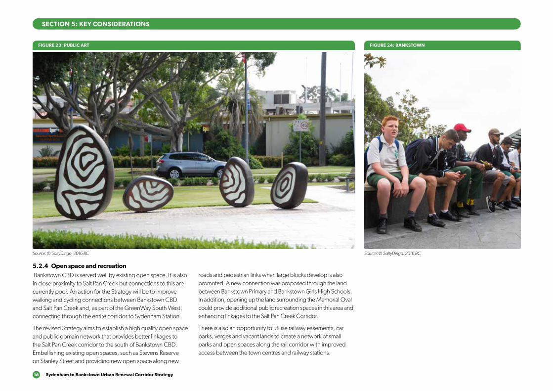
Bankstown StationAileen Sage highlighted the prospect of creating a new station square, which would be a new focal point of Bankstown Station Precinct, linking the north and south portions currently divided by the rail line.
FIGURE 20: CONCEPT FOR OVER STATION DEVELOPMENT
Source: Aileen Sage Architects, 2016
This would also enable the opportunity for over station development that will utilise the airspace above the new Bankstown metro station to deliver an iconic building and identifiable marker for Bankstown Station Precinct.
5.2.3 Transport and movement
Sydney MetroA new Metro station would significantly improve north-south connectivity across the railway line and encourage local retail activity surrounding the metro station. Further details of station entries will be included in the Environmental Impact Statement for the Sydney Metro Southwest, due to be lodged in 2017.
The rail line currently presents a significant barrier within the Bankstown Station Precinct, which bisects the precinct into north and south sub-zones. Both CM+ and Aileen Sage Architects identified the benefits of undergrounding Bankstown Station in order to improve north-south connectivity and the general public domain experience with a future road connection between The Appian Way and Restwell Street. In addition, options for relocating the bus terminus have been
proposed in order to achieve the potential improvements to this space. These would need to be considered as part of the implementation of the Sydney Metro project or as part of the redevelopment of Bankstown Central.
Access and movementBankstown CBD has a pedestrian catchment which is largely limited to the primary commercial and mixed use precinct immediately surrounding the rail line. Large street blocks, major roads such as Stacey Street, and the rail corridor reduce pedestrian permeability within the centre. New road or pedestrian links are also proposed to be incorporated between Stacey and Restwell Streets, and Oxford and Greenwood Avenue.
The proposed new north-south connections will provide enhanced connections between civic and retail precinct that are current divided by the rail line and presents opportunities to implement new public open spaces along the proposed concourse over the rail line. There will also be an opportunity for over station development that will create a visual marker for the Bankstown Station Precinct
SECTION 5: KEY CONSIDERATIONS
FIGURE 19: BANKSTOWN BUS TERMINUS - BANKSTOWN
Source: © SaltyDingo, 2016
Bankstown 17
FIGURE 21: BANKSTOWN STATION
Source: © SaltyDingo, 2016 BC
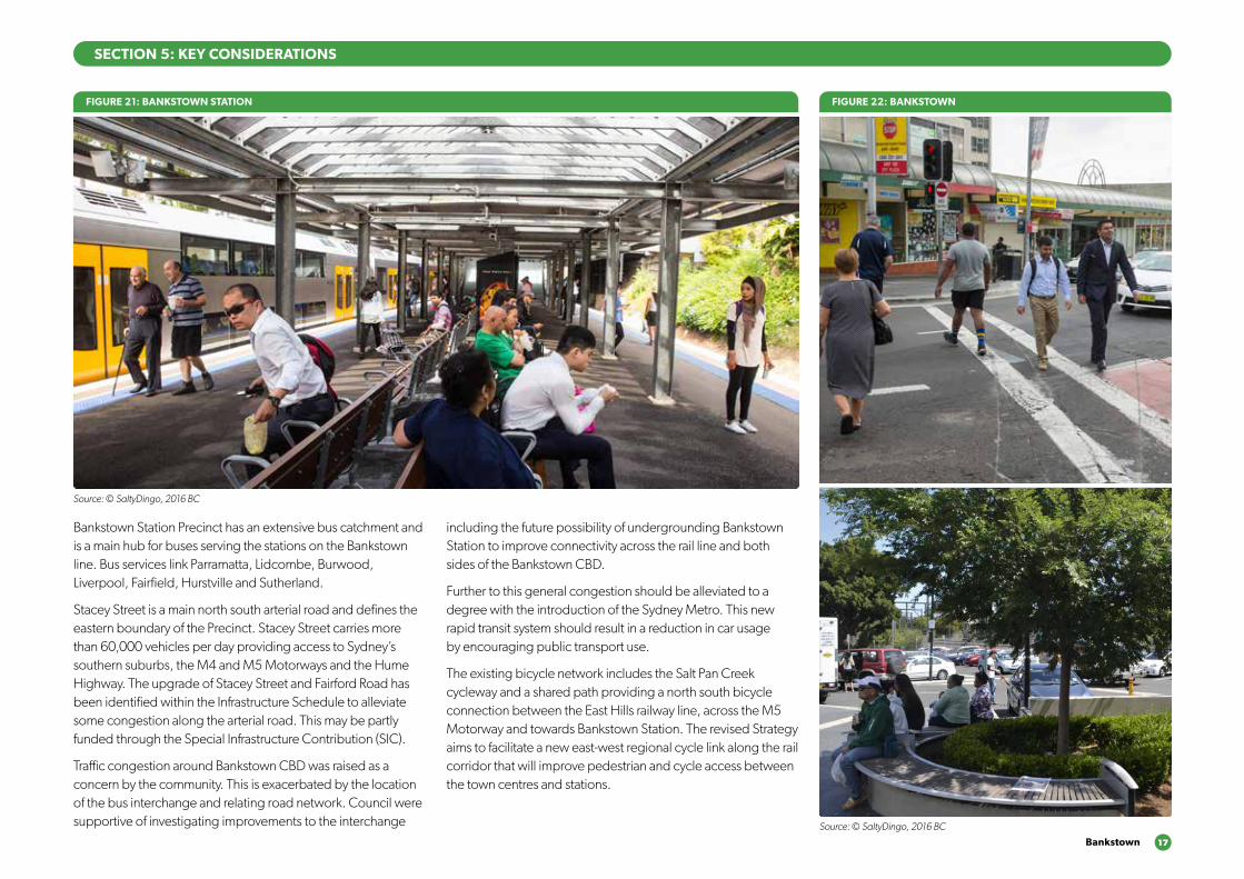
Bankstown Station Precinct has an extensive bus catchment and is a main hub for buses serving the stations on the Bankstown line. Bus services link Parramatta, Lidcombe, Burwood, Liverpool, Fairfield, Hurstville and Sutherland.
Stacey Street is a main north south arterial road and defines the eastern boundary of the Precinct. Stacey Street carries more than 60,000 vehicles per day providing access to Sydney’s southern suburbs, the M4 and M5 Motorways and the Hume Highway. The upgrade of Stacey Street and Fairford Road has been identified within the Infrastructure Schedule to alleviate some congestion along the arterial road. This may be partly funded through the Special Infrastructure Contribution (SIC).
Traffic congestion around Bankstown CBD was raised as a concern by the community. This is exacerbated by the location of the bus interchange and relating road network. Council were supportive of investigating improvements to the interchange
including the future possibility of undergrounding Bankstown Station to improve connectivity across the rail line and both sides of the Bankstown CBD.
Further to this general congestion should be alleviated to a degree with the introduction of the Sydney Metro. This new rapid transit system should result in a reduction in car usage by encouraging public transport use.
The existing bicycle network includes the Salt Pan Creek cycleway and a shared path providing a north south bicycle connection between the East Hills railway line, across the M5 Motorway and towards Bankstown Station. The revised Strategy aims to facilitate a new east-west regional cycle link along the rail corridor that will improve pedestrian and cycle access between the town centres and stations.
FIGURE 22: BANKSTOWN
Source: © SaltyDingo, 2016 BC
SECTION 5: KEY CONSIDERATIONS
18 Sydenham to Bankstown Urban Renewal Corridor Strategy
5.2.4 Open space and recreation
Bankstown CBD is served well by existing open space. It is also in close proximity to Salt Pan Creek but connections to this are currently poor. An action for the Strategy will be to improve walking and cycling connections between Bankstown CBD and Salt Pan Creek and, as part of the GreenWay South West, connecting through the entire corridor to Sydenham Station.
The revised Strategy aims to establish a high quality open space and public domain network that provides better linkages to the Salt Pan Creek corridor to the south of Bankstown CBD. Embellishing existing open spaces, such as Stevens Reserve on Stanley Street and providing new open space along new
SECTION 5: KEY CONSIDERATIONS
FIGURE 23: PUBLIC ART
Source: © SaltyDingo, 2016 BC
FIGURE 24: BANKSTOWN
Source: © SaltyDingo, 2016 BC
roads and pedestrian links when large blocks develop is also promoted. A new connection was proposed through the land between Bankstown Primary and Bankstown Girls High Schools. In addition, opening up the land surrounding the Memorial Oval could provide additional public recreation spaces in this area and enhancing linkages to the Salt Pan Creek Corridor.
There is also an opportunity to utilise railway easements, car parks, verges and vacant lands to create a network of small parks and open spaces along the rail corridor with improved access between the town centres and railway stations.
Bankstown 19
SECTION 5: KEY CONSIDERATIONS
FIGURE 25: WHAT’S CHANGED FROM DRAFT STRATEGY – BANKSTOWN STATION PRECINCT
800m
400m
800m
400m
800m
400m
BRANDON AVENUE
OXF
ORD
AVE
NU
E
GRE
ENW
OO
D A
VEN
UE
CH
APEL
RO
AD
PERC
Y ST
REET
STAC
EY S
TREE
T
STANLEY STREET
RAYMOND STREET
CRO
SS STREET
CARNATION AVENUE
NORTH TERRACE
RICKARD ROAD
LAD
Y CU
TLER AVENU
E
JAC
OBS
STR
EET
GRIFFITHS AVENUE
GARDENIA AVENUE
SALVIA AVENUE
VERBENA AVENUE
PETUNIA AVENUE
LEO
NA
RD S
TREE
T
REST
WEL
L STR
EET
VIM
Y ST
REET
NO
RTHAM
AVE
NUECAMBRIDGE AVENUE
CHELMSFORD AVENUE
EGA
N S
TREE
T
WIN
SPEA
R AV
ENU
E
GRE
ENW
OO
D A
VEN
UE
EGA
N S
TREE
T
WIN
SPEA
R AV
ENU
E
MARION STREET
BRA
NC
OU
RT A
VEN
UE
WEI
GA
ND
AVE
NU
E
REYN
OLD
S AV
ENU
E
CA
IRD
S AV
ENU
E
GORDON STREET
CARMEN STREET
FRENCH AVENUE
THE MALL
CH
APEL
RO
AD
KITC
HEN
ER P
ARA
DE
MER
EDIT
H S
TREE
T
SOUTH TERRACE
STAC
EY S
TREE
T
PRAIRIE VALE ROAD
RESTHAVEN ROAD
MYRTLE ROAD
MILTON STREET
SIR
JOSE
PH B
AN
KS S
TREE
T
CO
NW
AY R
OA
D
CH
APE
L RD
STH
GREENFIELD PARADE
MARION STREET
BANKSTOWN CITY PLAZA
MACAULEY AVENUEMACAULEY AVENUE
WATTLE STREET
ACAC
IA A
VEN
UE
HIG
HC
LERE
AVE
NU
E
BROADW
AY
MATTH
EWS STREET
RICKARD ST
ROSEM
ON
T STREET
CARRISBROOK AVENUE
WARATAH STREET
CAT
HER
INE
STR
EET
ARTHUR STREET
CAMPBELL STREET
KELLY STREET
MYALL STREET
SCOTT STREET
SOUTH TERRACE
WATTLE STREET
WARWICK STREET
HEN
RY S
TREE
T
MO
UN
T LE
WIS
AVE
NU
E
NO
BLE
AVEN
UE
NOCKOLDS AVENUE
GRIFFITHS AVENUE
YARRAN STREETMULGA STREET
TURNER STREET
TURNER STREET
PUNCHBOWL ROAD
PUNCHBOWL ROAD
THE BOULEVARDE
VICTORIA RO
AD
VIOLA STREET
LIND
EN AVEN
UE
LIND
EN AVEN
UE
LANCELOT STREETLANCELOT STREET
ROSSM
ORE AVEN
UE
ROSSM
ORE AVEN
UE
HILLCREST STREET
HILLCREST STREET
DUDLEY STREET ROSEM
OUN
T STREET SOUTH
WATTLE STREET
PUN
CH
BOW
L RO
AD
LAN
CAS
TER
AVEN
UE
URUNGA PARADE
THE BOULEVARDE
LAKEMBA STREET
FAIRMO
UNT STREET
BELLEVUE AVENUE
THE BOULEVARDE
ROBIN
SON
STREET NO
RTH
CORN
ELIA STREET
McCO
URT STREET
HILLARD STREET
KING
GEO
RGES RO
AD
KING
GEO
RGES RO
AD
BEAUCHAM
P STREET
RENO
WN
AVENUE DEN
MAN
AVENUE
FAUX STREET
URUNGA PARADE
TUCKER STREET
HILLCREST STREET
HILLCREST STREET
LAKEMBA STREET
LAKEMBA STREET
GILLIES STREET DENN
IS STREET
QUIG
G STREET
CROYDO
N STREET
SPROULE STREET
ERNEST STREET
HALDO
N STREET
ONEATA STREET
MYEE STREET
QUIG
G STREET
HALDO
N STREET
MO
RETON
STREET
MO
RETON
STREET
THE BOULEVARDE RAILWAY PARADE
HAM
DEN RO
AD
GARRO
NG
ROAD
BENARO
ON
ROAD
PUNCHBOWL R
OAD
PUNCHBOWL R
OAD
DENN
IS STREET
TAYLOR STREET
CHALMERS STREET
COLLIN
S STREET
CROYDO
N STREET
WAN
GEE RO
AD
WAN
GEE RO
AD
YANGOORA ROAD
YANGOORA ROAD
THE BOULEVARDE
RAILWAY PARADE
BRIDGE ROAD
COLLINS STREET LEYLANDS PARADE
YORK STREET
CHALMERS STREET
CANTERBURY ROAD
WILSON AVENUE
BURW
OO
D RO
AD
DRUMM
ON
D STREET
ANDERSO
N STREET
SHARP STREET
SHARP STREET
WAVERLEY STREET
TUDOR STREET
PLIMSOLL STREET
COBDEN STREET
RYDGE STREET
EDISON STREET
EDISON STREET
REGINALD AVENUE
BURWO
OD RO
AD
REDMAN PARADE
ST CLAIR STREET
SUDBURY STREET
CECILIA STREET
PASSEY AVENUE
HALL STREET
CLEARY AVENUE
BELMO
RE AVENUEPEEL STREET
CHAPEL STREET
CHAPEL STREET
BENARO
ON
ROAD
DRUMM
ON
D STREET
ANDERSO
N STREET
PEEL STREET
YANGOORA ROAD
YANGOORA ROAD
OXFO
RD STREET
OXFO
RD STREET
BRAND STREET
BRAND STREET
LAKEMBA STREET KENNEDY AVENUE
ALLAN AVENUE
MINNIE STREET
HUGH STREET
KNOX STREET
LUCERNE STREET
BURWO
OD RO
AD
BURWO
OD RO
AD
BURWO
OD RO
AD
PAXTON AVENUE
ETELA STREET
ISABEL STREET
BENARO
ON
ROAD
GLADSTONE STREET
MYALL STREET
ACACIA STREET
CLISSOLD PARADE
BELLOMBI STREET
FREDERICK STREET
NORTH PARADE SOUTH PARADE
EVALINE STREET
CLAREMONT STREET
AMY STREET
ANZAC MALL
HILL STREET
CLAREMONT STREET
HILL STREET
CANTERBURY ROAD
EIGHTH AVENUE
SEVENTH AVENUE
SEVENTH AVENUE
BROW
NIN
G STREET
SHAKESPEARE STREET
NINTH AVENUE
CAMPSIE STREET
WILFRED AVENUE
WILFRED AVENUE
ANZAC SQUARE
CARRINGTON SQ
MA
RLOW
E STREET
STAN
LEY STREET
ORISSA STREET
ORISSA STREET
THO
RNCRAFT PARADE
THO
RNCRAFT PARADE
THO
RNCRAFT PARADE
MCKERN STREET
BEAUMONT STREET
LOCH
STREET
LOCH
STREET
LOCH
STREET
LOCH
STREET
LOFTUS STREET
LOFTUS STREET
BEAM
ISH STREET
BEAM
ISH
HARO
LD STREET
DUKE STREET
PARK STREET
GO
ULD STREET
UNARA STREET
PERRY STREET
REDMAN STREET
SOUTH PARADE
STAN
LEY STREET
PARK STREET
UNARA STREET
REDMAN STREET
BRIGHTON AVENUE
DRYD
EN STREET
BURNS STREET
SHELLEY STREET
BYRON STREETBYRON STREET
MO
ORE STREET
COW
PER STREET
SIXTH AVEN
UE
FIFTH AVEN
UE
FOU
RTH AVEN
UE
THIRD
AVENU
E
SECO
ND
AVENU
E
SECO
ND
AVENU
E
FIRST AVENU
E
FIRST AVENU
E
BRUCE AVENUE
ALBERT STREET
OMAHA STREET
BALTIMO
RE STREET
LINCO
LN STREET
STREET
HIGH STREET
CANTERBURY ROAD
CANTERB
URY RO
AD
JEFF
REY
STRE
ET
CH
URC
H S
TREE
T
FLOSS STREET
MELF
ORD
STREET
HUTTON STREET
FORE STREET
BERNA STREET
CANTON STREET
HOWARD STREET
HIGH STREET
IVY STREET
EMU STREET
WARATAH STREET
WO
NG
A STREET
EMU STREET
WO
NG
A STREET
PHILLIPS AVEN
UE
WAIRO
A STRE
ET
NAPIER STREETNAPIER STREET
CHARLES STREET
BROUGHTO
N STREET
ROBERT STREET
JOHN STREET
JOHN STREET
MIN
TER
STRE
ET
MIN
TER
STRE
ET
TINCOMBE STREET
CLOSE STREETCLOSE STREET
BROUGHTO
N STREET
KING STREET
KING STREET
FREDERICK ST
PRINCESS STREET
CANTERBURY ROAD
FORE STREET
CANTERBURY ROAD
CH
URC
H S
TREE
T
TINCOMBE STREET
CRINAN STREET
MELF
ORD
STREET
MELF
ORD
STREET
DU
NST
AFF
ENAG
E ST
REET
FERN
HILL
STR
EET
DU
NTR
OO
N S
TREE
T
DU
NTR
OO
N S
TREE
T
HAMPDEN STREET
BARTON AVE
MARCIA STREET
WALLACE AVENUE
BARRE STREET
WOODSIDE AVE
THE AVENUE
FLOSS STREET
DU
NST
AFF
ENAG
E ST
REET
DU
NTR
OO
N S
TREE
T
BARTON AVE
MARCIA STREET
WALLACE AVENUE
BARRE STREET
WOODSIDE AVE
THE AVENUE
NEW CANTERBURY ROAD NEW CANTERBURY ROAD
GA
RNET STREET
FLOSS STREET
KEIR
AVE
NU
E
TENNENT PARADE
STA
RKEY
STR
EET
EUSTON ROAD
GOWER STREET
COMMONS STREETCOMMONS STREET
HO
PETO
UN
STR
EET
RAILW
AY S
T
CANTERTON STREET
ACTON STREET
KILBRIDE STREET
HURLSTONE AVENUE
FLOSS STREETFLOSS STREET
FOO
RD A
VEN
UE
FOO
RD A
VEN
UE
KEIR AVENUEKEIR AVENUE
HURLSTONE AVENUE
TENNYSON STREET
RIVERSID
E CRESCENT
WARDELL ROAD
DIBBLE AVENUE
RIVERSIDE CRESCENT
EWART STREET
BRUCE STREET
BRUCE STREET
BAYLEY STREET
WICKS AVENUE
DUDLEY STREET
DUDLEY STREET
SCHOOL PARADE
WARDELL
ROAD
CANONBURY
GROVE
KEITH STREET
MACARTHUR PA
RADE
LIVIN
GSTONE ROAD
LIVIN
GSTONE ROAD
HOLLANDS AVENUE
ROBERT STREET
DAVID ST
REET
MARRICKVILLE ROAD
THE PARADETHE PARADE
MYRA
ROA
D
TERR
ACE
ROA
D
HER
CU
LES
STRE
ETH
ERC
ULE
S ST
REET
NEW CANTERBURY ROAD
KINTO
RE STREET
HERCULES STREET
HERCULES STREET
BEACH ROAD
BEACH ROAD
DURHAM STREET
DURHAM STREET MARRICKVILLE ROAD
PINE STREET
LOFTUS STREET M
ARRICKVILLE ROAD
LOFTUS STREET
JERSEY STREET
JERSEY STREET
SCHWEBEL STREETHARRIET STREET
RUBY STREET
GROVE STREET
WARREN ROADRENWICK STREET
LEOFRENE AVENUE
CHARLOTT
E AVEN
UE
IVANHO
E STR
EET
ILLAW
ARRA ROAD
RICHARDSONS CRESCENT
HILL STREET
GLE
N ST
REET
LIVIN
GST
ON
E RO
AD
LIVIN
GST
ON
E RO
AD
VIEW
STRE
ET
PREMIER STREET
CARY STREET
EXCEL
SIO
R PARA
DE
THORNLEY STREET
CARRIN
GTON
ROAD
CARRIN
GTON
ROAD
ARTHUR STREET
ARTHUR STREET
FRANCIS STREET
ANN STREET
ILLAW
ARRA ROAD
MONCUR STREET
MONCUR STREET
CHURCH STREET
CHURCH STREET
GREENBANK STREET
GREENBANK STREET
MYRTLE STREET
MYRTLE STREET
PETE
RSH
AM
RO
AD
PETE
RSH
AM
RO
AD
FLETC
HER STR
EET
LIVIN
GST
ONE R
OAD
LIVIN
GST
ONE R
OAD
MARRICKVILLE ROAD
MARRICKVILLE ROAD
SILVER
STRE
ET
SILVER
STRE
ETG
LADST
ONE S
TREE
T
CENTRAL AVENUE CALVERT STREET
GARNERS
AVENUE
DESPOIN
TES STR
EET
MALA
KOFF
STREET
SYDENHAM ROAD
SYDENHAM ROAD
NORTH
COTE ST
STANLEY STREET
YABSLEY AVEYABSLEY AVE
LILYD
ALE
STR
EET
O’H
ARA ST
REET
JUNCTIO
N STRE
ETHIGH ST
REET
HAMPD
EN A
VENUE
RIVER
DALE A
VE
MARRICKVILLE ROAD
MEE
KS RO
AD
MEE
KS RO
AD
GER
ALD ST
REET
GER
ALD ST
REET
RAILWAY ROAD
PRINCES HIG
HWAY
UNWINS BRIDGE ROAD
RAILWAY PARADE
BUCKLEY STR
EET
GLEESO
N AVE
BARCLA
Y STREET
SYDNEY STR
EET
SYDNEY STR
EET
VIN
CENT S
TREE
T
VICTO
RIA RO
AD
SYDENHAM ROAD
FAVERSHAM
STREET
SAYWELL STREET
LILIAN FOWLER PLACE
CADOGAN STREET
CADOGAN STREETSLO
ANE STREET
SLOANE STREET
SHIRLOW STREET
SHIRLOW STREETGARDEN STREET
GEORGE STREETFREDERICK STREET
HENRY STREET
HENRY STREET
PARK ROAD
SAMUEL STREET
ROBERT STREET
SILVER STREET
EDINBURGH ROAD
EDINBURGH ROAD
FOREMAN STREET
FOREMAN STREET
FITZROY STREET
HO
PETO
UN
STR
EET
FITZROY STREET
SydenhamSydenham
MarrickvilleMarrickville
Dulwich HillDulwich HillHurlstone ParkHurlstone Park
CanterburyCanterbury
BelmoreBelmore
LakembaLakemba
Wiley ParkWiley Park
BankstownBankstown
Dulwich GroveDulwich Grove
ArlingtonArlington
CampsieCampsie
PunchbowlPunchbowl
ShoppingCentre
School
School
School
Fraser Park
Wicks Park
Tillman Park
School
School
School
School
School
School
Church
School
Fire station & Townhall
School
School
School
Mackey Park
Gough Whitlam Park
McNeilly Park
Marrickville Golf Club
Marrickville Golf Club
Canterbury Park
Tasker Park
School
School
School
Canterbury Park RacecourseCanterbury Park RacecourseCanterbury Park RacecourseCanterbury Park Racecourse
Ewen Park
Beaman Park
Church
Civic
School
School
School
BankstownMemorial Park
School
School
School
School
School
School
Punchbowl Park
School
School
Library
School
School
School
School
School
Wiley Park
School
School
School
Police
School
Canterbury Hospital
School
Church
Belmore Sportsground
Railway line and station
New railway station entry
Precinct boundary
400m and 800m walking catchment
Main roads
Main street shop top housing
Private recreation
Public recreation
Schools and community facilities
Single dwelling areas
Low rise housing
Medium-rise housing
Medium / high rise housing
High rise and/or mixed use
Transition edges
Potential over station development
New or enhanced public open space
Existing / recommended cycle route
New streets or pedestrian connections
Reduce to reflect land use and density under existing planning controls.
Reduce to medium and low rise housing to provide appropriate transition to single dwelling areas to the west.
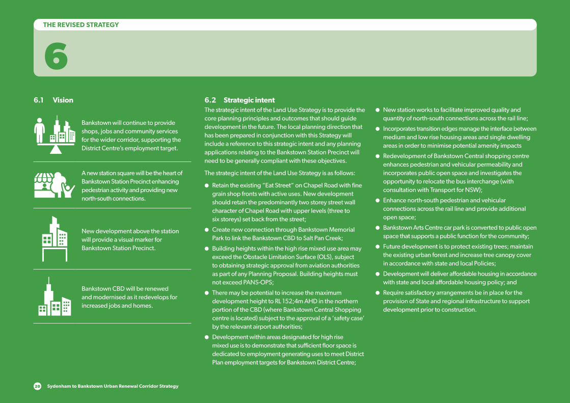
Sydenham to Bankstown Urban Renewal Corridor Strategy20
THE REVISED STRATEGY
66.1 Vision
Bankstown will continue to provide shops, jobs and community services for the wider corridor, supporting the District Centre’s employment target.
A new station square will be the heart of Bankstown Station Precinct enhancing pedestrian activity and providing new north-south connections.
New development above the station will provide a visual marker for Bankstown Station Precinct.
Bankstown CBD will be renewed and modernised as it redevelops for increased jobs and homes.
6.2 Strategic intentThe strategic intent of the Land Use Strategy is to provide the core planning principles and outcomes that should guide development in the future. The local planning direction that has been prepared in conjunction with this Strategy will include a reference to this strategic intent and any planning applications relating to the Bankstown Station Precinct will need to be generally compliant with these objectives.
The strategic intent of the Land Use Strategy is as follows:
●● Retain the existing “Eat Street” on Chapel Road with fine grain shop fronts with active uses. New development should retain the predominantly two storey street wall character of Chapel Road with upper levels (three to six storeys) set back from the street;
●● Create new connection through Bankstown Memorial Park to link the Bankstown CBD to Salt Pan Creek;
●● Building heights within the high rise mixed use area may exceed the Obstacle Limitation Surface (OLS), subject to obtaining strategic approval from aviation authorities as part of any Planning Proposal. Building heights must not exceed PANS-OPS;
●● There may be potential to increase the maximum development height to RL 152;4m AHD in the northern portion of the CBD (where Bankstown Central Shopping centre is located) subject to the approval of a ‘safety case’ by the relevant airport authorities;
●● Development within areas designated for high rise mixed use is to demonstrate that sufficient floor space is dedicated to employment generating uses to meet District Plan employment targets for Bankstown District Centre;
●● New station works to facilitate improved quality and quantity of north-south connections across the rail line;
●● Incorporates transition edges manage the interface between medium and low rise housing areas and single dwelling areas in order to minimise potential amenity impacts
●● Redevelopment of Bankstown Central shopping centre enhances pedestrian and vehicular permeability and incorporates public open space and investigates the opportunity to relocate the bus interchange (with consultation with Transport for NSW);
●● Enhance north-south pedestrian and vehicular connections across the rail line and provide additional open space;
●● Bankstown Arts Centre car park is converted to public open space that supports a public function for the community;
●● Future development is to protect existing trees; maintain the existing urban forest and increase tree canopy cover in accordance with state and local Policies;
●● Development will deliver affordable housing in accordance with state and local affordable housing policy; and
●● Require satisfactory arrangements be in place for the provision of State and regional infrastructure to support development prior to construction.
6.3 Built form typology in the Bankstown Precinct
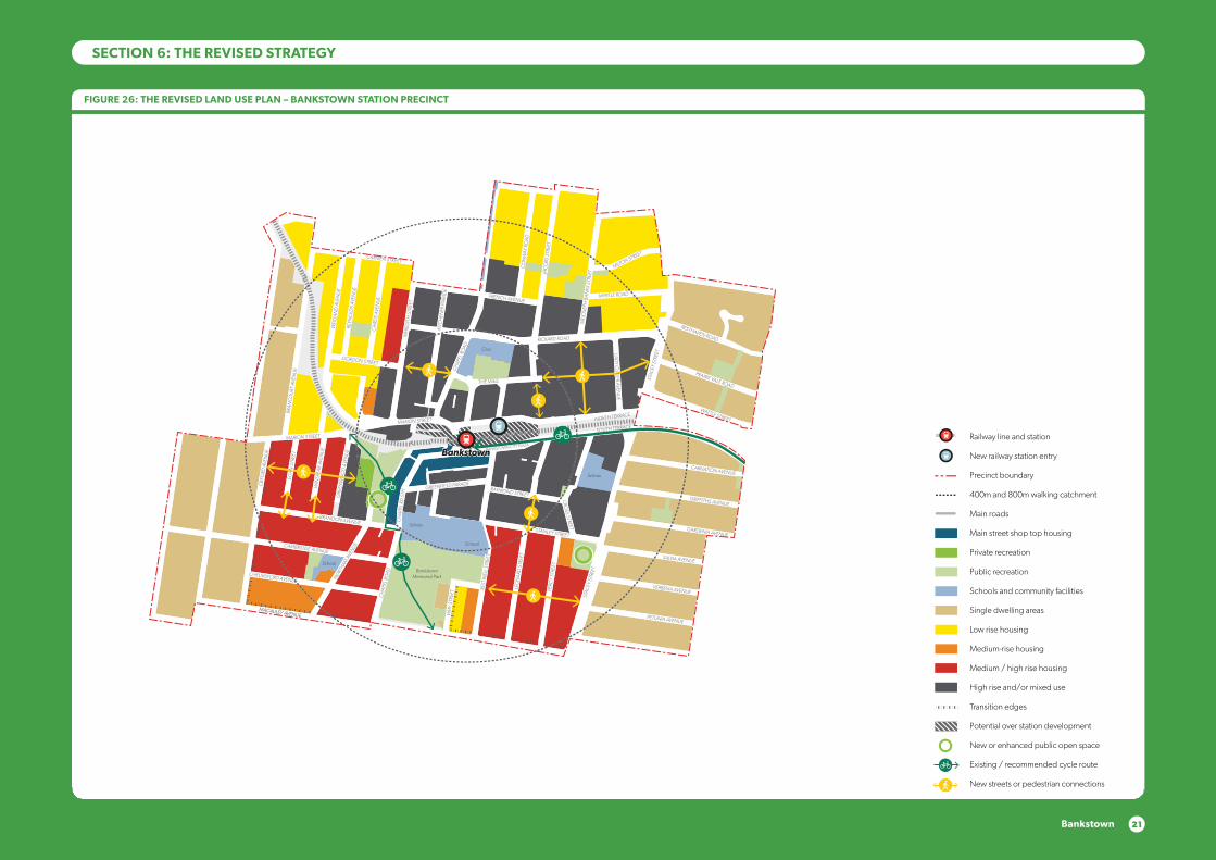
21Bankstown
FIGURE 26: THE REVISED LAND USE PLAN – BANKSTOWN STATION PRECINCT
SECTION 6: THE REVISED STRATEGY 800m
400m
800m
400m
800m
400m
BRANDON AVENUE
OXF
ORD
AVE
NU
E
GRE
ENW
OO
D A
VEN
UE
CH
APEL
RO
AD
PERC
Y ST
REET
STAC
EY S
TREE
T
STANLEY STREET
RAYMOND STREET
CRO
SS STREET
CARNATION AVENUE
NORTH TERRACE
RICKARD ROAD
LAD
Y CU
TLER AVENU
E
JAC
OBS
STR
EET
GRIFFITHS AVENUE
GARDENIA AVENUE
SALVIA AVENUE
VERBENA AVENUE
PETUNIA AVENUE
LEO
NA
RD S
TREE
T
REST
WEL
L STR
EET
VIM
Y ST
REET
NO
RTHAM
AVE
NUECAMBRIDGE AVENUE
CHELMSFORD AVENUE
EGA
N S
TREE
T
WIN
SPEA
R AV
ENU
E
GRE
ENW
OO
D A
VEN
UE
EGA
N S
TREE
T
WIN
SPEA
R AV
ENU
E
MARION STREET
BRA
NC
OU
RT A
VEN
UE
WEI
GA
ND
AVE
NU
E
REYN
OLD
S AV
ENU
E
CA
IRD
S AV
ENU
E
GORDON STREET
CARMEN STREET
FRENCH AVENUE
THE MALL
CH
APEL
RO
AD
KITC
HEN
ER P
ARA
DE
MER
EDIT
H S
TREE
T
SOUTH TERRACE
STAC
EY S
TREE
T
PRAIRIE VALE ROAD
RESTHAVEN ROAD
MYRTLE ROAD
MILTON STREET
SIR
JOSE
PH B
AN
KS S
TREE
T
CO
NW
AY R
OA
D
CH
APE
L RD
STH
GREENFIELD PARADE
MARION STREET
BANKSTOWN CITY PLAZA
MACAULEY AVENUEMACAULEY AVENUE
WATTLE STREET
ACAC
IA A
VEN
UE
HIG
HC
LERE
AVE
NU
E
BROADW
AY
MATTH
EWS STREET
RICKARD ST
ROSEM
ON
T STREET
CARRISBROOK AVENUE
WARATAH STREET
CAT
HER
INE
STR
EET
ARTHUR STREET
CAMPBELL STREET
KELLY STREET
MYALL STREET
SCOTT STREET
SOUTH TERRACE
WATTLE STREET
WARWICK STREET
HEN
RY S
TREE
T
MO
UN
T LE
WIS
AVE
NU
E
NO
BLE
AVEN
UE
NOCKOLDS AVENUE
GRIFFITHS AVENUE
YARRAN STREETMULGA STREET
TURNER STREET
TURNER STREET
PUNCHBOWL ROAD
PUNCHBOWL ROAD
THE BOULEVARDE
VICTORIA RO
AD
VIOLA STREET
LIND
EN AVEN
UE
LIND
EN AVEN
UE
LANCELOT STREETLANCELOT STREET
ROSSM
ORE AVEN
UE
ROSSM
ORE AVEN
UE
HILLCREST STREET
HILLCREST STREET
DUDLEY STREET ROSEM
OUN
T STREET SOUTH
WATTLE STREET
PUN
CH
BOW
L RO
AD
LAN
CAS
TER
AVEN
UE
URUNGA PARADE
THE BOULEVARDE
LAKEMBA STREET
FAIRMO
UNT STREET
BELLEVUE AVENUE
THE BOULEVARDE
ROBIN
SON
STREET NO
RTH
CORN
ELIA STREET
McCO
URT STREET
HILLARD STREET
KING
GEO
RGES RO
AD
KING
GEO
RGES RO
AD
BEAUCHAM
P STREET
RENO
WN
AVENUE DEN
MAN
AVENUE
FAUX STREET
URUNGA PARADE
TUCKER STREET
HILLCREST STREET
HILLCREST STREET
LAKEMBA STREET
LAKEMBA STREET
GILLIES STREET DENN
IS STREET
QUIG
G STREET
CROYDO
N STREET
SPROULE STREET
ERNEST STREET
HALDO
N STREET
ONEATA STREET
MYEE STREET
QUIG
G STREET
HALDO
N STREET
MO
RETON
STREET
MO
RETON
STREET
THE BOULEVARDE RAILWAY PARADE
HAM
DEN RO
AD
GARRO
NG
ROAD
BENARO
ON
ROAD
PUNCHBOWL R
OAD
PUNCHBOWL R
OAD
DENN
IS STREET
TAYLOR STREET
CHALMERS STREET
COLLIN
S STREET
CROYDO
N STREET
WAN
GEE RO
AD
WAN
GEE RO
AD
YANGOORA ROAD
YANGOORA ROAD
THE BOULEVARDE
RAILWAY PARADE
BRIDGE ROAD
COLLINS STREET LEYLANDS PARADE
YORK STREET
CHALMERS STREET
CANTERBURY ROAD
WILSON AVENUE
BURW
OO
D RO
AD
DRUMM
ON
D STREET
ANDERSO
N STREET
SHARP STREET
SHARP STREET
WAVERLEY STREET
TUDOR STREET
PLIMSOLL STREET
COBDEN STREET
RYDGE STREET
EDISON STREET
EDISON STREET
REGINALD AVENUE
BURWO
OD RO
AD
REDMAN PARADE
ST CLAIR STREET
SUDBURY STREET
CECILIA STREET
PASSEY AVENUE
HALL STREET
CLEARY AVENUE
BELMO
RE AVENUEPEEL STREET
CHAPEL STREET
CHAPEL STREET
BENARO
ON
ROAD
DRUMM
ON
D STREET
ANDERSO
N STREET
PEEL STREET
YANGOORA ROAD
YANGOORA ROAD
OXFO
RD STREET
OXFO
RD STREET
BRAND STREET
BRAND STREET
LAKEMBA STREET KENNEDY AVENUE
ALLAN AVENUE
MINNIE STREET
HUGH STREET
KNOX STREET
LUCERNE STREET
BURWO
OD RO
AD
BURWO
OD RO
AD
BURWO
OD RO
AD
PAXTON AVENUE
ETELA STREET
ISABEL STREET
BENARO
ON
ROAD
GLADSTONE STREET
MYALL STREET
ACACIA STREET
CLISSOLD PARADE
BELLOMBI STREET
FREDERICK STREET
NORTH PARADE SOUTH PARADE
EVALINE STREET
CLAREMONT STREET
AMY STREET
ANZAC MALL
HILL STREET
CLAREMONT STREET
HILL STREET
CANTERBURY ROAD
EIGHTH AVENUE
SEVENTH AVENUE
SEVENTH AVENUE
BROW
NIN
G STREET
SHAKESPEARE STREET
NINTH AVENUE
CAMPSIE STREET
WILFRED AVENUE
WILFRED AVENUE
ANZAC SQUARE
CARRINGTON SQ
MA
RLOW
E STREET
STAN
LEY STREET
ORISSA STREET
ORISSA STREET
THO
RNCRAFT PARADE
THO
RNCRAFT PARADE
THO
RNCRAFT PARADE
MCKERN STREET
BEAUMONT STREET
LOCH
STREET
LOCH
STREET
LOCH
STREET
LOCH
STREET
LOFTUS STREET
LOFTUS STREET
BEAM
ISH STREET
BEAM
ISH
HARO
LD STREET
DUKE STREET
PARK STREET
GO
ULD STREET
UNARA STREET
PERRY STREET
REDMAN STREET
SOUTH PARADE
STAN
LEY STREET
PARK STREET
UNARA STREET
REDMAN STREET
BRIGHTON AVENUE
DRYD
EN STREET
BURNS STREET
SHELLEY STREET
BYRON STREETBYRON STREET
MO
ORE STREET
COW
PER STREET
SIXTH AVEN
UE
FIFTH AVEN
UE
FOU
RTH AVEN
UE
THIRD
AVENU
E
SECO
ND
AVENU
E
SECO
ND
AVENU
E
FIRST AVENU
E
FIRST AVENU
E
BRUCE AVENUE
ALBERT STREET
OMAHA STREET
BALTIMO
RE STREET
LINCO
LN STREET
STREET
HIGH STREET
CANTERBURY ROAD
CANTERB
URY RO
AD
JEFF
REY
STRE
ET
CH
URC
H S
TREE
T
FLOSS STREET
MELF
ORD
STREET
HUTTON STREET
FORE STREET
BERNA STREET
CANTON STREET
HOWARD STREET
HIGH STREET
IVY STREET
EMU STREET
WARATAH STREET
WO
NG
A STREET
EMU STREET
WO
NG
A STREET
PHILLIPS AVEN
UE
WAIRO
A STRE
ET
NAPIER STREETNAPIER STREET
CHARLES STREET
BROUGHTO
N STREET
ROBERT STREET
JOHN STREET
JOHN STREET
MIN
TER
STRE
ET
MIN
TER
STRE
ET
TINCOMBE STREET
CLOSE STREETCLOSE STREET
BROUGHTO
N STREET
KING STREET
KING STREET
FREDERICK ST
PRINCESS STREET
CANTERBURY ROAD
FORE STREET
CANTERBURY ROAD
CH
URC
H S
TREE
T
TINCOMBE STREET
CRINAN STREET
MELF
ORD
STREET
MELF
ORD
STREET
DU
NST
AFF
ENAG
E ST
REET
FERN
HILL
STR
EET
DU
NTR
OO
N S
TREE
T
DU
NTR
OO
N S
TREE
T
HAMPDEN STREET
BARTON AVE
MARCIA STREET
WALLACE AVENUE
BARRE STREET
WOODSIDE AVE
THE AVENUE
FLOSS STREET
DU
NST
AFF
ENAG
E ST
REET
DU
NTR
OO
N S
TREE
T
BARTON AVE
MARCIA STREET
WALLACE AVENUE
BARRE STREET
WOODSIDE AVE
THE AVENUE
NEW CANTERBURY ROAD NEW CANTERBURY ROAD
GA
RNET STREET
FLOSS STREET
KEIR
AVE
NU
E
TENNENT PARADE
STA
RKEY
STR
EET
EUSTON ROAD
GOWER STREET
COMMONS STREETCOMMONS STREET
HO
PETO
UN
STR
EET
RAILW
AY S
T
CANTERTON STREET
ACTON STREET
KILBRIDE STREET
HURLSTONE AVENUE
FLOSS STREETFLOSS STREET
FOO
RD A
VEN
UE
FOO
RD A
VEN
UE
KEIR AVENUEKEIR AVENUE
HURLSTONE AVENUE
TENNYSON STREET
RIVERSID
E CRESCENT
WARDELL ROAD
DIBBLE AVENUE
RIVERSIDE CRESCENT
EWART STREET
BRUCE STREET
BRUCE STREET
BAYLEY STREET
WICKS AVENUE
DUDLEY STREET
DUDLEY STREET
SCHOOL PARADE
WARDELL
ROAD
CANONBURY
GROVE
KEITH STREET
MACARTHUR PA
RADE
LIVIN
GSTONE ROAD
LIVIN
GSTONE ROAD
HOLLANDS AVENUE
ROBERT STREET
DAVID ST
REET
MARRICKVILLE ROAD
THE PARADETHE PARADE
MYRA
ROA
D
TERR
ACE
ROA
D
HER
CU
LES
STRE
ETH
ERC
ULE
S ST
REET
NEW CANTERBURY ROAD
KINTO
RE STREET
HERCULES STREET
HERCULES STREET
BEACH ROAD
BEACH ROAD
DURHAM STREET
DURHAM STREET MARRICKVILLE ROAD
PINE STREET
LOFTUS STREET M
ARRICKVILLE ROAD
LOFTUS STREET
JERSEY STREET
JERSEY STREET
SCHWEBEL STREETHARRIET STREET
RUBY STREET
GROVE STREET
WARREN ROADRENWICK STREET
LEOFRENE AVENUE
CHARLOTT
E AVEN
UE
IVANHO
E STR
EET
ILLAW
ARRA ROAD
RICHARDSONS CRESCENT
HILL STREET
GLE
N ST
REET
LIVIN
GST
ON
E RO
AD
LIVIN
GST
ON
E RO
AD
VIEW
STRE
ET
PREMIER STREET
CARY STREET
EXCEL
SIO
R PARA
DE
THORNLEY STREET
CARRIN
GTON
ROAD
CARRIN
GTON
ROAD
ARTHUR STREET
ARTHUR STREET
FRANCIS STREET
ANN STREET
ILLAW
ARRA ROAD
MONCUR STREET
MONCUR STREET
CHURCH STREET
CHURCH STREET
GREENBANK STREET
GREENBANK STREET
MYRTLE STREET
MYRTLE STREET
PETE
RSH
AM
RO
AD
PETE
RSH
AM
RO
AD
FLETC
HER STR
EET
LIVIN
GST
ONE R
OAD
LIVIN
GST
ONE R
OAD
MARRICKVILLE ROAD
MARRICKVILLE ROAD
SILVER
STRE
ET
SILVER
STRE
ETG
LADST
ONE S
TREE
T
CENTRAL AVENUE CALVERT STREET
GARNERS
AVENUE
DESPOIN
TES STR
EET
MALA
KOFF
STREET
SYDENHAM ROAD
SYDENHAM ROAD
NORTH
COTE ST
STANLEY STREET
YABSLEY AVEYABSLEY AVE
LILYD
ALE
STR
EET
O’H
ARA ST
REET
JUNCTIO
N STRE
ETHIGH ST
REET
HAMPD
EN A
VENUE
RIVER
DALE A
VE
MARRICKVILLE ROAD
MEE
KS RO
AD
MEE
KS RO
AD
GER
ALD ST
REET
GER
ALD ST
REET
RAILWAY ROAD
PRINCES HIG
HWAY
UNWINS BRIDGE ROAD
RAILWAY PARADE
BUCKLEY STR
EET
GLEESO
N AVE
BARCLA
Y STREET
SYDNEY STR
EET
SYDNEY STR
EET
VIN
CENT S
TREE
T
VICTO
RIA RO
AD
SYDENHAM ROAD
FAVERSHAM
STREET
SAYWELL STREET
LILIAN FOWLER PLACE
CADOGAN STREET
CADOGAN STREETSLO
ANE STREET
SLOANE STREET
SHIRLOW STREET
SHIRLOW STREETGARDEN STREET
GEORGE STREETFREDERICK STREET
HENRY STREET
HENRY STREET
PARK ROAD
SAMUEL STREET
ROBERT STREET
SILVER STREET
EDINBURGH ROAD
EDINBURGH ROAD
FOREMAN STREET
FOREMAN STREET
FITZROY STREET
HO
PETO
UN
STR
EET
FITZROY STREET
SydenhamSydenham
MarrickvilleMarrickville
Dulwich HillDulwich HillHurlstone ParkHurlstone Park
CanterburyCanterbury
BelmoreBelmore
LakembaLakemba
Wiley ParkWiley Park
BankstownBankstown
Dulwich GroveDulwich Grove
ArlingtonArlington
CampsieCampsie
PunchbowlPunchbowl
ShoppingCentre
School
School
School
Fraser Park
Wicks Park
Tillman Park
School
School
School
School
School
School
Church
School
Fire station & Townhall
School
School
School
Mackey Park
Gough Whitlam Park
McNeilly Park
Marrickville Golf Club
Marrickville Golf Club
Canterbury Park
Tasker Park
School
School
School
Canterbury Park RacecourseCanterbury Park RacecourseCanterbury Park RacecourseCanterbury Park Racecourse
Ewen Park
Beaman Park
Church
Civic
School
School
School
BankstownMemorial Park
School
School
School
School
School
School
Punchbowl Park
School
School
Library
School
School
School
School
School
Wiley Park
School
School
School
Police
School
Canterbury Hospital
School
Church
Belmore Sportsground
Railway line and station
New railway station entry
Precinct boundary
400m and 800m walking catchment
Main roads
Main street shop top housing
Private recreation
Public recreation
Schools and community facilities
Single dwelling areas
Low rise housing
Medium-rise housing
Medium / high rise housing
High rise and/or mixed use
Transition edges
Potential over station development
New or enhanced public open space
Existing / recommended cycle route
New streets or pedestrian connections
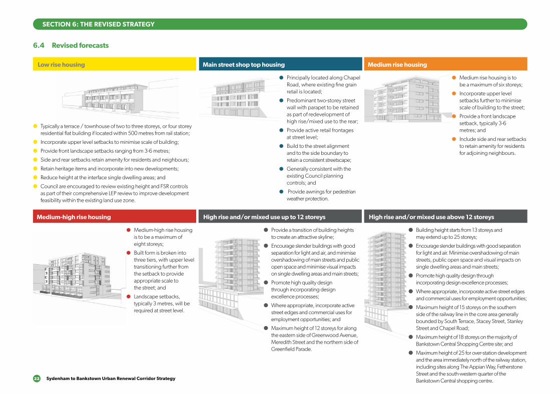
22 Sydenham to Bankstown Urban Renewal Corridor Strategy
6.4 Revised forecasts
SECTION 6: THE REVISED STRATEGY
Main street shop top housing
●● Principally located along Chapel Road, where existing fine grain retail is located;
●● Predominant two-storey street wall with parapet to be retained as part of redevelopment of high rise/mixed use to the rear;
●● Provide active retail frontages at street level;
●● Build to the street alignment and to the side boundary to retain a consistent streetscape;
●● Generally consistent with the existing Council planning controls; and
●● Provide awnings for pedestrian weather protection.
Medium rise housing
●● Medium rise housing is to be a maximum of six storeys;
●● Incorporate upper level setbacks further to minimise scale of building to the street;
●● Provide a front landscape setback, typically 3-6 metres; and
●● Include side and rear setbacks to retain amenity for residents for adjoining neighbours.
Medium-high rise housing
●● Medium-high rise housing is to be a maximum of eight storeys;
●● Built form is broken into three tiers, with upper level transitioning further from the setback to provide appropriate scale to the street; and
●● Landscape setbacks, typically 3 metres, will be required at street level.
High rise and/or mixed use up to 12 storeys High rise and/or mixed use above 12 storeys
● Provide a transition of building heights to create an attractive skyline;
● Encourage slender buildings with good separation for light and air, and minimise overshadowing of main streets and public open space and minimise visual impacts on single dwelling areas and main streets;
● Promote high quality design through incorporating design excellence processes;
● Where appropriate, incorporate active street edges and commercial uses for employment opportunities; and
● Maximum height of 12 storeys for along the eastern side of Greenwood Avenue, Meredith Street and the northern side of Greenfield Parade.
● Building height starts from 13 storeys and may extend up to 25 storeys;
● Encourage slender buildings with good separation for light and air. Minimise overshadowing of main streets, public open space and visual impacts on single dwelling areas and main streets;
● Promote high quality design through incorporating design excellence processes;
● Where appropriate, incorporate active street edges and commercial uses for employment opportunities;
● Maximum height of 15 storeys on the southern side of the railway line in the core area generally bounded by South Terrace, Stacey Street, Stanley Street and Chapel Road;
● Maximum height of 18 storeys on the majority of Bankstown Central Shopping Centre site; and
● Maximum height of 25 for over-station development and the area immediately north of the railway station, including sites along The Appian Way, Fetherstone Street and the south-western quarter of the Bankstown Central shopping centre.
Low rise housing
● Typically a terrace / townhouse of two to three storeys, or four storey residential flat building if located within 500 metres from rail station;
● Incorporate upper level setbacks to minimise scale of building;
● Provide front landscape setbacks ranging from 3-6 metres;
● Side and rear setbacks retain amenity for residents and neighbours;
● Retain heritage items and incorporate into new developments;
● Reduce height at the interface single dwelling areas; and
● Council are encouraged to review existing height and FSR controls as part of their comprehensive LEP review to improve development feasibility within the existing land use zone.
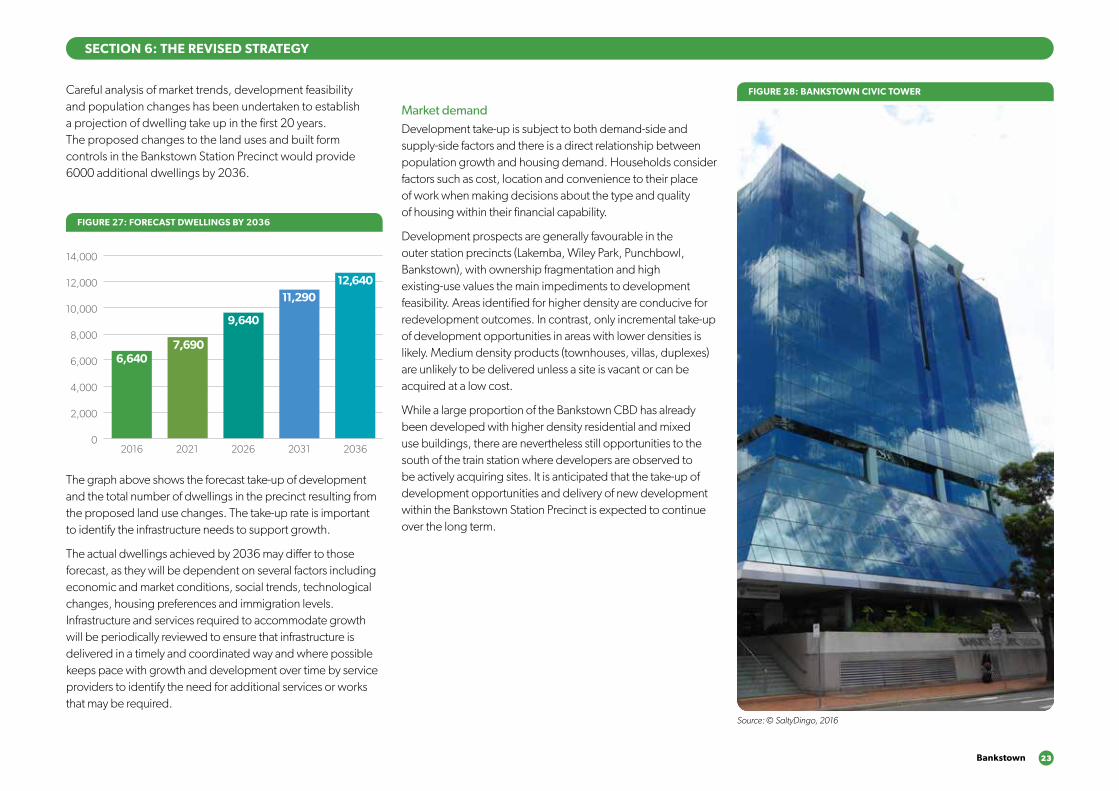
Bankstown 23
SECTION 6: THE REVISED STRATEGY
Careful analysis of market trends, development feasibility and population changes has been undertaken to establish a projection of dwelling take up in the first 20 years. The proposed changes to the land uses and built form controls in the Bankstown Station Precinct would provide 6000 additional dwellings by 2036.
The graph above shows the forecast take-up of development and the total number of dwellings in the precinct resulting from the proposed land use changes. The take-up rate is important to identify the infrastructure needs to support growth.
The actual dwellings achieved by 2036 may differ to those forecast, as they will be dependent on several factors including economic and market conditions, social trends, technological changes, housing preferences and immigration levels. Infrastructure and services required to accommodate growth will be periodically reviewed to ensure that infrastructure is delivered in a timely and coordinated way and where possible keeps pace with growth and development over time by service providers to identify the need for additional services or works that may be required.
Market demandDevelopment take-up is subject to both demand-side and supply-side factors and there is a direct relationship between population growth and housing demand. Households consider factors such as cost, location and convenience to their place of work when making decisions about the type and quality of housing within their financial capability.
Development prospects are generally favourable in the outer station precincts (Lakemba, Wiley Park, Punchbowl, Bankstown), with ownership fragmentation and high existing-use values the main impediments to development feasibility. Areas identified for higher density are conducive for redevelopment outcomes. In contrast, only incremental take-up of development opportunities in areas with lower densities is likely. Medium density products (townhouses, villas, duplexes) are unlikely to be delivered unless a site is vacant or can be acquired at a low cost.
While a large proportion of the Bankstown CBD has already been developed with higher density residential and mixed use buildings, there are nevertheless still opportunities to the south of the train station where developers are observed to be actively acquiring sites. It is anticipated that the take-up of development opportunities and delivery of new development within the Bankstown Station Precinct is expected to continue over the long term.
FIGURE 27: FORECAST DWELLINGS BY 2036
0
2,000
4,000
6,000
8,000
10,000
12,000
14,000
2016 2021 2026 2031 2036
6,6407,690
9,640
11,29012,640
Source: © SaltyDingo, 2016
FIGURE 28: BANKSTOWN CIVIC TOWER
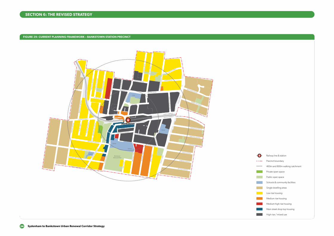
24 Sydenham to Bankstown Urban Renewal Corridor Strategy
800m
400m
800m
400m
800m
400m
BRANDON AVENUE
OXF
ORD
AVE
NU
E
GRE
ENW
OO
D A
VEN
UE
CH
APEL
RO
AD
PERC
Y ST
REET
STAC
EY S
TREE
T
STANLEY STREET
RAYMOND STREET
CRO
SS STREET
CARNATION AVENUE
NORTH TERRACE
RICKARD ROAD
LAD
Y CU
TLER AVENU
E
JAC
OBS
STR
EET
GRIFFITHS AVENUE
GARDENIA AVENUE
SALVIA AVENUE
VERBENA AVENUE
PETUNIA AVENUE
LEO
NA
RD S
TREE
T
REST
WEL
L STR
EET
VIM
Y ST
REET
NO
RTHAM
AVE
NUECAMBRIDGE AVENUE
CHELMSFORD AVENUE
EGA
N S
TREE
T
WIN
SPEA
R AV
ENU
E
GRE
ENW
OO
D A
VEN
UE
EGA
N S
TREE
T
WIN
SPEA
R AV
ENU
E
MARION STREET
BRA
NC
OU
RT A
VEN
UE
WEI
GA
ND
AVE
NU
E
REYN
OLD
S AV
ENU
E
CA
IRD
S AV
ENU
E
GORDON STREET
CARMEN STREET
FRENCH AVENUE
THE MALL
CH
APEL
RO
AD
KITC
HEN
ER P
ARA
DE
MER
EDIT
H S
TREE
T
SOUTH TERRACE
STAC
EY S
TREE
T
PRAIRIE VALE ROAD
RESTHAVEN ROAD
MYRTLE ROAD
MILTON STREET
SIR
JOSE
PH B
AN
KS S
TREE
T
CO
NW
AY R
OA
D
CH
APE
L RD
STH
GREENFIELD PARADE
MARION STREET
BANKSTOWN CITY PLAZA
MACAULEY AVENUEMACAULEY AVENUE
WATTLE STREET
ACAC
IA A
VEN
UE
HIG
HC
LERE
AVE
NU
E
BROADW
AY
MATTH
EWS STREET
RICKARD ST
ROSEM
ON
T STREET
CARRISBROOK AVENUE
WARATAH STREET
CAT
HER
INE
STR
EET
ARTHUR STREET
CAMPBELL STREET
KELLY STREET
MYALL STREET
SCOTT STREET
SOUTH TERRACE
WATTLE STREET
WARWICK STREET
HEN
RY S
TREE
T
MO
UN
T LE
WIS
AVE
NU
E
NO
BLE
AVEN
UE
NOCKOLDS AVENUE
GRIFFITHS AVENUE
YARRAN STREETMULGA STREET
TURNER STREET
TURNER STREET
PUNCHBOWL ROAD
PUNCHBOWL ROAD
THE BOULEVARDE
VICTORIA RO
AD
VIOLA STREET
LIND
EN AVEN
UE
LIND
EN AVEN
UE
LANCELOT STREETLANCELOT STREET
ROSSM
ORE AVEN
UE
ROSSM
ORE AVEN
UE
HILLCREST STREET
HILLCREST STREET
DUDLEY STREET ROSEM
OUN
T STREET SOUTH
WATTLE STREET
PUN
CH
BOW
L RO
AD
LAN
CAS
TER
AVEN
UE
URUNGA PARADE
THE BOULEVARDE
LAKEMBA STREET
FAIRMO
UNT STREET
BELLEVUE AVENUE
THE BOULEVARDE
ROBIN
SON
STREET NO
RTH
DEFOE STREET
McCO
URT STREET
HILLARD STREET
KING
GEO
RGES RO
AD
KING
GEO
RGES RO
AD
BEAUCHAM
P STREET
RENO
WN
AVENUE DEN
MAN
AVENUE
FAUX STREET
URUNGA PARADE
TUCKER STREET
HILLCREST STREET
HILLCREST STREET
LAKEMBA STREET
LAKEMBA STREET
GILLIES STREET DENN
IS STREET
QUIG
G STREET
CROYDO
N STREET
SPROULE STREET
ERNEST STREET
HALDO
N STREET
ONEATA STREET
MYEE STREET
QUIG
G STREET
HALDO
N STREET
MO
RETON
STREET
THE BOULEVARDE RAILWAY PARADE
HAM
DEN RO
AD
GARRO
NG
ROAD
BENARO
ON
ROAD
PUNCHBOWL R
OAD
PUNCHBOWL R
OAD
DENN
IS STREET
TAYLOR STREET
CHALMERS STREET
COLLIN
S STREET
CROYDO
N STREET
WAN
GEE RO
AD
WAN
GEE RO
AD
YANGOORA ROAD
YANGOORA ROAD
THE BOULEVARDE
RAILWAY PARADE
BRIDGE ROAD
COLLINS STREET LEYLANDS PARADE
YORK STREET
CHALMERS STREET
CANTERBURY ROAD
WILSON AVENUE
BURW
OO
D RO
AD
DRUMM
ON
D STREET
ANDERSO
N STREET
SHARP STREET
SHARP STREET
WAVERLEY STREET
TUDOR STREET
PLIMSOLL STREET
COBDEN STREET
RYDGE STREET
EDISON STREET
EDISON STREET
REGINALD AVENUE
BURWO
OD RO
AD
REDMAN PARADE
ST CLAIR STREET
SUDBURY STREET
CECILIA STREET
PASSEY AVENUE
HALL STREET
CLEARY AVENUE
BELMO
RE AVENUEPEEL STREET
CHAPEL STREET
CHAPEL STREET
BENARO
ON
ROAD
DRUMM
ON
D STREET
ANDERSO
N STREET
PEEL STREET
YANGOORA ROAD
YANGOORA ROAD
OXFO
RD STREET
OXFO
RD STREET
BRAND STREET
BRAND STREET
LAKEMBA STREET KENNEDY AVENUE
ALLAN AVENUE
MINNIE STREET
HUGH STREET
KNOX STREET
LUCERNE STREET
BURWO
OD RO
AD
PAXTON AVENUE
ETELA STREET
ISABEL STREET
BENARO
ON
ROAD
GLADSTONE STREET
MYALL STREET
ACACIA STREET
CLISSOLD PARADE
BELLOMBI STREET
FREDERICK STREET
NORTH PARADE SOUTH PARADE
EVALINE STREET
CLAREMONT STREET
AMY STREET
ANZAC MALL
HILL STREET
CLAREMONT STREET
HILL STREET
CANTERBURY ROAD
EIGHTH AVENUE
SEVENTH AVENUE
SEVENTH AVENUE
BROW
NIN
G STREET
SHAKESPEARE STREET
NINTH AVENUE
CAMPSIE STREET
WILFRED AVENUE
WILFRED AVENUE
ANZAC SQUARE
CARRINGTON SQ
MA
RLOW
E STREET
STAN
LEY STREET
ORISSA STREET
ORISSA STREET
THO
RNCRAFT PARADE
THO
RNCRAFT PARADE
THO
RNCRAFT PARADE
MCKERN STREET
BEAUMONT STREET
LOCH
STREET
LOCH
STREET
LOCH
STREET
LOCH
STREET
LOFTUS STREET
LOFTUS STREET
BEAM
ISH STREET
BEAM
ISH
HARO
LD STREET
DUKE STREET
PARK STREET
GO
ULD STREET
UNARA STREET
PERRY STREET
REDMAN STREET
SOUTH PARADE
STAN
LEY STREET
PARK STREET
UNARA STREET
REDMAN STREET
BRIGHTON AVENUE
DRYD
EN STREET
BURNS STREET
SHELLEY STREET
BYRON STREETBYRON STREET
MO
ORE STREET
COW
PER STREET
SIXTH AVEN
UE
FIFTH AVEN
UE
FOU
RTH AVEN
UE
THIRD
AVENU
E
SECO
ND
AVENU
E
SECO
ND
AVENU
E
FIRST AVENU
E
FIRST AVENU
E
BRUCE AVENUE
ALBERT STREET
OMAHA STREET
BALTIMO
RE STREET
LINCO
LN STREET
STREET
HIGH STREET
CANTERBURY ROAD
CANTERB
URY RO
AD
JEFF
REY
STRE
ET
CH
URC
H S
TREE
T
FLOSS STREET
MELF
ORD
STREET
HUTTON STREET
FORE STREET
BERNA STREET
CANTON STREET
HOWARD STREET
HIGH STREET
IVY STREET
EMU STREET
WARATAH STREET
WO
NG
A STREET
EMU STREET
WO
NG
A STREET
PHILLIPS AVEN
UE
WAIRO
A STRE
ET
NAPIER STREETNAPIER STREET
CHARLES STREET
BROUGHTO
N STREET
ROBERT STREET
JOHN STREET
JOHN STREET
MIN
TER
STRE
ET
MIN
TER
STRE
ET
TINCOMBE STREET
CLOSE STREETCLOSE STREET
BROUGHTO
N STREET
KING STREET
KING STREET
FREDERICK ST
PRINCESS STREET
CANTERBURY ROAD
FORE STREET
CANTERBURY ROAD
CH
URC
H S
TREE
T
TINCOMBE STREET
CRINAN STREET
MELF
ORD
STREET
MELF
ORD
STREET
DU
NST
AFF
ENAG
E ST
REET
FERN
HILL
STR
EET
DU
NTR
OO
N S
TREE
T
DU
NTR
OO
N S
TREE
T
HAMPDEN STREET
BARTON AVE
MARCIA STREET
WALLACE AVENUE
BARRE STREET
WOODSIDE AVE
THE AVENUE
FLOSS STREET
DU
NST
AFF
ENAG
E ST
REET
DU
NTR
OO
N S
TREE
T
BARTON AVE
MARCIA STREET
WALLACE AVENUE
BARRE STREET
WOODSIDE AVE
THE AVENUE
NEW CANTERBURY ROAD NEW CANTERBURY ROAD
GA
RNET STREET
FLOSS STREET
KEIR
AVE
NU
E
TENNENT PARADE
STA
RKEY
STR
EET
EUSTON ROAD
GOWER STREET
COMMONS STREETCOMMONS STREET
HO
PETO
UN
STR
EET
RAILW
AY S
T
CANTERTON STREET
ACTON STREET
KILBRIDE STREET
HURLSTONE AVENUE
FLOSS STREETFLOSS STREET
FOO
RD A
VEN
UE
FOO
RD A
VEN
UE
KEIR AVENUEKEIR AVENUE
HURLSTONE AVENUE
TENNYSON STREET
RIVERSID
E CRESCENT
WARDELL ROAD
DIBBLE AVENUE
RIVERSIDE CRESCENT
EWART STREET
BRUCE STREET
BRUCE STREET
BAYLEY STREET
WICKS AVENUE
DUDLEY STREET
DUDLEY STREET
SCHOOL PARADE
WARDELL
ROAD
CANONBURY
GROVE
KEITH STREET
MACARTHUR PA
RADE
LIVIN
GSTONE ROAD
LIVIN
GSTONE ROAD
HOLLANDS AVENUE
ROBERT STREET
DAVID ST
REET
MARRICKVILLE ROAD
THE PARADETHE PARADE
MYRA
ROA
D
TERR
ACE
ROA
D
HER
CU
LES
STRE
ETH
ERC
ULE
S ST
REET
NEW CANTERBURY ROAD
KINTO
RE STREET
HERCULES STREET
HERCULES STREET
BEACH ROAD
BEACH ROAD
DURHAM STREET
DURHAM STREET MARRICKVILLE ROAD
PINE STREET
LOFTUS STREET M
ARRICKVILLE ROAD
LOFTUS STREET
JERSEY STREET
JERSEY STREET
SCHWEBEL STREETHARRIET STREET
RUBY STREET
GROVE STREET
WARREN ROADRENWICK STREET
LEOFRENE AVENUE
CHARLOTT
E AVEN
UE
IVANHO
E STR
EET
ILLAW
ARRA ROAD
RICHARDSONS CRESCENT
HILL STREET
GLE
N ST
REET
LIVIN
GST
ON
E RO
AD
LIVIN
GST
ON
E RO
AD
VIEW
STRE
ET
PREMIER STREET
CARY STREET
EXCEL
SIO
R PARA
DE
THORNLEY STREET
CARRIN
GTON
ROAD
CARRIN
GTON
ROAD
ARTHUR STREET
ARTHUR STREET
FRANCIS STREET
ANN STREET
ILLAW
ARRA ROAD
MONCUR STREET
MONCUR STREET
CHURCH STREET
CHURCH STREET
GREENBANK STREET
GREENBANK STREET
MYRTLE STREET
MYRTLE STREET
PETE
RSH
AM
RO
AD
PETE
RSH
AM
RO
AD
FLETC
HER STR
EET
LIVIN
GST
ONE R
OAD
LIVIN
GST
ONE R
OAD
MARRICKVILLE ROAD
MARRICKVILLE ROAD
SILVER
STRE
ET
SILVER
STRE
ETG
LADST
ONE S
TREE
T
CENTRAL AVENUE CALVERT STREET
GARNERS
AVENUE
DESPOIN
TES STR
EET
MALA
KOFF
STREET
SYDENHAM ROAD
SYDENHAM ROAD
NORTH
COTE ST
STANLEY STREET
YABSLEY AVEYABSLEY AVE
LILYD
ALE
STR
EET
O’H
ARA ST
REET
JUNCTIO
N STRE
ETHIGH ST
REET
HAMPD
EN A
VENUE
RIVER
DALE A
VE
MARRICKVILLE ROAD
MEE
KS RO
AD
MEE
KS RO
AD
GER
ALD ST
REET
GER
ALD ST
REET
RAILWAY ROAD
PRINCES HIG
HWAY
UNWINS BRIDGE ROAD
RAILWAY PARADE
BUCKLEY STR
EET
GLEESO
N AVE
BARCLA
Y STREET
SYDNEY STR
EET
SYDNEY STR
EET
VIN
CENT S
TREE
T
VICTO
RIA RO
AD
SYDENHAM ROAD
FAVERSHAM
STREET
SAYWELL STREET
LILIAN FOWLER PLACE
CADOGAN STREET
CADOGAN STREETSLO
ANE STREET
SLOANE STREET
SHIRLOW STREET
SHIRLOW STREETGARDEN STREET
GEORGE STREETFREDERICK STREET
HENRY STREET
HENRY STREET
PARK ROAD
SAMUEL STREET
ROBERT STREET
SILVER STREET
EDINBURGH ROAD
EDINBURGH ROAD
FOREMAN STREET
FOREMAN STREET
FITZROY STREET
HO
PETO
UN
STR
EET
FITZROY STREET
SydenhamSydenham
MarrickvilleMarrickville
Dulwich HillDulwich HillHurlstone ParkHurlstone Park
CanterburyCanterbury
BelmoreBelmore
LakembaLakemba
Wiley ParkWiley Park
BankstownBankstown
Dulwich GroveDulwich Grove
ArlingtonArlington
CampsieCampsie
PunchbowlPunchbowl
ShoppingCentre
School
School
School
Fraser Park
Wicks Park
Tillman Park
School
School
School
School
School
School
Church
School
Fire station & Townhall
School
School
School
Mackey Park
Gough Whitlam Park
McNeilly Park
Marrickville Golf Club
Marrickville Golf Club
Canterbury Park
Tasker Park
School
School
School
Canterbury Park RacecourseCanterbury Park RacecourseCanterbury Park RacecourseCanterbury Park Racecourse
Ewen Park
Beaman Park
Church
Civic
School
School
School
BankstownMemorial Park
School
School
School
School
School
School
Punchbowl Park
School
School
Library
School
School
School
School
School
Wiley Park
School
School
School
Police
School
Canterbury Hospital
School
Church
Belmore Sportsground
Railway line & station
Precinct boundary
400m and 800m walking catchment
Private open space
Public open space
Schools & community facilities
Single dwelling areas
Low rise housing
Medium rise housing
Medium-high rise housing
Main street shop top housing
High rise / mixed use
SECTION 6: THE REVISED STRATEGY
FIGURE 29: CURRENT PLANNING FRAMEWORK – BANKSTOWN STATION PRECINCT
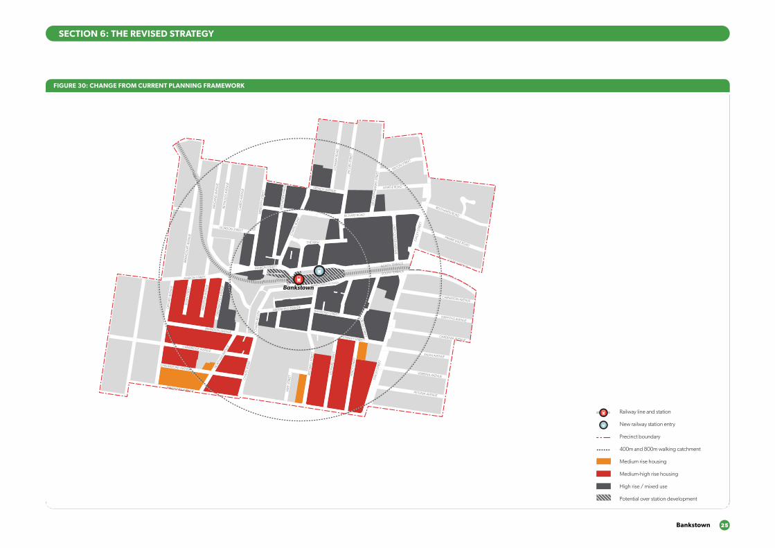
Bankstown 25
800m
400m
800m
400m
800m
400m
BRANDON AVENUE
OXF
ORD
AVE
NU
E
GRE
ENW
OO
D A
VEN
UE
CH
APEL
RO
AD
PERC
Y ST
REET
STAC
EY S
TREE
T
STANLEY STREET
RAYMOND STREET
CRO
SS STREET
CARNATION AVENUE
NORTH TERRACE
RICKARD ROAD
LAD
Y CU
TLER AVENU
E
JAC
OBS
STR
EET
GRIFFITHS AVENUE
GARDENIA AVENUE
SALVIA AVENUE
VERBENA AVENUE
PETUNIA AVENUE
LEO
NA
RD S
TREE
T
REST
WEL
L STR
EET
VIM
Y ST
REET
NO
RTHAM
AVE
NUECAMBRIDGE AVENUE
CHELMSFORD AVENUE
EGA
N S
TREE
T
WIN
SPEA
R AV
ENU
E
GRE
ENW
OO
D A
VEN
UE
EGA
N S
TREE
T
WIN
SPEA
R AV
ENU
E
MARION STREET
BRA
NC
OU
RT A
VEN
UE
WEI
GA
ND
AVE
NU
E
REYN
OLD
S AV
ENU
E
CA
IRD
S AV
ENU
E
GORDON STREET
CARMEN STREET
FRENCH AVENUE
THE MALL
CH
APEL
RO
AD
KITC
HEN
ER P
ARA
DE
MER
EDIT
H S
TREE
T
SOUTH TERRACE
STAC
EY S
TREE
T
PRAIRIE VALE ROAD
RESTHAVEN ROAD
MYRTLE ROAD
MILTON STREET
SIR
JOSE
PH B
AN
KS S
TREE
T
CO
NW
AY R
OA
D
CH
APE
L RD
STH
GREENFIELD PARADE
MARION STREET
BANKSTOWN CITY PLAZA
MACAULEY AVENUEMACAULEY AVENUE
WATTLE STREET
ACAC
IA A
VEN
UE
HIG
HC
LERE
AVE
NU
E
BROADW
AY
MATTH
EWS STREET
RICKARD ST
ROSEM
ON
T STREET
CARRISBROOK AVENUE
WARATAH STREET
CAT
HER
INE
STR
EET
ARTHUR STREET
CAMPBELL STREET
KELLY STREET
MYALL STREET
SCOTT STREET
SOUTH TERRACE
WATTLE STREET
WARWICK STREET
HEN
RY S
TREE
T
MO
UN
T LE
WIS
AVE
NU
E
NO
BLE
AVEN
UE
NOCKOLDS AVENUE
GRIFFITHS AVENUE
YARRAN STREETMULGA STREET
TURNER STREET
TURNER STREET
PUNCHBOWL ROAD
PUNCHBOWL ROAD
THE BOULEVARDE
VICTORIA RO
AD
VIOLA STREET
LIND
EN AVEN
UE
LIND
EN AVEN
UE
LANCELOT STREETLANCELOT STREET
ROSSM
ORE AVEN
UE
ROSSM
ORE AVEN
UE
HILLCREST STREET
HILLCREST STREET
DUDLEY STREET ROSEM
OUN
T STREET SOUTH
WATTLE STREET
PUN
CH
BOW
L RO
AD
LAN
CAS
TER
AVEN
UE
URUNGA PARADE
THE BOULEVARDE
LAKEMBA STREET
FAIRMO
UNT STREET
BELLEVUE AVENUE
THE BOULEVARDE
ROBIN
SON
STREET NO
RTH
DEFOE STREET
McCO
URT STREET
HILLARD STREET
KING
GEO
RGES RO
AD
KING
GEO
RGES RO
AD
BEAUCHAM
P STREET
RENO
WN
AVENUE DEN
MAN
AVENUE
FAUX STREET
URUNGA PARADE
TUCKER STREET
HILLCREST STREET
HILLCREST STREET
LAKEMBA STREET
LAKEMBA STREET
GILLIES STREET DENN
IS STREET
QUIG
G STREET
CROYDO
N STREET
SPROULE STREET
ERNEST STREET
HALDO
N STREET
ONEATA STREET
MYEE STREET
QUIG
G STREET
HALDO
N STREET
MO
RETON
STREET
THE BOULEVARDE RAILWAY PARADE
HAM
DEN RO
AD
GARRO
NG
ROAD
BENARO
ON
ROAD
PUNCHBOWL R
OAD
PUNCHBOWL R
OAD
DENN
IS STREET
TAYLOR STREET
CHALMERS STREET
COLLIN
S STREET
CROYDO
N STREET
WAN
GEE RO
AD
WAN
GEE RO
AD
YANGOORA ROAD
YANGOORA ROAD
THE BOULEVARDE
RAILWAY PARADE
BRIDGE ROAD
COLLINS STREET LEYLANDS PARADE
YORK STREET
CHALMERS STREET
CANTERBURY ROAD
WILSON AVENUE
BURW
OO
D RO
AD
DRUMM
ON
D STREET
ANDERSO
N STREET
SHARP STREET
SHARP STREET
WAVERLEY STREET
TUDOR STREET
PLIMSOLL STREET
COBDEN STREET
RYDGE STREET
EDISON STREET
EDISON STREET
REGINALD AVENUE
BURWO
OD RO
AD
REDMAN PARADE
ST CLAIR STREET
SUDBURY STREET
CECILIA STREET
PASSEY AVENUE
HALL STREET
CLEARY AVENUE
BELMO
RE AVENUEPEEL STREET
CHAPEL STREET
CHAPEL STREET
BENARO
ON
ROAD
DRUMM
ON
D STREET
ANDERSO
N STREET
PEEL STREET
YANGOORA ROAD
YANGOORA ROAD
OXFO
RD STREET
OXFO
RD STREET
BRAND STREET
BRAND STREET
LAKEMBA STREET KENNEDY AVENUE
ALLAN AVENUE
MINNIE STREET
HUGH STREET
KNOX STREET
LUCERNE STREET
BURWO
OD RO
AD
PAXTON AVENUE
ETELA STREET
ISABEL STREET
BENARO
ON
ROAD
GLADSTONE STREET
MYALL STREET
ACACIA STREET
CLISSOLD PARADE
BELLOMBI STREET
FREDERICK STREET
NORTH PARADE SOUTH PARADE
EVALINE STREET
CLAREMONT STREET
AMY STREET
ANZAC MALL
HILL STREET
CLAREMONT STREET
HILL STREET
CANTERBURY ROAD
EIGHTH AVENUE
SEVENTH AVENUE
SEVENTH AVENUE
BROW
NIN
G STREET
SHAKESPEARE STREET
NINTH AVENUE
CAMPSIE STREET
WILFRED AVENUE
WILFRED AVENUE
ANZAC SQUARE
CARRINGTON SQ
MA
RLOW
E STREET
STAN
LEY STREET
ORISSA STREET
ORISSA STREET
THO
RNCRAFT PARADE
THO
RNCRAFT PARADE
THO
RNCRAFT PARADE
MCKERN STREET
BEAUMONT STREET
LOCH
STREET
LOCH
STREET
LOCH
STREET
LOCH
STREET
LOFTUS STREET
LOFTUS STREET
BEAM
ISH STREET
BEAM
ISH
HARO
LD STREET
DUKE STREET
PARK STREET
GO
ULD STREET
UNARA STREET
PERRY STREET
REDMAN STREET
SOUTH PARADE
STAN
LEY STREET
PARK STREET
UNARA STREET
REDMAN STREET
BRIGHTON AVENUE
DRYD
EN STREET
BURNS STREET
SHELLEY STREET
BYRON STREETBYRON STREET
MO
ORE STREET
COW
PER STREET
SIXTH AVEN
UE
FIFTH AVEN
UE
FOU
RTH AVEN
UE
THIRD
AVENU
E
SECO
ND
AVENU
E
SECO
ND
AVENU
E
FIRST AVENU
E
FIRST AVENU
E
BRUCE AVENUE
ALBERT STREET
OMAHA STREET
BALTIMO
RE STREET
LINCO
LN STREET
STREET
HIGH STREET
CANTERBURY ROAD
CANTERB
URY RO
AD
JEFF
REY
STRE
ET
CH
URC
H S
TREE
T
FLOSS STREET
MELF
ORD
STREET
HUTTON STREET
FORE STREET
BERNA STREET
CANTON STREET
HOWARD STREET
HIGH STREET
IVY STREET
EMU STREET
WARATAH STREET
WO
NG
A STREET
EMU STREET
WO
NG
A STREET
PHILLIPS AVEN
UE
WAIRO
A STRE
ET
NAPIER STREETNAPIER STREET
CHARLES STREET
BROUGHTO
N STREET
ROBERT STREET
JOHN STREET
JOHN STREET
MIN
TER
STRE
ET
MIN
TER
STRE
ET
TINCOMBE STREET
CLOSE STREETCLOSE STREET
BROUGHTO
N STREET
KING STREET
KING STREET
FREDERICK ST
PRINCESS STREET
CANTERBURY ROAD
FORE STREET
CANTERBURY ROAD
CH
URC
H S
TREE
T
TINCOMBE STREET
CRINAN STREET
MELF
ORD
STREET
MELF
ORD
STREET
DU
NST
AFF
ENAG
E ST
REET
FERN
HILL
STR
EET
DU
NTR
OO
N S
TREE
T
DU
NTR
OO
N S
TREE
T
HAMPDEN STREET
BARTON AVE
MARCIA STREET
WALLACE AVENUE
BARRE STREET
WOODSIDE AVE
THE AVENUE
FLOSS STREET
DU
NST
AFF
ENAG
E ST
REET
DU
NTR
OO
N S
TREE
T
BARTON AVE
MARCIA STREET
WALLACE AVENUE
BARRE STREET
WOODSIDE AVE
THE AVENUE
NEW CANTERBURY ROAD NEW CANTERBURY ROAD
GA
RNET STREET
FLOSS STREET
KEIR
AVE
NU
E
TENNENT PARADE
STA
RKEY
STR
EET
EUSTON ROAD
GOWER STREET
COMMONS STREETCOMMONS STREET
HO
PETO
UN
STR
EET
RAILW
AY S
T
CANTERTON STREET
ACTON STREET
KILBRIDE STREET
HURLSTONE AVENUE
FLOSS STREETFLOSS STREET
FOO
RD A
VEN
UE
FOO
RD A
VEN
UE
KEIR AVENUEKEIR AVENUE
HURLSTONE AVENUE
TENNYSON STREET
RIVERSID
E CRESCENT
WARDELL ROAD
DIBBLE AVENUE
RIVERSIDE CRESCENT
EWART STREET
BRUCE STREET
BRUCE STREET
BAYLEY STREET
WICKS AVENUE
DUDLEY STREET
DUDLEY STREET
SCHOOL PARADE
WARDELL
ROAD
CANONBURY
GROVE
KEITH STREET
MACARTHUR PA
RADE
LIVIN
GSTONE ROAD
LIVIN
GSTONE ROAD
HOLLANDS AVENUE
ROBERT STREET
DAVID ST
REET
MARRICKVILLE ROAD
THE PARADETHE PARADE
MYRA
ROA
D
TERR
ACE
ROA
D
HER
CU
LES
STRE
ETH
ERC
ULE
S ST
REET
NEW CANTERBURY ROAD
KINTO
RE STREET
HERCULES STREET
HERCULES STREET
BEACH ROAD
BEACH ROAD
DURHAM STREET
DURHAM STREET MARRICKVILLE ROAD
PINE STREET
LOFTUS STREET M
ARRICKVILLE ROAD
LOFTUS STREET
JERSEY STREET
JERSEY STREET
SCHWEBEL STREETHARRIET STREET
RUBY STREET
GROVE STREET
WARREN ROADRENWICK STREET
LEOFRENE AVENUE
CHARLOTT
E AVEN
UE
IVANHO
E STR
EET
ILLAW
ARRA ROAD
RICHARDSONS CRESCENT
HILL STREET
GLE
N ST
REET
LIVIN
GST
ON
E RO
AD
LIVIN
GST
ON
E RO
AD
VIEW
STRE
ET
PREMIER STREET
CARY STREET
EXCEL
SIO
R PARA
DE
THORNLEY STREET
CARRIN
GTON
ROAD
CARRIN
GTON
ROAD
ARTHUR STREET
ARTHUR STREET
FRANCIS STREET
ANN STREET
ILLAW
ARRA ROAD
MONCUR STREET
MONCUR STREET
CHURCH STREET
CHURCH STREET
GREENBANK STREET
GREENBANK STREET
MYRTLE STREET
MYRTLE STREET
PETE
RSH
AM
RO
AD
PETE
RSH
AM
RO
AD
FLETC
HER STR
EET
LIVIN
GST
ONE R
OAD
LIVIN
GST
ONE R
OAD
MARRICKVILLE ROAD
MARRICKVILLE ROAD
SILVER
STRE
ET
SILVER
STRE
ETG
LADST
ONE S
TREE
T
CENTRAL AVENUE CALVERT STREET
GARNERS
AVENUE
DESPOIN
TES STR
EET
MALA
KOFF
STREET
SYDENHAM ROAD
SYDENHAM ROAD
NORTH
COTE ST
STANLEY STREET
YABSLEY AVEYABSLEY AVE
LILYD
ALE
STR
EET
O’H
ARA ST
REET
JUNCTIO
N STRE
ETHIGH ST
REET
HAMPD
EN A
VENUE
RIVER
DALE A
VE
MARRICKVILLE ROAD
MEE
KS RO
AD
MEE
KS RO
AD
GER
ALD ST
REET
GER
ALD ST
REET
RAILWAY ROAD
PRINCES HIG
HWAY
UNWINS BRIDGE ROAD
RAILWAY PARADE
BUCKLEY STR
EET
GLEESO
N AVE
BARCLA
Y STREET
SYDNEY STR
EET
SYDNEY STR
EET
VIN
CENT S
TREE
T
VICTO
RIA RO
AD
SYDENHAM ROAD
FAVERSHAM
STREET
SAYWELL STREET
LILIAN FOWLER PLACE
CADOGAN STREET
CADOGAN STREETSLO
ANE STREET
SLOANE STREET
SHIRLOW STREET
SHIRLOW STREETGARDEN STREET
GEORGE STREETFREDERICK STREET
HENRY STREET
HENRY STREET
PARK ROAD
SAMUEL STREET
ROBERT STREET
SILVER STREET
EDINBURGH ROAD
EDINBURGH ROAD
FOREMAN STREET
FOREMAN STREET
FITZROY STREET
HO
PETO
UN
STR
EET
FITZROY STREET
SydenhamSydenham
MarrickvilleMarrickville
Dulwich HillDulwich HillHurlstone ParkHurlstone Park
CanterburyCanterbury
BelmoreBelmore
LakembaLakemba
Wiley ParkWiley Park
BankstownBankstown
Dulwich GroveDulwich Grove
ArlingtonArlington
CampsieCampsie
PunchbowlPunchbowl
Railway line and station
New railway station entry
Precinct boundary
400m and 800m walking catchment
Medium rise housing
Medium-high rise housing
High rise / mixed use
Potential over station development
SECTION 6: THE REVISED STRATEGY
FIGURE 30: CHANGE FROM CURRENT PLANNING FRAMEWORK
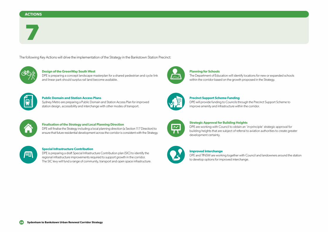
26 Sydenham to Bankstown Urban Renewal Corridor Strategy
7ACTIONS
The following Key Actions will drive the implementation of the Strategy in the Bankstown Station Precinct:
Design of the GreenWay South WestDPE is preparing a concept landscape masterplan for a shared pedestrian and cycle link and linear park should surplus rail land become available.
Public Domain and Station Access PlansSydney Metro are preparing a Public Domain and Station Access Plan for improved station design, accessibility and interchange with other modes of transport.
Finalisation of the Strategy and Local Planning DirectionDPE will finalise the Strategy including a local planning direction (a Section 117 Direction) to ensure that future residential development across the corridor is consistent with the Strategy.
Special Infrastructure ContributionDPE is preparing a draft Special Infrastructure Contribution plan (SIC) to identify the regional infrastructure improvements required to support growth in the corridor. The SIC levy will fund a range of community, transport and open space infrastructure.
Planning for SchoolsThe Department of Education will identify locations for new or expanded schools within the corridor based on the growth proposed in the Strategy.
Precinct Support Scheme FundingDPE will provide funding to Councils through the Precinct Support Scheme to improve amenity and infrastructure within the corridor.
Strategic Approval for Building HeightsDPE are working with Council to obtain an ‘in-principle’ strategic approval for building heights that are subject of referral to aviation authorities to create greater development certainty.
Improved InterchangeDPE and TfNSW are working together with Council and landowners around the station to develop options for improved interchange.
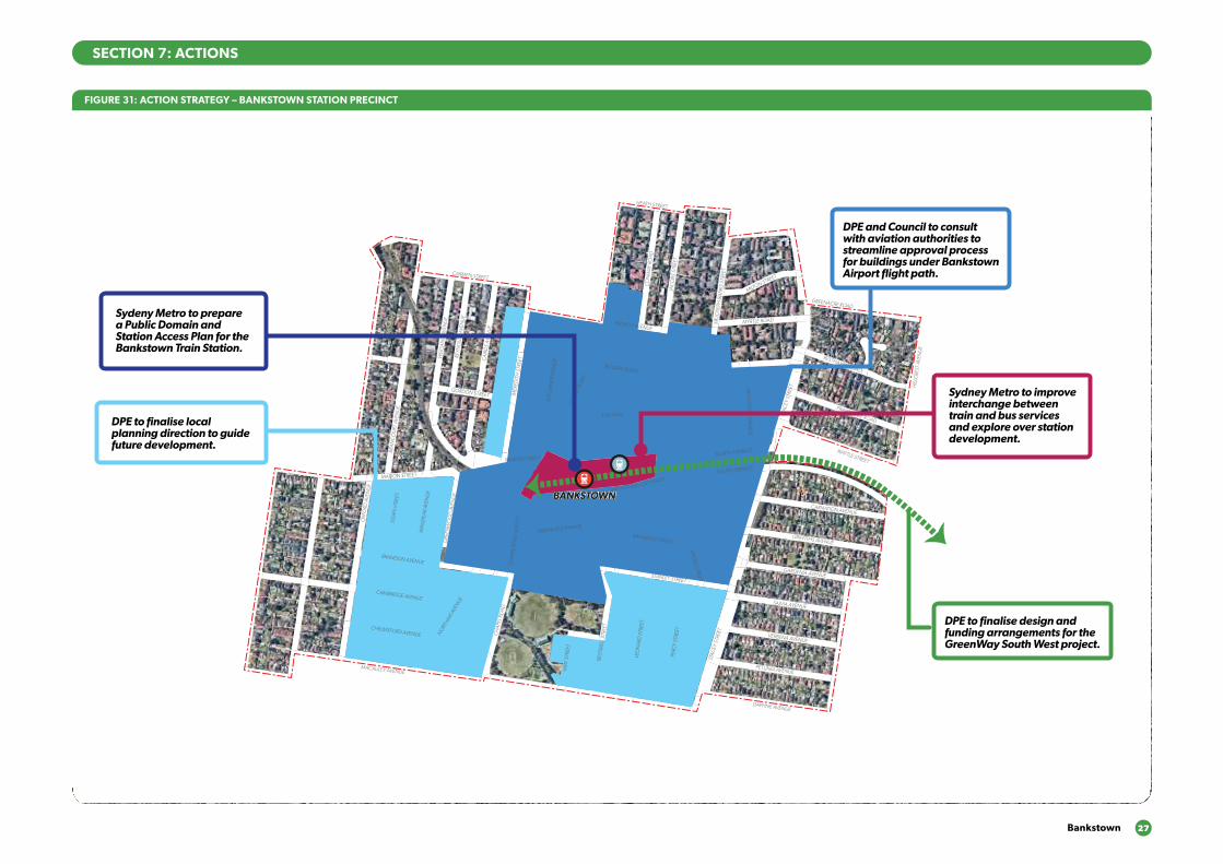
Bankstown 27
SECTION 7: ACTIONS
FIGURE 31: ACTION STRATEGY – BANKSTOWN STATION PRECINCT
BANKSTOWNBANKSTOWN
BRANDON AVENUE
OXF
ORD
AVE
NU
E
GRE
ENW
OO
D A
VEN
UE
CH
APEL
RO
AD
PERC
Y ST
REET
STAC
EY S
TREE
T
STANLEY STREET
RAYMOND STREET
CRO
SS STREET
CARNATION AVENUE
NORTH TERRACE
LAD
Y CU
TLER AVENU
E
JAC
OBS
STR
EET
GRIFFITHS AVENUE
GARDENIA AVENUE
SALVIA AVENUE
VERBENA AVENUE
PETUNIA AVENUE
LEO
NA
RD S
TREE
T
REST
WEL
L STR
EET
VIM
Y ST
REET
NO
RTHAM
AVE
NUE
CAMBRIDGE AVENUE
CHELMSFORD AVENUE
EGA
N S
TREE
T
WIN
SPEA
R AV
ENU
E
MARION STREET
BRA
NC
OU
RT A
VEN
UE
WEI
GA
ND
AVE
NU
E
REYN
OLD
S AV
ENU
E
CA
IRD
S AV
ENU
E
GORDON STREET
CARMEN STREET
FRENCH AVENUE
RICKARD ROAD
THE MALL
CH
APEL
RO
AD
KITC
HEN
ER P
ARA
DE
MER
EDIT
H S
TREE
T
SOUTH TERRACE
STAC
EY S
TREE
T
PRAIRIE VALE ROAD
WATTLE STREET
RESTHAVEN ROAD
MYRTLE ROAD
MILTON STREET
SIR
JOSE
PH B
AN
KS S
TREE
T
CO
NW
AY R
OA
D
HEATH STREET
GREENACRE ROAD
HILL
CRE
ST A
VEN
UE
CH
APE
L RO
AD
SO
UTH
GREENFIELD PARADE
MARION STREET
BANKSTOWN CITY PLAZA
MACAULEY AVENUE
DAPHNE AVENUE
DPE to finalise design and funding arrangements for the GreenWay South West project.
Sydeny Metro to prepare a Public Domain and Station Access Plan for the Bankstown Train Station.
DPE to finalise local planning direction to guide future development.
Sydney Metro to improve interchange between train and bus services and explore over station development.
DPE and Council to consult with aviation authorities to streamline approval process for buildings under Bankstown Airport flight path.

28 Sydenham to Bankstown Urban Renewal Corridor Strategy
FIGURE 32: INFRASTRUCTURE – BANKSTOWN STATION PRECINCT
INFRASTRUCTURE
8
School
School
School
School
Civic
BankstownMemorial Park
Ruse Park
T1T1
P1P1
P6P6
P10P10
T4T4
T3T3
T2T2
T3T3
R1R1
O2O2
0101
0303
P7P7
P5P5
P8P8
P4P4P3P3P2P2
C2C2
C1 C1
T5T5
P9P9
BRANDON AVENUEBRANDON AVENUE
OX
FORD
AV
ENU
EO
XFO
RD A
VEN
UE
GRE
ENW
OO
D A
VEN
UE
GRE
ENW
OO
D A
VEN
UE
CH
APE
L RO
AD
CH
APE
L RO
AD
PERC
Y S
TREE
TPE
RCY
STR
EET
STA
CEY
STR
EET
STA
CEY
STR
EET
STANLEY STREETSTANLEY STREET
RAYMOND STREETRAYMOND STREET
CRO
SS STREET
CRO
SS STREET
CARNATION AVENUECARNATION AVENUE
NORTH TERRACENORTH TERRACE
RICKARD ROADRICKARD ROAD
LAD
Y C
UTLER
AV
ENU
ELA
DY
CU
TLER A
VEN
UE
JAC
OB
S ST
REE
TJA
CO
BS
STR
EET
GRIFFITHS AVENUEGRIFFITHS AVENUE
GARDENIA AVENUEGARDENIA AVENUE
SALVIA AVENUESALVIA AVENUE
VERBENA AVENUEVERBENA AVENUE
PETUNIA AVENUEPETUNIA AVENUE
LEO
NA
RD S
TREE
TLE
ON
ARD
STR
EET
REST
WEL
L ST
REET
REST
WEL
L ST
REET
VIM
Y S
TREE
TV
IMY
STR
EET
NO
RTHAM
AVEN
UE
NO
RTHAM
AVEN
UE
CAMBRIDGE AVENUECAMBRIDGE AVENUE
CHELMSFORD AVENUECHELMSFORD AVENUE
EGA
N S
TREE
TEG
AN
STR
EET
WIN
SPEA
R A
VEN
UE
WIN
SPEA
R A
VEN
UE
MARION STREETMARION STREET
BRA
NC
OU
RT A
VEN
UE
BRA
NC
OU
RT A
VEN
UE
WEI
GA
ND
AV
ENU
EW
EIG
AN
D A
VEN
UE
REY
NO
LDS
AV
ENU
ERE
YN
OLD
S A
VEN
UE
CA
IRD
S A
VEN
UE
CA
IRD
S A
VEN
UE
GORDON STREETGORDON STREET
CARMEN STREETCARMEN STREET
FRENCH AVENUEFRENCH AVENUE
RICKARD ROADRICKARD ROAD
THE MALLTHE MALL
CH
APE
L RO
AD
CH
APE
L RO
AD
KIT
CH
ENER
PA
RA
DE
KIT
CH
ENER
PA
RA
DEM
ERED
ITH
STR
EET
MER
EDIT
H S
TREE
T
SOUTH TERRACESOUTH TERRACE
STA
CEY
STR
EET
STA
CEY
STR
EET
PRAIRIE VALE ROAD
PRAIRIE VALE ROAD
WATTLE STREET
WATTLE STREET
RESTHAVEN ROAD
RESTHAVEN ROAD
MYRTLE ROADMYRTLE ROAD
MILTON STREET
MILTON STREET
SIR
JOSE
PH B
AN
KS
STR
EET
SIR
JOSE
PH B
AN
KS
STR
EET
CO
NW
AY R
OA
DC
ON
WAY
RO
AD
HEATH STREETHEATH STREET
GREENACRE ROADGREENACRE ROAD
HIL
LCRE
ST A
VEN
UE
HIL
LCRE
ST A
VEN
UE
CH
APE
L RO
AD
SO
UTH
CH
APE
L RO
AD
SO
UTH GREENFIELD PARADE
GREENFIELD PARADE
MARION STREETMARION STREET
BANKSTOWN CITY PLAZABANKSTOWN CITY PLAZA
MACAULEY AVENUEMACAULEY AVENUE
DAPHNE AVENUEDAPHNE AVENUE
Improved bus interchange
Greenway Southwest cycle route
Proposed cycle route
Existing on-road cycle route
Improved bus service
Road upgrades and improvements
Precinct boundary
Existing railway station
New Metro station
New Metro line
New or improved open space
New street and/or pedestrian connection
New/improved pedestrian crossing

Bankstown 29
SECTION 8: INFRASTRUCTURE
The following table provides an overview of the infrastructure projects that have been identified to support growth in the Bankstown Station precinct.
Measure Responsibility Justification
Public Transport
T1 ●● Sydney Metro City & Southwest, including:
●● New modern metro stations that are fully accessible;
●● Improved pedestrian access and bicycle parking; and
●● Improved public domain around the station.
Sydney Metro The existing Bankstown Line between Bankstown and Sydenham will be upgraded and converted to metro standards, increasing services from eight an hour in the peak to 15 new metro trains every hour with real time information at metro stations and on board trains (Sydney Metro, 2017).
T2 Bus service improvements, including:
●● Bus priority measures along Parramatta to Bankstown Corridor;
●● Bus priority measures between Bankstown and Burwood; and
●● New bus service connecting Bankstown and Macquarie Park via Sydney Olympic Park (future M93 route).
Transport for NSW
Parramatta and Sydney Olympic Park are key employment destinations for residents of the corridor. A good quality public transport service will be required to accommodate this demand to reduce car dependency to the centre (ARUP, 2015).
T3 Increase the frequency of bus services that access the railway station (eg routes 905, 907, 909, 925, 913, 923, 926, 939, 940 & 941).
Transport for NSW
Increasing bus frequencies, particularly those serving rail stations, will promote bus to rail interchanges and reduce private vehicle dependency (ARUP, 2015).
Measure Responsibility Justification
Public Transport continued
T4 Investigate relocation and/or upgrade of bus interchange in Bankstown Central Shopping Centre.
Delivered as works in kind by developers.
Access to the shopping center is currently dominated by cars and buses with limited pedestrian connection (via the Compass Center) to the station. Most buses that stop at the station currently also stop at Bankstown Central (Aileen Sage Architects & Left Bank Co, 2017).
T5 Investigate new pedestrian links to create an ‘at-grade’ connection between Appian Way and Restwell Street.
Sydney Metro The rail line bisects Bankstown into distinct north and south precincts. The rail line also currently obstructs a connection between Restwell Street and The Appian Way and the cultural and civic precincts (Aileen Sage Architects & Left Bank Co, 2017).
Roads
R1 ●● Widen Stacey Street to 3 lanes in each direction between McCauley Street and Hume Highway; and
●● Grade separation of Hume Highway / Stacy Street intersection.
RMS Transport modelling indicates significant growth in private vehicle travel on the Fairford Road / Stacey Street corridor.
The Hume Highway / Stacy Street intersection currently acts as a key constraint on the road network. Grade separation would release capacity and enhance vehicle travel times and also improve bus reliability (ARUP, 2015)
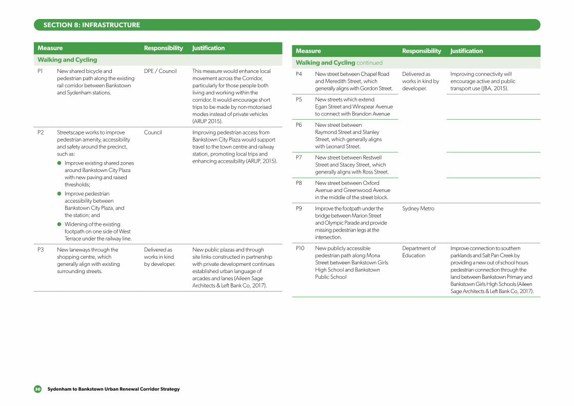
30 Sydenham to Bankstown Urban Renewal Corridor Strategy
SECTION 8: INFRASTRUCTURE
Measure Responsibility Justification
Walking and Cycling
P1 New shared bicycle and pedestrian path along the existing rail corridor between Bankstown and Sydenham stations.
DPE / Council This measure would enhance local movement across the Corridor, particularly for those people both living and working within the corridor. It would encourage short trips to be made by non-motorised modes instead of private vehicles (ARUP 2015).
P2 Streetscape works to improve pedestrian amenity, accessibility and safety around the precinct, such as:
●● Improve existing shared zones around Bankstown City Plaza with new paving and raised thresholds;
●● Improve pedestrian accessibility between Bankstown City Plaza, and the station; and
●● Widening of the existing footpath on one side of West Terrace under the railway line.
Council Improving pedestrian access from Bankstown City Plaza would support travel to the town centre and railway station, promoting local trips and enhancing accessibility (ARUP, 2015).
P3 New laneways through the shopping centre, which generally align with existing surrounding streets.
Delivered as works in kind by developer.
New public plazas and through site links constructed in partnership with private development continues established urban language of arcades and lanes (Aileen Sage Architects & Left Bank Co, 2017).
Measure Responsibility Justification
Walking and Cycling continued
P4 New street between Chapel Road and Meredith Street, which generally aligns with Gordon Street.
Delivered as works in kind by developer.
Improving connectivity will encourage active and public transport use (JBA, 2015).
P5 New streets which extend Egan Street and Winspear Avenue to connect with Brandon Avenue
P6 New street between Raymond Street and Stanley Street, which generally aligns with Leonard Street.
P7 New street between Restwell Street and Stacey Street, which generally aligns with Ross Street.
P8 New street between Oxford Avenue and Greenwood Avenue in the middle of the street block.
P9 Improve the footpath under the bridge between Marion Street and Olympic Parade and provide missing pedestrian legs at the intersection.
Sydney Metro
P10 New publicly accessible pedestrian path along Mona Street between Bankstown Girls High School and Bankstown Public School
Department of Education
Improve connection to southern parklands and Salt Pan Creek by providing a new out of school hours pedestrian connection through the land between Bankstown Primary and Bankstown Girls High Schools (Aileen Sage Architects & Left Bank Co, 2017).

Bankstown 31
SECTION 8: INFRASTRUCTURE
Measure Responsibility Justification
Parks and open space
O1 Improve open space and recreation facilities within Griffith Park and surrounding the Arts Centre.
Council
O2 New cycleway path along Salt Pan Creek from Bankstown Arts Centre to Macauley Avenue.
Council
O3 Improve open space and recreation facilities within the existing park at corner of Stanley and Stacey Streets.
Council
Schools and social infrastructure
C1 New community facility and meeting rooms in Griffiths Park.
Council Upgrading the existing centre to a multipurpose district facility will meet social infrastructure needs as the area grows (ARUP, 2015).
C2 Upgrade/expand Bankstown Library and Knowledge Centre.
Council Upgrading to the existing library will be sufficient to meet future needs (ARUP, 2015).
32 Sydenham to Bankstown Urban Renewal Corridor Strategy
9.1 Finalisation of the StrategyFollowing exhibition of this Strategy, the Department of Planning and Environment, in consultation with Council and key stakeholders will make any amendments required prior to finalisation. The Strategy will inform future land use change and guide development in the precinct. Once finalised, the Strategy will be implemented through amendments to local planning instruments, local planning investigations and planning proposals.
To ensure future land use change is consistent with the Strategy a local planning direction under Section 117 Direction of the Environmental Planning and Assessment Act 1979 will be applied to the revised Strategy.
The local planning direction, will require future amendments to any local or state planning instruments or planning proposals to be generally consistent with the finalised Strategy.
In particular, future rezoning proposals should demonstrate consistency with the following sections of the Strategy:
●● Figure 26 – Revised Land Use plan;
●● Section 6.2 – Strategic Intent;
●● Section 6.3 – Built Form Typology; and
●● Section 8 – Infrastructure Strategy.
9.2 Planning pathways To achieve the objectives of the Strategy, changes to the current planning controls in the Bankstown Local Environmental Plan 2015 are required. This includes amendments to the zoning, height, density, and built form controls. This would occur through local council and private proponent led planning proposals.
Local planning proposalsLocal councils periodically review the land use zoning planning controls that apply in their local government area. This is normally undertaken as comprehensive review of a councils LEP. The local council would prepare a planning proposal detailing the amendments to the LEP, which would need to be generally consistent with the Strategy.
Planning proposals can also be prepared by land owners or developers to amend the zoning and/or planning controls that apply to their land.
With regards to the Canterbury Road Review, once the review has been completed, a report will be produce to give guidance for any future rezoning proposals. Land owners and developers will then be able to lodge planning proposals to the Council that align with the recommendations of the review.
9IMPLEMENTATION
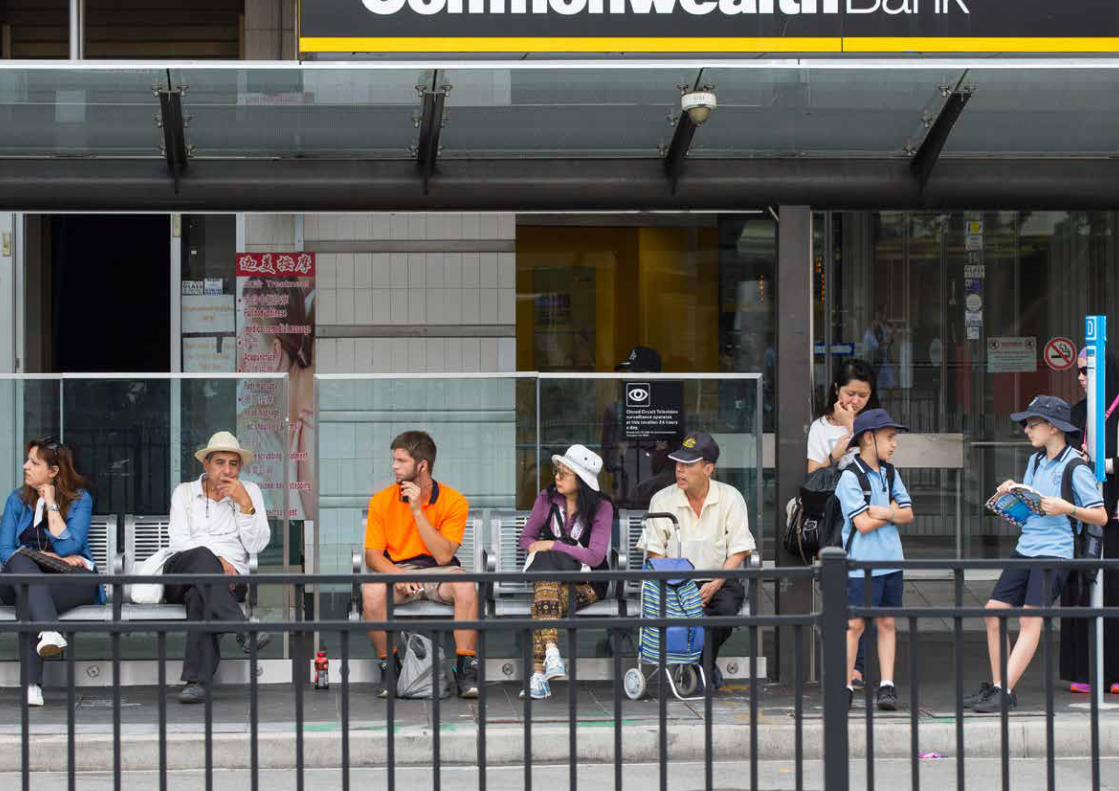
Related Documents