Government of the People’s Republic of Bangladesh Ministry of Water Resources Bangladesh Water Development Board COASTAL EMBANKMENT IMPROVEMENT PROJECT PHASE-1 Package 3 ENVIRONMENTAL IMPACT ASSESSMENT OF POLDER 23 May, 2021 FINAL REPORT

Welcome message from author
This document is posted to help you gain knowledge. Please leave a comment to let me know what you think about it! Share it to your friends and learn new things together.
Transcript
Government of the People’s Republic of Bangladesh
Ministry of Water Resources
Bangladesh Water Development Board
COASTAL EMBANKMENT IMPROVEMENT PROJECT
PHASE-1
Package 3
ENVIRONMENTAL IMPACT ASSESSMENT OF POLDER 23
May, 2021
FINAL REPORT
Polder 23-i
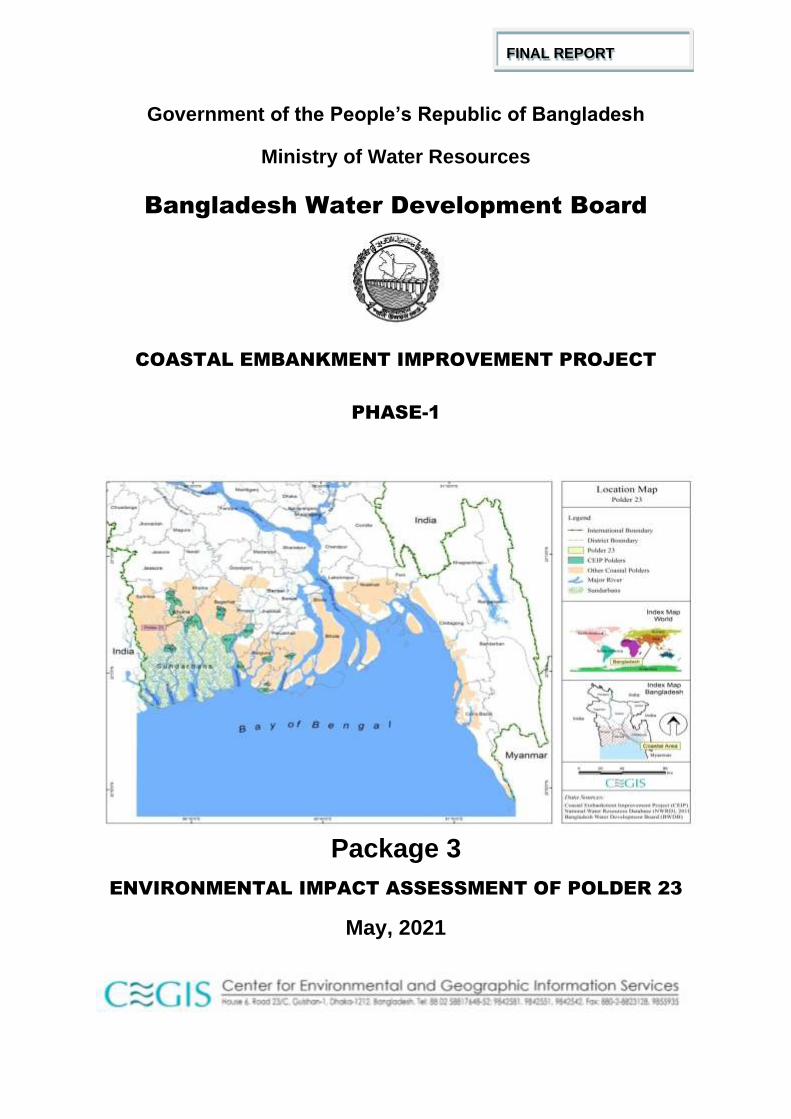
Study Team
A multidisciplinary team from Center for Environmental and Geographic Information Services
(CEGIS) conducted the EIA study for Rehabilitation of Polder 23. The study team comprised
of the following professionals:
Sl. No.
Position Incumbent
1 Water Resources Engineer/Team Leader Mr. Md. Sarfaraz Wahed
2 River Morphologist Mr. Pintu Kanungoe
3 Environmental Specialist Mr. Kazi Kamrull Hassan
4 Socio-economist Dr. Dilruba Ahmed
5 Soil & Agriculture Specialist Dr. Anil Chandra Aich
6 Fishery Specialist Dr. Ashraful Alam
7 Ecologist Mr. Ashoke Kumar Das
8 GIS/RS Specialist Ms. Pia Afreena Huq
9 Junior Professional (Water Resources Engineering) Mr. Fahad Khan Khadim
10 Junior Professional (Morphology) Mr. Sudipta Kumar Hore
11 Junior Professional (Fishery) Mr. Md. Ashraful Alom
12 Junior Professional (Ecology) Mr. Md. Sharif Hossain Sourav
13 Junior Professional (Forestry) Mr. Md. Mizanur Rahman
14 Junior Professional (Sociology) Mr. Mobasher Bin Ansari
15 GIS/RS Analyst Mr. Md. Saidur Rahman
16 GIS/RS Analyst Mr. Hasan Tawfique Imam
17 Enumerator Mr. Md. Azizur Rahman
18 Enumerator Mr. Muhammad Shahidur Rahman

Polder 23-i
Acknowledgement
The Center for Environmental and Geographic Information Services (CEGIS) has been entrusted with the responsibility of conducting the Environmental Impact Assessment (EIA) Study for Coastal Embankment Improvement Programme (CEIP) as a sub-consultant. CEGIS is indebted to the DDCS and PMSCs of CEIP-1 engaged by Bangladesh Water Development Board (BWDB) for assigning to CEGIS the task of conducting the Environmental Impact Assessment Study of coastal polders.
The multi-disciplinary team formed by CEGIS for conducting the environmental and social baseline survey of the CEIP-1 remembers with gratitude the guidance and support it received from Mr. Dr. Md. Mizanur Rahman, Project Director and Mr. Md.Delwar Hossain and Md. Habibur Rahman, earlier Project Directors, CEIP-1, BWDB and other officials of his office, while conducting the baseline survey on coastal Polder 23. CEGIS is thankful to DevConsultant Ltd. for their co-operation..
CEGIS is grateful to Mr. Harrie LaboyrieMr.Gerard Pichel and Mr. Derk Jan (Dick) Kevelam Team Leaders and Mr. Habibur Rahman, Deputy Team Leader of CEIP-1 for their direction, guidance and support with necessary data and documents on Polder 23 to the EIA study team. CEGIS also thanks other staffs of CEIP-1 for providing relevant documents during preparation of this report.
CEGIS gratefully acknowledges the support received from the Chief Engineer of Southwestern Zone; Superintending Engineer, Khulna O&M Circle; and Executive Engineer, and other officials of BWDB, Khulna for providing necessary information and cooperation to the study team during field visits.
Last but not the least, successful completion of the EIA study of Polder 23 under CEIP-1 has been made possible with active participation of the community of Polder 23 during field survey and public consultation meetings.
Polder 23-ii
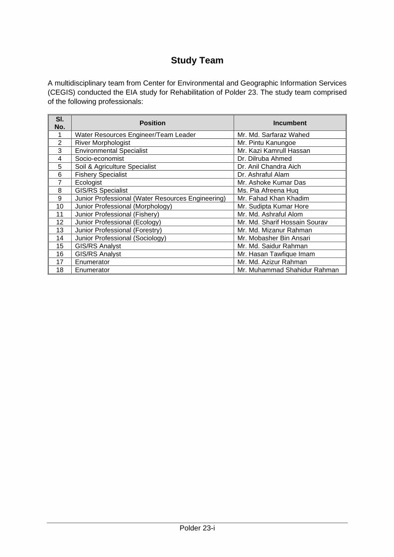
Table of Contents
Study Team .................................................................................................................................. i
Acknowledgement ..................................................................................................................... i
Table of Contents ...................................................................................................................... ii
List of Tables ............................................................................................................................ vii
List of Figures ............................................................................................................................ x
List of Maps ............................................................................................................................... xii
List of Pictures ........................................................................................................................ xiii
Abbreviations and Acronyms ............................................................................................. xv
Glossary .................................................................................................................................... xvii
Units Conversion .................................................................................................................... xix
Executive Summary ............................................................................................................... xx
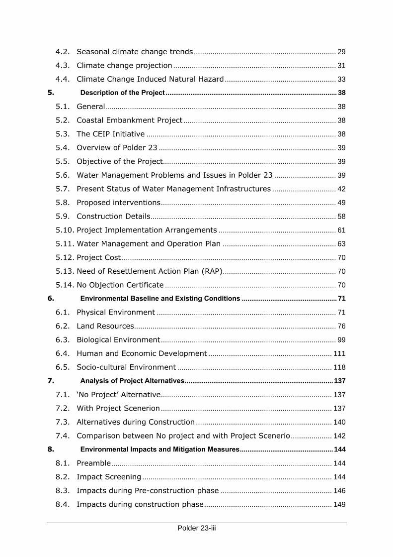
1. Introduction ................................................................................................................... 1
1.1. Background .......................................................................................................... 1
1.2. Regulatory and Policy Framework .................................................................... 4
1.3. Objectives of the Study ...................................................................................... 6
1.4. Scope of Works .................................................................................................... 6
1.5. Structure of the Report ...................................................................................... 7
2. Approach and Methodology ........................................................................................ 9
2.1. Overall Approach ................................................................................................. 9
2.2. Methodology ....................................................................................................... 10
3. Policy, Legal and Administrative Framework .......................................................... 21
3.1. Relevant National Policies, Strategies and Plans ......................................... 21
3.2. National Environmental Laws .......................................................................... 21
3.3. Other Relevant Acts .......................................................................................... 21
3.4. International Treaties Signed by GoB ............................................................ 22
3.5. Implication of GoB Polices, Acts and Rules on CEIP and their
Classification................................................................................................................. 23
3.6. Detailed Steps of In Country Environmental Clearance Procedure .......... 24
3.7. World Bank's Environmental Safeguard Policies .......................................... 25
3.8. Implications of WB Policies on CEIP ............................................................... 26
4. Climate Change Impact .............................................................................................. 27
4.1. Annual Climate Change Trends ....................................................................... 27
Polder 23-iii
4.2. Seasonal climate change trends ..................................................................... 29
4.3. Climate change projection ............................................................................... 31
4.4. Climate Change Induced Natural Hazard ...................................................... 33
5. Description of the Project .......................................................................................... 38
5.1. General ................................................................................................................ 38
5.2. Coastal Embankment Project .......................................................................... 38
5.3. The CEIP Initiative ............................................................................................ 38
5.4. Overview of Polder 23 ...................................................................................... 39
5.5. Objective of the Project.................................................................................... 39
5.6. Water Management Problems and Issues in Polder 23 .............................. 39
5.7. Present Status of Water Management Infrastructures ............................... 42
5.8. Proposed interventions ..................................................................................... 49
5.9. Construction Details .......................................................................................... 58
5.10. Project Implementation Arrangements ......................................................... 61
5.11. Water Management and Operation Plan ....................................................... 63
5.12. Project Cost ........................................................................................................ 70
5.13. Need of Resettlement Action Plan (RAP) ....................................................... 70
5.14. No Objection Certificate ................................................................................... 70
6. Environmental Baseline and Existing Conditions .................................................. 71
6.1. Physical Environment ....................................................................................... 71
6.2. Land Resources .................................................................................................. 76
6.3. Biological Environment ..................................................................................... 99
6.4. Human and Economic Development ............................................................ 111
6.5. Socio-cultural Environment ........................................................................... 118
7. Analysis of Project Alternatives .............................................................................. 137
7.1. ‘No Project’ Alternative ................................................................................... 137
7.2. With Project Scenerion ................................................................................... 137
7.3. Alternatives during Construction .................................................................. 140
7.4. Comparison between No project and with Project Scenerio .................... 142
8. Environmental Impacts and Mitigation Measures ................................................. 144
8.1. Preamble ........................................................................................................... 144
8.2. Impact Screening ............................................................................................ 144
8.3. Impacts during Pre-construction phase ...................................................... 146
8.4. Impacts during construction phase .............................................................. 149
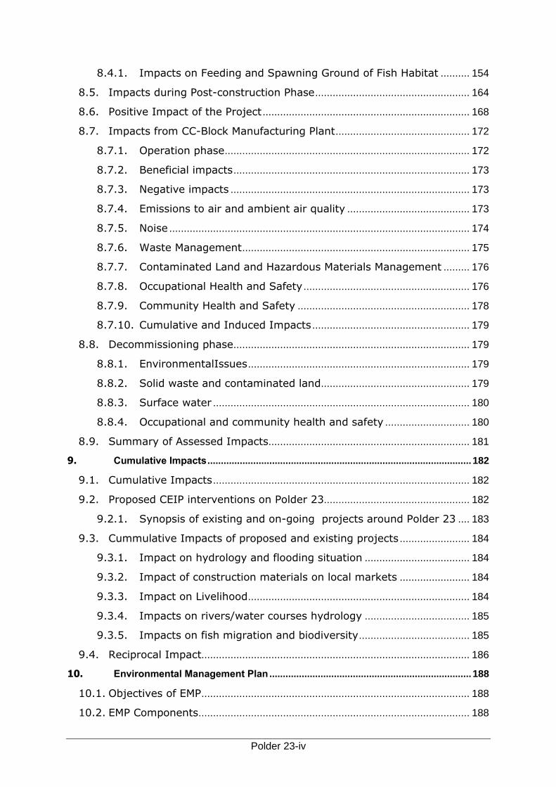
Polder 23-iv
8.4.1. Impacts on Feeding and Spawning Ground of Fish Habitat .......... 154
8.5. Impacts during Post-construction Phase ..................................................... 164
8.6. Positive Impact of the Project ....................................................................... 168
8.7. Impacts from CC-Block Manufacturing Plant .............................................. 172
8.7.1. Operation phase .................................................................................... 172
8.7.2. Beneficial impacts ................................................................................. 173
8.7.3. Negative impacts .................................................................................. 173
8.7.4. Emissions to air and ambient air quality .......................................... 173
8.7.5. Noise ....................................................................................................... 174
8.7.6. Waste Management .............................................................................. 175
8.7.7. Contaminated Land and Hazardous Materials Management ......... 176
8.7.8. Occupational Health and Safety ......................................................... 176
8.7.9. Community Health and Safety ........................................................... 178
8.7.10. Cumulative and Induced Impacts ...................................................... 179
8.8. Decommissioning phase ................................................................................. 179
8.8.1. EnvironmentalIssues ............................................................................ 179
8.8.2. Solid waste and contaminated land ................................................... 179
8.8.3. Surface water ........................................................................................ 180
8.8.4. Occupational and community health and safety ............................. 180
8.9. Summary of Assessed Impacts ..................................................................... 181
9. Cumulative Impacts .................................................................................................. 182
9.1. Cumulative Impacts ........................................................................................ 182
9.2. Proposed CEIP interventions on Polder 23.................................................. 182
9.2.1. Synopsis of existing and on-going projects around Polder 23 .... 183
9.3. Cummulative Impacts of proposed and existing projects ........................ 184
9.3.1. Impact on hydrology and flooding situation .................................... 184
9.3.2. Impact of construction materials on local markets ........................ 184
9.3.3. Impact on Livelihood ............................................................................ 184
9.3.4. Impacts on rivers/water courses hydrology .................................... 185
9.3.5. Impacts on fish migration and biodiversity ...................................... 185
9.4. Reciprocal Impact............................................................................................ 186
10. Environmental Management Plan ........................................................................... 188
10.1. Objectives of EMP ............................................................................................ 188
10.2. EMP Components ............................................................................................. 188
Polder 23-v
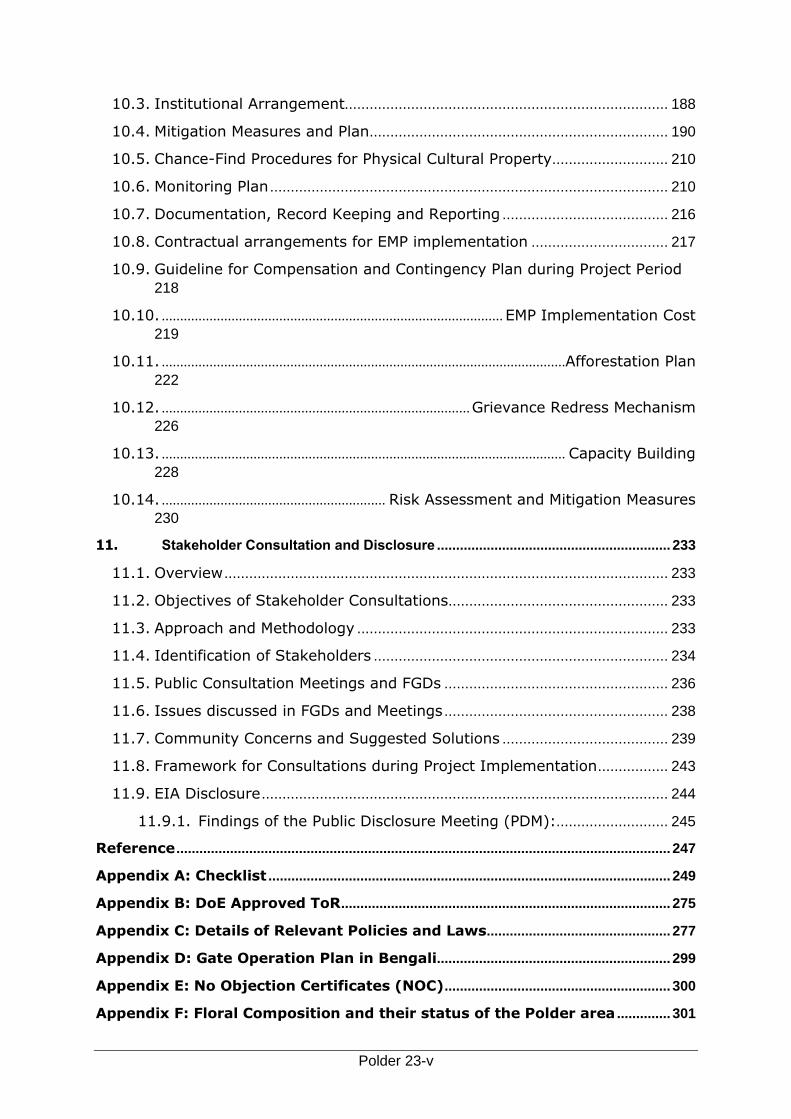
10.3. Institutional Arrangement.............................................................................. 188
10.4. Mitigation Measures and Plan ........................................................................ 190
10.5. Chance-Find Procedures for Physical Cultural Property ............................ 210
10.6. Monitoring Plan ................................................................................................ 210
10.7. Documentation, Record Keeping and Reporting ........................................ 216
10.8. Contractual arrangements for EMP implementation ................................. 217
10.9. Guideline for Compensation and Contingency Plan during Project Period
218
10.10. ............................................................................................. EMP Implementation Cost
219
10.11. ..............................................................................................................Afforestation Plan
222
10.12. .................................................................................... Grievance Redress Mechanism
226
10.13. .............................................................................................................. Capacity Building
228
10.14. ............................................................. Risk Assessment and Mitigation Measures
230
11. Stakeholder Consultation and Disclosure ............................................................. 233
11.1. Overview ........................................................................................................... 233
11.2. Objectives of Stakeholder Consultations..................................................... 233
11.3. Approach and Methodology ........................................................................... 233
11.4. Identification of Stakeholders ....................................................................... 234
11.5. Public Consultation Meetings and FGDs ...................................................... 236
11.6. Issues discussed in FGDs and Meetings ...................................................... 238
11.7. Community Concerns and Suggested Solutions ........................................ 239
11.8. Framework for Consultations during Project Implementation ................. 243
11.9. EIA Disclosure .................................................................................................. 244
11.9.1. Findings of the Public Disclosure Meeting (PDM):........................... 245
Reference ................................................................................................................................. 247
Appendix A: Checklist ......................................................................................................... 249
Appendix B: DoE Approved ToR ...................................................................................... 275
Appendix C: Details of Relevant Policies and Laws ................................................ 277
Appendix D: Gate Operation Plan in Bengali............................................................. 299
Appendix E: No Objection Certificates (NOC) ........................................................... 300
Appendix F: Floral Composition and their status of the Polder area .............. 301

Polder 23-vi
Appendix G: Wildlife Species Composition ................................................................ 303
Appendix H: List of participants of PCM ...................................................................... 306
Appendix I: Checklist of Public Consultation Meeting .......................................... 308
Appendix J: Summary of Assessed Impacts ............................................................. 309
Appendix K: Comments and Responses (IPOE) ...................................................... 327
Appendix L: Responses to World Bank Comments ................................................. 329
Polder 23-vii
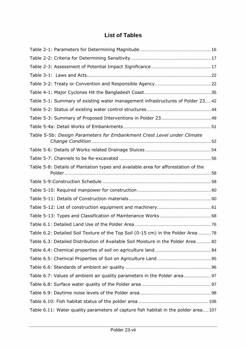
List of Tables
Table 2-1: Parameters for Determining Magnitude ............................................................ 16
Table 2-2: Criteria for Determining Sensitivity ................................................................... 17
Table 2-3: Assessment of Potential Impact Significance .................................................. 17
Table 3-1: Laws and Acts ........................................................................................................ 22
Table 3-2: Treaty or Convention and Responsible Agency ............................................... 22
Table 4-1: Major Cyclones Hit the Bangladesh Coast ........................................................ 35
Table 5-1: Summary of existing water management infrastructures of Polder 23..... 42
Table 5-2: Status of existing water control structures ...................................................... 44
Table 5-3: Summary of Proposed Interventions in Polder 23.......................................... 49
Table 5-4a: Detail Works of Embankments ......................................................................... 51
Table 5-5b: Design Parameters for Embankment Crest Level under Climate
Change Condition .................................................................................................... 52
Table 5-6: Details of Works related Drainage Sluices ....................................................... 54
Table 5-7: Channels to be Re-excavated ............................................................................. 56
Table 5-8: Details of Plantation types and available area for afforestation of the
Polder ........................................................................................................................... 58
Table 5-9:Construction Schedule ........................................................................................... 58
Table 5-10: Required manpower for construction .............................................................. 60
Table 5-11: Details of Construction materials ..................................................................... 60
Table 5-12: List of construction equipment and machinery ............................................. 61
Table 5-13: Types and Classification of Maintenance Works ........................................... 68
Table 6.1: Detailed Land Use of the Polder Area ................................................................ 76
Table 6.2: Detailed Soil Texture of the Top Soil (0-15 cm) in the Polder Area ........... 78
Table 6.3: Detailed Distribution of Available Soil Moisture in the Polder Area ............ 82
Table 6.4: Chemical properties of soil on agriculture land ............................................... 84
Table 6.5: Chemical Properties of Soil on Agriculture Land ............................................. 85
Table 6.6: Standards of ambient air quality ........................................................................ 96
Table 6.7: Values of ambient air quality parameters in the Polder area ....................... 97
Table 6.8: Surface water quality of the Polder area .......................................................... 97
Table 6.9: Daytime noise levels of the Polder area............................................................ 98
Table 6.10: Fish habitat status of the polder area ........................................................... 106
Table 6.11: Water quality parameters of capture fish habitat in the polder area ..... 107
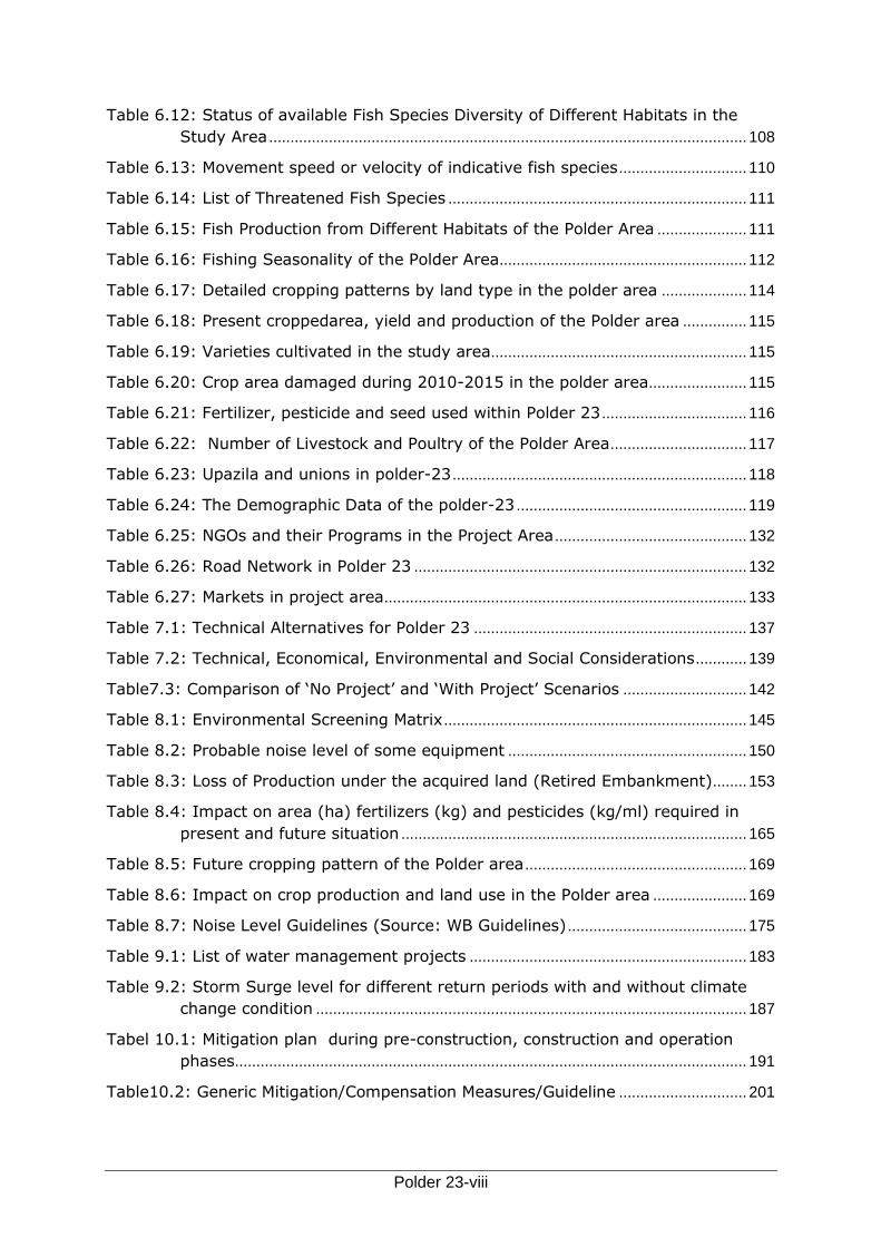
Polder 23-viii
Table 6.12: Status of available Fish Species Diversity of Different Habitats in the
Study Area ................................................................................................................ 108
Table 6.13: Movement speed or velocity of indicative fish species .............................. 110
Table 6.14: List of Threatened Fish Species ...................................................................... 111
Table 6.15: Fish Production from Different Habitats of the Polder Area ..................... 111
Table 6.16: Fishing Seasonality of the Polder Area .......................................................... 112
Table 6.17: Detailed cropping patterns by land type in the polder area .................... 114
Table 6.18: Present croppedarea, yield and production of the Polder area ............... 115
Table 6.19: Varieties cultivated in the study area............................................................ 115
Table 6.20: Crop area damaged during 2010-2015 in the polder area....................... 115
Table 6.21: Fertilizer, pesticide and seed used within Polder 23 .................................. 116
Table 6.22: Number of Livestock and Poultry of the Polder Area ................................ 117
Table 6.23: Upazila and unions in polder-23 ..................................................................... 118
Table 6.24: The Demographic Data of the polder-23 ...................................................... 119
Table 6.25: NGOs and their Programs in the Project Area ............................................. 132
Table 6.26: Road Network in Polder 23 .............................................................................. 132
Table 6.27: Markets in project area ..................................................................................... 133
Table 7.1: Technical Alternatives for Polder 23 ................................................................ 137
Table 7.2: Technical, Economical, Environmental and Social Considerations ............ 139
Table7.3: Comparison of ‘No Project’ and ‘With Project’ Scenarios ............................. 142
Table 8.1: Environmental Screening Matrix ....................................................................... 145
Table 8.2: Probable noise level of some equipment ........................................................ 150
Table 8.3: Loss of Production under the acquired land (Retired Embankment) ........ 153
Table 8.4: Impact on area (ha) fertilizers (kg) and pesticides (kg/ml) required in
present and future situation ................................................................................. 165
Table 8.5: Future cropping pattern of the Polder area .................................................... 169
Table 8.6: Impact on crop production and land use in the Polder area ...................... 169
Table 8.7: Noise Level Guidelines (Source: WB Guidelines) .......................................... 175
Table 9.1: List of water management projects ................................................................. 183
Table 9.2: Storm Surge level for different return periods with and without climate
change condition ..................................................................................................... 187
Tabel 10.1: Mitigation plan during pre-construction, construction and operation
phases ........................................................................................................................ 191
Table10.2: Generic Mitigation/Compensation Measures/Guideline .............................. 201
Polder 23-ix
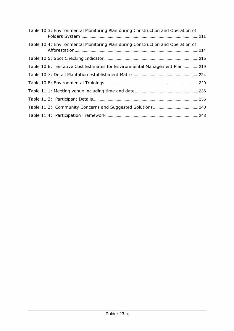
Table 10.3: Environmental Monitoring Plan during Construction and Operation of
Polders System ........................................................................................................ 211
Table 10.4: Environmental Monitoring Plan during Construction and Operation of
Afforestation ............................................................................................................. 214
Table 10.5: Spot Checking Indicator ................................................................................... 215
Table 10.6: Tentative Cost Estimates for Environmental Management Plan ............. 219
Table 10.7: Detail Plantation establishment Matrix ......................................................... 224
Table 10.8: Environmental Trainings ................................................................................... 229
Table 11.1: Meeting venue including time and date ........................................................ 236
Table 11.2: Participant Details ............................................................................................. 236
Table 11.3: Community Concerns and Suggested Solutions ........................................ 240
Table 11.4: Participation Framework ................................................................................. 243

Polder 23-x
List of Figures
Figure 2.1: Overall approach of the EIA study ...................................................................... 9
Figure 2.2: Aspects to be addressed in the Project Design and Description ................ 10
Figure 2.3: Typical process diagram of climate change impacts in coastal areas ...... 14
Figure 2.4: Concept of Alternative analysis to be used in the EIA study ...................... 18
Figure 2.5: Typical process diagram of climate change impacts in coastal areas ...... 19
Figure 3.1: Process of obtaining Clearance certificate from DoE .................................... 25
Figure 4.1: Temporal variations of mean maximum temperature over Polder 23
during the period 1976-2005. ................................................................................ 28
Figure 4.2: Temporal variations of annual mean minimum temperature over Polder
23 during the period 1976-2005. .......................................................................... 28
Figure 4.3: Temporal variations of annual rainfall over Polder 23 during the period
1976-2005. ................................................................................................................. 29
Figure 4.4: Change of seasonal rainfall (%) over Polder 23 for the year 2030 and
2050. ............................................................................................................................ 31
Figure 4.5: Annual cycle of projected maximum temperature with baseline over
Polder 23 in 2030 and 2050. .................................................................................. 32
Figure 4.6: Annual cycle of projected minimum temperature with baseline over
Polder 23 in 2030 and 2050. .................................................................................. 33
Figure 5.1: List of activities in Polder 23 at different project phases ............................ 51
Figure 5.2: Plan form of a typical khal to be re-excavated .............................................. 57
Figure 6.1: Monthly maximum, average and minimum Rainfall at Khulna BMD
Station ......................................................................................................................... 86
Figure 6.2: Annual rainfall (mm) trend in the Polder area ............................................... 87
Figure 6.3: Monthly variation of Temperature at Khulna BMD station .......................... 87
Figure 6.4: Monthly average relative Humidity at Khulna BMD station ........................ 88
Figure 6.5: Monthly average evaporation rate at Khulna BMD station .......................... 89
Figure 6.6: Monthly variation of average wind speed at Khulna BMD station ............. 89
Figure 6.7: Monthly average sunshine hours per day at Khulna BMD station ............. 90
Figure 6.8: Surface Water Level of Sibsa River .................................................................. 92
Figure 6.9: Monthly Variations of Average GWT ................................................................. 93
Figure 6.10: Tree Species occurrence according to salinity frontline from the
embankment ............................................................................................................ 102
Figure 6.11: Distribution of Households comprising member in each ......................... 119
Figure 6.12: Age Structure of the studied people ............................................................ 120
Polder 23-xi
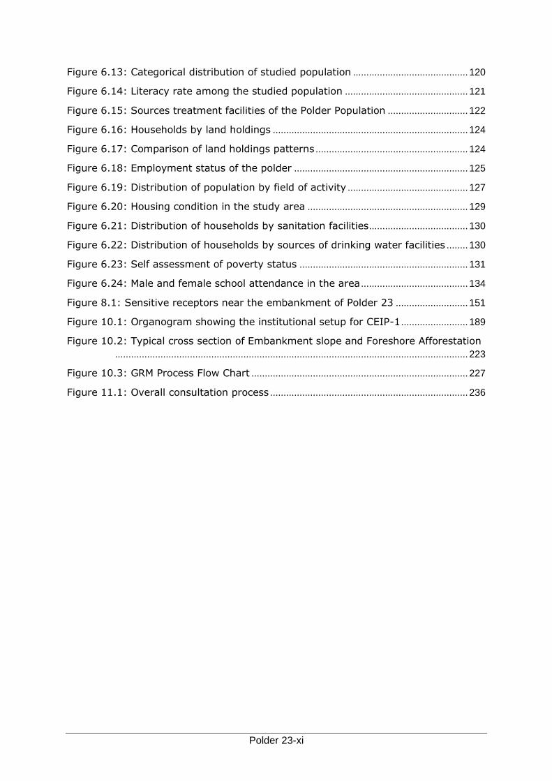
Figure 6.13: Categorical distribution of studied population ........................................... 120
Figure 6.14: Literacy rate among the studied population .............................................. 121
Figure 6.15: Sources treatment facilities of the Polder Population .............................. 122
Figure 6.16: Households by land holdings ......................................................................... 124
Figure 6.17: Comparison of land holdings patterns ......................................................... 124
Figure 6.18: Employment status of the polder ................................................................. 125
Figure 6.19: Distribution of population by field of activity ............................................. 127
Figure 6.20: Housing condition in the study area ............................................................ 129
Figure 6.21: Distribution of households by sanitation facilities ..................................... 130
Figure 6.22: Distribution of households by sources of drinking water facilities ........ 130
Figure 6.23: Self assessment of poverty status ............................................................... 131
Figure 6.24: Male and female school attendance in the area ........................................ 134
Figure 8.1: Sensitive receptors near the embankment of Polder 23 ........................... 151
Figure 10.1: Organogram showing the institutional setup for CEIP-1 ......................... 189
Figure 10.2: Typical cross section of Embankment slope and Foreshore Afforestation
.................................................................................................................................... 223
Figure 10.3: GRM Process Flow Chart ................................................................................. 227
Figure 11.1: Overall consultation process .......................................................................... 236
Polder 23-xii
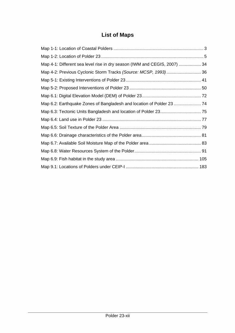
List of Maps
Map 1-1: Location of Coastal Polders ......................................................................... 3
Map 1-2: Location of Polder 23 ................................................................................... 5
Map 4-1: Different sea level rise in dry season (IWM and CEGIS, 2007) .................. 34
Map 4-2: Previous Cyclonic Storm Tracks (Source: MCSP, 1993) ............................ 36
Map 5-1: Existing Interventions of Polder 23 ............................................................. 41
Map 5-2: Proposed Interventions of Polder 23 .......................................................... 50
Map 6.1: Digital Elevation Model (DEM) of Polder 23 ................................................ 72
Map 6.2: Earthquake Zones of Bangladesh and location of Polder 23 ...................... 74
Map 6.3: Tectonic Units Bangladesh and location of Polder 23 ................................. 75
Map 6.4: Land use in Polder 23 ................................................................................ 77
Map 6.5: Soil Texture of the Polder Area .................................................................. 79
Map 6.6: Drainage characteristics of the Polder area ................................................ 81
Map 6.7: Available Soil Moisture Map of the Polder area .......................................... 83
Map 6.8: Water Resources System of the Polder ...................................................... 91
Map 6.9: Fish habitat in the study area ................................................................... 105
Map 9.1: Locations of Polders under CEIP-I ........................................................... 183
Polder 23-xiii
List of Pictures
Picture 5.1: Present condition of the embankment of the polder .................................................. 43
Picture 5.2: Brick soling on the crest of the embankment ............................................................. 43
Picture 5.3: Bitumen carpeting on the crest of the embankment .................................................. 43
Picture 5.4: Present condition of existing slope protection work ................................................... 44
Picture 5.5: Functioning condition of DS-1 .................................................................................... 48
Picture 5.6: Moderately functioning condition of DS-2 .................................................................. 48
Picture 5.7: Moderately functioning condition of DS-3 .................................................................. 48
Picture 5.8: Deplorable condition of FS-9 ...................................................................................... 48
Picture 6.1: Sibsa river during high tide ......................................................................................... 93
Picture 6.2: Sibsa river during low tide .......................................................................................... 93
Picture 6.3: Present condition of Embankment near DS-2, Harikhali............................................ 95
Picture 6.4: Present condition of Embankment at Karulia ............................................................. 95
Picture 6.5: Present condition of embankment along Sibsa river .................................................. 95
Picture 6.6: Vulnerable condition of the embankment at Paschim Kanmukhi............................... 95
Picture 6.7: Navigation in the rivers mainly for fishing ................................................................... 96
Picture 6.8: CEGIS Professional measuring water quality at field ................................................ 97
Picture 6.9: Satellite image (Jan, 2015) of the Polder showing different ecosystems ................ 100
Picture 6.10: Overview of homestead and aquatic vegetation pattern of Soladana Village from
embankment ............................................................................................................... 101
Picture 6.11: Social Afforestation along Embankment side of the Polder (Left: at Taltala and
Right: at Boyarjhanpa) ................................................................................................ 103
Picture 6.12: Open water fish habitats in the Polder area ........................................................... 106
Picture 6.13: Culture fish habitats in the Polder area .................................................................. 107
Picture 6.14: Composition of Fish Catch of the Polder Area ....................................................... 108
Picture 6.15: Fishing boat used in the Polder area ..................................................................... 112
Picture 6.16: Common fishing gear in the Polder area ............................................................... 113
Picture 6.17: View of Lt. Aman field in the Polder area .............................................................. 114
Picture 6.18: View of HYV Aman field in the Polder area ......................................................... 114
Picture 6.19: View of duck in the Polder area .............................................................................. 118
Picture 6.20: View of Goat grazing in the Polder area ................................................................ 118
Picture 6.21: Local educational institution at Polder area ........................................................... 122
Picture 6.22: A local village doctor providing treatment to a patient ........................................... 123
Picture 6.23: Different modes of livelihood activites at Polder 23 ............................................... 126
Picture 6.24: Practice of shrimp cultivation in agricultural land in the area ................................. 126
Picture 6.25: Solar connections of the area ................................................................................. 128
Picture 6.26: Different types housing structure at the Polder area .............................................. 129
Picture 6.27: Roads of the studied area ...................................................................................... 133
Picture 6.28: A temple of the studied area .................................................................................. 136
Picture 6.29: A mosque of the studied area ................................................................................ 136

Polder 23-xiv
Picture 11.1: PCM at Sholadana Union Auditorium .................................................................... 238
Picture 11.2: FGD at Paikghacha village ..................................................................................... 239
Picture 11.3: FGD at Sholadana village ...................................................................................... 240
Polder 23-xv
Abbreviations and Acronyms
ASA Association for Social Advancement
BBS Bangladesh Bureau of Statistics
BMD Bangladesh Meteorology Department
BRAC Bangladesh Rural Advancement Centre
BWDB Bangladesh Water Development Board
CDS Coastal Development Strategy
CEGIS Center for Environmental and Geographic Information Services
CEIP Coastal Embankment Improvement Program
CEIP-I Coastal Embankment Improvement Project, Phase- 1
CERP Coastal Embankment Rehabilitation Project
CZPo Coastal Zone Policy
DAE Department of Agricultural Extension
DDCS&PMSC Detailed Design, Construction Supervision and Project Management Support
Consultant
DevCon Dev Consultants Ltd
DoE Department of Environment
DPHE Department of Public Health Engineering
EA Environmental Assessment
ECA Environment Conservation Act
ECC Environmental Clearance Certificate
ECR Environment Conservation Rules
ECRRP Emergency 2007 Cyclone Recovery and Restoration Project
EIA Environmental Impact Assessment
EMF Environmental Management Framework
EMP Environmental Management Plan
ES Environmental Screening
FAO Food and Agriculture Organization of the United Nations
FGD Focus Group Discussion
FRSS Fisheries Resources Survey System
FWIP Future-with-Project
FWOP Future-without-Project
GIS Geographical Information System
GO Government Organization
GOB Government of Bangladesh
GPP Guidelines for People's Participation
GWT Ground Water Table
ha Hectare
HYV High Yielding Variety
IEE Initial Environmental Examination
IESCs Important Environmental and Social Components
ICZM Integrated Coastal Zone Management
IUCN International Union for Conservation of Nature
IWM Instititute of Water Modelling
KII Key Informant Interview
LGIs Local Government Institutions
Polder 23-xvi
LLP Low Lift Pump
MC Main Consultant (for CEIP-I Feasibility study)
MoEF Ministry of Environment and Forest
MoL Ministry of Land
MoWR Ministry of Water Resources
MSDSs Material Safety Data sheets
MT Metric ton
NAPA National Adaptation Programme of Action
NEMAP National Environment Management Action Plan
NCA Net Cultivable Area
NFP National Fisheries Policy
NGO Non-Governmental Organization
NLUP National Land Use Policy
NOC No Objection Certificate
NWRD National Water Resources Database
NWMP National Water Management Plan
NWP National Water Policy
O&M Operation and Maintenance
PAP Project Affected Person
PCM Public Consultation Meeting
PIO Project Implementation Office
PMU Mrpject Management Unit
PRA Participatory Rural Appraisal
PRSP Poverty Reduction Strategy Paper
PSC Project Steering Committee
RAP Resettlement Action Plan
RRA Rapid Rural Appraisal
SLR Sea Level Rise
SRDI Soil Resource Development Institute
TDS Total Dissolved Solids
ToR Terms of Reference
UFO Upazila Fisheries Office
UNDP United Nations Development Program
UNFCCC United Nations Framework Convention on Climate Change
VGD Vulnerable Group Development
VGF Vulnerable Group Feeding
WARPO Water Resources Planning Organization
WB World Bank
WMA Water Management Association
WMF Water Management Federation
WMG Water Management Groups
WMIP Water Management Improvement Project
WMO Water Management Organization
Polder 23-xvii
Glossary
Aila: Major Cyclone, which hit Bangladesh coast on May 25, 2009
Aman: Group of rice varieties grown in the monsoon season and harvested in the post-monsoon season. This is generally transplanted at the beginning of monsoon from July-August and harvested in November-Dec. Mostly rain-fed, supplemental irrigation needed in places during dry spell.
Aratdar: Main actor acting as a wholesaler or commission agent or covers both functions at the same time; carries out public auctions and is the main provider of credit in the marketing chain.
Aus: Group of rice varieties sown in the pre-monsoon season and harvested in the monsoon season. These are broadcasted/transplanted during March-April and harvested during June-July. Generally, rain-fed, irrigation needed for HYV T. Aus.
B Aus: Broadcast Aus
Bagda: Shrimp (Penaeus monodon), brackish/slightly saline water species.
Baor: Baor dead arm of a river in the Moribund Delta as in the case of the Ganges; also called oxbow lake. It appears as a saucer shaped depression. The term baor is synonymous to beel, familiar in the southwestern part of Bangladesh.
Bazar: Market
Beel: A saucer-shaped natural depression, which generally retains water throughout the year and in some cases seasonally connected to the river system.
Boro: A group of rice varieties sown and transplanted in winter and harvested at the end of the pre-monsoon season. These are mostly HYV and fully irrigated, planted in December-January and harvested before the onset of monsoon in April- May.
Golda Prawn (Macrobrachium rosenbergii), non-saline/fresh water species
Gher Farm lands converted into ponds with low dykes and used for cultivation of shrimp/prawn/fish.
Haor: A back swamp or bowl-shaped depression located between the natural levees of rivers and comprises of a number of beels.
Haat: Market place where market exchanges are carried out either once, twice or thrice a week, however not every day.
Jal: Different types of fishing net to catch fish from the water bodies.
Jhupri: Very small shed for living, made of locally available materials. One type of house used by very poor community members.
Kacha: A house made of locally available materials with earthen floor, commonly used in the rural areas.
Khal: A drainage channel usually small, sometimes man-made. The channel through which the water flows. Thismay or may not be perennial.
Kharif: Pre-monsoon and monsoon growing season. Cropping season linked to monsoon between March-October, often divided into kharif-1 (March-June) and kharif-2 (July-October).
Khas land: Land holding by the Government.
Kutcha Toilet: The earthen simple pit latrine consisting of a hole without cover.
Rabi: Dry agricultural crop growing season; mainly used for the cool winter season between November and February.

Polder 23-xviii
Ring slab: The simple pit latrine consists of a hole in the ground (which may be wholly or partially lined) covered by a squatting slab or seat where the user defecates. The defecation hole may be provided with a cover or plug to prevent the entrance of flies or egress of odor while the pit is not being used.
Sidr: Major Cyclone, which hit Bangladesh coast on November 15, 2007.
T. Aman: Transplanted Aman, grown between July to December
Upazila: Upazila is an administrative subdivision of a district.
Water sealed: A water sealed latrine is simply a pit latrine that has a water barrier to prevent odors. These latrines are simply pits dug in the ground in which human waste is deposited. A water sealed latrine has a bowl fixture that has a set amount of water retained in it. It is operated on the pour to flush system. These types of latrines can be connected to a septic tank system.
Polder 23-xix
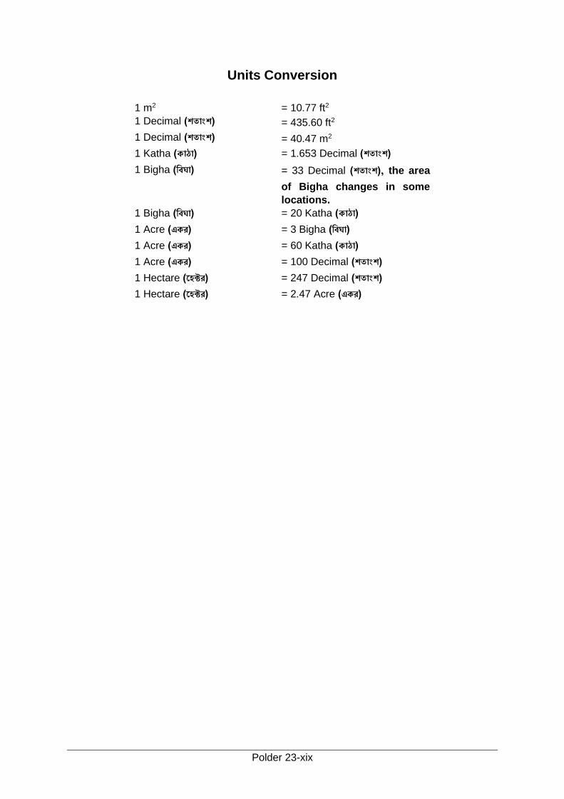
Units Conversion
1 m2 = 10.77 ft2
1 Decimal (শত াংশ) = 435.60 ft2
1 Decimal (শত াংশ) = 40.47 m2
1 Katha (ক ঠ ) = 1.653 Decimal (শত াংশ)
1 Bigha (wবঘ ) = 33 Decimal (শত াংশ), the area
of Bigha changes in some
locations. 1 Bigha (wবঘ ) = 20 Katha (ক ঠ )
1 Acre (একর) = 3 Bigha (wবঘ )
1 Acre (একর) = 60 Katha (ক ঠ )
1 Acre (একর) = 100 Decimal (শত াংশ)
1 Hectare (‡হকটর) = 247 Decimal (শত াংশ)
1 Hectare (‡হকটর) = 2.47 Acre (একর)
Polder 23-xx
Executive Summary
The Government of Bangladesh (GoB) has planned to implement the Coastal Embankment
Improvement Project, Phase 1 (CEIP-1), under which 17 Polders will be rehabilitated and
improved in the coastal area of the country. The GoB has obtained financial assistance from
the World Bank (WB) for this Project. In accordance with the national regulatory requirements
and WB safeguard policies, the rehabilitation and improvement activities of 17 Polders will be
implemented with three packages. EIA and EMP study for Package-1 (Polders 32, 33, 35/1
and 35/3 and Package-2 (Polders 43/2C, 47/2, 48, 40/2, 41/1 and 39/2C) have already been
done. Polders 14/1, 15, 16, 17/1, 17/2, 23 and 34/3 are included in Package-3. In Phase-1 of
CEIP Package-3 could not be implemented which are decided to implement in the next phase.
In accordance with the national regulatory requirements and WB safeguard policies, EIA and
EMP studies of seven Polders under Package-3 have been carried out. This document
presents the EIA report of Polder 23, which is one of these seven Polders of Package-3. It
may be mentioned that preliminarily 17 Polders were selected for rehabilitation in the feasibility
study considering physical conditions as well as damages to the Polders. Afterwards, these
Polders were selected through screening matrix. Considering environmental point of view,
multi-criteria analysis was conducted which has been mentioned in Strategic Environmental
Assessment (SEA) report for CEIP-1. The implementation of this EIA of Polder 23 would be
moved to a potential second phase of the Project together with additional polders under
design. The source of financing for the second phase is not yet determined.The EIA will be
updated ahead of starting of physical work of potential second phase as per requirement of
change of situation with passage of time
Background
The coastal zone in southern Bangladesh adjoining the Bay of Bengal is characterized by a
delicately balanced natural morphology of an evolving flat delta subject to very high tides and
frequent cyclones coming in from the Bay of Bengal encountering very large sediment inflows
from upstream. The coastal zone, in the past, in its natural state, used to face inundation by
high tides, salinity intrusion, cyclonic storms and associated tidal surges. In 1960s,
polderization started in the coastal areas to convert this area into permanent agricultural lands.
The polders in this area are enclosed on all sides by dykes or embankments, separating the
land from the main river system and offering protection against tidal floods, salinity intrusion
and sedimentation. These Polders are equipped with in- and outlet sluice gates to control the
water inside the embanked area.
The polders were originally designed without proper attention to storm surges. Recent
cyclonescaused substantial damage to the embankments and further threatened the integrity
of the coastal polders. In addition to breaching of the embankment due to cyclones, siltation
of peripheral rivers surrounding the embankment caused coastal polders to suffer from water
logging, which led to large scale environmental, social and economical degradation. Poor
maintenance and inadequate management of the polders have also contributed to internal
drainage congestion and heavy external siltation. As a result, soil fertility and good agriculture
production in some areas are declining because of water logging and salinity increase inside
the Polders.
The above reasons led the Government to re-focus its strategy on the coastal area from high
tides, storm surges. The long-term objective of the Government is to increase the resilience
of the entire coastal population from tidal flooding as well as natural disasters by upgrading
the whole embankment system. With an existing network of nearly 5,700 km long
embankments in 139 Polders, the magnitude of such a project is daunting and requires
Executive Summary
Polder 23-xxi
prudent planning. Hence, a multi-phased approach of embankment improvement and
rehabilitation will be adopted over a period of 15 to 20 years. The proposed CEIP-1 is the first
phase of this long-term program.
Location and Synopsis of Rehabilitation Work
The proposed Polder 23 is located in Paikgachha Upazila under Khulna District of Bangladesh.
The administrative and management control lies with BWDB’s Khulna O&M Division under the
southwestern zone. Water related problems like salinity intrusion, drainage congestion,
sedimentation, lack of suitable irrigation water and tidal flooding have increased severely in
this area. Consequently, the lives and livelihoods of the communities here have been
disrupted. The side slopes of the embankment are being damaged and eroded in different
places mainly due to river erosion and wave action. The overtopping that had occurred during
the Aila (2009) had also damaged and eroded the embankment in many locations of the
polder. There are so many unauthorised mini structures constructed by the Gher owners for
lifting water from the river for the purpose of shrimp culture.
The Project aims to enhance protection against natural disasters, increase resilience during
and after such disasters, and improve agricultural production by reducing saline water
intrusion. To meet the objectives of the CEIP-I, the key improvement works to be carried out
in Polder 23 under CEIP-1 are: re-sectioning of embankment (36.5 km); construction of retired
embankment (0.5 km); CEIP design crest level of embankment 5.00 (Ch. 7.50 to 16.50 km)
and 4.50 mPWD (remaining chainage); slope protection work of embankment (3.00 km);
construction (Replacement) of drainage sluices (17 nos); repairing of flushing sluices (08 nos);
demolishing of flushing sluices ( (14 nos); Re-excavation of drainage channels (20.15 km)
and afforestation of 26 ha (about 13 km along the periphery rivers). Other components of the
CEIP-1 will include implementation of social action plan, and an Environmental Management
Plan (EMP); supervision, monitoring and evaluation of project impacts; project management,
technical assistance, trainings, and technical studies; and contingent emergency response.
The Bangladesh Water Development Board (BWDB) is the implementing agency of this
Project.
After implementation of the proposed interventions, local stakeholders' participation in the
development and maintenance of this polder will be ensured. A three tier organizational
structure comprising of Water Management Groups (WMG) at the lowest level, Water
Management Associations (WMA) at the mid and Water Management Federation (WMF) at
the apex will be formed. The combination of groups, associations and federations in a
particular sub-project is together termed as the Water Management Organization (WMO).
Moreover, Community Based Organizationsoften termed as CBOs can also play a vital role in
maintenance activities. CBO includes ES (Embankment Settler); EMG (Embankment
Maintenance Group); LCS (Landless Contracting Society); and CMG (Canal Maintenance
Group).
Regulatory and Policy Framework
The construction, reconstruction, expansion of Polders and flood control embankment is
categorized as Red in accordance with the DoE‘s classification and according to the World
Bank safeguard policies, the project has been classified as Category A. The Environmental
Impact Assessment (EIA) study has been conducted and an Environmental Management Plan
(EMP) and Resettlement Action Plan (RAP) have been prepared as per GoB regulations and
World Bank Policies.
Proposed Rehabilitation Plan
Executive Summary
Polder 23-xxii
The proposed interventions in Polder- 23 under CEIP-1 are listed in the following table.
Type of Work Length Description of activities/works
Re-sectioning of embankment
36.50 km
Strengthening, widening and raising of existing embankment. The work will be executed from Ch 0.00 to 7.50, 7.50 to 16.50, 16.50 to 33.80 and 34.30 to 37.00.
Construction of retired embankment
0.50 km
Whenever a portion of the existing embankment is subject to erosion, retired embankment is to be constructed at a safe distance from the river towards country side to link with the existing embankment on both sites. The retired embankment will be constructed from Ch 33.80 to 34.30.
Construction of drainage sluices
02 nos.
Two new drainage sluices will be constructed at different locations to drain out excess rain water under the proposed rehabilitation plan.
Construction (Replacement) of drainage sluices
09 nos.
The structure has been fully damaged and approach embankment washed away during AILA. Nine number of drainage sluices will be constructed However, Among the drainage sluices of the Polder, eight numbers of existing sluices will be replaced and one new drainage sluice will be constructed with new design specifications.
Construction (Replacement) of flushing sluices
17 nos.
The structure has been fully damaged and approach embankment washed away during AILA. Seventeen numbers of existing flushing sluices will be replaced with new design specifications.
Re-excavation of drainage channels
20.15 km
Ten (10) drainage channels with a total length of 20.15 km will be re-excavated to ease water flow and reduce drainage congestion
Slope protection of embankment 3.00 km
Slope protection of the embankment against wave action will be carried out from Ch 10.00 km to 13.00.
Afforestation
7.23 ha
Afforestation will be implemented within the Polder to ensure the environmental sustainability as well as protection of embankment from erosion and tidal action
Designed crest level of embankment varies from 4.5 to 5.00 mPWD which has been assesd
through mathmetical modeling concedering storm surge level and monsoon water level for 25-
year return period under climate change scenarios. Sideslope of mbankment will be R/S 1:3
and C/S 1:2 respectively.
Executive Summary
Polder 23-xxiii
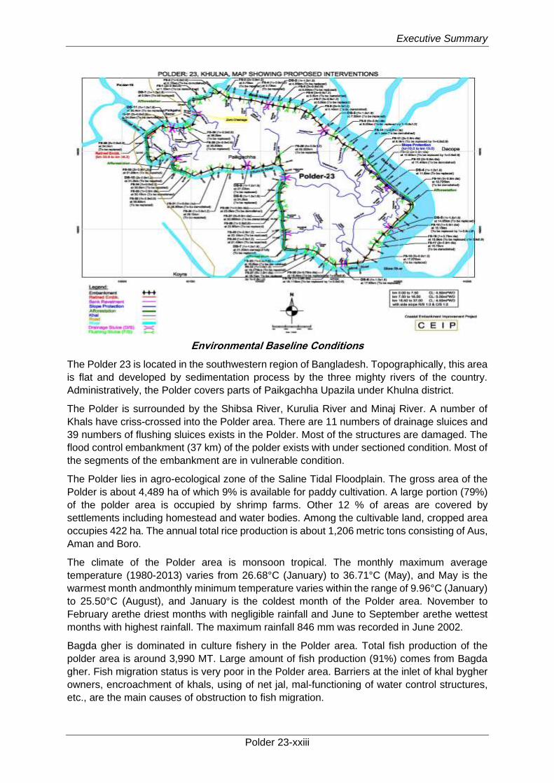
Environmental Baseline Conditions
The Polder 23 is located in the southwestern region of Bangladesh. Topographically, this area
is flat and developed by sedimentation process by the three mighty rivers of the country.
Administratively, the Polder covers parts of Paikgachha Upazila under Khulna district.
The Polder is surrounded by the Shibsa River, Kurulia River and Minaj River. A number of
Khals have criss-crossed into the Polder area. There are 11 numbers of drainage sluices and
39 numbers of flushing sluices exists in the Polder. Most of the structures are damaged. The
flood control embankment (37 km) of the polder exists with under sectioned condition. Most of
the segments of the embankment are in vulnerable condition.
The Polder lies in agro-ecological zone of the Saline Tidal Floodplain. The gross area of the
Polder is about 4,489 ha of which 9% is available for paddy cultivation. A large portion (79%)
of the polder area is occupied by shrimp farms. Other 12 % of areas are covered by
settlements including homestead and water bodies. Among the cultivable land, cropped area
occupies 422 ha. The annual total rice production is about 1,206 metric tons consisting of Aus,
Aman and Boro.
The climate of the Polder area is monsoon tropical. The monthly maximum average
temperature (1980-2013) varies from 26.68°C (January) to 36.71°C (May), and May is the
warmest month andmonthly minimum temperature varies within the range of 9.96°C (January)
to 25.50°C (August), and January is the coldest month of the Polder area. November to
February arethe driest months with negligible rainfall and June to September arethe wettest
months with highest rainfall. The maximum rainfall 846 mm was recorded in June 2002.
Bagda gher is dominated in culture fishery in the Polder area. Total fish production of the
polder area is around 3,990 MT. Large amount of fish production (91%) comes from Bagda
gher. Fish migration status is very poor in the Polder area. Barriers at the inlet of khal bygher
owners, encroachment of khals, using of net jal, mal-functioning of water control structures,
etc., are the main causes of obstruction to fish migration.
Executive Summary
Polder 23-xxiv
Polder 23 is located at south-west zone of the country consisting brackish nature of vegetation
and saline prone wetlands. The Polder falls under Bio-ecological zone 10 (Saline Tidal
Floodplain). Major ecosystems of this Polder are homesteads, crop fields, embankments,
shrimp farm, foreshore/intertidal river and canal.
Homestead bears higher population of flora and fauna. The encircled embankment of this
polder is barren or lightly vegetated. Adaptation of xerophytic species is remarkable in entire
the polder area. Some portions (Taltala and Boyarjhanpa), the embankments are planted with
Babla and Tamarind tree. Inter-tidal area of this Polder supports various avifauna as crabs,
mudskippers and scattered mangrove vegetation.
The total household 5,025 having a total population 22,128 of which 11,086 are males and
11,042females with a population density of 1,094 persons per sq km. The average literacy
rate is 57%, while male 65% and female 49%. Out of total population, 46%are engaged in
household work, 33% are employed, 01% looking for work and 20% do not work.
Potential Impacts and their Mitigations
Impacts during Pre-construction Phase
The potential environmental and social impacts associated with the pre-construction phase
of the project include deterioration of environmental quality from increased noise level and
dereriated air quality, land use change and increased vehicular traffic as follows:
Important Environmental Components
(IECs)
Potential Impacts Mitigation Measures
Pre-construction Phase
Air and Noise quality
Noise level around the construction sites and in settlement areas will be deteriorated for mobilization of construction, materials, trawler equipment and man-power. Navigation will be increased in the watercourses i.e. Sibsa, Kurulia and Minaj River. The increased navigation is expected to intense the noise level of the local vicinity. Besides, exhaust emission from materials and equipment mobilization trawlers and containing particulate matter and other ingredients would deteriorate the ambient air quality around the construction site and nearby areas due to movement of equipment carrying trawler. Fugitive dust emissions from the material stockyards would also deteriorate the ambient air quality of the locality.
• Construction material (sand etc.) should be covered while transporting and stock piled.
• The contractors need to be cautious to avoid unnecessary honking of material carrying trawler.
• The contractors should be encouraged to move all construction equipment, machinery and materials during day time instead of night.
• Stockyard should be covered during non-working period.
• Exhaust emissions from vehicles and equipment should comply with standards.
• Vehicles, generators and equipment should be properly tuned.
• Water will be sprinkled as and where needed to suppress dust emissions.
• Speed limits should be enforced for vehicles on earthen tracks.
• Vehicles and machinery should have proper mufflers and silencers.
Vegetation Preparation of construction sites, labor sheds and material stock yards is expected to damage vegetation where the land will be used for these purposes (Details will be illustrated after getting RAP Report).
• Habitat will be restored by planting trees, grasses at the damaged sites after completion of construction works.
Executive Summary
Polder 23-xxv
Important Environmental Components
(IECs)
Potential Impacts Mitigation Measures
Land use Land would be needed to establish temporary facilities including construction camp i.e labor shed and borrow pit areas. It is estimated that about 13 labor sheds would be constructed to established temporary facilities for the rehabilitation works. Therefore, land use will be changed temporary.
• Establish the construction camps within the area owned by BWDB, wherever available.
• Compensation/rent are to be paid if private property is acquired on temporary basis, the instructions should be specified in the tender document.
• Construct labor shed/camp at government khas land.
• Avoid impacts on local stakeholders.
• Any areas used for borrow pits in the foreshore should be away from sensitive areas such as mangrove vegetation, known fish spawning ground, habitatfor any endangered flora /fauna species.
vehicular traffic during mobilization
1. During contractor
mobilization, equipment, machinery,
material, and manpower will be
transported to the Polder resulting in
additional traffic on roads and
waterways. This traffic may
potentially cause traffic congestion
particularly at roads and jetties.
Moreover, most of the schools are
located near the embankment and
three important Bazars are also
located besides the embankment.
These will face traffic congestion
during Haat time. Earth work for re-
sectioning of embankment and
vehicles movement also may create
short term disturbances to the polder
inhabitants.
• The contractor should prepare a traffic management plan (TMP) and obtain approval from the DDCS&PMSConsultant.
• Contractor should also implement mobilization plan considering water vessels and launch movement in the external rivers and avoid the launch movement time.
• The TMP should be shared with the communities and should be finalized after obtaining their consent.
• The TMP should address the existing traffic congestion particularly at the Paikgaccha Bazar, Sholadana Bazar and Amurkata Bazar.
• Ensure minimal hindrance to local communities and commuters.
• The works on embankment should be carefully scheduled to minimize impact on local markets and transportation routes.
• The embankment works should be carried out in segments and soil will be placed linearly on half of the embankment, leaving the other half to be used as track.
• The works of the first half should be completed, and then of the other half should be undertaken.
• Work schedule to be finalized in coordination and consultation with local representatives and communities, specifically the Union Parishad members of the Polder.
• Local routes will not be blocked as much as possible. If unavoidable,

Executive Summary
Polder 23-xxvi
Important Environmental Components
(IECs)
Potential Impacts Mitigation Measures
alternative routes will be identified in consultation with local community.
• Vehicular traffic should be limitedin the Polder area and the embankment during off peak time. To avoid accident, signal man should be appointed during School time (10:00am to 13:00pm) and weekly marketdays (Hatbar)
• Keep provision of training on vehicular traffic moving pattern and management system for the local stakeholders using multimedia presentation and showing video at different common population gathering places in the Polder area.
Impacts during Construction Phase
The potential impacts during the construction phase include air pollution, noise pollution,
disruption of drainage system, loss of crop production, deterioration of soil quality, disrupt
irrigation, damage to fish habitat and other aquatic fauna, clearance of vegetation, traffic
congestion, conflict between local and outside labour, disturbance of local communication and
safety hazards as follows:
Important Environmental Components
(IECs)
Potential Impacts Mitigation Measures
Noise Vibration and air quality
The construction activities particularly demolition of existing water control structures, excavation, compaction, operation of construction machinery and vehicular traffic will generate noise and vibration which are likely to affect the nearby communities. The sensitive receptors including seven schools which are located close to the embankment (within 500 m) are likely to be more severely affected by noise. Construction machinery and Project vehicles will release exhaust emissions, containing carbon monoxide (CO), sulphur dioxide (SO2), oxides of nitrogen (NOX), and particulate matter (PM). These emissions can deteriorate the ambient air quality in the immediate vicinity of the Project sites
• Construction machineries should have proper mufflers and silencers.
• Noise levels from the construction machineries should comply with national noise standards (residential zone)
• Provision should be made for noise barriers at construction sites and near schools, Madrashas and other sensitive receptors as needed.
• Sprinkling of water and ramming of the material during construction
• Exhaust emissions from the mixture machine should comply with standards
• Restricting/limiting construction activities during the day time.
• Provision of PPE (ear muffs and plugs) for labors.
• Installation of fugitive particulate matter system and spraying water on construction materials.
• Construction team should be instructed to use the equipment properly, to minimize noise levels.
Executive Summary
Polder 23-xxvii
Important Environmental Components
(IECs)
Potential Impacts Mitigation Measures
• Liaison with the communities should be maintained and grievance redress mechanism will be established at the site.
Natural drainage system
The construction activity particularly for construction of drainage sluices, flushing sluices and re-excavation of the Khals may create obstacle to the natural drainage system of the study area especially around the project activity sites. During construction, the natural drainage system of the area will be hampered and may create temporarily drainage congestion in the Khals
• Some temporaryearthen dams should be built in the khal behind the construction of drainage sluices and behind the re-excavation segment at each reach.
• Bailing out of water behind the temporary earthen dams during construction work.
• Both contractor and BWDB should supervise the construction work
• Contractor should ensure that drainage channels are not obstructed or clogged by the construction activities.
• Contractor should ensure that construction activities do not inundate cultivation fields.
Soil and Water Contamination
Construction materials, demolished debris, fuel both from transportation vessel and construction machineries (piling machine, pump etc.) may degrade the soil and water quality. The construction workers will generate domestic solid waste and waste water including sewage. The amount of domestic wastewater generated by the construction workers is assumed to be equal to the amount of water usage. Oily water, waste oils, oily rags and other similar wastes will be generated from workshop. The stores and warehouse will generate solid waste such as empty cement bags, cardboards and wooden crates. Improper disposal of these waste streams can potentially contaminate the soils and water resources of the area. Soil and water contamination can potentially have negative impacts on the local community, natural vegetation, agriculture and biological resources of the area including aquatic flora and fauna.
• Prepare and implement pollution control plan;
• Workshops should have oil separators/sumpsto avoid release of oily water;
• Avoid repairing of vehicles and machinery in the field;
• Use plastic sheet or gravel in the workshop and equipment yard to prevent soil and water contamination;
• Dispose contaminated soil appropriately ensuring that it does not contaminate water bodies or affect drinking water sources;
• Contractor should ensure that there is no leakage, spillage or release of fuel, oil or any other affluent/waste on the ground or in the water from its construction machinery, vehicles, boats, launches, and barges. Contractor should regularly monitor the condition of its fleet;
• Material borrowed from the river banks should be carried out sufficiently away from the water edge, minimizing the possibility of loosing soil and wash out in the river;
• Contractor should locate camps far away from communities and drinking water sources;
• Prepare and implement camp waste management plan (septic tanks, proper solid waste disposal);
Executive Summary
Polder 23-xxviii
Important Environmental Components
(IECs)
Potential Impacts Mitigation Measures
• Release treated wastes on ground or in water;
• Recycle spoil and excavated material where possible;
• Dispose spoil at designated areas with community consent; and
• Construction material, demolished debris and excavated soil/silt should not be allowed to enter the water bodies.
Irrigation Construction activities particularly on regulators, water channels and re-excavation (20.15 km) activity of canals can potentially disrupt irrigation during both wet and dry season, thus negatively impacting cultivation.
• Contractor should construct diversion channels before construction/replacement of each regulator;
• Sequence of work of the regulators and the water channels would be carefully planned to avoid irrigation disruption;
• Contractor would ensure having no negative impacts on crop irrigation;
• Contractor would maintain liaison with the local communities; and
• Contractor would work during dry season.
Fish Feeding and spawning ground
Polder 14/1 is bounded by Kobodak and Arpangasia rivers on the western and Sakbaria River on the eastern part of the Polder. As per consultation with local fishers during field visit it is learnt that, the bank sides of these rivers have been reported as the feeding, nursery and spawning ground of brackish water fish species like Chewa, Pairsha, Gulsha Tengra, Bagda, chingri, etc. It is expected that activities of bank revetment would cause the partial destruction (if in the dry season) and full destruction (if in the rainy season) of the feeding, nursery and even spawning ground of these fish species.
• Earth work should be conducted during the dry season (November-May)
Sequence of work at the bank sides
of Kobodak and Sakbaria rivers will
be planned considering local
fisheries condition to minimize
impacts on spawning and
subsequently nursery ground of fish.
Contractor will maintain liaison with
experienced local fishermen.
The contractor will maintain proper
sequence of work so that the earth
work part of the revetment work
could be done within minimum period
as far as possible.
Fish Movement and Migration
A total of 20.15 km of internal Khals will be re-excavated under CEIP. It is expected that khal re-excavation activities especially bailing out of water would damage fish habitat in Khals and hamper fish migration temporarily during this phase.
• Construct diversion channels before construction of regulator considering fish migration period e.g. May, June, July and August
• Dismantle the bundhs and other obstructions built for supporting the construction of structures as soon as the construction is over.
• In case of manual re-excavation of khals, compartment would be built
Executive Summary
Polder 23-xxix
Important Environmental Components
(IECs)
Potential Impacts Mitigation Measures
and bailing out of water from one compartment to another for less damage to fish and excavate in cascading manner.
• Sequence of construction of regulators and re-excavation of drainage khals should be implemented one after another so that the construction activities could be made with minimum hindrnace to fish migration.
• Contractor will maintain liaison with fishers and farmers so that they could realize the issue for minimum impact to the shrimp farming and paddy cultivation.
Benthic Founa 2. During activities of re-
excavation of Khals especially
bailing out of water from the Khals
would hamper the khal habitat
condition. The habitat of Mud eel fish
species (chew, baim etc) and benthic
organisms will be affected by this
activity.
• Khal re-excavation should be carried out segment wise.
• Contractor will carry out khal excavation in segment thus minimizing impacts on benthic fauna.
• Monitor pre- and post-analysis of benthic fauna.
Vegetation • Re-sectioning of embankment will damage all undergrowth vegetation both at embankment slopes and the sites from which the soil would be collected. been covered with concrete blocks for slope protection. Embankment toes at Sakbaria, Matiabhanga, Gharilal and Jorshing villages follow strips of dense but small size (not more than 3m height and DBH 4cm) Gewa (Excoecaria agallocha) plants. These strips have been created naturally by germination of floating seeds from nearer mangrove forest. These saplings will be cut down/damaged during embankment re-sectioning.
• Collection of soils from foreshore area will also cause vegetation damage of these locations. Most of the foreshore area of this Polder is under plantation program by Climate Resilient Ecosystems and Livelihood (CREL) Project.
• Collect soil from barren land and alternate source like riverbed or nearby burrowpits at countryside as much as possible.
• Keep close liaison with CREL Project Authority and Forest Department during implementation of earth works.
• Needs approval from the DDCS&PMSC for vegetation clearance, if needed
• Create plant strips with same species at the toe of the embankment after completion of earthwork. The community members may be involved for protection of the saplings.
• Proper turfing should be made on the embankment slopes with local grasses (i.e., Durba (Cynodon dactylon), Mutha (Cyperus rotundus)) and ensure regular monitoring of turfed grasses till they matured.
• The top-soil at the construction and rehabilitation sites should be stored and used for plantation activities.
Executive Summary
Polder 23-xxx
Important Environmental Components
(IECs)
Potential Impacts Mitigation Measures
• Choose barren land for CC Block manufacturing and material storing.
• Implement plantation with native species along countryside slope of the embankment after finishing of construction works.
Inland and Waterway Traffic 3. Material transportation along
the major roads and waterways may
not create a significant problem;
however, additional traffic at smaller
jetties may cause traffic congestion
and hindrance to other commuters,
travelers, and transporters. For
material transportation from the
stock yard to the construction sites,
Polder’s internal roads can be used;
alternatively, the outer rivers can
also be used for this purpose.
• Contractor to prepare and implement traffic management plan.
• Contractor to establish new, temporary jetties where needed.
• River crossing for material transportation during nighttime where possible and appropriate
• Material transportation through rivers during high tide where needed.
• Liaison should be maintained with community and BIWTA.
Safety and Public Health Hazards
The area is prone to cyclones and storm surges. Although the works will be carried out during the dry season, a certain level of safety hazards still exists for the construction staff. The construction activities will involve operation of heavy construction machinery, vehicular traffic, excavation and filling operations. These activities may pose some safety hazards to the local population as well as for the construction workers. The fuel storage at the camp sites may also pose safety hazards for the construction staff as well as to surrounding population. Inappropriate waste disposal at the camps and construction sites, and air quality deterioration caused by the Project’s vehicular traffic and construction activities potentially pose health hazards to the construction staff and nearby population. Unhygienic condition and unavailability of safe drinking water for the construction staff will expose them to health risks. In addition, influx of construction staff can potentially expose the nearby population to communicable diseases.
• The contractors should prepare site specific Health, Safety and Environment (HSE) Plan and obtain approval from the Construction Supervision Consultants. The Plan should also include awareness building and prevention measures, particularly for communicable diseases such as hepatitis B and C, and HIV/AIDS.
• The WBG’s EHS Guidelines should be included in the contract documents and that should be followed during construction.
• Each contractor should prepare an Emergency Response Plan defining procedure to be followed during any emergency. This plan should be submitted to the Construction Supervision Consultants for review and approval;
• All workers must be provided with and use appropriate Personal Protective Equipment (PPE). First aid must be provided and there would be procedures in place to access appropriate emergency facilities.
• Liaison should be established with the Bangladesh Meteorological Department for early warning of storms and cyclones. Radio and television sets should be kept in all

Executive Summary
Polder 23-xxxi
Important Environmental Components
(IECs)
Potential Impacts Mitigation Measures
the labor camps for obtaining weather information.
• The construction sites should have protective fencing to avoid any unauthorized entry, where appropriate and possible
• Health screening of employees would be a Contractors obligation prior to laborers working on site and living in the temporary accommodation facilities. The health screening would entail normal review of physical fitness and also include a review of appropriate vaccinations. Workers would be given vaccinations as and where required;
• The WBG’s EHS Guidelines will be included in the contract documents. Each contractor will prepare an Emergency Response Plan defining procedures to be followed during any emergency. This plan will be submitted to Construction Supervision Consultants for review and approval;
• All employees need to provide induction training on health and safety prior to commencement of work. OHS issues would be part of the employee training plan. Training would include the provision of appropriate written or visual materials to reinforce learning. Illiteracy levels where high, the OHS issues should be covered more frequently than normal in toolbox talks;
• The labour shed/camps for accommodation of workers should be constructed according to the IFC/EBRD workers accommodation guidelines.
• Public awareness training and workshops on safety and health risks should be conducted for local communities prior to and during construction operations.
• Observing statutory requirements relating to minimum age for employment of children and meeting international standards of not employing any persons under the age of 16 for general work and no persons under the age of 18 for work involving hazardous activities. The
Executive Summary
Polder 23-xxxii
Important Environmental Components
(IECs)
Potential Impacts Mitigation Measures
construction contractor(s) should not hire people under the age of 18 on permanent contracts but would include short training activities for youth to the extent possible;
• Ensure the acceptable conditions of work including observing national statutory requirements related to minimum wages and hours of work;
• Ensure that no workers are charged fees to gain employment on the Project;
• Ensure the rigorous standards for occupational health and safety are in place;
• Contractor should establish a labor grievance mechanism and documenting its use for complaints about unfair treatment or unsafe living or working conditions without reprisal.
• The contractor should adopt a Human Resource Policy appropriate to the size and workforce which indicates the approach for management employees (this could be part requested in the tender process);
• Produce job descriptions and provide written contracts and other information that outline the working conditions and terms of employment, including the full range of benefits;
• Provide health insurance for employees for the duration of their contracts;
• Provide insurance for accidents resulting in disabilities or death of employees for the duration of their contracts;
• Develop a recruitment process community employees that involves local authorities in clearly understood procedures;
• Employ a community liaison officer (which could be full time or part of another post’s responsibilities);
• Raise awareness prior to recruitment, clarifying the local hire policy and procedures, including identification of opportunities for women to participate in employment and training;

Executive Summary
Polder 23-xxxiii
Important Environmental Components
(IECs)
Potential Impacts Mitigation Measures
• Regularly report the labor force profile, including gender, and location source of workers;
• Report regularly the labor and working condition key performance indicators, for instance hours worked (regular and overtime) during period and cumulatively, hours lost, number and type of accidents, near misses, site audits and meetings; trainings, and use of labor grievance mechanism;
• Hold toolbox talks on workers’ rights and the labor grievance mechanisms during the construction phase;
• Organize training program and keep training registers for construction workers;
• Establish Occupational Health and Safety (OHS) procedures in the overall environmental management system which provide workers with a safe and healthy work environment taking into account the inherent risks for this type of project.
• Availability of safe drinking water should have to be ensured for the construction staff.
• First aid boxes should have to be made available at each construction site. Emergency phone numbers (including hospitals, Fire services, and Police) should have to be displayed at key locations within the site. Each site should be occupied with an ambulance.
• Firefighting equipment should have to be made available at the camps and worksites.
• Waste management plan is to be prepared and implemented in accordance with international best practice.
• Liaison with the community should have to be maintained.
Hindrance for pedestrian and vehicle movement
Construction activities along the
embankments are likely to disrupt
the activities of these market
because four main markets are
located in the Polder near the
embankment. These markets play
important roles by providing sources
of livelihood for the Polder
• The works on embankment will be carefully scheduled to minimize the impacts on local markets and transportation routes.
• The embankment works will be carried out segment wise and soil will be placed linearly on half of the embankment, leaving the other half to be used as track. When the works of the first half are completed, it will
Executive Summary
Polder 23-xxxiv
Important Environmental Components
(IECs)
Potential Impacts Mitigation Measures
inhabitants as well as meeting the
daily needs of the people. In addition,
the tracks (mostly brick soled) on the
embankments are the key
transportation routes both for
pedestrians and vehicles in the
Polder connecting the communities
and the markets. The construction
activities along these embankments
will result in removal of these tracks
thus causing communication and
transportation problems to the local
population.
be opened for local traffic and the works of the other half will be undertaken.
• Work schedule will be finalized in coordination and consultation with local representatives and communities.
• Local routes will not be blocked as far as possible. If unavoidable, alternative routes will be identified in consultation with local community.
• No unauthorized entry of the local people/unwanted personnel at the camp site/work site will be allowed.
• Work sites and movement routes to be clearly demarcated, with appropriate warning signs (in Bangla and Chinese) at strategic locations.
• GRM will be put in place.
Social unrest A number of skilled and unskilled
labors will be required for the
construction activities. Most of the
labor will be needed for re-sectioning
of embankment and constructing
retired embankment. It is envisaged
that about 60 percent construction
workers will be recruited from within
the Polder area while the remaining
from other areas. The presence of
outside laborers in the area may
create friction and conflict between
the local labor and outside labor.,
and between local community and
outside labor.
Presence of number of labors from
outside can potentially cause
encroachment in the privacy of local
population particularly women and
hence their mobility can be
negatively affected.
• Proper awareness programs will have to be conducted through public consultation measures such as village scoping sessions, meetings, and placement of bill boards with assistance from the Union Parishad Chairman, Upazila Nirbahi Officer (UNO) and BWDB local officials.
• Cultural norms of the local community will have to be respected and honored.
• GRM will be established to address the grievances of local as well as outside laborers.
• Careful use of local natural resources and project resources, fuel, fuel-wood and electricity.
• Restrictions to be imposed in consumption of alcohol and drugs.
• Safe driving practices.
• Respect for the local community and its cultural norms in which laborers are working.
• Avoid construction activities during prayer time.
Natural hazard Historically, this area is vulnerable to cyclone, storm and tidal surges. As per construction schedule, the development activities of the proposed new polder will be conducted from October to May while most of the cyclone and storm surges are occurred in this area. According to previous record of occurrence of cyclone and storm surges, October to November
• Weather signals should have to be considered by the contractor during construction works.
• Radio and television should have to be kept in all labor sheds for getting weather information through these media.
Executive Summary
Polder 23-xxxv
Important Environmental Components
(IECs)
Potential Impacts Mitigation Measures
and April to May are the pick months of occurrence of cyclone and storm surges. It is suspected that the construction activities during this period may hamper as well as the workers may be injured
• Ensure rigorous standards for occupational health and safety are in place.
• Having the Contractor establish a labor grievance mechanism and documenting its use for complaints about unfair treatment or unsafe living or working conditions without reprisal.
Impacts from CC block manufacturing plant
The impact assessment is also focused on the environmental and social issues of automated
CC-block manufacturing plant during operation of plants as well as decommissioning of CC-
block plants based on potential impacts gathered through several visits to the CC-block
manufacturing plants leads to the following potential impacts. Appropriate mitigation measures
have been recommended to mitigate the adverse impacts during plant operation and
decommissioningphases as follows:
Important Environmental Components
(IECs)
Impact Mitigation
Emissions to air and ambient air quality
Air emissions will be generated from storage and handling of raw materials (mainly sand and cement) and emissions from equipment for transport, power supply and the plant itself. These emissions can deteriorate the ambient air quality in the immediate vicinity of the CC-block manufacturing plants. These emissions pose health hazards for the nearby communities as well as for the workers. In particular, any settlements near the plant areas may be exposed to air emissions caused by the CC-block manufacturing activities. However, effects of air pollution on biological and material receptors like flora, fauna, and construction materials need to be analysed.
• Emission inventory on a regular basis and comparison with air quality standards and between CC-Block plant operational and non-operational days
• Use of wind protection, barriers for wind protection for raw material stored in open piles
• Water sprinkling to be carried out where needed, particularly in dry season and on plant tracks and access roads near residential areas
• Dust extraction equipment and bag house filters, particularly for dry materials loading and unloading points
• Vehicle speed to be low at site and access roads (maximum 15 km per hour)
• Air quality monitoring to ensure mitigation measures are working, and further action to be taken if tolerance limits are exceeded
• Exhaust emissions from vehicles and equipment will comply with standards
• Vehicles and other machinery to be turned off/tuning when idle to minimize exhaust emissions
• Use of fuels with a low sulphur content (natural gas or LPG)
• Greenhouse Gas (GHG) Emissions and Energy Use. Greenhouse gas
Executive Summary
Polder 23-xxxvi
Important Environmental Components
(IECs)
Impact Mitigation
emissions, especially CO2, are mainly associated with the use of energy in the plants. Reference is made to the above measures to reduce SO2 and NOx emissions to reduce greenhouse gas emissions. However, the plant is not considered as a major energy consumer and therefore the impacts are considered low.
Noise level
The CC block manufacturing activities will generate noise and vibration, which are likely to affect any nearby communities and workers. Increased noise levels may cause disturbance, nuisance and even health hazards for nearby communities as well as for the workers. If the CC block plant isnot close to residential areas these impacts on nearby communities are considered low to moderate
Refers to construction phase
Waste management
The CC block manufacturing activities will generate solid and liquid waste. Solid waste will include domestic garbage; refuse from CC block construction, empty cement bags, etc. Liquid waste will include sewerage. The impact is considered moderate to low as the process does not generate much waste and the numbers of workers is limited
• The Contractor will prepare and implement a pollution control and waste management plan based on a waste management hierarchy that considers prevention, reduction, reuse, recovery, recycling, removal and finally disposal of wastes.
• Hazardous wastes should always be segregated from non-hazardous wastes. If generation of hazardous waste cannot be prevented through the implementation of the above general waste management practices, its management should focus on the prevention of harm to health, safety, and the environment. The following additional principles should be adhered to:
• Ensuring that contractors handling, treating, and disposing of hazardous waste are reputable and legitimate enterprises, licensed by the relevant regulatory agencies and following good international industry practice for the waste being handled
• Ensuring compliance with applicable local and international regulations
Hazardous materials
• Contamination of land should be avoided by preventing or controlling the release of hazardous materials, hazardous wastes, or oil/chemical to the environment. When contamination of land is
• Control measures to be implemented are: construction of secondary containment for storage tanks, avoidance of underground storage tanks and controlled transfer of oil from vehicle tanks to storage and vice versa. Proper secondary
Executive Summary
Polder 23-xxxvii
Important Environmental Components
(IECs)
Impact Mitigation
suspected or confirmed, the cause of the uncontrolled release should be identified and corrected to avoid further releases and associated adverse impacts. Contaminated lands should be managed to avoid the risk to human health and ecological receptors.
• The main risks for contaminated land at the plants is the storage and transfer/unloading of oil and lubricants for the vehicles and equipment.
containment structures should be capable of containing at least 110 per cent of the largest tank or 25% per cent of the combined tank volumes in areas with above-ground tanks with a total storage volume equal or greater than 1,000 litres.
• Workshops should be equipped with impermeable floors and oil-containing equipment should only be repaired in workshops.
Occupational health and safety(OHS)
Potential impacts related to
occupational health and safety at
the plant entails mainly physical
hazards, as there are:
• Rotating and Moving Equipment
• Noise and vibration
• Industrial Vehicle Driving and Site Traffic
Refers to construction phase
Community health and safety
Potential impacts related to
community health and safety for
the CC block plant entails mainly
traffic related hazards.
Transport safety practices as training
on safety aspects and driving skills
among drivers and use of speed
control devices on trucks
Regular maintenance of vehicles
Minimizing pedestrian interaction with
construction vehicles
Collaboration with local communities
and responsible authorities to
improve signage, visibility and overall
safety of roads
Impacts during Project Operation Phase
During operation phase, the project would have positive and negative impacts on
environmental and social components. The negative/adverse impacts with mitigation
measures are described as follows:
Important Environmental Components
(IECs)
Potential Impacts Mitigation Measures
Embankment Failure
Embankment failure or breaching of embankment is a common threat in the coastal region that is caused due to runoff, wave action, tidal surge and unauthorized activities like entering
• Regular monitoring and rigorous maintenance of the embankment and existing water control structures especially along the southern and western side of the Polder should be

Executive Summary
Polder 23-xxxviii
Important Environmental Components
(IECs)
Potential Impacts Mitigation Measures
saline/brackish water through pipies across the embankment by local people making the embankment weak. Lack of regular maintenance has created weak point at the sensitive locations of the embankment where the set back is less than 15m to 25m. Mal-maintenance and increasing intensity and magnitude of the cyclone and storm surge simultaneously have accelerated the risk of embankment failure.
ensured. This monitoring will particularly be carried out before and after monsoon season.
• Proper dumping and compaction of soil should be ensured during re-sectioning of the embankment.
• Side slope protection works should be maintained with proper design.
• Available cyclone and flood shelter should be prepared as a contingency measure during emergency situation.
• WMG should develop fund for such emergency situation.
• Structural measures like geo bag and sand bag should be kept in the Upazila office for emergency need.
Agro chemicals Implementation of the project interventions especially re-excavation of channels would cause expansion of area under irrigated cultivation of Boro (HYV) and T.Aus (Local) varieties of rice. The expansion of irrigated area would increase use of chemical inputs including fertilizers and pesticides. Runoff from such cultivation fields might potentially pollute the water bodies and even drinking water sources thus causing health hazards to the communities.
• Capacity building and awareness raising of the farmers will be carried out to practice Integrated Pest Management (IPM) and Integrated Crop Management (ICM) – in order to minimize usage of chemical inputs.
• Farmers group/WMO would have close contact with DAE for adoption of various measures of ICM.
• Farmers would be encouraged to use organic manure to increase soil fertility while avoiding water contamination. and
• Farmers would be encouraged to cultivate leguminous crops to enhance the soil quality as well as soil productivity.
Shrimp Farming and Livelihood
Shrimp farming is a common practice in this polder area. From the field visit, it wasfound that about 80% of the total area of land inside the polder has been converted to shrimp culture Ghers. After implementation of the proposed intervention, paddy land area will be increased compared to its base condition. On the other hand, shrimp farming area may be impacted due to reduction in saltwater intrusion. Thus, fish production from shrimp Gher may decline. The livelihood of the shrimp farmers will be impacted.
• Prospective of Golda farming should be encouraged through campaigning and by providing training on improved culture practices as well as rice-cum-golda farming within available sweet water as these are eco-friendly in nature
• Alternative income generation i.e. livestock rearing, poultry and integrated fish culture may create scope of alternative income for shrimp farm labour; and
• Implementation of land zoning for shrimp Gher in the polder area.
Cumulative Impacts The cumulative impacts of several existing and ongoing projects, as well as the proposed projects of CEIP-1 around the proposed rehabilitation Polder, were assessed. Such projects may have impacts on the hydrological network, flooding situation, life and livelihood of people, environmental quality, natural ecosystem, flora-fauna, etc. of Polder 23 and they were considered in this study. Apart from CEIP interventions, there are some other
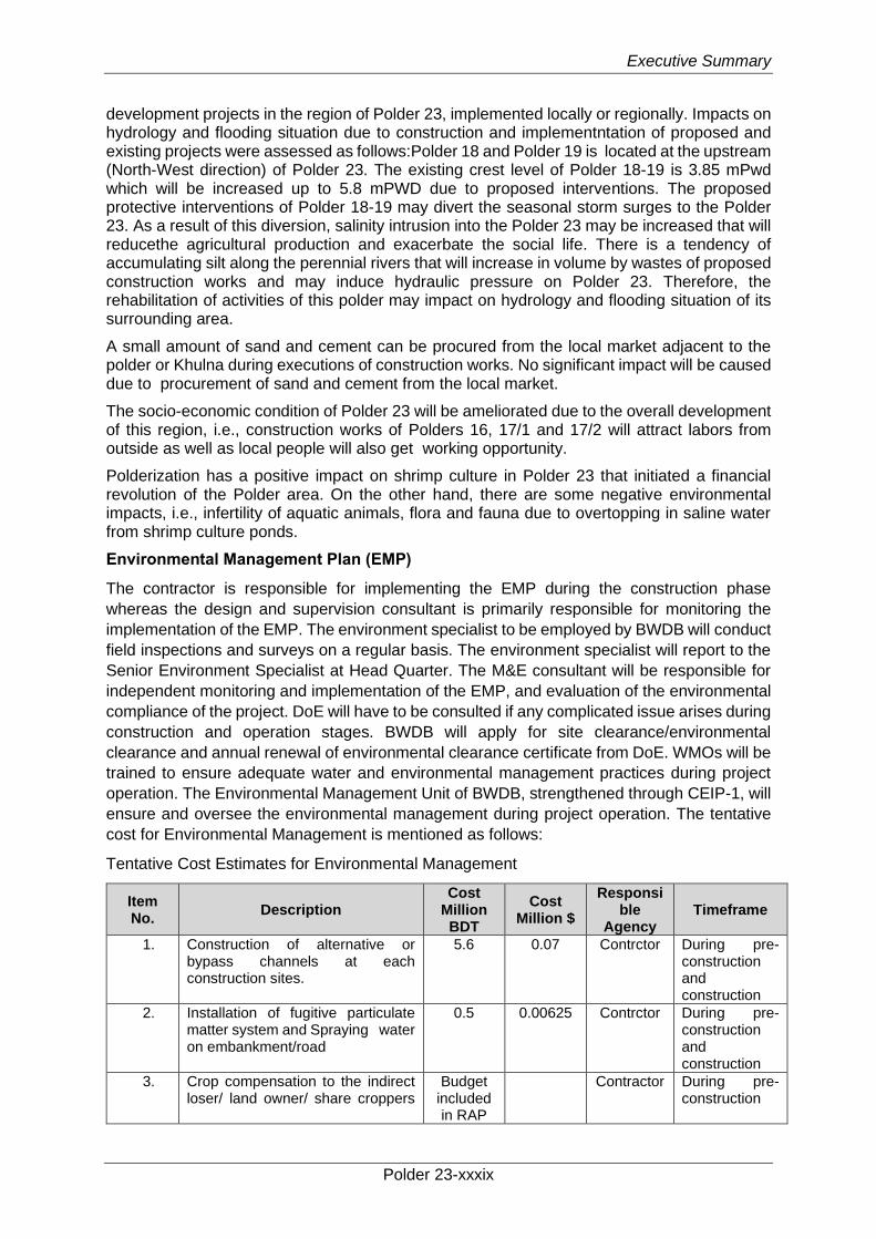
Executive Summary
Polder 23-xxxix
development projects in the region of Polder 23, implemented locally or regionally. Impacts on hydrology and flooding situation due to construction and implementntation of proposed and existing projects were assessed as follows:Polder 18 and Polder 19 is located at the upstream (North-West direction) of Polder 23. The existing crest level of Polder 18-19 is 3.85 mPwd which will be increased up to 5.8 mPWD due to proposed interventions. The proposed protective interventions of Polder 18-19 may divert the seasonal storm surges to the Polder 23. As a result of this diversion, salinity intrusion into the Polder 23 may be increased that will reducethe agricultural production and exacerbate the social life. There is a tendency of accumulating silt along the perennial rivers that will increase in volume by wastes of proposed construction works and may induce hydraulic pressure on Polder 23. Therefore, the rehabilitation of activities of this polder may impact on hydrology and flooding situation of its surrounding area.
A small amount of sand and cement can be procured from the local market adjacent to the polder or Khulna during executions of construction works. No significant impact will be caused due to procurement of sand and cement from the local market.
The socio-economic condition of Polder 23 will be ameliorated due to the overall development of this region, i.e., construction works of Polders 16, 17/1 and 17/2 will attract labors from outside as well as local people will also get working opportunity.
Polderization has a positive impact on shrimp culture in Polder 23 that initiated a financial revolution of the Polder area. On the other hand, there are some negative environmental impacts, i.e., infertility of aquatic animals, flora and fauna due to overtopping in saline water from shrimp culture ponds.
Environmental Management Plan (EMP)
The contractor is responsible for implementing the EMP during the construction phase
whereas the design and supervision consultant is primarily responsible for monitoring the
implementation of the EMP. The environment specialist to be employed by BWDB will conduct
field inspections and surveys on a regular basis. The environment specialist will report to the
Senior Environment Specialist at Head Quarter. The M&E consultant will be responsible for
independent monitoring and implementation of the EMP, and evaluation of the environmental
compliance of the project. DoE will have to be consulted if any complicated issue arises during
construction and operation stages. BWDB will apply for site clearance/environmental
clearance and annual renewal of environmental clearance certificate from DoE. WMOs will be
trained to ensure adequate water and environmental management practices during project
operation. The Environmental Management Unit of BWDB, strengthened through CEIP-1, will
ensure and oversee the environmental management during project operation. The tentative
cost for Environmental Management is mentioned as follows:
Tentative Cost Estimates for Environmental Management
Item No.
Description Cost
Million BDT
Cost Million $
Responsible
Agency Timeframe
1. Construction of alternative or bypass channels at each construction sites.
5.6 0.07 Contrctor During pre-construction and construction
2. Installation of fugitive particulate matter system and Spraying water on embankment/road
0.5 0.00625 Contrctor During pre-construction and construction
3. Crop compensation to the indirect loser/ land owner/ share croppers
Budget included in RAP
Contractor During pre-
construction
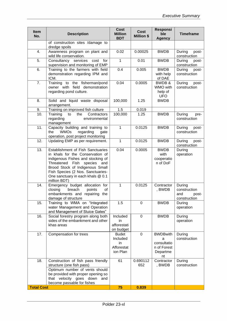
Executive Summary
Polder 23-xl
Item No.
Description Cost
Million BDT
Cost Million $
Responsible
Agency Timeframe
of construction sites /damage to dredge spoils
4. Awareness program on plant and wild life conservation.
0.02 0.00025 BWDB During post-construction
5. Consultancy services cost for supervision and monitoring of EMP
1 0.01 BWDB During post-construction
6. Training to the farmers with field demonstration regarding IPM and ICM.
0.4 0.005 BWDB with help of DAE
During post-construction
7. Training to the fisherman/pond owner with field demonstration regarding pond culture.
0.04 0.0005 BWDB & WMO with
help of UFO
During post-construction
8. Solid and liquid waste disposal arrangement.
100,000 1.25 BWDB
9. Training on improved fish culture 1.5 0.019
10. Training to the Contractors regarding environmental management
100,000 1.25 BWDB During pre-construction
11. Capacity building and training to the WMOs regarding gate operation, post project monitoring
1 0.0125 BWDB During post-construction
12. Updating EMP as per requirement. 1 0.0125 BWDB During post-construction
13. Establishment of Fish Sanctuaries in khals for the Conservation of indigenous Fishes and stocking of Threatened Fish species and Brood Stock of Indigenous Small Fish Species (2 Nos. Sanctuaries-One sanctuary in each khals @ 0.1 million BDT)
0.04 0.0005 BWDB with
cooperation of DoF
During operation
14. Emergency budget allocation for closing breach points of embankments and repairing the damage of structure
1 0.0125 Contractor, BWDB
During construction and post-construction
15. Training to WMA on “Integrated water Management and Operation and Management of Sluice Gates”
1.5 0 BWDB During operation
16. Social forestry program along both sides of the embankment and other khas areas
Included in
afforestation budget
0 BWDB During operation
17. Compensation for trees Budet Included
in Afforestation Plan
0 BWDBwith a
consultation of Forest Departme
nt
During construction
18. Construction of fish pass friendly structure (one fish pass)
61 0.690112652
Contractor, BWDB
During construction
Optimum number of vents should be provided with proper opening so that velocity goes down and become passable for fishes
Total Cost 75 0.839
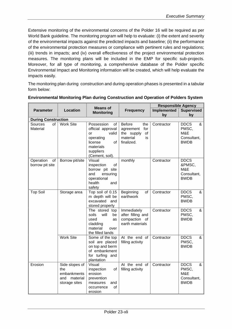
Executive Summary
Polder 23-xli
Extensive monitoring of the environmental concerns of the Polder 16 will be required as per
World Bank guideline. The monitoring program will help to evaluate: (i) the extent and severity
of the environmental impacts against the predicted impacts and baseline; (ii) the performance
of the environmental protection measures or compliance with pertinent rules and regulations;
(iii) trends in impacts; and (iv) overall effectiveness of the project environmental protection
measures. The monitoring plans will be included in the EMP for specific sub-projects.
Moreover, for all type of monitoring, a comprehensive database of the Polder specific
Environmental Impact and Monitoring information will be created, which will help evaluate the
impacts easily.
The monitoring plan during construction and during operation phases is presented in a tabular
form below:
Environmental Monitoring Plan during Construction and Operation of Polders System
Parameter Location Means of
Monitoring Frequency
Responsible Agency
Implemented by
Supervised by
During Construction
Sources of Material
Work Site Possession of official approval or valid operating license of materials suppliers (Cement, soil).
Before the agreement for the supply of material is finalized.
Contractor DDCS & PMSC, M&E Consultant, BWDB
Operation of borrow pit site
Borrow pit/site Visual inspection of borrow pit site and ensuring operational health and safety
monthly Contractor DDCS &PMSC, M&E Consultant, BWDB
Top Soil Storage area Top soil of 0.15 m depth will be excavated and stored properly
Beginning of earthwork
Contractor DDCS & PMSC, BWDB
The stored top soils will be used as cladding material over the filled lands
Immediately after filling and compaction of earth materials
Contractor DDCS & PMSC, BWDB
Work Site Some of the top soil are placed on top and berm of embankment for turfing and plantation
At the end of filling activity
Contractor DDCS & PMSC, BWDB
Erosion Side slopes of the embankments and material storage sites
Visual inspection of erosion prevention measures and occurrence of erosion
At the end of filling activity
Contractor DDCS & PMSC, M&E Consultant, BWDB
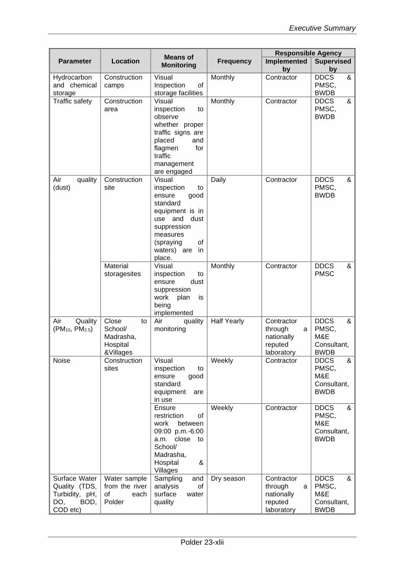
Executive Summary
Polder 23-xlii
Parameter Location Means of
Monitoring Frequency
Responsible Agency
Implemented by
Supervised by
Hydrocarbon and chemical storage
Construction camps
Visual Inspection of storage facilities
Monthly Contractor DDCS & PMSC, BWDB
Traffic safety Construction area
Visual inspection to observe whether proper traffic signs are placed and flagmen for traffic management are engaged
Monthly Contractor DDCS & PMSC, BWDB
Air quality (dust)
Construction site
Visual inspection to ensure good standard equipment is in use and dust suppression measures (spraying of waters) are in place.
Daily Contractor DDCS & PMSC, BWDB
Material storagesites
Visual inspection to ensure dust suppression work plan is being implemented
Monthly Contractor DDCS & PMSC
Air Quality (PM10, PM2.5)
Close to School/ Madrasha, Hospital &Villages
Air quality monitoring
Half Yearly Contractor through a nationally reputed laboratory
DDCS & PMSC, M&E Consultant, BWDB
Noise Construction sites
Visual inspection to ensure good standard equipment are in use
Weekly Contractor DDCS & PMSC, M&E Consultant, BWDB
Ensure restriction of work between 09:00 p.m.-6:00 a.m. close to School/ Madrasha, Hospital & Villages
Weekly Contractor DDCS & PMSC, M&E Consultant, BWDB
Surface Water Quality (TDS, Turbidity, pH, DO, BOD, COD etc)
Water sample from the river of each Polder
Sampling and analysis of surface water quality
Dry season Contractor through a nationally reputed laboratory
DDCS & PMSC, M&E Consultant, BWDB
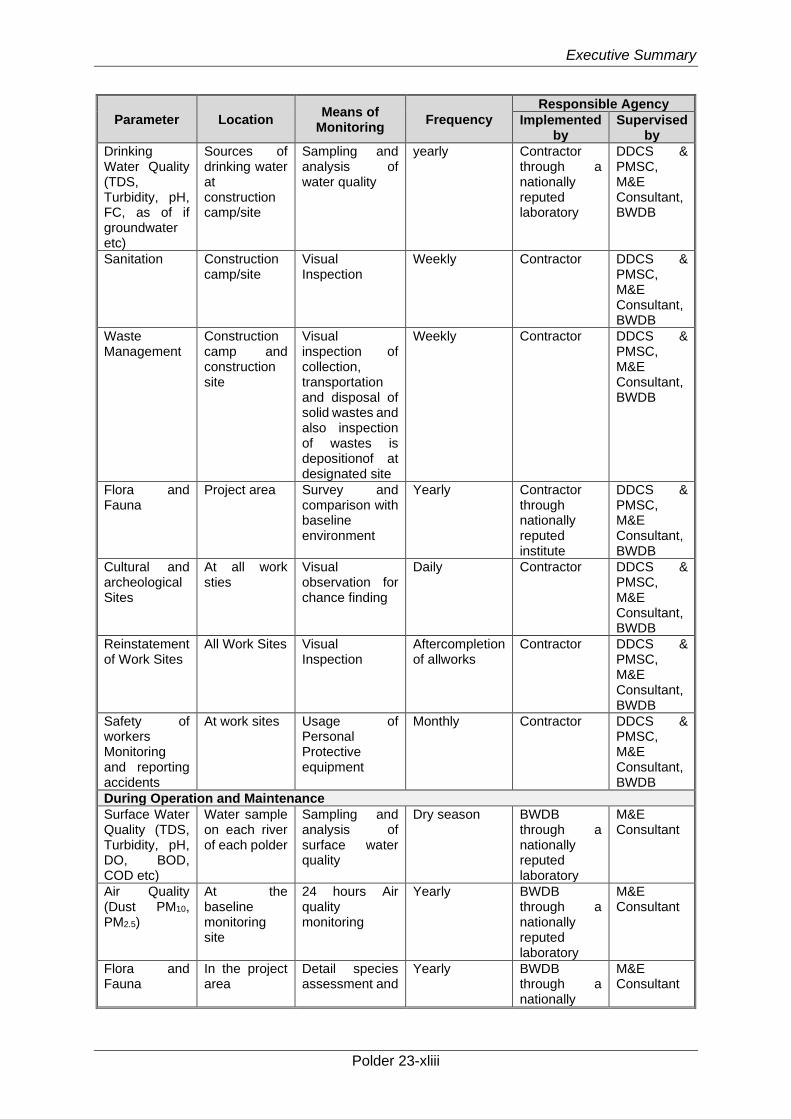
Executive Summary
Polder 23-xliii
Parameter Location Means of
Monitoring Frequency
Responsible Agency
Implemented by
Supervised by
Drinking Water Quality (TDS, Turbidity, pH, FC, as of if groundwater etc)
Sources of drinking water at construction camp/site
Sampling and analysis of water quality
yearly Contractor through a nationally reputed laboratory
DDCS & PMSC, M&E Consultant, BWDB
Sanitation Construction camp/site
Visual Inspection
Weekly Contractor DDCS & PMSC, M&E Consultant, BWDB
Waste Management
Construction camp and construction site
Visual inspection of collection, transportation and disposal of solid wastes and also inspection of wastes is depositionof at designated site
Weekly Contractor DDCS & PMSC, M&E Consultant, BWDB
Flora and Fauna
Project area Survey and comparison with baseline environment
Yearly Contractor through nationally reputed institute
DDCS & PMSC, M&E Consultant, BWDB
Cultural and archeological Sites
At all work sties
Visual observation for chance finding
Daily Contractor DDCS & PMSC, M&E Consultant, BWDB
Reinstatement of Work Sites
All Work Sites Visual Inspection
Aftercompletion of allworks
Contractor DDCS & PMSC, M&E Consultant, BWDB
Safety of workers Monitoring and reporting accidents
At work sites Usage of Personal Protective equipment
Monthly Contractor DDCS & PMSC, M&E Consultant, BWDB
During Operation and Maintenance
Surface Water Quality (TDS, Turbidity, pH, DO, BOD, COD etc)
Water sample on each river of each polder
Sampling and analysis of surface water quality
Dry season BWDB through a nationally reputed laboratory
M&E Consultant
Air Quality (Dust PM10, PM2.5)
At the baseline monitoring site
24 hours Air quality monitoring
Yearly BWDB through a nationally reputed laboratory
M&E Consultant
Flora and Fauna
In the project area
Detail species assessment and
Yearly BWDB through a nationally
M&E Consultant
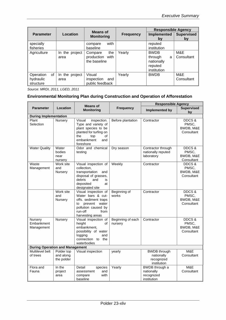
Executive Summary
Polder 23-xliv
Parameter Location Means of
Monitoring Frequency
Responsible Agency
Implemented by
Supervised by
specially fisheries
compare with baseline
reputed institution
Agriculture In the project area
Compare the production with the baseline
Yearly BWDB through a nationally reputed institution
M&E Consultant
Operation of hydraulic structure
In the project area
Visual inspection and public feedback
Yearly BWDB M&E Consultant
Source: MRDI, 2011, LGED, 2011
Environmental Monitoring Plan during Construction and Operation of Afforestation
Parameter Location Means of
Monitoring Frequency
Responsible Agency
Implemented by Supervised
by
During Implementation
Plant Selection
Nursery Visual inspection. Type and variety of plant species to be planted for turfing on the top of embankment and foreshore
Before plantation Contractor DDCS & PMSC,
BWDB, M&E Consultant
Water Quality Water bodies near nursery
Odor and chemical testing
Dry season Contractor through nationally reputed laboratory
DDCS & PMSC,
BWDB, M&E Consultant
Waste Management
Work site and Nursery
Visual inspection of collection, transportation and disposal of grasses, debris and is deposited at designated site
Weekly Contractor DDCS & PMSC,
BWDB, M&E Consultant
Work site and Nursery
Visual inspection of Water bars & cut-offs. sediment traps to prevent water pollution caused by run-off from harvesting areas
Beginning of works
Contractor DDCS & PMSC,
BWDB, M&E Consultant
Nursery Embankment Management
Nursery Visual inspection of height of embankment, possibility of water logging and connection to the waterbodies
Beginning of each nursery
Contractor DDCS & PMSC,
BWDB, M&E Consultant
During Operation and Management
Multilevel belt of trees
Polder top and along the polder
Visual inspection yearly BWDB through nationally
recognized institution
M&E Consultant
Flora and Fauna
In the project area
Detail species assessment and compare with baseline
Yearly BWDB through a nationally recognized institution
M&E Consultant
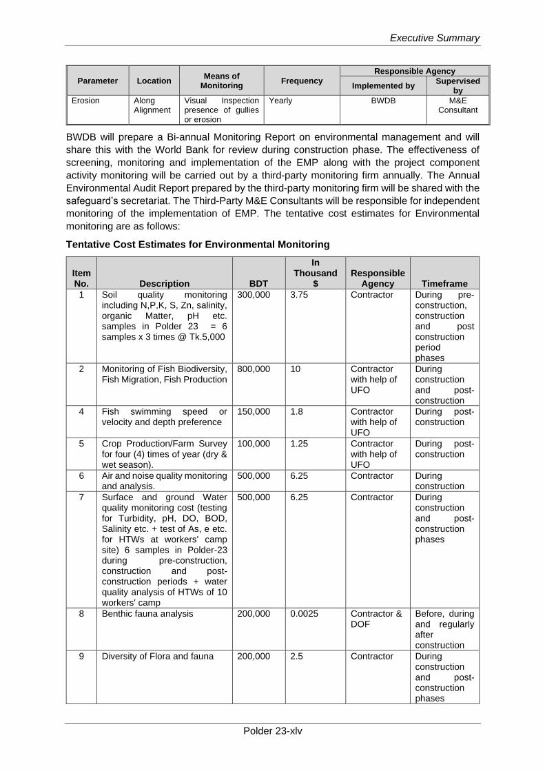
Executive Summary
Polder 23-xlv
Parameter Location Means of
Monitoring Frequency
Responsible Agency
Implemented by Supervised
by
Erosion Along Alignment
Visual Inspection presence of gullies or erosion
Yearly BWDB M&E Consultant
BWDB will prepare a Bi-annual Monitoring Report on environmental management and will
share this with the World Bank for review during construction phase. The effectiveness of
screening, monitoring and implementation of the EMP along with the project component
activity monitoring will be carried out by a third-party monitoring firm annually. The Annual
Environmental Audit Report prepared by the third-party monitoring firm will be shared with the
safeguard’s secretariat. The Third-Party M&E Consultants will be responsible for independent
monitoring of the implementation of EMP. The tentative cost estimates for Environmental
monitoring are as follows:
Tentative Cost Estimates for Environmental Monitoring
Item No. Description BDT
In Thousand
$ Responsible
Agency Timeframe
1 Soil quality monitoring including N,P,K, S, Zn, salinity, organic Matter, pH etc. samples in Polder 23 = 6 samples x 3 times @ Tk.5,000
300,000 3.75 Contractor During pre- construction, construction and post construction period phases
2 Monitoring of Fish Biodiversity, Fish Migration, Fish Production
800,000 10 Contractor with help of UFO
During construction and post-construction
4 Fish swimming speed or velocity and depth preference
150,000 1.8 Contractor with help of UFO
During post-construction
5 Crop Production/Farm Survey for four (4) times of year (dry & wet season).
100,000 1.25 Contractor with help of UFO
During post-construction
6 Air and noise quality monitoring and analysis.
500,000 6.25 Contractor During construction
7 Surface and ground Water quality monitoring cost (testing for Turbidity, pH, DO, BOD, Salinity etc. + test of As, e etc. for HTWs at workers' camp site) 6 samples in Polder-23 during pre-construction, construction and post-construction periods + water quality analysis of HTWs of 10 workers' camp
500,000 6.25 Contractor During construction and post-construction phases
8 Benthic fauna analysis 200,000 0.0025 Contractor & DOF
Before, during and regularly after construction
9 Diversity of Flora and fauna 200,000 2.5 Contractor During construction and post-construction phases
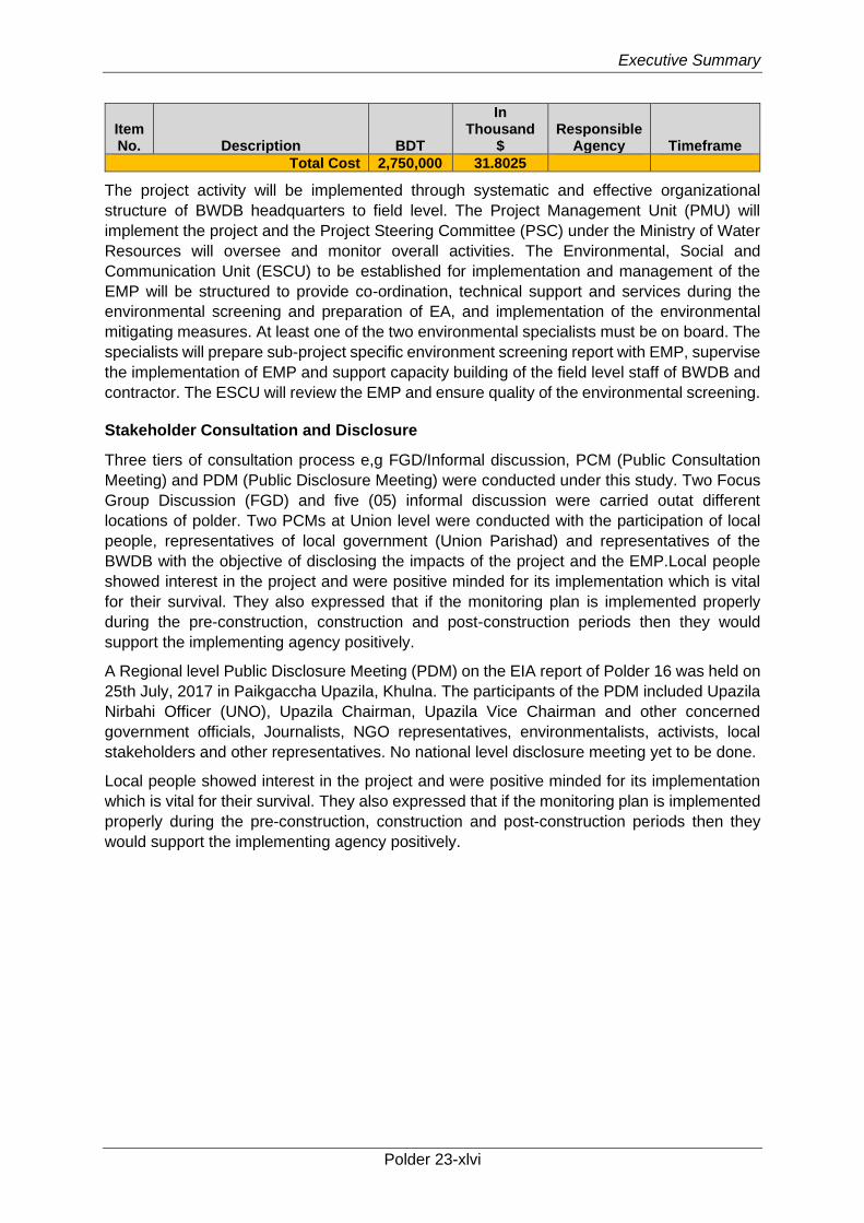
Executive Summary
Polder 23-xlvi
Item No. Description BDT
In Thousand
$ Responsible
Agency Timeframe
Total Cost 2,750,000 31.8025
The project activity will be implemented through systematic and effective organizational
structure of BWDB headquarters to field level. The Project Management Unit (PMU) will
implement the project and the Project Steering Committee (PSC) under the Ministry of Water
Resources will oversee and monitor overall activities. The Environmental, Social and
Communication Unit (ESCU) to be established for implementation and management of the
EMP will be structured to provide co-ordination, technical support and services during the
environmental screening and preparation of EA, and implementation of the environmental
mitigating measures. At least one of the two environmental specialists must be on board. The
specialists will prepare sub-project specific environment screening report with EMP, supervise
the implementation of EMP and support capacity building of the field level staff of BWDB and
contractor. The ESCU will review the EMP and ensure quality of the environmental screening.
Stakeholder Consultation and Disclosure
Three tiers of consultation process e,g FGD/Informal discussion, PCM (Public Consultation
Meeting) and PDM (Public Disclosure Meeting) were conducted under this study. Two Focus
Group Discussion (FGD) and five (05) informal discussion were carried outat different
locations of polder. Two PCMs at Union level were conducted with the participation of local
people, representatives of local government (Union Parishad) and representatives of the
BWDB with the objective of disclosing the impacts of the project and the EMP.Local people
showed interest in the project and were positive minded for its implementation which is vital
for their survival. They also expressed that if the monitoring plan is implemented properly
during the pre-construction, construction and post-construction periods then they would
support the implementing agency positively.
A Regional level Public Disclosure Meeting (PDM) on the EIA report of Polder 16 was held on
25th July, 2017 in Paikgaccha Upazila, Khulna. The participants of the PDM included Upazila
Nirbahi Officer (UNO), Upazila Chairman, Upazila Vice Chairman and other concerned
government officials, Journalists, NGO representatives, environmentalists, activists, local
stakeholders and other representatives. No national level disclosure meeting yet to be done.
Local people showed interest in the project and were positive minded for its implementation
which is vital for their survival. They also expressed that if the monitoring plan is implemented
properly during the pre-construction, construction and post-construction periods then they
would support the implementing agency positively.
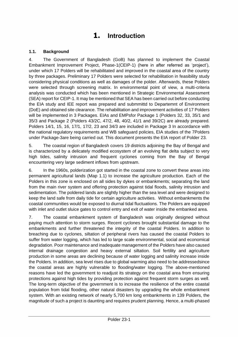
Polder 23-1
1. Introduction
1.1. Background
4. The Government of Bangladesh (GoB) has planned to implement the Coastal
Embankment Improvement Project, Phase-1(CEIP-1) (here in after referred as ‘project’),
under which 17 Polders will be rehabilitated and improved in the coastal area of the country
by three packages. Preliminary 17 Polders were selected for rehabilitation in feasibility study
considering physical conditions as well as damages of the polder. Afterwards, these Polders
were selected through screening matrix. In environmental point of view, a multi-criteria
analysis was conducted which has been mentioned in Strategic Environmental Assessment
(SEA) report for CEIP-1. It may be mentioned that SEA has been carried out before conducting
the EIA study and IEE report was prepared and submmittd to Departemnt of Environment
(DoE) and obtained site clearance. The rehabilitation and improvement activities of 17 Polders
will be implemented in 3 Packages. EIAs and EMPsfor Package 1 (Polders 32, 33, 35/1 and
35/3 and Package 2 (Polders 43/2C, 47/2, 48, 40/2, 41/1 and 39/2C) are already prepared.
Polders 14/1, 15, 16, 17/1, 17/2, 23 and 34/3 are included in Package 3 In accordance with
the national regulatory requirements and WB safeguard policies, EIA studies of the 7Polders
under Package-3are being carried out. This document presents the EIA report of Polder 23.
5. The coastal region of Bangladesh covers 19 districts adjoining the Bay of Bengal and
is characterized by a delicately modified ecosystem of an evolving flat delta subject to very
high tides, salinity intrusion and frequent cyclones coming from the Bay of Bengal
encountering very large sediment inflows from upstream.
6. In the 1960s, polderization got started in the coastal zone to convert these areas into
permanent agricultural lands (Map 1.1) to increase the agriculture production. Each of the
Polders in this zone is enclosed on all sides by dykes or embankments; separating the land
from the main river system and offering protection against tidal floods, salinity intrusion and
sedimentation. The poldered lands are slightly higher than the sea level and were designed to
keep the land safe from daily tide for certain agriculture activities. Without embankments the
coastal communities would be exposed to diurnal tidal fluctuations. The Polders are equipped
with inlet and outlet sluice gates to control entry and exit of water inside the embanked area.
7. The coastal embankment system of Bangladesh was originally designed without
paying much attention to storm surges. Recent cyclones brought substantial damage to the
embankments and further threatened the integrity of the coastal Polders. In addition to
breaching due to cyclones, siltation of peripheral rivers has caused the coastal Polders to
suffer from water logging, which has led to large scale environmental, social and economical
degradation. Poor maintenance and inadequate management of the Polders have also caused
internal drainage congestion and heavy external siltation. Soil fertility and agriculture
production in some areas are declining because of water logging and salinity increase inside
the Polders. In addition, sea level rises due to global warming also need to be addressedsince
the coastal areas are highly vulnerable to flooding/water logging. The above-mentioned
reasons have led the government to readjust its strategy on the coastal area from ensuring
protections against high tides by providing protection against frequent storm surges as well.
The long-term objective of the government is to increase the resilience of the entire coastal
population from tidal flooding, other natural disasters by upgrading the whole embankment
system. With an existing network of nearly 5,700 km long embankments in 139 Polders, the
magnitude of such a project is daunting and requires prudent planning. Hence, a multi-phased

Introduction
Polder 23-2
approach of embankment improvement and rehabilitation will be adopted over a period of 15
to 20 years. The proposed CEIP-1 is the first phase of this long-term program.
Coastal Embankment Improvement Project, Phase-1 (CEIP.1)
Bangladesh Water Development Board
Environmental Impact Assessment
Chapter-1: Introduction
Polder 23-3
Map 1-1: Location of Coastal Polders
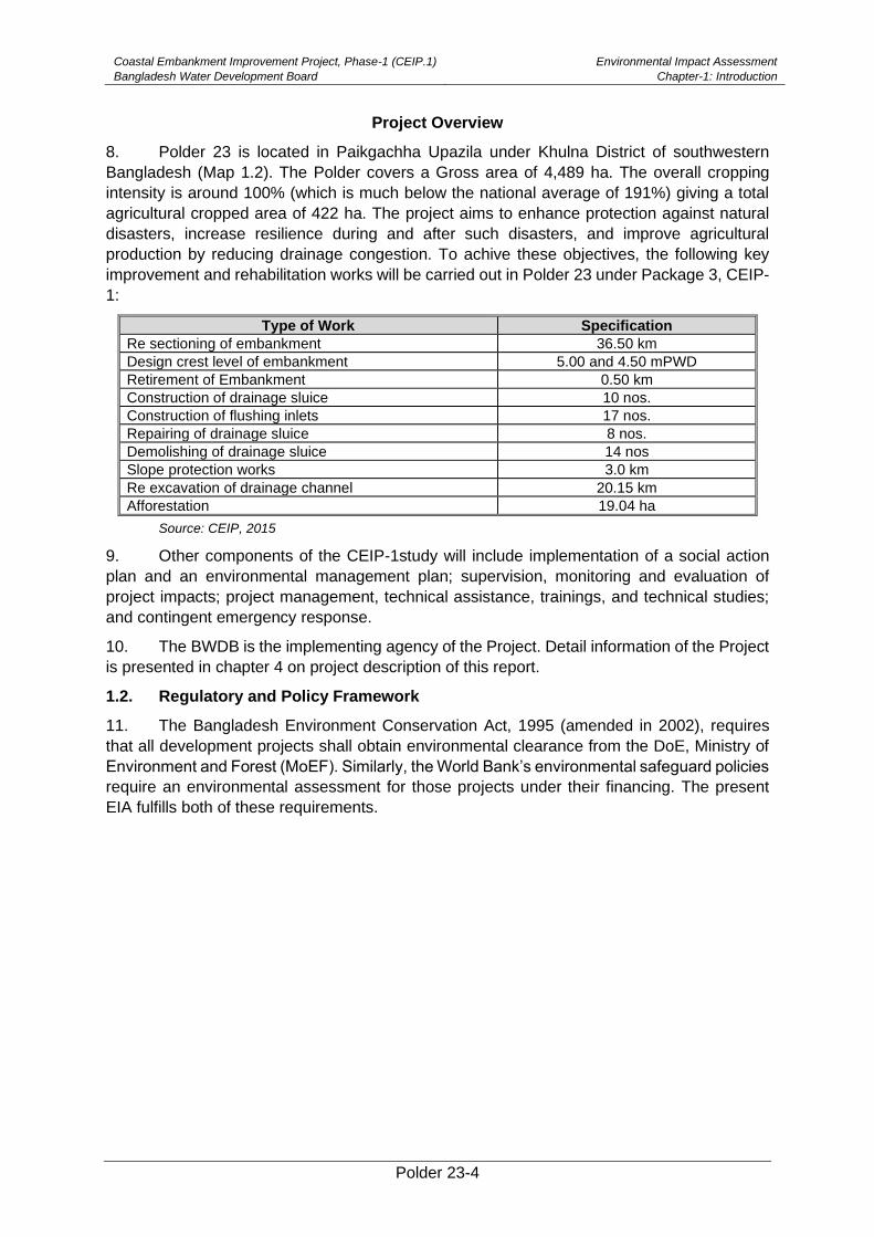
Coastal Embankment Improvement Project, Phase-1 (CEIP.1)
Bangladesh Water Development Board
Environmental Impact Assessment
Chapter-1: Introduction
Polder 23-4
Project Overview
8. Polder 23 is located in Paikgachha Upazila under Khulna District of southwestern
Bangladesh (Map 1.2). The Polder covers a Gross area of 4,489 ha. The overall cropping
intensity is around 100% (which is much below the national average of 191%) giving a total
agricultural cropped area of 422 ha. The project aims to enhance protection against natural
disasters, increase resilience during and after such disasters, and improve agricultural
production by reducing drainage congestion. To achive these objectives, the following key
improvement and rehabilitation works will be carried out in Polder 23 under Package 3, CEIP-
1:
Type of Work Specification
Re sectioning of embankment 36.50 km
Design crest level of embankment 5.00 and 4.50 mPWD
Retirement of Embankment 0.50 km
Construction of drainage sluice 10 nos.
Construction of flushing inlets 17 nos.
Repairing of drainage sluice 8 nos.
Demolishing of drainage sluice 14 nos
Slope protection works 3.0 km
Re excavation of drainage channel 20.15 km
Afforestation 19.04 ha
Source: CEIP, 2015
9. Other components of the CEIP-1study will include implementation of a social action
plan and an environmental management plan; supervision, monitoring and evaluation of
project impacts; project management, technical assistance, trainings, and technical studies;
and contingent emergency response.
10. The BWDB is the implementing agency of the Project. Detail information of the Project
is presented in chapter 4 on project description of this report.
1.2. Regulatory and Policy Framework
11. The Bangladesh Environment Conservation Act, 1995 (amended in 2002), requires
that all development projects shall obtain environmental clearance from the DoE, Ministry of
Environment and Forest (MoEF). Similarly, the World Bank’s environmental safeguard policies
require an environmental assessment for those projects under their financing. The present
EIA fulfills both of these requirements.
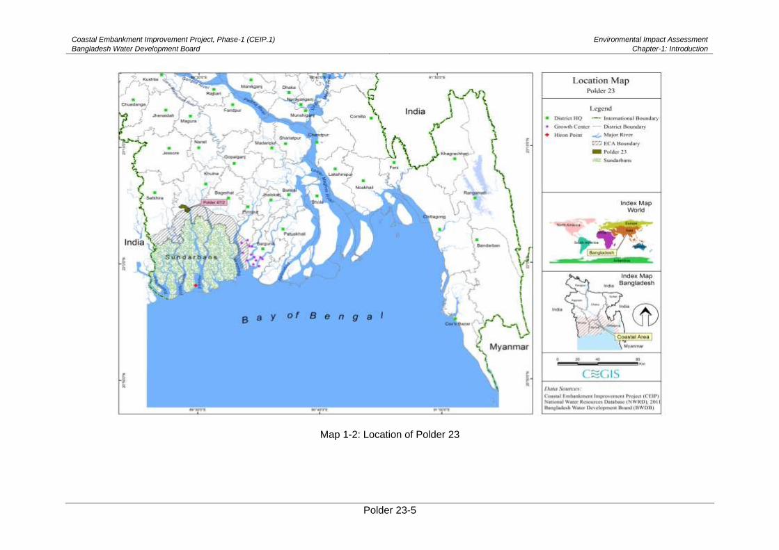
Coastal Embankment Improvement Project, Phase-1 (CEIP.1)
Bangladesh Water Development Board
Environmental Impact Assessment
Chapter-1: Introduction
Polder 23-5
Map 1-2: Location of Polder 23
Coastal Embankment Improvement Project, Phase-1 (CEIP.1)
Bangladesh Water Development Board
Environmental Impact Assessment
Chapter-1: Introduction
Polder 23-6
1.3. Objectives of the Study
12. The objective of the EIA study for Polder-23 is to identify and assess the potential
environmental impacts of the proposed project interventions, evaluate alternatives, and design
appropriate mitigation and management measures as well as monitoring guidelines to be
addressed in the Environmental Management Plan (EMP) in compliance with the national
regulatory and WB environmental policies and guidelines (for further details refer Chapter 3).
13. The specific objectives of the EIA study are to:
• Comply with the national regulatory and WB policy frameworks (further discussed
later in the document);
• Determine and describe the existing environmental and social settings of the Project
area (the Project area is defined as the entire area inside the polder, project
influence area outside the polder i.e. the embankments, borrow pits and spoil
disposal areas if located outside the polder; earth collection areas if located outside
the polder and access routes to the Polder);
• Identify and assess the potential environmental and social impacts of the Project;
• Identify mitigation measures to minimize the negative impacts and enhancement
measure to enhance the positive impacts; and
• Prepare an EMP including a detailedenvironmental monitoringissues
1.4. Scope of Works
14. The scope of works for conducting the EIA for Polder 23 included the following:
i. Carry out detail field investigation of required parameters of environmental and social
baseline, especially on the critical issues.
ii. Determine the potential impacts due to the project through identification, analysis and
evaluation of sensitive areas (natural habitats; sites of historic, cultural and
conservation importance), settlements and villages/agricultural areas or any other
identified Important Environmental and Social Components (IESCs).
iii. Determine the cumulative environmental impacts of the project which may occur inside
and outside the project area.
iv. Distinguish between significant positive and negative impacts, direct and indirect
impacts, immediate and long-term impacts, and unavoidable and irreversible impacts.
v. Identify feasible and cost-effective mitigation measures for each impact predicted as
above to reduce potentially significant adverse environmental impacts to acceptable
levels.
vi. Determine the capital and recurrent costs of the measures, and institutional, training
and monitoring requirements to effectively implement these measures. Identification of
all significant changes likely to be generated by the project activities. These would
include, but not be limited to changes in the coastal erosion and accretion due to
alteration of tidal currents, changing of fish migration routes, destruction of local
habitats, and water logging.
vii. Consultation with modeling consultants to establish conformity of the impact
assessment with existing and ongoing mathematical model due to climate change
developed by a number of reputed organizations. The developed models may be
available from the main consultant and implementing agency;
Coastal Embankment Improvement Project, Phase-1 (CEIP.1)
Bangladesh Water Development Board
Environmental Impact Assessment
Chapter-1: Introduction
Polder 23-7
viii. Prepare (a) an estimate of economic costs of the environmental damage and economic
benefits, where possible, from the direct positive impacts that the project is likely to
cause, and (b) an estimation of financial costs on the mitigation and enhancement
measures that the project is likely to require, and financial benefits, if any; the damage/
cost and benefits should be estimated in monetary value where possible, otherwise be
described in qualitative terms.
ix. Describe alternatives which were examined in course of developing the proposed
project and identify other alternatives which could achieve the same objectives. The
concept of alternatives extends to the sighting and design, technology selection,
rehabilitation/construction techniques and phasing, and operating and maintenance
procedures. Compare alternatives in terms of potential environmental impacts,
vulnerability, reliability, suitability under local conditions, and institutional, training, and
monitoring requirements. While describing the impacts, the irreversible or unavoidable
are unmitigable and impacts which may be mitigable. To the extent possible, quantify
the costs and benefits of each alternative, incorporating the estimated costs of any
mitigating measures. Include the alternative of not constructing the project to
demonstrate environmental conditions without it.
x. Identify the specific reciprocal impact of climate change on polder. Check the
suggested Polder height with respect to the SLR and high tide. Ensure that the design
will minimize the negative impact on the environment due to Polder rehabilitation
activities. For example, adequate fish pass should be provided to ensure free
movement of fish or drainage facility should be provided to avoid water logging in the
surrounding area.
xi. Prepare detail EMP along with respective EIA separately to monitor the implementation
of mitigation measures and the impacts of the project of other inputs (such as training
and institutional strengthening) needed to conduct it during construction and operation.
Include in the plan an estimate of capital and operating costs and a description of other
inputs (such as training and institutional strengthening) needed to implement the plan.
xii. Ensure to address occupational health and safety for the construction workers in the
EMP.
xiii. Develop Environmental monitoring format for regular monitoring of the project during
pre-construction, construction and operational stage and
xiv. Prepare the EIA report.
1.5. Structure of the Report
15. The report comprises the following chapters:
Chapter 1 (Introduction) describes the background of the project, objectives of the study,
scope of works with a list of EIA study team members.
Chapter 2 (Approach and Methodology) presents the detailed approach and procedure
followed to conduct the EIA study. The chapter also describes data sources and
methodology of data collection, processing and impact assessment.
Chapter 3 (Policy, Legal and Administrative Framework) reviews the national legislative,
regulatory and policy framework relevant to the EIA study. A discussion on the
WB safeguard policies and their applicability for the Project has also been
reviewed.
Coastal Embankment Improvement Project, Phase-1 (CEIP.1)
Bangladesh Water Development Board
Environmental Impact Assessment
Chapter-1: Introduction
Polder 23-8
Chapter 4 (Climate Change) descrives the climate change aspects from local perspectives
and the likely impacts on the project area and its surroundings.
Chapter 5 (Description of the Project) provides the simplified description of the project and its
phases, key activities under three phases, manpower, equipment, and material
requirements, implementation arrangements, implementation schedule, and other
related aspects.
Chapter 6 (Environmental Baseline and Existing Conditions) describes the existing
environmental and social settings in respect of Physical Environment, Biological
Environment and Socio-cultural environment of the project area.
Chapter 7 (Analysis of Alternatives) provides various alternatives considered during the
feasibility and design stage of the project, and their environmental and social
considerations.
Chapter 8 (Environmental Impacts and Mitigation Measures) identifies the environmental
impacts which may potentially be caused by various project phases, and also
proposes appropriate mitigation measures to avoid, offset, reduce, or compensate
these impacts.
Chapter 9 (Cumulative Impacts) presents analysis of cumulative impacts of the proposed
Project and other projects in the area. In addition, induced impacts have also
been covered in the chapter.
Chapter 10 (Environmental Management Plan) includes estimation of the impacts and costs
of the mitigation measures, prepare detail EMP with proposed work programs,
budget estimates, schedules, staffing and training requirements and other
necessary support services to implement the mitigation measures, phase wise
monitoring etc. specifies the implementation arrangements for the mitigation
measures identified during the EIA study. The EMP also includes among others
mitigation plan, enhancement plan, contingency plan and the environmental
monitoring plan.
Chapter 11 (Stakeholder Consultation and Disclosure) provides details of the consultations
held with the stakeholders at the project site and framework for consultations to
be carried out during construction phase. Community concerns and their
suggestedsolution and attitude towards the project is included in this chapter as a
part of EIA requirement
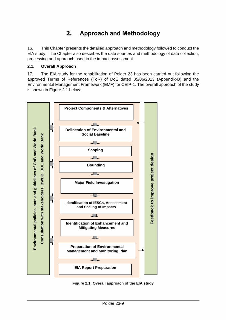
Polder 23-9
2. Approach and Methodology
16. This Chapter presents the detailed approach and methodology followed to conduct the
EIA study. The Chapter also describes the data sources and methodology of data collection,
processing and approach used in the impact assessment.
2.1. Overall Approach
17. The EIA study for the rehabilitation of Polder 23 has been carried out following the
approved Terms of References (ToR) of DoE dated 05/06/2013 (Appendix-B) and the
Environmental Management Framework (EMF) for CEIP-1. The overall approach of the study
is shown in Figure 2.1 below:
Figure 2.1: Overall approach of the EIA study
En
vir
on
men
tal p
olic
ies,
acts
an
d g
uid
elin
es o
f G
oB
an
d W
orl
d B
an
k
Co
nsu
ltati
on
wit
h s
takeh
old
ers
, B
WD
B, D
OE
an
d W
orl
d B
an
k
Feed
back t
o im
pro
ve p
roje
ct
desig
n
Project Components & Alternatives
Delineation of Environmental and Social Baseline
Scoping
Bounding
Major Field Investigation
Identification of IESCs, Assessment and Scaling of Impacts
Identification of Enhancement and Mitigating Measures
Preparation of Environmental Management and Monitoring Plan
EIA Report Preparation
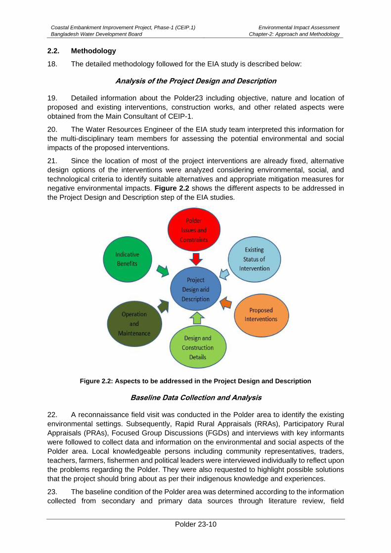
Coastal Embankment Improvement Project, Phase-1 (CEIP.1)
Bangladesh Water Development Board
Environmental Impact Assessment
Chapter-2: Approach and Methodology
Polder 23-10
2.2. Methodology
18. The detailed methodology followed for the EIA study is described below:
Analysis of the Project Design and Description
19. Detailed information about the Polder23 including objective, nature and location of
proposed and existing interventions, construction works, and other related aspects were
obtained from the Main Consultant of CEIP-1.
20. The Water Resources Engineer of the EIA study team interpreted this information for
the multi-disciplinary team members for assessing the potential environmental and social
impacts of the proposed interventions.
21. Since the location of most of the project interventions are already fixed, alternative
design options of the interventions were analyzed considering environmental, social, and
technological criteria to identify suitable alternatives and appropriate mitigation measures for
negative environmental impacts. Figure 2.2 shows the different aspects to be addressed in
the Project Design and Description step of the EIA studies.
Figure 2.2: Aspects to be addressed in the Project Design and Description
Baseline Data Collection and Analysis
22. A reconnaissance field visit was conducted in the Polder area to identify the existing
environmental settings. Subsequently, Rapid Rural Appraisals (RRAs), Participatory Rural
Appraisals (PRAs), Focused Group Discussions (FGDs) and interviews with key informants
were followed to collect data and information on the environmental and social aspects of the
Polder area. Local knowledgeable persons including community representatives, traders,
teachers, farmers, fishermen and political leaders were interviewed individually to reflect upon
the problems regarding the Polder. They were also requested to highlight possible solutions
that the project should bring about as per their indigenous knowledge and experiences.
23. The baseline condition of the Polder area was determined according to the information
collected from secondary and primary data sources through literature review, field
Coastal Embankment Improvement Project, Phase-1 (CEIP.1)
Bangladesh Water Development Board
Environmental Impact Assessment
Chapter-2: Approach and Methodology
Polder 23-11
investigations and consultations with different stakeholders. The baseline settings were
established with respect to the physical, biological and socio-cultural environmentincluding
identification of problems in respect of the proposed project sites and adjoining area. A
checklist was developed (Appendix A) and approved by the Detailed Design, Construction
Supervision and Project Management Support Consultant (DDCS&PMSC) and used to
register the information obtained from different stakeholders.
Physical Environment
24. Field visits at different stages of the study were arranged to the polder area and primary
data on water resource components were collected. Local knowledgeable persons and
community representatives were also interviewed. During field visits, the multidisciplinary EIA
study team members made observations pertaining to their individual areas of expertise.
Water Resources
25. Water resource data related to river hydrology and morphology, surface and ground
water availability, drainage pattern, ground and surface water quality and water use were
collected from secondary sources. Primary data on air, noise water were collected and
analyzed. The professionals of the multi-disciplinary teamreceived by feedback from the local
people. Major river systems were identified for hydrological and morphological investigation
through collection and analysis of historical and current image data. Specific areas or points
of interest were selected for collecting data on special hydrological and morphological aspects,
water availability, drainage pattern, water quality (surface and ground water), tidal flood, risk
of erosion and sedimentation.
26. Meteorological data such as temperature, rainfall, evapo-transpiration, wind speed and
humidity were collected from the National Water Resources Database (NWRD) of Water
Resources Planning Organization (WARPO), and subsequently analysed. The NWRD
contains long series of temporal data showing daily values for meteorological stations
maintained by the Bangladesh Meteorological Department (BMD).
27. The topographical and geological data were collected from Geological Survey of
Bangladesh and NWRD.
Land Resources
28. The agro-ecological region of the project area was identified using secondary sources
including Food and Agriculture Organization (FAO) and United Nations Development Program
(UNDP) information. The land type and soil texture data were collected from Upazila Land and
Soil Resources Utilization Guide of Soils Resources Development Institute (SRDI). The
secondary data of these parameters was verified at field level through physical observations
as well as consultations with the local people and officials of the Department of Agriculture
Extension (DAE) during field visit.
Biological Environment
Agricultural Resources
29. Land use information was prepared from satellite image classification followed byfield
verification. Data on agricultural resources which included existing cropping patterns, crop
variety, crop calendar, crop yield, crop damage, and agricultural input were collected from both
Coastal Embankment Improvement Project, Phase-1 (CEIP.1)
Bangladesh Water Development Board
Environmental Impact Assessment
Chapter-2: Approach and Methodology
Polder 23-12
secondary and primary sources. Agricultural data was collected through extensive field
surveys with the help of questionnaires and consultations with local people and concerned
agricultural officials. Agricultural resources data were also collected from secondary sources
from the DAE. Crop production was determined using the following formula:
• Total crop production = damage free area × normal yield + damaged area ×
damaged yield.
• The crop damage (production loss) was calculated using the following formula:
• Crop production loss = Total cropped area × normal yield (damaged area ×
damaged yield + damage free area × normal yield)
30. The crop damage data was collected from the field for the last three years.
Ecological Resources
31. The ecological component of the EIA study focused on terrestrial and riverine ecology
including flora, birds (including migratory birds), reptiles, amphibians, and mammals. The field
activities included collection of ecosystem and habitat information, sensitive habitat
identification, identifying ecological changes and potential ecological impact. The land use
information on different ecosystem was generated through analysis of recent satellite
imageries.
32. Field investigation methods included physical observation; transect walk, habitat
survey and consultations with local people. Public consultation meetings were carried out
through FGD and Key Informants Interview (KII) methods. Inventory of common flora and
fauna was developed based on field surveys and from the data base of the International Union
for Conservation of Nature (IUCN).
Fish and Fisheries
33. Primary data were collected from the fishermen community, fishermen households and
local key informants while secondary data were collected from Upazila Fisheries Offices
(UFOs) during field visits.
34. Fish habitat classification was made on the basis of physical existence and was
categorized into capture and culture fish habitats. The capture fish habitats included rivers,
khals, and tidal floodplains, borrow pits, and beels. The culture fish habitats included
homestead culture fish ponds, commercial fish farms, and shrimp ghers.
35. Information on post-harvest activities, forward and backward linkages, fishermen
livelihood information, fisheries management issues, potential fish recruitment, fish culture
infrastructure and fishermen vulnerability were also collected.
36. Secondary information from UFOs and literature were blended with primary data from
individual habitats to estimate fish production
Livestock Resources
37. Data on the present status of livestock (cow/bullock, buffalo, goat and sheep) and
poultry (duck and chicken) in the polder area was collected during field survey in consultation
with the local people through Participatory Rural Appraisal (PRA) and Rapid Rural Appraisal
(RRA). Livestock resources data were also collected from secondary sources from Upazila
Livestock Office.
Coastal Embankment Improvement Project, Phase-1 (CEIP.1)
Bangladesh Water Development Board
Environmental Impact Assessment
Chapter-2: Approach and Methodology
Polder 23-13
Socio-cultural Environment
38. The steps followed for collecting socio-cultural data are as under:
• Data was collected from Bangladesh Bureau of Statistics (BBS), 2011. The
relevant literatures from BWDB and main consultant was also reviewed;
• Reconnaissance field visit and discussions with BWDB officials and local
stakeholders were held for primary data collection;
• PRA /RRA, FGDs, KII were carried out for primary data collection;
• Institutional surveys were conducted for primary data collection from district
and upazila level.
39. Demographic information, such as population, occupation and employment, literacy
rate, drinking water, sanitation, and electricity facilities were collected from secondary sources.
Data on income, expenditure, land ownership pattern, self-assessed poverty status, migration,
social overhead capitals and quality of life, disasters, conflicts of the study area, information
on Non-governmental Organizations (NGOs), cultural and heritage features of the project area
were collected mainly from primary sources through PRA and FGDs and public consultations.
Climate Change
40. Climate change is caused by several factors such as biotic processes, variations in
solar radiation received by Earth, plate tectonics, and volcanic eruptions. Certain human
activities have also been identified as significant causes of recent climate change, often
referred to as global warming. In Bangladesh, climate change is an extremely crucial issue,
and according to National Geographic, the country ranks first as the most vulnerable nation,
to be highly impacted in the coming decades. In the coastal areas, the consequences of
climate change are more staggering. Climate change directly contributes to changes in
temperature and precipitation, which eventually raises thesea level andcause increased tidal
flooding. Climate change also affects the frequencies and intensities of cyclonic storm surge
events. Increase in salinity intrusion, river erosion, drainage congestion and water logging are
other associated impacts of climate change. Consequently, it is important to consider the
potential environmental and socio-economic impacts in a Climate Change perspective. Figure
2.3shows a process diagram of possible climate change impacts in the coastal areas of
Bangladesh.
41. Following the development of the Environmental and Social baseline condition,
analysis was made to underscore the major climate change issues in the polders.
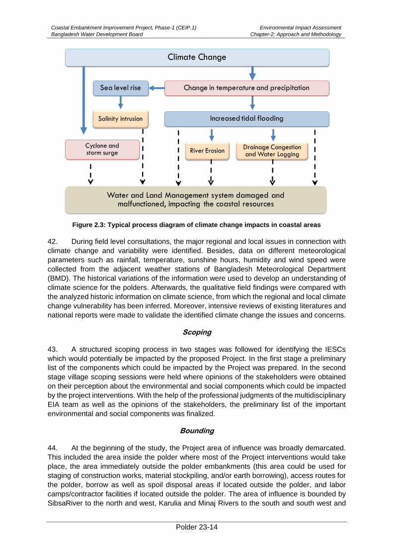
Coastal Embankment Improvement Project, Phase-1 (CEIP.1)
Bangladesh Water Development Board
Environmental Impact Assessment
Chapter-2: Approach and Methodology
Polder 23-14
Figure 2.3: Typical process diagram of climate change impacts in coastal areas
42. During field level consultations, the major regional and local issues in connection with
climate change and variability were identified. Besides, data on different meteorological
parameters such as rainfall, temperature, sunshine hours, humidity and wind speed were
collected from the adjacent weather stations of Bangladesh Meteorological Department
(BMD). The historical variations of the information were used to develop an understanding of
climate science for the polders. Afterwards, the qualitative field findings were compared with
the analyzed historic information on climate science, from which the regional and local climate
change vulnerability has been inferred. Moreover, intensive reviews of existing literatures and
national reports were made to validate the identified climate change the issues and concerns.
Scoping
43. A structured scoping process in two stages was followed for identifying the IESCs
which would potentially be impacted by the proposed Project. In the first stage a preliminary
list of the components which could be impacted by the Project was prepared. In the second
stage village scoping sessions were held where opinions of the stakeholders were obtained
on their perception about the environmental and social components which could be impacted
by the project interventions. With the help of the professional judgments of the multidisciplinary
EIA team as well as the opinions of the stakeholders, the preliminary list of the important
environmental and social components was finalized.
Bounding
44. At the beginning of the study, the Project area of influence was broadly demarcated.
This included the area inside the polder where most of the Project interventions would take
place, the area immediately outside the polder embankments (this area could be used for
staging of construction works, material stockpiling, and/or earth borrowing), access routes for
the polder, borrow as well as spoil disposal areas if located outside the polder, and labor
camps/contractor facilities if located outside the polder. The area of influence is bounded by
SibsaRiver to the north and west, Karulia and Minaj Rivers to the south and south west and
River Erosion
Climate Change
Sea level rise
Salinity intrusion
Change in temperature and precipitation
Increased tidal flooding
Cyclone andstorm surge
Water and Land Management system damaged and malfunctioned, impacting the coastal resources
Drainage Congestion and Water Logging
Coastal Embankment Improvement Project, Phase-1 (CEIP.1)
Bangladesh Water Development Board
Environmental Impact Assessment
Chapter-2: Approach and Methodology
Polder 23-15
SibsaRiver to the North East and Habukhali Khal in the east. It is noted that project area
includes polder area whereas study area includes both project area and peripheral rivers.
Major Field Investigation
45. The EIA study team members collected intensive data on the possible impact of the
project after obtaining the detailed rehabilitation plan from the project authority. The study
team carried out a number of comprehensive field investigations in order to collect primary
data and solicit feedback from local people. Intensive data on Baseline and IESCs were
collected from the field during this stage. Information on the IESCs were collected through a
mixed method including RRA, PRA and KII using checklists for water resources, land
resources, agriculture, livestock, fisheries, ecosystem and socio-economic components.
Intensive consultations with the local people were carried out for their feedback on the key
parameters. This process helped the multidisciplinary EIA study team to qualify their
professional observations. In this exercise, attention was given to understand the historical
status of the IESCs and the possible condition of the same against the proposed interventions.
Assessment and Scaling of Impacts
46. At this stage, attempts were made to assess the impacts of the proposed interventions
of the polder quantitatively. Impacts were also assessed qualitatively when quantification was
not possible. The impacts of proposed interventions, considering the climate-change scenario
for 2050, were estimated on the basis of differences between the future-without-project
(FWOP) condition and the future-with-project (FWIP) condition. The future-without-project
(FWOP) conditions were generated through trend analysis and consultations with the local
people. This reflected conditions of IESCs in absence of the proposed interventions in the
polder area. Expected changes due to proposed interventions were assessed to generate the
Future-with-Project (FWIP) condition. Comparison and projection methods were used for
impact prediction.
47. A screening matrix was used specifically for the proposed Project before impact
analysis in detail. This matrix was focused on the potential environmental impacts during the
design, construction and operation phases. The matrix examined the interaction of project
activities with various important components of the environment. The impacts were broadly
classified as physical, biological and social impacts, and each of them were further divided
into different aspects.
Methodology
48. The assessment of effects and identification of residual impacts takes account of any
incorporated mitigation measures adopted offset potential impact of project activities. This will
largely be dependent on the extent and duration of change, the number of people or size of
the resource affected (receptor) and their sensitivity to the change. Potential impacts can be
both negative and positive (beneficial), and the methodology defined below was applied to
define both beneficial and adverse potential impacts.
49. The criteria to determine significance are generally specific for each environmental and
social aspect/receptor. Generally, the magnitude of each potential impact is defined along with
the sensitivity of the receptor.
Magnitude
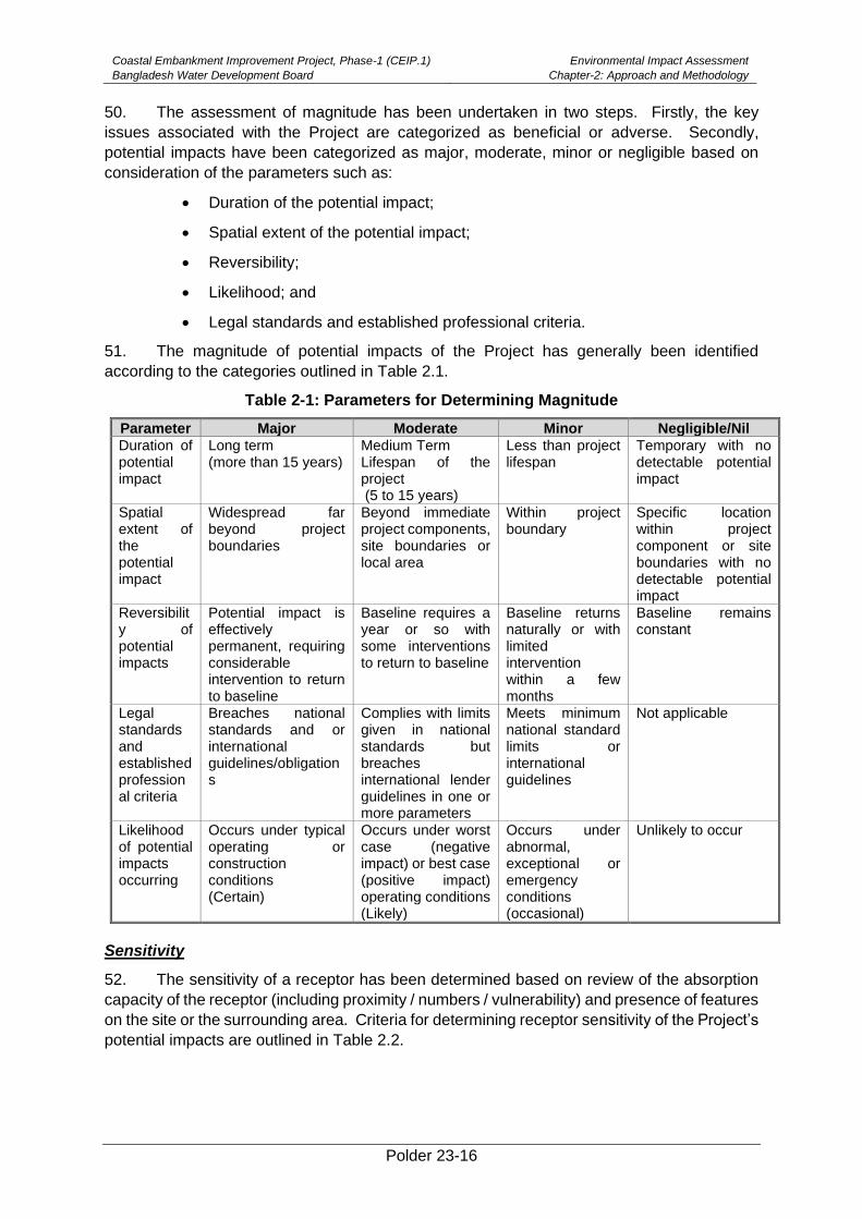
Coastal Embankment Improvement Project, Phase-1 (CEIP.1)
Bangladesh Water Development Board
Environmental Impact Assessment
Chapter-2: Approach and Methodology
Polder 23-16
50. The assessment of magnitude has been undertaken in two steps. Firstly, the key
issues associated with the Project are categorized as beneficial or adverse. Secondly,
potential impacts have been categorized as major, moderate, minor or negligible based on
consideration of the parameters such as:
• Duration of the potential impact;
• Spatial extent of the potential impact;
• Reversibility;
• Likelihood; and
• Legal standards and established professional criteria.
51. The magnitude of potential impacts of the Project has generally been identified
according to the categories outlined in Table 2.1.
Table 2-1: Parameters for Determining Magnitude
Parameter Major Moderate Minor Negligible/Nil
Duration of potential impact
Long term (more than 15 years)
Medium Term Lifespan of the project (5 to 15 years)
Less than project lifespan
Temporary with no detectable potential impact
Spatial extent of the potential impact
Widespread far beyond project boundaries
Beyond immediate project components, site boundaries or local area
Within project boundary
Specific location within project component or site boundaries with no detectable potential impact
Reversibility of potential impacts
Potential impact is effectively permanent, requiring considerable intervention to return to baseline
Baseline requires a year or so with some interventions to return to baseline
Baseline returns naturally or with limited intervention within a few months
Baseline remains constant
Legal standards and established professional criteria
Breaches national standards and or international guidelines/obligations
Complies with limits given in national standards but breaches international lender guidelines in one or more parameters
Meets minimum national standard limits or international guidelines
Not applicable
Likelihood of potential impacts occurring
Occurs under typical operating or construction conditions (Certain)
Occurs under worst case (negative impact) or best case (positive impact) operating conditions (Likely)
Occurs under abnormal, exceptional or emergency conditions (occasional)
Unlikely to occur
Sensitivity
52. The sensitivity of a receptor has been determined based on review of the absorption
capacity of the receptor (including proximity / numbers / vulnerability) and presence of features
on the site or the surrounding area. Criteria for determining receptor sensitivity of the Project’s
potential impacts are outlined in Table 2.2.
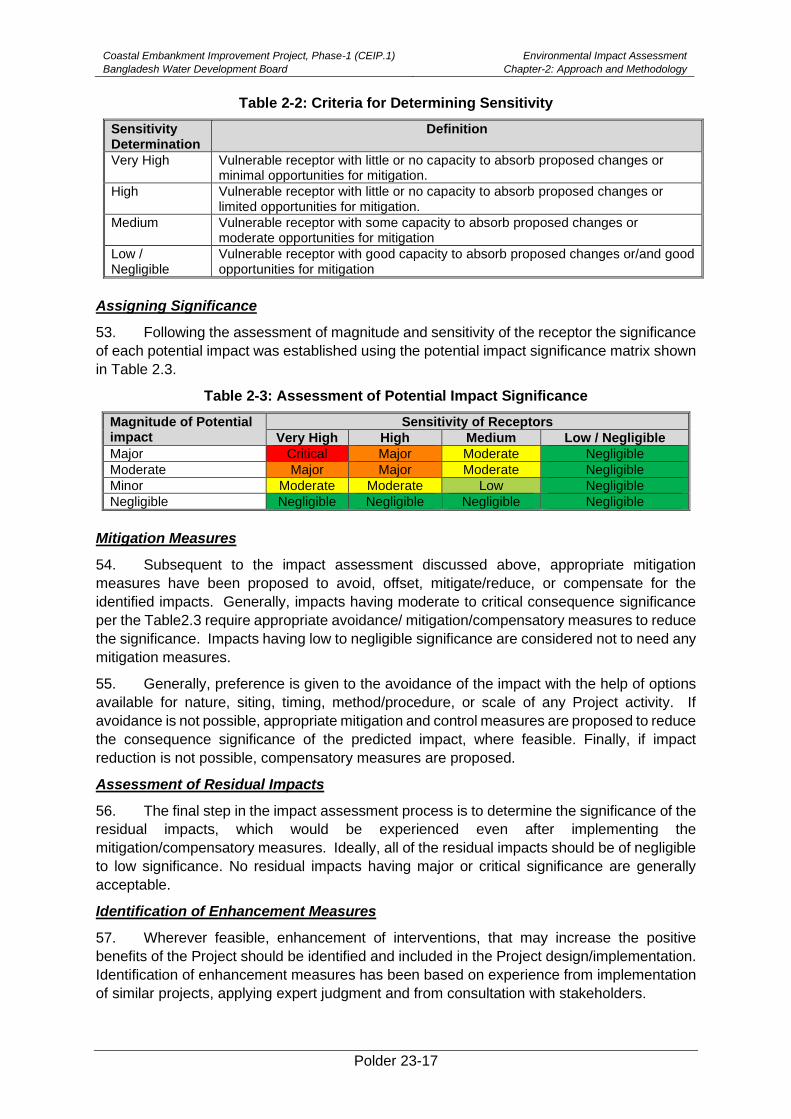
Coastal Embankment Improvement Project, Phase-1 (CEIP.1)
Bangladesh Water Development Board
Environmental Impact Assessment
Chapter-2: Approach and Methodology
Polder 23-17
Table 2-2: Criteria for Determining Sensitivity
Sensitivity Determination
Definition
Very High Vulnerable receptor with little or no capacity to absorb proposed changes or minimal opportunities for mitigation.
High Vulnerable receptor with little or no capacity to absorb proposed changes or limited opportunities for mitigation.
Medium Vulnerable receptor with some capacity to absorb proposed changes or moderate opportunities for mitigation
Low / Negligible
Vulnerable receptor with good capacity to absorb proposed changes or/and good opportunities for mitigation
Assigning Significance
53. Following the assessment of magnitude and sensitivity of the receptor the significance
of each potential impact was established using the potential impact significance matrix shown
in Table 2.3.
Table 2-3: Assessment of Potential Impact Significance
Magnitude of Potential impact
Sensitivity of Receptors
Very High High Medium Low / Negligible
Major Critical Major Moderate Negligible
Moderate Major Major Moderate Negligible
Minor Moderate Moderate Low Negligible
Negligible Negligible Negligible Negligible Negligible
Mitigation Measures
54. Subsequent to the impact assessment discussed above, appropriate mitigation
measures have been proposed to avoid, offset, mitigate/reduce, or compensate for the
identified impacts. Generally, impacts having moderate to critical consequence significance
per the Table2.3 require appropriate avoidance/ mitigation/compensatory measures to reduce
the significance. Impacts having low to negligible significance are considered not to need any
mitigation measures.
55. Generally, preference is given to the avoidance of the impact with the help of options
available for nature, siting, timing, method/procedure, or scale of any Project activity. If
avoidance is not possible, appropriate mitigation and control measures are proposed to reduce
the consequence significance of the predicted impact, where feasible. Finally, if impact
reduction is not possible, compensatory measures are proposed.
Assessment of Residual Impacts
56. The final step in the impact assessment process is to determine the significance of the
residual impacts, which would be experienced even after implementing the
mitigation/compensatory measures. Ideally, all of the residual impacts should be of negligible
to low significance. No residual impacts having major or critical significance are generally
acceptable.
Identification of Enhancement Measures
57. Wherever feasible, enhancement of interventions, that may increase the positive
benefits of the Project should be identified and included in the Project design/implementation.
Identification of enhancement measures has been based on experience from implementation
of similar projects, applying expert judgment and from consultation with stakeholders.
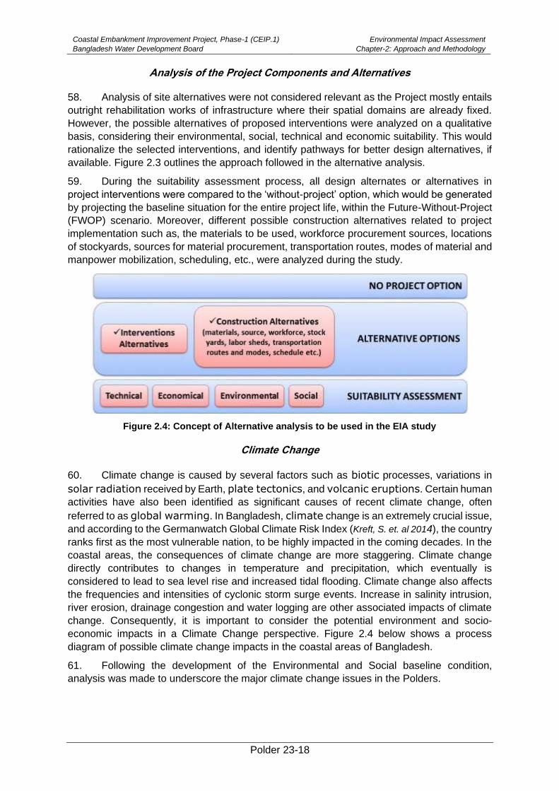
Coastal Embankment Improvement Project, Phase-1 (CEIP.1)
Bangladesh Water Development Board
Environmental Impact Assessment
Chapter-2: Approach and Methodology
Polder 23-18
Analysis of the Project Components and Alternatives
58. Analysis of site alternatives were not considered relevant as the Project mostly entails
outright rehabilitation works of infrastructure where their spatial domains are already fixed.
However, the possible alternatives of proposed interventions were analyzed on a qualitative
basis, considering their environmental, social, technical and economic suitability. This would
rationalize the selected interventions, and identify pathways for better design alternatives, if
available. Figure 2.3 outlines the approach followed in the alternative analysis.
59. During the suitability assessment process, all design alternates or alternatives in
project interventions were compared to the ‘without-project’ option, which would be generated
by projecting the baseline situation for the entire project life, within the Future-Without-Project
(FWOP) scenario. Moreover, different possible construction alternatives related to project
implementation such as, the materials to be used, workforce procurement sources, locations
of stockyards, sources for material procurement, transportation routes, modes of material and
manpower mobilization, scheduling, etc., were analyzed during the study.
Figure 2.4: Concept of Alternative analysis to be used in the EIA study
Climate Change
60. Climate change is caused by several factors such as biotic processes, variations in
solar radiation received by Earth, plate tectonics, and volcanic eruptions. Certain human
activities have also been identified as significant causes of recent climate change, often
referred to as global warming. In Bangladesh, climate change is an extremely crucial issue,
and according to the Germanwatch Global Climate Risk Index (Kreft, S. et. al 2014), the country
ranks first as the most vulnerable nation, to be highly impacted in the coming decades. In the
coastal areas, the consequences of climate change are more staggering. Climate change
directly contributes to changes in temperature and precipitation, which eventually is
considered to lead to sea level rise and increased tidal flooding. Climate change also affects
the frequencies and intensities of cyclonic storm surge events. Increase in salinity intrusion,
river erosion, drainage congestion and water logging are other associated impacts of climate
change. Consequently, it is important to consider the potential environment and socio-
economic impacts in a Climate Change perspective. Figure 2.4 below shows a process
diagram of possible climate change impacts in the coastal areas of Bangladesh.
61. Following the development of the Environmental and Social baseline condition,
analysis was made to underscore the major climate change issues in the Polders.
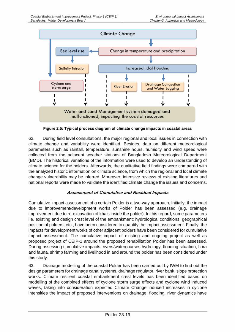
Coastal Embankment Improvement Project, Phase-1 (CEIP.1)
Bangladesh Water Development Board
Environmental Impact Assessment
Chapter-2: Approach and Methodology
Polder 23-19
Figure 2.5: Typical process diagram of climate change impacts in coastal areas
62. During field level consultations, the major regional and local issues in connection with
climate change and variability were identified. Besides, data on different meteorological
parameters such as rainfall, temperature, sunshine hours, humidity and wind speed were
collected from the adjacent weather stations of Bangladesh Meteorological Department
(BMD). The historical variations of the information were used to develop an understanding of
climate science for the polders. Afterwards, the qualitative field findings were compared with
the analyzed historic information on climate science, from which the regional and local climate
change vulnerability may be inferred. Moreover, intensive reviews of existing literatures and
national reports were made to validate the identified climate change the issues and concerns.
Assessment of Cumulative and Residual Impacts
Cumulative impact assessment of a certain Polder is a two-way approach. Initially, the impact
due to improvement/development works of Polder has been assessed (e.g. drainage
improvement due to re-excavation of khals inside the polder). In this regard, some parameters
i.e. existing and design crest level of the embankment; hydrological conditions, geographical
position of polders, etc., have been considered to quantify the impact assessment. Finally, the
impacts for development works of other adjacent polders have been considered for cumulative
impact assessment. The cumulative impact of existing and ongoing project as well as
proposed project of CEIP-1 around the proposed rehabilitation Polder has been assessed.
During assessing cumulative impacts, rivers/watercourses hydrology, flooding situation, flora
and fauna, shrimp farming and livelihood in and around the polder has been considered under
this study.
63. Drainage modelling of the coastal Polder has been carried out by IWM to find out the
design parameters for drainage canal systems, drainage regulator, river bank, slope protection
works. Climate resilient coastal embankment crest levels has been identified based on
modelling of the combined effects of cyclone storm surge effects and cyclone wind induced
waves, taking into consideration expected Climate Change induced increases in cyclone
intensities the impact of proposed interventions on drainage, flooding, river dynamics have
River Erosion
Climate Change
Sea level rise
Salinity intrusion
Change in temperature and precipitation
Increased tidal flooding
Cyclone andstorm surge
Water and Land Management system damaged and malfunctioned, impacting the coastal resources
Drainage Congestion and Water Logging
Coastal Embankment Improvement Project, Phase-1 (CEIP.1)
Bangladesh Water Development Board
Environmental Impact Assessment
Chapter-2: Approach and Methodology
Polder 23-20
been analyzed as well through modeling. The model results have been utilized in the EIA
study.
Preparation of Environmental Management and Monitoring Plan
64. An environmental management plan (EMP) for the proposed Project has been
prepared which comprises the mitigation/ enhancement measures with institutional
responsibilities, environmental monitoring plan, training and capacity building plan, and
reporting and documentation protocols (Refer Chapter 10).
EIA Report Preparation
65. At the end of the study, the present report has beenprepared incorporating all the
findings of the EIA.
Polder 23-21
3. Policy, Legal and Administrative Framework
66. This chapter presents a review of the national policy, legal, and regulatory framework
relevant to the environmental and social aspects of the project. Besides, review ofthe WB
environmental and social safeguard policies and guidelines are also incorporated in this
chapter.
3.1. Relevant National Policies, Strategies and Plans
67. List of relevant National policies and strategies and plans are given below:
(i) National Environment Policy, 1992
(ii) National Environment Management Action Plan, 1995
(iii) National Water Policy, 1999
(iv) Guidelines for Participatory Water Management (GPWM), 2014
(v) National Water Management Plan, 2001 (Approved in 2004)
(vi) Coastal Zone Policy, 2005
(vii) Coastal Development Strategy, 2006
(viii) National Land Use Policy (MoL, 2001)
(ix) National Agriculture Policy, 1999
(x) National Fisheries Policy, 1996
(xi) National Forest Policy, 1994
(xii) Private Forest Policy 1994
(xiii) National Livestock Development Policy, 2007
3.2. National Environmental Laws
68. List of relevant national laws and regulation are given below:
(i) Bangladesh Water Act, 2013
(ii) National River Protection Commission Act, 2013
(i) Bangladesh Environment Conservation Rules (ECR), 1997, Amended in
2010Bangladesh Environment Court Act, 2010
(ii) The Forest Act, 1927 & Amendment Act 2000
(iii) Private Forest Ordinance (PFO), 1959
(iv) Social Forestry Rules, 2004 and Amendments
(v) Antiquities Act, 1968
(vi) Bangladesh National Building Code, 2006
(vii) Standing Orders on Disaster, 2010
(viii) The Acquisition and Requisition of Immovable Property Ordinance, 1982
(ix) The East Bengal State Acquisition and Tenancy Act, 1950 (Revised 1994)
(x) Constitutional Right of the Tribal Peoples Rights
(xi) Ethnic Minority Rights in PRSP 2005
(xii) Acquisition and Requisition of Immovable Property Ordinance, 1982
69. Details of policies and laws are given in appendix (C)
3.3. Other Relevant Acts
70. There are a number of other laws and regulations applicable which are relevant for the
project. These are presented in the Table 3.1 below:
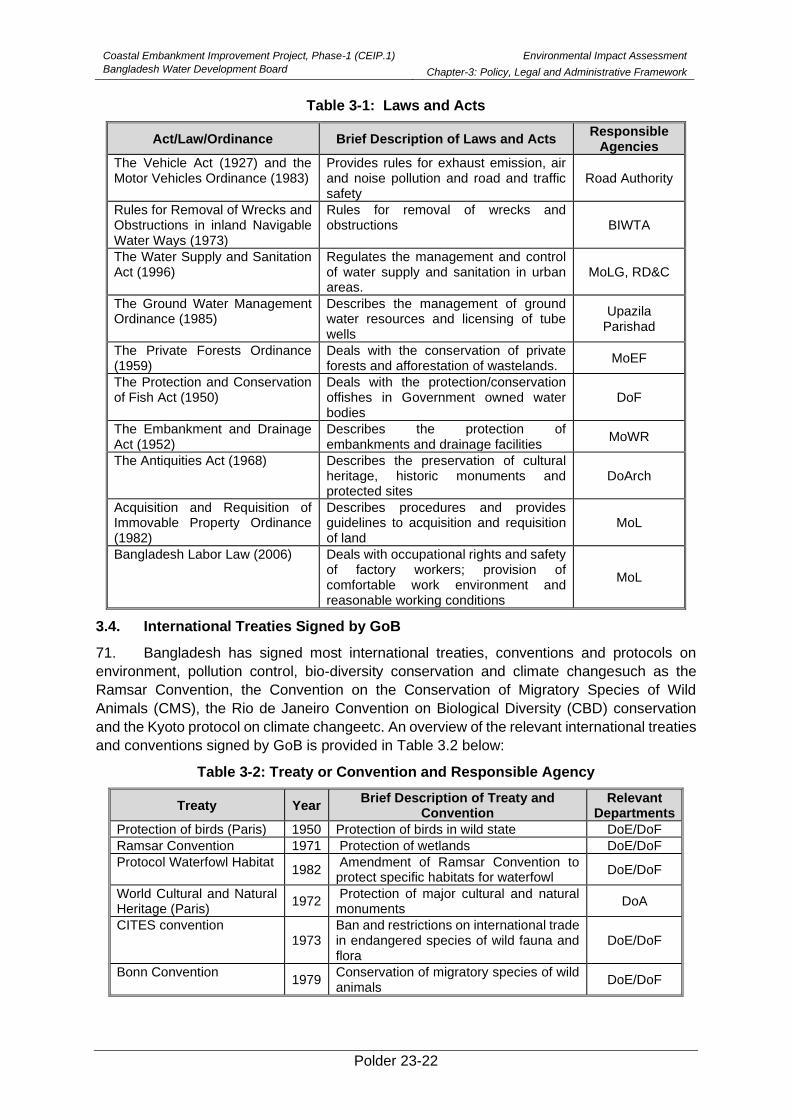
Coastal Embankment Improvement Project, Phase-1 (CEIP.1)
Bangladesh Water Development Board
Environmental Impact Assessment
Chapter-3: Policy, Legal and Administrative Framework
Polder 23-22
Table 3-1: Laws and Acts
Act/Law/Ordinance Brief Description of Laws and Acts Responsible
Agencies
The Vehicle Act (1927) and the Motor Vehicles Ordinance (1983)
Provides rules for exhaust emission, air and noise pollution and road and traffic safety
Road Authority
Rules for Removal of Wrecks and Obstructions in inland Navigable Water Ways (1973)
Rules for removal of wrecks and obstructions BIWTA
The Water Supply and Sanitation Act (1996)
Regulates the management and control of water supply and sanitation in urban areas.
MoLG, RD&C
The Ground Water Management Ordinance (1985)
Describes the management of ground water resources and licensing of tube wells
Upazila Parishad
The Private Forests Ordinance (1959)
Deals with the conservation of private forests and afforestation of wastelands.
MoEF
The Protection and Conservation of Fish Act (1950)
Deals with the protection/conservation offishes in Government owned water bodies
DoF
The Embankment and Drainage Act (1952)
Describes the protection of embankments and drainage facilities
MoWR
The Antiquities Act (1968) Describes the preservation of cultural heritage, historic monuments and protected sites
DoArch
Acquisition and Requisition of Immovable Property Ordinance (1982)
Describes procedures and provides guidelines to acquisition and requisition of land
MoL
Bangladesh Labor Law (2006) Deals with occupational rights and safety of factory workers; provision of comfortable work environment and reasonable working conditions
MoL
3.4. International Treaties Signed by GoB
71. Bangladesh has signed most international treaties, conventions and protocols on
environment, pollution control, bio-diversity conservation and climate changesuch as the
Ramsar Convention, the Convention on the Conservation of Migratory Species of Wild
Animals (CMS), the Rio de Janeiro Convention on Biological Diversity (CBD) conservation
and the Kyoto protocol on climate changeetc. An overview of the relevant international treaties
and conventions signed by GoB is provided in Table 3.2 below:
Table 3-2: Treaty or Convention and Responsible Agency
Treaty Year Brief Description of Treaty and
Convention Relevant
Departments
Protection of birds (Paris) 1950 Protection of birds in wild state DoE/DoF
Ramsar Convention 1971 Protection of wetlands DoE/DoF
Protocol Waterfowl Habitat 1982
Amendment of Ramsar Convention to protect specific habitats for waterfowl
DoE/DoF
World Cultural and Natural Heritage (Paris)
1972 Protection of major cultural and natural monuments
DoA
CITES convention 1973
Ban and restrictions on international trade in endangered species of wild fauna and flora
DoE/DoF
Bonn Convention 1979
Conservation of migratory species of wild animals
DoE/DoF
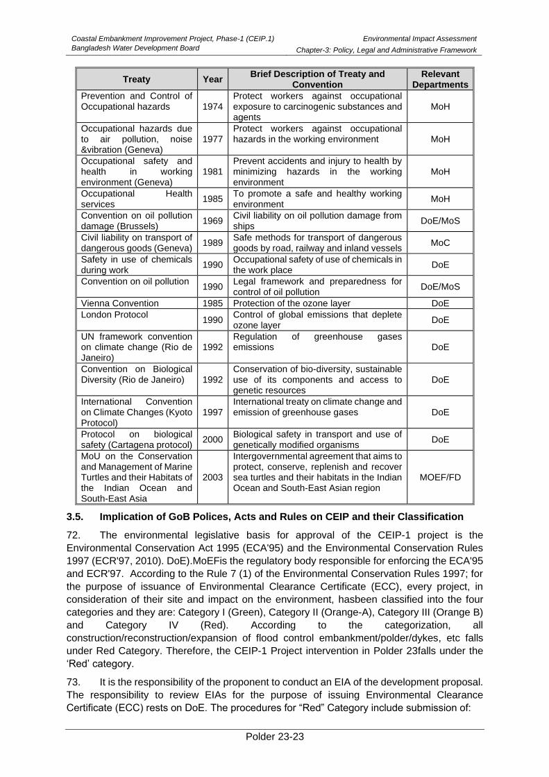
Coastal Embankment Improvement Project, Phase-1 (CEIP.1)
Bangladesh Water Development Board
Environmental Impact Assessment
Chapter-3: Policy, Legal and Administrative Framework
Polder 23-23
Treaty Year Brief Description of Treaty and
Convention Relevant
Departments
Prevention and Control of Occupational hazards 1974
Protect workers against occupational exposure to carcinogenic substances and agents
MoH
Occupational hazards due to air pollution, noise &vibration (Geneva)
1977 Protect workers against occupational hazards in the working environment MoH
Occupational safety and health in working environment (Geneva)
1981 Prevent accidents and injury to health by minimizing hazards in the working environment
MoH
Occupational Health services
1985 To promote a safe and healthy working environment
MoH
Convention on oil pollution damage (Brussels)
1969 Civil liability on oil pollution damage from ships
DoE/MoS
Civil liability on transport of dangerous goods (Geneva)
1989 Safe methods for transport of dangerous goods by road, railway and inland vessels
MoC
Safety in use of chemicals during work
1990 Occupational safety of use of chemicals in the work place
DoE
Convention on oil pollution 1990
Legal framework and preparedness for control of oil pollution
DoE/MoS
Vienna Convention 1985 Protection of the ozone layer DoE
London Protocol 1990
Control of global emissions that deplete ozone layer
DoE
UN framework convention on climate change (Rio de Janeiro)
1992 Regulation of greenhouse gases emissions DoE
Convention on Biological Diversity (Rio de Janeiro) 1992
Conservation of bio-diversity, sustainable use of its components and access to genetic resources
DoE
International Convention on Climate Changes (Kyoto Protocol)
1997 International treaty on climate change and emission of greenhouse gases DoE
Protocol on biological safety (Cartagena protocol)
2000 Biological safety in transport and use of genetically modified organisms
DoE
MoU on the Conservation and Management of Marine Turtles and their Habitats of the Indian Ocean and South-East Asia
2003
Intergovernmental agreement that aims to protect, conserve, replenish and recover sea turtles and their habitats in the Indian Ocean and South-East Asian region
MOEF/FD
3.5. Implication of GoB Polices, Acts and Rules on CEIP and their Classification
72. The environmental legislative basis for approval of the CEIP-1 project is the
Environmental Conservation Act 1995 (ECA'95) and the Environmental Conservation Rules
1997 (ECR'97, 2010). DoE).MoEFis the regulatory body responsible for enforcing the ECA'95
and ECR'97. According to the Rule 7 (1) of the Environmental Conservation Rules 1997; for
the purpose of issuance of Environmental Clearance Certificate (ECC), every project, in
consideration of their site and impact on the environment, hasbeen classified into the four
categories and they are: Category I (Green), Category II (Orange-A), Category III (Orange B)
and Category IV (Red). According to the categorization, all
construction/reconstruction/expansion of flood control embankment/polder/dykes, etc falls
under Red Category. Therefore, the CEIP-1 Project intervention in Polder 23falls under the
‘Red’ category.
73. It is the responsibility of the proponent to conduct an EIA of the development proposal.
The responsibility to review EIAs for the purpose of issuing Environmental Clearance
Certificate (ECC) rests on DoE. The procedures for “Red” Category include submission of:
Coastal Embankment Improvement Project, Phase-1 (CEIP.1)
Bangladesh Water Development Board
Environmental Impact Assessment
Chapter-3: Policy, Legal and Administrative Framework
Polder 23-24
➢ An Initial Environmental Examination (IEE)
➢ An Environmental Impact Assessment (EIA)
➢ An Environmental Management Plan (EMP)
74. Environment clearance has to be obtained by the respective implementing agency or
project proponent (private sector) from DoE. The environmental clearance procedure for Red
Category projects can be summarized as follows:
75. Application to DoE →Obtaining Site Clearance →Applying for Environmental
Clearance →Obtaining Environmental Clearance → Clearance Subject to annual renewal.
3.6. Detailed Steps of In Country Environmental Clearance Procedure
76. Departmentof Environment (DoE), under the Ministry of Environment and Forest
(MoEF), is the regulatorybody responsible for enforcing the ECA'95 and ECR'97. According
to the Environment Conservation Act 1995 no industrial unit or project will be established or
undertaken without obtaining, in the manner prescribed by the Environment Conservation
Rules 1997, an Environmental Clearance Certificate from the Director General. Therefore,
every development project/industry which are specified under the Schedule –1 of the
Environmental Conservation Rules 1997 require obtaining site clearance and environmental
clearance from DoE. For ‘Red’ category, it is mandatory to carry out an EIA including an EMP
and where necessary to develop a Resettlement Plan for getting environmental clearance
from DoE. The application procedure for obtaining site clearance and environmental clearance
for the sub-projects of Red category is shown in Figure 3.1.
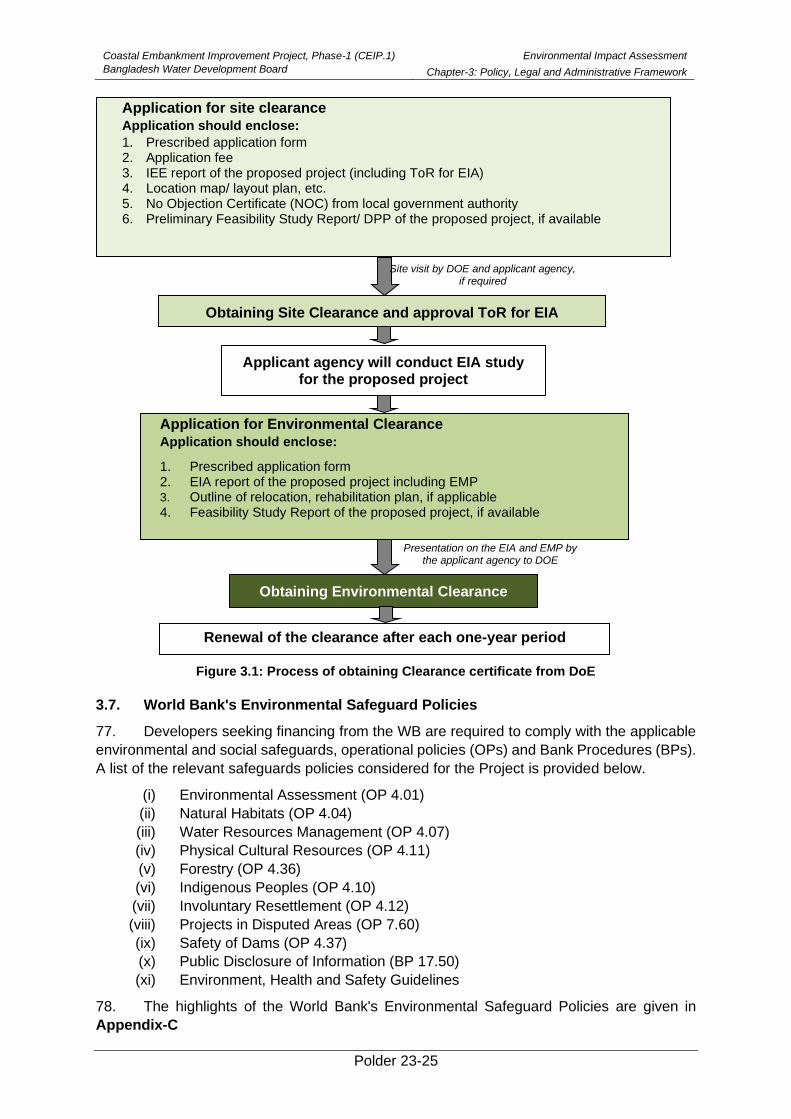
Coastal Embankment Improvement Project, Phase-1 (CEIP.1)
Bangladesh Water Development Board
Environmental Impact Assessment
Chapter-3: Policy, Legal and Administrative Framework
Polder 23-25
Figure 3.1: Process of obtaining Clearance certificate from DoE
3.7. World Bank's Environmental Safeguard Policies
77. Developers seeking financing from the WB are required to comply with the applicable
environmental and social safeguards, operational policies (OPs) and Bank Procedures (BPs).
A list of the relevant safeguards policies considered for the Project is provided below.
(i) Environmental Assessment (OP 4.01)
(ii) Natural Habitats (OP 4.04)
(iii) Water Resources Management (OP 4.07)
(iv) Physical Cultural Resources (OP 4.11)
(v) Forestry (OP 4.36)
(vi) Indigenous Peoples (OP 4.10)
(vii) Involuntary Resettlement (OP 4.12)
(viii) Projects in Disputed Areas (OP 7.60)
(ix) Safety of Dams (OP 4.37)
(x) Public Disclosure of Information (BP 17.50)
(xi) Environment, Health and Safety Guidelines
78. The highlights of the World Bank's Environmental Safeguard Policies are given in
Appendix-C
Applicant agency will conduct EIA study for the proposed project
Obtaining Environmental Clearance
Renewal of the clearance after each one-year period
Obtaining Site Clearance and approval ToR for EIA
Application for Environmental Clearance
Application should enclose:
1. Prescribed application form 2. EIA report of the proposed project including EMP 3. Outline of relocation, rehabilitation plan, if applicable
4. Feasibility Study Report of the proposed project, if available
Application for site clearance
Application should enclose:
1. Prescribed application form 2. Application fee 3. IEE report of the proposed project (including ToR for EIA) 4. Location map/ layout plan, etc. 5. No Objection Certificate (NOC) from local government authority 6. Preliminary Feasibility Study Report/ DPP of the proposed project, if available
Presentation on the EIA and EMP by the applicant agency to DOE
Site visit by DOE and applicant agency, if required
Coastal Embankment Improvement Project, Phase-1 (CEIP.1)
Bangladesh Water Development Board
Environmental Impact Assessment
Chapter-3: Policy, Legal and Administrative Framework
Polder 23-26
3.8. Implications of WB Policies on CEIP
79. The project interventions for Polder 23 fall under Category A, due to the complexity of
environmental issues associated with project activities involving major civil works by
reconstruction and rehabilitation of the coastal embankment to protect against tidal flooding
and storm surges. Since the coastal area is of high ecological sensitivity and vulnerability
certain negative environmental impacts may occur during the implementation and operational
phase on overall Polder system. The environment assessment (OP/BP 4.01), natural habitats
(OP/BP 4.04) and forests (OP/BP 4.36) policy have been triggered for the proposed project.
Although no direct impacts on physical cultural resources are expected, screening mechanism
incorporated into the EA process will identify subprojects with archeological, paleontological,
historical, religious, or unique natural values, chance and find procedure will be followed to
address physical cultural resources (OP/BP 4.11). The interventions under the proposed
Project may result in an increased availability of irrigation water through cleaning and
excavation of water courses in the Polder. This increased water availability can in turn
potentially increase the usage of chemical fertilizers and pesticides. During regular
environment monitoring in operational phase if the water and soil pollution is observed, the
proponent will be responsible for preparing Pest Management Plan with prior approval from
Bank. No Project activities are to be carried out in the rivers except some transportation.
Polder 23-27
4. Climate Change Impact
80. Climate is a critical factor in the lives and livelihoods of the people and socioeconomic
development as a whole. Climate has shown warming of 0.89 [0.69 to 1.08] °C over the period
1901–2012 which is mainly attributed to anthropogenic activities (IPCC 2013). Further, it is
projected that the global mean surface temperature may increase by 0.4°C to 1.6°C for
RCP2.6, 0.9°C to 2.0°C for RCP 4.5, 0.8°C to 1.8°C for RCP6.0 and 1.4°C to 2.6°C for RCP
8.5, respectively by 2046-2065 (IPCC 2013). The newer findings indicate that warming is more
pronounced than expected. The impact would be particularly severe in the tropical areas,
which mainly consist of developing countries, including Bangladesh. Increasing temperature
trends of the order of 0.60°C during last 112 years (IMD 2012) and increase in heavy rainfall
events and decrease in low and medium rainfall events (Goswami et al. 2006) over India have
been observed. Changes in rainfall and temperatures have also been reported by Dash et al.
(2009), and others.
81. One of the best ways of understanding how climate may change in future is to examine
how it has changed in the past based upon long-term observational records.. Polder 23 is
located near Khulna, so, meteorological parameters of Khulna station has been considered
as a Polder 23 in the study. Khulna station data (Polder 23) has been collected from
Bangladesh Meteorological Department (BMD). Seasonal mean values have been computed
from the monthly data of rainfall and temperature for the four meteorological seasons e.g. pre-
monsoon (March-May), monsoon (June-September), post-monsoon (October-November) and
winter (December-February). There are some months with missing data of Khulna station
(Polder 23) of BMD. To maintain the continuity, the gaps have been filled up by the time mean
values of the existing years for maximum and minimum temperatures. In rainfall data, the
variation is very large and so time-interpolation is not possible and the spatial interpolation is
also not reliable for rainfall. It will be fair to mention that for climate change studies, it would
have been better if longer period of data is available. With impact on key sectors like
agriculture, water resources and economics, climate plays an influential role in human life
cycles.
82. People and economies in Asia depend on rainfall for many purposes. Variations in
duration and quantity of rainfall bring profound impacts on water resources, human life,
economies and ecosystems. Extreme events such as floods, droughts and cyclones affect
lives and livelihoods, and often result in damages worth millions.
4.1. Annual Climate Change Trends
Annual mean maximum temperature trend
83. Long-term changes in surface temperature and precipitation over Polder 23 were
analyzed using observational records of BMD from 1976 to 2005. The temperature has the
dominant increasing trend as shown in Figure 4.1.
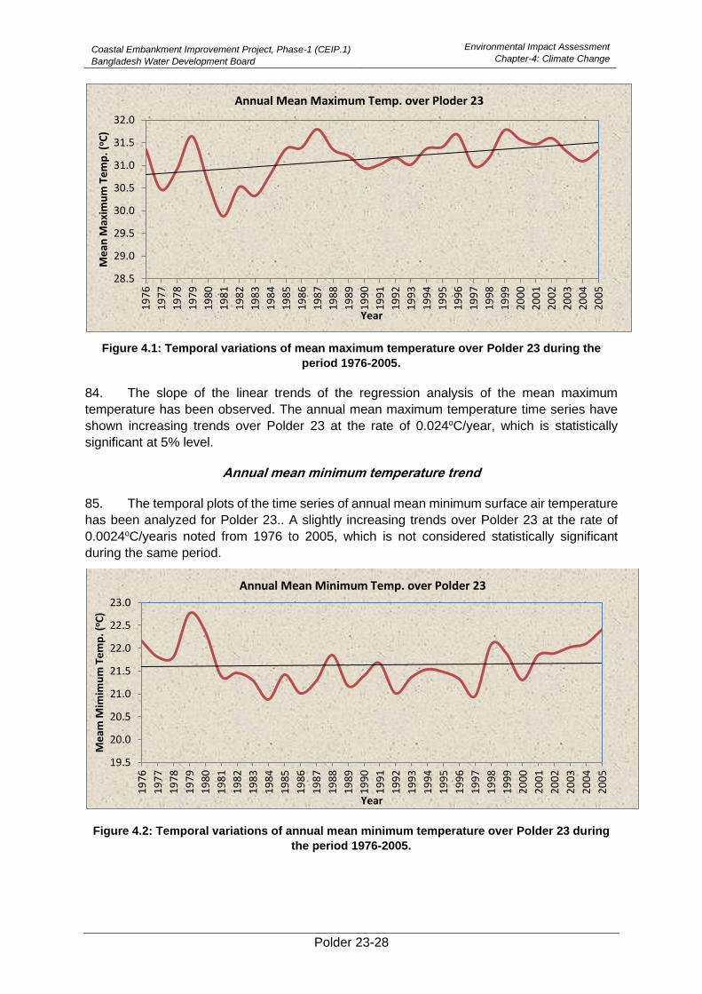
Coastal Embankment Improvement Project, Phase-1 (CEIP.1)
Bangladesh Water Development Board
Environmental Impact Assessment
Chapter-4: Climate Change
Polder 23-28
Figure 4.1: Temporal variations of mean maximum temperature over Polder 23 during the
period 1976-2005.
84. The slope of the linear trends of the regression analysis of the mean maximum
temperature has been observed. The annual mean maximum temperature time series have
shown increasing trends over Polder 23 at the rate of 0.024oC/year, which is statistically
significant at 5% level.
Annual mean minimum temperature trend
85. The temporal plots of the time series of annual mean minimum surface air temperature
has been analyzed for Polder 23.. A slightly increasing trends over Polder 23 at the rate of
0.0024oC/yearis noted from 1976 to 2005, which is not considered statistically significant
during the same period.
Figure 4.2: Temporal variations of annual mean minimum temperature over Polder 23 during
the period 1976-2005.
28.5
29.0
29.5
30.0
30.5
31.0
31.5
32.0
19
76
19
77
19
78
19
79
19
80
19
81
19
82
19
83
19
84
19
85
19
86
19
87
19
88
19
89
19
90
19
91
19
92
19
93
19
94
19
95
19
96
19
97
19
98
19
99
20
00
20
01
20
02
20
03
20
04
20
05
Me
an M
axim
um
Te
mp
. (oC
)
Year
Annual Mean Maximum Temp. over Ploder 23
19.5
20.0
20.5
21.0
21.5
22.0
22.5
23.0
19
76
19
77
19
78
19
79
19
80
19
81
19
82
19
83
19
84
19
85
19
86
19
87
19
88
19
89
19
90
19
91
19
92
19
93
19
94
19
95
19
96
19
97
19
98
19
99
20
00
20
01
20
02
20
03
20
04
20
05
Me
am M
imim
um
Te
mp
. (oC
)
Year
Annual Mean Minimum Temp. over Polder 23

Coastal Embankment Improvement Project, Phase-1 (CEIP.1)
Bangladesh Water Development Board
Environmental Impact Assessment
Chapter-4: Climate Change
Polder 23-29
Annual total rainfall
86. The temporal plots of the annual total rainfall of Polder 23 have been drawn to
investigate the nature of inter-annual fluctuations. Anincreasing trend in the annual rainfall
noticed at the rate of 3.721 mm/yearas noted from 1976 to 2005, which is notconsidered
statistically significant.
Figure 4.3: Temporal variations of annual rainfall over Polder 23 during the period 1976-2005.
4.2. Seasonal climate change trends
Winter climate change trend
a. Winter means maximum temperature trend
87. The winter mean maximum surface air temperature has an increasing trend over
Polder 23 during the period of 1976-2005 (Figure not shown). The increasing trend is observed
over Polder 23 at the rate of 0.022oC/year which is statistically significant at 5% level.
b. Winter means minimum temperature trend
88. According to the trend analysis, it is found that the winter mean minimum surface air
temperature has a decreasing trend over Polder 23 during the period of 1976-2005 (Figure
not shown). The decreasing/cooling trend over Polder 23 is -0.0061oC/year which is not
statistically significant.
c. Winter season rainfall trend
89. The temporal variations of winter rainfall during the period 1976-2005 have been
obtained. Slightly decreasing trend in the winter rainfall is noticed over Polder 23 at the rate of
-0.734 mm/year (Figure not shown), during the above period, which is not statistically
significant.
0
500
1000
1500
2000
2500
3000
19
76
19
77
19
78
19
79
19
80
19
81
19
82
19
83
19
84
19
85
19
86
19
87
19
88
19
89
19
90
19
91
19
92
19
93
19
94
19
95
19
96
19
97
19
98
19
99
20
00
20
01
20
02
20
03
20
04
20
05
Rai
nfa
ll (m
m)
Year
Annual rainfall over Polder 23
Coastal Embankment Improvement Project, Phase-1 (CEIP.1)
Bangladesh Water Development Board
Environmental Impact Assessment
Chapter-4: Climate Change
Polder 23-30
Pre-monsoon Climate Change Trends
a. Pre-monsoon mean maximum temperature trend
90. Pre-monsoon mean maximum temperature of Polder 23 has shown increasing trend
during the period 1976-2005 (Figure not shown). Increasing trend is observed over Polder 23
at the rate of 0.0096oC/year, which is not statistically significant.
b. Pre-monsoon mean minimum temperature trend
91. Pre-monsoon mean minimum temperature shows increasing trends over Polder 23
during the period 1976-2005. Warming trend is observed over Polder 23 at the rate of
0.014oC/year which is not statistically significant.
c. Pre-monsoon total rainfall trend
92. The temporal variations and the trend of pre-monsoon total rainfall during the period
1976-2005 have been obtained (Figure not shown). Decreasing trend is noticed in the pre-
monsoon season total rainfall over Polder 23 at the rate of -2.588 mm/year during the same
period, which is not statistically significant.
Monsoon Climate Change Trends
a. Monsoon mean maximum temperature trend
93. The Polder 23 has shown strong warming trend of mean maximum temperature in the
monsoon season during the period 1976-2005 (Figure not shown here). Polder 23 exhibits
strong warming trend during the monsoon season at the rate of 0.037oC/year which is
statistically significant at 1% level.
b. Monsoon season mean minimum temperature trend
94. It is observed that the Polder 23 has shown warming trend of mean minimum
temperature in the monsoon season during the period 1976-2005 (Figure not shown). Polder
23 has the warming trend with the value of 0.0048oC/year which is not statistically significant.
c. Monsoon season rainfall trend
95. The temporal variations and the trend of monsoon season rainfall are noticed during
the period 1976-2005 (Figure not shown). Increasing trend in the monsoon season rainfall are
observed over Polder 23 at the rate of 0.554 mm/year during the same period, which is not
statistically significant.
Post-monsoon Climate Change Trends
a. Post-monsoon mean maximum temperature trend
96. The Polder 23 has shown warming trend for post-monsoon mean maximum
temperature during the period 1976-2005 (Figure not shown). Slightly warming is observed
over Polder 23 at the rate of 0.023oC/year, which is not statistically significant.
b. Post-monsoon mean minimum temperature trend
97. Post monsoon mean minimum temperature has shown slightly decreasing trend over
Polder 23 and decreasing trend also shows at the rate of- 0.0072oC/year for the period 1976-
2005, which is not statistically significant.
c. Post-monsoon season rainfall trend
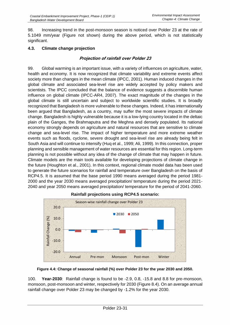
Coastal Embankment Improvement Project, Phase-1 (CEIP.1)
Bangladesh Water Development Board
Environmental Impact Assessment
Chapter-4: Climate Change
Polder 23-31
98. Increasing trend in the post-monsoon season is noticed over Polder 23 at the rate of
5.1049 mm/year (Figure not shown) during the above period, which is not statistically
significant.
4.3. Climate change projection
Projection of rainfall over Polder 23
99. Global warming is an important issue, with a variety of influences on agriculture, water,
health and economy. It is now recognized that climate variability and extreme events affect
society more than changes in the mean climate (IPCC, 2001). Human induced changes in the
global climate and associated sea-level rise are widely accepted by policy makers and
scientists. The IPCC concluded that the balance of evidence suggests a discernible human
influence on global climate (IPCC-AR4, 2007). The exact magnitude of the changes in the
global climate is still uncertain and subject to worldwide scientific studies. It is broadly
recognized that Bangladesh is more vulnerable to these changes. Indeed, it has internationally
been argued that Bangladesh, as a country, may suffer the most severe impacts of climate
change. Bangladesh is highly vulnerable because it is a low-lying country located in the deltaic
plain of the Ganges, the Brahmaputra and the Meghna and densely populated. Its national
economy strongly depends on agriculture and natural resources that are sensitive to climate
change and sea-level rise. The impact of higher temperature and more extreme weather
events such as floods, cyclone, severe drought and sea-level rise are already being felt in
South Asia and will continue to intensify (Huq et al., 1999; Ali, 1999). In this connection, proper
planning and sensible management of water resources are essential for this region. Long-term
planning is not possible without any idea of the change of climate that may happen in future.
Climate models are the main tools available for developing projections of climate change in
the future (Houghton et al., 2001). In this context, regional climate model data has been used
to generate the future scenarios for rainfall and temperature over Bangladesh on the basis of
RCP4.5. It is assumed that the base period 1990 means averaged during the period 1981-
2000 and the year 2030 means averaged precipitation/ temperature during the period 2021-
2040 and year 2050 means averaged precipitation/ temperature for the period of 2041-2060.
Rainfall projections using RCP4.5 scenario:
Figure 4.4: Change of seasonal rainfall (%) over Polder 23 for the year 2030 and 2050.
100. Year-2030: Rainfall change is found to be -2.9, 0.8, -15.8 and 8.8 for pre-monsoon,
monsoon, post-monsoon and winter, respectively for 2030 (Figure 8.4). On an average annual
rainfall change over Polder 23 may be changed by -1.2% for the year 2030.
-20.0
-10.0
0.0
10.0
20.0
Annual Pre-mon Monsoon Post-mon Winter
Rai
nfa
ll C
han
ge (
%)
Season-wise rainfall change over Polder 23
2030 2050
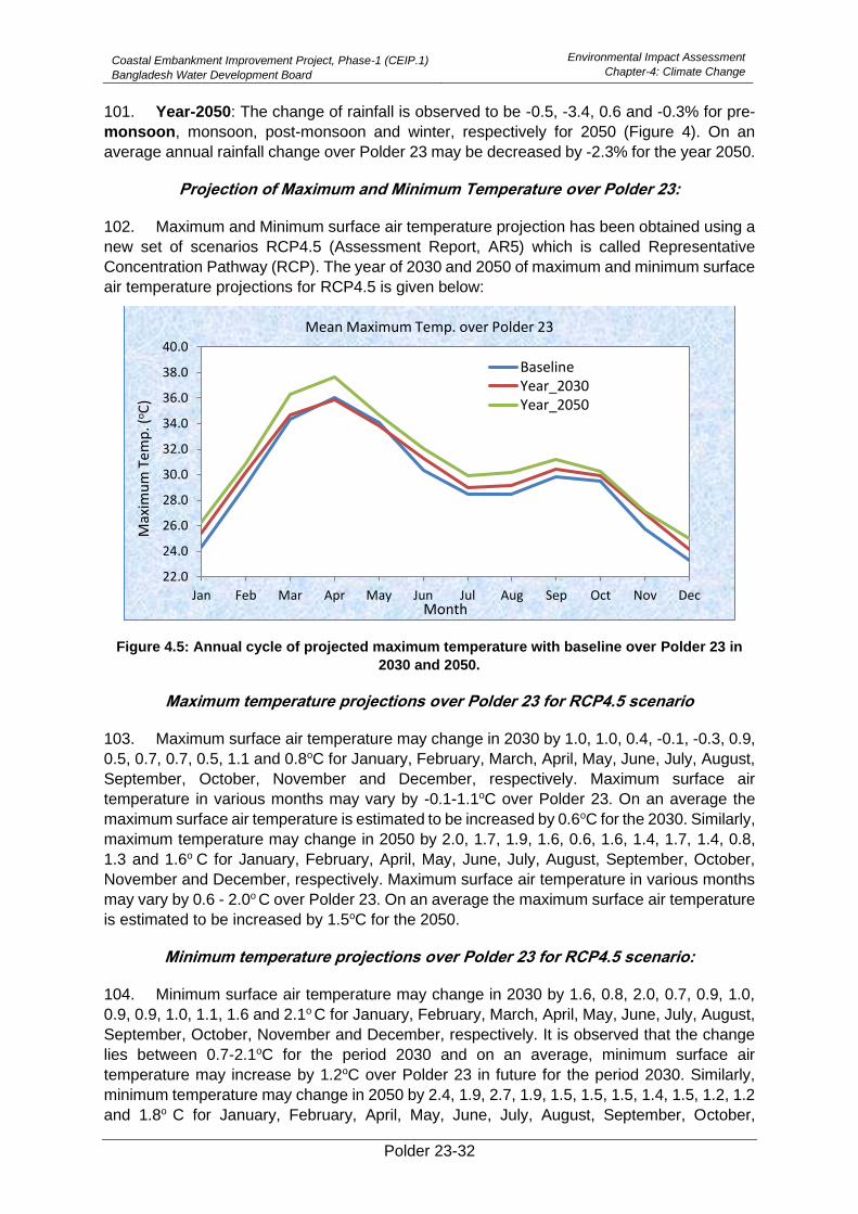
Coastal Embankment Improvement Project, Phase-1 (CEIP.1)
Bangladesh Water Development Board
Environmental Impact Assessment
Chapter-4: Climate Change
Polder 23-32
101. Year-2050: The change of rainfall is observed to be -0.5, -3.4, 0.6 and -0.3% for pre-
monsoon, monsoon, post-monsoon and winter, respectively for 2050 (Figure 4). On an
average annual rainfall change over Polder 23 may be decreased by -2.3% for the year 2050.
Projection of Maximum and Minimum Temperature over Polder 23:
102. Maximum and Minimum surface air temperature projection has been obtained using a
new set of scenarios RCP4.5 (Assessment Report, AR5) which is called Representative
Concentration Pathway (RCP). The year of 2030 and 2050 of maximum and minimum surface
air temperature projections for RCP4.5 is given below:
Figure 4.5: Annual cycle of projected maximum temperature with baseline over Polder 23 in
2030 and 2050.
Maximum temperature projections over Polder 23 for RCP4.5 scenario
103. Maximum surface air temperature may change in 2030 by 1.0, 1.0, 0.4, -0.1, -0.3, 0.9,
0.5, 0.7, 0.7, 0.5, 1.1 and 0.8oC for January, February, March, April, May, June, July, August,
September, October, November and December, respectively. Maximum surface air
temperature in various months may vary by -0.1-1.1oC over Polder 23. On an average the
maximum surface air temperature is estimated to be increased by 0.6oC for the 2030. Similarly,
maximum temperature may change in 2050 by 2.0, 1.7, 1.9, 1.6, 0.6, 1.6, 1.4, 1.7, 1.4, 0.8,
1.3 and 1.6o C for January, February, April, May, June, July, August, September, October,
November and December, respectively. Maximum surface air temperature in various months
may vary by 0.6 - 2.0o C over Polder 23. On an average the maximum surface air temperature
is estimated to be increased by 1.5oC for the 2050.
Minimum temperature projections over Polder 23 for RCP4.5 scenario:
104. Minimum surface air temperature may change in 2030 by 1.6, 0.8, 2.0, 0.7, 0.9, 1.0,
0.9, 0.9, 1.0, 1.1, 1.6 and 2.1o C for January, February, March, April, May, June, July, August,
September, October, November and December, respectively. It is observed that the change
lies between 0.7-2.1oC for the period 2030 and on an average, minimum surface air
temperature may increase by 1.2oC over Polder 23 in future for the period 2030. Similarly,
minimum temperature may change in 2050 by 2.4, 1.9, 2.7, 1.9, 1.5, 1.5, 1.5, 1.4, 1.5, 1.2, 1.2
and 1.8o C for January, February, April, May, June, July, August, September, October,
22.0
24.0
26.0
28.0
30.0
32.0
34.0
36.0
38.0
40.0
Jan Feb Mar Apr May Jun Jul Aug Sep Oct Nov Dec
Max
imu
m T
em
p. (
oC
)
Month
Mean Maximum Temp. over Polder 23
BaselineYear_2030Year_2050
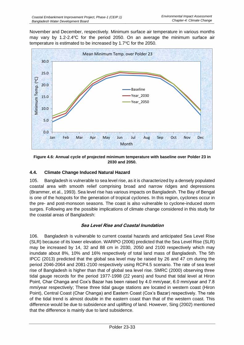
Coastal Embankment Improvement Project, Phase-1 (CEIP.1)
Bangladesh Water Development Board
Environmental Impact Assessment
Chapter-4: Climate Change
Polder 23-33
November and December, respectively. Minimum surface air temperature in various months
may vary by 1.2-2.4oC for the period 2050. On an average the minimum surface air
temperature is estimated to be increased by 1.7oC for the 2050.
Figure 4.6: Annual cycle of projected minimum temperature with baseline over Polder 23 in
2030 and 2050.
4.4. Climate Change Induced Natural Hazard
105. Bangladesh is vulnerable to sea level rise, as it is characterized by a densely populated
coastal area with smooth relief comprising broad and narrow ridges and depressions
(Brammer, et al., 1993). Sea level rise has various impacts on Bangladesh. The Bay of Bengal
is one of the hotspots for the generation of tropical cyclones. In this region, cyclones occur in
the pre- and post-monsoon seasons. The coast is also vulnerable to cyclone-induced storm
surges. Following are the possible implications of climate change considered in this study for
the coastal areas of Bangladesh:
Sea Level Rise and Coastal Inundation
106. Bangladesh is vulnerable to current coastal hazards and anticipated Sea Level Rise
(SLR) because of its lower elevation. WARPO (2006) predicted that the Sea Level Rise (SLR)
may be increased by 14, 32 and 88 cm in 2030, 2050 and 2100 respectively which may
inundate about 8%, 10% and 16% respectively of total land mass of Bangladesh. The 5th
IPCC (2013) predicted that the global sea level may be raised by 26 and 47 cm during the
period 2046-2064 and 2081-2100 respectively using RCP4.5 scenario. The rate of sea level
rise of Bangladesh is higher than that of global sea level rise. SMRC (2000) observing three
tidal gauge records for the period 1977-1998 (22 years) and found that tidal level at Hiron
Point, Char Changa and Cox’s Bazar has been raised by 4.0 mm/year, 6.0 mm/year and 7.8
mm/year respectively; These three tidal gauge stations are located in western coast (Hiron
Point), Central Coast (Char Changa) and Eastern Coast (Cox’s Bazar) respectively. The rate
of the tidal trend is almost double in the eastern coast than that of the western coast. This
difference would be due to subsidence and uplifting of land. However, Sing (2002) mentioned
that the difference is mainly due to land subsidence.
0.0
5.0
10.0
15.0
20.0
25.0
30.0
Jan Feb Mar Apr May Jun Jul Aug Sep Oct Nov Dec
Min
imu
m T
em
p. (
oC
)
Month
Mean Minimum Temp. over Polder 23
Baseline
Year_2030
Year_2050
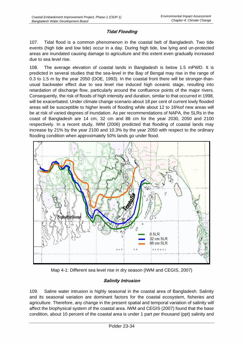
Coastal Embankment Improvement Project, Phase-1 (CEIP.1)
Bangladesh Water Development Board
Environmental Impact Assessment
Chapter-4: Climate Change
Polder 23-34
Tidal Flooding
107. Tidal flood is a common phenomenon in the coastal belt of Bangladesh. Two tide
events (high tide and low tide) occur in a day. During high tide, low lying and un-protected
areas are inundated causing damage to agriculture and this extent even gradually increased
due to sea level rise.
108. The average elevation of coastal lands in Bangladesh is below 1.5 mPWD. It is
predicted in several studies that the sea-level in the Bay of Bengal may rise in the range of
0.3 to 1.5 m by the year 2050 (DOE, 1993). In the coastal front there will be stronger-than-
usual backwater effect due to sea level rise induced high oceanic stage, resulting into
retardation of discharge flow, particularly around the confluence points of the major rivers.
Consequently, the risk of floods of high intensity and duration, similar to that occurred in 1998,
will be exacerbated. Under climate change scenario about 18 per cent of current lowly flooded
areas will be susceptible to higher levels of flooding while about 12 to 16%of new areas will
be at risk of varied degrees of inundation. As per recommendations of NAPA, the SLRs in the
coast of Bangladesh are 14 cm, 32 cm and 88 cm for the year 2030, 2050 and 2100
respectively. In a recent study, IWM (2006) predicted that flooding of coastal lands may
increase by 21% by the year 2100 and 10.3% by the year 2050 with respect to the ordinary
flooding condition when approximately 50% lands go under flood.
Map 4-1: Different sea level rise in dry season (IWM and CEGIS, 2007)
Salinity Intrusion
109. Saline water intrusion is highly seasonal in the coastal area of Bangladesh. Salinity
and its seasonal variation are dominant factors for the coastal ecosystem, fisheries and
agriculture. Therefore, any change in the present spatial and temporal variation of salinity will
affect the biophysical system of the coastal area. IWM and CEGIS (2007) found that the base
condition, about 10 percent of the coastal area is under 1 part per thousand (ppt) salinity and
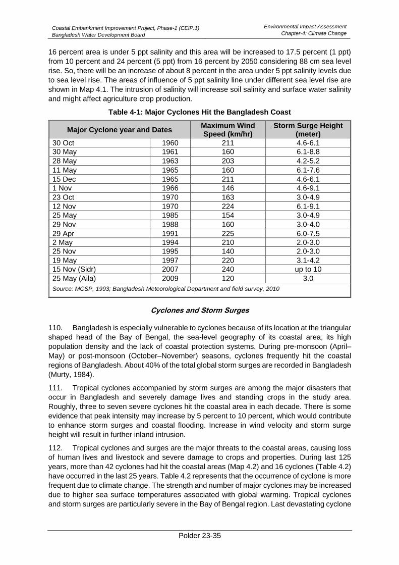
Coastal Embankment Improvement Project, Phase-1 (CEIP.1)
Bangladesh Water Development Board
Environmental Impact Assessment
Chapter-4: Climate Change
Polder 23-35
16 percent area is under 5 ppt salinity and this area will be increased to 17.5 percent (1 ppt)
from 10 percent and 24 percent (5 ppt) from 16 percent by 2050 considering 88 cm sea level
rise. So, there will be an increase of about 8 percent in the area under 5 ppt salinity levels due
to sea level rise. The areas of influence of 5 ppt salinity line under different sea level rise are
shown in Map 4.1. The intrusion of salinity will increase soil salinity and surface water salinity
and might affect agriculture crop production.
Table 4-1: Major Cyclones Hit the Bangladesh Coast
Major Cyclone year and Dates Maximum Wind Speed (km/hr)
Storm Surge Height (meter)
30 Oct 1960 211 4.6-6.1
30 May 1961 160 6.1-8.8
28 May 1963 203 4.2-5.2
11 May 1965 160 6.1-7.6
15 Dec 1965 211 4.6-6.1
1 Nov 1966 146 4.6-9.1
23 Oct 1970 163 3.0-4.9
12 Nov 1970 224 6.1-9.1
25 May 1985 154 3.0-4.9
29 Nov 1988 160 3.0-4.0
29 Apr 1991 225 6.0-7.5
2 May 1994 210 2.0-3.0
25 Nov 1995 140 2.0-3.0
19 May 1997 220 3.1-4.2
15 Nov (Sidr) 2007 240 up to 10
25 May (Aila) 2009 120 3.0
Source: MCSP, 1993; Bangladesh Meteorological Department and field survey, 2010
Cyclones and Storm Surges
110. Bangladesh is especially vulnerable to cyclones because of its location at the triangular
shaped head of the Bay of Bengal, the sea-level geography of its coastal area, its high
population density and the lack of coastal protection systems. During pre-monsoon (April–
May) or post-monsoon (October–November) seasons, cyclones frequently hit the coastal
regions of Bangladesh. About 40% of the total global storm surges are recorded in Bangladesh
(Murty, 1984).
111. Tropical cyclones accompanied by storm surges are among the major disasters that
occur in Bangladesh and severely damage lives and standing crops in the study area.
Roughly, three to seven severe cyclones hit the coastal area in each decade. There is some
evidence that peak intensity may increase by 5 percent to 10 percent, which would contribute
to enhance storm surges and coastal flooding. Increase in wind velocity and storm surge
height will result in further inland intrusion.
112. Tropical cyclones and surges are the major threats to the coastal areas, causing loss
of human lives and livestock and severe damage to crops and properties. During last 125
years, more than 42 cyclones had hit the coastal areas (Map 4.2) and 16 cyclones (Table 4.2)
have occurred in the last 25 years. Table 4.2 represents that the occurrence of cyclone is more
frequent due to climate change. The strength and number of major cyclones may be increased
due to higher sea surface temperatures associated with global warming. Tropical cyclones
and storm surges are particularly severe in the Bay of Bengal region. Last devastating cyclone
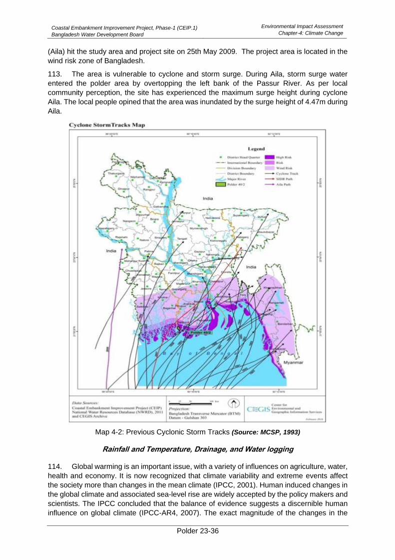
Coastal Embankment Improvement Project, Phase-1 (CEIP.1)
Bangladesh Water Development Board
Environmental Impact Assessment
Chapter-4: Climate Change
Polder 23-36
(Aila) hit the study area and project site on 25th May 2009. The project area is located in the
wind risk zone of Bangladesh.
113. The area is vulnerable to cyclone and storm surge. During Aila, storm surge water
entered the polder area by overtopping the left bank of the Passur River. As per local
community perception, the site has experienced the maximum surge height during cyclone
Aila. The local people opined that the area was inundated by the surge height of 4.47m during
Aila.
Map 4-2: Previous Cyclonic Storm Tracks (Source: MCSP, 1993)
Rainfall and Temperature, Drainage, and Water logging
114. Global warming is an important issue, with a variety of influences on agriculture, water,
health and economy. It is now recognized that climate variability and extreme events affect
the society more than changes in the mean climate (IPCC, 2001). Human induced changes in
the global climate and associated sea-level rise are widely accepted by the policy makers and
scientists. The IPCC concluded that the balance of evidence suggests a discernible human
influence on global climate (IPCC-AR4, 2007). The exact magnitude of the changes in the
Coastal Embankment Improvement Project, Phase-1 (CEIP.1)
Bangladesh Water Development Board
Environmental Impact Assessment
Chapter-4: Climate Change
Polder 23-37
global climate is still uncertain and subject to worldwide scientific studies. It is broadly
recognized that Bangladesh is more vulnerable to these changes. Indeed, it has internationally
been argued that Bangladesh, as a country, may suffer the most severe impacts of climate
change. Bangladesh is highly vulnerable because it is a low-lying country located in the deltaic
plain of the Ganges, the Brahmaputra and the Meghna and densely populated. Its national
economy strongly depends on agriculture and natural resources that are sensitive to climate
change and sea-level rise. The impact of higher temperature and more extreme weather
events such as floods, cyclone, severe drought and sea-level rise are already being felt in
South Asia and will continue to intensify (Huq et al., 1999; Ali, 1999). In this connection proper
planning and sensible management of water resources are essential for this region. Long-term
planning is not possible without any idea of the change of climate that may take place in future.
Climate models are the main tools available for developing projections of climate change in
the future (Houghton et al., 2001).
115. Regional Climate Downscaling (RCD) has an important role to play by providing
projections with much greater detail and more accurate representation of localized extreme
events than the GCM. South Asia Coordinated Regional climate Downscaling Experiment
(CORDEX) domain data (resolution 50 km) are available at Centre for Climate Change
Research (CCCR), IITM, India. The CCCR is recognized by World Climate Research
Programme (WCRP) and is responsible to generate downscaling model data over South Asia
CORDEX domain. These data have been used to generate the future scenarios for rainfall
and temperature at Patuakhali (because patuakhali is the nearest place of the polder) in
Bangladesh using RCP4.5 data set. The RCM model outputs were analyzed to find out
seasonal and annual rainfall and temperature over Bangladesh. It is assumed that the year
2030 means averaged precipitation/temperature during the period 2021-2040 and year 2050
means averaged precipitation/temperature for the period of 2041-2060 and base period 1990
means averaged during the period 1981-2000.
Polder 23-38
5. Description of the Project
5.1. General
116. The Bangladesh low-lying Delta is formed by the interaction of the very large summer
discharges of both water and sediment from the Ganges, Brahmaputra (Jamuna) and Meghna
Basins with tides in the Bay of Bengal, which can vary in range from 3 m in the west to nearly
6 m in the northeastern corner of the Bay near Sandwip.
117. The Coastal Zone of Bangladesh has been defined as the area within which the river
flows are influenced by the tide. Given the high tidal range and the very low river gradients,
the tide reaches very far landwards, particularly in the dry season. If the upstream freshwater
inflows are reduced in the dry season, salinity can also intrude very far upstream within the
river system, which comprises a number of very large estuaries.
5.2. Coastal Embankment Project
118. The Coastal Embankment Project (CEP) was initiated in the 1960s to reclaim or protect
areas in the coastal zone that lay below the highest tide levels for periodic inundation by saline
water. These lands could now be used for agriculture by providing drainage structures capable
of evacuating excess water during low tide. This system worked well for many years and 1.2
million hectares came under protection the embankment system bringing immense benefits.
119. However, there have been unintended consequences of this project. The very act of
preventing the high tides from spreading over the land and confining them within the river
channels initially increased the tidal range by about 30 per cent, which might have had an
immediate beneficial impact on drainage. However, the reduction of upstream and overbank
storage also decreased the tidal cubature (i.e., the volume of water displaced during a tidal
cycle).
120. The reduction in cubature induced sedimentation or more correctly a reduction in cross
sectional areas of the rivers of all types – the large rivers such as the Passur which have sandy
bottoms and clay/silt banks and the smaller rivers which have an excess of silt and clay. The
consequent choking of smaller rivers resulted in drainage congestion within some internal
polders, and navigation problems in some.
121. The embankment system was designed originally to keep out the highest tides, without
any consideration of possible storm surges. Recent cyclonic storm damages and the
anticipation of worse future situations because of climate change, has caused this strategy to
be revised. Additional problems have also been identified – the direct impact of sea level rise
on salinity intrusion into the coastal zone as well as on Polder drainage.
5.3. The CEIP Initiative
122. It is well recognized that infrastructural interventions in the coastal areas by
embankments and cyclone shelters have significantly reduced its vulnerability to natural
disasters at least partially and thus the poor people have some assurance of safety to their
lives and crops. However, some effectiveness of the infrastructures in most cases has been
compromised through poor and inadequate maintenance and sometimes by shifting the
embankments towards country sides. With the occurrence of the frequent storms in the recent
period, the Coastal Embankment Systems (CES) has weakened and calls for systematic
restoration and upgrading.
123. After cyclone Sidr struck the coastal area causing severe damage to the infrastructure,
lives and properties of the coastal belt, GOB obtained an IDA/credit for Emergency Cyclone
Recovery and Restoration Project (ECRRP, 2007) and proceeds from this credit would be

Coastal Embankment Improvement Project, Phase-1 (CEIP.1)
Bangladesh Water Development Board
Environmental Impact Assessment
Chapter-5: Description of the Project
Polder 23-39
used to meet the expenses for preparation of the proposed Coastal Embankment
Improvement Project-Phase-1 (CEIP-1).
124. It had been apprehended that undertaking the rehabilitation of coastal embankment
system under one or two localized projects would not bring any convincing change in such a
vast area. To resolve this multi-dimensional problem a strategic approach in the name of
Coastal Embankment Improvement Programme (CEIP) was felt necessary. It incorporates a
longer-term perspective in a programme spread over a period of 15-20 years, composed of at
least 3-4 sub-phases.
125. Polder 23 is one of the polders to be rehabilitated under the CEIP-1.
5.4. Overview of Polder 23
126. Polder 23 is located in Paikgachha Upazila under Khulna District. The Polder covers
two Union Parishad (UP) namely Sholadana and Laskar. The Polder is surrounded by three
rivers, Sibsa River to the North and East, Karulia River to the West and Minaj River to the
South. Sundarban is the biggest mangrove forest and a World heritage site is located about
10 km to south of the Polder.
127. The Polder was conceived in the early 1960s. Construction of the Polder was started
in 1965 and completed in 1968. Cyclone is the main threat to life and property in the area. The
original concept of construction of this Polder was to protect low lying coastal areas against
tidal flooding and salinity intrusion, considering only the tidal effects but ignoring effects of
wind, wave and cyclonic storm surges. The south-east corner of the Polder is under heavy
threat of cyclone surge, and wave overtopping aggravated by climate change.
5.5. Objective of the Project
128. The primary objective of the project is to restoration of the Polder that may protect the
coastal population from natural disasters and climate change. This may be fulfilled through a
set of specific objectives, such as (a) to protect embankment from river erosion and wave
action; (b) to prevent saline intrusion; (c) to provide improved drainage facilities; (d) to prevent
sedimentation both in agricultural land and in water resources system; (e) to enhance scope
of agricultural production; (f) to reduce vulnerability to sea level rise due to climate change;
and finally; (g) to protect life and properties of the polder community from storm surges.
5.6. Water Management Problems and Issues in Polder 23
129. The Polder 23, like other Polders in the coastal area of Bangladesh, was designed
originally to protect the inner area against highest tides, without much attention to storm
surges. Most segments of the embankment have been damaged mainly for overtopping of
cyclones and storm surges especially Aila (2009). Many segments of the embankment have
been damaged by wave action and eroded due to high pressure of tidal prism and continuous
water flow. At many places especially along the Sibsa River, the embankment was overtopped
during Aila. There is an abrupt ecological change inside the Polder area. More than 80% of
the Polder area is now under shrimp culture Gher1 and few agriculture lands remains inside
the Polder. It was observed that there are so many unauthorised mini structures constructed
by the Gher owners for lifting saline water from the river for the purpose of shrimp culture.
These structures make the embankment weaker. The entire embankment is under sectioned
than design section with deteriorated condition and is being aggravated day by day due to
climate change effect. The total length of the embankment needs to be re-sectioned as per
1Farms lands converted into ponds with low dykes and used for cultivation of shrimp/prawn/fish
Coastal Embankment Improvement Project, Phase-1 (CEIP.1)
Bangladesh Water Development Board
Environmental Impact Assessment
Chapter-5: Description of the Project
Polder 23-40
recommended crest level by CEIP. There are brick soling and bitumen carpeting on the top of
embankment as road, which is needed to be upgraded accordingly.
130. There are 11 numbers of drainage sluices in the Polder. The condition of the drainage
sluices is very deplorable. The concrete surfaces of the structures have deteriorated due to
long-term use and contact with saline water. In some places, the reinforcement is be exposed
and corroded in the saline environment. Most of the structures are not repairable condition.
Loose aprons of the structures have been damaged. Out of which one is fully damaged (DS-
1 at Ch. 21.35 km) and need to be reconstructed according to the new design by CEIP.
131. Besides, there are 39 numbers of flushing sluices in the Polder which were constructed
under 3rd fishery and 4th fishery projects. Out of which 14 numbers of flushing sluices are
required to be demolished as there is no need of flushing of water at those locations. About 8
numbers of the flushing sluices are functioning well and needed minor repairing and the
remaining 17 numbers of flushing sluices have been severely damaged but needs flushing at
the locality so that it required to be replaced as per new design by CEIP-1.
132. Similarly, most of the internal drainage channels have silted up which are needed to
be re-excavated for efficient drainage within the polder area.
133. An Index Map showing the alignment of the embankment, drainage sluice, drainage
channels are given below:
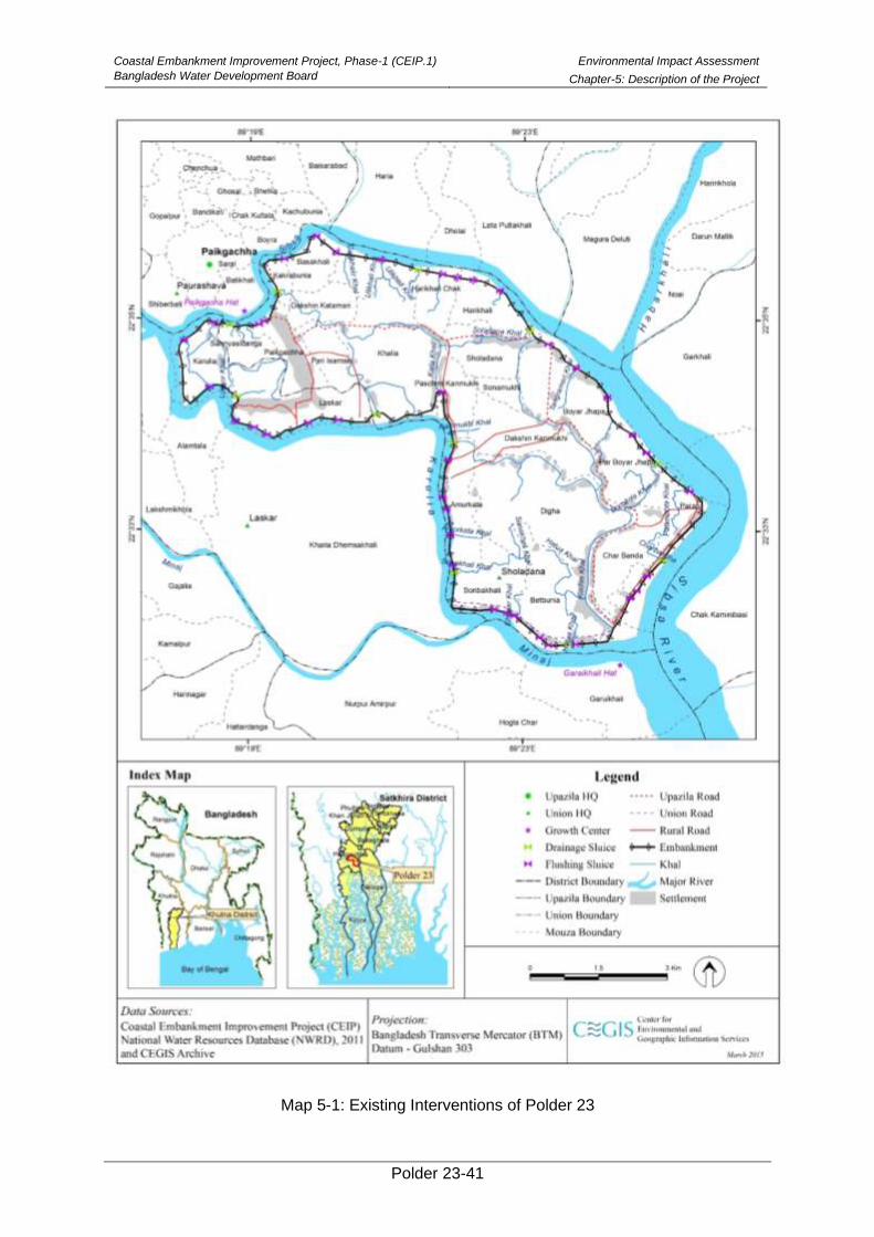
Coastal Embankment Improvement Project, Phase-1 (CEIP.1)
Bangladesh Water Development Board
Environmental Impact Assessment
Chapter-5: Description of the Project
Polder 23-41
Map 5-1: Existing Interventions of Polder 23
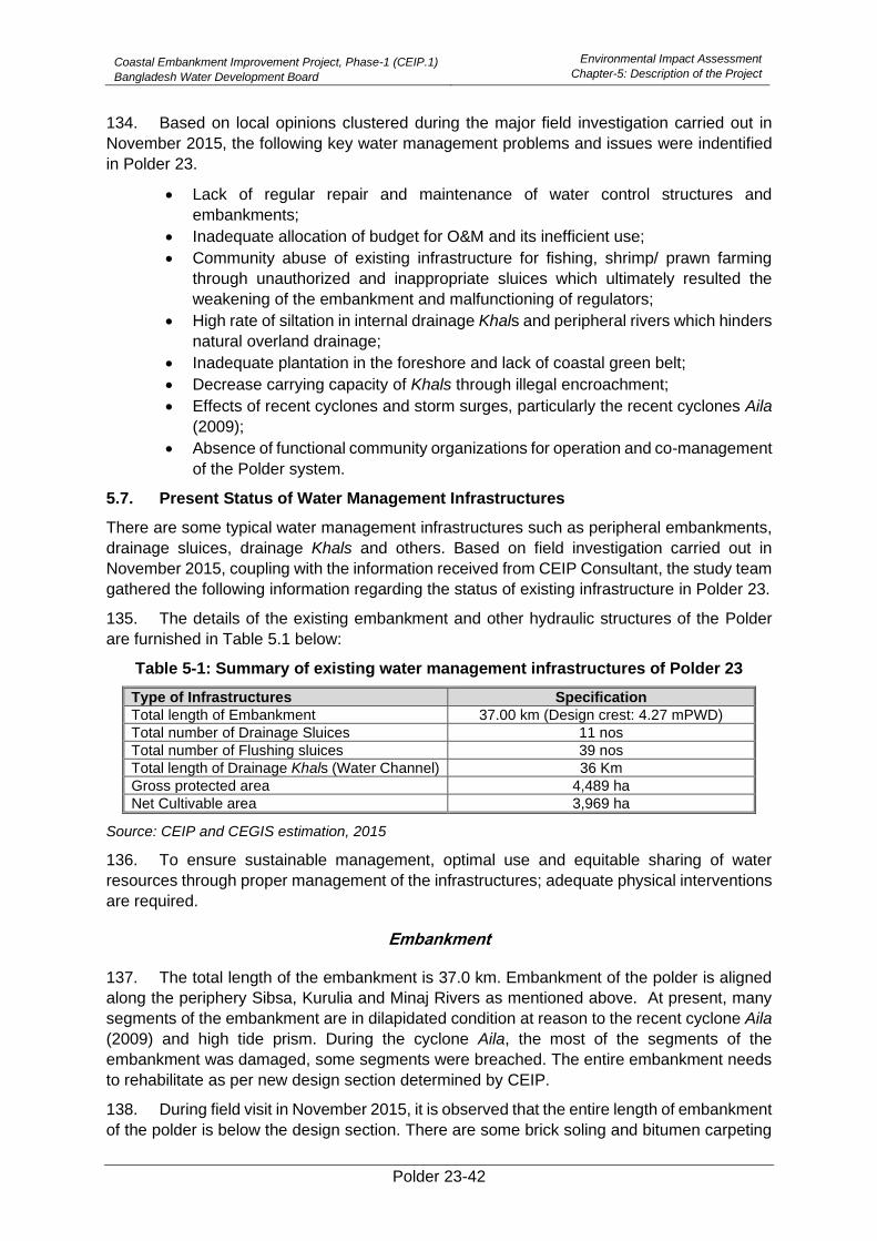
Coastal Embankment Improvement Project, Phase-1 (CEIP.1)
Bangladesh Water Development Board
Environmental Impact Assessment
Chapter-5: Description of the Project
Polder 23-42
134. Based on local opinions clustered during the major field investigation carried out in
November 2015, the following key water management problems and issues were indentified
in Polder 23.
• Lack of regular repair and maintenance of water control structures and
embankments;
• Inadequate allocation of budget for O&M and its inefficient use;
• Community abuse of existing infrastructure for fishing, shrimp/ prawn farming
through unauthorized and inappropriate sluices which ultimately resulted the
weakening of the embankment and malfunctioning of regulators;
• High rate of siltation in internal drainage Khals and peripheral rivers which hinders
natural overland drainage;
• Inadequate plantation in the foreshore and lack of coastal green belt;
• Decrease carrying capacity of Khals through illegal encroachment;
• Effects of recent cyclones and storm surges, particularly the recent cyclones Aila
(2009);
• Absence of functional community organizations for operation and co-management
of the Polder system.
5.7. Present Status of Water Management Infrastructures
There are some typical water management infrastructures such as peripheral embankments,
drainage sluices, drainage Khals and others. Based on field investigation carried out in
November 2015, coupling with the information received from CEIP Consultant, the study team
gathered the following information regarding the status of existing infrastructure in Polder 23.
135. The details of the existing embankment and other hydraulic structures of the Polder
are furnished in Table 5.1 below:
Table 5-1: Summary of existing water management infrastructures of Polder 23
Type of Infrastructures Specification
Total length of Embankment 37.00 km (Design crest: 4.27 mPWD)
Total number of Drainage Sluices 11 nos
Total number of Flushing sluices 39 nos
Total length of Drainage Khals (Water Channel) 36 Km
Gross protected area 4,489 ha
Net Cultivable area 3,969 ha
Source: CEIP and CEGIS estimation, 2015
136. To ensure sustainable management, optimal use and equitable sharing of water
resources through proper management of the infrastructures; adequate physical interventions
are required.
Embankment
137. The total length of the embankment is 37.0 km. Embankment of the polder is aligned
along the periphery Sibsa, Kurulia and Minaj Rivers as mentioned above. At present, many
segments of the embankment are in dilapidated condition at reason to the recent cyclone Aila
(2009) and high tide prism. During the cyclone Aila, the most of the segments of the
embankment was damaged, some segments were breached. The entire embankment needs
to rehabilitate as per new design section determined by CEIP.
138. During field visit in November 2015, it is observed that the entire length of embankment
of the polder is below the design section. There are some brick soling and bitumen carpeting
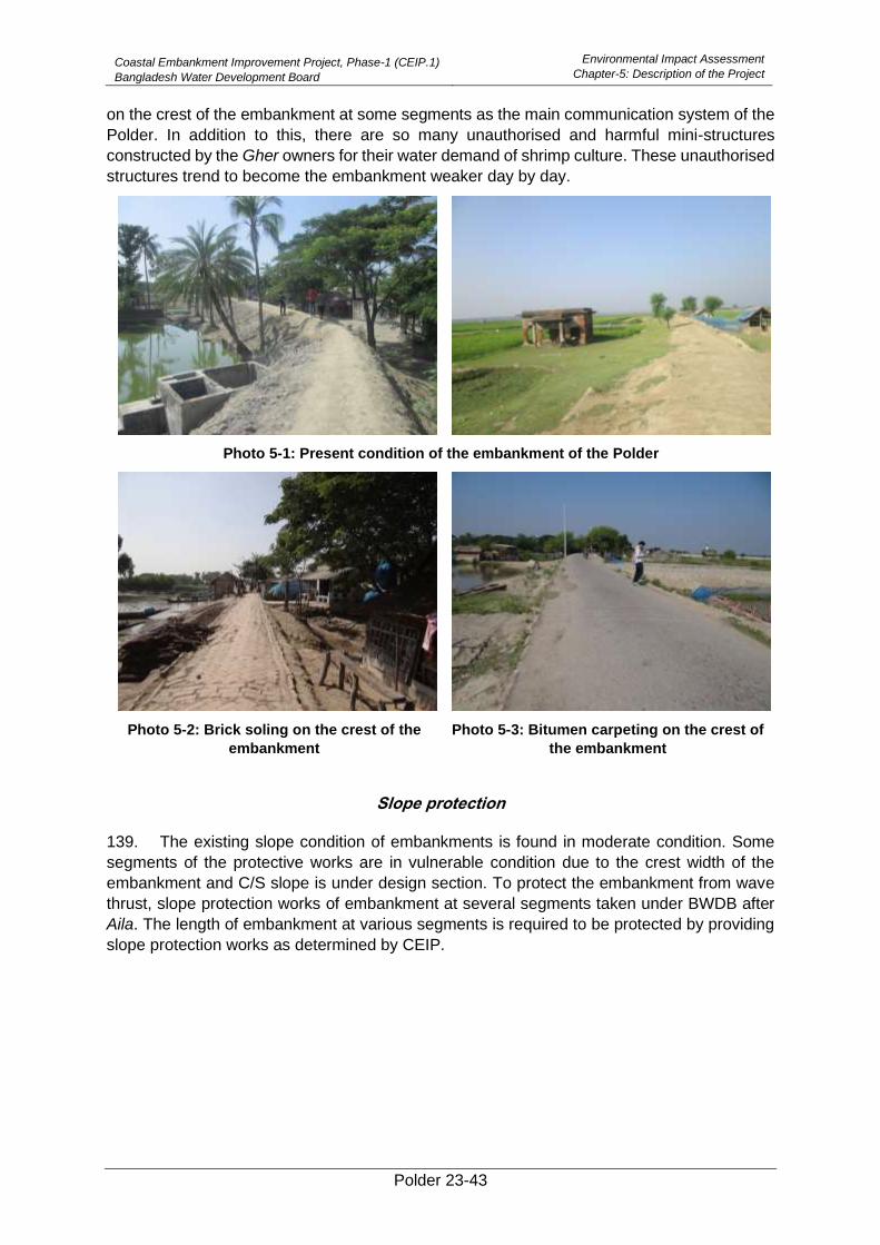
Coastal Embankment Improvement Project, Phase-1 (CEIP.1)
Bangladesh Water Development Board
Environmental Impact Assessment
Chapter-5: Description of the Project
Polder 23-43
on the crest of the embankment at some segments as the main communication system of the
Polder. In addition to this, there are so many unauthorised and harmful mini-structures
constructed by the Gher owners for their water demand of shrimp culture. These unauthorised
structures trend to become the embankment weaker day by day.
Photo 5-1: Present condition of the embankment of the Polder
Photo 5-2: Brick soling on the crest of the
embankment
Photo 5-3: Bitumen carpeting on the crest of
the embankment
Slope protection
139. The existing slope condition of embankments is found in moderate condition. Some
segments of the protective works are in vulnerable condition due to the crest width of the
embankment and C/S slope is under design section. To protect the embankment from wave
thrust, slope protection works of embankment at several segments taken under BWDB after
Aila. The length of embankment at various segments is required to be protected by providing
slope protection works as determined by CEIP.
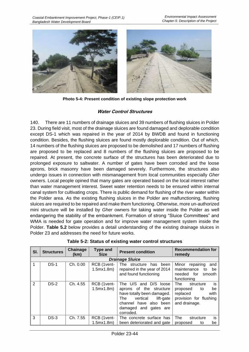
Coastal Embankment Improvement Project, Phase-1 (CEIP.1)
Bangladesh Water Development Board
Environmental Impact Assessment
Chapter-5: Description of the Project
Polder 23-44
Photo 5-4: Present condition of existing slope protection work
Water Control Structures
140. There are 11 numbers of drainage sluices and 39 numbers of flushing sluices in Polder
23. During field visit, most of the drainage sluices are found damaged and deplorable condition
except DS-1 which was repaired in the year of 2014 by BWDB and found in functioning
condition. Besides, the flushing sluices are found mostly deplorable condition. Out of which,
14 numbers of the flushing sluices are proposed to be demolished and 17 numbers of flushing
are proposed to be replaced and 8 numbers of the flushing sluices are proposed to be
repaired. At present, the concrete surface of the structures has been deteriorated due to
prolonged exposure to saltwater. A number of gates have been corroded and the loose
aprons, brick masonry have been damaged severely. Furthermore, the structures also
undergo issues in connection with mismanagement from local communities especially Gher
owners. Local people opined that many gates are operated based on the local interest rather
than water management interest. Sweet water retention needs to be ensured within internal
canal system for cultivating crops. There is public demand for flushing of the river water within
the Polder area. As the existing flushing sluices in the Polder are malfunctioning, flushing
sluices are required to be repaired and make them functioning. Otherwise, more un-authorized
mini structure will be installed by Gher owners for taking water inside the Polder as well
endangering the stability of the embankment. Formation of strong “Sluice Committees” and
WMA is needed for gate operation and for improve water management system inside the
Polder. Table 5.2 below provides a detail understanding of the existing drainage sluices in
Polder 23 and addresses the need for future works.
Table 5-2: Status of existing water control structures
Sl. Structures Chainage
(km) Type and
Size Present condition
Recommendation for remedy
Drainage Sluice
1 DS-1 Ch. 0.00 RCB (1vent-1.5mx1.8m)
The structure has been repaired in the year of 2014 and found functioning
Minor repairing and maintenance to be needed for smooth functioning
2 DS-2 Ch. 4.55
RCB (1vent-1.5mx1.8m)
The U/S and D/S loose aprons of the structure have totally been damaged. The vertical lift-gate channel have also been damaged and gates are corroded.
The structure is proposed to be replaced with provision for flushing and drainage.
3 DS-3 Ch. 7.55 RCB (1vent-1.5mx1.8m)
The concrete surface has been deteriorated and gate
The structure is proposed to be
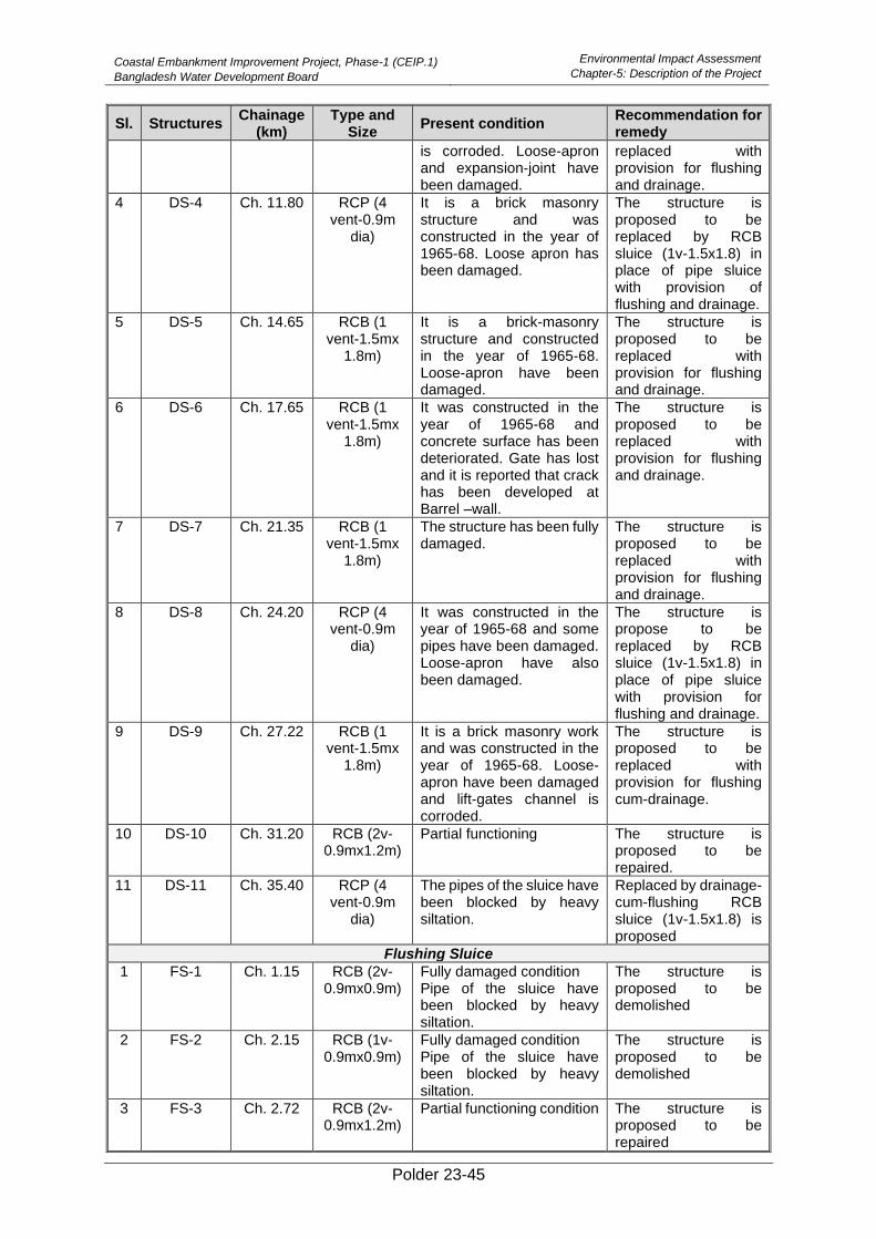
Coastal Embankment Improvement Project, Phase-1 (CEIP.1)
Bangladesh Water Development Board
Environmental Impact Assessment
Chapter-5: Description of the Project
Polder 23-45
Sl. Structures Chainage
(km) Type and
Size Present condition
Recommendation for remedy
is corroded. Loose-apron and expansion-joint have been damaged.
replaced with provision for flushing and drainage.
4 DS-4 Ch. 11.80 RCP (4 vent-0.9m
dia)
It is a brick masonry structure and was constructed in the year of 1965-68. Loose apron has been damaged.
The structure is proposed to be replaced by RCB sluice (1v-1.5x1.8) in place of pipe sluice with provision of flushing and drainage.
5 DS-5 Ch. 14.65 RCB (1 vent-1.5mx
1.8m)
It is a brick-masonry structure and constructed in the year of 1965-68. Loose-apron have been damaged.
The structure is proposed to be replaced with provision for flushing and drainage.
6 DS-6 Ch. 17.65 RCB (1 vent-1.5mx
1.8m)
It was constructed in the year of 1965-68 and concrete surface has been deteriorated. Gate has lost and it is reported that crack has been developed at Barrel –wall.
The structure is proposed to be replaced with provision for flushing and drainage.
7 DS-7 Ch. 21.35 RCB (1 vent-1.5mx
1.8m)
The structure has been fully damaged.
The structure is proposed to be replaced with provision for flushing and drainage.
8 DS-8 Ch. 24.20 RCP (4 vent-0.9m
dia)
It was constructed in the year of 1965-68 and some pipes have been damaged. Loose-apron have also been damaged.
The structure is propose to be replaced by RCB sluice (1v-1.5x1.8) in place of pipe sluice with provision for flushing and drainage.
9 DS-9 Ch. 27.22 RCB (1 vent-1.5mx
1.8m)
It is a brick masonry work and was constructed in the year of 1965-68. Loose-apron have been damaged and lift-gates channel is corroded.
The structure is proposed to be replaced with provision for flushing cum-drainage.
10 DS-10 Ch. 31.20 RCB (2v-0.9mx1.2m)
Partial functioning The structure is proposed to be repaired.
11 DS-11 Ch. 35.40 RCP (4 vent-0.9m
dia)
The pipes of the sluice have been blocked by heavy siltation.
Replaced by drainage-cum-flushing RCB sluice (1v-1.5x1.8) is proposed
Flushing Sluice
1 FS-1 Ch. 1.15 RCB (2v-0.9mx0.9m)
Fully damaged condition Pipe of the sluice have been blocked by heavy siltation.
The structure is proposed to be demolished
2 FS-2 Ch. 2.15 RCB (1v-0.9mx0.9m)
Fully damaged condition Pipe of the sluice have been blocked by heavy siltation.
The structure is proposed to be demolished
3 FS-3 Ch. 2.72 RCB (2v-0.9mx1.2m)
Partial functioning condition The structure is proposed to be repaired
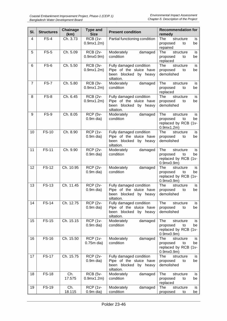
Coastal Embankment Improvement Project, Phase-1 (CEIP.1)
Bangladesh Water Development Board
Environmental Impact Assessment
Chapter-5: Description of the Project
Polder 23-46
Sl. Structures Chainage
(km) Type and
Size Present condition
Recommendation for remedy
4 FS-4 Ch. 3.73 RCB (1v-0.9mx1.2m)
Partial functioning condition The structure is proposed to be repaired
5 FS-5 Ch. 5.09 RCB (2v-0.9mx0.9m)
Moderately damaged condition
The structure is proposed to be replaced
6 FS-6 Ch. 5.50 RCB (3v-0.9mx1.2m)
Fully damaged condition Pipe of the sluice have been blocked by heavy siltation.
The structure is proposed to be demolished
7 FS-7 Ch. 5.80 RCB (3v-0.9mx1.2m)
Moderately damaged condition
The structure is proposed to be replaced
8 FS-8 Ch. 6.45 RCB (2v-0.9mx1.2m)
Fully damaged condition Pipe of the sluice have been blocked by heavy siltation.
The structure is proposed to be demolished
9 FS-9 Ch. 8.05 RCP (5v-0.9m dia)
Moderately damaged condition
The structure is proposed to be replaced by RCB (1v-0.9mx1.2m)
10 FS-10 Ch. 8.90 RCP (1v-0.9m dia)
Fully damaged condition Pipe of the sluice have been blocked by heavy siltation.
The structure is proposed to be demolished
11 FS-11 Ch. 9.90 RCP (2v-0.9m dia)
Moderately damaged condition
The structure is proposed to be replaced by RCB (1v-0.9mx0.9m)
12 FS-12 Ch. 10.95 RCP (2v-0.9m dia)
Moderately damaged condition
The structure is proposed to be replaced by RCB (1v-0.9mx0.9m)
13 FS-13 Ch. 11.45 RCP (2v-0.9m dia)
Fully damaged condition Pipe of the sluice have been blocked by heavy siltation.
The structure is proposed to be demolished
14 FS-14 Ch. 12.75 RCP (2v-0.9m dia)
Fully damaged condition Pipe of the sluice have been blocked by heavy siltation.
The structure is proposed to be demolished
15 FS-15 Ch. 15.15 RCP (1v-0.9m dia)
Moderately damaged condition
The structure is proposed to be replaced by RCB (1v-0.9mx0.9m)
16 FS-16 Ch. 15.50 RCP (1v-0.75m dia)
Moderately damaged condition
The structure is proposed to be replaced by RCB (1v-0.9mx0.9m)
17 FS-17 Ch. 15.75 RCP (2v-0.9m dia)
Fully damaged condition Pipe of the sluice have been blocked by heavy siltation.
The structure is proposed to be demolished
18 FS-18 Ch. 17.575
RCB (5v-0.9mx1.2m)
Moderately damaged condition
The structure is proposed to be replaced
19 FS-19 Ch. 18.115
RCP (1v-0.9m dia)
Moderately damaged condition
The structure is proposed to be
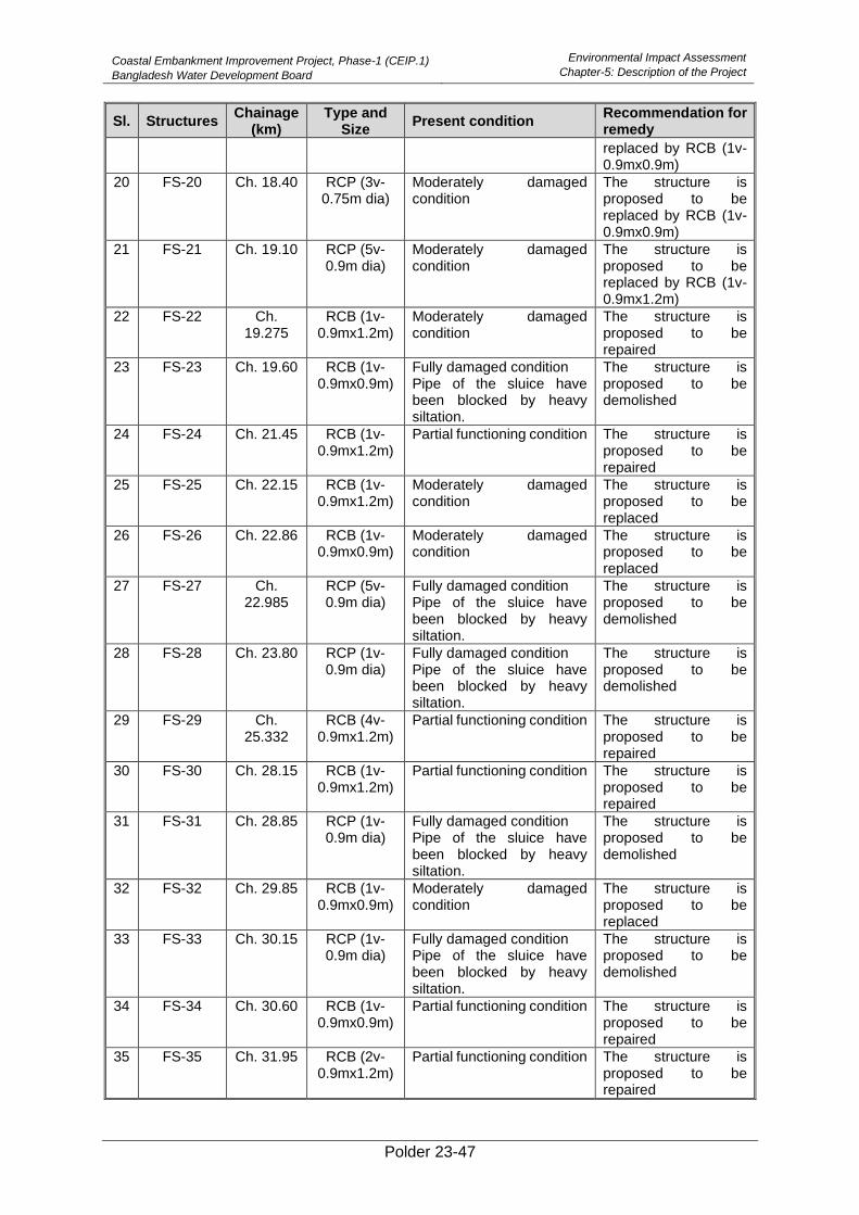
Coastal Embankment Improvement Project, Phase-1 (CEIP.1)
Bangladesh Water Development Board
Environmental Impact Assessment
Chapter-5: Description of the Project
Polder 23-47
Sl. Structures Chainage
(km) Type and
Size Present condition
Recommendation for remedy
replaced by RCB (1v-0.9mx0.9m)
20 FS-20 Ch. 18.40 RCP (3v-0.75m dia)
Moderately damaged condition
The structure is proposed to be replaced by RCB (1v-0.9mx0.9m)
21 FS-21 Ch. 19.10 RCP (5v-0.9m dia)
Moderately damaged condition
The structure is proposed to be replaced by RCB (1v-0.9mx1.2m)
22 FS-22 Ch. 19.275
RCB (1v-0.9mx1.2m)
Moderately damaged condition
The structure is proposed to be repaired
23 FS-23 Ch. 19.60 RCB (1v-0.9mx0.9m)
Fully damaged condition Pipe of the sluice have been blocked by heavy siltation.
The structure is proposed to be demolished
24 FS-24 Ch. 21.45 RCB (1v-0.9mx1.2m)
Partial functioning condition The structure is proposed to be repaired
25 FS-25 Ch. 22.15 RCB (1v-0.9mx1.2m)
Moderately damaged condition
The structure is proposed to be replaced
26 FS-26 Ch. 22.86 RCB (1v-0.9mx0.9m)
Moderately damaged condition
The structure is proposed to be replaced
27 FS-27 Ch. 22.985
RCP (5v-0.9m dia)
Fully damaged condition Pipe of the sluice have been blocked by heavy siltation.
The structure is proposed to be demolished
28 FS-28 Ch. 23.80 RCP (1v-0.9m dia)
Fully damaged condition Pipe of the sluice have been blocked by heavy siltation.
The structure is proposed to be demolished
29 FS-29 Ch. 25.332
RCB (4v-0.9mx1.2m)
Partial functioning condition The structure is proposed to be repaired
30 FS-30 Ch. 28.15 RCB (1v-0.9mx1.2m)
Partial functioning condition The structure is proposed to be repaired
31 FS-31 Ch. 28.85 RCP (1v-0.9m dia)
Fully damaged condition Pipe of the sluice have been blocked by heavy siltation.
The structure is proposed to be demolished
32 FS-32 Ch. 29.85 RCB (1v-0.9mx0.9m)
Moderately damaged condition
The structure is proposed to be replaced
33 FS-33 Ch. 30.15 RCP (1v-0.9m dia)
Fully damaged condition Pipe of the sluice have been blocked by heavy siltation.
The structure is proposed to be demolished
34 FS-34 Ch. 30.60 RCB (1v-0.9mx0.9m)
Partial functioning condition The structure is proposed to be repaired
35 FS-35 Ch. 31.95 RCB (2v-0.9mx1.2m)
Partial functioning condition The structure is proposed to be repaired
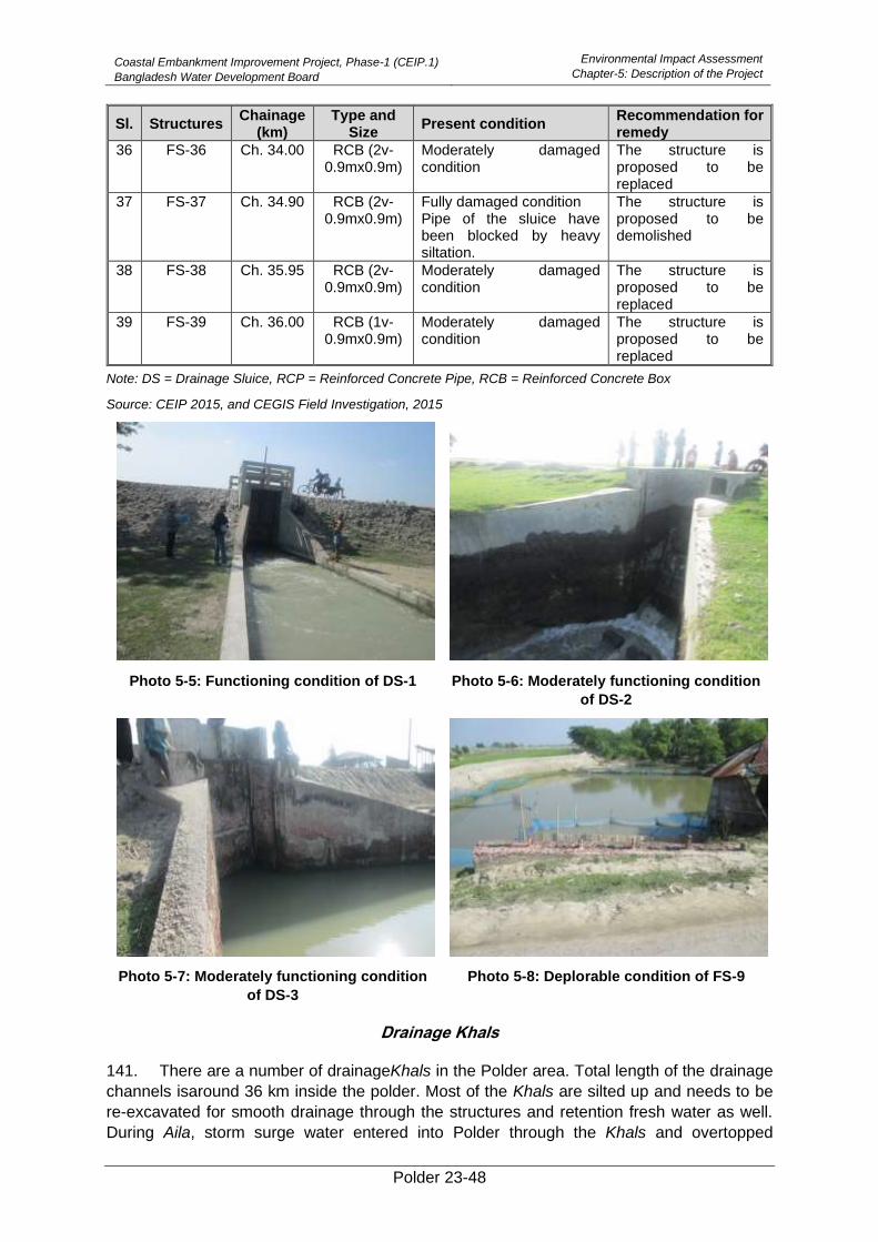
Coastal Embankment Improvement Project, Phase-1 (CEIP.1)
Bangladesh Water Development Board
Environmental Impact Assessment
Chapter-5: Description of the Project
Polder 23-48
Sl. Structures Chainage
(km) Type and
Size Present condition
Recommendation for remedy
36 FS-36 Ch. 34.00 RCB (2v-0.9mx0.9m)
Moderately damaged condition
The structure is proposed to be replaced
37 FS-37 Ch. 34.90 RCB (2v-0.9mx0.9m)
Fully damaged condition Pipe of the sluice have been blocked by heavy siltation.
The structure is proposed to be demolished
38 FS-38 Ch. 35.95 RCB (2v-0.9mx0.9m)
Moderately damaged condition
The structure is proposed to be replaced
39 FS-39 Ch. 36.00 RCB (1v-0.9mx0.9m)
Moderately damaged condition
The structure is proposed to be replaced
Note: DS = Drainage Sluice, RCP = Reinforced Concrete Pipe, RCB = Reinforced Concrete Box
Source: CEIP 2015, and CEGIS Field Investigation, 2015
Photo 5-5: Functioning condition of DS-1 Photo 5-6: Moderately functioning condition
of DS-2
Photo 5-7: Moderately functioning condition
of DS-3
Photo 5-8: Deplorable condition of FS-9
Drainage Khals
141. There are a number of drainageKhals in the Polder area. Total length of the drainage
channels isaround 36 km inside the polder. Most of the Khals are silted up and needs to be
re-excavated for smooth drainage through the structures and retention fresh water as well.
During Aila, storm surge water entered into Polder through the Khals and overtopped
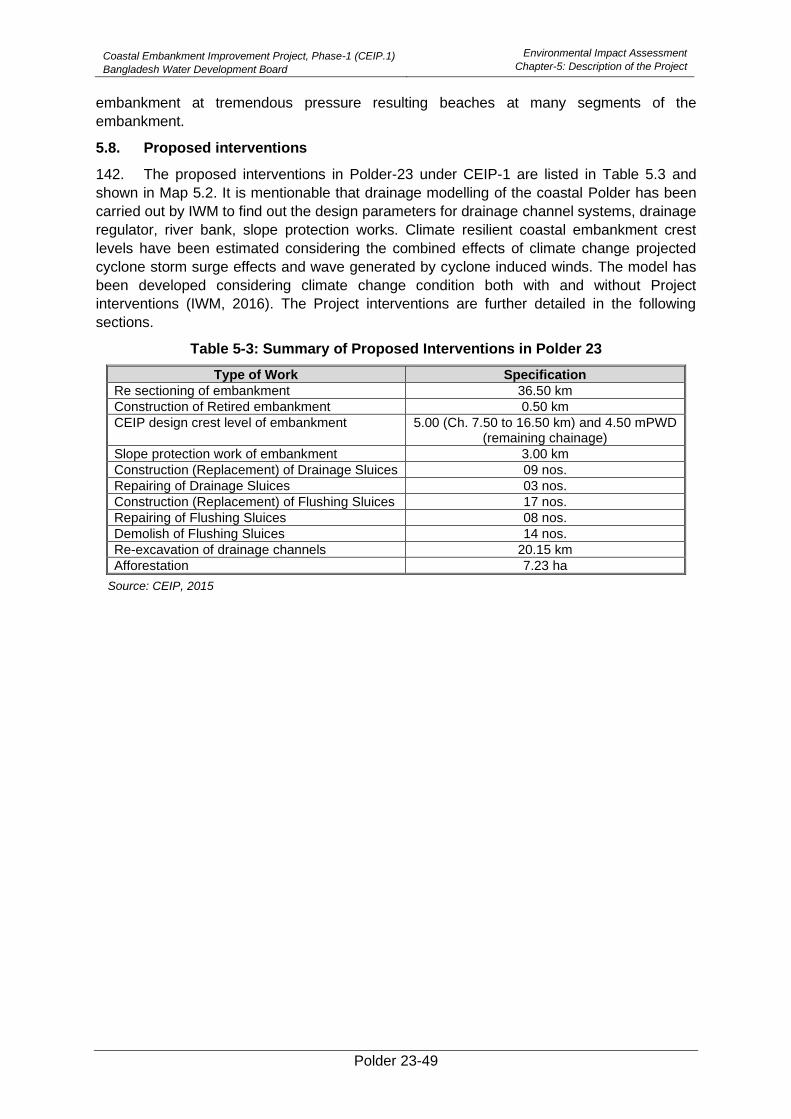
Coastal Embankment Improvement Project, Phase-1 (CEIP.1)
Bangladesh Water Development Board
Environmental Impact Assessment
Chapter-5: Description of the Project
Polder 23-49
embankment at tremendous pressure resulting beaches at many segments of the
embankment.
5.8. Proposed interventions
142. The proposed interventions in Polder-23 under CEIP-1 are listed in Table 5.3 and
shown in Map 5.2. It is mentionable that drainage modelling of the coastal Polder has been
carried out by IWM to find out the design parameters for drainage channel systems, drainage
regulator, river bank, slope protection works. Climate resilient coastal embankment crest
levels have been estimated considering the combined effects of climate change projected
cyclone storm surge effects and wave generated by cyclone induced winds. The model has
been developed considering climate change condition both with and without Project
interventions (IWM, 2016). The Project interventions are further detailed in the following
sections.
Table 5-3: Summary of Proposed Interventions in Polder 23
Type of Work Specification
Re sectioning of embankment 36.50 km
Construction of Retired embankment 0.50 km
CEIP design crest level of embankment 5.00 (Ch. 7.50 to 16.50 km) and 4.50 mPWD (remaining chainage)
Slope protection work of embankment 3.00 km
Construction (Replacement) of Drainage Sluices 09 nos.
Repairing of Drainage Sluices 03 nos.
Construction (Replacement) of Flushing Sluices 17 nos.
Repairing of Flushing Sluices 08 nos.
Demolish of Flushing Sluices 14 nos.
Re-excavation of drainage channels 20.15 km
Afforestation 7.23 ha
Source: CEIP, 2015

Coastal Embankment Improvement Project, Phase-1 (CEIP.1)
Bangladesh Water Development Board
Environmental Impact Assessment
Chapter-5: Description of the Project
Polder 23-50
Map 5-2: Proposed Interventions of Polder 23
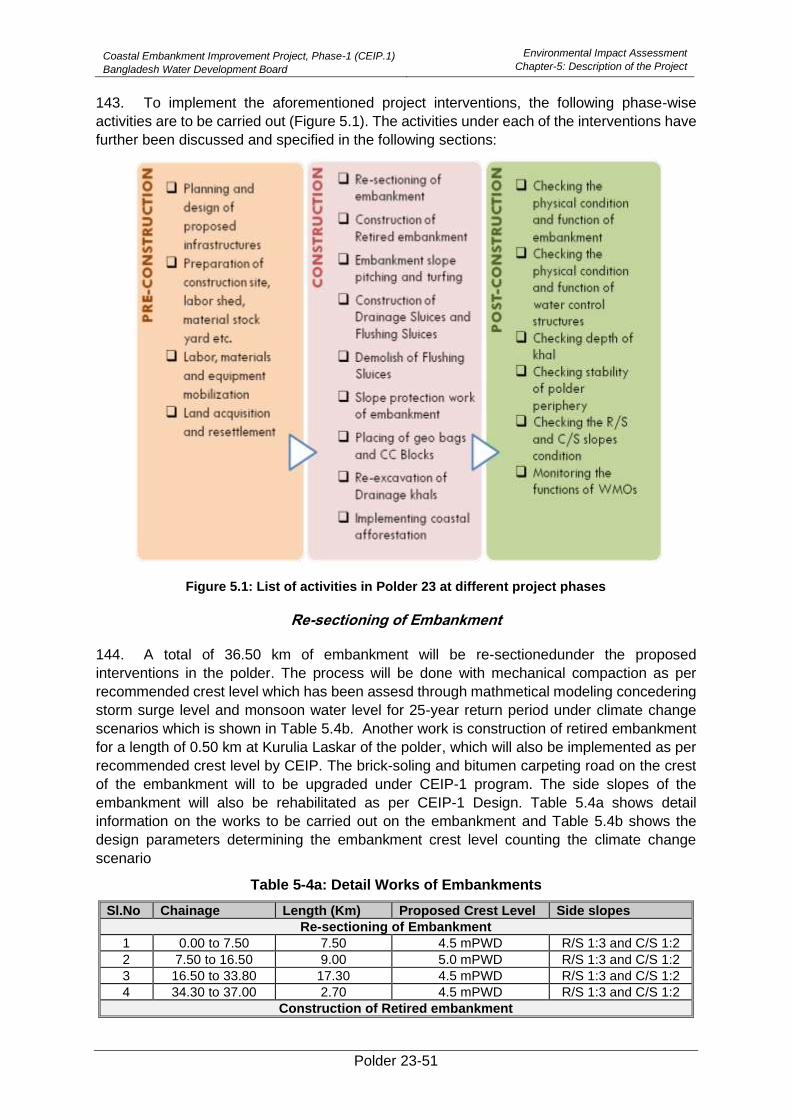
Coastal Embankment Improvement Project, Phase-1 (CEIP.1)
Bangladesh Water Development Board
Environmental Impact Assessment
Chapter-5: Description of the Project
Polder 23-51
143. To implement the aforementioned project interventions, the following phase-wise
activities are to be carried out (Figure 5.1). The activities under each of the interventions have
further been discussed and specified in the following sections:
Figure 5.1: List of activities in Polder 23 at different project phases
Re-sectioning of Embankment
144. A total of 36.50 km of embankment will be re-sectionedunder the proposed
interventions in the polder. The process will be done with mechanical compaction as per
recommended crest level which has been assesd through mathmetical modeling concedering
storm surge level and monsoon water level for 25-year return period under climate change
scenarios which is shown in Table 5.4b. Another work is construction of retired embankment
for a length of 0.50 km at Kurulia Laskar of the polder, which will also be implemented as per
recommended crest level by CEIP. The brick-soling and bitumen carpeting road on the crest
of the embankment will to be upgraded under CEIP-1 program. The side slopes of the
embankment will also be rehabilitated as per CEIP-1 Design. Table 5.4a shows detail
information on the works to be carried out on the embankment and Table 5.4b shows the
design parameters determining the embankment crest level counting the climate change
scenario
Table 5-4a: Detail Works of Embankments
Sl.No Chainage Length (Km) Proposed Crest Level Side slopes
Re-sectioning of Embankment
1 0.00 to 7.50 7.50 4.5 mPWD R/S 1:3 and C/S 1:2
2 7.50 to 16.50 9.00 5.0 mPWD R/S 1:3 and C/S 1:2
3 16.50 to 33.80 17.30 4.5 mPWD R/S 1:3 and C/S 1:2
4 34.30 to 37.00 2.70 4.5 mPWD R/S 1:3 and C/S 1:2
Construction of Retired embankment
Coastal Embankment Improvement Project, Phase-1 (CEIP.1)
Bangladesh Water Development Board
Environmental Impact Assessment
Chapter-5: Description of the Project
Polder 23-52
Sl.No Chainage Length (Km) Proposed Crest Level Side slopes
5 33+800 to 34+300
0.50 4.5 mPWD R/S 1:3 and C/S 1:2
Source: CEIP, 2015
Table 5-5b: Design Parameters for Embankment Crest Level under Climate Change Condition
Wave Computation
Monsoon Levels
Poin
t N
o.
Locatio
n
LD
L C
rest
Level (m
PW
D)
Exis
tin
g A
ve.
Cre
st
Level
(corr
ecte
d m
PW
D)
Mo
delle
d S
torm
Surg
e level
(corr
ecte
d m
PW
D)
Sta
ndard
Devia
tio
n (
m)
Sid
r S
imula
ted s
urg
e le
vel
(corr
ecte
d m
PW
D)
Aila
Sim
ula
ted s
urg
e level
(corr
ecte
d m
PW
D)
Recom
mended S
lope
Fre
e b
oard
for
Gra
ss o
r
Sm
ooth
paved (
Roughness
coeffic
ient
1.0
)
Fre
e b
oard
for
rough S
lope
(Roughness c
oeffic
ient
0.8
)
Allo
wance f
or
Subsid
ence
Rqd c
rest
Levelw
/o r
oughness
+ S
ubsid
ence &
no s
td
Rqd c
rest
Levelw
/o r
oughness
+ s
td +
Subsid
ence
Rqd c
rest
Levelw
ith r
oughness
+ s
ubsid
ence &
no s
td
Rqd c
rest
Levelw
ith r
oughness
+ S
ubsid
ence +
std
25 y
ear
ma
xim
um
WL in J
une
-S
ept
perio
d
Ma
x w
ind w
ave h
eig
ht in
June
-Sept
perio
d
Fre
e b
oard
for
Gra
ss o
r
sm
ooth
paved(R
oughness
coeffic
ient
1.0
)
Rqd c
rest
Levelw
/o r
oughness
with s
ubsid
ence a
nd fre
eboard
Cre
st
Level C
onsid
erin
g 0
.90m
freeboard
accord
ing to
Sta
ndard
Desig
n M
anual,
Volu
me
1, sta
ndard
desig
n
crite
rio
n o
f B
WD
B
1 2 3 4 5 6 7 8 9 10 11 12 13
(5+10+12)
14 (13+
6)
15 (5+11+12)
16 (15+
6) 17 18 19
20 (17+19+12)
21 (17+0.9m+
12)
Source: Design Team of DDCS&PMSC, 2019
*All values of storm surge level and monsoon water level are for 25-year return period under climate
change conditions
Note 1: At Polder No. 23, Storm Surge is insignificant, Monsoon Water Level governs the fixation of
crest level of embankment.
Note 2: According to the design manual of BWDB (Standard Design Manual, Volume 1, standard design
criterion of BWDB), the required minimum freeboard is 0.9m. Accordingly the proposed crest levels are
given in column 21.
Description of construction activities
145. The construction of the embankment both in new re-sectioning and retirement will be
carried out with the soil/earth obtained either from canal re-excavation, from borrow pits, or
other sources, approved by the Engineer. The earth materials will be well graded,
homogenous and free from logs, stumps, roots, rubbish or any other organic/ vegetable
ingredient.
146. Labor sheds construction with proper sanitation and other required allied facilities
should be planned before the commencement of construction activities for embankment
construction. A suitable site shall be selected and prepared by cleaning bushes, weeds, trees
etc. Alignment of the embankments has to be fixed with adequate base width. Base stripping
and removal of trees, weeds etc. will be done as per the instruction of the Engineer in-charge.
The tools required for the construction of embankments will be procured during this period.
After validating the final design, and preparation of siteearth will becarried and placed on the
alignment of the embankment. At the same time, each layer (of 1.5 feet) of dumped soil will
have to be compacted by a compactor machine. The slope and shaping of specified
embankment will be developed after proper compaction in layers. Thereaftergrass will placed
Coastal Embankment Improvement Project, Phase-1 (CEIP.1)
Bangladesh Water Development Board
Environmental Impact Assessment
Chapter-5: Description of the Project
Polder 23-53
on the slope of the embankment. Water and fertilizer will also be provided for the proper growth
of grass.
Construction (Replacing) and Repairing of Drainage Sluices and Flushing Sluices
147. There are 9 (nine) numbers of drainage sluices and 17 numbers of existing flushing
sluices of Polder 23 will be constructed or replaced with new design specifications by CEIP.
Besides, three numbers of existing drainage sluices and eight numbers of flushing sluices will
be repaired at different locations under the proposed interventions for rehabilitation of Polder
23 under CEIP. Furthermore, 14 numbers of flushing sluices will be demolished according
the proposed rehabilitation plan of the polder under CEIP-1. The summary of design
information of the proposed works in drainage sluices is given in Table 5.6.
148. The EIA study presumes that the invert level of the drainage sluice gate have been
fixed inmanner that about 50-60% of water will be retained in the khal tofacilitate irrigation,
fisheries, environment and other purposes.
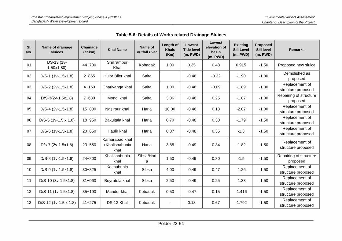
Coastal Embankment Improvement Project, Phase-1 (CEIP.1)
Bangladesh Water Development Board
Environmental Impact Assessment
Chapter-5: Description of the Project
Polder 23-54
Table 5-6: Details of Works related Drainage Sluices
Sl.
No.
Name of drainage
sluices
Chainage
(at km) Khal Name
Name of
outfall river
Length of
Khals
(Km)
Lowest
Tide level
(m. PWD)
Lowest
elevation of
basin
(m. PWD)
Existing
Sill Level
(m. PWD)
Proposed
Sill level
(m. PWD)
Remarks
01 DS-13 (1v-
1.50x1.80) 44+700
Shilirampur
Khal Kobadak 1.00 0.35 0.48 0.915 -1.50 Proposed new sluice
02 D/S-1 (1v-1.5x1.8) 2+865 Hulor Biler khal Salta -0.46 -0.32 -1.90 -1.00 Demolished as
proposed
03 D/S-2 (2v-1.5x1.8) 4+150 Charivanga khal Salta 1.00 -0.46 -0.09 -1.89 -1.00 Replacement of
structure proposed
04 D/S-3(2v-1.5x1.8) 7+630 Mondi khal Salta 3.86 -0.46 0.25 -1.87 -1.00 Repairing of structure
proposed
05 D/S-4 (2v-1.5x1.8) 15+880 Nasirpur khal Haria 10.00 -0.46 0.18 -2.07 -1.00 Replacement of
structure proposed
06 D/S-5 (1v-1.5 x 1.8) 18+950 Bakultala khal Haria 0.70 -0.48 0.30 -1.79 -1.50 Replacement of
structure proposed
07 D/S-6 (1v-1.5x1.8) 20+650 Haulir khal Haria 0.87 -0.48 0.35 -1.3 -1.50 Replacement of
structure proposed
08 D/s-7 (2v-1.5x1.8) 23+550
Kamarabad khal
+Khalishabunia
khal
Haria 3.85 -0.49 0.34 -1.82 -1.50 Replacement of
structure proposed
09 D/S-8 (1v-1.5x1.8) 24+800 Khalishabunia
khal
Sibsa/Hari
a 1.50 -0.49 0.30 -1.5 -1.50
Repairing of structure
proposed
10 D/S-9 (1v-1.5x1.8) 30+825 Kochubunia
khal Sibsa 4.00 -0.49 0.47 -1.26 -1.50
Replacement of
structure proposed
11 D/S-10 (3v-1.5x1.8) 31+060 Boyratola khal Sibsa 2.50 -0.49 0.25 -1.38 -1.50 Replacement of
structure proposed
12 D/S-11 (1v-1.5x1.8) 35+190 Mandur khal Kobadak 0.50 -0.47 0.15 -1.416 -1.50 Replacement of
structure proposed
13 D/S-12 (1v-1.5 x 1.8) 41+275 DS-12 Khal Kobadak - 0.18 0.67 -1.792 -1.50 Replacement of
structure proposed
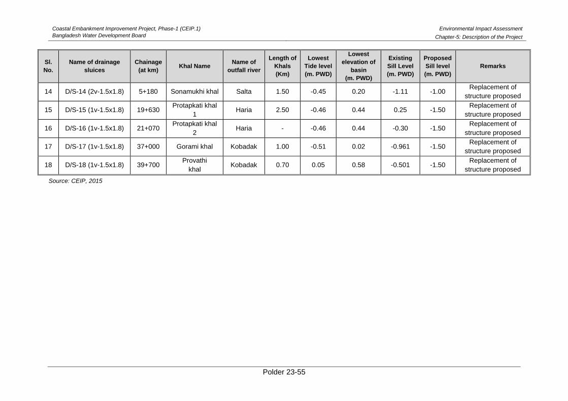
Coastal Embankment Improvement Project, Phase-1 (CEIP.1)
Bangladesh Water Development Board
Environmental Impact Assessment
Chapter-5: Description of the Project
Polder 23-55
Sl.
No.
Name of drainage
sluices
Chainage
(at km) Khal Name
Name of
outfall river
Length of
Khals
(Km)
Lowest
Tide level
(m. PWD)
Lowest
elevation of
basin
(m. PWD)
Existing
Sill Level
(m. PWD)
Proposed
Sill level
(m. PWD)
Remarks
14 D/S-14 (2v-1.5x1.8) 5+180 Sonamukhi khal Salta 1.50 -0.45 0.20 -1.11 -1.00 Replacement of
structure proposed
15 D/S-15 (1v-1.5x1.8) 19+630 Protapkati khal
1 Haria 2.50 -0.46 0.44 0.25 -1.50
Replacement of
structure proposed
16 D/S-16 (1v-1.5x1.8) 21+070 Protapkati khal
2 Haria - -0.46 0.44 -0.30 -1.50
Replacement of
structure proposed
17 D/S-17 (1v-1.5x1.8) 37+000 Gorami khal Kobadak 1.00 -0.51 0.02 -0.961 -1.50 Replacement of
structure proposed
18 D/S-18 (1v-1.5x1.8) 39+700 Provathi
khal Kobadak 0.70 0.05 0.58 -0.501 -1.50
Replacement of
structure proposed
Source: CEIP, 2015
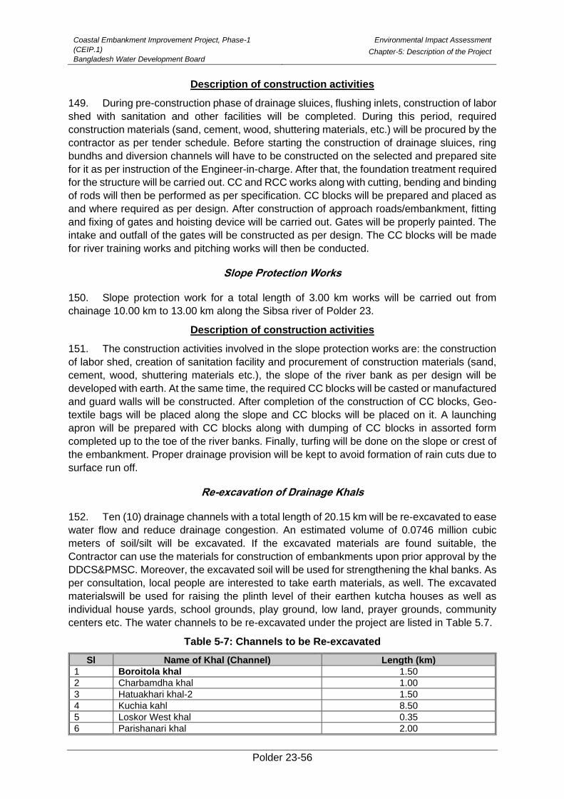
Coastal Embankment Improvement Project, Phase-1
(CEIP.1)
Bangladesh Water Development Board
Environmental Impact Assessment
Chapter-5: Description of the Project
Polder 23-56
Description of construction activities
149. During pre-construction phase of drainage sluices, flushing inlets, construction of labor
shed with sanitation and other facilities will be completed. During this period, required
construction materials (sand, cement, wood, shuttering materials, etc.) will be procured by the
contractor as per tender schedule. Before starting the construction of drainage sluices, ring
bundhs and diversion channels will have to be constructed on the selected and prepared site
for it as per instruction of the Engineer-in-charge. After that, the foundation treatment required
for the structure will be carried out. CC and RCC works along with cutting, bending and binding
of rods will then be performed as per specification. CC blocks will be prepared and placed as
and where required as per design. After construction of approach roads/embankment, fitting
and fixing of gates and hoisting device will be carried out. Gates will be properly painted. The
intake and outfall of the gates will be constructed as per design. The CC blocks will be made
for river training works and pitching works will then be conducted.
Slope Protection Works
150. Slope protection work for a total length of 3.00 km works will be carried out from
chainage 10.00 km to 13.00 km along the Sibsa river of Polder 23.
Description of construction activities
151. The construction activities involved in the slope protection works are: the construction
of labor shed, creation of sanitation facility and procurement of construction materials (sand,
cement, wood, shuttering materials etc.), the slope of the river bank as per design will be
developed with earth. At the same time, the required CC blocks will be casted or manufactured
and guard walls will be constructed. After completion of the construction of CC blocks, Geo-
textile bags will be placed along the slope and CC blocks will be placed on it. A launching
apron will be prepared with CC blocks along with dumping of CC blocks in assorted form
completed up to the toe of the river banks. Finally, turfing will be done on the slope or crest of
the embankment. Proper drainage provision will be kept to avoid formation of rain cuts due to
surface run off.
Re-excavation of Drainage Khals
152. Ten (10) drainage channels with a total length of 20.15 km will be re-excavated to ease
water flow and reduce drainage congestion. An estimated volume of 0.0746 million cubic
meters of soil/silt will be excavated. If the excavated materials are found suitable, the
Contractor can use the materials for construction of embankments upon prior approval by the
DDCS&PMSC. Moreover, the excavated soil will be used for strengthening the khal banks. As
per consultation, local people are interested to take earth materials, as well. The excavated
materialswill be used for raising the plinth level of their earthen kutcha houses as well as
individual house yards, school grounds, play ground, low land, prayer grounds, community
centers etc. The water channels to be re-excavated under the project are listed in Table 5.7.
Table 5-7: Channels to be Re-excavated
Sl Name of Khal (Channel) Length (km)
1 Boroitola khal 1.50
2 Charbamdha khal 1.00
3 Hatuakhari khal-2 1.50
4 Kuchia kahl 8.50
5 Loskor West khal 0.35
6 Parishanari khal 2.00
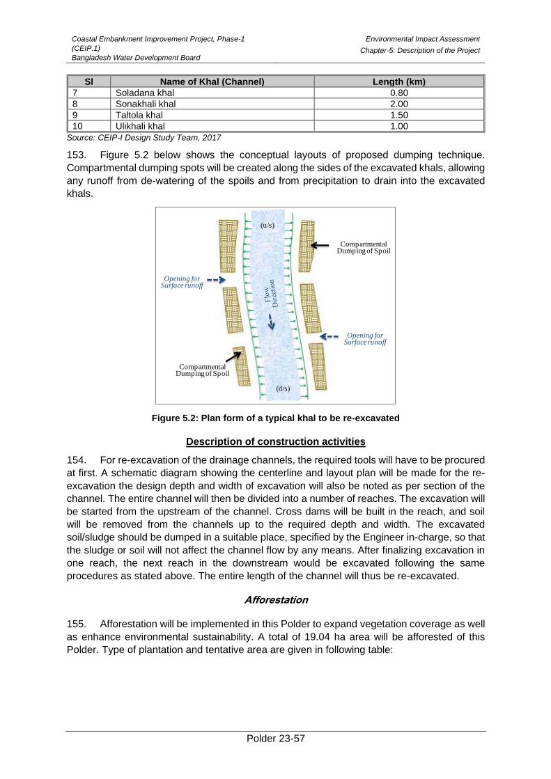
Coastal Embankment Improvement Project, Phase-1
(CEIP.1)
Bangladesh Water Development Board
Environmental Impact Assessment
Chapter-5: Description of the Project
Polder 23-57
Sl Name of Khal (Channel) Length (km)
7 Soladana khal 0.80
8 Sonakhali khal 2.00
9 Taltola khal 1.50
10 Ulikhali khal 1.00
Source: CEIP-I Design Study Team, 2017
153. Figure 5.2 below shows the conceptual layouts of proposed dumping technique.
Compartmental dumping spots will be created along the sides of the excavated khals, allowing
any runoff from de-watering of the spoils and from precipitation to drain into the excavated
khals.
Figure 5.2: Plan form of a typical khal to be re-excavated
Description of construction activities
154. For re-excavation of the drainage channels, the required tools will have to be procured
at first. A schematic diagram showing the centerline and layout plan will be made for the re-
excavation the design depth and width of excavation will also be noted as per section of the
channel. The entire channel will then be divided into a number of reaches. The excavation will
be started from the upstream of the channel. Cross dams will be built in the reach, and soil
will be removed from the channels up to the required depth and width. The excavated
soil/sludge should be dumped in a suitable place, specified by the Engineer in-charge, so that
the sludge or soil will not affect the channel flow by any means. After finalizing excavation in
one reach, the next reach in the downstream would be excavated following the same
procedures as stated above. The entire length of the channel will thus be re-excavated.
Afforestation
155. Afforestation will be implemented in this Polder to expand vegetation coverage as well
as enhance environmental sustainability. A total of 19.04 ha area will be afforested of this
Polder. Type of plantation and tentative area are given in following table:
(d/s)
(u/s)
Opening for Surface runoff
Opening for Surface runoff
Compartmental Dumping of Spoil
Compartmental Dumping of Spoil
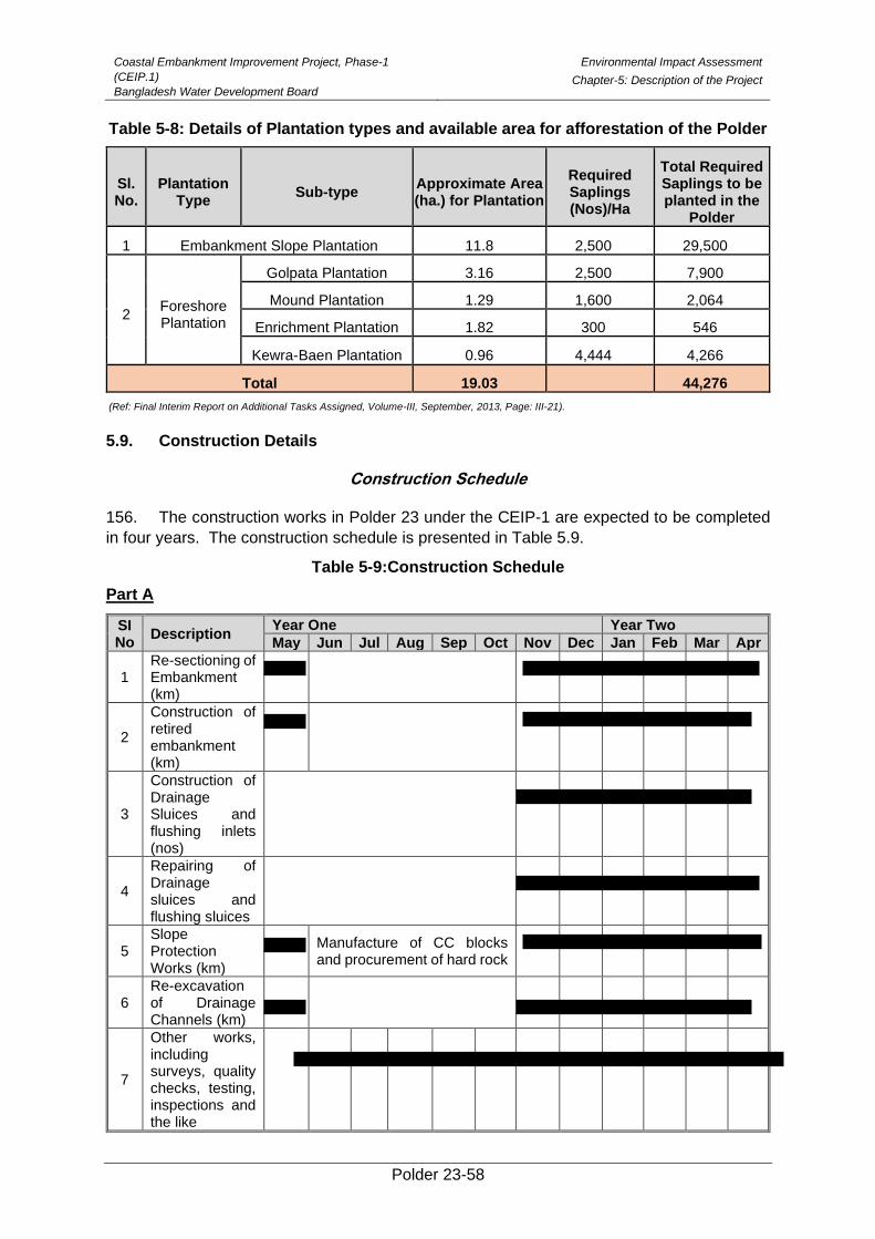
Coastal Embankment Improvement Project, Phase-1
(CEIP.1)
Bangladesh Water Development Board
Environmental Impact Assessment
Chapter-5: Description of the Project
Polder 23-58
Table 5-8: Details of Plantation types and available area for afforestation of the Polder
Sl. No.
Plantation Type
Sub-type Approximate Area (ha.) for Plantation
Required Saplings (Nos)/Ha
Total Required Saplings to be planted in the
Polder
1 Embankment Slope Plantation 11.8 2,500 29,500
2 Foreshore Plantation
Golpata Plantation 3.16 2,500 7,900
Mound Plantation 1.29 1,600 2,064
Enrichment Plantation 1.82 300 546
Kewra-Baen Plantation 0.96 4,444 4,266
Total 19.03
44,276
(Ref: Final Interim Report on Additional Tasks Assigned, Volume-III, September, 2013, Page: III-21).
5.9. Construction Details
Construction Schedule
156. The construction works in Polder 23 under the CEIP-1 are expected to be completed
in four years. The construction schedule is presented in Table 5.9.
Table 5-9:Construction Schedule
Part A
SI No
Description Year One Year Two
May Jun Jul Aug Sep Oct Nov Dec Jan Feb Mar Apr
1 Re-sectioning of Embankment (km)
2
Construction of retired embankment (km)
3
Construction of Drainage Sluices and flushing inlets (nos)
4
Repairing of Drainage sluices and flushing sluices
5 Slope Protection Works (km)
Manufacture of CC blocks and procurement of hard rock
6 Re-excavation of Drainage Channels (km)
7
Other works, including surveys, quality checks, testing, inspections and the like
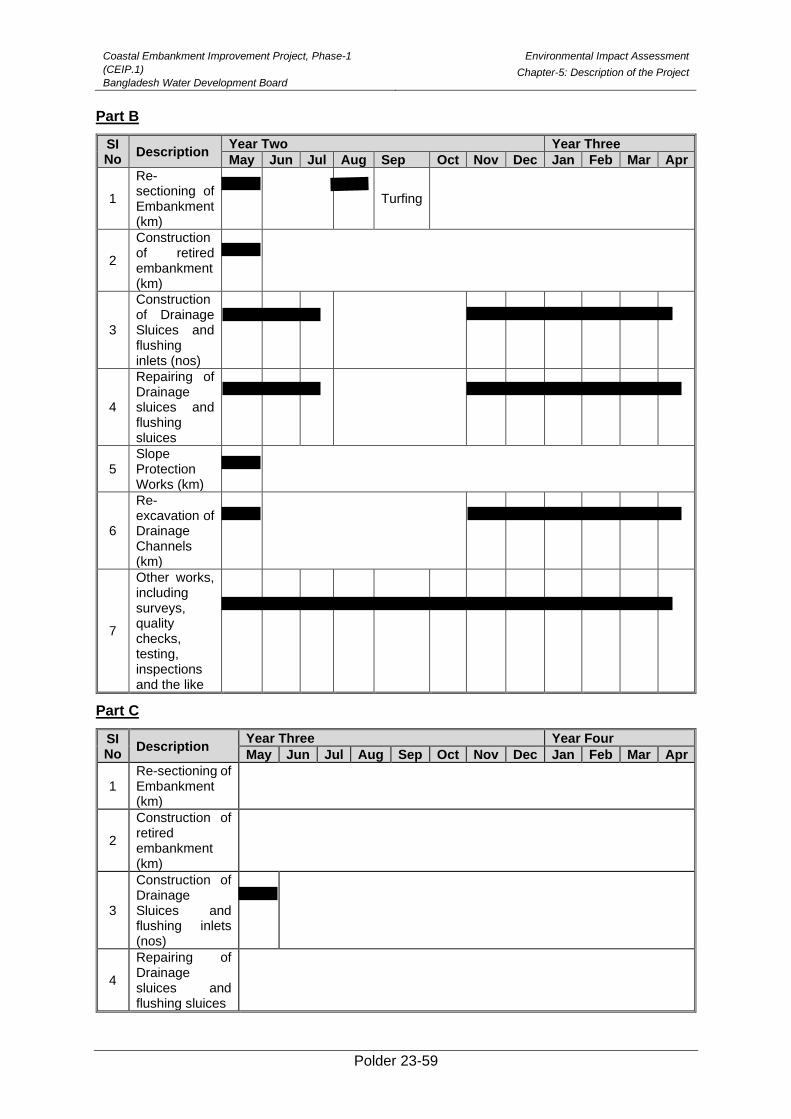
Coastal Embankment Improvement Project, Phase-1
(CEIP.1)
Bangladesh Water Development Board
Environmental Impact Assessment
Chapter-5: Description of the Project
Polder 23-59
Part B
SI No
Description Year Two Year Three
May Jun Jul Aug Sep Oct Nov Dec Jan Feb Mar Apr
1
Re-sectioning of Embankment (km)
Turfing
2
Construction of retired embankment (km)
3
Construction of Drainage Sluices and flushing inlets (nos)
4
Repairing of Drainage sluices and flushing sluices
5 Slope Protection Works (km)
6
Re-excavation of Drainage Channels (km)
7
Other works, including surveys, quality checks, testing, inspections and the like
Part C
SI No
Description Year Three Year Four
May Jun Jul Aug Sep Oct Nov Dec Jan Feb Mar Apr
1 Re-sectioning of Embankment (km)
2
Construction of retired embankment (km)
3
Construction of Drainage Sluices and flushing inlets (nos)
4
Repairing of Drainage sluices and flushing sluices
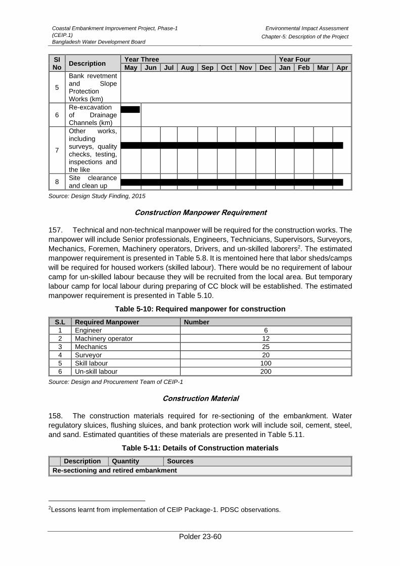
Coastal Embankment Improvement Project, Phase-1
(CEIP.1)
Bangladesh Water Development Board
Environmental Impact Assessment
Chapter-5: Description of the Project
Polder 23-60
SI No
Description Year Three Year Four
May Jun Jul Aug Sep Oct Nov Dec Jan Feb Mar Apr
5
Bank revetment and Slope Protection Works (km)
6 Re-excavation of Drainage Channels (km)
7
Other works, including surveys, quality checks, testing, inspections and the like
8 Site clearance and clean up
Source: Design Study Finding, 2015
Construction Manpower Requirement
157. Technical and non-technical manpower will be required for the construction works. The
manpower will include Senior professionals, Engineers, Technicians, Supervisors, Surveyors,
Mechanics, Foremen, Machinery operators, Drivers, and un-skilled laborers2. The estimated
manpower requirement is presented in Table 5.8. It is mentoined here that labor sheds/camps
will be required for housed workers (skilled labour). There would be no requirement of labour
camp for un-skilled labour because they will be recruited from the local area. But temporary
labour camp for local labour during preparing of CC block will be established. The estimated
manpower requirement is presented in Table 5.10.
Table 5-10: Required manpower for construction
S.L Required Manpower Number
1 Engineer 6
2 Machinery operator 12
3 Mechanics 25
4 Surveyor 20
5 Skill labour 100
6 Un-skill labour 200
Source: Design and Procurement Team of CEIP-1
Construction Material
158. The construction materials required for re-sectioning of the embankment. Water
regulatory sluices, flushing sluices, and bank protection work will include soil, cement, steel,
and sand. Estimated quantities of these materials are presented in Table 5.11.
Table 5-11: Details of Construction materials
Description Quantity Sources
Re-sectioning and retired embankment
2Lessons learnt from implementation of CEIP Package-1. PDSC observations.
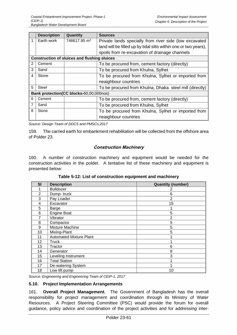
Coastal Embankment Improvement Project, Phase-1
(CEIP.1)
Bangladesh Water Development Board
Environmental Impact Assessment
Chapter-5: Description of the Project
Polder 23-61
Description Quantity Sources
1 Earth work 746617.95 m3 Private lands specially from river side (low excavated
land will be filled up by tidal silts within one or two years),
spoils from re-excavation of drainage channels
Construction of sluices and flushing sluices
2 Cement To be procured from, cement factory (directly)
3 Sand To be procured from Khulna, Sylhet
4 Stone To be procured from Khulna, Sylhet or imported from
neaighbour countries
5 Steel To be procured from Khulna, Dhaka steel mill (directly)
Bank protection(CC blocks-60,00,000nos)
6 Cement To be procured from, cement factory (directly)
7 Sand To be procured from Khulna, Sylhet
8 Stone To be procured from Khulna, Sylhet or imported from
neaighbour countries
Source: Design Team of DDCS and PMSCs,2017
159. The carried earth for embankment rehabilitation will be collected from the offshore area
of Polder 23.
Construction Machinery
160. A number of construction machinery and equipment would be needed for the
construction activities in the polder. A tentative list of these machinery and equipment is
presented below:
Table 5-12: List of construction equipment and machinery
Sl Description Quantity (number)
1 Bulldozer 2
2 Dump- truck 6
3 Pay Loader 2
4 Excavator 15
5 Barge 1
6 Engine Boat 5
7 Vibrator 2
8 Compactor 5
9 Mixture Machine 5
10 Mixing-Plant 5
11 Automated Mixture Plant 1
12 Truck 1
13 Tractor 6
14 Generator 8
15 Leveling Instrument 3
16 Total Station 1
17 De-watering System 1
18 Low lift pump 10
Source: Engineering and Engineering Team of CEIP-1, 2017
5.10. Project Implementation Arrangements
161. Overall Project Management. The Government of Bangladesh has the overall
responsibility for project management and coordination through its Ministry of Water
Resources. A Project Steering Committee (PSC) would provide the forum for overall
guidance, policy advice and coordination of the project activities and for addressing inter-
Coastal Embankment Improvement Project, Phase-1
(CEIP.1)
Bangladesh Water Development Board
Environmental Impact Assessment
Chapter-5: Description of the Project
Polder 23-62
agency issues. The BWDB will act as the Project Implementing Agency and implement the
project through a Project Management Unit (PMU).
162. Project Steering Committee (PSC). The PSC would be chaired by the Secretary of
Water Resources and will include the Secretaries of Finance, Agriculture, Environment, Public
Health Engineering, Forestry and Wildlife, and the Chief Executive officer of selected NGOs,
and representatives of the local/district administration as its members. The PSC will oversee
the project and provide policy-level guidance and inter-agency coordination for the project.
The Project Director of the PMU will act as the secretary of the PSC.
163. Project Management Unit (PMU). The BWDB will set up a PMU to oversee the
development and management of the Project. It will be led by a Project Director appointed by
the BWDB who will have the rank of Chief Engineer, and will directly report to the Director
General (DG). The PMU will have a central project office located at the headquarters of the
BWDB in Dhaka. The PMU will have 3 subordinate units: (i) Engineering Unit; (ii) Procurement
and Finance Unit; and (iii) Social, Environment and Communication Unit. In addition to the
central unit in Dhaka, three Field Level Offices will be set up, each headed by an Executive
Engineer, recruited by the project. The Field Offices will be located in each of the three main
project districts, namely Khulna, Patuakhali/ Barguna and Bagerhat.
164. The Procurement and Finance Unit will be responsible for the entire procurement
and financial management process of the Project. It will also be responsible for monitoring
project progress, to liaise with the Bank, and to prepare annual programs, implementation
reporting, updating all procurement reporting documents, and financial management
reporting. The procurement staff would consist of a Senior Procurement Specialist and one
Procurement Specialist. The finance staff would consist of one Deputy Director, Finance,
2Accountants and 3support staffs.
165. The Engineering Unit will oversee the work of the consultants on design and
construction supervision matters. A Deputy Project Director will head the Engineering Unit and
spend about half of his/her time at site to provide coordination between the PMU, the
supervising consultant and the three field offices. In addition to the Deputy Project Director,
the unit will also include two Executive Engineers, and two Assistant Engineers.
166. A Social, Environment and Communication Unit will supervise compliance with the
Environmental Management Plan and Social Action Program. This unit, together with the
engineering unit will implement the communication strategy. This unit will include a Senior
Environmental Specialist, a Senior Social Specialist, a Senior Forestry Specialist, a Revenue
Staff and a Communication Specialist.
167. Each Field Office will be staffed with one Project Manager/Executive Engineer (XEN),
two Sub-Divisional Engineers (SDEs) and two Assistant Engineers (AEs). In addition, an
Environmental Specialist, a Social Specialist and a Revenue Staff will work across all the three
field offices.
168. The PMU will be supported by the following consultancy services:
• An experienced NGO will be mobilized by the PMU to implement the social
afforestation recommended in the the EMP, the Social Action Plan including
mobilization of Water Management Organization, the RAP and the EMP.
• A Design and Construction Supervision Consultancy Firm will assist the PMU in
preparing the detailed design of the remaining polders and supervise all
construction. For civil works contracts, the Project Director will serve as the
Employer, and the Project Supervision Consultant will serve as the Engineer for
Coastal Embankment Improvement Project, Phase-1
(CEIP.1)
Bangladesh Water Development Board
Environmental Impact Assessment
Chapter-5: Description of the Project
Polder 23-63
construction supervision. At site, a Resident Engineer, appointed by the consultant,
with a team of specialists and inspectors will supervise the Contractor.
• A Monitoring and Evaluation Consultant will provide support in monitoring project
impacts and supervise the implementation of the EMP/RAP and report to the PMU.
• A Procurement Panel will be appointed by the BWDB to oversee the procurement
process of large value contracts subject to prior review under the Project. The panel
will consist of two international/expatriate specialists and one national specialist.
169. An Independent Panel of Experts (IPOE) will be appointed by the BWDB to act as an
independent “peer reviewer” and undertake quality control functions of various technical
outputs. The Panel will consist of 5 renowned experts in the fields of morphology/ river
engineering; tidal river management/ sedimentation, geotechnology, sociology and
environment.
170. This Institutional arrangement is effective and are being implemented in Package 1
and Package 2 of CEIP-1 and they are found to work effectively and satisfactorily.
5.11. Water Management and Operation Plan
Introduction
171. Coastal Polders, surrounded by embankments in the coastal region, protect the lives
and properties of people and agricultural lands with crops from tidal inundation; saline water
intrusion; storms and cyclonic surges thereby releasing a large extent of land for permanent
agriculture as well as congenial living condition.
172. The Polders have been playing vital role in safeguarding the coastal area; ensuring
and increasing agricultural production; improving livelihoods of the people; and mitigating
environmental damages. But these are vulnerable to storm surges; high tides; annual floods;
land erosion and drainage congestion. In many cases the structures as built have not been
found adequate to cope with the diversified needs of the local people. Changes in the land
use pattern of the area have also created water management conflicts and new
dimensional needs asking the structures to allow water to flow in both directions. So
maintenance of the Polder system with embankments and structural elements built over there
has permanently become important. The Government of Bangladesh either with assistances
from international donors and lending agencies or out of its own resources has been spending
money almost in a regular basis to keep the Polders in good working condition eventually to
save the coastal people. The Coastal Embankment Improvement Program (CEIP) is one of
the latest initiatives to address a systematic restoration and upgrading of Polder systems in
the coastal region. Under this long-term phased program of Polders improvement, Operation
and Maintenance issues with special reference to Local Government Institutions (LGIs) as well
as local stakeholders participation and need based budgeting will continue to remain at the
apex.
Operation Plan
173. Operational plan involves setting out the schedule of activities related to operation of
gates of structures by the users' organization to control water levels best suited to water
management and agricultural needs. In the coastal Polders, operation of gates mainly focuses
on protecting the saline water out of the Polder during high tides and allowing drainage of
excess water from inside the polder during low tides to minimize the depth of flooding but
storing enough water on the paddy fields. The trend however changes in the dry season where
Coastal Embankment Improvement Project, Phase-1
(CEIP.1)
Bangladesh Water Development Board
Environmental Impact Assessment
Chapter-5: Description of the Project
Polder 23-64
the operational plan aims in storing as much water in the canal networks as possible by closing
the gates. The water thus stored should have the basis of a balancing mechanism among
all categories of user viz paddy growers; salt producers (if there is any); shrimp producers
(also including other fish culture practices); and also domestic users. Operation of structures
should therefore be an organizational, low-cost activity requiring quick communication with the
beneficiaries and with project staffs at the lowest level.
(i) Operational Activities
174. The operational plan provides the framework upon which canal water levels (also
referred to as operation target) and day-to-day structure operation will be based. More
specifically, the operational plan for the CEIP Polders can be thought of as a hub for the
following operational activities:
➢ Operation of drainage regulators;
➢ Operation of flushing sluices/irrigation inlets; and
➢ Operation of privately owned Low Lift Pumps (LLPs)
175. Besides, some other activities may also be conceived in the context of varying polder
conditions. The following activities are within the purview of operational plan:
(a) Regulation of gates
176. In the past BWDB employed the Gate Operators from its own; but due to budget cuts
this position has been discontinued. Currently the responsibilities of gate operation are given
to beneficiaries in the Polders where agricultural activities are of main concern. Standard
procedures have been developed under different projects but are hardly followed as common
practices.
177. The picture in other Polders where only FCD activities exist is different; institutional set
up for the users' organizations is yet to be built and introduced. This particular issue will be
discussed in details in the following section to address Beneficiaries Participation in coastal
Polders.
178. The gates of each drainage sluice / regulator must be operated following certain fixed
rules regarding timings. BWDB O&M section in consultation with the beneficiaries'
organizations, DWM staffs and DAE field staffs will ensure operation of the gates in conformity
with operational timing based on actual water management and agricultural needs.
179. Flap Gates of regulators should remain in place at all times except during maintenance
and flushing. During pre-monsoon period, the vertical lift gates of each regulator should remain
closed for retention of water for irrigating Aus crops by LLPs. During monsoon (July to
September), the vertical lift gates should normally remain closed; but may be opened to
regulate the water levels inside the polder and should not be allowed to exceed the stated
maximum permissible level for safety reasons. In order to achieve this, discharges into the
river should commence (river levels permitting soon after this level is attained. This type of
water management decisions should be taken after due consideration of daily rainfall, river
stages, water levels inside the polder, gate opening schedules. However, the frequency and
type of this decision making process will vary with the seasonal conditions.
180. During post monsoon season (October to November), the vertical lift gates will be
operated to retain water in the drainage canals without overtopping the canal banks and
increasing the soil moisture level for cultivation. In all these cases there should be enough

Coastal Embankment Improvement Project, Phase-1
(CEIP.1)
Bangladesh Water Development Board
Environmental Impact Assessment
Chapter-5: Description of the Project
Polder 23-65
consultation with the beneficiaries' organizations because agricultural practices, crop varieties;
and cropping pattern changes with over time.
181. Operation of Flushing Sluices and Pipe Inlets should also have similar practices with
maximum involvement of beneficiaries' organizations. The O&M section and DWM staffs of
BWDB will assist them in the water management of command areas inside the polders.
(b) Frequent Watching of Embankments
182. This is a typical monitoring activity to be carried out by the BWDB O&M Staffs. It is
intended mainly to detect weak sections, gullies, slips, sign of squatter settlements, and
cultivation of perennial cash crops, cuts in the embankments to accommodate
homesteads, embankment subsidence and erosion and / or settlement of protection works.
(c) Regular Checking of Structures
183. This is also a typical monitoring activity to be carried out by BWDB's O&M field staffs
to detect slips at abutments, damage of protective works and wing walls, and periodic
damage to flap gates and fall boards etc. The functional groups under WMGs in the Polders
will assist the O&M Section Office of BWDB to identify and report the damages for rectification.
(d) Condition survey (of embankment & structures) and Engineering survey
184. The survey data obtained by the O&M field staffs of BWDB are used for estimating the
required maintenance works. Physical condition of embankments and structures are
investigated through field surveys once in a year. This is specially required to prepare the
details for carrying out periodic maintenance works.
(e) Supervision of preventive maintenance works
185. Preventive maintenance works are performed by community-based functional groups
(e.g. EMGs, SMGs, and CMGs) as and when required round the year. The works are the most
simple, cheap and cost effective maintenance works and are implemented more or less
continuously. The field staffs of O&M section of BWDB supervise all preventive maintenance
works.
(ii) Planning of Operation
186. The objective of structures operation is to maintain control over water levels in the
polder channels so as to ensure integrated water management. This means that the operation
of water management structures should be directly linked to agricultural requirements and on-
farm water management conditions keeping the eyes open on the requirements of other users
like fisher folk community, navigators/boatmen, salt growers (if applicable) and general water
users for domestic purpose. So, in the planning of operation, the demands of all categories of
beneficiaries should be taken into account for achieving a perfect integrated water
management. Participation of beneficiaries at all levels of planning is essential.
(III) Maintenance Works
187. Maintenance of embankments and structures is the most important item of activities in
the coastal polders. It is necessary and cannot be avoided because it helps in preserving the
infrastructure in good and functional condition; protects investments; and prevents high
rehabilitation costs. Since this is included in the day-today tasks schedule and needs
continuous efforts, maintenance of coastal Polders put emphasis on simple and cost effective
community-based interventions.
Coastal Embankment Improvement Project, Phase-1
(CEIP.1)
Bangladesh Water Development Board
Environmental Impact Assessment
Chapter-5: Description of the Project
Polder 23-66
188. In the coastal polders, the works which only directly the serve water management
should be regularly maintained. These activities are divided into:
(i)Preventive or Routine Maintenance;
(ii)Periodic Maintenance;
➢ Minor Periodic Maintenance
➢ Major Periodic Maintenance
(iii) Emergency Maintenance;
(i) Preventive or Routine Maintenance
189. The objective of preventive maintenance is to keep the overall Polder system including
all its elements in good functional order thereby reducing the need of periodic maintenance
eventually avoiding high rehabilitation costs. The works are simple, cheap and cost effective
and can be implemented through community-based functional groups such as EMGs, CMGs,
and SMGs. Preventive maintenance is carried out throughout the year, almost continuously
or as and when required. The works are noted below:
➢ All activities related to vegetative covers on embankment, i.e. new (or re-) planting;
enrichment planting; and maintenance of vegetation by EMGs and/or EPGs;
➢ Small earthworks on the embankment by EMGs;
➢ Cleaning, greasing, and painting of structures by SMGs;
➢ Cleaning Khals and Outfall Drains from aquatic weeds and floating debris, and
removing of silt in wet condition by CMGs.
190. The preventive maintenance interventions have been spelled out precisely in Table
4.10 below:
(ii) Periodic Maintenance
191. Periodic Maintenance intends to bring the components of the hydraulic infrastructure
back to its design standard. The works are more expensive than preventive maintenance and
are implemented by LCBs, LCSs, and PICs (food for works). Periodic maintenance has the
character of repair works and is identified during the field assessment at (more or less) regular
intervals.
192. The most important distinguishing characteristic of minor periodic maintenance works
is that it is more community based and often implemented by LCSs while major periodic
maintenance works are generally carried out through competitive bidding (LCBs). However, in
case of earth works at least 25% of the works should be allotted to LCSs. Both these types of
periodic maintenance are summarized as under:
(a) Minor Periodic Maintenance Works:
➢ Minor earth works on the embankments by LCSs, i.e., shaping and minor fillings
including repair of access ramps;
➢ Minor repair of protective works by LCSs, i.e., re-positioning of the displaced blocks;
➢ Minor repair of structures by LCSs, i.e., small patching of brick works, replacing rubber
seals etc.; and
➢ Re-excavation of Khals and removal of earthen cross dams by LCSs and / or PICs;
(b) Major Periodic Maintenance Works:
Coastal Embankment Improvement Project, Phase-1
(CEIP.1)
Bangladesh Water Development Board
Environmental Impact Assessment
Chapter-5: Description of the Project
Polder 23-67
➢ Major earth works by LCBs / LCSs i.e. re-sectioning of embankments including turfing;
➢ Major repair of structures by LCBs i.e. repair or replacement of metal works/hinges,
lifting mechanisms, gates, block works, head / wing walls etc.;
➢ Re-excavation of Khals by LCSs / PICs.
193. The periodic maintenance interventions have been spelled out precisely in Table 4.12
below.
(iii) Emergency Maintenance
194. Emergency works cover unforeseen interventions that require immediate actions to
protect the polder as a whole or a part thereof from the adverse effects of flooding or
uncontrolled saline intrusion etc. associated with damage of lives and properties. This type of
work requiring immediate attention includes the closure of an embankment breach, the repair
and replacement of flap gates, or the construction of cross dams over canals if structure fails.
As the title implies planning of these kinds of works is not possible. Table 5.13 indicates each
type of emergency maintenance works.
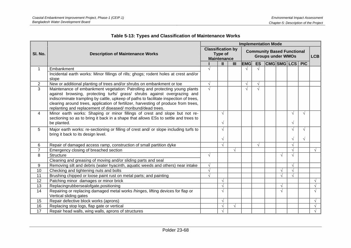
Coastal Embankment Improvement Project, Phase-1 (CEIP.1)
Bangladesh Water Development Board
Environmental Impact Assessment
Chapter-5: Description of the Project
Polder 23-68
Table 5-13: Types and Classification of Maintenance Works
Sl. No. Description of Maintenance Works
Implementation Mode
Classification by Type of
Maintenance
Community Based Functional Groups under WMOs LCB
I II III EMG ES CMG SMG LCS PIC
1 Embankment √ √ √
Incidental earth works: Minor fillings of rills; ghogs; rodent holes at crest and/or slope
2 New or additional planting of trees and/or shrubs on embankment or toe √ √ √
3 Maintenance of embankment vegetation: Patrolling and protecting young plants against browsing, protecting turfs/ grass/ shrubs against overgrazing and indiscriminate trampling by cattle, upkeep of paths to facilitate inspection of trees, clearing around trees, application of fertilizer, harvesting of produce from trees, replanting and replacement of diseased/ moribund/dead trees.
√ √ √
4 Minor earth works: Shaping or minor fillings of crest and slope but not re-sectioning so as to bring it back in a shape that allows ESs to settle and trees to be planted.
√ √
√ √
√
5 Major earth works: re-sectioning or filling of crest and/ or slope including turfs to bring it back to its design level.
√ √
√ √
√ √
6 Repair of damaged access ramp, construction of small partition dyke √ √ √
7 Emergency closing of breached section √ √ √
8 Structure √ √ √
Cleaning and greasing of moving and/or sliding parts and seal
9 Removing silt and debris (water hyacinth, aquatic weeds and others) near intake √ √
10 Checking and tightening nuts and bolts √ √ √
11 Brushing chipped or loose paint rust on metal parts; and painting √ √ √
12 Patching minor damages or minor brick √ √
13 Replacingrubbersealofgate,positioning √ √ √
14 Repairing or replacing damaged metal works /hinges, lifting devices for flap or Vertical sliding gates
√ √ √
15 Repair defective block works (aprons) √ √
16 Replacing stop logs, flap gate or vertical √ √ √
17 Repair head walls, wing walls, aprons of structures √ √
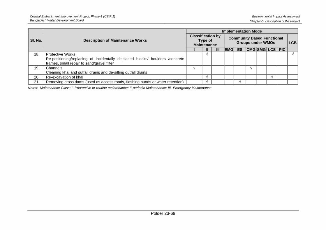
Coastal Embankment Improvement Project, Phase-1 (CEIP.1)
Bangladesh Water Development Board
Environmental Impact Assessment
Chapter-5: Description of the Project
Polder 23-69
Sl. No. Description of Maintenance Works
Implementation Mode
Classification by Type of
Maintenance
Community Based Functional Groups under WMOs LCB
I II III EMG ES CMG SMG LCS PIC
18 Protective Works Re-positioning/replacing of incidentally displaced blocks/ boulders /concrete frames, small repair to sand/gravel filter
√ √
19 Channels Cleaning khal and outfall drains and de-silting outfall drains
√ √
20 Re-excavation of khal √ √
21 Removing cross dams (used as access roads, flashing bunds or water retention) √ √
Notes: Maintenance Class; I- Preventive or routine maintenance; II-periodic Maintenance; III- Emergency Maintenance
Coastal Embankment Improvement Project, Phase-1 (CEIP.1)
Bangladesh Water Development Board
Environmental Impact Assessment
Chapter-5: Description of the Project
Polder 23-70
(iv) Planning of Maintenance
195. As already stated maintenance activities in BWDB Polders are conceived in three distinct
categories, i.e., Preventive Maintenance; Periodic Maintenance; and Emergency Maintenance.
Preventive maintenance requires little annual planning because Embankment Maintenance
Groups and Canal Maintenance Groups go ahead in a continuous process. Emergency
maintenance cannot be planned as this will be dependent on unexpected conditions and can
hardly be foreseen. So, the maintenance planning centers on periodic maintenance. The
selection of items to be maintained and repaired, and the ranking of the works, is the recurrent
activities in maintenance planning. This selection depends on the project inventory; the O&M
checklists filled in by the farmers under the guidance of the Section Officer; and monitoring data
produced by BWDB. A clear dichotomy is apparent here; monitoring focuses on the elements of
the infrastructure while the O&M checklists help identify the water management bottlenecks
and support the system approach. Another important issue in the maintenance planning is the
timing of maintenance, i.e., when certain works need to be carried out without hampering water
management, and if it does hamper in any area, all these should be reflected in the seasonal
water management plan. This concerns mainly the periodic maintenance works. A third planning
activity is a part of the implementation phase and concerns the drawing up of physical work plans
prior to the start of the works; this is in fact an activity between the contractor and the O&M Offices.
5.12. Project Cost
196. The implementation cost of the rehabilitation of Polder 23 is BDT Tk 11,495lakh.
5.13. Need of Resettlement Action Plan (RAP)
197. The interventions proposed in Polder 23 do not include any major type of works to be
carried out in new alignments. All Drainage or Flushing Sluices proposed to be replaced will be
re-constructed on existing alignment. Also, for the embankment re-sectioning works, the existing
alignment is to be used for the additional set back distance is to be used. Moreover, there is no
such intervention of construction of retired embankments. It can therefore be concluded that no
major resettlement may occur during project implementation. However, some minor resettlements
may be needed as some households still exist over or adjacent to the polder periphery, which
may be displaced during construction works. In this connection, a detail RAP investigation is
required, which is being conducted by the consultants.
5.14. No Objection Certificate
198. Polder 23 is located in the Paikgachha Upazila under Khulna District, covering Sholadana
and Laskar Union Parishad (UP). No archeological sites or cultural heritages are known to exist
in the union, which might be affected for interventions proposed for the rehabilitation of the polder.
Furthermore, there will be no problems of land acquisition or displacement of people since
rehabilitation will be made on the existing infrastructures. This has been addressed in the No
Objection Certificates (NOCs) collected from the Union Parishad Chairman, which are attached
in Appendix D.
Polder 23-71
6. Environmental Baseline and Existing Conditions
The baseline condition of Water Resources, Agriculture Resources, Fisheries, Ecology and Socio-
Economic Resources prevailing in the Polder area has been established by collecting data from
primary as well as secondary sources. The secondary sources include Bangladesh Water
Development Board (BWDB), National Water Resources Database (NWRD), Department of
Public Health Engineering (DPHE), Bangladesh Meteorological Department (BMD) and
Bangladesh Bureau of Statistics (BBS). Primary data are collected during field visits in the Polder
area.
6.1. Physical Environment
Physical environment refers to the physical and chemical features of an area. It includes the
climate, rainfall, wind, soil, obtainable nutrients and all other natural resources within the area.
The following sections provide analyses on different physical environmental features of the Polder
23.
Geology
Polder 23 is situated in a low-lying coastal region. From Spatial analysis, it is observed that the
polder is composed of Tidal Deltaic Deposit. The major portion of this deltaic sediment is
deposited subaqueously in the permanent water bodies where tidal waves and currents aid in
transportation and deposition. Typically low-lying deltaic environment comprises of soft sediments
and are densely populated and these regions are quite dynamic and the changes in coastal
geomorphology are quite rapid from impact of each cyclone.
Topography
199. The Polder area is located in the southern hydrological zone of the country, with very low
average elevations. In order to assess the topography of the Polder area, the Reduced Levels
(RLs) were collected from the Digital Elevation Model (DEM) of 300x300m resolution, generated
by the National Water Resources Database (NWRD). Analysis using Digital Elevation Model
(DEM) infers that the Reduced Levels3 (RLs) inside the polder vary from 0.66 to 1.68 m+PWD,
with average RL of around 1.14 m+PWD. From the DEM it is also found that around 15% of the
land area in the northwest part of the polder along the river Sibsa and Kurulia has relatively high
elevation between 1.40 to 1.68 m+PWD , whereas around 70% of the land inside the polder area
has elevation between 0.90 to 1.22 m+PWD. The rest 15% land area in the southwest side of the
polder has elevation below 0.81 m+PWD. Map 6.1 shows the topography of the Polder area,
identifying the rivers and categorizing land elevations.
3 Reduced Level in surveying refers to equating elevations of survey points with reference to a common assumed
datum. It is a vertical distance between survey point and adopted datum plane.
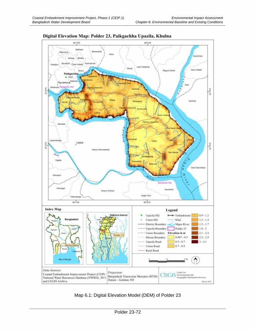
Coastal Embankment Improvement Project, Phase-1 (CEIP.1)
Bangladesh Water Development Board
Environmental Impact Assessment
Chapter-6: Environmental Baseline and Existing Conditions
Polder 23-72
Map 6.1: Digital Elevation Model (DEM) of Polder 23
Coastal Embankment Improvement Project, Phase-1 (CEIP.1)
Bangladesh Water Development Board
Environmental Impact Assessment
Chapter-6: Environmental Baseline and Existing Conditions
Polder 23-73
Seismicity
200. Geographical location of Bangladesh has made it ideal suited for natural disasters like
earthquake. Tectonic framework of Bangladesh and adjoining areas indicate that Bangladesh is
suited adjacent to the plate margins of India and Eurasia where devastating earthquakes have
occurred in the past. Depending on the geological structure, Geological Survey of Bangladesh
(GSB) has prepared a seismic zoning map of Bangladesh in 1979 dividing the country into three
generalized seismic zones: Zone-I, Zone-II, and Zone-III (Map 6.2). Accordingly, the project area
falls under Zone-III, which is characterized by Low earthquake prone site and has a basic seismic
coefficient of 0.04g (Map 5.2). Moreover, the Polder area is located inside the Faridpur Trough,
which is situated adjacent to the Hinge Zone and is characterized by a general gravity-low with
the development of Neogene sequence. Map 6.3 represents the tectonic units available in
Bangladesh and the location of the Polder area (within the Faridpur Trough).
201. It can therefore be inferred that in consideration of both seismicity and stratigraphy, the
Polder area occupies a relatively safer (seismically quiet and tectonically stable) side.
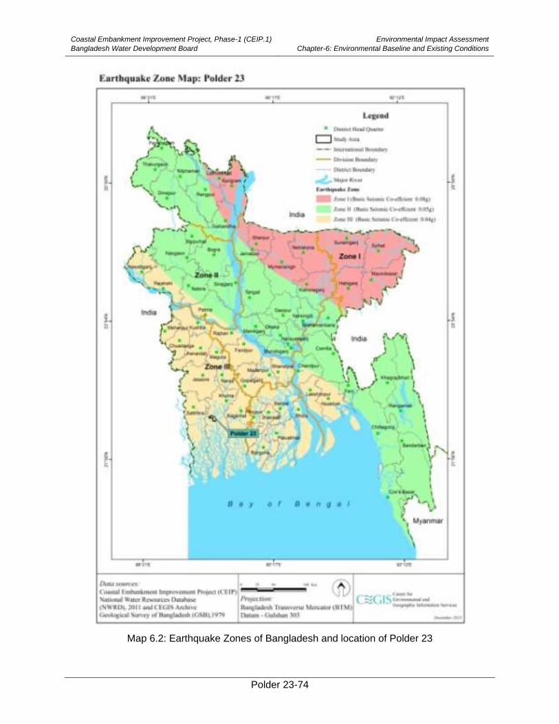
Coastal Embankment Improvement Project, Phase-1 (CEIP.1)
Bangladesh Water Development Board
Environmental Impact Assessment
Chapter-6: Environmental Baseline and Existing Conditions
Polder 23-74
Map 6.2: Earthquake Zones of Bangladesh and location of Polder 23
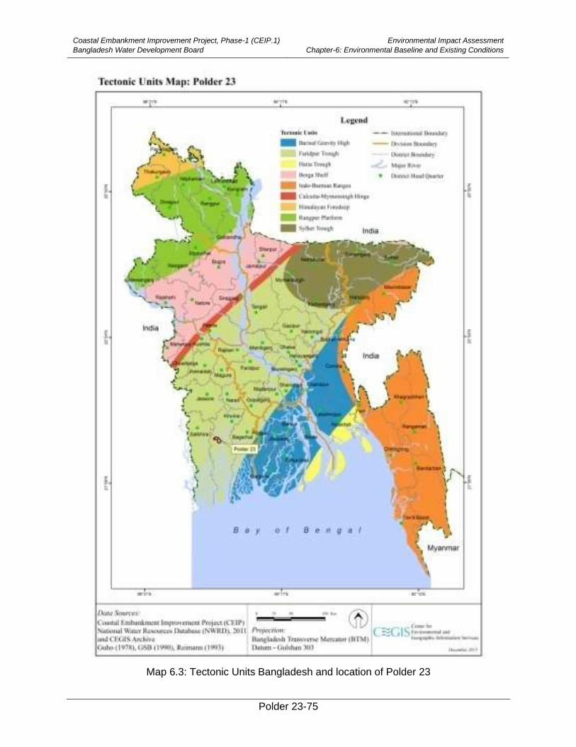
Coastal Embankment Improvement Project, Phase-1 (CEIP.1)
Bangladesh Water Development Board
Environmental Impact Assessment
Chapter-6: Environmental Baseline and Existing Conditions
Polder 23-75
Map 6.3: Tectonic Units Bangladesh and location of Polder 23
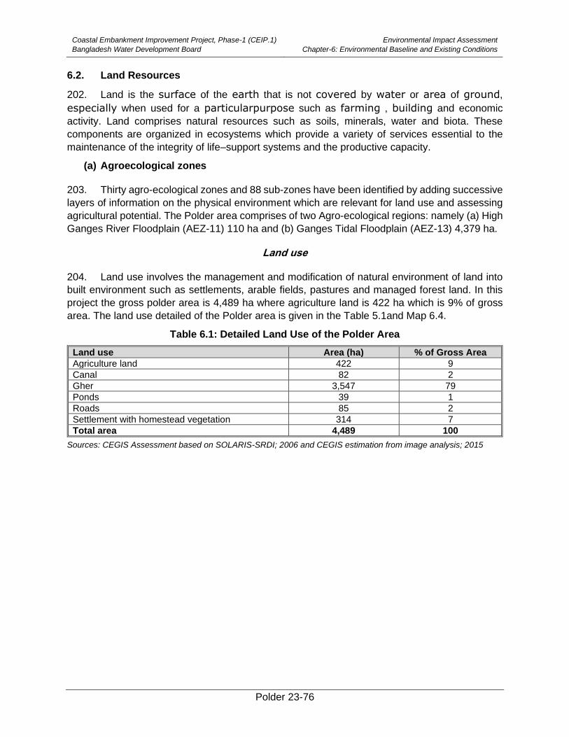
Coastal Embankment Improvement Project, Phase-1 (CEIP.1)
Bangladesh Water Development Board
Environmental Impact Assessment
Chapter-6: Environmental Baseline and Existing Conditions
Polder 23-76
6.2. Land Resources
202. Land is the surface of the earth that is not covered by water or area of ground,
especially when used for a particularpurpose such as farming , building and economic
activity. Land comprises natural resources such as soils, minerals, water and biota. These
components are organized in ecosystems which provide a variety of services essential to the
maintenance of the integrity of life–support systems and the productive capacity.
(a) Agroecological zones
203. Thirty agro-ecological zones and 88 sub-zones have been identified by adding successive
layers of information on the physical environment which are relevant for land use and assessing
agricultural potential. The Polder area comprises of two Agro-ecological regions: namely (a) High
Ganges River Floodplain (AEZ-11) 110 ha and (b) Ganges Tidal Floodplain (AEZ-13) 4,379 ha.
Land use
204. Land use involves the management and modification of natural environment of land into
built environment such as settlements, arable fields, pastures and managed forest land. In this
project the gross polder area is 4,489 ha where agriculture land is 422 ha which is 9% of gross
area. The land use detailed of the Polder area is given in the Table 5.1and Map 6.4.
Table 6.1: Detailed Land Use of the Polder Area
Land use Area (ha) % of Gross Area
Agriculture land 422 9
Canal 82 2
Gher 3,547 79
Ponds 39 1
Roads 85 2
Settlement with homestead vegetation 314 7
Total area 4,489 100
Sources: CEGIS Assessment based on SOLARIS-SRDI; 2006 and CEGIS estimation from image analysis; 2015
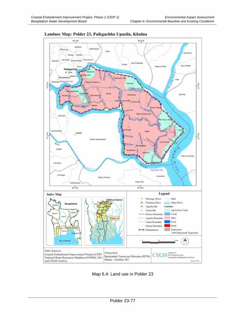
Coastal Embankment Improvement Project, Phase-1 (CEIP.1)
Bangladesh Water Development Board
Environmental Impact Assessment
Chapter-6: Environmental Baseline and Existing Conditions
Polder 23-77
Map 6.4: Land use in Polder 23
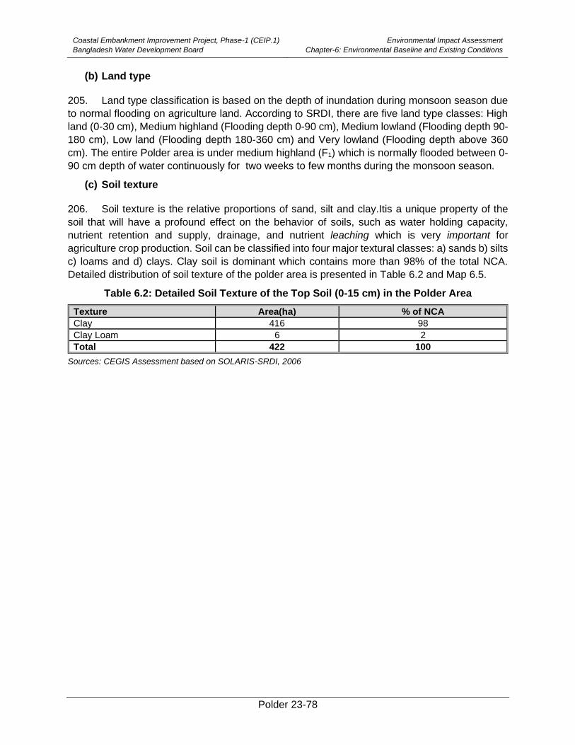
Coastal Embankment Improvement Project, Phase-1 (CEIP.1)
Bangladesh Water Development Board
Environmental Impact Assessment
Chapter-6: Environmental Baseline and Existing Conditions
Polder 23-78
(b) Land type
205. Land type classification is based on the depth of inundation during monsoon season due
to normal flooding on agriculture land. According to SRDI, there are five land type classes: High
land (0-30 cm), Medium highland (Flooding depth 0-90 cm), Medium lowland (Flooding depth 90-
180 cm), Low land (Flooding depth 180-360 cm) and Very lowland (Flooding depth above 360
cm). The entire Polder area is under medium highland (F1) which is normally flooded between 0-
90 cm depth of water continuously for two weeks to few months during the monsoon season.
(c) Soil texture
206. Soil texture is the relative proportions of sand, silt and clay.Itis a unique property of the
soil that will have a profound effect on the behavior of soils, such as water holding capacity,
nutrient retention and supply, drainage, and nutrient leaching which is very important for
agriculture crop production. Soil can be classified into four major textural classes: a) sands b) silts
c) loams and d) clays. Clay soil is dominant which contains more than 98% of the total NCA.
Detailed distribution of soil texture of the polder area is presented in Table 6.2 and Map 6.5.
Table 6.2: Detailed Soil Texture of the Top Soil (0-15 cm) in the Polder Area
Texture Area(ha) % of NCA
Clay 416 98
Clay Loam 6 2
Total 422 100
Sources: CEGIS Assessment based on SOLARIS-SRDI, 2006
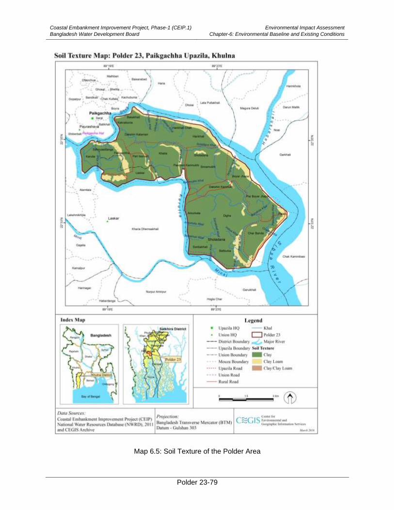
Coastal Embankment Improvement Project, Phase-1 (CEIP.1)
Bangladesh Water Development Board
Environmental Impact Assessment
Chapter-6: Environmental Baseline and Existing Conditions
Polder 23-79
Map 6.5: Soil Texture of the Polder Area
Coastal Embankment Improvement Project, Phase-1 (CEIP.1)
Bangladesh Water Development Board
Environmental Impact Assessment
Chapter-6: Environmental Baseline and Existing Conditions
Polder 23-80
(d) Drainage characteristics
207. Drainage plays a vital role in the management of soil productivity in the polder area. The
drainage characteristics have been divided into six classes (Excessively Drained, Well Drained,
Moderately well Drained, Imperfectly Drained, Poorly Drained and Very Poorly Drained) by SRDI
for agricultural uses. The Polder area is included in Poorly Drained class.
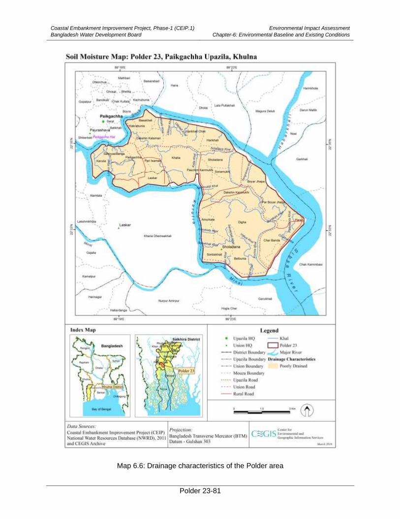
Coastal Embankment Improvement Project, Phase-1 (CEIP.1)
Bangladesh Water Development Board
Environmental Impact Assessment
Chapter-6: Environmental Baseline and Existing Conditions
Polder 23-81
Map 6.6: Drainage characteristics of the Polder area
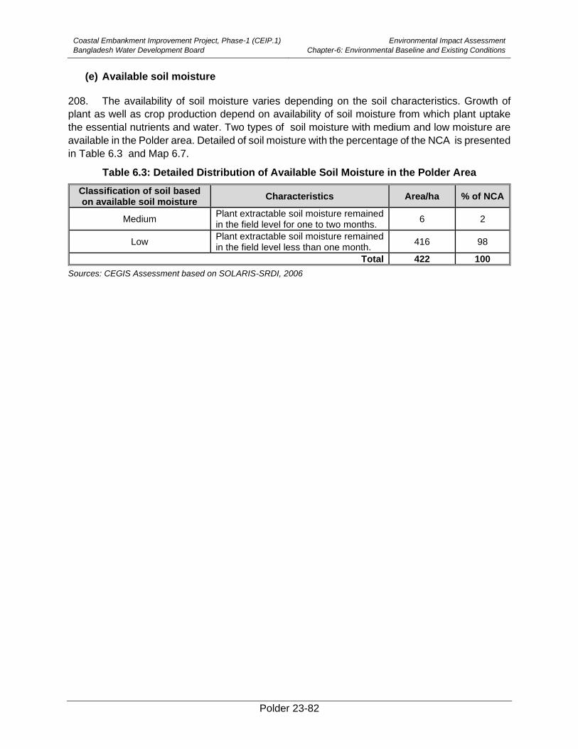
Coastal Embankment Improvement Project, Phase-1 (CEIP.1)
Bangladesh Water Development Board
Environmental Impact Assessment
Chapter-6: Environmental Baseline and Existing Conditions
Polder 23-82
(e) Available soil moisture
208. The availability of soil moisture varies depending on the soil characteristics. Growth of
plant as well as crop production depend on availability of soil moisture from which plant uptake
the essential nutrients and water. Two types of soil moisture with medium and low moisture are
available in the Polder area. Detailed of soil moisture with the percentage of the NCA is presented
in Table 6.3 and Map 6.7.
Table 6.3: Detailed Distribution of Available Soil Moisture in the Polder Area
Classification of soil based on available soil moisture
Characteristics Area/ha % of NCA
Medium Plant extractable soil moisture remained in the field level for one to two months.
6 2
Low Plant extractable soil moisture remained in the field level less than one month.
416 98
Total 422 100
Sources: CEGIS Assessment based on SOLARIS-SRDI, 2006
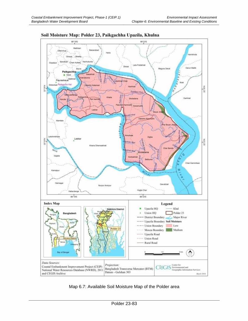
Coastal Embankment Improvement Project, Phase-1 (CEIP.1)
Bangladesh Water Development Board
Environmental Impact Assessment
Chapter-6: Environmental Baseline and Existing Conditions
Polder 23-83
Map 6.7: Available Soil Moisture Map of the Polder area
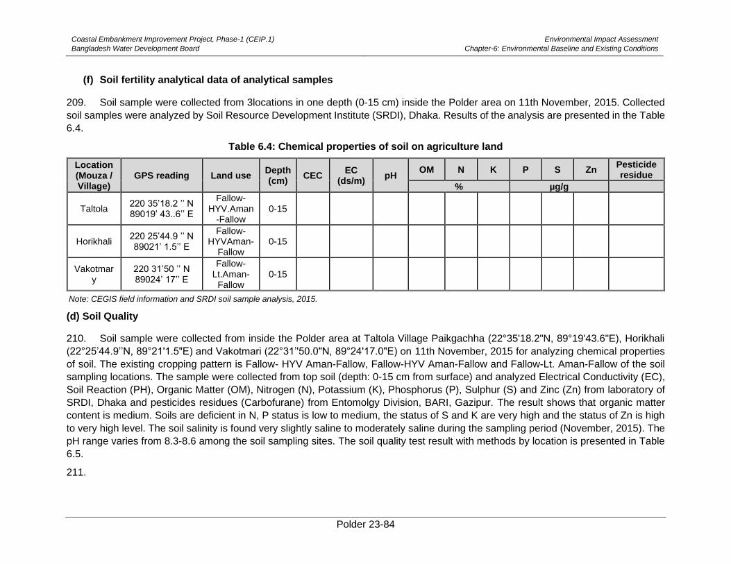
Coastal Embankment Improvement Project, Phase-1 (CEIP.1)
Bangladesh Water Development Board
Environmental Impact Assessment
Chapter-6: Environmental Baseline and Existing Conditions
Polder 23-84
(f) Soil fertility analytical data of analytical samples
209. Soil sample were collected from 3locations in one depth (0-15 cm) inside the Polder area on 11th November, 2015. Collected
soil samples were analyzed by Soil Resource Development Institute (SRDI), Dhaka. Results of the analysis are presented in the Table
6.4.
Table 6.4: Chemical properties of soil on agriculture land
Location (Mouza / Village)
GPS reading Land use Depth (cm)
CEC EC
(ds/m) pH
OM N K P S Zn Pesticide residue
% µg/g
Taltola 220 35’18.2 ’’ N 89019’ 43..6’’ E
Fallow-HYV.Aman
-Fallow 0-15
Horikhali 220 25’44.9 ’’ N 89021’ 1.5’’ E
Fallow-HYVAman-
Fallow 0-15
Vakotmary
220 31’50 ’’ N 89024’ 17’’ E
Fallow-Lt.Aman-
Fallow 0-15
Note: CEGIS field information and SRDI soil sample analysis, 2015.
(d) Soil Quality
210. Soil sample were collected from inside the Polder area at Taltola Village Paikgachha (22°35'18.2"N, 89°19'43.6"E), Horikhali
(22°25’44.9’’N, 89°21'1.5"E) and Vakotmari (22°31’'50.0"N, 89°24'17.0"E) on 11th November, 2015 for analyzing chemical properties
of soil. The existing cropping pattern is Fallow- HYV Aman-Fallow, Fallow-HYV Aman-Fallow and Fallow-Lt. Aman-Fallow of the soil
sampling locations. The sample were collected from top soil (depth: 0-15 cm from surface) and analyzed Electrical Conductivity (EC),
Soil Reaction (PH), Organic Matter (OM), Nitrogen (N), Potassium (K), Phosphorus (P), Sulphur (S) and Zinc (Zn) from laboratory of
SRDI, Dhaka and pesticides residues (Carbofurane) from Entomolgy Division, BARI, Gazipur. The result shows that organic matter
content is medium. Soils are deficient in N, P status is low to medium, the status of S and K are very high and the status of Zn is high
to very high level. The soil salinity is found very slightly saline to moderately saline during the sampling period (November, 2015). The
pH range varies from 8.3-8.6 among the soil sampling sites. The soil quality test result with methods by location is presented in Table
6.5.
211.
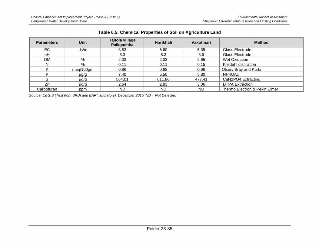
Coastal Embankment Improvement Project, Phase-1 (CEIP.1)
Bangladesh Water Development Board
Environmental Impact Assessment
Chapter-6: Environmental Baseline and Existing Conditions
Polder 23-85
Table 6.5: Chemical Properties of Soil on Agriculture Land
Parameters Unit Taltola village Paikgachha
Horikhali Vakotmari Method
EC ds/m 8.53 5.60 5.35 Glass Electrode
pH - 8.3 8.3 8.6 Glass Electrode
OM % 2.03 2.03 2.65 Wet Oxidation
N % 0.11 0.11 0.15 Kjeldahl distillation
K meq/100gm 0.86 0.68 0.66 Olsen/ Bray and Kurtz
P µg/g 7.40 5.50 5.80 NH4OAc
S µg/g 564.01 611.80 477.41 CaH2PO4 Extracting
Zn µg/g 2.64 2.83 3.06 DTPA Extraction
Carbofuran ppm ND ND ND Thermo Electron & Pekin Elmer
Source: CEGIS (Test from SRDI and BARI laboratory), December 2015; ND = Not Detected
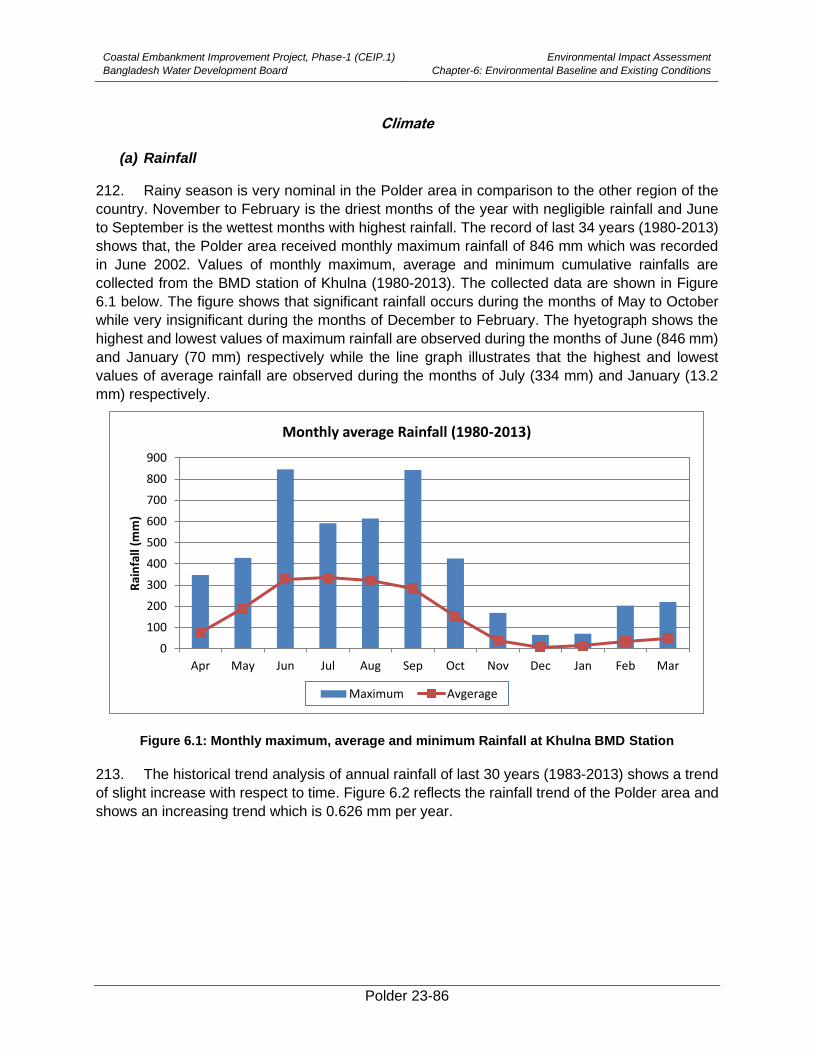
Coastal Embankment Improvement Project, Phase-1 (CEIP.1)
Bangladesh Water Development Board
Environmental Impact Assessment
Chapter-6: Environmental Baseline and Existing Conditions
Polder 23-86
Climate
(a) Rainfall
212. Rainy season is very nominal in the Polder area in comparison to the other region of the
country. November to February is the driest months of the year with negligible rainfall and June
to September is the wettest months with highest rainfall. The record of last 34 years (1980-2013)
shows that, the Polder area received monthly maximum rainfall of 846 mm which was recorded
in June 2002. Values of monthly maximum, average and minimum cumulative rainfalls are
collected from the BMD station of Khulna (1980-2013). The collected data are shown in Figure
6.1 below. The figure shows that significant rainfall occurs during the months of May to October
while very insignificant during the months of December to February. The hyetograph shows the
highest and lowest values of maximum rainfall are observed during the months of June (846 mm)
and January (70 mm) respectively while the line graph illustrates that the highest and lowest
values of average rainfall are observed during the months of July (334 mm) and January (13.2
mm) respectively.
Figure 6.1: Monthly maximum, average and minimum Rainfall at Khulna BMD Station
213. The historical trend analysis of annual rainfall of last 30 years (1983-2013) shows a trend
of slight increase with respect to time. Figure 6.2 reflects the rainfall trend of the Polder area and
shows an increasing trend which is 0.626 mm per year.
0
100
200
300
400
500
600
700
800
900
Apr May Jun Jul Aug Sep Oct Nov Dec Jan Feb Mar
Rai
nfa
ll (m
m)
Monthly average Rainfall (1980-2013)
Maximum Avgerage
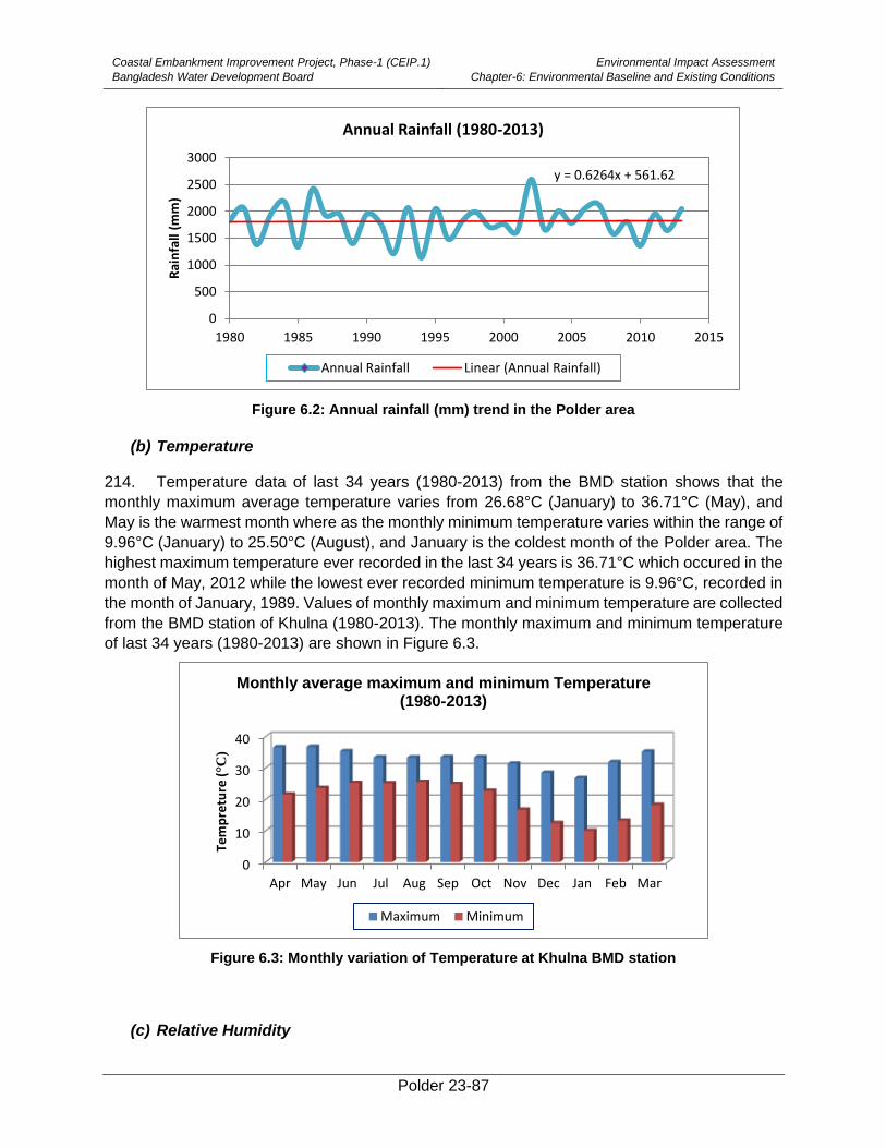
Coastal Embankment Improvement Project, Phase-1 (CEIP.1)
Bangladesh Water Development Board
Environmental Impact Assessment
Chapter-6: Environmental Baseline and Existing Conditions
Polder 23-87
Figure 6.2: Annual rainfall (mm) trend in the Polder area
(b) Temperature
214. Temperature data of last 34 years (1980-2013) from the BMD station shows that the
monthly maximum average temperature varies from 26.68°C (January) to 36.71°C (May), and
May is the warmest month where as the monthly minimum temperature varies within the range of
9.96°C (January) to 25.50°C (August), and January is the coldest month of the Polder area. The
highest maximum temperature ever recorded in the last 34 years is 36.71°C which occured in the
month of May, 2012 while the lowest ever recorded minimum temperature is 9.96°C, recorded in
the month of January, 1989. Values of monthly maximum and minimum temperature are collected
from the BMD station of Khulna (1980-2013). The monthly maximum and minimum temperature
of last 34 years (1980-2013) are shown in Figure 6.3.
Figure 6.3: Monthly variation of Temperature at Khulna BMD station
(c) Relative Humidity
y = 0.6264x + 561.62
0
500
1000
1500
2000
2500
3000
1980 1985 1990 1995 2000 2005 2010 2015
Rai
nfa
ll (m
m)
Annual Rainfall (1980-2013)
Annual Rainfall Linear (Annual Rainfall)
0
10
20
30
40
Apr May Jun Jul Aug Sep Oct Nov Dec Jan Feb Mar
Tem
pre
ture
(°C
)
Monthly average maximum and minimum Temperature (1980-2013)
Maximum Minimum
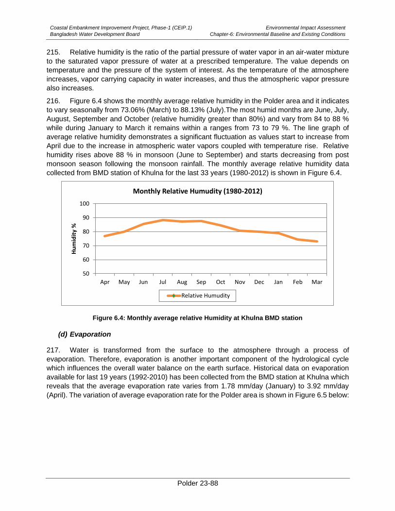
Coastal Embankment Improvement Project, Phase-1 (CEIP.1)
Bangladesh Water Development Board
Environmental Impact Assessment
Chapter-6: Environmental Baseline and Existing Conditions
Polder 23-88
215. Relative humidity is the ratio of the partial pressure of water vapor in an air-water mixture
to the saturated vapor pressure of water at a prescribed temperature. The value depends on
temperature and the pressure of the system of interest. As the temperature of the atmosphere
increases, vapor carrying capacity in water increases, and thus the atmospheric vapor pressure
also increases.
216. Figure 6.4 shows the monthly average relative humidity in the Polder area and it indicates
to vary seasonally from 73.06% (March) to 88.13% (July).The most humid months are June, July,
August, September and October (relative humidity greater than 80%) and vary from 84 to 88 %
while during January to March it remains within a ranges from 73 to 79 %. The line graph of
average relative humidity demonstrates a significant fluctuation as values start to increase from
April due to the increase in atmospheric water vapors coupled with temperature rise. Relative
humidity rises above 88 % in monsoon (June to September) and starts decreasing from post
monsoon season following the monsoon rainfall. The monthly average relative humidity data
collected from BMD station of Khulna for the last 33 years (1980-2012) is shown in Figure 6.4.
Figure 6.4: Monthly average relative Humidity at Khulna BMD station
(d) Evaporation
217. Water is transformed from the surface to the atmosphere through a process of
evaporation. Therefore, evaporation is another important component of the hydrological cycle
which influences the overall water balance on the earth surface. Historical data on evaporation
available for last 19 years (1992-2010) has been collected from the BMD station at Khulna which
reveals that the average evaporation rate varies from 1.78 mm/day (January) to 3.92 mm/day
(April). The variation of average evaporation rate for the Polder area is shown in Figure 6.5 below:
50
60
70
80
90
100
Apr May Jun Jul Aug Sep Oct Nov Dec Jan Feb Mar
Hu
mid
ity
%
Monthly Relative Humudity (1980-2012)
Relative Humudity
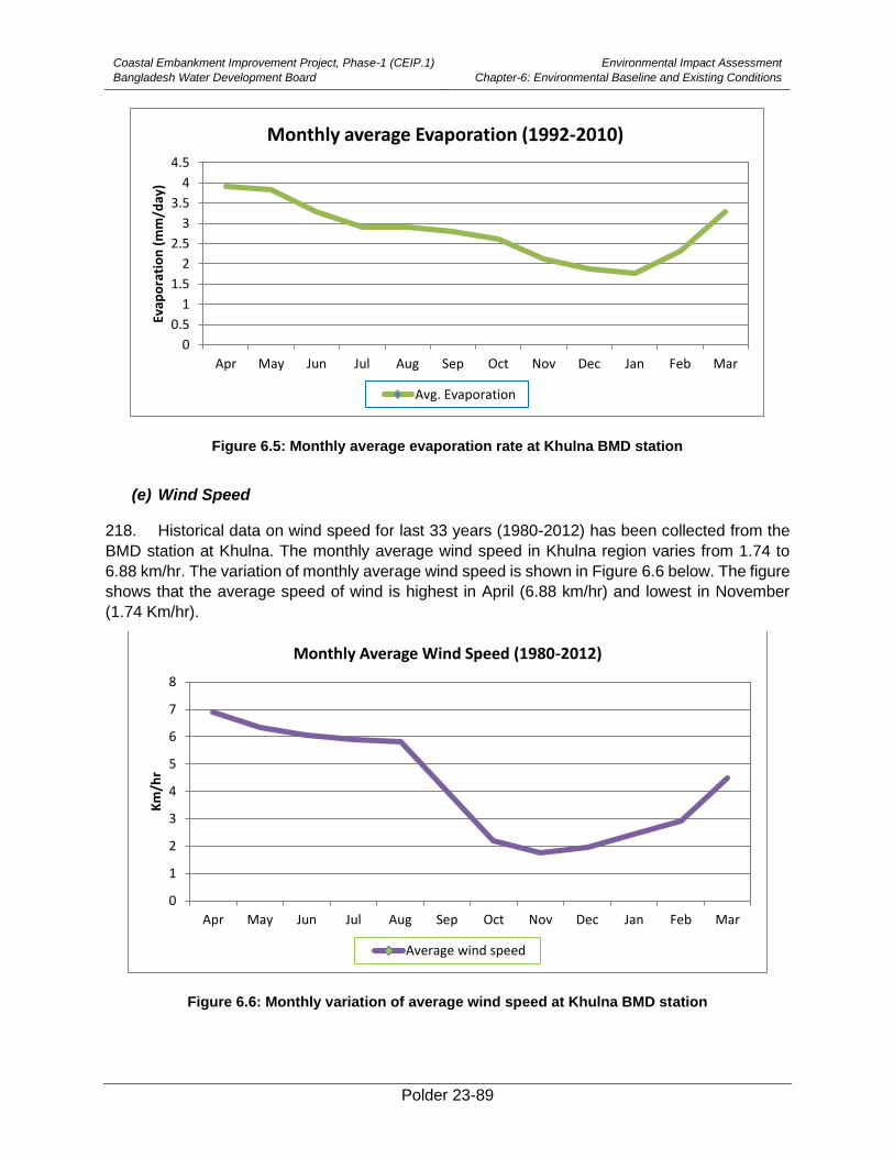
Coastal Embankment Improvement Project, Phase-1 (CEIP.1)
Bangladesh Water Development Board
Environmental Impact Assessment
Chapter-6: Environmental Baseline and Existing Conditions
Polder 23-89
Figure 6.5: Monthly average evaporation rate at Khulna BMD station
(e) Wind Speed
218. Historical data on wind speed for last 33 years (1980-2012) has been collected from the
BMD station at Khulna. The monthly average wind speed in Khulna region varies from 1.74 to
6.88 km/hr. The variation of monthly average wind speed is shown in Figure 6.6 below. The figure
shows that the average speed of wind is highest in April (6.88 km/hr) and lowest in November
(1.74 Km/hr).
Figure 6.6: Monthly variation of average wind speed at Khulna BMD station
0
0.5
1
1.5
2
2.5
3
3.5
4
4.5
Apr May Jun Jul Aug Sep Oct Nov Dec Jan Feb Mar
Evap
ora
tio
n (
mm
/day
)
Monthly average Evaporation (1992-2010)
Avg. Evaporation
0
1
2
3
4
5
6
7
8
Apr May Jun Jul Aug Sep Oct Nov Dec Jan Feb Mar
Km
/hr
Monthly Average Wind Speed (1980-2012)
Average wind speed
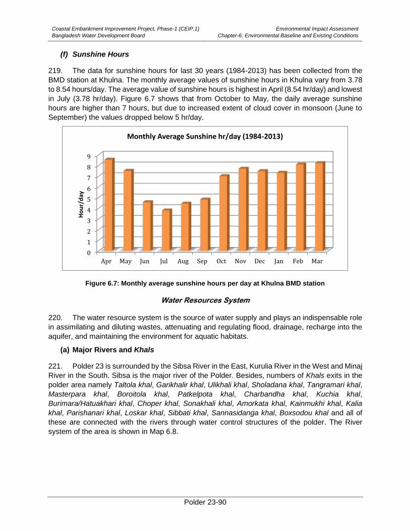
Coastal Embankment Improvement Project, Phase-1 (CEIP.1)
Bangladesh Water Development Board
Environmental Impact Assessment
Chapter-6: Environmental Baseline and Existing Conditions
Polder 23-90
(f) Sunshine Hours
219. The data for sunshine hours for last 30 years (1984-2013) has been collected from the
BMD station at Khulna. The monthly average values of sunshine hours in Khulna vary from 3.78
to 8.54 hours/day. The average value of sunshine hours is highest in April (8.54 hr/day) and lowest
in July (3.78 hr/day). Figure 6.7 shows that from October to May, the daily average sunshine
hours are higher than 7 hours, but due to increased extent of cloud cover in monsoon (June to
September) the values dropped below 5 hr/day.
Figure 6.7: Monthly average sunshine hours per day at Khulna BMD station
Water Resources System
220. The water resource system is the source of water supply and plays an indispensable role
in assimilating and diluting wastes, attenuating and regulating flood, drainage, recharge into the
aquifer, and maintaining the environment for aquatic habitats.
(a) Major Rivers and Khals
221. Polder 23 is surrounded by the Sibsa River in the East, Kurulia River in the West and Minaj
River in the South. Sibsa is the major river of the Polder. Besides, numbers of Khals exits in the
polder area namely Taltola khal, Garikhalir khal, Ulikhali khal, Sholadana khal, Tangramari khal,
Masterpara khal, Boroitola khal, Patkelpota khal, Charbandha khal, Kuchia khal,
Burimara/Hatuakhari khal, Choper khal, Sonakhali khal, Amorkata khal, Kainmukhi khal, Kalia
khal, Parishanari khal, Loskar khal, Sibbati khal, Sannasidanga khal, Boxsodou khal and all of
these are connected with the rivers through water control structures of the polder. The River
system of the area is shown in Map 6.8.
0
1
2
3
4
5
6
7
8
9
Apr May Jun Jul Aug Sep Oct Nov Dec Jan Feb Mar
Ho
ur/
day
Monthly Average Sunshine hr/day (1984-2013)
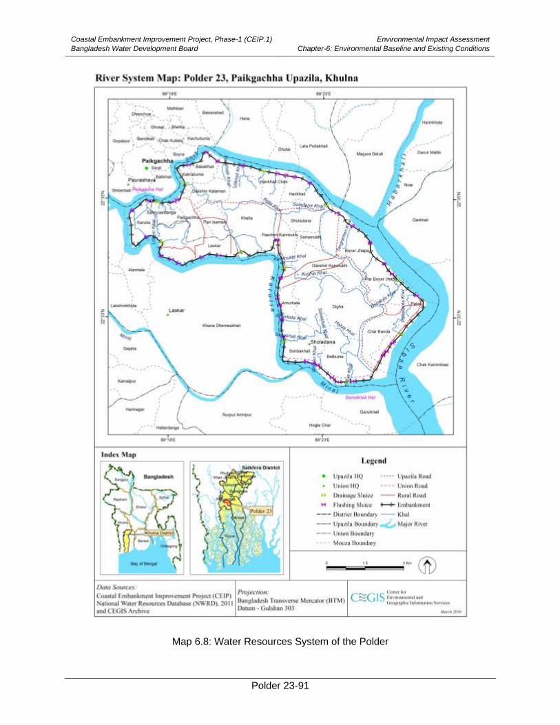
Coastal Embankment Improvement Project, Phase-1 (CEIP.1)
Bangladesh Water Development Board
Environmental Impact Assessment
Chapter-6: Environmental Baseline and Existing Conditions
Polder 23-91
Map 6.8: Water Resources System of the Polder
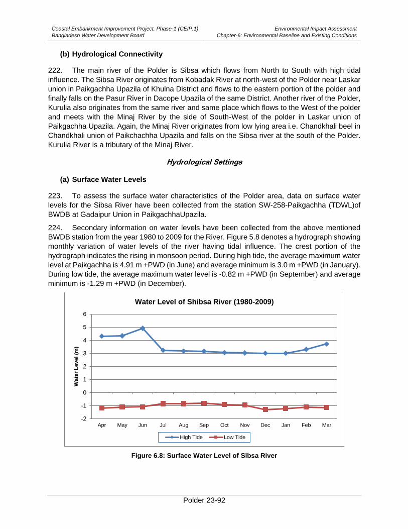
Coastal Embankment Improvement Project, Phase-1 (CEIP.1)
Bangladesh Water Development Board
Environmental Impact Assessment
Chapter-6: Environmental Baseline and Existing Conditions
Polder 23-92
(b) Hydrological Connectivity
222. The main river of the Polder is Sibsa which flows from North to South with high tidal
influence. The Sibsa River originates from Kobadak River at north-west of the Polder near Laskar
union in Paikgachha Upazila of Khulna District and flows to the eastern portion of the polder and
finally falls on the Pasur River in Dacope Upazila of the same District. Another river of the Polder,
Kurulia also originates from the same river and same place which flows to the West of the polder
and meets with the Minaj River by the side of South-West of the polder in Laskar union of
Paikgachha Upazila. Again, the Minaj River originates from low lying area i.e. Chandkhali beel in
Chandkhali union of Paikchachha Upazila and falls on the Sibsa river at the south of the Polder.
Kurulia River is a tributary of the Minaj River.
Hydrological Settings
(a) Surface Water Levels
223. To assess the surface water characteristics of the Polder area, data on surface water
levels for the Sibsa River have been collected from the station SW-258-Paikgachha (TDWL)of
BWDB at Gadaipur Union in PaikgachhaUpazila.
224. Secondary information on water levels have been collected from the above mentioned
BWDB station from the year 1980 to 2009 for the River. Figure 5.8 denotes a hydrograph showing
monthly variation of water levels of the river having tidal influence. The crest portion of the
hydrograph indicates the rising in monsoon period. During high tide, the average maximum water
level at Paikgachha is 4.91 m +PWD (in June) and average minimum is 3.0 m +PWD (in January).
During low tide, the average maximum water level is -0.82 m +PWD (in September) and average
minimum is -1.29 m +PWD (in December).
Figure 6.8: Surface Water Level of Sibsa River
-2
-1
0
1
2
3
4
5
6
Apr May Jun Jul Aug Sep Oct Nov Dec Jan Feb Mar
Wate
r L
evel (m
)
Water Level of Shibsa River (1980-2009)
High Tide Low Tide
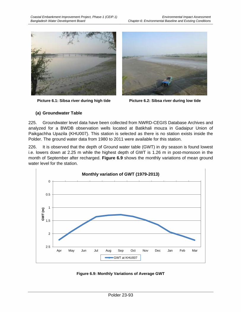
Coastal Embankment Improvement Project, Phase-1 (CEIP.1)
Bangladesh Water Development Board
Environmental Impact Assessment
Chapter-6: Environmental Baseline and Existing Conditions
Polder 23-93
Picture 6.1: Sibsa river during high tide Picture 6.2: Sibsa river during low tide
(a) Groundwater Table
225. Groundwater level data have been collected from NWRD-CEGIS Database Archives and
analyzed for a BWDB observation wells located at Batikhali mouza in Gadaipur Union of
Paikgachha Upazila (KHU007). This station is selected as there is no station exists inside the
Polder. The ground water data from 1980 to 2011 were available for this station.
226. It is observed that the depth of Ground water table (GWT) in dry season is found lowest
i.e. lowers down at 2.25 m while the highest depth of GWT is 1.26 m in post-monsoon in the
month of September after recharged. Figure 6.9 shows the monthly variations of mean ground
water level for the station.
Figure 6.9: Monthly Variations of Average GWT
0
0.5
1
1.5
2
2.5
Apr May Jun Jul Aug Sep Oct Nov Dec Jan Feb Mar
GW
T (
m)
Monthly variation of GWT (1979-2013)
GWT at KHU007
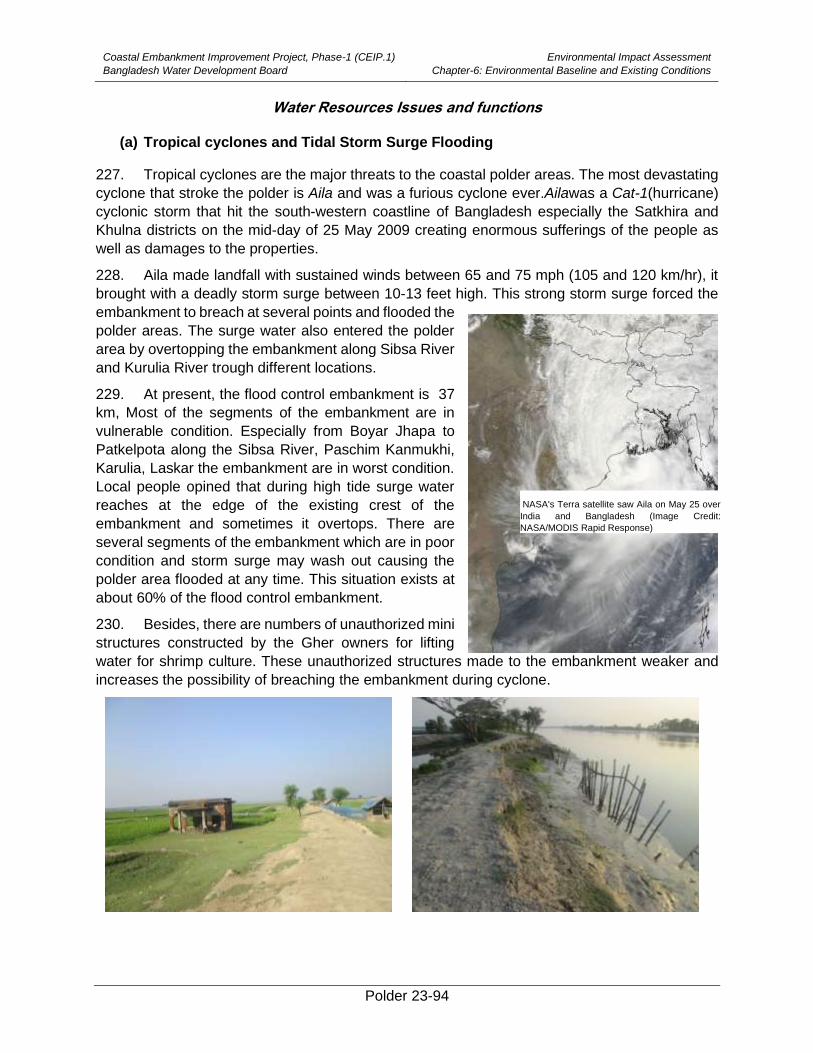
Coastal Embankment Improvement Project, Phase-1 (CEIP.1)
Bangladesh Water Development Board
Environmental Impact Assessment
Chapter-6: Environmental Baseline and Existing Conditions
Polder 23-94
Water Resources Issues and functions
(a) Tropical cyclones and Tidal Storm Surge Flooding
227. Tropical cyclones are the major threats to the coastal polder areas. The most devastating
cyclone that stroke the polder is Aila and was a furious cyclone ever.Ailawas a Cat-1(hurricane)
cyclonic storm that hit the south-western coastline of Bangladesh especially the Satkhira and
Khulna districts on the mid-day of 25 May 2009 creating enormous sufferings of the people as
well as damages to the properties.
228. Aila made landfall with sustained winds between 65 and 75 mph (105 and 120 km/hr), it
brought with a deadly storm surge between 10-13 feet high. This strong storm surge forced the
embankment to breach at several points and flooded the
polder areas. The surge water also entered the polder
area by overtopping the embankment along Sibsa River
and Kurulia River trough different locations.
229. At present, the flood control embankment is 37
km, Most of the segments of the embankment are in
vulnerable condition. Especially from Boyar Jhapa to
Patkelpota along the Sibsa River, Paschim Kanmukhi,
Karulia, Laskar the embankment are in worst condition.
Local people opined that during high tide surge water
reaches at the edge of the existing crest of the
embankment and sometimes it overtops. There are
several segments of the embankment which are in poor
condition and storm surge may wash out causing the
polder area flooded at any time. This situation exists at
about 60% of the flood control embankment.
230. Besides, there are numbers of unauthorized mini
structures constructed by the Gher owners for lifting
water for shrimp culture. These unauthorized structures made to the embankment weaker and
increases the possibility of breaching the embankment during cyclone.
NASA's Terra satellite saw Aila on May 25 over
India and Bangladesh (Image Credit:
NASA/MODIS Rapid Response)
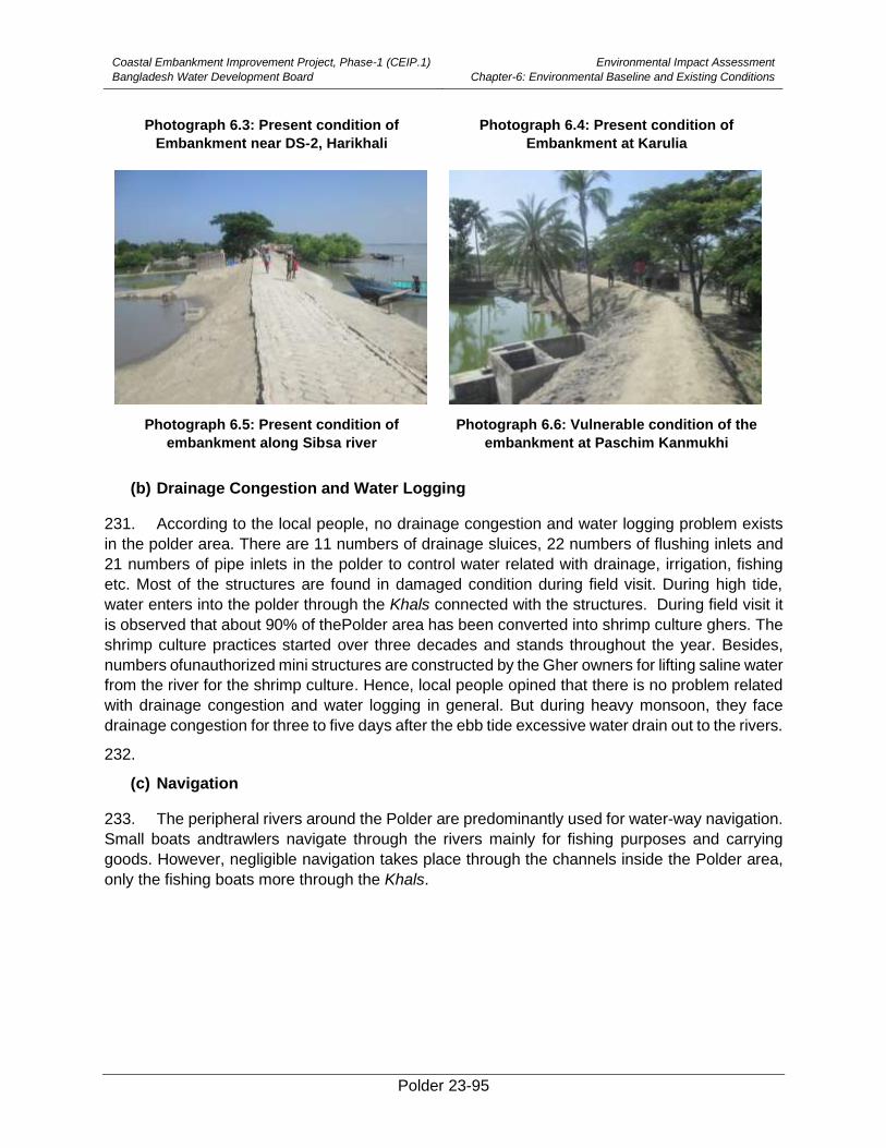
Coastal Embankment Improvement Project, Phase-1 (CEIP.1)
Bangladesh Water Development Board
Environmental Impact Assessment
Chapter-6: Environmental Baseline and Existing Conditions
Polder 23-95
Photograph 6.3: Present condition of
Embankment near DS-2, Harikhali
Photograph 6.4: Present condition of
Embankment at Karulia
Photograph 6.5: Present condition of
embankment along Sibsa river
Photograph 6.6: Vulnerable condition of the
embankment at Paschim Kanmukhi
(b) Drainage Congestion and Water Logging
231. According to the local people, no drainage congestion and water logging problem exists
in the polder area. There are 11 numbers of drainage sluices, 22 numbers of flushing inlets and
21 numbers of pipe inlets in the polder to control water related with drainage, irrigation, fishing
etc. Most of the structures are found in damaged condition during field visit. During high tide,
water enters into the polder through the Khals connected with the structures. During field visit it
is observed that about 90% of thePolder area has been converted into shrimp culture ghers. The
shrimp culture practices started over three decades and stands throughout the year. Besides,
numbers ofunauthorized mini structures are constructed by the Gher owners for lifting saline water
from the river for the shrimp culture. Hence, local people opined that there is no problem related
with drainage congestion and water logging in general. But during heavy monsoon, they face
drainage congestion for three to five days after the ebb tide excessive water drain out to the rivers.
232.
(c) Navigation
233. The peripheral rivers around the Polder are predominantly used for water-way navigation.
Small boats andtrawlers navigate through the rivers mainly for fishing purposes and carrying
goods. However, negligible navigation takes place through the channels inside the Polder area,
only the fishing boats more through the Khals.
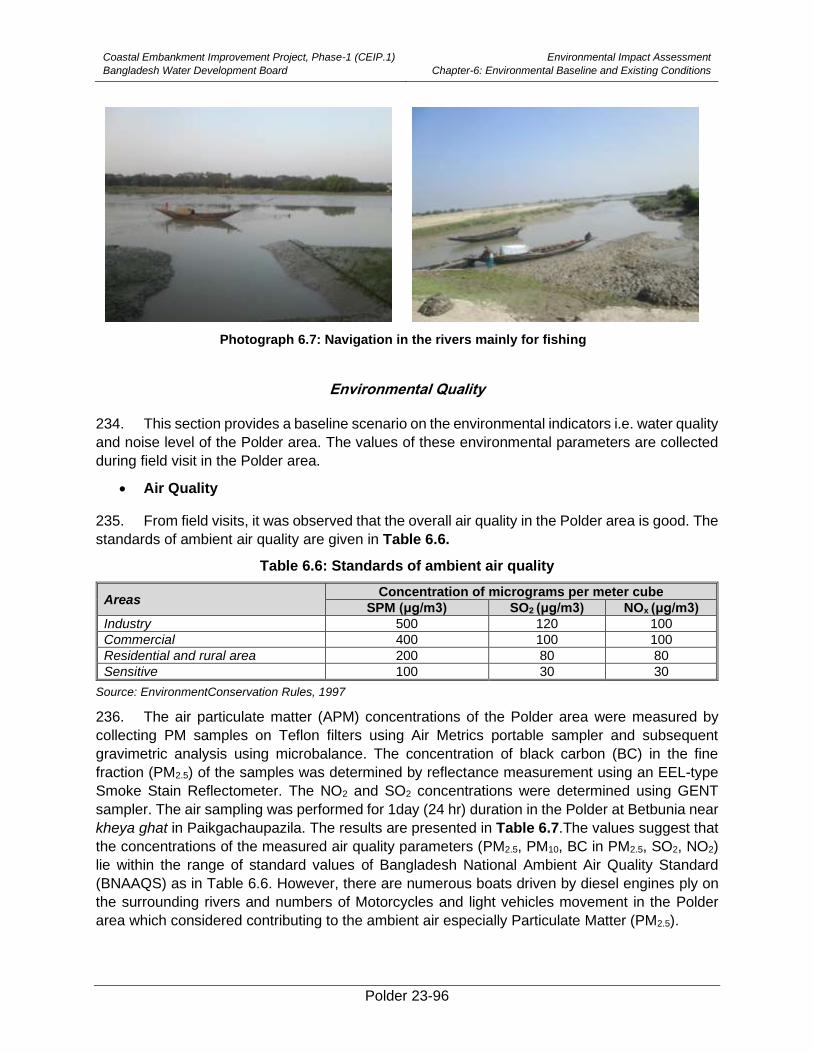
Coastal Embankment Improvement Project, Phase-1 (CEIP.1)
Bangladesh Water Development Board
Environmental Impact Assessment
Chapter-6: Environmental Baseline and Existing Conditions
Polder 23-96
Photograph 6.7: Navigation in the rivers mainly for fishing
Environmental Quality
234. This section provides a baseline scenario on the environmental indicators i.e. water quality
and noise level of the Polder area. The values of these environmental parameters are collected
during field visit in the Polder area.
• Air Quality
235. From field visits, it was observed that the overall air quality in the Polder area is good. The
standards of ambient air quality are given in Table 6.6.
Table 6.6: Standards of ambient air quality
Areas Concentration of micrograms per meter cube
SPM (μg/m3) SO2 (μg/m3) NOx (μg/m3)
Industry 500 120 100
Commercial 400 100 100
Residential and rural area 200 80 80
Sensitive 100 30 30
Source: EnvironmentConservation Rules, 1997
236. The air particulate matter (APM) concentrations of the Polder area were measured by
collecting PM samples on Teflon filters using Air Metrics portable sampler and subsequent
gravimetric analysis using microbalance. The concentration of black carbon (BC) in the fine
fraction (PM2.5) of the samples was determined by reflectance measurement using an EEL-type
Smoke Stain Reflectometer. The NO2 and SO2 concentrations were determined using GENT
sampler. The air sampling was performed for 1day (24 hr) duration in the Polder at Betbunia near
kheya ghat in Paikgachaupazila. The results are presented in Table 6.7.The values suggest that
the concentrations of the measured air quality parameters (PM2.5, PM10, BC in PM2.5, SO2, NO2)
lie within the range of standard values of Bangladesh National Ambient Air Quality Standard
(BNAAQS) as in Table 6.6. However, there are numerous boats driven by diesel engines ply on
the surrounding rivers and numbers of Motorcycles and light vehicles movement in the Polder
area which considered contributing to the ambient air especially Particulate Matter (PM2.5).
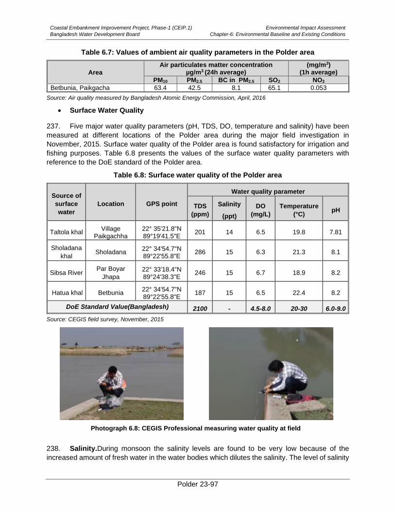
Coastal Embankment Improvement Project, Phase-1 (CEIP.1)
Bangladesh Water Development Board
Environmental Impact Assessment
Chapter-6: Environmental Baseline and Existing Conditions
Polder 23-97
Table 6.7: Values of ambient air quality parameters in the Polder area
Area
Air particulates matter concentration µg/m3 (24h average)
(mg/m3) (1h average)
PM10 PM2.5 BC in PM2.5 SO2 NO2
Betbunia, Paikgacha 63.4 42.5 8.1 65.1 0.053
Source: Air quality measured by Bangladesh Atomic Energy Commission, April, 2016
• Surface Water Quality
237. Five major water quality parameters (pH, TDS, DO, temperature and salinity) have been
measured at different locations of the Polder area during the major field investigation in
November, 2015. Surface water quality of the Polder area is found satisfactory for irrigation and
fishing purposes. Table 6.8 presents the values of the surface water quality parameters with
reference to the DoE standard of the Polder area.
Table 6.8: Surface water quality of the Polder area
Source of
surface
water
Location GPS point
Water quality parameter
TDS
(ppm)
Salinity
(ppt)
DO
(mg/L)
Temperature
(°C) pH
Taltola khal Village
Paikgachha 22° 35'21.8"N 89°19'41.5"E
201 14 6.5 19.8 7.81
Sholadana
khal Sholadana
22° 34'54.7"N 89°22'55.8"E
286 15 6.3 21.3 8.1
Sibsa River Par Boyar
Jhapa 22° 33'18.4"N 89°24'38.3"E
246 15 6.7 18.9 8.2
Hatua khal Betbunia 22° 34'54.7"N 89°22'55.8"E
187 15 6.5 22.4 8.2
DoE Standard Value(Bangladesh) 2100 - 4.5-8.0 20-30 6.0-9.0
Source: CEGIS field survey, November, 2015
Photograph 6.8: CEGIS Professional measuring water quality at field
238. Salinity.During monsoon the salinity levels are found to be very low because of the
increased amount of fresh water in the water bodies which dilutes the salinity. The level of salinity
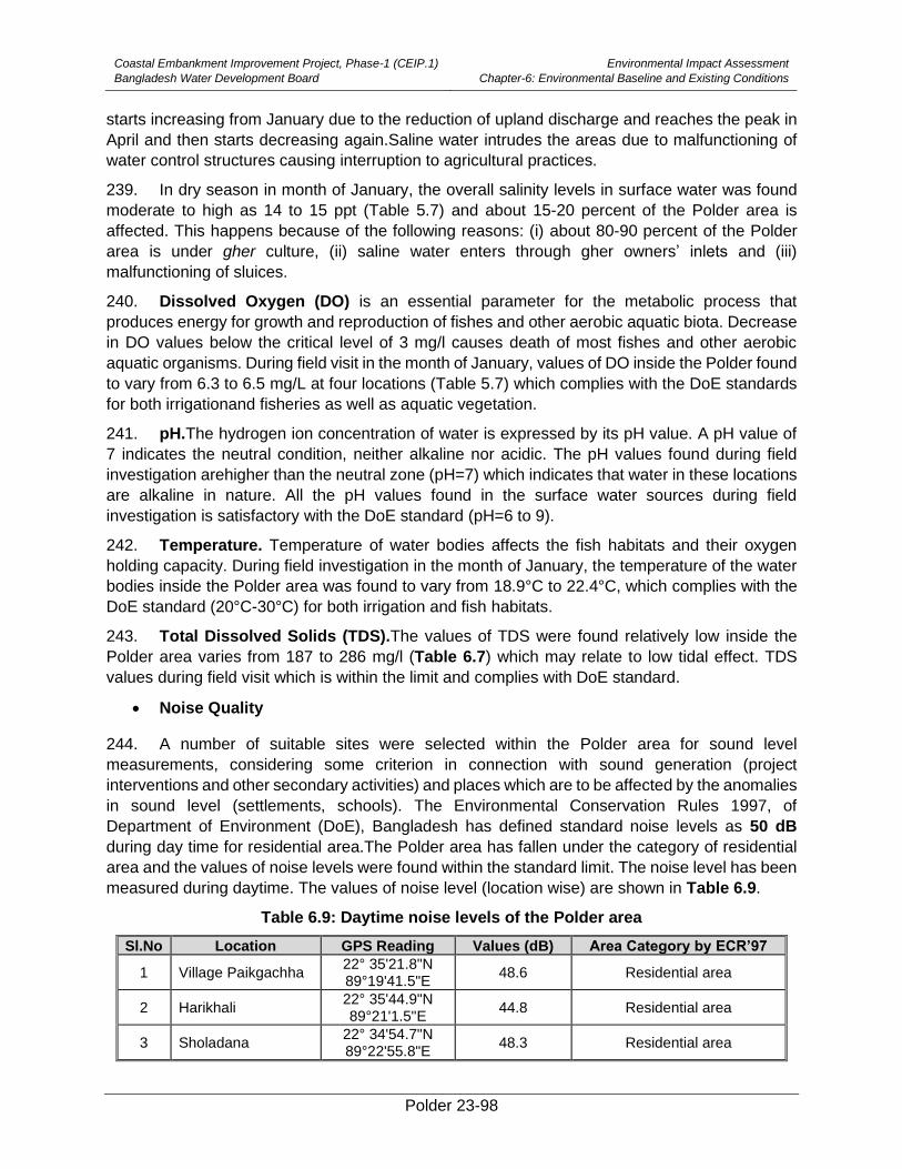
Coastal Embankment Improvement Project, Phase-1 (CEIP.1)
Bangladesh Water Development Board
Environmental Impact Assessment
Chapter-6: Environmental Baseline and Existing Conditions
Polder 23-98
starts increasing from January due to the reduction of upland discharge and reaches the peak in
April and then starts decreasing again.Saline water intrudes the areas due to malfunctioning of
water control structures causing interruption to agricultural practices.
239. In dry season in month of January, the overall salinity levels in surface water was found
moderate to high as 14 to 15 ppt (Table 5.7) and about 15-20 percent of the Polder area is
affected. This happens because of the following reasons: (i) about 80-90 percent of the Polder
area is under gher culture, (ii) saline water enters through gher owners’ inlets and (iii)
malfunctioning of sluices.
240. Dissolved Oxygen (DO) is an essential parameter for the metabolic process that
produces energy for growth and reproduction of fishes and other aerobic aquatic biota. Decrease
in DO values below the critical level of 3 mg/l causes death of most fishes and other aerobic
aquatic organisms. During field visit in the month of January, values of DO inside the Polder found
to vary from 6.3 to 6.5 mg/L at four locations (Table 5.7) which complies with the DoE standards
for both irrigationand fisheries as well as aquatic vegetation.
241. pH.The hydrogen ion concentration of water is expressed by its pH value. A pH value of
7 indicates the neutral condition, neither alkaline nor acidic. The pH values found during field
investigation arehigher than the neutral zone (pH=7) which indicates that water in these locations
are alkaline in nature. All the pH values found in the surface water sources during field
investigation is satisfactory with the DoE standard (pH=6 to 9).
242. Temperature. Temperature of water bodies affects the fish habitats and their oxygen
holding capacity. During field investigation in the month of January, the temperature of the water
bodies inside the Polder area was found to vary from 18.9°C to 22.4°C, which complies with the
DoE standard (20°C-30°C) for both irrigation and fish habitats.
243. Total Dissolved Solids (TDS).The values of TDS were found relatively low inside the
Polder area varies from 187 to 286 mg/l (Table 6.7) which may relate to low tidal effect. TDS
values during field visit which is within the limit and complies with DoE standard.
• Noise Quality
244. A number of suitable sites were selected within the Polder area for sound level
measurements, considering some criterion in connection with sound generation (project
interventions and other secondary activities) and places which are to be affected by the anomalies
in sound level (settlements, schools). The Environmental Conservation Rules 1997, of
Department of Environment (DoE), Bangladesh has defined standard noise levels as 50 dB
during day time for residential area.The Polder area has fallen under the category of residential
area and the values of noise levels were found within the standard limit. The noise level has been
measured during daytime. The values of noise level (location wise) are shown in Table 6.9.
Table 6.9: Daytime noise levels of the Polder area
Sl.No Location GPS Reading Values (dB) Area Category by ECR’97
1 Village Paikgachha 22° 35'21.8"N 89°19'41.5"E
48.6 Residential area
2 Harikhali 22° 35'44.9"N 89°21'1.5"E
44.8 Residential area
3 Sholadana 22° 34'54.7"N 89°22'55.8"E
48.3 Residential area
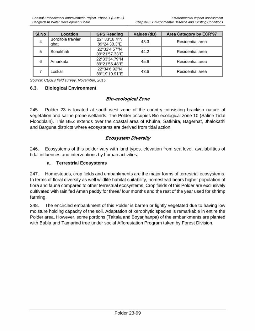
Coastal Embankment Improvement Project, Phase-1 (CEIP.1)
Bangladesh Water Development Board
Environmental Impact Assessment
Chapter-6: Environmental Baseline and Existing Conditions
Polder 23-99
Sl.No Location GPS Reading Values (dB) Area Category by ECR’97
4 Boroitola trawler ghat
22° 33'18.4"N 89°24'38.3"E
43.3 Residential area
5 Sonakhali 22°32'4.57"N 89°21'57.33"E
44.2 Residential area
6 Amurkata 22°33'34.79"N 89°21'56.48"E
45.6 Residential area
7 Loskar 22°34'6.92"N 89°19'10.91"E
43.6 Residential area
Source: CEGIS field survey, November, 2015
6.3. Biological Environment
Bio-ecological Zone
245. Polder 23 is located at south-west zone of the country consisting brackish nature of
vegetation and saline prone wetlands. The Polder occupies Bio-ecological zone 10 (Saline Tidal
Floodplain). This BEZ extends over the coastal area of Khulna, Satkhira, Bagerhat, Jhalokathi
and Barguna districts where ecosystems are derived from tidal action.
Ecosystem Diversity
246. Ecosystems of this polder vary with land types, elevation from sea level, availabilities of
tidal influences and interventions by human activities.
a. Terrestrial Ecosystems
247. Homesteads, crop fields and embankments are the major forms of terrestrial ecosystems.
In terms of floral diversity as well wildlife habitat suitability, homestead bears higher population of
flora and fauna compared to other terrestrial ecosystems. Crop fields of this Polder are exclusively
cultivated with rain fed Aman paddy for three/ four months and the rest of the year used for shrimp
farming.
248. The encircled embankment of this Polder is barren or lightly vegetated due to having low
moisture holding capacity of the soil. Adaptation of xerophytic species is remarkable in entire the
Polder area. However, some portions (Taltala and Boyarjhanpa) of the embankments are planted
with Babla and Tamarind tree under social Afforestation Program taken by Forest Division.
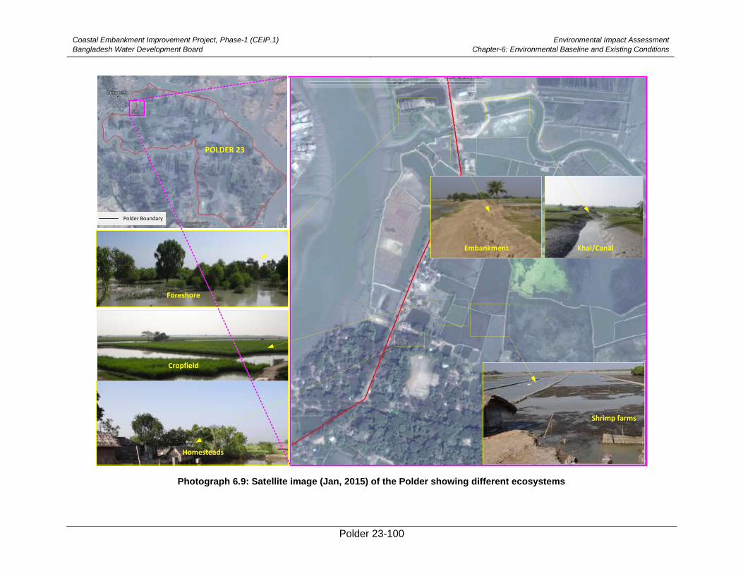
Coastal Embankment Improvement Project, Phase-1 (CEIP.1)
Bangladesh Water Development Board
Environmental Impact Assessment
Chapter-6: Environmental Baseline and Existing Conditions
Polder 23-100
Photograph 6.9: Satellite image (Jan, 2015) of the Polder showing different ecosystems
POLDER 23
Foreshore
Cropfield
Khal/CanalEmbankment
Homesteads
Polder Boundary
Shrimp farms
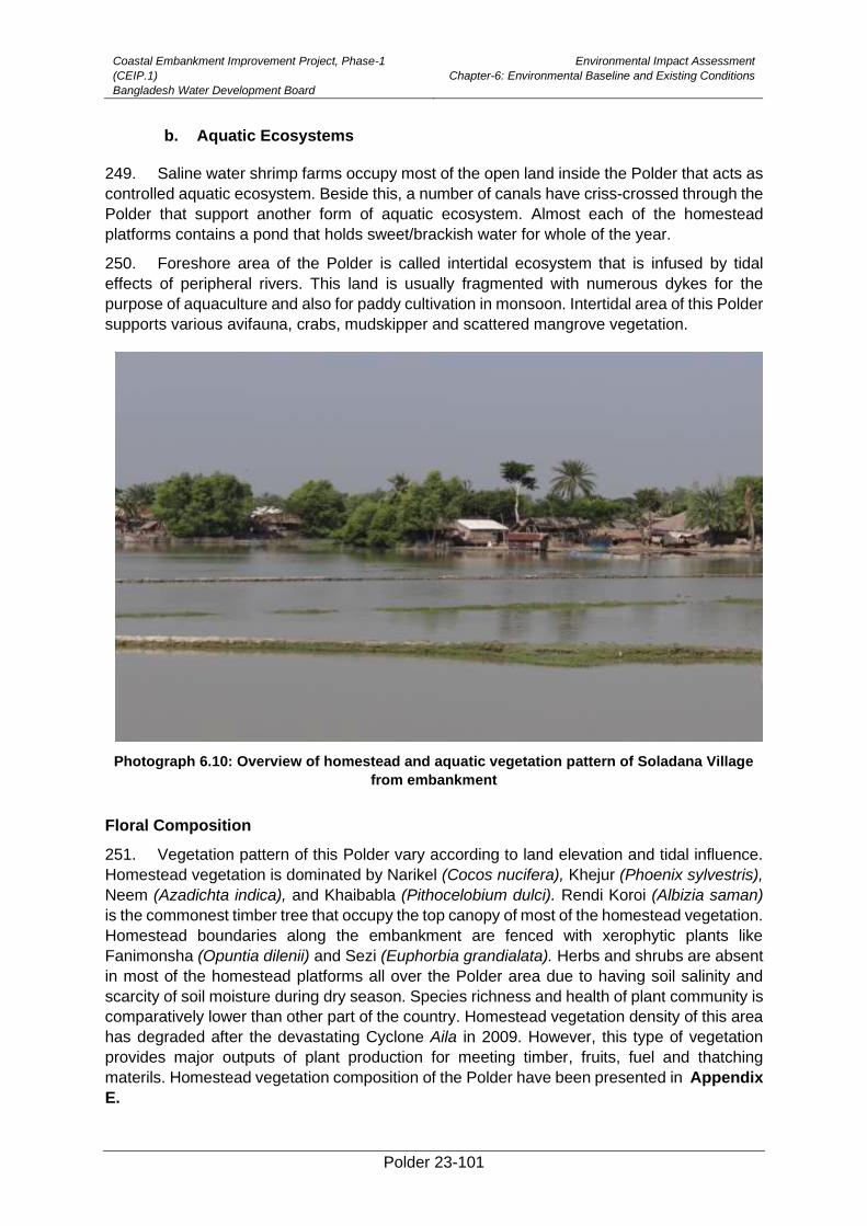
Coastal Embankment Improvement Project, Phase-1
(CEIP.1)
Bangladesh Water Development Board
Environmental Impact Assessment
Chapter-6: Environmental Baseline and Existing Conditions
Polder 23-101
b. Aquatic Ecosystems
249. Saline water shrimp farms occupy most of the open land inside the Polder that acts as
controlled aquatic ecosystem. Beside this, a number of canals have criss-crossed through the
Polder that support another form of aquatic ecosystem. Almost each of the homestead
platforms contains a pond that holds sweet/brackish water for whole of the year.
250. Foreshore area of the Polder is called intertidal ecosystem that is infused by tidal
effects of peripheral rivers. This land is usually fragmented with numerous dykes for the
purpose of aquaculture and also for paddy cultivation in monsoon. Intertidal area of this Polder
supports various avifauna, crabs, mudskipper and scattered mangrove vegetation.
Photograph 6.10: Overview of homestead and aquatic vegetation pattern of Soladana Village
from embankment
Floral Composition
251. Vegetation pattern of this Polder vary according to land elevation and tidal influence.
Homestead vegetation is dominated by Narikel (Cocos nucifera), Khejur (Phoenix sylvestris),
Neem (Azadichta indica), and Khaibabla (Pithocelobium dulci). Rendi Koroi (Albizia saman)
is the commonest timber tree that occupy the top canopy of most of the homestead vegetation.
Homestead boundaries along the embankment are fenced with xerophytic plants like
Fanimonsha (Opuntia dilenii) and Sezi (Euphorbia grandialata). Herbs and shrubs are absent
in most of the homestead platforms all over the Polder area due to having soil salinity and
scarcity of soil moisture during dry season. Species richness and health of plant community is
comparatively lower than other part of the country. Homestead vegetation density of this area
has degraded after the devastating Cyclone Aila in 2009. However, this type of vegetation
provides major outputs of plant production for meeting timber, fruits, fuel and thatching
materils. Homestead vegetation composition of the Polder have been presented in Appendix
E.
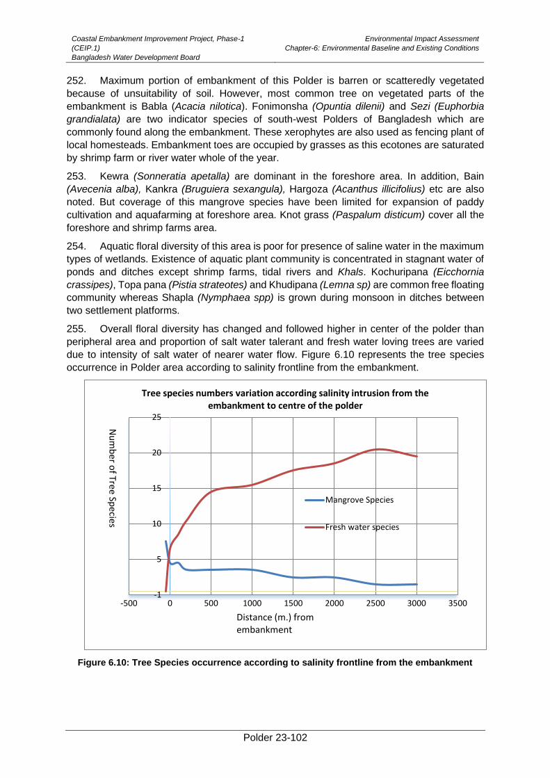
Coastal Embankment Improvement Project, Phase-1
(CEIP.1)
Bangladesh Water Development Board
Environmental Impact Assessment
Chapter-6: Environmental Baseline and Existing Conditions
Polder 23-102
252. Maximum portion of embankment of this Polder is barren or scatteredly vegetated
because of unsuitability of soil. However, most common tree on vegetated parts of the
embankment is Babla (Acacia nilotica). Fonimonsha (Opuntia dilenii) and Sezi (Euphorbia
grandialata) are two indicator species of south-west Polders of Bangladesh which are
commonly found along the embankment. These xerophytes are also used as fencing plant of
local homesteads. Embankment toes are occupied by grasses as this ecotones are saturated
by shrimp farm or river water whole of the year.
253. Kewra (Sonneratia apetalla) are dominant in the foreshore area. In addition, Bain
(Avecenia alba), Kankra (Bruguiera sexangula), Hargoza (Acanthus illicifolius) etc are also
noted. But coverage of this mangrove species have been limited for expansion of paddy
cultivation and aquafarming at foreshore area. Knot grass (Paspalum disticum) cover all the
foreshore and shrimp farms area.
254. Aquatic floral diversity of this area is poor for presence of saline water in the maximum
types of wetlands. Existence of aquatic plant community is concentrated in stagnant water of
ponds and ditches except shrimp farms, tidal rivers and Khals. Kochuripana (Eicchornia
crassipes), Topa pana (Pistia strateotes) and Khudipana (Lemna sp) are common free floating
community whereas Shapla (Nymphaea spp) is grown during monsoon in ditches between
two settlement platforms.
255. Overall floral diversity has changed and followed higher in center of the polder than
peripheral area and proportion of salt water talerant and fresh water loving trees are varied
due to intensity of salt water of nearer water flow. Figure 6.10 represents the tree species
occurrence in Polder area according to salinity frontline from the embankment.
Figure 6.10: Tree Species occurrence according to salinity frontline from the embankment
-1
5
10
15
20
25
-500 0 500 1000 1500 2000 2500 3000 3500
Tree species numbers variation according salinity intrusion from the embankment to centre of the polder
Mangrove Species
Fresh water species
Nu
mb
er of Tree
Species
Distance (m.) from embankment
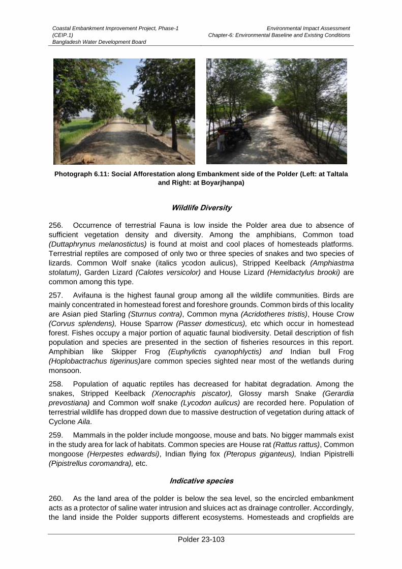
Coastal Embankment Improvement Project, Phase-1
(CEIP.1)
Bangladesh Water Development Board
Environmental Impact Assessment
Chapter-6: Environmental Baseline and Existing Conditions
Polder 23-103
Photograph 6.11: Social Afforestation along Embankment side of the Polder (Left: at Taltala
and Right: at Boyarjhanpa)
Wildlife Diversity
256. Occurrence of terrestrial Fauna is low inside the Polder area due to absence of
sufficient vegetation density and diversity. Among the amphibians, Common toad
(Duttaphrynus melanostictus) is found at moist and cool places of homesteads platforms.
Terrestrial reptiles are composed of only two or three species of snakes and two species of
lizards. Common Wolf snake (italics ycodon aulicus), Stripped Keelback (Amphiastma
stolatum), Garden Lizard (Calotes versicolor) and House Lizard (Hemidactylus brooki) are
common among this type.
257. Avifauna is the highest faunal group among all the wildlife communities. Birds are
mainly concentrated in homestead forest and foreshore grounds. Common birds of this locality
are Asian pied Starling (Sturnus contra), Common myna (Acridotheres tristis), House Crow
(Corvus splendens), House Sparrow (Passer domesticus), etc which occur in homestead
forest. Fishes occupy a major portion of aquatic faunal biodiversity. Detail description of fish
population and species are presented in the section of fisheries resources in this report.
Amphibian like Skipper Frog (Euphylictis cyanophlyctis) and Indian bull Frog
(Hoplobactrachus tigerinus)are common species sighted near most of the wetlands during
monsoon.
258. Population of aquatic reptiles has decreased for habitat degradation. Among the
snakes, Stripped Keelback (Xenocraphis piscator), Glossy marsh Snake (Gerardia
prevostiana) and Common wolf snake (Lycodon aulicus) are recorded here. Population of
terrestrial wildlife has dropped down due to massive destruction of vegetation during attack of
Cyclone Aila.
259. Mammals in the polder include mongoose, mouse and bats. No bigger mammals exist
in the study area for lack of habitats. Common species are House rat (Rattus rattus), Common
mongoose (Herpestes edwardsi), Indian flying fox (Pteropus giganteus), Indian Pipistrelli
(Pipistrellus coromandra), etc.
Indicative species
260. As the land area of the polder is below the sea level, so the encircled embankment
acts as a protector of saline water intrusion and sluices act as drainage controller. Accordingly,
the land inside the Polder supports different ecosystems. Homesteads and cropfields are
Coastal Embankment Improvement Project, Phase-1
(CEIP.1)
Bangladesh Water Development Board
Environmental Impact Assessment
Chapter-6: Environmental Baseline and Existing Conditions
Polder 23-104
dominated with fresh water loving plant species whereas khal banks and river foreshore are
dominated with saline water loving /mangrove plant species. Kewra (Sonneratia appetala) and
Gewa (Excoecaria agallocha) are the indicator species of this polder those indicate saline
water intrusion through Khals/canals inside the polder. Though maximum open land of the
polder are occupied by saline water shrimp farming (ghers) and tidal water allow all the
seasons inside the polder for flashing of ghers, so succession of saline tolerant species are
usually found at all the canal banks and even some of the gher dykes at south-eastern portion.
Fresh water shell (bivalve) is another indicator species of this area found in most of the pond
of this polder. This species have disappeared from ponds of this area due to tidal flood during
Cyclone Aila. Non-functionality of water control structures is also a cause for saline water
intrusion that negatively impact homestead vegetation.
Fish Habitat
261. Fish habitats of the polder area are primarily classified under two broad categories,
such as capture and culture fishery. Capture fisheries habitat include mainly internal Khals
(Map 5.9). A number of Khals include Sonakhali khal, Hatuakhari khal, Boroitola khal,
Sonakhali khal, Loskor khal, Parishanari khal, Orabunia khal, Taltola khal, etc. have criss-
crossedin the Polder area. Most of the Khalsare encroached bygher owner and controlled by
own constructed inlet. Therefore, capture fisheries in the Polder contribute negligible to local
fish production. The culture fishery of the Polder area is dominated by Bagda gher. The
contribution of cultured pond in the Polder area is reported as very low.
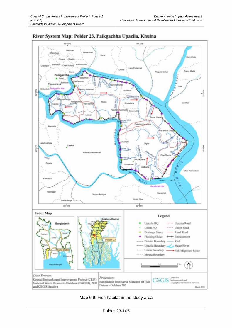
Coastal Embankment Improvement Project, Phase-1
(CEIP.1)
Bangladesh Water Development Board
Environmental Impact Assessment
Chapter-6: Environmental Baseline and Existing Conditions
Polder 23-105
Map 6.9: Fish habitat in the study area
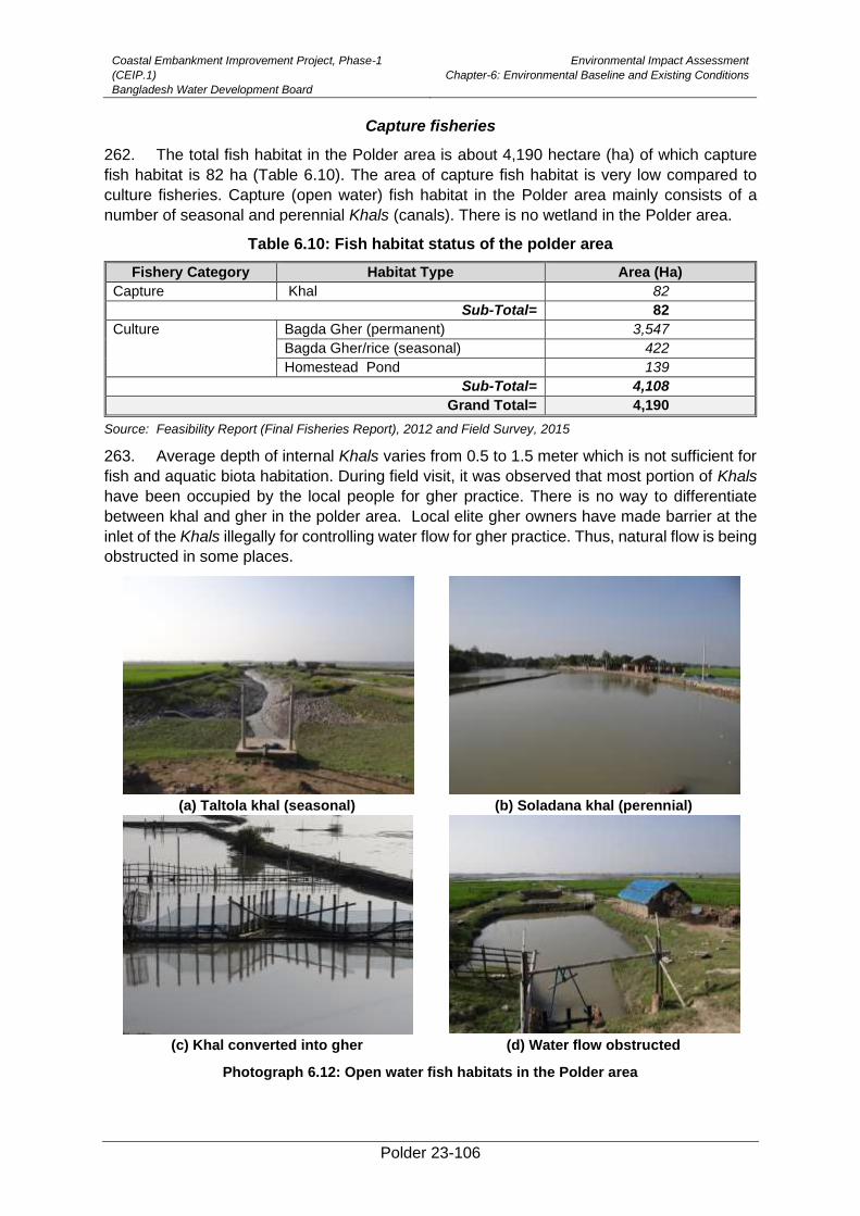
Coastal Embankment Improvement Project, Phase-1
(CEIP.1)
Bangladesh Water Development Board
Environmental Impact Assessment
Chapter-6: Environmental Baseline and Existing Conditions
Polder 23-106
Capture fisheries
262. The total fish habitat in the Polder area is about 4,190 hectare (ha) of which capture
fish habitat is 82 ha (Table 6.10). The area of capture fish habitat is very low compared to
culture fisheries. Capture (open water) fish habitat in the Polder area mainly consists of a
number of seasonal and perennial Khals (canals). There is no wetland in the Polder area.
Table 6.10: Fish habitat status of the polder area
Fishery Category Habitat Type Area (Ha)
Capture Khal 82
Sub-Total= 82
Culture Bagda Gher (permanent) 3,547
Bagda Gher/rice (seasonal) 422
Homestead Pond 139
Sub-Total= 4,108
Grand Total= 4,190
Source: Feasibility Report (Final Fisheries Report), 2012 and Field Survey, 2015
263. Average depth of internal Khals varies from 0.5 to 1.5 meter which is not sufficient for
fish and aquatic biota habitation. During field visit, it was observed that most portion of Khals
have been occupied by the local people for gher practice. There is no way to differentiate
between khal and gher in the polder area. Local elite gher owners have made barrier at the
inlet of the Khals illegally for controlling water flow for gher practice. Thus, natural flow is being
obstructed in some places.
(a) Taltola khal (seasonal) (b) Soladana khal (perennial)
(c) Khal converted into gher (d) Water flow obstructed
Photograph 6.12: Open water fish habitats in the Polder area
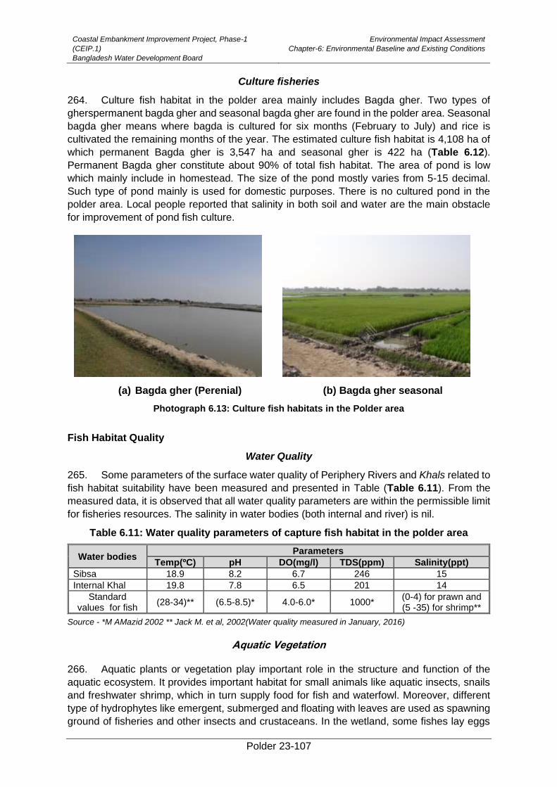
Coastal Embankment Improvement Project, Phase-1
(CEIP.1)
Bangladesh Water Development Board
Environmental Impact Assessment
Chapter-6: Environmental Baseline and Existing Conditions
Polder 23-107
Culture fisheries
264. Culture fish habitat in the polder area mainly includes Bagda gher. Two types of
gherspermanent bagda gher and seasonal bagda gher are found in the polder area. Seasonal
bagda gher means where bagda is cultured for six months (February to July) and rice is
cultivated the remaining months of the year. The estimated culture fish habitat is 4,108 ha of
which permanent Bagda gher is 3,547 ha and seasonal gher is 422 ha (Table 6.12).
Permanent Bagda gher constitute about 90% of total fish habitat. The area of pond is low
which mainly include in homestead. The size of the pond mostly varies from 5-15 decimal.
Such type of pond mainly is used for domestic purposes. There is no cultured pond in the
polder area. Local people reported that salinity in both soil and water are the main obstacle
for improvement of pond fish culture.
(a) Bagda gher (Perenial) (b) Bagda gher seasonal
Photograph 6.13: Culture fish habitats in the Polder area
Fish Habitat Quality
Water Quality
265. Some parameters of the surface water quality of Periphery Rivers and Khals related to
fish habitat suitability have been measured and presented in Table (Table 6.11). From the
measured data, it is observed that all water quality parameters are within the permissible limit
for fisheries resources. The salinity in water bodies (both internal and river) is nil.
Table 6.11: Water quality parameters of capture fish habitat in the polder area
Water bodies Parameters
Temp(ºC) pH DO(mg/l) TDS(ppm) Salinity(ppt)
Sibsa 18.9 8.2 6.7 246 15
Internal Khal 19.8 7.8 6.5 201 14
Standard values for fish
(28-34)** (6.5-8.5)* 4.0-6.0* 1000* (0-4) for prawn and (5 -35) for shrimp**
Source - *M AMazid 2002 ** Jack M. et al, 2002(Water quality measured in January, 2016)
Aquatic Vegetation
266. Aquatic plants or vegetation play important role in the structure and function of the
aquatic ecosystem. It provides important habitat for small animals like aquatic insects, snails
and freshwater shrimp, which in turn supply food for fish and waterfowl. Moreover, different
type of hydrophytes like emergent, submerged and floating with leaves are used as spawning
ground of fisheries and other insects and crustaceans. In the wetland, some fishes lay eggs
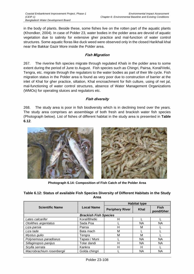
Coastal Embankment Improvement Project, Phase-1
(CEIP.1)
Bangladesh Water Development Board
Environmental Impact Assessment
Chapter-6: Environmental Baseline and Existing Conditions
Polder 23-108
in the body of plants. Beside these, some fishes live on the rotten part of the aquatic plants
(Khondker, 2004). In case of Polder 23, water bodies in the polder area are devoid of aquatic
vegetation due to salinity for extensive gher practice and mal-function of water control
structures. Some aquatic floras like duck weed were observed only in the closed Harikhali khal
near the Bakkar Gazir More inside the Polder area.
Fish Migration
267. The riverine fish species migrate through regulated Khals in the polder area to some
extent during the period of June to August. Fish species such as Chingri, Pairsa, Koral/Vetki,
Tengra, etc. migrate through the regulators to the water bodies as part of their life cycle. Fish
migration status in the Polder area is found as very poor due to construction of barrier at the
inlet of Khal for gher practice, siltation, Khal encroachment for fish culture, using of net jal,
mal-functioning of water control structures, absence of Water Management Organizations
(WMOs) for operating sluices and regulators etc.
Fish diversity
268. The study area is poor in fish biodiversity which is in declining trend over the years.
The study area comprises an assemblage of both fresh and brackish water fish species
(Photograph below). List of fishes of different habitat in the study area is presented in Table
6.12.
Photograph 6.14: Composition of Fish Catch of the Polder Area
Table 6.12: Status of available Fish Species Diversity of Different Habitats in the Study Area
Scientific Name Local Name
Habitat type
Periphery River Khal Fish
pond/Gher
Brackish Fish Species
Lates calcarifer Koral/Bhetki H L L
Otolithes argentatus Sada Poa L NA NA
Liza parsia Pairsa H M L
Liza tade Bata mach M L L
Mystus gulio Tengra M M L
Polynemous paradiseus Tapasi / Muni L NA NA
Sillaginopsis panijus Tolar dandi H NA NA
Scylla serrata Kankra H H L
Macrobrachium rosenbergii Golda chingri L NA NA
Coastal Embankment Improvement Project, Phase-1
(CEIP.1)
Bangladesh Water Development Board
Environmental Impact Assessment
Chapter-6: Environmental Baseline and Existing Conditions
Polder 23-109
Scientific Name Local Name
Habitat type
Periphery River Khal Fish
pond/Gher
Metapenaeus monoceros Horina chingri H L NA
Penaeus monodon Bagda chingri M L H
Fresh Water Fish Species
Channa punctatus Taki NA L* NA
Channa orientalis Cheng taki NA L* NA
Channa striatus Shol NA L* NA
Heteropneustes fossilis Shing NA L* NA
Puntius puntio Puti NA L* NA
Clarius batrachus Magur NA L* NA
Mystus vittatus Tengra M L* NA
Macrognathus pancalus Chirka baim M NA NA
Macrognathus aral Tara baim M NA NA
Lepidocephalus guntea Gutum L NA NA
Wallago attu Boal L NA NA
Glossogobius giuris Baila M L L
Eutropiichthyes vacha Bacha M L NA
Culture Fish Species
Telapia nilotica Telapia NA NA H
Hypophthalmichthys molitrix Silver Carp NA NA M
Puntius gonionotus Thai Sharputi NA NA M
Hypophthalmicthys molitrix Silver carp NA NA L
Catla catla Catla NA NA L
Labeo rohita Rui NA NA L
Source: Field Survey, 2015;
Note: Abundance Code: H= High; M= Medium; L= Low; NA= Not available; L* = fishes are found only in the
Harinkhali Khal (Closure)
269. Brackish water fish species like Chingri, Vetki, Pairsa, Khorkona are available in both
gher and Khals in the Polder area. Freshwater fish species arerare to extinct in the polder
area. Local people reported that the freshwater fishes disappeared due to saltwater intrusion
for extensive gher practice and obstruction of fish migration route by the gher owner.
Freshwater fishes like Taki, Shol, Cheng, Puti, Koi, Shing, Puti, etc are found only in the
Harinkhali closure khal in the Polder area but their abundance and contribution to fish
production is negligible. Local people informed that aforementioned fresh water fish species
were commonly found in the agriculture field and internal Khals in the past. The dominant
cultured fish species include Tilapia, Silver carp, Pangus. Moreover, Carp fish species like
Rui, Catla, Mrigel are also cultured in some homestead pond but their growth is very low
compared to other parts of the country because of salinity in pond water.
Indicative Fish Species
270. Among the fish species found in the study area mentioned above, the major indicative
and migratory fish species are Kaine Magur (Plotosus canius), near threatened in IUCN,
Bangladesh; Bhetki (Lates calcarifer), not evalusted; Parshe (Liza Parsia), not evaluated and
Guli Tengra (Mystus gulio), near threatened. These species are generally live in the brackish
to saline water but during the spawning season they come to brackish to freshwater
environment. The spawning season of Lates calcarifer, Plotosus canius and Mystus gulio
range from March to August whereas Liza parsia breeds from November to February (Figure
6.9). Usually these fishes enter into the Polder with the tide in drifting mode of migration during
the life stages of hatchling to fry. These fishes use the Ghers of the Polder as grow up habitat
in a culture mode. In addition to this phenomenon, the larger sized fish those cannot withstand
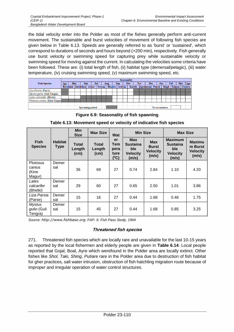
Coastal Embankment Improvement Project, Phase-1
(CEIP.1)
Bangladesh Water Development Board
Environmental Impact Assessment
Chapter-6: Environmental Baseline and Existing Conditions
Polder 23-110
the tidal velocity enter into the Polder as most of the fishes generally perform anti-current
movement. The sustainable and burst velocities of movement of following fish species are
given below in Table 6.13. Speeds are generally referred to as 'burst' or 'sustained', which
correspond to durations of seconds and hours beyond (>200 min), respectively. Fish generally
use burst velocity or swimming speed for capturing prey while sustainable velocity or
swimming speed for moving against the current. In calculating the velocities some criteria have
been followed. These are: (i) total length of fish, (ii) habitat type (demersal/pelagic), (iii) water
temperature, (iv) cruising swimming speed, (v) maximum swimming speed, etc.
Figure 6.9: Seasonality of fish spawning
Table 6.13: Movement speed or velocity of indicative fish species
Fish Species
HabitatType
Min Size
Max Size
Water
Temperature (0C)
Min Size Max Size
Total Length
(cm)
Total Length
(cm)
Max Sustaina
ble Velocity
(m/s)
Max Burst
Velocity (m/s)
Maximum Sustaina
ble Velocity
(m/s)
Maximum Burst Velocity
(m/s)
Plotosus canius (Kine Magur)
Demersal
36 69 27 0.74 2.84 1.10 4.20
Lates calcarifer (Bhetki)
Demersal 29 60 27 0.65 2.50 1.01 3.86
Liza Parsia (Parse)
Demersal
15 16 27 0.44 1.68 0.46 1.75
Mystus gulio (Guli Tengra)
Demersal 15 45 27 0.44 1.68 0.85 3.25
Source: http://www.fishbase.org; FAP- 6: Fish Pass Study, 1994
Threatened fish species
271. Threatened fish species which are locally rare and unavailable for the last 10-15 years
as reported by the local fishermen and elderly people are given in Table 6.14. Local people
reported that Gojal, Boal, Ayre which werefound in the Polder area are locally extinct. Other
fishes like Shol, Taki, Shing, Putiare rare in the Polder area due to destruction of fish habitat
for gher practices, salt water intrusion, obstruction of fish hatchling migration route because of
improper and irregular operation of water control structures.
Coastal Embankment Improvement Project, Phase-1
(CEIP.1)
Bangladesh Water Development Board
Environmental Impact Assessment
Chapter-6: Environmental Baseline and Existing Conditions
Polder 23-111
Table 6.14: List of Threatened Fish Species
Scientific Name Local Name Local Status
Rare Unavailable Locally Extinct
Channa punctatus Taki √
Channa orientalis Cheng taki √
Channa striatus Shol √
Heteropneustes fossilis Shing √
Puntius puntio Puti √
Clarius batrachus Magur √
Plotosus canius Gang Magur √
Mystus vittatus Tengra √
Channa marulius Gojal √
Wallago attu italies Boal √
Aorichthyes aor Ayre √
Nandus nandus italies Meni √
Source: Field Survey, 2015
6.4. Human and Economic Development
Fish Production
272. The estimated total fish production of the polder area is 3,990 Metric tons (MT) (Table
6.15). Large amount of fish production about 91% is coming from bagda gher followed by
homestead pond and khal. Fish production trend of the capture fishery in the Polder area is
decreasing due to siltation and low water flow in the internal khal, obstruction of fish migration,
improper and mal-function of water control structures, encroachment of Khals for gher
practices, etc.
Table 6.15: Fish Production from Different Habitats of the Polder Area
Fishery Category Habitat type Habitat Area (Ha) Production (MT)
Capture Khal 82 5
Sub-Total= 82 5
Culture
Bagda Gher (Permanent ) 3,547 3,902
Bagda Gher (Seasonal) 422 253
Homestead Pond 314 83
Sub-Total= 4,283 3,985
Grand Total= 4,365 3,990
Source: Draft Final of Fisheries Report (from main consultant), FRSS and CEGIS field survey 2015
Fishing Effort
Fisher number
273. The fishers’ households in the Polder include commercial and subsistence fishers.
Among them, 50% households are engaged as professional/commercial fishers and they
spend almost 12-16 hours of a day during 8-10 months of a year in fishing activities. Remaining
50% of households are subsistence level fishers. According to field visit, it is reported that
50% fishers are Muslim and 50% are Hindu. There is no specific “Fishers village” in the polder
area. Most of the fishers are living along the periphery of the Polder. The socio-economic
condition of the commercial fisher is poor. They have no fishing net and trawlers/boats. They
are dependent on fish traders (local elite) who provide fish trawlers and nets. The seasonal
vulnerability of the fishers starts from the late January and continue up to April. During this
period, fish catch is hardly recorded due to cool water as well as depression of the sea. In this
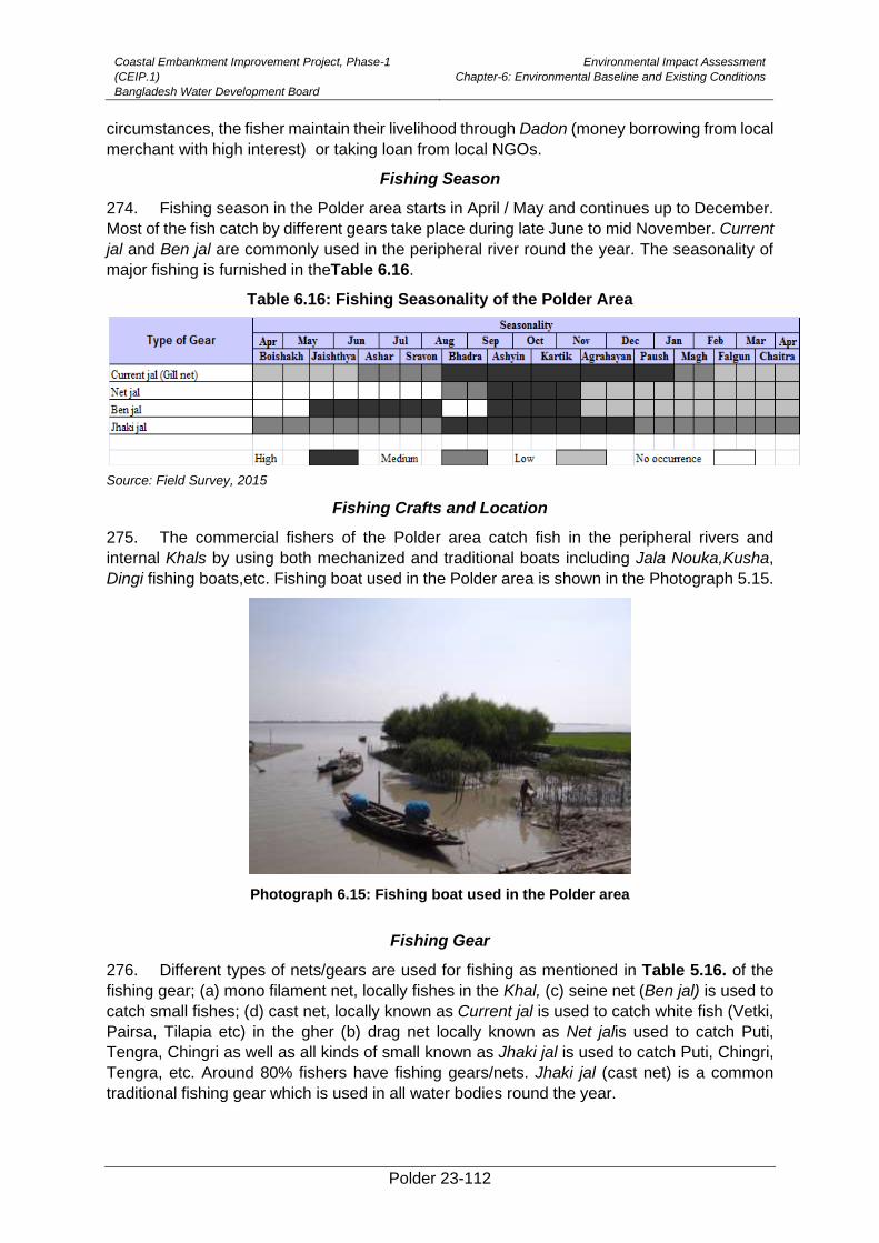
Coastal Embankment Improvement Project, Phase-1
(CEIP.1)
Bangladesh Water Development Board
Environmental Impact Assessment
Chapter-6: Environmental Baseline and Existing Conditions
Polder 23-112
circumstances, the fisher maintain their livelihood through Dadon (money borrowing from local
merchant with high interest) or taking loan from local NGOs.
Fishing Season
274. Fishing season in the Polder area starts in April / May and continues up to December.
Most of the fish catch by different gears take place during late June to mid November. Current
jal and Ben jal are commonly used in the peripheral river round the year. The seasonality of
major fishing is furnished in theTable 6.16.
Table 6.16: Fishing Seasonality of the Polder Area
Source: Field Survey, 2015
Fishing Crafts and Location
275. The commercial fishers of the Polder area catch fish in the peripheral rivers and
internal Khals by using both mechanized and traditional boats including Jala Nouka,Kusha,
Dingi fishing boats,etc. Fishing boat used in the Polder area is shown in the Photograph 5.15.
Photograph 6.15: Fishing boat used in the Polder area
Fishing Gear
276. Different types of nets/gears are used for fishing as mentioned in Table 5.16. of the
fishing gear; (a) mono filament net, locally fishes in the Khal, (c) seine net (Ben jal) is used to
catch small fishes; (d) cast net, locally known as Current jal is used to catch white fish (Vetki,
Pairsa, Tilapia etc) in the gher (b) drag net locally known as Net jalis used to catch Puti,
Tengra, Chingri as well as all kinds of small known as Jhaki jal is used to catch Puti, Chingri,
Tengra, etc. Around 80% fishers have fishing gears/nets. Jhaki jal (cast net) is a common
traditional fishing gear which is used in all water bodies round the year.
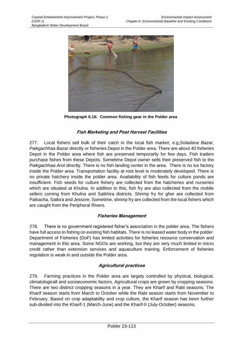
Coastal Embankment Improvement Project, Phase-1
(CEIP.1)
Bangladesh Water Development Board
Environmental Impact Assessment
Chapter-6: Environmental Baseline and Existing Conditions
Polder 23-113
Photograph 6.16: Common fishing gear in the Polder area
Fish Marketing and Post Harvest Facilities
277. Local fishers sell bulk of their catch in the local fish market, e.g,Soladana Bazar,
Paikgachhaa Bazar directly or fisheries Depot in the Polder area. There are about 40 fisheries
Depot in the Polder area where fish are preserved temporarily for few days. Fish traders
purchase fishes from these Depots. Sometime Depot owner sells their preserved fish to the
Paikgachhaa Arot directly. There is no fish landing center in the area. There is no ice factory
inside the Polder area. Transportation facility at root level is moderately developed. There is
no private hatchery inside the polder area. Availability of fish feeds for culture ponds are
insufficient. Fish seeds for culture fishery are collected from the hatcheries and nurseries
which are situated at Khulna. In addition to this, fish fry are also collected from the mobile
sellers coming from Khulna and Satkhira districts. Shrimp fry for gher are collected from
Paikacha, Satkira and Jessore. Sometime, shrimp fry are collected from the local fishers which
are caught from the Peripheral Rivers.
Fisheries Management
278. There is no government registered fisher’s association in the polder area. The fishers
have full access to fishing on existing fish habitats. There is no leased water body in the polder.
Department of Fisheries (DoF) has limited activities for fisheries resource conservation and
management in this area. Some NGOs are working, but they are very much limited in micro
credit rather than extension services and aquaculture training. Enforcement of fisheries
regulation is weak in and outside the Polder area.
Agricultural practices
279. Farming practices in the Polder area are largely controlled by physical, biological,
climatologicall and socioeconomic factors. Agricultural crops are grown by cropping seasons.
There are two distinct cropping seasons in a year. They are Kharif and Rabi seasons. The
Kharif season starts from March to October while the Rabi season starts from November to
February. Based on crop adaptability and crop culture, the Kharif season has been further
sub-divided into the Kharif-1 (March-June) and the Kharif-II (July-October) seasons.
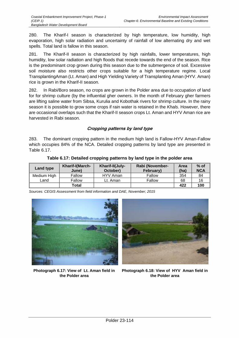
Coastal Embankment Improvement Project, Phase-1
(CEIP.1)
Bangladesh Water Development Board
Environmental Impact Assessment
Chapter-6: Environmental Baseline and Existing Conditions
Polder 23-114
280. The Kharif-I season is characterized by high temperature, low humidity, high
evaporation, high solar radiation and uncertainty of rainfall of low alternating dry and wet
spells. Total land is fallow in this season.
281. The Kharif-II season is characterized by high rainfalls, lower temperatures, high
humidity, low solar radiation and high floods that recede towards the end of the season. Rice
is the predominant crop grown during this season due to the submergence of soil. Excessive
soil moisture also restricts other crops suitable for a high temperature regime. Local
TransplantingAman (Lt. Aman) and High Yielding Variety of Transplanting Aman (HYV. Aman)
rice is grown in the Kharif-II season.
282. In Rabi/Boro season, no crops are grown in the Polder area due to occupation of land
for for shrimp culture (by the influential gher owners. In the month of February gher farmers
are lifting saline water from Sibsa, Kurulia and Kobothak rivers for shrimp culture. In the rainy
season it is possible to grow some crops if rain water is retained in the Khals. However, there
are occasional overlaps such that the Kharif-II season crops Lt. Aman and HYV Aman rice are
harvested in Rabi season.
Cropping patterns by land type
283. The dominant cropping pattern in the medium high land is Fallow-HYV Aman-Fallow
which occupies 84% of the NCA. Detailed cropping patterns by land type are presented in
Table 6.17.
Table 6.17: Detailed cropping patterns by land type in the polder area
Land type Kharif-I(March-
June) Kharif-II(July-
October) Rabi (November-
February) Area (ha)
% of NCA
Medium High Land
Fallow HYV Aman Fallow 354 84
Fallow Lt. Aman Fallow 68 16 Total 422 100
Sources: CEGIS Assessment from field information and DAE, November; 2015
Photograph 6.17: View of Lt. Aman field in
the Polder area
Photograph 6.18: View of HYV Aman field in
the Polder area
Coastal Embankment Improvement Project, Phase-1
(CEIP.1)
Bangladesh Water Development Board
Environmental Impact Assessment
Chapter-6: Environmental Baseline and Existing Conditions
Polder 23-115
Cropping intensity
284. The entire cultivable area is single cropped with rice grown in the kharif-II season.
Therefore, cropping intensity of the Polder is 100%.
Cropped Area and Production
285. Total cropped area is 422 ha in Kachubunia, Soladana, Horikhali, Vatokmari and
Taltola village where they grow only Lt Aman (16%) and HYV Aman (84%) rice (Table 5.7).
286. Total crop production is 1,206 metric tons of rice. Among the rice crops the
contributions of Lt. Aman and HYV Aman are 11% and 89% respectively. Detailed are
presented in Table 6.18.
Table 6.18: Present croppedarea, yield and production of the Polder area
Crop name Crop area (ha) Yield (m. tons/ha) Production (m. tons)
Lt. Aman 68 2.01* 137
HYV Aman 354 3.02* 1,069
Total 422 1,206
Sources: CEGIS estimation based on field information and DAE, October; 2015 * Indicates cleaned rice
287. The following crops varieties are used by the farmers in the study area (Table 6.19).
Table 6.19: Varieties cultivated in the study area
Crop Varieties
Lt. Aman Patnai, Orkoch, Asfol and Moriceshail
HYV Aman BR 10 and BR 11
Sources: CEGIS field survey, November; 2015.
Crop damage
288. Crops were damaged due to various causes in Kachubonia and Taltola village of the
polder area during 2010 to 2015. About 20% field crops (Lt. Aman and HYV Aman rice) were
damaged in the year 2010 by natural calamities (heavy rainfall). HYV Amon rice was damage
due to salinity and pest infestation during 2012 to 2015. Salinity is increasing day by day asfish
farmers are allowing saline water in the Polder area Detailed causes of damage for the last
six years is presented in the Table 6.20.
Table 6.20: Crop area damaged during 2010-2015 in the polder area
Sl No. Crops Damage (%) Year Reason of damage
1 Lt. Aman 10 2015 Pests
HYV Aman 20 2015 Salinity
2 Lt. Aman 10 2014 Pests
HYV Aman 15 2014 Salinity
3 Lt. Aman 15 2013 Pests
HYV Aman 10 2013 Salinity
4 Lt. Aman 20 2012 Pests
HYV Aman 15 2012 Pests
5 Lt. Aman 15 2011 Pests
HYV Aman 10 2011 Pests
6 Lt. Aman 20 2010 Heavy rainfall(Water logging)
HYV Aman 20 2010 Heavy rainfall(Water logging)
Sources: Feasibility report (Agriculture), CEIP and field information; November 2015
Agricultural Inputs

Coastal Embankment Improvement Project, Phase-1
(CEIP.1)
Bangladesh Water Development Board
Environmental Impact Assessment
Chapter-6: Environmental Baseline and Existing Conditions
Polder 23-116
Seeds
289. The seed rate used by the farmers in the Polder area is presented in Table 5.22. In
case of rice, farmers are using more seed than recommended.Most of the cases, seedlings
are affected by monsoon flood. According to the SAAOs and farmers, two years ago, they
were compelled to re-transplant seedlings due to damage by heavy rainfall during monsoon
season. Most of the farmers used their own seeds in case of Lt. Aman and HYV Aman. There
are three seed dealers in the Polder area, where seeds are available. The dealer got training
for all input use from Upazila Argiculture Office (UAO).
Fertilizer
290. The rate of fertilizer use per hectare varies considerably from farmer to farmer
depending on soil fertility, cropping pattern and financial ability. The major fertilizers used in
the polder are Urea, TSP/ SSP/DAP, MP and Gypsum. In most cases, farmers use fertilizers
in unbalanced way. Organic manures are not used by the farmers in the field crops. Local
women, farmers and local SAAO of DAE reported that cowdung is used mainly for fuel
purpose. According to local farmers and three SAAO’s, there are fertilizer dealers in every
local market. About 25% local farmers reported that they don’t have enough money to buy all
types of fertilizers at a time. Detailed information of chemical fertilizer use by the farmers is
presented in Table 6.21.
Table 6.21: Fertilizer, pesticide and seed used within Polder 23
Crops
Seeds used /
ha (kg)
Fertilizer/ha (kg) Irrigation cost /ha
(Tk)
Pesticide (ha/Tk)
Used cultivation
equipments (%)
Cost power tiller
(Tk./ha) Urea TSP MP Gypsum Zinc
Lt. Aman
60 120 70 40 0 8 0 700-800 90 4,500
HYV Aman
45 190 120 90 0 15 0 1000-1200 90 ,4500
Sources: Field information; November 2015
Pesticides
291. The use of pesticide depends on the degree of pest infestation. According to feasibility
report, all farmers (100%) applied pesticides in all crops such as T. Aman (Local), T. Aman
(HYV). But it isobserved that all farmers are not using pesticide in rice field. In the Polder area
farmers use pesticides one or two times even more. The major insects as reported by the
farmers were Yellow stem borer, Brown Plant Hopper, Rice bug and Ear cutting cater pillar.
Local farmers reported that they were using different types of pesticides such as Kartap,
Fortunate, Amithrin, Korazan and Ultimato for preventing pest infestation in crop field.
Labor
292. In the Polder area, almost 70% of the cultural practices for crop production are being
done manually. So, agricultural labor (seed sowing, intercultural operations, and harvesting
and post harvest technologies) is considered as one of the essential inputs for crop production.
The labor requirement is not equal throughout the year. The number of labor requirement
varies from crop to crop also. The average labor used in the Polder area for Lt Aman about
150 nos./ha and for HYV Aman it is about 165 nos./ha.
Integrated Crop Management (ICM)
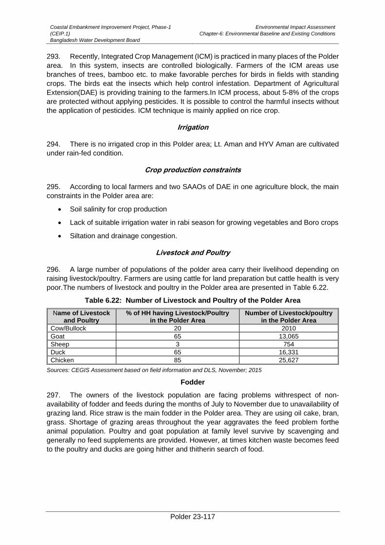
Coastal Embankment Improvement Project, Phase-1
(CEIP.1)
Bangladesh Water Development Board
Environmental Impact Assessment
Chapter-6: Environmental Baseline and Existing Conditions
Polder 23-117
293. Recently, Integrated Crop Management (ICM) is practiced in many places of the Polder
area. In this system, insects are controlled biologically. Farmers of the ICM areas use
branches of trees, bamboo etc. to make favorable perches for birds in fields with standing
crops. The birds eat the insects which help control infestation. Department of Agricultural
Extension(DAE) is providing training to the farmers.In ICM process, about 5-8% of the crops
are protected without applying pesticides. It is possible to control the harmful insects without
the application of pesticides. ICM technique is mainly applied on rice crop.
Irrigation
294. There is no irrigated crop in this Polder area; Lt. Aman and HYV Aman are cultivated
under rain-fed condition.
Crop production constraints
295. According to local farmers and two SAAOs of DAE in one agriculture block, the main
constraints in the Polder area are:
• Soil salinity for crop production
• Lack of suitable irrigation water in rabi season for growing vegetables and Boro crops
• Siltation and drainage congestion.
Livestock and Poultry
296. A large number of populations of the polder area carry their livelihood depending on
raising livestock/poultry. Farmers are using cattle for land preparation but cattle health is very
poor.The numbers of livestock and poultry in the Polder area are presented in Table 6.22.
Table 6.22: Number of Livestock and Poultry of the Polder Area
Name of Livestock and Poultry
% of HH having Livestock/Poultry in the Polder Area
Number of Livestock/poultry in the Polder Area
Cow/Bullock 20 2010
Goat 65 13,065
Sheep 3 754
Duck 65 16,331
Chicken 85 25,627
Sources: CEGIS Assessment based on field information and DLS, November; 2015
Fodder
297. The owners of the livestock population are facing problems withrespect of non-
availability of fodder and feeds during the months of July to November due to unavailability of
grazing land. Rice straw is the main fodder in the Polder area. They are using oil cake, bran,
grass. Shortage of grazing areas throughout the year aggravates the feed problem forthe
animal population. Poultry and goat population at family level survive by scavenging and
generally no feed supplements are provided. However, at times kitchen waste becomes feed
to the poultry and ducks are going hither and thitherin search of food.
Coastal Embankment Improvement Project, Phase-1
(CEIP.1)
Bangladesh Water Development Board
Environmental Impact Assessment
Chapter-6: Environmental Baseline and Existing Conditions
Polder 23-118
Photograph 6.19: View of duck in the Polder
area
Photograph 6.20: View of Goat grazing in
the Polder area
Disease
298. Productionof livestock and poultry ismainly constrained due to diseases and death of
the population. Every year livestock population is affected by different diseases like Tarka;
Anthrax, Foot and Mouth Disease (FMD), Black Quarter (BQ) and Hemorrhagic Septicemia
(HS), Diarrhoea and Pest Des Petits Ruminants (PPR). Major of the poultry diseases are duck
plague, Ranikhet (Newcastle), Fowl Pox and Fowl cholera. During monsoon season, the
soggy condition of the animal shelter promotes various kinds of diseases to the bullock and
cows. Moreover, the unhygienic condition of the courtyard during this season increases the
diseases of poultry birds. July to October (rainy season) months are periods of spreading
diseases to livestock and poultry population in large scale. There are many deaths of animal
and birds every year within in the Polder areas because of outbreaks of diseases due to poor
drainage conditions.
6.5. Socio-cultural Environment
299. The Polder 23 is situated in Paikgaccha upazila under Khulna district. The Polder area
encompasses two unions namely Sholadana and Laskar. Percentages of union boundary are
shown in Table 6.23.
Table 6.23: Upazila and unions in polder-23
Name of district Name of upazila Name of unions Percentage of union within polder
Khulna Paikgaccha Sholadana 90.3
Laskar 9.7
Source: Spatial GIS Analysis, CEGIS, 2015
Demography
300. The Polder consists a total of 5,025 households with22,128 population of which 11,086
are male and 11,042 are female. Average density of population is1,094 persons per sq. km
while the national population density is 1,015 persons per sq. km. The inhabitants of this
Polder belong to two main religious groups; i.e. the Muslim and Hindu. About 57.62% of total
populations are Muslim, 42.18% are Hindus and the rest (0.19) are Christian. Sex ratio of
thePolder area is 101 which are slightly higher than of the national level. There is no ethnic
community in the Polder. The demographic data of this Polder is presented in Table 6.24.
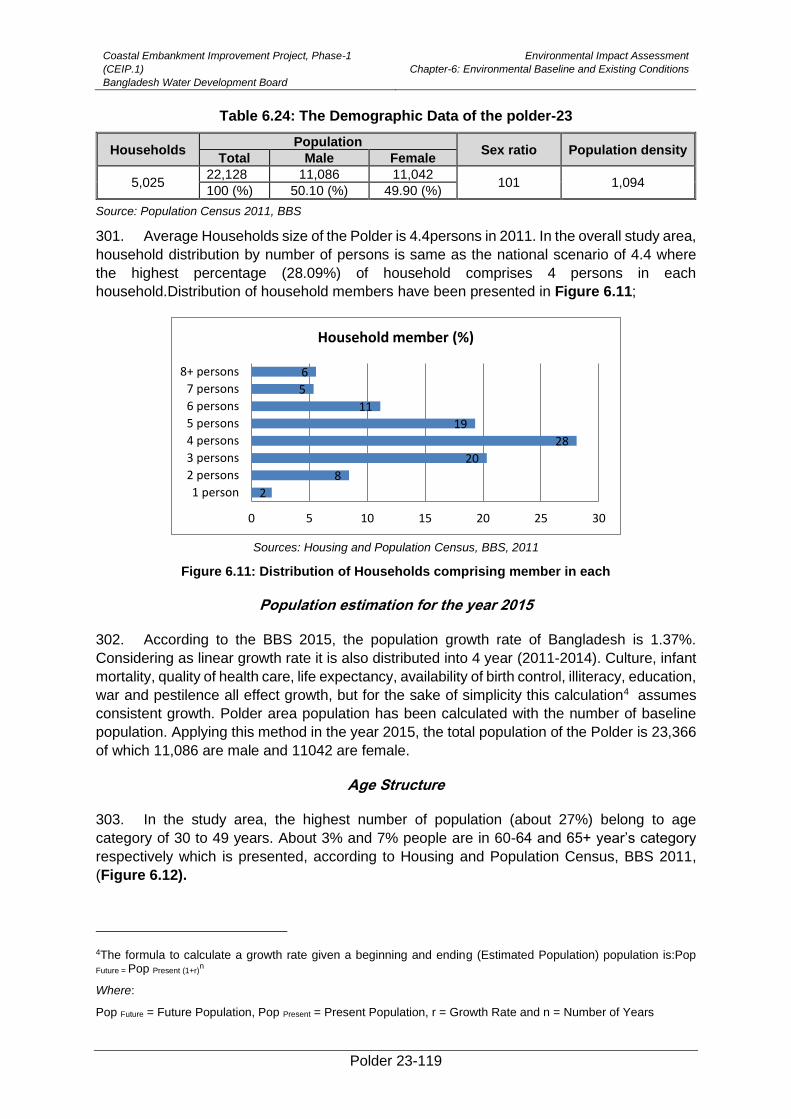
Coastal Embankment Improvement Project, Phase-1
(CEIP.1)
Bangladesh Water Development Board
Environmental Impact Assessment
Chapter-6: Environmental Baseline and Existing Conditions
Polder 23-119
Table 6.24: The Demographic Data of the polder-23
Households Population
Sex ratio Population density Total Male Female
5,025 22,128 11,086 11,042
101 1,094 100 (%) 50.10 (%) 49.90 (%)
Source: Population Census 2011, BBS
301. Average Households size of the Polder is 4.4persons in 2011. In the overall study area,
household distribution by number of persons is same as the national scenario of 4.4 where
the highest percentage (28.09%) of household comprises 4 persons in each
household.Distribution of household members have been presented in Figure 6.11;
Sources: Housing and Population Census, BBS, 2011
Figure 6.11: Distribution of Households comprising member in each
Population estimation for the year 2015
302. According to the BBS 2015, the population growth rate of Bangladesh is 1.37%.
Considering as linear growth rate it is also distributed into 4 year (2011-2014). Culture, infant
mortality, quality of health care, life expectancy, availability of birth control, illiteracy, education,
war and pestilence all effect growth, but for the sake of simplicity this calculation4 assumes
consistent growth. Polder area population has been calculated with the number of baseline
population. Applying this method in the year 2015, the total population of the Polder is 23,366
of which 11,086 are male and 11042 are female.
Age Structure
303. In the study area, the highest number of population (about 27%) belong to age
category of 30 to 49 years. About 3% and 7% people are in 60-64 and 65+ year’s category
respectively which is presented, according to Housing and Population Census, BBS 2011,
(Figure 6.12).
4The formula to calculate a growth rate given a beginning and ending (Estimated Population) population is:Pop
Future = Pop Present (1+r)n
Where:
Pop Future = Future Population, Pop Present = Present Population, r = Growth Rate and n = Number of Years
2
8
20
28
19
11
5
6
0 5 10 15 20 25 30
1 person
2 persons
3 persons
4 persons
5 persons
6 persons
7 persons
8+ persons
Household member (%)
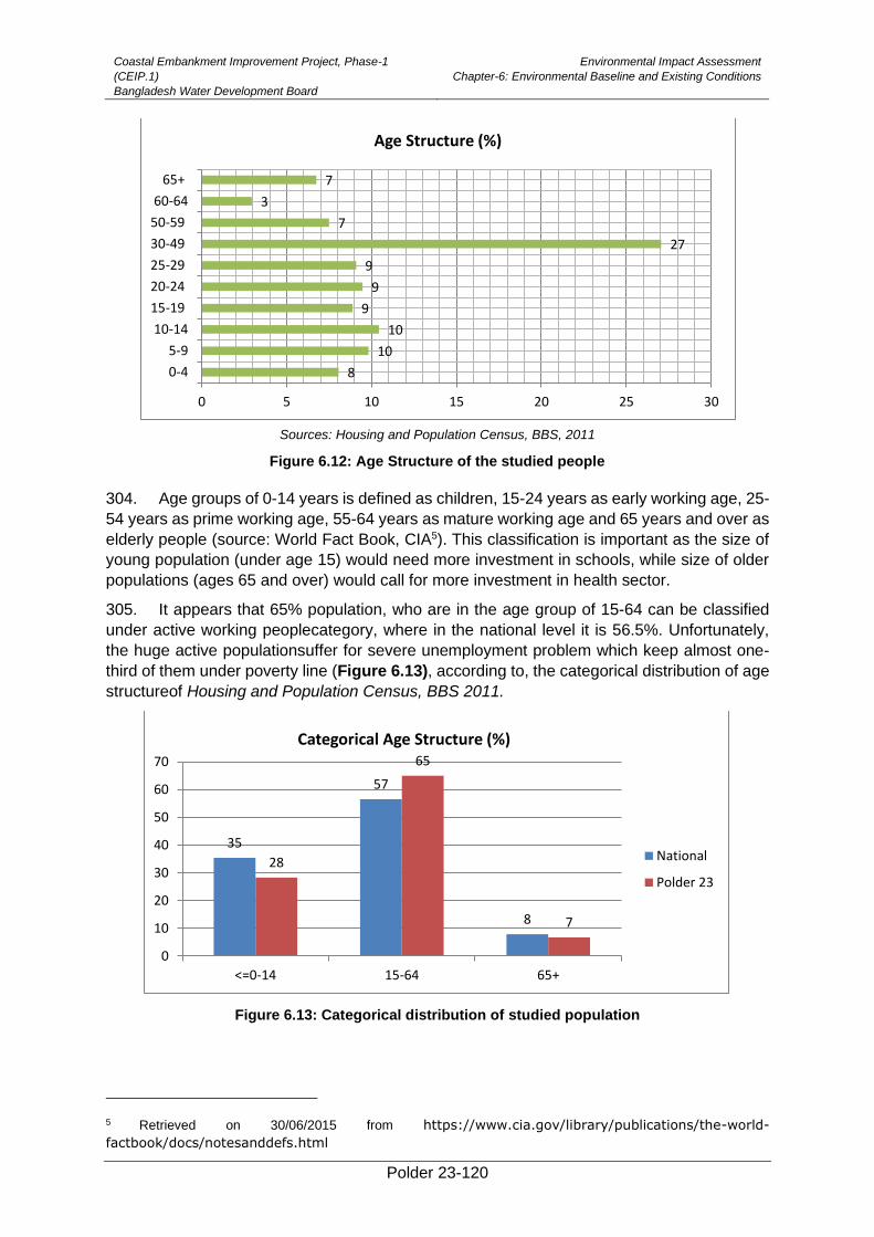
Coastal Embankment Improvement Project, Phase-1
(CEIP.1)
Bangladesh Water Development Board
Environmental Impact Assessment
Chapter-6: Environmental Baseline and Existing Conditions
Polder 23-120
Sources: Housing and Population Census, BBS, 2011
Figure 6.12: Age Structure of the studied people
304. Age groups of 0-14 years is defined as children, 15-24 years as early working age, 25-
54 years as prime working age, 55-64 years as mature working age and 65 years and over as
elderly people (source: World Fact Book, CIA5). This classification is important as the size of
young population (under age 15) would need more investment in schools, while size of older
populations (ages 65 and over) would call for more investment in health sector.
305. It appears that 65% population, who are in the age group of 15-64 can be classified
under active working peoplecategory, where in the national level it is 56.5%. Unfortunately,
the huge active populationsuffer for severe unemployment problem which keep almost one-
third of them under poverty line (Figure 6.13), according to, the categorical distribution of age
structureof Housing and Population Census, BBS 2011.
Figure 6.13: Categorical distribution of studied population
5 Retrieved on 30/06/2015 from https://www.cia.gov/library/publications/the-world-
factbook/docs/notesanddefs.html
8
10
10
9
9
9
27
7
3
7
0 5 10 15 20 25 30
0-4
5-9
10-14
15-19
20-24
25-29
30-49
50-59
60-64
65+
Age Structure (%)
35
57
8
28
65
7
0
10
20
30
40
50
60
70
<=0-14 15-64 65+
Categorical Age Structure (%)
National
Polder 23
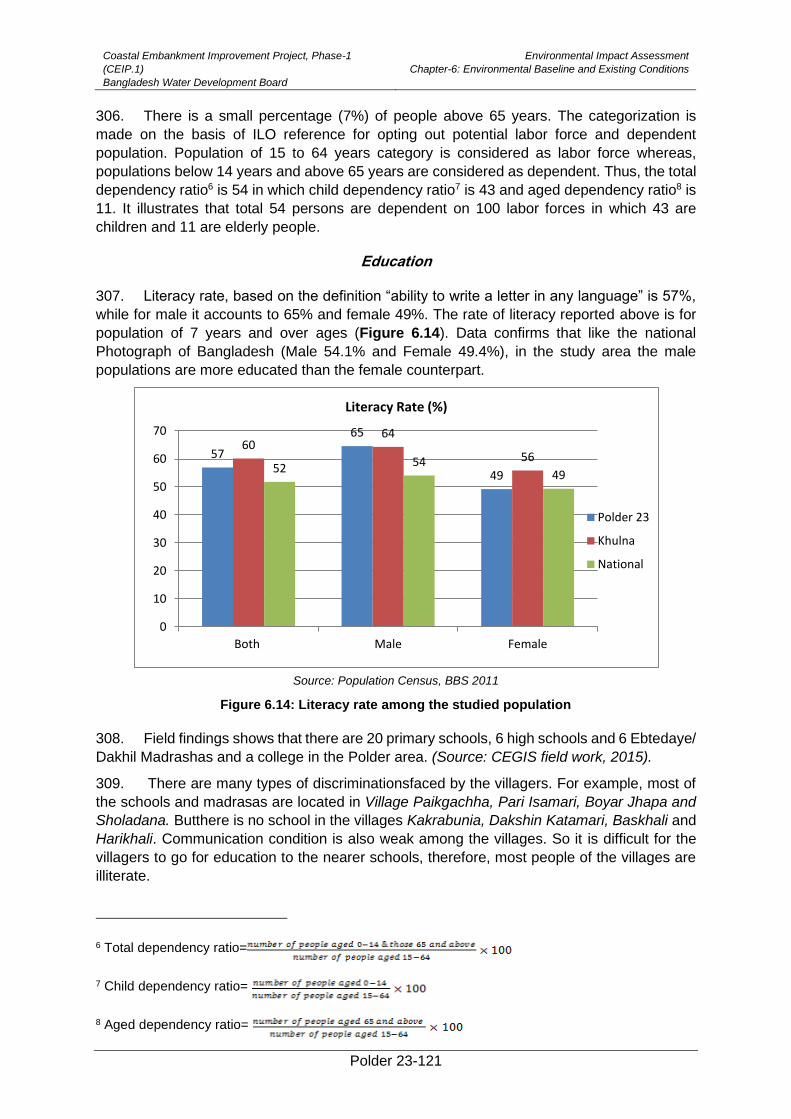
Coastal Embankment Improvement Project, Phase-1
(CEIP.1)
Bangladesh Water Development Board
Environmental Impact Assessment
Chapter-6: Environmental Baseline and Existing Conditions
Polder 23-121
306. There is a small percentage (7%) of people above 65 years. The categorization is
made on the basis of ILO reference for opting out potential labor force and dependent
population. Population of 15 to 64 years category is considered as labor force whereas,
populations below 14 years and above 65 years are considered as dependent. Thus, the total
dependency ratio6 is 54 in which child dependency ratio7 is 43 and aged dependency ratio8 is
11. It illustrates that total 54 persons are dependent on 100 labor forces in which 43 are
children and 11 are elderly people.
Education
307. Literacy rate, based on the definition “ability to write a letter in any language” is 57%,
while for male it accounts to 65% and female 49%. The rate of literacy reported above is for
population of 7 years and over ages (Figure 6.14). Data confirms that like the national
Photograph of Bangladesh (Male 54.1% and Female 49.4%), in the study area the male
populations are more educated than the female counterpart.
Source: Population Census, BBS 2011
Figure 6.14: Literacy rate among the studied population
308. Field findings shows that there are 20 primary schools, 6 high schools and 6 Ebtedaye/
Dakhil Madrashas and a college in the Polder area. (Source: CEGIS field work, 2015).
309. There are many types of discriminationsfaced by the villagers. For example, most of
the schools and madrasas are located in Village Paikgachha, Pari Isamari, Boyar Jhapa and
Sholadana. Butthere is no school in the villages Kakrabunia, Dakshin Katamari, Baskhali and
Harikhali. Communication condition is also weak among the villages. So it is difficult for the
villagers to go for education to the nearer schools, therefore, most people of the villages are
illiterate.
6 Total dependency ratio=
7 Child dependency ratio=
8 Aged dependency ratio=
57
65
49
6064
5652 54
49
0
10
20
30
40
50
60
70
Both Male Female
Literacy Rate (%)
Polder 23
Khulna
National
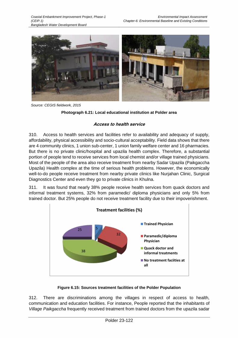
Coastal Embankment Improvement Project, Phase-1
(CEIP.1)
Bangladesh Water Development Board
Environmental Impact Assessment
Chapter-6: Environmental Baseline and Existing Conditions
Polder 23-122
Source: CEGIS fieldwork, 2015
Photograph 6.21: Local educational institution at Polder area
Access to health service
310. Access to health services and facilities refer to availability and adequacy of supply,
affordability, physical accessibility and socio-cultural acceptability. Field data shows that there
are 4 community clinics, 1 union sub-center, 1 union family welfare center and 16 pharmacies.
But there is no private clinic/hospital and upazila health complex. Therefore, a substantial
portion of people tend to receive services from local chemist and/or village trained physicians.
Most of the people of the area also receive treatment from nearby Sadar Upazila (Paikgaccha
Upazila) Health complex at the time of serious health problems. However, the economically
well-to-do people receive treatment from nearby private clinics like Nurjahan Clinic, Surgical
Diagnostics Center and even they go to private clinics in Khulna.
311. It was found that nearly 38% people receive health services from quack doctors and
informal treatment systems, 32% from paramedic/ diploma physicians and only 5% from
trained doctor. But 25% people do not receive treatment facility due to their impoverishment.
Figure 6.15: Sources treatment facilities of the Polder Population
312. There are discriminations among the villages in respect of access to health,
communication and education facilities. For instance, People reported that the inhabitants of
Village Paikgaccha frequently received treatment from trained doctors from the upazila sadar
5
32
38
25
Treatment facilities (%)
Trained Physician
Paramedic/diplomaPhysician
Quack doctor andinformal treatments
No treatment faciities atall
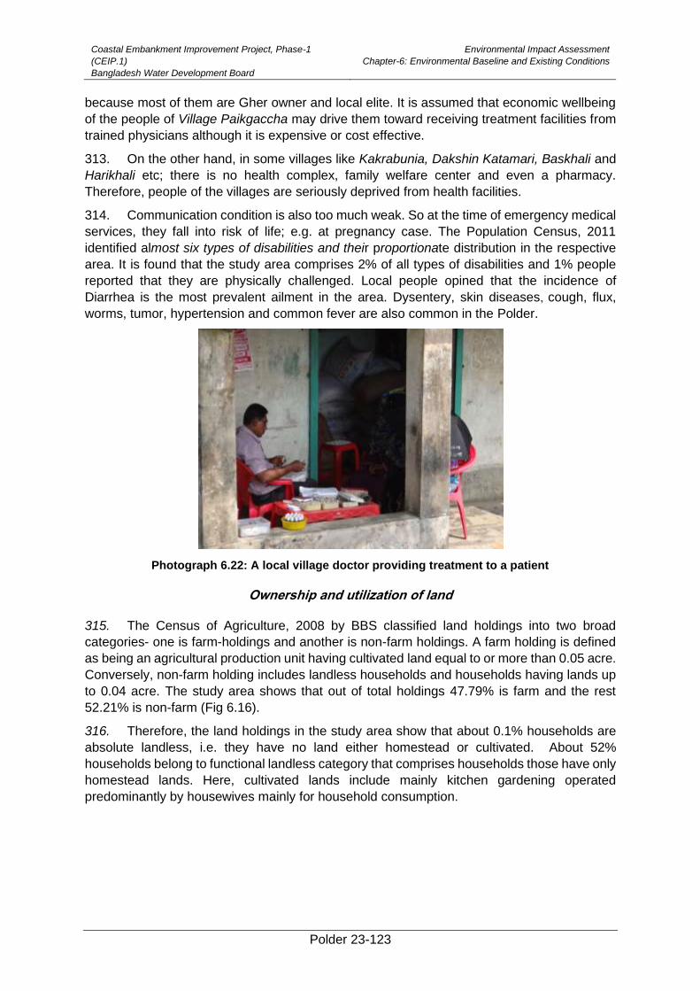
Coastal Embankment Improvement Project, Phase-1
(CEIP.1)
Bangladesh Water Development Board
Environmental Impact Assessment
Chapter-6: Environmental Baseline and Existing Conditions
Polder 23-123
because most of them are Gher owner and local elite. It is assumed that economic wellbeing
of the people of Village Paikgaccha may drive them toward receiving treatment facilities from
trained physicians although it is expensive or cost effective.
313. On the other hand, in some villages like Kakrabunia, Dakshin Katamari, Baskhali and
Harikhali etc; there is no health complex, family welfare center and even a pharmacy.
Therefore, people of the villages are seriously deprived from health facilities.
314. Communication condition is also too much weak. So at the time of emergency medical
services, they fall into risk of life; e.g. at pregnancy case. The Population Census, 2011
identified almost six types of disabilities and their proportionate distribution in the respective
area. It is found that the study area comprises 2% of all types of disabilities and 1% people
reported that they are physically challenged. Local people opined that the incidence of
Diarrhea is the most prevalent ailment in the area. Dysentery, skin diseases, cough, flux,
worms, tumor, hypertension and common fever are also common in the Polder.
Photograph 6.22: A local village doctor providing treatment to a patient
Ownership and utilization of land
315. The Census of Agriculture, 2008 by BBS classified land holdings into two broad
categories- one is farm-holdings and another is non-farm holdings. A farm holding is defined
as being an agricultural production unit having cultivated land equal to or more than 0.05 acre.
Conversely, non-farm holding includes landless households and households having lands up
to 0.04 acre. The study area shows that out of total holdings 47.79% is farm and the rest
52.21% is non-farm (Fig 6.16).
316. Therefore, the land holdings in the study area show that about 0.1% households are
absolute landless, i.e. they have no land either homestead or cultivated. About 52%
households belong to functional landless category that comprises households those have only
homestead lands. Here, cultivated lands include mainly kitchen gardening operated
predominantly by housewives mainly for household consumption.
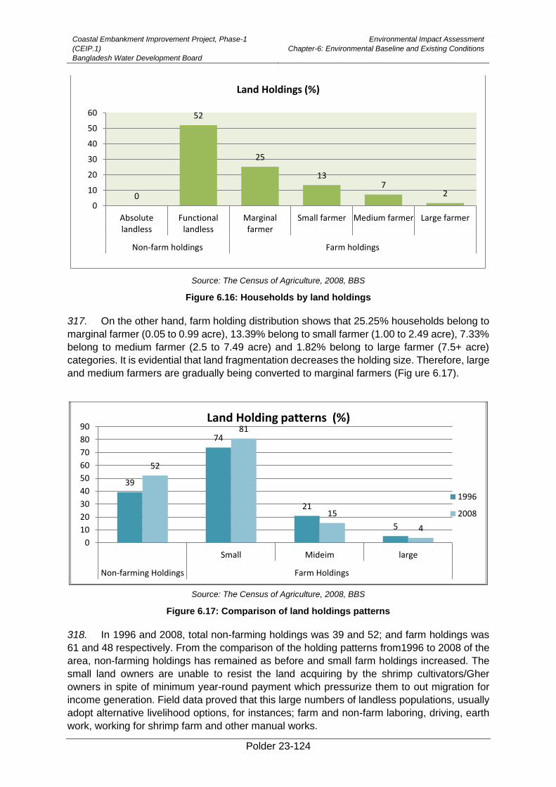
Coastal Embankment Improvement Project, Phase-1
(CEIP.1)
Bangladesh Water Development Board
Environmental Impact Assessment
Chapter-6: Environmental Baseline and Existing Conditions
Polder 23-124
Source: The Census of Agriculture, 2008, BBS
Figure 6.16: Households by land holdings
317. On the other hand, farm holding distribution shows that 25.25% households belong to
marginal farmer (0.05 to 0.99 acre), 13.39% belong to small farmer (1.00 to 2.49 acre), 7.33%
belong to medium farmer (2.5 to 7.49 acre) and 1.82% belong to large farmer (7.5+ acre)
categories. It is evidential that land fragmentation decreases the holding size. Therefore, large
and medium farmers are gradually being converted to marginal farmers (Fig ure 6.17).
Source: The Census of Agriculture, 2008, BBS
Figure 6.17: Comparison of land holdings patterns
318. In 1996 and 2008, total non-farming holdings was 39 and 52; and farm holdings was
61 and 48 respectively. From the comparison of the holding patterns from1996 to 2008 of the
area, non-farming holdings has remained as before and small farm holdings increased. The
small land owners are unable to resist the land acquiring by the shrimp cultivators/Gher
owners in spite of minimum year-round payment which pressurize them to out migration for
income generation. Field data proved that this large numbers of landless populations, usually
adopt alternative livelihood options, for instances; farm and non-farm laboring, driving, earth
work, working for shrimp farm and other manual works.
0
52
25
137
2
0
10
20
30
40
50
60
Absolutelandless
Functionallandless
Marginalfarmer
Small farmer Medium farmer Large farmer
Non-farm holdings Farm holdings
Land Holdings (%)
39
74
21
5
52
81
15
4
0
10
20
30
40
50
60
70
80
90
Small Mideim large
Non-farming Holdings Farm Holdings
Land Holding patterns (%)
1996
2008
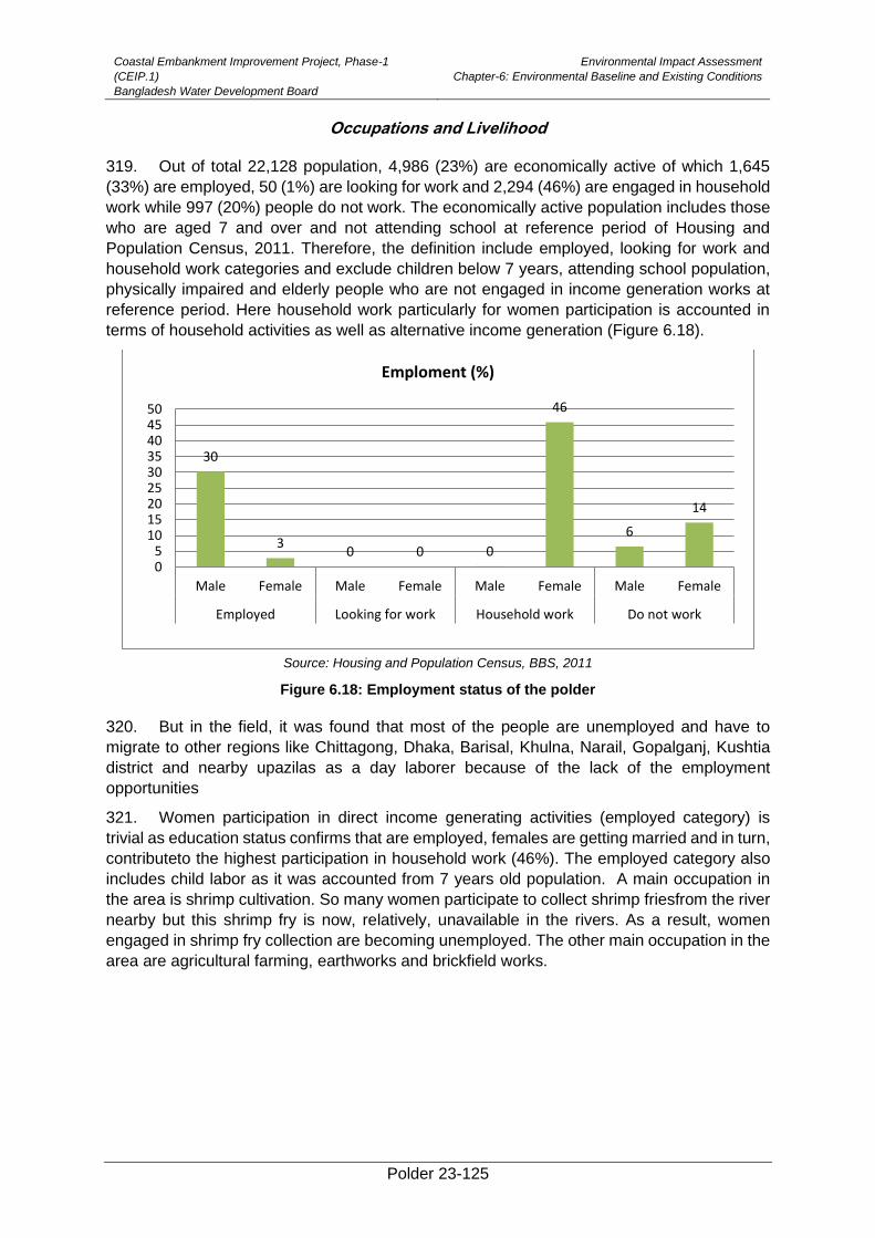
Coastal Embankment Improvement Project, Phase-1
(CEIP.1)
Bangladesh Water Development Board
Environmental Impact Assessment
Chapter-6: Environmental Baseline and Existing Conditions
Polder 23-125
Occupations and Livelihood
319. Out of total 22,128 population, 4,986 (23%) are economically active of which 1,645
(33%) are employed, 50 (1%) are looking for work and 2,294 (46%) are engaged in household
work while 997 (20%) people do not work. The economically active population includes those
who are aged 7 and over and not attending school at reference period of Housing and
Population Census, 2011. Therefore, the definition include employed, looking for work and
household work categories and exclude children below 7 years, attending school population,
physically impaired and elderly people who are not engaged in income generation works at
reference period. Here household work particularly for women participation is accounted in
terms of household activities as well as alternative income generation (Figure 6.18).
Source: Housing and Population Census, BBS, 2011
Figure 6.18: Employment status of the polder
320. But in the field, it was found that most of the people are unemployed and have to
migrate to other regions like Chittagong, Dhaka, Barisal, Khulna, Narail, Gopalganj, Kushtia
district and nearby upazilas as a day laborer because of the lack of the employment
opportunities
321. Women participation in direct income generating activities (employed category) is
trivial as education status confirms that are employed, females are getting married and in turn,
contributeto the highest participation in household work (46%). The employed category also
includes child labor as it was accounted from 7 years old population. A main occupation in
the area is shrimp cultivation. So many women participate to collect shrimp friesfrom the river
nearby but this shrimp fry is now, relatively, unavailable in the rivers. As a result, women
engaged in shrimp fry collection are becoming unemployed. The other main occupation in the
area are agricultural farming, earthworks and brickfield works.
30
30 0 0
46
6
14
05
101520253035404550
Male Female Male Female Male Female Male Female
Employed Looking for work Household work Do not work
Emploment (%)

Coastal Embankment Improvement Project, Phase-1
(CEIP.1)
Bangladesh Water Development Board
Environmental Impact Assessment
Chapter-6: Environmental Baseline and Existing Conditions
Polder 23-126
Photograph 6.23: Different modes of livelihood activites at Polder 23
322. Agricultural activities include broadly fishery and crop farming. Scope of employment
in agricultural sector is gradually decreasing due to lack of sweet water and saline water in the
area for shrimp cultivation Crops are grown in only 422 hectares but shrimp cultivation, is
practiced in 3,969 hectares. The Gher cultural practice in the area is shown in the Photograph
6.24.
Photograph 6.24: Practice of shrimp cultivation in agricultural land in the area
323. People stated that once people from nearer regions came for employment in their area,
but as a result of decreasing agricultural land and farming, as a result of cultivating shrimp
which reduces employment, therefore, they have to out migrate for employment.
Labor market
324. Data confirms that agriculture, industry and service are the sole sectors to generate
employment for the local people. Field findings documented that people who are not
permanently employed tend to engage themselves in those sectors in the forms of agricultural
laborers, fishers, brick field worker and earth workers. In agricultural sectors, most of the
laborers are supplied from the local villages.
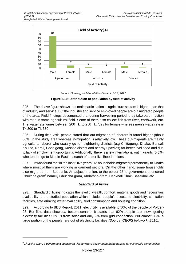
Coastal Embankment Improvement Project, Phase-1
(CEIP.1)
Bangladesh Water Development Board
Environmental Impact Assessment
Chapter-6: Environmental Baseline and Existing Conditions
Polder 23-127
Source: Housing and Population Census, BBS, 2011
Figure 6.19: Distribution of population by field of activity
325. The above figure shows that male participation in agriculture sectors is higher than that
of industry and service. But the industry and service employed people are out migrated people
of the area. Field findings documented that during harvesting period, they take part in action
with men in same agricultural field. Some of them also collect fish from river, earthwork, etc.
The wage rate varies between 200 Tk. to 250 Tk. /day for female whereas men’s wage rate is
Tk.300 to Tk.350
326. During field visit, people stated that out migration of laborers is found higher (about
60%) in the study area whereas in-migration is relatively low. These out-migrants are mainly
agricultural laborer who usually go to neighboring districts (e.g Chittagong, Dhaka, Barisal,
Khulna, Narail, Gopalgong, Kushtia district and nearby upazilas) for better livelihood and due
to lack of employment opportunity. Additionally, there is a few international out migrants (0.5%)
who tend to go to Middle East in search of better livelihood options.
327. It was found that in the last 5 five years, 13 households migrated permanently to Dhaka
where most of them are working in garment sectors. On the other hand, some households
also migrated from Bedbunia, An adjacent union, to the polder 23 to government sponsored
Ghuccha gram9 namely Ghuccha gram, Ahdarsho gram, Harikhali Chak, Basakhali etc.
Standard of living
328. Standard of living indicates the level of wealth, comfort, material goods and necessities
availability to the studied population which includes people’s access to electricity, sanitation
facilities, safe drinking water availability, fuel consumption and housing condition.
329. According to BBS Report, 2011, electricity is available to 50% of the people of Polder-
23. But field data showeda better scenario, it states that 62% people are, now, getting
electricity facilities,53% is from solar and only 9% from grid connection. But almost 38%, a
large portion of the people, are out of electricity facilities.(Source: CEGIS fieldwork, 2015).
9Ghuccha gram, a government sponsored village where government made houses for vulnerable communities.
84
72 1
5 10
102030405060708090
Male Female Male Female Male Female
Agriculture Industry Service
Field of Activity
Field of Activity(%)
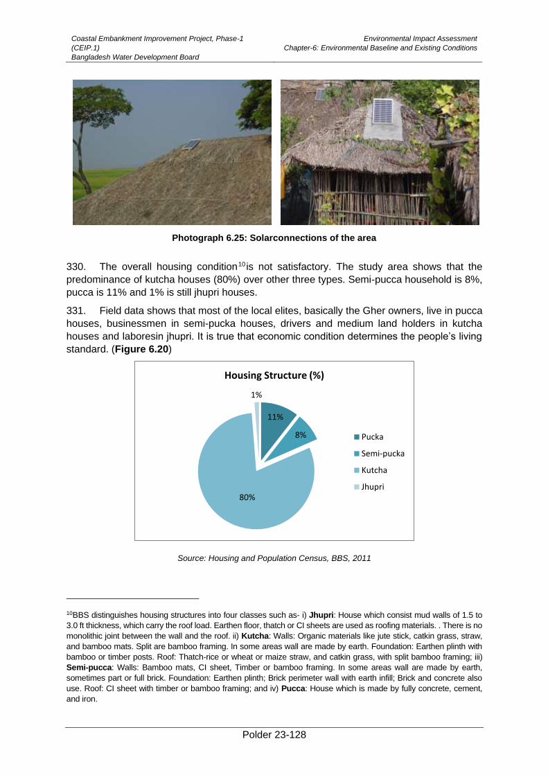
Coastal Embankment Improvement Project, Phase-1
(CEIP.1)
Bangladesh Water Development Board
Environmental Impact Assessment
Chapter-6: Environmental Baseline and Existing Conditions
Polder 23-128
Photograph 6.25: Solarconnections of the area
330. The overall housing condition10 is not satisfactory. The study area shows that the
predominance of kutcha houses (80%) over other three types. Semi-pucca household is 8%,
pucca is 11% and 1% is still jhupri houses.
331. Field data shows that most of the local elites, basically the Gher owners, live in pucca
houses, businessmen in semi-pucka houses, drivers and medium land holders in kutcha
houses and laboresin jhupri. It is true that economic condition determines the people’s living
standard. (Figure 6.20)
Source: Housing and Population Census, BBS, 2011
10BBS distinguishes housing structures into four classes such as- i) Jhupri: House which consist mud walls of 1.5 to
3.0 ft thickness, which carry the roof load. Earthen floor, thatch or CI sheets are used as roofing materials. . There is no
monolithic joint between the wall and the roof. ii) Kutcha: Walls: Organic materials like jute stick, catkin grass, straw,
and bamboo mats. Split are bamboo framing. In some areas wall are made by earth. Foundation: Earthen plinth with
bamboo or timber posts. Roof: Thatch-rice or wheat or maize straw, and catkin grass, with split bamboo framing; iii)
Semi-pucca: Walls: Bamboo mats, CI sheet, Timber or bamboo framing. In some areas wall are made by earth,
sometimes part or full brick. Foundation: Earthen plinth; Brick perimeter wall with earth infill; Brick and concrete also
use. Roof: CI sheet with timber or bamboo framing; and iv) Pucca: House which is made by fully concrete, cement,
and iron.
11%
8%
80%
1%
Housing Structure (%)
Pucka
Semi-pucka
Kutcha
Jhupri
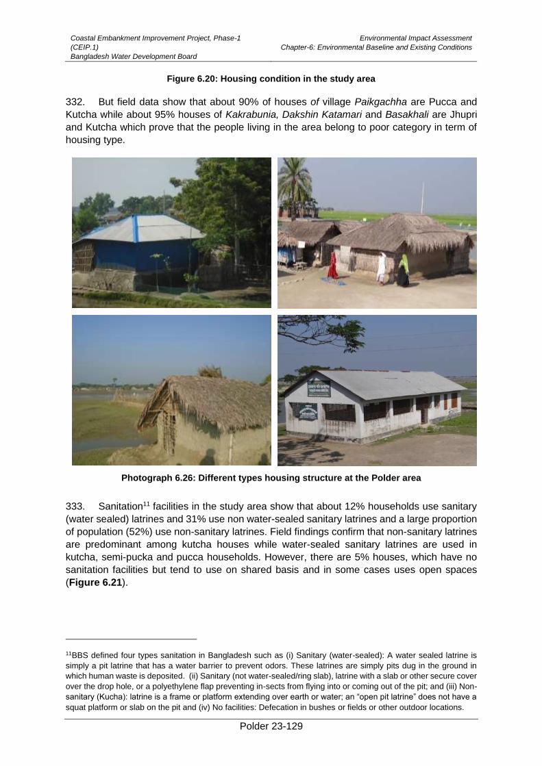
Coastal Embankment Improvement Project, Phase-1
(CEIP.1)
Bangladesh Water Development Board
Environmental Impact Assessment
Chapter-6: Environmental Baseline and Existing Conditions
Polder 23-129
Figure 6.20: Housing condition in the study area
332. But field data show that about 90% of houses of village Paikgachha are Pucca and
Kutcha while about 95% houses of Kakrabunia, Dakshin Katamari and Basakhali are Jhupri
and Kutcha which prove that the people living in the area belong to poor category in term of
housing type.
Photograph 6.26: Different types housing structure at the Polder area
333. Sanitation11 facilities in the study area show that about 12% households use sanitary
(water sealed) latrines and 31% use non water-sealed sanitary latrines and a large proportion
of population (52%) use non-sanitary latrines. Field findings confirm that non-sanitary latrines
are predominant among kutcha houses while water-sealed sanitary latrines are used in
kutcha, semi-pucka and pucca households. However, there are 5% houses, which have no
sanitation facilities but tend to use on shared basis and in some cases uses open spaces
(Figure 6.21).
11BBS defined four types sanitation in Bangladesh such as (i) Sanitary (water-sealed): A water sealed latrine is
simply a pit latrine that has a water barrier to prevent odors. These latrines are simply pits dug in the ground in
which human waste is deposited. (ii) Sanitary (not water-sealed/ring slab), latrine with a slab or other secure cover
over the drop hole, or a polyethylene flap preventing in-sects from flying into or coming out of the pit; and (iii) Non-
sanitary (Kucha): latrine is a frame or platform extending over earth or water; an “open pit latrine” does not have a
squat platform or slab on the pit and (iv) No facilities: Defecation in bushes or fields or other outdoor locations.
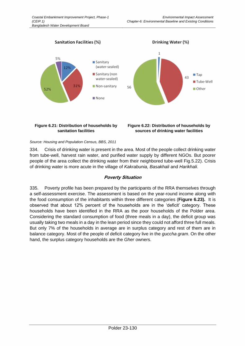
Coastal Embankment Improvement Project, Phase-1
(CEIP.1)
Bangladesh Water Development Board
Environmental Impact Assessment
Chapter-6: Environmental Baseline and Existing Conditions
Polder 23-130
Figure 6.21: Distribution of households by
sanitation facilities
Figure 6.22: Distribution of households by
sources of drinking water facilities
Source: Housing and Population Census, BBS, 2011
334. Crisis of drinking water is present in the area. Most of the people collect drinking water
from tube-well, harvest rain water, and purified water supply by different NGOs. But poorer
people of the area collect the drinking water from their neighbored tube-well Fig.5.22). Crisis
of drinking water is more acute in the village of Kakrabunia, Basakhali and Harikhali.
Poverty Situation
335. Poverty profile has been prepared by the participants of the RRA themselves through
a self-assessment exercise. The assessment is based on the year-round income along with
the food consumption of the inhabitants within three different categories (Figure 6.23). It is
observed that about 12% percent of the households are in the ‘deficit’ category. These
households have been identified in the RRA as the poor households of the Polder area.
Considering the standard consumption of food (three meals in a day), the deficit group was
usually taking two meals in a day in the lean period since they could not afford three full meals.
But only 7% of the households in average are in surplus category and rest of them are in
balance category. Most of the people of deficit category live in the guccha gram. On the other
hand, the surplus category households are the Gher owners.
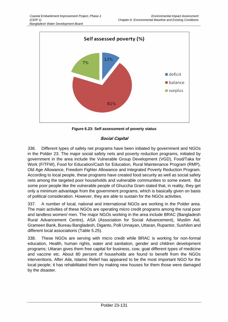
Coastal Embankment Improvement Project, Phase-1
(CEIP.1)
Bangladesh Water Development Board
Environmental Impact Assessment
Chapter-6: Environmental Baseline and Existing Conditions
Polder 23-131
Figure 6.23: Self assessment of poverty status
Social Capital
336. Different types of safety net programs have been initiated by government and NGOs
in the Polder 23. The major social safety nets and poverty reduction programs, initiated by
government in the area include the Vulnerable Group Development (VGD), Food/Taka for
Work (F/TFW), Food for Education/Cash for Education, Rural Maintenance Program (RMP),
Old Age Allowance, Freedom Fighter Allowance and Integrated Poverty Reduction Program.
According to local people, these programs have created food security as well as social safety
nets among the targeted poor households and vulnerable communities to some extent. But
some poor people like the vulnerable people of Ghuccha Gram stated that, in reality, they get
only a minimum advantage from the government programs, which is basically given on basis
of political consideration. However, they are able to sustain for the NGOs activities.
337. A number of local, national and international NGOs are working in the Polder area.
The main activities of these NGOs are operating micro credit programs among the rural poor
and landless women/ men. The major NGOs working in the area include BRAC (Bangladesh
Rural Advancement Centre), ASA (Association for Social Advancement), Muslim Aid,
Grameen Bank, Bureau Bangladesh, Diganto, Polli Unnayan, Uttaran, Rupantor, Sushilon and
different local associations (Table 5.25).
338. These NGOs are serving with micro credit while BRAC is working for non-formal
education, Health, human rights, water and sanitation, gender and children development
programs; Uttaran gives them free capital for business, cow, goat different types of medicine
and vaccine etc. About 80 percent of households are found to benefit from the NGOs
interventions. After Aila, Islamic Relief has appeared to be the most important NGO for the
local people; it has rehabilitated them by making new houses for them those were damaged
by the disaster.
Coastal Embankment Improvement Project, Phase-1
(CEIP.1)
Bangladesh Water Development Board
Environmental Impact Assessment
Chapter-6: Environmental Baseline and Existing Conditions
Polder 23-132
Table 6.25: NGOs and their Programs in the Project Area
Name of the NGOs
Type of Programs
Credit Education Water and Sanitation
Health Disaster Gender Food security
Others
BRAC ✓ ✓ ✓ ✓ - ✓ ✓ ✓
Uttaran ✓ - - ✓ - - ✓ ✓
ASA ✓ - - - - - - -
Islamic Relief - - - - ✓ - - ✓
Muslim Aid - ✓ - - - - ✓ ✓
Grameen Bank
- - - - ✓ - ✓ -
Bureau Bangladesh
✓ ✓ - - - - - ✓
Diganto ✓ ✓ - - - - - -
Polli Unnayan
✓ - - - - - - -
Rupantor ✓ - - - - - - -
Sushilon ✓ - - - - - - ✓
Source: CEGIS fieldwork, 2015
Roads
339. There are various types of roads which provide means of communication mostly within
the Polder. The Polder is surrounded by three major rivers namely, Karulia, Sibsa and Minaj.
People of the Polder can easily enter into the upazila sadar because it is nearby the
Pauroshava. According to NWRD database 2015, about 54.5 km of notable road network
exists in the studied unions of which 3 km roads are paved/Brick soling, 51.5 km roads are
earthen. Table 6.26presents data on road network in the polder area.Photograph 6.26
presents some photographs of these roads.
Table 6.26: Road Network in Polder 23
Name of the
Unions
Types of the
Roads Description
Length (Km)
Total (km)
Sholadana Laskar
Paved/Brick Soling
Garaikhali GC-Amurkata Bazar 1 3
Betbunia-Amurkata 1.1
Soladana kironsana house near bridge to Golder house road .9
Earthen Road
Paikgachhaa Lasker Madrasa-Parshemari to Soladana Bazar-Betbunia via Boraitala Kheyaghat
8.2 51.5
Lata UP Office (Katamari bazer) to Soladana bazer to Shonkardana
13.65
Amurkata Bazar-BoyarJhapa Eidgha 4.85
Betbunia-Amurkata to Minaj bazer to Kharia khalpar 7.5
Village Paikgachhaa) to Paikgachhaa Dakhinpara 2
Khatuamari WAPDA embankment to Betbunia madrasha via Nutun chalk
4.2
Gazalia bridge to Kalmibunia bridge via katabunia junior madhamik bidyalay
5
Basakhali WAPDA (Minaj embankment) to surikhali UZR road via kachibunia
6.1
Source: CEGIS fieldwork and LGED website, 2015
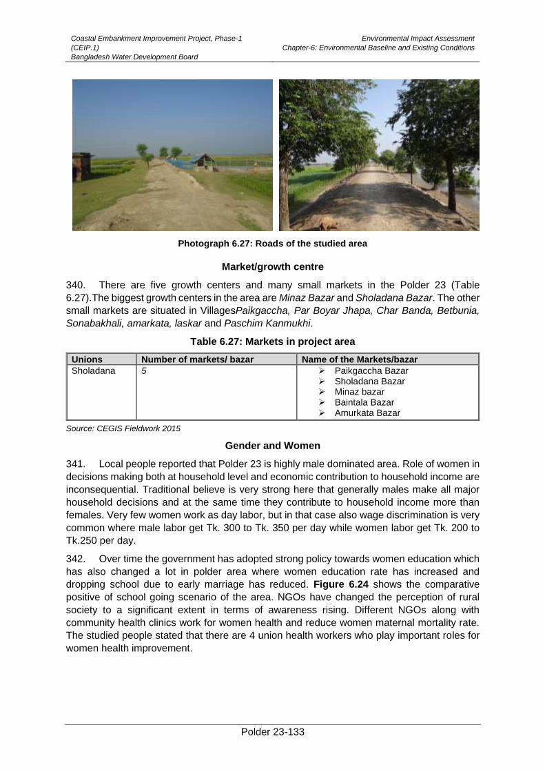
Coastal Embankment Improvement Project, Phase-1
(CEIP.1)
Bangladesh Water Development Board
Environmental Impact Assessment
Chapter-6: Environmental Baseline and Existing Conditions
Polder 23-133
Photograph 6.27: Roads of the studied area
Market/growth centre
340. There are five growth centers and many small markets in the Polder 23 (Table
6.27).The biggest growth centers in the area are Minaz Bazar and Sholadana Bazar. The other
small markets are situated in VillagesPaikgaccha, Par Boyar Jhapa, Char Banda, Betbunia,
Sonabakhali, amarkata, laskar and Paschim Kanmukhi.
Table 6.27: Markets in project area
Unions Number of markets/ bazar Name of the Markets/bazar
Sholadana 5 ➢ Paikgaccha Bazar ➢ Sholadana Bazar ➢ Minaz bazar ➢ Baintala Bazar ➢ Amurkata Bazar
Source: CEGIS Fieldwork 2015
Gender and Women
341. Local people reported that Polder 23 is highly male dominated area. Role of women in
decisions making both at household level and economic contribution to household income are
inconsequential. Traditional believe is very strong here that generally males make all major
household decisions and at the same time they contribute to household income more than
females. Very few women work as day labor, but in that case also wage discrimination is very
common where male labor get Tk. 300 to Tk. 350 per day while women labor get Tk. 200 to
Tk.250 per day.
342. Over time the government has adopted strong policy towards women education which
has also changed a lot in polder area where women education rate has increased and
dropping school due to early marriage has reduced. Figure 6.24 shows the comparative
positive of school going scenario of the area. NGOs have changed the perception of rural
society to a significant extent in terms of awareness rising. Different NGOs along with
community health clinics work for women health and reduce women maternal mortality rate.
The studied people stated that there are 4 union health workers who play important roles for
women health improvement.
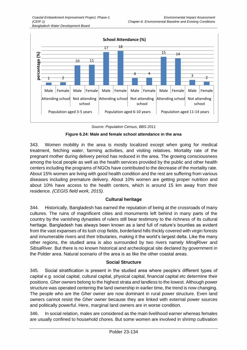
Coastal Embankment Improvement Project, Phase-1
(CEIP.1)
Bangladesh Water Development Board
Environmental Impact Assessment
Chapter-6: Environmental Baseline and Existing Conditions
Polder 23-134
Source: Population Census, BBS 2011
Figure 6.24: Male and female school attendance in the area
343. Women mobility in the area is mostly localized except when going for medical
treatment, fetching water, farming activities, and visiting relatives. Mortality rate of the
pregnant mother during delivery period has reduced in the area. The growing consciousness
among the local people as well as the health services provided by the public and other health
centers including the programs of NGOs have contributed to the decrease of the mortality rate.
About 15% women are living with good health condition and the rest are suffering from various
diseases including premature delivery. About 10% women are getting proper nutrition and
about 10% have access to the health centers, which is around 15 km away from their
residence. (CEGIS field work, 2015).
Cultural heritage
344. Historically, Bangladesh has earned the reputation of being at the crossroads of many
cultures. The ruins of magnificent cities and monuments left behind in many parts of the
country by the vanishing dynasties of rulers still bear testimony to the richness of its cultural
heritage. Bangladesh has always been known as a land full of nature’s bounties as evident
from the vast expanses of its lush crop fields, borderland hills thickly covered with virgin forests
and innumerable rivers and their tributaries, making it the world’s largest delta. Like the many
other regions, the studied area is also surrounded by two rivers namely MinajRiver and
SibsaRiver. But there is no known historical and archeological site declared by government in
the Polder area. Natural scenario of the area is as like the other coastal areas.
Social Structure
345. Social stratification is present in the studied area where people’s different types of
capital e.g. social capital, cultural capital, physical capital, financial capital etc determine their
positions. Gher owners belong to the highest strata and landless to the lowest. Although power
structure was operated centering the land ownership in earlier time, the trend is now changing.
The people who are the Gher owner are now dominant in rural power structure. Even land
owners cannot resist the Gher owner because they are linked with external power sources
and politically powerful. Here, marginal land owners are in worse condition.
346. In social relation, males are considered as the main livelihood earner whereas females
are usually confined to household chores. But some women are involved in shrimp cultivation
1 2
10 11
17 18
4 4
15 14
3 2
Male Female Male Female Male Female Male Female Male Female Male Female
Attending school Not attendingschool
Attending school Not attendingschool
Attending school Not attendingschool
Population aged 3-5 years Population aged 6-10 years Population aged 11-14 years
per
cen
tage
(%
)School Attendance (%)
Coastal Embankment Improvement Project, Phase-1
(CEIP.1)
Bangladesh Water Development Board
Environmental Impact Assessment
Chapter-6: Environmental Baseline and Existing Conditions
Polder 23-135
who basically collect shrimp fry. Some women work as a day laborer in earthwork and brick
field work. Furthermore, kitchen garden is main task done by women. In decision making both
in society and family, males are the main contributors. People reported that as female literacy
rate is gradually increasing, they are now contributing, although trivial, in household income
particularly in service sector such as teaching, factory worker etc.
Vulnerable Communities
347. In the studied area, there are some vulnerable people, who have lost everything during
the time of Aila and are living at government sponsored shelter centers in the village of
Harikhali, Harikhali Chak, and Basakhali. The vulnerable people suffer from safe drinking
water, without electricity, and terrible sanitation facility. In the area, there is no educational
institution, health complex and communication system is also terrible. In short, they don’t get
minimum standard of living in here rather they stay with a fear of river water breaching the
BWDB embankment.
Rituals and festivities
348. Anniversaries, fairs and festivals form a vital part in the social life of ordinary people of
the Polder 23. The biggest religious festivals are Eid-ul-Fitr and Eid-ul-Azha for the Muslim
community, Durga Puja for the Hindus, and Christmas for the Christians. Other Muslim
Festivals include Eid-e-Mialdunnabi, Muharram and Shab-e-Barat.
349. Although there are many types of discriminations in the polder area, but there is no
religious discrimination. Different types of religious groups perform their religious festivals with
due feastivity. Even other religious communities participate in the festivals with eagerness.
Muslims participate in different types of Pujas where Hindus and Christians also participate in
Eids and many Muslim festivals.
350. Among the non-religious festivals Bengali New Year (Pahela Baishakh, on 14 April),
Language Martyrs’ Day (on 21 February, now also called International Mother Language Day),
Independence and National Day (26 March), and Victory Day (16 December) are celebrated.
Mostly of these festivals are performed by the students of schools and college of the area.
Common Property Resources
351. The common property resources and community facilities in the area are different
social amenities e.g. mosques, graveyards, temples, cremation grounds, playgrounds, open
water bodies and Eidgahs (place for offering Eid prayers). These are used by the local people
for the purposes of religious, social and cultural gathering. Besides these, the BWDB
embankment is also used very commonly for different livelihood purposes i.e. living or taking
shelter by the local inhabitants. However, there is no known historical and archeological site
declared by government in the Polder area. There are 29 Mosques, 7 Graveyards, 38
Temples, 4 Crematoriums, 3 Playgrounds, 12 Eidgahs, 9 Cyclone centers, 5 Bazars and a
Cultural center.
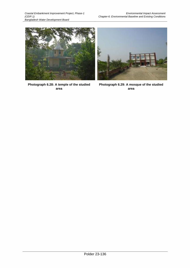
Coastal Embankment Improvement Project, Phase-1
(CEIP.1)
Bangladesh Water Development Board
Environmental Impact Assessment
Chapter-6: Environmental Baseline and Existing Conditions
Polder 23-136
Photograph 6.28: A temple of the studied
area
Photograph 6.29: A mosque of the studied
area
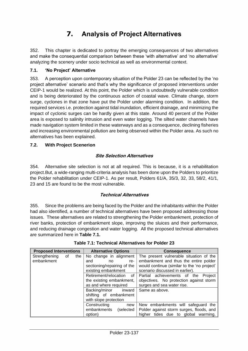
Polder 23-137
7. Analysis of Project Alternatives
352. This chapter is dedicated to portray the emerging consequences of two alternatives
and make the consequential comparison between these ‘with alternative’ and ‘no alternative’
analyzing the scenery under socio technical as well as environmental context.
7.1. ‘No Project’ Alternative
353. A perception upon contemporary situation of the Polder 23 can be reflected by the ‘no
project alternative’ scenario and that’s why the significance of proposed interventions under
CEIP-1 would be realized. At this point, the Polder which is undoubtedly vulnerable condition
and is being deteriorated by the continuous action of coastal wave. Climate change, storm
surge, cyclones in that zone have put the Polder under alarming condition. In addition, the
required services i.e. protection against tidal inundation, efficient drainage, and minimizing the
impact of cyclonic surges can be hardly given at this state. Around 40 percent of the Polder
area is exposed to salinity intrusion and even water logging. The silted water channels have
made navigation system limited in these waterways and as a consequence, declining fisheries
and increasing environmental pollution are being observed within the Polder area. As such no
alternatives has been explained.
7.2. With Project Scenerion
Site Selection Alternatives
354. Alternative site selection is not at all required. This is because, it is a rehabilitation
project.But, a wide-ranging multi-criteria analysis has been done upon the Polders to prioritize
the Polder rehabilitation under CEIP-1. As per result, Polders 61/A, 35/3, 32, 33, 58/2, 41/1,
23 and 15 are found to be the most vulnerable.
Technical Alternatives
355. Since the problems are being faced by the Polder and the inhabitants within the Polder
had also identified, a number of technical alternatives have been proposed addressing those
issues. These alternatives are related to strengthening the Polder embankment, protection of
river banks, protection of embankment slope, improving the sluices and their performance,
and reducing drainage congestion and water logging. All the proposed technical alternatives
are summarized here in Table 7.1.
Table 7.1: Technical Alternatives for Polder 23
Proposed Interventions Alternative Options Consequence
Strengthening of the embankment
No change in alignment and no re-sectioning/repairing of the existing embankment
The present vulnerable situation of the embankment and thus the entire polder would continue (similar to the ‘no project’ scenario discussed in earlier).
Retirement/relocation of the existing embankment, as and where required
Partial achievements of the Project objectives. No protection against storm surges and sea water rise.
Backing/minor inward shifting of embankment with slope protection
Same as above.
Constructing new embankments (selected option)
New embankments will safeguard the Polder against storm surges, floods, and higher tides due to global warming.
Coastal Embankment Improvement Project, Phase-1
(CEIP.1)
Bangladesh Water Development Board
Environmental Impact Assessment
Chapter-7: Analysis of Project Alternatives
Polder 23-138
Proposed Interventions Alternative Options Consequence
Hence, reduction in loss of lives and assets will be caused by the natural disasters.
Re-sectioning of existing embankment with new design heights (selected option).
Higher and wide embankments would be more effective and resilient, and will safeguard the Polder against storm surges, floods, and higher tides due to global warming. Hence, reduction in loss of lives and assets caused by the natural disasters.
Protection of embankment slope (against wave action)
No change in the existing embankment
Continued weakening of embankments; continuous subsidence of embankments due to traffic load and wave action; land resources would continue to be damaged/ lost (similar to the ‘no project’ scenario discussed earlier).
Slope protection (selected option)
Slope protection works will strengthen the embankments and protect them against subsidence, wave action, and wear and tear.
Foreshore plantation (selected option)
Effects of cyclone surge, wave action and wind could be mitigated to some extent, reducing loss of lives and assets.
Replacement of drainage sluices
No change in the existing structures
Continued use of the existing drainage sluices for both flushing and drainage would cause further damage to these structures. As a result, water logging and drainage congestion would be increased due to malfunctioning of the sluices (similar to the ‘no project’ scenario discussed in earlier).
Repairing of structures (possible where there is no need of re-sizing) (selected option for some structures)
For sluices which are beyond repair, this option would be similar to the ‘no project’ scenario described above.
Replacement of existing Drainage Sluice with Drainage-cum-flushing sluice (selected option for some of the sluices depending upon need)
Drainage-cum-flushing sluices will be more efficient and dry season rice cropping practice will be possible as sweet water can be stored and used later in the dry season for irrigation.
Regulators with provision for appropriate passages for fish and small boats.
In addition to the above advantages, the structures will facilitate fish migration and navigation across them. The cost of such structure is likely to be high.
Replacement of flushing sluices
No change in the existing structure
No dry season agriculture practice will be possible. Shrimp culture during January to May, as sweet water cannot be used in the periods of low rainfall (similar to the ‘no project’ scenario discussed earlier).
Repair of the existing structures
For sluices which are beyond repair, this option would be similar to the ‘no project’ scenario described above.
Replacement of the existing Flushing Sluices (selected option)
Replaced flushing sluices will facilitate better agriculture practices, increased dry
Coastal Embankment Improvement Project, Phase-1
(CEIP.1)
Bangladesh Water Development Board
Environmental Impact Assessment
Chapter-7: Analysis of Project Alternatives
Polder 23-139
Proposed Interventions Alternative Options Consequence
season rice cropping, and reduced shrimp culture - thus benefiting the poor farmers.
Re-excavation of drainage channels
No action is taken. Depth of water bodies would further decrease; drainage congestion and water logging will further increase (similar to the ‘no project’ scenario discussed earlier).
Channel re-excavation (selected option)
Depth of water bodies will increase, water logging and drainage congestion will decrease and fish habitats will increase.
Technical, Financial, Economic, Environmental, and Social Considerations of
Selected Options
356. Following initiatives are chosen for assessing the technical, financial, economic,
environmental, and social considerations. Table 7.2 below has disclosed all the options.
Table 7.2: Technical, Economical, Environmental and Social Considerations
Intervention Considerations
Technical Financial/Economic Environmental Social
Re-sectioning, embankment with new design heights
Better protection against cyclone surges and water level rise
Financial savings for reduction of reduced damages from floods
Improve surface water quality; improve natural vegetation
Reduce loss of lives and assets which would alleviate poverty; increase employment opportunities for local people.
Protection to river bank erosion
Financial savings as the embankments will provide good road transportation.
Reduce traffic congestion inside the polder because of improved embankments, which will facilitate vehicular traffic
Reduction of loss of assets which would bring poverty reduction
Prevention of salinity intrusion in the polder
Improve earnings of local people during construction
Improve crop production particularly for small farmers thus alleviating poverty.
Improve cropping pattern and boost up the local economy
Bank revetment, slope protection
Enhanced embankment protection against tidal wave action of rivers, provide erosion protection
Financial savings for reduction of damages from floods; increase life span of the infrastructure and associated water control structures; improve earnings of local people through employment during bank revetment works and slope protection works.
Improve embankment stability; reduce soil erosion; and provide good means of transportation
Reduce loss of lives and assets which would alleviate poverty; increase employment opportunities for local people.
Replacement of existing drainage sluice with drainage-cum-
Better functional performance in both flushing and drainage; achievethe
Financial savings against damages from water logging, drainage congestion, and salinity intrusion.
Removal of inactive sluices would improve the drainage characteristics
Better agriculture practice could be achieved which would improve cropping pattern,
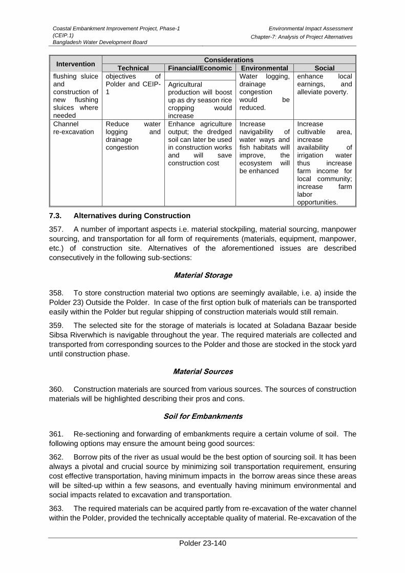
Coastal Embankment Improvement Project, Phase-1
(CEIP.1)
Bangladesh Water Development Board
Environmental Impact Assessment
Chapter-7: Analysis of Project Alternatives
Polder 23-140
Intervention Considerations
Technical Financial/Economic Environmental Social
flushing sluice and construction of new flushing sluices where needed
objectives of Polder and CEIP-1
Water logging, drainage congestion would be reduced.
enhance local earnings, and alleviate poverty.
Agricultural production will boost up as dry season rice cropping would increase
Channel re-excavation
Reduce water logging and drainage congestion
Enhance agriculture output; the dredged soil can later be used in construction works and will save construction cost
Increase navigability of water ways and fish habitats will improve, the ecosystem will be enhanced
Increase cultivable area, increase availability of irrigation water thus increase farm income for local community; increase farm labor opportunities.
7.3. Alternatives during Construction
357. A number of important aspects i.e. material stockpiling, material sourcing, manpower
sourcing, and transportation for all form of requirements (materials, equipment, manpower,
etc.) of construction site. Alternatives of the aforementioned issues are described
consecutively in the following sub-sections:
Material Storage
358. To store construction material two options are seemingly available, i.e. a) inside the
Polder 23) Outside the Polder. In case of the first option bulk of materials can be transported
easily within the Polder but regular shipping of construction materials would still remain.
359. The selected site for the storage of materials is located at Soladana Bazaar beside
Sibsa Riverwhich is navigable throughout the year. The required materials are collected and
transported from corresponding sources to the Polder and those are stocked in the stock yard
until construction phase.
Material Sources
360. Construction materials are sourced from various sources. The sources of construction
materials will be highlighted describing their pros and cons.
Soil for Embankments
361. Re-sectioning and forwarding of embankments require a certain volume of soil. The
following options may ensure the amount being good sources:
362. Borrow pits of the river as usual would be the best option of sourcing soil. It has been
always a pivotal and crucial source by minimizing soil transportation requirement, ensuring
cost effective transportation, having minimum impacts in the borrow areas since these areas
will be silted-up within a few seasons, and eventually having minimum environmental and
social impacts related to excavation and transportation.
363. The required materials can be acquired partly from re-excavation of the water channel
within the Polder, provided the technically acceptable quality of material. Re-excavation of the
Coastal Embankment Improvement Project, Phase-1
(CEIP.1)
Bangladesh Water Development Board
Environmental Impact Assessment
Chapter-7: Analysis of Project Alternatives
Polder 23-141
channels can ensure a considerable amount of earth during implementation of rehabilitation
works inside the Polder. This would curtail the cost of excavation for the borrow material,
although the cost of transportation to construction site would be slightly higher than the first
option, furthermore, some environmental and social impacts such as traffic congestion and air
pollution would be emerged within the Polder.
364. A considerable part of soil could be sourced from the borrow pits within the Polder. It
is done generally by mutual agreement with the land owners on the basis of compensation.
This option would involve the cost of excavation as like first option. Transportation cost, social
and environmental impacts and other parameters are almost similar to the second option, but
land degradation might be added with other environmental problems.
365. The material can be obtained from the river beds ensuring required quality unless the
soil from the riverside at outside the Polder embankment is suitably accepted;this option will
associate higher cost of material transportation along with other related environmental and
social problems such as traffic congestion, air and water pollution.
366. The final decision regarding the material source has not been finalized. This decision
is likely to be taken during construction period.
Sand
367. Sand is one of the fundamental part of constructions. It is usedbroadly to renovate
embankment, concret works, and manufacturing concrete blocks for protecting slope. Two
alternative options are available for acquiring sand.
368. Sand willbe procured directly from markets. This would entail consistent quality and
assured supply; however it would also entail increased transportation cost and associated
environmental and social impacts including traffic congestion and air pollution.
369. River bed is another option of obtaining sand. This source abolishes transportation
needs minimizing the associated costs, environmental as well as social impacts. However
quality of this sand may not be persistent in terms of quality and it is washed generally before
using.
370. However, the final decision regarding the source sand is yet to be decided. This
decision is generally taken during the construction phase.
Alternatives for Workforce Procurement
371. Two options of sourcing manpower for construction work are widely recognized. These
are explicated below.
372. Manpower is sourced as employing bulk from outside the Polder. But it creates a
chance of traffic congestion and air pollution as it requires larger camps and labor transport.
So, there is a probability of developing resentment which may lead to resistance from the local
community.
373. And definitely manpower from within the Polder as employing bulk would be another
option whereas only skilled and technical manpower would be brought from outside the Polder.
This option might be considered as better reducing labor camp sizes, and decreasing
transportationneed and associated environmental and social problems. This option offers
employment opportunities to the local community. So, it can increase their economic condition
Coastal Embankment Improvement Project, Phase-1
(CEIP.1)
Bangladesh Water Development Board
Environmental Impact Assessment
Chapter-7: Analysis of Project Alternatives
Polder 23-142
and also increase the local ownership of the project. Due to having all these advantages, this
option is preferred for manpower sourcing.
Alternatives for Mode of Transportation
374. In order to transport all construction materials from the source to main stock yard,
trucks are crucial and extensively used. And the materials are transferred from main stock to
construction site mostly in water ways, sometimes by roadway if feasible. Most of the roads
within the Polder is not suitable to carry heavy load vehicles, i.e. dump truck, trolley,
excavator,etc. That’s why sometimes small carts, non-motorized vehicles, manual labor, etc.
are used in road ways; and small boats, trawlers in waterways.
Waterways
375. Polder 23 is surrounded by Sibsa, Minaj and Kurulia River. Here mainly Sibsa River
flows perennially whereas other two are intermittent. Sibsa River generally remains navigable
all the year round and is used for transportation purposes during construction. The depth of
the River varies approximately from 10 meter to 15 meter with tide and ebb. Deposition
process and char (island) formation are not seen in the river.
Roadways
376. Upazila Road is still unsuitable to carry the heavy vehicular movement within Polder
area. That’s why waterway is used as the only way to transmit construction materials.
7.4. Comparison between No project and with Project Scenerio
377. The proposed interventions in order to get rid of above mentioned problems of Polder
23 under CEIP-1 are enlisted describing below. To pointout various aspects and
comprehending the significance of the proposed interventions within the Polder under the
Project, the ‘no project’ and ‘with project’ scenarios are compared in Table 7.3.
Table7.3: Comparison of ‘No Project’ and ‘With Project’ Scenarios
Proposed Works under CEIP-1
‘No Project’ Scenario ‘With Project’ Scenario
Re-sectioning of embankments (36.5km) and design crest level (5.00 m, PWD and 4.50 m, PWD)
At a certain number of points, the embankments will be further deteriorated and dropped below the design level. Therefore, cyclones, rise in surge heights due to global warming, and tidal actions will inundate the Polder, causing severe damage to the lives and property of local people.
Re-sectioned embankments would be more effective and resilient, and will safeguard the Polder against storm surges, floods, and higher tides due to global warming. Hence, reduction in loss of lives and assets caused by the natural disasters.
Because of submergence of the embankments during monsoon, transportation system would further deteriorate inside the Polder, and sufferings of local people would further increase.
Re-sectioned embankments will provide enhanced protection to Polder, facilitating transportation within the Polder even during monsoon.
Reduction of agricultural area, crisis situation for farmers from January to April (salinity intrusion) and May to August (flooding).
Re-sectioned embankments providing support to Polder facilitate enhanced agriculture activities and increased area for cultivation, thus increasing agriculture output.
Continued silt deposition inside the Polder due to cyclonic surges and
Decreased silt deposition in the Polder will result into improved
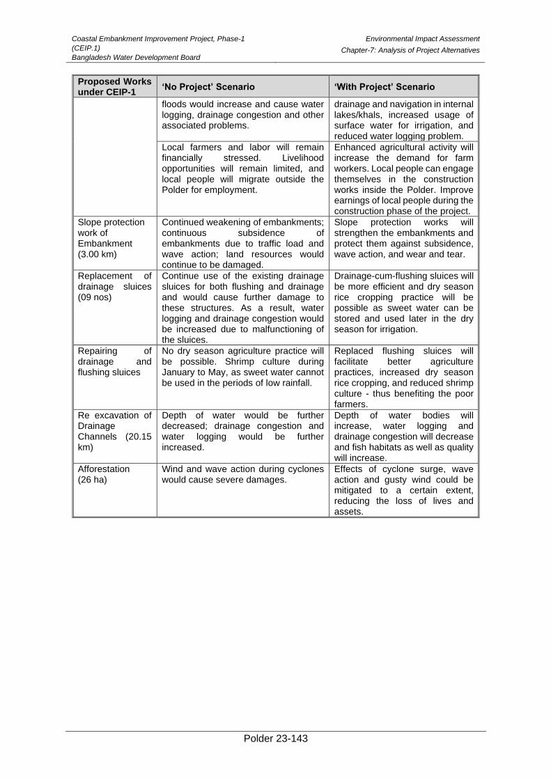
Coastal Embankment Improvement Project, Phase-1
(CEIP.1)
Bangladesh Water Development Board
Environmental Impact Assessment
Chapter-7: Analysis of Project Alternatives
Polder 23-143
Proposed Works under CEIP-1
‘No Project’ Scenario ‘With Project’ Scenario
floods would increase and cause water logging, drainage congestion and other associated problems.
drainage and navigation in internal lakes/khals, increased usage of surface water for irrigation, and reduced water logging problem.
Local farmers and labor will remain financially stressed. Livelihood opportunities will remain limited, and local people will migrate outside the Polder for employment.
Enhanced agricultural activity will increase the demand for farm workers. Local people can engage themselves in the construction works inside the Polder. Improve earnings of local people during the construction phase of the project.
Slope protection work of Embankment (3.00 km)
Continued weakening of embankments; continuous subsidence of embankments due to traffic load and wave action; land resources would continue to be damaged.
Slope protection works will strengthen the embankments and protect them against subsidence, wave action, and wear and tear.
Replacement of drainage sluices (09 nos)
Continue use of the existing drainage sluices for both flushing and drainage and would cause further damage to these structures. As a result, water logging and drainage congestion would be increased due to malfunctioning of the sluices.
Drainage-cum-flushing sluices will be more efficient and dry season rice cropping practice will be possible as sweet water can be stored and used later in the dry season for irrigation.
Repairing of drainage and flushing sluices
No dry season agriculture practice will be possible. Shrimp culture during January to May, as sweet water cannot be used in the periods of low rainfall.
Replaced flushing sluices will facilitate better agriculture practices, increased dry season rice cropping, and reduced shrimp culture - thus benefiting the poor farmers.
Re excavation of Drainage Channels (20.15 km)
Depth of water would be further decreased; drainage congestion and water logging would be further increased.
Depth of water bodies will increase, water logging and drainage congestion will decrease and fish habitats as well as quality will increase.
Afforestation (26 ha)
Wind and wave action during cyclones would cause severe damages.
Effects of cyclone surge, wave action and gusty wind could be mitigated to a certain extent, reducing the loss of lives and assets.
Polder 23-144
8. Environmental Impacts and Mitigation Measures
8.1. Preamble
378. This Chapter identifies the impacts of the project interventions on environment that
may potentially be caused by various Project phases and also suggests the appropriate
mitigation measures to avoid, offset, reduce, or compensate these impacts. Proposed
Interventions which may cause potential environmental impacts during pre-construction,
construction, and post-construction phases have been identified in Chapter 5. The following
detailed investigations have been carried out to assess the magnitude of these impacts:
• Environmental quality baseline monitoring of air, noise, surface water,
groundwater and soil;
• Ecological surveys comprising vegetation, wildlife and fisheries covering both
mainland and offshore area;
• Offshore surveys comprising socio-economic status and environmental
settings,
• Experts’ consultations focus group discussions, and public consultations.
• Census survey to assess the extent of resettlement (as required) loss of
vegetation, occupation, income and poverty status of the affected households.
8.2. Impact Screening
379. As part of the environmental impact assessment process, a screening matrix was used
specifically for the proposed Project, focusing the potential environmental impacts during the
design, construction and operation phases. The matrix examined the interaction of project
activities with various important components of the environment. The impacts were broadly
classified as physical, biological and social impacts, and each of them were further divided
into different aspects. The potential impacts thus predicted were characterized as follows:
• Highly negative (adverse) impact;
• Moderately negative impact;
• Insignificant impact;
• Highly positive (beneficial) impact;
• Moderately positive impact.
380. The matrix is provided in Table 8.1. The negative impacts predicted in this manner
were the ‘unmitigated’ impacts. Appropriate mitigation measures have been recommended
as part of this EIA study, for reducing the occurrence possibility and severity of the potentially
adverse impacts. The potentially negative impacts identified through this process are
discussed in the subsequent sections.

Coastal Embankment Improvement Project, Phase-1 (CEIP.1)
Bangladesh Water Development Board
Environmental Impact Assessment
Chapter-8: Environmental Impacts and Mitigation Measures
Polder 23-145
Table 8.1: Environmental Screening Matrix
Project Phases and Activities Physical Biological Social and Socioeconomic
A i r a n d
N o i s e
Q u a l i t y
E r o s i o n
F l o o d i n g
D r a i n a g e
s y s t e m
C h a n g e
o f l a n d
u s e
C r o p
p r o d u c t i o n
I r r i g a t i o n
F i s h
h a b i t a t a n d
m i g r a t i o n
B e n t h i c
f a u n a
C l e a r a n c e s
o f v e g e t a t i o n
O u t b r e a k
p l a n t
d i s e a s e
v e h i c u l a r
t r a f f i c
S a f e t y
a n d
P u b l i c
H e a l t h
H a z a r d s
I n l a n d
a n d
W a t e r w a y
T r a f f i c
P e d e s t r i a n
a n d
V e h i c l e
M o v e m e n t S o c i a l u n r e s t b e t w e e n
w o r k e r s
E m p l o y m e n t G e n e r a t i o n
G e n d e r P r o m o t i o n
S e a s o n a l O u t M i g r a t i o n
Pre-Construction Phase
Planning and design of the proposed
infrastructures 0 - - - - - - - - -
- - - - - - - - -
Preparation of construction site, labor
shed, material stock yard etc. 0 - - - 0 - - - - 0
- 0 - - - - LP - -
Labor, materials and equipment
mobilization - - - - - - - - - -
- 0 - - - - LP - -
Land acquisition and resettlement - - - - - - - - - - - - - - - - - - -
Construction Phase
Re-sectioning of embankment MN - - - - - - - - 0 - - MN - 0 MN MP - LP
Construction of Retired embankment MN - - - - - - - - 0 - - MN - - MN MP LP MP
Embankment slope pitching and turfing MN - - - - - - - - - - - MN - - MN MP MP LP
Construction of Drainage Sluices and
Flushing inlets MN - - - - 0 MN MN MN 0
- - MN MN MN 0 LP - -
Slope protection work of embankment 0 - - - - - - 0 - - - - MN - 0 MN MP - LP
Bank Revetment work MN - - MN - - - 0 - - - - MN MN 0 MN MP - LP
Placing of geo bags and CC Blocks - MN 0 MN - 0 - MN - 0 - - MN - 0 0 MP - LP
Re-excavation of Drainage Khals MN - - - - 0 MN MN MN - - - MN - - MN MP - MP
Implementing coastal afforestation - - - - - - - - - 0 - - - - MN MP LP MP
Operation Phase
Monitoring and Maintenance of
protective and earth works by BWDB. MP HP HP HP - - - - - -
- - - - - - -
Formation of local committees for
monitoring the works properly. HP HP HP HP - - - - - -
- - - - - - -
Key:-HN: High negative impact; MN: moderate negative impact; 0: insignificant/negligible impact; HP: high positive impact; MP: moderate positive impact.
Coastal Embankment Improvement Project, Phase-1
(CEIP.1)
Bangladesh Water Development Board
Environmental Impact Assessment
Chapter-8: Environmental Impacts and Mitigation Measures
Polder 23-146
8.3. Impacts during Pre-construction phase
381. The following activities should be carried out at pre-construction phase:
• Planning and design of proposed infrastructures
• Preparation of construction site, labor shed, material stock yard etc.
• Labor, materials and equipment mobilization
• Land acquisition and resettlemen
382. The above activities may create impact on the following environmental and social
components;
Deterioration of Air and Noise quality
Impact
383. Noise level around the construction sites and in settlement areas will be deteriorated
for mobilization of construction, materials, trawler equipment and man-power. Navigation will
be increased in the watercourses i.e. Sibsa, Kurulia and Minaj River. The increased navigation
is expected to intense the noise level of the local vicinity. Therefore, settlements, Bazar areas
and surroundings of the construction site will be affected by the increased noise level.Besides,
exhaust emission from materials and equipment mobilization trawlers and containing
particulate matter and other ingredients would deteriorate the ambient air quality around the
construction site and nearby areas due to movement of equipment carrying trawler. Fugitive
dust emissions from the material stockyards would also deteriorate the ambient air quality of
the locality. Moreover, the air and noise pollution are temporal and are reversible and will
naturally return to their baseline condition.
384. The significance of this unmitigated impact has been assessed as Minor on the basis
of impact magnitude and receptor sensitivity.
Mitigation
385. The mitigation measures suggested to address the above concerns are:
• Construction material (sand) should be covered while transporting and stock
piled.
• The contractors need to be cautious to avoid unnecessary honking of material
carrying trawler.
• The contractors should be encouraged to move all construction equipment,
machineries and materials during day time instead of night.
• Exhaust emissions from trawler and equipment should comply with the
standards of DoE.
• Sprinkling of water and ramming the materials of stockyard regularly.
• Stockyard should be covered during non working period.
Coastal Embankment Improvement Project, Phase-1
(CEIP.1)
Bangladesh Water Development Board
Environmental Impact Assessment
Chapter-8: Environmental Impacts and Mitigation Measures
Polder 23-147
Residual Impacts
386. The impacts associated with establishing the site facilities are likely to be adequately
addressed with the help of above mitigation measures. The significance of residual impacts
will be Low.
Change of Land Use
Impact
387. Land would be needed to establish temporary facilities including construction camp
(Labour shed) and borrow areas. Labour sheds would be constructed to establish temporary
facilities for the rehabilitation works. As per consultation with main consultant all labour sheds
(13-15) would be constructed in Khas land and requisition land.
388. For the re-excavation of canals, materials and equipment mobilization requires land at
site of the canals which is used for crops production.
389. The use of borrow pits area mainly remain fallow during dry season. In wet season,
these borrow pit area is used scattered for seedbed or grazing of livestock.
390. The significance of this potential unmitigated impact has been assessed as Low on
the basis of impact magnitude and receptor sensitivity. All the borrow pits of the foreshore
areas will be filled within one or two years due to tidal inundation.
Mitigation
391. The following measures should be implemented to address the above concerns:
• All the construction camps should be established within the area owned by
BWDB.
• Pay compensation/rent if private property is acquired on temporary basis, the
instructions should be specified in the tender document.
• Labor shed/camp should be constructed on government khas land.
• Avoid impacts on local stakeholders.
• Any areas used for borrow pits in the foreshore should be away from sensitive
areas such as mangrove vegetation, known fish spawning ground, habitatfor
any endangered flora /fauna species.
•
Residual Impacts
392. With the help of above mitigation measures, the impacts associated with changes in
land use are likely to be adequately addressed and the significance of residual impact will be
very low.
Clearances of vegetation
Impacts:
393. About 50 nos of timber trees (preliminary survey by EIA Team, to be finalized after
completion of RAP Survey) will need to be cut for trenching at proposed points ofembankment
for construction of drainage/flushing sluices. Except this, the fallow land beside embankment
can be used for all types of construction activities
Coastal Embankment Improvement Project, Phase-1
(CEIP.1)
Bangladesh Water Development Board
Environmental Impact Assessment
Chapter-8: Environmental Impacts and Mitigation Measures
Polder 23-148
394. In addition, there is a strips of about 1.5 km social afforestation from Chainage 10.0 to
11.5 km comprisingsaplings of Babla (Acacia nilotica) having average density of 9 saplings/m2.
All the saplings along the riverside slope will need to be cut during site preparation for slope
protection activities. However, the strip along countryside slope is not suspected to be
damaged.
Mitigation:
• Choose barren land and ground of Sluice Gateman’s houses for stocking
construction materials
• Proper compensation against tree felling inprivate land willbe given to the
owners according to Resettlement Action Plan (RAP)
• Implement tree plantation at the damaged sites and sluice surroundings after
completion of construction works
• Labor should be given early notice about plant conservation especially for
prescuring the countryside strips of plantation at slope protection site
(Chainage 10.0 to 11.5 km).
Residual Impacts
395. With the help of above mitigation measures, the impacts associated with establishing
the site facilities are likely to be adequately addressed and the residual impact will be very
low.
Increase in vehicular traffic during mobilization
Impact
396. During contractor mobilization, equipment, machinery, material, and manpower will be
transported to the Polder resulting in additional traffic on roads and waterways. This traffic
may potentially cause traffic congestion particularly at roads and jetties. The embankment is
the main road for communication for a large numberof the local people. Most of the internal
roads in the polder area have been damaged by Aila which are not suitable for movement of
vehicle. However, during Haat and marketing time, all the stakeholders use this embankment
as road for carrying their goods for buying and selling and other purposes. Mobilization of
contractor, equipment and machinery, construction material and manpower will be transported
to the Polder resulting in additional traffic on roads and in water ways. This may potentially
cause traffic congestion. Moreover, most of the schools are located near the embankment and
three important Bazars are also located besides the embankment. These will face traffic
congestion during Haat time. Earth work for re-sectioning of embankment and vehicles
movement also may create short term disturbances to the polder inhabitants.
Mitigation
397. The following measures will be implemented to address the above concerns:
• The contractor should prepare a traffic management plan (TMP) and obtain
approval from the DDCS&PMSConsultant.
• Contractor should also implement mobilization plan considering water vessels
and launch movement in the external rivers and avoid the launch movement
time.
Coastal Embankment Improvement Project, Phase-1
(CEIP.1)
Bangladesh Water Development Board
Environmental Impact Assessment
Chapter-8: Environmental Impacts and Mitigation Measures
Polder 23-149
• The TMP should be shared with the communities and should be finalized after
obtaining their consent.
• The TMP should address the existing traffic congestion particularly at the
Paikgaccha Bazar, Sholadana Bazar and Amurkata Bazar.
• Ensure minimal hindrance to local communities and commuters.
• The works on embankment should be carefully scheduled to minimize impact
on local markets and transportation routes.
• The embankment works should be carried out in segments and soil will be
placed linearly on half of the embankment, leaving the other half to be used as
track.
• The works of the first half should be completed, and then of the other half
should be undertaken.
• Work schedule tobe finalized in coordination and consultation with local
representatives and communities, specifically the Union Parishad members of
the Polder.
• Local routes will not be blocked as much as possible. If unavoidable,
alternative routes will be identified in consultation with local community.
• Vehicular traffic should be limitedin the Polder area and the embankment
during off peak time. To avoid accident, signal man should be appointed during
School time (10:00am to 13:00pm) and weekly marketdays (Hatbar)
• Keep provision of training on vehicular traffic moving pattern and management
system for the local stakeholders using multimedia presentation and showing
video at different common population gathering places in the Polder area.
Residual Impacts
398. The impacts on hindrance for pedestrian and vehicle movement are likely to be
adequately addressed with the help of above mitigation measuresand the significance of
residual impact will be Low.
8.4. Impacts during construction phase
399. The construction phase involves the following activities:
• Re-sectioning of embankment
• Construction of Retired embankment
• Embankment slope pitching and turfing
• Construction of Drainage Sluices and Flushing Sluices
• Demolishment of Flushing Sluices
• Slope protection work of embankment
• Placing of geo bags and CC Blocks
• Re-excavation of Drainage Khals
• Implementing coastal afforestation
400. The above activities would cause the following environmental and social impacts:
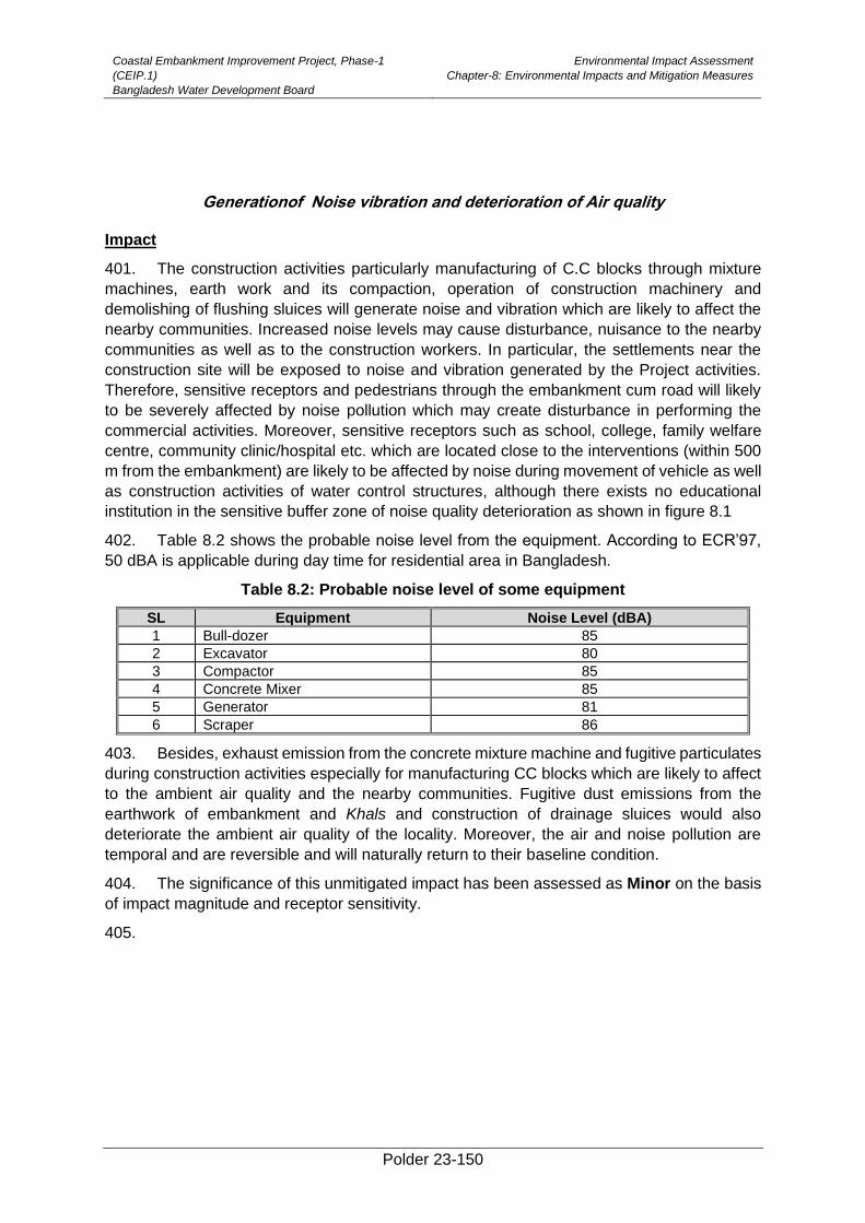
Coastal Embankment Improvement Project, Phase-1
(CEIP.1)
Bangladesh Water Development Board
Environmental Impact Assessment
Chapter-8: Environmental Impacts and Mitigation Measures
Polder 23-150
Generationof Noise vibration and deterioration of Air quality
Impact
401. The construction activities particularly manufacturing of C.C blocks through mixture
machines, earth work and its compaction, operation of construction machinery and
demolishing of flushing sluices will generate noise and vibration which are likely to affect the
nearby communities. Increased noise levels may cause disturbance, nuisance to the nearby
communities as well as to the construction workers. In particular, the settlements near the
construction site will be exposed to noise and vibration generated by the Project activities.
Therefore, sensitive receptors and pedestrians through the embankment cum road will likely
to be severely affected by noise pollution which may create disturbance in performing the
commercial activities. Moreover, sensitive receptors such as school, college, family welfare
centre, community clinic/hospital etc. which are located close to the interventions (within 500
m from the embankment) are likely to be affected by noise during movement of vehicle as well
as construction activities of water control structures, although there exists no educational
institution in the sensitive buffer zone of noise quality deterioration as shown in figure 8.1
402. Table 8.2 shows the probable noise level from the equipment. According to ECR’97,
50 dBA is applicable during day time for residential area in Bangladesh.
Table 8.2: Probable noise level of some equipment
SL Equipment Noise Level (dBA)
1 Bull-dozer 85
2 Excavator 80
3 Compactor 85
4 Concrete Mixer 85
5 Generator 81
6 Scraper 86
403. Besides, exhaust emission from the concrete mixture machine and fugitive particulates
during construction activities especially for manufacturing CC blocks which are likely to affect
to the ambient air quality and the nearby communities. Fugitive dust emissions from the
earthwork of embankment and Khals and construction of drainage sluices would also
deteriorate the ambient air quality of the locality. Moreover, the air and noise pollution are
temporal and are reversible and will naturally return to their baseline condition.
404. The significance of this unmitigated impact has been assessed as Minor on the basis
of impact magnitude and receptor sensitivity.
405.
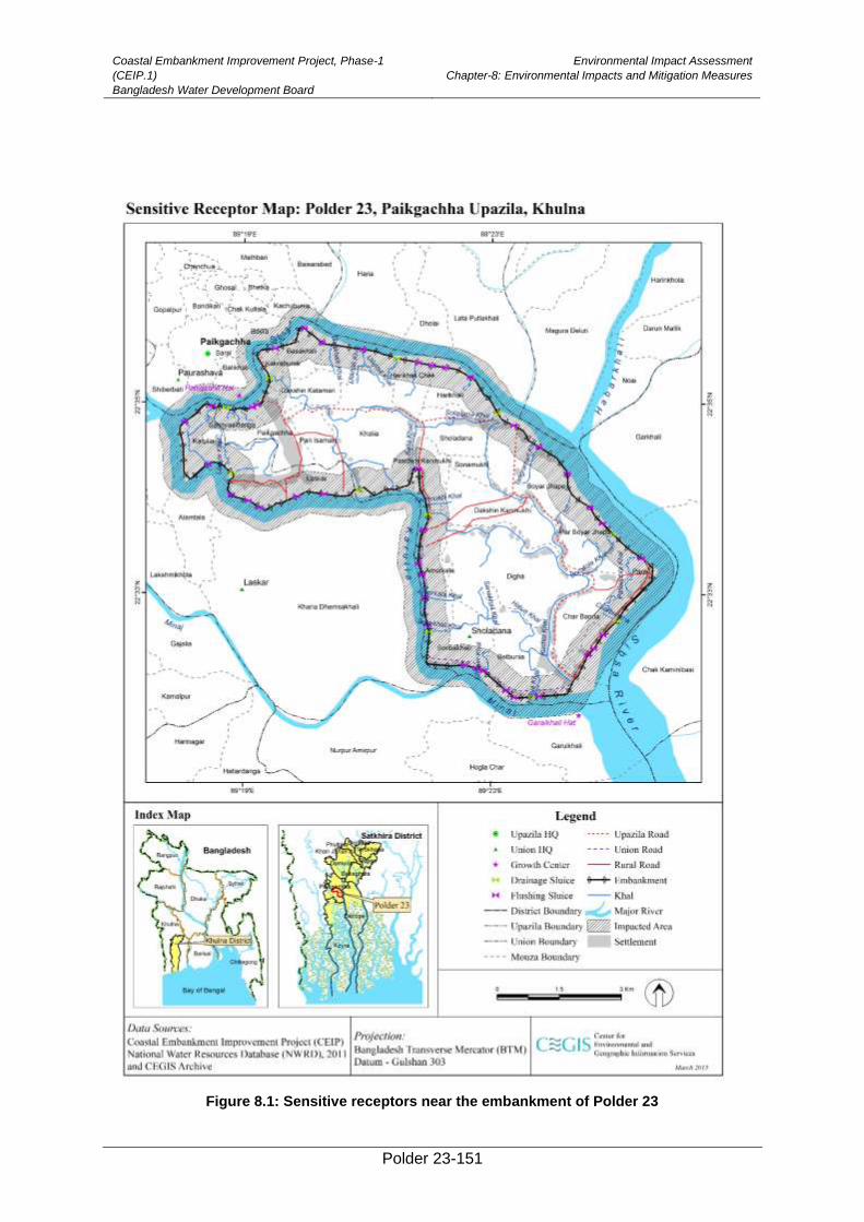
Coastal Embankment Improvement Project, Phase-1
(CEIP.1)
Bangladesh Water Development Board
Environmental Impact Assessment
Chapter-8: Environmental Impacts and Mitigation Measures
Polder 23-151
Figure 8.1: Sensitive receptors near the embankment of Polder 23
Coastal Embankment Improvement Project, Phase-1
(CEIP.1)
Bangladesh Water Development Board
Environmental Impact Assessment
Chapter-8: Environmental Impacts and Mitigation Measures
Polder 23-152
Mitigation
406. The following mitigation measures are being suggested to address the above
concerns:
• Construction machineries should have proper mufflers and silencers.
• Noise levels from the construction machineries should comply with national
noise standards (residential zone)
• Provision should be made for noise barriers at construction sites and near
schools, Madrashas and other sensitive receptors as needed.
• Sprinkling of water and ramming of the material during construction
• Exhaust emissions from the mixture machine should comply with standards
• Restricting/limiting construction activities during the day time.
• Provision of PPE (ear muffs and plugs) for labors.
• Installation of fugitive particulate matter system and spraying water on
construction materials.
• Construction team should be instructed to use the equipment properly, to
minimize noise levels.
• Liaison with the communities should be maintained and grievance redress
mechanism will be established at the site.
Residual Impacts
407. The impacts associated with noise and vibration is likely to be adequately addressed
with the help of the above mitigation measures. The significance of residual impact will be
Low.
Hindrance to the natural drainage system
Impact
408. The construction activity particularly for construction of drainage sluices, flushing
sluices and re-excavation of the Khals may create obstacle to the natural drainage system of
the study area especially around the project activity sites. During construction, the natural
drainage system of the area will be hampered and may create temporarily drainage congestion
in the Khals.Additionally, spoil earth from the excavation of Khals, would create also
disturbance to the natural drainage system.
409. The significance of this unmitigated temporal impact has been assessed as Minor on
the basis of impact magnitude and spatial extent.
Mitigation
410. The following mitigation measures are being suggested to address the above
concerns:
• Some temporaryearthen dams should be built in the khal behind the
construction of drainage sluices and behind the re-excavation segment at each
reach.
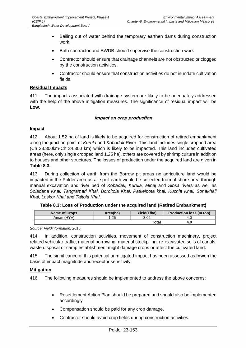
Coastal Embankment Improvement Project, Phase-1
(CEIP.1)
Bangladesh Water Development Board
Environmental Impact Assessment
Chapter-8: Environmental Impacts and Mitigation Measures
Polder 23-153
• Bailing out of water behind the temporary earthen dams during construction
work.
• Both contractor and BWDB should supervise the construction work
• Contractor should ensure that drainage channels are not obstructed or clogged
by the construction activities.
• Contractor should ensure that construction activities do not inundate cultivation
fields.
Residual Impacts
411. The impacts associated with drainage system are likely to be adequately addressed
with the help of the above mitigation measures. The significance of residual impact will be
Low.
Impact on crop production
Impact
412. About 1.52 ha of land is likely to be acquired for construction of retired embankment
along the junction point of Kurula and Kobadak River. This land includes single cropped area
(Ch 33.800km-Ch 34.300 km) which is likely to be impacted. This land includes cultivated
areas (here, only single cropped land 1.25 ha), others are covered by shrimp culture in addition
to houses and other structures. The losses of production under the acquired land are given in
Table 8.3.
413. During collection of earth from the Borrow pit areas no agriculture land would be
impacted in the Polder area as all spoil earth would be collected from offshore area through
manual excavation and river bed of Kobadak, Kurula, Minaj and Sibsa rivers as well as
Soladana Khal, Tangramari Khal, Boroitola Khal, Patkelpota khal, Kuchia Khal, Sonakhali
Khal, Loskor Khal and Taltola Khal.
Table 8.3: Loss of Production under the acquired land (Retired Embankment)
Name of Crops Area(ha) Yield(T/ha) Production loss (m.ton)
Aman (HYV) 1.25 3.02 4.0
Total 4.0
Source: Fieldinformation; 2015
414. In addition, construction activities, movement of construction machinery, project
related vehicular traffic, material borrowing, material stockpiling, re-excavated soils of canals,
waste disposal or camp establishment might damage crops or affect the cultivated land.
415. The significance of this potential unmitigated impact has been assessed as lowon the
basis of impact magnitude and receptor sensitivity.
Mitigation
416. The following measures should be implemented to address the above concerns:
• Resettlement Action Plan should be prepared and should also be implemented
accordingly
• Compensation should be paid for any crop damage.
• Contractor should avoid crop fields during construction activities.
Coastal Embankment Improvement Project, Phase-1
(CEIP.1)
Bangladesh Water Development Board
Environmental Impact Assessment
Chapter-8: Environmental Impacts and Mitigation Measures
Polder 23-154
• Contractor should avoid agricultural land for material borrowing, material
stockpiling and labor camps construction.
• Contractor should ensure that no vehicular movements take place inside
cultivation fields.
• Contractor should ensure that no material is dumped inside cultivation fields.
• Re-excavated soil of canals should not be dumped in agricultural land.
• Contractor should maintain liaison with communities.
Residual Impacts
417. With the help of above mitigation measures, the impacts associated with loss of
agriculture are likely to be adequately addressed and the significance of residual impact would
be very low.
Impact on irrigation
Impact
418. Construction activities particularly on regulators, water channels and re-excavation
(20.15 km) activity of canals can potentially disrupt irrigation during both wet and dry season,
thus negatively impacting cultivation. The works on sluices can cut off the incoming water from
the river; while the excavation works in water channels can affect water conveyance through
them and also saline water could enter the Polder area which can disrupt the crop production.
419. The significance of this potential unmitigated impact has been assessed as Moderate
on the basis of impact magnitude and receptor sensitivity.
Mitigation
420. The following measures should be implemented to address the above concerns:
• Contractorshould construct bypass channel before
construction/replacement/demolishing each regulator.
• Sequence of work at the regulators and in the water channels should be
carefully planned to avoid irrigation disruption.
• Contractor should ensure no negative impacts on crop irrigation.
• Contractor should maintain liaison with communities.
• Contractor should work during dry season.
Residual Impacts
421. The impacts associated with disruption of irrigation are likely to be adequately
addressed with the help of above mitigation measuresand the significance of residual impact
would be Low.
8.4.1. Impacts on Feeding and Spawning Ground of Fish Habitat
Impact
• Polder 14/1 is bounded by Kobodak and Arpangasia rivers on the west and Sakbaria River
on the eastern part of the Polder. As per consultation with local fishers during field visit it
is learnt that, the bank sides of these rivers have been reported as the feeding, nursery
Coastal Embankment Improvement Project, Phase-1
(CEIP.1)
Bangladesh Water Development Board
Environmental Impact Assessment
Chapter-8: Environmental Impacts and Mitigation Measures
Polder 23-155
and spawning ground of brackish water fish species like Chewa, Pairsha, Gulsha Tengra,
Bagda, chingri, etc. It is expected that activities of bank revetment (earth work from km 5.3
to km 5.7 and km 28.7 to km 29.3) and slope protection (earth work from km 1.0 to km 2.0,
km 3.0 to km 5.26, km 5.5 to km , km 7.0 to km 7.3, km 7.8 to km 8.8 and km 12.0 to km
12.5) would cause the partial destruction (if in the dry season) and full destruction (if in the
rainy season) the feeding, nursery and even spawning ground of these fish species.
• The significance of this potential unmitigated impact has been assessed as Major on the
basis of impact magnitude and receptor sensitivity.
Mitigation
• The following mitigation measures are being suggested to address the above concerns:
Earth work should be conducted during the dry season (November-May)
Sequence of work at the bank sides of Kobodak and Sakbaria rivers will be planned
considering local fisheries condtion to minimize impacts on spawning and
subsequently nursery ground of fish.
Contractor will maintain liason with experienced local fishermen.
Residual Impacts )
• The impacts on spawning and nursery ground are likely to be adequately addressed with
the help of above mitigation measures and the significance of residual impact will be Low.
422.
Impacts on Fish Habitat and Migration
Impact
423. A total of 20.15 km of internal Khals will be re-excavated under CEIP. It is expected
that khal re-excavation activities especially bailing out of water would damage fish habitat in
Khals and hamper fish migration temporarily during this phase. Migration of fish species
particularly Pairsa, Vetki (juvenile), Chingri, Gulsa, etc. are expected to be affected. Moreover,
feeding and breeding ground of the bottom dweller fishes will be lost. But after 1-2 year the
habitat quality will be improved. Impact magnitude of which thus is assessed as
Major.Similarly, 17 flushing inlets will be constructed on the Khals which would also obstruct
fish migration in the polder area. As damaged or mal-functioning drainage sluices will be
replaced by new one near the existing places, the drainage channels will not be clogged by
such activity. However, impact magnitude of such activities on fish migration is assessed as
Moderate.
424. The significance of the combined impacts have been assessed as Moderate on the
basis of impact magnitude and sensitivity to receptors.
Mitigation
425. The following mitigation measures will be implemented to address the above concerns:
• Construct diversion channels before construction of regulator considering fish
migration period e.g. May, June , July and August
• Most of the Small Indigenous Species (SIS) of fish spawn during the period of
November to April and keep important role in the recruitment to next progeny. For this
Coastal Embankment Improvement Project, Phase-1
(CEIP.1)
Bangladesh Water Development Board
Environmental Impact Assessment
Chapter-8: Environmental Impacts and Mitigation Measures
Polder 23-156
reason, limit the construction and re-excavation activities in the shallow area and/or
maintain the alignment of bank side to keep space in other side for accomplishing
migration to meet up the biological needs like spawning, feeding etc.
• Dismantle the bunds and other obstructions built for supporting the construction of
structures as soon as the construction is over.
• In case of manual re-excavation of khals, compartment would be built and bailing out
of water from one compartment to another for less damage to fish and excavate in
cascading manner.
• Re-excavation of drainage khals will follow the construction of regulators by spanning
a shortest possible time. Re-excavation of Khals should be implemented by
maintaining the alignment of side so that fish can utilize the space on the other side for
its migration. As a result, construction activities will have minimum hindrnace to fish
migration.
• Contractor will maintain liaison with fishers and farmers so that they could realize the
issue for minimum impact to the shrimp farming and paddy cultivation.
Residual Impacts
426. The impacts on fish habitat and migration are likely to be adequately addressed with
the help of above mitigation measures, and the significance of residual impact will be Low.
Impact on Benthic Founa
Impact
427. During activities of re-excavation of Khals especially bailing out of water from the Khals
would hamper the khal habitat condition. The habitat of Mud eel fish species (chew, baim etc)
and benthic organisms will be affected by this activity.
428. The significance of the combined impacts have been assessed asMajor on the basis
of impact magnitude and sensitivity to receptors.
Mitigation
429. The following mitigation measures should be implemented to address the above
concerns:
• Khal re-excavation should be carried out segment wise.
• Contractor will carry out khal excavation in segment thus minimizing impacts
on benthic fauna.
• Monitor pre and post analysis of benthic fauna.
Residual Impacts
430. The Project’s impacts on benthic fauna will be somewhat reduced with the help of the
above mitigation measures. After the construction phase, these resources are likely to fully
recover gradually. The significance of the residual impacts has therefore been assessed as
Low. Monitoring required.
Coastal Embankment Improvement Project, Phase-1
(CEIP.1)
Bangladesh Water Development Board
Environmental Impact Assessment
Chapter-8: Environmental Impacts and Mitigation Measures
Polder 23-157
Clearance of vegetation
Impacts:
431. Existing undergrowth vegetation along the embankment slopes would be buried
byplacing of earth during re-section. The foreshore undergrowth vegetation will also be
damaged at places from where soil would be collected. In the case of this polder, most of the
plant species at the proposed re-sectioned alignment and soil collection sites are seasonally
grown and life span is not more than one year. So, it is expected that the damaged sites will
recover within 1 to 2 years by natural regeneration of herbs and shrubs. Existing big trees at
the embankment slopes will not be cut for re-sectioning in most of the cases. For this reason,
this negative impact is temporary and recoverable.
432. The significance of this potential unmitigated impact has been assessed as Major on
the basis of impact magnitude and receptor sensitivity.
Mitigation:
• Collect soil from barren land as much as possible
• Proper turfing should be implemented at embankment slopes with local grasses (i.e
Durba (Cynodon dactylon), Mutha (Cyperus rotundus)) and ensure regular monitoring
of turf grasses till they mature.
Residual Impacts
433. With the help of the above mitigation measures, the impacts associated with re-section
of embankment will no residual impact.
Outbreak of plant diseases
Impacts:
434. There is a chance of damageto existing undergrowth vegetation (i.e. brackish grasses,
saplings of mangrove trees) due to movement of labor who will be engaged for plantation.
Incautious disposal of sapling’s poly bags may cause deterioration of soil quality. Besides
there may be a risk of outbreak of plant diseases to the other existing plants from the planted
disease affected saplings. Water flow in creeks and strips of planted area may be interrupted
byaccumulationof plant or plant shoots. Inadequate distance between two saplings may hinder
proper growth and cause disease outbreak.
435. Foreshore area of this Polder is not abounding with mangrove vegetation. There are
some small mangrove patches along the foreshore area at Patkelpota village. However,
incautious movement of labor may damage the vegetation.
Mitigation:
• Labor should be aware about the right way of plantation works without
damaging any existing vegetation
• Keep setback distance in plantation plan layout from the water passes
• All kinds of polyethylene bags and plastic ropes should be piled up in a pit for
dumping or burned in a proper way
• Care should be taken for physical and biological control of plant disease while
nursery raising and sapling plantation (i.e. using of disease free seeds, proper
treatment of nursery soils, using appropriate doses of pesticides and fertilizers)
Coastal Embankment Improvement Project, Phase-1
(CEIP.1)
Bangladesh Water Development Board
Environmental Impact Assessment
Chapter-8: Environmental Impacts and Mitigation Measures
Polder 23-158
• Pre-consultation with Forest Department and other related non-government
organizations for selecting of suitable species for plantation and spacing of the
saplings
• Develop a pest management plan for the holistic afforestation
• Collect saplings from nearer natural source (i.e. from The Sundarbans forests
beside Shibsha river) as much as possible and consult with Forest Department
for providing required saplings
Safety and Public Health Hazards
Impact
436. The area is prone to cyclones and storm surges. Although the works will be carried out
during the dry season, a certain level of safety hazards still exists for the construction staff.
The construction activities will involve operation of heavy construction machinery, vehicular
traffic, excavation and filling operations. These activities may pose some safety hazards to the
local population as well as for the construction workers. The fuel storage at the camp sites
may also pose safety hazards for the construction staff as well as for surrounding population.
Inappropriate waste disposal at the camps and construction sites, and air quality deterioration
caused by the Project’s vehicular traffic and construction activities potentially pose health
hazards for the construction staff and nearby population. Unhygienic condition and
unavailability of safe drinking water for the construction staff will expose them to health risks.
In addition, influx of construction staff might potentially expose the nearby population to
communicable diseases.
437. The significance of this potential unmitigated impact has been assessed as Moderate
on the basis of impact magnitude and receptor sensitivity.
Mitigation
438. The following measures should be implemented to address the above concerns:
• The contractors should prepare site specific Health, Safety and Environment
(HSE) Plan and obtain approval from the Construction Supervision
Consultants. The Plan should also include awareness rising and preventive
measures particularly for communicable diseases such as hepatitis B and C,
and HIV/AIDS.
• The WBG’s EHS Guidelines should be included in the contract documents and
that should be followed during construction.
• Liaison should be established with the Bangladesh Meteorological Department
for early warning of storms and cyclones. Radio and television sets will be kept
in all the labor camps for obtaining weather information.
• Each contractor should prepare an Emergency Response Plan defining
procedures to be followed during any emergency. This plan will be submitted
to Construction Supervision Consultants for review and approval;
• All workers must be provided with appropriate Personal Protective Equipment
(PPE) and should use them. First aid must be provided and there should be
procedures in place to access appropriate emergency facilities; procedures to
be notified all

Coastal Embankment Improvement Project, Phase-1
(CEIP.1)
Bangladesh Water Development Board
Environmental Impact Assessment
Chapter-8: Environmental Impacts and Mitigation Measures
Polder 23-159
• The construction sites should have protective fencing to avoid any
unauthorized entry, where appropriate and possible
• Health screening of employees would be a Contractor obligation prior to
laborers working on site and living in the temporary accommodation facilities.
The health screening would entail normal review of physical fitness and also
include a review of appropriate vaccinations. Workers would be given
vaccinations where required;
• All employees need to carry out induction health and safety training prior to
commencement of work. OHS issues would be part of the employee training
plan. Training would include the provision of appropriate written or visual
materials to reinforce learning. Where illiteracy levels are high, OHS issues
need to be covered more frequently than normal in toolbox talks;
• Public awareness training and workshops on safety and health risks will be
conducted for local communities prior to and during construction operations.
• Observing statutory requirements relating to minimum age for employment of
children and meeting international standards of not employing any person
under the age of 16 for general work and no persons under the age of 18 for
work involving hazardous activity. The construction contractor(s) would not hire
people under the age of 18 on permanent contracts but would include short
training activities for youth to the extent possible;
• Ensuring acceptable conditions of work including observing national statutory
requirements related to minimum wages and hours of work;
• Ensuring no workers are charged fees to gain employment on the Project;
• Ensuring rigorous standards for occupational health and safety are in place;
• Contractor should establish a labor grievance mechanism and documenting its
use for complaints about unfair treatment or unsafe living or working conditions
without reprisal.
• The contractor should adopt a Human Resource Policy appropriate to the size
and workforce which indicates the approach for management employees (this
could be part requested in the tender process);
• Produce job descriptions and provide written contracts and other information
that outline the working conditions and terms of employment, including the full
range of benefits;
• Provide health insurance for employees for the duration of their contracts;
• Provide insurance for accidents resulting in disabilities or death of employees
for the duration of their contracts;
• Develop a recruitment process community employees that involves local
authorities in clearly understood procedures;
• Employ a community liaison officer (this could be full time or part of another
post’s responsibilities);
• Raise awareness prior to recruitment, clarifying the local hire policy and
procedures, including identification of opportunities for women to participate in
employment and training;
Coastal Embankment Improvement Project, Phase-1
(CEIP.1)
Bangladesh Water Development Board
Environmental Impact Assessment
Chapter-8: Environmental Impacts and Mitigation Measures
Polder 23-160
• Report regularly on the labor force profile, including gender, and location
source of workers;
• Report regularly on labor and working condition key performance indicators, for
instance hours worked (regular and overtime) during period and cumulatively,
hours lost, number and type of accidents, near misses, site audits and
meetings; trainings, and use of labor grievance mechanism;
• Hold toolbox talks on workers’ rights and the labor grievance mechanisms
during the construction phase;
• Organize a training program and keep training registers for construction
workers;
• Establish Occupational Health and Safety (OHS) procedures in the overall
environmental management system which will provide workers with a safe and
healthy work environment taking into account the inherent risks for this type of
project.
➢ Availability of safe drinking water should be ensured for the construction staff. ➢ First aid boxes should be made available at each construction site. Emergency
phone numbers (including hospitals, Fire Department, and Police) should be displayed at key locations within the site. Each site should have an ambulance available.
➢ Firefighting equipment should be made available at the camps and worksites.
• Waste management plan to be prepared and implemented in accordance with
international best practice.
• Liaison with the community should be maintained.
Residual Impacts
439. With the help of above mitigation measures, the impacts associated with safety and
health hazards are likely to be mostly addressed and the significance of residual impact will
be low.
Labor force related impacts
Impact
440. Around 100 skilled workers/technical staff/operators/drivers and about 100 common
labour are considered required for construction activities 12 . The common labours are
considered to be recruited among the local people in the Polder. No need for any worker’s
camp is considered .
441. Contractor’s staff may not be accustomed to local conditions and people’s culture,
causing incidents of tension with the local population.
442. The significance of this potential unmitigated impact has been assessed as Moderate
on the basis of impact magnitude and receptor sensitivity.
Mitigation
12 Lessons learnt from the implementation of Package-I. Source: Package-I contractors Progress
Reporting.
Coastal Embankment Improvement Project, Phase-1
(CEIP.1)
Bangladesh Water Development Board
Environmental Impact Assessment
Chapter-8: Environmental Impacts and Mitigation Measures
Polder 23-161
443. The following mitigation measures are to be implemented to address the above
concerns:
• The Contractor will provide proper housing for his staffs at a site with adequate
facilities securing neighbours arenot disturbed.
• The Contractor will prepare and implement a Code-of-Conduct for his staff showing
respect to comply with and not offend local customs and cultural norms.
Residual Impacts
444. The impacts associated with labor force related impacts are likely to be adequately
addressed with the help of above mitigation measures, and the significance of residual impact
will be Low.
Increased Inland and Waterway Traffic
Impact
445. Transportation of construction materials is a key concern during the Project since the
Polder 23 is located in a remote area of Paikgachha Upazila under Khulna district. Two broad
options are available for carrying construction materials to the Project stockyards in the Polder.
The first option is road transportation and the other option is waterway transportation which is
comparatively easier, cost effective and fast way. Material transportation along the major
roads and waterways may not create a significant problem; however, additional traffic at
smaller jetties may cause traffic congestion and hindrance to other commuters, travelers, and
transporters. For material transportation from the stock yard to the construction sites, Polder’s
internal roads can be used; alternatively, the outer rivers can also be used for this purpose.
446. The significance of this potential unmitigated impact has been assessed as Moderate
on the basis of impact magnitude and receptor sensitivity.
Mitigation
447. The following measures will be implemented to address the above concerns:
• Contractor to prepare and implement traffic management plan.
• Contractor to establish new, temporary jetties where needed.
• River crossing for material transportation during nighttime where possible and
appropriate
• Material transportation through rivers during high tide where needed.
• Liaison should be maintained with community and BIWTA.
Residual Impacts
448. With the help of above mitigation measures, the impacts associated with additional
traffic on roads and along water ways are likely to be adequately addressed and the
significance of residual impact will be Low.
Hindrance for Pedestrian and Vehicle Movement
Coastal Embankment Improvement Project, Phase-1
(CEIP.1)
Bangladesh Water Development Board
Environmental Impact Assessment
Chapter-8: Environmental Impacts and Mitigation Measures
Polder 23-162
Impact
449. Three main markets are located in the polder near the embankment; these include the
Paikgaccha Bazar, Sholadana Bazar and Amurkata Bazar. These markets play an important
role by providing source of livelihood of the Polder inhabitants as well as meeting the daily
needs of the people. Construction activities along the embankments are likely to disrupt these
markets. In addition, the tracks (mostly brick soled) on the embankments are the key
transportation routes both for pedestrians and vehicles in the Polder connecting the
communities and markets. The construction activities along these embankments will result in
removal of these tracks thus causing communication and transportation problems to the local
population.
450. The significance of this potential unmitigated impact has been assessed as Moderate
on the basis of impact magnitude and receptor sensitivity.
Mitigation
451. The following measures should be implemented to address the above concerns:
• The works on embankment should be carefully scheduled to minimize impact
on local markets and transportation routes.
• The embankment works should be carried out in segments and soil should be
placed linearly on half of the embankment, leaving the other half to be used as
track. When the works are completed on the first half, it will be opened for local
traffic while works will be undertaken on the other half of the embankment.
• Work schedule should be finalized in coordination and consultation with local
representatives and communities.
• Local routes shouldnot be blocked as much as possible. If unavoidable,
alternative routes will be identified in consultation with local community.
• GRM will be put in place.
Residual Impacts
452. With the help of above mitigation measures, the impacts on the floral resources are
likely to be adequately addressed and the significance of residual impact will be Low.
Social unrest between Local and outside workers
Impact
453. A large number of skilled and unskilled labors will be required for construction activities.
Most of the labors will be needed for re-sectioning of embankment and retired embankment.
It is envisaged that about 60 percent construction workers will be recruited from within the
Polder while the remaining will come from other areas. The presence of outside laborers in
the area may create friction and conflict between the local labor and outside labors, and
between local community and outside labors.
• Demand of the local people related to the labor recruitment processes.
• Conflicting issues between the labors and the contractors related to wage,
working hour, working facilities, women workers involvement and payment
schedule.
• May create labor leadership problem.
Coastal Embankment Improvement Project, Phase-1
(CEIP.1)
Bangladesh Water Development Board
Environmental Impact Assessment
Chapter-8: Environmental Impacts and Mitigation Measures
Polder 23-163
454. Presence of a large number of outside labor can potentially cause encroachment in
the privacy of local population particularly women and their mobility can be negatively affected.
455. The significance of this potential unmitigated impact has been assessed as Moderate
on the basis of impact magnitude and receptor sensitivity.
Mitigation
456. The following measures should be implemented to address the above concerns:
• Proper awareness programs should be conducted through public consultation
measures such as village scoping sessions, meetings, and placement of bill
boards with assistance from the Union Parishad Chairman, Upazila Nirbahi
Officer (UNO) and BWDB local officers.
• Liaison with the communities should be maintained.
• Cultural norms of the local community should be respected and honored.
• GRM should be established to address the grievances of local as well as
outside laborers.
• Careful use of local natural resources and project resources, fuel, fuel-wood
and electricity.
• Restrictions related to consumption of alcohol and drugs.
• Safe driving practices.
• Respect for the local community and its cultural norms in which laborers are
working.
• Avoiding construction activities during prayer time.
Residual Impacts
457. With the help of above mitigation measures, the impacts associated with social unrest
are likely to be adequately addressed and the significance of residual impact will be Low.
Seasonal Impacts due to natural hazards
Impact
458. Historically, this area is vulnerable to cyclones, storms and tidal surges. As per
construction schedule, the rehabilitation activities of the polder will be conducted from October
to May while most of the cyclone and storm surges occurr in this area. According to previous
records of cyclones and storm surges, October to November and April to May are the peak
monthsof occurrence of cyclones and storm surges. It is suspected that the construction
activities during this period may be hampered as well as workers may get injured.
Mitigation
459. The following measures should be undertaken to address the above concerns:
• Weather signals should be considered by the contractor during construction works.
• Radio and television should be provided in all the labor sheds for receiving weather
information through these media.
• Ensuring rigorous standards for occupational health and safety are in place.
Coastal Embankment Improvement Project, Phase-1
(CEIP.1)
Bangladesh Water Development Board
Environmental Impact Assessment
Chapter-8: Environmental Impacts and Mitigation Measures
Polder 23-164
Residual Impacts
460. With the help of above mitigation measures, the impacts associated with seasonal
impacts (natural hazards) are likely to be adequately addressed and the significance of
residual impact will be Low.
8.5. Impacts during Post-construction Phase
461. After rehabilitation of the Polder, the following environmental and social impact may
occur.
Increased Use of Agro-chemical
Impact
462. At present, 356 ha of land are under Aman rice cultivation. Shrimp culture practices
are dominating here due to availability of saline water. After the fulfillment of intervention at
Polder area, agricultural practices covered land would increase instead of shrimp farming.
Continuousagriculture practices cause reduction of soil fertility and increase use of agro-
chemicals.
463. Presently, 148 tons of chemical fertilizers are required for cultivation of Aman rice. The
pesticide requirement for total rice production is 1.4 tons (Granular) and 0.25 tons (Liquid).
According to the initial estimates, non-saline water would be available from the internal canal
system, after the completion of the proposed Project and also reduce the salinity problem of
entire polder area. This would allow expansion of area under irrigation for initiation of Boro
cultivation and also increase Aman rice production. This expansion of irrigated cultivation is
likely to result in decreased soil fertility and increased use of chemical inputs including
fertilizers and pesticides. Due to expansion of Aman cultivation, additional 9.1 tons of chemical
fertilizers and 0.088 tons (Granular) 0.015 tons (Liquid) pesticide would be required for crop
production in future (Table 8.4). Runoff from such cultivation fields might potentially pollute the
water bodies and even drinking water sources thus causing health hazards to the
communities.
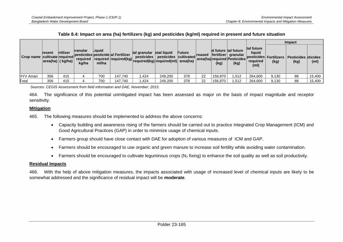
Coastal Embankment Improvement Project, Phase-1 (CEIP.1)
Bangladesh Water Development Board
Environmental Impact Assessment
Chapter-8: Environmental Impacts and Mitigation Measures
Polder 23-165
Table 8.4: Impact on area (ha) fertilizers (kg) and pesticides (kg/ml) required in present and future situation
Crop name Present
cultivate area(ha)
Fertilizer required ( kg/ha)
Granular pesticides required
kg/ha
Liquid pesticide required
ml/ha
Total Fertilizer required(kg)
Total granular pesticides
required(kg)
Total liquid pesticides
required(ml)
Future cultivated area(ha)
Increased area(ha)
Total future fertilizer required
(kg)
Total future granular
Pesticides (kg)
Total future liquid
pesticides required
(ml)
Impact
Fertilizers (kg)
Pesticides (kg)
Pesticides (ml)
HYV Aman 356 415 4 700 147,740 1,424 249,200 378 22 156,870 1,512 264,600 9,130 88 15,400
Total 356 415 4 700 147,740 1,424 249,200 378 22 156,870 1,512 264,600 9,130 88 15,400
Sources: CEGIS Assessment from field information and DAE, November; 2015;
464. The significance of this potential unmitigated impact has been assessed as major on the basis of impact magnitude and receptor
sensitivity.
Mitigation
465. The following measures should be implemented to address the above concerns:
• Capacity building and awareness rising of the farmers should be carried out to practice Integrated Crop Management (ICM) and
Good Agricultural Practices (GAP) in order to minimize usage of chemical inputs.
• Farmers group should have close contact with DAE for adoption of various measures of ICM and GAP.
• Farmers should be encouraged to use organic and green manure to increase soil fertility while avoiding water contamination.
• Farmers should be encouraged to cultivate leguminous crops (N2 fixing) to enhance the soil quality as well as soil productivity.
Residual Impacts
466. With the help of above mitigation measures, the impacts associated with usage of increased level of chemical inputs are likely to be
somewhat addressed and the significance of residual impact will be moderate.
Coastal Embankment Improvement Project, Phase-1
(CEIP.1)
Bangladesh Water Development Board
Environmental Impact Assessment
Chapter-8: Environmental Impacts and Mitigation Measures
Polder 23-166
Reduced Fish Migration Time
Impact
467. The mal-function drainage sluices in the polder area are still facilitating the migration
of Pairsa, Vetki,Gulsha, Tengraand Chingri fishes from river to internal khal and vice-versa.
However, drainage sluice gates are designed to control water for improvement of drainage
system of the Polder area. Sluice gates are mainly operated in order to meet the irrigation
purpose. Thus, the improved drainage sluices would hamper the migration behavior of the
above mentioned fish species. Moreover, the migration of fish specieswould be very restricted
with the replacement of the proposed drainage sluices.
468. The significance of the combined impacts have been assessed as Moderate on the
basis of impact magnitude and sensitivity to receptors.
Mitigation
469. The following mitigation measures will be implemented to address the above concerns:
• Follow sluice gate operation manual (Appendix-E) for allowing fish migration;
• Provide training to WMOs regarding gate operations;and
• Transferring juvenile fish from rivers to Polder.
• Fish pass may assist in the fish migration.
Residual Impacts
470. The impacts on migration status are likely to be adequately addressed with the help of
above mitigation measures and the significance of residual impact will be very low.
Impact on Shrimp Farming and Livelihood
Impact
471. Shrimp farming is a common practice in this polder area. From the field visit, it
wasfound that about 80% of the total area of land inside the polder has been converted to
shrimp culture Ghers. A few area of paddy land wasfound at the periphery of the embankment
near the Kurulia River. There is no paddy land in the middle of the polder area. A significant
number of farmers are involved in shrimp farming in this area because it is more profitable
than paddy. Shrimp export contributes significantly to the local and national economic
development, employment and income generation as well as livelihood improvement.
However, after implementation of the proposed intervention, saline water intrusion by
unauthorized structures and water control structures will be stopped. As a result, paddy land
area will increase compared to its base condition. On the other hand, shrimp farming area
may be impacted due to reduction in saltwater intrusion. Thus, fish production from shrimp
Gher may decline. The livelihood of the shrimp farmers will be impacted.
472. The significance of this potential unmitigated impact has been assessed as Major on
the basis of impact magnitude and sensitivity to receptors.
Coastal Embankment Improvement Project, Phase-1
(CEIP.1)
Bangladesh Water Development Board
Environmental Impact Assessment
Chapter-8: Environmental Impacts and Mitigation Measures
Polder 23-167
Mitigation
• Prospective of Golda farming should be encouraged through campaigning and
by providing training on improved culture practices as well as rice-cum-golda
farming within sweet water was available as these are eco-friendly in nature
• Alternative income generation, i.e. livestock rearing, poultry and integrated fish
culture may create scope of alternative income for shrimp farm labour; and
• Implementationoflandzoning for shrimp Gher in the polder area.
Residual Impacts
473. The impacts on migration status are likely to be adequately addressed with the help of
above mitigation measures and the significance of residual impact will be Moderate.
Risk of Embankment Failure
Impact
474. Rain cuts, wave action, tidal surge and public cuts are the major causes of
embankment breaching of the coastal region. Lack of regular maintenance has created weak
point at the sensitive locations of the embankment. Mal-maintenance and increasing intensity
and magnitude of the cyclone and storm surge have accelerated the risk of embankment
failure. Counter clockwise circulation of the cyclone of the Bay of Bengal will make the
embankment too more susceptible to breaches. On the other hands, Hand tube-wells, which
is locally known as ninety tube-well, have been installed at the crest of the embankment by
Gher owners for lifting saline water to satisfy the water demand for shrimp cultivation which
hass seriously weakened the embankment which increasingthe risk of embankment failure.
Mitigation
475. The following measures will be implemented to address the above concerns:
• Regular monitoring and careful maintenance of the embankment and existing
water control structures especially along the eastern side of the Polder should
be ensured. This monitoring will particularly be carried out before and after
monsoon season.
• Prevention of establishing hand tube-wells at the crest of the embankment.
• Available cyclone and flood shelter should be prepared as a contingency
measure during emergency situation.
• WMG should develop a fund for this kind of emergency situation.
• Structural measures like geo bag and sand bag should be kept in stock yard of
local BWBD previses.
Residual Impacts
476. With the help of above mitigation measures, the impacts associated with risk of
embankment failure are likely to be adequately addressed and the significance of residual
impact will be Low.
Coastal Embankment Improvement Project, Phase-1
(CEIP.1)
Bangladesh Water Development Board
Environmental Impact Assessment
Chapter-8: Environmental Impacts and Mitigation Measures
Polder 23-168
8.6. Positive Impact of the Project
Protect tidal flooding and storm surges
Impact
477. The proposed re-sectioning and retirement of embankment with new design section
by CEIP considering 5th IPCC (2013) predicted global sea level rise will protect the polder area
significantly from tidal flooding and further storm surges. At present about 60% of the
embankment is under designed section and extremely vulnerable condition at Boyar Jhapa to
Patkelpota along the Sibsa River, Paschim Kanmukhi, Karulia, Laskar areas of the polder
which will be protected noticeably after implementation of the proposed interventions under
CEIP.
478. The significance of this potential positive impact has been assessed as Major on the
basis of impact magnitude.
Erosion protection
Impact
479. The proposed slope protection works along the embankment would protect the polder
area from river erosion. If the proposed protective work is implemented adequately at the
mentioned locations or chainage, the Polder will be protected significantly from river bank
erosion. Besides, proposed afforestation along the rivers at proposed locations will also
protect the polder from the river erosion due towave action during high tide. Moreover, it will
safeguard social livelihood and ensure socio-economic security, assets along with the
ecosystem of the study area.
480. The significance of this potential positive impact has been assessed as Major on the
basis of impact magnitude.
Improved drainage system
Impact
481. After implementation of the proposed re-excavation of internal drainage Khals and
construction (replacement and repairing) of drainage sluices and flushing sluices as per design
and specification by CEIP, the drainage system and situation of the polder area would improve
significantly. The conveyance capacity of the Khals will increase andalso increased water
retention capacity of the polder area. Consequently, the cropping pattern will increase while
presently about 80% of the Polder net area is covered by shrimp culture ghers. Drainage
congestion in Taltola khal, Garikhalir khal, Ulikhali khal, Sholadana khal, Tangramari khal,
Masterpara khal, Boroitola khal, Patkelpota khal, Charbandha khal, Kuchia khal,
Burimara/Hatuakhari khal, Choper khal, Sonakhali khal, Amorkata khal, Kainmukhi khal, Kalia
khal, Parishanari khal, Loskar khal, Sibbati khal, Sannasidanga khal and Boxsodou khal during
monsoon will be removed and drainage pattern will be smoother than present condition.
482. The significance of this potential positive impact has been assessed as Moderate on
the basis of impact magnitude.
Protect salinity intrusion
483. According to the proposed intervention, re-sectioning and retired embankment and
construction (replacing and repairing) of drainage sluices and flushing sluices as per design
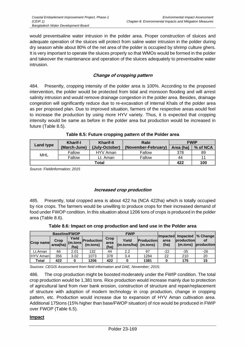
Coastal Embankment Improvement Project, Phase-1
(CEIP.1)
Bangladesh Water Development Board
Environmental Impact Assessment
Chapter-8: Environmental Impacts and Mitigation Measures
Polder 23-169
would preventsaline water intrusion in the polder area. Proper construction of sluices and
adequate operation of the sluices will protect from saline water intrusion in the polder during
dry season while about 80% of the net area of the polder is occupied by shrimp culture ghers.
It is very important to operate the sluices properly so that WMOs would be formed in the polder
and takeover the maintenance and operation of the sluices adequately to preventsaline water
intrusion.
Change of cropping pattern
484. Presently, cropping intensity of the polder area is 100%. According to the proposed
intervention, the polder would be protected from tidal and monsoon flooding and will arrest
salinity intrusion and would remove drainage congestion in the polder area. Besides, drainage
congestion will significantly reduce due to re-excavation of internal Khals of the polder area
as per proposed plan. Due to improved situation, farmers of the respective areas would feel
to increase the production by using more HYV variety. Thus, it is expected that cropping
intensity would be same as before in the polder area but production would be increased in
future (Table 8.5).
Table 8.5: Future cropping pattern of the Polder area
Land type Kharif-I
(March-June) Kharif-II
(July-October) Rabi
(November-February)
FWIP
Area (ha) % of NCA
MHL Fallow HYV Aman Fallow 378 89
Fallow Lt. Aman Fallow 44 11
Total 422 100
Source: Fieldinformation; 2015
Increased crop production
485. Presently, total cropped area is about 422 ha (NCA 422ha) which is totally occupied
by rice crops. The farmers would be unwilling to produce crops for their increased demand of
food under FWOP condition. In this situation about 1206 tons of crops is produced in the polder
area (Table 8.6).
Table 8.6: Impact on crop production and land use in the Polder area
Baseline/FWOP FWIP Impacted
area (ha)
Impacted production
(m.tons)
% Change of
production Crop name
Crop area(ha)
Yield (m.tons
/ha)
Production (m.tons)
Crop area (ha)
Yield (m.tons/ha)
Production (m.tons)
Lt.Aman 66 2.01 132 44 2.2 97 -22 -35 -26
HYV Aman 356 3.02 1073 378 3.4 1284 22 210 20
Total 422 0 1206 422 0 1381 0 175 15
Sources: CEGIS Assessment from field information and DAE, November; 2015;
486. The crop production might be boosted moderately under the FWIP condition. The total
crop production would be 1,381 tons. Rice production would increase mainly due to protection
of agricultural land from river bank erosion, construction of structure and repair/replacement
of structure with adoption of modern technology in crop production, change in cropping
pattern, etc. Production would increase due to expansion of HYV Aman cultivation area.
Additional 175tons (15% higher than base/FWOP situation) of rice would be produced in FWIP
over FWOP (Table 6.5).
Impact
Coastal Embankment Improvement Project, Phase-1
(CEIP.1)
Bangladesh Water Development Board
Environmental Impact Assessment
Chapter-8: Environmental Impacts and Mitigation Measures
Polder 23-170
487. Agriculture production increase, reduction of drainage congestion, income generation
is expected to improve the livelihood of the people. The people of the polder area would be
benefited (income increase) with the increase of crop production where very few people are
taking benefits from shrimp farming.
Enhancement
488. The following measures should be implemented to make project more beneficial to
people:
• Irrigation should be provided atoptimum level with minimum conveyance loss.
• Involvement of WMOs in project activities would enhance crop production.
• Introduction of HYV/Hybrid crop cultivars along with crop diversification need to be
practiced.
• Introduction of HVCs (High Value Crop) like Tomato, Green pea, Brinjal, Chili and
some other vegetables along with crop diversification need to be practiced.
Afforestation
489. Implementation of afforestation program of this project will mitigate negative impacts
associated with tree felling. Consequently, foreshore afforestation will enhance mangrove
vegetation coverage surrounding the polder. Enhancement of mangrove vegetation will
provide habitats especially for local wildifeand fishes.
Employment Generation
490. The construction work will generate a significant amount of employment over its
construction period for local people and other associated professionals. People will also be
involved in carrying operation and maintenance related jobs to operate the hydraulic
structures. It is expected that the agriculture production will increase; water logging will
decrease due to the project which will create jobs indirectly from agriculture, business and
commercial services. On the other hands, during construction period, Earthwork of
embankment and constructing structure will create temporary employment opportunities for
laborer of the polder. The employment Generation represents the different way of livelihood
by which people can generate their income and improve their living standard.
Gender Promotion
491. Construction work requires various types of skilled and unskilled labors. It is found that
in Bangladesh, a portion of construction labors are females. In including distressed and
widows who are dependent on others and do not have any definite source of income. The
construction activities give them a new window for employment. Therefore, employment
access to them during the construction works and operation/maintenance phase is
significantly positive for gender promotion.
Livelihood Development
492. Polder 23 was one of the worst affected polders during cyclone Aila. The project is
expected to increase resilience of people within Polder 23. On the other hand, intrusionof
saline water for shrimp cultivation decreases employment opportunities in the area. But it is

Coastal Embankment Improvement Project, Phase-1
(CEIP.1)
Bangladesh Water Development Board
Environmental Impact Assessment
Chapter-8: Environmental Impacts and Mitigation Measures
Polder 23-171
expected that the intervention may increase agriculture production and income generation
which will improve the livelihood of the people.
Social Use of Water
493. One of the main utility of water is its social uses, i.e. taking shower, washing chores
and other social uses. During the summer, most of the open water bodies, i.e. Khals, ponds
are being dry up and cause scarcity of water, As a result, people cannot use water for their
social needs at the time. Hence, if the proposed channels are re-excavated for drainage, it will
ensure water for the various social uses.
Disaster incidence
494. The study area being nearest to the Bay-of-Bengal natural disasters often hit this area
withouthaving any protection measure, the people of this locality are very much vulnerable.
There is no protection of lives and properties from different natural disaster. After
implementation the polder area will protect them from different natural disaster e.g. tidal surge,
river erosion, flooding, etc.
Seasonal out-migration
495. Due to lack of employment opportunities, out-migration is most frequent in the area.
But it is expected that the intervention may reduce the seasonal out migration of day laborers
from this polder due to creation of employment opportunity in agriculture and other sectors
respectively. However, the scale of this out migration will be low as well as in migration in crop
harvesting may increase.
496.
497.
Impact of major periodic maintenance works
Impact
498. The major periodic maintenance works during project operation phase include (i) re-
sectioning of embankments including turfing; (ii) repair or replacement of metal works/hinges,
lifting mechanisms, gates, block works, head / wing walls etc.; and re-excavation of khals by
LCSs / PICs. It is expected that these periodic maintenance works would have minor negative
and positive environmental and social impacts. However, re-sectioning of embankment along
with turfing may hamper movement of local people temporarily. Besides, temporary damages
of herbs, shrubs, various species of grass and bushes would take place due to soil dumping
for re-sectioning work. The repairing works of structure would obstruct movement and
migration of fish species like Chingri, Baila, Pairsa and fresh water fish like puti, tengra, bele,
etc. Fish hatchling movement will also be hampered due to repairing works during hatchling
period (May-July). On the other hand, a significant number of local labour will be recruited for
earth work, repairing of embankment and afforestation, soil dumping and compaction of earth.
Most of the maintenance works will be done by the LCS/WMO involving 60% male and 40%
female from the local area. Thus, employment access to both male and females of locality
during operation /maintenance phase will be promoted significantly and they can also take
part in different decision making processes.
Mitigation/Enhancement Measures
Coastal Embankment Improvement Project, Phase-1
(CEIP.1)
Bangladesh Water Development Board
Environmental Impact Assessment
Chapter-8: Environmental Impacts and Mitigation Measures
Polder 23-172
• Re-sectioning of embankment along with turfing would be conducted segment by segment
so that the movement of local people would not be hampered
• Re-excavation activity should be done segment wise
• Construction activities should be avoided during fish migration period, e.g. month of May to
July
• Excavated earth should be dumped at a safe distance from the khal banks to avoid return
back in the khals
• Implement plantation along the slopes of embankment after completing the earth works;
• Construction activities should not be carried out at early morning and night to avoid
disturbance to wild fauna.
8.7. Impacts from CC-Block Manufacturing Plant
499. For the automated CC-block manufacturing plant, the impact assessment is focused
on the environmental and social impacts of the operation phase and future decommissioning
phase. The residual impacts of the construction phase are described when relevant.
8.7.1. Operation phase
500. A scoping / screening process of the potential impacts gathered through several visits
to the CC-block manufacturing plants leads to the following potential impacts during the
operation phase of the plants:
• Environmental
- Involvement of Labour/Workers in the Plant
- Air Emissions and Ambient Air Quality
- Greenhouse Gas Emissions and Energy Use
- Noise
- Waste Management
- Contaminated Land and Hazardous Materials Management
• Occupational Health and Safety
• Community Health and Safety
• Land Requirement
501. The potential impacts thus predicted are characterized as follows:
• Beneficial Impacts
• High negative (adverse) impact
• Moderate negative impact
• Low impact
502. Appropriate mitigation measures are then recommended for the Moderate and High
Impacts, thus reducing the occurrence possibility and severity of the potentially adverse
impacts.
503. Beneficial Impacts are described and enhancement measures are recommended.
Coastal Embankment Improvement Project, Phase-1
(CEIP.1)
Bangladesh Water Development Board
Environmental Impact Assessment
Chapter-8: Environmental Impacts and Mitigation Measures
Polder 23-173
8.7.2. Beneficial impacts
504. The primary beneficial impact is employment generation. For the operation of the plant
as well as in the supply chain, multiple workers are needed as operators, Fork lift/ truck drivers,
boat operators etc.
505. In order to enhance this positive impact the contractor is required to engage local
workers in various positions as much as possible.
8.7.3. Negative impacts
Negative Environmental Impacts
8.7.4. Emissions to air and ambient air quality
Potential Impacts
506. Air emissions will be generated from storage and handling of raw materials (mainly
sand and cement) and emissions from equipment for transport, power supply and the plant
itself. These emissions can deteriorate the ambient air quality in the immediate vicinity of the
CC-block manufacturing plants. These emissions pose health hazards for the nearby
communities as well as for the workers. In particular, any settlements near the plant areas
may be exposed to air emissions caused by the CC-block manufacturing activities. However,
effects of air pollution on biological and material receptors like flora, fauna, and construction
materials need to be analysed.
Mitigation
507. Dust (particular matter) can be prevented with the following mitigation measures:
• Emission inventory on a regular basis and comparison with air quality standards and
between CC-Block plant operational and non-operational days
• Segregation of storage areas from other operational areas
• Use of wind protection, barriers for wind protection for raw material stored in open piles
• Construction material (sand/soil) to be kept covered while transporting and stock piled
• Water sprinkling to be carried out where needed, particularly in dry season and on
plant tracks and access roads near residential areas
• Enclosed dry raw material transportation systems (e.g. conveyors belts)
• Dust extraction equipment and bag house filters, particularly for dry materials loading
and unloading points
• Vehicle speed to be low at site and access roads (maximum 15 km per hour)
• Air quality monitoring to ensure mitigation measures are working, and further action to
be taken if tolerance limits are exceeded
• Monitor flora, fauna within the vicinity of the CC-plant for any impact.
508.
509. Pollution prevention and control techniques for the reduction of SO2 and NOx
emissions include:
• Exhaust emissions from vehicles and equipment will comply with standards
Coastal Embankment Improvement Project, Phase-1
(CEIP.1)
Bangladesh Water Development Board
Environmental Impact Assessment
Chapter-8: Environmental Impacts and Mitigation Measures
Polder 23-174
• Proper tuning of vehicles, generators, and equipment, to minimize exhaust emissions
• Vehicles and other machinery to be turned off when idle
• Good quality fuel
• Use of fuels with a low sulphur content (natural gas or LPG)
510. In addition to the above, liaison with the nearby communities will be maintained and a
grievance redress mechanism will be established at the plant for workers and nearby
residents.
511. Greenhouse Gas (GHG) Emissions and Energy Use. Greenhouse gas emissions,
especially CO2, are mainly associated with the use of energy in the plants. Reference is made
to the above measures to reduce SO2 and NOx emissions to reduce greenhouse gas
emissions. However, the plant is not considered as a major energy consumer and therefore
the impacts are considered low.
Residual impact
512. By implementing a proper selection of above mitigation measures, the impacts
associated with air emissions and ambient air quality are likely to be adequately addressed
and the significance of residual impacts will be low. Post-project epidemiological studies may
also show residual impacts (if any) related to prevalence of bronchitis or other air pollution
related diseases either among the workers or people living in the vicinity.
8.7.5. Noise
Potential Impacts
513. The CC block manufacturing activities will generate noise and vibration, which are
likely to affect any nearby communities and workers. Increased noise levels may cause
disturbance, nuisance and even health hazards for nearby communities as well as for the
workers. If the CC block plant is not close to residential areas these impacts on nearby
communities are considered low to moderate.
Mitigation
514. In order to mitigate noise impacts the following mitigation measures should be
implemented:
• Restricting/limiting operation activities during day time
• Noise levels from vehicles, equipment and machinery to comply with national and WB
noise standards
• Vehicles and machinery will have proper mufflers and silencers
• Provision of noise barriers at residential areas and other sensitive receptors
• Installing vibration isolation for mechanical equipment
• The plant operators will be instructed to properly use the equipment, to minimize noise
levels
• Liaison with the communities will be maintained and grievance redress mechanism will
be established.
• Provision and use of effective earmuffs and where necessary additional earplugs and
other PPEs by workers to be ensured.
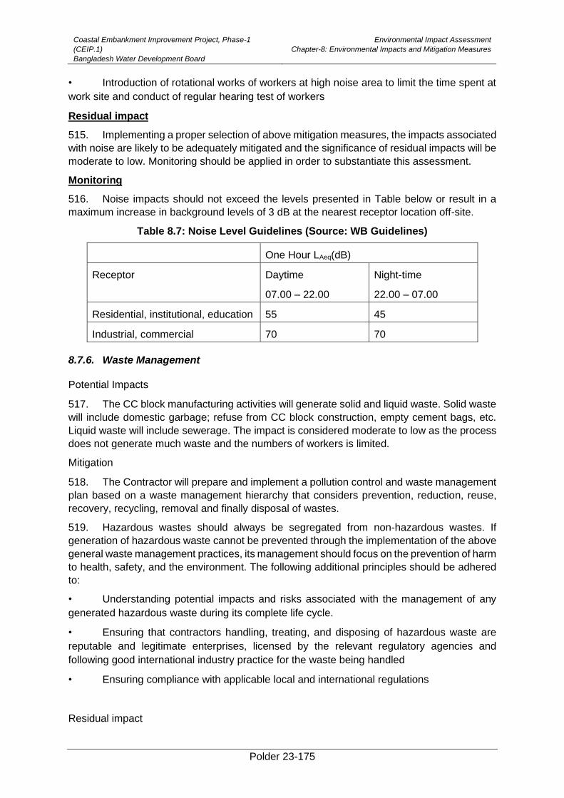
Coastal Embankment Improvement Project, Phase-1
(CEIP.1)
Bangladesh Water Development Board
Environmental Impact Assessment
Chapter-8: Environmental Impacts and Mitigation Measures
Polder 23-175
• Introduction of rotational works of workers at high noise area to limit the time spent at
work site and conduct of regular hearing test of workers
Residual impact
515. Implementing a proper selection of above mitigation measures, the impacts associated
with noise are likely to be adequately mitigated and the significance of residual impacts will be
moderate to low. Monitoring should be applied in order to substantiate this assessment.
Monitoring
516. Noise impacts should not exceed the levels presented in Table below or result in a
maximum increase in background levels of 3 dB at the nearest receptor location off-site.
Table 8.7: Noise Level Guidelines (Source: WB Guidelines)
One Hour LAeq(dB)
Receptor Daytime
07.00 – 22.00
Night-time
22.00 – 07.00
Residential, institutional, education 55 45
Industrial, commercial 70 70
8.7.6. Waste Management
Potential Impacts
517. The CC block manufacturing activities will generate solid and liquid waste. Solid waste
will include domestic garbage; refuse from CC block construction, empty cement bags, etc.
Liquid waste will include sewerage. The impact is considered moderate to low as the process
does not generate much waste and the numbers of workers is limited.
Mitigation
518. The Contractor will prepare and implement a pollution control and waste management
plan based on a waste management hierarchy that considers prevention, reduction, reuse,
recovery, recycling, removal and finally disposal of wastes.
519. Hazardous wastes should always be segregated from non-hazardous wastes. If
generation of hazardous waste cannot be prevented through the implementation of the above
general waste management practices, its management should focus on the prevention of harm
to health, safety, and the environment. The following additional principles should be adhered
to:
• Understanding potential impacts and risks associated with the management of any
generated hazardous waste during its complete life cycle.
• Ensuring that contractors handling, treating, and disposing of hazardous waste are
reputable and legitimate enterprises, licensed by the relevant regulatory agencies and
following good international industry practice for the waste being handled
• Ensuring compliance with applicable local and international regulations
Residual impact

Coastal Embankment Improvement Project, Phase-1
(CEIP.1)
Bangladesh Water Development Board
Environmental Impact Assessment
Chapter-8: Environmental Impacts and Mitigation Measures
Polder 23-176
520. Implementing a proper Waste Management Plan will mitigate potential impacts to low.
8.7.7. Contaminated Land and Hazardous Materials Management
Potential Impacts
521. Contamination of land should be avoided by preventing or controlling the release of
hazardous materials, hazardous wastes, or oil/chemical to the environment. When
contamination of land is suspected or confirmed, the cause of the uncontrolled release should
be identified and corrected to avoid further releases and associated adverse impacts.
Contaminated lands should be managed to avoid the risk to human health and ecological
receptors.
522. The main risks for contaminated land at the plants is the storage and transfer/unloading
of oil and lubricants for the vehicles and equipment. However, the limited use and the fact that
oil and lubricants are not a feed stock material to be used in the process or product of the plant
leads to a moderate to low potential impact.
Mitigation measures
523. Control measures to be implemented are: construction of secondary containment for
storage tanks, avoidance of underground storage tanks and controlled transfer of oil from
vehicle tanks to storage and vice versa. Proper secondary containment structures should be
capable of containing at least 110 per cent of the largest tank or 25% per cent of the combined
tank volumes in areas with above-ground tanks with a total storage volume equal or greater
than 1,000 litres.
524. Workshops should be equipped with impermeable floors and oil-containing equipment
should only be repaired in workshops.
Residual impact
525. Implementing the mentioned preventive measures will mitigate potential moderate
impacts to low.
8.7.8. Occupational Health and Safety
Potential Impacts
526. Potential impacts related to occupational health and safety at the plant entails mainly
physical hazards, as there are:
• Rotating and Moving Equipment
• Noise and vibration
• Industrial Vehicle Driving and Site Traffic
527. The impacts from the rotating and moving equipment and of noise and vibration are
considered high. The impacts from the vehicle driving and site traffic are considered moderate.
Mitigation Measures
528. Preventive and protective measures should be based on a comprehensive job safety
analyses and be introduced according to the following order of priority:

Coastal Embankment Improvement Project, Phase-1
(CEIP.1)
Bangladesh Water Development Board
Environmental Impact Assessment
Chapter-8: Environmental Impacts and Mitigation Measures
Polder 23-177
o Controlling the hazard at its source through use of engineering controls, e.g.
machine guarding, acoustic insulating, etc.
o Minimizing the hazard through design of safe work systems and administrative
or institutional control measures. Examples include job rotation, training safe
work procedures, lock-out and tag-out, workplace monitoring, limiting exposure
or work duration, etc.
o Providing appropriate personal protective equipment (PPE) in conjunction with
training, use, and maintenance of the PPE.
o A Health and Safety Plan and an Emergency Response Plan should be
developed and included in the Contractor’s ESMP
o A health screening of employees from outside the region should be carried out
prior to labourers start working on site.
• HR related measures are:
o Ensuring acceptable conditions of work including observing national statutory
requirements related to minimum wages and hours of work
o Ensuring no workers are charged fees to gain employment on the Project;
o A labour grievance mechanism and documenting its use for complaints about
unfair treatment or unsafe living or working conditions without reprisal will be
installed. Existing GRM may be utilized to address this with the present GRC
members on-board.
o Produce job descriptions and provide written contracts and other information
that outline the working conditions and terms of employment, including the full
range of benefits
o Provide health insurance for employees for the duration of their contracts
o Provide insurance for accidents resulting in disabilities or death of employees
for the duration of their contracts
o International and national laws and regulations should be followed related to
minimum age for employment of children (no employment of any persons under
the age of 16 for general work and no persons under the age of 18 for work
involving hazardous activities)
o Proper and regular wage payment to workers and maintain gender equity.
• To protect the occupational health and safety at the plants further, the following is
required as a minimum:
o Noise-absorbing materials should, to the extent feasible, be applied
o Rotating and alternating parts of the equipment should be physically isolated

Coastal Embankment Improvement Project, Phase-1
(CEIP.1)
Bangladesh Water Development Board
Environmental Impact Assessment
Chapter-8: Environmental Impacts and Mitigation Measures
Polder 23-178
o Passageways for pedestrians and vehicles within and outside buildings should
be segregated and clearly indicated
o Drivers on the forklifts require specific training and should be fit for the job
o Occupational health and safety training should be organized and specified for
the hazards identified
o Exposed moving parts or exposed pinch point of the equipment should be
guarded
o Noise levels should be within the following limits:
▪ No employee should be exposed to a noise level greater than 85 dB(A)
for a duration of more than 8 hours per day without hearing protection.
In addition, no unprotected ear should be exposed to a peak sound
pressure level (instantaneous) of more than 140 dB(C).
▪ The use of hearing protection should be enforced actively when the
equivalent sound level over 8 hours reaches 85 dB(A), the peak sound
levels reach 140 dB(C), or the average maximum sound level reaches
110dB(A). Hearing protective devices provided should be capable of
reducing sound levels at the ear to at least 85 dB(A).
▪ Although hearing protection is preferred for any period of noise
exposure in excess of 85 dB(A), an equivalent level of protection can
be obtained, but less easily managed, by limiting the duration of noise
exposure. For every 3 dB(A) increase in sound levels, the ‘allowed’
exposure period or duration should be reduced by 50 per cent.
▪ Prior to the issuance of hearing protective devices as the final control
mechanism, use of acoustic insulating materials, isolation of the noise
source, and other engineering controls should be investigated and
implemented, periodic medical hearing checks should be performed on
workers exposed to high noise levels.
o Exposure to whole-body vibrations from surfaces on which the worker stands
or sits, should be controlled through choice of equipment, installation of
vibration dampening pads or devices, and limiting the duration of exposure.
Residual impact
529. Implementing the mentioned mitigation measures will mitigate the impacts to low.
8.7.9. Community Health and Safety
Potential Impacts
530. Potential impacts related to community health and safety for the CC block plant entails
mainly traffic related hazards.
Mitigation Measures
531. Mitigation measures include:
Coastal Embankment Improvement Project, Phase-1
(CEIP.1)
Bangladesh Water Development Board
Environmental Impact Assessment
Chapter-8: Environmental Impacts and Mitigation Measures
Polder 23-179
• Transport safety practices as training on safety aspects and driving skills among
drivers and use of speed control devices on trucks
• Regular maintenance of vehicles
• Minimizing pedestrian interaction with construction vehicles
• Collaboration with local communities and responsible authorities to improve signage,
visibility and overall safety of roads
Residual impact
532. Implementing the mentioned mitigation measures will mitigate the impacts to low.
8.7.10. Cumulative and Induced Impacts
533. Neither cumulative nor induced impacts are expected from the CC block manufacturing
plants, as they are relatively small stand-alone plants with a minimum impact except for noise
and air pollution.
534. With the construction of the automated CC plant land use has changed for the time
being but may remain so in the long run.
8.8. Decommissioning phase
535. This section provides additional, specific guidance on prevention and control of
potential impacts that may occur during decommissioning of the CC block plant. In order to
avoid repetition, cross-referencing is made to above sections.
8.8.1. EnvironmentalIssues
Air Quality, Noise and Vibration
Potential Impacts
536. Potential impacts on air quality and noise and vibration impacts during
decommissioning of the plants will be related to the use of cranes, vehicles and other
demolishing equipment, and transport of materials. Air quality may be impacted due to soil
erosion after decommissioning as well; soil erosion could be caused by the exposure of barren
soil surfaces to wind.
537. Due to the limited size of the plant area the potential impacts on the environment during
decommissioning is considered to be low.
8.8.2. Solid waste and contaminated land
Potential Impacts
538. Solid waste will mainly be limited to refuse from CC block construction (concrete
leftovers), rejected CC blocks, empty cement bags, scrap metal, etc. The impact is considered
moderate to low.
539. Small amounts of hazardous wastes will include: small amount of contaminated soils,
unspent solvents, oily rags, used filters, empty paint cans, empty chemical containers, used
lubricating oil and used batteries and lighting equipment.
540. Not properly managed these wastes might lead to a moderate to high impact on both
the terrestrial and aquatic environment as well as human health and safety.
Coastal Embankment Improvement Project, Phase-1
(CEIP.1)
Bangladesh Water Development Board
Environmental Impact Assessment
Chapter-8: Environmental Impacts and Mitigation Measures
Polder 23-180
Mitigation Measures
• The Contractor will prepare and implement a pollution control and waste management
plan based on a waste management hierarchy that considers prevention, reduction, reuse,
recovery, recycling, removal and finally disposal of wastes.
• In the absence of qualified commercial or government-owned waste disposal operators
in Bangladesh, these wastes might be managed through installing on-site waste treatment or
recycling processes (waste could be assembled at one site). However, considering the amount
of these wastes, the final option might be an environmental sound long-term storage of wastes
at an appropriate location up until external commercial options become available.
Residual Impacts
541. Implementing proper waste management as described above will lead to low residual
impacts
8.8.3. Surface water
Potential Impact
542. Soil erosion caused by the exposure of barren soil surfaces to wind and rain during
and after site clearing may result in impacts to the quality of the natural water systems and
ultimately the biological systems that use these waters. The potential impact is considered to
be moderate.
Mitigation Measures
543. Soil erosion and water system management could include:
• Scheduling to avoid heavy rainfall periods (i.e., decommissioning during the dry
season) to the extent practical
• Mulching or re-vegetating to stabilize exposed areas
• Designing channels and ditches for post-construction flows
• Reducing or preventing off-site sediment transport through use of proper site drainage,
settlement ponds, silt fences, etc.
Residual impact
544. Implementing the mentioned mitigation measures will mitigate the potential impacts to
low.
8.8.4. Occupational and community health and safety
Potential Impacts
545. Occupational and community health and safety will not substantially differ from the
above described. An exception might be traffic safety. Decommissioning traffic will include
movement of heavy vehicles and local cargo vessels for the transport of materials and
equipment increasing the risk of traffic-related accidents and injuries to workers and local
communities. Potential impacts are considered moderate to low.
Mitigation measures
546. Accidents involving project vehicles and boats/cargo vessels during decommissioning
should be minimized through a combination of education and awareness-raising, proper
Coastal Embankment Improvement Project, Phase-1
(CEIP.1)
Bangladesh Water Development Board
Environmental Impact Assessment
Chapter-8: Environmental Impacts and Mitigation Measures
Polder 23-181
planning (avoiding severe weather conditions), and coordination with emergency responders
to ensure that appropriate first aid is provided in the event of accidents. Specific attention
should be paid to decommissioning works in the Health and Safety Plan and Emergency
Response Plan.
Residual Impacts
547. Implementing the mentioned mitigation measures will mitigate the potential impacts to
low.
8.9. Summary of Assessed Impacts
548. A summary of these impacts and their significance discussed in the above sections is
presented in Appendix I.
Polder 23-182
9. Cumulative Impacts
9.1. Cumulative Impacts
549. Definition: Cumulative impact is the impact on the environment which results from the
incremental impact of the action when added to other past, present, and reasonably
foreseeable future actions regardless of what agency or person undertakes such other actions.
550. Cumulative impacts on the environment of individual effect can be minor but it can be
significant when in combination with others taking over a period of time. The multiple impacts
of different activities may have an additive, synergistic or antagonistic effect on one another
and with the natural processes.
551. Methodology: Cumulative impacts entail the total of all impacts to a particular resource
that have occurred, or occurring, or may occur as a result of any action or influence in the
surrounding area. To Assess Cumulative Impact (CIA) of the proposed polder under CEIP, a
number of other projects exist apart from the CEIP Polders (at the vicinity of the polder) as
well as future plan has been considered. Before assessing the impacts, Valued Environmental
Component (VEC) has been selected. VECs for which an impact was deemed insignificant in
the EIA are not included in the CIA. The combined impacts of the project, other projects and
activities, and natural environmental drivers surrounding the polder that will influence the
VEC’s condition e.g. life and livelihood of people, water resources/hydrology, environmental
quality, natural ecosystem and flora-fauna etc.in a specific Polder have been assessed as
cumulative impact. The cumulative impact has been estimated qualitatively based on the
consensus estimate of a panel of experts. Furthermore, necessary additional mitigation
measures have been suggested for reducing an estimated unacceptable cumulative impact
on a VEC to an acceptable level.
552. Several existing, on-going and planned projects also exist in this region. Such projects
may have impact on the hydrological network, life and livelihood of people, environmental
quality, natural ecosystem, flora-fauna, etc. of Polder 23 This Chapter attempts to analyze
several indirect effects regarding several existing and ongoing projects, as well as the
implementation of different interventions proposed in Polder 23 under Coastal Embankment
Improvement Project-1 (CEIP-1). Besides, necessary mitigation measures based on analysis
of cumulative impacts are proposed.
9.2. Proposed CEIP interventions on Polder 23
553. CEIP is a multi-phased effort laid down by the GoB to refocus its strategy on the coastal
area by providing extra emphasis on frequent storm surges. The long-term objective of the
project is to increase the resilience of the entire coastal population to tidal flooding as well as
natural disasters by upgrading the whole embankment system. The embankment
improvement and rehabilitation approach will be adopted over a period of 15 to 20 years and
in this regard a total number of 17 polders have been selected through a participatory
screening process. Among these 17 polders (shown in Map 9.1), 4 polders (Polders 32, 33,
35/1, 35/3) were selected for rehabilitation works under the first phase of CEIP (CEIP-I), which
are being implemented. The other 13 polders have undergone pre-feasibility studies and
would be implemented gradually in later phases.
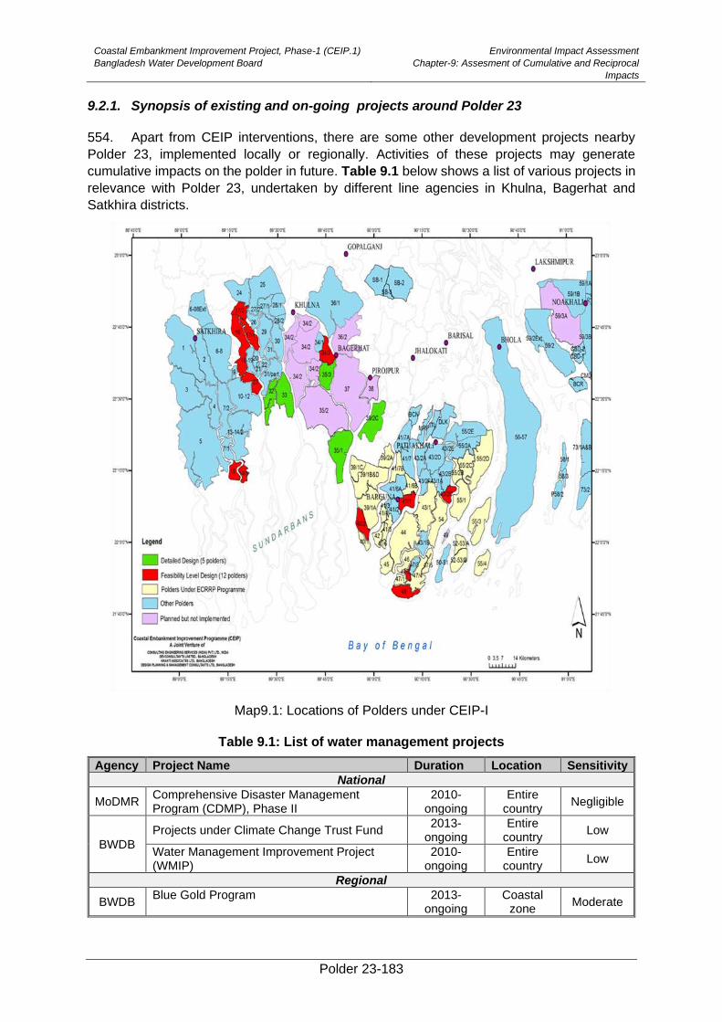
Coastal Embankment Improvement Project, Phase-1 (CEIP.1)
Bangladesh Water Development Board
Environmental Impact Assessment
Chapter-9: Assesment of Cumulative and Reciprocal
Impacts
Polder 23-183
9.2.1. Synopsis of existing and on-going projects around Polder 23
554. Apart from CEIP interventions, there are some other development projects nearby
Polder 23, implemented locally or regionally. Activities of these projects may generate
cumulative impacts on the polder in future. Table 9.1 below shows a list of various projects in
relevance with Polder 23, undertaken by different line agencies in Khulna, Bagerhat and
Satkhira districts.
Map9.1: Locations of Polders under CEIP-I
Table 9.1: List of water management projects
Agency Project Name Duration Location Sensitivity
National
MoDMR Comprehensive Disaster Management Program (CDMP), Phase II
2010- ongoing
Entire country
Negligible
BWDB
Projects under Climate Change Trust Fund 2013-
ongoing Entire
country Low
Water Management Improvement Project (WMIP)
2010-ongoing
Entire country
Low
Regional
BWDB Blue Gold Program 2013-
ongoing Coastal
zone Moderate
Coastal Embankment Improvement Project, Phase-1 (CEIP.1)
Bangladesh Water Development Board
Environmental Impact Assessment
Chapter-9: Assesment of Cumulative and Reciprocal
Impacts
Polder 23-184
Agency Project Name Duration Location Sensitivity
Coastal Embankment Rehabilitation Project (CERP)
1995-2004 Coastal
zone Negligible
BFD Marine Shrimp culture technology 1998-2004 Coastal
zone Moderate
555. The projects (listed in Table 9.1) which have or may have moderate sensitivities on
some of the environmental or social components of Polder 23 are briefly discussed in the
following sections.
9.3. Cummulative Impacts of proposed and existing projects
9.3.1. Impact on hydrology and flooding situation
556. The major part of Polder 23 is surrounded by the Sibsa in North-Eastern direction. The
Kurulia and the Minaj river is flowing along West and South direction of the polder respectively.
The existing crest levels of the polder ranges from 4.27 mPWD above MSL. Re-sectioning
works are proposed in the polder under CEIP, which would increase its crest level from 4.5 to
5.0 mPWD above MSL. This increase would reduce storm surge and saline water to enter into
the polder.
557. Among all CEIP polders, Polder 18-19 is located at the upstream (North-West
direction) of Polder 23. The existing crest level of Polder 18-19 is 3.85 mPwd which will be
increased up to 5.8 mPWD due to proposed interventions. The proposed protective
interventions of Polder 18 and19 may divert the seasonal storm surges to the Polder 23. As a
result of this diversion, salinity intrusion into the Polder 23 may be increased that will
deteriorate the agricultural production and exacerbate the social life. There is a tendency of
accumulating silts along the perennial rivers which will increase in volume by wastes of
proposed construction works that may cause induced hydraulic pressure on Polder 23.
However, the downstream part of Polder 23 may have less effect of the following impact.
558. The other CEIP polders are far away from the project area that’s why their interventions
have negligible impact on Polder 23.
9.3.2. Impact of construction materials on local markets
559. The construction materials to be required for re-sectioning of the embankment, water
regulatory sluices, flushing sluices, and bank protection work will include soil, cement, and
steel, stone and sand. The constructions materials especially sand and stone for construction
of sluice gate to be procured mainly from Sylhet directly. Coarse sand available from Sylhet
and stone chips (good quality) may be imported from neighbor countries. Cement and Steel
will be procured from company sale market of Khulna or will be procured from cement factory
and steel factory directly which would not cause any impact on market price. A small amount
of sand and cement can be procured from the local market at adjacent to the polder or from
Khulna during executions of construction works. No significant impact will be caused due to
sand procurement of sand and cement from local market.
9.3.3. Impact on Livelihood
560. The socio-economic condition of Polder 23 will be ameliorated due to the overall
development of this region, i.e., construction works of Polder 16 will attract labors from outside
as well as local people will also get working opportunity.
Coastal Embankment Improvement Project, Phase-1 (CEIP.1)
Bangladesh Water Development Board
Environmental Impact Assessment
Chapter-9: Assesment of Cumulative and Reciprocal
Impacts
Polder 23-185
9.3.4. Impacts on rivers/water courses hydrology
561. Because of polderization, the sediments which earlier (before polderization) could
spread out over the Polder area is being deposited in the river course. As a consequence,
river bed has been rising and aggravating erosion situation of the Polder area as well as
affecting navigation. This situation will also continue after rehabilitation of Polder. Tidal influx
would also remain within the river course and exert hydraulic pressure on the Polder and
deteriorate erosion.
9.3.5. Impacts on fish migration and biodiversity
562. The successive siltation in peripheral rivers and canals of Polder 23 may hamper fish
migration. In course of time, fish migration may be fully or partially obstructed in the Polder
area due to siltation. As a result, the fisheries biodiversity for both fresh and brackish water
may marginally decrease. Due to protection of Polder from flood water, water will move
towards the upstream of Kurulia and Minaj rivers and downstream of Sibsa River during high
tide. This increased volume of water will enhance fish migration in that water body.
Consequently, fish migration of surrounding canals will be improved. In future, the salinity
tolerant fish species will dominate while fresh water fish species may decrease.
impacts of Blue Gold interventionson on Polder 23
563. A total number of 12 Polders in Satkhira, Khulna and Patuakhali districts have been
selected for implementation of the program in the first phase. Among these, Polder 22 is
adjacent to Polder 23 in the North direction and therefore may generate some impacts in
future. The existing crest level of Polder 22 is 3.45mPWD above Mean Sea Level. The
proposed re-sectioning works are carried out along the periphery of these Polders up to the
design elevation of around 5.8 mPwd, there would be more floodplain sedimentation adjacent
to the downstream Polders. This may result increased sedimentation along the Sibsa river
system. Due to renovated elevation of embankment, tidal flow velocity might increase in the
downstream which would create more pressure along the peripheral embankment of Polder
23.
Impacts of Marine Shrimp Culture Technology
564. In 1998, Bangladesh Forest Department (FD) extended the culture technology of
marine shrimp on macro scale in Khulna, Bagerhat, Sathkhira and Cox’s bazar. The project
continued upto 2004, seeing viral attacks (of white spot syndrome virus, taura syndrome virus,
and infectious hypodermal and haematopoietic necrosis virus) on shrimps in the later stages
of the project implementation. However, the popularity of shrimp culture spread in local level.
Shrimp culture in Polder 23 during dry season is a very common practice like other
surrounding Polders. The shrimp culture is not labor intensive, thus creates more
unemployment problem. In the dry season, a number of places in the embankment were cut
down to allow the entry of saline water through Taingramari khal, Kuchia khal etc which may
reduce the strength of the embankment by creating weak points. One notable positive impact
of shrimp culture in Polder 23 is that it initiated a financial revolution of the Polder area
however; it has become a monopoly business. By now, the local people have fallen in an
ambivalent situation that they are suffering by loosing agricultural land and increased shrimp
culture in their land. Moreover, there are some negative environmental impacts i.e. infertility
Coastal Embankment Improvement Project, Phase-1 (CEIP.1)
Bangladesh Water Development Board
Environmental Impact Assessment
Chapter-9: Assesment of Cumulative and Reciprocal
Impacts
Polder 23-186
of aquatic animals, flora and fauna due to overtopping ofsaline water from shrimp culture
ponds.
9.4. Reciprocal Impact
565. Reciprocal impacts of Polder 23 have been assessed based on the model results
conducted Institute of Water Modelling (IWM). IWM used Rainfall runoff model, hydrodynamic
models and Storm surge model to analyze the existing meteorological situation of the polder
area. They have evaluated the physical changes in the relative polders, which may occur due
to climate change. All data used in the model setup and calibration (including topography, soil
maps, land use maps, and weather data, river network and cross-section, water level,
discharge and salinity) were obtained from different sources. The climate change scenario
RCP 8.5 is used in the models to simulate the climate change effects.
566. The runoff inside costal Polder is simulated using NAM (Nodbor Afstroming Model) of
DHI mike package. In the NAM model a lump watershed was defined, which considered the
area of polder 23. The contribution area of internal drainage system of Polder 23 was defined
in the mike 11 network module. Taking 2012 as base year, the peak runoff occurred in the
beginning of August with a magnitude of 36.11 cumec. The year 1986 was selected as design
year corresponding to 10 year return period. The peak runoff without considering climate
change is 52.62 cumec whereas 65.23 cumec peak runoff is obtained at the end of September
considering climate change. The peak runoffs without considering climate change and
considering climate change are 46% and 81% higher than the base year respectively.
567. The assessment of effectiveness of existing drainage system is performed under
climate change scenario RCP 8.5. Climate change condition is added to the model by
considering sea level rise of 50 cm at downstream boundary, increase of flow of Ganges with
16% to 28%, Brahmaputra with 8.5 % to 18.5% and Upper Meghna with 8% to 11%. Five days
rainfall event is considered with 10-year return period for the simulation for the existing
drainage system.
568. From the simulation, flood free (FF) area and F0 (0~0.3m) area cover about 73.06%
and 17.05% respectively without considering climate change. The fulfillment of drainage
criteria requires about 85% to 90% FF and F0 land, whereas 90.1% of FF and F0 land was
found from the simulation without climate change.
569. Considering the climate change scenario FF and F0 land cover are reduced to 53.30%
and 23.78% respectively. However, F1 land class (water depth .03m to 0.9m) increases from
9.88% to 21.76%. It indicates that the drainage channels have not proper storing capacity to
resist the future climate condition and needs further attention to obtain a climate resilient
Polder management.
570. The newly developed, calibrated and validated Bay of Bengal Model has been applied
for the study of storm surge modeling. It is a combination of Cyclone and Hydrodynamic
(MIKE21FM) models. Three open boundaries are defined in the model, two in the North in the
Upper Meghna River at Bhairab and in the Padma River at Baruria. Another one is in the South
in the Southern Bay of Bengal up to 16° latitude. The coastal Polders are included in this
model as dike. The surge water levels in different return period are presented in Table 9.2. It
is observed that due to climate change, surge level increases up to 0.17 m.
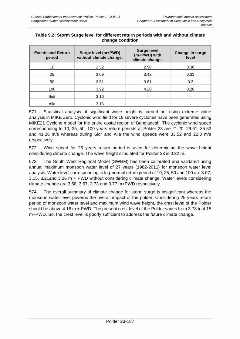
Coastal Embankment Improvement Project, Phase-1 (CEIP.1)
Bangladesh Water Development Board
Environmental Impact Assessment
Chapter-9: Assesment of Cumulative and Reciprocal
Impacts
Polder 23-187
Table 9.2: Storm Surge level for different return periods with and without climate change condition
Events and Return period
Surge level (m+PWD) without climate change.
Surge level (m+PWD) with
climate change.
Change in surge level
10 2.52 2.90 0.38
25 3.09 3.42 0.33
50 3.51 3.81 0.3
100 3.92 4.20 0.28
Sidr 3.16 - -
Aila 3.16 - -
571. Statistical analysis of significant wave height is carried out using extreme value
analysis in MIKE Zero. Cyclonic wind field for 19 severe cyclones have been generated using
MIKE21 Cyclone model for the entire costal region of Bangladesh. The cyclonic wind speed
corresponding to 10, 25, 50, 100 years return periods at Polder 23 are 21.20, 29.61, 35.52
and 41.26 m/s whereas during Sidr and Aila the wind speeds were 33.52 and 22.0 m/s
respectively.
572. Wind speed for 25 years return period is used for determining the wave height
considering climate change. The wave height simulated for Polder 23 is 0.32 m.
573. The South West Regional Model (SWRM) has been calibrated and validated using
annual maximum monsoon water level of 27 years (1982-2011) for monsoon water level
analysis. Water level corresponding to log-normal return period of 10, 25, 50 and 100 are 3.07,
3.15, 3.21and 3.26 m + PWD without considering climate change. Water levels considering
climate change are 3.58, 3.67, 3.73 and 3.77 m+PWD respectively.
574. The overall summary of climate change for storm surge is insignificant whereas the
monsoon water level governs the overall impact of the polder. Considering 25 years return
period of monsoon water level and maximum wind wave height, the crest level of the Polder
should be above 4.16 m + PWD. The present crest level of the Polder varies from 3.78 to 4.15
m+PWD. So, the crest level is poorly sufficient to address the future climate change.
Polder 23-188
10. Environmental Management Plan
575. This Chapter presents the Environmental Management Plan (EMP) for the CEIP-I
activities in the Polder 23. The EMP essentially provides the implementation mechanism for
the environmental and social mitigation measures discussed in Chapter 8
10.1. Objectives of EMP
576. The basic objective of the EMP is to manage, prevent, and mitigate potentially adverse
impacts of Project interventions in the Polder 23. The specific objectives of the EMP are to:
• Facilitate the implementation of the environmental and social mitigation measures
identified during the present EIA and discussed in Chapter 8.
• Assign responsibilities of project proponent, contractors, consultants, and other
members of the Project team for the environmental and social management of the
Project;
• Define a monitoring mechanism and identify monitoring parameters to ensure
effective implementation of the mitigation measures.
• Assess environmental training requirements for different stakeholders at various
levels.
• Describe communication and documentation requirements.
10.2. EMP Components
577. The EMP components are listed below:
• Institutional Arrangement
• Mitigation Measures and Plan
• Monitoring Plan
• Documentation and reporting
• Contractual arrangements for EMP implementation
• EMP implementation cost
• Capacity building
• Grievance redress mechanism
578. These components are discussed in following sections.
10.3. Institutional Arrangement
579. Clearly defined and functional institutional arrangements are essential for ensuring
effective and sustainable implementation of the EMP, particularly the mitigation measures
identified in the EIA. An Organogram showing the institutional set up of CEIP-1 including
organisation for implementation and monitoring of the EMP is shown in Figure 10.1.
The EMP should be included in all the bid documents of Polder 23 and will become a part of the
civil works contact. The strict implementation of the EMP and project management’s strict
enforcement of the adequate construction practices and standards will greatly reduce the
negative impacts of the Project.
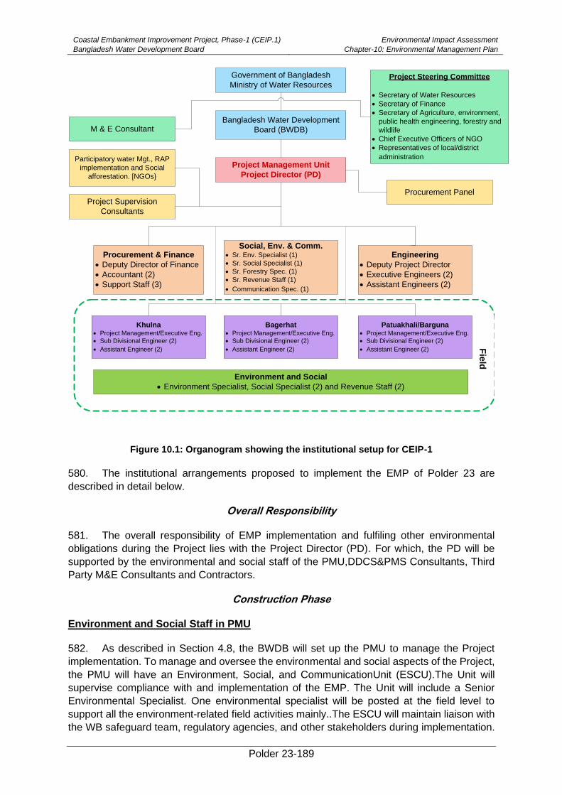
Coastal Embankment Improvement Project, Phase-1 (CEIP.1)
Bangladesh Water Development Board
Environmental Impact Assessment
Chapter-10: Environmental Management Plan
Polder 23-189
Government of Bangladesh
Ministry of Water Resources
Bangladesh Water Development
Board (BWDB)
Project Management Unit
Project Director (PD)
M & E Consultant
Participatory water Mgt., RAP
implementation and Social
afforestation. [NGOs}
Project Supervision
Consultants
Project Steering Committee
• Secretary of Water Resources
• Secretary of Finance
• Secretary of Agriculture, environment,
public health engineering, forestry and
wildlife
• Chief Executive Officers of NGO
• Representatives of local/district
administration
Procurement Panel
Procurement & Finance
• Deputy Director of Finance
• Accountant (2)
• Support Staff (3)
Social, Env. & Comm.• Sr. Env. Specialist (1)
• Sr. Social Specialist (1)
• Sr. Forestry Spec. (1)
• Sr. Revenue Staff (1)
• Communication Spec. (1)
Khulna• Project Management/Executive Eng.
• Sub Divisional Engineer (2)
• Assistant Engineer (2)
Engineering
• Deputy Project Director
• Executive Engineers (2)
• Assistant Engineers (2)
Patuakhali/Barguna• Project Management/Executive Eng.
• Sub Divisional Engineer (2)
• Assistant Engineer (2)
Bagerhat• Project Management/Executive Eng.
• Sub Divisional Engineer (2)
• Assistant Engineer (2)
Environment and Social
• Environment Specialist, Social Specialist (2) and Revenue Staff (2)
Fie
ld
Figure 10.1: Organogram showing the institutional setup for CEIP-1
580. The institutional arrangements proposed to implement the EMP of Polder 23 are
described in detail below.
Overall Responsibility
581. The overall responsibility of EMP implementation and fulfiling other environmental
obligations during the Project lies with the Project Director (PD). For which, the PD will be
supported by the environmental and social staff of the PMU,DDCS&PMS Consultants, Third
Party M&E Consultants and Contractors.
Construction Phase
Environment and Social Staff in PMU
582. As described in Section 4.8, the BWDB will set up the PMU to manage the Project
implementation. To manage and oversee the environmental and social aspects of the Project,
the PMU will have an Environment, Social, and CommunicationUnit (ESCU).The Unit will
supervise compliance with and implementation of the EMP. The Unit will include a Senior
Environmental Specialist. One environmental specialist will be posted at the field level to
support all the environment-related field activities mainly..The ESCU will maintain liaison with
the WB safeguard team, regulatory agencies, and other stakeholders during implementation.
Coastal Embankment Improvement Project, Phase-1 (CEIP.1)
Bangladesh Water Development Board
Environmental Impact Assessment
Chapter-10: Environmental Management Plan
Polder 23-190
The ESCU will also coordinate with the environmental staff of the DDCS&PMSCs. In order to
effectively manage the EA process and EMP implementation, the ESCU will be established
and made operational before awarding the contract to the contractor. The ESCU will be
responsible for updating the EIA after receiving the pending information.
583. IPoE will review the updated report and will guide to ESCU for further improvement of
the monitoring report.
Environment and Social Staff with Detailed Design Construction Supervision& Project
Management Support Consultants (DDCS&PMSCs)
584. The DDCS&PMSCSCswill be responsible for the overall supervision of Polder
rehabilitation related activities. The DDCS&PMSCwill ensure quality control and report to PD.
Theywill also assist the ESCU for ensuring environmental compliance and monitoring of
progress including EMP and/or ECP implementation. The DDSC&PMSCwill supervise the
Contractors, ensuring design compliance and quality of works.For supervising the EMP
implementation, DDCS&PMSCwill have dedicated and adequately qualified and experienced
environmental staff including field-based environmental monitors (EMs).The EMs will
supervise and monitor contractors to ensure compliance of the EMP.The
DDCS&PMSenvironmental staff will maintain coordination with the ESCU for the effective
implementation of EMP and other environmental commitments and obligations of the Project.
Contractor’s Environment Supervisors
585. The construction Contractors will have an adequate number of dedicated, properly
qualified and experienced, site-based Environmental Supervisors (ESs) at the construction
sites. The ESs will be responsible to implement various aspects of the EMP particularly the
mitigation measures to ensure that the environmental impacts of the construction works
remain within acceptable limits. The ESs will maintain coordination with the DDCS& PMSCs
at the site. The ESs will also be responsible to conduct environmental trainings for the
construction crew.
Post-Construction Phase
586. BWDB core unit has post of 4 Assistant Chiefs and 2 Deputy Chiefs to oversee the
overall environmental compliance of BWDB implemented projects. Under CEIP, the ESCU will
provide training to the BWDB people responsible for monitoring of environmental compliance.
Thus, a smooth transition to BWDB will happen to ensure environmental compliance during
the O&M after the project completion. These staff will be responsible to manage the
environmental aspects of the operation and maintenance of Polder, its water control
structures, and other relevant issues such as protection of key environmental resources of the
polder and maintain fish migration. Water Management organizations (WMO) will be formed
under the Bangladesh Guidelines for Participatory Water Management (Nov 2000) and
involved the beneficiary communities. WMOs will be trained by BWDB to ensure
environmental management during project operation. The Environmental Management Unit of
BWDB will ensure and oversee the environmental management during project implementation
and operation. The Water Management Organization will also be trained and involved in EMP
implementation during the operation phase.
10.4. Mitigation Measures and Plan
587. Mitigation is an integral part of impact evaluation. Where mitigation is deemed
appropriate, a proponent should strive to act upon effects, in the following order of priority, to:
• Eliminate or avoid adverse impacts, where reasonably achievable.
Coastal Embankment Improvement Project, Phase-1 (CEIP.1)
Bangladesh Water Development Board
Environmental Impact Assessment
Chapter-10: Environmental Management Plan
Polder 23-191
• Reduce adverse impacts to the lowest reasonably achievable level.
• Regulate adverse impacts to an acceptable level, or to an acceptable time
period.
• Create other beneficial impacts to partially or fully substitute for, or counter-
balance, adverse effects.
588. Mitigation measures should be considered starting with the Environmental
Assessment process. It is thus important, that there should be a good integration between the
EIA team and project design engineers. Project specific environmental construction guidelines
should be developed. These guidelines will specify precautions and mitigation measures for
construction activities, and to be included in the EMP.
589. Impacts identified severe in consequence category and or likelihood category will be
further analyzed to identify additional mitigation measures which are potentially available to
eliminate or reduce the predicted level of impact. Potential mitigation measures will include:
• habitat compensation program
• species specific management program
• engineering design solutions
• alternative approaches and methods in achieving the activity‘s objective
• stakeholder’s participation in finalizing mitigation measures
• construction practice including labor welfare measures
• operational control procedures
• management systems
590. Mitigation measures during pre-construction, construction and post-construction
operation phases have been presented in a tabular form in Table 10.1 which will be used in
Polder specific mitigation measure stated in Chapter8. Moreover, cost related EMP has been
presented in a different Table 10.6.
Tabel 10.1: Mitigation plan during pre-construction, construction and operation phases
Potential Impacts
Mitigation Measures
Responsible Agency for implementation of mitigation
Monitoring/Supervision Agency
A. Pre-construction Phase
Deterioration of
Air and Noise
quality
• Construction material (sand) should be covered while transporting and stock piled.
• The contractors need to be cautious to avoid unnecessary honking of material carrying trawler.
• The contractors should be encouraged to move all construction equipment, machineries and materials during day time instead of night.
• Exhaust emissions from trawler and equipment should comply with the standards of DoE.
Contractor DDCS&PM
SC, M&E
Consultant,
BWDB
Coastal Embankment Improvement Project, Phase-1 (CEIP.1)
Bangladesh Water Development Board
Environmental Impact Assessment
Chapter-10: Environmental Management Plan
Polder 23-192
Potential Impacts
Mitigation Measures
Responsible Agency for implementation of mitigation
Monitoring/Supervision Agency
• Sprinkling of water and ramming the materials of stockyard regularly.
• Stockyard should be covered during non-working period
Change of Land use
• All the construction camps should be established within the area owned by BWDB.
• Pay compensation/rent if private property is acquired on temporary basis, the instructions should be specified in the tender document.
• Labor shed/camp should be constructed on government khas land.
• Avoid impacts on local stakeholders.
Contractor DDCS&PM
SC, M&E
Consultant,
BWDB
Clearances of vegetation
• Choose barren land and ground of Sluice Gateman’s houses for stocking construction materials
• Proper compensation against tree felling inprivate land should be given to the owners
• Implement tree plantation at the damaged sites and sluice surroundings after completion of construction works
• Labor should be given early notice about plant conservation especially for prescuring the countryside strips of plantation at slope protection site (Chainage 10.0 to 11.5 km).
Contractor DDCS&PM
SC, M&E
Consultant,
BWDB
Increase in vehicular during mobilization
• The contractor should prepare a traffic management plan (TMP) and obtain approval from the Design Consultant (DC) and Construction Supervision (CS) consultant.
• Contractor should also implement mobilization plan considering water vessels and launch movement in the external rivers and avoid the launch movement time.
• The TMP should be shared with the communities and should be finalized after obtaining their consent.
• The TMP should address the existing traffic congestion particularly at the Paikgaccha Bazar, Sholadana Bazar and Amurkata Bazar.
• Ensure minimal hindrance to local communities and commuters.
• The works on embankment should be carefully scheduled to minimize impact on local markets and transportation routes.
• The embankment works should be carried out in segments and soil will be placed linearly on half of the embankment, leaving the other half to be used as track.
• The works of the first half should be completed, and then of the other half should be undertaken.
• Work schedule tobe finalized in coordination and consultation with local representatives and communities, specifically the Union Parishad members of the polder.
Contractor DDCS&PM
SC, M&E
Consultant,
BWDB
Coastal Embankment Improvement Project, Phase-1 (CEIP.1)
Bangladesh Water Development Board
Environmental Impact Assessment
Chapter-10: Environmental Management Plan
Polder 23-193
Potential Impacts
Mitigation Measures
Responsible Agency for implementation of mitigation
Monitoring/Supervision Agency
• Local routes will not be blocked as much as possible. If unavoidable, alternative routes will be identified in consultation with local community.
• Vehicular traffic should be limitedin the Polder area and the embankment during off peak time. To avoid accident, signal man should be appointed during School time (10:00am to 13:00pm) and weekly marketdays (Hatbar)
• Keep provision of training on vehicular traffic moving pattern and management system for the local stakeholders using multimedia presentation and showing video at different common population gathering places in the polder area.
B. Construction Phase
Deterioration of air and noise quality
• Construction machineries should have proper mufflers and silencers.
• Noise levels from the construction machineries should comply with national noise standards (residential zone)
• Provision should be made for noise barriers at construction sites and near schools, Madrashas and other sensitive receptors as needed.
• Sprinkling of water and ramming of the material during construction
• Exhaust emissions from the mixture machine should comply with standards
• Restricting/limiting construction activities during the day time.
• Provision of PPE (ear muffs and plugs) for labors.
• Installation of fugitive particulate matter system and spraying water on construction materials.
• Construction team should be instructed to use the equipment properly, to minimize noise levels.
• Liaison with the communities should be maintained and grievance redress mechanism will be established at the site.
Contractor DDCS&PM
SC, M&E
Consultant,
BWDB
Hindrance to the natural drainage system
• Some temporary earthen dams should be built in the khal behind the construction of drainage sluices and behind the re-excavation segment at each reach.
• Bailing out of water behind the temporary earthen dams during construction work.
• Both contractor and BWDB should supervise the construction work
• Contractor should ensure that drainage channels are not obstructed or clogged by the construction activities.
• Contractor should ensure that construction activities do not inundate cultivation fields.
Contractor DDCS&PM
SC, M&E
Consultant,
BWDB
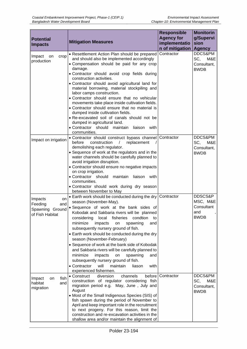
Coastal Embankment Improvement Project, Phase-1 (CEIP.1)
Bangladesh Water Development Board
Environmental Impact Assessment
Chapter-10: Environmental Management Plan
Polder 23-194
Potential Impacts
Mitigation Measures
Responsible Agency for implementation of mitigation
Monitoring/Supervision Agency
Impact on crop production
• Resettlement Action Plan should be prepared and should also be implemented accordingly
• Compensation should be paid for any crop damage.
• Contractor should avoid crop fields during construction activities.
• Contractor should avoid agricultural land for material borrowing, material stockpiling and labor camps construction.
• Contractor should ensure that no vehicular movements take place inside cultivation fields.
• Contractor should ensure that no material is dumped inside cultivation fields.
• Re-excavated soil of canals should not be dumped in agricultural land.
• Contractor should maintain liaison with communities.
Contractor DDCS&PM
SC, M&E
Consultant,
BWDB
Impact on irrigation • Contractor should construct bypass channel
before construction / replacement / demolishing each regulator.
• Sequence of work at the regulators and in the water channels should be carefully planned to avoid irrigation disruption.
• Contractor should ensure no negative impacts on crop irrigation.
• Contractor should maintain liaison with communities.
• Contractor should work during dry season between November to May
Contractor DDCS&PM
SC, M&E
Consultant,
BWDB
Impacts on
Feeding and
Spawning Ground
of Fish Habitat
• Earth work should be conducted during the dry
season (November-May).
• Sequence of work at the bank sides of
Kobodak and Sakbaria rivers will be planned
considering local fisheries condtion to
minimize impacts on spawning and
subsequently nursery ground of fish.
• Earth work should be conducted during the dry
season (November-February)
• Sequence of work at the bank side of Kobodak
and Sakbaria rivers will be carefully planned to
minimize impacts on spawning and
subsequently nursery ground of fish.
• Contractor will maintain liason with experienced fishermen.
Contractor DDSCS&P
MSC, M&E
Consultant
and ,
BWDB
Impact on fish habitat and migration
• Construct diversion channels before construction of regulator considering fish migration period e.g. May, June , July and August
• Most of the Small Indigenous Species (SIS) of fish spawn during the period of November to April and keep important role in the recruitment to next progeny. For this reason, limit the construction and re-excavation activities in the shallow area and/or maintain the alignment of
Contractor DDCS&PM
SC, M&E
Consultant,
BWDB
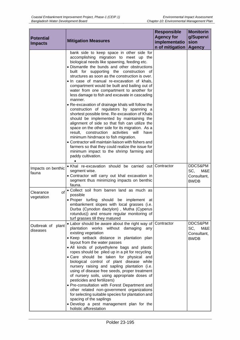
Coastal Embankment Improvement Project, Phase-1 (CEIP.1)
Bangladesh Water Development Board
Environmental Impact Assessment
Chapter-10: Environmental Management Plan
Polder 23-195
Potential Impacts
Mitigation Measures
Responsible Agency for implementation of mitigation
Monitoring/Supervision Agency
bank side to keep space in other side for accomplishing migration to meet up the biological needs like spawning, feeding etc.
• Dismantle the bunds and other obstructions built for supporting the construction of structures as soon as the construction is over.
• In case of manual re-excavation of khals, compartment would be built and bailing out of water from one compartment to another for less damage to fish and excavate in cascading manner.
• Re-excavation of drainage khals will follow the construction of regulators by spanning a shortest possible time. Re-excavation of Khals should be implemented by maintaining the alignment of side so that fish can utilize the space on the other side for its migration. As a result, construction activities will have minimum hindrnace to fish migration.
• Contractor will maintain liaison with fishers and farmers so that they could realize the issue for minimum impact to the shrimp farming and paddy cultivation.
•
Impacts on benthic fauna
• Khal re-excavation should be carried out segment wise.
• Contractor will carry out khal excavation in segment thus minimizing impacts on benthic fauna.
Contractor DDCS&PM
SC, M&E
Consultant,
BWDB
Clearance of vegetation
• Collect soil from barren land as much as possible
• Proper turfing should be implement at embankment slopes with local grasses (i.e. Durba (Cynodon dactylon) , Mutha (Cyperus rotundus)) and ensure regular monitoring of turf grasses till they matured
Outbreak of plant diseases
• Labor should be aware about the right way of plantation works without damaging any existing vegetation
• Keep setback distance in plantation plan layout from the water passes
• All kinds of polyethylene bags and plastic ropes should be piled up in a pit for recycling
• Care should be taken for physical and biological control of plant disease while nursery raising and sapling plantation (i.e. using of disease free seeds, proper treatment of nursery soils, using appropriate doses of pesticides and fertilizers)
• Pre-consultation with Forest Department and other related non-government organizations for selecting suitable species for plantation and spacing of the saplings
• Develop a pest management plan for the holistic afforestation
Contractor DDCS&PM
SC, M&E
Consultant,
BWDB
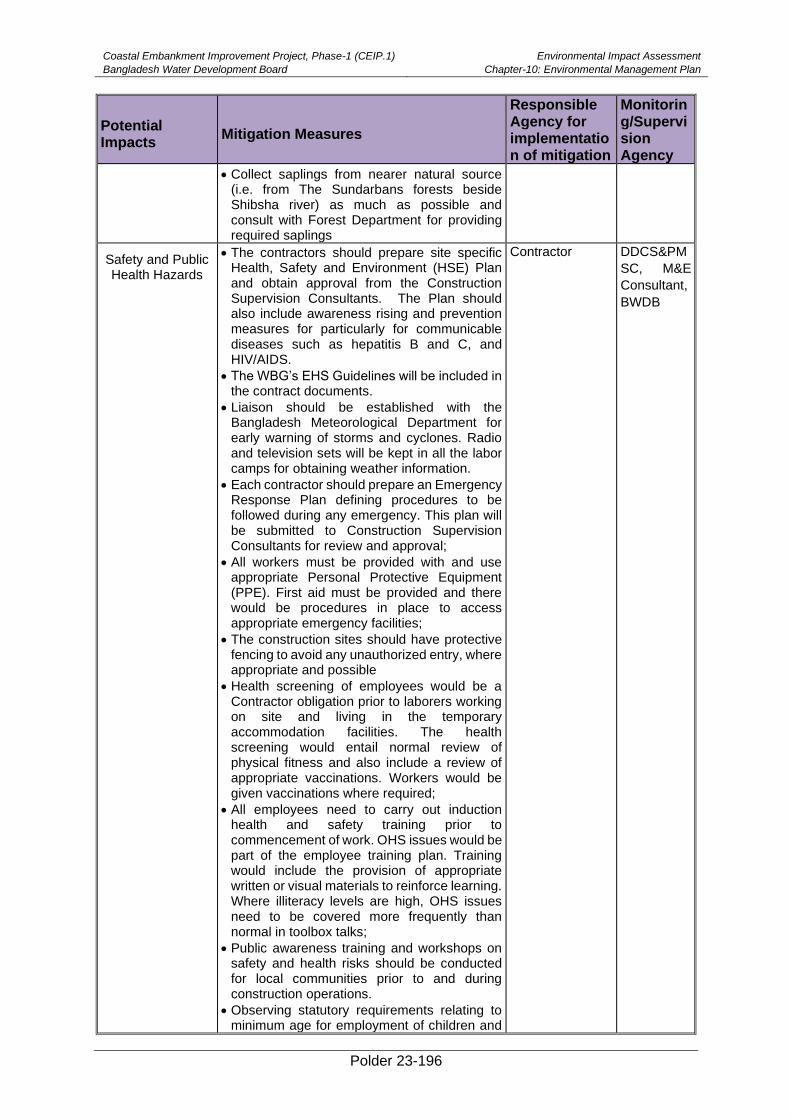
Coastal Embankment Improvement Project, Phase-1 (CEIP.1)
Bangladesh Water Development Board
Environmental Impact Assessment
Chapter-10: Environmental Management Plan
Polder 23-196
Potential Impacts
Mitigation Measures
Responsible Agency for implementation of mitigation
Monitoring/Supervision Agency
• Collect saplings from nearer natural source (i.e. from The Sundarbans forests beside Shibsha river) as much as possible and consult with Forest Department for providing required saplings
Safety and Public Health Hazards
• The contractors should prepare site specific Health, Safety and Environment (HSE) Plan and obtain approval from the Construction Supervision Consultants. The Plan should also include awareness rising and prevention measures for particularly for communicable diseases such as hepatitis B and C, and HIV/AIDS.
• The WBG’s EHS Guidelines will be included in the contract documents.
• Liaison should be established with the Bangladesh Meteorological Department for early warning of storms and cyclones. Radio and television sets will be kept in all the labor camps for obtaining weather information.
• Each contractor should prepare an Emergency Response Plan defining procedures to be followed during any emergency. This plan will be submitted to Construction Supervision Consultants for review and approval;
• All workers must be provided with and use appropriate Personal Protective Equipment (PPE). First aid must be provided and there would be procedures in place to access appropriate emergency facilities;
• The construction sites should have protective fencing to avoid any unauthorized entry, where appropriate and possible
• Health screening of employees would be a Contractor obligation prior to laborers working on site and living in the temporary accommodation facilities. The health screening would entail normal review of physical fitness and also include a review of appropriate vaccinations. Workers would be given vaccinations where required;
• All employees need to carry out induction health and safety training prior to commencement of work. OHS issues would be part of the employee training plan. Training would include the provision of appropriate written or visual materials to reinforce learning. Where illiteracy levels are high, OHS issues need to be covered more frequently than normal in toolbox talks;
• Public awareness training and workshops on safety and health risks should be conducted for local communities prior to and during construction operations.
• Observing statutory requirements relating to minimum age for employment of children and
Contractor DDCS&PM
SC, M&E
Consultant,
BWDB
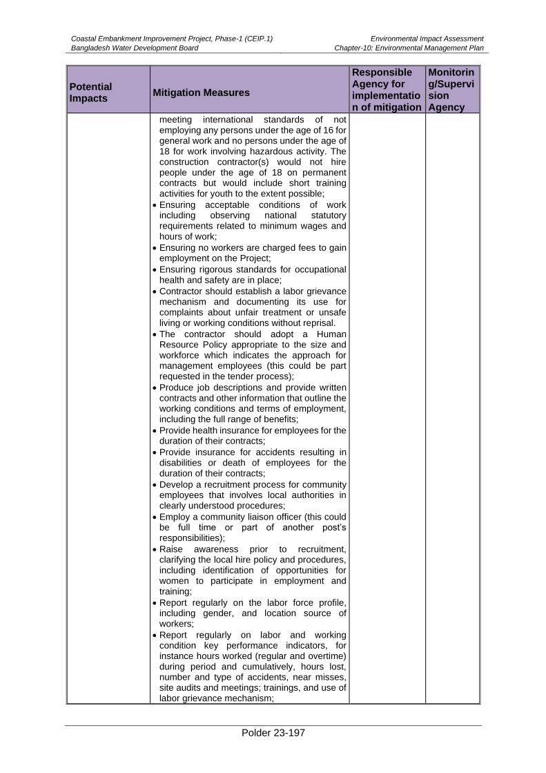
Coastal Embankment Improvement Project, Phase-1 (CEIP.1)
Bangladesh Water Development Board
Environmental Impact Assessment
Chapter-10: Environmental Management Plan
Polder 23-197
Potential Impacts
Mitigation Measures
Responsible Agency for implementation of mitigation
Monitoring/Supervision Agency
meeting international standards of not employing any persons under the age of 16 for general work and no persons under the age of 18 for work involving hazardous activity. The construction contractor(s) would not hire people under the age of 18 on permanent contracts but would include short training activities for youth to the extent possible;
• Ensuring acceptable conditions of work including observing national statutory requirements related to minimum wages and hours of work;
• Ensuring no workers are charged fees to gain employment on the Project;
• Ensuring rigorous standards for occupational health and safety are in place;
• Contractor should establish a labor grievance mechanism and documenting its use for complaints about unfair treatment or unsafe living or working conditions without reprisal.
• The contractor should adopt a Human Resource Policy appropriate to the size and workforce which indicates the approach for management employees (this could be part requested in the tender process);
• Produce job descriptions and provide written contracts and other information that outline the working conditions and terms of employment, including the full range of benefits;
• Provide health insurance for employees for the duration of their contracts;
• Provide insurance for accidents resulting in disabilities or death of employees for the duration of their contracts;
• Develop a recruitment process for community employees that involves local authorities in clearly understood procedures;
• Employ a community liaison officer (this could be full time or part of another post’s responsibilities);
• Raise awareness prior to recruitment, clarifying the local hire policy and procedures, including identification of opportunities for women to participate in employment and training;
• Report regularly on the labor force profile, including gender, and location source of workers;
• Report regularly on labor and working condition key performance indicators, for instance hours worked (regular and overtime) during period and cumulatively, hours lost, number and type of accidents, near misses, site audits and meetings; trainings, and use of labor grievance mechanism;
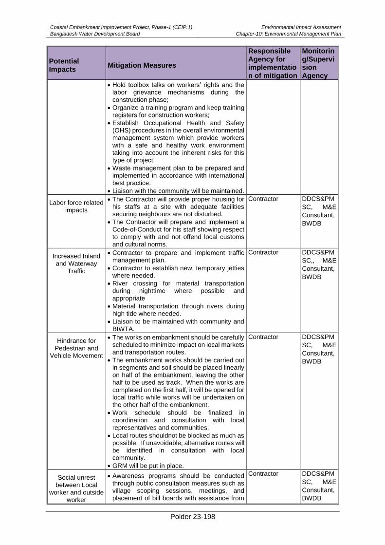
Coastal Embankment Improvement Project, Phase-1 (CEIP.1)
Bangladesh Water Development Board
Environmental Impact Assessment
Chapter-10: Environmental Management Plan
Polder 23-198
Potential Impacts
Mitigation Measures
Responsible Agency for implementation of mitigation
Monitoring/Supervision Agency
• Hold toolbox talks on workers’ rights and the labor grievance mechanisms during the construction phase;
• Organize a training program and keep training registers for construction workers;
• Establish Occupational Health and Safety (OHS) procedures in the overall environmental management system which provide workers with a safe and healthy work environment taking into account the inherent risks for this type of project.
• Waste management plan to be prepared and implemented in accordance with international best practice.
• Liaison with the community will be maintained.
Labor force related impacts
• The Contractor will provide proper housing for his staffs at a site with adequate facilities securing neighbours are not disturbed.
• The Contractor will prepare and implement a Code-of-Conduct for his staff showing respect to comply with and not offend local customs and cultural norms.
Contractor DDCS&PM
SC, M&E
Consultant,
BWDB
Increased Inland and Waterway
Traffic
• Contractor to prepare and implement traffic management plan.
• Contractor to establish new, temporary jetties where needed.
• River crossing for material transportation during nighttime where possible and appropriate
• Material transportation through rivers during high tide where needed.
• Liaison to be maintained with community and BIWTA.
Contractor DDCS&PM
SC,, M&E
Consultant,
BWDB
Hindrance for Pedestrian and
Vehicle Movement
• The works on embankment should be carefully scheduled to minimize impact on local markets and transportation routes.
• The embankment works should be carried out in segments and soil should be placed linearly on half of the embankment, leaving the other half to be used as track. When the works are completed on the first half, it will be opened for local traffic while works will be undertaken on the other half of the embankment.
• Work schedule should be finalized in coordination and consultation with local representatives and communities.
• Local routes shouldnot be blocked as much as possible. If unavoidable, alternative routes will be identified in consultation with local community.
• GRM will be put in place.
Contractor DDCS&PM
SC, M&E
Consultant,
BWDB
Social unrest between Local
worker and outside worker
• Awareness programs should be conducted through public consultation measures such as village scoping sessions, meetings, and placement of bill boards with assistance from
Contractor DDCS&PM
SC, M&E
Consultant,
BWDB
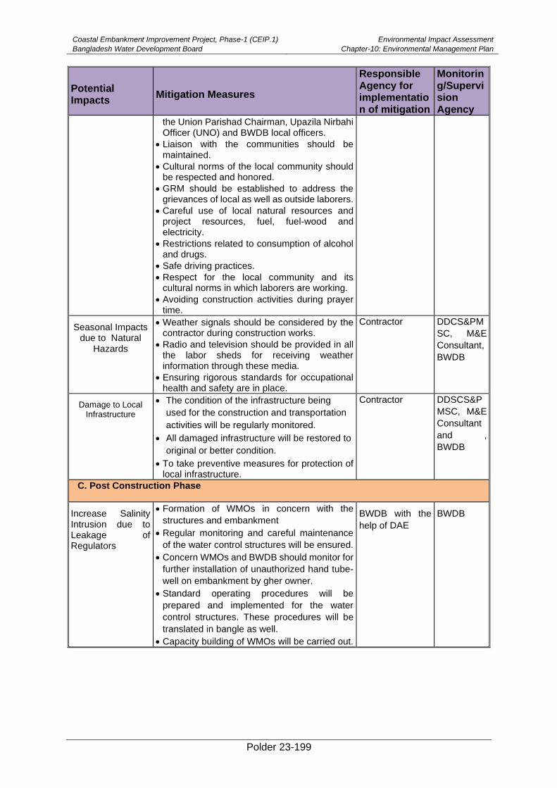
Coastal Embankment Improvement Project, Phase-1 (CEIP.1)
Bangladesh Water Development Board
Environmental Impact Assessment
Chapter-10: Environmental Management Plan
Polder 23-199
Potential Impacts
Mitigation Measures
Responsible Agency for implementation of mitigation
Monitoring/Supervision Agency
the Union Parishad Chairman, Upazila Nirbahi Officer (UNO) and BWDB local officers.
• Liaison with the communities should be maintained.
• Cultural norms of the local community should be respected and honored.
• GRM should be established to address the grievances of local as well as outside laborers.
• Careful use of local natural resources and project resources, fuel, fuel-wood and electricity.
• Restrictions related to consumption of alcohol and drugs.
• Safe driving practices.
• Respect for the local community and its cultural norms in which laborers are working.
• Avoiding construction activities during prayer time.
Seasonal Impacts due to Natural
Hazards
• Weather signals should be considered by the contractor during construction works.
• Radio and television should be provided in all the labor sheds for receiving weather information through these media.
• Ensuring rigorous standards for occupational health and safety are in place.
Contractor DDCS&PM
SC, M&E
Consultant,
BWDB
Damage to Local Infrastructure
• The condition of the infrastructure being
used for the construction and transportation
activities will be regularly monitored.
• All damaged infrastructure will be restored to
original or better condition.
• To take preventive measures for protection of local infrastructure.
Contractor DDSCS&P
MSC, M&E
Consultant
and ,
BWDB
C. Post Construction Phase
Increase Salinity Intrusion due to Leakage of Regulators
• Formation of WMOs in concern with the
structures and embankment
• Regular monitoring and careful maintenance
of the water control structures will be ensured.
• Concern WMOs and BWDB should monitor for
further installation of unauthorized hand tube-
well on embankment by gher owner.
• Standard operating procedures will be
prepared and implemented for the water
control structures. These procedures will be
translated in bangle as well.
• Capacity building of WMOs will be carried out.
BWDB with the
help of DAE BWDB
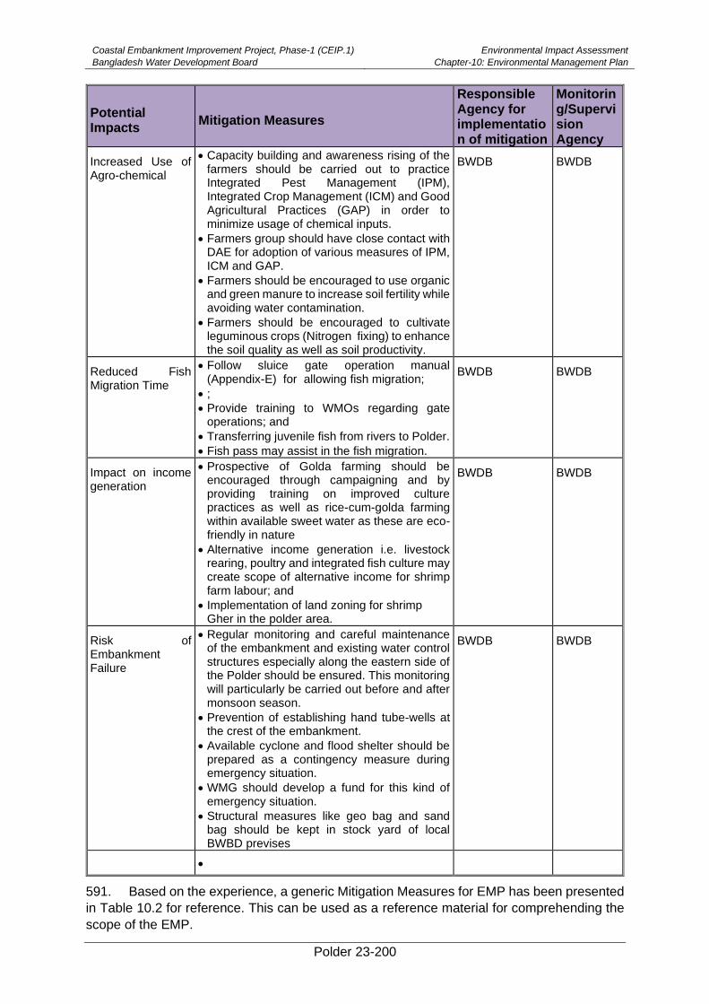
Coastal Embankment Improvement Project, Phase-1 (CEIP.1)
Bangladesh Water Development Board
Environmental Impact Assessment
Chapter-10: Environmental Management Plan
Polder 23-200
Potential Impacts
Mitigation Measures
Responsible Agency for implementation of mitigation
Monitoring/Supervision Agency
Increased Use of Agro-chemical
• Capacity building and awareness rising of the farmers should be carried out to practice Integrated Pest Management (IPM), Integrated Crop Management (ICM) and Good Agricultural Practices (GAP) in order to minimize usage of chemical inputs.
• Farmers group should have close contact with DAE for adoption of various measures of IPM, ICM and GAP.
• Farmers should be encouraged to use organic and green manure to increase soil fertility while avoiding water contamination.
• Farmers should be encouraged to cultivate leguminous crops (Nitrogen fixing) to enhance the soil quality as well as soil productivity.
BWDB BWDB
Reduced Fish Migration Time
• Follow sluice gate operation manual (Appendix-E) for allowing fish migration;
• ;
• Provide training to WMOs regarding gate operations; and
• Transferring juvenile fish from rivers to Polder.
• Fish pass may assist in the fish migration.
BWDB BWDB
Impact on income generation
• Prospective of Golda farming should be encouraged through campaigning and by providing training on improved culture practices as well as rice-cum-golda farming within available sweet water as these are eco-friendly in nature
• Alternative income generation i.e. livestock rearing, poultry and integrated fish culture may create scope of alternative income for shrimp farm labour; and
• Implementation of land zoning for shrimp Gher in the polder area.
BWDB BWDB
Risk of Embankment Failure
• Regular monitoring and careful maintenance of the embankment and existing water control structures especially along the eastern side of the Polder should be ensured. This monitoring will particularly be carried out before and after monsoon season.
• Prevention of establishing hand tube-wells at the crest of the embankment.
• Available cyclone and flood shelter should be prepared as a contingency measure during emergency situation.
• WMG should develop a fund for this kind of emergency situation.
• Structural measures like geo bag and sand bag should be kept in stock yard of local BWBD previses
BWDB BWDB
•
591. Based on the experience, a generic Mitigation Measures for EMP has been presented
in Table 10.2 for reference. This can be used as a reference material for comprehending the
scope of the EMP.
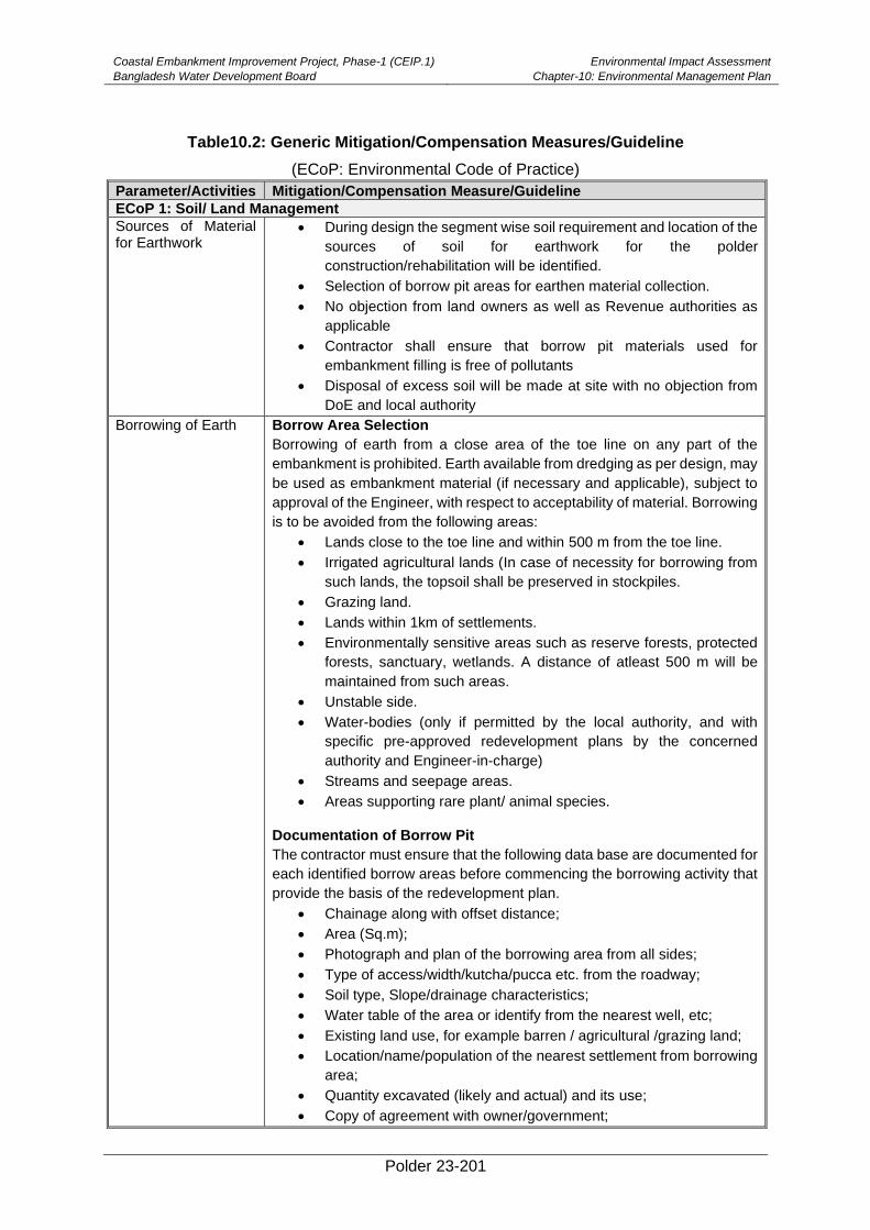
Coastal Embankment Improvement Project, Phase-1 (CEIP.1)
Bangladesh Water Development Board
Environmental Impact Assessment
Chapter-10: Environmental Management Plan
Polder 23-201
Table10.2: Generic Mitigation/Compensation Measures/Guideline
(ECoP: Environmental Code of Practice)
Parameter/Activities Mitigation/Compensation Measure/Guideline
ECoP 1: Soil/ Land Management
Sources of Material for Earthwork
• During design the segment wise soil requirement and location of the
sources of soil for earthwork for the polder
construction/rehabilitation will be identified.
• Selection of borrow pit areas for earthen material collection.
• No objection from land owners as well as Revenue authorities as
applicable
• Contractor shall ensure that borrow pit materials used for
embankment filling is free of pollutants
• Disposal of excess soil will be made at site with no objection from
DoE and local authority
Borrowing of Earth Borrow Area Selection
Borrowing of earth from a close area of the toe line on any part of the
embankment is prohibited. Earth available from dredging as per design, may
be used as embankment material (if necessary and applicable), subject to
approval of the Engineer, with respect to acceptability of material. Borrowing
is to be avoided from the following areas:
• Lands close to the toe line and within 500 m from the toe line.
• Irrigated agricultural lands (In case of necessity for borrowing from
such lands, the topsoil shall be preserved in stockpiles.
• Grazing land.
• Lands within 1km of settlements.
• Environmentally sensitive areas such as reserve forests, protected
forests, sanctuary, wetlands. A distance of atleast 500 m will be
maintained from such areas.
• Unstable side.
• Water-bodies (only if permitted by the local authority, and with
specific pre-approved redevelopment plans by the concerned
authority and Engineer-in-charge)
• Streams and seepage areas.
• Areas supporting rare plant/ animal species.
Documentation of Borrow Pit
The contractor must ensure that the following data base are documented for
each identified borrow areas before commencing the borrowing activity that
provide the basis of the redevelopment plan.
• Chainage along with offset distance;
• Area (Sq.m);
• Photograph and plan of the borrowing area from all sides;
• Type of access/width/kutcha/pucca etc. from the roadway;
• Soil type, Slope/drainage characteristics;
• Water table of the area or identify from the nearest well, etc;
• Existing land use, for example barren / agricultural /grazing land;
• Location/name/population of the nearest settlement from borrowing
area;
• Quantity excavated (likely and actual) and its use;
• Copy of agreement with owner/government;
Coastal Embankment Improvement Project, Phase-1 (CEIP.1)
Bangladesh Water Development Board
Environmental Impact Assessment
Chapter-10: Environmental Management Plan
Polder 23-202
Parameter/Activities Mitigation/Compensation Measure/Guideline
• Community facility in the vicinity of the borrow pit.
• Rehabilitation certificate from the land owner along with at least four
photograph of the rehabilitated site from different angles.
Excavation operation and Management of Excavated Material
To minimize the adverse impact during excavation of material the following
measures are to be undertaken:
• Adequate drainage system shall be provided to the excavated area
• At the stockpiling locations, the Contractor shall construct sediment
barriers to prevent erosion of excavated material due to runoff.
The followings precautions shall be undertaken during quarry operations.
• Overburden shall be avoided.
• During excavation slopes shall be flatter than 20 degrees to prevent
any sliding.
• In case of blasting, the procedure and safety measures shall be
taken as per DOE guidelines.
• The Contractor shall ensure that safety measures of all workers will
be taken.
• The Contractor shall ensure maintenance of crushers regularly as
per manufacturer‘s recommendation.
• During transportation of the material, measures shall be taken to
minimize the generation of dust and to prevent accidents.
Contamination of soil by fuel and lubrication
Ensure leakproof carriers (i.e, containers, barrels or lorries) for oil and
lubricants .
ECoP 2: Water Resource & Hydrology Management
Hazardous Waste Management
The contractor will minimize the generation of sediment, oil and grease,
excess nutrients, organic matter, litter, debris and any form of waste
(particularly petroleum and chemical wastes).
Ponding of water/water logging
• No ponding of water especially near the waste storage areas and
construction camps is to be allowed
• Discard all the storage containers which are capable of storing of
water, after use or store them in inverted position
• Reinstate relief and landscape
• Monitor drainage pattern after high down pouring and recession
flood
• Connect water pockets to the nearest drainage structures/canals
Soil Erosion and siltation
The Contractor shall
• Water the material stockpiles, access roads and bare soils on an as
required basis to minimize dust
• Increase the watering frequency during periods of high risk (e.g.
high winds)
• All the work sites (except permanently occupied by the road and
supporting facilities) will be reinstated to its initial conditions (relief,
topsoil, vegetation cover)
• Ensure that roads used by construction vehicles are swept regularly
to remove sediment.
Construction activities in water bodies
• Protect water bodies from sediment loads by silt screen or bubble
curtains or other barrier.
• No cement and water used for curing the cement concrete is to be
discharged directly into water courses and drainage inlets
Coastal Embankment Improvement Project, Phase-1 (CEIP.1)
Bangladesh Water Development Board
Environmental Impact Assessment
Chapter-10: Environmental Management Plan
Polder 23-203
Parameter/Activities Mitigation/Compensation Measure/Guideline
• Monitor the water quality in the runoff from the site or areas affected
by dredge plumes, and improve work practices as necessary
ECoP 3: Air Management
Construction vehicular traffic
The Contractor will
• Fit vehicles with appropriate exhaust systems and emission control
devices. Maintain these devices in good working condition.
• Operate the vehicles in a fuel efficient manner
• Cover haul vehicles carrying dusty materials (cement, borrow and
quarry) moving outside the construction site
• Impose speed limits on all vehicle movement at the worksite to
reduce dust emissions
• Control the movement of construction traffic
• Water construction materials before loading and being transported
• Service all vehicles regularly to minimize emissions
• Materials will be transported to site in off peak hours.
Construction activities
• Water the material stockpiles, access roads and bare soils as and
when required to minimize the potential environmental nuisance
due to dust.
• Increase the watering frequency during periods of high risk (e.g.
high winds).
• Stored materials such as excavated earth, dredged soil, gravel and
sand shall be covered and confined to avoid being wind-drifted
• Minimize the extent and period of exposure of the bare surfaces
• Reschedule earthwork activities or vegetation clearing activities,
where practical, if necessary avoid during periods of high wind and
if visible dust is blowing off-site
• Restore disturbed areas/side of the embankment as much as
practicable by plantation/vegetation/grass-turfing
• Establish adequate locations for storage, mixing and loading of
construction materials, in such a way that dust dispersion is
prevented for such operations
• Crushing of rocky and aggregate materials shall be wet-crushed, or
performed with particle emission control systems
Odor from Construction labor Camps
• Construction worker‘s camp shall be located at least500 m away
from the nearest habitation.
• The waste disposal and sewerage system for the camp shall be
properly designed, built and operated so that no odor is generated.
ECoP 3: Agriculture Management
Loss of Top Soil • Soil from fallow lands/ non-agricultural lands will be used in
earthwork of the embankments
• Collect/strip top soil before earth filling and store for reusing them
during final surfacing of embankment top and tree
plantation/afforestation.
• Strip the top soil to a depth of 15 cm and store in stock piles of height
not exceeding 2m
• Remove unwanted materials from top soil like grass, roots of trees
and similar others
• The stockpiles will maintain slopes of 2:1 to reduce surface runoff
and enhance percolation through the mass of stored soil
• Locate topsoil stockpiles in areas outside drainage lines and protect
from erosion
Coastal Embankment Improvement Project, Phase-1 (CEIP.1)
Bangladesh Water Development Board
Environmental Impact Assessment
Chapter-10: Environmental Management Plan
Polder 23-204
Parameter/Activities Mitigation/Compensation Measure/Guideline
• Spread the topsoil to maintain the physico-chemical and biological
activity of the soil.
• The stored top soil will be utilized for covering all disturbed area and
along the proposed plantation sites
• Topsoil stockpiles will be monitored and if any will adverse
conditions if identified are to be minimized through corrective
actions whice will include:
• Anaerobic conditions-turning the stockpile or creating ventilation
holes through the stockpile;
• Erosion – temporary protective silt fencing will be erected;
Soil salinity Use of duckweed will remove soil salinity
• Flushing with pre-monsoon rain water will reduce soil salinity.
• Saline tolerant crops need to be cultivated.
• Environmentally and socially responsive shrimp farming e.g.
shrimp-rice farming system to be encouraged.
• Increase upland discharge of fresh water will push back ingress of
saline water from the sea
• Green manure application is to be promoted
• Ground water abstraction for shrimp farming will be avoided.
ECoP 4: Noise Management
Construction vehicular traffic
• Maintain all vehicles in order to keep them in good working condition
in accordance with manufactures maintenance procedures
• Organize the loading and unloading of trucks, and handling
operations for minimizing construction noise at the work site.
Construction machinery
• Select appropriate site for all noise generating activities to avoid
noise pollution to local residents
• Maintain all equipment in order to keep it in good working condition
in accordance with manufactures maintenance procedures.
Construction activity • Notify adjacent landholders/Schools prior to any typical noise
events outside of daylight hours
• Employ best available work practices on-site to minimize
occupational noise levels
• Install temporary noise control barriers where appropriate
• Plan activities on site and deliveries to and from site to minimize
impact
• Monitor and analyze noise and vibration results and adjust
construction practices as required
• Avoid working during 09:00pm to 06:00 am within 500m from
residences.
ECoP 5: Ecology Management
Flora
Vegetation Clearance • Tree felling will be performed upon preliminary notification to the
relevant authority (Divisional Forest Office, DoE).
• Preparation of maps in GIS format, cadastral description of trees to
be felled, marking, and supervision of Forest Department are
necessary elements of the procedure.
• Provide adequate knowledge to the workers regarding nature
protection and the need of avoiding felling trees during construction
• Fruit and timber trees owned by local population will be
compensated at their replacement cost according to market prices
Coastal Embankment Improvement Project, Phase-1 (CEIP.1)
Bangladesh Water Development Board
Environmental Impact Assessment
Chapter-10: Environmental Management Plan
Polder 23-205
Parameter/Activities Mitigation/Compensation Measure/Guideline
Plant Management • Tree seedlings are planted in a way that minimizes damage to the
soil, while facilitating seedling survival. Appropriate tree seedling
species are to be selected for maintaining long-term productivity.
• Focus on tree species suitable for site condition
• Prevent unreasonable species resulting slow growth, less water and
soil conservation and pest or disease outbreaks
• Local species as planting materials, since natural selection and
succession are most suitable for local climates and natural
conditions
• Single species or clone monoculture are to be avoided
• Choose suitable species for berm andturfing
Planting • Leave set back requirements around streams, restricted areas e.g.
native vegetation, protected riparian strips, historic and heritage
sites, research areas.
• For nursery raising, physical and biological controls are practiced to
control the pests and diseases in the nurseries.
• Do not plant spread-prone species on sites where there is a high
risk of uncontrollable wilding spread beyond the boundaries of the
plantation.
• Consider appropriate species, patterns and layout when planting
areas with high visual values and/or with important recreational
values
Polypropylene Bags Handling
• Make a Borrow Pit at each site for collection of poly bags
• Collect all bags at the pits after plantation
• If feasible, inform private sector to collect those bags for recycling
Pest Management to Nursery
• During outbreak of any deadly plant disease develop a plan to
manage pest in coordination with neighbors by identifying existing
pests and diseases and the risks for introduction of new pests and
diseases.
• Share the plan with financial Bank before application.
Water Management • Install temporary sediment basins, where appropriate, to capture
sediment-laden run-off from nursery
• Divert runoff from undisturbed areas around the harvesting site
• Stockpile of fertilizer or agrochemical away from drainage lines
• Prevent all solid and liquid wastes against entering the waterways
by collecting solid waste, oils, chemicals, fertilizers waste and
transport to an approved waste disposal site
Fauna
Construction works in the surrounding lands
• Pre-entry survey and prevention of damage to fauna prior to the
start up of works
• Limit the construction works within the designated sites allocated to
the contractors
• Not be allow any destruction of nests or eggs of migratory birds
• Provide adequate knowledge to the workers regarding protection of
flora and fauna, and relevant government regulations and
punishments for illegal poaching.
ECoP 6: Fisheries Management
Construction works in the rivers and on the surrounding lands
• Critical breeding areas of major fish species will be identified and
declared as sanctuaries.
• Creation of small ditches and pools that may trap the fishes will be
avoided.
Coastal Embankment Improvement Project, Phase-1 (CEIP.1)
Bangladesh Water Development Board
Environmental Impact Assessment
Chapter-10: Environmental Management Plan
Polder 23-206
Parameter/Activities Mitigation/Compensation Measure/Guideline
• Creation of artificial waterfalls and other barriers for migration will
be avoided.
• Natural river channels are to be reinstated after completion of
construction works
Hydraulic Structure • Sufficient free flow will have be guaranteed in the design and
construction work to ensure free passages of migrating fishes.
• Hydraulic structure will be operated considering fish migration and
spawning time
• A guideline for area specific hydraulic structure operation will be
developed
Dredging • Ensure that the dredging activity will create minimum sediment load
in the water
• Avoid dredging during spawning period of fish
ECoP 7: Socio-Economic Management
Construction Camp Management
Siting and Location of construction camps (MRDI, 2011)
• The contractor shall establish signboard at worksite mentioning the
details of activities, cost and ensure of works,name and address of
contractor and Supervision arganisations.
• Locate the construction camps in the areas which are acceptable
from environmental, cultural or social point of view.
• Consider the location of construction camps far away from
communities in order to avoid social conflict in using the natural
resources such as water or to avoid the possible adverse impacts
of the construction camps on the surrounding communities.
• BWDB will endorse detailed layout plan for the development of the
construction camp submitted by the contractor. The plan will show
the relative locations of all temporary buildings and facilities that are
to be constructed together with the location of site roads, fuel
storage areas (for use in power supply generators), solid waste
management and dumping locations, and drainage facilities, prior to
the development of the construction camps.
• Local authorities responsible for health, religious and security shall
be duly informed about the set up of camp facilities so as to maintain
effective surveillance over public health, social and security matters
Construction Camp Facilities
The following facilities will have to be provided by the Contractor
• Adequate housing for all workers
• Safe and reliable water supply
• Hygienic sanitary facilities and sewerage system.
• Treatment facilities for sewerage of toilet and domestic wastes
• Storm water drainage facilities
• Provide in-house community/common entertainment facilities,
dependence of local entertainment outlets by the construction
camps to be discouraged/prohibited to the extent possible.
Solid Waste Management
• Ensure proper collection and disposal of solid wastes within the
construction camps
• Store inorganic wastes in a safe place within the household and
clear organic wastes on daily basis to waste collector.
• Establish waste collection, transportation and disposal systems with
the manpower and equipment/vehicles needed.
Coastal Embankment Improvement Project, Phase-1 (CEIP.1)
Bangladesh Water Development Board
Environmental Impact Assessment
Chapter-10: Environmental Management Plan
Polder 23-207
Parameter/Activities Mitigation/Compensation Measure/Guideline
• All solid waste should be collected and removed from the work
camps and disposed in approved disposal sites
Fuel Supplies for Cooking and Heatingpurposes
• Provide fuel to the construction camps for their domestic purpose,
in order to discourage use of fuel wood or other biomass.
• Conduct awareness campaigns to educate workers to protect the
biodiversity and wildlife of the project area, and relevant government
regulations and punishments on wildlife protection.
Health and Hygiene • Provide adequate health care facilities within construction sites
• Provide first aid facility round the clock. Maintain steady stock of
medicines in the facility
• Provide ambulance facility for the laborers during emergency to be
transported to nearest hospitals.
• Initial health screening of the laborers coming from outside areas
• Train all construction workers regarding basic sanitation and health
care issues and safety matters, and on the specific hazards of the
work
• Provide HIV awareness programming, including STI (sexually
transmitted infections) and HIV information, education and
communication for all workers on regular basis
• Provide adequate drainage facilities throughout the camps to
ensure that disease vectors such as stagnant water bodies and
puddles do not form. Assure regular mosquito repellant sprays
during monsoon.
• Conduct short training sessions on best hygiene practices and make
of mandatorily participation by all workers.
• Place display boards at strategic locations within the camps
containing messages on best hygienic practices
Payment of Wages • The payment of wages will be as per the Minimum Wages Act,
Department of Labor, and Government of Bangladesh for both male
and female workers.
• To display the minimum wages board in local languages at
labourcamps sites.
• Wages will be paid to the labourers only in presence of BWDB staff;
• Contractor is required to maintain register for payment of labor
wages with entry of every labor working for him. It should be
produced for verification if and when asked by the Engineer, EMU
and/or the concerned BWDB staff/Engineer‘s representative
Rehabilitation of Labor and Construction Camp
• At the completion of construction, all construction camp facilities
shall be dismantled and removed from the site. The site shall be
restored to a condition in no way inferior to the condition prior to
commencement of the works.
• Various activities to be carried out for site rehabilitation and include:
• Oil and fuel contaminated soil shall be removed and transported or
buried in waste disposal areas.
• Soak pits, septic tanks shall be covered and effectively sealed off.
• Debris (rejected material) will be disposed off suitably.
• Underground water tank in a barren/non-agricultural land can be
covered.
• If the construction camp site is on an agricultural land, the top soil
should be preserved and good earth can be spread back for a
minimum 30cm for faster rejuvenation of the land.
Coastal Embankment Improvement Project, Phase-1 (CEIP.1)
Bangladesh Water Development Board
Environmental Impact Assessment
Chapter-10: Environmental Management Plan
Polder 23-208
Parameter/Activities Mitigation/Compensation Measure/Guideline
• Proper documentation of rehabilitation site is necessary.
• This shall include the following:
• Photograph of rehabilitated site;
• Land owner consent letter for satisfaction in measurements taken
for rehabilitation of site; and
• Undertaking from contractor;
• In cases, where the construction camps site is located on a private
land holding, the contractor should still have to restore the campsite
as per this guideline. The rehabilitation is mandatory and will be
include in the agreement with the landowner by the contractor. A
certificate of satisfaction from the landowner should have to be
obtained.
Damage and Loss of Cultural Properties
Conservation of Religious Structures and Shrines
• All necessary and adequate care should be taken to minimize
impact on cultural properties which includes cultural sites and
places of worship including temples, mosques, churches and
shrines, etc., graveyards, monuments and any other important
structures as identified during design and all properties / sites /
remains notified. No work shall spillover to these properties and
premises. The design options for cultural property relocation and
enhancement need to be prepared.
• All conservation and protection measures will be taken up as per
design. Cleanliness at the access to such properties along with the
road should be maintained.
• During earth excavation, if any property is unearthed and seems to
be culturally significant or likely to have archaeological significance,
the same shall be intimated to the Engineer. Work shall be
suspended until further deciscion from the PD. The Archaeological
Department shall be intimated about the chance of such findings
and the Engineer shall carry out a join inspection with the
department. Actions as appropriate shall be intimated to the
Contractor along with the probable date for resuming the work.
• All fossils, coins, articles of value of antiquity and structures along
with all other things of geological or archaeological interest
discovered on the site shall be the property of the Government, and
shall be dealt with as per provisions of the relevant legislation.
Worker’s Accident Risk
Risk from Operations The Contractor is required to comply with all the precautions as required for
the safety of the workers as per the International Labor Organization(ILO)
convention. The contractor shall supply all necessary safety appliances
such as safety goggles, helmets, masks, books, etc., to the workers and
staff. The contractor has to comply with all regulations regarding safe
scaffolding, ladders, working platforms, gangway, stairwells, excavations,
trenches and safe means of entry and exit.
Risk from Electrical Equipment
Adequate precautions will have to be taken to prevent any danger from
electrical equipment. No materials on any of the sites will be stacked or
placed as to cause danger or inconvenience to any person or the public. All
necessary fencing and lights will be provided to protect the public. All
machineries to be used in the construction will conform to the relevant
Bangladesh Standards (BS) codes, will be free from patent defect, will be in
Coastal Embankment Improvement Project, Phase-1 (CEIP.1)
Bangladesh Water Development Board
Environmental Impact Assessment
Chapter-10: Environmental Management Plan
Polder 23-209
Parameter/Activities Mitigation/Compensation Measure/Guideline
good working condition, will be regularly inspected and properly maintained
as per BS provisions and to the satisfaction of the Engineer.
Risk from Hazardous Activity
All workers employed on mixing material, cement, lime mortars, concrete
etc., will be provided with protective footwear and protective goggles.
Workers, who are engaged in welding works, would be provided with
welder's protective eye-shields. Stone-breakers will be provided with
protective goggles and clothing and will be seated at sufficiently safe
intervals.
Malarial Risk The Contractor shall, at his own cost, conform all anti-malarial instructions
given to him by the Engineer and the EMU, including filling up of the borrow
pits whichhave been dug by him.
Disruption to Users
Loss of Access • At all times, the Contractor shall provide safe and convenient
passage for vehicles, pedestrians and livestock. Work that affects
the use of existing accesses shall not be undertaken without
providing adequate provisions to the prior satisfaction of the
Engineer.
• The works shall not interfere unnecessarily or improperly with the
convenience of public or the access to, use and occupation of public
or private roads, and any other access footpaths to or of properties
whether public or private.
Traffic Management • Special consideration shall be given in preparation of the traffic
control plan to the safety of pedestrians and workers at night
• The temporary traffic detours in settlement areas shall be kept free
from dust by frequent application of water
Traffic Control and Safety
The Contractor shall take all necessary measures for the safety of traffic
during construction and provide, erect and maintain such barricades,
including signs, markings, flags, lights and flagmen as may be required by
the Engineer for the information and protection of traffic approaching or
passing through the cross section.
Automated CC Block Plant
Construction
materials
• Materials to be stacked separately like sand, shingles, etc.
• Shingles to be washed while stacking
• Sand to be covered preventing them to be blown by wind
• Sand to be seived to discard mudlumps and other debris
Signages at the Plant • Bangla and English signs to be displayed at clearly visible locations
• Warning signs, including “DOs & DON’T’s” to avoid any accidents
• Signs strictly mentioning use of PPEs (ear plugs, ear muffs,
masks, helmets, gloves, shoes, etc.) while working at the plant
• Visible signs for fuel storage, stack yards, electrical appliances,
live electrical wires, office/residential area, etc.
• Signs with speed limits and movement directions for vehicles, fork
lifters
• Display board showing numbers of laborers working in a shift, CC
blocks produced and storage site
• Marking electrical appliances, live wires; keeping wires out of
reach to avoid any accident
• Sign showing designated sites of fire estinguishers
Automated Plant • Operated during day time only and in shifts
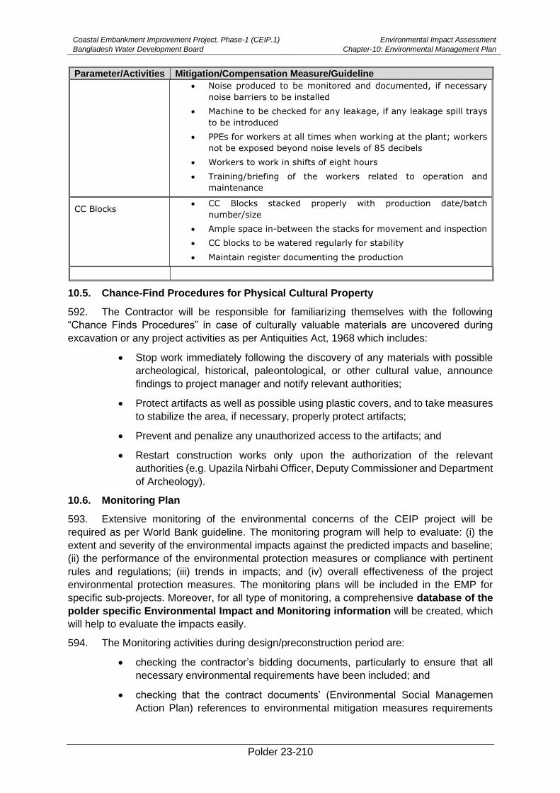
Coastal Embankment Improvement Project, Phase-1 (CEIP.1)
Bangladesh Water Development Board
Environmental Impact Assessment
Chapter-10: Environmental Management Plan
Polder 23-210
Parameter/Activities Mitigation/Compensation Measure/Guideline
• Noise produced to be monitored and documented, if necessary
noise barriers to be installed
• Machine to be checked for any leakage, if any leakage spill trays
to be introduced
• PPEs for workers at all times when working at the plant; workers
not be exposed beyond noise levels of 85 decibels
• Workers to work in shifts of eight hours
• Training/briefing of the workers related to operation and
maintenance
CC Blocks • CC Blocks stacked properly with production date/batch
number/size
• Ample space in-between the stacks for movement and inspection
• CC blocks to be watered regularly for stability
• Maintain register documenting the production
10.5. Chance-Find Procedures for Physical Cultural Property
592. The Contractor will be responsible for familiarizing themselves with the following
“Chance Finds Procedures” in case of culturally valuable materials are uncovered during
excavation or any project activities as per Antiquities Act, 1968 which includes:
• Stop work immediately following the discovery of any materials with possible
archeological, historical, paleontological, or other cultural value, announce
findings to project manager and notify relevant authorities;
• Protect artifacts as well as possible using plastic covers, and to take measures
to stabilize the area, if necessary, properly protect artifacts;
• Prevent and penalize any unauthorized access to the artifacts; and
• Restart construction works only upon the authorization of the relevant
authorities (e.g. Upazila Nirbahi Officer, Deputy Commissioner and Department
of Archeology).
10.6. Monitoring Plan
593. Extensive monitoring of the environmental concerns of the CEIP project will be
required as per World Bank guideline. The monitoring program will help to evaluate: (i) the
extent and severity of the environmental impacts against the predicted impacts and baseline;
(ii) the performance of the environmental protection measures or compliance with pertinent
rules and regulations; (iii) trends in impacts; and (iv) overall effectiveness of the project
environmental protection measures. The monitoring plans will be included in the EMP for
specific sub-projects. Moreover, for all type of monitoring, a comprehensive database of the
polder specific Environmental Impact and Monitoring information will be created, which
will help to evaluate the impacts easily.
594. The Monitoring activities during design/preconstruction period are:
• checking the contractor’s bidding documents, particularly to ensure that all
necessary environmental requirements have been included; and
• checking that the contract documents’ (Environmental Social Managemen
Action Plan) references to environmental mitigation measures requirements
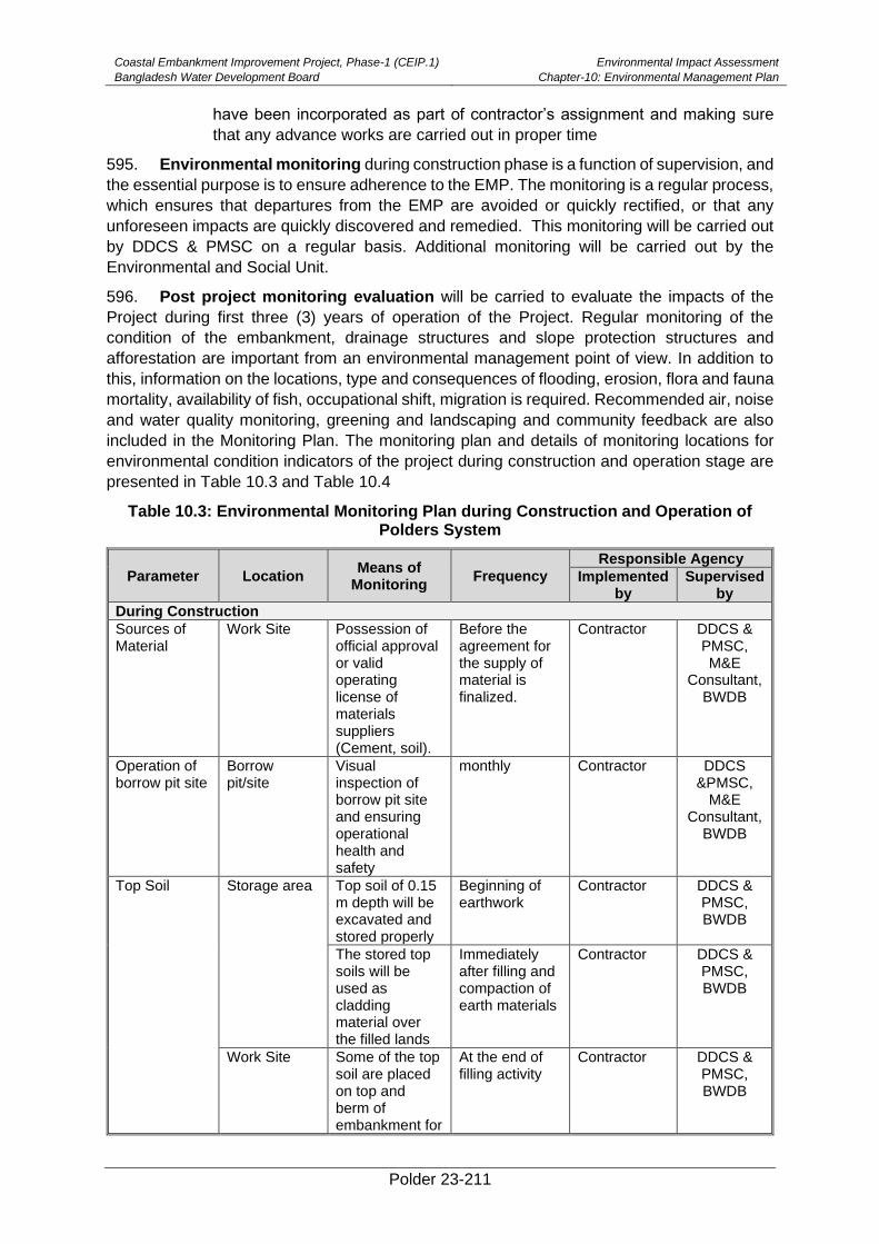
Coastal Embankment Improvement Project, Phase-1 (CEIP.1)
Bangladesh Water Development Board
Environmental Impact Assessment
Chapter-10: Environmental Management Plan
Polder 23-211
have been incorporated as part of contractor’s assignment and making sure
that any advance works are carried out in proper time
595. Environmental monitoring during construction phase is a function of supervision, and
the essential purpose is to ensure adherence to the EMP. The monitoring is a regular process,
which ensures that departures from the EMP are avoided or quickly rectified, or that any
unforeseen impacts are quickly discovered and remedied. This monitoring will be carried out
by DDCS & PMSC on a regular basis. Additional monitoring will be carried out by the
Environmental and Social Unit.
596. Post project monitoring evaluation will be carried to evaluate the impacts of the
Project during first three (3) years of operation of the Project. Regular monitoring of the
condition of the embankment, drainage structures and slope protection structures and
afforestation are important from an environmental management point of view. In addition to
this, information on the locations, type and consequences of flooding, erosion, flora and fauna
mortality, availability of fish, occupational shift, migration is required. Recommended air, noise
and water quality monitoring, greening and landscaping and community feedback are also
included in the Monitoring Plan. The monitoring plan and details of monitoring locations for
environmental condition indicators of the project during construction and operation stage are
presented in Table 10.3 and Table 10.4
Table 10.3: Environmental Monitoring Plan during Construction and Operation of Polders System
Parameter Location Means of
Monitoring Frequency
Responsible Agency
Implemented by
Supervised by
During Construction
Sources of Material
Work Site Possession of official approval or valid operating license of materials suppliers (Cement, soil).
Before the agreement for the supply of material is finalized.
Contractor DDCS & PMSC, M&E
Consultant, BWDB
Operation of borrow pit site
Borrow pit/site
Visual inspection of borrow pit site and ensuring operational health and safety
monthly Contractor DDCS &PMSC,
M&E Consultant,
BWDB
Top Soil Storage area Top soil of 0.15 m depth will be excavated and stored properly
Beginning of earthwork
Contractor DDCS & PMSC, BWDB
The stored top soils will be used as cladding material over the filled lands
Immediately after filling and compaction of earth materials
Contractor DDCS & PMSC, BWDB
Work Site Some of the top soil are placed on top and berm of embankment for
At the end of filling activity
Contractor DDCS & PMSC, BWDB
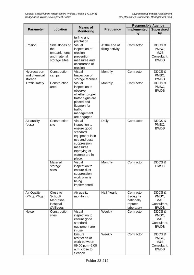
Coastal Embankment Improvement Project, Phase-1 (CEIP.1)
Bangladesh Water Development Board
Environmental Impact Assessment
Chapter-10: Environmental Management Plan
Polder 23-212
Parameter Location Means of
Monitoring Frequency
Responsible Agency
Implemented by
Supervised by
turfing and plantation
Erosion Side slopes of the embankments and material storage sites
Visual inspection of erosion prevention measures and occurrence of erosion
At the end of filling activity
Contractor DDCS & PMSC, M&E
Consultant, BWDB
Hydrocarbon and chemical storage
Construction camps
Visual Inspection of storage facilities
Monthly Contractor DDCS & PMSC, BWDB
Traffic safety Construction area
Visual inspection to observe whether proper traffic signs are placed and flagmen for traffic management are engaged
Monthly Contractor DDCS & PMSC, BWDB
Air quality (dust)
Construction site
Visual inspection to ensure good standard equipment is in use and dust suppression measures (spraying of waters) are in place.
Daily Contractor DDCS & PMSC, BWDB
Material storage sites
Visual inspection to ensure dust suppression work plan is being implemented
Monthly Contractor DDCS & PMSC
Air Quality (PM10, PM2.5)
Close to School/ Madrasha, Hospital &Villages
Air quality monitoring
Half Yearly Contractor through a nationally reputed laboratory
DDCS & PMSC, M&E
Consultant, BWDB
Noise
Construction sites
Visual inspection to ensure good standard equipment are in use
Weekly
Contractor DDCS & PMSC, M&E
Consultant, BWDB
Ensure restriction of work between 09:00 p.m.-6:00 a.m. close to School/
Weekly Contractor DDCS & PMSC, M&E
Consultant, BWDB
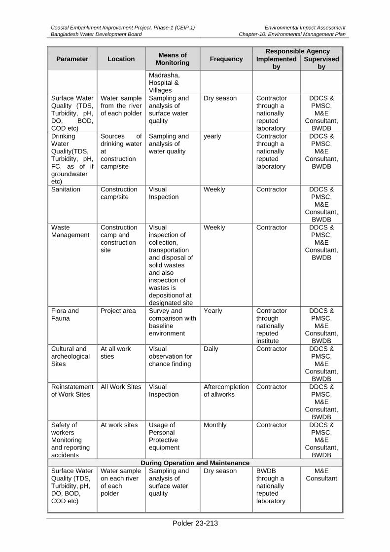
Coastal Embankment Improvement Project, Phase-1 (CEIP.1)
Bangladesh Water Development Board
Environmental Impact Assessment
Chapter-10: Environmental Management Plan
Polder 23-213
Parameter Location Means of
Monitoring Frequency
Responsible Agency
Implemented by
Supervised by
Madrasha, Hospital & Villages
Surface Water Quality (TDS, Turbidity, pH, DO, BOD, COD etc)
Water sample from the river of each polder
Sampling and analysis of surface water quality
Dry season Contractor through a nationally reputed laboratory
DDCS & PMSC, M&E
Consultant, BWDB
Drinking Water Quality(TDS, Turbidity, pH, FC, as of if groundwater etc)
Sources of drinking water at construction camp/site
Sampling and analysis of water quality
yearly Contractor through a nationally reputed laboratory
DDCS & PMSC, M&E
Consultant, BWDB
Sanitation Construction camp/site
Visual Inspection
Weekly Contractor DDCS & PMSC, M&E
Consultant, BWDB
Waste Management
Construction camp and construction site
Visual inspection of collection, transportation and disposal of solid wastes and also inspection of wastes is depositionof at designated site
Weekly Contractor DDCS & PMSC, M&E
Consultant, BWDB
Flora and Fauna
Project area Survey and comparison with baseline environment
Yearly Contractor through nationally reputed institute
DDCS & PMSC, M&E
Consultant, BWDB
Cultural and archeological Sites
At all work sties
Visual observation for chance finding
Daily
Contractor
DDCS & PMSC, M&E
Consultant, BWDB
Reinstatement of Work Sites
All Work Sites
Visual Inspection
Aftercompletion of allworks
Contractor
DDCS & PMSC, M&E
Consultant, BWDB
Safety of workers Monitoring and reporting accidents
At work sites Usage of Personal Protective equipment
Monthly Contractor DDCS & PMSC, M&E
Consultant, BWDB
During Operation and Maintenance
Surface Water Quality (TDS, Turbidity, pH, DO, BOD, COD etc)
Water sample on each river of each polder
Sampling and analysis of surface water quality
Dry season BWDB through a nationally reputed laboratory
M&E Consultant
Coastal Embankment Improvement Project, Phase-1 (CEIP.1)
Bangladesh Water Development Board
Environmental Impact Assessment
Chapter-10: Environmental Management Plan
Polder 23-214
Parameter Location Means of
Monitoring Frequency
Responsible Agency
Implemented by
Supervised by
Air Quality (Dust PM10, PM2.5)
At the baseline monitoring site
24 hours Air quality monitoring
Yearly BWDB through a nationally reputed laboratory
M&E Consultant
Flora and Fauna specially fisheries
In the project area
Detail species assessment and compare with baseline
Yearly BWDB through a nationally reputed institution
M&E Consultant
Agriculture In the project area
Compare the production with the baseline
Yearly BWDB through a nationally reputed institution
M&E Consultant
Operation of hydraulic structure
In the project area
Visual inspection and public feedback
Yearly BWDB
M&E Consultant
Source: MRDI, 2011, LGED, 2011
Table 10.4: Environmental Monitoring Plan during Construction and Operation of Afforestation
Parameter Location Means of
Monitoring Frequency
Responsible Agency
Implemented by Supervised
by
During Implementation
Plant Selection
Nursery Visual inspection. Type and variety of plant species to be planted for turfing on the top of embankment and foreshore
Before plantation Contractor DDCS & PMSC,
BWDB, M&E Consultant
Water Quality Water bodies near nursery
Odor and chemical testing
Dry season Contractor through nationally reputed laboratory
DDCS & PMSC,
BWDB, M&E Consultant
Waste Management
Work site and Nursery
Visual inspection of collection, transportation and disposal of grasses, debris and is deposited at designated site
Weekly Contractor DDCS & PMSC,
BWDB, M&E Consultant
Work site and Nursery
Visual inspection of Water bars & cut-offs .sediment traps to prevent water pollution caused by run-off from harvesting areas
Beginning of works
Contractor DDCS & PMSC,
BWDB, M&E Consultant
Nursery Embankment Management
Nursery Visual inspection of height of embankment, possibility of water logging and connection to the waterbodies
Beginning of each nursery
Contractor DDCS & PMSC,
BWDB, M&E Consultant
During Operation and Management
Coastal Embankment Improvement Project, Phase-1 (CEIP.1)
Bangladesh Water Development Board
Environmental Impact Assessment
Chapter-10: Environmental Management Plan
Polder 23-215
Parameter Location Means of
Monitoring Frequency
Responsible Agency
Implemented by Supervised
by
Multilevel belt of trees
Polder top and along the polder
Visual inspection yearly BWDB through nationally
recognized institution
M&E Consultant
Flora and Fauna
In the project area
Detail species assessment and compare with baseline
Yearly BWDB through a nationally recognized institution
M&E Consultant
Erosion Along Alignment
Visual Inspection presence of gullies or erosion
Yearly BWDB
M&E Consultant
Fish Habitat Observation
In the project area
Physical observation
Four (4) times of year (dry & wet season)
Contractor with help of UFO
M&E Consultant
Fish Catch assessmen survey
In the project area
Catch survey two (2) times of a year (dry & wet season)
Contractor with help of UFO
M&E Consultant
Fish swimming speed or velocity
In the project area
Measurement of water velocity
Once in a Week WMO with help of
UFO
M&E Consultant
Operation of fish pass
In the project area
Visual inspection and fishermen feedback
Reound the year
BWDB
M&E Consultant
Qualitative Spot-Checking Indicators
597. Moreover, a rapid environmental monitoring will be carried out as per following
checklist in terms of visual judgment during field visit as an indirect control to implement
Environmental Mitigation Plan. Table 10.5 can be followed during project construction and
operation process.
Table 10.5: Spot Checking Indicator
Parameter Visual Judgment Comments
Poor Moderate Satisfactory
Workers Safety
Camp Site Management
Plant Site Management
Borrowpit Area Management
Top Soil Prevention
Waste Management
Occupational Health and Safety
Stockpiling of construction materials
Reporting and Documentation
Third Party Validation
598. BWDB will engage independent consultants to conduct a third-party validation (TPV)
of the EMP implementation on yearly basis during the construction phase. During the TPV,
the consultants will review the implementation and effectiveness of various EMP activities
including mitigation measures, environmental monitoring, trainings, and documentation. The
consultants will also identify gaps and non-compliances in EMP implementation and propose
actions for their remedy.

Coastal Embankment Improvement Project, Phase-1 (CEIP.1)
Bangladesh Water Development Board
Environmental Impact Assessment
Chapter-10: Environmental Management Plan
Polder 23-216
10.7. Documentation, Record Keeping and Reporting
Record Keeping
599. Proper arrangements are necessary for recording, disseminating and responding to
information which emerges from various environmental monitoring and management
programs. They are also necessary for rendering the environmental management system
“auditable”. However, the primary focus must remain on the pragmatic control of pollution, not
creation of complex bureaucratic procedures. BWDB will maintain database of the polder
specific Environmental Impact and Monitoring informationfor keeping all type of monitoring
record. ESCU will assist BWDB for keeping these records initially. The trained BWDB staff will
take the responsibility of record keeping and monitoring during operation phase.
Monitoring Records
Quantitative Physical Monitoring
600. The objective of quantitative physical monitoring is to ensure that the mitigation
measures designed to prevent, reduce and where possible offset any significant adverse
impacts on the environment are being implemented throughout the Project lifecycle. DDCS &
PMSCwill regularly monitor and provide information to ESCU for updating the database.
DDCS & PMSC will provide the following information bi-weekly to ESCU, if not urgent.
• Sampling points;
• Dates and times of sample collection;
• Test results;
• Control limits;
• “Action limits” (about 80 percent of the control limits) at which steps must be
taken to prevent the impending breach of the control limit; and
• Any breaches of the control limits, including explanations if available.
601. The monitoring data would be continually processed as it is received, so as to avoid a
buildup of unprocessed data.
General Site Inspections and Monitoring
602. A Site Inspection Checklist for recording the findings of the general site condition
surveys would be developed by the respective contractors, on the basis of the Environmental
Mitigation Plan described in Chapter 6, during the construction phase. The Site Inspection
Checklist would be supported by sketches, as necessary.
Information Sources
603. A complete and up-to-date file of all relevant sources of information will be maintained
by the ESC unit of PMU. This file would be readily accessible and include, as a minimum,
copies of the following documents:
• Current environmental permits and consents;
• Action to fulfill the requirement of annual site clearance for polder area
• All relevant national regulations, international guidelines and codes of practice;
• Manufacturers’ MSDSs for all hazardous substances used on the project;
Coastal Embankment Improvement Project, Phase-1 (CEIP.1)
Bangladesh Water Development Board
Environmental Impact Assessment
Chapter-10: Environmental Management Plan
Polder 23-217
• Manufacturers’ operating manuals for all the environmental monitoring
equipment;
• Current calibration certificates for all equipment that requires calibration by an
external organization; and
• The latest version of this Environmental Management and Monitoring Plan.
Non-Compliance Report
604. Any breaches of the acceptable standards specified, would be reported to the PMU
using a standard form, i.e. a Non-Compliance Report (NCR).
605. A copy of each completed NCR would be kept maintained on file by DDCS&PMSC, to
be replaced by the reply copy when it is received. A record of corrective actions would also
be made and tracked to their completion.
Monthly Internal Reports by DDCS&PMSC
606. The DDCS & PMSC will prepare a monthly report for issuance to the ESCU of PMU.
These reports will summarize the followings:
• Progress of implementation of this EMP;
• Findings of the monitoring programs, with emphasis on any breaches of the
control standards, action levels or standards of general site management;
• Any emerging issues where information or data collected is substantially
different from the baseline data reported in the Environmental Assessment;
• Outstanding NCRs;
• Summary of any complaints by external bodies and actions taken / to be taken;
and
• Relevant changes or possible changes in legislation, regulations and
international practices.
Bi-annual Progress Report by BWDB
607. ESC unit of BWDB will prepare the Bi-annaul monitoring report on which will include
the environmental monitoring and the plan for next 6 months during construction phase and
will submit to the World Bank for review. The progress report will summarize the information
presented in Table 10.2, Table 10.3 and Table 10.4 respectivelyEnvironmental Audit Report
&Third-Party Monitoring Report
608. It is expected that BWDB will conduct annual environmental audit. In addition, the
environmental audit will be carried out before the mid-term evaluation and before project
closing. All Environmental Audit Report will be shared with Bank. Environmental monitoring
will be conducted during the project Third Party Monitoring. The Third-Party Monitoring report
will also be shared with Bank.The Bank would also supervise the environmental compliance
as part of regular implementation support missions.
10.8. Contractual arrangements for EMP implementation
609. Most of the contractors do not have any clear understanding about the need of
environmental management, some quoted very low price for implementation of EMP and
eventually cannot implement EMP as per design. To avoid this problem, fixed Budget will be

Coastal Embankment Improvement Project, Phase-1 (CEIP.1)
Bangladesh Water Development Board
Environmental Impact Assessment
Chapter-10: Environmental Management Plan
Polder 23-218
assigned for EMP implementation. The contractors may need orientation on the requirement
of the EMP in the pre-bidding meeting. The contractor needs to submit a Contractor
Environmental Social Management Action Plan (C-ESMAP) based on the EIA in line with
the construction schedule and guideline. The EAP needs to be reviewed by the supervision
consultant and cleared by BWDB and World Bank.
Guideline to Incorporate Environmental Management in Bid Document & Preparation
of C/ESMAP
• Prepare cost estimates, to be incorporated in the Bid Documents.
• Environmental Management Plan along with good environmental construction
guidelines to be incorporated in the bid document‘s work requirements.
• Preparation of work requirement (addendum/corrigendum to polder & hydraulic
structure construction/afforestation)
• Corrigendum / Addendum to polder/embankment specification, if any, as special
provisions to be incorporated in the bid documents.
• Penalty clauses for not complying with EMP requirements to be incorporated.
Indicative penalty clauses proposed in the CEIP are presented below (Addendum
to Clause 17.2 Contractor ‘s Care of the Works of FIDIC).
➢ The contractor has to follow all traffic safety measures as defined in the technical
specification. Damage shall be levied at the rate Tk. 3000/- per day per location for
non – conformity of traffic safety measures as decision of the Engineer.
➢ The contractor has to follow all environmental mitigation measures as defined in the
technical specification along with the Environmental Management Plan for the
specific CEIP activities. Damage shall be levied at the rate Tk. 3000/- per day per
location for nonconformity of Environmental Management Plan measures as
perdecision of the Engineer.
➢ The contractor has to ensure that prior to every monsoon season, during the
construction period; all temporary and permanent cross drainage structures are free
from debris as defined in the Technical Specifications along with the Environmental
Management Plan. Damage shall be levied at the rate of Tk.3000/- per day per
location for non-conformity as per the decision of the Engineer.
➢ The contractor is to ensure that sufficient numbers and good quality Personnel
Protective Equipment (PPE), will be provide to staff and labor all time as defined in
the labor codes read along with the EMP. Damage shall be levied at the rate of Tk.
1000/- per day for non-conformity as per the decision of the Engineer.
10.9. Guideline for Compensation and Contingency Plan during Project Period
610. Compensation becomes necessary when project impacts cannot be satisfactorily
mitigated. This can be paid in cash or kind and the emphasis will be on ensuring fairness and
causing minimum inconvenience to the affected party. The most common cause of
compensation payment is displacement of people and loss of productive land due to land
acquisition, tree cutting, or property damage. Such impacts can rarely be fully compensated.
The compensation will be given as per provision of the Resettlement Action Framework. Any
disputes over the compensation will be handled by the Grievance Redress Committee.
611. In addition to the compensation, water management projects should also have a
contingency plan to deal with emergencies and accidents. Such incidences encompass a
Coastal Embankment Improvement Project, Phase-1 (CEIP.1)
Bangladesh Water Development Board
Environmental Impact Assessment
Chapter-10: Environmental Management Plan
Polder 23-219
whole range of situations from personal injury during operation of a machine to breaching of
an embankment. Therefore, BWDB should be prepared for the following emergency situations:
• Embankment failure during a flood – keep sufficient number of sand bags in reserve.
• Bank caving/erosion – keep sufficient number of concrete blocks and sand bags in
reserve.
• Have an emergency evacuation plan for the people in the line of danger.
• Have a place designated as emergency shelter and ensure proper water supply,
power supply and sanitation at this site.
• Accidental spill of harmful chemicals – train some members on how to confine such
a spill and minimize potential danger to humans and other animals.
• Fire – keep fire extinguisher or emergency water pump ready at local project office.
• Personal injury – keep a first aid box at the project office. Have a plan for quickly
transfer of a seriously injured person to the nearest hospital.
10.10. EMP Implementation Cost
612. The estimated costs for the environmental management activities are set out in
Table 10.6 below.
Table 10.6: Tentative Cost Estimates for Environmental Management Plan
Item No. Description Cost Million
BDT Cost Million
$ Responsible
Agency Timeframe
1.
Construction of alternative or bypass channels at each construction sites. 5.6 0.07 Contrctor
During pre-construction and construction
2.
Installation of fugitive particulate matter system and Spraying water on embankment/road 0.5 0.00625 Contrctor
During pre-construction and construction
3.
Crop compensation to the indirect loser/ land owner/ share croppers of construction sites /damage to dredge spoils
Budget included in RAP Contractor
During pre-construction
4.
Awareness program on plant and wild life conservation. 0.02 0.00025 BWDB
During post-construction
5.
Consultancy services cost for supervision and monitoring of EMP 1 0.01 BWDB
During post-construction
6.
Training to the Contractors regarding environmental management
100,000 1.25 BWDB During pre-
construction
Coastal Embankment Improvement Project, Phase-1 (CEIP.1)
Bangladesh Water Development Board
Environmental Impact Assessment
Chapter-10: Environmental Management Plan
Polder 23-220
Item No. Description Cost Million
BDT Cost Million
$ Responsible
Agency Timeframe
7.
Training to the farmers with field demonstration regarding IPM and ICM. 0.4 0.005
BWDB with help of DAE
During post-construction
8.
Training to the fisherman/pond owner with field demonstration regarding pond culture. 0.04 0.0005
BWDB & WMO with
help of UFO During post-construction
9. Training on improved fish culture 1.5 0.019
10.
Capacity building and training to the WMOs regarding gate operation, post project monitoring 1 0.0125 BWDB
During post-construction
11. Updating EMP as per requirement. 1 0.0125 BWDB
During post-construction
12.
Establishment of Fish Sanctuaries in khals for the Conservation of indigenous Fishes and stocking of Threatened Fish species and Brood Stock of Indigenous Small Fish Species (2 Nos. Sanctuaries-One sanctuary in each khals @ 0.1 million BDT)
0.04
0.0005
BWDB with cooperation
of DoF
During operation
13.
Emergency budget allocation for closing breach points of embankments and repairing the damage of structure 1 0.0125
Contractor, BWDB
During construction
and post-construction
14.
Training to WMA on “Integrated water Management and Operation and Management of Sluice Gates”
1.5 0 BWDB During operation
15. Social forestry program along both sides of the embankment and other khas areas
Included in afforestation
budget
0 BWDB During operation
Coastal Embankment Improvement Project, Phase-1 (CEIP.1)
Bangladesh Water Development Board
Environmental Impact Assessment
Chapter-10: Environmental Management Plan
Polder 23-221
Item No. Description Cost Million
BDT Cost Million
$ Responsible
Agency Timeframe
16.
Compensation for trees
Budet Included in Afforestation
Plan
0 BWDBwith a consultation
of Forest Department
During construction
17.
Water sprinkling at re-sectioned/newly constructed embankments (@ Tk.3,000 per km (of embankment 30.50 km)
91,500 1.14 Contractor
During pre-construction
and construction
phases
18.
Construction of fish pass friendly structure (one fish pass)
61 0.690112652 Contractor,
BWDB During
construction
Optimum number of vents should be provided with proper opening so that velocity goes down and become passable for fishes
Total Cost 75 0.839
Note: 1 US$=80 BDT
Table 10.7: Tentative Cost Estimates for Environmental Monitoring
Item No.
Description BDT In Thousand
$ Responsible
Agency Timeframe
1
Soil quality monitoring including N,P,K, S, Zn, salinity, organic Matter, pH etc. samples in Polder 23 = 6 samples x 3 times @ Tk.5,000 300,000 3.75 Contractor
During pre- construction, construction and post construction period phases
2
Monitoring of Fish Biodiversity, Fish Migration, Fish Production 800,000 10
Contractor with help of UFO
During construction and post-construction
4
Fish swimming speed or velocity and depth preference 150,000 1.8
Contractor with help of UFO
During post-construction
5
Crop Production/Farm Survey for four (4) times of year (dry & wet season). 100,000 1.25
Contractor with help of UFO
During post-construction
6 Air and noise quality monitoring and analysis. 500,000 6.25 Contractor
During construction
Coastal Embankment Improvement Project, Phase-1 (CEIP.1)
Bangladesh Water Development Board
Environmental Impact Assessment
Chapter-10: Environmental Management Plan
Polder 23-222
Item No.
Description BDT In Thousand
$ Responsible
Agency Timeframe
7
Surface and ground Water quality monitoring cost (testing for Turbidity, pH, DO, BOD, Salinity etc. + test of As, e etc. for HTWs at workers' camp site) 6 samples in Polder-23 during pre-construction, construction and post-construction periods + water quality analysis of HTWs of 10 workers' camp 500,000 6.25 Contractor
During construction and post-construction phases
8 Benthic fauna analysis 200,000 0.0025 Contractor & DOF
Before, during and regularly after construction
9 Diversity of Flora and fauna 200,000 2.5 Contractor
During construction and post-construction phases
Total Cost 2,750,000 31.8025
10.11. Afforestation Plan
613. Slope area of Embankment will be planted with different fruit yielding, medicinal and
timber plants. For the Slope Plantation, the lower one third of the slope may be planted with
deep rooted tree species, the mid one third may be planted with shallow rooted medium size
tree species and the upper one third may be planted with species that have very small root
system. Keeping this in view, the middle row along the slope can be planted with Acacia
nilotica (Gum Arabic/Babla), Tamarindusindica (Tamarind/Tentul) and Phoenix sylvestris
(Date Palm/Khajur) at a spacing of 2M (6.5 ft) apart. The upper row can be at a distance of 6
to 8 feet i.e. 2 to 3M from the lower row. The upper row will be planted with shallow rooted
bushy plants which are available in local area. Lower row of embankment of this Polder is not
suitable for planting any non-mangrove species as the embankment toe are saturated by the
saline water of river or shrimp farms. Tamarindusindica (Tentul) and Acacia nilotica (Babla)
seedlings have to be raised in 10”x 6” poly bags. Before plantation, a temporary nursery will
be established in the polder area to ensure the availability of seedlings. Nursery costing has
been shown separately in Feasibility Report. Seedlings of other suggested plant species may
be purchased from local nurseries. Planting of 2,500 seedlings will make one ha slope
plantation. As per that estimation, a total of 29,500 nos saplings can be planted along the
slope of 13 Km embankment length.
614. About 7.23 ha foreshore area will be planted with mangrove speciesto protect against
tidal surges, wave attack and strong winds in order to reduce toe erosion and to stabilize the
embankment. The areas selected for afforestation in this are shown in detail in Map 5.1. The
available foreshore area of the polder can be planted with suitable mangrove species.
Sonneratia apetala (Mangrove Apple/Keora), Avicennia officinalis (Indian Mangrove/Baen)
and Nypa fruticans (Nipa Palm/Golpata) can be selected as the suitable species for this polder.
Golpata will be planted only along the strips of river and canal banks with an available area of
about 1.82 ha. Average distance between two saplings will be 1.5 m for Baen/Kewra sapling
and 2.0m for Golpata plantation to makeup the forest cover. In addition, the denude area of
existing forest patches will be planted under enrichment and mound plantation technic. By this
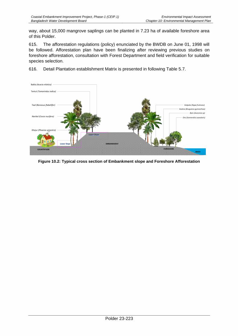
Coastal Embankment Improvement Project, Phase-1 (CEIP.1)
Bangladesh Water Development Board
Environmental Impact Assessment
Chapter-10: Environmental Management Plan
Polder 23-223
way, about 15,000 mangrove saplings can be planted in 7.23 ha of available foreshore area
of this Polder.
615. The afforestation regulations (policy) enunciated by the BWDB on June 01, 1998 will
be followed. Afforestation plan have been finalizing after reviewing previous studies on
foreshore afforestation, consultation with Forest Department and field verification for suitable
species selection.
616. Detail Plantation establishment Matrix is presented in following Table 5.7.
Figure 10.2: Typical cross section of Embankment slope and Foreshore Afforestation
Babla (Acacia nilotica)
Tentul (Tamarindus indica)
Taal (Borassus flabellifer)
Narikel (Cocos nucifera)
Khejur (Phoenix sylvestris)
Upper SlopeUpper Slope
Lower Slope EMBANKMENT
FORESHORE
Golpata (Nypa fruticans)
Bain (Avecenia sp)
Kankra (Bruguiera gymnorhiza)
Ora (Sonneratia caseolaris)
RIVERCOUNTRYSIDE
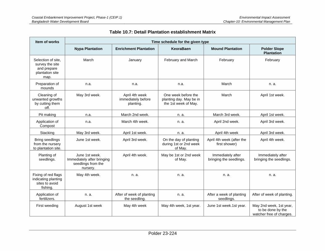
Coastal Embankment Improvement Project, Phase-1 (CEIP.1)
Bangladesh Water Development Board
Environmental Impact Assessment
Chapter-10: Environmental Management Plan
Polder 23-224
Table 10.7: Detail Plantation establishment Matrix
Item of works Time schedule for the given type
Nypa Plantation Enrichment Plantation KeoraBaen Mound Plantation Polder Slope Plantation
Selection of site, survey the site and prepare
plantation site map.
March January February and March February February
Preparation of mounds
n.a. n.a. n.a. March n. a.
Cleaning of unwanted growths
by cutting them off.
May 3rd week. April 4th week immediately before
planting.
One week before the planting day. May be in
the 1st week of May.
March April 1st week.
Pit making n.a. March 2nd week. n. a. March 3rd week. April 1st week.
Application of Compost
n.a. March 4th week. n. a. April 2nd week. April 3rd week.
Stacking May 3rd week. April 1st week. n. a. April 4th week April 3rd week.
Bring seedlings from the nursery to plantation site.
June 1st week. April 3rd week. On the day of planting during 1st or 2nd week
of May.
April 4th week (after the first shower)
April 4th week.
Planting of seedlings.
June 1st week. Immediately after bringing
seedlings from the nursery.
April 4th week. May be 1st or 2nd week of May.
Immediately after bringing the seedlings.
Immediately after bringing the seedlings.
Fixing of red flags indicating planting
sites to avoid fishing.
May 4th week. n. a. n. a. n. a. n. a.
Application of fertilizers.
n. a. After of week of planting the seedling.
n. a. After a week of planting seedlings.
After of week of planting.
First weeding August 1st week May 4th week May 4th week, 1st year. June 1st week.1st year. May 2nd week, 1st year, to be done by the
watcher free of charges.
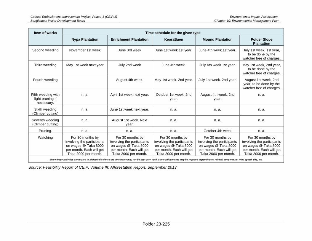
Coastal Embankment Improvement Project, Phase-1 (CEIP.1)
Bangladesh Water Development Board
Environmental Impact Assessment
Chapter-10: Environmental Management Plan
Polder 23-225
Item of works Time schedule for the given type
Nypa Plantation Enrichment Plantation KeoraBaen Mound Plantation Polder Slope Plantation
Second weeding November 1st week June 3rd week June 1st week.1st year. June 4th week.1st year. July 1st week, 1st year, to be done by the
watcher free of charges.
Third weeding May 1st week next year July 2nd week June 4th week. July 4th week 1st year. May 1st week, 2nd year, to be done by the
watcher free of charges.
Fourth weeding
August 4th week. May 1st week. 2nd year. July 1st week. 2nd year. August 1st week, 2nd year, to be done by the watcher free of charges.
Fifth weeding with light pruning if
necessary.
n. a. April 1st week next year. October 1st week. 2nd year.
August 4th week. 2nd year.
n. a.
Sixth weeding (Climber cutting)
n. a. June 1st week next year. n. a. n. a. n. a.
Seventh weeding (Climber cutting)
n. a. August 1st week. Next year.
n. a. n. a. n. a.
Pruning. n. a. n. a. n. a. October 4th week n. a.
Watching For 30 months by involving the participants on wages @ Taka 8000 per month. Each will get Taka 2000 per month.
For 30 months by involving the participants on wages @ Taka 8000 per month. Each will get Taka 2000 per month.
For 30 months by involving the participants on wages @ Taka 8000 per month. Each will get Taka 2000 per month.
For 30 months by involving the participants on wages @ Taka 8000 per month. Each will get Taka 2000 per month.
For 30 months by involving the participants on wages @ Taka 8000 per month. Each will get Taka 2000 per month.
Since these activities are related to biological science the time frame may not be kept very rigid. Some adjustments may be required depending on rainfall, temperature, wind speed, tide, etc.
Source: Feasibility Report of CEIP, Volume III: Afforestation Report, September 2013
Coastal Embankment Improvement Project, Phase-1 (CEIP.1)
Bangladesh Water Development Board
Environmental Impact Assessment
Chapter-10: Environmental Management Plan
Polder 23-226
10.12. Grievance Redress Mechanism
617. BWDB will establish a grievance redress mechanism (GRM) as a means to ensure
social accountability and to answer the queries and address complaints and grievances about
any irregularities in application of the guidelines adopted in this EIA for assessment and
mitigation of social and environmental impacts. Based on consensus, the procedure will help
to resolve issues/conflicts amicably and quickly, saving the aggrieved persons from having to
resort to expensive, time-consuming legal action. The procedure will however not pre-empt a
person’s right to go to the courts of law.
Grievance Redress Focal Points
618. A Grievance Redress Committee (GRC) at local level will be formed for each Union
with union level representation to ensure easy accessibility by the project affected persons
and communities. This local GRC will be the local focal points of the project GRM. The GRM
sets out the information and communications strategy to ensure that PAPs and communities
are fully informed about their rights to offer suggestions and make complaints. All grievances
received through the GRM process will primarily be forwarded to the GRCs. The Secretariat
for each GRC will be at the office of the Executive Engineer. If any grievance is not resolved
at GRC, the aggrieved person may request the convener of GRC to forward the case to the
Project Director at PMO, Dhaka. The GRC will officially forward the cases with their comments
to the Project Director. Hearing of petitions with GRCs will be arranged at the Convener’s
office or at Union Parishad/Ward Councillor’s office as agreed by the committee members.
The membership of the GRCs will ensure proper presentation of complaints and grievances
as well as impartial hearings and investigations, and transparent resolutions.
Membership of GRC
1. Executive Engineer (BWDB Division Office) : Convener
2. Representative of the RP Implementing NGO : Member-Secretary
3. Local UP Chairman /Ward Councillor : Member
4. Teacher from Local Educational Institution
(nominated by Upazila Administration)
: Member
5. Representative from Local Women’s Group : Member
6. Representative from the PAP Group : Member
619. Members of the GRCs will be nominated by the Executive Engineer at Division level
and approved by the Project Director, PMO, BWDB, Dhaka.
Grievance Resolution Process
620. All complaints will be received at the GRCs facilitated by the implementing agency.
The aggrieved persons may opt to make complaints directly to the Project Director or
Secretary of the MoWR or even to the court of law for resolution. The Member Secretary will
review and sort out the cases in terms of nature of grievance, urgency of resolution, and
schedule hearings in consultation with the Convener. All cases will be heard within four weeks
from the date of receiving the complaints.
621. If the resolution attempt at the local level fails, the GRC will refer the complaint with
the minutes of the hearings to the Project Director at PMO for further review. The Project
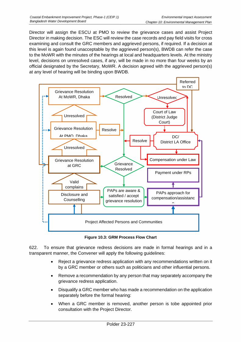
Coastal Embankment Improvement Project, Phase-1 (CEIP.1)
Bangladesh Water Development Board
Environmental Impact Assessment
Chapter-10: Environmental Management Plan
Polder 23-227
Director will assign the ESCU at PMO to review the grievance cases and assist Project
Director in making decision. The ESC will review the case records and pay field visits for cross
examining and consult the GRC members and aggrieved persons, if required. If a decision at
this level is again found unacceptable by the aggrieved person(s), BWDB can refer the case
to the MoWR with the minutes of the hearings at local and headquarters levels. At the ministry
level, decisions on unresolved cases, if any, will be made in no more than four weeks by an
official designated by the Secretary, MoWR. A decision agreed with the aggrieved person(s)
at any level of hearing will be binding upon BWDB.
Figure 10.3: GRM Process Flow Chart
622. To ensure that grievance redress decisions are made in formal hearings and in a
transparent manner, the Convener will apply the following guidelines:
• Reject a grievance redress application with any recommendations written on it
by a GRC member or others such as politicians and other influential persons.
• Remove a recommendation by any person that may separately accompany the
grievance redress application.
• Disqualify a GRC member who has made a recommendation on the application
separately before the formal hearing:
• When a GRC member is removed, another person is tobe appointed prior
consultation with the Project Director.
Project Affected Persons and Communities
Disclosure and
Counselling
PAPs approach for
compensation/assistanc
e
Payment under RPs
Grievance Resolution
At MoWR, Dhaka
PAPs are aware &
satisfied / accept
grievance resolution
Grievance
Resolved
Valid
complains
Unresolved
Unresolved
Grievance Resolution
at GRC
Grievance Resolution
At PMO, Dhaka DC/
District LA Office
Court of Law
(District Judge
Court)
Unresolved
Referred
to DC
Compensation under Law
Resolved
Resolve
d
Resolve
d
Coastal Embankment Improvement Project, Phase-1 (CEIP.1)
Bangladesh Water Development Board
Environmental Impact Assessment
Chapter-10: Environmental Management Plan
Polder 23-228
• The Convener will also ensure strict adherence to the impact mitigation policies
and guidelines adopted in this SMRPF and the mitigation standards, such as
compensation rates established through market price surveys.
GRM Disclosure, Documentation and Monitoring
623. The affected persons and their communities will be informed of the project’s grievance
redress mechanism in open meetings at important locations and in PAP group meetings.
Bangla translations of the EMF and the GRM in the form of information brochures will be
distributed among the project affected persons. The PAPs will also be briefed on the scope of
the GRC, the procedure for lodging grievances cases and the procedure of grievance
resolution at the project level.
624. To ensure impartiality and transparency, hearings on complaints will remain open to
the public. The GRCs will record the details of the complaints and their resolution in a register,
including intake details, resolution process and the closing procedures. BWDB will maintain
the following three Grievance Registers:
• Intake Register: (1) Case number, (2) Date of receipt, (3) Name of complainant, (4)
Gender, (5) name of Father or husband, (6) Complete address, (7) Main grievance
regarding social (loss of land/property or entitlements) or environmental, (8)
Complainants’ story and expectation with evidence, and (8) Previous records of similar
grievances.
• Resolution Register: (1) Serial no., (2) Case no.,(3) Name of complainant, (4)
Complainant’s story and expectation, (5) Date of hearing, (6) Date of field investigation
(if any), (7) Results of hearing and field investigation, (8) Decision of GRC, (9) Progress
(pending, solved), and (10) Agreements or commitments.
• Closing Register: (1) Serial no., (2) Case no., (3) Name of complainant, (4) Decisions
and response to complainants, (5) Mode and medium of communication, (6) Date of
closing, (7) Confirmation of complainants’ satisfaction, and (8) Management actions to
avoid recurrence.
625. Grievance resolution will be a continuous process in RP implementation. The PMO
and SMOs will keep records of all resolved and unresolved complaints and grievances (one
file for each case record) and make them available for review as and when asked for by the
WB and any other interested persons/entities. The PMO will also prepare periodic reports on
the grievance resolution process and publish these on the BWDB website.
10.13. Capacity Building
626. Since the effectiveness of the Environmental Assessment & implementation depends
considerably on the understanding and preparedness of their Engineers and in particular their
Environmental Team (Consisting of Contractor Environmental specialist, Consultant
environmental specialist, and ESCU of BWDB). It is important that the project authority
makes effort to sensitize the Engineers and Environmental Team on management of
environmental issues, provides guidance, and encourages them to build requisite capacities.
Table 10.8 provides a summary of various aspects of the environmental and social trainings
to be conducted at the construction site. PMU may revise the plan during the Project
implementation as required.
627. During the O&M phase of the Project, these trainings will be continued by BWDB staff
for all relevant O&M personnel and community.
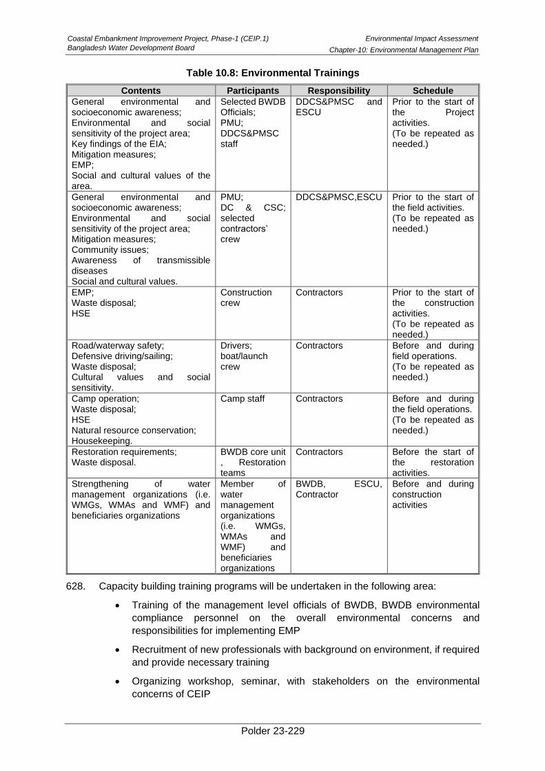
Coastal Embankment Improvement Project, Phase-1 (CEIP.1)
Bangladesh Water Development Board
Environmental Impact Assessment
Chapter-10: Environmental Management Plan
Polder 23-229
Table 10.8: Environmental Trainings
Contents Participants Responsibility Schedule
General environmental and socioeconomic awareness; Environmental and social sensitivity of the project area; Key findings of the EIA; Mitigation measures; EMP; Social and cultural values of the area.
Selected BWDB Officials; PMU; DDCS&PMSC staff
DDCS&PMSC and ESCU
Prior to the start of the Project activities. (To be repeated as needed.)
General environmental and socioeconomic awareness; Environmental and social sensitivity of the project area; Mitigation measures; Community issues; Awareness of transmissible diseases Social and cultural values.
PMU; DC & CSC; selected contractors’ crew
DDCS&PMSC,ESCU Prior to the start of the field activities. (To be repeated as needed.)
EMP; Waste disposal; HSE
Construction crew
Contractors Prior to the start of the construction activities. (To be repeated as needed.)
Road/waterway safety; Defensive driving/sailing; Waste disposal; Cultural values and social sensitivity.
Drivers; boat/launch crew
Contractors Before and during field operations. (To be repeated as needed.)
Camp operation; Waste disposal; HSE Natural resource conservation; Housekeeping.
Camp staff Contractors Before and during the field operations. (To be repeated as needed.)
Restoration requirements; Waste disposal.
BWDB core unit , Restoration teams
Contractors Before the start of the restoration activities.
Strengthening of water management organizations (i.e. WMGs, WMAs and WMF) and beneficiaries organizations
Member of water management organizations (i.e. WMGs, WMAs and WMF) and beneficiaries organizations
BWDB, ESCU, Contractor
Before and during construction activities
628. Capacity building training programs will be undertaken in the following area:
• Training of the management level officials of BWDB, BWDB environmental
compliance personnel on the overall environmental concerns and
responsibilities for implementing EMP
• Recruitment of new professionals with background on environment, if required
and provide necessary training
• Organizing workshop, seminar, with stakeholders on the environmental
concerns of CEIP
Coastal Embankment Improvement Project, Phase-1 (CEIP.1)
Bangladesh Water Development Board
Environmental Impact Assessment
Chapter-10: Environmental Management Plan
Polder 23-230
• Special training program for the contractors and workers on the EMP and their
responsibilities, who will actually be involved in the construction of the project
interventions. The Contractors will be provided guideline for preparation of
Environmental Action Plan in line with the construction workplan
• Training of the WMOs on successful operation of hydraulic structures
• Training on structured format in reporting for all stages of implementation and
of the relevant agencies involved in EMP implementation.
629. The training programs will be arranged before implementation of the interventions in
the polder area. Detailed plan can be made by the proposed ESC Unit of BWDB.
10.14. Risk Assessment and Mitigation Measures
630. Risk assessment in a development project involves the identification or recognition of
weaknesses and gaps in the project and evaluation of their potential threats to the
sustainability of the project. The rehabilitation works in Polder 23 have the dual purpose of
prevention of saline water intrusion into the polder area and agricultural improvement within
that area. The expected positive impacts from the project interventions have been summarized
below, while the potential adverse impacts have been identified and quantified above as well
as their mitigation measures have also been suggested in this report. Yet, challenges or
threats do remain in two sectors, which are addressed in this section. These relate to (a)
navigation (b) function of water management association and (c) fish migration and movement.
Navigation
631. Navigation in the inland waterways is an important aspect of the coastal economy -
facilitating the movement of people and commodities. Hence, empoldering areas are likely to
obstruct normal navigational operations in the rivers and connecting khals, and this issue could
be a matter of concern in Polder 23. However, since the early construction of polders in the
1960s, the problem was recognized and analyzed to reach the conclusion that, in most cases,
the benefits obtained from the construction of polders far outweigh the navigational losses.
Field visits to Polder 23 also revealed that water bodies and internal khals in the project area
are used for transportation of goods and persons, but there is not much marked demand for
water traffic to and from the poldered area and the neighboring sites outside the polder.
Drainage sluices and sluice gates are provided in the Polder, which are being rehabilitated
under this project. The gates in those structures are also operated in regular intervals to restrict
salinity intrusion. However, such gates or boat passes in the embankment for allowing
navigation through the embankment to and from the polder would allow large volumes of saline
water inside the Polder and may damage the soil, water and land – destroying crops.
632. However, in order to maintain navigation scenario, an arrangement may be made for
lifting ( of small size country boat from one side to other side i.e. river side to country side and
vise-versa for navigation purposes. This arrangement will not allow entry of saline water inside
the polder thus would not damage soil, water, land and crops.
Function of Water Management Association
633. This project has aimed at rejuvenating the Water Management Organizations (WMO)
in the polder, which consists of a three-tier organizational structure with Water Management
Groups (WMG) at the bottom of the hierarchy, Water Management Association (WMA) at the
mid-level and Water Management Federation (WMF) at the top. The main functions of the
Coastal Embankment Improvement Project, Phase-1 (CEIP.1)
Bangladesh Water Development Board
Environmental Impact Assessment
Chapter-10: Environmental Management Plan
Polder 23-231
WMOs are supposed to be assisting and participating in the operation and maintenance of the
polder. However, at the moment, there are no active WMOs on site, and their activities are
almost non-existent. The disrepair and lack of maintenance of the polder in the past due to
financial inadequacies of the WMOs as well as insufficient support from the BWDB had
contributed to the general decay of the polder’s structure and utility. In the past, there was
usually no fund allocated for the WMOs’ functions and needs. In Table 5.15 above, a long list
of duties and responsibilities of different tiers of WMOs has been provided, which – if
successfully performed and implemented – would greatly contribute to the sustainability of the
project. It is, therefore, recommended that the project should (i) ensure the
organization/formation of the WMOs before operation of the gates, training them in the
operation of structures etc., as well as in records/accounts keeping, and collaboration with
NGOs, and CBOs, and most importantly. This would help in developing ownership of the WMA
for realization of benefits from the Polder without hampering the hydrological and
environmental settings of the polder (ii) In addition to activation of WMOs, BWDB may recruit
sluice khalashi for each of the Drainage Sluices for smooth operation of the gates as per initial
practice (iii) provide budgetary allocation in the post-operation phase for the O & M related
tasks of the WMOs (iv) In addition, borrow pit, embankment slope, water bodies in the khas
land may be provided to the WMOs as an income generating sources for their sustainability.
Fish Migration and Movement
634. The peak velocity considered in designing of drainage sluices ranges from 3-4 m/s.
The sustainable velocities of the indicative fish species are estimated in the range of 0.46 m/s
to 1.1 m/s and burst velocities are in the range of 1.75 m/s to 4.2 m/s (Section 6.2.10). It is
noted that burst velocities of fish are applicable for capturing prey as the duration is only for
seconds. Considering designed peak velocities of drainage sluices and the estimated
sustainable velocities of the indicative fishes, it is observed that no fish will be able to pass
through the gates. Gradual decrement of the discharge and corresponding velocity at some
stages the fish can move against the current and eventually can pass through the gates if
attain the velocities congenial for such species.
635. On the other hand, during spawning season fish hatchlings and fries will be able to
pass through the gates with relatively high mortality. Moreover, there is a conflict of interest
between the Gher owners and agriculture farmers regarding the issue of water usage.
636. For mitigating the fish passing issues through the gates, it is recommended to consider
the fish pass friendly aspects in the structures to be constructed in the Polder for the proper
management of water. These may be done either by constructing drainage sluices by
maintaining the velocities passable for the mentioned indicative fish species or by constructing
fish pass structure. In case of sluice gates, based on catchment flow optimum number of vents
should be provided with proper opening so that velocity goes down and become passable for
fishes. In constructing fish pass, fish swimming speed or velocity and depth preference should
be considered. In case of the indicative fishes velocities are mentioned in Table 6.14 and the
depth preferences are as follows: Plotosus canius: 2-10 m; Liza Parsia: 1.5-10 m; Mystus
gulio: 1.5-10 m and Lates calcarifer: 2-20 m.
637. The Ghers are mostly concentrated in all over the Polder area. So, entry of saline water
through drainage canals in the Polder area may not harm significantly to the crops if water can
be managed in the canals in such a way that water does not spill over the crop fields. In that
case, the proper operation of the sluice gates and their distributary canals should be ensured.

Coastal Embankment Improvement Project, Phase-1 (CEIP.1)
Bangladesh Water Development Board
Environmental Impact Assessment
Chapter-10: Environmental Management Plan
Polder 23-232
638. There are Ghers in the polder where there is no boro crops are grown. In the months
of January to March when drifting migration of hatchling and fry with the tide of Liza parsia and
Mystus gulio may be obstructed as the farmers will use the deposited water of the canal and
inhibit the entry of saline water. The fishes at all their life stages from hatchling to adult of
Plotosus canius, Lates calcarifer, Liza parsia and Mystus gulio will be able to enter with the
tide into the Polder area when water will be allowed during the T. Aman cultivation season and
that will not hampar for crop cultivation. In future farmers can grow boro. Hence, the Sluice
Gates operation will be maintained properly.
Polder 23-233
11. Stakeholder Consultation and Disclosure
639. This chapter provides details of the consultations held with the stakeholders at the
Project site and framework for consultations to be carried out during construction phase.
11.1. Overview
640. The GoB as well as international donors (e.g. the World Bank) attach great importance
on involving primary and secondary stakeholders for determining the environmental and social
impacts associated with project implementation. Participation of stakeholders is an integral
part of the EIA process in order to gather local knowledge for baseline conditions, understand
perceptions of the community regarding impact significance, and propose meaningful
mitigation measures. During the present EIA study, an attempt was made to consult with a
full range of stakeholders to obtain their views on Project interventions.
641. According to the EIA Guidelines of the DoE, public participation is obligatory for the
EIAs of the Red Category projects. Public participation through consultations in the water
sector project is also mandated according to the Guidelines for the Participatory Water
Management (GPWM) of the BWDB. Similarly, the World Bank’s OP 4.01 requires that
stakeholder consultations are carried out at least twice for the Category A projects, once
shortly after environmental screening and before the terms of reference for the EA are
finalized, and then once a draft EIA report is prepared.
642. The present EIA study has been conducted after consulting with local communities,
non-governmental organizations (NGOs) and concerned government departments/
organizations dealing particularly with related fields, thus ensuring that their views and
concerns are taken into account in the study.
11.2. Objectives of Stakeholder Consultations
643. Objectives of the stakeholder consultation were as follows:
• To provide key Project information and create awareness among various stakeholders
about project intervention;
• To have interaction for primary and secondary data collection with project
beneficiaries, affectees, and other stakeholders;
• To identify environmental and social issues such as displacement, safety hazards,
employment, and vulnerable persons;
• To begin establishing communication and an evolving mechanism for the resolution of
social and environmental problems at local and Project level;
• To involve Project stakeholders in an inclusive manner; and
• To receive feedback from primary stakeholders on mitigation and enhancement
measures to address the environmental and social impacts of the Project.
11.3. Approach and Methodology
644. Participatory approach was followed in conducting the public consultation meetings in
the Polder 23. The EIA study team discussed first with the BWDB officials and then the Upazila
Parishad Chairman (UZPC) and/or the Upazila Nirbahi Officers (UNOs) and the Project
Implementation Officers (PIOs) of the polder area to share the Feasibility and EIA process of
the CEIP-1. The BWDB and local government officials/representatives were consulted to
Coastal Embankment Improvement Project, Phase-1 (CEIP.1)
Bangladesh Water Development Board
Environmental Impact Assessment
Chapter-11: Stakeholder Consultation and Disclosure
Polder 23-234
identify the potential stakeholders at the Polder level. With the available support from the
UNOs and/or PIOs, the union level public representatives as well as the key persons were
informed about the specific consultation meetings and requested them to participate in the
meeting.
645. Focus group discussions (FGD) were carried out in the public consultation process. In
order to conduct the FGD and consultation meetings, two checklists were prepared covering
the aspects including an overview of the proposed CEIP-1, information on the ongoing EIA
process, and seeking information on the problems of the area with their potential solutions.
The local needs and demands were discussed by giving equal opportunity to all participants
attending the meeting. All relevant issues within the water resources, land resources,
biological resources, socio-economic resources, and disaster aspects were discussed in detail
during the consultation meeting.
646. During the FGDs and consultation meetings, the EIA team displayed maps of the
Project area, shared the initial concepts on proposed interventions and facilitated the response
of the participants. The stakeholders of the Polder 23 were asked to share their needs,
problems, possible sustainable solutions, and their views on the Project interventions. The
stakeholders’ perceived views on important environmental and social components (IESCs)
and Project’s impacts on them, along with perceived benefits, risks, threats and demand from
the Project were identified during discussions.
11.4. Identification of Stakeholders
647. Stakeholders include all those who affect and are being affected by policies, decisions
or actions within a particular system. Stakeholders can be groups of people, organizations,
institutions and sometimes even individuals. Stakeholders can be divided into primary and
secondary stakeholder categories.
648. Primary Stakeholders: Primary stakeholders are people who would be directly
benefited or impacted by a certain project intervention. In case of the proposed Project in
Polder 23, the primary stakeholders include the people living within the Project area
particularly those who reside within and in the immediate vicinity of the Polder. The primary
stakeholders of the Project include the farmers, fishers, local business community as well as
the households to be displaced, women groups, and caretakers of community properties.
Primary stakeholders identified and consulted during the present EIA study include
communities to be benefitted and/or affected by the Project, local leaders, community
members and other local representatives.
649. Secondary Stakeholders: This category of stakeholders pertains to those who may
not be directly affected but have interests that could contribute to the study, play a role in
implementation at some stage, or affect decision making on Project aspects. NGOs,
concerned government departments, and line agencies fall under this category in this Project.
650. Secondary stakeholders for the Project include local government institutions (LGI),
Bangladesh Water Development Board, the Ministry of Water Resources, Department of
Forest, other government agencies, academia, NGOs, the World Bank, and general public at
large.
Time, Date and Venue Selection
651. Venue, date and time of meeting was selected through consultation with local people,
the project proponent and the EIA study team. These three groups selected an agreed venue
considering the closeness to the proposed project, easy accessibility to the venue and which
Coastal Embankment Improvement Project, Phase-1 (CEIP.1)
Bangladesh Water Development Board
Environmental Impact Assessment
Chapter-11: Stakeholder Consultation and Disclosure
Polder 23-235
is likely to be neutral. Date and time were also finalized in this way considering availability of
the participants, ensuring the maximum participation, weather and compliance with the other
arrangement.
Enlisting and Invitation
652. A comprehensive list of potential stakeholders was prepared through consultation. This
list was intended to cover all sorts of interest groups, occupational groups, socially acceptable
and knowledgeable peoples.
653. A formal invitation was sent to them and also communicated over telephone for
ensuring their presence in the meeting.
Consultation Instrument
654. Checklist: A checklist covering all possible issues to be addressed was prepared
through consultation with the multidisciplinary study team. This checklist was used in the
meeting to unveil peoples’ perception and opinion along with suggestions (checklist is
attached in Appendix H).
655. Attendance list: An inventory of the participants was maintained in attendance sheet
containing contact number. Scanned list of participants is attached in Appendix G.
656. Camera: For visualizing the participants, photographs were taken using camera.
Photos of the meeting participants are presented at the end of this chapter.
657. Sound Recorder: Deliberations of participants were recorded using audio recorder.
The study team encouraged all to participate willingly by explaining the ethics of the study and
recorded it.
Consultation Process
658. The study team conducted the meeting. During consultation meeting, the following
sequence was followed.
659. Greetings: At the outset, the team expressed greetings with all participants, welcomed
them for attending and stated the entire design of the meeting.
660. Introduction: The team members introduced themselves to the participants and gave
detail description of the project, spelled out about the objectives and anticipated outcome of
the meeting.
661. Respect to the participants: The study team showed respect to all participants. They
respected not only to the individuals but also their values, cultural practices and social
structures.
662. Ensuring peoples’ voice: Generally, all participants do not participate equally. In fact,
a substantial number of participants tended to remain silent in the meeting. However, the study
team encouraged all to participate willingly by explaining the ethics of the study.
663. Note taking: Discussed issues and opinions were written in notebook carefully. All
issues were given equal importance.
664. Recapitulation and closing the session: At the end, the study team recapitulated
the session and responded to the quarries. Finally, the facilitator closed the session by
thanking the participants.
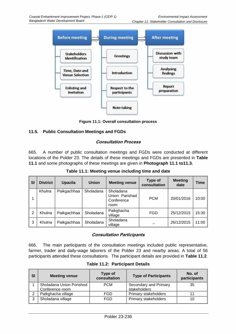
Coastal Embankment Improvement Project, Phase-1 (CEIP.1)
Bangladesh Water Development Board
Environmental Impact Assessment
Chapter-11: Stakeholder Consultation and Disclosure
Polder 23-236
Figure 11.1: Overall consultation process
11.5. Public Consultation Meetings and FGDs
Consultation Process
665. A number of public consultation meetings and FGDs were conducted at different
locations of the Polder 23. The details of these meetings and FGDs are presented in Table
11.1 and some photographs of these meetings are given in Photograph 11.1 to11.3.
Table 11.1: Meeting venue including time and date
Sl District Upazila Union Meeting venue Type of
consultation Meeting
date Time
1
Khulna Paikgachhaa Sholadana Sholadana Union Parishad Conference room
PCM 20/01/2016 10:00
2 Khulna Paikgachhaa Sholadana Paikghacha village
FGD 25/12/2015 15:30
3 Khulna Paikgachhaa Sholadana Sholadana village
,, 26/12/2015 11:00
Consultation Participants
666. The main participants of the consultation meetings included public representative,
farmer, trader and daily-wage laborers of the Polder 23 and nearby areas. A total of 56
participants attended these consultations. The participant details are provided in Table 11.2.
Table 11.2: Participant Details
Sl Meeting venue Type of
consultation Type of Participants
No. of participants
1 Sholadana Union Porishod Conference room
PCM Secondary and Primary stakeholders
35
2 Paikghacha village FGD Primary stakeholders 11
3 Sholadana village FGD Primary stakeholders 10
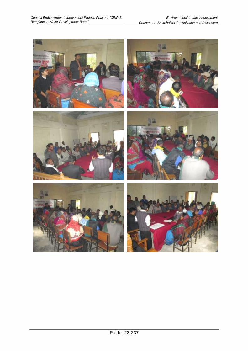
Coastal Embankment Improvement Project, Phase-1 (CEIP.1)
Bangladesh Water Development Board
Environmental Impact Assessment
Chapter-11: Stakeholder Consultation and Disclosure
Polder 23-237
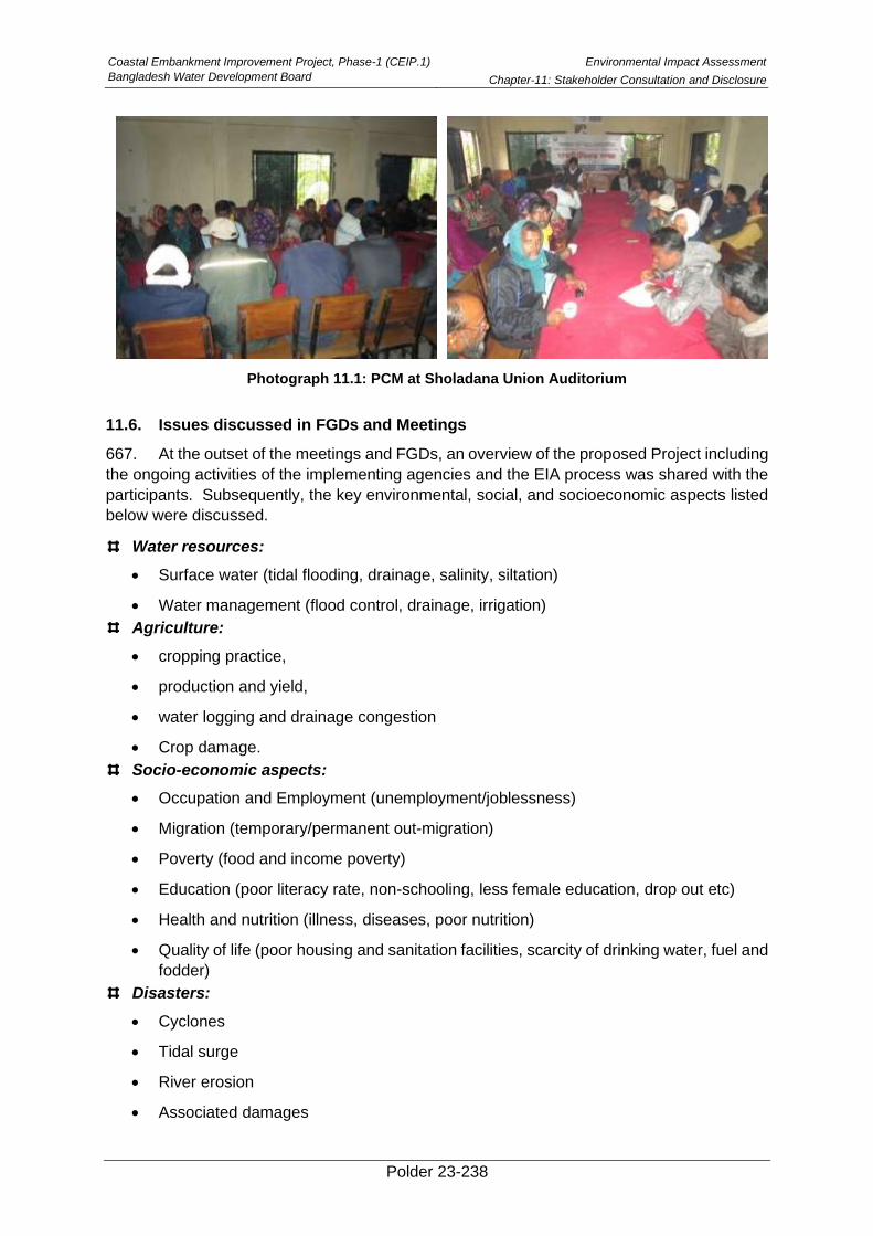
Coastal Embankment Improvement Project, Phase-1 (CEIP.1)
Bangladesh Water Development Board
Environmental Impact Assessment
Chapter-11: Stakeholder Consultation and Disclosure
Polder 23-238
Photograph 11.1: PCM at Sholadana Union Auditorium
11.6. Issues discussed in FGDs and Meetings
667. At the outset of the meetings and FGDs, an overview of the proposed Project including
the ongoing activities of the implementing agencies and the EIA process was shared with the
participants. Subsequently, the key environmental, social, and socioeconomic aspects listed
below were discussed.
Water resources:
• Surface water (tidal flooding, drainage, salinity, siltation)
• Water management (flood control, drainage, irrigation)
Agriculture:
• cropping practice,
• production and yield,
• water logging and drainage congestion
• Crop damage.
Socio-economic aspects:
• Occupation and Employment (unemployment/joblessness)
• Migration (temporary/permanent out-migration)
• Poverty (food and income poverty)
• Education (poor literacy rate, non-schooling, less female education, drop out etc)
• Health and nutrition (illness, diseases, poor nutrition)
• Quality of life (poor housing and sanitation facilities, scarcity of drinking water, fuel and
fodder)
Disasters:
• Cyclones
• Tidal surge
• River erosion
• Associated damages
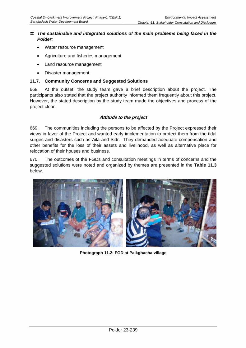
Coastal Embankment Improvement Project, Phase-1 (CEIP.1)
Bangladesh Water Development Board
Environmental Impact Assessment
Chapter-11: Stakeholder Consultation and Disclosure
Polder 23-239
The sustainable and integrated solutions of the main problems being faced in the
Polder:
• Water resource management
• Agriculture and fisheries management
• Land resource management
• Disaster management.
11.7. Community Concerns and Suggested Solutions
668. At the outset, the study team gave a brief description about the project. The
participants also stated that the project authority informed them frequently about this project.
However, the stated description by the study team made the objectives and process of the
project clear.
Attitude to the project
669. The communities including the persons to be affected by the Project expressed their
views in favor of the Project and wanted early implementation to protect them from the tidal
surges and disasters such as Aila and Sidr. They demanded adequate compensation and
other benefits for the loss of their assets and livelihood, as well as alternative place for
relocation of their houses and business.
670. The outcomes of the FGDs and consultation meetings in terms of concerns and the
suggested solutions were noted and organized by themes are presented in the Table 11.3
below.
Photograph 11.2: FGD at Paikghacha village
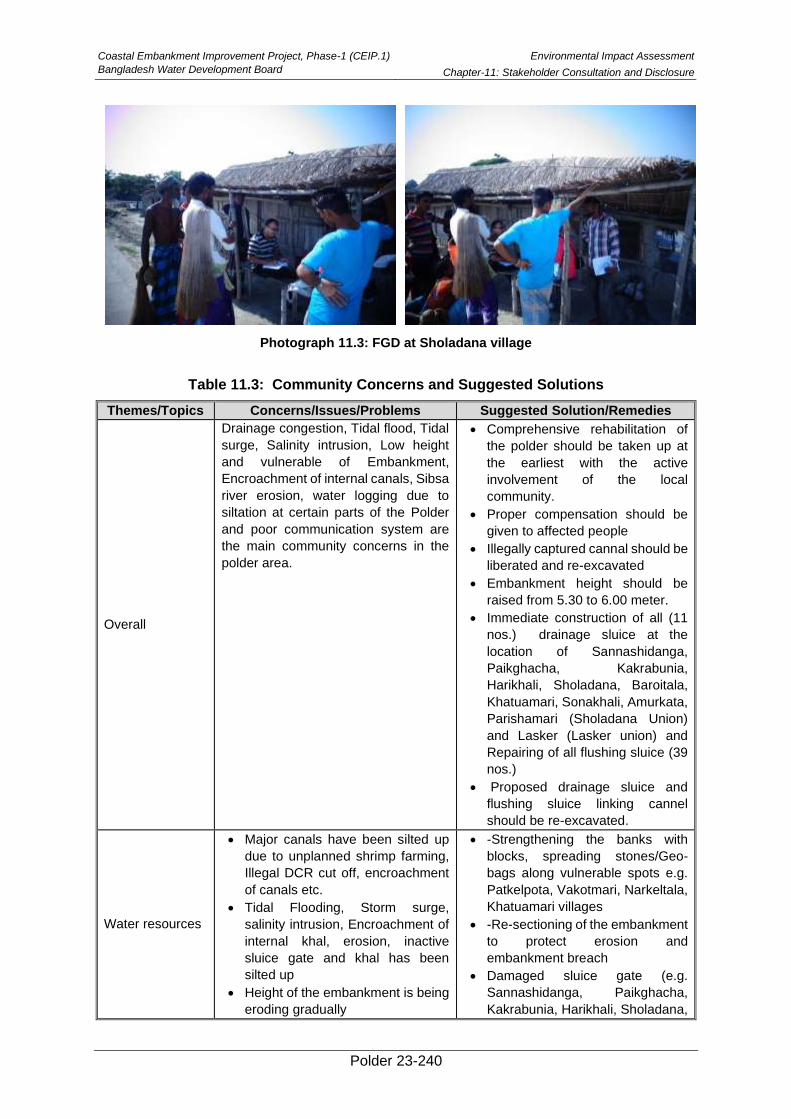
Coastal Embankment Improvement Project, Phase-1 (CEIP.1)
Bangladesh Water Development Board
Environmental Impact Assessment
Chapter-11: Stakeholder Consultation and Disclosure
Polder 23-240
Photograph 11.3: FGD at Sholadana village
Table 11.3: Community Concerns and Suggested Solutions
Themes/Topics Concerns/Issues/Problems Suggested Solution/Remedies
Overall
Drainage congestion, Tidal flood, Tidal
surge, Salinity intrusion, Low height
and vulnerable of Embankment,
Encroachment of internal canals, Sibsa
river erosion, water logging due to
siltation at certain parts of the Polder
and poor communication system are
the main community concerns in the
polder area.
• Comprehensive rehabilitation of
the polder should be taken up at
the earliest with the active
involvement of the local
community.
• Proper compensation should be
given to affected people
• Illegally captured cannal should be
liberated and re-excavated
• Embankment height should be
raised from 5.30 to 6.00 meter.
• Immediate construction of all (11
nos.) drainage sluice at the
location of Sannashidanga,
Paikghacha, Kakrabunia,
Harikhali, Sholadana, Baroitala,
Khatuamari, Sonakhali, Amurkata,
Parishamari (Sholadana Union)
and Lasker (Lasker union) and
Repairing of all flushing sluice (39
nos.)
• Proposed drainage sluice and
flushing sluice linking cannel
should be re-excavated.
Water resources
• Major canals have been silted up
due to unplanned shrimp farming,
Illegal DCR cut off, encroachment
of canals etc.
• Tidal Flooding, Storm surge,
salinity intrusion, Encroachment of
internal khal, erosion, inactive
sluice gate and khal has been
silted up
• Height of the embankment is being
eroding gradually
• -Strengthening the banks with
blocks, spreading stones/Geo-
bags along vulnerable spots e.g.
Patkelpota, Vakotmari, Narkeltala,
Khatuamari villages
• -Re-sectioning of the embankment
to protect erosion and
embankment breach
• Damaged sluice gate (e.g.
Sannashidanga, Paikghacha,
Kakrabunia, Harikhali, Sholadana,
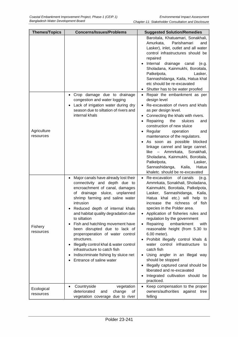
Coastal Embankment Improvement Project, Phase-1 (CEIP.1)
Bangladesh Water Development Board
Environmental Impact Assessment
Chapter-11: Stakeholder Consultation and Disclosure
Polder 23-241
Themes/Topics Concerns/Issues/Problems Suggested Solution/Remedies
Baroitala, Khatuamari, Sonakhali,
Amurkata, Parishamari and
Lasker), inlet, outlet and all water
control infrastructures should be
repaired
• Internal drainage canal (e.g.
Sholadana, Kainmukhi, Boroitala,
Patkelpota, Lasker,
Sannashidanga, Kaila, Hatua khal
etc should be re-excavated
• Shutter has to be water proofed
Agriculture
resources
• Crop damage due to drainage
congestion and water logging
• Lack of irrigation water during dry
season due to siltation of rivers and
internal khals
• Repair the embankment as per
design level
• Re-excavation of rivers and khals
as per design level.
• Connecting the khals with rivers.
• Repairing the sluices and
construction of new sluice
• Regular operation and
maintenance of the regulators.
• As soon as possible blocked
linkage cannel and large cannel.
like – Ammrkata, Sonakhali,
Sholadana, Kainmukhi, Boroitala,
Patkelpota, Lasker,
Sannashidanga, Kaila, Hatua
khaletc. should be re-excavated
Fishery
resources
• Major canals have already lost their
connectivity and depth due to
encroachment of canal, damages
of drainage sluice, unplanned
shrimp farming and saline water
intrusion
• Reduced depth of internal khals
and habitat quality degradation due
to siltation
• Fish and hatchling movement have
been disrupted due to lack of
properoperation of water control
structures.
• Illegally control khal & water control
infrastructure to catch fish
• Indiscriminate fishing by sluice net
• Entrance of saline water
• Re-excavation of canals (e.g.
Ammrkata, Sonakhali, Sholadana,
Kainmukhi, Boroitala, Patkelpota,
Lasker, Sannashidanga, Kaila,
Hatua khal etc.) will help to
increase the richness of fish
species in the Polder area.
• Application of fisheries rules and
regulation by the government
• Repairing embankment with
reasonable height (from 5.30 to
6.00 meter).
• Prohibit illegally control khals &
water control infrastructure to
catch fish
• Using angler in an illegal way
should be stopped
• Illegally captured canal should be
liberated and re-excavated
• Integrated cultivation should be
practiced.
Ecological
resources
• Countryside vegetation
deteriorated and change of
vegetation coverage due to river
• Keep compensation to the proper
owners/authorities against tree
felling
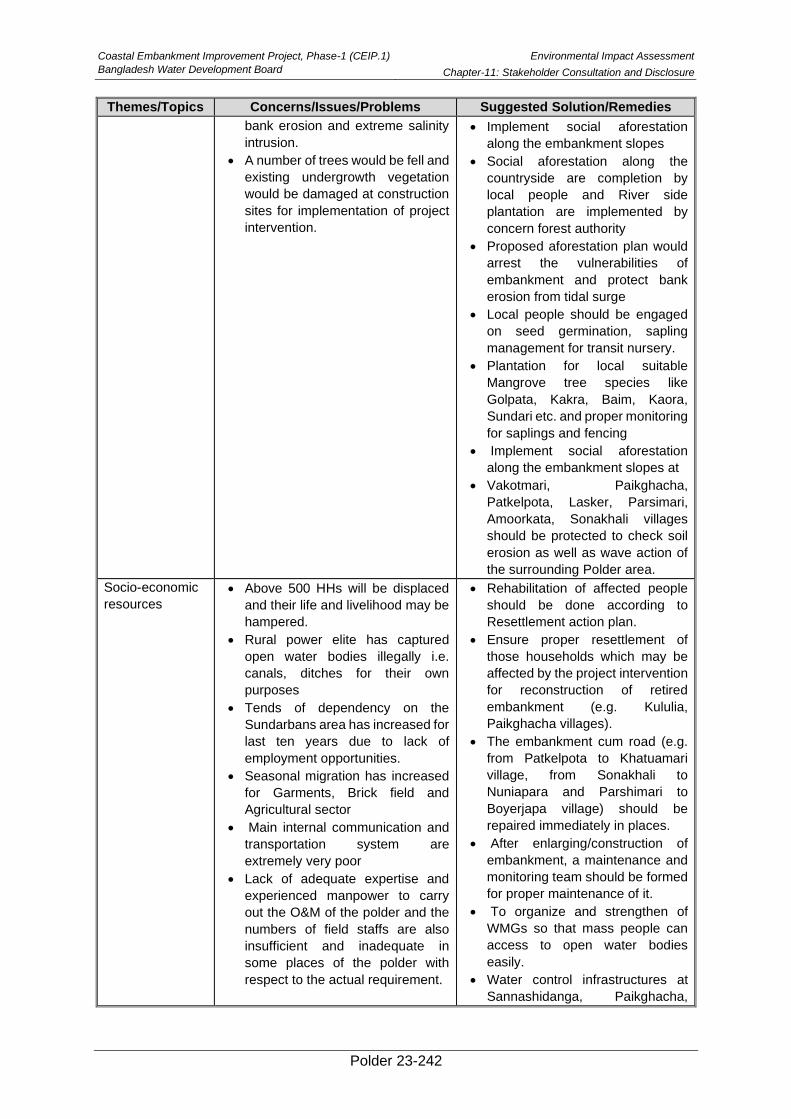
Coastal Embankment Improvement Project, Phase-1 (CEIP.1)
Bangladesh Water Development Board
Environmental Impact Assessment
Chapter-11: Stakeholder Consultation and Disclosure
Polder 23-242
Themes/Topics Concerns/Issues/Problems Suggested Solution/Remedies
bank erosion and extreme salinity
intrusion.
• A number of trees would be fell and
existing undergrowth vegetation
would be damaged at construction
sites for implementation of project
intervention.
• Implement social aforestation
along the embankment slopes
• Social aforestation along the
countryside are completion by
local people and River side
plantation are implemented by
concern forest authority
• Proposed aforestation plan would
arrest the vulnerabilities of
embankment and protect bank
erosion from tidal surge
• Local people should be engaged
on seed germination, sapling
management for transit nursery.
• Plantation for local suitable
Mangrove tree species like
Golpata, Kakra, Baim, Kaora,
Sundari etc. and proper monitoring
for saplings and fencing
• Implement social aforestation
along the embankment slopes at
• Vakotmari, Paikghacha,
Patkelpota, Lasker, Parsimari,
Amoorkata, Sonakhali villages
should be protected to check soil
erosion as well as wave action of
the surrounding Polder area.
Socio-economic
resources
• Above 500 HHs will be displaced
and their life and livelihood may be
hampered.
• Rural power elite has captured
open water bodies illegally i.e.
canals, ditches for their own
purposes
• Tends of dependency on the
Sundarbans area has increased for
last ten years due to lack of
employment opportunities.
• Seasonal migration has increased
for Garments, Brick field and
Agricultural sector
• Main internal communication and
transportation system are
extremely very poor
• Lack of adequate expertise and
experienced manpower to carry
out the O&M of the polder and the
numbers of field staffs are also
insufficient and inadequate in
some places of the polder with
respect to the actual requirement.
• Rehabilitation of affected people
should be done according to
Resettlement action plan.
• Ensure proper resettlement of
those households which may be
affected by the project intervention
for reconstruction of retired
embankment (e.g. Kululia,
Paikghacha villages).
• The embankment cum road (e.g.
from Patkelpota to Khatuamari
village, from Sonakhali to
Nuniapara and Parshimari to
Boyerjapa village) should be
repaired immediately in places.
• After enlarging/construction of
embankment, a maintenance and
monitoring team should be formed
for proper maintenance of it.
• To organize and strengthen of
WMGs so that mass people can
access to open water bodies
easily.
• Water control infrastructures at
Sannashidanga, Paikghacha,
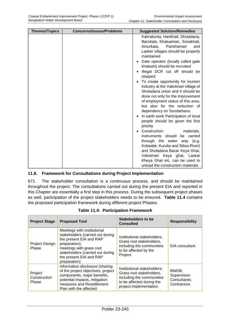
Coastal Embankment Improvement Project, Phase-1 (CEIP.1)
Bangladesh Water Development Board
Environmental Impact Assessment
Chapter-11: Stakeholder Consultation and Disclosure
Polder 23-243
Themes/Topics Concerns/Issues/Problems Suggested Solution/Remedies
Kakrabunia, Harikhali, Sholadana,
Baroitala, Khatuamari, Sonakhali,
Amurkata, Parishamari and
Lasker villages should be properly
maintained
• Gate operator (locally called gate
khalashi) should be recruited
• Illegal DCR cut off should be
stopped
• To create opportunity for tourism
industry at the Vakotmari village of
Sholadana union and it should be
done not only for the improvement
of employment status of this area,
but also for the reduction of
dependency on Sundarbans.
• In earth work Participation of local
people should be given the first
priority
• Construction materials,
instruments should be carried
through the water way (e.g.
Kobadak, Kurulia and Sibsa River)
and Sholadana Bazar Keya Ghat,
Vakotmari Keya ghat, Laskar
Kheya Ghat etc. can be used to
unload the construction materials
11.8. Framework for Consultations during Project Implementation
671. The stakeholder consultation is a continuous process, and should be maintained
throughout the project. The consultations carried out during the present EIA and reported in
this Chapter are essentially a first step in this process. During the subsequent project phases
as well, participation of the project stakeholders needs to be ensured. Table 11.4 contains
the proposed participation framework during different project Phases.
Table 11.4: Participation Framework
Project Stage Proposed Tool Stakeholders to be Consulted
Responsibility
Project Design Phase
Meetings with institutional stakeholders (carried out during the present EIA and RAP preparation); meetings with grass root stakeholders (carried out during the present EIA and RAP preparation)
Institutional stakeholders; Grass root stakeholders, including the communities to be affected by the Project.
EIA consultant.
Project Construction Phase
Information disclosure (sharing of the project objectives, project components, major benefits, potential impacts, mitigation measures and Resettlement Plan with the affected
Institutional stakeholders; Grass root stakeholders, including the communities to be affected during the project implementation.
BWDB; Supervision Consultants; Contractors
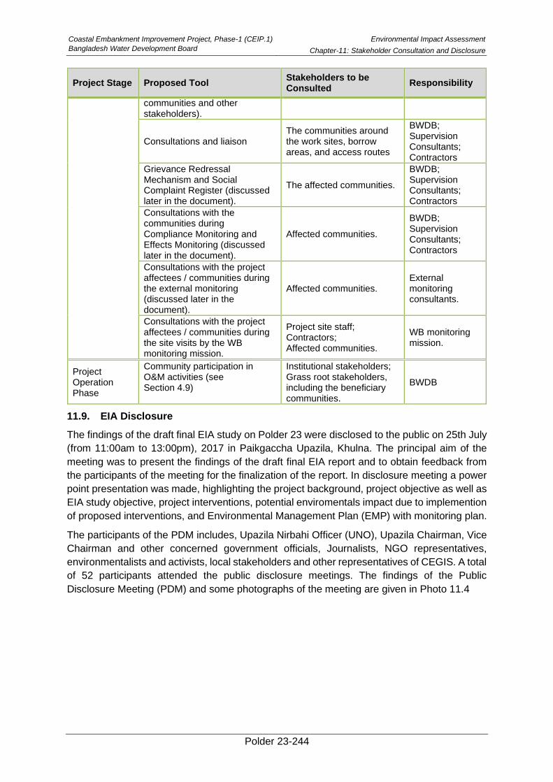
Coastal Embankment Improvement Project, Phase-1 (CEIP.1)
Bangladesh Water Development Board
Environmental Impact Assessment
Chapter-11: Stakeholder Consultation and Disclosure
Polder 23-244
Project Stage Proposed Tool Stakeholders to be Consulted
Responsibility
communities and other stakeholders).
Consultations and liaison The communities around the work sites, borrow areas, and access routes
BWDB; Supervision Consultants; Contractors
Grievance Redressal Mechanism and Social Complaint Register (discussed later in the document).
The affected communities.
BWDB; Supervision Consultants; Contractors
Consultations with the communities during Compliance Monitoring and Effects Monitoring (discussed later in the document).
Affected communities.
BWDB; Supervision Consultants; Contractors
Consultations with the project affectees / communities during the external monitoring (discussed later in the document).
Affected communities. External monitoring consultants.
Consultations with the project affectees / communities during the site visits by the WB monitoring mission.
Project site staff; Contractors; Affected communities.
WB monitoring mission.
Project Operation Phase
Community participation in O&M activities (see Section 4.9)
Institutional stakeholders; Grass root stakeholders, including the beneficiary communities.
BWDB
11.9. EIA Disclosure
The findings of the draft final EIA study on Polder 23 were disclosed to the public on 25th July
(from 11:00am to 13:00pm), 2017 in Paikgaccha Upazila, Khulna. The principal aim of the
meeting was to present the findings of the draft final EIA report and to obtain feedback from
the participants of the meeting for the finalization of the report. In disclosure meeting a power
point presentation was made, highlighting the project background, project objective as well as
EIA study objective, project interventions, potential enviromentals impact due to implemention
of proposed interventions, and Environmental Management Plan (EMP) with monitoring plan.
The participants of the PDM includes, Upazila Nirbahi Officer (UNO), Upazila Chairman, Vice
Chairman and other concerned government officials, Journalists, NGO representatives,
environmentalists and activists, local stakeholders and other representatives of CEGIS. A total
of 52 participants attended the public disclosure meetings. The findings of the Public
Disclosure Meeting (PDM) and some photographs of the meeting are given in Photo 11.4
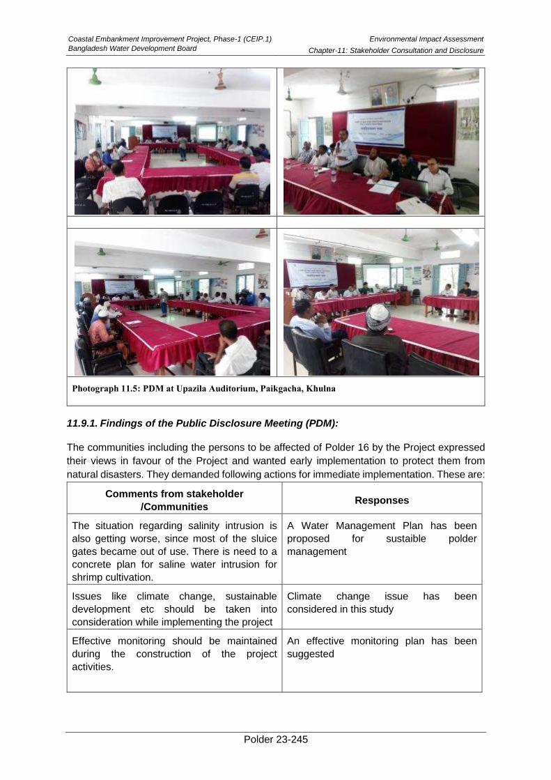
Coastal Embankment Improvement Project, Phase-1 (CEIP.1)
Bangladesh Water Development Board
Environmental Impact Assessment
Chapter-11: Stakeholder Consultation and Disclosure
Polder 23-245
Photograph 11.5: PDM at Upazila Auditorium, Paikgacha, Khulna
11.9.1. Findings of the Public Disclosure Meeting (PDM):
The communities including the persons to be affected of Polder 16 by the Project expressed
their views in favour of the Project and wanted early implementation to protect them from
natural disasters. They demanded following actions for immediate implementation. These are:
Comments from stakeholder
/Communities Responses
The situation regarding salinity intrusion is
also getting worse, since most of the sluice
gates became out of use. There is need to a
concrete plan for saline water intrusion for
shrimp cultivation.
A Water Management Plan has been
proposed for sustaible polder
management
Issues like climate change, sustainable
development etc should be taken into
consideration while implementing the project
Climate change issue has been
considered in this study
Effective monitoring should be maintained
during the construction of the project
activities.
An effective monitoring plan has been
suggested
Coastal Embankment Improvement Project, Phase-1 (CEIP.1)
Bangladesh Water Development Board
Environmental Impact Assessment
Chapter-11: Stakeholder Consultation and Disclosure
Polder 23-246
Comments from stakeholder
/Communities Responses
Engagement of local government for canal
excavation should be ensured
To be considered
Tree plantation need to be increased.
A detailed tree plantation plan has been
undertaken in this project
Adequate compensation for affected by the
project activities should be ensured.
Agreed and to be ensured
Awareness building program among the
communities should be conducted for better
water management;
Agreed and to be initiated
Proper O & M for embankments and sluice
gates in the polder area should be ensured
Agreed and to be ensured
Water Management Organizations (MWOs)
should be formed for proper functioning of
water control structures.
Agreed and to be formed before operation
of the water control structures.
Polder 23-247
Reference
BARC, 2012. Fertilizer Recommendation Guide, Bangladesh Agricultural Research Council,
Farmgate, Dhaka-1215.
BBS, 2011. Population Census 2011, Bangladesh Bureau of Statistics (BBS), Statistical
Division, Ministry of Finance and Planning,
BBS, 2008. Preliminary Report of Agriculture Census 2008, Bangladesh Bureau of Statistics
(BBS), Government of the People's Republic of Bangladesh
DoE, 1997. EIA Guidelines for Industries. Department of Environment (DoE), Dhaka,
Bangladesh.
CEIP, 2012. Feasibility Report, Coastal Embankment and Improvement Project (CEIP),
Bangladesh Water Development Board (BWDB), Dhaka, Bangladesh.
MoEF, 1997. The Environment Conservation Rules, Ministry of Environment and Forest
(MoEF) Government of the People’s Republic of Bangladesh, Dhaka,
Bangladesh
FAO/UNDP, 1988. Land Resources Appraisal of Bangladesh for Agricultural Development
(Report-2), “Agro-ecological Regions of Bangladesh”, Prepared by Food and
Agricultural Organization (FAO), United Nations.
Feasibility Report of CEIP, Volume lll: Afforestation Report, September 2013.
IMD, 2012. “Annual Climate Summary 2012”. National Climate Centre, Pune.
IPCC, 2001, Climate Change 2001: The scientific Basis, Contribution of Working Group I to
the Third Assessment Report of the Intergovernmental Panel on Climate
Change, Houghton, J.T., Ding. Y., Griggs, D.J., Noguer, M., van der Linden,
P.J., Dai, X., Maskell, K., Johnson, C.A. (Eds), IPCC, Cambridge University
Press, Cambridge, p. 881.
IPCC, 2013. Summary for Policymakers. In: Climate Change 2013: The Physical Science
Basis. Contribution of Working Group I to the Fifth Assessment Report of the
Intergovernmental Panel on Climate Change [Stocker, T.F., D. Qin, G.-K.
Plattner, M. Tignor, S.K. Allen, J. Boschung, A. Nauels, Y. Xia, V. Bex and P.M.
Midgley (eds.)]. Cambridge University Press, Cambridge, United Kingdom and
New York, NY, USA.
Dash, S.K., Kulkarni, M.A., Mohanty, U.C. and Prasad, K., 2009. “Changes in the
characteristics of rain events in India”. J. Geophys. Res., 114, D10109, doi:
10.1029/2008JD010572
IUCN, 2000. Red list of threatened animals of Bangladesh. The World Conservation Union
(IUCN), Dhaka, Bangladesh. 54 pp.
Jack M. Whetstone, Gravil D. Treece, Craig L. Browdy, and Alvin D. Stokes, 2002.
Opportunities and Constraints in Marine Shrimp Farming, SRAC Publication No.
2600, July 2002
S. Kreft, D. Eckstein, L. Junghans, C. Kerestan and U. Hagen, Global Climate Risk Index
2015; available at http://germanwatch.org/de/download/10333.pdf
Coastal Embankment Improvement Project, Phase-1
(CEIP.1), Bangladesh Water Development Board
Environmental Impact Assessment
Reference
Polder 23-248
Mazid. M.A, 2002. Development of Fisheries in Bangladesh, Plans for Strategies for Income
Generation and Poverty Alleviation, Momin Offset Press, Dhaka 1205.
SOLARIS-SRDI (Soil and Land Resources Information System-Soil Resource and
Development Institute), 2006. SOLARIS Model developed by Center for
Environmental and Geographic Information Services (CEGIS) for Soil Resource
and Development Institute (SRDI), Farmgate, Dhaka-1215.
WARPO, 2005. Guidelines for Environmental Assessment of Water Management (flood
control, Drainage and Irrigation) projects. National Water Management Project.
Water Resources Planning Organization (WARPO), Dhaka.
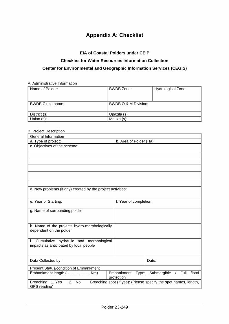
Polder 23-249
Appendix A: Checklist
EIA of Coastal Polders under CEIP
Checklist for Water Resources Information Collection
Center for Environmental and Geographic Information Services (CEGIS)
A. Administrative Information
Name of Polder: BWDB Zone: Hydrological Zone:
BWDB Circle name: BWDB O & M Division:
District (s): Upazila (s):
Union (s): Mouza (s):
B. Project Description
General Information
a. Type of project: b. Area of Polder (Ha):
c. Objectives of the scheme:
d. New problems (if any) created by the project activities:
e. Year of Starting: f. Year of completion:
g. Name of surrounding polder
h. Name of the projects hydro-morphologically dependent on the polder
i. Cumulative hydraulic and morphological impacts as anticipated by local people
Data Collected by: Date:
Present Status/condition of Embankment
Embankment length (……………….Km) Embankment Type: Submergible / Full flood protection
Breaching: 1. Yes 2. No Breaching spot (If yes): (Please specify the spot names, length, GPS reading)
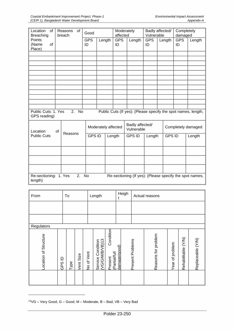
Coastal Embankment Improvement Project, Phase-1
(CEIP.1), Bangladesh Water Development Board
Environmental Impact Assessment
Appendix-A
Polder 23-250
Location of Breaching Points (Name of Place)
Reasons of breach
Good Moderately affected
Badly affected/ Vulnerable
Completely damaged
GPS ID
Length GPS ID
Length GPS ID
Length GPS ID
Length
Public Cuts: 1. Yes 2. No Public Cuts (If yes): (Please specify the spot names, length, GPS reading)
Location of Public Cuts
Reasons
Moderately affected Badly affected/ Vulnerable
Completely damaged
GPS ID Length GPS ID Length GPS ID Length
Re-sectioning: 1. Yes 2. No Re-sectioning (If yes): (Please specify the spot names, length)
From To Length Height
Actual reasons
Regulators
Location o
f S
tructu
re
GP
S ID
Type
Vent
Siz
e
No o
f V
ent
Serv
ice C
ond
itio
n
(VG
/G/M
/B/V
B)1
3
Pre
sent
Con
ditio
n
(Part
ial/fu
ll
dam
age/g
oo
d)
Pre
sent
Pro
ble
ms
Reasons f
or
pro
ble
m
Year
of pro
ble
m
Reha
bili
table
(Y
/N)
Repla
ceab
le (
Y/N
)
13VG – Very Good, G – Good, M – Moderate, B – Bad, VB – Very Bad
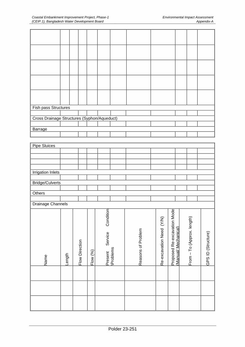
Coastal Embankment Improvement Project, Phase-1
(CEIP.1), Bangladesh Water Development Board
Environmental Impact Assessment
Appendix-A
Polder 23-251
Fish pass Structures
Cross Drainage Structures (Syphon/Aqueduct)
Barrage
Pipe Sluices
Irrigation Inlets
Bridge/Culverts
Others
Drainage Channels
Nam
e
Leng
th
Flo
w D
irection
Flo
w (
%)
Pre
sent
Serv
ice
Cond
itio
n
\Pro
ble
ms
Reasons o
f P
roble
m
Re-e
xcavatio
n N
eed (Y
/N)
Pro
pose
d R
e-e
xcavatio
n M
ode
(Manu
al/ M
ech
anic
al)
Fro
m –
To
(A
ppro
x. le
ngth
)
GP
S ID
(S
tructu
re)
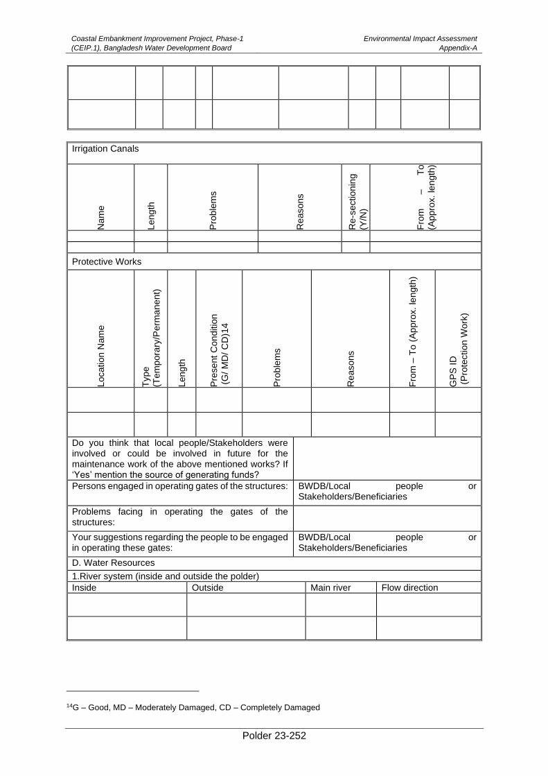
Coastal Embankment Improvement Project, Phase-1
(CEIP.1), Bangladesh Water Development Board
Environmental Impact Assessment
Appendix-A
Polder 23-252
Irrigation Canals
Nam
e
Leng
th
Pro
ble
ms
Reasons
Re
-section
ing
(Y/N
)
Fro
m
–
To
(Appro
x. le
ngth
)
Protective Works
Location N
am
e
Type
(Tem
pora
ry/P
erm
anent)
Leng
th
Pre
sent
Con
ditio
n
(G
/ M
D/ C
D)1
4
Pro
ble
ms
Reasons
Fro
m –
To
(A
ppro
x. le
ngth
)
GP
S ID
(P
rote
ction W
ork
)
Do you think that local people/Stakeholders were involved or could be involved in future for the maintenance work of the above mentioned works? If ‘Yes’ mention the source of generating funds?
Persons engaged in operating gates of the structures: BWDB/Local people or Stakeholders/Beneficiaries
Problems facing in operating the gates of the structures:
Your suggestions regarding the people to be engaged in operating these gates:
BWDB/Local people or Stakeholders/Beneficiaries
D. Water Resources
1.River system (inside and outside the polder)
Inside Outside Main river Flow direction
14G – Good, MD – Moderately Damaged, CD – Completely Damaged
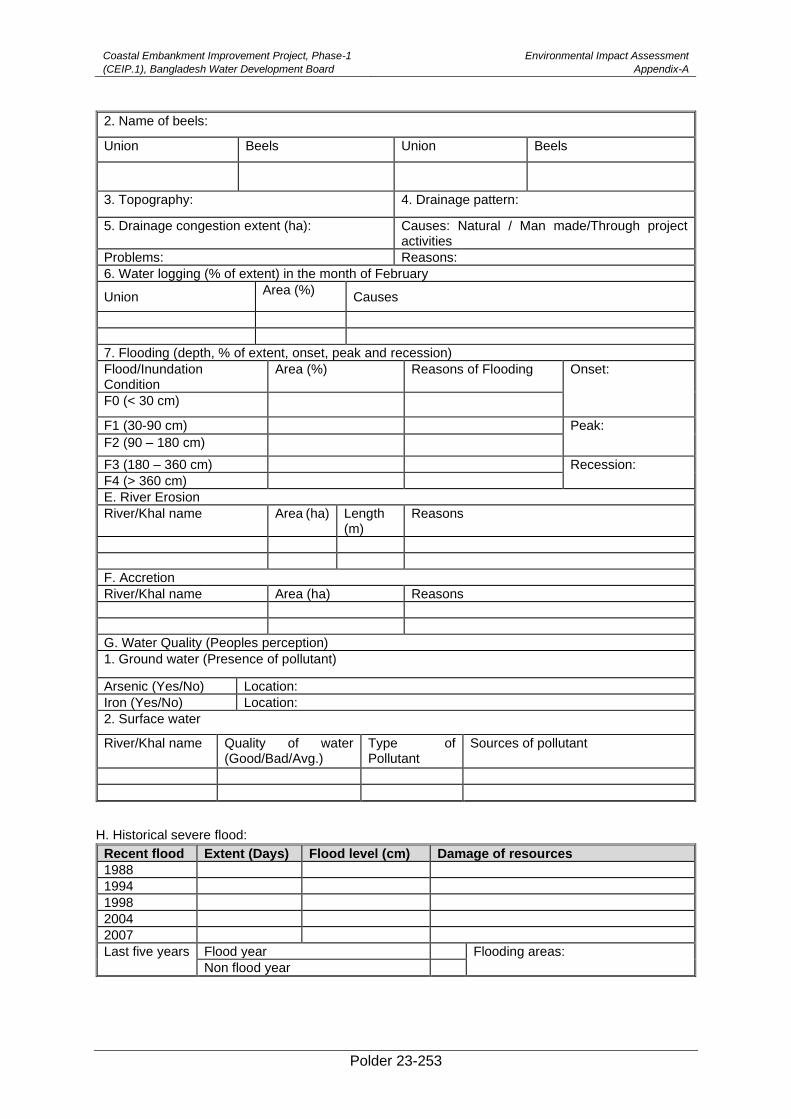
Coastal Embankment Improvement Project, Phase-1
(CEIP.1), Bangladesh Water Development Board
Environmental Impact Assessment
Appendix-A
Polder 23-253
2. Name of beels:
Union Beels Union Beels
3. Topography: 4. Drainage pattern:
5. Drainage congestion extent (ha): Causes: Natural / Man made/Through project activities
Problems: Reasons:
6. Water logging (% of extent) in the month of February
Union Area (%)
Causes
7. Flooding (depth, % of extent, onset, peak and recession)
Flood/Inundation Condition
Area (%) Reasons of Flooding Onset:
F0 (< 30 cm)
F1 (30-90 cm) Peak:
F2 (90 – 180 cm)
F3 (180 – 360 cm) Recession:
F4 (> 360 cm)
E. River Erosion
River/Khal name Area (ha) Length (m)
Reasons
F. Accretion
River/Khal name Area (ha) Reasons
G. Water Quality (Peoples perception)
1. Ground water (Presence of pollutant)
Arsenic (Yes/No) Location:
Iron (Yes/No) Location:
2. Surface water
River/Khal name Quality of water (Good/Bad/Avg.)
Type of Pollutant
Sources of pollutant
H. Historical severe flood:
Recent flood Extent (Days) Flood level (cm) Damage of resources
1988
1994
1998
2004
2007
Last five years Flood year Flooding areas:
Non flood year

Coastal Embankment Improvement Project, Phase-1
(CEIP.1), Bangladesh Water Development Board
Environmental Impact Assessment
Appendix-A
Polder 23-254
I. Participatory Social Mapping by stakeholders (Name of regulators, name of public cuts points, Name
of breaching points, location of water logged area, identification of encroached canal with name and
their location on map)
J. Peoples opinion of the project
Pre-project condition:
Period of project benefits:
Present condition and Present problems:
Causes of problems:
Probable Solution/Improvement:
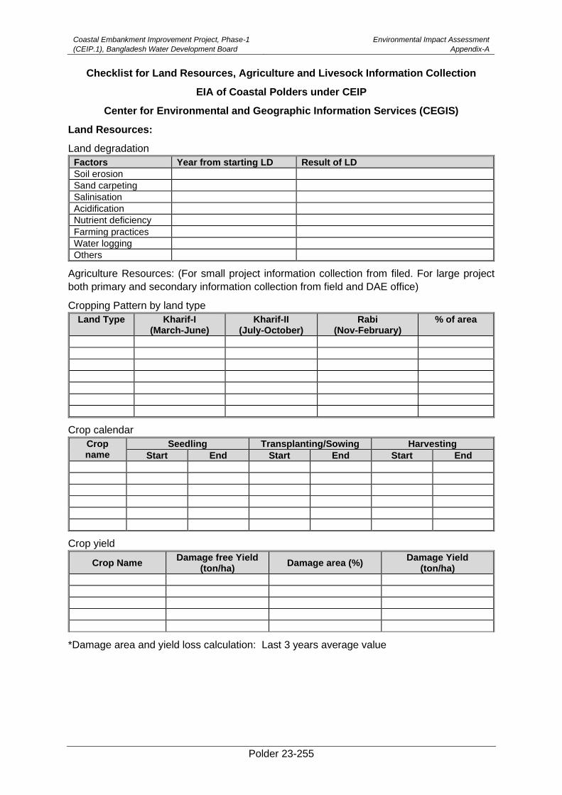
Coastal Embankment Improvement Project, Phase-1
(CEIP.1), Bangladesh Water Development Board
Environmental Impact Assessment
Appendix-A
Polder 23-255
Checklist for Land Resources, Agriculture and Livesock Information Collection
EIA of Coastal Polders under CEIP
Center for Environmental and Geographic Information Services (CEGIS)
Land Resources:
Land degradation
Factors Year from starting LD Result of LD
Soil erosion
Sand carpeting
Salinisation
Acidification
Nutrient deficiency
Farming practices
Water logging
Others
Agriculture Resources: (For small project information collection from filed. For large project
both primary and secondary information collection from field and DAE office)
Cropping Pattern by land type
Land Type Kharif-I (March-June)
Kharif-II (July-October)
Rabi (Nov-February)
% of area
Crop calendar
Crop name
Seedling Transplanting/Sowing Harvesting
Start End Start End Start End
Crop yield
*Damage area and yield loss calculation: Last 3 years average value
Crop Name Damage free Yield
(ton/ha) Damage area (%)
Damage Yield (ton/ha)
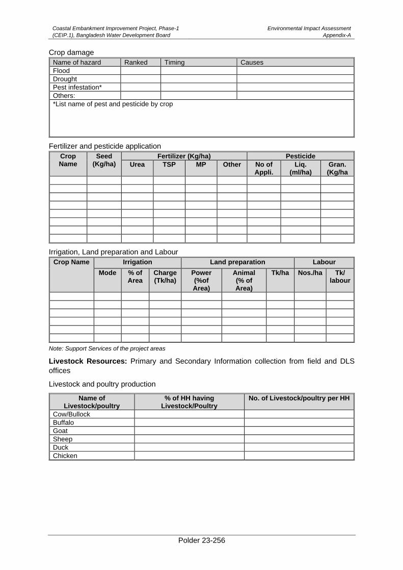
Coastal Embankment Improvement Project, Phase-1
(CEIP.1), Bangladesh Water Development Board
Environmental Impact Assessment
Appendix-A
Polder 23-256
Crop damage
Name of hazard Ranked Timing Causes
Flood
Drought
Pest infestation*
Others:
*List name of pest and pesticide by crop
Fertilizer and pesticide application
Crop Name
Seed (Kg/ha)
Fertilizer (Kg/ha) Pesticide
Urea TSP MP Other No of Appli.
Liq. (ml/ha)
Gran. (Kg/ha
Irrigation, Land preparation and Labour
Note: Support Services of the project areas
Livestock Resources: Primary and Secondary Information collection from field and DLS
offices
Livestock and poultry production
Name of Livestock/poultry
% of HH having Livestock/Poultry
No. of Livestock/poultry per HH
Cow/Bullock
Buffalo
Goat
Sheep
Duck
Chicken
Crop Name Irrigation Land preparation Labour
Mode % of Area
Charge (Tk/ha)
Power (%of Area)
Animal (% of Area)
Tk/ha Nos./ha Tk/ labour
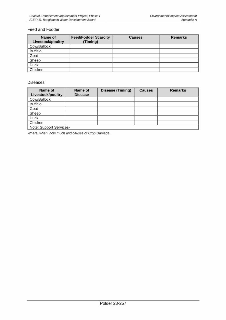
Coastal Embankment Improvement Project, Phase-1
(CEIP.1), Bangladesh Water Development Board
Environmental Impact Assessment
Appendix-A
Polder 23-257
Feed and Fodder
Name of Livestock/poultry
Feed/Fodder Scarcity (Timing)
Causes Remarks
Cow/Bullock
Buffalo
Goat
Sheep
Duck
Chicken
Diseases
Name of Livestock/poultry
Name of Disease
Disease (Timing) Causes Remarks
Cow/Bullock
Buffalo
Goat
Sheep
Duck
Chicken
Note: Support Services-
Where, when, how much and causes of Crop Damage.
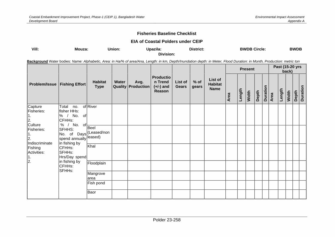
Coastal Embankment Improvement Project, Phase-1 (CEIP.1), Bangladesh Water
Development Board
Environmental Impact Assessment
Appendix-A
Polder 23-258
Fisheries Baseline Checklist
EIA of Coastal Polders under CEIP
Vill: Mouza: Union: Upazila: District: BWDB Circle: BWDB
Division:
Background Water bodies: Name: Alphabetic, Area: in Ha/% of area/Ana, Length: in km, Depth/Inundation depth: in Meter, Flood Duration: in Month, Production: metric ton
Problem/Issue Fishing Effort Habitat Type
Water Quality
Avg. Production
Production Trend (+/-) and Reason
List of Gears
% of gears
List of Habitat Name
Present Past (15-20 yrs
back)
Are
a
Len
gth
Wid
th
Dep
th
Du
rati
on
Are
a
Len
gth
Wid
th
Dep
th
Du
rati
on
Capture Fisheries: 1. 2. Culture Fisheries: 1. 2. Indiscriminate Fishing Activities: 1. 2.
Total no. of fisher HHs: % / No. of CFHHs: % / No. of SFHHS: No. of Days spend annually in fishing by CFHHs: SFHHs: Hrs/Day spend in fishing by CFHHs: SFHHs:
River
Beel (Leased/non leased)
Khal
Floodplain
Mangrove area
Fish pond
Baor
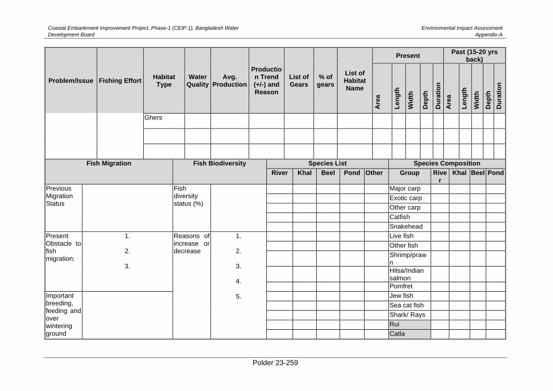
Coastal Embankment Improvement Project, Phase-1 (CEIP.1), Bangladesh Water
Development Board
Environmental Impact Assessment
Appendix-A
Polder 23-259
Problem/Issue Fishing Effort Habitat Type
Water Quality
Avg. Production
Production Trend (+/-) and Reason
List of Gears
% of gears
List of Habitat Name
Present Past (15-20 yrs
back)
Are
a
Len
gth
Wid
th
Dep
th
Du
rati
on
Are
a
Len
gth
Wid
th
Dep
th
Du
rati
on
Ghers
Fish Migration Fish Biodiversity Species List Species Composition
River Khal Beel Pond Other Group River
Khal Beel Pond
Previous Migration Status
Fish diversity status (%)
Major carp
Exotic carp
Other carp
Catfish
Snakehead
Present Obstacle to fish migration:
1.
2.
3.
Reasons of increase or decrease
1.
2.
3.
4.
5.
Live fish
Other fish
Shrimp/prawn
Hilsa/Indian salmon
Pomfret
Important breeding, feeding and over wintering ground
Jew fish
Sea cat fish
Shark/ Rays
Rui
Catla
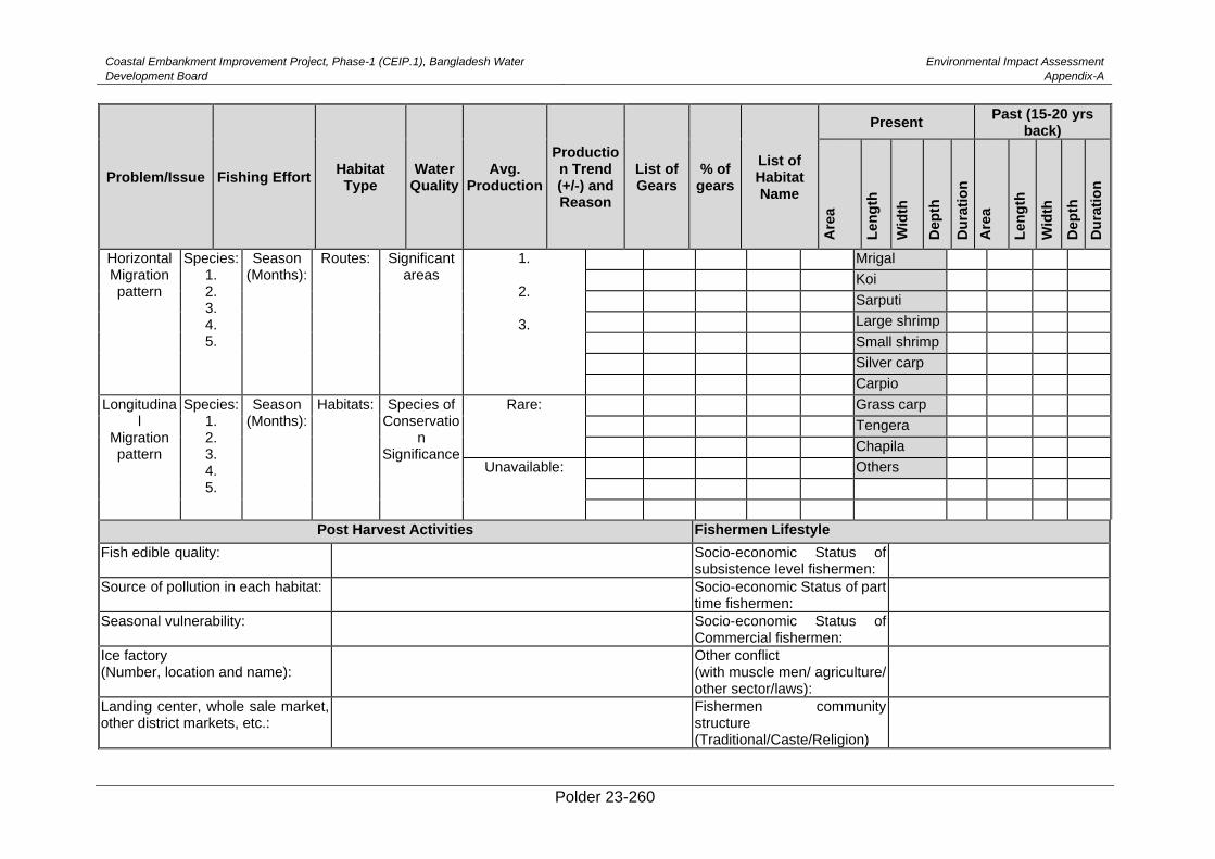
Coastal Embankment Improvement Project, Phase-1 (CEIP.1), Bangladesh Water
Development Board
Environmental Impact Assessment
Appendix-A
Polder 23-260
Problem/Issue Fishing Effort Habitat Type
Water Quality
Avg. Production
Production Trend (+/-) and Reason
List of Gears
% of gears
List of Habitat Name
Present Past (15-20 yrs
back)
Are
a
Len
gth
Wid
th
Dep
th
Du
rati
on
Are
a
Len
gth
Wid
th
Dep
th
Du
rati
on
Horizontal Migration pattern
Species: 1. 2. 3. 4. 5.
Season (Months):
Routes: Significant areas
1.
2.
3.
Mrigal
Koi
Sarputi
Large shrimp
Small shrimp
Silver carp
Carpio
Longitudinal
Migration pattern
Species: 1. 2. 3. 4. 5.
Season (Months):
Habitats: Species of Conservatio
n Significance
Rare:
Grass carp
Tengera
Chapila
Unavailable:
Others
Post Harvest Activities Fishermen Lifestyle
Fish edible quality: Socio-economic Status of subsistence level fishermen:
Source of pollution in each habitat: Socio-economic Status of part time fishermen:
Seasonal vulnerability: Socio-economic Status of Commercial fishermen:
Ice factory (Number, location and name):
Other conflict (with muscle men/ agriculture/ other sector/laws):
Landing center, whole sale market, other district markets, etc.:
Fishermen community structure (Traditional/Caste/Religion)
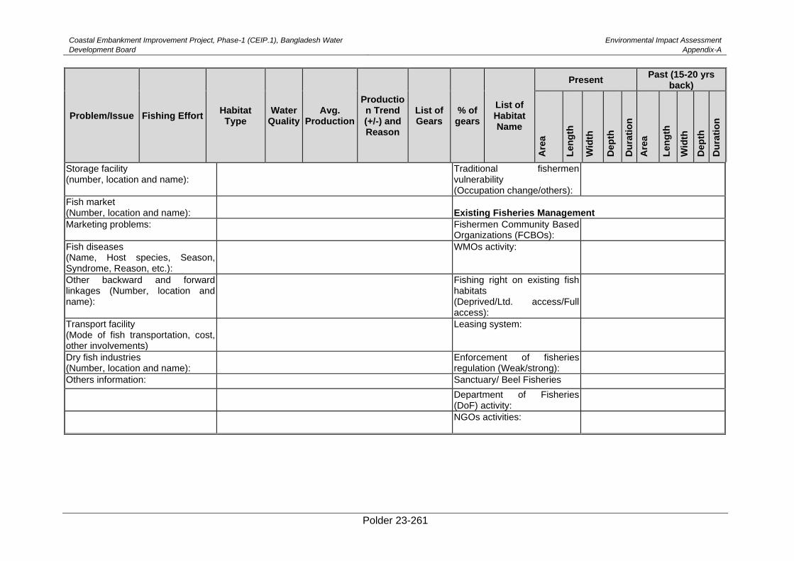
Coastal Embankment Improvement Project, Phase-1 (CEIP.1), Bangladesh Water
Development Board
Environmental Impact Assessment
Appendix-A
Polder 23-261
Problem/Issue Fishing Effort Habitat Type
Water Quality
Avg. Production
Production Trend (+/-) and Reason
List of Gears
% of gears
List of Habitat Name
Present Past (15-20 yrs
back)
Are
a
Len
gth
Wid
th
Dep
th
Du
rati
on
Are
a
Len
gth
Wid
th
Dep
th
Du
rati
on
Storage facility (number, location and name):
Traditional fishermen vulnerability (Occupation change/others):
Fish market (Number, location and name):
Existing Fisheries Management
Marketing problems: Fishermen Community Based Organizations (FCBOs):
Fish diseases (Name, Host species, Season, Syndrome, Reason, etc.):
WMOs activity:
Other backward and forward linkages (Number, location and name):
Fishing right on existing fish habitats (Deprived/Ltd. access/Full access):
Transport facility (Mode of fish transportation, cost, other involvements)
Leasing system:
Dry fish industries (Number, location and name):
Enforcement of fisheries regulation (Weak/strong):
Others information: Sanctuary/ Beel Fisheries
Department of Fisheries (DoF) activity:
NGOs activities:
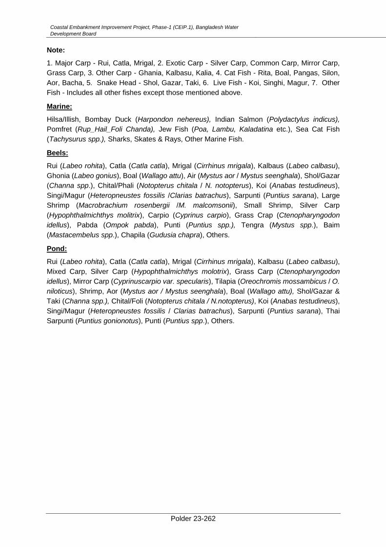
Coastal Embankment Improvement Project, Phase-1 (CEIP.1), Bangladesh Water
Development Board
Environmental Impact Assessment
Appendix-A
Polder 23-262
Note:
1. Major Carp - Rui, Catla, Mrigal, 2. Exotic Carp - Silver Carp, Common Carp, Mirror Carp,
Grass Carp, 3. Other Carp - Ghania, Kalbasu, Kalia, 4. Cat Fish - Rita, Boal, Pangas, Silon,
Aor, Bacha, 5. Snake Head - Shol, Gazar, Taki, 6. Live Fish - Koi, Singhi, Magur, 7. Other
Fish - Includes all other fishes except those mentioned above.
Marine:
Hilsa/Illish, Bombay Duck (Harpondon nehereus), Indian Salmon (Polydactylus indicus),
Pomfret (Rup_Hail_Foli Chanda), Jew Fish (Poa, Lambu, Kaladatina etc.), Sea Cat Fish
(Tachysurus spp.), Sharks, Skates & Rays, Other Marine Fish.
Beels:
Rui (Labeo rohita), Catla (Catla catla), Mrigal (Cirrhinus mrigala), Kalbaus (Labeo calbasu),
Ghonia (Labeo gonius), Boal (Wallago attu), Air (Mystus aor / Mystus seenghala), Shol/Gazar
(Channa spp.), Chital/Phali (Notopterus chitala / N. notopterus), Koi (Anabas testudineus),
Singi/Magur (Heteropneustes fossilis /Clarias batrachus), Sarpunti (Puntius sarana), Large
Shrimp (Macrobrachium rosenbergii /M. malcomsonii), Small Shrimp, Silver Carp
(Hypophthalmichthys molitrix), Carpio (Cyprinus carpio), Grass Crap (Ctenopharyngodon
idellus), Pabda (Ompok pabda), Punti (Puntius spp.), Tengra (Mystus spp.), Baim
(Mastacembelus spp.), Chapila (Gudusia chapra), Others.
Pond:
Rui (Labeo rohita), Catla (Catla catla), Mrigal (Cirrhinus mrigala), Kalbasu (Labeo calbasu),
Mixed Carp, Silver Carp (Hypophthalmichthys molotrix), Grass Carp (Ctenopharyngodon
idellus), Mirror Carp (Cyprinuscarpio var. specularis), Tilapia (Oreochromis mossambicus / O.
niloticus), Shrimp, Aor (Mystus aor / Mystus seenghala), Boal (Wallago attu), Shol/Gazar &
Taki (Channa spp.), Chital/Foli (Notopterus chitala / N.notopterus), Koi (Anabas testudineus),
Singi/Magur (Heteropneustes fossilis / Clarias batrachus), Sarpunti (Puntius sarana), Thai
Sarpunti (Puntius gonionotus), Punti (Puntius spp.), Others.
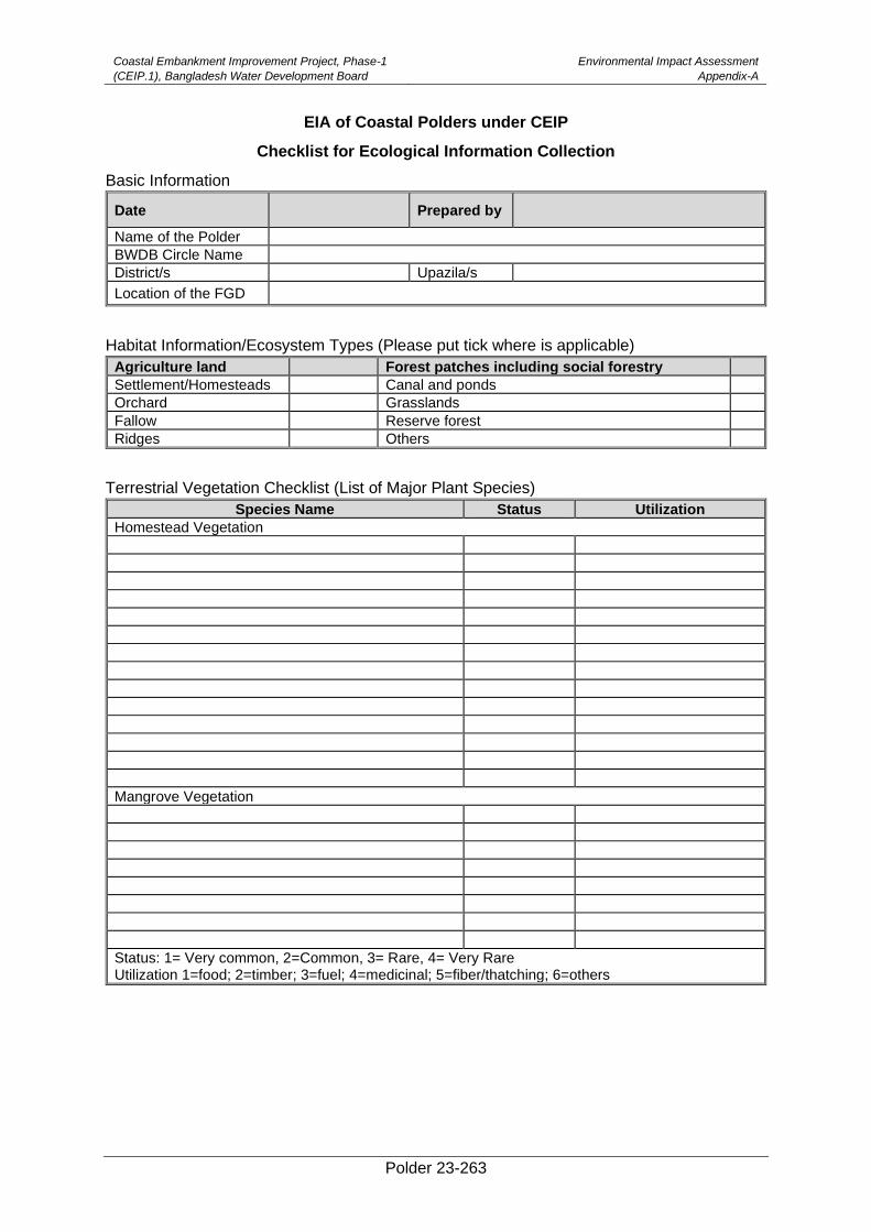
Coastal Embankment Improvement Project, Phase-1
(CEIP.1), Bangladesh Water Development Board
Environmental Impact Assessment
Appendix-A
Polder 23-263
EIA of Coastal Polders under CEIP
Checklist for Ecological Information Collection
Basic Information
Date Prepared by
Name of the Polder
BWDB Circle Name
District/s Upazila/s
Location of the FGD
Habitat Information/Ecosystem Types (Please put tick where is applicable)
Agriculture land Forest patches including social forestry
Settlement/Homesteads Canal and ponds
Orchard Grasslands
Fallow Reserve forest
Ridges Others
Terrestrial Vegetation Checklist (List of Major Plant Species)
Species Name Status Utilization
Homestead Vegetation
Mangrove Vegetation
Status: 1= Very common, 2=Common, 3= Rare, 4= Very Rare Utilization 1=food; 2=timber; 3=fuel; 4=medicinal; 5=fiber/thatching; 6=others
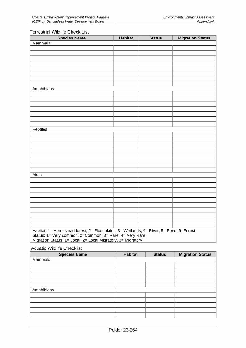
Coastal Embankment Improvement Project, Phase-1
(CEIP.1), Bangladesh Water Development Board
Environmental Impact Assessment
Appendix-A
Polder 23-264
Terrestrial Wildlife Check List
Species Name Habitat Status Migration Status
Mammals
Amphibians
Reptiles
Birds
Habitat: 1= Homestead forest, 2= Floodplains, 3= Wetlands, 4= River, 5= Pond, 6=Forest Status: 1= Very common, 2=Common, 3= Rare, 4= Very Rare Migration Status: 1= Local, 2= Local Migratory, 3= Migratory
Aquatic Wildlife Checklist
Species Name Habitat Status Migration Status
Mammals
Amphibians
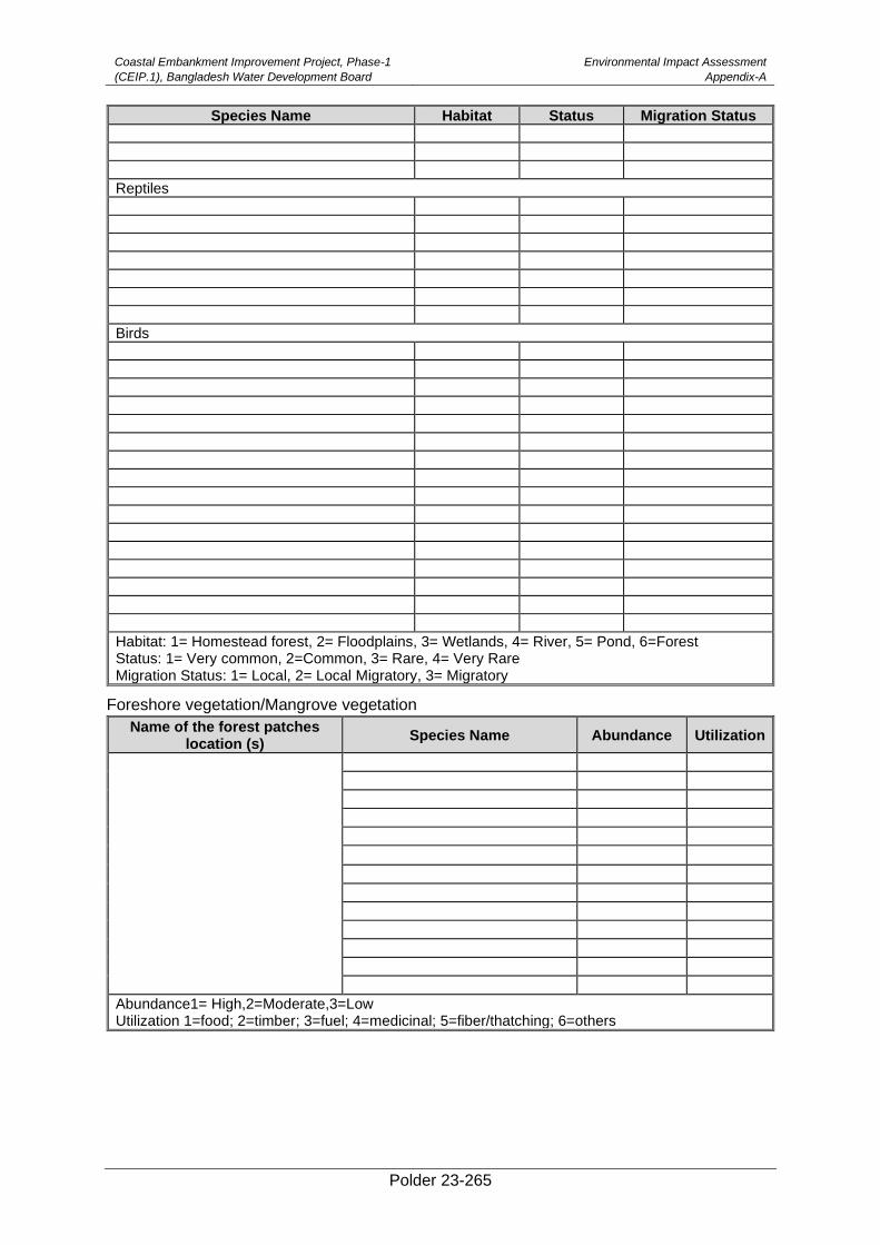
Coastal Embankment Improvement Project, Phase-1
(CEIP.1), Bangladesh Water Development Board
Environmental Impact Assessment
Appendix-A
Polder 23-265
Species Name Habitat Status Migration Status
Reptiles
Birds
Habitat: 1= Homestead forest, 2= Floodplains, 3= Wetlands, 4= River, 5= Pond, 6=Forest Status: 1= Very common, 2=Common, 3= Rare, 4= Very Rare Migration Status: 1= Local, 2= Local Migratory, 3= Migratory
Foreshore vegetation/Mangrove vegetation
Name of the forest patches location (s)
Species Name Abundance Utilization
Abundance1= High,2=Moderate,3=Low Utilization 1=food; 2=timber; 3=fuel; 4=medicinal; 5=fiber/thatching; 6=others
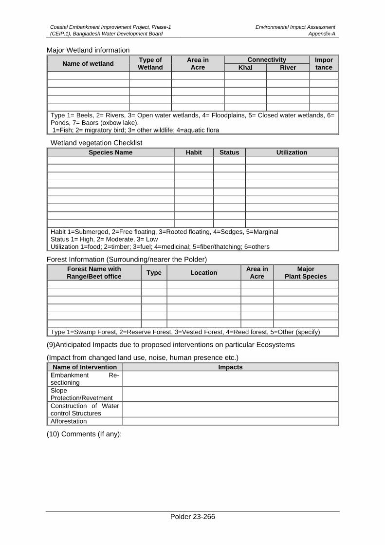
Coastal Embankment Improvement Project, Phase-1
(CEIP.1), Bangladesh Water Development Board
Environmental Impact Assessment
Appendix-A
Polder 23-266
Major Wetland information
Name of wetland Type of Wetland
Area in Acre
Connectivity Impor tance Khal River
Type 1= Beels, 2= Rivers, 3= Open water wetlands, 4= Floodplains, 5= Closed water wetlands, 6= Ponds, 7= Baors (oxbow lake). 1=Fish; 2= migratory bird; 3= other wildlife; 4=aquatic flora
Wetland vegetation Checklist
Species Name Habit Status Utilization
Habit 1=Submerged, 2=Free floating, 3=Rooted floating, 4=Sedges, 5=Marginal Status 1= High, 2= Moderate, 3= Low Utilization 1=food; 2=timber; 3=fuel; 4=medicinal; 5=fiber/thatching; 6=others
Forest Information (Surrounding/nearer the Polder)
Forest Name with Range/Beet office
Type Location Area in
Acre Major
Plant Species
Type 1=Swamp Forest, 2=Reserve Forest, 3=Vested Forest, 4=Reed forest, 5=Other (specify)
(9)Anticipated Impacts due to proposed interventions on particular Ecosystems
(Impact from changed land use, noise, human presence etc.)
Name of Intervention Impacts
Embankment Re-sectioning
Slope Protection/Revetment
Construction of Water control Structures
Afforestation
(10) Comments (If any):
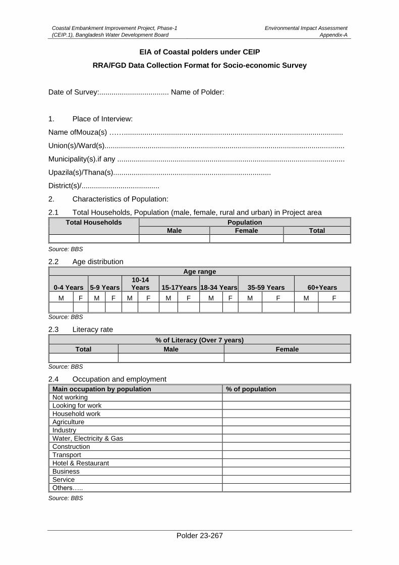
Coastal Embankment Improvement Project, Phase-1
(CEIP.1), Bangladesh Water Development Board
Environmental Impact Assessment
Appendix-A
Polder 23-267
EIA of Coastal polders under CEIP
RRA/FGD Data Collection Format for Socio-economic Survey
Date of Survey:.................................. Name of Polder:
1. Place of Interview:
Name ofMouza(s) ……...........................................................................................................
Union(s)/Ward(s).....................................................................................................................
Municipality(s).if any ...............................................................................................................
Upazila(s)/Thana(s).............................................................................
District(s)/......................................
2. Characteristics of Population:
2.1 Total Households, Population (male, female, rural and urban) in Project area
Total Households Population
Male Female Total
Source: BBS
2.2 Age distribution
Age range
0-4 Years 5-9 Years 10-14 Years 15-17Years 18-34 Years 35-59 Years 60+Years
M F M F M F M F M F M F M F
Source: BBS
2.3 Literacy rate
% of Literacy (Over 7 years)
Total Male Female
Source: BBS
2.4 Occupation and employment
Main occupation by population % of population
Not working
Looking for work
Household work
Agriculture
Industry
Water, Electricity & Gas
Construction
Transport
Hotel & Restaurant
Business
Service
Others…..
Source: BBS
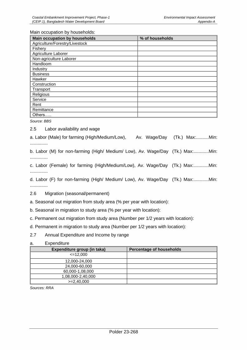
Coastal Embankment Improvement Project, Phase-1
(CEIP.1), Bangladesh Water Development Board
Environmental Impact Assessment
Appendix-A
Polder 23-268
Main occupation by households:
Main occupation by households % of households
Agriculture/Forestry/Livestock
Fishery
Agriculture Laborer
Non-agriculture Laborer
Handloom
Industry
Business
Hawker
Construction
Transport
Religious
Service
Rent
Remittance
Others…..
Source: BBS
2.5 Labor availability and wage
a. Labor (Male) for farming (High/Medium/Low), Av. Wage/Day (Tk.) Max:..........Min:
..............
b. Labor (M) for non-farming (High/ Medium/ Low), Av. Wage/Day (Tk.) Max:............Min:
..............
c. Labor (Female) for farming (High/Medium/Low), Av. Wage/Day (Tk.) Max:............Min:
..............
d. Labor (F) for non-farming (High/ Medium/ Low), Av. Wage/Day (Tk.) Max:............Min:
..............
2.6 Migration (seasonal/permanent)
a. Seasonal out migration from study area (% per year with location):
b. Seasonal in migration to study area (% per year with location):
c. Permanent out migration from study area (Number per 1/2 years with location):
d. Permanent in migration to study area (Number per 1/2 years with location):
2.7 Annual Expenditure and Income by range
a. Expenditure
Expenditure group (in taka) Percentage of households
<=12,000
12,000-24,000
24,000-60,000
60,000-1,08,000
1,08,000-2,40,000
>=2,40,000
Sources: RRA
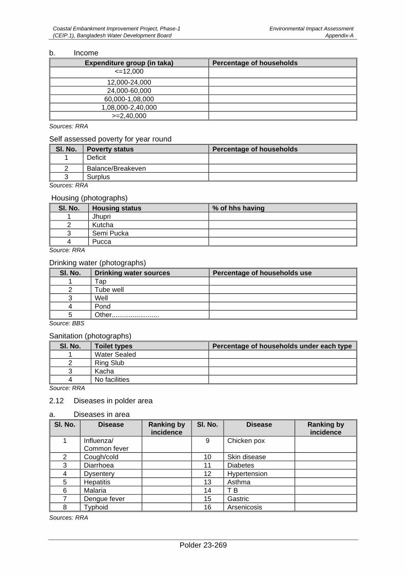
Coastal Embankment Improvement Project, Phase-1
(CEIP.1), Bangladesh Water Development Board
Environmental Impact Assessment
Appendix-A
Polder 23-269
b. Income
Expenditure group (in taka) Percentage of households
<=12,000
12,000-24,000
24,000-60,000
60,000-1,08,000
1,08,000-2,40,000
>=2,40,000
Sources: RRA
Self assessed poverty for year round
Sl. No. Poverty status Percentage of households
1 Deficit
2 Balance/Breakeven
3 Surplus
Sources: RRA
Housing (photographs)
Sl. No. Housing status % of hhs having
1 Jhupri
2 Kutcha
3 Semi Pucka
4 Pucca
Source: RRA
Drinking water (photographs)
Sl. No. Drinking water sources Percentage of households use
1 Tap
2 Tube well
3 Well
4 Pond
5 Other.........................
Source: BBS
Sanitation (photographs)
Sl. No. Toilet types Percentage of households under each type
1 Water Sealed
2 Ring Slub
3 Kacha
4 No facilities
Source: RRA
2.12 Diseases in polder area
a. Diseases in area
Sl. No. Disease Ranking by incidence
Sl. No. Disease Ranking by incidence
1 Influenza/ Common fever
9 Chicken pox
2 Cough/cold 10 Skin disease
3 Diarrhoea 11 Diabetes
4 Dysentery 12 Hypertension
5 Hepatitis 13 Asthma
6 Malaria 14 T B
7 Dengue fever 15 Gastric
8 Typhoid 16 Arsenicosis
Sources: RRA
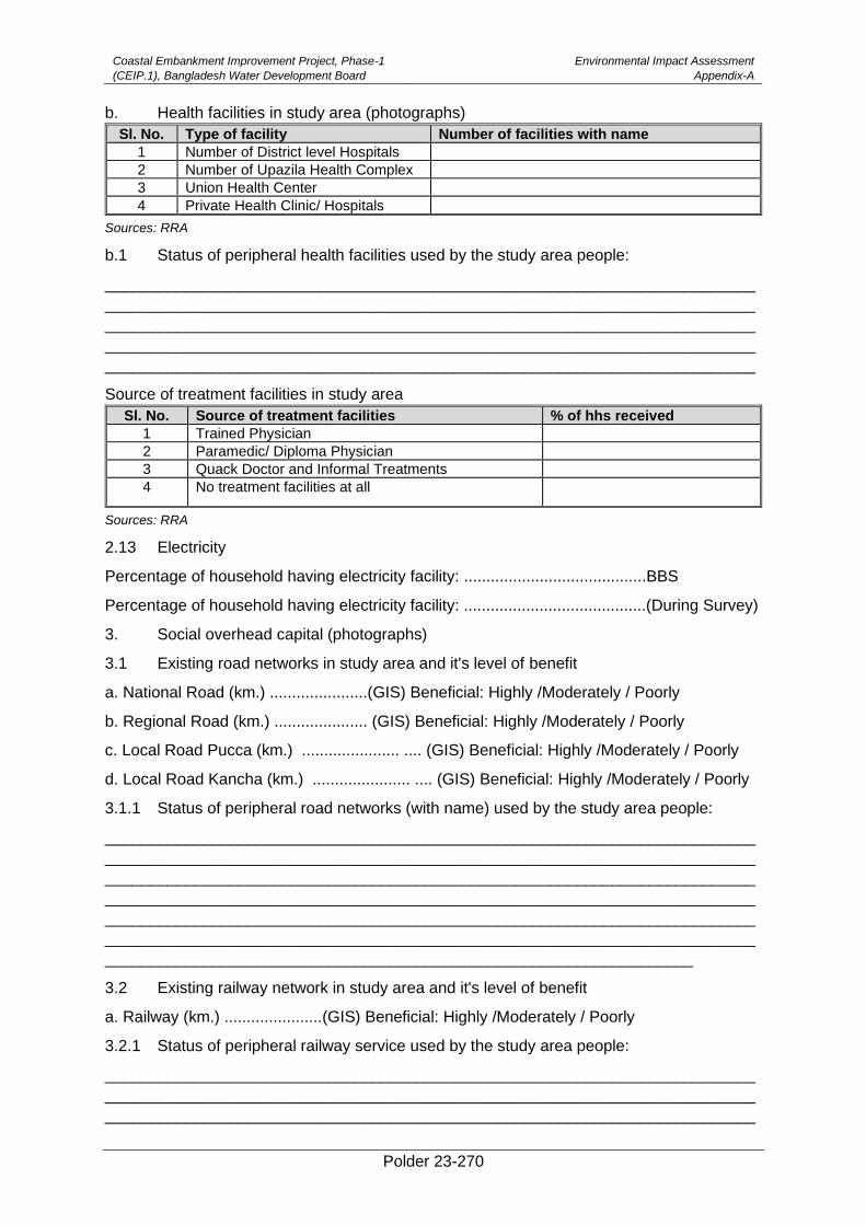
Coastal Embankment Improvement Project, Phase-1
(CEIP.1), Bangladesh Water Development Board
Environmental Impact Assessment
Appendix-A
Polder 23-270
b. Health facilities in study area (photographs)
Sl. No. Type of facility Number of facilities with name
1 Number of District level Hospitals
2 Number of Upazila Health Complex
3 Union Health Center
4 Private Health Clinic/ Hospitals
Sources: RRA
b.1 Status of peripheral health facilities used by the study area people:
_________________________________________________________________________
_________________________________________________________________________
_________________________________________________________________________
_________________________________________________________________________
_________________________________________________________________________
Source of treatment facilities in study area
Sl. No. Source of treatment facilities % of hhs received
1 Trained Physician
2 Paramedic/ Diploma Physician
3 Quack Doctor and Informal Treatments
4 No treatment facilities at all
Sources: RRA
2.13 Electricity
Percentage of household having electricity facility: .........................................BBS
Percentage of household having electricity facility: .........................................(During Survey)
3. Social overhead capital (photographs)
3.1 Existing road networks in study area and it's level of benefit
a. National Road (km.) ......................(GIS) Beneficial: Highly /Moderately / Poorly
b. Regional Road (km.) ..................... (GIS) Beneficial: Highly /Moderately / Poorly
c. Local Road Pucca (km.) ...................... .... (GIS) Beneficial: Highly /Moderately / Poorly
d. Local Road Kancha (km.) ...................... .... (GIS) Beneficial: Highly /Moderately / Poorly
3.1.1 Status of peripheral road networks (with name) used by the study area people:
_________________________________________________________________________
_________________________________________________________________________
_________________________________________________________________________
_________________________________________________________________________
_________________________________________________________________________
_________________________________________________________________________
__________________________________________________________________
3.2 Existing railway network in study area and it's level of benefit
a. Railway (km.) ......................(GIS) Beneficial: Highly /Moderately / Poorly
3.2.1 Status of peripheral railway service used by the study area people:
_________________________________________________________________________
_________________________________________________________________________
_________________________________________________________________________
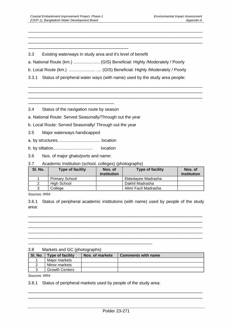
Coastal Embankment Improvement Project, Phase-1
(CEIP.1), Bangladesh Water Development Board
Environmental Impact Assessment
Appendix-A
Polder 23-271
_________________________________________________________________________
_________________________________________________________________________
_________________________________________________________________________
__________________________________________
3.3 Existing waterways in study area and it's level of benefit
a. National Route (km.) ...................... (GIS) Beneficial: Highly /Moderately / Poorly
b. Local Route (km.) ...................... .... (GIS) Beneficial: Highly /Moderately / Poorly
3.3.1 Status of peripheral water ways (with name) used by the study area people:
_________________________________________________________________________
_________________________________________________________________________
_________________________________________________________________________
____________________________________
3.4 Status of the navigation route by season
a. National Route: Served Seasonally/Through out the year
b. Local Route: Served Seasonally/ Through out the year
3.5 Major waterways handicapped
a. by structures.................................... location
b. by siltation................................. location
3.6 Nos. of major ghats/ports and name:
3.7 Academic Institution (school, colleges) (photographs)
Sl. No. Type of facility Nos. of Institution
Type of facility Nos. of Institution
1 Primary School Ebtedayee Madrasha
2 High School Dakhil Madrasha
3 College Alim/ Fazil Madrasha
Sources: RRA
3.6.1 Status of peripheral academic institutions (with name) used by people of the study
area:
_________________________________________________________________________
_________________________________________________________________________
_________________________________________________________________________
_________________________________________________________________________
_________________________________________________________________________
____________________________________________________
3.8 Markets and GC (photographs)
Sl. No. Type of facility Nos. of markets Comments with name
1 Major markets
2 Minor markets
3 Growth Centers
Sources: RRA
3.8.1 Status of peripheral markets used by people of the study area:
_________________________________________________________________________
_________________________________________________________________________
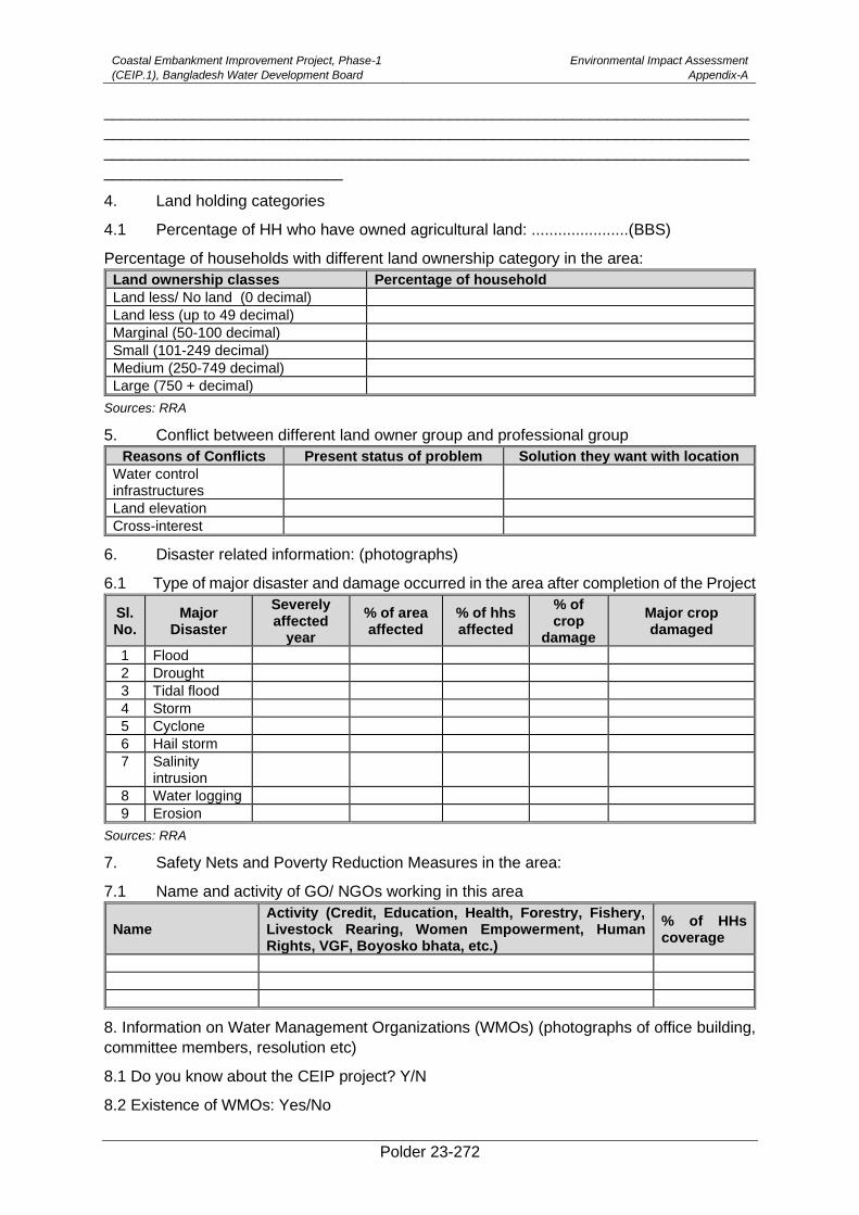
Coastal Embankment Improvement Project, Phase-1
(CEIP.1), Bangladesh Water Development Board
Environmental Impact Assessment
Appendix-A
Polder 23-272
_________________________________________________________________________
_________________________________________________________________________
_________________________________________________________________________
___________________________
4. Land holding categories
4.1 Percentage of HH who have owned agricultural land: ......................(BBS)
Percentage of households with different land ownership category in the area:
Land ownership classes Percentage of household
Land less/ No land (0 decimal)
Land less (up to 49 decimal)
Marginal (50-100 decimal)
Small (101-249 decimal)
Medium (250-749 decimal)
Large (750 + decimal)
Sources: RRA
5. Conflict between different land owner group and professional group
Reasons of Conflicts Present status of problem Solution they want with location
Water control infrastructures
Land elevation
Cross-interest
6. Disaster related information: (photographs)
6.1 Type of major disaster and damage occurred in the area after completion of the Project
Sl. No.
Major Disaster
Severely affected
year
% of area affected
% of hhs affected
% of crop
damage
Major crop damaged
1 Flood
2 Drought
3 Tidal flood
4 Storm
5 Cyclone
6 Hail storm
7 Salinity intrusion
8 Water logging
9 Erosion
Sources: RRA
7. Safety Nets and Poverty Reduction Measures in the area:
7.1 Name and activity of GO/ NGOs working in this area
Name Activity (Credit, Education, Health, Forestry, Fishery, Livestock Rearing, Women Empowerment, Human Rights, VGF, Boyosko bhata, etc.)
% of HHs coverage
8. Information on Water Management Organizations (WMOs) (photographs of office building,
committee members, resolution etc)
8.1 Do you know about the CEIP project? Y/N
8.2 Existence of WMOs: Yes/No
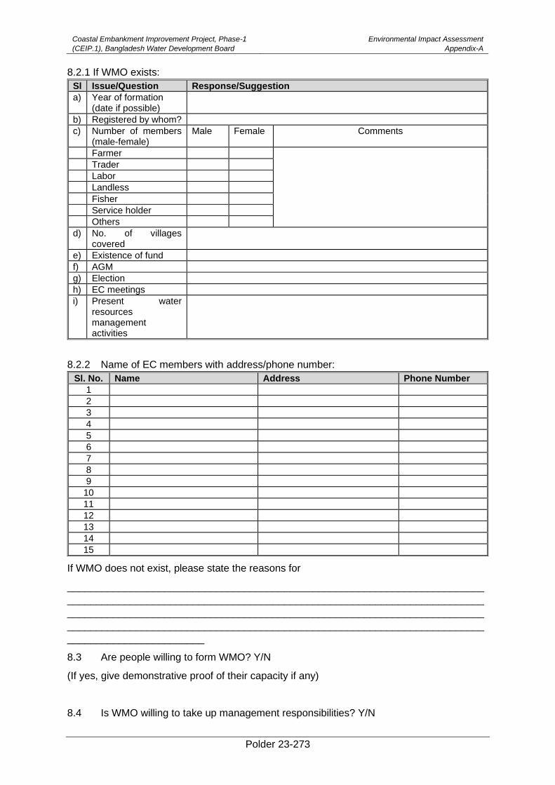
Coastal Embankment Improvement Project, Phase-1
(CEIP.1), Bangladesh Water Development Board
Environmental Impact Assessment
Appendix-A
Polder 23-273
8.2.1 If WMO exists:
Sl Issue/Question Response/Suggestion
a) Year of formation (date if possible)
b) Registered by whom?
c) Number of members (male-female)
Male Female Comments
Farmer
Trader
Labor
Landless
Fisher
Service holder
Others
d) No. of villages covered
e) Existence of fund
f) AGM
g) Election
h) EC meetings
i)
Present water resources management activities
8.2.2 Name of EC members with address/phone number:
Sl. No. Name Address Phone Number
1
2
3
4
5
6
7
8
9
10
11
12
13
14
15
If WMO does not exist, please state the reasons for
_________________________________________________________________________
_________________________________________________________________________
_________________________________________________________________________
_________________________________________________________________________
________________________
8.3 Are people willing to form WMO? Y/N
(If yes, give demonstrative proof of their capacity if any)
8.4 Is WMO willing to take up management responsibilities? Y/N
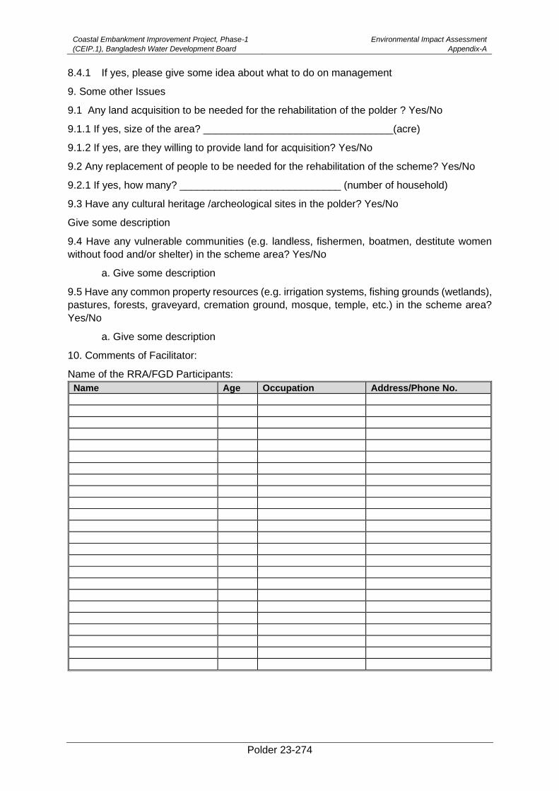
Coastal Embankment Improvement Project, Phase-1
(CEIP.1), Bangladesh Water Development Board
Environmental Impact Assessment
Appendix-A
Polder 23-274
8.4.1 If yes, please give some idea about what to do on management
9. Some other Issues
9.1 Any land acquisition to be needed for the rehabilitation of the polder ? Yes/No
9.1.1 If yes, size of the area? _________________________________(acre)
9.1.2 If yes, are they willing to provide land for acquisition? Yes/No
9.2 Any replacement of people to be needed for the rehabilitation of the scheme? Yes/No
9.2.1 If yes, how many? ____________________________ (number of household)
9.3 Have any cultural heritage /archeological sites in the polder? Yes/No
Give some description
9.4 Have any vulnerable communities (e.g. landless, fishermen, boatmen, destitute women
without food and/or shelter) in the scheme area? Yes/No
a. Give some description
9.5 Have any common property resources (e.g. irrigation systems, fishing grounds (wetlands),
pastures, forests, graveyard, cremation ground, mosque, temple, etc.) in the scheme area?
Yes/No
a. Give some description
10. Comments of Facilitator:
Name of the RRA/FGD Participants:
Name Age Occupation Address/Phone No.
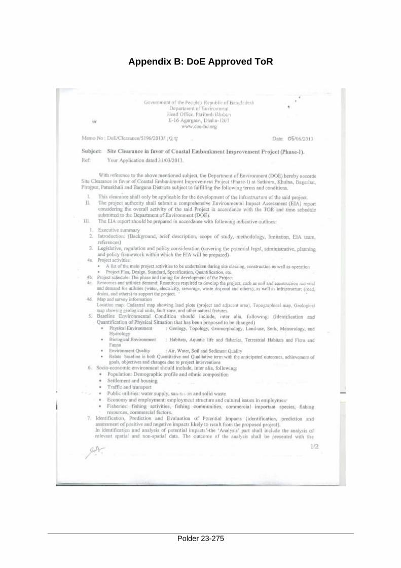
Polder 23-275
Appendix B: DoE Approved ToR
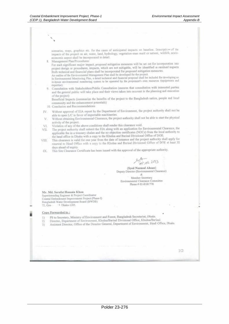
Coastal Embankment Improvement Project, Phase-1
(CEIP.1), Bangladesh Water Development Board
Environmental Impact Assessment
Appendix-B
Polder 23-276
Polder 23-277
Appendix C: Details of Relevant Policies and Laws
(A) National Legislation
(i) Environment Conservation Act, 1995
The national environmental legislation is known as Environmental Conservation Act (ECA),
1995 (subsequent amendments) is currently the main legislative document relevant to
environmental protection in Bangladesh. It was promulgated in 1995 and has repealed the
earlier environment pollution control ordinance of 1977. The main objectives of ECA 1995
are:
• Conservation and improvement of environment, and
• Control and mitigation of pollution of environment.
The main strategies of the Act can be summarized as:
• Declaration of ecologically critical areas, and restriction on the operation and process,
which can be carried, out or cannot be initiated in the ecologically critical areas.
• Regulation in respect of vehicles emitting smoke harmful for the environment.
• Environmental clearance.
• Regulation of the industries and other development activities – discharge permit.
• Promulgation of standards for quality of air, water, noise and soil for different areas for
different purposes.
• Promulgation of standard limit for discharging and emitting waste.
• Formulation and declaration of environmental guidelines.
Bangladesh Environmental Conservation Act (Amendment 2000) focuses on: (1) ascertaining
responsibility for Compensation in cases of damage to ecosystems, (2) increased provision of
punitive measures both for fines and imprisonment and (3) fixing authority on cognizance of
offences.
Bangladesh Environmental Conservation Act (Amendment 2002) elaborates on: (1) restriction
on polluting automobiles, (2) restriction on the sale and production of environmentally harmful
items like polythene bags, (3) assistance from law enforcement agencies for environmental
actions, (4) break up of punitive measures and (5) authority to try environmental cases.
Bangladesh Environmental Conservation Act (Amendment 2010) elaborates on (1)
demarcation of wetlands and water bodies, (2) Hazardous waste import, transportation,
storage etc., (3) Cutting of hills, mountains (4) Ecologically Critical Areas.
Failure to comply with any part of the Environment Conservation Act 1995 may result in
punishment to a maximum of 5 years imprisonment or a maximum fine of Tk. 100,000, or both.
(ii) Environment Conservation Rules, 1997 (amendments in 2002 and 2003)
A set of the relevant rules promulgated to implement the ECA 1995. There have been three
amendments to the Rules until now in February and August 2002 and April 2003 respectively.
The Rules mainly consist of:
• The national Environmental Quality Standards (EQS) for ambient air, surface water,
groundwater, drinking water, industrial effluents, emissions, noise and vehicular
exhaust;
Coastal Embankment Improvement Project, Phase-1
(CEIP.1), Bangladesh Water Development Board
Environmental Impact Assessment
Appendix-C
Polder 23-278
• Categorization of industries, development projects and other activities on the basis of
pollution activities of the existing or proposed industries/development
projects/activities.
• Procedure for obtaining environmental clearance;
• Requirement for undertaking IEE and EIA as well as formulating EMP according to
categories of industries/development projects/activities;
• Procedure for damage-claim by persons affected or likely to be affected due to
polluting activities or activities causing hindrance to normal civic life.
The proposed projectbelongs to the Red Category according to the classification of industrial
units or projects described in the Schedule-1 in the Rules. The procedure for issuing
Environmental Clearance Certificate is elaborated in the Rules that must have to follow by the
BWDB.
Another rule of the ECR is to determine environmental standards. The standards for air, water,
sound, odor and other components of the environment shall be determined in accordance with
the standards specified in Schedules - 2, 3, 4, 5, 6, 7 and 8. The proposed project must comply
these standards during carrying out the activities.
(iii) The Environment Court Act, 2000
The Environment Court Act, 2000 has been enacted in order to establish environmental courts
in each administrative division of Bangladesh. Under this Act, the court has concurrent
jurisdiction i.e. to try both civil and criminal cases. The basis for instituting a case is a violation
of the “environmental law”, meaning the Bangladesh Environment Conservation Act, 1995 and
Rules made there under. In particular the environment court is empowered to:
• Impose penalties for violating court orders;
• Confiscate any article, equipment and transport used for the commission of the
offence2;
• Pass any order or decree for compensation;
• Issue directions to the offender or any person (a) not to repeat or continue the offence;
(b) to take preventive or remedial measures with relation to any injury, specifying the
time limit and reporting to the DOE regarding the implementation of the directions.
(iv) Bangladesh Water Act, 2013
The Water Act 2013 exists for integrated development, management, extraction, distribution,
usage, protection and conservation of water resources in Bangladesh.
As per this Act, all forms of water (e.g., surface water, ground water, sea water, rain water and
atmospheric water) within the territory of Bangladesh belong to the government on behalf of
the people. Without prior permission issued by the Executive Committee, no individuals or
organizations will be allowed to extract, distribute, use, develop, protect, and conserve water
resources, nor they will be allowed to build any structure that impede the natural flow of rivers
and creeks. Issuance of clearance certificate must be obtained by all organizations or
appropriate authorities that are involved in undertaking, making or implementing a Water
Resource Development Project before initiating the project, according to section 16.
Coastal Embankment Improvement Project, Phase-1
(CEIP.1), Bangladesh Water Development Board
Environmental Impact Assessment
Appendix-C
Polder 23-279
(v) Guidelines for Participatory Water Management (GPWM), 2014
The Guidelines for Participatory Water Management,2014 have been prepared under “Bangladesh Water Development Board Act 2000”. The Rules relate to formation and functions of water management organizations (WMOs) in water resources projects.
The Guidelines for Participatory Water Management (GPWM) in Bangladesh provides the following:
• Participation is an important voluntary process in which local stakeholders influence policy formulation, alternative plans/designs, investment choices and management decisions affecting their communities and establish the sense of ownership.
• Give the local stakeholders a decisive voice at all stages of water management.
• Participation of local stakeholders to prepare production plans on agriculture, fishery, forestry and livestock development and environmental management plan based on the feasibility study by the implementing agencies.
• According to this rule, every water management group will form cluster groups including landless men and women of the project area for infrastructure development or maintenance related activities of which 30 percent will be women.
(vi) The Embankment and Drainage Act, 1952
This is an Act to consolidate the laws relating to embankment and drainage and make better
provisions for the construction, maintenance, management, removal and control of
embankments and watercourses or the better drainage of lands and for their protection from
floods, erosion or other damage by water. The major provisions are:
According to the Section 4 (1) every embankment, watercourse and embanked tow-path
maintained by the Government or the Authority, and all land, earth, pathways, gates, berms
and hedges belonging to or forming part of, or standing on, any such embankment or water-
course shall vest in the Government or the Authority.
Section 25 describes the restoration of land etc. that any person who shall have sustained
damage by the execution of such works shall receive compensation from the Government or
the Authority. Any alteration if appear unnecessary shall be restored as nearly as possible to
the state in which they were before the activity at the expense of the Government or the
Authority.
Section 28 outlines the provisions of compensation of damages of any land or any right of
fishery, right of drainage, right to the use of water or other right of property shall be
compensated.
Section 55 to 59 outline penalties for following cases: unauthorized interference and abetment,
injuring embankments, diverting rivers or grazing cattle on embankments, removal of
obstruction and repair of damage, and obstructing persons in exercise of powers under this
Act.
(vii) Wildlife (Conservation and Security) Act, 2012
The Bangladesh Wildlife (Conservation and Security) Act of 2012 has been formulated by
repealing previous laws i.e. Wildlife (Preservation) Act of 1973 and it aims at conservation and
safety of biodiversity, forest and wildlife of the country. The Department of Forest (DoF) has
the primary responsibility for implementing this Act. The key issues in the Act are:
Coastal Embankment Improvement Project, Phase-1
(CEIP.1), Bangladesh Water Development Board
Environmental Impact Assessment
Appendix-C
Polder 23-280
• Prohibition made related to wild animals and plants that no person can hunt any wild
animal without a license or willfully pick, uproot, destroy or collect any plant
• Determination of vulnerable, endangered and critically endangered species of wild
animals and plants
• Declaration of sanctuary for the conservation of forest and habitat of wildlife and
prohibitions made on such sanctuary.
• Requirement of license to cultivate, extract, manufacture, rear, export or import any
wild animal or part of its body, meat, trophy, uncured trophy or any plant.
• Restriction on import, export and re-export of wild animals and plants.
The regulation of the Wildlife Act prohibits establishing or operating any industrial factory within
2 (two) kilometers from the boundary of a sanctuary. This applies to the Polders improvement
activity near the Sundarbans Reserve Forest area. Capturing, killing, shooting or trapping of
wildlife is prohibited in sanctuary and conservation of all natural resources such as vegetation,
soil and water are managed mainly for undisturbed breeding of wildlife. Clause 14 articulates
the activities prohibited in a sanctuary listed below:
• cultivate any land;
• establish or undertake any industrial operation;
• harvest, destroy or collect any plant;
• set any kind of fire;
• enter into a sanctuary with any weapon without the permission of the Chief Warden or
the officer authorised by him in this behalf;
• disturb or threat any wildlife, or use chemicals, explosives or any other weapon or
substances which may destroy wildlife habitat;
• introduce any exotic animal or plant;
• introduce any domestic animal or allow any domestic animal to stray;
• dump any materials detrimental to wildlife;
• explore or dig for extraction of minerals;
• fell any plant or part thereof except silvicultural operations required for natural
regeneration of plants;
• divert, stop or pollute watercourse; or
• Introduce any alien and invasive plant species.
This Act is particularly relevant to this study because “biodiversity “is dealt under the Act and
according to the Act, “biodiversity” means genetic and species diversity of all species or sub-
species of flora and fauna living in aquatic, terrestrial and marine ecosystems or diversity of
their ecosystems. It is to be ensured that sufficient mitigation measures are taken for ensuring
the safety of biodiversity and protection of flora and fauna. The EIA provides mitigation
measures for biodiversity conservation including ecology and fisheries in chapter 8.
(viii) The Protection and Conservation of Fish Act, 1950 and Rules, 1985
The Act aims for the protection and conservation of fish in Bangladesh which has amendment
in 1995. This Act provides power to the government to:
• Make and apply rules in any water or waters for the purposes of protection of fisheries.
• Prohibit or regulate the erection and use of fixed engines; and the construction,
temporary or permanent, of weirs, dams, bunds, embankments and other structures.
• Prohibit the destruction of fish by explosives, guns, and bows in inland or coastal areas.
• Prohibit the destruction of fish by means of poisoning, pollution and effluents.
Coastal Embankment Improvement Project, Phase-1
(CEIP.1), Bangladesh Water Development Board
Environmental Impact Assessment
Appendix-C
Polder 23-281
• Prescribe the seasons during which fishing is allowed.
• Prohibit fishing in all waters during spawning periods.
• Specify the officials with authority to detect breaches.
The Government made Rules in 1985 which contains 11 sections about various measures of
protection and conservation and 2 Schedules specifying waters in which the catching of certain
fish species is prohibited without a valid license, specifying fish species of which the catching
or sale in certain periods is prohibited, and containing a form of a license for catching of carps
in Prohibited Waters. Regulation 3 prohibits the erection of fixed engines in rivers and canals.
No fish shall be destroyed by making use of poison or explosives (regulations 4 and 5).
Licenses issued under regulation 8 only for purposes of pisciculture. Regulations prohibit the
catching, carrying, transporting, offering for sale or possessing of frogs.
(ix) The Forest Act, 1927
The Forest Act was passed in 1927 in order to consolidatethe lawrelating to forests, The forest
Act was enacted to preserve and safeguardforest in general, both public and private. The
Forest Act of 1927 was amended in 1989 to provide deterrent penalties for certain forest
offences and latest amendment came 2000 to add provision for social forestry. To elaborate
the social forestry procedure Social Forestry Rules were framed in 2004 under the Forest Act,
1927 and Forest Transit Rules were framed in 2011.
This Act bears some important provisions suchas constitution of reserved forest, formation of
any forestlandor wasteland or any land suitable for afforestation willbe the property of
Government. This Act covers all procedural matters in implementationin all aspects related to
forest conservation and developmentin Bangladesh. The key issues in the Act are:
• Section 3: The Government may declare any forest land which is property of the
Government to be reserved forest land.
• Section 4: The Government shall issue a notice to that effect in the Official Gazette.
• Section 5: No rights shall be acquired in reserved forest land other than those acquired
by succession or by government grant or contract and no clearing of cultivation shall
be carried out other than in accordance with rules made by the Government for the
reserved area.
• Section 28 provides for settlement of claims in the reserved area, prohibited activities,
and powers of the Forest Officer in respect of such area. The Government may assign
to any village community reserved forests and such forest land shall be called Village
Forest.
• Section 32: Other public forest or waste land may be declared protected forests and
the Government may make rules in respect of all matters listed in the section for such
areas.
• Section 76 defines additional regulation making powers of the Government.
(x) Acquisition and Requisition of Immovable Property Ordinance 1982
The principal legal instrument governing land acquisition in Bangladesh is the Acquisition and
Requisition of Immovable Property Ordinance, 1982 and subsequent amendments during
1993 - 1994. The 1982 Ordinance requires that compensation be paid for (i) land and assets
permanently acquired (including standing crops, trees, and houses) and (ii) any other
damages caused by such acquisition. The Ordinance provides certain safeguards for the
owners and has provision for payment of “fair value” for the property acquired.
Coastal Embankment Improvement Project, Phase-1
(CEIP.1), Bangladesh Water Development Board
Environmental Impact Assessment
Appendix-C
Polder 23-282
Deputy Commissioners (DC) will pay compensation for the land to be acquired based on Land
Acquisition Proposals to be submitted by the requiring body. DCs, in all the cases, determine
market value of acquired assets on the date of notice of acquisition (notice under section 3 of
the Ordinance). The DCs then adds 50% premium on the assessed value for cash
compensation under law (CCL) of all acquired assets except standing crops due to compulsory
acquisition. The CCL paid for land is generally less than the “current market price” as owners
customarily report undervalued land transaction prices in order to pay lower stamp duty and
registration fees. If the land acquired has standing crops cultivated by tenant (bargadar) under
a legally constituted agreement, the law requires that part of the compensation money be paid
in cash to the tenants as per the agreement. Places of worship, graveyard and cremation
grounds are not to be acquired for any purpose. The law requires that the salvaged materials
upon payment of compensation will be auctioned out by the government. Under the 1982
Ordinance, the Government is obliged to pay compensation only for the assets acquired.
However, the provisions under this law are not adequate to cope with the adverse effects
related to land acquisition and involuntary resettlement, nor do they do fully match the
requirements of the WB’s Operational Polices (OP 4.12) or international standards. Some of
such gaps in existing land acquisition law of the country are:
• Existing GOB laws recognize title owners only; informal settlers are not covered
• Consultation with affected community not legally required
• No support or program for income and livelihood restoration.
In light of addressing these shortcomings, the Government of Bangladesh is working on
preparation of a national policy on involuntary resettlement, which is consistent with the
general policy of the Government that the rights of those displaced by development projects
shall be fully respected, and persons being displaced shall be treated with dignity and assisted
in such a way that safeguards their welfare and livelihoods irrespective of title, gender, and
ethnicity. The Government will undertake further work towards legislative changes to
safeguard resettlement rights by law once the draft policy is approved in the Cabinet.
This proposed project requires land acquisition in each Polder area, which should be done
following the procedure mentioned in this Act.
(xi) Noise Pollution (Control) Rules, 2006
According to Environment Protection Act 1995, the government formulated the noise pollution
Rules & Regulation in 2006. This regulation recommends to keep the sound level 50 dB at the
quieter area from 6am until 9pm and at night 40 dB, similarly, at residential area on the day of
55 dB and at night 45 dB, a mixed area, 60 dB at day time and at night 50 dB, a commercial
area on the day of 70 dB and at night 60 dB and the industrial areas of the day 75 dB and at
night 70 dB.
(xii) Disaster Management Act, 2012
The Disaster Management Act 2012 aims at coordinating the activities of disaster
management and making these object oriented and strengthened to build up infrastructure of
effective disaster management to fight all types of disaster. Disastermeans any such incidents
created by nature or human.
This Act is particularly relevant to avoiding accidental hazard both in construction and post-
construction phase. The relevance of this act for this proposed project arises as following:
Coastal Embankment Improvement Project, Phase-1
(CEIP.1), Bangladesh Water Development Board
Environmental Impact Assessment
Appendix-C
Polder 23-283
• To make a disaster management plan for rehabilitation to bring back any infrastructure,
life, livelihood and working environment damaged by disaster to previous condition or
better condition.
• To create effective disaster management infrastructure to fight disaster and to make
the public concerned and strengthened to face the disasters.
• To ensure that obstacle is created in plying fire brigade and rescue vehicles during fire,
earthquake, building slide or other disaster.
Disaster (to certain degree) may occur in present project if any harmful situation occurs during
the normal work or construction activity. Therefore, appropriate management plan should have
to be taken by the project proponent to prevent any unwanted disaster in the location.
(xiii) Antiquities Act, 1968
The Antiquities Act 1968 (amended in 1976) establishes the legal framework for the
preservation and protection of antiquities. According to the Act, any ancient monument
(minimum 100 years old) illustrative of architecture, warfare, politics or culture can be regarded
as an article of antiquity.The law terms the archeological sites and monuments as antiquities.
The Act has defined the procedure in dealing with antiquities in following matters, i.e. custody,
preservation of ownerless antiquity, prohibition of movement of antiquity, right of access to
protected immovable antiquities etc.
If the proposed project finds any archaeological sites or national antics during carrying out the
activity, then it will be dealt under this Act. Discovery or existence of an antiquity will
immediately be notified to the Advisory committee formed under this law for the protection of
national antiquities. Mitigation measures are outlined for the potential damage and loss of
cultural propertiesin chapter 10.
(xiv) Bangladesh Labour Act, 2006 and Rules, 2015
Bangladesh Labour Act was promulgated in 2006. The legislation pertains to the occupational
rights and safety of factory workers and the provision of a comfortable work environment and
reasonable working conditions. The amendment in 2013 has introduced a good number of
important items like workers’ welfare, rights and safety and industrial safety and expansion of
the industry are particularly relevant for this proposed study.
In 2015, Bangladesh government has introduced the Bangladesh Labour Rules. Some of the
relevant points of this Rules are health and fire safety, prescribe from for filling case in Labour
Court, and approval of factory plan and any extension among others.
The Bangladesh Labour Act 2006 consolidated and repealed 25 previous labour related laws
including the Dock Labourers Act, 1934, the Factories Act, 1965 among others.
The proposed project is required to obey occupation health and safety of the workers covered
under this Act while carrying out the activities.
(B) Relevant National Policies, Plans and Strategies
(i) National Environment Policy, 1992
The National Environment Policy (NEP) is one of the key policy documents of the Government.
The policy addresses 15 sectors in all, in addition to providing directives on the legal
framework and institutional arrangements. Coastal and marine environment is one of the key
Coastal Embankment Improvement Project, Phase-1
(CEIP.1), Bangladesh Water Development Board
Environmental Impact Assessment
Appendix-C
Polder 23-284
sectors covered in this policy. The policy declarations that have particular bearing on the
Integrated Coastal Zone Management (ICZM) are listed below.
• Sustainable use of coastal and marine resources and preservation of coastal
ecosystem
• Prevention of national and international activities causing pollution in coastal and
marine environment
• Strengthening research in protection and development of coastal and marine
resources and environment
• Exploration of coastal and marine fisheries to a maximum sustainable limit
Regarding water resource development, flood control and irrigation sector, the policy seeks
to:
• ensure environmentally-sound utilization of all water resources;
• ensure that water development activities and irrigation networks do not create adverse
environmental impact;
• ensure that all steps are taken for flood control, including construction of
embankments, dredging of rivers, digging of canals, etc, be environmentally sound at
local, zonal and national levels;
• ensure mitigation measures of adverse environmental impact of completed water
resources development and flood control projects;
• keep the rivers, canals, ponds, lakes, haors, baors and all other water bodies and water
resources free from pollution;
• ensure sustainable, long-term, environmentally sound and scientific exploitation and
management of the underground and surface water resources; and
• conduct environmental impact assessment before undertaking projects for water
resources development and management.
The Policy is applicable to the Package 3 under CEIP-1and the proposed interventions are
required to comply with all the policy directives emphasizing particularly on reducing adverse
environmental impacts. The EIA studies of the coastal polders are required to clearly address
the potential impacts and propose mitigation measures.
(ii) National Water Policy, 1999
The National Water Policy (NWP) was adopted in 1999 with the objectives of improved water
resources management and protection of the environment.
The policy has several clauses related to water resource development projects for ensuring
environmental protection. Some of the relevant clauses are:
• Clause 4.5b: Planning and feasibility studies of all projects will follow the Guidelines
for Project Assessment, the Guidelines for People's Participation (GPP), the
Guidelines for Environmental Impact Assessment, and all other instructions that may
be issued from time to time by the Government.
• Clause 4.9b: Measures will be taken to minimize disruption to the natural aquatic
environment in streams and water channels.
• Clause 4.9e: Water development plans will not interrupt fish movement and will make
adequate provisions in control structures for allowing fish migration and breeding.
• Clause 4.10a: Water development projects should cause minimal disruption to
navigation and, where necessary, adequate mitigation measures should be taken.
Coastal Embankment Improvement Project, Phase-1
(CEIP.1), Bangladesh Water Development Board
Environmental Impact Assessment
Appendix-C
Polder 23-285
• Clause 4.12a: Give full consideration to environmental protection, restoration and
enhancement measures consistent with National Environmental Management Action
Plan (NEMAP) and the National Water Management Plan (NWMP).
• Clause 4.12b: Adhere to a formal environment impact assessment (EIA) process, as
set out in EIA guidelines and manuals for water sector projects, in each water
resources development project or rehabilitation program of size and scope specified
by the Government from time to time.
• Clause 4.12c: Ensure adequate upland flow in water channels to preserve the coastal
estuary ecosystem threatened by intrusion of salinity from the sea.
• Clause 4.13b: Only those water related projects will be taken up for execution that will
not interfere with aquatic characteristics of those water bodies.
Most of the above clauses will be applicable to the Package 3 under CEIP-1. The Project
design and present EIA study will be required to comply with these requirements.
(iii) National Water Management Plan, 2004
The National Water Management Plan (NWMP) has been prepared with three central
objectives consistent with Water Policy aims and national goals. These objectives are:
• Rational management and wise-use of Bangladesh’s water resources
• People’s quality of life improved by the equitable, safe and reliable access to water for
production, health and hygiene
• Clean water in sufficient and timely quantities for multi-purpose use and preservation
of the aquatic and water dependent eco-systems.
The Plan is structured in a manner that the objectives of 84 different programmes planned for
the next 25 years contribute individually and collectively to attainment of both the overall
objectives as well as to intermediate sub-sectoral goals. The major programs in the Plan have
been organized under eight sub-sectoral clusters: (i) Institutional Development, ii) Enabling
Environment, (iii) Main River, (iv) Towns and Rural Areas, v) Major Cities; (vi) Disaster
Management; (vii) Agriculture and Water Management, and (viii) Environment and Aquatic
Resources.
The CEIP-1 is itself a project designed under this Plan and addresses its key objectives for
the water resource management in the coastal areas.
(iv) Coastal Zone Policy, 2005
The Government has formulated the Coastal Zone Policy that provides a general guidance to
all concerned for the management and development of the coastal zone in a manner so that
the coastal people are able to pursue their life and livelihoods within secure and conducive
environment.
The Policy has relevance in proposed project in following matters:
• Reduction of vulnerabilities: Safety measures will be enhanced by combining cyclone
shelters, multi-purpose embankments, killas, road system and disaster warning
system. It should include special measures for children, women, the disabled and the
old;
• Sustainable management of natural resources: Small water reservoirs shall be built
to capture tidal water in order to enhance minor irrigation in coastal areas.
Appropriate water management system within the polder utilizing
Coastal Embankment Improvement Project, Phase-1
(CEIP.1), Bangladesh Water Development Board
Environmental Impact Assessment
Appendix-C
Polder 23-286
existinginfrastructures will be established for freshwater storage and other water
utilization.
(v) National Land-use Policy 2001
The Government of Bangladesh has adopted national Land use Policy, 2001. The salient
features of the policy objectives are:
• To prevent the current tendency of gradual and consistent decrease of cultivable land for
the production of food to meet the demand of expanding population;
• To promote sustainable and planned utilization ofland through ‘zoning system’ of land for
commercial and other purposes;
• To ensure the best utilization of char lands by land accretion for rehabilitation of landless
people,
• To protect state-owned land which can be used to meet the needs of development
projects;
• To ensure that land use is in harmony with natural environment;
• To use land resources in the best possible way and to play supplementary role in
controlling the consistent increase in the number of land less people towards the
elimination of poverty and the increase of employment;
• To protect natural forest areas, prevent river erosion and destruction of hills;
• To prevent land pollution; and
• To ensure the minimal use of land for construction of both government and nongovernment
buildings.
The land-use policy has specific section for the coastal region, where strengthening the
protection against cyclone through implementing various activities has been guided. The
extent of activities that will affect the land will ensure that the existing national land use policy
is adhered.
(vi) National Agriculture Policy, 1999
The overall objective of the National Agriculture Policy is to make the nation self-sufficient in
food through increasing production of all crops including cereals and ensure a dependable
food security system for all. The policy has some specific guidelines related to coastal areas
ensuring to the development of coastal zone agriculture.
• To increase production of potential crops suitable for the coastal areas.
• To build water reservoir to capture tidal water and thereby expanding mechanized
irrigation facilities in the coastal areas.
• To research the development of improved crop varieties and technologies suitable for
cultivation in coastal, hilly, water logged and salinity affected areas.
The above policies are not directly relevant to the responsibility of the project proponent;
however, the proposed CEIP-1is expected to contribute to achieving the objectives of the
agriculture policy.
(vii) Guidelines for Environmental Assessment of Water Management (Flood
Control, Drainage and Irrigation- FCD/I) Projects
The Guidelines for Environmental Assessmentof Water Management (Flood Control,
Drainage and Irrigation- FCD/I) Projects is prepared by the Water Resources Planning
Coastal Embankment Improvement Project, Phase-1
(CEIP.1), Bangladesh Water Development Board
Environmental Impact Assessment
Appendix-C
Polder 23-287
Organization (WARPO) on 2001 and approved on 2003 by the Ministry ofEnvironment and
Forestwith assistancefrom National Water Management Plan Project (NWMPP).
The Guidelines are intended to be a mandatory part of planning FCD/I projects of all sizes.The
aim of this document is to provide the framework for EA of FCD/I projects in Bangladesh. The
steps for EA include project appreciation, data collection and environmental baseline
description, fieldinvestigations, people’s participation, scoping and bounding, impact
assessment, analysis ofalternatives and the environmental management plan, which are
within the national framework of environmental and social planning.
However, these EA Guidelines for FCD/I projects do not contain details of all the necessary
environmentalissues and procedures. EA practitioners must follow the relevant instructions in
other nationalregulations and guidelines, as well as those of bilateral or international funding
agencies whenapplicable. Therefore, ECR 1997 has been followed primarily along with this
for the procedures for obtaining ECC from DoE along with these Guidelines. There is no major
deviation in the process.
Implication of legal aspects on this project
(i) Administrative Procedures for Obtaining Location/Environmental
Clearance
The legislative bases for environmental assessment for the proposed project intervention are
the Environmental Conservation Act 1995 and the Environmental Conservation Rules 1997.
According to the ECA 1995, the proponent must need to obtain an Environmental Clearance
Certificate from the Department of Environment (DoE) in the manner prescribed by the Rules.
Environmental clearance has to be obtained in two steps: first location clearance and
thereafter environmental clearance. Environmental Clearance Certificate is issued to all
existing and proposed industrial units and projects falling in the Green category, but it is
required to obtain a Location Clearance Certificate for industrial units and projects falling in
the Orange – A, Orange – B and Red categories, and then the Environmental Clearance
Certificate will be issued. According to the categorization,
construction/reconstruction/expansion of flood control embankments, polders, and dykes
related activities fall into the Red category. Therefore, the proposed water supply project
falls under the ‘Red’ category and hence necessitates a full-scale EIA.
Like all other projects, this project also needs to meet the requirement of the DOE. An
environmental assessment (EA) study needs to be undertaken for obtaining the environmental
clearance. The procedure to obtain an Environmental Clearance Certificate for this “Red”
category project requires submission of following documents along with the application:
• Feasibility Report for the Project (where applicable)
• Environmental Impact Assessment (EIA) Report
• Environmental Management Plan (EMP)
• No Objection Certificate from relevant Local Authority (where applicable)
• Other necessary information, (where applicable)
Public participation or consultation is not a condition in the ECR 1997 and/or EIA Guidelines,
however, DoE prefers the proponent to do public consultation during the assessment and puts
condition for it while providing site clearance or during the approval of the EIA TOR.
Steps to be followed for obtaining Environmental Clearance Certificate (ECC) in connection
with the Red Category from DOE are outlined in Figure 3.1.
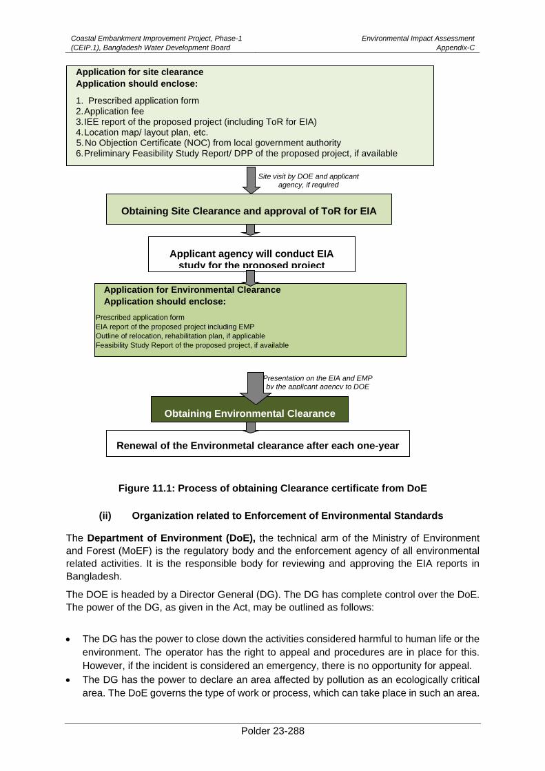
Coastal Embankment Improvement Project, Phase-1
(CEIP.1), Bangladesh Water Development Board
Environmental Impact Assessment
Appendix-C
Polder 23-288
Figure 11.1: Process of obtaining Clearance certificate from DoE
(ii) Organization related to Enforcement of Environmental Standards
The Department of Environment (DoE), the technical arm of the Ministry of Environment
and Forest (MoEF) is the regulatory body and the enforcement agency of all environmental
related activities. It is the responsible body for reviewing and approving the EIA reports in
Bangladesh.
The DOE is headed by a Director General (DG). The DG has complete control over the DoE.
The power of the DG, as given in the Act, may be outlined as follows:
• The DG has the power to close down the activities considered harmful to human life or the
environment. The operator has the right to appeal and procedures are in place for this.
However, if the incident is considered an emergency, there is no opportunity for appeal.
• The DG has the power to declare an area affected by pollution as an ecologically critical
area. The DoE governs the type of work or process, which can take place in such an area.
Applicant agency will conduct EIA study for the proposed project
Obtaining Environmental Clearance
Renewal of the Environmetal clearance after each one-year period
Obtaining Site Clearance and approval of ToR for EIA
Application for Environmental Clearance
Application should enclose:
Prescribed application form
EIA report of the proposed project including EMP
Outline of relocation, rehabilitation plan, if applicable
Feasibility Study Report of the proposed project, if available
Application for site clearance
Application should enclose:
1. Prescribed application form 2.Application fee 3.IEE report of the proposed project (including ToR for EIA) 4.Location map/ layout plan, etc. 5.No Objection Certificate (NOC) from local government authority 6.Preliminary Feasibility Study Report/ DPP of the proposed project, if available
Presentation on the EIA and EMP by the applicant agency to DOE
Site visit by DOE and applicant agency, if required
Coastal Embankment Improvement Project, Phase-1
(CEIP.1), Bangladesh Water Development Board
Environmental Impact Assessment
Appendix-C
Polder 23-289
• Before undertaking any new development project, the project proponent must take an
Environmental Clearance from the DoE. The procedures to take such clearance are in
place.
Failure to comply with any part of ECA 1995 may result in punishment by a maximum of 10
years imprisonment or a maximum fine of Tk. 1000,000 or both.
World Bank's Environmental Safeguard Policies
(i) Environmental Assessment (OP 4.01)
EA requirement. The World Bank requires environmental assessment (EA) of projects
proposed for Bank support to ensure that they are environmentally sound and sustainable,
and thus to improve decision making. The Bank Policy OP 4.01 considers that EA is a process
whose breadth, depth, and type of analysis depend on the nature, scale, and potential
environmental impact of the proposed project. EA evaluates a project's potential
environmental risks and impacts in its area of influence; examines project alternatives;
identifies ways of improving project selection, siting, planning, design, and implementation by
preventing, minimizing, mitigating, or compensating for adverse environmental impacts and
enhancing positive impacts; and includes the process of mitigating and managing adverse
environmental impacts throughout the project implementation period. EA takes into account
the natural environment (air, water and land); human health and safety; social aspects
(involuntary resettlement, indigenous peoples and physical cultural resources); and trans-
boundary and global environmental aspects. The Bank Policy also envisages that the borrower
Government is responsible for carrying out the EA and the Bank advises the borrower on the
Bank's EA requirements.
The present EIA has been carried out in compliance with this Operational Policy(OP).
EA classification. The World Bank classifies the proposed project into oneof the four
categories, depending on the type, location, sensitivity, and scale of the project and the nature
and magnitude of its potential environmental impacts. These categories are defined below.
Category A: A proposed project is classified as Category A if it is likely to have significant
adverse environmental impacts that are sensitive, diverse, or unprecedented. These impacts
may affect an area broader than the sites or facilities subject to physical works.
Category B: A proposed project is classified as Category B if its potential adverse
environmental impacts on human populations or environmentally important areas--including
wetlands, forests, grasslands, and other natural habitats--are less adverse than those of
Category A projects.
Category C: A proposed project is classified as Category C if it is likely to have minimal or no
adverse environmental impacts. Beyond screening, no further EA action is required for a
Category C project.
Category F: A proposed project is classified as Category F if it involves investment of Bank
funds through a financial intermediary, in subprojects that may result in adverse environmental
impacts.
The proposed CEIP-1has been classified as Category A, since some of the potential impacts
are likely to be significant and diverse.
(ii) Natural Habitats (OP 4.04)
Coastal Embankment Improvement Project, Phase-1
(CEIP.1), Bangladesh Water Development Board
Environmental Impact Assessment
Appendix-C
Polder 23-290
The Policy describes the conservation of natural habitats, like other measures that protect and
enhance the environment, to be essential for long-term sustainable development. The Bank
therefore supports the protection, maintenance, and rehabilitation of natural habitats and their
functions in its economic and sector work, project financing, and policy dialogue. The Bank
also supports, and expects borrowers to apply a precautionary approach to natural resource
management to ensure opportunities for environmentally sustainable development. The Bank-
promotes and supports natural habitat conservation and improved land use by financing
projects designed to integrate into national and regional development the conservation of
natural habitats and the maintenance of ecological functions. Furthermore, the Bank promotes
the rehabilitation of degraded natural habitats. The Bank does not support projects that involve
the significant conversion or degradation of critical natural habitats.
The WBOP 4.04 is triggered for the proposed Project. However, the proposed activities will
be undertaken in an area where natural habitat has already been modified to farm lands and
built-up area. Furthermore, appropriate control measures have been incorporated in the
environmental management plan (provided later in the document) to prevent any potential
impacts of the Project on the nearby foreshore area.
(iii) Water Resources Management (OP 4.07)
Through this Policy, the Bank seeks to support operations that provide potable water,
sanitation facilities, flood control, and water for productive activities in a manner that is
economically viable, environmentally sustainable, and socially equitable. The Bank assists
borrowers in many priority areas, among which developing a comprehensive framework for
designing water resource investments, policies, and institutions is very important. Within this
framework, when the borrower develops and allocates water resources, it considers cross-
sectoral impacts in a regional setting (e.g., a river basin). Restoring and preserving aquatic
ecosystems and guarding against overexploitation of groundwater resources are also given
priority to the provision of adequate water and sanitation services for the poor. Furthermore,
special attentions are needed by the borrowers to avoid the water logging and salinity
problems associated with irrigation investments by (i) monitoring water tables and
implementing drainage networks where necessary, and (ii) adopting best management
practices to control water pollution.
The proposed Project seeks to address several of the Policy objectives particularly those
relating to flood control and water resource management for productive activities.
(iv) Physical Cultural Resources (OP 4.11)
The World Bank’s general policy regarding cultural properties is to assist in their preservation,
and to seek to avoid their elimination. The specific aspects of the Policy are given below. 15
• The Bank normally declines to finance projects that will significantly damage non-
replicable cultural property, and will assist only those projects that are sited or designed
so as to prevent such damage.
• The Bank will assist in the protection and enhancement of cultural properties
encountered in Bank-financed projects, rather than leaving that protection to chance.
In some cases, the project is best relocated in order that sites and structures can be
preserved, studied, and restored intact in situ. In other cases, structures can be
relocated, preserved, studied, and restored on alternate sites. Often, scientific study,
15Excerpts from the OPN 11.03. WB Operational Manual. September 1986.
Coastal Embankment Improvement Project, Phase-1
(CEIP.1), Bangladesh Water Development Board
Environmental Impact Assessment
Appendix-C
Polder 23-291
selective salvage, and museum preservation before destruction is all that is necessary.
Most such projects should include the training and strengthening of institutions
entrusted with safeguarding a nation’s cultural patrimony. Such activities should be
directly included in the scope of the project, rather than being postponed for some
possible future action, and the costs are to be internalized in computing overall project
costs.
• Deviations from this policy may be justified only where expected project benefits are
great, and the loss of or damage to cultural property is judged by competent authorities
to be unavoidable, minor, or otherwise acceptable. Specific details of the justification
should be discussed in project documents.
• This policy pertains to any project in which the Bank is involved, irrespective of whether
the Bank is itself financing the part of the project that may affect cultural property.
This OP is not triggered since no cultural or archaeological resources are known to exist in
the vicinity of the Project nor have any such resources been identified during field
investigations. However, ‘chance find’ procedures will be implemented in the EMP.
(v) Forestry (OP 4.36)
This Policy recognizes the need to reduce deforestation and promote sustainable forest
conservation and management in reducing poverty. The Bank believes that forests are very
much essential for poverty reduction and sustainable development irrespective of their
location in the world. The Bank assists borrowers with forest restoration activities that maintain
or enhance biodiversity and ecosystem functionality. The Bank also assists borrowers with the
establishment and sustainable management of environmentally appropriate, socially
beneficial, and economically viable forest plantations to help meet growing demands for forest
goods and services. The Bank does not finance projects that, in its opinion, would involve
significant conversion or degradation of critical forest areas or related critical natural habitats.
Furthermore, the Bank does not finance projects that contravene applicable international
environmental agreements.
Though this OP is triggered during the concept development stage, the proposed Project is
not located in any forested area and will therefore not have any direct impact on forests.
(vi) Projects on International Waterways (OP 7.50)
Projects on international waterways may affect the relations between the WB and its
borrowers, and between riparian states. Therefore, the Bank attaches great importance to the
riparian making appropriate agreements or arrangements for the entire waterway, or parts
thereof, and stands ready to assist in this regard. A borrower must notify other riparian of
planned projects that could affect water quality or quantity, sufficiently far in advance to allow
them to review the plans and raise any concerns or objections.
(vii) Pest Management (OP 4.09)
Through this OP, the WB supports a strategy that promotes use of biological or environmental
control methods and reduces reliance on synthetic chemical pesticides. Rural development
and health sector projects have to avoid using harmful pesticides. Other pesticides can be
used, but only as an element of an Integrated Pest Management Plan (IPMP) that emphasizes
environmental and biological controls.
(viii) Indigenous Peoples (OP 4.10)
Coastal Embankment Improvement Project, Phase-1
(CEIP.1), Bangladesh Water Development Board
Environmental Impact Assessment
Appendix-C
Polder 23-292
For purposes of this Policy, the term ‘Indigenous Peoples’ is used in a generic sense to refer
to a distinct, vulnerable, social and cultural group possessing the following characteristics in
varying degrees:16
• self-identification as members of a distinct indigenous cultural group and recognition
of this identity by others;
• collective attachment to geographically distinct habitats or ancestral territories in the
project area and to the natural resources in these habitats and territories;
• customary cultural, economic, social, or political institutions that are separate from
those of the dominant society and culture; and
• an indigenous language, often different from the official language of the country or
region.
The OP defines the process to be followed if the project affects the indigenous people.
No indigenous people - with a social and cultural identity distinct from the dominant society
that makes them vulnerable to being disadvantaged in the development process – are known
to exist in the Project area. Therefore, this OP is not triggered.
However, if such groups are identified during the Project implementation, the proponents will
develop an Indigenous People Development Plan, in compliance with the OP and get it
approved by the Bank.
(ix) Involuntary Resettlement (OP 4.12)
The WB’s experience indicates that involuntary resettlement under development projects, if
unmitigated, often gives rise to severe economic, social, and environmental risks: production
systems are dismantled; people face impoverishment when their productive assets or income
sources are lost; people are relocated to environments where their productive skills may be
less applicable and the competition for resources greater; community institutions and social
networks are weakened; kin groups are dispersed; and cultural identity, traditional authority,
and the potential for mutual help are diminished or lost. This policy includes safeguards to
address and mitigate these impoverishment risks.17
The overall objectives of the Policy are given below.
• Involuntary resettlement should be avoided where feasible, or minimized, exploring all
viable alternative project designs.
• Where it is not feasible to avoid resettlement, resettlement activities should be
conceived and executed as sustainable development programs, providing sufficient
investment resources to enable the persons displaced by the project to share in project
benefits. Displaced persons should be meaningfully consulted and should have
opportunities to participate in planning and implementing resettlement programs.
• Displaced persons should be assisted in their efforts to improve their livelihoods and
standards of living or at least to restore them, in real terms, to pre-displacement levels
or to levels prevailing prior to the beginning of project implementation, whichever is
higher.
16Excerpts from the OP 4.10. WB Operational Manual. July 2005.
17Excerpts from WB OP 4.12. WB Operational Manual. December 2001.

Coastal Embankment Improvement Project, Phase-1
(CEIP.1), Bangladesh Water Development Board
Environmental Impact Assessment
Appendix-C
Polder 23-293
Since the proposed Project will involve land acquisition as well as displacement of houses and
other assets, a Resettlement Action Plan (RAP) has been prepared, under a separate cover,
in accordance with this Policy.
(x) Projects in Disputed Areas (OP 7.60)
Projects in disputed areas may raise a number of delicate problems affecting relations not only
between the Bank and its member countries, but also between the borrower and one or more
neighboring countries. In order not to prejudice the position of either the Bank or the countries
concerned, any dispute over an area in which a proposed project is located is dealt with at the
earliest possible stage.
The Bank may proceed with a project in a disputed area if the governments concerned agree
that, pending the settlement of the dispute, the project proposed for country A should go
forward without prejudice to the claims of country B. 18
This OP is not triggered since no part of the Project area is located in any disputed territory.
(xi) Safety of Dams (OP 4.37)
The Policy seeks to ensure that appropriate measures are taken and sufficient resources
provided for the safety of dams that the WB finances. However, this OP is not relevant since
the proposed Project does not involve construction of dams.
(xii) Public Disclosure of Information (BP 17.50)
This BP deals with the World Bank policy on disclosure of information. It is a mandatory
procedure to be followed by the borrower and Bank and supports public access to information
on environmental and social aspects of projects.
Once finalized, the EIA report will be disclosed to the public and will also be available on the
official website of the BWDB. EIA will also be sent to the WB InfoShop.
(xiii) Environment, Health and Safety Guidelines
The Environment, Health, and Safety (EHS)19 Guidelines contain the performance levels and
measures that are generally considered to be achievable in new facilities or project by existing
technology at reasonable costs. These Guidelines will be applicable to the Project.
(C) World Bank's Environmental Safeguard Policies
(xiv) Environmental Assessment (OP 4.01)
EA requirement. The World Bank requires environmental assessment (EA) of projects
proposed for Bank support to ensure that they are environmentally sound and sustainable,
and thus to improve decision making. The Bank Policy OP 4.01 considers that EA is a process
whose breadth, depth, and type of analysis depend on the nature, scale, and potential
environmental impact of the proposed project. EA evaluates a project's potential
environmental risks and impacts in its area of influence; examines project alternatives;
identifies ways of improving project selection, siting, planning, design, and implementation by
preventing, minimizing, mitigating, or compensating for adverse environmental impacts and
enhancing positive impacts; and includes the process of mitigating and managing adverse
environmental impacts throughout the project implementation period. EA takes into account
18Excerpts from the OP 7.60. WB Operational Manual. November 1994.
19 Environmental, Health and Safety Guidelines. IFC/WB Group, April 30, 2007.
Coastal Embankment Improvement Project, Phase-1
(CEIP.1), Bangladesh Water Development Board
Environmental Impact Assessment
Appendix-C
Polder 23-294
the natural environment (air, water and land); human health and safety; social aspects
(involuntary resettlement, indigenous peoples and physical cultural resources); and trans-
boundary and global environmental aspects. The Bank Policy also envisages that the borrower
Government is responsible for carrying out the EA and the Bank advises the borrower on the
Bank's EA requirements.
The present EIA has been carried out in compliance with thisOperational Policy( OP).
EA classification. The World Bank classifies the proposed project into oneof the four
categories, depending on the type, location, sensitivity, and scale of the project and the nature
and magnitude of its potential environmental impacts. These categories are defined below.
Category A: A proposed project is classified as Category A if it is likely to have significant
adverse environmental impacts that are sensitive, diverse, or unprecedented. These impacts
may affect an area broader than the sites or facilities subject to physical works.
Category B: A proposed project is classified as Category B if its potential adverse
environmental impacts on human populations or environmentally important areas--including
wetlands, forests, grasslands, and other natural habitats--are less adverse than those of
Category A projects.
Category C: A proposed project is classified as Category C if it is likely to have minimal or no
adverse environmental impacts. Beyond screening, no further EA action is required for a
Category C project.
Category F: A proposed project is classified as Category F if it involves investment of Bank
funds through a financial intermediary, in subprojects that may result in adverse environmental
impacts.
The proposed CEIP-I has been classified as Category A, since some of the potential impacts
are likely to be significant and diverse.
(xv) Natural Habitats (OP 4.04)
The Policy describes the conservation of natural habitats, like other measures that protect and
enhance the environment, to be essential for long-term sustainable development. The Bank
therefore supports the protection, maintenance, and rehabilitation of natural habitats and their
functions in its economic and sector work, project financing, and policy dialogue. The Bank
also supports, and expects borrowers to apply a precautionary approach to natural resource
management to ensure opportunities for environmentally sustainable development. The Bank-
promotes and supports natural habitat conservation and improved land use by financing
projects designed to integrate into national and regional development the conservation of
natural habitats and the maintenance of ecological functions. Furthermore, the Bank promotes
the rehabilitation of degraded natural habitats. The Bank does not support projects that involve
the significant conversion or degradation of critical natural habitats.
The WBOP 4.04 is triggered for the proposed Project. However, the proposed activities will
be undertaken in an area where natural habitat has already been modified to farm lands and
built-up area. Furthermore, appropriate control measures have been incorporated in the
environmental management plan (provided later in the document) to prevent any potential
impacts of the Project on the nearby foreshore area.
(xvi) Water Resources Management (OP 4.07)
Through this Policy, the Bank seeks to support operations that provide potable water,
sanitation facilities, flood control, and water for productive activities in a manner that is
economically viable, environmentally sustainable, and socially equitable. The Bank assists
Coastal Embankment Improvement Project, Phase-1
(CEIP.1), Bangladesh Water Development Board
Environmental Impact Assessment
Appendix-C
Polder 23-295
borrowers in many priority areas, among which developing a comprehensive framework for
designing water resource investments, policies, and institutions is very important. Within this
framework, when the borrower develops and allocates water resources, it considers cross-
sectoral impacts in a regional setting (e.g., a river basin). Restoring and preserving aquatic
ecosystems and guarding against overexploitation of groundwater resources are also given
priority to the provision of adequate water and sanitation services for the poor. Furthermore,
special attentions are needed by the borrowers to avoid the water logging and salinity
problems associated with irrigation investments by (i) monitoring water tables and
implementing drainage networks where necessary, and (ii) adopting best management
practices to control water pollution.
The proposed Project seeks to address several of the Policy objectives particularly those
relating to flood control and water resource management for productive activities.
(xvii) Physical Cultural Resources (OP 4.11)
The World Bank’s general policy regarding cultural properties is to assist in their preservation,
and to seek to avoid their elimination. The specific aspects of the Policy are given below. 20
• The Bank normally declines to finance projects that will significantly damage
non-replicable cultural property, and will assist only those projects that are sited
or designed so as to prevent such damage.
• The Bank will assist in the protection and enhancement of cultural properties
encountered in Bank-financed projects, rather than leaving that protection to
chance. In some cases, the project is best relocated in order that sites and
structures can be preserved, studied, and restored intact in situ. In other cases,
structures can be relocated, preserved, studied, and restored on alternate
sites. Often, scientific study, selective salvage, and museum preservation
before destruction is all that is necessary. Most such projects should include
the training and strengthening of institutions entrusted with safeguarding a
nation’s cultural patrimony. Such activities should be directly included in the
scope of the project, rather than being postponed for some possible future
action, and the costs are to be internalized in computing overall project costs.
• Deviations from this policy may be justified only where expected project
benefits are great, and the loss of or damage to cultural property is judged by
competent authorities to be unavoidable, minor, or otherwise acceptable.
Specific details of the justification should be discussed in project documents.
• This policy pertains to any project in which the Bank is involved, irrespective of
whether the Bank is itself financing the part of the project that may affect
cultural property.
This OP is not triggered since no cultural or archaeological resources are known to exist in
the vicinity of the Project nor have any such resources been identified during field
investigations. However, ‘chance find’ procedures will be implemented in the EMP.
(xviii) Forestry (OP 4.36)
This Policy recognizes the need to reduce deforestation and promote sustainable forest
conservation and management in reducing poverty. The Bank believes that forests are very
much essential for poverty reduction and sustainable development irrespective of their
20 Excerpts from the OPN 11.03. WB Operational Manual. September 1986.
Coastal Embankment Improvement Project, Phase-1
(CEIP.1), Bangladesh Water Development Board
Environmental Impact Assessment
Appendix-C
Polder 23-296
location in the world. The Bank assists borrowers with forest restoration activities that maintain
or enhance biodiversity and ecosystem functionality. The Bank also assists borrowers with the
establishment and sustainable management of environmentally appropriate, socially
beneficial, and economically viable forest plantations to help meet growing demands for forest
goods and services. The Bank does not finance projects that, in its opinion, would involve
significant conversion or degradation of critical forest areas or related critical natural habitats.
Furthermore, the Bank does not finance projects that contravene applicable international
environmental agreements.
Though this OP is triggered during the concept development stage, the proposed Project is
not located in any forested area and will therefore not have any direct impact on forests.
(xix) Projects on International Waterways (OP 7.50)
Projects on international waterways may affect the relations between the WB and its
borrowers, and between riparian states. Therefore, the Bank attaches great importance to the
riparian making appropriate agreements or arrangements for the entire waterway, or parts
thereof, and stands ready to assist in this regard. A borrower must notify other riparian of
planned projects that could affect water quality or quantity, sufficiently far in advance to allow
them to review the plans and raise any concerns or objections.
(xx) Pest Management (OP 4.09)
Through this OP, the WB supports a strategy that promotes use of biological or environmental
control methods and reduces reliance on synthetic chemical pesticides. Rural development
and health sector projects have to avoid using harmful pesticides. Other pesticides can be
used, but only as an element of an Integrated Pest Management Plan (IPMP) that emphasizes
environmental and biological controls.
(xxi) Indigenous Peoples (OP 4.10)
For purposes of this Policy, the term ‘Indigenous Peoples’ is used in a generic sense to refer
to a distinct, vulnerable, social and cultural group possessing the following characteristics in
varying degrees:21
• self-identification as members of a distinct indigenous cultural group and
recognition of this identity by others;
• collective attachment to geographically distinct habitats or ancestral territories
in the project area and to the natural resources in these habitats and territories;
• customary cultural, economic, social, or political institutions that are separate
from those of the dominant society and culture; and
• an indigenous language, often different from the official language of the country
or region.
The OP defines the process to be followed if the project affects the indigenous people. No
indigenous people - with a social and cultural identity distinct from the dominant society that
makes them vulnerable to being disadvantaged in the development process – are known to
exist in the Project area. Therefore this OP is not triggered.
However, if such groups are identified during the Project implementation, the proponents will
develop an Indigenous People Development Plan, in compliance with the OP and get it
approved by the Bank.
21 Excerpts from the OP 4.10. WB Operational Manual. July 2005.
Coastal Embankment Improvement Project, Phase-1
(CEIP.1), Bangladesh Water Development Board
Environmental Impact Assessment
Appendix-C
Polder 23-297
(xxii) Involuntary Resettlement (OP 4.12)
The WB’s experience indicates that involuntary resettlement under development projects, if
unmitigated, often gives rise to severe economic, social, and environmental risks: production
systems are dismantled; people face impoverishment when their productive assets or income
sources are lost; people are relocated to environments where their productive skills may be less
applicable and the competition for resources greater; community institutions and social networks
are weakened; kin groups are dispersed; and cultural identity, traditional authority, and the
potential for mutual help are diminished or lost. This policy includes safeguards to address and
mitigate these impoverishment risks.22
The overall objectives of the Policy are given below.
• Involuntary resettlement should be avoided where feasible, or minimized,
exploring all viable alternative project designs.
• Where it is not feasible to avoid resettlement, resettlement activities should be
conceived and executed as sustainable development programs, providing
sufficient investment resources to enable the persons displaced by the project
to share in project benefits. Displaced persons should be meaningfully
consulted and should have opportunities to participate in planning and
implementing resettlement programs.
• Displaced persons should be assisted in their efforts to improve their livelihoods
and standards of living or at least to restore them, in real terms, to pre-
displacement levels or to levels prevailing prior to the beginning of project
implementation, whichever is higher.
Since the proposed Project will involve land acquisition as well as displacement of houses and
other assets, a Resettlement Action Plan (RAP) has been prepared, under a separate cover,
in accordance with this Policy.
(xxiii) Projects in Disputed Areas (OP 7.60)
Projects in disputed areas may raise a number of delicate problems affecting relations not only
between the Bank and its member countries, but also between the borrower and one or more
neighboring countries. In order not to prejudice the position of either the Bank or the countries
concerned, any dispute over an area in which a proposed project is located is dealt with at the
earliest possible stage.
The Bank may proceed with a project in a disputed area if the governments concerned agree
that, pending the settlement of the dispute, the project proposed for country A should go
forward without prejudice to the claims of country B. 23
This OP is not triggered since no part of the Project area is located in any disputed territory.
(xxiv) Safety of Dams (OP 4.37)
The Policy seeks to ensure that appropriate measures are taken and sufficient resources
provided for the safety of dams that the WB finances. However this OP is not relevant since
the proposed Project does not involve construction of dams.
(xxv) Public Disclosure of Information (BP 17.50)
22 Excerpts from WB OP 4.12. WB Operational Manual. December 2001.
23 Excerpts from the OP 7.60. WB Operational Manual. November 1994.

Coastal Embankment Improvement Project, Phase-1
(CEIP.1), Bangladesh Water Development Board
Environmental Impact Assessment
Appendix-C
Polder 23-298
This BP deals with the World Bank policy on disclosure of information. It is a mandatory
procedure to be followed by the borrower and Bank and supports public access to information
on environmental and social aspects of projects.
Once finalized, the EIA report will be disclosed to the public and will also be available on the
official website of the BWDB. EIA will also be sent to the WB InfoShop.
(xxvi) Environment, Health and Safety Guidelines
The Environment, Health, and Safety (EHS)24 Guidelines contain the performance levels and
measures that are generally considered to be achievable in new facilities or project by existing
technology at reasonable costs. These Guidelines will be applicable to the Project.
24 Environmental, Health and Safety Guidelines. IFC/WB Group, April 30, 2007.
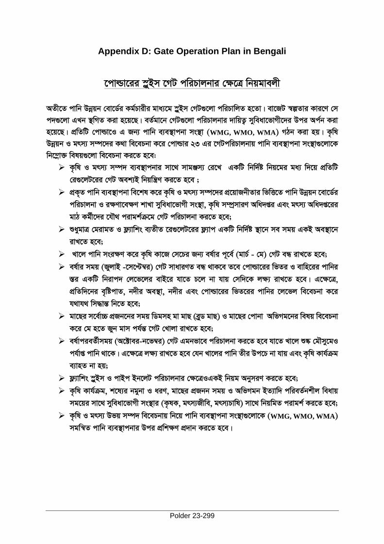
Polder 23-299
Appendix D: Gate Operation Plan in Bengali
‡cvìv‡ii ¯øyBm ‡MU cwiPvjbvi †ÿ‡Î wbqgvejx
AZx‡Z cvwb Dbœqb †ev‡W©i Kg©Pvixi gva¨‡g øyBm †MU¸‡jv cwiPvwjZ n‡Zv| ev‡RU ¯íZvi Kvi‡Y †m
c`¸‡jv GLb ’wMZ Kiv n‡q‡Q| eZ©gv‡b †MU¸‡jv cwiPvjbvi `vwqZ¡ myweav‡fvMx‡`i Dci Ac©b Kiv
n‡q‡Q| cÖwZwU †cvìv‡I G Rb¨ cvwb e¨e¯’vcbv ms ’v (WMG, WMO, WMA) MVb Kiv nq| K…wl
Dbœqb I grm¨ m¤ú‡`i K_v we‡ePbv K‡i †cvìvi 23 Gi ‡MUcwiPvjbvq cvwb e¨e¯’vcbv ms ’v¸‡jv‡K
wb‡¤œv³ welq¸‡jv we‡ePbv Ki‡Z n‡e:
➢ K…wl I grm¨ m¤ú` e¨e ’vcbvi mv‡_ mvgÄm¨ †i‡L GKwU wbw ©ó wbq‡gi ga¨ w`‡q cÖwZwU
†i¸‡jU‡ii †MU Aek¨B wbqwš¿Y Ki‡Z n‡e ;
➢ cÖK„Z cvwb e¨e ’vcbv we‡kl K‡i K…wl I grm¨ m¤ú‡`i cÖ‡qvRbxZvi wfwˇZ cvwb Dbœqb ‡ev‡W©i
cwiPvjbv I iÿYv‡eÿY kvLv myweav‡fvMx ms ’v, K…wl m¤úªmviY Awa`ßi Ges grm¨ Awa`߇ii
gvV Kg©x‡`i ‡hŠ_ civgk©µ‡g †MU cwiPvjbv Ki‡Z n‡e;
➢ ïaygvÎ †givgZ I d¬¨vwks e¨ZxZ ‡i¸‡jU‡ii d¬¨vc GKwU wbw ©ó ’v‡b me mgq GKB Ae ’v‡b
ivL‡Z n‡e;
➢ Lv‡j cvwb msiÿY K‡i K…wl Kv‡R †m‡Pi Rb¨ el©vi c~‡e© (gvP© - †g) †MU eÜ ivL‡Z n‡e;
➢ el©vi mgq (RyjvB -‡m‡Þ¤i) †MU mvaviYZ eÜ _vK‡e Z‡e †cvìv‡ii wfZi I evwn‡ii cvwbi
¯Íi GKwU wbivc` †j‡f‡ji evB‡i hv‡Z P‡j bv hvq †mw`‡K jÿ¨ ivL‡Z n‡e| G‡ÿ‡Î,
cÖwZw`‡bi e„wócvZ, b`xi Ae ’v, b`xi Ges †cvìv‡ii wfZ‡ii cvwbi ‡j‡fj we‡ePbv K‡i
h_vh_ wm×všÍ wb‡Z n‡e;
➢ gv‡Qi m‡e©v”P cÖRb‡bi mgq wWgmn gv gvQ (eyªW gvQ) I gv‡Qi †cvbv AwfMg‡bi welq we‡ePbv
K‡i †g n‡Z Ryb gvm ch©šÍ ‡MU †Lvjv ivL‡Z n‡e;
➢ el©vcieZ©xmgq (A‡±vei-b‡f¤i) †MU Ggbfv‡e cwiPvjbv Ki‡Z n‡e hv‡Z Lv‡j ﮋ †gŠmy‡gI
ch©vß cvwb _v‡K| G‡ÿ‡Î jÿ¨ ivL‡Z n‡e †hb Lv‡ji cvwb Zxi Dc‡P bv hvq Ges K…wl Kvh©µg
e¨vnZ bv nq;
➢ d¬¨vwks ¯øyBm I cvBc Bb‡jU cwiPvjbvi †ÿ‡ÎIGKB wbqg AbymiY Ki‡Z n‡e;
➢ K…wl Kvh©µg, k‡l¨i bgybv I aiY, gv‡Qi cÖRbb mgq I AwfMgb BZ¨vw` cwieZ©bkxj weavq
mg‡qi mv‡_ myweav‡fvMx ms¯’vi (K…lK, grm¨Rxwe, grm¨Pvwl) mv‡_ wbqwgZ civgk© Ki‡Z n‡e;
➢ K…wl I grm¨ Dfq m¤ú` we‡ePbvq wb‡q cvwb e¨e ’vcbv ms ’v¸‡jv‡K (WMG, WMO, WMA)
mgwšZ cvwb e¨e ’vcbvi Dci cÖwkÿY cÖ`vb Ki‡Z n‡e|
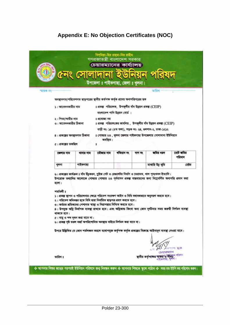
Polder 23-300
Appendix E: No Objection Certificates (NOC)
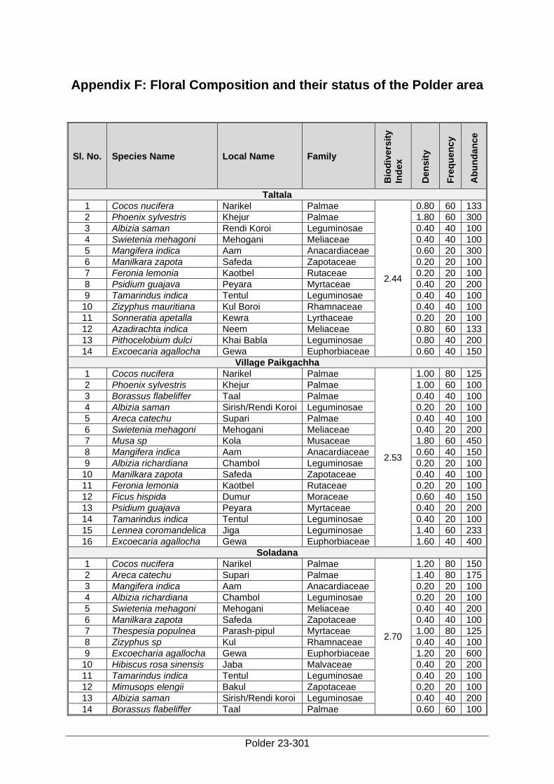
Polder 23-301
Appendix F: Floral Composition and their status of the Polder area
Sl. No. Species Name Local Name Family
Bio
div
ers
ity
Ind
ex
Den
sit
y
Fre
qu
en
cy
Ab
un
dan
ce
Taltala
1 Cocos nucifera Narikel Palmae
2.44
0.80 60 133
2 Phoenix sylvestris Khejur Palmae 1.80 60 300
3 Albizia saman Rendi Koroi Leguminosae 0.40 40 100
4 Swietenia mehagoni Mehogani Meliaceae 0.40 40 100
5 Mangifera indica Aam Anacardiaceae 0.60 20 300
6 Manilkara zapota Safeda Zapotaceae 0.20 20 100
7 Feronia lemonia Kaotbel Rutaceae 0.20 20 100
8 Psidium guajava Peyara Myrtaceae 0.40 20 200
9 Tamarindus indica Tentul Leguminosae 0.40 40 100
10 Zizyphus mauritiana Kul Boroi Rhamnaceae 0.40 40 100
11 Sonneratia apetalla Kewra Lyrthaceae 0.20 20 100
12 Azadirachta indica Neem Meliaceae 0.80 60 133
13 Pithocelobium dulci Khai Babla Leguminosae 0.80 40 200
14 Excoecaria agallocha Gewa Euphorbiaceae 0.60 40 150
Village Paikgachha
1 Cocos nucifera Narikel Palmae
2.53
1.00 80 125
2 Phoenix sylvestris Khejur Palmae 1.00 60 100
3 Borassus flabeliffer Taal Palmae 0.40 40 100
4 Albizia saman Sirish/Rendi Koroi Leguminosae 0.20 20 100
5 Areca catechu Supari Palmae 0.40 40 100
6 Swietenia mehagoni Mehogani Meliaceae 0.40 20 200
7 Musa sp Kola Musaceae 1.80 60 450
8 Mangifera indica Aam Anacardiaceae 0.60 40 150
9 Albizia richardiana Chambol Leguminosae 0.20 20 100
10 Manilkara zapota Safeda Zapotaceae 0.40 40 100
11 Feronia lemonia Kaotbel Rutaceae 0.20 20 100
12 Ficus hispida Dumur Moraceae 0.60 40 150
13 Psidium guajava Peyara Myrtaceae 0.40 20 200
14 Tamarindus indica Tentul Leguminosae 0.40 20 100
15 Lennea coromandelica Jiga Leguminosae 1.40 60 233
16 Excoecaria agallocha Gewa Euphorbiaceae 1.60 40 400
Soladana
1 Cocos nucifera Narikel Palmae
2.70
1.20 80 150
2 Areca catechu Supari Palmae 1.40 80 175
3 Mangifera indica Aam Anacardiaceae 0.20 20 100
4 Albizia richardiana Chambol Leguminosae 0.20 20 100
5 Swietenia mehagoni Mehogani Meliaceae 0.40 40 200
6 Manilkara zapota Safeda Zapotaceae 0.40 40 100
7 Thespesia populnea Parash-pipul Myrtaceae 1.00 80 125
8 Zizyphus sp Kul Rhamnaceae 0.40 40 100
9 Excoecharia agallocha Gewa Euphorbiaceae 1.20 20 600
10 Hibiscus rosa sinensis Jaba Malvaceae 0.40 20 200
11 Tamarindus indica Tentul Leguminosae 0.40 20 100
12 Mimusops elengii Bakul Zapotaceae 0.20 20 100
13 Albizia saman Sirish/Rendi koroi Leguminosae 0.40 40 200
14 Borassus flabeliffer Taal Palmae 0.60 60 100
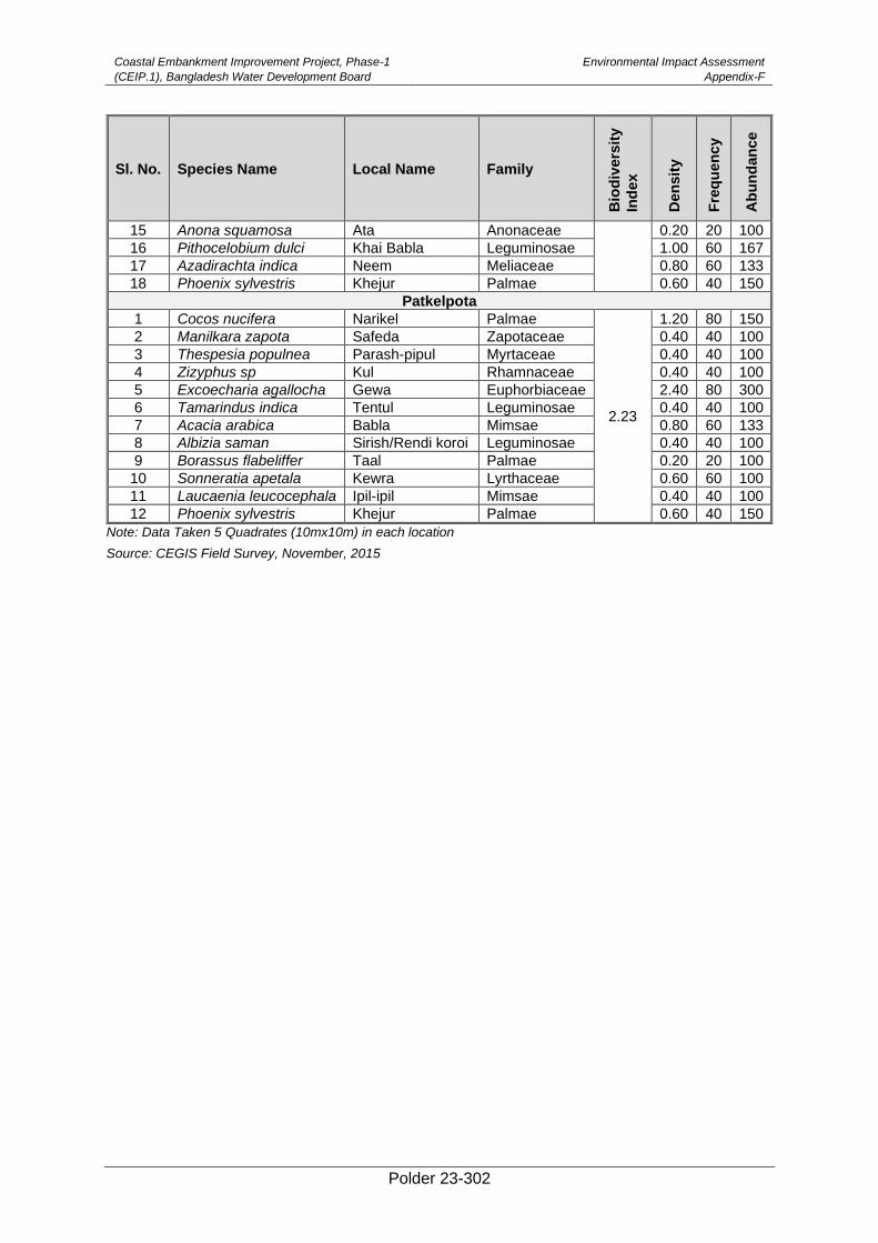
Coastal Embankment Improvement Project, Phase-1
(CEIP.1), Bangladesh Water Development Board
Environmental Impact Assessment
Appendix-F
Polder 23-302
Sl. No. Species Name Local Name Family
Bio
div
ers
ity
Ind
ex
Den
sit
y
Fre
qu
en
cy
Ab
un
dan
ce
15 Anona squamosa Ata Anonaceae 0.20 20 100
16 Pithocelobium dulci Khai Babla Leguminosae 1.00 60 167
17 Azadirachta indica Neem Meliaceae 0.80 60 133
18 Phoenix sylvestris Khejur Palmae 0.60 40 150
Patkelpota
1 Cocos nucifera Narikel Palmae
2.23
1.20 80 150
2 Manilkara zapota Safeda Zapotaceae 0.40 40 100
3 Thespesia populnea Parash-pipul Myrtaceae 0.40 40 100
4 Zizyphus sp Kul Rhamnaceae 0.40 40 100
5 Excoecharia agallocha Gewa Euphorbiaceae 2.40 80 300
6 Tamarindus indica Tentul Leguminosae 0.40 40 100
7 Acacia arabica Babla Mimsae 0.80 60 133
8 Albizia saman Sirish/Rendi koroi Leguminosae 0.40 40 100
9 Borassus flabeliffer Taal Palmae 0.20 20 100
10 Sonneratia apetala Kewra Lyrthaceae 0.60 60 100
11 Laucaenia leucocephala Ipil-ipil Mimsae 0.40 40 100
12 Phoenix sylvestris Khejur Palmae 0.60 40 150
Note: Data Taken 5 Quadrates (10mx10m) in each location
Source: CEGIS Field Survey, November, 2015
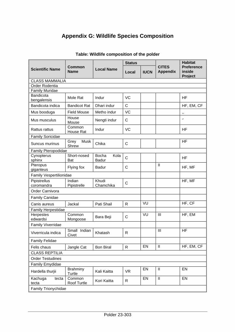
Polder 23-303
Appendix G: Wildlife Species Composition
Table: Wildlife composition of the polder
Scientific Name Common Name
Local Name
Status CITES Appendix
Habitat Preference inside Project
Local IUCN
CLASS MAMMALIA
Order Rodentia
Family Muridae
Bandicota bengalensis
Mole Rat Indur VC
HF
Bandicota indica Bandicot Rat Dhari indur C HF, EM, CF
Mus booduga Field Mouse Metho indur VC ,,
Mus musculus House Mouse
Nengti indur C
‘’
Rattus rattus Common House Rat
Indur VC
HF
Family Soricidae
Suncus murinus Grey Musk Shrew
Chika C HF
Family Pteropodidae
Cynopterus sphinx
Short-nosed Bat
Bocha Kola Badur
C
HF
Pteropus giganteus
Flying fox Badur C II
HF, MF
Family Vespertilionidae
Pipistrellus coromandra
Indian Pipistrelle
Khudi Chamchika
C HF, MF
Order Carnivora
Family Canidae
Canis aureus Jackal Pati Shail R VU HF, CF
Family Herpestidae
Herpestes edwardsi
Common Mongoose
Bara Beji C VU III HF, EM
Family Viverridae
Viverricula indica Small Indian Civet
Khatash R III HF
Family Felidae
Felis chaus Jangle Cat Bon Biral R EN II HF, EM, CF
CLASS REPTILIA
Order Testudines
Family Emydidae
Hardella thurjii Brahminy Turtle
Kali Kaitta VR EN II EN
Kachuga tecta tecta
Common Roof Turtle
Kori Kaitta R EN II EN
Family Trionychidae

Coastal Embankment Improvement Project, Phase-1
(CEIP.1), Bangladesh Water Development Board
Environmental Impact Assessment
Appendix-G
Polder 23-304
Scientific Name Common Name
Local Name
Status CITES Appendix
Habitat Preference inside Project
Local IUCN
Lissemys punctata punctata
Flap-shelled Spotted Turtle
Sundi Kachap R VU III WL
Order Sauria
Family Gekkonidae
Hemidactylus brooki
House Lizard Tiktiki VC
HF
Hemidactylus frenatus
Common Lizard
Tiktiki C
HF
Family Agamidae
Calotes versicolor Garden Lizard
Raktochusa C HF, EM,
CF,MF
Mabuya carinata Common Skink
Anjan O
HF,CF,WL
Family Varanidar
Varanus bengalensis
Bengal Grey Monitor
Gui Shap O VU I
HF, MF
Varanus flavescens
Yellow Common Monitor
Shona Gui O EN I
WL
Order Serpentes
Family Dipradidae
Lycodon jara Yellow Wolf Snake
Ghorginni C HF, CF
Family Natricidae
Amphiesma stolata
Stripes Keelback
Dora Sap C
HF, WL
Atretium schistosum
Olive Keelback
Mete Sap O
HF
Xenochrophis cerasogaster
Dark-bellied Marsh Snake
Kalo Mete Dora
R VU
HF, WL
Xenochrophis piscator
Checkered Keelback
Dhora Sap C
HF, WL
Family Colubridae
Ahaetulla nasutus Common Vine Snake
Laodoga C VU
HF, CF, MF
Ptyas mucosus Rat Snake Daraj/Darash C II HF, CF
Family Homalopsidae
Cerberus rhynchops
Dog-faced Water Snake
Jalbora C VU
WL, CF
Enhydris enhydris Smooth Water Snake
Pyna Sap C
WL
Family Elaphidae
Bungarus caeruleus
Common Krait
Kal Keotey R
R HF
Bungarus fasiciatus
Banded Krait Sankini VR
VR HF, MF
Naja naja kaouthia Monocellate Cobra
Gokhra R VU
HF
Naja naja naja Binocellate Cobra
Khoia Gokhra R EN II
HF
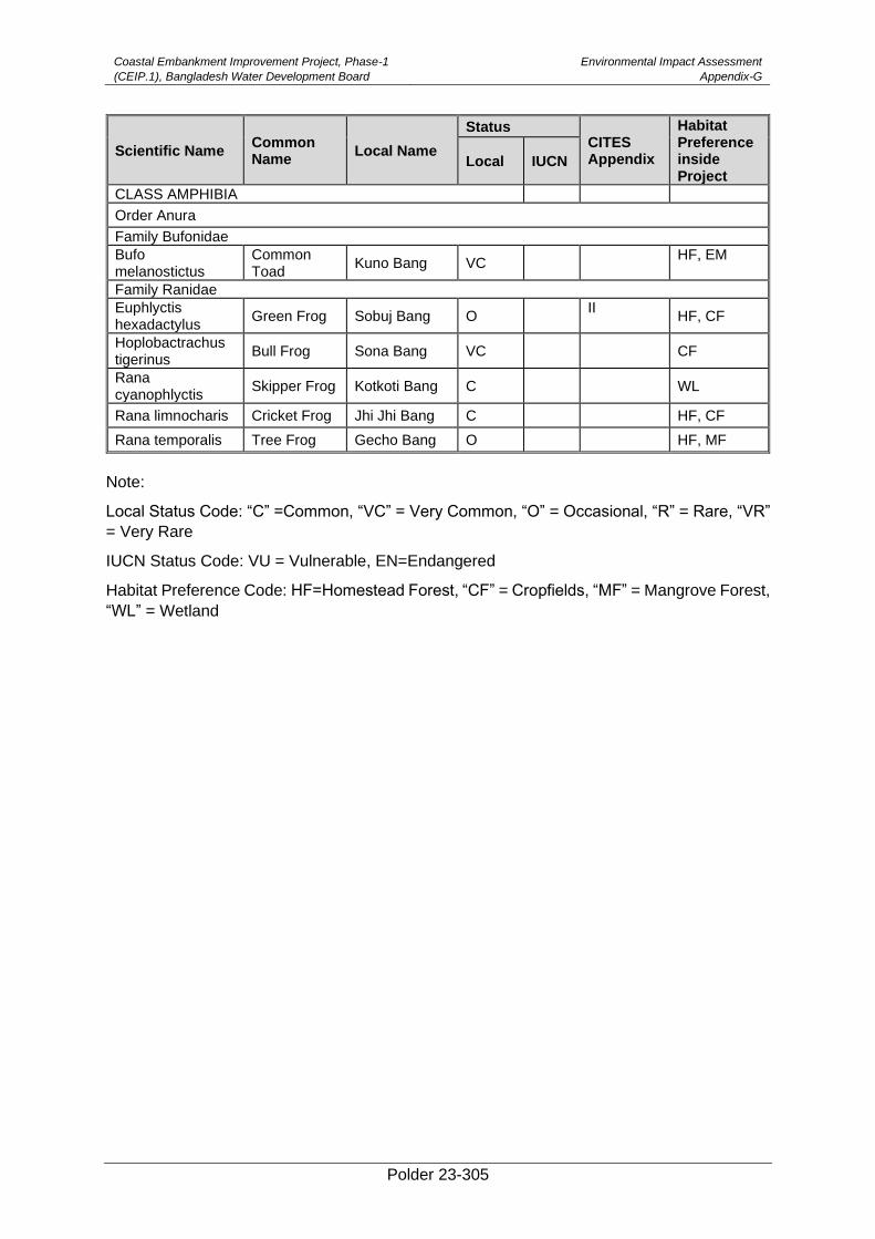
Coastal Embankment Improvement Project, Phase-1
(CEIP.1), Bangladesh Water Development Board
Environmental Impact Assessment
Appendix-G
Polder 23-305
Scientific Name Common Name
Local Name
Status CITES Appendix
Habitat Preference inside Project
Local IUCN
CLASS AMPHIBIA
Order Anura
Family Bufonidae
Bufo melanostictus
Common Toad
Kuno Bang VC HF, EM
Family Ranidae
Euphlyctis hexadactylus
Green Frog Sobuj Bang O II
HF, CF
Hoplobactrachus tigerinus
Bull Frog Sona Bang VC
CF
Rana cyanophlyctis
Skipper Frog Kotkoti Bang C
WL
Rana limnocharis Cricket Frog Jhi Jhi Bang C HF, CF
Rana temporalis Tree Frog Gecho Bang O HF, MF
Note:
Local Status Code: “C” =Common, “VC” = Very Common, “O” = Occasional, “R” = Rare, “VR”
= Very Rare
IUCN Status Code: VU = Vulnerable, EN=Endangered
Habitat Preference Code: HF=Homestead Forest, “CF” = Cropfields, “MF” = Mangrove Forest,
“WL” = Wetland
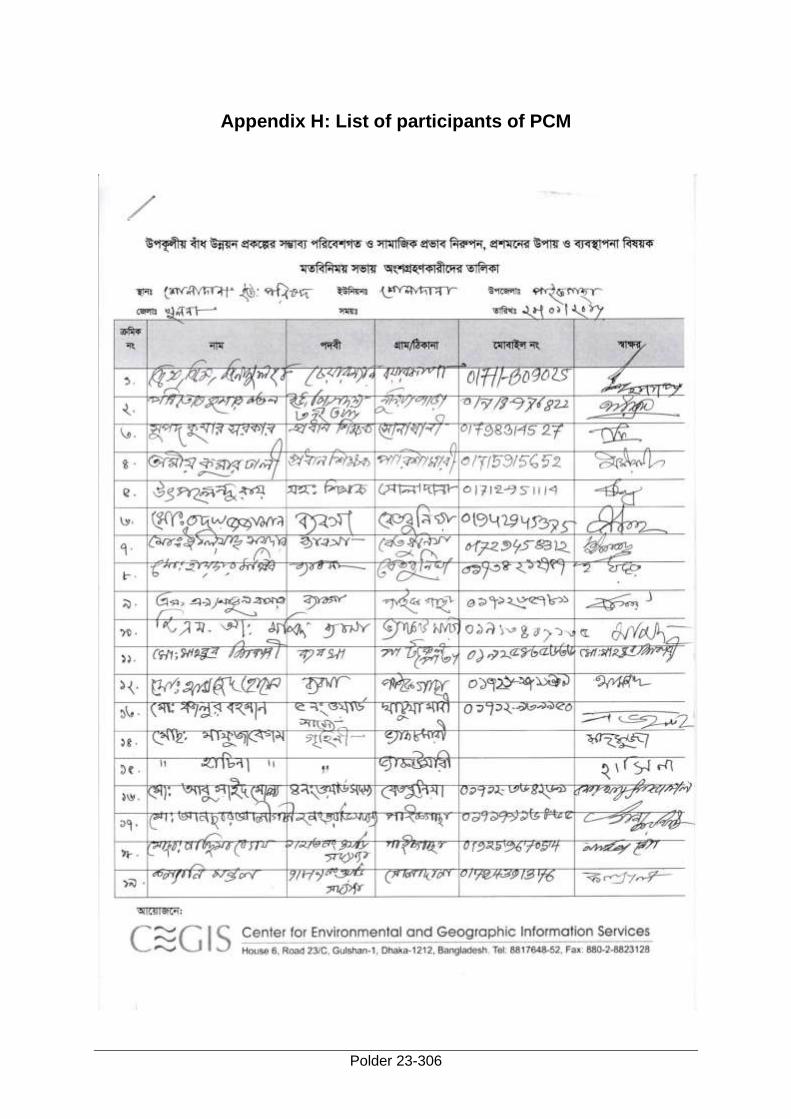
Polder 23-306
Appendix H: List of participants of PCM
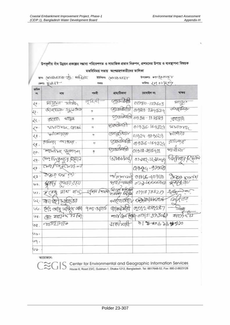
Coastal Embankment Improvement Project, Phase-1
(CEIP.1), Bangladesh Water Development Board
Environmental Impact Assessment
Appendix-H
Polder 23-307
Polder 23-308
Appendix I: Checklist of Public Consultation Meeting
ENVIRONMENTAL IMPACT ASSESSMENT OF
Coastal Embankment Improvement Project (CEIP)
Checklist for Public Consultation Meeting (PCM)
• Self and organization’s introduction
• Orientation of the participants
• Purpose of the meeting (Generic and specific)
• Brief introduction about the project (by facilitator)
• Outlining the general problems of the studied area
• Knowledge about the project
• Attitude towards the project
• Project related problems (especially drainage, tidal water, agricultural practice, land
source, ground water, intake and discharge of water, quality of water, Fisheries
resources; Plantation, Marine ecosystem, Terrestrial wildlife employment, income,
etc.)
• Project induced opportunities
• Suggestions for mitigation of problems
• Suggestions for enhancement of opportunities
• Suggestions to project implementers and planners
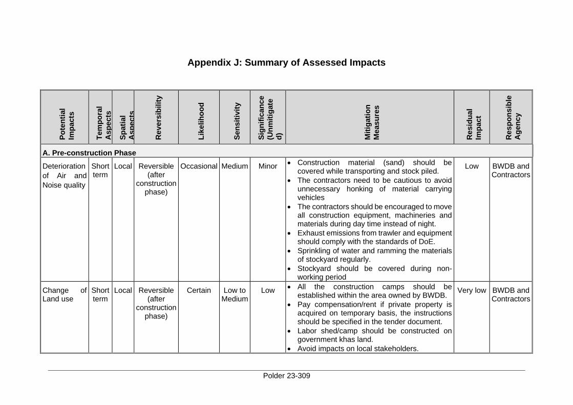
Polder 23-309
Appendix J: Summary of Assessed Impacts P
ote
nti
al
Imp
acts
Tem
po
ral
As
pe
cts
Sp
ati
al
As
pe
cts
Re
ve
rsib
ilit
y
Lik
elih
oo
d
Se
ns
itiv
ity
Sig
nif
ican
ce
(Un
mit
igate
d)
Mit
igati
on
Me
as
ure
s
Re
sid
ua
l
Imp
act
Re
sp
on
sib
le
Ag
en
cy
A. Pre-construction Phase
Deterioration
of Air and
Noise quality
Short term
Local Reversible (after
construction phase)
Occasional Medium Minor • Construction material (sand) should be
covered while transporting and stock piled.
• The contractors need to be cautious to avoid unnecessary honking of material carrying vehicles
• The contractors should be encouraged to move all construction equipment, machineries and materials during day time instead of night.
• Exhaust emissions from trawler and equipment should comply with the standards of DoE.
• Sprinkling of water and ramming the materials of stockyard regularly.
• Stockyard should be covered during non-working period
Low BWDB and Contractors
Change of Land use
Short term
Local Reversible (after
construction phase)
Certain Low to Medium
Low • All the construction camps should be
established within the area owned by BWDB.
• Pay compensation/rent if private property is acquired on temporary basis, the instructions should be specified in the tender document.
• Labor shed/camp should be constructed on government khas land.
• Avoid impacts on local stakeholders.
Very low BWDB and Contractors
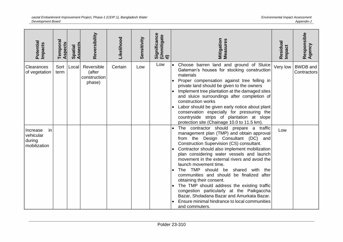
oastal Embankment Improvement Project, Phase-1 (CEIP.1), Bangladesh Water
Development Board
Environmental Impact Assessment
Appendix-J
Polder 23-310
Po
ten
tial
Imp
acts
Tem
po
ral
As
pe
cts
Sp
ati
al
As
pe
cts
Re
ve
rsib
ilit
y
Lik
elih
oo
d
Se
ns
itiv
ity
Sig
nif
ican
ce
(Un
mit
igate
d)
Mit
igati
on
Me
as
ure
s
Re
sid
ua
l
Imp
act
Re
sp
on
sib
le
Ag
en
cy
Clearances of vegetation
Sort term
Local Reversible (after
construction phase)
Certain Low Low • Choose barren land and ground of Sluice
Gateman’s houses for stocking construction materials
• Proper compensation against tree felling in private land should be given to the owners
• Implement tree plantation at the damaged sites and sluice surroundings after completion of construction works
• Labor should be given early notice about plant conservation especially for pressuring the countryside strips of plantation at slope protection site (Chainage 10.0 to 11.5 km).
Very low BWDB and Contractors
Increase in vehicular during mobilization
• The contractor should prepare a traffic
management plan (TMP) and obtain approval from the Design Consultant (DC) and Construction Supervision (CS) consultant.
• Contractor should also implement mobilization plan considering water vessels and launch movement in the external rivers and avoid the launch movement time.
• The TMP should be shared with the communities and should be finalized after obtaining their consent.
• The TMP should address the existing traffic congestion particularly at the Paikgaccha Bazar, Sholadana Bazar and Amurkata Bazar.
• Ensure minimal hindrance to local communities and commuters.
Low
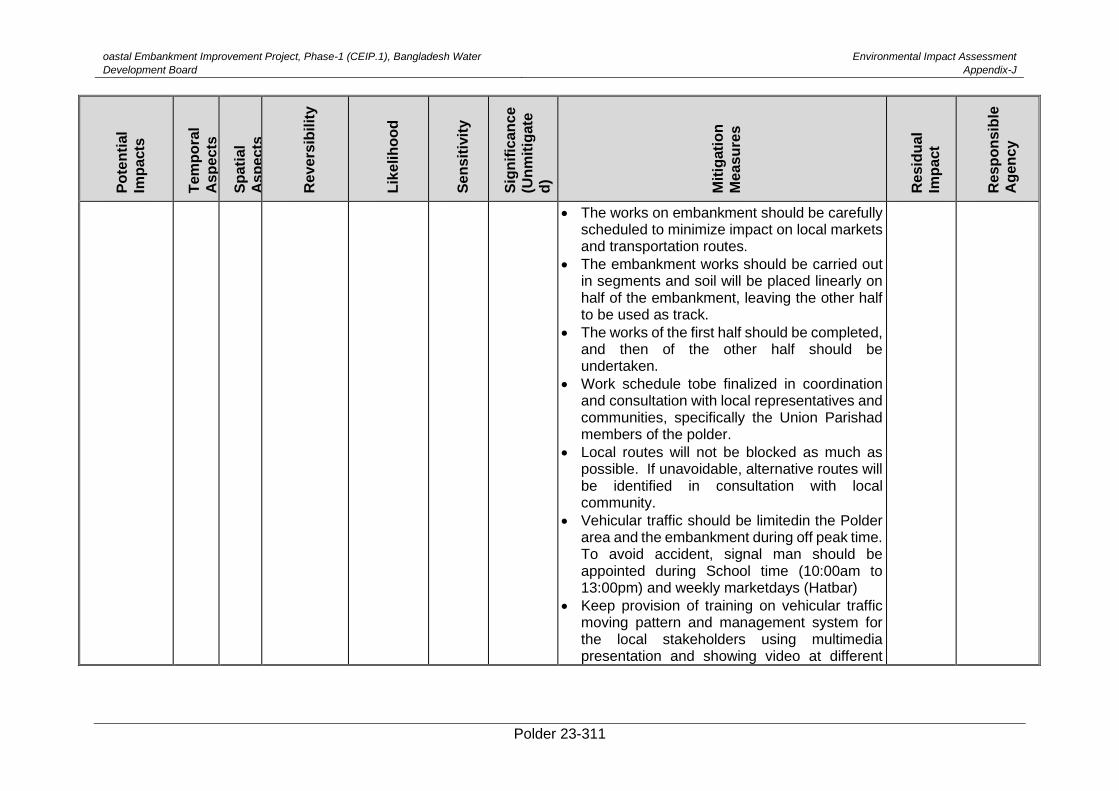
oastal Embankment Improvement Project, Phase-1 (CEIP.1), Bangladesh Water
Development Board
Environmental Impact Assessment
Appendix-J
Polder 23-311
Po
ten
tial
Imp
acts
Tem
po
ral
As
pe
cts
Sp
ati
al
As
pe
cts
Re
ve
rsib
ilit
y
Lik
elih
oo
d
Se
ns
itiv
ity
Sig
nif
ican
ce
(Un
mit
igate
d)
Mit
igati
on
Me
as
ure
s
Re
sid
ua
l
Imp
act
Re
sp
on
sib
le
Ag
en
cy
• The works on embankment should be carefully scheduled to minimize impact on local markets and transportation routes.
• The embankment works should be carried out in segments and soil will be placed linearly on half of the embankment, leaving the other half to be used as track.
• The works of the first half should be completed, and then of the other half should be undertaken.
• Work schedule tobe finalized in coordination and consultation with local representatives and communities, specifically the Union Parishad members of the polder.
• Local routes will not be blocked as much as possible. If unavoidable, alternative routes will be identified in consultation with local community.
• Vehicular traffic should be limitedin the Polder area and the embankment during off peak time. To avoid accident, signal man should be appointed during School time (10:00am to 13:00pm) and weekly marketdays (Hatbar)
• Keep provision of training on vehicular traffic moving pattern and management system for the local stakeholders using multimedia presentation and showing video at different
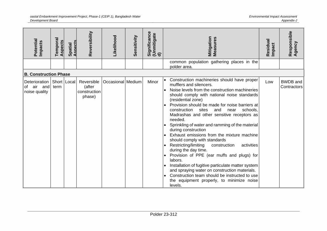
oastal Embankment Improvement Project, Phase-1 (CEIP.1), Bangladesh Water
Development Board
Environmental Impact Assessment
Appendix-J
Polder 23-312
Po
ten
tial
Imp
acts
Tem
po
ral
As
pe
cts
Sp
ati
al
As
pe
cts
Re
ve
rsib
ilit
y
Lik
elih
oo
d
Se
ns
itiv
ity
Sig
nif
ican
ce
(Un
mit
igate
d)
Mit
igati
on
Me
as
ure
s
Re
sid
ua
l
Imp
act
Re
sp
on
sib
le
Ag
en
cy
common population gathering places in the polder area.
B. Construction Phase
Deterioration of air and noise quality
Short term
Local Reversible (after
construction phase)
Occasional Medium Minor • Construction machineries should have proper mufflers and silencers.
• Noise levels from the construction machineries should comply with national noise standards (residential zone)
• Provision should be made for noise barriers at construction sites and near schools, Madrashas and other sensitive receptors as needed.
• Sprinkling of water and ramming of the material during construction
• Exhaust emissions from the mixture machine should comply with standards
• Restricting/limiting construction activities during the day time.
• Provision of PPE (ear muffs and plugs) for labors.
• Installation of fugitive particulate matter system and spraying water on construction materials.
• Construction team should be instructed to use the equipment properly, to minimize noise levels.
Low BWDB and Contractors
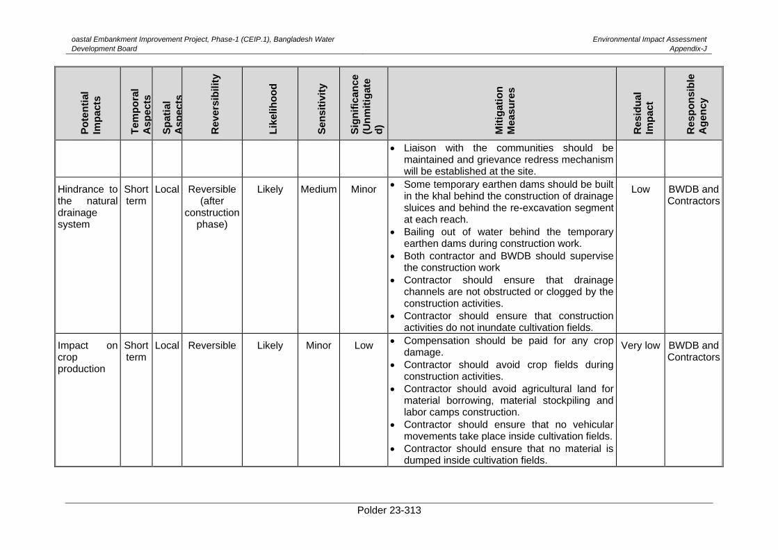
oastal Embankment Improvement Project, Phase-1 (CEIP.1), Bangladesh Water
Development Board
Environmental Impact Assessment
Appendix-J
Polder 23-313
Po
ten
tial
Imp
acts
Tem
po
ral
As
pe
cts
Sp
ati
al
As
pe
cts
Re
ve
rsib
ilit
y
Lik
elih
oo
d
Se
ns
itiv
ity
Sig
nif
ican
ce
(Un
mit
igate
d)
Mit
igati
on
Me
as
ure
s
Re
sid
ua
l
Imp
act
Re
sp
on
sib
le
Ag
en
cy
• Liaison with the communities should be maintained and grievance redress mechanism will be established at the site.
Hindrance to the natural drainage system
Short term
Local Reversible (after
construction phase)
Likely Medium Minor • Some temporary earthen dams should be built
in the khal behind the construction of drainage sluices and behind the re-excavation segment at each reach.
• Bailing out of water behind the temporary earthen dams during construction work.
• Both contractor and BWDB should supervise the construction work
• Contractor should ensure that drainage channels are not obstructed or clogged by the construction activities.
• Contractor should ensure that construction activities do not inundate cultivation fields.
Low BWDB and Contractors
Impact on crop production
Short term
Local Reversible Likely Minor Low • Compensation should be paid for any crop damage.
• Contractor should avoid crop fields during construction activities.
• Contractor should avoid agricultural land for material borrowing, material stockpiling and labor camps construction.
• Contractor should ensure that no vehicular movements take place inside cultivation fields.
• Contractor should ensure that no material is dumped inside cultivation fields.
Very low BWDB and Contractors
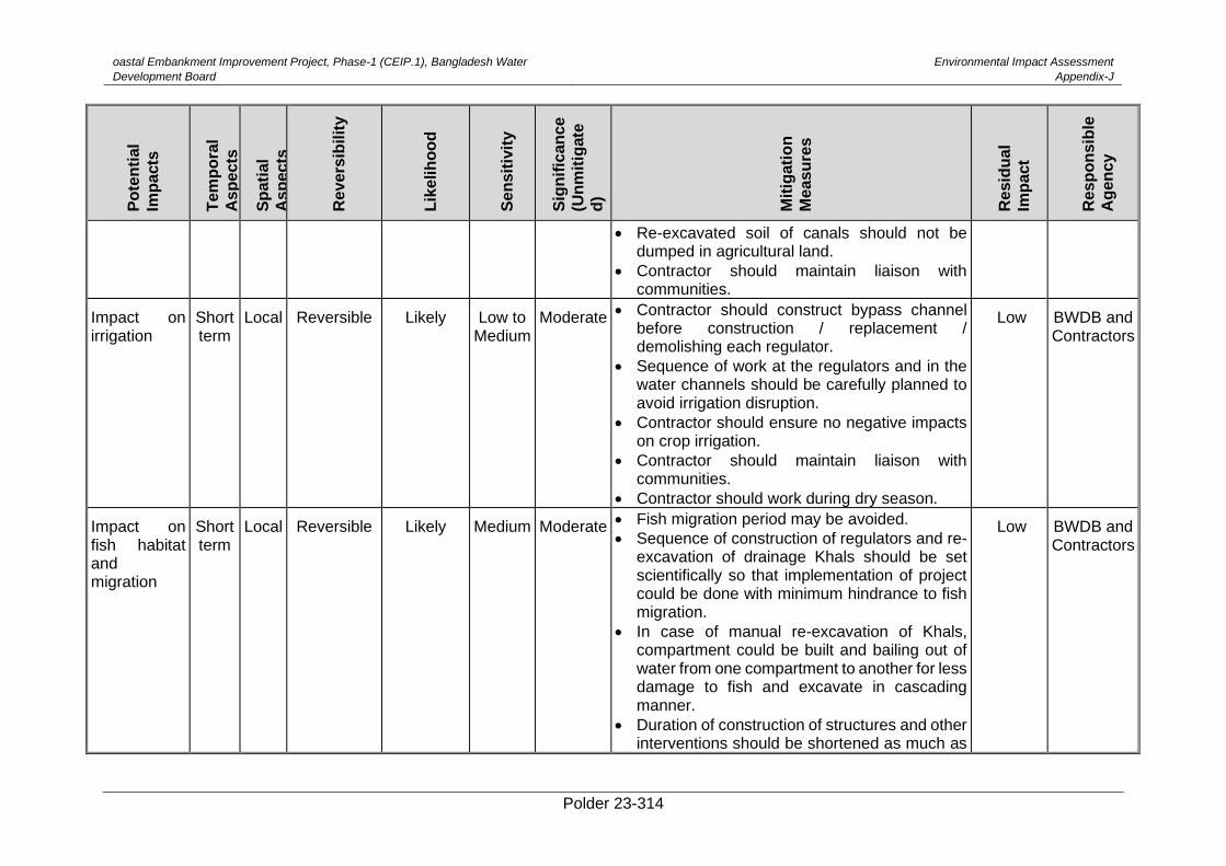
oastal Embankment Improvement Project, Phase-1 (CEIP.1), Bangladesh Water
Development Board
Environmental Impact Assessment
Appendix-J
Polder 23-314
Po
ten
tial
Imp
acts
Tem
po
ral
As
pe
cts
Sp
ati
al
As
pe
cts
Re
ve
rsib
ilit
y
Lik
elih
oo
d
Se
ns
itiv
ity
Sig
nif
ican
ce
(Un
mit
igate
d)
Mit
igati
on
Me
as
ure
s
Re
sid
ua
l
Imp
act
Re
sp
on
sib
le
Ag
en
cy
• Re-excavated soil of canals should not be dumped in agricultural land.
• Contractor should maintain liaison with communities.
Impact on irrigation
Short term
Local Reversible Likely Low to Medium
Moderate • Contractor should construct bypass channel before construction / replacement / demolishing each regulator.
• Sequence of work at the regulators and in the water channels should be carefully planned to avoid irrigation disruption.
• Contractor should ensure no negative impacts on crop irrigation.
• Contractor should maintain liaison with communities.
• Contractor should work during dry season.
Low BWDB and Contractors
Impact on fish habitat and migration
Short term
Local Reversible Likely Medium Moderate • Fish migration period may be avoided.
• Sequence of construction of regulators and re-excavation of drainage Khals should be set scientifically so that implementation of project could be done with minimum hindrance to fish migration.
• In case of manual re-excavation of Khals, compartment could be built and bailing out of water from one compartment to another for less damage to fish and excavate in cascading manner.
• Duration of construction of structures and other interventions should be shortened as much as
Low BWDB and Contractors
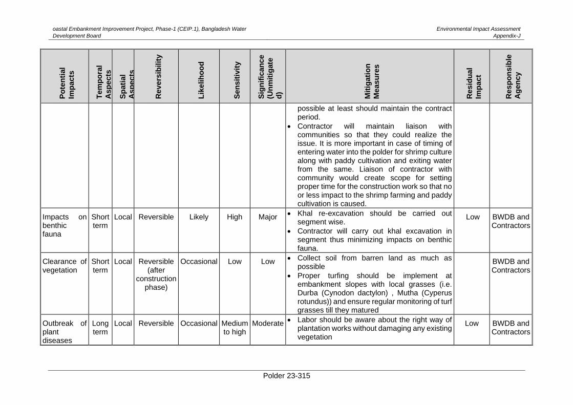
oastal Embankment Improvement Project, Phase-1 (CEIP.1), Bangladesh Water
Development Board
Environmental Impact Assessment
Appendix-J
Polder 23-315
Po
ten
tial
Imp
acts
Tem
po
ral
As
pe
cts
Sp
ati
al
As
pe
cts
Re
ve
rsib
ilit
y
Lik
elih
oo
d
Se
ns
itiv
ity
Sig
nif
ican
ce
(Un
mit
igate
d)
Mit
igati
on
Me
as
ure
s
Re
sid
ua
l
Imp
act
Re
sp
on
sib
le
Ag
en
cy
possible at least should maintain the contract period.
• Contractor will maintain liaison with communities so that they could realize the issue. It is more important in case of timing of entering water into the polder for shrimp culture along with paddy cultivation and exiting water from the same. Liaison of contractor with community would create scope for setting proper time for the construction work so that no or less impact to the shrimp farming and paddy cultivation is caused.
Impacts on benthic fauna
Short term
Local Reversible Likely High Major • Khal re-excavation should be carried out
segment wise.
• Contractor will carry out khal excavation in segment thus minimizing impacts on benthic fauna.
Low BWDB and Contractors
Clearance of vegetation
Short term
Local Reversible (after
construction phase)
Occasional Low Low • Collect soil from barren land as much as possible
• Proper turfing should be implement at embankment slopes with local grasses (i.e. Durba (Cynodon dactylon) , Mutha (Cyperus rotundus)) and ensure regular monitoring of turf grasses till they matured
BWDB and Contractors
Outbreak of plant diseases
Long term
Local Reversible
Occasional Medium to high
Moderate • Labor should be aware about the right way of
plantation works without damaging any existing vegetation
Low BWDB and Contractors
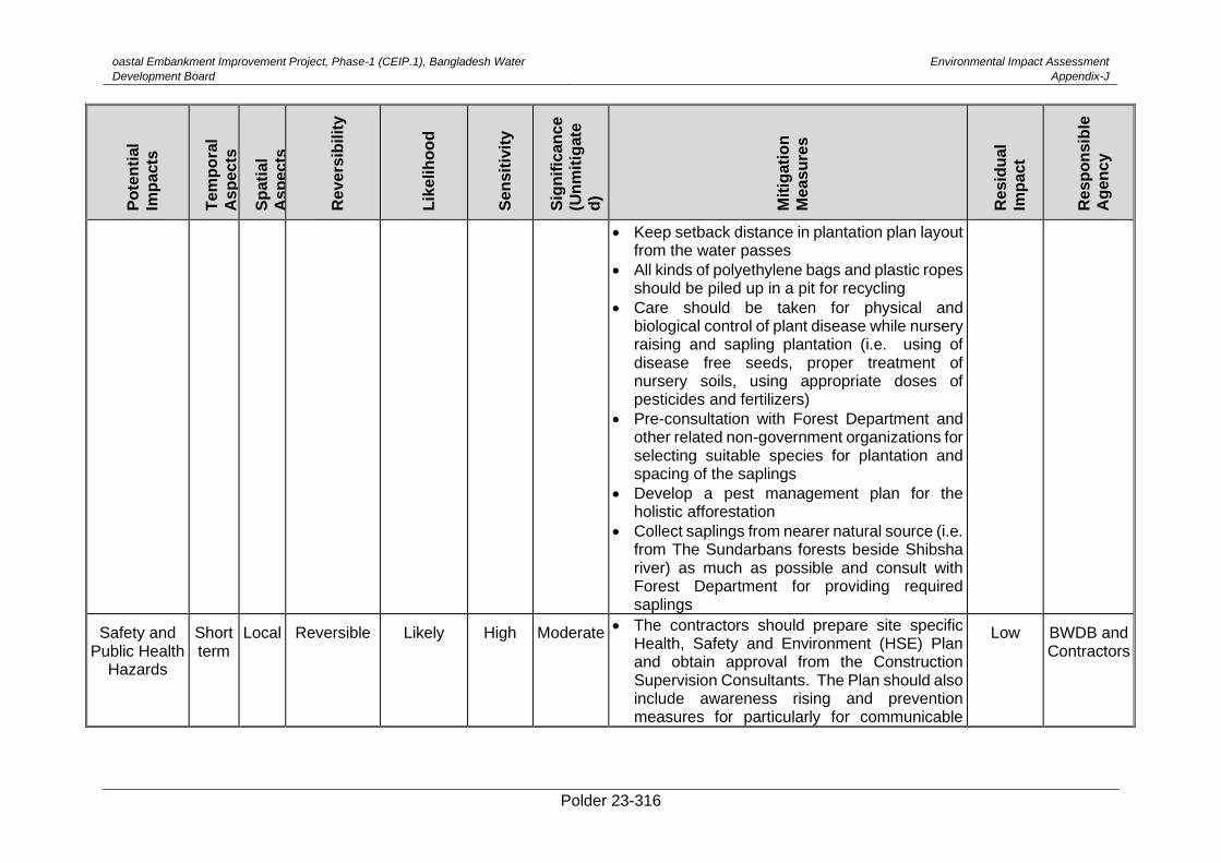
oastal Embankment Improvement Project, Phase-1 (CEIP.1), Bangladesh Water
Development Board
Environmental Impact Assessment
Appendix-J
Polder 23-316
Po
ten
tial
Imp
acts
Tem
po
ral
As
pe
cts
Sp
ati
al
As
pe
cts
Re
ve
rsib
ilit
y
Lik
elih
oo
d
Se
ns
itiv
ity
Sig
nif
ican
ce
(Un
mit
igate
d)
Mit
igati
on
Me
as
ure
s
Re
sid
ua
l
Imp
act
Re
sp
on
sib
le
Ag
en
cy
• Keep setback distance in plantation plan layout from the water passes
• All kinds of polyethylene bags and plastic ropes should be piled up in a pit for recycling
• Care should be taken for physical and biological control of plant disease while nursery raising and sapling plantation (i.e. using of disease free seeds, proper treatment of nursery soils, using appropriate doses of pesticides and fertilizers)
• Pre-consultation with Forest Department and other related non-government organizations for selecting suitable species for plantation and spacing of the saplings
• Develop a pest management plan for the holistic afforestation
• Collect saplings from nearer natural source (i.e. from The Sundarbans forests beside Shibsha river) as much as possible and consult with Forest Department for providing required saplings
Safety and Public Health
Hazards
Short term
Local Reversible Likely High Moderate • The contractors should prepare site specific Health, Safety and Environment (HSE) Plan and obtain approval from the Construction Supervision Consultants. The Plan should also include awareness rising and prevention measures for particularly for communicable
Low BWDB and Contractors
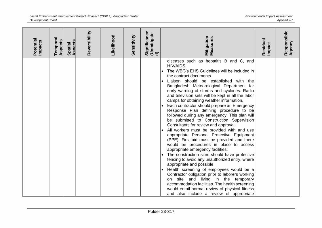
oastal Embankment Improvement Project, Phase-1 (CEIP.1), Bangladesh Water
Development Board
Environmental Impact Assessment
Appendix-J
Polder 23-317
Po
ten
tial
Imp
acts
Tem
po
ral
As
pe
cts
Sp
ati
al
As
pe
cts
Re
ve
rsib
ilit
y
Lik
elih
oo
d
Se
ns
itiv
ity
Sig
nif
ican
ce
(Un
mit
igate
d)
Mit
igati
on
Me
as
ure
s
Re
sid
ua
l
Imp
act
Re
sp
on
sib
le
Ag
en
cy
diseases such as hepatitis B and C, and HIV/AIDS.
• The WBG’s EHS Guidelines will be included in the contract documents.
• Liaison should be established with the Bangladesh Meteorological Department for early warning of storms and cyclones. Radio and television sets will be kept in all the labor camps for obtaining weather information.
• Each contractor should prepare an Emergency Response Plan defining procedure to be followed during any emergency. This plan will be submitted to Construction Supervision Consultants for review and approval;
• All workers must be provided with and use appropriate Personal Protective Equipment (PPE). First aid must be provided and there would be procedures in place to access appropriate emergency facilities;
• The construction sites should have protective fencing to avoid any unauthorized entry, where appropriate and possible
• Health screening of employees would be a Contractor obligation prior to laborers working on site and living in the temporary accommodation facilities. The health screening would entail normal review of physical fitness and also include a review of appropriate
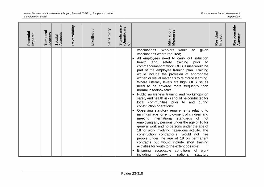
oastal Embankment Improvement Project, Phase-1 (CEIP.1), Bangladesh Water
Development Board
Environmental Impact Assessment
Appendix-J
Polder 23-318
Po
ten
tial
Imp
acts
Tem
po
ral
As
pe
cts
Sp
ati
al
As
pe
cts
Re
ve
rsib
ilit
y
Lik
elih
oo
d
Se
ns
itiv
ity
Sig
nif
ican
ce
(Un
mit
igate
d)
Mit
igati
on
Me
as
ure
s
Re
sid
ua
l
Imp
act
Re
sp
on
sib
le
Ag
en
cy
vaccinations. Workers would be given vaccinations where required;
• All employees need to carry out induction health and safety training prior to commencement of work. OHS issues would be part of the employee training plan. Training would include the provision of appropriate written or visual materials to reinforce learning. Where illiteracy levels are high, OHS issues need to be covered more frequently than normal in toolbox talks;
• Public awareness training and workshops on safety and health risks should be conducted for local communities prior to and during construction operations.
• Observing statutory requirements relating to minimum age for employment of children and meeting international standards of not employing any persons under the age of 16 for general work and no persons under the age of 18 for work involving hazardous activity. The construction contractor(s) would not hire people under the age of 18 on permanent contracts but would include short training activities for youth to the extent possible;
• Ensuring acceptable conditions of work including observing national statutory
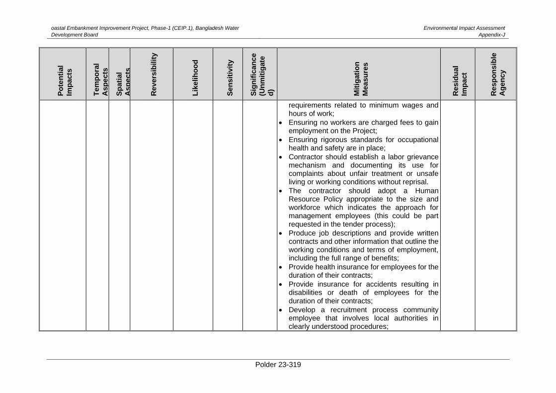
oastal Embankment Improvement Project, Phase-1 (CEIP.1), Bangladesh Water
Development Board
Environmental Impact Assessment
Appendix-J
Polder 23-319
Po
ten
tial
Imp
acts
Tem
po
ral
As
pe
cts
Sp
ati
al
As
pe
cts
Re
ve
rsib
ilit
y
Lik
elih
oo
d
Se
ns
itiv
ity
Sig
nif
ican
ce
(Un
mit
igate
d)
Mit
igati
on
Me
as
ure
s
Re
sid
ua
l
Imp
act
Re
sp
on
sib
le
Ag
en
cy
requirements related to minimum wages and hours of work;
• Ensuring no workers are charged fees to gain employment on the Project;
• Ensuring rigorous standards for occupational health and safety are in place;
• Contractor should establish a labor grievance mechanism and documenting its use for complaints about unfair treatment or unsafe living or working conditions without reprisal.
• The contractor should adopt a Human Resource Policy appropriate to the size and workforce which indicates the approach for management employees (this could be part requested in the tender process);
• Produce job descriptions and provide written contracts and other information that outline the working conditions and terms of employment, including the full range of benefits;
• Provide health insurance for employees for the duration of their contracts;
• Provide insurance for accidents resulting in disabilities or death of employees for the duration of their contracts;
• Develop a recruitment process community employee that involves local authorities in clearly understood procedures;
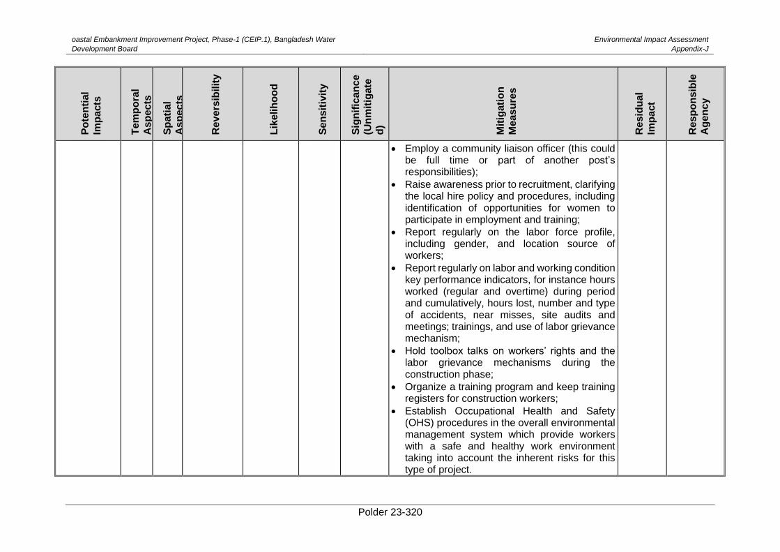
oastal Embankment Improvement Project, Phase-1 (CEIP.1), Bangladesh Water
Development Board
Environmental Impact Assessment
Appendix-J
Polder 23-320
Po
ten
tial
Imp
acts
Tem
po
ral
As
pe
cts
Sp
ati
al
As
pe
cts
Re
ve
rsib
ilit
y
Lik
elih
oo
d
Se
ns
itiv
ity
Sig
nif
ican
ce
(Un
mit
igate
d)
Mit
igati
on
Me
as
ure
s
Re
sid
ua
l
Imp
act
Re
sp
on
sib
le
Ag
en
cy
• Employ a community liaison officer (this could be full time or part of another post’s responsibilities);
• Raise awareness prior to recruitment, clarifying the local hire policy and procedures, including identification of opportunities for women to participate in employment and training;
• Report regularly on the labor force profile, including gender, and location source of workers;
• Report regularly on labor and working condition key performance indicators, for instance hours worked (regular and overtime) during period and cumulatively, hours lost, number and type of accidents, near misses, site audits and meetings; trainings, and use of labor grievance mechanism;
• Hold toolbox talks on workers’ rights and the labor grievance mechanisms during the construction phase;
• Organize a training program and keep training registers for construction workers;
• Establish Occupational Health and Safety (OHS) procedures in the overall environmental management system which provide workers with a safe and healthy work environment taking into account the inherent risks for this type of project.
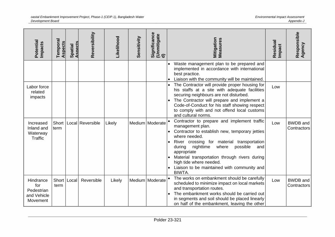
oastal Embankment Improvement Project, Phase-1 (CEIP.1), Bangladesh Water
Development Board
Environmental Impact Assessment
Appendix-J
Polder 23-321
Po
ten
tial
Imp
acts
Tem
po
ral
As
pe
cts
Sp
ati
al
As
pe
cts
Re
ve
rsib
ilit
y
Lik
elih
oo
d
Se
ns
itiv
ity
Sig
nif
ican
ce
(Un
mit
igate
d)
Mit
igati
on
Me
as
ure
s
Re
sid
ua
l
Imp
act
Re
sp
on
sib
le
Ag
en
cy
• Waste management plan to be prepared and implemented in accordance with international best practice.
• Liaison with the community will be maintained.
Labor force related impacts
• The Contractor will provide proper housing for his staffs at a site with adequate facilities securing neighbours are not disturbed.
• The Contractor will prepare and implement a Code-of-Conduct for his staff showing respect to comply with and not offend local customs and cultural norms.
Low
Increased Inland and Waterway
Traffic
Short term
Local Reversible Likely Medium Moderate • Contractor to prepare and implement traffic management plan.
• Contractor to establish new, temporary jetties where needed.
• River crossing for material transportation during nighttime where possible and appropriate
• Material transportation through rivers during high tide where needed.
• Liaison to be maintained with community and BIWTA.
Low BWDB and Contractors
Hindrance for
Pedestrian and Vehicle Movement
Short term
Local Reversible Likely Medium Moderate • The works on embankment should be carefully
scheduled to minimize impact on local markets and transportation routes.
• The embankment works should be carried out in segments and soil should be placed linearly on half of the embankment, leaving the other
Low BWDB and Contractors
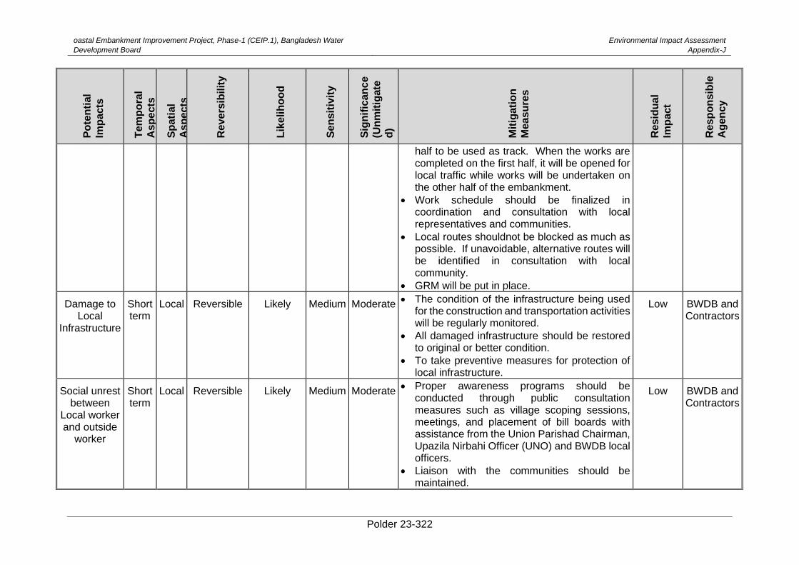
oastal Embankment Improvement Project, Phase-1 (CEIP.1), Bangladesh Water
Development Board
Environmental Impact Assessment
Appendix-J
Polder 23-322
Po
ten
tial
Imp
acts
Tem
po
ral
As
pe
cts
Sp
ati
al
As
pe
cts
Re
ve
rsib
ilit
y
Lik
elih
oo
d
Se
ns
itiv
ity
Sig
nif
ican
ce
(Un
mit
igate
d)
Mit
igati
on
Me
as
ure
s
Re
sid
ua
l
Imp
act
Re
sp
on
sib
le
Ag
en
cy
half to be used as track. When the works are completed on the first half, it will be opened for local traffic while works will be undertaken on the other half of the embankment.
• Work schedule should be finalized in coordination and consultation with local representatives and communities.
• Local routes shouldnot be blocked as much as possible. If unavoidable, alternative routes will be identified in consultation with local community.
• GRM will be put in place.
Damage to Local
Infrastructure
Short term
Local Reversible Likely Medium Moderate • The condition of the infrastructure being used for the construction and transportation activities will be regularly monitored.
• All damaged infrastructure should be restored to original or better condition.
• To take preventive measures for protection of local infrastructure.
Low BWDB and Contractors
Social unrest between
Local worker and outside
worker
Short term
Local Reversible Likely Medium Moderate • Proper awareness programs should be
conducted through public consultation measures such as village scoping sessions, meetings, and placement of bill boards with assistance from the Union Parishad Chairman, Upazila Nirbahi Officer (UNO) and BWDB local officers.
• Liaison with the communities should be maintained.
Low BWDB and Contractors
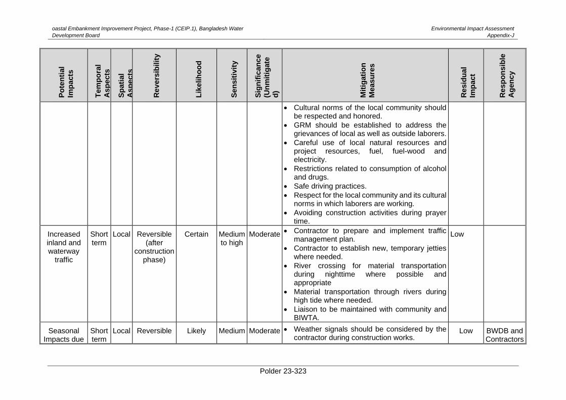
oastal Embankment Improvement Project, Phase-1 (CEIP.1), Bangladesh Water
Development Board
Environmental Impact Assessment
Appendix-J
Polder 23-323
Po
ten
tial
Imp
acts
Tem
po
ral
As
pe
cts
Sp
ati
al
As
pe
cts
Re
ve
rsib
ilit
y
Lik
elih
oo
d
Se
ns
itiv
ity
Sig
nif
ican
ce
(Un
mit
igate
d)
Mit
igati
on
Me
as
ure
s
Re
sid
ua
l
Imp
act
Re
sp
on
sib
le
Ag
en
cy
• Cultural norms of the local community should be respected and honored.
• GRM should be established to address the grievances of local as well as outside laborers.
• Careful use of local natural resources and project resources, fuel, fuel-wood and electricity.
• Restrictions related to consumption of alcohol and drugs.
• Safe driving practices.
• Respect for the local community and its cultural norms in which laborers are working.
• Avoiding construction activities during prayer time.
Increased inland and waterway
traffic
Short term
Local Reversible (after
construction phase)
Certain Medium to high
Moderate • Contractor to prepare and implement traffic management plan.
• Contractor to establish new, temporary jetties where needed.
• River crossing for material transportation during nighttime where possible and appropriate
• Material transportation through rivers during high tide where needed.
• Liaison to be maintained with community and BIWTA.
Low
Seasonal Impacts due
Short term
Local Reversible Likely Medium Moderate • Weather signals should be considered by the contractor during construction works.
Low BWDB and Contractors
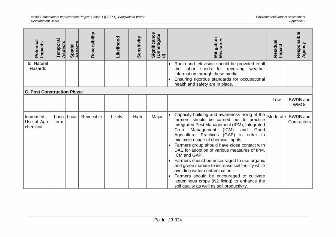
oastal Embankment Improvement Project, Phase-1 (CEIP.1), Bangladesh Water
Development Board
Environmental Impact Assessment
Appendix-J
Polder 23-324
Po
ten
tial
Imp
acts
Tem
po
ral
As
pe
cts
Sp
ati
al
As
pe
cts
Re
ve
rsib
ilit
y
Lik
elih
oo
d
Se
ns
itiv
ity
Sig
nif
ican
ce
(Un
mit
igate
d)
Mit
igati
on
Me
as
ure
s
Re
sid
ua
l
Imp
act
Re
sp
on
sib
le
Ag
en
cy
to Natural Hazards
• Radio and television should be provided in all the labor sheds for receiving weather information through these media.
• Ensuring rigorous standards for occupational health and safety are in place.
C. Post Construction Phase
Low BWDB and WMOs
Increased Use of Agro-chemical
Long term
Local Reversible Likely High Major • Capacity building and awareness rising of the
farmers should be carried out to practice Integrated Pest Management (IPM), Integrated Crop Management (ICM) and Good Agricultural Practices (GAP) in order to minimize usage of chemical inputs.
• Farmers group should have close contact with DAE for adoption of various measures of IPM, ICM and GAP.
• Farmers should be encouraged to use organic and green manure to increase soil fertility while avoiding water contamination.
• Farmers should be encouraged to cultivate leguminous crops (N2 fixing) to enhance the soil quality as well as soil productivity.
Moderate BWDB and Contractors
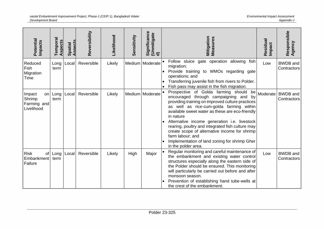
oastal Embankment Improvement Project, Phase-1 (CEIP.1), Bangladesh Water
Development Board
Environmental Impact Assessment
Appendix-J
Polder 23-325
Po
ten
tial
Imp
acts
Tem
po
ral
As
pe
cts
Sp
ati
al
As
pe
cts
Re
ve
rsib
ilit
y
Lik
elih
oo
d
Se
ns
itiv
ity
Sig
nif
ican
ce
(Un
mit
igate
d)
Mit
igati
on
Me
as
ure
s
Re
sid
ua
l
Imp
act
Re
sp
on
sib
le
Ag
en
cy
Reduced Fish Migration Time
Long term
Local Reversible Likely Medium Moderate • Follow sluice gate operation allowing fish migration;
• Provide training to WMOs regarding gate operations; and
• Transferring juvenile fish from rivers to Polder.
• Fish pass may assist in the fish migration.
Low BWDB and Contractors
Impact on Shrimp Farming and Livelihood
Long term
Local Reversible Likely Medium Moderate • Prospective of Golda farming should be encouraged through campaigning and by providing training on improved culture practices as well as rice-cum-golda farming within available sweet water as these are eco-friendly in nature
• Alternative income generation i.e. livestock rearing, poultry and integrated fish culture may create scope of alternative income for shrimp farm labour; and
• Implementation of land zoning for shrimp Gher in the polder area.
Moderate BWDB and Contractors
Risk of Embankment Failure
Long term
Local Reversible Likely High Major • Regular monitoring and careful maintenance of the embankment and existing water control structures especially along the eastern side of the Polder should be ensured. This monitoring will particularly be carried out before and after monsoon season.
• Prevention of establishing hand tube-wells at the crest of the embankment.
Low BWDB and Contractors
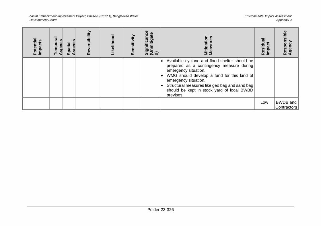
oastal Embankment Improvement Project, Phase-1 (CEIP.1), Bangladesh Water
Development Board
Environmental Impact Assessment
Appendix-J
Polder 23-326
Po
ten
tial
Imp
acts
Tem
po
ral
As
pe
cts
Sp
ati
al
As
pe
cts
Re
ve
rsib
ilit
y
Lik
elih
oo
d
Se
ns
itiv
ity
Sig
nif
ican
ce
(Un
mit
igate
d)
Mit
igati
on
Me
as
ure
s
Re
sid
ua
l
Imp
act
Re
sp
on
sib
le
Ag
en
cy
• Available cyclone and flood shelter should be prepared as a contingency measure during emergency situation.
• WMG should develop a fund for this kind of emergency situation.
• Structural measures like geo bag and sand bag should be kept in stock yard of local BWBD previses
Low BWDB and Contractors
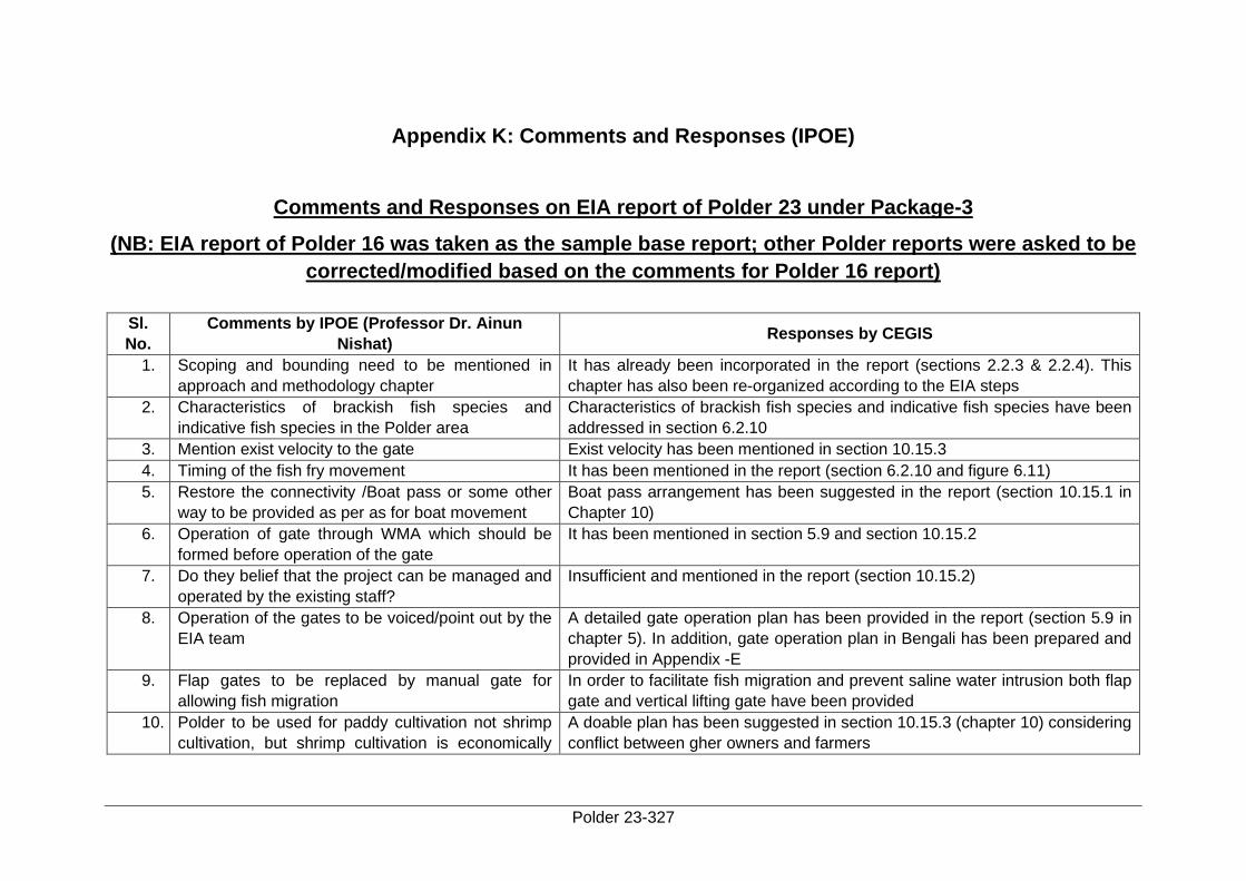
Polder 23-327
Appendix K: Comments and Responses (IPOE)
Comments and Responses on EIA report of Polder 23 under Package-3
(NB: EIA report of Polder 16 was taken as the sample base report; other Polder reports were asked to be
corrected/modified based on the comments for Polder 16 report)
Sl.
No.
Comments by IPOE (Professor Dr. Ainun
Nishat) Responses by CEGIS
1. Scoping and bounding need to be mentioned in
approach and methodology chapter
It has already been incorporated in the report (sections 2.2.3 & 2.2.4). This
chapter has also been re-organized according to the EIA steps
2. Characteristics of brackish fish species and
indicative fish species in the Polder area
Characteristics of brackish fish species and indicative fish species have been
addressed in section 6.2.10
3. Mention exist velocity to the gate Exist velocity has been mentioned in section 10.15.3
4. Timing of the fish fry movement It has been mentioned in the report (section 6.2.10 and figure 6.11)
5. Restore the connectivity /Boat pass or some other
way to be provided as per as for boat movement
Boat pass arrangement has been suggested in the report (section 10.15.1 in
Chapter 10)
6. Operation of gate through WMA which should be
formed before operation of the gate
It has been mentioned in section 5.9 and section 10.15.2
7. Do they belief that the project can be managed and
operated by the existing staff?
Insufficient and mentioned in the report (section 10.15.2)
8. Operation of the gates to be voiced/point out by the
EIA team
A detailed gate operation plan has been provided in the report (section 5.9 in
chapter 5). In addition, gate operation plan in Bengali has been prepared and
provided in Appendix -E
9. Flap gates to be replaced by manual gate for
allowing fish migration
In order to facilitate fish migration and prevent saline water intrusion both flap
gate and vertical lifting gate have been provided
10. Polder to be used for paddy cultivation not shrimp
cultivation, but shrimp cultivation is economically
A doable plan has been suggested in section 10.15.3 (chapter 10) considering
conflict between gher owners and farmers
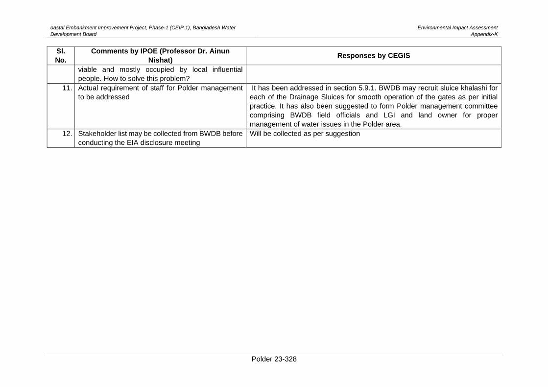
oastal Embankment Improvement Project, Phase-1 (CEIP.1), Bangladesh Water
Development Board
Environmental Impact Assessment
Appendix-K
Polder 23-328
Sl.
No.
Comments by IPOE (Professor Dr. Ainun
Nishat) Responses by CEGIS
viable and mostly occupied by local influential
people. How to solve this problem?
11. Actual requirement of staff for Polder management
to be addressed
It has been addressed in section 5.9.1. BWDB may recruit sluice khalashi for
each of the Drainage Sluices for smooth operation of the gates as per initial
practice. It has also been suggested to form Polder management committee
comprising BWDB field officials and LGI and land owner for proper
management of water issues in the Polder area.
12. Stakeholder list may be collected from BWDB before
conducting the EIA disclosure meeting
Will be collected as per suggestion
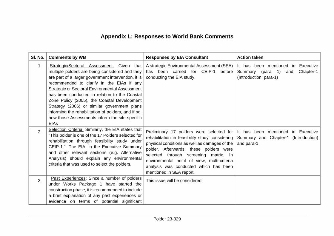
Polder 23-329
Appendix L: Responses to World Bank Comments
Sl. No. Comments by WB Responses by EIA Consultant Action taken
1. Strategic/Sectoral Assessment: Given that
multiple polders are being considered and they
are part of a larger government intervention, it is
recommended to clarify in the EIAs if any
Strategic or Sectoral Environmental Assessment
has been conducted in relation to the Coastal
Zone Policy (2005), the Coastal Development
Strategy (2006) or similar government plans
informing the rehabilitation of polders, and if so,
how those Assessments inform the site-specific
EIAs
A strategic Environmental Assessment (SEA)
has been carried for CEIP-1 before
conducting the EIA study.
It has been mentioned in Executive
Summary (para 1) and Chapter-1
(Introduction: para-1)
2. Selection Criteria: Similarly, the EIA states that
"This polder is one of the 17 Polders selected for
rehabilitation through feasibility study under
CEIP-1.". The EIA, in the Executive Summary
and other relevant sections (e.g. Alternative
Analysis) should explain any environmental
criteria that was used to select the polders.
Preliminary 17 polders were selected for
rehabilitation in feasibility study considering
physical conditions as well as damages of the
polder. Afterwards, these polders were
selected through screening matrix. In
environmental point of view, multi-criteria
analysis was conducted which has been
mentioned in SEA report.
It has been mentioned in Executive
Summary and Chapter-1 (Introduction)
and para-1
3. Past Experiences: Since a number of polders
under Works Package 1 have started the
construction phase, it is recommended to include
a brief explanation of any past experiences or
evidence on terms of potential significant
This issue will be considered
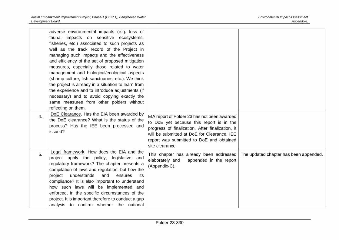
oastal Embankment Improvement Project, Phase-1 (CEIP.1), Bangladesh Water
Development Board
Environmental Impact Assessment
Appendix-L
Polder 23-330
adverse environmental impacts (e.g. loss of
fauna, impacts on sensitive ecosystems,
fisheries, etc.) associated to such projects as
well as the track record of the Project in
managing such impacts and the effectiveness
and efficiency of the set of proposed mitigation
measures, especially those related to water
management and biological/ecological aspects
(shrimp culture, fish sanctuaries, etc.). We think
the project is already in a situation to learn from
the experience and to introduce adjustments (if
necessary) and to avoid copying exactly the
same measures from other polders without
reflecting on them.
4. DoE Clearance. Has the EIA been awarded by
the DoE clearance? What is the status of the
process? Has the IEE been processed and
issued?
EIA report of Polder 23 has not been awarded
to DoE yet because this report is in the
progress of finalization. After finalization, it
will be submitted at DoE for Clearance. IEE
report was submitted to DoE and obtained
site clearance.
5. Legal framework. How does the EIA and the
project apply the policy, legislative and
regulatory framework? The chapter presents a
compilation of laws and regulation, but how the
project understands and ensures its
compliance? It is also important to understand
how such laws will be implemented and
enforced, in the specific circumstances of the
project. It is important therefore to conduct a gap
analysis to confirm whether the national
This chapter has already been addressed
elaborately and appended in the report
(Appendix-C).
The updated chapter has been appended.
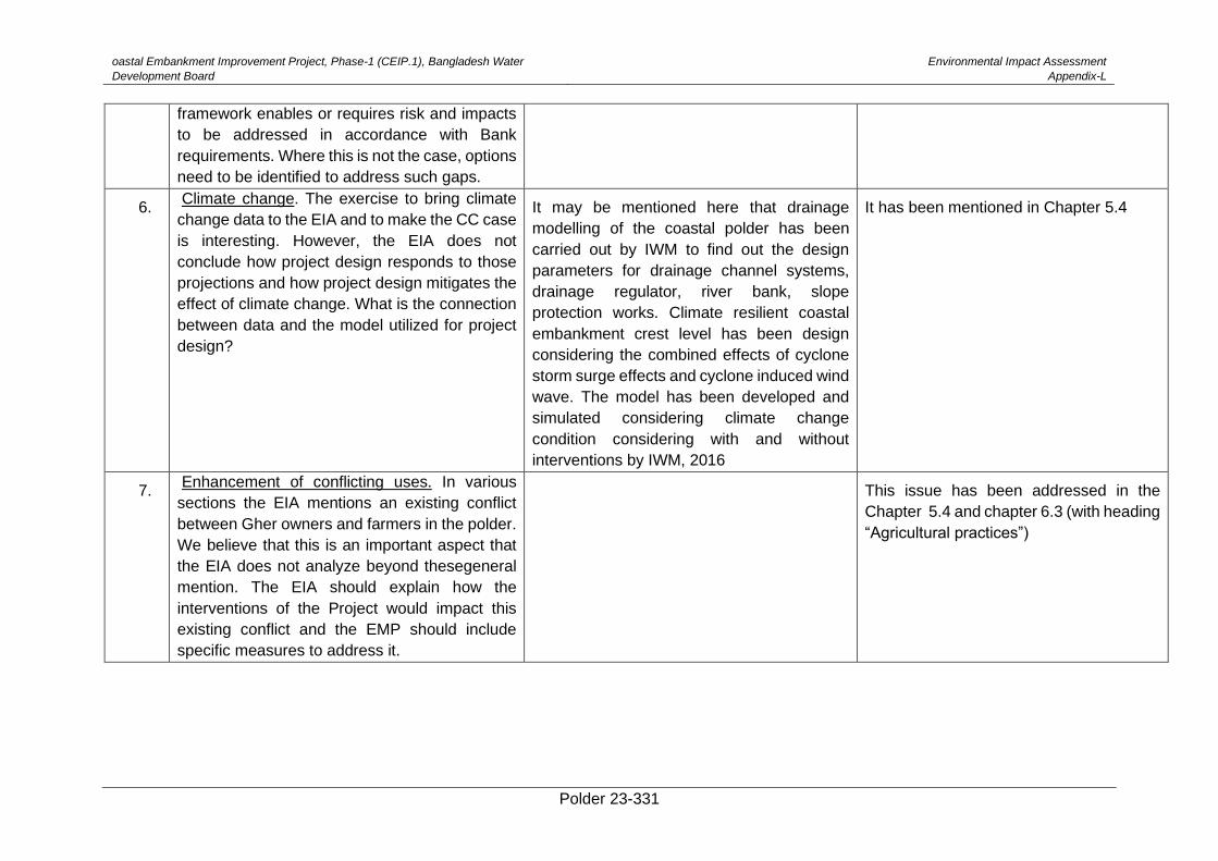
oastal Embankment Improvement Project, Phase-1 (CEIP.1), Bangladesh Water
Development Board
Environmental Impact Assessment
Appendix-L
Polder 23-331
framework enables or requires risk and impacts
to be addressed in accordance with Bank
requirements. Where this is not the case, options
need to be identified to address such gaps.
6. Climate change. The exercise to bring climate
change data to the EIA and to make the CC case
is interesting. However, the EIA does not
conclude how project design responds to those
projections and how project design mitigates the
effect of climate change. What is the connection
between data and the model utilized for project
design?
It may be mentioned here that drainage
modelling of the coastal polder has been
carried out by IWM to find out the design
parameters for drainage channel systems,
drainage regulator, river bank, slope
protection works. Climate resilient coastal
embankment crest level has been design
considering the combined effects of cyclone
storm surge effects and cyclone induced wind
wave. The model has been developed and
simulated considering climate change
condition considering with and without
interventions by IWM, 2016
It has been mentioned in Chapter 5.4
7. Enhancement of conflicting uses. In various
sections the EIA mentions an existing conflict
between Gher owners and farmers in the polder.
We believe that this is an important aspect that
the EIA does not analyze beyond thesegeneral
mention. The EIA should explain how the
interventions of the Project would impact this
existing conflict and the EMP should include
specific measures to address it.
This issue has been addressed in the
Chapter 5.4 and chapter 6.3 (with heading
“Agricultural practices”)
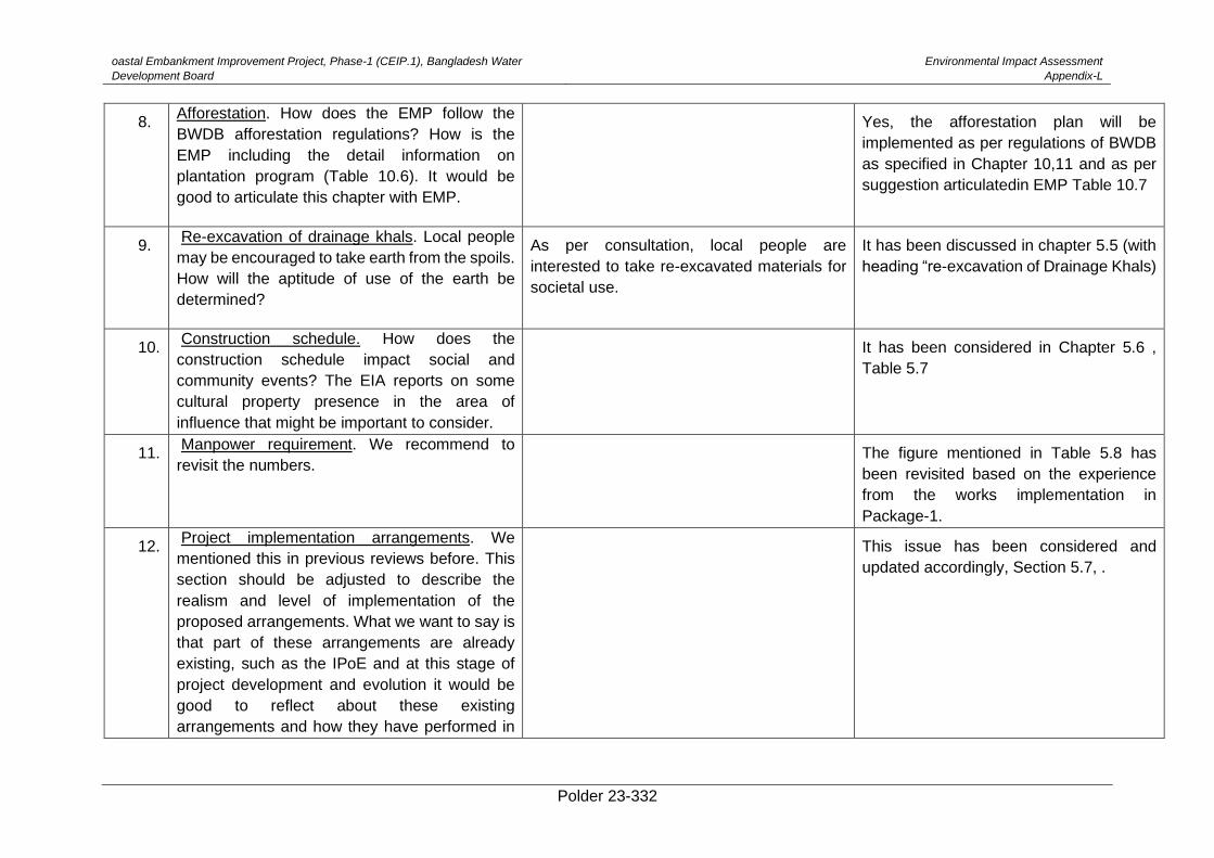
oastal Embankment Improvement Project, Phase-1 (CEIP.1), Bangladesh Water
Development Board
Environmental Impact Assessment
Appendix-L
Polder 23-332
8. Afforestation. How does the EMP follow the
BWDB afforestation regulations? How is the
EMP including the detail information on
plantation program (Table 10.6). It would be
good to articulate this chapter with EMP.
Yes, the afforestation plan will be
implemented as per regulations of BWDB
as specified in Chapter 10,11 and as per
suggestion articulatedin EMP Table 10.7
9. Re-excavation of drainage khals. Local people
may be encouraged to take earth from the spoils.
How will the aptitude of use of the earth be
determined?
As per consultation, local people are
interested to take re-excavated materials for
societal use.
It has been discussed in chapter 5.5 (with
heading “re-excavation of Drainage Khals)
10. Construction schedule. How does the
construction schedule impact social and
community events? The EIA reports on some
cultural property presence in the area of
influence that might be important to consider.
It has been considered in Chapter 5.6 ,
Table 5.7
11. Manpower requirement. We recommend to
revisit the numbers. The figure mentioned in Table 5.8 has
been revisited based on the experience
from the works implementation in
Package-1.
12. Project implementation arrangements. We
mentioned this in previous reviews before. This
section should be adjusted to describe the
realism and level of implementation of the
proposed arrangements. What we want to say is
that part of these arrangements are already
existing, such as the IPoE and at this stage of
project development and evolution it would be
good to reflect about these existing
arrangements and how they have performed in
This issue has been considered and
updated accordingly, Section 5.7, .
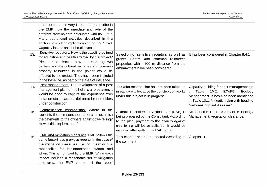
oastal Embankment Improvement Project, Phase-1 (CEIP.1), Bangladesh Water
Development Board
Environmental Impact Assessment
Appendix-L
Polder 23-333
other polders. It is very important to describe in
the EMP how the mandate and role of the
different stakeholders articulates with the EMP.
Many operational activities described in this
section have clear implications at the EMP level.
Capacity issues should be discussed.
13. Sensitive receptors. How is the baseline defined
for education and health affected by the project?
Please also discuss how the market/growth
centers and the cultural heritages and common
property resources in the polder would be
affected by the project. They have been included
in the baseline, as part of the area of influence.
Selection of sensitive receptors as well as
growth Centre and common resources
properties within 500 m distance from the
embankment have been considered
It has been considered in Chapter 8.4.1
14. Pest management. The development of a pest
management plan for the holistic afforestation. It
would be good to capture the experience from
the afforestation actions delivered for the polders
under construction.
The afforestation plan has not been taken up
in package-1 because the construction works
under this project is in progress
Capacity building for pest management in
, Table 10.2, ECoP5: Ecology
Management. It has also been mentioned
in Table 10.1. Mitigation plan with heading
“outbreak of plant diseases”
15. Compensation mechanisms. Where in the
report is the compensation criteria to establish
the payments to the owners against tree felling?
How is this implemented?
A detail Resettlement Action Plan (RAP) is
being prepared by the Consultant. According
to the plan, payment to the owners against
tree felling will be established. It would be
included after getting the RAP report.
Mentioned in Table 10.2, ECoP 5: Ecology
Management, vegetation clearance,
16. EMP and mitigation measures. EMP follows the
same footprint as previous reports. In the case of
the mitigation measures it is not clear who is
responsible for implementation, where and
when. This is not fixed by the EMP. While each
impact included a reasonable set of mitigation
measures, the EMP chapter of the report
This chapter has been updated according to
the comment
Chapter 10
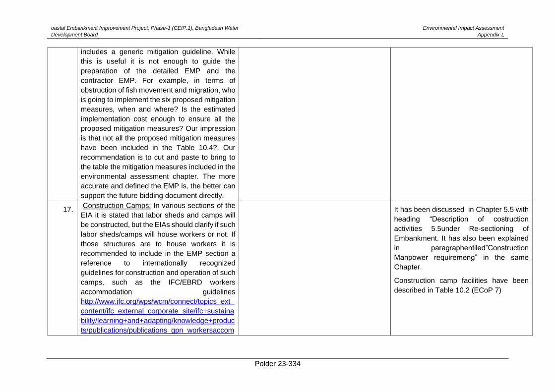
oastal Embankment Improvement Project, Phase-1 (CEIP.1), Bangladesh Water
Development Board
Environmental Impact Assessment
Appendix-L
Polder 23-334
includes a generic mitigation guideline. While
this is useful it is not enough to guide the
preparation of the detailed EMP and the
contractor EMP. For example, in terms of
obstruction of fish movement and migration, who
is going to implement the six proposed mitigation
measures, when and where? Is the estimated
implementation cost enough to ensure all the
proposed mitigation measures? Our impression
is that not all the proposed mitigation measures
have been included in the Table 10.4?. Our
recommendation is to cut and paste to bring to
the table the mitigation measures included in the
environmental assessment chapter. The more
accurate and defined the EMP is, the better can
support the future bidding document directly.
17. Construction Camps: In various sections of the
EIA it is stated that labor sheds and camps will
be constructed, but the EIAs should clarify if such
labor sheds/camps will house workers or not. If
those structures are to house workers it is
recommended to include in the EMP section a
reference to internationally recognized
guidelines for construction and operation of such
camps, such as the IFC/EBRD workers
accommodation guidelines
http://www.ifc.org/wps/wcm/connect/topics_ext_
content/ifc_external_corporate_site/ifc+sustaina
bility/learning+and+adapting/knowledge+produc
ts/publications/publications_gpn_workersaccom
It has been discussed in Chapter 5.5 with
heading “Description of costruction
activities 5.5under Re-sectioning of
Embankment. It has also been explained
in paragraphentiled”Construction
Manpower requiremeng” in the same
Chapter.
Construction camp facilities have been
described in Table 10.2 (ECoP 7)
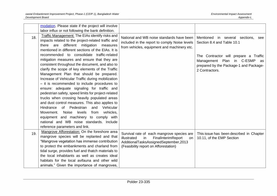
oastal Embankment Improvement Project, Phase-1 (CEIP.1), Bangladesh Water
Development Board
Environmental Impact Assessment
Appendix-L
Polder 23-335
modation. Please state if the project will involve
labor influx or not following the bank definition.
18. Traffic Management: The EIAs identify risks and
impacts related to the project-related traffic and
there are different mitigation measures
mentioned in different sections of the EIAs. It is
recommended to consolidate traffic-related
mitigation measures and ensure that they are
consistent throughout the document, and also to
clarify the scope of key elements of the Traffic
Management Plan that should be prepared.
Increase of Vehicular Traffic during mobilization
– it is recommended to include procedures to
ensure: adequate signaling for traffic and
pedestrian safety, speed limits for project-related
trucks when crossing heavily populated areas
and dust control measures. This also applies to
Hindrance of Pedestrian and Vehicular
Movement. Noise levels from vehicles,
equipment and machinery to comply with
national and WB noise standards. Include
reference parameters and link.
National and WB noise standards have been
included in the report to comply Noise levels
from vehicles, equipment and machinery etc.
Mentioned in several sections, see
Section 8.4 and Table 10.1
The Contractor will prepare a Traffic
Management Plan in C-ESMP as
prepared by the Package-1 and Package-
2 Contractors.
19. Mangrove Afforestation: On the foreshore area
mangrove species will be replanted and that
“Mangrove vegetation has immense contribution
to protect the embankments and charland from
tidal surge, provides fuel and thatch materials to
the local inhabitants as well as creates ideal
habitats for the local avifauna and other wild
animals.” Given the importance of mangroves,
Survival rate of each mangrove species are illustrated in FinalInterimReport on AdditionalTasksAssignedSeptember,2013 (Feasibility report on Afforestation)
This issue has been descrbed in Chapter 10.11, of the EMP Section
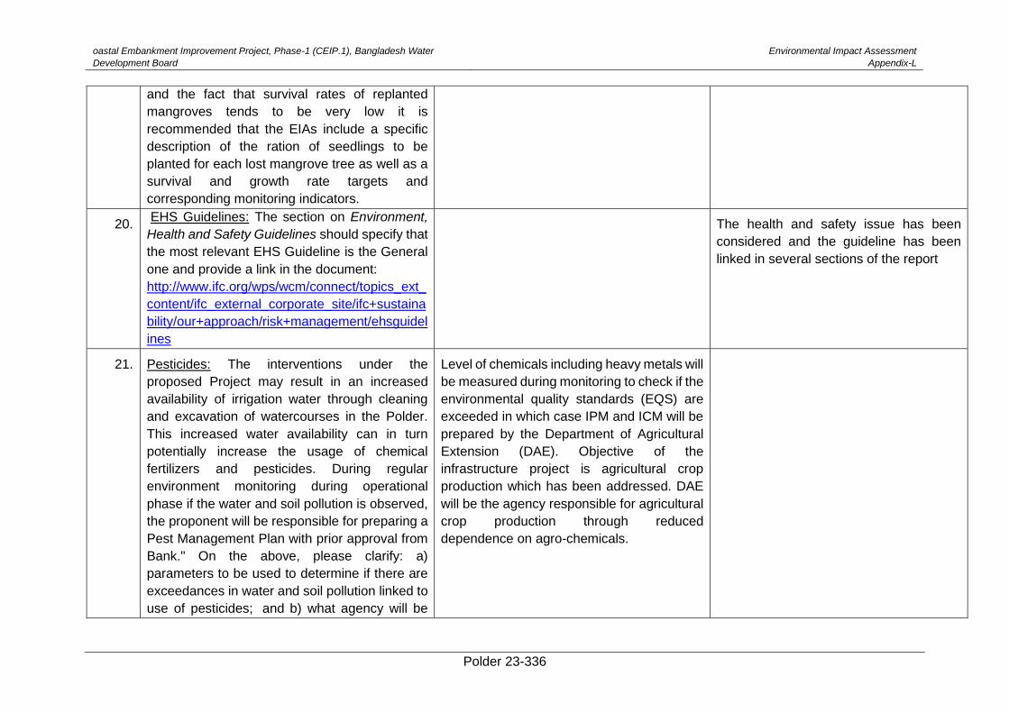
oastal Embankment Improvement Project, Phase-1 (CEIP.1), Bangladesh Water
Development Board
Environmental Impact Assessment
Appendix-L
Polder 23-336
and the fact that survival rates of replanted
mangroves tends to be very low it is
recommended that the EIAs include a specific
description of the ration of seedlings to be
planted for each lost mangrove tree as well as a
survival and growth rate targets and
corresponding monitoring indicators.
20. EHS Guidelines: The section on Environment,
Health and Safety Guidelines should specify that
the most relevant EHS Guideline is the General
one and provide a link in the document:
http://www.ifc.org/wps/wcm/connect/topics_ext_
content/ifc_external_corporate_site/ifc+sustaina
bility/our+approach/risk+management/ehsguidel
ines
The health and safety issue has been
considered and the guideline has been
linked in several sections of the report
21. Pesticides: The interventions under the
proposed Project may result in an increased
availability of irrigation water through cleaning
and excavation of watercourses in the Polder.
This increased water availability can in turn
potentially increase the usage of chemical
fertilizers and pesticides. During regular
environment monitoring during operational
phase if the water and soil pollution is observed,
the proponent will be responsible for preparing a
Pest Management Plan with prior approval from
Bank." On the above, please clarify: a)
parameters to be used to determine if there are
exceedances in water and soil pollution linked to
use of pesticides; and b) what agency will be
Level of chemicals including heavy metals will
be measured during monitoring to check if the
environmental quality standards (EQS) are
exceeded in which case IPM and ICM will be
prepared by the Department of Agricultural
Extension (DAE). Objective of the
infrastructure project is agricultural crop
production which has been addressed. DAE
will be the agency responsible for agricultural
crop production through reduced
dependence on agro-chemicals.
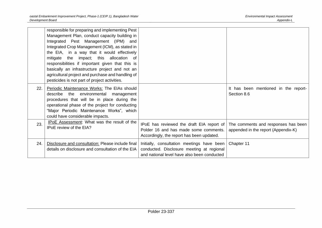
oastal Embankment Improvement Project, Phase-1 (CEIP.1), Bangladesh Water
Development Board
Environmental Impact Assessment
Appendix-L
Polder 23-337
responsible for preparing and implementing Pest
Management Plan, conduct capacity building in
Integrated Pest Management (IPM) and
Integrated Crop Management (ICM), as stated in
the EIA, in a way that it would effectively
mitigate the impact; this allocation of
responsibilities if important given that this is
basically an infrastructure project and not an
agricultural project and purchase and handling of
pesticides is not part of project activities.
22. Periodic Maintenance Works: The EIAs should
describe the environmental management
procedures that will be in place during the
operational phase of the project for conducting
“Major Periodic Maintenance Works”, which
could have considerable impacts.
It has been mentioned in the report-
Section 8.6
23. IPoE Assessment: What was the result of the
IPoE review of the EIA? IPoE has reviewed the draft EIA report of
Polder 16 and has made some comments.
Accordingly, the report has been updated.
The comments and responses has been
appended in the report (Appendix-K)
24. Disclosure and consultation: Please include final
details on disclosure and consultation of the EIA
Initially, consultation meetings have been
conducted. Disclosure meeting at regional
and national level have also been conducted
Chapter 11
Related Documents