1 Automated Building Extraction and Reconstruction from LIDAR Data Abstract Building information is extremely important for many applications such as urban planning, telecommunication, or environment monitoring etc. Automated techniques and tools for data acquisition from remotely sensed imagery are urgently needed. This paper presents an automatic approach for building extraction and reconstruction from airborne Light Detection and Ranging (LIDAR) data. First digital surface model (DSM) is generated from LIDAR data and then the objects higher than the ground are automatically detected from DSM. Based on general knowledge about buildings, geometric characteristics such as size, height and shape information are used to separate buildings from other objects. The extracted building outlines are simplified using an orthogonal algorithm to obtain better cartographic quality. Watershed analysis is conducted to extract the ridgelines of building roofs. The ridgelines as well as slope information are used to classify building types. The buildings are reconstructed using three parametric building models (flat, gabled, hipped). Finally, the results of extraction are compared with manually digitized reference data to conduct an accuracy assessment. The experimental results are very promising.

Welcome message from author
This document is posted to help you gain knowledge. Please leave a comment to let me know what you think about it! Share it to your friends and learn new things together.
Transcript

1
Automated Building Extraction and
Reconstruction from LIDAR Data
Abstract
Building information is extremely important for many applications such as urban
planning, telecommunication, or environment monitoring etc. Automated techniques and
tools for data acquisition from remotely sensed imagery are urgently needed. This paper
presents an automatic approach for building extraction and reconstruction from airborne
Light Detection and Ranging (LIDAR) data. First digital surface model (DSM) is
generated from LIDAR data and then the objects higher than the ground are
automatically detected from DSM. Based on general knowledge about buildings,
geometric characteristics such as size, height and shape information are used to separate
buildings from other objects. The extracted building outlines are simplified using an
orthogonal algorithm to obtain better cartographic quality. Watershed analysis is
conducted to extract the ridgelines of building roofs. The ridgelines as well as slope
information are used to classify building types. The buildings are reconstructed using
three parametric building models (flat, gabled, hipped). Finally, the results of extraction
are compared with manually digitized reference data to conduct an accuracy assessment.
The experimental results are very promising.

2
Introduction
More than 50% of the world population lived in urban/suburban areas, so detailed and
up-to-date building information is of great importance to every resident, government
agencies, and private companies (utilities, real estates etc.). Remote sensing is one of the
most efficient ways to acquire and extract the required information. Therefore, it is not
surprise that public government agencies as well as private companies spend millions of
dollars each year obtaining aerial photograph and other forms of remotely sensed data
(Jensen and Cowen, 1999).
However, the traditional manually building extraction from raw imagery is highly
labor-intensive, time-consuming and very expensive. During the past two decades many
researchers in photogrammetry, remote sensing and computer vision communities have
been trying to study and develop the automatic or semi-automatic approaches for building
extraction and reconstruction (Gruen et al., 1997; Mayer, 1999).
For monocular image, shadow analysis is often used to estimate 3D information
and assist building detection. 2D building roof hypotheses are generated from extracted
linear features by perceptual grouping. These hypotheses are then verified by 3D
evidence consisting of shadows and walls (Nevatia et al., 1997; Lin and Nevatia, 1998).
Obviously building detection from monocular image is extremely difficult since it
generally leads to ambiguous solutions (Henricsson and Baltsavias, 1997).
Buildings are 3D objects. The acquisition of 3D information from stereo images is
a common photogrammetric practice. Shi et al. (1997) proposed an automated building
extraction system that consists of low level image processing, stereo image matching and

3
surface reconstruction. Sahar and Krupnik (1999) developed a semiautomatic building
extraction approach, which buildings were detected interactively and 3D building
outlines were extracted using shadow analysis and stereoscopic processing. Kim and
Muller (1998) used a graph-based detection technique to extract 2D building outlines and
used stereo image pairs to extract height information. 3D building reconstruction was
achieved by interpolating heights into the areas defined by 2D building boundaries using
3D height information.
Digital surface model (DSM) can provide very useful clues for building locations.
Stereo images matching is a standard photogremmetric technique to generate DSM.
However, this technique is good only for open smooth terrain surface. The quality of
DSMs in built-up areas is poor due to occlusions and height discontinuities (Haala and
Brenner, 1998). In addition the aerial photographs are typically very complex and contain
a large number of objects in the scene. The automatic building extraction from aerial
photograph has proven to be quite difficult. Those approaches are far from being useful
in practice for images of different characteristics and complex contents (Mayer, 1999).
In recent years, two classes of active sensors have been developed that can
measure 3D topography directly: Interferometric Synthetic Aperture Radar (IFSAR) and
Light Detection and Ranging (LIDAR). IFSAR data can provide cues to assist building
detection from aerial photograph (Huertas et al., 1998). However, IFSAR do not generate
elevation data below a vertical accuracy of 1 meter. Additionally due to issues underlying
microwave reflections and interaction with man-made environments, IFSAR for detailed
mapping of urban landscapes is limited because of building layover/shadows (Hill et al.,

4
2000). On the other hand, airborne LIDAR has become an accurate, cost-effective
alternative to conventional technologies for the creation of DSMs at vertical accuracies of
15 centimeters to 100 centimeters (Hill et al., 2000). A building extraction comparison
from IFSAR and LIDAR data showed that LIDAR data provide a better shape
characterization of buildings (Gamba and Houshmand, 2000).
Several approaches have been presented for building extraction from the laser
altimeter data. Mass and Vosselman (1999) extracted buildings from original laser
altimeter point data. Parameters of standard gable roof type building were determined by
invariant moment analysis. Using a technique based on intersection of planes fitted into
triangulated point cloud, models of more complex building could be determined.
Laplacian of Gaussian edge detector was used by Wang (1998) to extract edges from
DSM image derived from LIDAR data. Again moment analysis was used to describe
edge properties. Edges were classified to separate building edges from other edges based
on shape and morphology differences. Tree usually is the major problem for building
extraction from DSM. Brunn and Weinder (1998) discriminated buildings and vegetation
by utilization of differential geometry via Bayesian networks. Step edge and crease edge
information were used to extract vegetation areas and building roof structures.
Also color attributes can facilitate to distinguish buildings from other objects.
Henricsson (1998) addressed the role of color attributes for automated 3D building
reconstruction from multiple color aerial images. Haala and Brenner (1999) combined
multi-spectral imagery and laser altimeter data for classification to extraction of

5
buildings, trees and grass-covered areas. Similarly Hug (1997) used surface reflectance
data provided by advanced laser sensor to separate man-made objects and natural objects.
This paper proposes an automatic approach for building extraction and
reconstruction solely based on LIDAR data. First DSM is generated from original
LIDAR point data, then we threshold the normalized DSM (the difference between DSM
and bare elevation) to get an initial segmentation. Buildings and trees are separated based
on surface roughness measured by differential geometric quantities. After raster-to-vector
conversion, the building outlines are simplified using an orthogonal algorithm. We utilize
slope information and watershed analysis to determine the building roof types. Finally the
buildings are reconstructed using three parametric models.
In the next section, the detailed approach to extract building outlines is described.
Then the followed section explains the building roof models and 3D reconstruction
methodology. The experimental results are presented and assessed by comparing with
reference data. Finally are the conclusions and discussion.
Extraction of Building Outlines
The proposed approach for extracting building outlines consists of three processes:
generating DSM, detecting building outlines, and simplifying outlines (Figure 1).

6
Generate DSM From LIDAR Point Data
Raw LIDAR data is a collection of mass points with XYZ coordinates. To generate DSM,
the point data have to be interpolated into regular grid data. There are several surface
interpolation methods such as inverse distance weighted interpolation, kriging,
polynomial regression etc. Our purpose is extracting buildings rather than constructing a
Figure 1. Scheme for building outline extraction
LIDAR Point Data
DSM Generation
Height Thresholding Size Thresholding Gradient Thresholding
Building Extraction
Outline Simplifying
Raster-to-Vector Conversion

7
smooth surface, therefore, a nearest neighbor interpolation method was chosen because it
will preserve the sharp difference between buildings and their surrounding ground.
The generated DSM not only represents the terrain surface, but also contains
buildings and other objects that are higher than the bare surface. The normalized DSM,
i.e. the difference between DSM and bare terrain surface, will describe these objects
(buildings, trees, etc). Terrain surface information can be obtained from other sources
such as topographic maps, stereo aerial photographs etc, but an approximation of
topographic surface can be directly derived from DSM using mathematical morphology
algorithm (Brunn, 1998).
Extract Building Outlines
Because we extract buildings solely from DSM, the criteria to distinguish buildings form
other objects must be geometric ones. Based on general knowledge about buildings, we
try to use size, height and shape characteristics to discriminate buildings from other
objects.
Due to the fact that buildings are man-made objects for accommodating human
beings or articles, it should have enough height and size. Using a height threshold can
remove objects with lower height such as cars, and a size threshold will remove some
smaller objects such as single trees.
However, there still has a tough problem left: the larger vegetation area or
vegetation mixed with buildings cannot be removed using height or size criteria.
Additional reflectance information delivered by some airborne laser scanner sensors or

8
multi-spectral imagery may be useful to distinguish vegetation from buildings (Hug,
1997; Haala and Brenner, 1999). However, we can also separate them based on geometric
shape characteristics because vegetation and building have significantly difference in
geometric shape: usually building is a polyhedron consists of flat planes and tree is
irregular shaped. It is possible to discriminate vegetation and building based on
roughness of surface measured by differential geometric criteria (Brunn and Weidner,
1998).
Differential geometry is geometry done using differential calculus, or shape
description through derivatives. Gradient is the primary first-order differential quantity
for an image. It is a vector whose components measure how rapidly pixel values are
changing with distance in the x and y directions. The gradient direction at a point is the
direction of steepest ascent at that point. The gradient magnitude gives the amount of the
difference between pixels in the neighborhood. Most edge detectors are based in some
way on measuring the intensity gradient. (Morse, 2000)
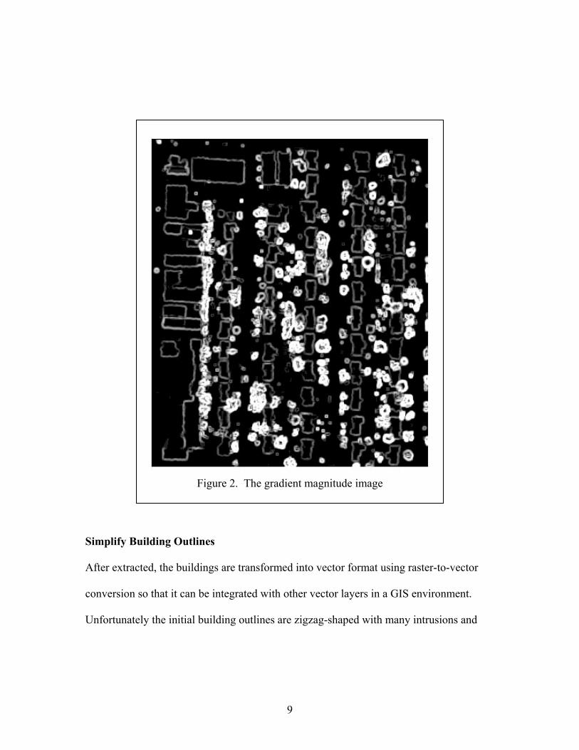
Gradient calculation is often done using convolution. The Gaussian kernels are
selected. Figure 2 shows the grey scale image of gradient magnitude. We can clearly see
the building outlines and trees. Trees are brighter clusters with irregular shapes. Using a
maginitude threshold, we can extract the tree boundaries. Then, set the tree boundaries as
a mask, the building outlines can be selected and separated.
9
Simplify Building Outlines
After extracted, the buildings are transformed into vector format using raster-to-vector
conversion so that it can be integrated with other vector layers in a GIS environment.
Unfortunately the initial building outlines are zigzag-shaped with many intrusions and
Figure 2. The gradient magnitude image

10
extrusions (Figure 3a) due to the raster nature of DSM. To obtain a better cartographic
quality, the outlines need to be refined and simplified.
Buildings are generally orthogonal areas with rectangular corners. We use an
orthogonal simplification algorithm to reduce details in the outlines, while maintaining
their essential shape and size of the buildings. Based on given parameters, small
intrusions will be either filled up or widened. Small extrusions will be cut off. Some sides
will be straightened or changed to simpler forms. The number of vertices will be reduced,
but the building areas will remain roughly the same as the original.
Figure 3b shows the result of building outline simplification. All building corners
become rectangular. Small intrusions and extrusion are removed. In the mean time, any
building with an area smaller than the specified minimum threshold will be excluded.
(a) (b)
Figure 3. Results of building simplifying: (a) before simplifying; (b) after simplifying

11
3D Building Reconstruction
In this section, we first discuss the commonly used building models for 3D
reconstruction. Then, the building reconstruction processes are described.
Building Models
Buildings are man-made objects with variety of shape and roof type. Also the texture,
illumination, sun angle etc in an image make the extraction more difficult. To represent
the buildings, we have to use simplified models to describe it. Most building extraction
approaches assume that buildings have rectilinear shapes with flat roof (Nevatia et al.,
1997; Sahar and Krupnlk, 1999). However, simple flat model has limited applications.
Parametric models are more complex and can describe most buildings in terms of simple
primitive shapes. It only uses a few parameters (length, width, height) to describe certain
building types such as gabled, hipped building etc. For more complex buildings,
polyhedral models and generic models may be used. However, these models may fail due
to the complexity of building extraction. Interactive editing is necessary (Brunn and
Weidner, 1998).
We will reconstruct 3D buildings using three common building roof models: flat,
gabled, and hipped. These three models can represent most buildings especially in
residential areas.

12
Determine Building Roof Type and 3D Reconstruction
We already got the building outlines, so the length and width parameters of each building
are known. Next step is to determine building roof type and extract height information
from DSM. The basic scheme is showed in Figure 4.
Flat Building
Flat building has flat roof. Therefore, it has a lower slope. A slope analysis can detect the
flat buildings. First we compute the slope of DSM and binarize the slope image to find
Figure 4. Scheme for 3D building reconstruction
DSM
Slope thresholding
Flat Building Ridgeline Extraction
Watershed Analysis
Hipped Building
Parameter Determination
Gabled Building
3D Building Reconstruction

13
all pixels whose slope is less than a threshold. Using the building outlines as a zone layer,
all pixels fall within a building boundary define a distinct zone. Then, we compute the
area from binarized slope image for each zone (building) using a zonal statistics.
Comparing the calculated area with the whole area of each building, the flat buildings can
be determined. The height of each flat building can be determined by the average height
of pixels within each building boundary.
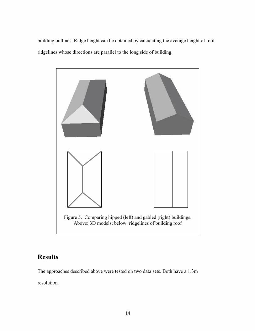
Hipped vs Gabled
From Figure 5, we can see that hipped and gabled buildings have different roof ridgeline
shapes: gabled roof has one simple straight line whose direction is parallel to the long
side of building; the ridgeline of hipped roof consists of forked line segments with
different directions. DSM can describe the 3D surface of a building and the shape of a
building roof determines how water will flow across it. Flow across a surface will always
be in the steepest down-slope direction. Therefore, for each cell of DSM, the direction of
flow can be calculated. Then, it is possible to determine which and how many cells flow
into any given cell. This information can be used to define watershed boundaries. Cells
with a flow accumulation of zero are local topographic highs and may be used to identify
ridges. After extracting the ridgelines of building roof, hipped and gabled buildings can
be distinguished based on shape characteristics.
Two height parameters need to be determined: eave height and ridge height.
Appropriate height of eave can be derived from the mean height of corner points of
14
building outlines. Ridge height can be obtained by calculating the average height of roof
ridgelines whose directions are parallel to the long side of building.
Results
The approaches described above were tested on two data sets. Both have a 1.3m
resolution.
Figure 5. Comparing hipped (left) and gabled (right) buildings. Above: 3D models; below: ridgelines of building roof

15
Figure 6 is one scene of residential area where many trees mingled with buildings.
This is a normalized DSM image in grey scale. The brighter pixel has larger value (higher
elevation). It can be clearly seen that the buildings and trees are stand out from
surrounding ground. From the shaded relief map (Figure 7), we even can see some roof
structures and cars (small noise). The extracted results showed in Figure 8, overlaid with
DSM. Figure 9 shows a 3D perspective view of extracted building draped on DEM (bare
earth). Almost all buildings are successfully extracted. Visual results are rather good.
Detailed evaluation will be discussed in the following part.
Figure 6. Normalized DSM of a residential area

16
Figure 7. Shade relief map of normalized DSM

17
Figure 8. Extracted buildings overlaid with DSM

18
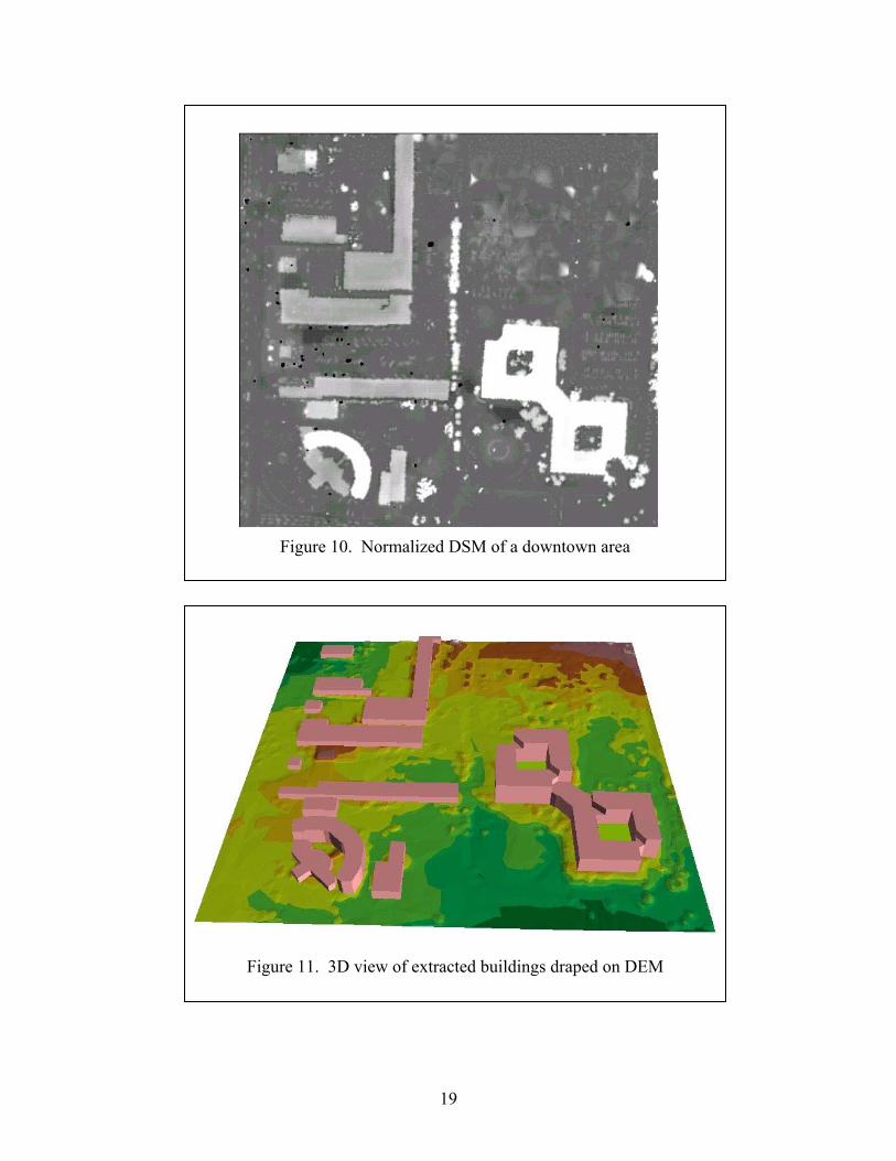
Another test data set is a downtown scene with high commercial buildings (Figure
10). Tree is not a major problem for this image. However, some special processes are
needed. We cannot use the orthogonal algorithm to simplify the semi-circular shaped
building located at the low left corner. We may use either the original outlines or
manually delineate the outlines. Also special attention should be paid to the building with
two holes in the center. This building has multiple heights although this cannot be seen
from the normalized DSM image. The boundaries between building parts with different
heights can be detected from the gradient magnitude image. These boundaries need to be
integrated with extracted outlines to further segment this building. Figure 11 shows the
extracted results draped on bare earth.
Figure 9. 3D perspective view of extracted buildings overlaid on DEM
19
Figure 10. Normalized DSM of a downtown area
Figure 11. 3D view of extracted buildings draped on DEM

20
Accuracy Assessment
The results look excellent visually. However, a quantitative accuracy assessment is
needed to know how good these results are. Heipke et al. (1997) proposed several
measures to evaluate the quality of road extraction. The completeness and correctness
measures can be used to assess building extraction too. Completeness represents the
percentage of reference data being extracted. Correctness indicates the percentage of
correctly extraction. Nevatia and Huertas (1999) used the similar measures for building
evaluation. Although the RMS (Root Mean Square) error is the standard measure to
express the geometrical accuracy, it only covers certain aspects of the geometric accuracy
of building extraction. Henricsson and Baltsavias (1997) used area difference and overlay
errors as two indicators for building shape similarity.
We compare the automatically extracted buildings with reference data manually
digitized from aerial photograph with 0.25m resolution. The reference data contain
building outlines and roof type information. We can get the completeness and correctness
measure by comparing number of extracted buildings with reference data. Horizontal
RMS error can be obtained by calculating the distance between corresponding building
corners. Overlaying extracted building with reference data will lead to the overlay error
as well as area & perimeter difference measure. Due to lack of height information of
reference data, we cannot assess the vertical geometric accuracy. We compare extracted
roof types with reference data to obtain classification accuracy. The seven quality
measures (completeness, correctness, classification accuracy, RMS error, area difference,
21
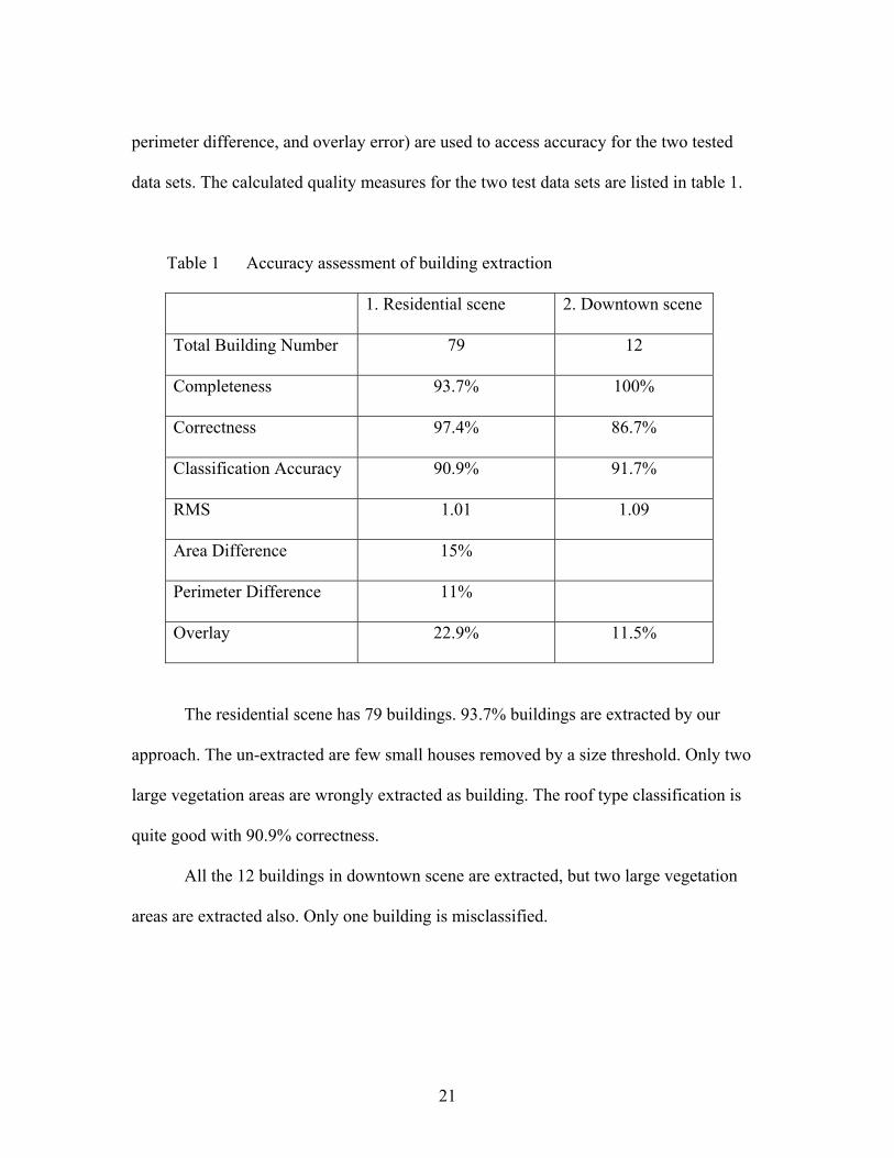
perimeter difference, and overlay error) are used to access accuracy for the two tested
data sets. The calculated quality measures for the two test data sets are listed in table 1.
Table 1 Accuracy assessment of building extraction
1. Residential scene 2. Downtown scene
Total Building Number 79 12
Completeness 93.7% 100%
Correctness 97.4% 86.7%
Classification Accuracy 90.9% 91.7%
RMS 1.01 1.09
Area Difference 15%
Perimeter Difference 11%
Overlay 22.9% 11.5%
The residential scene has 79 buildings. 93.7% buildings are extracted by our
approach. The un-extracted are few small houses removed by a size threshold. Only two
large vegetation areas are wrongly extracted as building. The roof type classification is
quite good with 90.9% correctness.
All the 12 buildings in downtown scene are extracted, but two large vegetation
areas are extracted also. Only one building is misclassified.

22
Discussion and Conclusions
This paper described an automatic approach for building extraction and reconstruction
from LIDAR data. Solely based on derived DSM, general knowledge about building’s
geometric characteristics such as size, height and shape information are used to separate
buildings from other objects. Watershed analysis and slope information are used to
classify building roof types. Finally the buildings are reconstructed using three parametric
building models (Flat, Hipped, and Gabled).
The results showed that our approach has really good performance. …………This
approach has great potential for practical use in photogrammetry and remote sensing
industry. In addition, all the algorithms are written in an integrated GIS environment. The
extracted buildings can be directly used for further analysis together with other GIS
layers.
For the time being, this approach uses only three building models. However, with
the available of more dense LIDAR data, other complex building models such as
Cross-gabled or cross-hipped etc. can be constructed.
Although this approach is a fully automatic, user still need to input few
parameters such min building size etc. The selection of parameters may have influence on
the final results. Usually user chooses the parameters based on experience or general
knowledge. To determine the appropriate parameters or threshold in an objective way
need to be study in the future.

23
This approach needs to be tested on more data sets and improved to deal with
more complex DSM data.
Reference
Brunn, A., and U. Weidner, 1998, Hierarchical Bayesian nets for building extraction
using dense digital surface models, ISPRS Journal of Photogrammetry & Remote
Sensing, 53(5): 296-307.
Fischer, A., T. H. Kolbe, F. Lang, A. B. Cremers, W. Forstner, L. Plumer, and V.
Steinhage. 1998, Extracting buildings from aerial images using hierarchical aggregation
in 2D and 3D, Computer Vision and Image Understanding 72(2): 185-203.
Gamba, P., and B. Houshmand, 2000, Digital surface models and building extraction: a
comparison of IFSAR and LIDAR data, IEEE Transactions on Geoscience and Remote
Sensing, 38 (4): 1959-1968.
Gruen, A., E.P. Baltsavias, and O. Henricsson, 1997, Automatic Extraction of Man-Made
Objects from Aerial and Space Images (II), Birkhauser Verlag.
Haala, N., and C. Brenner, 1998, Interpretation of urban surface models using 2D
building information, Computer Vision and Image Understanding, 72(2): 204-214.

24
Haala, N., and C. Brenner,1999, Extraction of building and trees in urban environments,
ISPRS Journal of Photogrammetry & Remote Sensing, 54(2-3): 130-137.
Heipke, C., H. Mayer, C. Wiedemann, and O. Jamet, 1997, Evaluation of automatic road
extraction, International Archives of Photogrammetry and Remote Sensing, 32 (3): 47-
56.
Henricsson, O., 1998, The role of color attributes and similarity grouping in 3-D building
reconstruction, Computer Vision and Image Understanding, 72(2): 163-184.
Henricsson, O., and E. Baltsavias, 1997, 3-D building reconstruction with ARUBA: a
qualitative and quantitative evaluation, Automatic Extraction of Man-Made Objects from
Aerial and Space Images (II) (A. Gruen, E.P. Baltsavias, and O. Henricsson, editors),
Birkhauser Verlag, pp 65-76.
Hill, J.M., L.A. Graham, R.J. Henry, D.M. Cotter, A. Ding, and D. Young, 2000, Wide-
area topographic mapping and applications using airborne light detection and ranging
(LIDAR) technology, Photogrammetric Engineering & Remote Sensing, 66(8): 908-x.
Huertas, A., Z. Kim, and R. Nevatia, 1998, Use of IFSAR with intensity images for
automatic building modeling, DARPA Image Understanding Workshop 1998, Monterey,
California.

25
Hug, C., 1997, Extracting artificial surface objects from airborne laser scanner data,
Automatic Extraction of Man-Made Objects from Aerial and Space Images (II) (A.
Gruen, E.P. Baltsavias, and O. Henricsson, editors), Birkhauser Verlag, pp 193-202.
Jensen, J. R., and D. C. Cowen, 1999, Remote sensing of urban/suburban infrastructure
and socio-economic attributes, Photogrammetric Engineering & Remote Sensing, 65(5):
611-622.
Kim, T., and J. P. Muller, 1998, A technique for 3D building reconstruction,
Photogrammetric Engineering & Remote Sensing, 64(9): 923-930.
Lin, C., and R. Navatia,1998, Building detection and description from a single intensity
image, Computer Vision and Image Understanding, 72(2): 101-121.
Mass, H.G., and G. Vosselman, 1999, Two algorithms for extracting building models
from raw laser altimetry data, ISPRS Journal of Photogrammetry & Remote Sensing,
54(2-3): 153-163.
Mayer, H., 1999, Automatic object extraction from aerial imagery: a survey focusing on
buildings, Computer Vision and Image Understanding, 74(2): 138-149.

26
Morse, B. S., 2000, Differential geometry,
URL:http://www.dai.ed.ac.uk/CVonline/LOCAL_COPIES/MORSE/diffgeom.pdf.
Nevaita, R., and A. Huertas, 1999, Final technical report,
URL:http://iris.usc.edu/Outlines/papers/2000/APGD-final.pdf
Nevatia, R., C. Lin, and A. Huertas, 1997, A system for building detection from aerial
images, Automatic Extraction of Man-Made Objects from Aerial and Space Images (II)
(A. Gruen, E.P. Baltsavias, and O. Henricsson, editors), Birkhauser Verlag, pp 77-86.
Sahar, L., and A. Krupnik, 1999, Semniautomatic extraction of building outlines from
large-scale aerial images, Photogrammetric Engineering & Remote Sensing, 65(4): 459-
465.
Shi, Z., R. Shibasaki, and S. Murai, 1997, Automated building extraction from digital
stereo imagery, Automatic Extraction of Man-Made Objects from Aerial and Space
Images (II) (A. Gruen, E.P. Baltsavias, and O. Henricsson, editors), Birkhauser Verlag,
pp 109-118.
Wang, Z., 1998, Extracting building information from LIDAR data, ISPRS Commission
III Symposium on Object Recognition and Scene Classification from Multi-Spectral and
Multi-Sensor Pixels, Columbus, Ohio.

27
Weidner, U., and W. Forstner, 1995, Towards automatic building reconstruction from
high resolution digital elevation models, ISPRS Journal of Photogrammetry & Remote
Sensing, 50(4), 38-49.
Related Documents