San Angelo District Yoakum District Austin District Laredo District . / 77 . / 87 . / 90 . / 59 . / 59 . / 77 . / 281 . / 183 . / 183 . / 281 . / 87 . / 281 . / 90 . / 181 . / 83 . / 77 . / 90 . / 290 . / 59 . / 281 . / 183 . / 290 . / 87 . / 77 . / 83 . / 87 . / 90 . / 277 . / 90 . / 90 . / 90 . / 181 . / 277 . / 290 . / 59 . / 87 . / 77 . / 290 . / 57 . / 83 . / 77 . / 77 . / 290 . / 181 . / 83 . / 83 . / 57 . / 290 . / 77 . / 83 . / 59 . / 277 . / 59 . / 57 . / 83 . / 277 . / 83 . / 183 . / 277 S T 130 S T 80 S T 185 S T 16 S T 71 S T 72 S T 211 S T 142 S T 173 S T 123 S T 21 S T 97 S T 46 S T 21 S T 123 S T 16 S T 359 S T 35 S T 173 S T 16 S T 72 S T 97 S T 95 S T 44 S T 85 S T 130 S T 16 S T 44 S T 97 2725 1626 78 973 1518 725 812 2369 624 3351 306 3009 462 624 20 624 65 § ¨ ¦ 90A § ¨ ¦ 90A § ¨ ¦ 90A § ¨ ¦ 77A § ¨ ¦ 35 § ¨ ¦ 35 § ¨ ¦ 37 § ¨ ¦ 10 § ¨ ¦ 37 § ¨ ¦ 410 § ¨ ¦ 10 § ¨ ¦ 35 § ¨ ¦ 10 § ¨ ¦ 37 § ¨ ¦ 35 § ¨ ¦ 10 § ¨ ¦ 10 Blanco County Bastrop County Hays County Fayette County Caldwell County Live Oak County Bee County McMullen County Refugio County San Patricio County Jim Wells County Duval County Crockett County Sutton County Kimble County Gonzales County Lavaca County Jackson County Victoria County Goliad County Calhoun County Colorado County Val Verde County Edwards County Real County Kinney County Uvalde County Maverick County Zavala County Dimmit County Webb County Lee County De Witt County La Salle County Gillespie County Kerr County Kendall County Comal County Bandera County Guadalupe County Bexar County Medina County Wilson County Atascosa County Karnes County Frio County Burleson County Washington County Travis County Pleasanton Garden Ridge Bulverde Fair Oaks Ranch China Grove Selma Converse Helotes Universal City Live Oak Floresville Bastrop Uvalde Pearsall Cibolo Corpus Christi Corpus Christi Schertz Beeville Hondo Kerrville Boerne New Braunfels Eagle Pass Cuero Saint Hedwig Seguin Corpus Christi Victoria San Antonio Del Rio Austin Coahuila De Zaragoza Mexico San Antonio Bay Aransas Bay Corpus Christi Bay Nueces Bay Copano Bay Lavaca Bay Gulf of Mexico 9 11 12 13 14 15 2 3 4 8 7 6 10 5 1 2015 SAN ANTONIO DISTRICT TRAFFIC MAP IH Toll US State Arterials & Collectors Local Cities Counties Districts KEY TO SHEETS ³ Texas Department of Transportation Transportation Planning and Programming Division Traffic Analysis System Support Branch PREPARED BY THE IN COOPERATION WITH THE United States Department of Transportation Federal Highway Administration COPYRIGHT 2016 by the Texas Department of Transportation. All rights reserved. NOTICE: This map has been prepared for internal use within the Texas Department of Transportation. Accuracy is limited to the validity of available data. Publication Date: September 2016 Toll road traffic counts are shown for context purposes only and may not represent On System traffic. 0 10 20 5 Miles

Welcome message from author
This document is posted to help you gain knowledge. Please leave a comment to let me know what you think about it! Share it to your friends and learn new things together.
Transcript

San Angelo District
Yoakum District
Austin District
Laredo District
./77
./87
./90
./59
./59
./77
./281
./183
./183
./281
./87
./281
./90
./181
./83
./77
./90
./290
./59
./281
./183
./290
./87
./77
./83
./87
./90
./277
./90
./90
./90
./181
./277
./290
./59
./87
./77
./290
./57
./83
./77
./77
./290
./181
./83
./83
./57
./290
./77
./83
./59
./277
./59
./57
./83
./277
./83
./183./277
ST130
ST80
ST185
ST16
ST71
ST72
ST211
ST142
ST173 ST123
ST21
ST97
ST46
ST21
ST123
ST16
ST359
ST35
ST173
ST16
ST72
ST97
ST95
ST44
ST85
ST130
ST16
ST44
ST97
2725
1626
78
973
1518
725
812
2369
624
3351
306
3009
462
624
20
624
65
§̈¦90A
§̈¦90A
§̈¦90A
§̈¦77A
§̈¦35
§̈¦35 §̈¦37
§̈¦10
§̈¦37
§̈¦410
§̈¦10
§̈¦35
§̈¦10
§̈¦37
§̈¦35
§̈¦10
§̈¦10
BlancoCounty
BastropCounty
HaysCounty
FayetteCountyCaldwell
County
Live OakCounty
BeeCounty
McMullenCounty
RefugioCounty
SanPatricioCountyJim Wells
CountyDuvalCounty
CrockettCounty
SuttonCounty
KimbleCounty
GonzalesCounty Lavaca
County
JacksonCounty
VictoriaCounty
GoliadCounty
CalhounCounty
ColoradoCounty
Val VerdeCounty
EdwardsCounty
RealCounty
KinneyCounty
UvaldeCounty
MaverickCounty Zavala
County
DimmitCounty
WebbCounty
LeeCounty
De WittCounty
La SalleCounty
GillespieCounty
KerrCounty
KendallCounty Comal
County
BanderaCounty
GuadalupeCounty
BexarCounty
MedinaCounty
WilsonCounty
AtascosaCounty
KarnesCountyFrio
County
BurlesonCounty
WashingtonCounty
TravisCounty
Pleasanton
Garden Ridge
Bulverde
Fair Oaks Ranch
China Grove
Selma
Converse
Helotes UniversalCity
Live Oak
Floresville
Bastrop
Uvalde
Pearsall
Cibolo
Corpus ChristiCorpus Christi
Schertz
Beeville
Hondo
Kerrville
Boerne
New Braunfels
Eagle Pass
Cuero
SaintHedwig
Seguin
Corpus Christi
Victoria
San Antonio
DelRio
Austin
CoahuilaDe Zaragoza
Mexico SanAntonio
Bay
AransasBay
CorpusChristi Bay
NuecesBay
CopanoBay
LavacaBay
Gulf ofMexico
911 12
1314
15
23 4
876
10
5
1
2015 SAN ANTONIO DISTRICT TRAFFIC MAPIH
Toll
US
StateArterials &CollectorsLocal
Cities
Counties
DistrictsKEY TO SHEETS³ Texas Department of Transportation
Transportation Planning and Programming DivisionTraffic Analysis System Support Branch
PREPARED BY THE
IN COOPERATION WITH THEUnited States Department of Transportation Federal Highway Administration
COPYRIGHT 2016 by the Texas Department of Transportation.All rights reserved.NOTICE: This map has been prepared for internal use within the Texas Department ofTransportation. Accuracy is limited to the validity of available data.
Publication Date: September 2016
Toll road traffic counts are shown for context purposes only and may not represent OnSystem traffic.0 10 205
Miles

!.
!.
!.
!.
!.
!.
!.
!.
112
132
78
120
857
693
813
803
Rocksprings
San AngeloDistrict
San AntonioDistrict
674
26302995
1873235
336
335
335
1340
ST55
ST39
ST55
ST55
ST41
ST41
ST39
ST41
ST41
ST41
./290
./377
./377
./377
./83
./83
./377
./83
./83
§̈¦10
§̈¦10SuttonCounty Kimble
County
EdwardsCounty
RealCounty
KerrCounty
BanderaCounty
2015 SAN ANTONIO DISTRICT TRAFFIC MAP
Sheet 1 of 15 Base Sheets³0 2.5 51.25Miles
Texas Department of TransportationTransportation Planning and Programming Division
Traffic Analysis System Support Branch
PREPARED BY THE
IN COOPERATION WITH THEUnited States Department of Transportation Federal Highway Administration
COPYRIGHT 2016 by the Texas Department of Transportation.All rights reserved.NOTICE: This map has been prepared for internal use within the Texas Departmentof Transportation. Accuracy is limited to the validity of available data.
Publication Date: September 2016
Toll road traffic counts are shown for context purposes only and may not representOn System traffic.
Arterials &Collectors City! TownState!. AADT Inset
US Local DistrictIH County County

!
!
!
!
!
!.
!.
!.
!.
!.
!.
!.
!.
!.
!. !. !.
!.
!.
!.
!. !.!. !.
!.
!.
!.
!.
!.
!.
!.
!.
!.
!.
!.
!.!.
!.
!.
!.
!.
!.!.
!.
!.
!.
!.
!.
!.!.
!.!.
!.
!.
!.!.
!.
!.!.!.
!.
!.!.!.!.!.
!.
!.
!.
!.
!.
!.
!.!.
!.
!.
!.!.
!.
!.!.
!.
!.
!.
!.
!.
!.
!.
!.
!.
!.
!.
!.
!.
!.
!.
!.
!.
!.
!. !.
!.
!.
!.
!.
!.
!.
!.
!.
!.!.
!.!.
!.
!. !.
!.
!.!.
!.
!.
!.
!.
!.
!.
!.
391
425
909
960
16802
21637560
21592
951512791
5111 28855568
2587
2397
70176289
71145931
197
6306
4375
754
7389
6661
123534983435
1445
658
1196911332
11394776
2147
4047
7736
91010304
1977
3147
3817326
102357247
6439
487
9299
403810334537
2697
15455971362
35103177
139944967
96127466
3141071
337927001511
897
904
3931138
531
222
112
78
10069
1461
3683
176
113 382
2955
3587
3814
6476
4862
310
4746
174
Kerrville
Fredericksburg
Ingram
San AngeloDistrict
AustinDistrict
San AntonioDistrict
783
385 965479
1631
480
473
1376
783
479
783
289
1350
1338
1273
1341
2771
1340
1341
1621
1340
2093
20932093
ST534
ST27
ST27
ST173
ST173
ST41
ST39
ST16
ST27ST16
ST27
ST27
ST16
ST16
ST39
ST16
ST39
ST41
./87
./87
./290
./87
./290./290
./87
./290
./290./290./290
./290
§̈¦10
§̈¦10
§̈¦10
§̈¦10
§̈¦10
§̈¦10
§̈¦10
§̈¦10
Comfort
Camp Verde
Mountain Home
Center Point
Harper
KimbleCounty
GillespieCounty
KerrCounty
KendallCounty
BanderaCounty
See Supp Sheet 1
2015 SAN ANTONIO DISTRICT TRAFFIC MAP
Sheet 2 of 15 Base Sheets³0 2.5 51.25Miles
Texas Department of TransportationTransportation Planning and Programming Division
Traffic Analysis System Support Branch
PREPARED BY THE
IN COOPERATION WITH THEUnited States Department of Transportation Federal Highway Administration
COPYRIGHT 2016 by the Texas Department of Transportation.All rights reserved.NOTICE: This map has been prepared for internal use within the Texas Departmentof Transportation. Accuracy is limited to the validity of available data.
Publication Date: September 2016
Toll road traffic counts are shown for context purposes only and may not representOn System traffic.
Arterials &Collectors City! TownState!. AADT Inset
US Local DistrictIH County County

!
!
!
!!
!
!
!
!
!
!.
!.
!.
!.!.
!.
!.!.
!.!.
!.!.
!.
!.
!.
!.
!.
!.!.!.
!.
!.
!.
!.
!.
!.
!.
!.
!.
!.
!.
!.
!.
!.
!.
!.
!.
!.
!.
!.
!.
!.
!.
!.
!.
!.
!.
!.
!.
!.
!.
!.
!. !.
!.
!.
!.
!.
!.
!.!.
!.
!.
!.
!.
!.
!.
!.
!.
!.
!.
!.
!.
!.
!.
!.
!.
!.
!.
!.
!.
!.!.
!.
!.!.
!.
!.
!.
!.
!.
!.
!.
!.!. !.
!.
!.!.
!. !.
!.
!.
!.
!.!.
!.
30502904
8317
18481236
2231663
52034969
6238
759
668353
4957
903771618053
2146
2632
5099
23157120760
1533616425
19185
7215
85414698
9470
2053
8806
5682
70502300
18243
6652
23265789
6889
2028
16658
24087
1961117506 32323
9279
187
2268
276
166
386
722
376
1010
391
28306440
3357
4253
661
696956565
57918
2467
26157
10460
3814
5841
79509554
2009822706
55907
17137
40107
4039
786921616219
9988
13315
6797
26378
30498 16290
8168
2187
15653
224
606
689820
8801
5785
6050
59701
6802
8452
6977
3177
14604
8240
29538
33576351
13058
Wimberley
Fair Oaks Ranch
Blanco
Boerne
New Braunfels
Bulverde
Woodcreek
San Antonio
Dripping Springs
AustinDistrict
San AntonioDistrict
12
2325
474
1376
1623
32
484
3237
150165
1376
473
32
12
1888
1376
12
1888
32
1623
473
473
474
473
2722
165
2325
1376
289
3424
1102
1101
306
306
1621
306
3159
2673
1863
311
3351
306
3009
3351
ST46
ST46
ST46
ST46
ST46
ST46
./281
./87
./281
./281
./281
./281
§̈¦10
§̈¦35
§̈¦10
KendaliaSisterdale
Fischer
Canyon CitySpring Branch
SattlerStartzville
Twin Sisters
Specht Store
Mount Gainor
CanyonLake
BlancoCounty
HaysCountyGillespie
County
KendallCounty
ComalCounty
BexarCounty
2015 SAN ANTONIO DISTRICT TRAFFIC MAP
Sheet 3 of 15 Base Sheets³0 2.5 51.25Miles
Texas Department of TransportationTransportation Planning and Programming Division
Traffic Analysis System Support Branch
PREPARED BY THE
IN COOPERATION WITH THEUnited States Department of Transportation Federal Highway Administration
COPYRIGHT 2016 by the Texas Department of Transportation.All rights reserved.NOTICE: This map has been prepared for internal use within the Texas Departmentof Transportation. Accuracy is limited to the validity of available data.
Publication Date: September 2016
Toll road traffic counts are shown for context purposes only and may not representOn System traffic.
Arterials &Collectors City! TownState!. AADT Inset
US Local DistrictIH County County

!!
!
!
!
!
!
!
!
!
!
!
!
!
!
!
!
!
!
!
!
!
!
!
!
!.
!.
!.
!.
!.
!.
!.
!.!.
!.
!.
!.
!.!.
!.
!.
!.
!.
!.
!.
!.!.
!.
!.
!.
!.!.
!.
!.
!.
!.
!.!.
!.
!.
!.
!.
!.
!.
!.
627
1015
3236
4204
1461
266
747
591
687450
1927
5305
11588237
512971533
280098003
1765
1835
4957
2146
2632
5099
23157120760
1533616425
19185 15653
14604
1893
1721
9932
1032
273
13058
5314
5330
Wimberley
Buda
Bastrop
Lockhart
Kyle
MustangRidge
New Braunfels
San Marcos
Austin
Creedmoor
Luling
Hays
Uhland
San Leanna
Staples
Woodcreek
Mountain City
Niederwald
Martindale
Dripping Springs
YoakumDistrict
AustinDistrict
San AntonioDistrict
2325
12
12
32
967
1826
150
12
12
3237
967
150
1386
1322
2430
110
812
1854
672
1626
20
1102
973
621
306
20
1209
86
713
1979
621
2770
1327
812
1984
2439
1625
1626
969
3353
535
1978
1966
2001
2001
1977 671
713
1101
1339
86
1854
20
86
1322
535
3158
2984
1185
20
535
6722720
20812
713
ST82
ST21
ST80
ST21
ST45
ST46
ST21
ST71
ST45 ST21
ST21
ST130
ST123
ST123
ST80
ST21
ST80
ST130
ST130
ST304
ST142
ST21
ST130
ST304
ST304
ST130
./183
./183
./183
§̈¦35
§̈¦35
§̈¦35
§̈¦35
§̈¦35
Lytton SpringsMendoza
Dale
MaxwellReedville
McMahan
Tilmon
Fentress
Prairie Lea
Stairtown
Hunter
Manchaca
ElroyCarl
Redwood
Staples
Zorn
Cedar Creek
Rockne
Red Rock
Bateman
String Prairie
Driftwood
Hays City
Goforth
BastropCounty
HaysCounty
CaldwellCounty
GonzalesCounty
ComalCounty
GuadalupeCounty
TravisCounty
§̈¦B35
2015 SAN ANTONIO DISTRICT TRAFFIC MAP
Sheet 4 of 15 Base Sheets³0 2.5 51.25Miles
Texas Department of TransportationTransportation Planning and Programming Division
Traffic Analysis System Support Branch
PREPARED BY THE
IN COOPERATION WITH THEUnited States Department of Transportation Federal Highway Administration
COPYRIGHT 2016 by the Texas Department of Transportation.All rights reserved.NOTICE: This map has been prepared for internal use within the Texas Departmentof Transportation. Accuracy is limited to the validity of available data.
Publication Date: September 2016
Toll road traffic counts are shown for context purposes only and may not representOn System traffic.
Arterials &Collectors City! TownState!. AADT Inset
US Local DistrictIH County County

!
!
!
!
!
!
!
!.
!.
!.
!.
!.
!.
!.
!.
!.
!.
!.!. !.
!.!.
!.!.
!.
!.
!.
!.
!.!.
!.
!.
!.
!.
!.
!.
!.
!.
!.
!.
!.120
353
379
578464
346
1161
603
632
126
611
1791
51567
1517
1684291
1595
190
665
84
120 1921260
168 744576
171
345 191
427
707
397
47
Leakey
Camp Wood
San AngeloDistrict
San AntonioDistrictLaredo
District
2748
1050
337
187
337
337
187
1050
337
187
335
337
336
335
187
2631
470
3199
1120
1051
ST55
ST55
ST55
ST127
ST55
ST55
./83
./83
./83
./83
./83
Rio Frio
Barksdale
Vanderpool
Utopia
Reagan Wells
Montell
Concan
EdwardsCounty
RealCounty
KinneyCounty
UvaldeCounty
BanderaCounty
2015 SAN ANTONIO DISTRICT TRAFFIC MAP
Sheet 5 of 15 Base Sheets³0 2.5 51.25Miles
Texas Department of TransportationTransportation Planning and Programming Division
Traffic Analysis System Support Branch
PREPARED BY THE
IN COOPERATION WITH THEUnited States Department of Transportation Federal Highway Administration
COPYRIGHT 2016 by the Texas Department of Transportation.All rights reserved.NOTICE: This map has been prepared for internal use within the Texas Departmentof Transportation. Accuracy is limited to the validity of available data.
Publication Date: September 2016
Toll road traffic counts are shown for context purposes only and may not representOn System traffic.
Arterials &Collectors City! TownState!. AADT Inset
US Local DistrictIH County County
!
!
!
!
!
!
!
!
!
!.!.
!.
!.
!.
!.
!.
!.
!.
!.
!.
!.
!.
!.
!.
!.
!.
!.
!.
!.
!.
!.
!.
!.
!.
!.
!.
!. !.
!.
!.
!.
!.
!.!.
!.
!.
!.
!.
!.
!.
!.
!.
!.
!.
!.
!.
!.
!.
!.
!.!.
!. !.
!.
!.
!.
!.
!.
!. !.!.!.
!.!.
!.
!.
!.
!.!.!.
!.
!.
!.
!.
!.
!.
!.
!.
!.
!.
!.
!.
!. !.
!.
!.
!.
!.
!.
!.
!.
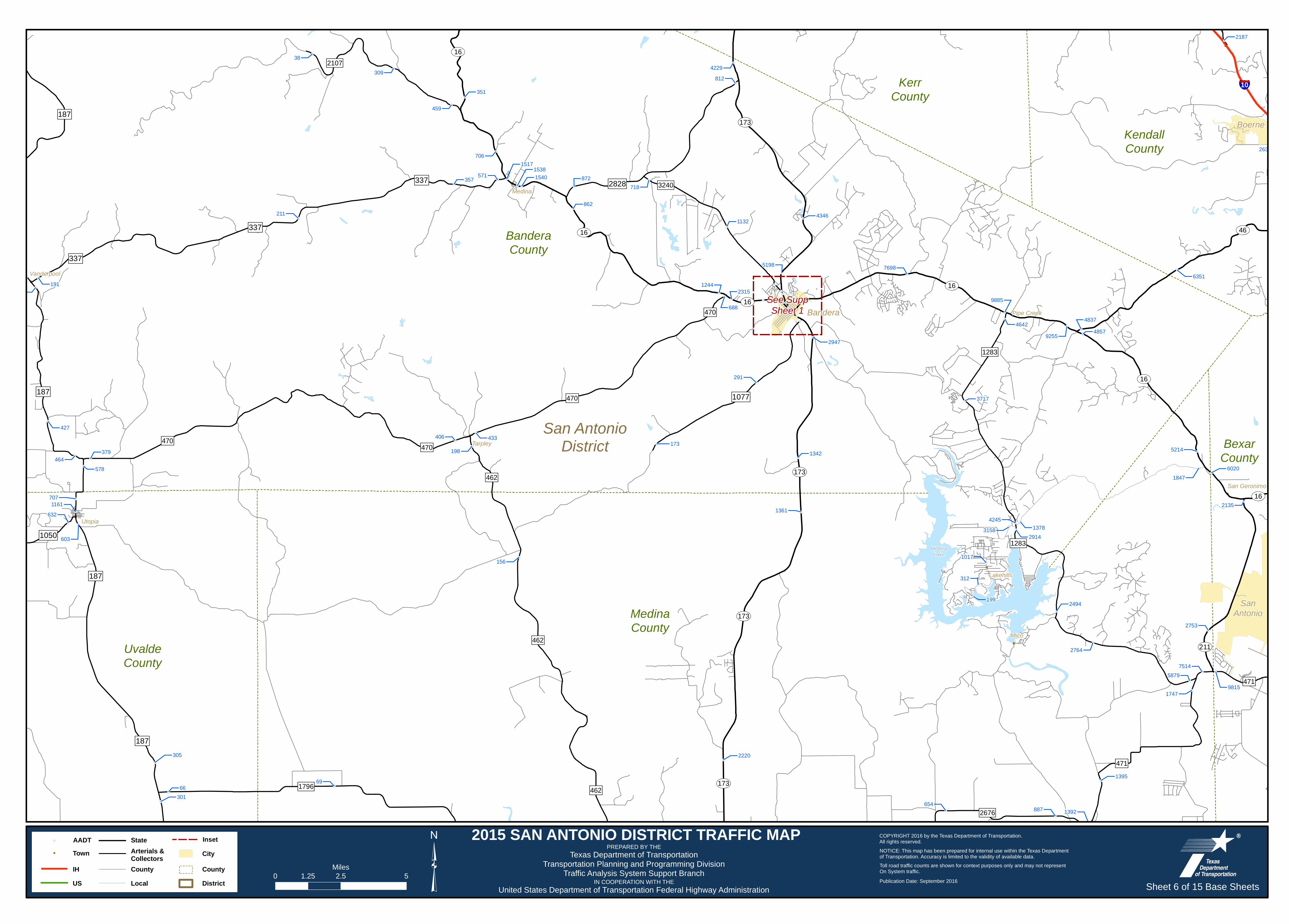
26378
2187
6020
5214
1847
2135
2753
98151747
5879
483748579255
4642
4346
7698
3717
5198
2947
2494
13784245
29143158
1017
312
199
1395
1392887
1361
654
812
1132
718872
862
2315
688
1244
173
351
459
15401538
1517706
571357
433
198
406
2220
156
38
211
379
578464
346
6966
301
1161
603
632
345 191
427
707
305
309
9885
6351
1342
291
2764
7514
4229
Boerne
SanAntonio
Bandera
San AntonioDistrict
187
2828
1050
337
1077
337
187
337
187
187
471
462
1283
462
471
1283
462
3240
470
2107
2676
470
1796
470
470
ST16
ST16ST16
ST173
ST16
ST211
ST16
ST173
ST173
ST16
ST46
ST173
§̈¦10
Tarpley
Lakehills
Medina
Vanderpool
Pipe Creek
Utopia
San Geronimo
Mico
MedinaLake
UvaldeCounty
KerrCounty
KendallCounty
BanderaCounty
BexarCounty
MedinaCounty
See SuppSheet 1
2015 SAN ANTONIO DISTRICT TRAFFIC MAP
Sheet 6 of 15 Base Sheets³0 2.5 51.25Miles
Texas Department of TransportationTransportation Planning and Programming Division
Traffic Analysis System Support Branch
PREPARED BY THE
IN COOPERATION WITH THEUnited States Department of Transportation Federal Highway Administration
COPYRIGHT 2016 by the Texas Department of Transportation.All rights reserved.NOTICE: This map has been prepared for internal use within the Texas Departmentof Transportation. Accuracy is limited to the validity of available data.
Publication Date: September 2016
Toll road traffic counts are shown for context purposes only and may not representOn System traffic.
Arterials &Collectors City! TownState!. AADT Inset
US Local DistrictIH County County

!
!
!
!
!
!
!
!
!
!
!
!
!
!
!
!
!. !.!.!.
!.
!.
!.
!.!.
!.
!.
!.
!.
!.
!.
!.
!.
!.
!.
!.
!.
!.
!.
!.
!.
!.
!.!.
!.
!.
!.
!.
!.
!.
!.
!.
!.
!.
!.
!.
!.
!.
!.
!.
!.
!.
!.!.
!.
!.!.
!.
!.
!.
!.
!.
!.
!.
!.
!.
!.
!. !.
!.
!.
!.
!.
!.
!. !.
!.!.
!.
!.
!.
!.
!.
!.
!.
!.
!. !.
!.
!.!.
!.
!.
!.
!.
!. !.
!.
!.
!. !.
!.!.!.!.
!.
!.!.
!.
!.
!.
!.
!. !.!.
!.
!.
!.
!.
!.!.
!.
!.
!.
!.
!.
!.
!.
!.!.
!.
!.
!.
!.
!.
!.
!.
!.
!.
!.
!.!.
!.
!.!.
!.!.
!.
!.
!.!.
!.!.
!.
!.
!.
!.
!.!.
!.
!.
!.
!.
!.
!.
!.
!.
!.
!.
!.
!.
!.
!.
!.
!.
!.
!.
!.
!.
!.
!.
!.
!.
!.
!.!.
!.
!.
!. !.
!.
!.
!.
!.
!.
!.
!.
!.
!. !.
!.
!.
!.
!.!.
!.!.
!.
!.
!.
!.
!.
!.!.
!.
!.
!.
!.
!.!. !.
!.
!.
!.
!.
!.
!.
!.
!.!.
!.
!.
!.
!.
!.
!.!.
!.
!.
!.
!.
!.
!.
!.
!.
!. !.
!.
!.
!.
!.!.
!.
!.
!.
!.
!.
!.
!.
!.!.
!.
!.!.
!.!.!.!.
!.
!.
!.
!. !.
!.
!.
!.
!.
!.
!.
!.
!.
!.
!.
!.
!.
!.
!.
!.
!.
!.
!.
!.!.
!.!.!.
!.
!.!.
!.
!.
!.
!. !.
!.
!.
!.
!.!.
!.
!.
!.
!.
!.
!.
!.
!.
!.
!.
!.
!.!.
!. !.
!.
!.!.
!.
!.!.
!.
!.
!.
!.
!.
!.
!. !.
!.!.
!.
!. !.
!.
!.
!.
!.
!.
!.
!.
!.
!.!.!.!.
!.
!.
!.
!.!.
!.
!.
!.!.!.
!.
!.
!.
!.
!.
!.
!.
!.!.!.
!.
!.
!.
!.
!.
!.
!.
!.
!.
!.
!.
!.
!.
!.
!.
!.
!.
!.
!.!.!.
!.
!.
!.
!.
!.
!.!.
!.
!.
!.!.
!.
!.
!.
!.
!.
!.
!.
!. !.
!.
!.
!.
!.
!.
!.!.
!.
!.!.
!.
!.!.
!.!.!.
!.
!.
!.
!.
!.
!.
!.!.
!.!.
!.
!.
!.
!.
!.
42445
2632
2917232203
261622378
17200
8746
18362
5114
1787
62594093
1665
110089
1579
15562
10453345
7484
9896
10246
7302
382657623556
45543
2015
1197
61366144
2985
2883
68187488
1678
44172
1618
1235
1212
1633
139429642722
817
4621811
3164
10297
9063
90391169
9895
45230
198745877
124964
11438
20075
1673826093
30204
126785
2744433551157352
11498
11376
304735106
2978910264
6280
20631
32510
25190
92763577
3180
28002783
36262239
2124
4996024049
10946
8752
10206
94538311265
233010463
1069
1642
12015640
1008 4873
3372
3617
4647
33841
6304
13096
12593
169017
2637865260191955
2164094987
107780
10065619477
58811
10363
79469
22491
2827
1093110699
7385
922430007
13755
13341
196975
12261
30128
93113
16337
217119
18452
158742
18608341676
180103
22171
19293
21086
15782216196
36576
55648
10592
4285
31010
65764
3235
32965013
3892
12324796
14030
3800
16441
24091
40717
82666
8209968859
177352
71652
3026019218
111426
1944018916
68181
135550
10977
22537
77497
16849
65872
60598
11795
17014
12906
68607
13581
11622
10302310187399204
105259
164091
24800
23144
205441
192659161941
193267
88203
93957
144141
132166
259477
32850
32539
29821136275
26497
158927224
16243
3097421498
36863
25722726961
259898
209745
244459
34503
29813
34093
24730
160425
154145
21510
147952
193361
1307981404
100664
130531
1328547931
1382186604
19331
193003
35359
23788
11376
134306
173964
149744
15261415199
113122
15711
140895
13175
7501
89175
62093
8357
6020
5214
1847
129500
156306
24182
187048
121400
119668
15618
18240818126
2824222395
2182860207
5691129509
2079449407
105328
13981
15853
20670
11536
32898
406813933381114
27902
254746
32148
42430196376
76402
1988912054
10494
690848068431597
32731
23155
3513939414
43431
47624
21012
73775
113200
124728
9949569873
399
8225240399
104244
4316616869
23285
2135
2753
98151747
5879
63393
3108038132
28114
29124964049698
5519
12131
9573
8319696
1291
7724
51581360
10914
53314066
59166583
13385
6089
11539
5378
40903715
8313
21816158
2840
24163
7433
272414616
14428
5605172381
84639
836103871
577957563
25157
7246
27279
47283
17247
1526830558
21923
2172
80924
239626714
5352
2842345892
46778417094031
5270
25062672369509
51451
54741
4242
7130101172119
3894
2732
3276950
938
19097
3736
23588
21561
4797
51489
27102
2323643677
93594
105721
98947
54533
844
7514
8350
7461
27991
1696011774
11520
10202
106859277
38544
812
28208
5295
12264
11859
Saint Hedwig
Garden Ridge
Windcrest
Shavano Park
ChinaGrove
Selma
Converse
AlamoHeights Terrell
Hills
Kirby
Helotes
Universal City
Live Oak
Cibolo
Schertz
New Braunfels
San Antonio
Grey Forest
Bulverde
Castle Hills
Fair Oaks Ranch
Hollywood ParkMarion
New Berlin
La Vernia
Leon Valley
Balcones Heights
Olmos Park
Santa Clara
LaCoste
Castroville
Von Ormy
Seguin
San AntonioDistrict
1518
1535
1937
143
1863
78
1628
78
1535
2790
465
2536
1516
1101
1516
2772
2252
3009
3351
4712790
1518
1103
471
3432
1346
1976
482
2696
2696
2252
1560
775
78
3432
471
467
1518
3009
725
1957
2538
775
1346
775
1863
539
1044
,+536
,+122
ST337
ST368
ST345
ST13
ST1604
ST345
ST13
ST1604
ST353
ST1604
ST1604
ST1604ST16
ST16
ST16
ST46
ST151
ST218
ST211
ST16
ST151
ST211
./87
./281
./281
./90
./87
./90
./90
§̈¦10
§̈¦35
§̈¦35
§̈¦10
§̈¦35
§̈¦410
§̈¦10§̈¦410
§̈¦37
§̈¦35
§̈¦35
§̈¦10
§̈¦10
§̈¦35
§̈¦35
§̈¦10
§̈¦10
§̈¦410 §̈¦410
§̈¦10
§̈¦410
Freiheit
Solms
Bracken
Schumannsville
Leon Springs
San Geronimo
Martinez
SayersLone Oak
Parita
Mangus Corner Southton
Midway
Macdona
Von Ormy
Gardendale
ComalCounty
BanderaCounty
GuadalupeCounty
BexarCounty
MedinaCounty
WilsonCounty
§̈¦B35
See Supp Sheet 1
2015 SAN ANTONIO DISTRICT TRAFFIC MAP
Sheet 7 of 15 Base Sheets³0 2.5 51.25Miles
Texas Department of TransportationTransportation Planning and Programming Division
Traffic Analysis System Support Branch
PREPARED BY THE
IN COOPERATION WITH THEUnited States Department of Transportation Federal Highway Administration
COPYRIGHT 2016 by the Texas Department of Transportation.All rights reserved.NOTICE: This map has been prepared for internal use within the Texas Departmentof Transportation. Accuracy is limited to the validity of available data.
Publication Date: September 2016
Toll road traffic counts are shown for context purposes only and may not representOn System traffic.
Arterials &Collectors City! TownState!. AADT Inset
US Local DistrictIH County County

!
!
!
!
!
!
!
!
!
!
!
!
!
!
!
!
!
!
!
!.
!.
!. !.
!.!.
!.
!.
!.
!.
!.
!.
!.
!.
!.
!.
!.
!.
!.
!.
!.
!.
!.
!.
!.
!.
!.
!.
!.
!.
!.
!.
!.
!.
!.!.!.
!.
!.
!.
!.
!.
!.
!.!.
!.!.
!.
!.
!.
!.
!.
!.
!.
!.
!.
!. !.!.!.
!.
!.!.
!.
!.
!.!.!.
!.
!.!.
!. !.
!.!. !.
!.
!.
!.
!.
!.!.
!.!.
!.
!.
!.
!.!.
!.
!.
!.
!.!.
!.
!.
!.
!.!.
!.!.!.!.
!. !.!.!.!.
!.
!.!.!. !.
!.
!.
!.
!.
!.
!.
!.
!.
!.
!.
!.
!.
!.
!.!.
!.
!.
!.
!.
!.
!.!.
!.
!.!.
!.
!.
!.
!.
!.
!.
!.
!.
!.
!.
!.
!.
!.
!.
!.
!.
!.
!.
!.
!.!.
!.
!.!. !.
!.
!.
!.
!.
!.
!. !.
!.
!.
!. !.
!.
!.
!.
30665
4825
1769184
33025
159270
169
91
2815
438
1812
2662193
665
581
490
499
343
832726
632
514
10242
10384
12360
20626
3122
2278
1038
39648
1421
6110
1083
2669
1706
5136
10119412
40455647
66353001
5432
1991
2097
20257684
2042
12115
267 3693
41666
11168
7791
2577
7034
6466
2468
2616
48242508
4721
42445
7124
1247
4156
2632
2917232203
261622378
17200
87465114
7302
382657623556
45543
2015
1197
1678
1618
1235
1212
1633
139429642722
817
4621811
1130
198
1291
7724
1883
51581360
10914
53314066
59166583
8350
2115
2551
7461
5239
1094
832
11171
11008773
415
9424
449
812
5295
4433
5314
Luling
Gonzales
Seguin
New Braunfels
Nixon Smiley
New Berlin
La Vernia
Santa Clara
YoakumDistrict
AustinDistrict
San AntonioDistrict
86
2091
2984
465
2538
466
1620
78
1101
2772
7583353
1116
1386
477
1150
725
1322
1586
766
466
78
20
108
467
3234
775
1104
2623
1117
467
725
1044
3282775
466
1150
532
2438
77
2091
539
539
3335
466
1682
1116
2922
2067
1681 1117
1117
108
1116
794,+B123
,+95
ST97
ST97
ST123
ST46
ST123
ST46
ST97
ST97
ST80
ST80
ST97
ST304
ST123
ST80
ST97
ST123
ST130
ST80
./90A
./90A
./90A
./90A
./183
./90
./183
./90
./183
./90
./90
./87
./183
./87
./90
./90
./90
§̈¦10
§̈¦10
§̈¦10
§̈¦35
§̈¦10
§̈¦10
§̈¦10
§̈¦10
Freiheit
Geronimo
KingsburySchumannsville
Nolte
Zipp
Thompsonville
Harwood
Ottine
Belmont
Oak Forest
Monthalia
Cost
Bebe
Leesville
Wrightsboro
Schoolland
Cheapside
CaldwellCounty
GonzalesCounty
De WittCounty
ComalCounty Guadalupe
County
WilsonCounty
§̈¦B35
See SuppSheet 1
2015 SAN ANTONIO DISTRICT TRAFFIC MAP
Sheet 8 of 15 Base Sheets³0 2.5 51.25Miles
Texas Department of TransportationTransportation Planning and Programming Division
Traffic Analysis System Support Branch
PREPARED BY THE
IN COOPERATION WITH THEUnited States Department of Transportation Federal Highway Administration
COPYRIGHT 2016 by the Texas Department of Transportation.All rights reserved.NOTICE: This map has been prepared for internal use within the Texas Departmentof Transportation. Accuracy is limited to the validity of available data.
Publication Date: September 2016
Toll road traffic counts are shown for context purposes only and may not representOn System traffic.
Arterials &Collectors City! TownState!. AADT Inset
US Local DistrictIH County County

!
!
!.
!.
!.
!.
!.
!.
!.
!.
!.
!.
!. !.
!.
!.!.
!.
!.
!.!.
!.
!.
!.
!.
!. !.
!.!.
!.!.
!.
!. !.
!.
!.
!.
!.!. !.!.!.
!.
!.
!.
!.
!.
!.
!.
!.!.!.
!.
!.
!.!.!.
!.
!.!.
!.
!.
!.
!.
!.
!.
!.!.
!.
!.
!.
!.!.!.
!.
!.
!.
!.
!.
!.
!.
!. !.
!.
!.
!.341236
181711
671191
1377
7552219
6721
329
13968367
1086 406
138
211
8575
10389539
589
786
2309
16598
2658847
495
1068
2918
2467
34856765
25447523
2278
4497297
1346
1749
43533089
1232
666
447
1698
1756Uvalde
San AntonioDistrict
LaredoDistrict
187
2690
1022
334334
1403
117
1435
3447
1436
1052
1049
2369
117
481
3199
2730
10232369
30
1572
1049
117
140
140
481
481
140
ST127
ST55
ST127
ST55
./83
./90./90
./90
./90
./90
./83
./83
./90
./90
./83
./90
./83
Knippa
Blewett
KinneyCounty Uvalde
County
MaverickCounty
ZavalaCounty
See Supp Sheet 1
2015 SAN ANTONIO DISTRICT TRAFFIC MAP
Sheet 9 of 15 Base Sheets³0 2.5 51.25Miles
Texas Department of TransportationTransportation Planning and Programming Division
Traffic Analysis System Support Branch
PREPARED BY THE
IN COOPERATION WITH THEUnited States Department of Transportation Federal Highway Administration
COPYRIGHT 2016 by the Texas Department of Transportation.All rights reserved.NOTICE: This map has been prepared for internal use within the Texas Departmentof Transportation. Accuracy is limited to the validity of available data.
Publication Date: September 2016
Toll road traffic counts are shown for context purposes only and may not representOn System traffic.
Arterials &Collectors City! TownState!. AADT Inset
US Local DistrictIH County County

!
!!
!
!
!
!
!
!
!
!.!.
!.
!.
!.
!.
!.
!.!.!.!. !.
!.
!.
!.
!.
!.!.
!.
!.
!.
!.
!.
!.
!.
!.!.!.
!.
!.
!.
!.!.
!. !.
!.
!.
!.!.!.
!.
!.
!.!.
!.
!.
!.
!.
!.
!.
!.
!.
!.!.
!.!.
!.
!.
!.
!.
!.
!.
!.
!.
!.
!.
!.
!.
!.
!.
!.
!.
!.
!. !.
!.!.!.
!.
!.!.!.!.
!.
!.
!.
!.
!.!.
!.
!.
!.!.!.
!.
!.
!.!.
!.
!.
!.
!.
!.
!.!.
!.
!.!.
!.
!.
!.
!. !.
!.
!.
!.
!.
!.
!.
!.
!.
!.
!.
!.
!.
!.
!.!.
!.!.
!.
!.
!.!.!.
!. !.!.!.
!.
!.
!.
!.
!.
!.
!.
!.
!.
!. !.!.
!.
!.
!.
!.
!.
!.
!.
!.
!.
!.
!.
!.
5519
12131
9573
19696
1815
1392
2052
1992
3429
2458
789
1077
152229861512
402257
341236
2119
3894
2732
3276950
938
374894218
5010
98697479
23511560
3038
2005
371462471
34762500
36448
5241
437
2796
19097
3736
2358822949
2032319730
958
8231003
788939
2925
688
3168
3610840692036
4897802
777
52131164
3896
31301008
2147
866
1634
29623
13222
2499
809
3668
345
3025628
453
251567
29650
455
40229528888
29534
26655
2840
130564529
3019
18522
40711764
1281
41471831915615
905
9933
687
10429
750424
230
558
89079159
595
5588200
382
157
8016
7245
443
2667 3056
1377
835591422915
6957671 417
7552
189
219
6721844
8227
240
820816
156
430
1465
4113
947
3025
145
487
490
9274
4667
2913
447
Devine
Hondo
Sabinal
Natalia
Lytle
LaCosteCastroville
San AntonioDistrict
LaredoDistrict
187
187
187
187
471
2200
1250
3175
462
2676
3352
2790
462
1343
2504
471
2676
463
2730
2200
471
3176
472
30
2779
1957
1343
1796
140
462
462
462140
2200
2200ST132
ST211
ST173
ST173
ST173
ST173
ST127
./57
./90
./90
./57
./90./90
./90
./90
§̈¦35
§̈¦35
§̈¦35
§̈¦35
Kyote
MooreBigfoot
Frio Town
Riomedina
Quihi
Dunlay
D'Hanis
Biry
Yancey
UvaldeCounty
ZavalaCounty
BexarCounty
MedinaCounty
FrioCounty
See SuppSheet 1
2015 SAN ANTONIO DISTRICT TRAFFIC MAP
Sheet 10 of 15 Base Sheets³0 2.5 51.25Miles
Texas Department of TransportationTransportation Planning and Programming Division
Traffic Analysis System Support Branch
PREPARED BY THE
IN COOPERATION WITH THEUnited States Department of Transportation Federal Highway Administration
COPYRIGHT 2016 by the Texas Department of Transportation.All rights reserved.NOTICE: This map has been prepared for internal use within the Texas Departmentof Transportation. Accuracy is limited to the validity of available data.
Publication Date: September 2016
Toll road traffic counts are shown for context purposes only and may not representOn System traffic.
Arterials &Collectors City! TownState!. AADT Inset
US Local DistrictIH County County

!
!
!
!
!
!
!
!
!
!
!
!
!
!
!
!
!.
!.
!.
!.
!.!.
!.
!.
!. !.
!.
!.!.
!.!.!.!.
!.
!. !.!.
!.
!.
!.
!.
!.
!.
!.
!.
!.
!.
!.
!.
!.
!.
!.
!.
!.
!.
!.
!.
!.
!.
!.!.
!.
!.
!.
!.!.!.
!.!.!.
!.!.!.
!.!.!.!.
!.
!.
!.
!.
!.
!.
!. !.!.
!.
!.!.
!.!.
!.
!.
!.!.!.
!.
!.
!.
!.
!.
!.
!.!.
!.
!.
!.
!.
!.
!.
!.
!.
!.!.!.
!.
!.
!.
!.
!.
!.
!.
!.
!.
!.
!.
!.
!.!.
!.!. !.
!. !.
!.
!.
!.
!.
!.!. !.
!.
!.
!.
!.
!.
!.
!.
!.
!.!.
!.
!. !.!. !.
!.
!.
!.
!.
!.
!.!.!.
!.
!.
!.
!.
!.
!.
!.
!.
!.
!.
!.
!.
!.
!.
!.
!.
!.
!.
!.
!.
!.
!.
!.
!.
!.
!. !.!.
!.
!.
!.
!.
!.
!.
!.
!. !.
!.
!.
!.
!.
!.!.
!.
!.
!.
!.
!.
!.
!.
!.
!.
!. !.!.
!.
!.!.
!.!.!.
!.
!.
!.
!.
!.
!.
!.
!.
!.
!.
!.
!.
!.
!.
!.
!. !.
!.
!.
!.
!.
!.
!.
!.
!.
!.!.!.
!.
!.
!.
!.
!.
!.
!.
!.
!.
!.
!.
!.
!.
!.
!.
!.
!.
!.
!.!.!.!.
!.
!.!.
!.!.
!.!.
!.
!.
!.!.
!.
!.
!.
!.!.
!.
!.
!.
!.
!.
!.
!.1159
972
1527
12667967
12908
6721
16711
1025523695
4244
3420
26868
801563525460
79502673
24163950
38883412
5262
585021876
20782
22317
4051
8401084 1980
3167
611
628580
647
1144
9382
811
2176
10813
1213013100
15571203
1149
1025
891
6573638
272
572751
518
513
223
363
431
1072
414
210895013
4291
2040785
4924262
52071
13581898
1396
49366391
636
321
46407
42931
34788
33514
1933
2715
11211520
4408413
87517350
7764
2148
4266
1346
3912
563
302
1299
5168
32927
24392
25001
697
28120
1367
1838
5780
66892497
1672
11074
2021
8043
9202
12515
4228
93708291
5837 73769537
4079
2337
2192314778344
6888
22689
7577
8048
23837
5772
4196
25932
62053437
16632
7803
8061
7154
218113291
546
6711
6860
5659
48797040
51188
28247250
5661
6300
85298031
12848
7821
23411981
2824
11562762
47644
4066037489
4218
5010
98697479
23511560
3038
21352005
371462471
34762500
36448
5241
2799
1553
486
365
20331789
1620
11101248
3542
2030
403
170
616
8103
1152
2452378
448
437
2796
559376
307
812
8634
11061970
31499294
1023462
41274101
3488
961
3077
958
3168
3610840692036
4897
52133896
3025
453
212
864
1245616092
124586253
1137
44693
9905
4999
17129
17718
3774
1967
3346
9164
8982
3719
34887
3025
3043
1669
9274
4667
3469
3966
1697
14147
5071
4567
3506
492
4390
200
2913
3286
730730
10165
1941
21725
7961
356
992
11351
Poth
Poteet
San Antonio
Pleasanton
Jourdanton
Elmendorf
Charlotte
Natalia
Lytle
Somerset
Floresville
Von Ormy
San AntonioDistrict
CorpusChristiDistrict
327
541
3350
463
2790
3510
1937
537
427
791
539
476
1144
3006
2146
2505
2579
478
2790
1303
1470
1333
476
1344
476
536
1344
1549
541
3161
1303
1784
536
1332140
775
791
2505
2146
2504
3175
1333
541
,+162
ST1604
ST1604
ST1604
ST181
ST1604
ST173
ST132
ST16
ST97
ST16
ST97
ST97
ST16
ST97
ST173
ST16
ST97
ST173
ST85
ST97
./281
./281
./181
./181
./181
./281
§̈¦37
§̈¦37
§̈¦37
§̈¦35
§̈¦37
§̈¦35
§̈¦37
§̈¦37McCoy
Espey
Leming
Kyote
Coughran
Deweesville
Sutherland Springs
Saspamco
Canada VerdeGraytown
Fairview
Dewees
Midway
Buena Vista
Losoya
CalaverasLake
BrauningLake
BexarCounty
MedinaCounty
WilsonCounty
AtascosaCounty
KarnesCounty
FrioCounty
See Supp Sheet 1
2015 SAN ANTONIO DISTRICT TRAFFIC MAP
Sheet 11 of 15 Base Sheets³0 2.5 51.25Miles
Texas Department of TransportationTransportation Planning and Programming Division
Traffic Analysis System Support Branch
PREPARED BY THE
IN COOPERATION WITH THEUnited States Department of Transportation Federal Highway Administration
COPYRIGHT 2016 by the Texas Department of Transportation.All rights reserved.NOTICE: This map has been prepared for internal use within the Texas Departmentof Transportation. Accuracy is limited to the validity of available data.
Publication Date: September 2016
Toll road traffic counts are shown for context purposes only and may not representOn System traffic.
Arterials &Collectors City! TownState!. AADT Inset
US Local DistrictIH County County

!
!
!
!
!
!
!
!
!
!
!
!
!
!
!
!
!
!
!.
!.
!.
!.!.!.
!.
!.
!.
!.!.
!.
!.
!.
!.
!.
!.
!.
!.
!.
!.
!.
!.
!.!.
!.
!.
!.
!.
!.
!.!.
!.
!.
!.
!.
!.!.
!.
!.
!.
!.
!.
!.!.
!.
!.!.!.
!.
!.
!.
!. !.!.
!.
!.
!.
!.
!.!.
!.
!.
!.5283
6176240
315
167
113
1993
596
5741
232
533
11331501
1856
5431
48966458
22251986
8197
10430
6540
4757
398
6369
21292151
264
33494472
913
3904
148
653304
359
868
1159
972
1161607
1527
12667967
12908
6721
16711
10255
4244
3888
1144
9382
811
2176
10813
1213013100
15571203
891
14147
5071
733 3844
3875
170
5272
5995
886
5782
Runge
Nixon
Poth
Yorktown
Karnes City
Falls City
Nordheim
Smiley
Stockdale
Kenedy
Floresville
YoakumDistrict
San AntonioDistrict
CorpusChristiDistrict
541
1344
3191
541
537
237
1116
239
539
2773
953
884
1922 240
1354
1107
1353
537
885
1347
99
627
2724
791
1961
2816
81
884
2980
1347
538
792
81
2542
81
237627
2718
427
1144
238
1020
240
108
952
2656
887
766
108
887
ST80
ST123
ST123
ST72
ST119
ST119
ST119
ST72
ST80
ST119
ST123
ST97
ST119
ST119
ST80
ST119
ST123
ST80 ST72
ST72
./181
./87./87
./87
./87
./181
./87
./183
./181
./87
./181
Westhoff
Gillett
Pawelekville Ecleto
Cestohowa
Panna Maria HelenaHobson
Deweesville
Sutherland Springs
Pandora
Kosciusko
GruenauNew Davy
Garfield
Cotton Patch
Weser
Weesatche
GonzalesCounty
GoliadCounty
De WittCounty
WilsonCounty
KarnesCounty
2015 SAN ANTONIO DISTRICT TRAFFIC MAP
Sheet 12 of 15 Base Sheets³0 2.5 51.25Miles
Texas Department of TransportationTransportation Planning and Programming Division
Traffic Analysis System Support Branch
PREPARED BY THE
IN COOPERATION WITH THEUnited States Department of Transportation Federal Highway Administration
COPYRIGHT 2016 by the Texas Department of Transportation.All rights reserved.NOTICE: This map has been prepared for internal use within the Texas Departmentof Transportation. Accuracy is limited to the validity of available data.
Publication Date: September 2016
Toll road traffic counts are shown for context purposes only and may not representOn System traffic.
Arterials &Collectors City! TownState!. AADT Inset
US Local DistrictIH County County

!
!
!
!
!.
!.
!.
!.
!.
!.
!.
!.
!.
!.!.!.!.
!.!.
!.
!.
!.
!.
!.
!.
!.
!.
!.
!.
!.!.
!.
!.
!.
!.
!.
!.
!.
!.
!.
!.
!.!.
!.!.
!.!.
!.
!.
!.
!.
!.!.
!.!.
!.
!.!.
!.
!.
!.
!.
!.
!.
!.
!. !.
!.
!.
!.!.
!.
961
3077
212155
864921
103
70
25941
3413
1196
1438
3109
3317
336291622734448
391
4248
23995
7791
484311377
110198357
10630
3865
3759
69611562
24709
32411504
1160
25209791
7312833
586
2749
1650
24903
511
25289
601
25391
1776465728050
4958615
70564674
41274091
7130
25203 2741
3774
16391357
4942
200
33133
2301
1571
Pearsall
Big Wells
Dilley
San AntonioDistrict
LaredoDistrict
187
140
468
3352
117
1549
469
1171583
1866
472
1581
140
140
140
1582
1582
2779
1582
117
117
,+581
ST85
ST85
ST97
ST85
ST85
ST97
ST85
ST85
ST85
./57 ./57./57
§̈¦35
§̈¦35
§̈¦35
§̈¦35
§̈¦35
Hindes
DerbyDivot
Millett
ZavalaCounty
DimmitCounty
La SalleCounty
FrioCounty
§̈¦B35
§̈¦B35
2015 SAN ANTONIO DISTRICT TRAFFIC MAP
Sheet 13 of 15 Base Sheets³0 2.5 51.25Miles
Texas Department of TransportationTransportation Planning and Programming Division
Traffic Analysis System Support Branch
PREPARED BY THE
IN COOPERATION WITH THEUnited States Department of Transportation Federal Highway Administration
COPYRIGHT 2016 by the Texas Department of Transportation.All rights reserved.NOTICE: This map has been prepared for internal use within the Texas Departmentof Transportation. Accuracy is limited to the validity of available data.
Publication Date: September 2016
Toll road traffic counts are shown for context purposes only and may not representOn System traffic.
Arterials &Collectors City! TownState!. AADT Inset
US Local DistrictIH County County

!
!
!
!
!
!
!
!
!!
!
!.
!.
!.
!.!.
!.
!.
!.
!.
!.
!.
!.
!.
!.!.!.
!.
!.
!.
!.!.
!.
!.
!.
!.!.
!.
!.
!.
!.
!.
!.
!.
!.
!.
!.
!.
!.
!.
!.
!.
!. !.
!.
!.
!.
!.
!.!.
!.
!.!.
!.!.
!.
!.
!.
!.
!.
!.
!.
3845
2136
1694
1184
5272211
1631
230581225573
21093
1710
1235
26221
27810
20081078
3068890
1741
1448
1111
18235319
1548
4893
1075
7691631
4997
1354
472
30
5875
2240
16367388
1642
5987
86758871 87985826
9893
2209
230
10533212
3109
31013317
7157
4078
1738
5785
4223
718
3082
6662
6553
Christine
Three Rivers
San AntonioDistrict
CorpusChristiDistrict
LaredoDistrict
1873
1203
2102
1358
1091
2924
1582
1099
99
1042
882
99
99
3387
1545
791
2049
99
791
140
3192
99
140
3445
791
ST72
ST97ST85
ST97
ST97
ST72
ST16
ST72
ST16
ST72
ST72ST72
ST97
ST16
ST97
ST16
ST16
./281A
./281A
./281
./281
§̈¦37
§̈¦37
§̈¦37
§̈¦37
§̈¦37
Fashing
Campbellton Peggy
Hindes
Esseville
Whitsett
Ray Point
OakvilleCalliham
TildenFowlerton
ChokeCanyon
Reservoir
Live OakCounty
McMullenCounty
La SalleCounty
AtascosaCounty
KarnesCounty
FrioCounty
2015 SAN ANTONIO DISTRICT TRAFFIC MAP
Sheet 14 of 15 Base Sheets³0 2.5 51.25Miles
Texas Department of TransportationTransportation Planning and Programming Division
Traffic Analysis System Support Branch
PREPARED BY THE
IN COOPERATION WITH THEUnited States Department of Transportation Federal Highway Administration
COPYRIGHT 2016 by the Texas Department of Transportation.All rights reserved.NOTICE: This map has been prepared for internal use within the Texas Departmentof Transportation. Accuracy is limited to the validity of available data.
Publication Date: September 2016
Toll road traffic counts are shown for context purposes only and may not representOn System traffic.
Arterials &Collectors City! TownState!. AADT Inset
US Local DistrictIH County County

!
!
!.
!.
!.!.
!.
!.
!.
!.
177
12801979
1926
1746
2075
1160
1910
George West
San AntonioDistrict
CorpusChristiDistrict
LaredoDistrict
889
624
3162
3469
3336
1359
2359
889
624
624
1962
624
624
624
ST16
ST16
ST16
ST16
ST16
./59
./281
./281
./59
./59
./281
./281
./281
./281
./59
./59
Seven Sisters
Annarose
Live OakCounty
McMullenCounty
Jim WellsCountyDuval
CountyWebb
County
La SalleCounty
2015 SAN ANTONIO DISTRICT TRAFFIC MAP
Sheet 15 of 15 Base Sheets³0 2.5 51.25Miles
Texas Department of TransportationTransportation Planning and Programming Division
Traffic Analysis System Support Branch
PREPARED BY THE
IN COOPERATION WITH THEUnited States Department of Transportation Federal Highway Administration
COPYRIGHT 2016 by the Texas Department of Transportation.All rights reserved.NOTICE: This map has been prepared for internal use within the Texas Departmentof Transportation. Accuracy is limited to the validity of available data.
Publication Date: September 2016
Toll road traffic counts are shown for context purposes only and may not representOn System traffic.
Arterials &Collectors City! TownState!. AADT Inset
US Local DistrictIH County County
Related Documents