15 September 2014 ENVIRONMENTAL AUDIT REPORT Lot 611 Wadeye Community REPORT Report Number. 147663038-003-R-Rev0 Distribution: email: Kirstine Cossens (TDC) Submitted to: Kirstine Cossens - Acting CEO Thamarrurr Development Corporation Lot 463, Perdjert Street WADEYE COMMUNITY, NT 0822

Welcome message from author
This document is posted to help you gain knowledge. Please leave a comment to let me know what you think about it! Share it to your friends and learn new things together.
Transcript
15 September 2014
ENVIRONMENTAL AUDIT REPORT
Lot 611 Wadeye Community
REP
OR
T
Report Number. 147663038-003-R-Rev0
Distribution:
email: Kirstine Cossens (TDC)
Submitted to:Kirstine Cossens - Acting CEO Thamarrurr Development Corporation Lot 463, Perdjert Street WADEYE COMMUNITY, NT 0822
LOT 611 WADEYE COMMUNITY
15 September 2014 Report No. 147663038-003-R-Rev0 i
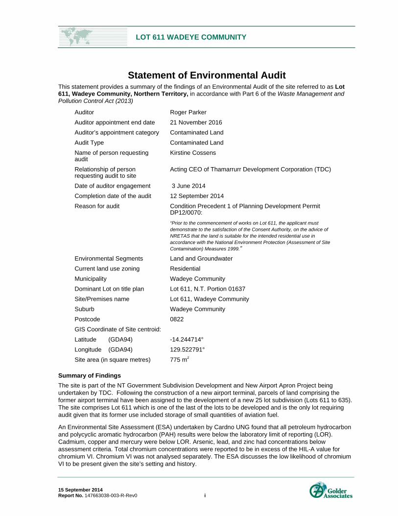
Statement of Environmental Audit This statement provides a summary of the findings of an Environmental Audit of the site referred to as Lot 611, Wadeye Community, Northern Territory, in accordance with Part 6 of the Waste Management and Pollution Control Act (2013)
Auditor Roger Parker
Auditor appointment end date 21 November 2016
Auditor’s appointment category Contaminated Land
Audit Type Contaminated Land
Name of person requesting audit
Kirstine Cossens
Relationship of person requesting audit to site
Acting CEO of Thamarrurr Development Corporation (TDC)
Date of auditor engagement 3 June 2014
Completion date of the audit 12 September 2014
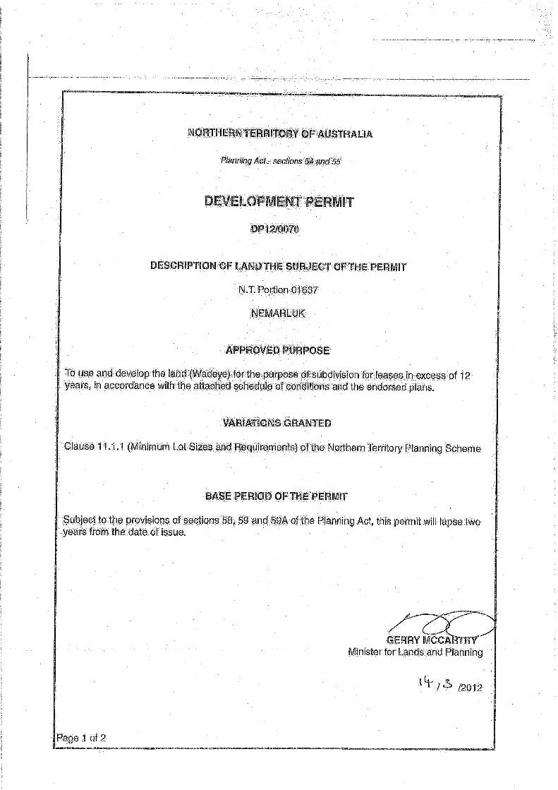
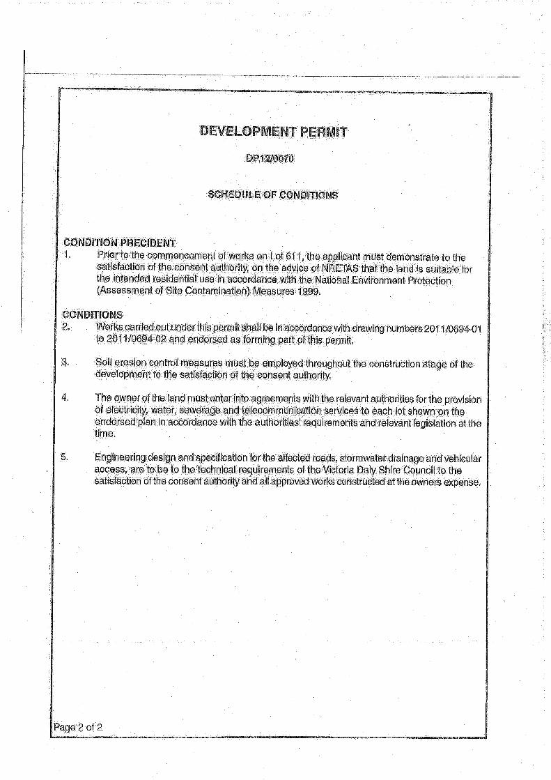
Reason for audit Condition Precedent 1 of Planning Development Permit DP12/0070:
“Prior to the commencement of works on Lot 611, the applicant must demonstrate to the satisfaction of the Consent Authority, on the advice of NRETAS that the land is suitable for the intended residential use in accordance with the National Environment Protection (Assessment of Site Contamination) Measures 1999.”
Environmental Segments Land and Groundwater
Current land use zoning Residential
Municipality Wadeye Community
Dominant Lot on title plan Lot 611, N.T. Portion 01637
Site/Premises name Lot 611, Wadeye Community
Suburb Wadeye Community
Postcode 0822
GIS Coordinate of Site centroid:
Latitude (GDA94)
Longitude (GDA94)
-14.244714°
129.522791°
Site area (in square metres) 775 m2
Summary of Findings
The site is part of the NT Government Subdivision Development and New Airport Apron Project being undertaken by TDC. Following the construction of a new airport terminal, parcels of land comprising the former airport terminal have been assigned to the development of a new 25 lot subdivision (Lots 611 to 635). The site comprises Lot 611 which is one of the last of the lots to be developed and is the only lot requiring audit given that its former use included storage of small quantities of aviation fuel.
An Environmental Site Assessment (ESA) undertaken by Cardno UNG found that all petroleum hydrocarbon and polycyclic aromatic hydrocarbon (PAH) results were below the laboratory limit of reporting (LOR). Cadmium, copper and mercury were below LOR. Arsenic, lead, and zinc had concentrations below assessment criteria. Total chromium concentrations were reported to be in excess of the HIL-A value for chromium VI. Chromium VI was not analysed separately. The ESA discusses the low likelihood of chromium VI to be present given the site’s setting and history.
LOT 611 WADEYE COMMUNITY
15 September 2014 Report No. 147663038-003-R-Rev0 ii
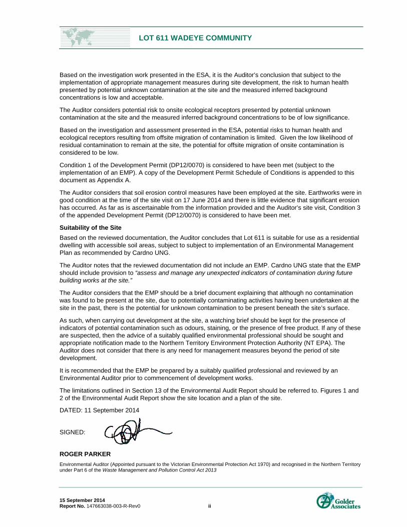
Based on the investigation work presented in the ESA, it is the Auditor’s conclusion that subject to the implementation of appropriate management measures during site development, the risk to human health presented by potential unknown contamination at the site and the measured inferred background concentrations is low and acceptable.
The Auditor considers potential risk to onsite ecological receptors presented by potential unknown contamination at the site and the measured inferred background concentrations to be of low significance.
Based on the investigation and assessment presented in the ESA, potential risks to human health and ecological receptors resulting from offsite migration of contamination is limited. Given the low likelihood of residual contamination to remain at the site, the potential for offsite migration of onsite contamination is considered to be low.
Condition 1 of the Development Permit (DP12/0070) is considered to have been met (subject to the implementation of an EMP). A copy of the Development Permit Schedule of Conditions is appended to this document as Appendix A.
The Auditor considers that soil erosion control measures have been employed at the site. Earthworks were in good condition at the time of the site visit on 17 June 2014 and there is little evidence that significant erosion has occurred. As far as is ascertainable from the information provided and the Auditor’s site visit, Condition 3 of the appended Development Permit (DP12/0070) is considered to have been met.
Suitability of the Site
Based on the reviewed documentation, the Auditor concludes that Lot 611 is suitable for use as a residential dwelling with accessible soil areas, subject to subject to implementation of an Environmental Management Plan as recommended by Cardno UNG.
The Auditor notes that the reviewed documentation did not include an EMP. Cardno UNG state that the EMP should include provision to “assess and manage any unexpected indicators of contamination during future building works at the site.”
The Auditor considers that the EMP should be a brief document explaining that although no contamination was found to be present at the site, due to potentially contaminating activities having been undertaken at the site in the past, there is the potential for unknown contamination to be present beneath the site’s surface.
As such, when carrying out development at the site, a watching brief should be kept for the presence of indicators of potential contamination such as odours, staining, or the presence of free product. If any of these are suspected, then the advice of a suitably qualified environmental professional should be sought and appropriate notification made to the Northern Territory Environment Protection Authority (NT EPA). The Auditor does not consider that there is any need for management measures beyond the period of site development.
It is recommended that the EMP be prepared by a suitably qualified professional and reviewed by an Environmental Auditor prior to commencement of development works.
The limitations outlined in Section 13 of the Environmental Audit Report should be referred to. Figures 1 and 2 of the Environmental Audit Report show the site location and a plan of the site.
DATED: 11 September 2014
SIGNED:
ROGER PARKER
Environmental Auditor (Appointed pursuant to the Victorian Environmental Protection Act 1970) and recognised in the Northern Territory under Part 6 of the Waste Management and Pollution Control Act 2013
LOT 611 WADEYE COMMUNITY
15 September 2014 Report No. 147663038-003-R-Rev0 iii
Table of Contents
1.0 INTRODUCTION ................................................................................................................................................ 1
2.0 EXECUTIVE STATEMENT ................................................................................................................................ 1
3.0 SITE IDENTIFICATION ..................................................................................................................................... 2
4.0 DOCUMENT OVERVIEW .................................................................................................................................. 2
5.0 AUDITED DOCUMENTATION .......................................................................................................................... 3
6.0 AUDIT SCOPE AND METHODOLOGY ............................................................................................................ 3
7.0 SITE ASSESSMENT ......................................................................................................................................... 4
7.1 Objective ............................................................................................................................................... 4
7.2 Scope .................................................................................................................................................... 4
7.3 Site History and Site Inspection Summary ........................................................................................... 4
7.4 Fieldwork .............................................................................................................................................. 5
7.5 Sampling Results Summary ................................................................................................................. 5
7.6 Cardno UNG Conclusion ...................................................................................................................... 5
8.0 SITE CHARACTERISTICS ................................................................................................................................ 5
8.1 Site Description/History ........................................................................................................................ 5
8.2 Environmental Setting .......................................................................................................................... 6
8.3 Geology ................................................................................................................................................ 7
8.4 Hydrogeology ....................................................................................................................................... 7
8.5 Extent of Impacts .................................................................................................................................. 7
8.6 Conceptual Site Model ......................................................................................................................... 8
9.0 BASIS OF ADOPTION FOR ASSESSMENT CRITERIA ................................................................................. 8
9.1 Soil Assessment Criteria ...................................................................................................................... 8
9.2 Groundwater Assessment Criteria ....................................................................................................... 8
10.0 QUALITY ASSURANCE / QUALITY CONTROL ............................................................................................. 8
11.0 SITE SUITABILITY AND ENVIRONMENTAL MANAGEMENT ..................................................................... 10
11.1 The Auditor’s Assessment of Risk ..................................................................................................... 10
11.2 Site Suitability and Environmental Management Plan ....................................................................... 11
12.0 CLOSURE ........................................................................................................................................................ 12
13.0 LIMITATIONS .................................................................................................................................................. 12
LOT 611 WADEYE COMMUNITY
15 September 2014 Report No. 147663038-003-R-Rev0 iv
TABLES
Table 1: Legal Identification Lot 611 ........................................................................................................................... 2
Table 2: Summary of Contaminated Sites Assessment reviewed as part of Audit .................................................... 3
Table 3: Review of Quality Assurance and Quality Control ........................................................................................ 9
FIGURES
FIGURE 1 Site Location Plan
FIGURE 2 Site Plan
APPENDICES
APPENDIX A Copy of Development Permit Schedule of Conditions
(DP12/0070)
APPENDIX B Audited Documentation
APPENDIX C Auditor Correspondence
APPENDIX D Limitations
LOT 611 WADEYE COMMUNITY
15 September 2014 Report No. 147663038-003-R-Rev0 1
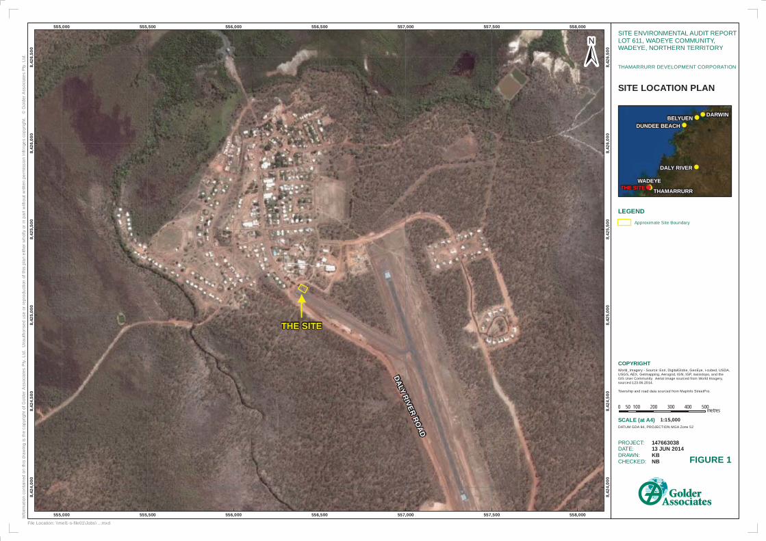
1.0 INTRODUCTION Mr Roger Parker of Golder Associates Pty Ltd (Golder) was engaged by Thamarrurr Development Corporation (TDC) to act as Environmental Auditor (the Auditor) in relation to land located at Lot 611, Wadeye Community, Northern Territory (the site). The site location and site plan are shown on Figures 1 and 2.
The Auditor was requested to verify compliance with specific conditions outlined in the Development Permit DP12/0070 which is attached to this document as Appendix A. The specific conditions triggering the request for the Environmental Audit are:
Condition 1: “Prior to the commencement of works on Lot 611, the applicant must demonstrate to the satisfaction of the Consent Authority, on the advice of NRETAS that the land is suitable for the intended residential use in accordance with the National Environment Protection (Assessment of Site Contamination) Measures 1999.”
Condition 3: “Soil erosion control measures must be employed throughout the construction phase of the development to the satisfaction of the consent authority.”
Contact details for Roger Parker:
Roger Parker – Victorian appointed Environmental Auditor – reappointment due 21 November 2016 Golder Associates Pty Ltd PO Box 6079 Hawthorn West VIC 3122 Ph: 03 8862 3500 Fax: 03 8862 3501 [email protected]
Given Mr Parker is an appointed Victorian Environmental Auditor, he is able to act as an Environmental Auditor in NT under Part 6 of the Waste Management and Pollution Control Act, January 2013. The Act requires an Environmental Audit be conducted by a “Qualified Person” who is accredited under either the New South Wales Site Auditor Scheme or the Victorian Environmental Auditor Scheme.
TDC has engaged Roger Parker to conduct an Environmental Audit (the Audit). It is understood that TDC was formed following local government reform in 2007 and is leasing the site from Daly River / Port Keats Aboriginal Land Trust. The Northern Territory Environment Protection Authority (NT EPA) was advised of the Audit in correspondence to Ryan Wagner (Environmental Officer – Pollution Control) on 13 June 2004. This correspondence is included within Appendix C (Auditor Correspondence).
2.0 EXECUTIVE STATEMENT The Auditor considers that the site is suitable for the proposed land-use as residential dwellings with garden / accessible soil area subject to a site environmental management plan (EMP) being put in place to assess and manage any unexpected indicators of contamination during future building works at the site, as recommended in the reviewed documentation prepared by Cardno Ullman & Nolan:
Cardno Ullman & Nolan (2014) Final Report on Tier 1 Environmental Site Assessment, Lot 611 Wadeye Community, NT (Ref U33277, dated 15 August 2014).
Condition 1 of the Development Permit (DP12/0070) is considered to have been met (subject to the implementation of certain management measures to be outlined in an Environmental Management Plan (EMP)).
The Auditor considers that soil erosion control measures have been employed at the site. Earthworks were in good condition at the time of the site visit on 17 June 2014 and there is little evidence that significant erosion has occurred. As far as is ascertainable from the information provided and the Auditor’s site visit, Condition 3 of the appended Development Permit (DP12/0070) is considered to have been met.
LOT 611 WADEYE COMMUNITY
15 September 2014 Report No. 147663038-003-R-Rev0 2
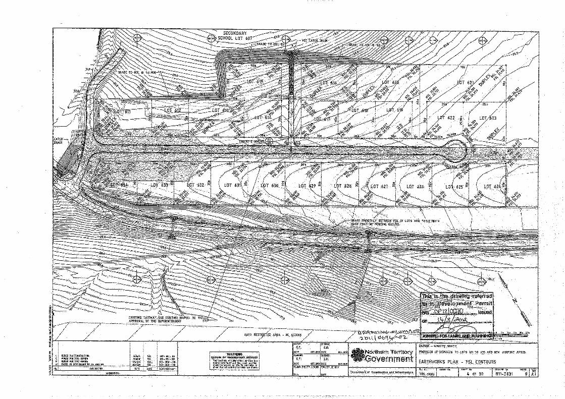
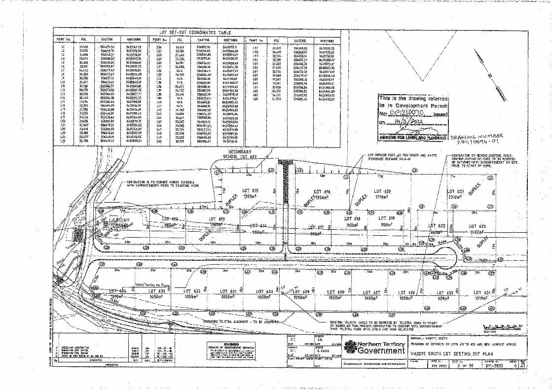
3.0 SITE IDENTIFICATION The site is part of the NT Government Subdivision Development and New Airport Apron Project being undertaken by TDC. Following the construction of a new airport terminal, parcels of land comprising the former airport terminal have been assigned to the development of a new 25 lot subdivision (Lots 611 to 635). The site comprises Lot 611 which is one of the last of the lots to be developed and is the only lot requiring audit given that its former use included storage of small quantities of aviation fuel.
The legal description of the site is summarised in the table below.
Table 1: Legal Identification Lot 611
Lot 611
Land Description Lot 611, N.T. Portion 01637 Nemarluk
Property Street Address Lot 611, Wadeye Community, Northern Territory 0822
Current Legal Description Lot 611, Wadeye Community, N.T. Daly River / Port Keats Aboriginal Land Trust (as detailed on Survey Plan CP 004183, dated October 1978)
4.0 DOCUMENT OVERVIEW The structure of this report is consistent with the requirements for Environmental Audits in Victoria and the Auditor’s expectation of what is required in the Northern Territory. An additional section has been included (Section 6.0 Audit Scope and Methodology) to outline the scope of and the approach to the Audit. Other sections included (Section 7.0 Site Assessment) provide a summary of the assessment presented in each of the reviewed documents (listed in Section 5.0 Audited Documentation), reference to Auditor correspondence and summary of outstanding Auditor comments. This section has been included to provide a basis for the information summarised in Section 8.0 Site Characteristics. Information presented in Sections 7.0 and 8.0 of this report is summarised from the audited documents with Auditor correspondence and outstanding Auditor comments presented in boxed text at the end of each sub section in Section 7.0.
Discussion from the Auditor is subsequently presented as follows:
Section 9.0 Basis of Adoption of Assessment Criteria
Section 11.0 Auditor’s Assessment
Section 12.0 Auditor’s Conclusions and Recommendations.
Information included with this report:
Figures 1 and 2 – Golder Site Location Plan and Site Boundary Plan
Figure 3 – Figure reproduced from audited Cardno UNG documentation (Site Layout and Sampling Location plan)
Appendix A – Copy of Development Permit Schedule of Conditions (DP12/0070)
Appendix B – Audited Documentation
Appendix C – Auditor Correspondence
Appendix D – Limitations.
LOT 611 WADEYE COMMUNITY
15 September 2014 Report No. 147663038-003-R-Rev0 3
5.0 AUDITED DOCUMENTATION A summary of contaminated sites assessment undertaken and reviewed as part of the Audit is summarised in the table below. Copies of these reported are included in Appendix B.
Table 2: Summary of Contaminated Sites Assessment reviewed as part of Audit
Assessment Stage
Date Description Document Reference
Stage 1 Environmental Site Assessment
9 June 2014 Stage 1 Environmental Site Assessment with preliminary sampling
Cardno Ullman and Nolan Geotechnic (Cardno UNG, 2014a). Lot 611 Wadeye Community, NT. Final report on Stage One Environmental Site Assessment. Prepared for Thamarrurr Development Corporation. 9 June 2014.
Stage 1 Environmental Site Assessment
15 August 2014
Table including summary of auditor comments and Cardno UNG responses to comments
Cardno Ullman and Nolan Geotechnic (Cardno UNG, 2014b). Summary Table of Auditor Comments and Cardno Responses.
Stage 1 Environmental Site Assessment
15 August 2014
Revision of Cardno UNG (2014a) further to Auditor comments
Cardno Ullman and Nolan Geotechnic (Cardno UNG, 2014c). Lot 611 Wadeye Community, NT. Final Report on Stage One Environmental Site Assessment. Prepared for Thamarrurr Development Corporation. 15 August 2014.
6.0 AUDIT SCOPE AND METHODOLOGY The Audit commenced in June 2014 with a walkover of the site by the Auditor on 17 June 2014 and the review of the Environmental Site Assessment undertaken by Cardno UNG, (Cardno UNG 2014a) which included soil investigations. The Audit was completed with the review of Cardno UNG (2014b) (a tabulated response to Auditor comments) and Cardno UNG (2014c) (final report) which were undertaken in response to the Auditor’s letter of 18 June 2014 which requested a number of clarifications from Cardno UNG. A copy of the Notification of Request to Issue a Certificate of Environmental Audit for the site and the Auditor’s letter following review of Cardno UNG (2014a) are presented in Appendix C of this report. Cardno UNG (2014b) is also provided in Appendix C.
The purpose of the Audit was to evaluate whether, in the opinion of the Auditor, the contamination investigations provided in the documentation undertaken by Cardno UNG are complete, accurate, reliable and in accordance with Northern Territory legislation, relevant guidelines and policies. In addition, the purpose of the Audit was to assess whether the work completed by Cardno UNG was sufficiently sound to form a basis for decisions or actions relating to the proposed use of the site as a residential dwellings with garden / accessible soil areas. An assessment was also made on the erosion control measures put in place as part of the construction phase of the development.
The approach taken to the Audit is summarised as follows:
The site was visited by the Auditor on 17 June 2014, for the purpose of undertaking a site walkover to visually assess the current condition of the site and its immediate surroundings.
The audited document (Cardno UNG, 2014a) was reviewed by the Auditor and comments provided to TDC and Cardno UNG on 18 June 2014.
An updated version of the report and the corresponding response to Auditor comments prepared by Cardno UNG (Cardno UNG, 2014b and Cardno UNG, 2014c) were subsequently reviewed. All Auditor comments on the first version of the report were either closed (comment addressed or appropriate explanation provided), noted (explanation provided by Cardno UNG with no further response required from the Auditor) with none being left open to be addressed in subsequent assessment/documentation.
The NT EPA requires assessment of site contamination to be conducted in accordance with the National Environment Protection (Assessment of Site Contamination) Measure 1999 (amended 2013) (the NEPM). Therefore, review of audited documents included assessment against NEPM requirements. This included, but was not necessarily limited to:
LOT 611 WADEYE COMMUNITY
15 September 2014 Report No. 147663038-003-R-Rev0 4
Review of the site description (including current use and site activities), environmental setting (including geology and hydrogeology) and history
Scope of work against the objectives
Basis of design of scope of work (including presented data quality objectives (DQOs))
Basis of selection of assessment criteria
Field methodologies including sample collection, handling and transport
Quality Assurance / Quality Control (QA/QC) programs and performance
Results presented and supporting documentation (such as field notes, test pit logs, chain of custody documentation, laboratory analytical reports etc.)
Assessment of results including development of the conceptual site model (CSM), risk assessments and discussions
Conclusions drawn and recommendations made.
7.0 SITE ASSESSMENT The following provides a summary of the main aspects of the Environmental Site Assessment (ESA) prepared by Cardno UNG (2014c).
7.1 Objective The objective as stated in the ESA was to:
Identify the potential for contamination within the proposed allotment as part of the residential subdivision development.
7.2 Scope The scope of work included:
Review of the site background information available online or within existing Cardno databases
Review of the environmental setting of the site
Review of information pertaining to potential contamination at the site
A visual inspection of the site to confirm and ground-truth the desktop information
Interviews with available staff to assess the nature of the activities and land use(s) conducted at the site
Indicative surface soil sampling within high risk areas
Development of a preliminary CSM to assist in assessing potential risk to human health and the environment
Preparation of a Stage 1 Contamination Assessment report.
The Assessment Guidelines section of the ESA lists the selected assessment criteria to include Health Investigation Levels (HILs) and Health Screening Levels (HSLs) as set out in the NEPM.
7.3 Site History and Site Inspection Summary The site history summary stated that potential soil contamination may include petroleum hydrocarbons associated with the presence of an emergency aircraft fuel depot that was present within Lot 611 prior to development. The fuel depot was known to store no more than six drums (totalling about 1,000 litres) and the refuelling of the aircraft occurred within the bitumen apron and was only carried out in emergencies as
LOT 611 WADEYE COMMUNITY
15 September 2014 Report No. 147663038-003-R-Rev0 5
aircraft were responsible for carrying sufficient fuels to return back to Darwin without the need to refuel at Wadeye. The Site History interview of Thamarrurr Development Corporation personnel undertaken by Cardno UNG also confirmed that approximately 450m3 of soil was cut from Lot 611 and removed from site and approximately 60m3 of select fill was brought onto site (prior to the soils investigation undertaken by Cardno UNG).
Field observations during the Cardno UNG walkover included that the site comprises near level cleared land devoid of any vegetation. The adjacent allotment to the east (Lot 215) includes the former airport terminal building with semi-mature trees. A preliminary conceptual site model (CSM) was developed following the site history review and site inspection. Potential risks to construction workers and future residential occupants of the site with direct contact with the soil were identified as potentially complete exposure pathways. For this reason, field sampling was proposed to quantify risk to potential receptors.
7.4 Fieldwork Cardno UNG undertook a site inspection and intrusive investigation on 11th December 2013 and made general observations on Lot 611 and the surrounding area such as infrastructure, slopes, drainage and vegetation.
An excavator was used to excavate 4 test pits at the location of the former fuel storage area and samples were taken from each test pit at depths of 0-0.25m 0.25-0.5m and 0.5-0.75m. Fieldwork procedures gave consideration to the NEPM and AS4482 guidelines.
Ground conditions observed by Cardno UNG during the soil sampling comprised silty sandy gravelly fill materials (0.3 m depth) overlying natural clayey sandy gravel. Staining and odours were not reported at any of the four sampling locations.
7.5 Sampling Results Summary All PAH results were below the laboratory limit of reporting (LOR). Cadmium, copper and mercury were below LOR. Arsenic, lead, nickel and zinc had concentrations below assessment criteria. Total chromium concentrations above the EIL for trivalent chromium (Cr III) within each sample, and above HIL-A for hexavalent chromium (Cr IV) within each sample. Speciation of chromium was not undertaken.
The report concluded that the analytes tested were below levels identified as suitable for the proposed land use in relation to the protection of human health. The report also concluded that where residential housing is likely to contain “extensive horticultural gardens for produce” further assessment Cr IV concentrations may be justified.
7.6 Cardno UNG Conclusion The ESA (Cardno UNG, 2014c) concludes:
“The site is considered suitable for the proposed residential land-use, subject to a site environmental management plan being put in place to assess and manage any unexpected indicators of contamination during future building works at the site.”
8.0 SITE CHARACTERISTICS The Stage One Environmental Site Assessment (Cardno UNG (2014c)) presents background information for site description, site history, geology, hydrogeology and CSM. Information from this report and supplementary information from the Auditor’s site walkover undertaken on 17 June is summarised in Sections 8.1 to 8.6.
8.1 Site Description/History The site location and plan are presented on Figures 1 and 2. The site is part of the NT Government Subdivision Development and New Airport Apron Project being undertaken by TDC. Following the construction of a new airport terminal, parcels of land comprising the former airport terminal have been assigned to the development of a new 25 lot subdivision (Lots 611 to 635). The site comprises Lot 611 which is one of the last of the lots to be developed. The former terminal building is still in existence and is
LOT 611 WADEYE COMMUNITY
15 September 2014 Report No. 147663038-003-R-Rev0 6
located to the north west of Lot 611. The subdivision, including Lot 611 is generally flat although it grades down to gullies either side of the development.
Lot 611 is level and has a gravelly soil surface. There has been some cut to level the block with a cut surface evident on the north west side near the former terminal building (Cardno UNG report that the cut volume was approximately 450m3 ). There may be fill on the other side of the site to form the level platform. It is understood that a veneer of fill has been placed across the surface (Cardno UNG report that the fill volume was approximately 60m3).
To the north of the site lies Wadeye School and to the south is residential subdivision development (Lots 612 to 635) which is either recently constructed or nearing completion. The existing airport terminal and airstrip are located 500 m to the south east of Lot 611.
Prior to the Cardno UNG investigation undertaken in 2013, there are no environmental investigation works known to have taken place. Cardno UNG completed a Geotechnical Site Classification Assessment (April, 2013) within neighbouring Lots 624 – 634 for the purpose of providing geotechnical recommendations for the development.
The site history summary stated that potential soil contamination may include petroleum hydrocarbons associated with the presence of an emergency aircraft fuel depot that was present within Lot 611 prior to development. The fuel depot was known to store no more than six drums (totalling 1,000 litres) and the refuelling of the aircraft occurred within the bitumen apron and was only carried out in emergencies as aircraft were responsible for carrying sufficient fuels to return back to Darwin without the need to refuel at Wadeye. The Auditor site visit included an inspection of the current emergency fuel storage area. The drums were stored on an un-bunded, sealed surface and there was no evidence of spillage, leakage or staining.
The fuel storage was used for approximately 20 years prior to being decommissioned. The land use prior to the development of the airport infrastructure is unknown but is unlikely to have included any commercial or industrial use of the land.
8.2 Environmental Setting Lot 215 to the north west of the site includes the former airport terminal building and semi-mature trees, which are still present. Lot 142 to the north of the site includes Wadeye School and contains single storey classrooms and covered common areas. The Lot contains sporadic semi-mature trees and grasses. Lot 613 to the south east includes a newly constructed residential dwelling with carport. The property is devoid of any vegetation and gradually slopes towards the east.
The site is situated in the Port Keats catchment area. The coastline is approximately 11km to the west and Sandfly Creek is the closest watercourse to the site at approximately 650 m to the west, running south east to North West, then northerly past the township. Cardno (2014) considers that stormwater flow across the Wadeye area is likely to be towards the north and west, into Sandfly Creek.
The southern Wadeye region has been classified as “Extremely Low Probability / Low Confidence” with regards to containing Actual Acid Sulphate Soils (ASS) or Potential Acid Sulphate Soils (PASS).
LOT 611 WADEYE COMMUNITY
15 September 2014 Report No. 147663038-003-R-Rev0 7
8.3 Geology The geology of the area is described in the published maps and information from the Northern Territory Geological Survey, 1:250,000 Geological Map Series and explanatory notes of Port Keats (Sheet SD 52-11, 1971). The site is underlain by:
Port Keats Group of the Triassic Permian Period (200-300Ma). Consists of micaceous sandy siltstone, siltstone, sandstone, minor limestone and basal conglomerate units.
Recent Tertiary (Cainozoic) alluvial and colluvial deposits of unconsolidated sand and clayey sand occur as a thin cover over the lower Port Keats Group and surrounding areas.
The geology identified during sampling consisted of silty sandy gravel fill materials (pale brown, fine to coarse grained, angular to sub-rounded, fine to coarse grained sand) to 0.3 m depth, overlying natural clayey sandy gravel (orange-brown, fine to medium grained, sub angular to sub rounded fine to coarse grained sand).
8.4 Hydrogeology The hydrogeology section of Cardno UNG (2014c) includes a list of registered borehole data obtained from a search of the Natural Resource Maps NT and Department of Lands Resource Management Groundwater database. There are over 20 registered groundwater bores within a 5km radius which are associated with rural residential and agricultural properties. Based on the published groundwater bore information, Cardno indicate the groundwater level to be 11 m to 13 m below ground level and that risks to groundwater can be discounted. In order to provide some verification of these statements, Golder sourced topographical information from a published GIS source, referenced as:
World_Topo_Map - Sources: Esri, DeLorme, NAVTEQ, TomTom, Intermap, increment P Corp., GEBCO, USGS, FAO, NPS, NRCAN, GeoBase, IGN, Kadaster NL, Ordnance Survey, Esri Japan, METI, Esri China (Hong Kong), and the GIS User Community)
This reference confirmed that the topographic level at the site is approximately 25 m above sea level and therefore it is considered that the depth to groundwater would not be less than that assumed by Cardno UNG. On this basis and considering the conceptual site model, the Auditor agrees with the Cardno UNG statement that the possibility of risk to groundwater can be discounted.
8.5 Extent of Impacts All petroleum hydrocarbon results were below the laboratory limit of reporting (LOR). Cadmium, copper and mercury were below LOR. Arsenic, lead, and zinc had concentrations below assessment criteria.
Total chromium concentrations were reported to be in excess of the HIL-A value for chromium VI. Chromium VI was not analysed separately. Cardno UNG (2014c) discusses the low likelihood of chromium VI to be present given the site’s setting and history. The Auditor agrees with the Cardno UNG statement that the chromium concentration is likely to consist of chromium III, and is also likely to be associated with background concentrations in the area.
The Auditor considers that the EILs presented for chromium III and nickel have not been calculated correctly and should be lower than those presented in Table 1 of Cardno UNG (2014c). This causes the site concentrations to exceed EILs for residential land-use for both chromium III and nickel.
Further to this, as background samples were not taken in order to derive an ambient background concentration, Cardno UNG have conservatively compared the site concentrations directly with the added contaminant limit. This approach is considered to overestimate the risk as in reality, the concentrations reported are likely to be representative of background rather than being representative of any impact from the site.
These results indicate that the site has not been impacted by any of the potential contaminants considered.
LOT 611 WADEYE COMMUNITY
15 September 2014 Report No. 147663038-003-R-Rev0 8
8.6 Conceptual Site Model A preliminary CSM was developed for the site as part of the Stage One Environmental Site Assessment and was used to inform the soil sampling strategy. The CSM was not further updated following consideration of the soil results.
In summary, the CSM considered total recoverable hydrocarbons, benzene, toluene, ethylbenzene, xylenes and polycyclic aromatic hydrocarbons as the potential contaminants of concern with the source being spills and leaks associated with the former fuel depot. Potential contamination pathways via soil, groundwater and surface water are discussed and potential receptors considered are construction workers and future residential occupants of the site.
Overall (taking into account Cardno UNG’s response to Auditor comments), the audited documents conclude that reported concentrations are consistent with background conditions and therefore there are no unacceptable risks associated with the site’s previous use. The CSM was not subsequently revised however the audited documentation has shown there to be no viable source – pathway – receptor linkages following the intrusive investigation and the provision of the requested clarifications.
9.0 BASIS OF ADOPTION FOR ASSESSMENT CRITERIA
9.1 Soil Assessment Criteria The Assessment Guidelines section of the ESA (Cardno UNG, 2014a) lists the selected assessment criteria to include HILs and HSLs as set out in the NEPM specifically:
HIL-A and HSL-A (residential end use with garden / accessible soil)
Comparisons were also made against the following assessment criteria:
HIL-B (residential with minimal opportunities for soil access)
HIL-C (public open space)
HIL D and HSL-D (commercial / industrial)
Ecological Investigation Levels (EILs) for the protection of terrestrial ecosystems
Management Limits (non-health based – e.g. aesthetic considerations)
Canadian Council of Ministers of the Environment (CCME) Protection of Groundwater for potable and livestock supply
Landfill acceptance criteria (Vantassel and Hogans Pocket Landfills, Queensland).
Based on the identified receptors and CSM for the site, the Auditor considers HIL-A, HSL-A, EILs and ESLs to be appropriate for use in assessing the site. The remaining assessment criteria listed above are not considered to be relevant to the site.
9.2 Groundwater Assessment Criteria The assessment did not require comparisons with groundwater assessment criteria as the CSM demonstrated that risks to groundwater could be discounted based on the absence of a source of impact. Groundwater was not sampled as part of this assessment.
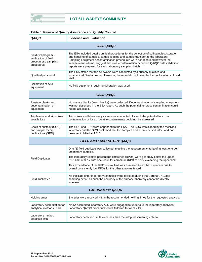
10.0 QUALITY ASSURANCE / QUALITY CONTROL A review of the QA/QC data presented in the ESA is presented in Table 3 below.
LOT 611 WADEYE COMMUNITY
15 September 2014 Report No. 147663038-003-R-Rev0 9
Table 3: Review of Quality Assurance and Quality Control
QA/QC Evidence and Evaluation
FIELD QA/QC
Field QC program - verification of field procedures / sampling procedures
The ESA included details on field procedures for the collection of soil samples, storage and handling of samples, sample logging and sample transport to the laboratory. Sampling equipment decontamination procedures were not described however the sample results do not suggest that cross contamination occurred. QA/QC data validation reports were prepared for each laboratory sampling batch.
Qualified personnel The ESA states that the fieldworks were conducted by a suitably qualified and experienced Geotechnician. However, the report did not describe the qualifications of field staff.
Calibration of field equipment
No field equipment requiring calibration was used.
FIELD QA/QC
Rinstate blanks and decontamination of equipment
No rinstate blanks (wash blanks) were collected. Decontamination of sampling equipment was not described in the ESA report. As such the potential for cross contamination could not be assessed.
Trip blanks and trip spikes volatile loss
Trip spikes and blank analysis was not conducted. As such the potential for cross contamination or loss of volatile contaminants could not be assessed.
Chain of custody (COC) and sample receipt notifications (SRN)
The COC and SRN were appended to the ESA. The COC was signed by the receiving laboratory and the SRN confirmed that the samples had been received intact and had been kept chilled at 4.8°C
FIELD AND LABORATORY QA/QC
Field Duplicates
One (1) field duplicate was collected, meeting the assessment criteria of at least one per 20 primary samples.
The laboratory relative percentage difference (RPDs) were generally below the upper RPD limit of 30%, with one result for chromium (RPD of 37%) exceeding the upper limit.
This exceedance of the RPD control limit was assessed to not be of concern due to overall consistently low RPDs for the other analytes tested.
Field Triplicates No triplicate (inter laboratory) samples were collected during the Cardno UNG soil sampling event, as such the accuracy of the primary laboratory cannot be directly assessed.
LABORATORY QA/QC
Holding times Samples were received within the recommended holding times for the requested analysis.
Laboratory accreditation for analytical methods used
NATA accredited laboratory ALS were engaged to undertake the laboratory analyses. Laboratory QA/QC procedures were followed for all results.
Laboratory method detection limit
Laboratory detection limits were less than the adopted screening criteria.
LOT 611 WADEYE COMMUNITY
15 September 2014 Report No. 147663038-003-R-Rev0 10
QA/QC Evidence and Evaluation
QA/QC DATA EVALUATION
Data quality objectives (DQOs)
The DQOs for the investigation, were specifically discussed in the ESA, however a Sampling and Analysis Quality Plan (SAQP) was not presented. The Auditor considers that the steps of the DQO process have largely been carried out with the exception of the “development of the analytical approach or decision rule” which was not undertaken in accordance with industry standards.
This DQO step defines acceptable limits for QA/QC samples (for example rinsate blanks, duplicates etc). As rinsate blanks or inter laboratory split duplicates were not undertaken, the Auditor considers that this DQO step has not been fully met.
The Auditor considers however that the data is nevertheless of a sufficient quality on which conclusions can be based, and this deviation from industry practice has not affected the overall conclusions of the report.
Completeness of test program
The overall results of the soil sampling are considered sufficient to support the conclusions generated.
11.0 SITE SUITABILITY AND ENVIRONMENTAL MANAGEMENT
11.1 The Auditor’s Assessment of Risk Based on review of the documentation provided, the Auditor agrees with Cardno UNG’s conclusion (see Section 7.6) and considers that there is a low likelihood that contamination sources remain on the site.
Assessment of Human Health Risks Based on the investigation work presented in the ESA, it is the Auditor’s conclusion that subject to the implementation of appropriate management measures during site development, the risk to human health presented by potential unknown contamination at the site and the measured inferred background concentrations is low and acceptable. This is based on:
The ESA reported site concentrations to be below the relevant adopted assessment criteria.
The assumption that the total chromium present is chromium III rather than chromium VI.
The EMP should address potential risks during development ground works within the Lot 611 Audit Area.
Assessment of Ecological or Phytotoxic Risks The Auditor considers potential risk to onsite ecological receptors presented by potential unknown contamination at the site and the measured inferred background concentrations to be of low significance. This is based on:
The site is located within a highly modified ecological setting.
The ESA reported site concentrations that were inferred to be representative of background concentrations.
Given that the measured site concentrations are inferred to be representative of background concentrations, the Auditor considers potential risk to offsite ecological receptors is low and acceptable.
Potential for Offsite Migration of Onsite Contamination Based on the investigation and assessment presented in the ESA, potential risks to human health and ecological receptors resulting from offsite migration of contamination is limited. Given the low likelihood of residual contamination to remain at the site, the potential for offsite migration of onsite contamination is considered to be low.
LOT 611 WADEYE COMMUNITY
15 September 2014 Report No. 147663038-003-R-Rev0 11
11.2 Site Suitability and Environmental Management Plan Based on the reviewed documentation, the Auditor concludes that Lot 611 is suitable for use as a residential dwelling with accessible soil areas, subject to subject to implementation of an EMP as recommended by Cardno UNG.
The Auditor notes that the reviewed documentation did not include an EMP. Cardno UNG state that the EMP should include provision to “assess and manage any unexpected indicators of contamination during future building works at the site.”
The Auditor considers that the EMP should be a brief document explaining that although no contamination was found to be present at the site, due to potentially contaminating activities having been undertaken at the site in the past, there is the potential for unknown contamination to be present beneath the site’s surface.
As such, when carrying out development works, a watching brief should be kept for the presence of indicators of potential contamination such as odours, staining, or the presence of free product. If any of these are suspected, then the advice of a suitably qualified environmental professional should be sought and appropriate notification made to the NT EPA.
It is recommended that the EMP be prepared by a suitably qualified professional and reviewed by an Environmental Auditor prior to commencement of development works.
The Auditor does not consider that there is any need for management measures beyond the period of site development.
LOT 611 WADEYE COMMUNITY
15 September 2014 Report No. 147663038-003-R-Rev0 12
12.0 CLOSURE Based on the information within the documentation reviewed the Auditor considers that no unacceptable risks to human health, environment or environmental values are present due to the reported concentrations at the site in its current condition.
The Auditor considers that the site is suitable for the proposed land use as a residential dwelling with accessible soil subject to the implementation of an Environmental Management Plan (EMP) during development works as recommended in the Audited Documentation. The EMP should allow for the identification of any unexpected indicators of contamination during development works at the site, and if identified, the EMP should trigger the appropriate assessment and management of these impacts.
Therefore Condition 1 of the Development Permit (DP12/0070) is considered to have been met (subject to the implementation of an EMP).
In terms of soil erosion, as far as is ascertainable from the information provided and the Auditor’s site visit, Condition 3 of the appended Development Permit (DP12/0070) is considered to have been met.
No restrictions are considered to be required by the Auditor, apart from environmental management planning for development works as discussed above.
This Environmental Audit Report and appendices is a discussion of the Auditor’s review of available information and forms the basis for the Site Audit Statement for Lot 611, Wadeye Community, Northern Territory, as shown in Figures 1 and 2.
The Statement of Environmental Audit outlines the Auditor’s assessment of site suitability as a residential dwelling with accessible soil areas.
A copy of the Statement of Environmental Audit is included at the front of this report. Any changes to the Statement of Environmental Audit must be approved by an appropriately accredited Auditor in conjunction with the Environment Protection Authority.
13.0 LIMITATIONS This report represents a review of certain information relating to the subject site that was obtained from the sources and contacts noted by methods described in this report. Golder and the Contaminated Sites Auditor have used reasonable care to:
Avoid reliance upon data and information that is inaccurate
Confirm that the data and information on which the Auditor has relied in forming an opinion regarding the condition of the site constitutes an adequate basis for forming that opinion.
In addition, while this audit report has been undertaken in accordance with EPA Victoria: Environmental auditor (contaminated land): Guidelines for issue of certificates and statements of environmental audit (2014) and also current industry practice, there may be some limitations on the meaning and use of this report.
LOT 611 WADEYE COMMUNITY
15 September 2014 Report No. 147663038-003-R-Rev0
Report Signature Page
GOLDER ASSOCIATES PTY LTD
Roger Parker Environmental Auditor (appointed pursuant to the Environment Protection Act 1970)
NB/RJP/ae
A.B.N. 64 006 107 857
Golder, Golder Associates and the GA globe design are trademarks of Golder Associates Corporation.
\\ade1-s-file01\jobs-enviro\env\2014\147663038 - thamarrurr - audit wadeye nt\correspondence out\147663038-003-r\147663038-003-r-reva.docx
LOT 611 WADEYE COMMUNITY
15 September 2014 Report No. 147663038-003-R-Rev0
FIGURE 1 Site Location Plan
Info
rmat
ion
co
ntai
ned
on
this
dra
win
g is
the
cop
yrig
ht
of G
old
er A
ssoc
iate
s P
ty. L
td.
Una
uth
oris
ed
use
or
repr
odu
ctio
n o
f th
is p
lan
eith
er w
hol
ly o
r in
par
t w
itho
ut w
ritte
n p
erm
issi
on
infr
inge
s co
pyr
igh
t.
© G
old
er A
ssoc
iate
s P
ty. L
td.
DA
LY R
IVE
R R
OA
D
555,000
555,000
555,500
555,500
556,000
556,000
556,500
556,500
557,000
557,000
557,500
557,500
558,000
558,000
8,42
4,0
00
8,42
4,0
00
8,42
4,5
00
8,42
4,5
00
8,42
5,0
00
8,42
5,0
00
8,42
5,5
00
8,42
5,5
00
8,42
6,0
00
8,42
6,0
00
8,42
6,5
00
8,42
6,5
00
SITE ENVIRONMENTAL AUDIT REPORT LOT 611, WADEYE COMMUNITY, WADEYE, NORTHERN TERRITORY
THAMARRURR DEVELOPMENT CORPORATION
SITE LOCATION PLAN
SCALE (at A4)DATUM GDA 94, PROJECTION MGA Zone 52
COPYRIGHTWorld_Imagery - Source: Esri, DigitalGlobe, GeoEye, i-cubed, USDA,USGS, AEX, Getmapping, Aerogrid, IGN, IGP, swisstopo, and the GIS User Community. Aerial image sourced from World Imagery,sourced 123.06.2014.
Township and road data sourced from MapInfo StreetPro.
FIGURE 1
!(
!(!(
!(
!(!(!(THE SITE
DARWIN
DALY RIVER
DUNDEE BEACH
BELYUEN
THAMARRURR
WADEYE
1:15,000
0 100 200 300 400 50050 metres
File Location: \\mel1-s-file01\Jobs\ ...mxd
±
147663038
NB
13 JUN 2014KB
LEGEND
Approximate Site Boundary
PROJECT:
CHECKED:
DATE:DRAWN:
THE SITE
LOT 611 WADEYE COMMUNITY
15 September 2014 Report No. 147663038-003-R-Rev0
FIGURE 2 Site Plan

Inform
ation
conta
ined o
n this
draw
ing is
the c
opyri
ght o
f Gold
er As
socia
tes P
ty. Lt
d. U
nauth
orise
d use
or re
produ
ction
of th
is pla
n eith
er wh
olly o
r in pa
rt with
out w
ritten
perm
ission
infrin
ges c
opyri
ght.
© G
older
Asso
ciates
Pty.
Ltd.
SITE ENVIRONMENTAL AUDIT REPORT LOT 611, WADEYE COMMUNITY, WADEYE, NORTHERN TERRITORY
THAMARRURR DEVELOPMENT CORPORATION
SITE BOUNDARY PLAN
SCALE (at A4) Not to Scale
COPYRIGHTWorld_Imagery - Source: Esri, DigitalGlobe, GeoEye, i-cubed, USDA,USGS, AEX, Getmapping, Aerogrid, IGN, IGP, swisstopo, and the GIS User Community. Aerial image sourced from World Imagery,sourced 123.06.2014.
Township and road data sourced from MapInfo StreetPro.Information shown from Cardno Ung Project No: U33277, Figure 1, Dated 15 August 2014.
FIGURE 2
THE SITE
DARWIN
DALY RIVER
DUNDEE BEACHBELYUEN
THAMARRURRWADEYE
File Location: \\mel1-s-file01\Jobs\ ...mxd
147663038
NB12 SEP 2014KB
PROJECT:
CHECKED:DATE:DRAWN:
LOT 611 WADEYE COMMUNITY
15 September 2014 Report No. 147663038-003-R-Rev0
APPENDIX A Copy of Development Permit Schedule of Conditions (DP12/0070)
LOT 611 WADEYE COMMUNITY
15 September 2014 Report No. 147663038-003-R-Rev0
APPENDIX B Audited Documentation
Cardno Ullman & Nolan, Final Report on Stage One Environmental Site Assessment, Lot 611 Wadeye Community, NT (Ref: U33277, dated 15 August 2014)
STAGE ONE ENVIRONMENTAL SITE ASSESSMENT
BRUCE HIGHWAY AND BOWEN DEVELOPMENT ROAD INTERSECTION UPGRADE U23547
Prepared for
Thamarrurr Development Corporation
15 August 2014
FINAL REPORT ON TIER 1 ENVIRONMENTAL SITE ASSESSMENT
LOT 611 WADEYE COMMUNITY NT
U33277
FINAL REPORT ON TIER 1 ENVIRONMENTAL SITE ASSESSMENT LOT 611 WADEYE COMMUNITY NT
15 August 2014 Cardno Ullman and Nolan Geotechnic (NT) ii
Contact Information
Cardno Ullman and Nolan Geotechnic (NT) ABN 78 078 713 934
76 Benison Road
Winnellie NT 0820 Australia
P.O. Box 39623
Winnellie NT 0821 Australia
Telephone: 08 8984 4983
Facsimile: 08 8984 4659
www.cardno.com.au
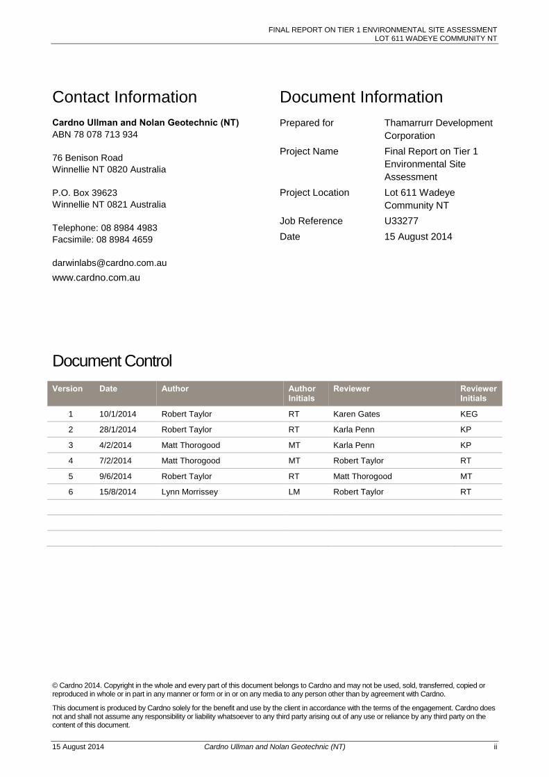
Document Information
Prepared for Thamarrurr Development
Corporation
Project Name Final Report on Tier 1
Environmental Site
Assessment
Project Location Lot 611 Wadeye
Community NT
Job Reference U33277
Date 15 August 2014
Document Control
Version Date Author Author Initials
Reviewer Reviewer Initials
1 10/1/2014 Robert Taylor RT Karen Gates KEG
2 28/1/2014 Robert Taylor RT Karla Penn KP
3 4/2/2014 Matt Thorogood MT Karla Penn KP
4 7/2/2014 Matt Thorogood MT Robert Taylor RT
5 9/6/2014 Robert Taylor RT Matt Thorogood MT
6 15/8/2014 Lynn Morrissey LM Robert Taylor RT
© Cardno 2014. Copyright in the whole and every part of this document belongs to Cardno and may not be used, sold, transferred, copied or reproduced in whole or in part in any manner or form or in or on any media to any person other than by agreement with Cardno.
This document is produced by Cardno solely for the benefit and use by the client in accordance with the terms of the engagement. Cardno does not and shall not assume any responsibility or liability whatsoever to any third party arising out of any use or reliance by any third party on the content of this document.
FINAL REPORT ON TIER 1 ENVIRONMENTAL SITE ASSESSMENT LOT 611 WADEYE COMMUNITY NT
15 August 2014 Cardno Ullman and Nolan Geotechnic (NT) iii
Letter of Transmittal
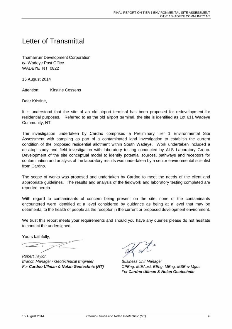
Thamarrurr Development Corporation
c/- Wadeye Post Office
WADEYE NT 0822
15 August 2014
Attention: Kirstine Cossens
Dear Kristine,
It is understood that the site of an old airport terminal has been proposed for redevelopment for
residential purposes. Referred to as the old airport terminal, the site is identified as Lot 611 Wadeye
Community, NT.
The investigation undertaken by Cardno comprised a Preliminary Tier 1 Environmental Site
Assessment with sampling as part of a contaminated land investigation to establish the current
condition of the proposed residential allotment within South Wadeye. Work undertaken included a
desktop study and field investigation with laboratory testing conducted by ALS Laboratory Group.
Development of the site conceptual model to identify potential sources, pathways and receptors for
contamination and analysis of the laboratory results was undertaken by a senior environmental scientist
from Cardno.
The scope of works was proposed and undertaken by Cardno to meet the needs of the client and
appropriate guidelines. The results and analysis of the fieldwork and laboratory testing completed are
reported herein.
With regard to contaminants of concern being present on the site, none of the contaminants
encountered were identified at a level considered by guidance as being at a level that may be
detrimental to the health of people as the receptor in the current or proposed development environment.
We trust this report meets your requirements and should you have any queries please do not hesitate
to contact the undersigned.
Yours faithfully,
Robert Taylor Karen Gates
Branch Manager / Geotechnical Engineer Business Unit Manager
For Cardno Ullman & Nolan Geotechnic (NT) CPEng, MIEAust, BEng, MEng, MSEnv.Mgmt
For Cardno Ullman & Nolan Geotechnic
FINAL REPORT ON TIER 1 ENVIRONMENTAL SITE ASSESSMENT LOT 611 WADEYE COMMUNITY NT
15 August 2014 Cardno Ullman and Nolan Geotechnic (NT) iv
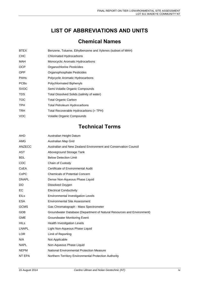
LIST OF ABBREVIATIONS AND UNITS
Chemical Names BTEX Benzene, Toluene, Ethylbenzene and Xylenes (subset of MAH)
CHC Chlorinated Hydrocarbons
MAH Monocyclic Aromatic Hydrocarbons
OCP Organochlorine Pesticides
OPP Organophosphate Pesticides
PAHs Polycyclic Aromatic Hydrocarbons
PCBs Polychlorinated Biphenyls
SVOC Semi-Volatile Organic Compounds
TDS Total Dissolved Solids (salinity of water)
TOC Total Organic Carbon
TPH Total Petroleum Hydrocarbons
TRH Total Recoverable Hydrocarbons (= TPH)
VOC Volatile Organic Compounds
Technical Terms AHD Australian Height Datum
AMG Australian Map Grid
ANZECC Australian and New Zealand Environment and Conservation Council
AST Aboveground Storage Tank
BDL Below Detection Limit
COC Chain of Custody
CoEA Certificate of Environmental Audit
CoPC Chemicals of Potential Concern
DNAPL Dense Non-Aqueous Phase Liquid
DO Dissolved Oxygen
EC Electrical Conductivity
EILs Environmental Investigation Levels
ESA Environmental Site Assessment
GCMS Gas Chromatograph - Mass Spectrometer
GDB Groundwater Database (Department of Natural Resources and Environment)
GME Groundwater Monitoring Event
HILs Health Investigation Levels
LNAPL Light Non-Aqueous Phase Liquid
LOR Limit of Reporting
N/A Not Applicable
NAPL Non-Aqueous Phase Liquid
NEPM National Environmental Protection Measure
NT EPA Northern Territory Environmental Protection Authority
FINAL REPORT ON TIER 1 ENVIRONMENTAL SITE ASSESSMENT LOT 611 WADEYE COMMUNITY NT
15 August 2014 Cardno Ullman and Nolan Geotechnic (NT) v
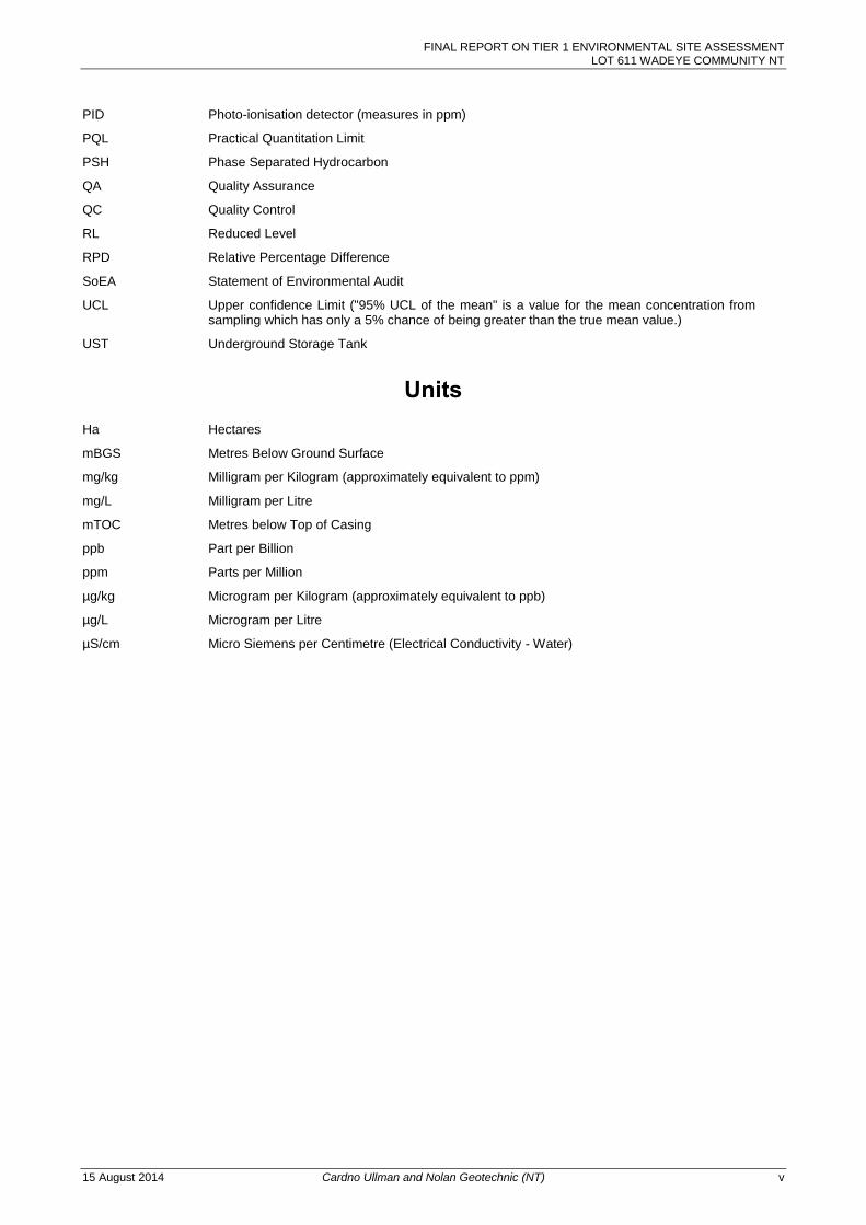
PID Photo-ionisation detector (measures in ppm)
PQL Practical Quantitation Limit
PSH Phase Separated Hydrocarbon
QA Quality Assurance
QC Quality Control
RL Reduced Level
RPD Relative Percentage Difference
SoEA Statement of Environmental Audit
UCL Upper confidence Limit ("95% UCL of the mean" is a value for the mean concentration from sampling which has only a 5% chance of being greater than the true mean value.)
UST Underground Storage Tank
Units Ha Hectares
mBGS Metres Below Ground Surface
mg/kg Milligram per Kilogram (approximately equivalent to ppm)
mg/L Milligram per Litre
mTOC Metres below Top of Casing
ppb Part per Billion
ppm Parts per Million
µg/kg Microgram per Kilogram (approximately equivalent to ppb)
µg/L Microgram per Litre
µS/cm Micro Siemens per Centimetre (Electrical Conductivity - Water)
FINAL REPORT ON TIER 1 ENVIRONMENTAL SITE ASSESSMENT LOT 611 WADEYE COMMUNITY NT
15 August 2014 Cardno Ullman and Nolan Geotechnic (NT) vi
TABLE OF CONTENTS
Letter of Transmittal iii 1 INTRODUCTION 8
1.1 OBJECTIVES AND SCOPE OF WORKS 8
1.1.1 Scope of Works 8
1.2 LIMITATIONS OF THE ESA REPORT 9
1.2.1 Authorised Agents for Report Use 9
2 SITE DESCRIPTION 10
2.1 GEOLOGY 10
2.2 ACID SULFATE SOILS 10
2.3 HYDROGEOLOGY 11
2.4 HYDROLOGY 11
2.5 SENSITIVE RECEPTORS ANDRECEIVING ENVIRONMENTS 11
3 SITE HISTORY 12
3.1 HISTORICAL AND CURRENT TITLE INFORMATION 12
3.2 HISTORICAL AERIAL PHOTOGRAPHY 12
3.3 SITE HISTORY INTERVIEW 12
3.4 SITE INSPECTION 13
3.4.1 GENERAL OBSERVATIONS 13
3.4.2 CONTAMINANTS OF POTENTIAL CONCERN 14
3.5 SITE HISTORY INTEGRITY ASSESSMENT 14
4 PRELIMINARY CONCEPTUAL SITE MODEL 15
4.1 AREAS OF ENVIRONMENTAL CONCERN 15
4.2 PRELIMINARY CONCEPTUAL SITE MODEL 15
4.2.1 Potential Contamination Sources 16
4.2.2 Potential Contamination Pathways 16
4.2.3 Receptors 16
4.3 SUMMARY 17
5 DATA QUALITY OBJECTIVES 18
6 ASSESSMENT GUIDELINES 19
6.1 SAMPLING GUIDELINES AND STANDARDS 19
6.2 SOIL ASSESSMENT CRITERIA 19
6.3 BASIS FOR ASSESSMENT CRITERIA 19
7 PRELIMINARY SOIL SAMPLING METHODOLOGY 21
7.1 SAMPLING RATIONALE 21
7.2 SOILS SAMPLING METHODOLOGY 21
8 QUALITY ASSURANCE DETAIL 22
8.1 FIELD AND SPLIT DUPLICATES 22
8.2 DATA VALIDATION 23
9 SAMPLING RESULTS AND DISCUSSION 24
9.1 ANALYTICAL RESULTS 24
9.1.1 Petroleum Hydrocarbons and Polycyclic Aromatic Hydrocarbons 24
9.1.2 Heavy Metals 24
FINAL REPORT ON TIER 1 ENVIRONMENTAL SITE ASSESSMENT LOT 611 WADEYE COMMUNITY NT
15 August 2014 Cardno Ullman and Nolan Geotechnic (NT) vii
9.2 RESULT DISCUSSION AND ASSESSMENT OF RISK 24
10 CONCLUSIONS AND RECOMMENDATIONS 26
11 LIMITATIONS 27
Appendices
APPENDIX A SITE PHOTOGRAPHS
APPENDIX B TEST PIT LOGS
APPENDIX C LABORATORY RESULTS SUMMARY TABLE
APPENDIX D LABORATORY REPORT AND CHAIN OF CUSTODY DOCUMENTATION
Tables
Table 3-1 DATE QUALITY OBJECTIVES PROCESS 14
Table 4-1 REGISTERED WATERBORE BOREHOLE DATA 11
Table 7-1 AREAS OF POTENTIAL CONCERN AND POTENTIAL CONTAMINANT SOURCES IDENTIFIED ON THE SITE 15
Table 9-1 DUPLICATE RESULTS 22
Figures
Figure 1 Site Layout and Sampling Location Plan
FINAL REPORT ON TIER 1 ENVIRONMENTAL SITE ASSESSMENT LOT 611 WADEYE COMMUNITY NT
15 August 2014 Cardno Ullman and Nolan Geotechnic (NT) Page 8
1 INTRODUCTION
Cardno Ullman and Nolan Geotechnic Pty Ltd (Cardno) has been commissioned by Thamarrurr
Development Corporation to undertake a Preliminary Tier 1 Environmental Site Assessment (ESA), with
sampling required as part of a contaminated land investigation to establish the current environmental
condition of Lot 611 Wadeye Community, Northern Territory.
This preliminary investigation will assess the potential for residual contamination to be present within
the property boundaries as a result of historical and/or current land use(s). An area of possible
contamination within the allotment has also been targeted for soil sampling and testing, with the results
discussed within this report.
The intention of the report is to form the basis of a preliminary assessment of site suitability for
residential development.
1.1 OBJECTIVES AND SCOPE OF WORKS
The primary objective of this ESA is to identify the potential for contamination to be present within the
Lot 611 Wadeye which is to form as part of a residential subdivision development. The investigation of
Lot 611 is required due to the presence of a former fuel storage activity associated with an airstrip
terminal.
The purpose of the investigation is to enable an evaluation of the suitability of Lot 611 Wadeye for the
proposed residential use, given the historical usage of the site.
The scope of works completed in order to achieve the objectives and purpose of the investigation is
detailed in the scope of works section below:
1.1.1 Scope of Works
The following scope of works was conducted:
Review of the site background information available online or within existing Cardno databases,
including:
- A review of historical aerial photographs for the site to ascertain previous land use and determine a
timeline for past land use; and
- Review of the historical and current land titles for the property.
Review of the environmental setting of the site, including (but not limited to):
- Geological, hydrological and hydrogeological setting;
- Vegetation;
- Site landforms, topography and morphology (including land filling and earthmoving works); and
- Acid Sulfate Soils (ASS) risk mapping.
Review of information pertaining to potential contamination at the site including:
- Chemical storage and potential for leaks, spills and discharges;
- Identification of potential onsite sources of contamination, including diffuse and point sources; and
- Identification of the potential chemicals of concern and description of their characteristics, including
migration and persistence within the environment.
A visual inspection of the site to confirm and ground-truth the desktop information.
Interviews with available site staff to determine the nature of the activities and land use(s) conducted at
the site.
Indicative surface soil sampling within high risk areas where contaminants of concern would likely
concentrate.
Development of a preliminary Conceptual Site Model (CSM) risk assessment to assist in determining
potential risk to human health and the environment.
FINAL REPORT ON TIER 1 ENVIRONMENTAL SITE ASSESSMENT LOT 611 WADEYE COMMUNITY NT
15 August 2014 Cardno Ullman and Nolan Geotechnic (NT) Page 9
Preparation of a Tier 1 Contamination Assessment report identifying potential constraints associated with
contamination issues and provision of recommendations, if required.
To assess the need for further investigation (if any) and if not make a recommendation on the suitability
or otherwise of the site for residential use.
In the instance that the site is deemed unsuitable for the proposed residential use, the actions required
to be taken in order to make the site suitable for such usage will be outlined.
1.2 LIMITATIONS OF THE ESA REPORT It is the reader’s responsibility to verify the correct interpretation and intention of the recommendations
presented herein. Cardno UNG assumes no responsibility for misunderstandings or improper
interpretations that result in unsatisfactory or unsafe work products. It is the reader’s further
responsibility to acquire copies of any supplemental reports, addenda or responses to public agency
reviews that may supersede recommendations in this report.
The findings presented in this report have been based on the investigation described herein, which was
undertaken in general accordance with Australian Standard 4482.1-2005 sampling series and NEPM
2013 guideline. This investigation is preliminary in nature and does not constitute a Stage 2
investigation.
As such, the investigation report only includes a limited amount of subsurface (intrusive) sampling of
the site, targeting the most at-risk areas based on the professional judgement of the investigating
Environmental Scientist.
It is understood that this report is required in order to satisfy conditions outlined in the projects’
development conditions as required by the development consent authority. The report is provided for
this purpose and no other purpose.
This investigation is designed in order to provide an assessment of on-site contamination conditions at
locations representative of likely environmental risks. Environmental studies identify actual sub-surface
conditions only at those points where samples are taken, when they are taken. Actual conditions
between sampling locations may differ from those inferred because no professional, no matter how
qualified, and no sub-surface exploration program, no matter how comprehensive, can reveal what is
hidden below the ground surface. The actual interface between materials may be far more gradual or
abrupt than an assessment indicates. Actual conditions in areas not sampled may differ from that
predicted.
1.2.1 Authorised Agents for Report Use
This report has been specifically prepared for use by Thamarrurr Development Corporation (the client),
and the regulatory assessing agencies of Northern Territory Environmental Protection Authority (NT
EPA) subject to:
This Stage One report has been prepared for Thamarrurr Development Corporation for use by
themselves and appointed consultants to meet required obligations and enable project progression;
The use of the reports by any related parties is subject to the same terms of agreement formed between
Cardno UNG and Thamarrurr Development Corporation; and
Any users of the reports acknowledge the limitations section stated in Section 1.2 and Section 12. No
other users or parties (other than described above) are authorised to use this report without prior written
approval of Cardno UNG.
FINAL REPORT ON TIER 1 ENVIRONMENTAL SITE ASSESSMENT LOT 611 WADEYE COMMUNITY NT
15 August 2014 Cardno Ullman and Nolan Geotechnic (NT) Page 10
2 SITE DESCRIPTION
In accordance with the development plans provided by the client, the study site (Lot 611) is part of the
NT Government Subdivision Development and New Airport Apron Project being undertaken by
Thamarrurr Development Corporation within the Wadeye Community. Thamarrurr Development
Corporation was formed following the Local Government reform in 2007, when the Thamarrurr Regional
Council was subsumed by the Victoria Daly Shire Council. As part of this amalgamation, non-core Shire
Council functions in Wadeye were transferred to Thamarrurr Development Corporation.
Following the construction of a new Port Keats (Wadeye) Airport Terminal, parcels of land have been
assigned to the development of a new 25-lot subdivision (Lots 611 to 635) within the southern area of
Wadeye.
Several of the newly developed allotments have already had residential housing constructed on site,
with Lot 611 one of the final allotments to receive construction.
A site location plan is presented in Figure 1 with site photographs presented in Appendix A.
The area of land earmarked for residential development includes:
Lot 611 on NT Portion 1637 – This vacant allotment is situated on near-level topography and contains
little to no vegetation.
The former terminal building is still situated to the north-west of the study site. To the north of the site
contains the Wadeye School, and to the south is the recently constructed (or near completion)
residential subdivision development (Lots 612 to 635).
The existing airport terminal and airstrip is situated 500m towards the south east.
2.1 GEOLOGY The regional geology of the area is described in the published maps and information from the Northern
Territory Geological Survey (NTGS), 1:250,000 Geological Map Series and Explanatory Notes of PORT
KEATS (Sheet SD 52-11, 1971).
The site is underlain by the Port Keats Group of the Triassic and Permian period (200-300Ma). The Port
Keats Group consists of micaceous sandy siltstone, siltstone, sandstone, minor limestone and basal
conglomerate units.
Recent Tertiary (Cainozoic) alluvial and colluvial deposits of unconsolidated sand and clayey sand
occur as a thin cover over the lower Port Keats Group and surrounding areas. This description is
consistent with the geology observed during the site investigation.
The soils and geologies described are consistent with descriptions of low to moderate soil permeability.
2.2 ACID SULFATE SOILS In accordance with the Australian Soil Resources Information System (ASRIS) Acid Sulfate Soil (ASS)
Overlay Map June 2013, the Southern Wadeye region has been classified as Extremely Low
Probability/Low Confidence with regards to containing ASS/PASS soils.
ASS occurrence is considered unlikely to be a confounding factor relating to this assessment.
FINAL REPORT ON TIER 1 ENVIRONMENTAL SITE ASSESSMENT LOT 611 WADEYE COMMUNITY NT
15 August 2014 Cardno Ullman and Nolan Geotechnic (NT) Page 11
2.3 HYDROGEOLOGY A search of the Natural Resource Maps NT and Department of Lands Resource Management
Groundwater Database was conducted. The search indicated over 20 registered groundwater bores
exist within a 5km radius of the site and are associated with rural residential and agricultural properties.
From review of the NT water bore database the flowing bores were interrogated. The standing water
level in registered groundwater bores seems reasonably consistent with some localised variation;
however it was not possible to confirm the RL for the boreholes and standing water level, though dates
were also an issue when ascertaining how seasonal rainfall may have impacted on recorded readings.
Therefore the indicative depth to groundwater at the site is assessed as 11-13 meters below ground
level. Based on the borehole data inferred direction of groundwater movement at the site is likely to be
in a (state direction to RN007274, RN007273).
Table 2-1 REGISTERED WATERBORE BOREHOLE DATA Bore reference Date of installation
(completion) Depth of bore
(m) Standing Water Level
(m) RN27146 03/09/1990 50.00 -
RN009265 05/04/1978 48.30 11.84
RN009262 26/03/1978 38.00 11.00
RN005612 28/09/1966 10.40 13.70
RN005613 29/09/1966 16.10 5.20
RN007275 03/10/1970 38.10 13.41
RN007274 <1981 38.40 13.40
RN007273 1970 32.00 13.40
RN007276 1970 22.80 1.52
RN027143 30/08/1990 32.60 -
2.4 HYDROLOGY The study site is situated within the Port Keats catchment area. The coast line is located 11km to the
west and Sandfly Creek approximately 650m to the west, running south-east to north-west, then north
past the township. Sandfly Creek is the closest water course to site, at approximately 8.0km north of
Wadeye the local water courses reach the sea passing to the east of Dorcherty Island flowing to the
Timor Sea.
It is anticipated based on the site topography that stormwater at site would drain either direct to ground,
to the road, or into the vacant low-lying land to the east. The general stormwater flow across the
Wadeye catchment is likely to be towards the north and west, into the neighbouring Sandfly Creek.
2.5 SENSITIVE RECEPTORS AND RECEIVING ENVIRONMENTS Based on the site condition assessment, sensitive potential off-site receiving environments and receptors are considered to be:
Groundwater flowing beneath the site;
Road reserve stormwater catchment and table drains;
Neighbouring residential allotments and schools; and
Sandfly Creek as well as other local tributaries and watercourses from stormwater flow from the
general Wadeye area.
Sensitive potential on-site receptors are considered to be
Site soils and subsoils
Current site users
Future site users including construction workers and inhabitants of future residences
FINAL REPORT ON TIER 1 ENVIRONMENTAL SITE ASSESSMENT LOT 611 WADEYE COMMUNITY NT
15 August 2014 Cardno Ullman and Nolan Geotechnic (NT) Page 12
3 SITE HISTORY
The site history investigation has been prepared with consideration of the NEPM Site Contamination
Measure 1999 (as amended 2013) - NEPM 2013 guidelines and AS4482. The objective of the site
history investigation is to complete an investigation to determine the probable locations and spatial
extent of contaminant use, storage and disposal across the site; as well as identifying potential
contamination from past and present land use.
Sources of site historical detail include:
Darwin Land and Planning Services (Department of Lands Planning and the Environment) for aerial
information;
Darwin Environment Protection Authority;
NT Department of Land Resource Management ;
Site History interviews with relevant TDC personnel; and
Site inspections of entire site for ground-truthing and identification of information that may not have been
identified from the collation of the above information.
Cardno UNG completed a Geotechnical Site Classification Assessment, dated April 2013, within the
neighbouring allotments (Lots 624 – 634) for the purpose of providing geotechnical recommendations
for residential development. A desktop study of this report was completed as part of the Preliminary
Environmental Site Assessment; however the previous geotechnical assessment did not reveal any
additional historical detail regarding the site and is therefore not considered relevant to the assessment.
The relevant site history information which was obtained during the review is presented below.
3.1 HISTORICAL AND CURRENT TITLE INFORMATION The study site (Lot 611) is part of the property NT Por 1637 for the Township of Wadeye, with the
Owner Category as Aboriginal Land (Scheduled under ALRA) along with the greater Thamarrurr
Region. Historical title information indicated the Property Name is Daly River/Port Keats Aboriginal
Land Trust, as detailed on Survey Plan CP 004183, dated October 1978.
The historical title search did not reveal any additional information regarding the historic site usage.
3.2 HISTORICAL AERIAL PHOTOGRAPHY Due to the geographic location of the site, and the isolation from the larger regional centres, historical
aerial photographs covering the region, prior to 2005, are of a very large coverage area with low
resolution.
Therefore, the site location and surface features are unable to be distinguished for the study region and
surrounding areas.
The historical aerial photograph review did not reveal any additional factual information regarding the
site history or historical land use and therefore cannot be relied upon as evidence for the assessment.
3.3 SITE HISTORY INTERVIEW Prior to the investigation, a site interview was conducted with a member of Thamarrurr Development
Corporation. The interview was undertaken via a phone conversation. The following information was
provided during the site history interview:
Lot 611 is situated in the southern region of Wadeye aboriginal community and is currently being
developed for residential housing by Thamarrurr Development Corporation;
FINAL REPORT ON TIER 1 ENVIRONMENTAL SITE ASSESSMENT LOT 611 WADEYE COMMUNITY NT
15 August 2014 Cardno Ullman and Nolan Geotechnic (NT) Page 13
The site is being developed for residential use following the relocation of the Port Keats Airport Apron
and Terminal Building;
The original terminal building is still present to the north-west of Lot 611, however the site of the former
fuel depot is within the boundaries of Lot 611;
The fuel stored on site within the former fuel depot contained no more than 6 drums (approximately
1,000 litres) of aviation fuel, and was for emergency purposes only;
The refuelling of aircraft occurred within the bitumen apron and was only carried out in emergencies, as
aircraft were responsible for carrying enough fuel to get them back to Darwin from Wadeye without the
need to re-fuel at Wadeye.
The fuel storage was used for approximately 20 years prior to decommission;
The fuel storage area was on gravel and was within security fencing. The fuel storage area was not
bunded and there were no drains or first flush containment systems surrounding the area. When the fuel
storage area was removed the gravel beneath the area was removed and disposed at an industrial
dump.
The land use prior to development of the airport infrastructure is unknown, however based on the history
of the Wadeye community it is considered unlikely that an industrial activity with the potential to create
contamination impacts was undertaken at the site.
During the recent subdivision development, approximately 450m3 of soil was cut from Lot 611 and
removed from site. Approximately 60m3 of select fill was brought onto site. Earthworks were completed
prior to this contamination assessment. This fill material was sourced from a local gravel pit outside 7
km Wadeye for the provision of clean fill and therefore is unlikely to contain contamination (pers comm
Kristine Cossens).
3.4 SITE INSPECTION A site inspection was undertaken on 11th December 2013 by a suitably qualified and experienced
Geotechnician. The site inspection was focussed on Lot 611, however Cardno did also visually inspect
the neighbouring lots for potential stormwater/contaminants flow paths.
This section contains a summary of the observations carried out on site. Refer to Figure 1 for the site
layout plan and Appendix A for site photographs.
3.4.1 GENERAL OBSERVATIONS
LOT AND PLAN FIELD OBSERVATIONS
Lot 611 on NT Portion 1637
The site comprised of near-level cleared land, devoid of any vegetation. All evidence of the fuel storage and airport apron had been removed prior to the inspection. No staining or indication (odours etc) of contamination within fill or natural materials beneath during the investigation.
Lot 215 on NT Portion 1637 (Neighbouring allotment)
Site infrastructure visible and remaining onsite which was observed was the former airport terminal building (existing) within semi-mature tress to the north.
Lot 613 on NT Portion 1637 (Neighbouring allotment)
Lot 613 to the south included a newly constructed residential dwelling and carport. The property was devoid of any vegetation, and gradually slopes towards the east.
Lot 142 on NT Portion 1637 (Neighbouring allotment)
Lot 142 to the north included the Wadeye School infrastructure, and contains single-storey classrooms and covered common areas. The site was observed to contain sporadic semi-mature trees and grasses.
FINAL REPORT ON TIER 1 ENVIRONMENTAL SITE ASSESSMENT LOT 611 WADEYE COMMUNITY NT
15 August 2014 Cardno Ullman and Nolan Geotechnic (NT) Page 14
3.4.2 CONTAMINANTS OF POTENTIAL CONCERN
Using the information obtained during the site inspection and desktop study data, potential
contaminants of concern were identified as contaminants associated with historic storage of aviation
fuel.
The most significant area of concern is the site of the original emergency fuel storage depot, situated
within the boundaries of Lot 611. Although the fuel storage has been decommissioned, historical fuel
leaks and spills from fuel storage containers may have occurred, the evidence for which was not
visually apparent on the day of inspection.
3.5 SITE HISTORY INTEGRITY ASSESSMENT Information gathered from the site history investigation indicates that potential soil contamination may
include petroleum hydrocarbons associated with the presence of an emergency aircraft fuel storage
depot that was present within Lot 611 prior to the recent subdivision development.
The following data gaps are present in the site history:
Prior to the airport infrastructure, little information is known about the previous land use of Lot
611 and surrounding allotments. Given the history of the community, however, the prior land
use is considered unlikely to be of an industrial nature.
The aerial photography of the site is unclear making interpretation of historical aerials difficult.
Precise operational management details for the history of the fuel storage and complaints
history are unclear due to the length of storage.
Given the above information gaps from the site history assessment a sampling programme was devised in
order to confirm site soil conditions beneath the former fuel storage areas.
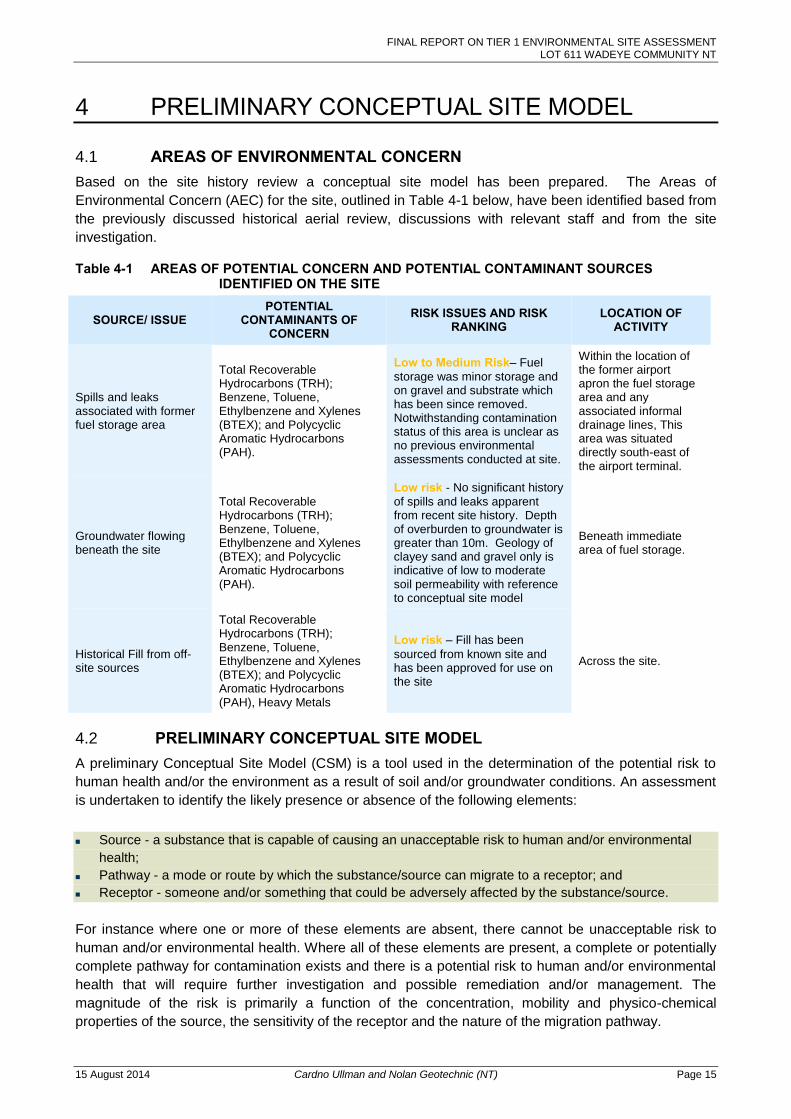
FINAL REPORT ON TIER 1 ENVIRONMENTAL SITE ASSESSMENT LOT 611 WADEYE COMMUNITY NT
15 August 2014 Cardno Ullman and Nolan Geotechnic (NT) Page 15
4 PRELIMINARY CONCEPTUAL SITE MODEL
4.1 AREAS OF ENVIRONMENTAL CONCERN Based on the site history review a conceptual site model has been prepared. The Areas of
Environmental Concern (AEC) for the site, outlined in Table 4-1 below, have been identified based from
the previously discussed historical aerial review, discussions with relevant staff and from the site
investigation.
Table 4-1 AREAS OF POTENTIAL CONCERN AND POTENTIAL CONTAMINANT SOURCES IDENTIFIED ON THE SITE
SOURCE/ ISSUE POTENTIAL
CONTAMINANTS OF CONCERN
RISK ISSUES AND RISK RANKING
LOCATION OF ACTIVITY
Spills and leaks associated with former fuel storage area
Total Recoverable Hydrocarbons (TRH); Benzene, Toluene, Ethylbenzene and Xylenes (BTEX); and Polycyclic Aromatic Hydrocarbons (PAH).
Low to Medium Risk– Fuel
storage was minor storage and on gravel and substrate which has been since removed. Notwithstanding contamination status of this area is unclear as no previous environmental assessments conducted at site.
Within the location of the former airport apron the fuel storage area and any associated informal drainage lines, This area was situated directly south-east of the airport terminal.
Groundwater flowing beneath the site
Total Recoverable Hydrocarbons (TRH); Benzene, Toluene, Ethylbenzene and Xylenes (BTEX); and Polycyclic Aromatic Hydrocarbons (PAH).
Low risk - No significant history
of spills and leaks apparent from recent site history. Depth of overburden to groundwater is greater than 10m. Geology of clayey sand and gravel only is indicative of low to moderate soil permeability with reference to conceptual site model
Beneath immediate area of fuel storage.
Historical Fill from off- site sources
Total Recoverable Hydrocarbons (TRH); Benzene, Toluene, Ethylbenzene and Xylenes (BTEX); and Polycyclic Aromatic Hydrocarbons (PAH), Heavy Metals
Low risk – Fill has been
sourced from known site and has been approved for use on the site
Across the site.
4.2 PRELIMINARY CONCEPTUAL SITE MODEL A preliminary Conceptual Site Model (CSM) is a tool used in the determination of the potential risk to
human health and/or the environment as a result of soil and/or groundwater conditions. An assessment
is undertaken to identify the likely presence or absence of the following elements:
Source - a substance that is capable of causing an unacceptable risk to human and/or environmental
health;
Pathway - a mode or route by which the substance/source can migrate to a receptor; and
Receptor - someone and/or something that could be adversely affected by the substance/source.
For instance where one or more of these elements are absent, there cannot be unacceptable risk to
human and/or environmental health. Where all of these elements are present, a complete or potentially
complete pathway for contamination exists and there is a potential risk to human and/or environmental
health that will require further investigation and possible remediation and/or management. The
magnitude of the risk is primarily a function of the concentration, mobility and physico-chemical
properties of the source, the sensitivity of the receptor and the nature of the migration pathway.
FINAL REPORT ON TIER 1 ENVIRONMENTAL SITE ASSESSMENT LOT 611 WADEYE COMMUNITY NT
15 August 2014 Cardno Ullman and Nolan Geotechnic (NT) Page 16
4.2.1 Potential Contamination Sources
Section 4.1 has presented the likelihood of contaminant sources being present at the site based on the
findings of the site inspection. It is noted that contaminant concentrations in soils at the site from the
majority of identified sources is generally expected to be low. The expected low concentrations is
based on the likelihood/risk of occurrence and the likelihood of exceedances of health based guidelines
for contaminants in soils based on the limited land use in the past.
Based on the assessment of the areas of environmental concern the residual risk of significance
requiring further investigation was considered to be the area of the former fuel storage area.
It is understood that during the recent subdivision development, 450m3 of soil was removed from the
surface of the site, and backfilled with 60m3 of select from a known source of fill, therefore this is not
considered to be a potential source of contamination.
4.2.2 Potential Contamination Pathways
SOIL
The entire allotment is currently unsealed and comprises near-level bare land; therefore, potential for direct soil contamination from onsite activities is possible. The majority of Lot 611 was previously sealed with bitumen under airstrip apron prior to the subdivision development, therefore this migration pathway is not considered to be a potentially problematic contamination pathway.
GROUNDWATER
Groundwater is likely to fluctuate seasonally in the general area as a result of heavy rains during the wet season followed by long dry periods with minimal rain. There is potential for leaks/spills to reach groundwater, particularly when the water table is near the ground surface, however would be heavily dependent on the subsurface geology. The desktop review indicates that the soils present are of medium to low permeability which would indicate a generally low risk of migration to groundwater from surface soils and spills.
SURFACE WATER
Stormwater from the allotment will likely discharge to the neighbouring road reserve.
The nearest natural surface water body is Sandfly Creek (approximately 650m to the west) however is considered unlikely that stormwater from the site will directly flow into the Creek, unless there is a substantial rain event/flooding. Surface water and stormwater is unlikely to constitute a potential contamination pathway of travel to adjacent properties unless sampling of aviation area and preferential stormwater flow paths demonstrate surface and sub-surface soils are historically impacted by aviation fuel
4.2.3 Receptors
Given the new allotment is part of a residential sub-division, direct human contact with soil is expected
to be feasible, especially site construction works and eventual site occupancy.
There may be a residual risk to construction workers as potential receptors during soil handling for
future the construction of foundations.
The proposed residential land use, makes future residential users of the site a potential receptor
mainly via the pathway of soil contact and gardening.
Of lesser concern, based on the conceptual site model, is the potential for off-site receptors at the
adjacent educational facilities.
For this reason, further quantification of contamination within the fuel depot area (field sampling) is
justified to assess the likelihood of human contact with contaminants and possible completion of the
source-pathway-receptor relationships within the CSM.
FINAL REPORT ON TIER 1 ENVIRONMENTAL SITE ASSESSMENT LOT 611 WADEYE COMMUNITY NT
15 August 2014 Cardno Ullman and Nolan Geotechnic (NT) Page 17
4.3 SUMMARY For a risk to the environment or human health to exist there must a contaminant source and a pathway
to the receptor. Possible risk to construction workers and current and future residential occupants of the
site with direct contact to the soil has been identified; therefore further investigation through intrusive
chemical analysis (field sampling) is justified to quantify risk to the potential receptors. The progress
and findings of the aforementioned sampling is discussed in the sections which follow.
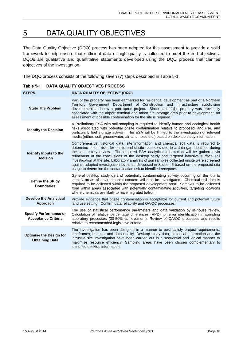
FINAL REPORT ON TIER 1 ENVIRONMENTAL SITE ASSESSMENT LOT 611 WADEYE COMMUNITY NT
15 August 2014 Cardno Ullman and Nolan Geotechnic (NT) Page 18
5 DATA QUALITY OBJECTIVES
The Data Quality Objective (DQO) process has been adopted for this assessment to provide a solid
framework to help ensure that sufficient data of high quality is collected to meet the end objectives.
DQOs are qualitative and quantitative statements developed using the DQO process that clarifies
objectives of the investigation.
The DQO process consists of the following seven (7) steps described in Table 5-1.
Table 5-1 DATA QUALITY OBJECTIVES PROCESS STEPS DATA QUALITY OBJECTIVE (DQO)
State The Problem
Part of the property has been earmarked for residential development as part of a Northern Territory Government Department of Construction and Infrastructure subdivision development and new airport apron project. Since part of the property was previously associated with the airport terminal and minor fuel storage area prior to development, an assessment of possible contamination for the site is required.
Identify the Decision A Preliminary ESA with soil sampling is required to identify human and ecological health risks associated with potential onsite contamination relative to proposed land use, and particularly fuel storage activity. The ESA will be limited to the investigation of relevant media (either: soil; groundwater; air; and noise etc.) based on desktop study information.
Identify Inputs to the Decision
Comprehensive historical data, site information and chemical soil data is required to determine health risks for onsite and offsite receptors due to a data gap identified during the site history review. The required ESA analytical information will be gathered via refinement of the conclusions of the desktop study and targeted intrusive surface soil investigation at the site. Laboratory analysis of soil samples collected onsite were screened against adopted investigation levels as discussed in Section 6 based on the proposed site usage to determine the contamination risk to identified receptors.
Define the Study Boundaries
General desktop study data of potentially contaminating activity occurring on the lots to identify areas of environmental concern will also be investigated. Chemical soil data is required to be collected within the proposed development area. Samples to be collected from within areas associated with potentially contaminating activities, targeting locations where chemicals are likely to have migrated to/from.
Develop the Analytical Approach
Provide evidence that onsite contamination is acceptable for current and potential future land use setting. Confirm data reliability and QA/QC processes.
Specify Performance or Acceptance Criteria
The use of statistical performance parameters and data validation by in-house review. Calculation of relative percentage differences (RPD) for error identification in sampling laboratory processes (30-50% achievement). Review of QA/QC processes and results relative to recommended legislative criteria.
Optimise the Design for Obtaining Data
The investigation has been designed in a manner to best satisfy project requirements, timeframes, budgets and data quality. Desktop study data, historical information and the intrusive site investigation have been carried out in a sequential and logical manner to maximise resource efficiency. Sampling areas have been chosen complementary to identified desktop information.
FINAL REPORT ON TIER 1 ENVIRONMENTAL SITE ASSESSMENT LOT 611 WADEYE COMMUNITY NT
15 August 2014 Cardno Ullman and Nolan Geotechnic (NT) Page 19
6 ASSESSMENT GUIDELINES
6.1 SAMPLING GUIDELINES AND STANDARDS In the absence of state specific contamination guidelines, the site assessment criteria for this assessment have been taken from the following documents: National Environment Protection (Assessment of Site Contamination) Measure (NEPM) 1999 (as
amended 2013) (NEPM 2013);
Australian Standard AS 4482.1-2005 Guide to the Investigation and Sampling of Sites with Potentially
Contaminated Soil, Part 1: Non-Volatile and Semi-Volatile Compounds;
Australian Standard AS 4482.2-1999 Guide to the Sampling and Investigation of Potentially
Contaminated Soil – Volatile Substances;
Environmental Protection Act 1994;
Northern Territory Environment Protection Authority Act 2012;
Health screening levels for Petroleum Hydrocarbons in Soil and Groundwater (CRC CARE Health
Screening Levels 2011);
Canada wide standard for petroleum hydrocarbons in soil (CCME 2008); and
Australian Standard AS 1726-1993 Geotechnical Site Investigations.
6.2 SOIL ASSESSMENT CRITERIA Assessment of soil contamination in Northern Territory is based on the National Environment Protection
Measure guidelines (herein referred to as NEPM 2013). The soil assessment criteria used in this
assessment include the Health Investigation Limits (HIL “A”) for standard residential land uses and
Health Screening Levels (HSL’s) for direct soil contact at residential premises.
Investigation levels are applicable to terrestrial ecosystems and depend on specific soil physiochemical
properties and land use scenarios. They generally apply to the top 2m of soil. These guidelines apply
when assessing the site contamination status; and detail acceptable levels of inorganic and organic
contaminants within soil and water. In this assessment results are compared against NEPM 2013 HILs
and HSLs.
Given, the intended land use, the soil results have also been compared to ESLs and EILs for urban
residential and public open space usage. Possible background concentrations of contaminants of
concern in soil have been adopted from Olzowy et al where necessary. Site specific ESLs and EILs
were assessed using the aged Added Contaminant Limits set out in NEPM 2013 toolbox, relative to
literature values for Cation Exchange Capacity and pH expected for soils encountered at the site.
The investigation levels presented in this report are not necessarily clean up or response levels nor are
they desirable soil quality criteria, but rather are to be used for assessment of residual contamination
only to prompt site specific risk assessment (Tier 2 assessment) where requried.
6.3 BASIS FOR ASSESSMENT CRITERIA The analysis has been undertaken against the following guidelines:
National Environment Protection (Assessment of Site Contamination) Measure (NEPM) 2013; and
Health screening levels for petroleum hydrocarbons in soil and groundwater (CRC Care 2011).
The assessment criteria for contamination currently used in the Northern Territory for the analysis of soil contamination levels is NEPM (2013). The guideline values adopted for this assessment are listed below:
FINAL REPORT ON TIER 1 ENVIRONMENTAL SITE ASSESSMENT LOT 611 WADEYE COMMUNITY NT
15 August 2014 Cardno Ullman and Nolan Geotechnic (NT) Page 20
Health Investigation Levels for residential land-uses (HIL A); and
Soil Health Screening Levels for Low Density Residential Housing (HSL A) for direct contact.
Soil Health Screening Levels for Commercial Industrial (HSLD) for direct contact to assess construction
and soil handling exposure risk
Ecological Investigation levels for urban residential and public open spaces (EIL Areas of Ecological
Significance, Urban Residential and Public Open Space)
Ecological Screening Levels for commercial industrial usage (ESLs Commercial Industrial Use)
Comparison against these criteria was used to determine risk to the future occupants of the property and the suitability of the redeveloped site for the proposed end use. In the instance that the conceptual site model and subsequent soil investigation appears to indicate a risk to groundwater, HSLs relating to groundwater assessment and vapour intrusion will also be considered.
FINAL REPORT ON TIER 1 ENVIRONMENTAL SITE ASSESSMENT LOT 611 WADEYE COMMUNITY NT
15 August 2014 Cardno Ullman and Nolan Geotechnic (NT) Page 21
7 PRELIMINARY SOIL SAMPLING METHODOLOGY
7.1 SAMPLING RATIONALE The sampling rationale for the Tier 1 intrusive investigation which was applied was a targeted judgemental approach to the assessment of the former fuel storage area. The sampling rationale and extent of sampling was based on the extent of the preliminary CSM and the observations of the historic fuel storage area from the site inspection. Four (4) Soil samples were considered an appropriate density based on the size of the area (>20m
2)
and were collected from the locations assessed to have been most likely exposed to contamination from site activities. These locations included two (2) locations in the immediate area and two (2) locations in the general direction of stormwater migration. Samples were collected from surface and subsurface materials from the location at depths of 0-0.25m 0.25-0.5m and 0.5-0.75m. Provision was made in the sampling methodology to vary the depths in the event that contaminant markers were encountered.
7.2 SOILS SAMPLING METHODOLOGY Soil samples were collected from four testing locations at the depths previously identified and situated within the fuel storage area in order to delineate potential contamination impacts. Selected samples across all three sampling depths were analysed for potential contaminants, including the recently placed fill at the surface. The following procedures were implemented with consideration of the NEPM 2013 and AS4482 guideline series: Collection of soil samples (including quality assurance samples, consisting of duplicate samples
only), filled to zero headspace, labelled accordingly and immediately placed on ice;
Geotechnical logging of the soil profile (with reference to AS1726) and visual assessment of any
contamination markers;
Sample handling undertaken using Nitrile gloves to avoid cross contamination and replaced
between each test location;
Sample collection occurred directly from the excavated spoil from the centre of the excavator
bucket without touching soils which had come in contact with the bucket;
The bucket was inspected and cleaned prior to the commencement of sampling; and
Samples were transported to ALS Environmental for chemical analysis (refer below for laboratory
analysis).
Cardno maintained a Quality Assurance/Quality Control (QA/QC) standard protocol for the works. QA/QC samples and procedures comprised: Field duplicate soil sample collection at a rate of 1/10 samples (10%) for blind submission to
primary laboratory; Split samples were not collected and analysed interlab as a lab integrity check
due to the limited scope of the sampling and the degree of confidence in the primary laboratory
internal QA/QC procedures based on regularity of use.
QA/QC has been further discussed in Section 8. Soil samples were analysed for potential contaminants of concern as identified in the preliminary conceptual site model as follows:
TRH, BTEX and PAH; and
Eight metals including arsenic, cadmium, copper, chromium, lead, nickel, zinc and mercury.
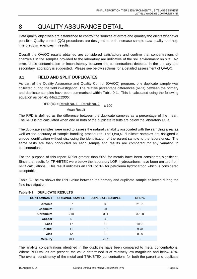
FINAL REPORT ON TIER 1 ENVIRONMENTAL SITE ASSESSMENT LOT 611 WADEYE COMMUNITY NT
15 August 2014 Cardno Ullman and Nolan Geotechnic (NT) Page 22
8 QUALITY ASSURANCE DETAIL
Data quality objectives are established to control the sources of errors and quantify the errors whenever
possible. Quality control (QC) procedures are designed to both increase sample data quality and help
interpret discrepancies in results.
Overall the QA/QC results obtained are considered satisfactory and confirm that concentrations of
chemicals in the samples provided to the laboratory are indicative of the soil environment on site. No
error, cross contamination or inconsistency between the concentrations detected in the primary and
secondary laboratory is suggested. Please see below sections for a detailed assessment of QA/QC.
8.1 FIELD AND SPLIT DUPLICATES As part of the Quality Assurance and Quality Control (QA/QC) program, one duplicate sample was
collected during the field investigation. The relative percentage differences (RPD) between the primary
and duplicate samples have been summarised within Table 9-1. This is calculated using the following
equation as per AS 4482.1:2005:
RPD (%) = Result No. 1 – Result No. 2
Mean Result
The RPD is defined as the difference between the duplicate samples as a percentage of the mean.
The RPD is not calculated when one or both of the duplicate results are below the laboratory LOR.
The duplicate samples were used to assess the natural variability associated with the sampling area, as
well as the accuracy of sample handling procedures. The QA/QC duplicate samples are assigned a
unique identification without disclosing the identification of the parent sample to the laboratories. The
same tests are then conducted on each sample and results are compared for any variation in
concentrations.
For the purpose of this report RPDs greater than 50% for metals have been considered significant.
Since the results for TRH/BTEX were below the laboratory LOR, hydrocarbons have been omitted from
RPD calculations. This result indicates an RPD of 0% for petroleum hydrocarbon which is considered
acceptable.
Table 8-1 below shows the RPD value between the primary and duplicate sample collected during the
field investigation.
Table 8-1 DUPLICATE RESULTS CONTAMINANT ORIGINAL SAMPLE DUPLICATE SAMPLE RPD %
Arsenic 37 30 21.21
Cadmium <1 <1 -
Chromium 218 301 37.28
Copper 5 <5 -
Lead 17 19 10.91
Nickel 11 10 9.78
Zinc 12 12 0.00
Mercury <0.1 <0.1 -
The analyte concentrations identified in the duplicate have been compared to metal concentrations.
Where RPD values are present, the value determined is of relatively low magnitude and below 40%.
The overall consistency of the metal and TRH/BTEX concentrations for both the parent and duplicate
x 100
FINAL REPORT ON TIER 1 ENVIRONMENTAL SITE ASSESSMENT LOT 611 WADEYE COMMUNITY NT
15 August 2014 Cardno Ullman and Nolan Geotechnic (NT) Page 23
sample suggests that laboratory or sampling error has not occurred and that the sampling methodology
has been undertaken competently.
8.2 DATA VALIDATION All incoming analytical data has been reviewed by appropriately qualified environmental personnel. All
data has been independently assessed against the predetermined Data Quality Objectives (DQOs) and
data quality indicators (completeness, comparability, representativeness, precision and accuracy) for all
field and laboratory procedures and results received.
Following review of all supplied laboratory reports and review of field sampling procedures, the
following comments can be made.
No method blank outliers occurred.
Sample integrity and container requirements were documented as acceptable.
Laboratory surrogate recovery was considered acceptable indicating the laboratory accuracy was
acceptable.
Duplicate analysis is deemed acceptable and compliant to required NEPM 2013 and AS Standards
sampling procedures.
All field sheets, field log books and calibration sheets were reviewed for completeness by the onsite
Environmental Engineer before dismantling the sampling equipment at each sample location with all
documentation reviewed at the conclusion of the field sampling day.
All scientific meters used throughout the sampling investigation were calibrated according to
manufacturer’s specifications.
All sample holding times have been met.
All samples received were adequately chilled during transport to the nominated laboratories with the
correct preservations used for the specified target analyte. All samples were received in good working
order.
All requested test analyses are NATA certified with all laboratory test requests in compliance. All
certificates of analysis received have been authorised by a NATA signatory laboratory prior to release.
All reports have been reviewed by appropriately qualified chemical personnel.
Upon receipt of quality control reports from the laboratory, it was noted that acceptable metal surrogate
recoveries were reported. The results indicate good repeatability for the majority of analysis, below the
acceptable limit of 30-50% variability.
FINAL REPORT ON TIER 1 ENVIRONMENTAL SITE ASSESSMENT LOT 611 WADEYE COMMUNITY NT
15 August 2014 Cardno Ullman and Nolan Geotechnic (NT) Page 24
9 SAMPLING RESULTS AND DISCUSSION
The results are summarised in Appendix E. The full laboratory reports and chain of custody (COC) documentation are presented in Appendix F.
9.1 ANALYTICAL RESULTS
9.1.1 Petroleum Hydrocarbons and Polycyclic Aromatic Hydrocarbons
All petroleum hydrocarbon and PAH results were below the LOR for the methods used, and hence well within protection of human health guidelines. There is no indication of human health or environmental risk in the samples tested.
9.1.2 Heavy Metals
Cadmium, copper and mercury are below the limits of reporting (LOR). The remaining five heavy
metals tested had low concentrations or are within levels consistent with background ranges for
naturally occurring soils in the Northern Territory.
From the laboratory results, the soils appear to have elevated chromium content, however are within
levels consistent with background ranges for chromium in naturally occurring soils. At the levels
detected for each of the eight samples analysed, the HIL-A value for chromium VI was exceeded,
however were below the limits for HIL-D. HiL-D has been adopted to screen for possible risk from
limited exposure during soil handling or construction works through direct contact.
Chromium VI is quickly oxidised and is rarely present in the environment unless a source is present.
Possible prior land use that can contribute to high hexavalent chromium content include the use of
certain historic phosphate fertilisers, tanning activities or the presence of treated timber or timber
treating agents, however these activities are not deemed to have occurred at the site based on the site
history investigation.
As there are no sources apparent for Chromium VI in the site history it is likely that the Total Chromium
concentration detected is comprised of entirely of Chromium III.
Therefore, for residential housing with minimal horticultural gardens for produce, the level of chromium
detected is considered to not present a health risk for residential occupancy.
All results are below HILs for the protection of human health and are considered to not be an
environmental risk to human health.
Results are also generally below the most sensitive Ecological Investigation Levels (EILs) for areas of
ecological significance which affords a 99% level protection indicating a minimal level of ecological risk
apart from Chromium which is above this guideline value. Notwithstanding the Chromium
concentrations (assumed to be Chromium III) are within the acceptable threshold of EILs for urban
parkland and residential use for typical soils when taking the Added Contaminant Limit (ACL) alone into
account. Therefore the contaminant concentrations at the site are deemed to be of negligible
ecological risk.
9.2 RESULT DISCUSSION AND ASSESSMENT OF RISK The area associated with the former fuel storage area was identified as a potential area of concern for
residual hydrocarbons within the soil, with the areas specifically targeted. Subsequent soil samples
were collected from across the site from four locations where the preliminary conceptual model
identified the highest risk.
FINAL REPORT ON TIER 1 ENVIRONMENTAL SITE ASSESSMENT LOT 611 WADEYE COMMUNITY NT
15 August 2014 Cardno Ullman and Nolan Geotechnic (NT) Page 25
All of the parameters measured were below the LOR or within background concentrations for
hydrocarbons and PAH. This indicates negligible residual hydrocarbon contaminant occurs within these
areas. Therefore, no risk to construction workers or future residential occupants was identified within
the area tested.
It is important to note that while a PID was not engaged during the assessment due to logistics issues,
the absence of this line of evidence is not considered to have impacted on the integrity of the
assessment due to the absence of visual and olfactory observations and taken with the fact that the
semi-volatile samples collected were analysed within the required holding time.
The soils appear to have elevated chromium content, and the chromium levels detected exceeded the
HIL-A value for chromium VI, however were below the limits for HIL-B to HIL-D. Therefore, for low
density residential housing (assuming usage of gardens for produce), the level of chromium detected is
considered to not present a health risk for residential occupancy. In the event that (any) future more
sensitive land use is proposed, (such as a health or aged care facility), further assessment of chromium
valency (chromium VI) concentrations may be justified.
All of the remaining heavy metal concentrations were below the LOR or well within protection of human
health guideline limits. This indicates negligible residual contaminant occurs within these areas.
Therefore, low residual risk to construction workers or future residential occupants was identified within
the area tested.
For calculation of site specific EILs, Added Contaminant Limits considered were those for NEPM 2013
and were extrapolated based on the soil type found at the site. In order to apply a conservative
assessment of site specific EILs, the contribution of background concentration to the EIL was
disregarded and ACL value only was considered as the applicable screening level.
Based on the above results a contiguous source-pathway-receptor relationship in the conceptual site
model is not deemed to exist due to the absence of a source with concentrations above screening
guideline values, present in soils at the site. Based on the evidence within the site history, in the event
that historic spills had occurred in the past, these have now been removed from the site in the surface
scrape. Based on the depth to groundwater and soil permeability characteristics, site conditions as
assessed appear to indicate a minimal risk that historic minor spills have migrated to groundwater.
Therefore the final conceptual site model following assessment is considered to be characterised by an
absence of complete contamination pathways to receptors which might result in impact to groundwater
and surface water present at the site, future users and residences or the possibility of migration to off-
site properties.
FINAL REPORT ON TIER 1 ENVIRONMENTAL SITE ASSESSMENT LOT 611 WADEYE COMMUNITY NT
15 August 2014 Cardno Ullman and Nolan Geotechnic (NT) Page 26
10 CONCLUSIONS AND RECOMMENDATIONS
Cardno, on behalf of Thamarrurr Development Corporation completed a Preliminary Environmental Site
Assessment with preliminary sampling as part of a contaminated land investigation to establish the
current condition of the proposed residential allotment (Lot 611) within South Wadeye. The area of the
proposed residential allotment previously contained infrastructure associated with the Port Keats
Airport, which following the construction of the new airport facilities further to the south, allowed the
area to be redeveloped for residential housing.
The investigation included a desktop study which looked at historical land use for the site and
surrounding area to identify potentially contaminating activities that may have occurred. A site
conceptual model was developed to identify potential sources, pathways and receptors for
contamination. This assessment identified one major potential source of concern:
Potential for residual petroleum hydrocarbon contamination from potential spills and leaks associated
with the previous land use which encompassed the airport fuel depot (emergency fuel storage). The
potential that through years of use localised spillages may have occurred and that contaminants of
concern could enter the soil profile was investigated. As such the investigation aimed to identify if any
accumulation of hydrocarbons was present and if so were the levels of contamination to a level
considered detrimental to health and wellbeing of people and the environment exposed.
A sampling investigation was undertaken as part of this investigation. The sampling locations were
targeted based on the most likely locations for soil contamination. Samples were collected from four
locations within the site of the former fuel storage depot. Laboratory testing was undertaken and
analysis of the results completed. The result of the analysis identified contaminants of concern within
the materials sampled as either below the LOR or within background concentrations for surface and
near surface soils samples. All of the analytes tested reported values below human or ecological risk
screening levels for the proposed land use for ‘low density residential’, according to NEPM 2013.
The soils do appear to have elevated chromium content, however the chromium levels detected are
considered to be comprised of Chromium III based on the site history profile and oxidation
characteristics of Chromium VI. Therefore, for low density residential housing the level of chromium
detected is considered to not present a health risk for residential occupancy. However, if a sensitive
land use is proposed in the future (such as a health care facility), further assessment of chromium
valency (chromium VI) concentrations may be justified.
Based on the preliminary ESA findings and conclusions, the site is considered suitable for the proposed
residential land-use, subject to a site environmental management plan being put in place to assess and
manage any unexpected indicators of contamination during future building works at the site.
No further assessment work is recommended in order to approve the proposed development from a
contamination perspective; however future earthworks or building works should include monitoring for
visible or olfactory contaminant markers relating to hydrocarbon contamination and the
recommendations of this report should be reviewed in the event that additional evidence of site
contamination comes to light.
FINAL REPORT ON TIER 1 ENVIRONMENTAL SITE ASSESSMENT LOT 611 WADEYE COMMUNITY NT
15 August 2014 Cardno Ullman and Nolan Geotechnic (NT) Page 27
11 LIMITATIONS
No part of this Preliminary ESA is to be taken in isolation from the whole report to represent the
findings. This report must be read in its entirety, including appendices and attachments and is subject to
the stated limitations. Environmental services are provided by Cardno Ullman & Nolan Geotechnic Pty
Ltd (Cardno UNG) in accordance with generally accepted professional engineering and environmental
practice in the area where these services are rendered. The client acknowledges that the present
standard in the engineering and environmental profession does not include a guarantee of perfection,
and no other warranty, expressed or implied, is extended by Cardno UNG.
Subject to the scope of work, Cardno’s assessment was limited strictly to identifying the environmental
conditions associated with the subject properties and does not include evaluation of any other issues.
The absence of any identified hazardous or toxic materials should not be interpreted as a guarantee
that such materials do not exist on the subject property. It is the reader’s responsibility to verify the
correct interpretation and intention of the recommendations presented herein. Cardno UNG assumes
no responsibility for misunderstandings or improper interpretations that result in unsatisfactory or
unsafe work products. It is the reader’s further responsibility to acquire copies of any supplemental
reports, addenda or responses to public agency reviews that may supersede recommendations in this
report.
The findings presented in this report have been based on the investigation described herein, which was
undertaken in general accordance with Australian Standard 4482.1-2005 and National Environment
Protection (Assessment of Site Contamination) Measure (NEPM) 1999 (as amended) 2013. It is a
report based on the concentrations of contaminants observed in soil at the time of sample collection.
There are always some variations in subsurface conditions and contaminant concentrations across a
site, which cannot be fully defined by investigation. The measurements and values obtained from
sampling and testing during the investigation may not represent the extremes of conditions that may
exist within this site. Hence, it is recommended that if any ground conditions significantly different to
those described in this report are encountered, further advice should be immediately sought from
Cardno UNG.
STAGE ONE ENVIRONMENTAL SITE ASSESSMENT
FIGURES Figure 1 Site Layout and Sampling Location Plan
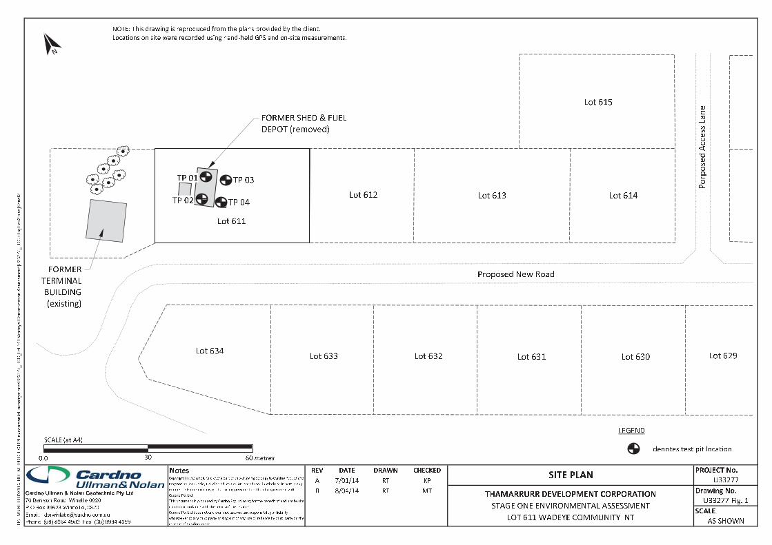
�� �� � � � � � � � � � � � � � � �� � � � � � � � � � � �� � � � � � � � � � � � �� � !" # ��$% & & ' ( () * +,- ./ 0 1 2 34 5 5 6 7 8 9:;<=>?@>==A@>?<BCAA=>DEAFG=BDH<=IJKLMINOIPQR@I
JOSPK TQPKMIS<CUUVWW XDYB XZMP[\\]Q^O _OBMIPQNKIQPKMI`SSOSSNOIP<aCUUVWW XDYBb cK T\LOJVdeRSe fHgOOPV
h i j k l m n o p q r s 3 0 t ��$uv w x y z{ | } z~ } |� � | v �� �~ � � �� y x w � y } v � } | z� � y � � z~ { �� �v ~ { � }v u � y � ~ v � } x � } � �~ �� � x ~ v } �� � � � �� � v � �� } y �~ � �� y y� �� �v w z� � v y y� w yv � � �� � z~ � | v �� v y z~ w � y } z~ �~ x� �~ ~ � y v y �v y � v y v ~ �~ x �� � z �� }v �~ x w� y� v ~ v } |� y } | �~ � x �{ y� � �� ~ } � z } |u � y � ~ v � } x � } ��� | z� � v � � �� ~ } z� w yv � � �� � � x u � y � ~ v � } x � } � � v �� x �v y } |� �� ~ � � z } v � �~ � � � � � x } |�� � z� ~ } z~ � � �v y � �~ �� � z } | } |� }� y � � v � } |� y� } � z~ � y�u � y � ~ v � } x � } � � v � � ~ v } �~ � � | � � � ~ v } �� � � �� �~ x y� � wv ~ � z � z � z } x v y � z � � z � z } x� | � }� v � �� y }v �~ x } | z y � w � y } x � y z� z~ { v � } v � �~ x � � � v y y� � z �~ �� � x } | z y � w � y } x v ~ } |��v ~ }� ~ } v � } | z� � v � � �� ~ }� % & & ' ( (�� � �� � � � �� � � � � � �� � �� � �� � �� � ¡ �¢ £ � �¤ ¥ ¦§̈ ©ª «̈ ¬ « ®¯ ° © §̈ ± ± ©§ ² ³́ ²µ¶ · ¦ «̧ ¹ º ¥́ ¹ ° © ¨̈ § ± ± ©§ ¯ ² ³́ ²»¼ © ±½ ® ¾ ¿ © ¨ ± Àª Á ¾ ® «̈¶  «¼ ¶ õ Ä «̈ § Å ² ³ Æ ³ º ³ Ç Ç º ³ ¹ È ̧ Å ² ³ Æ ³ º ³ Ç Ç ¥ É º Ê Ë Ì Í Ì Î Î Ï Î Î Ð Ñ Ò Ñ Ó Ô Õ Í Ñ Ö Ê × Ô Î Õ Ô Î Ì Ê Ø Ô ÖÙ Ú Û Ü Ý Þ ß Ý Ý ß à á â Þ ß ã Ý ß Ú Û ä Û Ù Ù Ý Ù Ù ã Ý ß Úä Þ Ú å æ æ ç Û è Ý é Ý ê Þ ã ã ë ß á Ú é ß Úì í î í ï ð ñò ó ô õò ö õò ö õ÷ ø õ ù ô ú û õ ø ô óü ý � þ ÿ � � � � � ��� � � � � � � � � �
� � � � � � � � � � � � � �� � � � � � � � � � � � � � � � � � � � � � � �� � � � � �
� ! " #$%& ''$##( )* $
� � � � � � � � � � � � � � � � � � � � � � � � � � � � � + � � � � � ,
- � + �- � + � - � + �- � + �
. / � 0 1 �- 1 � 0 2 � 3 �4 5 2 � 6 2 � 78 � 9 : � � :; < =
. / � 0 1 � > ? 1 6 @ . 5 1 �A B C D E FG H I J K H L M
N O � ÿP � Q RS TU � V RW X RS U Y ZU [ T\ ] Y T̂ U [ _ � Q Y Z ` � W S ZU [ a R T Y T bc � Q Y ] R̀ YW ��þ [ ] � � R [W S [W S R � Y V YU Y U Y ] [U T Y T \ S RW X Q � W Td Q Y T̀ e � ü � W T [W d S R � Y _ Y � S \ U Y _ YW �S �
TIER 1 ENVIRONMENTAL SITE ASSESSMENT
APPENDIX A SITE PHOTOGRAPHS
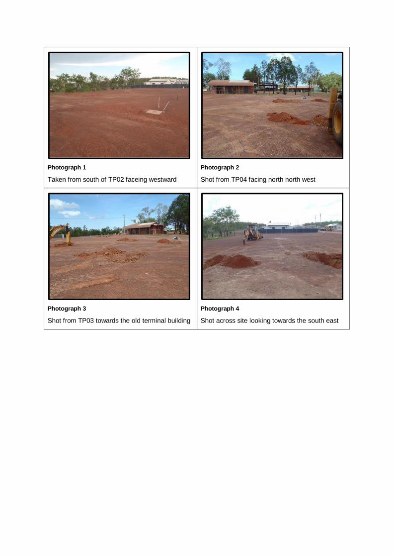
Photograph 1
Taken from south of TP02 faceing westward
Photograph 2
Shot from TP04 facing north north west
Photograph 3
Shot from TP03 towards the old terminal building
Photograph 4
Shot across site looking towards the south east
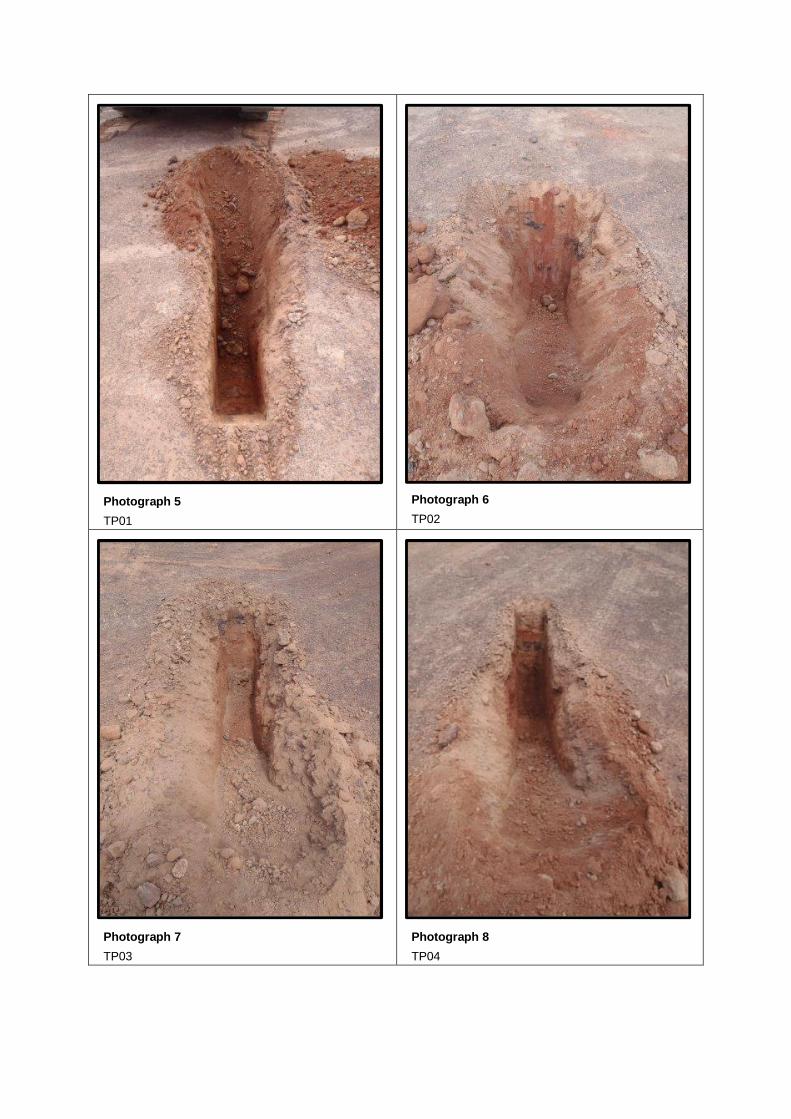
Photograph 5
TP01
Photograph 6
TP02
Photograph 7
TP03
Photograph 8
TP04
TIER 1 ENVIRONMENTAL SITE ASSESSMENT
APPENDIX B TEST PIT LOGS

0.30
1.00
GM
GC
D
M
Silty Sandy Gravel; pale brown, fine to coarse grained, angular to sub-angular, fineto coarse grained sand (FILL)
MPS 40 LL 15 P75 10
Comments: recent fill; void of organics; no odour; no sign of staining/streaks
Clayey Sandy Gravel; orange-brown, fine to medium grained, sub-angular tosub-rounded, fine to coarse grained sand (NATURAL)
MPS 20 LL 25 P75 20
Comments: natural soil; no odour; no sign of staining or streaks; no organic material
TEST PIT TP 01 TERMINATED AT 1.00 mTarget depth
ES
ES
ES
ES
0.25m
0.50m
0.75m
STRATA
Gra
phic
Log
Moi
stur
e
Dep
th (
m)
RL
(m A
HD
)
Cla
ssifi
catio
n
Con
sist
ency
TESTINGVISUAL SOIL DESCRIPTION
Description(SOIL NAME; plasticity/grain size, colour, particle
shape, secondary components, minor constituents)(ROCK NAME; grain size, colour, minor constituents)
CU
_LIB
_06.
GLB
Log
CU
BO
RE
HO
LE L
OG
U33
277
TP
LO
GS
.GP
J <
<D
raw
ingF
ile>
> 1
5/08
/201
4 09
:49
8.3
0.00
3 D
evel
oped
by
Dat
gel
Contractor : Supplied by client
Machines : Machine Excavator
Excavation Method :
Dimensions :
Coords : AGD 84 52
TEST PIT LOGTest Pit No. : TP 01
Sheet : 1 of 1
Hole Commenced : 11.12.13
Hole Completed : 11.12.13
Logged By : GC
Checked By : RT
Surface R.L. (m) : AHD
Client : Thamarrurr Development Corp.
Project : Stage One Environmental
Contamination Assessment
Job No : U33277
Site : New Subdivision Development
Location : Lot 611 Wadeye NT
Moisture Consistency Visual Description SamplingMPSLLP75
maximum particle sizeLiquid Limit
% passing 75um sieve
DMW
DryMoistWet
very softsoft
loosevery loose
densemedium dense
very densestiff
very stifffirm
hard
UDPPESLABDUPSPLITB
VSSLVLDMDVDStVStFH
Undisturbed Sample & Size in mmDisturbed Sample
Pocket Penetrometer ValueEnvironmental Sample
Sample sent to LabDuplicate Sample
Split SampleBulk Sample
TestingSampling
SAMPLING
0.5
1.0

0.30
1.00
GM
GC
D
M
Silty Sandy Gravel; pale brown, fine to coarse grained, angular to sub-angular, fineto coarse grained sand (FILL)
MPS 40 LL 15 P75 10
Comments: recent fill; void of organics; no odour; no sign of staining/streaks
Clayey Sandy Gravel; orange-brown, fine to medium grained, sub-angular tosub-rounded, fine to coarse grained sand (NATURAL)
MPS 20 LL 25 P75 20
Comments: natural soil; no odour; no sign of staining or streaks; no organic material
TEST PIT TP 02 TERMINATED AT 1.00 mTarget depth
ES
ES
ES
ES
0.25m
0.50m
0.75m
STRATA
Gra
phic
Log
Moi
stur
e
Dep
th (
m)
RL
(m A
HD
)
Cla
ssifi
catio
n
Con
sist
ency
TESTINGVISUAL SOIL DESCRIPTION
Description(SOIL NAME; plasticity/grain size, colour, particle
shape, secondary components, minor constituents)(ROCK NAME; grain size, colour, minor constituents)
CU
_LIB
_06.
GLB
Log
CU
BO
RE
HO
LE L
OG
U33
277
TP
LO
GS
.GP
J <
<D
raw
ingF
ile>
> 1
5/08
/201
4 09
:49
8.3
0.00
3 D
evel
oped
by
Dat
gel
Contractor : Supplied by client
Machines : Machine Excavator
Excavation Method :
Dimensions :
Coords : AGD 84 52
TEST PIT LOGTest Pit No. : TP 02
Sheet : 1 of 1
Hole Commenced : 11.12.13
Hole Completed : 11.12.13
Logged By : GC
Checked By : RT
Surface R.L. (m) : AHD
Client : Thamarrurr Development Corp.
Project : Stage One Environmental
Contamination Assessment
Job No : U33277
Site : New Subdivision Development
Location : Lot 611 Wadeye NT
Moisture Consistency Visual Description SamplingMPSLLP75
maximum particle sizeLiquid Limit
% passing 75um sieve
DMW
DryMoistWet
very softsoft
loosevery loose
densemedium dense
very densestiff
very stifffirm
hard
UDPPESLABDUPSPLITB
VSSLVLDMDVDStVStFH
Undisturbed Sample & Size in mmDisturbed Sample
Pocket Penetrometer ValueEnvironmental Sample
Sample sent to LabDuplicate Sample
Split SampleBulk Sample
TestingSampling
SAMPLING
0.5
1.0

0.30
1.00
GM
GC
D
M
Silty Sandy Gravel; pale brown, fine to coarse grained, angular to sub-rounded, fineto coarse grained sand (FILL)
MPS 40 LL 15 P75 10
Comments: recent fill; void of organics; no odour; no sign of staining/streaks
Clayey Sandy Gravel; orange-brown, fine or medium grained, sub-angular tosub-rounded, fine to coarse grained sand (NATURAL)
MPS 20 LL 25 P75 20
Comments: natural soil; no odour; no sign of staining or streaks; no organic material
TEST PIT TP 03 TERMINATED AT 1.00 mTarget depth
ES
ES
ES
ES
0.25m
0.50m
0.75m
STRATA
Gra
phic
Log
Moi
stur
e
Dep
th (
m)
RL
(m A
HD
)
Cla
ssifi
catio
n
Con
sist
ency
TESTINGVISUAL SOIL DESCRIPTION
Description(SOIL NAME; plasticity/grain size, colour, particle
shape, secondary components, minor constituents)(ROCK NAME; grain size, colour, minor constituents)
CU
_LIB
_06.
GLB
Log
CU
BO
RE
HO
LE L
OG
U33
277
TP
LO
GS
.GP
J <
<D
raw
ingF
ile>
> 1
5/08
/201
4 09
:49
8.3
0.00
3 D
evel
oped
by
Dat
gel
Contractor : Supplied by client
Machines : Machine Excavator
Excavation Method :
Dimensions :
Coords : AGD 84 52
TEST PIT LOGTest Pit No. : TP 03
Sheet : 1 of 1
Hole Commenced : 11.12.13
Hole Completed : 11.12.13
Logged By : GC
Checked By : RT
Surface R.L. (m) : AHD
Client : Thamarrurr Development Corp.
Project : Stage One Environmental
Contamination Assessment
Job No : U33277
Site : New Subdivision Development
Location : Lot 611 Wadeye NT
Moisture Consistency Visual Description SamplingMPSLLP75
maximum particle sizeLiquid Limit
% passing 75um sieve
DMW
DryMoistWet
very softsoft
loosevery loose
densemedium dense
very densestiff
very stifffirm
hard
UDPPESLABDUPSPLITB
VSSLVLDMDVDStVStFH
Undisturbed Sample & Size in mmDisturbed Sample
Pocket Penetrometer ValueEnvironmental Sample
Sample sent to LabDuplicate Sample
Split SampleBulk Sample
TestingSampling
SAMPLING
0.5
1.0
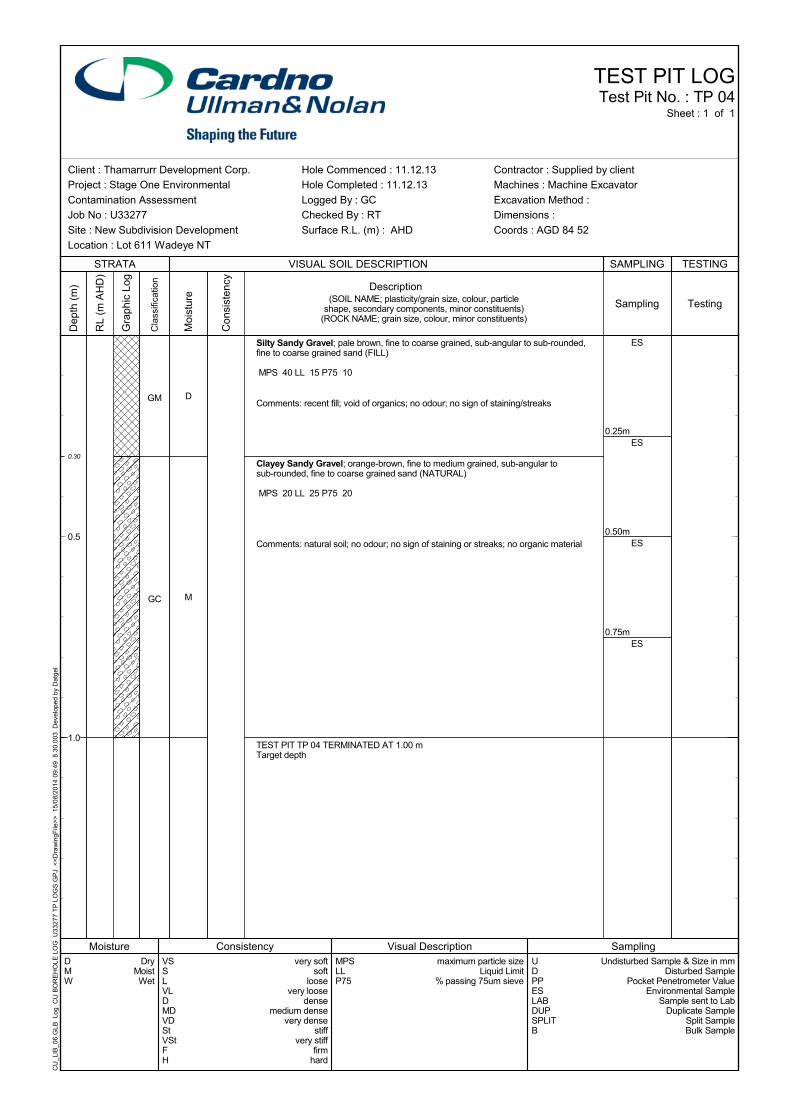
0.30
1.00
GM
GC
D
M
Silty Sandy Gravel; pale brown, fine to coarse grained, sub-angular to sub-rounded,fine to coarse grained sand (FILL)
MPS 40 LL 15 P75 10
Comments: recent fill; void of organics; no odour; no sign of staining/streaks
Clayey Sandy Gravel; orange-brown, fine to medium grained, sub-angular tosub-rounded, fine to coarse grained sand (NATURAL)
MPS 20 LL 25 P75 20
Comments: natural soil; no odour; no sign of staining or streaks; no organic material
TEST PIT TP 04 TERMINATED AT 1.00 mTarget depth
ES
ES
ES
ES
0.25m
0.50m
0.75m
STRATA
Gra
phic
Log
Moi
stur
e
Dep
th (
m)
RL
(m A
HD
)
Cla
ssifi
catio
n
Con
sist
ency
TESTINGVISUAL SOIL DESCRIPTION
Description(SOIL NAME; plasticity/grain size, colour, particle
shape, secondary components, minor constituents)(ROCK NAME; grain size, colour, minor constituents)
CU
_LIB
_06.
GLB
Log
CU
BO
RE
HO
LE L
OG
U33
277
TP
LO
GS
.GP
J <
<D
raw
ingF
ile>
> 1
5/08
/201
4 09
:49
8.3
0.00
3 D
evel
oped
by
Dat
gel
Contractor : Supplied by client
Machines : Machine Excavator
Excavation Method :
Dimensions :
Coords : AGD 84 52
TEST PIT LOGTest Pit No. : TP 04
Sheet : 1 of 1
Hole Commenced : 11.12.13
Hole Completed : 11.12.13
Logged By : GC
Checked By : RT
Surface R.L. (m) : AHD
Client : Thamarrurr Development Corp.
Project : Stage One Environmental
Contamination Assessment
Job No : U33277
Site : New Subdivision Development
Location : Lot 611 Wadeye NT
Moisture Consistency Visual Description SamplingMPSLLP75
maximum particle sizeLiquid Limit
% passing 75um sieve
DMW
DryMoistWet
very softsoft
loosevery loose
densemedium dense
very densestiff
very stifffirm
hard
UDPPESLABDUPSPLITB
VSSLVLDMDVDStVStFH
Undisturbed Sample & Size in mmDisturbed Sample
Pocket Penetrometer ValueEnvironmental Sample
Sample sent to LabDuplicate Sample
Split SampleBulk Sample
TestingSampling
SAMPLING
0.5
1.0

TIER 1 ENVIRONMENTAL SITE ASSESSMENT
APPENDIX C LABORATORY RESULTS SUMMARY TABLE

TABLE 1: Summary of Heavy Metal Results
pH (p
H u
nit)
Moi
stur
e C
onte
nt %
Tota
l O
rgan
ic
Car
bon
%
Exch
anga
ble
Cal
cium
Exch
anga
ble
Mag
nesi
um
Exch
anga
ble
Pota
ssiu
m
Exch
anga
ble
Sodi
um
Cat
ion
Exch
ange
C
apac
ity
Alu
min
ium
Ars
enic
Cad
miu
m
Chr
omiu
m
Cop
per
Iron
Lead
Mer
cury
Nic
kel
Zinc
- 1-50 1 5 - 1000 2-100 - 2-200 0.03 5-500 10-300100 410 220 1100 270 670
- 40 - 210 80 - 110 50 280- 100 20 1002 6,000 - 300 40 400 7,400- 500 150 5002 30,000 - 1,200 120 1,200 60,000- 300 90 3002 17,000 - 600 80 1,200 30,000- 3000 900 36002 240,000 - 1,500 730 6,000 400,000
Sample ID Date SampledTP1 0.25 11/12/2013 4.5 4.5 0.24 0.2 0.2 <0.1 <0.1 0.5 - 31 <1 185 <5 - 13 <0.1 9 13
TP1 0.75 11/12/2013 1.2 17.5 0.19 0.2 1.0 <0.1 <0.1 1.2 - 31 <1 194 <5 - 16 <0.1 10 44
TP2 0.25 11/12/2013 4.7 14.8 0.29 1.2 0.2 <0.1 <0.1 1.5 - 36 <1 272 <5 - 21 <0.1 15 13
TP2 0.50 11/12/2013 4.2 9.0 0.15 1.0 0.7 <0.1 <0.1 1.8 - 37 <1 218 5 - 17 <0.1 11 12
TP3 0.25 11/12/2013 4.1 15.1 0.40 0.3 <0.1 <0.1 <0.1 0.4 - 31 <1 213 <5 - 33 <0.1 9 10
TP3 0.75 11/12/2013 4.2 9.8 0.2 0.4 0.4 <0.1 <0.1 0.9 - 38 <1 198 5 - 16 <0.1 10 10
TP4 0.25 11/12/2013 4.0 9.3 0.2 0.8 0.2 <0.1 <0.1 1.0 - 33 <1 223 <5 - 14 <0.1 10 10
TP4 0.50 11/12/2013 4.2 12.4 0.1 1.2 0.6 <0.1 <0.1 1.8 - 30 <1 200 <5 - 16 <0.1 8 10
DUP 1 11/12/2013 4.4 14.3 0.2 1.2 0.5 <0.1 <0.1 1.8 - 30 <1 301 <5 - 19 <0.1 10 12
1 Site specific highest level of protection used for aged contaminants consisting of ACL only
2 Value for chromium (VI) only
ND = Non-detect (below LOR) 2 value for chromium (IV) only
HIL D (NEPC,2013)
EIL - ecological significance' (NEPC,2013)1
Background range
Metals (mg/kg)
HIL A (NEPC,2013)
Exchangable Cations (meq/100g)
HIL B (NEPC,2013)HIL C (NEPC,2013)
EIL - urban parkland and residential use (NEPC,2013)1
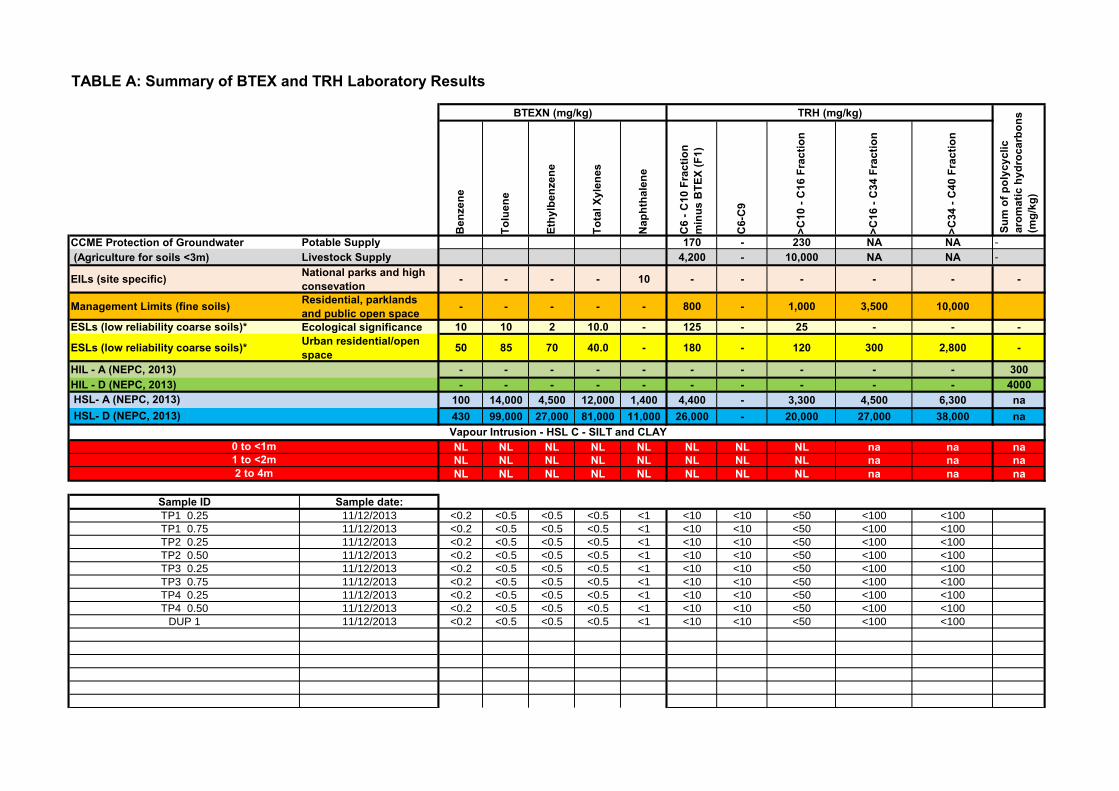
TABLE A: Summary of BTEX and TRH Laboratory Results
Ben
zene
Tolu
ene
Ethy
lben
zene
Tota
l Xyl
enes
Nap
htha
lene
C6
- C10
Fra
ctio
n
min
us B
TEX
(F1)
C6-
C9
>C10
- C
16 F
ract
ion
>C16
- C
34 F
ract
ion
>C34
- C
40 F
ract
ion
CCME Protection of Groundwater Potable Supply 170 - 230 NA NA -
(Agriculture for soils <3m) Livestock Supply 4,200 - 10,000 NA NA -
EILs (site specific) National parks and high consevation - - - - 10 - - - - - -
Management Limits (fine soils) Residential, parklands and public open space - - - - - 800 - 1,000 3,500 10,000
ESLs (low reliability coarse soils)* Ecological significance 10 10 2 10.0 - 125 - 25 - - -
ESLs (low reliability coarse soils)* Urban residential/open space 50 85 70 40.0 - 180 - 120 300 2,800 -
HIL - A (NEPC, 2013) - - - - - - - - - - 300HIL - D (NEPC, 2013) - - - - - - - - - - 4000
100 14,000 4,500 12,000 1,400 4,400 - 3,300 4,500 6,300 na430 99,000 27,000 81,000 11,000 26,000 - 20,000 27,000 38,000 na
NL NL NL NL NL NL NL NL na na naNL NL NL NL NL NL NL NL na na naNL NL NL NL NL NL NL NL na na na
Sample ID Sample date:TP1 0.25 11/12/2013 <0.2 <0.5 <0.5 <0.5 <1 <10 <10 <50 <100 <100
TP1 0.75 11/12/2013 <0.2 <0.5 <0.5 <0.5 <1 <10 <10 <50 <100 <100
TP2 0.25 11/12/2013 <0.2 <0.5 <0.5 <0.5 <1 <10 <10 <50 <100 <100
TP2 0.50 11/12/2013 <0.2 <0.5 <0.5 <0.5 <1 <10 <10 <50 <100 <100
TP3 0.25 11/12/2013 <0.2 <0.5 <0.5 <0.5 <1 <10 <10 <50 <100 <100
TP3 0.75 11/12/2013 <0.2 <0.5 <0.5 <0.5 <1 <10 <10 <50 <100 <100
TP4 0.25 11/12/2013 <0.2 <0.5 <0.5 <0.5 <1 <10 <10 <50 <100 <100
TP4 0.50 11/12/2013 <0.2 <0.5 <0.5 <0.5 <1 <10 <10 <50 <100 <100
DUP 1 11/12/2013 <0.2 <0.5 <0.5 <0.5 <1 <10 <10 <50 <100 <100
2 to 4m1 to <2m0 to <1m
Sum
of p
olyc
yclic
ar
omat
ic h
ydro
carb
ons
(mg/
kg)
TRH (mg/kg)BTEXN (mg/kg)
Vapour Intrusion - HSL C - SILT and CLAY
HSL- A (NEPC, 2013) HSL- D (NEPC, 2013)
TIER 1 ENVIRONMENTAL SITE ASSESSMENT
APPENDIX D LABORATORY REPORT AND CHAIN OF CUSTODY DOCUMENTATION
False
6 6.00False Environmental
CERTIFICATE OF ANALYSISWork Order : ES1327287 Page : 1 of 7
:: LaboratoryClient Environmental Division SydneyCARDNO ULLMAN & NOLAN GEOTECHNIC PTY LTD
: :ContactContact MR ROBERT TAYLOR Client Services
:: AddressAddress PO BOX 39623
WINNELLIE NT, AUSTRALIA 0821
277-289 Woodpark Road Smithfield NSW Australia 2164
:: E-mailE-mail [email protected] [email protected]
:: TelephoneTelephone +61 08 89844983 +61-2-8784 8555
:: FacsimileFacsimile +61 08 89844659 +61-2-8784 8500
:Project U33277 LOT 611 WADEYE CONTAMINATION ASSESSMENT QC Level : NEPM 2013 Schedule B(3) and ALS QCS3 requirement
:Order number ----
:C-O-C number ---- Date Samples Received : 13-DEC-2013
Sampler : GC Issue Date : 23-DEC-2013
Site : ----
9:No. of samples received
Quote number : EN/024/12 9:No. of samples analysed
This report supersedes any previous report(s) with this reference. Results apply to the sample(s) as submitted. All pages of this report have been checked and approved for
release.
This Certificate of Analysis contains the following information:
l General Comments
l Analytical Results
l Surrogate Control Limits
Environmental Division Sydney ABN 84 009 936 029 Part of the ALS Group An ALS Limited Company
Address 277-289 Woodpark Road Smithfield NSW Australia 2164 | PHONE +61-2-8784 8555 | Facsimile +61-2-8784 8500
2 of 7:Page
Work Order :
:Client
ES1327287
CARDNO ULLMAN & NOLAN GEOTECHNIC PTY LTD
U33277 LOT 611 WADEYE CONTAMINATION ASSESSMENT:Project
General Comments
The analytical procedures used by the Environmental Division have been developed from established internationally recognized procedures such as those published by the USEPA, APHA, AS and NEPM. In house
developed procedures are employed in the absence of documented standards or by client request.
Where moisture determination has been performed, results are reported on a dry weight basis.
Where a reported less than (<) result is higher than the LOR, this may be due to primary sample extract/digestate dilution and/or insufficient sample for analysis.
Where the LOR of a reported result differs from standard LOR, this may be due to high moisture content, insufficient sample (reduced weight employed) or matrix interference.
When sampling time information is not provided by the client, sampling dates are shown without a time component. In these instances, the time component has been assumed by the laboratory for processing purposes.
CAS Number = CAS registry number from database maintained by Chemical Abstracts Services. The Chemical Abstracts Service is a division of the American Chemical Society.
LOR = Limit of reporting
^ = This result is computed from individual analyte detections at or above the level of reporting
Key :
This document has been electronically signed by the authorized signatories indicated below. Electronic signing has been carried out in
compliance with procedures specified in 21 CFR Part 11.
Signatories Accreditation CategoryPosition
Ashesh Patel Inorganic Chemist Sydney Inorganics
Celine Conceicao Senior Spectroscopist Sydney Inorganics
Di-An Dao Sydney Inorganics
Phalak Inthaksone Laboratory Manager - Organics Sydney Organics
SATISH.TRIVEDI 2 IC Acid Sulfate Soils Supervisor Brisbane Acid Sulphate Soils
NATA Accredited Laboratory 825
Accredited for compliance with
ISO/IEC 17025.
Signatories
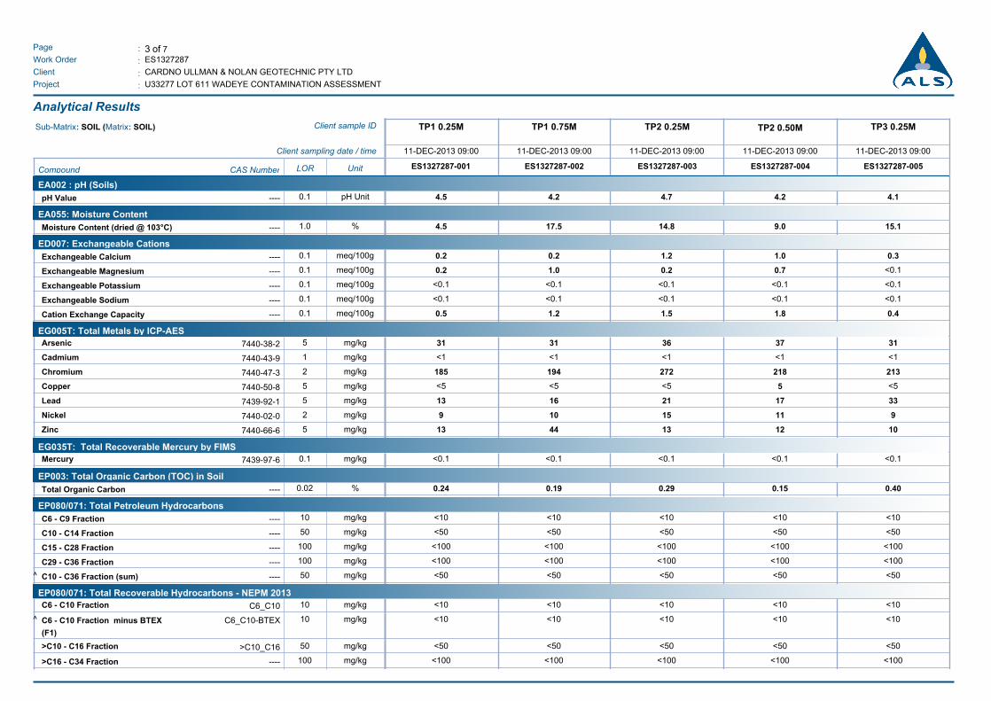
3 of 7:Page
Work Order :
:Client
ES1327287
CARDNO ULLMAN & NOLAN GEOTECHNIC PTY LTD
U33277 LOT 611 WADEYE CONTAMINATION ASSESSMENT:Project
Analytical Results
TP3 0.25MTP2 0.50MTP2 0.25MTP1 0.75MTP1 0.25MClient sample IDSub-Matrix: SOIL (Matrix: SOIL)
11-DEC-2013 09:0011-DEC-2013 09:0011-DEC-2013 09:0011-DEC-2013 09:0011-DEC-2013 09:00Client sampling date / time
ES1327287-005ES1327287-004ES1327287-003ES1327287-002ES1327287-001UnitLORCAS NumberCompound
EA002 : pH (Soils)
pH Value 4.24.5 4.7 4.2 4.1pH Unit0.1----
EA055: Moisture Content
Moisture Content (dried @ 103°C) 17.54.5 14.8 9.0 15.1%1.0----
ED007: Exchangeable Cations
Exchangeable Calcium 0.20.2 1.2 1.0 0.3meq/100g0.1----
Exchangeable Magnesium 1.00.2 0.2 0.7 <0.1meq/100g0.1----
Exchangeable Potassium <0.1<0.1 <0.1 <0.1 <0.1meq/100g0.1----
Exchangeable Sodium <0.1<0.1 <0.1 <0.1 <0.1meq/100g0.1----
Cation Exchange Capacity 1.20.5 1.5 1.8 0.4meq/100g0.1----
EG005T: Total Metals by ICP-AES
Arsenic 3131 36 37 31mg/kg57440-38-2
Cadmium <1<1 <1 <1 <1mg/kg17440-43-9
Chromium 194185 272 218 213mg/kg27440-47-3
Copper <5<5 <5 5 <5mg/kg57440-50-8
Lead 1613 21 17 33mg/kg57439-92-1
Nickel 109 15 11 9mg/kg27440-02-0
Zinc 4413 13 12 10mg/kg57440-66-6
EG035T: Total Recoverable Mercury by FIMS
Mercury <0.1<0.1 <0.1 <0.1 <0.1mg/kg0.17439-97-6
EP003: Total Organic Carbon (TOC) in Soil
Total Organic Carbon 0.190.24 0.29 0.15 0.40%0.02----
EP080/071: Total Petroleum Hydrocarbons
C6 - C9 Fraction <10<10 <10 <10 <10mg/kg10----
C10 - C14 Fraction <50<50 <50 <50 <50mg/kg50----
C15 - C28 Fraction <100<100 <100 <100 <100mg/kg100----
C29 - C36 Fraction <100<100 <100 <100 <100mg/kg100----
^ C10 - C36 Fraction (sum) <50<50 <50 <50 <50mg/kg50----
EP080/071: Total Recoverable Hydrocarbons - NEPM 2013
C6 - C10 Fraction <10<10 <10 <10 <10mg/kg10C6_C10
^ C6 - C10 Fraction minus BTEX
(F1)
<10<10 <10 <10 <10mg/kg10C6_C10-BTEX
>C10 - C16 Fraction <50<50 <50 <50 <50mg/kg50>C10_C16
>C16 - C34 Fraction <100<100 <100 <100 <100mg/kg100----
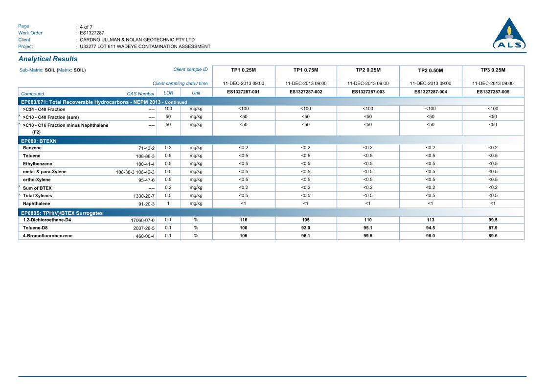
4 of 7:Page
Work Order :
:Client
ES1327287
CARDNO ULLMAN & NOLAN GEOTECHNIC PTY LTD
U33277 LOT 611 WADEYE CONTAMINATION ASSESSMENT:Project
Analytical Results
TP3 0.25MTP2 0.50MTP2 0.25MTP1 0.75MTP1 0.25MClient sample IDSub-Matrix: SOIL (Matrix: SOIL)
11-DEC-2013 09:0011-DEC-2013 09:0011-DEC-2013 09:0011-DEC-2013 09:0011-DEC-2013 09:00Client sampling date / time
ES1327287-005ES1327287-004ES1327287-003ES1327287-002ES1327287-001UnitLORCAS NumberCompound
EP080/071: Total Recoverable Hydrocarbons - NEPM 2013 - Continued
>C34 - C40 Fraction <100<100 <100 <100 <100mg/kg100----
^ >C10 - C40 Fraction (sum) <50<50 <50 <50 <50mg/kg50----
^ >C10 - C16 Fraction minus Naphthalene
(F2)
<50<50 <50 <50 <50mg/kg50----
EP080: BTEXN
Benzene <0.2<0.2 <0.2 <0.2 <0.2mg/kg0.271-43-2
Toluene <0.5<0.5 <0.5 <0.5 <0.5mg/kg0.5108-88-3
Ethylbenzene <0.5<0.5 <0.5 <0.5 <0.5mg/kg0.5100-41-4
meta- & para-Xylene <0.5<0.5 <0.5 <0.5 <0.5mg/kg0.5108-38-3 106-42-3
ortho-Xylene <0.5<0.5 <0.5 <0.5 <0.5mg/kg0.595-47-6
^ Sum of BTEX <0.2<0.2 <0.2 <0.2 <0.2mg/kg0.2----
^ Total Xylenes <0.5<0.5 <0.5 <0.5 <0.5mg/kg0.51330-20-7
Naphthalene <1<1 <1 <1 <1mg/kg191-20-3
EP080S: TPH(V)/BTEX Surrogates
1.2-Dichloroethane-D4 105116 110 113 99.5%0.117060-07-0
Toluene-D8 92.0100 95.1 94.5 87.9%0.12037-26-5
4-Bromofluorobenzene 96.1105 99.5 98.0 89.5%0.1460-00-4
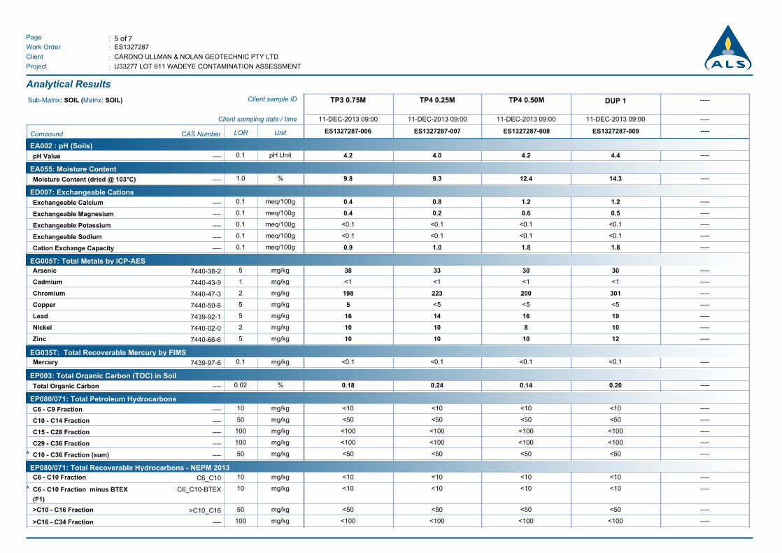
5 of 7:Page
Work Order :
:Client
ES1327287
CARDNO ULLMAN & NOLAN GEOTECHNIC PTY LTD
U33277 LOT 611 WADEYE CONTAMINATION ASSESSMENT:Project
Analytical Results
----DUP 1TP4 0.50MTP4 0.25MTP3 0.75MClient sample IDSub-Matrix: SOIL (Matrix: SOIL)
----11-DEC-2013 09:0011-DEC-2013 09:0011-DEC-2013 09:0011-DEC-2013 09:00Client sampling date / time
----ES1327287-009ES1327287-008ES1327287-007ES1327287-006UnitLORCAS NumberCompound
EA002 : pH (Soils)
pH Value 4.04.2 4.2 4.4 ----pH Unit0.1----
EA055: Moisture Content
Moisture Content (dried @ 103°C) 9.39.8 12.4 14.3 ----%1.0----
ED007: Exchangeable Cations
Exchangeable Calcium 0.80.4 1.2 1.2 ----meq/100g0.1----
Exchangeable Magnesium 0.20.4 0.6 0.5 ----meq/100g0.1----
Exchangeable Potassium <0.1<0.1 <0.1 <0.1 ----meq/100g0.1----
Exchangeable Sodium <0.1<0.1 <0.1 <0.1 ----meq/100g0.1----
Cation Exchange Capacity 1.00.9 1.8 1.8 ----meq/100g0.1----
EG005T: Total Metals by ICP-AES
Arsenic 3338 30 30 ----mg/kg57440-38-2
Cadmium <1<1 <1 <1 ----mg/kg17440-43-9
Chromium 223198 200 301 ----mg/kg27440-47-3
Copper <55 <5 <5 ----mg/kg57440-50-8
Lead 1416 16 19 ----mg/kg57439-92-1
Nickel 1010 8 10 ----mg/kg27440-02-0
Zinc 1010 10 12 ----mg/kg57440-66-6
EG035T: Total Recoverable Mercury by FIMS
Mercury <0.1<0.1 <0.1 <0.1 ----mg/kg0.17439-97-6
EP003: Total Organic Carbon (TOC) in Soil
Total Organic Carbon 0.240.18 0.14 0.20 ----%0.02----
EP080/071: Total Petroleum Hydrocarbons
C6 - C9 Fraction <10<10 <10 <10 ----mg/kg10----
C10 - C14 Fraction <50<50 <50 <50 ----mg/kg50----
C15 - C28 Fraction <100<100 <100 <100 ----mg/kg100----
C29 - C36 Fraction <100<100 <100 <100 ----mg/kg100----
^ C10 - C36 Fraction (sum) <50<50 <50 <50 ----mg/kg50----
EP080/071: Total Recoverable Hydrocarbons - NEPM 2013
C6 - C10 Fraction <10<10 <10 <10 ----mg/kg10C6_C10
^ C6 - C10 Fraction minus BTEX
(F1)
<10<10 <10 <10 ----mg/kg10C6_C10-BTEX
>C10 - C16 Fraction <50<50 <50 <50 ----mg/kg50>C10_C16
>C16 - C34 Fraction <100<100 <100 <100 ----mg/kg100----
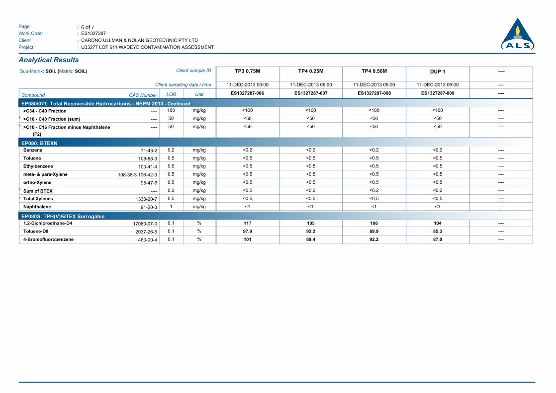
6 of 7:Page
Work Order :
:Client
ES1327287
CARDNO ULLMAN & NOLAN GEOTECHNIC PTY LTD
U33277 LOT 611 WADEYE CONTAMINATION ASSESSMENT:Project
Analytical Results
----DUP 1TP4 0.50MTP4 0.25MTP3 0.75MClient sample IDSub-Matrix: SOIL (Matrix: SOIL)
----11-DEC-2013 09:0011-DEC-2013 09:0011-DEC-2013 09:0011-DEC-2013 09:00Client sampling date / time
----ES1327287-009ES1327287-008ES1327287-007ES1327287-006UnitLORCAS NumberCompound
EP080/071: Total Recoverable Hydrocarbons - NEPM 2013 - Continued
>C34 - C40 Fraction <100<100 <100 <100 ----mg/kg100----
^ >C10 - C40 Fraction (sum) <50<50 <50 <50 ----mg/kg50----
^ >C10 - C16 Fraction minus Naphthalene
(F2)
<50<50 <50 <50 ----mg/kg50----
EP080: BTEXN
Benzene <0.2<0.2 <0.2 <0.2 ----mg/kg0.271-43-2
Toluene <0.5<0.5 <0.5 <0.5 ----mg/kg0.5108-88-3
Ethylbenzene <0.5<0.5 <0.5 <0.5 ----mg/kg0.5100-41-4
meta- & para-Xylene <0.5<0.5 <0.5 <0.5 ----mg/kg0.5108-38-3 106-42-3
ortho-Xylene <0.5<0.5 <0.5 <0.5 ----mg/kg0.595-47-6
^ Sum of BTEX <0.2<0.2 <0.2 <0.2 ----mg/kg0.2----
^ Total Xylenes <0.5<0.5 <0.5 <0.5 ----mg/kg0.51330-20-7
Naphthalene <1<1 <1 <1 ----mg/kg191-20-3
EP080S: TPH(V)/BTEX Surrogates
1.2-Dichloroethane-D4 105117 106 104 ----%0.117060-07-0
Toluene-D8 92.297.9 89.9 85.3 ----%0.12037-26-5
4-Bromofluorobenzene 89.4101 92.2 87.0 ----%0.1460-00-4
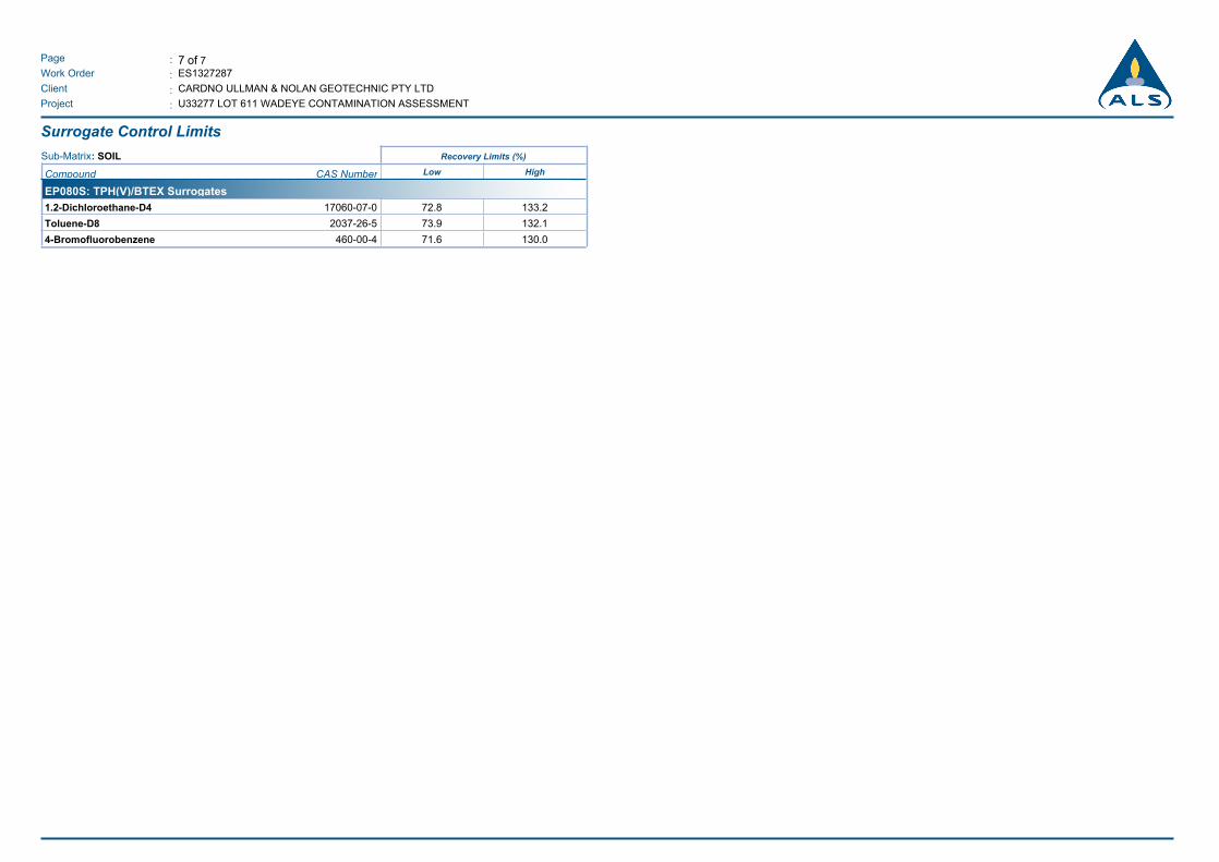
7 of 7:Page
Work Order :
:Client
ES1327287
CARDNO ULLMAN & NOLAN GEOTECHNIC PTY LTD
U33277 LOT 611 WADEYE CONTAMINATION ASSESSMENT:Project
Surrogate Control Limits
Recovery Limits (%)Sub-Matrix: SOIL
Compound CAS Number Low High
EP080S: TPH(V)/BTEX Surrogates
1.2-Dichloroethane-D4 17060-07-0 72.8 133.2
Toluene-D8 2037-26-5 73.9 132.1
4-Bromofluorobenzene 460-00-4 71.6 130.0
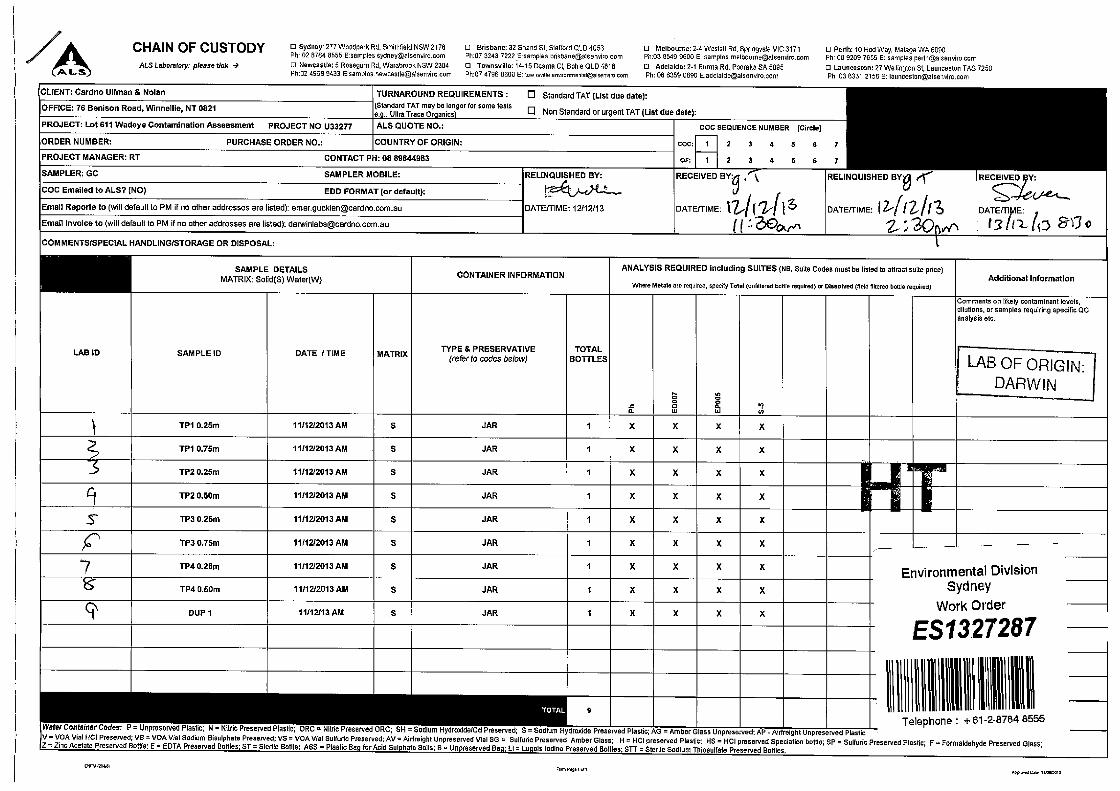
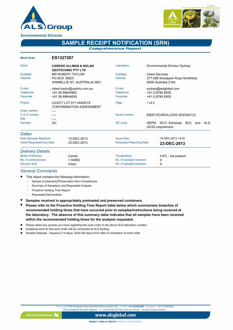
Environmental Division
SAMPLE RECEIPT NOTIFICATION (SRN)Comprehensive Report
Work Order : ES1327287
:: LaboratoryClient Environmental Division SydneyCARDNO ULLMAN & NOLAN
GEOTECHNIC PTY LTD: :ContactContact MR ROBERT TAYLOR Client Services
:: AddressAddress PO BOX 39623
WINNELLIE NT, AUSTRALIA 0821
277-289 Woodpark Road Smithfield
NSW Australia 2164
:: E-mailE-mail [email protected] [email protected]:: TelephoneTelephone +61 08 89844983 +61-2-8784 8555:: FacsimileFacsimile +61 08 89844659 +61-2-8784 8500
::Project U33277 LOT 611 WADEYE
CONTAMINATION ASSESSMENT
Page 1 of 2
:Order number ----::C-O-C number ---- Quote number EB2013CARULL0335 (EN/024/12)
Site : ----Sampler : :QC LevelGC NEPM 2013 Schedule B(3) and ALS
QCS3 requirement
DatesDate Samples Received : 13-DEC-2013 Issue Date : 16-DEC-2013 14:04
Scheduled Reporting Date: 23-DEC-2013:Client Requested Due Date 23-DEC-2013
Delivery DetailsMode of Delivery Temperature: :Carrier 4.8'C - Ice presentNo. of coolers/boxes No. of samples received: :1 HARD 9Security Seal No. of samples analysed: :Intact. 9
General Comments
This report contains the following information:l
- Sample Container(s)/Preservation Non-Compliances
- Summary of Sample(s) and Requested Analysis
- Proactive Holding Time Report
- Requested Deliverables
l Samples received in appropriately pretreated and preserved containers.
Please refer to the Proactive Holding Time Report table below which summarises breaches of
recommended holding times that have occurred prior to samples/instructions being received at
the laboratory. The absence of this summary table indicates that all samples have been received
within the recommended holding times for the analysis requested.
l
Please direct any queries you have regarding this work order to the above ALS laboratory contact.l
Analytical work for this work order will be conducted at ALS Sydney.l
Sample Disposal - Aqueous (14 days), Solid (60 days) from date of completion of work order.l
Environmental Division Sydney ABN 84 009 936 029 Part of the ALS Group An ALS Limited Company
Address 277-289 Woodpark Road Smithfield NSW Australia 2164 | PHONE +61-2-8784 8555 | Facsimile +61-2-8784 8500
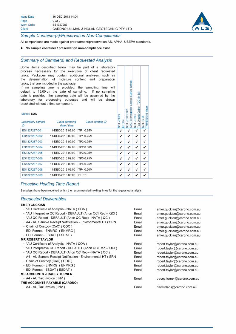
16-DEC-2013 14:04:Issue Date
2 of 2:Page
Work Order :
:Client
ES1327287
CARDNO ULLMAN & NOLAN GEOTECHNIC PTY LTD
Sample Container(s)/Preservation Non-Compliances
All comparisons are made against pretreatment/preservation AS, APHA, USEPA standards.
l No sample container / preservation non-compliance exist.
Summary of Sample(s) and Requested Analysis
Some items described below may be part of a laboratory
process neccessary for the execution of client requested
tasks. Packages may contain additional analyses, such as
the determination of moisture content and preparation
tasks, that are included in the package.
If no sampling time is provided, the sampling time will
default to 15:00 on the date of sampling. If no sampling
date is provided, the sampling date will be assumed by the
laboratory for processing purposes and will be shown
bracketed without a time component.
SO
IL -
EA
002
pH (
1:5)
SO
IL -
ED
007
Def
CE
C /
Exc
hang
eabl
e C
atio
ns (
ED
007)
-D
efau
lt
SO
IL -
EP
003
Tot
al O
rgan
ic C
arbo
n (T
OC
) in
Soi
l
SO
IL -
S-0
5
TR
H/B
TE
XN
/8 M
etal
s
ES1327287-001 11-DEC-2013 09:00 TP1 0.25M ü ü ü ü
ES1327287-002 11-DEC-2013 09:00 TP1 0.75M ü ü ü ü
ES1327287-003 11-DEC-2013 09:00 TP2 0.25M ü ü ü ü
ES1327287-004 11-DEC-2013 09:00 TP2 0.50M ü ü ü ü
ES1327287-005 11-DEC-2013 09:00 TP3 0.25M ü ü ü ü
ES1327287-006 11-DEC-2013 09:00 TP3 0.75M ü ü ü ü
ES1327287-007 11-DEC-2013 09:00 TP4 0.25M ü ü ü ü
ES1327287-008 11-DEC-2013 09:00 TP4 0.50M ü ü ü ü
ES1327287-009 11-DEC-2013 09:00 DUP 1 ü ü ü ü
Matrix: SOIL
Client sample IDLaboratory sample
ID
Client sampling
date / time
Proactive Holding Time Report
Sample(s) have been received within the recommended holding times for the requested analysis.
Requested Deliverables
EMER GUCKIAN
- *AU Certificate of Analysis - NATA ( COA ) Email [email protected] *AU Interpretive QC Report - DEFAULT (Anon QCI Rep) ( QCI ) Email [email protected] *AU QC Report - DEFAULT (Anon QC Rep) - NATA ( QC ) Email [email protected] A4 - AU Sample Receipt Notification - Environmental HT ( SRN Email [email protected] Chain of Custody (CoC) ( COC ) Email [email protected] EDI Format - ENMRG ( ENMRG ) Email [email protected] EDI Format - ESDAT ( ESDAT ) Email [email protected]
MR ROBERT TAYLOR
- *AU Certificate of Analysis - NATA ( COA ) Email [email protected] *AU Interpretive QC Report - DEFAULT (Anon QCI Rep) ( QCI ) Email [email protected] *AU QC Report - DEFAULT (Anon QC Rep) - NATA ( QC ) Email [email protected] A4 - AU Sample Receipt Notification - Environmental HT ( SRN Email [email protected] Chain of Custody (CoC) ( COC ) Email [email protected] EDI Format - ENMRG ( ENMRG ) Email [email protected] EDI Format - ESDAT ( ESDAT ) Email [email protected]
MS ACCOUNTS -TRACEY TURNER
- A4 - AU Tax Invoice ( INV ) Email [email protected]
THE ACCOUNTS PAYABLE (CARDNO)
- A4 - AU Tax Invoice ( INV ) Email [email protected]
False 6 6.00False
Environmental
QUALITY CONTROL REPORTWork Order : ES1327287 Page : 1 of 8
:: LaboratoryClient Environmental Division SydneyCARDNO ULLMAN & NOLAN GEOTECHNIC PTY LTD
: :ContactContact MR ROBERT TAYLOR Client Services
:: AddressAddress PO BOX 39623
WINNELLIE NT, AUSTRALIA 0821
277-289 Woodpark Road Smithfield NSW Australia 2164
:: E-mailE-mail [email protected] [email protected]
:: TelephoneTelephone +61 08 89844983 +61-2-8784 8555
:: FacsimileFacsimile +61 08 89844659 +61-2-8784 8500
:Project U33277 LOT 611 WADEYE CONTAMINATION ASSESSMENT QC Level : NEPM 2013 Schedule B(3) and ALS QCS3 requirement
Site : ----
:C-O-C number ---- Date Samples Received : 13-DEC-2013
Sampler : GC Issue Date : 23-DEC-2013
:Order number ----
9:No. of samples received
Quote number : EN/024/12 9:No. of samples analysed
This report supersedes any previous report(s) with this reference. Results apply to the sample(s) as submitted. All pages of this report have been checked and approved for
release.
This Quality Control Report contains the following information:
l Laboratory Duplicate (DUP) Report; Relative Percentage Difference (RPD) and Acceptance Limits
l Method Blank (MB) and Laboratory Control Spike (LCS) Report ; Recovery and Acceptance Limits
l Matrix Spike (MS) Report; Recovery and Acceptance Limits
Address 277-289 Woodpark Road Smithfield NSW Australia 2164 | PHONE +61-2-8784 8555 | Facsimile +61-2-8784 8500
Environmental Division Sydney ABN 84 009 936 029 Part of the ALS Group An ALS Limited Company
2 of 8:Page
Work Order :
:Client
ES1327287
CARDNO ULLMAN & NOLAN GEOTECHNIC PTY LTD
U33277 LOT 611 WADEYE CONTAMINATION ASSESSMENT:Project
General Comments
The analytical procedures used by the Environmental Division have been developed from established internationally recognized procedures such as those published by the USEPA, APHA, AS and NEPM. In house
developed procedures are employed in the absence of documented standards or by client request.
Where moisture determination has been performed, results are reported on a dry weight basis.
Where a reported less than (<) result is higher than the LOR, this may be due to primary sample extract/digestate dilution and/or insufficient sample for analysis.
Where the LOR of a reported result differs from standard LOR, this may be due to high moisture content, insufficient sample (reduced weight employed) or matrix interference.
Anonymous = Refers to samples which are not specifically part of this work order but formed part of the QC process lot
CAS Number = CAS registry number from database maintained by Chemical Abstracts Services. The Chemical Abstracts Service is a division of the American Chemical Society.
LOR = Limit of reporting
RPD = Relative Percentage Difference
# = Indicates failed QC
Key :
This document has been electronically signed by the authorized signatories indicated below. Electronic signing has been carried out in compliance with
procedures specified in 21 CFR Part 11.
Signatories Accreditation CategoryPosition
Ashesh Patel Inorganic Chemist Sydney Inorganics
Celine Conceicao Senior Spectroscopist Sydney Inorganics
Di-An Dao Sydney Inorganics
Phalak Inthaksone Laboratory Manager - Organics Sydney Organics
SATISH.TRIVEDI 2 IC Acid Sulfate Soils Supervisor Brisbane Acid Sulphate Soils
SignatoriesNATA Accredited
Laboratory 825
Accredited for
compliance with
ISO/IEC 17025.
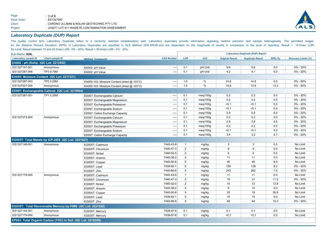
3 of 8:Page
Work Order :
:Client
ES1327287
CARDNO ULLMAN & NOLAN GEOTECHNIC PTY LTD
U33277 LOT 611 WADEYE CONTAMINATION ASSESSMENT:Project
Laboratory Duplicate (DUP) Report
The quality control term Laboratory Duplicate refers to a randomly selected intralaboratory split. Laboratory duplicates provide information regarding method precision and sample heterogeneity. The permitted ranges
for the Relative Percent Deviation (RPD) of Laboratory Duplicates are specified in ALS Method QWI -EN/38 and are dependent on the magnitude of results in comparison to the level of reporting: Result < 10 times LOR:-
No Limit; Result between 10 and 20 times LOR:- 0% - 50%; Result > 20 times LOR:- 0% - 20%.
Sub-Matrix: SOIL Laboratory Duplicate (DUP) Report
Original Result RPD (%)Laboratory sample ID Client sample ID Method: Compound CAS Number LOR Unit Duplicate Result Recovery Limits (%)
EA002 : pH (Soils) (QC Lot: 3213542)
EA002: pH Value ---- 0.1 pH Unit 9.8 9.8 0.0 0% - 20%AnonymousES1327147-001
EA002: pH Value ---- 0.1 pH Unit 4.2 4.1 0.0 0% - 20%TP3 0.75MES1327287-006
EA055: Moisture Content (QC Lot: 3217331)
EA055-103: Moisture Content (dried @ 103°C) ---- 1.0 % 14.8 14.9 0.9 0% - 50%TP2 0.25MES1327287-003
EA055-103: Moisture Content (dried @ 103°C) ---- 1.0 % 14.8 12.9 13.2 0% - 50%AnonymousES1327527-005
ED007: Exchangeable Cations (QC Lot: 3218904)
ED007: Exchangeable Calcium ---- 0.1 meq/100g 0.2 0.2 0.0 0% - 20%TP1 0.25MES1327287-001
ED007: Exchangeable Magnesium ---- 0.1 meq/100g 0.2 0.2 0.0 0% - 20%
ED007: Exchangeable Potassium ---- 0.1 meq/100g <0.1 <0.1 0.0 0% - 20%
ED007: Exchangeable Sodium ---- 0.1 meq/100g <0.1 <0.1 0.0 0% - 20%
ED007: Cation Exchange Capacity ---- 0.1 meq/100g 0.5 0.5 0.0 0% - 20%
ED007: Exchangeable Calcium ---- 0.1 meq/100g 0.2 0.2 0.0 0% - 20%AnonymousES1327373-004
ED007: Exchangeable Magnesium ---- 0.1 meq/100g 2.9 2.8 4.6 0% - 20%
ED007: Exchangeable Potassium ---- 0.1 meq/100g 0.2 0.2 0.0 0% - 20%
ED007: Exchangeable Sodium ---- 0.1 meq/100g <0.1 <0.1 0.0 0% - 20%
ED007: Cation Exchange Capacity ---- 0.1 meq/100g 3.4 3.2 4.7 0% - 20%
EG005T: Total Metals by ICP-AES (QC Lot: 3221527)
EG005T: Cadmium 7440-43-9 1 mg/kg 3 3 0.0 No LimitAnonymousES1327148-001
EG005T: Chromium 7440-47-3 2 mg/kg 8 9 0.0 No Limit
EG005T: Nickel 7440-02-0 2 mg/kg 4 4 0.0 No Limit
EG005T: Arsenic 7440-38-2 5 mg/kg 11 11 0.0 No Limit
EG005T: Copper 7440-50-8 5 mg/kg 45 48 6.9 No Limit
EG005T: Lead 7439-92-1 5 mg/kg 150 138 8.2 0% - 20%
EG005T: Zinc 7440-66-6 5 mg/kg 243 262 7.5 0% - 20%
EG005T: Cadmium 7440-43-9 1 mg/kg <1 <1 0.0 No LimitAnonymousES1327179-004
EG005T: Chromium 7440-47-3 2 mg/kg 19 21 11.2 0% - 50%
EG005T: Nickel 7440-02-0 2 mg/kg 14 12 12.8 No Limit
EG005T: Arsenic 7440-38-2 5 mg/kg 9 10 0.0 No Limit
EG005T: Copper 7440-50-8 5 mg/kg 25 19 26.8 No Limit
EG005T: Lead 7439-92-1 5 mg/kg 15 15 0.0 No Limit
EG005T: Zinc 7440-66-6 5 mg/kg 58 64 10.3 0% - 50%
EG035T: Total Recoverable Mercury by FIMS (QC Lot: 3221528)
EG035T: Mercury 7439-97-6 0.1 mg/kg 0.1 0.1 0.0 No LimitAnonymousES1327148-001
EG035T: Mercury 7439-97-6 0.1 mg/kg <0.1 <0.1 0.0 No LimitAnonymousES1327179-004
EP003: Total Organic Carbon (TOC) in Soil (QC Lot: 3218205)
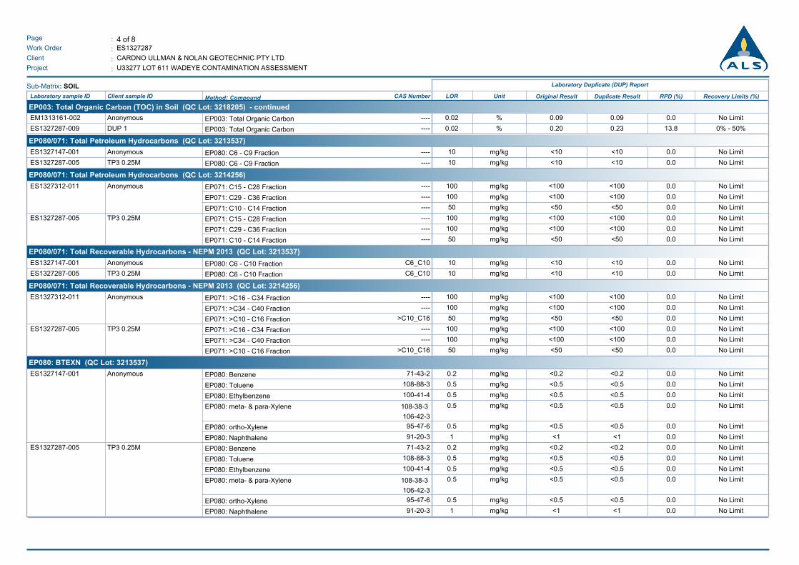
4 of 8:Page
Work Order :
:Client
ES1327287
CARDNO ULLMAN & NOLAN GEOTECHNIC PTY LTD
U33277 LOT 611 WADEYE CONTAMINATION ASSESSMENT:Project
Sub-Matrix: SOIL Laboratory Duplicate (DUP) Report
Original Result RPD (%)Laboratory sample ID Client sample ID Method: Compound CAS Number LOR Unit Duplicate Result Recovery Limits (%)
EP003: Total Organic Carbon (TOC) in Soil (QC Lot: 3218205) - continued
EP003: Total Organic Carbon ---- 0.02 % 0.09 0.09 0.0 No LimitAnonymousEM1313161-002
EP003: Total Organic Carbon ---- 0.02 % 0.20 0.23 13.8 0% - 50%DUP 1ES1327287-009
EP080/071: Total Petroleum Hydrocarbons (QC Lot: 3213537)
EP080: C6 - C9 Fraction ---- 10 mg/kg <10 <10 0.0 No LimitAnonymousES1327147-001
EP080: C6 - C9 Fraction ---- 10 mg/kg <10 <10 0.0 No LimitTP3 0.25MES1327287-005
EP080/071: Total Petroleum Hydrocarbons (QC Lot: 3214256)
EP071: C15 - C28 Fraction ---- 100 mg/kg <100 <100 0.0 No LimitAnonymousES1327312-011
EP071: C29 - C36 Fraction ---- 100 mg/kg <100 <100 0.0 No Limit
EP071: C10 - C14 Fraction ---- 50 mg/kg <50 <50 0.0 No Limit
EP071: C15 - C28 Fraction ---- 100 mg/kg <100 <100 0.0 No LimitTP3 0.25MES1327287-005
EP071: C29 - C36 Fraction ---- 100 mg/kg <100 <100 0.0 No Limit
EP071: C10 - C14 Fraction ---- 50 mg/kg <50 <50 0.0 No Limit
EP080/071: Total Recoverable Hydrocarbons - NEPM 2013 (QC Lot: 3213537)
EP080: C6 - C10 Fraction C6_C10 10 mg/kg <10 <10 0.0 No LimitAnonymousES1327147-001
EP080: C6 - C10 Fraction C6_C10 10 mg/kg <10 <10 0.0 No LimitTP3 0.25MES1327287-005
EP080/071: Total Recoverable Hydrocarbons - NEPM 2013 (QC Lot: 3214256)
EP071: >C16 - C34 Fraction ---- 100 mg/kg <100 <100 0.0 No LimitAnonymousES1327312-011
EP071: >C34 - C40 Fraction ---- 100 mg/kg <100 <100 0.0 No Limit
EP071: >C10 - C16 Fraction >C10_C16 50 mg/kg <50 <50 0.0 No Limit
EP071: >C16 - C34 Fraction ---- 100 mg/kg <100 <100 0.0 No LimitTP3 0.25MES1327287-005
EP071: >C34 - C40 Fraction ---- 100 mg/kg <100 <100 0.0 No Limit
EP071: >C10 - C16 Fraction >C10_C16 50 mg/kg <50 <50 0.0 No Limit
EP080: BTEXN (QC Lot: 3213537)
EP080: Benzene 71-43-2 0.2 mg/kg <0.2 <0.2 0.0 No LimitAnonymousES1327147-001
EP080: Toluene 108-88-3 0.5 mg/kg <0.5 <0.5 0.0 No Limit
EP080: Ethylbenzene 100-41-4 0.5 mg/kg <0.5 <0.5 0.0 No Limit
EP080: meta- & para-Xylene 108-38-3
106-42-3
0.5 mg/kg <0.5 <0.5 0.0 No Limit
EP080: ortho-Xylene 95-47-6 0.5 mg/kg <0.5 <0.5 0.0 No Limit
EP080: Naphthalene 91-20-3 1 mg/kg <1 <1 0.0 No Limit
EP080: Benzene 71-43-2 0.2 mg/kg <0.2 <0.2 0.0 No LimitTP3 0.25MES1327287-005
EP080: Toluene 108-88-3 0.5 mg/kg <0.5 <0.5 0.0 No Limit
EP080: Ethylbenzene 100-41-4 0.5 mg/kg <0.5 <0.5 0.0 No Limit
EP080: meta- & para-Xylene 108-38-3
106-42-3
0.5 mg/kg <0.5 <0.5 0.0 No Limit
EP080: ortho-Xylene 95-47-6 0.5 mg/kg <0.5 <0.5 0.0 No Limit
EP080: Naphthalene 91-20-3 1 mg/kg <1 <1 0.0 No Limit
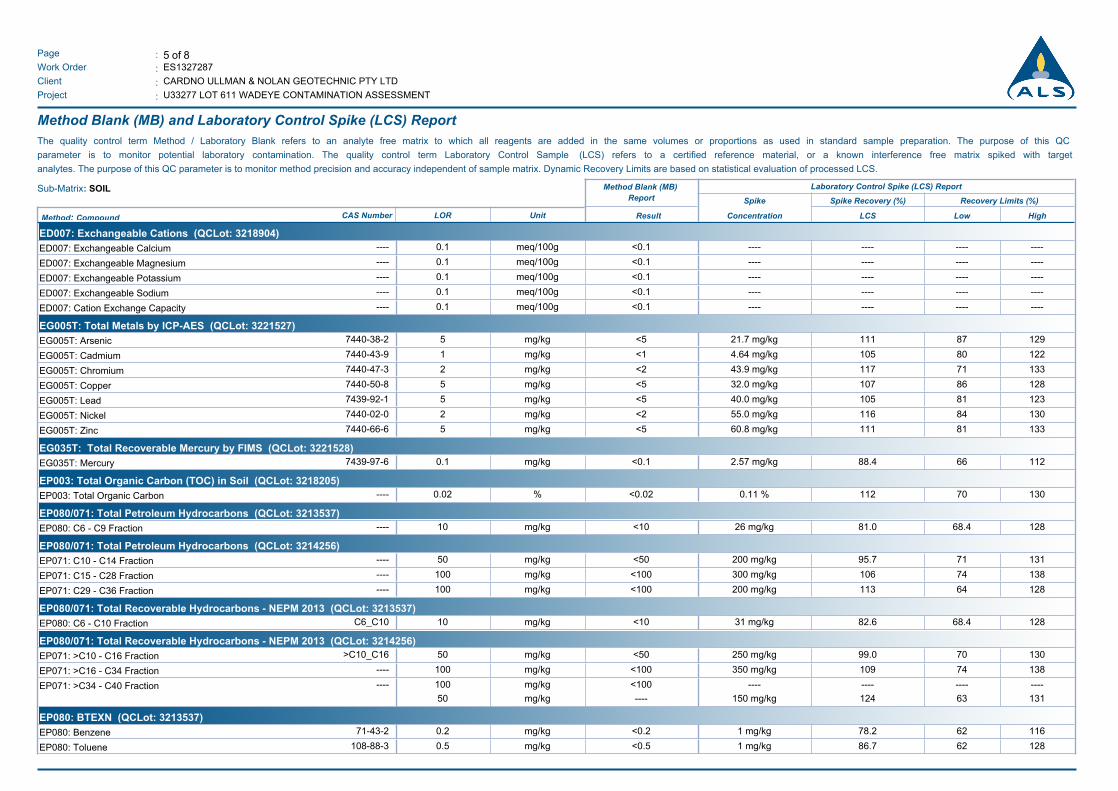
5 of 8:Page
Work Order :
:Client
ES1327287
CARDNO ULLMAN & NOLAN GEOTECHNIC PTY LTD
U33277 LOT 611 WADEYE CONTAMINATION ASSESSMENT:Project
Method Blank (MB) and Laboratory Control Spike (LCS) Report
The quality control term Method / Laboratory Blank refers to an analyte free matrix to which all reagents are added in the same volumes or proportions as used in standard sample preparation. The purpose of this QC
parameter is to monitor potential laboratory contamination. The quality control term Laboratory Control Sample (LCS) refers to a certified reference material, or a known interference free matrix spiked with target
analytes. The purpose of this QC parameter is to monitor method precision and accuracy independent of sample matrix. Dynamic Recovery Limits are based on statistical evaluation of processed LCS.
Sub-Matrix: SOIL Method Blank (MB)
Report
Laboratory Control Spike (LCS) Report
Spike Spike Recovery (%) Recovery Limits (%)
Result Concentration HighLowLCSMethod: Compound CAS Number LOR Unit
ED007: Exchangeable Cations (QCLot: 3218904)
ED007: Exchangeable Calcium ---- 0.1 meq/100g <0.1 -------- --------
ED007: Exchangeable Magnesium ---- 0.1 meq/100g <0.1 -------- --------
ED007: Exchangeable Potassium ---- 0.1 meq/100g <0.1 -------- --------
ED007: Exchangeable Sodium ---- 0.1 meq/100g <0.1 -------- --------
ED007: Cation Exchange Capacity ---- 0.1 meq/100g <0.1 -------- --------
EG005T: Total Metals by ICP-AES (QCLot: 3221527)
EG005T: Arsenic 7440-38-2 5 mg/kg <5 11121.7 mg/kg 12987
EG005T: Cadmium 7440-43-9 1 mg/kg <1 1054.64 mg/kg 12280
EG005T: Chromium 7440-47-3 2 mg/kg <2 11743.9 mg/kg 13371
EG005T: Copper 7440-50-8 5 mg/kg <5 10732.0 mg/kg 12886
EG005T: Lead 7439-92-1 5 mg/kg <5 10540.0 mg/kg 12381
EG005T: Nickel 7440-02-0 2 mg/kg <2 11655.0 mg/kg 13084
EG005T: Zinc 7440-66-6 5 mg/kg <5 11160.8 mg/kg 13381
EG035T: Total Recoverable Mercury by FIMS (QCLot: 3221528)
EG035T: Mercury 7439-97-6 0.1 mg/kg <0.1 88.42.57 mg/kg 11266
EP003: Total Organic Carbon (TOC) in Soil (QCLot: 3218205)
EP003: Total Organic Carbon ---- 0.02 % <0.02 1120.11 % 13070
EP080/071: Total Petroleum Hydrocarbons (QCLot: 3213537)
EP080: C6 - C9 Fraction ---- 10 mg/kg <10 81.026 mg/kg 12868.4
EP080/071: Total Petroleum Hydrocarbons (QCLot: 3214256)
EP071: C10 - C14 Fraction ---- 50 mg/kg <50 95.7200 mg/kg 13171
EP071: C15 - C28 Fraction ---- 100 mg/kg <100 106300 mg/kg 13874
EP071: C29 - C36 Fraction ---- 100 mg/kg <100 113200 mg/kg 12864
EP080/071: Total Recoverable Hydrocarbons - NEPM 2013 (QCLot: 3213537)
EP080: C6 - C10 Fraction C6_C10 10 mg/kg <10 82.631 mg/kg 12868.4
EP080/071: Total Recoverable Hydrocarbons - NEPM 2013 (QCLot: 3214256)
EP071: >C10 - C16 Fraction >C10_C16 50 mg/kg <50 99.0250 mg/kg 13070
EP071: >C16 - C34 Fraction ---- 100 mg/kg <100 109350 mg/kg 13874
EP071: >C34 - C40 Fraction ---- 100 mg/kg <100 -------- --------
50 mg/kg ---- 124150 mg/kg 13163
EP080: BTEXN (QCLot: 3213537)
EP080: Benzene 71-43-2 0.2 mg/kg <0.2 78.21 mg/kg 11662
EP080: Toluene 108-88-3 0.5 mg/kg <0.5 86.71 mg/kg 12862
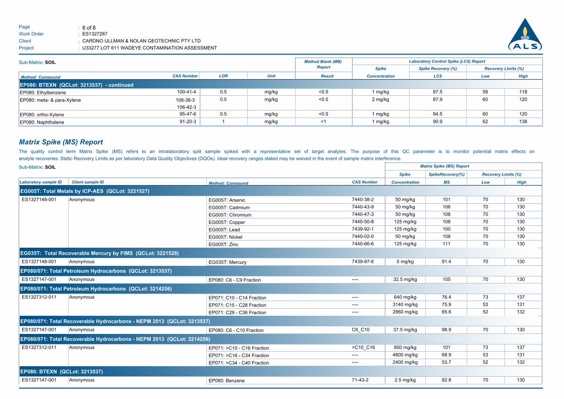
6 of 8:Page
Work Order :
:Client
ES1327287
CARDNO ULLMAN & NOLAN GEOTECHNIC PTY LTD
U33277 LOT 611 WADEYE CONTAMINATION ASSESSMENT:Project
Sub-Matrix: SOIL Method Blank (MB)
Report
Laboratory Control Spike (LCS) Report
Spike Spike Recovery (%) Recovery Limits (%)
Result Concentration HighLowLCSMethod: Compound CAS Number LOR Unit
EP080: BTEXN (QCLot: 3213537) - continued
EP080: Ethylbenzene 100-41-4 0.5 mg/kg <0.5 87.51 mg/kg 11858
EP080: meta- & para-Xylene 108-38-3
106-42-3
0.5 mg/kg <0.5 87.92 mg/kg 12060
EP080: ortho-Xylene 95-47-6 0.5 mg/kg <0.5 94.51 mg/kg 12060
EP080: Naphthalene 91-20-3 1 mg/kg <1 90.91 mg/kg 13862
Matrix Spike (MS) ReportThe quality control term Matrix Spike (MS) refers to an intralaboratory split sample spiked with a representative set of target analytes. The purpose of this QC parameter is to monitor potential matrix effects on
analyte recoveries. Static Recovery Limits as per laboratory Data Quality Objectives (DQOs). Ideal recovery ranges stated may be waived in the event of sample matrix interference.
Sub-Matrix: SOIL Matrix Spike (MS) Report
SpikeRecovery(%) Recovery Limits (%)Spike
HighLowMSConcentrationLaboratory sample ID Client sample ID Method: Compound CAS Number
EG005T: Total Metals by ICP-AES (QCLot: 3221527)
AnonymousES1327148-001 7440-38-2EG005T: Arsenic 10150 mg/kg 13070
7440-43-9EG005T: Cadmium 10650 mg/kg 13070
7440-47-3EG005T: Chromium 10850 mg/kg 13070
7440-50-8EG005T: Copper 108125 mg/kg 13070
7439-92-1EG005T: Lead 100125 mg/kg 13070
7440-02-0EG005T: Nickel 10850 mg/kg 13070
7440-66-6EG005T: Zinc 111125 mg/kg 13070
EG035T: Total Recoverable Mercury by FIMS (QCLot: 3221528)
AnonymousES1327148-001 7439-97-6EG035T: Mercury 91.45 mg/kg 13070
EP080/071: Total Petroleum Hydrocarbons (QCLot: 3213537)
AnonymousES1327147-001 ----EP080: C6 - C9 Fraction 10532.5 mg/kg 13070
EP080/071: Total Petroleum Hydrocarbons (QCLot: 3214256)
AnonymousES1327312-011 ----EP071: C10 - C14 Fraction 76.4640 mg/kg 13773
----EP071: C15 - C28 Fraction 75.93140 mg/kg 13153
----EP071: C29 - C36 Fraction 65.62860 mg/kg 13252
EP080/071: Total Recoverable Hydrocarbons - NEPM 2013 (QCLot: 3213537)
AnonymousES1327147-001 C6_C10EP080: C6 - C10 Fraction 98.937.5 mg/kg 13070
EP080/071: Total Recoverable Hydrocarbons - NEPM 2013 (QCLot: 3214256)
AnonymousES1327312-011 >C10_C16EP071: >C10 - C16 Fraction 101850 mg/kg 13773
----EP071: >C16 - C34 Fraction 68.94800 mg/kg 13153
----EP071: >C34 - C40 Fraction 53.72400 mg/kg 13252
EP080: BTEXN (QCLot: 3213537)
AnonymousES1327147-001 71-43-2EP080: Benzene 82.82.5 mg/kg 13070
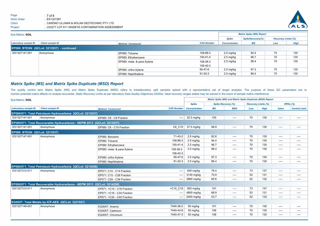
7 of 8:Page
Work Order :
:Client
ES1327287
CARDNO ULLMAN & NOLAN GEOTECHNIC PTY LTD
U33277 LOT 611 WADEYE CONTAMINATION ASSESSMENT:Project
Sub-Matrix: SOIL Matrix Spike (MS) Report
SpikeRecovery(%) Recovery Limits (%)Spike
HighLowMSConcentrationLaboratory sample ID Client sample ID Method: Compound CAS Number
EP080: BTEXN (QCLot: 3213537) - continued
AnonymousES1327147-001 108-88-3EP080: Toluene 94.42.5 mg/kg 13070
100-41-4EP080: Ethylbenzene 96.72.5 mg/kg 13070
108-38-3
106-42-3
EP080: meta- & para-Xylene 96.42.5 mg/kg 13070
95-47-6EP080: ortho-Xylene 97.32.5 mg/kg 13070
91-20-3EP080: Naphthalene 86.42.5 mg/kg 13070
Matrix Spike (MS) and Matrix Spike Duplicate (MSD) Report
The quality control term Matrix Spike (MS) and Matrix Spike Duplicate (MSD) refers to intralaboratory split samples spiked with a representative set of target analytes. The purpose of these QC parameters are to
monitor potential matrix effects on analyte recoveries. Static Recovery Limits as per laboratory Data Quality Objectives (DQOs). Ideal recovery ranges stated may be waived in the event of sample matrix interference.
Sub-Matrix: SOIL Matrix Spike (MS) and Matrix Spike Duplicate (MSD) Report
RPDs (%)Spike Recovery (%) Recovery Limits (%)Spike
Control LimitValueHighLowMSDMSConcentrationLaboratory sample ID Client sample ID Method: Compound CAS Number
EP080/071: Total Petroleum Hydrocarbons (QCLot: 3213537)
AnonymousES1327147-001 ----EP080: C6 - C9 Fraction --------10532.5 mg/kg 13070 ----
EP080/071: Total Recoverable Hydrocarbons - NEPM 2013 (QCLot: 3213537)
AnonymousES1327147-001 C6_C10EP080: C6 - C10 Fraction --------98.937.5 mg/kg 13070 ----
EP080: BTEXN (QCLot: 3213537)
AnonymousES1327147-001 71-43-2EP080: Benzene --------82.82.5 mg/kg 13070 ----
108-88-3EP080: Toluene --------94.42.5 mg/kg 13070 ----
100-41-4EP080: Ethylbenzene --------96.72.5 mg/kg 13070 ----
108-38-3
106-42-3
EP080: meta- & para-Xylene --------96.42.5 mg/kg 13070 ----
95-47-6EP080: ortho-Xylene --------97.32.5 mg/kg 13070 ----
91-20-3EP080: Naphthalene --------86.42.5 mg/kg 13070 ----
EP080/071: Total Petroleum Hydrocarbons (QCLot: 3214256)
AnonymousES1327312-011 ----EP071: C10 - C14 Fraction --------76.4640 mg/kg 13773 ----
----EP071: C15 - C28 Fraction --------75.93140 mg/kg 13153 ----
----EP071: C29 - C36 Fraction --------65.62860 mg/kg 13252 ----
EP080/071: Total Recoverable Hydrocarbons - NEPM 2013 (QCLot: 3214256)
AnonymousES1327312-011 >C10_C16EP071: >C10 - C16 Fraction --------101850 mg/kg 13773 ----
----EP071: >C16 - C34 Fraction --------68.94800 mg/kg 13153 ----
----EP071: >C34 - C40 Fraction --------53.72400 mg/kg 13252 ----
EG005T: Total Metals by ICP-AES (QCLot: 3221527)
AnonymousES1327148-001 7440-38-2EG005T: Arsenic --------10150 mg/kg 13070 ----
7440-43-9EG005T: Cadmium --------10650 mg/kg 13070 ----
7440-47-3EG005T: Chromium --------10850 mg/kg 13070 ----
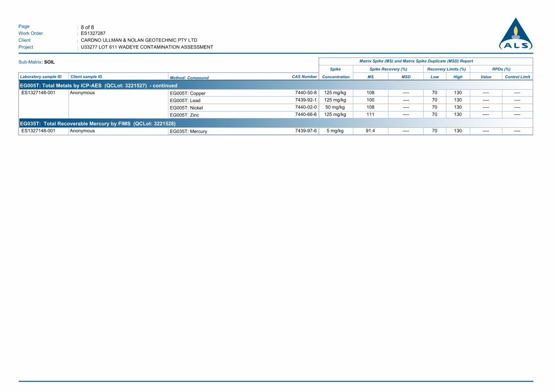
8 of 8:Page
Work Order :
:Client
ES1327287
CARDNO ULLMAN & NOLAN GEOTECHNIC PTY LTD
U33277 LOT 611 WADEYE CONTAMINATION ASSESSMENT:Project
Sub-Matrix: SOIL Matrix Spike (MS) and Matrix Spike Duplicate (MSD) Report
RPDs (%)Spike Recovery (%) Recovery Limits (%)Spike
Control LimitValueHighLowMSDMSConcentrationLaboratory sample ID Client sample ID Method: Compound CAS Number
EG005T: Total Metals by ICP-AES (QCLot: 3221527) - continued
AnonymousES1327148-001 7440-50-8EG005T: Copper --------108125 mg/kg 13070 ----
7439-92-1EG005T: Lead --------100125 mg/kg 13070 ----
7440-02-0EG005T: Nickel --------10850 mg/kg 13070 ----
7440-66-6EG005T: Zinc --------111125 mg/kg 13070 ----
EG035T: Total Recoverable Mercury by FIMS (QCLot: 3221528)
AnonymousES1327148-001 7439-97-6EG035T: Mercury --------91.45 mg/kg 13070 ----
LOT 611 WADEYE COMMUNITY
15 September 2014 Report No. 147663038-003-R-Rev0
APPENDIX C Auditor Correspondence
Ci – Golder Associates, Notice of Request to Issue a Certificate of Environmental Audit (Ref: 147663038-001-L-Rev0, dated 13 June 2014)
Cii – Golder Associates, Lot 611 Wadeye Community, Northern Territory – Auditor Comments on Final report on Stage One Environmental Site Assessment (Ref: 147663038-002-L-Rev0, dated 18 June 2014)
Ciii – Cardno Ullman & Nolan, Summary of Auditor Comments for Lot 611 Wadeye Community, NT – Final Report on Stage One Environmental Site Assessment, June 2014
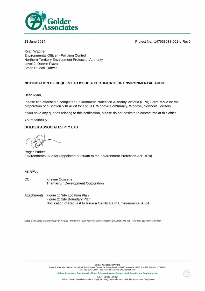
Golder Associates Pty Ltd
Level 2, Paspalis Centrepoint, 48-50 Smith Street, Darwin, Northern Territory 0800, Australia (GPO Box 379, Darwin, NT 0801) Tel: +61 8943 0689 Fax: +61 8 8941 0848 www.golder.com
Golder Associates: Operations in Africa, Asia, Australasia, Europe, North America and South America
A.B.N. 64 006 107 857 Golder, Golder Associates and the GA globe design are trademarks of Golder Associates Corporation.
Dear Ryan,
Please find attached a completed Environment Protection Authority Victoria (EPA) Form 759.2 for the preparation of a Section 53X Audit for Lot 611, Wadeye Community, Wadeye, Northern Territory.
If you have any queries relating to this notification, please do not hesitate to contact me at this office.
Yours faithfully
GOLDER ASSOCIATES PTY LTD
Roger Parker Environmental Auditor (appointed pursuant to the Environment Protection Act 1970) NB:RP/eo CC: Kirstine Cossens
Thamarrurr Development Corporation
Attachments: Figure 1: Site Location Plan
Figure 2: Site Boundary Plan Notification of Request to Issue a Certificate of Environmental Audit
\\ade1-s-file01\jobs-enviro\env\2014\147663038 - thamarrurr - audit wadeye nt\correspondence out\147663038-001-l-rev0 docx_epa notification.docx
13 June 2014 Project No. 147663038-001-L-Rev0
Ryan Wagner Environmental Officer - Pollution Control Northern Territory Environment Protection Authority Level 2, Darwin Plaza Smith St Mall, Darwin
NOTIFICATION OF REQUEST TO ISSUE A CERTIFICATE OF ENVIRONMENTAL AUDIT

Info
rmat
ion
co
ntai
ned
on
this
dra
win
g is
the
cop
yrig
ht
of G
old
er A
ssoc
iate
s P
ty. L
td.
Una
uth
oris
ed
use
or
repr
odu
ctio
n o
f th
is p
lan
eith
er w
hol
ly o
r in
par
t w
itho
ut w
ritte
n p
erm
issi
on
infr
inge
s co
pyr
igh
t.
© G
old
er A
ssoc
iate
s P
ty. L
td.
DA
LY R
IVE
R R
OA
D
555,000
555,000
555,500
555,500
556,000
556,000
556,500
556,500
557,000
557,000
557,500
557,500
558,000
558,000
8,42
4,0
00
8,42
4,0
00
8,42
4,5
00
8,42
4,5
00
8,42
5,0
00
8,42
5,0
00
8,42
5,5
00
8,42
5,5
00
8,42
6,0
00
8,42
6,0
00
8,42
6,5
00
8,42
6,5
00
SITE ENVIRONMENTAL AUDIT REPORT LOT 611, WADEYE COMMUNITY, WADEYE, NORTHERN TERRITORY
THAMARRURR DEVELOPMENT CORPORATION
SITE LOCATION PLAN
SCALE (at A4)DATUM GDA 94, PROJECTION MGA Zone 52
COPYRIGHTWorld_Imagery - Source: Esri, DigitalGlobe, GeoEye, i-cubed, USDA,USGS, AEX, Getmapping, Aerogrid, IGN, IGP, swisstopo, and the GIS User Community. Aerial image sourced from World Imagery,sourced 123.06.2014.
Township and road data sourced from MapInfo StreetPro.
FIGURE 1
!(
!(!(
!(
!(!(!(THE SITE
DARWIN
DALY RIVER
DUNDEE BEACH
BELYUEN
THAMARRURR
WADEYE
1:15,000
0 100 200 300 400 50050 metres
File Location: \\mel1-s-file01\Jobs\ ...mxd
±
147663038
NB
13 JUN 2014KB
LEGEND
Approximate Site Boundary
PROJECT:
CHECKED:
DATE:DRAWN:
THE SITE
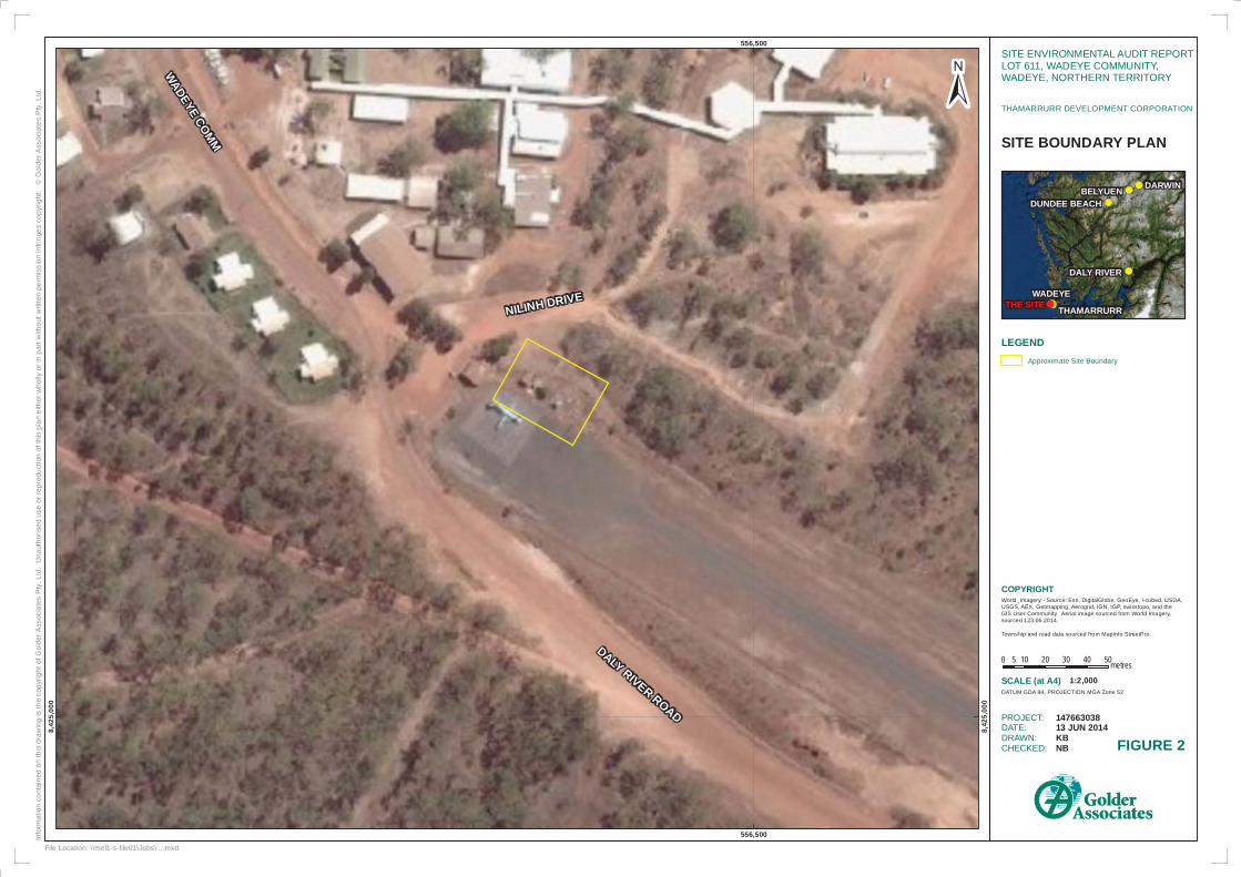
Info
rmat
ion
co
ntai
ned
on
this
dra
win
g is
the
cop
yrig
ht
of G
old
er A
ssoc
iate
s P
ty. L
td.
Una
uth
oris
ed
use
or
repr
odu
ctio
n o
f th
is p
lan
eith
er w
hol
ly o
r in
par
t w
itho
ut w
ritte
n p
erm
issi
on
infr
inge
s co
pyr
igh
t.
© G
old
er A
ssoc
iate
s P
ty. L
td.
DALY RIVER ROAD
NILINH DRIVE
WA
DE
YE CO
MM
556,500
556,500
8,42
5,0
00
8,42
5,0
00
SITE ENVIRONMENTAL AUDIT REPORT LOT 611, WADEYE COMMUNITY, WADEYE, NORTHERN TERRITORY
THAMARRURR DEVELOPMENT CORPORATION
SITE BOUNDARY PLAN
SCALE (at A4)DATUM GDA 94, PROJECTION MGA Zone 52
COPYRIGHTWorld_Imagery - Source: Esri, DigitalGlobe, GeoEye, i-cubed, USDA,USGS, AEX, Getmapping, Aerogrid, IGN, IGP, swisstopo, and the GIS User Community. Aerial image sourced from World Imagery,sourced 123.06.2014.
Township and road data sourced from MapInfo StreetPro.
FIGURE 2
!(
!(!(
!(
!(!(!(THE SITE
DARWIN
DALY RIVER
DUNDEE BEACH
BELYUEN
THAMARRURR
WADEYE
1:2,000
0 10 20 30 40 505 metres
File Location: \\mel1-s-file01\Jobs\ ...mxd
±
147663038
NB
13 JUN 2014KB
LEGEND
Approximate Site Boundary
PROJECT:
CHECKED:
DATE:DRAWN:
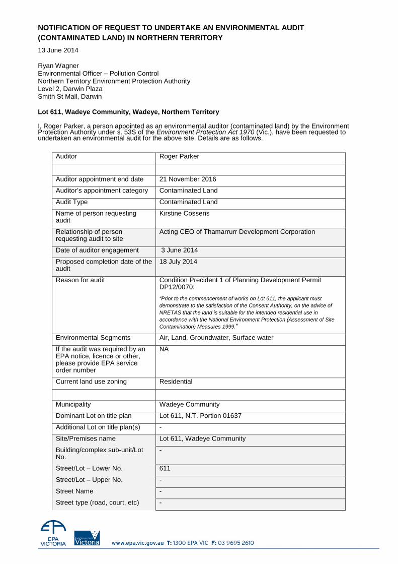
NOTIFICATION OF REQUEST TO UNDERTAKE AN ENVIRONMENTAL AUDIT (CONTAMINATED LAND) IN NORTHERN TERRITORY
13 June 2014 Ryan Wagner Environmental Officer – Pollution Control Northern Territory Environment Protection Authority Level 2, Darwin Plaza Smith St Mall, Darwin Lot 611, Wadeye Community, Wadeye, Northern Territory I, Roger Parker, a person appointed as an environmental auditor (contaminated land) by the Environment Protection Authority under s. 53S of the Environment Protection Act 1970 (Vic.), have been requested to undertaken an environmental audit for the above site. Details are as follows.
Auditor Roger Parker
Auditor appointment end date 21 November 2016
Auditor’s appointment category Contaminated Land
Audit Type Contaminated Land
Name of person requesting audit
Kirstine Cossens
Relationship of person requesting audit to site
Acting CEO of Thamarrurr Development Corporation
Date of auditor engagement 3 June 2014
Proposed completion date of the audit
18 July 2014
Reason for audit Condition Precident 1 of Planning Development Permit DP12/0070:
“Prior to the commencement of works on Lot 611, the applicant must demonstrate to the satisfaction of the Consent Authority, on the advice of NRETAS that the land is suitable for the intended residential use in accordance with the National Environment Protection (Assessment of Site Contamination) Measures 1999.”
Environmental Segments Air, Land, Groundwater, Surface water
If the audit was required by an EPA notice, licence or other, please provide EPA service order number
NA
Current land use zoning Residential
Municipality Wadeye Community
Dominant Lot on title plan Lot 611, N.T. Portion 01637
Additional Lot on title plan(s) -
Site/Premises name Lot 611, Wadeye Community
Building/complex sub-unit/Lot No.
-
Street/Lot – Lower No. 611
Street/Lot – Upper No. -
Street Name -
Street type (road, court, etc) -
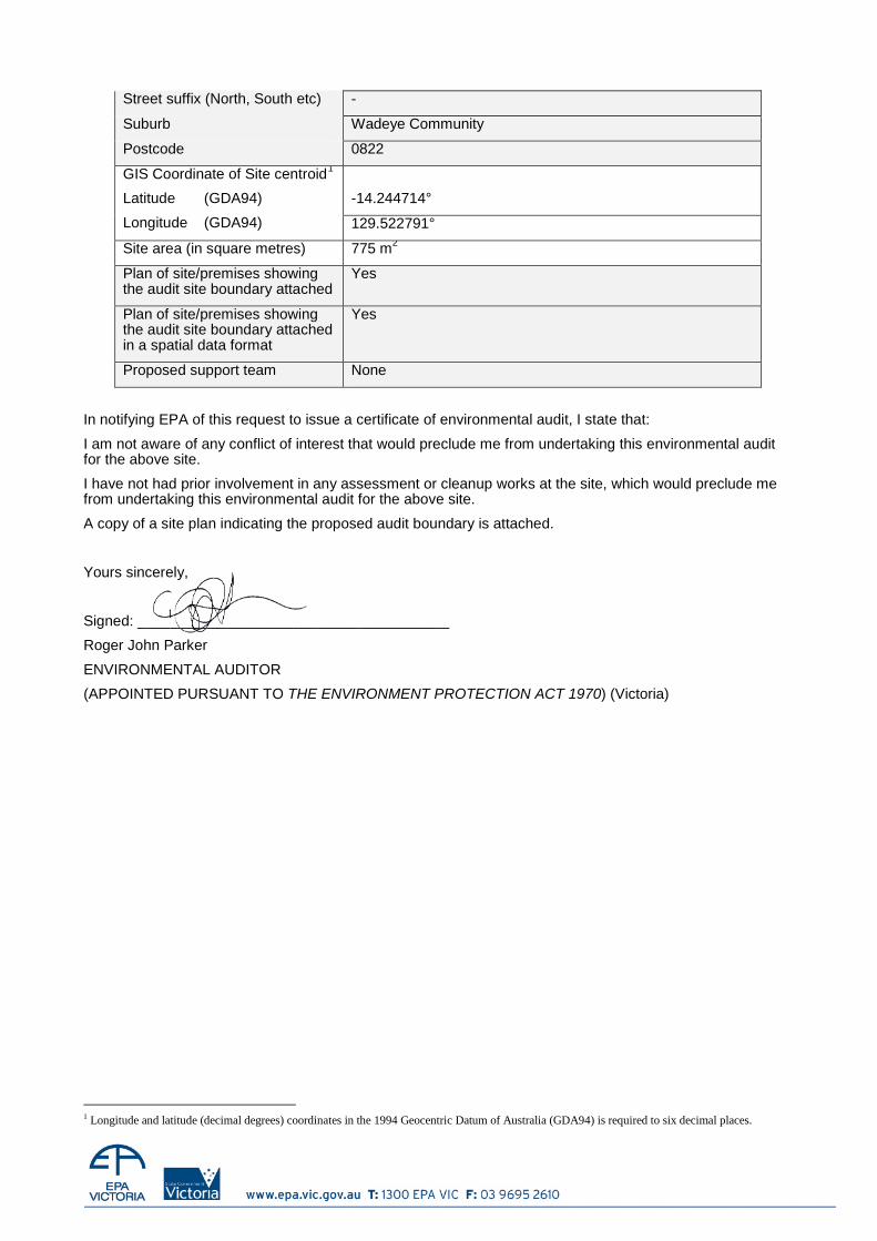
Street suffix (North, South etc) -
Suburb Wadeye Community
Postcode 0822
GIS Coordinate of Site centroid1
Latitude (GDA94)
Longitude (GDA94)
-14.244714°
129.522791°
Site area (in square metres) 775 m2
Plan of site/premises showing the audit site boundary attached
Yes
Plan of site/premises showing the audit site boundary attached in a spatial data format
Yes
Proposed support team None
In notifying EPA of this request to issue a certificate of environmental audit, I state that:
I am not aware of any conflict of interest that would preclude me from undertaking this environmental audit for the above site.
I have not had prior involvement in any assessment or cleanup works at the site, which would preclude me from undertaking this environmental audit for the above site.
A copy of a site plan indicating the proposed audit boundary is attached.
Yours sincerely,
Signed: ______________________________________
Roger John Parker
ENVIRONMENTAL AUDITOR
(APPOINTED PURSUANT TO THE ENVIRONMENT PROTECTION ACT 1970) (Victoria)
1 Longitude and latitude (decimal degrees) coordinates in the 1994 Geocentric Datum of Australia (GDA94) is required to six decimal places.
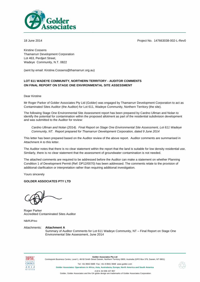
Golder Associates Pty Ltd
Centrepoint Business Centre, Level 1, 48-50 Smith Street Darwin, Northern Territory 0800, Australia (GPO Box 379, Darwin, NT 0801)
Tel: +61 8943 0689 Fax: +61 8 8941 0848 www.golder.com
Golder Associates: Operations in Africa, Asia, Australasia, Europe, North America and South America
A.B.N. 64 006 107 857 Golder, Golder Associates and the GA globe design are trademarks of Golder Associates Corporation.
Dear Kirstine
Mr Roger Parker of Golder Associates Pty Ltd (Golder) was engaged by Thamarrurr Development Corporation to act as Contaminated Sites Auditor (the Auditor) for Lot 611, Wadeye Community, Northern Territory (the site).
The following Stage One Environmental Site Assessment report has been prepared by Cardno Ullman and Nolan to identify the potential for contamination within the proposed allotment as part of the residential subdivision development and was submitted to the Auditor for review:
Cardno Ullman and Nolan (2014). Final Report on Stage One Environmental Site Assessment, Lot 611 Wadeye Community, NT. Report prepared for Thamarrurr Development Corporation, dated 9 June 2014
This letter has been prepared based on the Auditor review of the above report. Auditor comments are summarised in Attachment A to this letter.
The Auditor notes that there is no clear statement within the report that the land is suitable for low density residential use. Similarly, there is no clear statement that the assessment of groundwater contamination is not needed.
The attached comments are required to be addressed before the Auditor can make a statement on whether Planning Condition 1 of Development Permit (Ref: DP12/0070) has been addressed. The comments relate to the provision of additional clarification or interpretation rather than requiring additional investigation.
Yours sincerely
GOLDER ASSOCIATES PTY LTD
Roger Parker Accredited Contaminated Sites Auditor NB/RJP/eo Attachments: Attachment A
Summary of Auditor Comments for Lot 611 Wadeye Community, NT – Final Report on Stage One Environmental Site Assessment, June 2014
18 June 2014 Project No. 147663038-002-L-Rev0
Kirstine Cossens Thamarrurr Development Corporation Lot 463, Perdjert Street, Wadeye Community, N.T. 0822 (sent by email: [email protected])
LOT 611 WADEYE COMMUNITY, NORTHERN TERRITORY - AUDITOR COMMENTS
ON FINAL REPORT ON STAGE ONE ENVIRONMENTAL SITE ASSESSMENT
ATTACHMENT A Auditor Comments
17 June 2014 Reference No. 147663038-017-L-RevAA 1/4
Summary of Auditor Comments for Lot 611 Wadeye Community, NT – Final Report on Stage One Environmental Site Assessment, June 2014
Section Comments Questions Cardno
Resonse
General
There are a number of matters in the Cardno UNG Report that need further consideration. These could be addressed in a letter if it is not appropriate to update the report.
The Auditor notes the cover letter attached to the report explaining the context of the report. Neither this letter nor the main report reach a conclusion on the suitability of the land for the proposed low density residential use.
Can Cardno UNG make a clear statement about the suitability of the site for the proposed residential use (or need for further investigation is they consider that to be the case)?
There is no mention of field screening of soil samples using a photo-ionisation detector (PID) anywhere in the report.
Was a PID used in the investigation?
Section 1.1 It is noted that “the primary objective of this Stage One ESA is to identify the potential for contamination within the proposed allotment as part of the residential subdivision development”
Is the objective also to consider if further investigation is needed or if not, the site is suitable for the proposed low density residential use?
Section 1.2
Cardno UNG states “It is the reader’s responsibility to verify the correct interpretation and intention of the recommendations presented herein”. No recommendations are provided. However, a recommendation on suitability of land use or recommendation for further investigation should be provided.
Section 2.1 Why is reference made to National Environment Protection Council (NEPC),1999
and Draft 2010 Variation? Not relevant to any works current or past.
Section 2.2
Cardno UNG states “Given, the intended land use is a residential property and the areas under study were previously occupied by an operational airstrip, the soil results have not been compared to ESLs or EILs”. The Auditor considers ecological receptors should always be considered for residential development. The Auditor notes that various EILs have been included in tables at the back of the Cardno UNG report.
Section 3 Why is the Data Quality Objective (DQO) approach “preliminary”? Is Cardno UNG
expecting to make some change to this?
Table 3.1
The following statement is made in Table 3.1. “A Stage 1 ESA with preliminary soil sampling is required to identify human and ecological health risks associated with potential onsite contamination relative to proposed land use, and particularly notifiable EMR activity. The ESA will be limited to the investigation of relevant media (either: soil; groundwater; air; and noise etc.) based on desktop study information”.
Ecological risk is clearly identified in this table. Why is it excluded elsewhere in the document? Why is there mention of Environmental Management Register (EMR) notifiable activity? Why is noise relevant to the assessment?
Table 3.1 states that “comprehensive historical data, site information and chemical soil data is required to determine health risks for onsite and offsite receptors.”
Can Cardno UNG make a clear statement about the contamination status of the site in terms of both onsite and offsite receptors?
The following statement is made in Table 3.1. “The investigation has been designed in a manner to best satisfy project requirements, timeframes, budgets and data quality”.
Is Cardno UNG satisfied that the assessment is not constrained in any way and that a clear statement on suitability of the land for low density residential use can be provided?
Section 4.2
In relation to ASS, the following is stated “This means that construction within this area is only considered to be within the Acid Sulfate Soils Special Management Zone if there are excavations below 5m AHD”. Similar inference made in following paragraph.
Can Cardno UNG clarify this statement as it is likely to be a mis-interpretation of ASS guidance?
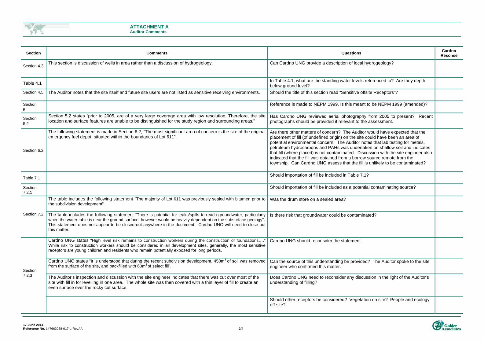
ATTACHMENT A Auditor Comments
17 June 2014 Reference No. 147663038-017-L-RevAA 2/4
Section Comments Questions Cardno
Resonse
Section 4.3
This section is discussion of wells in area rather than a discussion of hydrogeology.
Can Cardno UNG provide a description of local hydrogeology?
Table 4.1 In Table 4.1, what are the standing water levels referenced to? Are they depth
below ground level?
Section 4.5
The Auditor notes that the site itself and future site users are not listed as sensitive receiving environments. Should the title of this section read “Sensitive offsite Receptors”?
Section 5
Reference is made to NEPM 1999. Is this meant to be NEPM 1999 (amended)?
Section 5.2
Section 5.2 states “prior to 2005, are of a very large coverage area with low resolution. Therefore, the site location and surface features are unable to be distinguished for the study region and surrounding areas.”
Has Cardno UNG reviewed aerial photography from 2005 to present? Recent photographs should be provided if relevant to the assessment.
Section 6.2
The following statement is made in Section 6.2, “The most significant area of concern is the site of the original emergency fuel depot, situated within the boundaries of Lot 611”.
Are there other matters of concern? The Auditor would have expected that the placement of fill (of undefined origin) on the site could have been an area of potential environmental concern. The Auditor notes that lab testing for metals, petroleum hydrocarbons and PAHs was undertaken on shallow soil and indicates that fill (where placed) is not contaminated. Discussion with the site engineer also indicated that the fill was obtained from a borrow source remote from the township. Can Cardno UNG assess that the fill is unlikely to be contaminated?
Table 7.1 Should importation of fill be included in Table 7.1?
Section 7.2.1
Should importation of fill be included as a potential contaminating source?
Section 7.2
The table includes the following statement “The majority of Lot 611 was previously sealed with bitumen prior to the subdivision development”.
Was the drum store on a sealed area?
The table includes the following statement “There is potential for leaks/spills to reach groundwater, particularly when the water table is near the ground surface, however would be heavily dependent on the subsurface geology”. This statement does not appear to be closed out anywhere in the document. Cardno UNG will need to close out this matter.
Is there risk that groundwater could be contaminated?
Section 7.2.3
Cardno UNG states “High level risk remains to construction workers during the construction of foundations….” While risk to construction workers should be considered in all development sites, generally, the most sensitive receptors are young children and residents who remain potentially exposed for long periods.
Cardno UNG should reconsider the statement.
Cardno UNG states “It is understood that during the recent subdivision development, 450m3 of soil was removed
from the surface of the site, and backfilled with 60m3 of select fill”.
Can the source of this understanding be provided? The Auditor spoke to the site engineer who confirmed this matter.
The Auditor’s inspection and discussion with the site engineer indicates that there was cut over most of the site with fill in for levelling in one area. The whole site was then covered with a thin layer of fill to create an even surface over the rocky cut surface.
Does Cardno UNG need to reconsider any discussion in the light of the Auditor’s understanding of filling?
Should other receptors be considered? Vegetation on site? People and ecology off site?
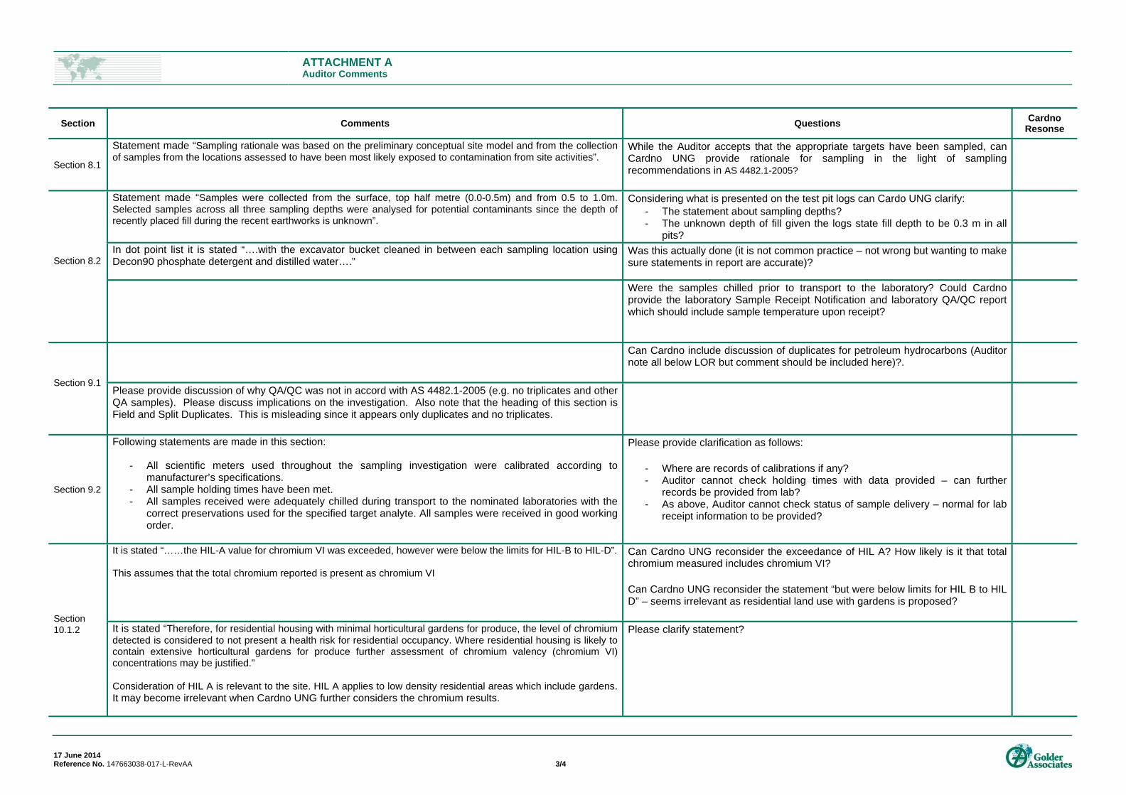
ATTACHMENT A Auditor Comments
17 June 2014 Reference No. 147663038-017-L-RevAA 3/4
Section Comments Questions Cardno
Resonse
Section 8.1
Statement made “Sampling rationale was based on the preliminary conceptual site model and from the collection of samples from the locations assessed to have been most likely exposed to contamination from site activities”.
While the Auditor accepts that the appropriate targets have been sampled, can Cardno UNG provide rationale for sampling in the light of sampling recommendations in AS 4482.1-2005?
Section 8.2
Statement made “Samples were collected from the surface, top half metre (0.0-0.5m) and from 0.5 to 1.0m. Selected samples across all three sampling depths were analysed for potential contaminants since the depth of recently placed fill during the recent earthworks is unknown”.
Considering what is presented on the test pit logs can Cardo UNG clarify: - The statement about sampling depths? - The unknown depth of fill given the logs state fill depth to be 0.3 m in all
pits?
In dot point list it is stated “….with the excavator bucket cleaned in between each sampling location using Decon90 phosphate detergent and distilled water….”
Was this actually done (it is not common practice – not wrong but wanting to make sure statements in report are accurate)?
Were the samples chilled prior to transport to the laboratory? Could Cardno provide the laboratory Sample Receipt Notification and laboratory QA/QC report which should include sample temperature upon receipt?
Section 9.1
Can Cardno include discussion of duplicates for petroleum hydrocarbons (Auditor note all below LOR but comment should be included here)?.
Please provide discussion of why QA/QC was not in accord with AS 4482.1-2005 (e.g. no triplicates and other QA samples). Please discuss implications on the investigation. Also note that the heading of this section is Field and Split Duplicates. This is misleading since it appears only duplicates and no triplicates.
Section 9.2
Following statements are made in this section:
- All scientific meters used throughout the sampling investigation were calibrated according to manufacturer’s specifications.
- All sample holding times have been met. - All samples received were adequately chilled during transport to the nominated laboratories with the
correct preservations used for the specified target analyte. All samples were received in good working order.
Please provide clarification as follows:
- Where are records of calibrations if any? - Auditor cannot check holding times with data provided – can further
records be provided from lab? - As above, Auditor cannot check status of sample delivery – normal for lab
receipt information to be provided?
Section 10.1.2
It is stated “……the HIL-A value for chromium VI was exceeded, however were below the limits for HIL-B to HIL-D”. This assumes that the total chromium reported is present as chromium VI
Can Cardno UNG reconsider the exceedance of HIL A? How likely is it that total chromium measured includes chromium VI? Can Cardno UNG reconsider the statement “but were below limits for HIL B to HIL D” – seems irrelevant as residential land use with gardens is proposed?
It is stated “Therefore, for residential housing with minimal horticultural gardens for produce, the level of chromium detected is considered to not present a health risk for residential occupancy. Where residential housing is likely to contain extensive horticultural gardens for produce further assessment of chromium valency (chromium VI) concentrations may be justified.” Consideration of HIL A is relevant to the site. HIL A applies to low density residential areas which include gardens. It may become irrelevant when Cardno UNG further considers the chromium results.
Please clarify statement?
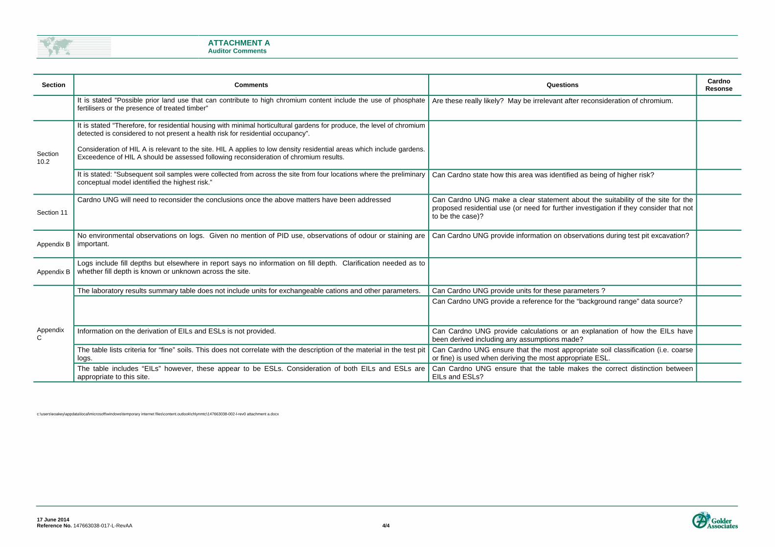
ATTACHMENT A Auditor Comments
17 June 2014 Reference No. 147663038-017-L-RevAA 4/4
Section Comments Questions Cardno
Resonse
It is stated “Possible prior land use that can contribute to high chromium content include the use of phosphate fertilisers or the presence of treated timber”
Are these really likely? May be irrelevant after reconsideration of chromium.
Section 10.2
It is stated “Therefore, for residential housing with minimal horticultural gardens for produce, the level of chromium detected is considered to not present a health risk for residential occupancy”. Consideration of HIL A is relevant to the site. HIL A applies to low density residential areas which include gardens. Exceedence of HIL A should be assessed following reconsideration of chromium results.
It is stated: “Subsequent soil samples were collected from across the site from four locations where the preliminary conceptual model identified the highest risk.”
Can Cardno state how this area was identified as being of higher risk?
Section 11
Cardno UNG will need to reconsider the conclusions once the above matters have been addressed
Can Cardno UNG make a clear statement about the suitability of the site for the proposed residential use (or need for further investigation if they consider that not to be the case)?
Appendix B No environmental observations on logs. Given no mention of PID use, observations of odour or staining are important.
Can Cardno UNG provide information on observations during test pit excavation?
Appendix B Logs include fill depths but elsewhere in report says no information on fill depth. Clarification needed as to whether fill depth is known or unknown across the site.
Appendix C
The laboratory results summary table does not include units for exchangeable cations and other parameters. Can Cardno UNG provide units for these parameters ?
Can Cardno UNG provide a reference for the “background range” data source?
Information on the derivation of EILs and ESLs is not provided. Can Cardno UNG provide calculations or an explanation of how the EILs have been derived including any assumptions made?
The table lists criteria for “fine” soils. This does not correlate with the description of the material in the test pit logs.
Can Cardno UNG ensure that the most appropriate soil classification (i.e. coarse or fine) is used when deriving the most appropriate ESL.
The table includes “EILs” however, these appear to be ESLs. Consideration of both EILs and ESLs are appropriate to this site.
Can Cardno UNG ensure that the table makes the correct distinction between EILs and ESLs?
c:\users\eoakey\appdata\local\microsoft\windows\temporary internet files\content.outlook\chlynmtc\147663038-002-l-rev0 attachment a.docx
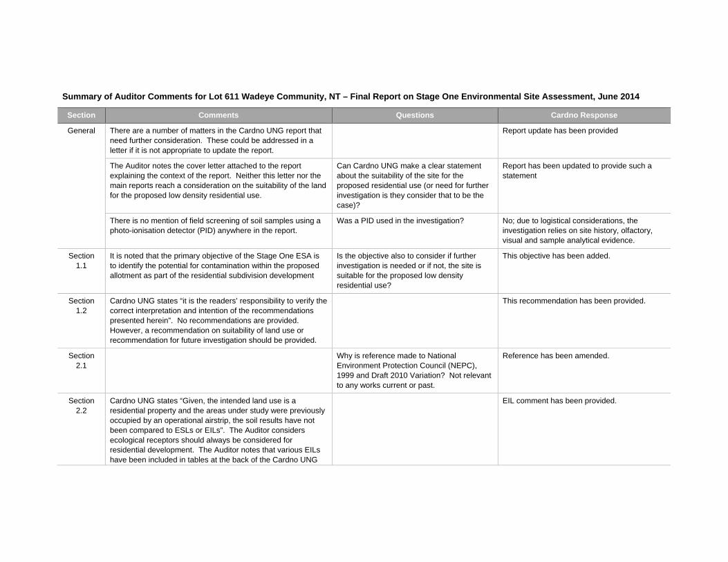
Summary of Auditor Comments for Lot 611 Wadeye Community, NT – Final Report on Stage One Environmental Site Assessment, June 2014
Section Comments Questions Cardno Response
General There are a number of matters in the Cardno UNG report that need further consideration. These could be addressed in a letter if it is not appropriate to update the report.
Report update has been provided
The Auditor notes the cover letter attached to the report explaining the context of the report. Neither this letter nor the main reports reach a consideration on the suitability of the land for the proposed low density residential use.
Can Cardno UNG make a clear statement about the suitability of the site for the proposed residential use (or need for further investigation is they consider that to be the case)?
Report has been updated to provide such a statement
There is no mention of field screening of soil samples using a photo-ionisation detector (PID) anywhere in the report.
Was a PID used in the investigation? No; due to logistical considerations, the investigation relies on site history, olfactory, visual and sample analytical evidence.
Section 1.1
It is noted that the primary objective of the Stage One ESA is to identify the potential for contamination within the proposed allotment as part of the residential subdivision development
Is the objective also to consider if further investigation is needed or if not, the site is suitable for the proposed low density residential use?
This objective has been added.
Section 1.2
Cardno UNG states “it is the readers’ responsibility to verify the correct interpretation and intention of the recommendations presented herein”. No recommendations are provided. However, a recommendation on suitability of land use or recommendation for future investigation should be provided.
This recommendation has been provided.
Section 2.1
Why is reference made to National Environment Protection Council (NEPC), 1999 and Draft 2010 Variation? Not relevant to any works current or past.
Reference has been amended.
Section 2.2
Cardno UNG states “Given, the intended land use is a residential property and the areas under study were previously occupied by an operational airstrip, the soil results have not been compared to ESLs or EILs”. The Auditor considers ecological receptors should always be considered for residential development. The Auditor notes that various EILs have been included in tables at the back of the Cardno UNG
EIL comment has been provided.

Section Comments Questions Cardno Response
report.
Section 3 Why is the Data Quality Objective (DQO) approach “preliminary”? Is Cardno UNG expecting to make some change to this?
Wording has been amended. DQO approach is integral to investigative process.
Table 3.1 The following statement is made in Table 3.1 “A Stage 1 ESA with preliminary soil sampling is required to identify human and ecological health rieks associated with potential onsite contamination relative to proposed land use, and particularly notifiable EMR activity. The ESA will be limited to the investigation of relevant media (either, soil, groundwater, air and noise etc) base on desktop study information”.
Ecological risk is clearly identified in this table. Why is it excluded elsewhere in the document?
Why is there mention of Environmental Management Register (EMR) notifiable activity?
Why is noise relevant to the assessment?
Ecological risks are now considered.
Table has been amended.
Reference to noise issues has been removed.
Table 3.1 states that “comprehensive historical data, site information and chemical soil data is required to determine health risks for onsite and offsite receptors?
Can Cardno UNG make a clear statement about eh contamination status of the site in terms of both onsite and offsite receptors?
Report has been clarified in this regard.
The following statement is made in Table 3.1 “The investigation has been designed in a manner to best satisfy project requirements, timeframes, budgets and data quality”.
Is Cardno UNG satisfied that the assessment is not constrained in any way and that a clear statement on suitability of the land for low density residential use can be provided?
Budget is often a constraint/consideration yet is not deemed to impact on the integrity of the current study.
Section 4.2
In relation to ASS, the following is stated “This means the construction within this area is only considered to be within the Acid Sulfate Soils Special Management Zone if there are excavations below 5m AHD”. Similar inference mad in following paragraph.
Can Cardno UNG clarify this statement as it is likely to be a mis-interpretation of ASS guidance?
Location of ASS Special Management Zone is not considered particularly relevant to the investigation; therefore this statement has been removed.
Section 4.3
This section if discussion of wells in area rather than a discussion of hydrogeology.
Can Cardno UNG provide a description of local hydrogeology?
The specified hydrogeology is now deemed adequate to meet the requirement of NEPM 2013 and AS4482 for a site of this nature and complexity.
Table 4.1 In Table 4.1 what are the standing water levels referenced to? Are they depth below ground level?
Mbtc (meters below top of casing)
Section 4.5
The Auditor notes that the site itself and future site users are not listed as sensitive receiving environments.
Should the title of this section read “Sensitive offsite Receptors?
This section has been renamed and amended.
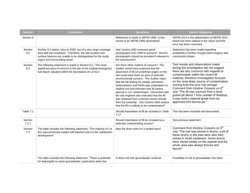
Section Comments Questions Cardno Response
Section 5 Reference is made to NEPM 1999. Is this meant to be NEPM 1999 (amended)?
NEPM 2013 is the abbreviation of NEPM 2013 which has been utilised in the report and this error has been corrected.
Section 5.2
Section 5.2 states “prior to 2005, are of a very large coverage area with low resolution. Therefore, the site location and surface features are unable to be distinguished for the study region and surrounding areas”.
Has Cardno UNG reviewed aerial photography from 2005 to present? Recent photographs should be provided if relevant to the assessment?
Statement has been made regarding availability of further Google earth imagery and conclusions drawn.
Section 6.2
The following statement is made in Section 6.2, “The most significant area of concern is the site of the original emergency fuel depot, situated within the boundaries of Lot 611”.
Are there other matters of concern? The Auditor would have expected that the placement of fill (of undefined origin) on the site could have been an area of potential environmental concern. The Auditor notes that the lab testing for metals, petroleum hydorcarbons and PAHs was undertaken on shallow soil and indicates that fill (where placed) is not contaminated. Discussion with the site engineer also indicated that the fill was obtained from a borrow source remote from the township. Can Cardno UNG assess that the fill is unlikely to be contaminated?
Test results and observations made during the investigation did not suggest there are any concerns with regards to contamination within the recent fill material, therefore investigation focused on the most likely source of contamination coming from the prior fuel storage Comment from Kirstine Cossens on 6th July “The fill was sourced from a local gravel pit about 7 kms outside of Wadeye, it was select material grade from an approved DOI borrow pit.”
Table 7.1 Should importation of fill be included in Table 7.1?
This has been included and discounted.
Section 7.2.1
Should importation of fill be included as a potential contaminating source?
See previous statement
Section 7.2
The table includes the following statement, “The majority of Lot 611 was previously sealed with bitumen prior to the subdivision development”.
Was the drum store on a sealed area? Comment from Kirstine Cossens on 6th July “The fuel was stored in drums, a lot of these drums in the past were also then stored in small containers. Some drums were stored simply on the asphalt and the whole area was always fenced and secure”
The table includes the following statement, “There is potential for leaks/spills to reach groundwater, particularly when the
Is there risk that groundwater could be Possibility of risk to groundwater has been
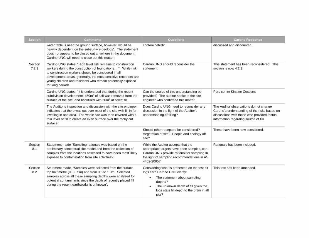
Section Comments Questions Cardno Response
water table is near the ground surface, however, would be heavily dependent on the subsurface geology”. The statement does not appear to be closed out anywhere in the document. Cardno UNG will need to close out this matter.
contaminated? discussed and discounted.
Section 7.2.3
Cardno UNG states, “High level risk remains to construction workers during the construction of foundations….”. While risk to construction workers should be considered in all development areas, generally, the most sensitive receptors are young children and residents who remain potentially exposed for long periods.
Cardno UNG should reconsider the statement.
This statement has been reconsidered. This section is now 4.2.3
Cardno UNG states, “It is understood that during the recent subdivision development, 450m3 of soil was removed from the surface of the site, and backfilled with 60m3 of select fill.
Can the source of this understanding be provided? The auditor spoke to the site engineer who confirmed this matter.
Pers comm Kirstine Cossens
The Auditor’s inspection and discussion with the site engineer indicates that there was cut over most of the site with fill in for levelling in one area. The whole site was then covered with a thin layer of fill to create an even surface over the rocky cut surface.
Does Cardno UNG need to reconsider any discussion in the light of the Auditor’s understanding of filling?
The Auditor observations do not change Cardno’s understanding of the risks based on discussions with those who provided factual information regarding source of fill/
Should other receptors be considered? Vegetation of site? People and ecology off site?
These have been now considered.
Section 8.1
Statement made “Sampling rationale was based on the preliminary conceptual site model and from the collection of samples from the locations assessed to have been most likely exposed to contamination from site activities?
While the Auditor accepts that the appropriate targets have been samples, can Cardno UNG provide rational for sampling in the light of sampling recommendations in AS 4462-2005?
Rationale has been included.
Section 8.2
Statement made, “Samples were collected from the surface, top half metre (0.0-0.5m) and from 0.5 to 1.0m. Selected samples across all these sampling depths were analysed for potential contaminants since the depth of recently placed fill during the recent earthworks is unknown”.
Considering what is presented on the test pit logs carn Cardno UNG clarify:
The statement about sampling depths?
The unknown depth of fill given the logs state fill depth to the 0.3m in all pits?
This text has been amended.
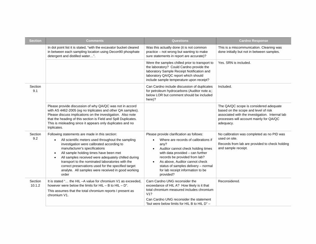
Section Comments Questions Cardno Response
In dot point list it is stated, “with the excavator bucket cleared in between each sampling location using Decon90 phosphate detergent and distilled water…”.
Was this actually done (it is not common practice – not wrong but wanting to make sure statements in report are accurate)?
This is a miscommunication. Cleaning was done initially but not in between samples.
Were the samples chilled prior to transport to the laboratory? Could Cardno provide the laboratory Sample Receipt Notification and laboratory QA/QC report which should include sample temperature upon receipt?
Yes. SRN is included.
Section 9.1
Can Cardno include discussion of duplicates for petroleum hydrocarbons (Auditor note a;; below LOR but comment should be included here)?
Included.
Please provide discussion of why QA/QC was not in accord with AS 4462-2005 (eg no triplicates and other QA samples). Please discuss implications on the investigation. Also note that the heading of this section is Field and Spill Duplicates. This is misleading since it appears only duplicates and no triplicates.
The QA/QC scope is considered adequate based on the scope and level of risk associated with the investigation. Internal lab processes will account mainly for QA/QC adequacy.
Section 9.2
Following statements are made in this section:
All scientific meters used throughout the sampling investigation were calibrated according to manufacturer’s specifications
All sample holding times have been met All samples received were adequately chilled during
transport to the nominated laboratories with the correct preservations used for the specified target analyte. All samples were received in good working order
Please provide clarification as follows:
Where are records of calibrations if any?
Auditor cannot check holding times with data provided – can further records be provided from lab?
As above, Auditor cannot check status of samples delivery – normal for lab receipt information to be provided?
No calibration was completed as no PID was used on site.
Records from lab are provided to check holding and sample receipt.
Section 10.1.2
It is stated “… the HIL –A value for chromium V1 as exceeded, however were below the limits for HIL – B to HIL – D”.
This assumes that the total chromium reports I present as chromium V1.
Carn Cardno UNG reconsider the exceedance of HIL A? How likely is it that total chromium measured includes chromium V1?
Can Cardno UNG reconsider the statement “but were below limits for HIL B to HIL D” –
Reconsidered.
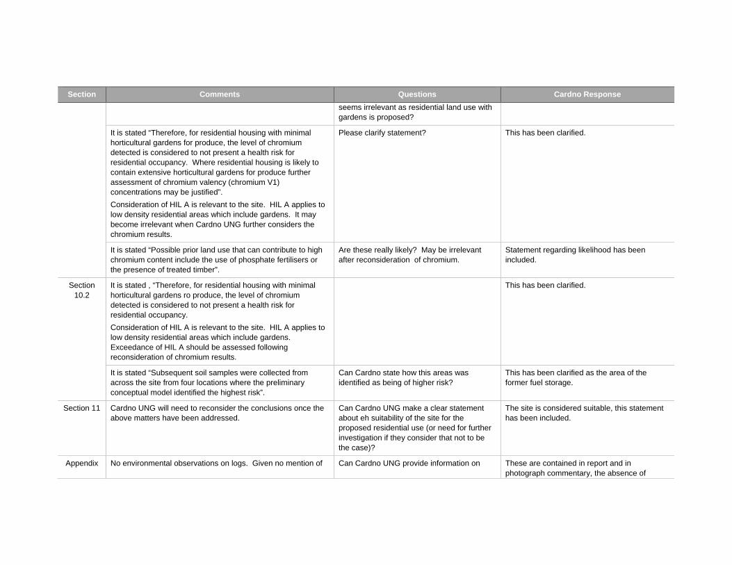
Section Comments Questions Cardno Response
seems irrelevant as residential land use with gardens is proposed?
It is stated “Therefore, for residential housing with minimal horticultural gardens for produce, the level of chromium detected is considered to not present a health risk for residential occupancy. Where residential housing is likely to contain extensive horticultural gardens for produce further assessment of chromium valency (chromium V1) concentrations may be justified”.
Consideration of HIL A is relevant to the site. HIL A applies to low density residential areas which include gardens. It may become irrelevant when Cardno UNG further considers the chromium results.
Please clarify statement? This has been clarified.
It is stated “Possible prior land use that can contribute to high chromium content include the use of phosphate fertilisers or the presence of treated timber”.
Are these really likely? May be irrelevant after reconsideration of chromium.
Statement regarding likelihood has been included.
Section 10.2
It is stated , “Therefore, for residential housing with minimal horticultural gardens ro produce, the level of chromium detected is considered to not present a health risk for residential occupancy.
Consideration of HIL A is relevant to the site. HIL A applies to low density residential areas which include gardens. Exceedance of HIL A should be assessed following reconsideration of chromium results.
This has been clarified.
It is stated “Subsequent soil samples were collected from across the site from four locations where the preliminary conceptual model identified the highest risk”.
Can Cardno state how this areas was identified as being of higher risk?
This has been clarified as the area of the former fuel storage.
Section 11 Cardno UNG will need to reconsider the conclusions once the above matters have been addressed.
Can Cardno UNG make a clear statement about eh suitability of the site for the proposed residential use (or need for further investigation if they consider that not to be the case)?
The site is considered suitable, this statement has been included.
Appendix No environmental observations on logs. Given no mention of Can Cardno UNG provide information on These are contained in report and in photograph commentary, the absence of
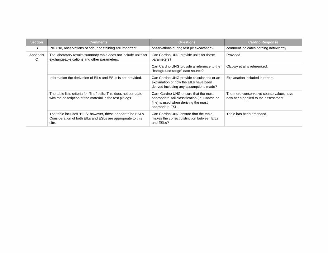
Section Comments Questions Cardno Response
B PID use, observations of odour or staining are important. observations during test pit excavation? comment indicates nothing noteworthy
Appendix C
The laboratory results summary table does not include units for exchangeable cations and other parameters.
Can Cardno UNG provide units for these parameters?
Provided.
Can Cardno UNG provide a reference to the “background range” data source?
Olzowy et al is referenced.
Information the derivation of EILs and ESLs is not provided. Can Cardno UNG provide calculations or an explanation of how the EILs have been derived including any assumptions made?
Explanation included in report.
The table lists criteria for “fine” soils. This does not correlate with the description of the material in the test pit logs.
Carn Cardno UNG ensure that the most appropriate soil classification (ie. Coarse or fine) is used when deriving the most appropriate ESL.
The more conservative coarse values have now been applied to the assessment.
The table includes “EILS” however, these appear to be ESLs. Consideration of both EILs and ESLs are appropriate to this site.
Can Cardno UNG ensure that the table makes the correct distinction between EILs and ESLs?
Table has been amended,
LOT 611 WADEYE COMMUNITY
15 September 2014 Report No. 147663038-003-R-Rev0
APPENDIX D Limitations
LIMITATIONS
This Document has been provided by Golder Associates Pty Ltd (“Golder”) subject to the following limitations: This Document has been prepared for the particular purpose outlined in Golder’s proposal and no responsibility is accepted for the use of this Document, in whole or in part, in other contexts or for any other purpose. The scope and the period of Golder’s Services are as described in Golder’s proposal, and are subject to restrictions and limitations. Golder did not perform a complete assessment of all possible conditions or circumstances that may exist at the site referenced in the Document. If a service is not expressly indicated, do not assume it has been provided. If a matter is not addressed, do not assume that any determination has been made by Golder in regards to it. Conditions may exist which were undetectable given the limited nature of the enquiry Golder was retained to undertake with respect to the site. Variations in conditions may occur between investigatory locations, and there may be special conditions pertaining to the site which have not been revealed by the investigation and which have not therefore been taken into account in the Document. Accordingly, additional studies and actions may be required. In addition, it is recognised that the passage of time affects the information and assessment provided in this Document. Golder’s opinions are based upon information that existed at the time of the production of the Document. It is understood that the Services provided allowed Golder to form no more than an opinion of the actual conditions of the site at the time the site was visited and cannot be used to assess the effect of any subsequent changes in the quality of the site, or its surroundings, or any laws or regulations. Any assessments made in this Document are based on the conditions indicated from published sources and the investigation described. No warranty is included, either express or implied, that the actual conditions will conform exactly to the assessments contained in this Document. Where data supplied by the client or other external sources, including previous site investigation data, have been used, it has been assumed that the information is correct unless otherwise stated. No responsibility is accepted by Golder for incomplete or inaccurate data supplied by others. Golder may have retained subconsultants affiliated with Golder to provide Services for the benefit of Golder. To the maximum extent allowed by law, the Client acknowledges and agrees it will not have any direct legal recourse to, and waives any claim, demand, or cause of action against, Golder’s affiliated companies, and their employees, officers and directors. This Document is provided for sole use by the Client and is confidential to it and its professional advisers. No responsibility whatsoever for the contents of this Document will be accepted to any person other than the Client. Any use which a third party makes of this Document, or any reliance on or decisions to be made based on it, is the responsibility of such third parties. Golder accepts no responsibility for damages, if any, suffered by any third party as a result of decisions made or actions based on this Document.
GOLDER ASSOCIATES PTY LTD GAP Form No. LEG 04 RL 1
Golder Associates Pty Ltd
Centrepoint Business Centre, Level 1, 48-50 Smith Street
Darwin, Northern Territory 0800
Australia
T: +61 8943 0689
Related Documents