Sunrise Powerlink Transmission Project Mitigation Monitoring, Compliance, and Reporting Program California Public Utilities Commission and Bureau of Land Management U.S. Department of Interior November 2009 Attachment A Project Segments Map

Welcome message from author
This document is posted to help you gain knowledge. Please leave a comment to let me know what you think about it! Share it to your friends and learn new things together.
Transcript
Sunrise Powerlink Transmission Project Mitigation Monitoring, Compliance, and Reporting Program
California Public Utilities Commission and
Bureau of Land Management U.S. Department of Interior
November 2009
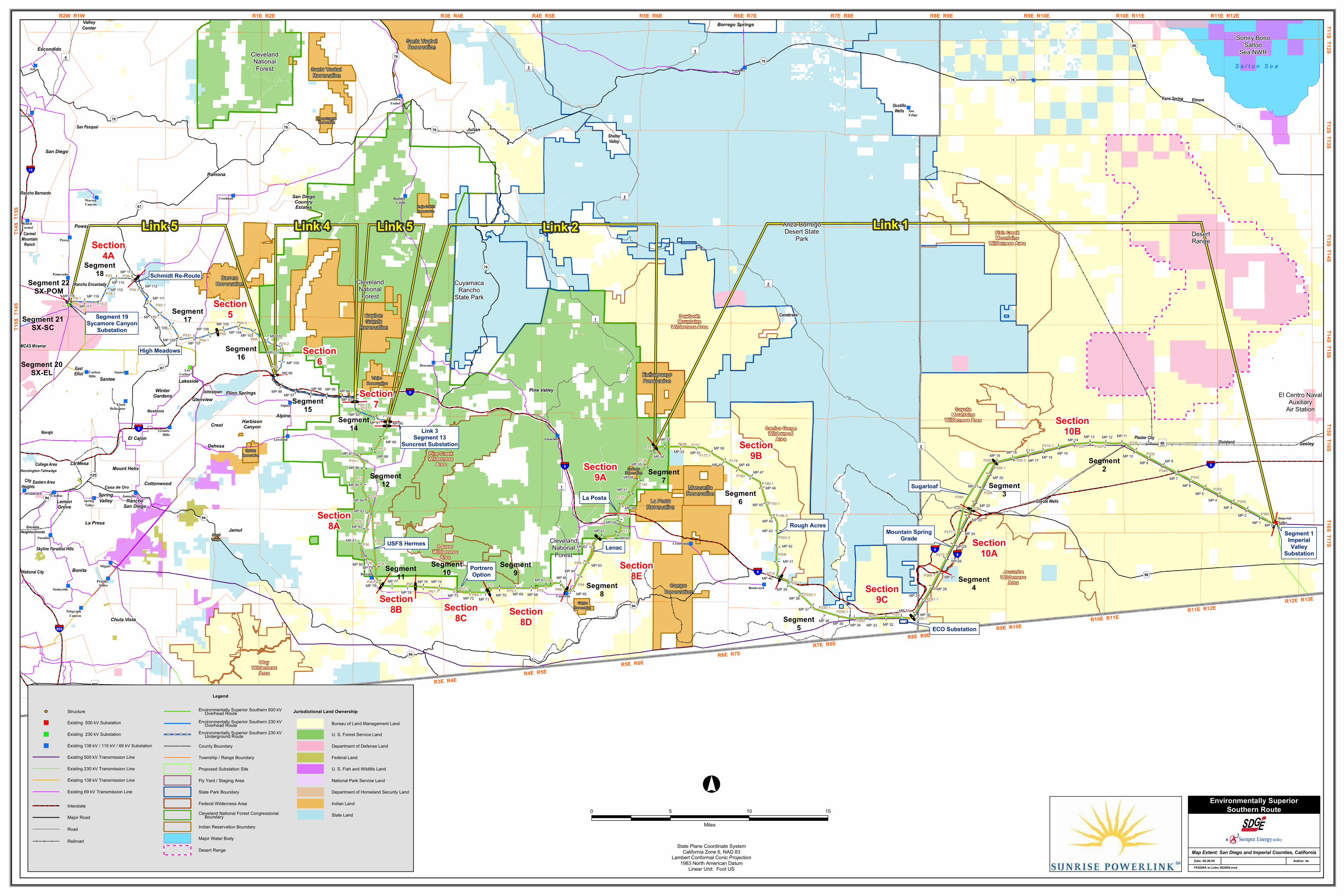
Attachment A Project Segments Map
") ")
")")
")
")
")")
")
")
")
")")
") ")")
") ")
")
")")
")
")
")")
")")
")
")
")
")
")
")
")
")
") ")
")
")
")
")
")
!(!(!(
!( !( !( !(!(!( !( !( !(!(
!(
!(
!(
!(
!(
!(!(
!( !( !(!( !( !( !(
!(
!(
!(
!(
!(!(
!(
!(
!(!(
!(!(!(!( !( !( !(!( !(!(
!(!(
!(!(!( !( !(
!(!(
!(!( !(
!(
!(
!(
!(!( !(!(
!(!(
!(
!(
!(!(
!(
!(
!(
!(!(
!(!(!(
!(!(
!(
!(
!(!(
!(!(
!(!( !(!(!(
!(!(
!(!(
!(
!(
!(
!(
!(
!(!(!(
!(
!(!(
!(
!(
!(
!(
!(
!(
!(!(!(
!(
!(
!(
!(
!(
!(
!(
!(
!(
!(
!(
!(!(
!(
!(
!(
!(!(
!(
!(!( !( !( !( !( !( !( !( !( !( !( !(
!( !( !(!( !( !( !( !( !(
!(!( !( !( !( !( !( !( !( !( !( !( !(
!( !( !( !(
!(!( !(!(
!(
!( !( !(
!(!(
!(
!(
!(
!(
!(
!(
!(
!(
!(
!(
!(
!(
!(
!( !( !( !( !(!(
!(
!(
!(
!(
!(
!(
!(
!(
!(
!(!(
!(
!(
!(
!(
!(
!(
!(
!(
!(
!(
!(
!(
!(
!(
!(
!( !( !( !( !( !( !( !( !( !( !( !( !(!(
!(!(
!(!(
!(!(
!(
!(!(
!(!(
!(
!(!(
!(!(
!(
!(
!(
!(
!(
!(
!(
!(
!(!(
!(
!(
!(
!(
!(
!(
!(
!(
!(
!(
!(
!(
!(
!(
!(
!(
!(!(
!(!(
!(
!(!(
!(
!(!(
!(
!(
!(
!( !(!(
!(!(
!( !( !( !( !(!( !( !( !( !( !( !( !( !( !( !( !( !( !(!(!( !(
!(
!(
!(
!(
!(!(
!(
!(
!(
!(!(
!(
!(
!(
!(
!(
!(
!(
!(
!(
!(
!(
!(
!(
!(
!(
!(
!(
!(
!(
!(
!(
!(
!(
!(
!(!(
!(!(
!(!(
!(!( !(
!( !( !(!(
!( !(!(
!(!( !( !( !( !( !( !( !( !( !( !( !( !(
!(
!(
!(
!(
!(
!(
!(
!(
!(!(
!(
!(!(
!(
!(
!(
!(
!(
!(
!(
!(
!(
!(
!(
!(
!(
!(
!(
!(
!(
!(
!(
!(!(
!(
!(
!(
!(
!(
!(
!(
!(
!(
!(
!(
!(
!(
!(
!(!(
!(!(
!(
!(
!(
!(
!(
!(
!(
!(
!(
!(
!(
!(
!(
!(
!(
!(!(
!(
!(
!(
!(
!(
!(
!(
!(!(!(!(
!(
!(
!(
!(
!(
!(
!(
!(!(!(!(
!(
!(
!(
!(
!(
!(
!(
!(
!(
!(
!(
!(
!(
!(
!(
!(!(!(!(
!(
!(
!(
!(
!(
!(
!(
!(
!(
!(
!(
!(
!(
!(
!(
!(
!(!(!(!(!(!(
!(
!(
!(
!(
!(
!(
!(
!(
!(
!(
!(
!(
!(
!(
!(!(!(
!(
!(
!(
!(
!(
!(
!(
!(
!(
!(
!(
!(
!(
!(!(!(!(
!(!(!(
!(!(!(!(
!(
!(
!(
!(
!(
!(
!(
!(
!(
!(
!(
!(
!(
!(
!(
!(!(
!(!(
!(
!(
!(
!(
!(
!(
!(
!(
!(
!(
!(!(
!(
!(
!(
!(
!(!(
!(
!(!(!(
Section7
Section8A
Sugarloaf
Mountain SpringGrade
Rough Acres
La Posta
PortreroOption
USFS Hermes
High Meadows
Schmidt Re-Route
Lenac
Segment 19Sycamore Canyon
Substation
Segment 1ImperialValley
Substation
Link 3Segment 13
Suncrest Substation
ECO Substation
Section10B
Section10A
Section9C
Section9B
Section9A
Section8E
Section8D
Section8C
Section8B
Section6
Section5
Section4A
Segment2
Segment3
Segment4
Segment5
Segment6
Segment7
Segment8
Segment9
Segment10Segment
11
Segment12
Segment14
Segment15
Segment16
Segment17
Segment18
Segment 20SX-EL
Segment 21SX-SC
Segment 22SX-POM
§̈¦805
§̈¦5
§̈¦8
§̈¦8
§̈¦8
§̈¦8
§̈¦8
§̈¦8
§̈¦15
§̈¦8
©̈2
©̈1
©̈1
©̈80
©̈3
©̈6
©̈2
©̈2
©̈905
©̈2
OP78
OP94
OP86
OP79
OP78
OP78
OP78
OP78
OP78
OP78
OP94
OP79
OP98
OP67
OP67
OP94
OP94
OP125
P1P8-1
P13-2
P18-1
P23 P28-1
P34-1
P40-1
P45-1
P54-1P59
P64-2
P69-1P74-2
P79-1
P84
P95-1P101-1P107
P5-2
P10-1
P15
P20-1
P25-1
P30
P35
P40-1 P45P51-1 P57-1
P65-1
P70P75-1 P79
P84P89-1
P94
P99-1
P105P110
P115
P120-1
P125
P130
P136
P141P146 P151
P173-1P178
P183P188-1
P193-1
P198-3
P203-3
P208
P214
P220-1
P225-1
P230-1P235-1
P240P246 P251
P255-1
P261-1
P266-1
P272-1
P277-1
P290
P295
P300-1P305-3
P310P315-1 P320-1 P325-2
P330-1
P335
P340P345
P350
P355
P360P282
P284
P292
P261
P301
P361
P531
MP 0MP 1MP 2
MP 3MP 4
MP 5MP 6
MP 7
MP 8MP 9MP 10
MP 11MP 12MP 13MP 14
MP 15MP 16MP 17
MP 18MP 19
MP 20MP 21
MP 22
MP 23
MP 24
MP 25
MP 26
MP 27
MP 28MP 29
MP 30MP 31
MP 32MP 33MP 34MP 35MP 36
MP 37
MP 38
MP 39
MP 40
MP 41
MP 42
MP 43
MP 44
MP 45
MP 46
MP 47MP 48MP 49
MP 50MP 51MP 52
MP 53
MP 54MP 55
MP 56
MP 57
MP 58
MP 59
MP 60MP 61
MP 62
MP 63MP 64
MP 65
MP 66MP 67
MP 68MP 69MP 70MP 71MP 72MP 73
MP 74MP 75
MP 76
MP 77MP 78
MP 79MP 80
MP 81
MP 82
MP 83
MP 84
MP 85
MP 86
MP 87 MP 88
MP 89
MP 90MP 91MP 92
MP 93MP 94MP 95MP 96
MP 97MP 98
MP 99
MP 100
MP 101
MP 102MP 103MP 104MP 105
MP 106
MP 107MP 108
MP 109
MP 110
MP 111
MP 112
MP 113
MP 114MP 115
MP 116
MP 117
MP 118
Link 5 Link 4 Link 5 Link 2 Link 1
ClevelandNationalForest
ClevelandNationalForest
Anza-BorregoDesert State
Park DesertRange
El Centro NavalAuxiliary
Air Station
CuyamacaRancho
State Park
ClevelandNationalForest
Sonny BonoSalton
Sea NWRSanta YsabelReservation
CampoReservation
Mesa GrandeReservation
Santa YsabelReservation
La PostaReservation
ManzanitaReservation
SycuanReservation
ViejasReservation
CampoReservation
JamulVillage
La PostaReservation
EwiiaapaaypReservation
CapitanGrande
Reservation
BaronaReservation
Inaja-CosmitReservation
Miguel
SantaYsabel
Streamview Chollas
Pomerado
Paradise
SanFelipe
Ash Narrows
SpringValley
Felicita
BoulderCreekWarren
Canyon
RanchCarmel
Poway
DescansoLos
CochesCarltonHills
ClarkHelicopter Alpine
GraniteHills
GlencliffLoveland
Jamacha
ImperialValley
Crestwood
BarrettProctor
Valley BoulevardSunnyside
TelegraphCanyon
Creelman
Cameron
Santee
HauserWilderness
Area
OtayWilderness
Area
Carrizo GorgeWilderness
Area
Fish CreekMountains
Wilderness Area
SawtoothMountains
Wilderness Area
CoyoteMountains
Wilderness Area
Pine CreekWilderness
Area
JacumbaWilderness
Area
Escondido
San Diego
Poway
Santee
Navajo
EastElliot
MCAS Miramar
Rancho Encantada
CarmelMountain
Ranch
Rancho Bernardo
San Pasqual
Skyline Paradise Hills
EncantoNeighborhoods
CityHeights
Eastern Area
Kensington-TalmadgeCollege Area
OcotilloWells
Borrego Springs
ShelterValley
Canebrake
Johnstown Flinn SpringsGlenview
DehesaPlaster City Dixieland
ElmoreKane Spring
Coyote Wells
HarbisonCanyonCrest
Alpine
LakesideWinter
Gardens
Cottonwood
Jamul
RanchoSan Diego
SpringValley
Seeley
Mount Helix
Casa de Oro
Bostonia
Bonita
La Presa
Pine Valley
Julian
Ramona
San DiegoCountryEstates
ValleyCenter
Chula Vista
National City
LemonGrove
La Mesa
El Cajon
S a l t o n S e a
°0 5 10 15
Miles
State Plane Coordinate SystemCalifornia Zone 6, NAD 83
Lambert Conformal Conic Projection1983 North American Datum
Linear Unit: Foot US
R3E R4ER4E R5E
R5E R6ER6E R7E
R7E R8ER8E R9E
R9E R10ER10E R11E
R11E R12ER12E R13E
R2W R1W R1E R2E R3E R4E R4E R5E R5E R6E R6E R7E R7E R8E R8E R9E R9E R10E R10E R11E R11E R12ET11S T12S
T12S T13ST13S T14S
T14S T15ST15S T16S
T16S T17ST1
4S T
13S
T15S
T14
S
Map Extent: San Diego and Imperial Counties, CaliforniaDate: 08.28.09 Author: tw
Environmentally SuperiorSouthern Route
Legend
Structure
State Park Boundary
Cleveland National Forest Congressional Boundary
Proposed Substation Site
Desert Range
Major Water Body
Environmentally Superior Southern 230 kV Overhead Route
Indian Reservation Boundary
Environmentally Superior Southern 500 kV Overhead Route
Federal Wilderness Area
Environmentally Superior Southern 230 kV Underground Route
Bureau of Land Management Land
Department of Homeland Security Land
Indian Land
U. S. Fish and Wildlife Land
National Park Service Land
U. S. Forest Service Land
Federal Land
Department of Defense Land
State Land
Jurisdictional Land Ownership
Fly Yard / Staging Area
County Boundary
Township / Range Boundary
Railroad
")
")
Existing 138 kV / 115 kV / 69 kV Substation")
Existing 500 kV Transmission Line
Existing 230 kV Transmission Line
Existing 138 kV Transmission Line
Existing 69 kV Transmission Line
Interstate
Major Road
Road
Existing 500 kV Substation
Existing 230 kV Substation
FESSRA w Links 082809.mxd
Related Documents