ATTACHMENT 14 TCAP

Welcome message from author
This document is posted to help you gain knowledge. Please leave a comment to let me know what you think about it! Share it to your friends and learn new things together.
Transcript
ATTACHMENT 14
TCAP
To: From: Date: Re:
Memorandum
South Texas Water Authority Board of Directors Carola G. Serrato, Executive Director April 23, 2020 Strategic Hedging Program (SHP) - TCAP Contract for Services - Commercial Electricity Service Agreement (CESA)
Background:
During the last meeting, the Board tabled action on the Strategic Hedging Program (SHP). During the February Board meeting, the Board indicated an interest in whether the City of Kingsville would be participating in the Program. Enclosed is the latest email correspondence from TCAP regarding the entities that have formally approved the SHP contracts. The names of entities whose governmental bodies will be considering taking action in the near future are also enclosed. In addition, attached is a copy of the memo from Kingsville City Attorney Courtney Alvarez recommending to the Kingsville Council to adopt a resolution to participate in SHP as well as execute the CESA with GEXA.
Analysis:
There are the two agreements that must be executed if STW A decides to pa1ticipate in SHP. It is not required to purchase energy under SHP and STW A can remain on a fixed pricing. At this time, the price of oil and gas has fallen to all-time lows. Enclosed is a NPR article on that subject. How long the decrease in demand and COVID-19 pandemic affects prices is unknown. In the last memo, staff indicated that purchasing under the SHP would begin close to the end of calendar year 2020. However, as described in the last memo, every month under the SHP one-twelfth of needs are purchased. Again, it is not ce1tain whether the financial environment after COVID-19 will result in a gradual increase in prices or frequent fluctuations. It is impmtant to note that there is a possibility of a recurrence of COVID-19 this coming Fall 2020.
Staff Recommendation:
As before, staff recommends that the Board table this item.
Board Action:
Determine whether to table action, participate in SHP or remain on a fixed pricing program. If selecting SHP, authorize execution of the contracts between TCAP/STWA and STW A/GEXA.
Summarization:
As a reminder, a decision by September will be necessary.
TO:
CC:
FROM:
DATE:
SUBJECT:
City of Kingsville Legal Department
Mayor and City Commissioners
Mark Mclaughlin, City Manager
Courtney Alvarez, City Attorney
April 17, 2020
Resolution regarding TCAP PSA & CESA
Summary: Consider a resolution executing a Professional Services Agreement (PSA) with Texas
Coalition for Affordable Power (TCAP) for the purchase of electricity and participation in
Strategic Hedging Program (SHP) and executing a Commercial Electric Services Agreement
(CESA) with Gexa Energy for power to be provided on and after January 1, 2023.
Background:
When the Texas Legislature deregulated the state's electricity market in 2001, Cities Aggregation Power
Project and South Texas Aggregation Project (STAP) were formed to buy power in blocks for
governmental entities. In 2010, CAPP and STAPP merged to form TCAP. TCAP is a non-profit organization
committed to providing electricity at the lowest possible cost to it's members who are all public entities.
TCAP has previously used fixed cost contracts coverings years in an attempt to lock in the lowest price
available leading up to contract execution dates. The City currently has a contract with TCAP that covers
2018-2022. TCAP has designed a new procurement strategy that will involve TCAP Initially committing to
purchase power two years in advance of delivery on behalf of its members who desire participation in a
SHP that will involve a series of monthly competitive auctions.
The Professional Services Agreement (PSA) enumerates services and benefits to members of TCAP and
provides TCAP with specific authority to procure power in the wholesale market on behalf of members
who choose to participate in the SHP. The PSA is a relational contract that defines services provided by
TCAP to members regardless of whether a member decides to commit to the SHP. The attached PSA will
provide TCAP with an agreement to procure energy on behalf of member cities at the best and lowest
price either by SHP or, if market conditions dictate, fixed rate contracts.
City of Kingsville Legal Department
The PSA and SHP have built In time periods that entities may exit SHP if they desire to return to a fixed
rate contract. In addition, TCAP will move entities to a fixed rate contract if market conditions become
unfavorable for SHP (ie, rising rates with no expectation rates will return to lower levels).
The industry-standard retail contract offered by a Retail Electric Provider (REP) is a Commercial Electric
Service Agreement (CESA). TCAP negotiated modifications to the current CESA between the City and
Gexa Energy, the current REP, to reflect participation In the SHP. The CESA will facilitate participation in
the SHP effective for power deliveries in and beyond 2023.
Financial Impact: None. (In FY22-23, the new rates will be known and implemented.)
Recommendation: Staff recommends approval of the resolution to execute a Professional
Services Agreement with TCAP for the purchase of electricity and participate in the SHP and to
execute the CESA with Gexa Energy.
RESOLUTION #2020-__
A RESOLUTION OF THE CITY OF KINGSVILLE, TEXAS, ADOPTING TCAP'S PROFESSIONAL SERVICES AGREEMENT AND GEXA ENERGY'S COMMERCIAL ELECTRIC SERVICE AGREEMENT FOR POWER TO BE PROVIDED ON AND AFTER JANUARY 1, 2023.
WHEREAS, the City of Kingsville, Texas (City) is a member of Texas Coalition for Affordable Power, Inc, (TCAP), a non-profit, political subdivision corporation of the State of Texas; and
WHEREAS, TCAP has previously arranged for the City to purchase power through Gexa Energy with a contract set to expire December 31, 2022; and
WHEREAS, TCAP has designed a new procurement strategy that will involve TCAP initially committing to purchase power two years in advance of delivery on behalf of its members who desire participation in a Strategic Hedging Program ("SHP") that will involve a series of monthly competitive auctions; and
WHEREAS, TCAP has prepared a Professional Services Agreement ("PSA"), attached as Exhibit A, that, in addition to enumerating services and benefits to members of TCAP, provides TCAP with specific authority to procure power in the wholesale market on behalf of members who choose to participate in the SHP; and
WHEREAS, approval of the PSA is a necessary, but not sufficient, prerequisite to participation in the SHP; and
WHEREAS, the PSA is a relational contract that defines services provided by TCAP to members regardless of whether a member decides to commit to the SHP; and
WHEREAS, the industry-standard retail contract is a Commercial Electric Service Agreement ("CESA") offered by a Retail Electric Provider ("REP"); and
WHEREAS, TCAP has negotiated modifications to the current CESA between the City and Gexa Energy to reflect participation in the SHP; and
WHEREAS, the CESA that will facilitate participation in the SHP effective for power deliveries in and beyond 2023 (attached as Exhibit B) will need to be approved and signed prior to October 1,2020;and
WHEREAS, the City desires to participate in the SHP.
NOW THEREFORE, BE IT RESOLVED BY THE CITY COMMISSION OF THE CITY OF KINGSVLLE, TEXAS:
Section 1: That the City Manager is authorized to sign Exhibit ", TCAP's Professional Services Agreement, and Exhibit B, Gexa Energy's CESA, and send the agreements to TCAP, 15455 Dallas Parkway, Ste. 600, Addison, TX 75001.
Section 2: That all resolutions or parts of resolutions in conflict with this resolution are repealed to the extent of such conflict only.
Section 3: That this Resolution shall be and become effective on or after adoption.
PASSED AND APPROVED by a majority vote of the City Commission on this the 27th day of
April, 2020.
Sam R. Fugate, Mayor
ATTEST:
Mary Valenzuela, City Secretary
APPROVED AS TO FORM
Courtney Alvarez, City Attorney
2
From: Sent: To:
[email protected] Monday, April 20, 2020 3:13 PM Margaret Somereve
Subject: FW: Free-Falling: U.S. Benchmark Oil Price Goes Negative As Demand Disappears
Margaret,
Since you offered, have TCAP's oil/gas pricing consultants reported on the COVID-19 situation and whether they expect prices to rebound quickly, over a given period of time or fluctuate for the next year or so?
Below is a link to a very interesting NPR article that paints a very bleak picture.
Carola
Carola G. Serrato Executive Director
South Texas Water Authority PO Box 1701 Kingsville, Texas 78364 361-592-9323 x112
From: Carola Serrato <[email protected]> Sent: Monday, April 20, 2020 2:51 PM To: Carola Serrato <[email protected]> Subject: NPR: Free-Falling: U.S. Benchmark Oil Price Goes Negative As Demand Disappears
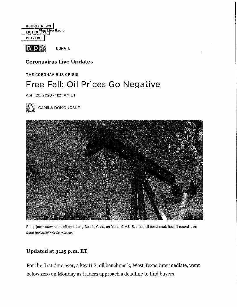
Free-Falling: U.S. Benchmark Oil Price Goes Negative As Demand Disappears For the first time ever, a key oil benchmark, West Texas Intermediate, fell below zero on Monday. That means some traders, instead of paying money to buy oil, are paying to get rid of it.
Read in NPR: https://apple.news/AFxaWiBDtTYyNUTE2- se4w
Shared from Apple News
Sent from my iPhone
1
HOURLY NEWS
LISTEN 'l_lWEL ve Radio
. PLAYLIST I
hlDIJ DONATE
Coronavirus Live Updates
THE CORONAVIRUS CRISIS
Free Fall: Oil Prices Go Negative April 20, 2020 · 11:21 AM ET
~,,j CAMILA DOMONOSKE Ui
Pump jacks draw crude oil near Long Beach, Calif., on March 9. A U.S. crude oil benchmark has hit record lows.
David McNew/AFP via Getty Images
Updated at 3:25 p.m. ET
For the first time ever, a key U.S. oil benchmark, West Texas Intermediate, went
below zero on Monday as traders approach a deadline to find buyers.

That means some traders, instead of paying money to buy oil, are paying to get rid of
it.
The unprecedented shift comes as global oil markets continue to grapple with a
pandemic-driven collapse in demand.
At the start of 2020, a barrel of Wfl cost around $60. Prices had dropped swiftly
because of the corona virus, landing at around $18 a barrel on Friday.
Then on Monday they plummeted through the floor. And kept going. Wfl for May
delivery settled at a negative $37.63 - meaning traders are paying $37.63 to get
someone to accept a delivery of a barrel of oil.
The plunging price ofWTI is driven by a trading contract deadline; oil traders have
until Tuesday to sell off the current futures contract. And they need buyers who are
capable of receiving and storing that much oil. Clearly, those buyers are in short
supply.
Other types of crude, without a deadline coming up that quickly, have not dropped
nearly so sharply.
But in general, crude oil prices are very low and continue to fall. Brent, an
international benchmark, is in the mid-$2os and fell more than 9% on Monday.
Oil-producing countries and companies are trying to reduce their output, but they
can't keep pace with the extremely rapid drop in global demand, as the world
economy hits the brakes.
That's creating a massive oversupply of oil and raising concerns about where buyers
will be able to physically store it all.
covid-19 coronavirus oil prices oil
From: Sent: To: Subject:
Thank-you, this is very helpful.
Carola G. Serrato Executive Director
[email protected] Monday, April 20, 2020 2:01 PM 'Margaret Somereve' RE: Strategic Hedging Program
South Texas Water Authority PO Box 1701 Kingsville, Texas 78364 361-592-9323 x112
From: Margaret Somereve <[email protected]> Sent: Monday, April 20, 2020 1:54 PM To: [email protected] Subject: Re: Strategic Hedging Program
Carola, This is what we have right now
Members with signed SHP agreements:
Aquilla Water District City of Aubrey Benbrook Library District City of Benbrook City of Brownwood Calhoun Port Authority City of Dalworthington Gardens City of Dublin City of Duncanville City of Everman City of Harker Heights City of Ovilla City of Prosper City of Lyford City of Roanoke City of Robinson City of Seadrift City of Sinton City of Watuaga
Members who councils said to bring the SHP documents for approval to council at a study session/work session
meeting: City of Allen
1

City of Victoria
Members who are currently working on getting the SHPs to council for approval: City of Grand Prairie City of Grapevine City of Kingsville City of Lewisvilleq City of Pleasanton (went to council last week)
Hope this helps and let me know if you have any questions. Margaret
On Mon, Apr 20, 2020, 1:42 PM <[email protected]> wrote:
Good Afternoon Margaret,
Is it possible to get a list of the entities that have formally adopted to participate in the SHP?
Carola
Carola G. Serrato
Executive Director
South Texas Water Authority
PO Box 1701
Kingsville, Texas 78364
361-592-9323 x112
2

ATTACHMENT 15
Resolution 20-07
RESOLUTION 20-07
RESOLUTION OF THE SOUTH TEXAS WATER AUTHORITY ADOPTING TCAP'S PROFESSIONAL SERVICES AGREEMENT AND GEXA ENERGY'S COMMERCIAL ELECTRIC SERVICE AGREEMENT FOR POWER TO BE PROVIDED ON AND AFTER JANUARY 1, 2023
WHEREAS, the South Texas Water Authority ("Authority") is a member of Texas Coalition For Affordable Power, Inc. ("TCAP"), a non-profit, political subdivision corporation of the State of Texas; and
WHEREAS, TCAP has previously arranged for the Authority to purchase power through Gexa Energy with a contract set to expire December 31, 2022; and
WHEREAS, TCAP has designed a new procurement strategy that will involve TCAP initially committing to purchase power two years in advance of delivery on behalf of its members whq desire paiiicipation in a Strategic Hedging Program ("SHP") that will involve a series of monthly competitive auctions; and
WHEREAS, TCAP has prepared a Professional Services Agreement ("PSA"), attached as Exhibit A, that, in addition to enumerating services and benefits to members of TCAP, provides TCAP with specific authority to procure power in the wholesale market on behalf of members who choose to patiicipate in the SHP; and
WHEREAS, approval of the PSA is a necessaiy, but not sufficient, prerequisite to participation in the SHP; and
WHEREAS, the PSA is a relational contract that defines services provided by TCAP to members regardless of whether a member decides to commit to the SHP; and
WHEREAS, the industly-standard retail contract is a Commercial Electric Service Agreement ("CESA") offered by a Retail Electric Provider ("REP"); and
WHEREAS, TCAP has negotiated modifications to the current CESA between the Authority and Gexa Energy to reflect patiicipation in the SHP; and
WHEREAS, the CESA that will facilitate patiicipation in the SHP effective for power deliveries in and beyond 2023 (attached as Exhibit B) will need to be approved and signed prior to October 1, 2020; and
WHEREAS, the Authority desires to patiicipate in the SHP.
7907968 1
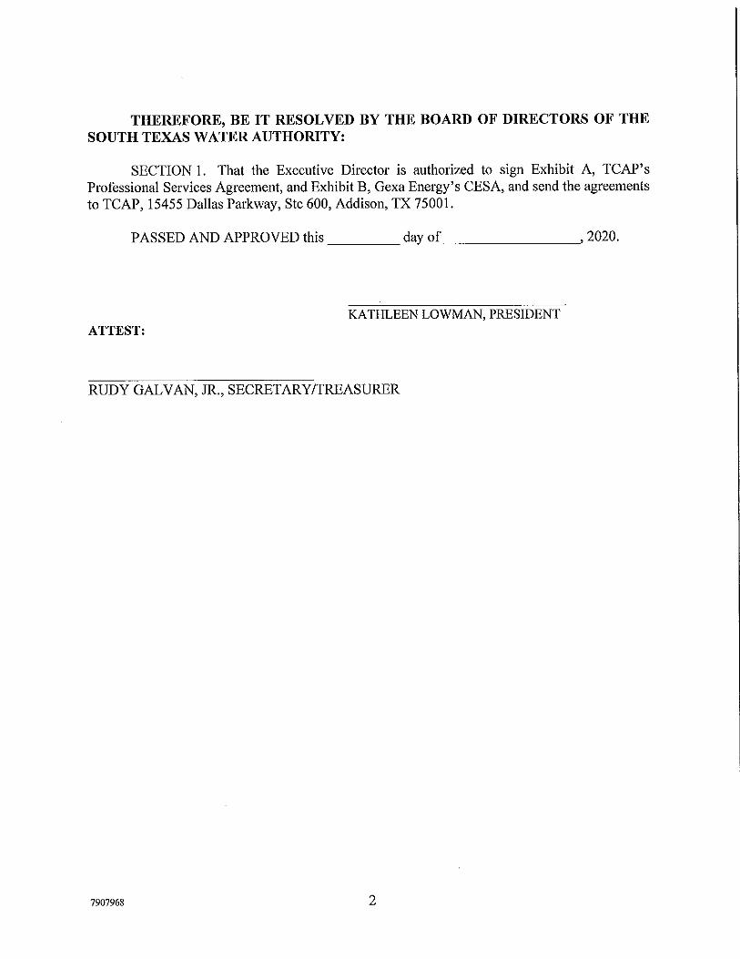
THEREFORE, BE IT RESOLVED BY THE BOARD OF DIRECTORS OF THE SOUTH TEXAS WATER AUTHORITY:
SECTION I. That the Executive Director is authorized to sign Exhibit A, TCAP's Professional Services Agreement, and Exhibit B, Gexa Energy's CESA, and send the agreements to TCAP, 15455 Dallas Parkway, Ste 600, Addison, TX 75001.
PASSED AND APPROVED this ____ day of _______ ~• 2020.
KATHLEEN LOWMAN, PRESIDENT ATTEST:
RUDY GALVAN, JR., SECRETARY/TREASURER
7907968 2

ATTACHMENT 16
Corrpro CIS
Memorandum
To: From:
South Texas Water Authority Board of Directors Carola G. Serrato, Executive Director
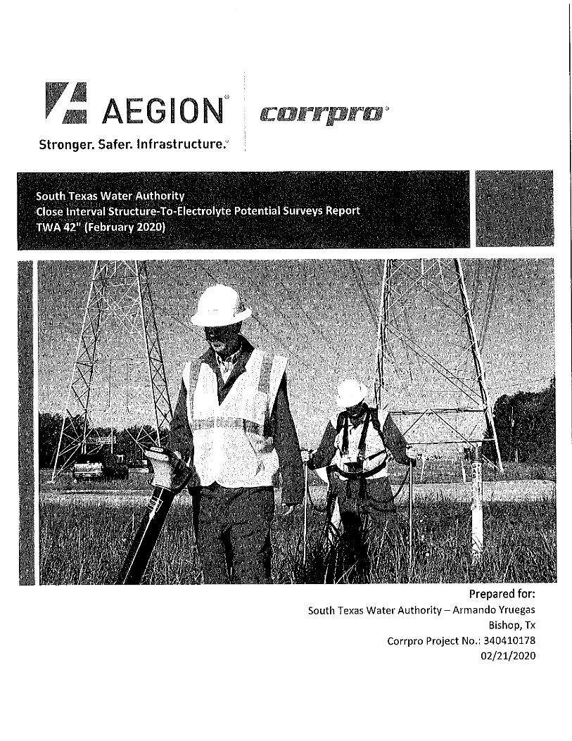
Date: April 23, 2020 Re: Cathodic Protection Services - Corrpro Services - CP Survey for Contract I
Background:
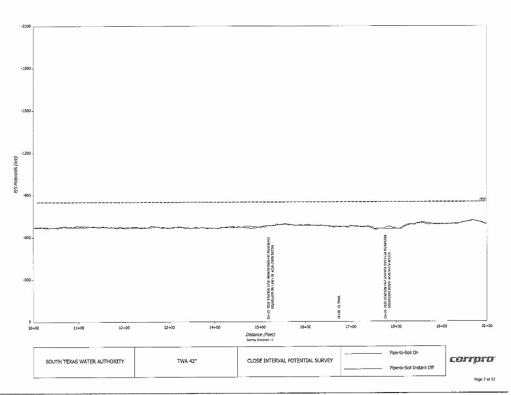
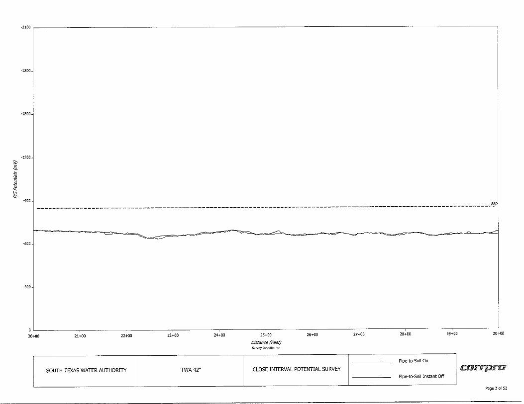
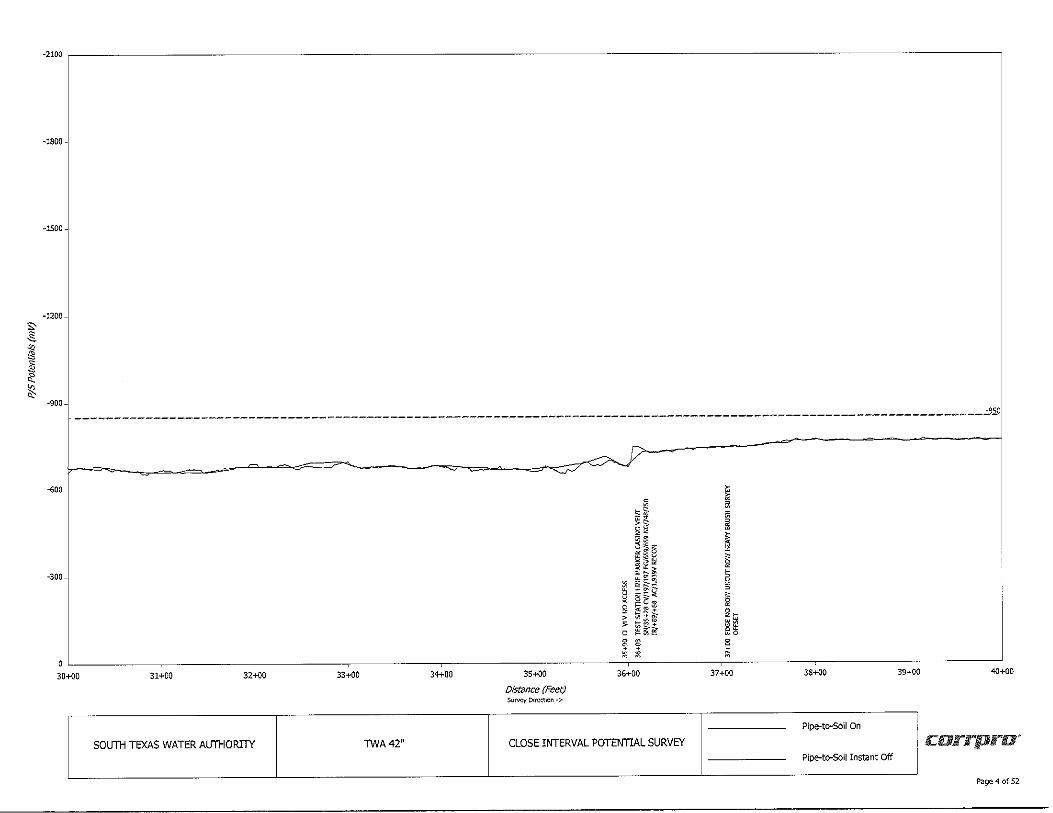
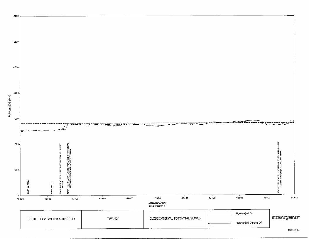
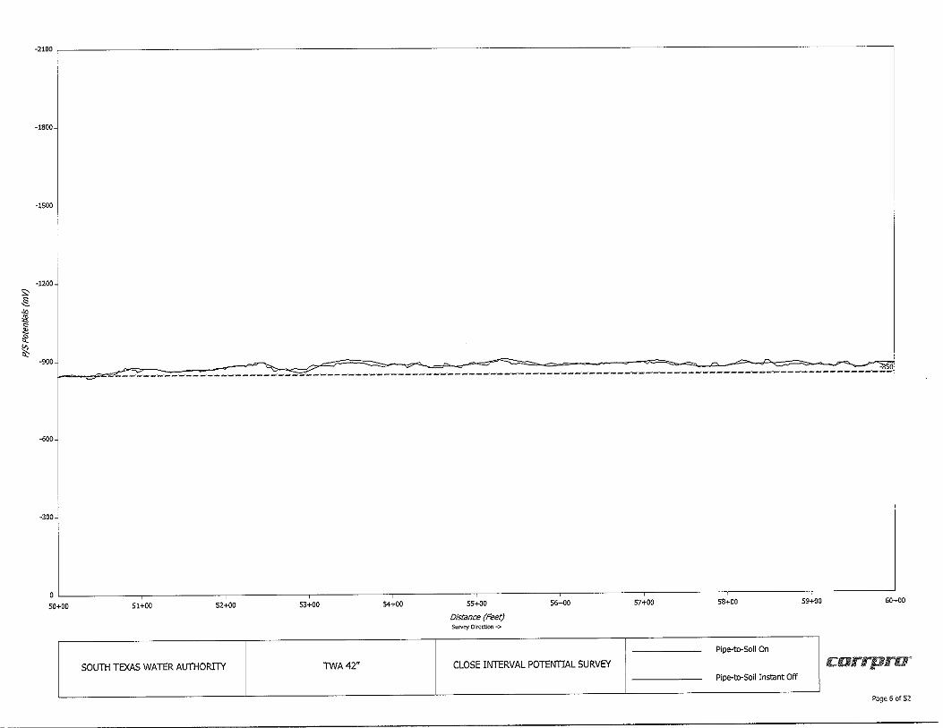
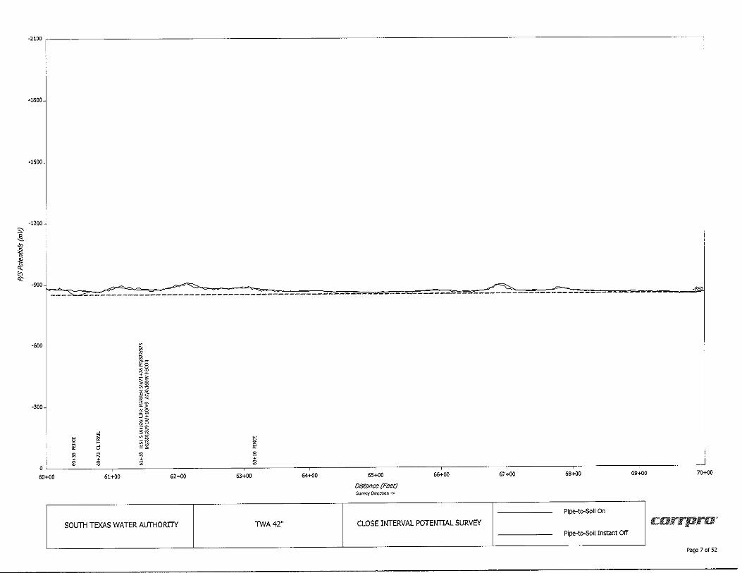
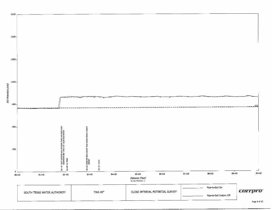
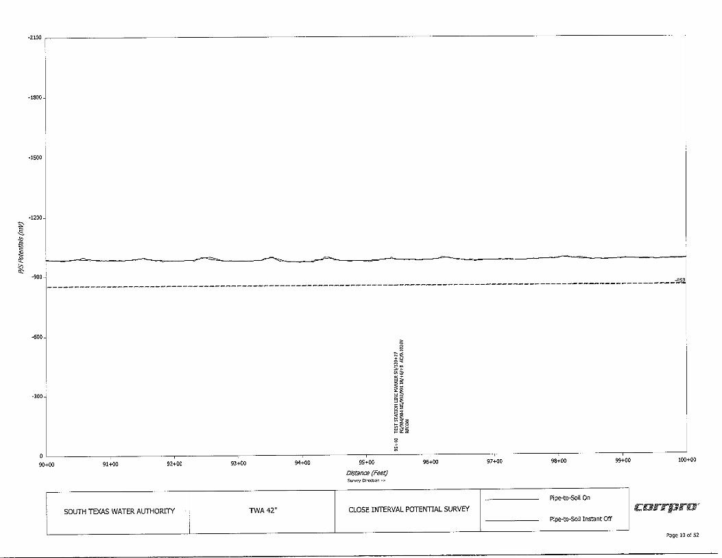
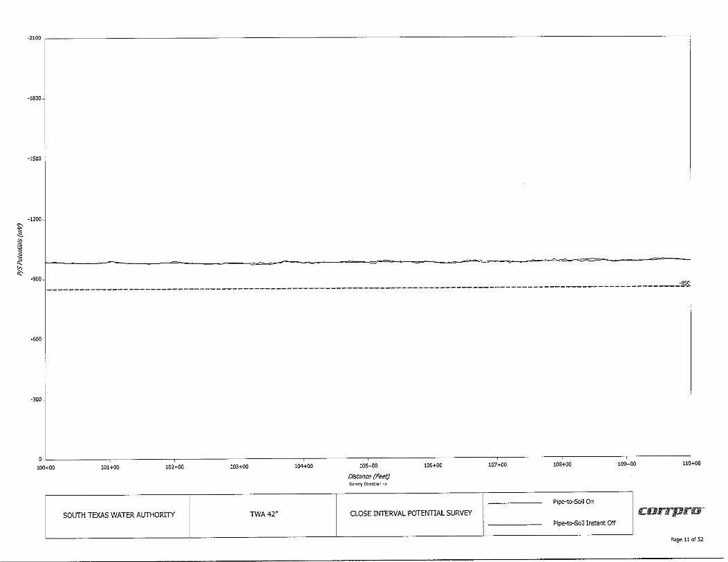
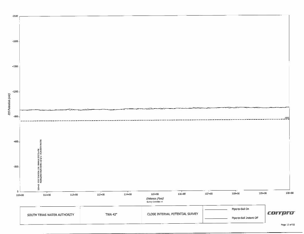
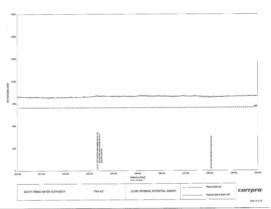
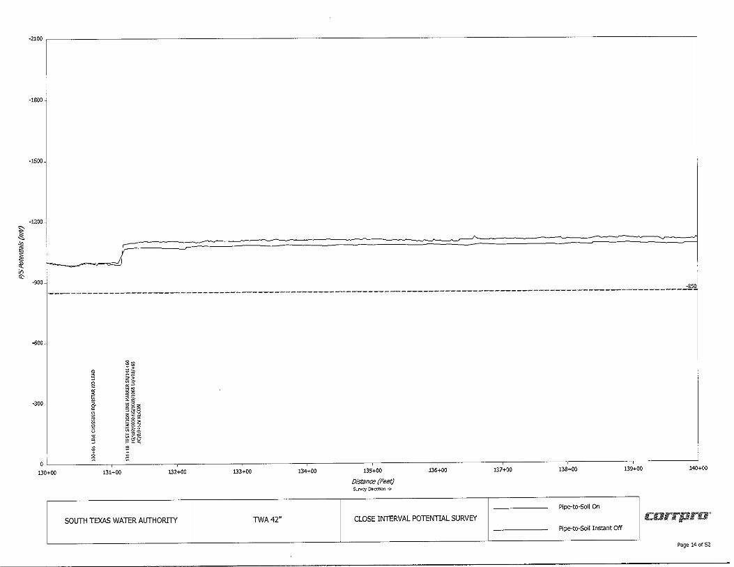
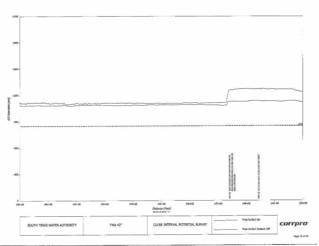
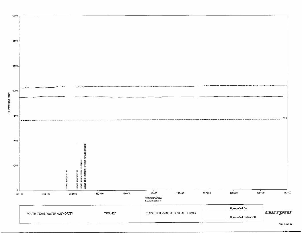
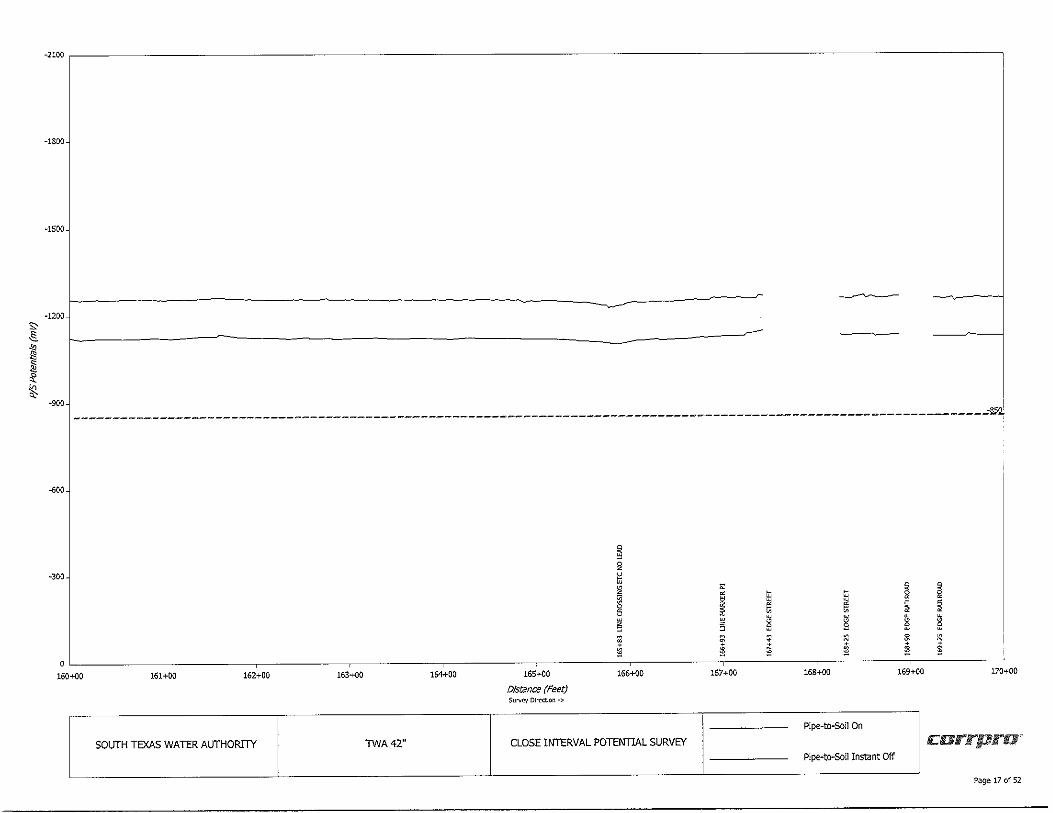
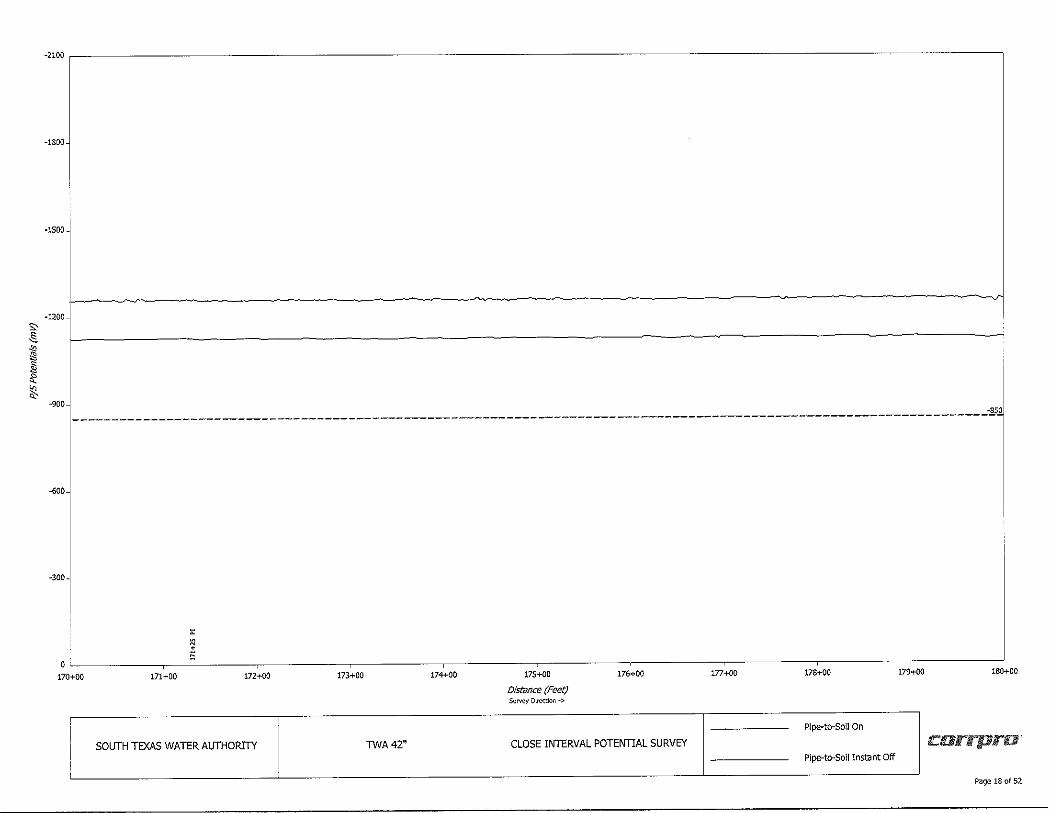
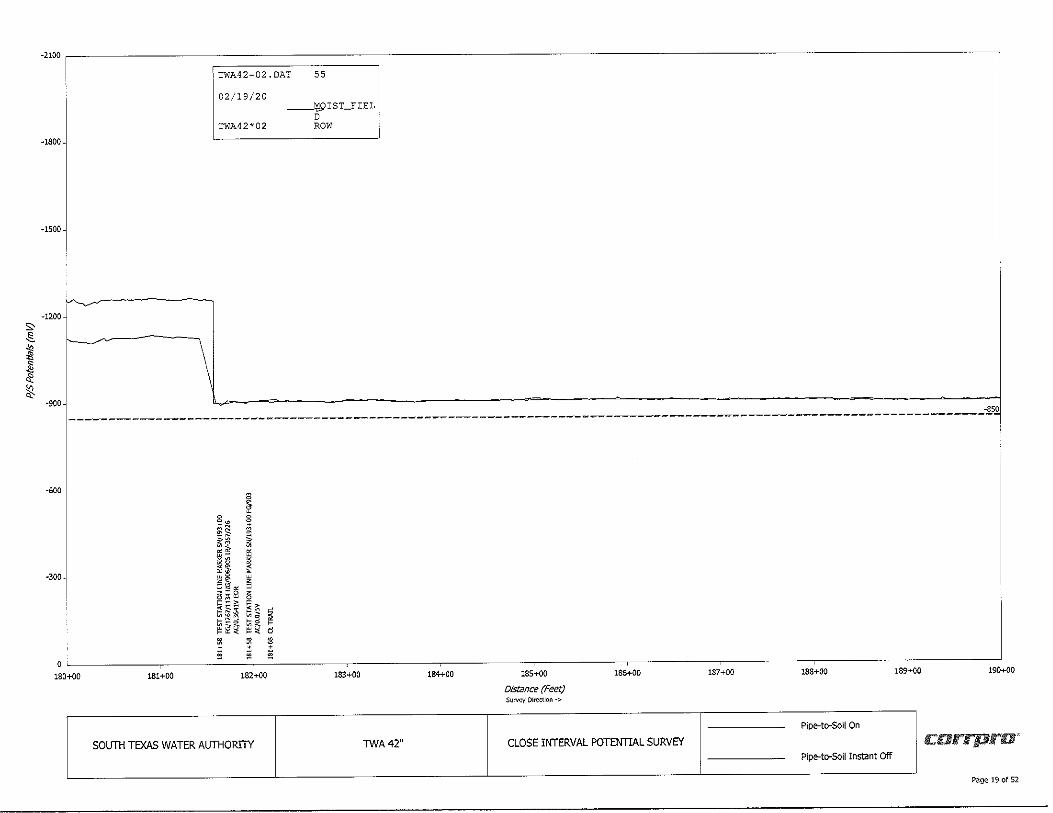
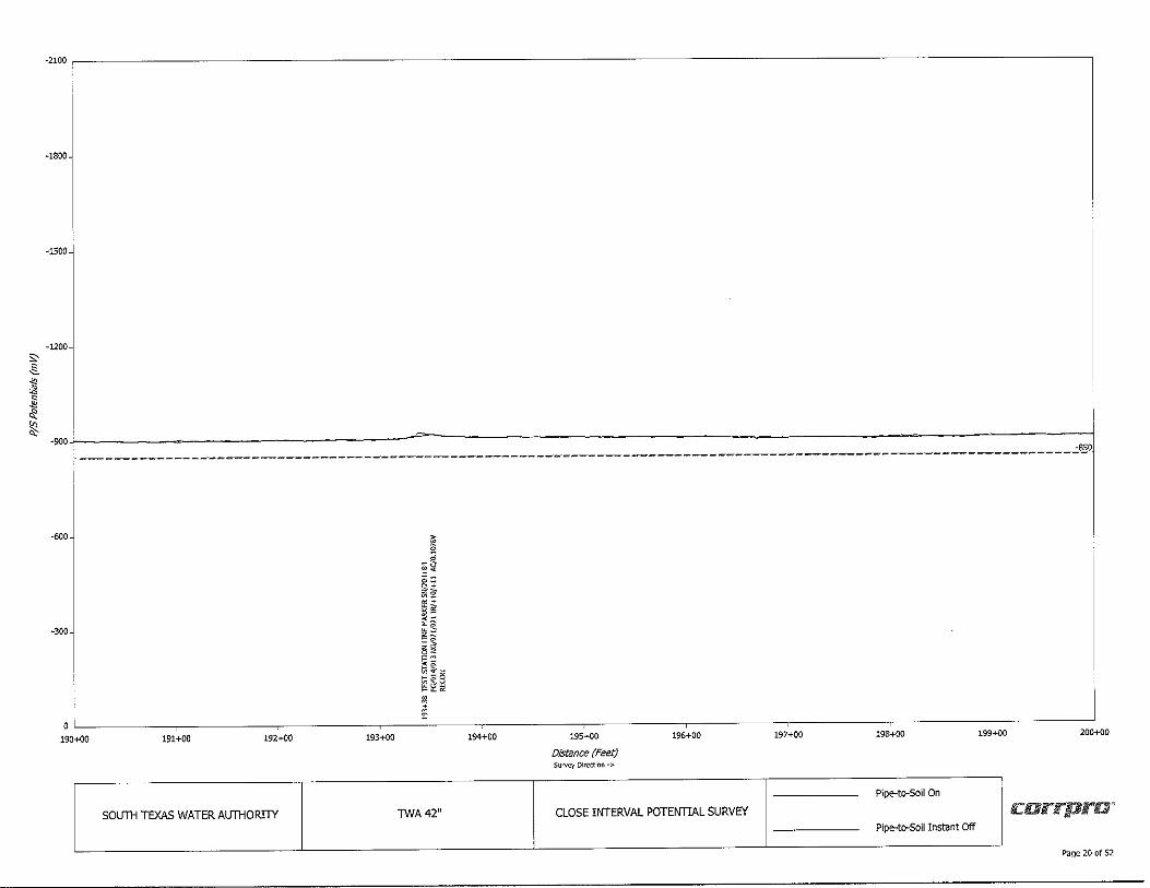
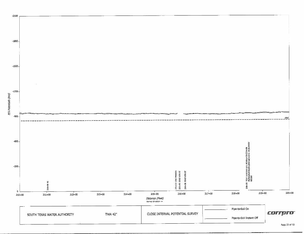
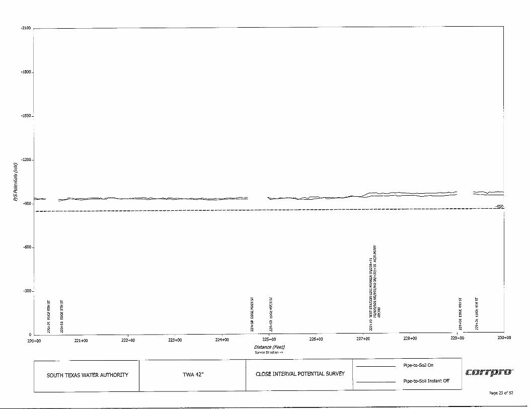
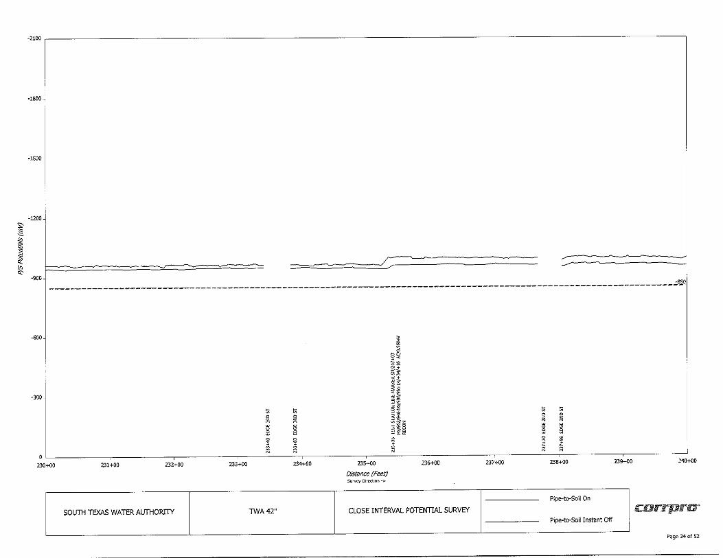
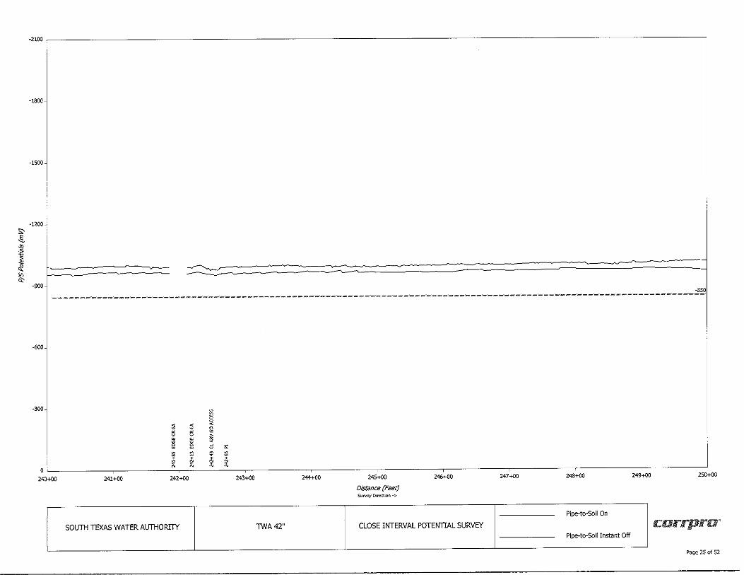
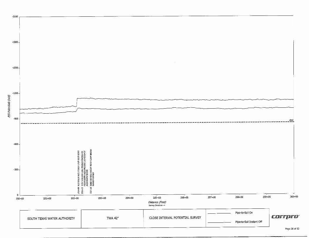
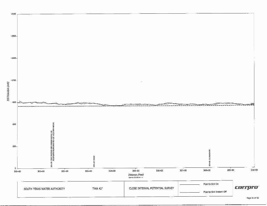
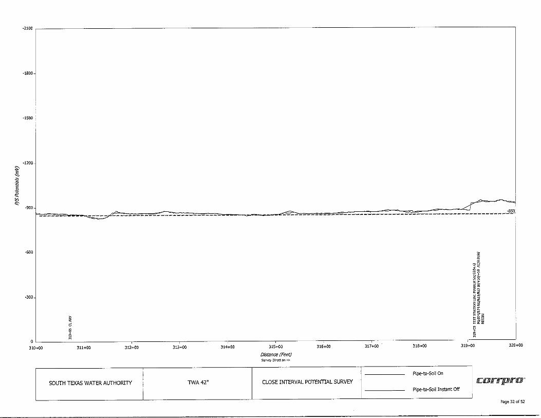
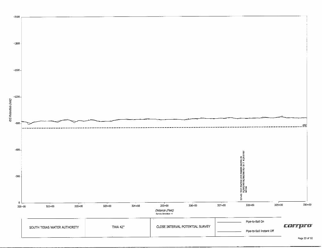
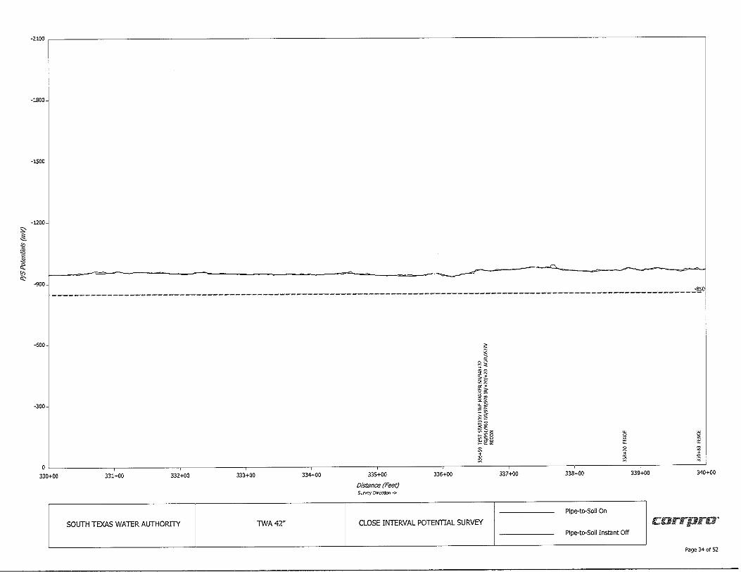
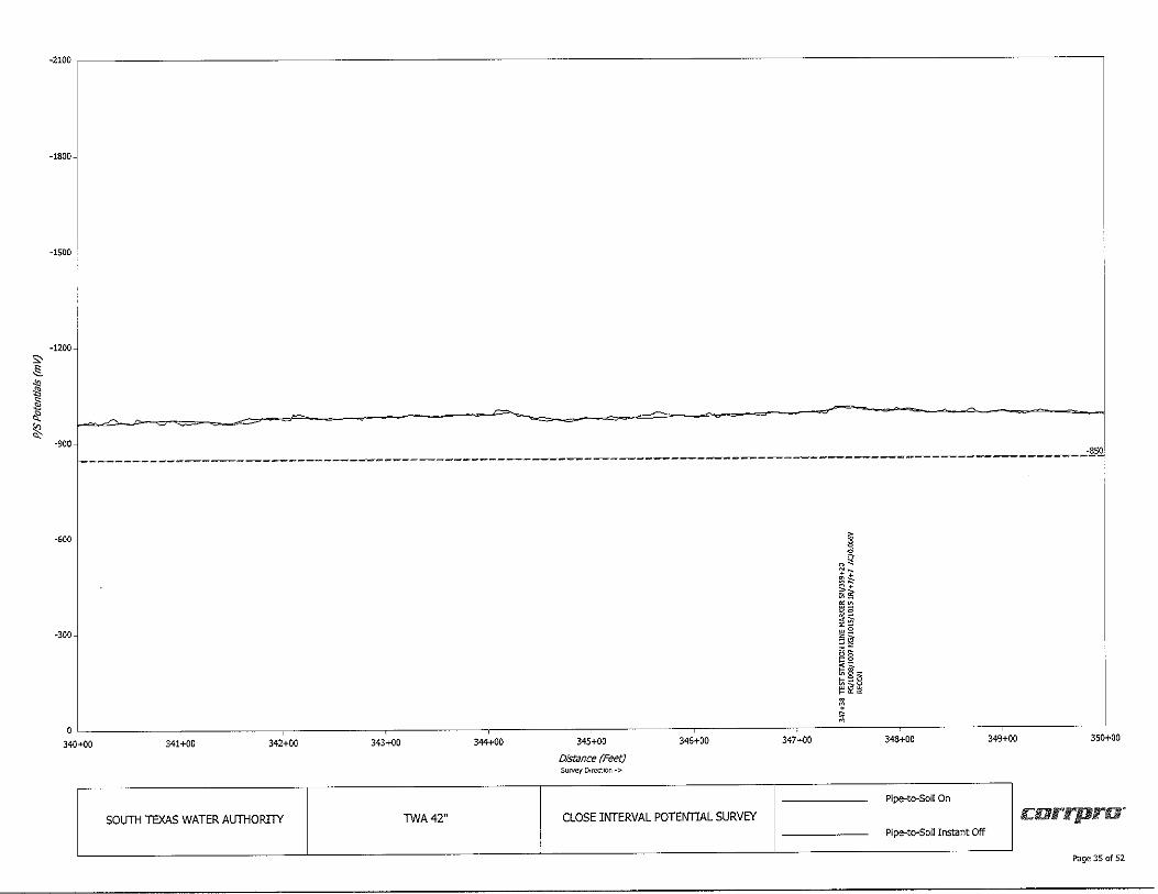
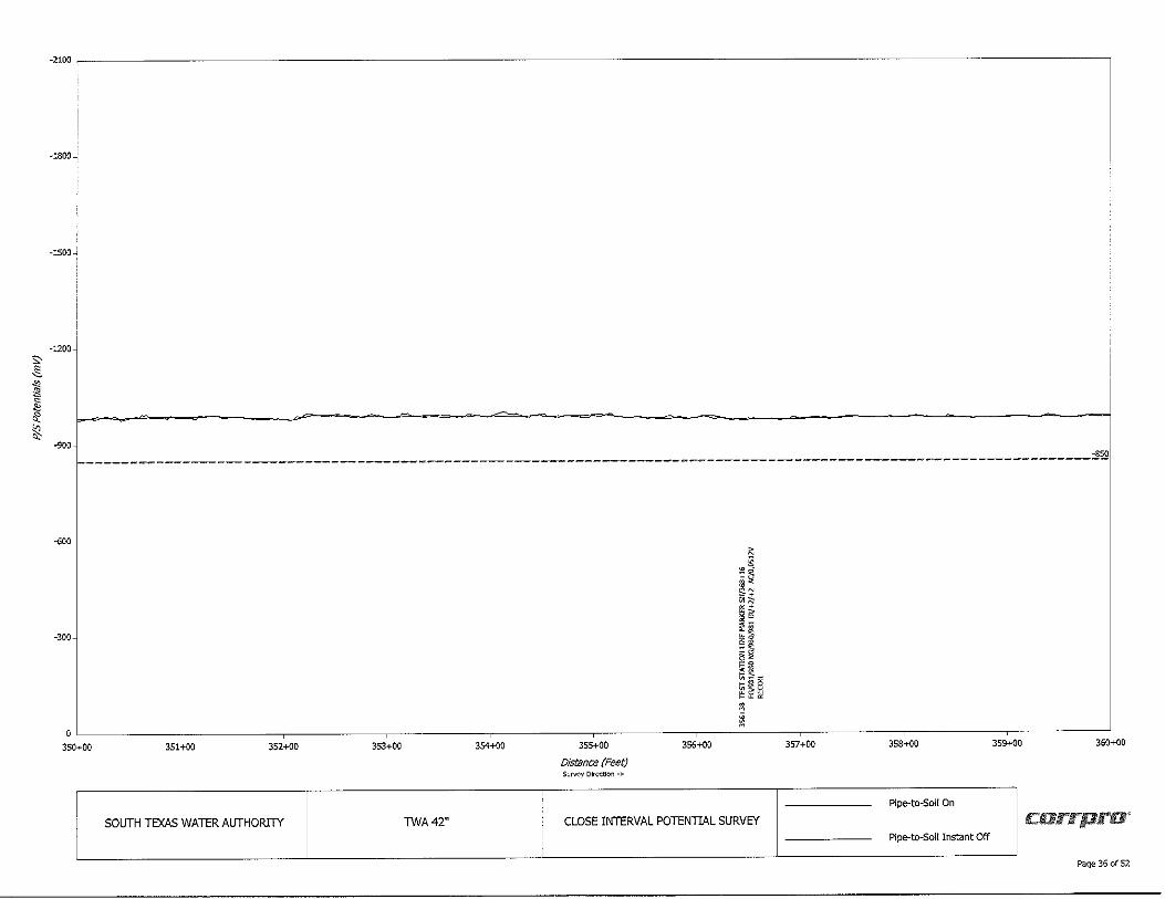
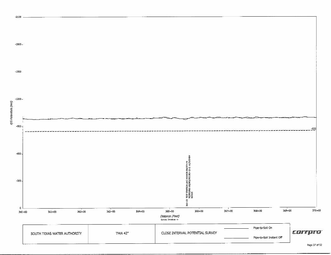
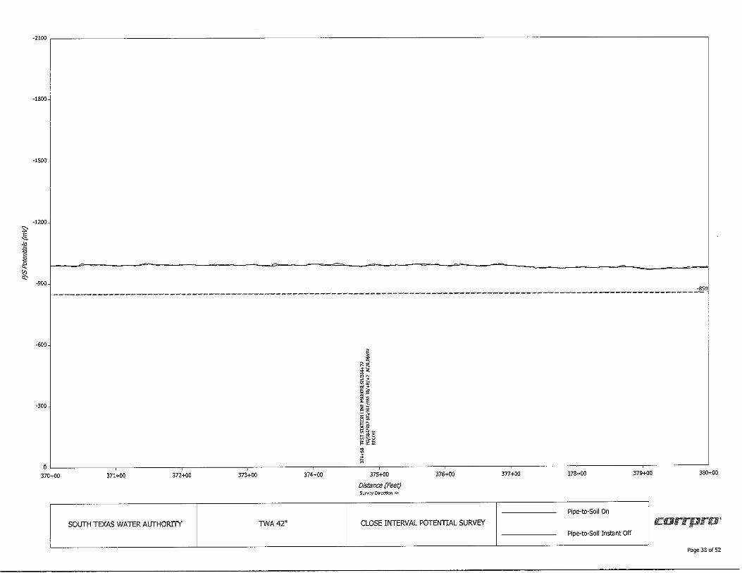
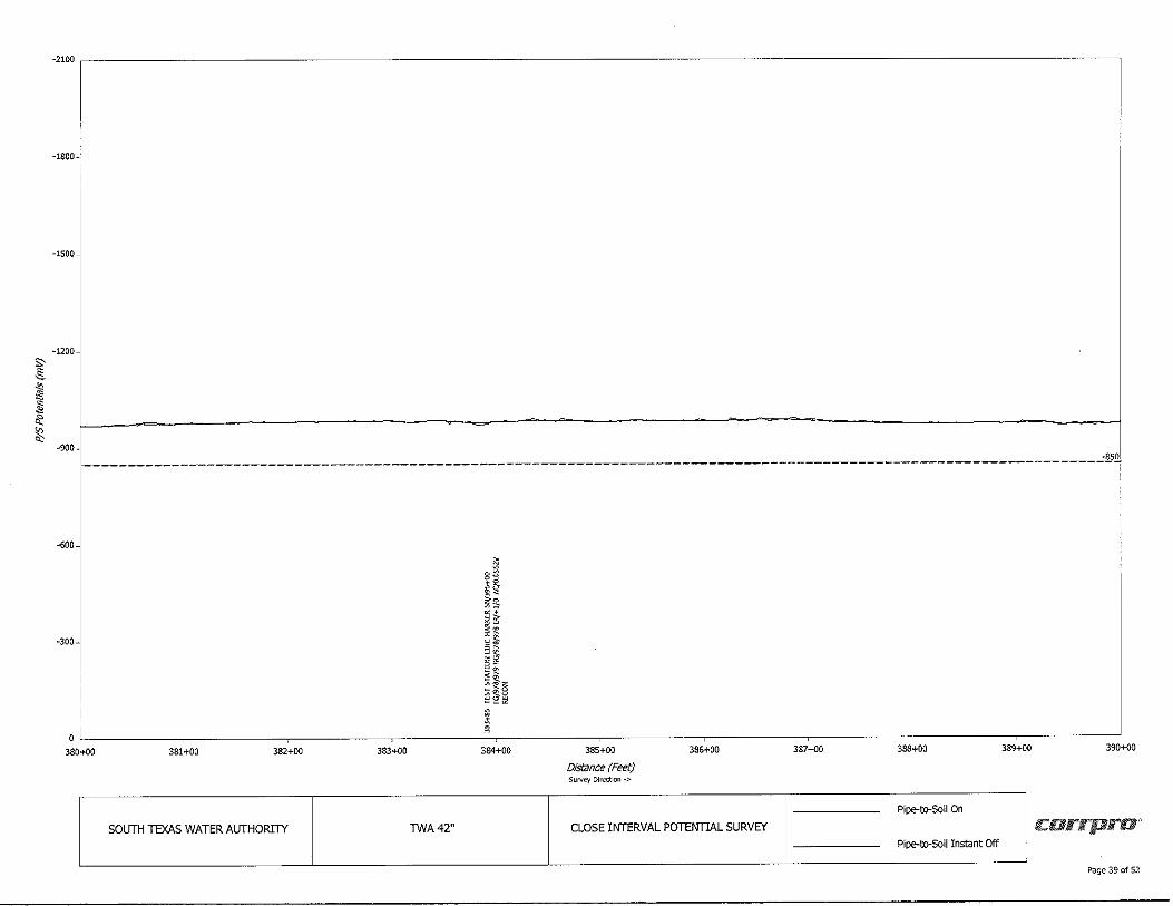
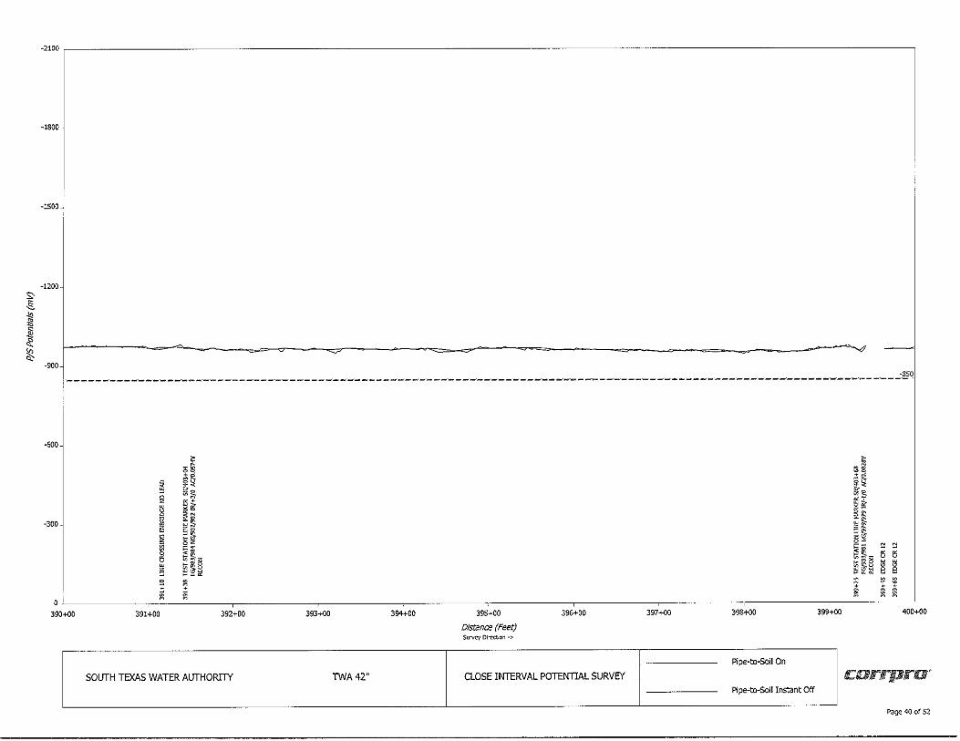
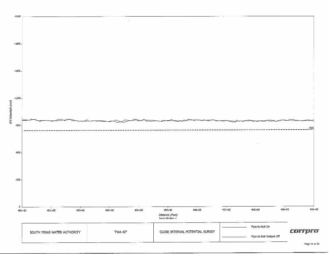
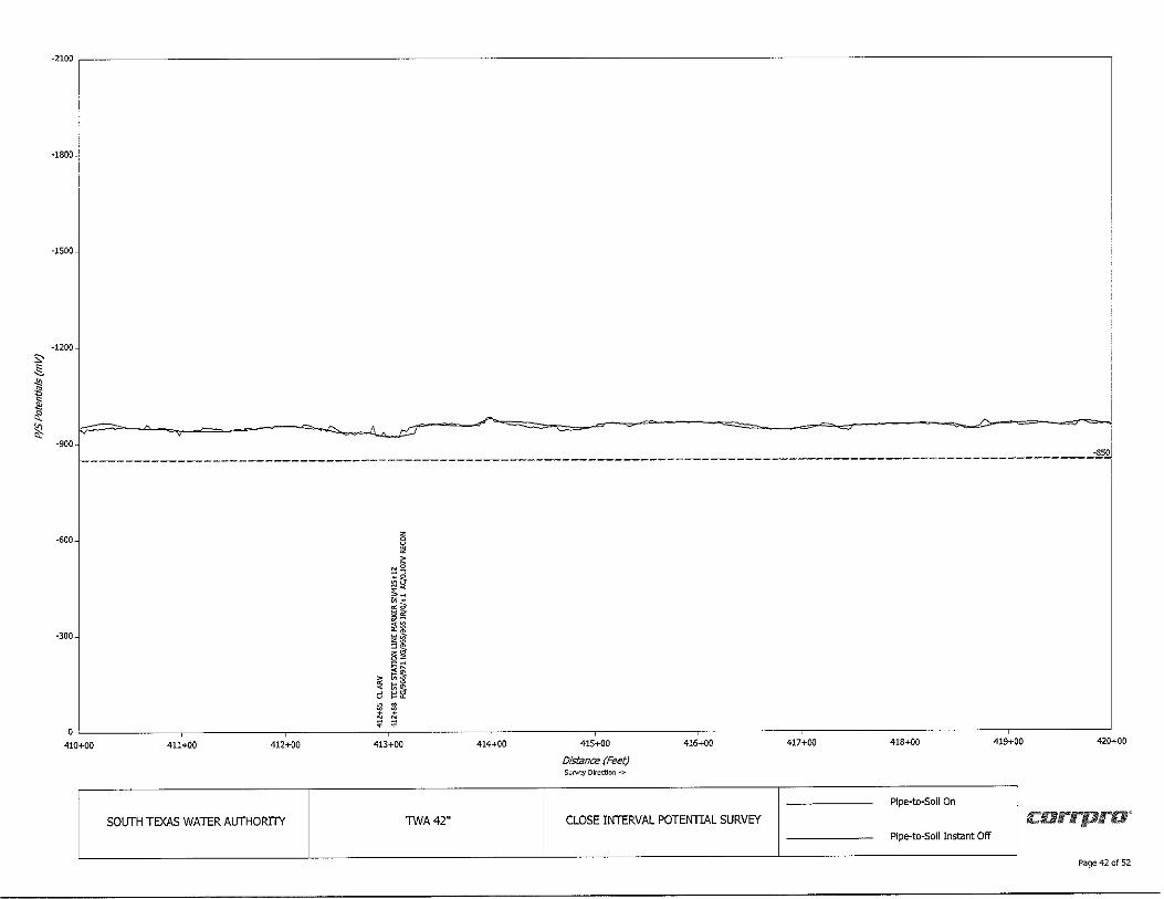
During the last meeting, staff reported that O&M Supervisor Armando Yruegas continues to communicate with Aegion/Corrpro representatives regarding the report on the Closed Interval Survey (CIS) of Contract I. Attached is the entire report, including the actual survey graphs. Also attached is the most recent email correspondence with a quote in the amount of$15,175 for Corrpro to perform the services that they recommend. As before, the standard of -850-mA is used to determine whether a section of pipe is adequately protected or not. This delineation is shown as a dashed red line on the rep01t graphs.
Analysis:
When reviewing the graphs it should be noted there are several areas where a break in the readings appears. Those gaps are actually road crossings. For example, on page 16 of 52, there is a break between station 151+ 70 and station 152+20. The gap is County Road 4. These gaps can be found on pages 17, 22, 23, 24, 25, 28, 30, 40, 46 and 51.
The following is a breakdown of the areas meeting the -850-mA standard and those areas that do not reach the required level to be considered adequately protected:
• •
• •
• •
•
• •
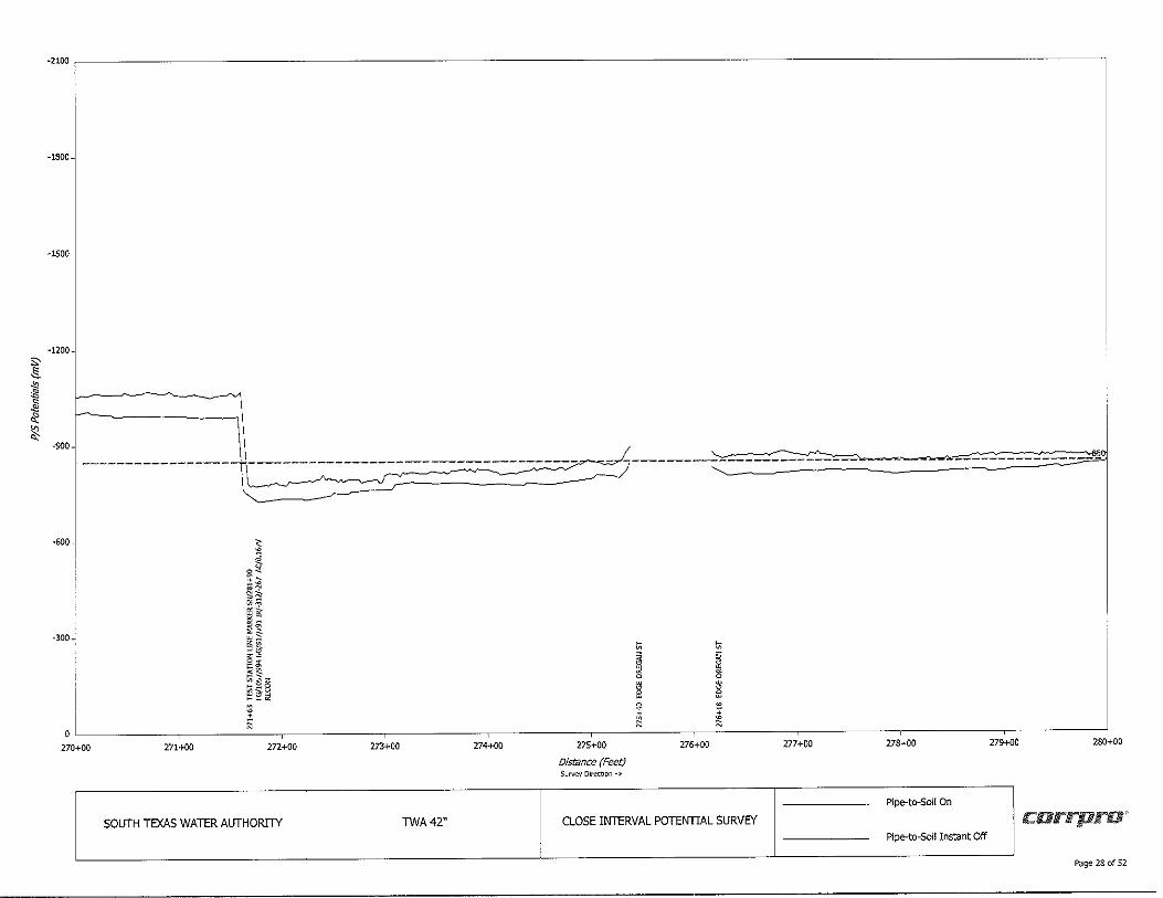
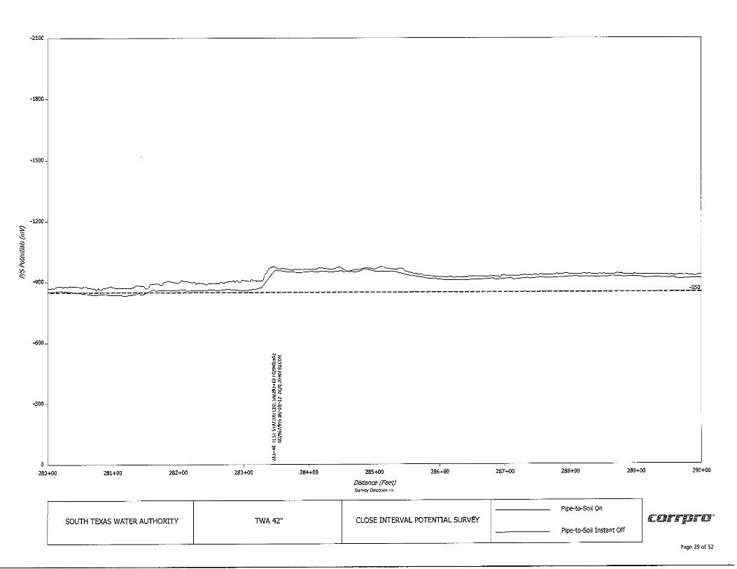
Pages I through 5 of the survey show readings of about -650-mA to -700-mA . On page 5 around station 41 +60, there is a noticeable jump in the readings from about -750-mA to just under/over -850mA. These readings continue from that station to 81+90 (around 4,000 If). Another increase occurs with readings in the -1 000+mA range to station 181+ 70 (around 10,000 lf) . Thereafter, the readings are above the -850-mA standard until Oregon Street on the north side of Bishop (station 274+40- about 9,300 feet distance). At that point, the readings again hover just under/over the standard until about station 283+00 . The readings are acceptable until station 304+00 for a short distance and increase above the standard until station 311 +50 with a repeat of readings being just under/over the standard. There is another noticeable jump at station 319+08. After that, the readings are at the -900+mA range up to several line crossings around station 461 +00 or after about a 10,000 If distance. The readings are then in the -800-mA range for approximately 1,000 If. Then, there is a noticeable increase at station 473+60 with readings in the -950-mA range until the end of Contract I.
Staff Recommendations:
As presented previously, the rep01t indicates that slightly less than 15% of Contract I is not adequately protected. However, that includes those sections that are just below the -850-mA mark. Corrpro is recommending additional services to examine ce1tain areas at a cost of $15,175. O&M Supervisor Armando Y ruegas recommends hiring Corrpro to perform the additional work.
With regards to Contract 2, staff recommends continuing to: install anodes, repair or replace test stations, repair broken bonds and maintain/monitor impressed current stations.
42" Waterline Assessment and Potential Projects April 23, 2020 Page 2 of2
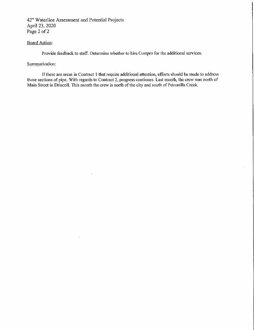
Board Action:
Provide feedback to staff. Determine whether to hire Corrpro for the additional services.
Summarization:
If there are areas in Contract I that require additional attention, effo1ts should be made to address those sections of pipe. With regards to Contract 2, progress continues. Last month, the crew was north of Main Street in Driscoll. This month the crew is nmth of the city and south of Petronilla Creek.
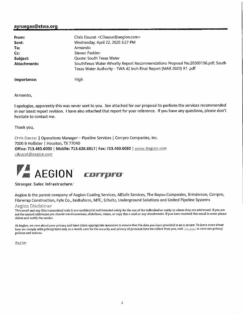
From: Sent: To: Cc: Subject: Attachments:
Importance:
Armando,
Chris Dauzat <[email protected]> Wednesday, April 22, 2020 3:27 PM Armando Steven Padden Quote: South Texas Water South Texas Water Athority Report Recommendations Proposal No.20300156.pdf; South Texas Water Authority - TWA 42 Inch Final Report (MAR 2020) R1 .pdf
High
I apologize, apparently this was never sent to you. See attached for our proposal to perform the services recommended in our latest report revision. I have also attached that report for your reference. If you have any questions, please don't
hesitate to contact me.
Thank you,
Chris Dauzat I Operations Manager - Pipeline Services I Corrpro Companies, Inc. 7000 B Hollister I Houston, TX 77040 Office: 713.460.6000 I Mobile: 713.628.8817 I Fax: 713.460.6060 I www.Aegion.com
r.,: AEGION carrpra•· Stronger. Safer. Infrastructure:
Aegion is the parent company of Aegion Coating Services, AIISafe Services, The Bayou Companies, Brinderson, Corrpro, Fibrwrap Construction, Fyfe Co., lnsituform, MTC, Schultz, Underground Solutions and United Pipeline Systems
Aegion Disclaimer This email and any files transmitted with it are confidential and intended solely for the use of the individual or entity to whom they are addressed, If you are not the named addressee you should not disseminate, distribute, retain, or copy this e-mail or any attachments. If you have received this email in error please delete and notify the sender.
AtAegion, we care about your privacy and have taken appropriate measures to ensure that the data you have provided to us is secure. To learn more about how we comply with privacy laws and, as a result, care for the security and privacy of personal data we collect from you, visit thi.s_:~-.,;;_t: to view our privacy policies and notices.
Aeefon
1
Armando Yruegas South Texas Water Authority Ph:361.445.5109 [email protected]
Proposal for Cathodic Protection Services
South Texas Water Authority
Bishop Texas
r~ AEGION' Stronger. Safer. Infrastructure:
March 26, 2020
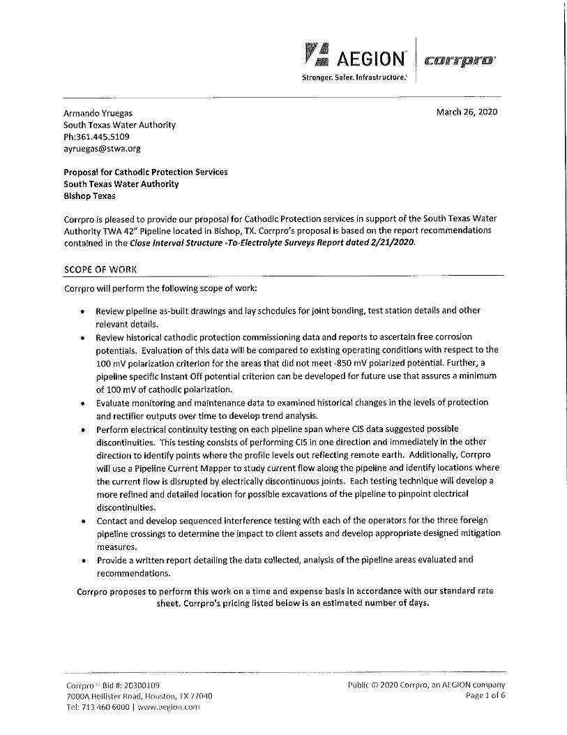
Corrpro is pleased to provide our proposal for Cathodic Protection services in support of the South Texas Water Authority TWA 42" Pipeline located in Bishop, TX. Corrpro's proposal is based on the report recommendations contained in the Close Interval Structure -To-Electrolyte Surveys Report dated 2/21/2020.
SCOPE OF WORI<
Corrpro will perform the following scope of work:
• Review pipeline as-built drawings and lay schedules for joint bonding, test station details and other
relevant details.
• Review historical cathodic protection commissioning data and reports to ascertain free corrosion
potentials. Evaluation of this data will be compared to existing operating conditions with respect to the
100 mV polarization criterion for the areas that did not meet -850 mV polarized potential. Further, a
pipeline specific Instant Off potential criterion can be developed for future use that assures a minimum
of 100 mV of cathodic polarization.
• Evaluate monitoring and maintenance data to examined historical changes in the levels of protection
and rectifier outputs over time to develop trend analysis.
• Perform electrical continuity testing on each pipeline span where CIS data suggested possible
discontinuities. This testing consists of performing CIS in one direction and immediately in the other
direction to identify points where the profile levels out reflecting remote earth. Additionally, Corrpro
will use a Pipeline Current Mapper to study current flow along the pipeline and identify locations where
the current flow is disrupted by electrically discontinuous joints. Each testing technique will develop a
more refined and detailed location for possible excavations of the pipeline to pinpoint electrical
discontinuities.
• Contact and develop sequenced interference testing with each of the operators for the three foreign
pipeline crossings to determine the impact to client assets and develop appropriate designed mitigation
measures. • Provide a written report detailing the data collected, analysis of the pipeline areas evaluated and
recommendations.
Corrpro proposes to perform this work on a time and expense basis In accordance with our standard rate sheet. Corrpro's pricing listed below is an estimated number of days.
Corrpro ' Bid fl: 20300109 7000A Hollister Road, Houston, TX 770~0 Tel: 713 460 6000 I www.aegion.com
Public© 2020 Corrpro, ;:-m AEGION company Pagelof6
r,! AEGION. Stronger. Safer. Infrastructure:
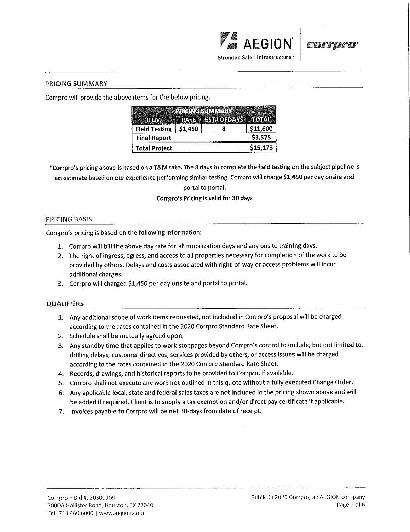
PRICING SUMMARY
Corrpro will provide the above items for the below pricing.
Final Report
Total Project $15,175
•corrpro's pricing above is based on a T&M rate. The 8 days to complete the field testing on the subject pipeline is
an estimate based on our experience performing similar testing. Corrpro will charge $1,450 per day onsite and
portal to portal.
Corrpro's Pricing is valid for 30 days
PRICING BASIS
Corrpro's pricing is based on the following information:
1. Corrpro will bill the above day rate for all mobilization days and any onsite training days.
2. The right of ingress, egress, and access to all properties necessary for completion of the work to be
provided by others. Delays and costs associated with right-of-way or access problems will incur
additional charges.
3. Corrpro will charged $1,450 per day onsite and portal to portal.
QUALIFIERS
1. Any additional scope of work items requested, not included in Corrpro's proposal will be charged
according to the rates contained in the 2020 Corrpro Standard Rate Sheet.
2. Schedule shall be mutually agreed upon. 3. Any standby time that applies to work stoppages beyond Corrpro's control to include, but not limited to,
drilling delays, customer directives, services provided by others, or access issues will be charged
according to the rates contained in the 2020 Corrpro Standard Rate Sheet.
4. Records, drawings, and historical reports to be provided to Corrpro, if available.
5. Corrpro shall not execute any work not outlined in this quote without a fully executed Change Order.
6. Any applicable local, state and federal sales taxes are not included in the pricing shown above and will
be added if required. Client is to supply a tax exemption and/or direct pay certificate if applicable.
7. Invoices payable to Corrpro will be net 30-days from date of receipt.
Cor,vro ' Bid Ii: ,0300109 7000A Hollister Road, Houston, TX 77040 Te!: 713 460 6000 I wwv,.aegion.com
Public C~) 2020 Corrpro, an Af:GION company
Page2of6
r_: AEGION" Stronger. Safer. Infrastructure:
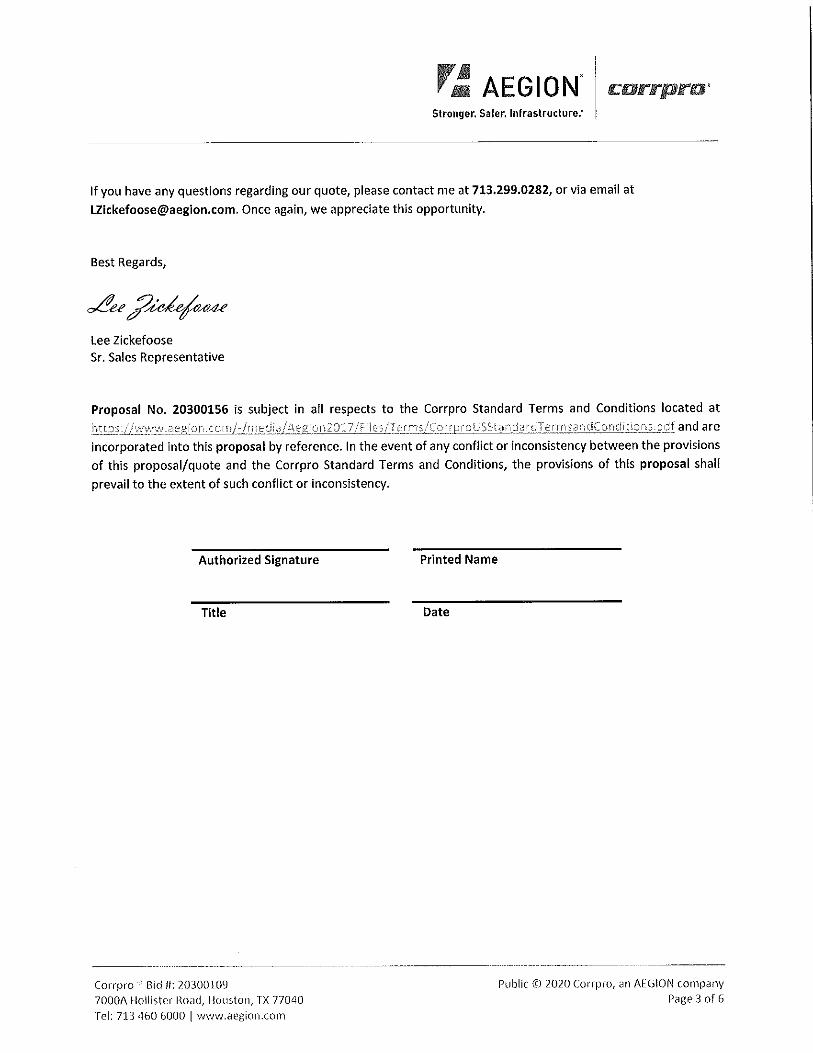
If you have any questions regarding our quote, please contact me at 713,299.0282, or via email at
[email protected]. Once again, we appreciate this opportunity.
Best Regards,
Lee Zickefoose Sr. Sales Representative
Proposal No. 20300156 is subject in all respects to the Corrpro Standard Terms and Conditions located at
:~.~.!J.?S:.//wv,1\N.aegion ,corTr 1~)me1Ji al Aeg!on2Cl 17 IF iies/Ter rns/Cm~proUSS:a,nda!'dTerrnsandCondit~cms.odf and are incorporated into this proposal by reference. In the event of any conflict or inconsistency between the provisions
of this proposal/quote and the Corrpro Standard Terms and Conditions, the provisions of this proposal shall
prevail to the extent of such conflict or inconsistency.
Authorized Signature
Title
Corrpro 'Bid II: 20300109 7000A Hollister Road, Houston, TX 77040
Tel: 713 460 6000 I www.aegion.com
Printed Name
Date
---------------- ----------------
Public CC) 2020 Corrpm, an AEGION company Page3of6
Y~ AEGION" rc:arrpra· Stronger. Safer. Infrastructure.'
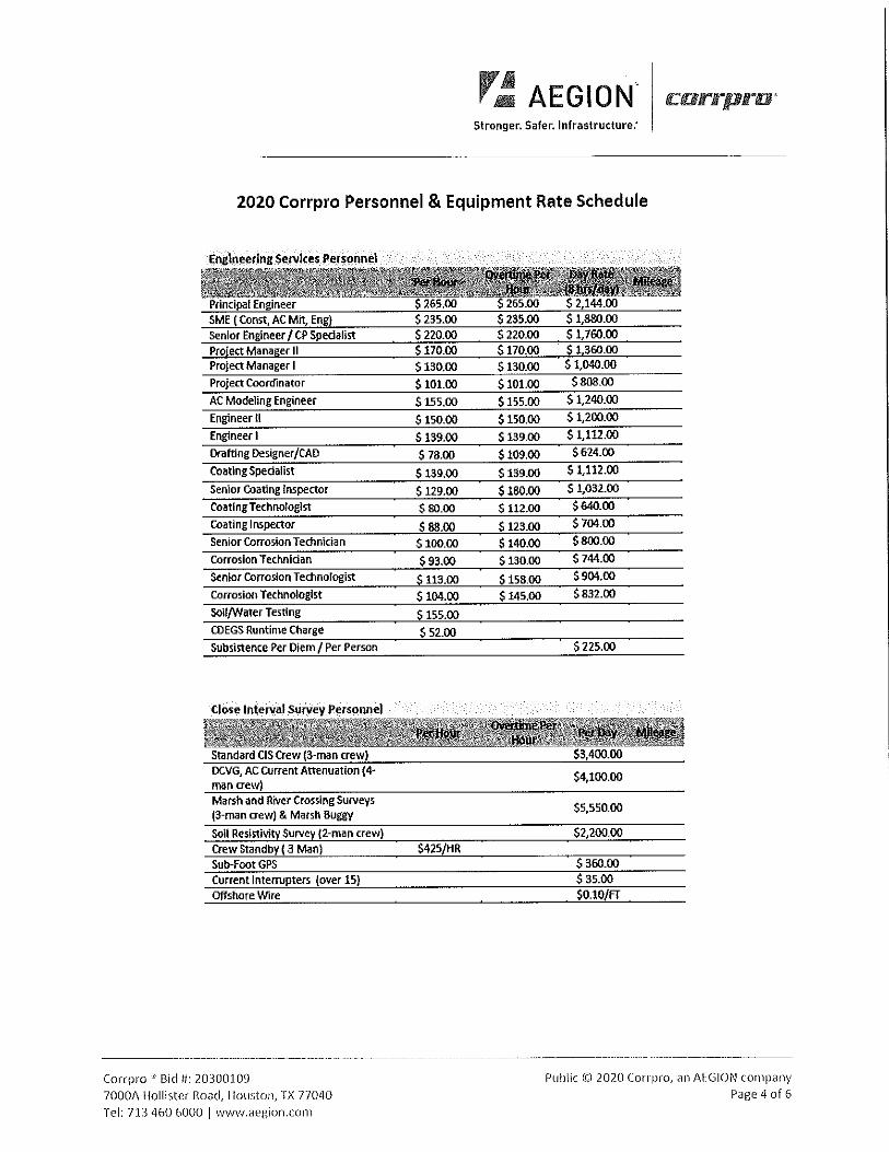
2020 Corrpro Personnel & Equipment Rate Schedule
Enghl~ering Services_ Pe_rsorme_l
Project Coordinator
AC Modeling Engineer
Engineer II Engineer I Drafting Designer/CAD Coating Specialist
Senior coating Inspector Coating Technologist
coating Inspector
Senior Corrosion Technician Corrosion Technician
Senior Corrosion Technologist Corrosion Technologist
SOil/Water Testing COEGS Runtime Charge
Subsistence Per Diem/ Per Person
Standard CIS crew (3-man crew) DC.VG, AC current Attenuation (4-man crew) Marsh and River Crossing Surveys (3-man crew) & Marsh Buggy
SOIi Resistivity Survey (2-man crew) crew Standby ( 3 Man) Sub-Foot GPS current Interrupters (over 15) Offshore Wire
Corrpro '' Bid II: 20300109 7000A Hollister Ro<.>d, Houston, TX 77040 Tel: 713 460 6000 I www.aegion.com
S 130.00 S 130.00
S 101.00 5101.00
$ 155.00 $ 155.00
S 150.00 $ 150.00
S 139.00 $ 139.00
$ 78.00 S 109.00
S 139.00 S 139.00
$ 129.00 S 180.00
$80.00 $ 112.00
$88.00 $ 123.00 S 100.00 S 140.00
$93.00 $130.00
$ 113.00 $ 158.00 S 104.00 $ 145.00
S 155.00
$ 52.00
$425/HR
S 2,144.00 $1,880.00 S 1,760.00 $1,360.00 $1,040.00
$808.00
$1,240.00
S 1,200.00
$1,112.00
S 624.00
S 1,112.00
$1,032.00
$640.00
$ 704.00
S 800.00
$ 744.00
$904.00
$832.00
S 225.00
$4,100.00
$5,550.00
$2,200.00
$ 360.00 $ 35.00 $0.10/FT
Public © 2020 Corrpro, an AEGION company Page 4 of 6
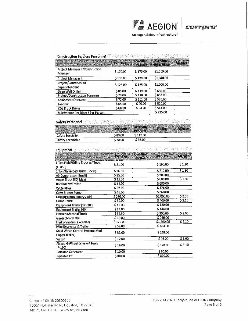
COnstr.uc-tion Services Per.sonnet
Project Manager II/Construction Manager Project Manager I Project/Construction Superintendent Dee~ Well Driller Project/Construction Foreman Equipment Operator laborer COL Truck Driver Subsistence Per Diem/ Per Person
Safety Personnel
Safety Specialist Safety Technician
Equipment
1 Ton Field/Utility Truck w Tool, (F -350) 2 Ton Stake Bed Truck IF-550) Air Compressor (Small) Auger Truck (50' Max) Backhoe w/Trafler Cable Plow Coke Breeze Pump Drill Rig (Mud Rotary/ Air) Dump Truck Equi~entTrailer 112'-20') Equipmeni Trailer 140') Flatbed Material Truck Geotechnical Drill Hydro Vacuum Excavator Mini Excavator & Trailer Solid Waste Control System (Mud Puppy Trailer) Pickup Pickup 4-Wheel Drive w/Tools IF-150) Portable Generator Portable P~
Corrpro 'Bid II: 20300109 7000A Hollister Road, Houston, TX 77040
Tel: 713 460 6000 I www.aegion.com
$ 170.00
$ 130.00
$ 125.00
$85.00 S 79.00 S 72.00 $ 65.00 $68.00
$80.00 S 70.00
$ 21.00
$ 26.50 $ 25.00 $85.00 $ 85.00 $ 62.00 $45.00 $ 250.00 $ 50.00 S 15.00 $ 18.00 $ 37.50 $30.00 S 175.00 $ 58.00
$31.00
$12.00
$ 16.00
$10.00 $40.00
r~ AEGION" Stronger. Safer. Infrastructure:
S 170.00
S 130.00
$ 125.00
$119.00 $ 110.00 S 101.00 S 90.00 $94.00
S 112.00 S 98.00
$1,360.00
$1,040.00
$1,000.00
$680.00 $632.00 $ 576.00 $ 520.00 $ 544.00 S 225.00
S 160.00 $1.20
S 212.00 S 1.30 $ 200.00 S 680.00 $ 1.80 $680.00 $476.00 S 360.00
S2.000.00 $ 2.30 S 400.00 $2.10 S 120.00 S 144.00 $300.00 $2.00 S 240.00
$1,400.00 $ 2.10 $464.00
S 248.00
$96.00 S 1.00
$128.00 $1.10
$B0.00 $320.00
Public Ct;) 2020 Corrpro, an AEGION company Page 5 of G
r~ AEGION" c:orrpro' Stronger. Safer. Infrastructure:
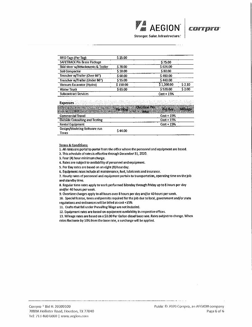
RFID Tags (Per Tag) S 25.00 SAfETRACK Pin Braze Package S 75.00 Skid steer w/Attachments & Trailer S 78.00 $624.00 Soil compactor $10.00 $80.00
Trencher w/Traller (OVer 66") S 60.00 $480.00
Trencher w/Trailer (Under 66") $55.00 S 440.00 Vacuum Excavator (Hydro} S 150.00 S 1,200.00 $2.10
Water Truck Subcontract Services
Commercial Travel Outside Consulting and Testing Rental Equipment Design/Modeling Software run Times
Terms & Conditions:
S 65.00 S 520.00 S 2.00
Cost+ 15%
Cost+ 15%
S44.00
1. All rates are portal to portal from the office where the personnel and equipment are based. 2. This schedule of rates is effective through December 31, 2020. 3. Four (4} hour minimum charge. 4, Rates are subject to a\'ailability of personnel and equipment.
S. Per Day rates are based on an eight (8) hour day. 6. Equipment rates include all maintenance, fuel, lubricants and insurance. 7. Hourty rates of personnel and equipment pertain to transportation, operating time on the Job and standby time.
8. Regular time rates apply to work perfom1ed Monday through Friday up to 8 hours per day and/or 40 hours per week. 9. overtime charges apply to all hours over 8 hours per day and/or 40 hours per week. 10. Special license, taxes and permits required for the job due to local1 government and/or state regulations and ordinances wm be billed at cost+ 15% 11. Crafts that fall under Prevailing Wage are not induded. 12. Equipment rates are based on equipment availability in respective offices. B. Mileage rates are based on a S3.00 Per Gallon diesel base rate. Rates subject to change. When rates fluctuate by 10Yo from the base rate, a surcharge will be applied.
- --------- ---------------------- --------------------- --------------------
Corrpro : Bid ti: 20300109
70001\ Hollister Road, Houston, TX 770~0 Tel: 713 460 6000 I www.aegion.com
Public Ci::) 2020 Corrpro, an AEGlON company Page 6 of 6
Stronger. Safer. Infrastructure."
c:orrpro 0
Prepared for: South Texas Water Authority-Armando Yruegas
Bishop, Tx
Corrpro Project No.: 340410178
02/21/2020
r~ AEGION" Stronger. Safer. Infrastructure:
TABLE OF CONTENTS QUALITY ASSURANCE FORM ................................................................................................ PAGE 3
SUMMARY .......................................................................................................................... PAGE 4
RECOMMENDATIONS ......................................................................................................... PAGE 5
APPENDIX A EXCEPTION TABLES
APPENDIX 8 GRAPHS
APPENDIX C RECTIFIER DATA
APPENDIX D TEST STATION DATA
.APPENDIX E CLOSE INTERVAL SURVEY PROCEDURE AND EQUIPMENT SPECIFICATIONS
ri: AEGION Stronger. Safer. Infrastructure.'
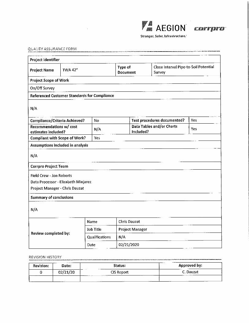
QUALITY ASSURANCE. FORM
Project Identifier
Project Name TWA42" Type of Close Interval Pipe-to-Soil Potential
Document Survey
Project Scope of Work
On/Off Survey
Referenced Customer Standards for Compliance
N/A
Compliance/Criteria Achieved? No Test procedures documented? Yes
Recommendations w/ cost N/A
Data Tables and/or Charts Yes
estimates included? Included?
Compliant with Scope of Work? Yes
Assumptions included in analysis
N/A
Corrpro Project Team
Field Crew - Jon Roberts
Data Processor - Elizabeth Minjarez
Project Manager - Chris Dauzat
Summary of conclusions
N/A
Name Chris Dauzat
Job Title Project Manager Review completed by:
Qualifications N/A
Date 02/21/2020
REVISION HISTORY
Revision: Date: Status: Approved by:
0 02/21/20 CIS Report C. Dauzat
ri: AEGION. corrpro· Stronger. Safer, Infrastructure:
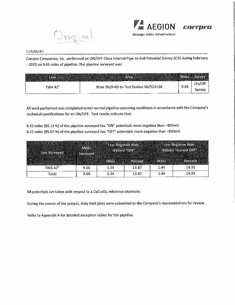
SUMMARY
Corrpro Companies, Inc. performed an ON/OFF Close Interval Pipe-to-Soil Potential Survey (CIS) during February
- 2020 on 9.66 miles of pipeline. The pipeline surveyed was:
TWA42" Riser SN/0+00 to Test Station SN/523+18 9.66 On/Off
Survey
All work performed was completed under normal pipeline operating conditions in accordance with the Company's
technical specifications for an ON/OFF. Test results indicate that:
8.32 miles (86.13 %) of the pipeline surveyed has "ON" potentials more negative than -850mV.
8.22 miles {85.07 %) of the pipeline surveyed has "OFF" potentials more negative than -850mV.
TWA42" 9.66 1.34 13.87
Total 9.66 1.34 13.87 1.44
All potentials are taken with respect to a CuCuSO, reference electrode.
14.93
During the course of the project, daily field plots were submitted to the Company's representatives for review.
Refer to Appendix A for detailed exception tables for this pipeline.
r~ AEGION crarrprra · Stronger, Safer, Infrastructure:
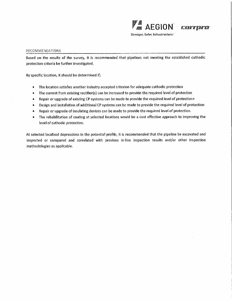
RECOMMENDATIONS
Based on the results of the survey, it is recommended that pipelines not meeting the established cathodic
protection criteria be further investigated.
By specific location, it should be determined if;
• The location satisfies another industry accepted criterion for adequate cathodic protection
• The current from existing rectifier(s) can be increased to provide the required level of protection
• Repair or upgrade of existing CP systems can be made to provide the required level of protection+
• Design and installation of additional CP systems can be made to provide the required level of protection
• Repair or upgrade of insulating devices can be made to provide the required level of protection.
• The rehabilitation of coating at selected locations would be a cost effective approach to improving the
level of cathodic protection.
At selected localized depressions in the potential profile, it is recommended that the pipeline be excavated and
inspected or compared and correlated with previous in-line inspection results and/or other inspection
methodologies as applicable.
r~ AEGION" carrprar Stronger. Safer. Infrastructure:
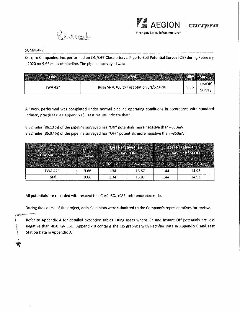
SUMMARY
Corrpro Companies, Inc. performed an ON/OFF Close Interval Pipe-to-Soil Potential Survey (CIS) during February
- 2020 on 9.66 miles of pipeline. The pipeline surveyed was:
TWA42" Riser SN/0+00 to Test Station SN/523+18 9.66 On/Off
Survey
All work performed was completed under normal pipeline operating conditions in accordance with standard
industry practices (See Appendix E). Test results indicate that:
8.32 miles (86.13 %) of the pipeline surveyed has "ON" potentials more negative than -850mV.
8.22 miles (85.07 %) of the pipeline surveyed has "OFF" potentials more negative than -850mV.
TWA42" 9.66 1.34 13.87 1.44
Total 9.66 1.34 13.87 1.44
All potentials are recorded with respect to a Cu/Cuso. (CSE) reference electrode.
14.93
14.93
During the course of the project, daily field plots were submitted to the Company's representatives for review.
Refer to Appendix A for detailed exception tables listing areas where On and Instant Off potentials are less
negative than -850 mV CSE. Appendix B contains the CIS graphics with Rectifier Data in Appendix C and Test
Station Data in Appendix D.
r~ AEGION" corrpro· Stronger. Safer. Infrastructure."
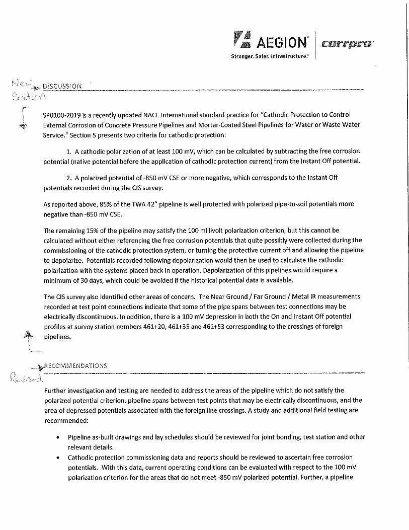
'" '·"-~ DISCUSSION
-~ !
SPOl00-2019 is a recently updated NACE International standard practice for "Cathodic Protection to Control
External Corrosion of Concrete Pressure Pipelines and Mortar-Coated Steel Pipelines for Water or Waste Water
Service." Section 5 presents two criteria for cathodic protection:
1. A cathodic polarization of at least 100 mV, which can be calculated by subtracting the free corrosion
potential (native potential before the application of cathodic protection current) from the Instant Off potential.
2. A polarized potential of-850 mV CSE or more negative, which corresponds to the Instant Off
potentials recorded during the CIS survey.
As reported above, 85% of the TWA 42" pipeline is well protected with polarized pipe-to-soil potentials more
negative than -850 mV CSE.
The remaining 15% of the pipeline may satisfy the 100 millivolt polarization criterion, but this cannot be
calculated without either referencing the free corrosion potentials that quite possibly were collected during the
commissioning of the cathodic protection system, or turning the protective current off and allowing the pipeline
to depolarize. Potentials recorded following depolarization would then be used to calculate the cathodic
polarization with the systems placed back in operation. Depolarization of this pipelines would require a
minimum of 30 days, which could be avoided if the historical potential data is available.
The CIS survey also identified other areas of concern. The Near Ground/ Far Ground/ Metal IR measurements
recorded at test point connections indicate that some of the pipe spans between test connections may be
electrically discontinuous. In addition, there is a 100 mV depression in both the On and Instant Off potential
profiles at survey station numbers 461 +20, 461 +35 and 461 +53 corresponding to the crossings of foreign
pipelines.
-)>-RECOMMENDATIONS
Further investigation and testing are needed to address the areas of the pipeline which do not satisfy the
polarized potential criterion, pipeline spans between test points that may be electrically discontinuous, and the
area of depressed potentials associated with the foreign line crossings. A study and additional field testing are
recommended:
• Pipeline as-built drawings and lay schedules should be reviewed for joint bonding, test station and other
relevant details.
• Cathodic protection commissioning data and reports should be reviewed to ascertain free corrosion
potentials. With this data, current operating conditions can be evaluated with respect to the 100 mV
polarization criterion for the areas that do not meet -850 mV polarized potential. Further, a pipeline
r~ AEGION" corrpra· Stronger. Safer. Infrastructure:
specific Instant Off potential criterion can be developed for future use that assures a minimum of 100
mV of cathodic polarization.
• Monitoring and maintenance data should be examined to evaluate changes in levels of protection and
rectifier outputs over time.
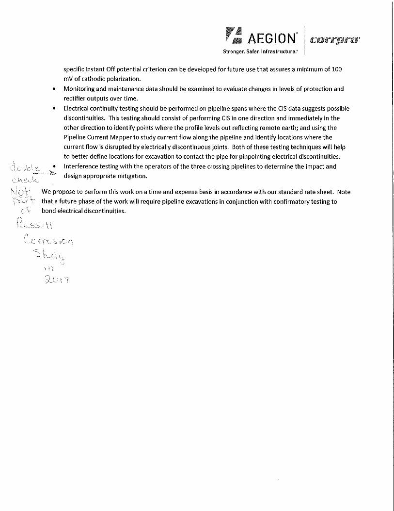
• Electrical continuity testing should be performed on pipeline spans where the CIS data suggests possible
discontinuities. This testing should consist of performing CIS in one direction and immediately in the
other direction to identify points where the profile levels out reflecting remote earth; and using the
Pipeline Current Mapper to study current flow along the pipeline and identify locations where the
current flow is disrupted by electrically discontinuous joints. Both of these testing techniques will help
to better define locations for excavation to contact the pipe for pinpointing electrical discontinuities.
Interference testing with the operators of the three crossing pipelines to determine the impact and • ;":::__,,'1,;,, design appropriate mitigation.
We propose to perform this work on a time and expense basis in accordance with our standard rate sheet. Note
~.. that a future phase of the work will require pipeline excavations in conjunction with confirmatory testing to
t ·~ bond electrical discontinuities.

ri: AEGION Stronger. Safer. Infrastructure:
APPENDIX A: EXCEPTION TABLES
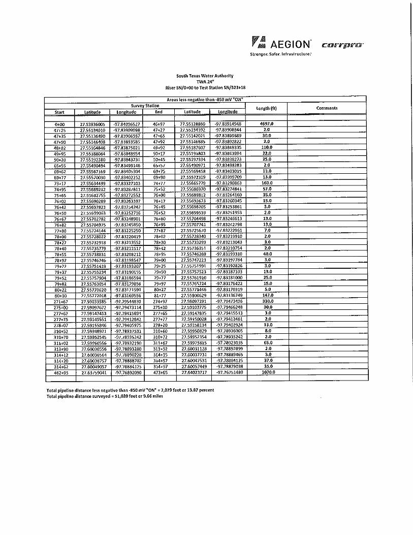
Start Latitude
0,00 27.53936005 47+25 27.55134010
47+35 27.55136490
47+90 27.55146408 48+82 27.55164846 49+95 27.55188084 50-i.20 27.55192280
65-t-55 27.55490494 69+62 27.55567169 69+77 27.55570030 73+17 27.55634499 74+95 27.55669212 75+65 27.55682755 76+02 27.55690289 76+42 27.55697823 76+50 27.55699063 76+67 27.55702782 76+82 27.55704975 77+80 27.55724144 78+00 27.55728022 78+27 27.55732918 78+40 27.55735779 78+55 27.55738831 78+97 27.55746746 79+22 27.55751419 79+37 27.55755234 79+52 27.55757904 79+82 27.55763054 80+22 27.55770620 80+30 27.55772018 271+67 27.59033585 275+00 27.59097672 277+62 27.59147453 277+75 27.59149551 278+07 27.59155846 310+52 27.59948921 310+70 27.59952545 311+02 27.59960556 313+90 27.60030556 314+12 27.60036564 314+20 27.60038757 314+62 27.60049057 462+95 27 .63759041
South Texas Water Authority TWA24"
Riser SN/0+OOto Test Station SN/523+18
Areas less negative than-850 mV ~ON" Survey Station
Lon°itude End Latitude Lon°1tude
-97.84096527 46+97 27.55128860 -97.83914948
-97.83909098 47-+27 27.55134392 -97.83908-844 -97.83906937 47+65 27.55142021 -97.83899689
-97.83893585 47+92 27.55146885 -97 .83892822
-97.83875021 49+92 27.55187607 -97 .83849335 -97.83848954 50+17 27.55191803 -97.83843994
-97.83843231 50+45 27.55197334 -97.83838273
-97.83499146 65+57 27.55490971 -97.83498383 -97.83405304 69+75 27.55569458 -97.83403015 -97.83402252 69+90 27.55572319 -97 .83399709 -97.83327103 74+77 27.55665779 -97.83290863 -97.83287811 75+52 27.55680370 -97.83274841 -97.83272552 76+00 27.55689812 -97.83264160 -97 .83263397 76+17 27.55692673 -97.83260345 -97.83254242 76+45 27.55698205 -97.83253861 -97.83252716 76+52 27.55699539 -97.83251953 -97.83248901 76+80 27.55704498 -97.83246613 -97.83245850 76+95 27.55707741 -97.83242798 -97.83225250 77+87 27.55725670 -97.83222961 -97.83220419 78+02 27.55728340 -97.83219910 -97.83213552 78+30 27.55733299 -97.83213043 -97.83211517 78+42 27.55736351 -97.83210754 -97.83208212 78+95 27.55746269 -97.83199310 -97.83198547 79+00 27.55747223 -97.83197784 -97.83193207 79+25 27.55751991 -97,83192826 -97.83190155 79+50 27.55757523 -97.83187103 -97.83186594 79+77 27.55761910 -97 .83181000 -97.83179856 79+97 27.55765724 -97.83176422 -97.83171590 80+27 27.55771446 -97.83170319 -97.83169556 81+77 27.55800629 -97.83136749 -97.79544830 274+97 27.59097291 -97.79473496 -97.79473114 275+30 27.59103775 -97.79466248 -97.79415894 277+65 27.59147835 -97.79415513 -97.79412842 277+77 27.59150028 -97.79412461 -97.79405975 278+20 27.59158134 -97,79402924 -97.78937531 310+60 27.59950829 -97.78936005 -97.78935242 310+72 27.59952354 -97.78935242 -97.78932190 311+67 27.59975815 -97.78923035 -97.78893280 313+92 27.60031128 -97.78892899 -97.78890228 314+15 27.60037231 -97.78889465 -97.78888702 314+57 27.60047531 -97.78884125 -97.78884125 314+97 27.60057449 -97.78879038 -97.76892090 473+65 27.64023717 -97.76751489
Total plpeUne distance less negative than-850 mV "ON"= 7,079 feet or 13.87 percent Total pipellne distance surveyed= 51,020 feet or 9.66 mlles
Jr~ AEGION. Stronger. Saler. lnlra~lrudure.'
Length {ft) Comments
4697.0 2.0
30.0 2.0
110.0 22.0 25.0 2.0 13.0 13.0
160.0 57.0 35.0 15.0 3.0 2.0 13.0 13.0 7.0 2.0 3.0 2.0
40.0 3.0 3.0 13.0 25.0 15.0 5.0
147.0 330.0 30.0 3.0 2.0 13,0 8.0 2.0
65.0 2.0 3.0 37.0 35.0
1070.0
South Texas Water Authority TWA24"
RiserSN/0+00 to Test Station SN/523+18
r.i:! AEGION. Slronger. Safer. lnfraslrutlure.'
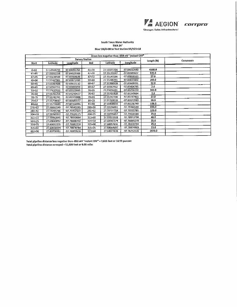
Areas less negative than •850 mV "Instant OFFQ
Survey Station
Start Latitude Lonoltude End Latitude Lon°1tude
0+02 27.53938293 -97.84095764 41+70 27.55031204 -97.84032440
41+85 27.55032158 -97 .8<1029388 47+20 27.55133247 -97.83909607
47+45 27.55138588 -97 .83904648 47+72 27.55143166 -97.83898163
49+00 27.55167961 -97.83871460 So+60 27.55200291 -97.83835602
60+45 27.55387688 -97.83615112 60,67 27.55388928 -97.83609391
69+65 27.55567551 -97.83405050 69+67 27.55567932 -97.83404795
73+32 27.55637932 -97.83323669 76+35 27.55696201 -97.832S6150
76+60 27.55701256 -97.83250427 76+62 27.55701828 -97.83249664
78+75 27.55742741 -97.83203888 79+02 27.55747700 -97 .83197403
79+57 27.55758667 -97.83185577 80'15 27.55769539 -97.83172989
80+42 27.55774689 -97.83166886 81+80 27.55800056 -97,83136749
271+62 27.59032249 -97.79545593 280+00 27.59196091 -97.79365540
280+42 27.59205246 -97.79357529 281+62 27.59231758 -97.79335785
304+10 27.59789372 -97.79024125 304+35 27.59795857 -97.79020310
311+12 27.59962845 -97.78930664 311-+60 27.59973908 -97.78923798
314+25 27.60040092 -97.78888702 314+50 27.60045529 -97.78885270
314+75 27 .60052395 -97.78882218 315+00 27.60057831 -97.78878784
315+02 27 .60058594 -97.78878784 315+25 27.60064697 -97.78874969
462+90 27.63756561 -97.76893616 473+60 27 .64022636 97.76752116
Total plpeHne distance less negatl11e than -850 mV"lnstant OFFP = 7,616feet or 14.93 percent Total pipeline distance surveyed= 51,020 feet or9.66 mlles
Length (ft)
4168.0 535.0 27.0 160.0 22.0 2.0
303.0 2.0
27.0 58.0 138.0 838.0 120.0 25.0 48.0 25.0 25.0 23.0
1070.0
Comments

r~ AEGION' c:orrpro· Stronger. Safer, Infrastructure:
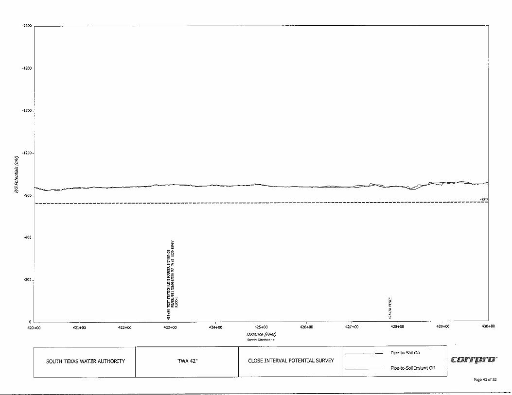
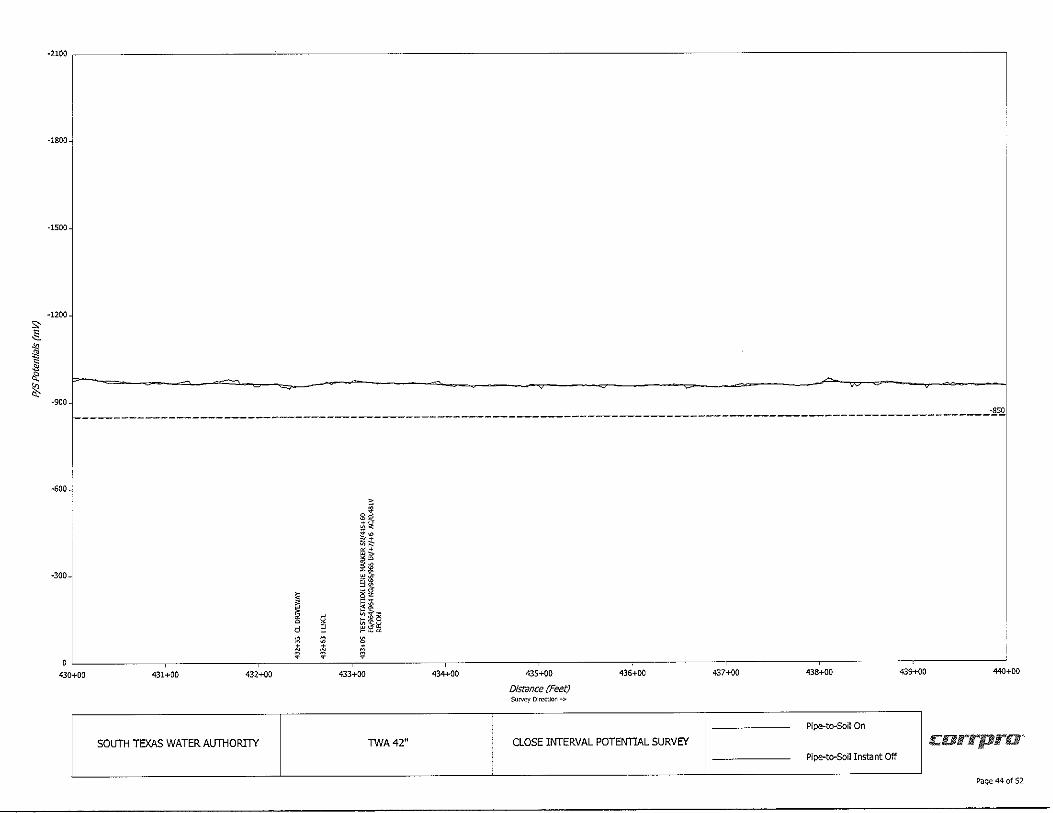
APPENDIX B: GRAPHS
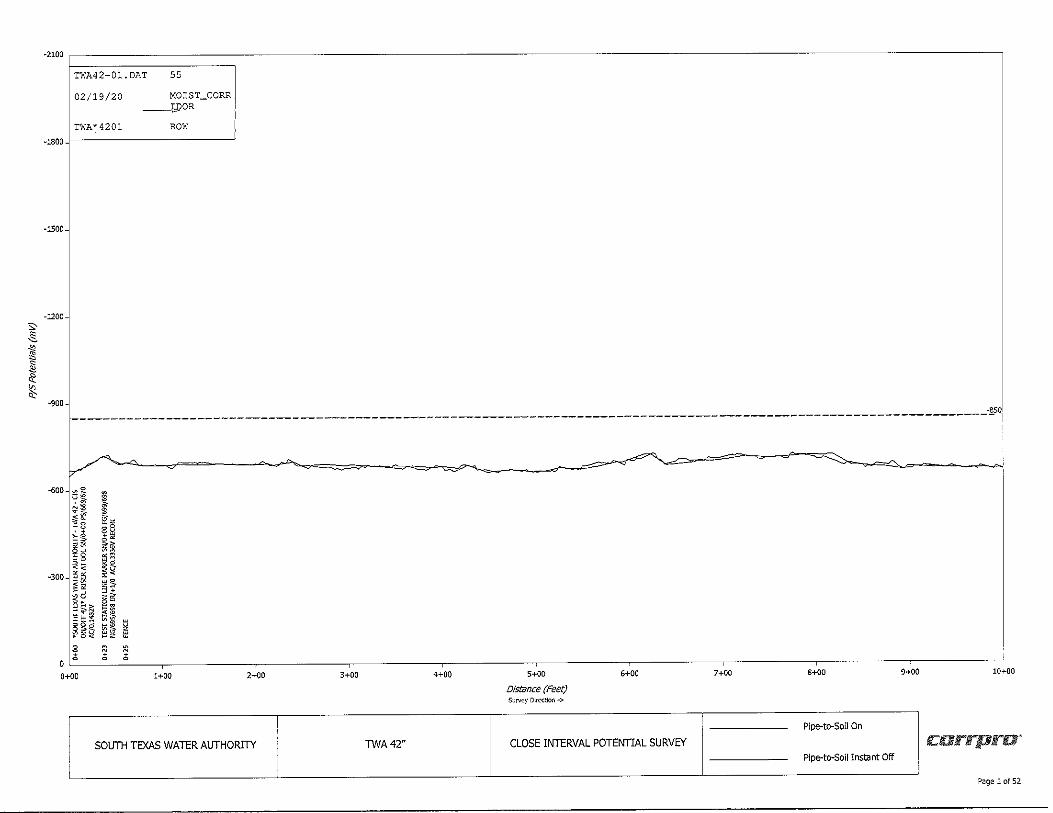
s, ~ .,, ~ .§ .: ;\:, o;
-2100
TWA42-01.DAT 55
02/19/20
TWA*4201
MOIST_CORR ----1",l)OR
ROW -1800 f----------------~
-1500
-1200
-900 -850 1------------------------------------------------------------------------------------------------- -1
-600~-0
~ ~ -....,::,.,,._
~ ~ '--~ ___,______ "--- -..._,,--.., = ~
,:.§ i :.: l "" ~8 ii:~ r I ; i ~
" § ·300~~~ ~:
:.'!: o2 § :=;,
j2 ;;~ $~ ~$ u~ ~ii~
.«sS ~g e 8 " o a 0 a
0+00 1+00 2+00 3+00 4+00 5+00 6+00 7+00 8+00 9+00 10+00
Distance (Feet} Survey Direction->
Pipe-to-Soil On
SOUTH TEXAS WATER AUTHORITY TWA42" CLOSE INTERVAL POTENTIAL SURVEY carrpra-Pipe-to-Soil Instant Off
I Page 1 of 52
,:_§_ .,, ~
I ~ "
-2100 ~--------------------------------------------------------------------,
-1800
-1500
-1200
-900 _________________________________________________________________________________________________ 3,.0
-600
-300-
10+00 11+00 12+00 13+00
SOLJTH TEXAS WATER AlJTHORin' TWA42"
14+00
i §;; il~ ·~ •• i~ 1~ w,S
~t ~;; ~~ •• ~ ~ M
~ 15+00
Dlstilnce {Feet) Survey Dlrcctkln ->
16+00
CLOSE INTERVAL POTENTIAL SURVEY
i d $
:1:
17+00
i ~B "~ ~~ n e "-
~~ -~ <!.'> t;; !i ~~ g
18+00
Pipe-to-Soll On
Pipe-to-Soil Instant Off
19+00 20+00
c:arrpra-
P<1ge 2 of 52
s, .§_ .,, ~ ]j 0: ~ "'
-2100 ~-----------------------------------------------------------------------,
-1800
-1500
-1200
-900 -eso; --------------------------~------------------~-------------------------- ,___________________ I
-600
-300
oL_ ____ ~----~-----~----~-----~----~----~----~,:-:------:,-::-----~ 28+00 29+00 30+00
20+00 21+00 22+00 23+00 24+00
SOUTH TEXAS WATER AUTHORITY TWA42"
25+00
Distance (Feet) Surv~y Direction->
26+00
CLOSE INTERVAL POTENTIAL SURVEY
27+00
Pipe-to-son on
! carrpra' Pipe-to-Soil Instant Off
Pcige 3 of 52
s, -Is
" ,11 ~
"' 0: ~ "'
-2100 ~--------------------------------------------------------------------,
·1800
-1500
-1200
-900
------------------------------------------------------------------------------------- --.:$2•
-- ~ -600~ ~ ~, " • ~~ il
0 ·-a,: - § ~t5 • ~·- ;::
~~- i -300~
,. ; •"" ~ 9$~ ~ f5~~ § ' " . Q <~ +
gi ; t;; + $ ~ t;;~+ d I=! v'i ?! ~ s 8 .. /i " ~
30+00 31+00 32+00 33+00 34+00 35+00 36+00 37+00 38+00 39+00 40+00
Dlstonce (Feet) Su,v.:,y Dlrcct~n -:,.
Pipe-to-Soil On
SOUTH TEXAS WATER AUTHORITY TWA42" CLOSE INTERVAL POTENTIAL SURVEY c:orrpru· Pipe-to-Soil Instant Off
Page 4 of 52
"' .§_ .,,, ~ .§ <\: ~ <,:
-2100 ~-------------------------------------------------------------------------~
-1800
-1500
-1200...J
-900~ , _______________ . ·rr-- --=--- --;_;:--.,------ -------- - -~---- = . -= " 0 - ~ -=- - ----~------~
-600-. ~ I i cl ~§ Ii ~a il !~ ~~
~ ", S$ -"' .,,
" "o ,_
~ • !, I~ ~o
-300~ 5 ,~ ~2 §~ s 8i ;:: 8 er
~ •• ~I ~ ~
g~ ~I d "'
h ~- ti ~ • $ • • + +
$ - - • • 40+00 41+00 42+00 43+00 44+00 45+00 46+00 47+00 48+00 49+00 50+00
DistBnce (Feet) Sur,,,zy Direction.,.
Pipe-to-Soll On
SOITTH TEXAS WATER AITTHORITY TWA42" CLOSE INTERVAL POTENTIAL SURVEY c:arrpra· Pipe-to-Soil Instant Off
Page 5 of 52
s, .§. .,, ,1: ~
"' ~ ~
-2100 --------------------------------------------------------------------------,
-1800
-1500
-1200
-900L-~--::::S'_;:_:-:_:-:_::,.;:_-;:_::::_::-::-:::::_-:_:::_::.:.=-~-=:::,_::-:::_c:_,;:_,:_';,_::::::~~-::_=:_:_~_:_=::=~_:::_:'._:.:::_:_::":_:::'.:_~_~_:.:.:_~_~_::'.:_::_::_:::_::.:_==-=-=-=·=-:-:.:.~==~·==· =~=:::~=:. ".::::.:::::::::::::::
-600
-300..;
50+00 51+00 52+00 53+00 54+00
SOUTH TEXAS WATER AUTHORITY TWA42"
55+00
Distance (Feet) Survey DlrcctJon -;,
56+00
CLOSE INTERVAL POTENTIAL SURVEY
57+00 58+00 59+00 60+00
Pipe-to-Soll On
carrpra· Pipe-to-Soil Instant Off
P;Jge 6 of 52
-2100 ~--------------------------------------------------------------------------
s, .§_ _,,,
-1800
-1500
-1200-
~ ___, ~ -- = --- -----"' I --- -¾:_ I ~ - ----~ -900---1 .,.p-<' ,...... = ----- --1 s;___;.; ___ _
-600
~ ~· ~~ ti >c
-300
I
~
"§ ~-~t l:;!~ O+ a~ ••
~ ~~
d ~~ ~ e
a • $ il o~ 60+00 61+00 62+00
SOUTH TEXAS WATER AUTHORITY
i 8 il
63+00 64+00
TWA42"
65+00
Distance (Feet) Sur,,zy D1rectl<:m ->
66+00
CLOSE INTERVAL POTENTIAL SURVEY
-~
67+00 68+00 69+00 70+00
Pipe-to-Soll On
corrpra· Pipe-to-Soll Instant Off
Page 7 of 52

s, .§_
"' ~ ,l ii: ~
-21001--------------------------------------------------------------------------------~
·1800
-1500~
-1200
-900 -~Q
-600
-300
QL__---~----~----~----~----~----~----,-----=-c::---------:_:,::::-----~ 78+00 79+00 80+00
70+00 71+00 72+00 73+00 74+00 75+00
Distance (Feet) Survey Direction ->
76+00
SOUTH TEXAS WATER AUTHORITY TWA 42" CLOSE INTERVAL POTENTIAL SURVEY
77+00
Pipe-to-Soll On
carrpra" P!pe-to--Soll Instant Off
?3ge 8 of 52
s:.§_ .,, ,!I s
"' Ii: ~ "
-2100 ~---------------------------------------------------------------,
-1800
-1500
-1200
-900
1---===-•----~d-~------------------------------------------------------------------------------------------- -.E5.Q
-600 ~ ~ ia " s~ i, .~ il
-300
~:;; I ~~ p ;:; ~
!!:!! ~ 9t •• ;:;
•• @ ~ ~ _, g~ ' ~ I;;§ ' ~· ~" d .$
l ~ ~ 80+00 81+00 82+00 83+00 84+00 85+00 86+00 87+00 88+00 89+00 90+00
Distance (Feet) Surwy Direction->
Pipe-to-Soil On
SOUTH TEXAS WATER AUTHORITY TWA42" CLOSE INTERVAL POTENTIAL SURVEY carrpru-Pipe-to-Soil Instant Off
Page 9 of 52
s, ~ .,, ~ s
"' "' ~ "
-2100 ~--------------------------------------------------------------------7
-1800
-1500
•1200
-,001-----------------------------------------------------------·----------------------------------------------------~~I
-soo
-300 '
~ a '1 ~~ -· ~i g~ ~i ~~ ~i-
0 ~ 8
90+00 ~ ~ '! • 91+00 92+00 93+00 94+00 95+00
Distance (Feet) SUN"'/ Direction -:,.
96+00
SOUTH TEXAS WATER ALJTHORITY . TWA42" CLOSE INTERVAL POTENTIAL SURVEY
97+00 98+00 99+00 100+00
Pipe-to-Soil On c:orrpra-
Pipe-to-Soil Instant Off
Page 10 of 52
s, .§_
" ,!I ~
"' ~ ~
-2100 ~---------------------------------------------------------------------c
-1800
-1500-
-1200
-900
i--------------- ------------------------------------------------------------·------~.o_
-600
-300
100+00 101+00 102+00 103+00 104+00
SOUTH TEXAS WATER AUTHORITY TWA42"
105+00
Distance (Feet} Survey Direction ->
106+00
CLOSE INTERVAL POTENTIAL SURVEY
107+00 108+00
Pipe-to-Soll on
Pipe-to-Soll Instant Off
109+00 110+00
c:orrpra·
Page 11 of 52
s:-~
" ,i: s ~ ~
~
-2100 .~--------------------------------------------------------------------7
-1800
-1500...;
-1200
-900 -850 ---------------------------------------------------------------------------------------- ' -·- --
-600
-300
§ ~
d j;.; ~i:: ~•!\ ~g:
~~ H ~~ 1 8
0 -
110+00 111+00 112+00 113+00 114+00 115+00
Distance (Feet) Survey Direction->
116+00
SOUTH TEXAS WATER AUTHORITY TWA 42" CLOSE INTERVAL POTENTIAL SURVEY
117+00 118+00 119+00 120+00
Pipe-to-Soll On
c:arrpru· Pipe-to-Soll Instant Off
Page 12 of 52
s, ~
" i ,j <: ¾?_ o;
-2100 ~---------------------------------------------------------------,
-1800
-1500
-1200
-900 -850 ---------------------------- "---------. ---· -------- ----------------·-----------------·. ----------- ·---------------- . . . .
-Goo_;
-300
"· + + 1:S~ ~~
n i it5 ,c~ ~§~ a~· ,-~~ ~ ill? ~
9 g
i g
I . 5 8
~ " oL----~----~-----~~=-----~-----~----~----~-----~------:,--::--------::::'. 128+00 129+00 130+00
120+00 121+00 122+00 123+00 124+00
SOUTH TEXAS WATER AUTHORITY TWA42"
125+00
Distance (Feet) Sur,cy D1~1on ->
126+00
CLOSE INTERVAL POTENTIAL SURVEY
127+00
Pipe-to-Soil On
corrpra· Pipe-to-Soll Instant Off
Page 13 of 52
s.§.
"' ,Ii s '!a ci: t
-2100 ~---------------------------------------------------------------,
-1800 .!
-1500
-1200
-900 -850 ----------------------------------------------------------------------- --
-600
•300
130+00
•• ~ ii
~t g "-
i If ~i~
~ .-s~~ § ~1~ w
ij ~ iJ
~ • a -131+00 132+00 133+00 134+00 135+00
Distance (Feet) Suiv<?y Dlrcct~n ->
136+00
SOUTH TEXAS WATER AUTHORITY TWA 42" CLOSE INTERVAL POTENTIAL SURVEY
137+00 138+00 139+00 140+00
Pipe-to-Soll On
rc:arrpra· Pipe-to-Soll Instant Off
Page 14of52
s, .§_
"' t s
" <!'. ~ ""
-2100
-1800
-1500
-1200-
-900---------- - ----------- -------------------------------------------------------------~~~
-600---'
-300
140+00 141+00 142+00 143+00
SOUTH TEXAS WATER AUTHORITY
144+00
TWA42"
145+00
Distance (Feet) Surv,:,y Direction-;,
146+00
CLOSE INTERVAL POTENTIAL SURVEY
8~ ~ i~ " ii ~ "- ~ ig ;.:ti; g §~B B~~ ~ i=§r; ffi ~~:: C 1;;;:::o ~ ~ g,:;,
~ • +
" 147+00 148+00 149+00 150+00
Pipe-to-Soil On
c:arrpra· P!pe-to-Soil Instant Off
Page 15 of 52
s_§_
"' ~ i ~ ¾:, "'
-2100
-lSQ0..;
-1500
-1200
-900 -850 --------------------------------------------------------------------------------------------- ---
-600
~300~
~ " ~ g §
~ s • !'i
0
150+00 151+00 152+00
SOLJTH TEXAS WATER AlJTHORITY
" ~ ~ g ~ ~ §
~
~ g
i 8
I ~ § ~ ~ •
153+00
TWA42"
154+00 155+00
Distance (Feet) Survey D1rcct100 -;,,
156+00
CLOSE INTERVAL POTENTIAL SURVEY
157+00 158+00 159+00 160+00
Pipe-to-Soil On
carrpru-Pipe-to-Soll Instant Off
Page 16 of 52
s, _§_ .. S!l ~ ~ ¾:_
"
-2100 ---------------------------------------------------------------------------,
-1800-
-1500
--------~
-1200
-
-900 -~O -------------------------------------------------------------------------------------------------------- ,-
-<500
~ 2
·300j ~ ; a Q
I • le le ~ i ~ ~ § t;; ~
" " § § § g ~ 5 ~ ~ § " • ~ ~ ~ i1 ii §
0 160+00 161+00 162+00 163+00 154+00 165+00 166+00 167+00 168+00 169+00 170+00
Distance (Feet) SuNey Direction->
Pipe-to-Soil On
SOUTH TEXAS WATER AUTHORITY TWA42" CLOSE INTERVAL POTENTIAL SURVEY carrpra' Pipe-to-Soil Instant Off
Page 17 of 52
s.§_
" ~ t cl: ¾!, "'
-2100 ~--------------------------------------------------------------------7
-1800
-1500
-1200
-900
-----------·-----------------------------------------------------------------------------~~~
-600
-300
0-----~-=---~-----~----~-----~----~-----~----~------:::c-::------=: 178+00 179+00 180+00
170+00 171+00 172+00 173+00 174+00
SOUTH TEXAS WATER AUTHORITY TWA42"
175+00
Distance (Feet) Sur,~y Direction->
176+00
CLOSE INTERVAL POTENTIAL SURVEY
177+00
P!pe-to-So!I on
corrpra' Pipe-to-Soll Instant Off
Page 18 of 52
S' ~
" ,;: .§ 0: ~ "'
-2100 ~--------------------------------------------------------------------7
-1800
-1500
~
-1200
I \ -900-1
TWA42-02.DAT 55
02/19/20
TWA42*02
_!@IST_FIEL D ROW
-850 ---------------------------------------------------------------------------------- ----
-600
-300
I s. 8
I~ i vi .., vi
";; ~ 11 ~ " " ~". ~ 0 ~ ti:: ,j ~ - > ~
~~~ ~~ ~ ~~~ ~~;; • • • ,:!; ,:!; ,:!;
0 ~ ~ ~
180+00 181+00 182+00 183+00 184+00 185+00 185+00 187+00 188+00 189+00 190+00
Distance (Feet} SulV<:)' Direction ->
Pipe-to-Soil On
SOUTH TEXAS WATER AUTHORITY TWA42" CLOSE INTERVAL POTENTIAL SURVEY carrpro" Pipe-to-Soil Instant Off
Page 19 of 52
"' ~ " ssl ]j 0: ¾!_ '"
-2100 ~--------------------------------------------------------------------7
-1800
-1500
-1200
-900 -850 --------------------------------~------------------------------------------------- --------
-600
-300
I ¥~ "= it ~i ~· ~~ B~ "" ~$-
0 @~~ 190+00 •
~ 191+00 192+00 193+00
SOUTH TEXAS WATER AUTHORITY TWA42"
194+00 195+00
Distance (Feet) su=y Direction->
195+00
CLOSE INTERVAL POTENTIAL SURVEY
197+00 198+00 199+00 200+00
Pipe-to-Soll On
carrpra· Pipe-to-Soil Instant Off
Page 20 of 52

s, _§_ .,, i s
" <I: ~ "'
-2100 ~---------------------------------------------------------------,
-1800
-1500
-1200
-900
------------------------------------------------------------------------------------------ -~~
-600
-300
I d
i ~~ ';:!~ *~ I! ~i ~~ ~~ ,,,_ t;; ~ 8 ~~~ a
• M • 0 ~ M
" ~ :€ 200+00 a " •
201+00 202+00 203+00 204+00 205+00
Distance (Feet) Sur,,cy Direction ->
206+00
SOUTH TEXAS WATER AUTHORITY TWA 42" CLOSE INTERVAL POTENTIAL SURVEY
207+00 208+00 209+00 210+00
Pipe-to-Soil On
currpru-Pipe-to-Soil Instant Off
Page 21 of 52
s;, ,§_
" ~ ~ 0: ~ 0:
-2100
-1800
-1500
-1200
-900 _______________________________________________________________________________________________ ____:§0
-600
-300
I ~ t;;
ffi ~ § §
>
ii . " •• it gi ~· §~ .~ ,. t;;~-
~i~
0 ,~~--------;~~;----------;;;~;-----------;-;-;'.:::--------::~-::--------~------il_J__ ' 210+00 ~ 211+00 212+00
~ ~ i .. ~ ~ ~
N N
213+00 214+00 215+00 216+00 217+00 218+00
Distance (Feet) Survey Direction -;,.
Pipe-to-Soil On
SOUTH TEXAS WATER AUTHORITY TWA 42" CLOSE INTERVAL POTEITTIAL SURVEY Pipe-to-Soil Instant Off
219+00 220+00
carrpra"
Page 22 of 52
s, .§_
" c1!
I ~ "
-2100 ----------------------------------------------------------------,
-1800
-1500~
-1200
-900
---------------------------------------------------------------------------------------------_§~
-1500
-300-
I;; t;; t;; I;;
~ ~ ~ ~ g g g g
I i ~ !
" " 0
220+00 221+00 222+00 223+00 224+00 225+00 226+00
Distance (Feet) Surw.y Dlrcctlo~ -;,
SOUTH TEXAS WATER AUTHORITY TWA42" CLOSE INTERVAL POTENTIAL SURVEY
~ s~ ~~ Sz
ii -'
ii c5:;,: c• < ._ lri~B mf~ 8
~ 227+00 228+00
Pipe-to-Soil On
Pipe-to-Soil Instant Off
I;; I;;
~ ~ g g 8 ~ ~ Ii
229+00 230+00
corrpru·
Page 23 of 52
;;~
"' ~ ~ <\: ~
-2100~----------~
-1800-
-1500
-1200
·900 -850 ----------------------------------------------------------------------- ------
-<00
-300
" ~ g r "
230+00 231+00 232+00 233+00
SOUTH TEXAS WATER AUTHORITY TWA42"
" ~ § ~
~ 234+00 235+00
Distance (Feet) SUl'\l~Y Direction·>
~ e§ ~:;,:;2 '+ ~~ c+ ~,:: •• ;$ 9• ;; ~ s• ~§~ ~~-
236+00
CLOSE INTERVAL POTENTIAL SURVEY
" " 9 ~ a
§ §
~ ? i:i ~
237+00 238+00 239+00 240+00
Pipe-to-Soil On
c:orrpra· Pipe-to-Soil Instant Off
Page 24 of 52
s:-_§_ .,, "" a
" <I: ¾?, "'
-2100 ----------------------------------------------------------------,
-1800
-1500
-1200-
-900 -850 -------------------------- . ,_. _________ . --·-------------- . ------------ -------~' --------------- . ---------- -- . ~--- --- ----- --- . . . ----
-600
-300
~ ~ ~ @
5 5 ~ g § d
~ - • " ~ ~
240+00 241+00 242+00 243+00 244+00
SOUTH TEXAS WATER ALJTHORITY TWA42"
245+00
Distance {Feet) Survry DlrectlOO ->
246+00
CLOSE INTERVAL POTENTIAL SURVEY
247+00 248+00 249+00 250+00
Pipe-to-Soll On
carrpra· Pipe-to-Soll Instant Off
Page 25 of 52
5.' ~
"' ~ E ~
t
-2100 ~--------------------------------------------------------------------7
-1800
-1500
-1200
_/ -900- -850; ----------------------------------------------·-------------------- ·-----·-------------------- --------- -- - . -
-600
-300
$ ~ 7 I ~ f~: ~ ! v1g ~ r ~il ~ e. ~$ ... £ ~•a ~ • all:• §i ffi ~{~ 0:0 § t;;>@ 2; ~ ~~~ g~ • M < ;?j ;!; ;!;
0 ~ ~ );l
250+00 251+00 252+00
SOUTH TEXAS WATER AUTHORITY
253+00 254+00
TWA42"
255+00
Distance (Feet) Survey D11\.'Ctlon -;,
256+00
CLOSE INTERVAL POTENTIAL SURVEY
257+00 258+00 259+00 260+00
Pipe-to-Soll On
c:orrpro' Pipe-to-Soil Instant Off
Page 26 of 52
s, .§_
"' ,1l ~ ~ !(,_
"
-2100 ~--------------------------------------------------------------------7
-1800
-1500-
-1200
-900 -850 --------------------------------------------------------------------------------- ~~--
-600
-300
260+00 261+00
0 '.j::-;<
if "§ ~" •t §~B is; iii ~§~ t;;8:=: 1;;-" ~~~ ~ ii
262+00
SOUTH TEXAS WATER AUTHORITY
263+00
TWA42"
I ~ " ~
~ § g g ;
• 264+00 265+00
Distance (Feet) Sur,,cy Direction->
266+00
CLOSE INTERVAL POTENTIAL SURVEY
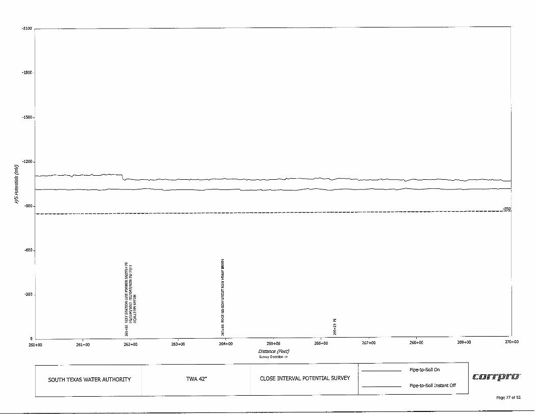
267+00 268+00 269+00 270+00
Pipe--to--So!I On
currpru-Pipe-to-Soll Instant Off
Page 27 of 52
s, .§.
"' ~ s ~ <\: !(!_ "'
·2100 ---------------------------------------------------------------------------,
-1800
-1500
-1200
-900
-600
-300-
--------------------------------
~ g~ ;!;!;; s~ u;;;:; ;t ~§_
t;; t;; Ii ~ii t;;~2 ~~~
i § , , l ; 0
- ' I $ j; ~ :::::. ,1;
" 271+00 272+00 273+00
SOLJTH TEXAS WATER ALJTHORITY TWA42"
274+00 275+00
Distance (Feet) Su~ Direction ->
276+00
CLOSE INTERVAL POTENTIAL SURVEY
0
277+00 278+00 279+00 280+00
Pipe-to-Soil on
carrpro-Pipe-to-Soll Instant Off
Page 28 of 52
s, .§_
" ,1l ~
" ~ ~
-2100~-----------
-1800-
-1500
-1200
-900 ' --- -- ~
~=~ - ~ -850 ~ -=----~------------------------------------------------------------
-600-
-300
i~ h i~ ON
~i ii il: !i{
"" t;; ~ ~~
0 •
280+00 ~ 281+00 282+00 283+00
SOL/TH TEXAS WATER AUTHORITY TWA42"
284+00 285+00
Distance (Feet) Survey D1~cuon ->
286+00
CLOSE INTERVAL POTENTIAL SURVEY
287+00 288+00
Pipe-to-Soll On
Pipe-to--Soll Instant Off
289+00 290+00
currpru,
Page 29 of 52
·2100 ~-------------------------------------------------------------------------,
TWA42-03.DAT 50
02/20/20 ~
TWA42*03
-1800 ~ _______ ,,,QIST_FIEL
D
-1500-
-1200 s;-.§_
" ~ E 0: ~ "' -900 - .~ ~
~
~ - -850 1-· ----- --------------------------------------------- --- --------- --- ------------·-· - ----- --- . ·-- --- -- . . ~---- - --- - ------ -------------------
-600
l ~ a 8' ,g • [~ i~ i u'j~ r ~ ~- ,L~ ~>
-300~ ~~
~i ~ ~ § ~ 15:.::: e e
.~ ;;~
~it5 p "i 5 5 ~~ ~ ~~~ g § ~ 12 ~ li'. s ~ i
g 8
~ € i, i, 0
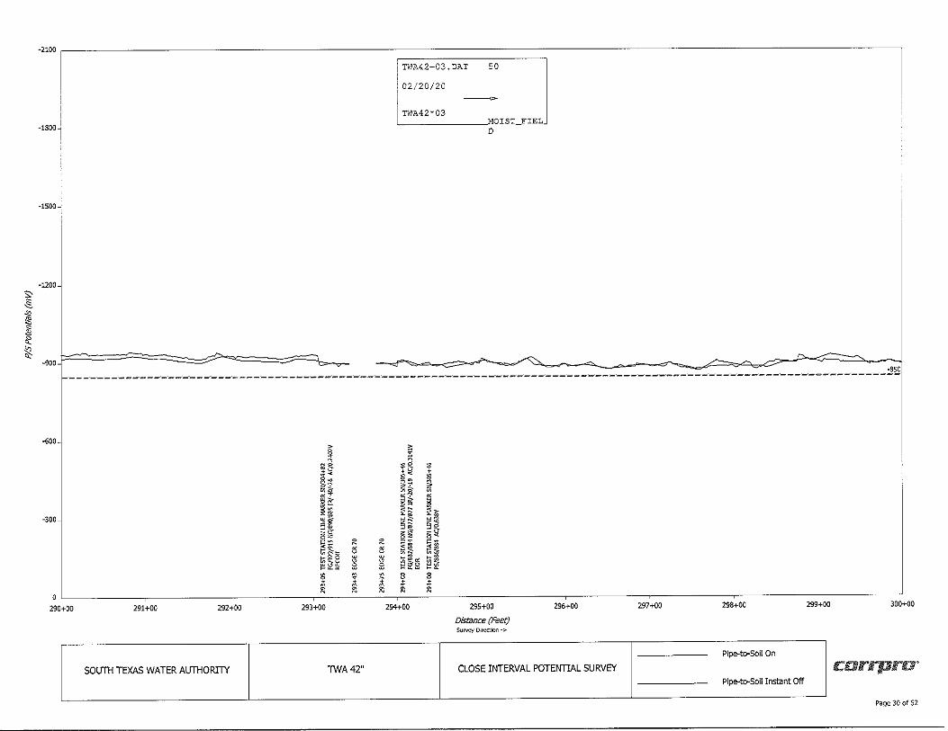
290+00 291+00 292+00 293+00 294+00 295+00 296+00 297+00 298+00 299+00 300+00
Distance (Feet) Su~ Direction ->
Pipe-to-Soil On
SOUTH TEXAS WATER AUTHORITY TWA42" CLOSE INTERVAL POTENTIAL SURVEY c:arrpro' Pipe-to-Soil Instant Off
Page 30 of 52
s:_§_
" ,! s l!, ~ lg
-2100 ---------------------------------------------------------------------,
-1800
-1500
-1200
-900 I D ----o - - ~----~ --- c ____,-c - ~ --~ - .,- ----------- ___. - -----=--__ j ----- - ______ ::_ ---'=--- " ~-.:!'..,
-6-00
·300-
~ N~
~~ ~3 ~! .-ii ai •• a~ ~~ ~
0 i ~ 300+00 g 301+00 302+00 303+00
SOUTH TEXAS WATER AUTHORITY TWA42"
304+00 305+00
Distance (Feet) Survey Direction-;,
306+00
CLOSE INTERVAL POTENTIAL SURVEY
307+00
~
I d s i
308+00 309+00 310+00
Pipe-to-Soil On
c:arrpru-Pipe-to-Soll Instant Off
Page 31 of 52
s, ~
"' ~ .!] <I: ~ ""
-2100 ---------------------------------------------------------------------,
-1800
-1500~
-1200
-900 -850 ~---~-~ ·-. --------~; ·~--- . =· --------~. ------ . ----------·-----------
-600
-300
I N" i: -· ~,: >S u ,:!~ 'l'
' ,! 0 ~·
0 • .,_
-a
H '"
• ~
~ d
311+00 312+00 313+00 314+00 315+00
Distance (Feet) survey Direction ❖
316+00 317+00 318+00 319+00
P!pe-to--Soil On
320+00
SOUTH TEXAS WATER AUTHORITY TINA42" CLOSE INTERVAL POTENTIAL SURVEY c:arrpra' Plpe--to--Soil Instant Off
Page 32 of 52
"' _§_
" ;,: ~
"' ~ i8:
-2100 ---------------------------------------------------------------------~
-1800
-1500
-1200
-'lOO -850 --------------------- -------------------·. ------------------------------ ·------------------------------------- . - _ _.
-6-00
-300
320+00 321+00 322+00 323+00
SOUTH TEXAS WATER AUTHORITY
324+00
TWA42"
325+00
Distance {Feet) Su~ D11ect100 ->
326+00
CLOSE INTERVAL POTENTIAL SURVEY
327+00
I ~--~ ~i .~ n ~! ·•• <~
~~a eb'~ a /: a
328+00
Pipe-to-Soil On
Pipe-to-Soil Instant Off
329+00 330+00
carrpra·
Page 33 of 52
s:-_§_ .,, '11 ~ .!, ~
t
-2100 ~--------------------------------------------------------------------,
-1800
-1500
-1200
-900 -850 ------------------------------------------------------------------------------------------ ---
-600
-300
~ a§ i~ ~" ·~ " . ~~ . " §~ ~~ ~i ~~s ~ ~ -~• e e S: R l:3 . . . • • • 0 M M M
330+00 331+00 332+00 333+00
SOUTH TEXAS WATER ALJTHORITY TWA42"
334+00 335+00
Dis/Ence (Feet} Su~ Dlr<::ctlon->
336+00
CLOSE INTERVAL POTENTIAL SURVEY
337+00 338+00 339+00 340+00
Pipe-to-Soll On
c:orrpro' Pipe-to-Soll Instant Off
Page 34 of 52
s, ~
"' ,:;: ~
" <I: !'.,_ SC
-2100 ~--------------------------------------------------------------------,
-1800
-1500~
-1200
-900 -850, 1-----------------------------------------------------------------------------------------------
-600
-300
@j
0~
':tr:; ~~ ,~ .~ i[ a<
~~ ~~
0 I;;§, t;;-0
340+00 ~ il:lii i 341+00 342+00 343+00 344+00
SOUTH TEXAS WATER AUTHORITY TWA42"
345+00
Distance (Feet) Sur,ey Direction •>
346+00
CLOSE INTERVAL POTENTIAL SURVEY
347+00 348+00 349+00 350+00
Pipe-to-Soil On
c:arrpra· Pipe-to-Soll Instant Off
Page 35 of 52
s, .§_
" Jg
~ 0: ~ 0:
-2100 ---------------------------------------------------------------------,
-1800
-1500
-1200
-900 -850 ,---------------------------------------------------------------------------------------------
-600
-300
350+00 351+00 352+00 353+00 354+00
SOUTH TEXAS WATER AUTHORITY TWA42"
355+00
Distance (Feet) Su~ Direct~ ->
356+00
~
<O ~ ~§ !, ,/;
!! ,~
u q gie ~~~
i
CLOSE INTERVAL POTENTIAL SURVEY
357+00 358+00 359+00 350+00
Pipeato-Soil On
c:arrpro" Pipeato-Soll Instant Off
Page 36 of 52
s, .§_ .,, ,:!I s
"' <I: ~
-2100~~~~~~~~~~~~-
-1800
-1500
-1200
.900...;
-600
-300
360+00
-850 ------------------------------------------------------------------------------------------------------------------
361+00 362+00 363+00 364+00
SOUTH TEXAS WATER AUTHORITY TWA42"
365+00
Distance (Feet) Survey Direction->
,! ,t ~ S<+ ·-;! "" !!.!;::r
~~ !;1i t;; - -
©~i 'i' *
366+00
CLOSE INTERVAL POTENTIAL SURVEY
367+00 368+00 369+00 370+00
Plpe-to-Soil On
carrpra-Pipe-to-Soll Instant Off
Page 37 of 52
s:,§_ .,, ,1: ~ ~ ~
-2100 ~--------------------------------------------------------------------------
-1800
-1500
-1200
-900 -850,
---------------------- ~---------------------------- --~-------------- ----------~----------------------------- I
-600
-300
370+00 371+00 372+00 373+00 374+00
SOUTH TEXAS WATER AUTHORITY TWA42"
~i i~ ·~ ~ii: ~-!li §~ ~i ~i,8 ~ [li, $
t 375+00
Distance (Feet) Survey Dlrs::ctkJn ->
376+00
CLOSE INTERVAL POTENTIAL SURVEY
377+00 378+00 379+00 380+00
Pipe-to-Soil On
corrpra" Pipe-to-Soll Instant Off
Page 38 of 52
s:-s§_
"' ,1l ~
"' ~ lg
-2100 ~--------------------------------------------------------------------------,
-1800~
-1500
-1200
-900
-----------------------------------------------------------------------------------------1?~
-600
-300
11 r,,,'Z.
;i i• ',:!~
~~ o-!a< t;;£-t;; ,._ 5 ~~~
0 ~ 380+00 ~ 381+00 382+00 383+00 384+00
SOUTH TEXAS WATER AUTHORITY TWA42"
385+00
Distance (Feet) Survey D11\."'ctlon ->
386+00
CLOSE INTERVAL POTENTIAL SURVEY
387+00 388+00 389+00 390+00
Pipe-to-Soil On
corrpro' Pipe-to-Soil Instant Off
Page 39 of 52
s, ~ .,, ,,: .ii! <\: !(;_ <,:
-2100 -------------------------------------------------------------------------------------,
-1800
•1500~
-1200
-900
-600
-300
·850 ------------· ------- ----------- .. ·--------· . ---------------------------------------· - ------------- --- - ,---------------------------------,
~ as
~ i! g u ~ I • ~~ " ·-i Sf
t;; i 8 " ~ ~ ~ 0
~1 i! ~~ a< ~[ ~~ i=-+ N N
~L ii ii ~[i § §
~ ~ i ii
391+00 392+00 393+00
~ ~ ~
390+00 ii !i !i 394+00 395+00
Distance (Feet)
396+00 397+00 398+00 399+00 400+00
Survey Direction ->
Pipe-to-Soil On
SOUTH TEXAS WATER AUTHORITY TWA42" CLOSE INTERVAL POTENTIAL SURVEY carrpra' Pipe-to-Soll Instant Off
Page 40 of 52
s;, ,§_
"' §
-2100
-1800
-1500
-1200
~ l ~ ..., <=- ., ~ ~ C) ~.. D = _, = - D C ,..,, _, =-~ -900~
-sso --------------- . --------~ . ----------------------------------------------------- --------------- - --------------. - --·----------------------------- -
-600
-300
400+00 401+00 402+00 403+00 404+00
SOUTH TEXAS WATER AUTHORITY TWA42"
405+00
Distance (Feet) Su~ Dlrcct..,n ->
406+00
CLOSE INTERVAL POTENTIAL SURVEY
407+00 408+00 409+00 410+00
Pipe-to-Soll On
carrpro' Pipe-to-Soll Instant Off
Page 41 of 52
Sc .§.
"' '11 ~ '!, ~
t
-2100 ---------------------------------------------------------------------------,
-1800
-1500
-1200
~
-900 -850 1----------------------------------------------------------------------------------------
-600
-300
:; iii ~
~g O< ~+ "" ~ ,r ~i n .-~ ~[
d di
0 ffi~ •• ~ ~
411+00 412+00 413+00
SOUTH TEXAS WATER ALJTHORTIY TWA42"
414+00 415+00
Distance (Feet) Sur,.,,zy Dlrccticn .,.
416+00
CLOSE INTERVAL POTENTIAL SURVEY
417+00 418+00
Pipe-to-Soll On
Pipe-to-Soll Instant Off
419+00 420+00
c:arrpra·
Page 42 of 52
s:-.§_
"' l's s .!l ~ :g
-2100 ~------------------------------------------------------------------------------------,
-1800
-1500~
-1200
-900 -850 ----------------- ---------------- ------------------------- --- . ---- ·-~- -- ----- --- . ---------- ----- - - ·-· -------- --- . --------------
-600
-300~
il ~" "~ i! .~ ~~[
Ii !ii! g ii 8
0 ~ii'~
420+00 ~ ~ 421+00 422+00 423+00
SOUTH TEXAS WATER AUTHORITY TWA42"
424+00 425+00
Distance (Feet) Survey Dlr<:ctton ->
426+00
CLOSE INTERVAL POTENTIAL SURVEY
427+00
i ~ 428+00 429+00 430+00
Pipe-to-Soil On
c:arrpru" Pipe-to-Soil Instant Off
Page 43 of 52
s, _§_ .,, ~ ~ .'!a ~
i£.
-2100 ~---------------~----------------------------------------------------------,
-1800
-1500
-1200
-V
-900 -850 1------------------------------------·------------------------------------------------------------
-600-
a .~ j;~
I~ ;:;,;;:::-
-300
•• ~ et
I ;; "" "I ~ I;; §
d "'
~ ~
i a " ~ s 430+00 431+00 432+00 433+00
SOUTH TEXAS WATER AUTHORITY TWA42"
434+00 435+00
Distance (Feet) SuN<:Y Dln,ctlon ->
435+00
CLOSEINTERVALPOTEr-lTIALSURVEY
437+00 438+00 439+00 440+00
Pipe-to-Soil On
corrpru· Pipe-to-Soil Instant Off
Page 44 of 52
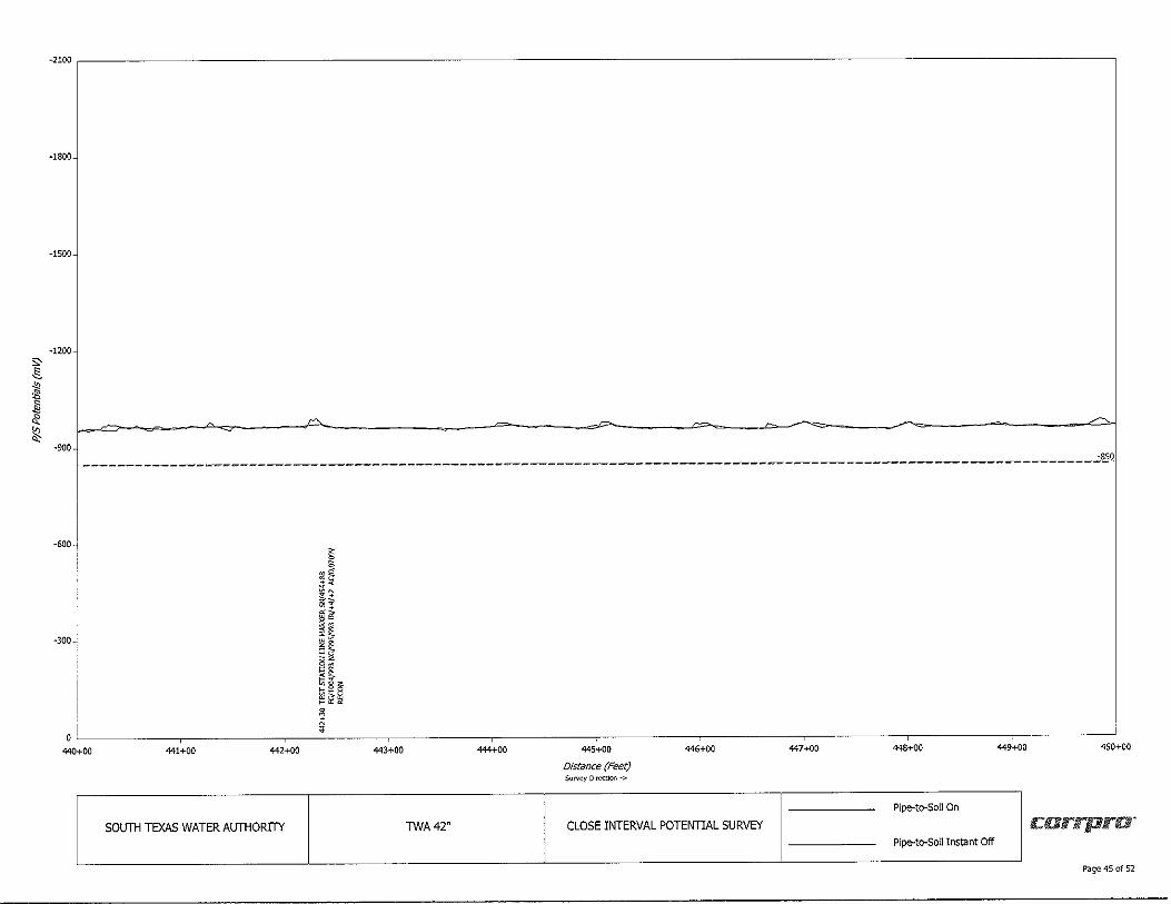
S> .@_
"' l,:
E <\: ~ "'
-2100 ~--------------------------------------------------------------------------
-1800
-1500
-1200
~
-900 -850 -----------------------------------·---------------------------------------------------------
-600-
-300;
~ s ~§ ;• ,, ~$ ,~ ~i B~ !; It t;;il• t;;--~
I ~h 0 ~
440+00 ;f 441+00 442+00
SOUTH TEXAS WATER AUTHORITY
443+00 444+00
TWA42"
445+00
Distance (Feet} Sul'\l~Y Direction->
446+00
CLOSE INTERVAL POTENTIAL SURVEY
447+00 448+00 449+00 450+00
Pipe-to-Soil On
c:arrpra· Pipe-to-Soll Instant Off
Page 45 of 52
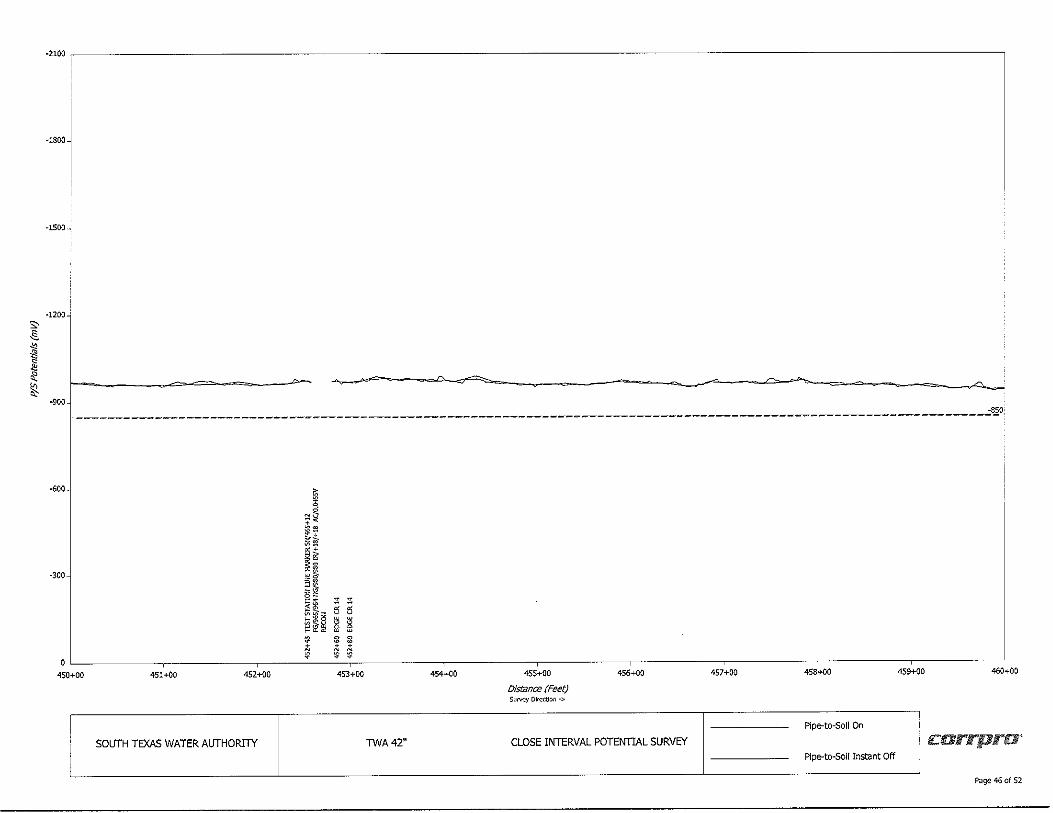
s, _§.
" ,§ C
"' ~ ~
-2100 ~--------------------------------------------------------------------,
·1800
-1500-
-1200
•900 -850, --------------------------------------------------------------------------·---------------------
-600
! .~ + ~ell
""' vl ell
•300
•+ ~-!f n •! ;!; ;!;
~I" 5 5
~ iii § § • & g
~ + + ~ ~
450+00 451+00 452+00 453+00
SOUTH TEXAS WATER AUTHORTIY TWA42"
454+00 455+00
Distance (Feet) Su~ Olr<:ctlon ->
456+00
CLOSE INTERVAL POTENTIAL SURVEY
457+00 458+00
Pipe-to-Soll On
Pipe-to-Soll Instant Off
459+00 460+00
7
c:arrpra·
Page 46 of 52
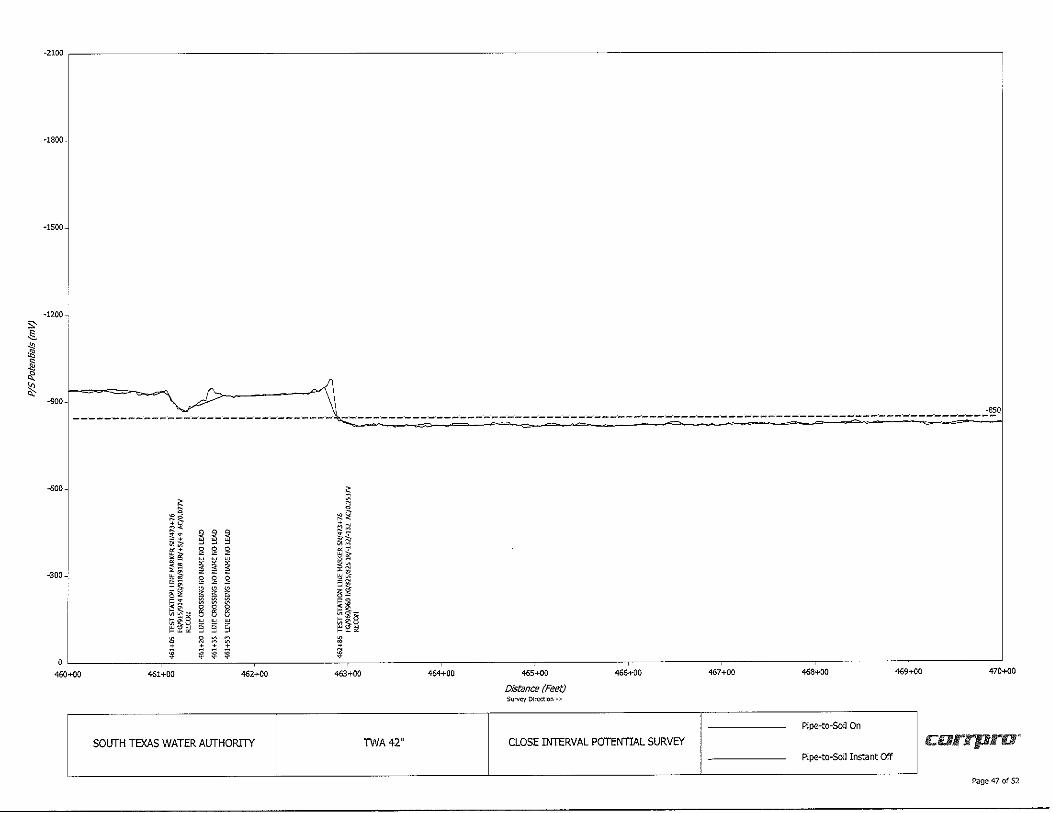
-2100 ~------------------------------------------------------------------------------------,
-1800
-1500
-1200-
"' .§_
" ~ s
"' <I: -900J--=-=~==--~ ~ ~
-850 ----·. ·-- -- -- --- -- - . ·-----~ - d - =-- ·~ =- =. = ·-- - . = ------- -;::-----------------.
-600~ ~ ~J 2
~~ ~ iJ. +, a< 9 9 9 g; :1 t
"" Cl!~
u g g g u ~ ~ ~ -300-: §~ g g g §~ -S ~ ~ ~ .~ •-~::: l2 l2 ~ ·~ ~ ;;; § § t; :ta ~~~ § § § ~~~ ~ 2 :::l ::::: ~ , •• + ii
0 * i (i1 ;
460+00 461+00 462+00 463+00 454+00 465+00 466+00 467+00 468+00 469+00 470+00
Distance (Feet) Survey Direction->
Pipe-to-Soil On
SOUTH TEXAS WATER AUTHORITY TVI/A 42" CLOSE INTERVAL POTENTIAL SURVEY rcarrpro· P!pe-to-Soil Instant Off
Page 47 of 52
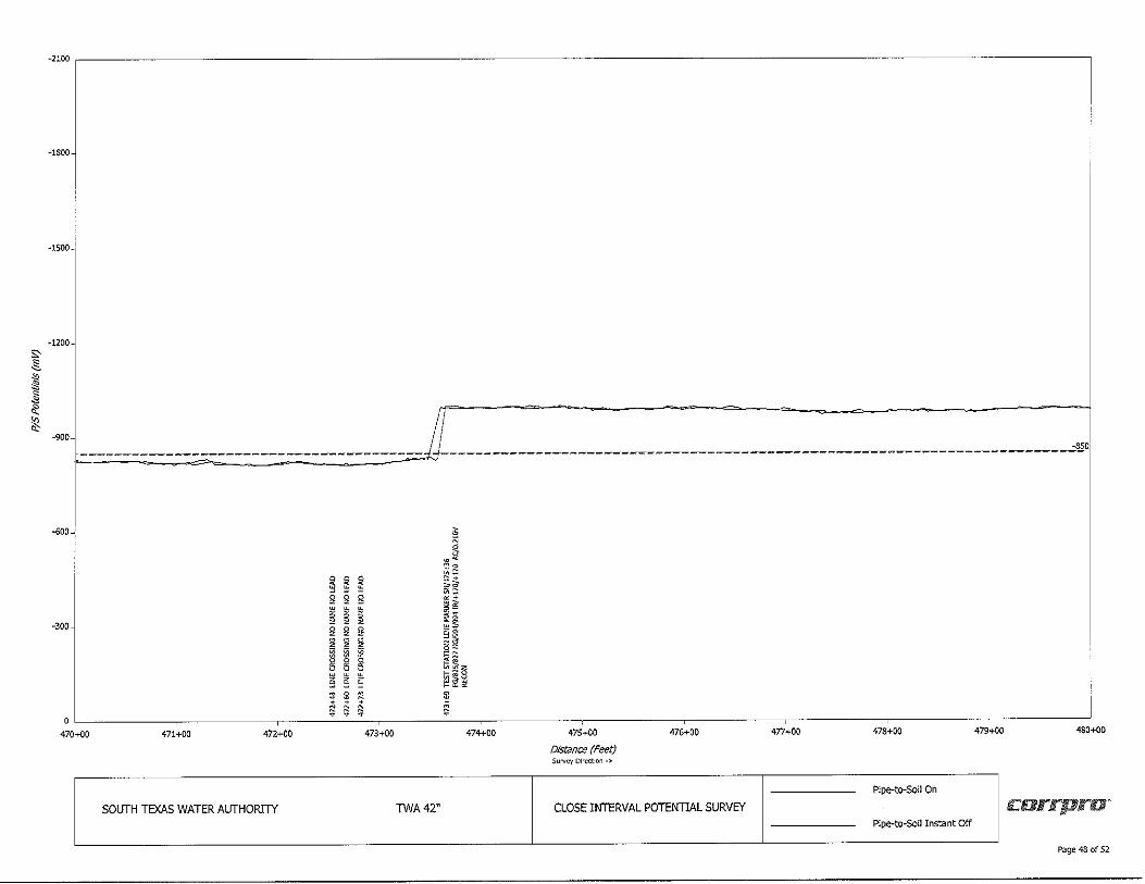
s, .§.
" 1!i ~
"' <\: ~
-2100
-1800
-1500
-1200
-900 l ---------- -____________________ jJ ______________________________________________________________ -<!',O
-600-'
~ ~ g g
-300
~ ~ ~ ~ g g ~ ~ g g
~ g
~ g
I
~ .~ ~~ ~~ gi ;i al ~ ~ g §\§
470+00 ~ ~~ ©
§ § § * $ ~ + + $ f; ii
471+00 472+00 473+00 474+00
SOUTH TEXAS WATER AUTHORITY TWA42"
475+00
Distance (Feet) Sur,~y Direction -;,,
476+00
CLOSE INTERVAL POTENTIAL SURVEY
477+00 478+00 479+00 480+00
Pipe-to-Soil On
carrpru, Plpe-to-So!I Instant Off
Page 48 of 52
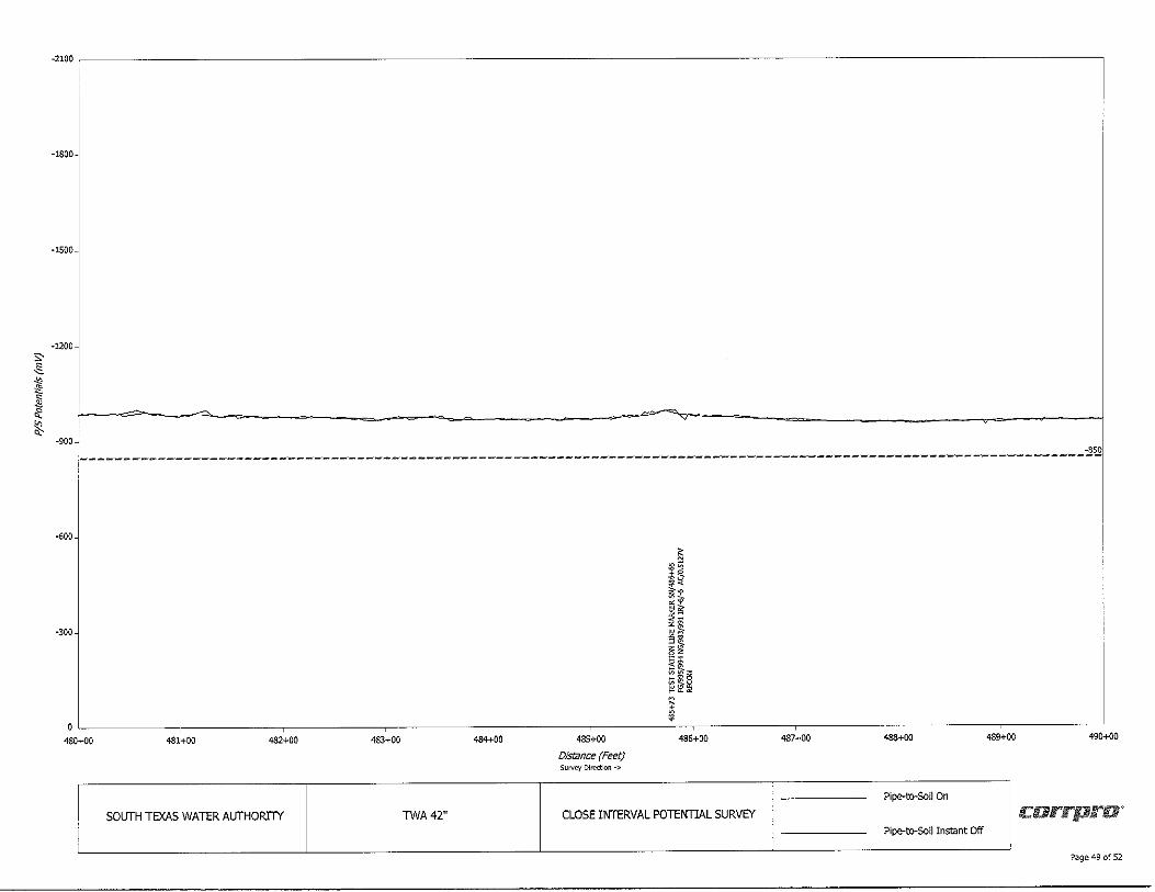
s:-~
" ~ ~ <I: ~ "
-2100 ~--------------------------------------------------------------------------,
-1800
-1500
-1200
--- y
-900~
.------------------------------------------------------------------- ·------------------------------ ·-------~ ·----- - .
-<00
-300
480+00 481+00 482+00 483+00 484+00
SOITTH TEXAS WATER AITTHORITY TWA42"
485+00
Distance (Feet) Survey Direction->
~ ::gcii
ii~ ~~
"" i! :; t
~I •l ;H ~ ,
486+00
CLOSE INTERVAL POTEITTIAL SURVEY
487+00 488+00 489+00
Pipe-to-Soil On
Pipe-to-Soil Instant Off
-850
490+00
corrpra'
Page 49 of 52
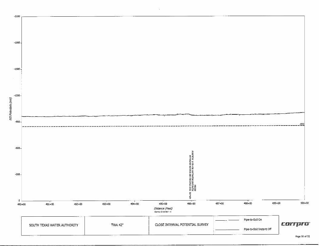
s:,§.
" i'l s
" cl: ~
-2100 ~--------------------------------------------------------------------------
-1800
-1500~
-1200 !
-900 -850 1-------------------------------------------------------------------------------·----------------------
-600
-300
~ .~ ;~ "· ~.:t. u Ii
0 ,, ta--
~~ ,,, ~ii:• ~
t 491+00 492+00 493+00
SOUTH TEXAS WATER AUTHORITY TWA42"
494+00 495+00
Distance (Feet) Survey Olrcctlon -;,.
496+00
CLOSE INTERVAL POTENTIAL SURVEY
497+00 498+00 499+00 500+00
Pipe-to-Soll On
carrpra' Pipe-to-Soil Inst.ant Off
Page 50 of 52
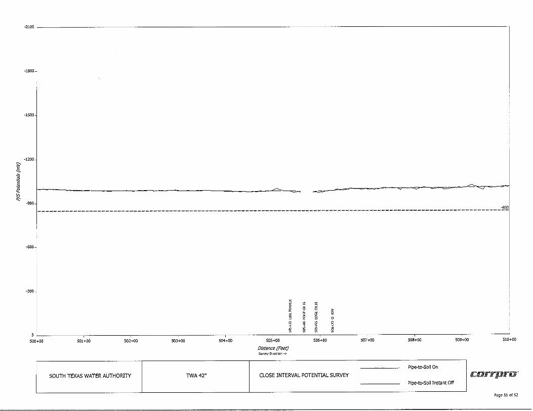
S' s§.
" ~ ~ "' le ~
-2100 ~--------------------------------------------------------------------7
-18007
-1500
-1200
-900 -850 --------------------------------------------------------------------------~--------------------------
-600~
-300
I • • 5 5 ~ § ~ g d
~ s • ~
~ § • ~ ~
500+00 501+00 502+00 503+00 504+00 505+00 506+00 507+00 508+00 509+00 510+00
Distance (Feet) Su~ Direction->
Pipe-to-Son on
SOL/TH TEXAS WATER Al/THORITY TWA42" CLOSE INTERVAL POTENTIAL SURVEY c:arrpra· Pipe-to-Soil Instant Off
Page 51 of 52
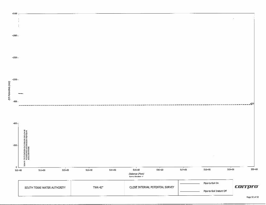
;;, ,§_ .,, ,1: ,j ~ ~ "'
-2100 ----------------------------------------------------------------------
-1800
•1500
-1200
·900
---------------------------------------------------------------------------------------- -~o
-600---:
·300
510+00
e::~ ~~ is-l § ~i ~?~ o::::~
~I~ ~il°sl
i 511+00 512+00
SOUTH TEXAS WATER AUTHORITY
513+00 514+00
TWA42"
515+00
Distance {Feet) Su~ Dlr\!ctlon ->
516+00
CLOSE INTERVAL POTENTIAL SURVEY
517+00 518+00 519+00 520+00
Pipe-to-Soll On
c:arrprnr Pipe-to-Soil Instant Off
Page 52 of 52

ri: AEGION rc:rarrpro, Stronger. Safer. Infrastructure:
APPENDIX C: RECTIFIER DATA
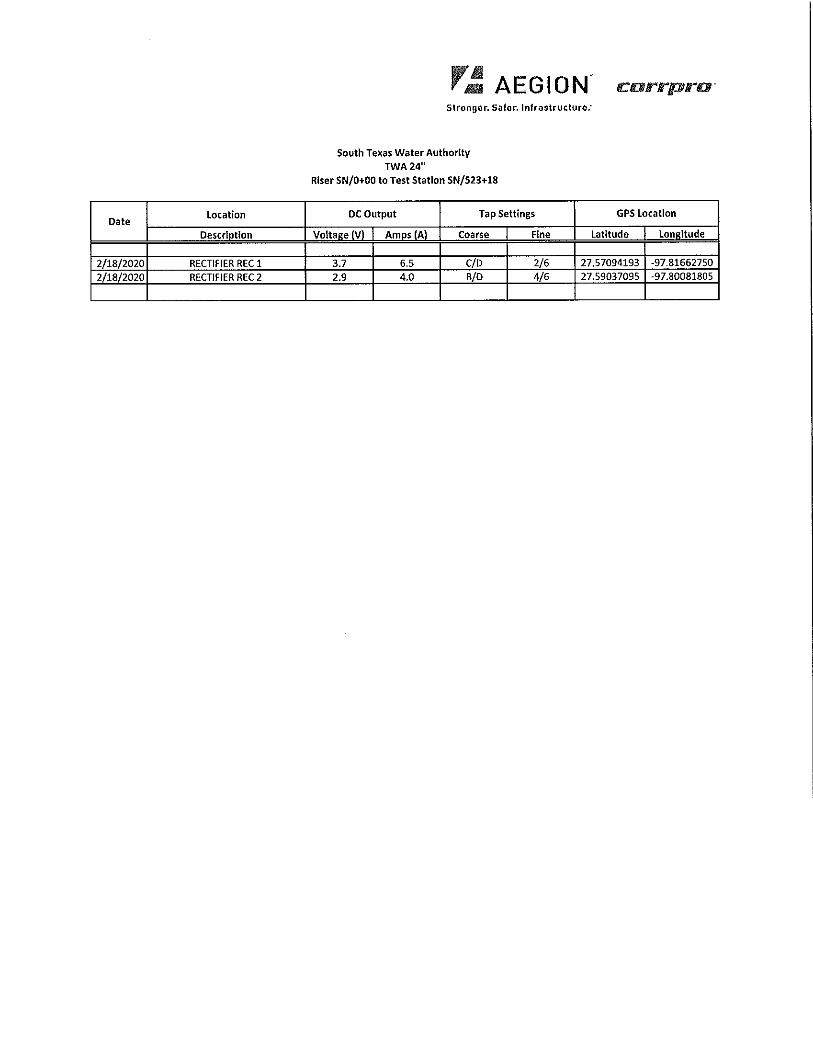
Date Location
Descriotlon
2/18/2020 RECTIFIER REC 1
2/18/2020 RECTIFIER REC 2
r_: AEGION crarrpro· Stronger. Safer. Infrastructure:
South Texas Water Authority TWA24"
Riser SN/0+00 to Test Station SN/523+18
DC Output Tap Settings
Volta•e IV\ Amos IA\ Coarse Fine
3.7 6.5 C/D 2/6 2.9 4.0 B/D 4/6
GPS location
Latitude Loneltude
27.57094193 -97.81662750
27.59037095 -97.80D81805

ri: AEGION c:orrpro·· Stronger. Safer, Infrastructure.'
APPENDIX D: TEST STATION DATA
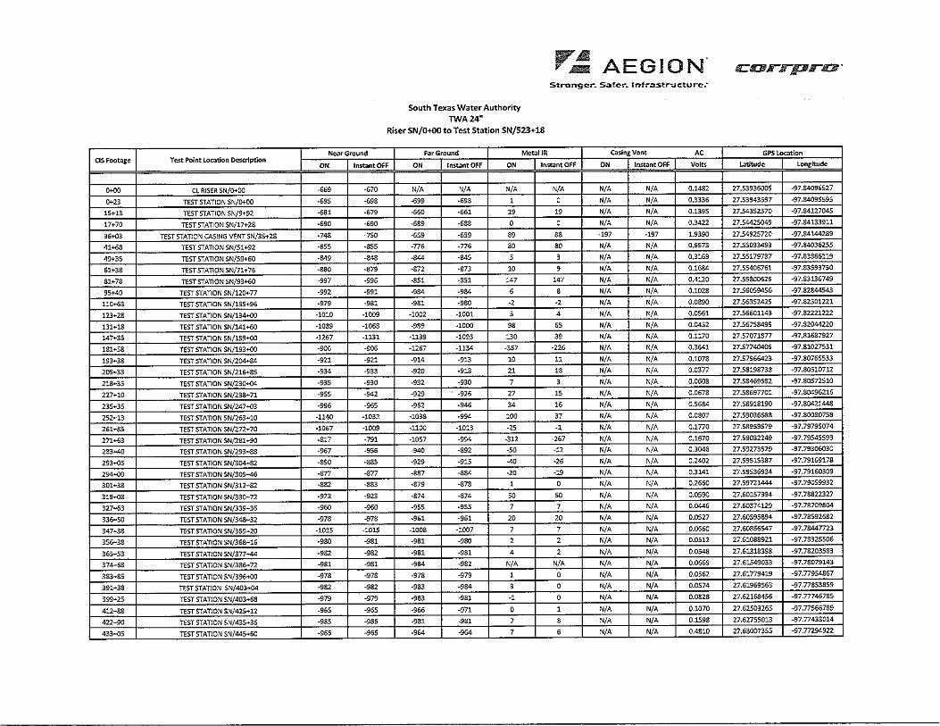
CIS Foot.ige Test Point Location ~scrlptlon
0+00 CL RISER SN/0+00
0+23 TEST STATION SN/o+OO
15+13 TEST STATION SN/9+92
17+70 TEST STATION SN/17+28
36+03 TEST STATION CASING VENT SN/35+28
41+68 TEST STATION SN/51+92
49+35 TEST STATION SN/59+60
61+38 TEST STATION SN/71+76
81+78 TEST STATION SN/93+60
95+40 TEST STATION SN/120+77
110+63 TEST STATION SN/135+96
123+28 TEST STATION SN/134+00
131+18 TEST STATION SN/141+60
147+35 TEST STATION 5N/159+00
181+58 TEST STATION SN/193+00
193+38 TEST STATION SN/204+84
205+33 TEST STATION SN/216+85
218+35 TEST STATION SN/230+04
227+10 TEST STATION SN/238+71
235+35 TEST STATION SN/247+03
252+13 TEST STATION SN/263+10
261+85 TEST STATION SN/272+70
271+63 TEST STATION SN/281+90
283+40 TEST STATION SN/293+88
293+05 TEST STATION SN/304+82
294+00 TEST STATION SN/305+46
301+38 TEST STATION SN/312+82
319+08 TEST STATION SN/330+72
327+63 TEST STATION SN/339+36
336+50 TEST STATION SN/348+32
347+38 TEST STATION SN/359+20
356+38 TEST STATION SN/368+16
365+53 TEST STATION SN/377+44
374+68 TEST STATION SN/386+72
383+85 TEST STATION SN/396+00
391+38 TESTSTATION SN/403+04
399+25 TEST STATION SN/403+68
412+88 TEST STATION SN/425+12
422+90 TEST STATION SN/435+36
433+05 TEST STATION SN/445+60
South Texas Water Authority TWA24"
,..~ AEGION. Streng er. Safe:-. lnfr.:,stn.icturc-:
Riser SN/0+00 to Test Station SN/523+18
Near Ground Far Ground Metal JR Casing Vent AC
ON Instant OFF ON lnst;intOFF ON lnst.lntOFF ON Instant OFF Volts
-669 -670 N/A N/A N/A N/A N/A N/A 0,1482
-695 -698 -699 -698 1 0 N/A N/A 0,3336
-681 -679 -560 ·661 19 19 N/A N/A 0.1395
-690 -690 -689 .,,. 0 0 N/A N/A 0,3422
·748 -750 -659 -659 89 S8 -197 -197 1.9390
-855 -855 -776 -776 80 80 N/A N/A 0,6573
.349 ·848 -844 ·845 5 3 N/A N/A 0,3169
·880 -879 -872 -873 10 9 N/A N/A 0.1684
-997 -995 -851 -851 147 147 N/A N/A 0.4120
-992 ·991 .934 .984 6 8 N/A N/A 0.1028
.979 -981 -981 -980 ·2 ·2 N/A N/A 0.0890
-1010 ·1009 -1002 -1001 5 4 N/A N/A 0.0561
-1089 -1068 -989 -1000 98 65 N/A N/A 0.0452
·1267 -1131 -1139 -1093 130 39 N/A N/A 0,1170
-906 -906 -1267 -1134 -357 -226 N/A N/A 0.3641
-921 -921 -914 -913 10 11 N/A N/A 0.1078
.934 -933 -920 -918 21 18 N/A N/A 0.0377
-935 -930 -932 -930 7 3 N/A N/A 0.0608
-955 -942 -929 -926 27 15 N/A N/A 0.0678
-996 -965 -962 -946 34 16 N/A N/A 0.5584
-1140 ·1032 -1038 .994 100 37 N/A N/A 0.0807
-1057 -1009 -1100 -1013 ·25 ·1 N/A N/A 0.1770
-817 -791 -1057 .994 -312 -267 N/A N/A 0.1670
-967 -956 -940 -892 •SO ·12 N/A N/A 0.3046
-890 -885 -929 -915 -40 ·26 N/A N/A 0.2402
-877 -877 •887 -884 ·20 .19 N/A N/A 0.3141
-882 -883 -879 -878 1 0 N/A N/A 0.2650
-923 -923 -874 -874 so so N/A N/A 0.0590
-960 -960 -955 -955 7 7 N/A N/A 0.0446
-978 -978 -961 -961 20 20 N/A N/A 0.0527
-101S -1015 -1008 -1007 7 7 N/A N/A 0.0660
-930 -931 -981 -980 2 2 N/A N/A 0.0512
-932 -932 ·981 -981 4 2 N/A N/A 0.0548
-981 -981 ·984 -982 N/A N/A N/A N/A 0.0669
-978 -978 -978 -979 1 0 N/A N/A 0.0562
-982 -982 -983 ·984 3 0 N/A N/A 0.0574
-979 -979 ·983 -981 ·1 0 N/A N/A 0.0828
-965 -955 -966 -971 0 1 N/A N/A 0.1070
-985 -986 -981 -981 7 8 N/A N/A 0.1598
-966 -965 ·964 -964 7 6 N/A N/A 0,4810
carrprc;·
GPS!.oc:itlon
t..rtitude Longitude
27.53936005 -97.S4096527
27.53943597 ·97.84095595
27.54352570 -97.84127045
27.54425049 -97.84133911
27,54925720 -97.84144289
27.55033493 -97,84036255
27.55179787 -97,83865119
27.55405751 -97.83593750
27.55800629 -97.83135749
27,56059456 -97 .82844543
27.56352425 -97.82501221
27,56601143 -97.82221222
27.56758499 -97.82044220
27.57071877 -97,81687927
27,57740409 -97.81027531
27,57966423 -97.80765533
27.58198738 -97.80510712
27.58469582 -97.80572510
27.S8697701 -97.80496216
27.58918190 -97.80421448
27.59036588 -97.30080758
27.58959579 -97.79795074
27.59032249 -97.79545593
27.59273529 -97,79306030
27.59515387 -97.79169178
27.59536934 •97.79160309
27.59721444 •97,79059932
27,60157394 -97.78822327
27,60374129 -97.78709804
27.60595894 -97.78592682
27.60866547 -97.78447723
27.61083921 -97.78325506
27.61313398 -97,78203583
27.61549033 -97.78079143
27.61779419 -97. 77954867
27,61969563 -97.778538S9
27.62168456 -97.77746785
27.62503265 -97.77566789
27.62755013 -97.77433014
27.63007355 -97.m94s22
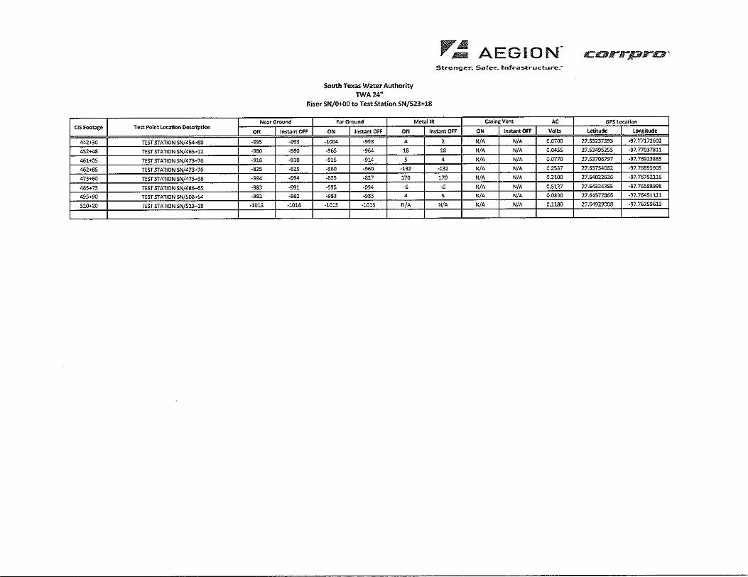
CISFoot.ige Test Point loc;;ition Description
442+30 TEST STATION SN/454+88
452+48 TEST STATION SN/465+12
461+05 TEST STATION SN/473+76
452+85 TEST STATION SN/473+76
473+60 TEST STATION SN/475+36
485+73 TEST STATION SN/486+65
495+90 TEST STATION SN/508+64
510+20 TEST STATION SN/523+18
South Texas Water Authority TWA24"
_.. Al . ,.- Alllil! AEGION
Stronger.. Sater-. lnfr..i:s:tructurc:
Riser SN/0+00 to Test Station SN/523+18
Near Ground Far Ground Mct.illR Casins:Vent AC
ON Instant OFF ON Instant OFF ON Instant OFF ON Instant OFF Volts
-995 -993 -1004 -993 4 2 N/A N/A 0,0700
-980 -980 -965 -964 18 18 N/A N/A 0,0455
-918 -918 -915 -914 5 4 N/A N/A 0.0770
-825 -825 -960 -960 -132 -132 N/A N/A 0.2537
-994 -994 -825 -827 170 170 N/A N/A 0,2100
-983 -991 -995 -994 ., -6 N/A N/A 0.5127
-981 -982 -983 -983 4 5 N/A N/A 0,0830
-1013 -1014 -1015 -1013 N/A N/A N/A N/A 0,1180
carrprc1r
GPS Loc;;itlon
Latitude Longitude!
27.63237393 -97.77172602
27.63495255 -97.77037811
27.53706797 -97,76923885
27.637540S2 -97.75895905
27.64022636 -97.76752116
27.64324285 -97.76588998
27.64577865 -97.76451111
27.64929008 -97.76259613

r ~ AE GI ON rcorrptrO' Stronger. Safer, Infrastructure:
APPENDIX E: CLOSE INTERVAL SURVEY PROCEDURE AND
EQUIPMENT SPECIFICATIONS
,..~ AEGION' carrpra · Stronger. Safer. Infrastructure.'
c:orrpro" Department:
Operations
Document Title: Document Number:
Close Interval Potential Survey WI FLD035
Scope: To describe the actions necessary to conduct a close interval potential survey.
Purpose: The purpose of this work instruction is to set forth the proper steps necessary to conduct a close
interval potential survey.
Responsibility: It is the responsibility of the Operations Manager to ensure any one going out to perform this
task is properly trained.
Associated Documentation:
Process:
1.0 Purpose
1. General: Close interval, pipe-to-soil and potential gradient surveys are applicable to all buried pipelines with earthen cover. Where the pipeline is under concrete or asphalt pavement, holes must be drilled to facilitate reference cell contact with the underlying fill. This often makes these types of surveys impractical in paved areas.
2. Cathodic Protection Criteria: Close interval surveys allow assessment of cathodic protection system performance and operation in accordance with established criteria for cathodic protection. With reference cell placement at 2.5-foot intervals, a nearly continuous evaluation is possible, unlike test- points- only surveys, which simply sample locations along the pipeline route.
3. Coating Faults: IR drop in close interval pipe-to-soil potential surveys of cathodically protected pipelines with the current ON aids is detecting locations of protective coating faults. The IR drop component in the potential measurement is reduced when in close proximity to the coating fault, thereby reducing the absolute value of the potential. Voltage gradient measurements (DCVG) are also used to detect coating faults. An increase in magnitude of the voltage gradient with cathodic protective current applied, is associated with increased current flow to relatively poorly coated areas.
,,~ AEGION' c:orrprta' Stronger. Safer. Infrastructure:
4. Other Anomalies: Close interval pipe-to-soil potential surveys also aid in identifying other anomalies including:
• interference conditions • shorted casings • areas of electrical or geologic current shielding • contact with other metallic structures • defective electrical isolation joints • localized corrosion
2.0 Methodology
1. General: Over-the-line pipe-to-soil potential surveys are conducted to evaluate the performance of the corrosion mitigation system.
2. Intervals: Pipe-to-soil readings shall be taken at 2.5 feet intervals and correlated to station numbers for the pipeline.
3. Wire: Each pipeline section shall be surveyed by utilizing an insulated copper wire that is electrically connected to a test station.
4. Locating the Pipeline:
a) The pipeline shall be located with an inductive pipe locator prior to collecting the data to ensure that the reference electrode is placed directly over the line.
b) Marsh and water crossings, which cannot be walked, will typically be located by the line of sight method, using pipeline markers and/or pipeline appurtenances. Magnetometers may also be employed for greater accuracy.
5. Data Recording: Potential measurements shall be recorded as a function of distance.
6. Wire Deployment: To eliminate problems with static charge build-up on the insulation, the wire shall not be pulled along the pipeline right-of-way but shall be laid out as the crew advances.
7. Footage Counter: The wire shall be fed through an accurate distance-measuring device with the actual footage recorded on the graphic data display.
8. Pipe Access Points: Potential measurements shall be taken at each test station, rectifier, highway casing, railroad casing, and foreign pipeline crossings.
9. IR Drop Measurements: Near ground and far ground "IR" drop measurements shall be recorded at each point of pipeline connection.
10. Accuracy: Potentials shall be measured to an accuracy of+/- 5 millivolts and correlated to landmarks such as roads, casing vents, fences, and streams.
r~ AEGION. carrpra· Stronger. Safer, Infrastructure:
11. Landmarks: All permanent landmarks shall be identified and listed along with their appropriate survey station numbers. All survey station numbers shall be easily converted to the permanent pipeline station numbers.
3.0 Equipment
1. General: Data shall be gathered utilizing an electronics package consisting of a computer, a high input impedance digital voltmeter, a solid state memory, a keyboard, and a liquid crystal display (LCD).
2. Data Collector: The data logger shall be built for field use. It shall have an input impedance of 100 to 200 megohms with an accuracy of 0.1% of full scale over the operating temperature range (-4 to 122 degrees F). The enclosure shall be sealed to protect against moisture and dust. The unit shall meet NEMA 4X requirements and shall be rated to operate in 100% humidity. Quantities Required: 2 data loggers, 2 internal GPS-AI, 2 batteries, 1 dump cable.
3. Laptop with Survey Software & Hot Spot: The computer controls the operation of each of the related devices with the commands, which the computer must execute, stored in memory. The computer counts the pulses coming from the magnetic switch in the footage counter and when the proper number of pulses has occurred (20 for a 2.5 foot interval survey), the reading of the digital voltmeter is displayed on the LCD and stored in memory. The LCD provides the operator with a visual indication of the potentials being recorded.
4. Footage Counter: The footage counter shall be mounted on a holster type wire dispensing apparatus. The counter shall be an electronic wire measuring device with magnetic sensing and a LCD display, resettable with adjustment in one half-foot increments from Oto 19,999 feet. The maximum variation between the distance displayed and the wire dispensed shall be plus or minus five feet per mile (less than 0.1%). A lock mode shall be incorporated in the system to go around obstacles in the survey path. In this mode no footage or potentials shall be stored to minimize scale error. The length of the wire dispensed while in the lock mode shall be displayed on the screen. Quantities Required: 3 counters, 2 chains or cables.
5. Wire: Onshore survey wire should be No. 34 AWG copper conductor with lacquer insulation. Dispensing spools should be plastic and contain approximately 3 miles of wire each. Length of wire varies and is dependent on the mileage.
6. Current Interrupters: One of two types of current interrupters shall be used for ON/OFF Potential Surveys.
a} GPS Synchronized: The GPS units shall be 60 or 100-ampere capacity AC/DC, 115 VAC or DC battery powered unit with GPS synchronization. GPS synchronization shall have an accuracy of 5 milliseconds. All timing cycles shall be keyboard programmable. The unit shall be enclosed in a rugged and waterproof NEMA-4 case. Required quantity is based on the number of current sources.
7. Reference Electrodes: Industry standard copper/copper sulfate with ceramic plugs shall be used. Clear windows on cells shall be covered to avoid photoelectric effects. Copper sulfate solution and tips shall be regularly cleaned and maintained. All cells shall be tested daily for accuracy to± 3 mV, and add this test data into the data file (use Code 31 = Half Cell Check, and type in left and right reference cell readings into the data stream). Refer to NACE Standard TM0497 (latest revision) entitled "Measurement Techniques Related to Criteria for Cathodic Protection on Underground or Submerged Metallic Piping Systems." Quantities Required: 4 reference electrodes, 6 tips, 1 bottle copper sulfate.
r~ AEGION' Stronger. Safer. Infrastructure.'
8. DGPS Unit: Quantities Required: 2 DGPS units, 2 batteries, 2 antennas, 4 antenna cables.
9. Miscellaneous Equipment (required quantities are in parenthesis): Line Locator with transmitter (2) Multimeter with Leads (1) Amp Clamp (1) S00W Power lnvertor (1)
4.0 Procedures
crarrrpra ·
There are various types of close interval, pipe-to-soil potential surveys including: ON/OFF surveys, potential gradient (DCVG) surveys, depolarized potential surveys and ON potential surveys.
4.1 ON/OFF Potential Survey
1. This survey is applicable to pipelines protected with impressed current cathodic protection systems for detecting external pipeline anomalies and evaluating corrosion protection performance in accordance with cathodic protection criteria.
2. ON/OFF Potential Surveys are performed by electronically synchronizing current interrupters and placing in each rectifier, bond and other current drain point that influences the pipeline potential in the survey area. Standard interrupter cycles are 8 seconds ON, 2 seconds OFF; or 800 milliseconds ON, 200 milliseconds OFF.
3. Reference cells are placed directly over the pipeline at 2.5 foot intervals. The maximum distance between OFF readings is not to exceed twenty (20) feet.
4. ON and OFF potentials are recorded with a handheld computer programmed with ON/OFF Potential Survey software.
5. The accuracy of the data shall be verified using one of the following techniques:
• Wave form capture and analysis • Digital oscilloscope • Digitized signal equipment
6. Digitally stored, pipe-to-soil potential wave prints shall be recorded at an aboveground test station twice daily. The wave print location shall be documented to correlate with the survey data. This data will be used to determine the presence of potential sources of error from:
• Line current flow • Scale accuracy • Potential spiking • Interrupter synchronization drift • Stray DC earth currents • Voltage signal noise
r~ AEGION. Stronger. Safer. Infrastructure:
4.2 CIS with DCVG Survey
1. This survey is applicable to well coated pipelines to detect coating holidays. It is best performed in conjunction with an ON/OFF Survey.
2. DCVG Surveys are performed using three reference cells placed over the pipeline and to each side. Cell separation of ten (10) feet is desirable provided that right-of-way conditions permit.
3. DCVG measurements consist of two earth potential gradient measurements, one between the cell over the line and the cell to one side; and the second between the cell over the line and the cell to the other side. The survey progresses along the pipeline alignment with all three cell measurements recorded every 2.5 feet.
4. DCVG data is recorded with a hand held computer programmed with DCVG Survey software. This allows the data to be plotted and provides a permanent record.
4.3 Depolarized Potential Survey
1. This survey technique is applicable to poorly coated pipelines protected with impressed current cathodic protection systems where the 100 mV polarization decay criterion is to be employed for evaluating the effectiveness of the cathodic protection system. It must be performed in conjunction with an ON/OFF Potential Survey.
2. De-energize all impressed current transformer-rectifiers and other DC power supplies. Either break critical bonds or adjust to only overcome interference effects while not providing additional cathodic protection.
3. Let the pipeline depolarize for five (5) days or until such time as a plot of potential vs. time indicates that the pipe-to-soil potential is no longer decaying.
4. Reference cells are placed over the pipeline every 2.5 feet.
5. Depolarized potentials are recorded with a handheld computer programmed with Depolarized Potential Survey software. This allows the data to be plotted in conjunction with an ON/OFF Potential Survey data for calculation of the polarization shift.
4.4 ON Potential Survey
1. This survey technique is applicable to pipelines protected with sacrificial anodes or other cathodic protection current sources that cannot be interrupted.
2. Reference electrodes are placed over the pipeline every 2.5 feet.
3. ON potentials are recorded with a handheld computer programmed with ON Potential Survey software.
r~ AEGION c:orrpra· Stronger. Safer. Infrastructure.'
5.0 Data and Reporting
1. Data Files: Must be submitted daily with the list (.1st) file(s) and production summary. The production summary must include: date, company name, diameter of pipe, starting station number, ending station number, and any discrepancies. Valid DGPS data must be recorded at every reading. The file name shall be in the following format:
Job Segment Number-Operator lnitials_Date_ Valve Section Example: 100-HCN_ll MAY_00
Note: For single lines, the job segment number starts with 100 and grows sequentially, and for multiple lines, the job segment number continues at 200,300,400, etc.
b Field Plots: Field plots of the data collected shall be generated by the survey crew during the course of the survey. This must be done.
3. Final Plots: Both ON and OFF potentials shall be plotted and easily distinguished one from the other. On bare lines requiring an impressed current OFF survey, the depolarized potentials shall be plotted and easily distinguished from the ON and OFF readings. DCVG data will be distinguishable from potential data and will be plotted to a right hand scale on the graph.
4. Features: The stationing and identification of all features shall be listed at the bottom of the graph, at the point on the graph at which they occur. No abbreviations are allowed; use Codes only and identify all road names.
5. Continuity Test Data: Remote and local potential readings recorded at test stations as Far Ground - "FG/", Near Ground - "NG/", Casing to Soil - "CS/", Pipe to Soil - "PS/", respectively, shall be listed in the comment field. JR Drop Readings: IR drop readings shall be listed in the comment field as "IR" with magnitude and polarity. This data must be at all reconnect points.
Example for an ON/OFF: SN*S2+80 FG/1089/950 NG/1080/950 IR-9/0
6. Rectifier Data: The rectifier DC outputs "as found" and "as adjusted" shall be tabulated for each rectifier surveyed. This data must be part of the data file once it is known that the area has been interrupted. When rectifiers are all in place, the list of rectifiers and the readings must be submitted.
If you are unsure of the test work instruction contact your supervisor immediately.
Records Generated:
Revision History:
Date Rev Changed Description # By
10/22/12 0 Todd Initial issue of document. Brabson
11MAY2016 1 Kaizen Updated to current header. Updated equipment list with Team required quantities. Updated Data & Reporting requirements.
Approver
Todd Brabson Chris Dauzat, Scott James
ATTACHMENT 17
Annexation Petition Santos Ramirez, Jr.
To: From: Date: Re:
Memorandum
South Texas Water Authority Board of Directors Carola G. Serrato, Executive Director April 20, 2020 Annexation Petitions - Final Approval -Annexation Petition for Santos Ramirez Jr. - Cyndie Park Unit 1, Lots 11 and 12
Background:
As the Board is aware, the Nueces County Grant Administration office acquired funds to address water quality problems for the Cyndie Park and The Ranch subdivisions. Since those subdivisions are not within South Texas Water Authority's district boundaries, the prope1ty owner requests retail water service from the NWSC and annexation into STWA's district. This results in the new NWSC member paying the same costs (NWSC retail water bill and STWA property taxes) as all other NWSC customers.
Analysis:
During the last Board meeting, Resolution 20-12 was approved calling for the required public hearing on the annexation petition filed by Mr. Santos Ramirez, Jr., Cyndie Park 1, Lots 11 and 12. A public hearing is scheduled for immediately preceding the regular Board meeting. Staff does not anticipate any public comment during the meeting since the annexation is for Mr. Ramirez's property only and he has filed the request. In order to complete the process, the Board will need to approve/adopt Resolution 20-13.
Staff Recommendation:
Adopt Resolution 20-13.
Board Action:
Determine whether to adopt Resolution 20-13.
Summarization:
Last month, staff reported that this property was in foreclosure when the other annexations were being processed. The seller was able to repossess the prope1ty resulting in this new request for service.
A TI ACHMENT 18
Resolution 20-13
CERTIFICATE FOR RESOLUTION APPROVING ANNEXATION
THE STATE OF TEXAS § COUNTIES OF KLEBERG AND NUECES § SOUTH TEXAS WATER AUTHORITY §
We, the undersigned officers of the Board of Directors of said Authority, hereby certify as follows:
I. The Board of Directors of said Authority convened in REGULAR MEETING ON THE 28TH DAY OF APRIL, 2020, at the regular designated meeting place, and the roll was called of the duly constituted officers and members of said Board, to-wit:
Kathleen Lowman, President Brandon W. Barrera, Vice-President Rudy Galvan, Jr., Secretary/Treasurer Jose M. Graveley
Lupita Perez Patsy A. Rodgers Filiberto Trevifto, III
and all of said persons were present, except the following absentees: _____ thus constituting a quorum. Whereupon, among other business the following was transacted at said Meeting: a written
RESOLUTION APPROVING ANNEXATION
was duly introduced for the consideration of said Board and read in full. It was then moved and seconded that said Resolution be passed; and, after due discussion, said motion, canying with it the passage of said Resolution, prevailed and carried by the following vote:
AYES:
NOES:
2. That a ttue, full, and correct copy of the aforesaid Resolution passed at the Meeting described in the above and foregoing paragraph is attached to and follows this Certificate; that said Resolution has been duly recorded in said Board's minutes of said Meeting; that the above and foregoing paragraph is a true, full, and correct excerpt from said Board's minutes of said Meeting pertaining to the passage of said Resolution; that the persons named in the above and foregoing paragraph are the duly chosen, qualified, and acting officers and members of said Board as indicated therein; that each of the officers and members of said Board was duly and sufficiently notified officially and personally, in advance, of the time, place, and purpose of the aforesaid Meeting, and that said Resolution would be introduced and considered for passage at said Meeting, and each of said officers and members consented, in advance, to the holding of said Meeting for such purpose; and the said Meeting was open to the public, and public notice of the time, place, and purpose of said Meeting was given all as required by
Chapter 551, Texas Govermnent Code.
SIGNED AND SEALED the 28th day April, 2020.
Rudy Galvan, Jr., Secretaty Board of Directors
Kathleen Lowman, President Board of Directors
SOUTH TEXAS WATER AUTHORITY
Resolution 20-13
THE STATE OF TEXAS § COUNTIES OF KLEBERG AND NUECES § SOUTH TEXAS WATER AUTHORITY §
WHEREAS, the Board of Directors conducted a hearing on this date in reference to the annexation of the territo1y described in Exhibit A attached hereto; and
WHEREAS, it was deemed advisable by the Board to approve the annexation of such territmy to the Authority; and
WHEREAS, it is officially found and determined: that a case of emergency or urgent public necessity exists which required the holding of the meeting at which this Resolution was adopted and that said meeting was open to the public, and public notice of the time, place and purpose of said meeting was given, all as required by Chapter 551, Texas Govermnent Code.
THEREFORE, BE IT RESOLVED BY THE BOARD OF DIRECTORS OF SOUTH TEXAS WATER AUTHORITY:
1. That the annexation of the territory described in Exhibit A is hereby approved by this Board, and it is hereby found that there will be benefit to the territory as amended.
2. That pursuant to Article 7, Chapter 436, Acts of the 66th Legislature, Regular Session, 1979, no election is required to approve the annexation as the petition was signed by all residents and landowners of the annexed territmy.
STATE OF TEXAS COUNTY OF NUECES
PETITION FOR ADDITION OF CERTAlN LANDS TO THE SOUTH TEXAS WATER AUTHORITY
TO THE BOARD OF DIRECTORS OF THE SOUTH TEXAS WATER AUTHORITY:
The undersigned (herein called "Petitioner"), holder of title to the territory described by metes and bounds in Exhibit "A" which is attached hereto and incorporated herein for all purposes, being all of the residents and landowners of such territory, as shown by the tax rolls of Nueces County, Texas, and acting pursuant to the provisions of Section 11006.052, Special District Local Laws Code, respectfully petitions the Board of Directors of South Texas Water Authority that the territory described by metes and bounds in Exhibit "A" be added to and become a pa1t of the established South Texas Water Authority, and in support of this petition would show as follows:
I.
Fee simple title and full ownership of the aforesaid territory, which lies wholly within Nueces County, Texas, is vested in Petitioner.
II.
The addition of said territ01y to South Texas Water Authority is feasible and practical, would be to the best interest both to the territory and to the Authority and would benefit said territory.
III.
The Authority will be able to supply water, or have water supplied, to the added territory.
N.
This petition shall constitute an election on the part of the Petitioner, its successors and assigns, for the aforesaid land and any improvements which may be constructed thereon to become liable for all present and future debts of the Authority in the same manner and to the same extent as other lands and improvements in the Authority are liable for the Authority's debts.
V.
Petitioner hereby authorizes the Board of Directors of the Authority to levy taxes and set rates sufficient to pay their share of the aforementioned outstanding indebtedness.
WHEREFORE, Petitioner prays that this petition be properly filed, as provided by law; that the Board of Directors of South Texas Water Authority hear and consider the petition in keeping with the provisions of Section 11006.052, Special District Local Laws Code and that this petition in all things be granted and that the territory described in Exhibit "A" be added to and become a part of the established South Texas Water Authority; that after this petition is granted the Board's order thereon be filed of record and be recorded in the Deed Records of Nueces County, Texas; and that the area described in Exhibit "A" be thereafter a component pa1t of South Texas Water Authority.
[Signatures and Acknowledgement on following page.]
EXECUTED this ( Z'.) day of n'\ {).fl(_ 0. , 20 LJ .
STATE OF TEXAS
COUNTY of Kle,he\J
~ ACKNOWLEDGEMENT
/ Subscribed and sworn to before me ----~S~a~n"'to~s~R~a~m"'i~re~z=Jr~. _______ on this the
6+/\ dayof fvl11-vc./1 2020.
ti~~~:ft11,,{,. NOEMI S. FLORES
iii'ji'~\i'lotary Public, State of Texas - to ' I!:; \~:-.. l~i Comm. Expires 04-22-2020 -:-,i~:1fi~,.f Notary ID 2926416 My Commission Expires:
NOTARY SEAL
Exhibit "A"
To
PETITION FOR ADDITION OF CERTAIN LANDS TO THE SOUTH TEXAS WATER AUTHORITY
Property Description:
Cyndie Park Unit 1, Lot 11 and Lot 12, AKA 4590 Cyndie Ln., Robstown in Nueces County, Texas, and as described in the Warranty Deed with Vendor's Lien recorded under Document No. 2017020757 of the Official Records of Nueces County, Texas.
ATTACHMENT 19
Annexation Petition Jose A. and Mary L. Garcia
John Hernandez
Memorandum
To: South Texas Water Authority Board of Directors From: Carola G. Serrato, Executive Director Date: April 23, 2020 Re: Annexation Petitions - Set Time and Date for Public Hearing:
Jose A. and Mary L. Garcia - The Ranch-Umecorded Subdivision, Lot 7 Block G John Hernandez- The Ranch- Umecorded Subdivision, Tract 21-H
Background:
As the Board is aware, the Nueces County Grant Administration office acquired funds to address water quality problems in the area of Cyndie Park and The Ranch subdivisions. A 4" waterline was extended from the Nueces Water Supply Corporation (NWSC) 6" line and placed into service on April 8th• Since the Cyndie Park and The Ranch subdivisions are not within South Texas Water Authority's district boundaries, the property owner requests retail water service from the NWSC and annexation into STWA's district. This results in the new NWSC member paying the same costs (NWSC retail water bill and STWA property taxes) as all other NWSC customers.
Analysis:
Enclosed are two (2) annexation petitions from Mr. Jose A. Garcia and Mr. John Hernandez. These petitions begin the annexation process for their properties. The corresponding resolutions will set the time and date for a public hearing on the annexation. The public hearing will be scheduled for immediately preceding the May 26th Board meeting.
Staff Recommendation:
Adopt Resolution 20-14 and Resolution 20-15
Board Action:
Determine whether to adopt Resolution 20-14 and Resolution 20-15.
Summarization:
Mr. Garcia's property will require an extension to the NWSC's distribution system. Mr. Garcia has paid the cost of the extension. Mr. Hernandez's property is a recent purchase after the original owner evicted and reclaimed the tract.

ATTACHMENT 20
Resolution 20-14
SOUTH TEXAS WATER AUTHORITY
Resolution 20-14
RESOLUTION OF DETERMINATION OF VALIDITY OF ANNEXATION PETITION, SETTING PUBLIC HEARING AND AUTHORIZING PUBLICATION OF NOTICE.
WHEREAS, Jose A. Garcia and Maiy L. Garcia (Petitioners), have filed the attached petition (the Petition) with the South Texas Water Authority requesting annexation of their property into the South Texas Water Authority in order to allow water service to their property to be provided by Nueces Water Supply Corporation, and
WHEREAS, the South Texas Water Authority Board of Directors has reviewed the Petition and finds that it meets a·ll of the requirements for annexation into the South Texas Water Authority's District, and
WHEREAS, the Board of Directors hereby sets a public hearing to hear evidence for or against the proposed annexation of this property to be held on May 26, 2020 at 5:30 p.m. at the South Texas Water Authority, 2302 East Sage Road, Kingsville, Texas.
NOW, THEREFORE, BE IT RESOLVED that the Board of Directors of the South Texas Water Authority hereby authorizes the publication of the attached Notice of Public Hearing on Annexation for a public hearing to be held on May 26, 2020 at 5:30 p.m. at South Texas Water Authority, 2302 East Sage Road, Kingsville, Texas. At such hearing all interested persons may appear and offer evidence for or against the proposed annexation of the property described in Exhibit A of the Petition.
Duly adopted this 28th day of April, 2020.
KATHLEEN LOWMAN, PRESIDENT
ATTEST:
RUDY GALVAN, JR., SECRETARY/TREASURER
STATE OF TEXAS COUNTY OF NUECES
PETITION FOR ADDITION OF CERTAIN LANDS TO TIIE SOUTH TEXAS WATER AUTHORITY
TO THE BOARD OF DIRECTORS OF THE SOUTH TEXAS WATER AUTHORITY:
The undersigned (herein called "Petitioner"), holder of title to the territmy described by metes and bounds in Exhibit "A" which is attached hereto and incorporated herein for all purposes, being all of the residents and landowners of such territmy, as shown by the tax rolls of Nueces County, Texas, and acting pursuant to the provisions of Section 11006.052, Special District Local Laws Code, respectfully petitions the Board of Directors of South Texas Water Authority that the territory described by metes and bounds in Exhibit "A" be added to and become a part of the established South Texas Water Authority, and in support of this petition would show as follows:
I.
Fee simple title and full ownership of the aforesaid territmy, which lies wholly within Nueces County, Texas, is vested in Petitioner.
II.
The addition of said teffitmy to South Texas Water Authority is feasible and practical, would be to the best interest both to the teffitmy and to the Authority and would benefit said territmy.
III.
The Authority will be able to supply water, or have water supplied, to the added territory.
IV.
This petition shall constitute an election on the pait of the Petitioner, its successors and assigns, for the aforesaid land and any improvements which may be constructed thereon to become liable for all present and future debts of the Authority in the same manner and to the same extent as other lands and improvements in the Authority are liable for the Authority's debts.
V.
Petitioner hereby authorizes the Board of Directors of the Authority to levy taxes and set rates sufficient to pay their share of the aforementioned outstanding indebtedness.
WHEREFORE, Petitioner prays that this petition be properly filed, as provided by law; that the Board of Directors of South Texas Water Authority hear and consider the petition in keeping with the provisions of Section 11006.052, Special District Local Laws Code and that this petition in all things be granted and that the ten-itmy described ·in Exhibit "A" be added to and become a part of the established South Texas Water Authority; that after this petition is granted the Board's order thereon be filed of record and be recorded in the Deed Records of Nueces County, Texas; and that the area described in Exhibit "A" be thereafter a component part of South Texas Water Authority.
[Signatures and Acknowledgement on following page.)
EXECUTED this j_ day of /4r<Li' / , 20 2-o .
,~fuu~ :£ ~ <'<A Ge'~ Maiy L. Garcia
ACKNOWLEDGEMENT
STATE OF TEXAS
COUNTY of \\),,lL>' r ,ea.,
Subscribed and swom to before me ____ _.,_J,cos,,e'---'A-"'.-'G,,aecrc"'i"-a ______ on this the
__ \~s.±_+ __ day of \\-9 r I I
SHERRY HERNANDEZ My Notary ID# 128833645 Expires December 20, 2023
NOTARY SEAL
ACKNOWLEDGEMENT
STATE OF TEXAS
COUNTY of \\\.v_-e_c fS
,20:i-O.
c;;~l~,uu~ Nota1y Public __.:::,
My Commission Expires: \ 0- - a-0 -;;,.'3
Subscribed and sworn to before me ____ .ceM"'a"'p~•2=Lc.... ""G-"'ar"'c""iac___ _____ on this the
-~\ s± ___ day of ~ 0f ~ (
SHERRY HERNANDEZ My Nolary ID# 128833645 Expires December 20, 2023
NOTARY SEAL
20w.
Notaiy Public
My Commission Expires: (-;) -;;,.()-&~
Exhibit "A"
To
PETITION FOR ADDITION OF CERTAIN LANDS TO THE SOUTH TEXAS WATER AUTHORITY
Property Description:
Lot 7, Block G of The Ranch Subdivision in Nueces County, Texas, being a tract of land containing 2.6 acres, more or less, conveyed by Wananty Deed from John S. McGregor and C.C. Speed to Willie Lee Hill and Maiy Anne Hill, and more fully described in Volume 1875, Pages 345 through 351, Deed Records ofNueces County, Texas, and under File No. 326690, County Clerk Records ofNueces County, Texas.
NOTICE OF PUBLIC HEARING ON ANNEXATION
THE STATE OF TEXAS SOUTH TEXAS WATER AUTHORITY
Pursuant to a Resolution adopted by the Board of Directors of South Texas Water Authority, a hearing shall be held at the South Texas Water Authority, 2302 East Sage Road, Kingsville, Texas, on May 26, 2020 at 5 :30 p.m. with respect to the Petition filed by Jose A. Garcia and Mary L. Garcia for annexation of the territory described below, on the question of whether the territory sought to be annexed will be benefited by the improvements, works, and facilities then owned or operated or contemplated to be owned or operated by the Authority or by the other functions of the Authority. All interested persons may appear at such hearing and offer evidence for or against the proposed annexation.
Signed this the 28th day of April, 2020.
Kathleen Lowman, President Board of Directors South Texas Water Authority
That certain lot or tract of land situated in Nueces County, Texas, and more patiicularly described as follows:
Lot 7, Block G of The Ranch Subdivision in Nueces County, Texas, being a tract of land containing 2.6 acres, more or less, conveyed by Warranty Deed from John S. McGregor and C.C. Speed to Willie Lee Hill and Mary Anne Hill, and more fully described in Volume 1875, Pages 345 through 351, Deed Records of Nueces County, Texas, and under File No. 326690, County Clerk Records of Nueces County, Texas.
ATTACHMENT 21
Resolution 20-15
SOUTH TEXAS WATER AUTHORITY
Resolution 20-15
RESOLUTION OF DETERMINATION OF VALIDITY OF ANNEXATION PETITION, SETTING PUBLIC HEARING AND AUTHORIZING PUBLICATION OF NOTICE.
WHEREAS, John Hernandez (Petitioner), has filed the attached petition (the Petition) with the South Texas Water Authority requesting annexation of his property into the South Texas Water Authority in order to allow water service to their property to be provided by Nueces Water Supply Corporation, and
WHEREAS, the South Texas Water Authority Board of Directors has reviewed the Petition and finds that it meets all of the requirements for annexation into the South Texas Water Authority's District, and
WHEREAS, the Board of Directors hereby sets a public hearing to hear evidence for or against the proposed annexation of this property to be held on May 26, 2020 at 5:30 p.m. at the South Texas Water Authority, 2302 East Sage Road, Kingsville, Texas.
NOW, THEREFORE, BE IT RESOLVED that the Board of Directors of the South Texas Water Authority hereby authorizes the publication of the attached Notice of Public Hearing on Annexation for a public hearing to be held on May 26, 2020 at 5:30 p.m. at South Texas Water Authority, 2302 East Sage Road, Kingsville, Texas. At such hearing all interested persons may appear and offer evidence for or against the proposed annexation of the property described in Exhibit A of the Petition.
Duly adopted this 28th day of April, 2020.
KATHLEEN LOWMAN, PRESIDENT
ATTEST:
RUDY GALVAN, JR., SECRETARY/TREASURER
STATE OF TEXAS COUNTY OF NUECES
PETITION FOR ADDITION OF CERTAIN LANDS TO THE SOUTH TEXAS WATER AUTHORITY
TO THE BOARD OF DIRECTORS OF THE SOUTH TEXAS WATER AUTHORITY:
The undersigned (herein called "Petitioner"), holder of title to the tenitory described by metes and bounds in Exhibit "A" which is attached hereto and incorporated herein for all purposes, being all of the residents and landowners of such tenitory, as shown by the tax rolls of Nueces County, Texas, and acting pursuant to the provisions of Section 11006.052, Special District Local Laws Code, respectfully petitions the Board of Directors of South Texas Water Authority that the tenit01y described by metes and bounds in Exhibit "A" be added to and become a part of the established South Texas Water Authority, and ·in support of this petition would show as follows:
I.
Fee simple title and full ownership of the aforesaid tenit01y, which lies wholly within Nueces County, Texas, is vested in Petitioner.
II.
The addition of said ten-itciry to South Texas Water Authority is feasible and practical, would be to the best interest both to the territmy and to the Authority and would benefit said territory.
III.
The Authority will be able to supply water, or have water supplied, to the added territoty.
N.
This petition shall constitute an election on the part of the Petitioner, its successors and assigns, for the aforesaid land and any improvements which may be constructed thereon to become liable for all present and future debts of the Authority in the same manner and to the same extent as other lands and improvements in the Authority are liable for the Authority's debts. ·
V.
Petitioner hereby authorizes the Board of Directors of the Authority to levy taxes and set rates sufficient to pay their share of the aforementioned outstanding indebtedness.
WHEREFORE, Petitioner prays that this petition be properly filed, as provided by law; that the Board of Directors of South Texas Water Authority hear and consider the petition in keeping with the provisions of Section 11006.052, Special District Local Laws Code and that this petition in all things be granted and that the territ01y described in Exhibit "A" be added to and become a part of the established South Texas Water Authority; that after this petition is granted the Board's order thereon be filed of record and be recorded in the Deed Records of Nueces County, Texas; and that the area described in Exhibit "A" be thereafter a component patt of South Texas Water Authority.
[Signatures and Acknowledgement on following page.]

EXECUTED this -Z. C.. day of_,_./±~1_,,_(2~,1,~1_· / ___ , 20 Z O .
ACKNOWLEDGEMENT
STATE OF TEXAS
COUNTY of ~J [Jj ce 5'
N~ '1 My Commission Expires: $/c::J@-3
NOTARY SEAL
Exhibit "A"
To
PETITION FOR ADDITION OF CERTAIN LANDS TO THE SOUTH TEXAS WATER AUTHORITY
Property Description,
Tract Twenty-One-H (21-H), The Ranch, being a tract of land containing 1.31 acres, more or less out of238.79 acres of land out of CASA BLANCA GRANT and being patt of Blocks 24 and 25 of the MANTORBRIGGS &KUYKENDALL SUBDIVISION of5155.97 acres in Nueces County, Texas, according to the map or plat recorded in Volume 2, Page 57, of the Map records of Nueces County, Texas, being more patiicularly described by metes and bounds in the Warranty Deed with Vendor's Lien recorded under Document No. 2016053695 of the Official Records of Nueces County, Texas.
NOTICE OF PUBLIC HEARING ON ANNEXATION
THE STATE OF TEXAS SOUTH TEXAS WATER AUTHORITY
Pursuant to a Resolution adopted by the Board of Directors of South Texas Water Authority, a hearing shall be held at the South Texas Water Authority, 2302 East Sage Road, Kingsville, Texas, on May 26, 2020 at 5:30 p.m. with respect to the Petition filed by John Hernandez for annexation of the territory described below, on the question of whether the territory sought to be annexed will be benefited by the improvements, works, and facilities then owned or operated or contemplated to be owned or operated by the Authority or by the other functions of the Authority. All interested persons may appear at such hearing and offer evidence for or against the proposed annexation.
Signed this the 28th day of April, 2020.
Kathleen Lowman, President Board of Directors South Texas Water Authority
That certain lot or tract of land situated in Nueces County, Texas, and more patiicularly described as follows:
Tract Twenty-One-H (21-H), The Ranch, being a tract of land containing 1.31 acres, more or less out of 238.79 acres of land out of CASA BLANCA GRANT and being pati of Blocks 24 and 25 of the MANTOR BRIGGS & KUYKENDALL SUBDIVISION of 5155.97 acres in Nueces County, Texas, according to the map or plat recorded in Volume 2, Page 57, of the Map records of Nueces County, Texas, being more patiicularly described by metes and bounds in the Warranty Deed with Vendor's Lien recorded under Document No. 2016053695 of the Official Records of Nueces County, Texas.
Related Documents