AVIATION SAFETY INVESTIGATION REPORT BO/200105769 Mount Gambier, SA 10 December 2001 Raytheon Beech 200C, VH-FMN

Welcome message from author
This document is posted to help you gain knowledge. Please leave a comment to let me know what you think about it! Share it to your friends and learn new things together.
Transcript

AVIATION SAFETY INVESTIGATION REPORT
BO/200105769
Mount Gambier, SA10 December 2001
Raytheon Beech 200C,
VH-FMN
Department of Transport and Regional Services
Australian Transport Safety Bureau
AVIATION SAFETY INVESTIGATION REPORTBO/200105769
Raytheon Beech 200C,
VH-FMN
Mount Gambier, SA10 December 2001
Released under the provisions of Section 19CU of Part 2A of the Air Navigation Act 1920.

ii
This report was produced by the Australian Transport Safety Bureau (ATSB), PO Box 967, Civic Square ACT 2608.
Readers are advised that the ATSB investigates for the sole purpose of enhancing safety. Consequently, reports are confinedto matters of safety significance and may be misleading if used for any other purpose.
ISBN 1 877071 23 4 June 2003
Acknowledgment:Front cover photograph kindly provided by Australian Aviation, Canberra, Australia.

iii
CONTENTS
INTRODUCTION v
1. FACTUAL INFORMATION 1
1.1 History of the flight 1
1.2 Injuries to persons 3
1.3 Damage to aircraft 3
1.4 Other damage 3
1.5 Personnel information 3
1.6 Aircraft information 4
1.6.1 Ground Proximity Warning System 4
1.6.2 Global Positioning System 4
1.6.3 Altimeter 4
1.6.4 Radio altimeter 5
1.6.5 Altitude alerting system 5
1.6.6 Voice advisory 6
1.7 Meteorological information 7
1.8 Aids to navigation 7
1.9 Communications 8
1.10 Aerodrome information 8
1.11 Flight recorder information 9
1.12 Wreckage information 9
1.13 Medical information 12
1.14 Fire 12
1.15 Survival aspects 12
1.16 Operational information 13
1.16.1 Mount Gambier instrument approaches 12
1.16.2 GPS RWY 18 approach 12
1.16.3 GPS arrival procedure 14
1.16.4 Descent to Mount Gambier 16
1.16.4.1 Descent from cruise 16
1.16.4.2 Descent below the published minimum descent altitude 16
1.16.4.3 Flight planning information 16
1.17 Tests and research 19
1.17.1 Controlled flight into terrain and approach and landing accident reduction 19
1.17.2 Dark night approaches 20
iv
1.18 Additional information 20
1.18.1 Previous occurrences 20
1.18.2 Ground proximity warning systems 21
1.18.3 Organisational information 22
1.18.4 Classification of aircraft operations 22
2. ANALYSIS 23
2.1 Instrument approach methods 23
2.2 Altitude warning systems 24
2.3 Aircraft serviceability 24
2.4 Lighting and weather conditions 25
2.5 Other issues 25
3. CONCLUSIONS 27
3.1 Findings 27
3.2 Significant factors 27
4. SAFETY ACTION 29
5. ATTACHMENTS 30

v
INTRODUCTION
The Australian Transport Safety Bureau (ATSB) is an operationally independent multi-modalBureau within the Commonwealth Department of Transport and Regional Services. ATSBinvestigations are independent of regulatory, operator or other external bodies.
In terms of aviation, the ATSB is responsible for investigating accidents, serious incidents,incidents and safety deficiencies involving civil aircraft operations in Australia, as well asparticipating in overseas investigations of accidents and serious incidents involving Australianregistered aircraft. The ATSB also conducts investigations and studies of the aviation system toidentify underlying factors and trends that have the potential to adversely affect safety. Aprimary concern is the safety of commercial air transport, with particular regard to fare-payingpassenger operations.
The ATSB, and prior to 1 July 1999, the Bureau of Air Safety Investigation (BASI), is acorporate member of the Flight Safety Foundation and the International Society of Air SafetyInvestigators.
The ATSB performs its aviation functions in accordance with the provisions of the AirNavigation Act 1920, Part 2A. Section 19CA of the Act states that the object of an investigationis to determine the circumstances surrounding any accident, serious incident, incident orsafety deficiency to prevent the occurrence of other similar events. The results of thesedeterminations form the basis for safety recommendations and advisory notices, statisticalanalyses, research, safety studies and ultimately accident prevention programs. Similar toequivalent overseas organisations, the ATSB has no power to implement its recommendations.
It is not the object of an investigation to determine blame or liability. However, it should berecognised that an investigation report must include factual material of sufficient weight tosupport the analysis and conclusions reached. That material will at times contain informationreflecting on the performance of individuals and organisations, and how their actions mayhave contributed to the outcomes of the matter under investigation. At all times the ATSBendeavours to balance the use of material that could imply adverse comment, with the need toproperly explain what happened, and why, in a fair and unbiased manner.
This report is written in harmony with the International Standards and RecommendedPractices promulgated in International Civil Aviation Organization (ICAO) Annex 13 to theConvention on International Civil Aviation. Section 1, Factual Information, contains theknown facts relevant to the occurrence. Issues raised in Section 1 are addressed in Section 2,Analysis.

vi
1
1 FACTUAL INFORMATION
1.1 History of the flightThe Raytheon Beech 200C Super King Air, registered VH-FMN, departed Adelaide at 2240 hours Central Summer Time (CSuT)1 under the Instrument Flight Rules for MountGambier, South Australia. The ambulance aircraft was being positioned from Adelaide toMount Gambier to transport a patient from Mount Gambier to Sydney for a medicalprocedure, for which time constraints applied. The pilot intended to refuel the aircraft atMount Gambier. The planned flight time to Mount Gambier was 52 minutes. On board werethe pilot and one medical crewmember. The medical crewmember was seated in a rear-facingseat behind the pilot.
On departure from Adelaide, the pilot climbed the aircraft to an altitude of 21,000 ft abovemean sea level for the flight to Mount Gambier. At approximately 2308, the pilot requested andreceived from Air Traffic Services (ATS) the latest weather report for Mount Gambieraerodrome, including the altimeter sub-scale pressure reading of 1012 millibars. Atapproximately 2312, the pilot commenced descent to Mount Gambier. At approximately 2324,the aircraft descended through about 8,200 ft and below ATS radar coverage.
At approximately 2326, the pilot made a radio transmission on the Mount GambierMandatory Broadcast Zone (MBZ) frequency advising that the aircraft was 26 NM north,inbound, had left 5,000 ft on descent and was estimating the Mount Gambier circuit at 2335.At about 2327, the pilot started a series of radio transmissions to activate the Mount Gambieraerodrome pilot activated lighting (PAL).2 At approximately 2329, the pilot made a radiotransmission advising that the aircraft was 19 NM north and maintaining 4,000 ft. About 3 minutes later, he made another series of transmissions to activate the Mount Gambier PAL.At approximately 2333, the pilot reported to ATS that he was in the circuit at Mount Gambierand would report after landing. Witnesses located in the vicinity of the aircraft’s flight pathreported that the aircraft was flying lower than normal for aircraft arriving from the northwest.
At approximately 2336 (56 minutes after departure), the aircraft impacted the ground at aposition 3.1 NM from the threshold of runway (RWY) 18. The pilot sustained fatal injuries andthe medical crewmember sustained serious injuries, but egressed unaided.
The location of the accident site is depicted at fig. 1.
1 All times used in this report are stated in the 24-hour clock format and refer to Mount Gambier local time of day, CentralSummer Time (CSuT). CSuT was Coordinated Universal Time (UTC) + 101⁄2 hours.
2 Pilot activated lighting (PAL) will remain illuminated for 30 to 60 minutes, depending on the installation timer setting. Thewind indicator light will flash continuously during the last 10 minutes of lighting illumination to warn users that the lightsare about to extinguish. To maintain continuity of lighting, the activation sequence can be repeated. The Mount GambierPAL was set to operate for 30 minutes.

Figure 1:Location of accident site
2
Mt Gambier aerodrome
Runway 18
Runwayextended
centreline
Accident site
3.1 NM
N

1.2 Injuries to persons
Injuries Crew Medical crewmember Others Total
Fatal 1 - - 1
Serious - 1 - 1
Minor - - - -
None - - - -
1.3 Damage to aircraftThe aircraft was destroyed by impact forces and post-impact fire.
1.4 Other damageNil.
1.5 Personnel information
Type of licence Air Transport Pilot (Aeroplane) Licence Instrument rating Multi Engine CommandMedical certificate Class 1, vision correction requiredFlying experience (total hours) 13,730.0Total command 9,003.0Total night 1,390.0Total on type 372.0Total last 24 hours 3.1Total last 30 days 18.0Total last 90 days 87.0Total on type last 90 days 52.0Last flight check 16 August 2001 (Line check)
The pilot was familiar with the occurrence aircraft. A review of the pilot’s previous flyingexperience indicated that he had a significant amount of experience conducting nightapproaches to remote locality airfields. As he was based at Port Augusta, the pilot did not fly toMount Gambier often. A review of the pilot’s flying logbook indicated that his last flight intoMount Gambier took place on 19 August 2001, and that flight was by day. The investigationcould find no record of him having ever flown into Mount Gambier by night.
During the period 4–6 December 2001, the pilot was rostered on day shift. During the period7–9 December 2001, he was rostered off duty. He then commenced a 4-day series of night-shiftduties at 1800 hours on 10 December. Prior to the occurrence flight, the pilot had flown fromPort Augusta to Adelaide via Whyalla on another air ambulance mission.
Based on interviews and a review of telephone records, the pilot obtained less than 7 hourssleep on each of the nights of 7 and 8 December. It could not be determined how much sleepthe pilot had on 9 December. At about midday on 10 December, the pilot mentioned to anassociate in a telephone conversation that he intended to have a sleep during the day. However,the maximum period of time between phone calls after this conversation, and prior to 1800,was just under two hours.
3

1.6 Aircraft information
Manufacturer Raytheon BeechModel Super King Air B200CSerial number BL-47Powerplants Two Pratt & Whitney PT6A-42Registration VH-FMNYear of manufacture 1982Total airframe hours 10,907.7Date of last maintenance 16/10/01Type of last maintenance Phase 4 & 5 Maintenance release Dated 16/10/01, valid to 16/10/02 or 10,951.9 hours
1.6.1 Ground proximity warning system
The aircraft was not fitted with a ground proximity warning system (GPWS), nor was itrequired by regulation.
1.6.2 Global Positioning System
The aircraft was fitted with a Bendix/King KLN-900 Global Positioning System (GPS)navigation system, which consisted of a panel mounted receiver/display unit and a GPSantenna. The system was designed to provide the pilot with navigation and positioninformation from received satellite signals. Flight plans were entered into the receiver/displayunit as a number of waypoints to be flown. Navigation data could also be displayed on acourse deviation indicator (CDI) and a horizontal situation indicator (HSI). Steeringinformation was also coupled to the autopilot in the NAV mode.
Manufacturer’s literature stated that the system was designed to meet TSO-C129,3 Class A1specifications for non-precision instrument approaches, as well as for all enroute and terminaloperations.
Procedures for use of the system were contained in the company Flying Operations Manual.The GPS database was last updated on 28 November 2001 and was valid until 26 December2001.
1.6.3 Altimeter
The aircraft was fitted with a Sperry BA-141 encoding altimeter. Manufacturer’s literaturestated that the BA-141 encoding altimeter provided the following displays:
• Counter drum display of altitude, marked in 20-foot increments.
• Pointer display of altitude between thousand-foot levels with 20-foot graduations.
• Altitudes below 10,000 feet are annunciated by a black and white crosshatch on theleft-hand digit position of the counter display.
• Barometric pressure counter, set by means of the BARO knob, displays barometricpressure in inches of mercury and millibars.
• Failure warning flag.
4
3 Technical Standard Order C129 (TSO-C129), Airborne Supplemental Navigation Equipment using the Global Positioning System (GPS).

The altimeter and pitot-static system was last inspected on 19 January 2001, with no anomaliesnoted. The BA-141 altimeter is depicted at fig. 2.
FIGURE 2:Sperry BA-141 encoding altimeter
1.6.4 Radio altimeter
While a radio altimeter is standard fitment in many turbine-engine aircraft, there was noAustralian regulatory requirement for such equipment to be fitted. However, FMN was fittedwith a Sperry AA-300 radio altimeter. The pilot could select a height using the radio altimeterdecision height knob, which would provide an advisory light on the attitude indicator andradio altimeter, when the aircraft descended below that height. The radio altimeter alsoprovided input to the voice advisory system.
The company Flying Operations Manual stated that:
The Radar Altimeter, if fitted, is to be set to 500 ft, except when conducting aninstrument approach, where MDH or DH is to be set.4
1.6.5 Altitude alerting system
Paragraph 7.2 of Civil Aviation Order (CAO) 20.18 stated that:
Pressurised turbine engined aircraft operating in controlled airspace under InstrumentFlight Rules (except night VMC) shall be equipped with an altitude alerting system.
FMN was fitted with a Sperry SPI-500 Flight Director System which incorporated an AL-245altitude alert controller. The altitude alert controller provided a means for setting the desiredaltitude reference for the altitude alerting and altitude preselect system, which provided inputto the autopilot. Manufacturer’s literature stated that as the aircraft approached a point 1,000 ftfrom a selected altitude, a warning light would illuminate on the altimeter and a single aural
5
4 Minimum Descent Height or Decision Height.
alert would sound for 1 second. The light would remain on until the aircraft was 250 ft fromthe selected altitude. The autopilot would then capture the selected altitude. If the aircraft thendeviated by 250 ft or more from the selected altitude, the light would again illuminate and asingle aural alert would again sound. The light would remain on until the aircraft returned towithin 250 ft or deviated more than 1,000 ft from the selected altitude. The nature of the auralalert was dependent upon pilot selection of a panel-mounted switch which would present thepilot with either a voice advisory alert (see paragraph 1.6.6) or altitude aural alert. Proceduresfor use of the system were contained in the company Flying Operations Manual. Thoseprocedures included, in part:
• Descending OCTA [outside controlled airspace], in IMC [instrument meteorologicalconditions] or at night set the route LSALT [lowest safe altitude] or destination MSA[minimum sector altitude].
• During an instrument approach, the missed approach altitude normally should beset once the approach is commenced. This may be delayed if using the [AltitudePreselect] Controller in conjunction with the autopilot. Do not try to set limitingaltitudes late in the approach, as this creates an unnecessary additional workload at acritical time, and in any case, many limiting altitudes cannot be set as they are notmultiples of 100 ft.
The system did not permit the pilot to prevent activation of the altitude aural alert. Inaddition, no volume control was provided. No altitude aural alert was heard on the cockpitvoice recorder (CVR) recording (see paragraph 1.11).
1.6.6 Voice advisory
FMN was fitted with a Sperry VA-100 Voice Advisory unit. Manufacturer’s literature stated thatthe VA-100 was designed to:
…advise the pilot by ‘VOICE ADVISORY’ (a digitised female voice) of absolutealtitude during approaches to land, unsafe and changing conditions when in closeproximity to the ground, and unsafe and changing conditions while enroute.
If the voice advisory system was activated, it provided voice advisories dependent upon thealtitude selected on the altitude alert controller (that is, at 1,000 ft above the selected altitudeand at 250 ft deviation from the selected altitude). It also provided voice advisories at variousaltitudes dependent on the height selected on the radio altimeter.
The unit could be inhibited by pilot selection of a panel-mounted switch. Manufacturer’sliterature stated that when switched to the ‘OFF’ position, the unit annunciated a single‘VOICE OFF’. The operator could not recall if the unit fitted to FMN provided thatannunciation. No such annunciation was heard on the CVR recording.
Company pilots reported that the unit produced ‘…an excessive…’ number of aural alerts. Inparticular, they reported ‘…six or more…’ alerts within the last 1,000 ft during an approach toland, which was distracting and interfered with normal communications. They reported that itwas common practice for pilots to inhibit the voice advisory due to that distraction.Notwithstanding, inhibition of the voice advisory would have been replaced by aural alertsfrom the altitude alerting system. A voice advisory was detected on the CVR recording whenthe aircraft was passing about 19,700 ft on descent to Mount Gambier. There were nosubsequent voice advisories recorded.
FMN was one of three B200C aircraft purchased second-hand by the operator. Each of thethree aircraft had different avionics packages fitted. The Flying Operations Manual providedstandard procedures for the fleet of three B200C aircraft, but contained no information with
6

respect to operation of the voice advisory as FMN was the only company aircraft fitted with thesystem.
There were no CASA or US Federal Aviation Administration Airworthiness Directives,Airworthiness Advisory Circulars or Airworthiness Bulletins pertaining to any failures of theGPS navigation system, altimeter, radio altimeter, altitude alerting system or voice advisorysystem fitted to the aircraft.
1.7 Meteorological informationDuring the flight, ATS advised the pilot in command of the latest Mount Gambier aerodromeforecast. That forecast included wind from 240 degrees at 6 to 10 kts, visibility 7 km, lightdrizzle, scattered cloud at 800 ft, broken cloud at 3,500 ft, temperature and dew point both 11 degrees Celsius, and QNH 1012 Hpa.
On descent into Mount Gambier, the pilot obtained the latest actual aerodrome weatherconditions from an automatic broadcasting system at the aerodrome. That weather broadcastincluded wind from 230 degrees at 6 kts, humidity 96 per cent, nil rainfall in the last 10minutes, temperature and dew point both 11 degrees Celsius, and QNH 1012 Hpa.
Reported weather conditions in the area at the time of impact included low cloud, rainshowers, moderate winds and low visibility. At the time of the accident there was no visiblemoon and no other aircraft were operating in the vicinity.
1.8 Aids to navigationMount Gambier aerodrome radio navigation aids consisted of a VHF Omni-directional RadioRange (VOR) and Non Directional Radio Beacon (NDB). ATS radar data indicated that theaircraft was tracking from Adelaide to Mount Gambier aerodrome, probably with reference tothe VOR. There was little or no ambient illumination in the area surrounding the aircraft’sflight path during the latter stages of the descent to Mount Gambier. Company pilots reportedthat the aerodrome lighting could be ‘…difficult to see…’ when flying from the direction ofAdelaide, which was to the northwest of Mount Gambier, however, there were no reports thatthe lighting was difficult to see when on approach to the runway.
1.9 CommunicationsAll communications between ATS and the pilot in command were recorded by ground-basedautomatic voice recording equipment for the duration of the flight. Radio transmissions madeby the pilot on the Mount Gambier aerodrome frequency were recorded on the aerodromeautomatic voice recording equipment. The quality of the aircraft’s recorded transmissions wasgood. Radio transmissions from the aircraft did not indicate any aircraft anomalies.
Radio transmissions were also recorded on the aircraft CVR and are discussed at paragraph1.11.
1.10 Aerodrome informationMount Gambier aerodrome is situated 5 NM north of the township and is 212 ft above meansea level. It is operated by the District Council of Grant and has three runways. RWY 18/36 wasthe preferred runway for regular public transport and Royal Flying Doctor Service operations.It was aligned 176/356 degrees M, was 1,524 m (5,000 ft) in length and had negligible slope.Witnesses who were in the vicinity of the aerodrome shortly after the accident advised that theaerodrome PAL was illuminated. Aerodrome operations personnel reported that post-accident
7

testing of the PAL system indicated that it was functioning correctly. An Abbreviated ‘T’ VisualApproach Slope Indicator System (AT-VASIS) pilot-interpreted runway glideslope indication,set at 3 degrees to the horizontal, was provided for RWY 18/36.5 The system was installed onthe left side of RWY 18. The AT-VASIS was designed to illuminate coincident with activation ofthe PAL. Aerodrome operations personnel reported that post-accident testing of the AT-VASISsystem indicated that it was functioning correctly. There was no evidence to indicate that theAT-VASIS was not illuminated at the time of the occurrence.
1.11 Flight recorder informationThe aircraft was not fitted with a flight data recorder, nor was it required by regulation.
The aircraft was fitted with a Collins 642C-1 CVR, which was recovered in good condition. TheCVR provided 33 minutes of good quality audio data of the flight, recorded on four separatechannels. CVR data ceased at impact at approximately 2336. Engine and propeller noise wasaudible on the recording, and no anomalies were detected. In addition, there was no indicationfrom the pilot that the aircraft was functioning abnormally. The recording revealed that thepilot had configured the aircraft for landing by extending the landing gear and increasingpropeller RPM.6 The last recording made by the pilot was about 2.5 minutes prior to impact.There was no indication on the CVR that the pilot saw the ground prior to impact. The onlyaltitude alert on the CVR was a voice advisory at 19,700 ft on descent.
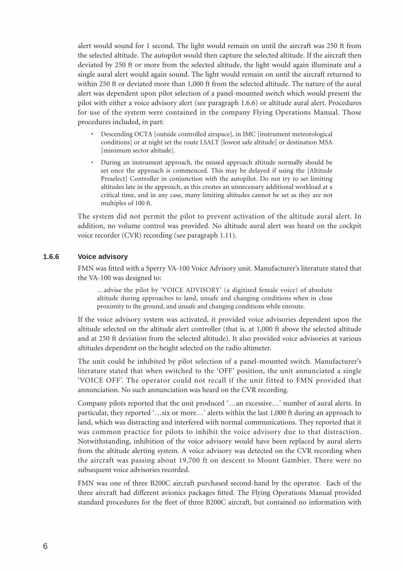
1.12 Wreckage informationThe impact position was right of the RWY 18 extended centreline, with a deviation to the rightof about 5 to 10 degrees (that is, about 185–190 degrees M). The aircraft impacted the groundslightly right wing low and in a nose-low attitude. The impact swathe extended approximately240 metres and the aircraft came to rest upright and facing back towards the direction of flight.The tail section had separated and was lying inverted a short distance from the remainder ofthe aircraft. The cabin airstair door was open and had been used by the medical crewmemberfor egress. The emergency location transmitter (ELT) had activated on impact. Examination ofthe wreckage and impact swathe indicated that the aircraft's landing gear was extended and theflaps were in the approach configuration. The aircraft’s final position is depicted at figs. 3 and 4. The impact swathe is depicted at fig. 5.
Ground vegetation consisted of a cleared pine plantation, with some secondary growth to aheight of about 5 metres. Damage to trees in the approach path indicated an aircraft approachangle of about 10 to 13 degrees. The operator estimated that such an approach angle would
8
5 An AT-VASIS consists of 10 light units arranged on one side of the runway, in the form of a single wing bar of four lightunits, with a bisecting longitudinal line of six lights. The red ‘fly up’ indication is designed to be visual to ground level. TheAirservices Australia Aeronautical Information Publication stated that the AT-VASIS:
…standard installation aims to provide an obstacle clearance of at least 11M above a 1.9 degree slope, within the azimuthsplay of 7.5 degree either side of the runway centre line for a distance of 5 NM from the threshold…When the installationdiffers from the standard, details are promulgated in the aerodrome documentation.
Mount Gambier aerodrome documentation did not publish advice of a difference to the standard installation. Paragraph 7.6of Chapter 12 of the Civil Aviation Safety Authority Document Rules and Practices for Aerodromes, current at the time of theoccurrence, stated that:
The beam of light produced by the units is to be such that in clear weather the effective visual range of the indicator is tobe at least 4 nautical miles over the angle of 11⁄2 degrees above and 1 degree below the correct approach slope, both by dayand by night, and in azimuth over 10 degrees by day and 30 degrees by night. The light units are to have as great anintensity as possible from ground level to 6 degrees in elevation.
6 Propeller RPM is increased to allow the aircraft engines to develop maximum horsepower if required, and is conducted aspart of the aircraft checklist procedures on final or short final approach.

have required an aircraft attitude of about 5 degrees nose-down on the aircraft attitudeindicator and a rate of descent of about 1,500 to 2,800 ft per minute, dependant uponindicated airspeed and wind effect. The aircraft’s approach path is depicted at fig. 6. Due toimpact and fire damage, no information was able to be obtained from cockpit instruments andflight control positions.
Following discussions with Mount Gambier Police, and in accordance with the provisions ofthe Air Navigation Act 1920, Part 2A, Section 19FM, the aircraft wreckage was released to theowner on 13 December 2001.
FIGURE 3:Final wreckage position
9
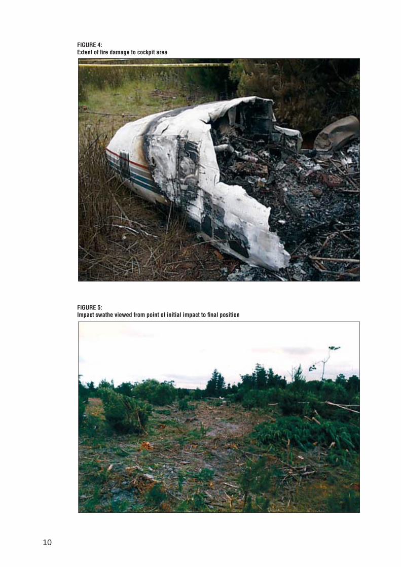
FIGURE 4:Extent of fire damage to cockpit area
FIGURE 5:Impact swathe viewed from point of initial impact to final position
10
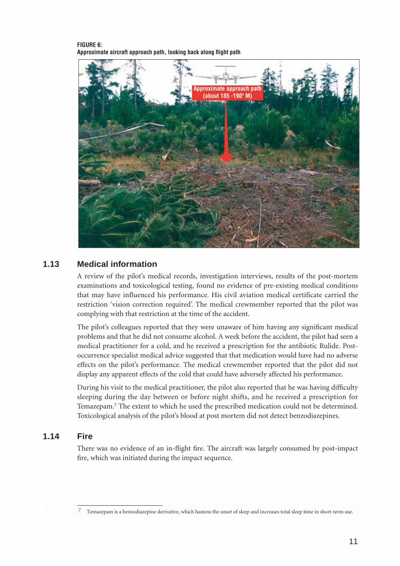
FIGURE 6:Approximate aircraft approach path, looking back along flight path
1.13 Medical informationA review of the pilot’s medical records, investigation interviews, results of the post-mortemexaminations and toxicological testing, found no evidence of pre-existing medical conditionsthat may have influenced his performance. His civil aviation medical certificate carried therestriction ‘vision correction required’. The medical crewmember reported that the pilot wascomplying with that restriction at the time of the accident.
The pilot’s colleagues reported that they were unaware of him having any significant medicalproblems and that he did not consume alcohol. A week before the accident, the pilot had seen amedical practitioner for a cold, and he received a prescription for the antibiotic Rulide. Post-occurrence specialist medical advice suggested that that medication would have had no adverseeffects on the pilot’s performance. The medical crewmember reported that the pilot did notdisplay any apparent effects of the cold that could have adversely affected his performance.
During his visit to the medical practitioner, the pilot also reported that he was having difficultysleeping during the day between or before night shifts, and he received a prescription forTemazepam.7 The extent to which he used the prescribed medication could not be determined.Toxicological analysis of the pilot’s blood at post mortem did not detect benzodiazepines.
1.14 FireThere was no evidence of an in-flight fire. The aircraft was largely consumed by post-impactfire, which was initiated during the impact sequence.
11
Approximate approach path(about 185 -190º M)
7 Temazepam is a benzodiazepine derivative, which hastens the onset of sleep and increases total sleep time in short-term use.
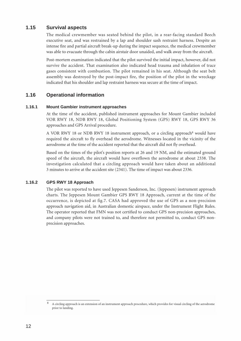
1.15 Survival aspectsThe medical crewmember was seated behind the pilot, in a rear-facing standard Beechexecutive seat, and was restrained by a lap and shoulder sash restraint harness. Despite anintense fire and partial aircraft break-up during the impact sequence, the medical crewmemberwas able to evacuate through the cabin airstair door unaided, and walk away from the aircraft.
Post-mortem examination indicated that the pilot survived the initial impact, however, did notsurvive the accident. That examination also indicated head trauma and inhalation of tracegases consistent with combustion. The pilot remained in his seat. Although the seat beltassembly was destroyed by the post-impact fire, the position of the pilot in the wreckageindicated that his shoulder and lap restraint harness was secure at the time of impact.
1.16 Operational information
1.16.1 Mount Gambier instrument approaches
At the time of the accident, published instrument approaches for Mount Gambier includedVOR RWY 18, NDB RWY 18, Global Positioning System (GPS) RWY 18, GPS RWY 36approaches and GPS Arrival procedure.
A VOR RWY 18 or NDB RWY 18 instrument approach, or a circling approach8 would haverequired the aircraft to fly overhead the aerodrome. Witnesses located in the vicinity of theaerodrome at the time of the accident reported that the aircraft did not fly overhead.
Based on the times of the pilot’s position reports at 26 and 19 NM, and the estimated groundspeed of the aircraft, the aircraft would have overflown the aerodrome at about 2338. Theinvestigation calculated that a circling approach would have taken about an additional 3 minutes to arrive at the accident site (2341). The time of impact was about 2336.
1.16.2 GPS RWY 18 Approach
The pilot was reported to have used Jeppesen Sanderson, Inc. (Jeppesen) instrument approachcharts. The Jeppesen Mount Gambier GPS RWY 18 Approach, current at the time of theoccurrence, is depicted at fig.7. CASA had approved the use of GPS as a non-precisionapproach navigation aid, in Australian domestic airspace, under the Instrument Flight Rules.The operator reported that FMN was not certified to conduct GPS non-precision approaches,and company pilots were not trained to, and therefore not permitted to, conduct GPS non-precision approaches.
12
8 A circling approach is an extension of an instrument approach procedure, which provides for visual circling of the aerodromeprior to landing.
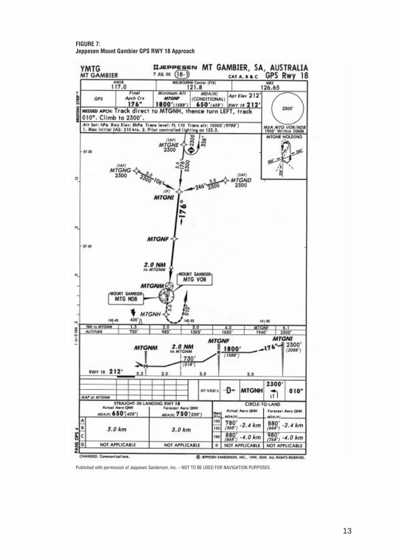
FIGURE 7:Jeppesen Mount Gambier GPS RWY 18 Approach
Published with permission of Jeppesen Sanderson, Inc. – NOT TO BE USED FOR NAVIGATION PURPOSES.
13
Witnesses located under the GPS RWY 18 Approach path, and to the south of the GPSwaypoint MTGNF (5.3 NM north of the threshold RWY 18), reported that they heard theoccurrence aircraft some distance to the west of them, and that it did not overfly their location.Witnesses located to the south and west of MTGNF, reported that the occurrence aircraftoverflew their location.
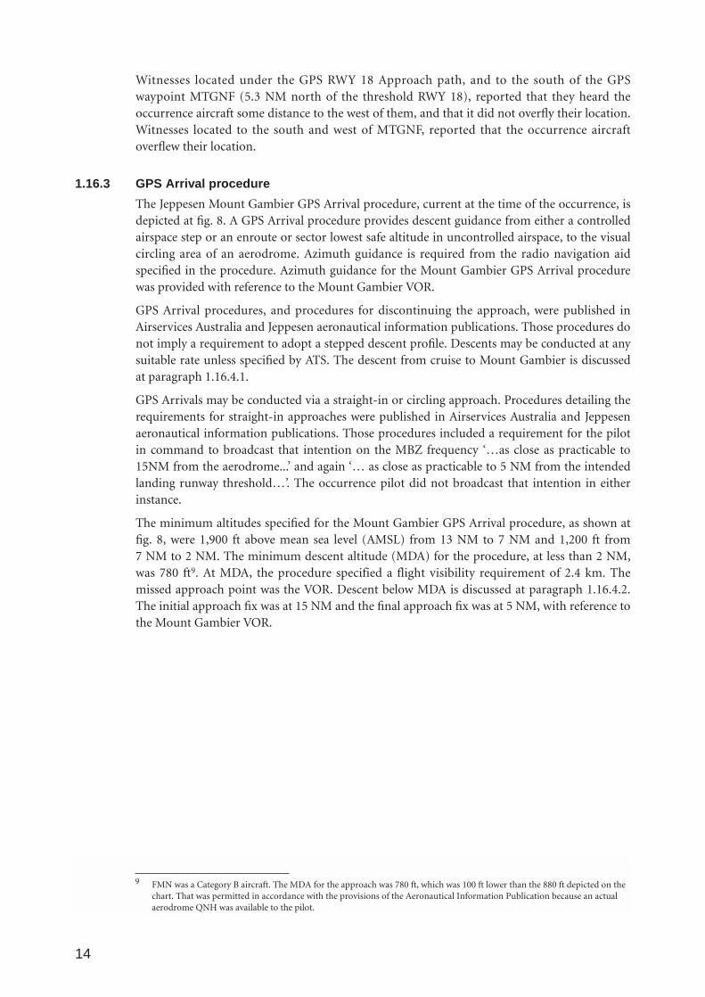
1.16.3 GPS Arrival procedure
The Jeppesen Mount Gambier GPS Arrival procedure, current at the time of the occurrence, isdepicted at fig. 8. A GPS Arrival procedure provides descent guidance from either a controlledairspace step or an enroute or sector lowest safe altitude in uncontrolled airspace, to the visualcircling area of an aerodrome. Azimuth guidance is required from the radio navigation aidspecified in the procedure. Azimuth guidance for the Mount Gambier GPS Arrival procedurewas provided with reference to the Mount Gambier VOR.
GPS Arrival procedures, and procedures for discontinuing the approach, were published inAirservices Australia and Jeppesen aeronautical information publications. Those procedures donot imply a requirement to adopt a stepped descent profile. Descents may be conducted at anysuitable rate unless specified by ATS. The descent from cruise to Mount Gambier is discussedat paragraph 1.16.4.1.
GPS Arrivals may be conducted via a straight-in or circling approach. Procedures detailing therequirements for straight-in approaches were published in Airservices Australia and Jeppesenaeronautical information publications. Those procedures included a requirement for the pilotin command to broadcast that intention on the MBZ frequency ‘…as close as practicable to15NM from the aerodrome...’ and again ‘… as close as practicable to 5 NM from the intendedlanding runway threshold…’. The occurrence pilot did not broadcast that intention in eitherinstance.
The minimum altitudes specified for the Mount Gambier GPS Arrival procedure, as shown atfig. 8, were 1,900 ft above mean sea level (AMSL) from 13 NM to 7 NM and 1,200 ft from 7 NM to 2 NM. The minimum descent altitude (MDA) for the procedure, at less than 2 NM,was 780 ft9. At MDA, the procedure specified a flight visibility requirement of 2.4 km. Themissed approach point was the VOR. Descent below MDA is discussed at paragraph 1.16.4.2.The initial approach fix was at 15 NM and the final approach fix was at 5 NM, with reference tothe Mount Gambier VOR.
14
9 FMN was a Category B aircraft. The MDA for the approach was 780 ft, which was 100 ft lower than the 880 ft depicted on thechart. That was permitted in accordance with the provisions of the Aeronautical Information Publication because an actualaerodrome QNH was available to the pilot.
FIGURE 8:Jeppesen Mount Gambier GPS Arrival procedure
Published with permission of Jeppesen Sanderson, Inc. – NOT TO BE USED FOR NAVIGATION PURPOSES.
15

1.16.4 Descent to Mount Gambier
1.16.4.1 Descent from cruise
ATS recorded radar data at fig. 9, indicated that the aircraft commenced descent to MountGambier, from cruise altitude, at about 2312 and was about 89 NM from Mount Gambier atthat time. The initial rate of descent was about 440 ft per minute for about 5 minutes, untilabout 67 NM from Mount Gambier, indicating a descent profile of about 6 NM per 1,000 ft.The aircraft then descended at a rate of 1,350 ft per minute for about 8 minutes, until radarcontact was lost at an altitude of about 8,200 ft AMSL and 34 NM from Mount Gambier. Thatindicated a descent profile of about 3 NM per 1,000 ft. Aircraft groundspeed during thedescent varied between 237 and 269 kts.
A plan view depicting pilot position reports and radar data is at fig.10.
1.16.4.2 Descent below the published minimum descent altitude
Requirements for discontinuing an instrument approach or procedure, and therefore descentbelow GPS Arrival procedure steps or MDA, by night, were published in Airservices Australiaand Jeppesen aeronautical information publications. Those requirements included, in part,establishing and maintaining the aircraft:
• clear of cloud
• in sight of ground or water
• with a flight visibility not less than 5,000M
• within 5NM… of that aerodrome aligned with the runway centreline and establishednot below ‘on slope’ on the T-VASIS…
In addition, when conducting a straight-in approach, a pilot in command was required tobroadcast on the MBZ frequency at 5 NM, that the aircraft was established on final approach atthat distance and identifying the runway to be used. There was no evidence on recordedinformation that the occurrence pilot broadcast that intention.
1.16.4.3 Flight planning information
The aircraft took off from Adelaide with full fuel tanks. The operator reported that the pilotintended to refuel at Mount Gambier.
16

FIGURE 9:Aircraft descent profile10
17
0
2000
4000
6000
8000
1000
0
1200
0
1400
0
1600
0
1800
0
2000
0
2200
0
Altitude (feet)
Top
of D
esce
nt
330
310
290
270
250
230
210
190
170
150
130
110
Groundspeed (knots)
Tim
e (lo
cal)
23:10:00
23:12:00
23:14:00
23:16:00
23:18:00
23:20:00
23:22:00
23:24:00
23:26:00
23:28:00
23:30:00
23:32:00
23:34:00
23:36:00
23:38:00
Tran
smis
sion
to A
TC: C
ircui
t are
a M
ount
Gam
bier
adv
ise
on g
roun
d
Tran
smis
sion
to A
TC: s
witc
h ra
dio
from
Are
a to
MBZ
freq
uenc
y
Min
imum
Saf
e Al
titud
eTr
ansm
issi
on to
MBZ
: 20
corr
ectio
n 26
mile
s...l
eft 5
,000
ft...
Tran
smis
sion
to M
BZ:
19 m
iles
YMTG
...m
aint
aini
ng 4
,000
ft...
Tran
smis
sion
: pos
sibl
y ac
tivat
e PA
L
Land
ing
gear
ext
ensi
onPr
opel
ler R
PM in
crea
sed
Appr
ox .
Tim
e of
Impa
ctGr
ound
spee
d
Mod
e C
Altit
ude
2300
1900
1200
780
10 Altitudes shown in Figs. 9 and 10 are in feet above mean sea level (AMSL). Mount Gambier aerodrome is 212 ft AMSL.

FIGURE 10:Plan view depicting pilot position reports and radar data11
18
-35
-30
-25
-20
-15
-10-505
1015203035
-35
-30
-20
-15
-10
-50
510
1520
3035
MSA
230
019
012
0 0
Reco
rded
rada
r tra
ck la
st v
alid
retu
rn23
:24:
57 a
ppro
xim
atel
y34
nau
tical
mile
s8,
200
feet
140
deg
rees
mag
netic
to M
ount
Gam
bier
VH-F
MN
advi
ses
19 n
autic
al m
iles
inbo
und
mai
ntai
ning
4,0
00 fe
et
VH-F
MN
advi
ses
26 n
autic
al m
iles
north
inbo
und
left
5,00
0 fe
et
Runw
ay 1
8ex
tend
edce
ntre
line
Acc
iden
t site
Proj
ecte
d in
boun
dra
dar t
rack
True
Nor
th 00
25-2
5
25
Reco
rded
Rad
ar D
ata
26 N
M a
rc
25 N
M M
SA
19 N
M a
rc
13 N
M s
tep
7 NM
ste
p
2 NM
ste
p
YMTG
VOR
Acci
dent
site
loca
tion
11 Radar data was obtained from Airservices Australia.
1.17 Tests and research12
1.17.1 Controlled flight into terrain and approach and landing accident reduction
Research conducted by an industry task force, under the auspices of the International CivilAviation Organization (ICAO), attributed 80 per cent of fatalities in commercial transport-aircraft accidents, throughout the world, to controlled flight into terrain (CFIT) accidents, andaccidents occurring during the approach-and-landing phase. CFIT occurs when an airworthyaircraft, under the control of the flight crew, is flown unintentionally into terrain, obstacles orwater, usually with no prior awareness by the crew. This type of accident can occur duringmost phases of flight, but CFIT is more common during the approach-and-landing phase. Thisphase begins when an airworthy aircraft under the control of the flight crew descends below5,000 feet above ground level (AGL), with the intention to conduct an approach. It ends whenthe landing is complete or the flight crew flies the aircraft above 5,000 feet AGL enroute toanother aerodrome.
In late 1992, in response to a high CFIT accident rate worldwide, the Flight Safety Foundation(FSF) formed a CFIT and Approach and Landing Task Force. By mid-1993, ICAO and FSF hadagreed to a cooperative approach to the CFIT problem. A number of teams were formed,focussing on such aspects as aircraft equipment, flight crew training and procedures, flightoperations, and ATS training and procedures. From the work of these teams, a number ofissues were highlighted. Those relevant to this accident include:
• Ground proximity warning systems (GPWS)
Given the substantial safety benefits of GPWS, the task force considered that all aircraft incommercial and corporate use, including those involved in domestic operations only,should be equipped with GPWS.
• Radio altimeter
The task force was convinced of the value of the radio altimeter and believed that theequipment was underutilised as a terrain awareness/avoidance aid in aircraft that are notequipped with GPWS. The task force recommended that procedures should be developedto make greater use of radio altimeters to increase crews’ awareness of their aircraft’svertical position.
• CFIT and Approach-and-Landing Accident Reduction (ALAR) awareness material
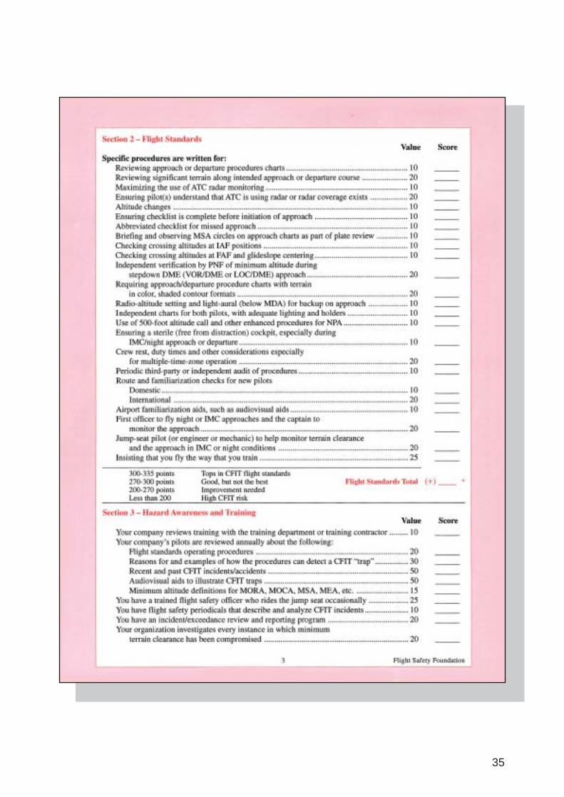
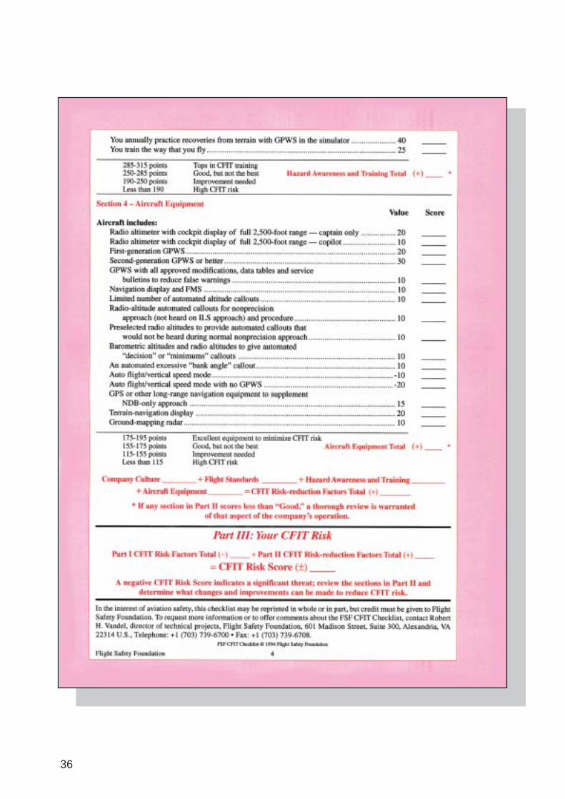
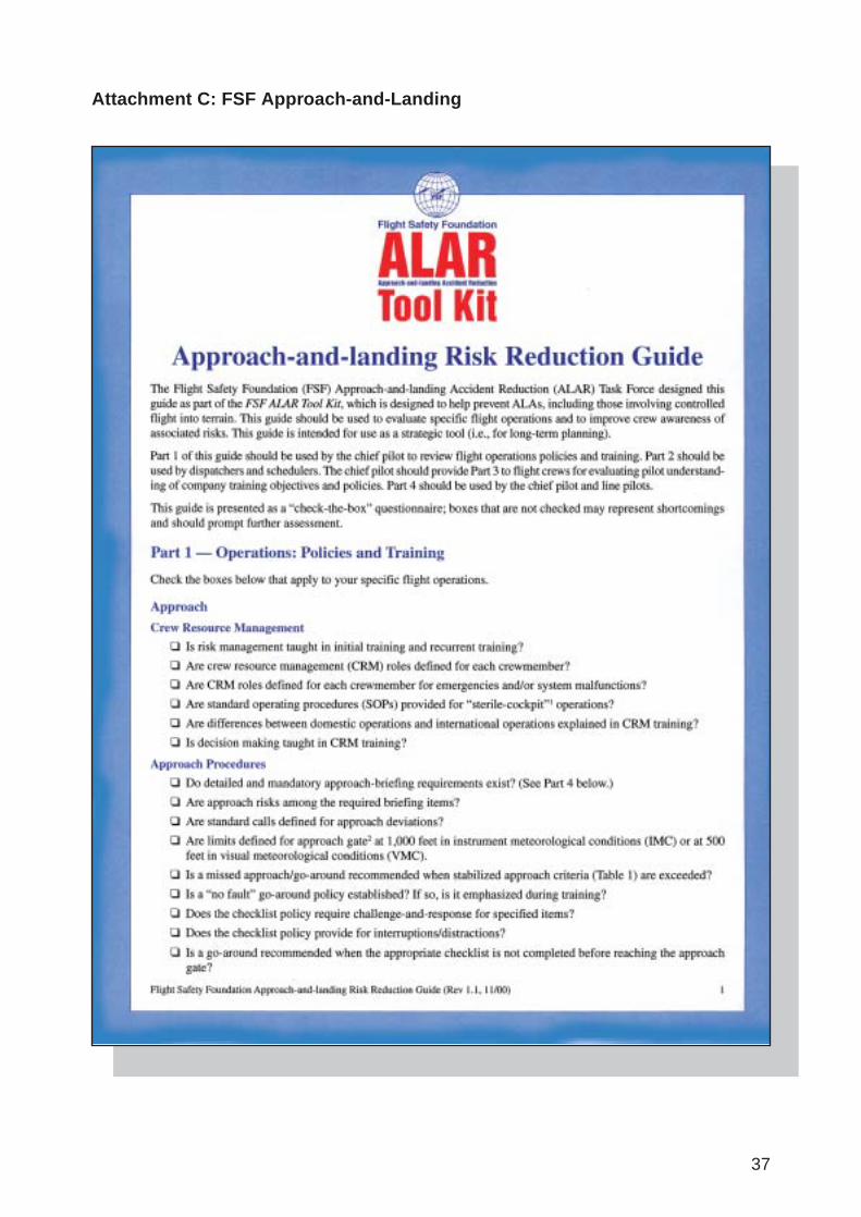
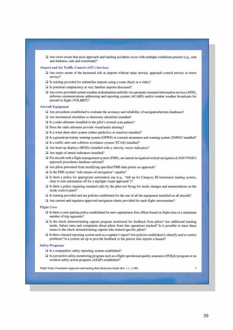
The FSF CFIT task force developed a complete CFIT education and prevention package forall members of the aviation community worldwide. The package consisted of a number ofsafety awareness products including a CFIT Safety Alert, CFIT Checklist and a number ofeducational video productions. The checklist was designed to assist aircraft operators inevaluating the CFIT risk for a particular route or flight. It was also useful in highlightingaspects of company operations, which might be contributing to CFIT risk. A copy of thechecklist is included at Attachment B. In addition, ICAO produced a CD-ROM entitled‘CFIT Education and Training Aid’. The FSF task force also produced an ALAR tool kit,which consists of an ‘Approach-and-landing Risk Reduction Guide’. A copy of the guide isincluded at Attachment C. The education and training packages were distributed to theworldwide civil aviation industry by the FSF and by ICAO to its Contracting States.13
19
12 Information contained in this section was sourced from the ICAO and FSF internet web-sites. Australia is an active memberstate within ICAO and the ATSB is a member of the FSF.
13 Copies of the education and training programs, including video programs, are available in CD-ROM format and can beobtained directly from the FSF (www.flightsafety.org) or through aviation retail outlets.

In addition to the production of education and training programs, the FSF made a number ofrecommendations to ICAO concerning the use of GPWS and design and presentation of non-precision instrument approach procedures.
1.17.2 Dark night approaches
Research conducted by Transport Canada indicates that approach-and-landing accident riskincreases significantly during approaches in ‘black hole’ conditions. The term ‘black hole’ isgenerally used to describe aerodromes isolated from sources of significant ground lighting. Ona dark night, those aerodromes necessitate an approach to the runway over dark and generallyunlit terrain and can contribute to the pilot experiencing various visual and other sensoryillusions.
The latter stages of the occurrence flight were flown over dark, unlit terrain towards lights, inconditions of low cloud, rain showers and the lack of a defined horizon. Flying a visualapproach in those conditions has been associated with less reliable pilot control of approachpath angle due to the lack of visual cues. On occasions, pilots have experienced difficultyjudging rates of descent and closure rates, resulting in them overestimating approach pathangle and flying a shallow approach, sometimes resulting in ground impact short of the litarea. The same conditions can also produce high approaches, however low approaches havebeen shown to be more likely. In those instances of low approaches, a comparison of theapproach path flown by pilots during a night visual approach, with the desired altitudes, isdepicted at fig. 11.
FIGURE 11:Comparison of the approach path flown by pilots during a night visual approach with the desired altitudes14
The hazards of black hole situations have been widely publicised throughout the aviationcommunity since the late 1960s. Research conducted at Boeing suggested in part that pilots incommand:
• supplement outside visual reference to the runway with airport approach slopeindicators or glide path information from navigation instruments
• use distance measuring equipment to fly a 3 degree approach angle
• overfly an unfamiliar aerodrome before commencing the approach to landing
20
14 Illustration reproduced from Human Factors in Aviation, Earl Weiner and David Nagel, 1988
1.18 Additional information
1.18.1 Previous occurrences
As a result of the investigation into the CFIT accident involving Westwind VH-AJS near AliceSprings on 27 April 1996, the then Bureau of Air Safety Investigation (BASI)15 made tworecommendations. One of those recommendations referred to the fitment of GPWS to aircraftengaged in regular public transport or charter category operations16. As FMN was engaged inaerial work category operations, the recommendations do not directly apply to this occurrence.However, GPWS issues are further examined at paragraph 1.18.2.
A search of the ATSB air safety occurrence database identified a number of previous nightCFIT aircraft accidents that have occurred in Australia, including, but not limited to:
• Chieftain VH-NDU, at Young, NSW, on 11 June 1993 (ATSB occurrence number199301743)
• Aero Commander VH-BSS, near Sydney, NSW, on 14 January 1994 (ATSB occurrencenumber 199400096)
• Chieftain VH-KIJ, near King Island, TAS, on 8 February 1996 ((ATSB occurrence number199600399)
• Cessna 210 VH-SJP, at Osborne Mine, QLD, on 26 February 1998 (ATSB occurrencenumber 199800604)
However, those occurrences displayed a number of differences from the circumstances of theoccurrence involving FMN.
1.18.2 Ground proximity warning systems
GPWS provides flight crew with aural and visual alerts when one of the following thresholdsare exceeded between 50 and 2,450 ft radio altitude:
• excessive descent rate
• excessive terrain closure rate
• altitude loss after take-off or go-around
• unsafe terrain clearance while not in the landing configuration
• below glide slope deviation
Subsection 9 of Civil Aviation Order (CAO) 20.18, current at the time of the accident, detailedthe Australian regulatory requirements concerning GPWS. The order applies only to turbine-engine aircraft with a take-off weight in excess of 15,000 kg or that are carrying 10 or morepassengers and engaged in regular public transport or charter operations. FMN had amaximum certificated take-off weight of 5,670 kg, and was engaged in aerial work categoryoperations. In addition, at the time of the accident, FMN was configured for ambulanceoperations. In that configuration, FMN was certified under Civil Aviation Regulation (CAR)35 to carry up to six adult persons. Consequently, there was no regulatory requirement forFMN to be fitted with a GPWS.
21
15 BASI became part of the new ATSB on 1 July 1999.
16 Recommendation R19960040 states:
The Bureau of Air Safety Investigation recommends that the Civil Aviation Safety Authority expedite the discussion withindustry with the aim of implementing the changes made to ICAO annex 6 part 1, paragraph 6.15.3 prior to 1 January1999.
ICAO standards and recommended practices with respect to fitment of GPWS are contained inAnnex 6, Operation of Aircraft. However, Annex 6 does not apply to aircraft engaged in aerialwork category operations. Consequently, there was no ICAO requirement to fit GPWS toFMN.
In January 2001, CASA circulated to industry Discussion Paper DP 01010S. That paperconcerned a proposed Part 137 of the Civil Aviation Safety Regulations (CASRs), entitledAerial Work Operations. The CASR part number was subsequently revised to Part 136. Thepaper did not address fitment of GPWS to aircraft engaged in aerial work operations.
1.18.3 Organisational information
The operator had established a training and checking organisation in accordance with CAR217 (1), as a result of CASA direction to do so. The organisation consisted of:
• a training cell consisting of the Aviation Manager and Assistant Aviation manager
• selected pilots approved for specific supervisory, training and/or checking duties, assecondary functions to their primary duties
The structure, duties and responsibilities of the organisation, including training andproficiency programs, were outlined in the company Flying Operations Manual.
The operator reported that company pilots underwent four training and checking flights plus aCommand Multi-Engine Instrument Rating renewal per year. It reported satisfaction with theoccurrence pilot’s flying performance. The operator also reported that there were two basicvariations used by company pilots for conducting instrument approaches:
• flying a considered descent rate and levelling at the steps
• aiming for the 300 ft per NM profile
The operator also reported that, as all company operations are conducted single pilot, themethod of flying an instrument descent profile was seen as personal preference. As long as itwas compliant and safe, an individual pilot could use the method that they had been taught,had consolidated, and were comfortable with.
The company Flying Operations Manual contained information about CFIT awareness, andprocedures for using altitude awareness systems fitted to company aircraft. The manual statedthat:
Part of the rationale behind these requirements is to provide a measure of protectionagainst controlled flight into terrain, which is now the international leading accidentcause. Not surprisingly, 80% of these accidents have occurred within 15 nm of anairfield. What is surprising, though, is that half of these have occurred through descentinto relatively flat terrain. The above procedures are aimed at providing appropriatewarnings to the pilot.
1.18.4 Classification of aircraft operations
In September 2001, the ATSB recommended that CASA:
…consider proposing an increase in the operations’ classification, and/or theminimum safety standards required, for organisations that transport their ownemployees and similar personnel (for example contractors, personnel from relatedorganisations, or prisoners, but not fare-paying passengers) on a regular basis. Thisrecommendation applies to all such operations, regardless of the take-off weight of theaircraft involved.
As a result of that recommendation, and following a consultative process, CASA has proposedthe issue of a Notice of Proposed Rule Making, regarding classification of aircraft operations, in 2003.
22
2 ANALYSIS
2.1 Instrument approach methodsCalculated flight parameters and witness evidence indicated that the aircraft did not flyoverhead the aerodrome. It is therefore unlikely that the pilot was attempting to conduct aVOR RWY 18 or an NDB RWY 18 approach, for which he held qualifications. Witnessevidence also indicated that the pilot was not attempting to conduct a GPS RWY 18 non-precision approach. Additionally, the aircraft was not certified to conduct GPS non-precisionapproaches and the pilot was not qualified to conduct GPS non-precision approaches.
Therefore, it was more likely that the pilot was attempting to conduct a GPS Arrival procedure,for which he held a qualification. That procedure presented a pilot in command with twooptions in accordance with the published instrument approach procedures:
• fly overhead the aerodrome and/or the navigation aid and, if visual, conduct a circlingapproach
• conduct a straight-in approach by tracking to intercept the 360 degree M radial inboundbefore the final approach fix (5 NM from the VOR). In this case, the pilot should notdescend below 1,200 ft, until within 5 NM, established on the runway centreline, andvisually established not below the AT-VASIS glideslope indication.
As discussed above, the available evidence indicates that the pilot did not fly overhead theaerodrome or VOR. It is therefore considered likely that he was intending to position theaircraft for a straight-in approach, backed up with circling if a visual landing could not beassured.
The investigation noted the following aspects of the pilot’s approach method:
• The pilot did not broadcast an intention on the MBZ frequency to conduct a straight-inapproach at 15 NM and at 5 NM. It is possible that he did not do so because he was notexpecting to be able to complete a straight-in approach due to the previously advisedprevailing weather conditions at Mount Gambier.
• Based on witness evidence, the aircraft was not aligned with the runway centreline at 5 NMfrom the VOR.
• The aircraft was not in a position for the pilot to be visually established on the AT-VASISglideslope after descending below 1,200 ft. The intersection of a 3 degree glideslope fromthe runway threshold/aimpoint with 1,200 ft was at 3.2 NM from the threshold. Theaircraft impacted the ground at 3.1 NM from the threshold. Had the pilot not visuallyacquired the AT-VASIS, he should have remained at 1,200 ft until he was at 2 NM. Theinvestigation was unable to determine whether the pilot had visually acquired the AT-VASIS.
• The aircraft rate of descent at the point of impact was in excess of the 3 degree AT-VASISglideslope. Damage to trees in the approach path indicated an aircraft approach angle ofabout 10 to 13 degrees. The operator estimated that such an approach angle would haverequired an aircraft attitude of about 5 degrees nose-down on the aircraft attitude indicatorand a rate of descent of about 1,500 to 2,800 ft per minute, dependant upon indicatedairspeed, wind effect and other factors. It is possible that the pilot remained at 1,200 ft orabove until 5 NM from the VOR.
23

There was no conclusive evidence to indicate why the pilot deviated from publishedinstrument approach procedures. In addition, the combination of aircraft attitude and rate ofdescent during the latter stages of the approach to land could not be explained.
2.2 Altitude warning systemsThe circumstances of the accident appear to be consistent with controlled flight into terrain.Regardless of why the pilot deviated from published instrument approach procedures, he couldhave still detected and corrected this situation had he been using defences which should havebeen available to him if they were serviceable. FMN was fitted with altitude warning andalerting systems. The company Flying Operations Manual contained procedures for use of theaircraft radio altimeter and altitude alerting system, in particular, setting of the decisionheights for each system. Due to the extent of fire damage, the height settings at impact couldnot be determined.
It was common practice amongst company pilots to inhibit the voice advisory system due tothe reported distractions the system produced in the final stages of approach, due to inputfrom the radar altimeter. However, if the system was inhibited, the altitude alerting systemshould have sounded an aural alert when the aircraft descended below 1,000 ft above the heightset on the altitude alert controller. No altitude aural alerts were heard on the CVR, and novoice advisories were heard after the aircraft had passed through 19,700 ft. In addition, theradio altimeter should have been set to 780 ft, in accordance with the requirements of thecompany Flying Operations Manual. In order to prevent radio altimeter input to the altitudeaural alerting system, the radio altimeter must be set to zero, however, to do so was not inaccordance with standard operating procedures. It is possible that the pilot had not inhibitedthe voice advisory system, in which case, the absence of recorded voice alerts could indicatefailure of the system. Due to the extent of fire damage, the serviceability of the system couldnot be determined. If the pilot had left the altitude selection on the altitude alert controller atthe cruise altitude setting, the design of the system was such that, as the aircraft descendedmore than 1,000 ft below that selection, there would be no further altitude alerts. However, thealtitude selection on the altitude alert controller also provided input to the autopilot.Accordingly, the investigation considers it unlikely that the pilot would have left the altitudeselection at the cruise altitude setting, as this would mean that he would not be able to use theautopilot to fly the aircraft to, and level the aircraft at, a selected altitude during the descent.The absence of recorded altitude aural or voice alerts, subsequent to the voice advisory at19,700 ft, could not be explained.
The aircraft was not fitted with a GPWS, nor was it required by regulation. The function ofsuch systems is to prevent CFIT accidents. A GPWS may have provided the pilot with a moresalient warning to enable him to take corrective action in time to avoid ground contact.
2.3 Aircraft serviceabilityInformation from the CVR indicated that the aircraft was in controlled flight at impact. Engineand propeller noise was audible on the recording, and no anomalies were detected. In addition,there was no indication from the pilot that the aircraft was functioning abnormally. Theaircraft was in the approach configuration at the time of impact. In addition, radiotransmissions made by the pilot did not indicate any aircraft anomalies during the last 33 minutes of the flight. Due to impact and fire damage, the investigation was not able toexamine the cockpit instrumentation. However, apart from possible altitude alerting systemfailure as discussed at paragraph 2.2, there were no indications, prior to, or during the flight, ofany problems with any of the aircraft systems that may have contributed to the circumstances
24
of the accident. In summary, the investigation considered that the aircraft was capable ofnormal flight prior to impact.
2.4 Lighting and weather conditionsRWY 18 was equipped with an AT-VASIS, which provided a pilot with visual glideslopeguidance when the aircraft was aligned with the runway centreline. Had the pilot compliedwith the published instrument approach procedures, he would have been able to effectively usethe guidance provided by the AT-VASIS and the runway lights. The red ‘fly-up’ light indicationwas designed to be visual from ground level, within an azimuth of 30 degrees (15 degreeseither side of the runway centreline). The pilot should have been able to see the red ‘fly-up’indication. Aerodrome operations personnel reported that post-accident testing of the AT-VASIS system indicated that it was functioning correctly. There was no evidence to indicatethat the AT-VASIS was not functioning at the time of the occurrence.
Weather conditions prevailing in the Mount Gambier area included low cloud, low visibilityand rain showers. There was no visible moon or other ambient illumination, or groundlighting in the area surrounding the aircraft’s flight path and to the north of the runway. Thatcombination would have made it difficult for the pilot to visually acquire the ground or otherterrain features. There was no indication that the pilot saw the ground during the latter part ofthe approach.
Information from the CVR recording indicated that the pilot attempted to activate theaerodrome lighting more than once. The investigation considered that action was probably dueto the pilot not sighting, or being able to sight, the aerodrome lighting, at least during periodsof the descent.
2.5 Other issuesThe pilot broadcast on the MBZ frequency an estimated arrival time in the circuit area (about3 NM from the aerodrome reference point) of 2335. He then reported to ATS as having arrivedin the circuit area at 2333. Based upon estimations of the aircraft’s groundspeed, it was likelythat he was still about 9 NM from Mount Gambier. There was no evidence to indicate why thepilot made this radio transmission at this position.
The pilot intended to refuel the aircraft at Mount Gambier. He was aware that time constraintsapplied to the transport of the patient from Mount Gambier to Sydney, but he did not expressany concerns about time pressures on the CVR recording.
The aircraft was fitted with a Sperry BA-141 encoding altimeter that displayed altitude on acounter drum in addition to a pointer. Both the counter and pointer were calibrated in 20-ftincrements. Failure warning was indicated by a large warning flag that obscured the counterdrum when activated. The design of some older altimeters that used different altitude displaymethods, had been misread by pilots in previous occurrences. The BA-141 altimeter fitted tothe occurrence aircraft did not use those display methods. Additionally, the pilot was familiarwith the occurrence aircraft. The investigation therefore considered that it was unlikely that thepilot misread the altimeter fitted to the aircraft.
It is possible that the pilot was incapacitated in the period just prior to the accident. However,there was no evidence to indicate any pre-existing medical condition that could have led toincapacitation. The pilot had been suffering the effects of a cold, for which he received medicaladvice and antibiotic medication. Post-accident medical advice indicated that it was unlikelythat his cold and the medication had any adverse influence on his performance.
25
The accident occurred at approximately 2336, and the pilot had received less than the generallyrecommended 7.5 to 8 hours of sleep17 in the third and second nights prior to the accident.The pilot had also reported that he was experiencing difficulty sleeping during the day beforeand after night shifts, and had obtained prescribed medication for this problem. The extent towhich he was using this medication could not be determined, however, toxicological analysis ofthe pilot’s blood at post mortem did not detect benzodiazepines. Overall, it is possible that thepilot may have been experiencing a level of fatigue at the time of the accident, but there wasinsufficient information to make any conclusions regarding the extent of fatigue, or the extentto which it may have contributed to the accident.
The conduct of non-precision approaches can be a relatively high workload task for a singlepilot operation in dark night conditions and reduced visibility. This workload can be managedand an appropriate level of safety assurance generally established for such tasks with soundpreparation for the approach, compliance with published procedures, and the effective use ofaltitude alerting systems. The use of two pilot operations is a means of providing greater safetyassurance in such conditions, as long as appropriate procedures and training for multi-crewoperations is put in place. However, the cost of implementing such a defence can be prohibitivefor small operators. In addition, there was no regulatory requirement for the occurrence flightto be crewed by two pilots. Further, the FSF ALAR tool kit places more emphasis on thefitment of radio altimeters and GPWS than crewing by two pilots.
Medical advice indicated that the pilot survived the impact, but did not survive the accident.The reason for his non-survival could not be conclusively established. It is likely that themedical crewmember’s survival was attributable, at least in part, to the fact that the seat wasrear facing and there was a large amount of habitable space surrounding that seat area.
26
17 Battelle Memorial Institute, An Overview of the Scientific Literature Concerning Fatigue, Sleep, and the Circadian Cycle, 1998.(Report prepared for the Office of the Chief Scientific and Technical Adviser for Human Factors, Federal AviationAdministration, USA.)
3 CONCLUSIONS
3.1 Findings1. The pilot held a valid pilot’s licence, endorsed for the Raytheon Beech 200C aircraft.
2. The pilot held a valid command multi-engine instrument rating.
3. The aircraft was operating under a valid maintenance release at the time of the accident.
4. Apart from possible altitude alerting system failure, there were no indications, prior to, orduring the flight, of any problems with any of the aircraft systems that may havecontributed to the circumstances of the accident.
5. Mount Gambier aerodrome lighting was observed by witnesses to be illuminated at thetime of the occurrence.
6. Mount Gambier aerodrome AT-VASIS, radio-navigation aids and PAL were tested post-accident and found to be capable of operating normally.
7. Dark night conditions existed in the area surrounding the approach path of the aircraft,due to low cloud, low visibility and rain showers.
8. The aircraft was in the approach configuration at the time of impact.
9. For reasons which could not be ascertained, the pilot did not comply with therequirements of the published instrument approach procedures.
3.2 Significant factors1. Dark night conditions existed in the area surrounding the approach path of the aircraft.
2. For reasons which could not be ascertained, the pilot did not comply with therequirements of the published instrument approach procedures.
3. The aircraft was flown at an altitude insufficient to ensure terrain clearance.
27

28
4 SAFETY ACTION
As a result of this occurrence, the Australian Transport Safety Bureau again highlights theimportance of good CFIT/ALAR awareness to operators and includes the FSF CFIT checklistand ALAR risk reduction guide at Attachments B and C of this report.
The Civil Aviation Safety Authority (CASA) has encouraged use of the FSF CFIT awarenessmaterial and has included CFIT awareness modules in its safety and promotional activities forsome time. During 2002, the module was included in eight Flight Safety Forums and fourRoadshows. CASA report that 2,600 and 165 people attended these events, respectively. During2003, CASA has planned seven Roadshows in regional locations and has reported that CFITwill continue to remain one of their core safety promotional activities.
In addition, the Aviation Safety Foundation of Australia has conducted FSF ALAR courses.
Prior to the occurrence, the operator had acquired new aircraft fitted with Enhanced GPWS,despite no regulatory requirement to do so.
The investigation noted that amendment 92 to the Airservices Australia AeronauticalInformation Publication, Departure and Approach Procedures (West), dated 17 April 2003,included an amended GPS Arrival chart for Mount Gambier. That amendment revised theMinimum Descent Altitude (MDA) step from 2 NM to 4 NM. The revision permits an aircraftto descend to MDA 2 NM earlier that previously, which will permit a pilot in command moretime to achieve a more stable descent profile to the runway.
29

30

5 ATTACHMENTS
Attachment A: Terms and abbreviationsAGL Above Ground Level
ALAR Approach-and-Landing Accident Reduction
ATS Air Traffic Services
AT-VASIS Abbreviated ‘T’ Visual Approach Slope Indicator System
BASI Bureau of Air Safety Investigation
CAO Civil Aviation Order
CAR Civil Aviation Regulation
CASA Civil Aviation Safety Authority
CASRs Civil Aviation Safety Regulations
CFIT Ccontrolled flight into terrain
CVR Cockpit Voice Recorder
DH Decision Height
ELT Emergency Location Transmitter
FSF Flight Safety Foundation
ft Feet
GPS Global Positioning System
GPWS Ground Proximity Warning System
Hpa Hectopascals
ICAO International Civil Aviation Organisation
IFR Instrument Flight Rules
kg Kilograms
km Kilometres
kts Knots
M Magnetic
MBZ Mandatory Broadcast Zone
NDB Non Directional radio Beacon
MDH Minimum Descent Height
NM Nautical Miles
PAL Pilot Activated Lighting
QNH An altimeter sub-scale setting to show height above mean sea level
VHF Very High Frequency
VMC Visual Meteorological Conditions
VOR VHF Omni-directional Radio range
31

32

33
Attachment B: FSF CFIT Checklist Risk Reduction Guide

34
35
36
37
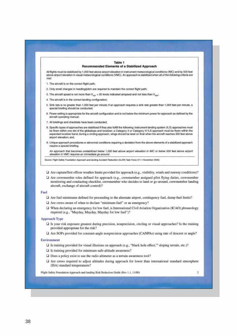
Attachment C: FSF Approach-and-Landing
38
39
40
41
42
Related Documents