Key issues arising from the 2006 WMO/ UNEP Ozone Assessment Atmospheric effects of volcanic eruptions as seen by famous artists and depicted in their paintings Atmospheric CO2, ocean acidification, and ecological changes in planktonic calcifying organisms ESF- EuroCLIMATE Workshop report

Welcome message from author
This document is posted to help you gain knowledge. Please leave a comment to let me know what you think about it! Share it to your friends and learn new things together.
Transcript
Key issues arising from the 2006 WMO/UNEP Ozone Assessment
Atmospheric effects of volcanic eruptions as seen by famous artists and depicted in their paintings
Atmospheric CO2, ocean acidification, and ecological changes in planktonic calcifying organismsESF- EuroCLIMATE Workshop report

THE EGGS
EGU News
News
Journal Watch
Atmospheric effects of volcanic eruptions as seen by famous artists and depicted in theirpaintings
Key issues arising from the 2006 WMO/UNEP Ozone Assessment
Atmospheric CO2, ocean acidification, and ecological changes in planktonic calcifying organismsESF- EuroCLIMATE Workshop report
New books
Book reviews
Events
Job Positions
3
6
18
21
24
28
34
36
37
44
THE EGGS | ISSUE 22 | DECEMBER 2007
© European Geosciences Union, 2007
Reproduction is authorised, provided the source is acknowledged, save where otherwise stated. Where prior permission must be obtained for the reproduction or use of textual and multimedia information (sound, images, software, etc.), such permission shall cancel the abovementioned general permission and indicate clearly any restrictions on use.
EDITORS Managing Editor: Kostas KourtidisDepartment of Environmental Engineering, School of EngineeringDemokritus University of ThraceVas. Sofias 12, GR-67100 Xanthi, Greecetel. +30-25410-79383, fax. +30-25410-79379email: [email protected] Assistant Editor: Magdeline PokarBristol Glaciology Center,School of Geographical Sciences, University of BristolUniversity RoadBristol, BS8 1SS, United Kingdomtel. +44(0)117 928 8186, fax. +44(0)117 928 7878email: [email protected] Hydrological Sciences: Guenther BloeschlInstitut fur Hydraulik, Gewasserkunde und WasserwirtschaftTechnische Universitat Wien Karlsplatz 13/223, A-1040 Wien, Austriatel. +43-1-58801-22315, fax. +43-1-58801-22399email: [email protected] Biogeosciences: Jean-Pierre GattusoLaboratoire d’Oceanographie de Villefranche, UMR 7093 CNRS-UPMC B. P. 28, F-06234 Villefranche-sur-mer Cedex France tel. +33-(0)493763859, fax. +33-(0)493763834email: [email protected]: Susanna Zerbini Department of Physics, Sector of Geophysics University of Bolo-gna, Viale Berti Pichat 8 40127 Bologna, Italy tel. +39-051-2095019, fax +39-051-2095058e-mail: [email protected] Geodynamics: Bert L.A. Vermeersen Delft University of Technology DEOS - Fac. Aerospace Engineer-ing Astrodynamics and Satellite Systems Kluyverweg 1, NL-2629 HS Delft The Netherlands tel. +31-15-2788272 fax. +31-15-2785322 8e-mail: [email protected] Atmospheric Sciences: Hans Xiang-Yu Huang Danish Meteorological Institute, Lyngbyvej 100, 2100 Copenha-gen, Denmarktel. +45-39157423, fax. +45-39157460 e-mail: [email protected] Seismology: Marco Mucciarelli Universita della Basilicata Di.S.G.GCampus Macchia Romana, 85100 Potenza Italytel. (39) 0971-205094, fax. (39) 0971-205070 e-mail: [email protected] Climate: Yu Shaocai Atmospheric Sciences Modeling Division (E243-01), National Exposure Research Laboratory U.S. Environmental Protection AgencyRTP, NC 27711, USA tel. +1-919-541-0362, fax. +1-919-541-1379 e-mail: [email protected] Atmospheric Chemistry: Kostas Kourtidis Department of Environmental Engineering,School of Engineering, Demokritus University of ThraceVas. Sofias 12, GR-67100 Xanthi, Greecetel. +30-25410-79383, fax. +30-25410-79379 e-mail: [email protected] GENERAL CONTACT For general matters please contact Kostas Kourtidis, at: [email protected] SUBMISSION OF MATERIAL For material submission, please contact the Editor-in-chief or the appropriate Section Editor.ADVERTISING For advertising information, please contact: [email protected] TECHNICAL For technical questions, please contact: [email protected]
Cover photo: Glacier tongues at the flanks of Mount Elbrus, Georgia. Credit: E. Zervas, distributed by EGU via www.imaggeo.net.

THE EGGS back to contents
Call for Papers is open now, deadline for abstract submission is 14 January 2008
EGU General Assembly 2008
Dear colleagues,
We are pleased to inform you that the Call-for-Papers programme for the European Geosciences Union (EGU) General Assembly 2008 is open now. On behalf of the Programme Committee, we cordially invite you to have a look in the programme and to submit abstracts to the various sessions.
All necessary information can be found under http://meetings.copernicus.org/egu2008.The deadline for the receipt of abstracts is 14 January 2008!
Abstract Registration
During the abstract registration, an author can choose whether a contribution should be a poster (choice “Poster”) or is preferred to be an oral (choice “No preference”, since there is no guarantee that it will definitely become an oral). Please note that an author is able to submit not more than one regular abstract and one solicited abstract with the choice “No preference”. Of course, poster papers are always welcome!
Please do not hesitate to contact us ([email protected]) in case that any question may arise!We hope that we can spark your interest in the programme and we are looking forward to receive your contributions!
Gerald Ganssen, Chair of the Programme CommitteeArne Richter, EGU Executive Secretary
Katja Gaenger & Martin Rasmussen, Copernicus Meeting Office
Geoscientific Model Development
A New EGU Online Open Access Journal
EGU launched another open access Journal, Geoscientific Model Development (GMD) (http://www.geoscientific-model-development.net/). Executive Editors are Daniel Lunt, James Annan, Julia C. Hargreaves, Ian Rutt and Rolf Sander.
Aims and Scope
Geoscientific Model Development (GMD) is an international scientific journal dedicated to the publication and public discussion of the description, development and benchmarking of numerical models of the Earth System and its components. Manuscript types considered for peer-reviewed publication are:
Model descriptions;Model intercomparison descriptions;Benchmarking papers;Technical papers.GMD has an innovative two-stage publication process
involving the scientific discussion forum Geoscientific Model Development Discussions (GMDD), which has been designed to:
foster scientific discussion;maximise the effectiveness and transparency of scientific
quality assurance;enable rapid publication;make scientific publications freely accessible.In the first stage, papers that pass a rapid access peer-
review are immediately published on the Geoscientific Model Development Discussions (GMDD) website. They are then subject to Interactive Public Discussion, during which the referees’ comments (anonymous or attributed), additional short comments by other members of the scientific community (attributed) and the authors’ replies are also published in GMDD. In the second stage, the peer-review process is completed and, if accepted, the final revised papers are published in GMD. To ensure publication precedence for authors, and to provide a lasting record of scientific discussion, GMDD and GMD are both ISSN-registered, permanently archived and fully citable.
GMD also offers an efficient new way of publishing special issues, in which the individual papers are published as soon as available and linked electronically.
Geoscientific Model Development (GMD) and Geoscientific Model Development Discussions (GMDD) are published by the Copernicus GmbH (Copernicus Publications) on behalf of the European Geosciences Union (EGU).

THE EGGS back to contents
Deadline: Wednesday, 16 January 2008, 24:00 (GMT+1 hour)
EGU Election 2007/2008 of the President and of the General Secretary of the Union
We hereby invite all Members of the European Geosciences Union (EGU) for 2007 to participate in the Election 2007/2008. This event includes the election of the President and of the General Secretary of the Union.
The elected President will serve as President-Elect (Vice-President) for 2008-2009, then as President for 2009-2011, and finally as Past-President (Vice-President) for 2011-2012.
The elected General Secretary will serve in this position for 2008-2010 with the option of an unlimited and immediate re-election for another 2 years thereafter.
Candidates
On its meeting at 12 October 2007, the Council of the European Geosciences Union approved the following candidates:
Candidates for the Election for President (in alphabetical order) are Donald Dingwell and Tuija Pulkkinen.
Candidate for the Election for General Secretary is Hans Thybo.
Election Procedure
In order to save paper and mailing costs, the election will be executed electronically: Have your ballot number ready, which has been sent to you already by email. Go to http://www.cosis.net/elections/election.php?eid=1 and follow the instructions.
Thank you for participating in the EGU Election 2007/2008 and for supporting the European Geosciences Union.
sponsorship would be used to allow EGU to cover the registration costs of teachers and scientists from less developed countries to attend the General
Assembly and the Education activities as well as for the running of topical conferences specifically targeted at the less developed world.
EGU Statement on Sponsorship of the Union
26 October 2007.- The EGU Council at its meeting on 12 October 2007 in Lyon discussed the issue of whether the Union should accept sponsorship from individuals, the public sector and the private sector.
The sponsorship would be used to enhance EGU activities in the realms of Education and Outreach, specifically to allow EGU to cover the registration costs of teachers and scientists from less developed countries to attend the General Assembly and the Education activities. Also sponsorship would be used for the running of topical conferences, such as the Alexander von Humboldt conferences, which are specifically targeted at the less developed world.
EGU Sponsorship Principles
Sponsorship means payment by a government agency, private sector organisation or individual in return for public association with an EGU activity, project, event, or asset. It can be in cash or in kind, and includes co-funding of projects. Sponsorship can help EGU achieve its objectives, and will be actively sought. However it must be governed by the following
principles, which have been endorsed by EGU Council.--The sponsorship agreement must be in writing and
where appropriate, cleared with the lawyers of EGU and of the sponsor, and should set out unambiguously the responsibilities and expectations of each party, and the benefits which each will receive. It should also include clauses covering its review and termination.
--Any sponsorship must produce benefit for EGU within its agreed strategic objectives.
--This benefit must outweigh any reputation or business risk for EGU through being associated with the sponsor.
--Sponsorship must always be consistent with EGU’s ethical policy as defined by the EGU senior advisory group on ethics, geopolitics and public affairs.
--The arrangement must be wholly transparent, with provision for scrutiny by EGU members.
--EGU will not endorse or give preference to sponsor products. Nor will EGU give any competitive advantage to any sponsor.
--All Intellectual Property Rights (IPR) stemming from the sponsored activity, whether anticipated or not, remains the

THE EGGS back to contents
property of EGU, unless there is an explicit agreement to the contrary in the original sponsorship document.
--There should be no exclusivity clause. EGU’s work, and its key messages, should not be influenced or contradicted by the sponsor. Any statement by the sponsor about its relationship with EGU, or use of EGU logos/brands in sponsor advertising or publications showing images relating to EGU activities, must be explicitly approved by the EGU Executive committee. This requirement should be spelled out in the sponsorship agreement.
--Sponsorship income for a project or activity should be in addition to core funding by EGU. It should normally not exceed
40% of the total funds for a project or an activity, unless the agreement specifically prescribes co-funding or matched funding.
--The chair of the funding committee will obtain approval from council before approaching potential sponsors. All sponsorships over Euro 100 will be disclosed in EUG’s Treasurer’s Report to the General Assembly. Any offer of sponsorship of over Euro 1,000, or which is novel, or which may prove contentious, must be brought to EGU Council after consultation with the EGU senior advisory group on ethics, geopolitics and public affairs.
EGU Press Release
and help EGU’ voice grow stronger
Remember to renew your 2008 EGU membership
Membership Fees for 2008 remain low, at the following rates:Regular Membership: 20,- EUR Student Membership: 10,- EURRetired Senior Membership: 10,- EUR Please use the COSIS Online Shopping System (go to http://www.copernicus.org/EGU/membership/general.html and follow
the link) at no additional service charges, in particular in case you want to pay by credit card online. You will be asked to login first, so please have your COSIS ID-No. and password ready and enter the membership subscription. If you are not yet registered with COSIS, you will be asked to make a quick registration free-of-charge.
For membership at student or retired scientist rates your status in the COSIS System must be “Student” or “Retired” respectively; if necessary, select “Change Status” on your Personal Home and proceed as indicated before continuing with your order. Otherwise the status “Regular” is used, and the regular subscription prices are taken automatically.
Once your payment has been effected you will be informed. A pro-forma invoice and/or an invoice and/or a receipt can be obtained online via COSIS.

THE EGGS back to contents
In 2005, the International Ocean Colour Coordinating Group (IOCCG) convened a working group to examine the state of the art in ocean colour data merging, which showed that the research techniques had matured sufficiently for creating long multi-sensor datasets (IOCCG, 2007). As a result, ESA initiated and funded the DUE GlobColour project (http://www.globcolour.info/) to develop a satellite based ocean colour data set to support global carbon-cycle research. It aims to satisfy the scientific requirement for a long (10+ year) time-series of consistently calibrated global ocean colour information with the best possible spatial coverage.
The three year project kicked-off in November 2005 under the leadership of ACRI-ST (France). The objective is to produce a global daily ocean colour data set with the best possible coverage by merging together data from the three most capable sensors: SeaWiFS on GeoEye’s Orbview-2 mission, MODIS on NASA’s Aqua mission and MERIS on ESA’s ENVISAT mission.
In setting up the GlobColour project, three user organisations were invited to help. Their roles are to specify the detailed user requirements, act as a channel to the broader end user community and to provide feedback and assessment of the results. The International Ocean Carbon Coordination Project (IOCCP) based at UNESCO in Paris provides direct access to the carbon cycle modelling community’s requirements and to the modellers themselves who will use the final products. The UK Met Office’s National Centre for Ocean Forecasting (NCOF) in Exeter, UK, provides an understanding of the requirements of oceanography users, and the IOCCG bring their understanding of the global user needs and valuable advice on best practice within the ocean colour science community.
The first year was a feasibility demonstration phase that was successfully concluded at a user consultation workshop organised by the Laboratoire d’Océanographie de Villefranche, France, in December 2006. Error statistics and inter-sensor biases were quantified by comparison with in-situ measurements from moored optical buoys and ship based campaigns, and used as input to the merging. The second year was dedicated to the production of the time series. In total more than 25 Tb of input (level 2) data have been ingested and 14 Tb of intermediate and output products created, with 4 Tb of data distributed to the user community. Quality control (QC) is provided through the Diagnostic Data Sets (DDS), which are extracted sub-areas covering locations of in-situ data collection or interesting oceanographic phenomena. The Full Product Set (FPS) covers global daily merged ocean colour products in the time period 1997-2006 and is freely available for use by the worldwide science community at
http://www.globcolour.info/data_access_full_prod_set.html .
The GlobColour service distributes global daily, 8-day and monthly data sets at 4.6 km resolution for, chlorophyll-a concentration, normalised water-leaving radiances (412, 443, 490, 510, 531, 555 and 620 nm, 670, 681 and 709 nm), diffuse attenuation coefficient, coloured dissolved and detrital organic materials, total suspended matter or particulate backscattering coefficient, turbidity index, cloud fraction and quality indicators. Error statistics from the initial sensor characterisation are used as an input to the merging methods and propagate through the merging process to provide error estimates on the output merged products. These error estimates are a key component of GlobColour as they are invaluable to the users;
particularly the modellers who need them in order to assimilate the ocean colour data into ocean simulations. See the Product User Guide (PUG) for further details on the GlobColour products
http://www.globcolour.info/CDR_Docs/GlobCOLOUR_PUG.pdf.
An intensive phase of validation has been undertaken to assess the quality of the data set. In addition, inter-comparisons between the different merged datasets will help in further refining the techniques used. Both the final products and the quality assessment were presented at a
second user consultation in Oslo on 20-22 November 2007; presentations are available on the GlobColour WWW site.
In 2008, the project will continue merging MERIS and MODIS ocean colour data, with a global daily delivery in NRT to primarily support operational oceanography. In the future this will feed into the European Community funded Marine Core Service that will start to provide, in 2008, a suite of services to support Europe’s decision makers. Future availability of MERIS ocean colour data will be assured with the launch of the first Sentinel-3 satellite in 2012. GlobColour’s merged ocean colour dataset will be provided in future by the Ocean Colour Thematic Assembly Centre (OC TAC) whose main objective is to bridge the gap
between space agencies providing ocean colour data and GMES marine applications. The OC TAC will deliver core ocean colour products, annotated with pixel level quality control flags and reliable error estimates, at global to regional European scales consolidating European efforts and maximising their impact.
IOCCG
News on GlobColourThe Full Product Set covers global daily merged ocean colour products at 4.6 km resolution in the time pe-
riod 1997-2006 and is freely available on the web

THE EGGS back to contents
On the occasion of the 20th anniversary of the Montreal Protocol for the protection of the ozone layer, scientists gathered at the Academy of Athens on September 26th, 2007. They noted that the success of the Montreal Protocol is largely based on scientific progress made over the last decades. A world of extreme high chlorine, low ozone, and high UV has presently been avoided. Continued adherence to the Montreal Protocol will assure that this remains the case in the future.
It is perhaps one of the most illustrious examples of a successful global collaboration between scientific, industrial and environmental organizations and policy makers. Control of ozone depleting substances as imposed by the Montreal Protocol is not the only factor that influences the variability of ozone and of harmful solar UV radiation. Aerosols, volcanic eruptions and climate change also influence the expected recovery of the ozone layer from the effects of halocarbons.
In areas like Greece where climate change may lead to significant reduction in precipitation and more frequent heat waves with more intense urban ozone and aerosol pollution events, new scientific and policy challenges will have to be faced.
Impact of Climate Change – Ozone climate Interactions
• The decrease in ozone-depleting substances is a dominant factor in the expected return of ozone levels to pre-1980 values. However changes in climate will influence if, when, and to what extent ozone will return to pre-1980 values in different regions.
• Future increases of greenhouse gas concentrations will contribute to the average cooling in the stratosphere.
Chemical reaction rates in the atmosphere are dependent on temperature, and thus the concentration of ozone is sensitive to climate changes. Stratospheric cooling was observed during the past two decades. Further changes to the temperature and circulation of the stratosphere could affect climate and weather in the troposphere.
Implications for Policy Formulation
• The Montreal Protocol is working: There is clear evidence of a decrease in the atmospheric burden of ozone-depleting substances and some early signs of stratospheric ozone recovery.
• Failure to comply with the Montreal Protocol would delay, or could even prevent, recovery of the ozone layer.
• Understanding the interconnections between ozone depletion and climate change is crucial for projections of future ozone abundances.
• Stratospheric and tropospheric ozone are critical components of the global climate system. Understanding this system requires continuation and strengthening of observation systems for ozone and other relevant species, both from ground and space. These observations will provide indispensable information about the phase-out of halocarbons as required by the Montreal Protocol and about the evolution of the atmosphere under climate change. Continuous efforts in laboratory studies and model developments are also needed.
• It is imperative to develop similar cooperative relationships between scientific, industrial and environmental organizations and policy makers to develop effective approaches to environmental threats in the “anthroposcene” era.
20th anniversary of the Montreal Protocol - Athens StatementOn the occasion of the 20th anniversary of the Montreal Protocol for the protection of the ozone layer, scien-
tists gathered at the Academy of Athens on September 26th, 2007.

THE EGGS back to contents
15 November 2007.- A new map showing the distribution of loess sediments in Europe has been published for the first time in 75 years, in digital format. With this map, Dagmar Haase, a geographer at the Helmholtz Centre for Environmental Research (UFZ), has completed the work of various researchers who had begun as far back as the 1970s and 80s to revise the last comprehensive inventory produced by Rudolf Grahmann, which appeared in Mitteilungen der Gesellschaft für Erdkunde in Leipzig in 1932. Haase and her colleagues have produced the new map with a scale of 1:2,500,000 with the help of modern digital information systems.
Whether they are lime-grey or dark black, loess sediments and the soils derived from them are of special importance for agriculture worldwide because they are some of the most fertile soils there are. In Germany, soil quality is given a rating using an index. The maximum value of 100 was attributed to the loess soil at Eickendorf in the Magdeburger Börde plains.
Loess sediments and their soils cover around one-tenth of the earth. In Europe, loess is a powdery product of glaciations during the Ice Age. During those cold periods, this very fine, light material was swept from bare regions on the edges of the glaciers and deposited in regions with denser vegetation. Loess consists
largely of quartz grains and lime. The very fine grains ensure good aeration, water storage and mineral levels. This means that soils derived from loess are very fertile, like the black earth of the Börde plains, but are also particularly susceptible to erosion. It is therefore important to know where exactly these fertile soils so worthy of protection are to be found.
As far back as 1966 the then Loess Commission of the International Union for Quaternary Research (INQUA) decided to draw up a European loess map. Although this resulted in intensive research and new findings in various European countries, a new map for the whole of Europe was never produced and the already outdated map of 1932 remained the only standard work. In 2003, a group of Leipzig-based scientists resumed work on the European loess map, the plans for which had been developed in the 1980s. For this it was necessary to find standardised definitions for the various types of loess sediments. The idea for the European loess map was born back in 1966. Over the following two decades the analogue dispersal data for loess and loess sediments throughout Europe were collated through collaboration between scientists in Eastern and Western Europe. After the fall of Communism in 1990, the project was put on hold for a few years because of the ‘restructuring’
in Central Eastern Europe. The rich fund of map material from all over Europe and the former Soviet Union that had been collected by about 2000 was then used at the UFZ to produce the European Loess Map 1:2,500,000 using modern GIS technology.
In total, loess soils cover around one fifth of Europe: especially in the Eastern European lowlands, in a belt north of the low mountain range, in the foothills of the Alps and the Danube basin and in various other river basins. The publication of the map in Quaternary Science Reviews marks the completion of a project on which geographers and soil scientists have been working for decades.
Peer reviewed publication and refer-ences
Haase, D., Fink, J., Haase, G., Ruske, R., Pecsi, M., Richter, H., Altermann, M., Jäger, K. D. (2007): Loess in Europe - its spatial distribution based on a European Loess Map, scale 1:2,500,000 Quat.Sci.Rev. 26 (9-10), 1301-1312 http://dx.doi.org/10.1016/j.quascirev.2007.02.003
Helmholtz Centre for Environ-mental Research - UFZ
Reference URL:http://www.ufz.de/index.
php?en=15536
New European Loess MapUpdated for the first time since 1932
22 October 2007.-A paper in the Journal of Geophysical Research by Dr Ute Schuster and Professor Andrew Watson of UEA’s School of Environmental Sciences again raises concerns that the oceans might be slowing their uptake of CO2.
Results of their decade-long study in the North Atlantic show that the uptake in this ocean, which is the most intense sink for atmospheric CO2, slowed down dramatically between the mid-nineties
and the early 2000s.A slowdown in the sink in the
Southern Ocean had already been inferred, but the change in the North Atlantic is greater and more sudden, and could be responsible for a substantial proportion of the observed weakening.
The observations were made from merchant ships equipped with automatic instruments for measuring carbon dioxide in the water. Much of the data has come from a container ship carrying
bananas from the West Indies to the UK, making a round-trip of the Atlantic every month. The MV Santa Maria, chartered by Geest, has generated more than 90,000 measurements of CO2 in the past few years.
The results show that the uptake by the North Atlantic halved between the mid-90s, when data was first gathered, and 2002-05.
North Atlantic slows on the uptake of CO2Decade-long study in the North Atlantic show that the uptake in this ocean, slowed down dramatically
between the mid-nineties and the early 2000s
THE EGGS back to contents
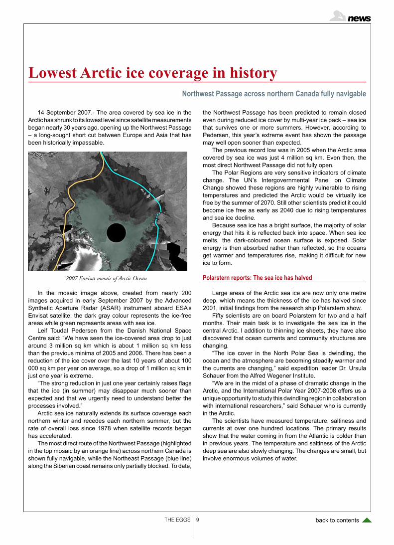
14 September 2007.- The area covered by sea ice in the Arctic has shrunk to its lowest level since satellite measurements began nearly 30 years ago, opening up the Northwest Passage – a long-sought short cut between Europe and Asia that has been historically impassable.
In the mosaic image above, created from nearly 200 images acquired in early September 2007 by the Advanced Synthetic Aperture Radar (ASAR) instrument aboard ESA’s Envisat satellite, the dark gray colour represents the ice-free areas while green represents areas with sea ice.
Leif Toudal Pedersen from the Danish National Space Centre said: “We have seen the ice-covered area drop to just around 3 million sq km which is about 1 million sq km less than the previous minima of 2005 and 2006. There has been a reduction of the ice cover over the last 10 years of about 100 000 sq km per year on average, so a drop of 1 million sq km in just one year is extreme.
“The strong reduction in just one year certainly raises flags that the ice (in summer) may disappear much sooner than expected and that we urgently need to understand better the processes involved.”
Arctic sea ice naturally extends its surface coverage each northern winter and recedes each northern summer, but the rate of overall loss since 1978 when satellite records began has accelerated.
The most direct route of the Northwest Passage (highlighted in the top mosaic by an orange line) across northern Canada is shown fully navigable, while the Northeast Passage (blue line) along the Siberian coast remains only partially blocked. To date,
the Northwest Passage has been predicted to remain closed even during reduced ice cover by multi-year ice pack – sea ice that survives one or more summers. However, according to Pedersen, this year’s extreme event has shown the passage may well open sooner than expected.
The previous record low was in 2005 when the Arctic area covered by sea ice was just 4 million sq km. Even then, the most direct Northwest Passage did not fully open.
The Polar Regions are very sensitive indicators of climate change. The UN’s Intergovernmental Panel on Climate Change showed these regions are highly vulnerable to rising temperatures and predicted the Arctic would be virtually ice free by the summer of 2070. Still other scientists predict it could become ice free as early as 2040 due to rising temperatures and sea ice decline.
Because sea ice has a bright surface, the majority of solar energy that hits it is reflected back into space. When sea ice melts, the dark-coloured ocean surface is exposed. Solar energy is then absorbed rather than reflected, so the oceans get warmer and temperatures rise, making it difficult for new ice to form.
Polarstern reports: The sea ice has halved
Large areas of the Arctic sea ice are now only one metre deep, which means the thickness of the ice has halved since 2001, initial findings from the research ship Polarstern show.
Fifty scientists are on board Polarstern for two and a half months. Their main task is to investigate the sea ice in the central Arctic. I addition to thinning ice sheets, they have also discovered that ocean currents and community structures are changing.
“The ice cover in the North Polar Sea is dwindling, the ocean and the atmosphere are becoming steadily warmer and the currents are changing,” said expedition leader Dr. Ursula Schauer from the Alfred Wegener Institute.
“We are in the midst of a phase of dramatic change in the Arctic, and the International Polar Year 2007-2008 offers us a unique opportunity to study this dwindling region in collaboration with international researchers,” said Schauer who is currently in the Arctic.
The scientists have measured temperature, saltiness and currents at over one hundred locations. The primary results show that the water coming in from the Atlantic is colder than in previous years. The temperature and saltiness of the Arctic deep sea are also slowly changing. The changes are small, but involve enormous volumes of water.
Lowest Arctic ice coverage in historyNorthwest Passage across northern Canada fully navigable
2007 Envisat mosaic of Arctic Ocean

THE EGGS 10 back to contents
11 October 2007.- Noted for its bizarre hydrocarbon lakes and frozen methane clouds, Saturn’s largest moon, Titan, also appears to have widespread drizzles of methane, according to a team of astronomers at the University of California, Berkeley. New near-infrared images from ESO’s Very Large Telescope (VLT) in Chile and the W. M. Keck Observatory in Hawaii show for the first time a nearly global cloud cover at high elevations and, dreary as it may seem, a widespread and persistent morning drizzle of methane over the western foothills of Titan’s major continent, Xanadu.
In most of the Keck and VLT images, liquid methane clouds and drizzle appear at the morning edge of Titan, the arc of the moon that has just rotated into the light of the sun.
Imke de Pater, member of the team that made the discovery, says Titan’s topography could be causing this drizzle, when moisture laden clouds pushed upslope by winds condense to form a coastal rain.
Lead author Máté Ádámkovics noted that only areas near Xanadu exhibited morning drizzle, and not always in the same spot. Depending on conditions, the drizzle could hit the ground or turn into a ground mist. The drizzle or mist seems to dissipate after local mid-morning, which, because Titan takes 16 Earth days to rotate once, is about three Earth days after sunrise.
Ádámkovics first saw evidence of widespread, cirrus-like clouds and
methane drizzle when analysing data taken on 28 February 2005 from a new instrument on the VLT - the Spectrograph for INtegral Field Observations in the Near Infrared (SINFONI). Further images and spectra taken on April 17, 2006, by the OH-Suppressing Infra-Red Imaging Spectrograph (OSIRIS) on Keck II confirmed the clouds. Both instruments measure spectra of light at many points in an image rather than averaging over a small aperture or slit. By subtracting light reflected from the surface from the light reflected by the clouds, the researchers were able to obtain images of the clouds covering the entire moon.
Titan, larger than the planet Mercury, is the only moon in the Solar System with a thick atmosphere, which is comprised mostly of nitrogen and resembles Earth’s early atmosphere. Previous observations have shown that the entire moon is swathed in a hydrocarbon haze extending as high as 500 kilometres, becoming thinner with height. The south pole area exhibits more haze than elsewhere, with a hood of haze at an altitude between 30 and 50 kilometres.
Because of its extremely cold surface temperature - minus 183 degrees Celsius - trace chemicals such as methane and ethane, which are explosive gases on Earth, exist as liquids or solids on Titan. Some level features on the surface near the poles are thought to be lakes of liquid hydrocarbon analogous to Earth’s watery oceans, and presumably these lakes are filled by methane precipitation. ESA’s Huygens probe observed features that appear to be controlled by flows down slopes, whether caused by precipitation or springs.
Until now, however, no rain had been observed directly.
“Widespread and persistent drizzle may be the dominant mechanism for returning methane to the surface from the atmosphere and closing the methane cycle, [analogous to Earth’s water cycle]”, the authors wrote.
Actual clouds on Titan were first imaged in 2001 by de Pater’s group and colleagues at Caltech using the Keck II telescope with adaptive optics and confirmed what had been inferred from
spectra of Titan’s atmosphere. These frozen methane clouds hovered at an elevation of about 30 kilometres around Titan’s south pole.
Since then, isolated ethane clouds have been observed at the north pole by NASA’s Cassini spacecraft, while both Cassini and Keck photographed methane clouds scattered at mid-southern latitudes. Also in 2005, the ESA Huygens probe, released by Cassini, plummeted through Titan’s atmosphere, collecting data on methane relative humidity. These data provided evidence for frozen methane clouds between 25 and 30 kilometres in elevation and liquid methane clouds - with possible drizzle - between 15 and 25 kilometres high. The extent of the clouds detected in the descent area was unclear, however.
The new images show clearly a widespread cloud cover of frozen methane at a height of 25 to 35 kilometres - “a new type of cloud, a big global cloud of methane,” Ádámkovics said - that is consistent with Huygens’ measurements, plus liquid methane clouds in the tropopause below 20 kilometres with rain at lower elevations.
“The clouds we see are like cirrus clouds on Earth,” Ádámkovics said. “One difference is that the methane droplets are predicted to be at least millimetre-sized on Titan, that is, a thousand times larger than in terrestrial clouds. Since the clouds have about the same moisture content as Earth’s clouds, this means the droplets on Titan are much more spread out and have a lower density in the atmosphere, which makes the clouds hard to detect.”
The scientists report their observation in the 11 October issue of Science Express: “Widespread Morning Drizzle on Titan”, by Máté Ádámkovics, Michael H. Wong, Conor Laver, and Imke de Pater.
Reference:http://www.eso.org/public/outreach/
press-rel/pr-2007/pr-47-07.html
Drizzly Mornings on Saturn’s moon TitanAccording to a team of astronomers at the University of California
Credit: ESO Press Photo 47/07 (11 October 2007). Drizzly Mornings on Titan

THE EGGS 11 back to contents
Europeans and Americans are working together to uncover the secrets of one of the more mysterious objects in our Solar System. They are currently poring over hundreds of images of Saturn’s third largest moon, Iapetus, sent by the Cassini-Huygens spacecraft, which was developed jointly by the Eu-ropean Space Agency and NASA. Iapetus is best known for its dramatic two-tone colouration: one half is bright, cratered and possibly covered in ice, while the other is ten times darker
and covered in a material yet to be identified. ‘The images are really stunning,’ says Tilmann Denk, Cassini imaging scientist at the Free University in Berlin, Germany. ‘I was most pleased about the images showing huge mountains rising over the ho-rizon.’
The latest images show a heavily cratered surface and a mountain ridge that runs along the moon’s equator. Many of the close-up observations focus on the curious 20-km high mountain ridge which gives the moon its walnut-shaped ap-pearance. Cassini has flown nearly 100 times closer to Iapetus than in it did in 2004, bringing the spacecraft to a distance of about 1640 km from the surface. ‘Very few places in our solar system are more bizarre than the patchwork of pitch dark and snowy bright we have seen on this moon,’ says Carolyn Porco, Cassini imaging team leader at the Space Station Institute, USA.
The return of images and other data was delayed at one point when the spacecraft was hit by a galactic cosmic ray, which put it into the so-called safe mode. This occurred after the spacecraft had loaded all of the flyby data on its data re-corders and had begun sending the data back home. The flow of data was resumed a few hours later. The spacecraft is once again operating normally, and its instruments are expected to resume normal operations shortly.
Cassini’s observations of Iapetus will assist in characteriz-ing the chemical composition of its surface; they will also help in the search for evidence of a faint atmosphere or erupting gas plumes, and map the night-time temperature of the sur-face. These and other results will be carefully studied in the weeks and months to come, as scientists attempt to make the two-tone moon give up its secrets.
ESA
Saturn’s third moon begins to yield its secretsCassini has flown nearly 100 times closer to Iapetus than in it did in 2004, bringing the spacecraft to a dis-
tance of about 1640 km from the surface and yielding remarkable images
12 Ïctober 2007.- The European Commission has adopted an Integrated Maritime Policy for the European Union, unveiled at a press conference on 10 October in Brussels, Belgium.
European Commissioner in charge of Fisheries and Mari-time Affairs Joe Borg said: “This is a crucial first step for Eu-rope’s oceans and sea – unlocking the potential and facing the challenges of a Maritime Europe will be our common goal. It will allow us to make the most of the geopolitical realities of our continent and will help Europe face some of the major chal-lenges before it.
“At the European level, it is clear the transnational charac-ter of maritime affairs demands a European approach: shipping and traffic corridors cross the waters of our Member States, oil spills and pollution know no borders in Europe’s waters and
illegal activities … are transnational by nature, affecting all of Europe.”
The European Commission (EC) said the new policy will build on Europe’s strengths in marine research, technology and innovation and will be anchored in the European Union’s (EU) overarching commitment to ensuring that economic de-velopment does not come at the price of environmental sus-tainability.
Under the European Space Policy, ESA is responsible for implementing space capabilities that respond to EU policy needs. The Integrated Maritime Policy will facilitate efficient ex-ploitation of space systems in the maritime sector, which ESA has been actively involved in over the last 25 years.
ESA
New EU maritime policyEuropean Commission adopted an Integrated Maritime Policy for the European Union
Iapetus’ landscape

THE EGGS 1 back to contents
McMurdo Station, Antarctica, Nov. 28, 2007 -- A second sea-son in Antarctica for the Antarctic Geological Drilling (ANDRILL) Program has exceeded all expectations, according to the co-chief scientists of the program’s Southern McMurdo Sound Project.
On November 21, the drilling team passed the 1,000-meter mark in rock core pulled from beneath the sea floor in McMurdo Sound, and with a remarkable recovery rate of more than 98 per-cent. The end of drilling is scheduled for this weekend, and only a few tens of meters of core remain to be recovered for an ex-pected final total of more than 1,100 meters (3,600 feet). It’s the second-deepest rock core drilled in Antarctica, surpassed only by the 1,285 meters (more than 4,215 feet) recovered by last year’s ANDRILL effort, the McMurdo Ice Shelf Project.As the job nears completion for the Southern McMurdo Sound Project drillers, the co-chief scientists, David Harwood of the University of Ne-braska-Lincoln and Fabio Florindo of Italy’s National Institute of Geophysics and Volcanology in Rome, said they couldn’t be more pleased with the results. They said the efforts of the program’s nearly 80 scientists, drillers, engineers, technicians, students and educators in Antarctica, with the operations and logistics support provided by Antarctica New Zealand, have given the world’s sci-entists more than a kilometer of pristine rock core that records the history of climate and glacial fluctuations in Antarctica over the past 20 million years.
“It’s everything we hoped for,” Harwood said. “Combine the drill hole we recovered last year with this one, from a time period right below it, and it’s more than 2 kilometers (1 1/4 miles) of geo-logical history. It’s phenomenal what we’ve recovered. There’s a lot of diversity in the core, indeed more than we can digest right now. It will take some time to fully resolve the paleoenvironmental and dynamic paleoclimate information in the core.
“The goal of this drilling project was sediment core retrieval from the middle Miocene Epoch when, for an extended period, Earth was warmer than today. Florindo and Harwood said they are especially pleased to have recovered such high-quality core from this target period.
“We now have a more complete core record from the middle Miocene and a step into a colder period of time, and that was one of our key targets,” Florindo said. “It will tell an important story when we put together our recovery with the record of last season. This is exciting science and it will echo loudly in the scientific com-munity.”
The middle Miocene has long been held as one of the funda-mental time intervals in development of the modern Antarctic ice sheets. It encompassed a change from a warm climate optimum approximately 17 million years ago to the onset of major cooling approximately 14 million years ago, and the formation of a quasi-permanent ice sheet on East Antarctica. Florindo and Harwood said fossils and sediments deposited during this year’s ANDRILL target interval suggest the persistence of warmer-than-present conditions over an extended period of the middle and late Mio-cene when the western Ross Sea and McMurdo Sound resem-bled the modern climate conditions of southernmost South Amer-ica, southwestern New Zealand, and southern Alaska, rather than
the cold polar climate of today.“Until now, most climatic interpretations for this time period
has been based on measurement of oxygen isotopes in the deep sea, far from Antarctica,” Harwood said. “The cores we’ve recov-ered will give us a high resolution history of paleoclimate change directly from the Antarctic continent.
“The sediment cores reflect deposition close to or beneath grounded glaciers, alternating with fine-grained sediments, which provide clear evidence for ice advance and substantial retreat during main climate transitions, Florindo and Harwood said. They said programs like ANDRILL are extremely important because of the uncertainties about the future behavior of Antarctic ice sheets. This stratigraphic record will be used to determine the behavior of ancient ice sheets, and to better understand the factors driving past ice sheet, ice shelf and sea-ice growth and decay. This new knowledge will enhance our understanding of Antarctica’s poten-tial responses to future global climate changes.
After a seven-week setup period by Antarctica New Zealand during late winter in the Southern Hemisphere, drilling began Oct. 9 and continued until last week, with the drillers recovering 25 to 70 meters of core each day. There was only one major interrup-tion, occurring in early November when sand and water flowed into the drill hole, but Harwood said the drill team “did an awe-some job” of fixing the problem.
Following the planned drilling stoppage at the end of last week, scientists lowered a variety of scientific instruments into the deep drill hole over several days to get a better understanding of the physical properties of the geologic layers under pressure and to obtain an acoustic image of the inside of the borehole. Drilling resumed this week and will continue until probably Sunday to re-cover about 100 meters of additional core.
The first stop for each core section after recovery is the Crary Science and Engineering Center, operated by the U.S. National Science Foundation at McMurdo Station. After preliminary exami-nation by on-ice scientists, the cores are shipped to Florida State University’s Antarctic Marine Geology Research Facility in Talla-hassee for storage and long-term study.
ANDRILL is a multinational collaboration comprised of scien-tists, students and educators from the four partner nations (Ger-many, Italy, New Zealand and the United States) to recover strati-graphic records from the Antarctic continental margin. ANDRILL is one of about 220 projects endorsed by the fourth International Polar Year, 2007-2009, one of the largest collaborative science programs ever attempted. For more information, visit http://andrill.org.
Funding support for ANDRILL comes from the U.S National Science Foundation, New Zealand Foundation of Research, Sci-ence, and Technology, Royal Society of New Zealand Marsden Fund, Antarctica New Zealand, the Italian National Program for Research in Antarctica, the German Science Foundation and the Alfred Wegener Institute for Polar and Marine Research Sci-ence.
ANDRILL NEWS RELEASEforwarded by EGU Press Office
ANDRILL’s 2nd Antarctic drilling season exceeds all expectations
The end of drilling is scheduled for this weekend, and only a few tens of meters of core remain to be recovered for an expected final total of more than 1,100 meters

THE EGGS 1 back to contents
11 October 2007.- Newly assembled radar images from Cassini provide the best views of the hydrocarbon lakes and seas on Saturn’s moon Titan. A new radar image reveals that Titan’s south polar region also has lakes.
The southern region images were beamed back after a flyby on 2 October in which a prime goal was the hunt for lakes at the south pole.
A new mosaic image comprised from seven Titan fly-bys over the last year and a half shows a north pole pitted with giant lakes and seas, at least one of them larger than Lake Superior in the USA.
Approximately 60% of Titan’s north polar region, above 60° north, has been mapped by Cassini’s radar instrument. About 14% of the mapped region is covered by what scientists inter-pret as liquid hydrocarbon lakes.
Lakes and seas are very common at the high northern lati-tudes of Titan, which is in winter now. Methane and ethane rain there could be filling the lakes and seas (see relevant news in this issue). These liquids also carve meandering rivers and channels on the moon’s surface. Now Cassini is moving into unknown territory, down to the south pole of Titan.
It is summer at Titan’s south pole. A season on Titan lasts nearly 7.5 years, one quarter of a Saturn year, which is 29.5 years long. Monitoring seasonal change helps scientists un-derstand the processes at work there.
Scientists working on the data are making progress in un-derstanding how the lakes may have formed. On Earth, lakes fill low spots or are created when the local topography inter-sects a groundwater table. Lopes and her colleagues think that the depressions containing the lakes on Titan may have been formed by volcanism or by a type of erosion (called karstic) of the surface, leaving a depression where liquids can accumu-late. This type of lake is common on Earth.
The lakes on Titan appear to be in varying states of full-ness, suggesting their involvement in a complex hydrologic system. The lakes seen so far vary in size from the small-est observable, approximately 1 square km, to greater than 100,000 square km. Of the roughly 400 observed lakes, 70% of their area is taken up by large seas greater than 26,000 square km.
Future radar flybys will image closer to the southern pole and are expected to show more lakes.
ESA
Cassini’s new images from Titan lakesNewly assembled radar images from the October 2 flyby of Cassini provide views of
the hydrocarbon lakes and seas on Saturn’s moon Titan
Titan’s north polar region (Image credit: ESA )
Dec. 6, 2007.- The International Association on Urban Climate (IAUC) is happy to announce that Dr.Sci. Masatoshi Yoshino, Professor Emeritus of the University of Tsukuba and Senior Programme Advisor, Environmental and Sustainable Development Programme at the United Nations University, has been selected by the IAUC Awards Committee for the 4th (2007) Luke Howard Award. His influence over the field is sig-nificant, covering various aspects of regional climatology and urban climatology.
Prof. Yoshino has made great achievements in the field of small scale climate including urban climate. He is the author of more than 300 articles on climatology with more than 100 pa-pers in peer-reviewed journals. One of his excellent achieve-
ments is the publication of the textbook entitled Climate in a Small Area (Yoshino, M., 1975, University of Tokyo Press, To-kyo). This text has been used for a long time as a standard textbook of this field, since the climate in various regions in the world is systematically described based on detailed data. Theoretical relations between geographical features and the climate system are also explained well.
In an achievement directly related to urban climate, he summarized the history of urban climate research. This report showed the past flow of studies of the urban climate, and sug-gested future directions of the field. One of these should be a study of precipitation affected by the urban activity in which he investigated high temporal frequency precipitation changes
The 4th Luke Howard AwardThe International Association on Urban Climate honors Prof. Yoshino
for his outstanding contributions in the field of urban climatology
THE EGGS 1 back to contents
around an urban area. (Yoshino, M., 1990/91: “Development of urban climatology and problems today”. Energy and Buildings, 15/16, 1-10.).
In other disciplines such as impacts of global warming, land use change, flood disasters in urban areas and wind dis-tributions, his activities, mainly in China, Thailand, Indonesia, Sri Lanka and other Asian countries, are well-known through many publications and advisories for policy-making.
Dr. Sci. Yoshino has served as a leader of academic societ-ies including Vice-president of the International Geographical Union (IGU), chairman of the Climatology Commission of the IGU, and the chairman of the National Committee of Interna-
tional Geosphere-Bioshere Programme (IGBP) and he has also contributed to international societies on sustainable de-velopment as a senior executive advisor of the United Nations University.
Based on his outstanding contributions to the field of urban climatology in a combination of research, teaching and service to the international community of urban climatologists, Prof. Yoshino was selected as the winner of the IAUC Luke Howard Award 2007.
Manabu KandaIAUC Awards Committee Chair
14 November 2007.- Two young geoscientists have been selected to receive the Albert Maucher Prize by the Deutsche Forschungsgemeinschaft (DFG, German Research Foundation) in honour of their outstanding research findings. The prize was awarded on 8 November 2007 to Dr. Martin Blu-menberg from the Institute of Biogeo-chemistry and Marine Chemistry at the University of Hamburg, who received the prize for his studies of anaerobic methane oxidation, and Dr. David Dolejs from the Bavarian Research Institute of Experimental Geochemistry and Geo-physics at the University of Bayreuth for his work on the development of complex thermodynamic models of silicate-fluo-ride melts.
The Albert Maucher Prize, which includes an award of 10,000 euros for each winner, is generally conferred once every two years to young geosci-entists in recognition of their outstand-ing research findings. It was the express
wish of Albert Maucher, who donated the prize and who himself received DFG funding at the beginning of his scientific research career, that it should be award-ed for original research approaches and methods.
The winners of the 2007 prize:
Dr. Martin Blumenberg (36), Uni-versity of Hamburg
|In his studies in organic geochemis-try/isotopic geochemistry Martin Blumen-berg has been looking at the anaerobic oxidation of methane, which occurs in ocean sediments and is responsible for about 90% of the natural decomposition of methane, a potent greenhouse gas. The geobiological and biogeochemical aspects he has been studying are not only of key importance for the present, but also for the past development of the earth’s climate. Blumenberg’s work has highlighted the importance of methano-trophic bacteria.
Dr. David Dolejs (33), University of Bayreuth
David Dolejs has made a significant contribution to the field of high pressure mineralogy with his work on experimen-tal simulation of geochemical cycles within our planet. His research includes the physical and chemical properties of melts and liquid phases in multi-phase systems, and he has developed a ther-modynamic model for silicate melts, making it easier to understand the com-plex phase mixture and melt structure. Amongst other things, his work at the boundary between material science, chemistry, engineering and mineral physics is important for the study of min-eral deposits.
Profiles and CVs for both of the prizewinners are available on the inter-net at http://www.dfg.de/en/news/scien-tific_prizes/maucher_preis/
2007 Albert Maucher Prize for Outstanding Young Geoscientists
The DFG Honours Research into Methane Oxidation and Thermodynamic Models
30 October 2007.- Researchers from the University of Alaska-Fairbanks and the University of Southampton have identified Arctic lakes as a likely source of increased levels of atmospheric methane as temperatures rose towards the end of the last ice age.
Previous studies of ice cores from Greenland and Antarc-tica have shown that when global climates warmed between
14,000 and 11,500 years ago, levels of methane in the atmo-sphere increased significantly. There was also an unidentified northern source of the gas at that time.
According to new research published in the latest edition of Science (26 October), methane bubbling from Arctic lakes could have been responsible for up to 87 per cent of this north-ern source. The findings could help climate modellers to as-
Study identifies Arctic lakes as a major source of prehistoric methaned
Arctic lakes a likely source of increased levels of atmospheric methane as temperatures rose towards the end of the last ice age

THE EGGS 1 back to contents
sess how warming affects atmospheric levels of methane, a potent greenhouse gas.
Previous hypotheses suggested that the increase came from gas hydrates or wetlands. The new study’s findings indi-cate that methane bubbling from thermokarst lakes, which are formed when permafrost thaws rapidly, is likely to be a third and major source.
The group’s calculations suggest that the lakes contrib-uted 33 to 87 per cent of the methane increase from northern sources. The team examined lakes in Siberia and northern Alaska that currently release methane, by gathering samples of permafrost and thawing them in the laboratory to measure
the levels of methane that permafrost soil can produce imme-diately after thawing. Using geological data they reconstructed the pattern of lake formation since the end of the last ice age.
The paper ‘Thermokarst Lakes as a Source of Atmospheric CH4 During the Last Deglaciation’ by Katey Walter, of the Insti-tute for Northern Engineering, University of Alaska-Fairbanks; Mary Edwards of the University of Southampton’s School of Geography; Guido Grosse, an International Polar Year post-doctoral fellow with the UAF Geophysical Institute; Sergey Zi-mov of the Russian Academy of Sciences; and Terry Chapin of the UAF Institute of Arctic Biology, is published in Science. 26 October 2007 (Science 318, 633 - 2007).
3 December 2007.- Venus Express has now orbited Earth’s twin for 500 Earth days, completing as many orbits. The satel-lite maintains steady and excellent performance.
While early results have already been published, some of the first detailed analyses are now being completed and will soon be published.
Venus’ atmosphere
Recent observations with the Visible and Near-Infrared Mapping Spectrometer (VIRTIS), have shown that Venus’ at-mospheric structure changes quite rapidly, from day to day.
Giuseppe Piccioni, co-Principal Investigator for VIRTIS on board Venus Express says, “It seems that the mid latitudes form a sort of transition region with mostly laminar flow. Moving equatorward, there is more convective flow in the atmosphere,
whereas the polar region is dominated by huge vortices.” The meteorology of the planet, including its deep atmo-
sphere is highly variable. Although the configuration of the flow is similar, the intensity of turbulence changes significantly from one orbit to the next.
The polar region or the ‘black hole’ seen in the images is where the polar dipole dominates. The polar dipole is the name given to a giant double-vortex, each of which is about 2000 km across, similar to the eye of a hurricane. The double-vortex has been seen at both the north and south poles, rotating in opposite directions (clockwise at the north pole and counter-clockwise at the south pole). Observations with Venus Express show that the vortex at the south pole also changes its shape rapidly, from one orbit to the next.
ESA
Almost 600 days at Venusand as many orbits completed by the Venus Express spacecraft
17 October 2007.- The Irish government has launched a major new strategy to maximise the scientific, economic and social potential of Ireland’s significant marine resources.
Sea Change: A Marine Knowledge, Research and Innova-tion Strategy for Ireland 2007-2013 will support a range of ca-pability and capacity enhancements designed to exploit core scientific strengths and deliver new commercial opportunities and policy options.
As part of this strategy the recently announced Beaufort Marine Research Awards will deliver €20 million in research funds to establish world class marine research groups in five areas. The Beaufort Awards target research leaders of inter-national standing and mobile early stage researchers from Ire-land and abroad to fill the following posts:
• 4 Principal Investigators (7 year Contracts)• 15 Researcher Posts (7 year Contracts)• 28 PhD Studentships (4 year Stipend)The Minister for Communications, Energy & Natural Re-
sources and the Minister for Agriculture, Fisheries & Food re-
cently announced the 10 Research Groups/Centres that were successful in their bid for the Awards, following evaluation by international experts.
The research groups/centres are located in five Institutions on the Island of Ireland (32 counties) and have demonstrated capacity to conduct innovative research and provide research training.
These awards are named after Francis Beaufort (1774-1857) the Irish hydrographer, from Navan, Co Meath who devised the Beaufort wind-classification scale. The Beaufort scheme allows researchers on the Island of Ireland access to the world class facilities of the Marine Institute thereby optimis-ing the use of this world class Institute. The Institute has its headquarters in Oranmore and field research station at New-port Co Mayo.
Reference:http://www.marine.ie
Beaufort Marine Research AwardsIreland Announces €20 million fund for Marine Research

THE EGGS 1 back to contents
24 September 2007.- If our planet did not have the ability to store oxygen in the deep reaches of its mantle there would prob-ably be no life on its surface. This is the conclusion reached by scientists at the University of Bonn who have subjected the min-eral majorite to close laboratory examination. Majorite normally occurs only at a depth of several hundred kilometres – under very high pressures and temperatures. The Bonn researchers have demonstrated that, under these conditions, the mineral stores oxygen and performs an important function as an oxygen reservoir. Near the earth’s surface the structure breaks down, releasing oxygen, which then binds with hydrogen from the earth’s interior to form water. The findings have been published in Nature (doi:10.1038/nature06183).
At the boundaries between the tectonic plates, in the sub-duction zones, material is drawn down hundreds of kilometres into the hot interior. As the material descends it takes with it oxy-gen, which is bound as iron oxide in the earth’s mantle – oxygen that derives from the dim distant beginnings of the universe.
At these depths high pressures and temperatures prevail. As the mantle material melts the iron oxide undergoes a chemical metamorphosis in which its oxygen component becomes, in a sense, more reactive. Moreover, it changes its medium of trans-portation, now being incorporated into the exotic mineral ma-jorite which only occurs at these depths. And, as Professor Dr. Christian Ballhaus from the Mineralogical Institute at the Bonn University explains, “The higher the pressure, the more oxygen can be stored by majorite”.
We can envisage the majorite as operating like an elevator for oxygen. But this time it moves in the opposite direction: the
mineral rises with convection. Nearing the earth’s surface the pressure in the mantle becomes too weak to maintain the ma-jorite, which then decomposes. That is where the stored oxygen is released, and near the surface it is made available for all the oxidation reactions that are essential for life on earth.
In particular, the earth constantly exudes hydrogen, which combines with this oxygen to form water. Without the “oxygen elevator” in its mantle the earth would probably be a barren plan-et. “According to our findings, planets below a certain size hardly have any chance of forming a stable atmosphere with a high water content,” points out Arno Rohrbach, doctoral student in the research team at the Mineralogical Institute. “The pressure in their mantle is just not high enough to store sufficient oxygen in the rock and release it again at the surface.”
The bigger the planet, the greater is its capacity to store heat; and, correspondingly, the longer-lasting and more intensive is the convection in its crust. Mars, for example, with a diameter of about 7,000 kilometres (the earth’s diameter measures 12,700 km) cooled down long ago to a level at which there is no longer any movement in its mantle. Its crust has therefore lost the abil-ity to transport oxygen and maintain a lasting water-rich atmo-sphere, according to Professor Ballhaus.
In other respects, too, the size of a planet is decisive for the formation of an atmosphere. Only if temperatures in a planet’s interior are high enough for it to have a fluid metal core can it develop a magnetic field. The magnetic field then protects the planet from solar wind. Over time, these winds would otherwise blow the atmosphere away.
Majorite stores oxygen and performs an important function as an oxygen reservoir and water source
Planets below a certain size seem to hardly have any chance of forming a stable atmosphere with a high water content
TWAS and illycaffè s.p.a. have in-stituted high-level prizes to honour dis-tinguished scientists from developing countries. The Trieste Town Council and the Trieste International Foundation for Scientific Progress and Freedom are collaborating in this effort.
The prize has been named Trieste Science Prize in recognition of the unique and fundamental role that the Trieste System of scientific institutions plays in promoting science and technol-ogy in the developing world.
It has been established to give inter-national recognition and visibility to out-standing scientific achievements made by individual scientists in developing countries.
Nature
The prizes are awarded annually and rotate among the various fields of science. In 2008, prizes will be awarded in Earth, Space, Ocean and Atmospher-ic Sciences and Engineering Sciences.
The first two prizes were awarded in 2005 in the fields of biological sciences and physics & astronomy. In 2006 the prizes were awarded in the fields of mathematics and medical sciences, and in 2007 in agricultural sciences and chemical sciences.
Each prize carries a monetary award of US$50,000 generously contributed by illycaffè, a trophy and a certificate bearing a citation highlighting the ma-jor contributions for which the prize is
awarded.The prizes will be presented to the
recipients at a special occasion ar-ranged by TWAS, illycaffè, and the Tri-este Town Council.
Eligibility
Candidates must be nationals of de-veloping countries, working and living in the South. The prizes will only be award-ed to individuals for scientific research of outstanding international merit carried out at institutions in developing coun-tries. Individuals who have received the Nobel Prize, the Tokyo/Kyoto Prize, the Crafoord Prize or the Abel Prize are not eligible for the Trieste Science Prize.
The Trieste Science PrizeIn 2008, prizes will be awarded in Earth, Space, Ocean and Atmospheric Sciences.
THE EGGS 1 back to contents
International Jury
A jury of internationally renowned scientists chaired by the president of TWAS is charged with the selection of awardees. Jury members are not eligi-ble for the Trieste Science Prize.
Nominations
Nominations are invited from TWAS members, selected individuals, as well
as from science academies, national re-search councils, universities and scien-tific institutions. Self-nominations will not be accepted. Nominations should be ac-companied by a 5-6 page biographical sketch of the nominee including his/her major scientific accomplishments, pre-prints of not more than 20 of the candi-date’s most significant publications and a complete list of publications. A brief professional C.V. of the candidate may also be included.
The deadline for receiving nomi-nations for the 2008 prizes (in Earth, Space, Ocean and Atmospheric Sci-ences and in Engineering Sciences) is 31 January 2008.
Nomination forms are available at: http://users.ictp.it/~twas/docs/TSP_NomForm2008_e.doc
24 October 2007.- A new mission to the Moon was launched today by the Chinese National Space Administration (CNSA). Chang’e-1 blasted off from the Xichang Satellite Launch Centre, Sichuan, atop a Long March 3A rocket.
Chang’e-1 represents the first step in the Chinese ambition to land robotic explorers on the Moon before 2020. Chang’e-1 has four mission goals to accomplish. The first is to make three-dimensional images of many lunar landforms and outline maps of major lunar geological structures. This mapping will include the first detailed images taken of some regions near the lunar poles.
Chang’e-1 is also designed to analyze the abundance of up to 14 chemical elements and their distribution across the lunar surface. Thirdly it will measure the depth of the lunar soil and lastly it will explore the space weather between the Earth and the Moon.
The spacecraft is large, weighing in at 2350 kg and it will operate from a low, circular lunar orbit, just 200 km above the surface of the Moon. From here, it will perform its science mis-
sion for a full year. ESA is collaborating with the Chinese on this mission by
providing spacecraft and ground operations support services to CNSA.
To perform its science mission, Chang’e-1 carries a variety of instruments: a CCD stereo camera, a laser altimeter, an im-aging interferometer, a gamma-ray/X-ray spectrometer, a micro-wave radiometer, a high-energy particle detector, and a solar wind particle detector.
Named after the Chinese goddess of the Moon, Chang’e-1 represents the first phase in the Chinese Lunar Exploration Programme (CLEP). This programme is expected to last until around 2020 and the next phase will include a lander and as-sociated rover. Looking farther into the future, plans are being drawn up for a sample return mission to bring lunar rocks to Earth for analysis.
ESA
Chang’e-1 - new mission to Moonlaunched by the Chinese National Space Administration
28 November 2007.- Data gathered by the Cassini space-craft have confirmed the presence of heavy negative ions in the upper regions of Titan’s atmosphere. These particles may act as organic building blocks for more complicated molecules and their discovery was completely unexpected because of the chemical composition of the atmosphere (which lacks oxygen and mainly consists of nitrogen and methane). The observation has now been verified on 16 different encounters and findings were published in Geophysical Research Letters on November 28.
Cassini’s electron spectrometer has enabled the detection of negative ions which have 10,000 times the mass of hydrogen. Most likely these negative ions form in the upper atmosphere before moving closer to the surface, where they probably form the mist which shrouds the planet.
The new paper builds on work published in Science (May 11) where the team found smaller thiolins, up to 8,000 times the mass of hydrogen, forming away from the surface of Titan.
Heavy ions in Titan’s atmosphereMost likely these negative ions form in the upper atmosphere

THE EGGS 1 back to contents
Spectral absorption properties of atmospheric aerosolsthe authors attempt to briefly summarize the state of knowledge
of aerosol absorption spectra in the atmosphere
The authors have determined the solar spectral absorption optical depth of atmospheric aerosols for specific case studies during several field programs (three cases have been reported previously; two are new results). They combined airborne mea-surements of the solar net radiant flux density and the aerosol optical depth with a detailed radiative transfer model for all but one of the cases. The field programs (SAFARI 2000, ACE Asia, PRIDE, TARFOX, INTEX-A) contained aerosols representing the major absorbing aerosol types: pollution, biomass burning, desert dust and mixtures. In all cases the spectral absorption optical depth decreases with wavelength and can be approxi-mated with a power-law wavelength dependence (Absorption Angstrom Exponent or AAE). They compare their results with other recent spectral absorption measurements and attempt to
briefly summarize the state of knowledge of aerosol absorp-tion spectra in the atmosphere. They discuss the limitations in using the AAE for calculating the solar absorption. They also discuss the resulting spectral single scattering albedo for these cases.
The article is available free of charge at:http://www.atmos-chem-phys.net/7/5937/2007/acp-7-
5937-2007.html
Bergstrom, R. W., Pilewskie, P., Russell, P. B., Re-demann, J., Bond, T. C., Quinn, P. K., and Sierau, B.,
Spectral absorption properties of atmospheric aerosols, Atmos. Chem. Phys., 7, 5937-5943, 2007.
The origin of the 1500-year climate cycles in Holocene North-Atlantic records
1500 year climate cycles are linked with the oceanic circulation and not with variations in solar output as previously argued
Since the first suggestion of 1500-year cycles in the ad-vance and retreat of glaciers (Denton and Karlen, 1973), many studies have uncovered evidence of repeated climate oscilla-tions of 2500, 1500, and 1000 years. During last glacial period, natural climate cycles of 1500 years appear to be persistent (Bond and Lotti, 1995) and remarkably regular (Mayewski et al., 1997; Rahmstorf, 2003), yet the origin of this pacing during the Holocene remains a mystery (Rahmstorf, 2003), making it one of the outstanding puzzles of climate variability. Solar variability is often considered likely to be responsible for such cyclicities, but the evidence for solar forcing is difficult to evaluate within available data series due to the shortcomings of conventional time-series analyses. However, the wavelets analysis method is appropriate when considering non-stationary variability. Here we show by the use of wavelets analysis that it is possible to distinguish solar forcing of 1000- and 2500- year oscillations from oceanic forcing of 1500-year cycles. Using this method, the relative contribution of solar-related and ocean-related cli-mate influences can be distinguished throughout the 10,000 yr Holocene intervals since the last ice age. These results
reveal that the 1500-year climate cycles are linked with the oceanic circulation and not with variations in solar output as previously argued (Bond et al., 2001). In this light, previously studied marine sediment (Bianchi and McCave, 1999; Chap-man and Shackleton, 2000; Giraudeau et al., 2000), ice core (O’Brien et al., 1995; Vonmoos et al., 2006) and dust records (Jackson et al., 2005) can be seen to contain the evidence of combined forcing mechanisms, whose relative influences var-ied during the course of the Holocene. Circum-Atlantic climate records cannot be explained exclusively by solar forcing, but require changes in ocean circulation, as suggested previously (Broecker et al., 2001; McManus et al., 1999).
The article is available free of charge at:http://www.clim-past.net/3/569/2007/cp-3-569-2007.html
Debret, M., Bout-Roumazeilles, V., Grousset, F., Des-met, M., McManus, J. F., Massei, N., Sebag, D., Petit, J.-R.,
Copard, Y., and Trentesaux, A., The origin of the 1500-year climate cycles in Holocene North-Atlantic records,
Clim. Past, 3, 569-575, 2007.
How unusual was autumn 2006 in Europe?the warm autumn 2006 either was a very rare coincidence, or the local temperature rise is much stronger
than modelled, or non-linear physics that is missing from models increases the probability of warm extremesThe temperatures in large parts of Europe have been re-
cord high during the meteorological autumn of 2006. Compared to 1961–1990, the 2 m temperature was more than three de-grees Celsius above normal from the North side of the Alps to
southern Norway. This made it by far the warmest autumn on record in the United Kingdom, Belgium, the Netherlands, Den-mark, Germany and Switzerland, with the records in Central England going back to 1659, in the Netherlands to 1706 and in
THE EGGS 1 back to contents
Denmark to 1768. The deviations were so large that under the obviously false assumption that the climate does not change, the observed temperatures for 2006 would occur with a prob-ability of less than once every 10 000 years in a large part of Europe, given the distribution defined by the temperatures in the autumn 1901–2005.
A better description of the temperature distribution is to as-sume that the mean changes proportional to the global mean temperature, but the shape of the distribution remains the same. This includes to first order the effects of global warming. Even under this assumption the autumn temperatures were very unusual, with estimates of the return time of 200 to 2000 years in this region. The lower bound of the 95% confidence interval is more than 100 to 300 years.
Apart from global warming, linear effects of a southerly cir-culation are found to give the largest contributions, explaining about half of the anomalies. SST anomalies in the North Sea
were also important along the coast.Climate models that simulate the current atmospheric cir-
culation well underestimate the observed mean rise in autumn temperatures. They do not simulate a change in the shape of the distribution that would increase the probability of warm events under global warming. This implies that the warm au-tumn 2006 either was a very rare coincidence, or the local temperature rise is much stronger than modelled, or non-linear physics that is missing from these models increases the prob-ability of warm extremes.
The article is available free of charge at:http://www.clim-past.net/3/659/2007/cp-3-659-2007.html
van Oldenborgh, G. J., How unusual was autumn 2006 in Europe?, Clim. Past, 3, 659-668, 2007.
Reconstructing the glacier contribution to sea-level rise back to 1850
glacier contribution to sea level rise was 5.5±1.0 cm during the period 1850–2000 and 4.5±0.7 cm during the period 1900–2000
he authors present a method to estimate the glacier contribution to sea-level rise from glacier length records. These records form the only direct evidence of glacier changes prior to 1946, when the first continuous mass-balance observations began. A globally representative length signal is calculated from 197 length records from all continents by normalisation and averaging of 14 different regions. Next, the resulting signal is calibrated with mass-balance observations for the period 1961–2000. They found that the glacier contribution to sea level rise was 5.5±1.0 cm during the period 1850–2000 and 4.5±0.7 cm during the period 1900–2000.
The article is available free of charge at:http://www.the-cryosphere.net/1/59/2007/tc-1-59-2007.html
J. Oerlemans, M. Dyurgerov, and R. S. W. van de Wal, Reconstructing the glacier contribution to sea-level rise back to 1850, The Cryosphere, 1, 59-65, 2007.
Microbiology and atmospheric processes: the role of biological particles in cloud physics
overview paper gives an introduction to aerosol-cloud processes involving CCN and IN in general and pro-vides a short summary of previous laboratory, field and modelling work which investigated the CCN and IN
activity of bacterial cells and pollenAs part of a series of papers on the sources, distribution
and potential impact of biological particles in the atmosphere, this paper introduces and summarizes the potential role of biological particles in atmospheric clouds. Biological particles like bacteria or pollen may be active as both cloud conden-sation nuclei (CCN) and heterogeneous ice nuclei (IN) and thereby can contribute to the initial cloud formation stages and the development of precipitation through giant CCN and IN processes. The paper gives an introduction to aerosol-cloud processes involving CCN and IN in general and provides a short summary of previous laboratory, field and modelling work which investigated the CCN and IN activity of bacterial cells and pollen. Recent measurements of atmospheric ice nuclei with a continuous flow diffusion chamber (CFDC) and of the heterogeneous ice nucleation efficiency of bacterial cells are
also briefly discussed. As a main result of this overview paper we conclude that a proper assessment of the impact of biologi-cal particles on tropospheric clouds needs new laboratory, field and modelling work on the abundance of biological particles in the atmosphere and their CCN and heterogeneous IN proper-ties.
The article is available free of charge at:http://www.biogeosciences.net/4/1059/2007/bg-4-1059-
2007.html
Möhler, O., DeMott, P. J., Vali, G., and Levin, Z., Micro-biology and atmospheric processes: the role of biologi-cal particles in cloud physics, Biogeosciences, 4, 1059-
1071, 2007.
THE EGGS 0 back to contents
No major carbon sink in the Amazon?Jon Lloyd and co-workers present data which do not support the view of a large carbon sink in the Amazon
region, contrasting several earlier publications.Jon Lloyd and co-workers present data which do not support
the view of a large carbon sink in the Amazon region. These findings are contrasting several earlier publications presenting data derived from eddy covariance flux measurements.
There is an ongoing discussion about the function of tropi-cal rainforests as global carbon sinks. Especially eddy covari-ance studies supported the conclusion to regard the Amazon forest as an ultimate carbon sink. However, especially net eco-system exchange data derived from eddy covariance studies are often regarded as highly critical because of high uncer-tainties of night time values. But also very recent modelling supported the view that tropical ecosystems may currently be strong sinks for CO2. But whether the Amazon is a small sink, as biomass measurements suggest, or even a small source, as some global models suggest, we have to realize that the ecosystem is obviously not the large sink that the flux tower measurements let us believe. To clarify this question, we need measurements.
Within this context the recent paper by Jon Lloyd and co-workers in BIOGEOSCIENCES is of special interest. The au-thors present data which do not support the view of a large carbon sink in the Amazon region. These findings derived from airborne flux studies are clearly contrasting the earlier publica-tions presenting data derived from eddy covariance flux mea-surements.
The full paper is available free of charge athttp://www.biogeosciences.net/4/759/2007/bg-4-759-
2007.pdf
Lloyd, J., Kolle, O., Fritsch, H., de Freitas, S. R., Silva Dias, M. A. F., Artaxo, P., Nobre, A. D., de Araujo, A. C.,
Kruijt, B., Sogacheva, L., Fisch, G., Thielmann, A., Kuhn, U., and Andreae, M. O.: An airborne regional carbon bal-ance for Central Amazonia, Biogeosciences, 4, 759-768,
2007.
Alignment of atmospheric mineral dust due to electric fieldIt is possible that the alignment and the electric field modify dust transport
Optical polarimetry observations on La Palma, Canary Islands, during a Saharan dust episode show dichroic extinction indicating the presence of vertically aligned particles in the atmosphere. Modelling of the extinction together with particle orientation indicates that the alignment could have been due to an electric field of the order of 2 kV/m. Two alternative mechanisms for the origin of the field are examined: the effect of reduced atmospheric conductivity and charging of the dust layer, the latter effect being a more likely can-didate. It is concluded that partial alignment may be a common feature of Saharan dust layers. The modelling indicates that the align-ment can significantly alter dust optical depth. This Venetian blind effect may have decreased optical thickness in the vertical direction by as much as 10% for the case reported here. It is also possible that the alignment and the electric field modify dust transport.
The article is available free of charge at:http://www.atmos-chem-phys.net/7/6161/2007/acp-7-6161-2007.html
Ulanowski, Z., Bailey, J., Lucas, P. W., Hough, J. H., and Hirst, E., Alignment of atmospheric mineral dust due to elec-tric field, Atmos. Chem. Phys., 7, 6161-6173, 2007.
Temperatures and precipitation totals over the Russian Far East and Eastern Siberia
dominant modes oscillate with periods of about 2–3 yr and 6–8 yr that are accompanied by statistically sig-nificant changes in such monthly teleconnection indices, as the Arctic and North Pacific Oscillations
The present study examines the spatial-temporal regime of the mean monthly temperature (MMT) and monthly precipitation (MPT) anomalies over the Russian Far East and Eastern Siberia for the period 1949–2003. The original data were analyzed spatially by means of complex principal component analysis and temporally by means of the maximum entropy method and traditional Fourier spectral analysis. The interannual variability in these anomalies can be represented by the single dominant modes. These dominant modes oscillate with periods of about 2–3 yr and 6–8 yr that are accompanied by statistically significant changes in such monthly teleconnection indices, as the Arctic and North Pacific Oscillations.
The article is available free of charge at:http://www.hydrol-earth-syst-sci.net/11/1831/2007/hess-11-1831-2007.html
Krokhin, V. V. and Luxemburg, W. M. J., Temperatures and precipitation totals over the Russian Far East and East-ern Siberia: long-term variability and its links to teleconnection indices, Hydrol. Earth Syst. Sci., 11, 1831-1841, 2007.

THE EGGS 1 back to contents
1. Introduction
Intense optical phenomena observed worldwide during sunsets following major volcanic eruptions, caused by volcanic aerosols injected in the stratosphere and remained there for a period of few years after the eruption, have been reported by several authors (Symons, 1888; Sandick, 1890; Sapper, 1917; Shaw, 1936; Hymphreys, 1940; Lamb, 1970; Deirmendijian, 1973). These optical phenomena have been attributed to the enhanced forward scattering caused by the volcanic aerosols in the stratosphere (Deirmendijian, 1973). The effects of volca-nic eruptions on climate along with volcanic indices of impor-tance to climate have been recently discussed in the literature (Robock, 2000; Zielinski, 2000; Robertson et al., 2001). The earliest compilation is the Dust Veil Index (DVI), introduced by Lamb (1970, 1977, 1983), is based primarily on historical ac-counts of optical phenomena while surface radiation measure-ments were used when available. Our work provides a new look at the reconstruction of the aerosol optical depth before, during and after major volcanic eruptions by studying the col-oration of the atmosphere in paintings, which portrayed sun-sets in the period 1500–1900. This was done by measuring the red to green ratios of more than 500 paintings as well as using model calculations to simulate and calibrate the mea-surements from the coloration in paintings.
Paintings representing sunsets throughout the period 1500–1900 formed the source of the observational material. We have found a number of 554 paintings from 181 painters, which have been divided into two groups: the group of “volca-nic sunset paintings” and the group of “non-volcanic sunset paintings”. The “volcanic sunset paintings” include those that were created within a period of three years that followed a ma-jor volcanic eruption. The rest of the paintings were considered to represent the background coloration of sunsets. Notable
among the painters are Joseph Mallord William Turner, Caspar David Friedrich, and Edgar Degas.
2. Methodology
In order to characterize the redness of the sunset sky, the chromatic ratio R/G was calculated from the RGB values mea-sured on the digitized paintings and when possible, also the solar zenith angle pertaining to each painting. For the calcula-tion of the R/G ratio we averaged the measured values over the field of view of the artist near the horizon. In our study, the UVspec model (Mayer and Kylling, 2005; Kylling et al., 1998) from the LibRadTran package (http://www.libradtran.org) was used to simulate the R/G ratios determined from the paintings. From the above model runs estimates of the R/G ratios were determined by the model for various combinations of the aero-sol model and the aerosol optical depth, and these estimates were compared to the ones that obtained from the paintings.
3. Results and discussion
Our analysis began by examining the artist’s perception of sunsets by measuring chromatic ratios during each artist’s lifetime. Some artists have painted sunsets before, during and following major volcanic eruptions and they have “painted” an enhancement of R/G value in the years following a major vol-canic eruption. Fig 1 shows 3 artists that have painted a volca-nic and a non-volcanic sunset. We showed that this reddening can be tentatively attributed to the volcanic events and not to abnormalities in the color degradation due to age or other ran-dom factor affecting each painter’s color perception. As J. M.W. Turner (Bockemuhl, 2000) said: “I did not paint it to be under-stood, but I wished to show what such a scene was like”.
The dependence of R/G ratios on solar zenith angle was
Atmospheric effects of volcanic eruptions as seen by
famous artists and depicted in their paintingsby C.S. Zerefos et al.
A new look at the reconstruction of atmospheric optical properties before, during and after major volcanic eruptions by studying the coloration of the atmosphere in paintings, which portrayed sunsets in the period 1500–1900. The work was done by measuring the red to green ratios of more than 500 paintings as well as us-ing model calculations to simulate and calibrate the measurements from the coloration in paintings.
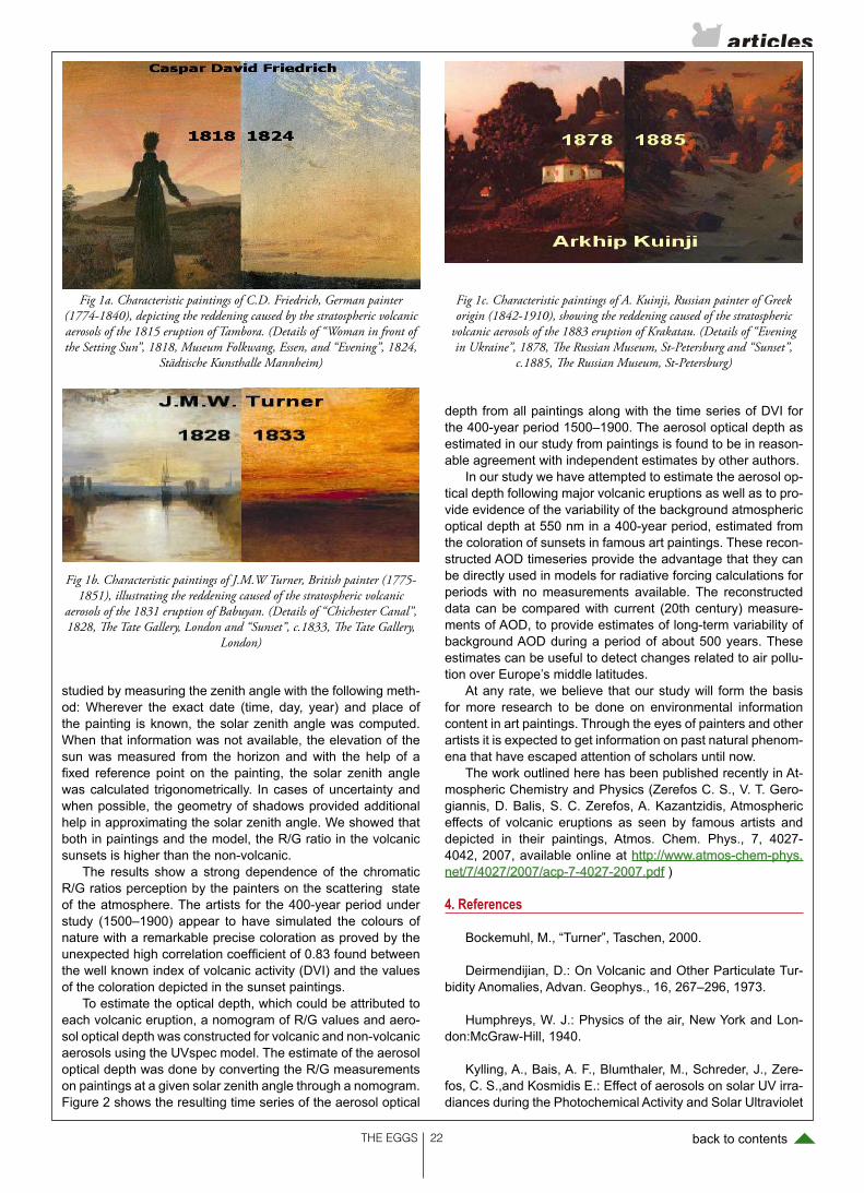
THE EGGS back to contents
studied by measuring the zenith angle with the following meth-od: Wherever the exact date (time, day, year) and place of the painting is known, the solar zenith angle was computed. When that information was not available, the elevation of the sun was measured from the horizon and with the help of a fixed reference point on the painting, the solar zenith angle was calculated trigonometrically. In cases of uncertainty and when possible, the geometry of shadows provided additional help in approximating the solar zenith angle. We showed that both in paintings and the model, the R/G ratio in the volcanic sunsets is higher than the non-volcanic.
The results show a strong dependence of the chromatic R/G ratios perception by the painters on the scattering state of the atmosphere. The artists for the 400-year period under study (1500–1900) appear to have simulated the colours of nature with a remarkable precise coloration as proved by the unexpected high correlation coefficient of 0.83 found between the well known index of volcanic activity (DVI) and the values of the coloration depicted in the sunset paintings.
To estimate the optical depth, which could be attributed to each volcanic eruption, a nomogram of R/G values and aero-sol optical depth was constructed for volcanic and non-volcanic aerosols using the UVspec model. The estimate of the aerosol optical depth was done by converting the R/G measurements on paintings at a given solar zenith angle through a nomogram. Figure 2 shows the resulting time series of the aerosol optical
depth from all paintings along with the time series of DVI for the 400-year period 1500–1900. The aerosol optical depth as estimated in our study from paintings is found to be in reason-able agreement with independent estimates by other authors.
In our study we have attempted to estimate the aerosol op-tical depth following major volcanic eruptions as well as to pro-vide evidence of the variability of the background atmospheric optical depth at 550 nm in a 400-year period, estimated from the coloration of sunsets in famous art paintings. These recon-structed AOD timeseries provide the advantage that they can be directly used in models for radiative forcing calculations for periods with no measurements available. The reconstructed data can be compared with current (20th century) measure-ments of AOD, to provide estimates of long-term variability of background AOD during a period of about 500 years. These estimates can be useful to detect changes related to air pollu-tion over Europe’s middle latitudes.
At any rate, we believe that our study will form the basis for more research to be done on environmental information content in art paintings. Through the eyes of painters and other artists it is expected to get information on past natural phenom-ena that have escaped attention of scholars until now.
The work outlined here has been published recently in At-mospheric Chemistry and Physics (Zerefos C. S., V. T. Gero-giannis, D. Balis, S. C. Zerefos, A. Kazantzidis, Atmospheric effects of volcanic eruptions as seen by famous artists and depicted in their paintings, Atmos. Chem. Phys., 7, 4027-4042, 2007, available online at http://www.atmos-chem-phys.net/7/4027/2007/acp-7-4027-2007.pdf )
4. References
Bockemuhl, M., “Turner”, Taschen, 2000.
Deirmendijian, D.: On Volcanic and Other Particulate Tur-bidity Anomalies, Advan. Geophys., 16, 267–296, 1973.
Humphreys, W. J.: Physics of the air, New York and Lon-don:McGraw-Hill, 1940.
Kylling, A., Bais, A. F., Blumthaler, M., Schreder, J., Zere-fos, C. S.,and Kosmidis E.: Effect of aerosols on solar UV irra-diances during the Photochemical Activity and Solar Ultraviolet
Fig 1a. Characteristic paintings of C.D. Friedrich, German painter (1774-1840), depicting the reddening caused by the stratospheric volcanic aerosols of the 1815 eruption of Tambora. (Details of “Woman in front of the Setting Sun”, 1818, Museum Folkwang, Essen, and “Evening”, 1824,
Städtische Kunsthalle Mannheim)
Fig 1b. Characteristic paintings of J.M.W Turner, British painter (1775-1851), illustrating the reddening caused of the stratospheric volcanic
aerosols of the 1831 eruption of Babuyan. (Details of “Chichester Canal”, 1828, The Tate Gallery, London and “Sunset”, c.1833, The Tate Gallery,
London)
Fig 1c. Characteristic paintings of A. Kuinji, Russian painter of Greek origin (1842-1910), showing the reddening caused of the stratospheric
volcanic aerosols of the 1883 eruption of Krakatau. (Details of “Evening in Ukraine”, 1878, The Russian Museum, St-Petersburg and “Sunset”,
c.1885, The Russian Museum, St-Petersburg)
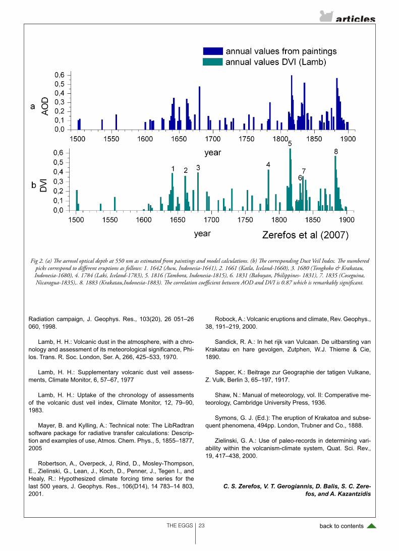
THE EGGS back to contents
Radiation campaign, J. Geophys. Res., 103(20), 26 051–26 060, 1998.
Lamb, H. H.: Volcanic dust in the atmosphere, with a chro-nology and assessment of its meteorological significance, Phi-los. Trans. R. Soc. London, Ser. A, 266, 425–533, 1970.
Lamb, H. H.: Supplementary volcanic dust veil assess-ments, Climate Monitor, 6, 57–67, 1977
Lamb, H. H.: Uptake of the chronology of assessments of the volcanic dust veil index, Climate Monitor, 12, 79–90, 1983.
Mayer, B. and Kylling, A.: Technical note: The LibRadtran software package for radiative transfer calculations: Descrip-tion and examples of use, Atmos. Chem. Phys., 5, 1855–1877, 2005
Robertson, A., Overpeck, J, Rind, D., Mosley-Thompson, E., Zielinski, G., Lean, J., Koch, D., Penner, J., Tegen I., and Healy, R.: Hypothesized climate forcing time series for the last 500 years, J. Geophys. Res., 106(D14), 14 783–14 803, 2001.
Robock, A.: Volcanic eruptions and climate, Rev. Geophys., 38, 191–219, 2000.
Sandick, R. A.: In het rijk van Vulcaan. De uitbarsting van Krakatau en hare gevolgen, Zutphen, W.J. Thieme & Cie, 1890.
Sapper, K.: Beitrage zur Geographie der tatigen Vulkane, Z. Vulk, Berlin 3, 65–197, 1917.
Shaw, N.: Manual of meteorology, vol. II: Comperative me-teorology, Cambridge University Press, 1936.
Symons, G. J. (Ed.): The eruption of Krakatoa and subse-quent phenomena, 494pp. London, Trubner and Co., 1888.
Zielinski, G. A.: Use of paleo-records in determining vari-ability within the volcanism-climate system, Quat. Sci. Rev., 19, 417–438, 2000.
C. S. Zerefos, V. T. Gerogiannis, D. Balis, S. C. Zere-fos, and A. Kazantzidis
Fig 2. (a) The aerosol optical depth at 550 nm as estimated from paintings and model calculations. (b) The corresponding Dust Veil Index. The numbered picks correspond to different eruptions as follows: 1. 1642 (Awu, Indonesia-1641), 2. 1661 (Katla, Iceland-1660), 3. 1680 (Tongkoko & Krakatau, Indonesia-1680), 4. 1784 (Laki, Iceland-1783), 5. 1816 (Tambora, Indonesia-1815), 6. 1831 (Babuyan, Philippines- 1831), 7. 1835 (Coseguina, Nicaragua-1835),. 8. 1883 (Krakatau,Indonesia-1883). The correlation coefficient between AOD and DVI is 0.87 which is remarkably significant.

THE EGGS back to contents
In the 2002 Assessment it was indicated that the total atmo-spheric burden of ozone depleting substances was respond-ing as expected to the controls on production imposed by the Montreal Protocol, and that the ozone-layer depletion from the Protocol’s controlled substances is expected to begin to ame-liorate within the next decade or so. The Executive Summary of the 2006 Assessment noted that an important next step is to ask whether stratospheric ozone and surface UV radiation are responding as expected to the controls imposed by the Pro-tocol. In addressing this question it is necessary to consider factors other than ozone-depleting substances that also influ-ence ozone and UV radiation. These factors include natural dynamical variability, volcanic eruptions, solar variations, aero-sols, and climate change. The status of our understanding and the key questions for several of these issues are discussed below.
Ozone-depleting substances
The observed tropospheric abundances of HCFCs are in-creasing more slowly than anticipated, and those of bromine-containing gases are declining more quickly than anticipated. While both facts are good for the ozone layer, it is important to reconcile them with estimates of the relevant emissions. The importance of stratospheric bromine from very short-lived spe-cies (VSLS) appears to be significantly greater than previously estimated (WMO, Figures 2–3), and needs to be better quan-tified. We are still waiting for the observed decline of tropo-spheric bromine to be reflected in the stratosphere.
Key issues arising from the 2006 WMO/UNEP Ozone Assessment
In the 2002 Assessment it was indicated that the ozone-layer depletion from the Protocol’s controlled sub-stances is expected to begin to ameliorate within the next decade or so. The Executive Summary of the 2006 Assessment noted that an important next step is to ask whether stratospheric ozone and surface UV radiation are responding as expected to the controls imposed by the Protocol. In addressing this question it is neces-sary to consider factors other than ozone-depleting substances that also influence ozone and UV radiation. The status of our understanding and the key questions for several of these issues are discussed below
by T.G. Shepherd and W.J. Randel
Figure 1. (a) Meridional cross section of ozone trends during 1979-2005 derived from SAGE satellite and polar ozone-sonde data. Trends are derived from regression onto EESC, and expressed in terms of net percentage change during 1979-2005. Contours are -4, -8, -12, -16, -20, -30, -40%. (b) Latitudinal structure of annual mean column ozone trends during 1979-2005,derived from vertically integrated SAGE/sonde data and merged TOMS/SBUV data. Trends are expressed in terms of net ozone change over 1979-2005. The heavy dashed line denotes trends derived from SAGE data, integrated only over 25-50 km. From Randel and Wu, 2007.
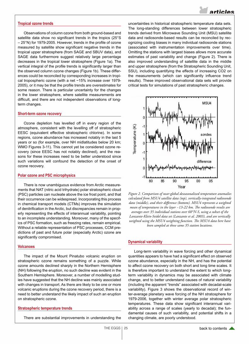
THE EGGS back to contents
Tropical ozone trends
Observations of column ozone from both ground-based and satellite data show no significant trends in the tropics (25°S – 25°N) for 1979-2005. However, trends in the profile of ozone measured by satellite show significant negative trends in the tropical upper stratosphere (from SAGE and SBUV data), and SAGE data furthermore suggest relatively large percentage decreases in the tropical lower stratosphere (Figure 1a). The vertical integral of the profile trends is significantly larger than the observed column ozone changes (Figure 1b). These differ-ences could be reconciled by corresponding increases in tropi-cal tropospheric ozone (with a net ~15% increase over 1979-2005), or it may be that the profile trends are overestimates for some reason. There is particular uncertainty for the changes in the lower stratosphere, where satellite measurements are difficult, and there are not independent observations of long-term changes.
Short-term ozone recovery
Ozone depletion has levelled off in every region of the atmosphere, consistent with the levelling off of stratospheric EESC (equivalent effective stratospheric chlorine). In some regions, ozone abundance has increased notably in the last 5 years or so (for example, over NH midlatitudes below 20 km; WMO Figures 3-11). This cannot yet be considered ozone re-covery (since EESC has not notably declined), and the rea-sons for these increases need to be better understood since such variations will confound the detection of the onset of ozone recovery.
Polar ozone and PSC microphysics
There is now unambiguous evidence from Arctic measure-ments that NAT (nitric acid trihydrate) polar stratospheric cloud (PSC) particles can nucleate above the ice frost point, and that their occurrence can be widespread. Incorporating this process in chemical transport models (CTMs) improves the simulation of denitrification in the Arctic, but discrepancies remain in prop-erly representing the effects of interannual variability, pointing to an incomplete understanding. Moreover, many of the specif-ics of PSC formation, such as freezing rates, remain empirical. Without a reliable representation of PSC processes, CCM pre-dictions of past and future polar (especially Arctic) ozone are significantly compromised.
Volcanoes
The impact of the Mount Pinatubo volcanic eruption on stratospheric ozone remains something of a puzzle. While ozone amounts declined sharply in the Northern Hemisphere (NH) following the eruption, no such decline was evident in the Southern Hemisphere. Moreover, a number of modelling stud-ies have suggested that the NH decline was mainly associated with changes in transport. As there are likely to be one or more volcanic eruptions during the ozone recovery period, there is a need to better understand the likely impact of such an eruption on stratospheric ozone.
Stratospheric temperature trends
There are substantial improvements in understanding the
uncertainties in historical stratospheric temperature data sets. The long-standing differences between lower stratospheric trends derived from Microwave Sounding Unit (MSU) satellite data and radiosonde-based results can be reconciled by rec-ognizing cooling biases in many individual radiosonde stations (associated with instrumentation improvements over time). Omitting the stations with largest biases allows more accurate estimates of past variability and change (Figure 2). There is also improved understanding of satellite data in the middle and upper stratosphere (from the Stratospheric Sounding Unit, SSU), including quantifying the effects of increasing CO2 on the measurements (which can significantly influence trend results). These improved observational data sets will provide critical tests for simulations of past stratospheric changes.
Dynamical variability
Long-term variability in wave forcing and other dynamical quantities appears to have had a significant effect on observed ozone abundance, especially in the NH, and has the potential to affect ozone recovery on both short and long time scales. It is therefore important to understand the extent to which long-term variability in dynamics may be associated with climate change, and to better understand causes of natural variability (including the apparent “trends” associated with decadal-scale variability). Figure 3 shows the observational record of win-ter-average planetary wave forcing of the NH stratosphere for 1979-2006, together with winter average polar stratospheric temperatures. These data show significant interannual vari-ability across a range of scales (yearly to decadal); the fun-damental causes of such variability, and potential shifts in a changing climate, are poorly understood.
Figure 2. Comparison of near-global deseasonalized temperature anomalies calculated from MSU4 satellite data (top), vertically-integrated radiosonde data (middle), and their difference (bottom). MSU4 represents a weighted mean of temperatures in the layer ~13-22 km. The radiosonde results are averages over 35 individual stations over 60°N-S, using a subset of the
Lanzante-Klein-Seidel data set (Lanzante et al. 2003), and are vertically weighted using the MSU4 weighting function. The MSU4 data here have
been sampled at these same 35 station locations.

THE EGGS back to contents
Tropical tropopause temperature and water vapour
CCMs generally predict a warming of the tropical tropo-pause region from climate change, and a modest increase in stratospheric water vapour, but these predictions do not ap-pear to be consistent with past observations. CCM simulations of both fields often show large biases, with significant differ-ences among models (Eyring et al., 2006, Figure 7). It is pos-sible that long-term changes predicted in the models are more robust, but this would need to be demonstrated. There are also remaining uncertainties regarding decadal-scale changes in the observational record.
Brewer Dobson circulation and age of air
CCMs suggest an increase in tropical upwelling and thus decrease in age of air throughout the stratosphere, due to cli-mate change (WMO, Figures 5-19). The extent of the increase varies substantially among models. The mechanism for the increased upwelling has yet to be determined, and its robust-ness assessed. Changes in age of air call into question the ODS scenarios used by CCMs, which impose tropospheric concentrations and thus cannot represent the effects of a fast-er removal of ODSs.
Solar signal in ozone
The ozone solar signal provides a key physical link be-tween solar variability and climate, and is also important for in-terpreting low frequency ozone variability. However, there are substantial uncertainties in quantifying effects of the 11-year solar cycle on stratospheric ozone and temperature, both in comparisons of models and observations, and even among dif-ferent observational data sets. The main differences regard the magnitude of the solar signal in column ozone (Figure 4), and
the vertical profile of the solar signal in the tropics; much of the uncertainties result from the relatively short observational data records, and possible confusion of volcanic and QBO effects.
Ozone simulation by CTMs
When driven by observed meteorology, CTMs should, in principle, be able to reproduce the observed behaviour of ozone. This makes CTMs potentially useful tools for separat-ing (to the extent this is possible) the effects of chemical and dynamical processes on observed ozone changes. Although CTMs have been used very successfully to identify chemical processes in the context of particular winters, decadal-times-cale simulations by CTMs are still plagued by errors in trans-port (e.g. age of air) from assimilated winds. This limits our ability to attribute past ozone changes.
Ozone simulation by CCMs
CCM predictions of future ozone are limited by a persis-tent young bias in age of air, although the situation has im-proved markedly in recent years. CCM simulations of midlati-tude ozone can reproduce the overall features the past record, but there are substantial uncertainties in detail and differences among models (WMO Figures 3-26). While the observational record contains significant effects of dynamical variability, es-pecially in the NH, such variability should also be evident in the CCMs. Reconciling the past observations with CCM simula-tions remains an essential task.
Polar ozone and long-term recovery
Model predictions of future Arctic ozone are highly uncer-tain because of large uncertainties in the future dynamical state of the Arctic polar vortex (WMO Figures 6-12, 6-13). It will be important to understand the sensitivity of modelled dynamical behaviour to various model parameters, such as horizontal/
Figure 3. Lower time series show winter-averaged eddy heat flux (a proxy for planetary wave forcing) at 100 hPa for the NH for 1979-2006
(averaged over December-March for each year). Upper curves show the corresponding January-March averaged polar 100 hPa temperatures
(averaged over 60°– 90°N).Both sets of curves show results derived from NCEP and ERA40 reanalyses, plus NCEP Climate Prediction Center
(CPC) data.Figure 4. Latitudinal profile of the solar cycle variations in column ozone, derived from vertically integrated SAGE I+II data (over 20-50 km), and three column ozone data sets (groundbased, SBUV, and merged TOMS/
SBUV data). Error bars on the TOMS/SBUV curve denote 2*sigma uncertainty in the fit.
THE EGGS back to contents
vertical resolution, dynamical wave forcing, radiative balances, etc. Model simulations need to become more robust and pro-vide better estimates of the uncertainty associated with natural variability, as well as the effects of climate change.
Radiative forcing from ozone changes
The radiative forcing from stratospheric ozone changes (e.g. as used by IPCC) assumes that all the ozone changes are due to ODSs and thus that the ozone radiative forcing is an indirect forcing which can be set against the direct radiative forcing from the ODSs themselves. However, it seems clear that a significant fraction of the observed ozone changes are associated with changes in transport rather than with ODSs. Moreover, these transport-induced changes appear to be lo-cated preferentially in the lowest part of the stratosphere, where they have a maximum impact on radiative forcing. It is thus necessary to quantify the vertical profile of ozone changes attributable to ODSs, and its associated radiative forcing.
References
Eyring, V. et al., Assessment of temperature, trace spe-cies and ozone in chemistry-climate model simulations of the recent past, J. Geophys. Res., 111, D22308, doi:10.1029/2006JD007327, 2006.
Lanzante, J.R., S.A. Klein, D.J. Seidel, 2003: Temporal ho-mogenization of monthly radiosonde temperature data. Part I: Methodology. J. Climate, 16, 224-240.
Randel, W. J., and F. Wu (2007), A stratospheric ozone pro-file data set for 1979– 2005: Variability, trends, and compari-sons with column ozone data, J. Geophys. Res., 112, D06313, doi:10.1029/2006JD007339.
Scientific Assessment of Ozone Depletion: 2006, WMO, Report No. 50.
This article was reprodused by permission from SPARC Newsletter No 29 (http://www.atmosp.physics.utoronto.ca/SPARC/Newsletter29/newsletter29.pdf)
T. G. Shepherd, University of Toronto, Canada, [email protected]
W. J. Randel, National Center for Atmospheric Research, USA, [email protected]
THE EGGS back to contents
A summary of the lectures will be available as video at the ESF website of the workshop (http://www.esf.org/acidification-workshop.html).
Background
Changes in ocean chemistry due to anthropogenic CO2 emissions affect marine life, nutrient cycles and biocalcifica-tion. Increasing atmospheric CO2 levels results in increased seawater CO2 concentrations and consequently alters the seawater carbonate equilibrium, decreasing pH. This effect can effect marine ecosystems and especially marine calcify-ing organisms. For given CO2 emission scenarios the gross chemistry of this process can be modeled very well while it is more difficult to predict the impact of OA on the biota and
the feedback of the biosphere to OA. The main purpose of this workshop was to understand the consequences of future CO2 emissions for the marine environment and to establish re-search priorities that would most effectively fill in current gaps in our fundamental understanding.
Marine carbonate precipitation today is a biologically con-trolled process with main contributions by pelagic planktonic organisms (such as coccolithophores, foraminifera, and ptero-pods). Planktonic calcifiers are particularly significant since they are the main contributors to the export of carbonates from the surface ocean to the sea floor. Their continuous fossil re-cord provides the opportunity to observe past calcification and ecological responses to a range of scenarios including both rapidly rising and persistently high atmospheric CO2 levels.
Atmospheric CO2, ocean acidification, and ecological
changes in planktonic calcifying organisms
ESF- EuroCLIMATE Workshop report
The European Science Fondation (EuroCLIMATE Programme) sponsored a workshop on Atmospheric CO2, ocean acidification, and ecological changes in planktonic calcifying organisms with 45 international partici-pants both from the EuroCLIMATE programme as well as externally invited experts. The event was co-spon-sored by PAGES (Past Global Changes) with participation from SOLAS and IMBER. The workshop was hosted in Barcelona, Spain at the Cosmo Caixa Science Museum and Hotel Eden Roc Conference Center (Sant Feliu de de Guíxols). In the afternoon of September 26th a public symposium on ocean acidification (OA) was organized at, and co-sponsored by, the Science Museum of Barcelona. Public lectures were given by four participants of the workshop: Richard Feely (NOAA Seattle) Global Warming and Ocean Acidification: Double Trouble for Marine Ecosystems; Victoria Fabry (California State University San Marcos) A global geochemical experiment with unknown ecological consequences; James Zachos (University of California at Santa Cruz) Long-term Consequences of Ocean Acidification: A Paleoperspective; and Carol Turley (Plymouth Marine Lab-oratory) Taking the Science of Ocean Acidification to Policy Makers, Stakeholders and Society. These lectures provide an authoritative but accessible overview of the issue.
by Patrizia Ziveri
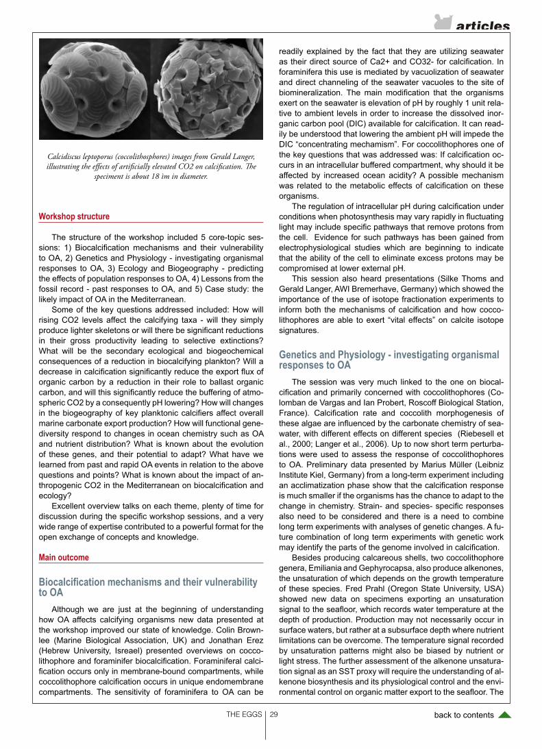
THE EGGS back to contents
Workshop structure
The structure of the workshop included 5 core-topic ses-sions: 1) Biocalcification mechanisms and their vulnerability to OA, 2) Genetics and Physiology - investigating organismal responses to OA, 3) Ecology and Biogeography - predicting the effects of population responses to OA, 4) Lessons from the fossil record - past responses to OA, and 5) Case study: the likely impact of OA in the Mediterranean.
Some of the key questions addressed included: How will rising CO2 levels affect the calcifying taxa - will they simply produce lighter skeletons or will there be significant reductions in their gross productivity leading to selective extinctions? What will be the secondary ecological and biogeochemical consequences of a reduction in biocalcifying plankton? Will a decrease in calcification significantly reduce the export flux of organic carbon by a reduction in their role to ballast organic carbon, and will this significantly reduce the buffering of atmo-spheric CO2 by a consequently pH lowering? How will changes in the biogeography of key planktonic calcifiers affect overall marine carbonate export production? How will functional gene-diversity respond to changes in ocean chemistry such as OA and nutrient distribution? What is known about the evolution of these genes, and their potential to adapt? What have we learned from past and rapid OA events in relation to the above questions and points? What is known about the impact of an-thropogenic CO2 in the Mediterranean on biocalcification and ecology?
Excellent overview talks on each theme, plenty of time for discussion during the specific workshop sessions, and a very wide range of expertise contributed to a powerful format for the open exchange of concepts and knowledge.
Main outcome
Biocalcification mechanisms and their vulnerability to OA
Although we are just at the beginning of understanding how OA affects calcifying organisms new data presented at the workshop improved our state of knowledge. Colin Brown-lee (Marine Biological Association, UK) and Jonathan Erez (Hebrew University, Isreael) presented overviews on cocco-lithophore and foraminifer biocalcification. Foraminiferal calci-fication occurs only in membrane-bound compartments, while coccolithophore calcification occurs in unique endomembrane compartments. The sensitivity of foraminifera to OA can be
readily explained by the fact that they are utilizing seawater as their direct source of Ca2+ and CO32- for calcification. In foraminifera this use is mediated by vacuolization of seawater and direct channeling of the seawater vacuoles to the site of biomineralization. The main modification that the organisms exert on the seawater is elevation of pH by roughly 1 unit rela-tive to ambient levels in order to increase the dissolved inor-ganic carbon pool (DIC) available for calcification. It can read-ily be understood that lowering the ambient pH will impede the DIC “concentrating mechamism”. For coccolithophores one of the key questions that was addressed was: If calcification oc-curs in an intracellular buffered compartment, why should it be affected by increased ocean acidity? A possible mechanism was related to the metabolic effects of calcification on these organisms.
The regulation of intracellular pH during calcification under conditions when photosynthesis may vary rapidly in fluctuating light may include specific pathways that remove protons from the cell. Evidence for such pathways has been gained from electrophysiological studies which are beginning to indicate that the ability of the cell to eliminate excess protons may be compromised at lower external pH.
This session also heard presentations (Silke Thoms and Gerald Langer, AWI Bremerhave, Germany) which showed the importance of the use of isotope fractionation experiments to inform both the mechanisms of calcification and how cocco-lithophores are able to exert “vital effects” on calcite isotope signatures.
Genetics and Physiology - investigating organismal responses to OA
The session was very much linked to the one on biocal-cification and primarily concerned with coccolithophores (Co-lomban de Vargas and Ian Probert, Roscoff Biological Station, France). Calcification rate and coccolith morphogenesis of these algae are influenced by the carbonate chemistry of sea-water, with different effects on different species (Riebesell et al., 2000; Langer et al., 2006). Up to now short term perturba-tions were used to assess the response of coccolithophores to OA. Preliminary data presented by Marius Müller (Leibniz Institute Kiel, Germany) from a long-term experiment including an acclimatization phase show that the calcification response is much smaller if the organisms has the chance to adapt to the change in chemistry. Strain- and species- specific responses also need to be considered and there is a need to combine long term experiments with analyses of genetic changes. A fu-ture combination of long term experiments with genetic work may identify the parts of the genome involved in calcification.
Besides producing calcareous shells, two coccolithophore genera, Emiliania and Gephyrocapsa, also produce alkenones, the unsaturation of which depends on the growth temperature of these species. Fred Prahl (Oregon State University, USA) showed new data on specimens exporting an unsaturation signal to the seafloor, which records water temperature at the depth of production. Production may not necessarily occur in surface waters, but rather at a subsurface depth where nutrient limitations can be overcome. The temperature signal recorded by unsaturation patterns might also be biased by nutrient or light stress. The further assessment of the alkenone unsatura-tion signal as an SST proxy will require the understanding of al-kenone biosynthesis and its physiological control and the envi-ronmental control on organic matter export to the seafloor. The
Calcidiscus leptoporus (coccolithosphores) images from Gerald Langer, illustrating the effects of artificially elevated CO2 on calcification. The
speciment is about 18 ìm in diameter.

THE EGGS 0 back to contents
following two questions provide interesting ideas to ponder in future research endeavors. What would be the consequence on export and how the sedimentary record is written if a phe-nomenon such as anthropogenically imposed OA prevented the coccolithophores from calcifying? And, is the efficiency of alkenone export dependent upon a ballasting effect due to biomineralization?
Ecology and Biogeography - predicting the effects of population responses to OA
The ecology of coccolithophores and foraminifera was re-viewed by Jeremy Young (Natural History Museum London, UK) and Ralf Schiebel (National Oceanography Centre South-ampton, UK) and by Toby Tyrrel (National Oceanography Cen-tre Southampton, UK) from the ecosystem modelling point of view. Tyrrel specified the need for more large scale surveys, both of the open ocean to constrain the large-scale biogeo-chemical processes and of shelf seas and semi-enclosed seas which may have more unusual carbon chemistries and as such, possibly be more informative. He also presented recent-ly published data on the Baltic Sea, which revealed an unusual undersaturation for calcium carbonate in wintertime surface waters (Tyrrell et al, 2007).
The workshop emphasized the additional knowledge which can be gained studying ecology and biogeography. Laboratory experiments play a valuable role but have well-acknowledged shortcomings, including: (1) the difficulties of running them for long enough to allow the organisms to adapt via evolution to the different chemistry (2) usually the restriction to a mono-culture rather than a species assemblage, and hence no pos-sibility for replacement of acid-sensitive by acid-insensitive (or more tolerant) species or strains, and (3) the lack of an ecosystem, and hence inability to examine trophic effects such as variation in shell thickness on grazing susceptibility. It is therefore essential to supplement laboratory experiments with field observations, including studying the chemical conditions of environments in which calcifiers do and do not live, to see which ranges of pH and CaCO3 saturation state (Ω) they can tolerate in-situ.
Pelagic calcifiers are not normally dominant components of marine ecosystems, but they do play major biogeochemical roles both via export of calcium carbonate to the sediments and perhaps most importantly by ballasting particulate organic car-bon (POC). Transport of POC to the deep sea in marine snow and fecal pellets is dependant on ballasting by mineral matter and particularly by the shells of pelagic calcifiers (Armstrong et al. 2002, Klaas & Archer 2002). Hence, a major impact of reduced calcification would be reduced flux of food to the deep benthic community and a reduction in CO2 sequestration into sediments and the deep ocean. A first compilation of coccolith data shows a relationship between coccolith carbonate and POC flux (Ziveri et al., 2007).
The effect of climate change on the ecology and biogeog-raphy of foraminifera and coccolithophores are plentiful and interdependent. For instance, additional to an increase in tem-perature of the ocean, global warming is predicted to reduce the depth of the mixed layer and to increase the stability of surface waters. These hydrographic changes will have con-sequences for nutrient supply and hence affect the basis of the oceanic food web. Equally, increased uptake of CO2 by the ocean will not only affect its carbonate chemistry but also the bioavailability of micro nutrients such as Fe. However, new
data were presented at the workshop showing ecological and predicted biogeographical changes in our present and future high-CO2 oceans. For instance, Patrizia Ziveri (Universitat Autonoma Barcelona, Spain, and Vrije Universiteit Amster-dam, The Netherlands) reported a clear ecological change in coccolithophore distribution in the annual varved sediment of the Santa Barbara Basin since the 1970’s associated with in-creased stratification and annual temperature.
Lessons from the fossil record - past responses to OA
The overview lectures by Daniela Schmidt (Bristol Univer-sity, UK) and Heather Stoll (Oviedo University, Spain) reported examples of OA events in the geological past focusing on some key periods such as the PETM (Paleocene-Eocene Thermal Maximum) at around 55 Myr ago. Andy Ridgewell (Bristol Uni-versity, UK) discussed the issues related to computer simula-tions to model past changes in OA and any potential biological responses. Schmidt pointed out that changes in species com-position and biogeography could be as important, if not more so, than actual extinctions during OA events. Particular focus was given to the K-T (K-Pg) Boundary (approx. 65 Myr ago). A decrease in carbonate accumulation at this time is related to reduction in carbonate production (i.e. calcification) rather than increased dissolution at the sea floor. Foraminiferal tests de-crease in average size while the carbonate producing plankton shifted from coccolithophore to foraminifera domination. Re-covery of carbonate production took several millions of years. Stoll focused on the PETM showing evidence from a site in the Southern Ocean (a region particularly sensitive to the effects of OA) of distinct shifts in plankton assemblage at this time, with an increase in the presence of species more suited to warmer conditions although these also tend to be those less suscep-tible to dissolution. Further evidence of assemblage changes at this time comes from other regions.
Coccolith Sr/Ca measurements are used as a paleo proxy for algal carbonate production and provide some evidence that coccolithophore production may have peaked during the PETM in the Southern Ocean region. Ridgwell discussed some key areas for attention when using computer simulations to model past changes in OA and any potential biological responses. Although it is relatively straightforward to predict the inorganic response of carbonate sediments to changes in ocean acidity, it is extremely important to constrain the associated changes in atmospheric CO2 and possible biological calcification respons-es before we will be able to reduce the uncertainties in our models. Richard Zeebe (University of Hawaii, USA) stressed the importance of major events in the past as the nearest can-didate for a direct analogue to current OA. Particular emphasis was given to considering the geographical distribution of any event in terms of response in the system. For example the ex-tent of carbonate dissolution during the PETM was not globally equal. None of the past OA analogues will be able to depict the true extend of future acidification since the injection of carbon into the ocean / atmosphere system during the PETM was most likely not as rapid and intense as the modern situa-tion. A more gradual release of carbon would have been more efficiently buffered by deep sea carbonate dissolution which would have meant a significantly reduced effect on surface ocean pH. An important point made by Carol Turley (Plymouth Marine Laboratory, UK) was that any effect on marine biocal-cification during the PETM would represent the very minimum

THE EGGS 1 back to contents
response that might be expected in the future. A problem with using the PETM and the KPg to understand effects and re-covery time is the very different ecosystem structure so deep in the geological record. The youngest geological example of deep sea acidification (causing dissolution) is the Mid-Brunhes interval (around 0.5 Myr ago). Stephen Barker (Cardiff Univer-sity) used this interval to highlight a key area of uncertainty for predicting future consequences of OA: the cycling of organic and inorganic carbon. Dissolution during the Mid-Brunhes in-terval is possibly driven by changes in the calcifying planktonic ecosystem that can influence the balance between the organic and inorganic carbon pumps (and hence atmospheric CO2). The recent nature of these changes allows a direct comparison to be made with modern ecosystems and can bridge the gap between geology and modern biogeography.
What is known about the impact of anthropogenic CO2 and OA in the Mediterranean?
Most climate models are today restricted to the major oceans, as the oceanographic processes in semi-enclosed or relatively shallow basins, such as the Mediterranean Sea, the Caribbean, the North Sea and the continental shelf of Indone-sia are too complex and small-scale to be resolved in global climate models. From a European perspective, this excludes one of the major economically important regions from future predictions.
Sebastian Meier (CEREGE, France) gave an introduction to the oceanography of the Mediterranean, providing implica-tions about past and future changes. The Mediterranean is an area of high anthropogenic carbon input and extreme carbon-ate supersaturation, so no signs of dissolution are expected. However, the workshop offered the unique opportunity to share unpublished results that showed something different.
Catherine Goyet (University of Perpignan, France) present-ed the calculation of anthropogenic carbon from the long time series (1994-2006) DYFAMED site and the extrapolation of the results to the whole Mediterranean. The analysis reveals a big difference between the eastern and western basin. A change is noted between the years 2001 and 2006, related to water circulation.
Despite the fact that the Mediterranean region has been identified as a “hot spot” for future climate change with predict-ed temperature increase of up to 6°C on land within the next 100 years, only very limited and patchy information is available so far for the Mediterranean Sea so far. Taking into account that the Mediterranean Sea is known to sink for anthropogenic carbon, the combined effects of OA and temperature increase on climate and ecosystem may be larger than in any other Eu-ropean region. Due to the short residence time in the Mediter-ranean Sea future changes will take place relatively fast and should therefore be a primary target for future research.
In particular, the carbonate system of the Mediterranean Sea and the response of the highly adapted organisms is poorly understood. Generally, supersaturation with respect to calcite and aragonite is observed throughout the entire basin, which may be the reason for overcalcification observed in coccolitho-phores in the eastern Mediterranean (Maria Triantaphyllou, University of Athens, Greece). At the same time, however, ef-fects that are ascribed to OA can already be observed in other parts of the Mediterranean, like e.g. thinning and malformation of coccolithophores (S. Meier) and massive blooms of jellyfish (Dror Angel, Haifa University, Israel). From the little informa-
tion available, it seems that recent oceanographic changes like the Eastern Mediterranean Transient, i.e. a shift in the site of deep water formation, coincide with changes in the uptake and sequestration of anthropogenic carbon. Due to this high envi-ronmental variability within a relatively restricted space and the resulting steep physicochemical gradients, the Mediterranean Sea could serve as a small-scale model for studying the im-pact of future OA and warming.
Final considerations
The stimulating cross-disciplinary thinking of this workshop provided a unique opportunity to trace the state of knowledge and prioritize research agendas to understand future impacts of fossil-fuel CO2 on planktonic calcifying organisms and eco-systems.
We are now beginning to understand mechanistically why the physiology and the biocalcification of these organisms are affected by high CO2. This understanding makes the issue of OA and the rate and magnitude projected for the coming de-cades an even larger risk. There are already notable field ob-servations on ecological changes and effects on calcification.
The workshop was entitled “Atmospheric CO2, Ocean Acidification, and Ecological Changes in Planktonic Calcifying Organisms”, but it is noteworthy that most marine plankton are not calcifiers and several of the participants pointed out that we should place greater emphasis on the effects of elevated oceanic CO2 and acidification on planktonic communities as a whole since we may assume that these changes will affect many other cellular processes and organismal interactions, in addition to calcification.
There is the need of an international network of observa-tions and process studies investigating potential OA impacts. Considering the potential socio-economic impacts of OA, it seems timely to join forces and share resources in an interna-tional effort guided by an international scientific steering group similar to that carried out in the 1980-90’s by the international marine programs JGOFS and WOCE. It is fundamental to agree on standardized protocols (e.g. calcification rate mea-surements, CO2 system parameters, manipulation of seawa-ter CO2 chemistry, determination of abundances and distribu-tions of planktonic calcifiers, respiration measurements). The organizers of the Scoping Workshop on Ocean Acidification Research (Scripps, San Diego, October 9-11, 2007) Victoria Fabry and Richard Feely who were actively involved in this ESF workshop felt very strongly about this.
Along with climate change, ocean acidification shows the need for urgent and substantial reduction of CO2 emissions and might provide tipping points for mitigation or adaptation strategies. Therefore it is important that both the climate change and energy policy communities are aware of the problem and that scientists with knowledge of ocean acidification engage with these communities. Carol Turley noted that if the marine science community wants to influence future CO2 emission strategies we have to catch–up with the climate change policy community and need to address questions such as “what con-stitute a dangerous pH change?” and “where are the tipping points?” Most importantly we will assess within our own com-munity the level of certainty of our understanding, with regard to ocean acidification, of the distant past and our predictions of the future, their impacts and feedbacks and find effective way to voice this information clearly and without ambiguity to those that will be making future policy decisions. As a follow up, sev-
THE EGGS back to contents
eral of the participants will meet in January 2008 to discuss socio-economic impacts of ocean acidification and produce a policy briefing.
Authors:
• Patrizia Ziveri, Universitat Autonoma de Barcelona, Insti-tute of Environmental Science and Technology (ICTA) Bellat-erra, Spain, and Department of Paleoclimatology and Geomor-phology, Vrije Universiteit, Amsterdam, Netherlands
• Victoria Fabry, California State University San Marcos, De-partment of Biological Sciences, San Marcos, United States
• Jelle Bijma, Alfred-Wegener Institut für Polar- und Meeres-forschung, Carbon Group. Bremerhaven, Germany
• Daniela Turk, European Science Foundation, Life, Earth and Environmental Sciences, Strasbourg, France
• Jeremy Young, The Natural History Museum, Department of Palaeontology, London, United Kingdom
• Daniela Schmidt, University of Bristol, Bristol, United Kingdom
• Colin Brownlee, Marine Biological Association, Plymouth, United Kingdom.
• Jonathan Erez, The Hebrew University of Jerusalem, Je-rusalem, Israel
• Thorsten Kiefer, PAGES International Project Office, Bern, Switzerland
• Carol Turley, Plymouth Marine Laboratory, Plymouth, United Kingdom
• Anton Eisenhauer, Kiel University, Leibniz Institute of Ma-rine Sciences (IFM-GEOMAR), GEOMAR Research Center for Marine Sciences, Kiel, Germany
Corresponding author: Patrizia Ziveri, Universitat Autonoma de Barcelona, Institute of Environmental
Science and Technology (ICTA) Bellaterra, Spain, and De-partment of Paleoclimatology and Geomorphology,
Vrije Universiteit, Amsterdam, Netherlands

THE EGGS
Imaggeo is the online open access geosciences image repository of the European Geosciences Union. Every geoscientist who is an amateur photographer (but also other people) can submit their images to this repository.
Being open access, images from Imaggeo can be used by scientists for their presentations or publications as well as by the press.
If you submit your images to imaggeo, you retain full rights of use, since they are licenced and distributed by EGU under a Creative Commons licence.
www.imaggeo.net

THE EGGS back to contents
Fundamentals of GeophysicsAuthors: William LowriePublisher: Cambridge University Press, New YorkISBN: 9780521675963YEAR : 2007EDITION : 2ndPAGES : 392PRICE : 49.00 €paperback
This second edition of Fundamentals of Geophysics has been completely revised and updated, and is the ideal geophysics textbook for undergraduate students of geoscience with an introductory level of knowledge in physics and mathematics. It gives a comprehensive treatment of the fundamental principles of each major branch of geophysics, and presents geophysics within the wider context of plate tectonics, geodynamics and planetary science. Basic principles are explained with the aid of numerous figures and step-by-step mathematical treatments, and important geo-physical results are illustrated with examples from the scientific literature. Text-boxes are used for auxiliary explanations and to handle topics of interest for more advanced students. This new edition also includes review questions at the end of each chapter to help assess the reader’s understanding of the topics covered and quantitative exercises for more thorough evaluation. Solutions to the exercises and electronic copies of the figures are available to instructors. • Each chapter now contains review questions and exercises • Solutions to the exercises and electronic versions of the figures are available on a password-protected website • Text-boxes present auxiliary explanations and topics of interest for more advanced students
Metamorphic Rocks: A Classification and Glossary of TermsAuthors: Douglas Fettes and Jacqueline Desmons (Eds.)Publisher: Cambridge University PressISBN: 9780521868105YEAR : 2007EDITION : 1stPAGES : 256PRICE : 57.00 €hardback
Many common terms in metamorphic petrology vary in their usage and meaning between countries. The International Union of Geological Sciences (IUGS) Subcom-mission on the Systematics of Metamorphic Rocks (SCMR) has aimed to resolve this, and to present systematic terminology and rock definitions that can be used worldwide. This book is the result of discussion and consultation lasting 20 years and involving hundreds of geoscientists worldwide. It presents a complete nomen-clature of metamorphic rocks, with a comprehensive glossary of definitions, sources and etymology of over 1100 terms, and a list of mineral abbreviations. Twelve multi-authored sections explain how to derive the correct names for metamorphic rocks and processes, and discuss the rationale behind the more important terms. These sections deal with rocks from high- to low- and very-low-grade. This book will form a key reference and international standard for all geoscientists studying metamorphic rocks. • Contains the IUGS recommendations for the classification of metamorphic rocks • Compiled by members of an international panel established to standardise the classification and naming of metamorphic rocks • Contains a glossary of over 1100 terms

THE EGGS back to contents
Reservoir Geomechanics
Authors: Mark D. ZobackPublisher: Cambridge University PressISBN: 9780521770699YEAR : 2007EDITION : 1stPAGES : 464PRICE : 106.00 €hardback
This interdisciplinary book encompasses the fields of rock mechanics, structur-al geology and petroleum engineering to address a wide range of geomechanical problems that arise during the exploitation of oil and gas reservoirs. It considers key practical issues such as prediction of pore pressure, estimation of hydrocarbon col-umn heights and fault seal potential, determination of optimally stable well trajecto-ries, casing set points and mud weights, changes in reservoir performance during depletion, and production-induced faulting and subsidence. The book establishes the basic principles involved before introducing practical measurement and experimen-tal techniques to improve recovery and reduce exploitation costs. It illustrates their successful application through case studies taken from oil and gas fields around the world. This book is a practical reference for geoscientists and engineers in the petroleum and geothermal industries, and for research scientists interested in stress measurements and their application to problems of faulting and fluid flow in the crust. • Interdisciplinary book covering rock mechanics, structural geology and petroleum engineering • Covers the practical issues that arise during the exploitation of oil and gas reservoirs • Illustrates successful applications of the principles involved to im-prove recovery and lower costs during reservoir exploitation

THE EGGS
book reviews
back to contents
A good reading opportunity
Debris Flow: Mechanics, Prediction and Countermeasures
Tamotsu TakahashiPublished by: Taylor & Francis, London, UKISBN: 978-0-415-43552-9YEAR : 2007EDITION : 1st#PAGES : 448PRICE : 81.00 €
Debris flows are a common type of mass movement in mountain areas worldwide. A much diversified and still not fully understood hydraulic and geomorphological phenom-enon, debris flows can be highly destructive. Some of the larg-est landslide catastrophes in the world have been caused by debris flow events. Due to the geological, morphological, and climatic setting, Japan is particularly prone to debris flows. It is therefore no surprise that Japanese scientists and engineers have long investigated debris flows. Professor Tamotsu Taka-hashi, a prominent scientist and research engineer, devoted his carrier to the investigation of debris flows and to the de-sign of countermeasures to mitigate the risk posed by debris flows and related sediment transport phenomena. Some of his contributions to the field are considered fundamental by de-bris flow investigators, and are widely cited in the international literature. In this book, Professor Takahashi has not attempted a systematic or comprehensive review of the vast international literature on debris flows. Rather, he has presented the results of his own work and the work of his numerous collaborators, chiefly at the Disaster Prevention Research Institute of Kyoto University, over a period of more than 40 years. With this re-spect, the book distils the “Japanese approach” to the investi-gation, prediction and mitigation of debris flows.
The book is organized into seven chapters. Chapter 1 intro-duces the reader to debris flows and examines taxonomy, ex-plaining the rationale for a mechanical classification of debris flows. Chapter 2 presents theoretical results and experimental data, and discusses models for the mechanics of flows, a com-plex problem and a fundamental step for the understanding of the – still not fully understood – behaviour of debris flows. In the next three chapters, field data, results of laboratory ex-periments, empirical equations, and mathematical models are used to explore the three main geomorphological processes that characterize a typical debris flow, namely: (i) the initiation and development of a debris flow (Chapter 3), (ii) the move-ment and transport of the failed material (Chapter 4), and (iii) the deposition of the debris flow material, most commonly on a fan (Chapter 5). Multiple processes are considered for the possible initiation of debris flows, including gully erosion, land-sliding, and the collapse of a natural dam. Mechanical expla-nations for the shape of a debris flow front, for the ability of a
debris flow to carry large boulders and to accumulate coarser material at the front and to the side of the moving flow, are of-fered. Empirical equations and numerical models are present-ed to estimate the debris flow arrival distance on a fan, and to describe the formation of a debris flow fan. Chapter 6 presents six examples of field, laboratory and numerical investigations, conducted to study catastrophic debris flow events in Japan, Italy, Colombia and Venezuela, including the December 1999 debris flows along the Caribbean coast of Venezuela that re-sulted in more than 20 000 fatalities. In the last chapter (Chap-ter 7) debris flow countermeasures are examined, including “hard” engineering methods and “soft” planning schemes. Given the long tradition and notorious experience of Japanese engineers in building structures to prevent, contain, divert, or stop debris flows (the world-renowned SABO works), the chap-ter is biased towards the structural measures. The book ends by listing 212 references, 45 percent of which are papers and reports published in Japanese.
As I said before, the book is not intended to be a complete review of the literature on debris flows. Topics only partly cov-ered in the book or not covered at all include: (i) the definition of rainfall thresholds for the possible initiation of debris flows, (ii) methods for regional debris flow susceptibility or hazard zo-nation, (iii) investigation of the recurrence properties of debris flows, and (iv) the design, implementation and management of regional debris flow warning systems. Lack of completeness does not compromise the value of a book that represents an important and welcomed addition.
The book reads well, although in places the text could be further polished. The price is not too high, and the volume rep-resents a good reading opportunity for scientists, engineers and practitioners interested in the multiple aspects of debris flows.
This review is reproduced from Natural Hazards and Earth System Sciences, 7, 513–514, 2007,
http://www.natural-hazards-and-earth-system-sciences.net/book_reviews.html
Fausto GuzzettiCNR IRPI, Perugia, Italy
Debris flows are a common type of mass movement in mountain areas worldwide. A much diversified and still not fully understood hydraulic and geomorphological phenomenon, debris flows can be highly destructive.
THE EGGS back to contents
4th ESA EO Summer School on Earth System Monitoring and Modelling -
(Course)04/08/2008 - 14/08/2008 - ESRIN, Franscati, Italy
The European Space Agency (ESA) invites young re-searchers to join leading experts in Earth Observation (EO), Earth System Modelling and Data Assimilation for keynote lec-tures, hands-on computing practicals and poster sessions, on the occasion of the 4th ESA EO Summer School on “Earth System Monitoring & Modelling”, which will be held in ESRIN (Frascati, near Rome) between the 4th and 14th August 2008.
The European Space Agency (ESA) organizes a series of summer schools on Monitoring and Modelling of the Earth Sys-tem to promote the exploitation of Earth Observation (EO) data across disciplines, with a specific focus on their assimilation into Earth System models.
The two-week courses held in ESA/ESRIN (near Rome, Italy) during August (typically every two years) aim to provide students with an integrated end- to-end perspective going from measurement techniques to end-user applications. Courses include lectures covering issues related to Remote Sensing, Earth System Modelling and Data Assimilation as well as hands-on computing exercises on processing of EO data from ESA and Third Party Missions. Students have the opportunity to present their work during a poster session. Keynote lectures on global change issues are also given to discuss the current state of the science of global change and its relationship to society in order to help students appreciate how their specific field fits into a broader scientific and political context. For more information, please see previous programme, news or video.
The school is open to young researchers (i.e. Ph.D. stu-dents, young post- doctoral scientists) who are specialised in a variety of Earth Science disciplines and wish to expand and improve their knowledge and skills. Participation is limited to a maximum of 60 students and is highly competitive. There is no fee for the school but students are expected to cover their own travel and accommodation cost (unfortunately, financial support is not available). All students will be hosted at the Villa Tuscolana at special ESA rate.
All enquiries should be addressed to [email protected] information and the on-line application form are avail-
able at: http://envisat.esa.int/envschool/
Application Deadline: 15th February 2008Organizer:ESAhttp://envisat.esa.int/envschool/
37th COSPAR Scientific Assembly - (Meeting)
13/07/2008 - 20/07/2008 - Montreal, Canada
The 37th COSPAR Scientific Assembly will be held at the Palais des Congrès de Montréal from 13 - 20 July 2008.
This Assembly is open to scientists of all nations.The abstract submission period for COSPAR 2008 in Montre-
al, Canada will end on Sunday, February 17, 2008 at 23:59 CET.
For more information please go to http://www.cospar-as-sembly.org/
Organizer:COSPAR (Committee on Space Research)http://www.cospar-assembly.org/
Quadrennial Ozone Symposium QOS 2008 - (Meeting)
29/06/2008 - 05/07/2008 - Tromsø, Norway
The International Ozone Commission (IOC) of the Interna-tional Association for Meteorology and Atmospheric Sciences (IAMAS) announces that the next Quadrennial Ozone Sympo-sium QOS 2008 will be held in the Tromsø, Norway from June 29th - July 5th, 2008.
Focus of the symposium will be on the following topics:--Ozone depletion in a historical perspective--New developments in observational techniques--Observations – total ozone, vertical distribution, analysis
and evaluation--Ozone depleting substances--UV changes--Tropospheric ozone – trends, precursors, emissions--Climate ozone interaction--New processes, uncertainties--Polar ozone--Ozone recovery
Organizer:The International Ozone Commission (IOC) of the Interna-
tional Association for Meteorology and Atmospheric Sciences (IAMAS) and the European Commission
http://www.qos2008.no/
Arctic Frontiers - (Meeting)20/01/2008 - 25/01/2008 - Tromsø. Norway
The conference Arctic Frontiers takes place in Tromsø un-der the title “Challenges for oil and gas development in the Arc-tic”. In 2008 it has a unique co-operation with the Arctic Moni-toring Assessment Programme (AMAP), a permanent program under the Arctic Council. During Arctic Frontiers AMAP is going to release the report “Assessment of Oil and Gas Activities in the Arctic”.
Policy Making Conference (20 - 22 January): Challenges for oil and gas development in the Arctic, Science conference (23 – 25 January): Oil and Gas Activities in the Arctic, the sci-entific frontier.
Organizer:www.arcticfrontiers.com

THE EGGS back to contents
10th Scientific Conference of the International Global Atmospheric
Chemistry Project - (Meeting)07/09/2008 - 12/09/2008 - Annecy-le-Vieux, France
The conference is held under the auspices of the Interna-tional Global Atmospheric Chemistry (IGAC) Project and the Europen Network of Excellence ACCENT and sponsored by CNRS.
This conference will be a carbon neutral event: The local organisation committee aims at reducing emissions from travel and accommodation activities where possible, and to offset any emissions that cannot be reduced through other means.
Important Dates
Abstract submission deadline: 31 March, 2008Online submission of abstract will start in January 2008Deadline for application to Young Scientists financial sup-
port: 15 March, 2008Online registration will open in January 2008 with an early-
bird registration deadline, 31 March 2008
Session themes:
- Atmospheric chemistry and climate (joint with SPARC)- Understanding Processes from the Local to the Global
scale- Understanding the Scales of Interactions in the Tropical
Tropopause Layer- Impact of Clouds and Chemistry on Regional and Global
Scales- Observing Atmospheric Composition from the Global
to the Local Scales - Biogenic impacts on the Regional and Global Scale
- Anthropogenic impacts of urban centres on the Regional and Global scale
- From the Nanoscale to the Macroscale: Process Studies- Polar and Oceanic Regions - Relating Local and Regional
Processes to the Larger ScaleKeynote speakers include Daniel Jacob, Oliver Wild, Ian
Folkins, Ulrike Lohman, Pieternel Levelt, Laurens Ganzeveld, Shaw Liu, Cristina Facchini and Charles Zender
The IGAC symposium will follow the SPARC General As-sembly which will take place the week before. Specific reg-istration fees will be available for participants attending both conferences with joint sessions planned at the end of SPARC, beginning of IGAC. Details will be provided soon on the sym-posium web site.
The IGAC symposium is organized as a Carbon Neutral Conference.
More details will be given on the web site on the objectives and efforts to reach this goal. As a result, no poster announcing the symposium will be mailed to scientific institutes, it is only being sent by email (colour and eco-friendly versions) and can be downloaded from the website.
Local Organizing Committee
Kathy Law (Chair), Claire Granier and Paolo Laj (co-chairs), Pierre Cellier, Isabelle Chiapello, Christian George, Mathieu
leporini, Celine Mari, Wahid Mellouki, Laurent Menut, Marie Monier, Vincent-Henri Peuch, Nathalie Poisson, Joel Savarino, Sophie Szopa, Robert Vautard, Solene Turquety
Scientific Committee
Mary Barth and Paul Monks (co-chairs), Paolo Artaxo, Greg Ayers, John Burrows, Isabelle Chiapello, David Edwards, Christian George, Barry Huebert, Yutaka Kondo, Celine Mari, Jennifer Murphy, Spiros Pandis, Claire Reeves, Y. Rudich, Drew Shindell, Andreas Stohl, Geoff Tyndall, Eric Wolf
Sponsors:
ACCENT, NOAA, CNRS, INSU, ESF, WMO, ADEME, GIS-Climat, CEA, Meteo France, Ville d’Annecy, Annecy-le-Vieux, Conseil General Haute Savoie, Region Rhones Alpes, Evian
For more information please visit the conference web site: http://www.igacfrance2008.fr/
HydroPredict- 2008 - (Meeting)15/09/2008 - 18/09/2008 - Prague, Czech Republic
International Interdisciplinary conference on Predictions for Hydrology, Ecology, and Water Resources Management:Using Data and Models to Benefit Society
Deadline for submission of abstracts: 1 February 2008E-Mail: [email protected]
Organizer:• International Association of Hydrological Sciences
(IAHS)• Charles University, Prague, Czech Republic• US Geological Survey (USGS)• Universität für Bodenkultur Wien (BOKU), University of
Natural Resources and Applied Life Sciences, Viennahttp://www.natur.cuni.cz/hydropredict2008/
Karel Kovar; Netherlands Environmental Assessment Agency,
P.O.Box 303, 3720 AH BILTHOVEN, The Netherlands,[email protected]
International Radiation Symposium (IRS2008): Current Problems in
Atmospheric Radiation - (Meeting)03/08/2008 - 08/08/2008 - Foz do Iguaçu, Brazil
Session A: Topical Union Session
Subjects: Current Problems in Atmospheric Radiation. This session presents plenary lectures on outstanding issues that should be shared by all participants.

THE EGGS back to contents
Session B: Radiative Transfer Theory and Modeling
We invite papers on radiative transfer (RT) theory including one- and three-dimensional RT applications to the atmosphere and surface (vegetation, land and sea ice). We are interested in aspects of solar and infrared radiation and expect papers on methods for identifying errors and limits of various RT methods in climate and remote sensing studies. We strongly encour-age papers on the use of RT theory for new and advanced active and passive remote sensing techniques including inter-pretation of hyperspectral measurements. Papers on model-ing of cloud-aerosol interaction involving RT theory are very welcome.
Session C: Molecular Radiative Properties
We invite papers on the radiative properties of molecules with application to atmospheric remote sensing. Papers on measurements of molecular line parameters and cross sec-tions for pure rotational (microwave), vibration-rotation (infra-red) and electronic transitions (UV-visible) are welcome. Stud-ies on atmospheric continua and non-Voigt line shape functions are particularly welcome. Applications to satellite, airborne and ground-based remote sensing will be discussed. Radia-tive transfer and spectroscopy issues that we welcome include those related to the chemistry satellite instruments (ACE, TES, MIPAS, SCIAMACHY, MLS and more) and the most recent meteorological satellite missions such as AIRS and IASI.
Session D: Particle Radiative properties
We invite papers on theoretical, experimental and observa-tional studies on atmospheric particle properties, both aerosols and cloud particles. We are interested in radiative properties such as extinction, scattering and absorption coefficients, sin-gle scattering albedo, asymmetry factor, and phase function of aerosol and cloud particles (water, ice and graupel) at spec-tral regions from ultraviolet to microwave and on the relevant microphysical properties, like size distributions, refractive in-dex, effect of relative humidity, particle shape and mixture of components. Measuring methods, both in situ and remote, and temporal and spatial variations of these properties in the Earth’s atmosphere are also important topics in this session.
Session E: General Remote Sensing
Advanced remote sensing measurement systems are be-ing employed for observing a wide variety of geophysical vari-ables from ground-, aircraft-, and satellite-based platforms. These are enabling a wide range of research and operational applications associated with, for example, detailed ecosystem property characterizations through retrievals of atmospheric state, dynamics, and composition, all with increasing spatial resolutions and coverage areas, to improve scientific under-standing and predictive capability for these geophysical pa-rameters and how they respond to natural and anthropogenic external forcing. Abstracts are solicited on the following and related general remote sensing topics:
· determination of atmospheric state, dynamics, and com-position
· geophysical parameter retrieval, error analysis methodol-ogy, and the influence of a priori information
· remote sensing data fusion (multi-sensor, multi-platform, passive & active), and the impact on information content
· analysis of methods using the spectral, angular, temporal and polarization radiation characteristics
· sounding of the troposphere, stratosphere, and upper non-LTE atmosphere
· sounding of 3-D media, tomography and other approach-es
· new measurement/instrument concepts and prototype demonstrations
· remote sensing experiment results· laboratory instrument characterization and testing· calibration techniques (spectral, spatial, and radiometric)· enabling subsystem- or system-level technologies· new remote sensing data sampling, processing, compres-
sion, and telemetry approaches· measurement system validation (sensor & data products)· environmental research and operational applications.
Session F: Satellite Measurements
Geostationary satellites provide a continuous view of weather systems that enables measurement of motion, devel-opment, and decay of atmospheric phenomena. The Global Observing System (GOS) network of more than five geosta-tionary satellites provides global coverage in the topics and midlatitudes of short-term events such as severe thunder-storms, recognizable in their early stages; the associated warning capability has been a primary justification for the geo-stationary spacecraft. Polar-orbiting satellites, acquiring data from all parts of the globe and especially from the midlatitudes and polar regions, enable measurements of (a) daily global cloud cover and (b) surface temperature and vertical variation of temperature and water vapour in the atmosphere. Together, the polar-orbiting and geostationary satellites constitute a truly global meteorological satellite network. The addition to the GOS of research and development systems to the operational systems has expanded its spectral, spatial, and temporal re-mote sensing capabilities dramatically.
This meeting provides an international forum for exchang-ing information about the applications of current remote sens-ing systems contributing to the Global Observing System. Pa-pers are solicited in the following and related areas:
* long term calibration of operational sensors* new and improved algorithm for clear and cloudy sky ob-
servations* nowcasting applications* satellite data and numerical weather prediction* climate trends depicted in weather satellite data* role of satellite and in situ observations in the Global Ob-
serving System* applications with new environmental research and opera-
tional systems
Session G: Surface measurements and field experiments
Subjects:- Results from field experiments including ground based
and aircraft measurements- Results from surface networks- On-going satellite validation efforts- New instrumentation for radiation and radiation related

THE EGGS 0 back to contents
properties- Recent developments in reducing the uncertainty in ra-
diomety at the Earth’s surface
Note: This section will include all aspects of field measure-ments of atmospheric radiation including surface networks, air-craft campaigns, and the results of intensive observation peri-ods focused on the measurements of the radiation field or on the components that directly affect the radiation field. In most of these experiments, the optical characteristics of aerosol and clouds, and the chemical composition of the atmosphere are also observed and could be presented this Section. The pre-sentation of atmospheric radiation data collected by a variety of programs and the modeling and re-analyses of these data sets is also encouraged.
Session H: Radiation budget and forcing
Radiation budget is a key parameter of the Earth’s climate system. Its components can be altered by anthropogenic and natural processes resulting in climate changes. This problem will be the focal point of the session. We invite papers on ob-servation and modeling of the Earth and Surface Radiation budget as well as its variability in space and time. We also wel-come papers which can improve our understanding and quan-titative characterization of the radiative forcing by solar irradi-ance, atmospheric species, clouds and aerosol. The papers based on the comparison of the simulated radiation budget with observation data are very welcome. Special attention will be paid to the following key issues: the results of recent satel-lite experiments CERES and GERBE; cloud, surface albedo and direct/indirect aerosol radiative forcing; uncertainties in the anthropogenic and natural forcing; validation of the Earth/Surface radiation budget retrieved from the data acquired by ground based/satellite instruments; energy budget/water cycle interactions.
Session I: Weather and climate applications
Subjects that are of interest but not limited to:
1. The use of radiative transfer parameterizations for improving weather and climate forecasting.
- Implementation, validation and comparison of radiative transfer paramateriztions within weather and climate models.
- Results of assimilating radiation quantities into forecast and climate models
- Impacts of radiative processes on weather forecasting and climate model outputs,
- The prediction and validation of radiation quantities from weather and climate models.
- Verification of model simulations of radiation and other meteorological and climate variables.
- Scaling of sub-grid radiative processes into large scale climate models (e.g. local aerosol sources, open leads in Arctic and Antarctic waters).
2. Radiative processes in climate and weather, and their consequences (e.g., cloud-climate interactions, aero-sol-chemistry-climate interactions, atmosphere-ocean in-teractions)
- Climate variations and changes due to natural and anthro-pogenic radiative forcings; climate feedbacks and sensitivity, global and regional changes, impacts on the hydrologic cycle, and comparisons of model simulations with observations.
- Diagnostic analyses of the weather and climate system utilizing model simulations and observations (e.g., satellite, ground-based, aircraft) on a variety of space and time scales.
3. Global and regional radiation climatologies
- Detection and characteriziation of climate change. - Regional changes in radiation regimes and their environ-
mental impacts. - Climate data record management, access, quality control,
and stewardship as they impact of climate assessment.
4. Other topics such as
- Design, development, and implementation of future cli-mate sensor systems.
- National and international climate research program and initiative
- Other general climate studies that are related to climate variability and changes, such as those on climate analysis method, data quality, new data sets, observation systems, etc.
Key issues that are of interest but not limited to:Improvements in weather forecasts as a consequence of
improved parameterization of radiative process guided by the-oretical knowledge and observations; variations in radiation, hydrologic and other climate variables on timescales ranging from seasonal to interannual, and to interdecadal, with impli-cations for climate sensitivity; impact of clouds, water vapor, greenhouse gases, aerosol, and solar forcings on Earth’s cli-mate change, including comparisons of simulations with ob-servations; growing needs for the long term high quality cli-mate data records and improved climate sensor system and coordinated research and operational program.
Session J: Biosphere-Atmosphere interactions influencing the radiation budget
The fluxes of aerosol and trace gases from terrestrial eco-systems to the atmosphere plays a major role in influencing the atmospheric radiation balance. In tropical areas, biogenic aerosol and biomass burning emissions injects large amounts of aerosol particles in the atmosphere that have strong direct and indirect radiative forcing. Some of these particles can act as cloud condensation nuclei (CCN) and their variability in con-centrations can change cloud microphysics and cloud lifetime, that are key ingredients in the indirect aerosol forcing. Trace gas fluxes such as isoprene, terpenes and other hydrocarbons that can produce secondary organic aerosols are also impor-tant in vegetated areas. The impact of changes in convective conditions are important, since the vertical distribution of aero-sols can change the thermodynamic stability significantly and convection characteristics. Changes in CCN properties and fluxes from marine and continental areas alters cloud micro-physics, that together with dynamical and thermodynamic con-ditions alter the several key atmospheric processes.
Abstract submission starts November 12. You can submit
THE EGGS 1 back to contents
papers for all sessions from B to J, except Session A which is devoted to the plenary lectures.
http://www.irs2008.org.br
Extreme Events in the Environmental and Socio-Economic Sciences -
(Meeting)26/03/2008 - 28/03/2008 - Ecole Normale Supérieure,
Paris, France
Aims and Scope
This is an event organized around, but going well beyond the final, open meeting of the EC project “Extreme Events: Causes and Consequences (E2C2)”; E2C2 brought together mathematicians, physicists, geoscientists and researchers in the socio-economic sciences from 17 institutions in 9 coun-tries. A special E2C2 session, open to all EGU General Assem-bly participants, has been held every year since April 2005, and a special, highly interdisciplinary extreme-events session has also been held at the Spring Meeting of the American Geo-physical Union in Acapulco, Mexico, in May 2007. Hence the event in March 2008 is also a summing-up of 3 such special EGU sessions and one AGU session.
The meeting will present mathematical and statistical methods for the study of extreme events. Applications of these methods to the geosciences (climatology, hydrology, geomor-phology and seismology), as well as to the economy and social sciences will be surveyed. Both the methodology and its ap-plications will focus on results developed within the framework of the E2C2 project, while confronting them with and comple-menting them by the best results in this broad field.
High-profile scientists outside of the project will be invited for keynote presentations, along with leading scientists from within the project. The meeting will be open to researchers and the user community from the public and private sector, includ-ing but not restricted to re-insurance companies and environ-mental consulting firms.
Programme Committee Members : M. Ghil and P. Yiou (Co-chairs), S. Hallegatte, B. D. Malamud, P. Naveau, A. Soloviev
Organization Committee Members : M. Ghil, P. Yiou, S. Hallegatte and B. Laboulle
http://e2c2.ipsl.jussieu.fr/
Leverhulme Climate Symposium 2008 - (Meeting)
10/03/2008 - 13/03/2008 - University of Cambridge and the Royal Society, London
The Symposium will bring together leading scientists from around the world to explore how knowledge gained from un-derstanding past climate change may be applied to the mod-elling of the Earth’s present and future climate and the likely sensitivity of climate to anthropogenic forcing.
Applications are invited from early-career scientists (ad-vanced PhD students and post-docs) working in relevant fields to participate in the symposium. Approximately 20 funded places are available. Successful applicants will have an active involvement in the symposium and will be required to act as rapporteurs. All local expenses will be covered and funds are available to assist with travel expenses.
The Symposium aims to demonstrate the lessons and strengths of this multidisciplinary approach to government, policy advisors, media, educators and environmental groups. The foundation for a continuing program of joint research will be established and opportunities sought to enhance public un-derstanding of climate change science.
The Leverhulme Climate Symposium 2008 is sponsored by the Leverhulme Trust and co-ordinated by the University of Cambridge.
The Symposium will take place 10th - 13th March 2008 at the University of Cambridge and the Royal Society, London. The symposium in Cambridge will accommodate approximate-ly one hundred delegates and will focus on six key questions at the forefront of climate research. The one-day public meet-ing in London will provide a larger forum for communicating multidisciplinary climate research to a more general audience, which will include representatives of government, industry, en-vironmental groups and the media.
The Six Questions proposed for discussion are:1. What evidence is there that solar variability has led to
significant climate variability on decadal to millennial times-cales? What potential amplifying mechanisms could explain the magnitude of the resultant climate variability?
2. What changes in past atmospheric composition/circula-tion and the hydrological cycle over the last glacial cycle do cli-mate models predict? How do these predictions compare with information from the palaeoclimate record?
3. What is the evidence for changes in ocean circulation during the last glacial cycle? How can we reconcile these ob-servations with models of the magnitude and speed of the changes in ocean circulation?
4. What was the role of the carbon cycle in glacial inter-glacial changes? What modelling approaches are needed to investigate this?
5. How have ice sheets grown, waned and broken up over the last few climatic cycles? How can ice sheet models be im-proved to take account of such data?
6. How can models of future climate be developed to ac-count for instabilities driven by rapid feedbacks? How can we use information from the palaeoclimate record to improve our understanding of such feedbacks?
Days 1-3 (10th,11th,12th March, Cambridge)The structure of the scientific meeting in Cambridge will
be that three questions will be considered on each of the first two days, introduced by means of plenary lectures on the top-ics and followed by discussion in six break-out groups, two to each question. The break-out groups will then report back to the meeting to allow general discussion and the conclusions refined on the morning of day three.
Day 4 (March 13th, London)The final day of the symposium will be a public meeting in
London in which a synthesis of the scientific discussion will be presented along with key-note talks on aspects of rapid climate

THE EGGS back to contents
change and a panel discussion with broader participation, also covering the socio-economic and policy dimensions. Talks will be given by leading experts on past, present and future climate and a summary of the economic and political dimension will provide the framework for the discussion. In addition there will be an exhibits of research relating to climate change allowing visitors to meet and talk to the researchers themselves who are behind the work on show.
Closing Deadline for “Early-Career Scientist” applica-tions: 10th January 2008
Further details and on-line applications: http://www.lever-hulmeclimatesymposium.org
1st International Workshop- Hemus-Net Project - (Meeting)
03/12/2007 - 05/12/2007 - Sofia, Bulgaria
You are invited to attend the First International Workshop on “Advances in understanding crustal deformation in South-ern Europe using the Global Positioning System”, organized by the HemusNET group and sponsored by the NATO Science for Peace and Security Programme (http://www.nato.int/sci-ence/index.html), the Bulgarian Academy of Sciences (http://www.bas.bg/) , the National Observatory of Athens (www.noa.gr) and Leica Geosystems (http://www.leica-geosystems.com/corporate/en/lgs_405.htm). This year’s Workshop will be held on December 3-5, 2007 at the Bulgarian Academy of Sci-ence Congress Centre in Sofia, Bulgaria. The attendance is free but there will be no travel support or any other form of financial assistance. The participants will receive a CDROM with all Workshop presentations in PowerPoint Format. This year the workshop is being held in conjunction with the Inter-national Training Course on the GAMIT software (http://ww-wgpsg.mit.edu/~simon/gtgk/). The Course will start the morn-ing of November 30, 2007 and will be in the same facility as the Workshop. For additional information contact Dr Bob King [email protected] Plenary sessions of 2 hours each will respectively introduce and summarize the work of each topic. If you would like to help shape the agenda for a topic or to be a speaker, please contact Dr Athanassios Ganas ([email protected]) or Dr Ivan Georgiev ([email protected] ).
This year’s topics are as follows: a) review the current state of knowledge on GNSS applications in each of HemusNET countries (Greece, Bulgaria, Romania). Talks will be presented by companies and organizations providing GPS services in SE Europe b) present current research on geodynamics and geo-physics that makes use of space geodesy products such as i) integration of High-Rate GPS Measurements and Real-Time Seismic Data ii) Geodesy and Geophysics of Large earth-quakes, crustal strain, Coastal Subsidence, Regional Sea Lev-el Rise, etc iii) Future of Global Navigation Satellite Systems iv) Earthquake Geology, Active Tectonics, and Mountain Build-ing in South Europe c) establish priorities for the expansion of HemusNET in west Balkans (Serbia, Croatia, Montenegro, FYROM, Albania, Bosnia) d) identify potential new partners in West Balkans e) evaluate existing technologies and scientific approaches & f) organise a one-day field trip to a HemusNET
station in South-west Bulgaria to review installation and opera-tion procedures.
Benefits of participation
a) This workshop is expected to enhance international collaborations and stimulate teams of proponents to develop competitive FP7/ESF/NATO/UNESCO proposals addressing seismic hazards, crustal deformation, GNSS applications.
b) Visit the users in Bulgaria (Academy, Cadastre Agency, etc) and meet GPS users from other countries c) give talks and presentations to a large audience of professionals in geodesy, seismology, surveying
d) Meet European companies active in RTK GPS products & e) establish links with the academic community of South-east Europe.
A few words on the HemusNET Project. In 2006, The Na-tional Observatory of Athens (Greece), The Bulgarian Acad-emy of Sciences (Bulgaria) and the National Institute for Earth Physics (Romania) have won a NATO Science for Peace con-tract to install and operate a network of GNSS stations in SE Europe. This network is part of the HemusNET project which studies the geodynamics of the Hemus (Balkan) peninsula and its associated seismic hazard (www.hemus-net.org) . This project started on 8 November 2006 and will last for 3 years. Eight (8) GNSS stations were installed during May – July 2007. We also maintain an open data policy and plan to transmit ad-vanced knowledge on East Mediterranean Geodynamics and GNSS technology to young scientists and engineers in this re-gion.
http://www.hemus-net.org
2nd International Workshop in Geoenvironment and Geotechnics -
(Meeting)08/09/2008 - 09/09/2008 - Milos island, Greece
Aim
The aim of this workshop is to provide a forum for the world’s leading scientific and technical communities, to inter-act and address the main issues and the key challenges of the mining and civil construction industry in the beginning of the 21st century in order to reduce its environmental and health impacts, life cycle assessment, risk analysis, hazard detec-tion and control, environmental and health consequences and liability, waste management, monitoring and projection tech-niques, geotechnical issues, propabilistic modelling, geoen-vironmental engineering, dam and embankment design and case studies.
Topics
-Risk assessment in mining, metallurgical and waste dis-posal sites
-Life cycle assessment-Hazard detection and control

THE EGGS back to contents
-Remediation of contaminated soils and mining/metallurgi-cal sites
-Mine quarry reclamation / revegetation-Mine closure - post mining land use-Environmental geochemistry of ore deposits, tailings and
waste rocks-Solid waste management-Geotechnical aspects of mine waste-Dam and waste dumps design, construction and stability-Advanced modeling techniques in geotechnical and
geoenvironmental engineering-Advanced monitoring techniques (remote sensing, deci-
sion support and alerting techniques)
-Engineering geology applications-Mine waste management - New EC directives
Detailed information about the topics, the committees and the call for papers is available on the web site.
The deadline for abstracts submission is 29 February 2008
http://milos.conferences.gr/?geoenv2008
THE EGGS back to contents
Atmospheric Sciences-AcademicWyoming Excellence Chair in Ecological Climatology
Company: The University of WyomingLocation: USA-LaramieDate Posted: 01/11/2007[show details...]
General-AcademicAssistant Professor - Soil Physics
Company: Auburn UniversityLocation: USA-AuburnDate Posted: 11/01/2007[show details...]
Planetary and Solar System Sciences-AcademicESA Postdoctoral Fellowships in Space Science
Company: European Space AgencyLocation: The Netherlands or Spain-Noordwijk or Ma-
dridDate Posted: 14/11/2007[show details...]
Interdisciplinary / Other-AcademicSenior Scientist (tenure track) - Soil Landscape Modelling
Company: ZALFLocation: Germany-MünchebergDate Posted: 06/12/2007[show details...]
Interdisciplinary / Other-AcademicTwo Tenure-track faculty positions- Harvard University
Company: Harvard UniversityLocation: USA-CambridgeDate Posted: 06/12/2007[show details...]
Atmospheric Sciences-AcademicGroup Leader (E 15) of the Shared Research Group “Nanoscale Atmospheric Research”
Company: Universität Karlsruhe and the Forschun-gszentrum Karlsruhe
Location: Germany-KarlsruheDate Posted: 07/12/2007[show details...]
Interdisciplinary / Other-AcademicFaculty Position - Natural Hazards/Geological Engineer/Gen-eral
Company: Michigan Technological UniversityLocation: USA-HoughtonDate Posted: 18/12/2007[show details...]
Climate-Academic3 Post-Doc, Junior Scientist or Scientist Positions
Company: CMCC (Centro Euro-Mediterraneo per i Cambiamenti Climatici)
Location: Italy-BolognaDate Posted: 04/01/2008[show details...]
Interdisciplinary / Other-GovernmentContractor Request
Company: Group on Earth Observations (GEO)Location: Switzerland-GenevaDate Posted: 19/12/2007[show details...]
More details on these jobs can be found online at www.the-eggs.org (click on the button “Job Positions” on the left). Job positions online are updated twice a week.
Related Documents