JPL D-20062 Advanced Spaceborne Thermal Emission and Reflection Radiometer ASTER Higher-Level Product User Guide Version 2.0 May 2001

Welcome message from author
This document is posted to help you gain knowledge. Please leave a comment to let me know what you think about it! Share it to your friends and learn new things together.
Transcript

JPL D-20062
Advanced Spaceborne Thermal Emission andReflection Radiometer
ASTER Higher-Level Product User Guide
Version 2.0May 2001
2
Table of Contents
SECTION 1: Introduction 4
Document Purpose and Overview 4Additional Resources 4
SECTION 2: ASTER Product Primer 6
Top-Level Organization of ASTER Products 6hdf Files and met Files 7What Is in the hdf File? 9What Is In the met File? 11Some Key Pieces of Information About ASTER Products 12
SECTION 3: ASTER Higher-Level Products 13
Summary Table 14Decorrelation Stretch 15Brightness Temperature 17Surface Reflectance 18Surface Radiance VNIR, SWIR 20Surface Radiance TIR 22Surface Emissivity 24Surface Kinetic Temperature 26DEM 27
SECTION 4: Product Definitions--Common Information 29
formatted_product_summary 30productmetadata.0 33coremetadata.0 35QA_alert_table 37level_1_carryover 38badpixelinformation 49
3
Table of Contents (cont'd)
SECTION 5: Product Definitions--Product-Specific Information 51
Decorrelation Stretch 52Brightness Temperature 54Surface Radiance and Surface Reflectance VNIR, SWIR 55Surface Radiance TIR 59Surface Emissivity 62Surface Kinetic Temperature 64DEM 66
APPENDIX A: Contents of "formatted_product_summary" 68
APPENDIX B: Metadata Cross Reference Table 70

4
SECTION 1: Introduction
Document Purpose and Overview
This document explains the structure and content of each higher-level ASTER data product.Users will need this information to understand the many metadata fields included in each productas well as the science and other data contained in the product body. ("Metadata" is accessoryinformation such as time and location of acquisition, various quality information, and whichtelescopes were used.)
Section 2, the ASTER Product Primer, explains the overall structure of higher-level ASTERproducts and attempts to remove some of the mysteries and confusion over metadata. It explainsthe difference between hdf and met files, and what the different components of the hdf filecontain.
Section 3, ASTER Product Overview, contains a description of each higher-level ASTERproduct. Sections 4 and 5, Product Definitions, provide a description of each metadata attributeand product body components. Section 4 includes those items that are shared among allproducts, and Section 5 includes the product-specific items.
Appendix A lists the contents of an important component of every higher-level ASTER productcalledformatted_product_summary. This hdf global attribute contains most or all of themetadata that most users will need--if you want to understand a data granule (ie, roughly, ascene), this is the first place to look for information. This is especially important for new usersof ASTER data, as the product structure may otherwise be intimidating.
Appendix B includes a metadata attribute cross-reference table. If you know the name of ametadata attribute that you are interested in, but do not know which hdf attribute it is in (e.g.,coremetadata.0 or productmetadata.0), consult this list. However, if you useformatted_product_summary, you will not often need to do that.
Additional Resources
URLs:
http://asterweb.jpl.nasa.gov/
This is the US ASTER website, containing information on the instrument, how to obtain data, theLevel 1 Product Specification, and much more.
http://edcdaac.usgs.gov/
Website of the EROS Data Center DAAC, where ASTER data are archived. This is an excellentgateway to other resources, including the EDG and the ASTER On-Demand Product Request site(this is where to order most Higher Level products, as these are generated only “on-demand;sometimes they are called “custom products”).

5
http://edcimswww.cr.usgs.gov/pub/imswelcome/
Direct path to the EOS Data Gateway (EDG), the search and order system for all EOS products.All archived ASTER products are ordered from here (L1a, L1b, Decorrelation Stretch, DEM)
http://www.gds.aster.ersdac.or.jp/
Homepage of the ASTER Ground Data System in Japan, containing much information onASTER, on the Level 1 products and all products offered by GDS, and GDS services.
http://www.science.aster.ersdac.or.jp/astere1.htm
The Japanese ASTER User Guide provides excellent information on the ASTER instrument andoperations, as well as on the Level 1 products.
http://e0ins02u.ecs.nasa.gov:10800/
The On-Demand Product Request pages allow users to order on-demand ASTER products.
http://hdfeos.gsfc.nasa.gov/hdfeos/workshop.html
This site contains a vast amount of information and references on HDF-EOS, including on-linetutorials and downloadable documents. Good for beginners and all other levels of users.
Documents
Higher-Level Data Product Quality Assessment Plan. JPL D-13841. October 1999. Thisdocument defines and explains QA Planes and QA Alerts--critical for a full understanding ofASTER higher-level products. Available from US ASTER website athttp://asterweb.jpl.nasa.gov/
ASTER Level 1 Product Specification. Available from US ASTER website athttp://asterweb.jpl.nasa.gov/
HDF User's Guide. Available at hdfeos workshop website athttp://hdfeos.gsfc.nasa.gov/hdfeos/workshop.html
Algorithm Theoretical Basis Documents. Available fromhttp://eospso.gsfc.nasa.gov/atbd/astertables.html
6
SECTION 2: ASTER Product Primer
All products stored in the EOSDIS Core System (ECS), including ASTER products, contain alarge amount of standardized metadata. Most products contain additional instrument-specificand product-specific metadata. All this metadata provides great detail about the data and theconditions under which it was acquired and processed.
The standard format for all ECS products is a variety of hdf called HDF-EOS. This new formatis unfamiliar to most users and, while very versatile, is more complex than some more familiarformats.
Both of these facts can make it difficult for you (the End User) to find the single piece ofmetadata you are looking for. There are too many places to look and too many pieces to siftthrough once you get there. To summarize the initial feelings of many users, these products arecomplicated and confusing.
The purpose of the ASTER Product Primer is to provide an overview of the basic organizationand contents of ASTER products. It explains the difference between the metadata in the .hdf andthe met file, describes each of the objects within the .hdf file, and where to go to find differenttypes of metadata. It also explains where to look for more information on hdf and other topics.
Also, it contains a very brief but important section called "Some Key Pieces of InformationAbout ASTER Products". Be sure to review that.
Top-Level Organization of ASTER Products
ASTER products are in HDF-EOS format, the standard format for all ECS products. The detailsof this format can be found in documents listed in the Additional Resources section in theIntroduction. This format imposes certain constraints on the organization of ASTER products sothat they follow the standard.
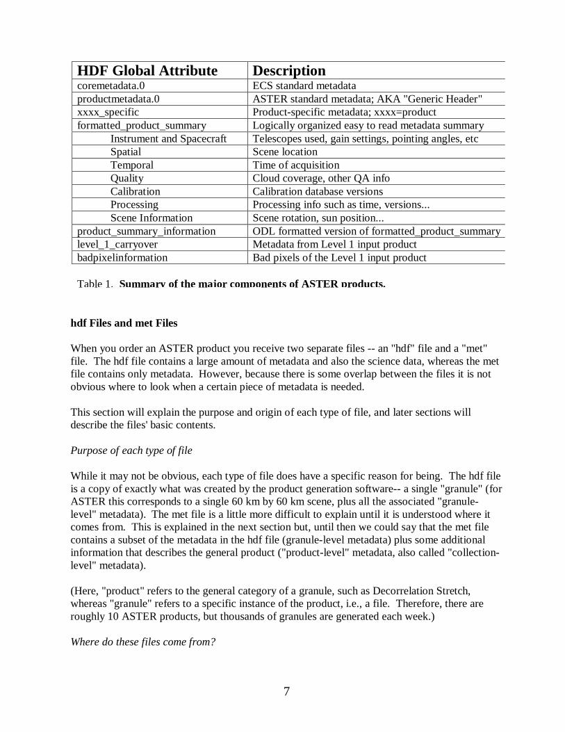
The major components of ASTER products (which correspond to global hdf attributes), alongwith a brief description of each, can be found in Table 1. Most users find the organization of thefirst three components to be rather unfriendly but, fortunately, ASTER products have a globalhdf attribute called formatted_product_summary. Although the information it contains isextracted from the first three components, it is organized in a much more logical manner, makingit easier to find items of interest. Note: There is also a global hdf attribute called"product_summary_information"--this contains the same information asformatted_product_summary but it is in ODL format, a machine-oriented format that is muchharder to read.
There is also a component containing very detailed product-specific information, as well as twocomponents that carry over information from the Level 1 file used as input.
7
hdf Files and met Files
When you order an ASTER product you receive two separate files -- an "hdf" file and a "met"file. The hdf file contains a large amount of metadata and also the science data, whereas the metfile contains only metadata. However, because there is some overlap between the files it is notobvious where to look when a certain piece of metadata is needed.
This section will explain the purpose and origin of each type of file, and later sections willdescribe the files' basic contents.
Purpose of each type of file
While it may not be obvious, each type of file does have a specific reason for being. The hdf fileis a copy of exactly what was created by the product generation software-- a single "granule" (forASTER this corresponds to a single 60 km by 60 km scene, plus all the associated "granule-level" metadata). The met file is a little more difficult to explain until it is understood where itcomes from. This is explained in the next section but, until then we could say that the met filecontains a subset of the metadata in the hdf file (granule-level metadata) plus some additionalinformation that describes the general product ("product-level" metadata, also called "collection-level" metadata).
(Here, "product" refers to the general category of a granule, such as Decorrelation Stretch,whereas "granule" refers to a specific instance of the product, i.e., a file. Therefore, there areroughly 10 ASTER products, but thousands of granules are generated each week.)
Where do these files come from?
HDF Global Attribute Descriptioncoremetadata.0 ECS standard metadataproductmetadata.0 ASTER standard metadata; AKA "Generic Header"xxxx_specific Product-specific metadata; xxxx=productformatted_product_summary Logically organized easy to read metadata summary
Instrument and Spacecraft Telescopes used, gain settings, pointing angles, etcSpatial Scene locationTemporal Time of acquisitionQuality Cloud coverage, other QA infoCalibration Calibration database versionsProcessing Processing info such as time, versions...Scene Information Scene rotation, sun position...
product_summary_information ODL formatted version of formatted_product_summarylevel_1_carryover Metadata from Level 1 input productbadpixelinformation Bad pixels of the Level 1 input product
Table 1. Summary of the major components of ASTER products.
8
Although you don’t have to know the answer to this question, it is an area of confusion for mostusers. It is useful for understanding the differences between these files, and will help you decidewhere to look for what you want. Of course, the explanation is not simple, and perhaps lengthierthan you wish to read. If so, just skip this section, but remember this:the best place to look formetadata of interest is in the global hdf attribute called “formatted_product_summary”,which is explained later in this document.
So, where do these files come from? We’ll answer this question first by explaining the simplecase -- archived products such as routinely generated Decorrelation Stretch. Then we willexplain the slightly more complicated case of non -archived products such as the atmosphericallycorrected products.
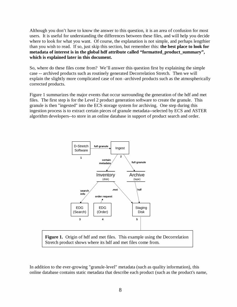
Figure 1 summarizes the major events that occur surrounding the generation of the hdf and metfiles. The first step is for the Level 2 product generation software to create the granule. Thisgranule is then "ingested" into the ECS storage system for archiving. One step during thisingestion process is to extract certain pieces of granule metadata--selected by ECS and ASTERalgorithm developers--to store in an online database in support of product search and order.
In addition to the ever-growing "granule-level" metadata (such as quality information), thisonline database contains static metadata that describe each product (such as the product's name,
D-StretchSoftware
Ingest
EDG(Search)
Archive(tape)
Inventory(disk)
EDG(Order)
StagingDisk
User Pickup
hdf.met
full granule
certainmetadata
searchinfo
order request
full granule
1
5
2
3 4
Figure 1. Origin of hdf and met files. This example using the DecorrelationStretch product shows where its hdf and met files come from.

9
what instrument it comes from, and contact information). This static, product-level metadata isknown as "Collection-level" metadata. Collection-level metadata is information that applies to anentire collection of granules: for ASTER, such a “collection” is simply a product, such asDecorrelation Stretch.
So, at this point we have a lot of metadata stored online, as well as a granule in the archive thatcontains science data and metadata. The next step is for the user to search for, and then order, aproduct using the EOS Data Gateway (EDG). The system responds to this order by extractingthe hdf file from the archive and placing a copy on a staging disk. Also, it creates a copy of theappropriate online metadata -- this is the met file -- and places that on a staging disk. This metfile contains all the granule-level metadata extracted during ingest and stored online by thesystem (well, almost--see below), plus the appropriate collection-level metadata.
For products that are not archived, and so not ordered using EDG, this sequence is slightly morecomplicated. In this case the EDG is used to locate the 1a or 1b granule, and the On-DemandProduct Request software used to order it. This request goes to the DAAC, where it is handled inthe same manner as for archived products. In fact, the granule is actually archived, though onlytemporarily, and it is deleted after the user pulls the data from the staging disk. In any case, theuser still obtains the hdf and met files, and their content is the same as for archived products.
The granule-level metadata in the met file may differ slightly from the metadata extracted fromthe granule during ingest. This is because there are several Quality Assessment fields that can bemodified after the granule is archived. The met file will contain the latest values for these fields,whereas the hdf file contains the original values.
What Is in the hdf File?
The short answer to this question, to use one set of commonly applied terminology, is "metadata"and "data" (the data are often call the "product body"). That is rather imprecise--what the usersof these terms are really doing is distinguishing two format categories: ODL (for metadata), andeverything else. These are described below for your reading pleasure.
Metadata
Metadata are contained in a series of components within the hdf file (each component is a globalhdf attribute). These components are in ODL format (Object Description Language), a widelyused format for certain types of information that always has the form of ATTRIBUTE =VALUE. It is widely used because it is easy to parse and search…if you are a machine. Mostnormal people find it extremely verbose and sometimes poorly organized, making it hard to findspecific attributes of interest. With enough practice you will probably adjust to that.Alternatively, you can use an EOS-provided tool to streamline it into a much more readableformat. This tool, called ufm for “user friendly metadata” is available at
http://hdfeos.gsfc.nasa.gov/hdfeos/ufm1_3.html

10
Although the hdf file contains a variety of global attributes, one of these is special. The hdfattribute calledformatted_product_summary is a composite of most of the useful informationin all the other components, organized in a logical fashion, and in human-friendly format (notODL). This global hdf attribute was created specifically to provide ASTER users with a singleplace to go for metadata information, thus minimizing the need for understanding details of thehdf file and of metadata organization. A summary of the contents of this component appears inAppendix A.
However, if you need to look at some of the other components, for example, for information notin the summary, here is an explanation of those. A complete listing of the contents of each ofthese is available in Section 5. Also, Appendix B contains an index of metadata attributes thatcross-reference to the global hdf attribute that contain them. With that, if you know the name ofa metadata attribute, you can find which hdf attribute to search in.
StructMetadata.0.This is for system use during creation and archival of the product, and shouldbe ignored by users.
coremetadata.0.This contains information common to all ECS products such as the spatial andtemporal boundaries of the granule, the production time of the granule, and certain qualityinformation. True “core” attributes, as well as Product-Specific Attributes (PSAs) are included.It is sometimes referred to as “inventory”.
productmetadata.0.This contains information common to all ASTER products, such as thedatabase version used during Level 1 processing, pointing angles, and which telescopes were on.
xxx_specific. This contains product dependent metadata, and so varies from product to product("xxx" will be replaced with a name or indicator for a real product). Typically it includes thevalues of any run-time parameters and various processing statistics.
formatted_product_summary. As already described, this contains most of the usefulinformation that can be found in all the other components, but organized into a single, coherentwhole. In general, this is the first place you should go to find product information, and typicallyit should be the only place you'll need to go to learn about the granule.
product_summary_information.This is an ODL-formatted version of the previous attribute.
level_1_carryover.This contains a copy of the metadata from the original Level 1 granule.Because the quality and characteristics of the higher-level granule depend on the L1 inputgranule, access to this information could be important.
badpixelinformation.This identifies the bad pixels found during Level 1 processing and iscarried over from the Level 1 input granule.
Product Body
11
The term Product Body is sometimes used for all parts of the product that are not in ODL format.For ASTER products the body conforms to HDF-EOS "Swath" format, a standard EOS formatdescribed in great detail elsewhere (see Additional Resources in Introduction). ASTER productscontain a geolocation area and a variety of other data areas that vary in contents and format.Most “science data” is contained in "planes" consisting of lines of pixels that correspond to thelines of pixels in the input product. There are also some specialized planes that contain pixel-level Quality Assessment data. Here is a summary of each of the major body components.
Geolocation Fields.Geolocation information is contained in an 11 by 11 grid for each granule.Such a grid is a standard item for HDF-EOS "swath" format products (see the HDF-EOSspecification for details). Geolocation of any individual science pixel is obtained byinterpolation between the grid points. Some users interpolate between the four corners instead ofusing the swath grid, however this is not recommended due to accuracy considerations.
Data fields. These fields contain various types of science data, depending upon the product.Typically each band corresponds to a data plane (such as “surface radiance for band 6”), butsome information may exist in other formats (such as the emissivity histograms for SurfaceKinetic Temperature).
QA Fields. Each Level 2 ASTER product contains two or three data planes forpixel-level QAinformation. The first QA data plane is common to all L2 ASTER products while the other dataplanes are product-specific. These data planes are described in detail in the ASTER Higher-Level Data Product Quality Assessment Plan. Note thatgranule-level QA information isavailable in the metadata.
What Is In the met File?
As discussed previously, the information in the met file is extracted from the online metadatadatabase at the time a product order is filled. The basic components of the met file are providedbelow. Note that if a QA field has been updated since the granule was created, the met file willcontain the updated value of the field. The fields subject to possible update are:
• OperationalQualityFlag• OperationalQualityFlagExplanation• ScienceQualityFlag• ScienceQualityFlagExplanation
"Collection" level metadata.This type of metadata applies to all granules within a “collection”(for ASTER, a collection is a product, like Surface Radiance--VNIR, SWIR, or Surface KineticTemperature). It contains information such as the product's name, what instrument it comesfrom, and contact information. Some of this information may also be contained elsewhere.
“Core” metadata.For higher-level products this is a copy of coremetadata.0, but includes anyupdates to the QA fields listed above. Note that for Level 1 products it is a slightly reformatted

12
version of the same information (this reformatting occurs during ingest of Level 1 products andhelps to make the data more easily searchable).
PSAs. These are Product-Specific Attributes, which are non-core attributes that have been madesearchable--that is, placed online so they are available to the EDG search engine. Having saidthat, PSAs are included in coremetdata.0.
Some Key Pieces of Information About ASTER Products
Here is a short list of facts that all users of ASTER data should know.
1. Product Summary. If you need a piece of metadata, go first to the"formatted_product_summary" section described above. This section includes all of the mostcommonly used metadata, is easy to find, and exists in a user-friendly version meant only forpeople (ie, no ODL).
2. Geodetic vs Geocentric Coordinates.While all metadata use geodetic coordinates, the L1swath data are in geocentric coordinates, which are slightly different. L2 and higher productsgenerated in the US have swath data that are in geodetic coordinates.
3. UTM Map Projection. The default map projection, applied during generation of 1b, isUTM. However, these granules are path oriented (following the ground track) rather than maporiented (with North up). Thus, ASTER scenes are rotated from North by an amount equal toSceneOrientationAngle (a metadata attribute whose value you can find in the Product Summary).
4. Expedited Data Differences.Expedited data are slightly different from non-expedited,differing in the following ways:
a. No TIR short-term calibration information includedb. No band 3bc. Registration quality may be lower, especially if scene has few features.d. No xAR_ID

13
SECTION 3: ASTER Higher-Level Products
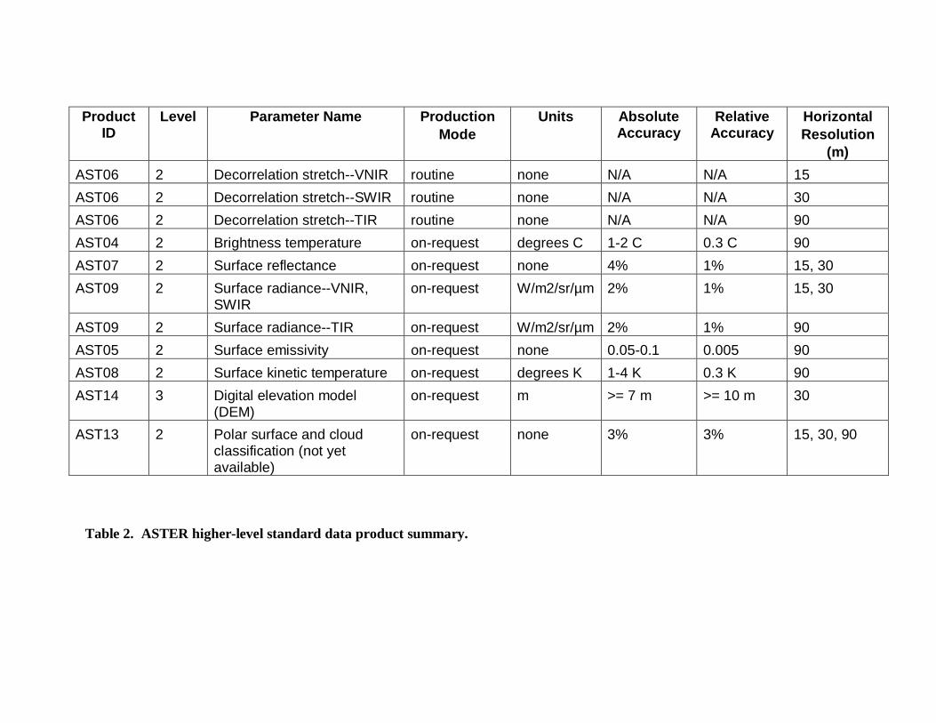
Table 2 lists each of the ASTER higher-level Standard Data Products and some of their basiccharacteristics.
Following that is an abstract of each product. These summaries give a brief overview of theproduct and the algorithm used to create it.
ProductID
Level Parameter Name ProductionMode
Units AbsoluteAccuracy
RelativeAccuracy
HorizontalResolution
(m)
AST06 2 Decorrelation stretch--VNIR routine none N/A N/A 15
AST06 2 Decorrelation stretch--SWIR routine none N/A N/A 30
AST06 2 Decorrelation stretch--TIR routine none N/A N/A 90
AST04 2 Brightness temperature on-request degrees C 1-2 C 0.3 C 90
AST07 2 Surface reflectance on-request none 4% 1% 15, 30
AST09 2 Surface radiance--VNIR,SWIR
on-request W/m2/sr/µm 2% 1% 15, 30
AST09 2 Surface radiance--TIR on-request W/m2/sr/µm 2% 1% 90
AST05 2 Surface emissivity on-request none 0.05-0.1 0.005 90
AST08 2 Surface kinetic temperature on-request degrees K 1-4 K 0.3 K 90
AST14 3 Digital elevation model(DEM)
on-request m >= 7 m >= 10 m 30
AST13 2 Polar surface and cloudclassification (not yetavailable)
on-request none 3% 3% 15, 30, 90
Table 2. ASTER higher-level standard data product summary.
15
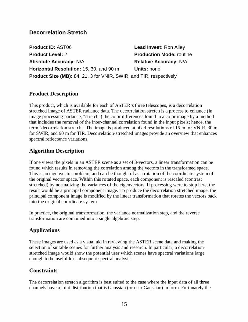
Decorrelation Stretch
Product ID: AST06 Lead Invest: Ron Alley
Product Level: 2 Production Mode: routine
Absolute Accuracy: N/A Relative Accuracy: N/A
Horizontal Resolution: 15, 30, and 90 m Units: none
Product Size (MB): 84, 21, 3 for VNIR, SWIR, and TIR, respectively
Product Description
This product, which is available for each of ASTER’s three telescopes, is a decorrelationstretched image of ASTER radiance data. The decorrelation stretch is a process to enhance (inimage processing parlance, “stretch”) the color differences found in a color image by a methodthat includes the removal of the inter-channel correlation found in the input pixels; hence, theterm “decorrelation stretch”. The image is produced at pixel resolutions of 15 m for VNIR, 30 mfor SWIR, and 90 m for TIR. Decorrelation-stretched images provide an overview that enhancesspectral reflectance variations.
Algorithm Description
If one views the pixels in an ASTER scene as a set of 3-vectors, a linear transformation can befound which results in removing the correlation among the vectors in the transformed space.This is an eigenvector problem, and can be thought of as a rotation of the coordinate system ofthe original vector space. Within this rotated space, each component is rescaled (contraststretched) by normalizing the variances of the eigenvectors. If processing were to stop here, theresult would be a principal component image. To produce the decorrelation stretched image, theprincipal component image is modified by the linear transformation that rotates the vectors backinto the original coordinate system.
In practice, the original transformation, the variance normalization step, and the reversetransformation are combined into a single algebraic step.
Applications
These images are used as a visual aid in reviewing the ASTER scene data and making theselection of suitable scenes for further analysis and research. In particular, a decorrelation-stretched image would show the potential user which scenes have spectral variations largeenough to be useful for subsequent spectral analysis
Constraints
The decorrelation stretch algorithm is best suited to the case where the input data of all threechannels have a joint distribution that is Gaussian (or near Gaussian) in form. Fortunately the

16
algorithm is fairly insensitive to substantial deviations from the ideal. One should be aware,though, that if the distribution of the input pixels is strongly bimodal (or multimodal), theeffectiveness of the decorrelation stretch is weakened, and there will be less diversity of color inthis image than in other images.
Additionally, the decorrelation stretch algorithm is a method of color enhancement that exploitswhatever interchannel differences that may exist. Implicit in this technique is the assumption thatthe differences are real, and not noise or processing artifacts. The algorithm single-mindedlyproduces a color enhanced output; if noise is a major component of the scene variation, thealgorithm will enhance those noise differences to produce an output that, while colorful, will bepainfully noisy.
17
Brightness Temperature at Sensor
Product ID: AST04 Lead Invest: Ron Alley
Product Level: 2 Production Mode: on-request
Absolute Accuracy: 1-2 C Relative Accuracy: 0.3 C
Horizontal Resolution: 90 m Units: degrees C
Product Size (MB): 84
Product DescriptionThe body of this product is the brightness temperature for ASTER's five thermal-infrared bands (8-12µm, bands 10-14). Brightness temperature is the apparent observed temperature, assuming a surface emissivity of 1.0 (i.e., as if theobject were a blackbody). The calculations are performed starting with the radiance at sensor as input; noatmospheric correction is included for this product.
Algorithm Description
The amount of radiance that an ASTER channel will observe when viewing a source of a particular temperature iscalculated in the following manner. The spectral radiance at each wavelength (to a 0.01µm precision) is computedusing the Planck function. This value is multiplied by the normalized spectral response function at that wavelength,and the results of this calculation are integrated over the range of wavelengths that have a sensor response.
The above calculation was made for each of the five ASTER TIR channels at all temperatures (toa 0.01 degree C precision) that the ASTER TIR subsystem was designed to record (200 to 370degrees Kelvin). The result is a table of observed radiances as a function of temperature. Thistable was used to construct a second table, which lists temperature as a function of radiance. Thissecond table is stored as a lookup table, to be used to generate this product.
Applications
Brightness temperature has been used to observe volcanic ash clouds, detect ice leads in theArctic, and to identify anthropogenic and natural fires, to name a few examples. The ASTERbrightness temperature will be used as an alternate to radiance in the temperature/emissivityseparation algorithm to report relative cloud-top temperature because there will be no routinelyavailable applicable atmospheric correction to enable a calculation of exact cloud-toptemperature. ASTER brightness temperatures can be acquired during the day or night and overall surface types (land, water, cloud, etc.).
Constraints
The algorithm is constrained only by the fact that it requires unsaturated input radiance values.The algorithm should work on TIR data acquired during the day or night and over land, clouds,water, or anything else not hotter than about 120 degrees C or colder than about –100 degrees C.
18
Surface Reflectance
Product ID: AST07 Lead Invest: Kurt Thome
Product Level: 2 Production Mode: on-requestAbsolute Accuracy: 0.01 for reflectance <0.15, 7% for reflectance >0.15Relative Accuracy: 0.005Horizontal Resolution: 15, 30 m Units: noneProduct Size (MB): 215
Product Description
The Level 2 surface reflectance data set (AST07) contains surface reflectance for each of thenine VNIR and SWIR bands at 15-m and 30-m resolutions, respectively. The results areobtained by applying an atmospheric correction to radiances reported by the ASTER sensor. Theatmospheric correction removes effects due to changes in satellite-sun geometry and atmosphericconditions. The atmospheric correction algorithm is applied to clear-sky pixels only and theresults are reported as a number between 0 and 1.
Algorithm Description
The atmospheric correction algorithm used to retrieve the surface reflectance relies on a look-uptable (LUT) approach. The LUT contains forward radiative transfer calculations from a Gauss-Seidel iteration code to compute at-satellite radiance for a set of assumed surface reflectancevalues and a variety of atmospheric conditions. The atmospheric correction is applied by using aset of input atmospheric conditions relating to the ASTER scene of interest to select a portion ofthe LUT. The output of the LUT search is a set of surface reflectance/at-sensor radiance pairs.Using linear interpolation on these pairs, a radiance reported by ASTER is converted to a surfacereflectance. The atmospheric conditions are defined by the aerosol size distribution (orequivalently the aerosol type), the aerosol amount, surface pressure, and the sun-satellitegeometry, The aerosol information is obtained from outside sources, for example MISR,MODIS, or climatological means. The scattering phase functions of the aerosol particles in theatmosphere are assumed to scatter as mie particles using the aerosol size distribution informationsupplied by MISR or MODIS. The results from this method will be in reflectance units (valuesbetween 0 and 1) with an accuracy dependent upon the accuracy of input atmospheric conditionsand the surface slope. The model is expected to lose accuracy in terrain with high relief due tothe assumption of horizontal homogeneity made in the radiative transfer code. Also because ofthis assumption, the model will give less accurate results in regions where the atmosphere orsurface are not horizontally homogeneous on the scale of several pixels.
Applications
Accurate atmospheric correction removes effects of changes in satellite-sun geometry andatmospheric conditions and improves surface type classification and estimates of the Earth's
19
radiation budget, and use of ASTER data for applications such as agricultural managementrequires atmospheric correction.
Constraints
This description applies to the atmospheric correction method used for the solar-reflective bandsonly for clear-sky pixels. This algorithm requires a digital elevation model providing slope andelevation for accurate modeling of surface reflectance. The model requires total and componentoptical depths as input. The algorithm is computed only for daytime image data for the VNIR -SWIR bands. The algorithm begins to break down at large view angles (not applicable forASTER) and large solar zenith angles (>75 degrees). The algorithm’s accuracy also degradessomewhat in regions around the backscatter direction due to strong surface BRDF effects.Uncertainty in the results also increases in regions of atmospheric heterogeneity.
20
Surface Radiance – VNIR, SWIR
Product ID: AST09 Lead Invest: Kurt Thome
Product Level: 2 Production Mode: on-requestAbsolute Accuracy: 8% for reflectance >0.1; 15% for reflectance <0.1Relative Accuracy: 1%Horizontal Resolution: 15, 30 m Units: W m-2 sr-1 µm-1
Product Size (MB): 215
Product Description
The Level 2 surface radiance data set (AST09) contains surface radiance for each of the nineVNIR and SWIR bands at 15-m and 30-m resolutions, respectively. The results are obtained byapplying an atmospheric correction to radiances reported by the ASTER sensor. Theatmospheric correction removes effects due to changes in satellite-sun geometry and atmosphericconditions. The atmospheric correction algorithm is applied to clear-sky pixels only and theresults are reported as a number between 0 and 1.
Algorithm Description
The atmospheric correction algorithm used to retrieve the surface radiance relies on a look-uptable (LUT) approach. The LUT contains forward radiative transfer calculations from a Gauss-Seidel iteration code to compute at-satellite radiance for a set of assumed surface reflectancevalues and a variety of atmospheric conditions. The atmospheric correction is applied by using aset of input atmospheric conditions relating to the ASTER scene of interest to select a portion ofthe LUT. The output of the LUT search is a set of surface radiance/at-sensor radiance pairs.Using linear interpolation on these pairs, a radiance reported by ASTER is converted to a surfaceradiance. The atmospheric conditions are defined by the aerosol size distribution (orequivalently the aerosol type), the aerosol amount, surface pressure, and the sun-satellitegeometry, The aerosol information is obtained from outside sources, for example MISR,MODIS, or climatological means. The scattering phase functions of the aerosol particles in theatmosphere are assumed to scatter as mie particles using the aerosol size distribution informationsupplied by MISR or MODIS. The accuracy of the results from this method are dependent uponthe accuracy of input atmospheric conditions and the surface slope. The model is expected tolose accuracy in terrain with high relief due to the assumption of horizontal homogeneity madein the radiative transfer code. Also because of this assumption, the model will give less accurateresults in regions where the atmosphere or surface are not horizontally homogeneous on the scaleof several pixels.
Applications
Accurate atmospheric correction removes effects of changes in satellite-sun geometry andatmospheric conditions and improves surface type classification and estimates of the Earth'sradiation budget, and use of ASTER data for applications such as agricultural managementrequires atmospheric correction.

21
Constraints
This description applies to the atmospheric correction method used for the solar-reflective bandsonly for clear-sky pixels. This algorithm requires a digital elevation model providing slope andelevation for accurate modeling of surface reflectance. The model requires total and componentoptical depths as input. The algorithm is computed only for daytime image data for the VNIR -SWIR bands. The algorithm begins to break down at large view angles (not applicable forASTER) and large solar zenith angles (>75 degrees). The algorithm’s accuracy also degradessomewhat in regions around the backscatter direction due to strong surface BRDF effects.Uncertainty in the results also increases in regions of atmospheric heterogeneity
22
Surface Radiance – TIR
Product ID: AST09 Lead Invest: Frank Palluconi
Product Level: 2 Production Mode: on-requestAbsolute Accuracy: 2% Relative Accuracy: 1%Horizontal Resolution: 90 m Units: W m-2 sr-1 µm-1
Product Size (MB): 13
Product Description
This product provides surface leaving radiance, in W m-2 sr-1 µm-1, for the five ASTER TIRchannels at 90 m spatial resolution. In addition, the down welling sky irradiance in W m-2 µm-1
for the five ASTER TIR channels is also provided. Atmospheric correction has been applied andthe surface leaving radiance is valid for the clear sky portion of scenes. This radiance includesboth surface emitted and surface reflected components. The surface radiance is only of knownaccuracy for cloud-free pixels since insufficient information is available about cloud propertiesfor a valid correction of cloudy pixels.
Accurate atmospheric correction is intended to remove the effect of the atmosphere providing theopportunity to use these radiances in the determination of surface spectral emissivity and surfacekinetic temperature. This atmospheric correction, along with similar corrections for other Terrainstruments, marks the first implementation of operational atmospheric correction inenvironmental satellites. This parameter is generated only upon request, and the data can becollected during either the daytime or nighttime.
Algorithm Description
The radiance measured by the ASTER instrument includes emission, absorption, and scatteringby the constituents of the earth's atmosphere. The purpose of atmospheric correction is toremove these effects providing estimates of the radiation emitted and reflected at the surface.Atmospheric correction is necessary to isolate those features of the observation that are intrinsicto the surface from those caused by the atmosphere.
The approach involves two fundamental elements: 1) the use of a radiation transfer modelcapable of estimating the magnitude of atmosphere emission, absorption, and scattering, and 2)the acquisition of all the necessary atmospheric parameters (i.e. temperature, water vapor, ozone,aerosols) at the time and location of the measurement to be corrected. MODTRAN is the chosenradiation transfer model.
Applications
Surface leaving radiance is closely associated with the thermal properties of the surface itselfnearly independent of the overlying atmosphere. If the spectral emissivity of the surface isknown, the surface kinetic temperature can be directly obtained given the information providedwith this product. Surface kinetic temperature can be used in a number of applications ranging
23
from derivations of sensible heat flux to estimates of plant stress. Several methods of separatingsurface leaving radiance into estimates of spectral emissivity and surface kinetic temperatureexist including the algorithm used for this process by ASTER. Spectral emissivity can be used toestimate surface composition, which has wide application in geology, environmental assessmentand urban planning.
Constraints
The surface leaving radiance is only of known accuracy for cloud-free pixels. As this dataproduct does not correct for the presence of water or ice clouds it is of uncertain value when suchclouds are present, however, a cloud mask is included in the quality assurance "QA plane"portion of the product, allowing the user to avoid cloudy pixels. In addition, the cloud identityproducts from MODIS and MISR may be used if the spatial resolution of these products isacceptable. This product is used within the ASTER operational data product productionframework as an input to the generation of surface spectral emissivity for the five ASTER TIRchannels and the derivation of surface kinetic temperature.
24
Surface Emissivity
Product ID: AST05 Lead Invest: Gillespie/Rokugawa
Product Level: 2 Production Mode: on-request
Absolute Accuracy: 0.05-0.1 Relative Accuracy: 0.005
Horizontal Resolution: 90 m Units: none
Product Size (MB): 9
Product Description
The Level-2 land surface emissivity product contains surface emissivity at 90-m resolutiongenerated only over the land from ASTER's five thermal infrared channels. Surface emissivity isrequired to derive land surface temperature (AST08) data, also at a resolution of 90 meters. Theemissivity product is critical for deriving accurate land surface temperatures. It is thereforeimportant in studies of surface energy and water balance. The emissivity product is also usefulfor mapping geologic and land-cover features.
Current sensors provide only limited information useful for deriving surface emissivity andresearchers are required to use emissivity surrogates such as land-cover type or vegetation indexin making rough estimates of emissivity and hence land surface temperatures. The five thermalinfrared channels of the ASTER instrument enable direct surface emissivity estimates. Mappingof thermal features from optical sensors such as Landsat and AVHRR has been used for manydevelopmental studies. These instruments, however, lack the spectral coverage, resolution andradiometric accuracy that will be provided by the ASTER instrument.
Algorithm Description
Read in the land-leaving radiance and down-welling sky irradiance vectors for each pixel.Estimate the emissivity spectrum using the Normalized Emissivity Method and iterativelycompensate for reflected skylight. Normalize the emissivity spectrum using the averageemissivity for each pixel. Calculate the min-max difference (MMD) of the normalized spectrumand estimate the minimum emissivity using a regression that relates the MMD and the minimumemissivity. Scale the normalized emissivities using the minimum emissivity. Compensate forreflected skylight using the refined emissivities. Use the emissivity value to calculate atemperature using Planck's Law.
Applications
Emissivity is useful in identifying surface composition. Many minerals -- especially silicateminerals that make up the bulk of the Earth’s surface -- have distinctive thermal infraredemissivity spectra, but ambiguous or non-distinctive VNIR spectra. Quartz, feldspars,amphiboles, and pyroxenes all are in this category. Carbonate rocks also have distinctivespectra, although the diagnostic features are unresolved by ASTER. Because other minerals --especially iron-bearing and hydrated minerals -- have distinctive VNIR and SWIR spectra,surface composition mapping is best undertaken with the full range of ASTER bands, not just the

25
TIR bands alone.
Rock and soil emissivities also contrast with vegetation, snow and water. Therefore, emissivitydata are useful for mapping forest clearings and snow coverage.
Atmospheric gases such as SO2, emitted from volcanoes, absorb ground-emitted thermalradiation selectively. Therefore, emissivity maps are useful in recognizing the presence ofvolcanic emissions, although special processing is required to quantify them. The samecomments apply to industrial pollution.
Constraints
Currently there are no constraints, and the algorithm should work with TIR data acquired duringthe day or night. The algorithm will return incorrect values for clouds, however, because theatmospheric corrections will have been inaccurate due to a lack of knowledge of cloud height.Therefore, if a pixel is classified as "cloud" on the basis of its spectral and temperaturecharacteristics a notation to that effect will be made in the QA plane. Because clouds radiate tothe ground, pixels not covered by clouds but in their vicinity will also have inaccurateemissivties and spectra, and therefore these pixels are also noted in the QA plane. For coldsurfaces viewed through a warm or humid atmosphere correction for reflected skylight can beinaccurate, leading to inaccurate emissivity estimates.
26
Surface Kinetic Temperature
Product ID: AST08 Lead Invest: Gillespie/Rokugawa
Product Level: 2 Production Mode: on-request
Absolute Accuracy: 1-4 K Relative Accuracy: 0.3 K
Horizontal Resolution: 90 m Units: degrees K
Product Size (MB): 3
Product Description
The Level-2 land surface kinetic temperature product contains surface temperatures at 90-mresolution generated only over the land from ASTER's five thermal infrared channels. Landsurface temperatures are determined from Planck's Law, using the emissivities from AST05 toscale the measured radiances after correction for atmospheric effects. Surface temperatures areimportant in studies of surface energy and water balance. They are also useful in studies ofvolcanism and thermal pollution.
Current sensors provide only limited information useful for deriving surface emissivity, andtherefore land surface temperature estimates can be inaccurate. The five thermal infraredchannels of the ASTER instrument enable direct surface emissivity estimates, and accuratetemperature estimation.
Algorithm Description
See AST05, Surface Emissivity.
Applications
The derived land surface temperature has applications in studies of surface energy and waterbalance. Temperature data will be used in the monitoring and analysis of volcanic processes,day and night temperature data will be used to estimate thermal inertia, and thermal data will beused for high-resolution mapping of fires as a complement to MODIS global fire data. Thermaldata are especially useful in fire studies because they can “see through” smoke to the burningterrain below.
Constraints
See AST05, Surface Emissivity. For cold surfaces viewed through a warm or humid atmospherecorrection for reflected skylight can be inaccurate, leading to inaccurate emissivity estimates.The error increases as the emissivity decreases. Therefore, even if some emissivities areerroneous, surface temperatures may be accurate, provided some of the emissivities are nearunity.

27
Digital Elevation Model (DEM)
Product ID: AST14 Lead Invest: Mike Abrams/Roy Welch
Product Level: 2 Production Mode: on-request
Absolute Accuracy: >= 7 m Relative Accuracy: >= 10 m
Horizontal Resolution: 30 m Units: m
Product Size (MB): 35
Product Description
This data set contains topographic information derived from the along-track, 15 m ASTERoptical stereo data acquired in near infrared bands 3N and 3B. It can be created as a RelativeDEM (no ground control) or an Absolute DEM (with ground control, which must be supplied bythe user). These high spatial resolution DEMs (up to 7 m absolute horizontal and verticalaccuracy with appropriate ground control, and up to 10 m relative accuracy without groundcontrol) can be used to derive absolute slope and slope aspect good to 5 degrees over horizontaldistances of more than 100 m. ASTER DEMs should meet 1:50,000 to 1:250,000 map accuracystandards.
This is an on-request product which will be generated by the Land Processes DAAC at EROSData Center at a rate of one 60 km X 60 km stereo pair/day. Based on simulations of instrumentoperations, mission planning, cloud cover and illumination, an ASTER digital stereo data setwith a base/height ratio of 0.6 should be acquired for all of the Earth's land surface below 82degrees latitude by the end of the 6 year mission. ASTER stereo pairs also can be processed toDEMs by users operating their own software.
Generation of elevation models from stereo photographic data, now a routine adjunct to standardsurveying methods, has been developed over the past 60 years based on the principles ofphotogrammetry. Extensions of these principles to the generation of DEMs from optical, digitalstereo satellite data has been implemented over the past two decades. Examples of these satellitestereo systems include SPOT, JERS-1 OPS, and MOMS. Currently, there are large areas of theglobe for which no consistent, high-resolution, widely available elevation models exist. ASTERDEMs will help provide much needed coverage over many of these areas.
Algorithm Description
An autocorrelation approach using commercial software at the Land DAAC will produce DEMsfrom Level 1A or 1B digital stereo pairs.
Applications
Topographic data as well as derived slope and slope aspect are basic to all aspects of land surfaceresearch including; cartography, climate modeling, biogeochemistry, biogeography, geophysics,geology, geomorphology and soil science. Digital elevation data are also required for

28
atmospheric and radiometric correction of most satellite observations of the land surface. Digitalelevation data are also used for practical engineering applications such as studies of drainage andrunoff, and site suitability studies for urban development, waste containment, and recreation.
Constraints
This product will be produced using off the shelf commercial software. Absolute accuracydepends on availability of investigator-provided ground control point

29
SECTION 4: Product Definitions--Common Information
Many metadata attributes are common to all ASTER products. This section describes each ofthese shared metadata attributes. They are organized according to the hdf component to whichthey belong.
Note: You won't find the QA_Alert_table component in a product if that table is empty, i.e. if noalerts were generated.

30
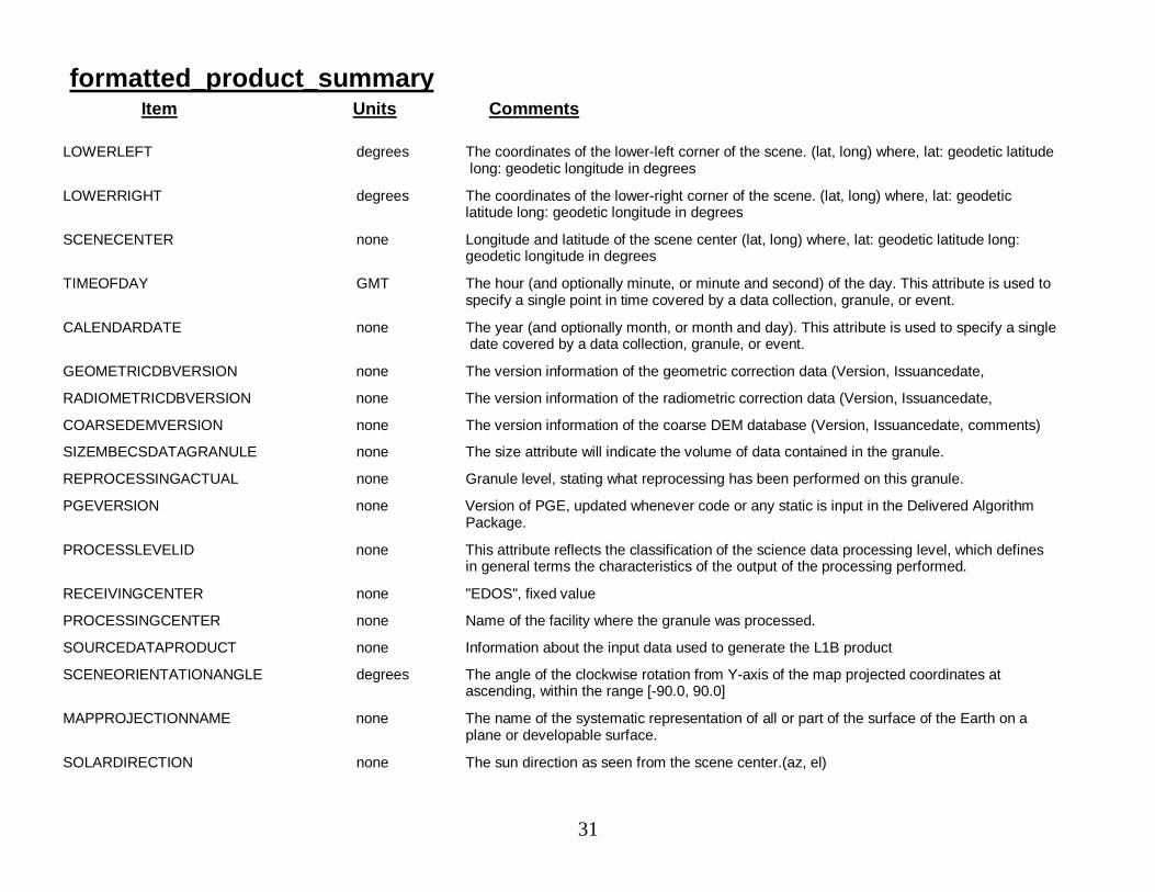
formatted_product_summaryItem Units Comments
ASTEROBSERVATIONMODE none Observation modes for each sensorgroup (VNIR1, VNIR2, SWIR or TIR)
POINTINGINFO none Pointing Angle for the corresponding sensor
GAIN none Band number and Gain setting.
QAPERCENTMISSINGDATA none Granule level % missing data. This attribute can be repeated for individual parameterswithin a granule.
QAPERCENTOUTOFBOUNDSDATA none Granule level % out of bounds data. This attribute can be repeated for individualparameters within a granule.
QAPERCENTINTERPOLATEDDATA none Granule level % interpolated data. This attribute can be repeated for individual parameterswithin a granule.
AUTOMATICQUALITYFLAG none Automatic Quality Flag: Good, Bad or Suspect
SCENECLOUDCOVERAGE none Cloud coverage (in %) of the whole scene
QUADRANTCLOUDCOVERAGE none Cloud coverage (in %) for each of the 4 quarters of the scene (upper left, upper right, lowerleft, lower right
INSTRUMENTSHORTNAME none The unique identifier of an instrument. (ASTER)
SPATIALRESOLUTION none The nominal spatial resolutions of VNIR, SWIR and TIR. (res. of VNIR, res. of SWIR, res. ofTIR)
ASTEROPERATIONMODE none One of three operation modes: OBSERVATION, CALIBRATION or TEST
WESTBOUNDINGCOORDINATE none Pointing Angle for the corresponding sensor Band number and Gain setting Western-mostcoordinate of the limit of coverage expressed in longitude.
NORTHBOUNDINGCOORDINATE none Northern-most limit of coverage expressed in geodetic latitude.
EASTBOUNDINGCOORDINATE none Eastern-most coordinate of the limit of coverage expressed in longitude.
SOUTHBOUNDINGCOORDINATE none Southern-most limit of coverage expressed in geodetic latitude.
UPPERLEFT degrees The coordinates of the upper-left corner of the scene. (lat, long) where, lat: geodeticlatitude long: geodetic longitude in degrees
UPPERRIGHT degrees The coordinates of the upper-right corner of the scene. (lat, long) where, lat: geodeticlatitude long: geodetic longitude in degrees
31
formatted_product_summaryItem Units Comments
LOWERLEFT degrees The coordinates of the lower-left corner of the scene. (lat, long) where, lat: geodetic latitudelong: geodetic longitude in degrees
LOWERRIGHT degrees The coordinates of the lower-right corner of the scene. (lat, long) where, lat: geodeticlatitude long: geodetic longitude in degrees
SCENECENTER none Longitude and latitude of the scene center (lat, long) where, lat: geodetic latitude long:geodetic longitude in degrees
TIMEOFDAY GMT The hour (and optionally minute, or minute and second) of the day. This attribute is used tospecify a single point in time covered by a data collection, granule, or event.
CALENDARDATE none The year (and optionally month, or month and day). This attribute is used to specify a singledate covered by a data collection, granule, or event.
GEOMETRICDBVERSION none The version information of the geometric correction data (Version, Issuancedate,
RADIOMETRICDBVERSION none The version information of the radiometric correction data (Version, Issuancedate,
COARSEDEMVERSION none The version information of the coarse DEM database (Version, Issuancedate, comments)
SIZEMBECSDATAGRANULE none The size attribute will indicate the volume of data contained in the granule.
REPROCESSINGACTUAL none Granule level, stating what reprocessing has been performed on this granule.
PGEVERSION none Version of PGE, updated whenever code or any static is input in the Delivered AlgorithmPackage.
PROCESSLEVELID none This attribute reflects the classification of the science data processing level, which definesin general terms the characteristics of the output of the processing performed.
RECEIVINGCENTER none "EDOS", fixed value
PROCESSINGCENTER none Name of the facility where the granule was processed.
SOURCEDATAPRODUCT none Information about the input data used to generate the L1B product
SCENEORIENTATIONANGLE degrees The angle of the clockwise rotation from Y-axis of the map projected coordinates atascending, within the range [-90.0, 90.0]
MAPPROJECTIONNAME none The name of the systematic representation of all or part of the surface of the Earth on aplane or developable surface.
SOLARDIRECTION none The sun direction as seen from the scene center.(az, el)
32
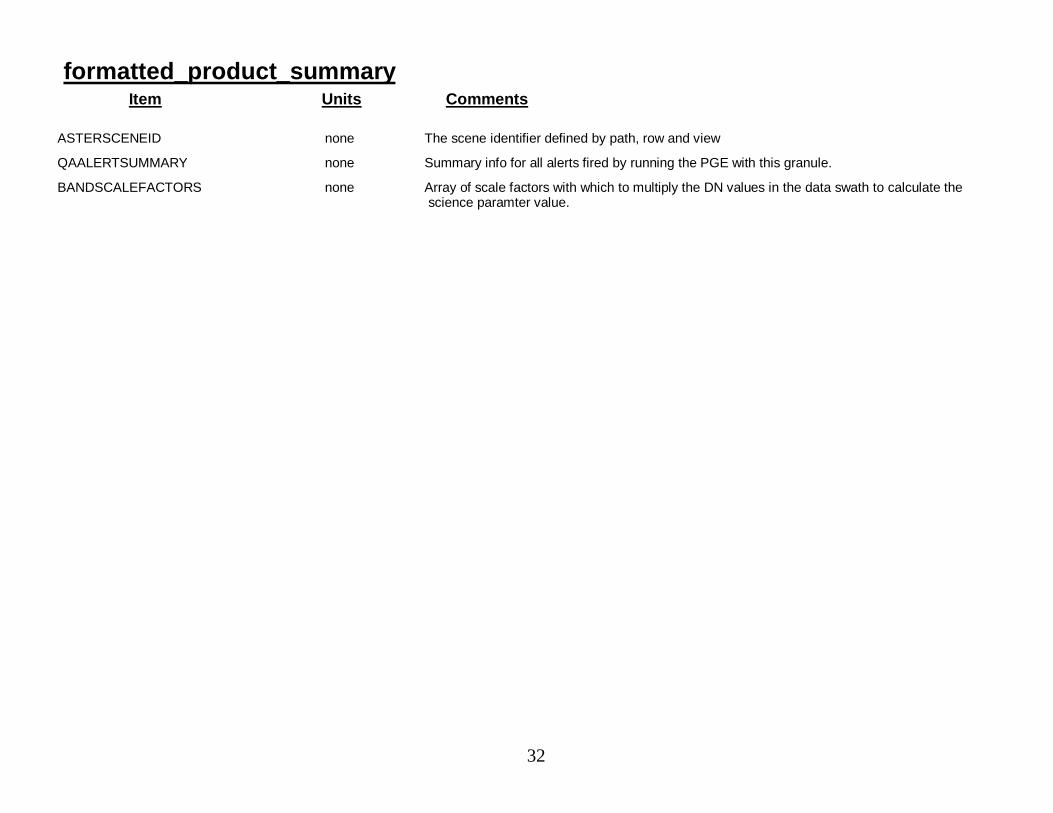
formatted_product_summaryItem Units Comments
ASTERSCENEID none The scene identifier defined by path, row and view
QAALERTSUMMARY none Summary info for all alerts fired by running the PGE with this granule.
BANDSCALEFACTORS none Array of scale factors with which to multiply the DN values in the data swath to calculate thescience paramter value.
33
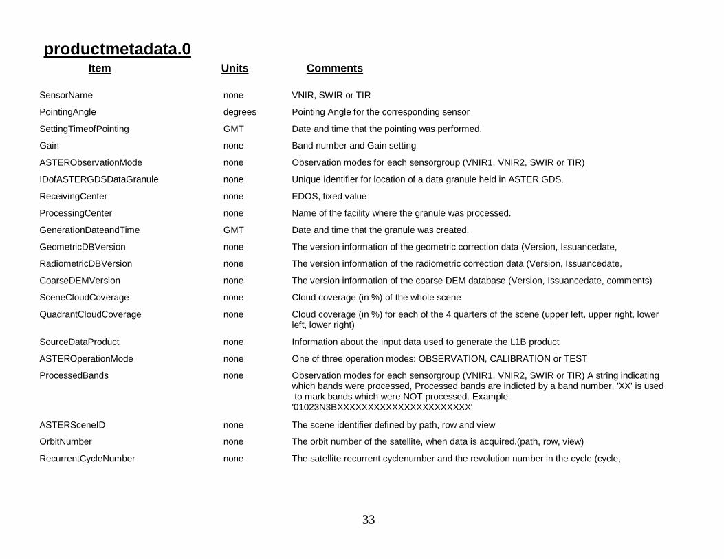
productmetadata.0Item Units Comments
SensorName none VNIR, SWIR or TIR
PointingAngle degrees Pointing Angle for the corresponding sensor
SettingTimeofPointing GMT Date and time that the pointing was performed.
Gain none Band number and Gain setting
ASTERObservationMode none Observation modes for each sensorgroup (VNIR1, VNIR2, SWIR or TIR)
IDofASTERGDSDataGranule none Unique identifier for location of a data granule held in ASTER GDS.
ReceivingCenter none EDOS, fixed value
ProcessingCenter none Name of the facility where the granule was processed.
GenerationDateandTime GMT Date and time that the granule was created.
GeometricDBVersion none The version information of the geometric correction data (Version, Issuancedate,
RadiometricDBVersion none The version information of the radiometric correction data (Version, Issuancedate,
CoarseDEMVersion none The version information of the coarse DEM database (Version, Issuancedate, comments)
SceneCloudCoverage none Cloud coverage (in %) of the whole scene
QuadrantCloudCoverage none Cloud coverage (in %) for each of the 4 quarters of the scene (upper left, upper right, lowerleft, lower right)
SourceDataProduct none Information about the input data used to generate the L1B product
ASTEROperationMode none One of three operation modes: OBSERVATION, CALIBRATION or TEST
ProcessedBands none Observation modes for each sensorgroup (VNIR1, VNIR2, SWIR or TIR) A string indicatingwhich bands were processed, Processed bands are indicted by a band number. 'XX' is usedto mark bands which were NOT processed. Example
'01023N3BXXXXXXXXXXXXXXXXXXXXXX'
ASTERSceneID none The scene identifier defined by path, row and view
OrbitNumber none The orbit number of the satellite, when data is acquired.(path, row, view)
RecurrentCycleNumber none The satellite recurrent cyclenumber and the revolution number in the cycle (cycle,

34
productmetadata.0Item Units Comments
FlyingDirection none The satellite flight direction when observation is done. `AS': ascending direction. `DE':descending direction
SolarDirection degrees The sun direction as seen from the scene center.(az, el)
SpatialResolution m The nominal spatial resolutions of VNIR, SWIR and TIR. (res. of VNIR, res. of SWIR, res. ofTIR)
UpperLeft degrees The coordinates of the upper-left corner of the scene. (lat, long) where, lat: geodeticlatitude long: geodetic longitude in degrees
UpperRight degrees The coordinates of the upper-right corner of the scene. (lat, long) where, lat: geodeticlatitude long: geodetic longitude in degrees
LowerLeft degrees The coordinates of the lower-left corner of the scene. (lat, long) where, lat: geodetic latitudelong: geodetic longitude in degrees
LowerRight degrees The coordinates of the lower-right corner of the scene. (lat, long) where, lat: geodeticlatitude long: geodetic longitude in degrees
SceneCenter degrees Longitude and latitude of the scene center (lat, long) where, lat: geodetic latitude long:geodetic longitude in degrees
SceneOrientationAngle degrees The angle of the clockwise rotation from Y-axis of the map projected coordinates atascending, within the range [-90.0, 90.0]
BandScaleFactors none Array of scale factors with which to multiply the DN values in the data swath to calculate thescience paramter value.
35
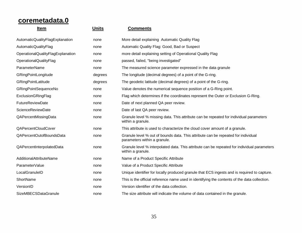
coremetadata.0Item Units Comments
AutomaticQualityFlagExplanation none More detail explaining Automatic Quality Flag
AutomaticQualityFlag none Automatic Quality Flag: Good, Bad or Suspect
OperationalQualityFlagExplanation none more detail explaining setting of Operational Quality Flag
OperationalQualityFlag none passed, failed, "being investigated"
ParameterName none The measured science parameter expressed in the data granule
GRingPointLongitude degrees The longitude (decimal degrees) of a point of the G-ring.
GRingPointLatitude degrees The geodetic latitude (decimal degrees) of a point of the G-ring.
GRingPointSequenceNo none Value denotes the numerical sequence position of a G-Ring point.
ExclusionGRingFlag none Flag which determines if the coordinates represent the Outer or Exclusion G-Ring.
FutureReviewDate none Date of next planned QA peer review.
ScienceReviewDate none Date of last QA peer review.
QAPercentMissingData none Granule level % missing data. This attribute can be repeated for individual parameterswithin a granule.
QAPercentCloudCover none This attribute is used to characterize the cloud cover amount of a granule.
QAPercentOutofBoundsData none Granule level % out of bounds data. This attribute can be repeated for individualparameters within a granule.
QAPercentInterpolatedData none Granule level % interpolated data. This attribute can be repeated for individual parameterswithin a granule.
AdditionalAttributeName none Name of a Product Specific Attribute
ParameterValue none Value of a Product Specific Attribute
LocalGranuleID none Unique identifier for locally produced granule that ECS ingests and is required to capture.
ShortName none This is the official reference name used in identifying the contents of the data collection.
VersionID none Version identifier of the data collection.
SizeMBECSDataGranule none The size attribute will indicate the volume of data contained in the granule.
36
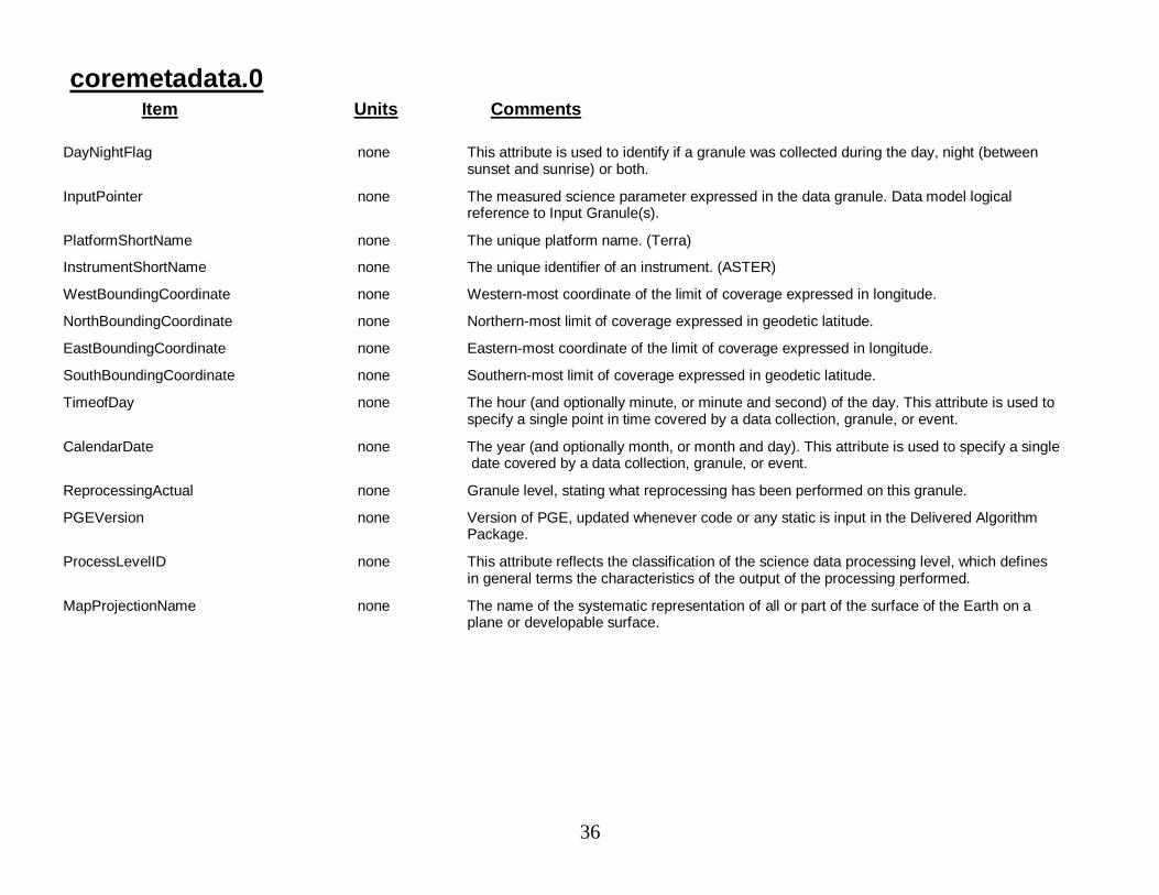
coremetadata.0Item Units Comments
DayNightFlag none This attribute is used to identify if a granule was collected during the day, night (betweensunset and sunrise) or both.
InputPointer none The measured science parameter expressed in the data granule. Data model logicalreference to Input Granule(s).
PlatformShortName none The unique platform name. (Terra)
InstrumentShortName none The unique identifier of an instrument. (ASTER)
WestBoundingCoordinate none Western-most coordinate of the limit of coverage expressed in longitude.
NorthBoundingCoordinate none Northern-most limit of coverage expressed in geodetic latitude.
EastBoundingCoordinate none Eastern-most coordinate of the limit of coverage expressed in longitude.
SouthBoundingCoordinate none Southern-most limit of coverage expressed in geodetic latitude.
TimeofDay none The hour (and optionally minute, or minute and second) of the day. This attribute is used tospecify a single point in time covered by a data collection, granule, or event.
CalendarDate none The year (and optionally month, or month and day). This attribute is used to specify a singledate covered by a data collection, granule, or event.
ReprocessingActual none Granule level, stating what reprocessing has been performed on this granule.
PGEVersion none Version of PGE, updated whenever code or any static is input in the Delivered AlgorithmPackage.
ProcessLevelID none This attribute reflects the classification of the science data processing level, which definesin general terms the characteristics of the output of the processing performed.
MapProjectionName none The name of the systematic representation of all or part of the surface of the Earth on aplane or developable surface.

37
QA_alert_tableItem Units Comments
QAStatNumTempOOR none The number of pixels with a possible but out-of-range temperature
QAStatNumAddlBadPixels none The additional number of bad pixels added by L2 processing.
QAStatNumPixAllBndsOOR none The number of pixels where all bands exceed their critical values
QAStatLUTExtrpReqd none The atmospheric correction required extrapolation of the LUT
QAStatPctFailPixels none The % of pixels for which the algorithm fails
QAStatPctBadPixels none The % of pixels that are bad in the output product
QAStatPctHiUncertPixels none The % of pixels with high uncertainty values
QAAlertNumTempImposs none Summary Statistic QAStatNumTempImposs exceeded threshold value and triggered this
QAAlertNumTempOOR none Summary Statistic QAStatNumTempOOR exceeded threshold value and triggered this alert
QAAlertOffDiagElemOOR none Any off-diagonal input correlation matrix element is greater than or equal to one
QAAlertEigenvalOOR none Any of the three eigenvalues is less than a threshold value
QAAlertOffDiagInpLTLim none An off-diagonal input correlation matrix element is less than a threshold value
QAAlertNumAddlBadPixels none Summary Statistic QAStatNumAddlBadPixels exceeded threshold value and triggered thisalert
QAAlertNumPixAllBndsOOR none Summary Statistic QAStatNumPixAllBndsOOR exceeded threshold value and triggered thisalert
QAAlertLUTExtrpReqd none The atmospheric correction required extrapolation of the LUT
QAAlertPctFailPixels none Summary Statistic QAStatPctFailPixels exceeded threshold value and triggered this alert
QAAlertPctBadPixels none Summary Statistic QAStatPctBadPixels exceeded threshold value and triggered this alert
QAAlertPctHiUncertPixels none Summary Statistic QAStatPctHiUncertPixels exceeded threshold value and triggered this
QACritAlertsCnt none Here are the Alert-related Product Specific Attributes (PSA) Number of Critical Alertstriggered
QANonCritAlertsCnt none Number of Non-Critical Alerts triggered
QASummaryOfAlerts none Summary information for all alerts triggered during the processing of this granule.
38
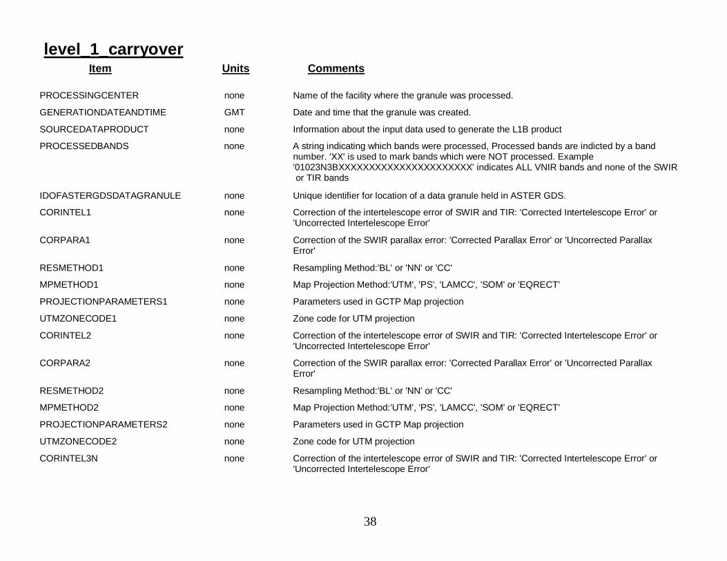
level_1_carryoverItem Units Comments
PROCESSINGCENTER none Name of the facility where the granule was processed.
GENERATIONDATEANDTIME GMT Date and time that the granule was created.
SOURCEDATAPRODUCT none Information about the input data used to generate the L1B product
PROCESSEDBANDS none A string indicating which bands were processed, Processed bands are indicted by a bandnumber. 'XX' is used to mark bands which were NOT processed. Example'01023N3BXXXXXXXXXXXXXXXXXXXXXX' indicates ALL VNIR bands and none of the SWIRor TIR bands
IDOFASTERGDSDATAGRANULE none Unique identifier for location of a data granule held in ASTER GDS.
CORINTEL1 none Correction of the intertelescope error of SWIR and TIR: 'Corrected Intertelescope Error' or'Uncorrected Intertelescope Error'
CORPARA1 none Correction of the SWIR parallax error: 'Corrected Parallax Error' or 'Uncorrected ParallaxError'
RESMETHOD1 none Resampling Method:'BL' or 'NN' or 'CC'
MPMETHOD1 none Map Projection Method:'UTM', 'PS', 'LAMCC', 'SOM' or 'EQRECT'
PROJECTIONPARAMETERS1 none Parameters used in GCTP Map projection
UTMZONECODE1 none Zone code for UTM projection
CORINTEL2 none Correction of the intertelescope error of SWIR and TIR: 'Corrected Intertelescope Error' or'Uncorrected Intertelescope Error'
CORPARA2 none Correction of the SWIR parallax error: 'Corrected Parallax Error' or 'Uncorrected ParallaxError'
RESMETHOD2 none Resampling Method:'BL' or 'NN' or 'CC'
MPMETHOD2 none Map Projection Method:'UTM', 'PS', 'LAMCC', 'SOM' or 'EQRECT'
PROJECTIONPARAMETERS2 none Parameters used in GCTP Map projection
UTMZONECODE2 none Zone code for UTM projection
CORINTEL3N none Correction of the intertelescope error of SWIR and TIR: 'Corrected Intertelescope Error' or'Uncorrected Intertelescope Error'
39
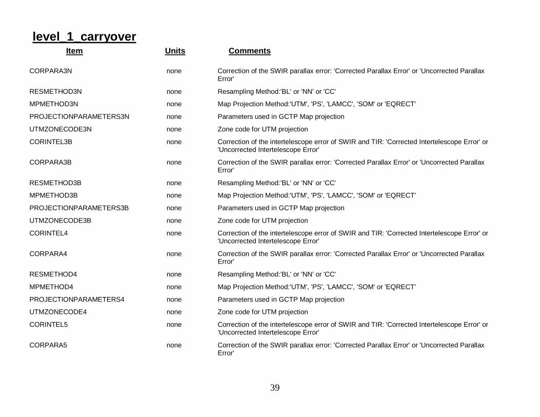
level_1_carryoverItem Units Comments
CORPARA3N none Correction of the SWIR parallax error: 'Corrected Parallax Error' or 'Uncorrected ParallaxError'
RESMETHOD3N none Resampling Method:'BL' or 'NN' or 'CC'
MPMETHOD3N none Map Projection Method:'UTM', 'PS', 'LAMCC', 'SOM' or 'EQRECT'
PROJECTIONPARAMETERS3N none Parameters used in GCTP Map projection
UTMZONECODE3N none Zone code for UTM projection
CORINTEL3B none Correction of the intertelescope error of SWIR and TIR: 'Corrected Intertelescope Error' or'Uncorrected Intertelescope Error'
CORPARA3B none Correction of the SWIR parallax error: 'Corrected Parallax Error' or 'Uncorrected ParallaxError'
RESMETHOD3B none Resampling Method:'BL' or 'NN' or 'CC'
MPMETHOD3B none Map Projection Method:'UTM', 'PS', 'LAMCC', 'SOM' or 'EQRECT'
PROJECTIONPARAMETERS3B none Parameters used in GCTP Map projection
UTMZONECODE3B none Zone code for UTM projection
CORINTEL4 none Correction of the intertelescope error of SWIR and TIR: 'Corrected Intertelescope Error' or'Uncorrected Intertelescope Error'
CORPARA4 none Correction of the SWIR parallax error: 'Corrected Parallax Error' or 'Uncorrected ParallaxError'
RESMETHOD4 none Resampling Method:'BL' or 'NN' or 'CC'
MPMETHOD4 none Map Projection Method:'UTM', 'PS', 'LAMCC', 'SOM' or 'EQRECT'
PROJECTIONPARAMETERS4 none Parameters used in GCTP Map projection
UTMZONECODE4 none Zone code for UTM projection
CORINTEL5 none Correction of the intertelescope error of SWIR and TIR: 'Corrected Intertelescope Error' or'Uncorrected Intertelescope Error'
CORPARA5 none Correction of the SWIR parallax error: 'Corrected Parallax Error' or 'Uncorrected ParallaxError'

40
level_1_carryoverItem Units Comments
RESMETHOD5 none Resampling Method:'BL' or 'NN' or 'CC'
MPMETHOD5 none Map Projection Method:'UTM', 'PS', 'LAMCC', 'SOM' or 'EQRECT'
PROJECTIONPARAMETERS5 none Parameters used in GCTP Map projection
UTMZONECODE5 none Zone code for UTM projection
CORINTEL6 none Correction of the intertelescope error of SWIR and TIR: 'Corrected Intertelescope Error' or'Uncorrected Intertelescope Error'
CORPARA6 none Correction of the SWIR parallax error: 'Corrected Parallax Error' or 'Uncorrected ParallaxError'
RESMETHOD6 none Resampling Method:'BL' or 'NN' or 'CC'
MPMETHOD6 none Map Projection Method:'UTM', 'PS', 'LAMCC', 'SOM' or 'EQRECT'
PROJECTIONPARAMETERS6 none Parameters used in GCTP Map projection
UTMZONECODE6 none Zone code for UTM projection
CORINTEL7 none Correction of the intertelescope error of SWIR and TIR: 'Corrected Intertelescope Error' or'Uncorrected Intertelescope Error'
CORPARA7 none Correction of the SWIR parallax error: 'Corrected Parallax Error' or 'Uncorrected ParallaxError'
RESMETHOD7 none Resampling Method:'BL' or 'NN' or 'CC'
MPMETHOD7 none Map Projection Method:'UTM', 'PS', 'LAMCC', 'SOM' or 'EQRECT'
PROJECTIONPARAMETERS7 none Parameters used in GCTP Map projection
UTMZONECODE7 none Zone code for UTM projection
CORINTEL8 none Correction of the intertelescope error of SWIR and TIR: 'Corrected Intertelescope Error' or'Uncorrected Intertelescope Error'
CORPARA8 none Correction of the SWIR parallax error: 'Corrected Parallax Error' or 'Uncorrected ParallaxError'
RESMETHOD8 none Resampling Method:'BL' or 'NN' or 'CC'
41
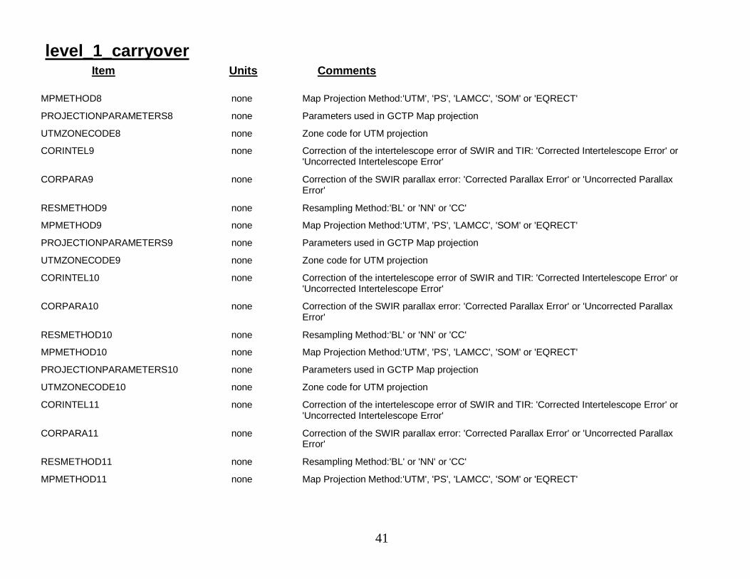
level_1_carryoverItem Units Comments
MPMETHOD8 none Map Projection Method:'UTM', 'PS', 'LAMCC', 'SOM' or 'EQRECT'
PROJECTIONPARAMETERS8 none Parameters used in GCTP Map projection
UTMZONECODE8 none Zone code for UTM projection
CORINTEL9 none Correction of the intertelescope error of SWIR and TIR: 'Corrected Intertelescope Error' or'Uncorrected Intertelescope Error'
CORPARA9 none Correction of the SWIR parallax error: 'Corrected Parallax Error' or 'Uncorrected ParallaxError'
RESMETHOD9 none Resampling Method:'BL' or 'NN' or 'CC'
MPMETHOD9 none Map Projection Method:'UTM', 'PS', 'LAMCC', 'SOM' or 'EQRECT'
PROJECTIONPARAMETERS9 none Parameters used in GCTP Map projection
UTMZONECODE9 none Zone code for UTM projection
CORINTEL10 none Correction of the intertelescope error of SWIR and TIR: 'Corrected Intertelescope Error' or'Uncorrected Intertelescope Error'
CORPARA10 none Correction of the SWIR parallax error: 'Corrected Parallax Error' or 'Uncorrected ParallaxError'
RESMETHOD10 none Resampling Method:'BL' or 'NN' or 'CC'
MPMETHOD10 none Map Projection Method:'UTM', 'PS', 'LAMCC', 'SOM' or 'EQRECT'
PROJECTIONPARAMETERS10 none Parameters used in GCTP Map projection
UTMZONECODE10 none Zone code for UTM projection
CORINTEL11 none Correction of the intertelescope error of SWIR and TIR: 'Corrected Intertelescope Error' or'Uncorrected Intertelescope Error'
CORPARA11 none Correction of the SWIR parallax error: 'Corrected Parallax Error' or 'Uncorrected ParallaxError'
RESMETHOD11 none Resampling Method:'BL' or 'NN' or 'CC'
MPMETHOD11 none Map Projection Method:'UTM', 'PS', 'LAMCC', 'SOM' or 'EQRECT'
42
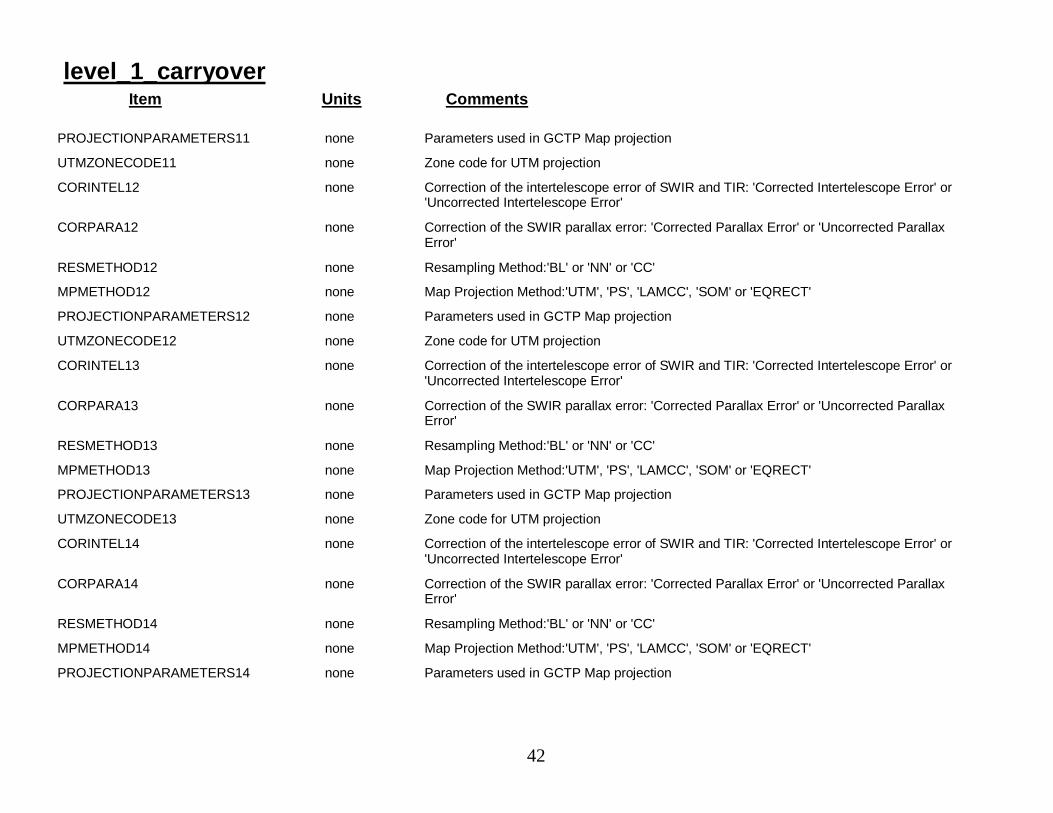
level_1_carryoverItem Units Comments
PROJECTIONPARAMETERS11 none Parameters used in GCTP Map projection
UTMZONECODE11 none Zone code for UTM projection
CORINTEL12 none Correction of the intertelescope error of SWIR and TIR: 'Corrected Intertelescope Error' or'Uncorrected Intertelescope Error'
CORPARA12 none Correction of the SWIR parallax error: 'Corrected Parallax Error' or 'Uncorrected ParallaxError'
RESMETHOD12 none Resampling Method:'BL' or 'NN' or 'CC'
MPMETHOD12 none Map Projection Method:'UTM', 'PS', 'LAMCC', 'SOM' or 'EQRECT'
PROJECTIONPARAMETERS12 none Parameters used in GCTP Map projection
UTMZONECODE12 none Zone code for UTM projection
CORINTEL13 none Correction of the intertelescope error of SWIR and TIR: 'Corrected Intertelescope Error' or'Uncorrected Intertelescope Error'
CORPARA13 none Correction of the SWIR parallax error: 'Corrected Parallax Error' or 'Uncorrected ParallaxError'
RESMETHOD13 none Resampling Method:'BL' or 'NN' or 'CC'
MPMETHOD13 none Map Projection Method:'UTM', 'PS', 'LAMCC', 'SOM' or 'EQRECT'
PROJECTIONPARAMETERS13 none Parameters used in GCTP Map projection
UTMZONECODE13 none Zone code for UTM projection
CORINTEL14 none Correction of the intertelescope error of SWIR and TIR: 'Corrected Intertelescope Error' or'Uncorrected Intertelescope Error'
CORPARA14 none Correction of the SWIR parallax error: 'Corrected Parallax Error' or 'Uncorrected ParallaxError'
RESMETHOD14 none Resampling Method:'BL' or 'NN' or 'CC'
MPMETHOD14 none Map Projection Method:'UTM', 'PS', 'LAMCC', 'SOM' or 'EQRECT'
PROJECTIONPARAMETERS14 none Parameters used in GCTP Map projection
43
level_1_carryoverItem Units Comments
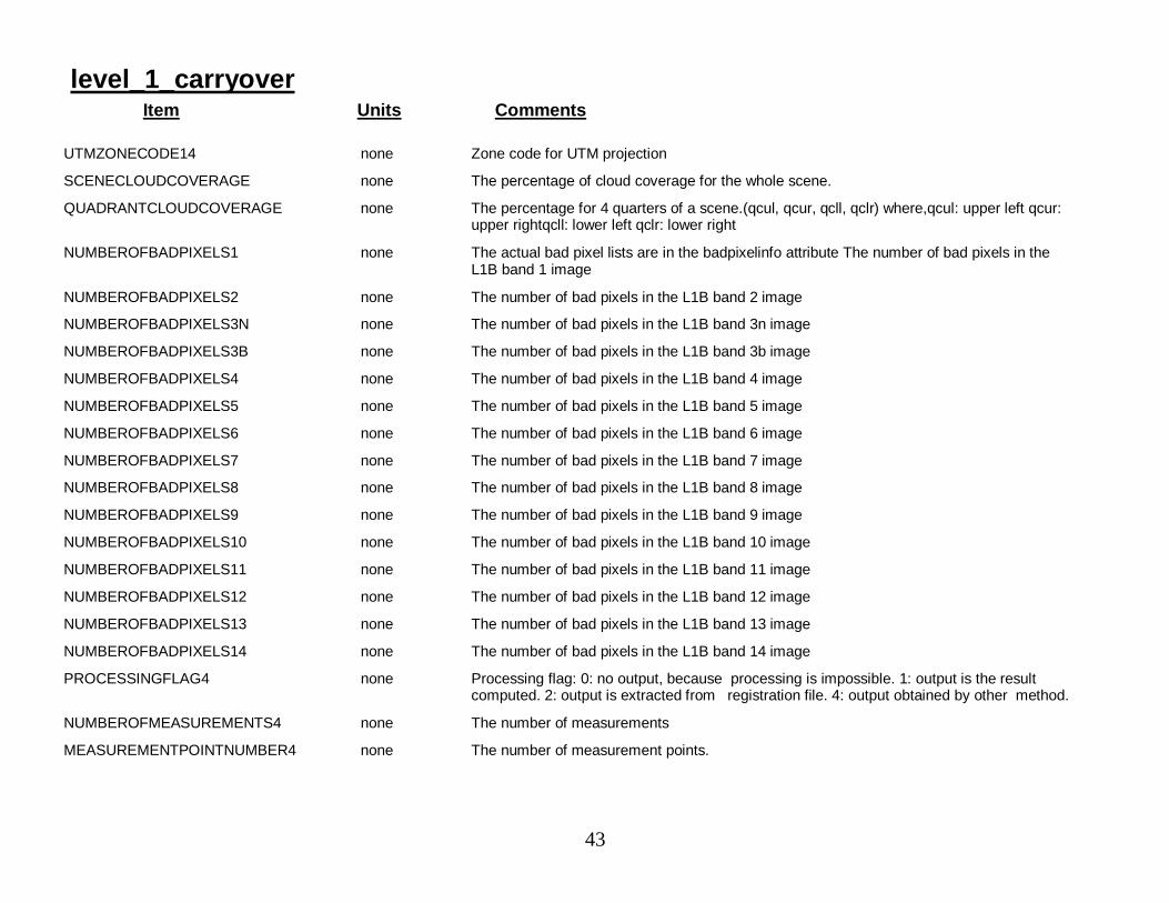
UTMZONECODE14 none Zone code for UTM projection
SCENECLOUDCOVERAGE none The percentage of cloud coverage for the whole scene.
QUADRANTCLOUDCOVERAGE none The percentage for 4 quarters of a scene.(qcul, qcur, qcll, qclr) where,qcul: upper left qcur:upper rightqcll: lower left qclr: lower right
NUMBEROFBADPIXELS1 none The actual bad pixel lists are in the badpixelinfo attribute The number of bad pixels in theL1B band 1 image
NUMBEROFBADPIXELS2 none The number of bad pixels in the L1B band 2 image
NUMBEROFBADPIXELS3N none The number of bad pixels in the L1B band 3n image
NUMBEROFBADPIXELS3B none The number of bad pixels in the L1B band 3b image
NUMBEROFBADPIXELS4 none The number of bad pixels in the L1B band 4 image
NUMBEROFBADPIXELS5 none The number of bad pixels in the L1B band 5 image
NUMBEROFBADPIXELS6 none The number of bad pixels in the L1B band 6 image
NUMBEROFBADPIXELS7 none The number of bad pixels in the L1B band 7 image
NUMBEROFBADPIXELS8 none The number of bad pixels in the L1B band 8 image
NUMBEROFBADPIXELS9 none The number of bad pixels in the L1B band 9 image
NUMBEROFBADPIXELS10 none The number of bad pixels in the L1B band 10 image
NUMBEROFBADPIXELS11 none The number of bad pixels in the L1B band 11 image
NUMBEROFBADPIXELS12 none The number of bad pixels in the L1B band 12 image
NUMBEROFBADPIXELS13 none The number of bad pixels in the L1B band 13 image
NUMBEROFBADPIXELS14 none The number of bad pixels in the L1B band 14 image
PROCESSINGFLAG4 none Processing flag: 0: no output, because processing is impossible. 1: output is the resultcomputed. 2: output is extracted from registration file. 4: output obtained by other method.
NUMBEROFMEASUREMENTS4 none The number of measurements
MEASUREMENTPOINTNUMBER4 none The number of measurement points.
44
level_1_carryoverItem Units Comments
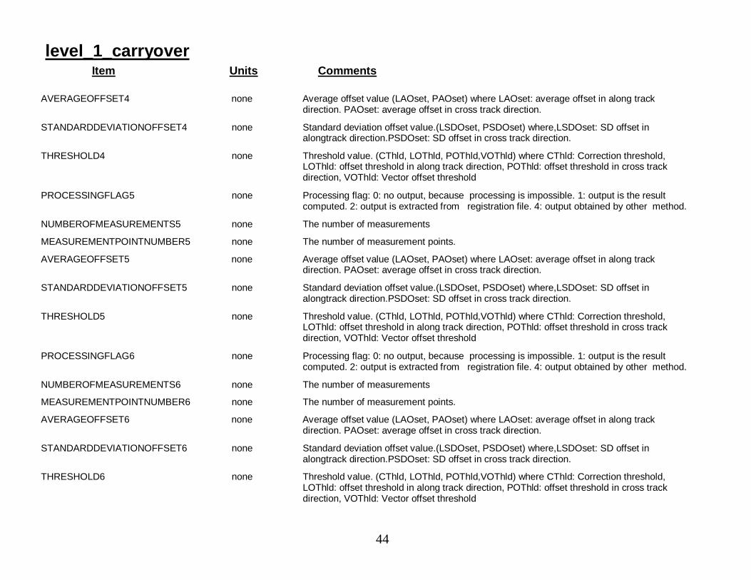
AVERAGEOFFSET4 none Average offset value (LAOset, PAOset) where LAOset: average offset in along trackdirection. PAOset: average offset in cross track direction.
STANDARDDEVIATIONOFFSET4 none Standard deviation offset value.(LSDOset, PSDOset) where,LSDOset: SD offset inalongtrack direction.PSDOset: SD offset in cross track direction.
THRESHOLD4 none Threshold value. (CThld, LOThld, POThld,VOThld) where CThld: Correction threshold,LOThld: offset threshold in along track direction, POThld: offset threshold in cross trackdirection, VOThld: Vector offset threshold
PROCESSINGFLAG5 none Processing flag: 0: no output, because processing is impossible. 1: output is the resultcomputed. 2: output is extracted from registration file. 4: output obtained by other method.
NUMBEROFMEASUREMENTS5 none The number of measurements
MEASUREMENTPOINTNUMBER5 none The number of measurement points.
AVERAGEOFFSET5 none Average offset value (LAOset, PAOset) where LAOset: average offset in along trackdirection. PAOset: average offset in cross track direction.
STANDARDDEVIATIONOFFSET5 none Standard deviation offset value.(LSDOset, PSDOset) where,LSDOset: SD offset inalongtrack direction.PSDOset: SD offset in cross track direction.
THRESHOLD5 none Threshold value. (CThld, LOThld, POThld,VOThld) where CThld: Correction threshold,LOThld: offset threshold in along track direction, POThld: offset threshold in cross trackdirection, VOThld: Vector offset threshold
PROCESSINGFLAG6 none Processing flag: 0: no output, because processing is impossible. 1: output is the resultcomputed. 2: output is extracted from registration file. 4: output obtained by other method.
NUMBEROFMEASUREMENTS6 none The number of measurements
MEASUREMENTPOINTNUMBER6 none The number of measurement points.
AVERAGEOFFSET6 none Average offset value (LAOset, PAOset) where LAOset: average offset in along trackdirection. PAOset: average offset in cross track direction.
STANDARDDEVIATIONOFFSET6 none Standard deviation offset value.(LSDOset, PSDOset) where,LSDOset: SD offset inalongtrack direction.PSDOset: SD offset in cross track direction.
THRESHOLD6 none Threshold value. (CThld, LOThld, POThld,VOThld) where CThld: Correction threshold,LOThld: offset threshold in along track direction, POThld: offset threshold in cross trackdirection, VOThld: Vector offset threshold
45
level_1_carryoverItem Units Comments
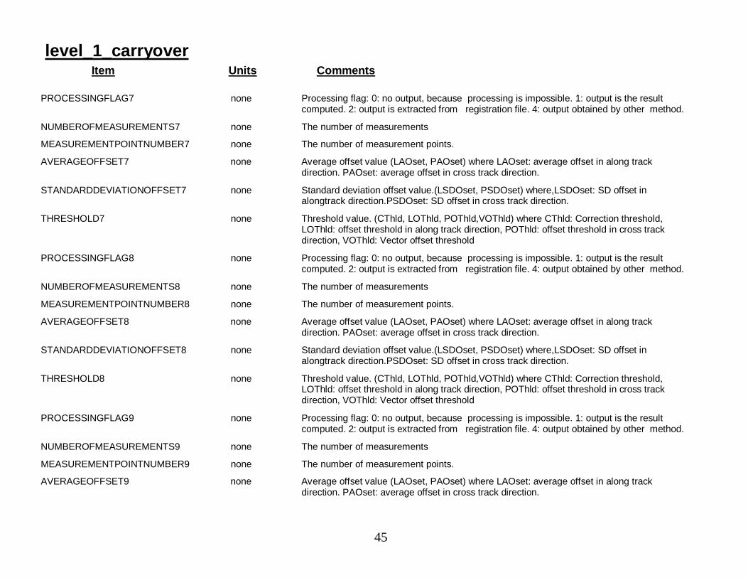
PROCESSINGFLAG7 none Processing flag: 0: no output, because processing is impossible. 1: output is the resultcomputed. 2: output is extracted from registration file. 4: output obtained by other method.
NUMBEROFMEASUREMENTS7 none The number of measurements
MEASUREMENTPOINTNUMBER7 none The number of measurement points.
AVERAGEOFFSET7 none Average offset value (LAOset, PAOset) where LAOset: average offset in along trackdirection. PAOset: average offset in cross track direction.
STANDARDDEVIATIONOFFSET7 none Standard deviation offset value.(LSDOset, PSDOset) where,LSDOset: SD offset inalongtrack direction.PSDOset: SD offset in cross track direction.
THRESHOLD7 none Threshold value. (CThld, LOThld, POThld,VOThld) where CThld: Correction threshold,LOThld: offset threshold in along track direction, POThld: offset threshold in cross trackdirection, VOThld: Vector offset threshold
PROCESSINGFLAG8 none Processing flag: 0: no output, because processing is impossible. 1: output is the resultcomputed. 2: output is extracted from registration file. 4: output obtained by other method.
NUMBEROFMEASUREMENTS8 none The number of measurements
MEASUREMENTPOINTNUMBER8 none The number of measurement points.
AVERAGEOFFSET8 none Average offset value (LAOset, PAOset) where LAOset: average offset in along trackdirection. PAOset: average offset in cross track direction.
STANDARDDEVIATIONOFFSET8 none Standard deviation offset value.(LSDOset, PSDOset) where,LSDOset: SD offset inalongtrack direction.PSDOset: SD offset in cross track direction.
THRESHOLD8 none Threshold value. (CThld, LOThld, POThld,VOThld) where CThld: Correction threshold,LOThld: offset threshold in along track direction, POThld: offset threshold in cross trackdirection, VOThld: Vector offset threshold
PROCESSINGFLAG9 none Processing flag: 0: no output, because processing is impossible. 1: output is the resultcomputed. 2: output is extracted from registration file. 4: output obtained by other method.
NUMBEROFMEASUREMENTS9 none The number of measurements
MEASUREMENTPOINTNUMBER9 none The number of measurement points.
AVERAGEOFFSET9 none Average offset value (LAOset, PAOset) where LAOset: average offset in along trackdirection. PAOset: average offset in cross track direction.
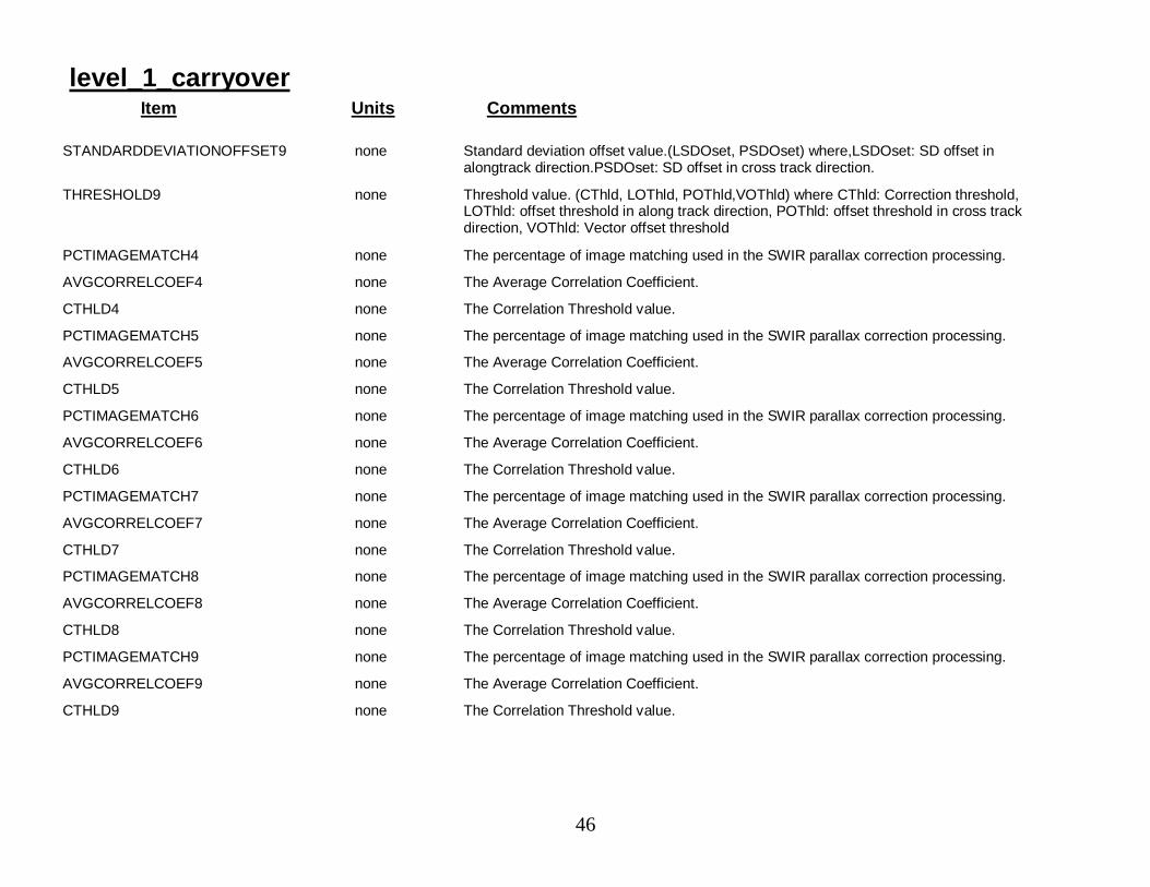
46
level_1_carryoverItem Units Comments
STANDARDDEVIATIONOFFSET9 none Standard deviation offset value.(LSDOset, PSDOset) where,LSDOset: SD offset inalongtrack direction.PSDOset: SD offset in cross track direction.
THRESHOLD9 none Threshold value. (CThld, LOThld, POThld,VOThld) where CThld: Correction threshold,LOThld: offset threshold in along track direction, POThld: offset threshold in cross trackdirection, VOThld: Vector offset threshold
PCTIMAGEMATCH4 none The percentage of image matching used in the SWIR parallax correction processing.
AVGCORRELCOEF4 none The Average Correlation Coefficient.
CTHLD4 none The Correlation Threshold value.
PCTIMAGEMATCH5 none The percentage of image matching used in the SWIR parallax correction processing.
AVGCORRELCOEF5 none The Average Correlation Coefficient.
CTHLD5 none The Correlation Threshold value.
PCTIMAGEMATCH6 none The percentage of image matching used in the SWIR parallax correction processing.
AVGCORRELCOEF6 none The Average Correlation Coefficient.
CTHLD6 none The Correlation Threshold value.
PCTIMAGEMATCH7 none The percentage of image matching used in the SWIR parallax correction processing.
AVGCORRELCOEF7 none The Average Correlation Coefficient.
CTHLD7 none The Correlation Threshold value.
PCTIMAGEMATCH8 none The percentage of image matching used in the SWIR parallax correction processing.
AVGCORRELCOEF8 none The Average Correlation Coefficient.
CTHLD8 none The Correlation Threshold value.
PCTIMAGEMATCH9 none The percentage of image matching used in the SWIR parallax correction processing.
AVGCORRELCOEF9 none The Average Correlation Coefficient.
CTHLD9 none The Correlation Threshold value.
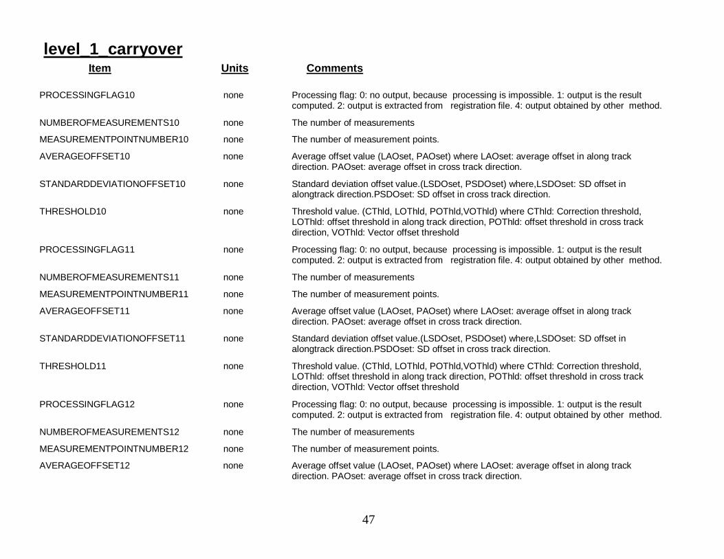
47
level_1_carryoverItem Units Comments
PROCESSINGFLAG10 none Processing flag: 0: no output, because processing is impossible. 1: output is the resultcomputed. 2: output is extracted from registration file. 4: output obtained by other method.
NUMBEROFMEASUREMENTS10 none The number of measurements
MEASUREMENTPOINTNUMBER10 none The number of measurement points.
AVERAGEOFFSET10 none Average offset value (LAOset, PAOset) where LAOset: average offset in along trackdirection. PAOset: average offset in cross track direction.
STANDARDDEVIATIONOFFSET10 none Standard deviation offset value.(LSDOset, PSDOset) where,LSDOset: SD offset inalongtrack direction.PSDOset: SD offset in cross track direction.
THRESHOLD10 none Threshold value. (CThld, LOThld, POThld,VOThld) where CThld: Correction threshold,LOThld: offset threshold in along track direction, POThld: offset threshold in cross trackdirection, VOThld: Vector offset threshold
PROCESSINGFLAG11 none Processing flag: 0: no output, because processing is impossible. 1: output is the resultcomputed. 2: output is extracted from registration file. 4: output obtained by other method.
NUMBEROFMEASUREMENTS11 none The number of measurements
MEASUREMENTPOINTNUMBER11 none The number of measurement points.
AVERAGEOFFSET11 none Average offset value (LAOset, PAOset) where LAOset: average offset in along trackdirection. PAOset: average offset in cross track direction.
STANDARDDEVIATIONOFFSET11 none Standard deviation offset value.(LSDOset, PSDOset) where,LSDOset: SD offset inalongtrack direction.PSDOset: SD offset in cross track direction.
THRESHOLD11 none Threshold value. (CThld, LOThld, POThld,VOThld) where CThld: Correction threshold,LOThld: offset threshold in along track direction, POThld: offset threshold in cross trackdirection, VOThld: Vector offset threshold
PROCESSINGFLAG12 none Processing flag: 0: no output, because processing is impossible. 1: output is the resultcomputed. 2: output is extracted from registration file. 4: output obtained by other method.
NUMBEROFMEASUREMENTS12 none The number of measurements
MEASUREMENTPOINTNUMBER12 none The number of measurement points.
AVERAGEOFFSET12 none Average offset value (LAOset, PAOset) where LAOset: average offset in along trackdirection. PAOset: average offset in cross track direction.
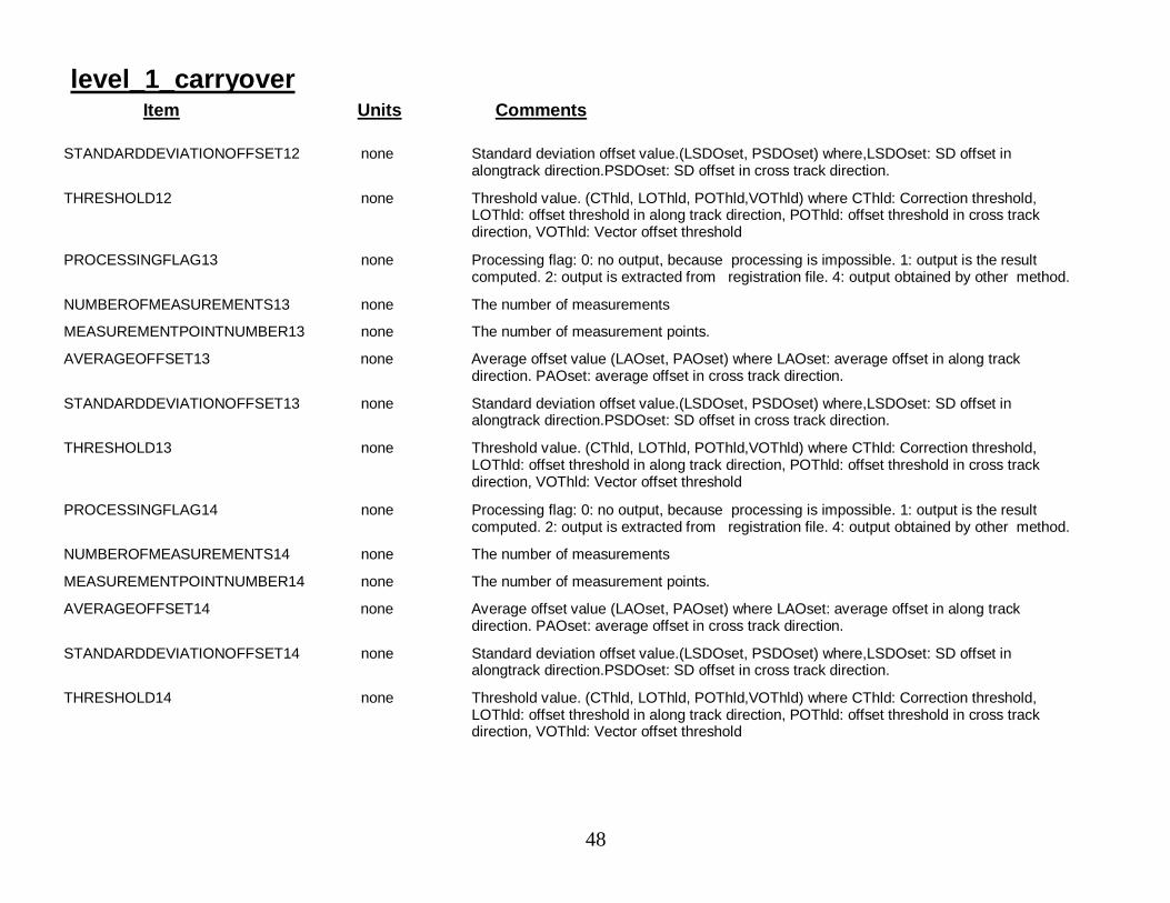
48
level_1_carryoverItem Units Comments
STANDARDDEVIATIONOFFSET12 none Standard deviation offset value.(LSDOset, PSDOset) where,LSDOset: SD offset inalongtrack direction.PSDOset: SD offset in cross track direction.
THRESHOLD12 none Threshold value. (CThld, LOThld, POThld,VOThld) where CThld: Correction threshold,LOThld: offset threshold in along track direction, POThld: offset threshold in cross trackdirection, VOThld: Vector offset threshold
PROCESSINGFLAG13 none Processing flag: 0: no output, because processing is impossible. 1: output is the resultcomputed. 2: output is extracted from registration file. 4: output obtained by other method.
NUMBEROFMEASUREMENTS13 none The number of measurements
MEASUREMENTPOINTNUMBER13 none The number of measurement points.
AVERAGEOFFSET13 none Average offset value (LAOset, PAOset) where LAOset: average offset in along trackdirection. PAOset: average offset in cross track direction.
STANDARDDEVIATIONOFFSET13 none Standard deviation offset value.(LSDOset, PSDOset) where,LSDOset: SD offset inalongtrack direction.PSDOset: SD offset in cross track direction.
THRESHOLD13 none Threshold value. (CThld, LOThld, POThld,VOThld) where CThld: Correction threshold,LOThld: offset threshold in along track direction, POThld: offset threshold in cross trackdirection, VOThld: Vector offset threshold
PROCESSINGFLAG14 none Processing flag: 0: no output, because processing is impossible. 1: output is the resultcomputed. 2: output is extracted from registration file. 4: output obtained by other method.
NUMBEROFMEASUREMENTS14 none The number of measurements
MEASUREMENTPOINTNUMBER14 none The number of measurement points.
AVERAGEOFFSET14 none Average offset value (LAOset, PAOset) where LAOset: average offset in along trackdirection. PAOset: average offset in cross track direction.
STANDARDDEVIATIONOFFSET14 none Standard deviation offset value.(LSDOset, PSDOset) where,LSDOset: SD offset inalongtrack direction.PSDOset: SD offset in cross track direction.
THRESHOLD14 none Threshold value. (CThld, LOThld, POThld,VOThld) where CThld: Correction threshold,LOThld: offset threshold in along track direction, POThld: offset threshold in cross trackdirection, VOThld: Vector offset threshold
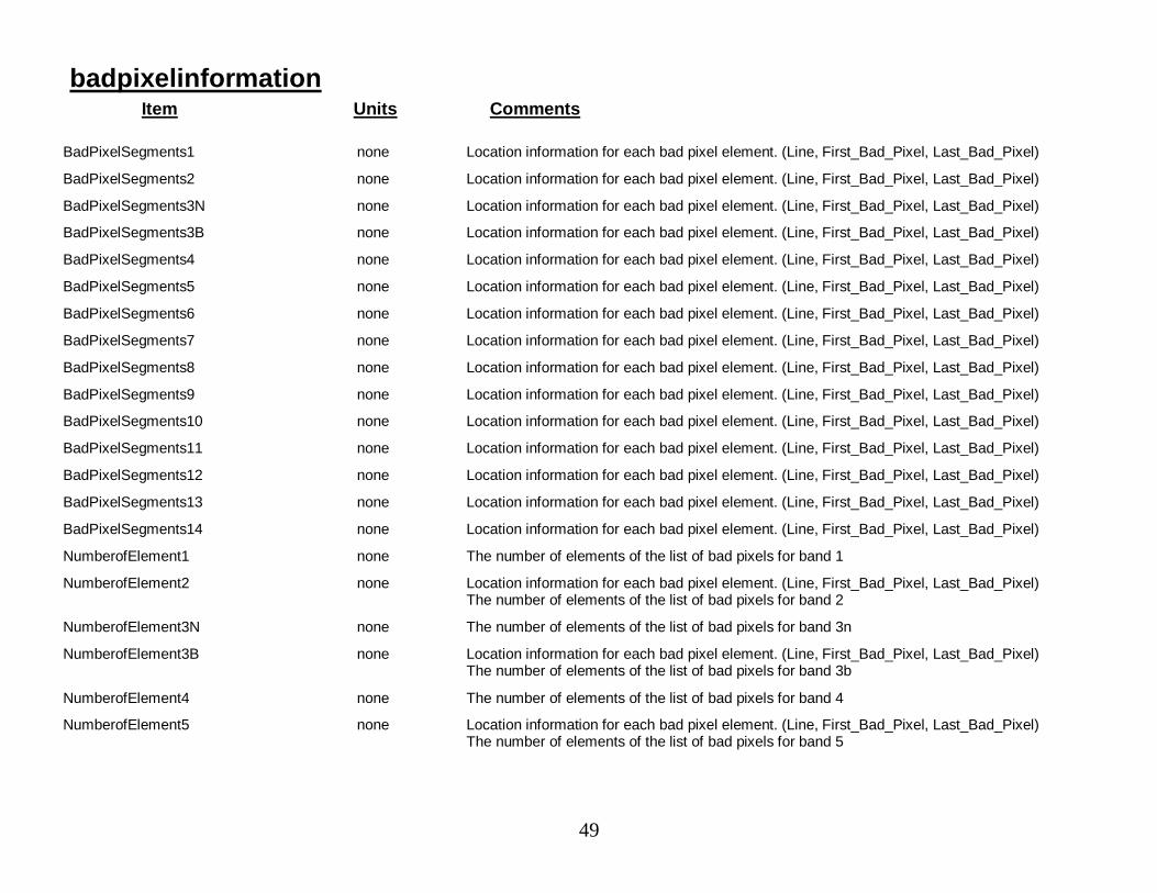
49
badpixelinformationItem Units Comments
BadPixelSegments1 none Location information for each bad pixel element. (Line, First_Bad_Pixel, Last_Bad_Pixel)
BadPixelSegments2 none Location information for each bad pixel element. (Line, First_Bad_Pixel, Last_Bad_Pixel)
BadPixelSegments3N none Location information for each bad pixel element. (Line, First_Bad_Pixel, Last_Bad_Pixel)
BadPixelSegments3B none Location information for each bad pixel element. (Line, First_Bad_Pixel, Last_Bad_Pixel)
BadPixelSegments4 none Location information for each bad pixel element. (Line, First_Bad_Pixel, Last_Bad_Pixel)
BadPixelSegments5 none Location information for each bad pixel element. (Line, First_Bad_Pixel, Last_Bad_Pixel)
BadPixelSegments6 none Location information for each bad pixel element. (Line, First_Bad_Pixel, Last_Bad_Pixel)
BadPixelSegments7 none Location information for each bad pixel element. (Line, First_Bad_Pixel, Last_Bad_Pixel)
BadPixelSegments8 none Location information for each bad pixel element. (Line, First_Bad_Pixel, Last_Bad_Pixel)
BadPixelSegments9 none Location information for each bad pixel element. (Line, First_Bad_Pixel, Last_Bad_Pixel)
BadPixelSegments10 none Location information for each bad pixel element. (Line, First_Bad_Pixel, Last_Bad_Pixel)
BadPixelSegments11 none Location information for each bad pixel element. (Line, First_Bad_Pixel, Last_Bad_Pixel)
BadPixelSegments12 none Location information for each bad pixel element. (Line, First_Bad_Pixel, Last_Bad_Pixel)
BadPixelSegments13 none Location information for each bad pixel element. (Line, First_Bad_Pixel, Last_Bad_Pixel)
BadPixelSegments14 none Location information for each bad pixel element. (Line, First_Bad_Pixel, Last_Bad_Pixel)
NumberofElement1 none The number of elements of the list of bad pixels for band 1
NumberofElement2 none Location information for each bad pixel element. (Line, First_Bad_Pixel, Last_Bad_Pixel)The number of elements of the list of bad pixels for band 2
NumberofElement3N none The number of elements of the list of bad pixels for band 3n
NumberofElement3B none Location information for each bad pixel element. (Line, First_Bad_Pixel, Last_Bad_Pixel)The number of elements of the list of bad pixels for band 3b
NumberofElement4 none The number of elements of the list of bad pixels for band 4
NumberofElement5 none Location information for each bad pixel element. (Line, First_Bad_Pixel, Last_Bad_Pixel)The number of elements of the list of bad pixels for band 5
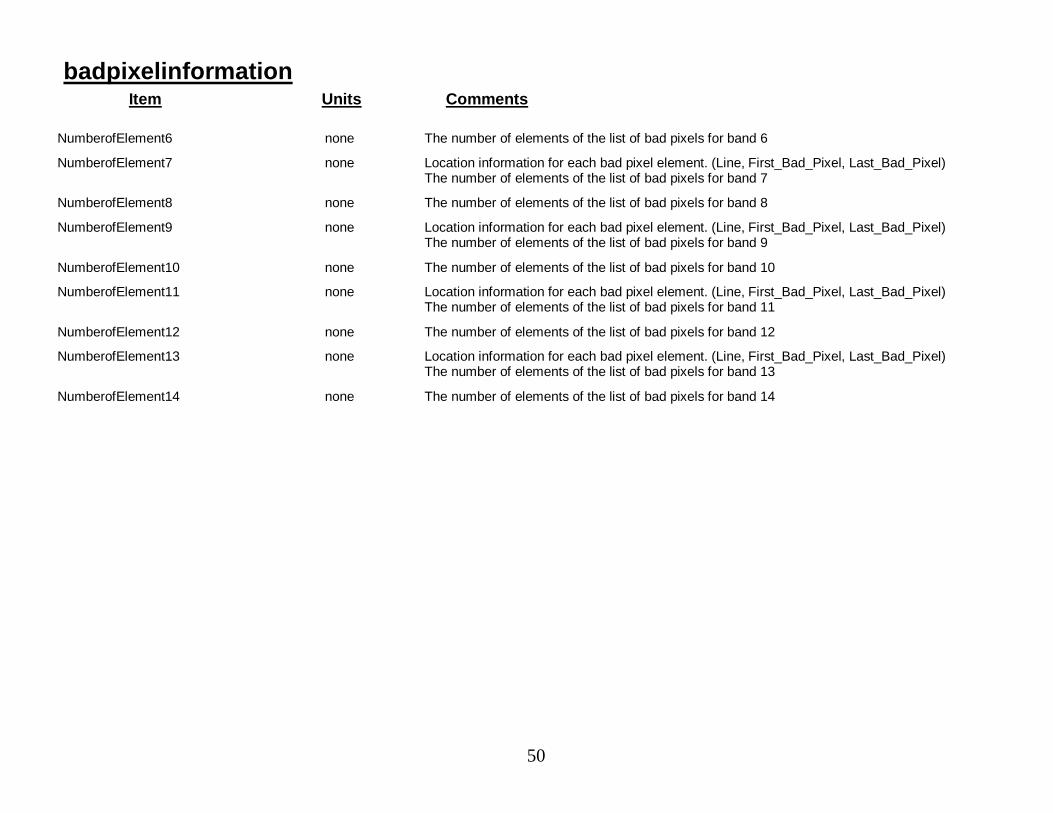
50
badpixelinformationItem Units Comments
NumberofElement6 none The number of elements of the list of bad pixels for band 6
NumberofElement7 none Location information for each bad pixel element. (Line, First_Bad_Pixel, Last_Bad_Pixel)The number of elements of the list of bad pixels for band 7
NumberofElement8 none The number of elements of the list of bad pixels for band 8
NumberofElement9 none Location information for each bad pixel element. (Line, First_Bad_Pixel, Last_Bad_Pixel)The number of elements of the list of bad pixels for band 9
NumberofElement10 none The number of elements of the list of bad pixels for band 10
NumberofElement11 none Location information for each bad pixel element. (Line, First_Bad_Pixel, Last_Bad_Pixel)The number of elements of the list of bad pixels for band 11
NumberofElement12 none The number of elements of the list of bad pixels for band 12
NumberofElement13 none Location information for each bad pixel element. (Line, First_Bad_Pixel, Last_Bad_Pixel)The number of elements of the list of bad pixels for band 13
NumberofElement14 none The number of elements of the list of bad pixels for band 14

51
SECTION 5: Product Definitions--Product-Specific Information
This section describes the metadata that is specific to each product.
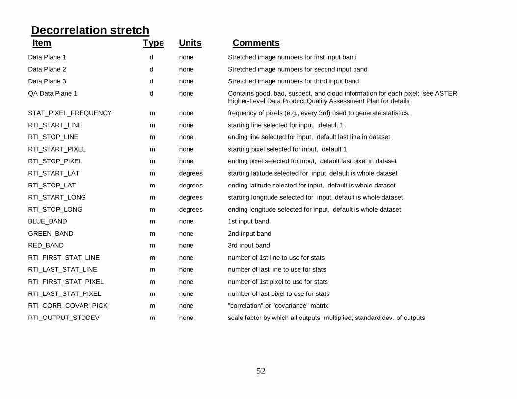
52
Decorrelation stretchItem Type Units Comments
Data Plane 1 d none Stretched image numbers for first input band
Data Plane 2 d none Stretched image numbers for second input band
Data Plane 3 d none Stretched image numbers for third input band
QA Data Plane 1 d none Contains good, bad, suspect, and cloud information for each pixel; see ASTERHigher-Level Data Product Quality Assessment Plan for details
STAT_PIXEL_FREQUENCY m none frequency of pixels (e.g., every 3rd) used to generate statistics.
RTI_START_LINE m none starting line selected for input, default 1
RTI_STOP_LINE m none ending line selected for input, default last line in dataset
RTI_START_PIXEL m none starting pixel selected for input, default 1
RTI_STOP_PIXEL m none ending pixel selected for input, default last pixel in dataset
RTI_START_LAT m degrees starting latitude selected for input, default is whole dataset
RTI_STOP_LAT m degrees ending latitude selected for input, default is whole dataset
RTI_START_LONG m degrees starting longitude selected for input, default is whole dataset
RTI_STOP_LONG m degrees ending longitude selected for input, default is whole dataset
BLUE_BAND m none 1st input band
GREEN_BAND m none 2nd input band
RED_BAND m none 3rd input band
RTI_FIRST_STAT_LINE m none number of 1st line to use for stats
RTI_LAST_STAT_LINE m none number of last line to use for stats
RTI_FIRST_STAT_PIXEL m none number of 1st pixel to use for stats
RTI_LAST_STAT_PIXEL m none number of last pixel to use for stats
RTI_CORR_COVAR_PICK m none "correlation" or "covariance" matrix
RTI_OUTPUT_STDDEV m none scale factor by which all outputs multiplied; standard dev. of outputs

53
Decorrelation stretchItem Type Units Comments
RTI_OUTPUT_MEAN m none desired mean of outputs
NUM_STAT_LINES m none number of lines processed in generating statistics.
NUM_STAT_PIXELS m none number of pixels used to generate statistics.
CLOUD_STAT_PIXELS m none number of cloud pixels rejected in gathering stats
BAD_STAT_PIXELS m none number of bad pixels rejected in gathering stats
LINES_PROCESSED m none number of lines processed in stretching image.
GOOD_PIXELS m none number of pixels used in stretching image
CLOUD_PIXELS m none number of cloud pixels rejected in stretching image
BAD_PIXELS m none number of bad pixels rejected in stretching image
BAND_MEANS m W/m^2/sr/um list: estimated means of 3 bands used
BAND_STDDEVS m W/m^2/sr/um list: estimated standard deviations of 3 bands used
COVARIANCE_MATRIX m none list: the 9 elements of the matrix
CORRELATION_MATRIX m none list: the 9 elements of the matrix,
EIGEN_VALUES m none Characteristic values of the correlation/covariance matrix; used todetermine the decorrelation stretch factors (see ATBD for details)
EIGEN_VECTORS m none list: the 9 elements of the 3 eigenvectors
TRANSFORM_MATRIX m none list: the 9 elements of the matrix
OFFSET_VECTOR m none subtracted from each output vector
MESSAGES m none processing status messages
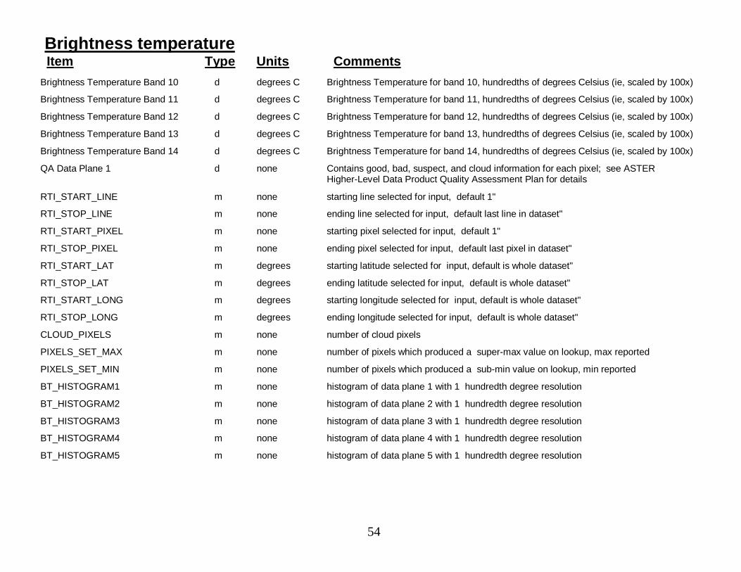
54
Brightness temperatureItem Type Units Comments
Brightness Temperature Band 10 d degrees C Brightness Temperature for band 10, hundredths of degrees Celsius (ie, scaled by 100x)
Brightness Temperature Band 11 d degrees C Brightness Temperature for band 11, hundredths of degrees Celsius (ie, scaled by 100x)
Brightness Temperature Band 12 d degrees C Brightness Temperature for band 12, hundredths of degrees Celsius (ie, scaled by 100x)
Brightness Temperature Band 13 d degrees C Brightness Temperature for band 13, hundredths of degrees Celsius (ie, scaled by 100x)
Brightness Temperature Band 14 d degrees C Brightness Temperature for band 14, hundredths of degrees Celsius (ie, scaled by 100x)
QA Data Plane 1 d none Contains good, bad, suspect, and cloud information for each pixel; see ASTERHigher-Level Data Product Quality Assessment Plan for details
RTI_START_LINE m none starting line selected for input, default 1"
RTI_STOP_LINE m none ending line selected for input, default last line in dataset"
RTI_START_PIXEL m none starting pixel selected for input, default 1"
RTI_STOP_PIXEL m none ending pixel selected for input, default last pixel in dataset"
RTI_START_LAT m degrees starting latitude selected for input, default is whole dataset"
RTI_STOP_LAT m degrees ending latitude selected for input, default is whole dataset"
RTI_START_LONG m degrees starting longitude selected for input, default is whole dataset"
RTI_STOP_LONG m degrees ending longitude selected for input, default is whole dataset"
CLOUD_PIXELS m none number of cloud pixels
PIXELS_SET_MAX m none number of pixels which produced a super-max value on lookup, max reported
PIXELS_SET_MIN m none number of pixels which produced a sub-min value on lookup, min reported
BT_HISTOGRAM1 m none histogram of data plane 1 with 1 hundredth degree resolution
BT_HISTOGRAM2 m none histogram of data plane 2 with 1 hundredth degree resolution
BT_HISTOGRAM3 m none histogram of data plane 3 with 1 hundredth degree resolution
BT_HISTOGRAM4 m none histogram of data plane 4 with 1 hundredth degree resolution
BT_HISTOGRAM5 m none histogram of data plane 5 with 1 hundredth degree resolution
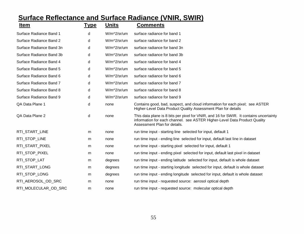
55
Surface Reflectance and Surface Radiance (VNIR, SWIR)Item Type Units Comments
Surface Radiance Band 1 d W/m^2/sr/um surface radiance for band 1
Surface Radiance Band 2 d W/m^2/sr/um surface radiance for band 2
Surface Radiance Band 3n d W/m^2/sr/um surface radiance for band 3n
Surface Radiance Band 3b d W/m^2/sr/um surface radiance for band 3b
Surface Radiance Band 4 d W/m^2/sr/um surface radiance for band 4
Surface Radiance Band 5 d W/m^2/sr/um surface radiance for band 5
Surface Radiance Band 6 d W/m^2/sr/um surface radiance for band 6
Surface Radiance Band 7 d W/m^2/sr/um surface radiance for band 7
Surface Radiance Band 8 d W/m^2/sr/um surface radiance for band 8
Surface Radiance Band 9 d W/m^2/sr/um surface radiance for band 9
QA Data Plane 1 d none Contains good, bad, suspect, and cloud information for each pixel; see ASTERHigher-Level Data Product Quality Assessment Plan for details
QA Data Plane 2 d none This data plane is 8 bits per pixel for VNIR, and 16 for SWIR. It contains uncertaintyinformation for each channel. see ASTER Higher-Level Data Product QualityAssessment Plan for details.
RTI_START_LINE m none run time input - starting line selected for input, default 1
RTI_STOP_LINE m none run time input - ending line selected for input, default last line in dataset
RTI_START_PIXEL m none run time input - starting pixel selected for input, default 1
RTI_STOP_PIXEL m none run time input - ending pixel selected for input, default last pixel in dataset
RTI_STOP_LAT m degrees run time input - ending latitude selected for input, default is whole dataset
RTI_START_LONG m degrees run time input - starting longitude selected for input, default is whole dataset
RTI_STOP_LONG m degrees run time input - ending longitude selected for input, default is whole dataset
RTI_AEROSOL_OD_SRC m none run time input - requested source: aerosol optical depth
RTI_MOLECULAR_OD_SRC m none run time input - requested source: molecular optical depth
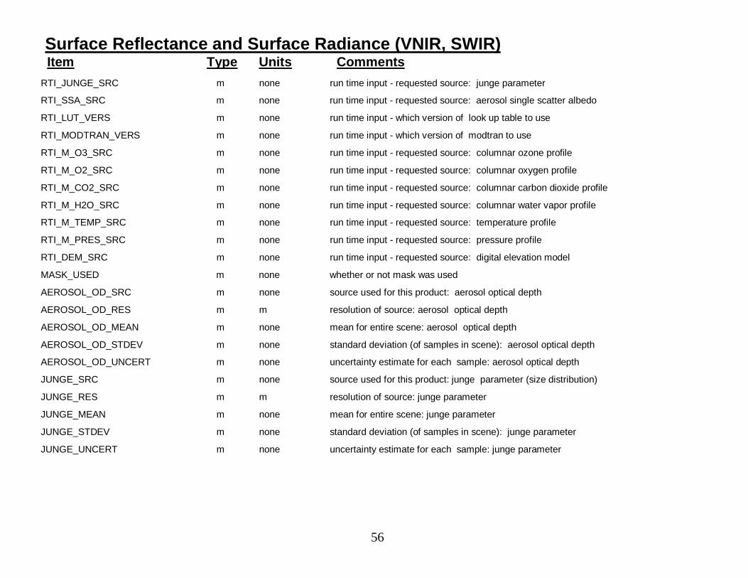
56
Surface Reflectance and Surface Radiance (VNIR, SWIR)Item Type Units Comments
RTI_JUNGE_SRC m none run time input - requested source: junge parameter
RTI_SSA_SRC m none run time input - requested source: aerosol single scatter albedo
RTI_LUT_VERS m none run time input - which version of look up table to use
RTI_MODTRAN_VERS m none run time input - which version of modtran to use
RTI_M_O3_SRC m none run time input - requested source: columnar ozone profile
RTI_M_O2_SRC m none run time input - requested source: columnar oxygen profile
RTI_M_CO2_SRC m none run time input - requested source: columnar carbon dioxide profile
RTI_M_H2O_SRC m none run time input - requested source: columnar water vapor profile
RTI_M_TEMP_SRC m none run time input - requested source: temperature profile
RTI_M_PRES_SRC m none run time input - requested source: pressure profile
RTI_DEM_SRC m none run time input - requested source: digital elevation model
MASK_USED m none whether or not mask was used
AEROSOL_OD_SRC m none source used for this product: aerosol optical depth
AEROSOL_OD_RES m m resolution of source: aerosol optical depth
AEROSOL_OD_MEAN m none mean for entire scene: aerosol optical depth
AEROSOL_OD_STDEV m none standard deviation (of samples in scene): aerosol optical depth
AEROSOL_OD_UNCERT m none uncertainty estimate for each sample: aerosol optical depth
JUNGE_SRC m none source used for this product: junge parameter (size distribution)
JUNGE_RES m m resolution of source: junge parameter
JUNGE_MEAN m none mean for entire scene: junge parameter
JUNGE_STDEV m none standard deviation (of samples in scene): junge parameter
JUNGE_UNCERT m none uncertainty estimate for each sample: junge parameter
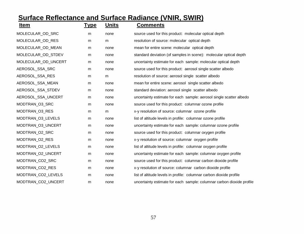
57
Surface Reflectance and Surface Radiance (VNIR, SWIR)Item Type Units Comments
MOLECULAR_OD_SRC m none source used for this product: molecular optical depth
MOLECULAR_OD_RES m m resolution of source: molecular optical depth
MOLECULAR_OD_MEAN m none mean for entire scene: molecular optical depth
MOLECULAR_OD_STDEV m none standard deviation (of samples in scene): molecular optical depth
MOLECULAR_OD_UNCERT m none uncertainty estimate for each sample: molecular optical depth
AEROSOL_SSA_SRC m none source used for this product: aerosol single scatter albedo
AEROSOL_SSA_RES m m resolution of source: aerosol single scatter albedo
AEROSOL_SSA_MEAN m none mean for entire scene: aerosol single scatter albedo
AEROSOL_SSA_STDEV m none standard deviation: aerosol single scatter albedo
AEROSOL_SSA_UNCERT m none uncertainty estimate for each sample: aerosol single scatter albedo
MODTRAN_O3_SRC m none source used for this product: columnar ozone profile
MODTRAN_O3_RES m m x-y resolution of source: columnar ozone profile
MODTRAN_O3_LEVELS m none list of altitude levels in profile: columnar ozone profile
MODTRAN_O3_UNCERT m none uncertainty estimate for each sample: columnar ozone profile
MODTRAN_O2_SRC m none source used for this product: columnar oxygen profile
MODTRAN_O2_RES m none x-y resolution of source: columnar oxygen profile
MODTRAN_O2_LEVELS m none list of altitude levels in profile: columnar oxygen profile
MODTRAN_O2_UNCERT m none uncertainty estimate for each sample: columnar oxygen profile
MODTRAN_CO2_SRC m none source used for this product: columnar carbon dioxide profile
MODTRAN_CO2_RES m none x-y resolution of source: columnar carbon dioxide profile
MODTRAN_CO2_LEVELS m none list of altitude levels in profile: columnar carbon dioxide profile
MODTRAN_CO2_UNCERT m none uncertainty estimate for each sample: columnar carbon dioxide profile
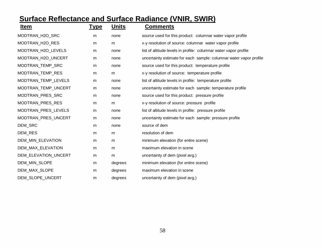
58
Surface Reflectance and Surface Radiance (VNIR, SWIR)Item Type Units Comments
MODTRAN_H2O_SRC m none source used for this product: columnar water vapor profile
MODTRAN_H2O_RES m m x-y resolution of source: columnar water vapor profile
MODTRAN_H2O_LEVELS m none list of altitude levels in profile: columnar water vapor profile
MODTRAN_H2O_UNCERT m none uncertainty estimate for each sample: columnar water vapor profile
MODTRAN_TEMP_SRC m none source used for this product: temperature profile
MODTRAN_TEMP_RES m m x-y resolution of source: temperature profile
MODTRAN_TEMP_LEVELS m none list of altitude levels in profile: temperature profile
MODTRAN_TEMP_UNCERT m none uncertainty estimate for each sample: temperature profile
MODTRAN_PRES_SRC m none source used for this product: pressure profile
MODTRAN_PRES_RES m m x-y resolution of source: pressure profile
MODTRAN_PRES_LEVELS m none list of altitude levels in profile: pressure profile
MODTRAN_PRES_UNCERT m none uncertainty estimate for each sample: pressure profile
DEM_SRC m none source of dem
DEM_RES m m resolution of dem
DEM_MIN_ELEVATION m m minimum elevation (for entire scene)
DEM_MAX_ELEVATION m m maximum elevation in scene
DEM_ELEVATION_UNCERT m m uncertainty of dem (pixel avg.)
DEM_MIN_SLOPE m degrees minimum elevation (for entire scene)
DEM_MAX_SLOPE m degrees maximum elevation in scene
DEM_SLOPE_UNCERT m degrees uncertainty of dem (pixel avg.)
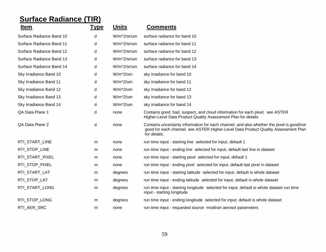
59
Surface Radiance (TIR)Item Type Units Comments
Surface Radiance Band 10 d W/m^2/sr/um surface radiance for band 10
Surface Radiance Band 11 d W/m^2/sr/um surface radiance for band 11
Surface Radiance Band 12 d W/m^2/sr/um surface radiance for band 12
Surface Radiance Band 13 d W/m^2/sr/um surface radiance for band 13
Surface Radiance Band 14 d W/m^2/sr/um surface radiance for band 14
Sky Irradiance Band 10 d W/m^2/um sky irradiance for band 10
Sky Irradiance Band 11 d W/m^2/um sky irradiance for band 11
Sky Irradiance Band 12 d W/m^2/um sky irradiance for band 12
Sky Irradiance Band 13 d W/m^2/um sky irradiance for band 13
Sky Irradiance Band 14 d W/m^2/um sky irradiance for band 14
QA Data Plane 1 d none Contains good, bad, suspect, and cloud information for each pixel; see ASTERHigher-Level Data Product Quality Assessment Plan for details
QA Data Plane 2 d none Contains uncertainty information for each channel, and also whether the pixel is good/notgood for each channel. see ASTER Higher-Level Data Product Quality Assessment Planfor details.
RTI_START_LINE m none run time input - starting line selected for input, default 1
RTI_STOP_LINE m none run time input - ending line selected for input, default last line in dataset
RTI_START_PIXEL m none run time input - starting pixel selected for input, default 1
RTI_STOP_PIXEL m none run time input - ending pixel selected for input, default last pixel in dataset
RTI_START_LAT m degrees run time input - starting latitude selected for input, default is whole dataset
RTI_STOP_LAT m degrees run time input - ending latitude selected for input, default is whole dataset
RTI_START_LONG m degrees run time input - starting longitude selected for input, default is whole dataset run timeinput - starting longitude
RTI_STOP_LONG m degrees run time input - ending longitude selected for input, default is whole dataset
RTI_AER_SRC m none run time input - requested source modtran aerosol parameters

60
Surface Radiance (TIR)Item Type Units Comments
RTI_MODTRAN_VERS m none run time input - which version of modtran to use
RTI_M_O3_SRC m none run time input - requested source columnar ozone profile
RTI_M_CO2_SRC m none run time input - requested source columnar carbon dioxide profile
RTI_M_H2O_SRC m none run time input - requested source columnar water vapor profile
RTI_M_TEMP_SRC m none run time input - requested source temperature profile
RTI_M_PRES_SRC m none run time input - requested source pressure profile
RTI_DEM_SRC m none run time input - requested source digital elevation model
MASK_USED m none whether or not mask was used
AEROSOL_OD_SRC m none source used for this product aerosol optical depth
AEROSOL_OD_RES m m resolution of source aerosol optical depth
AEROSOL_OD_MEAN m none mean for entire scene aerosol optical depth
AEROSOL_OD_STDEV m none standard deviation (of samples in scene) aerosol optical depth
AEROSOL_OD_UNCERT m none uncertainty estimate for each sample aerosol optical depth
MODTRAN_ALT_LEVELS m none list of altitude levels for profile data
MODTRAN_O3_SRC m none source used for this product columnar ozone profile
MODTRAN_O3_RES m m x-y resolution of source columnar ozone profile
MODTRAN_O3_UNCERT m none uncertainty estimate for each sample columnar ozone profile
MODTRAN_H2O_SRC m none source used for this product columnar water vapor profile
MODTRAN_H2O_RES m m x-y resolution of source columnar water vapor profile
MODTRAN_H2O_UNCERT m none uncertainty estimate for each sample columnar water vapor profile
MODTRAN_TEMP_SRC m none source used for this product temperature profile
MODTRAN_TEMP_RES m m x-y resolution of source temperature profile

61
Surface Radiance (TIR)Item Type Units Comments
MODTRAN_TEMP_UNCERT m none uncertainty estimate for each sample temperature profile
MODTRAN_PRES_SRC m none source used for this product pressure profile
MODTRAN_PRES_RES m m x-y resolution of source pressure profile
MODTRAN_PRES_UNCERT m none uncertainty estimate for each sample pressure profile
DEM_SRC m none source of dem
DEM_RES m m resolution of dem
DEM_MIN m m minimum elevation (for entire scene)
DEM_MAX m m maximum elevation in scene
DEM_UNCERT m none uncertainty of dem (pixel avg.)
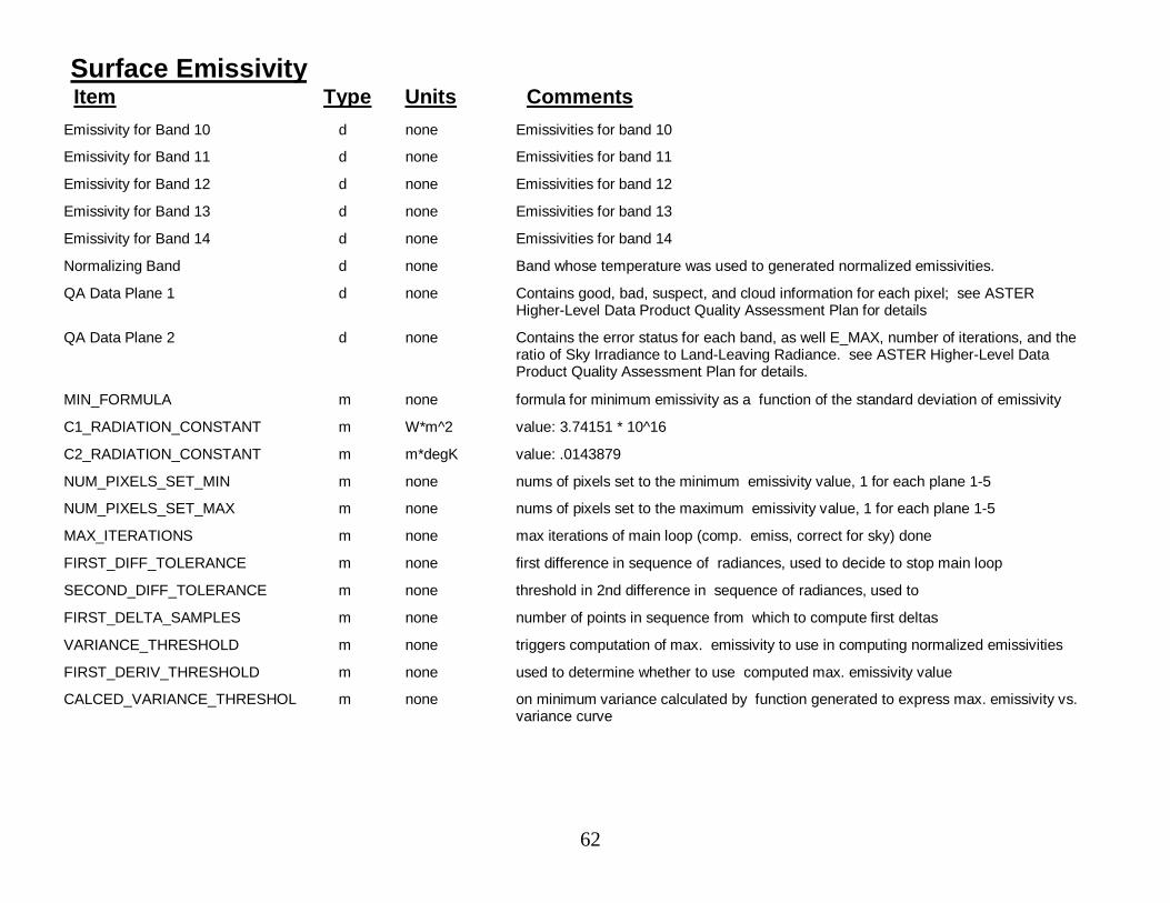
62
Surface EmissivityItem Type Units Comments
Emissivity for Band 10 d none Emissivities for band 10
Emissivity for Band 11 d none Emissivities for band 11
Emissivity for Band 12 d none Emissivities for band 12
Emissivity for Band 13 d none Emissivities for band 13
Emissivity for Band 14 d none Emissivities for band 14
Normalizing Band d none Band whose temperature was used to generated normalized emissivities.
QA Data Plane 1 d none Contains good, bad, suspect, and cloud information for each pixel; see ASTERHigher-Level Data Product Quality Assessment Plan for details
QA Data Plane 2 d none Contains the error status for each band, as well E_MAX, number of iterations, and theratio of Sky Irradiance to Land-Leaving Radiance. see ASTER Higher-Level DataProduct Quality Assessment Plan for details.
MIN_FORMULA m none formula for minimum emissivity as a function of the standard deviation of emissivity
C1_RADIATION_CONSTANT m W*m^2 value: 3.74151 * 10^16
C2_RADIATION_CONSTANT m m*degK value: .0143879
NUM_PIXELS_SET_MIN m none nums of pixels set to the minimum emissivity value, 1 for each plane 1-5
NUM_PIXELS_SET_MAX m none nums of pixels set to the maximum emissivity value, 1 for each plane 1-5
MAX_ITERATIONS m none max iterations of main loop (comp. emiss, correct for sky) done
FIRST_DIFF_TOLERANCE m none first difference in sequence of radiances, used to decide to stop main loop
SECOND_DIFF_TOLERANCE m none threshold in 2nd difference in sequence of radiances, used to
FIRST_DELTA_SAMPLES m none number of points in sequence from which to compute first deltas
VARIANCE_THRESHOLD m none triggers computation of max. emissivity to use in computing normalized emissivities
FIRST_DERIV_THRESHOLD m none used to determine whether to use computed max. emissivity value
CALCED_VARIANCE_THRESHOL m none on minimum variance calculated by function generated to express max. emissivity vs.variance curve
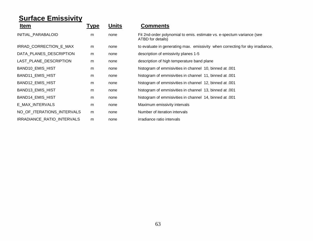
63
Surface EmissivityItem Type Units Comments
INITIAL_PARABALOID m none Fit 2nd-order polynomial to emis. estimate vs. e-spectum variance (seeATBD for details)
IRRAD_CORRECTION_E_MAX m none to evaluate in generating max. emissivity when correcting for sky irradiance,
DATA_PLANES_DESCRIPTION m none description of emissivity planes 1-5
LAST_PLANE_DESCRIPTION m none description of high temperature band plane
BAND10_EMIS_HIST m none histogram of emmisivities in channel 10, binned at .001
BAND11_EMIS_HIST m none histogram of emmisivities in channel 11, binned at .001
BAND12_EMIS_HIST m none histogram of emmisivities in channel 12, binned at .001
BAND13_EMIS_HIST m none histogram of emmisivities in channel 13, binned at .001
BAND14_EMIS_HIST m none histogram of emmisivities in channel 14, binned at .001
E_MAX_INTERVALS m none Maximum emissivity intervals
NO_OF_ITERATIONS_INTERVALS m none Number of iteration intervals
IRRADIANCE_RATIO_INTERVALS m none irradiance ratio intervals
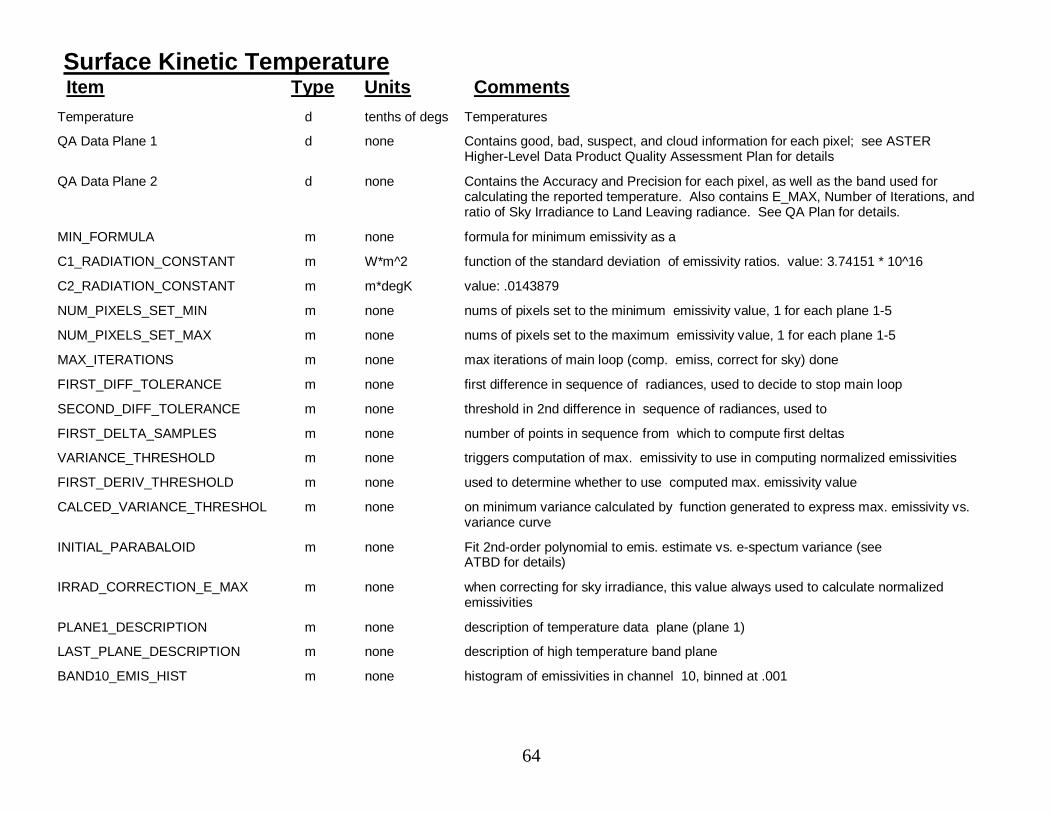
64
Surface Kinetic TemperatureItem Type Units Comments
Temperature d tenths of degs Temperatures
QA Data Plane 1 d none Contains good, bad, suspect, and cloud information for each pixel; see ASTERHigher-Level Data Product Quality Assessment Plan for details
QA Data Plane 2 d none Contains the Accuracy and Precision for each pixel, as well as the band used forcalculating the reported temperature. Also contains E_MAX, Number of Iterations, andratio of Sky Irradiance to Land Leaving radiance. See QA Plan for details.
MIN_FORMULA m none formula for minimum emissivity as a
C1_RADIATION_CONSTANT m W*m^2 function of the standard deviation of emissivity ratios. value: 3.74151 * 10^16
C2_RADIATION_CONSTANT m m*degK value: .0143879
NUM_PIXELS_SET_MIN m none nums of pixels set to the minimum emissivity value, 1 for each plane 1-5
NUM_PIXELS_SET_MAX m none nums of pixels set to the maximum emissivity value, 1 for each plane 1-5
MAX_ITERATIONS m none max iterations of main loop (comp. emiss, correct for sky) done
FIRST_DIFF_TOLERANCE m none first difference in sequence of radiances, used to decide to stop main loop
SECOND_DIFF_TOLERANCE m none threshold in 2nd difference in sequence of radiances, used to
FIRST_DELTA_SAMPLES m none number of points in sequence from which to compute first deltas
VARIANCE_THRESHOLD m none triggers computation of max. emissivity to use in computing normalized emissivities
FIRST_DERIV_THRESHOLD m none used to determine whether to use computed max. emissivity value
CALCED_VARIANCE_THRESHOL m none on minimum variance calculated by function generated to express max. emissivity vs.variance curve
INITIAL_PARABALOID m none Fit 2nd-order polynomial to emis. estimate vs. e-spectum variance (seeATBD for details)
IRRAD_CORRECTION_E_MAX m none when correcting for sky irradiance, this value always used to calculate normalizedemissivities
PLANE1_DESCRIPTION m none description of temperature data plane (plane 1)
LAST_PLANE_DESCRIPTION m none description of high temperature band plane
BAND10_EMIS_HIST m none histogram of emissivities in channel 10, binned at .001
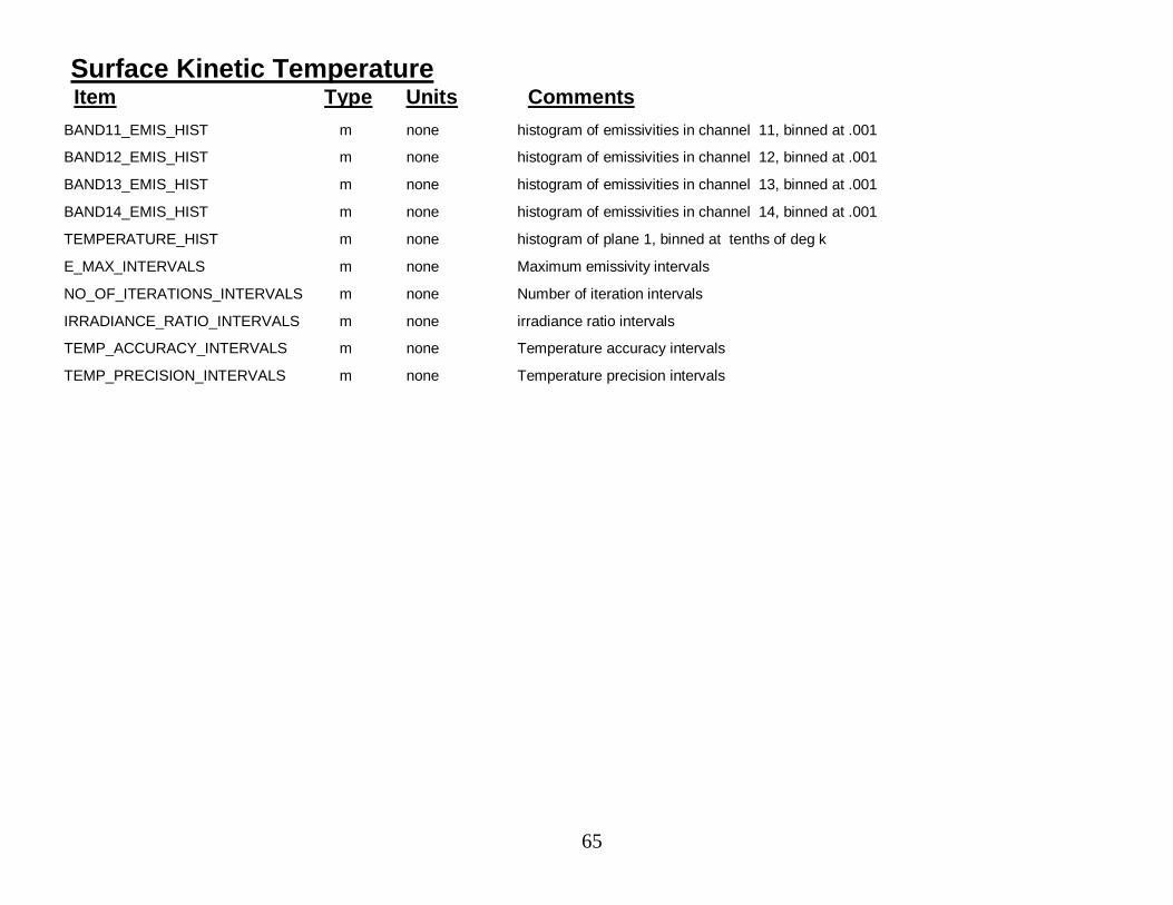
65
Surface Kinetic TemperatureItem Type Units Comments
BAND11_EMIS_HIST m none histogram of emissivities in channel 11, binned at .001
BAND12_EMIS_HIST m none histogram of emissivities in channel 12, binned at .001
BAND13_EMIS_HIST m none histogram of emissivities in channel 13, binned at .001
BAND14_EMIS_HIST m none histogram of emissivities in channel 14, binned at .001
TEMPERATURE_HIST m none histogram of plane 1, binned at tenths of deg k
E_MAX_INTERVALS m none Maximum emissivity intervals
NO_OF_ITERATIONS_INTERVALS m none Number of iteration intervals
IRRADIANCE_RATIO_INTERVALS m none irradiance ratio intervals
TEMP_ACCURACY_INTERVALS m none Temperature accuracy intervals
TEMP_PRECISION_INTERVALS m none Temperature precision intervals
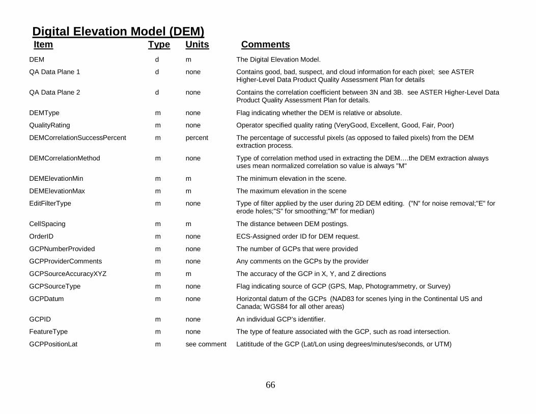
66
Digital Elevation Model (DEM)Item Type Units Comments
DEM d m The Digital Elevation Model.
QA Data Plane 1 d none Contains good, bad, suspect, and cloud information for each pixel; see ASTERHigher-Level Data Product Quality Assessment Plan for details
QA Data Plane 2 d none Contains the correlation coefficient between 3N and 3B. see ASTER Higher-Level DataProduct Quality Assessment Plan for details.
DEMType m none Flag indicating whether the DEM is relative or absolute.
QualityRating m none Operator specified quality rating (VeryGood, Excellent, Good, Fair, Poor)
DEMCorrelationSuccessPercent m percent The percentage of successful pixels (as opposed to failed pixels) from the DEMextraction process.
DEMCorrelationMethod m none Type of correlation method used in extracting the DEM….the DEM extraction alwaysuses mean normalized correlation so value is always "M"
DEMElevationMin m m The minimum elevation in the scene.
DEMElevationMax m m The maximum elevation in the scene
EditFilterType m none Type of filter applied by the user during 2D DEM editing. ("N" for noise removal;"E" forerode holes;"S" for smoothing;"M" for median)
CellSpacing m m The distance between DEM postings.
OrderID m none ECS-Assigned order ID for DEM request.
GCPNumberProvided m none The number of GCPs that were provided
GCPProviderComments m none Any comments on the GCPs by the provider
GCPSourceAccuracyXYZ m m The accuracy of the GCP in X, Y, and Z directions
GCPSourceType m none Flag indicating source of GCP (GPS, Map, Photogrammetry, or Survey)
GCPDatum m none Horizontal datum of the GCPs (NAD83 for scenes lying in the Continental US andCanada; WGS84 for all other areas)
GCPID m none An individual GCP’s identifier.
FeatureType m none The type of feature associated with the GCP, such as road intersection.
GCPPositionLat m see comment Latititude of the GCP (Lat/Lon using degrees/minutes/seconds, or UTM)

67
Digital Elevation Model (DEM)Item Type Units Comments
GCPPositionLon m see comment Longitude of the GCP (Lat/Lon using degrees/minutes/seconds, or UTM)
GCPPositionElev m m Elevation of the GCP
GCPXLocation3N m none Identifies the sample number in the 3N image of the pixel associated with the GCP
GCPYLocation3N m none Identifies the line number in the 3N image of the pixel associated with the GCP
GCPXLocation3B m none Identifies the sample number in the 3B image of the pixel associated with the GCP
GCPYLocation3B m none Identifies the line number in the 3B image of the pixel associated with the GCP
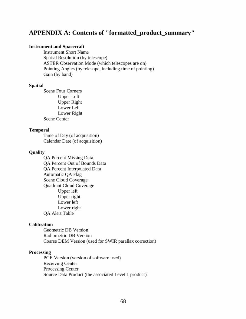
68
APPENDIX A: Contents of "formatted_product_summary"
Instrument and SpacecraftInstrument Short NameSpatial Resolution (by telescope)ASTER Observation Mode (which telescopes are on)Pointing Angles (by telesope, including time of pointing)Gain (by band)
SpatialScene Four Corners
Upper LeftUpper RightLower LeftLower Right
Scene Center
TemporalTime of Day (of acquisition)Calendar Date (of acquisition)
QualityQA Percent Missing DataQA Percent Out of Bounds DataQA Percent Interpolated DataAutomatic QA FlagScene Cloud CoverageQuadrant Cloud Coverage
Upper leftUpper rightLower leftLower right
QA Alert Table
CalibrationGeometric DB VersionRadiometric DB VersionCoarse DEM Version (used for SWIR parallax correction)
ProcessingPGE Version (version of software used)Receiving CenterProcessing CenterSource Data Product (the associated Level 1 product)

69
SceneScene Orientation Angle (rotation of scene axis relative to North)Map ProjectionSolar Direction
AzimithElevation
Band Scale Factors
Product-Specific (varies by product)
Level 1 CarryoverA copy of the metadata from the associated Level 1 product--except for bad pixel
information which is provided separately (next item)
Level 1 Bad Pixel InformationNumber of Bad Pixels (by band)List of Bad Pixels (by band)

70
APPENDIX B: Metadata Cross Reference Table
If you know the name of a metadata attribute, but don't know which hdf attribute contains it, usethis table to find out. (Please ignore case--sometimes an item is represented in all upper case,sometimes in mixed or lower case.)
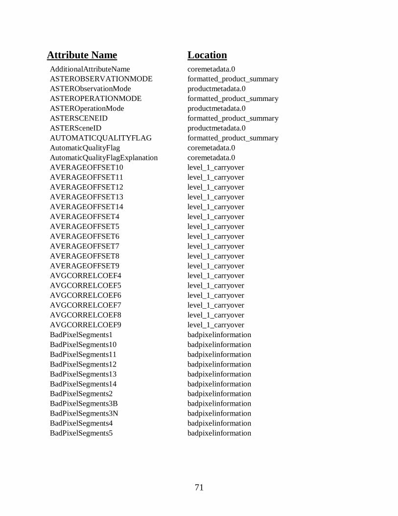
71
Attribute Name LocationAdditionalAttributeName coremetadata.0ASTEROBSERVATIONMODE formatted_product_summaryASTERObservationMode productmetadata.0ASTEROPERATIONMODE formatted_product_summaryASTEROperationMode productmetadata.0ASTERSCENEID formatted_product_summaryASTERSceneID productmetadata.0AUTOMATICQUALITYFLAG formatted_product_summaryAutomaticQualityFlag coremetadata.0AutomaticQualityFlagExplanation coremetadata.0AVERAGEOFFSET10 level_1_carryoverAVERAGEOFFSET11 level_1_carryoverAVERAGEOFFSET12 level_1_carryoverAVERAGEOFFSET13 level_1_carryoverAVERAGEOFFSET14 level_1_carryoverAVERAGEOFFSET4 level_1_carryoverAVERAGEOFFSET5 level_1_carryoverAVERAGEOFFSET6 level_1_carryoverAVERAGEOFFSET7 level_1_carryoverAVERAGEOFFSET8 level_1_carryoverAVERAGEOFFSET9 level_1_carryoverAVGCORRELCOEF4 level_1_carryoverAVGCORRELCOEF5 level_1_carryoverAVGCORRELCOEF6 level_1_carryoverAVGCORRELCOEF7 level_1_carryoverAVGCORRELCOEF8 level_1_carryoverAVGCORRELCOEF9 level_1_carryoverBadPixelSegments1 badpixelinformationBadPixelSegments10 badpixelinformationBadPixelSegments11 badpixelinformationBadPixelSegments12 badpixelinformationBadPixelSegments13 badpixelinformationBadPixelSegments14 badpixelinformationBadPixelSegments2 badpixelinformationBadPixelSegments3B badpixelinformationBadPixelSegments3N badpixelinformationBadPixelSegments4 badpixelinformationBadPixelSegments5 badpixelinformation
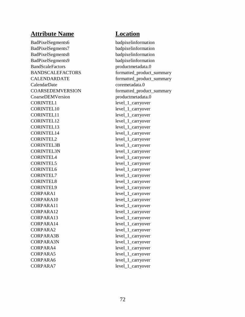
72
Attribute Name LocationBadPixelSegments6 badpixelinformationBadPixelSegments7 badpixelinformationBadPixelSegments8 badpixelinformationBadPixelSegments9 badpixelinformationBandScaleFactors productmetadata.0BANDSCALEFACTORS formatted_product_summaryCALENDARDATE formatted_product_summaryCalendarDate coremetadata.0COARSEDEMVERSION formatted_product_summaryCoarseDEMVersion productmetadata.0CORINTEL1 level_1_carryoverCORINTEL10 level_1_carryoverCORINTEL11 level_1_carryoverCORINTEL12 level_1_carryoverCORINTEL13 level_1_carryoverCORINTEL14 level_1_carryoverCORINTEL2 level_1_carryoverCORINTEL3B level_1_carryoverCORINTEL3N level_1_carryoverCORINTEL4 level_1_carryoverCORINTEL5 level_1_carryoverCORINTEL6 level_1_carryoverCORINTEL7 level_1_carryoverCORINTEL8 level_1_carryoverCORINTEL9 level_1_carryoverCORPARA1 level_1_carryoverCORPARA10 level_1_carryoverCORPARA11 level_1_carryoverCORPARA12 level_1_carryoverCORPARA13 level_1_carryoverCORPARA14 level_1_carryoverCORPARA2 level_1_carryoverCORPARA3B level_1_carryoverCORPARA3N level_1_carryoverCORPARA4 level_1_carryoverCORPARA5 level_1_carryoverCORPARA6 level_1_carryoverCORPARA7 level_1_carryover
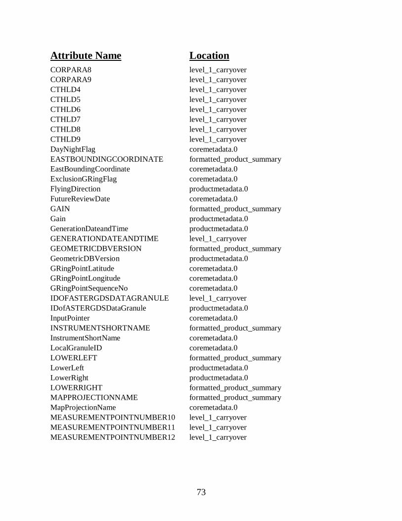
73
Attribute Name LocationCORPARA8 level_1_carryoverCORPARA9 level_1_carryoverCTHLD4 level_1_carryoverCTHLD5 level_1_carryoverCTHLD6 level_1_carryoverCTHLD7 level_1_carryoverCTHLD8 level_1_carryoverCTHLD9 level_1_carryoverDayNightFlag coremetadata.0EASTBOUNDINGCOORDINATE formatted_product_summaryEastBoundingCoordinate coremetadata.0ExclusionGRingFlag coremetadata.0FlyingDirection productmetadata.0FutureReviewDate coremetadata.0GAIN formatted_product_summaryGain productmetadata.0GenerationDateandTime productmetadata.0GENERATIONDATEANDTIME level_1_carryoverGEOMETRICDBVERSION formatted_product_summaryGeometricDBVersion productmetadata.0GRingPointLatitude coremetadata.0GRingPointLongitude coremetadata.0GRingPointSequenceNo coremetadata.0IDOFASTERGDSDATAGRANULE level_1_carryoverIDofASTERGDSDataGranule productmetadata.0InputPointer coremetadata.0INSTRUMENTSHORTNAME formatted_product_summaryInstrumentShortName coremetadata.0LocalGranuleID coremetadata.0LOWERLEFT formatted_product_summaryLowerLeft productmetadata.0LowerRight productmetadata.0LOWERRIGHT formatted_product_summaryMAPPROJECTIONNAME formatted_product_summaryMapProjectionName coremetadata.0MEASUREMENTPOINTNUMBER10 level_1_carryoverMEASUREMENTPOINTNUMBER11 level_1_carryoverMEASUREMENTPOINTNUMBER12 level_1_carryover
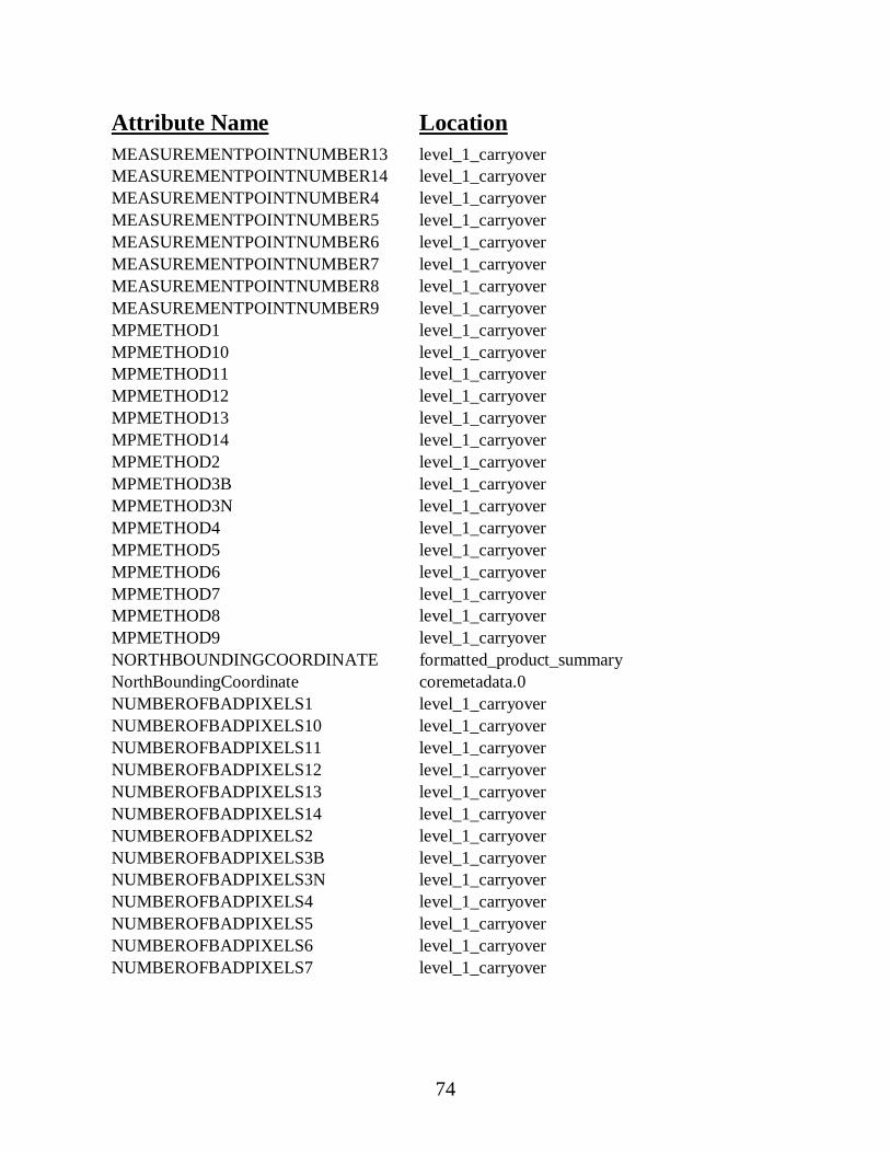
74
Attribute Name LocationMEASUREMENTPOINTNUMBER13 level_1_carryoverMEASUREMENTPOINTNUMBER14 level_1_carryoverMEASUREMENTPOINTNUMBER4 level_1_carryoverMEASUREMENTPOINTNUMBER5 level_1_carryoverMEASUREMENTPOINTNUMBER6 level_1_carryoverMEASUREMENTPOINTNUMBER7 level_1_carryoverMEASUREMENTPOINTNUMBER8 level_1_carryoverMEASUREMENTPOINTNUMBER9 level_1_carryoverMPMETHOD1 level_1_carryoverMPMETHOD10 level_1_carryoverMPMETHOD11 level_1_carryoverMPMETHOD12 level_1_carryoverMPMETHOD13 level_1_carryoverMPMETHOD14 level_1_carryoverMPMETHOD2 level_1_carryoverMPMETHOD3B level_1_carryoverMPMETHOD3N level_1_carryoverMPMETHOD4 level_1_carryoverMPMETHOD5 level_1_carryoverMPMETHOD6 level_1_carryoverMPMETHOD7 level_1_carryoverMPMETHOD8 level_1_carryoverMPMETHOD9 level_1_carryoverNORTHBOUNDINGCOORDINATE formatted_product_summaryNorthBoundingCoordinate coremetadata.0NUMBEROFBADPIXELS1 level_1_carryoverNUMBEROFBADPIXELS10 level_1_carryoverNUMBEROFBADPIXELS11 level_1_carryoverNUMBEROFBADPIXELS12 level_1_carryoverNUMBEROFBADPIXELS13 level_1_carryoverNUMBEROFBADPIXELS14 level_1_carryoverNUMBEROFBADPIXELS2 level_1_carryoverNUMBEROFBADPIXELS3B level_1_carryoverNUMBEROFBADPIXELS3N level_1_carryoverNUMBEROFBADPIXELS4 level_1_carryoverNUMBEROFBADPIXELS5 level_1_carryoverNUMBEROFBADPIXELS6 level_1_carryoverNUMBEROFBADPIXELS7 level_1_carryover
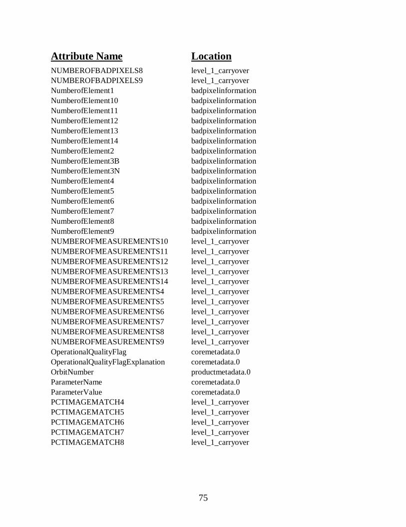
75
Attribute Name LocationNUMBEROFBADPIXELS8 level_1_carryoverNUMBEROFBADPIXELS9 level_1_carryoverNumberofElement1 badpixelinformationNumberofElement10 badpixelinformationNumberofElement11 badpixelinformationNumberofElement12 badpixelinformationNumberofElement13 badpixelinformationNumberofElement14 badpixelinformationNumberofElement2 badpixelinformationNumberofElement3B badpixelinformationNumberofElement3N badpixelinformationNumberofElement4 badpixelinformationNumberofElement5 badpixelinformationNumberofElement6 badpixelinformationNumberofElement7 badpixelinformationNumberofElement8 badpixelinformationNumberofElement9 badpixelinformationNUMBEROFMEASUREMENTS10 level_1_carryoverNUMBEROFMEASUREMENTS11 level_1_carryoverNUMBEROFMEASUREMENTS12 level_1_carryoverNUMBEROFMEASUREMENTS13 level_1_carryoverNUMBEROFMEASUREMENTS14 level_1_carryoverNUMBEROFMEASUREMENTS4 level_1_carryoverNUMBEROFMEASUREMENTS5 level_1_carryoverNUMBEROFMEASUREMENTS6 level_1_carryoverNUMBEROFMEASUREMENTS7 level_1_carryoverNUMBEROFMEASUREMENTS8 level_1_carryoverNUMBEROFMEASUREMENTS9 level_1_carryoverOperationalQualityFlag coremetadata.0OperationalQualityFlagExplanation coremetadata.0OrbitNumber productmetadata.0ParameterName coremetadata.0ParameterValue coremetadata.0PCTIMAGEMATCH4 level_1_carryoverPCTIMAGEMATCH5 level_1_carryoverPCTIMAGEMATCH6 level_1_carryoverPCTIMAGEMATCH7 level_1_carryoverPCTIMAGEMATCH8 level_1_carryover
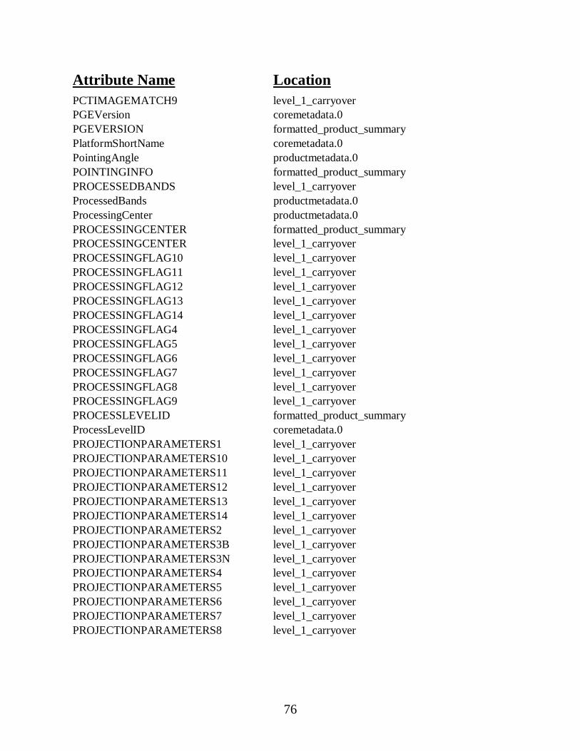
76
Attribute Name LocationPCTIMAGEMATCH9 level_1_carryoverPGEVersion coremetadata.0PGEVERSION formatted_product_summaryPlatformShortName coremetadata.0PointingAngle productmetadata.0POINTINGINFO formatted_product_summaryPROCESSEDBANDS level_1_carryoverProcessedBands productmetadata.0ProcessingCenter productmetadata.0PROCESSINGCENTER formatted_product_summaryPROCESSINGCENTER level_1_carryoverPROCESSINGFLAG10 level_1_carryoverPROCESSINGFLAG11 level_1_carryoverPROCESSINGFLAG12 level_1_carryoverPROCESSINGFLAG13 level_1_carryoverPROCESSINGFLAG14 level_1_carryoverPROCESSINGFLAG4 level_1_carryoverPROCESSINGFLAG5 level_1_carryoverPROCESSINGFLAG6 level_1_carryoverPROCESSINGFLAG7 level_1_carryoverPROCESSINGFLAG8 level_1_carryoverPROCESSINGFLAG9 level_1_carryoverPROCESSLEVELID formatted_product_summaryProcessLevelID coremetadata.0PROJECTIONPARAMETERS1 level_1_carryoverPROJECTIONPARAMETERS10 level_1_carryoverPROJECTIONPARAMETERS11 level_1_carryoverPROJECTIONPARAMETERS12 level_1_carryoverPROJECTIONPARAMETERS13 level_1_carryoverPROJECTIONPARAMETERS14 level_1_carryoverPROJECTIONPARAMETERS2 level_1_carryoverPROJECTIONPARAMETERS3B level_1_carryoverPROJECTIONPARAMETERS3N level_1_carryoverPROJECTIONPARAMETERS4 level_1_carryoverPROJECTIONPARAMETERS5 level_1_carryoverPROJECTIONPARAMETERS6 level_1_carryoverPROJECTIONPARAMETERS7 level_1_carryoverPROJECTIONPARAMETERS8 level_1_carryover
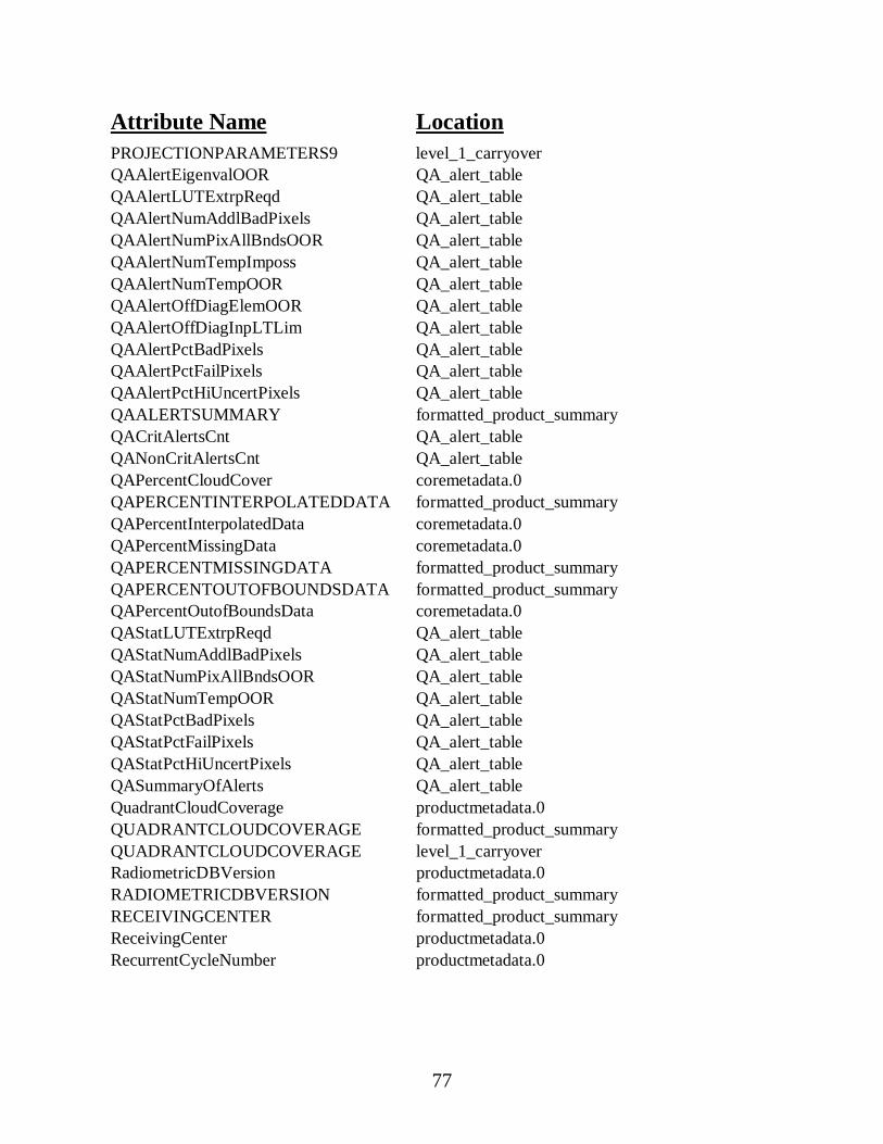
77
Attribute Name LocationPROJECTIONPARAMETERS9 level_1_carryoverQAAlertEigenvalOOR QA_alert_tableQAAlertLUTExtrpReqd QA_alert_tableQAAlertNumAddlBadPixels QA_alert_tableQAAlertNumPixAllBndsOOR QA_alert_tableQAAlertNumTempImposs QA_alert_tableQAAlertNumTempOOR QA_alert_tableQAAlertOffDiagElemOOR QA_alert_tableQAAlertOffDiagInpLTLim QA_alert_tableQAAlertPctBadPixels QA_alert_tableQAAlertPctFailPixels QA_alert_tableQAAlertPctHiUncertPixels QA_alert_tableQAALERTSUMMARY formatted_product_summaryQACritAlertsCnt QA_alert_tableQANonCritAlertsCnt QA_alert_tableQAPercentCloudCover coremetadata.0QAPERCENTINTERPOLATEDDATA formatted_product_summaryQAPercentInterpolatedData coremetadata.0QAPercentMissingData coremetadata.0QAPERCENTMISSINGDATA formatted_product_summaryQAPERCENTOUTOFBOUNDSDATA formatted_product_summaryQAPercentOutofBoundsData coremetadata.0QAStatLUTExtrpReqd QA_alert_tableQAStatNumAddlBadPixels QA_alert_tableQAStatNumPixAllBndsOOR QA_alert_tableQAStatNumTempOOR QA_alert_tableQAStatPctBadPixels QA_alert_tableQAStatPctFailPixels QA_alert_tableQAStatPctHiUncertPixels QA_alert_tableQASummaryOfAlerts QA_alert_tableQuadrantCloudCoverage productmetadata.0QUADRANTCLOUDCOVERAGE formatted_product_summaryQUADRANTCLOUDCOVERAGE level_1_carryoverRadiometricDBVersion productmetadata.0RADIOMETRICDBVERSION formatted_product_summaryRECEIVINGCENTER formatted_product_summaryReceivingCenter productmetadata.0RecurrentCycleNumber productmetadata.0
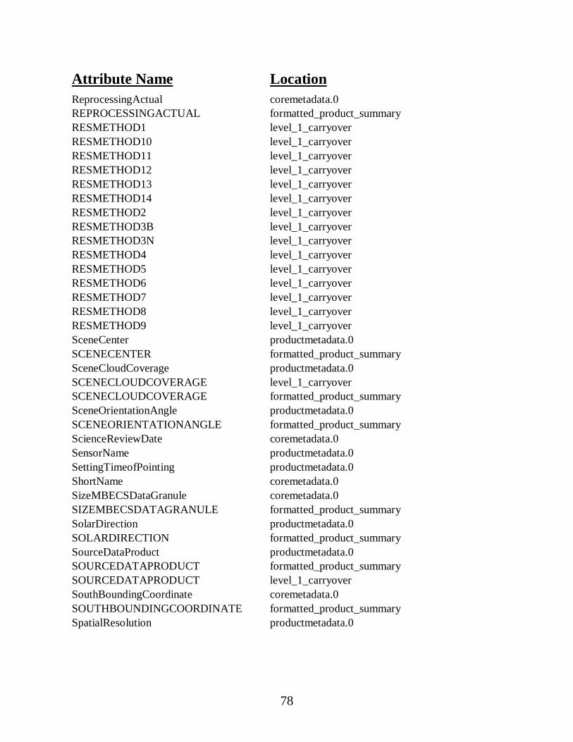
78
Attribute Name LocationReprocessingActual coremetadata.0REPROCESSINGACTUAL formatted_product_summaryRESMETHOD1 level_1_carryoverRESMETHOD10 level_1_carryoverRESMETHOD11 level_1_carryoverRESMETHOD12 level_1_carryoverRESMETHOD13 level_1_carryoverRESMETHOD14 level_1_carryoverRESMETHOD2 level_1_carryoverRESMETHOD3B level_1_carryoverRESMETHOD3N level_1_carryoverRESMETHOD4 level_1_carryoverRESMETHOD5 level_1_carryoverRESMETHOD6 level_1_carryoverRESMETHOD7 level_1_carryoverRESMETHOD8 level_1_carryoverRESMETHOD9 level_1_carryoverSceneCenter productmetadata.0SCENECENTER formatted_product_summarySceneCloudCoverage productmetadata.0SCENECLOUDCOVERAGE level_1_carryoverSCENECLOUDCOVERAGE formatted_product_summarySceneOrientationAngle productmetadata.0SCENEORIENTATIONANGLE formatted_product_summaryScienceReviewDate coremetadata.0SensorName productmetadata.0SettingTimeofPointing productmetadata.0ShortName coremetadata.0SizeMBECSDataGranule coremetadata.0SIZEMBECSDATAGRANULE formatted_product_summarySolarDirection productmetadata.0SOLARDIRECTION formatted_product_summarySourceDataProduct productmetadata.0SOURCEDATAPRODUCT formatted_product_summarySOURCEDATAPRODUCT level_1_carryoverSouthBoundingCoordinate coremetadata.0SOUTHBOUNDINGCOORDINATE formatted_product_summarySpatialResolution productmetadata.0
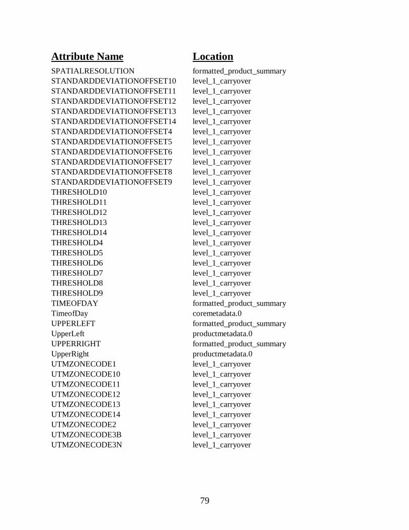
79
Attribute Name LocationSPATIALRESOLUTION formatted_product_summarySTANDARDDEVIATIONOFFSET10 level_1_carryoverSTANDARDDEVIATIONOFFSET11 level_1_carryoverSTANDARDDEVIATIONOFFSET12 level_1_carryoverSTANDARDDEVIATIONOFFSET13 level_1_carryoverSTANDARDDEVIATIONOFFSET14 level_1_carryoverSTANDARDDEVIATIONOFFSET4 level_1_carryoverSTANDARDDEVIATIONOFFSET5 level_1_carryoverSTANDARDDEVIATIONOFFSET6 level_1_carryoverSTANDARDDEVIATIONOFFSET7 level_1_carryoverSTANDARDDEVIATIONOFFSET8 level_1_carryoverSTANDARDDEVIATIONOFFSET9 level_1_carryoverTHRESHOLD10 level_1_carryoverTHRESHOLD11 level_1_carryoverTHRESHOLD12 level_1_carryoverTHRESHOLD13 level_1_carryoverTHRESHOLD14 level_1_carryoverTHRESHOLD4 level_1_carryoverTHRESHOLD5 level_1_carryoverTHRESHOLD6 level_1_carryoverTHRESHOLD7 level_1_carryoverTHRESHOLD8 level_1_carryoverTHRESHOLD9 level_1_carryoverTIMEOFDAY formatted_product_summaryTimeofDay coremetadata.0UPPERLEFT formatted_product_summaryUpperLeft productmetadata.0UPPERRIGHT formatted_product_summaryUpperRight productmetadata.0UTMZONECODE1 level_1_carryoverUTMZONECODE10 level_1_carryoverUTMZONECODE11 level_1_carryoverUTMZONECODE12 level_1_carryoverUTMZONECODE13 level_1_carryoverUTMZONECODE14 level_1_carryoverUTMZONECODE2 level_1_carryoverUTMZONECODE3B level_1_carryoverUTMZONECODE3N level_1_carryover

80
Attribute Name LocationUTMZONECODE4 level_1_carryoverUTMZONECODE5 level_1_carryoverUTMZONECODE6 level_1_carryoverUTMZONECODE7 level_1_carryoverUTMZONECODE8 level_1_carryoverUTMZONECODE9 level_1_carryoverVersionID coremetadata.0WESTBOUNDINGCOORDINATE formatted_product_summaryWestBoundingCoordinate coremetadata.0
Related Documents