Assimilation of Satellite Derived Snow Information in the Canadian Land Data Assimilation System Chris Derksen, Libo Wang Climate Research Division, Environment Canada Toronto, ON Stéphane Bélair, Sheena Solomon, Marco Carrera, and Bernard Bilodeau Meteorological Research Division, Environment Canada, Dorval, QC Sari Metsamaki Finnish Environment Institute, Helsinki

Welcome message from author
This document is posted to help you gain knowledge. Please leave a comment to let me know what you think about it! Share it to your friends and learn new things together.
Transcript
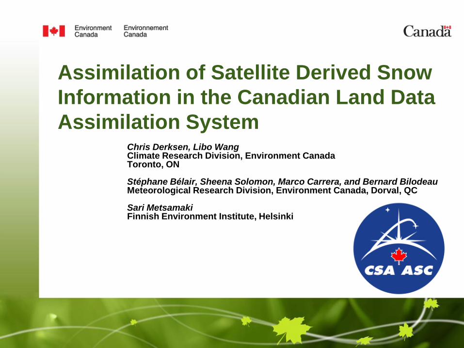
Assimilation of Satellite Derived Snow
Information in the Canadian Land Data
Assimilation SystemChris Derksen, Libo WangClimate Research Division, Environment CanadaToronto, ON
Stéphane Bélair, Sheena Solomon, Marco Carrera, and Bernard BilodeauMeteorological Research Division, Environment Canada, Dorval, QC
Sari MetsamakiFinnish Environment Institute, Helsinki
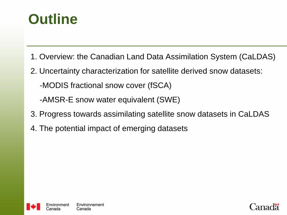
Outline
1. Overview: the Canadian Land Data Assimilation System (CaLDAS)
2. Uncertainty characterization for satellite derived snow datasets:
-MODIS fractional snow cover (fSCA)
-AMSR-E snow water equivalent (SWE)
3. Progress towards assimilating satellite snow datasets in CaLDAS
4. The potential impact of emerging datasets

Research Context
• Efforts are underway to improve treatment of the land surface, and include a
hydrological component, to Environment Canada’s (EC) numerical prediction systems.
• Emphasis on assimilation of space-based remote sensing data (for soil moisture,
terrestrial snow, and vegetation).
• Single system for all NWP systems (deterministic and ensemble-based) + hydrology
models.
• In EC’s current prediction systems, snow is initialized using surface observations of
snow depth (sparsely distributed in space; no information on the fractional coverage of
snow on the ground).
• Satellite derived measurements can produce the spatially and temporally continuous
observations necessary to systematically monitor snow cover, and characterize initial
conditions.
A primary objective is to improve the representation of snow in Environment Canada’s
operational prediction systems by including space-based measurements in the
Canadian Land Data Assimilation System (CaLDAS).
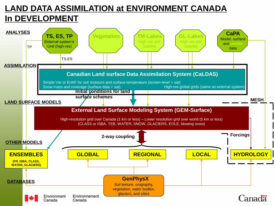
LAND DATA ASSIMILATION at ENVIRONMENT CANADA
In DEVELOPMENT
ENSEMBLES(FR, ISBA, CLASS,
WATER, GLACIERS)
GLOBAL REGIONAL LOCAL
GenPhysXSoil texture, orography,
vegetation, water bodies,
glaciers, and cities
TM-LakesHigh-res grid
Satellite
TS, ES, TPExternal system’s
Grid (high-res)
ANALYSES
ASSIMILATION
OTHER MODELS
DATABASES
Vegetation GL-LakesHigh-res grid
Satellite
Canadian Land surface Data Assimilation System (CaLDAS)
High-res global grids (same as external system)Simple Var or EnKF for soil moisture and surface temperature (screen-level + sat)
Snow mass and coverage (surface data + sat)
External Land Surface Modeling System (GEM-Surface)
High-resolution grid over Canada (1 km or less) – Lower resolution grid over world (5 km or less)
(CLASS or ISBA, TEB, WATER, SNOW, GLACIERS, EOLE, blowing snow)
LAND SURFACE MODELS
CaPAModel, surface
and satellite
data
HYDROLOGY
MESH
Initial conditions for land
surface schemes
2-way coupling Forcings
TP
TS,ES

Current Treatment of Snow in CaLDAS:
Canadian Meterological Centre Daily Gridded
Global Snow Depth
Start Date 12-Mar-1998
End Date Ongoing
Domain Global
Temporal Resolution Daily
Spatial Resolution 1/3 degree
Variables Depth; Density
• All available snow depth observations (from synops,
meteorological aviation reports, and special aviation
reports) are ingested into the analysis.
• Updated every 6 hours using optimum interpolation
with an initial guess field provided by a simple snow
accumulation and melt model using analyzed
temperatures and forecast (6 hour) precipitation from
the CMC global forecast model.
• The analysis includes an estimate of the density of
the snowpack.
• Now archived at NSIDC. Known sources of uncertainty:
• Low depth bias and early melt bias due to
climate station observing locations.
• Data sparse regions: snow depth corresponds
to the initial guess field
• Density derived from very simple time decay
function (can be replaced by climatology in post
processing).

Sparse conventional observation network:
A challenge for data assimilation
strategies and algorithm evaluation.
The Need for Satellite Derived
Snow Information

Objective is to develop validated, temporally consistent datasets:
1. Fractional snow covered area: MODIS
2. Snow water equivalent: Passive microwave (AMSR-E; SSM/I)
3. Snow melt onset/duration: QuikSCAT
Collectively, these datasets tell us what fraction of the surface is snow covered, how much
water is stored in the snowpack, when and for how long it melts.
These snow cover parameters are then utilized for:
• Determining cryosphere/climate interactions
• Evaluation of historical data records
• Climate model evaluation
• Initial conditions for land surface data assimilation
Satellite-Derived Snow Cover Dataset
Development at Environment Canada

Based on Metsamaki et al. (2005), reflectance of the
target area described as a function of:
-canopy transmissivity (t),
-snow covered area (SCA),
-dry snow reflectance (,snow),
-snow-free ground reflectance (,ground)
-forest canopy reflectance (,forest)):
The effective transmissivity estimated from MODIS
reflectance data at full dry snow cover conditions
(SCA=1):
MODIS Derived Fractional
Snow Covered Area (fSCA)

Dataset Resolution Snow
Parameter
Retrieval
Basis
Clouds Uncertainty Determination
NOAA IMS 4 km Snow Extent
(snow/no-snow)
Subjective No Agreement with model first guess
MODIS CGF 5 km fSCA Statistical No Time lag since cloud free look
MODIS
fSCA
1 km fSCA Spectral Yes Variance in reference reflectance used in
retrieval equations
25 May 2007
MODIS fSCA NASA MODIS CGF NOAA IMSCGF Cloud Persistence
Assessment: MODIS fSCA
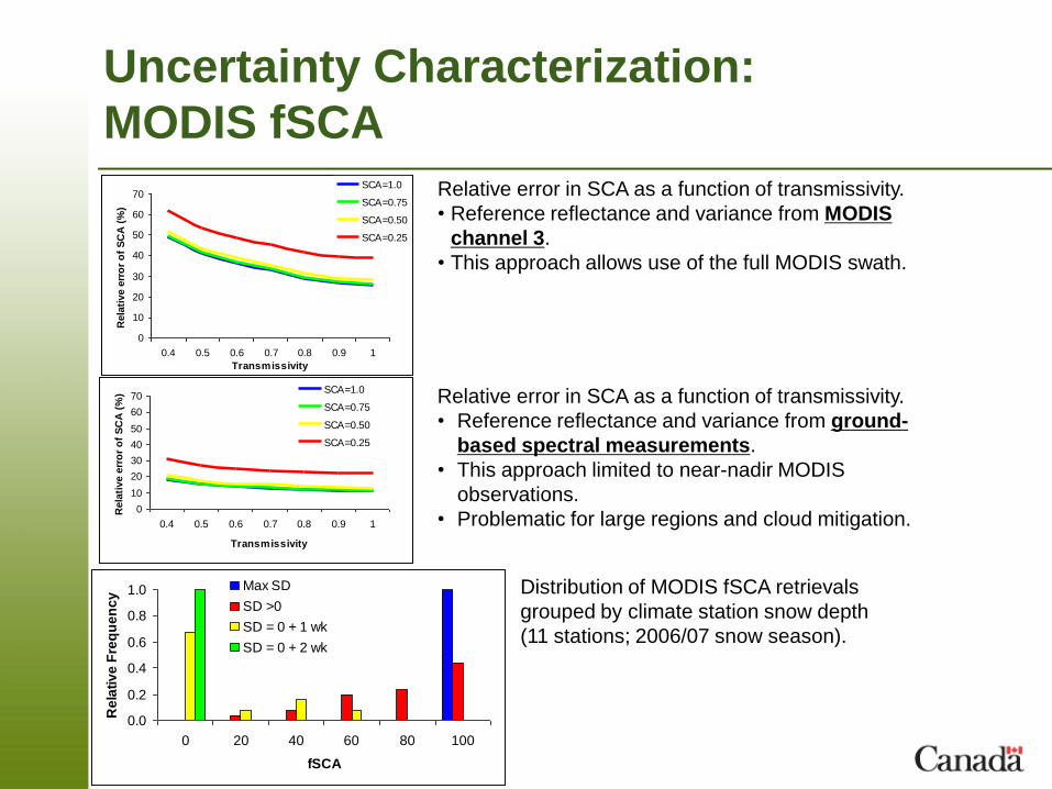
Uncertainty Characterization:
MODIS fSCA
0
10
20
30
40
50
60
70
0.4 0.5 0.6 0.7 0.8 0.9 1
Transmissivity
Rela
tive e
rro
r o
f S
CA
(%
)
SCA=1.0
SCA=0.75
SCA=0.50
SCA=0.25
Relative error in SCA as a function of transmissivity.
• Reference reflectance and variance from MODIS
channel 3.
• This approach allows use of the full MODIS swath.
Relative error in SCA as a function of transmissivity.
• Reference reflectance and variance from ground-
based spectral measurements.
• This approach limited to near-nadir MODIS
observations.
• Problematic for large regions and cloud mitigation.0
10
20
30
40
50
60
70
0.4 0.5 0.6 0.7 0.8 0.9 1
Transmissivity
Rela
tive e
rro
r o
f S
CA
(%
) SCA=1.0
SCA=0.75
SCA=0.50
SCA=0.25
0.0
0.2
0.4
0.6
0.8
1.0
0 20 40 60 80 100
fSCA
Re
lati
ve
Fre
qu
en
cy
Max SD
SD >0
SD = 0 + 1 wk
SD = 0 + 2 wk
Distribution of MODIS fSCA retrievals
grouped by climate station snow depth
(11 stations; 2006/07 snow season).

Environment Canada SWE
Algorithm Summary
SWE Algorithm Approach Experiments References
Open prairie with
wet/patchy snow
indicator
37V-19V Saskatchewan 1982 Goodison and Walker, 1995
Walker and Goodison, 1993
(A. Glaciology)
Boreal forest:
Shallow snow
37V-19V
(Separate equations
for deciduous,
coniferous, and sparse
forest)
BOREAS 1994;
Saskatchewan 2003
Goita et al., 2003
(Int. J. Remote Sensing)
Boreal forest:
Deep snow
19V-10V Manitoba 2004-2007;
NWT 2005-2007
Derksen, 2008
(Remote Sens. Environ.)
Lake rich sub-arctic
tundra
37V NWT 2005;
SnowSTAR 2007;
IPY 2008
Derksen et al., in press
(Remote Sens. Environ.)
Suite of empirical, land cover specific algorithms
Summary of algorithm validation over
Canada separated by land cover.
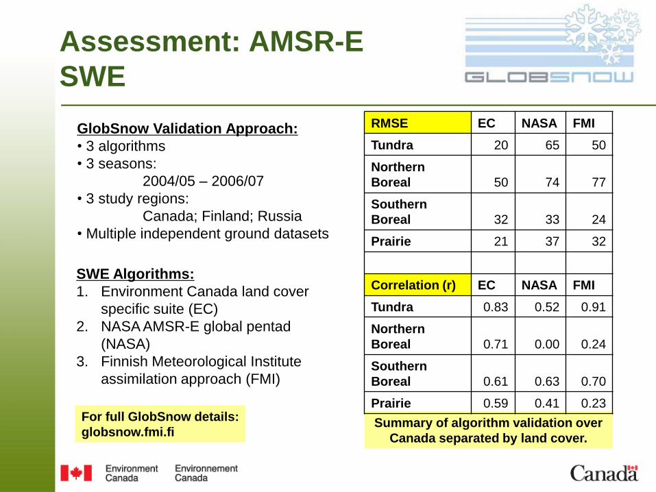
Assessment: AMSR-E
SWE
RMSE EC NASA FMI
Tundra 20 65 50
Northern
Boreal 50 74 77
Southern
Boreal 32 33 24
Prairie 21 37 32
Correlation (r) EC NASA FMI
Tundra 0.83 0.52 0.91
Northern
Boreal 0.71 0.00 0.24
Southern
Boreal 0.61 0.63 0.70
Prairie 0.59 0.41 0.23
SWE Algorithms:
1. Environment Canada land cover
specific suite (EC)
2. NASA AMSR-E global pentad
(NASA)
3. Finnish Meteorological Institute
assimilation approach (FMI)
GlobSnow Validation Approach:
• 3 algorithms
• 3 seasons:
2004/05 – 2006/07
• 3 study regions:
Canada; Finland; Russia
• Multiple independent ground datasets
For full GlobSnow details:
globsnow.fmi.fi
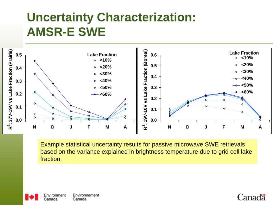
Uncertainty Characterization:
AMSR-E SWE
Example statistical uncertainty results for passive microwave SWE retrievals
based on the variance explained in brightness temperature due to grid cell lake
fraction.
0.0
0.1
0.2
0.3
0.4
0.5
N D J F M AR2:
37
V-1
9V
vs
La
ke
Fra
cti
on
(P
rair
ie)
<10%
<20%
<30%
<40%
<50%
<60%
Lake Fraction
0.0
0.1
0.2
0.3
0.4
0.5
0.6
N D J F M AR2:
19
V-1
0V
vs
La
ke
Fra
cti
on
(B
ore
al)
<10%
<20%
<30%
<40%
<50%
<60%
Lake Fraction

Progress Towards Assimilation of Satellite
Information:
Perturbation of Surface Fields
Surface characteristics forced with an ensemble of inputs by perturbing albedo, leaf
area index, vegetation fraction and roughness length over the sphere.
This determines the first guess or model error covariance matrix B.
Albedo
• Surface characteristics are perturbed using a
Markov chain approach, thus producing
random fields (between 20 to 60) which are
used for ensemble data assimilation.
• The fields that are produced are space-time
auto-correlated to get a smoother time
evolution by avoiding the generation of noisy
patterns.
• These fields are input to the GEM model which
outputs 20 (to 60) model states at each time
step.
• From this, the covariance between the different
model states is used to estimate the model
error (first guess error B).
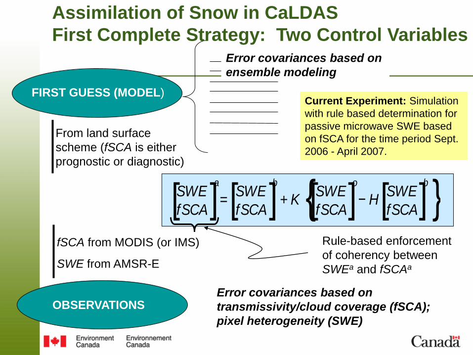
FIRST GUESS (MODEL)
Error covariances based on
ensemble modeling
From land surface
scheme (fSCA is either
prognostic or diagnostic)
OBSERVATIONS
fSCA from MODIS (or IMS)
SWE from AMSR-E
[SWE
fSCA]a
=[SWE
fSCA]b
+ K {[SWE
fSCA]o
− H[SWE
fSCA]b
}Rule-based enforcement
of coherency between
SWEa and fSCAa
Error covariances based on
transmissivity/cloud coverage (fSCA);
pixel heterogeneity (SWE)
Assimilation of Snow in CaLDAS
First Complete Strategy: Two Control Variables
Current Experiment: Simulation
with rule based determination for
passive microwave SWE based
on fSCA for the time period Sept.
2006 - April 2007.
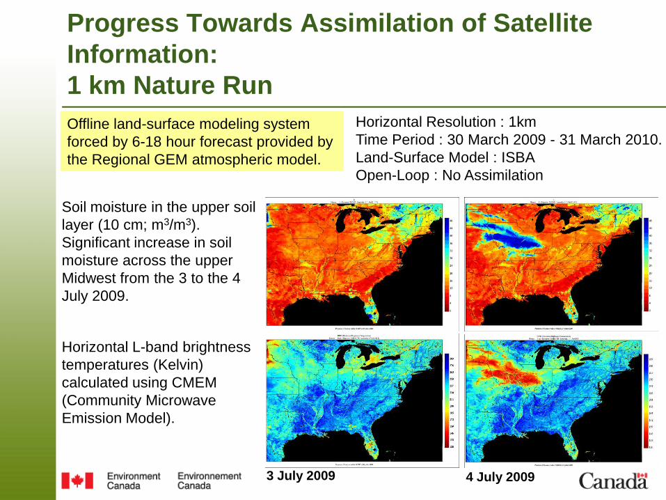
Progress Towards Assimilation of Satellite
Information:
1 km Nature Run
Offline land-surface modeling system
forced by 6-18 hour forecast provided by
the Regional GEM atmospheric model.
Horizontal Resolution : 1km
Time Period : 30 March 2009 - 31 March 2010.
Land-Surface Model : ISBA
Open-Loop : No Assimilation
Soil moisture in the upper soil
layer (10 cm; m3/m3).
Significant increase in soil
moisture across the upper
Midwest from the 3 to the 4
July 2009.
Horizontal L-band brightness
temperatures (Kelvin)
calculated using CMEM
(Community Microwave
Emission Model).
3 July 2009 4 July 2009

Potential Impacts of Emerging Datasets
CoReH20High resolution measurements with sensitivity to deep snowpacks will produce
datasets that address priority EC applications, including:
-Land surface initial conditions in CaLDAS (1– 4 km)
-Evaluation of hydrological models, i.e. CRHM; improved flood forecasting (1 km)
-Information for alpine snowpacks (100 – 500 m)
GlobSnowGlobal SE and SWE datasets available in NRT for NWP and climate applications (2012).
Includes SWE retrieval + variance estimate.
SWE Variance

Conclusions
• The characterization of uncertainty in satellite-derived snow datasets is necessary to
facilitate assimilation. This process now complete for 2 datasets over central Canada:
-MODIS fSCA (SYKE algorithm)
-AMSR-E SWE (EC algorithms)
• A new method was developed to produce an ensemble spread or variance based on
realistic perturbations of both atmospheric forcing and surface characteristics.
• The framework for the assimilation of satellite snow observations in CaLDAS was
developed using an Ensemble Kalman Filter approach.
• A one-year high-resolution (1 km) nature run coupled with CMEM simulations was
performed over eastern North America. This approach will be utilized as a test bed for
the assimilation of SWE information in CaLDAS.
• GlobSnow and CoReH20 datasets represent important new levels of information for
assimilation.

Questions?Questions?
• AMSR-E data provided by the National Snow and Ice Data Center.
• Dorothy Hall, Jeff Miller and George Riggs provided the MODIS CGF dataset; Yi
Luo, Alexander Trishchenko, and Konstantin Khlopenkov provided MODIS clear-
sky compositing and reprojection software.
• Thanks to the Canadian Space Agency for support through the Government
Research Initiatives Program
Progress Towards Assimilation of Satellite
Information:
Perturbation of Surface Fields
For determining the first guess or model error covariance matrix B, surface
characteristics forced with an ensemble of inputs by perturbing albedo, leaf area
index, vegetation fraction and roughness length over the sphere.
Space-time auto-correlated 2D random fields on sphere are generated using
Markov's chain
ψ(λ,φ,t) = μ + ∑Lmax
alm
(t)Ylm
(λ,φ)
Lmin
ψ perturbation factor
(λ,φ) longitude and latitude
μ mean perturbation
Lmin;Lmax min and max wavenumbers perturbed
Ylm spherical harmonics of degree l and order m
Alm spherical harmonics coefficient that evolves in time
∆t time step
Perturbation time step: 6 hr
20 random fields/ensembles evolving in time for each
variable
Albedo
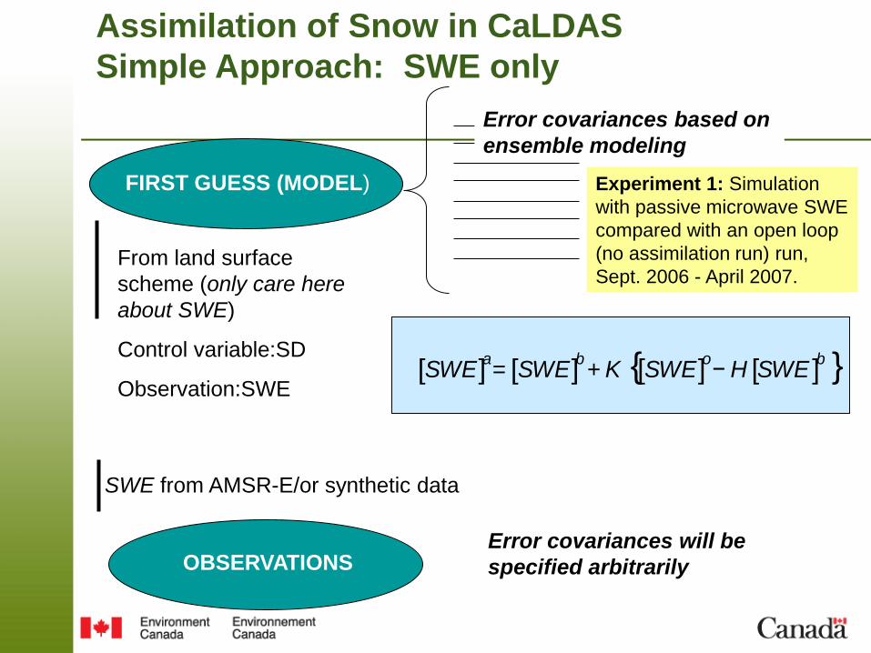
FIRST GUESS (MODEL)
Error covariances based on
ensemble modeling
From land surface
scheme (only care here
about SWE)
Control variable:SD
Observation:SWE
OBSERVATIONS
SWE from AMSR-E/or synthetic data
Error covariances will be
specified arbitrarily
[SWE]a= [SWE]
b+ K {[SWE]
o− H [SWE ]
b }
Assimilation of Snow in CaLDAS
Simple Approach: SWE only
Experiment 1: Simulation
with passive microwave SWE
compared with an open loop
(no assimilation run) run,
Sept. 2006 - April 2007.
Related Documents