Procedia Environmental Sciences 20 (2014) 747 – 752 1878-0296 © 2014 The Authors. Published by Elsevier B.V. This is an open access article under the CC BY-NC-ND license (http://creativecommons.org/licenses/by-nc-nd/3.0/). Selection and peer-review under responsibility of the SustaiN conference committee and supported by Kyoto University; (RISH), (OPIR), (GCOE-ARS) and (GSS) as co-hosts doi:10.1016/j.proenv.2014.03.089 Available online at www.sciencedirect.com ScienceDirect The 4th International Conference on Sustainable Future for Human Security, SustaiN 2013 Assessment of Paleo-hydrology and Paleo-inundation Conditions: the Process Pingping Luo a, *, Kaoru Takara a , Bin He a , Weili Duan b , Apip a , Daniel Nover c , Watanabe Tsugihiro d , Kenichi Nakagami e and Izumi Takamiya f a Disaster Prevention Research Institute (DPRI), Kyoto University, Gokasho, Uji-shi, Kyoto 611-0011, Japan b Department of Civil and Earth Resources Engineering, Graduate School of Engineering, Kyoto University, Kyoto, Japan c AAAS Science and Technology Policy Fellow, U.S. Environmental Protection Agency, Global Change Research Program, Washington D.C., WA, USA d Graduate School of Global Environmental Studies, Kyoto University, Sakyo-ku, Kyoto 606-8501 Japan e Graduate School of Policy Science & College of Policy Science, Ritsumeikan University, Kyoto Japan f Faculty of Literature, Arts and Cultural Studies, Kinki University, Osaka, Japan. Abstract Paleo-hydrology is an important study which simulates the historical hydrology at the lack of observed period, calibrated at the present period and predicted the future hydrological condition. The study of paleo-hydrology is to obtain the historical evidence for the present hydrology and improve the accuracy of the statistical analysis and the prediction modeling assessment. Paleo- inundation assessment is the study of historical inundation under flood events which occurred prior to direct measurement of hydrologic parameters using modern methods. The ultimate objectives of this study were to estimate paleo-inundation under extreme floods using historical literature and incomplete data records. This paper focused on an application of estimating historical inundation conditions under paleo-floods using modern technologies at the river basin scale. Keywords: Paleo-inundation, Paleo-hydrology, Nile River basin, Flo-2D, flood risk management * Corresponding author. Tel.: +81-774-38-4005; fax: +81-774-38-4130. E-mail address:[email protected]. © 2014 The Authors. Published by Elsevier B.V. This is an open access article under the CC BY-NC-ND license (http://creativecommons.org/licenses/by-nc-nd/3.0/). Selection and peer-review under responsibility of the SustaiN conference committee and supported by Kyoto University; (RISH), (OPIR), (GCOE-ARS) and (GSS) as co-hosts

Welcome message from author
This document is posted to help you gain knowledge. Please leave a comment to let me know what you think about it! Share it to your friends and learn new things together.
Transcript
Procedia Environmental Sciences 20 ( 2014 ) 747 – 752
1878-0296 © 2014 The Authors. Published by Elsevier B.V. This is an open access article under the CC BY-NC-ND license (http://creativecommons.org/licenses/by-nc-nd/3.0/).Selection and peer-review under responsibility of the SustaiN conference committee and supported by Kyoto University; (RISH), (OPIR), (GCOE-ARS) and (GSS) as co-hosts doi: 10.1016/j.proenv.2014.03.089
Available online at www.sciencedirect.com
ScienceDirect
The 4th International Conference on Sustainable Future for Human Security, SustaiN 2013
Assessment of Paleo-hydrology and Paleo-inundation Conditions: the Process
Pingping Luoa,*, Kaoru Takaraa, Bin Hea, Weili Duanb, Apipa, Daniel Noverc, Watanabe Tsugihirod, Kenichi Nakagamie and Izumi Takamiyaf
aDisaster Prevention Research Institute (DPRI), Kyoto University, Gokasho, Uji-shi, Kyoto 611-0011, Japan bDepartment of Civil and Earth Resources Engineering, Graduate School of Engineering, Kyoto University, Kyoto, Japan
cAAAS Science and Technology Policy Fellow, U.S. Environmental Protection Agency, Global Change Research Program, Washington D.C., WA, USA
d Graduate School of Global Environmental Studies, Kyoto University, Sakyo-ku, Kyoto 606-8501 Japan eGraduate School of Policy Science & College of Policy Science, Ritsumeikan University, Kyoto Japan
fFaculty of Literature, Arts and Cultural Studies, Kinki University, Osaka, Japan.
Abstract
Paleo-hydrology is an important study which simulates the historical hydrology at the lack of observed period, calibrated at the present period and predicted the future hydrological condition. The study of paleo-hydrology is to obtain the historical evidence for the present hydrology and improve the accuracy of the statistical analysis and the prediction modeling assessment. Paleo-inundation assessment is the study of historical inundation under flood events which occurred prior to direct measurement of hydrologic parameters using modern methods. The ultimate objectives of this study were to estimate paleo-inundation under extreme floods using historical literature and incomplete data records. This paper focused on an application of estimating historical inundation conditions under paleo-floods using modern technologies at the river basin scale. © 2013 The Authors. Published by Elsevier B.V. Selection and peer-review under responsibility of the SustaiN conference committee and supported by Kyoto University; (RISH), (OPIR), (GCOE-ARS) and (GSS) as co-hosts.
Keywords: Paleo-inundation, Paleo-hydrology, Nile River basin, Flo-2D, flood risk management
* Corresponding author. Tel.: +81-774-38-4005; fax: +81-774-38-4130.
E-mail address:[email protected].
© 2014 The Authors. Published by Elsevier B.V. This is an open access article under the CC BY-NC-ND license (http://creativecommons.org/licenses/by-nc-nd/3.0/).Selection and peer-review under responsibility of the SustaiN conference committee and supported by Kyoto University; (RISH), (OPIR), (GCOE-ARS) and (GSS) as co-hosts
748 Pingping Luo et al. / Procedia Environmental Sciences 20 ( 2014 ) 747 – 752
1. Introduction
Inundation simulation is an essential exercise for managing flood risk, as it provides tools necessary to reduce damage and economic loss while providing information for protecting human populations from the effects of floods. Paleo-inundation studies, a part of paleo-flood hydrology, attempts to estimate inundation conditions under historical events using a combination of historical information and modern methods. Paleo-inundation analysis plays an important role in reconstructing flood conditions, evaluating historical flood control policy, providing the experiences of historical escape technology and the method for evaluating the flood risk.
A great deal of researches has focused on hydrologic and paleo-hydrologic studies in the Nile river basin. Recorded flood levels in the Nile river at Roda island have been used to identify the multi-scale detection of abrupt climate change using the Mann-Kendall rank test1,2. Oscillatory modes have been used to extend the Nile river records from 622 A.D. to 1922 A.D3. Deep Mediterranean sediments have been examined to explore Nile flood records and provide a direct link between deep-marine sedimentary records and climate change4. Relationships between paleo-climate variability and paleo-flood have also been investigated5,6. It is important to simulate paleo-inundation conditions for paleo-hydrologic studies in the Nile river basin.
The main objectives of this study were 1) to develop the basic process for paleo-inundation reconstruction and paleo-hydrologic analysis in river basins that lack observed data, 2) to provide a case study for the paleo-inundation reconstruction assessment, and 3) to discuss the basic approaches to paleo-hydrology and paleo-inundation assessment.
2. Study Site
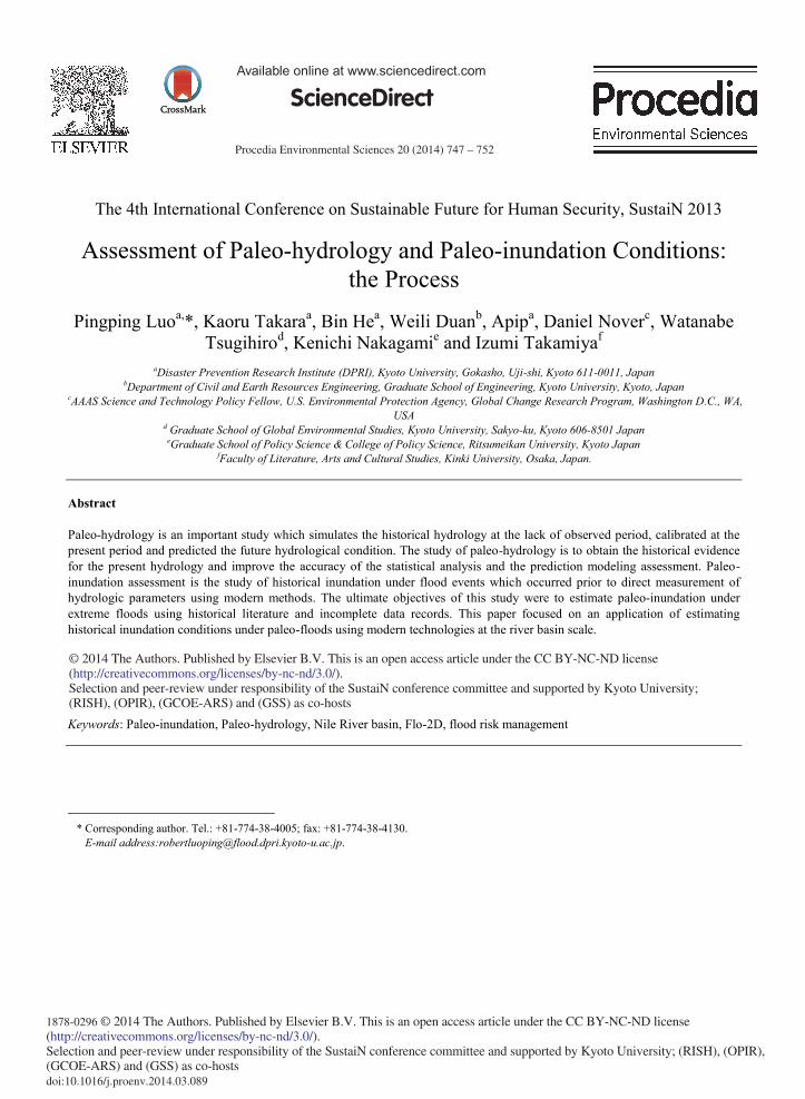
The Nile River is one of the longest rivers in the world with a length of 6740 km from the source to the sea. The Nile river basin extends from 4ºS to 32ºN and covers an area of 3 million km2.It includes two main branches (Blue Nile and White Nile), the mainstream and lakes (Victoria, Albert, Kayoga, Edward).The climate in the upstream of Nile river basin is tropical, and the climate in the downstream of Nile river basin is arid and semi-arid. The mean annual rainfall in the upstream is 1200 mm, but that in the downstream is less than 10 mm. In this study, we would focus on the main Nile river basin in Egypt. The main Nile river basin in Egypt includes one big dam called Aswan high dam which was constructed completely on July 21, 1970. A vast lake called Nasser Lake is located in southern Egypt and northern Sudan. According to an agreement between Egypt and Sudan (1959) the Nile water budget is 18.5 109 m3 to Sudan and 55.5 109 m3 to Egypt. The Nile river flood is an important nature cycle in Egypt since the ancient period. The flood inundation in Egypt used to happen every year, and it stopped until the Aswan high dam was completed. The detail location is shown in Figure 1.
Fig. 1. Location of study area with the blue square in the left DEM map.
749 Pingping Luo et al. / Procedia Environmental Sciences 20 ( 2014 ) 747 – 752
Paleo-Environment
Paleo-Discharge
Paleo-Rainfall
CD
RM
V3
Flo-2D
Lisflood-fp
Support the information for the sustainable society under the
climate change and extreme events
Old Maps • BooksPictures • Drawers
Historical W
ater depth
Historical Inundation
Maps
Paleo-period Present-period
Systematical recordedR
ainfall
Systematical recorded
Discharge and W
ater depth
Digitalized Inundation
Maps
Future-period
DEM
, Land use, soil type, river channelScenario
informationModel
Reconstruction
Clim
ate model
PLUR
PDF,A
DA
Scenario Discharge
Methods
Provide a high dependable evidence for predict the
future flood disaster.
Observation Database, Books,
Websites
3. Methods
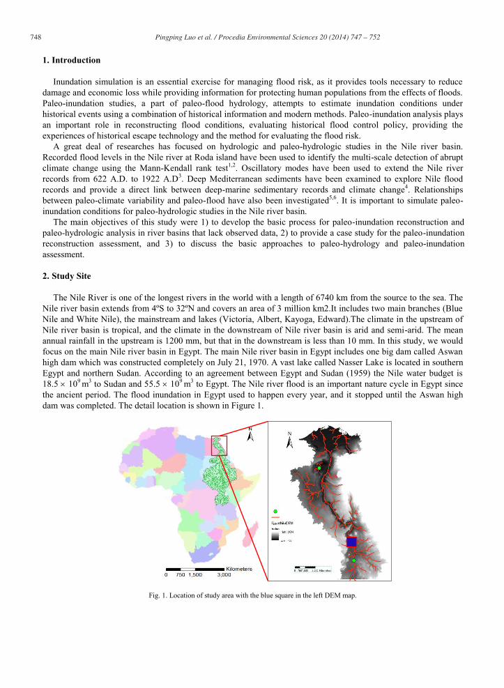
This section describes the basic approach to paleo-hydrologic reconstructions. The main objective of this study is to reconstruct paleo-inundation conditions in past periods. The process of this study is described in Fig. 2 below:
Fig. 2. Structure of paleo-condition for case study and paleo-inundation condition using basin scale method
1) Collected observed data for the present period, including digitized inundation maps, systematic recorded discharge, rainfall and water depth, and DEM, land use, soil type, and river channel as input data for the model simulation and statistical analysis. Current data are available from a number of government offices, online databases (Global Runoff Data Center, U.S. Geological Survey and so on), books and websites. The models which are shown in Figure 2, such as CDRMV3, Flo-2D, Global climate model and PLUR model),were calibrated using observed data from the present period.
2) Historical recorded data, including rainfall, discharge, water level, environmental conditions etc. would be collected from old maps, books, pictures and drawings to represent the paleo-period in which systematic recorded data is lacking. Historical recorded data were used to validate the paleo-discharge and paleo-inundation simulations.
3) Paleo-inundation simulations were conducted based on collected data from the present and paleo-period. 4) The climate, hydrologic, and environment construction model were calibrated and validated using
collected data from the present and paleo-period. 5) Paleo-inundation conditions were reconstructed using the historical scenario from step 3, simulated data
and calibrated models from step 4.
750 Pingping Luo et al. / Procedia Environmental Sciences 20 ( 2014 ) 747 – 752
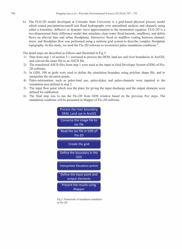
6) The FLO-2D model developed at Colorado State University is a grid-based physical process model which routed precipitation-runoff and flood hydrographs over unconfined surfaces and channels using either a kinematic, diffusive or dynamic wave approximation to the momentum equation. FLO-2D is a two-dimensional finite difference model that simulates clear-water flood hazards, mudflows, and debris flows on alluvial fans and urban floodplains. Interactive flood or mudflow routing between channel, street, and floodplain flow was performed using a uniform grid system to describe complex floodplain topography. In this study, we used the Flo-2D software to reconstruct paleo-inundation conditions 8.
The detail steps are described as follows and illustrated in Fig 3: 1) Data from step 1 of section 3.1 wereused to process the DEM, land use and river boundaries in ArcGIS,
and convert the raster file to an ASCII file. 2) The transferred ASCII files from step 1 were used as the input in Grid Developer System (GDS) of Flo-
2D software. 3) In GDS, 100 m grids were used to define the simulation boundary using polyline shape file, and to
interpolate the elevation points. 4) Paleo-information, such as paleo-land use, paleo-dykes and paleo-channels were inputted to the
simulation area defined in step 3. 5) The input flow point which was the place for giving the input discharge and the output elements were
defined for calibration. 6) The final step was to run the Flo-2D from GDS window based on the previous five steps. The
inundation condition will be presented in Mapper of Flo-2D software.
Fig.3. Framework of inundation simulation in Flo-2D
Process the river boundary, DEM, Land use in ArcGIS
Converse the image file to asc file
Read the asc file in GDS of Flo-2D
Create the grid
Define the boundary in the GDS
Present the results using Mapper
Interpolate Elevation points
h l i
Define the input point and output elements
751 Pingping Luo et al. / Procedia Environmental Sciences 20 ( 2014 ) 747 – 752
4. Results and Discussion
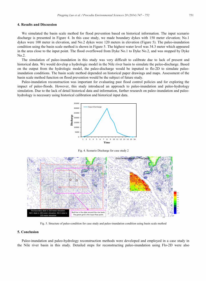
We simulated the basin scale method for flood prevention based on historical information. The input scenario discharge is presented in Figure 4. In this case study, we made boundary dykes with 150 meter elevation; No.1 dykes were 100 meter in elevation, and No.2 dykes were 120 meters in elevation (Figure 5). The paleo-inundation condition using the basin scale method is shown in Figure 5. The highest water level was 34.3 meter which appeared in the area close to the input point. The flood overflowed from Dyke No.1 to Dyke No.2, and was stopped by Dyke No.2.
The simulation of paleo-inundation in this study was very difficult to calibrate due to lack of present and historical data. We would develop a hydrologic model in the Nile river basin to simulate the paleo-discharge. Based on the output from the hydrologic model, the paleo-discharge would be inputted to flo-2D to simulate paleo-inundation conditions. The basin scale method depended on historical paper drawings and maps. Assessment of the basin scale method function on flood prevention would be the subject of future study.
Paleo-inundation reconstruction was important for evaluating past flood control policies and for exploring the impact of paleo-floods. However, this study introduced an approach to paleo-inundation and paleo-hydrology simulation. Due to the lack of detail historical data and information, further research on paleo-inundation and paleo-hydrology is necessary using historical calibration and historical input data.
Fig. 4. Scenario Discharge for case study 2
Fig. 5. Structure of paleo-condition for case study and paleo-inundation condition using basin scale method
5. Conclusion
Paleo-inundation and paleo-hydrology reconstruction methods were developed and employed in a case study in the Nile river basin in this study. Detailed steps for reconstructing paleo-inundation using Flo-2D were also
0
5000
10000
15000
20000
25000
30000
35000
1 2 3 4 5 6 7 8 9 10 11 12 13 14 15 16
Disc
harg
e
Time
Input Discharge
Red line is the dyke around the rive bank.The green grid is the input flow point.
The boundary dyke is 150 meter elevation.NO.1 dyke is 100 meter elevation. NO.2 dyke is
120 meter elevation
12
752 Pingping Luo et al. / Procedia Environmental Sciences 20 ( 2014 ) 747 – 752
described. A case study of paleo-inundation condition was conducted using Flo-2D software under historical scenario discharge and the basin scale method. The process of model calibration and validation was necessary in the study areas which lack observed data. Further study of paleo-inundation and paleo-hydrologic reconstruction using historical recorded data is necessary.
Acknowledgement
The authors thank the supports from the Postdoctoral fellowship of the Japan Society for the Promotion of Science (JSPS) P12055, JSPS KAKENHI Grant Number 24∙02055, Designing Local Frameworks for Integrated Water Resources Management at the Research Institute for Humanity and Nature (RIHN), JSPS Grant-in-Aid for Scientific Research(A) Grant Number 24248041, the Kyoto University Global COE program on “Sustainability/Survivability Science for a Resilient Society Adaptable to Extreme Weather Conditions”, and Inter-Graduate School Program for Sustainable Development and Survivable Societies (GSS), MEXT Program for Leading Graduate Schools 2011-2018.
References
1. Fraedrich, K., Jiang, J., Gerstengarbe, F.W. and Werner, P.C. Multiscale detection of abrupt climate changes: application to River Nile flood levels. International Journal of Climatology. 1997;17(12): 1301-1315.
2. Jiang, J., Mendelssohn, R., Schwing, F. and Fraedrich, K. Coherency detection of multiscale abrupt changes in historic Nile flood levels. Geophysical research letters. 2002; 29(8): 112-111-112-114.
3. Kondrashov, D., Feliks, Y. and Ghil, M. Oscillatory modes of extended Nile River records (AD 622–1922). Geophysical research letters. 2005;32(10).
4. Ducassou, E., Mulder, T., Migeon, S., Gonthier, E., Murat, A., Revel, M., Capotondi, L., Bernasconi, S.M., Mascle, J. and Zaragosi, S. Nile floods recorded in deep Mediterranean sediments. Quaternary Research. 2008; 70(3): 382-391.
5. Hassan, F.A. Extreme Nile floods and famines in Medieval Egypt (AD 930–1500) and their climatic implications. Quaternary International. 2007;173: 101-112.
6. Eltahir, E.A.B. El Niño and the natural variability in the flow of the Nile River. Water Resources Research. 1996; 32(1): 131-137.
Related Documents