Assessment and Catalogue of Puerto Rican Mooring Buoys WORCESTER POLYTECHNIC INSTITUTE May 5, 2009 By Greg Coffey Eric Greer Ryan LaSante Brittany McNally Project Liaison: Dr. Craig Lilyestrom, Mr. Carlos Matos Project Advisors: Professor Karen Lemone and Professor Ingrid Shockey

Welcome message from author
This document is posted to help you gain knowledge. Please leave a comment to let me know what you think about it! Share it to your friends and learn new things together.
Transcript

Assessment and Catalogue of Puerto Rican Mooring Buoys
WORCESTER POLYTECHNIC INSTITUTE May 5, 2009
By
Greg Coffey Eric Greer
Ryan LaSante Brittany McNally
Project Liaison: Dr. Craig Lilyestrom, Mr. Carlos Matos
Project Advisors: Professor Karen Lemone and Professor Ingrid Shockey

ii
ABSTRACT
The Department of Natural and Environmental Resources of Puerto Rico has installed over 270 mooring
buoys in seagrass, coral, and mangrove regions with the anticipation that they will curb boating damage
and allow these natural environments to recover. To streamline buoy management, our group
constructed a Geographic Information System database. This contains data we gathered at each buoy
concerning its exact GPS location, condition, the recovery of the environment it is protecting, and
observations of boating trends within the region.

iii
ACKNOWLEDGEMENTS
Throughout the course of this project there have been many helpful individuals who have taken time from their busy lives to contribute to the success of this project. We would like to thank them for their contributions. To Craig Lilyestrom for his wealth of information and coordination of our entire project. To Carlos Matos for his exceptional aid with fieldwork, and continuous support with all aspects of our project. To Edwin and Maribel Rodriguez for the sharing of their photography, and help throughout our project. To the Oficina de Informática: Nora Alvarez, Victor Cuadrado Landrau, and Alberto Colón for their help with developing the GIS Database. To the Coral Rangers for their assistance with aquatic transportation. To our fellow colleagues from WPI: Kevin Vayda, Dan Cafferty, and Jason Carmichael for their willingness to share their survey results.

iv
AUTHORSHIP
We, as a group, have researched and written this report. All sections of this paper were written through our combined efforts. We have all agreed upon this.
v
TABLE OF CONTENTS ABSTRACT ...................................................................................................................................................... ii
ACKNOWLEDGEMENTS ................................................................................................................................ iii
AUTHORSHIP ................................................................................................................................................ iv
LIST OF TABLES ............................................................................................................................................ viii
LIST OF FIGURES .......................................................................................................................................... viii
EXECUTIVE SUMMARY .................................................................................................................................. x
CHAPTER 1: INTRODUCTION ......................................................................................................................... 1
CHAPTER 2: BACKGROUND ........................................................................................................................... 3
2.1 Coral Reefs .............................................................................................................................................. 3
2.1.1 Location and Extent ............................................................................................................................. 3
2.1.2 Importance ........................................................................................................................................... 4
2.1.3 Interactions with Surrounding Ecosystems ......................................................................................... 4
2.2 Seagrass .................................................................................................................................................. 5
2.2.1 Location and Extent ............................................................................................................................. 5
2.2.2 Importance ........................................................................................................................................... 5
2.2.3 Interactions with Surrounding Ecosystems ......................................................................................... 7
2.3 Environmental Damage .......................................................................................................................... 7
2.3.1 Hurricane Damage ............................................................................................................................... 8
2.3.2 Disease ................................................................................................................................................. 8
2.3.3 Boating Damage ................................................................................................................................... 9
2.4 Mooring Buoys ...................................................................................................................................... 10
2.4.1 Red Sea Case Study ............................................................................................................................ 12
2.4.2 Great Barrier Reef Study .................................................................................................................... 12
2.4.3 Potential Mooring Buoy Drawbacks .................................................................................................. 13
2.5 Stakeholders .......................................................................................................................................... 14
2.6 Summary ............................................................................................................................................... 14
CHAPTER 3: METHODOLOGY ...................................................................................................................... 15
3.1 Catalogued the Buoys’ Locations .......................................................................................................... 15
3.2 Evaluated the Conditions of the Buoys ................................................................................................. 16
3.3 Assessed the Surrounding Ecosystems .................................................................................................. 16
3.4 Identified Boating Activities .................................................................................................................. 17

vi
3.5 Analyzed Boat Traffic ............................................................................................................................ 17
3.6 Developed Geographic Information System (GIS) Database ................................................................ 18
3.7 Summary ............................................................................................................................................... 18
CHAPTER 4: RESULTS AND ANALYSIS .......................................................................................................... 19
4.1 Catalogue of the Buoys’ Locations ........................................................................................................ 19
4.2 Evaluation of the Conditions of the Buoys ............................................................................................ 28
4.3 Assessment of the Surrounding Ecosystems ......................................................................................... 30
4.4 Identification of Boating Activities ........................................................................................................ 32
4.4.1 Educational Outreach Interviews ....................................................................................................... 35
4.4.2 Aerial Surveys ..................................................................................................................................... 35
4.5 Analysis of Boat Traffic ......................................................................................................................... 38
4.6 General Analysis .................................................................................................................................... 39
4.7 Concluding Remarks .............................................................................................................................. 41
CHAPTER 5: CONCLUSION ........................................................................................................................... 43
5.1 Recommendations ................................................................................................................................ 44
REFERENCES ................................................................................................................................................ 45
GLOSSARY.................................................................................................................................................... 48
APPENDIX A: MISSION STATEMENT ............................................................................................................ 50
APPENDIX B: PROPOSED TIMELINE ............................................................................................................. 51
APPENDIX C: PUERTO RICO BACKGROUND INFORMATION ....................................................................... 52
APPENDIX D: ADDITIONAL MOORING BUOY INFORMATION ..................................................................... 53
D-1: How Mooring Buoys are Cleaned ........................................................................................................ 53
D-2: The Installation of Mooring Buoys ...................................................................................................... 53
APPENDIX E: DESCRIPTIONS OF MOORING BUOY SITES VISITED ............................................................... 54
E-1: Guánica ................................................................................................................................................ 54
E-2: Salinas .................................................................................................................................................. 54
E-3: Fajardo ................................................................................................................................................. 54
E-4: Parguera .............................................................................................................................................. 54
E-5: Culebra ................................................................................................................................................. 55
APPENDIX F: DATABASE USE ....................................................................................................................... 56
F-1: Trimble Data Collection ........................................................................................................................ 56
F-2: Updating the Database ........................................................................................................................ 59
F-3: The Database Website ......................................................................................................................... 60

vii
APPENDIX G: MOORING BUOY ANALYSIS FORM ........................................................................................ 63
G-1: Paper Form .......................................................................................................................................... 63
G-2: Electronic Trimble Form ...................................................................................................................... 64
APPENDIX H: BOATING TRAFFIC ANALYSIS FORM ...................................................................................... 65
H-1: Paper Form .......................................................................................................................................... 65
H-2: Electronic Trimble Form ...................................................................................................................... 66

viii
LIST OF TABLES
Table 1: Buoys Not Being Used ................................................................................................................... 37
Table 2: Comparison of Boat Traffic ........................................................................................................... 39
Table 3: Proposed Timeline ........................................................................................................................ 51
LIST OF FIGURES
Figure 1: Hard and Soft Coral ........................................................................................................................ 3
Figure 2: Peacock Flounder Swimming in Seagrass ...................................................................................... 6
Figure 3: Scarring in a Seagrass Meadow ..................................................................................................... 9
Figure 4: Mooring Buoy System .................................................................................................................. 11
Figure 5: Mooring Buoys near Guánica ....................................................................................................... 15
Figure 6: Growth on the Buoy and the Lines .............................................................................................. 16
Figure 7: DNER Snorkeler Analyzing the Environment ............................................................................... 16
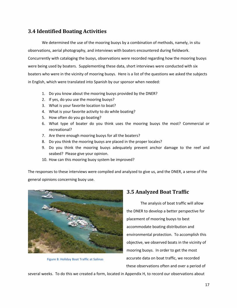
Figure 8: Holiday Boat Traffic at Salinas ..................................................................................................... 17
Figure 9: Eric Greer Cataloguing Mooring Buoys with the Trimble ............................................................ 19
Figure 10: Map of Guánica Mooring Buoys ................................................................................................ 20
Figure 11: Map of Salinas Mooring Buoys .................................................................................................. 21
Figure 12: Map of Palomino Mooring Buoys .............................................................................................. 22
Figure 13: Map of Wolf's Den Mooring Buoys ............................................................................................ 22
Figure 14: Map of Icacos Mooring Buoys .................................................................................................... 23
Figure 15: Mooring Buoys at Palominto ..................................................................................................... 24
Figure 16: Mooring Buoys at Culebra ......................................................................................................... 25
Figure 17: Mooring Buoys at the Cay of Collado at Parguera ..................................................................... 26
Figure 18: Mooring Buoys at the Cay of Enrique at Parguera .................................................................... 26
Figure 19: Mooring Buoys at the Cay of Enrique at Parguera .................................................................... 27
Figure 20: Mooring Buoys at the Cay of Caracoles at Parguera ................................................................. 27
Figure 21: A Propeller Scar in the Buoy ...................................................................................................... 28
Figure 22: A Mooring Buoy Missing Its Pickup Line .................................................................................... 29
Figure 23: Greg Coffey Photographing the Surrounding Ecosystems ......................................................... 30
Figure 24: Lost Traps Demonstrate the Negative Impact of Humans ......................................................... 32
Figure 25: Two Boats Tied to Mooring Buoys ............................................................................................. 33
Figure 26: Two boats rafting at Fajardo. Notice how the other buoy is ignored. ...................................... 35
Figure 27: Large Boat Anchored in Seagrass at Salinas............................................................................... 36
Figure 28: Improper Mooring Buoy Use at Salinas ..................................................................................... 36
Figure 29: Boating Traffic at Palomino over Easter Weekend .................................................................... 37
Figure 30: Boat Traffic at Icacos over Easter Weekend .............................................................................. 38
Figure 31: Bare Patches in a Seagrass Meadow .......................................................................................... 40
Figure 32: Trimble Desktop ......................................................................................................................... 56

ix
Figure 33: TerraSync Status Screen ............................................................................................................. 56
Figure 34: TerraSync Data File Creation ...................................................................................................... 57
Figure 35: TerraSync Antenna Height ......................................................................................................... 57
Figure 36: TerraSync Data Screen ............................................................................................................... 57
Figure 37: Buoy Data Form ......................................................................................................................... 58
Figure 38: TerraSync Data Update Screen .................................................................................................. 58
Figure 39: Transferring the Data from the Trimble .................................................................................... 59
Figure 40: Exporting the Data into the Database ....................................................................................... 59
Figure 41: Export Setup Properties ............................................................................................................. 60
Figure 42: Database Importer ..................................................................................................................... 60
Figure 43: Database Website, Map ............................................................................................................. 61
Figure 44: Database Website, Sidebar ........................................................................................................ 61
Figure 45: Database Website, Data ............................................................................................................ 62

x
EXECUTIVE SUMMARY
In 1990, the Department of Natural and Environmental Resources (DNER) of Puerto Rico began
the Marine Buoy Program in an effort to protect the offshore ecosystems that are constantly being
damaged by harmful boating practices. The Marine Resources Division of the DNER installs and
maintains the mooring buoys, which are permanently anchored buoys that allow boaters to moor
without damaging the seafloor. Prior to our project, there were 270 mooring buoys off the coast of
Puerto Rico whose exact location, current condition, and extent of use were relatively unknown. The
DNER was unsure of the effectiveness of their program; to remedy this we created a Geographic
Information System (GIS) database. The database contains a catalogue of the buoys’ exact GPS
coordinates in addition to information regarding the buoys’ current conditions, states of the
surrounding environments, and observations of the boating activities and traffic in the area.
We traveled to different areas around Puerto Rico so that we could collect a representative
sample of the buoys surrounding the island. We recorded our data using a Trimble GPS transponder,
which is a handheld GPS unit with the ability to store locations and record our observations in editable
datasheets. When we traveled to the mooring fields, we catalogued each buoy’s location and
discovered that the buoys were all installed on the lee side of the islands and cays. The lee side
corresponds to the Puerto Rican side of the surrounding islands, and contains delicate coral and
seagrass ecosystems. Interviews conducted in situ provided another reason as to why the buoys were
placed on the Puerto Rican side of the islands: boaters would rather anchor closer to the Puerto Rican
mainland than waste time and gasoline to circumnavigate the islands. The sheltered waters also offer a
safer environment for other aquatic recreational activities, especially for children.
In addition to recording the locations, we analyzed the conditions of the buoys to discern their
maintenance needs. Using the Trimble, we recorded the level of damage for each of the buoy’s
components. We found that the conditions of the buoys were generally a good indicator of the
popularity of the site: the more visited locations had a greater number of buoys with deteriorating
components. However, at more remote locations, the most prevalent damage that needed to be
addressed was the accumulation of excessive marine flora and fauna on the lines and buoy. The buoy’s
downline, which attaches the buoy to the anchor, serves as a beneficial microenvironment where many
species flourish without competition from other seafloor inhabitants. However, when this environment
ascends to the buoy and the pickup line, these components become weighed down, and sit lower in the
xi
water. This leads to an increase in damage, especially to the pickup line, as boaters will frequently run
over these components.
To determine whether the Marine Buoy Program alleviates damage to the environment, we
assessed the surrounding marine ecosystems: coral, seagrass, and mangroves. With one exception, the
areas that harbored coral showed no signs of recent damage. However, due to coral’s long recovery
time (25-100 years), we were unable to observe much growth in hard coral environments. Although we
have not seen hard coral recover, we have seen that seagrass recovery times vary drastically with depth.
There is more damage in shallow water than deep water; yet damage to seagrass in deeper water takes
longer to recover –nine years. Unlike the other environments, mangroves showed no obvious damage
in the areas inspected; however our schedule did not allow us to return after a major holiday weekend
to examine the damage accrued from boaters. Aerial photographs taken during the holiday depict a
large number of crafts tying to the mangrove roots, which could cause damage to their root systems.
We identified activities boaters conducted at the mooring buoys to the primary buoy uses.
From our observations, we discovered the majority of buoy users were fishing, swimming, snorkeling,
sunbathing, or socializing. Unfortunately, most of our fieldwork took place during normal business
hours, so aerial surveys were used to reveal the weekend popularity of the sites we visited. Through
these we found that many of the boaters who tied up to the buoys were using the system incorrectly.
These boaters were acting in a way that could damage the mooring buoy, as well as the surrounding
ecosystems, by not tying their own line to the pickup line, connecting to other boats, or dropping anchor
in addition to being moored at the buoy. From the surveys, we discovered that only a small percentage
of the boats were actually using the buoys properly, if at all. This is because most boaters are drawn to
the near-shore areas of shallow calm water. Here, they can anchor in the sand of the beach, avoiding
the fines for dropping anchor on reefs or seagrass, while still remaining close to shore.
Our analysis of boat traffic around the buoys took into account all the boats in the general
vicinity. These data came from a combination of our observations and the DNER’s aerial surveys. During
the week, we found the dominant boat type to be commercial ferries. Aside from these crafts
transporting people back and forth between islands, there were only a few small to medium-sized
recreational boats on the water. The aerial surveys show that, unlike weekdays, the holiday weekend
brought many recreational crafts to areas supported by mooring buoys. The sheer number of boats
indicates that the influx on weekends is too great for the current number of mooring buoys to handle.
Although there are not a sufficient number of buoys to handle the holiday traffic, enough buoys should

xii
be installed to accommodate the average weekend influx. With protection against average weekend
boating traffic, the surrounding ecosystems would be able to recover more fully between holidays. A
problem that we have noticed, though, is that sometimes the mooring buoy cannot provide adequate
protection because the boats are too large to use the buoy and are forced to drop anchor, damaging the
ecosystem.
The GIS database that we constructed contains the information collected regarding the Marine
Buoy Program, and will aid the DNER in protecting the marine environments around Puerto Rico. With
this database, the DNER will be able to better organize and plan maintenance schedules for the buoys
that manage the surrounding environments. Because of the buoys, damage to the seagrass, soft coral,
and mangroves is greatly decreased, and, even if there are not sufficient mooring buoys for all the
boaters on weekends, there are enough during the week to allow these ecosystems to begin to recover.
Another pattern we discovered is that areas subject to heavy traffic sustain a significant amount of
damage to ecosystems and mooring buoys alike. Additionally, because there has not been significant
evidence of hard coral recovery, the effectiveness of the mooring buoys pertaining to hard coral is
unknown.
Based upon our findings, we recommend that buoys in popular locations be reexamined
following major weekends. This will allow the DNER to simultaneously check the conditions of the buoys
and the environmental impact of the large influx of boaters. The GIS database should also be regularly
updated with the current conditions of both the buoys and the surrounding ecosystems, along with any
additional information. We also believe that a limited view of the database should be published on the
DNER’s website, to be available for public access. Another idea is to use our database to expand the
“Adopt-A-Buoy” program, which allows the public to “adopt” buoys, but could see the sponsors
performing a more active role in the cleaning and maintenance of their buoys. In following these
recommendations, and with continued attention to habitat restoration, maintenance of the buoys, and
regulations of boating practices, the marine environments around Puerto Rico should see a full recovery.

1
CHAPTER 1: INTRODUCTION
As global awareness shifts toward the reality that humans are causing major environmental
impacts, many corporations and governments are turning some of their funding to address these issues
(National Wildlife Federation, 2007). Some private companies, in an effort to preserve the environment
have given money to endangered terrestrial zones and in some instances use these areas for their
mutual gain as nature tourism sites (Moreno, 2005). On an island such as Puerto Rico aquatic tourism
can be a strong source of revenue, making the benefits of preserving marine ecosystems both
environmentally and economically sound.
An example of an environment providing both ecological and economic gain is the coral reef.
The collective coral reef systems of the world provide a home for over half a million different species
and have more biodiversity than the summation of the rest of the oceans (Spalding, Ravilious, & Green,
2001). These ecosystems, among the most productive on the planet, can provide valuable resources to
mankind when properly maintained. If gathered in a responsible manner, the fauna in one square
kilometer of a reef ecosystem can supply all of the protein 300 people need for day-to-day living
(Jennings & Polunin, 1996). Reefs can also be a valuable asset for the tourism industry. Activities such
as scuba diving, snorkeling, and boating can all bring revenue to local businesses. Other environments,
such as seagrass and mangroves, function symbiotically with coral reefs and can provide similar benefits
for the community.
Seagrass enriches the biodiversity of the waters and provides a unique commercial venue.
Within this habitat there exist numerous creatures that use the vegetation for shelter and sustenance.
Marine grass ecosystems reduce current speeds and wave intensity, which creates a more hospitable
environment for its inhabitants. This reduction of current velocity by the flora, in combination with a
complex root system, reduces aquatic erosion. The roots also redistribute nutrients, which allows for
certain fish and shellfish to flourish (Gullström et al., 2002).
Due to the large number of boats registered in Puerto Rico, anchor damage has become one of
the major causes of devastation to seagrass and coral; however it can be successfully abated with the
use of mooring buoys (U.S. Dept of Homeland Security & United States Coast Guard, 2008). Surrounding
the island of Puerto Rico, the Department of Natural and Environmental Resources (DNER) has installed

2
over 270 mooring buoys in sensitive marine floor environments to combat the damage done by boating
anchors.
At the commencement of our project, the exact location, condition, and extent of use of these
buoys were unknown. The exact GPS coordinates of the anchor pin are needed to facilitate
reinstallation of a buoy, since the pin is hard to locate even when given a general position. Following
installation, conditions will often vary between buoys, making it important to know the current levels of
damage so that the DNER can perform maintenance in a timely manner. Additionally, knowledge of the
distribution and concentration of marine traffic is required for the DNER to provide convenient mooring
sites.
The goal of our project was to create a Geographic Information System (GIS) database
containing clear and updatable data regarding the mooring buoys surrounding Puerto Rico. This
database was completed by addressing the following objectives: obtaining complete information on the
locations and conditions of the mooring buoys, assessing the surrounding ecosystems, identifying
boating activities that are conducted at the buoys, and analyzing boat traffic. This GIS database will
provide the basis for future projects of the DNER as well as a valuable reference regarding the mooring
buoys.

3
CHAPTER 2: BACKGROUND
In constructing a GIS database of the mooring buoys around Puerto Rico, a number of elements
are needed to understand the methods employed. These elements also offer an insight to the
importance to our project. Coral reefs and seagrass are the primary environments that the DNER is
trying to protect from marine damage. While most damage cannot be controlled, mooring buoys may
be a solution to helping coral and seagrass to recover by lessening the negative impact of humans. It is
important to know who advocates for the protection of the ecosystems with mooring buoys and who
uses the ecosystems for their benefit.
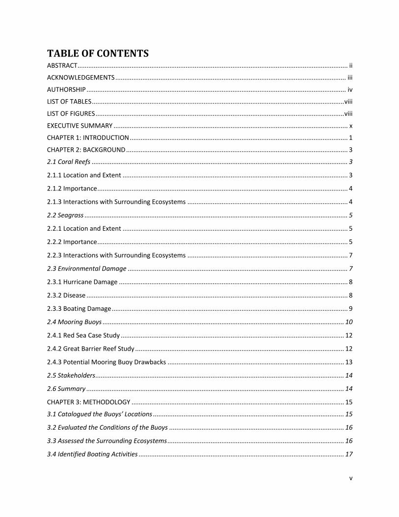
2.1 Coral Reefs
The coral reef is a very important ecosystem that is made up of a plethora of organisms, each
doing a different job to help the coral reef operate. Reefs are one of the “most productive and
biologically diverse ecosystems on earth” (Moberg & Folke, 1999).
2.1.1 Location and Extent
A coral reef is a collection of coral organisms that have come together to live in a large colony.
The coral polyps that do not live in these colonies can be found all over the world. Aside from the coral,
many other organisms live in the reef
because of the shelter and food it
provides (Spalding et al., 2001).
One might think that due to the
sheer magnitude of species that live in the
coral reef that reefs occupy a large ocean
area, but they only represent 1.2% of the
continental shelf and 0.09% of all the
oceans (Spalding et al., 2001). Coral can
be found all over the ocean at any depth,
but coral reefs are almost exclusively
found in warm shallow coastal waters.
The coral reefs located in the Caribbean and Atlantic make up less than 8% of the world’s entire reef
population (Spalding et al., 2001).
Figure 1: Hard and Soft Coral

4
2.1.2 Importance
Despite the small amount of ocean floor covered by coral, there have been more than sixty
thousand species classified. However, it is estimated that there are about a half million to two million
plant and animal species living in coral reefs (Moberg & Folke, 1999; Spalding et al., 2001). Reefs
provide a safe place and sustenance for their inhabitants to spawn, mature, and breed.
Besides being a home to many different species, coral reefs have other attributes as well, such
as providing various resources for a large community (Spalding et al., 2001). This community includes
pharmaceutical companies, tourists, commercial fishermen, and aquariums (Moberg & Folke, 1999).
Pharmaceutical companies have researched the use of seaweeds, sponges, and other life forms located
on the reef to produce useful substances that can be used in anticancer or AIDS-inhibiting drugs
(Moberg & Folke, 1999; Spalding et al., 2001). A few examples of recreational activities that tourists and
locals participate in and around the reef include scuba diving, snorkeling, and swimming. Another use of
the reefs, commercial fishing, provides ten percent of all fish that are consumed by humans. Coral reefs
also fuel the marine aquarium industry; the coral and many of the species that inhabit the reef are
caught and sold to many aquarium enthusiasts (Moberg & Folke, 1999).
2.1.3 Interactions with Surrounding Ecosystems
Besides providing these resources, coral reefs also protect the coasts that they surround. The
islands in the Caribbean are constantly hit by hurricanes and tropical storms (Spalding et al., 2001). The
coral reefs bear the full brunt of these attacks. They also protect the islands from waves and currents.
Without this protection, much of the land would erode into the ocean (Moberg & Folke, 1999). Even the
beaches receive their sand from the coral reefs, through the process of erosion (Spalding et al., 2001).
Furthermore, the mangrove ecosystem in Puerto Rico tends to grow in coral cays. These cays protect
the mangroves and the seagrass, thus protecting valuable juvenile habitat of many of the reef’s fauna
(García-Sais et al., 2008). In return, mangroves trap unwanted runoff, which left unhindered, would
devastate both seagrasses and coral reefs in the area by blocking sunlight to the marine ecosystems
(Moberg & Folke, 1999).
Ultimately, coral reefs are part of a delicate balance between many other ecosystems. Humans
use the reef for its many resources, while marine life relies on it for its shelter and abundance in
sustenance. Without coral reefs, islands in the Caribbean would be left defenseless from the brute force

5
of Mother Nature. While these ecosystems are very small and confined to very specific locations in the
context of the world’s oceans, they are still extremely important.
2.2 Seagrass
Seagrass beds are another ecosystem that can be found off the coast of Puerto Rico. Seagrass is
a group of flowering underwater plants that have evolved to the point where they can now live fully
submerged in seas across the world (Orth et al., 2006). They are considered to be “ecological
engineers,” and provide numerous important services to marine life and its dependants (Orth et al.,
2006).
2.2.1 Location and Extent
Seagrass is estimated to cover 10% of coastal ocean floor, or about 0.15% of the global ocean,
making its total area comparable to other important ecosystems such as coral reefs, macroalgae, and
mangroves (Hemminga & Duarte, 2000). Different varieties of seagrass are located all around the world,
living in all but the most polar waters and can be found off the shores of every continent except
Antarctica (Orth et al., 2006, Hemminga & Duarte, 2000). Even with the beds covering such a small
portion of the ocean floor, it still makes up 1% of the total biomass of marine plants (Hemminga &
Duarte, 2000).
While seagrass is found in many different parts of the world, most species live in similar
environments. This is because they all share the need to have an abundant supply of sunlight, meaning
that the depth of water in which seagrass can live is limited by the amount of sunlight available.
Seagrass also requires a good substrate into which it can extend its roots, such as sandy or muddy
sediment, although a few species of seagrass can grow on rocks. Along with needing to be able to
penetrate the substrate, seagrass requires the toxicity of the area it is growing in to be reasonable. Not
all seagrass is created equal though. Some species can actually grow in intertidal areas where they are
exposed to both air and excessive amounts of sunlight. This type of seagrass can grow much closer to
shore than some of its cousins. Because it is not always submerged, fauna can only forage during high
tides (Hemminga & Duarte, 2000).
2.2.2 Importance
Seagrass is important to all varieties of marine life, both big and small. Fish and invertebrates
find food and shelter in seagrass meadows. They are found in much larger numbers because this area

6
allows for improved chances of maturing when compared to areas without vegetation (Larkum, Orth, &
Duarte, 2006). However, this does not mean that seagrass is a safe haven. In fact, seagrass provides an
important foraging habitat for mobile predators such as sharks, various fish, and rays. It also can
provide for more docile creatures such as sea turtles, dugongs, manatees, and many different kinds of
fish and invertebrates (Jackson et al., 2001). Seagrass is so important to its inhabitants that in 1930
when there was a large-scale loss of seagrass to disease in the North Atlantic, it resulted in the only
known extinction of a marine gastropod (Orth et al., 2006). Along with the extinction, there was also a
collapse of scallop fisheries and a
decrease in waterfowl numbers (Orth
et al., 2006). It is the richness of
seagrass that allows such diverse
marine life to flourish, and when it is
absent from the marine environment
the effects are felt all over.
While seagrass is important to
marine life, one should not forget that
it is also a vital part of the global
community. It provides resources that
help both local populations near the
seagrass but also the overall well being of the planet (Gullström et al., 2002). Seagrass produces an
impressive amount of resources for its relatively small biomass. In terms of size versus primary
production, seagrass is much higher than many terrestrial forests and grasslands, and more than 10
times greater than coral reefs (Hemminga & Duarte, 2000).
Most of the carbon produced by seagrass is deposited in the surrounding sediment, making
marine meadows carbon sinkholes that contain about 15% of the total carbon stored in marine
ecosystems (Hemminga & Duarte, 2000). Seagrass actually traps nutrients and carbon, some of which
gets picked up in currents and carried to deep sea environments where there are fewer nutrients (Orth
et al., 2006). While storing carbon is important to the environment, seagrass also plays an important
part for fishing, both commercial and recreational. Many recreationally and commercially important fish
and invertebrates spend at least part of their life in a seagrass habitat (Larkum et al., 2006). Because
Figure 2: Peacock Flounder Swimming in Seagrass

7
certain types of fish and invertebrates flourish in seagrass, commercial fishing has become an extremely
large venture for the surrounding communities (Gullström et al., 2002).
2.2.3 Interactions with Surrounding Ecosystems
Seagrass has positive impacts on the surrounding ecosystems, such as mangroves and coral
reefs, due to its ability to act as a buffer zone and a habitat for fish. In some parts of the world, seagrass
acts as a nursery for many fish, which can only be found in other ecosystems as adults (Larkum et al.,
2006). Thus seagrass helps populate the surrounding habitats by providing a safe and nutrient-rich
habitat in which marine life can grow. Many organisms travel between the coral reef and seagrass
ecosystems. These organisms are important because they provide nourishment for predators and also
control populations. For example, herbivores such as sea urchins travel to seagrass beds to feed on sun-
blocking weeds, allowing the seagrass to flourish (Moberg & Folke, 1999). The reduction in current
speed and wave intensity are two more ways that seagrass helps out neighboring ecosystems (Gullström
et al., 2002). With lower currents and smaller waves, erosion is less of a problem along the coast
(Larsen & Webb, 2009).
Seagrass is located off of coasts all over the world, in different shapes and forms. In all forms,
however, they are important both to the species that live and rely upon seagrass and for the resources
to humans that it provides. Seagrass is also important to surrounding ecosystems and has even been
considered by some as “biological sentinels, or ‘coastal canaries’” (Orth et al., 2006). Changes in
seagrass are early indicators of environmental shifts and are useful harbingers of challenges facing
surrounding ecosystems. The importance of seagrass cannot be overstated in terms of both economic
benefit and the marine life that depends upon it. From these observations, action must be taken to
protect these important ecosystems from destruction.
2.3 Environmental Damage
There are three primary forms of damage to seagrass and coral environment: hurricane damage,
disease, and boating damage. Of these three damages, our project is specifically focused on preventing
boating damage. The other forms of damage are important to be aware of because they can exacerbate
damage done by poor boating practices.
8
2.3.1 Hurricane Damage
In the Caribbean, hurricanes are the most prevalent natural disaster, and cause more
devastation than all other sources of damage (García-Sais et al., 2008). Tropical storms create large
fluctuations in waves, exposing shallow corals to intense stresses, such as being overturned and broken.
In addition, the runoff from the rain causes an increase in sediment and terrestrial pollutants in the
waters. All these factors lead to the destruction of the coral reef (García-Sais et al., 2008; Woodley et
al., 1981).
Hurricanes can be just as deadly to seagrass environments as they are to coral. The strong
waves disturb the beds and uproot the seagrass, which causes holes to appear that can last for many
years. These holes travel around the beds with the ebb and flow of the tide, impairing the ability for the
marine grass to mend and allowing for further damage. However, the primary species of seagrass found
in the Caribbean is Thalassia testudinum, a robust species that has shown only modest damage from
hurricanes in the past (Green & Short, 2003).
Damage done by hurricanes is impossible to control, but diseases that exist in these marine
ecosystems often have causes that can be linked to human activities. Coral bleaching and
eutrophication of seagrass are some such diseases.
2.3.2 Disease
Coral bleaching is a disease that has many causes, and affects all coral reefs in the world.
Bleaching occurs when the photosynthetic species, namely zooxanthaellae, that help the coral produce
energy die off (Rosenberg & Loya, 2004). Coral bleaching is caused by many factors that work together:
temperature changes, variance in salinity, and exposure to sunlight. Sedimentation from runoff and
pollutants in the water also play a part in the coral bleaching process (Larsen & Webb, 2009). Bleaching
devastates coral reefs by depriving them of energy and causing a loss of pigmentation. It can take up to
fifty years for coral to recover from a bleaching event, during which its support of other marine species
is limited and it is more susceptible to mechanical damage (Rosenberg & Loya, 2004).
Eutrophication is a condition where water quality is decreased by excessive amounts of nitrogen
and phosphate (Hemminga & Duarte, 2000). Nitrogen and phosphate are two chemicals found in
fertilizer, which can enter ocean water through runoff from land erosion. Nitrogen and phosphate in
water promote the growth of algae, and this excess growth interferes with seagrass’s ability to receive

9
light from the sun and conduct photosynthesis. The lack of sun causes seagrass to produce less energy,
and reduces the amount of nutrients it releases into the environment. Disruption of nutrients and large
amounts of algae interfere with normal marine life and kill off many species of fish. The use of fertilizer
near waterways is a human activity that is adversely affecting seagrass ecosystems (Hemminga &
Duarte, 2000). Another human activity that harms marine environments is boating.
2.3.3 Boating Damage
Boating practices in marine habitats have a strong effect on coral and seagrass, and fortunately
can be regulated easier than most other factors. Boats that frequent seagrass and coral habitats often
set anchor to maintain their position. The use of anchors in these natural environments, as well as
groundings on coral reefs and plowing through seagrass, all have a profound impact upon these
ecosystems and cause significant damage.
Boats and ships that run aground upon coral reefs cause severe breakage and damage along
large areas of the reef. Large ships colliding with the reef
cause damage in a greater area than just the immediate
vicinity of the strike. This can destabilize large sections of
reef whereas small boat groundings tend to have a more
localized effect. After an impact, if unaided, soft coral
begins to grow back within two years, and hard coral begins
to form after eight years. The soft coral of the reef will
return to its prior state after about 10-15 years whereas the
hard coral can take up to a century to return to its prior
state (Jaap, 2000).
Seagrass beds are particularly susceptible to
boating damages since they are often found in shallow
coastal waters. People who use small boats often
overestimate the depth of the water, or try to dock while in
seagrass environments and run aground. The groundings
carve long furrows into the seagrass, disrupting their
root system, as shown in Figure 3. Even if the boat
Figure 3: Scarring in a Seagrass Meadow

10
does not run aground, the propellers rip the seagrass up by their roots, and it can take 2-5 years to
recover (Dawes, Andorfer, Rose, Uranowski, & Ehringer, 1997; Hemminga & Duarte, 2000).
A study conducted in the Abrolhos Marine National Park in Brazil found that anchors damaged
0.5% of the park’s meadow per year (Creed & Amado Filho, 1999). Although this percentage seems
small, the amount of time it takes for the seagrass to recuperate makes the extent of damage very
significant. Seagrass can recover from anchor damage within one year when in a sheltered
environment, but if exposed to heavy surf or other forms of damage the grass can take up to nine years
to repair (Dawes et al., 1997). The research conducted in Brazil has found that recovering seagrass in
damaged areas had a lower concentration of plants than control areas did at the start of the
experiment. The root system of the damaged grass is less dense, allowing more sediment to escape into
the environment and erode the seafloor (Creed & Amado Filho, 1999). The time it takes for seagrass to
recover, and the amount of damage that is done by an anchor, makes it important to protect the
seagrass from boating damages.
Anchors cause extreme damage to coral reefs, especially when used improperly. When anchors
are set from boats they cause crushing damage to polyps, which break off or die. Once the anchor is set
the chain can drag across the reef, fracturing weaker soft coral, or can be wrapped around hard coral
structures that protrude from the reef. The retrieval of the anchor can also sever, overturn, or crush the
coral reef (Dinsdale & Harriott, 2004). Compared to other forms of damage, damage caused by anchors
is preventable.
Hurricane damage, disease, and boating damage are all major sources of destruction to marine
habitats surrounding Puerto Rico. Unfortunately, disease and hurricane damage cannot be easily
controlled; however, boating damage can be lessened by human intervention. The use of public
mooring buoys is one potential answer in the quest to reduce the amount of damage caused by anchors
to these marine environments.
2.4 Mooring Buoys
To successfully stave off the anchor damage done by ships, the Department of Natural and
Environmental Resources has installed mooring buoys all around the island in locations where diving and
boating are most popular. Mooring buoys are small round floats that support a pickup line on the
surface, are tied to a through-line that connects to a downline, which ties to a pin anchored deep in the

11
substrate of the ocean floor (Figure 4). These are then placed where dropping anchor can lead to
damage to a sensitive marine environment. The shackle connecting the downline and the anchor allows
the buoy to twist and turn without becoming entangled. The purpose of the buoy is to float a pickup
line on the surface of the water and mark its location. This pickup line allows for boats to tie up instead
of dropping anchor (Boaters Land, 2009).
Mooring buoys are designed so that a boater can
tie up their boat and leave it for periods of time without
worrying about it. In a sense, it is a permanent fixture in
the ocean, and can last several seasons. Unfortunately,
mooring buoys do not last as long in salt water as they
do with freshwater (Boaters Land, 2009).
On the island of Puerto Rico, a plethora of
people use and work on the coral reef every day. Diving
and fishing charters, commercial fisherman, and
recreational boaters work and play out on the water.
With all of these people taking advantage of the natural
wonders of the island, the coral reef is suffering. The
reef appeals to recreational boaters because of the
calmer waters it provides. Unfortunately, the reef
cannot withstand so much boating traffic. Even so,
Puerto Rican officials are not necessarily as concerned
with the scuba diving charter boats because it is in the charters’ best interest to preserve the reef as
their livelihood depends on its continuing prosperity (García-Sais et al., 2008). Additionally, the majority
of charter boats are up to date with all of the marine policies put in place by the DNER. Recreational
boaters and the general public, however, are not as familiar with DNER regulations, and therefore can
cause more damage by improperly anchoring (García-Sais et al., 2008). Although anchor damage is only
a small part of the damages that are inflicted on seagrass and coral reefs every day, it can be controlled
with the use of mooring buoys (García-Sais et al., 2008).
Mooring buoys can be an easy solution to the problem of anchor damage. Just maintaining and
providing enough mooring buoys for the public will lower the damage greatly. Since the DNER first
provided mooring buoys in the more popular areas of the reef, anchor damage has been reduced
Figure 4: Mooring Buoy System

12
(García-Sais et al., 2008). Unfortunately, detailed information regarding the location and the condition
of the buoys is unknown. The mooring buoys are not continually monitored; therefore the DNER does
not know what kind of shape the mooring buoys are in, or if they are being used by recreational boaters
(García-Sais et al., 2008).
2.4.1 Red Sea Case Study
To better understand the relationship between anchor damage and mooring buoys, a case study
that took place in the Red Sea was examined. Off the east coast of Egypt, tourism within the coral reef
environment, especially in the Hurghada section, had exploded. Until 1997, nothing was organized to
prevent damage done to the reef by the sheer number of tourists. To try to curtail the damage, 250
mooring buoys and reef top pins were placed all over the reef for the public to use. The Hurghada
Environmental Protection and Conservation Association was formed to maintain these buoys and
regulate not only who uses the reef, but how they use it as well. These regulations state that diving
charters are only allowed to be in a location for a certain amount of time. There is also a mandate that
states that only a certain amount of dives can be performed each year. Before 1997, diving charters
performed as many dives as they wished without any thought to the damage that was being done on
the reef. Without any mooring buoys, these boats anchored wherever they wanted. Too much diving
was taking place at sites that were popular and the reef was severely damaged.
This environmental plan has taken off because of the success of installing these mooring buoys.
Now more than 1000 buoys are located all over the reef and it is against the law to drop anchor.
Egyptian Environmental Affairs Authority even has rangers that are assigned to the Hurghada section to
regulate this law (Jameson, Ammar, Saadalla, Mostafa, & Riegl, 2007).
2.4.2 Great Barrier Reef Study
The negative impact of tourism has also affected the coral in the Great Barrier Reef. In the more
popular areas of the Great Barrier Reef Marine Park, anchor damage is found to be the most
detrimental. The officials that regulate the Marine Park have instituted many solutions to the anchor
damage. They, like many other places in the world, have placed public mooring buoys all around the
reef. As a major step in preserving the reef, they also have posted signs in certain areas where
anchoring is not allowed at all. To help recreational boaters and tourists, a program was created to
educate boaters on preservation policies regarding the reef (Harriott, 2002).

13
2.4.3 Potential Mooring Buoy Drawbacks
Even though mooring buoys can decrease the amount of anchor damage in seagrass and coral,
the mooring anchors can cause damage themselves. In areas where mooring buoys are placed, damage
caused by diving and snorkeling has increased, however anchor damage still far outweighs the damage
done by divers (Harriott, 2002).
Seagrass can become very damaged by mooring anchors. When mooring anchors are not
designed correctly, the surrounding habitat will be damaged by it. If a poor location is chosen, for
example, sewage and sediment can build up around the anchor, which can block the seagrass from the
sun (Creed & Amado Filho, 1999). A case study near Western Australia reported that permanent
moorings were destroying the seagrass, particularly around Rottnest Island. This location has the most
mooring installations in any area of the surrounding reef. To study the damage, aerial surveys were
used to monitor the effect of the moorings on the seagrass. The team found that there were “bare
patches” near the moorings where once there was seagrass (Hastings, Hesp, & Kendrick, 1995).
When it was found that the type of mooring that was implemented caused some damage to the
seagrass, a new type of mooring anchor was chosen to lessen the impact. The first anchor, known as a
one-chain system, was switched over to the “Cyclone” or three-chain system. The Australian study
proved that the damage caused by the three-chain system is just as disastrous as caused by the one-
chain system (Hastings et al., 1995). The problem that they did not realize is that the anchor is the cause
of damage in seagrass, not the type of mooring. Because of this, the difference between the one chain
and three chain systems is trivial, and the damage can only be avoided by using the anchor appropriate
to the kind of seabed.
The types of anchors that are utilized by the DNER are Halas and Manta. Halas anchors, used in
hard-bottom locations such as coral, are attached by being placed in a bored hole, which is then filled
with hydraulic cement. The Manta anchors are used in seagrass locations with soft bottoms, and consist
of a long rod drilled into the substrate, which is then pulled up slightly to engage two barb-like legs to
hold it into the seafloor. These two systems do not damage the surrounding ecosystem beyond initial
installation.
Mooring buoys can cause damage to the surrounding environment; however, the damage
caused by boat anchors is more devastating to the marine environment. Further research is needed to
determine if there is a better solution than mooring buoys. For the time being, mooring buoys are the
14
solution practiced to prevent anchor damage problems. Other countries have seen success through the
use of these buoys. Puerto Rico has started this endeavor and hopes to see success as well.
2.5 Stakeholders
Due to the lack of observations, interviews, surveys, and quantitative data that have been
collected to date, it is difficult to determine the specific parties involved. At this time, the major
stakeholders in the Marine Buoy Program are the DNER, the National Oceanographic and Atmospheric
Association (NOAA), charter boat companies, eco-tourism agencies and recreational boaters.
NOAA is actively interested in preserving sensitive marine environments. Just like the DNER,
NOAA is a trustee in the marine benthic habitat, and wishes to see the sites well maintained. They have
provided funds for the DNER to install buoys off the south coast of the island, but their interest stems
mostly from the surrounding environment. Recreational boaters solely care about the maintenance of
the buoys so that they can moor without illegally dropping anchor. On the other hand, some charter
companies and eco-tourism agencies care for the condition of both the seafloor and to a lesser extent
the buoys. This is because they can moor without destroying the surrounding ecosystems, which act as
their source of revenue.
2.6 Summary
Marine environments such as coral reefs and seagrass are important parts of the global
ecosystem. These valuable habitats, however, are highly susceptible to damage from humans, and as
such need to be protected. One such method of protection, which has been successfully employed, is
the installation of mooring buoys in these fragile areas. While they are not perfect, mooring buoy
benefits outweigh the costs and provide a better alternative to the haphazard anchor damage that can
occur in their absence. Considering Puerto Rico's use of these marine environments, as well as the
wealth of biodiversity they support, various stakeholders have a vested interest in the results of our
project. After we collected this background information, we planned and undertook a thorough
methodology resulting in the completion of the database by accomplishing our objectives.

15
CHAPTER 3: METHODOLOGY
As previously stated, there are 270 mooring buoys off the coast of Puerto Rico whose condition,
exact location, and extent of use were unknown. This lack of information made it difficult for the
Department of Natural and Environmental Resources (DNER) to properly allocate work and assets to
maintain the buoys and the surrounding environments. A high priority of the DNER is to prevent marine
damage, which mooring buoys help avert, making their maintenance a critical aspect of the coastal
conservation efforts. Our goal was to remedy this situation by creating a GIS database that contains all
the information in a clear and updatable way. To enable the completion of this goal, we met the
following objectives:
Catalogued the Buoys’ Locations
Evaluated the Conditions of the Buoys
Assessed the Surrounding Ecosystem
Identified Boating Activities
Analyzed Boat Traffic
Data have been gathered from five key areas surrounding Puerto Rico: Guánica, Salinas, Fajardo,
Parguera, and Culebra. These regions contain the highest number of buoys and are the areas most
frequented by recreational boaters. These locales were chosen to obtain the maximum amount of data
in the most critical regions. We begin with a description of the methods used to meet our objectives.
3.1 Catalogued the Buoys’ Locations
One of the main concerns of the
DNER was that the exact locations of the
buoys were unknown, more specifically,
the exact location of the buoys’ anchors.
Knowing the anchor‘s exact location is
important because if a buoy becomes
detached, the anchor pin can be easily
found by divers to facilitate replacement.
Using a Trimble GPS transponder, we
established each anchor’s precise Figure 5: Mooring Buoys near Guánica

16
geographic coordinates, which have been imported into a GIS database.
3.2 Evaluated the Conditions of the Buoys
The Trimble software, called GPS Pathfinder Office, allowed for the creation of a digital
evaluation form on the GPS unit. The Trimble also allowed for digital entry of our observations, which
were directly imported into the GIS Database
when back in the office. While in the field, we
evaluated each buoy’s condition by looking at
its components: anchor, swivel, shaffing tube,
downline, lead weight, thru-line, buoy,
reflective tape and pickup line.
We looked for evidence of corrosion,
broken parts, fraying in the ropes, cleanliness,
and propeller scars. Our group observed the
submerged components by snorkeling. This
information was included in the database so that the DNER is able to track maintenance needs, and
update the condition as necessary for each buoy.
3.3 Assessed the Surrounding Ecosystems
An assessment of the surrounding ecosystems
allows us to best evaluate the mooring buoy program. As
with the evaluation of the buoys’ conditions, snorkeling
was used to examine these environments. Indicators of
damage included overturned, bleached, or broken coral,
and cuts or scarring in the seagrass bed. We used the
Trimble to store information regarding the extent and
type of damage to the ecosystems, which was uploaded
to the GIS database for easy assessment. With this
information in the database, updates can be made, and
each individual buoy’s effectiveness can be rated.
Figure 6: Growth on the Buoy and the Lines
Figure 7: DNER Snorkeler Analyzing the Environment
17
3.4 Identified Boating Activities
We determined the use of the mooring buoys by a combination of methods, namely, in situ
observations, aerial photography, and interviews with boaters encountered during fieldwork.
Concurrently with cataloging the buoys, observations were recorded regarding how the mooring buoys
were being used by boaters. Supplementing these data, short interviews were conducted with six
boaters who were in the vicinity of mooring buoys. Here is a list of the questions we asked the subjects
in English, which were translated into Spanish by our sponsor when needed:
1. Do you know about the mooring buoys provided by the DNER?
2. If yes, do you use the mooring buoys?
3. What is your favorite location to boat?
4. What is your favorite activity to do while boating?
5. How often do you go boating?
6. What type of boater do you think uses the mooring buoys the most? Commercial or
recreational?
7. Are there enough mooring buoys for all the boaters?
8. Do you think the mooring buoys are placed in the proper locales?
9. Do you think the mooring buoys adequately prevent anchor damage to the reef and
seabed? Please give your opinion.
10. How can this mooring buoy system be improved?
The responses to these interviews were compiled and analyzed to give us, and the DNER, a sense of the
general opinions concerning buoy use.
3.5 Analyzed Boat Traffic
The analysis of boat traffic will allow
the DNER to develop a better perspective for
placement of mooring buoys to best
accommodate boating distribution and
environmental protection. To accomplish this
objective, we observed boats in the vicinity of
mooring buoys. In order to get the most
accurate data on boat traffic, we recorded
these observations often and over a period of
several weeks. To do this we created a form, located in Appendix H, to record our observations about
Figure 8: Holiday Boat Traffic at Salinas
18
the size and type of boat, their activity, type of marine environment, and their use of the buoy. Our
group compiled this information into the database, providing the DNER with an idea of boating
distributions around the buoys in Puerto Rico.
3.6 Developed Geographic Information System (GIS) Database
The GIS database provides the DNER with a tool to analyze and share current data concerning
the mooring buoys. GIS is a system that combines the strengths of layered images with the power of a
database by linking together maps and the information attributed to their features (Environmental
Systems Research Institute, 1997).
Our team developed the GIS database using PostgreSQL in conjunction with the interfacing
software, GPS Pathfinder Office and Quantum GIS. The database is structured to facilitate
maintainability and updatability by the DNER, and is flexible enough to accommodate additional data
sets. The transfer of data from the Trimble to the database has been automated as much as possible to
reduce the complexity of the process while minimizing human error. This automated process is
interfaced through a website on the DNER server.
We created the interface to the database with a specific focus directed toward its ease of use
for DNER employees. The interface is an internal website hosted by the DNER and was developed using
the web publishing technology, SIMILE Exhibit, which allowed us to display data directly from the DNER’s
Geo Server. Using this webpage, DNER employees will have access to all the information pertaining to
mooring buoys.
3.7 Summary
By cataloging the buoys’ locations, evaluating their conditions, assessing the surrounding
ecosystems, identifying boating activities, and analyzing boat traffic, we obtained all the information
needed for our database. This database represents the culmination of both our fieldwork and software
development, which facilitated the creation of a clear and updatable web interface. Using this website
and database, the DNER can make informed decisions regarding installation and maintenance of the
mooring buoys, as well as monitor the surrounding ecosystems.

19
CHAPTER 4: RESULTS AND ANALYSIS
While conducting our fieldwork we visited many different locations around Puerto Rico where
mooring buoys have been installed, including Guánica, Salinas, Fajardo, Parguera, and Culebra. These
sites were chosen to maximize the effectiveness of the database by providing information regarding the
locations most frequented by boaters that have delicate seafloor environments. While at these locales,
we catalogued the buoys’ locations, evaluated the conditions of the buoys, assessed the surrounding
ecosystems, identified boating activities, and analyzed boat traffic. We took this information, which we
stored in the Trimble GPS transponder, and transferred the data into a GIS database.
4.1 Catalogue of the Buoys’ Locations
When we catalogued the buoys, we determined their exact geographical locations using the
Trimble GPS Transponder. After downloading the data from the Trimble, we overlaid the locations on
satellite imagery provided by Google Maps. On
the maps below, each white circle represents a
buoy (Figure 10-21).
Figure 10 shows the 14 mooring buoys
located off the coast of Guánica at the island of
Cayo Aurora. These buoys were distributed in
the area surrounding the island’s sole pier,
each approximately 54 feet from its closest
neighbor. These relatively short distances are
due to the shallow waters in which the buoys
were installed. While at the site we discovered
one buoy, not attached to an anchor, which the DNER brought back to the department for cleaning and
reinstallation.
Figure 9: Eric Greer Cataloguing Mooring Buoys with the Trimble

20
Figure 10: Map of Guánica Mooring Buoys
Figure 11 shows eight mooring buoys located off the coast of Salinas at Cayo Matias. These
buoys were distributed very similarly to the buoys at Guánica, an average of 46 feet apart, and were
located in the mangrove channels in the center of the island. While we were there, DNER divers
reinstalled three mooring buoys in the western channel.

21
Figure 11: Map of Salinas Mooring Buoys
Off the coast of Fajardo, there are four small islands with mooring buoys: Palomino, Wolf’s Den,
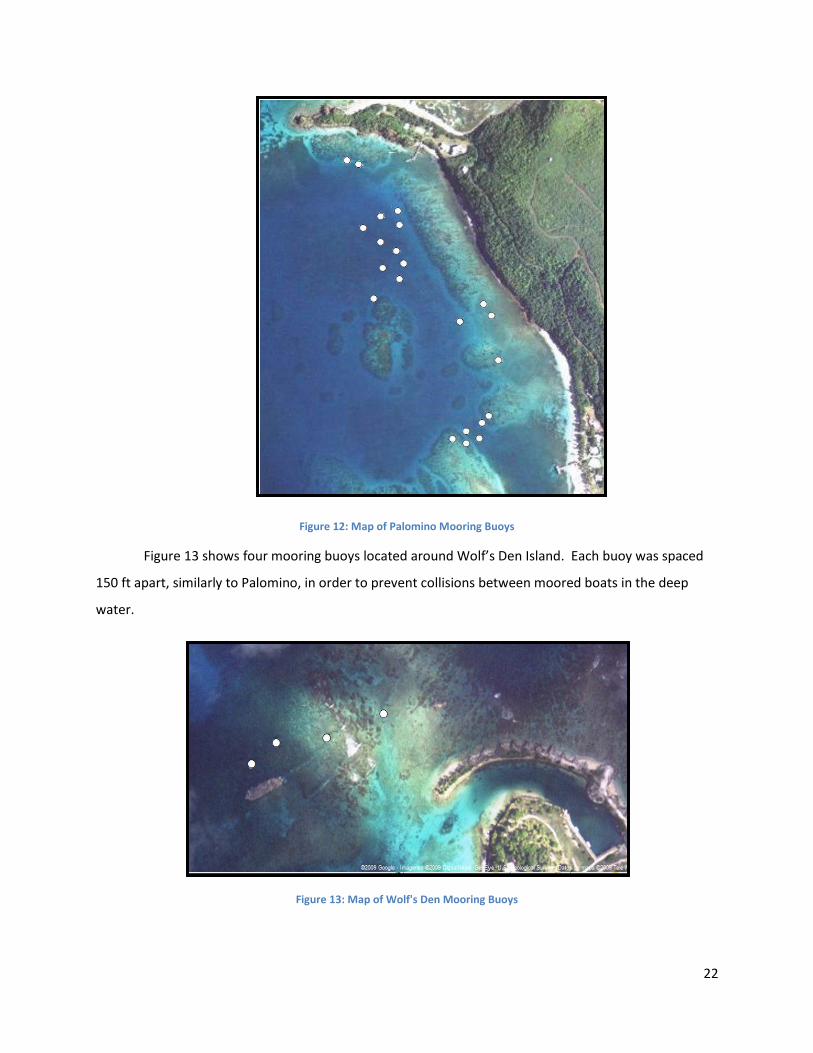
Icacos, and Palominto. Figure 12 shows 22 mooring buoys off the coast of Palomino separated by an
average of 150 feet. This distance is necessary due to the deep waters that require long downlines on
the buoys. The longer downlines create a greater radius for the physical buoys to drift, and because
they drift so far, the large distances between buoys prevent them from getting their lines tangled. With
the deeper water, larger boats can also use these mooring buoys, which is another reason for the
greater distance between them.
22
Figure 12: Map of Palomino Mooring Buoys
Figure 13 shows four mooring buoys located around Wolf’s Den Island. Each buoy was spaced
150 ft apart, similarly to Palomino, in order to prevent collisions between moored boats in the deep
water.
Figure 13: Map of Wolf's Den Mooring Buoys

23
Figure 14 shows only one buoy located off the island of Icacos. This is because two buoys were
missing at the time of our cataloguing. However, there were other mooring buoys in the area that did
not belong to the DNER, one of which appeared to be the same model as the DNER buoys. The other
buoys are in place at Icacos probably due to the fact that charter boats that wish to keep the
surrounding ecosystems intact while still being able to moor frequently in this area.
Figure 14: Map of Icacos Mooring Buoys
At the small island of Palominto, which is next to the island of Palomino, four buoys were
catalogued ( Figure 15). These buoys were anchored at a depth of approximately 15 feet and
were about 300 feet apart from one another. There were supposed to be six buoys in this area, but two
were missing.
24
Figure 15: Mooring Buoys at Palominto
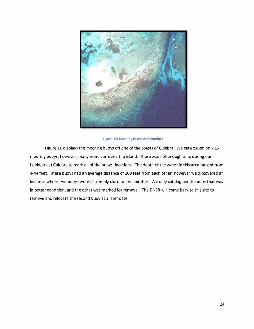
Figure 16 displays the mooring buoys off one of the coasts of Culebra. We catalogued only 15
mooring buoys, however, many more surround the island. There was not enough time during our
fieldwork at Culebra to mark all of the buoys’ locations. The depth of the water in this area ranged from
4-44 feet. These buoys had an average distance of 209 feet from each other; however we discovered an
instance where two buoys were extremely close to one another. We only catalogued the buoy that was
in better condition, and the other was marked for removal. The DNER will come back to this site to
remove and relocate the second buoy at a later date.

25
Figure 16: Mooring Buoys at Culebra
Figure 17 shows Colloado, the first cay we visited off the coast of Parguera. With an average
depth of three feet, and a range of depths from two to four feet, this area contained five mooring buoys
that stood sentry over the seagrass below. The spacing between each buoy was common for shallow
fields: approximately 75 feet.

26
Figure 17: Mooring Buoys at the Cay of Collado at Parguera
The cay of Enrique, shown in Figures 18 and 19, contains six mooring buoys in seagrass. The
depths at the buoys are consistently four feet, except for one in 15 foot deep water. Arranged in a
linear configuration, these buoys are spaced an average of 126 feet apart.
Figure 18: Mooring Buoys at the Cay of Enrique at Parguera

27
Figure 19: Mooring Buoys at the Cay of Enrique at Parguera
Figure 20 shows Caracoles, the last cay we visited in Parguera. The 17 mooring buoys installed
at this location sit in water with a range of depth from two to thirteen feet. The average spacing
between buoys is 100 feet, which allows for larger boats to moor in this seagrass field.
Figure 20: Mooring Buoys at the Cay of Caracoles at Parguera

28
We observed that all the buoys are located between the coast of Puerto Rico and the small
islands. No buoys at this time have been placed on the far side of any of the small islands that we
visited. This is probably because conditions closer to Puerto Rico are more protected and placid, thus
safer. Also, another contributing factor is that after travelling out to one of the small islands, Puerto
Rican boaters do not want to waste gasoline and time to circumnavigate the island when there are
convenient moorings nearby in calm waters. Therefore the DNER decided to place almost all of their
buoys on the sheltered, or lee, sides of islands surrounding Puerto Rico.
4.2 Evaluation of the Conditions of the Buoys
The conditions of the buoys varied drastically between the sites we visited, with damage ranging
from none to severe. Most of the buoys had microecosystems growing and flourishing on the downline
and thru-line beneath the surface of the water. These microecosystems depend upon the buoys for the
structural support provided as well as the freedom from
competition with other denizens of the seafloor. They are
capable of flourishing in calm shallow waters, but we did not
observe any microecosystems in places where the water was
rough. If the waters are too rough, as was the case at Fajardo
and Culebra, there were no microecosystems on the lines.
The DNER leaves these ecosystems on the buoys, and to our
surprise, they also choose to leave bird feces on the buoys
because the nitrates enrich the surrounding seagrass.
Something to note is that our observations show the buoys
with bird feces are the ones with the thickest algae on the
bottom.
The buoys around Guánica had been cleaned and
repaired only two weeks prior to our evaluation, thus their
good condition. Most of the physical damage to the buoys was concentrated on the various lines.
However, all the damage that we observed at Guánica was caused exclusively by natural means. Other
than the accumulation of algae, coral, and sponges, the buoys around Guánica had no visible damage.
After our evaluation of Guánica, we found that our efficiency could be improved by setting the default
Figure 21: A Propeller Scar in the Buoy

29
value of damage to “None” on our electronic evaluation form. This greatly reduces the time spent
evaluating the condition of a buoy that has little to no damage, or isolated damage.
While cataloguing the buoys around Salinas, we found them all to be in good working order.
These mooring buoys were installed to protect mangroves from people tying up to them and damaging
the root systems of the trees. Most of the buoys there were recently replaced and had new components
with no prior damage. However, four of the other buoys needed to be cleaned of algae and other plant
growth, which was done by DNER snorkelers with knives. The cleaning is required due to the fact that
the buoys and lines become weighed down by the growth and will float lower in the water. When this
happens it is hard for boaters to see the pickup lines and the buoys, which often leads to boaters driving
over the lines, cutting them with their propellers.
At the islands off of Fajardo, the mooring
buoys were in fairly good condition with some
exceptions. Several buoys were missing their
pickup lines, which make it difficult for boaters to
tie up to, though some still managed. An example
of a missing pickup line can be seen in Figure 22.
While most of the buoys we observed were in
working condition, they were all showing signs that
replacement will be necessary shortly if the present
rate of deterioration continues. At Palomino, there
were multiple instances of buoys that showed scars from boat collisions. It appeared that after the
vessels run over the buoy, the propeller then lacerates it, leaving deep scars and a need for
replacement. The buoys that were in the best condition were the four buoys that were located off of
the small cay of Palominto. These buoys were both clean and in good condition and did not need
immediate DNER attention.
We observed that the majority of the mooring buoys located off the cays surrounding Parguera
were in working condition with little damage. However, at one of the cays, Caracoles, there were
multiple mooring buoys that were missing their pickup lines. Coincidently, this cay had the highest
number of buoys out of all the sites around Parguera.
Figure 22: A Mooring Buoy Missing Its Pickup Line

30
In general, all of the areas have similar types of damage with the only major difference being the
levels of severity. These levels have changed in relation to the remoteness of each site. The more
popular the site, like Fajardo, the more damage there is, while less frequented areas, such as Guánica,
have less damage. Our observations are slightly biased, however, because we did not visit sites at the
same time interval since the last maintenance was performed. This makes it difficult to compare
different areas to each other based on the levels of damage.
The types of damage were fairly consistent from site to site. Each of the sites we visited had
either no damage or the damage was mainly focused around the pickup line, indicating that boaters are
using the mooring buoys in a similar manner all around Puerto Rico. The damage to the pickup line is
more severe because it is the only part of the buoy system, aside from the buoy itself, which is on the
surface of the water. This, when combined with the fact that the line is harder to see than the buoy,
makes it more likely to be run over by passing boats. Also, the pickup line is the point of contact
between boaters and the buoy, meaning that it is more likely to be mishandled and damaged through
human interaction.
4.3 Assessment of the Surrounding Ecosystems
While evaluating the mooring buoys’ conditions we
assessed their effect on the surrounding ecosystems. We
observed that the seagrass environments surrounding Puerto
Rico are in various stages of recovery. For instance, at Guánica
the seagrass had no visible damage and according to our
liaison, the site was recovering from prior harmful boating
practices. Similarly, at Salinas, much of the seagrass was
healthy without any recent damage. It is believed that
Salinas’s sandy mangrove channel used to contain a large
seagrass meadow, which was completely uprooted by a
hurricane. There was also a significant amount of visible
damage surrounding the islands off the coast of Fajardo. At
Palomino and Wolf’s Den, there were numerous bare patches
interspersed with the recovering seagrass. The primary causes
of these bare spots are anchors set from recreational crafts visiting the islands. At one of the buoys off
Figure 23: Greg Coffey Photographing the Surrounding Ecosystems

31
the coast of Wolf’s Den there were many cases of blowholes and scarring in the seagrass. One
particularly large spot near Palomino was caused by a barge grounding and trying to get free. At
Parguera, we observed that the further from shore we traveled, the better the condition of the
environment. At the first cay we approached, there was no visible damage to the seagrass around the
buoys. However, damage became more apparent the closer we traveled to the cay’s shore. This
damage was only moderate compared to the damage around Caracoles, which was very severe,
containing long wide scars in the seagrass and uprooted patches where anchors had clearly been
dropped.
Not all of the locations we visited fostered the growth of coral, but those that did exhibited
moderate amounts of damage, mainly due to fragmentation and scraping of the hard corals. For
instance, at Icacos we observed an area of localized fragmentation near a buoy. Around the buoy’s
downline, there was a large area of eroded hard coral, which, contrary to our other observations of the
area, was sparsely populated by soft fan corals. An example of negative human interaction in the area
was a heavy steel cage that had plummeted to the seabed breaking off large pieces of coral. Scraping
was also prevalent along the coral reefs at Icacos and Palomino showing that anchor damage is still a
major concern in the protection of coral environments.
We found that in deep water seagrass meadows there are some small bald spots where the
anchor-pin of a mooring buoy is located. These may be attributed to the installation process of the
anchor, as there must be a rod drilled into the substrate, which would undoubtedly damage roots and
vegetation. Another proposed cause of the bare spots is that sting rays use the mooring buoys as
“scratching posts,” which destroys the vegetation and root systems around the anchors (E. Rodriguez,
personal communication, March 27, 2009). The plant itself would then take roughly nine years to
recover due to the less than ideal growing conditions of the deeper water. This disparity in depth also
accounts for why the seagrass in the shallows surrounding Guánica and Salinas has recovered fully since
installation.
Aside from one noticeably recent break we observed in a hard coral, the majority of the damage
we saw appeared to be from before the installation of the mooring buoys. The buoys, having been
installed for less than two decades, have not been in place long enough for any large-scale recovery of
hard coral to present itself. Hard coral that was killed off prior to the installation could take up to a
century to regenerate, making our observations premature.
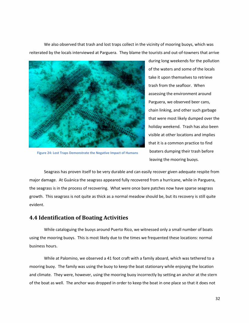
32
We also observed that trash and lost traps collect in the vicinity of mooring buoys, which was
reiterated by the locals interviewed at Parguera. They blame the tourists and out-of-towners that arrive
during long weekends for the pollution
of the waters and some of the locals
take it upon themselves to retrieve
trash from the seafloor. When
assessing the environment around
Parguera, we observed beer cans,
chain linking, and other such garbage
that were most likely dumped over the
holiday weekend. Trash has also been
visible at other locations and implies
that it is a common practice to find
boaters dumping their trash before
leaving the mooring buoys.
Seagrass has proven itself to be very durable and can easily recover given adequate respite from
major damage. At Guánica the seagrass appeared fully recovered from a hurricane, while in Parguera,
the seagrass is in the process of recovering. What were once bare patches now have sparse seagrass
growth. This seagrass is not quite as thick as a normal meadow should be, but its recovery is still quite
evident.
4.4 Identification of Boating Activities
While cataloguing the buoys around Puerto Rico, we witnessed only a small number of boats
using the mooring buoys. This is most likely due to the times we frequented these locations: normal
business hours.
While at Palomino, we observed a 41 foot craft with a family aboard, which was tethered to a
mooring buoy. The family was using the buoy to keep the boat stationary while enjoying the location
and climate. They were, however, using the mooring buoy incorrectly by setting an anchor at the stern
of the boat as well. The anchor was dropped in order to keep the boat in one place so that it does not
Figure 24: Lost Traps Demonstrate the Negative Impact of Humans

33
swing around the buoy, making it safer and easier to keep an eye on the children. The reasoning behind
why boaters are not supposed to drop anchor while connected to a mooring buoy is because it has the
potential to damage the ecosystems, and even if it is in a sand bottom, it could lessen the chances of the
environment recovering in that area. This is problematic for boaters who wish to stabilize their craft
because the other alternative, a system involving two mooring buoys, is not a viable option. The
variability and size of the boats, chance of entanglement, maintenance, and costs are all reasons why a
dual mooring buoy system cannot be implemented.
We returned to Palomino and visited its small neighbor, Palominto, on a weekend where more
than twenty boats total were sighted anchoring very close to the beach. Many of these boats were also
rafted together so that the boaters could better enjoy each other’s company. Besides anchoring along
the beach, other boats were using the mooring buoys, the majority of which were using the buoys
correctly. Only two boats were seen using buoys incorrectly. One boat was tied up correctly, however it
was too large a vessel to use the mooring buoy. It put so much strain on the lines that the buoy was
completely submerged, which could cause the buoy to become detached from the anchor. The other
boat tied the pickup line of the mooring buoy directly to its cleat, which also puts unnecessary strain on
the lines (Figure 25).
Figure 25: Two Boats Tied to Mooring Buoys. The first picture is the correct way to moor by tying a line from the boat to the pickup line. The second picture shows the incorrect way to moor by tying the pickup line directly to the boat.
During our fieldwork in Parguera, we interviewed two boaters who frequent the area and
regularly use the mooring buoys. Our interviews indicated that these boaters believe mooring buoys
help protect the environment and the only improvement that could be made would be to supply more
mooring buoys. One boater said that when he visits the cays near Parguera, all of the mooring buoys
are usually being used by other boaters. As a last resort he either has to drop anchor farther away from

34
where he wants to be or tie up to the mangroves since there are simply not enough mooring buoys for
everyone. The boater also stated that he would prefer to be closer to shore, so that his small children
can play safely in the shallow water.
We conducted four group interviews at Culebra, three of which were comprised of locals, while
the other group was from California. The Californians were sailing through the British Virgin Isles, and
were visiting Puerto Rico for the first time. While they were looking for a safe place to anchor, they
were delighted to find a DNER mooring buoy they could tie up to instead of dropping anchor. They
believe that these mooring buoys protect the environment and were pleased that the DNER had
installed them for public use. Most of our initial interview questions were not applicable to the visiting
Californians because they were intended for people that are familiar with the local mooring buoys.
The responses we received from the locals around Culebra were all very similar. They believed
that the mooring buoys prevent damage to the environment, are primarily used by recreational boaters,
and are placed in the proper locales. However, all of our subjects would like to see more mooring buoys
installed and one interviewee thought that the buoys should be placed closer to shore. Another
common theme between the locals was that some of the buoys are too close together, creating an
unsafe distance between moored boats. They believe the distance should be larger to prevent collisions
and entanglements.
The suggestion from our interviews at Parguera and Culebra, to have mooring buoys closer to
shore, corresponds with observations from aerial surveys depicting many boats anchored along the
shoreline. Unfortunately, this suggestion is not feasible because the water is too shallow to allow boats
to moor at a buoy without damaging the ecosystems. The boat could ground and the buoy and
downline could scrape the environment, causing excessive amounts of damage.
From our interviews two suggestions became prevalent: there is a need for more mooring buoys
and the buoys must be placed farther apart. In many locations, these two suggestions would conflict
with each other. This is because an increase in mooring buoys would force the buoys to be installed too
close to one another. For example in Caracoles, the buoys are spaced approximately 100 feet apart to
prevent collisions. Adding more mooring buoys would reduce this distance while increasing the chance
of collisions and entanglements. The only safe way to add mooring buoys is to maintain the distance
and place them farther from the islands. This, however, would be incompatible with the prior
suggestion that the buoys be placed closer to shore.

35
4.4.1 Educational Outreach Interviews
As a supplement to our own interviews, Kevin Vayda, Daniel Cafferty, and Jason Carmichael
provided results from a section of their survey for our use. They worked with the Educational Outreach
division of the DNER to assess the common knowledge regarding marine ecosystems around Puerto
Rico. When we received their data, they had interviewed 283 subjects at marinas, beaches, and the
DNER vessel registration office. The data provided concern the public’s perception and use of the DNER
mooring buoys. From their results, 60% of people surveyed were aware that the DNER has provided
public mooring buoys for their use and 52% of these subjects use the buoys. However, only 20% believe
that there are enough mooring buoys along the coast of Puerto Rico. Additionally, 6% of the people
have dropped anchor on coral reef and seagrass (Vayda, Cafferty, & Carmichael, 2009).
Even though 6% can be seen as a small number, the total number of subjects for these surveys is
not very large compared to the number of registered boats of Puerto Rico. If this sample is
representative of the entire population of boaters, 6% would be an extremely large number. There
could be a number of reasons why boaters knowingly drop anchor on fragile marine ecosystems:
boaters may not be cognizant of the damages they are inflicting on the environments or perhaps the
boaters do not care about the damage they cause. Another reason, which concerns this project, is that
maybe there were too few buoys for all of the boaters to tie up to. From the survey, 20% believe that
there are not enough mooring buoys, which agrees with the interviews that we conducted at Culebra
and Parguera. The interviews state that there are plenty of mooring buoys during the week, but during
the weekends and holidays, there are simply not
enough to handle the influx.
4.4.2 Aerial Surveys
The DNER conducted aerial surveys over
Easter to view the boating distribution during this
very busy weekend. Among others, Guánica,
Fajardo, and Salinas were photographed to best
show how all the boats were using the buoys. The
photographs showed that many mooring buoys were
being used improperly, but even with the
large number of boats not all the buoys were
Figure 26: Two boats rafting at Fajardo. Notice how the other buoy is ignored.

36
being used. This may be because boaters prefer to moor closer to shore or to raft together rather than
being farther apart at separate buoys.
Other bad practices observed were boats lining the beaches and mangroves. The boats dropped
anchor along the sand, and with such a large number of boats, this can cause serious erosion to the
beach. Along the mangrove channels in Salinas a long row of boats had tied their lines to the mangrove
branches. This causes damage to
the mangroves by breaking its
branches and roots. If there was not
enough room near the beach or next
to the mangrove forest, the boaters
proceeded to drop anchor wherever
they wanted. At Salinas, a large
boat deliberately dropped anchor
upon the seagrass bed (Figure 27).
Buoys can be seen used improperly in the aerial photography of Salinas, where a buoy can be
seen pulled from the water and hovering above the
surface (Figure 28). It cannot be determined how the
boater is using this buoy, but it is certainly improper.
In this area that contains 34 boats and only four
buoys it was surprising to see one buoy being
completely ignored.
Icacos was the only area where all the
mooring buoys were used during this holiday
weekend. Unfortunately, Icacos only contains one
mooring buoy. All the other sites had quite a few
buoys that were not being used even though the number of boats in the area was much higher than the
number of buoys. Table 1 compares the number of boats to the number of buoys that were not used
when these data were taken.
Figure 27: Large Boat Anchored in Seagrass at Salinas
Figure 28: Improper Mooring Buoy Use at Salinas

37
Table 1: Buoys Not Being Used
Site Total Number of Boats
Total Number of Buoys
Total Number of Buoys Not Being Used
Guánica 17 14 3
Salinas 85 8 1
Palomino 70 22 5
Wolf’s Den 3 3 3
Icacos 64 1 0
There are a few possible reasons why boaters were not using the mooring buoys. The mooring
buoys may have been in disrepair, rendering them unusable to boaters. Since the aerial surveys were
collected on Sunday, at the end of Easter weekend, these buoys could have been damaged earlier in the
weekend. Another reason is that the boaters decided to go wherever they desired rather than limiting
themselves to locations with buoys. With the holiday festivities and the large number of other boats, a
boater has more confidence to drop anchor in seagrass or coral environments if there are others doing
the same. With this data and the aerial photography, it appears as if boaters go where they please with
little regard to the environment.
When it comes to aquatic activities, people tend to go where they want. From our observations
we witnessed that most boaters will go closer to shore and drop anchor in the sand. Although this
practice is not illegal, it is discouraged by
the DNER because it erodes the beaches.
Boaters avoid fines for dropping anchor
in seagrass or coral by getting close
enough to shore that there is only sand.
However, we observed that if their
interest coincides with that of a mooring
buoy location then some of the boaters
will use the buoy instead of dropping
anchor. Figure 29: Boating Traffic at Palomino over Easter Weekend

38
4.5 Analysis of Boat Traffic
While we were cataloguing the buoys around Puerto Rico, we observed a relatively small
number of boats in the vicinity of the mooring buoys. At Guánica and Salinas we witnessed a total of
seven boats; all except one were just passing through. In general it appears that boaters would prefer
to drop anchor close to shore in sand rather than tie up to a mooring buoy. At the sites around Fajardo,
we observed fourteen recreational boats, six of which were anchored in sand. Another common boat
activity is ferrying people from one destination to another. This happens because people, especially
tourists who do not have their own watercraft, still wish to visit the offshore locations. We witnessed a
total of four ferries at Guánica and Fajardo. There were only a few boats at Parguera and they were
mostly small recreational vessels that were either anchored, tied up to mooring buoys, or just passing
through.
To try to ascertain a better
idea of the boat traffic during the
weekend; another excursion was
undertaken to Fajardo and Culebra
on a Sunday. Compared to when
we visited Palomino previously,
there were over 49 boats present
in this location and this was only at
one of the many islands off the
coast of Fajardo. Most of these
boats were anchored next to
shore, but the rest were using all of
the mooring buoys in that area. While at Culebra we counted 43 boats in different areas around the
island. There were other parts of the island that were populated with many boats but we were unable
to travel to them due to time constraints.
To showcase the difference between the number of boats during a holiday weekend and a
common weekday, Table 2 shows how many boats was present Sunday during Easter Weekend and how
many boats were present during an average weekday.
Figure 30: Boat Traffic at Icacos over Easter Weekend
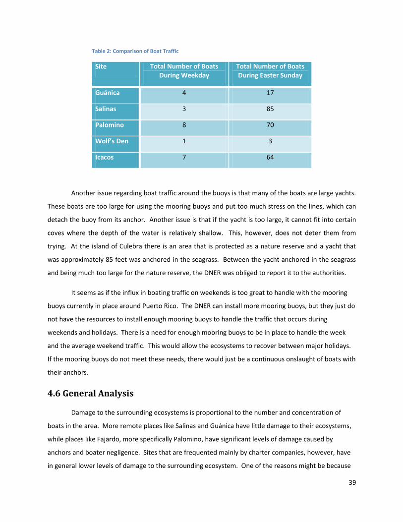
39
Table 2: Comparison of Boat Traffic
Site Total Number of Boats During Weekday
Total Number of Boats During Easter Sunday
Guánica 4 17
Salinas 3 85
Palomino 8 70
Wolf’s Den 1 3
Icacos 7 64
Another issue regarding boat traffic around the buoys is that many of the boats are large yachts.
These boats are too large for using the mooring buoys and put too much stress on the lines, which can
detach the buoy from its anchor. Another issue is that if the yacht is too large, it cannot fit into certain
coves where the depth of the water is relatively shallow. This, however, does not deter them from
trying. At the island of Culebra there is an area that is protected as a nature reserve and a yacht that
was approximately 85 feet was anchored in the seagrass. Between the yacht anchored in the seagrass
and being much too large for the nature reserve, the DNER was obliged to report it to the authorities.
It seems as if the influx in boating traffic on weekends is too great to handle with the mooring
buoys currently in place around Puerto Rico. The DNER can install more mooring buoys, but they just do
not have the resources to install enough mooring buoys to handle the traffic that occurs during
weekends and holidays. There is a need for enough mooring buoys to be in place to handle the week
and the average weekend traffic. This would allow the ecosystems to recover between major holidays.
If the mooring buoys do not meet these needs, there would just be a continuous onslaught of boats with
their anchors.
4.6 General Analysis
Damage to the surrounding ecosystems is proportional to the number and concentration of
boats in the area. More remote places like Salinas and Guánica have little damage to their ecosystems,
while places like Fajardo, more specifically Palomino, have significant levels of damage caused by
anchors and boater negligence. Sites that are frequented mainly by charter companies, however, have
in general lower levels of damage to the surrounding ecosystem. One of the reasons might be because

40
the charter boats both want to preserve the environments for the sake of their business. Since they
transport more people per boat, there are not as many vessels in the area. Although charter boats stem
damage to the ecosystems by educating their passengers on how to interact with the reef safely, the
largest emergent pattern of our results is that the popular sites are still the areas that sustain the most
damage.
These popular areas contain the most damage to both buoys and ecosystems. The reason for
the popularity is that these areas are close to major cities and large resorts, which allow tourists easy
access. These places are also well known for their swimming and marine activities. Because they are
used so frequently, the ecosystems have a hard time recovering from all the traffic. More remote places
are allowed to recover because they only experience an influx of visitors during major holidays and
weekends. The more popular the site, the more
boats there are. These boats tend to crowd where
there are not enough mooring buoys so they have
to drop anchor, which damages the ecosystems.
While the ecosystems are being damaged so too
are the mooring buoys meant to protect them.
Because of the sheer number of boats using these
buoys, they sustain more damage from improper
use and general wear, rendering them unusable.
During the weekends and holidays, when there is
an increase in boaters, damages to buoys are
exasperated, diminishing the number of mooring buoys which leads to the deterioration of the
surrounding ecosystems.
Seagrass is often located on the calmer side of the small islands and is observed to be the best
at rebounding compared to soft and hard corals. If there is only an occasional flux of boaters, seagrass
has the time and capability to recover quickly, especially in shallow waters. In Guánica for instance, we
observed seagrass flourishing in the shallows where before, according to our liaison, the seagrass had
been significantly reduced by boating practices. At the more popular sites for boating activities, the
seagrass has had less time to recuperate. This is evident in the numerous bare patches interspersed
within the seagrass meadows off the coast of Fajardo.
Figure 31: Bare Patches in a Seagrass Meadow

41
There was a noticeable difference in pickup lines between the calm waters of Guánica and
Salinas and the rough bay of Fajardo. The pickup lines had the same amount of damage, but the
amount of growth was significantly varied. The pickup lines at Guánica and Salinas were weighed down
by a large collection of algae, sponges, and other organisms whereas the pickup lines at Fajardo were
relatively clean. There are two possible reasons why pickup lines at Fajardo lack the marine
accumulation seen elsewhere: the rough waters hamper the growth on the pickup lines or the frequent
use of these mooring buoys due to their popularity does not allow for algae to collect. At this time, it is
not clear which is the contributing reason. It may be a combination of both.
From our interviews and the aerial surveys it seems as if there is a difference in attitude towards
the marine environment and the mooring buoys between locals that use these ecosystems around their
home and the vacationers who arrive on major holidays. During our weekend fieldwork, we witnessed
boaters both anchored and actively dropping anchor in seagrass environments, contrary to during the
week where we only observed boats anchored in sand. In the interviews we conducted, the boaters
spoke of trash that had accumulated near the mooring buoys and stated it was leftover from vacationers
who do not live in the area, but who travel there on weekends. If buoys were being used, most of them
were used improperly. Again, it may be because of the overwhelming number of boats, but it seems as
if the vacationing boaters do not show as much respect to the environment as the locals do.
4.7 Concluding Remarks
The results obtained by our fieldwork are lacking in data due to the simple fact that we
catalogued only 98 of the 270 mooring buoys. With a full catalogue of all the mooring buoys, the DNER
will be able to properly construct maintenance schedules. However, the buoys we catalogued provided
a testing area for refining procedures allowing the DNER to catalogue the remaining mooring buoys
more easily. Other than the number of buoys catalogued, insufficient data were collected through
interviews assessing the public’s opinion of the use of mooring buoys. Even though we were unable to
achieve a sizable sample, the interviews we did collect provided vital insight into the mindset of the
boaters using the mooring buoys, while simultaneously reinforcing observations gathered in the field.
To date our analysis has shown that the buoys are helping the ecosystems by facilitating the
recovery of seafloor environments through prevention of anchor damage. The use of the buoys does
have an impact on their condition, however, as we found buoys in the more traveled regions to have
damages such as propeller scarring, which was not seen in more remote locations. These scarred buoys

42
will be replaced now that they have been catalogued as severely damaged. The cataloguing of the
buoys will greatly help the DNER to identify where to allocate installation and maintenance. The other
benefit of an exact coordinate for each buoy is that if one of them should be lost, the anchor pin can be
found far easier than if only the general location was known.

43
CHAPTER 5: CONCLUSION
Marine damage is a common problem around the world. Mooring buoys are a part of a solution
to prevent damage caused by humans. Although human impact is a small aspect of the damage, it is
easily exacerbated by other causes. Because the buoys have such a positive impact on the environment,
the DNER wants to manage them effectively. Puerto Rico has many offshore natural wonders that need
protection from the surge of tourists and locals looking to experience them. Practices were put into
place to try and preserve these environments, while allowing many people to experience them. This is a
great benefit of mooring buoys: that people can still see the natural environment without inflicting
damage. The goal of our project was the creation of a GIS database that would allow the DNER to easily
manage these buoys. This was accomplished through the cataloguing the buoys’ locations, evaluating
the conditions of the buoys, assessing the surrounding ecosystems, identifying boating activities, and
analyzing boat traffic.
By constructing a GIS database to contain all of the relevant information gathered through
fieldwork, we have effectively created a tool that can provide quick and efficient access to information
regarding the mooring buoys surrounding Puerto Rico. With this database, the DNER will be able to
effectively manage the mooring buoys by creating maintenance schedules and assessing the impact of
the mooring buoys on the surrounding ecosystems.
The factors that contribute to the destruction of Puerto Rico’s marine habitats range from
hurricanes and diseases to careless boating practices. While some of these factors cannot be controlled,
the DNER has targeted the direct influences from human boating behaviors, one of which is the setting
of anchor while in the marine ecosystems. This small action causes disproportionally large amounts of
damage; however, it can be deterred through the installation of mooring buoys.
With the database effectively managing these buoys, an accurate survey on whether the soft
and hard corals are truly recovering can be ascertained over a long period of time, seeing as their
regeneration will take at least a quarter of a century. Since the mooring buoys have allowed seagrass to
recover at some of the shallower locations, it appears that they will also allow the soft and hard corals
as well as deep water seagrass to recover. These organisms take a much longer period to recover and,
hopefully, mooring buoys are giving them that chance.

44
5.1 Recommendations
We recommend the installation of more mooring buoys in the Palomino and Icacos sites, as
these areas are still being affected by boaters dropping anchor. There are not enough mooring buoys to
handle all of the vacationers, especially during major weekends and holidays, and these islands receive a
lot more visitors during the week when compared to sites such as Guánica and Salinas. The ecosystems
surrounding Guánica and Salinas are able to recover during the week when there is slow boat traffic. In
the more popular places, there are simply not enough mooring buoys, because the islands are visited
more frequently during the week and even more so on the weekend. The ecosystems cannot recover
due to the boaters’ excessive use.
Another recommendation is to do maintenance immediately following a major holiday, when
there is a large increase in use of mooring buoys. The buoys and the environment exhibit high levels of
disrepair, especially in extremely popular locales. The sooner maintenance can be provided to these
areas the less time the buoys will have to deteriorate. Immediately addressing damage can improve the
lifetime of the buoys and also allow the ecosystems to recover if the buoys are still operational. If the
buoys are not repaired immediately, boaters have no choice but to drop anchor on the seafloor.
We recommend that the database be regularly updated so that it remains current and
pertinent. The DNER will be able to plan maintenance schedules for the mooring buoys as well as
monitor the surrounding ecosystems. Also if a version was published on the DNER website and
continuously updated then the public could access it and learn the locations of the mooring buoys. To a
lesser extent, this would also allow the DNER direction in how to proceed in organizing a volunteer
workforce to clean the mooring buoys.
Another idea is that the DNER could expand upon the Adopt-A-Buoy program to allow for the
public to play an active role in maintenance as well as sponsoring a buoy. As responsibilities, the
adopter would have to maintain the buoy’s cleanliness and report any and all damages to the DNER. A
possible benefit to adopting a buoy would allow the adopter to place their name or logo underneath the
“DRNA” already written on the buoy.
This database will allow the DNER to easily manage the locations and the current conditions of
all the buoys. It will also provide supplementary information in the form of what kinds of boaters are
using the buoys and how they are using them. With data from the database, the DNER can better

45
protect the environment from human abuse and overuse and future projects can be easily planned and
executed.
REFERENCES
Boaters Land. (2009). How do I use a mooring buoy? - taylor made mooring buoys. Retrieved 2/13/2009, 2009, from http://www.boatersland.com/mooring.html
CIA. (2009). CIA - the world factbook -- Puerto Rico. Retrieved 2/12/2009, 2009, from https://www.cia.gov/library/publications/the-world-factbook/geos/rq.html
Creed, J. C., & Amado Filho, G. M. (1999). Disturbance and recovery of the macroflora of a seagrass (halodule wrightii ascherson) meadow in the Abrolhos Marine National Park, Brazil: An experimental evaluation of anchor damage. Journal of Experimental Marine Biology and Ecology, 235(2), 285-306. doi:DOI: 10.1016/S0022-0981(98)00188-9
Dawes, C. J., Andorfer, J., Rose, C., Uranowski, C., & Ehringer, N. (1997). Regrowth of the seagrass thalassia testudinum into propeller scars. Aquatic Botany, 59(1-2), 139-155. doi:DOI: 10.1016/S0304-3770(97)00021-1
Dinsdale, E. A., & Harriott, V. J. (2004). Assessing anchor damage on coral reefs: A case study in selection of environmental indicators. Environmental Management, 33(1), 126-139. Retrieved from http://dx.doi.org/10.1007/s00267-003-3056-9
Environmental Systems Research Institute. (1997). Getting to know ArcView GIS : The geographic information system (GIS) for everyone (2nd ed.). Cambridge: GeoInformation International.
García-Sais, J. R., Appeldoorn, R., Battista, T., Bauer, L., Bruckner, A., Caldow, C., et al. (2008). The state of coral reef ecosystems of the commonwealth of Puerto Rico. The State of Coral Reef Ecosystems of the Unites States and Pacific Freely Associated States: 2008. NOAA Technical Memorandum NOS NCCOS 73., 73, 75-116. Retrieved from DSpace at Mote Marine Laboratory database.
gastropod. (n.d.). Dictionary.com Unabridged (v 1.1). Retrieved April 16, 2009, from Dictionary.com
website: http://dictionary.reference.com/browse/gastropod
Green, E. P., & Short, F. T. (2003). World atlas of seagrasses. Berkeley: University of California Press.
Gullström, M., Castro, M. d. l. T., Bandeira, S. O., Björk, M., Dahlberg, M., Kautsky, N., et al. (2002). Seagrass ecosystems in the western Indian Ocean. Ambio, 31(7/8, The Western Indian Ocean), 588-596. Retrieved from http://www.jstor.org/stable/4315313
Harriott, V. J. (2002). Marine tourism impacts and their management on the great barrier reef No. 46). CRC Reef Research Centre, Townsville: CRC Reef Research Centre and School of Tropical Environmental Science and Geography, James Cook University. Retrieved from http://crcreef.jcu.edu.au/publications/techreport/pdf/Harriott46.pdf

46
Hastings, K., Hesp, P., & Kendrick, G. A. (1995). Seagrass loss associated with boat moorings at rottnest island, Western Australia. Ocean and Coastal Management, 26(3), 225-246. Retrieved from http://dx.doi.org/10.1016/0964-5691(95)00012-Q
Hemminga, M. A., & Duarte, C. M. (2000). Seagrass ecology. Cambridge, UK ; New York, NY: Cambridge University Press.
Jaap, W. C. (2000). Coral reef restoration. Ecological Engineering, 15(3-4), 345-364. doi:DOI: 10.1016/S0925-8574(00)00085-9
Jackson, J. B. C., Kirby, M. X., Berger, W. H., Bjorndal, K. A., Botsford, L. W., Bourque, B. J., et al. (2001). Historical overfishing and the recent collapse of coastal ecosystems. Science, 293(5530), 629-637. doi:10.1126/science.1059199
Jameson, S. C., Ammar, M. S. A., Saadalla, E., Mostafa, H. M., & Riegl, B. (2007). A quantitative ecological assessment of diving sites in the Egyptian Red Sea during a period of severe anchor damage: A baseline for restoration and sustainable tourism management. Journal of Sustainable Tourism, 15(3), 309-323. doi:10.2167
Jennings, S., & Polunin, N. V. C. (1996). Impacts of fishing on tropical reef ecosystems. Ambio, 25(1), 44-49. Retrieved from http://www.jstor.org/stable/4314417
Larkum, A. W. D., Orth, R. J., & Duarte, C. M. (2006). Seagrasses : Biology, ecology, and conservation. Dordrecht, The Netherlands: Springer.
Larsen, M. C., & Webb, R. M. T. (2009). Potential effects of runoff, fluvial sediment, and nutrient discharges on the coral reefs of Puerto Rico Retrieved from http://find.galegroup.com/itx/infomark.do?contentSet=IAC-Documents&docType=IAC&type=retrieve&tabID=T002&prodId=AONE&docId=A192974474&userGroupName=mlin_c_worpoly&version=1.0&source=gale
marine ecosystem. (2009). In Encyclopædia Britannica. Retrieved April 16, 2009, from Encyclopædia
Britannica Online: http://www.britannica.com/EBchecked/topic/365256/marine-ecosystem
Moberg, F., & Folke, C. (1999). Ecological goods and services of coral reef ecosystems. Ecological Economics, 29(2), 215-233. doi:DOI: 10.1016/S0921-8009(99)00009-9
Moreno, P. S. (2005). Ecotourism along the meso-american caribbean reef: The impacts of foreign investment. Human Ecology, 33(2), 217-244. Retrieved from http://dx.doi.org/10.1007/s10745-005-2433-9
National Wildlife Federation. (2007). Wildlife conservation funding. Retrieved 1/30/2009, 2009, from http://www.nwf.org/congressandglobalwarming/wildlifeconservationfunding.cfm
Orth, R. J., Carruthers, T. J. B., Dennison, W. C., Duarte, C. M., Fourqurean, J. W., Jr., K. L. H., et al. (2006). A global crisis for seagrass ecosystems. Bioscience, 56(12), 987-996. Retrieved from http://www.jstor.org/stable/4488220

47
Robert B. Ditton, Don J. Clark. (1994). Charistics, attitudes, catch and release behavior, and expendatures of billfish tournament anglers in Puerto Rico. Texas A&M University: Department of Wildlife and Fisheries Sciences.
Rosenberg, E., & Loya, Y. (2004). Coral health and disease. New York: Springer-Verlag.
Spalding, M., Ravilious, C., & Green, E. P. (2001). World atlas of coral reefs University of California Press.
U.S. Dept of Agriculture National Agriculture Statistics Service. (2007). 2007 census of agriculture island profile Puerto Rico
U.S. Dept of Homeland Security, & United States Coast Guard. (2008). Boating statistics 2007 No. P16754.21)United States Coast Guard.
Vayda, K., Cafferty, D., & Carmichael, J. (2009). Maintaining marine ecosystems (WPI IQP. Worcester MA:
Woodley, J. D., Chornesky, E. A., Clifford, P. A., Jackson, J. B. C., Kaufman, L. S., Knowlton, N., et al. (1981). Hurricane Allen's impact on jamaican coral reefs. Science, 214(4522), 749-755. doi:10.1126/science.214.4522.749
48
GLOSSARY
Blowhole: An excavation of an area of seagrass and ocean floor caused by a high amount of turbidity
from a boat propeller (C. Matos, personal communication, March 24, 2009).
Buoy Cleaning: The process of removing algae growing on a mooring buoy's various components. It is
performed using a knife to scrape off the algae weighing the buoy down.
Fragmentation: Damage that has caused pieces of coral to break off (C. Matos, personal
communication, March 24, 2009).
Gastropod: “Any mollusk of the class Gastropoda, comprising the snails, whelks, slugs, etc”
(Dictionary.com Unabridged, 2009)
Grounding: The act of a boat’s hull physically coming into contact with a seafloor environment.
Halas [anchor system]: An anchor for mooring buoys that is used in hard-bottom sea floor
environments, such as coral. Installed by boring into the top of a rock or coral outcrop, inserting the
Halas anchor with pin on tom, then filling with hydraulic cement (C. Matos, personal
communication, March 27, 2009).
Laceration: Damage caused by contact with ropes, chains and the weight of the anchor (C. Matos,
personal communication, March 24, 2009).
Manta [anchor system]: Used in soft-bottom sea floor environments as an anchor for mooring buoys.
Found in seagrass beds and mangrove cays where mooring buoys have been installed. It is installed
by drilling the anchor into the substrate to a depth before pulling up on it to engage steel arms that
act as barbs, holding the anchor in place (C. Matos, personal communication, March 27, 2009).
Pulverization: Maceration or grinding of coral (C. Matos, personal communication, March 24, 2009).
Primary Production: The transformation of energy to organic substances using photosynthesis or other
chemical means. (Encyclopædia Britannica, 2009)
Rafting: The process of one boat using a mooring buoy, anchoring, or tying off to something while other
boats tie to the boat already moored (C. Matos, personal communication, March 30, 2009).
Reef walking: A water activity where the participants walk on and along the coral reef.
Scrape: Mild physical contact with some scarring or removal of the outer layer, mainly used regarding
coral reefs (C. Matos, personal communication, March 24, 2009).
Scar: A long trench cut into a seagrass bed that is formed most commonly by boats and propellers (C.
Matos, personal communication, March 24, 2009).

49
Trimble GPS Transponder: A handheld device that takes GPS coordinates. It also can use data forms to
create features that can be displayed using a Geographic Information System client and stored easily
in a database.

50
APPENDIX A: MISSION STATEMENT
The Department of Natural and Environmental Resources mission statement: “To protect,
conserve, and manage the natural and environmental resources of the country, balanced so as to
guarantee future generations their enjoyment and to promote a better quality of life.”

51
APPENDIX B: PROPOSED TIMELINE
The following table was the projected layout of our timeframe while at the project site. We
scheduled it in the most logistical fashion, beginning with assessment and planning, and development of
the database. Interviews and buoy evaluation have multiple weeks allotted for their completion due to
the sheer magnitude of the task. Analysis of boating traffic was dependent upon data gathered while
evaluating buoys and documents provided by the DNER. The last two weeks were reserved for the
finalization of both the database and the report.
Table 3: Proposed Timeline
TASK
Week
03/15-
03/21
03/22-
03/28
03/29-
04/04
04/05-
04/11
04/12-
04/18
04/19-
04/25
04/26-
05/02
05/03-
05/06
Assess
Information and
Plan Fieldwork
Assess
&
Plan
Develop
Database
Develop
Database
Interviews Interviews
Buoy Evaluation Buoy Evaluation
Analyze Boating
Traffic Analyze Boating Traffic
Finalize
Database
Finalize Database
Finalize Report Finalize Report

52
APPENDIX C: PUERTO RICO BACKGROUND INFORMATION
The island of Puerto Rico is located south and east of the Dominican Republic, and is roughly
three times the size of Rhode Island, at 8870 km2. With a fairly consistent Caribbean environment,
Puerto Rico enjoys warm temperatures year-round on the majority of the landmass, including the
coastal plains and sand beaches. Some lower temperatures may be experienced in the mountainous
regions inland where it is also marginally more arid than the lower, northern parts of the island. (CIA,
2009)
Due to its geographic location, Puerto Rico experiences many hurricanes throughout the
summer months, often leading to problems on and off the island (CIA, 2009). Because of past and
current agricultural trends, torrential rain can lead to erosion and washout. This runoff, when it feeds
into the tributaries and rivers, will eventually flow out to the ocean. This presents the problem of
sedimentation, which is damaging to the local ecosystems and ultimately leads to a drop to their
economic production (Hemminga & Duarte, 2000; Larsen & Webb, 2009).
Both seagrass beds and coral reefs can offer valuable commodities to the mainland, including
fish and mollusks, as well as an attractive place for tourists. As of 2007 the aquaculture of Puerto Rico
enjoyed a market value of $832,725 (U.S. Dept of Agriculture National Agriculture Statistics Service,
2007). Interestingly enough, however, fish is one of Puerto Rico’s larger imports (CIA, 2009), even in
light of the publicity enjoyed as an excellent sport fishing location (Robert B. Ditton, Don J. Clark, 1994).
Puerto Rico’s dependence on foreign fish is due to the island having become a large industrial
center, with many U.S. businesses investing money there. What was once a major agricultural center
focused on sugar production has now devoted its fields to dairy and livestock, while allowing production
facilities for chemicals and pharmaceuticals to become a main source of revenue (CIA, 2009).
A 2004 statistic gives that roughly 5 million tourists visited Puerto Rico that year (CIA, 2009).
With regard to statistics concerning revenues, none have been found that break down the “goods and
services” into finite areas. Because of this, little is known about how much monetary value any given
sphere of business will have. Boating, diving, fishing and other forms of marine recreation are present in
Puerto Rico, but the actual distribution patterns cannot be traced by economic means.

53
APPENDIX D: ADDITIONAL MOORING BUOY INFORMATION
D-1: How Mooring Buoys Are Cleaned
Because of their fairly stable position on the ocean surface, mooring buoys tend to accrue
marine vegetation on any component that stays continuously submerged. The creation of these
microecosystems would be beneficial if not for the fact that the added flora weighs down the buoy and
increases the likelihood of boats colliding with and damaging the buoy and its parts.
When a buoy has amassed enough plant matter to warrant cleaning, the first step is to approach
the buoy and expose the underside with the growth on it. From here, all vegetation that can be pulled
off by hand is removed. Next, the spine of a utility knife, about one foot long, is used to scrape down
the rest of the surface shaving off any residual plant matter. When the flora has grown and covered the
pickup line of the mooring buoy, it cannot be easily cleaned without damaging the fibers of the line, so
the DNER replaces it with a new clean line.
D-2: The Installation of Mooring Buoys
Mooring buoys can have a service span of over five years in calm fresh water. The buoys off the
coast of Puerto Rico, however, are installed in saltwater and at times are located in very rough
environments either through natural wave action or poor boating practices. Due to these less than
favorable conditions, the buoys can detach from their anchors and become lost from time to time.
Buoy damage usually initiates at the pickup line and propagates downwards to the anchor pin.
In the case that the entire buoy is missing, the anchor pin usually remains in the seafloor. In this case,
the installation requires finding the existing pin. Next, a downline is prepared by passing rope through a
section of plastic pipe, used to prevent frictional damage, and then weaving the rope back into itself so
that the pipe with rope inside forms a loop. This loop is then connected to a shackle, which then fastens
to the anchor pin. The downline is then tied to a through-line, which passes through the buoy and is
connected to the pickup line by another looped knot. A consideration in this process is the depth of the
water in which the buoy sits: SCUBA divers are needed for deep water while snorkelers suffice for
shallower areas. Additionally, the ropes must be of the proper length to allow the right amount of slack
so that the tension does not pull out the anchor.

54
APPENDIX E: DESCRIPTIONS OF MOORING BUOY SITES VISITED
E-1: Guánica
The site at Guánica is a small mangrove island less than a mile off the coast. Surrounding the
island are fourteen mooring buoys that are available for public use by boaters. This island, called Cayo
Aurora (affectionately called Gilligan’s Island) is very popular among the locals. On the weekend
following our fieldwork; over 600 people were predicted to arrive to enjoy the crystal clear waters.
E-2: Salinas
The Salinas site is another island that is located close to the coast. It is primarily a mangrove
island and has eight mooring buoys, four of which protect seagrass while the rest defend mangroves
from boaters tying to their roots. This island, Cayo Matias, is an excellent spot for snorkeling among the
mangroves making it a popular destination for both tourists and locals. Without the mooring buoys
present, damage would inevitably occur to this environment.
E-3: Fajardo
The islands surrounding Fajardo are further away from the coast than the cays around Salinas
and Guánica. The major islands are Icacos, Palomino, and Wolf’s Den; there is also a very small cay near
Palomino named Palominto. There are mooring buoys installed around each island: one at Icacos,
twenty-two at Palomino, four at Palominto, and three at Wolf’s Den. The buoys are placed there to
stem anchor damage to the coral and seagrass environments that surround these islands. These islands
are not made of mangroves but instead have sandy beaches with grass and palm trees. Palomino and
Icacos are the largest islands around Fajardo and the area around Icacos is part of a large coral reef. This
area is popular for snorkeling and many charter boats bring their patrons here to enjoy all the ocean has
to offer. These islands are very popular because they are close to the mainland of Puerto Rico and also
are the closest to the commonwealth’s capital, San Juan.
E-4: Parguera
Parguera is a small town located in southwest Puerto Rico. The small mangrove islands around
Parguera are all in shallow waters with seagrass surrounding them. We visited three of these cays:
Colloado, Enrique, and Caracoles. Each of these areas was outfitted with mooring buoys to protect the

55
mangroves and seagrass. Colloado had five, Enrique eight, and Caracoles seventeen. Due to the warm
shallow waters of the Caribbean, boaters here enjoy snorkeling and swimming in the sea.
E-5: Culebra
Culebra is a large island off the coast of Puerto Rico that is world renowned for its beaches. This
island is different from the other cays that we have visited because it is large enough to support a town,
population 1, 868 (U.S. Dept of Agriculture National Agriculture Statistics Service, 2007). Surrounding
the island are clear waters filled with seagrass and coral. These waters range from very shallow to about
40 feet deep. The deeper areas around the island are where the coral environments are located. A
popular activity for boaters is to snorkel around these coral reefs. To protect this beautiful area, a large
number of mooring buoys were installed. However, when we visited Culebra, we did not have enough
time to catalogue all of the mooring buoys around the island. We were only able to catalogue 15 buoys
that were installed off of Carlos Rosario Beach. The DNER will catalogue the remaining buoys at a future
point in time and import them into the database.

56
APPENDIX F: DATABASE USE
F-1: Trimble Data Collection
The Trimble GPS transponder allows for easy collection of fieldwork data by applying just a click.
Collecting data on a Trimble helps eliminate clerical errors that can arise while transferring data from
paper to an electronic form, such as a database. The Trimble allows for simple entry of data in one
convenient location rather than multiple datasheets. Below are instructions on how to use the Trimble
to gather field data.
On the Trimble desktop, double tap the TerraSync software
icon to open the data collection program.
TerraSync opens by displaying the Status screen. Adjusting
the slider at the bottom of this screen adjusts precision (accuracy)
and productivity (speed) of the GPS while recording the
coordinates. A balance between these settings ensures that data
collection can be done in the field rapidly, while still taking valid
coordinates.
To begin taking data, change to the Data screen by tapping
the dropdown arrow in the upper left next to “Status” and then
tapping “Data”.
Figure 32: Trimble Desktop
Figure 33: TerraSync Status Screen

57
The Data screen begins with a new data file. In the
bottom right hand corner, tap the keyboard icon to open the
on screen keyboard. Input the desired name of the file by
tapping each letter. Scroll down, or close the keyboard to
select the “PR Mooring Buoy 3” data dictionary. This data
dictionary is the most current version for collecting mooring
buoy data. Tap “Create” to save the file and begin collecting
features.
The antenna height is determined by how the Trimble is
used, either handheld or using the backpack antenna. Enter the
height of the antenna in meters and then tap “OK”. Change the
“Measure To” to the appropriate setting.
Select the feature that you would like to create and
then tap “Create”. For example, how to create a buoy
feature is shown below.
Figure 34: TerraSync Data File Creation
Figure 35: TerraSync Antenna Height
Figure 36: TerraSync Data Screen

58
Any fields with a red asterisk are required to be entered
before continuing. The text fields can be entered by using the
onscreen keyboard. Drop down menus give a choice of options to
select. Afterwards, scroll down and enter the rest of the
information for the buoy.
To take the position of the buoy, tap “Log”. The pause
icon above “Log” will transition to a play icon and the “Log” will
change to “Pause”. Wait until the 0 changes to a 1. If more than
one position is taken then the average of all the positions will be
the final position. Then tap “Pause”. When all information has
been entered and the position calculated, tap “OK” and the
feature will be saved. For the best results make sure that four or
more satellites are displayed in the top center. Fewer than four
does not provide a sufficient amount of accuracy.
If a feature needs to be edited, tap the drop
down arrow next to “Collect” and then tap “Update”.
Select the feature that you want to change and then tap
“Begin”. Modify the feature in the same manner as
creating a new feature.
Figure 37: Buoy Data Form
Figure 38: TerraSync Data Update Screen
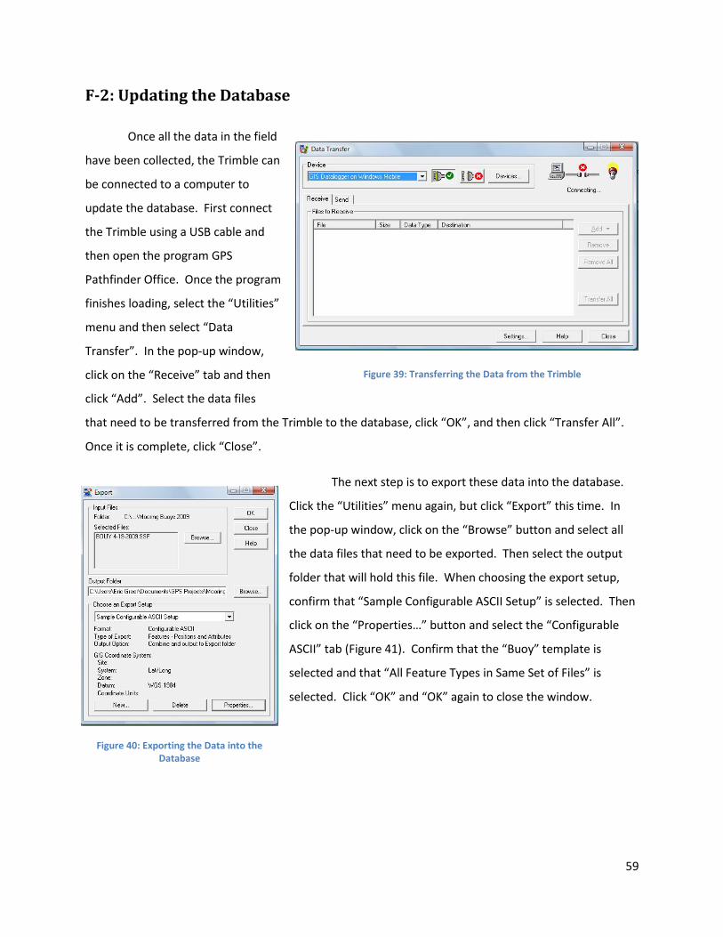
59
F-2: Updating the Database
Once all the data in the field
have been collected, the Trimble can
be connected to a computer to
update the database. First connect
the Trimble using a USB cable and
then open the program GPS
Pathfinder Office. Once the program
finishes loading, select the “Utilities”
menu and then select “Data
Transfer”. In the pop-up window,
click on the “Receive” tab and then
click “Add”. Select the data files
that need to be transferred from the Trimble to the database, click “OK”, and then click “Transfer All”.
Once it is complete, click “Close”.
The next step is to export these data into the database.
Click the “Utilities” menu again, but click “Export” this time. In
the pop-up window, click on the “Browse” button and select all
the data files that need to be exported. Then select the output
folder that will hold this file. When choosing the export setup,
confirm that “Sample Configurable ASCII Setup” is selected. Then
click on the “Properties…” button and select the “Configurable
ASCII” tab (Figure 41). Confirm that the “Buoy” template is
selected and that “All Feature Types in Same Set of Files” is
selected. Click “OK” and “OK” again to close the window.
Figure 39: Transferring the Data from the Trimble
Figure 40: Exporting the Data into the Database

60
Figure 41: Export Setup Properties
Once all the data are exported, GPS Pathfinder Office can be closed and an internet browser
opened. Navigate to the data upload website, click “OK” in the dialog box and then “Open” to allow the
file to run. Enter in a username and password, then
click “Upload a File” and select the file to be uploaded
to the database website. Then click “Open”. The data
will be uploaded to the database website
automatically. This process can only be used to insert
new buoys and new vessels and modify buoys that are
already in the database. To modify vessels that are
already in the database, a program such as Quantum
GIS must be used.
F-3: The Database Website
The user can read information about mooring buoys in two different ways: “MAP” and “DATA”.
When the user is toggled to “MAP” (Figure 43) the mooring buoy locations are represented on a map of
Puerto Rico that is powered by Google Earth. Each pin represents a mooring buoy. Using the key in the
top left corner of the map, the user can pan up, down, right, or left and also zoom in or out. The type of
Figure 42: Database Importer

61
map can also be changed by clicking on the buttons that are in the top right hand corner of the map.
The legend of the map indicates that each color of the pin represents a certain type of buoy.
Figure 43: Database Website, Map
Mooring buoys can be located in two different ways. The empty field titled “Search” allows the
user to type in the type of anchor or what substrate the buoy is located in. This field is only useful when
trying to locate buoys because it searches the database for any
buoys that contain that value. For instance, typing in “pickup line”
would not be helpful because it would not filter any buoys, since all
include a pickup line.
Another way to filter buoys is by clicking on any of the
hyperlinks located in the right hand column. When clicking on a
value, only the buoys of that value will appear on the map. This is
very useful because the user can click on multiple values, thus
narrowing the search. The user can search for buoys according to
anchor type, habitat, cleanliness, and types of damage to the
buoy, and surrounding environment. For example, in clicking
“Manta” for type of anchor and “Coral” for type of seafloor, the map will show three buoys in the
Fajardo area. These buoys have a Manta-type anchor and are protecting corals.
Figure 44: Database Website, Sidebar

62
In the “DATA” version, the user can see data on each mooring buoy in a tabular form (Figure 45).
The user can still use the filters at the right of the screen to highlight buoys of particular interest. All of
the information pertaining to the mooring buoys will be listed under each buoy number.
Figure 45: Database Website, Data

63
APPENDIX G: MOORING BUOY ANALYSIS FORM
G-1: Paper Form
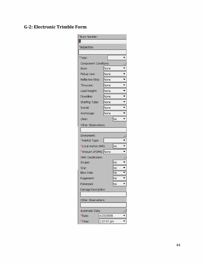
64
G-2: Electronic Trimble Form

65
APPENDIX H: BOATING TRAFFIC ANALYSIS FORM
H-1: Paper Form

66
H-2: Electronic Trimble Form
Related Documents