ASSESSING THE IMPLICATIONS OF DECENTRALIZATION ON LIVELIHOOD, BIODIVERSITY, AND ECOLOGICAL SUSTAINABILITY IN UGANDA A PRELIMINARY ANALYSIS OF THE PILOT.
Dec 27, 2015
Welcome message from author
This document is posted to help you gain knowledge. Please leave a comment to let me know what you think about it! Share it to your friends and learn new things together.
Transcript

ASSESSING THE IMPLICATIONS OF DECENTRALIZATIONASSESSING THE IMPLICATIONS OF DECENTRALIZATIONON LIVELIHOOD, BIODIVERSITY, ON LIVELIHOOD, BIODIVERSITY,
AND ECOLOGICAL SUSTAINABILITY IN UGANDAAND ECOLOGICAL SUSTAINABILITY IN UGANDA
A PRELIMINARY ANALYSIS OF THE PILOT SANREM/UFRIC SITEA PRELIMINARY ANALYSIS OF THE PILOT SANREM/UFRIC SITE
PRESENTATION TO IFRIMICHIGAND UNIVERSITY
APRIL 09, 2008
ContentContent Land Ownership and Forest History in UgandaLand Ownership and Forest History in Uganda Forest Policy and Subsequent ReformsForest Policy and Subsequent Reforms Decentralization (political and environmental)Decentralization (political and environmental) Implication of Decentralization on Livelihood, Implication of Decentralization on Livelihood,
Biodiversity and Ecological SustainabilityBiodiversity and Ecological Sustainability House Types, Occupations, Food Security, House Types, Occupations, Food Security,
Diseases Diseases GIS and RS (landscape scale)GIS and RS (landscape scale) Forest Governance Forest Governance Opportunities and ConstraintsOpportunities and Constraints Conclusions and RecommendationsConclusions and Recommendations
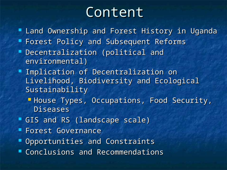
Land TenureLand Tenure Crown or government Crown or government Freehold (customary and mailo)Freehold (customary and mailo) LeaseLease Bibanja (squatters)Bibanja (squatters)Under the Uganda Agreement of 1900, there was a paradigm shift in Under the Uganda Agreement of 1900, there was a paradigm shift in
landholding in Uganda, and the land tenurial systems drastically landholding in Uganda, and the land tenurial systems drastically changed: changed: Crown, mailo, leasehold, and freehold interests Crown, mailo, leasehold, and freehold interests were were introduced and replaced traditional, customary, and communal introduced and replaced traditional, customary, and communal landholdings. landholdings.
For instance, in Buganda the 1900 land settlement resulted in land being For instance, in Buganda the 1900 land settlement resulted in land being shared almost equally between the leading chiefs and their relatives shared almost equally between the leading chiefs and their relatives and friends, on one hand, and the Uganda Protectorate Government and friends, on one hand, and the Uganda Protectorate Government on the other. Out of a population of close to 1,000,000 people only on the other. Out of a population of close to 1,000,000 people only 3,700 were allocated land. The rest were left landless. 3,700 were allocated land. The rest were left landless.

Distribution of Forest Types in Distribution of Forest Types in UgandaUganda
Cover type
Forestreserves
under state or
local authority
National parks
and wildlifereserves
underUWA
Private land
(private and
customaryland) Total (ha)
Tropical high forests
306,000 267,000 351,000 924,000
Woodlands 411,000 462,000 3,102,000 3,975,000
Plantations 20,000 2,000 11,000 33,000
Other 414,000 1,167,000 13,901,000 15,482,000
Total 1,151,000 1,898,000 17,365,000 20,414,000Source: National Biomass Study of the Forest Department (1999)

Distribution of Forest Types in Distribution of Forest Types in UgandaUganda (cont’d)(cont’d)
Management authority %
National Forest Authority 15
Local government and private forests
70
Uganda Wildlife Authority 15
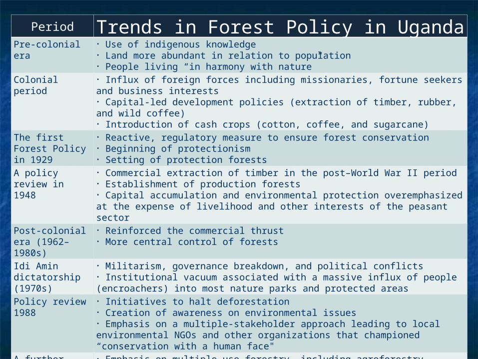
Period Trends in Forest Policy in UgandaPre-colonial era • Use of indigenous knowledge
• Land more abundant in relation to population• People living “in harmony with nature”
Colonial period • Influx of foreign forces including missionaries, fortune seekers and business interests• Capital-led development policies (extraction of timber, rubber, and wild coffee)• Introduction of cash crops (cotton, coffee, and sugarcane)
The first Forest Policy in 1929
• Reactive, regulatory measure to ensure forest conservation• Beginning of protectionism• Setting of protection forests
A policy review in 1948
• Commercial extraction of timber in the post–World War II period• Establishment of production forests• Capital accumulation and environmental protection overemphasized at the expense of livelihood and other interests of the peasant sector
Post-colonial era (1962–1980s)
• Reinforced the commercial thrust• More central control of forests
Idi Amin dictatorship (1970s)
• Militarism, governance breakdown, and political conflicts• Institutional vacuum associated with a massive influx of people (encroachers) into most nature parks and protected areas
Policy review 1988
• Initiatives to halt deforestation• Creation of awareness on environmental issues• Emphasis on a multiple-stakeholder approach leading to local environmental NGOs and other organizations that championed “conservation with a human face"
A further review in 2001
• Emphasis on multiple-use forestry, including agroforestry• Recognized the realities and complexities of multiple use, and the need for multiple-stakeholder collaboration

Decentralization in Uganda: The Structural Decentralization in Uganda: The Structural AspectsAspects
Uganda has a five-tier local government system comprised of Uganda has a five-tier local government system comprised of administrative and legislative functions with executive administrative and legislative functions with executive officers performing the administrative functions while elected officers performing the administrative functions while elected representatives perform the legislative functions.representatives perform the legislative functions.
The overarching level of local government is the district The overarching level of local government is the district (Local Council 5), below which is the county in rural areas or (Local Council 5), below which is the county in rural areas or a municipality in urban areas, both of which are essentially a municipality in urban areas, both of which are essentially administrative units. The next levels of local governance, in administrative units. The next levels of local governance, in decreasing order, include the sub-county (Local Council 3), decreasing order, include the sub-county (Local Council 3), the parish (Local Council 2), and the village (Local Council 1) the parish (Local Council 2), and the village (Local Council 1) (see Fig. 1).(see Fig. 1).
The above seemingly democratic structural arrangement for The above seemingly democratic structural arrangement for decentralized governance has not yet been adequately decentralized governance has not yet been adequately complemented by the necessary operational arrangements complemented by the necessary operational arrangements for effective local empowerment, particularly in the for effective local empowerment, particularly in the environment-related sectors. environment-related sectors.

An Organogram of the UgandaAn Organogram of the UgandaLocal Government SystemLocal Government System
DISTRICT COUNCIL(LC 5)
SUB-COUNTY (LC 3)
PARISH(LC 2)
VILLAGE(LC 1)
MUNICIPALITY (LC 4)
(Urban setting)
COUNTY (LC 4)(Rural setting)
CITY DIVISION(LC 3)
Fig. 1

Decentralization in Relation to Decentralization in Relation to Community Forest Management in Community Forest Management in
UgandaUganda The main law governing environmental issues in Uganda is the The main law governing environmental issues in Uganda is the
National Environmental Statute of 1995. It encourages National Environmental Statute of 1995. It encourages “maximum participation of the people of Uganda in the “maximum participation of the people of Uganda in the development policies, plans and processes for the management development policies, plans and processes for the management of the environment.” The National Environmental Management of the environment.” The National Environmental Management Authority (NEMA) is the coordinating body and charged with the Authority (NEMA) is the coordinating body and charged with the responsibility to work with lower-level institutions, namely the responsibility to work with lower-level institutions, namely the district and local environmental committees, to ensure that (1) district and local environmental committees, to ensure that (1) environmental concerns are integrated into their planning environmental concerns are integrated into their planning processes, (2) local people participate in environmental processes, (2) local people participate in environmental planning, and (3) local people and resources are mobilized to planning, and (3) local people and resources are mobilized to solve environmental problems.solve environmental problems.
Committees were created to partner local government units with Committees were created to partner local government units with collaborative resource management and include production and collaborative resource management and include production and environmental committees (PECs) at the district, sub-county, environmental committees (PECs) at the district, sub-county, parish, and village levels (see Fig. 2). The PECs consist of parish, and village levels (see Fig. 2). The PECs consist of elected representatives as well as technocrats and bureaucrats. elected representatives as well as technocrats and bureaucrats. Representatives of the PECs sit in the Community Protected Representatives of the PECs sit in the Community Protected Area Committee (CPAC).Area Committee (CPAC).
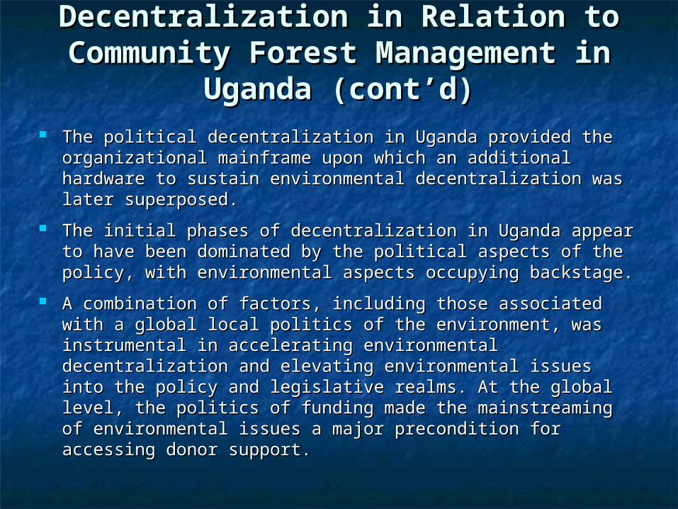
The political decentralization in Uganda provided the The political decentralization in Uganda provided the organizational mainframe upon which an additional organizational mainframe upon which an additional hardware to sustain environmental decentralization was hardware to sustain environmental decentralization was later superposed.later superposed.
The initial phases of decentralization in Uganda appear to The initial phases of decentralization in Uganda appear to have been dominated by the political aspects of the policy, have been dominated by the political aspects of the policy, with environmental aspects occupying backstage.with environmental aspects occupying backstage.
A combination of factors, including those associated with a A combination of factors, including those associated with a global local politics of the environment, was instrumental in global local politics of the environment, was instrumental in accelerating environmental decentralization and elevating accelerating environmental decentralization and elevating environmental issues into the policy and legislative realms. environmental issues into the policy and legislative realms. At the global level, the politics of funding made the At the global level, the politics of funding made the mainstreaming of environmental issues a major mainstreaming of environmental issues a major precondition for accessing donor support.precondition for accessing donor support.
Decentralization in Relation to Decentralization in Relation to Community Forest Management in Community Forest Management in
Uganda (cont’d)Uganda (cont’d)

An Organogram of How PECs RelateAn Organogram of How PECs Relateto the Local Governance Structureto the Local Governance Structure
DISTRICT COUNCIL
DPEC
SUB-COUNTY (LC 3)
PEC
PARISH(LC 2)PPEC
VILLAGE (LC 1)VPEC
NFA, UWANEMA, WDA
CPAC
Resource UserGroup
CITY DIVISION
(LC 3)PEC
Fig. 2
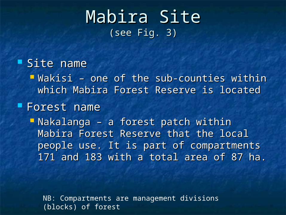
Mabira SiteMabira Site(see Fig. 3)(see Fig. 3)
Site nameSite name Wakisi – one of the sub-counties within Wakisi – one of the sub-counties within
which Mabira Forest Reserve is locatedwhich Mabira Forest Reserve is located
Forest nameForest name Nakalanga – a forest patch within Mabira Nakalanga – a forest patch within Mabira
Forest Reserve that the local people Forest Reserve that the local people use. It is part of compartments 171 and use. It is part of compartments 171 and 183 with a total area of 87 ha.183 with a total area of 87 ha.
NB: Compartments are management divisions (blocks) of forest
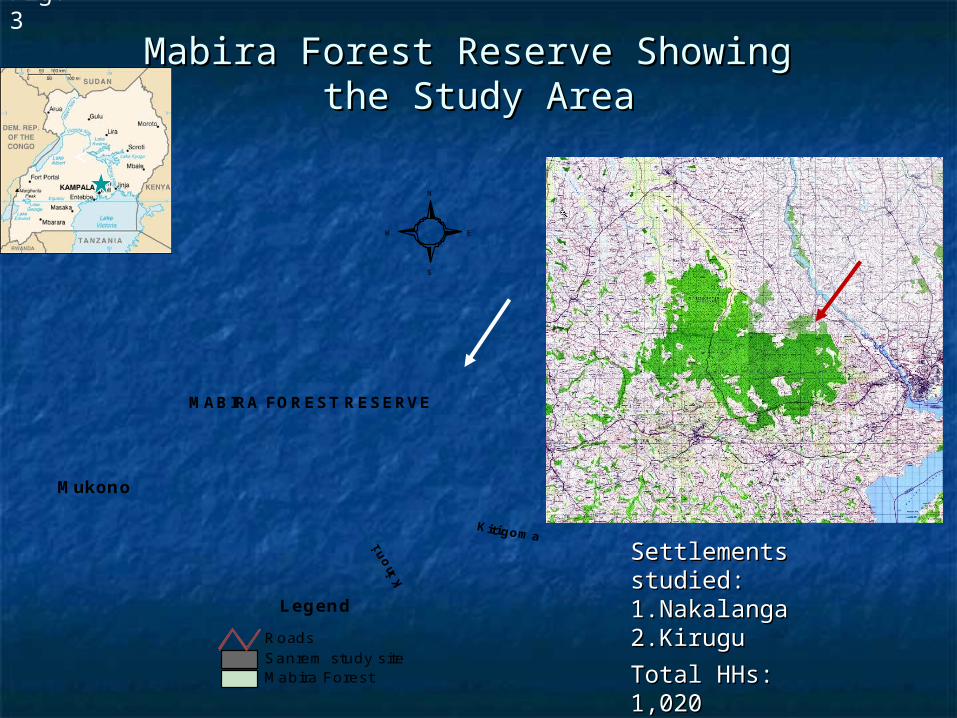
Mabira Forest Reserve Showing Mabira Forest Reserve Showing the Study Areathe Study Area
MABIRA FOREST RESERVE
Mukono
Mabira Forest Sanrem study siteRoads
S
N
EW
Legend
Fig. 3
Settlements Settlements studied:studied:1.1.NakalangaNakalanga2.2.KiruguKirugu
Total HHs: 1,020Total HHs: 1,020
No. sampled: 221No. sampled: 221
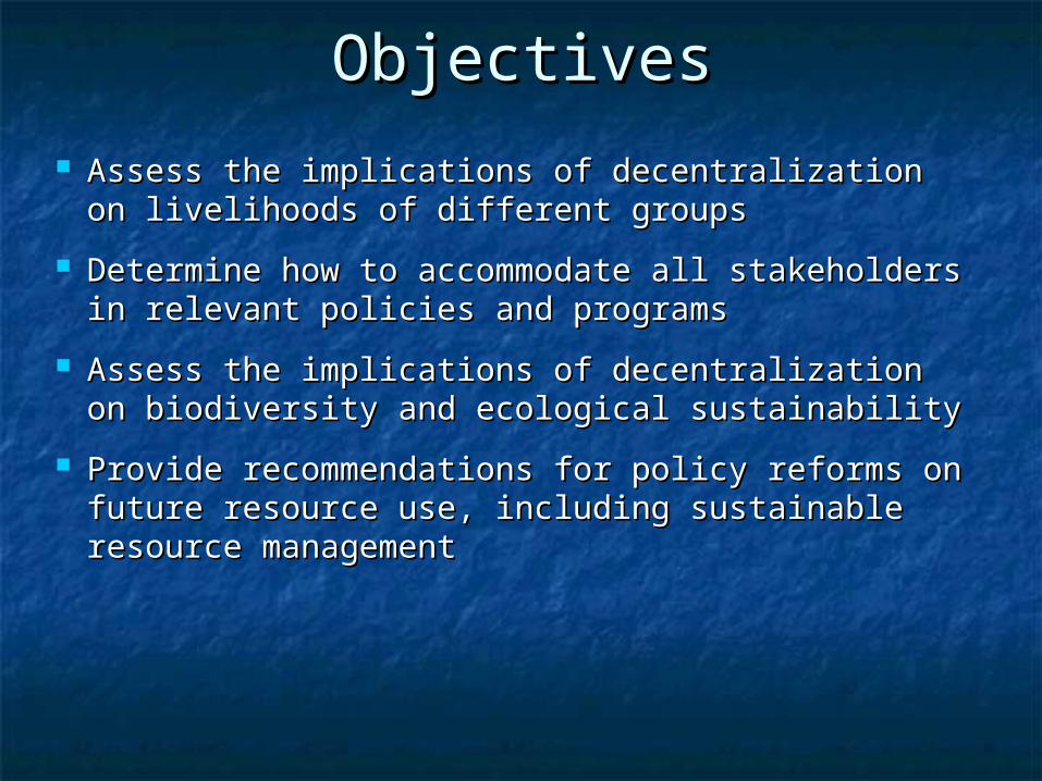
ObjectivesObjectives
Assess the implications of decentralization on Assess the implications of decentralization on livelihoods of different groupslivelihoods of different groups
Determine how to accommodate all Determine how to accommodate all stakeholders in relevant policies and programsstakeholders in relevant policies and programs
Assess the implications of decentralization on Assess the implications of decentralization on biodiversity and ecological sustainabilitybiodiversity and ecological sustainability
Provide recommendations for policy reforms Provide recommendations for policy reforms on future resource use, including sustainable on future resource use, including sustainable resource managementresource management

Why Mabira?Why Mabira? An important forest ecosystem in Uganda An important forest ecosystem in Uganda
and a watershed for the Lake Victoria basin and a watershed for the Lake Victoria basin and Lake Kyoga in mid-northern Ugandaand Lake Kyoga in mid-northern Uganda
Has enormous pressure for subsistence use Has enormous pressure for subsistence use and commercial farming of sugarcane and and commercial farming of sugarcane and tea (conflicting interests of the stakeholders tea (conflicting interests of the stakeholders and threat of degazetting)and threat of degazetting) Heavily encroached by local communities Heavily encroached by local communities
in the 1970s and the early 1980s, but in the 1970s and the early 1980s, but people were evicted in 1988people were evicted in 1988
Comparable to Kakamega Forest in Kenya Comparable to Kakamega Forest in Kenya that is being studied by the Kenyan SANREM that is being studied by the Kenyan SANREM teamteam

Why These Settlements?Why These Settlements?
Most of the households (HHs) are within 2 Most of the households (HHs) are within 2 km from the forest boundary.km from the forest boundary.
Settlements have been in existence since the Settlements have been in existence since the late 1940s.late 1940s.
They are heavily populated, mostly by They are heavily populated, mostly by migrants from eastern Uganda (1020 HHs with migrants from eastern Uganda (1020 HHs with an average of 8 people per HH). Only 221 HHs an average of 8 people per HH). Only 221 HHs were randomly interviewed.were randomly interviewed.
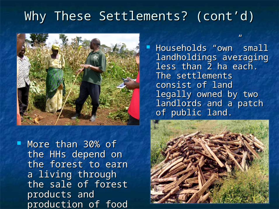
Why These Settlements? (cont’d)Why These Settlements? (cont’d)
Households “own” small Households “own” small landholdings averaging landholdings averaging less than 2 ha each. less than 2 ha each. The The settlements consist of settlements consist of land legally owned by land legally owned by two landlords and a two landlords and a patch of public land.patch of public land.
More than 30% of the More than 30% of the HHs depend on the HHs depend on the forest to earn a living forest to earn a living through the sale of through the sale of forest products and forest products and production of food production of food stuff.stuff.

House Types House Types
TYPE OF ROOF
Settlement
Thatched grass Iron Other Total
Nakalanga 26 26.5 72 73.5 -- -- 98
Kirugu 33 26.8% 87 71.5 3 1.6 123
Total 20 16% 104 82.5% 2 1.6% 221
TYPE OF WALL
SettlementMud & Cement Pole & Mud Brick/Block Total
Nakalanga 5 5.1% 79 79% 14 14.3% 98
Kirugu 20 16.3% 50 40.7% 53 43.1% 123
Total 29 23.2% 52 41.5% 45 35.4% 221
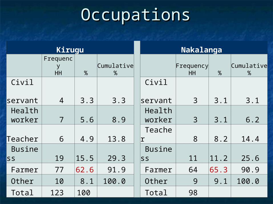
OccupationsOccupations
Kirugu Nakalanga
FrequencyHH %
Cumulative %
FrequencyHH %
Cumulative %
Civil servant 4 3.3 3.3
Civil servant 3 3.1 3.1
Health worker 7 5.6 8.9
Health worker 3 3.1 6.2
Teacher 6 4.9 13.8 Teacher 8 8.2 14.4 Business 19 15.5 29.3
Business 11 11.2 25.6
Farmer 77 62.6 91.9 Farmer 64 65.3 90.9 Other 10 8.1 100.0 Other 9 9.1 100.0 Total 123 100 Total 98
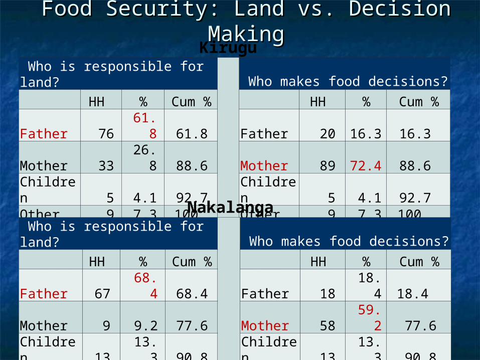
Food Security: Land vs. Decision Food Security: Land vs. Decision MakingMaking
Who is responsible for land? Who makes food decisions?
HH % Cum % HH % Cum %Father 76 61.8 61.8 Father 20 16.3 16.3Mother 33 26.8 88.6 Mother 89 72.4 88.6Children 5 4.1 92.7 Children 5 4.1 92.7Other 9 7.3 100 Other 9 7.3 100
Total 123 Total 123
Who is responsible for land? Who makes food decisions?
HH % Cum % HH % Cum %Father 67 68.4 68.4 Father 18 18.4 18.4 Mother 9 9.2 77.6 Mother 58 59.2 77.6Children 13 13.3 90.8 Children 13 13.3 90.8Other 9 9.2 100 Other 9 9.2 100
Total 98 Total 98
Kirugu
Nakalanga
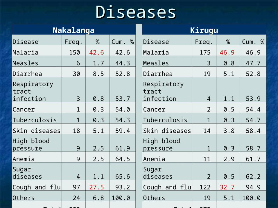
DiseasesDiseasesNakalanga Kirugu
Disease Freq. % Cum. % Disease Freq. % Cum. %
Malaria 150 42.6 42.6 Malaria 175 46.9 46.9
Measles 6 1.7 44.3 Measles 3 0.8 47.7
Diarrhea 30 8.5 52.8 Diarrhea 19 5.1 52.8
Respiratory tract infection 3 0.8 53.7
Respiratory tract infection 4 1.1 53.9
Cancer 1 0.3 54.0 Cancer 2 0.5 54.4
Tuberculosis 1 0.3 54.3 Tuberculosis 1 0.3 54.7
Skin diseases 18 5.1 59.4 Skin diseases 14 3.8 58.4
High blood pressure 9 2.5 61.9
High blood pressure 1 0.3 58.7
Anemia 9 2.5 64.5 Anemia 11 2.9 61.7
Sugar diseases 4 1.1 65.6 Sugar diseases 2 0.5 62.2
Cough and flu 97 27.5 93.2 Cough and flu 122 32.7 94.9
Others 24 6.8 100.0 Others 19 5.1 100.0
Total 352 Total 373
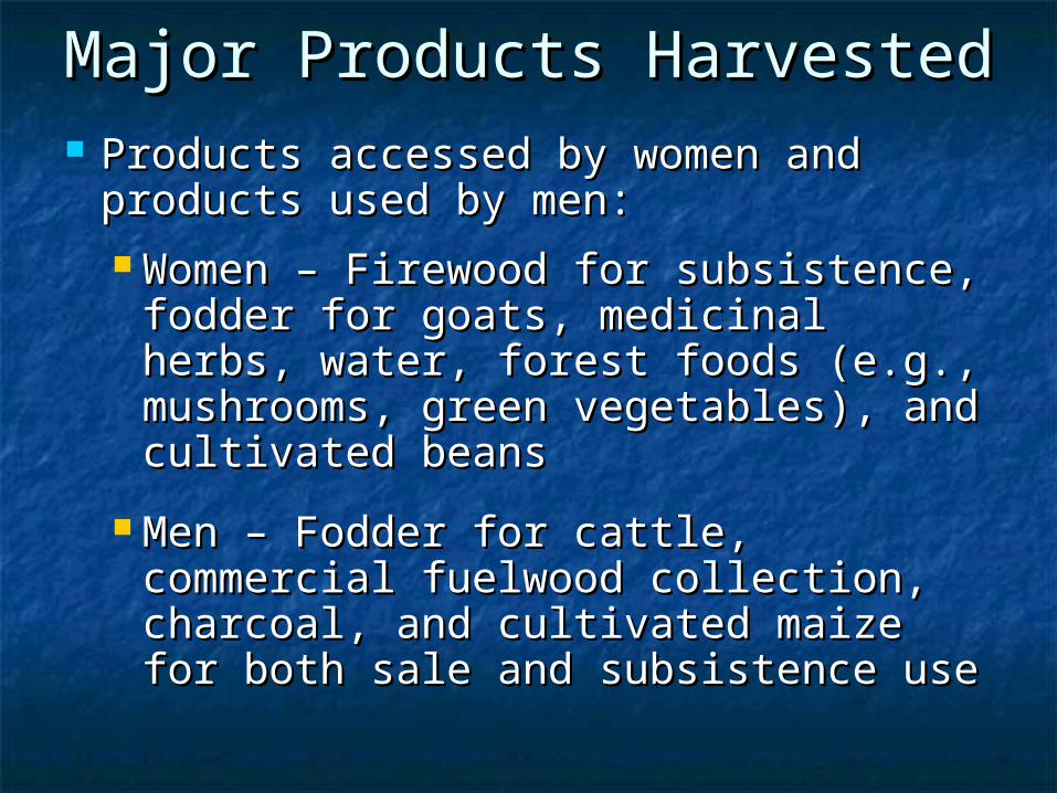
Major Products HarvestedMajor Products Harvested Products accessed by women and Products accessed by women and
products used by men:products used by men: Women – Firewood for subsistence, Women – Firewood for subsistence,
fodder for goats, medicinal herbs, fodder for goats, medicinal herbs, water, forest foods (e.g., water, forest foods (e.g., mushrooms, green vegetables), and mushrooms, green vegetables), and cultivated beanscultivated beans
Men – Fodder for cattle, commercial Men – Fodder for cattle, commercial fuelwood collection, charcoal, and fuelwood collection, charcoal, and cultivated maize for both sale and cultivated maize for both sale and subsistence usesubsistence use

GIS and Remote SensingGIS and Remote Sensing
Interpretation of 1959 land cover Interpretation of 1959 land cover (aerials) (aerials) FR boundary, 2 Km bufferFR boundary, 2 Km buffer 82 settlement around and 15 within82 settlement around and 15 within THF and wood land savanna(see Fig. 4)THF and wood land savanna(see Fig. 4)
1989-93 (before decentralization) by 1989-93 (before decentralization) by SPOT satellite imagesSPOT satellite images
Supervised classification of 2006 TM Supervised classification of 2006 TM satellite imagessatellite images

1959 Land Cover: THF and Woodland 1959 Land Cover: THF and Woodland SavannaSavanna
FR boundary
2-km buffer
Fig. 4
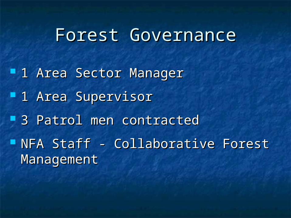
Forest GovernanceForest Governance
1 Area Sector Manager1 Area Sector Manager
1 Area Supervisor1 Area Supervisor
3 Patrol men contracted3 Patrol men contracted
NFA Staff - Collaborative Forest NFA Staff - Collaborative Forest ManagementManagement

The Role of Local Communities The Role of Local Communities in Local Governancein Local Governance
Planting and maintenance of trees in Planting and maintenance of trees in degraded areasdegraded areas
Formation of collaborative forest Formation of collaborative forest management (not completed)management (not completed)
Conflict resolution between illegal harvesters Conflict resolution between illegal harvesters and NFA (LC 1)and NFA (LC 1)
Diversification of income-generating activities Diversification of income-generating activities to reduce reliance on forests, such as:to reduce reliance on forests, such as: Bee keepingBee keeping Pineapple cultivationPineapple cultivation Livestock husbandryLivestock husbandry
The Role of Local Councils in The Role of Local Councils in
Local GovernanceLocal Governance The role of the District Forest ServiceThe role of the District Forest Service
Advisor to private forest owners and Advisor to private forest owners and tree farmerstree farmers
Licensing for harvesting of forest Licensing for harvesting of forest products on local forest reserves and products on local forest reserves and public landpublic land
Collection of taxes on forest produce Collection of taxes on forest produce (e.g., charcoal and timber)(e.g., charcoal and timber)
The District lacks resources to carry The District lacks resources to carry out most of the above. out most of the above.

What the Communities What the Communities Want Want
Use the taungya system (combination of Use the taungya system (combination of trees and plants in a field) to plant and trees and plants in a field) to plant and manage a buffer zone around the forestmanage a buffer zone around the forest
More involvement in monitoring and More involvement in monitoring and enforcement of forest rules, especially enforcement of forest rules, especially the forest adjacent to their landthe forest adjacent to their land
Involvement in allocating licenses for Involvement in allocating licenses for firewood collectionfirewood collection

Implications of Implications of Decentralization on Livelihood Decentralization on Livelihood
of Local Communitiesof Local Communities Access to commercial forest produce Access to commercial forest produce
is limited, because issuing of licences is limited, because issuing of licences for charcoal or timber is far and for charcoal or timber is far and problematic.problematic.
Both men and women have access to Both men and women have access to fodder for their livestock.fodder for their livestock.
There is no significant involvement in There is no significant involvement in resource management by the local resource management by the local communities at present.communities at present.
Forest Condition in the Patch Forest Condition in the Patch StudiedStudied
No timber-size class observed in the plots studied – No timber-size class observed in the plots studied – average DBH was 19 cm. We had expected average average DBH was 19 cm. We had expected average DBH to be more than 40 cm in this ecosystem.DBH to be more than 40 cm in this ecosystem.
Few commercial timber species were encountered.Few commercial timber species were encountered.
Species richness was low – 32 species – much lower Species richness was low – 32 species – much lower than 119 species recorded in the 1980 NBS than 119 species recorded in the 1980 NBS inventory and 142 species in the 1968 FD inventory.inventory and 142 species in the 1968 FD inventory.
Only 24 tree species were recorded instead of Only 24 tree species were recorded instead of more than 70 tree species expected in this more than 70 tree species expected in this ecosystemecosystem
30% of the trees were 30% of the trees were Brosnetia paperiferaBrosnetia paperifera (Paper (Paper Mulberry) an invasive tree species.Mulberry) an invasive tree species.
Forest Condition in the Patch Forest Condition in the Patch StudiedStudied
(cont’d)(cont’d)
All plots studied had evidence of harvesting.All plots studied had evidence of harvesting.
Average crown cover was 20%.Average crown cover was 20%.
30% of the sampled plots had evidence of 30% of the sampled plots had evidence of recent cultivation.recent cultivation.

OpportunitiesOpportunities Stakeholders at Local, Sub-County, District and Stakeholders at Local, Sub-County, District and
National levels are aware of the importance of National levels are aware of the importance of environmental protection in Mabira forest environmental protection in Mabira forest
Decentralization is fully institutionalized as a Decentralization is fully institutionalized as a governance strategygovernance strategy
Capacities of local communities and local Capacities of local communities and local government are being enhancedgovernment are being enhanced
Promotion of PMA and poverty-eradication Promotion of PMA and poverty-eradication programs by NAADS in the area programs by NAADS in the area
improved cattle and goat raising improved cattle and goat raising Pineapple processingPineapple processing Upland rice cultivationUpland rice cultivation Promotion of horticultural crops Promotion of horticultural crops
ConstraintsConstraints High population depending on the forest High population depending on the forest
for livelihoodfor livelihood
Limited alternative sources of incomeLimited alternative sources of income
Limited landholdingsLimited landholdings
Declining soil fertilityDeclining soil fertility
Limited participation of local Limited participation of local communities in decision making and communities in decision making and operational-level activitiesoperational-level activities
The proposed de-gazettement of the The proposed de-gazettement of the forest for sugarcane growingforest for sugarcane growing
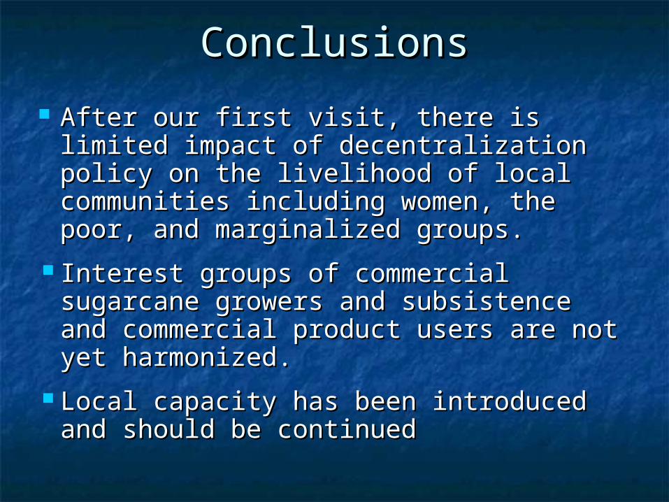
ConclusionsConclusions
After our first visit, there is limited After our first visit, there is limited impact of decentralization policy on the impact of decentralization policy on the livelihood of local communities including livelihood of local communities including women, the poor, and marginalized women, the poor, and marginalized groups.groups.
Interest groups of commercial sugarcane Interest groups of commercial sugarcane growers and subsistence and commercial growers and subsistence and commercial product users are not yet harmonized.product users are not yet harmonized.
Local capacity has been introduced and Local capacity has been introduced and should be continuedshould be continued
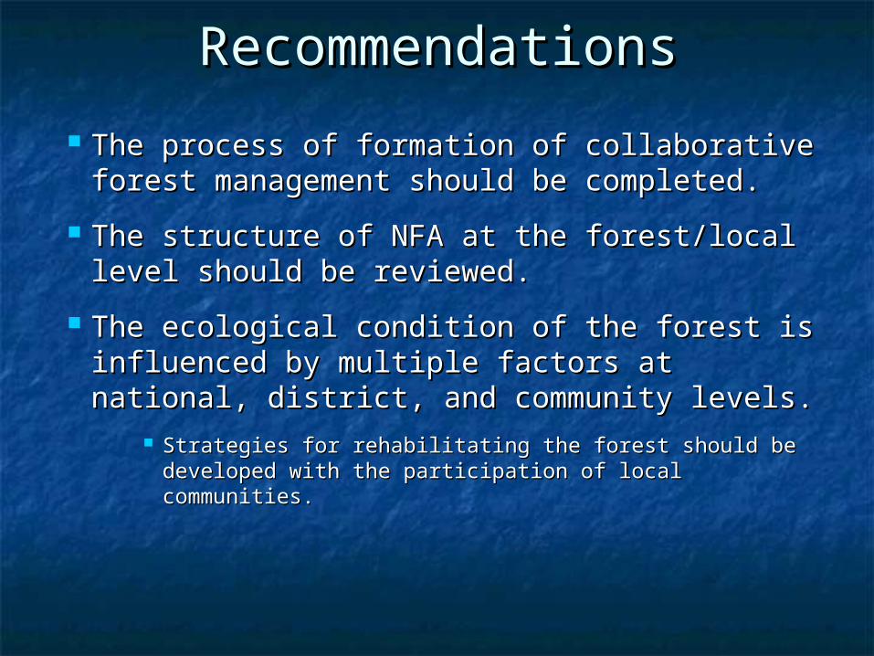
RecommendationsRecommendations
The process of formation of collaborative The process of formation of collaborative forest management should be completed.forest management should be completed.
The structure of NFA at the forest/local The structure of NFA at the forest/local level should be reviewed.level should be reviewed.
The ecological condition of the forest is The ecological condition of the forest is influenced by multiple factors at national, influenced by multiple factors at national, district, and community levels.district, and community levels.
Strategies for rehabilitating the forest should be Strategies for rehabilitating the forest should be developed with the participation of local developed with the participation of local communities.communities.
Related Documents