This article appeared in a journal published by Elsevier. The attached copy is furnished to the author for internal non-commercial research and education use, including for instruction at the authors institution and sharing with colleagues. Other uses, including reproduction and distribution, or selling or licensing copies, or posting to personal, institutional or third party websites are prohibited. In most cases authors are permitted to post their version of the article (e.g. in Word or Tex form) to their personal website or institutional repository. Authors requiring further information regarding Elsevier’s archiving and manuscript policies are encouraged to visit: http://www.elsevier.com/copyright

Welcome message from author
This document is posted to help you gain knowledge. Please leave a comment to let me know what you think about it! Share it to your friends and learn new things together.
Transcript
This article appeared in a journal published by Elsevier. The attachedcopy is furnished to the author for internal non-commercial researchand education use, including for instruction at the authors institution
and sharing with colleagues.
Other uses, including reproduction and distribution, or selling orlicensing copies, or posting to personal, institutional or third party
websites are prohibited.
In most cases authors are permitted to post their version of thearticle (e.g. in Word or Tex form) to their personal website orinstitutional repository. Authors requiring further information
regarding Elsevier’s archiving and manuscript policies areencouraged to visit:
http://www.elsevier.com/copyright
Author's personal copy
Landscape and Urban Planning 91 (2009) 17–25
Contents lists available at ScienceDirect
Landscape and Urban Planning
journa l homepage: www.e lsev ier .com/ locate / landurbplan
Assessing conservation status on coastal dunes: A multiscale approach
Marta Carboni a,∗, Maria Laura Carranzab, Alicia Acostaa
a Dipartimento di Biologia, Università degli Studi di Roma Tre, V.le Marconi 446, 00146 Roma, Italyb Dipartimento STAT, Università degli Studi del Molise, Ctrada Fonte Lappone, Pesche (IS) 86090, Italy
a r t i c l e i n f o
Article history:Received 19 March 2008Received in revised form 8 September 2008Accepted 13 November 2008Available online 25 December 2008
Keywords:Central ItalyCoastal vegetationDiversity analysisLandscapeMediterranean dunesScale
a b s t r a c t
Coastal dune systems are particularly fragile and threatened environments, which, however, providefundamental ecosystem services to nearby urban areas acting for example as protective buffers againsterosion. Correctly assessing their conservation status is a priority in order to manage them adequately andto plan urban development in coastal regions. In this paper we propose a practical multiscale method forthe assessment of the conservation status of sandy coastal environment. The proposed method is articu-lated in two stages, one focusing on the landscape and the other on the plant community level. In the firstphase mosaic structure and composition of the coastal landscape are analyzed using a series of indica-tors: natural coastal surface, richness of land cover typologies, landscape diversity and eveness, numberand average size of habitat patches, and mean shape index. At a detailed scale, floristic, vegetational andstructural aspects of the dune plant communities are analyzed along the main environmental gradient bymeasuring: spatial connectivity and richness of boundaries, species diversity, eveness and chorologicalindex. In this work we apply and test the method in an experimental area on the Tyrrhenian coast of Italy(Latium region), comparing the conservation status of two study sites.
© 2008 Elsevier B.V. All rights reserved.
1. Introduction
Sandy seashores are biologically diverse transitional systems(‘ecotones’) between land and water, which make up 20% of theworld’s coastlines (Walker et al., 2003; Van der Maarel, 2003).By occupying zones of transition between terrestrial and marineecosystems, coastal dunes represent particularly interesting envi-ronments both from an ecological and landscape perspective.
Coastal dune systems are also particularly fragile environmentsand several potential dangers threaten them. Human activitiesin littoral areas are widespread and have been intensifying inthe course of the 20th century, since historically urban zoneshave developed in coastal areas in most parts of the world(Cori, 1999). Factors causing disturbance are of various nature.Cattle grazing, farming, reforestation and urbanization have elim-inated many stretches of internal vegetation zonation, while coastbound tourism and especially coastal erosion, endanger beach andembryo-dune communities (Brown and McLachlan, 2002; Géhuand Biondi, 1994; O’Shea and Kirkpatrick, 2000; Taveira Pinto,2004).
Coastal regions in the past have often been inappropriately man-aged largely due to a lack of adequate planning. Fortunately, the
∗ Corresponding author. Tel.: +39 0657336389 fax: +39 0657336405.E-mail addresses: [email protected] (M. Carboni), [email protected]
(M.L. Carranza), [email protected] (A. Acosta).
concept of coastal zone management has nowadays become gen-erally accepted (Taveira Pinto, 2004). In fact, just as coastal dunescan be strongly affected by urban settlements, it is now recognizedthat healthy vegetated sandy ecosystems can provide fundamen-tal ecosystem services to nearby urban areas, effectively acting inlong term planning efforts as the best possible protective buffersagainst infrastructure damages due to coastal erosion (Jolicoeur andO’Carrol, 2007). However, small ecosystems often disappear in largescale studies, such as many coastal zone management plans andregional plans in general. It is therefore essential to carefully planurban development and to monitor these environments at a morelocal level in order to protect and manage their entire biodiversityadequately, thus maintaining the ecosystem services they provide(Davies et al., 1995; Provoost et al., 2004).
The evaluation of the state of ecosystems at a given time andplace is at the basis of any planning process for the management ofnatural resources. Even though the definition of conservation statushas been greatly debated, it is generally recognized that its assess-ment can be based on the measure of biodiversity or of featuresused as surrogates thereof (Cabeza and Moilanen, 2001; Margulesand Pressey, 2000; Yoccoz et al., 2001). In particular, vegetation,because of its specific nature, is considered a good indicator of over-all biodiversity and specifically of ecosystem integrity of coastaldune environments (Araújo et al., 2002; Géhu and Biondi, 1994;Géhu and Géhu, 1980; Lopez and Fennessy, 2002).
Many methods for conservation status assessment based on veg-etation analysis have been proposed both in local and regional
0169-2046/$ – see front matter © 2008 Elsevier B.V. All rights reserved.doi:10.1016/j.landurbplan.2008.11.004
Author's personal copy
18 M. Carboni et al. / Landscape and Urban Planning 91 (2009) 17–25
contexts, but these have generally focused either on the commu-nity level or on the landscape level, independently of the spatialextent considered. Community level studies, in which species arethe most common analysis unit, have used indices, such as speciesrichness, diversity and abundance to identify conservation priori-ties (Balaguru et al., 2006; Greco and Petriccione, 1991; Tchouto etal., 2006), which in some cases have been associated to bioindicatorspecies of quality (Godefroid and Koedam, 2003). Often syntheticindicators obtained with the help of some form of expert rankinghave been proposed, and used to spatialize quality information overlarge regions (Lopez and Fennessy, 2002; Poldini and Pertot, 1989).
On the other hand, on the landscape level, where units are eitherpatches or ecosystems, several compositional and structural met-rics as well as rarity of ecosystems and cover typologies have beenlinked to disturbance levels and used to identify conservation andrestoration priorities (Botequilha Leitão and Ahern, 2002; Langankeet al., 2007; Lausch and Herzog, 2002; Palik et al., 2000).
In coastal environments in particular, however, fewer methodshave been proposed for quality and disturbance assessment of thevegetation based on biodiversity. On the plant community level, sin-gle species as bioindicators (Géhu and Biondi, 1994; Hinchliffe andConran, 2005) or parameters, such as species richness, diversity andcover (Grunewald and Schubert, 2007; Isermann and Krisch, 1995;Vogt Andersen, 1995) have been used to evaluate dune naturalnessand effects of human disturbance on coastal vegetation. The spa-tial pattern of dune communities has also been linked to qualityand disturbance (Acosta et al., 2000, 2003). On the landscape levelsuch indicators as patch length and boundaries, vegetation coverand other classical landscape compositional and structural indiceshave been used to assess the condition of dune systems and theamount of human pressure (Carranza et al., 2007; Curr et al., 2000).
However, it has long been recognized that biodiversity has ahierarchical nature, encompassing a wide spectrum of diversitycomponents at different scales, from the species to the ecosys-tem and landscape level, including their processes and interactions(Primack, 2000; Whittaker, 1972; UNEP, 1992). The multiscalenature of disturbances, which tend to be spatially and temporallyheterogeneous, has been increasingly accepted as well, especiallybecause landscapes respond differentially to the spread of distur-bances (Beever et al., 2006; Van der Maarel, 1993). Focusing onany single biodiversity component alone is insufficient to protectother components or correctly estimate overall conservation state(Bonn and Gaston, 2005). Higher levels in the biological hierarchy,such as habitat types and landscapes, can better integrate someof the threats to biodiversity, such as fragmentation and habitatloss, and the ecological processes that contribute to the mainte-nance of ecosystem function (Faith and Walker, 1996; Wessels etal., 1999). On the other hand such high organizational levels losebiological precision in the assessment of diversity and therefore itis important that lower level diversity is analyzed to some degree.A complete analysis of the conservation status of the vegetation ofnatural areas should not therefore be limited to a single aspect butshould take into account multiple levels of biodiversity both froma compositional and structural point of view. This can be achievedin an effective and efficient way by assessing a series of selectedindicators, representing the entire complexity of the vegetationsystem. But even though the need for such approaches is recog-nized (Provoost et al., 2004), very few studies have attempted areal multiscale approach in the assessment of quality for conserva-tion and monitoring purposes (Hermy and Cornelis, 2000; Roy andTomar, 2000), particularly in coastal environments (Espejel et al.,2004).
The purpose of this paper is therefore to propose a scientificallysound and practical method for the assessment of conservation sta-tus in sandy coastal environments, based on the multiscale conceptof biodiversity, focusing on the vegetation aspect.
2. Methods
In relation with a specialized flora, plant communities of coastaldunes in various parts of the world, though single species generallyvary, have much in common from the point of view of adaptations,strategies, structure, space occupation and therefore successionalchange and zonation (Doing, 1981; Frederiksen et al., 2006; García-Novo et al., 2004). Moreover, physical limiting factors (such asunstable substrate, wind velocity, salt spray, organic matter con-tent, sand blast and burial, episodic overwashes, etc.) are organizedalong a steep environmental gradient that determines a strong sea-inland zonation of the vegetation (Frederiksen et al., 2006; Houle,1997; Maun, 1998; Packham and Willis, 1997; Sykes and Wilson,1988; Wilson and Sykes, 1999). The environmental requirements ofcoastal plant communities are very specific, so that their positionin the sequence tends to be fixed (Sykes and Wilson, 1991).
The proposed method builds on these fundamental character-istics of the coastal environment. Two scales are considered: thelandscape level (structure and composition) and the plant commu-nity level. At each scale the data are gathered and expressed througha series of indicators. The general method as presented here can beapplied to most coastal dune environments worldwide, but sam-pling units and level of detail are dependent on specific regionalconditions. As an example, we therefore apply and test the methodin a representative area on the Tyrrhenian coast of Italy (Latiumregion).
2.1. Landscape scale
At the landscape level it is first of all necessary to identify themajor land cover types for landscape scale analyses (Thackrah etal., 2004). To these purposes a detailed land cover (LC) map of thecoastal areas to be examined is necessary. Acosta et al. (2005) founda good correspondence between CORINE land cover classes and veg-etation types on coastal dune ecosystems, therefore we propose touse this classification for habitat diversity study. It is essential thatthe mapping of habitats in the coastal dune environment be car-ried out at a detailed scale, but a preliminary study of the specificconfiguration of the vegetation based on available literature is nec-essary in order to select the appropriate level of detail (scale of themap). On these grounds the following indicators are calculated toevaluate coastal landscape.
2.1.1. Landscape compositionFirst of all, the coastal dune land cover mosaic is analyzed on the
level of landscape composition. The abundance of each CORINE cat-egory is calculated for the coasts to be evaluated, as well as the totalrichness of land cover categories. In particular these parametersare highlighted for natural areas and for natural coastal land covercategories. Attention is paid to urban surface abundance as well,as an indicator of human influence and of vulnerability to humandisturbance of the natural landscape (Margules and Pressey, 2000;McKinney, 2002). Finally, richness and abundance parameters ofeach single category can be utilized to express in a synthetic waythe diversity and evenness of the entire analyzed landscape.
2.1.2. Analysis of landscape structureIn order to analyze the spatial pattern of the coastal vegetation
patches we propose to calculate the following classical landscapepattern statistics: the number of patches (NUMP) for all land covercategories, for natural areas and for coastal areas, their mean patchsize in square meters (MPS) and their mean shape index (MSI). Theway in which the surface of each category is arranged in numberof patches (and therefore average patch size for each category) isrelated to habitat fragmentation or to heterogeneity of the spa-tial pattern. The shape index is a shape complexity indicator that
Author's personal copy
M. Carboni et al. / Landscape and Urban Planning 91 (2009) 17–25 19
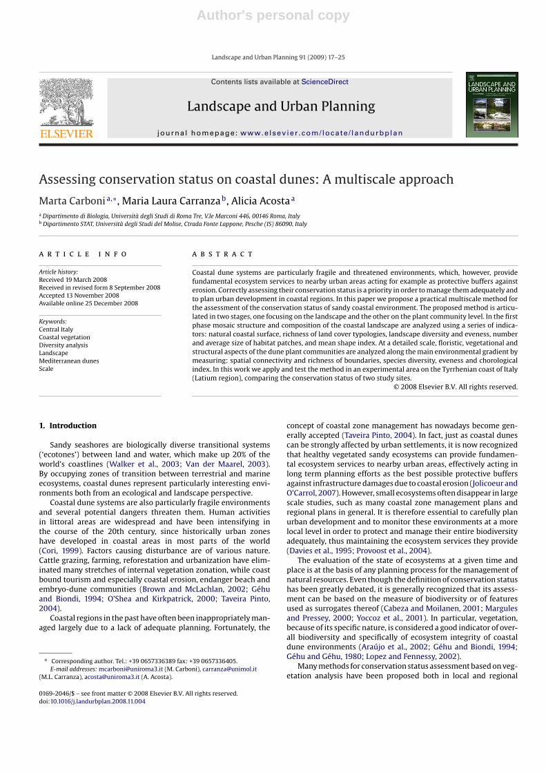
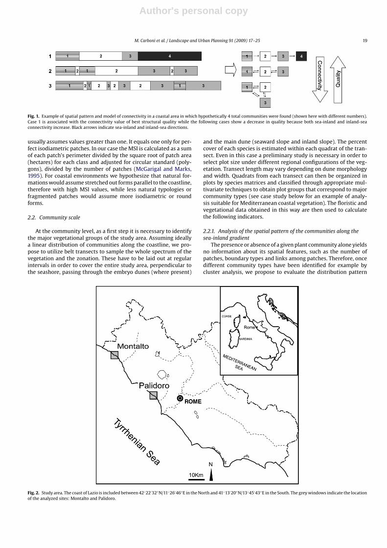
Fig. 1. Example of spatial pattern and model of connectivity in a coastal area in which hypothetically 4 total communities were found (shown here with different numbers).Case 1 is associated with the connectivity value of best structural quality while the following cases show a decrease in quality because both sea-inland and inland-seaconnectivity increase. Black arrows indicate sea-inland and inland-sea directions.
usually assumes values greater than one. It equals one only for per-fect isodiametric patches. In our case the MSI is calculated as a sumof each patch’s perimeter divided by the square root of patch area(hectares) for each class and adjusted for circular standard (poly-gons), divided by the number of patches (McGarigal and Marks,1995). For coastal environments we hypothesize that natural for-mations would assume stretched out forms parallel to the coastline,therefore with high MSI values, while less natural typologies orfragmented patches would assume more isodiametric or roundforms.
2.2. Community scale
At the community level, as a first step it is necessary to identifythe major vegetational groups of the study area. Assuming ideallya linear distribution of communities along the coastline, we pro-pose to utilize belt transects to sample the whole spectrum of thevegetation and the zonation. These have to be laid out at regularintervals in order to cover the entire study area, perpendicular tothe seashore, passing through the embryo dunes (where present)
and the main dune (seaward slope and inland slope). The percentcover of each species is estimated within each quadrat of the tran-sect. Even in this case a preliminary study is necessary in order toselect plot size under different regional configurations of the veg-etation. Transect length may vary depending on dune morphologyand width. Quadrats from each transect can then be organized inplots by species matrices and classified through appropriate mul-tivariate techniques to obtain plot groups that correspond to majorcommunity types (see case study below for an example of analy-sis suitable for Mediterranean coastal vegetation). The floristic andvegetational data obtained in this way are then used to calculatethe following indicators.
2.2.1. Analysis of the spatial pattern of the communities along thesea-inland gradient
The presence or absence of a given plant community alone yieldsno information about its spatial features, such as the number ofpatches, boundary types and links among patches. Therefore, oncedifferent community types have been identified for example bycluster analysis, we propose to evaluate the distribution pattern
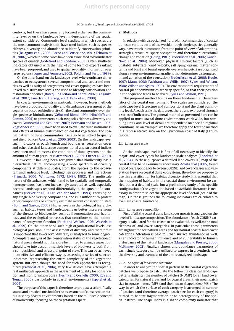
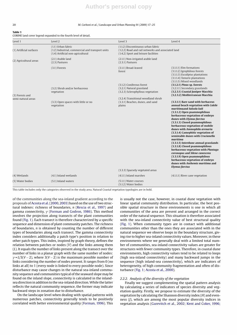
Fig. 2. Study area. The coast of Lazio is included between 42◦22′32′′N/11◦26′46′′E in the North and 41◦13′20′′N/13◦45′43′′E in the South. The grey windows indicate the locationof the analyzed sites: Montalto and Palidoro.
Author's personal copy
20 M. Carboni et al. / Landscape and Urban Planning 91 (2009) 17–25
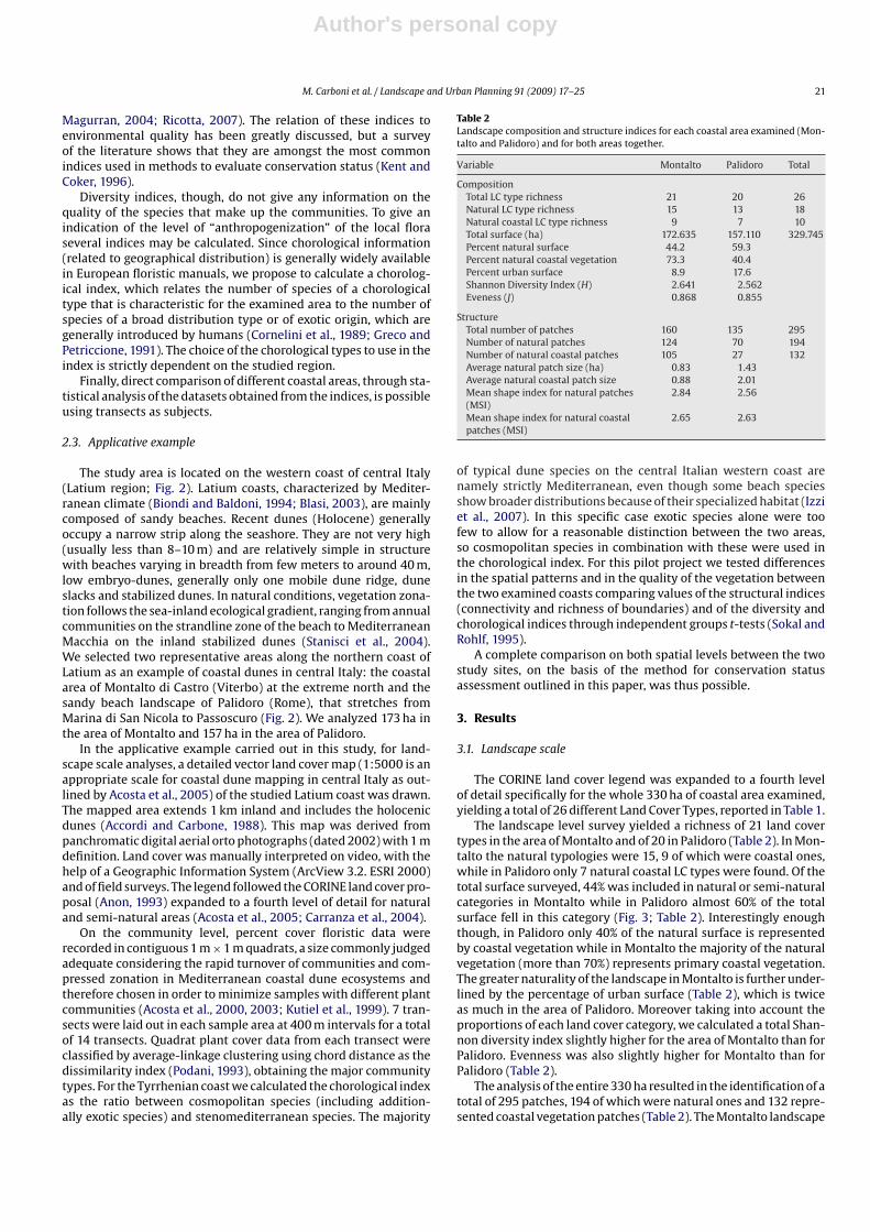
Table 1CORINE land cover legend expanded to the fourth level of detail.
Level 1 Level 2 Level 3 Level 4
(1) Artificial surfaces(1.1) Urban fabric (1.1.2) Discontinuous urban fabric(1.2) Industrial, commercial and transport units (1.2.2) Road and rail networks and associated land(1.4) Artificial non-agricultural (1.4.2) Sport and leisure facilities
(2) Agricultural areas(2.1) Arable land (2.1.1) Non-irrigated arable land(2.3) Pastures (2.3.1) Pastures
(3) Forests andsemi-natural areas
(3.1) Forests (3.1.1) Broad-leavedforest
(3.1.1.1) Elm formations(3.1.1.2) Igrophilous forests(3.1.1.3) Eucaliptus plantations(3.1.1.4) Tamarix plantations(3.1.1.5) Mixed woodlands
(3.1.2) Coniferous forest (3.1.2.1) Pinus sp. forests(3.2) Shrub and/or herbaceousvegetation
(3.2.1) Natural grassland (3.2.1.1) Secondary grasslands(3.2.3) Sclerophyllous vegetation (3.2.3.1) Coastal Juniper Macchia
(3.2.3.2) Mediterranean Macchia(3.2.4) Transitional woodland shrub
(3.3) Open spaces with little or novegetation
(3.3.1) Beaches, dunes, and sandplains
(3.3.1.1) Bare sand with herbaceusannual beach vegetation with Cakilemaritimaand Salsola kali(3.3.1.2) Open psammophilousherbaceous vegetation of embryodunes with Elymus farctus(3.3.1.3) Closed psammophilousherbaceous vegetation of mobiledunes with Ammophila arenaria(3.3.1.4) Camephitic vegetation ofsemistable dunes with Crucianellamaritima(3.3.1.5) Interdune annual grasslands(3.3.1.8) Closed psammophilousherbaceous vegetation with Plantagocoronopus and Silene canescens(3.3.1.9) Open psammophilousherbaceous vegetation of embryodunes with Anthemis maritima andElymus farctus
(3.3.3) Sparsely vegetated areas
(4) Wetlands (4.1) Inland wetlands (4.1.1) Inland marshes (4.1.1.1) River cane vegetation
(5) Water bodies (5.1) Inland waters (5.1.1) Water courses(5.1.2) Water bodies
This table includes only the categories observed in the study area. Natural Coastal vegetation typologies are in bold.
of the communities along the sea-inland gradient according to theproposals of Acosta et al. (2000, 2003) based on the use of two struc-tural indexes: richness of boundaries, n (Rescia et al., 1997) andgamma connectivity, � (Forman and Godron, 1986). This methodinvolves the projection along transects of the plant communitiesfound (Fig. 1). Each transect is therefore characterized by a specificsequence and dimension of plant community patches. The richnessof boundaries, n is obtained by counting the number of differenttypes of boundaries along each transect. The gamma connectivityindex considers additionally a patch type’s position in relation toother patch types. This index, inspired by graph theory, defines therelation between patches or nodes (V) and the links among them(L). It equals the number of links present along the transect over thenumber of links in a planar graph with the same number of nodes:� = L/3(V − 2), where 3(V − 2) is the maximum possible number oflinks considering the number of nodes present. It ranges from 0 (nolinks at all) to 1 (every node is linked to every possible node). Sincedisturbance may cause changes in the natural sea-inland commu-nity sequence and communities typical of the seaward slope may befound on the inland slope, connectivity is calculated in the inland-sea direction in addition to the sea-inland direction. While the latterreflects the natural community sequence, the former may indicatebackward steps in zonation due to disturbance.
On the landscape level when dealing with spatial patterns withnumerous patches, connectivity generally tends to be positivelycorrelated with better environmental quality (Forman, 1996). This
is usually not the case, however, in coastal dune vegetation withlinear spatial community distribution. In particular, the best pos-sible spatial structure in these environments is one in which allcommunities of the area are present and arranged in the correctorder of the natural sequence. This situation is therefore associatedwith the sea-inland connectivity value of best structural quality(Fig. 1). When community types are in contact with additionalcommunities other than the ones they are associated with in thenatural sequence we observe loops in the boundary structure, giv-ing rise to higher sea-inland connectivity values. Moreover, in theseenvironments where we generally deal with a limited total num-ber of communities, sea-inland connectivity values are greater forstructures with fewer community types. Therefore, in coastal duneenvironments, high connectivity values tend to be related to loops(high sea-inland connectivity) and many backward jumps in thesequence (high inland-sea connectivity), which are indicators ofheterogeneity, of high community fragmentation and often of dis-turbance (Fig. 1; Acosta et al., 2000).
2.2.2. Analysis of the diversity of the vegetationFinally we suggest complementing the spatial pattern analysis
by calculating a series of indicators of species diversity and veg-etation quality. Firstly, we propose to estimate the diversity of thevegetation by calculating the Shannon diversity index (H) and even-ness (J), which are among the most popular diversity indices invegetation analysis (Gurevitch et al., 2002; Kent and Coker, 1996;
Author's personal copy
M. Carboni et al. / Landscape and Urban Planning 91 (2009) 17–25 21
Magurran, 2004; Ricotta, 2007). The relation of these indices toenvironmental quality has been greatly discussed, but a surveyof the literature shows that they are amongst the most commonindices used in methods to evaluate conservation status (Kent andCoker, 1996).
Diversity indices, though, do not give any information on thequality of the species that make up the communities. To give anindication of the level of “anthropogenization” of the local floraseveral indices may be calculated. Since chorological information(related to geographical distribution) is generally widely availablein European floristic manuals, we propose to calculate a chorolog-ical index, which relates the number of species of a chorologicaltype that is characteristic for the examined area to the number ofspecies of a broad distribution type or of exotic origin, which aregenerally introduced by humans (Cornelini et al., 1989; Greco andPetriccione, 1991). The choice of the chorological types to use in theindex is strictly dependent on the studied region.
Finally, direct comparison of different coastal areas, through sta-tistical analysis of the datasets obtained from the indices, is possibleusing transects as subjects.
2.3. Applicative example
The study area is located on the western coast of central Italy(Latium region; Fig. 2). Latium coasts, characterized by Mediter-ranean climate (Biondi and Baldoni, 1994; Blasi, 2003), are mainlycomposed of sandy beaches. Recent dunes (Holocene) generallyoccupy a narrow strip along the seashore. They are not very high(usually less than 8–10 m) and are relatively simple in structurewith beaches varying in breadth from few meters to around 40 m,low embryo-dunes, generally only one mobile dune ridge, duneslacks and stabilized dunes. In natural conditions, vegetation zona-tion follows the sea-inland ecological gradient, ranging from annualcommunities on the strandline zone of the beach to MediterraneanMacchia on the inland stabilized dunes (Stanisci et al., 2004).We selected two representative areas along the northern coast ofLatium as an example of coastal dunes in central Italy: the coastalarea of Montalto di Castro (Viterbo) at the extreme north and thesandy beach landscape of Palidoro (Rome), that stretches fromMarina di San Nicola to Passoscuro (Fig. 2). We analyzed 173 ha inthe area of Montalto and 157 ha in the area of Palidoro.
In the applicative example carried out in this study, for land-scape scale analyses, a detailed vector land cover map (1:5000 is anappropriate scale for coastal dune mapping in central Italy as out-lined by Acosta et al., 2005) of the studied Latium coast was drawn.The mapped area extends 1 km inland and includes the holocenicdunes (Accordi and Carbone, 1988). This map was derived frompanchromatic digital aerial orto photographs (dated 2002) with 1 mdefinition. Land cover was manually interpreted on video, with thehelp of a Geographic Information System (ArcView 3.2. ESRI 2000)and of field surveys. The legend followed the CORINE land cover pro-posal (Anon, 1993) expanded to a fourth level of detail for naturaland semi-natural areas (Acosta et al., 2005; Carranza et al., 2004).
On the community level, percent cover floristic data wererecorded in contiguous 1 m × 1 m quadrats, a size commonly judgedadequate considering the rapid turnover of communities and com-pressed zonation in Mediterranean coastal dune ecosystems andtherefore chosen in order to minimize samples with different plantcommunities (Acosta et al., 2000, 2003; Kutiel et al., 1999). 7 tran-sects were laid out in each sample area at 400 m intervals for a totalof 14 transects. Quadrat plant cover data from each transect wereclassified by average-linkage clustering using chord distance as thedissimilarity index (Podani, 1993), obtaining the major communitytypes. For the Tyrrhenian coast we calculated the chorological indexas the ratio between cosmopolitan species (including addition-ally exotic species) and stenomediterranean species. The majority
Table 2Landscape composition and structure indices for each coastal area examined (Mon-talto and Palidoro) and for both areas together.
Variable Montalto Palidoro Total
CompositionTotal LC type richness 21 20 26Natural LC type richness 15 13 18Natural coastal LC type richness 9 7 10Total surface (ha) 172.635 157.110 329.745Percent natural surface 44.2 59.3Percent natural coastal vegetation 73.3 40.4Percent urban surface 8.9 17.6Shannon Diversity Index (H) 2.641 2.562Eveness (J) 0.868 0.855
StructureTotal number of patches 160 135 295Number of natural patches 124 70 194Number of natural coastal patches 105 27 132Average natural patch size (ha) 0.83 1.43Average natural coastal patch size 0.88 2.01Mean shape index for natural patches(MSI)
2.84 2.56
Mean shape index for natural coastalpatches (MSI)
2.65 2.63
of typical dune species on the central Italian western coast arenamely strictly Mediterranean, even though some beach speciesshow broader distributions because of their specialized habitat (Izziet al., 2007). In this specific case exotic species alone were toofew to allow for a reasonable distinction between the two areas,so cosmopolitan species in combination with these were used inthe chorological index. For this pilot project we tested differencesin the spatial patterns and in the quality of the vegetation betweenthe two examined coasts comparing values of the structural indices(connectivity and richness of boundaries) and of the diversity andchorological indices through independent groups t-tests (Sokal andRohlf, 1995).
A complete comparison on both spatial levels between the twostudy sites, on the basis of the method for conservation statusassessment outlined in this paper, was thus possible.
3. Results
3.1. Landscape scale
The CORINE land cover legend was expanded to a fourth levelof detail specifically for the whole 330 ha of coastal area examined,yielding a total of 26 different Land Cover Types, reported in Table 1.
The landscape level survey yielded a richness of 21 land covertypes in the area of Montalto and of 20 in Palidoro (Table 2). In Mon-talto the natural typologies were 15, 9 of which were coastal ones,while in Palidoro only 7 natural coastal LC types were found. Of thetotal surface surveyed, 44% was included in natural or semi-naturalcategories in Montalto while in Palidoro almost 60% of the totalsurface fell in this category (Fig. 3; Table 2). Interestingly enoughthough, in Palidoro only 40% of the natural surface is representedby coastal vegetation while in Montalto the majority of the naturalvegetation (more than 70%) represents primary coastal vegetation.The greater naturality of the landscape in Montalto is further under-lined by the percentage of urban surface (Table 2), which is twiceas much in the area of Palidoro. Moreover taking into account theproportions of each land cover category, we calculated a total Shan-non diversity index slightly higher for the area of Montalto than forPalidoro. Evenness was also slightly higher for Montalto than forPalidoro (Table 2).
The analysis of the entire 330 ha resulted in the identification of atotal of 295 patches, 194 of which were natural ones and 132 repre-sented coastal vegetation patches (Table 2). The Montalto landscape
Author's personal copy
22 M. Carboni et al. / Landscape and Urban Planning 91 (2009) 17–25
Fig. 3. Land cover maps of the analyzed coastal areas showing the diagnostic categories highlighted in Table 2 as derived from the produced IV level CORINE land cover mapof the studied Latium coast. Maps, realized at a scale 1:5000, are presented here at ca. 1:30,000 scale. Natural surfaces are in grey, with coastal typologies highlighted with adarker shade of grey.
Table 3Main plant communities found in the two coastal dune systems with their relative position along the beach-dune profile.
No. Zone Montalto Palidoro
1 Beach and embryo dunes Cakile maritima-Salsola kali community Cakile maritima-Elymus farctuscommunity2 Mobile dunes Elymus farctus-Anthemis maritima community Elymus farctus-Anthemis maritima community3 Interdune and backdune Silene canescens-Medicago litoralis community Silene canescens-Plantago coronopus community4 Edge of fixed dune Juniperus oxicedrus-Cistus incanus community Avena barbata-Bromus rigidus community5 Fixed dune Phillyrea latifolia-Pistacia lentiscus community
Fig. 4. Cluster analysis for the vegetation of the two examined coastal areas. 5 plant communities were identified in the coastal area of Montalto (A) and 4 communities inPalidoro (B). Numbers refer to the plant communities listed in Table 3.
was much more structured and heterogeneous from this point ofview, especially considering the 105 natural coastal patches in thisarea (85% of the total natural patches) in contrast to only 27 natu-ral coastal patches in Palidoro (less than 40% of the natural patchesof this area). This aspect is reflected in the average size of natu-
Table 4Indices of spatial structure and quality of the vegetation for both coastal areas exam-ined (Montalto and Palidoro).
Variable Montalto Palidoro Sig.
Spatial structureRichness of boundaries (n) 3.286 2.571 0.109�sea-inland 0.531 0.589 0.311� inland-sea 0.237 0.206 0.699
Quality of the vegetationShannon diversity index (H) 3.182 2.813 0.014Eveness (J) 0.884 0.835 0.017Corological index (A) 0.304 0.413 0.332
Significance values refer to t-tests for independent groups (df = 12).
ral coastal patches, which is of less than a hectare for the formerand more than double for the latter. On the other hand, the meanshape index does not highlight particular differences in the shapeof the natural coastal patches of the two areas. This index is rela-tively high for both areas indicating stretched out shapes instead ofisodiametric ones, as is expected for coastal vegetation. The rela-tively high MSI in Montalto even in face of the remarkable numberof polygons suggests that in this area we are dealing with a nat-ural heterogeneity typical for these environments, and not with afragmented landscape as a consequence of human disturbance.
3.2. Community scale
We identified five plant communities through cluster analysisin the coastal area of Montalto and four in Palidoro (Table 3). Theserange from the pioneer beach communities to a well-developedMediterranean Macchia in Montalto and to a secondary grasslandsubstituting the shrub vegetation in Palidoro as a consequence ofpast human activities, passing through herbaceous psammophilous
Author's personal copy
M. Carboni et al. / Landscape and Urban Planning 91 (2009) 17–25 23
communities affected by various degrees of disturbance along thedune profile (Fig. 4; Table 3). In the area of Palidoro plant com-munities of the mobile dune and of the backdune appear to beparticularly altered in their floristic composition, and here the zona-tion ends with a secondary grassland (Table 3).
With respect to the analysis of the spatial arrangement ofvegetational groups along the sea-inland gradient no significantdifferences emerged between the two coastal areas neither in thespatial connectivity indices, nor in richness of boundaries (Table 4).Richness of boundaries is slightly higher for the coastal area of Mon-talto because of the presence of a greater number of communities inthis area, but the difference is not significant. Both areas seem to besubject to a considerable amount of disturbance with relatively highconnectivity values in average, mainly due to heterogeneity andto the fragmentation of the communities and their repeated pres-ence along the transects corresponding both to backward steps inthe natural coastal zonation and to contact loops along the naturalcommunity sequence.
As for the quality of the vegetation, Shannon diversity index andevenness are significantly higher for the dune system of Montaltothan for the coast of Palidoro (Table 4) indicating a richer and morediverse vegetation for the northern area. In particular the fairly wellpreserved backdune Macchia, which has been completely elimi-nated in the southern area as a consequence of past agriculturalactivities, is probably responsible for such higher diversity values.
On the other hand no significant differences emerge for thechorological index, which has relatively low values for both areas.This indicates that both areas are not particularly subject to invasionby human-favored or alien species and the strict Mediterraneancharacter of their flora is maintained.
4. Discussion and conclusions
In face of the numerous threats endangering coastal habitatsthe need for monitoring and active management of these environ-ments has emerged. Multiscale approaches are extremely usefulto study small and patchily distributed ecosystems of the world,such as sand dunes, in particular if they are close to urban areas.In fact, hierarchically nested land use plans are becoming widelyused because of their usefulness to stress importance of naturalecosystems for management and sustainable urban development.Analyzing coastal dunes at a broad organizational level and then,zooming them down to a finer level, can highlight more emergentproperties providing valid arguments for their management andprotection, also with the perspective of protecting strategic infras-tructures and urban developments (Jolicoeur and O’Carrol, 2007).The method proposed in this paper, by exploring two organiza-tional levels at the extremes of the biodiversity spectrum, allowedthe comparison of two local areas along the Tyrrhenian coast in acomprehensive way.
The landscape of Montalto is richer in natural coastal land covertypologies, which also cover a greater surface in this area, and ismore diverse overall. The Palidoro coast, on the other hand, is muchmore influenced by the coastal suburbanization phenomenon (thisarea was also included in a region classified as one of the mostcritically urbanized of the northwestern Mediterranean by Coriin 1999) and the natural landscape here appears therefore moreendangered in terms of alien invasions and trampling linked tohuman settlements (Curr et al., 2000; Kutiel et al., 1999; O’Sheaand Kirkpatrick, 2000). Moreover the Montalto landscape is morestructured and heterogeneous, especially when considering natu-ral coastal land cover typologies, which in this area are arrangedin numerous patches that still maintain their natural shape paral-lel to the coastline. The landscape of Palidoro, on the other handis shaped by the heritage of intense agricultural activities in the
past, revealed in particular by the presence of few large polygonseven in natural categories. In contrast with the wealth of literaturedescribing effects of urban sprawling, few studies have highlightedthe strong landscape modifying impacts of past agricultural activi-ties on coastal areas, even though agricultural surfaces often occupylarge percentages of the coastal landscape (as indicated for examplein Italy by Carranza et al., 2004).
On the community level the analysis of the spatial pattern ofthe communities highlighted structural alterations in both areas.These are probably associated with disturbance due to tramplingand summer coast bound tourism. Even though no statistically sig-nificant structural differences emerge between the two areas, thevegetation of Montalto still resulted significantly richer and morediverse than the one of Palidoro, underlining once more the flatten-ing effects of the past agricultural activities and present recreationalones in the latter area. Several studies have in fact highlightedthe strong negative effects of trampling and other human induceddisturbances on the plant communities of coastal dunes in theMediterranean as well as in other parts of Europe, with signifi-cant lowering of diversity values in trampled sites (Grunewald andSchubert, 2007; Kutiel et al., 1999; Vogt Andersen, 1995). Tram-pling and other recreation linked human activities, such as beachcleaning are rated by Brown and McLachlan (2002) among the mostsevere factors impacting sandy shores.
The two levels of analysis work complementarily to portray acomplete picture of the naturalness of the vegetation in the twocoastal areas examined. We are therefore able to recognize a betterconservation state of the northern coast, while the second samplearea, both because of sprawling and summer tourism associatedwith the proximity of the 4 million inhabitants metropolitan area ofRome (ca. 30 km south) and of intense past farming and agriculturalactivities, has been much more subjected to disturbance.
Our conclusion can be considered particularly trustworthybecause the approach considers both the ecological processes shap-ing the coastal landscapes (higher organizational level) and thefloristic emergencies of the sand dune communities (communitylevel).
The method demonstrated several advantages. At the higherorganizational level, the relevant data are generally widely avail-able and relatively easily analyzed. Although the sampling processat the community scale is time-consuming, the use of transectsmakes it possible to include the greatest amount of diversity alongthe sea-inland gradient in the shortest amount of time, renderingthe sampling effort the most time and cost effective possible. Incontrast with many approaches for the study of conservation sta-tus or vulnerability of natural habitats, which have relied on thecompletion of checklists or on ratings and scorings by experts andmanagers (Poldini and Pertot, 1989; Regan et al., 2007; Williams etal., 2001), the direct measure of surrogate features of biodiversityat different levels in our proposal avoids the introduction of subjec-tive judgement and bias. Moreover the method overall causes onlyminimal disturbance to the examined communities, even though itinvolves both the community and the landscape level. Neverthelesswe obtained a set of different indicators on various organizationallevels of the coastal environment, which are easy to determine orto calculate.
The assessment is therefore easily repeatable, allowing forstraightforward comparisons among coastal areas. It may hence beused to compare the conservation status of various coastal areasand identify conservation priorities in a general region at a moredetailed and local level as regular reserve design methodologiesand in a fashion specifically tuned for coastal environments. Addi-tionally this methodology, since it can be repeated in the courseof the years, may be used as a basis for monitoring coastal duneecosystems over time and for assessing the effects of managementchanges, when the focus needs to be specifically on the vegeta-
Author's personal copy
24 M. Carboni et al. / Landscape and Urban Planning 91 (2009) 17–25
tion, which is often neglected or its contribution to dune healthunderestimated.
In conclusion, we proposed an articulated method to evaluateconservation status and disturbance levels on sandy coastal areasencompassing multiple levels of the plant biodiversity. The methodsummarizes coastal vegetation conservation status in an objective,standardized and repeatable way by means of several biodiversityindicators. While not all aspects studied were significantly differentbetween sample areas examined in the applicative example, themethod was articulated enough to pinpoint the overall differencein conservation status, fulfilling therefore satisfactorily its purpose.
Acknowledgements
The authors wish to acknowledge the financial support of theItalian Ministry of Education (MIUR, PRIN 2005–2007) and to thankthe editor Dr. J.E. Rodiek as well as two anonymous referees forhelping improve a previous version of the manuscript.
References
Accordi, G., Carbone, F., 1988. Map of litofacies of Lazio-Abruzzo and bordering areas.CNR-Quaderni della Ricerca Scientifica 114 (5) (in Italian).
Acosta, A., Blasi, C., Stanisci, A., 2000. Spatial connectivity and boundary patterns incoastal dune vegetation in the Circeo National Park, Central Italy. J. Veg. Sci 11,149–154.
Acosta, A., Blasi, C., Carranza, M.L., Ricotta, C., Stanisci, A., 2003. Quantifying eco-logical mosaic connectivity and hemeroby with a new topoecological index.Phytocoenologia 33, 623–631.
Acosta, A., Carranza, M.L., Izzi, C.F., 2005. Combining land cover mapping of coastaldunes with vegetation analysis. Appl. Veg. Sci. 8, 133–138.
Anon., 1993. CORINE Land Cover. Technical Guide. CECA-CEE-CEEA, Bruxelles.Araújo, R., Honrado, J., Granja, H.M., De Pinho, S.N., Caldas, F.B., 2002. Vegetation
complexes of coastal sand dunes as an evaluation instrument of geomor-phologic changes in the coastline. In: Littoral 2002. The Changing Coast.EUROCOAST/EUCC, Porto, Portugal, pp. 337–339.
Balaguru, B., John Britto, S.J.S., Nagamurugan, N., Natarajan, D., Soosairaj, S., 2006.Identifying conservation priority zones for effective management of tropicalforests in eastern Ghats of India. Biodivers. Conserv. 15, 1529–1543.
Beever, E.A., Swihart, R.K., Bestelmeyer, B.T., 2006. Linking the concept of scale tostudies of biological diversity: evolving approaches and tools. Divers. Distrib. 12,229–235.
Biondi, E., Baldoni, M., 1994. The climate and vegetation of peninsular Italy. Colloq.Phytosociol. 23, 675–721.
Blasi, C., 2003. Bioclimate of Italy. In: Blasi, C. (Ed.), Ecological Information in Italy.Ministero dell’Ambiente e della Tutela del Territorio-Società Botanica Italiana,Rome, pp. 11–12.
Bonn, A., Gaston, K.J., 2005. Capturing biodiversity: selecting high priority areas forconservation using different criteria. Biodivers. Conserv. 14, 1083–1100.
Botequilha Leitão, A., Ahern, J., 2002. Applying landscape ecological conceptsand metrics in sustainable landscape planning. Landsc. Urban Plan. 59, 65–93.
Brown, A.C., McLachlan, A., 2002. Sandy shore ecosystems and the threats fac-ing them: some predictions for the year 2025. Environ. Conserv. 29, 62–77.
Cabeza, M., Moilanen, A., 2001. Design of reserve networks and the persistence ofbiodiversity. Trends Ecol. Evol. 16, 242–248.
Carranza, M.L., Acosta, A., Giancola, D., 2004. Landscape analysis of the Molisan coast.GR Estimo e Territorio 12, 39–43.
Carranza, M.L., Feola, S., Acosta, A., Stanisci, A., 2007. Using between patch bound-aries for conservation status assessment on coastal dune ecosystems. In: Bunce,R.G.H., Jongman, R.H.G., Lojas, L., Weel, S. (Eds.), 25 years Landscape ecology:Scientific Principles in Practice. IALE Publication series 4, Wageningen, TheNetherlands.
Cori, B., 1999. Spatial dynamics of Mediterranean coastal regions. J. Coast. Conserv.5, 105–112.
Cornelini, P., Loche, P., Pani, F., 1989. The use of the plant information in the definitionof environmental quality. Informatore Botanico Italiano 21, 152–164 (in Italian).
Curr, R.H.F., Koh, A., Edwards, E., Williams, A.T., Davies, P., 2000. Assessing anthro-pogenic impact on Mediterranean sand dunes from aerial digital photography.J. Coast. Conserv. 6, 15–22.
Davies, P., Williams, A.T., Curr, R.H.F., 1995. Decision making in dune management:theory and practice. J. Coast. Conserv. 1, 87–96.
Doing, H., 1981. A comparative scheme of dry coastal sand dune habitats, with exam-ples from the eastern United States and some other temperate regions. Veröff.Geobot. Inst. Stift. Rübel Zür. 77, 41–72.
Espejel, I., Ahumada, B., Cruz, Y., Heredia, A., 2004. Coastal vegetation as indicatorsfor conservation. In: Martínez, M.L., Psuty, N.P. (Eds.), Coastal Dunes: Ecologyand Conservation. Ecological Studies, vol. 171. Springer, Berlin, Heidelberg, pp.297–318.
Faith, D.P., Walker, P.A., 1996. Environmental diversity: on the best-possible use ofsurrogate data for assessing the relative biodiversity of sets of areas. Biodivers.Conserv. 5, 399–415.
Forman, R.T., Godron, M., 1986. Landscape Ecology. Wiley, New York.Forman, R.T., 1996. Land Mosaics. Cambridge University Press, Cambridge.Frederiksen, L., Kollmann, J., Vestergaard, P., Bruun, H.H., 2006. A multivariate
approach to plant community distribution in the coastal dune zonation of NWDenmark. Phytocoenologia 36, 321–342.
García-Novo, F., Diaz-Barradas, M.C., Zunzunegui, M., García-Mora, R., Gallego-Fernández, J.B., 2004. Plant functional types in coastal dune habitats. In:Martínez, M.L., Psuty, N.P. (Eds.), Coastal Dunes: Ecology and Conservation. Eco-logical Studies, vol. 171. Springer, Berlin, Heidelberg, pp. 155–169.
Géhu, J.M., Géhu, J., 1980. A methodology for the objective evaluation of naturalenvironments. Coastal examples. In: Third Seminary of Applied Phytosociol-ogy “Biological Evaluation of the Territory through Biocenotic Indices”. InstituteEuropéen d’Ecologie, Metz, pp. 75–94 (in French).
Géhu, J.M., Biondi, E., 1994. Anthropization of Mediterranean dunes. In: Ferrari, C.,Manes, F., Biondi, E. (Eds.), Alterazioni Ambientali ed Effetti sulle Piante. Edagri-cole, pp. 160–176 (in Italian).
Godefroid, S., Koedam, N., 2003. Identifying indicator plant species of habitat qualityand invasibility as a guide for peri-urban forest management. Biodivers. Conserv.12, 1699–1713.
Greco, S., Petriccione, B., 1991. Environmental quality evaluation in a disturbedecosystem, on the basis of floristic and vegetational data. In: Ravera (Ed.), Terres-trial and Aquatic Ecosystems: Perturbation and Recovery. Ellis Horwood Limited,Chichester, UK, pp. 101–108.
Grunewald, R., Schubert, H., 2007. The definition of a new plant diversity index“H′
dunes” for assessing human damage on coastal dunes—derived from the Shan-
non index of entropy H′ . Ecol. Ind. 7, 1–21.Gurevitch, J., Scheiner, S.M., Fox, G.A., 2002. The Ecology of Plants. Sinauer Associates,
Inc., Publishers, Sunderland, MA, USA.Hermy, M., Cornelis, J., 2000. Towards a monitoring method and a number of mul-
tifaceted and hierarchical biodiversity indicators for urban and suburban parks.Landsc. Urban Plan. 49, 149–162.
Hinchliffe, J., Conran, J.G., 2005. Life-class stages in coast daisy-bush (Olearia axillaris:Asteraceae) as a possible means of monitoring coastal dunes. Aust. J. Bot. 53,133–139.
Houle, G., 1997. Interactions between resources and abiotic conditions control plantperformance on subarctic coastal dunes. Am. J. Bot. 84, 1729–1737.
Isermann, M., Krisch, H., 1995. Dunes in contradiction with different interests. anexample: the camping-ground Prerow (Darß/Baltic Sea). In: Salman, A.H.P.M.,Berends, H., Bonazountas, M. (Eds.), Coastal Management and Habitat Conser-vation. EUCC, Leiden, The Netherlands, pp. 439–449.
Izzi, C.F., Acosta, A., Carranza, M.L., Ciaschetti, G., Conti, F., Di Martino, L., D’Orazio,G., Frattaroli, A., Pirone, G., Stanisci, A., 2007. The census of the vascular flora ofcoastal dune environments of central Italy. Fitosociology 44, 129–137 (in Italian).
Jolicoeur, S., O’Carrol, S., 2007. Sandy barriers, climate change and long-termplanning of strategic coastal infrastructures, Îles-de-la-Madeleine, Gulf of St.Lawrence (Québec, Canada). Landsc. Urban Plan. 81, 287–298.
Kent, M., Coker, P., 1996. Vegetation Description and Analysis. John Wiley and SonsLtd., Chichester, England.
Kutiel, P., Zhevelev, H., Harrison, R., 1999. The effect of recreational impacts on soiland vegetation of stabilised coastal dunes in the Sharon Park, Israel. Ocean Coast.Manage. 42, 1041–1060.
Langanke, T., Burnett, C., Lang, S., 2007. Assessing the mire conservation status of araised bog site in Salzburg using object-based monitoring and structural analysis.Landsc. Urban Plan. 79, 160–169.
Lausch, A., Herzog, F., 2002. Applicability of landscape metrics for the monitoringof landscape change: issues of scale, resolution and interpretability. Ecol. Ind. 2,3–15.
Lopez, R.D., Fennessy, M.S., 2002. Testing the floristic quality assessment index as anindicator of wetland condition. Ecol. Appl. 12, 487–497.
Magurran, A.E., 2004. Measuring Biological Diversity. Blackwell Publishing, Malden,MA.
Margules, C.R., Pressey, R.L., 2000. Systematic conservation planning. Nature 405,243–252.
Maun, M.A., 1998. Adaptations of plants to burial in coastal sand dunes. Can. J. Bot.76, 713–738.
McGarigal, K., Marks, B.J., 1995. FRAGSTATS: spatial analysis program for quantifyinglandscape structure. USDA Forest Service General Technical Report PNW-GTR-351.
McKinney, M.L., 2002. Urbanization, biodiversity, and conservation. BioScience 52,883–890.
O’Shea, E.M., Kirkpatrick, J.B., 2000. The impact of suburbanization on remnantcoastal vegetation in Hobart, Tasmania. Appl. Veg. Sci. 3, 243–252.
Packham, J.R., Willis, A.J., 1997. Ecology of Dunes, Salt Marsh and Shingle. Chapman& Hall, London.
Palik, B.J., Goebel, P.C., Kirkman, L.K., West, L., 2000. Using landscape hierarchies toguide restoration of disturbed ecosystems. Ecol. Appl. 10, 189–202.
Podani, J., 1993. SYN-TAX pc. Computer Programs For Multivariate Data Analysis inEcology and Systematics, Version 5. Scientia Publishing, Budapest.
Poldini, L., Pertot, M., 1989. Indexing criteria for the naturalistic value on the exampleof the “Carso triestino-friulano”. Informatore Botanico Italiano 21, 133–151 (inItalian).
Primack, R.B., 2000. A Primer of Conservation Biology. Sinauer Associates, Inc., Pub-lishers, Sunderland, MA.
Author's personal copy
M. Carboni et al. / Landscape and Urban Planning 91 (2009) 17–25 25
Provoost, S., Ampe, C., Bonte, D., Cosyns, E., Hoffmann, M., 2004. Ecology, manage-ment and monitoring of grey dunes in Flanders. J. Coast. Conserv. 10, 33–42.
Regan, H.M., Davis, F.W., Andelman, S.J., Widyanata, A., Freese, M., 2007. Compre-hensive criteria for biodiversity evaluation in conservation planning. Biodivers.Conserv. 16, 2715–2728.
Rescia, A.J., Schmitz, M.F., Martín de Agar, P., de Pablo, C.L., Pineda, F.D., 1997. Afragmented landscape in northern Spain analyzed at different spatial scales:implications for management. J. Veg. Sci. 8, 343–352.
Ricotta, C., 2007. A semantic taxonomy for diversity measures. Acta Biotheor. 55,23–33.
Roy, P.S., Tomar, S., 2000. Biodiversity characterization at landscape level usinggeospatial modelling technique. Biol. Conserv. 95, 95–109.
Sokal, R.R., Rohlf, F.J., 1995. Biometry. W.H. Freeman, New York.Stanisci, A., Acosta, A., Ercole, S., Blasi, C., 2004. Plant communities on costal dunes
in Lazio (Italy). Annali di Botanica nuova serie IV, 115–128.Sykes, M.T., Wilson, J.B., 1988. An experimental investigation into the response
of some New Zealand sand dune species to salt spray. Ann. Bot. 62, 159–166.
Sykes, M.T., Wilson, J.B., 1991. Vegetation of a coastal sand dune system in southernNew Zealand. J. Veg. Sci. 2, 531–538.
Taveira Pinto, F., 2004. The practice of coastal zone management in Portugal. J. Coast.Conserv. 10, 147–158.
Tchouto, M.G.P., Yemefack, M., De Boer, W.F., De Wilde, J.J.F.E., Van der Mae-sen, L.J.G., Cleef, A.M., 2006. Biodiversity hotspots and conservation prioritiesin the Campo-Ma’an rain forests, Cameroon. Biodivers. Conserv. 15, 1219–1252.
Thackrah, G., Rhind, P., Hurford, C., Barnsley, M., 2004. Using earth observation datafrom multiple sources to map rare habitats in a coastal conservation area. J. Coast.Conserv. 10, 53–64.
UNEP [United Nations Environment Programme], 1992. Convention on BiologicalDiversity. United Nations Environment Programme, Nairobi, Kenya.
Van der Maarel, E., 1993. Some remarks on disturbance and its relations to diversityand stability. J. Veg. Sci. 6, 733–736.
Van der Maarel, E., 2003. Some remarks on the functions of European coastal ecosys-tems. Phytocoenologia 33, 187–202.
Vogt Andersen, U., 1995. Resistance of Danish coastal vegetation types to humantrampling. Biol. Conserv. 71, 223–230.
Walker, S., Wilson, J.B., Steel, J.B., Rapson, G.L., Smith, B., King, W.McG., Cottam, Y.H.,2003. Properties of ecotones: evidence from five ecotones objectively deter-mined from a coastal vegetation gradient. J. Veg. Sci. 14, 579–590.
Wessels, K.J., Freitag, S., Van Jaarsveld, A.S., 1999. The use of land facets as biodiversitysurrogates during reserve selection at a local scale. Biol. Conserv. 89, 21–38.
Whittaker, R.H., 1972. Evolution and measurement of species diversity. Taxon 21,213–251.
Williams, A.T., Alveirinho-Dias, J., García Novo, F., García-Mora, M.R., Curr, R., Pereira,A., 2001. Integrated coastal dune management: checklists. Cont. Shelf Res. 21,1937–1960.
Wilson, J.B., Sykes, M.T., 1999. Is zonation on coastal sand dunes determined pri-marily by sand burial or salt spray? A test in New Zealand dunes. Ecol. Lett. 2,233–236.
Yoccoz, N.G., James, D.N., Boulinier, T., 2001. Monitoring of biological diversity inspace and time. Trends Ecol. Evol. 16 (8), 446–453.
Related Documents