14th District 11th District 15th District 16th District 13th District 8th District 6th District 7th District 18th District BUCHANAN FIELD SAN PABLO AVE MORAGA RD MORAGA WAY ROSE DR SOLANO WAY W K ST TAYLOR BLVD PINEHURST RD CEDAR ST RELIEZ VALLEY RD CUMMINGS SKWY PINOLE VALLEY RD ST MARYS RD 2ND ST MARIN AVE 13TH AVE E H ST GILMAN ST BAYSHORE RD YGNACIO VALLEY RD MARINA VISTA AVE WILLOW AVE RUDGEAR RD 1ST ST 23RD ST TELEGRAPH AVE WATERFRONT RD PORT CHICAGO HWY CLAREMONT AVE CUTTING BLVD DWIGHT WAY 6TH ST WILLOW PASS RD BAY ST PERALTA ST CAMINO PABLO BROADWAY TER 34TH ST S MAIN ST W GRAND AVE HOWE RD BOYD RD ALCATRAZ AVE CANYON RD SNAKE RD ARLINGTON AVE UNIVERSITY AVE POTRERO AVE MOESER LN MARKET AVE CALIFORNIA ST LUPINE RD OLIVERA RD RHEEM BLVD GREGORY LN 51ST ST POMONA ST WALNUT AVE CENTER AVE OHIO AVE HASTINGS DR 35TH AVE REFUGIO VALLEY RD 30TH ST MANDANA BLVD OAK PARK BLVD MACARTHUR BLVD MEADOW LN PIEDMONT AVE COLUMBUS AVE POWELL ST MAIN ST JOAQUIN MILLER RD CURTIS ST 12TH ST PARR BLVD CHESLEY AVE SAN MATEO ST KEY RT BLVD PLEASANT HILL RD E SHAMROCK DR 18TH ST PENNSYLVANIA AVE E 18TH ST KEELER AVE TARA HILLS DR WRIGHT AVE TROTTER WAY PACIFIC AVE W MACDONALD AVE EVENS AVE EMBARCADERO ST W BARRETT AVE JOHN MUIR PKWY JONES ST SHATTUCK PL SKYLINE BLVD SAN PABLO AVE S K Y L I N E B L V D San Francisco Bay San Pablo Bay Suisun Bay UNIV OF CAL BERKELEY OAKLAND NAVAL SUPPLY CTR OAKLAND ARMY BASE MONTCLAIR GC HOLY NAMES COLLEGE TILDEN PARK GC RICHMOND CC ORINDA CC FRANKLIN CANYON GC MIRA VISTA CC SAINT MARYS COLLEGE OF CAL JOHN F KENNEDY UNIV Mare Island Naval Shipyard Treasure Island Naval Base Grizzly Island Wildlife Area Naval Fuel Supply Depot Concord Naval Weapons Station Oakland Richmond Orinda Contra Costa County Solano County Marin County Alameda County San Francisco County Lafayette Benicia Concord Martinez Walnut Creek Rodeo Berkeley Alamo Pinole Vallejo Moraga Town Hercules Pleasant Hill Vine Hill El Cerrito San Pablo Albany El Sobrante Crockett Piedmont Pacheco San Francisco Danville Richmond Emeryville Kensington Tara Hills Alameda West Pittsburg Bayview-Montalvin East Richmond Heights 4 4 242 123 123 24 24 13 13 80 80 80 80 780 680 680 680 580 880 980 580 Alhambra Valley Rd Mayhew Way Alhambra Valley Rd 2nd Ave Walnut Creek Hilltop Dr Castro Ranch Rd Arroyo del Hambre Creek Bay Area RT RR Brookwood Dr Weaver Ln Paso Nogal Burlington Northern Santa Fe R 1st Ave Ironwood Dr Greenridge Dr Pheasant Ln Sunset Dr Treat Blvd Chilpancingo Pky Concord Ave Valley View Rd Richmond Pky El Portal Dr Canary Ln Appian Way May Rd High St Diane Dr Christen Dr Fran Way 4th Ave S Canyon Rd Topaz Ln Savannah Cir A L H A M B R A V A L L E Y R D Assembly District 11 West Part Map 1 of 4 0 1 2 3 4 Miles 15 06 01 07 08 26 02 10 17 04 19 11 28 20 14 18 05 21 25 22 16 13 09 12 Yolo Sonoma Napa Solano San Joaquin Marin Alameda Sacramento Stanislaus Contra Costa Lake Placer Santa Clara San Mateo Sutter San Francisco P a c i f i c O c e a n Mapped Area Legend Assembly Boundary State Boundary County Boundary City Boundary Major Highway Other Highway Railroad Outside District Major Landmarks

Welcome message from author
This document is posted to help you gain knowledge. Please leave a comment to let me know what you think about it! Share it to your friends and learn new things together.
Transcript

14th District
11th District
15thDistrict
16th District
13th District
8th District6thDistrict
7th District
18th District
BUCHANANFIELD
SA
N P
AB
LO A
VE
MO
RA
GA
RD
MORAGA WAY
ROSE DR
SO
LAN
O W
AY
W K ST
TAYLOR BLVD
PINEHURST RD
CEDAR ST
RE
LIEZ VA
LLEY
RD
CUMM
INGS SKW
Y
PINOLE VALLEY RD
ST
MA
RY
S R
D
2ND ST
MARIN AVE
13TH A
VE
E H ST
GILMAN ST
BA
YS
HO
RE
RD
YGNACIO VALLEY RD
MARINA VISTA AVE
WILLO
W AV
E
RUDGEAR RD
1ST
ST
23R
D S
T
TE
LEG
RA
PH
AV
E
WATERFRONT RD
PO
RT
CH
ICA
GO
HW
Y
CLA
REM
ON
T AV
E
CUTTING BLVD
DWIGHT WAY
6TH
ST
WILLOW PASS RD
BAY ST PE
RA
LTA
ST
CAMINO PABLO
BROADWAY TER
34T
H S
T
S M
AIN
ST
W GRAND AVE
HOWE R
D
BOYD RD
ALCATRAZ AVE
CA
NYO
N R
D
SN
AK
E R
D
AR
LING
TON
AV
E
UNIVERSITY AVE
POTRERO AVE
MOESER LN
MARKET AVE
CALIFORNIA ST
LUPINE RD
OLIVERA RD
RH
EE
M B
LVD
GREGORY LN
51ST ST
POMONA ST
WALNUT AVE
CENTER AVE
OHIO AVE
HASTINGS D
R
35TH AVE
REFUGIO VALLEY RD
30T
H S
T
MANDANA BLVD
OAK PARK BLVD
MACARTHUR BLVD
ME
AD
OW
LN
PIEDMONT A
VE
COLUMBUS AVE
POWELL ST
MA
IN
ST
JOAQUIN MILLER RD
CU
RT
IS S
T
12TH ST
PARR BLVD
CHESLEY AVE
SA
N M
ATEO
ST
KE
Y R
T B
LVD
PLEASANT H
ILL RD
E
SHAMROCK DR
18TH ST
PENNSYLVANIA AVE
E 18TH ST
KE
ELE
R AV
E
TARA HILLS DR
WRIGHT AVE
TR
OT
TE
R W
AY
PACIFIC
AVE
W MACDONALD AVE
EVENS AVE
EMBARCADERO
ST
W BARRETT AVE
JOHN MUIR PKWY
JONES ST
SHATTUCK PL
SKYLINE BLVD
SAN PABLO AVE
SKYLINE
BL
V
D
S a n F r a n c i s c o B a y
S a n P a b l o B a y
S u i s u n B a y
UNIV OF CALBERKELEY
OAKLANDNAVAL SUPPLY CTR
OAKLANDARMY BASE MONTCLAIR
GC
HOLY NAMESCOLLEGE
TILDENPARKGC
RICHMONDCC
ORINDA CC
FRANKLINCANYON
GC
MIRA VISTA CC
SAINT MARYSCOLLEGE OF CAL
JOHN F KENNEDY UNIV
Mare IslandNaval Shipyard
Treasure IslandNaval Base
Grizzly IslandWildlife Area
NavalFuel Supply
Depot
ConcordNaval Weapons
Station
Oakland
RichmondOrinda
Contra Costa County
Solano County
MarinCounty
AlamedaCounty
SanFrancisco
County
Lafayette
Benicia
Concord
Martinez
WalnutCreek
Rodeo
Berkeley
Alamo
Pinole
Vallejo
Moraga Town
Hercules
Pleasant Hill
Vine Hill
El Cerrito
San Pablo
Albany
El Sobrante
Crockett
Piedmont
Pacheco
SanFrancisco
Danville
Richmond
Emeryville
Kensington
Tara Hills
Alameda
WestPittsburg
Bayview-Montalvin
EastRichmondHeights
4
4
242
123
123
24
24
13
13
80
80
80
80
780 680
680
680
580
880
980 580
Alhambra Valley Rd
Mayhew Way
Alhambra Valley Rd
2nd Ave
Walnut C
reekHilltop Dr
Cas
tro
Ran
ch R
d
Arroyo del HambreCreek
Bay Area RT RR
Bro
okw
ood
Dr
Weaver Ln
Paso N
ogal
Burlington Northern Santa Fe R
1st Ave
Iron
wo
od
Dr
Gre
enrid
ge D
rP
heas
ant L
nSunset Dr
Treat B
lvd
Chilpancingo Pky Concord Ave
Valley View Rd
Richmond Pky
El Portal
Dr
Canary Ln
Appian Way
May
Rd
Hig
h S
t
DianeD
r
Chr
iste
nD
r
Fra
n W
ay
4th Ave S
Canyon Rd
Topaz Ln
Savannah Cir
ALHAMBRA VALLEY RD
Assembly District 11West Part
Map 1 of 4
0 1 2 3 4
Miles
15
06
01
07
08
26
02
10
17
04
19
11
28
20
14
18
05
21
25
22
1613
09
12
Yolo
SonomaNapa
Solano
San Joaquin
Marin
Alameda
Sacramento
Stanislaus
Contra Costa
Lake Placer
Santa Clara
SanMateo
Sutter
SanFrancisco
Pa
ci f i c
Oc
e an
MappedArea
Legend
Assembly Boundary
State Boundary
County Boundary
City Boundary
Major Highway
Other Highway
Railroad
Outside District
Major Landmarks
15th District
11th District
8th District
MARSH CREEK RD
BALFOUR RD
VA
SC
O R
D
CLAYTON RD
BA
ILE
Y R
D
SE
LLE
RS
AV
E
DE
ER
VA
LLE
Y R
D
STAT
E H
WY
84
DELTA RD
CONCO
RD BLVD
BUCHANANRD
SUNSET RD
KIRKER PASS RD
A S
T
CAMINO TASSAJARA
BY
RO
N H
WY
OH
AR
A A
VE
HIL
LC
RE
ST
AV
E
CHESTNUT ST
L S
T
CONCORD AVE
BLACKHAWK RD
DIABLO RD
E 14TH ST
EMPIRE MINE RD
10TH ST
E 18TH ST
COWELL RD
LIVORNA RD
MARSH CREEK RD
E 3RD ST
WALNUT AVE
W 4TH ST
STONEMANAVE
STAT
E H
WY
4
STATE HWY 4
CO
WELL R
D
CAMINO DIABLO
HA
RB
OR
ST
RA
ILR
OA
D A
VE
W LELAND RD
DANVILLE
BLV
D
FA
IRV
IEW
AV
E
WA
LN
UT
BLV
D
STONE VALLEY RD
LELAND AVE
SO
MERSVIL
LE R
D
JAMES DONLON BLVD
N PARKSIDE DR
LO
VE
RID
GE
RD
MIR
AN
DA
AV
E
CERRO BLVD
BA
BE
L L
N
SYCAMORE
VALLEY RD
WATERFRONT RD
DEN
KIN
GER
RD
CO
LU
MB
IA S
T
HARTZ AV
E
E 10TH ST
CENTRAL BLVD
GR
EE
N V
ALLE
Y R
D
RUDGEAR RD
LO
NG
NE
LL A
VE
ME
SA
RID
GE
DR
W CYPRESS RD
WILLOW PASS RD
CAMINO TASSAJARA
BRIONES VALLEYRD
MT
DIA
BLO SCENIC BLVD
MARSH CREEK RD
Mount
Diablo
State
Park
Concord
Naval Weapons
Station
LOWER
SHERMAN
ISLAND
WILDLIFE AREA
Franks Tract
State Recreation Area
DELTAVIEWGC
LONETREE
GC
DIABLOCREEK
GC
BOUNDARYOAKGC
THEBETHEL ISLAND
GC
S u i s u n B a y
S a c r a m e n t oR i v e r
Sa
nJ o a q u i n R i v e r
Concord Antioch
S o l a n o C o u n t y
Sacramento County
C o n t r a C o s t a C o u n t y
Alamo
Oakley
Danville
Pittsburg
Blackhawk
WalnutCreek
Clayton
Byron
Brentwood
Bethel IslandBay Point
Knightsen
Diablo
4
242
4
4
4
4
84
160
680
Marsh C
reek Rd
North G
ate Rd
Union P
acific RR
Brio
nes
Valle
y Rd
Contra C
osta C
anal
Dee
r Val
ley
Rd
Castle R
ock Rd
Sta
te R
oute
160
Balfour Rd
Weave
r Ln
Bri
dgehead R
d
Arbolado Dr
Treat B
lvd
E 18th St
Bay Are
a RT R
R
Elm
Ln
Syc
amor
e Spr
ings
Rd
Wilbur Ave
Savannah
Cir
Lone Tree Way
North Gate Rd
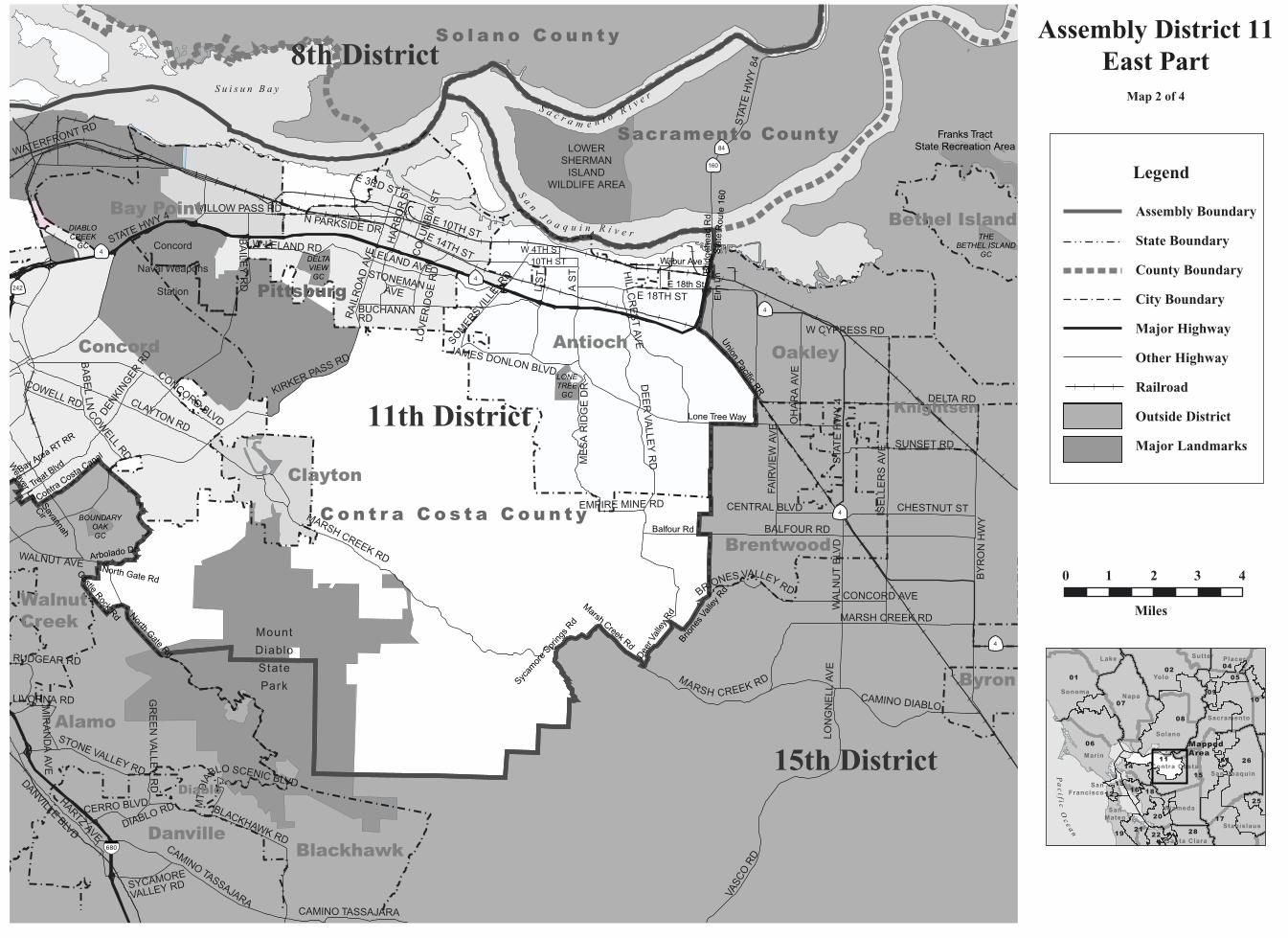
Assembly District 11East Part
Map 2 of 4
0 1 2 3 4
Miles
15
06
01
07
08
26
02
10
17
04
19
11
28
20
14
18
05
21
25
22
1613
09
12
Yolo
SonomaNapa
Solano
San Joaquin
Marin
Alameda
Sacramento
Stanislaus
Contra Costa
Lake Placer
Santa Clara
SanMateo
Sutter
SanFrancisco
Pa
ci f i c
Oc
e an
MappedArea
Legend
Assembly Boundary
State Boundary
County Boundary
City Boundary
Major Highway
Other Highway
Railroad
Outside District
Major Landmarks

PINOLEHIGH SCHOOL
CENTRAL COSTACOLLEGE
SAINTJOSEPHCEMETERY
DOCTORSHOSPITAL
14th District
11th District
SAN PABLO AVE
AP
PIA
N W
AY
SA
N PA
BLO
DA
M R
D
PINOLE VALLEY RD
HILLTOP DR
LUPINE RD
VALLE
Y V
IEW
RD
CASTRO
RANCH R
D
34T
H S
T
SHAWN D
R
SOLANO AVEGARVIN AVE
MCBRYDE AVE
WILS
ON
AVE
EVENS AVE
BA
RR
AN
CA
ST
PORTAL DR
SYCAMORE AVE
SHAMROCK DR
ESMOND AVE
MANOR RD
VALE
RD
MARICOPA AVE
CHURCH LN
AR
LING
TON
BLV
D
TARA HILLS DR
REDWOOD RD
SAN
PAB
LOD
AM R
D
SA
N PA
BLO
AVE
REFUGIOVALLEY
RDContra Costa County
0.28
Richmond
Pinole
Hercules
El Sobrante
San Pablo
Tara Hills
El Sobrante
BayviewMontalvin
EastRichmondHeights
El Sobrante
Rollingwood
WILDCAT CANYON REG PARK
ALVARADO PARK
KENNEDY GROVE REC AREA
FAIRMEADPARK
HILLTOP LAKE PARK
LA MONINEVALLEY PARK
HILLTOPGREENPARK
OHLONEPARK
FERNANDEZPARK
REFUGUIOVALLEYPARK
MEADOWPARK
LOUISE FRANCISPARK 80
80
Hilltop Dr
San PabloCreek
Phe
asan
t Ln
Sunset Dr
San Pablo Creek
B.N. Santa Fe RR
Bruno Rd
Gre
enrid
ge D
r
Castro Ranch Rd
San
Pabl
o Av
e
Valley View Rd
Richmond Pky
El Portal Dr
Canary Ln
Appian Way
May
Rd
Diane D
rFran W
ay
Canyon RdSan Pablo Creek
Assembly District 11Southwest Part
Map 3 of 4
0 0.5 1
Miles
15
06
01
07
08
26
02
10
17
04
19
11
28
20
14
18
05
21
25
22
1613
09
12
Yolo
SonomaNapa
Solano
San Joaquin
Marin
Alameda
Sacramento
Stanislaus
Contra Costa
Lake Placer
Santa Clara
SanMateo
Sutter
SanFrancisco
Pa
ci f i c
Oc
e an
MappedArea
Legend
Assembly Boundary
State Boundary
County Boundary
City Boundary
Major Highway
Other Highway
Other Road
Railroad
Outside District
Major Landmarks
Institutions

LAFAYETTECEMETERY
CONCORDH.S.
DIABLO VALLEYCOLLEGE
OAKMONTMEMORIAL
PARK
SAINT STEPHENCEMETERY
JOHN MUIRMED CEN
KAISERHOSPITAL
DELASALLE H.S.
CARONDELETH.S.
MOUNTDIABLOH.S.
IGNACIOVALLEYH.S.
MT DIABLOHOSPITAL
11th District
15th District
14th District
BUCHANANFIELD
N M
AIN
ST
TAY
LO
R B
LVD
PLE
AS
AN
T H
ILL R
D
CLAYTON RD
RE
LIEZ VA
LLEY
RD
OAK G
RO
VE R
D
N G
ATE
RD
WILLOW PASS RDCONCORD BLVD
ALH
AM
BR
A AV
E
YGNACIO VALLEY RD
GEARY RD
OLYMPIC BLVD
BOYD RD
MONUM
ENT BLV
D
CO
NT
RA
CO
STA
BLV
D
COWELL RD
WALNUT AVE
S M
AIN
ST
OA
K R
D
BU
EN
A V
ISTA
AV
E
MA
RK
ET
ST
OAK PARK BLVD
ME
AD
OW
LN
N C
IVIC
DR
BA
BE
L L
N
GRAYSON RD
MO
RA
GA
RD
EA
ST S
T
DEN
KING
ER R
D
ST MARYS RD
BAN
CR
OFT R
D
GA
LIN
DO
ST
MT DIABLO BLVD
1S
T S
T
CLAYTON RD
CO
WELL R
D
CONCORD AVE
GREGORY LN
VINE HILL WAY
CIV
IC D
R
OA
KLA
ND
BLV
D
MT DIABLO BLVD
YGNACIO VALLEY R
D
PLEASANT HILL RD
AMP
PATT
ER
SO
NB
LV
CONTRACOSTA
CC
BOUNDARYOAKGC
BUCHANANFIELDS
GC
CONCORDNAVAL WEAPONS
STA
Mount DiabloState Park
Concord
Walnut Creek
Lafayette
Pleasant Hill
Martinez
Alamo
Pacheco
BRIONES
REGIONAL
PARK
SHELL RIDGEOPEN SPACE
LIME RIDGE
OPEN SPACE
DIABLO FOOTHILLSREGIONAL PARK
HEATHERFARMSPARK
NEWHALLCOMMUNITY
PARK
HIDDEN VALLEY PARK
PASONOGALPARK
ACALANESOPEN SPACE
STERLING HILLSPARK
JOHN FBALDWIN
PARKHIDDEN LAKES PARK
WILLOW PASSPARK
242
24
680
680
680
North Gate Rd
Castle R
ock Rd
Contra C
osta C
anal
Reliez Valley R
d Walnut C
reek
Mayhew Way
Bay Area Rapid Tr
ansit RR
Paso
Nogal
1st Ave
Ironw
ood D
r 2nd Ave
Bro
okw
ood D
r
Weaver Ln
Arbolado Dr
Treat B
lvd
Chilpancingo Pky
Concord Ave
3rd AveChristen Dr
Hig
h S
t
4th Avenue South
Topaz Ln
Savannah C
ir
Contra Costa Canal
Reliez Valley Rd
Assembly District 11Concord Detail
Map 4 of 4
0 0.5 1
Miles
15
06
01
07
08
26
02
10
17
04
19
11
28
20
14
18
05
21
25
22
1613
09
12
Yolo
SonomaNapa
Solano
San Joaquin
Marin
Alameda
Sacramento
Stanislaus
Contra Costa
Lake Placer
Santa Clara
SanMateo
Sutter
SanFrancisco
Pa
ci f i c
Oc
e an
MappedArea
Legend
Assembly Boundary
State Boundary
County Boundary
City Boundary
Major Highway
Other Highway
Other Road
Railroad
Outside District
Major Landmarks
Institutions
C A L I F O R N I A A S S E M B LY D I S T R I C T S
Assembly Redistricting Plan (SB 802), September 13, 2001
The Honorable Robert M. Hertzberg, SpeakerState CapitolRoom 219Sacramento, CA 95814
The California State Assembly Rules CommitteeThe Honorable Dennis Cardoza, ChairP.O. Box 942849Sacramento, CA 94249-0001
The California State Assembly Committee on Elections, Reapportionment, and Constitutional AmendmentsThe Honorable John Longville, ChairP.O. Box 942849Sacramento, CA 94249-0001
Produced at California State University NorthridgeDr. Jolene Koester, President
Eugene Turner, Project DirectorDepartment of Geography18111 Nordhoff St.Northridge, CA 91330
with
Rubyjane Domingo, Pat Jolley, Meredith Leonard
2001
About the Maps
These maps present specific informationabout the features comprising the borders of theAssembly Districts of California that were cre-ated after the 2000 Census. Each of the 80 dis-tricts are represented by one to ten maps withthe number depending on the size of the districtand the complexity of the features followed bythe boundary. In general, the boundaries followcounty lines, city limit lines, and roads, butoccasionally canals, streams, and small roadsare followed.
The Assembly boundary data were creat-ed in digital form from Census 2000 TIGERfiles for California by Pactech Incorporated ofPasadena, CA. The boundary files were releasedin two forms, as a file of district polygons andas a file of line segments used to create thepolygons. Where these line segments were iden-tified, those identifiers were used to label themap boundaries. In addition, place boundarieswere created from the TIGER files.
Other map information such as roads,railroads, coastlines, and landmarks wereobtained from Geographic Data Technologies.Dynamap 2000 files (v10.1). Government landownership information such as national forestboundaries was obtained from a governmentland ownership layer prepared by the CaliforniaTeale Data Center.
Maps were prepared from the digitalfiles using Arcmap 8.1 software fromEnvironmental Systems Research Incorporated.An Albers equal area projection was used forthe maps with a central meridian of 120 degreeswest longitude and standard parallels of 30 and40 degrees of latitude. Coordinates are based onNAD83.
conneljw
About the Maps These maps present specific information about the features comprising the borders of the Assembly Districts of California that were created after the 2000 Census. Each of the 80 districts are represented by one to ten maps with the number depending on the size of the district and the complexity of the features followed by the boundary. In general, the boundaries follow county lines, city limit lines, and roads, but occasionally canals, streams, and small roads are followed. The Assembly boundary data were created in digital form from Census 2000 TIGER files for California by Pactech Incorporated of Pasadena, CA. The boundary files were released in two forms, as a file of district polygons and as a file of line segments used to create the polygons. Where these line segments were identified, those identifiers were used to label the map boundaries. In addition, place boundaries were created from the TIGER files. Other map information such as roads, railroads, coastlines, and landmarks were obtained from Geographic Data Technologies. Dynamap 2000 files (v10.1). Government land ownership information such as national forest boundaries was obtained from a government land ownership layer prepared by the California Teale Data Center. Maps were prepared from the digital files using Arcmap 8.1 software from Environmental Systems Research Incorporated. An Albers equal area projection was used for the maps with a central meridian of 120 degrees west longitude and standard parallels of 30 and 40 degrees of latitude. Coordinates are based on NAD83.
Related Documents