113 ANNALES · Ser. hist. sociol. · 24 · 2014 · 1 original scientific article UDC 911(497.57/.58) received: 2014-01-27 ARTIFICIAL PENINSULAS AND PSEUDO-ISLANDS OF CROATIA Josip FARIČIĆ University of Zadar, Department of Geography, F. Tudjmana 24i, 23 000 Zadar, Croatia e-mail: [email protected] Lena MIROŠEVIĆ University of Zadar, Department of Geography, F. Tudjmana 24i, 23 000 Zadar, Croatia e-mail: [email protected] ABSTRACT The paper discusses the artificial peninsulas and pseudo-islands of Croatia, i.e. technically bridged islands, which are linked to the neighbouring mainland or a larger island by means of a dike, bridge or both dike and bridge. Where- as artificial peninsulas are entirely incorporated into the mainland by means of dikes, pseudo-islands are connected to the mainland via bridges, thus losing some of their insular characteristics, particularly in terms of their functional link to the mainland. Croatian bridged islands played a vital role in the past as in times of war they represented refuges or places of permanent settlement. Nowadays, in times of marked littoralisation, these islands have experienced a dramatic change in function and physical appearance, mostly due to their transport connections with the mainland, which has naturally resulted in their inclusion in the tourist valorisation of natural and cultural heritage. On the one hand, this has contributed to the slowing down of the depopulation process, which is a basic social characteristic of most Croatian islands, but on the other hand, it has led to the spontaneous, uncoordinated, excessive building of apart- ments and other constructions which in size and shape have ruined the authentic cultural appearance of the islands. Key words: islands, artificial peninsulas, pseudo-islands, Croatian islands, Croatia, Adriatic PENISOLE ARTIFICIALI E PSEUDO ISOLE DELLA CROAZIA SINTESI Il saggio prende in esame l’argomento delle penisole artificiali e delle pseudo isole della Croazia, cioè le isole che tecnicamente non sono isole perché sono legate alla terraferma o a un’isola più grande da una diga o da un ponte, oppure da ambedue, diga e ponte. Mentre le penisole artificiali sono completamente incorporate alla terraferma tramite le dige, le pseudo-isole sono collegate alla terraferma da ponti, perdendo in tal modo alcune delle loro par- ticolarità insulari, in particolare quando si parla del collegamento funzionale alla terraferma. Le isole croate collegate alla terraferma da ponti giocarono un ruolo vitale nel passato, rappresentando in tempi di guerra rifugi o luoghi di stabilimento permanente. Oggi, nel periodo della marcata litoralizzazione, queste isole subiscono radicali cambiamenti nel funzionamento e nell’aspetto fisico, grazie maggiormente al collegamento di trasporto con la terraferma, il che naturalmente ha avuto come conseguenza la valorizzazione del loro patrimonio naturale e culturale a fini turistici. Da una parte ciò ha contribuito al rallentamento del processo dello spopolamento, che è la fondamentale caratteristica sociale della maggior parte delle isole croate, però d’altra parte ha portato alla spontanea, non coordinata, ed eccessiva costruzione di appartamenti, case da affitto e altre costruzioni che con le loro dimensioni e con la loro forma hanno rovinato l’autentico aspetto culturale delle isole. Parole chiave: isole, penisole artificiali, pseudo isole, isole croate, Croazia, Adriatico

Welcome message from author
This document is posted to help you gain knowledge. Please leave a comment to let me know what you think about it! Share it to your friends and learn new things together.
Transcript
113
ANNALES · Ser. hist. sociol. · 24 · 2014 · 1
original scientifi c article UDC 911(497.57/.58)received: 2014-01-27
ARTIFICIAL PENINSULAS AND PSEUDO-ISLANDS OF CROATIA
Josip FARIČIĆ University of Zadar, Department of Geography, F. Tudjmana 24i, 23 000 Zadar, Croatia
e-mail: [email protected]
Lena MIROŠEVIĆ University of Zadar, Department of Geography, F. Tudjmana 24i, 23 000 Zadar, Croatia
e-mail: [email protected]
ABSTRACT
The paper discusses the artifi cial peninsulas and pseudo-islands of Croatia, i.e. technically bridged islands, which are linked to the neighbouring mainland or a larger island by means of a dike, bridge or both dike and bridge. Where-as artifi cial peninsulas are entirely incorporated into the mainland by means of dikes, pseudo-islands are connected to the mainland via bridges, thus losing some of their insular characteristics, particularly in terms of their functional link to the mainland.
Croatian bridged islands played a vital role in the past as in times of war they represented refuges or places of permanent settlement. Nowadays, in times of marked littoralisation, these islands have experienced a dramatic change in function and physical appearance, mostly due to their transport connections with the mainland, which has naturally resulted in their inclusion in the tourist valorisation of natural and cultural heritage. On the one hand, this has contributed to the slowing down of the depopulation process, which is a basic social characteristic of most Croatian islands, but on the other hand, it has led to the spontaneous, uncoordinated, excessive building of apart-ments and other constructions which in size and shape have ruined the authentic cultural appearance of the islands.
Key words: islands, artifi cial peninsulas, pseudo-islands, Croatian islands, Croatia, Adriatic
PENISOLE ARTIFICIALI E PSEUDO ISOLE DELLA CROAZIA
SINTESI
Il saggio prende in esame l’argomento delle penisole artifi ciali e delle pseudo isole della Croazia, cioè le isole che tecnicamente non sono isole perché sono legate alla terraferma o a un’isola più grande da una diga o da un ponte, oppure da ambedue, diga e ponte. Mentre le penisole artifi ciali sono completamente incorporate alla terraferma tramite le dige, le pseudo-isole sono collegate alla terraferma da ponti, perdendo in tal modo alcune delle loro par-ticolarità insulari, in particolare quando si parla del collegamento funzionale alla terraferma.
Le isole croate collegate alla terraferma da ponti giocarono un ruolo vitale nel passato, rappresentando in tempi di guerra rifugi o luoghi di stabilimento permanente. Oggi, nel periodo della marcata litoralizzazione, queste isole subiscono radicali cambiamenti nel funzionamento e nell’aspetto fi sico, grazie maggiormente al collegamento di trasporto con la terraferma, il che naturalmente ha avuto come conseguenza la valorizzazione del loro patrimonio naturale e culturale a fi ni turistici. Da una parte ciò ha contribuito al rallentamento del processo dello spopolamento, che è la fondamentale caratteristica sociale della maggior parte delle isole croate, però d’altra parte ha portato alla spontanea, non coordinata, ed eccessiva costruzione di appartamenti, case da affi tto e altre costruzioni che con le loro dimensioni e con la loro forma hanno rovinato l’autentico aspetto culturale delle isole.
Parole chiave: isole, penisole artifi ciali, pseudo isole, isole croate, Croazia, Adriatico
114
ANNALES · Ser. hist. sociol. · 24 · 2014 · 1
Josip FARIČIĆ et al: ARTIFICIAL PENINSULAS AND PSEUDO-ISLANDS OF CROATIA, 113–128
INTRODUCTION
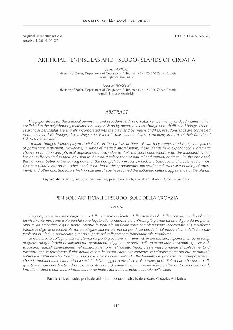
The frontal Croatian coastline, which encompasses most of the north-eastern Adriatic, consists of more than a thousand islands (Stražičić, 1997, Duplančić Leder et al., 2004). These islands form a complex area in which the sea, karst relief, Mediterranean climate, and rich fl ora and fauna mingle and co-exist with human activity and life in general. The islands are individual geographic microsystems, but also a basic natural, geo-graphic and socioeconomic developmental resource, with great potential, along with the limitations of eco-nomic exploitation. Since the Croatian islands are geo-graphically quite fragmented and dispersed, this results in problems related to transport connections with the mainland, which is one of the most prominent limiting factors for insular development (Stražičić, 1987). In this respect, certain Croatian bridged islands, or those linked to the neighbouring mainland by means of a dike, are the prominent ones.
The literature, both international and Croatian, con-tains many different insular typologies based upon vari-ous criteria, depending on the aims and methodologies of particular authors (Haila, 1990, King, 1933, Ratter and Sandner, 1996, Royle, 2001, Rubić, 1952, Magaš, 2008, Faričić et al., 2010). In this respect, Croatian insular ty-pology is no exception, and it represents a basis for nu-merous scientifi c discussions. The research focus of this paper are islands linked to the neighbouring mainland by dike, bridge or both dike and bridge (Fig. 1). Connect-ing islands to the neighbouring mainland by means of a
permanent construction contributes to natural and socio-economic changes. Therefore, the aim of this paper is to discuss the problems of defi ning and categorising these Croatian islands and to determine the fundamental char-acteristics of their socioeconomic development after be-ing linked to the mainland. The paper singles out several types of such islands according to the way in which they were connected to the mainland, and when, along with the implications. The typological division of Croatian bridged islands is based upon two main criteria:
a) type of connection b) impact of mainland connection on the socioeco-
nomic insular development.In order to achieve the aim of the research, a compar-
ative analysis of different sources of geographical data was carried out, including archival and cartographic sources and various demographic databases. The avail-able literature was studied, including mostly reviews of the historical development and geographic features of particular islands, with no particular emphasis on the type and implications of their connection with the main-land. In addition, fi eld observations and terrestrial and aerial photographs were used.
ARTIFICIAL PENINSULAS AND PSEUDO-ISLANDS OF CROATIA
Geography dictionaries generally defi ne islands as areas of land surrounded by sea, river or lake water (Dudley Stamp, 1961, Whittow, 1984, Mayhew, Penny, 1992, Clark, 1993, Cvitanović, 2002). The legal defi ni-tion given by United Nations Convention on the Law of the Sea is also important. Article 121 Paragraph 1 of the Convention defi nes an island as a naturally formed area of land, surrounded by water, which is above water at high tide (UN, 1982). According to these defi nitions it seems that islands should represent easily identifi able ar-eas, since the natural borderline between mainland and sea is absolutely clear. However, these defi nitions do not specify possible changes regarding insular connection to the mainland. Namely, insular features change signifi -cantly when permanent transport connections, bridges, tunnels or dikes replace occasional transport commu-nications such as maritime or air traffi c (Baldacchino, 2007). Due to their newly acquired physical changes, such islands can be diffi cult to categorise and conceptu-alise (Barthon, 2007). There are three elementary types of such islands in Croatia, which differ in the way they are linked to the mainland:
a) islands linked to the mainland by means of dikesb) islands linked to the mainland by means of bridgesc) islands linked to the mainland by means of dikes
and bridgesIf connected to the mainland by means of a dike, an
island loses its physical and functional insular features entirely. Moreover, the natural characteristics of the is-land and its surrounding waters undergo considerable
Figure 1 Artifi cial peninsulas and pseudo-islands of Croatia
115
ANNALES · Ser. hist. sociol. · 24 · 2014 · 1
Josip FARIČIĆ et al: ARTIFICIAL PENINSULAS AND PSEUDO-ISLANDS OF CROATIA, 113–128
modifi cations. For example, dikes prevent the fl ow of sea water between islands and the sea, along with the mixing of physical and chemical sea water characteris-tics, the exchange of nutritive elements and the migra-tion of marine organisms, etc. At the same time, dikes enable animal migration and the spread of fl ora from the mainland to the (former) island and vice versa.
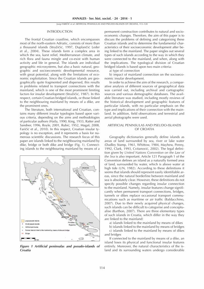
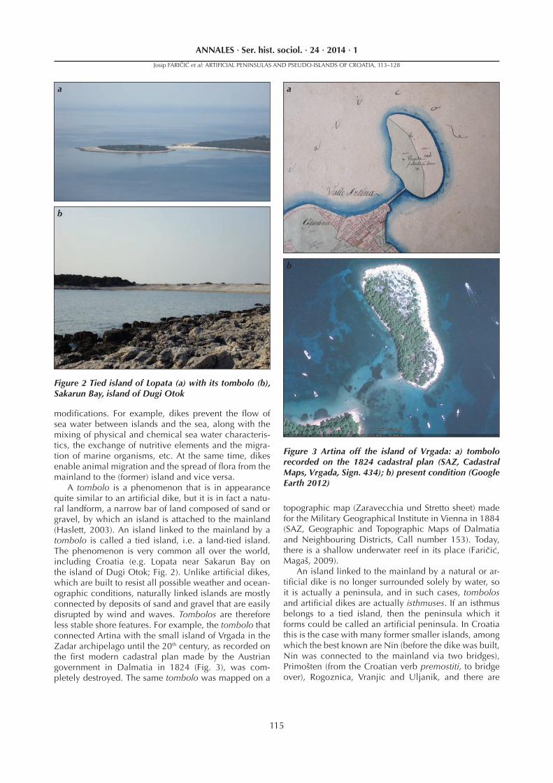
A tombolo is a phenomenon that is in appearance quite similar to an artifi cial dike, but it is in fact a natu-ral landform, a narrow bar of land composed of sand or gravel, by which an island is attached to the mainland (Haslett, 2003). An island linked to the mainland by a tombolo is called a tied island, i.e. a land-tied island. The phenomenon is very common all over the world, including Croatia (e.g. Lopata near Sakarun Bay on the island of Dugi Otok; Fig. 2). Unlike artifi cial dikes, which are built to resist all possible weather and ocean-ographic conditions, naturally linked islands are mostly connected by deposits of sand and gravel that are easily disrupted by wind and waves. Tombolos are therefore less stable shore features. For example, the tombolo that connected Artina with the small island of Vrgada in the Zadar archipelago until the 20th century, as recorded on the fi rst modern cadastral plan made by the Austrian government in Dalmatia in 1824 (Fig. 3), was com-pletely destroyed. The same tombolo was mapped on a
topographic map (Zaravecchia und Stretto sheet) made for the Military Geographical Institute in Vienna in 1884 (SAZ, Geographic and Topographic Maps of Dalmatia and Neighbouring Districts, Call number 153). Today, there is a shallow underwater reef in its place (Faričić, Magaš, 2009).
An island linked to the mainland by a natural or ar-tifi cial dike is no longer surrounded solely by water, so it is actually a peninsula, and in such cases, tombolos and artifi cial dikes are actually isthmuses. If an isthmus belongs to a tied island, then the peninsula which it forms could be called an artifi cial peninsula. In Croatia this is the case with many former smaller islands, among which the best known are Nin (before the dike was built, Nin was connected to the mainland via two bridges), Primošten (from the Croatian verb premostiti, to bridge over), Rogoznica, Vranjic and Uljanik, and there are
Figure 2 Tied island of Lopata (a) with its tombolo (b), Sakarun Bay, island of Dugi Otok
Figure 3 Artina off the island of Vrgada: a) tombolo recorded on the 1824 cadastral plan (SAZ, Cadastral Maps, Vrgada, Sign. 434); b) present condition (Google Earth 2012)
a
b
a
b
116
ANNALES · Ser. hist. sociol. · 24 · 2014 · 1
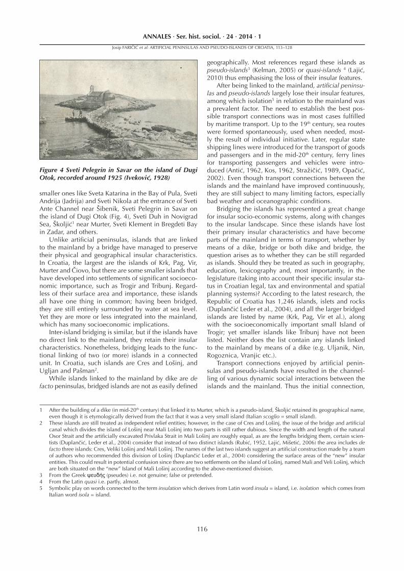
smaller ones like Sveta Katarina in the Bay of Pula, Sveti Andrija (Jadrija) and Sveti Nikola at the entrance of Sveti Ante Channel near Šibenik, Sveti Pelegrin in Savar on the island of Dugi Otok (Fig. 4), Sveti Duh in Novigrad Sea, Školjić1 near Murter, Sveti Klement in Bregdeti Bay in Zadar, and others.
Unlike artifi cial peninsulas, islands that are linked to the mainland by a bridge have managed to preserve their physical and geographical insular characteristics. In Croatia, the largest are the islands of Krk, Pag, Vir, Murter and Čiovo, but there are some smaller islands that have developed into settlements of signifi cant socioeco-nomic importance, such as Trogir and Tribunj. Regard-less of their surface area and importance, these islands all have one thing in common; having been bridged, they are still entirely surrounded by water at sea level. Yet they are more or less integrated into the mainland, which has many socioeconomic implications.
Inter-island bridging is similar, but if the islands have no direct link to the mainland, they retain their insular characteristics. Nonetheless, bridging leads to the func-tional linking of two (or more) islands in a connected unit. In Croatia, such islands are Cres and Lošinj, and Ugljan and Pašman2.
While islands linked to the mainland by dike are de facto peninsulas, bridged islands are not as easily defi ned
geographically. Most references regard these islands as pseudo-islands3 (Kelman, 2005) or quasi-islands 4 (Lajić, 2010) thus emphasising the loss of their insular features.
After being linked to the mainland, artifi cial peninsu-las and pseudo-islands largely lose their insular features, among which isolation5 in relation to the mainland was a prevalent factor. The need to establish the best pos-sible transport connections was in most cases fulfi lled by maritime transport. Up to the 19th century, sea routes were formed spontaneously, used when needed, most-ly the result of individual initiative. Later, regular state shipping lines were introduced for the transport of goods and passengers and in the mid-20th century, ferry lines for transporting passengers and vehicles were intro-duced (Antić, 1962, Kos, 1962, Stražičić, 1989, Opačić, 2002). Even though transport connections between the islands and the mainland have improved continuously, they are still subject to many limiting factors, especially bad weather and oceanographic conditions.
Bridging the islands has represented a great change for insular socio-economic systems, along with changes to the insular landscape. Since these islands have lost their primary insular characteristics and have become parts of the mainland in terms of transport, whether by means of a dike, bridge or both dike and bridge, the question arises as to whether they can be still regarded as islands. Should they be treated as such in geography, education, lexicography and, most importantly, in the legislature (taking into account their specifi c insular sta-tus in Croatian legal, tax and environmental and spatial planning systems)? According to the latest research, the Republic of Croatia has 1,246 islands, islets and rocks (Duplančić Leder et al., 2004), and all the larger bridged islands are listed by name (Krk, Pag, Vir et al.), along with the socioeconomically important small Island of Trogir; yet smaller islands like Tribunj have not been listed. Neither does the list contain any islands linked to the mainland by means of a dike (e.g. Uljanik, Nin, Rogoznica, Vranjic etc.).
Transport connections enjoyed by artifi cial penin-sulas and pseudo-islands have resulted in the channel-ling of various dynamic social interactions between the islands and the mainland. Thus the initial connection,
1 After the building of a dike (in mid-20th century) that linked it to Murter, which is a pseudo-island, Školjić retained its geographical name, even though it is etymologically derived from the fact that it was a very small island (Italian scoglio = small island).
2 These islands are still treated as independent relief entities; however, in the case of Cres and Lošinj, the issue of the bridge and artifi cial canal which divides the island of Lošinj near Mali Lošinj into two parts is still rather dubious. Since the width and length of the natural Osor Strait and the artifi cially excavated Privlaka Strait in Mali Lošinj are roughly equal, as are the lengths bridging them, certain scien-tists (Duplančić, Leder et al., 2004) consider that instead of two distinct islands (Rubić, 1952, Lajić, Mišetić, 2006) the area includes de facto three islands: Cres, Veliki Lošinj and Mali Lošinj. The names of the last two islands suggest an artifi cial construction made by a team of authors who recommended this division of Lošinj (Duplančić Leder et al., 2004) considering the surface areas of the “new” insular entities. This could result in potential confusion since there are two settlements on the island of Lošinj, named Mali and Veli Lošinj, which are both situated on the “new” Island of Mali Lošinj according to the above-mentioned division.
3 From the Greek ψευδής (pseudes) i.e. not genuine; false or pretended.4 From the Latin quasi i.e. partly, almost.5 Symbolic play on words connected to the term insulation which derives from Latin word insula = island, i.e. isolation which comes from
Italian word isola = island.
Figure 4 Sveti Pelegrin in Savar on the island of Dugi Otok, recorded around 1925 (Iveković, 1928)
Josip FARIČIĆ et al: ARTIFICIAL PENINSULAS AND PSEUDO-ISLANDS OF CROATIA, 113–128
117
ANNALES · Ser. hist. sociol. · 24 · 2014 · 1
apart from providing physical integration, gradually af-fects other aspects of the fusion of the island with the neighbouring mainland, especially in the case of smaller islands, whose integration has been much faster. This is probably why such islands were excluded from the list of islands, islets and rocks in the most recent research conducted on the number, area and coastline length of the Croatian islands (Duplančić Leder et al., 2004).
Larger bridged islands, primarily owing to their size and geographical indentedness, are not entirely fused with the mainland, even though bridging has contrib-uted to their transport connections, as well as their eco-nomic and demographic development.
This is the main reason why research papers, de-velopment programmes, the environmental and spatial planning systems of coastal counties, and legislative reg-ulations governing certain privileges enjoyed by island populations, refer to them as islands. For instance, they have been included in fundamental provisions which deal with insular development issues – the National Is-land Development Programme (Starc et al., 1997) and Islands Act (Zakon o otocima, 1999). In regard to the physical appearance of these islands, it is possible to determine differences in the degree to which they are integrated with the mainland in terms of the distance of island settlements from the mainland.
ARTIFICIAL PENINSULAS
Small islands are usually connected to the mainland by means of dikes (and sometimes to neighbouring larg-er islands). Although the connection is artifi cial, such is-lands have the physical appearance of peninsulas. In the past, they played an important role, because they served as refuges from perils and threats from the mainland, especially the Ottoman invasions on the north-eastern Adriatic coast. Compact settlements with houses, nar-row streets, small town squares and a narrow shoreline sprang up. The best examples are Nin, Primošten, Ro-goznica and Vranjic.
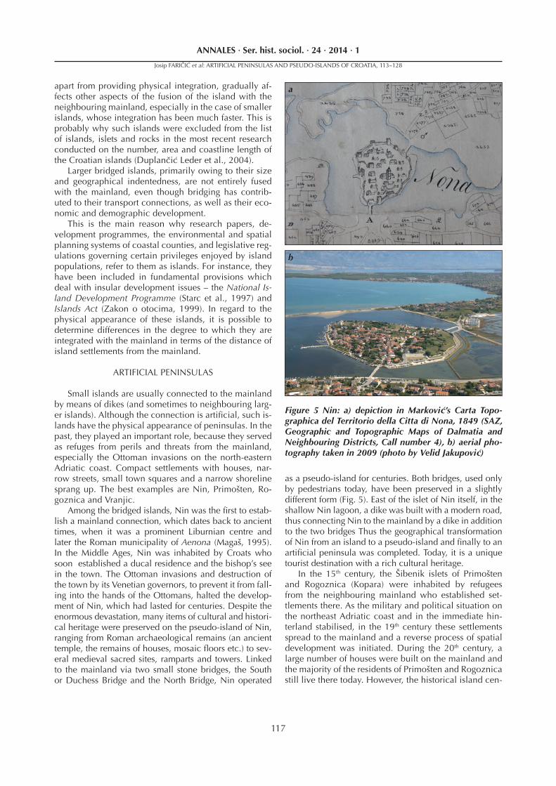
Among the bridged islands, Nin was the fi rst to estab-lish a mainland connection, which dates back to ancient times, when it was a prominent Liburnian centre and later the Roman municipality of Aenona (Magaš, 1995). In the Middle Ages, Nin was inhabited by Croats who soon established a ducal residence and the bishop’s see in the town. The Ottoman invasions and destruction of the town by its Venetian governors, to prevent it from fall-ing into the hands of the Ottomans, halted the develop-ment of Nin, which had lasted for centuries. Despite the enormous devastation, many items of cultural and histori-cal heritage were preserved on the pseudo-island of Nin, ranging from Roman archaeological remains (an ancient temple, the remains of houses, mosaic fl oors etc.) to sev-eral medieval sacred sites, ramparts and towers. Linked to the mainland via two small stone bridges, the South or Duchess Bridge and the North Bridge, Nin operated
as a pseudo-island for centuries. Both bridges, used only by pedestrians today, have been preserved in a slightly different form (Fig. 5). East of the islet of Nin itself, in the shallow Nin lagoon, a dike was built with a modern road, thus connecting Nin to the mainland by a dike in addition to the two bridges Thus the geographical transformation of Nin from an island to a pseudo-island and fi nally to an artifi cial peninsula was completed. Today, it is a unique tourist destination with a rich cultural heritage.
In the 15th century, the Šibenik islets of Primošten and Rogoznica (Kopara) were inhabited by refugees from the neighbouring mainland who established set-tlements there. As the military and political situation on the northeast Adriatic coast and in the immediate hin-terland stabilised, in the 19th century these settlements spread to the mainland and a reverse process of spatial development was initiated. During the 20th century, a large number of houses were built on the mainland and the majority of the residents of Primošten and Rogoznica still live there today. However, the historical island cen-
Figure 5 Nin: a) depiction in Marković’s Carta Topo-graphica del Territorio della Citta di Nona, 1849 (SAZ, Geographic and Topographic Maps of Dalmatia and Neighbouring Districts, Call number 4), b) aerial pho-tography taken in 2009 (photo by Velid Jakupović)
a
b
Josip FARIČIĆ et al: ARTIFICIAL PENINSULAS AND PSEUDO-ISLANDS OF CROATIA, 113–128
118
ANNALES · Ser. hist. sociol. · 24 · 2014 · 1
tres are still important as centres of local administration, where the parish church, commercial buildings and docks, etc., are located .
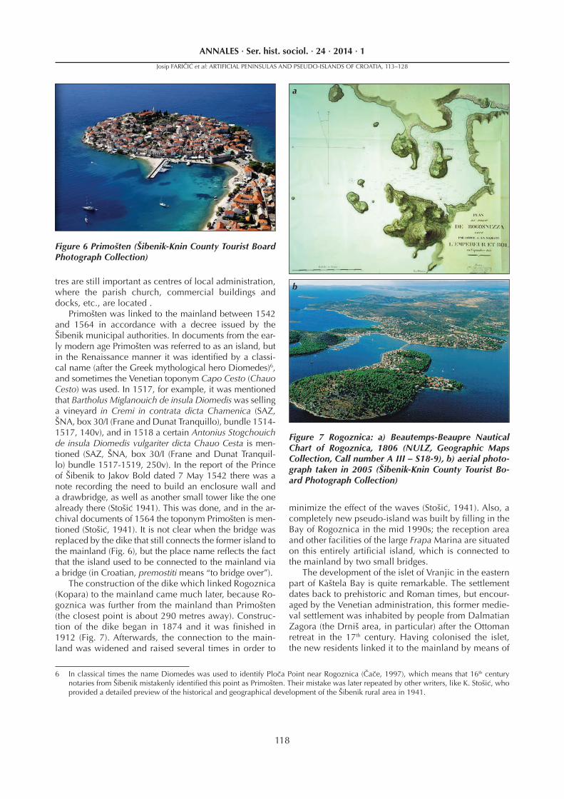
Primošten was linked to the mainland between 1542 and 1564 in accordance with a decree issued by the Šibenik municipal authorities. In documents from the ear-ly modern age Primošten was referred to as an island, but in the Renaissance manner it was identifi ed by a classi-cal name (after the Greek mythological hero Diomedes)6, and sometimes the Venetian toponym Capo Cesto (Chauo Cesto) was used. In 1517, for example, it was mentioned that Bartholus Miglanouich de insula Diomedis was selling a vineyard in Cremi in contrata dicta Chamenica (SAZ, ŠNA, box 30/I (Frane and Dunat Tranquillo), bundle 1514-1517, 140v), and in 1518 a certain Antonius Stogchouich de insula Diomedis vulgariter dicta Chauo Cesta is men-tioned (SAZ, ŠNA, box 30/I (Frane and Dunat Tranquil-lo) bundle 1517-1519, 250v). In the report of the Prince of Šibenik to Jakov Bold dated 7 May 1542 there was a note recording the need to build an enclosure wall and a drawbridge, as well as another small tower like the one already there (Stošić 1941). This was done, and in the ar-chival documents of 1564 the toponym Primošten is men-tioned (Stošić, 1941). It is not clear when the bridge was replaced by the dike that still connects the former island to the mainland (Fig. 6), but the place name refl ects the fact that the island used to be connected to the mainland via a bridge (in Croatian, premostiti means “to bridge over”).
The construction of the dike which linked Rogoznica (Kopara) to the mainland came much later, because Ro-goznica was further from the mainland than Primošten (the closest point is about 290 metres away). Construc-tion of the dike began in 1874 and it was fi nished in 1912 (Fig. 7). Afterwards, the connection to the main-land was widened and raised several times in order to
minimize the effect of the waves (Stošić, 1941). Also, a completely new pseudo-island was built by fi lling in the Bay of Rogoznica in the mid 1990s; the reception area and other facilities of the large Frapa Marina are situated on this entirely artifi cial island, which is connected to the mainland by two small bridges.
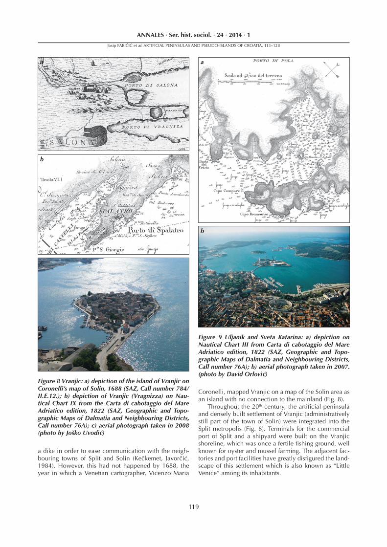
The development of the islet of Vranjic in the eastern part of Kaštela Bay is quite remarkable. The settlement dates back to prehistoric and Roman times, but encour-aged by the Venetian administration, this former medie-val settlement was inhabited by people from Dalmatian Zagora (the Drniš area, in particular) after the Ottoman retreat in the 17th century. Having colonised the islet, the new residents linked it to the mainland by means of
6 In classical times the name Diomedes was used to identify Ploča Point near Rogoznica (Čače, 1997), which means that 16th century notaries from Šibenik mistakenly identifi ed this point as Primošten. Their mistake was later repeated by other writers, like K. Stošić, who provided a detailed preview of the historical and geographical development of the Šibenik rural area in 1941.
Figure 6 Primošten (Šibenik-Knin County Tourist Board Photograph Collection)
Figure 7 Rogoznica: a) Beautemps-Beaupre Nautical Chart of Rogoznica, 1806 (NULZ, Geographic Maps Collection, Call number A III – S18-9), b) aerial photo-graph taken in 2005 (Šibenik-Knin County Tourist Bo-ard Photograph Collection)
a
b
Josip FARIČIĆ et al: ARTIFICIAL PENINSULAS AND PSEUDO-ISLANDS OF CROATIA, 113–128
119
ANNALES · Ser. hist. sociol. · 24 · 2014 · 1
a dike in order to ease communication with the neigh-bouring towns of Split and Solin (Kečkemet, Javorčić, 1984). However, this had not happened by 1688, the year in which a Venetian cartographer, Vicenzo Maria
Coronelli, mapped Vranjic on a map of the Solin area as an island with no connection to the mainland (Fig. 8).
Throughout the 20th century, the artifi cial peninsula and densely built settlement of Vranjic (administratively still part of the town of Solin) were integrated into the Split metropolis (Fig. 8). Terminals for the commercial port of Split and a shipyard were built on the Vranjic shoreline, which was once a fertile fi shing ground, well known for oyster and mussel farming. The adjacent fac-tories and port facilities have greatly disfi gured the land-scape of this settlement which is also known as “Little Venice” among its inhabitants.
Figure 8 Vranjic: a) depiction of the island of Vranjic on Coronelli’s map of Solin, 1688 (SAZ, Call number 784/II.E.12.); b) depiction of Vranjic (Vragnizza) on Nau-tical Chart IX from the Carta di cabotaggio del Mare Adriatico edition, 1822 (SAZ, Geographic and Topo-graphic Maps of Dalmatia and Neighbouring Districts, Call number 76A); c) aerial photograph taken in 2008 (photo by Joško Uvodić)
Figure 9 Uljanik and Sveta Katarina: a) depiction on Nautical Chart III from Carta di cabotaggio del Mare Adriatico edition, 1822 (SAZ, Geographic and Topo-graphic Maps of Dalmatia and Neighbouring Districts, Call number 76A); b) aerial photograph taken in 2007. (photo by David Orlović)
a
c
b
a
b
Josip FARIČIĆ et al: ARTIFICIAL PENINSULAS AND PSEUDO-ISLANDS OF CROATIA, 113–128
120
ANNALES · Ser. hist. sociol. · 24 · 2014 · 1
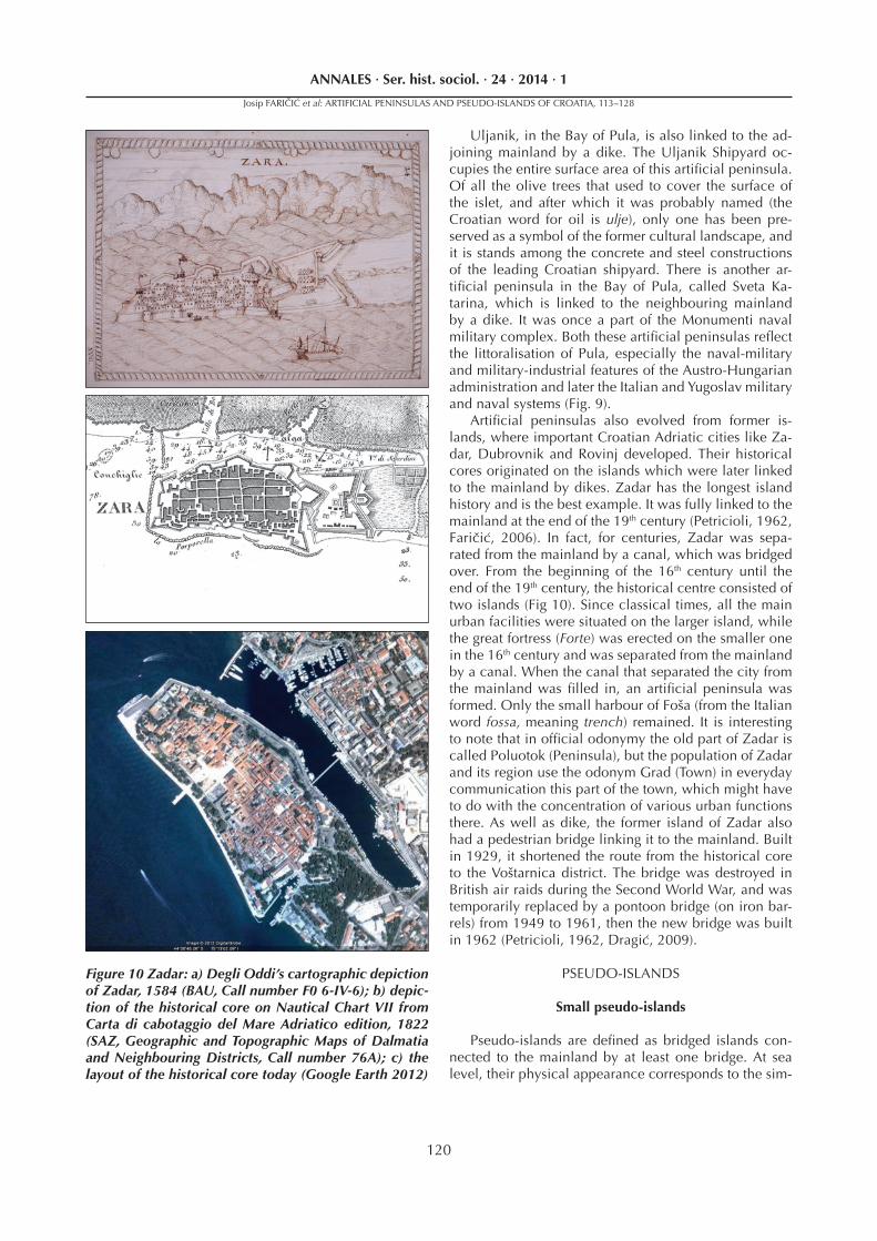
Uljanik, in the Bay of Pula, is also linked to the ad-joining mainland by a dike. The Uljanik Shipyard oc-cupies the entire surface area of this artifi cial peninsula. Of all the olive trees that used to cover the surface of the islet, and after which it was probably named (the Croatian word for oil is ulje), only one has been pre-served as a symbol of the former cultural landscape, and it is stands among the concrete and steel constructions of the leading Croatian shipyard. There is another ar-tifi cial peninsula in the Bay of Pula, called Sveta Ka-tarina, which is linked to the neighbouring mainland by a dike. It was once a part of the Monumenti naval military complex. Both these artifi cial peninsulas refl ect the littoralisation of Pula, especially the naval-military and military-industrial features of the Austro-Hungarian administration and later the Italian and Yugoslav military and naval systems (Fig. 9).
Artifi cial peninsulas also evolved from former is-lands, where important Croatian Adriatic cities like Za-dar, Dubrovnik and Rovinj developed. Their historical cores originated on the islands which were later linked to the mainland by dikes. Zadar has the longest island history and is the best example. It was fully linked to the mainland at the end of the 19th century (Petricioli, 1962, Faričić, 2006). In fact, for centuries, Zadar was sepa-rated from the mainland by a canal, which was bridged over. From the beginning of the 16th century until the end of the 19th century, the historical centre consisted of two islands (Fig 10). Since classical times, all the main urban facilities were situated on the larger island, while the great fortress (Forte) was erected on the smaller one in the 16th century and was separated from the mainland by a canal. When the canal that separated the city from the mainland was fi lled in, an artifi cial peninsula was formed. Only the small harbour of Foša (from the Italian word fossa, meaning trench) remained. It is interesting to note that in offi cial odonymy the old part of Zadar is called Poluotok (Peninsula), but the population of Zadar and its region use the odonym Grad (Town) in everyday communication this part of the town, which might have to do with the concentration of various urban functions there. As well as dike, the former island of Zadar also had a pedestrian bridge linking it to the mainland. Built in 1929, it shortened the route from the historical core to the Voštarnica district. The bridge was destroyed in British air raids during the Second World War, and was temporarily replaced by a pontoon bridge (on iron bar-rels) from 1949 to 1961, then the new bridge was built in 1962 (Petricioli, 1962, Dragić, 2009).
PSEUDO-ISLANDS
Small pseudo-islands
Pseudo-islands are defi ned as bridged islands con-nected to the mainland by at least one bridge. At sea level, their physical appearance corresponds to the sim-
Figure 10 Zadar: a) Degli Oddi’s cartographic depiction of Zadar, 1584 (BAU, Call number F0 6-IV-6); b) depic-tion of the historical core on Nautical Chart VII from Carta di cabotaggio del Mare Adriatico edition, 1822 (SAZ, Geographic and Topographic Maps of Dalmatia and Neighbouring Districts, Call number 76A); c) the layout of the historical core today (Google Earth 2012)
Josip FARIČIĆ et al: ARTIFICIAL PENINSULAS AND PSEUDO-ISLANDS OF CROATIA, 113–128
121
ANNALES · Ser. hist. sociol. · 24 · 2014 · 1
ple geographical defi nition of islands, even after being bridged over. From a functional point of view, these is-lands include small islands which have been fully incor-porated into the mainland and whose historical cores have spread to the mainland, where most residential, commercial and other buildings and communal infra-structure are located, and where most of the population lives. Unfortunately, there are no precise statistical data that can be used to determine the ratio between the number of housing units and population on pseudo-is-lands and on the mainland. Nevertheless, on the basis of original archival and cartographic documentation and the available data, it is possible to reconstruct the his-torical and geographical development of Croatia’s most important small pseudo-islands – Tribunj and Trogir.
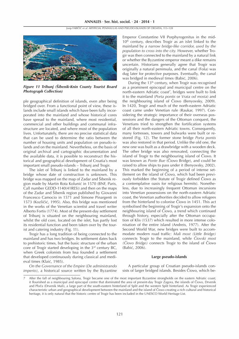
The islet of Tribunj is linked to the mainland by a bridge whose date of construction is unknown. This bridge was mapped on the map of Zadar and Šibenik re-gion made by Martin Rota Kolunić in 1570 (BNF, Paris, Call number GEDD-1140(41RES)) and then on the maps of the Zadar and Šibenik region published by Giovanni Francesco Camocio in 1571 and Simone Pinargenti in 1573 (Kozličić, 1995). Also, this bridge was mentioned in the works of the Venetian scientist and travel writer Alberto Fortis (1774). Most of the present-day settlement of Tribunj is situated on the neighbouring mainland, whilst the old core, located on the islet, has partly lost its residential function and been taken over by the tour-ist and catering industry (Fig. 11).
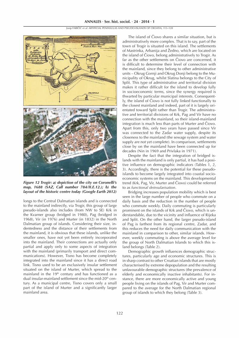
Trogir has a long tradition of being connected to the mainland and has two bridges. Its settlement dates back to prehistoric times, but the basic structure of the urban core of Trogir started developing in the 3rd century BC, when Greek colonists from Issa founded a settlement that developed continuously during classical and medi-eval times (Klaić, 1985).
On the Governance of the Empire (De administrando imperio), a historical source written by the Byzantine
Emperor Constantine VII Porphyrogenitus in the mid-10th century, describes Trogir as an islet linked to the mainland by a narrow bridge-like corridor, used by the population to cross into the city. However, whether Tro-gir was then connected to the mainland by a natural link or whether the Byzantine emperor meant a dike remains uncertain. Historians generally agree that Trogir was originally a natural peninsula, and the canal (Foša) was dug later for protective purposes. Eventually, the canal was bridged in medieval times (Babić, 2006).
During the 13th century, when Trogir was recognised as a prominent episcopal and municipal centre on the north-eastern Adriatic coast7, bridges were built to link it to the mainland (Porta pontis or Vrata od mosta) and the neighbouring island of Čiovo (Benyovsky, 2009). In 1420, Trogir and much of the north-eastern Adriatic coast came under Venetian rule (Raukar, 1997). Con-sidering the strategic importance of their overseas pos-sessions and the dangers of the Ottoman conquest, the Venetians tried to strengthen the fortifi cation systems of all their north-eastern Adriatic towns. Consequently, many fortresses, towers and bulwarks were built or re-stored (Fig. 12). The former stone bridge Porta pontis was also restored in that period. Unlike the old one, the new one was built as a drawbridge with a wooden deck. The other bridge was also renovated, connecting the island of Trogir to the neighbouring island of Čiovo. It was known as Ponte Bue (Čiovo Bridge), and could be raised to allow ships to pass under it (Benyovsky, 2002). This marked the beginning of a period of intense set-tlement on the island of Čiovo, which had been previ-ously forbidden (the Statute of Trogir defi ned Čiovo as a contemplative oasis for religious hermits). Nonethe-less, due to increasingly frequent Ottoman incursions into Venetian possessions on the north-eastern Adriatic coast, the Venetian authorities decided to allow refugees from the hinterland to colonise Čiovo in 1451. This act symbolised the beginning of Trogir’s expansion onto the neighbouring island of Čiovo, a trend which continued through history, especially after the Ottoman occupa-tion of Klis (1537) which resulted in more intense colo-nisation of the entire island (Andreis, 1977). After the Second World War, new bridges were built to accom-modate modern road traffi c: Mali most (Little Bridge) connects Trogir to the mainland, while Čiovski most (Čiovo Bridge) connects Trogir to the island of Čiovo (Babić, 2006).
Large pseudo-islands
A particular group of Croatian pseudo-islands con-sists of larger bridged islands. Besides Čiovo, which be-
Figure 11 Tribunj (Šibenik-Knin County Tourist Board Photograph Collection)
7 After the fall of neighbouring Salona, Trogir became one of the most important Byzantine strongholds on the eastern Adriatic coast; it fl ourished as a municipal and episcopal centre that dominated the area of present-day Trogir Zagora, the islands of Čiovo, Drvenik and Ploča (Drvenik Mali), a large part of the south-eastern hinterland of Split and the western Split hinterland. As Trogir experienced characteristic urban and geographical development between the mainland and the island of Čiovo creating a rich cultural and historical heritage, it is only natural that the historic centre of Trogir has been included in the UNESCO World Heritage List.
Josip FARIČIĆ et al: ARTIFICIAL PENINSULAS AND PSEUDO-ISLANDS OF CROATIA, 113–128
122
ANNALES · Ser. hist. sociol. · 24 · 2014 · 1
The island of Čiovo shares a similar situation, but is administratively more complex. That is to say, part of the town of Trogir is situated on this island. The settlements of Mastrinka, Arbanija and Žedno, which are located on the island of Čiovo, belong administratively to Trogir. As far as the other settlements on Čiovo are concerned, it is diffi cult to determine their level of connection with the mainland, since they belong to other administrative units – Okrug Gornji and Okrug Donji belong to the Mu-nicipality of Okrug, whilst Slatina belongs to the City of Split. This type of administrative and territorial division makes it rather diffi cult for the island to develop fully in socioeconomic terms, since the synergy required is thwarted by particular municipal interests. Consequent-ly, the island of Čiovo is not fully linked functionally to the closest mainland and indeed, part of it is largely ori-entated toward Split rather than Trogir. The administra-tive and territorial divisions of Krk, Pag and Vir have no connection with the mainland, so their island-mainland integration is much less than parts of Murter and Čiovo. Apart from this, only two years have passed since Vir was connected to the Zadar water supply, despite its closeness to the mainland (the sewage system and water supply are not yet complete). In comparison, settlements close by on the mainland have been connected up for decades (Nin in 1969 and Privlaka in 1971).
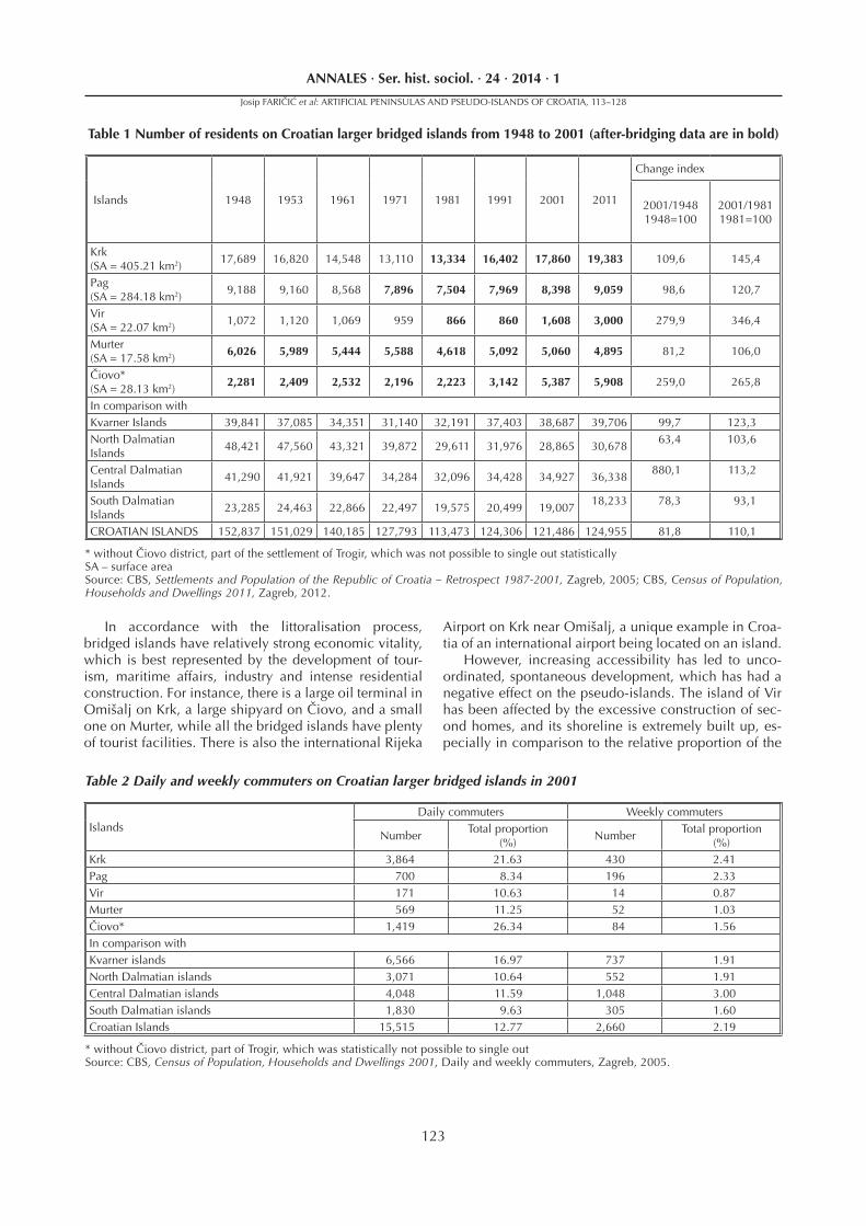
Despite the fact that the integration of bridged is-lands with the mainland is only partial, it has had a posi-tive infl uence on demographic indicators (Tables 1, 2, 3). Accordingly, there is the potential for these pseudo-islands to become largely integrated into coastal socio-economic systems on the mainland. This developmental trend (Krk, Pag, Vir, Murter and Čiovo) could be referred to as functional deinsularisation.
Bridging increases population mobility which is best seen in the large number of people who commute on a daily basis and the reduction in the number of people who commute weekly. Daily commuting is particularly prominent on the islands of Krk and Čiovo, which is un-derstandable, due to the vicinity and infl uence of Rijeka and Split. On the other hand, the larger pseudo-island of Pag is farthest from its regional centre, Zadar, and this reduces the need for daily communication with the mainland in comparison to other, similar islands. How-ever, weekly commuting is above the average level for the group of North Dalmatian Islands to which this is-land belongs (Table 2).
Demographic growth infl uences demographic struc-tures, particularly age and economic structures. This is in sharp contrast to other Croatian islands that are mostly characterised by extreme depopulation and the resulting unfavourable demographic structures (the prevalence of elderly and economically inactive inhabitants). For in-stance, there are more economically active and young people living on the islands of Pag, Vir and Murter com-pared to the average for the North Dalmatian regional group of islands to which they belong (Table 3).
Figure 12 Trogir: a) depiction of the city on Coronelli’s map, 1688 (SAZ, Call number 784/II.E.12.); b) the layout of the historic centre today (Google Earth 2012)
longs to the Central Dalmatian islands and is connected to the mainland indirectly, via Trogir, this group of large pseudo-islands also includes (from NW to SE) Krk in the Kvarner group (bridged in 1980), Pag (bridged in 1968), Vir (in 1976) and Murter (in 1832) in the North Dalmatian group of islands. Considering their size, in-dentedness and the distance of their settlements from the mainland, it is obvious that these islands, unlike the smaller ones, have not yet been entirely incorporated into the mainland. Their connections are actually only partial and apply only to some aspects of integration with the mainland (primarily transport and direct com-munications). However, Tisno has become completely integrated into the mainland since it has a direct road link. Tisno used to be an exclusively insular settlement situated on the island of Murter, which spread to the mainland in the 19th century and has functioned as a dual insular-mainland settlement since the mid-20th cen-tury. As a municipal centre, Tisno covers only a small part of the island of Murter and a signifi cantly larger mainland area.
Josip FARIČIĆ et al: ARTIFICIAL PENINSULAS AND PSEUDO-ISLANDS OF CROATIA, 113–128
a
b
123
ANNALES · Ser. hist. sociol. · 24 · 2014 · 1
Islands 1948 1953 1961 1971 1981 1991 2001 2011
Change index
2001/19481948=100
2001/19811981=100
Krk (SA = 405.21 km2)
17,689 16,820 14,548 13,110 13,334 16,402 17,860 19,383 109,6 145,4
Pag (SA = 284.18 km2)
9,188 9,160 8,568 7,896 7,504 7,969 8,398 9,059 98,6 120,7
Vir (SA = 22.07 km2)
1,072 1,120 1,069 959 866 860 1,608 3,000 279,9 346,4
Murter (SA = 17.58 km2)
6,026 5,989 5,444 5,588 4,618 5,092 5,060 4,895 81,2 106,0
Čiovo* (SA = 28.13 km2)
2,281 2,409 2,532 2,196 2,223 3,142 5,387 5,908 259,0 265,8
In comparison withKvarner Islands 39,841 37,085 34,351 31,140 32,191 37,403 38,687 39,706 99,7 123,3North Dalmatian Islands
48,421 47,560 43,321 39,872 29,611 31,976 28,865 30,67863,4 103,6
Central Dalmatian Islands
41,290 41,921 39,647 34,284 32,096 34,428 34,927 36,338880,1 113,2
South Dalmatian Islands
23,285 24,463 22,866 22,497 19,575 20,499 19,00718,233 78,3 93,1
CROATIAN ISLANDS 152,837 151,029 140,185 127,793 113,473 124,306 121,486 124,955 81,8 110,1
Table 1 Number of residents on Croatian larger bridged islands from 1948 to 2001 (after-bridging data are in bold)
* without Čiovo district, part of the settlement of Trogir, which was not possible to single out statisticallySA – surface areaSource: CBS, Settlements and Population of the Republic of Croatia – Retrospect 1987-2001, Zagreb, 2005; CBS, Census of Population, Households and Dwellings 2011, Zagreb, 2012.
IslandsDaily commuters Weekly commuters
NumberTotal proportion
(%)Number
Total proportion(%)
Krk 3,864 21.63 430 2.41Pag 700 8.34 196 2.33Vir 171 10.63 14 0.87Murter 569 11.25 52 1.03Čiovo* 1,419 26.34 84 1.56In comparison withKvarner islands 6,566 16.97 737 1.91North Dalmatian islands 3,071 10.64 552 1.91Central Dalmatian islands 4,048 11.59 1,048 3.00South Dalmatian islands 1,830 9.63 305 1.60Croatian Islands 15,515 12.77 2,660 2.19
* without Čiovo district, part of Trogir, which was statistically not possible to single out Source: CBS, Census of Population, Households and Dwellings 2001, Daily and weekly commuters, Zagreb, 2005.
Table 2 Daily and weekly commuters on Croatian larger bridged islands in 2001
In accordance with the littoralisation process, bridged islands have relatively strong economic vitality, which is best represented by the development of tour-ism, maritime affairs, industry and intense residential construction. For instance, there is a large oil terminal in Omišalj on Krk, a large shipyard on Čiovo, and a small one on Murter, while all the bridged islands have plenty of tourist facilities. There is also the international Rijeka
Airport on Krk near Omišalj, a unique example in Croa-tia of an international airport being located on an island.
However, increasing accessibility has led to unco-ordinated, spontaneous development, which has had a negative effect on the pseudo-islands. The island of Vir has been affected by the excessive construction of sec-ond homes, and its shoreline is extremely built up, es-pecially in comparison to the relative proportion of the
Josip FARIČIĆ et al: ARTIFICIAL PENINSULAS AND PSEUDO-ISLANDS OF CROATIA, 113–128
124
ANNALES · Ser. hist. sociol. · 24 · 2014 · 1
total number of housing units. Even though the inten-sive construction of second homes has been happening along the entire Adriatic coast since the 1970s, Vir has become a prime example of a mistake that should never be repeated. It is true that the current situation is a direct result of the 1970s Yugoslav government policy which, at one point, considered building a nuclear power plant on the Island of Vir. This resulted in low real-estate prices; however the nuclear plant was never built and consequently the result was excessive building of sec-ond homes. According to the 1971 Population Census, Vir had only 253 housing units, and 3.6% of them were second homes. The result of excessive and spontane-ous construction was that by 2001, Vir had 6,573 hous-ing units, 90.1% of which were second homes (Table 4). Finally, the total number of housing units increased 25 times between 1971 and 2001 while the number of second homes increased 661 times; at the same time, the number of permanent residents increased only by 67.7%! Second homes on the island of Vir account for
Table 3 Age and economic structures of populations on bridged islands according to the 2001 population census (in %)
* omitting part of Trogir situated on Čiovo, which was statistically not possible to single outSource: CBS, Census of Population, Households and Dwellings 2001, Population according to Age and Sex, Zagreb, 2005; CBS, Census of Population, Households and Dwellings 2001, Population according to Activity, Zagreb, 2005.
IslandsAge structure
(by age groups)Economic structure
0-19 20-59 60 and over Active InactiveKrk 22.82 45.19 38.46 42.59 57.41Pag 22.20 50.18 27.44 41.33 58.67Vir 21.21 54.98 23.01 39.12 60.88Murter 21.86 48.36 29.29 39.07 60.93Čiovo* 24.06 53.70 21.50 38.70 61.30Kvarner islands 22.71 53.83 22.81 43.96 56.04North Dalmatian islands 19.70 47.90 32.40 35.50 64.50Central Dalmatian islands 22.30 51.30 26.40 42.46 57.54South Dalmatian islands 22.91 50.81 26.01 41.70 58.30Croatian islands; Total 21.92 50.94 26.63 40.86 59.14
up to 30% of all second homes on the North Dalmatian islands. Despite bans and warnings that illegal build-ings would be demolished, construction continued on the island of Vir, and according to the fi rst, incomplete data of the 2011 Census of Population, Households and Dwellings, there were 12,750 dwellings on the island. However, only 1,297 of them were permanently inhab-ited, which means that approximately 11,000 of them were used as second homes (the number of dwellings used for other purposes was unknown). If we multiply the number of housing units by 4, which is the average number of tenants/tourists that reside in them during the tourist season, we arrive at the fi gure of 44,000 tourists and only 3,000 local residents (14.7:1)!
Bridging Vir to the mainland has affected the increase in the number of residents as well as tourist develop-ment on the island. However, the excessive building of second homes was neither well planned nor coordi-nated. It was not supported by an adequate municipal infrastructure (sewage and water supply, roads etc.), and
Settlement
1971 2001Total number of
housing unitsSecond homes
Total number of housing units
Second homes
Number SA (m2)Number
Total proportion
(%)SA (m2)
Total propor-
tion(%)
Number SA (m2) Number
Total propor-
tion(%)
SA (m2)
Total propor-
tion(%)
Pag 2,096 150,092 325 15.5 19,153 12.8 12,065 828,355 5,572 46.2 364,313 44.0Vir 253 13,997 9 3.6 385 2.8 6,573 566,036 5,960 90.7 503,594 89.0Murter 1,701 133,162 630 37.0 37,710 28.3 4,688 349,627 2,042 43.6 147,559 42.2Total 11,291 785,656 2,008 17.8 118,872 15.1 37,095 2,766,918 19,762 53.3 1,438,337 52.0
Table 4 Comparison of total number of housing units and second homes on North Dalmatian islands in 1971 and 2001
Sources: FIS, Population and Housing Census 1971, Dwellings – Size, ownership, households and persons, Bk. II, Belgrade, 1972; FIS, Population and housing census 1971, Vacation and Recreation Dwellings, Bk. VI, Federal Institute for Statistics, Belgrade, 1973; CBS, Population, Housing and Dwelling Census 2001, Dwellings by Occupancy, Zagreb, 2002.
Josip FARIČIĆ et al: ARTIFICIAL PENINSULAS AND PSEUDO-ISLANDS OF CROATIA, 113–128
125
ANNALES · Ser. hist. sociol. · 24 · 2014 · 1
the aesthetics of the old island settlements were spoiled. Valuable parts of the coastline that attracted investors became overcrowded, as the many buildings erected along the coastline actually exhausted coastal resourc-es. To a certain extent, a similar thing has happened on parts of Krk, Pag, Murter and Čiovo.
CONCLUSION
Bridged islands, i.e. islands linked to the mainland by means of a dike or bridge, form a particular group of islands. Artifi cial peninsulas are created in cases of insu-lar connection to the mainland by means of a dike (Ul-janik, Nin, Primošten, Rogoznica, Vranjic etc.) whereas pseudo-islands are the result of insular connection to the mainland by means of a bridge. They have lost some of their insular characteristics, especially in terms of trans-port connections to the mainland, and this contributes to multiple functional ties. Due to the diversity of their historical and geographical bridging, two categories of islands can be determined.
The fi rst category of pseudo-islands includes gener-ally smaller islands which have both physically as well as functionally fused with the neighbouring mainland (Tribunj and Trogir).
The other category, from the Croatian point of view, comprises larger islands functionally marked by partial deinsularisation (Pag, Krk, Vir, Murter and Čiovo). This typological classifi cation is based on an analysis of de-mographic and economic data and on the results of fi eld research.
The research results show that pseudo-islands tend to have more favourable demographic trends and struc-tures, and the mobility of their population is stronger than on non-bridged islands. In fact, pseudo-islands are more actively involved in the processes of littoralisation, characterised by the intense concentration of social and economic activities along the narrow coastline, while the hinterland and small and distant islands in particular are characterised by depopulation processes and eco-nomic depression. Of course, littoralisation, as a com-prehensive process in coastal regions, also affects many other Croatian islands, particularly the larger ones lo-cated close to the mainland. On these islands, unlike artifi cial peninsulas and pseudo-islands, the process has been mostly local in character (social and economic activities are concentrated in the narrow coastal strip, while the interior of the islands has become depopulat-ed and marked by economic stagnation or regression).
Josip FARIČIĆ et al: ARTIFICIAL PENINSULAS AND PSEUDO-ISLANDS OF CROATIA, 113–128
126
ANNALES · Ser. hist. sociol. · 24 · 2014 · 1
HRVATSKI UMJETNI POLUOTOCI I PSEUDO-OTOCI
Josip FARIČIĆ Univerza v Zadru, Oddelek za geografi jo, F. Tudjmana 24i, 23 000 Zadar, Hrvaška
e-mail: [email protected]
Lena MIROŠEVIĆ Univerza v Zadru, Oddelek za geografi jo, F. Tudjmana 24i, 23 000 Zadar, Hrvaška
e-mail: [email protected]
SAŽETAK
U radu se razmatraju hrvatski umjetni poluotoci i pseudo-otoci. Radi se o otocima koji su tehničkim zahvatima premošteni, tj. spojeni sa susjednim kopnom ili susjednim većim otokom putem nasipa, putem mosta te putem nasi-pa i mosta. U slučaju spajanja otoka s kopnom putem nasipa oblikuju se umjetni poluotoci (Uljanik, Nin, Primošten, Rogoznica, Vranjic i dr.), a u slučaju spajanja s kopnom putem mosta stvaraju se pseudo-otoci. Takvi otoci izgubili su dio svojih inzularnih obilježja osobito u pogledu prometnog povezivanja s kopnom što pridonosi višestrukim funkcionalnim vezama. Zbog njihova različitog povijesno-geografskog okvira premoštavanja, osobito onih otoka povezanih putem mosta s kopnom, moguće je razlikovati dvije kategorije takvih otoka. Prvu kategoriju pseudo-otoka čine uglavnom manji otoci, koji su u potpunosti fi zionomski i funkcionalno srasli sa susjednim kopnom (Tribunj i Trogir). Druga kategorija su, u hrvatskim razmjerima, veći otoci koji u funkcionalnom smislu obilježava parcijalna deinzularizacija (Pag, Krk, Vir, Murter i Čiovo).
Hrvatski umjetni poluotoci i pseudo-otoci tijekom prošlosti imali su veliko značenje jer su u vrijeme ratnih sukoba na susjednom kopnu često imali ulogu utočišta ili mjesta trajnijeg nastanjivanja. U suvremeno doba ti otoci se fi zi-onomski i funkcionalno znatno preobražavaju, uglavnom poradi činjenice da su prometno integrirani sa susjednim kopnom te, sukladno tome, intenzivno uključeni u turističko vrjednovanje prirodne i kulturne baštine. To je s jedne strane pridonijelo ublažavanju procesa depopulacije, temeljnoga društvenog obilježja većine hrvatskih otoka, a s druge strane spontanoj i nekoordinarnoj prekomjernoj izgradnji stanova za odmor te drugih graditeljskih zahvata koji svojim dimenzijama i oblikom narušavaju izvorni otočni kulturni ambijent.
Istraživanjem je utvrđeno da pseudo-otoci imaju povoljnije demografske trendove i odgovarajuće demo-grafske strukture te da je veća mobilnost na relaciji otok – kopno u odnosu na otoke koji nisu premošteni. Zapravo, pseudo-otoci su u većoj mjeri uključeni u litoralizacijske procese koje u hrvatskim prilikama obilježava intenzivno okupljanje društvenih i gospodarskih aktivnosti uz uski obalni pojas dok zaobalni prostor te najveći dio otočnog prostora (posebno mali i od kopna udaljeni otoci) obilježava depopulacija i gospodarska depresija. Naravno, litora-lizacija je kao sveobuhvatan proces u obalnim regijama zahvatila i brojne druge hrvatske otoke, osobito veće i bliže kopnu, s time da je, za razliku od umjetnih poluotoka i pseudo-otoka, na tim otocima taj proces uglavnom lokalnih razmjera (društvene i gospodarske aktivnosti okupljaju se uz uski obalni rub otoka, dok je unutrašnjost otoka depo-pulirala i gospodarski stagnirala ili nazadovala).
Ključne riječi: otoci, umjetni poluotoci, pseudo otoci, hrvatski otoci, Hrvatska, Jadran
Josip FARIČIĆ et al: ARTIFICIAL PENINSULAS AND PSEUDO-ISLANDS OF CROATIA, 113–128
127
ANNALES · Ser. hist. sociol. · 24 · 2014 · 1
ARCHIVAL RECORDS
BAU – Biblioteca Arcivescovale Udine, Map of Za-dar in Degli Oddi’s isolario Viaggio de la Provincie di Mare della Signoria di Venetia, Venice, 1584, Call num-ber F0 6-IV-6.
BNF – Bibliothèque nationale de France, Paris, Mar-tin Rota Kolunić: Map of Zadar and Šibenik region, 1570, Call number GEDD-1140(41RES).
CBS – Croatian Bureau of Statistics, Census of Popu-lation, Households and Dwellings 2001, Population ac-cording to Activity, Zagreb, 2005.
CBS – Croatian Bureau of Statistics, Census of Popu-lation, Households and Dwellings 2011, First Results, Zagreb, 2011.
CBS – Croatian Bureau of Statistics, Census of Pop-ulation, Households and Dwellings 2001, Daily and weekly commuters, Zagreb, 2005.
CBS – Croatian Bureau of Statistics, Census of Popu-lation, Households and Dwellings 2001, Population ac-cording to Age and Sex, Zagreb, 2005.
CBS – Croatian Bureau of Statistics, Population, Housing and Dwelling Census 2001, Dwellings by Oc-cupancy, Zagreb, 2005.
CBS – Croatian Bureau of Statistics, Settlements and Population of the Republic of Croatia – Retrospect 1987-2001, Zagreb, 2005.
FIS – Federal Institute for Statistics, Population and Housing Census 1971, Dwellings – Size, ownership, households and persons, Bk. II, Belgrade, 1972.
FIS – Federal Institute for Statistics, Population and housing census 1971, Vacation and Recreation Dwell-ings, Bk. VI, Belgrade, 1973.
NULZ – National and University Library in Zagreb, Geographic Maps Collection, Nautical Chart of Ro-goznica from Beautemps-Beaupre manuscript atlas of North-Eastern Adriatic, 1806, Call number A III – S18-9.
SAZ – State Archives in Zadar, Cadastral Maps, Vr-gada, Vienna, 1824, Call number 434.
SAZ – State Archives in Zadar, Geographic and Topo-graphic Maps of Dalmatia and Neighbouring Districts, Carta Topographica del Territorio della Citta di Nona, Zadar, 1849, Call number 4.
SAZ – State Archives in Zadar, Geographic and Topo-graphic Maps of Dalmatia and Neighbouring Districts, Nautical Charts III, VII and IX from Carta di cabotaggio del Mare Adriatico edition, Milan, 1822, Call number 76A.
SAZ – State Archives in Zadar, Geographic and Topo-graphic Maps of Dalmatia and Neighbouring Districts, Topographical Map in scale 1:75,000, Sheet Zaravec-chia und Stretto, Military Geographical Institute, Vien-na, 1884, Call number 153.
SAZ – State Archives in Zadar, Maps of Zadar, Trogir and Solin in Coronelli’s isolario Mari, Golfi , Isole, Spi-aggie, Porti, Citta, Fortezze ed altri Louoghi dell’ Istria, Quarner, Dalmazia, Albania, Epiro e Livadia, Venice,
1688, Call number 784/II.E.12.SAZ, ŠNA – State Archives in Zadar, Šibenik Notary
Archive, box 30/I (Frane and Dunat Tranquillo), bundle 1514-1517, 140v.
SAZ, ŠNA – State Archives in Zadar, Šibenik Notary Archive, box 30/I (Frane and Dunat Tranquillo), bundle 1517-1519, 250v.
REFERENCES
Andreiss, P. (1977): Povijest grada Trogira I i II. Split, Splitski književni krug.
Antić, V. (1962): Pomorstvo i naš turizam. In: No-vak, G., Maštrović, V. (ed.): Pomorski zbornik, I. Zadar, Institut za historijske i ekonomske nauke JAZU u Zadru, 987-1058.
Baldacchino, G. (2006): Islands, Island Studies, Is-land Studies Journal 1, 1. Charlottetown, 3-18.
Barthon, C. (2007): Bridge Impacts on Islands off the West Coast of France. In: Baldacchino, G.: Bridging Is-lands – The Impact of Fixed Links. Charlottetown, Acorn Press, 219-235.
Benyovsky, I. (2002): Urbane promjene u Trogiru u prvim desetljećima mletačke vlasti (1420.-1450.). Pov-ijesni prilozi, 23. Zagreb, 71-86.
Benyovsky, I. (2009): Srednjovjekovni Trogir – Pros-tor i društvo. Zagreb, Hrvatski institut za povijest.
Clark, A. N. (1993): Dictionary of Geography. Lon-don, Longman.
Čače, S. (1997): Promunturium Diomedis (Plin. Nat. hist. 3, 141 ). Radovi Filozofskog fakulteta Zadar, 35. Razdio povijesnih znanosti, 22. Zadar, 21-45.
Dragić, A. (2009): Zadar – Obnova i razvoj (1945.-2006.). Zadar, Gradska knjižnica Zadar.
Dudley Stamp, L. (1961.): A Glossary of Geographi-cal Terms. London: Longmans, Green and Co., Ltd.
Duplančić Leder, T., Ujević, T., Čala, M. (2004): Coastline lengths and areas of islands in the Croatian part of Adriatic Sea determined from the topographic maps at the scale of 1:25.000. Geoadria, 9, 1. Zadar, 5-32.
Faričić, J. (2006a): Sjevernodalmatinski otoci u pro-cesu litoralizacije. PhD thesis. Zagreb, Prirodoslovno-matematički fakultet Sveučilišta u Zagrebu.
Faričić, J. (2006b): Geografski aspekti razvitka za-darske luke. In: Kozličić, M. (ed.): Jadranske studije – Luke istočnog Jadrana, 1. Orebić, Zaklada C. Fisković, 67-96.
Faričić, J., Magaš, D. (2009): Geografski ambijent oblikovanja i korištenja toponima na otoku Vrgadi, In: Skračić, V. (ed.): Toponimija otoka Vrgade, Biblioteka Onomastica Adriatica. Zadar, Centar za onomastička istraživanja Sveučilišta u Zadru, 11-59.
Faričić, J., Graovac, V. & Čuka, A. (2010): Mali hr-vatski otoci – radno-rezidencijalni prostor i/ili prostor odmora i rekreacije. Croatian Small Islands – Residential and/or Leisure Area. Geoadria, 15, 1. Zadar, 145-185.
Josip FARIČIĆ et al: ARTIFICIAL PENINSULAS AND PSEUDO-ISLANDS OF CROATIA, 113–128
128
ANNALES · Ser. hist. sociol. · 24 · 2014 · 1
Fortis, A. (1774): Viaggio in Dalmazia. Venezia.Hache, J. D. (2007): Islands, Fixed Links, and the
European Union. In: Baldacchino, G.: Bridging Islands – The Impact of Fixed Links. Charlottetown, Acorn Press, 161-184.
Haila, Y. (1990): Toward an Ecological Defi nition of an Island: A Northwest European Perspective. Journal of Biogeography, 17, 6. New York, 561-568.
Haslett, S. K. (2003): Coastal Systems. London, Routledge.
Jurić, A. (1989.): Vranjic. In: Brajković, V.: Pomorska enciklopedija, 8. Zagreb, JLZ Mirosav Krleža, 518.
Kečkemet, D., Javorčić, I. (1984): Vranjic kroz vje-kove. Split, Institut za historiju radničkog pokreta u Dal-maciji.
Kelman, I. (2005): What are islands, isolated geogra-phies, and small states?, http://www.islandvulnerability.org/background.html
King, R. (1993): The Geographical Fascination of Islands, In: Lockhart, D. G., Drakakis Smith, D. and Schembri, J. (eds.): The Development Process in Small Island States. London and New York, Routledge, 13-37.
Klaić, N. (1985): Trogir u srednjem vijeku, 2. Split, Izdanja Muzeja grada Trogira.
Kos, L. (1962): O novom saobraćajnom povezivanju naših otoka sa kopnom. In: Novak, G., Maštrović, V. (ed.): Pomorski zbornik, I. Zadar, Institut za historijske i ekonomske nauke JAZU u Zadru, 901-921.
Kozličić, M. (1995.): Kartografski spomenici hrvat-skog Jadrana. Zagreb, AGM.
Iveković, Ć. M. (1928): Dugi otok i Kornat. Rad JAZU, 235. Zagreb, 245-279.
Lajić, I. (2010): Mali otoci Hrvatske i njihova de-mografska perspektiva – primjer otoka Ista. In: Faričić, J. (ed.): Otoci Ist i Škarda. Zadar, Sveučilište u Zadru, Zavod za prostorno uređenje Zadarske županije, Mat-ica hrvatska – Ogranak u Zadar i Hrvatsko geografsko društvo – Zadar, 31-42.
Lajić, I., Mišetić, R. (2006): Otočni logaritam – Aktu-alno stanje i suvremeni demografski procesi na jadran-skim otocima. Zagreb, Institut za migracije i narodnosti and Ministarstvo mora, turizma, prometa i razvitka.
Magaš, D. (2008): Geografske posebnosti razvitka malih hrvatskih otoka. In: Faričić, J. (ed.): Otok Rava.
Zadar, Sveučilište u Zadru, Razred za prirodne znanosti HAZU, Matica hrvatska – Zadar, Hrvatsko geografsko društvo – Zadar, 19-42.
Mayhew, S., Penny, A. (1992.): The Concise Oxford Dictionary of Geography. Oxford, Oxford University Press.
Opačić, V. T. (2002.): Geografski aspekt proučavanja trajektnog prometa: Primjer hrvatskog otočja. Geoadria, 7, 2. Zadar, 95-109.
Petricioli, I. (1962): Urbanistički razvoj zadar-ske luke. In: Novak, G., Maštrović, V. (ed.): Pomorski zbornik, II. Zadar, Institut za historijske i ekonomske nauke JAZU u Zadru, 1453-1466.
Petricioli, I. (1999): Stari Zadar u slici i riječi. Zadar, Narodni muzej.
Ratter, B. M. W., Sandner, G. (1996): Small Islands, Large Questions: Introduction to Special Issue. Geogra-phische Zeitschrift, 84, 2. Stuttgart, 63-66.
Raukar, T. (1997): Hrvatsko srednjovjekovlje. Za-greb, Školska knjiga.
RC (1999): Islands Act (Zakon o otocima). Narodne novine, 34. Zagreb, Republic of Croatia.
Royle, S. A. (2001): A Geography of Islands – small island insularity. London and New York, Routledge.
Rubić, I. (1952): Naši otoci na Jadranu. Split, Izdanje Odbora za proslavu desetgodišnjice Mornarice.
Starc, N., Kaštelan-Macan, M. and Ćurlin, S. (eds)(1997): National Island Development Programme (Na-cionalni program razvitka otoka). Zagreb, Ministry of Reconstruction and Development (Ministarstvo obnove i razvitka).
Stošić, K. (1941): Sela šibenskog kotara. Šibenik, Tiskara Kačić.
Stražičić, N. (1987): Prirodno-geografske značajke kao poticajni i ograničavajući faktori razvoja jadranskih otoka. Pomorski zbornik, 25. Rijeka, 39-55.
Stražičić, N. (1989): Pomorska geografi ja Jugoslavi-je. Zagreb, Školska knjiga.
Stražičić, N. (1997): Prilog poznavanju ukupnog broja hrvatskih jadranskih otoka i broja naseljenih otoka među njima. Pomorski zbornik, 35. Rijeka, 219-240.
UN (1982): United Nations Convention on the Law of the Sea. New York, United Nations.
Whittow, J. (1984.): Dictionary of Physical Geogra-phy. London, Penguin Books.
Josip FARIČIĆ et al: ARTIFICIAL PENINSULAS AND PSEUDO-ISLANDS OF CROATIA, 113–128
Related Documents