Welcome message from author
This document is posted to help you gain knowledge. Please leave a comment to let me know what you think about it! Share it to your friends and learn new things together.
Transcript
Although unimpressive in its initial years, this small collection of residential and commercial buildings described by Albert Gallatin in 1801 eventually grew into the Capitol Hill of today, including the monumental federal complex around the Capitol that holds international significance, and the extensive residential neighborhoodthat stretches beyond this core to the east.
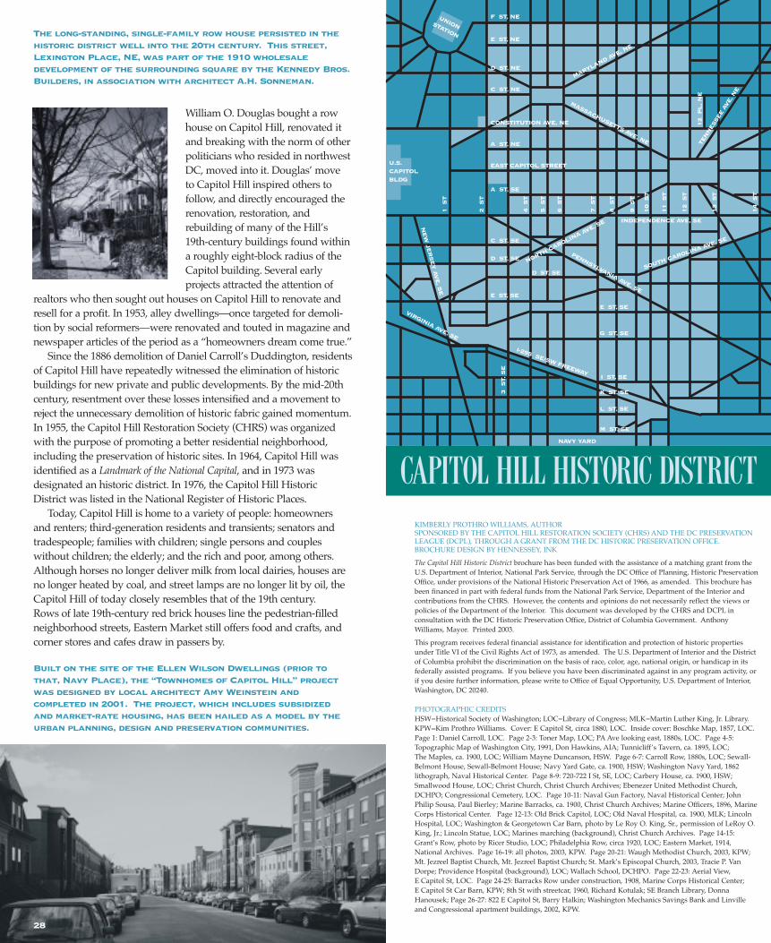
The Capitol Hill Historic District is one of the oldest residentialneighborhoods of Washington, DC. It is a large area stretching as fareast of the U.S. Capitol grounds as 14th Street, south to the Navy Yard,and north to F Street, NE. The district, which includes 200 city squares and approximately 8,000 buildings, is one of the largest historic districts in the country. Its history spans the history of the city, beginning as a cluster of boarding houses around the Capitol to servemembers of Congress and as a small, working-class communityaround the Navy Yard. Its principal period of growth occurredbetween 1880 and 1893 as residential development expanded toaccommodate the growing numbers of middle-class governmentworkers. Following this building boom and up to the mid-20th century, the neighborhood continued to push eastward, filling in theextensive open land between the Capitol and the Anacostia River.Although Capitol Hill owes its existence and growth to the presenceof the federal government, the historic district excludes the Capitolgrounds and the monumental core, and instead recognizes the neighborhood, its residents, and local institutions.
The street pattern of Capitol Hill follows Peter (Pierre) L’Enfant’splan, where a city grid intersects with diagonal avenues to create avariety of rectangular and irregular-shaped open spaces that serve asparks and green spaces. The wide avenues, with their deep setbacksand tall buildings provide grandeur, while the narrower, tree-lined grid streets offer an intimate feel and small-town charm. Architecturally, Capitol Hill is characterized by its cohesive collections of intact 19th-century row houses that line the major avenues and hidden alleys and reflect a variety of period styles, dominated by richly detailed and highly ornate brick Queen Anne examples. Historic churches, schools, commercialand institutional buildings punctuate these rows of residences.
Around the Capitol are seven or eight boarding houses, one tailor, one shoemaker, one printer, a washingwoman, a grocery shop, a pamphletsand stationery shop, a small dry-goods shop, and an oyster house.This makes the whole of the Federal city as connected with the Capitol.” (Secretary of the Treasury, AlbertGallatin to his wife, January 1801)
“
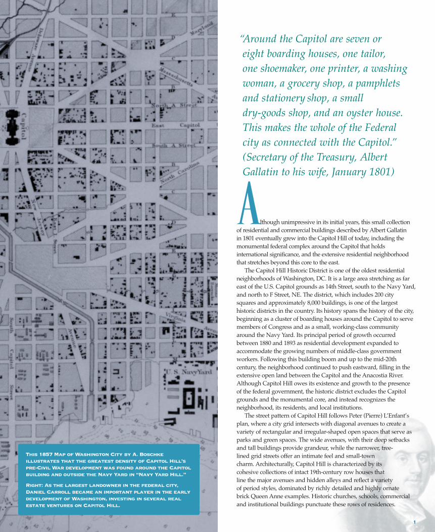
This 1857 Map of Washington City by A. Boschke illustrates that the greatest density of Capitol Hill’s pre-Civil War development was found around the Capitolbuilding and outside the Navy Yard in “Navy Yard Hill.”
Right: As the largest landowner in the federal city,Daniel Carroll became an important player in the earlydevelopment of Washington, investing in several realestate ventures on Capitol Hill.
1

E A R LY H I S T O R Y
Prior to European settlement, Indian tribes of the Algonquin familyinhabited much of present-day Washington, DC. Nacochthanke, thelargest Indian village in the area was located on the eastern shore ofthe Anacostia. In 1889, an old village site was recorded as being “just south of the Capitol, north of Garfield Park between 1st and 2ndStreets, SE.” Although some of the land forming Capitol Hill wascleared by the Indians for cultivation, most of it was heavily woodedand remained so until the mid-18th-century. By then, the majority ofthe land was owned by Charles Carroll, of the prominent MarylandCarroll family; Notley Young, longtime land owner in the area; andothers, including Jonathan Slater, all of whom had cleared the forests, established plantations, and began the cultivation of tobaccoand other crops.
Just prior to the establishment of the federal city, the area that laterdeveloped as Capitol Hill consisted of several large tracts of landextending east of Jenkins Hill (present site of the Capitol). While thehill’s western slopes remained heavily wooded, the plateau stretchingeast was cleared of trees and under cultivation. On this land above theAnacostia River two principal landowners, Charles Carroll ofCarrollsburg and Jonathan Slater, operated plantations. The 1,400 acresof land owned by Charles Carroll since circa 1760 extended south ofthe Capitol to the Anacostia River. When Carroll built his Georgianhouse, Duddington Manor near Greenleaf Point (site of present FortMcNair), it was one of the first houses in the vicinity. During his three-decade-long ownership, Carroll divided his land into smaller tracts,including a 160-acre section which he platted as the town ofCarrollsburg. Although the town never materialized, a reference to itsurvives in the 20th-century naming of the street, Carrollsburg Place insouthwest DC. Another section of his land, including Jenkins Hill, thefuture site of the Capitol, went to his son Daniel Carroll of Duddington.In 1791, Daniel Carroll became one of the original nineteen city
proprietors who deeded land to the federal government for the establishment of the nation’s capitol.
Jonathan Slater, owner of approximately 500 acres, purchased themajority of his land in 1764 and added to it over the years. Like othermiddle-size planters of his day, Slater resided on and worked his ownland, living in his house near the present-day intersection of 8th andM Streets, SE. In March of 1791, Slater sold his land to William Prout, a British merchant and his future son-in-law. Prout purchased the land as a speculative venture with the expectation that it would beincluded in the new federal city. Like Daniel Carroll, Prout becameone of the original city proprietors and was committed to the buildingof a new community on Capitol Hill.
T H E F E D E R A L C I T Y
Following the selection of Washington as the site for the federal city,the French artist and engineer, Major Peter (Pierre) Charles L’Enfant,prepared his famous plan for a portion of the ten-mile-square city, centered at the confluence of the Potomac River and the EasternBranch (Anacostia River). L’Enfant’s plan combined an orthogonal citygrid with diagonal avenues that took advantage of the natural terrain and allowed for expansive vistas. Capitol Hill figured prominently on L’Enfant’s plan with the Capitol, or “CongressHouse,” sited on Jenkins Hill, one of the highest points within the newWashington City, and described by him as a “pedestal waiting for asuperstructure.” From the Capitol, wide avenues radiated on the diagonal and along the compass points, interrupted at major intersections by “reservations,” or open spaces that L’Enfant intendedas places for monuments and memorials. For Lincoln Park, located on a rise of land one mile east of the Capitol, L’Enfant envisioned a “historic column” that would mark the prime meridian for the entirecontinent. Based upon L’Enfant’s plan, it was widely expected that the
2 3
Circa 1880 view looking east on Pennsylvania Avenue fromthe Capitol dome, taken before the construction of theLibrary of Congress and the other federal buildings thattoday circumscribe the Capitol Grounds.
Above: This 1874 map compiled by Joseph Toner shows the tracts of land forming the new federal city and theirownership in 1791, superimposed on the major streets ofL’Enfant’s plan.

54
city woulddevelop to theeast of theCapitol.L’Enfant himself wrote,“On thisplateau thefirst settlementof a great citywould neces-sarily takeplace…” ForEast CapitolStreet—a 160-foot-widemonumentalavenueextendingfrom the“CongressHouse” east toa proposedbridge cross-ing theAnacostiaRiver—L’Enfant
envisioned a grand commercial corridor, with an arcade “underwhose cover Shops will be most conveniently and agreeably situated.”Pennsylvania Avenue, laid roughly along the existing ferry road connecting the Maryland countryside across the Anacostia to the portat Georgetown, was an important artery anticipated as the ceremonialentrance to the nation’s capital. Eighth Street, a broad street likelyintended for commercial development, connected PennsylvaniaAvenue to a site on the river proposed by L’Enfant as an “exchange,”or trade center.
L’Enfant was committed to his plan and went to great lengths toensure its accurate execution. Local landowner Daniel Carroll, one ofthe first residents to construct a substantial house in the new city,found himself affected by the endorsed street plan. In 1791, whenCarroll began construction of his mansion, Duddington (named afterhis family seat on the Anacostia) on a site that projected into the route
L’Enfant had proposed for New Jersey Avenue, SE, L’Enfant orderedthe partially erected house demolished. This act, in conjunction withL’Enfant’s difficult personality, ultimately contributed to his early resignation as architect. Duddington was immediately rebuilt to facethe proposed street, and stood as a local landmark until its demolition in 1886.
Other entrepreneurs, such as city proprietor William Prout andwealthy trader William Mayne Duncanson were, like L’Enfant, convinced of the future prominence of Capitol Hill. In 1791, Proutwrote a friend: “My land lies in the center and is the best situation inthe whole city.” In 1795, Duncanson, an early investor in Washingtonreal estate, built The Maples (in the 600 block of South CarolinaAvenue, SE), a grand Federal-style house that included slave quarters
and stablesand wasdescribedby GeorgeWashingtonas “a finehouse in thewoods.”
DespiteL’Enfant’svision, thecity grewwest of theCapitoltoward theWhiteHouse,rather thaneast towardtheAnacostia.
Runoff from land cleared for agricultural purposes upstream of thefederal city caused the river to silt up, forming wide marshes at itsbanks, and hampering construction of the active commercial portenvisioned by L’Enfant. Meanwhile, the success of the port inGeorgetown and the prestige of the White House neighborhoodpulled development west. In fact, in the decade after the founding ofthe city, Pennsylvania Avenue, SE remained a rutted and bumpy dirtroad. A lone tavern building stood at the corner of 9th Street andPennsylvania Avenue welcoming travelers to the fledgling city.
This map, prepared by architect/cartographer Don Hawkins in1991, shows the topography ofthe city of Washington in 1792,combined with the L’Enfant plan.Capitol Hill—at the height of aplateau designated by heavy shading in
the center of this site map—clearlyoccupied a prominent place on the
landscape of the new federal city.
In 1795 to showcase his wealth, WilliamMayne Duncanson constructed The Maples.Like many other early investors, Duncansonoverextended himself, and by 1800 had lostboth his money and his house. Following itsowner’s financial ruin, The Maples stoodvacant until 1815 when the property was purchased and renovated by Francis ScottKey, author of the Star Spangled Banner. In 1876, Emily Edson Briggs, a pioneeringwoman journalist who wrote under the penname “Olivia,” purchased The Maples and livedthere until her death. In 1936, Briggs’ heirssold The Maples to an anonymous purchaserwho donated it to Friendship House, a socialservice agency founded in 1904 and still operating out of the house today.
Tunnicliff’s Tavern at 9th and PennsylvaniaAvenue, SE and shown in this late 19th-centuryphotograph opened in 1795. Within a few yearsWilliam Tunnicliff moved his business closer tothe Capitol. The tavern later became a hotel,private home, and beer garden before beingdemolished in 1936.
T H E B O A R D I N G H O U S E C O M M U N I T Y
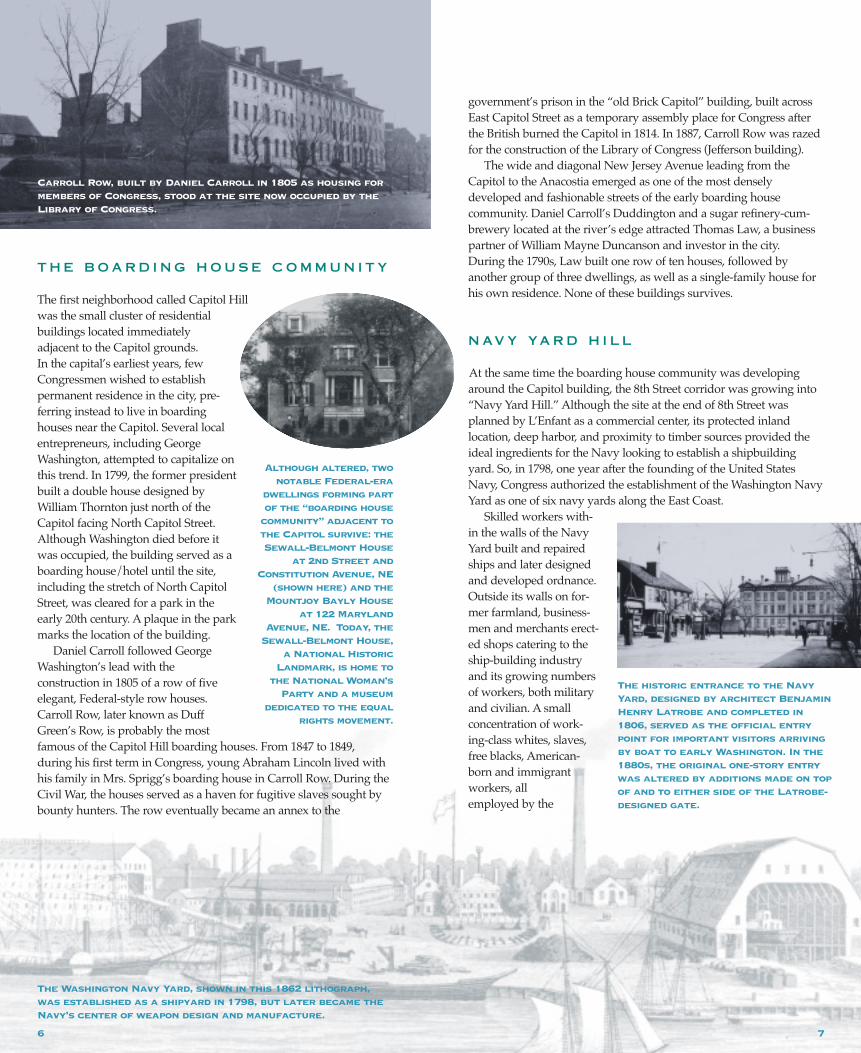
The first neighborhood called Capitol Hillwas the small cluster of residentialbuildings located immediately adjacent to the Capitol grounds. In the capital’s earliest years, fewCongressmen wished to establishpermanent residence in the city, pre-ferring instead to live in boardinghouses near the Capitol. Several localentrepreneurs, including GeorgeWashington, attempted to capitalize onthis trend. In 1799, the former presidentbuilt a double house designed byWilliam Thornton just north of theCapitol facing North Capitol Street.Although Washington died before itwas occupied, the building served as aboarding house/hotel until the site,including the stretch of North CapitolStreet, was cleared for a park in theearly 20th century. A plaque in the parkmarks the location of the building.
Daniel Carroll followed GeorgeWashington’s lead with the construction in 1805 of a row of fiveelegant, Federal-style row houses.Carroll Row, later known as DuffGreen’s Row, is probably the mostfamous of the Capitol Hill boarding houses. From 1847 to 1849, during his first term in Congress, young Abraham Lincoln lived withhis family in Mrs. Sprigg’s boarding house in Carroll Row. During theCivil War, the houses served as a haven for fugitive slaves sought bybounty hunters. The row eventually became an annex to the
government’s prison in the “old Brick Capitol” building, built acrossEast Capitol Street as a temporary assembly place for Congress afterthe British burned the Capitol in 1814. In 1887, Carroll Row was razedfor the construction of the Library of Congress (Jefferson building).
The wide and diagonal New Jersey Avenue leading from theCapitol to the Anacostia emerged as one of the most densely developed and fashionable streets of the early boarding house community. Daniel Carroll’s Duddington and a sugar refinery-cum-brewery located at the river’s edge attracted Thomas Law, a businesspartner of William Mayne Duncanson and investor in the city. During the 1790s, Law built one row of ten houses, followed by another group of three dwellings, as well as a single-family house forhis own residence. None of these buildings survives.
N AV Y YA R D H I L L
At the same time the boarding house community was developingaround the Capitol building, the 8th Street corridor was growing into“Navy Yard Hill.” Although the site at the end of 8th Street wasplanned by L’Enfant as a commercial center, its protected inland location, deep harbor, and proximity to timber sources provided theideal ingredients for the Navy looking to establish a shipbuildingyard. So, in 1798, one year after the founding of the United StatesNavy, Congress authorized the establishment of the Washington NavyYard as one of six navy yards along the East Coast.
Skilled workers with-in the walls of the NavyYard built and repairedships and later designedand developed ordnance.Outside its walls on for-mer farmland, business-men and merchants erect-ed shops catering to theship-building industryand its growing numbersof workers, both militaryand civilian. A small concentration of work-ing-class whites, slaves,free blacks, American-born and immigrant workers, all employed by the
Carroll Row, built by Daniel Carroll in 1805 as housing formembers of Congress, stood at the site now occupied by theLibrary of Congress.
Although altered, twonotable Federal-era
dwellings forming partof the “boarding house
community” adjacent tothe Capitol survive: theSewall-Belmont House
at 2nd Street andConstitution Avenue, NE
(shown here) and theMountjoy Bayly House
at 122 MarylandAvenue, NE. Today, the
Sewall-Belmont House,a National Historic
Landmark, is home tothe National Woman’s
Party and a museum dedicated to the equal
rights movement.
The Washington Navy Yard, shown in this 1862 lithograph, was established as a shipyard in 1798, but later became theNavy’s center of weapon design and manufacture.
The historic entrance to the NavyYard, designed by architect BenjaminHenry Latrobe and completed in1806, served as the official entrypoint for important visitors arrivingby boat to early Washington. In the1880s, the original one-story entrywas altered by additions made on topof and to either side of the Latrobe-designed gate.
6 7
Navy, built the first houses around the Yard’s gates. Grocers, shoemakers, tailors, butchers, bakers and other merchants all vying fortheir business quickly established stores, turning Navy Yard Hill into abustling commercial and residential community.
Likely inspired by George Washington’s “party wall” proclamationof 1791 that allowed half of a party wall to be placed on the adjacent
property, the first houses erected for the small community were typically modest-sized, two-story brick or frame structures built aspairs or in small groupings of three. The surviving houses from thisperiod are readily distinguished by their steeply pitched gable roofforms and shared central chimneys.
From its founding, the Navy Yard employed African Americans,many of whom were slaves leased out by local owners. One worker,African-American Michael Shiner, began his 52-year career at theNavy Yard as a slave, and ended it as a freed man. During his tenureat the Yard, Shiner recorded many observations in his journals, including a vivid account of the British attack on Washington inAugust 1814. Three other former slaves who also worked at The NavyYard, George Bell, Nicholas Franklin, and Moses Liverpool, organizedthe city’s first school for blacks in 1807.
Some of Washington’s most prominent residents lived alongsidethis working-class community. Naval officers, politicians, statesmenand other members of the city’s establishment built houses along the
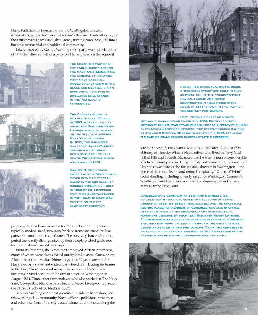
Above: The original Christ Church, a two-story structure built in 1807,survives behind the present GothicRevival facade and tower constructed in 1849 (third story added in 1891) shown in this turn-of-the-century photograph.
Left: Originally part of a mixedMethodist congregation founded in 1805, Ebenezer UnitedMethodist Church was established in 1827 as a separate churchby its African-American members. The present church building,at 4th and D Streets, SE (shown) was built in 1897, replacingthe earlier frame church known as “Little Ebenezer.”
8
streets between Pennsylvania Avenue and the Navy Yard. An 1836obituary of Timothy Winn, a Naval officer who lived in Navy YardHill at 10th and I Streets, SE, noted that he was “a man of considerablescholarship, and possessed elegant taste and many accomplishments.”His house was “one of the finest establishments in Washington …thehome of the most elegant and refined hospitality.” Others of Winn’ssocial standing, including an early mayor of Washington, Samuel N.Smallwood, and Navy Yard architect and engineer James Carberylived near the Navy Yard.
The urban character ofthe early houses aroundthe Navy Yard illustratesthe general expectationthat Navy Yard Hill would quickly grow into adense and sizeable urban community. This pair ofdwellings still stands in the 700 block of I Street, SE.
The Carbery house at 423 6th Street, SE, built in 1803, was occupied byarchitect Benjamin HenryLatrobe while he workedon the design of severalNavy Yard buildings. In 1833, the building’snamesake, James Carbery,purchased the house, residing there until hisdeath. The central towerwas added in 1881.
Samuel N. Smallwood,twice mayor of Washington,moved into this Federalhouse in the 300 block ofVirginia Avenue, SE. Built in 1800 by Dr. FrederickMay, the house was razedin the 1960s to make wayfor the southeast-southwest Freeway.
Congressional Cemetery at 18th and E Streets, SE, established in 1807, was ceded to the vestry of ChristChurch in 1812. By 1835, it had also become the unofficialresting place for members of Congress who died in office.Over each grave of the deceased, Congress erected a monument designed by architect Benjamin Henry Latrobe.For members who died but were buried elsewhere, Congresserected cenotaphs, or “empty tombs” of the same Latrobedesign and shown in this photograph. Today, the cemetery isan active burial ground, managed by The Association of thePreservation of Historic Congressional Cemetery.
9

Beginning in the 1830s, the Washington Navy Yardbegan the production ofordnance. More than acentury later, duringWorld War II, the NavalGun Factory at theWashington Navy Yard was the world’s largestmanufacturer of weapons.
As the community grew,several religious buildings ofdifferent denominations wereconstructed near the Navy
Yard and around the Capitol. In 1794, the federal city’s first Episcopalchurch, Christ Church (Washington Parish) was created by an Act ofthe Maryland Assembly. For years, the congregation met in a tobaccobarn near New Jersey Avenue and D Street, SE, before completing itstwo-story church building at 6th and G Streets, SE in 1807. Designedby Robert Alexander, the church was constructed on lots donated bylocal landowner and parishioner, William Prout.
By 1820, congregations representing the Methodist, Catholic,Baptist, and Presbyterian denominations had all established churcheson Capitol Hill. In 1827, African-American worshippers who attendedthe precursor to Trinity Methodist Church (now Capitol Hill UnitedMethodist Church) at Seward Square managed to establish their ownchurch, Ebenezer Methodist Church in a small frame structure at 4thand D Streets, SE. Ebenezer Methodist Church quickly became animportant community institution, sponsoring in 1864 one of the firstpublicly funded schools for black students.
T H E M A R I N E B A R R A C K S
When the United States moved its capital from Philadelphia toWashington in 1800, the United States Marine Corps, “entrusted withthe protection of all federal buildings” was instructed to follow. Thefirst company of Marines set up camp in Georgetown and later on EStreet, NW, but in 1801, President Thomas Jefferson, on horseback and
Right: These officers, shown with the Commandant’s House inbackground, were stationed at the Marine Barracks in 1896.
Below: The originalMarine Barracks, shownin this circa 1905 photo,consisted of the MarineCommandant’s House (notshown) facing G Street,SE and this large paradeground and quarters for500 enlisted men andofficers along 8thStreet, SE.
John Philip Sousa, born in 1854at 636 G Street, SE to immi-grant parents (his motherwas Bavarian and his father,Portuguese), was raised in ahouse on 7th Street, SE.Sousa, shown in this circa1890 photograph, became arenowned composer and musi-cian. He was director of theMarine Band from 1880-92.
accompanied by Marine Corps Lieutenant Colonel William WardBurrows, selected the site between 8th and 9th and G and I Streets, SEfor the Marine Barracks. The site was chosen for its proximity to the Navy Yard, but also had the advantage of being “within easymarching distance” of the Capitol and the President’s House. English architect George Hadfield, primarily known for his work on the U.S. Capitol building but also for his design of Old City Hall at Judiciary Square, designed the original barracks complex on thesite, begun in 1801.
Established in 1798 and headquartered at the Marine Barracks, the Marine Band has played for every president since John Adams.Dubbed the “President’s Own” by Thomas Jefferson, the band playedall over Washington throughout the 19th century, at outdoor concerts,dancing assemblies, parades, civic affairs, and even worship services.From 1880 to 1892, under the leadership of John Philip Sousa, theMarine Band gained international acclaim. Sousa, who was born andraised in the neighborhood, composed dozens of stirring marches,among them the Washington Post March and Semper Fidelis, eventuallygaining him the title of “March King.”
Although the Marine Barracks did not employ civilian workers as the Navy Yard did, its existence on Capitol Hill contributed to thearea’s economic growth and stability, not to mention its character. In 1838, Major Augustus A. Nicholson, Quartermaster General of theMarines and a lavish entertainer, purchased the Maples, the largeFederal house built by William Mayne Duncanson in 1795. DuringNicholson’s residency, the Maples became the unofficial Marine headquarters and the center of military social life.
C I V I L WA R - E R A D E V E L O P M E N T
In the decades leading up to the Civil War, the Capitol Hill communitycontinued slow growth. The Capitol building, burned by the British in 1814, and the Navy Yard (set aflame by Navy Yard CommandantCaptain Thomas Tingey, under orders of the Secretary of the Navy toprevent its capture by the enemy) were both rebuilt after the Britishinvasion. Shipbuilding and ship repair resumed immediately at theNavy Yard, and in 1815, while the Capitol was being rebuilt, a temporary building, later dubbed the “Old Brick Capitol,” was erectedto house Congress. These highly visible construction projects gave thecapital a renewed sense of permanence, while the Marine Barracks,one of the few public buildings spared by the British in 1814, providedCapitol Hill and the city with a sense of security.
Beginning in the 1830s, the function of the Navy Yard began tochange from the construction of wooden ships to the large-scale manufacture of ordnance. During the Civil War, CommanderDahlgren, commandant of the Navy Yard, kept the Yard’s shops
10 11
open 24 hours a day to pro-duce boat guns, shells, percus-sion caps, and 35,000 minieand musket balls per day. As activity within the walls ofthe Yard increased, troopactivity surrounding the Yardalso intensified. Guns werepositioned to defend LatrobeGate, while other entrances tothe Yard were barricaded andfortified. Troops were presenteverywhere around NavyYard Hill and the Capitol.Existing buildings were commandeered for militaryuse and new buildings wereconstructed. The tower ofChrist Church at 6th and GStreets reputedly served as a
Union lookout post; present-day Lincoln Park became a hospital sitefor wounded soldiers; Providence Hospital opened its doors to civilians and the military in a temporary home at 2nd and D Streets;and the Naval Hospital at 9th and Pennsylvania Avenue was underconstruction for the exclusive use of Navy personnel.
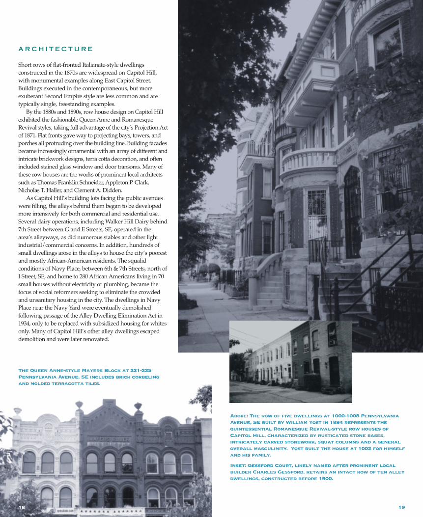
Lincoln Hospital, a Union hospital named in honor of the commander-in-chief, was sited at today’s Lincoln Park, a refuse heapprior to the Civil War. To memorialize the assassinated leader, an 1866act of Congress officially designated the former hospital site as LincolnSquare. Ten years later, the bronze “Emancipation” statue was erected with funds provided by freed slaves. As such, the park heldspecial appeal to African Americans and the site became a populartourist attraction.
Capitol Hill benefited from the city’s first streetcar system, builtduring the Civil War to facilitate the movement of troops and sup-plies. The Georgetown-Navy Yard streetcar line opened in 1862 as oneof the city’s first three horse-drawn streetcar lines (the 7th Street lineand the 14th Street line were the other two). Although the Navy Yard
was already the terminus of a long-standing transportation route (asearly as 1830, an omnibus operated between the Navy Yard andGeorgetown), the permanent Georgetown-Navy Yard line ultimatelyencouraged development along its heavily traveled route. FromGeorgetown, the line traveled east along Pennsylvania Avenue pastthe Capitol, then headed south on 8th Street, SE to the Navy Yard.
During the Civil War, due largely to the presence of the Navy Yard,Capitol Hill survived in relative prosperity. The years immediately following the Civil War, however, were difficult ones. Appropriationsfor the Navy were drastically reduced and the Navy Yard workforcefell to an all-time low. Despite this economic malaise, the populationboom that followed the War brought new investment opportunitiesfor entrepreneurs with the vision and money. In 1866, one suchinvestor, Stephen Flanagan, a Philadelphia tugboat manufacturer, builtone of Capitol Hill’s finest rows of residences on an undeveloped andremote street southwest of Lincoln Square. This row, PhiladelphiaRow on 11th Street, SE, located well east of the established residentialstreets around the Capitol, anticipated by several decades the eastward development of Capitol Hill beyond the one-mile radius of the Capitol.
Several years later and closer to the Capitol, Milwaukee architectand Union veteran, Captain Alfred Grant envisioned the potential fora fashionable post-War residential district. In 1870-71, at a strategic
location on the southside of East CapitolStreet between 2nd and3rd Streets, Grant constructed a row offourteen houses in anopulent Italianate style.Alas, Grant’s askingprice of $75,000 for thecentral two housesscared away even the British minister, interested in acquiringthem for the Britishlegation. After sluggishsales, Captain Grant
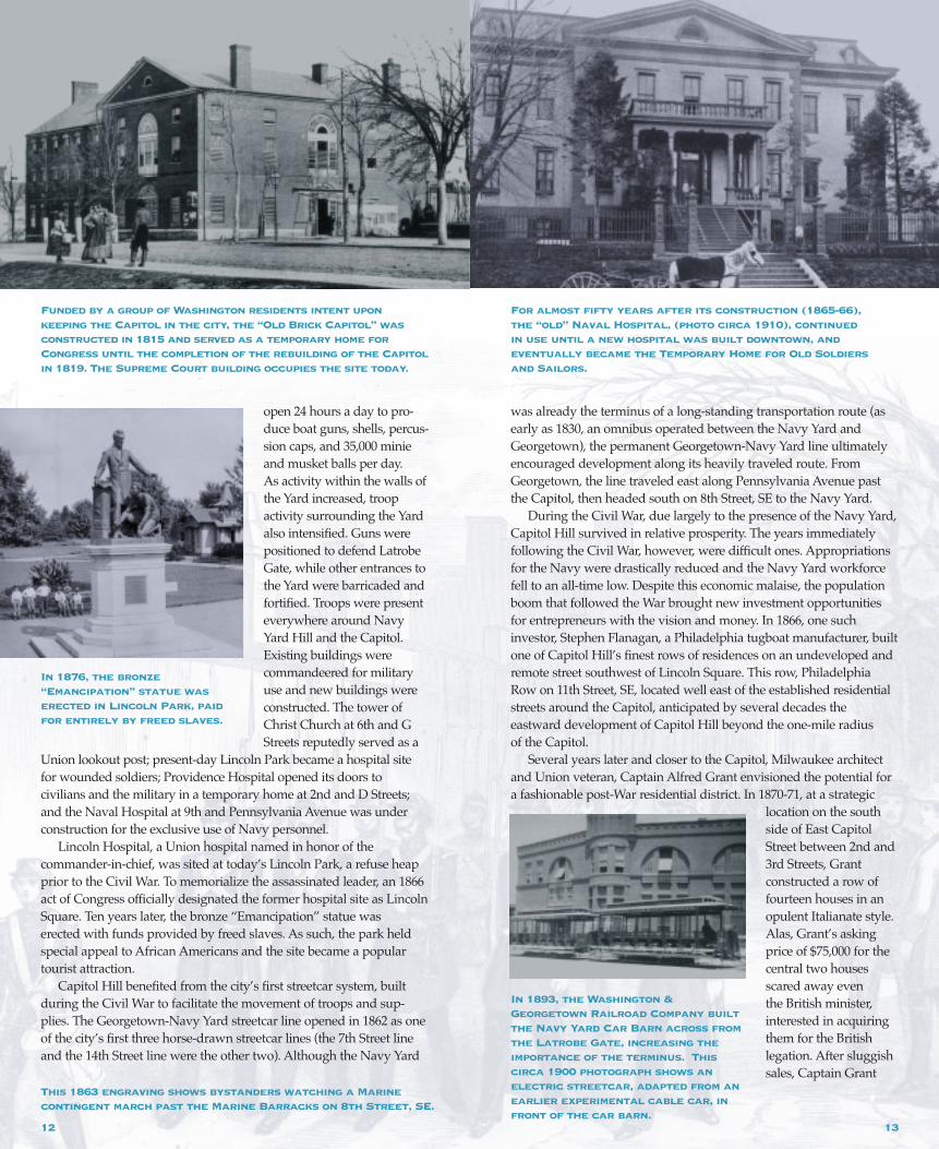
Funded by a group of Washington residents intent upon keeping the Capitol in the city, the “Old Brick Capitol” was constructed in 1815 and served as a temporary home forCongress until the completion of the rebuilding of the Capitolin 1819. The Supreme Court building occupies the site today.
This 1863 engraving shows bystanders watching a Marine contingent march past the Marine Barracks on 8th Street, SE.
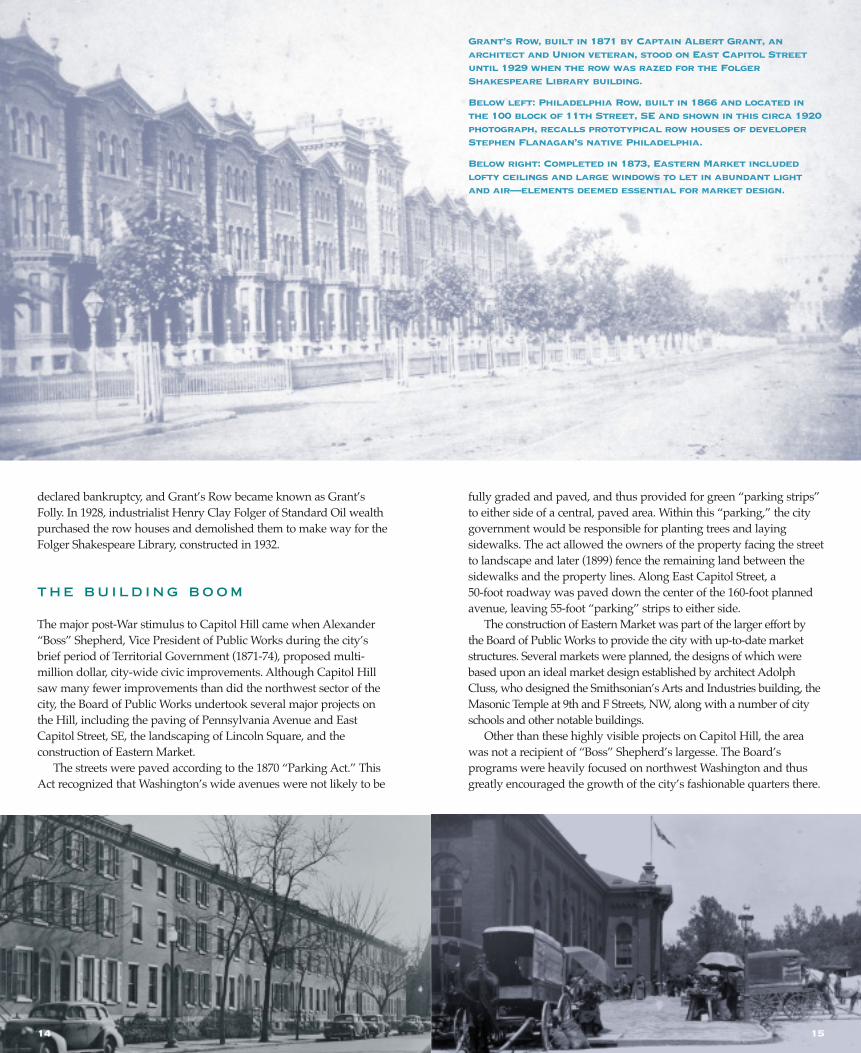
For almost fifty years after its construction (1865-66), the “old” Naval Hospital, (photo circa 1910), continued in use until a new hospital was built downtown, and eventually became the Temporary Home for Old Soldiers and Sailors.
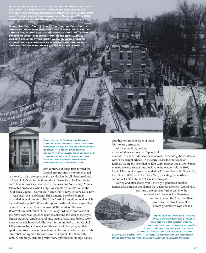
In 1893, the Washington &Georgetown Railroad Company builtthe Navy Yard Car Barn across fromthe Latrobe Gate, increasing theimportance of the terminus. Thiscirca 1900 photograph shows anelectric streetcar, adapted from anearlier experimental cable car, infront of the car barn.
1312
In 1876, the bronze“Emancipation” statue waserected in Lincoln Park, paidfor entirely by freed slaves.
declared bankruptcy, and Grant’s Row became known as Grant’sFolly. In 1928, industrialist Henry Clay Folger of Standard Oil wealthpurchased the row houses and demolished them to make way for theFolger Shakespeare Library, constructed in 1932.
T H E B U I L D I N G B O O M
The major post-War stimulus to Capitol Hill came when Alexander“Boss” Shepherd, Vice President of Public Works during the city’sbrief period of Territorial Government (1871-74), proposed multi-million dollar, city-wide civic improvements. Although Capitol Hillsaw many fewer improvements than did the northwest sector of thecity, the Board of Public Works undertook several major projects onthe Hill, including the paving of Pennsylvania Avenue and EastCapitol Street, SE, the landscaping of Lincoln Square, and the construction of Eastern Market.
The streets were paved according to the 1870 “Parking Act.” ThisAct recognized that Washington’s wide avenues were not likely to be
fully graded and paved, and thus provided for green “parking strips”to either side of a central, paved area. Within this “parking,” the citygovernment would be responsible for planting trees and laying sidewalks. The act allowed the owners of the property facing the streetto landscape and later (1899) fence the remaining land between thesidewalks and the property lines. Along East Capitol Street, a 50-foot roadway was paved down the center of the 160-foot plannedavenue, leaving 55-foot “parking” strips to either side.
The construction of Eastern Market was part of the larger effort by the Board of Public Works to provide the city with up-to-date marketstructures. Several markets were planned, the designs of which werebased upon an ideal market design established by architect AdolphCluss, who designed the Smithsonian’s Arts and Industries building, theMasonic Temple at 9th and F Streets, NW, along with a number of cityschools and other notable buildings.
Other than these highly visible projects on Capitol Hill, the areawas not a recipient of “Boss” Shepherd’s largesse. The Board’s programs were heavily focused on northwest Washington and thusgreatly encouraged the growth of the city’s fashionable quarters there.
Grant’s Row, built in 1871 by Captain Albert Grant, an architect and Union veteran, stood on East Capitol Streetuntil 1929 when the row was razed for the FolgerShakespeare Library building.
Below left: Philadelphia Row, built in 1866 and located inthe 100 block of 11th Street, SE and shown in this circa 1920photograph, recalls prototypical row houses of developerStephen Flanagan’s native Philadelphia.
Below right: Completed in 1873, Eastern Market includedlofty ceilings and large windows to let in abundant lightand air—elements deemed essential for market design.
14 15

17
For its growth, Capitol Hill depended on small-scale real estate specu-lators, local developers and committed residents and businessmen. In 1883, seventeen Hill residents signed a written document to theDistrict Commissioners complaining of the city’s neglect of the areaeast of the Capitol. Several of these signers were pillars of the commu-nity, including local entrepreneur and businessman, John Herrell.Herrell, owner of a brick-making firm on Capitol Hill, and laterfounder and first president of the National Capital Bank and first pres-ident of the East Washington Savings Bank, is credited with the con-struction of several residential developments of the 1870s and 1880s.
Like Herrell, other small-scale developers,including the real estate firm of
Weller and Repetti, builderWilliam Yost, and the prolific
builder Charles Gessford,at first constructed
small groups of rowhouses on vacant
lots close to the Capitol.Eventually, these
developers and others capitalized on the extensive tracts of cheap andundeveloped land further east of the Capitol, where they built longerrows of attached housing. These row houses, taking advantage ofeconomies of scale and inexpensive, mass-produced architectural elements, were affordable and appealed to the middle-class resident.
The “Projection Act,” passed in 1871, ultimately provided CapitolHill with much of the architectural character that defines the historicdistrict today. This act, along with L’Enfant’s wide streets and thelandscaping promoted by the 1870 “Parking Act,” distinguishesCapitol Hill from older, 18th-century towns such as Georgetown andAlexandria. The “Projection Act” allowed bay windows, corner towers, and porches to project into public space. This projectionlegislation allowed developers greater freedom to introduce popularelements found in the evolving Queen Anne, Romanesque Revival,Italianate, and other Victorian-era styles.
In 1883, the federal government passed the Civil Service Act, a law that gave government workers greater job security and regularwages. Its passage, combined with the improvements to Capitol Hill’s infrastructure and the need to house the post-Civil War populationboom, ensured the future growth of Capitol Hill as an important middle-class residential community of the nation’s capital. With thepromise of a weekly paycheck, the growing federal workforce wasquick to purchase the single-family row houses emerging all overCapitol Hill, within walking distance of the government’s greatest centers of employment: Congress, the Navy Yard, and the GovernmentPrinting Office. Thus, beginning in 1871, but climaxing in the decadebetween 1883 and 1893, Capitol Hill became home to many in the federal government workforce (both African American and white),their families, and the associated commercial, institutional, and servicecommunities. During that period, Capitol Hill began to evolve into theCapitol Hill of today, with cohesive collections of brick row housesexecuted in a variety of Victorian-era styles, punctuated by stores onnearly every corner, and notable religious and educational institutionstucked into the residential blocks.
Far left: Capitol Hill businessman John Herrell contributedto the residential development of Capitol Hill by financingthe construction of several rows of houses, including the 900block of Pennsylvania Avenue, SE where he lived.
Left center: Built by architect/builder Charles Gessford for just $10,000, this row of 2-1/2-story Queen Anne brickhouses with two-story projecting bays is typical of the late 19th-century, middle-class speculative row houses constructed on Capitol Hill.
Right center: This row of dwellings in the 300 block of AStreet, SE features flat facades with heavy wooden door andwindow hoodmolds, characteristic of the Italianate style andwell represented in the Capitol Hill buildings of the 1870s.
Far right: This Second Empire style house at 316 A Street, NE,circa 1870, was the home of African-American abolitionistFrederick Douglass. Douglass lived here with his family fromat least 1874 until 1878 when he moved to Cedar Hill in Anacostia.
TheRomanesqueRevival-styleMary L. HillHouse at 408 A Street, SE,designed byarchitectNicholas T.Haller, features
an intricatelycarved and
arched entry
16
19
A R C H I T E C T U R E
Short rows of flat-fronted Italianate-style dwellings constructed in the 1870s are widespread on Capitol Hill,with monumental examples along East Capitol Street.Buildings executed in the contemporaneous, but more exuberant Second Empire style are less common and aretypically single, freestanding examples.
By the 1880s and 1890s, row house design on Capitol Hillexhibited the fashionable Queen Anne and RomanesqueRevival styles, taking full advantage of the city’s Projection Actof 1871. Flat fronts gave way to projecting bays, towers, andporches all protruding over the building line. Building facadesbecame increasingly ornamental with an array of different andintricate brickwork designs, terra cotta decoration, and oftenincluded stained glass window and door transoms. Many ofthese row houses are the works of prominent local architectssuch as Thomas Franklin Schneider, Appleton P. Clark,Nicholas T. Haller, and Clement A. Didden.
As Capitol Hill’s building lots facing the public avenueswere filling, the alleys behind them began to be developedmore intensively for both commercial and residential use.Several dairy operations, including Walker Hill Dairy behind7th Street between G and E Streets, SE, operated in the area’s alleyways, as did numerous stables and other light industrial/commercial concerns. In addition, hundreds ofsmall dwellings arose in the alleys to house the city’s poorestand mostly African-American residents. The squalid conditions of Navy Place, between 6th & 7th Streets, north ofI Street, SE, and home to 280 African Americans living in 70small houses without electricity or plumbing, became thefocus of social reformers seeking to eliminate the crowdedand unsanitary housing in the city. The dwellings in NavyPlace near the Navy Yard were eventually demolished following passage of the Alley Dwelling Elimination Act in1934, only to be replaced with subsidized housing for whitesonly. Many of Capitol Hill’s other alley dwellings escapeddemolition and were later renovated.
Above: The row of five dwellings at 1000-1008 PennsylvaniaAvenue, SE built by William Yost in 1894 represents the quintessential Romanesque Revival-style row houses ofCapitol Hill, characterized by rusticated stone bases, intricately carved stonework, squat columns and a generaloverall masculinity. Yost built the house at 1002 for himselfand his family.
Inset: Gessford Court, likely named after prominent localbuilder Charles Gessford, retains an intact row of ten alleydwellings, constructed before 1900.
18
The Queen Anne-style Mayers Block at 221-225Pennsylvania Avenue, SE includes brick corbelingand molded terracotta tiles.

Clockwise from top left: TheWaugh Methodist Church at308 A Street, NE (now Faith
Tabernacle) was originally built in 1858. The present buildingdates primarily from a circa 1892 enlargement.
Mt. Jezreel Baptist Church, built in 1883, was designed byCalvin T.S. Brent, the first African-American architect topractice in Washington. This illustration shows Mt. Jezreelbefore the present artificial stone facade was applied to the building.
St. Mark’s Church, built in 1888-89 and designed by Baltimorearchitect T. Buckler Ghequier, reflects an English GothicRevival style, with high Victorian design treatment, including Tiffany stained-glass windows.
Grace Baptist Church, a robust, Romanesque Revival-stylechurch at 901 South Carolina Avenue, SE and built in 1891-95, has been converted into condominiums.
R E L I G I O N , E D U C AT I O N , C U LT U R E
Capitol Hill’s diverse population, including immigrants and AfricanAmericans, both free and enslaved, nurtured a wide range of religiousfaiths, and financial, cultural, and educational institutions. Thrivingsmaller communities of Eastern Europeans, Asians, Irish, and Germansthat had established themselves near the Navy Yard and its jobs in theearliest years, moved north and east along with the rest of the popula-tion, bringing with them their cultural traditions and institutions.
From 1860 to 1898, thirty-five new churches formed in the largerCapitol Hill area, up from about a dozen in 1860. Several of these
churches were newly established African-American congregations,such as Mt. Jezreel at 5th and E Streets, SE, organized in 1883 and built by freed slaves. The majority of the others, however, were mission churches of existing congregations in and beyond CapitolHill. In 1867, Christ Church organized St. Mark’s Episcopal Church at3rd and A Streets, SE, as a “colony” church, just as members of theMethodist Protestant Church at Virginia Avenue and 5th Street, SE
organized the North Carolina M.P. Church in 1872. The SoutheastHebrew Congregation, organized in 1909, eventually purchased a permanent meeting place at 417 9th Street, SE. Like the residential andcommercial buildings of the period, these religious edifices, often builton prominent corner lots, or facing public squares, were designed in avariety of Victorian-era styles by notable architects and designers.
Public school education in Washington, begun in a limited capacityfor whites in 1804 and established for blacks only in 1862, gained asense of permanency following the Civil War. Prior to 1862, black children attended schools in African-American churches, or thoseorganized by individuals such as the Liverpool/Bell School. The post-War restructuring of the school system was complemented by the construction of a number of new and architecturally notable brickschool buildings that catered to the widely scattered population of the
Wallach School, the city’s first substantial school building,was constructed in 1864 at 7th and Pennsylvania Avenue, SE(site of present-day Hine Junior High School).
Providence Hospital was established in 1861 at 2nd and D Streets, SE when the city’s only existing civilian hospital (at Judiciary Square) was taken over by the Union Army. The now-demolished mission-style hospital, shown here, was a1904 remodel of the original purpose-built hospital buildingon the site. The cleared site, twice slated for Congressionalparking, but vociferously opposed by local citizens’ groups,was converted into a landscaped park in 1979.
2120

2322
city. One of the first of these new schools, Wallach School, designed inan exuberant Renaissance Revival style by the firm of Cluss andKammerhueber and constructed in 1864, was located on the north sideof Pennsylvania Avenue, SE at 7th Street. The architectural success ofWallach School inspired the construction of other well-designed publicschool buildings, a trend that continued into the 20th century. LincolnSchool, the first public school for black students in the city, was a hum-bler frame structure, built in 1865 at 2nd and C Streets, SE.
Other institutions, such as Providence Hospital, the NationalCapital Bank and the East Washington Savings Bank were also estab-lished, as were a number of fraternal organizations, including theNaval Lodge and the Harmony Lodge of the International Order ofOdd Fellows, a building still standing at 516 8th Street, SE.
THE H ILLIN THE20THCENTURY
At the turn of the20th century,Capitol Hill was acollection of well-established andvibrant residentialneighborhoods,composed of middle-class gov-ernment workers.Around the Capitol,the federal govern-ment’s presence onCapitol Hillexpanded substan-tially. The SenatePark CommissionPlan of 1901-1902(the McMillan Plan)called for surround-ing the Capitol withclassically inspiredbuildings for thelegislative and judicial branches of government. In 1904, the NewYork firm of Carrere& Hastingsdesigned theRussell SenateOffice Building andthe Cannon HouseOffice Building,both of which werecompleted in 1909.The construction ofthese buildingscoincided with the
construction of Daniel Burnham’s Union Station and followed the1897 completion of the Library of Congress building, designed by thearchitectural firm of Smithmeyer and Pelz.
Throughout the first half of the 20th century, the federal govern-ment continued to expand its complex of buildings around theCapitol, in particular the Supreme Court Building, and pushed for thedevelopment of East Capitol Street as the “Avenue of the States.” The Supreme Court project at 1st and East Capitol Streets began withthe purchase of land in 1928 and ended with the dedication of theCass Gilbert-designed Supreme Court building in 1935. The NationalCapital Park and Planning Commission scheme to line East CapitolStreet with monumental structures remained unrealized, though talkof its implementation continued into the 1960s. While these new
This aerial view of Capitol Hill looking west from LincolnPark to the Capitol shows the contrast in scale between thelarge federal buildings around the Capitol and the neigh-borhood’s smaller and predominantly 19th-century buildings.
2524
and theaters arose in place of older19th-century structures.
At the same time, new and extended streetcar lines on Capitol Hillopened up new corridors for development, expanding the residentialcore of the neighborhood. In the early 1890s, the MetropolitanRailroad Company extended its East Capitol Street line to 15th Street,making the area east of Lincoln Square more accessible. In 1908,Capitol Traction Company extended its U Street line to 8th Street, NE,then down 8th Street to the Navy Yard, providing the northeast section of Capitol Hill direct access to area jobs.
During and after World War I, the city experienced another tremendous surge in population that again transformed Capitol Hill,
pushing development further east into the undeveloped blocks of land between
Lincoln Park and the Anacostia River.Row house construction built to
attract government workers and
The surviving Academy Theaterat 535 8th Street, SE, shown in
this snowy 1960 winter scene,was one of four theaters along 8th
Street, SE built in the first decadesof the 20th century that catered to the
Navy Yard community. The more architecturally prominentPenn Theater on Pennsylvania Avenue followed in 1935.
20th-century buildings transformed theCapitol grounds into a monumental fed-
eral center, their development also resulted in the elimination of muchof Capitol Hill’s earliest building stock. Daniel Carroll’s Duddingtonand Thomas Law’s speculative row houses along New Jersey Avenuefell to this progress, as did George Washington’s double house, the“Old Brick Capitol,” Carroll Row, and Grant’s Row, to name just a few.
At a local level, the Capitol Hill economy benefited from anexpanded federal presence. The Navy Yard Hill neighborhood, whichhad suffered a post-Civil War slump from reduced military spending,began to experience its own revival. With President TheodoreRoosevelt’s revitalization of the U.S. Navy, ordnance production at the Navy Yard was up, once again establishing the Yard as the city’slargest industrial employer and once again attracting a diverse workforce to the neighborhood. The Marines, committed to their CapitolHill presence, began a major, multi-year rebuilding program thatsparked a private development boom in the immediate vicinity of 8thStreet that had ripple effects across all of Capitol Hill. New, 20th-century buildings, including multi-story apartment buildings, banks,
Background: In 1908, all of the original Barracks’ buildings,save for the Commandant’s house, were replaced by anentirely new complex, designed by the prominent Washingtonarchitecture firm of Hornblower and Marshall. This 1908photograph shows the Barracks under construction.
Capitol Hill’s Southeast Branchlibrary was constructed with fundsprovided by the Carnegie Corporationin 1922. The Northeast BranchLibrary (not shown), built during thelean years of the Depression, waserected with funds obtained byCongressional appropriations.
Right: The East Capitol Street Car Barn on East CapitolStreet between 14th and 15th Streets was constructed in1896 at the terminus of the Metropolitan Railroad Company’sstreetcar lines. The grand Romanesque Revival-style building designed by architect Waddy B. Wood, provided storage room for streetcars, a repair shop, and companyoffices. The building currently houses apartments.

27
returning soldiers andtheir families remained popular. However,multi-story apartment
buildings, more effectively able to house the growing population andincreasingly acceptable to the middle-class resident, became the building of choice for developers.
As the city’s population soared, the need for housing and city services such as schools, firehouses, post offices, libraries, and otherpublic amenities grew. Following an established model, the Office ofthe Municipal Architect designed and built a number of new two- andthree-story brick school buildings across Capitol Hill. Prior to 1954 and the landmark decision Brown vs. the Board of Education, the city built separate schools for African Americans and whites. Because of the racial diversity of Capitol Hill’s neighborhoods, theseformerly segregated school buildings are often found within blocks of each other.
Following World War II, the Navy began to contract the productionand manufacture of weapons to private firms, leaving the Navy Yardan obsolete facility. This drastic reduction in ordnance production converted the bustling Navy Yard from an employment center of tensof thousands to one of just a few thousand. As the number of military
and civilian personnel diminished at theNavy Yard, the vitality of the neighborhooddeclined. At the same time, the trend forestablished middle-class residents (bothAfrican American and white) to abandoncity neighborhoods for emerging suburbs intensified. The formerly owner-occupied,Victorian-era row houses were left vacant or divided up as flats, or floor-by-floor apartments, attracting lower-income andmore transient residents.
As the growth of the suburbs drew mid-dle-class residents away from Capitol Hilltransforming its socio-economic composition,public housing, urban renewal and socialreform efforts of the 1960s and 70s also con-tributed to its loss of historic buildings, par-ticularly in that area around the Navy Yard.Modern apartment blocks and town housecomplexes replaced 19th-century residentialand commercial buildings. The Southeast-Southwest Freeway, built in the late 1960salong the line of what was Virginia Avenue,obliterated an array of buildings, many ofwhich
were distinguished Federal andGreek Revival-style residences thathad once attracted members of the political and professional elite.
P O S T - W O R L D WA R I I R E S T O R AT I O N
At the same time large numbers of Capitol Hill’s buildings were being eradicated in the name of urban renewal in the post-World WarII era, a movement towards the “restoration” of the Hill’s neglected19th-century building stock began. In 1949, Supreme Court Justice
During the 1990s, People’s Commercial & Savings bank (1920)at 9th and East Capitol Streets, NE was converted into a private residence. This adaptive re-use project followedother successful examples in the Capitol Hill HistoricDistrict, including Grace Baptist Church and theMetropolitan Railway Car Barn, both rehabilitated for residential use. Currently, three former public schools—Bryan, Lovejoy and Lenox Elementary Schools—are alsobeing adapted as residences.
26
The WashingtonMechanics SavingsBank (1908) at thecorner of 8th and GStreets, SE is one ofseveral banks thatwere built to servethe various neigh-borhoods of thegrowing Capitol Hill.
Initially, architectsdesigned apartmentbuildings to fit neatly into thestreetscape, respecting the scale
created by the existing row houses, as did Appleton P. Clark in his designs for the 1914 Linville apartments on 6th Street,NE. By the 1920s, however, larger and taller apartmentbuildings, such as the Art Deco Congressional apartments, on Constitution Avenue, NE, were built with less regard to thescale of the surrounding buildings.
F ST, NE
E ST, NE
D ST, NE
C ST, NE
CONSTITUTION AVE, NE
A ST, NE
EAST CAPITOL STREET
A ST, SE
C ST, SE
D ST, SE
D ST, SE
E ST, SE
1 ST
2 ST
4 ST
5 ST
6 ST
7 ST
8 ST
9 ST
10 ST
11 ST
12 ST
13 ST
14 ST
3 ST,
SE
MARYLAND AVE, NE
MASSACHUSETTS AVE, NE
PENNSYLVANIA AVE, SE
I-295 SE/SW FREEWAYI ST, SE
UNIONSTATION
U.S.CAPITOLBLDG
VIRGINIA AVE, SE
NEW
JER
SEY A
VE, S
E
SOUTH CAROLINA AVE, SE
E ST, SE
G ST, SE
NAVY YARD
TENNES
SEE
AVE,
NE
INDEPENDENCE AVE, SE
NORTH CAROLINA AVE, SE
KIMBERLY PROTHRO WILLIAMS, AUTHORSPONSORED BY THE CAPITOL HILL RESTORATION SOCIETY (CHRS) AND THE DC PRESERVATIONLEAGUE (DCPL), THROUGH A GRANT FROM THE DC HISTORIC PRESERVATION OFFICE.BROCHURE DESIGN BY HENNESSEY, INK
The Capitol Hill Historic District brochure has been funded with the assistance of a matching grant from theU.S. Department of Interior, National Park Service, through the DC Office of Planning, Historic PreservationOffice, under provisions of the National Historic Preservation Act of 1966, as amended. This brochure hasbeen financed in part with federal funds from the National Park Service, Department of the Interior andcontributions from the CHRS. However, the contents and opinions do not necessarily reflect the views orpolicies of the Department of the Interior. This document was developed by the CHRS and DCPL in consultation with the DC Historic Preservation Office, District of Columbia Government. AnthonyWilliams, Mayor. Printed 2003.
This program receives federal financial assistance for identification and protection of historic propertiesunder Title VI of the Civil Rights Act of 1973, as amended. The U.S. Department of Interior and the Districtof Columbia prohibit the discrimination on the basis of race, color, age, national origin, or handicap in itsfederally assisted programs. If you believe you have been discriminated against in any program activity, orif you desire further information, please write to Office of Equal Opportunity, U.S. Department of Interior,Washington, DC 20240.
PHOTOGRAPHIC CREDITSHSW=Historical Society of Washington; LOC=Library of Congress; MLK=Martin Luther King, Jr. Library.KPW=Kim Prothro Williams. Cover: E Capitol St, circa 1880, LOC. Inside cover: Boschke Map, 1857, LOC.Page 1: Daniel Carroll, LOC. Page 2-3: Toner Map, LOC; PA Ave looking east, 1880s, LOC. Page 4-5:Topographic Map of Washington City, 1991, Don Hawkins, AIA; Tunnicliff’s Tavern, ca. 1895, LOC; The Maples, ca. 1900, LOC; William Mayne Duncanson, HSW. Page 6-7: Carroll Row, 1880s, LOC; Sewall-Belmont House, Sewall-Belmont House; Navy Yard Gate, ca. 1900, HSW; Washington Navy Yard, 1862 lithograph, Naval Historical Center. Page 8-9: 720-722 I St, SE, LOC; Carbery House, ca. 1900, HSW;Smallwood House, LOC; Christ Church, Christ Church Archives; Ebenezer United Methodist Church,DCHPO; Congressional Cemetery, LOC. Page 10-11: Naval Gun Factory, Naval Historical Center; JohnPhilip Sousa, Paul Bierley; Marine Barracks, ca. 1900, Christ Church Archives; Marine Officers, 1896, MarineCorps Historical Center. Page 12-13: Old Brick Capitol, LOC; Old Naval Hospital, ca. 1900, MLK; LincolnHospital, LOC; Washington & Georgetown Car Barn, photo by Le Roy O. King, Sr., permission of LeRoy O.King, Jr.; Lincoln Statue, LOC; Marines marching (background), Christ Church Archives. Page 14-15:Grant’s Row, photo by Ricer Studio, LOC; Philadelphia Row, circa 1920, LOC; Eastern Market, 1914,National Archives. Page 16-19: all photos, 2003, KPW. Page 20-21: Waugh Methodist Church, 2003, KPW;Mt. Jezreel Baptist Church, Mt. Jezreel Baptist Church; St. Mark’s Episcopal Church, 2003, Tracie P. VanDorpe; Providence Hospital (background), LOC; Wallach School, DCHPO. Page 22-23: Aerial View, E Capitol St, LOC. Page 24-25: Barracks Row under construction, 1908, Marine Corps Historical Center; E Capitol St Car Barn, KPW; 8th St with streetcar, 1960, Richard Kotulak; SE Branch Library, DonnaHanousek; Page 26-27: 822 E Capitol St, Barry Halkin; Washington Mechanics Savings Bank and Linvilleand Congressional apartment buildings, 2002, KPW.
12 PL, N
E
K ST, SE
L ST, SE
M ST, SE
CAPITOL HILL HISTORIC DISTRICT
William O. Douglas bought a rowhouse on Capitol Hill, renovated itand breaking with the norm of otherpoliticians who resided in northwestDC, moved into it. Douglas’ move to Capitol Hill inspired others to follow, and directly encouraged therenovation, restoration, and rebuilding of many of the Hill’s19th-century buildings found withina roughly eight-block radius of theCapitol building. Several early projects attracted the attention of
realtors who then sought out houses on Capitol Hill to renovate andresell for a profit. In 1953, alley dwellings—once targeted for demoli-tion by social reformers—were renovated and touted in magazine and newspaper articles of the period as a “homeowners dream come true.”
Since the 1886 demolition of Daniel Carroll’s Duddington, residentsof Capitol Hill have repeatedly witnessed the elimination of historicbuildings for new private and public developments. By the mid-20thcentury, resentment over these losses intensified and a movement toreject the unnecessary demolition of historic fabric gained momentum.In 1955, the Capitol Hill Restoration Society (CHRS) was organizedwith the purpose of promoting a better residential neighborhood,including the preservation of historic sites. In 1964, Capitol Hill wasidentified as a Landmark of the National Capital, and in 1973 was designated an historic district. In 1976, the Capitol Hill HistoricDistrict was listed in the National Register of Historic Places.
Today, Capitol Hill is home to a variety of people: homeownersand renters; third-generation residents and transients; senators andtradespeople; families with children; single persons and couples without children; the elderly; and the rich and poor, among others.Although horses no longer deliver milk from local dairies, houses areno longer heated by coal, and street lamps are no longer lit by oil, theCapitol Hill of today closely resembles that of the 19th century. Rows of late 19th-century red brick houses line the pedestrian-filledneighborhood streets, Eastern Market still offers food and crafts, andcorner stores and cafes draw in passers by.
28
The long-standing, single-family row house persisted in thehistoric district well into the 20th century. This street,Lexington Place, NE, was part of the 1910 wholesale development of the surrounding square by the Kennedy Bros.Builders, in association with architect A.H. Sonneman.
Built on the site of the Ellen Wilson Dwellings (prior tothat, Navy Place), the “Townhomes of Capitol Hill” projectwas designed by local architect Amy Weinstein and completed in 2001. The project, which includes subsidizedand market-rate housing, has been hailed as a model by theurban planning, design and preservation communities.
Related Documents