Camp Edwards at the Massachusetts Military Reservation Cape Cod, Massachusetts Groundwater Plume Maps & Information Booklet 2011 Army Environmental Command Impact Area Groundwater Study Program

Welcome message from author
This document is posted to help you gain knowledge. Please leave a comment to let me know what you think about it! Share it to your friends and learn new things together.
Transcript

Camp Edwards at the Massachusetts Military Reservation Cape Cod, Massachusetts
Groundwater Plume Maps & Information Booklet 2011
Army Environmental Command
Impact Area Groundwater Study Program

Potentially contaminated sites are identified through historical reviews, interviews and site inspections.
Rapid Response Actions are often implemented to accelerate cleanup and prevent migration of contamination while investigations and remedy selection are still under way. Sampling
Investigations are conducted to identify the presence and extent of soil or groundwater contamination.
About the Impact Area Groundwater Study Program
The U.S. Army Environmental Command’s Impact Area Groundwater Study Program (IAGWSP) is continuing to move forward with selection and implementation of remedies for addressing groundwater contamination and its sources at Camp Edwards on the Massachusetts Military Reservation (MMR). Working in cooperation with the U.S. Environmental Protection Agency (EPA) and the Massachusetts Department of Environmental Protection (MassDEP), the IAGWSP now has remedies or interim treatment systems in place for nine of 11 groundwater plumes.
Program Background
Investigations into possible contamination at Camp Edwards began in response to community concerns that historic activities might have impacted the groundwater underlying the military installation. The 15,000 acres that comprise Camp Edwards lie over an important recharge area for a portion of the Cape Cod aquifer, known as the Sagamore Lens, which is the principal source of drinking water for the four towns of the Upper Cape: Sandwich, Bourne, Mashpee and Falmouth. In 1997, EPA began issuing Administrative Orders under the Safe Drinking Water Act, requiring the investigation and cleanup of contamination from military activities. MassDEP also has been actively involved to ensure that the substantive requirements of state statutes are met throughout the investigation and cleanup.
IAGWSP investigations have looked at the impacts from military and defense contractor activities conducted on Camp Edwards since the early 1900s. These activities included: firing of artillery, mortars, small arms, and other projectiles; demolition training; and the detonation of munitions and explosives. Additionally, burning and burial of munitions and explosives occurred on some of the defense contractor ranges. Initial investigations included the review of historic records and photographs, interviews with former soldiers and workers, and site inspections. To date, the IAGWSP has installed and sampled almost 1,200 groundwater monitoring well screens in over 500 locations. More than 100,000 groundwater and soil samples have been collected and analyzed.
Contamination Source Areas and Cleanup
Source areas are areas of soil contamination that are or could be leaching into the aquifer at high enough levels to create groundwater contamination, such as areas of soil that contain explosives. The primary contaminants in soil are explosives, including RDX, TNT and its breakdown products, perchlorate, the propellants 2,4- and 2,6-DNT, nitroglycerine, and metals.
Contamination Investigation/
Cleanup Process

Decision Documents record the selected Response Action, explain why it was selected, and tell how it will be implemented. It also provides responses to public comments.
Long-term monitoring, operations and maintenance and land-use controls verify the effectiveness of the action, confirm that modeled predictions are accurate, ensure that there is no exposure to contamination that could cause a risk to human health, and maintain the treatment systems to ensure the effectiveness of the response action.
Remedy Selection Plans present an evaluation of alternatives and detail the preferred final Response Action. Public comments on Remedy Selection Plans are solicited.
Source areas within the Camp Edwards Impact Area and Training Ranges resulted from the detonation, destruction, and burial of munitions, explosives, and propellants, as well as the firing of artillery, mortars, small arms and other projectiles, and demolition training. Of the areas evaluated as part of the IAGWSP, several locations have been confirmed as source areas that contributed to soils and/or groundwater contamination in the past. Contaminated soils from these areas were excavated and were either treated on site by thermal desorption or alkaline hydrolysis, or disposed of off site at permitted facilities. In several cases, source areas have contributed to groundwater contamination at concentrations exceeding federal or state drinking water standards or risk-based levels, thereby creating a groundwater plume that requires monitoring and/or remediation. Unexploded ordnance (UXO) has been separated from soils manually, mechanically, and robotically, and has been disposed of by the blow-in-place method or in a contained detonation chamber. All of the known source areas, with the exception of the Central Impact Area, have been addressed.
Methods used to address soil that could be sources of groundwater contamination, include:
Dry screening (sifting)/soil washing (separating materials using water)/pneumatic separation (separating materials using air) - sifts or separates lead and other metallic fragments from the soil. This method was used to remove 60 tons of lead from small arms range berms.Thermal desorption - uses heat to destroy contaminants. This process treated more than 48,000 tons of soil excavated from Demolition Area 1 and other source areas.Alkaline hydrolysis treatment - uses lime to chemically break down contaminants. This process treated more than 9,500 tons of soil from the Southeast Ranges and other source areas.Off site disposal - soil from small removal actions, or soil that isn’t treatable on site due to the type of contaminants or concentrations, is shipped to a licensed disposal facility.
Methods used to address metallic items, including UXO, munitions debris, and rang scrap include:Robotics - Remote-controlled clearing and excavation equipment is used to clear vegetation and remove soil and metallic items, including potentially unexploded munition items, from suspected source areas.Recycling - A large number of metallic objects, including tanks, were cut apart and recycled.
Methods of Soil Treatment
Soil Washing
Thermal DesorptionAlkaline Hydrolosis
Off-Site Disposal

Glossary and Acronyms
gpm = gallons per minute
Land-use Controls = Administrative and/or legal controls that minimize the potential for human exposure to contamination by limiting land or resource use. Land-use controls also consist of measures that would prevent interference with monitoring and/or treatment systems.
MMR = Massachusetts Military Reservation.
MEC = munitions and explosives of concern.
Monitored Natural Attenuation = Treatment approach of allowing natural processes to reduce contaminant concentrations to acceptable levels over time.
RDX (Hexahydro-1,3,5-Trinitro-1,3,5-Triazine), TNT (trinitrotoluene) and HMX (Octahydro-1,3,5,7-tetranitro-1,3,5,7-tetrazocine) = explosives compounds used in military munitions, primary contaminants in soil and groundwater at MMR.
Perchlorate = an oxidizer; used in military munitions and commercial fireworks, primary contaminant in soil and groundwater at MMR.
ppb = parts per billion; measure of concentration of contaminants, approximately equivalent to micrograms per liter.
RRA = Rapid Response Action; Interim action that begins cleanup while investigations and the formal process of presenting and selecting long-term alternatives is completed.
UXO = Unexploded Ordnance; military munitions that have been primed, fused, armed, or otherwise prepared for action, and fired, dropped, launched, projected, or placed in such a manner to constitute a hazard to operations, installations, personnel, or material and remain unexploded either by malfunction, design, or any other case.
A plume is a body of groundwater containing contaminants that exceed federal and/or state drinking water standards or risk-based levels. The primary contaminants in groundwater are the explosives compound RDX and perchlorate. The cleanup levels are 0.6 parts per billion (ppb) for RDX and 2 ppb for perchlorate. Depending on the levels of contamination and the time it takes for some of the chemicals to naturally break down, groundwater contamination at Camp Edwards is usually addressed by: focused extraction and treatment, land-use controls or monitored natural attenuation (natural breakdown), or a combination thereof. Monitored natural attenuation and land-use controls allow attenuation of contamination through the natural processes of dilution, degradation, dispersion, and sorption (i.e. binding of contaminants to the soil), and they include groundwater monitoring to verify that the plume is attenuating, or shrinking, as predicted. Land-use controls are regulations, restrictions, and other protective measures to prevent the use of contaminated portions of the aquifer for drinking water; monitoring of land-use controls ensures their effectiveness. Annual reporting on monitoring-program results include changes in plume extent or concentrations, comparisons of real vs. modeled results,
and recommendations for improving performance. Five-year reviews are conducted to ensure the remedy is still protective and performing as anticipated.
To treat groundwater contamination, extraction wells are placed within a plume to pump the contaminated groundwater from the aquifer to a treatment plant where the water is filtered through carbon and/or ion-exchange resins held in large vessels. Treated water is returned to the aquifer through reinjection wells or infiltration trenches.
The IAGWSP is currently addressing nine groundwater plumes. At this time, interim (RRA) or final systems are treating approximately 2.5 million gallons of water per day. Five plumes are undergoing active groundwater cleanup: Demolition Area 1, J-1 southern, J-2 northern, J-2 eastern and J-3. Demolition Area 2, Northwest Corner, Western Boundary, and L Range are in long-term monitoring with Monitored Natural Attenuation and Land-Use Controls as the selected remedies. Final cleanup decisions are pending for the J-1 northern and the Central Impact Area plumes.
The areas of groundwater contamination are not currently impacting public or private drinking water supplies. The contamination is being addressed to ensure safe drinking water supplies are not impacted in the future.
GROUNDWATER CLEANUP

.
SITE INVESTIGATION
RESPONSEDEVELOPMENT AND
SELECTION (IF REQUIRED)
RESPONSEIMPLEMENTATION (IF
REQUIRED)
ANTICPATEDREMEDY IN PLACE*
DEMOLITION AREA 1
FALL 2009
BA-4 FALL 2009
WESTERN BOUNDARY
SPRING 2010
NORTHWEST CORNER
SPRING 2010
DEMOLITION AREA 2
SPRING 2010
L RANGE
FALL 2010
FORMER K RANGE
2011
FORMER A RANGE
2011
GUN AND MORTAR POSITIONS
2011
J-2 RANGE
2012
J-3 RANGE
2012
SMALL ARMS RANGE
2012
J-1 RANGE
2013
CENTRAL IMPACT AREA
2013
*Remedy in Place – When remedial action, if required, has been completed or a final groundwater system is in place.
Source RRA
Source and Groundwater RRA
Source RRA
Source RRA
Source and Groundwater RRA
Source and Groundwater RRA
Source RRA
Source RRA
SITE STATUS

DEMOLITION AREA 1
The source area was removed during a 2004 rapid response action in which 28,000 tons of soil were excavated, treated by thermal desorption, and returned to the site. A groundwater treatment system began addressing the plume in 2004.The system was expanded in 2007, in accordance with a 2006 Decision Document.The source area Decision Document Addendum was signed in 2009.
CENTRAL IMPACT AREA
In 2004, source area removals were conducted at two of the areas within the site. The soil was treated using thermal desorption.Removal of soil and metallic items, including munitions and related debris began in 2009 and is ongoing at the primary remaining source areas within the Central Impact Area. Approximately 12,300 tons have been removed through 2010.
NORTHWEST CORNER
Soil and groundwater data indicate there is no continuing source. Monitored Natural Attenuation and Land-Use Controls was selected as the remedy in a 2010 Decision Document.All residences are connected to town water. The narrow RDX plume appears to have originated in the Central Impact Area.
The source was removed during a 2004 response action in which 12,000 tons of soil was excavated and treated using thermal desorption. Metallic debris, including unexploded munition items, was also removed. A Decision Document that calls for Monitored Natural Attenuation and Land-Use Controls as the remedy was signed in 2010.
Although no specific source area has been identified for the low levels of perchlorate found in groundwater at this location, the groundwater data suggest the source is depleted.The 2010 Decision Document calls for Monitored Natural Attenuation and Land-Use Controls to verify modeling predictions and prevent exposure to contaminated groundwater.
The source area was removed in a small 2006 removal action. A No Further Action Decision Document was signed in 2009.
Site Status/Relevant Facts
Final Remedy in Place Treatment System in Place, Final Decision PendingRemedy Selection Pending Sites with No Related Groundwater Contamination
28
6a
BourneRotary
Northwest Corner
Central Impac
Bourne
Demolition Area 1
OtisRotary
Western Boundary
6
LOCATION MAP
Impact Area Groundwat
DEMOLITION AREA 2
WESTERN BOUNDARY
BA-4 DISPOSAL SITE
There are other plumes in the southern area of the MMR not depicted on this map being addressed by the Air Force Center for Engineering and the Environment. See contact information on the back cover.

J-1 RANGE
The source area was removed from this contractor-operated range in a series of actions from 2004 to 2010 in which 5,700 tons of soil were removed and treated and/or disposed of off site. Over 3,300 munitions items were removed, including approximately 50 that may have contained explosive filler. A groundwater treatment system located at the MMR boundary has been addressing the highest concentrations in the southern plume since 2007. Additional source area investigations were conducted on this range through 2009 to identify and remove any pits used for burying explosives and munition items, which could be future sources of contamination.A Decision Document that calls for Focused Extraction with Monitored Natural Attenuation and Land-Use Controls is pending and expected in 2011.
J-2 RANGE
In 2004, 8,400 tons of soil were excavated from this former contractor-operated range and treated by thermal desorption. More than 42,000 munitions items were removed, including approximately 750 that may have contained explosive filler. Additional source area investigations were conducted through 2009 to identify and remove any pits used for burning and burying explosives and munitions.In 2010, 1,700 tons of soil were removed and treated using alkaline hydrolysis. Interim groundwater treatment systems addressing the northern and eastern portions of the J-2 Range groundwater plumes began in 2006 and 2008, respectively.
J-3 RANGE
The source area was removed as part of a 3,500-ton soil removal conducted on the former contractor-operated range in 2004. The soil was treated on-site using thermal desorption. An interim treatment system began addressing the groundwater plume in 2006. Although contamination from this plume migrated beyond the installation boundary before treatment started, residents are not exposed to contaminated groundwater since all homes in the area are on town water.Sampling of Snake Pond is conducted throughout the recreational season.
L RANGE
The source area was removed during a series of actions in 2008 and 2009. Remote controlled robotic equipment was used to clear the former grenade-launcher training range in 2008. 4,100 tons of contaminated soil were removed from the range and treated in 2009 using alkaline hydrolysis.A Decision Document that calls for Monitored Natural Attenuation and Land-Use Controls as the remedy was signed in 2010.
130
Demolition Area 2
ct Area
Sandwich
J2 Range
J1 Range
J3 Range
L Range
Bou
rne
Sand
wic
h
130
6a
Sandwich
Impact AreaGroundwater Study Program
0 4,000Feet
ter Study Program
Perchlorate Plume(2 ppb and above)
RDX Plume(0.6 ppb and above)
Treatment System Piping
LEGEND
Groundwater Flow Direction
Water Supply Well
Gun/Mortar Position
Small Arms Range
Injection WellExtraction Well
OTHER SITES
Gun and Mortar Positions: Soil removals were completed in 2001 and 2004 at two of the 37 former mortar and artillery firing sites. Remedy selection is anticipated in 2011. Small Arms Ranges: A berm maintenance program removed 60 tons of lead and treated 36,000 tons of soil in 1998 at 16 current ranges. More than 7,000 tons of soil was removed from three former ranges in 2009. Investigations are expected to be completed in 2011. Former A and K Ranges: In 2009, soil removals were conducted at the former anti-tank range and the former rocket/grenade-launcher range. 188 tons were removed and treated by alkaline hydrolysis. Remedy selection is anticipated in 2011.
March 2011
Background
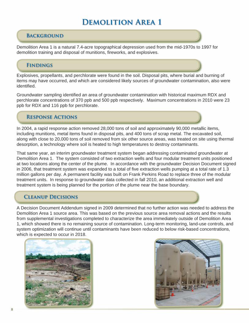
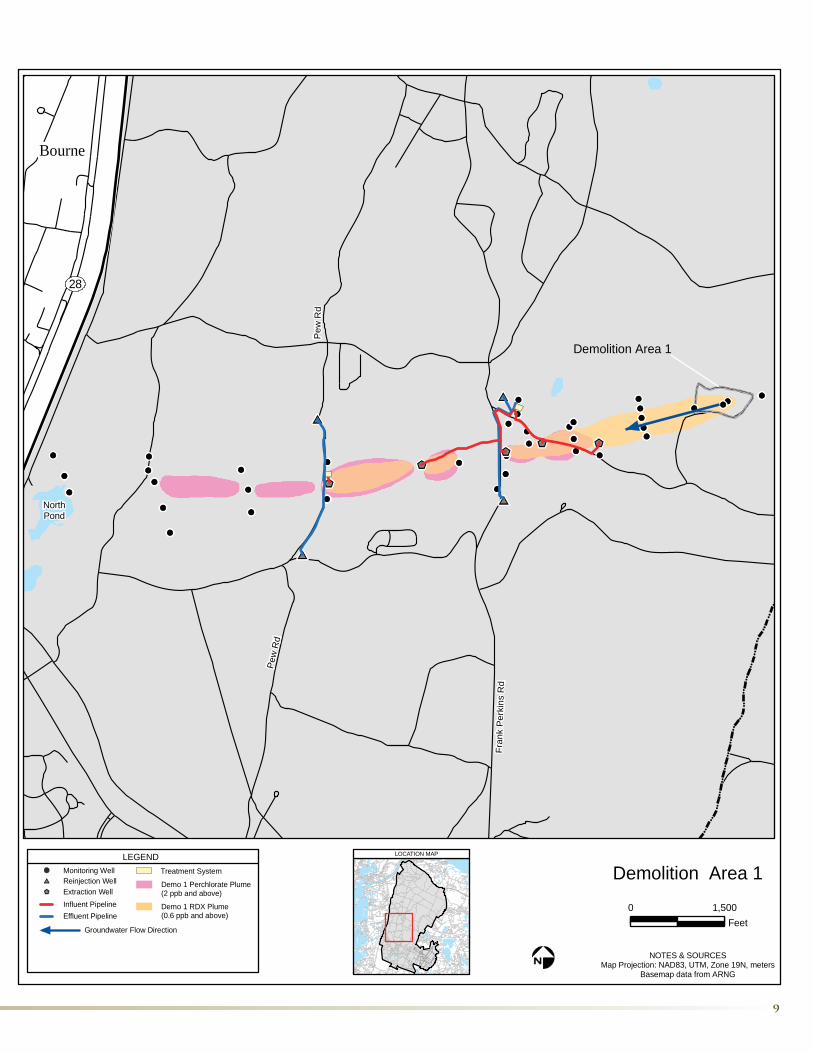
Demolition Area 1 is a natural 7.4-acre topographical depression used from the mid-1970s to 1997 for demolition training and disposal of munitions, fireworks, and explosives.
Findings
Explosives, propellants, and perchlorate were found in the soil. Disposal pits, where burial and burning of items may have occurred, and which are considered likely sources of groundwater contamination, also were identified.
Groundwater sampling identified an area of groundwater contamination with historical maximum RDX and perchlorate concentrations of 370 ppb and 500 ppb respectively. Maximum concentrations in 2010 were 23 ppb for RDX and 116 ppb for perchlorate.
Response Actions
In 2004, a rapid response action removed 28,000 tons of soil and approximately 90,000 metallic items, including munitions, metal items found in disposal pits, and 400 tons of scrap metal. The excavated soil, along with close to 20,000 tons of soil removed from six other source areas, was treated on site using thermal desorption, a technology where soil is heated to high temperatures to destroy contaminants.
That same year, an interim groundwater treatment system began addressing contaminated groundwater at Demolition Area 1. The system consisted of two extraction wells and four modular treatment units positioned at two locations along the center of the plume. In accordance with the groundwater Decision Document signed in 2006, that treatment system was expanded to a total of five extraction wells pumping at a total rate of 1.3 million gallons per day. A permanent facility was built on Frank Perkins Road to replace three of the modular treatment units. In response to groundwater data collected in fall 2010, an additional extraction well and treatment system is being planned for the portion of the plume near the base boundary.
A Decision Document Addendum signed in 2009 determined that no further action was needed to address the Demolition Area 1 source area. This was based on the previous source area removal actions and the results from supplemental investigations completed to characterize the area immediately outside of Demolition Area 1, which showed there is no remaining source of contamination. Long-term monitoring, land-use controls, and system optimization will continue until contaminants have been reduced to below risk-based concentrations, which is expected to occur in 2018.
Demolition Area 1
Cleanup Decisions
Fran
k P
erki
ns R
d
Pew
Rd
Pew
Rd
NorthPond
Bourne
28
Demolition Area 1
0 1,500Feet
NOTES & SOURCESMap Projection: NAD83, UTM, Zone 19N, meters
Basemap data from ARNG
LOCATION MAP
Demolition Area 1LEGEND
Treatment System
Groundwater Flow Direction
Demo 1 RDX Plume(0.6 ppb and above)
Demo 1 Perchlorate Plume(2 ppb and above)
Monitoring Well
Extraction WellReinjection Well
Influent PipelineEffluent Pipeline

Background
The Central Impact Area is a 330-acre portion of the Camp Edwards Impact Area located in the vicinity of Tank Alley and Turpentine Road. It was used from the 1930s through 1997 as the primary target area for artillery and mortar firing from the Gun & Mortar positions. The area includes a number of specific investigation areas including the SCAR Rocket Site, the Eastern Test Site, Chemical Spill 19 (CS-19) site, and the Turpentine Road/Tank Alley target area.
Findings
Soil investigations found detections of RDX, other explosives, propellants, and perchlorate in the areas primarily focused around the former targets.
Results from groundwater sampling identified a number of finger-like plumes of RDX, along with some smaller plumes of perchlorate, migrating from the Central Impact Area. Historic maximum concentrations within the plumes were 44 ppb for RDX in 2006 and 7 ppb for perchlorate in 2009. In 2010, the maximum RDX and perchlorate concentrations were 17 ppb and 5 ppb respectively. These plumes are migrating northwest toward the installation’s boundary and the Cape Cod Canal. No public water supply wells are located in this area and no private water supplies are currently impacted by these plumes.
Response Actions
Soil removal actions have been conducted at Target 9, Target 25, Target 23, Target 42, site, the CS-19 Bunker Area, the CS-19 Expansion Area, and on Tank Alley and Turpentine Road. Overall a total of 5.5 acres were cleared of munitions and approximately 15,200 tons of soil were excavated and treated on site, disposed of off site, or are awaiting final disposition. During the investigation of the High Use Target Area (HUTA 1) HUTA 2, and nine munitions test plots, all munitions were removed from an area of approximately 4.3 acres. Thus, complete removal of munitions has been performed for a total area of approximately 10 acres.
Intrusive investigations and munitions removals have been conducted at the SCAR site, the Eastern Test site, and the CS-19 Bunker Area. The area along Tank Alley and Turpentine Road, where low level RDX water-table detections were observed, will undergo munitions removal this spring. Once this has been completed, the majority of munitions will have been removed from a total of 22 acres. Another 12 acres have been cleared to a minimum of two feet to allow vehicle traffic, and surface clearance was conducted on another 11 acres.
The Final Remedial Investigation/Feasibility Study report for the Central Impact Area is expected in spring 2011. It is anticipated that a remedy will be in place in 2013.
Central Impact Area
Cleanup Decisions

Wood RoadJefferson Road
Poca
sset
San
dwich
Rd
Turp
entin
e R
d
Central Impact Area
Frank Perkins Rd
Pew
Rd
0 1,500Feet
NOTES & SOURCESMap Projection: NAD83, UTM, Zone 19N, meters
Basemap data from ARNG
LOCATION MAP
Central Impact AreaLEGEND
Groundwater Flow Direction
RDX Plume(0.6 ppb and above)
Perchlorate Plume(2 ppb and above)
Monitoring Well
Tank Alley

Background
The Northwest Corner site is located near the Cape Cod Canal and includes areas of the installation where pyrotechnics and artillery were used. Also, fireworks displays which contain large amounts of perchlorate, were used in the area from 1996 until 2003.
Findings
Soil investigations performed in 2003 found significant levels of perchlorate in the soil along Canal View Road immediately after a fireworks display. Subsequent soil sampling in 2008 indicated that the perchlorate levels in the soil were depleted. RDX was not detected in this area. Fireworks debris discovered along Canal View Road had a high level of perchlorate. Groundwater sampling identified two distinct plumes. The shallow, wide perchlorate plume, which originates in the Northwest Corner, had a maximum historic detection of 26 ppb in 2005, and in 2010 had a maximum detection of 11 ppb. A narrow, deeper RDX plume, which extends back towards and originated from the Central Impact Area, had a maximum concentration of 15 ppb in 2009. Area residences are on town water and there are no nearby public water supplies.
Response Actions
Perchlorate concentrations in the soil rapidly decreased following discontinuation of fireworks displays; therefore no soil remediation is necessary.
The selected remedy for addressing the groundwater plume, as outlined in the 2010 Decision Document, is Monitored Natural Attenuation and Land-Use Controls. Long-term monitoring and land-use controls will continue until contaminant concentrations are below risk-based levels, which is expected to be 2012 for perchlorate and 2022 for RDX.
Northwest Corner
Background
Demolition Area 2 was used from the late 1970s to the late 1980s for demolition training involving small explosive charges.
Findings
RDX and propellants were detected in soil in a man-made berm and adjacent soil piles on the western edge of the Demolition Area 2 clearing and in a 30-square-foot area within a shallow depression at the center of the clearing.
Groundwater sampling conducted in 2006 identified a plume with maximum RDX concentrations of 7 ppb migrating to the north. Monitoring in 2010 showed that all levels were below 1.5 ppb. However, it is possible that some higher levels of contamination persist between monitoring locations. The plume is located entirely on MMR and no private or public water supplies are currently impacted by this plume.
Response Actions
In 2004, a source area response action excavated 1,200 tons of soil from the berm, the soil piles, and the center of the site. The soil was treated using thermal desorption.
The selected remedy for addressing the groundwater plume is Monitored Natural Attenuation and Land-Use Controls. Monitoring and land-use controls will continue until the concentrations of RDX are below risk-based levels, which is expected to be 2013.
Demolition Area 2
Cleanup Decisions
Cleanup Decisions

Bourne
Cana
l View
Roa
d
Sandwich
0 1,500Feet
NOTES & SOURCESMap Projection: NAD83, UTM, Zone 19N, meters
Basemap data from ARNG
Northewst Corner andDemolition Area 2
LEGEND
Groundwater Flow Direction
RDX Plume(0.6 ppb and above)
Perchlorate Plume(2 ppb and above)
Monitoring Well
LOCATION MAP

Background
The J-1 Range was used for military training purposes from 1935 to the mid-1970s. From 1957 through the late 1980s, the range was used by defense contractors to test various caliber munitions. Excess explosives, propellants, and munitions were also burned and buried on the range. These activities resulted in the release of explosives compounds and perchlorate to the surrounding soil and groundwater, creating the J-1 northern and southern groundwater plumes.
Findings
Investigation in the Interberm Area, the source of the J-1 Range northern plume, revealed soil contamination in three burn pits and a burial pit along the southern edge of the range, two structures formerly used to burn items – the steel-lined pit and popper kettle, and numerous other disposal pits and burn pits located on either side of the range road. Recently conducted soil sampling identified additional soil contaminated by explosives in this portion of the range. In 2008, a robotics technology demonstration was conducted at the range to evaluate the effectiveness of using remotely-operated equipment to safely remove unexploded ordnance. Identified items were segregated and disposed of.
A groundwater plume originating from this area, identified as the J-1 Range northern plume, is migrating northwest from the middle of the range into the Impact Area. The maximum concentrations of RDX and perchlorate in 2010 were 11 ppb and 42 ppb respectively. The historic maximum concentrations were 36 ppb in 2004 and 78 ppb in 2008 for RDX and perchlorate, respectively. Investigations to further delineate the leading edge of the plume are expected to be completed in 2011.
Investigations in the southernmost portion of the range, the source of the J-1 Range southern plume, revealed numerous burn and burial pits. Recently conducted soil sampling identified additional soil contaminated by explosives in this area of the range. The J-1 Range southern plume is defined by an on-base portion that extends from the source area and terminates at the base boundary at an extraction well, and an off-base portion that extends approximately 1,000 feet beyond the base boundary, beneath a residential area. There is no exposure to the contaminated groundwater plume as all residences in the off-base portion of the plume are connected to the municipal water supply. As of 2009, the maximum concentration of RDX in the on-base portion of the plume was 14 ppb and the maximum in the off-base portion of the plume was 20 ppb. The maximum historical concentration in the plume was 130 ppb in 2006. Recent data obtained during additional investigations found RDX at 71 ppb along Grand Oak Road and at 44 ppb at a location along Windsong Road.
Response Actions
Clearance in support of the cumulative investigations and excavation activities resulted in the removal of significant quantities of unexploded ordnance and munitions debris from portions of the range responsible for the J-1 Range northern and J-1 Range southern groundwater plumes. More than 5,600 tons of contaminated soil have been excavated and either disposed of off site at permitted facilities or treated on site by alkaline hydrolysis.
A July 2010 Remedy Selection Plan documented that no further action was necessary for the source areas due to the removal of the contaminated soils and UXO. Focused Extraction with two extraction wells along with Monitored Natural Attenuation and Land-Use Controls was selected as the groundwater remedy for the northern plume. Treatment of the on-base portion of the southern plume began in 2007 under an interim response action. The extraction and treatment system consists of one well currently pumping at 45 gallons per minute and treatment by granular activated carbon. Treated groundwater is returned to the aquifer through an infiltration trench. The Remedy Selection Plan calls for an additional off-base extraction well along with Monitored Natural Attenuation and Land-Use Controls.
J-1 Range
Cleanup Decisions

J-1Range
Forestdale
Wood Road
Jefferson Road
130
0 1,500Feet
NOTES & SOURCESMap Projection: NAD83, UTM, Zone 19N, meters
Basemap data from ARNG
LOCATION MAP
J-1 RangeLEGEND
Treatment System
Groundwater Flow Direction
RDX Plume(0.6 ppb and above)
Perchlorate Plume(2 ppb and above)
Monitoring WellExtraction Well
Effluent PipelineInfiltration Trench
Composite RDX/Perchlorate plume(s)related to other investigation site(s)

Background
The J-2 Range was used for military training in the 1940s and by defense contractors for munitions testing from 1953 until the late 1980s. Excess explosives, propellant, and munitions were also burned and buried on the range. These activities resulted in the release of explosives compounds and perchlorate to the surrounding soil and groundwater.
Findings
Soil sampling indicated elevated levels of contaminants in areas of the range used for munitions testing and disposal activities. More than 9,700 tons of contaminated soil, believed to be the source of the J-2 Range northern and eastern groundwater plumes, was removed for on site thermal treatment as part of response actions from 2004 to 2006. In 2009, another 1,665 tons of contaminated soil was excavated for treatment using alkaline hydrolysis. Approximately 1,700 tons of additional soil, which was excavated from various areas of the site between 1997 and 2009, was disposed of off site.
The J-2 Range has two identified areas of groundwater contamination known as the J-2 northern and J-2 eastern plumes. RDX and perchlorate are the primary site contaminants associated with the plumes. The 2010 maximum concentrations for the J-2 northern plume were 4 ppb for RDX and 6 ppb for perchlorate. Historical maximum concentrations detected for RDX were 16 ppb in 2008 and 140 ppb for perchlorate in 2003. The 2010 maximum concentrations for the J-2 eastern plume were 14 ppb for RDX and 6 ppb for perchlorate, and historical maximums for RDX were 16 ppb in 2008 and 71 ppb for perchlorate in 2008.
Response Actions
Treatment of the J-2 northern plume began in 2006 under an interim response action. The extraction and treatment system consists of three wells currently pumping at 195 gallons per minute, and treatment by granular activated carbon and ion exchange resins. Treated groundwater is returned to the aquifer through infiltration trenches. Treatment of the J-2 eastern plume became operational under an interim response action in 2008. The system consists of three wells pumping at a total of 375 gallons per minute, and treatment by granular activated carbon and ion exchange resins. Treated groundwater is also returned to the aquifer through infiltration trenches.
The Remedial Investigation/Feasibility Study report for the J-2 Range is expected in winter 2011. It is anticipated that a remedy will be in place in 2012.
J-2 Range
Cleanup Decisions

J-2Range
Forestdale
Wood Road
Jefferson Road
130
0 1,500Feet
NOTES & SOURCESMap Projection: NAD83, UTM, Zone 19N, meters
Basemap data from ARNG
LOCATION MAP
J-2 RangeLEGEND
Treatment System
Groundwater Flow Direction
RDX Plume(0.6 ppb and above)
Perchlorate Plume(2 ppb and above)
Monitoring WellExtraction WellInfluent Pipeline
Effluent PipelineInfiltration Trench
Composite RDX/Perchlorate plume(s)related to other investigation site(s)

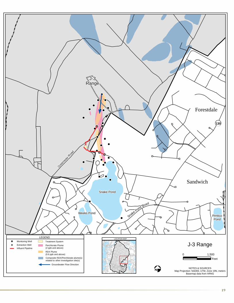
Background
The J-3 Range was used in the 1940s as a mortar and rocket impact area. From 1968 to the late 1990s the range was used by a defense contractor as a weapons testing and development range.
Findings
Soil sampling indicated elevated levels of site contaminants in areas of the range used for munitions testing and disposal activities. More than 3,500 tons of contaminated soil believed to be the source of the J-3 Range groundwater plume were removed during a 2004 response action. The excavated soil was treated using thermal desorption. Approximately 225 tons of additional soil excavated from various areas of the site between 2005 and 2009 was disposed of off site. The nature and extent of contamination at the former mortar and rocket impact area is presently being evaluated and the evaluation is expected to be completed within the next two years.
The primary site contaminants in the J-3 Range groundwater plume are RDX and perchlorate. The 2010 maximum concentrations were 20 ppb for RDX and 22 ppb for perchlorate. The historic maximum concentration for RDX was 38 ppb in 2008 and for perchlorate was 770 ppb in 2005. The plume extends from the primary source areas to off base in the Town of Sandwich. Areas residences are on town water and these contaminants have not been detected in nearby pond water samples.
Response Actions
Treatment of the contaminated groundwater plume began in 2006 under an interim response action. The extraction and treatment system consists of three wells currently pumping at 195 gallons per minute, and treatment by granular activated carbon and ion exchange resins. Treated groundwater is returned to the aquifer through the existing Fuel Spill 12 (FS-12) treatment system reinjection wells.
The Remedial Investigation/Feasibility Study report for the J-3 Range is expected in 2011/early 2012.
J-3 Range
Cleanup Decisions
J-3Range
Forestdale
130
Snake Pond
Weeks PondPimlicoPond
Sandwich
Greenw
ay R
oad
SnakePond Road
0 1,500Feet
NOTES & SOURCESMap Projection: NAD83, UTM, Zone 19N, meters
Basemap data from ARNG
LOCATION MAP
J-3 RangeLEGEND
Treatment System
RDX Plume(0.6 ppb and above)
Perchlorate Plume(2 ppb and above)
Monitoring WellExtraction WellInfluent Pipeline
Groundwater Flow Direction
Composite RDX/Perchlorate plume(s)related to other investigation site(s)

Background
The L Range was primarily used as a 40mm grenade-launcher familiarization range from the 1970s to the mid-1990s. The area had been in use as a training range since the 1940s.
Findings
The groundwater contamination at L Range occurs as isolated and noncontiguous lobes detached from up gradient source areas. While there are no residences in the vicinity, residences downgradient are connected to the municipal water supply. Based on recent data, RDX and perchlorate concentrations have decreased or remained stable in most of the downgradient monitoring wells. Perchlorate is no longer detected above 2 ppb in any monitoring well. L Range groundwater contamination currently consists of two RDX lobes and four areas with low levels of perchlorate. The current maximum detection of RDX is 2.8 ppb; perchlorate is 0.69 ppb.
Response Actions
In 2008, a robotics technology demonstration was conducted at L range to evaluate the effectiveness of remotely- operated equipment to safely remove unexploded ordnance and to facilitate multi-increment soil sampling. A variety of equipment (including a rototiller, surface rake, and power rake) attached to a remote-controlled All Purpose Remote Transport (ARTS) was employed to loosen the top layer of soil and remove root matter. After the soil was loosened, UXO clearance was conducted in a series of transects across the width of the range using an ARTS-mounted screener to collect the remaining material greater than one inch in diameter (including 40mm grenades) from the top six inches of the soil. Metallic debris smaller than one inch remained on the range. Soil sampling results indicated elevated levels of explosives in the middle of the range floor. Approximately 4,000 tons of explosives-contaminated soil was excavated from the range between September and October 2009. These soils were treated by alkaline hydrolysis in a lined treatment cell on the range. No explosives were detected in the treated soils. These soils were subsequently placed back on the range. Sixty-nine potentially high explosive grenades and 96 other munitions and explosives of concern (MEC) items (fuzes, smoke grenades, etc.) were recovered from the range as a result of the robotics activities and the screening of excavated soils. More than 24,000 pounds of munitions debris were removed from the range as a result of this effort.
A September 2010 Decision Document for the L Range documented that no further action for the source area was necessary, based on the removal of the contaminated soils and unexploded ordnance. The groundwater remedy selected for the range was Monitored Natural Attenuation and Land-Use Controls. Cleanup levels are expected to be achieved by 2027 as site contaminants in groundwater are reduced to risk-based levels through natural processes.
L Range
Cleanup Decisions

LRange
Forestdale
130
Snake Pond
Weeks PondPimlicoPond
Sandwich
Greenw
ay R
oad
SnakePond Road
0 1,500Feet
NOTES & SOURCESMap Projection: NAD83, UTM, Zone 19N, meters
Basemap data from ARNG
LOCATION MAP
L RangeLEGEND
RDX Plume(0.6 ppb and above)
Monitoring Well
Groundwater Flow Direction
Composite RDX/Perchlorate plume(s)related to other investigation site(s)

Background
The BA-4 Disposal Area is a small site on the eastern portion of Camp Edwards. Soil contamination at BA-4 was found at several locations where past disposal activities were reported to have taken place.
Findings
Soil samples were collected at the site and surveys with metal-detecting devices were conducted in several areas suspected of containing burial sites. Lead was detected in soil at one area and at another area a 55-gallon drum used for burning was identified and found to contain contaminated soil. No significant groundwater contamination related to this site has been identified.
Response Actions
Subsurface investigations conducted in 2001 removed the 55-gallon drum from one of five investigation areas, and removed 312 expended jet starter cartridges and igniter tubes from another. A response action in 2006 removed close to 96 tons of soil from the areas where these items had been located.
The Decision Document for the BA-4 Disposal Area, issued in 2009, determined that no further action was required at the site.
BA-4 Disposal Area
Background
The Western Boundary site extends west from inside the installation to the Monument Beach section of Bourne. The investigation was initiated to look into perchlorate detections upgradient of Bourne water supply wells.
Findings
Soil Investigations within the site found a couple of low level detections of perchlorate.
Perchlorate in groundwater samples ranged from less than 1 ppb in the off post portion of the site to less than 3 ppb on the installation. Monitoring results from 2010 both on and off post were all below 1 ppb.
Response Actions
Given the low soil and groundwater detections, the source area is likely depleted.
The 2010 Decision Document calls for Monitored Natural Attenuation and Land-Use Controls to address groundwater as monitoring results and model predictions indicate that perchlorate concentrations in groundwater at the site are already below 2 ppb. Long-term monitoring and land-use controls will continue until 2012 to verify that contamination throughout the plume continues to be below risk-based levels.
Western Boundary
Cleanup Decisions
Cleanup Decisions

Background
The Former A Range, also called the Former Gravity Anti-Tank Range, was used from 1941 until the mid-1970s as an anti-tank artillery and rocket range and for machine gun training.
Findings
Soil sampling detected low levels of propellants and semi-volatile organic compounds at the firing points and explosives in the target area. There were no detections of groundwater contamination identified related to activities at the range.
Response Actions A soil investigation that included the removal of 360 tons of soil was conducted in 2005 to analyze deep soil for explosives. The soil was disposed of off site. An additional 75 tons of soil was excavated in 2010 and disposed of off site. In addition, in 2010, 3,750 tons of soil were sifted to remove munitions and bullets from the target area.
The final remedy will be presented for public comment in early 2011.
The Former K Range was used as a rocket range in the 1960s and a grenade-launcher range from 1968 until the 1970s. A portion of the Former K Range was used as a pistol range until the late 1980s.
Soil sampling results from more than 50 locations found random, low level detections of the explosives RDX and TNT at the firing line. Explosives were detected at one suspected target area.
No detectable levels of explosives, lead, or other contaminants related to the investigation were found in sampling results from eight groundwater monitoring wells and direct-push groundwater samples at and downgradient of the targets.
In 2010, 188 tons of soil was removed from the target area and treated using alkaline hydrolysis.
The final remedy will be presented for public comment in early 2011.
Former A Range
Former K Range
Background
Findings
Response Actions
Cleanup Decisions
Cleanup Decisions

Background
The 37 Gun & Mortar Firing Positions were used for training from the early 1930s until 1997. The positions range in size from about a half acre to several acres. Propellants from firing were the primary concern at these sites.
Findings
The propellant 2,4-DNT was found in soil at some of the firing points; however the DNT is bound within the nitrocellulose fibers and therefore does not pose a threat to the environment. Monitoring wells installed to evaluate the quality of groundwater migrating from these gun and mortar positions have not found any detections related to them.
Response Actions
Removal actions in 2000 and 2004 excavated approximately 2,000 tons of contaminated soil from two gun positions. Soil was disposed of off site in 2000, and treated using thermal desorption in 2004.
The final investigation report for the site is expected in early 2011.
Gun and Mortar Firing Positions
Background
The Small Arms Ranges include 45 current and former ranges used since the 1940s for various types of small arms firing. Ranges include firing points and targets, many with earthen berms used to capture fired rounds.
Findings
The propellants nitroglycerine and 2,4-DNT, which are related to firing, were found at varying levels at the firing line on 17 ranges; however, nitroglycerine and DNT are bound within nitrocellulose fibers and therefore do not pose a threat to the environment. Metals, including lead and tungsten, were found primarily in the berms at the ranges where ammunition containing these metals was used.
Nitroglycerine, 2,4-DNT, lead, and other metals related to activities on the Small Arms Ranges have not been found in monitoring wells installed to evaluate the quality of groundwater migrating from beneath the firing lines and berms. Tungsten has been detected in only one monitoring well.
Response Actions
A berm maintenance program was conducted in 1998. Existing berms were excavated and soil sifting and washing were used to remove approximately 60 tons of lead. In 2006 & 2009-2010, soil with high concentrations of tungsten was removed from ranges where tungsten bullets were fired. Approximately 4,800 tons of soil have been removed from three former ranges.
The final investigation report for the site is expected in 2011.
Small Arms Ranges
Cleanup Decisions
Cleanup Decisions

To Learn More About the IAGWSP
To learn more about the Impact Area Groundwater Study Program and opportunities for public input, visit the IAGWSP web site at groundwaterprogram.army.mil. Information also is available through:
MMR Cleanup Team (MMRCT) and Senior Management Board Meetings – These two citizens’ advisory teams meet with members of the Installation Restoration Program, the IAGWSP, EPA, and MassDEP to review program activities and to provide input. For more information on the meetings, which are open to the public, please visit the programs’ web sites: www.mmr.org or groundwaterprogram.army.mil.
Neighborhood Meetings – The IAGWSP periodically holds neighborhood meetings and information sessions to update the public about investigations of interest to a particular community.
Public Comment Periods – Remedy Selection Plans are presented for public review and comment. To find out more about upcoming opportunities for public comment and proposed actions, visit the IAGWSP web site.
Town Updates – The IAGWSP provides annual updates to the Boards of Selectmen and Health in each of the four towns surrounding Camp Edwards. Presentations to the selectmen are televised on public access TV.
Mailing List – Mailing and e-mail lists are used to send out meeting announcements, updates, fact sheets, and newsletters. To be added to the list, please contact Lori Boghdan at 508-968-5635.
Local Media – The IAGWSP routinely updates the local media on program events, advertises meetings and other events in the local newspapers, and responds to requests for information on all aspects of the program.
Visit the IAGWSP Web site at: groundwaterprogram.army.mil
Falmouth Public Library123 Katherine Lee Bates RoadFalmouth, MA 02540
Documents and Updates:
Documents related to the IAGWSP investigation and cleanup are available on the IAGWSP Web site and at the following public libraries:
Jonathan Bourne Library19 Sandwich RoadBourne, MA 02532
Sandwich Public Library 142 Main StreetSandwich, MA 02563

Contacts
For additional information, please contact:
Impact Area Groundwater Study ProgramLori Boghdan1803 West Outer RoadCamp Edwards, MA 02542 Phone: 508.968.5635E-mail: [email protected]
U.S. Environmental Protection Agency, New England RegionJeanethe FalveyPhone: 617.918.1020E-mail: [email protected]
Massachusetts Department of Environmental ProtectionEllie DonovanPhone: 508.946.2866E-mail: [email protected]
Impact Area Groundwater Study Program1803 West Outer RoadCamp Edwards, MA 02542
For information on the Installation Restoration
Program, please contact:
Air Force Center for Engineering and the Environment
Doug KarsonPhone: 508.968.4678, ext. 2E-mail: [email protected] Web site: www.mmr.org
For information on
Other MMR Activities,
please contact:
Massachusetts National Guard Environmental & Readiness Center
Lynda WadsworthPhone: 508.968.5152E-mail: [email protected] Web site: www.eandrc.org
This fact sheet was developed in coor-dination with EPA and MassDEP.
Printed on recycled paper
Related Documents