Annals of the Association of American Geographers, 92(2), 2002, pp. 267–283 © 2002 by Association of American Geographers Published by Blackwell Publishing, 350 Main Street, Malden, MA 02148, and 108 Cowley Road, Oxford, OX4 1JF, UK. Arising from the Bajos: The Evolution of a Neotropical Landscape and the Rise of Maya Civilization Nicholas P. Dunning,* Sheryl Luzzadder-Beach,** Timothy Beach, † John G. Jones, ‡ Vernon Scarborough, § and T. Patrick Culbert ¶ *Department of Geography, University of Cincinnati **Department of Geography and Earth Science, George Mason University † School of Foreign Service, Georgetown University ‡ Department of Anthropology, Texas A&M University § Department of Anthropology, University of Cincinnati ¶ Department of Anthropology, University of Arizona The conjunctive use of paleoecological and archaeological data to document past human-environment relation- ships has become a theoretical imperative in the study of ancient cultures. Geographers are playing leading roles in this scholarly effort. Synthesizing both types of data, we argue that large karst depressions known as bajos in the Maya Lowlands region were anthropogenically transformed from perennial wetlands and shallow lakes to seasonal swamps between 400 bc and ad 250. This environmental transformation helps answer several questions that have long puzzled scholars of Maya civilization: (1) why many of the earliest Maya cities were built on the margins of bajos, (2) why some of these early centers were abandoned between 100 bc and ad 250, and (3) why other centers constructed elaborate water storage systems and survived into the Classic period (ad 250–900). The transforma- tion of the bajos represents one of the most significant and long-lasting anthropogenic environmental changes documented in the pre-Columbian New World. Key Words: geoarchaeology, Latin America, neotropics, Maya ar- chaeology, wetlands. egional landscapes are the product of the long- term dynamics of human-environment interac- tions. Indeed, it is critical that we have a long- term perspective in order to best understand ongoing changes in today’s ambient environment (Oldfield 1998; Klepeis and Turner 2001). 1 Analysis of landscape trans- formations can also reveal important clues about the so- cial and environmental dynamics associated with the rise and decline of ancient civilizations. Behind such in- vestigations there is a growing theoretical imperative for the integration of paleoecological and archaeological re- search in order to understand more fully the impacts of ancient societies on the environment (e.g., Butzer 1996; Fall, Lines, and Falconer 1998; Redman 1999). Geogra- phers have played a critical role in this work, using a combination of historical, archaeological, geoarchaeo- logical, and physical geographical approaches to help es- tablish the time depth, spatial extent, and causation of both intentional and unintentional anthropogenic envi- ronmental change associated with pre-Columbian popu- lations in the New World (e.g., Turner 1974, 1983; Mathewson 1984; Doolittle 1990; Butzer 1992, 1996; Denevan 1992; Dunning 1992; Sluyter and Siemens 1992; Turner and Butzer 1992; O’Hara, Street-Perrott, and Burt 1993; Dunning and Beach 1994, 2000; Beach and Dunning 1995; Turner et al. 1995; Beach 1998; Woods and McCann 1999; Whitmore and Turner 2001). In this article, we report on a profound transfor- mation of wetland ecosystems across wide areas of the Maya Lowlands region and the apparent impacts of those changes on the course of Maya civilization. This ecolog- ical transformation represents one of the most significant and long-lasting anthropogenic environmental changes documented in the pre-Columbian New World. Our re- search continues a long tradition of geographical research on the ecology and use of wetlands in the pre-Hispanic Americas (e.g., West and Armillas 1950; Denevan 1970, 1982; Siemens and Puleston 1972; Turner 1974; Sie- mens 1978, 1983; Gliessman et al. 1983; Turner and Harrison 1983; Wilken 1987; Sluyter 1994). Traditional models of Maya civilization posited a se- quential, unilinear progression of increasing population and cultural complexity beginning in the Early Preclassic period (ca. 1000 bc) and ending dramatically in the “col- lapse” of Classic civilization in the Terminal Classic (ca. ad 900) (see, e.g., Coe 1966; Adams 1977). We now R

Welcome message from author
This document is posted to help you gain knowledge. Please leave a comment to let me know what you think about it! Share it to your friends and learn new things together.
Transcript

Annals of the Association of American Geographers
, 92(2), 2002, pp. 267–283© 2002 by Association of American GeographersPublished by Blackwell Publishing, 350 Main Street, Malden, MA 02148, and 108 Cowley Road, Oxford, OX4 1JF, UK.
Arising from the
Bajos
: The Evolution of a Neotropical Landscape and the
Rise of Maya Civilization
Nicholas P. Dunning,* Sheryl Luzzadder-Beach,** Timothy Beach,
†
John G. Jones,
‡
Vernon Scarborough,
§
and T. Patrick Culbert
¶
*Department of Geography, University of Cincinnati**Department of Geography and Earth Science, George Mason University
†
School of Foreign Service, Georgetown University
‡
Department of Anthropology, Texas A&M University
§
Department of Anthropology, University of Cincinnati
¶
Department of Anthropology, University of Arizona
The conjunctive use of paleoecological and archaeological data to document past human-environment relation-ships has become a theoretical imperative in the study of ancient cultures. Geographers are playing leading rolesin this scholarly effort. Synthesizing both types of data, we argue that large karst depressions known as
bajos
in theMaya Lowlands region were anthropogenically transformed from perennial wetlands and shallow lakes to seasonalswamps between 400
bc
and
ad
250. This environmental transformation helps answer several questions that havelong puzzled scholars of Maya civilization: (1) why many of the earliest Maya cities were built on the margins ofbajos, (2) why some of these early centers were abandoned between 100
bc
and
ad
250, and (3) why other centersconstructed elaborate water storage systems and survived into the Classic period (
ad
250–900). The transforma-tion of the bajos represents one of the most significant and long-lasting anthropogenic environmental changesdocumented in the pre-Columbian New World.
Key Words: geoarchaeology, Latin America, neotropics, Maya ar-chaeology, wetlands.
egional landscapes are the product of the long-term dynamics of human-environment interac-tions. Indeed, it is critical that we have a long-
term perspective in order to best understand ongoingchanges in today’s ambient environment (Oldfield 1998;Klepeis and Turner 2001).
1
Analysis of landscape trans-formations can also reveal important clues about the so-cial and environmental dynamics associated with therise and decline of ancient civilizations. Behind such in-vestigations there is a growing theoretical imperative forthe integration of paleoecological and archaeological re-search in order to understand more fully the impacts ofancient societies on the environment (e.g., Butzer 1996;Fall, Lines, and Falconer 1998; Redman 1999). Geogra-phers have played a critical role in this work, using acombination of historical, archaeological, geoarchaeo-logical, and physical geographical approaches to help es-tablish the time depth, spatial extent, and causation ofboth intentional and unintentional anthropogenic envi-ronmental change associated with pre-Columbian popu-lations in the New World (e.g., Turner 1974, 1983;Mathewson 1984; Doolittle 1990; Butzer 1992, 1996;Denevan 1992; Dunning 1992; Sluyter and Siemens
1992; Turner and Butzer 1992; O’Hara, Street-Perrott,and Burt 1993; Dunning and Beach 1994, 2000; Beachand Dunning 1995; Turner et al. 1995; Beach 1998;Woods and McCann 1999; Whitmore and Turner2001). In this article, we report on a profound transfor-mation of wetland ecosystems across wide areas of theMaya Lowlands region and the apparent impacts of thosechanges on the course of Maya civilization. This ecolog-ical transformation represents one of the most significantand long-lasting anthropogenic environmental changesdocumented in the pre-Columbian New World. Our re-search continues a long tradition of geographical researchon the ecology and use of wetlands in the pre-HispanicAmericas (e.g., West and Armillas 1950; Denevan 1970,1982; Siemens and Puleston 1972; Turner 1974; Sie-mens 1978, 1983; Gliessman et al. 1983; Turner andHarrison 1983; Wilken 1987; Sluyter 1994).
Traditional models of Maya civilization posited a se-quential, unilinear progression of increasing populationand cultural complexity beginning in the Early Preclassicperiod (ca. 1000
bc
) and ending dramatically in the “col-lapse” of Classic civilization in the Terminal Classic (ca.
ad
900) (see, e.g., Coe 1966; Adams 1977). We now
R
268 Dunning et al.
know that Maya civilization suffered other significantperturbations prior to the Classic collapse, including theabandonment of some of the largest urban centers to-wards the end of the Late Preclassic period (ca.
ad
150)(Hansen 1992; Grube 1995). In this article we reportnew evidence suggesting that both the decline of theseearly centers and the growth of later cities relate to an-thropogenic changes in wetland environments.
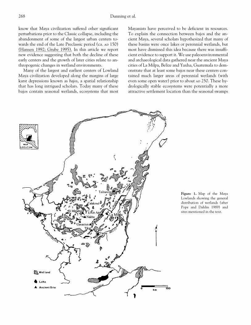
Many of the largest and earliest centers of LowlandMaya civilization developed along the margins of largekarst depressions known as
bajos
, a spatial relationshipthat has long intrigued scholars. Today many of thesebajos contain seasonal wetlands, ecosystems that most
Mayanists have perceived to be deficient in resources.To explain the connection between bajos and the an-cient Maya, several scholars hypothesized that many ofthese basins were once lakes or perennial wetlands, butmost have dismissed this idea because there was insuffi-cient evidence to support it. We use paleoenvironmentaland archaeological data gathered near the ancient Mayacities of La Milpa, Belize and Yaxha, Guatemala to dem-onstrate that at least some bajos near these centers con-tained much larger areas of perennial wetlands (witheven some open water) prior to about
ad
250. These hy-drologically stable ecosystems were potentially a moreattractive settlement location than the seasonal swamps
Figure 1. Map of the MayaLowlands showing the generaldistribution of wetlands (afterPope and Dahlin 1989) andsites mentioned in the text.

Evolution of a Neotropical Landscape and the Rise of Maya Civilization 269
found there today. We argue that human-induced envi-ronmental change, in tandem with climatic change,transformed at least some of these bajos between 1,700and 3,000 years ago. These changes may help explainwhy some early Maya urban centers were abandonednear the end of the Late Preclassic period (400
bc
–
ad
150) and others adapted elaborate water-storage systems.Such environmental changes and resulting storage sys-tems may have been important factors in the emergentpolitical structure of Classic Maya civilization. As pro-found as the transformation of the bajos was, it is equallyremarkable that in many areas the Maya not only suc-cessfully adapted to but flourished in the altered environ-ment throughout the Classic period (
ad
250–900).
Bajos and Wetlands in the Maya Lowlands Environment
The Maya Lowlands cultural region encompasses all ofthe karstic Yucatan Peninsula and adjacent low-lyingareas of Mexico, Guatemala, and Belize (Figure 1). Bajosand other wetlands are a common feature across thesouthern and central Maya Lowlands, variably coveringbetween 40 and 60 percent of land area across the region.
2
An east-west transect across the southern Maya Lowlandsreveals significant variation in elevation and hydrology(Figure 2). The coastward or exterior margins of the Low-lands are low-lying (1–20 m above mean sea level [msl]),and many wetlands are spring-fed or riparian and typi-cally of a perennial nature, maintaining saturated or near-saturated soil-moisture conditions throughout the year.In contrast, interior areas of the Lowlands are generallyelevated 120–300 m above mean sea level, and perennialsurface water of any sort is generally rare and oftenperched in clay layers. Bajos are very common through-out this region. The seasonal wetlands typical of interiorbajos today are flooded for as many as several months anddry for the remainder of the year. The interior bajos con-tain a variety of vegetation communities, depending onthe relative degree of inundation and desiccation charac-teristic of any given area (Lundell 1937; Siemens 1978;
Pope and Dahlin 1989; Culbert et al. 1996). Some inte-rior bajos today include small pockets of perennial wet-lands with generally herbaceous vegetation; these pocketsare known locally as
civales
(Lundell 1937; Jacob 1995).Soils in the interior bajos range from organic Histosols(peats) found in
civales
to fine clay Vertisols, a soil typethat seems to characterize the most extensive areas (Sim-mons, Tarano, and Pinto 1959; Beach 1998). Both theHistosols and Vertisols pose significant difficulties for ag-riculture, and the Vertisols have large seasonal water def-icits and severe cracking. These generalizations maskmuch greater variation within and between bajos in theirhydologies, soils, and variations (Culbert, Levi, and Cruz1990; Brokaw and Mallory 1993; Culbert et al. 1996;Kunen et al. 2000; Dunning et al. forthcoming)
Despite 1500–2000 mm of annual rainfall, water is anespecially precious resource across much of the MayaLowlands interior because of two facts of nature. First, theregion has a tropical wet/dry climate, with more than 90percent of rainfall arriving during a late May-Decemberwet season, leaving the landscape dry for four months.Table 1 and Figure 3 illustrate the water budget for theChan Chich Lodge, a meteorological station recently es-tablished near La Milpa in northwestern Belize. Second,the region is largely karst, with most water quickly enter-ing the complex groundwater system and accessible onlyin a few places. As ancient Maya civilization developed,adaptation to this hydrology was critical for the success orfailure of individual regions, cities, and dynasties (Scar-borough 1993). The idea that significant hydrologicchanges may have occurred during the rise of Maya civi-lization enriches our understanding of the adaptive sys-tems associated with Maya prehistory (Hodell, Curtis,and Brenner 1995; Brenner et al. 2000; Hoddell, Brenner,and Curtis 2000; Hodell, Brenner, and Guilderson 2001).
Bajos and Wetlands in the Maya Lowlands: Earlier Research
The hypothesis that the interior bajos in the SouthernMaya Lowlands may have at one time contained shallow
Figure 2. Elevational transect from the northern Caribbean coast of Belize to the Mirador Basin in the northern Peten (Guatemala).

270 Dunning et al.
lakes has been proposed before, but proponents of this hy-pothesis suggested that the lakes filled with sediment dur-ing the Late Classic (
ad
550–850) apogee of Maya civili-zation, when population levels—and presumably landdisturbance—reached their maxima. This idea was firstput forth in 1931 by Cooke, who suggested that
bajo
sedi-mentation (from agricultural intensification on adjacentuplands) had deprived the Maya of their primary watersource, possibly increased mosquito populations (andmosquito-borne diseases), and triggered the abandon-ment of the Classic period centers of the southern Low-lands. This suggestion was furthered by Ricketson (1937),who excavated a 5.5-m-deep pit in a bajo adjacent to theancient center of Uaxactun. He interpreted the stratigra-phy to be a combination of alluvial and colluvial deposi-tion, as indicated by a layer of water-worn pebbles andthick, dark clays believed to have been eroded off adja-cent uplands. In 1957, Palerm and Wolf suggested that
bajos may have been used for wetland agriculture usingdrained field systems similar to the
chinampas
of the Val-ley of Mexico, and that they played an analogous role inthe centralization of political authority. This idea pre-saged a paradigm shift in Maya research, from a modelholding that Classic Maya civilization consisted of vacantceremonial centers with a dispersed population practicinglong-fallow swidden farming to a model featuring true cit-ies and dense populations supported by a variety of inten-sive agricultural practices (Turner 1993).
Harrison (1977) furthered this model by noting thestrong spatial correlation between settlements and bajosin southern Quintana Roo, punctuated by the aerial ob-servation of features in bajos believed to represent exten-sive wetland field systems. Subsequent ground investiga-tions and excavations confirmed some features in theBajo Morocoy (near the large site of Tzibanche) to bewetland fields (Gliessman et al. 1983). Wetland field sys-tems have been more thoroughly investigated in the low-lying perennial wetlands of northern Belize. Neverthe-less, controversy remains concerning the degree towhich these wetland field systems are the result of natu-ral processes or human modification and the temporalperiods during which they were under cultivation (cf.Turner and Harrison 1983; Pope and Dahlin 1989, 1993;Harrison 1990, 1996; Pohl, Bloom, and Pope 1990; Jacob1995; Pohl et al. 1996; Pope, Pohl, and Jacob 1996).
There has been an equal amount of contention aboutthe degree to which the bajos of the elevated interiorportions of the Maya Lowlands were a valuable resourcefor agriculture or other uses. Soil investigations in bajosnear the large ancient cities of Tikal and El Miradorseemingly refuted earlier assertions that these depres-sions had once contained lakes. However, the oft-citedCowgill and Hutchinson (1963) only excavated twodeep soil pits in the huge Bajo de Santa Fe, 3.5 km east of
Figure 3. Water budget forChan Chich, Belize: five-yearaverage, 1991–1996.
Table 1.
Water Budget for Chan Chich, Belize: Five-Year Average, 1991–1996
MonthPrecipitation in Millimeters
PotentialEvapotranspiration
in Millimeters
Average DailyTemperature
(Celsius)
JAN 175 75 23FEB 100 105 25MAR 58 143 27APR 25 193 29MAY 85 199 29JUN 205 178 28JUL 160 177 28AUG 190 172 28SEP 195 166 28OCT 170 122 26NOV 100 102 25
DEC
79
53
21

Evolution of a Neotropical Landscape and the Rise of Maya Civilization 271
the great ancient Maya city of Tikal. Detailed studymade of the pit’s clay stratigraphy led to the conclusionthat the clays were produced by mass wasting of the lime-stone bedrock comprising the uplands surrounding thebajo. Today, the soil these authors described would beclassified as a Vertisol (Jacob 1995). Cowgill and Hitch-inson (1963, 12) paid relatively little attention to a layerof “carbonaceous material of unknown nature and ori-gin” found at a depth of about 5 m. This layer yielded aradiocarbon date of 11,560
�
360 B.P. Unfortunately,no mention is made as to whether the measured samplewas pretreated to minimize hard-water error; thus, it ispossible that this date is erroneously old. Hard-watererror can result from the dissolution of ancient limestonein the watershed and incorporation of the
14
C-deficientcarbon into shell carbonate (Islebe et al. 1996).
Dahlin and colleagues made more extensive soil in-vestigations in a large bajo adjacent to the large center ofEl Mirador (Dahlin, Foss, and Chambers 1980; Pope andDahlin 1989; Dahlin and Dahlin 1994). They foundVertisols to be the most prevalent soil within the bajo,interpreted to indicate that similar environmental con-ditions had prevailed throughout Maya times. It is note-worthy that the stratigraphy in most soil pits includedone or more buried topsoil (Ab) horizons. We will dis-cuss further below the significance of the Ab horizonsfound at Tikal and El Mirador.
A heated debate has centered on the issue of whetheror not the seasonal wetlands characteristic of interiorbajos today comprised a suitable environment for inten-sive wetland agriculture. Following the detection of wet-land fields in the Bajo Morocoy, many scholars believedthat similar field systems would likely be found through-out the interior bajos of the central and southern MayaLowlands (Turner 1978; Harrison 1990).
3
Furthermore,it appeared for a period of time that airborne syntheticaperture radar (SAR) had successfully detected pattern-ing consistent with canals and wetland field systemsacross wide areas of the Lowlands (Adams 1980; Adams,Brown, and Culbert 1981; Adams et al. 1990). Unfortu-nately, interpretation of the SAR data was flawed, withSAR system noise or bedrock fracturing producing falsepatterning, including areas that were not wetlands (Popeand Dahlin 1989, 1993; Adams 1993; Dunning, Beach,and Rue 1997).
Investigations of bajos near the ancient city of RioAzul in northeastern Guatemala reinforced the fact thatthere is considerable environmental heterogeneity withinthese basins (Culbert, Levi, and Cruz 1989, 1990). Vari-ation exists in drainage, soils, and vegetation associa-tions. Mapping and excavations revealed networks ofpossible ditches towards the margins of the Bajo Peder-
nal. It should be noted, however, that others have sug-gested that such ditches were actually natural anastim-orizing channels (Jacob 1995; Pope and Dahlin 1993).Nevertheless, it is critical to note that the seasonalswamps found today in interior bajos are far from envi-ronmentally homogeneous, with some areas havinggreater agricultural potential than others (Culbert et al.1996; Kunen et al. 2000). Others have argued that theVertisols prevalent today in many interior bajos wouldhave made significant agriculture difficult (Pope andDahlin 1989, 1993; Dahlin and Dahlin 1994). They ar-gue that these soils are often deficient in phosphorus, po-tassium, and zinc, low in organic matter, poorly aerated,overly acidic, subject to seasonal shrinking and swellingcapable of tearing crop roots, extremely hard when dry,and plastic and sticky when wet. Dahlin and Dahlin(1994) suggested that bajos may have been more likelyused principally as areas of managed forest. However, wehave found few such limitations in the upland bajos innorthwestern Belize (Beach et al. forthcoming; Dunninget al. forthcoming). Whether or not bajos are agricultur-ally limited, they cover large areas of the southern andcentral Maya Lowlands, and it would be surprising ifthese basins did not play a significant land use rolethroughout the course of Maya civilization.
Cultural Historical Context
Maya people began settling in the Lowlands by at least4,000 B.P., initially in small, scattered farming commu-nities. The earliest known major urban centers in theMaya Lowlands, Nakbe and El Mirador (Figure 1), flour-ished in the Middle and Late Preclassic periods (900
bc–ad
150), but were effectively abandoned thereafter (Hansen1992). These centers lie adjacent to some of the largestbajos in the region. Many other large Maya communitiesin the southern Lowlands, such as Tikal, Calakmul, Uax-actun, Rio Azul, and La Milpa, had their origins in Pre-classic times but continued to flourish and grow duringthe subsequent Protoclassic and Classic periods (
ad
150–900). These urban centers are also situated adjacent tobajos
.
Evidence suggests that many of these persistingcommunities began constructing reservoirs and otherwater and land management features towards the end ofthe Preclassic period and into the Classic (Scarborough1993; Dunning 1995). Across much of the Maya Low-lands, the population continued to grow steadily through-out the Classic period up to the time of the “Classic col-lapse,” between
ad
800 and 900, when populationsacross the interior Lowlands plummeted sharply andmany urban centers were effectively abandoned.

272 Dunning et al.
Methods and Results
We collected the data reported in this section duringpaleoenvironmental and archaeological investigationsnear La Milpa in 1997 and 1998, and between Yaxha andTikal, Guatemala in 1999. In both cases, investigationsincluded survey and mapping of topography, hydrology,soils, vegetation, and cultural features. Our work in-cluded extensive geoarchaeological trenching, sedimentcoring, and excavations of cultural features.
Investigations at La Milpa, Belize
The ancient city of La Milpa is located in northwest-ern Belize near the eastern margin of the large interiorkarst plateau, a hydrologically elevated area character-ized by rugged free-draining uplands and numerous bajos(Dunning, Beach, Farrell, and Luzzadder-Beach 1998;Dunning et al. forthcoming). The La Milpa site center issituated atop a topographically prominent ridge on theplateau and is flanked by bajos of various sizes. Soils onthe limestone uplands across this region are fertile butshallow clay Rendolls (or Rendzinas), soils that are vul-nerable to erosion where they occur on sloping terrain.Bajo soils are chiefly deeper clay Vertisols, but transi-tional soils occur along the catena up to the crest. Nativevegetation ranges from deciduous swamp forest in the ba-jos to tropical wet/dry deciduous forest across the up-
lands, reflecting the influence of the regional dry season(Brokaw and Mallory 1993).
The earliest Maya occupation thus far discovered at LaMilpa occurred during the Middle Preclassic period (900–400
bc
). However, the first monumental architecture inthe site center dates to the subsequent Late Preclassic pe-riod (400
bc
–
ad
150) (Guderjan 1991; Tourtellot et al.1994; Hammond et al. 1996, 1998). Occupation and con-struction at La Milpa continued, with some interruption,through the middle of the Terminal Classic (ca.
ad
900),after which the site and region were largely and abruptlyabandoned. Sometime during the Classic occupation ofLa Milpa, the Maya modified portions of the ridge-top sitecenter to create large reservoirs (Scarborough et al. 1995).
Our investigations in the drainages and bajos flankingLa Milpa revealed evidence of significant environmentaldisturbance. These investigations included the detailedmapping of Drainage 1 on the eastern side of the site cen-ter and Drainage 3 on the west. We excavated twenty-nine geoarchaeological pits and trenches, twenty-sevenwater and soil management features (dams, weirs, andterraces), and eighteen associated residential features inthe two drainages and the bajos into which they dis-gorge.
4
Several of the more significant trenches exca-vated in Drainage 3 and the associated Far Western Bajoare discussed below.
Operation V33a is one of several trenches across thelower reaches of the Drainage 3 channel (Figure 4). Soil
Vegetation:Upland forest and corozal
Soil Units:1) Very dark gray (5YR3/1) sandy clay (�5% coarse sand); large crumb structure.2) Very dark gray (5YR3/1) sandy clay (�40% coarse sand and small limestone pebbles); small crumb structure.3) Dark gray (5YR4/1) sandy clay (�20% coarse sand); fine crumb structure.4) Very dark gray (7.5YR3/0) sandy clay (�5% coarse sand); small subangular blocky structure; faint
slickensides.5) Grayish brown (10YR5/2) sandy clay (�20% coarse sand); large subangular blocky structure; slickensides.6) Black (5YR2.5/1) clay; large subangular blocky structure; slickensides.7) Dark grayish brown (10YR4/2) clayey coarse sand (�40% clay); large crumbs.8) Fifty percent sub-rounded gravel, cobbles, and small boulders in a matrix of very dark gray (10YR3/1) sandy
clay (�15% coarse sand).9) Grayish brown (10YR5/1) clayey coarse sand (�40% clay).
10a) Dark grayish brown (10YR4/2) sandy clay (�5% coarse sand); large subangular blocky structure; slickensides.11) Yellowish brown (10YR5/6) sandy clay in a matrix of decomposing limestone boulders.12a) Hard limestone bedrock.
Figure 4. Profile of Opera-tion V33a showing stratig-raphy typical of the lowerreaches of Drainage 3.

Evolution of a Neotropical Landscape and the Rise of Maya Civilization 273
Unit 6 is a buried topsoil with soil humates dating toabout 1200–910
bc
(calibrated) (Beta-112474). Thissoil was buried multiple times by fluvial sediments. Atone time, the lower reaches of the Drainage 3 channelunderwent massive aggradation, and coarse alluvium(Unit 8) completely choked the channel. Subsequenterosion reopened the channel and flushed out much ofthe Unit 8 alluvium. Where Drainage 3 disgorged ontothe nearly flat bajo floor, some 70 m lower in elevationthan the La Milpa site center, deposition of coarse sedi-ments formed a wide, deltaic fan incised by braidedchannels. Operation BH6 revealed two ephemeral chan-nels marked by slackwater deposits of finer, more organicsediments (Units 3 and 5) (Figure 5). Humates in Unit 5(100–130-cm depth) date to 415–365
bc
(calibrated)(Beta-118306); humates in Unit 3 (30–60-cm depth)date to
ad
330–440 (calibrated) (Beta-118305).Beyond the delta was a concomitant aggradation of
finer sediments across the Far Western Bajo floor. Fif-teen trenches excavated in this bajo revealed a generalburied soil (paleosol). In Operation BH9, this ancientsoil comprises Unit 5a (Figure 6), where faint organicmatter (Saprist) and pollen were fortuitously preserved.Most of the pollen was partially oxidized but could stillbe readily identified. That pollen assemblage was domi-nated by
Typha
(cattail), a plant characteristic of peren-nial wetlands and lake margins, and by other aquatic veg-
etation (Table 2). Long-distance
Pinus
(pine) and
Quercus
(oak) pollen were also identified; such pollen are typicallytrapped in bodies of open water. In combination, thesepollen indicate the former presence of a perennial wet-land, probably containing pockets of open water. The com-position of Unit 5a is consistent with the peaty surface-horizon forming in a perennial wetland, a very different ec-osystem from the seasonally desiccated scrub forest that oc-cupies the bajo today. Unit 5a has been radiocarbon-datedto
ad
15–110 (calibrated) (Beta-121443).Another line of evidence about environmental
change in these bajos can be found in the isotopic com-position of carbon (C) in organic matter (OM) in theburied soils found in the bajos flanking La Milpa. Thecomposition of Unit 5a in Operation BH9 also indicatesthat this buried horizon represents an ancient peat layerthat formed within a perennial wetland (Figure 7). Sim-ilar findings have been reported from buried soil found ina large bajo near Nakbe (Figure 1) (Jacob 1995). Plantswith a C3 photosynthetic pathway have a
�
13
C valuenear
�
27‰, whereas plants with a C4 pathway have a
�
13
C value near
�
14‰. OM in surface soils in the Nakbeand La Milpa bajos had an average value near
�
27‰, re-flecting the present-day arboreal, seasonal swamp forestvegetation. In the buried soils at Nakbe, however, OMhad average values around
�
23‰, suggesting the deriva-tion of OM from both C4 and C3 herbaceous plants and
Vegetation:Corozal forest
Soil Units:1) Black (7.5YR2/0) clay; large crumb structure.2a) Black (5YR2.5/1) sandy clay (�40% coarse sand); large crumb structure; �10% gravel and small cobbles.2b) Dark gray (5YR4/1) clayey sand (�40% clay); large crumb structure; �10% gravel and small cobbles.3) Very dark gray (5YR5/1) sandy clay (�20% medium sand); blocky to massive structure.4) Fifty percent sub-rounded gravel, cobbles and small boulders in a matrix of dark yellowish brown (10YR4/4)
clayey coarse sand (�20% clay).5) Very dark gray (7.5YR3/0) clay; massive.6) Matrix of grayish brown (7.5YR5/2) clayey coarse sand interspersed with 30% sub-rounded gravel, cobbles, and
small boulders.7) Pale yellow (2.5YR7/4) clay with �20% reddish yellow mottles; massive; slickensides.8) Limestone bedrock.
Figure 5. Profile of Opera-tion BH6 showing stratigraphytypical of deltaic deposition atthe mouth of Drainage 3.

274 Dunning et al.
from moisture-loving trees. Since the herbaceous speciesin tropical wetlands include both C4 and C3 plants, OMderived from such plant communities will always containa mixture of carbon isotopes (Boutton 1991). Isotopic C
in buried soils from bajos near La Milpa is even more sup-portive of the former presence of herbaceous vegetation.OM
�
13
C values from these soils ranged from
�
18.3‰ to
�
23.2‰, midway between the
�
13‰ value expectedfor exclusively herbaceous C4 plants and the
�
27‰value expected for exclusively woody C3 plants. Theseisotopic C values correspond well to the mixed herba-ceous and aquatic woody vegetation found within andbordering perennial wetlands. At present, we have noevidence that the Maya were cultivating this perennialwetland in the Preclassic. We have found eroded arti-facts scattered throughout the sediments down into thedeepest paleosols. The Maya were all around the areaand, if nothing else, this wetland would have provided areliable source of water during the dry season in an areawhere no such water exists today.
Unit 4 in Operation BH9 is a thick layer of fine sandyclay sediment that buried Unit 5a and 5b (Figure 6). Weinterpret this burial to have resulted from substantial de-forestation and subsequent erosion of the slopes in theFar Western Bajo watershed. The preservation of peatindicates that sedimentation occurred rapidly. Defores-tation and the large-scale deposition of clay sediments inthe bajo probably caused long-term hydrologic and eco-logical changes (Figure 8). Sedimentation and eutrophi-cation can greatly degrade wetland functions (NationalResearch Council Committee on Characterization ofWetlands 1995). Also, a deforested and eroded water-shed would have severely retarded rainfall infiltrationand evapotranspiration, leaving a much higher percent-age to run off through seasonal channels or into karstswallow holes. Further, the new dense-clay layer raisingthe base elevation of the bajo floor may have also con-
Vegetation:Tintal-scrub forest and sawgrass
Soil Units:1) Black (5YR2.5/1) clay; large crumb structure.2) Dark gray (5YR4/1) clay with �20% yellowish red mottles (5YR5/8); large crumb structure.3) Gray (5YR5/1) clay with �40% yellowish red mottles; medium subangular blocky structure.4) Light gray (5YR7/1) clay with �10% yellowish red mottles and �5% coarse sand; massive.5a) Very dark gray (7.5YR3/0) clay; interfingered with thin bands of sapric material; massive.5b) Very dark gray (7.5YR3/0) clay with �20% red and light gray mottles; massive.6) White (5YR8/1) clay with �30% reddish yellow (5YR7/8) mottles; massive.
Figure 6. Profile of Opera-tion BH9 revealing stratigra-phy typical of the Far WesternBajo floor.
Table 2.
Pollen from Unit 5a, Operation BH9, Programme for Belize Archaeological Project
Long-distance types
Pinus
(Pine) 8
Quercus
(Oak) 4Aquatic types
Typha
(cattail) 88Cyperaceae (sedge) 33
Cladium
(Sawgrass) 6Open-area types
Poaceae (grass) 29*Asteraceae (Composites) 10Alismataceae (pickerelweed) 3Polygonaceae 1
Amaranthus
1Forest types
Fabaceae (Legume family) 1
Haematoxylon
(logwood) 1
Coccoloba
(Bob) 1
Hirea
(Liana) 1
Burcera
(gumbolimbo) 1Moraceae (fig family) 2Combretaceae/Melastomataceae 3
Myrica
(wax myrtle) 2
Machaerium/Dahlbergia
1Rubiaceae 1
OtherUnknown A (possibly
Casearia
) 2
Indeterminate 1
Note:
Based on a standard count of 200 pollen grains; numbers are absolutequantities.*May be in part Olyra, an aquatic grass.

Evolution of a Neotropical Landscape and the Rise of Maya Civilization 275
fined groundwater seepage preventing recharge of thewetland. Such groundwater contributions are often crit-ical for maintaining wetland moisture levels. Both effectswould have resulted in significantly reduced soil mois-ture levels in the dry season. These changes may haveinitiated the transformation from an herbaceous aquatic-adapted vegetative complex to a scrub-forest complexadapted to drastic seasonal moisture fluctuations.
The violent distortion and fragmentation of Unit 3and lower strata in Operation BH9 (Figure 6) is the re-sult of significant argilloturbation (clay shrink and swellactivity) (Beach et al. forthcoming). One factor contrib-uting to this argilloturbation was probably differentialpressure-loading and confining pressure within the accu-mulating sediment comprising Units 3 and 4 (Paton1974). Another contributing factor was the onset ofdrying and wetting extremes, probably reflecting defor-
estation, rather than climate change, within the bajowatershed. However, we cannot discount the potentialregional climatic drying that may have also contributed todesiccation and argilloturbation in the bajos (e.g., Brenneret al. 2000; Hodell, Brenner, and Curtis 2000; Pope et al.2000; Hodell, Brenner, and Guilderson 2001). This bro-ken stratigraphy is characteristic of upland bajo soil pro-files throughout the La Milpa area. Investigations in asmaller bajo at the mouth of Drainage 1 revealed simi-lar distorted strata, including buried Preclassic topsoil(Dunning and Beach 2000; Beach et al. forthcoming).Notably, since the reforestation of the bajo after the re-gion was depopulated around ad 900, argilloturbation ofthe surface soil has been relatively minimal, as evident inthe stable development of surface-soil horizons (Figure 6,Units 1 and 2).
Evidence thus far strongly suggests that deforestationand soil erosion associated with Late Preclassic (400 bc–ad 150) populations and agriculture at La Milpa were theroot causes of the changes occurring in local bajos. Ourinvestigations at La Milpa and in surrounding lands, in-cluding forty-two geoarchaeological trenches andtwenty-six radiocarbon dates from buried soils, consis-tently indicate severe environmental disruption associ-ated with Preclassic land clearance (Dunning et al. 1999;Dunning and Beach 2000).
The Preclassic population in the La Milpa area wassmaller than later Classic numbers, but they probably
Figure 7. �13C of soil organic matter in La Milpa and Nakbe bajos.Nakbe data from Jacob (1995), figure 4-16.
Figure 8. Schematic representation of anthropogenic change in an interior Maya Lowlands bajo.

276 Dunning et al.
practiced extensive forms of forest clearance and agricul-ture, generating disproportionately high environmentaldisturbance. Much of the region’s sloping upland terrainwas probably denuded of its soil cover. This conclusionconcurs with previously documented evidence that sug-gests that, for some regions, the Maya of the ensuingEarly Classic period may have inherited a severely erodedlandscape from their ancestors (Jacob 1995; Beach 1998;Dunning, Rue, Beach, Covich, and Traverse 1998; Dun-ning et al. 1999; Dunning and Beach 2000).
Ancient land-use on gently sloping lands flanking theFar Western Bajo and other bajos in the vicinity of LaMilpa included extensive networks of agricultural ter-races, berms, and field walls (Figure 9) (Tourtellot et al.1994; Hughbanks 1998; Kunen 2001). Recent work atNakbe in the northern Peten has also documented ex-tensive terracing around the margins of bajos (Hansen etal. 2000). In one instance, massive colluviation buried abajo-margin terrace, sealing and preserving the Late Pre-classic planting surface. Analysis of the buried terracesoil indicates that it was being built up and enriched withorganic mucks derived from a perennial wetland (pre-sumably in the adjacent bajo). Carbon-isotope analysisof soil behind a bajo-margin terrace at La Milpa also in-dicates enrichment with muck.
Investigations at the huge site of Calakmul and theadjacent El Laberinto Bajo suggest that during the tran-sition from Preclassic to Classic occupation around ad200, an agricultural system evolved emphasizing the ter-racing and intensive cultivation of colluvial soils accu-mulating along the bajo margins (Gunn et al. 2000). Thesystem of walls and terraces around the La Milpa bajosmay also represent the development of bajo-margin in-tensive agriculture.
Despite the transformation of the Far Western Bajo at
La Milpa from a perennial wetland to a seasonal swampforest, this area continued to be a focus of Maya settle-ment in the Classic period. In fact, population grew con-siderably during the Classic, both along the margins ofthe bajo and on a large, rocky “island” within it (Kunen2000). These findings strongly suggest that these bajoscontinued to be an important resource, although wehave no direct evidence of the nature of Classic land-useon the bajo floors themselves.5
Investigations Near Yaxha and Tikal
Investigations of large interior bajos near Yaxha andTikal have also revealed dense settlement dating fromLate Preclassic through Late Classic times on flankinguplands and on “islands” within the bajos (Culbert et al.1996; Fialko 1999; Kunen et al. 2000). Immediatelynorth of the ancient city of Yaxha lies the sprawling (ap-proximately 150 km2), topographically complex Bajo LaJusta. This bajo contains a variety of seasonal wetlandtypes and is dotted with numerous islands of variable size,including one on which was built the major monumentalarchitectural center of Pozo Maya. Nearby is one of themore distinctive features found to date in a bajo: theAguada Maya, a 13,200 m2 bermed, rectangular, peren-nial pond. Although the Aguada Maya may have begunas a natural pond, it was clearly heavily modified byhuman labor. Many of the Bajo La Justa sites contain ev-idence of significant Preclassic and Early Classic settle-ment, but occupation appears to have been greatest inthe Late Classic. We strongly suspect that the modifica-tion of the Aguada Maya dates at least in part to the LateClassic. This assertion is also supported by evidence indi-cating that earlier features on the bajo floor may havebeen buried by sedimentation.
Figure 9. Map of a portion of the eastern margin of the Far Western Bajo, La Milpa (Far West Drainage Survey Block 16, mapped by PaulHughbanks and Julie Kunen) showing agricultural terraces and field walls.

Evolution of a Neotropical Landscape and the Rise of Maya Civilization 277
In 1999, numerous pits and trenches were excavatedin a variety of environmental contexts in the Bajo LaJusta. Most of these revealed clay-heaved, distorted Ver-tisols broadly similar to those observed near La Milpa.We again interpret these argilloturbation features to bethe result of combined subsidence and compression asso-ciated with clay-sediment deposition and to shrinkingand swelling associated with seasonal wetting and dry-ing. In most of the excavations carried down to a suffi-cient depth, Ab horizons occurred at depths rangingfrom 80 to 290 cm. Only one of these paleosols has beenradiocarbon-dated.
Operation 6D3 was a hand-dug extension of a narrowbackhoe trench, located a few hundred meters down-slope from the northernmost monumental architecture atYaxha. This extension was completed because the smallbackhoe could only reach a depth of about 1.5 m. Muchof the upper portions of the revealed profile resemblethat of a typical bajo Vertisol (Figure 10). However, thelower portions of the excavation produced two distinc-tive features. Unit 6 is a wavy band of black, organic clayinterspersed with residual Saprist (faint organic matter),similar to the peaty paleosol found in the Far WesternBajo at La Milpa. Carbon isotopes from Unit 6 also indi-cate this deposit formed in a perennial wetland (Figure7). Fortuitously, Unit 6 also preserved pollen of manyaquatic species, such as water lilies and cattails as well asopen-water-deposited pine and oak pollen (Table 3).Pollen also indicate considerable open, grassy areas. OneZea Mays pollen grain indicates that the Maya may havebeen cultivating nearby areas, since these pollen do nottravel far from their source. Unit 6 produced a radiocar-bon date of ad 75 (calibrated) (Beta-134143). Unit 5 is astratum of gray clay that appears to include an approxi-mately 160-cm-wide ridge bounded on both sides byditches some 30–40 cm in depth. Both the ridge andditches are continuous features across the width of theexcavation (1 m). Unit 4 is a pale clay that we interpretto be a slope wash and precipitate deposit derived fromnearby low limestone ridges.
At present, we interpret the stratigraphy in Operation6D3 as follows. Around ad 75, this portion of the Bajo LaJusta was a perennial wetland with pockets of open waterand wide, grassy margins. Whether the Maya were culti-vating maize in the bajo (probably with the use of ditch-ing) or on higher ground nearby is unclear. Some timeafter ad 75, this section of the bajo began to rapidly fillwith gray, colluvial clay, probably coincident with forestclearance on adjacent uplands. It appears that the Mayamay have brought this new clayey surface into agricul-tural production using ditching and mounding. How-ever, continued colluviation further filled the bajo,
eventually transforming it from a perennial to a seasonalwetland—a process analogous to that described abovefor La Milpa. A thin topsoil formed in this deposit afterMaya abandonment.
Trenches excavated nearby in the Bajo La Justa in1996 and partially reopened in 1999 revealed deeply bur-ied channels filled in with clayey sediment (Kunen et al.2000). Portions of these buried channels included verysharp “cuts” into underlying sascab (marl), suggestive ofhuman modification. The date of these channels remainsunknown, however, and conclusive evidence of humanmodification has not been recovered.
As with La Milpa, the presence of heavy Classic pe-riod settlement on bajo “islands” and margins stronglysuggests that the Bajo La Justa continued to be an impor-tant resource area even after its transformation into aseasonal wetland. The presence of the Aguada Mayawithin the bajo further suggests that the Maya may haveattempted to manipulate soil moisture conditions innearby portions of the bajo to improve agricultural pro-ductivity. In the large Bajo Zocotzal southwest of Tikal,Fialko (1999) found Late Classic dams and weirs in twoarroyos leading into the bajo, indicating attempts tomanage water at least within localized areas.
Discussion
We cannot yet conclude that all—or even most—interior bajos in the southern and central Maya Lowlandscontained perennial wetlands at some point in their past,but evidence to that effect is mounting. As noted above,Jacob (1995) suggested that carbon isotopes in buriedsoil horizons in a bajo near Nakbe indicated that theseburied organic layers originated in peaty deposits formedin perennial wetlands analogous to contemporary civalesbut much larger. It is also possible that the paleosols stud-ied earlier in bajos near El Mirador and Tikal also repre-sent old, remnant peats (Cowgill and Hutchinson 1963;Dahlin et al. 1983; Dahlin and Dahlin 1994). Thus far,we do not know the degree to which Preclassic Mayapeople practiced any form of agriculture directly in theformer perennial wetlands of the interior bajos. How-ever, the preferential settlement of bajo margins duringthe Preclassic can most simply be explained by their im-portance as a water source in a region that is practicallywaterless at the height of the annual dry season today.The rapid sedimentation that occurred in many bajossuggests that significance disturbance, probably includ-ing quarrying, was taking place on adjacent uplands(Hansen et al. 2000).
If our model of bajo transformation represents condi-

278 Dunning et al.
Vegetation:Mixed palm bajo forest.
Soil Units:1) Black (5YR2.5/1) clay; large, hard crumbs; dense root mat.2) Very dark gray (7.5YR3/0) clay; large, hard crumbs; diminishing roots.3) Dark gray (7.5YR4/1) clay; platy to massive; slickensides.4) Light gray (10YR7/2) clay; 1–2% coarse sand; small, platy peds;
slickensides.5) Gray (10YR6/1) clay; 3–4% coarse sand; massive; slickensides.6) Black (7.5YR2/0) clay with visible tissue impressions interbedded with
pockets of sapric peat; clay is platy; peat is highly compressed.7) Gray (10YR5/1) clay; 5–6% coarse sand; massive; scattered small, black
Mn oxide inclusions.8) White sascab and weathering, cherty limestone.
Figure 10. West profile of Operation 6D3, Bajos CommunitiesProject, Guatemala.
tions affecting much of the interior portions of the cen-tral and southern Maya Lowlands, it has important im-plications for understanding changes that occurred inMaya civilization towards the end of the Preclassic pe-riod. One of the most notable changes occurring at thattime was the abandonment of El Mirador, Nakbe, andnearby urban centers (Hansen 1992). Notably, thesewere the largest known Preclassic urban centers in theMaya Lowlands. It is possible that their large populationsmade them particularly vulnerable to environmental dis-turbance, including prolonged drought (Hodell, Bren-ner, and Guilderson 2001). Or, perhaps because of theirgreat size, environmental degradation was more severe orrapid than in neighboring areas, thereby triggering aban-donment. Although the environmental disturbance gen-erated by Preclassic people was certainly significant else-where, it may not have been so rapid or acute as aroundEl Mirador and Nakbe, because Preclassic populationswere much smaller in other localities. This differencemay help explain why, in neighboring places such asTikal and La Milpa, population continued to grow andurban development persisted.
Recent syntheses of paleoclimatic models and datafound convergent indications of maximal rainfall acrossthe southern Maya Lowlands around 1000 bc (Brenner
et al. 2000; Pope et al. 2000), a condition that may havehelped establish perennial wetlands in many bajos. Conver-gent data also indicated that gradual but irregular climaticdrying ensued, with maximal dryness occurring around ad100, possibly playing a significant role in the transformationof bajos from perennial to seasonal wetlands and in thetransition from the Preclassic to Classic periods in Mayacivilization; such drying also apparently occurred aroundthe end of the Late Classic, circa ad 800 (Hodell, Brenner,and Curtis 2000; Hodell, Brenner, and Guilderson 2001).
In many places like La Milpa, the loss of perennialwater sources in the bajos necessitated developing newwater sources and more water-conservative agriculture.Thus, it is not surprising that during the transition fromthe Preclassic to the Classic, reservoirs became an inte-gral part of the urban landscape at many Southern Low-
Table 3. Pollen from Unit 6, Operation 6D3, Bajo Communities Project, Guatemala
Long-distance typesPinus (Pine) 21Quercus (Oak) 14Liquidambar 1Ulmus/Chaetoptelea 2
Aquatic typesTypha (cattail) 5Cyperaceae (sedge) 4Cladium (sawgrass) 15Nymphea (water lily) 20
Open area types and cultigensPoaceae (grass)* 47Asteraceae (composites) 21Polemoniaceae 1Laminaceae 1Waltherea 2Zea mays 1
Forest typesFabaceae (Legume family) 1Bursera (gumbolimbo) 2Moraceae (Fig family) 6Combretaceae 9Myrica (wax myrtle) 2Anacardiaceae 2Erthroxylaceae 1Byrsonima 4Sebastiana 4Alnus 1Sapotaceae 1Celtis 2
OtherUnknown A (may be Casearia) 1Unknowns 2Indeterminate 7
Note: Based on a standard count of 200 pollen grains; numbers are absolutequantities.*May be in part Olyra, an aquatic grass.

Evolution of a Neotropical Landscape and the Rise of Maya Civilization 279
land centers (Scarborough 1993). The localized controlof water resources by urban elites, the intensification oflocal agricultural production, and the centralization andstratification of land wealth were also fundamental com-ponents of the Preclassic-Classic transition (Dunning1995). These processes were seemingly brought about inpart by the adaptations necessitated by the transforma-tion of the bajos and by apparent climatic drying, andprobably also facilitated by the disruption of the urbanhierarchy accompanying the fall of El Mirador andnearby Preclassic centers.
Evidence from settlement patterns at La Milpa, BajoLa Justa, and elsewhere in the southern and central MayaLowlands suggests that large numbers of people contin-ued to live along bajo margins throughout the Classic pe-riod. Part of this pattern may be attributable to loca-tional inertia, but part was undoubtedly related toagriculture. However, both the nature and success of an-cient agriculture in the bajos remain problematic and inneed of further investigation.
More broadly, our findings demonstrate the poten-tially devastating and long-term consequences of tropi-cal deforestation. The transformation of bajos from pe-rennial to seasonal wetlands occurred about 2,000 yearsago. Even after the general abandonment of the regionaround ad 900, most bajos remained seasonal wetlands,with only a few pockets of perennial moisture (civales)slowly being reestablished. For the Maya, transformationof the bajos was apparently initially a significant prob-lem, but was later overcome by adaptive ingenuity thatflourished into complex agricultural systems by the LateClassic (Dunning and Beach 2000). Nevertheless, thesuccess experienced by Classic Maya civilization was alsofinite. By ad 900, large sections of the Lowlands—partic-ularly the interior areas—were largely abandoned, a pro-cess that is itself far from understood.
Our research also contributes to the corpus of evi-dence dismissing the “leyenda verde” (Turner and Butzer1992; Whitmore and Turner 2001) or “pristine myth”(Denevan 1992; Butzer 1993)—the idea that the ecosys-tems of the New World were relatively undisturbed bypre-Columbian occupation. We have only recently be-gun to appreciate the magnitude of environmentalchanges brought about by Native American activities.Although it has been suggested that pre-Columbian en-vironmental disturbances have been greatly exaggerated(e.g., Vale 1998), our investigations strongly indicatethat the state of many of the wetlands of the Maya Low-lands to this day is partly a product of pre-Hispanic human-environment interactions.
Our findings are consistent with a principle tenet ofthe “new ecology”: namely, that the biophysical envi-
ronment is inherently more unstable than is usually rec-ognized in traditional systems models, and that humaninteractions add an even greater dynamic flux to envi-ronmental systems (cf. Botkin 1990; Zimmerer 1994;Balée 1998). We see the changes that occurred in the ba-jos as the product of complex interactions between hu-man disturbance, climate change, and a highly vulnerableenvironment. With the removal of human disturbance,the bajo ecosystems certainly did not return to their pre-disturbance state. The long-term impacts of even low-technology human disturbance of tropical ecosystemsshould be considered as these areas are colonized foragricultural development today.
Acknowledgments
Much of the work reported here has been carried outas part of the Programme for Belize ArchaeologicalProject, under the general supervision of Fred Valdez,Jr., and with the gracious cooperation of the Depart-ment of Archaeology, the Ministry of Tourism and theEnvironment, and the Programme for Belize. Investiga-tions during 1997 and 1998 were carried out with thesupport of a National Science Foundation grant to Ver-non Scarborough and Nicholas Dunning. Earlier workwas supported by funds from a National Geographic So-ciety grant to Scarborough in 1992 and a Heinz FamilyFoundation grant to Dunning in 1994, and from theUniversity of Cincinnati, University of Texas, GeorgetownUniversity, George Mason University, and generous pri-vate donors. Dunning and Timothy Beach undertook in-vestigations in 1996 as part of Boston University’s LaMilpa Archaeological Project, headed by Norman Ham-mond and Gair Tourtellot. Hammond and Tourtellotare to be thanked for their cooperation and friendly ex-change of ideas over the past several years, which haveenriched our work immensely. Numerous personnel ofthe Programme for Belize Archaeological Project havecontributed to the work reported here, including AlanCovich, Jon Hageman, Paul Hughbanks, Julie Kunen,John Lohse, David McDowell, Hugh Robichaux, KerrySagebiel, Frank Saul, Julie Saul, Lauren Sullivan, andSkye Wagner. Some of the work reported here was car-ried out as part of the Bajo Communities Project, di-rected by Pat Culbert. This research is being conductedas part of Subproyecto Intersitios, directed by VilmaFialko, as part of the larger Proyecto Triangulo of the In-stituto de Antropología e Historia (Guatemala). Recentfunding for the Bajo Communities Project has been pro-vided by a grant from NASA to Culbert, Fialko, andTom Sever. Numerous personnel from the Bajo Com-
280 Dunning et al.
munities Project contributed to the work reported herefrom the 1999 season, including Rosa María Chan,Vilma Fialko, Liwy Grazioso, Gustavo Martínez, JohnMurphy, and Tom Sever. Hammond, Tourtellot, JohnJacob, G. S. Humphreys, Scott Fedick, Jeffrey Baker,Bruce Dahlin, Joel Gunn, Richard Hansen, Peter Harri-son, Bill Doolittle, Andrew Sluyter, B. L. Turner, II, andBetsy Lazaron provided helpful comments on earlierversions of this article, including versions presented atthe 95th Annual Meeting of the Association of AmericanGeographers, 23–27 March 1999, Honolulu, Hawaii andin the “Mesoamerican Wetlands” symposium at the 65thAnnual Meeting of the Society for American Archaeol-ogy, 5–9 April 2000, Philadelphia, Pennsylvania.
Notes
1. In addition to the report edited by Oldfield (1998), readersinterested in ongoing work on global environmental changeare referred to the other projects sponsored by the Interna-tional Geosphere-Biosphere Programme (IGBP), informa-tion on many of which is available on its website.
2. The concentration of wetlands varies considerably across theMaya Lowlands. Generally, wetlands are most common in ri-parian areas towards the margins of the region and within thelarge structural depression known as the Mirador Basin. De-tailed delimitation of wetland areas has been accomplished insome portions of the lowlands (e.g., Klepeis and Turner 2001).
3. The wetland fields in the Bajo Morocoy have been cited asevidence for the use of seasonal wetlands for intensive agri-culture because the soil surface horizon in this bajo dries outfor several months each year (Gliessman et al. 1983; Adams etal. 1990; Harrison 1990; Adams 1993). However, despite beingdrier than the riparian perennial wetlands of northern Belize(where many wetland fields have been investigated), conditionsin the Bajo Morocoy may be significantly wetter than those inmany interior bajos (where other wetland fields have yet tobe securely identified) (Pope and Dahlin 1989, 1993).
4. These numbers do not include excavations made in the site-center reservoirs at La Milpa or investigations made at othersites in the Programme for Belize. For further discussion of in-vestigations in Drainage 1 at La Milpa, please refer to Dun-ning and Beach (2000).
5. We have found several wetland fields complexes, includingones clearly in use during the Late Classic period, in riparianand spring-fed perennial wetlands in low-lying areas over 10km southeast of La Milpa and below the Rio Bravo Escarp-ment. However, these perennial wetlands are much lower inelevation than the upland bajos near La Milpa and areas far-ther west and have very different hydrologies.
References
Adams, R. E. W. 1977. Prehistoric Mesoamerica. Boston: Little,Brown & Co.
———. 1980. Swamps, canals, and the location of ancientMaya cities. Antiquity 54:206–14.
———. 1993. Rebuttal to Pope and Dahlin: 2. Journal of FieldArchaeology 20:383.
Adams, R. E. W., W. E. Brown, Jr., and T. P. Culbert. 1981. Ra-dar mapping, archaeology, and ancient Maya land use. Sci-ence 213:1457–63.
Adams, R. E. W., T. P. Culbert, W. E. Brown, Jr., P. D. Harrison,and L. J. Levi. 1990. Rebuttal to Pope and Dahlin. Journalof Field Archaeology 17:241–44.
Balée, W. 1998. Introduction. In Advances in historical ecology,ed. W. Balée, 1–12. New York: Columbia University Press.
Beach, T. P. 1998. Soil catenas, tropical deforestation, and an-cient and contemporary soil erosion in the Peten, Guate-mala. Physical Geography 19:378–405.
Beach, T. P., and N. P. Dunning. 1995. Ancient Maya terracingand Maya conservation in the Petén rainforest of Guate-mala. Journal of Soil and Water Conservation 50:138–45.
Beach, T. P., S. Luzzadder-Beach, N. P. Dunning, and V. Scar-borough. Forthcoming. Depression soils in the lowlandtropics of northwestern Belize. In Lowland Maya area: Threemillennia at the human-wildland interface, ed. A. Gomez-Pompa, M. Allen, S. Fedick, and J. J. Jimenez-Orsonio.Binghamton, NY: Haworth Press.
Botkin, D. B. 1990. Discordant harmonies. Oxford: Oxford Uni-versity Press.
Boutton, T. W. 1991. Stable carbon isotope ratios of natural ma-terials. In Carbon isotope techniques, ed. D. C. Coleman andB. Fry, 173–85. New York: Academic Press.
Brenner, M, D. Hodell, J. Curtis, M. Rosenmeier, F. Anselmetti,and D. Areztegui. 2000. Paleolimnological approaches toinferring past climate change in the Maya region. Paperpresented at the 65th Annual Meeting of the Society forAmerican Archaeology, Philadelphia, PA, 5–9 April.
Brokaw, N. V. L., and E. P. Mallory. 1993. Vegetation of the RioBravo Conservation and Management Area, Belize. Ma-nomet, MA: Manomet Bird Observatory.
Butzer, K. W. 1992. The Americas before and after 1492: An in-troduction to current geographical research. Annals of theAssociation of American Geographers 82:345–68.
———. 1993. No Eden in the New World. Nature 362:15–17.———. 1996. Ecology in the long view: Settlement histories,
agrosystemic strategies, and ecological performance. Jour-nal of Field Archaeology 23:141–50.
Coe, M. D. 1966. The Maya. New York: Praeger.Cooke, C. W. 1931. Why the Mayan cities of the Peten district,
Guatemala, were abandoned. Journal of the WashingtonAcademy of Sciences 21:283–87.
Cowgill, U. M., and G. E. Hutchinson. 1963. El Bajo de SantaFe. Transactions of the American Philosophical Society 53 (7):3–44.
Culbert, T. P., V. Fialko, B. McKee, L. Grazioso, and J. Kunun.1996. Investigación arqueológica en el Bajo La Justa: latemporada de 1996 (Archaeological investigation in theBajo La Justa: The 1996 season). In X Simposio de Investiga-ciones Arqueológicas en Guatemala (Tenth Symposium onArchaeological Investigations in Guatemala), ed. J. P.Laporte and H. L. Escobedo, 367–71. Guatemala City: Mu-seo Nacional de Arqueología y Etnología de Guatemala.
Culbert, T. P., L. J. Levi, and L. Cruz. 1989. The Rio AzulAgronomy Program: The 1986 season. In Rio Azul reportsno. 4: The 1986 Season, ed. R. E. W. Adams, 189–214. SanAntonio: University of Texas at San Antonio.

Evolution of a Neotropical Landscape and the Rise of Maya Civilization 281
Culbert, T. P., L. J. Levi, and L. Cruz. 1990. Lowland Maya wet-land agriculture: The Rio Azul Agronomy Program. In Vi-sion and revision in Maya studies, ed. F. S. Clancy and P. D.Harrison, 115–24. Albuquerque: University of New Mex-ico Press.
Dahlin, B. H., and A. Dahlin. 1994. Platforms in the akalche atEl Mirador, Peten, Guatemala and their implications.Geoarchaeology 9:203–37.
Dahlin, B. H., J. E. Foss, and M. E. Chambers. 1980. ProjectAkalches: Reconstructing the natural and cultural historyof a seasonal swamp: Preliminary results. In El Mirador, ElPetén, Guatemala: An interim report, ed. R. T. Matheny, 37–58. Papers of the New World Archaeological Foundationno. 45. Provo, UT: Brigham Young University.
Denevan, W. M. 1970. Aboriginal drained-field agriculture inthe Americas. Science 169:647–54.
———. 1982. Hydraulic agriculture in the American tropics:Forms, measures, and recent research. In Maya subsistence:Studies in memory of Dennis E. Puleston, ed. K. V. Flannery,181–203. New York: Academic Press.
———. 1992. The pristine myth: The landscape of the Ameri-cas in 1492. Annals of the Association of American Geogra-phers 82:369–85.
Doolittle, W. E. 1990. Canal irrigation in prehistoric Mexico: Thesequence of technological change. Austin: University of TexasPress.
Dunning, N. P. 1992. Lords of the hills: Ancient Maya settlement inthe Puuc region, Yucatan, Mexico. Monographs in WorldPrehistory 15. Madison, WI: Prehistory Press.
———. 1995. Coming together at the temple mountain: Envi-ronment, subsistence, and the emergence of Classic Mayasegmentary states. In The emergence of Classic Maya civiliza-tion, ed. N. Grube, 61–70. Acta Mesoamericana no. 8.Möckmühl: Verlag von Flemming.
Dunning, N. P., and T. Beach. 1994. Soil erosion, slope manage-ment, and ancient terracing in the Maya Lowlands. LatinAmerican Antiquity 5:51–69.
Dunning, N. P., and T. Beach. 2000. Stability and instability inPrehispanic Maya landscapes. In An imperfect balance: Pre-Columbian New World ecosystems, ed. D. Lentz, 179–202.New York: Columbia University Press.
Dunning, N. P., T. Beach, P. Farrell, and S. Luzzadder-Beach.1998. Prehispanic agrosystems and adaptive regions in theMaya Lowlands. Culture and Agriculture 20:87–100.
Dunning, N. P., T. Beach, and D. J. Rue. 1997. The paleoecol-ogy and ancient settlement of the Petexbatun region, Gua-temala. Ancient Mesoamerica 8:185–97.
Dunning, N. P., J. G. Jones, Luzzadder-Beach, S., and Beach, T.Forthcoming. Ancient Maya landscapes in NorthwesternBelize. In Heterarchy, political economy, and the ancientMaya: The Three Rivers region of the east-central Yucatan Pen-insula, ed. V. Scarborough, F. Valdez, Jr., and N. P. Dun-ning. Tempe: University of Arizona Press.
Dunning, N. P., D. J. Rue, T. Beach, A. Covich, and A. Traverse.1998. Human-environment interactions in a tropical water-shed: The paleoecology of Laguna Tamarindito, El Peten,Guatemala. Journal of Field Archaeology 25: 139–51.
Dunning, N. P., V. L. Scarborough, F. Valdez Jr., S. Luzzadder-Beach, T. Beach, and J. G. Jones. 1999. Temple mountains,sacred lakes, and fertile fields: Ancient Maya landscapes innorthwestern Belize. Antiquity 73:650–60.
Fall, P. L., L. Lines, and S. E. Falconer. 1998. Seeds of civiliza-tion: Bronze Age rural economy and ecology in the south-
ern Levant. Annals of the Association of American Geogra-phers 88:107–25.
Fialko, V. 1999. Recursos hidraulicos en Tikal y sus periferias(Hydrologic resources in Tikal and its peripheries). In XIIIsimposio de investigaciones arqueológicas en Guatemala (Thir-teenth Symposium on Archaeological Investigations inGuatemala), ed. H. Escobedo and J. P. LaPorte, 164–71.Guatemala City: Museo Nacional de Arqueología.
Gliessman, S. R., B. L. Turner, II, F. J. Rosado May, and M. F.Amador. 1983. Ancient raised-field agriculture in theMaya Lowlands of southeastern Mexico. In Drained-field ag-riculture in Central and South America, ed. J. P. Darch, 91–110. BAR International Series no. 189. Oxford: BritishArchaeological Reports.
Grube, N. 1995. Transformations of Maya society at the end ofthe Preclassic. In The emergence of Classic Maya civilization,ed. N. Grube, 1–7. Acta Mesoamericana no. 8. Möckmühl:Verlag von Flemming.
Guderjan, T. H., Ed. 1991. Maya settlement in northwestern Bel-ize: the 1988 and 1990 seasons of the Rio Bravo ArchaeologicalProject. Culver City, CA: Labyrinthos.
Gunn, J. D., J. E. Foss, W. J. Folan, and M. del RosarioDominguez Carrasco. 2000. Environments of elevated cit-ies in the interior Yucatan Peninsula. Paper presented atthe 65th Annual Meeting of the Society for American Ar-chaeology, Philadelphia, PA, 5–9 April.
Hammond, N., G. Tourtellot, III, S. Donaghey, and A. Clarke.1996. Survey and excavation at La Milpa, Belize, 1996.Mexicon 18:86–91.
Hammond, N., G. Tourtellot, III, S. Donaghey, and A. Clarke.1998. No slow dusk: Maya urban development and declineat La Milpa, Belize. Antiquity 72:831–37.
Hansen, R. D. 1992. The archaeology of ideology: A study ofMaya Preclassic architectural sculpture at Nakbe, Peten,Guatemala. Ph.D. diss., Department of Anthropology,University of California, Los Angeles.
Hansen, R. D., S. Bosarth, R. Byrne, J. Jacob, and T. Schreiner.2000. Climatic and environmental variability in the rise ofMaya Civilization: A perspective from northern Peten. Pa-per presented at the 65th Annual Meeting of the Societyfor American Archaeology, Philadelphia, PA, 5–9 April.
Harrison, P. D. 1977. The rise of the bajos and the fall of theMaya. In Social process in Maya prehistory, ed. N. Hammond,469–508. New York: Academic Press.
———. 1990. The revolution in ancient Maya subsistence. In Vi-sion and revision in Maya studies, ed. F. Clancy and P. D. Harri-son, 99–113. Albuquerque: University of New Mexico Press.
———. 1996. Settlement and land use in the PulltrouserSwamp Archaeological Zone. In The managed mosaic: An-cient Maya agriculture and resource use, ed. S. L. Fedick,177–90. Salt Lake City: University of Utah Press.
Hodell, D. A., M. Brenner, and J. H. Curtis. 2000. Climatechange in the Northern American tropics and subtropicssince the last Ice Age: Implications for environment andculture. In An imperfect balance: Pre-Columbian New Worldecosystems, ed. D. Lentz, 13–38. New York: Columbia Uni-versity Press.
Hodell, D. A., M. Brenner, J. H. Curtis, and T. Guilderson.2001. Solar forcing of drought frequency in the Maya Low-lands. Science 292:1367–70.
Hodell, D. A., J. H. Curtis, and M. Brenner. 1995. Possible roleof climate in the collapse of Classic Maya civilization. Na-ture 375:391–94.

282 Dunning et al.
Hughbanks, P. J. 1998. Settlement and land use at Guijarral,northwestern Belize. Culture and Agriculture 20:107–20.
International Geosphere-Biosphere Programme (IGBP). http://www.igbp.kva.se (last accessed 31 January 2002).
Islebe, G. A., H. Hooghiemstra, M. Brenner, J. Curtis, and D. A.Hodell. 1996. A Holocene vegetation history from lowlandGuatemala. The Holocene 6:265–71.
Jacob, J. S. 1995. Archaeological pedology in the Maya Low-lands. In Pedological perspectives in archaeological research,51–80. Soil Science Society of America Special Pub-lication no. 44. Madison, WI: Soil Science Society ofAmerica.
Klepeis, P., and B. L. Turner, II. 2001. Integrated land historyand global change science: The example of the SouthernYucatan Peninsular Region Project. Land Use Policy18:239–72.
Kunen, J. L. 2001. Study of an ancient Maya bajo landscape innorthwestern Belize. Ph.D. diss., Department of Anthro-pology, University of Arizona.
Kunen, J. L., T. P. Culbert, V. Fialko, B. R. McKee, and L. Grazi-oso. 2000. Bajo communities: A case study from the CentralPeten. Culture and Agriculture 22 (3): 15–31.
Lundell, C. L. 1937. The vegetation of the Petén. Carnegie Institu-tion of Washington Publication 478. Washington, DC:Carnegie Institution.
Mathewson, K. 1984. Irrigation horticulture in highland Guatemala:The tablón system of Panajachel. Boulder: Westview Press.
National Research Council Committee on Characterization ofWetlands. 1995. Wetlands: Characteristics and boundaries.Washington, DC: National Academy Press.
O’Hara, S. L., F. A. Street-Perrott, and T. P. Burt. 1993. Accel-erated soil erosion around a Mexican highland lake causedby Prehispanic agriculture. Nature 362:48–51.
Oldfield, F., ed. 1998. Past global changes (PAGES): Status reportand implementation plan. IGBP Report 45. Stockholm: In-ternational Geosphere-Biosphere Programme.
Palerm, A., and E. R. Wolf. 1957. Ecological potential and cul-tural development in Mesoamerica In Studies in human ecol-ogy: A series of lectures given at the Anthropological Society ofWashinton, ed. A. Palerm, 1–38. Pan-American UnionSocial Science Monographs 3. Washington, DC: Pan-American Union.
Paton, T. R. 1974. Origins and terminology for gilgai in Austra-lia. Geoderma 11:221–42.
Pohl, M. D., P. R. Bloom, and K. O. Pope. 1990. Interpretationof wetland farming in northern Belize. In Ancient Mayawetland agriculture: Excavations on Albion Island, northernBelize, ed. M. D. Pohl, 187–237. Boulder: Westview Press.
Pohl, M. D., K. O. Pope, J. G. Jones, J. S. Jacob, D. R. Piperno,S. D. deFrance, D. L. Lentz, J. A. Gifford, M. E. Danforth,and J. K. Josserand. 1996. Early agriculture in the MayaLowlands. Latin American Antiquity 7:355–72.
Pope, K. O., and B. H. Dahlin. 1989. Ancient Maya wetland ag-riculture: New insights from ecological and remote sensingresearch. Journal of Field Archaeology 16:87–106.
Pope, K. O, and B. H. Dahlin. 1993. Radar detection and ecol-ogy of ancient Maya canal systems: Reply to Adams et al.Journal of Field Archaeology 20:379–83.
Pope, K. O, M. D. Pohl, and J. S. Jacob. 1996. Formation of an-cient Maya wetland fields: Natural and anthropogenic pro-cesses. In The managed mosaic: Ancient Maya agriculture andresource use, ed. S. L. Fedick, 165–76. Salt Lake City: Uni-versity of Utah Press.
Pope, K. O, M. D. Pohl, J. S. Jacob, J. G. Jones, and E. Rejman-kova. 2000. Ecosystem dynamics: The paleoecological im-perative in archaeological research. Paper presented at the65th Annual Meeting of the Society for American Archae-ology, Philadelphia, PA, 5–9 April.
Redman, C. L. 1999. Human impact on ancient environments.Tucson: University of Arizona Press.
Ricketson, O. G., Jr. 1937. Uaxactun, Guatemala, Group E -1926–1931. Part 1: The excavations. Carnegie Institutionof Washington Publication no. 477. Washington, DC: Car-negie Institution.
Scarborough, V. L. 1993. Water management for the southernMaya Lowlands: An accretive model for the engineeredlandscape. In Economic aspects of water management in theprehispanic New World, ed. V. L. Scarborough and B. Issac,17–68. Research in Economic Anthropology Supplement7. Greenwich: JAI Press.
Scarborough, V. L., M. E. Becher, J. L. Baker, G. Harris, andF. Valdez Jr. 1995. Water and land at the ancient Mayacommunity of La Milpa. Latin American Antiquity 6:98–119.
Siemens, A. H. 1978. Karst and the pre-Hispanic Maya in thesouthern Lowlands. In Pre-Hispanic Maya agriculture, ed.P. D. Harrison and B. L. Turner, II, 117–44. Albuquerque:University of New Mexico Press.
———. 1983. Wetland agriculture in pre-Hispanic Mesoamer-ica. Geographical Review 73:166–81.
Siemens, A. H., and D. E. Puleston. 1972. Ridged fields and as-sociated features in southern Campeche: New perspectiveson the lowland Maya. American Antiquity 37:228–39.
Simmons, C. S., J. M. Tarano T., and J. H. Pinto Z. 1959. Clas-ificación de reconocimiento de los suelos de la República de Gua-temala (Reconnaissance classification of the soils of the Re-public of Guatemala). Guatemala City: Instituto deAgropecuario Nacional, Servicio Cooperativa Inter-Amer-icana de Agricultura.
Sluyter, A. 1994. Intensive wetland agriculture in Mesoamerica:Space, time, and form. Annals of the Association of AmericanGeographers 84:557–84.
Sluyter, A., and A. H. Siemens. 1992. Vestiges of pre-Hispanicsloping-field terraces on the piedmont of central Veracruz,Mexico. Latin American Antiquity 3:148–60.
Tourtellot, G., III, J. J. Rose, N. Grube, S. Donaghey, and N.Hammond. 1994. More light on La Milpa: Maya settlementarchaeology in northwestern Belize. Mexicon 16:119–25.
Turner, B. L., II. 1974. Prehistoric intensive agriculture in theMayan Lowlands. Science 185:118–24.
———. 1978. Ancient agricultural land-use in the central low-lands. In Pre-Hispanic Maya agriculture, ed. P. D. Harrisonand B. L. Turner, II, 163–83. Albuquerque: University ofNew Mexico Press.
———. 1983. Once beneath the forest: Prehistoric terracing in theRio Bec region of the Maya Lowlands. Boulder: WestviewPress.
———. 1993. Rethinking the “new orthodoxy”: Interpretingancient Maya agriculture and environment. In Culture,form, and place: Essays in cultural and historical geography, ed.K. W. Mathewson, 57–88. Geosciences and Man 32.Baton Rouge, LA: Geoscience Publications, Department ofGeography and Anthropology, Louisiana State University.
Turner, B. L., II., and K. W. Butzer. 1992. The Columbian en-counter and land-use change. Environment 43 (8): 16–20,37–44.

Evolution of a Neotropical Landscape and the Rise of Maya Civilization 283
Turner, B. L., II, A. Gómez Sal, F. González Bernáldez, and F. diCastri. 1995. Global land-use change: A perspective from theColumbian encounter. Madrid: Consejo Superior de Investi-gaciones Científicas.
Turner, B. L., II, and P. D. Harrison. 1983. Pulltrouser Swampand Maya raised fields: A summation. In Pulltrouser Swamp:Ancient Maya habitat, agriculture, and settlement in northernBelize, ed. B. L. Turner, II and P. D. Harrison, 246–69. Aus-tin: University of Texas Press.
Vale, T. 1998. The myth of the humanized landscape: An exam-ple from Yosemite National Park. Natural Areas Journal18:231–36.
West, R. C., and P. Armillas. 1950. Las chinampas de Mexico(The chinampas of Mexico). Cuadernos Americanos(American Notebooks) 50:165–82.
Whitmore, T. M., and B. L. Turner, II. 2001. Cultivated land-scapes of native Middle America on the eve of the Conquest.Oxford Geographical and Environmental Studies. Oxford:Oxford University Press.
Wilken, G. C. 1987. Good farmers: Traditional agricultural re-source management in Central America. Berkeley: Universityof California Press.
Woods, W. I., and J. M. McCann. 1999. The anthropogenicorigin and persistence of Amazonian dark earths. Year-book of the Conference of Latin-Americanist Geographers25:7–14.
Zimmerer, K. S. 1994. Human geography and the “new ecology”:The prospect and promise of integration. Annals of the As-sociation of American Geographers 84:108–25.
Correspondence: Department of Geography, University of Cincinnati, Cincinnati, OH 45221–0131, e-mail: [email protected] (Dun-ning); Department of Geography and Earth Science, George Mason University, Fairfax, VA 22030-4444, e-mail: [email protected] (Luzzader-Beach); School of Foreign Service, Georgetown University, Washington, DC 20057, e-mail: [email protected] (Beach); Department ofAnthropology, Texas A&M University, College Station, TX 77843-4352, e-mail: [email protected] (Jones); Department of Anthropology,University of Cincinnati, Cincinnati, OH 45221, e-mail: [email protected] (Scarborough); Department of Anthropology, Univer-sity of Arizona, Tucson, AZ 85721-0001, email: [email protected] (Culbert).
Related Documents


![Neotropical cervidology_12[1]](https://static.cupdf.com/doc/110x72/547f4ab5b37959a22b8b56e0/neotropical-cervidology121.jpg)


