RESEARCH ARTICLE Areas of endemism of land planarians (Platyhelminthes: Tricladida) in the Southern Atlantic Forest Domingo Lago-Barcia ID 1,2 *, Marcio Bernardino DaSilva 3 , Luis Americo Conti ID 4 , Fernando Carbayo 1,2 1 Laborato ´ rio de Ecologia e Evoluc ¸ ão, Escola de Artes, Ciências e Humanidades (EACH), Universidade de São Paulo (USP), São Paulo, SP, Brazil, 2 Departamento de Zoologia, Instituto de Biociências, Universidade de São Paulo (USP), Rua do Matão, São Paulo, SP, Brazil, 3 Departamento de Sistema ´ tica e Ecologia, CCEN, Universidade Federal da Paraı ´ba, Cidade Universita ´ ria, Conj. Pres. Castelo Branco III, João Pessoa, PB, Brazil, 4 Escola de Artes, Ciências e Humanidades (EACH), Universidade de São Paulo (USP), São Paulo, SP, Brazil * [email protected] Abstract Areas of endemism (AoE) are the main study units in analytical biogeographic methods, and are often defined as an area with two or more endemic species living in them, presenting substantial congruence among their range limits. We explored the distribution of land pla- narians (Geoplanidae, Platyhelminthes) across the southern region of the Brazilian Atlantic forest (from the state of Rio de Janeiro, to the state of Rio Grande do Sul) utilizing DaSilva’s et al. (2015) protocol. We used two methods, Endemicity Analysis (EA), and Geographical Interpolation of Endemism (GIE). We identified nine AoE of terrestrial flatworms in the Southern Atlantic forest. Performance of the methodologies is discussed. These AoE of land planarians can be explained through vicariance events combined with their physiologi- cal and ecological own limitations. Interestingly, these AoE are congruent with fine-scale approaches such as that with harvestmen. Most land planarians have revealed to present a very small distributional range evidencing their potential as a good model for fine-scale stud- ies of AoE. Introduction Historical biogeography has evolved substantially since its beginning three centuries ago [1]. One of its main objectives is to detect areas of endemism (AoE) [2]. Because AoE are the main study units in analytical biogeographic methods [3, 4], they can serve to design biogeographic regionalization schemes [5], to infer historical relationships between them [6], to study organ- ism-climate dynamics [7], and as a criterion to identify areas for conservation [8, 9, 10, 11]. Different methodologies have been proposed to achieve said objectives [12–21] with different animal taxons [3, 22–26]. AoE are hypothesized areas that can vary depending on the data use [13, 27–30]. AoE are often defined as an area with two or more endemic species living in them, presenting PLOS ONE PLOS ONE | https://doi.org/10.1371/journal.pone.0235949 July 20, 2020 1 / 24 a1111111111 a1111111111 a1111111111 a1111111111 a1111111111 OPEN ACCESS Citation: Lago-Barcia D, DaSilva MB, Conti LA, Carbayo F (2020) Areas of endemism of land planarians (Platyhelminthes: Tricladida) in the Southern Atlantic Forest. PLoS ONE 15(7): e0235949. https://doi.org/10.1371/journal. pone.0235949 Editor: Tunira Bhadauria, Feroze Gandhi Degree College, INDIA Received: November 19, 2019 Accepted: June 7, 2020 Published: July 20, 2020 Peer Review History: PLOS recognizes the benefits of transparency in the peer review process; therefore, we enable the publication of all of the content of peer review and author responses alongside final, published articles. The editorial history of this article is available here: https://doi.org/10.1371/journal.pone.0235949 Copyright: © 2020 Lago-Barcia et al. This is an open access article distributed under the terms of the Creative Commons Attribution License, which permits unrestricted use, distribution, and reproduction in any medium, provided the original author and source are credited. Data Availability Statement: All relevant data are within the paper and its Supporting Information files.

Welcome message from author
This document is posted to help you gain knowledge. Please leave a comment to let me know what you think about it! Share it to your friends and learn new things together.
Transcript
RESEARCH ARTICLE
Areas of endemism of land planarians
(Platyhelminthes: Tricladida) in the Southern
Atlantic Forest
Domingo Lago-BarciaID1,2*, Marcio Bernardino DaSilva3, Luis Americo ContiID
4,
Fernando Carbayo1,2
1 Laboratorio de Ecologia e Evolucão, Escola de Artes, Ciências e Humanidades (EACH), Universidade de
São Paulo (USP), São Paulo, SP, Brazil, 2 Departamento de Zoologia, Instituto de Biociências, Universidade
de São Paulo (USP), Rua do Matão, São Paulo, SP, Brazil, 3 Departamento de Sistematica e Ecologia,
CCEN, Universidade Federal da Paraıba, Cidade Universitaria, Conj. Pres. Castelo Branco III, João Pessoa,
PB, Brazil, 4 Escola de Artes, Ciências e Humanidades (EACH), Universidade de São Paulo (USP), São
Paulo, SP, Brazil
Abstract
Areas of endemism (AoE) are the main study units in analytical biogeographic methods, and
are often defined as an area with two or more endemic species living in them, presenting
substantial congruence among their range limits. We explored the distribution of land pla-
narians (Geoplanidae, Platyhelminthes) across the southern region of the Brazilian Atlantic
forest (from the state of Rio de Janeiro, to the state of Rio Grande do Sul) utilizing DaSilva’s
et al. (2015) protocol. We used two methods, Endemicity Analysis (EA), and Geographical
Interpolation of Endemism (GIE). We identified nine AoE of terrestrial flatworms in the
Southern Atlantic forest. Performance of the methodologies is discussed. These AoE of
land planarians can be explained through vicariance events combined with their physiologi-
cal and ecological own limitations. Interestingly, these AoE are congruent with fine-scale
approaches such as that with harvestmen. Most land planarians have revealed to present a
very small distributional range evidencing their potential as a good model for fine-scale stud-
ies of AoE.
Introduction
Historical biogeography has evolved substantially since its beginning three centuries ago [1].
One of its main objectives is to detect areas of endemism (AoE) [2]. Because AoE are the main
study units in analytical biogeographic methods [3, 4], they can serve to design biogeographic
regionalization schemes [5], to infer historical relationships between them [6], to study organ-
ism-climate dynamics [7], and as a criterion to identify areas for conservation [8, 9, 10, 11].
Different methodologies have been proposed to achieve said objectives [12–21] with different
animal taxons [3, 22–26].
AoE are hypothesized areas that can vary depending on the data use [13, 27–30]. AoE are
often defined as an area with two or more endemic species living in them, presenting
PLOS ONE
PLOS ONE | https://doi.org/10.1371/journal.pone.0235949 July 20, 2020 1 / 24
a1111111111
a1111111111
a1111111111
a1111111111
a1111111111
OPEN ACCESS
Citation: Lago-Barcia D, DaSilva MB, Conti LA,
Carbayo F (2020) Areas of endemism of land
planarians (Platyhelminthes: Tricladida) in the
Southern Atlantic Forest. PLoS ONE 15(7):
e0235949. https://doi.org/10.1371/journal.
pone.0235949
Editor: Tunira Bhadauria, Feroze Gandhi Degree
College, INDIA
Received: November 19, 2019
Accepted: June 7, 2020
Published: July 20, 2020
Peer Review History: PLOS recognizes the
benefits of transparency in the peer review
process; therefore, we enable the publication of
all of the content of peer review and author
responses alongside final, published articles. The
editorial history of this article is available here:
https://doi.org/10.1371/journal.pone.0235949
Copyright: © 2020 Lago-Barcia et al. This is an
open access article distributed under the terms of
the Creative Commons Attribution License, which
permits unrestricted use, distribution, and
reproduction in any medium, provided the original
author and source are credited.
Data Availability Statement: All relevant data are
within the paper and its Supporting Information
files.
substantial congruence among their range limits [27]. Those basic criteria are based on the
concept of a common biogeographical origin and/or isolation of those species ranges [3, 31].
The Atlantic Forest is one of the largest forests in the Americas, extending over approxi-
mately 150 million hectares [32]. Longitudinal, latitudinal and altitudinal ranges have modeled
different climatic and environmental conditions producing distinct environments in it [33,
34]. These different conditions have created a complex biome that is characterized by high lev-
els of endemism (averaging nearly 50% overall, and as high as 95% in some groups; [35]).
Since the proposition of the first biogeographic regionalization of the world, by Wallace
[36], many studies identifying AoE have been carried out, including those in the Atlantic For-
est in the 20th century (Fig 1). Through the years, the AoE proposed for the Atlantic Forest
vary in size and number depending on the taxonomic group being studied. Muller [22] divided
the Atlantic Forest into 3 AoE using amphibians, reptiles, birds and mammals. He named
them Pernambuco, Bahia and Paulista. The author considered AoE as those areas where
endemic species distributions overlapped. Kinzey [23] identified the same AoE as Muller,
though smaller in size, using primate distributions. Cracraft [3] suggested two AoE using bird
distributions; one of these areas extends from Pernambuco to Santa Catarina, and the other
covers the so called “Paranaense Forest”, as named by Morrone [31]. Amorim & Pires [37]
detected two large AoE, using diptera and primate distributions. These two large areas are
located in the borderline between Espırito Santo and Rio de Janeiro states and were subdivided
into smaller areas, namely the northern area, in turn with four subareas, and the southern
area, with two. Costa et al., [38] also discovered two large AoE using mammals distribution.
Differently from Amorim & Pires [37] and Muller [22], they positioned the limit between
these two areas 300 km further south, though, concordant with Muller [22], the northern area
was subdivided into the same four subareas. Silva & Casteleti [24] detected five AoE of butter-
flies, birds and primates. Those areas were named Brejos Nordestinos, Pernambuco, Diaman-
tina, Bahia and Serra do Mar. Brejos Nordestinos are higher altitude forest spots, surrounded
by Caatinga in the states of Ceara, Pernambuco, Paraiba, and Piaui states; Pernambuco is situ-
ated in the coastal region of occidental Northeast Brazil; Diamantina is located in the interior
of the state of Bahia; Bahia extends from the state of Sergipe to the state of Espirito Santo; Serra
do Mar comprises the mountainous areas from Rio de Janeiro to Rio Grande do Sul states.
The five AoE of Silva & Castelei [24] were delimited adjacent to three mixed transitional areas
named São Francisco, Florestas do Interior and Florestas de Araucaria. Silva et al. [39] pro-
posed four AoE using bird ranges: Pernambuco (as defined in previous studies); Bahia Central
(corresponding to Diamantina in Silva & Casteleti [24]); Bahia (homonym of Bahia AoE in
Silva & Casteleti [24]); and Serra do Mar, the latter located on both sides of the Rio Doce, and
extending from Espırito Santo to the northern Santa Catarina. Prado et al. [26] detected a sin-
gle AoE of rodents in the Atlantic Forest region, the so-called Eastern South America, and sub-
divided it into four subregions. Each subregion would coincide with Pernambuco, Bahia,
Diamantina and Serra do Mar AoE of Silva & Casteleti [24], respectively. Pinto-da-Rocha et al.[40], DaSilva & Pinto-da-Rocha [41] and DaSilva et al. [25] detected 12 AoE using harvestmen
distributions. Only two out of the 12 were coincident with previously proposed AoE, namely
Pernambuco and Bahia. The remaining ten AoE are small areas placed within AoE mentioned
in the literature. Hoffmeister et al. [19] detected 29 groups of AoE. Some of these groups were
congruent with previously delimited areas discovered by different authors. Based on orchid
bee distributions, Garrafoni et al. [42] found at least five main AoE, which are congruent with
those from Silva & Casteleti [24], varying only in size.
Refinement of the methods in the discovery of AoE has accordingly produced more refined,
congruent areas inferred from different taxonomic groups. General differences are related to
size and shape of the areas.
PLOS ONE Areas of endemism of land planarians (Platyhelminthes: Tricladida) in the Southern Atlantic Forest
PLOS ONE | https://doi.org/10.1371/journal.pone.0235949 July 20, 2020 2 / 24
Funding: The present work was financed with
support from Fundacão de Amparo à Pesquisa do
Estado de São Paulo (FAPESP) (Proc. 2016/18295-
5) (http://www.fapesp.br/) and a Graduate
Fellowship from Conselho Nacional de
Desenvolvimento Cientıfico e Tecnologico (CNPq)
(http://www.cnpq.br/). The funders had no role in
study design, data collection and analysis, decision
to publish, or preparation of the manuscript.
Competing interests: The authors have declared
that no competing interests exist.
Numbers of AoE have varied according to progressive refinement of the methods and the
taxonomic group used as model, either animals or plants. It is expected that lineages coexisting
in a geographical space will also share overlapped biogeographic history. Deviations from this
situation may be assigned to contingencies and to the unique ecological and physiological con-
straints undergone by each lineage. By contributing with additional taxa, new distributional
data and new historical reconstructions of unexplored taxonomic groups, progress can be
achieved in AoE knowledge [31] and new AoE hypotheses can be generated. Terrestrial
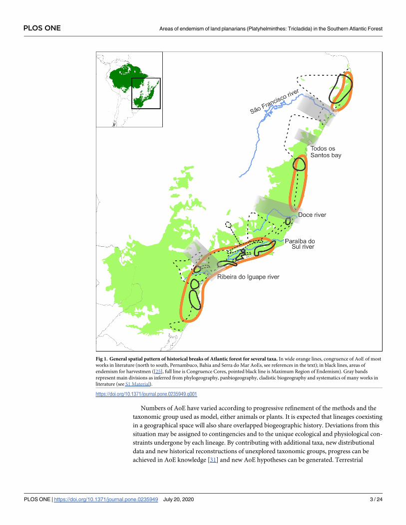
Fig 1. General spatial pattern of historical breaks of Atlantic forest for several taxa. In wide orange lines, congruence of AoE of most
works in literature (north to south, Pernambuco, Bahia and Serra do Mar AoEs, see references in the text); in black lines, areas of
endemism for harvestmen ([25], full line is Congruence Cores, pointed black line is Maximum Region of Endemism). Gray bands
represent main divisions as inferred from phylogeography, panbiogeography, cladistic biogeography and systematics of many works in
literature (see S1 Material).
https://doi.org/10.1371/journal.pone.0235949.g001
PLOS ONE Areas of endemism of land planarians (Platyhelminthes: Tricladida) in the Southern Atlantic Forest
PLOS ONE | https://doi.org/10.1371/journal.pone.0235949 July 20, 2020 3 / 24

flatworms or land planarians (Platyhelminthes, Geoplanidae) are one of those unexplored tax-
onomic groups. No biogeographic studies have been previously done using these animals. Ter-
restrial flatworms are very sensitive to changes in the conditions of their environment [43], are
highly endemic due to their low vagility and dependence on humidity [44, 45] and are endemic
to relatively small areas [46]. Furthermore, recent taxonomic revisions revealed that land pla-
narians have smaller distributions than what was previously thought, due to the discovery of
cryptic species under the same name [47–49]. For these reasons, land planarians are consid-
ered an optimal taxonomic group to carry out biogeographic studies. This paper aims to con-
tribute to the debate of discovery and test of congruence of areas of endemism in the Atlantic
forest. For this purpose, we explored the distribution of land planarians across the Atlantic
Forest using two methods, Endemicity Analysis (EA), and Geographical Interpolation of
Endemism (GIE).
Materials and methods
List of abbreviations
AoE: Area of endemism
CC: Congruence Core
EA: Endemicity Analysis
GIE: Geographic Interpolation of Endemism
MIS: Area of endemism of Misiones
MRE: Maximum Region of Endemism
NDM/VNDM: Software that carries out an Endemicity Analysis
NSC: Area of endemism of North Santa Catarina
ORG: Area of endemism of the Serra dos Orgãos
POA: Area of endemism of Porto Alegre
PR: Area of endemism of Parana
SFP: Area of endemism of São Francisco de Paula
SMSP: Area of endemism of Serra do Mar de São Paulo
SSC: Area of endemism of South Santa Catarina
SSP: Area of endemism of Southern São Paulo
WS: Widespread
The study area comprises the areas covered with Atlantic forest between, and including, the
state of Espırito Santo (the northernmost) and Rio Grande do Sul (the southernmost). We
compiled distributional data belonging to 270 species of geoplanids (Tables 1 and S1). For
these species, 403 records were obtained from the literature and 166 from our own data, sum-
ming up a total of 570 records in our dataset (S1 Table and S2 Material). Species with doubtful
records or identification, from literature or our own data, were not considered (S2 Table). One
record is here understood as an observation of a species (either from literature or from our
own data) in a certain locality, independently from the number of times this species was
found.
PLOS ONE Areas of endemism of land planarians (Platyhelminthes: Tricladida) in the Southern Atlantic Forest
PLOS ONE | https://doi.org/10.1371/journal.pone.0235949 July 20, 2020 4 / 24
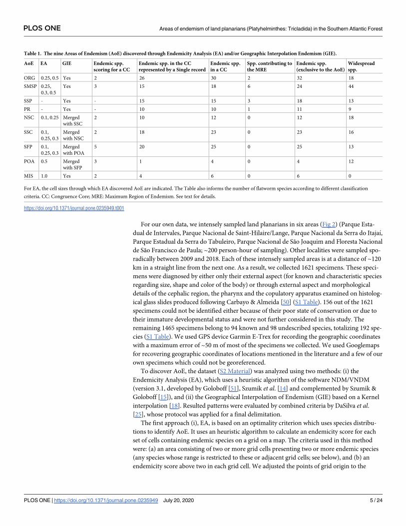
For our own data, we intensely sampled land planarians in six areas (Fig 2) (Parque Esta-
dual de Intervales, Parque Nacional de Saint-Hilaire/Lange, Parque Nacional da Serra do Itajaı,
Parque Estadual da Serra do Tabuleiro, Parque Nacional de São Joaquim and Floresta Nacional
de São Francisco de Paula; ~200 person-hour of sampling). Other localities were sampled spo-
radically between 2009 and 2018. Each of these intensely sampled areas is at a distance of ~120
km in a straight line from the next one. As a result, we collected 1621 specimens. These speci-
mens were diagnosed by either only their external aspect (for known and characteristic species
regarding size, shape and color of the body) or through external aspect and morphological
details of the cephalic region, the pharynx and the copulatory apparatus examined on histolog-
ical glass slides produced following Carbayo & Almeida [50] (S1 Table). 156 out of the 1621
specimens could not be identified either because of their poor state of conservation or due to
their immature developmental status and were not further considered in this study. The
remaining 1465 specimens belong to 94 known and 98 undescribed species, totalizing 192 spe-
cies (S1 Table). We used GPS device Garmin E-Trex for recording the geographic coordinates
with a maximum error of ~50 m of most of the specimens we collected. We used Googlemaps
for recovering geographic coordinates of locations mentioned in the literature and a few of our
own specimens which could not be georeferenced.
To discover AoE, the dataset (S2 Material) was analyzed using two methods: (i) the
Endemicity Analysis (EA), which uses a heuristic algorithm of the software NDM/VNDM
(version 3.1, developed by Goloboff [51], Szumik et al. [14] and complemented by Szumik &
Goloboff [15]), and (ii) the Geographical Interpolation of Endemism (GIE) based on a Kernel
interpolation [18]. Resulted patterns were evaluated by combined criteria by DaSilva et al.[25], whose protocol was applied for a final delimitation.
The first approach (i), EA, is based on an optimality criterion which uses species distribu-
tions to identify AoE. It uses an heuristic algorithm to calculate an endemicity score for each
set of cells containing endemic species on a grid on a map. The criteria used in this method
were: (a) an area consisting of two or more grid cells presenting two or more endemic species
(any species whose range is restricted to these or adjacent grid cells; see below), and (b) an
endemicity score above two in each grid cell. We adjusted the points of grid origin to the
Table 1. The nine Areas of Endemism (AoE) discovered through Endemicity Analysis (EA) and/or Geographic Interpolation Endemism (GIE).
AoE EA GIE Endemic spp.
scoring for a CC
Endemic spp. in the CC
represented by a Single record
Endemic spp.
in a CC
Spp. contributing to
the MRE
Endemic spp.
(exclusive to the AoE)
Widespread
spp.
ORG 0.25, 0.5 Yes 2 26 30 2 32 18
SMSP 0.25,
0.3, 0.5
Yes 3 15 18 6 24 44
SSP - Yes - 15 15 3 18 13
PR - Yes - 10 10 1 11 9
NSC 0.1, 0.25 Merged
with SSC
2 10 12 0 12 18
SSC 0.1,
0.25, 0.3
Merged
with NSC
2 18 23 0 23 16
SFP 0.1,
0.25, 0.3
Merged
with POA
5 20 25 0 25 13
POA 0.5 Merged
with SFP
3 1 4 0 4 12
MIS 1.0 Yes 2 4 6 0 6 0
For EA, the cell sizes through which EA discovered AoE are indicated. The Table also informs the number of flatworm species according to different classification
criteria. CC: Congruence Core; MRE: Maximum Region of Endemism. See text for details.
https://doi.org/10.1371/journal.pone.0235949.t001
PLOS ONE Areas of endemism of land planarians (Platyhelminthes: Tricladida) in the Southern Atlantic Forest
PLOS ONE | https://doi.org/10.1371/journal.pone.0235949 July 20, 2020 5 / 24
default position provided by NDM and to three other origins randomly selected to test for
eventual hidden AoE caused by its position, and subsequently run 100 replicas with each of
five different grid cell sizes (0.1˚, 0.25˚, 0.3˚, 0.5˚, and 1˚) to examine the effect of cell size on
inferred patterns of endemism. We largely follow the protocol proposed by DaSilva et al., [25]
for several reasons discussed further below (see section Discussion: 1. Methodological observa-tions). We computed consensus areas of endemism beginning, with 0.1˚ grid size cells, through
a strict consensus or tight consensus rule [52, 53] using 5% similarity in species distribution
between different sets of cells. Afterwards, we added the results obtained from analysis run
with progressively larger grid cells (0.25˚, 0.3˚, 0.5˚, and 1˚)–sets resulting from larger grid
cells are either the same as the smaller ones (but with coarser limits), the sums of two or more
smaller ones or new areas [25]. Our complete dataset presents a number of gaps between sam-
pled areas (Ex. S1–S8 Figs). Some of these gaps represent unsampled areas (empty cells in
NDM/VNDM, S1–S8 Figs) and others represent real absences of certain species (brown cells
in NDM/VNDM, S1–S8 Figs).
Fig 2. Localities intensively sampled (~200 person-hour of sampling) in the Atlantic forest. Basemap source: Esri. "Topographic"
[basemap]. Scale Not Given. "World Topographic Map". https://www.arcgis.com/home/item.html?id=
30e5fe3149c34df1ba922e6f5bbf808f.
https://doi.org/10.1371/journal.pone.0235949.g002
PLOS ONE Areas of endemism of land planarians (Platyhelminthes: Tricladida) in the Southern Atlantic Forest
PLOS ONE | https://doi.org/10.1371/journal.pone.0235949 July 20, 2020 6 / 24

The second approach (ii), GIE, is based on a kernel interpolation of the species distribution,
indicating level of endemism based on the area of influence of the species and their distribution
overlap [18]. The spatial modeling was performed with the GIE toolbox provided by [18] in Esri
ArcGis software 10.6 (http://www.esri.com). The interpolation is based on the definition of
areas of influence around species centroid points. These centroid points are calculated as arith-
metic means of each species sampling coordinates [54]. Five categories of influence were deter-
mined based on the maximum distance between the centroid and the furthest point of
occurrence for each species. Each category defines the radius of the area of influence around
each species’ centroid. The “influence” of each area decreases outwards, away from the centroid,
according to a Gaussian function. The overlap between the areas of influence of all species was
estimated by the kernel algorithm and the results were expressed in consensus normalized raster
grids, representing relative levels of endemism. Although the establishment of the limits of clas-
ses and weight that can be given to each class is in certain way arbitrary, the representation of
areas of endemism as natural units with fuzzy boundaries is more compatible with the theoreti-
cal models of distribution of AoE (see [13], [4]). In this study, we performed a variation of said
arbitrary units (categorization schemes) to analyze the influence they may have on AoE identifi-
cation through GIE. The first analysis was obtained by analyzing the normalized data (i.e. each
of the five categories in the analysis had the same influence). The second analysis was done
using five categories, with the predefined weight given by the GIE tool set [18]. In this analysis,
species with smaller ranges weighted more (single record species not included in the consen-
sus), progressively and exponentially losing weight in the successive categories. Species with a
single record, and therefore present in a single locality, were named as ‘Single Record’.
Species ranges that delimit or influence AoE in the numerical analyses (i. e., EA and GIE)
were used to delimit the Congruence Cores (CC, [25]) of AoE. A CC is an endemic area by def-
inition, but does not define an AoE by itself. Apart from species exclusively present within a
CC, there may also occur species that do not contribute to the identification of a CC in the
analyses. These species occur either in more than one CC, thus are defined and classified as
widespread (WS) (i.e. a WS species is a species found in at least two different CCs), or in one
CC and outside of it, but never within the limits of another CC. The latter situation is the basis
for delimiting a ‘Maximum Region of Endemism’ (MRE) [25]. Therefore a MRE is an expan-
sion of the AoE using the distribution of species which are found inside its CC but never inside
another CC. Finally, all species included in the study were classified within one of the four lev-
els of endemicity (CC, MRE, WS, and Single Record species, modified from [25]). AoE are
thus delimited with a CC and a MRE, when applied in addition to the delimitations directly
achieved by the numerical methods (EA and GIE).
Ethics statement
Field permit number: ICMBio 57798–1, ICMBio 11748–4 (Instituto Chico Mendes de Conser-
vacão da Biodiversidade (ICMBio)); EBBAut.020/2013 (Museu de Zoologia da Universidade
de São Paulo (MZUSP)); 42.520/2007 (Instituto do Meio Ambiente de Santa Catarina (IMA)
(former FATMA)).
Results
Endemicity analysis with NDM/VNDM—method (i)
Best adjustment of the points of grid origin were to -56.0 (X), -19.1 (Y). The analysis employ-
ing the 0.1˚ cell size grid, produced four sets of preliminary AoE. The consensus analysis of
these sets generated the following three consensus-sets. The northernmost consensus set,
named North Santa Catarina (Table 1 and S1 Fig) is located in the north-east region of the
PLOS ONE Areas of endemism of land planarians (Platyhelminthes: Tricladida) in the Southern Atlantic Forest
PLOS ONE | https://doi.org/10.1371/journal.pone.0235949 July 20, 2020 7 / 24
state of Santa Catarina (Fig 3). It is defined by two species (to see species list see S1–S8 Figs)
(latter defined using 0.25˚-cells as well). Consensus-set of South Santa Catarina (S2 Fig) is
located in the south-east region of the state of Santa Catarina (Fig 3); it is defined by two spe-
cies (three species define with 0.25˚-cells as well). The southernmost consensus-set identified
is the São Francisco de Paula (S3 Fig), located in the Floresta Nacional de São Francisco de
Paula, in the state of Rio Grande do Sul (Fig 3). It is defined by five species.
The analysis employing 0.25˚ cell size grid generated nine sets, and the consensus analysis
generated six sets, namely the above-mentioned three sets using 0.1˚-cells (obviously differing
in the size, but defined by the same species each, respectively) plus two new sets. One of these
new sets is the consensus-set of the Serra dos Orgãos (S4 Fig), located in the Serra dos Orgãos,
in the state of Rio de Janeiro (Fig 3). This set is defined by two species (the latter species define
with 0.5˚-cells as well). The other consensus-set is the Serra do Mar de São Paulo (S5 Fig),
located in the state of São Paulo (Fig 3). This set is defined by three species. The remaining sets
produced would be a disjunct AoE, which overlaps with other sets previously generated (South
Santa Catarina and São Francisco de Paula) (S6 Fig) and therefore presents WS species; thus, it
cannot be considered an AoE.
Analysis run using 0.3˚ cell size grids generated sets of preliminary AoE all overlapping
with sets generated with smaller cell size grids. These results are not shown.
The analysis employing 0.5˚ cell size grid generated 19 sets, and the consensus analysis gener-
ated five sets four of which overlap sets previously generated by the other sized grid analyses plus
Fig 3. Endemicity analysis results obtained with A) 0.1˚ cell size grids. B) 0.25˚ cell size grids. C) 0.5˚ cell size grids. D) 1˚ cell size grids.
Basemap source: Esri. "Topographic" [basemap]. Scale Not Given. "World Topographic Map". https://www.arcgis.com/home/item.html?
id=30e5fe3149c34df1ba922e6f5bbf808f.
https://doi.org/10.1371/journal.pone.0235949.g003
PLOS ONE Areas of endemism of land planarians (Platyhelminthes: Tricladida) in the Southern Atlantic Forest
PLOS ONE | https://doi.org/10.1371/journal.pone.0235949 July 20, 2020 8 / 24
only one new, named Porto Alegre (S7 Fig). This consensus-set is located in the metropolitan
area of Porto Alegre, in the state of Rio Grande do Sul (Fig 3), and is defined by three species
The last analysis was run with 1˚ cell size grid. It generated thirty three sets from which the
consensus analysis resulted in five sets. Four of these sets overlap existing sets previously gen-
erated and one set is new. This new consensus-set is named Misiones (S8 Fig) and is located in
the province of Misiones, Argentina (Fig 3). This set is defined by two species.
In short, the seven AoE identified through EA, named after the geographical location of
their consensus-sets, are as follows: Serra dos Orgãos, Serra do Mar de São Paulo, North Santa
Catarina, South Santa Catarina, São Francisco de Paula, Porto Alegre and Misiones.
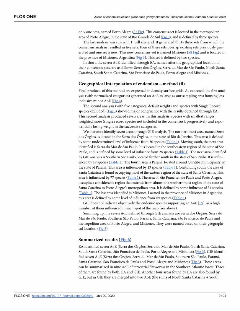
Geographical interpolation of endemism—method (ii)
Final products of this method are expressed in density surface grids. As expected, the first anal-
ysis (with normalized categories) generated an AoE as large as our sampling area housing less
inclusive minor AoE (Fig 4).
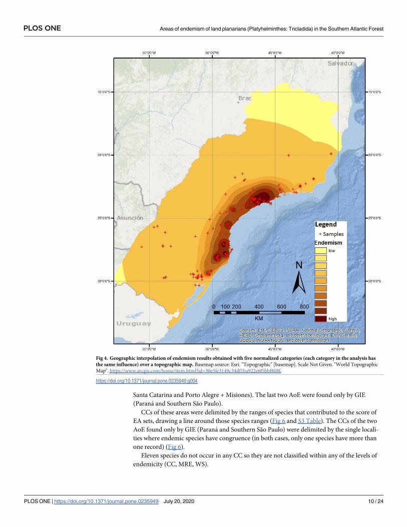
The second analysis (with five categories, default weights and species with Single Record
species excluded) (Fig 5) showed major congruence with the results obtained through EA.
This second analysis produced seven areas. In this analysis, species with smallest ranges
weighted more (single record species not included in the consensus), progressively and expo-
nentially losing weight in the successive categories.
We therefore identify seven areas through GIE analysis. The northernmost area, named Serra
dos Orgãos, is located in the Serra dos Orgãos, in the state of Rio de Janeiro. This area is defined
by some undetermined level of influence from 30 species (Table 1). Moving south, the next area
identified is Serra do Mar de São Paulo. It is located in the southeastern region of the state of São
Paulo, and is defined by some level of influence from 28 species (Table 1). The next area identified
by GIE analysis is Southern São Paulo, located further south in the state of São Paulo. It is influ-
enced by 19 species (Table 1). The fourth area is Parana, located around Curitiba municipality, in
the state of Parana. This area is influenced by 13 species (Table 1). Continuing south, the area of
Santa Catarina is found occupying most of the eastern region of the state of Santa Catarina. This
area is influenced by 77 species (Table 1). The area of São Francisco de Paula and Porto Alegre,
occupies a considerable region that extends from almost the southernmost region of the state of
Santa Catarina to Porto Alegre’s metropolitan area. It is defined by some influence of 34 species
(Table 1). The last area identified is Misiones. Located in the province of Misiones in Argentina,
this area is defined by some level of influence from six species (Table 1).
GIE does not indicate objectively the endemic species supporting an AoE [59], as a high
number of them influenced in each spot of the map (see above).
Summing up, the seven AoE defined through GIE analysis are Serra dos Orgãos, Serra do
Mar de São Paulo, Southern São Paulo, Parana, Santa Catarina, São Francisco de Paula and
metropolitan area of Porto Alegre, and Misiones. They were named based on their geographi-
cal location (Fig 5).
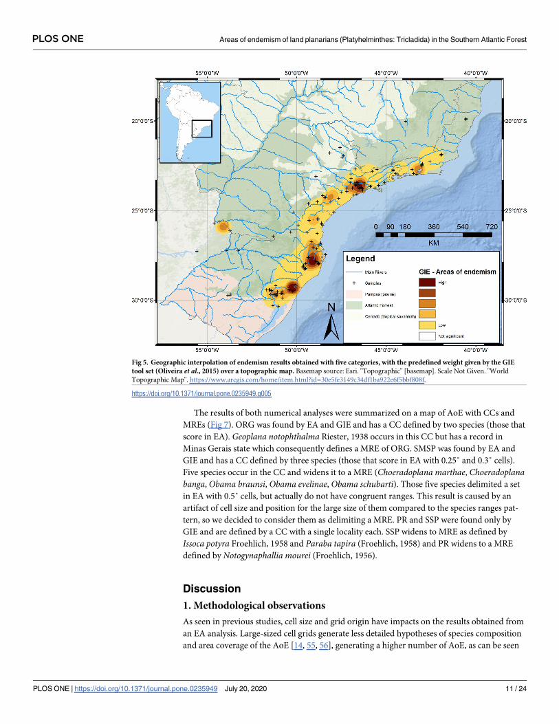
Summarized results (Fig 6)
EA identified seven AoE (Serra dos Orgãos, Serra do Mar de São Paulo, North Santa Catarina,
South Santa Catarina, São Francisco de Paula, Porto Alegre and Misiones) (Fig 3). GIE identi-
fied seven AoE (Serra dos Orgãos, Serra do Mar de São Paulo, Southern São Paulo, Parana,
Santa Catarina, São Francisco de Paula and Porto Alegre and Misiones) (Fig 5). These areas
can be summarized in nine AoE of terrestrial flatworms in the Southern Atlantic forest. Three
of them are found by both, EA and GIE. Another four areas found by EA are also found by
GIE, but in GIE they are merged into two AoE (the sums of North Santa Catarina + South
PLOS ONE Areas of endemism of land planarians (Platyhelminthes: Tricladida) in the Southern Atlantic Forest
PLOS ONE | https://doi.org/10.1371/journal.pone.0235949 July 20, 2020 9 / 24
Santa Catarina and Porto Alegre + Misiones). The last two AoE were found only by GIE
(Parana and Southern São Paulo).
CCs of these areas were delimited by the ranges of species that contributed to the score of
EA sets, drawing a line around those species ranges (Fig 6 and S3 Table). The CCs of the two
AoE found only by GIE (Parana and Southern São Paulo) were delimited by the single locali-
ties where endemic species have congruence (in both cases, only one species have more than
one record) (Fig 6).
Eleven species do not occur in any CC so they are not classified within any of the levels of
endemicity (CC, MRE, WS).
Fig 4. Geographic interpolation of endemism results obtained with five normalized categories (each category in the analysis has
the same influence) over a topographic map. Basemap source: Esri. "Topographic" [basemap]. Scale Not Given. "World Topographic
Map". https://www.arcgis.com/home/item.html?id=30e5fe3149c34df1ba922e6f5bbf808f.
https://doi.org/10.1371/journal.pone.0235949.g004
PLOS ONE Areas of endemism of land planarians (Platyhelminthes: Tricladida) in the Southern Atlantic Forest
PLOS ONE | https://doi.org/10.1371/journal.pone.0235949 July 20, 2020 10 / 24
The results of both numerical analyses were summarized on a map of AoE with CCs and
MREs (Fig 7). ORG was found by EA and GIE and has a CC defined by two species (those that
score in EA). Geoplana notophthalma Riester, 1938 occurs in this CC but has a record in
Minas Gerais state which consequently defines a MRE of ORG. SMSP was found by EA and
GIE and has a CC defined by three species (those that score in EA with 0.25˚ and 0.3˚ cells).
Five species occur in the CC and widens it to a MRE (Choeradoplana marthae, Choeradoplanabanga, Obama braunsi, Obama evelinae, Obama schubarti). Those five species delimited a set
in EA with 0.5˚ cells, but actually do not have congruent ranges. This result is caused by an
artifact of cell size and position for the large size of them compared to the species ranges pat-
tern, so we decided to consider them as delimiting a MRE. PR and SSP were found only by
GIE and are defined by a CC with a single locality each. SSP widens to MRE as defined by
Issoca potyra Froehlich, 1958 and Paraba tapira (Froehlich, 1958) and PR widens to a MRE
defined by Notogynaphallia mourei (Froehlich, 1956).
Discussion
1. Methodological observations
As seen in previous studies, cell size and grid origin have impacts on the results obtained from
an EA analysis. Large-sized cell grids generate less detailed hypotheses of species composition
and area coverage of the AoE [14, 55, 56], generating a higher number of AoE, as can be seen
Fig 5. Geographic interpolation of endemism results obtained with five categories, with the predefined weight given by the GIE
tool set (Oliveira et al., 2015) over a topographic map. Basemap source: Esri. "Topographic" [basemap]. Scale Not Given. "World
Topographic Map". https://www.arcgis.com/home/item.html?id=30e5fe3149c34df1ba922e6f5bbf808f.
https://doi.org/10.1371/journal.pone.0235949.g005
PLOS ONE Areas of endemism of land planarians (Platyhelminthes: Tricladida) in the Southern Atlantic Forest
PLOS ONE | https://doi.org/10.1371/journal.pone.0235949 July 20, 2020 11 / 24

in the present study. Usage of large-sized cell grids affects results, such as the collapse of two
AoE into a single one [25] or the inclusion of important barriers within a single AoE [57]. On
the other hand, small grids introduce false absence of species, make distributions discontinu-
ous, and present smaller number of species per cell, making it more difficult to detect AoE
and, therefore, defining fewer of them [57]. Influences derived from cell size in revealing AoE
are alleviated by DaSilva’s et al. [25] protocol. It is important to use different grid cell sizes in
EA or Parsimony Analysis of Endemicity–if only one cell size grid had been used or tested
with our data, some AoE would have been missed through EA.
On the other hand, GIE analysis includes another “scaling effect” similar to the cell size grid
dilemma mentioned before. There are two arbitrarily chosen units in GIE analysis. One unit is
the number of categories of influence to be used in the analysis. The other is the values limiting
the influence of each category (the relative weight each class will have in the analysis). Tests
varying the number of categories have shown that modifying this unit, will not affect signifi-
cantly the results obtained via GIE analysis [18]. Although a large number of categories will
definitely affect the analysis, identifying AoE with higher discontinuity and also showing
Fig 6. Topographical map showing AoE identified in this study through the different methodologies used. Basemap
source: Esri. "Topographic" [basemap]. Scale Not Given. "World Topographic Map". https://www.arcgis.com/home/item.
html?id=30e5fe3149c34df1ba922e6f5bbf808f.
https://doi.org/10.1371/journal.pone.0235949.g006
PLOS ONE Areas of endemism of land planarians (Platyhelminthes: Tricladida) in the Southern Atlantic Forest
PLOS ONE | https://doi.org/10.1371/journal.pone.0235949 July 20, 2020 12 / 24

“micro areas” which sometimes are composed by a single species. This overestimates the
amount of detected AoE (following Platnick’s [27] definition of an AoE, a single endemic spe-
cies should not be able to define AoE) (S8 Fig). Therefore the chosen categorization scheme
should be tested and evaluated for every dataset analyzed in order to evade defining highly dis-
continuous AoE or overidentifying the number of AoE.
With the dataset analyzed with normalized weighted categories (all weights are the same for
every category) (Fig 4), the obtained result is a single AoE comprising the whole study area
with minor areas defined inside. This analysis is unable to identify AoE (AoE identified in this
study by other GIE categorization schemes and EA) such as ORG, POA or MIS. The reason
for this is the fact that the influence value of species with very restricted distributions is the
same as the influence value of WS species. When trying to identify AoE, species with restricted
ranges are much more indicative than WS species. Therefore, GIE analysis should be carried
out with weighted categories.
Fig 7. Delimitation of AoE of land planarians, on a topographical map of the Atlantic forest region. Basemap source: Esri.
"Topographic" [basemap]. Scale Not Given. "World Topographic Map". https://www.arcgis.com/home/item.html?id=
30e5fe3149c34df1ba922e6f5bbf808f.
https://doi.org/10.1371/journal.pone.0235949.g007
PLOS ONE Areas of endemism of land planarians (Platyhelminthes: Tricladida) in the Southern Atlantic Forest
PLOS ONE | https://doi.org/10.1371/journal.pone.0235949 July 20, 2020 13 / 24

The categorization scheme chosen for GIE in this study consisted of five weighted catego-
ries (default weights in the ArcGIS toolbox). Single Record species were not included in the
consensus of this analysis to evade the identification of areas with one Single Record species
and to try and minimize the effect of poorly sampled species on AoE identification (see [58]).
As EA does not take in account single-cell sets, which would be resulted from aggregation of
many Single Record species, this analysis shows high congruence with EA results.
GIE analysis overcomes several problems generated from the use of grid cells [18]. It allows
the use of distributional data with gaps and offers the possibility of identifying AoE with fuzzy
edges which corresponds better with the spatial and temporary reality of AoE [4, 18]. In con-
trast, it does not show objectively the limits of an AoE, because of this fuzzy edges.
GIE fails to provide a set of species diagnosing the identified AoE [59] apart from the “scal-
ing effect” derived from the arbitrary units chosen for the categorization scheme. The identifi-
cation of an AoE should not be possible if the list of species diagnosing that area cannot be
obtained. An approximate list of species influencing a specific AoE can be obtained with GIE,
but those species cannot be classified as diagnostic species because numerically it is not possi-
ble to know the influence of each species in each AoE identified.
No method, neither EA or GIE, is able to perform a complete analysis to identify AoE, due
to the different flaws each methodology presents [25, 57, 60]. The analysis perform differently,
offering the possibility to detect AoE based on different methodological approaches. Therefore
the most efficient way to work when trying to detect AoE is through the integration of different
methodologies and parameters as seen in previous studies [18, 20, 25, 42]. By working with dif-
ferent numerical algorithms, functions and formulas and different theoretical and methodo-
logical approaches, we are able to analyze our databases with a broader spectrum and correlate
our practical results to the reality of endemic species distribution and congregation, with a
higher confidence.
DaSilva’s protocol facilitates the integration of different methodologies when identifying
AoE. The use of a Congruence Core (CC) to delimit the main area of endemic species congru-
ence permits the inclusion of results obtained through other methodologies efficiently and
avoids the artifacts caused by grid cells, fuzzy edges or others. Defining Maximum Region of
Endemism (MRE) also sets the concept that an AoE does not occupy, only, the congruent
space between endemic species, but the outside areas which might represent the dynamism of
said endemic species as well [25, 61]. DaSilva’s protocol also maximizes EA’s performance by
including several steps that reduce the grid-size effect and by discarding a high number of
resulted sets caused by several combinations of overlapping ranges and consequent redun-
dancy between them. DaSilva’s protocol is focused on grid-based methods, but can be an effec-
tive tool to integrate results obtained from other methodologies that obviate grids as well.
Species with a single record were included in this study, even though they are not consid-
ered in endemism analyses. In fact, EA only considers sets with two or more cells, thus a cell
with many endemic species is not detected by the method as an AoE. GIE overcomes this
problem, but is also unable to differentiate localities with just one species record from localities
with two or more species records, as mentioned above. These limitations become evident in
our study as we found eight additional localities to bear two or more endemic species recorded
only once in the entire study area. From North to South, these localities are Santa Maria Mada-
lena-RJ (two Single Record species), São Jose do Barreiro-SP (three Single Record species),
Ubatuba-SP (four Single Record species), Matinhos-PR (four Single Record species), Três Bar-
ras-SC (two Single Record species), PN São Joaquim-SC (31 Single Record species), Derruba-
das-SC (two Single Record species) and Santa Maria-RS (two Single Record species). We
believe that these species represent important biological information for planarian distribution
PLOS ONE Areas of endemism of land planarians (Platyhelminthes: Tricladida) in the Southern Atlantic Forest
PLOS ONE | https://doi.org/10.1371/journal.pone.0235949 July 20, 2020 14 / 24
and diversity, and the methods should be reconsidered so the Single Record species compute
for the discovery of AoE.
2. Inferring AoE based on land planarian distributions
Our dataset revealed nine AoE in total, plus eight localities with two or more Single Record
species. Two AoE (SSP and PR) could not be detected by our EA. These AoE (SSP and PR)
present an extremely high number of endemic species (19 and 18 species, respectively). These
two AoE were not detected due to the fact that all except one species endemic to them are
known from one locality and thus are not considered by EA, because the method only consid-
ers sets with two cells or more [25, 57].
As mentioned before, some species distributions do not completely overlap the CCs. Those
species present in only one CC and outside of it will define a MRE. They can be interpreted as
an extension from a CC due to ontological causes, or, as the source of an error such as under-
sampled regions. Most of the identified AoE do not have a MRE because planarian records are
very concentrated in specific localities and regions, and those localities and regions were each
delimited as an AoE (see discussion below). Only four AoE delimited MREs: ORG, SMSP, SSP
and PR. Some of the species defining MREs create doubtful AoE. Such is the case of Geoplananotophthalma which defines a distant portion of ORG’s MRE northwards, in the state of
Minas Gerais. This MRE is a peculiar configuration for an AoE as AoE are defined by the con-
gruence of only species with small distributions [62]. WS species cannot define an AoE, but G.
notophthalma cannot be considered a WS species as it is not found in any other AoE, apart
from ORG. Thus, G. notophthalma is found in the geographic region of Serra dos Orgãos and
in Minas Gerais, and must expand ORG’s AoE’s borders through a MRE, thus giving rise to a
disjunct AoE. Froehlich [63] suggested this species to be synonym of O. applanata (Graff,
1899), but the situation would not change since their distribution is the same.
Each of the six intensively sampled areas is at a distance of 120 km from the nearest inten-
sively sampled area and, interestingly, each one was revealed as an AoE. This situation rises a
question: if we had sampled between these intensively sampled areas, would we have discov-
ered additional AoE? In other words, geographic distribution of most land planarians might
occur at a scale smaller than areas with 120 km in length. General assumptions of endemism
have been proposed and explained as a consequence of the ecological and physiological limita-
tions of these organisms [43, 46, 64]. If this is true, further sampling of these organisms is
promising in revealing new AoE within the study area even so because most land planarians
have revealed to present a very small distributional range and each of the six areas intensely
sampled turned out to be an AoE.
3. Causal factors of areas of endemism
In general, Serra do Mar, the mountains spreading almost along the whole geographic range
herein analyzed, is considered a single area of endemism for forest-dependent vertebrate and
plant taxa [22, 24, 65, 66]. However, some studies have shown a more endemic pattern of dis-
tribution for species or populations in the southeastern-south coastal mountains and adjacent
lowlands of Atlantic Forest, as seen with the area of endemism of harvestmen [25] and spiders
[18], specific distributional congruence of vertebrates [67], ecological regionalization of frogs
[68], and phylogeographic structure of species of frogs [69–72], bees [73], vipers [74], birds
[75, 76], mammals [77, 78] and harvestmen [79, 80]. The main divergence is found to the
south of the state of São Paulo or close to Ribeira do Iguape river valley [6, 67, 71, 73, 74, 76],
but with very different times of divergence between those taxa (~ 0.39–4.9 m.y.a.) and weak
inference of causal processes.
PLOS ONE Areas of endemism of land planarians (Platyhelminthes: Tricladida) in the Southern Atlantic Forest
PLOS ONE | https://doi.org/10.1371/journal.pone.0235949 July 20, 2020 15 / 24

The planarian species show very restricted ranges only compared to harvestmen species
[25], or maybe to some frog or cricket taxa [81, 82]. They seem to be restricted to more humid
portions of the forest on mountain slopes or adjacent regions, where the core of their areas of
endemism is located, with few exceptions. Main valleys or sedimentary basins seem to be the
barriers for those taxa, as described for Paraıba do Sul river and Ribeira do Iguape river [64,
67, 71, 73, 74, 76, 79, 80].
The Atlantic Forest is not physiognomically homogeneous. It presents humid forests con-
centrating on slopes or medium altitudes of mountains. The valleys and coastal plains are com-
posed by a marine influenced vegetation, and interior lowlands of the south-southeastern
region are composed by seasonal semideciduous forests. The endemic patterns found herein
and for harvestmen show a restriction in more humid forests. This could be directly influenced
by past events of forest reduction and posterior concentration in those regions, or refuges. A
great body of literature from different sources and proxies continues to furnish evidence for
reduction of forests in cycles during the Neogene (e.g. [70, 75, 83–85]). The high endemicity
found for planarians seems to be influenced by those reductions, since PR x SC x SFP x POA
and ORG x SMSP x SSP do not have clear geographic barriers. In this view, in the regions of
those AoE cores, the forest should have been more humid than in lowland areas and conse-
quently should have been maintained with few alterations during climatic fluctuations [25, 83,
86, 87].
The same should have happened to sedimentary basins wherein the great rivers flow. Those
basins were originated by tectonism related with uprising of mountain ranges of Serra do Mar
and Serra da Mantiqueira and subsidence of valleys since at least the Miocene [88–90]. In fact,
the southeastern region of the Atlantic Forest is considered as the main rift system of eastern
South America [89]. Some of those valleys started to be rain shadows as they are hidden from
orographic rains and coastal humidity behind the Serra do Mar mountains (e.g. Paraıba do Sul
river, [91]). Rivers originated as they flowed to the subsidence regions and most of their heads
were captured from a western direction, eastward to the coast [92]. Sedimentation of those
regions was affected by neotectonic reactivation [90] and rising of the amount of flowing water
in more humid periods, even forming paleolakes [89] or by marine transgressions into coastal
valleys [93–95]. Then, many associated events feedbacked sedimentary basins as barriers for
forest-dependent taxa, avoiding the development of humid forests for long periods. They
resulted in many taxa splitting in these lowlands and valley regions but in different times
between each other. DaSilva et al. [6] proposed a model of reiterative barriers with spatial con-
gruence in multiple times to explain those patterns.
Alvarez-Presas et al. [64] have shown a phylogeographic structure for Cephaloflexa bergiplanarian populations, congruent to those main barriers, Paraıba do Sul river and Ribeira do
Iguape river valleys, and a split in northern São Paulo/south Rio de Janeiro states. There is not
a clear geographic barrier associated to the latter, but is congruent to ORG X SMSP AoE, cited
above, the same for harvestmen AoE [25], and phylogeographic structure for Promitobatesharvestmen [79]. The dating estimates for those main splits of Cephaloflexa planarian is about
8 m.y.a., in the Miocene period, near to the Promitobates harvestmen splits estimated in about
11 m.y.a. It is important to note that possible reductions of forest caused by climatic desicca-
tion probably occurred previously to the renowned and more recorded Pliocene/Pleistocene
fluctuations [96–98]. In spite of lack of phylogeographic structure of some populations of
Cephaloflexa, Alvarez-Presas et al. [64] assumed that populations remained separated by those
main barriers and there were few more recent dispersions.
POA and MIS areas have a different character related to their physical conditions. It is
assumed that those forests have seasonal deciduous physiognomies [99] in contrast to the
humid evergreen forests of the other areas of endemism. These endemisms could be associated
PLOS ONE Areas of endemism of land planarians (Platyhelminthes: Tricladida) in the Southern Atlantic Forest
PLOS ONE | https://doi.org/10.1371/journal.pone.0235949 July 20, 2020 16 / 24
to those species ecological requirements or isolation from the surrounding open vegetations.
However, MIS seems to be related to a separation at Parana river or its tributary valleys, since
they flow on an important sedimentary basin, as discussed above.
Based on this discussion, the hypotheses for the causes of the presented endemic patterns,
inferred as speciation processes between endemic species living in those areas of endemism,
should be tested or deepened by a phylogenetic framework with temporal estimation of each
cladogenesis. The corroboration of the phylogeographic structure and the main populational
divergence shown by Alvarez-Presas et al. [64] and the areas of endemism of hundreds of pla-
narians species contribute to the understanding of the biogeographical evolution of those ani-
mals and consequently, of the humid Atlantic Forest.
Conclusions
In this paper, we corroborate DaSilva’s et al., (2015) protocol as an effective tool to aid in the
discovery of AoE. This protocol was used with two numerical methodologies, namely an EA
(grid-based) and a GIE (centroid-based). The protocol exploits the advantages of each numeri-
cal methodology (EA allows the identification of species defining an AoE and permits a more
accurate delimitation of an AoE; GIE even detects AoE consisting of a single record), whereas
a number of potential AoE failed to be noticed by the numerical methods.
The AoE of land planarians discovered here are congruent with fine-scale approaches such
as that addressed by DaSilva et al. (2015) for harvestmen. Land planarians and harvestmen are
hygrophilous and forest-dependent organisms and present sensitivity to environmental
changes. Presumably, due to these common physiological and ecological constraints, harvest-
men and land planarians may predict, more robustly, a common history of other restricted
taxa of the Atlantic Forest. Furthermore, new samplings in unexplored localities in the study
area might indeed uncover new endemisms and additional AoE. Hence, these organisms
might be a good model for fine-scale studies of AoE.
Supporting information
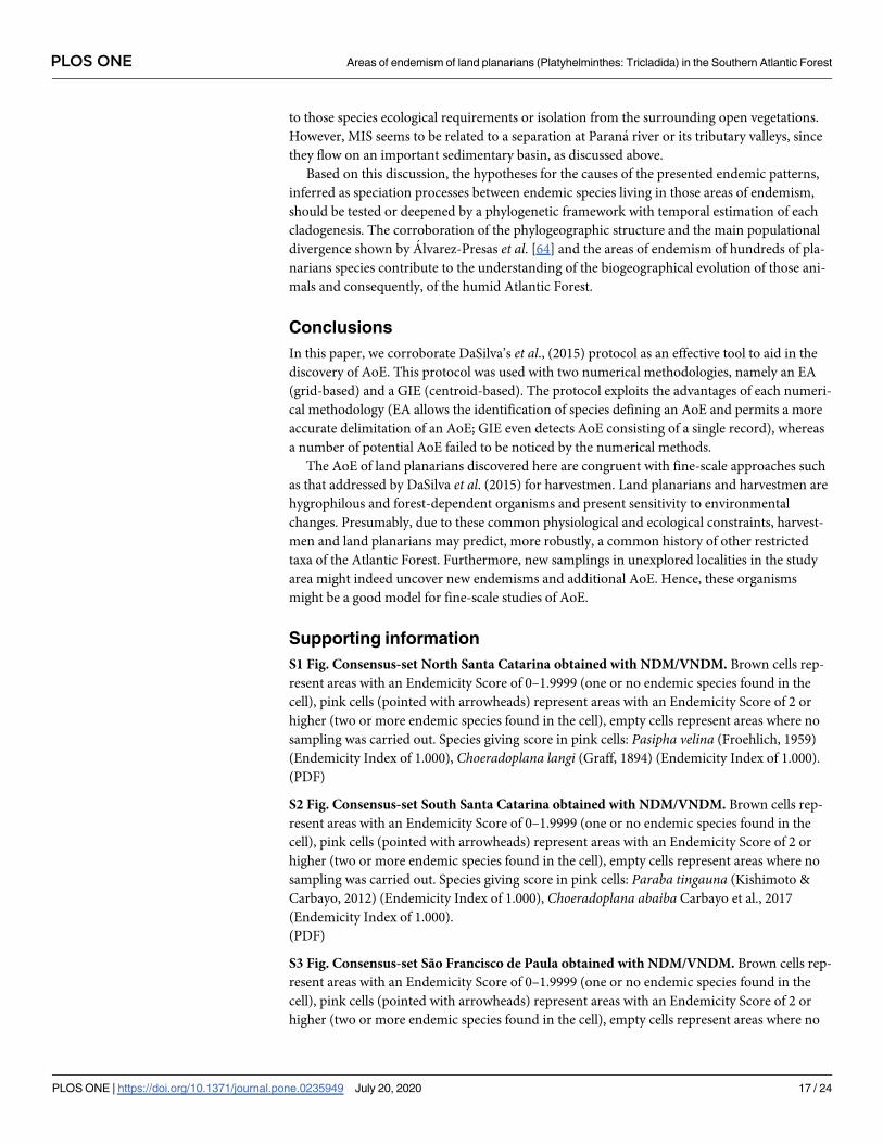
S1 Fig. Consensus-set North Santa Catarina obtained with NDM/VNDM. Brown cells rep-
resent areas with an Endemicity Score of 0–1.9999 (one or no endemic species found in the
cell), pink cells (pointed with arrowheads) represent areas with an Endemicity Score of 2 or
higher (two or more endemic species found in the cell), empty cells represent areas where no
sampling was carried out. Species giving score in pink cells: Pasipha velina (Froehlich, 1959)
(Endemicity Index of 1.000), Choeradoplana langi (Graff, 1894) (Endemicity Index of 1.000).
(PDF)
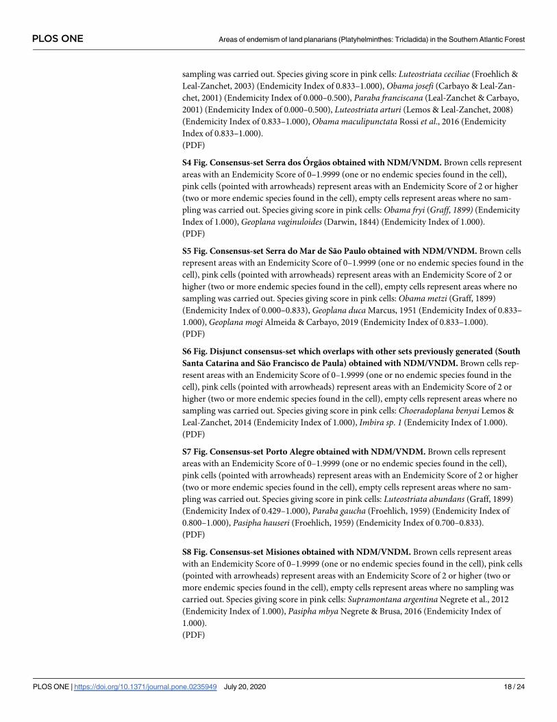
S2 Fig. Consensus-set South Santa Catarina obtained with NDM/VNDM. Brown cells rep-
resent areas with an Endemicity Score of 0–1.9999 (one or no endemic species found in the
cell), pink cells (pointed with arrowheads) represent areas with an Endemicity Score of 2 or
higher (two or more endemic species found in the cell), empty cells represent areas where no
sampling was carried out. Species giving score in pink cells: Paraba tingauna (Kishimoto &
Carbayo, 2012) (Endemicity Index of 1.000), Choeradoplana abaiba Carbayo et al., 2017
(Endemicity Index of 1.000).
(PDF)
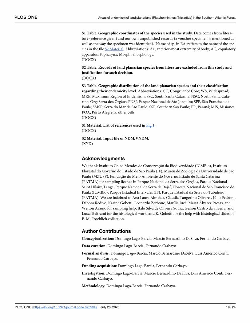
S3 Fig. Consensus-set São Francisco de Paula obtained with NDM/VNDM. Brown cells rep-
resent areas with an Endemicity Score of 0–1.9999 (one or no endemic species found in the
cell), pink cells (pointed with arrowheads) represent areas with an Endemicity Score of 2 or
higher (two or more endemic species found in the cell), empty cells represent areas where no
PLOS ONE Areas of endemism of land planarians (Platyhelminthes: Tricladida) in the Southern Atlantic Forest
PLOS ONE | https://doi.org/10.1371/journal.pone.0235949 July 20, 2020 17 / 24
sampling was carried out. Species giving score in pink cells: Luteostriata ceciliae (Froehlich &
Leal-Zanchet, 2003) (Endemicity Index of 0.833–1.000), Obama josefi (Carbayo & Leal-Zan-
chet, 2001) (Endemicity Index of 0.000–0.500), Paraba franciscana (Leal-Zanchet & Carbayo,
2001) (Endemicity Index of 0.000–0.500), Luteostriata arturi (Lemos & Leal-Zanchet, 2008)
(Endemicity Index of 0.833–1.000), Obama maculipunctata Rossi et al., 2016 (Endemicity
Index of 0.833–1.000).
(PDF)
S4 Fig. Consensus-set Serra dos Orgãos obtained with NDM/VNDM. Brown cells represent
areas with an Endemicity Score of 0–1.9999 (one or no endemic species found in the cell),
pink cells (pointed with arrowheads) represent areas with an Endemicity Score of 2 or higher
(two or more endemic species found in the cell), empty cells represent areas where no sam-
pling was carried out. Species giving score in pink cells: Obama fryi (Graff, 1899) (Endemicity
Index of 1.000), Geoplana vaginuloides (Darwin, 1844) (Endemicity Index of 1.000).
(PDF)
S5 Fig. Consensus-set Serra do Mar de São Paulo obtained with NDM/VNDM. Brown cells
represent areas with an Endemicity Score of 0–1.9999 (one or no endemic species found in the
cell), pink cells (pointed with arrowheads) represent areas with an Endemicity Score of 2 or
higher (two or more endemic species found in the cell), empty cells represent areas where no
sampling was carried out. Species giving score in pink cells: Obama metzi (Graff, 1899)
(Endemicity Index of 0.000–0.833), Geoplana duca Marcus, 1951 (Endemicity Index of 0.833–
1.000), Geoplana mogi Almeida & Carbayo, 2019 (Endemicity Index of 0.833–1.000).
(PDF)
S6 Fig. Disjunct consensus-set which overlaps with other sets previously generated (South
Santa Catarina and São Francisco de Paula) obtained with NDM/VNDM. Brown cells rep-
resent areas with an Endemicity Score of 0–1.9999 (one or no endemic species found in the
cell), pink cells (pointed with arrowheads) represent areas with an Endemicity Score of 2 or
higher (two or more endemic species found in the cell), empty cells represent areas where no
sampling was carried out. Species giving score in pink cells: Choeradoplana benyai Lemos &
Leal-Zanchet, 2014 (Endemicity Index of 1.000), Imbira sp. 1 (Endemicity Index of 1.000).
(PDF)
S7 Fig. Consensus-set Porto Alegre obtained with NDM/VNDM. Brown cells represent
areas with an Endemicity Score of 0–1.9999 (one or no endemic species found in the cell),
pink cells (pointed with arrowheads) represent areas with an Endemicity Score of 2 or higher
(two or more endemic species found in the cell), empty cells represent areas where no sam-
pling was carried out. Species giving score in pink cells: Luteostriata abundans (Graff, 1899)
(Endemicity Index of 0.429–1.000), Paraba gaucha (Froehlich, 1959) (Endemicity Index of
0.800–1.000), Pasipha hauseri (Froehlich, 1959) (Endemicity Index of 0.700–0.833).
(PDF)
S8 Fig. Consensus-set Misiones obtained with NDM/VNDM. Brown cells represent areas
with an Endemicity Score of 0–1.9999 (one or no endemic species found in the cell), pink cells
(pointed with arrowheads) represent areas with an Endemicity Score of 2 or higher (two or
more endemic species found in the cell), empty cells represent areas where no sampling was
carried out. Species giving score in pink cells: Supramontana argentina Negrete et al., 2012
(Endemicity Index of 1.000), Pasipha mbya Negrete & Brusa, 2016 (Endemicity Index of
1.000).
(PDF)
PLOS ONE Areas of endemism of land planarians (Platyhelminthes: Tricladida) in the Southern Atlantic Forest
PLOS ONE | https://doi.org/10.1371/journal.pone.0235949 July 20, 2020 18 / 24
S1 Table. Geographic coordinates of the species used in the study. Data comes from litera-
ture (reference given) and our own unpublished records (a voucher specimen is mentioned as
well as the way the specimen was identified). ‘Name of sp. in EA’ reffers to the name of the spe-
cies in the file S2 Material. Abbreviations: A1, anterior-most extremity of body; AC, copulatory
apparatus; F, pharynx; Morph., morphology.
(DOCX)
S2 Table. Records of land planarian species from literature excluded from this study and
justification for such decision.
(DOCX)
S3 Table. Geographic distribution of the land planarian species and their classification
regarding their endemicity level. Abbreviations: CC, Congruence Core; WS, Widespread;
MRE, Maximum Region of Endemism; SSC, South Santa Catarina; NSC, North Santa Cata-
rina; Org: Serra dos Orgãos; PNSJ, Parque Nacional de São Joaquim; SFP, São Francisco de
Paula; SMSP, Serra do Mar de São Paulo; SSP, Southern São Paulo; PR, Parana; MIS, Misiones;
POA, Porto Alegre; x, other cells.
(DOCX)
S1 Material. List of references used in Fig 1.
(DOCX)
S2 Material. Input file of NDM/VNDM.
(XYD)
Acknowledgments
We thank Instituto Chico Mendes de Conservacão da Biodiversidade (ICMBio), Instituto
Florestal do Governo do Estado de São Paulo (IF), Museu de Zoologia da Universidade de São
Paulo (MZUSP), Fundacão do Meio Ambiente do Governo Estado de Santa Catarina
(FATMA) for sampling licence in Parque Nacional da Serra dos Orgãos, Parque Nacional
Saint Hilaire/Lange, Parque Nacional da Serra de Itajaı, Floresta Nacional de São Francisco de
Paula (ICMBio); Parque Estadual Intervales (IF), Parque Estadual da Serra do Tabuleiro
(FATMA). We are indebted to Ana Laura Almeida, Claudia Tangerino Olivares, Julio Pedroni,
Debora Redivo, Karine Gobetti, Leonardo Zerbone, Marılia Juca, Marta Alvarez Presas, and
Welton Araujo for sampling help; Italo Silva de Oliveira Sousa, Geison Castro da Silveira, and
Lucas Beltrami for the histological work; and K. Gobetti for the help with histological slides of
E. M. Froehlich collection.
Author Contributions
Conceptualization: Domingo Lago-Barcia, Marcio Bernardino DaSilva, Fernando Carbayo.
Data curation: Domingo Lago-Barcia, Fernando Carbayo.
Formal analysis: Domingo Lago-Barcia, Marcio Bernardino DaSilva, Luis Americo Conti,
Fernando Carbayo.
Funding acquisition: Domingo Lago-Barcia, Fernando Carbayo.
Investigation: Domingo Lago-Barcia, Marcio Bernardino DaSilva, Luis Americo Conti, Fer-
nando Carbayo.
Methodology: Domingo Lago-Barcia, Fernando Carbayo.
PLOS ONE Areas of endemism of land planarians (Platyhelminthes: Tricladida) in the Southern Atlantic Forest
PLOS ONE | https://doi.org/10.1371/journal.pone.0235949 July 20, 2020 19 / 24
Project administration: Domingo Lago-Barcia, Fernando Carbayo.
Resources: Fernando Carbayo.
Software: Domingo Lago-Barcia, Luis Americo Conti.
Supervision: Fernando Carbayo.
Validation: Domingo Lago-Barcia, Luis Americo Conti.
Visualization: Domingo Lago-Barcia.
Writing – original draft: Domingo Lago-Barcia, Marcio Bernardino DaSilva, Fernando
Carbayo.
Writing – review & editing: Domingo Lago-Barcia, Marcio Bernardino DaSilva, Luis Americo
Conti, Fernando Carbayo.
References1. Morrone JJ, Crisci JV. Historical biogeography: introduction to methods. Annu. Rev. Ecol. Syst. 1995;
26: 373–401.
2. Henderson IM. Biogeography without area? Austral Syst Bot. 1991; 4: 59.
3. Cracraft J. Historical biogeography and patterns of differentiation within the South American avifauna:
areas of endemism. Ornithol. Monogr. 1985; 36: 49–84.
4. Crother BI, Murray CM. Ontology of areas of endemism. J Biogeogr. 2011; 38(6): 1009–1015.
5. Morrone JJ. Biogeographical regionalisation of the Neotropical Region. Zootaxa. 2014; 3782(1): 001–
110.
6. DaSilva MB, Pinto-da-Rocha R, and Morrone JJ. Historical relationships of areas of endemism of the
Brazilian Atlantic rain forest: a cladistic biogeographic analysis of harvestman taxa (Arachnida: Opi-
liones). Curr Zool. 2016; 63(5): 525–535. https://doi.org/10.1093/cz/zow092 PMID: 29492012
7. Gamez N, Nihei SS, Scheinvar E, Morrone JJ. A temporally dynamic approach for cladistic biogeogra-
phy and the processes underlying the biogeographic patterns of North American deserts. J Zoolog Syst
Evol Res. 2014. https://doi.org/10.1111/jzs.12142.
8. Vane-Wright RI, Humphries CJ, Williams PH. 1991. What to protect? Systematics and the agony of
choice. Biol Conserv. 1991; 55: 235–254. https://doi.org/10.1016/0006-3207(91)90030-d
9. Rodrigues AS, Orestes Cerdeira J, Gaston KJ. Flexibility, efficiency, and accountability: Adapting
reserve selection algorithms to more complex conservation problems. Ecography. 2000; 23: 565–574.
https://doi.org/10.1111/j.1600-0587.2000.tb00175.x
10. Dıaz Gomez JM. Estimating ancestral ranges: Testing methods with a clade of Neotropical lizards
(Iguania: Liolaemidae). PloS One. 2011; 6: e26412. https://doi.org/10.1371/journal.pone.0026412
PMID: 22028873
11. Martınez-Hernandez F, Mendoza-Fernandez AJ, Perez-Garcıa FJ, Martınez-Nieto MI, Garrido-Becerra
JA, Salmeron-Sanchez E, et al. (2015) Areas of endemism as a conservation criterion for Iberian gypso-
philous flora: a multi-scale test using the NDM/VNDM program. Plant Biosyst. 2015; 149(3): 483–493.
https://doi.org/10.1080/11263504.2015.1040481
12. Rosen BR. From fossils to earth history: Applied historical biogeography. In: Myers A, Giller P, editors.
Analytical biogeography: An integrated approach to the study of animal and plant distribution. Chapman
and Hall, London; 1988. p. 437–481.
13. Morrone JJ. On the identification of Areas of Endemism. Syst. Biol. 1994; 43: 438–441.
14. Szumik C, Cuezzo F, Goloboff PA, Chalup A. An optimality criterion to determine areas of endemism.
Syst Biol. 2002; 51: 806–816. https://doi.org/10.1080/10635150290102483 PMID: 12396592
15. Szumik C, Goloboff PA. Areas of endemism: an improved optimality criterion. Syst Biol. 2004; 53: 968–
977. https://doi.org/10.1080/10635150490888859 PMID: 15764564
16. Porzecanski AL, Cracraft J. Cladistic analysis of distributions and endemism (CADE): Using raw distri-
butions of birds to unravel the biogeography of the South American arid lands. J Biogeogr. 2005; 32:
261–275. https://doi.org/10.1111/j.1365-2699.2004.01138.x
17. Dos Santos DA, Fernandez HR, Cuezzo MG, Domınguez E. Sympatry inference and network analysis
in biogeography. Syst. Biol. 2008; 57: 432–448. https://doi.org/10.1080/10635150802172192 PMID:
18570037
PLOS ONE Areas of endemism of land planarians (Platyhelminthes: Tricladida) in the Southern Atlantic Forest
PLOS ONE | https://doi.org/10.1371/journal.pone.0235949 July 20, 2020 20 / 24

18. Oliveira U, Brescovit AD, Santos AJ. Delimiting Areas of Endemism through Kernel Interpolation. PLoS
ONE. 2015; 10(1): e0116673. https://doi.org/10.1371/journal.pone.0116673 PMID: 25611971
19. Hoffmeister CH, Ferrari A. Areas of endemism of arthropods in the Atlantic Forest (Brazil): an approach
based on a metaconsensus criterion using endemicity analysis. Biol J Linn Soc. 2016; 119(1): 126–144.
https://doi.org/10.1111/bij.12802
20. Morales-Guerrero A, Miranda TP, Marques AC. Comparison between Parsimony Analysis of Endemic-
ity (PAE), Endemicity Analysis (EA), and an alternative coding of Three-Distribution Statements based
on hypothetical distributions. Syst Biodivers. 2017; 15(5): 391–398. https://doy.org/10.1080/14772000.
2016.1257519
21. Salinas NR, Wheeler WC. Statistical Modeling of Distribution Patterns: A Markov Random Field Imple-
mentation and Its Application on Areas of Endemism. Syst. Biol. 2019; 0(0): 1–15. https://doi.org/10.
1093/sysbio/syz033
22. Muller P. The dispersal centres of terrestrial vertebrates in the Neotropical realm: a study in the evolu-
tion of the Neotropical biota and its native landscape. Biogeographica 2. 1973; 1–250.
23. Kinzey WG. 1982. Distribution of primates and forest refuges. In: Prance GT, Editor. Biological diversifi-
cation in the tropics. Columbia University Press, New York, New York; 1982. p. 455–482.
24. Silva JMC, Casteleti CHM. Estado da biodiversidade da Mata Atlantica brasileira. In: Galindo–Leal C,
Camara IG, editors. Mata Atlantica: Biodiversidade, Ameacas e Perspectivas. 2005.
25. DaSilva MB, Pinto-da-Rocha R, DeSouza AM. A protocol for the delimitation of areas of endemism and
the historical regionalization of the Brazilian Atlantic Rain Forest using harvestmen distribution data.
Cladistics. 2015; 31: 692–705.
26. Prado JR, Brennand PGG, Godoy LP, Libardi GS, Edson, Abreu F Jr, et al. Species richness and areas
o endemism of oryzomyine rodents (Cricetidae, Sigmodontinae) in South America: an NDM/VNDM
approach.s J Biogeogr. 2015; 42: 540–551.
27. Platnick NI. On areas of endemism. Aust. Syst. Bot. 1991; 4: 11–12.
28. Espinosa D, Aguilar C, Escalante T. Endemismo, areas de endemismo y regionalizacion biogeografica.
In: Llorente J, Morrone JJ, editors. Introduccion a la biogeografıa en Latinoamerica: teorıas, conceptos,
metodos y aplicaciones. Mexico D.F: Las Prensas de Ciencias; 2001. p. 3137.
29. Linder P. On areas of endemism, with an example from the African Restionaceae. Syst. Biol. 2001; 50:
892–912. https://doi.org/10.1080/106351501753462867 PMID: 12116639
30. Carine MA, Humphries CJ, Guma IR, Reyes-Betancort JA, Guerra AS. Areas and algorithms: evaluat-
ing numerical approaches for the delimitation of areas of endemism in the Canary Islands archipelago.
J Biogeogr. 2009; 36: 593–611.
31. Morrone JJ. Homology, biogeography and areas of endemism. Divers. Distrib. 2001; 7: 297–300.
32. Morellato LPC, Haddad CFB. Introduction: The Brazilian Atlantic Forest. Biotropica. 2000; 32(4b): 786–
792.
33. Leitão-Filho HF, Morellato LPC. Semideciduous forests of Southeastern Brasil – Serra do Japi. In:
Davis SD, Heywood VH, Herrera-MacBryde O, Villa-Lobos J, Hamilton AC, editors. Centres for plant
diversity: a guide and strategy for their conservation. IUCN, WWF, Washington; 1997. p. 381–384.
34. Camara IG. Brief history of conservation in the Atlantic Forest. In: Galindo-Leal C, Camara IG, editors.
The Atlantic Forest of South America: Biodiversity Status, Threats, and Outlook. CABS and Island
Press, Washington; 2003. p. 31–42.
35. Brown K, Jil S, Brown GG. Habitat alteration and species loss in Brazilian forests. In: Whitmore TC,
Sayer JA, editors. Tropical deforestation and species extinction. Chapman and Hall, London, England;
1992. p. 119–142.
36. Wallace AR. On the monkeys of the Amazon. Proc. Zool. Soc. Lond. 1852; 20: 107–110.
37. Amorim DS, Pires MRS. Neotropical biogeography and a method for a maximum biodiversity estima-
tion. In: Bicudo CEM, Menezes NA, editors. Biodiversity in Brazil. A First Approach. Conselho Nacional
de Desenvolvimento Cientifico e Tecnologico, São Paulo; 1996. p. 183–219.
38. Costa LP, Fonseca GAB, Fonseca MT. Biogeography of South America forest mammals: endemism
and diversity in the Atlantic Forest. Biotropica. 2000; 32: 872–881.
39. Silva JMC, Sousa MC, Castelletti CHM. Areas of endemism for passerine birds in the Atlantic forest,
South America. Glob Ecol Biogeogr. 2004; 13: 85–92.
40. Pinto-da-Rocha R, DaSilva MB, Bragagnolo C. Faunistic similarity and historical biogeography of the
harvestmen of southern and southeastern Atlantic Rain Forest of Brazil. J. Arachnol. 2005; 33: 290–299.
41. DaSilva MB, Pinto-da-Rocha R. A historia da Mata Atlantica atraves da distribuicão dos opiliões (Ara-
chnida). In: Carvalho CJB, Almeida EAB, editors. Biogeografia da America do Sul: Padrões e Proces-
sos. Editora Roca, São Paulo; 2011. p. 221–238.
PLOS ONE Areas of endemism of land planarians (Platyhelminthes: Tricladida) in the Southern Atlantic Forest
PLOS ONE | https://doi.org/10.1371/journal.pone.0235949 July 20, 2020 21 / 24
42. Garrafoni ARS, Moura FR, Lourenco AP. Areas of endemism in the Atlantic Forest: quantitative bioge-
ography insights from orchid bees (Apidae: Euglossini). Apidologie. 2017; 48: 513. https://doi.org/10.
1007/s13592-017-0494-6
43. Carbayo F, Leal-Zanchet AM, Vieira EM. Terrestrial flatworm (Platyhelminthes: Tricladida: Terricola)
diversity vs. man-induced disturbance in a subtropical rainforest from Southern Brazil. Biodivers Con-
serv. 2002; 11: 1091–1104.
44. Sluys R. Platyhelminthes as paleogeographical indicators. Hydrobiologia. 1995; 305: 49–53.
45. Winsor L, Johns PM, Yeates GW. Introduction, ecological and systematic background to the Terricola
(Tricladida). Pedobiologia. 1998; 42: 389–404.
46. Sluys R. Global diversity of land planarians (Platyhelminthes, Tricladida, Terricola): a new indicator-
taxon in biodiversity and conservation studies. Biodivers Conserv. 1999; 8: 1663–1681.
47. Lemos VS, Cauduro GP, Valiati VH, Leal-Zanchet AM. Phylogenetic relationships within the flatworm
genus Choeradoplana Graff (Platyhelminthes: Tricladida) inferred from molecular data with the descrip-
tion of two new sympatric species from Araucaria moist forests. Invertebr Syst. 2014; 28: 605–627.
https://doi.org/10.1071/IS14003
48. Almeida AL, Marques FPL, Carbayo F. ‘Endless forms most beautiful’: taxonomic revision of the planar-
ian Geoplana vaginuloides (Darwin, 1844) and discovery of numerous congeners (Platyhelminthes: Tri-
cladida). Zool J Linnean Soc. 2018; 20: 1–65.
49. Lago-Barcia D, Carbayo F. Taxonomic revision of four species of the Neotropical land planarian genera
Cratera and Geoplana (Platyhelminthes, Tricladida) with a description of two new species and an emen-
dation of Cratera. Zootaxa. 2018; 4500(4): 517–542 https://doi.org/10.11646/zootaxa.4500.4.3 PMID:
30486048
50. Carbayo F, Almeida AL. Anatomical deviation of male organs of land planarians from Rio de Janeiro,
Brazil, with description of two new species of Cratera (Platyhelminthes, Tricladida). Zootaxa. 2015;
3931(1): 027–040. https://doi.org/10.11646/zootaxa.3931.1.2
51. Goloboff P. NDM and VNDM: Programs for the identification of areas of endemism, vers. 1.6. 2002.
52. Szumik C, Casagranda D, Roig-Junent S. Manual de NDM/VNDM: programas para la identificacion de
areas de endemismo. Inst. Arg. Est. Filogenet. 2006; 5(3):1–26.
53. Aagesen L, Szumik C, Goloboff P. Consensus in the search for areas of endemism. J Biogeogr. 2013;
40: 2011–2016.
54. Franklin J. Mapping species distributions: spatial inference and prediction. Cambridge University
Press. 2010.
55. Szumik C, Aagesen L, Casagranda D, Arzamendia V, Baldo D, Claps LE, et al. Detecting areas of ende-
mism with a taxonomically diverse data set: plants, mammals, reptiles, amphibians, birds and insects
from Argentina. Cladistics. 2012; 1: 1–13.
56. Aagesen L, Szumik C, Zuloaga FO, Morrone O. Biogeography of the South America highlands—recog-
nizing the Altoandina, Puna, and Prepuna through the study of Poaceae. Cladistics. 2009; 25: 295–310.
57. Moline PM, Linder HP. Input data, analytical methods and biogeography of Elegia (Restionaceae). J.
Biogeogr. 2006; 33: 47–62.
58. Casagranda MD, Goloboff PA. On stability measures and effects of data structure in the recognition of
areas of endemism. Biol. J. Linn. Soc. 2019; 20: 1–13.
59. Escalante T. A natural regionalization of the world based on primary biogeographic homology of terres-
trial mammals. Biol. J. Linn. Soc. 2016; 120(2): 349–362. https://doi.org/10.1111/bij.12898.
60. Nihei SS. Misconceptions about parsimony analysis of endemicity. J Biogeogr. 2006; 33: 2099–2106.
61. Noguera-urbano EA. Areas of endemism: travelling through space and the unexplored dimension. Syst.
Biol. 2016; 14(2): 131–139. https://doy.org/10.1080/14772000.2015.1135196
62. Deo AJ, DeSalle R. Nested areas of endemism analysis. J. Biogeogr. 2006; 33: 1511–1526.
63. Froehlich CG. (1956). Tricladida Terricola das regi~oes de Teresopolis e Ubatuba. Pap Avulsos Zool.
1956; 12: 313–344.
64. Alvarez-Presas M, Sanchez-Gracia A, Carbayo F, Rozas J, Riutort M. Insights into the origin and distri-
bution of biodiversity in the Brazilian Atlantic forest hot spot: a statistical phylogeographic study using a
low-dispersal organism. Heredity. 2014; 112: 656–665. https://doi.org/10.1038/hdy.2014.3 PMID:
24549112
65. Prance GT. Forest refuges: evidence from woody angiosperms. In: Prance GT, editor. Biological Diver-
sification in the Tropics. Columbia University Press, New York, NY; 1982. p. 137–158.
66. Soderstrom TR, Judziewicz EJ, Clark LG. Distribution patterns of Neotropical bamboos. In: Vanzolini
PE, Heyer WR, editors. Proceedings of a Workshop on Neotropical Distribution Patterns. Academia
Brasileira de Ciências, Rio de Janeiro; 1988. p. 121–157.
PLOS ONE Areas of endemism of land planarians (Platyhelminthes: Tricladida) in the Southern Atlantic Forest
PLOS ONE | https://doi.org/10.1371/journal.pone.0235949 July 20, 2020 22 / 24

67. Silva SM, Moraes-Barros N, Ribas CC, Ferrand N, Morgante JS. Divide to conquer: a complex pattern
of biodiversity depicted by vertebrate components in the Brazilian Atlantic Forest. Biol. J. Linn. Soc.
2012; 107: 39–55.
68. Vasconcelos TS, Prado VHM, Silva FR, Haddad CFB. Biogeographic Distribution Patterns and Their
Correlates in the Diverse Frog Fauna of the Atlantic Forest Hotspot. PLoS ONE. 2014; 9(8): e104130.
https://doi.org/10.1371/journal.pone.0104130 PMID: 25140882
69. Fitzpatrick SW, Brasileiro CA, Haddad CFB, Zamudio KR. Geographical variation in genetic structure of
an Atlantic Coastal Forest frog reveals regional differences in habitat stability. Mol Ecol. 2009; 18:
2877–2896. https://doi.org/10.1111/j.1365-294X.2009.04245.x PMID: 19500257
70. Carnaval AC, Hickerson MJ, Haddad CFB, Rodrigues MT, Moritz C. Stability predicts genetic diversity
in the Brazilian Atlantic Forest Hotspot. Science. 2009; 323: 785–789. https://doi.org/10.1126/science.
1166955 PMID: 19197066
71. Brunes TO, Sequeira F, Haddad CFB, Alexandrino J. Gene and species trees of a Neotropical group of
treefrogs: genetic diversification in the Brazilian Atlantic Forest and the origin of a polyploid species.
Mol. Phylogen. Evol. 2010; 57: 1120–1133
72. Amaro RC, Rodrigues MT, Yonenaga-Yassuda Y, Carnaval AC. Demographic processes in the mon-
tane Atlantic rainforest: molecular and cytogenetic evidence from the endemic frog Proceratophrys
boiei. Mol. Phylogenetics Evol. 2012; 62: 880–888.
73. Batalha-Filho H, Waldschmidt AM, Campos LAO, Tavares MG, Fernandes-Salomão TM. Phylogeogra-
phy and historical demography of the Neotropical stingless bee elipona quadrifasciata (Hymenoptera,
Apidae): incongruence between morphology and mitochondrial DNA. Apidologie. 2010; 41: 534–547.
74. Grazziotin FG, Monzel M, Echeverrigaray S, Bonatto SL. Phylogeography of the Bothrops jararaca com-
plex (Serpentes: Viperidae): past fragmentation and island colonization in the Brazilian Atlantic Forest.
Mol Ecol. 2006; 15: 3969–3982. https://doi.org/10.1111/j.1365-294X.2006.03057.x PMID: 17054497
75. D’Horta FM, Cabanne GS, Meyer D, Miyaki CY. The genetic effects of Late Quaternary climatic
changes over a tropical latitudinal gradient: diversification of an Atlantic Forest passerine. Mol Ecol.
2011; 20: 1923–1935. https://doi.org/10.1111/j.1365-294X.2011.05063.x PMID: 21410807
76. Cavarzere V, Silveira LF, Vasconcelos MF, Grantsau R, Straube FC. Taxonomy and biogeography of
Stephanoxis Simon, 1897 (Aves: Trochilidae). Pap Avulsos Zool. 2014; 54: 69–79.
77. Mustrangi MA, Patton JL. Phylogeography and systematics of the Slender Mouse Opossum Marmo-
sops (Marsupialia: Didelphidae). University of California Publications in Zoology. 1997;130.
78. Martins FM, Templeton AR, Pavan ACO, Kohlbach BC, Morgante JS. 2009. Phylogeography of the
common vampire bat (Desmodus rotundus): Marked population structure, Neotropical Pleistocene
vicariance and incongruence between nuclear and mtDNA markers. BMC Evol. Biol. 2009; 9: 294.
https://doi.org/10.1186/1471-2148-9-294 PMID: 20021693
79. Bragagnolo C, Pinto-da-Rocha R, Antunes M, Clouse RM. Phylogenetics and phylogeography of a
long-legged harvestman (Arachnida: Opiliones) in the Brazilian Atlantic Rain Forest reveals poor dis-
persal, low diversity, and extensive mitochondrial introgression. Invertebr Syst. 2015; 29: 386–404.
80. Peres EA, DaSilva MB, Antunes M Jr, Pinto-Da-Rocha R. A short-range endemic species from south-
eastern Atlantic Rain Forest shows deep signature of historical events: phylogeography of harvestmen
Acutisoma longipes (Arachnida: Opiliones). Syst. Biol. 2017. https://doi.org/10.1080/14772000.2017.
1361479
81. Heyer WR, Maxson LR. Relationships, zoogeography, and speciation mechanisms of frogs of the
genus Cycloramphus (Amphibia, Leptodactylidae). Arquiv. Zool. 1983; 30(5): 341–373.
82. Mello FAG. Sistematica, distribuicão e diferenciacão de grilos do gênero Aracamby Mello, 1992 nas
matas costeiras do sudeste do Brasil e sistema insular adjacente: aspectos morfologicos, cromossomi-
cos e comportamentais (Orthoptera: Grylloidea: Phalangopsidae). PhD thesis, Instituto de Biociências,
Universidade de São Paulo, Brazil. 1994.
83. Haffer J. Biogeography of Neotropical birds. In: Whitmore TC, Prance GT, editors. Biogeography and
Quaternary history in tropical America. Oxford: Clarendon Press; 1987. p. 105–150.
84. Ledru MP, Rousseau DD, Cruz FW Jr, Riccomini C, Karmann I, Martin L. Paleoclimate changes during
the last 100,000 yr from a record in the Brazilian Atlantic rainforest region and interhemispheric compar-
ison. Quarten Res. 2005; 64: 444–450.
85. Saia SEMG, Pessenda LCR, Gouveia SEM, Aravena R, Bendassolli JA. Last glacial maximum (LGM)
vegetation changes in the Atlantic Forest, southeastern Brazil. Quatern. Int. 2008; 184: 195–201.
86. Jackson JF. Differention in the genera Enyalius and Strobilurus (Iguanidae): implications for Pleisto-
cene climatic changes in eastern Brazil. Arq Zool Est São Paulo. 1978; 30: 1–79.
87. Carnaval AC, Waltari E, Rodrigues MT, Rosauer D, VanDerWal J, Damasceno R, et al. Prediction of
phylogeographic endemism in an environmentally complex biome. Proc R Soc B. 2014; 281: 1–8.
PLOS ONE Areas of endemism of land planarians (Platyhelminthes: Tricladida) in the Southern Atlantic Forest
PLOS ONE | https://doi.org/10.1371/journal.pone.0235949 July 20, 2020 23 / 24

88. Almeida FFM, Carneiro CDR. Origem e evolucão da Serra do Mar. Rev Bras Geoc. 1998; 28(2): 135–
150.
89. Riccomini C, Santanna L, Ferrari A. Evolucão geologica do Rift Continental do Sudeste do Brasil. In:
Mantesso Neto V, In: Bartorelli A, In: Carneiro C, In: Brito Neves B, eds. Geologia do Continente Sul-
Americano: Evolucão da Obra de Fernando Flavio Marques de Almeida. São Paulo: Beca; 2004.
p. 383–405.
90. Saadi A, Bezerra FHR, Costa RD, Igreja HLS, Franzinelli E. 2005. Neotectonica da plataforma brasi-
leira. In: Souza CRG, Suguio K, Oliveira AMS, Oliveira PE, editors. Quaternario do Brasil. Associacão
Brasileira de Estudos do Quaternario/Holos Editora, Ribeirão Preto; 2005. p. 211–234.
91. Behling H, Lichte M. Evidence of dry and cold climatic conditions at glacial times in tropical southeastern
Brazil. Quat Res. 1997; 48: 348–358
92. Ribeiro AC. Tectonic history and the biogeography of the freshwater fishes from the coastal drainages
of eastern Brazil: an example of faunal evolution associated with a divergent continental margin. Neo-
trop. Ichthyol. 2006; 4: 225–246.
93. Martin L, Suguio K, Flexro JM. As flutuacões de nıvel do mar durante o Quaternario Superior e a evo-
lucão geologica de “deltas” brasileiros. Boletim IG-USP publicacão especial. 1993; 15: 1–186.
94. Suguio K, Angulo RJ, Carvalho AM, Corrêa ICS, Tomazelli LJ, Willwock JA, et al. Paleonıveis do mar e
paleolinhas de costa. Quaternario do Brasil. In: Souza CRG, Suguio K, Oliveira MAS, Oliveira PE, edi-
tors. Quaternario do Brasil. Ribeirão Preto: Associacão Brasileira de Estudos do Quaternario/Holos Edi-
tora; 2005. p. 114–129.
95. Rossetti DF, Goes AM. Marine influence in the Barreiras Formation, State of Alagoas, northeastern Bra-
zil. An Acad Bras Ciênc. 2009; 81: 741–755.
96. Cerling TE, Harris JM, MacFadden BJ, Leakey MG, Quadek J, Eisenmann V, et al. Global vegetation
change through the Miocene/Pliocene boundary. Nature. 1997; 389: 153–158.
97. Ravelo AC, Andreasen DH, Lyle M, Lyle AO, Wara MW. Regional climate shifts caused by gradual
global cooling in the Pliocene epoch. Nature. 2004; 429:263–267. https://doi.org/10.1038/nature02567
PMID: 15152244
98. Holbourn A, Kuhnt W, Lyle M, Schneider L, Romero O, Andersen N. Middle Miocene climate cooling
linked to intensification of eastern equatorial Pacific upwelling. Geology. 2014; 42: 19–22.
99. IBGE 2012. Mapa da Area de Aplicacão da Lei n˚ 11.428 de 2006 (1: 5,000,000), 2nd edn. Rio de
Janeiro: Fundacão Instituto de Geografia e Estatıstica (IBGE).
PLOS ONE Areas of endemism of land planarians (Platyhelminthes: Tricladida) in the Southern Atlantic Forest
PLOS ONE | https://doi.org/10.1371/journal.pone.0235949 July 20, 2020 24 / 24
Related Documents