1 | Page Houses of the Holy: architecture and meaning in the structure of Stonehenge, Wiltshire, UK Timothy Darvill Timothy Darvill is Professor of Archaeology in the Department of Archaeology, Anthropology and Forensic Science, Bournemouth University, UK. His research interests lie in the Neolithic of Northwest Europe and in archaeological resource management, and he has carried out fieldwork in Germany, Russia, Malta, England, Wales, and the Isle of Man. In 2008, together with Geoff Wainwright, he undertook excavations inside the stone circles at Stonehenge as part of ongoing research into the links between Stonehenge and the sources of the Bluestones in the Preseli Hills of southwest Wales. He is a member of the Editorial Advisory Board of Time & Mind. [email protected]. Abstract Stonehenge in central southern England is internationally known. Recent re-evaluations of its date and construction sequence provides an opportunity to review the meaning and purpose of key structural components. Here it is argued that the central stone structures did not have a single purpose but rather embody a series of symbolic representations. During the early third millennium this included a square-in- circle motif representing a sacred house or ‘big house’ edged by the five Sarsen Trilithons. During the late third millennium BC, as house styles changed, some of the stones were re-arranged to form a central oval setting that perpetuated the idea of the a sacred dwelling. The Sarsen Circle may have embodied a time- reckoning system based on the lunar month. From about 2500 BC more than 80 bluestones were brought to the site from sources in the Preseli Hills of west Wales about 220km distant. Initially arranged as a Double Circle they are variously rearranged at least four times over the following centuries. The diverse lithology of the bluestones reflects the landscape from which the stones derived so that the monument embodied a microcosm of the distant land. Associations with water and healing suggest one reason why Stonehenge became such a powerful place in prehistoric times. Keywords: Stonehenge, bluestone, sarsen, Neolithic, Britain, henge, houses, big house, prehistoric architecture, calendar Introduction The recent publication of a revised chronology and structural sequence for Stonehenge (Darvill et al. 2012) together with the results of high resolution imaging of the stones in the centre of the monument (Abbott and Anderson-Whymark 2012) and studies of the site and its surroundings (Bowden et al. 2015; Field et al. 2014; 2015) provides new insights into the development, organization, and use of this iconic prehistoric site on Salisbury Plain in central southern England. It also affords a suitable opportunity to review and take stock of what is known about the architectural form the monument, and the meanings that might have attached to its principal components. In this paper attention is directed towards the main structural elements in their order of appearance, expanding and updating proposals set out elsewhere (Darvill 2005; 2006). Figure 1 shows a plan of Stonehenge with the main structures indicated (not all of which remain visible) while Table 1 summarizes the main stages in its development. Trampled under foot Theories about the purpose and use of Stonehenge abound in a vast literature accumulated over several centuries. As new lines of evidence emerge, and fresh inquiries are undertaken, some ideas simply get

Welcome message from author
This document is posted to help you gain knowledge. Please leave a comment to let me know what you think about it! Share it to your friends and learn new things together.
Transcript
1 | P a g e
Houses of the Holy: architecture and meaning in the structure of Stonehenge, Wiltshire, UK Timothy Darvill
Timothy Darvill is Professor of Archaeology in the Department of Archaeology, Anthropology and Forensic Science, Bournemouth University, UK. His research interests lie in the Neolithic of Northwest Europe and in archaeological resource management, and he has carried out fieldwork in Germany, Russia, Malta, England, Wales, and the Isle of Man. In 2008, together with Geoff Wainwright, he undertook excavations inside the stone circles at Stonehenge as part of ongoing research into the links between Stonehenge and the sources of the Bluestones in the Preseli Hills of southwest Wales. He is a member of the Editorial Advisory Board of Time & Mind. [email protected].
Abstract
Stonehenge in central southern England is internationally known. Recent re-evaluations of its date and construction sequence provides an opportunity to review the meaning and purpose of key structural components. Here it is argued that the central stone structures did not have a single purpose but rather embody a series of symbolic representations. During the early third millennium this included a square-in-circle motif representing a sacred house or ‘big house’ edged by the five Sarsen Trilithons. During the late third millennium BC, as house styles changed, some of the stones were re-arranged to form a central oval setting that perpetuated the idea of the a sacred dwelling. The Sarsen Circle may have embodied a time-reckoning system based on the lunar month. From about 2500 BC more than 80 bluestones were brought to the site from sources in the Preseli Hills of west Wales about 220km distant. Initially arranged as a Double Circle they are variously rearranged at least four times over the following centuries. The diverse lithology of the bluestones reflects the landscape from which the stones derived so that the monument embodied a microcosm of the distant land. Associations with water and healing suggest one reason why Stonehenge became such a powerful place in prehistoric times.
Keywords: Stonehenge, bluestone, sarsen, Neolithic, Britain, henge, houses, big house, prehistoric architecture, calendar
Introduction
The recent publication of a revised chronology and structural sequence for Stonehenge (Darvill et al. 2012)
together with the results of high resolution imaging of the stones in the centre of the monument (Abbott
and Anderson-Whymark 2012) and studies of the site and its surroundings (Bowden et al. 2015; Field et al.
2014; 2015) provides new insights into the development, organization, and use of this iconic prehistoric site
on Salisbury Plain in central southern England. It also affords a suitable opportunity to review and take
stock of what is known about the architectural form the monument, and the meanings that might have
attached to its principal components. In this paper attention is directed towards the main structural
elements in their order of appearance, expanding and updating proposals set out elsewhere (Darvill 2005;
2006). Figure 1 shows a plan of Stonehenge with the main structures indicated (not all of which remain
visible) while Table 1 summarizes the main stages in its development.
Trampled under foot
Theories about the purpose and use of Stonehenge abound in a vast literature accumulated over several
centuries. As new lines of evidence emerge, and fresh inquiries are undertaken, some ideas simply get
2 | P a g e
trampled under foot in the rush for new understandings. Some get forgotten but later re-emerge in new
guises. A few endure. Most scholars from the seventeenth century onwards have argued for a single
overarching purpose for what they see as Stonehenge. Thus in the 1620s Inigo Jones considered it to be
Roman temple to the god Coelus (Jones and Webb 1655) while by the 1660s Walter Charleton believed it
was a Danish Court Royal (1663). John Aubrey suggested it was a temple of the Druids (1693), a proposal
developed with alacrity by William Stukeley who first noted the alignment with the rising sun at
midsummer (1740, 35). Fast-forward to the later twentieth century and Gerald Hawkins (1964; 1965) saw
the site as a Neolithic computer for predicting astronomical events. In contrast, Mike Parker Pearson and
his colleague Ramilisonina (1998) drew on the particular ethnographic analogy of standing stones erected
during Islamic times in Madagascar to suggest that Stonehenge was a place of the ancestors where the use
of stone stood as a metaphor for permanence (c.f. Atkinson 1979, 174 for a similar idea).
New models of available radiocarbon dates show that the Stonehenge visible today developed piecemeal
over a period of more than a thousand years, with at least three or four major episodes of remodelling. As
such it is arguably the most complicated monument known from Neolithic and Chalcolithic northwestern
Europe, and is inherently unlikely to have had a single enduring purpose. Each of its different parts may
well have had different purposes and meanings. An analogy is sometimes drawn with Europe’s great
medieval cathedrals, each of which contains a huge array of symbolically meaningful architectural
components that are called into play for performances such as christenings, weddings, funerals, harvest
festivals, saints’ days, observances of the birth, death and resurrection of the central deity, and many other
events that both celebrate life and commemorate death. The fortunes of such places fluctuate over time.
And just as the masons responsible for the first phase of any great cathedral had no conception of what the
place would look like four or five centuries later, so there was no great blueprint for Stonehenge that would
somehow guide those turning the first turf for the construction of earthwork enclosure around 3000 BC
through to the stone structures at their most elaborate around 2000 BC.
Stonehenge was not simply a succession of preconceived architectural stages but rather the product of
incremental organic growth; as Richard Bradley (1998, 7) has suggested, a key element in monument
building at this time was the process of becoming, the act of construction as a means of inculcating a sense
of time and place rather than the final accomplishment. Against such a background, the present author and
Geoff Wainwright have followed up an idea recorded by Geoffrey of Monmouth back in the twelfth century
AD and proposed that one element of the Stonehenge story, mainly focused on Stages 2 to 4, was that it
became a healing centre where the perceived curative powers of the bluestones introduced into the site
from west Wales brought new powers to an already ancient place (Darvill 2006; 2007; Darvill and
Wainwright 2009; 2014).
Recent work has emphasised the time-depth of the Stonehenge landscape. The surrounding area was
already the focus of monumental construction as far back as the eighth millennium BC (Cleal et al. 1995,
41–56), and there was occupation in the Avon Valley to the east from this time too (Jacques and Phillips
2014). Long barrows, oval barrows, and linear enclosures known as cursuses were built in the area during
the fourth millennium BC (Darvill 2006, 69–92; Bowden et al. 2015, 13–27). What we now see as
Stonehenge began its life as a fairly conventional formative henge around 3000 BC with the construction of
a circular earthwork enclosure 90m across with entrances to the northeast and southeast (Darvill et al.
2012, 1028–30. Stage 1). A deposit of ox and red deer bones already between 50 and 850 years old was
deposited in the ditch shortly after it was cut, connected the new structure with traditional sites and
practices in the area (Cleal et al. 1995, 108). Over the following centuries, the earthwork enclosure was
used as a cremation cemetery, while the ceremonial arena defined by the earthwork incorporated a scatter
of rectangular timber-framed buildings. A ring of 56 pits, posts and/or stones represented archaeologically
by the Aubrey Holes hugged the inner edge of the bank. These edged the central arena and there might
have been other post and/or stone settings in the central space and around the entrances. More than a
dozen similar contemporary formative henges have been recognized across the British Isles and more no
doubt await discovery (Darvill 2006, 97; Burrow 2010).
3 | P a g e
Rock and roll
During its early life, through most of the early third millennium BC, Stonehenge was far from exceptional;
only with the construction of the first stone structures in the centre of the site does it develop its unique
characteristics. Two main kinds of stone are represented: the large sarsen stones believed to be of local
origin (Atkinson 1979, 116–22; Parker Pearson 2015) and the smaller ‘bluestones’ long known to have come
from within and around the Preseli mountains of west wales (Thomas 1923; and see Darvill and Wainwright
forthcoming for summary of recent work). The first major stone structures set up in the centre of the
earthwork enclosure comprised carefully worked gigantic sarsen blocks assembled as the five Sarsen
Trilithons (Figure 2) and the Sarsen Circle 30 uprights linked at the top by lintels (Figure 3). Around them
was a series of sarsen outliers that can also be assigned to Stage 2 (Darvill et al. 2012, 1030–32).
Importantly, the excavations undertaken in 2008 (Darvill and Wainwright 2009), together with a review of
previous excavation records, shows that once these sarsen structures were put in place they remained
fixed and formed the architectural framework of the monument for several centuries.
Sarsen Trilithon Horseshoe
In plan the five Sarsen Trilithons are generally seen as forming a rough square or horseshoe-shape,
externally 16m by 16.5m, open to the northeast (Cleal et al. 1995, fig. 93), and part of a widespread
tradition of structures referred to as ‘coves’ (Burl 1988a; 1997). Embedded in the plan of the Sarsen
Trilithon Horseshoe is the principal axis of Stonehenge orientated on the rising midsummer sun to the
northeast and the setting midwinter sun to the southwest.
The trilithons are graded in height with the tallest, the so-called Great Trilithon, to the southwest. The
lintels of the Sarsen Trilithons are secured to their supporting uprights by simple mortise and tenon joints.
The faces of the uprights and lintels were shaped by a complicated and distinctive sequence of dressing
(Abbott and Anderson-Whymark 2012, 18–21). Symbols of axes and daggers carved into the surface of
Stone 53 were added in the early second millennium BC to judge by the form of the items depicted (Abbott
and Anderson-Whymark 2012, 33–5). At the focus of the horseshoe lay the Altar Stone, a block of Old Red
Sandstone 4.9m long by 1.0m wide by 0.5m thick imported from outcrops of the Senni Beds found widely
across south Wales and the Marches (Ixer and Turner 2006). Whether the Altar Stone was originally upright
or flat remains a matter of debate (Burl 2001).
The great size of the sarsen blocks used to form the uprights of the trilithons (more than 6.5m tall by 2.5m
wide by 1.0m thick and estimated to weight around 23 tons in the case of Stone 56) means that they must
have been carefully chosen from the extant sarsen fields available across central southern England in the
early third millennium BC (Bowen and Smith 1977). But their arrangement and positioning may not have
been so functionally driven. Alasdair Whittle notes how the uprights of the trilithons embody a kind of
language in which there were oppositions between rough and smooth. Thus anyone standing in the centre
of the structure and turning to view each trilithon in turn would see smoothed, shaped, slim stones on the
left with rough, natural, bulky stones to the right (Whittle 1997, 161. See Figure 2).
What the Sarsen Trilithons meant to those who set them up, and what, if anything, they represented either
individually or collectively is far from clear. Sometimes they are seen as doorways, perhaps portals between
different worlds, although the gaps between the uprights are too narrow to allow the easy passage of
humans. Since the late nineteenth century there has been speculation that the trilithons represent the
guardians or main deities of the site (Barclay 1895, 97–110) and it remains an interesting idea. It is also one
that chimes well with recent research on the origins and nature of gods and religion in the European Bronze
Age (Olmsted 1994; Kristiansen and Larsson 2005). Fundamental here is a recognition of three realms:
upper (the sky), middle (the earth), and lower (the netherworld / underworld) each associated with
particular gods and symbols. The upper realm divides into two spheres, day and night, that are controlled
by a pair of gods who were twins. Twins also rule in the other realms, and Olmsted contends that dialectical
tensions between twins is a critical aspect of Pre-Indo-European religion (1994, 87–8). In such a model each
4 | P a g e
of the trilithons could be considered conjoined deities, pairs of gods, or an early form of the Divine Twins
born at the same time from a single union (Darvill 2006, 144–5). The Great Trilithon to the southwest is the
largest and most prominent. It is set astride the principal axis and might cautiously be identified with a pair
of deities representing day and night, the sun and moon, summer and winter, life and death, perhaps even
the prehistoric equivalents of the twins Apollo and Artemis as they are known in later pantheons across the
Old World.
Sarsen Circle
Surrounding, and therefore effectively enclosing, the Sarsen Trilithon Horseshoe is a ring of 30 uprights
originally linked together at the top by lintels. It was built soon after the construction of the Sarsen Trilithon
Horseshoe, probably around 2580–2475BC (Darvill et al. 2012, 1033), but it is notable that the dressing of
the uprights and lintels differs in execution from that generally applied to the trilithons (Abbott and
Anderson-Whymark 2012, 21–4). The external diameter of the circle is about 30m and the gap between the
uprights averages 1.8m; the gap between Stones 1 and 30 on the principal axis to the northeast is 2.1m and
this seems to have been the main entrance. All surviving elements of this circle show carefully working. An
area of sarsen flaking has been investigated outside the earthwork enclosure to the north (Parker Pearson
2012, 248–52) and it is assumed that the stones for the Sarsen Circle and the Trilithon Horseshoe were
shaped here before being moved into the circle. Great attention has been lavished on the outer faces of the
stones used to build the northeast quadrant (see Figure 3) suggesting they were meant to be viewed when
approaching the structure from this direction (Abbott and Anderson-Whymark 2012, 50).
Axe-heads have been found carved onto Stones 3, 4, and 5, and a dagger on Stone 23 (Abbott and
Anderson-Whymark 2012, 26–32); like the carvings on the trilithons they were added in the early second
millennium BC. Although it has been suggested that the Sarsen Circle was never completed (e.g. Ashbee
1998) recent work disputes this while showing that the Sarsen Circle was never perfectly symmetrical and
that the southwestern sector was not as well constructed as the northeastern sector (Abbott and
Anderson-Whymark 2012, 53; Field et al. 2015, 137–40).
The selection of stones for the pillars of the Sarsen Circle was perhaps less critical than for the uprights of
the Sarsen Trilithons; pillars are typically around 4m tall by 2m wide by 1m thick in finished form, weighing
up to 19 tons in the case of Stone 2. The arrangement and placement of the stones reveals an interesting
pattern. Working on megalithic tombs and stone settings around Carnac in Brittany, Emmanuel Mens
conclusively showed that individual stones were consistently positioned so that those faces which in their
natural state connected with the ground or the parent rock outcrop were on the inside while faces that had
been exposed to the elements were placed to form the outer skin of the monument (Mens 2008). Careful
checking of the uprights in the Sarsen Circle by Mens and the present author showed that the same
principle applied at Stonehenge: the eroded unprotected surfaces face outwards while the smoother
surfaces face inwards.
Although there were originally 30 pillars in the Sarsen Circle, Stone 11 in the southeastern sector is smaller
than all the rest (Figure 4). Recent work suggests that it may have had its top broken off at some point
(Abbott and Anderson-Whymark 2012, 50), but even so it is only about half the width of other stones. A
simple functional explanation may apply, for example the unavailability of finding enough suitably sized
stones. But as Gerald Hawkins noted back in the 1960s, 29.5 is a very significant number as it equates very
closely to the 29.53 solar days in the lunar cycle between full moons (Hawkins 1964; 1965, 145). It is
tempting therefore to see each pillar in the Sarsen Circle as representing a specific day in what would
effectively be a lunar month of solar 30 days, thereby providing a simple time-reckoning system that
ensured ceremonies and time-critical events happened at propitious moments. However, such a cycle
would generally get out of step with the pattern of major observable solar events such as the solstices
which run on a 365.25 day cycle. To avoid this, or at least minimize the impact, five solar days would have
to be added to each cycle of 12 months of 30 days each (12 x 30= 360 + 5= 365 days). At Stonehenge those
five days could be represented by the five Sarsen Trilithons. In this connection it is interesting to note the
5 | P a g e
revised Egyptian civil calendar introduced in the third millennium BC used exactly this pattern (Parker 1974,
52-3), with the five epagomenal days marking the birth of the five children of Geb (earth god) and his sister-
spouse Nut (sky god): Osiris, Horus, Seth, Isis, and Nephthys (Spalinger 1995).
Sarsen outliers
Several sarsen stones can be seen around the periphery of Stonehenge and the site of others are known
through excavations. The most prominent remaining stone is the Heel Stone (Stone 96) outside the
earthwork enclosure to the northeast. In 1979 an empty stone socket was found next to The Heel Stone
(Pitts 1982). It may have held a partner (designated Stone 97) thereby creating a ‘stone pair’ of the kind
found widely across western Britain (Burl 1993, 180–202). Alternatively, it may once have held The Heel
Stone itself before it was moved to its present position. Either way, Stones 96 and 97 straddle the principal
axis of Stonehenge. At least five other stone sockets and numerous postholes/stakeholes have been found
around the northeastern entrance to the earthwork enclosure suggesting to Aubrey Burl (1994) the
presence of some kind of entrance passage delimited by stones or posts, of which only the fallen Slaughter
Stone now remains.
Standing immediately inside the inner edge of the earthwork enclosure were four sarsen stones known as
the Station Stones. Only two survive (Stones 91 and 93), although empty sockets representing the other
two (Stones 92 and 94) are known through excavation (Cleal et al. 1995, 273). Little can be said about their
place in the development of the site, although they are assumed to be early in the sequence, perhaps part
of Stage 2 (Darvill et al. 2012, 1033–34). Together, these four stones define a fairly precise rectangle 80m
by 30m with astronomical sightlines (Ruggles 1997, 219–20). The two short northeast/southwest sides fix a
solstitial orientation towards the midsummer sunrise to the northeast and the midwinter sunset to the
southwest. The two long northwest/southeast sides are approximately orientated on the major extreme
southern moonrise (full in summer) and the major extreme northern moonset (full in winter) which would
happen every 18.6 years (Ruggles 1997, 218–21). What such observations mean remains far from clear; a
simple pragmatic use for them would be to mark/record the passing of solar years so that every fourth year
an extra epagomenal day could be added (a leap-year) to keep the proposed time-reckoning system
embodied in the pillars of the Sarsen Circle and the Sarsen Trilithons in line with Solar years.
Sarsen architecture and the Stonehenge ensemble
The Sarsen Trilithons and the Sarsen Circle were major constructions involving a considerable labour force
with all the associated social costs that this implies within a prehistoric society. In a very real sense these
two elements comprise the architectural superstructure that is Stonehenge. Both were in place by 2400 BC,
and once established remained fixed in position as one of the most enduring elements of the central
structure. Spiritually, the stones may represent key deities. Horologically, the various elements may have
combined as a simple time-reckoning system. Architecturally, these setting formalize the principal axis of
Stonehenge with the rising sun at the Summer Solstice and the setting sun at the Winter Solstice thereby
implying a strong interest in a solar cosmology and links between earth and sky. Eric Fernie (1994) has
discussed the form of the sarsen monument and made some interesting comparisons with more recent
religious buildings, especially in relation to its use and movements within it. He felt it was the Winter
Solstice that was most important to the users of Stonehenge (Fernie 1994, 155), a view now widely
supported by a variety of other evidence (see Darvill 2006, 146; Parker Pearson 2012). Looked at on a wider
canvass, the circle, the square, and, even more interestingly, the juxtaposition of a square set centrally
within a circle are familiar motifs in the architecture of communities living across Britain and Ireland in the
later third millennium BC.
It has long been recognized that the sarsen architecture of Stonehenge utilized techniques more commonly
applied in carpentry, and that it was a stone skeuomorph of temples and shrines built elsewhere in wood
(Atkinson 1979, 177). Such timber circles are widely known across the British Isles through their ground-
6 | P a g e
plans of pits and postholes (Gibson 1998). Within the Stonehenge landscape the Southern Circle at
Durrington Walls and the central setting within Woodhenge show similarities with Stonehenge, although
the phasing of the multiple rings at both sites remains an issue (Cunnington 1929, 18; Wainwright and
Longworth 1971, 204–25; Thomas 2007). Further afield, at Sarn-y-bryn-caled, Powys, 20 posts arranged on
the circumference of a circle c.20m in diameter surrounded a central setting of six posts adjacent to a two-
poster that could be reconstructed as a timber trilithon. Dating to about 2000 BC, the arrangement of the
site showed some evidence of an interest in sunrise at the Winter Solstice (Gibson 1994, 181–88). Rather
more clear is the site at Holme-next-the-Sea (popularly known as ‘Seahenge’), Norfolk, an exceptionally
well-preserved timber circle (Brennand and Taylor 2003). It comprised an irregular ring of 56 large oak
posts built in the spring or early summer of 2049 BC. It surrounds the inverted lower trunk and root-plate of
a substantial oak tree. Although small at less than 7m in diameter, it is significant that the posts were made
of spit trunks set with their external bark-covered surfaces facing outwards and the fresh split faces
inwards in a manner echoing the systematic placement of stones in the Sarsen Circle at Stonehenge (see
above). Embedded into the architecture of Seahenge was a primary axis from the entrance marked by a
forked post (post 35=37) in the southwestern sector across to the large un-split post 65 in the northeastern
sector that was orientated on the midsummer sunrise and the midwinter sunset. Thus although
Stonehenge is unique in the sense of being made of stone, comparanda constructed in wood can assist in
understanding its wider meanings.
The ancestry of the circle as an architectural device in Britain can be traced back into the fourth millennium
BC where it is fairly well represented in the design of round barrows, ring-ditches, simple passage graves,
earthwork enclosures of various kinds, and cup-and-ring rock art (Darvill 2010, 77–129; Leary et al. 2011),
all features whose origins and inspiration for which may lie south-westwards along the Atlantic coastlands
of France and the Iberian peninsula (Bradley 2012). It was during the early third millennium BC that the
circle became more widespread with the proliferation of round barrows, developed passage graves, and a
range of enclosure forms that included formative henges, classic henges, stone circles, timber circles, and
pit circles to follow conventional archaeological classifications. In simple terms a circle is often seen as a
symbol of wholeness, unity, the cosmos, the untamed world, and the sun or full moon, although what
exactly it mean to the builders of Stonehenge is not known.
In contrast, the square is often seen as a symbol of enclosure, order, stability, the earth, domestication and
the material world, and a signifier of the four seasons, four cardinal directions, and the four elements of
earth, air, fire, and water. The ancestry of the square / horseshoe shape as an architectural device has its
roots back in the fourth millennium BC with coves (Burl 1988a; 1997), small earthwork enclosures (Loveday
2006, fig. 30), the portal settings at portal dolmens and in the terminal ends of some long barrows (Burl
1988a, 5), and in the shape and layout of some domestic dwellings (Darvill 1996; Smyth 2014). It was the
last of these that become important in the third millennium BC because when the long-houses and timber
halls of earlier times disappear from the archaeological record the square forms persist. During the early
third millennium BC relatively small dwellings that in plan are square with rounded corners become the
norm and are closely associated with Grooved Ware using communities (Darvill 1996, 90–8). Internally, a
square hearth lies in the centre of the floor with what is often called a ‘dresser’ – better seen as domestic
shrine – in the wall opposite the doorway and bed-boxes along the walls to either side (Figure 5). Stone
built examples can be seen at Skara Brae (Childe 1931. Figure 6.F) and Barnhouse in Orkney (Richards 2005.
Figure 6.E), while wooden examples are known at Trelystan, Powys (Britnell 1982), and Durrington Walls,
Wiltshire (Parker Pearson 2007).
Throughout the British Isles during the late fourth and third millennia BC the circular and square elements
seen in the houses and other buildings come together as what Pollard has dubbed the ‘square-in-circle’
motif (Pollard 2010, 344–6). A critical starting point for understanding these patterns was work by Colin
Richards looking at the context and meaning of early third millennium BC monuments in Orkney (Richards
1993). He noted a common pattern to the architectural organization of space within houses, ceremonial
places, and burial monuments that could be tracked across the British Isles and which he linked to the
7 | P a g e
representation of a widely held cosmological order. At the centre of this scheme was the hearth which was
taken to be a transformative feature that could be equated with the sun.
Stonehenge certainly embeds the square-in-circle motif in its central Stage 2-3 settings, and a wide range of
comparative examples can be seen (Figure 6). Similar in size to the Stonehenge settings are a series of large
house-like structures that feature four large posts set in a square in the centre. Examples are well-scattered
across the British Isles and include Phase 2 at Site 1 on Machrie Moor, Arran (Haggarty 1991, 60-64. Figure
6.B); at least two separate rings at Greenbogs, Aberdeenshire (Noble et al. 2012. Figure 6.C), the Northern
Circle at Durrington Walls, Wiltshire (Wainwright and Longworth 1971, 41–44. Figure 6.D), Durrington 68,
Wiltshire (Pollard 1995), Wyke Down, Dorset (Green 2000, fig. 47), Ballynahatty, Co. Down (Hartwell 1998),
and Knowth, Co. Meath, Ireland (Eogan and Roche 1997, fig. 21). Whether these were roofed structures or
open timber settings has been much debated, but they certainly share commonality in shape and size with
the free-standing ‘four-posters’ comprising four large stones in a square formation found mainly in
northern Britain (Burl 1988b).
Looking again at the houses, specific similarities between the Sarsen Trilithon Horseshoe and the form of
late Neolithic houses have been discussed by Richard Bradley (2005, 74; 2012, 18–9) and Josh Pollard
(2010; 2012) and the match seems close. Examination of the plans suggests that the central square-shaped
elements, the hearth and living floor, are usually set within a circular or near circular outer frame forming
an integral part of the structure in which the difference in shape is absorbed the thickness of the wall itself.
Looked at as a kind of house, the Great Trilithon at Stonehenge could be seen as the equivalent of a dresser
with a clear bipartite left and right division.
Generally larger, and more comparable in scale to Stonehenge, are a series of ceremonial structures (Figure
7). At some a square-shaped house-like structure is surrounded by a separate circular or near-circular
fence, wall, or ditch, as for example at Barn House Structure 8, Orkney (Richards 2005, 157–94. Figure 7.C)
and Durrington Walls Western Enclosures, Wiltshire (Thomas 2007, 152–55). Contemporary passage graves
such as Quanterness (Figure 7.B) and Maes Howe (Figure 7.D) on Orkney also have a similar ground-plan to
the houses, but with burial cells arranged around the edge of the central chamber where beds would be in
the domestic context (Richards 1993; 2005, 250–2). Four large stone pillars at the corners of the central
chamber at Maes Howe are reminiscent of the four-post settings seen in some large houses, and there is
increasing evidence that this great passage grave was built over the remains of a demolished house
(Richards 2005, 229–48). The central chamber elements are contained within a mound whose outer form is
a circle and the whole monument lies within a circular enclosure whose form resembles a formative henge.
Some classic henges have a similar structure and social use of space. At the Stones of Stenness on Orkney, a
central square stone-lined hearth was surrounded by a circle of 12 large stone pillars and an enclosing
earthwork (Ritchie 1976; Richards 2005, 218–24), while Burl (1998a, 12–17) lists rectangular coves in the
centre three classic henges: Arbor Low, Derbyshire; Avebury, Wiltshire; Cairnpapple, West Lothian; and
Mount Pleasant Site IV, Dorset. Coneybury Henge, Wiltshire, appears to have a four-post setting in the
centre (Richards 1990, fig. 99) and Mayburgh, Cumbria, once contained a stone four-poster (Burl 1988b,
58–9).
The central sarsen structure at Stonehenge fits very comfortably within these traditions that develop the
basic form of the house, what Josh Pollard called ‘temple-architecture’ (2010, 344): house-like non-
domestic structures variously represented in stone or wood that can be seen as ceremonial houses, ‘big
houses’ (Bradley 2005, 74), or simply the houses of the holy. At Stonehenge four of the trilithons could be
equated with the four posts seen in timber versions with, as noted above, the south-west trilithon
matching the ‘dresser’ or ‘shrine’ opposite the entrance. The four-station arrangement could perhaps be
seen as a reference to a scheme of cosmological quartering: the four pillars of the world (Pollard 2010, 346)
or a quadripartite cosmology (Darvill 1997, 182–9). The shapes themselves may representations of a round
untamed cosmos containing a square domesticated human domain. Taken in wider perspective it is not
unusual for the major structural supports of timber houses built by agricultural communities to be
associated with particular deities or spirits. North Caddian Pawnee houses, for example, included four posts
8 | P a g e
representing lightning, thunder, winds, and cloud (Huffman and Earley 2014, fig. 3). Amongst Tukanoan
communities in northwest Amazonia, longhouses replicate and model the structure of the cosmos: its floor
is the earth and its posts are mountains which support the roof or the sky above (Hugh-Jones 1995, 233–4).
In Britain some late medieval dwellings in the North Riding of Yorkshire included a decorated rowan-wood
(mountain ash) post, a so-called ‘witch post’, just inside the doorway to prevent witches entering the house
(Nattrass 1956). And Mike Parker Pearson takes the analogy still further by seeing the Sarsen Trilithon
Horseshoe as the representation of a meeting-house: ‘the meeting place of the ancestors of the people of
Britain’ in which the trilithons symbolized ‘five tribal lineages charting their descent from five original
households or founding ancestors’ (2012, 338). Such an interpretation is not incompatible with the idea
that individual trilithons represented ancestral deities watching over the activities taking place in the
central arena, with the red-coloured Altar Stone representing the hearth, a permanent symbol of the sun’s
power of renewal and of life itself (see above and Darvill 2013).
There is still much to learn about the sarsen architecture of Stonehenge, but from about 2500 BC or soon
after the square in circle structure provided the framework within which various arrangements of
bluestones were set.
Over the hills and far away
While the local sarsens provided space, the imported Bluestones provided the power of place and gave
Stonehenge another tier of importance. The term ‘Bluestone’ is archaeological vocabulary for all the stones
that are foreign to the chalklands of southern Britain, especially the spotted and unspotted dolerite (also
known as Preselite), rhyolites, volcanic tuffs from southwest Wales approximately 220km northwest of
Stonehenge in a straight line, further taking account of possible routes overland and/or by sea and riverine
transport (Atkinson 1979, 105).
If Mike Parker Pearson’s speculations are right, there may be early uses of imported Bluestones at a circle
set in the end of the Stonehenge Avenue beside the River Avon some 2.5km southeast of Stonehenge, and
also perhaps in the 56 Aubrey Holes situated immediately inside the bank of the earthwork enclosure at
Stonehenge (2012, 216–30; Parker Pearson et al. 2010). However, secure evidence for these possibilities in
the form of pieces of Bluestone from identified stone sockets seems to be lacking. The earliest secure
evidence for Bluestone at Stonehenge is during Stage 2 around 2500 BC when they appear in paired stone
sockets (known as the Q and R Holes) forming the Double Bluestone Circle. Subsequently, the Bluestone
pillars were moved to form four or five successive arrangements, each involving one or more concentric
rings and ovals within area defined by the Sarsen Circle.
Double Bluestone Circle (Q and R Holes)
The earliest recognized Bluestone setting in the central part of the site related to the Q and R Holes which
seem to have been added to form a halo around the outside of the Sarsen Trilithon Horseshoe around 2500
BC, perhaps before the Sarsen Circle was added (Darvill et al. 2012, fig. 4, Stage 2 Scenario 1, early). The
ground-plan of this first bluestone setting is poorly known because it was wholly removed during later
reconstructions (Cleal et al. 1995, 169–88). Only the eastern sector has been firmly established through
excavation, although some information is available about the western part as localized excavations here
provide glimpses of relevant features. Richard Atkinson (1979, 58–61) suggested that the dumb-bell-shaped
sockets he first found in 1954 (the Q- and R-Holes) were the remains of a round or slightly oval Double
Bluestone Circle, with an overall diameter of about 26m and involving perhaps 88 or 90 stones (see Darvill
2006, fig 41 for reconstruction). Later interpretations have sometimes favoured an incomplete structure,
perhaps of rectangular or horseshoe form (e.g. Cleal et al. 1995, 188), but in fact Atkinson’s original idea
(1979, fig. 3) stands up remarkably well to modelling that uses all the excavated features of this phase in a
single structure (Darvill 2008, fig. 41).
9 | P a g e
Little is known about the pillars that made up the Double Bluestone Circle as only their sockets were
recorded through excavation. No stumps were found in the base of the sockets, although hollows
representing the position of extracted stones were noted and Atkinson stated that ‘the occurrence of
minute chips of dolerite embedded in some of these impressions showed conclusively that the Q and R
holes had once been the sockets for bluestones’ (1979, 58). Fragments of bluestone were present in the
fills of Q-Holes 4, 6 and 7 and in R-Hole 5 (Cleal et al. 1995, 184). Nothing is now visible of the Double
Bluestone Circle, but it is assumed that some or all of the stones forming its pillars were reused in later
remodellings, and that most are therefore still on site today. Recent laser-scanning of the extant stones has
enabled detailed analysis of the dressing marks. This shows that the methods used for shaping and finishing
the sarsen trilithons were the same as those represented on the bluestones of the Bluestone Oval /
Horseshoe (see below), a finding that adds weight to the preference for Scenario 1 in Stage 2 of the
development of Stonehenge (Abbott and Anderson-Whymark 2012, 25; Darvill et al. 2012, 1030 and fig. 4).
Central Bluestone circle
This circle is only known from an arc of five stoneholes within the area defined by the Sarsen Trilithon
Horseshoe (Cleal et al. 1995, 206–9, fig. 109). Assuming it was once a complete circle, it would have
comprised around 25 pillars and had a diameter of about 10m. Nothing is known about the nature or
lithology of the pillars forming this structure; none of it is now visible. It can be tentatively dated to Stage 3
perhaps about 2300–2200 BC (Darvill et al. 2012, 1034), perhaps contemporary with the construction of the
Avenue linking Stonehenge to the River Avon, and just ahead of the final remodeling of the bluestones in
Stage 4 (after 2200 BC) which created the arrangement still visible today.
Outer Bluestone Circle
Between the Sarsen Circle and the Sarsen Trilithon Horseshoe is a ring of 30 surviving bluestones, 25m in
overall diameter. Originally there may have been as many as 70 stones in this circle and, as already noted, it
is assumed that this circle was made by reusing stones from earlier arrangements (Darvill et al. 2012, 1036–
7). As seen today, many of the original stones are missing, while others have been reduced to stumps as a
result of robbing and breaking them up. Lithologically, the stones represented in the Outer Bluestone Circle
include dolerites, rhyolites, and tuffs from a range of outcrops within and around the eastern end of the
Preseli Hills (Bevins et al. 1989; 2014; Ixer and Bevins 2011a; Thorpe et al. 1991).
The pillars forming the Outer Bluestone Circle at Stonehenge were roughly graded in height with the tallest
examples to the southwest. The pair flanking the principal axis to the northeast were perhaps selected for
their shape with the one to the left of the axis / entrance as viewed from the centre of the site (Stone 49)
having a bevelled top while the one to the right (Stone 31) has a flat top (Figure 8). This may be evidence of
sexual dimorphism in the form of male and female stones respectively (Darvill 2004, 51–2). Most of the
stones in the Bluestone Circle were unworked with the exception of two spotted dolerite lintels reused
from an earlier structure (Stones 36 and 150), and Stone 45 which has coarse pick dressing on its interior
face (Abbott and Anderson-Whymark 2012, 25).
Bluestone Oval / Bluestone Horseshoe
Inside the Sarsen Trilithon Horseshoe, at the centre of the structure, was an oval setting of 24 or 25
bluestones about 18m by 12m – the Bluestone Oval. It can be dated to Stage 4, contemporary with the
Outer Bluestone Circle around 2200–2000 BC (Darvill et al. 2012, 1036–7).
The relatively large bluestone pillars in the Bluestone Oval are all shaped and well-finished, and were
arranged to be graded in height with the taller examples in the southwest sector. All of the four pillars in
the Bluestone Oval sampled by the Open University researchers in the 1980s proved to be spotted dolerite
and to have originated in a compact area of the eastern Preselis (Thorpe et al. 1991). All the pillars showed
10 | P a g e
signs of working, mostly fine traverse tooling and fine pick dressing (Abbott and Anderson-Whymark 2012,
24–5). Two or possibly three pillars (Stones 67, 70, and possibly 69) appear to have been reused uprights
with tenons on top, while stones 66 and 68 were once joined with tongue and groove jointing.
One final visible change was the removal of five or six bluestones from the northeastern sector of the
Bluestone Oval to turn it into a Bluestone Horseshoe of 19 pillars, open on the principal axis to the
northeast. When this happened, and where these superfluous stones went, is not known for sure, but some
may well have been taken off-site and others broken up.
Bluestone architecture and meanings
Movement of the bluestones from west Wales to Stonehenge probably began in a social context dominated
by insular Grooved Ware using communities. But most of the remodelling after 2300 BC took place in a
quite different social context, one dominated by the beliefs and traditions of Beaker using communities
who were part of much wider European networks whose coherence and spread was closely connected with
the development of metallurgy (Needham 2005). Early continuity in the use of the circle motif concentric
with the Sarsen Circle is consistent with these associations. The apparent use of a double circle with two
closely-set concentric rings is curious as, in general, multiple circles of stones or posts are widely spaced.
However, Barnatt (1989, 34–5) notes parallels with his Western Irregular Circles and notes examples on
Dartmoor, southwestern England, and western Scotland.
Moving stones about was clearly part of the picture. Transporting around 80 bluestone blocks from west
Wales to Stonehenge was only the start. It is clear that around a dozen of the bluestones surviving at the
site today were once part of earlier structures that included at least two bluestone trilithons and a pair of
tall bluestones conjoined vertically by a tongue-and-groove jointing. These may have been part of the
earlier, now lost, settings at Stonehenge itself, but other possibilities have been discussed. Geoffrey of
Monmouth’s account of how the stones got to Stonehenge includes the idea that they had originally stood
on a mountain in Ireland (Mount Killaraus ), or perhaps west Wales, and that it was this monument (the
Giant’s Dance) rather than newly quarried stones that Merlin transported to Salisbury Plain (Thorpe 1966,
196; Piggott 1941). It is a possibility explored by Atkinson (1979, 184), and the idea underpins a continuing
quest by Mike Parker Pearson and colleagues to find such a monument in the Preseli Mountains (Parker
Pearson 2016). Closer to Stonehenge, J F S Stone suggested the presence of a bluestone monument near
the western end of the Stonehenge Cursus because abundant fragments of bluestone had been found in
the area (Stone 1948, 16–18). However, test-pitting as part of the Stonehenge Riverside Project (Parker
Pearson 2012, 262–4) and extensive geophysical surveys (Darvill et al. 2013) have not, so far at least,
identified any physical traces of such a structure. The discovery in 2009 of stone sockets in a ring beside the
River Avon at the southeastern end of the Stonehenge Avenue (Parker Pearson 2012, 216–30) have also
prompted suggestions that this was a circle of about 24 bluestones. However, so far, no evidence has been
published that confirms the lithology of the stones that occupied the sockets, and it equally possible that
some or all were sarsens.
The most remarkable reorganization of the bluestones was in Stage 4, roughly dated to 2270–2020 BC,
when the last main configuration was created: the Outer Bluestone Circle and the Bluestone Oval. The
outer circle followed traditional patterns but one of the key features revealed by the 2008 excavations was
just how closely-set the stones were. In their original form there are hardly any gaps between them to the
extent that they serve to create what Atkinson (1979, 14) referred to as a ‘ritual fence’ of some kind around
the central area. Certainly they serve to create two concentric corridors or pathways in the space between
the Sarsen Circle and the Sarsen Horseshoe. In contrast, the oval was a novel shape for Stonehenge, but
should not be a surprise given its construction by users of Beaker pottery. Across the west of Britain, and in
many areas beyond, Beaker houses were oval in plan, so its introduction here represents the careful
transformation of the traditional ceremonial house using new architectural forms (Figure 9). The closest
analogy for the Stonehenge oval ‘house’ is the Beaker house at Northton on the Isle of Harris in the
Hebrides, excavated by Derek Simpson in 1965–66 (Simpson et al. 2006). At 8.7m by 4.7m and with
11 | P a g e
southwest-northeast orientation the similarity is striking (Figure 9.D). More than a dozen other oval Beaker
houses of varying size and construction are known in western Britain (Simpson 1971) including recent
discoveries at Barvas, Lewis (Cowie 1987), Dalmore, Lewis (Sharples 1984), Rosinish, Benbecula (Shepherd
and Tuckwell 1977), Cill Donnain, South Uist (Hamilton and Sharples 2012), Sorrisdale, Coll (Ritchie and
Crawford 1978. Figure 9.B), Sennen, Cornwall (Jones at el. 2012, 10–13. Figure 9.C), High Lea Farm near
Cranborne, Dorset (J. Gale pers. comm.), and further east at Belle Tout, East Sussex (Bradley 1970). On the
continent oval Beaker houses have been recorded at Molenaarsgraaf and Noordwijk in the Netherlands
(Fokkens 2005, 409).
Non-domestic oval monuments were also built in the coastlands of northwestern Europe at this time
(Darvill and Wainwright 2003), including stone examples at Bedd Arthur, Pembrokeshire (Darvill and
Wainwright 2003, 13-18. Figure 10.B), and Millin Bay, Co. Down in Northern Ireland (Collins and Waterman
1955. Figure 10. D) as well as timber examples at Greenbogs, Aberdeenshire (Noble et al. 2012, 142. Figure
10.C).
Through these changes in the arrangement of bluestones, the central area of Stonehenge was maintained
as a house of the holy through cultural change and shifting architectural preferences, in much the same
way that two 4-posters within circles were probably replaced by an oval structure in Area III at Greenbogs,
Aberdeenshire, although the exact stratigraphic relationships and succession of structures is slightly unclear
(Noble et al. 2012, 142).
The disposition of the various bluestone lithologies in the Stage 4 monument suggested to Richard Bradley
that these elements of the monument were essentially a microcosm of the landscape of southwest Wales
(Bradley 2000, 92–5), an idea developed and expanded as the complexity and diversity of stone sources
within and around the Preseli Mountains became clear from new fieldwork (Darvill 2006, 136–141). Now it
is clear that the central Bluestone Oval comprises only dolerites from outcrops on the high ground of the
eastern Preselis, while the Outer Bluestone Circle includes dolerites from these same areas interspersed
with rhyolites and tuffs from outcrops on lower ground around the central ridge.
Not only is the pattern of lithologies different between these two components, but also the preservation of
the stones. The pillars of the Outer Bluestone Circle are very fragmentary, many are missing, and they do
not seem to have been very consistently shaped. By contrast the dolerite pillars of the Bluestone Oval were
well finished, graded in height from the lowest in the northeast to the tallest in the southwest and survive
rather better. In profile these stones could be seen as representing the form of a giant stone axe, or
perhaps the silhouette of a human figure, or both rolled into one (Figure 11). Atkinson wondered whether
the stones could embody the spirits of departed ancestors (1979, 174), a theme developed by Parker
Pearson and Ramilisonina (1998) in their vision of the monument as the domain of the dead that has since
been expanded (Parker Pearson 2004; 2012, 10–11). However, it is important to reflect that no burials have
ever been found in association with these stones. Indeed, there are no certain prehistoric burials within the
central area of Stonehenge at all. The cremations and single inhumation that are known all lie around the
line of the ditch, bank, and Aubrey Holes on the periphery of the sacred enclosure, and almost all of them
date to the first half of the third millennium BC. During Stages 3–5 at Stonehenge literally hundreds of
burials were made under or within the many round barrows that surround and in some senses overlook the
monument (Darvill 1997, fig. 11; 2006, fig. 57; Woodward and Woodward 2006).
The bluestones did not serve as permanent markers because as soon as they were set up people started
breaking bits off them, especially those in the Outer Bluestone Circle. Excavations within Stonehenge in
2008 (Darvill and Wainwright 2009) confirmed what earlier excavations had hinted at, namely that the
great spread of flakes and debris usually referred to as the ‘Stonehenge Layer’ accumulated over millennia
and includes evidence for the use of bluestone to fashion axes and discs. These, together with unmodified
pieces, would probably have been used as amulets, talismans, and lucky charms or various sorts. Similar
evidence of working was found in 1979–80 during excavations alongside the A344 just outside Stonehenge.
A working floor perhaps associated with a shelter was strewn with debris, including waste from shaping
various kinds of bluestone that seems to have been robbed from Stonehenge (Pitts 1982). It is also notable
12 | P a g e
that the distribution of bluestone axes and shaft-hole implements across southern Britain is highly
suggestive of exchange networks centred on Stonehenge rather than the Preseli Hills (cf. Williams-Thorpe
et al. 2004; 2006). Such implements perhaps carried special power and meanings, as Richard Atkinson
wistfully remarked: ‘like Excalibur, they possessed symbolic and magical qualities’ (1979, 176). One fairly
large block of bluestone may have been taken to Boles Barrow some 19km away to the northwest where it
was included in the blocking deposits inserted into the chamber of a much earlier long barrow (Darvill
2006, 126), while other pieces found their way into the upper ditch fill at Windmill Hill (Smith 1965, 114),
the great conical mound at Silbury Hill (Leary et al. 2013, 212), and several other sites of the period (see
Thorpe et al. 1991, tab. 2).
Colour, texture, form, and source exposure may all have played a part in developing complicated sets of
meanings and roles for the bluestones, much of which we can only guess at. The spotted dolerites occupy
pride of place high in the hills, and these sources provided the largest blocks that are the most intensively
worked. Some of the earliest detailed descriptions of Stonehenge, written in the early twelfth century AD,
assert that the stones were brought to Salisbury Plain because they were considered to have magic healing
powers, and there are descriptions of how they were believed to work that involved a strong connection
with water (Grinsell 1975; Piggott 1941; and see Darvill 2007 and 2009 for further discussion). In Wales
water flowing from outcrops providing contributions to the bluestone assemblage at Stonehenge have long
been considered to have healing properties. On the main Preseli ridge the outcrops around Carn Menyn are
associated with enhanced springheads, some of which have been significated through the application of
rock art (Darvill and Wainwright 2011; 2014). Carn Goedog, an important source of pillarstones (Bevins et
al. 2014; Parker Pearson et al. 2016), stands above springs feeding the Afon Brynberian. While to the north
of the ridge the well-explored outcrops of Craig Rhos-y-felin which appear to have been a key source of
rhyolites (Ixer and Bevins 2011b; Parker Pearson et al. 2015; 2016) stands beside the Afon Brynberian and
less than 1km from the holy well (Ffynnongroes) at Crosswell, Meline (Jones 1992, 215). At Stonehenge
itself there is a long tradition that pieces chipped from the stones there had a curative effect (Grinsell
1975), and the connection between the site and water in Stonehenge Bottom and the River Avon was
formalized by the construction of the Avenue at just the time that bluestones were introduced into the
central setting.
In the context of prehistoric healthcare there is no suggestion that Preseli stones and/or water from them
do actually cure ailments; as with miracle cures the world over, all that is required here is a belief on the
part of the sufferer that it might (Scott 2010). Moving stones about with such intentions in mind may seem
odd and out of step with the archaeological notion that stones are somehow functional things. But
ethnography helps expand the range of possible understandings here. Tim Insoll’s idea, based on fieldwork
amongst Tallensi communities in northern Ghana, of shrines being ‘franchised’ through the introduction of
stones from a distant source is especially relevant (Insoll 2006). Elaborating shrines in this way gave them
power and meaning, meeting local demands, and also setting up a centre whose fame and reputation
spread out to provide a draw to pilgrims and no little economic benefit to the host population.
The later history of Stonehenge is not so well known as its earlier phases. What we see today is mainly a
vestige of how the monument stood about 2000 BC. It is possible that one final reworking of the bluestones
was planned when the Y and Z holes were dug between 1630 BC and 1520 BC outside the Sarsen Circle
(Cleal et al. 1995, 256–65). With 30 holes in each ring, mimicking the 30 stones of the Sarsen Circle, they
could have accommodated some or all of the remaining bluestones, but in the end the sockets were left
empty. When exactly the five or six bluestones at the northeast end of the oval (Cleal et al. 1995, fig. 116)
were removed is far from certain, but it may have been in relatively recent times. Certainly, interest in the
bluestones at Stonehenge did not cease in prehistoric times. In the fourth century AD a shaft that was dug
adjacent to bluestone Stone 35a, refilled with rich dark soil, and then ritually sealed by the placement of a
large piece of bluestone that when first set up would have marked the position of the shaft (Darvill and
Wainwright 2009, 15). Coins, pottery, brooches, surgical instruments, and possibly also a curse-tablet from
earlier excavations show that Stonehenge was just as much a sacred spot in Roman times as it had been
earlier (Darvill 2006, 203–13).
13 | P a g e
Conclusion: Bringing it on home
Stonehenge was a long-lived and complex structure and it would be naive to imagine that it had one
unchanging purpose throughout its history. In its early years it was an enclosed cemetery and intimately
connected with the disposal and celebration of the dead. Later, it seems to have been a monument for the
living. The sarsen structures provided the architectural framework and were no doubt replete with meaning
and symbolism. The circle-square motif so clearly represented in the Sarsen Circle and Sarsen Trilithon
Horseshoe draw in themes from across the British Isles and created a ceremonial focus in the form of a ‘big
house’. The sarsen structures also created a ceremonial precinct that later housed the bluestones which in
turn contributed much to the power of the place. At this time, the late third millennium BC, it became a
celebrated ceremonial centre, probably a place of pilgrimage for those who travelled in the hope that their
ailments would be cured and their well-being improved. No doubt the great deities, perhaps gods of the
sun and moon, presided over these occasions, immortalized in the trilithons and the very structure of the
monument. But the stones were not just memorials to the gods; in this view the gods were also agents in
the well-being and fecundity of their people. Maintaining the houses of the holy, first the square typical of
Grooved Ware using communities and later the oval form typical of Beaker houses, was an important part
of maintaining the power of the monument.
Acknowledgements
Thanks to Geoff Wainwright for so many fruitful discussions about Stonehenge and its purpose, and to Vanessa Constant for preparing the illustrations. This paper is an expanded version of a lecture presented at a conference entitled Der Aufbruch zu Neuen Horizonten. Neuw Sichtweisen über die europäische Frühbronzezeit held in Halle (Saale), Germany, in November 2010 updated here to take account of recent research and new publications.
Bibliography Abbott, M. and Anderson-Whymark, H., 2012. Stonehenge laser scan: Archaeological analysis report.
London: English Heritage Report Series 32-2012. [Available on-line at: http://services.english-
heritage.org.uk/ResearchReportsPdfs/032_2012web.pdf]
Ashbee, P., 1998. Stonehenge: its possible non-completion, slighting and dilapidation. Wiltshire
Archaeological and Natural History Magazine 91: 139–42.
Atkinson, R.J.C., 1979. Stonehenge (Revised Edition). Harmondsworth: Penguin.
Aubrey, J., 1693 (ed. J. Fowles and R. Legge 1980). Monumenta Britannica. Milborne Port: Dorset Publishing
Company. Two volumes.
Barclay, E., 1895. Stonehenge and its earthworks. London: D. Nutt.
Barnatt, J., 1989. Stone circles of Britain. Taxonomic and distributional analysis and a catalogue of sites in
England, Scotland and Wales. Oxford: British Archaeological Reports (BAR British Series 215).
Bevins, R.E., Lees, G.J., and Roach, R., 1989, Ordovician intrusions of the Strumble Head – Mynydd Preseli
region, Wales: lateral extensions of the Fishguard Volcanic Complex. Journal of the Geological Society of
London 46: 113–23.
Bevins, R.E., Ixer, R.A. and Pearce, N.J.G., 2014. Carn Goedog is the likely major source of Stonehenge
doleritic bluestones: evidence based on compatible element geochemistry and Principal Component
Analysis. Journal of Archaeological Science 42: 179–93.
14 | P a g e
Bowden, M., Soutar, S., Field, D. and Barber, M., 2015. The Stonehenge landscape. Analysing the
Stonehenge World Heritage Site. Swindon: Historic England.
Bowen, C. and Smith, I.F., 1977. Sarsen stones in Wessex: the Society's first investigations in the Evolution
of the Landscape Project. Antiquaries Journal 57: 186–96.
Bradley, R., 1970. The excavation of a Beaker settlement at Belle Tout, East Sussex, England. Proceedings of
the Prehistoric Society 36: 312–79.
Bradley, R., 1998. The significance of monuments. London: Routledge.
Bradley, R. 2000. An archaeology of natural places. London: Routledge.
Bradley, R., 2005. Ritual and domestic life in prehistoric Europe. London: Routledge.
Bradley, R., 2012. The idea of order. The circular archetype in prehistoric Europe. Oxford: Oxford University
Press.
Brennand, M. and Taylor, M., 2003. The survey and excavation of a Bronze Age timber circle at Holm-next-
the-Sea, Norfolk, 1998–9. Proceedings of the Prehistoric Society 69: 1–84.
Britnell, W., 1982. The excavation of two round barrows at Trelystan, Powys. Proceedings of the Prehistoric
Society 48: 133–202.
Burl, A., 1988a. Coves: structural enigmas of the Neolithic. Wiltshire Archaeological and Natural History
Magazine 82: 1–18.
Burl, A., 1988b. Four-posters. Bronze Age stone circles of western Europe. Oxford: British Archaeological
Reports (BAR British Series 195).
Burl, A., 1993. From Carnac to Callanish. The prehistoric stone rows and avenues of Britain, Ireland and
Brittany. New Haven and London: Yale University Press.
Burl, A., 1994. Stonehenge: slaughter, sacrifice and sunshine. Wiltshire Archaeological and Natural History
Magazine 87: 85–95.
Burl, A., 1997. The sarsen horseshoe inside Stonehenge: a rider. Wiltshire Archaeological and Natural
History Magazine 90: 1–12.
Burl, A., 2001. The Third Stone. The Altar Stone at Stonehenge: prone to doubt. 3rd Stone 40: 48–55.
Burrow, S., 2010. The formative henge: speculations drawn from the circular traditions of Wales and
adjacent counties. In J. Leary, T. Darvill and D. Field (eds.), Round mounds and monumentality in the
British Neolithic and beyond. Oxford: Oxbow Books (Neolithic Studies Group Seminar Papers 10). 182–
96.
Charleton, W., 1663. The Chorea Gigantun or Stone-heng restored to the Danes. London.
Childe, G.V., 1931. Skara Brae: a Pictish village in Orkney. London: Kegan Paul, Trench , Trubner & co.
Cleal, R.M.J., Walker, R.K.E. and Montague, R., 1995. Stonehenge in its Landscape. Twentieth-Century
Excavations. London: English Heritage Archaeological Report 10.
Collins, A.E.P. and Waterman, D.M., 1955. Millin Bay: a late Neolithic sites in Co. Down. Belfast: HMSO
(Archaeological Research Publications (Northern Ireland) 4).
Cowie, T., 1987. Barvas. Discovery and Excavation in Scotland 1987: 62.
Cunnington, M.E., 1929. Woodhenge. Devizes: Privately Published.
Darvill, T., 1996. Neolithic buildings in England, Wales, and the Isle of Man. In T. Darvill and J. Thomas
(eds.), Neolithic houses in northwest Europe and beyond. Oxford: Oxbow Books (Neolithic Studies Group
Seminar Papers 1). 77–111.
15 | P a g e
Darvill, T., 1997. Ever increasing circles: the sacred geography of Stonehenge and its landscape. In B.
Cunliffe and C. Renfrew (eds.), Science and Stonehenge. Oxford: Oxford University Press (Proceedings of
the British Academy 92). 167–202.
Darvill, T., 2004. Tales of the land, tales of the sea: people and presence in the Neolithic of Man and
beyond. In V. Cummings and C. Fowler (eds.), The Neolithic of the Irish Sea. Materiality and traditions of
practice. Oxford: Oxbow Books. 46–54.
Darvill, T., 2005 (ed.). Stonehenge World Heritage Site: An archaeological research framework. London and
Bournemouth: English Heritage and Bournemouth University.
Darvill, T., 2006. Stonehenge: the biography of a landscape. Stroud: The History Press.
Darvill, T., 2007. Towards the within: Stonehenge and its purpose. In D.A. Barrowclough and C. Malone
(eds.), Cult in context. Reconsidering ritual in archaeology. Oxford: Oxbow Books. 148–57.
Darvill, T., 2009. Beyond Stonehenge: seeking the start of the bluestone trail. In C. Scarre (ed.), Megalithic
quarrying. Sourcing, extracting and manipulating the stones. Oxford: BAR International Series 1923. 45–
53.
Darvill, T., 2010. Prehistoric Britain (Second Edition). Abingdon: Routledge.
Darvill, T., 2013. Fifty shades of red: The basic colour category red in the monuments and material culture of
Neolithic and Bronze Age communities in Atlantic Northwest Europe. In H. Meller, C-H. Wunderlich and F.
Knoll (eds.), Rot – Die Archäologie bekennt Farbe. 5 Mitteldeutscher Archäologentag vom 04 bis 06
Oktober 2012 in Halle (Salle). Halle (Saale): Tagungen des Landesmuseums für Vorgeschichte Halle 10.
229–41.
Darvill, T. and Wainwright, G., 2003. Stone circles, oval settings and henges in southwest Wales and
beyond. Antiquaries Journal 83: 9–45.
Darvill, T. and Wainwright, G., 2009. Stonehenge Excavations 2008. Antiquaries Journal 89: 1–19.
Darvill, T. and Wainwright, G., 2011. The Stones of Stonehenge. Current Archaeology 21.12 (Issue 252): 28–35.
Darvill, T. and Wainwright, G., 2014. Beyond Stonehenge: Carn Menyn Quarry and the origin and date of
the bluestone extraction in the Preseli Hills of south-west Wales. Antiquity 88: 1099–1114.
Darvill, T. and Wainwright, G., forthcoming. Neolithic and Bronze Age Pembrokeshire: 4000 – 700 BC. In H.
James (ed.), County History of Pembrokeshire. Volume 1. Carmarthen. Pembrokeshire County History
Trust.
Darvill, T., Parker Pearson, M., Jordon, P. and Wainwright, G., 2012, Remodelling Stonehenge. Antiquity 86:
1021–40.
Darvill, T., Lüth, F., Rassmann, K., Fischer, A., and Winkelmann, K., 2013. Stonehenge, Wiltshire, UK: High
resolution geophysical surveys in the surrounding landscape 2011. European Journal of Archaeology 16.1:
63–93.
Eogan, G., and Roche, H., 1997. Excavations at Knowth 2. Settlement and ritual sites of the fourth and third
millennia BC. Dublin: Royal Irish Academy.
Fernie, E., 1994. Stonehenge as architecture. Art History 17.2: 147–59.
Field, D., Linford, N., Barber, M., Anderson-Whymark, H., Bowden, M., Topping, P. and Linford, P., 2014.
Analytical surveys of Stonehenge and its immediate environs, 2009–2013: Part 1 – the landscape and
earthworks. Proceedings of the Prehistoric Society 80: 1–32.
Field, D., Anderson-Whymark, H., Linford, N., Barber, M., Linford, P. and Topping, P., 2015. Analytical
surveys of Stonehenge and its environs, 2009–2013: Part 2 – the stones. Proceedings of the Prehistoric
Society 81: 125–148.
16 | P a g e
Fokkens, H., 2005. Longhouses in unsettled settlements. Settlements in Beaker period and Bronze Age. In
L.P. Louwe Kooijmans, P.W. van den Broeke, H. Fokkens and A.L. van Gijn, A.L. (eds.), The prehistory of
the Netherlands. Amersterdam: Amsterdam University Press. 407–32.
Gibson, A., 1994. Excavations at the Sarn-y-bryn-caled cursus complex, Welshpool, Powys, and the timber
circles of Great Britain. Proceedings of the Prehistoric Society 60: 143–223.
Gibson, A., 1998. Stonehenge and timber circles. Stroud: Tempus.
Green, M., 2000. A landscape revealed. 10,000 years on a chalkland farm. Stroud: Tempus.
Grinsell, L.V., 1975. Legendary history and folklore of Stonehenge. St Peter Port: Toucon.
Haggarty, A., 1991. Machrie Moor, Arran: recent excavations at two stone circles. Proceedings of the
Society of Antiquaries of Scotland 121: 51–94.
Hamilton, M.A. and Sharples, N.M., 2012. Early Bronze Age settlement at Mathair Mheadhanach and Cill
Donnain, South Uist. In M. Parker Pearson (ed.), Machair to Mountains: archaeological survey and
excavations in South Uist. Oxford: Oxbow Books (SEARCH Monograph 4).
Hartwell, B., 1998. The Ballynahatty complex. In A. Gibson and D. Simpson (eds.), Prehistoric ritual and
religion. Stroud: Alan Sutton. 32–44.
Hawkins, G.S., 1964. Stonehenge: a Neolithic computer. Nature 202: 1254–61.
Hawkins, G.S., 1965. Stonehenge decoded. London: Doubleday & Co.
Huffman, T.N. and Earley, F.L., 2014. Caddoan archaeology on the High Plains: a conceptual nexus of Bison,
Lodges, maize, and rock art. American Antiquity 70.4: 655–78.
Hugh-Jones, A., 1995. Inside-out and back-to front: The androgynous house in northwest Amazonia. In J.
Carsten and S. Hugh-Jones (eds.), About the house. Lévi-Strauss and beyond. Cambridge: Cambridge
University Press. 226–52.
Insoll, T., 2006. Shrine franchising and the Neolithic in the British Isles: some observations based upon the
Tallensi, Northern Ghana. Cambridge Archaeological Journal 16.2: 223–238.
Ixer, R.A. and Bevins, R.E., 2011a. The detailed petrography of six orthostats from the Bluestone Circle,
Stonehenge. Wiltshire Archaeological and Natural History Magazine 104: 1–14.
Ixer, R.A. and Bevins, R.E., 2011b. Craig Rhos-y-Felin, Pont Saeson is the dominant source of the
Stonehenge rhyolitic ‘debitage’. Archaeology in Wales 50: 21–31.
Ixer, R.A. and Turner, P., 2006. A detailed re-examination of the petrology of the Altar Stone and other non-
sarsen sandstones from Stonehenge as a guide to their provenance. Wiltshire Archaeological and
Natural History Magazine 99: 1–9.
Jacques, D. and Phillips, T., 2014. Mesolithic settlement near Stonehenge: excavations at Blick Mead,
Vespasian’s Camp, Amesbury. Wiltshire Archaeological and Natural History Magazine 107: 7–27.
Jones, A.M., Taylor, S. and Sturgess, J., 2012. A Beaker structure and other discoveries along the Sennen to
Porthcurno South West Water pipeline. Cornish Archaeology 51: 1–67.
Jones, I. and Webb, J., 1655. The most notable antiquity of Great Britain, vulgarly called Stone-heng, on
Salisbury Plain restored. London.
Jones, F., 1992. The holy wells of Wales. Cardiff: Cardiff University Press.
Kristiansen, K. and Larsson, T., 2005. The rise of Bronze Age Society. Cambridge: Cambridge University
Press.
Leary, J., Darvill, T. and Field, D. (eds.), 2011. Round mounds and monumentality in the British Neolithic and
beyond. Oxford: Oxbow Books (Neolithic Studies Group Seminar Papers 10).
17 | P a g e
Leary, J., Field, D., and Campbell, G. (eds.), 2013. Silbury Hill. The largest prehistoric mound in Europe.
London: English Heritage.
Loveday, R., 2006. Inscribed across the landscape. The cursus enigma. Stroud: Tempus.
Mens, E., 2008, Refitting megaliths in western France. Antiquity 82: 25–36.
Nattrass, M., 1956. Witch posts and early dwellings in Cleveland. Yorkshire Archaeological Journal 39: 136–
46.
Needham, S., 2005. Transforming Beaker culture in north-west Europe: processes of fusion and fission.
Proceedings of the Prehistoric Society 71: 171–218.
Noble, G., Greig, M. and Millican, K., 2011. Excavations at a multi-period site at Greenbogs, Aberdeenshire,
Scotland and the four-post timber architecture tradition of late Neolithic Britain and Ireland.
Proceedings of the Prehistoric Society 78: 135–71.
Olmsted, G.S., 1994. The gods of the Celts and the Indo-Europeans. Budapest: Archaeolingua 6.
Parker, R.A., 1974. Ancient Egyptian astronomy. In F.R. Hodson (ed.), The place of astronomy in the ancient
world. London: Oxford University Press. 51–65.
Parker Pearson, M., 2004. Earth, wood and fire: materiality and Stonehenge. In N. Boivin and M.A. Owoc
(eds.), Soils, Stones and Symbols: Cultural Perceptions of the mineral world. London: Routledge. 71–89.
Parker Pearson, M., 2007. The Stonehenge Riverside Project: excavations at the east entrance of Durrington
Walls. In M. Larsson and M. Parker Pearson (eds.), From Stonehenge to the Baltic. Living with cultural
diversity in the third millennium BC. Oxford: Archaeopress (BAR International Series 1692). 125–44.
Parker Pearson, M., 2012. Stonehenge. Exploring the greatest stone age mystery: London: Simon &
Schuster.
Parker Pearson, M., 2015. The sarsen stones of Stonehenge. Proceedings of the Geological Association
[Available on-line at: dx.doi.org/10.1016/ j.pgeola.2015.07.004]
Parker Pearson, M., 2016. Secondhand Stonehenge? Current Archaeology 26.11 (Issue 311): 18–22.
Parker Pearson, M., Pollard, J., Thomas, J. and Welham, K., 2010. Newhenge. British Archaeology 110, 15–
21.
Parker Pearson, M., Bevins, R., Ixer, R., Pollard, J., Richards, C., Welham, K., Chan, B., Edinborough, K.,
Hamilton, D., Macphail, R., Schlee, D., Schwenninger, J-L., Simmons, E. and Smith, M., 2015. Craig
Rhos-y-felin: a Welsh bluestone megalithic quarry for Stonehenge. Antiquity 89: 1331–52.
Parker Pearson, M., Pollard, J., Richards, C., Schlee, D. and Welham, K., 2016. In search of the Stonehenge
quarries. British Archaeology 146: 16–23.
Parker Pearson, M. and Ramilisonina, 1998. Stonehenge for the ancestors: the stones pass on the message.
Antiquity 72: 308–26 and 355–6.
Piggott, S., 1941. The sources of Geoffrey of Monmouth. II: The Stonehenge Story. Antiquity 15: 305–19.
Pitts, M., 1982. On the road to Stonehenge: report on the investigations beside the A344 in 1968, 1979, and
1980. Proceedings of the Prehistoric Society 48: 75–132.
Pollard, J., 1995. The Durrington 68 timber circle: a forgotten late Neolithic monument. Wiltshire
Archaeological and Natural History Magazine 88: 122–5.
Pollard, J., 2010. The materialization of religious structures in the time of Stonehenge. Material Religion
5.3: 332–53.
Pollard, J., 2012. Living with sacred spaces: The henge monuments of Wesex. In A. Gibson (ed.), Enclosing
the Neolithic. Recent studies in Britain and Europe. Oxford: Archaeopress (BAR International Series
2440). 93–107.
18 | P a g e
Richards, C., 1993. Monumental choreography: architecture and spatial representation in Late Neolithic
Orkney. In C. Tilley (ed.), Interpretative archaeology. Oxford: BERG. 143–78.
Richards, C., 2005. Dwelling among the monuments. The Neolithic village of Barnhouse, Maeshowe passage
grave and surrounding monuments at Stenness, Orkney. Cambridge: McDonald Institute Monographs.
Richards, J., 1990. The Stonehenge Environs Project. London: English Heritage (HBMCE Archaeological
Report 16).
Ritchie, J.N.G., 1976. The Stones of Stenness, Orkney. Proceedings of the Society of Antiquaries of Scotland
107: 1–60.
Ritchie, J.N.G. and Crawford, J., 1978. Recent work on Coll and Skye. Proceedings of the Society of
Antiquaries of Scotland 109: 76–103.
Ruggles, C., 1997. Astronomy and Stonehenge. In B. Cunliffe and C. Renfrew (eds.), Science and Stonehenge.
Oxford: Oxford University Press (Proceedings of the British Academy 92). 203–29.
Scott, R.A., 2010. Miracle cures. Saints, pilgrimage, and the healing power of belief. Berkeley: University of
California Press.
Sharples, N., 1984. Dalmore. Current Archaeology 8.8 (Issue 91): 235.
Shepherd, I.A.G. and Tuckwell, A.N., 1977. Traces of beaker-period cultivation at Rosinish, Benbicula.
Proceedings of the Society of Antiquaries of Scotland 108: 108–13.
Simpson, D.D.A., 1971. Beaker houses and settlements in Britain. In D.D.A. Simpson (ed.), Economy and
settlement in Neolithic and early Bronze Age Britain and Europe. Leicester: Leicester University Press.
131–52.
Simpson, D.D.A., Murphy, E.M. and Gregory, R.A., 2006. Excavations at Northton, Isle of Harris. Oxford:
Archaeopress (BAR British Series 408).
Smith, I.F., 1965. Windmill Hill and Avebury. Oxford: At the Clarendon Press.
Smyth, J., 2014. Settlement in the Irish Neolithic. New discoveries at the edge of Europe. Oxford: Oxbow
Books (Prehistoric Society Research Papers 6).
Spalinger, A., 1995. Some remarks on the epagomenal days in ancient Egypt. Journal of Near Eastern
Studies 54.1: 33–47.
Stone, J.F.S., 1948. The Stonehenge Cursus and its affinities. Archaeological Journal 104: 7–19.
Stukeley, W., 1740, Stonehenge, a temple restor'd to the British Druids.
Thomas, H.H., 1923. The source of the stones of Stonehenge. Antiquaries Journal 3: 239–60.
Thomas, J., 2007. The internal features at Durrington Walls: investigations in the Southern Circle and
Western Enclosures 2005–6. In M. Larsson and M. Parker Pearson (eds.), From Stonehenge to the Baltic:
Living with cultural diversity in the third millennium BC. Oxford: BAR International Series 1692. 145–58.
Thorpe, L. (trans.), 1966. Geoffrey of Monmouth. The history of the kings of Britain. Harmondsworth:
Penguin.
Thorpe, R.S., Williams-Thorpe, O., Jenkins, D. and Watson, J., 1991. The geological sources and transport of
the bluestones of Stonehenge, Wiltshire, UK. Proceedings of the Prehistoric Society 57: 103–57.
Wainwright, G.J. and Longworth, I.H., 1971. Durrington Walls: excavations 1966–1968. London: Society of
Antiquaries (Reports of the Research Committee of the Society of Antiquaries of London 29).
Whittle, A., 1997. Remembered and imagined belongings: Stonehenge in its traditions and structures of
meaning. In B. Cunliffe and C. Renfrew (eds.), Science and Stonehenge. Oxford: Oxford University Press
(Proceedings of the British Academy 92). 145–66.

19 | P a g e
Williams-Thorpe, O., Potts, P.J. and Jones, M.C., 2004. Non-destructive provenancing of bluestone axe-
heads in Britain. Antiquity 78: 359–79.
Williams-Thorpe, O., Jones, M.C., Potts, P.J. and Webb, P., 2006. Preseli dolerite bluestones: axe-heads,
Stonehenge monoliths, and outcrop sources. Oxford Journal of Archaeology 25.1: 29–46.
Woodward, A.B. and Woodward, P., 1996. The topography of some barrow cemeteries in Bronze Age
Wessex. Proceedings of the Prehistoric Society 62: 275–92.
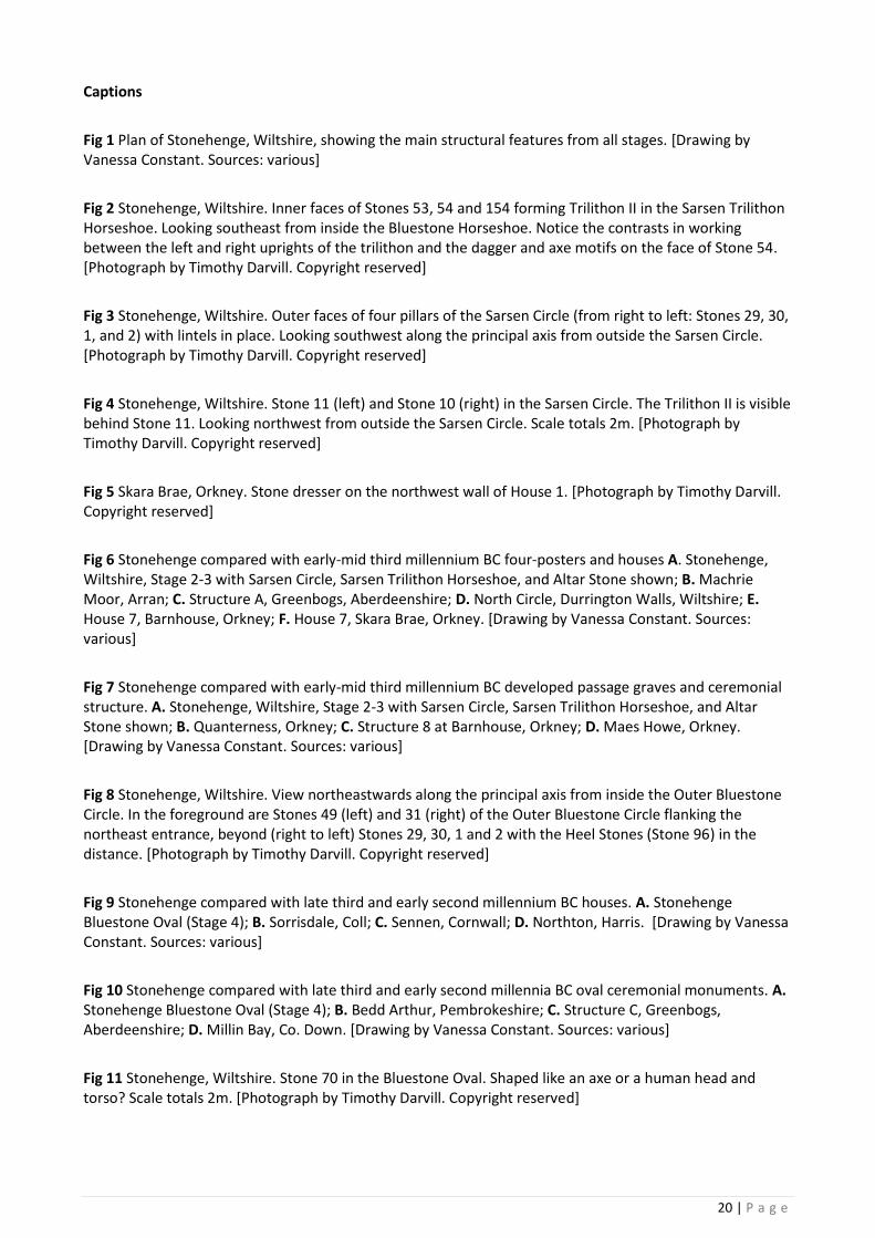
20 | P a g e
Captions
Fig 1 Plan of Stonehenge, Wiltshire, showing the main structural features from all stages. [Drawing by Vanessa Constant. Sources: various]
Fig 2 Stonehenge, Wiltshire. Inner faces of Stones 53, 54 and 154 forming Trilithon II in the Sarsen Trilithon Horseshoe. Looking southeast from inside the Bluestone Horseshoe. Notice the contrasts in working between the left and right uprights of the trilithon and the dagger and axe motifs on the face of Stone 54. [Photograph by Timothy Darvill. Copyright reserved]
Fig 3 Stonehenge, Wiltshire. Outer faces of four pillars of the Sarsen Circle (from right to left: Stones 29, 30, 1, and 2) with lintels in place. Looking southwest along the principal axis from outside the Sarsen Circle. [Photograph by Timothy Darvill. Copyright reserved]
Fig 4 Stonehenge, Wiltshire. Stone 11 (left) and Stone 10 (right) in the Sarsen Circle. The Trilithon II is visible behind Stone 11. Looking northwest from outside the Sarsen Circle. Scale totals 2m. [Photograph by Timothy Darvill. Copyright reserved]
Fig 5 Skara Brae, Orkney. Stone dresser on the northwest wall of House 1. [Photograph by Timothy Darvill. Copyright reserved]
Fig 6 Stonehenge compared with early-mid third millennium BC four-posters and houses A. Stonehenge, Wiltshire, Stage 2-3 with Sarsen Circle, Sarsen Trilithon Horseshoe, and Altar Stone shown; B. Machrie Moor, Arran; C. Structure A, Greenbogs, Aberdeenshire; D. North Circle, Durrington Walls, Wiltshire; E. House 7, Barnhouse, Orkney; F. House 7, Skara Brae, Orkney. [Drawing by Vanessa Constant. Sources: various]
Fig 7 Stonehenge compared with early-mid third millennium BC developed passage graves and ceremonial structure. A. Stonehenge, Wiltshire, Stage 2-3 with Sarsen Circle, Sarsen Trilithon Horseshoe, and Altar Stone shown; B. Quanterness, Orkney; C. Structure 8 at Barnhouse, Orkney; D. Maes Howe, Orkney. [Drawing by Vanessa Constant. Sources: various]
Fig 8 Stonehenge, Wiltshire. View northeastwards along the principal axis from inside the Outer Bluestone Circle. In the foreground are Stones 49 (left) and 31 (right) of the Outer Bluestone Circle flanking the northeast entrance, beyond (right to left) Stones 29, 30, 1 and 2 with the Heel Stones (Stone 96) in the distance. [Photograph by Timothy Darvill. Copyright reserved]
Fig 9 Stonehenge compared with late third and early second millennium BC houses. A. Stonehenge Bluestone Oval (Stage 4); B. Sorrisdale, Coll; C. Sennen, Cornwall; D. Northton, Harris. [Drawing by Vanessa Constant. Sources: various]
Fig 10 Stonehenge compared with late third and early second millennia BC oval ceremonial monuments. A. Stonehenge Bluestone Oval (Stage 4); B. Bedd Arthur, Pembrokeshire; C. Structure C, Greenbogs, Aberdeenshire; D. Millin Bay, Co. Down. [Drawing by Vanessa Constant. Sources: various]
Fig 11 Stonehenge, Wiltshire. Stone 70 in the Bluestone Oval. Shaped like an axe or a human head and torso? Scale totals 2m. [Photograph by Timothy Darvill. Copyright reserved]

21 | P a g e
Table 1 Summary of the main stages in the development of Stonehenge 3000 – 1500 BC (based on Darvill et al. 2012)
Author contact details
Professor Timothy Darvill
Centre for Archaeology and Anthropology
Department of Archaeology, Anthropology and Forensic Science
Faculty of Science and Technology
Bournemouth University
Fern Barrow
Poole
Dorset BH12 5BB
United Kingdom
Email: [email protected]
Figure 1
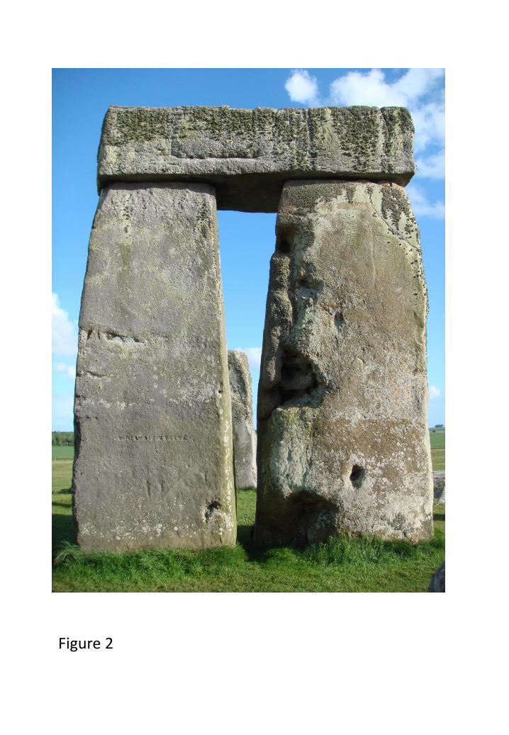
Figure 2
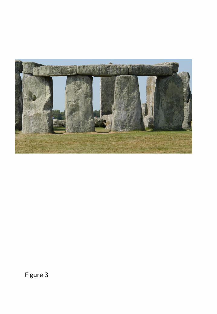
Figure 3
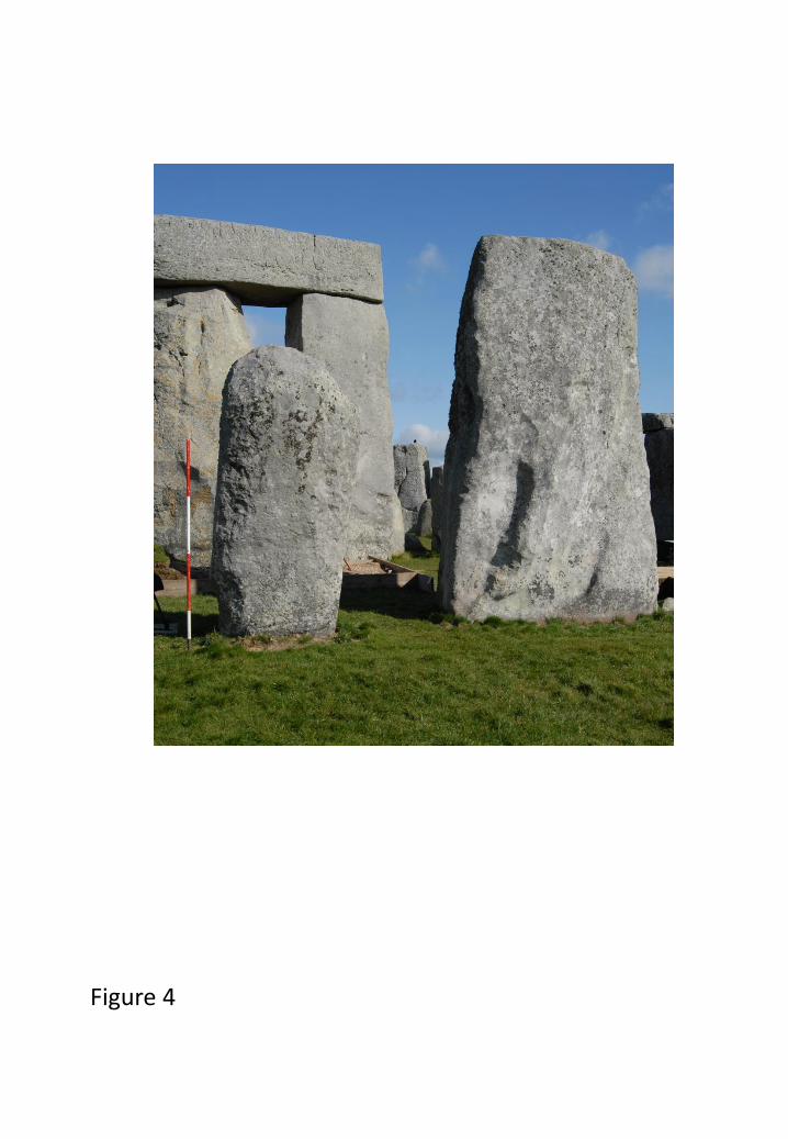
Figure 4
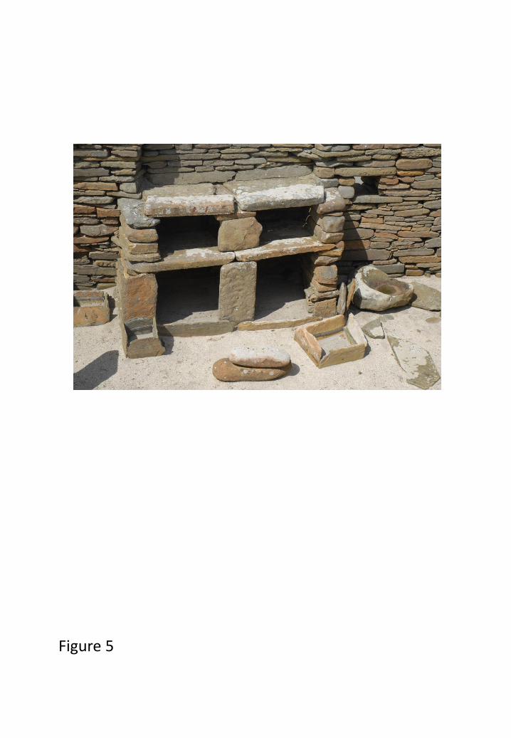
Figure 5

Figure 6
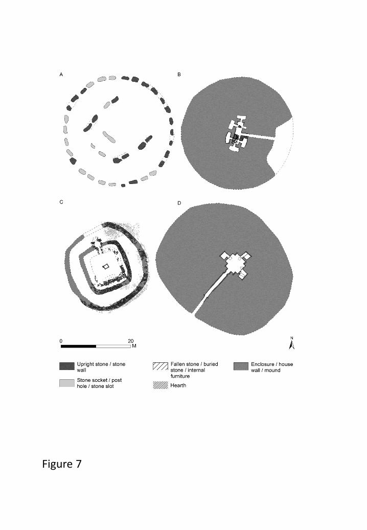
Figure 7

Figure8
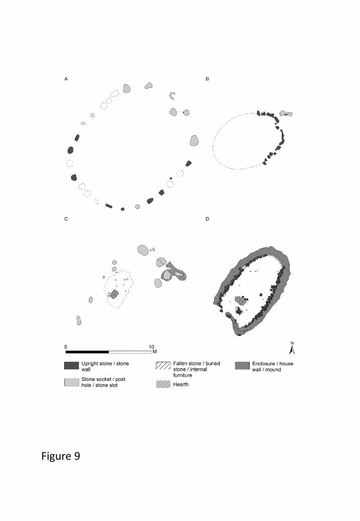
Figure 9
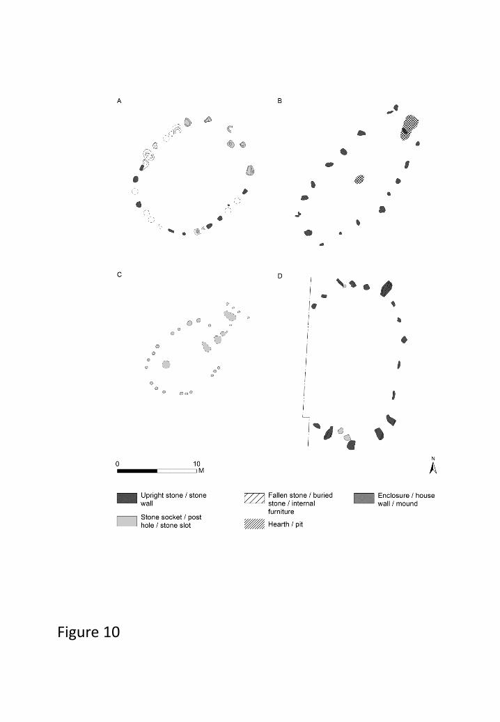
Figure 10
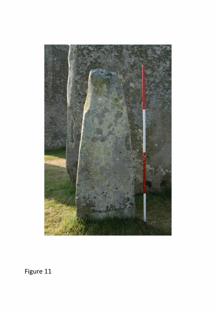
Figure 11
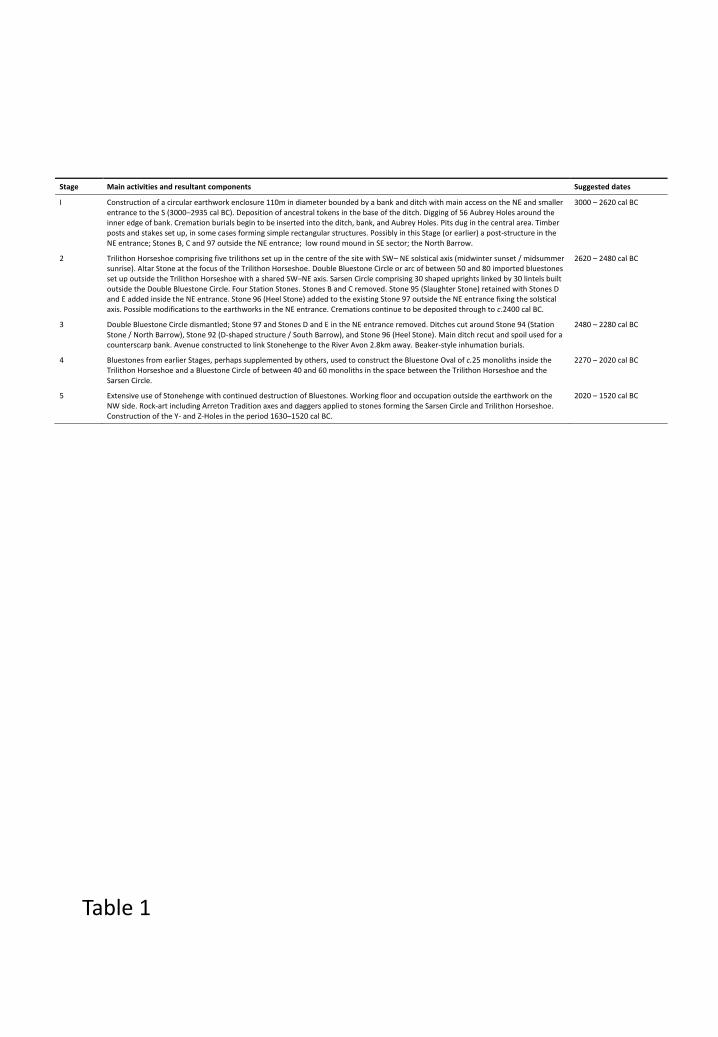
Stage Main activities and resultant components Suggested dates
I Construction of a circular earthwork enclosure 110m in diameter bounded by a bank and ditch with main access on the NE and smaller entrance to the S (3000–2935 cal BC). Deposition of ancestral tokens in the base of the ditch. Digging of 56 Aubrey Holes around the inner edge of bank. Cremation burials begin to be inserted into the ditch, bank, and Aubrey Holes. Pits dug in the central area. Timber posts and stakes set up, in some cases forming simple rectangular structures. Possibly in this Stage (or earlier) a post-structure in the NE entrance; Stones B, C and 97 outside the NE entrance; low round mound in SE sector; the North Barrow.
3000 – 2620 cal BC
2 Trilithon Horseshoe comprising five trilithons set up in the centre of the site with SW– NE solstical axis (midwinter sunset / midsummer sunrise). Altar Stone at the focus of the Trilithon Horseshoe. Double Bluestone Circle or arc of between 50 and 80 imported bluestones set up outside the Trilithon Horseshoe with a shared SW–NE axis. Sarsen Circle comprising 30 shaped uprights linked by 30 lintels built outside the Double Bluestone Circle. Four Station Stones. Stones B and C removed. Stone 95 (Slaughter Stone) retained with Stones D and E added inside the NE entrance. Stone 96 (Heel Stone) added to the existing Stone 97 outside the NE entrance fixing the solstical axis. Possible modifications to the earthworks in the NE entrance. Cremations continue to be deposited through to c.2400 cal BC.
2620 – 2480 cal BC
3 Double Bluestone Circle dismantled; Stone 97 and Stones D and E in the NE entrance removed. Ditches cut around Stone 94 (Station Stone / North Barrow), Stone 92 (D-shaped structure / South Barrow), and Stone 96 (Heel Stone). Main ditch recut and spoil used for a counterscarp bank. Avenue constructed to link Stonehenge to the River Avon 2.8km away. Beaker-style inhumation burials.
2480 – 2280 cal BC
4 Bluestones from earlier Stages, perhaps supplemented by others, used to construct the Bluestone Oval of c.25 monoliths inside the Trilithon Horseshoe and a Bluestone Circle of between 40 and 60 monoliths in the space between the Trilithon Horseshoe and the Sarsen Circle.
2270 – 2020 cal BC
5 Extensive use of Stonehenge with continued destruction of Bluestones. Working floor and occupation outside the earthwork on the NW side. Rock-art including Arreton Tradition axes and daggers applied to stones forming the Sarsen Circle and Trilithon Horseshoe. Construction of the Y- and Z-Holes in the period 1630–1520 cal BC.
2020 – 1520 cal BC
Table 1
Related Documents