Archaeology of the Russian Scare: The Port Adelaide Torpedo Station by Martin Wimmer B.A., Assoc. Dip. Bus., B.Arch. A thesis submitted in partial fulfilment of the requirements for the degree of Bachelor of Archaeology (Honours) Department of Archaeology School of Humanities Flinders University October 2005

Welcome message from author
This document is posted to help you gain knowledge. Please leave a comment to let me know what you think about it! Share it to your friends and learn new things together.
Transcript
Archaeology of the Russian Scare:
The Port Adelaide Torpedo Station
by Martin Wimmer
B.A., Assoc. Dip. Bus., B.Arch.
A thesis submitted in partial fulfilment of the requirements for the
degree of Bachelor of Archaeology (Honours)
Department of Archaeology
School of Humanities
Flinders University
October 2005

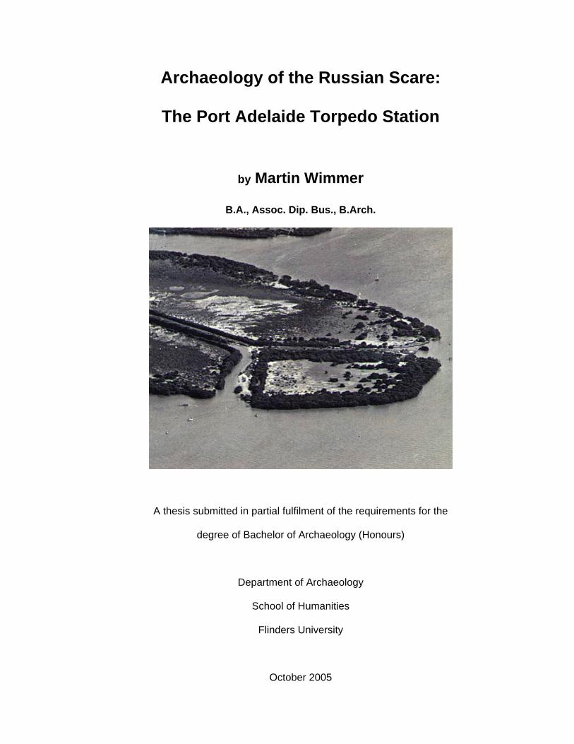
Cover Page - aerial photograph of the Port Adelaide Torpedo Station site looking
south, 16 January 1937 (Photo: D. Darian Smith, Adelaide; Jan Perry: Private
Collection).
ii

Table of Contents
CONTENTS PAGE
ACKNOWLEDGEMENTS viii
DECLARATION OF CANDIDATE ix
LIST OF ABBREVIATIONS x
ABSTRACT xi
TABLE OF FIGURES xiii
INTRODUCTION 1
Introduction 1
Research questions 1
Summary of thesis chapters 3
Description of study area 4
CHAPTER ONE: LITERATURE REVIEW 5
Introduction 5
The archaeology of the recent past 5
Hybrid studies: maritime and historical archaeology 7
Military site archaeology 8
Cultural heritage management (CHM) approaches to 11
military site archaeology
Thematic models of heritage classification: Australia 12
and England
Garden and botanical studies 14
Previous archaeological investigation of Australian 16
colonial torpedo stations
iii
Previous archaeological investigation of the Port 16
Adelaide Torpedo Station
Conclusion 17
CHAPTER TWO: HISTORICAL BACKGROUND 18
Introduction 18
First landfall 18
The naval store 19
The ‘Russian Scare’ 20
The Jervois plan 21
The Torpedo Station 21
Abandonment 23
Conclusion 24
CHAPTER THREE: METHOD 25
Introduction 25
Methodological techniques employed 25
Historical and archival research 26
Expert advice 28
Pre-disturbance survey 29
Minor site disturbance 37
Overlaying aerial photographs 37
Conclusion 38
CHAPTER FOUR: RESULTS 40
Introduction 40
Black beacon 40
Artificial harbour 42
Magnetometer survey of artificial harbour 42
iv
Artificial sea wall 44
Main track and associated structures 46
Torpedo boat shed and filling shed 53
Perry’s Creek 53
Exotic vegetation 55
Conclusion 60
CHAPTER FIVE: DISCUSSION 61
Introduction 61
The sum of all fears 62
Technology and a shift in defence theory: reasons for 63
abandonment
Defining the cultural landscape of the Torpedo Station 66
Specialised experiences of time and place 68
Mode of construction 69
Site formation processes: pre-abandonment 71
Site formation processes: post-abandonment 72
Botanical investigations 78
Further investigations 80
Cultural Heritage Torpedoed 83
Conclusion 83
CHAPTER SIX: CONCLUSION 85
Introduction: an embarrassment of riches 85
Future archaeological directions: unanswered questions 85
Identifying cultural significance 87
Interpretive potential 89
Conclusion: archaeology as optimism 89
v
REFERENCES 91
APPENDICES 98
APPENDIX ONE 98
Certificate of Title
(Land Titles Office Adelaide)
APPENDIX TWO 99
Treloar and Treloar 2000 transect shown as shaded area
and main Torpedo Station track shown as yellow line
(Mapland survey 6107: Photo 173)
APPENDIX THREE 100
Plan of colonial defences, October 1858 - section showing
arcs of fire from proposed forts (Torpedo Station site circled in red)
(Private Collection: Jan Perry)
APPENDIX FOUR 101
Winton survey: 28 April 1938 (ruins and old gun circled in red)
(Land Titles Office 1938)
APPENDIX FIVE 102
Total station survey of cultural material associated with the
Port Adelaide Torpedo Station
(Mapland survey 6107: Photo 173)
APPENDIX SIX 103
Chart of Torpedo Station showing artificial bay, jetty and moorings
(Drawing No. 4322/17: nd.)
APPENDIX SEVEN 104
Magnetometer survey of artificial harbour overlaid on aerial
photograph of Torpedo Station site.
vi
(Image courtesy of Ian Moffat, Ecophyte Technologies Pty Ltd
and Australian School of Petroleum, University of Adelaide; Mapland
survey 6107: Photo 173)
APPENDIX EIGHT 105
Magnetometer survey of artificial harbour: overlaid
transects depict collection bias of significant readings
(Image courtesy of Ian Moffat, Ecophyte Technologies Pty Ltd
and Australian School of Petroleum, University of Adelaide)
APPENDIX NINE 106
1954 Aerial photograph of Torpedo Station site depicting structures
in artificial harbour
(Mapland Survey 153: Photo 7893)
APPENDIX TEN 107
Old bricks now a part of the artificial sea wall
APPENDIX ELEVEN 109
Aerial photograph showing extent of high water, 4 November 1954
(Mapland survey 149: Photo 6864)
APPENDIX TWELVE 110
Total station survey of stormwater inspection points overlaid on
Aerial photograph of Perry’s Creek
(Mapland survey 153: Photo 7893)
APPENDIX THIRTEEN 111
Brief description of Torpedo Station, no date
(Private Collection: Jan Perry)
vii

Acknowledgements
As with any voluminous work, there are volumes of individuals to thank. The
following typology is presented in no particular stratigraphy –
Civilian
Cheryl Ahrens – moral support; Anna Wimmer - therapy; Oma and Opa – baby
sitting; Jan Perry – archival material/ field work.
Archaeological
Mark Staniforth – supervision/ field work; John Schofield – recent military sites (UK);
Terry Arnott – South Australian maritime heritage; Nathan Richards – South
Australian maritime heritage; Tim Smith – New South Wales maritime heritage; Mike
Nash – Tasmanian maritime heritage; Cassandra Philippou – Victorian maritime
heritage; Paddy Waterson – Queensland maritime heritage; Denis Gojak – colonial
defences; Peter Bell – old bricks; Joe Flatman - field work; Matt Schlitz – technical
assistance/ field work; Rick Bullers – field work/ wood analysis; Mathew Matikian –
IT/ field work; Linda Honey – field work; Debra Shefi – field work/ photography;
Amanda Hale – field work.
Geophysical
Ian Moffat - magnetometer survey/ imaging.
Botanical
John Sandham – plant characteristics; Dave Hemmings – plant identification.
viii

___________________________________________________________________
Declaration of Candidate
I certify that this thesis does not incorporate without acknowledgement any material
previously submitted for a degree or diploma in any university; and that to the best of
my knowledge and belief it does not contain any material previously published or
written by another person except where due reference is made in the text.
Martin Wimmer
21.10.05
___________________________________________________________________
ix
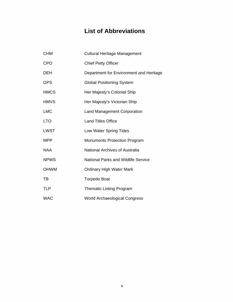
List of Abbreviations
CHM Cultural Heritage Management
CPO Chief Petty Officer
DEH Department for Environment and Heritage
GPS Global Positioning System
HMCS Her Majesty’s Colonial Ship
HMVS Her Majesty’s Victorian Ship
LMC Land Management Corporation
LTO Land Titles Office
LWST Low Water Spring Tides
MPP Monuments Protection Program
NAA National Archives of Australia
NPWS National Parks and Wildlife Service
OHWM Ordinary High Water Mark
TB Torpedo Boat
TLP Thematic Listing Program
WAC World Archaeological Congress
x
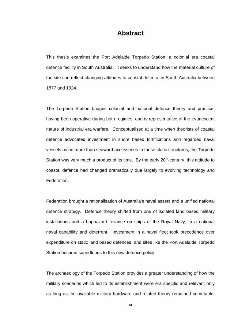
Abstract
This thesis examines the Port Adelaide Torpedo Station, a colonial era coastal
defence facility in South Australia. It seeks to understand how the material culture of
the site can reflect changing attitudes to coastal defence in South Australia between
1877 and 1924.
The Torpedo Station bridges colonial and national defence theory and practice,
having been operative during both regimes, and is representative of the evanescent
nature of industrial era warfare. Conceptualised at a time when theorists of coastal
defence advocated investment in shore based fortifications and regarded naval
vessels as no more than seaward accessories to these static structures, the Torpedo
Station was very much a product of its time. By the early 20th-century, this attitude to
coastal defence had changed dramatically due largely to evolving technology and
Federation.
Federation brought a rationalisation of Australia’s naval assets and a unified national
defence strategy. Defence theory shifted from one of isolated land based military
installations and a haphazard reliance on ships of the Royal Navy, to a national
naval capability and deterrent. Investment in a naval fleet took precedence over
expenditure on static land based defences, and sites like the Port Adelaide Torpedo
Station became superfluous to this new defence policy.
The archaeology of the Torpedo Station provides a greater understanding of how the
military scenarios which led to its establishment were era specific and relevant only
as long as the available military hardware and related theory remained immutable.
xi
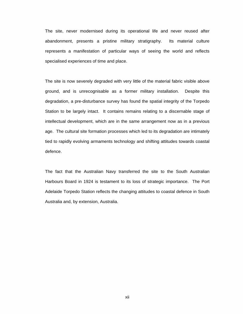
The site, never modernised during its operational life and never reused after
abandonment, presents a pristine military stratigraphy. Its material culture
represents a manifestation of particular ways of seeing the world and reflects
specialised experiences of time and place.
The site is now severely degraded with very little of the material fabric visible above
ground, and is unrecognisable as a former military installation. Despite this
degradation, a pre-disturbance survey has found the spatial integrity of the Torpedo
Station to be largely intact. It contains remains relating to a discernable stage of
intellectual development, which are in the same arrangement now as in a previous
age. The cultural site formation processes which led to its degradation are intimately
tied to rapidly evolving armaments technology and shifting attitudes towards coastal
defence.
The fact that the Australian Navy transferred the site to the South Australian
Harbours Board in 1924 is testament to its loss of strategic importance. The Port
Adelaide Torpedo Station reflects the changing attitudes to coastal defence in South
Australia and, by extension, Australia.
xii

Table of Figures
FIGURE PAGE
FIGURE ONE 20
Infrastructure of naval store, overwritten in red in the late 1920s.
Black beacon circled in blue. (Admiralty Chart 1876)
FIGURE TWO 22
A Type II torpedo boat with torpedo dropping gear on its sides.
(Armstrong 1896: 203)
FIGURE THREE 30
C.1911 site plan of Torpedo Station (not to scale).
(NAA: MP472, 18/11/2562)
FIGURE FOUR 32
Matt Schlitz conducting a total station survey of the Torpedo Station.
(Photo: Debra Shefi, 11 May 2005)
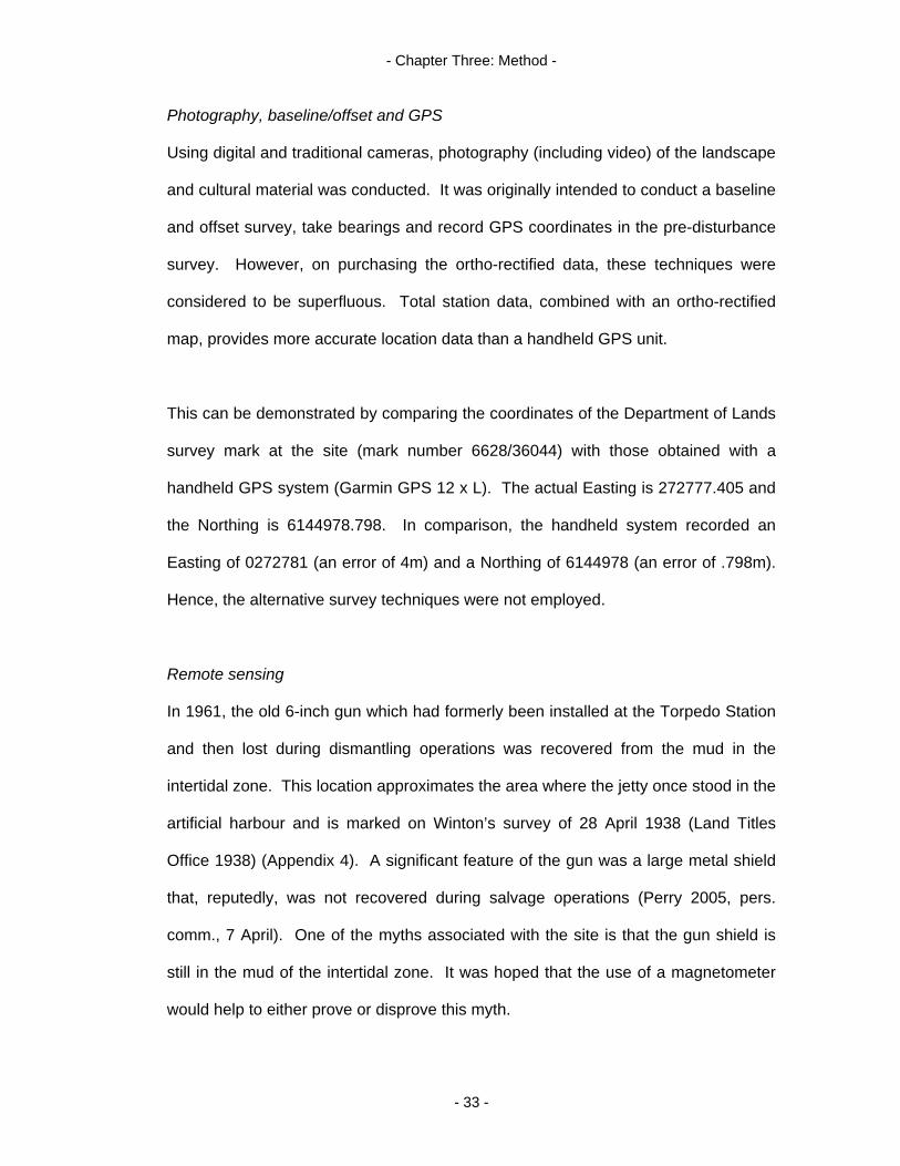
FIGURE FIVE 35
Torpedo Station 6-inch Armstrong gun and shield.
(Healey 1999: 6)
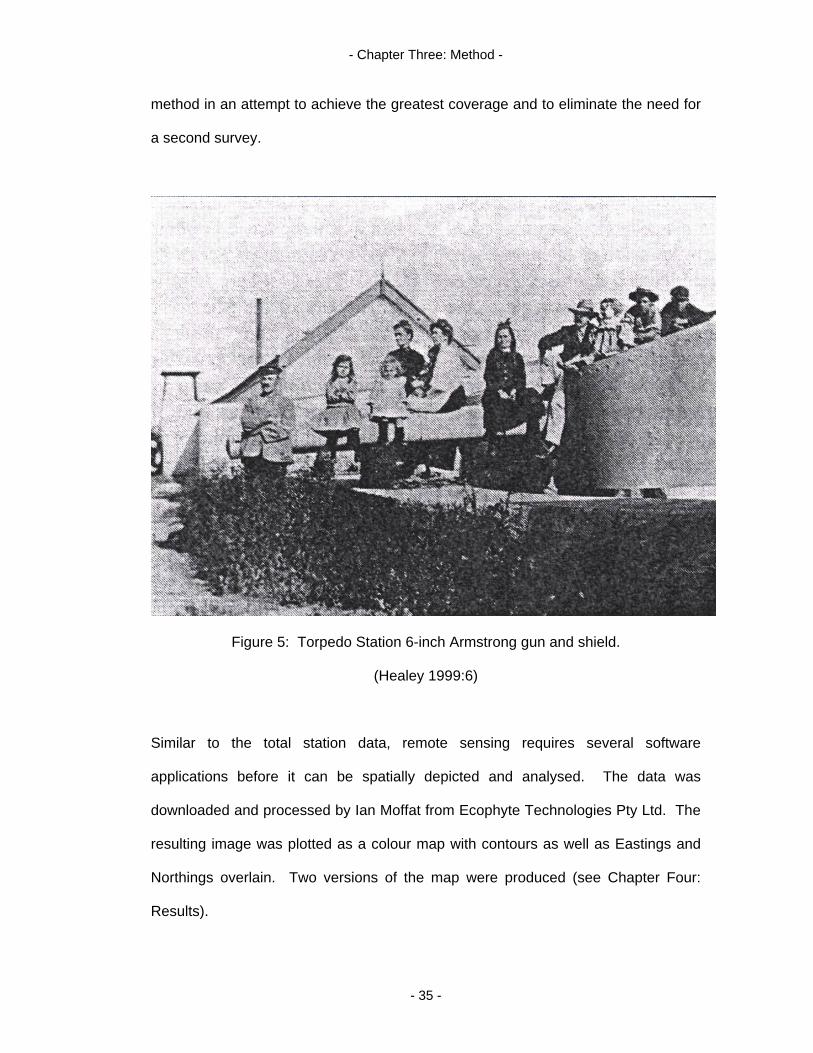
FIGURE SIX 36
Magnetometer survey of artificial harbour conducted by Ian Moffat,
Rick Bullers and Joe Flatman.
(Photo: Martin Wimmer, 1 June 2005)
FIGURE SEVEN 40
Remains of black beacon, north face.
(Photo: Martin Wimmer, 5 October 2004)
xiii
FIGURE EIGHT 41
Cell structure of Blackwood (Acacia melanoxylon).
(Ilic 1991: 33)
FIGURE NINE 45
Artificial sea wall, north face.
(Photo: Martin Wimmer, 5 October 2004)
FIGURE TEN 47
Cultural material churned up by the trenching process –
possibly belonging to the tank stand.
(Photo: Martin Wimmer, 21 September 2005)
FIGURE ELEVEN 48
Brine main inspection and maintenance port, western face.
(Photo: Martin Wimmer, 21 September 2005)
FIGURE TWELVE 49
Gun platform remnant, north face.
(Photo: Debra Shefi, 11 May 2005)
FIGURE THIRTEEN 50
Imprint of tramway tracks, looking west.
(Photo: Martin Wimmer, 11 May 2005)
FIGURE FOURTEEN 52
Southern portion of raised walkway depicting rubble construction.
(Photo: Martin Wimmer, 11 May 2005)
FIGURE FIFTEEN 56
Opuntia sp., western edge.
(Photo: Martin Wimmer, 5 October 2004)
xiv

FIGURE SIXTEEN 58
Pig Face (Carpobrotus sp.).
(Photo: Martin Wimmer, 21 September 2005)
FIGURE SEVENTEEN 58
Pig Face (Lampranthus sp.).
(Photo: Martin Wimmer, 21 September 2005)
FIGURE EIGHTEEN 59
Rectangular mass of African Boxthorn (green and dry branches),
looking north-east.
(Photo: Martin Wimmer, 21 September 2005)
FIGURE NINETEEN 70
Fort Glanville, early 1970s.
(Colwell 1973: 73)
FIGURE TWENTY 73
Public torpedo auction.
(The Register 15 March 1912: 2)
FIGURE TWENTY ONE 84
New slip under construction September 2005 (eastern face),
56 metres east-north-east of black beacon.
(Photo: Martin Wimmer, 21 September 2005)
FIGURE TWENTY TWO 90
Torpedo reuse - post public auction?
(Milligan 1975: 17)
xv
- Introduction -
Introduction
As an island continent, Australia’s settlement and commerce is intimately tied to
themes of seafaring. Early seafarers colonised Australia more than 40,000 years
ago. In historical times, seafarers charted and raised their flag on Australian soil in
the name of a foreign head of state and the imperialist designs of that state. Some
of the common recurring themes of seafaring are naval warfare and coastal defence,
with a more recent and overlapping facet being torpedo warfare.
This archaeological thesis investigates a colonial era torpedo station located at Port
Adelaide. A relic of South Australia’s colonial Navy, the Torpedo Station is situated
at the confluence of Hindmarsh Reach and the North Arm of the Port Adelaide River.
The study site extends across a terrestrial and inundated landscape, blurring the
boundary of maritime and historical archaeology.
It is considered that archaeological investigation and interpretation of the structures
left behind at the Torpedo Station by changes in technology, defence policy and the
rationalisation of related infrastructure post-Federation, will serve to broaden our
understanding of colonial era military sites. Further, this thesis may serve as a
model or precursor to a broader study of seafaring themes aligned with coastal
defence and their impact on the Australian landscape and psyche.
Research questions
By using archaeological techniques to analyse the cultural landscape of a 19th-
century coastal defence site, this thesis will investigate the following question: “How
does the material culture of the Port Adelaide Torpedo Station reflect the changing
attitudes to coastal defence in South Australia between 1877 and 1924?”. The
- 1 -
- Introduction -
decision to frame the research question within this particular date range was based
on the following reasons.
At the urging of the Colonial Office in London, Lieutenant General William Jervois
took up a five year residency as the Governor of South Australia in 1877, before
moving on to a similar position in New Zealand in 1882. Jervois, a respected military
engineer, was an expert in coastal defence theory and the construction of
fortifications who used his expertise to steer South Australia’s capabilities in these
areas. Previously, the Colony of South Australia was largely defenceless (Nairn et al
1972:479-480).
In 1924, ownership of the Torpedo Station was transferred from the Royal Australian
Navy to the South Australian Harbours Board (Commonwealth of Australia Gazette
1924, 52:1574). This act was intimately tied to changing attitudes about coastal
defence in South Australia. It demonstrated a shift in defence theory and practice,
and underlined the loss of the strategic and tactical potency of the site.
This thesis will combine archaeology with the cross-disciplinary skills of geophysics
and botany to address some secondary questions arising from its investigations.
These concern the Torpedo Station’s conception, construction, effectiveness and
abandonment. An investigation of the cultural and natural site formation processes
that have acted upon it since abandonment will also be undertaken. It will be argued
that the various observable site formation processes (for example, dismantling and
trenching), are a direct consequence of the changing attitudes to coastal defence in
South Australia.
- 2 -
- Introduction -
Summary of thesis chapters
Chapter One provides a literature review and includes the following topics: the
archaeology of the recent past; military site archaeology and the current English
approach to this, highlighting its relevance to the Australian experience; hybrid
studies of maritime and historical archaeology; cultural heritage management
approaches to military site archaeology; garden and botanical studies; and previous
archaeological investigation of torpedo stations in Australia. Chapter Two details the
historical background of the site from earliest recorded landfall in 1831. It ties the
Torpedo Station to the historical defence landscape of this section of the Port
Adelaide River, and outlines its transition from military to civilian use.
Chapter Three details the methods used in the pre-disturbance survey of the site,
including the interdisciplinary aspects of the study. It also documents some of the
shortcomings of different aspects of the survey. Chapter Four describes the material
culture of the Torpedo Station as uncovered by the pre-disturbance survey, and also
describes the site formation processes that have acted upon it.
Chapter Five discusses the material culture of the Torpedo Station and the
associated cultural landscape. It summarizes the results of the investigation against
the main research question, demonstrating how the Torpedo Station reflects
changing attitudes to coastal defence in South Australia between 1877 and 1924.
This chapter also analyzes the genesis of the Torpedo Station, its mode of
construction, and site formation processes both pre and post abandonment. It
discusses the findings of the botanical and geophysical investigations, and also
offers suggestions regarding possible future investigations of both the terrestrial and
marine environments associated with the Station.
- 3 -

- Introduction -
Chapter Six concludes the thesis by noting the richness of the material culture extant
on the site. It also summarizes new and as yet unanswered questions arising from
the study. A statement of cultural significance of the Torpedo Station is provided, as
well as an argument for heritage listing. The chapter concludes with a discussion of
the interpretive potential of the site and a note on the optimism of archaeology.
Description of study area
The Port Adelaide Torpedo Station, now a section of parent title: CT 5636/256
(Appendix 1), is situated in the Hundred of Port Adelaide approximately 12km
north/west of the Adelaide CBD. A Department of Lands survey mark (6628/36044)
is located within the south/western perimeter of the site. This has a GPS coordinate
of 272777.405E/6144978.798N (site datum WGS84). Presently constituting an area
of approximately 3.85 hectares (9½-acres), it has the Port Adelaide River as its
western boundary and the North Arm of the same river system on its northern
perimeter. The site, rhomboidal in shape and measuring approximately 250m by
300m, encompasses three easements and a right of way. The land is arid and
sandy, and covered with a mix of low lying indigenous and exotic vegetation.
The area is owned by the State Government Land Management Corporation (LMC).
Access can be gained via a dirt track extension of Moorhouse Road. It is not fenced,
although a low earthen embankment along its northern perimeter, and a locked gate
at the end of Moorhouse Road, currently restrict vehicular access. Its predominant
disposition as waste land, in combination with its river frontage and the profit
generating nature of its current owner, makes the area prone to redevelopment (see
page 84).
- 4 -
- Chapter One: Literature Review -
War…alters our world and our history, our political systems, our social
attitudes, our perceptions and our moralities (Forsyth 1985:9)
Introduction
The heritage of war is as much a part of human legacy as that of the arts or
sciences. Every age has cast off and abandoned the superseded theory and fabric
of conflict. This is especially true of the period of industrialised warfare post 1850.
Schofield et al (2002:4) observed that “the materiality of [industrialised] warfare is a
vast and diverse subject, from entire landscapes whose personalities bear traces of
military activity or presence to specific places – sites, structures, buildings,
monuments – where events occurred or where soldiers sat, waiting for invasions that
in some cases never came”.
The archaeology of the recent past
Stevenson (2001:61) argued that “the modern period with its rich contextual sources
is ideal ground on which to write archaeologies…Terms such as ‘Georgian’ and
‘Victorian’ are words that the public can relate to as the recent past”. This augurs
well for archaeology in Australia where, like other states in the ‘New World’ that were
colonised by imperial European powers, there exists a distinct dichotomy of human
occupation and an abrupt beginning to its historical period.
There is, however, a paucity of archaeological research (especially published
archaeological research) in some areas of dedicated or themed studies of the recent
past in Australia. Of particular note are themes relevant to this thesis. The
archaeology of colonial era torpedo stations, coastal defences in colonial South
Australia, and the ‘Russian Scare’ are themes largely absent in current research. As
- 5 -
- Chapter One: Literature Review -
a consequence, and despite the wealth of contextual sources available, the fabric
and social context of these specific areas of human endeavour are not well
understood.
One possible reason is that archaeology developed with a focus on the distant past.
As a discipline, it helped establish the antiquity of humans and piece together absent
ancient histories. In Australia, this is mirrored by archaeological research into the
history of its Indigenous settlement and the Indigenous ties to place (see Mulvaney
and Kamminga 1999; Williamson 2004). Archaeological interpretation of the recent
past has typically been viewed as ancillary to this traditional role. The rich contextual
material associated with the recent past (for example, good documentation and
ample material culture) has meant that archaeological study of the absent present
has been seen to be more closely related to the work of historians than
archaeologists (Buchli & Lucas 2001:3).
Advances in archaeological theory since the 1960s (see, for example, Binford 1962;
Deetz 1977; Rathje et al 1992) has led to a realisation that archaeology is actually
defined by a study of material culture and its relation to human behaviour, and not by
the study of particular time periods. Johnson (2000:63) qualified this by writing that
archaeologies of the present are concerned with examining the link between human
behaviour and material debris. In a sense, since the 1960s traditional artefact
typologies have been replaced by typologies of archaeologists (Chapman 2003:13)
including historical and maritime practitioners.
In light of this shift in definition, the ‘marginal’ archaeologies of the recent past are
now understood as being valid areas of research. Consequently, they are becoming
- 6 -

- Chapter One: Literature Review -
more common and more readily assimilated into the realm of mainstream
archaeology. Growing archaeological interest in the remains of industrial era warfare
has been ratified with sessions dedicated to the heritage of ‘recent’ armed conflict at
international forums [for example, World Archaeological Congress 4 (WAC-4) in
Cape Town 1999 and at World Archaeological Congress 5 (WAC-5) in Washington
DC 2003].
In Australia, as in other parts of the world, this enlightenment has been particularly
relevant to the archaeologies of colonisation, with many gaps in our knowledge of
the recent past being slowly filled by various thematic studies. Australian
archaeological studies of its recent martial past are now strongly developed in
certain areas. These studies range from contact in settler societies (Murray 2004) to
aircraft losses over water during World War Two (Ford 2004; Jung 1996, 2000, 2004,
2005; McCarthy 2004; Smith 2004). Despite this, and regardless of their vast
acreage and reflective material culture, certain types of military facility and landscape
still elude archaeological investigation and publication.
Hybrid studies: maritime and historical archaeology
The Port Adelaide Torpedo Station extends across a terrestrial and intertidal
landscape, distorting the boundary of maritime and historical archaeology. The
terrestrial component of the Station included numerous buildings, roads, tracks and a
tramway, whilst the maritime segment of the site included a jetty, a slipway, at least
one navigational beacon, several fixed mooring structures and an associated debris
field.
- 7 -

- Chapter One: Literature Review -
In Australia, the hybrid nature of some archaeological sites has previously been
explored in thematic studies such as shore based whaling operations (Lawrence &
Staniforth 1998; Paterson 2004) and shipwreck survivors camps (Morse 1988;
Pasveer et al 1998; Stanbury 1998; Gibbs 2003; Nash 2004). The archaeology of
shore based maritime defence installations fits with Australia’s holistic approach to
the duality of ‘coastal archaeology’, and would complement the existing body and
method associated with the genre.
Military site archaeology
Present knowledge and understanding of South Australian colonial era coastal
defences, defence related theory and the changing attitudes to these is derived
largely from a historiography constructed around archival material. Thus far,
investigation of the fabric still extant on such sites has been limited. This is
especially true of the Port Adelaide Torpedo Station, but it is also true of similar sites
around Australia.
In Australia, a paucity of published archaeological research on colonial defence
installations, and military sites in general, indicates that such intellectual pursuit is
not yet considered mainstream archaeology and, consequently, is bereft of funding.
As will be discussed later in this chapter, the military site archaeology that is
conducted largely takes the form of cultural heritage management reports which are
required by the relevant legislation. Such reports are mainly unpublished and
contribute little to a greater understanding of the past.
Industrialisation coupled the escalating scientific technologies of war with mass
production to such an efficient level that successive innovations rendered previous
- 8 -
- Chapter One: Literature Review -
technologies obsolete, and enabled conflict to be waged on a global scale. English
Heritage (2000:1) noted “such was the speed of change in the development of
strategies during this period that some sites and structures were superceded after
only a year or so of active life”. Examples of such innovation can be drawn from the
introduction of self loading rifles, breach loading artillery, torpedoes and high seas
fleets powered by steam turbines. The manifestation of this in the Australian
Colonies and on the Australian landscape was to dramatically influence South
Australia’s defence theory and defence infrastructure between 1877 and 1924.
Military installations fall into Darvill’s (1999:104) paradigm of landscape in that they
are not only composed of physical and structural dimensions, but also enshrine
metaphysical and social aspects. A military landscape is the embodiment of an
“expression of particular ways of seeing the world – specialised experiences of time
and place”. Schofield et al (2002:1) endorsed this by claiming that much can be
learnt about culture, and the manner in which it develops, from how people fight.
Archaeologists working on military sites do more than just fill the gaps in our
knowledge about specific military encounters. They “challenge us to think about how
archaeology can be used to study warfare, tactics, and strategy” (Orser & Fagan
1995:67). A military landscape seen not only as an artefact, but also as a socially
constituted structure, endows it with context. Such a context allows archaeologists
to link sites to one another, to the environment and to the culturally specific
conceptualisation and use of space (Darvill et al 1993:564).
This concept has been further refined and adopted by the English Monuments
Protection Program (MPP) to classify sites such as former military facilities as relict
cultural landscapes. Darvill et al (1993:564) defined these as “pieces of natural or
- 9 -
- Chapter One: Literature Review -
artificial scenery containing remains relating to a particular form, stage or type of
intellectual development…which exists now in the same pattern or arrangement as in
some previous age…[S]ufficient archaeological evidence still exists to allow the
study of socio-cultural patterning at a larger scale than possible from individual
monuments or groups of monuments”.
The archaeological elements of a relict cultural landscape need to be connected in a
logical way via articulating features. These could be natural, such as rivers or
coastlines, or they could be man-made, such as roads, tracks or linear earthworks.
Features like these endow a site with a framework that physically connects the
elements and delimits spaces. Such landscapes are likely to have some
geographical or topographical consolidation as a macro region, for instance, a river
valley or a peninsula. In addition, relict cultural landscapes can be divided into two
types: 1) synchronic, containing material culture belonging largely to one main period
of activity; and 2) diachronic, containing material culture from a succession of
different phases of use.
If one were to apply this framework to the Torpedo Station, the diachronic model
would identify three successive and distinct cultural landscapes in a macro view of
the site. This stratigraphy would include the original Indigenous landscape, the
Torpedo Station and the site’s current disposition as wasteland. However, the
research question underpinning this thesis sets parameters within which a
synchronic study can also take place, and allows a micro view of a specific layer of
site occupation and use – that of the Torpedo Station. The Station displays a
“chronological homogeneity within and between monuments represented” and a
“spatial integrity [with] clear signs of articulation between the main archaeological
- 10 -

- Chapter One: Literature Review -
elements present” which further identify it as a synchronic relict cultural landscape
(Darvill et al 1993:567).
Cultural heritage management (CHM) approaches to military site archaeology
Site types not yet considered part of mainstream archaeology suffer from a lack of
funding and, consequently, dedicated research. Most new archaeological work on
coastal defences in Australia seems to have been conducted on previously surveyed
and already listed heritage sites. Many of these are attached to, or part of, national
parks. This ‘new’ body of work is largely generated as a stipulation of the relevant
Act (for example, in South Australia see Sections 37 and 38, National Parks and
Wildlife Act, 1972; in New South Wales see the Heritage Act, 1977) and enshrined in
legislation to facilitate management of the cultural resource, rather than to foster any
stand alone or systematic theoretical study.
The intellectual product of such contractual obligation is largely unpublished,
relegated to the grey area of cognitive pursuit and generally available only to those
who have conducted, or paid for, the research (Staniforth 2005, pers. comm., 11
May). Gojak (2002:170) mentions examples of the kind of contracted and
unpublished management reports produced by the New South Wales (NSW)
National Parks and Wildlife Service (NPWS) on defence heritage sites.
The Australian model of colonial coastal defence archaeology is vindicated by
McGlade (1999:459) who detailed the two currently accepted archaeological paths
that can lead through such cultural landscapes. The first is represented by
“foregrounding symbolic, structural and phenomenological perspectives” of the
landscape and the second is aligned with “heritage management issues”. Clearly,
- 11 -
- Chapter One: Literature Review -
the path most commonly trod in the archaeology of Australian military landscapes
relevant to this study is the second.
It is also clear that this model cannot, in itself, lead to greater understanding of the
past. It is concerned only with maintaining the status quo or the integrity of the fabric
of sites fortunate enough to be listed on heritage registers. Canning professed that
academia often criticises such non-academic archaeology for a “lack of rigor, and the
production of vast quantities of useless archaeological survey data”. He also
acknowledged that some of the perceived shortcomings of this data include “poor
sampling methods, insufficient survey coverage, non-standardised survey methods
[and] visibility constraints” (2005:6).
Despite the negative perceptions of this CHM generated data, Canning did express
some optimism in using it for the predictive modelling of archaeological sensitivity.
Such models, he explained, could assist in the “preservation of representative
samples of the archaeological record for researchers of tomorrow” (2005:13). It
follows that the more sites listed, the greater the opportunity for archaeologists in the
long term, even if this amounts to no more than a management report in the short
term. Additional colonial era coastal defence sites are nominated for heritage listing
(from time to time). Most recently in NSW, for example, a 9.2-inch coastal gun
emplacement installed in 1893 at Ben Buckler Headland has been nominated for the
State Heritage Register (Heritage Council of NSW 2005).
Thematic models of heritage classification: Australia and England
Changes to the Australian National Heritage Register will allow for the inclusion of
themes in the Register’s modified format. Examples of such themes could include
- 12 -
- Chapter One: Literature Review -
‘Torpedo Stations in Australia’ or ‘Australia’s Colonial Coastal Defence Sites’ (Arnott
2004, pers. comm., 18 June). Thematic listings could assist in validating such
‘peripheral’ sites as mainstream, and ultimately encourage a more cognitive
approach to the resource in the medium or longer term.
Such a model already exists in England, with the Thematic Listing Program (TLP)
being used in conjunction with regional and site specific surveys, and targeting (!)
recent military heritage (English Heritage 2004). The English model is particularly
relevant to Australian colonial sites, given Australia’s early colonial dependency on
England for everything from consumer goods (Staniforth 2003) to defence. Most of
the defence technology in the Australian Colonies was imported from Britain, with
defence tactics theorised by English military personnel attached to the Colonial
Office in London (for example, Jervois and Scratchley).
Some solidarity can be expressed with England when considering Australia’s array
of coastal defences for archaeological investigation (see Oppenheim (2005) for an
overview of the coastal defences of Sydney Harbour, 1788-1963). England also has
a wealth of coastal defence sites from this era, along with a previous reluctance to
admit such recent military heritage into its archaeological mainstream. Dobinson et
al (1997:288) recognized that English forts of the Roman period and 17th-century
defences of the Civil War were well researched and recorded nationally. However,
for recent periods (post 1660), an understanding of the monuments of war was
generally poor, with the remains never being subjected to a systematic review.
This situation began to be addressed in the late 1980s through various English
Heritage initiatives, including the MPP and the TLP, and led to a fuller understanding
- 13 -
- Chapter One: Literature Review -
of the recent defence heritage resource in England. The English model
demonstrates that, for archaeology, the study of the heritage of war from a recent,
historical period (for example, coastal defences) is as important as the study of older
border fortifications such as the Great Wall of China or Hadrian’s Wall in
Northumbria (Baker 1993:709).
Garden and botanical studies
Gardens and the location of various significant botanical specimens have long been
acknowledged as important cultural markers: “They represent a story of social and
cultural change, and a botanical nursery of traditions and experimentation”
(Department for Environment, Heritage and Aboriginal Affairs 1998:2). The analysis
of exotic vegetation introduced to cultural landscapes can occur on many levels.
Two forms of analysis are relevant to this study. The first uses vegetation as a way
of determining past cultural behaviour. The second uses vegetation to locate cultural
material.
1. Using vegetation to determine past cultural behaviour:
Shackel (1996:87-109) sketched the utilitarian development of landscape and
garden in an armoury town during its transition from a centre of artisans and master
craftsmen to that of a military facility in early 1830s America: “Grasses were
intentionally planted and indigenous vegetation was kept to a minimum. Grasses
dominated the new landscape, providing an appearance of formality” (1996:96). He
also found that small garden plots were often retained by households with some
social standing. This model could have direct parallels with 19th-century Australian
landscape theory at the Torpedo Station. Unrecorded aspects of the Station’s
history may well have included a formalized landscape with possible garden plots.
- 14 -

- Chapter One: Literature Review -
Colonial era maps have depicted vegetation along this stretch of the Port Adelaide
River as consisting mainly of mangroves and samphire (a general label for low lying,
salt resistant vegetation). Exotic vegetation currently extant on the Torpedo Station,
especially in the vicinity of the caretaker’s residence, is of interest as it may have
once formed part of a garden, hedge or border.
From historical records, Starbuck (1994:115) revealed that “British armies of the late
eighteenth century…were accompanied by sizeable numbers of dependents – wives,
camp followers, and children”. Johnson (2002) also theorised that the presence of
gardens at military sites can provide evidence for the presence of women at those
sites. Women are frequently largely invisible in the historical record pertaining to
military installations. Remnant vegetation belonging to the fabric of the Torpedo
Station could provide information on traditional women’s duties (for example, food
production and preparation or the manufacture of vegetable dyes).
2. Using vegetation to locate cultural material:
Exotic vegetation can also be used to locate extant cultural material (see Stacy et al
2005:11). Coombe (2001:93) found a correlation between extant non-indigenous
plants and house sites even in severely environmentally degraded cultural locations.
This has obvious application to a survey of the Torpedo Station. Pest plant
specimens can also lead to the discovery of buried cultural material. This is
supported by Shackel (1996:95) who observed, through archaeobotanical analysis of
soils around dwellings in a formalised compound, that some aggressive, introduced
weeds also invade and occupy disturbed soil. Extant clumps of exotic vegetation
may be indicators of obscured structures.
- 15 -
- Chapter One: Literature Review -
Previous archaeological investigation of Australian colonial torpedo stations
An electronic mail survey of the State Maritime Heritage Officers in each of the
former Australian Colonies that utilised torpedo boats and mine defences (Tasmania,
Victoria, New South Wales, Queensland and Western Australia) failed to uncover
any previously published or even conducted archaeological work on torpedo
stations. Certain States have completed work on some of their torpedo boats, for
example, HMVS Lonsdale in Victoria (Philippou 2005, pers. comm., 28 July). New
South Wales has no remains associated with the submarine mining activity across
Sydney Harbour, whilst the miscellaneous wire extant in many places is associated
with commercial fishing operations (Smith 2005, pers. comm., 1 August). In
Queensland, excavations at the Naval Stores at Kangaroo Point and Fort Lytton on
the Brisbane River did not address the topic of this investigation (Waterson 2005,
pers. comm., 3 August). Western Australia did not respond to the inquiries made.
Previous archaeological investigation of the Port Adelaide Torpedo Station
As far as can be ascertained, only one other published archaeological investigation
of the Torpedo Station (erroneously referred to as the Torpedo Boat Station) has
been undertaken (see Treloar & Treloar 2001). In September 2000, a group of
students and staff from the Department of Archaeology, Flinders University
conducted a field walk survey of the site as a practical component for a maritime
archaeology topic Underwater and Coastal Archaeology (ARCH 3005). This
involved walking along a transect roughly north to south near the western edge of
the site, with GPS coordinates of the axis being recorded (Appendix 2).
Cultural material that was observed and recorded during the field walk appears to
have had no relation to the colonial era infrastructure originally on the site. Instead,
- 16 -

- Chapter One: Literature Review -
it consisted largely of construction material and garbage dumped there post
abandonment. The authors of the resultant report conceded that, due to the various
techniques employed in measuring distances (by ten separate individuals), it may be
difficult to accurately plot the cultural material or relocate it (Treloar & Treloar
2001:8). Further, there seems to be an error on Page 12 at Figure 13 in the report.
A hand drawn diagram of the visual transects used in a part of the study places the
power station (presumably that of Torrens Island) at the western side of Hindmarsh
Reach on Lefevre Peninsula instead of on Torrens Island north of the North Arm.
Conclusion
This chapter has attempted to place the current study in the continuum of military
site archaeology. Commencing with a general overview of military site archaeology
and moving to the particular (torpedo stations), it has investigated cultural landscape
theory as it applies to the genre, and compared the Australian and English models of
classification and archaeological investigation. Both Australia and England invest
heavily in heritage management studies, but generally place little emphasis on a
greater understanding of the sites. It is argued that this, to some extent, explains the
paucity of published archaeological material in some themes relating to recent
military conflict. Further, this situation is arguably largely due to a non-acceptance of
such studies into mainstream archaeology.
- 17 -

- Chapter Two: Historical Background -
Introduction
The recorded history of the Colony of South Australia is punctuated with references
to the Port Adelaide River. Its importance to the new Colony as a sheltered haven
and its easily defended entrance made it an ideal location from which to conduct
commerce.
The river bank between the River’s entrance and the North Arm has a long
association with the defence of Adelaide. 19th-century Port Adelaide Harbour
Regulations stated that no ship or vessel shall “whilst above the North Arm, fire or
suffer to be fired, any cannon or gun” and “ships with gunpowder on board
exceeding 30lbs, shall not pass ‘Lipson Reach’, North Arm, without landing such
gunpowder” (Sustenance 1877:109-111). Torrens Island was used continuously as
a quarantine station and during World War One it housed an internment camp. A
naval store and later the Torpedo Station were situated on the opposite side of the
North Arm to Torrens Island.
Existing infrastructure associated with the policing of the River may well have been
one of the motivations for positioning the Torpedo Station in this area. Its genesis
from first landfall is detailed below.
First landfall
The Port Adelaide River was observed as an indentation in the coastline by Captain
Collett Barker from the summit of Mt. Lofty in 1831. His investigation of the area was
followed by Captain Jones on the Henry in 1833 (Dutton 1960:175). On 28
September 1836, the Rapid anchored in the North Arm and adjacent land was
searched for fresh water. By 7 February 1837, Colonel Light had completed
- 18 -
- Chapter Two: Historical Background -
soundings well down the Port Adelaide River (Dutton 1960:178-211). By the end of
1840, the study area had been plotted by Hindmarsh and Lindsay in their original
surveys of the Port Adelaide area (Land Titles Office (a), (b) and (c)). In 1865,
Wellbank published what was, in effect, a virtual tour of the length of the Port
Adelaide River for the aid of mariners. It listed all natural and man-made features,
and provided notes on the bylaws affecting the said waterway.
The naval store
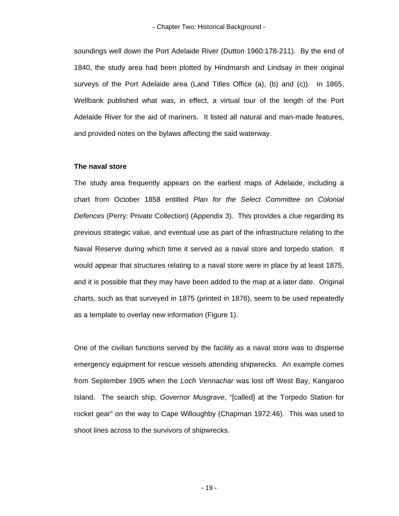
The study area frequently appears on the earliest maps of Adelaide, including a
chart from October 1858 entitled Plan for the Select Committee on Colonial
Defences (Perry: Private Collection) (Appendix 3). This provides a clue regarding its
previous strategic value, and eventual use as part of the infrastructure relating to the
Naval Reserve during which time it served as a naval store and torpedo station. It
would appear that structures relating to a naval store were in place by at least 1875,
and it is possible that they may have been added to the map at a later date. Original
charts, such as that surveyed in 1875 (printed in 1876), seem to be used repeatedly
as a template to overlay new information (Figure 1).
One of the civilian functions served by the facility as a naval store was to dispense
emergency equipment for rescue vessels attending shipwrecks. An example comes
from September 1905 when the Loch Vennachar was lost off West Bay, Kangaroo
Island. The search ship, Governor Musgrave, “[called] at the Torpedo Station for
rocket gear” on the way to Cape Willoughby (Chapman 1972:46). This was used to
shoot lines across to the survivors of shipwrecks.
- 19 -
- Chapter Two: Historical Background -
Figure 1: Infrastructure of naval store, overwritten in red in the late 1920s.
Black beacon circled in blue. (Admiralty Chart 1876)
The ‘Russian Scare’
From an ideological perspective, the Torpedo Station is representative of Australian
colonial reaction to the perceived threat of burgeoning Russian imperialism. This
fear was compounded by the departure from Australia of British troops in 1870, and
persistent rumours of a Russian naval squadron steaming somewhere in the Pacific
Ocean (Colwell 1973:72). It instigated a flurry of coastal defence construction
throughout the Colonies between the 1870s and the defeat of the Russian Navy by
Japan in February 1905. This construction was often haphazard and ill advised,
prompting the Colonial Office in London to dispatch Sir William Jervois and Colonel
Peter Scratchley, outstanding military engineers, to the Australasian Colonies in
1877 (Nairn et al 1972:479-480; Searle & Ward 1976:98-99). Jervois and Scratchley
- 20 -

- Chapter Two: Historical Background -
prepared a risk assessment for each Colony and suggested appropriate remedies to
defensive shortcomings, mainly in the form of coastal defences.
The Jervois plan
Jervois was appointed Governor of the Colony of South Australia in 1877 and
immediately began implementing his defence plan. His appointment in the Colony
“coincided with good rainfall and unprecedented extension of agricultural land” (Nairn
et al 1972:480). This economic boom allowed for the building of massive
fortifications at Taperoo (Fort Largs) and Semaphore Park (Fort Glanville).
Accessories included a military road (Military Road) connecting the forts with
Glenelg, a solitary cruiser (HMCS Protector) and the Torpedo Station.
Such fortifications and their support facilities were typical of the period. English
Heritage (2000:3) noted that “the enormous technological advances of the middle
years of the 19th-century affected warfare radically. Steam-powered, ironclad,
warships could now operate regardless of the limitations of wind and tide, and rifled
artillery gave far greater range and accuracy to guns than ever before. These
developments alarmed military engineers and, in part, stimulated the massive
program of coastal fortification”.
The Torpedo Station
In two memorandums to the House of Assembly, Jervois (1882:2) regarded “the
construction of land batteries, with certain other works, to be essential for the
protection of the capital and chief port of the colony against hostile aggression”. He
stipulated that “[t]orpedoes should be provided, to be placed across the entrance to
- 21 -

- Chapter Two: Historical Background -
the Port Creek…these torpedoes would be worked from the shore, and for their
manipulation it would be necessary to train specially about six or eight men”.
By 1885, the first buildings of the Torpedo Station proper had been completed and
handed over (Parliamentary Papers 1886, 2(29A):16). Numerous structures
pertaining to its specialized naval use were eventually erected on the site. Included
were a boat shed and slipway; a jetty; various utility sheds, store rooms and a
workshop; a caretaker’s residence; a 6-inch breech loading gun and a tramway. In
1905, a second class torpedo boat (TB 191) built by Thornycroft and Co. of London
in 1884 was sequestered from Tasmania and stationed at the Torpedo Station
(Figure 2). Decommissioned in 1911, the boat’s eventual disposition is currently
unknown.
Figure 2: A Type II torpedo boat with torpedo dropping gear on its sides.
(Armstrong 1896:203)
- 22 -
- Chapter Two: Historical Background -
Abandonment
The Torpedo Station survived Federation and a rationalization of naval infrastructure
only to be completely dismantled by December 1917. Much of the portable fabric
(iron and wood) was reused at other naval and municipal facilities around South
Australia. For example, the rails and sleepers were reused as a slipway, and the
galvanized iron sheets from the buildings were used on warehouses and classrooms
(Perry 2004, pers. comm., 28 July).
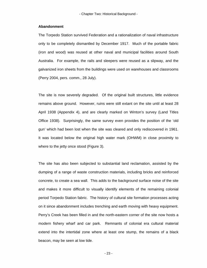
The site is now severely degraded. Of the original built structures, little evidence
remains above ground. However, ruins were still extant on the site until at least 28
April 1938 (Appendix 4), and are clearly marked on Winton’s survey (Land Titles
Office 1938). Surprisingly, the same survey even provides the position of the ‘old
gun’ which had been lost when the site was cleared and only rediscovered in 1961.
It was located below the original high water mark (OHWM) in close proximity to
where to the jetty once stood (Figure 3).
The site has also been subjected to substantial land reclamation, assisted by the
dumping of a range of waste construction materials, including bricks and reinforced
concrete, to create a sea wall. This adds to the background surface noise of the site
and makes it more difficult to visually identify elements of the remaining colonial
period Torpedo Station fabric. The history of cultural site formation processes acting
on it since abandonment includes trenching and earth moving with heavy equipment.
Perry’s Creek has been filled in and the north-eastern corner of the site now hosts a
modern fishery wharf and car park. Remnants of colonial era cultural material
extend into the intertidal zone where at least one stump, the remains of a black
beacon, may be seen at low tide.
- 23 -
- Chapter Two: Historical Background -
Conclusion
Constructed prior to 1901, the Torpedo Station is unique in South Australia. It
constitutes one of the few (and quite possibly the only) remaining examples of
terrestrial infrastructure directly associated with South Australia’s Colonial Navy. It is
representative of an early type of imported military technology and defence system
which positions it precisely in the continuum of rapidly evolving industrial era warfare
and related defence theory. It is the manifestation of one man’s vision and embodies
time specific attitudes to coastal defence in South Australia. Its abandonment
signifies a shift in these attitudes.
- 24 -
- Chapter Three: Method -
Introduction
One of the popular myths about archaeology is that it relies heavily on excavation.
This study will clearly show that this isn’t always the case. No excavation was
undertaken during the course of this investigation. As Gamble (2001:50-51)
explained “the past 30 years have seen a move away from excavation as the
archaeologist’s main method for finding out about the past…[it] is costly and is
increasingly seen as a last resort”.
Instead, methods were largely based on a pre-disturbance survey of the site. This
was done to determine how much of the Torpedo Station’s material culture is
currently visible, and how much of it may remain in situ. An overview of the whole
site was considered of greater relevance to answering the research question than an
excavation of part of it. The archaeological investigation did entail some minor site
disturbance. This involved wood sampling from the remains of a colonial era beacon
in the intertidal zone.
Methodological techniques employed
Methods employed to investigate the central research question included historical
and archival research; liaising with expert practitioners from fields other than
archaeology; a visual inspection of the site; a total station survey; photography;
remote sensing with the aid of magnetometry; botanical analysis; wood sampling and
analysis; and the use of ortho-rectified data to overlay aerial photographs, maps and
spatial data from the pre-disturbance survey. An explanation of how each of these
techniques was applied to specific areas of the investigation, why they were chosen,
the difficulties encountered, and the nature and extent of information that can
potentially be obtained follows.
- 25 -
- Chapter Three: Method -
Historical and archival research
This included informal meetings with Jan Perry, a direct descendant of the Torpedo
Station’s last caretaker, Chief Petty Officer (CPO) Henry Perry who was appointed in
1895 (Healey 1999:6). Jan Perry has a significant interest in her family’s
involvement at the Station. As a consequence, she has a considerable amount of
archival material in her possession, including the earliest known aerial photograph of
the site dated 1937 (see cover page).
Historical research encompassed ongoing searches at the Land Titles Office (LTO),
the Department for Environment and Heritage (DEH) , State Records Office, National
Archives of Australia (NAA), the State Library, various university libraries and
Mapland. Of particular interest were Parliamentary records and Parliamentary
debates (especially those relating to Governor Jervois, Colonel Scratchley, public
works and defence), contemporary newspaper articles, and charts, maps and aerial
photographs of the site that detail the changing shoreline and infrastructure.
It was considered that 1) Parliamentary papers may detail the genesis of South
Australia’s defence policy and the Torpedo Station; 2) newspapers may add an extra
social dimension to the study by showcasing public opinion; and 3) early surveys
may provide clues of cultural site formation processes prior to the advent of aerial
photography, and also indicate the location of structures such as buildings, roads
and fences. This may then have provided clues regarding the location of a garden
and other significant plantings in the vicinity.
- 26 -
- Chapter Three: Method -
Aerial photographs
Mapland is a repository of aerial photographs and aerial surveys generally dating
from 1949. A search revealed twenty one significant images of the site dating
between 1949 and 2002. Eleven images over this period were selected as being of
special interest due to obvious changes in the landscape, and these were purchased
in digital form. The 2002 image is ortho-rectified (see pre-disturbance section
below).
Land Titles Office
A number of register searches and searches of cancelled titles were conducted at
the LTO. Not only do these documents show the trail of ownership of a block of
land, they can also provide information on site formation processes that have acted
upon it. Examples of such processes could include subdivision, the erection of
fences or the construction of new tracks/roads.
State Library
The State Library has three books in its special collections directly relevant to this
study. These are Wellbank (1865), Sustenance (1877) and Armstrong (1896).
Wellbank (1865) and Sustenance (1877) can only be viewed in the Somerville
Reading Room, and neither book is allowed to be photocopied as they form part of
the Library’s historical collection of South Australiana. Published prior to 1920, they
are considered to be fragile documents. Both have sections on navigating the Port
Adelaide River and mention each beacon, buoy and sandbank between the entrance
to the River and Port Adelaide. They also detail the harbour regulations. Despite its
age and seeming rarity, Armstrong (1896) is allowed to be photocopied as it does
not relate specifically to South Australia. This volume details late Victorian concepts
- 27 -

- Chapter Three: Method -
of torpedo warfare and technology, and was researched and published at a time
when the Torpedo Station was operational.
National Archives of Australia
The NAA has a number of files on the Torpedo Station in its Adelaide branch; most
are from the last phase of its existence. These range in date from around the time of
abandonment to the site’s transfer to the South Australian Harbours Board in 1924.
The earlier files of the Torpedo Station are kept interstate (Sydney and Melbourne)
and are of large proportions. It was not possible to order copies of individual
documents in a file, and the cost of reproduction of the whole file made it prohibitive
to order the relevant copies from interstate.
Expert advice
Due to the multidisciplinary aspect of some elements in the pre-disturbance survey,
advice from three practitioners in alternative fields was sought. These included 1)
Ian Moffat, a geophysicist with Ecophyte Technologies Pty Ltd and the Australian
School of Petroleum, University of Adelaide. Ian conducted a magnetometer survey
of the artificial bay and advised on remote sensing techniques which could be
applied to the terrestrial aspects; 2) John Sandham, the Collections Manager at the
Royal Botanical Gardens, Adelaide. John offered advice on how exotic plants could
invade settled areas and detailed their longevity; 3) Dave Hemmings, a Project
Officer at Wittunga Homestead Botanic Gardens. Dave helped with the identification
of found botanical specimens.
- 28 -

- Chapter Three: Method -
Pre-disturbance survey
Visual inspection
Using a c.1911 site plan of the Torpedo Station (Figure 3), a visual inspection was
conducted, and the observed material culture and site formation processes were
recorded. The plan chosen to guide the inspection depicted the facility’s
infrastructure as it was at its greatest extent. It was hypothesised that any extant
cultural material observed relating to the Torpedo Station would correlate with
structures depicted on this plan. Inferences leading to this conclusion were drawn
from historical documentation. For example, an 1889 Military Map (State Records
35/585/104) depicts only 3 structures and a telegraph line, whilst the c.1911 site plan
shows 17 structures including 2 tracks.
It is also known that the Torpedo Station’s operations were being scaled down
around 1911, with the torpedo boat (TB 191) being disposed of in that year (Gillett
1982:9) and 14 torpedoes auctioned to the general public on 18 March 1912 (The
Register 1912:2). Further, by November 1912, plans were underway to transfer the
Station’s workshop and boatshed to other locations around Port Adelaide (National
Archives of Australia D292, 14/1/2). By 1916, dismantling of the Station had already
begun with the removal of the boat shed (National Archives of Australia D292,
14/1/3), and negotiations were underway to transfer the site to the South Australian
Harbours Board (National Archives of Australia A569, B1925/2573). It is therefore
considered unlikely that any new structures relating to the function of the Torpedo
Station were erected between 1911 and 1916.
- 29 -

- Chapter Three: Method -
Figure 3: C.1911 site plan of Torpedo Station (not to scale).
(NAA: MP472, 18/11/2562)
Total station survey
A Sokkia total station was used to plot in significant points (Figure 4). Examples
include the black beacon; exotic vegetation situated in proximity to the former
caretaker’s residence; the sea wall; the artificial harbour at low tide; the ‘track’ that
- 30 -
- Chapter Three: Method -
ran through the centre of Torpedo Station ‘village’; the location of debris which is
presumed to have belonged to the original structures of the Station; and the
alignment of the brine main which was considered to have been trenched through
the structures on the Northern side of the track.
Modern structures such as fence lines, functioning beacons and telegraph poles
were also recorded. These are able to be used as reference points when
transferring data to the ortho-rectified map. Four permanent points are required on
each image for best realignment. A Department of Lands survey mark (elevation
2.325m) was located adjacent to the main points of interest and was used as the
reference (datum) point from which to take all other readings (see Photography,
baseline/offset and GPS below for coordinates).
A major problem with the total station is that it was very difficult to set up, requiring
the expertise of the Archaeology Department’s Technical Officer on each field trip. A
second drawback with the total station is that data collected must be processed
through various software applications before it can be represented as spatial, two
dimensional information. This also required the expertise of the Technical Officer.
The reformatted information was plotted onto the ortho-rectified 2002 map to show
the exact spatial arrangement of these cultural markers on the landscape (Appendix
5).
Ortho-rectified digital maps display GPS coordinates as the curser is moved across
the screen, thereby allowing significant points to be plotted onto the original image.
The GPS coordinates of the Treloar and Treloar (2001) fieldwork were also
- 31 -

- Chapter Three: Method -
incorporated into this map, enabling all archaeological work conducted to be
combined into one representation (Appendix 2).
Figure 4: Matt Schlitz conducting a total station survey of the Torpedo Station.
(Photo: Debra Shefi, 11 May 2005)
- 32 -
- Chapter Three: Method -
Photography, baseline/offset and GPS
Using digital and traditional cameras, photography (including video) of the landscape
and cultural material was conducted. It was originally intended to conduct a baseline
and offset survey, take bearings and record GPS coordinates in the pre-disturbance
survey. However, on purchasing the ortho-rectified data, these techniques were
considered to be superfluous. Total station data, combined with an ortho-rectified
map, provides more accurate location data than a handheld GPS unit.
This can be demonstrated by comparing the coordinates of the Department of Lands
survey mark at the site (mark number 6628/36044) with those obtained with a
handheld GPS system (Garmin GPS 12 x L). The actual Easting is 272777.405 and
the Northing is 6144978.798. In comparison, the handheld system recorded an
Easting of 0272781 (an error of 4m) and a Northing of 6144978 (an error of .798m).
Hence, the alternative survey techniques were not employed.
Remote sensing
In 1961, the old 6-inch gun which had formerly been installed at the Torpedo Station
and then lost during dismantling operations was recovered from the mud in the
intertidal zone. This location approximates the area where the jetty once stood in the
artificial harbour and is marked on Winton’s survey of 28 April 1938 (Land Titles
Office 1938) (Appendix 4). A significant feature of the gun was a large metal shield
that, reputedly, was not recovered during salvage operations (Perry 2005, pers.
comm., 7 April). One of the myths associated with the site is that the gun shield is
still in the mud of the intertidal zone. It was hoped that the use of a magnetometer
would help to either prove or disprove this myth.
- 33 -

- Chapter Three: Method -
A Geometrics G-56 proton precession magnetometer owned by the Flinders
University Department of Archaeology was used for this purpose. “Magnetometers
measure the strength of the earth’s magnetic field and can detect variations in this
field caused by the presence of ferrous material or objects” (Dean et al 2000:142).
Two handheld GPS units were also employed to produce a virtual grid over the
search area. This maximized transect coverage when using the magnetometer, and
allowed proceedings to be accurately plotted.
The site is littered with ferrous material ranging from old tins and car parts to slabs of
steel reinforced concrete. A number of underground utilities, including at least three
brine mains and a high pressure gas pipeline, can also be found in the vicinity (some
of these are clearly marked). Further, a dolphin mooring device was originally
located on each side of the jetty and it is possible that parts of these may still be in
situ. All of these metallic objects may affect the results of the intended survey.
Given the mass of the shield (Figure 5), it was hoped that its magnetic signature
would be quite distinct from that of the other ferrous objects in the immediate vicinity
to allow a positive identification. If located, the shield was to be included in the total
station survey.
The survey required the use of an Avalon inflatable boat (property of the Earth
Sciences Department, Flinders University), two personnel to row and a third to
operate the instruments (Figure 6). Recording commenced approximately 150m
north of the artificial harbour in order to establish a baseline of magnetic readings for
the area. The boat was rowed north/south in transects guided by two handheld GPS
systems (Garmin GPS 48; Garmin GPS 72) and then east/west using the same
- 34 -
- Chapter Three: Method -
method in an attempt to achieve the greatest coverage and to eliminate the need for
a second survey.
Figure 5: Torpedo Station 6-inch Armstrong gun and shield.
(Healey 1999:6)
Similar to the total station data, remote sensing requires several software
applications before it can be spatially depicted and analysed. The data was
downloaded and processed by Ian Moffat from Ecophyte Technologies Pty Ltd. The
resulting image was plotted as a colour map with contours as well as Eastings and
Northings overlain. Two versions of the map were produced (see Chapter Four:
Results).
- 35 -
- Chapter Three: Method -
Figure 6: Magnetometer survey of artificial harbour conducted by Ian Moffat, Rick
Bullers and Joe Flatman. (Photo: Martin Wimmer, 1 June 2005)
It was anticipated that the magnetometer could also be used in a terrestrial survey of
the area around the magazine. However, this would have proven ineffective given
the amount of disturbance generated by ferrous material. Alternative remote sensing
techniques that may successfully be used on this site are discussed in Chapter Five:
Discussion.
Botanical analysis
The Torpedo Station had been built on reclaimed ground to keep the infrastructure
above the original high water mark (OHWS) and occasional flooding. Exotic
vegetation in close proximity to the main track was noted, and significant flora
photographed and recorded with the total station. This ‘high ground’ was judged to
be the most likely area to locate remnant vegetation, as it would have originally kept
plantings away from the salt water of the Port Adelaide River. It was also considered
- 36 -
- Chapter Three: Method -
that the fill used in the colonial era earthworks may have been more nutritious than
the surrounding sandy soil.
Slow growing and slow propagating species of plant were targeted as these were
least likely to have invaded the site after abandonment. Plants that had clumped in
unusual formations alongside the track were also recorded, as they may indicate the
location of foundations or other buried structures. Photographs and general
descriptions of the highlighted specimens were then examined by staff at Adelaide
and Wittunga botanical gardens for identification.
Minor site disturbance
Wood sampling:
Two samples of wood from the black navigational beacon were taken for analysis at
low tide to determine what tree species was preferred for use as beacons in marine
environments. This involved using a chisel and hammer to collect a 2cm by 2cm by
5cm piece of wood from the exterior and one from the interior of the stump. Each
sample was placed in a separate bag and labeled. Arnott (2004, pers. comm., 15
October) did not object to this procedure as the site had no protection status. It was
speculated by personnel from DEH that the stump may be an Iron Bark species.
However, this was disproved by the analysis (see page 41). This kind of analysis
can also provide information on the timber industry of colonial times. For example,
the wood may have come from an interstate source.
Overlaying aerial photographs
By utilizing the digital data obtained from Mapland and departmental ARCH MAP
software, specifically, the Geo Referencing Wizard on the tool bar, it was possible to
- 37 -
- Chapter Three: Method -
overlay the aerial photographs and measure the extent of land reclamation, as well
as observe the changing shape of the landscape. This was done by identifying at
least four points that appear in each image and stretching one image to scale over
another.
Aerial photographs have the potential to reveal man-made structures that cannot be
seen from ground level, for example, foundations and tracks or walkways. Of
particular interest is a small artificial harbour in the vicinity of the former jetty that
may have been dredged to allow unhindered access to this structure. Another point
of interest detected are the natural site formation processes that appear to have
taken place on the seaward sides of the site as a result of the shifting sand,
especially the sandy spit on the north-western point. A similar spit appears on the
earliest charts of the area and seems to be a constant or regenerating feature. Spits
were already noted as hazards to navigation in the 1860s and 1870s. Sustenance
(1877:108) has indicated that “[I]t will be found as a rule, that all the small tributary
creeks along the course of the main stream throw out sand or mud spits at various
distances, in proportion to their size, which should be carefully guarded against”.
Conclusion
This chapter has outlined the methods employed to investigate the cultural
landscape of the colonial era torpedo station. Based largely on a pre-disturbance
survey of the site, it has detailed why specific methods were chosen and what some
of their limitations are. The Torpedo Station is representative of colonial era defence
theory, and the decay of that theory is embodied in the severe degradation of the
site. The methods designed to investigate this degraded cultural landscape included
historical research; liaising across multidisciplinary fields; field walking; a total station
- 38 -

- Chapter Three: Method -
survey; a magnetometer survey; wood analysis; a botanical investigation;
photography; and overlaying a selection of historical aerial photographs and GPS
coordinates.
- 39 -
- Chapter Four: Results -
Introduction
This chapter details the results obtained from the pre-disturbance survey. It
describes the investigation of aspects of each of the structures constituting the site’s
cultural remains, and reveals problems encountered during the survey (for example,
other cultural material brought to the site post abandonment).
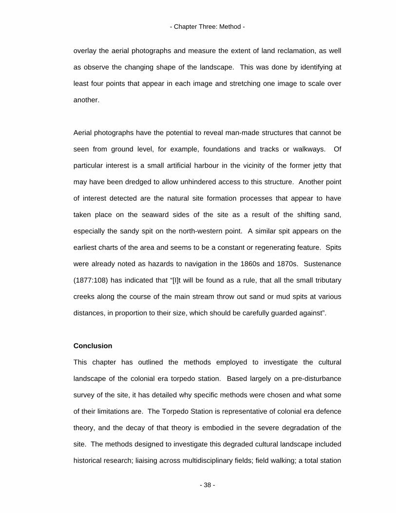
Black beacon
The remains of a black beacon were observed in the intertidal zone. This was
recorded with a total station, photographed (Figure 7), sampled for timber analysis
and measured. The remains are 41.5cm (16.34 inches) at the highest point and
22cm (8.66 inches) at the lowest. An anomaly was seen in the width of the stump,
with the artefact being 47cm (18.50 inches) wide at the top but only 42.5cm (16.73
inches) wide at the base. This suggests that the tree trunk used may have been
fixed bottom up instead of top up. Alternatively, the reduction may be the result of
deterioration.
Figure 7: Remains of black beacon, north face
(Photo: Martin Wimmer, 5 October 2004)
- 40 -

- Chapter Four: Results -
Analysis of the cell structure in the wood sample (Figure 8) revealed that the timber
selected was Blackwood (Acacia melanoxylon) and not an Iron Bark species as DEH
had suggested. Acacia melanoxylon is a hardwood commonly called Wattle and is
better known as a furniture wood. It does “produce a splendid fiddleback
figure…often exploited by cabinet makers” (Hill 1985:113).
In the mid 19th-century, the Adelaide Plain and surrounding foothills had huge stands
of Blackwood (Planning SA 2000). This legacy can still be found in the names of
Adelaide suburbs such as Blackforest and Blackwood. It is possible that as the
Adelaide Plain was being cleared for subdivision during colonial times, some of the
timber may have been used in municipal works like the Port Adelaide River’s
navigational beacons.
Figure 8: Cell structure of Blackwood (Acacia melanoxylon).
(Ilic 1991:33)
- 41 -

- Chapter Four: Results -
The exterior of the stump is black and has a rough sand paper texture. It could not
be ascertained if this was the original bituminous Admiralty coating or the result of
exposure to weather over the last 130 years. Whereas the exterior is very hard, the
interior is soft, possibly the result of dry rot. This particular beacon is clearly marked
on a chart of Port Adelaide dating from 1876 (Figure 1, circled in blue) and would
have been a recognisable landmark during the time of the Torpedo Station.
Beacons of this type were important navigational devices (Wellbank 1865;
Sustenance 1877). Black beacons were positioned along the eastern bank of the
Port Adelaide River, whilst red beacons were positioned on the western bank. The
black beacon on the sandy spit of the Torpedo Station was the southern most and
last beacon of this type before entering the Port.
Artificial harbour
An artificial harbour on the site’s western boundary extends into Hindmarsh Reach.
Originally, this feature was dredged to a depth of 7.62m (25 feet) at low water spring
tides (LWST) to facilitate a deep water access to the Station’s jetty (Drawing No.
3422/17, nd.) which stood at the centre of the artificial basin (Appendix 6). No trace
of the mining cable tank or jetty was found, although anomalies recorded in the
magnetometer survey may indicate a debris field related to these two structures. A
number of stumps were observed in the intertidal zone north of this position, but
were judged to be the remains of mangroves rather than cultural material.
Magnetometer survey of artificial harbour
A magnetometer survey of the harbour was conducted with the intention of locating
submerged cultural material associated with the site (for example, the gun shield).
- 42 -
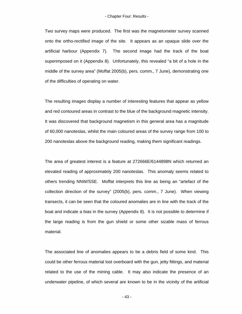
- Chapter Four: Results -
Two survey maps were produced. The first was the magnetometer survey scanned
onto the ortho-rectified image of the site. It appears as an opaque slide over the
artificial harbour (Appendix 7). The second image had the track of the boat
superimposed on it (Appendix 8). Unfortunately, this revealed “a bit of a hole in the
middle of the survey area” (Moffat 2005(b), pers. comm., 7 June), demonstrating one
of the difficulties of operating on water.
The resulting images display a number of interesting features that appear as yellow
and red contoured areas in contrast to the blue of the background magnetic intensity.
It was discovered that background magnetism in this general area has a magnitude
of 60,000 nanoteslas, whilst the main coloured areas of the survey range from 100 to
200 nanoteslas above the background reading, making them significant readings.
The area of greatest interest is a feature at 272666E/6144898N which returned an
elevated reading of approximately 200 nanoteslas. This anomaly seems related to
others trending NNW/SSE. Moffat interprets this line as being an “artefact of the
collection direction of the survey” (2005(b), pers. comm., 7 June). When viewing
transects, it can be seen that the coloured anomalies are in line with the track of the
boat and indicate a bias in the survey (Appendix 8). It is not possible to determine if
the large reading is from the gun shield or some other sizable mass of ferrous
material.
The associated line of anomalies appears to be a debris field of some kind. This
could be other ferrous material lost overboard with the gun, jetty fittings, and material
related to the use of the mining cable. It may also indicate the presence of an
underwater pipeline, of which several are known to be in the vicinity of the artificial
- 43 -
- Chapter Four: Results -
harbour. The worst scenario is that the readings indicate material unrelated to the
Torpedo Station (for example, garbage).
Approximately 65m due south of this point at 272600E/144900N is another
significant anomaly of approximately 100 nanoteslas. If the line of the jetty were
projected out beyond these two large anomalies they would be approximately
equidistance each side of it. Given this, the anomalies may in fact be the remains of
two dolphin mooring devices placed 60.96m (200 feet) apart “to keep ships off the
jetty” (Drawing No. 3422/17, nd.) (Appendix 6).
Two aerial photographs supplied with this report, 16 January 1937 (see cover page)
and 8 December 1954: #153/7893 (Appendix 9), show a large triangular structure in
the harbour and a smaller non-descript structure south of this point (the dolphins are
depicted as triangular in shape on the chart). It is uncertain if the objects shown are
the Torpedo Station era dolphins or more recent structures. Their physical size,
however, seems to relate to the anomalous readings obtained in the survey.
Artificial sea wall
The artificial sea wall enclosing the northern and western sides of the site is
composed of demolition waste, for example, slabs of reinforced concrete and bricks
(Figure 9). The wall in the area of the artificial harbour was examined. This portion
may well be composed of construction material from the Station mixed in with
material dumped on the site. It seems logical for original material from the Station
(for example, pieces of the gun platform) to have been reused on the site given its
weight and the difficulty and presumed added cost of moving it from the site.
- 44 -
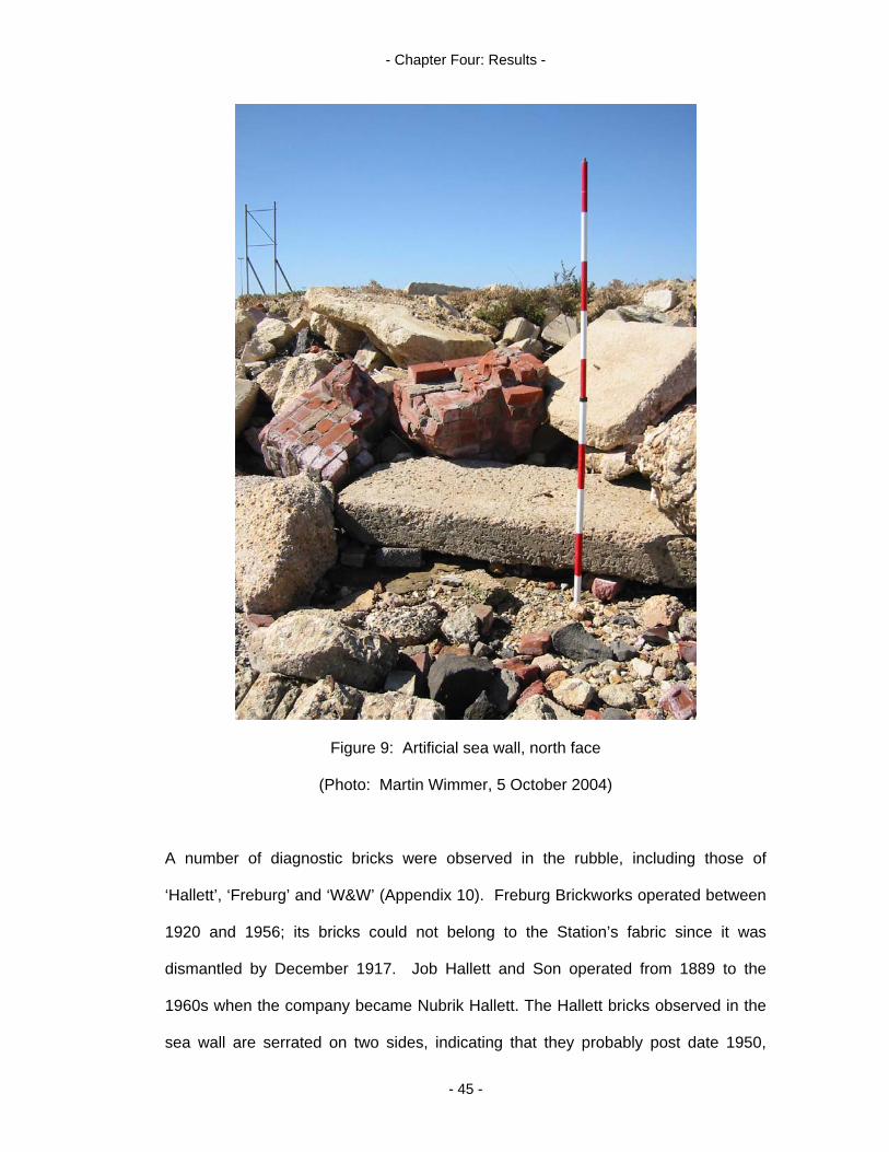
- Chapter Four: Results -
Figure 9: Artificial sea wall, north face
(Photo: Martin Wimmer, 5 October 2004)
A number of diagnostic bricks were observed in the rubble, including those of
‘Hallett’, ‘Freburg’ and ‘W&W’ (Appendix 10). Freburg Brickworks operated between
1920 and 1956; its bricks could not belong to the Station’s fabric since it was
dismantled by December 1917. Job Hallett and Son operated from 1889 to the
1960s when the company became Nubrik Hallett. The Hallett bricks observed in the
sea wall are serrated on two sides, indicating that they probably post date 1950,
- 45 -
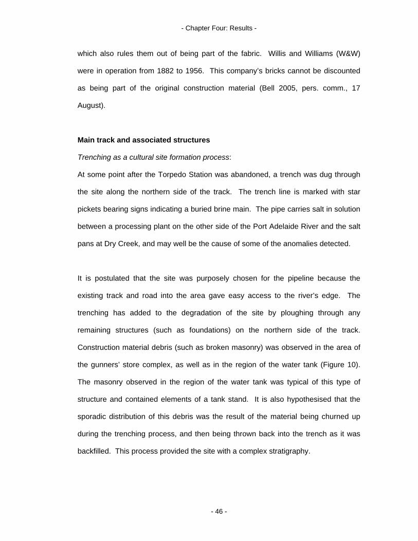
- Chapter Four: Results -
which also rules them out of being part of the fabric. Willis and Williams (W&W)
were in operation from 1882 to 1956. This company’s bricks cannot be discounted
as being part of the original construction material (Bell 2005, pers. comm., 17
August).
Main track and associated structures
Trenching as a cultural site formation process:
At some point after the Torpedo Station was abandoned, a trench was dug through
the site along the northern side of the track. The trench line is marked with star
pickets bearing signs indicating a buried brine main. The pipe carries salt in solution
between a processing plant on the other side of the Port Adelaide River and the salt
pans at Dry Creek, and may well be the cause of some of the anomalies detected.
It is postulated that the site was purposely chosen for the pipeline because the
existing track and road into the area gave easy access to the river’s edge. The
trenching has added to the degradation of the site by ploughing through any
remaining structures (such as foundations) on the northern side of the track.
Construction material debris (such as broken masonry) was observed in the area of
the gunners’ store complex, as well as in the region of the water tank (Figure 10).
The masonry observed in the region of the water tank was typical of this type of
structure and contained elements of a tank stand. It is also hypothesised that the
sporadic distribution of this debris was the result of the material being churned up
during the trenching process, and then being thrown back into the trench as it was
backfilled. This process provided the site with a complex stratigraphy.
- 46 -
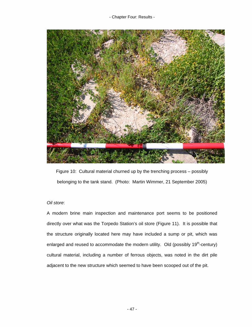
- Chapter Four: Results -
Figure 10: Cultural material churned up by the trenching process – possibly
belonging to the tank stand. (Photo: Martin Wimmer, 21 September 2005)
Oil store:
A modern brine main inspection and maintenance port seems to be positioned
directly over what was the Torpedo Station’s oil store (Figure 11). It is possible that
the structure originally located here may have included a sump or pit, which was
enlarged and reused to accommodate the modern utility. Old (possibly 19th-century)
cultural material, including a number of ferrous objects, was noted in the dirt pile
adjacent to the new structure which seemed to have been scooped out of the pit.
- 47 -

- Chapter Four: Results -
Figure 11: Brine main inspection and maintenance port, western face.
(Photo: Martin Wimmer, 21 September 2005)
6-inch breach loading gun:
This weapon was removed at the time of the Station’s dismantling, and is now
situated adjacent to the Birkenhead Tavern car park at 3 Elder Road, Birkenhead.
However, given its weight of more than 5080.25kg (5 tons), it was hypothesised that
the gun would have required a robust platform from which to effectively operate. A
large, curved concrete base with the gun and shield positioned on top of it is clearly
visible in a contemporary photograph of the weapon in situ (Figure 5). A portion of
what was presumed to have been this concrete structure was located off the SW end
of the track, diagonally opposite its original position. It is suggested that this may
have been blocking the brine pipe trench construction. As a consequence, it had
- 48 -

- Chapter Four: Results -
been broken up and rolled or dragged clear, ending up on the other side of the track
(Figure 12).
Figure 12: Gun platform remnant, north face
(Photo: Debra Shefi, 11 May 2005)
Tramway and main hall:
The main avenue of the Torpedo Station ‘village’ is still used as a track through the
site. It is hypothesised that the original surface is still extant on the track; this is
charcoal in colour and was identified as an ash track. Ash was the most common
method of surfacing a railway line in the late 19th-century and early 20th-century
(Flatman 2005, pers. comm., 1 June). A tramway was originally situated along this
route extending from the jetty into the main hall; this is clearly marked on the site
plan (Figure 3). The dark grey colouration stopped abruptly along a straight line at
what was assumed to be either the entrance or the western wall of the main hall.
- 49 -
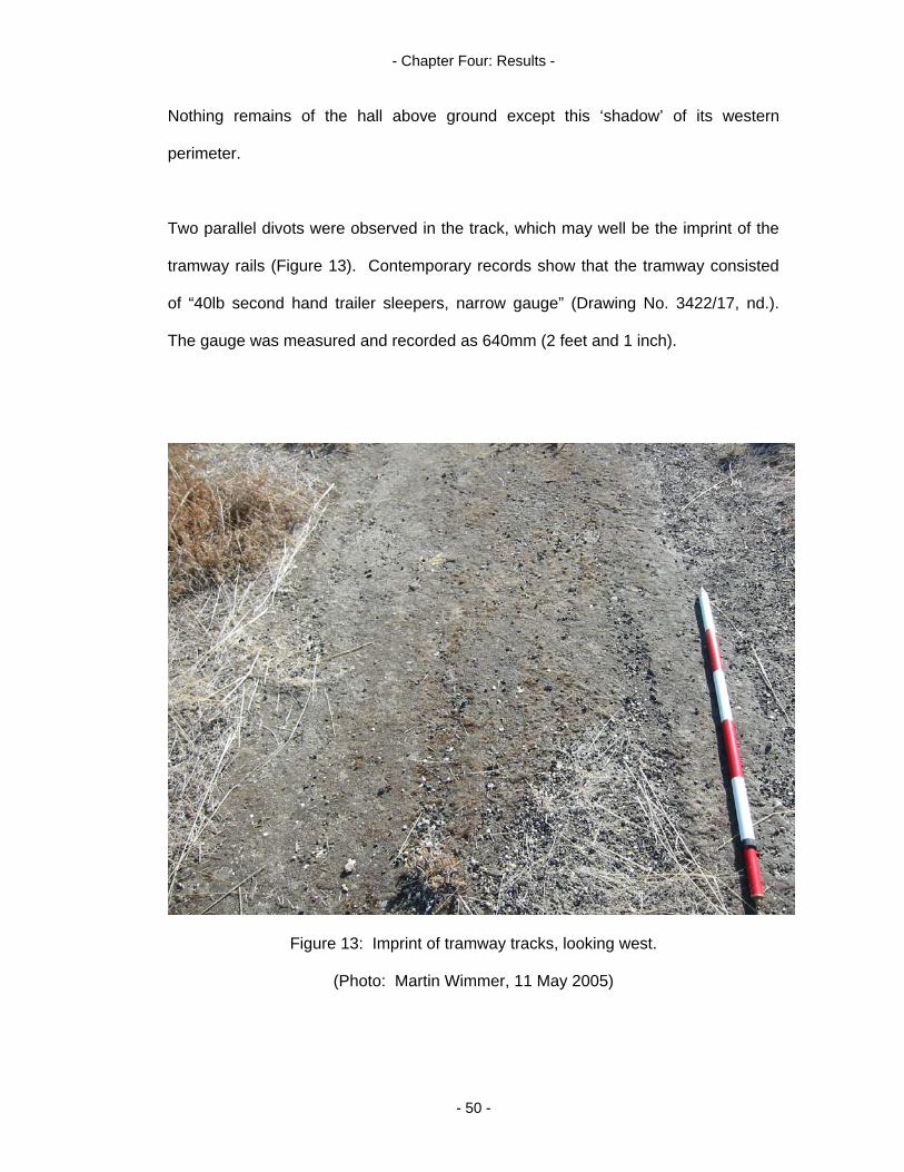
- Chapter Four: Results -
Nothing remains of the hall above ground except this ‘shadow’ of its western
perimeter.
Two parallel divots were observed in the track, which may well be the imprint of the
tramway rails (Figure 13). Contemporary records show that the tramway consisted
of “40lb second hand trailer sleepers, narrow gauge” (Drawing No. 3422/17, nd.).
The gauge was measured and recorded as 640mm (2 feet and 1 inch).
Figure 13: Imprint of tramway tracks, looking west.
(Photo: Martin Wimmer, 11 May 2005)
- 50 -

- Chapter Four: Results -
Magazine:
The southern side of the track seems to have escaped the destructive trenching
process caused by the brine main. Assuming that magazines are, by necessity, of
solid construction, it is considered that the magazine’s foundation may still be largely
intact, although no visible evidence of this structure was observed above ground.
Piles:
There is no sign above ground of the piles which are indicated on the c.1911 site
plan by a series of dashed lines each side of the track, and also around the boat and
filling sheds (Figure 3). With a predisposition to flooding (Appendix 11), the Torpedo
Station and its associated infrastructure (including the causeway road leading to the
site from Dry Creek) were built on reclaimed land consisting of artificially raised
platforms. It may well be that the method of reclamation employed in colonial times
was to enclose an area with piles, then fill it with rubble and sand to provide a solid
base on which to build. The piling used may have been sheet piling, as was used
along the causeway leading to the Torpedo Station and mentioned in Drawing No.
3422/17 (nd.). From the historical documentation, it could not be determined if the
piles were made of wood or metal from the historical documentation.
The notes attached to Drawing No. 3422/17 (nd.) indicate that the piling was already
rotten where water washed over the road along the causeway. No date is given, but
the amount of infrastructure detailed places this remark at about the time of the
Torpedo Station. It is little wonder, then, that a century on no sign of the piles
remains. The embankment, although severely eroded, is still extant and there is an
obvious step down to the rest of the site from the track.
- 51 -
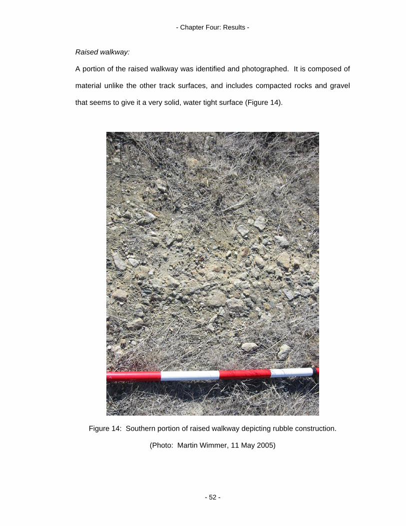
- Chapter Four: Results -
Raised walkway:
A portion of the raised walkway was identified and photographed. It is composed of
material unlike the other track surfaces, and includes compacted rocks and gravel
that seems to give it a very solid, water tight surface (Figure 14).
Figure 14: Southern portion of raised walkway depicting rubble construction.
(Photo: Martin Wimmer, 11 May 2005)
- 52 -

- Chapter Four: Results -
The walkway was followed for a short distance and was found to end abruptly at a
point just past the bend indicated on the site plan. The area north of this point and
extending east and west for the width of the site has been cleared and excavated
with heavy earthmoving equipment. The scrapings have been used to form an
embankment between the site and the main road. This embankment is a
conglomeration of local top soil and cultural material, which may be fragments of the
boat shed and filling shed. This area was cleared for a gas main, which is also
clearly marked by a row of warning signs. Masonry was observed slightly west of
the point where the raised walkway connects with the main track. This may relate to
the unidentified structure drawn on the site plan at that location.
Torpedo boat shed and filling shed
No trace of the location of the torpedo boat shed and slipway, or the detonators and
filling shed, were found. It is thought that the remains of these two structures are
under the fishery wharf car park and the associated access road. In addition to
trenching, extensive land reclamation has also taken place in this area.
Perry’s Creek
A stormwater outlet was observed emptying into the North Arm east of the fishery
jetty. This may be the remains of Perry’s Creek, which is now filled in. It is possible
that the natural ‘trench’ of the creek was utilised to lay a stormwater utility instead of
excavating another trench. The Creek’s old (and presumed) alignment was followed
south along a series of concrete and metal inspection points.
A point of conjecture is raised here. Although no scale is indicated on the c.1911
site plan, all of the structures listed seem to fit the scheme of what was observed on
- 53 -

- Chapter Four: Results -
the ground. The one exception to this rule is the location of Perry’s Creek, which is
shown to be very close to the raised walkway, and a long way from the line of
concrete and metal inspection points noted above. One explanation is that the plan
had been intentionally foreshortened to fit all of the Torpedo Station’s features into a
compact format.
However, the line of the brine main trench crosses the track at a similar angle to that
of Perry’s Creek and moves easterly. This is also the alignment of the old access
road to the Torpedo Station. As mentioned, it was postulated that this road may
have provided an easy method of trenching the brine main from the salt pans at Dry
Creek to the processing plant across the Port Adelaide River. Given this, the
diagram may well portray the actual location of Perry’s Creek.
The modern stormwater outlet and inspection points may then actually indicate a
new alignment of Perry’s Creek, with the old outlet to the North Arm being blocked
off during the land reclamation process. It is possible that a new alignment was
desirable to capture stormwater runoff when the land east of the site was subdivided
to form the industrial complex now situated there. The pipe and associated
inspection ports may also be nothing more than a stormwater utility, with the creek
disappearing completely during the reclamation process. Appendix 12 depicts the
total station survey of the stormwater inspection points overlaid on a 1954 aerial
photograph of Perry’s Creek. It clearly shows that Perry’s Creek is in fact 86m west
of the line of the surveyed points. This supports the accuracy of the c.1911 site plan,
and negates the hypothesis that the stormwater outlet represents the original
alignment of Perry’s Creek.
- 54 -
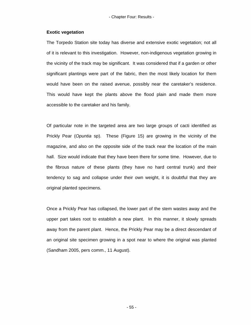
- Chapter Four: Results -
Exotic vegetation
The Torpedo Station site today has diverse and extensive exotic vegetation; not all
of it is relevant to this investigation. However, non-indigenous vegetation growing in
the vicinity of the track may be significant. It was considered that if a garden or other
significant plantings were part of the fabric, then the most likely location for them
would have been on the raised avenue, possibly near the caretaker’s residence.
This would have kept the plants above the flood plain and made them more
accessible to the caretaker and his family.
Of particular note in the targeted area are two large groups of cacti identified as
Prickly Pear (Opuntia sp). These (Figure 15) are growing in the vicinity of the
magazine, and also on the opposite side of the track near the location of the main
hall. Size would indicate that they have been there for some time. However, due to
the fibrous nature of these plants (they have no hard central trunk) and their
tendency to sag and collapse under their own weight, it is doubtful that they are
original planted specimens.
Once a Prickly Pear has collapsed, the lower part of the stem wastes away and the
upper part takes root to establish a new plant. In this manner, it slowly spreads
away from the parent plant. Hence, the Prickly Pear may be a direct descendant of
an original site specimen growing in a spot near to where the original was planted
(Sandham 2005, pers comm., 11 August).
- 55 -
- Chapter Four: Results -
Figure 15: Opuntia sp., western edge.
(Photo: Martin Wimmer, 5 October 2004)
The cacti on the northern side of the track appear to be growing in a straight line.
This linear arrangement could indicate a deliberate planting. The line also seemed
to correspond with the brine trench. Prickly Pear can propagate from cuttings, and it
is possible that trenching broke up the parent cactus with bits being thrown into the
trench during backfilling to later take root.
Opuntia sp. has some association with British military sites and, by extension, British
colonial sites, as it attracts the cochineal insects which produce the red dye used to
colour British soldier’s redcoats. Prickly Pear was originally brought to Australia by
Captain Phillip on the First Fleet, with a view to setting up a dye making industry
(Tanner 2004). The fruit of the Prickly Pear is edible and can also be used in jam
- 56 -
- Chapter Four: Results -
production. Domestic industries like these could suggest some level of self
sufficiency at the Torpedo Station, specifically women’s domestic duties (Johnston
2002). No reference to such industry has been found in the histories of the Torpedo
Station. Opuntia sp. thrives in harsh conditions; this may have also influenced its
choice for the Torpedo Station environment.
Two genus of Pig Face (Carpobrotus sp. and Lampranthus sp.) were observed
spreading away from the track and were photographed (Figures 16 and 17). Pig
Face are possible remnants of the Torpedo Station, and fit the Shackel (1996) model
of low lying ground cover being introduced at 19th-century military facilities to provide
some formal delineation. Like the Prickly Pear, Pig Face thrives in harsh conditions,
and the fruit of Carpobrotus sp. is also edible. In fact, this is what gave rise to the
genus name “karpos meaning fruit and brota meaning edible” (Page & Olds
1998:194). Carpobrotus sp. was the more prodigious of the two genera of Pig Face
found. One possible reason is that it may be indigenous. Some varieties of
Carpobrotus sp. are indigenous to Australia and this may give them survival
advantages over introduced varieties.
When compared to other introduced species found on the site, Prickly Pear and Pig
Face seem to hug the Torpedo Station track. This may be an indication of their
inability to grow and spread rapidly, and could support the hypothesis that they are
part of the Station’s fabric. In comparison, species such as Tree Mallow (Lavatera
arborea), Date Palm (Phoenix canariensis), Pampas Grass (Cortaderia selloana),
African Box Thorn (Lycium ferocissimum), Olive Trees (Olea europaea) and Thistles
(Onopordum sp.) were recorded as being randomly scattered all over the site.
- 57 -

- Chapter Four: Results -
Figure 16: Pig Face (Carpobrotus sp.)
(Photo: Martin Wimmer, 21 September 2005)
Figure 17: Pig Face (Lampranthus sp.)
(Photo: Martin Wimmer, 21 September 2005)
- 58 -

- Chapter Four: Results -
African Boxthorn has legendary pest status in Australia. Specimens that were found
have, in all probability, migrated into the site with the aid of birds. They appear as
single bushes in the paddocks each side of the track. However, in one spot they are
represented as a large rectangular clump (Figure 18). This mass is approximately
located where the magazine was situated, and may actually be growing within the
confines of its foundation. It is thought that the Box Thorn may have taken
advantage of the disturbed soil, backfill or foundation structure to take hold in this
area. More research on African Box Thorn is required to see if this opportunism is
typical of the species, and if it is in fact growing within the magazine foundations.
Figure 18: Rectangular mass of African Boxthorn (green and dry branches), looking
north-east. (Photo: Martin Wimmer, 21 September 2005)
- 59 -
- Chapter Four: Results -
Conclusion
This chapter has detailed the results of the pre-disturbance survey of the Torpedo
Station. A c.1911 site plan used in conjunction with a visual inspection of the site
revealed a substantial amount of surviving material culture, which was investigated
using archaeological, botanical and geophysical techniques. Problems arising
during the course of the survey, such as the presence of unrelated cultural material
and difficulties of working on water during the magnetometer survey, were outlined.
It was also shown how such problems could influence or bias the survey results.
Limitations of the current survey and future investigative directions were also
identified.
- 60 -
- Chapter Five: Discussion -
How does the material culture of the Port Adelaide Torpedo Station reflect the
changing attitudes to coastal defence in South Australia between 1877 and
1924?
Introduction
Torpedo warfare is a recent addition to the seafaring themes of naval warfare and
coastal defence. It is an example of the rapidly evolving technology of post 1850
industrial era warfare. The first use of torpedoes in armed conflict was during the
American Civil War (1861-65) (Armstrong 1896:2). By the time the virtues of this
new technology were sold on to the Australian Colonies in the late 1870s by Jervois
and Scratchley, the genre included static submarine mines which were tethered to
cables or anchored to the sea bed, as well as the motorised warheads we identify as
torpedoes today.
Torpedo schools, such as Vernon and Defiance in England (see Armstrong 1896,
chapter IX), were set up to train naval personnel in torpedo use. Torpedo stations
were constructed as storage and deployment facilities for this new type of weapon.
These stations were often built in strategic locations, for example, at Magazine Bay,
New Zealand guarding the entrance to Lyttleton (Lyttelton Torpedo Boat Museum,
nd) and the Port Adelaide Torpedo Station guarding the entrance to Port Adelaide.
Former industrial era military sites such as the Port Adelaide Torpedo Station are
ideal ground for writing archaeologies. They encapsulate unique cultural landscapes
of evolving defence theory and technology. Information about such sites comes
primarily from historiographies that often avoid dealing with the fabric. Archaeology
- 61 -
- Chapter Five: Discussion -
can interpret the reflective memory of the material culture associated with military
sites and provide a greater understanding of them.
The sum of all fears: a need for coastal defence in the Colonies
The withdrawal of British Troops from Australia in 1870 coupled with the ‘Russian
Scares’ of 1878 and 1885 led to a flurry of coastal defence construction throughout
the Australian Colonies. This served the dual needs of placating the colonists and
strategically defending Britain’s commerce by providing safe coaling stations in
Australasia for the Royal Navy.
South Australia’s colonial defence fabric included a solitary cruiser (HMCS
Protector), the principal fortifications at Taperoo (Fort Largs) and Semaphore Park
(Fort Glanville) and ancillary features such as the Torpedo Station (Port Adelaide)
and the military road (Military Road) connecting Glenelg with the forts.
The Port Adelaide Torpedo Station is an example of a synchronic relict cultural
landscape (Darvill et al 1993). It owes its genesis to the arrival of Jervois, an
acclaimed British military engineer, in the Colony in 1877. Jervois’ risk assessment
of the coastline adjacent to Adelaide and his knowledge of fortification and ordnance
led to the conceptualisation of the Colony’s defences. By 1885, construction of the
Torpedo Station was well underway when “a torpedo magazine, with two rooms
attached for [a] keeper, [had] been erected and handed over” (Parliamentary Papers
1886, 2(29A):16). The facility was never modernised during its period of use and
never reused as a military site after December 1917, by which time it had been
largely dismantled. Consequently, the Torpedo Station is the product of one main
- 62 -

- Chapter Five: Discussion -
period of activity; and the extant material culture of the site reflects this single use
and the mentality of the time.
The fact that so little remains of the Torpedo Station today is testament to the
changing attitudes towards coastal defence in South Australia between 1877 and
1924. The attitude in colonial South Australia seems to have been that fixed, shore
based defensive structures were the lynch pin of coastal defence, and naval vessels
(such as HMCS Protector) were no more than a seaward adjunct of the fortifications
(Nicholls 1995:14). By the early 20th-century, this attitude had changed dramatically,
due largely to evolving technology and Federation. During the time span addressed
by the research question (1877 -1924), defence theory moved from investing in static
coastal structures to the procurement of a highly mobile deterrent and the
establishment of the Royal Australian Navy.
Technology and a shift in defence theory: reasons for abandonment
Technological change and inappropriate weapons systems:
Gould (1990:160) identifies patterning in the archaeological record relating to
modern military sites as trend innovation. This concept is directly related to the
industrial era arms race and the copycat tendencies of different nations in their
acquisition and use of evolving military technology. The Torpedo Station was a
product of 19th-century trend innovation. Consequently, it is anticipated that the
information obtained from this study will prove useful in a larger comparative study of
the South Australian coastal defences from the specified era, and help demonstrate
the notion of direct competition between nations preparing for war in a bygone era.
- 63 -
- Chapter Five: Discussion -
The Port Adelaide Torpedo Station reflects specialised experiences of time and
place with both its conception and abandonment. The military scenarios which led to
its establishment were era specific and relevant only as long as the available military
hardware remained immutable.
The late 19th and early 20th-centuries were, however, a time of unprecedented
technological change. The engines which powered high seas fleets became more
efficient, armour became thicker, guns more powerful and, by 1914, aircraft began to
play a role in military strategy. When one compares the disposal of the torpedo boat
and fourteen torpedoes with the careful dismantling of the portable fabric of the
Torpedo Station, and the subsequent reuse of this fabric at other naval facilities, one
is left in no doubt as to the antiquity and uselessness of the Station’s defence system
by the early 1900s.
From the beginning, the Torpedo Station was plagued by an inappropriate choice of
weaponry. At a Parliamentary inquiry in 1887, it was revealed that the submarine
mines chosen would not withstand a great amount of water pressure; the submarine
cable (purchased in 1885) was defective, unarmoured and condemned for
submarine use; the original ten torpedoes purchased from England were virtually
useless and still packed in their original cases. Further, only two people in the
Colony knew anything of the torpedoes’ use and there was no launch available to
train more or to even deploy the weapons (Parliamentary Papers 1887, 3(112):35).
When a Type II torpedo boat was finally procured in 1905, it proved an unstable
weapons delivery platform and was unable to operate in heavy seas, “in fact, the
dropping of one of the torpedoes would almost capsize the boat” (Gillett 1982:8).
- 64 -

- Chapter Five: Discussion -
Further proof of its instability at sea was demonstrated when it flipped under tow on
its journey from Hobart to Adelaide. Type II torpedo boats “were to be used in
protected harbours or roadsteads, or if at sea, only in very fine weather” (Armstrong
1896:165). In all probability, the boat may have been able to operate effectively in
the sheltered waters of the Port Adelaide River. However, with a torpedo carrying
capability of two, one would think that once enemy vessels had entered the river ‘the
game was probably already up’.
The fact that the Torpedo Station was never up-gunned, but was abandoned during
the course of a global war without ever coming under direct enemy attack, shows
that it no longer held any strategic value as a defence installation. It also reflects a
shift in attitude away from this type of coastal defence in South Australia when the
Colony was absorbed by the Federation of Australian States.
Federation:
On 1 March 1901, the Australian States transferred their naval and military forces to
the Australian Federal Government. Stevens (2004:1) describes how “the ships
inherited from the previous state navies were tired, old and inadequate even for
training”. Federation brought a rationalisation of Australia’s naval assets and a
unified national defence strategy. Defence theory shifted from one of isolated land
based military installations and a reliance on ships of the Royal Navy, to a national
naval capability and deterrent. Coastal defence now looked beyond Australian
territorial waters and towards the horizon rather than along its coastline. Investment
in a flotilla took precedence over expenditure on static land based defences. Sites
such as the Port Adelaide Torpedo Station became superfluous to this new defence
policy.
- 65 -
- Chapter Five: Discussion -
Defining the cultural landscape of the Torpedo Station
The dynamics of industrial era warfare is such that it ensures a continual flux of
military sites. Some, because of their strategic locations, are summarily upgraded
and display a distinct stratigraphy of modernisation. Others, such as the Port
Adelaide Torpedo Station, lose their strategic capability because technology has
made them obsolete, and are consequently locations of single use.
Whatever the scenario, each military site representing a specific innovation (or era)
provides a snapshot of evolving militarism, and each is a cultural landscape.
Stratigraphic distillation of military landscapes into layers containing material culture
or “materiel culture” (Schofield et al 2002) belonging largely to one main period of
activity leads these layers to be understood as synchronic relict cultural landscapes
(Darvill et al 1993).
The Port Adelaide Torpedo Station was a single use military facility belonging to an
era of rapidly changing technology and armed capability. The term ‘single use’ is
applied here to mean that the facility was never structurally modernised or upgraded
beyond its late 19th-century mine laying and torpedo delivery capability, even though
it retained some level of naval capacity up to the beginning of the First World War.
Although not upgraded, it did, during its existence, receive out-dated military
hardware. For example, in 1885 a defective, unarmoured and superceded
submarine cable and from 1905 a Thornycroft Type II Torpedo Boat built in 1884,
were stationed at the facility (Gillett 1982:69; Healey 1999:6).
In the near ninety years since the Torpedo Station was abandoned, the area has
been subjected to various cultural and natural site formation processes. These
- 66 -

- Chapter Five: Discussion -
include the dismantling and removal of all portable and reusable infrastructure by
December 1917 (NAA: D292, 14/1/3 pt.1 (b)); land reclamation along the foreshore;
trenching for pipe laying; and shifting sand and infestation by exotic plants. These
processes will be discussed more fully below.
The site is now severely environmentally degraded and virtually unrecognisable as a
former military installation. The research question underpinning this thesis, namely,
“How does the material culture of the Port Adelaide Torpedo Station reflect the
changing attitudes to coastal defence in South Australia between 1877 and 1924?”
helped delimit and distil the military landscape of the Torpedo Station from the more
general civilian cultural landscapes preceding and post dating it. This distillation was
achieved by utilising modern survey and GIS techniques, along with cross-
disciplinary analysis (geophysical and botanical) in conjunction with a c.1911 site
plan of the Station to conduct a pre-disturbance survey of the site (see Chapter
Three: Method). The survey revealed that the Torpedo Station’s spatial integrity,
defined by an ‘improved’ landscape of tracks, artificial harbour and possible
foundation debris, is still partly intact despite the site’s severe degradation.
The existing material culture of the Torpedo Station contains information relating to a
specific stage of technological development. It exists now in the same pattern or
arrangement as it did when it was first commissioned. This defines the site as a
relict cultural landscape. Further fit to the relict cultural landscape model can be
derived from the site’s topographical coherence. Such coherence is demonstrated
with the material culture of the Torpedo Station being contained within a distinct
geographical zone, for example, on the tip of a peninsula and at the confluence of
two major waterways. The geographical features of the site, such as its coastline,
- 67 -
- Chapter Five: Discussion -
tracks and linear earthworks also connect the archaeological elements in a logical
way.
As a repository of cultural material and philosophies belonging to one main period of
activity, the Port Adelaide Torpedo Station can be more precisely classified as a
synchronic relict cultural landscape. Such landscapes were discussed at some
length in Chapter One: Literature Review.
Specialised experiences of time and place
The Port Adelaide Torpedo Station is a site of colonial military strategy. As such, it is
a reflective and tangible link in an unbroken chain of short-lived and evolving
industrial technologies of warfare and defence theory through the ages. The site fits
Darvill’s (1999) paradigm of a cultural landscape in that the extant material culture of
the Torpedo Station not only represents the physical residue of warfare, but is also a
manifestation of a particular way of seeing the world. This can be demonstrated in
the genesis of the Torpedo Station which is grounded in a hierarchy of defence
theory. This embodies a tactical response on two levels to the perceived threat of a
naval assault by Russian cruisers roaming the Pacific Ocean in the 1870s and
1880s.
At a local level, the Torpedo Station is no more than an accessory to the coastal
fortifications at Semaphore Park and Taperoo. It materialised from a need of the
Colony to defend itself after the last British Regiments withdrew in 1870 (Cooper
1950:79), which was exacerbated by ‘Russian Scares’ in 1878 and 1885. The
ensuing paranoia fed by these events led to the conceptualisation of South
Australia’s coastal defences by Jervois (Nairn et al 1972:479-480).
- 68 -
- Chapter Five: Discussion -
At a global level, the Torpedo Station was a component of the Australia Station
(Bach 1986:184-197) conceived to support British imperial policy and protect colonial
trade and merchant shipping by providing safe coaling ports for the Royal Navy
(Nicholls 1995:1-15). These stations were selected with reference to the trade
routes (Clarke 1894:137). Consequently, a chain which included Gibraltar, Aden,
Hong Kong and Australia, amongst others, were maintained within steaming
distance of each other to refuel the warships of the time (Jervois 1880:18-20).
The strategic purpose of the Torpedo Station at both of these levels was to deny, or
hamper, access to the port of Adelaide via the Port Adelaide River utilising the
available military technology of the time. In theory, this was to be achieved variously
by running a boom consisting of a cable with submarine mines attached across the
River from the Torpedo Station, the deployment of torpedoes (Jervois 1882) and,
from 1905, the use of a torpedo boat.
Mode of construction
The Torpedo Station was constructed as an accessory to the fortifications at
Semaphore Park and Taperoo and was, in fact, covered by the arcs of cannon fire
from these forts (NAA: AP161/1, item 1) (Appendix 3). Fort Glanville at Semaphore
Park and Fort Largs at Taperoo were constructed of brick and concrete to withstand
direct naval bombardment. Indeed, their fabric is still largely intact.
In contrast, very little remains of the Torpedo Station in the archaeological record.
Contemporary written records show that the Torpedo Station was constructed mainly
of wood and galvanised iron except for the magazine, which was built of stone and
sand brick (Appendix 13). This is in striking contrast to Fort Glanville (Figure 19)
- 69 -
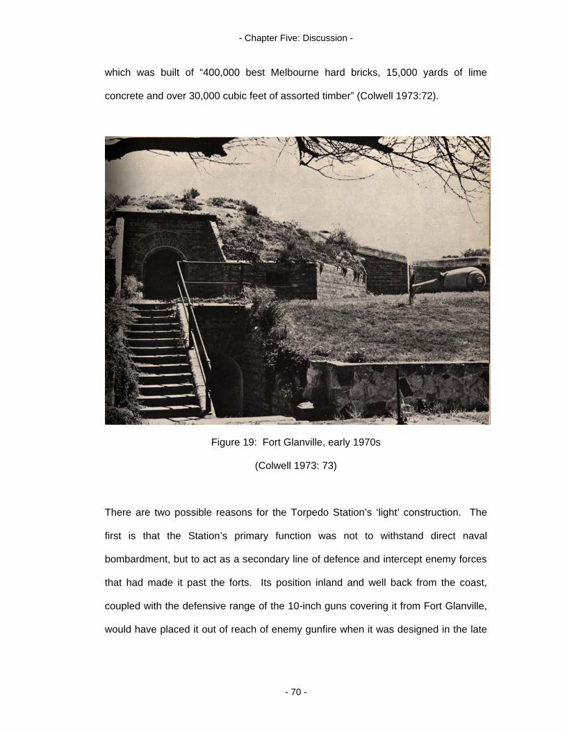
- Chapter Five: Discussion -
which was built of “400,000 best Melbourne hard bricks, 15,000 yards of lime
concrete and over 30,000 cubic feet of assorted timber” (Colwell 1973:72).
Figure 19: Fort Glanville, early 1970s
(Colwell 1973: 73)
There are two possible reasons for the Torpedo Station’s ‘light’ construction. The
first is that the Station’s primary function was not to withstand direct naval
bombardment, but to act as a secondary line of defence and intercept enemy forces
that had made it past the forts. Its position inland and well back from the coast,
coupled with the defensive range of the 10-inch guns covering it from Fort Glanville,
would have placed it out of reach of enemy gunfire when it was designed in the late
- 70 -
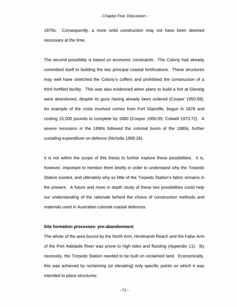
- Chapter Five: Discussion -
1870s. Consequently, a more solid construction may not have been deemed
necessary at the time.
The second possibility is based on economic constraints. The Colony had already
committed itself to building the two principal coastal fortifications. These structures
may well have stretched the Colony’s coffers and prohibited the construction of a
third fortified facility. This was also evidenced when plans to build a fort at Glenelg
were abandoned, despite its guns having already been ordered (Cooper 1950:98).
An example of the costs involved comes from Fort Glanville, begun in 1878 and
costing 15,000 pounds to complete by 1880 (Cooper 1950:95; Colwell 1973:72). A
severe recession in the 1890s followed the colonial boom of the 1880s, further
curtailing expenditure on defence (Nicholls 1995:26).
It is not within the scope of this thesis to further explore these possibilities. It is,
however, important to mention them briefly in order to understand why the Torpedo
Station existed, and ultimately why so little of the Torpedo Station’s fabric remains in
the present. A future and more in depth study of these two possibilities could help
our understanding of the rationale behind the choice of construction methods and
materials used in Australian colonial coastal defences.
Site formation processes: pre-abandonment
The whole of the area bound by the North Arm, Hindmarsh Reach and the False Arm
of the Port Adelaide River was prone to high tides and flooding (Appendix 11). By
necessity, the Torpedo Station needed to be built on reclaimed land. Economically,
this was achieved by reclaiming (or elevating) only specific points on which it was
intended to place structures.
- 71 -
- Chapter Five: Discussion -
These earthworks are indicated on the c.1911 site plan as dashed lines around the
torpedo boat shed and slipway, the detonators and filling shed, the main track
leading through the Station to the jetty and the dotted lines of the raised walkway
(Figure 3). It is suggested that the raised areas indicated by the dashed lines
labelled “Piles” were engineered by shoring up sections of the site with piling and
backfilling them with sand and rubble to create a solid base on which to build. These
are, perhaps, the most important cultural feature of the Torpedo Station as they
supported the whole of the infrastructure.
Perry’s Creek appears on colonial era maps as a small, meandering stream.
However, on the c.1911 site plan and 20th-century aerial photographs, it appears
quite linear. From the 20th-century depictions and images, it can be seen that the
‘straightened’ creek runs alongside the causeway road as far as the bridge over the
False Arm’s flood plain, some distance south/east of the Station. Perry’s Creek may
have been deepened and straightened by the Naval Reserve during the time of the
Torpedo Station (Perry 2004, pers. comm., 28 July).
Site formation processes: post abandonment
Since abandonment, the Torpedo Station has been subjected to diverse natural and
cultural site formation processes which have contributed to its severe degradation.
Many of these processes were identified in the pre-disturbance survey, whilst others
were determined from written records.
Dismantling the buildings:
The beginning of the end for the Torpedo Station was signalled by the torpedo boat’s
decommissioning in 1911 (Gillett 1982:9) and the public auction of fourteen
- 72 -

- Chapter Five: Discussion -
torpedoes (Figure 20) on 18 March 1912 (The Register 1912:2). By November
1912, an alternative location for a Navy drill hall, office, boat shed and slip were
being sought, and the possibility of re-erecting certain structures from the site in the
new location was being considered (NAA: D292, 14/1/3 pt.1(a)).
Figure 20: Public torpedo auction
(The Register 15 March 1912:2)
The first major phase of the post abandonment cultural site formation process at the
Torpedo Station was completed by 20 December 1917 when the District Naval
Officer reported to the Director of Naval Works that “the whole of the buildings at the
Torpedo Station had been taken down and all material removed…” (NAA: D292,
14/1/3 pt.1(b)). Sixty four sheets of galvanised iron from the Station were
- 73 -
- Chapter Five: Discussion -
subsequently reused for a Naval Guard House at Port Pirie, and approximately sixty
sheets for a Naval Guard Shelter at Outer Harbour (NAA: D292, 14/1/3 pt.1(c)).
Presumably, all iron, wood and machinery were removed in this process.
Of the standing structures once in place, it is postulated that only part of the
foundations, hearths and chimneys may have been left extant after the dismantling
process. Evidence of this material (concrete and red brick) was recorded in situ, and
some may have been reused in constructing the adjacent artificial sea wall at a later
date. It is further postulated that the magazine remained largely intact during the
dismantling process, although its roof was probably removed at this time. The
magazine is the only structure whose ruins appear on a 1938 survey of the site
(Land Titles Office 1938). Being composed of stone and sand brick would have
made it difficult and expensive to dismantle, yet no sign of its structural components
were visible on the surface during the current survey. In all probability, the
foundations of the magazine, by necessity a fairly robust structure, still survive under
the top soil. Further investigation could be effected via probing, remote sensing or
excavation.
Loss of cannon and associated material:
The Station’s 6-inch Armstrong cannon also appears on the 1938 Winton survey.
This was ‘lost’ in the Port Adelaide River adjacent to the jetty during the dismantling
process and only recovered in 1961. It’s location in the intertidal zone is clearly
marked on the 1938 chart. A magnetometer survey of the artificial harbour indicated
the possible presence of a debris field which may be related to the gun. An
unsubstantiated rumour suggests that the gun’s shield was not recovered in 1961
and may still be on the river bed. Readings of between 100 and 200 nanoteslas
- 74 -
- Chapter Five: Discussion -
above the background intensity obtained during the magnetometer survey were
significant, and further investigation by divers may be able to determine if the ferrous
material detected belongs to the gun.
Trenching the brine main:
Some time after the Torpedo Station was abandoned, a trench was dug along the
northern side of the main track. This process began east of the raised walkway and
continued west at least as far as the oil store. Following the line of this trench, it was
observed that it may have cut through all of the buried structures still extant on that
side of the track. Pockets of churned up masonry were noted along a line
connecting these two structures which may well belong to the Torpedo Station.
Despite this destructive process, it is possible that the extant structures were not
completely destroyed. Contemporary records show that some of the structures were
of considerable size. For instance, the workshop was 45.72m (150 feet) long and
3.35m (11 feet) wide (NAA: D292, 14/1/3 pt.1(a)). It is feasible that a portion of this
structure’s foundation survived the trenching process and may be rediscovered
through probing, remote sensing or excavation.
Contemporary photographs show that the gun platform was a large, circular concrete
base (Figure 5). This structure would have been a major obstacle during the
trenching process for it lay directly in the line of the trench. Nothing now remains
above ground of the platform in its original position. However, on the southern side
of the track and slightly to the west of this position is a considerable concrete mass
(Figure 12). It is suggested that this concrete is a portion of the gun platform, and
that during the trenching process the platform was partially broken up and dragged
or rolled clear of the work area. It is further postulated that other portions of the gun
- 75 -

- Chapter Five: Discussion -
platform may have been reused in the section of artificial sea wall adjacent to this
area.
Recent land reclamation and construction of the sea wall:
The Torpedo Station site is bound on two sides (to the north and west) by an artificial
sea wall which is the product of recent period land reclamation process. The wall is
composed of building rubble such as old bricks and slabs of concrete (Figure 9). It is
hypothesised that some of the material used in its construction may, in fact, be fabric
belonging to the foundations, hearths and chimneys of the Torpedo Station. If
material from the Torpedo Station were reused in the sea wall, it makes sense that it
would have been deposited on the western face near where the jetty once stood.
Much of the material in the sea wall is heavy and cumbersome. It follows that a
shorter distance for deposition, such as the western face, would be favoured over
the longer distance to the northern face.
Just prior to the arrival of the torpedo boat in 1905, the last structures of the site
were erected. These were the torpedo boat shed and slipway (Gillett 1982:69;
Healey 1999:6). However, repairs to structures at the Torpedo Station with bricks
made after 1905 may have been affected up until abandonment some time before
December 1917. Consequently, the years 1905-1917 represent a grey area in
attempting to date construction material found on the site, and justify using 1917 as
the terminal date for such investigations. Analysis of the diagnostic elements of the
bricks recorded in this area may preclude them from association with the Torpedo
Station fabric. For instance, the bricks may have been produced post December
1917. Those predating 1917 may well belong to hearth, chimney and foundation
structures of the Torpedo Station’s buildings which were not salvaged during the
- 76 -
- Chapter Five: Discussion -
dismantling process. Bricks manufactured by Willis and Williams (W&W) and
recorded in the sea wall (Appendix 10) may have formed part of the fabric of the
Torpedo Station.
Recent land reclamation has pushed back the high water mark and intertidal zone
around the Torpedo Station by several metres with the construction of the sea wall.
A dirt road and car park border the sea wall facing the North Arm. It is possible that
the Torpedo Station’s slipway may still exist under the road or car park. The
landscape in this area has been altered to such an extent that it was difficult to
pinpoint exactly where this structure had been.
The filling in of Perry’s Creek may have been a part of the modern land reclamation
process, serving to stabilize the location by stopping flooding along its course and
improve sanitation. This process of filling in a water course also means there is no
need for bridges in the area to be built and maintained.
Land clearance:
Heavy earthmoving equipment has cleared the land north of the bend in the raised
walkway and formed an embankment separating the site from the access road. It is
suggested that this was done to facilitate the laying and easy maintenance of a
buried high pressure gas main. The cleared land is roughly rectangular in shape,
and extends east and west for the length of the site. The exact location of the boat
and filling sheds could no longer be determined due to the area’s severe
degradation, although it is possible that the embankment contains some of the fabric
of these structures.
- 77 -
- Chapter Five: Discussion -
Rubbish dumping:
A considerable amount of garbage was observed on the site, especially in close
vicinity to the raised Torpedo Station track. This track still provides easy access into
the site, and its secluded nature makes it an ideal ground for dumping rubbish.
Household refuse as well as construction material was observed each side of the
track and also recorded on the Treloar and Treloar (2001) field walk survey. This
adds to the background noise of the site, making it harder to positively identify fabric
belonging to the Torpedo Station.
Natural processes:
Shifting sand and low lying vegetation (including grasses, Pig Face and African
Boxthorn) have obscured much of the remaining fabric of the Station. These natural
site formation processes may well act to protect any remaining fabric belonging to
the Torpedo Station.
Botanical investigations
The various exotic plant species on the site add an extra dimension to the pre-
disturbance survey of the Torpedo Station. Some plants such as Prickly Pear
(Opuntia sp.) and Pig Face (Carpobrotus sp. and Lampranthus sp.) may be
descended from original plantings. Both genera have a fibrous constitution and do
not have the longevity of hardwood plants. Therefore, it is unlikely that they do
represent original plantings, but they may be directly descended from them
(Sandham 2005, pers. comm., 11 August). It is hypothesised that if they are
representative of plantings at the Torpedo Station, they could provide an
understanding of some social aspects relating to coastal military sites. Such aspects
could include the presence of women (Johnson 2002); types of subsistence industry
- 78 -

- Chapter Five: Discussion -
such as food and dye production (Tanner 2004); and the availability of plant
specimens or hedging techniques and garden design (Department for Environment,
Heritage and Aboriginal Affairs 1988; Shackel 1996).
Conversely, Prickly Pear and Pig Face may bear no relationship to the Torpedo
Station at all. Both genera easily cultivate from cuttings. Cuttings may have been
dumped on each side of the track along with other household refuse (garbage is
visible adjacent to the foliage) some time post abandonment and taken root.
The Torpedo Station site is arid and sandy. Given this, the track verge is probably
the best location for plants to take hold. Before the era of modern land reclamation
and the construction of the sea wall, the earthworks that the Torpedo Station is built
on would have kept the vegetation growing above the flooding seawater of the tidal
Port Adelaide River. It makes sense that original plantings would have utilised
available space on this raised ground. Further, the hardened and sloping surface of
the reclaimed land that the track is built on would serve to channel any run off from
rain to its edges where these plants have been. By extension, lines or patches of
vegetation such as those observed each side of the track have also been used to
find obscured material culture in other locations (see Coombe 2001).
Other plant specimens recorded on the site such as African Box Thorn (Lycium
ferocissimum) may also be used to help locate cultural material or provide a greater
understanding of site formation processes. The normal distribution of this species
over the site is as individual shrubs scattered about. It is hypothesised that a thick
stand of African Box Thorn growing alongside the track in the vicinity of the
magazine may actually be growing within the foundations of that structure.
- 79 -
- Chapter Five: Discussion -
Magazines of this era typically had wood and earth floors to minimise the risk of
sparks and make it safe for handling live ammunition (Colwell 1973:72). It is
possible that the Box Thorn is taking advantage of the earth and decomposing wood
of the magazine’s floor by establishing itself in this location (Sandham 2005, pers.
comm., 11 August).
Further investigations
The pre-disturbance survey of the Torpedo Station has shown that its spatial integrity
is still largely intact, despite the numerous site formation processes that have been
operating there. This augers well for a future investigation of the site.
Terrestrial:
Trenching on the site has churned up numerous pieces of masonry. Contemporary
records suggest that some of the structures (the workshop, for example) were of
considerable size, and it is possible that portions of their foundations are still intact
and were only severed by the trench. Trenching only took place on the northern side
of the track; this means that the foundations of the buildings on the southern side
(such as the magazine) may still be complete. The existence of a large clump of
African Box Thorn may indicate the location of the magazine.
The location of these structures could be further investigated with the use of probes
or remote sensing. Given the limitations of a magnetometer survey of the terrestrial
aspects of the site due to the large amount of ferrous material scattered about there,
two alternative remote sensing devices have been suggested by Ian Moffat. These
are a Geonics EM 31 for deep surveys, and a Geonics EM 38 for shallow surveys of
.75m and 1.5m. The latter would be ideal for the magazine site. Both measure
- 80 -
- Chapter Five: Discussion -
changes in conductivity of the earth’s surface, with a significant change over a small
area normally indicating cultural material. Unfortunately, Flinders University has
neither of these devices. However, given that the foundations are, in all probability,
not that far underground, a probe may be all that is required to locate them (Moffat
2005(a), pers. comm., 1 June).
The presumed intactness and solidity of the magazine’s foundations makes them an
ideal subject for a future excavation. Not only would this uncover data about the
structure’s dimensions, construction method and the materials used, but it may also
discover how the structure was seated into the earthworks.
Earthworks and ramparts have a long association with military engineering that
predates the classical period. The colonial era earthworks (reclaimed land) of the
Torpedo Station are quite possibly the most important feature of the site, for it is
what made the Station a viable entity. An excavation across the track would allow a
scientific analysis of its construction and help gain an understanding of colonial land
management theory and practice.
Marine:
The magnetometer survey of the artificial harbour returned some significant
readings. Further investigation of the river bed by divers using probes may discover
ferrous artefacts relating to the Torpedo Station such as the gun shield, dolphin
mooring devices or a debris field associated with the Station’s jetty. Marine
environments often preserve certain types of material better than terrestrial
(Muckelroy 1980:178-179). This is evidenced at the Torpedo Station site with the
remains of the black beacon in the intertidal zone. It is still in remarkably good
- 81 -
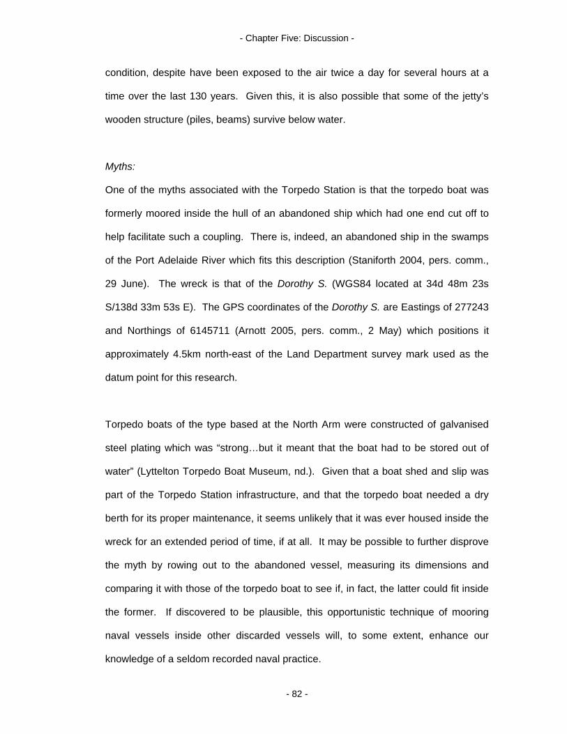
- Chapter Five: Discussion -
condition, despite have been exposed to the air twice a day for several hours at a
time over the last 130 years. Given this, it is also possible that some of the jetty’s
wooden structure (piles, beams) survive below water.
Myths:
One of the myths associated with the Torpedo Station is that the torpedo boat was
formerly moored inside the hull of an abandoned ship which had one end cut off to
help facilitate such a coupling. There is, indeed, an abandoned ship in the swamps
of the Port Adelaide River which fits this description (Staniforth 2004, pers. comm.,
29 June). The wreck is that of the Dorothy S. (WGS84 located at 34d 48m 23s
S/138d 33m 53s E). The GPS coordinates of the Dorothy S. are Eastings of 277243
and Northings of 6145711 (Arnott 2005, pers. comm., 2 May) which positions it
approximately 4.5km north-east of the Land Department survey mark used as the
datum point for this research.
Torpedo boats of the type based at the North Arm were constructed of galvanised
steel plating which was “strong…but it meant that the boat had to be stored out of
water” (Lyttelton Torpedo Boat Museum, nd.). Given that a boat shed and slip was
part of the Torpedo Station infrastructure, and that the torpedo boat needed a dry
berth for its proper maintenance, it seems unlikely that it was ever housed inside the
wreck for an extended period of time, if at all. It may be possible to further disprove
the myth by rowing out to the abandoned vessel, measuring its dimensions and
comparing it with those of the torpedo boat to see if, in fact, the latter could fit inside
the former. If discovered to be plausible, this opportunistic technique of mooring
naval vessels inside other discarded vessels will, to some extent, enhance our
knowledge of a seldom recorded naval practice.
- 82 -

- Chapter Five: Discussion -
Cultural heritage torpedoed
Don’t it always seem to go
That you don’t know what you’ve got
Till it’s gone
They paved paradise
And put in a parking lot. (Mitchell 1970)
The site is currently owned by the South Australian Land Management Corporation,
an entity vested with the responsibility of generating income from idle State assets.
The site has river frontage on two sides and, with its current disposition as
wasteland, is prone to redevelopment (Figure 21). The Port Adelaide Torpedo
Station has no heritage listing, however, pending changes to the National Heritage
Register may open the way for thematic listings of such sites. Possible themes
could include ‘Australia’s Colonial Coastal Defence Sites’ or ‘Torpedo Stations in
Australia’. A model of thematic listings of military heritage sites is already in place in
England.
Conclusion
Despite the environmental degradation of the Torpedo Station, the spatial
arrangement of its military design is still evident. Facets of this design were
investigated and recorded with a pre-disturbance survey of the site using
archaeological and cross-disciplinary techniques. This Chapter has discussed the
survey’s findings and the potential of the existing material culture for future
investigation. Such a study could serve as a model for similar investigations in
Australia and other former British Colonies to gain a greater understanding of the
- 83 -
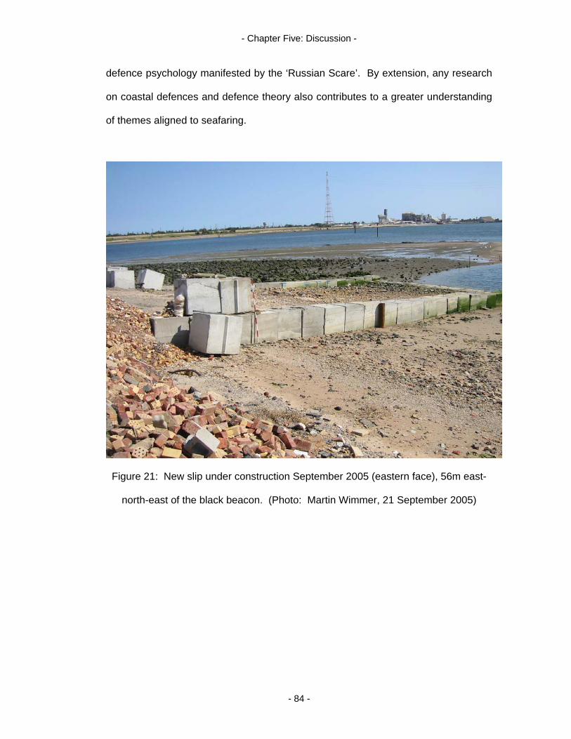
- Chapter Five: Discussion -
defence psychology manifested by the ‘Russian Scare’. By extension, any research
on coastal defences and defence theory also contributes to a greater understanding
of themes aligned to seafaring.
Figure 21: New slip under construction September 2005 (eastern face), 56m east-
north-east of the black beacon. (Photo: Martin Wimmer, 21 September 2005)
- 84 -

- Chapter Six: Conclusion -
Introduction: an embarrassment of riches
This thesis has explored the material (materiel) culture of the Port Adelaide Torpedo
Station. It has shown, through a pre-disturbance survey of the site, that the spatial
integrity is still largely intact despite its severe degradation. The reflective quality of
the extant material culture represents an embarrassment of riches in terms of
gaining knowledge of a little understood aspect of Victorian era colonial culture
(coastal defence), and its subsequent metamorphosis with the advent of nationhood.
The site bridges colonial and national defence theory, and is representative of the
evanescent nature of industrial era warfare.
The pristine nature of the cultural landscape that is the Port Adelaide Torpedo
Station is guaranteed by virtue of the fact that the Station was never upgraded or
reused as a military installation after it was abandoned. This singular military
stratigraphy makes it unusual in South Australian colonial military history. Historical
documents, coupled with the archaeological theory and method employed in this
investigation, has provided an understanding of the material culture of the site.
Questions surrounding the Station’s conception, construction, effectiveness and
abandonment were addressed and answered to some extent within the limitations of
an Honours thesis.
Future archaeological directions: unanswered questions
The true extent of the remains of the Torpedo Station is as yet unknown, but may be
revealed with further archaeological investigation including the use of probing,
remote sensing and excavation. A wider study of similar sites interstate and
overseas may position the Port Adelaide site more precisely in the defence
continuum, adding considerably to an understanding of this site type.
- 85 -

- Chapter Six: Conclusion -
Raised track:
Earthworks and ramparts like those of the Torpedo Station have a long historical
association with military sites and are often all that remains of those facilities. The
raised track of the Torpedo Station is, perhaps, the most surprising and significant
structure of the site. It is an example of colonial era land management theory and
land reclamation practice. Built in the 19th-century to support a defence installation,
it is today, rather ironically, protected by a modern era sea wall which is
representative of 20th-century land management theory and practice. An excavation
of this structure will reveal its method of construction and provide an understanding
of how structures such as the magazine were seated onto it. It may also provide a
further understanding as to why most of the structures built on it were of fairly light
construction.
Magazine and other structures:
In all probability, the foundations of the magazine will be the most intact of all the
structures that were erected on the site because they were avoided by the trenching
event. Consequently, this structure would present the best opportunity for a
successful excavation. Foundations belonging to the structures on the northern side
of the track may be partially intact and could also be explored with remote sensing,
probing and excavation.
Artificial bay:
It is possible that significant readings obtained during the magnetometer survey of
the artificial bay are from ferrous material relating to the Torpedo Station. Diving on
the site and the use of probes may reveal their identity and significance.
- 86 -
- Chapter Six: Conclusion -
Botanical studies:
The plant species found present an interesting addition to the archaeology of the
Torpedo Station and warrant a more extensive cross-disciplinary study which was
beyond the scope of this thesis. The potential for vegetation to reveal unknown
social aspects of the site, either as material culture or as markers for locating
material culture, is heightened in the harsh environment of the Torpedo Station. The
dry and sandy conditions seem to have dissuaded most varieties of exotic plant from
invading the area. Those that are there may be remnants of original plantings, or
newcomers taking advantage of the disturbed soil around building foundations.
Future soil tests may also add to an understanding of plant distribution and provide a
baseline for archaeological studies in other coastal locations.
Comparative studies:
The site lends itself to a comparative study of other torpedo stations. The literature
search accompanying this thesis failed to uncover any other archaeological studies
of similar sites in Australia. It was hypothesised that none have been undertaken, or
the information is caught up in the grey literature of heritage management reports.
As a consequence, there is great potential for a wider study of torpedo station sites
or colonial coastal defence installations, perhaps as part of a post graduate research
project. Such a study will lead to a greater understanding of Victorian era defence
theory and technology in the Australian landscape and reveal even more of the
changing attitudes to coastal defence between 1877 and 1924.
Identifying cultural significance
The Torpedo Station is situated close to the historical precinct of Port Adelaide, and
is adjacent to the Ship’s Graveyard Heritage Trail of Garden Island, as well as a
- 87 -

- Chapter Six: Conclusion -
number of theme related museums including the South Australian Maritime Museum
and a military vehicles museum. Popular dolphin watching cruises along the Port
Adelaide River regularly carry tourists past the site. Despite its potential for cultural
tourism, the site is not well known to the community and is currently not interpreted
to the public.
The remains of the Port Adelaide Torpedo Station have reflective memory to spare.
If the terms of the Australia ICOMOS Burra Charter (1999) were applied to the site,
its cultural significance could be assessed on historical and scientific grounds.
1) Historical significance:
The site owes its conception and existence to a historic figure - Sir William Jervois.
It is associated with an historical event – the ‘Russian Scare’. It is representative of
a phase of coastal defence theory and practice. It is a part of the colonial activity of
constructing coastal defences. Its spatial integrity ensures that evidence of the
above mentioned associations survive in situ.
2) Scientific significance:
The site is rare in Australia, and quite possibly internationally. It is representative of
the site type; this is obvious from the spatial integrity of the remaining material
culture and historical documents. The site has the possibility of contributing further
substantial information on past military technology and policy, as well as colonial
land management theory and practice.
- 88 -

- Chapter Six: Conclusion -
Interpretive potential
The Port Adelaide Torpedo Station is a rare and unique reminder of the changing
attitude to coastal defence in South Australia between 1877 and 1924. As such, and
given the extant material culture of the site, it has significant interpretive potential.
Interpretation presents the opportunity of showcasing the design of a colonial era
torpedo station. Story boards placed around the site adjacent to each feature on the
c.1911 site plan could lead visitors on an informed walk around the site. Further
archaeological investigation could improve the quality of information presented on
interpretive signage and brochures.
The Torpedo Station’s cannon could be retrieved from its present location next to the
Birkenhead Tavern and repositioned on the site. For effect, the cannon could be
placed right on the point, where it would be clearly visible from traffic on both
Hindmarsh Reach and the North Arm.
Conclusion: archaeology as optimism
Despite the severe degradation of its cultural landscape, archaeology was able to
reveal that there is still an embarrassment of extant cultural riches associated with
the Torpedo Station site. The archaeology of the Port Adelaide Torpedo Station has
moved an understanding of the changing attitudes toward coastal defence in South
Australia between 1877 and 1924 away from the associated historiographies, and
toward a rigorous scientific study of the Torpedo Station’s material culture. At the
completion of this study, the archaeological potential of the site is not yet fully
realised.
- 89 -
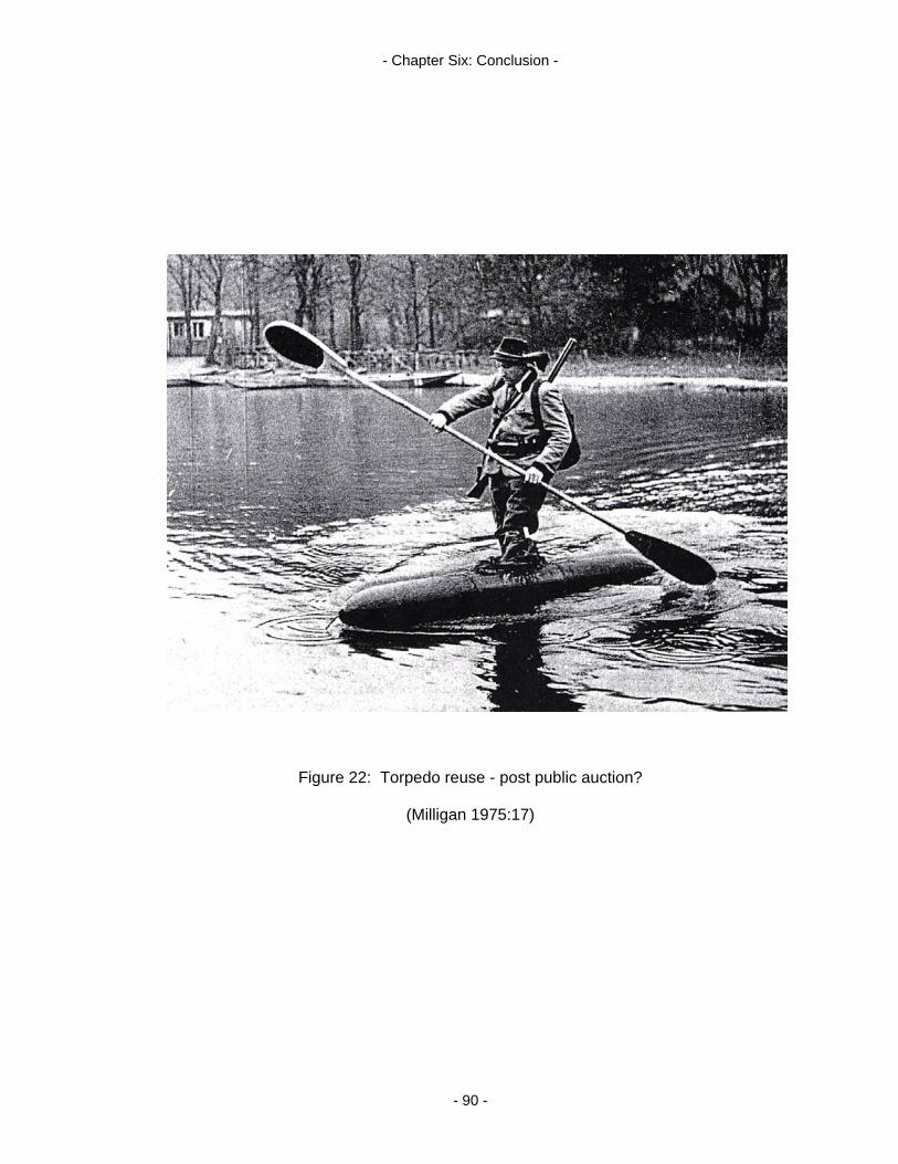
- Chapter Six: Conclusion -
Figure 22: Torpedo reuse - post public auction?
(Milligan 1975:17)
- 90 -

- References -
Admiralty Chart 1876 (4808/90). Port Adelaide. Published at the Admiralty, London. Armstrong, G. 1896. Torpedoes and Torpedo Vessels. George Bell and Sons, London. Arnott, T. 2004. Senior Maritime Archaeologist, Department for Environment and Heritage.
Personal communication, 18 June. Arnott, T. 2004. Senior Maritime Archaeologist, Department for Environment and Heritage.
Personal communication, 15 October. Arnott, T. 2005. Senior Maritime Archaeologist, Department for Environment and Heritage.
Personal Communication, 2 May. Australia ICOMOS Burra Charter, 1999. [Online, accessed 21 August, 2005]
URL:http://www.icomos.org/australia/burra.html Bach, J. 1986. The Australia Station: A History of the Royal Navy in the South West
Pacific, 1821-1913. New South Wales University Press, Kensington New South Wales.
Baker, F. 1993. ‘The Berlin Wall: production, preservation and consumption of a 20th-
century monument’. Antiquity 67: 709-733. Bell, P. 2005. Consulting Historian. Personal communication, 17 August. Binford, L. 1962. ‘Archaeology as Anthropology’. American Antiquity 29: 217-225. Buchli, V. and Lucas, G. 2001. ‘The absent present: archaeologies of the contemporary
past’. In Buchli, V. and Lucas, G. (eds) Archaeologies of the Contemporary Past. Routledge, London: 3-18.
Canning, S. 2005. ‘Belief in the past: Dempster-Shafer theory, GIS and archaeological
predictive modelling’. Australian Archaeology 60: 6-15. Chapman, G. 1972. Kangaroo Island Shipwrecks: An Account of the Ships and Cutters
Wrecked Around Kangaroo Island. A Roebuck Book. Union Offset Co., Pty., Ltd. Canberra.
Chapman, R. 2003. Archaeologies of Complexity. Routledge, London. Clarke, G. 1894. ‘Imperial defence’. In de Labilliere, F. Federal Britain or Unity and
Federation of the Empire. Sampson Low, Marston and Company Ltd., London: 125-148.
Colwell, M. 1973. The National Trust in South Australia. Rigby, Adelaide. Commonwealth of Australia Gazette 1924. 24 July. 52: 1574. H.J. Green, Government
Printer, Melbourne. Coombe, A.R. 2001. Plants: Indicators of Past Cultural Activity: Extant Plants in the
Landscape as Indicators to the Past. Unpublished Honours Thesis. Department of Archaeology, Flinders University.
- 91 -
- References -
Cooper, H. 1950. A Naval History of South Australia and Other Historical Notes. Hassell Press, Adelaide.
Darvill, T. 1999. ‘The historic environment, historic landscapes, and space-time-action
models in landscape archaeology’. In Ucko, P. and Layton, R. (eds) The Archaeology and Anthropology of Landscape: Shaping Your Landscape. Routledge, London: 104-118.
Darvill, T., Gerrard, C. and Startin, B. 1993. ‘Identifying and protecting historic landscapes.
(England’s Monuments Protection Program)’. Antiquity 67(256): 563-574. Dean, M., Ferrari, B., Oxley, I., Redknap, M. and Watson, K. (eds) 2000. Archaeology
Underwater. The NAS Guide to Principles and Practice. Archetype Publications, London and Nautical Archaeology Society, Portsmouth.
Deetz, J. 1977. In Small Things Forgotten: The Archaeology of Early American Life.
Anchor, New York. Department of Environment, Heritage and Aboriginal Affairs 1998. Gardens in South
Australia 1840-1940: Guidelines for Design and Conservation. Department for Environment, Heritage and Aboriginal Affairs and City of Adelaide.
Dobinson, C., Lake, J. and Schofield, J. 1997. ‘Monuments of war: defining England’s 20th-
century defence heritage’. Antiquity 71: 288-299. Drawing No.3422/17, nd. Plan of Torpedo Station and Road to Magazines in North Arm.
Relates to MB 20/03. Dutton, G. 1960. Founder of a City: The Life of Colonel William Light – First Surveyor
General of the Colony of South Australia: Founder of Adelaide 1786-1839. F.W. Cheshire, Melbourne.
English Heritage 2000. Twentieth-Century Military Sites. Westerham Press, no place of
publication listed. English Heritage 2004. Recent Military History: A Review of Progress 1994-2004. [Online,
accessed 20 June, 2005] URL: http://www.english-heritage.org.uk/military Flatman, J. 2005. Lecturer. Department of Archaeology, Flinders University. Personal
Communication, 1 June. Ford, J. 2004. The Archaeology of Aircraft Losses in Water in Victoria, Australia During
World War Two. Maritime Archaeology Monograph and Reports Series No. 1. Flinders University, Adelaide.
Forsyth, F. 1985. Foreword in Keegan, J. and Holmes, R. Soldiers: A History of Men in
Battle. Hamish Hamilton, London. Gamble, C. 2001. Archaeology: The Basics. Routledge, London.
- 92 -
- References -
Gibbs, M. 2003. ‘The archaeology of crisis: shipwreck survivor camps in Australia’. Historical Archaeology 37(1): 128-145.
Gillett, R. 1982. Australia’s Colonial Navies. Naval Historical Society of Australia. Dawson
Publications, Sydney. Gojak, D. 2002. ‘So suspicious of enemies: Australia’s late nineteenth and twentieth-
century coastal defences, their archaeology and interpretation’. In Schofield, J., Johnson, G. and Beck, C. (eds) Materiel Culture: The Archaeology of Twentieth Century Conflict. Routledge, London: 159-171.
Gould, R. 1990. Recovering the Past. University of New Mexico Press, Albuquerque. Healey, J. 1999. ‘Life at the Torpedo Station’. History SA, the Newsletter of the Historical
Society of SA. September 1999. Heritage Act, 1977. New South Wales. [Online, accessed 9 August, 2005]
URL:http://www.austlii.edu.au/au/legis/nsw/consol_act/ha197786 Heritage Council of NSW 2005. State Heritage Register Committee, Agenda item: 7.1. File:
H05/00100/1. Hill, A. 1985. Antique Furniture in Australia: Finding, Identifying, Restoring and Enjoying It.
Viking Penguin Books Australia Ltd., Ringwood Victoria. Ilic, J. 1991. CSIRO Atlas of Hardwoods. Crawford House Press in association with
CSIRO, East Melbourne. Jervois, W. 1880. Defences of Great Britain and Her Dependencies: A Lecture. E. Spiller,
Government Printer Adelaide. Jervois, W. 1882. ‘Vessels of war for the defence of South Australia’. Proceedings of the
Parliament of South Australia with Copies of Documents Ordered to be Reprinted 1882, 3(30): 1-2. E. Spiller, Gov. Printer, Adelaide.
Johnson, M. 2000. Archaeological Theory: An Introduction. Blackwell Publishers, Oxford. Johnson, M. 2002. Behind the Castle Gate: From Medieval to Renaissance. Routledge,
New York. Jung, S. 1996. ‘Archaeological investigations of the Catalina wreck sites in East Arm,
Darwin Harbour’. The Bulletin of the Australian Institute for Maritime Archaeology 20(2): 23-40.
Jung, S. 2000. Quarantine Island, East Arm and the Darwin Harbour Catalina puzzle’. The
Bulletin of the Australasian Institute for Maritime Archaeology 24: 105-114. Jung, S. 2004. ‘Artefacts from Broome’s World War Two flying boat wrecks: a survey of
data collected 1979-2001’. The Bulletin of the Australasian Institute for Maritime Archaeology 28: 63-80.
- 93 -

- References -
Jung, S. 2005. ‘Archaeological investigations of the World War Two Catalina Flying Boat wreck sites in East Arm, Darwin Harbour: an appraisal of results’. In Bourke, P., Brockwell, S. and Fredericksen, C. (eds) Darwin Archaeology: Aboriginal, Asian and European Heritage of Australia’s Top End. Charles Darwin University Press, Darwin: 85-95.
Land Titles Office (a). Microfiche Archive 18/4. No. 3 Sections F and K. Surveyed by
Hindmarsh and Lindsay, 21st of November 1840. Land Titles Office (b). Microfiche Archive 18/5. No. 4 Sections G, H and I. Land Titles Office (c). Microfiche Archive 18/6. Plan of Section G and H. New Port.
Surveyed by Hindmarsh and Lindsay. Received at the office 18th of April 1840. Land Titles Office 1938. W. A. Winton survey of H.B. Bk 76: G.G.18.9.90. Hundred of Port
Adelaide. 28 April. Lawrence, S. and Staniforth, M. (eds) 1998. The Archaeology of Whaling in Southern
Australia and New Zealand. Special Publication 10, Australian Institute for Maritime Archaeology.
Lyttelton Torpedo Boat Museum, nd. Thornycroft Torpedo Boat Museum: Magazine Bay.
Museum publication. McCarthy, M. 2004. ‘Historic aircraft wrecks as archaeological sites’. The Bulletin of the
Australasian Institute for Maritime Archaeology 28: 81-90. McGlade, J. 1999. ‘Archaeology and the evolution of cultural landscapes: towards an
interdisciplinary research agenda’. In Ucko, P. and Layton, R. (eds) The Archaeology and Anthropology of Landscape: Shaping Your Landscape. Routledge, London: 458-482.
Milligan, S. 1975. Transports of Delight. Penguin Books, Ringwood, Australia. Mitchell, J. 1970. ‘Big yellow taxi’. Ladies of the Canyon. Reprise Records, Warner Music:
244 085. Moffat, I. 2005(a). Geophysicist, Ecophyte Technologies Pty Ltd and Australian School of
Petroleum, University of Adelaide. Personal Communication 1 June. Moffat, I. 2005(b). Geophysicist, Ecophyte Technologies Pty Ltd and Australian School of
Petroleum, University of Adelaide. Personal Communication 7 June. Morse, K. 1988. ‘An archaeological survey of midden sites near the Zuytdorp Wreck,
Western Australia. Reprinted in Staniforth, M. and Hyde, M. (eds) 2001, Maritime Archaeology in Australia: A Reader 159-162 . Southern Archaeology, Blackwood, South Australia.
Muckelroy, K. (ed) 1980. Archaeology Underwater: An Atlas of the Worlds Submerged
Sites. McGraw-Hill Book Company (UK) Limited, Maidenhead, Berkshire. Mulvaney, D. and Kamminga, J. 1999. Prehistory of Australia. Allen and Unwin, Sydney.
- 94 -

- References -
Murray, T. (ed) 2004. The Archaeology of Contact in Settler Societies. Cambridge University Press, Cambridge.
NAA: A569, B1925/2573. (National Archives of Australia). Correspondence from E.
Johnston, Superintendent of Aerodromes, Department of Defence. 20 January, 1923.
NAA: AP161/1, item 1. (National Archives of Australia). Chart Showing Arcs of Fire: Fort
Largs and Glanville, 1903. NAA: D292, 14/1/3 pt.1(a). (National Archives of Australia). Communication 12/138. From
A/Commander D.N.O., SA to Director of Naval Reserves, Melbourne. 26 November, 1912.
NAA: D292, 14/1/3 pt.1(b). (National Archives of Australia). Communication SA 17/7015.
From District Naval Officer SA to Director of Naval Works. 20 December, 1917. NAA: D292, 14/1/3 pt.1(c). (National Archives of Australia). Communication. From R.
Sutherland, Chief Armourer to the Sub District Naval Officer. 11 August, 1922. NAA: MP472, 18/11/2562. (National Archives of Australia). Site Plan of the Port Adelaide
Torpedo Station, c.1911. Nairn, B., Searle, C. and Ward, R. (eds) 1972. Australian Dictionary of Biography: Vol.4
1851-1890, D-J. Melbourne University Press, Melbourne. Nash, M. 2004. Investigation of the Survivors Camps from the Sydney Cove Shipwreck.
Maritime Archaeology Monograph and Reports Series No.2. Flinders University, Adelaide.
National Parks and Wildlife Act, 1972. South Australia. [Online, accessed 13 July, 2005]
URL:http://www.parliament.sa.gov.au/catalog/legislation/acts/n/1972.56.un.htm Nicholls, B. 1995. Statesmen and Sailors: Australian Maritime Defence 1870-1920.
Standard Publishing House, Rozelle, NSW. Oppenheim, P. 2005. The Fragile Forts: The Fixed Defences of Sydney Harbour 1788-
1963. Army History Unit – Department of Defence, Canberra and Australian Military History Publications, Loftus Australia.
Orser, C. and Fagan, B. 1995. Historical Archaeology. Harper Collins College Publishers,
New York. Page, S. and Olds, M. (eds) 1998. Botanica: The Illustrated Guide of Over 10,000 Garden
Plants and how to Cultivate Them. Random House Publishing, Sydney. Parliamentary Papers, South Australia 1886. Blue Book. Public Works Report, 1885-6.
2(29A): 16. E. Spiller, Government Printer, Adelaide. Parliamentary Papers, South Australia 1887. Report to Select Committee: Minutes of
Evidence on Defence Force. 3(112): 35. E. Spiller, Government Printer, Adelaide.
- 95 -
- References -
Pasveer, J., Buck, A. and van Huystee, M. 1998. ‘Victims of the Batavia mutiny: physical anthropological and forensic studies of the Beacon Island skeletons’. Reprinted in Staniforth, M. and Hyde, M. (eds) 2001, Maritime Archaeology in Australia: A Reader 142-147. Southern Archaeology, Blackwood, South Australia.
Paterson, A. 2004. Understanding the Sleaford Bay Tryworks: An Interpretive Approach to
the Industrial Archaeology of Shore Based Whaling. Maritime Archaeology Monograph and Reports Series No.3. Flinders University, Adelaide.
Perry, J. Private Collection. Plan Illustrating the Evidence Given by the Collector of
Customs and Naval Officer Before the Select Committee on Colonial Defences, Oct., 1858.
Perry, J. 2004. Personal communication, 28 July. Perry, J. 2005. Personal communication, 7 April. Philippou, C. 2005. Maritime Heritage Officer, Heritage Victoria. Personal communication,
28 July. Planning SA 2000. Forests and Woodlands of the Adelaide Plains in 1836: A Native
Vegetation Planting Guide. A chart produced by the Information and Data Analysis Branch, Planning SA
Rathje, W., Hughes, W., Wilson, D., Tani, M., Archer, G., Hunt, R. and Jones, T. 1992.
‘The archaeology of contemporary landfills’. American Antiquity 57(3): 437-47. Sandham, J. 2005. Collection Manager, Royal Botanical Gardens, Adelaide. Personal
communication, 11 August. Schofield, J., Johnson, W. and Beck, C. (eds) 2002. Introduction to Materiel Culture: The
Archaeology of Twentieth Century Conflict. Routledge, London: 1-8. Searle, G. and Ward, R. (eds) 1976. Australian Dictionary of Biography Vol. 6: 1851-1890,
R-Z. Melbourne University Press, Melbourne. Shackel, P. 1996. Culture Change and the New Technology: An Archaeology of the Early
American Industrial Era. Plenum Press, New York. Smith, T. 2004. ‘Plane sailing: the archaeology of aircraft losses over water in New South
Wales, Australia’. The Bulletin of the Australasian Institute for Maritime Archaeology 28: 113-124.
Smith T. 2005. Senior Heritage Officer, Heritage NSW. Personal communication, 1
August. Stacy, B., Arthur, D., Wimmer, M. and Smith, P. 2005. ‘The Great Eastern Road’. In Smith,
P., Piddock, S. and Pate, D. (eds) Historic Sites and Landscapes: The Great Eastern Road and the First Creek Catchment. Hills Face Zone Cultural Heritage Project Reports, Department of Archaeology, Flinders University. Volume III. Kopi Books, Adelaide: 1-12.
- 96 -
- References -
Stanbury, M. 1998. ‘Land archaeology in the Houtman Abrolhos’. Reprinted in Staniforth, M. and Hyde, M. (eds) 2001, Maritime Archaeology in Australia: A Reader 148-158. Southern Archaeology, Blackwood, South Australia.
Staniforth, M. 2003. Material Culture and Consumer Society: Dependent Colonies in
Colonial Australia. Kluwer Academic/Plenum Publishers, New York. Staniforth, M. 2004. Associate Professor, Department of Archaeology, Flinders University.
Personal communication, 29 June. Staniforth, M. 2005. Associate Professor, Department of Archaeology, Flinders University.
Personal communication, 11 May. Starbuck, D. 1994. ‘The identification of gender at northern military sites of the late
eighteenth century.’ In Scott, E. (ed) Those of Little Note: Gender, Race, and Class in Historical Archaeology: 115-128.
State Records: 35/585/104. Military Map 1889. Compiled by the Surveyor General’s Office. Stevens, D. 2004. ‘How old is Australia’s Navy?’ In Kerr, G. (ed) Australian Maritime
Issues 2004. Sea Power Centre – Australia Annual 12: 1-3. Stevenson, G. 2001. ‘Archaeology as the design history of the everyday’. In Buchli, V. and
Lucas, G. (eds) Archaeologies of the Contemporary Past. Routledge, London: 51-62.
Sustenance, S. (ed) 1877. Wellbanks Australian Nautical Almanac and Coasters Guide for
the Southern and Eastern Coasts of Australia. Compiled from the Most Authentic Sources for the Year 1877. James Reading and Co., Sydney.
Tanner, L. 2004. ‘Prickly Pear history’. North West Weeds. [Online, accessed 23 March,
2005] URL: http://www.northwestweeds.nsw.gov.au/prickly_pear_history.htm The Register, 1912. 15 March. Adelaide. Vol. LXXVII. Treloar, T. and Treloar, J. 2001. ‘Port River surveys: the Torpedo Boat Station and channel
marker, Port Adelaide’. Soundings 2nd Series 2(1): 6-12. Waterson, P. 2005. EPA, Queensland Government. Personal communication, 3 August. Wellbank, I. 1865. Nautical Almanac and Coasters Guide, for the Southern and Eastern
Coasts of New Holland. Reading and Wellbank, Sydney. Williamson, C. 2004. ‘Contact archaeology and the writing of aboriginal history’. In Murray,
T. (ed) The Archaeology of Conflict in Settler Societies. Cambridge University Press, Cambridge: 176-199.
- 97 -
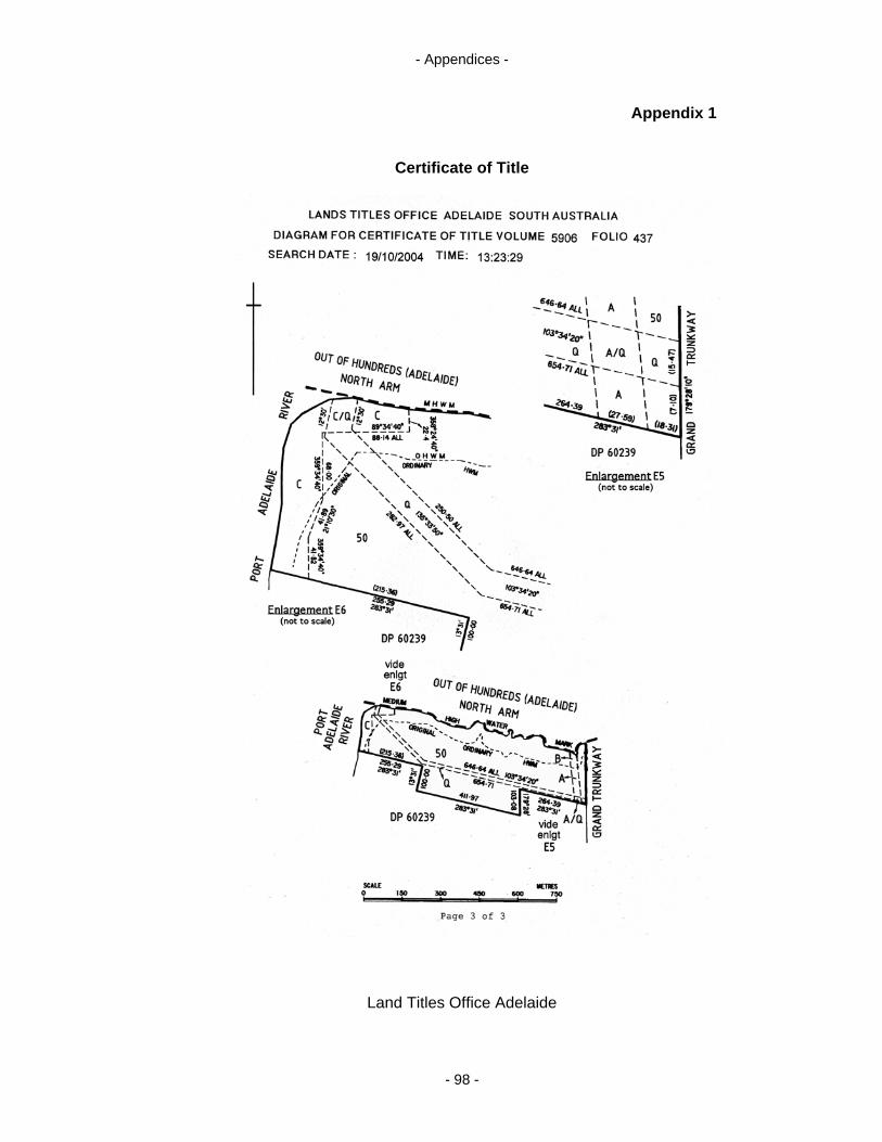
- Appendices -
Appendix 1
Certificate of Title
Land Titles Office Adelaide
- 98 -
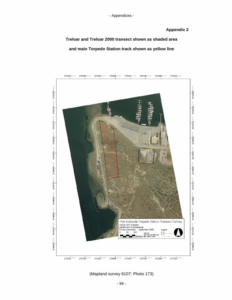
- Appendices -
Appendix 2
Treloar and Treloar 2000 transect shown as shaded area
and main Torpedo Station track shown as yellow line
(Mapland survey 6107: Photo 173)
- 99 -
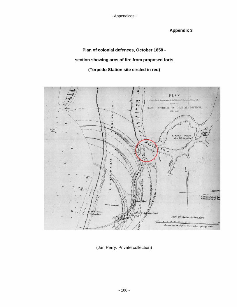
- Appendices -
Appendix 3
Plan of colonial defences, October 1858 -
section showing arcs of fire from proposed forts
(Torpedo Station site circled in red)
(Jan Perry: Private collection)
- 100 -
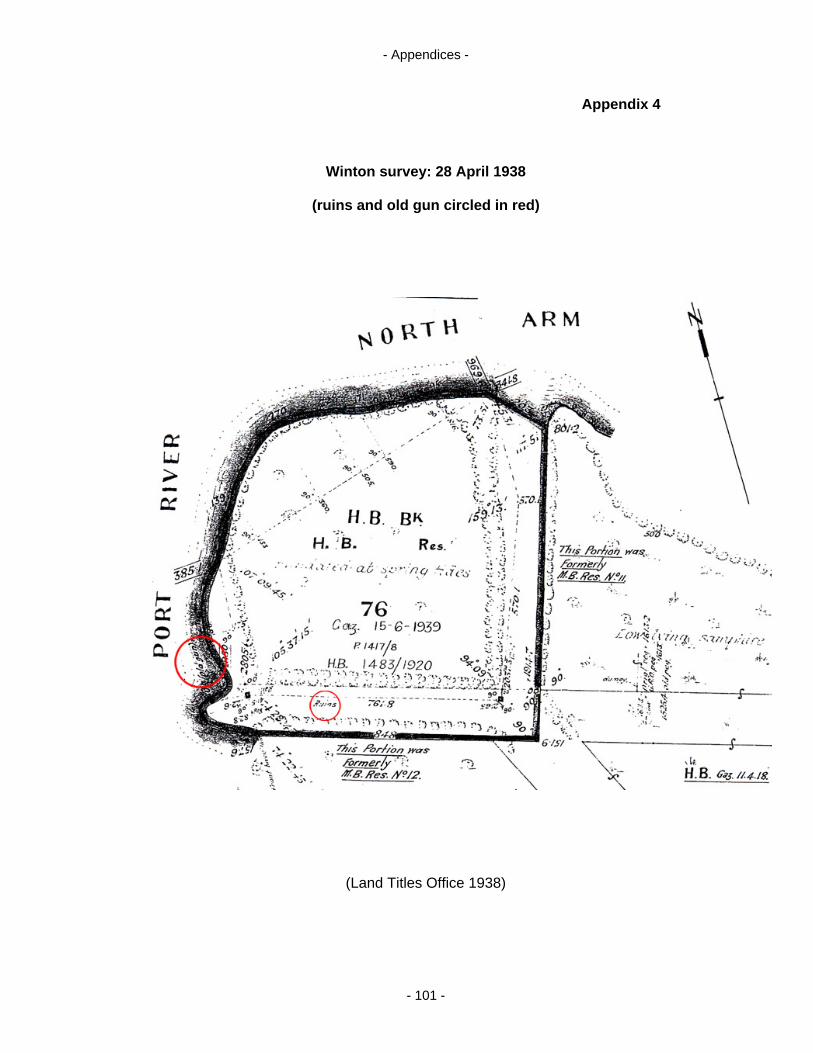
- Appendices -
Appendix 4
Winton survey: 28 April 1938
(ruins and old gun circled in red)
(Land Titles Office 1938)
- 101 -

- Appendices -
Appendix 5
Total station survey of cultural material associated with
the Port Adelaide Torpedo Station
(Mapland survey 6107: Photo 173)
- 102 -
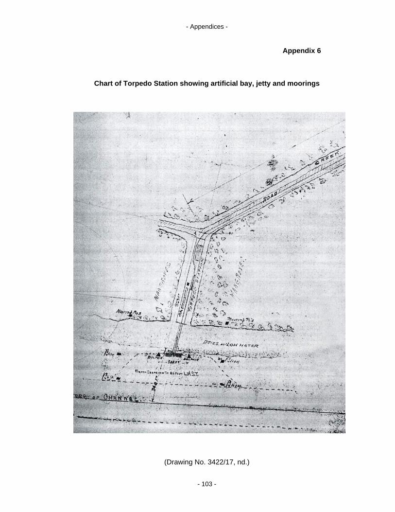
- Appendices -
Appendix 6
Chart of Torpedo Station showing artificial bay, jetty and moorings
(Drawing No. 3422/17, nd.)
- 103 -

- Appendices -
Appendix 7
Magnetometer survey of artificial harbour overlaid
on aerial photograph of Torpedo Station site
(Image courtesy of Ian Moffat, Ecophyte Technologies Pty Ltd and Australian School
of Petroleum, University of Adelaide; Mapland survey 6107: Photo 173)
- 104 -

- Appendices -
Appendix 8
Magnetometer survey of artificial harbour:
overlaid transects depict collection bias of significant readings
(Image courtesy of Ian Moffat, Ecophyte Technologies Pty Ltd and Australian School
of Petroleum, University of Adelaide)
- 105 -
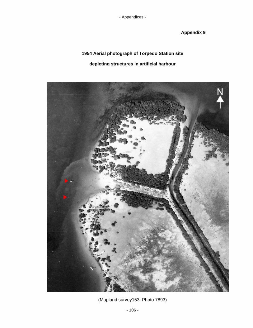
- Appendices -
Appendix 9
1954 Aerial photograph of Torpedo Station site
depicting structures in artificial harbour
(Mapland survey153: Photo 7893)
- 106 -
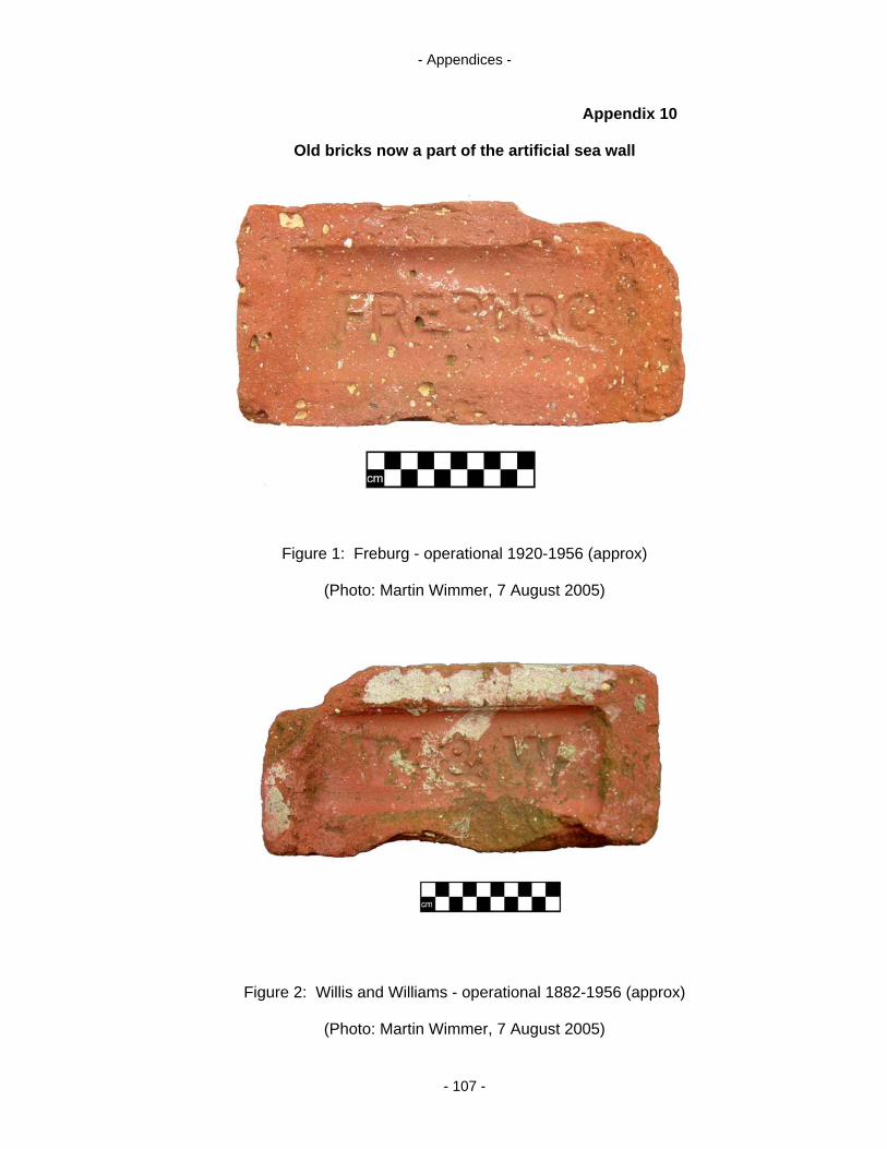
- Appendices -
Appendix 10
Old bricks now a part of the artificial sea wall
Figure 1: Freburg - operational 1920-1956 (approx)
(Photo: Martin Wimmer, 7 August 2005)
Figure 2: Willis and Williams - operational 1882-1956 (approx)
(Photo: Martin Wimmer, 7 August 2005)
- 107 -
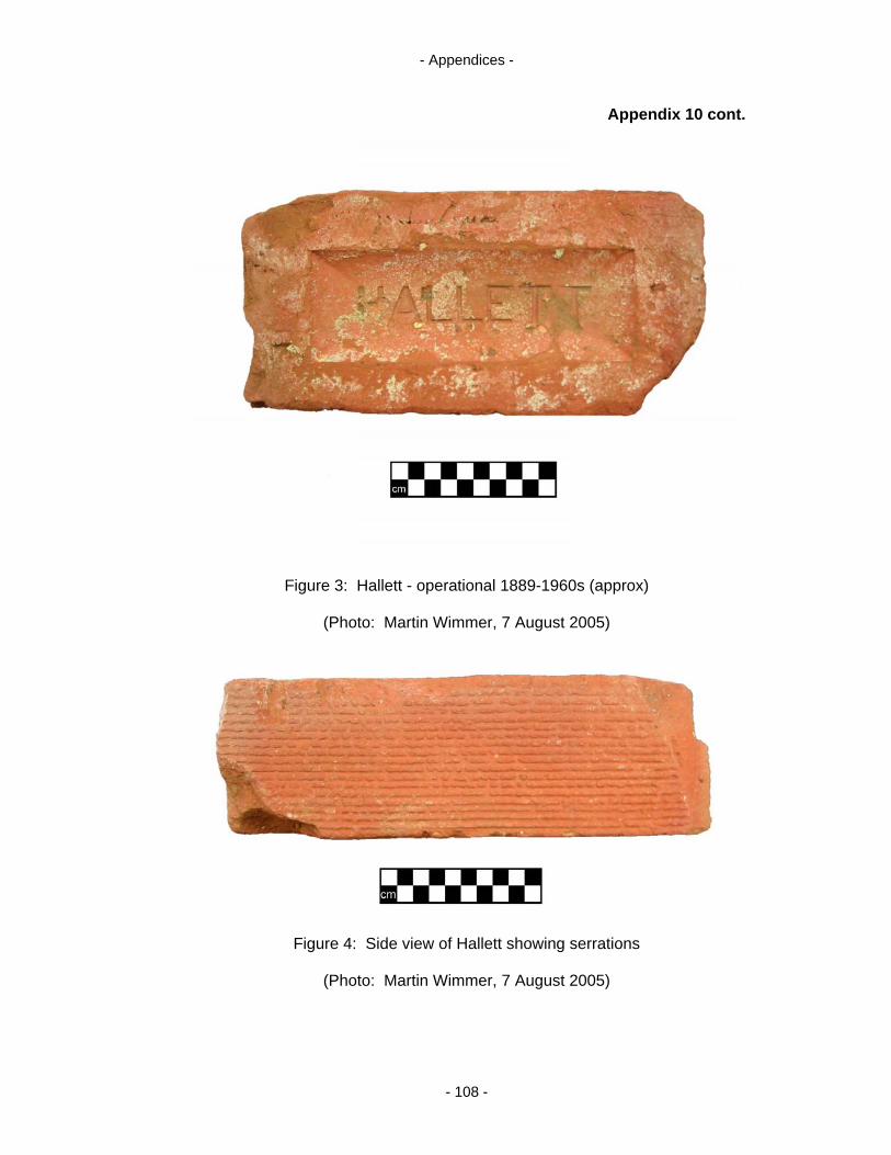
- Appendices -
Appendix 10 cont.
Figure 3: Hallett - operational 1889-1960s (approx)
(Photo: Martin Wimmer, 7 August 2005)
Figure 4: Side view of Hallett showing serrations
(Photo: Martin Wimmer, 7 August 2005)
- 108 -
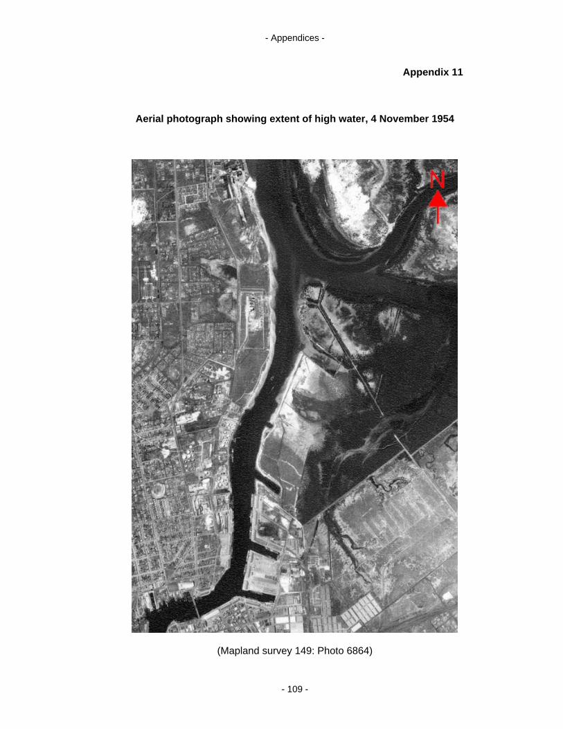
- Appendices -
Appendix 11
Aerial photograph showing extent of high water, 4 November 1954
(Mapland survey 149: Photo 6864)
- 109 -
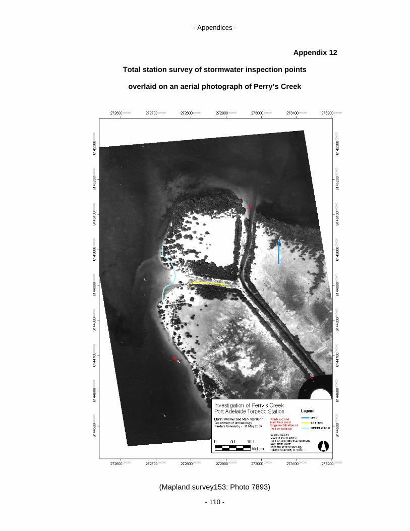
- Appendices -
Appendix 12
Total station survey of stormwater inspection points
overlaid on an aerial photograph of Perry’s Creek
(Mapland survey153: Photo 7893)
- 110 -

- Appendices -
Appendix 13
Brief description of Torpedo Station, no date
(Jan Perry: Private Collection)
- 111 -
Related Documents