ALBERT RECKITT ARCHAEOLOGICAL LECTURE Archaeology in Mesopotamia: Digging Deeper at Tell Brak JOAN OATES Fellow of the Academy TELL BRAK, THE ANCIENT CITY OF NAGAR, is situated in the Khabur plain of north-eastern Syria close to the frontiers of Iraq and Turkey; it is one of the largest ancient sites in Northern Mesopotamia. 1 A small settlement existed here as early as 6000 BC and by the late fifth millennium Brak had become one of the earliest Near Eastern cities. The modern tell occupies some 60 hectares and stands over 40 metres in height (Fig. 1). The tell itself is surrounded by a number of satellite settlements, largely of fourth- millennium date, but including one small fifth-millennium ‘Ubaid site, a Roman farmstead and a castellum and, to the north, a considerable area of Byzantine and early Islamic settlement (Fig. 23, NE of the tell). One reason for the site’s importance was its strategic position, situated on a major route from the Tigris Valley northwards to the mines of Anatolia and westwards to the Euphrates and the Mediterranean (Fig. 2). A British expedition under the direction of Sir Max Mallowan exca- vated here for three seasons in the late 1930s (Mallowan 1947). Recent work at the site was resumed in 1976 under the direction of David Oates. Mesopotamian tell sites consist of layer upon layer of ancient occupa- tion, with buildings constructed largely in mud-brick which, over time, simply decays to form part of the mud fabric of the mound. One of the Read at the Academy on 27 April 2004. 1 Modern political boundaries rarely coincide with those of the ancient world. The term Northern Mesopotamia includes not only northern Iraq but also part of the Khabur plain in north-east Syria. The term ‘Upper Mesopotamia’ is also used, in particular to include adjacent areas of south-eastern Anatolia which in the periods discussed here were often closely related, culturally, to what is now north-eastern Syria and northern Iraq. Proceedings of the British Academy, 131, 1–39. © The British Academy 2005.

Welcome message from author
This document is posted to help you gain knowledge. Please leave a comment to let me know what you think about it! Share it to your friends and learn new things together.
Transcript

ALBERT RECKITT ARCHAEOLOGICAL LECTURE
Archaeology in Mesopotamia:Digging Deeper at Tell Brak
JOAN OATESFellow of the Academy
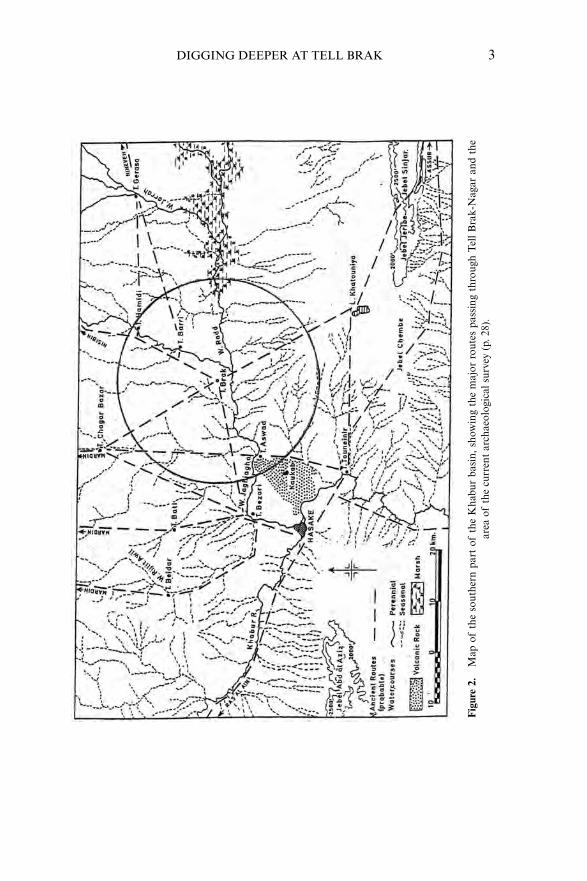
TELL BRAK, THE ANCIENT CITY OF NAGAR, is situated in the Khabur plainof north-eastern Syria close to the frontiers of Iraq and Turkey; it is oneof the largest ancient sites in Northern Mesopotamia.1 A small settlementexisted here as early as 6000 BC and by the late fifth millennium Brak hadbecome one of the earliest Near Eastern cities. The modern tell occupiessome 60 hectares and stands over 40 metres in height (Fig. 1). The tellitself is surrounded by a number of satellite settlements, largely of fourth-millennium date, but including one small fifth-millennium ‘Ubaid site, aRoman farmstead and a castellum and, to the north, a considerable areaof Byzantine and early Islamic settlement (Fig. 23, NE of the tell). Onereason for the site’s importance was its strategic position, situated on amajor route from the Tigris Valley northwards to the mines of Anatoliaand westwards to the Euphrates and the Mediterranean (Fig. 2).
A British expedition under the direction of Sir Max Mallowan exca-vated here for three seasons in the late 1930s (Mallowan 1947). Recentwork at the site was resumed in 1976 under the direction of David Oates.Mesopotamian tell sites consist of layer upon layer of ancient occupa-tion, with buildings constructed largely in mud-brick which, over time,simply decays to form part of the mud fabric of the mound. One of the
Read at the Academy on 27 April 2004.1 Modern political boundaries rarely coincide with those of the ancient world. The term NorthernMesopotamia includes not only northern Iraq but also part of the Khabur plain in north-eastSyria. The term ‘Upper Mesopotamia’ is also used, in particular to include adjacent areas ofsouth-eastern Anatolia which in the periods discussed here were often closely related, culturally,to what is now north-eastern Syria and northern Iraq.
Proceedings of the British Academy, 131, 1–39. © The British Academy 2005.

2 Joan Oates
disadvantages of this type of site in the context of the relatively dry envi-ronment is that major settlements tend to persist in strategic situationsand therefore tend to remain continuously occupied, often until medievalor even more modern times, a situation that renders extensive investiga-tion of their early history virtually impossible. And it is just such sitesthat archaeologists would wish to investigate in order more fully to under-stand earlier periods when comparable strategic choice would also havebeen an important factor in the pattern of settlement. One persuasivereason for choosing to return to Tell Brak was the lack at that time innorthern Mesopotamia of any well-stratified urban material of EarlyBronze Age date (third millennium BC) and the fact that the whole of thesouthern part of the Brak tell had been abandoned at the end of the thirdmillennium, making material of this date immediately accessible to thearchaeologist. Thus at Brak, unusually, there was an obviously importantand immediately accessible third-millennium city.
A second reason for choosing Brak was that Mallowan had discoveredthere the so-called Palace of Naram-Sin, grandson of Sargon of Agade,whose contemporary inscriptions accord him the titles ‘king of the fourquarters (of the world)’ and ‘smiter of Armanum and Ebla’ (TellMardikh in northern Syria), which ‘since the beginning of mankind no
Figure 1. Tell Brak from the north; in the background the gap between Jebel Sinjar and JebelJeribe is visible, 50 km to the south.
DIGGING DEEPER AT TELL BRAK 3
Fig
ure
2.M
ap o
fth
e so
uthe
rn p
art
ofth
e K
habu
r ba
sin,
show
ing
the
maj
or r
oute
s pa
ssin
g th
roug
h T
ell B
rak-
Nag
ar a
nd t
hear
ea o
fth
e cu
rren
t ar
chae
olog
ical
sur
vey
(p.2
8).

4 Joan Oates
king had ever destroyed’ (Frayne 1993, 136). The ‘palace’ was actually aheavily fortified storehouse (the outer wall was 9 metres thick, Mallowan1947, pls 48:2, 59), in which Naram-Sin had fortunately left his namestamped on some of the mud-bricks used in its construction (Oates et al.2001, figs 136, 381). Thus Brak also offered an opportunity to investigatea major provincial centre of what is often referred to as the world’s first‘empire’, a claim at that time increasingly subject to sceptical comment.Indeed in 1985 a distinguished American scholar wrote, ‘The data wehave do not suggest any empires or large states in third millennium Syria. . . the presence of Naram-Sin’s garrison at Tell Brak and scribal bom-bast notwithstanding’ (Michalowski 1985, 301), a phrase which was toprove extremely useful in raising research funds for the investigation ofAkkadian imperial administration at the site. Another persuasive reasonfor selecting Brak was that Naram-Sin’s stamped bricks provided the onlythird-millennium archaeological horizon in the whole of northernMesopotamia and Syria that could be precisely historically dated. Thisremains so, even today.
A large volume on the third-millennium excavations was published in2001 (Oates, Oates and McDonald). The intention of this paper is tofocus on two recent projects, the investigation of the earlier fourth to fifth-millennium levels and an intensive survey of the surrounding countryside,begun two years ago, using the latest satellite imagery and computer soft-ware. The following brief comments on the third-millennium discoveriesare intended to provide a broader context for the more recent work;supporting evidence and further illustration can be found in the finalreports.
Third-millennium Brak
Brak was occupied throughout the third millennium BC, but up to now wehave excavated extensively only the second half of this millennium, focus-ing particularly on what we now know to have been an important pre-Akkadian kingdom and the succeeding Akkadian levels.2 Also ofsignificance, especially from an environmental point of view, is theexcavation of levels of post-Akkadian date, approximately 2150–1950 BC.
2 Earlier third-millennium material of the ‘Ninevite 5’ phase is widely present at the site but isless well documented owing to the depth of the overlying, later third-millennium deposits (seeMatthews 2003, ch. 5; Oates, et al. 2001, 188–201 and figs 466–71).
The ancient name of Tell Brak-Nagar was originally suggested on theevidence of the second-millennium texts from Mari (Charpin 1990; Oateset al. 2001, 379–80), is attested in inscriptions from Brak itself and con-firmed by the work of our colleagues at Ebla, south of Aleppo, and thesite of Tell Beydar, some 40 kilometres north-west of Brak, a small townthat was clearly a dependency of Brak.3 Contemporary cuneiform tabletsfrom Ebla tell us that in the third millennium Nagar was the dominantcity in this part of northern Mesopotamia, and a major point of contactat the interface between the cities of the Levant in the west and those ofMesopotamia. Indeed the city’s importance clearly reflects its position atthe western margins of Mesopotamia itself and controlling not onlyroutes to the west but also to the Tigris and the south (Fig. 2).
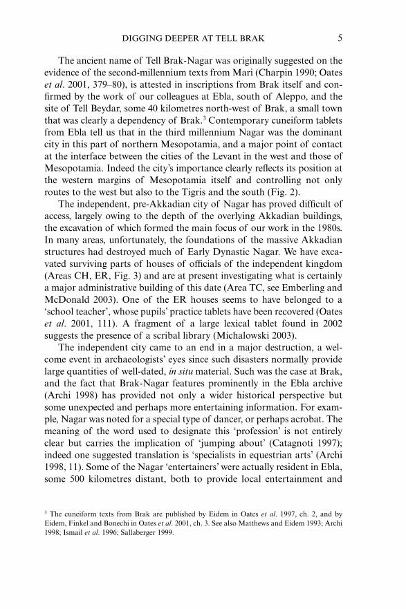
The independent, pre-Akkadian city of Nagar has proved difficult ofaccess, largely owing to the depth of the overlying Akkadian buildings,the excavation of which formed the main focus of our work in the 1980s.In many areas, unfortunately, the foundations of the massive Akkadianstructures had destroyed much of Early Dynastic Nagar. We have exca-vated surviving parts of houses of officials of the independent kingdom(Areas CH, ER, Fig. 3) and are at present investigating what is certainlya major administrative building of this date (Area TC, see Emberling andMcDonald 2003). One of the ER houses seems to have belonged to a‘school teacher’, whose pupils’ practice tablets have been recovered (Oateset al. 2001, 111). A fragment of a large lexical tablet found in 2002suggests the presence of a scribal library (Michalowski 2003).
The independent city came to an end in a major destruction, a wel-come event in archaeologists’ eyes since such disasters normally providelarge quantities of well-dated, in situ material. Such was the case at Brak,and the fact that Brak-Nagar features prominently in the Ebla archive(Archi 1998) has provided not only a wider historical perspective butsome unexpected and perhaps more entertaining information. For exam-ple, Nagar was noted for a special type of dancer, or perhaps acrobat. Themeaning of the word used to designate this ‘profession’ is not entirelyclear but carries the implication of ‘jumping about’ (Catagnoti 1997);indeed one suggested translation is ‘specialists in equestrian arts’ (Archi1998, 11). Some of the Nagar ‘entertainers’ were actually resident in Ebla,some 500 kilometres distant, both to provide local entertainment and
DIGGING DEEPER AT TELL BRAK 5
3 The cuneiform texts from Brak are published by Eidem in Oates et al. 1997, ch. 2, and byEidem, Finkel and Bonechi in Oates et al. 2001, ch. 3. See also Matthews and Eidem 1993; Archi1998; Ismail et al. 1996; Sallaberger 1999.
6 Joan Oates
instruction in their special arts. Nagar was also noted for the quality ofits hybrid equids which were both expensive and much in demand in thewest (Oates 2003, 117). We believe that these were donkey-onager hybridswhich, before the introduction of the horse, were the preferred draughtanimal, deemed especially suitable for drawing the chariots of gods andkings. The long-necked equids in Figure 4 are almost certainly thehybrids, and we know from the Beydar documents that the ruler of Nagarvisited the towns of his kingdom with just such an entourage. At the sametime the texts from Ebla tell us that the king’s ‘superintendents of thecharioteers’ and ‘breeders of livestock’ actually travelled to Brak-Nagarfor the acquisition of these animals which at least occasionally cost asmuch as 5 minas of silver (over 2 kilos), more than fifty times the price ofa donkey.
Figure 3. Contour plan of Tell Brak, one metre contour intervals.

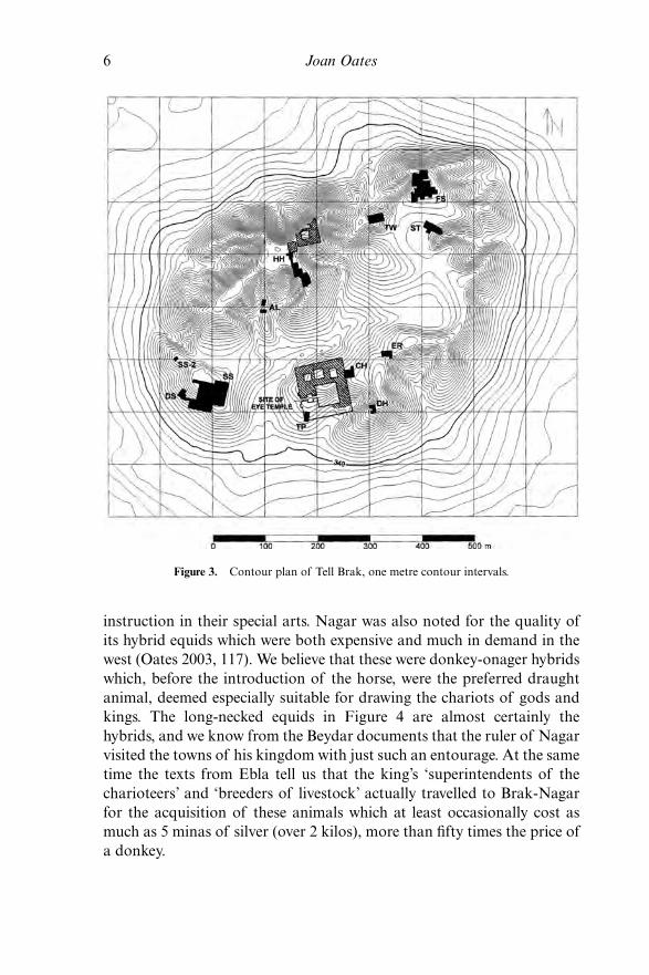
Texts from Ebla also provide information about the dowry of thedaughter of the ruler of Ebla on her marriage to the crown prince ofNagar (Biga 1998). This is the earliest recorded royal dowry and clearlyrepresented a desirable political alliance. Included were large quantities oftextiles and perfumed oils. Regrettably, we have yet to find any trace ofthe forty-two jars of wine sent from Ebla to Nagar for the weddingcelebrations. From this period we have perhaps the finest object to havebeen found at Brak, a statue of a couchant human-headed bison (Fig. 5),a mythical creature associated with the sun god.
Following the destruction of the city sometime in the twenty-thirdcentury BC, Nagar was rebuilt by officials of the Akkadian Dynasty as amajor centre of their provincial administration, a fact clearly attested inthe cuneiform documents from the site. The earliest Akkadian phase hasprovided us, inter alia, with two extraordinary public buildings, the first alarge complex in Area SS which occupies the whole of the south-westcorner of the site, an area of some 60 by over 100 metres (Fig. 6). Thebuilding consists of several distinct complexes, including a temple in thenorth-east, entered from the east courtyard, an administrative unitentered from the west (in particular room 23 and, later, room 18, together
DIGGING DEEPER AT TELL BRAK 7
Figure 4. Impression of jar sealing depicting a wheeled vehicle drawn by four equids,almost certainly the donkey-onager hybrids bred at Brak-Nagar, mid third millennium BC;
seal height 3.4 cm.
8 Joan Oates
with the courtyard to the north), an ‘industrial’ area west of the templewith unusually large ovens (e.g. room 4) and, most unusual of all, a vastsouth courtyard with a massive limestone throne dais at its north end(Fig. 7) and surrounded by large iwans with doorways 5 metres wide, withsingle supporting columns. The most extraordinary features of the build-ing were the unique, decorative, shallow fluted pilasters in the mud wallplaster, and the subtle trompe l’oeil concealment of the trapezoidal court-yard, the shape of which presumably reflected the existing contours of thetell. The concealment was effected by the use of elaborately rebated piersin the corners in order to conceal the lack of right angles, a surprisinglysophisticated architectural technique for the mid third millennium.
Figure 5. Limestone sculpture of a human-headed bison, found in Area SS, height 28.2, length 41.5 cm, now in the Deir ez-Zor Museum (further comment in Hansen 2001).

DIGGING DEEPER AT TELL BRAK 9
Fig
ure
6.P
lan
ofE
arly
Akk
adia
n bu
ildin
g in
Are
a SS
.

10 Joan Oates
The name of one of the officials in charge of this building has beenpreserved, one Muris, bearer of a north Semitic name. Contemporarysealings from a local seal belonging to him and another in the Akkadianstyle which had obviously been presented to him, and on which his namerepresents a later cutting have been recovered from the building(Oates et al. 2001, figs 171–2). It would appear that at least in the earlyyears of their administration the Akkadians made use of local officials,who of course knew where to collect the taxes, a ploy not unknown to theRomans.
A second early Akkadian building (Area FS) has within it a verysimilar temple and an official ‘reception suite’, but otherwise consists ofa number of very large courtyards in which we have found both micro-stratigraphic evidence of herbivore dung and traces of small stakes,almost certainly used to tether animals (Oates et al. 2001, 41–50 andfig. 366). Sealed dockets, recovered in the courtyard just outside the tem-ple itself, record transactions involving the donkey-onager hybrids thatwere in such demand at Ebla, and it is clear that the building was in someway connected with the breeding and use of these animals (Oates et al.2001, 118). The Area FS complex lies near the north gate of the city andmay also have served as some type of ‘way station’ (the contemporaryBeydar texts attest just such an institution, Sallaberger 1996, 1999).
Figure 7. Area SS, north façade of south courtyard.
At some time during the Akkadian occupation of the site but beforethe construction of Naram-Sin’s ‘Palace’, microstratigraphic and otherarchaeological evidence demonstrates that both monumental buildingswere briefly abandoned, then cleared out and deliberately filled in, thelatter process involving both ritual burning and the ritual deposition ofvaluable objects. That is, there are at Brak at least two contemporaryexamples of ritual closure of major temple complexes, sometime early inthe Akkadian period.4 Valuable objects were deposited on the floors, andthe deliberate fill in both buildings was carefully sealed. In Area SS foodofferings were found on the sealed surface, while in FS a number of ritualdonkey burials were discovered and the complete skeleton of a saluki wasfound, together with its water bowl (discussed by Clutton-Brock in Oateset al., 2001, 327–9).
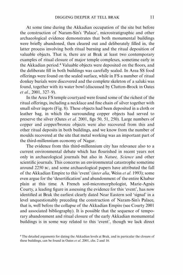
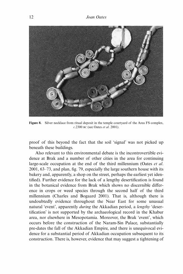
In the Area FS temple courtyard were found some of the richest of theritual offerings, including a necklace and fine chain of silver together withsmall silver ingots (Fig. 8). These objects had been deposited in a cloth orleather bag, in which the surrounding copper objects had served topreserve the silver (Oates et al. 2001, figs 50, 51, 250). Large numbers ofcopper and copper/bronze objects were also recovered from this andother ritual deposits in both buildings, and we know from the number ofmoulds recovered at the site that metal working was an important part ofthe third-millennium economy of Nagar.
The evidence from this third-millennium city has relevance also to acurrent environmental debate which has flourished in recent years notonly in archaeological journals but also in Nature, Science and otherscientific journals. This concerns an environmental catastrophe sometimearound 2250 BC, and some archaeological papers have attributed the fallof the Akkadian Empire to this ‘event’ (inter alia, Weiss et al. 1993); someeven argue for the ‘desertification’ and abandonment of the entire Khaburplain at this time. A French soil-micromorphologist, Marie-AgnèsCourty, a leading figure in assessing the evidence for this ‘event’, has nowidentified at Brak the earliest clearly dated Near Eastern soil ‘signal’ in alevel unquestionably preceding the construction of Naram-Sin’s Palace,that is, well before the collapse of the Akkadian Empire (see Courty 2001and associated bibliography). It is possible that the sequence of tempo-rary abandonment and ritual closure of the early Akkadian monumentalbuildings is in some way related to this ‘event’, though we lack direct
DIGGING DEEPER AT TELL BRAK 11
4 The detailed arguments for dating the Akkadian levels at Brak, and in particular the closure ofthese buildings, can be found in Oates et al. 2001, chs. 2 and 16.
12 Joan Oates
proof of this beyond the fact that the soil ‘signal’ was not picked upbeneath these buildings.
Also relevant to this environmental debate is the incontrovertible evi-dence at Brak and a number of other cities in the area for continuinglarge-scale occupation at the end of the third millennium (Oates et al.2001, 63–73, and plan, fig. 79, especially the large southern house with itsbakery and, apparently, a shop on the street, perhaps the earliest yet iden-tified). Further evidence for the lack of a lengthy desertification is foundin the botanical evidence from Brak which shows no discernible differ-ence in crops or weed species through the second half of the thirdmillennium (Charles and Bogaard 2001). That is, although there isundoubtedly evidence throughout the Near East for some unusualnatural ‘event’, apparently during the Akkadian period, a lengthy ‘deser-tification’ is not supported by the archaeological record in the Khaburarea, nor elsewhere in Mesopotamia. Moreover, the Brak ‘event’, whichoccurs before the construction of the Naram-Sin Palace, substantiallypre-dates the fall of the Akkadian Empire, and there is unequivocal evi-dence for a substantial period of Akkadian occupation subsequent to itsconstruction. There is, however, evidence that may suggest a tightening of
Figure 8. Silver necklace from ritual deposit in the temple courtyard of the Area FS complex,c.2300 BC (see Oates et al. 2001).

Akkadian control following the Brak ‘event’, for example the construc-tion of the heavily fortified ‘palace’ itself and the apparent introductionof greater numbers of Akkadian as opposed to local officials, perhaps areflection of unrest in the countryside of the type that often follows somenatural catastrophe.
Second-millennium Brak
We have also excavated second-millennium levels, which are found onlyon the highest (northern) part of the mound and extensively in theploughed fields to the north of the tell (excavations published in Oates et al.1997). Of especial interest was a Mitanni palace and adjoining temple,found adjacent to private houses investigated by Mallowan in the 1930s.Among the unusual discoveries in the palace were two extraordinarilywell-preserved staircases—the living quarters were on the upper floor—and an area of large and well-preserved workrooms from which werecovered not only objects of ivory (some clearly unfinished) and a greatvariety of ancient glass but also glass ingots together with slag indicatingthe working of both copper and iron. This building proved to be aparticularly well-preserved example of the Late Bronze Age type ofpalace complex in which large numbers of specialist craftsmen wereemployed.
Several cuneiform tablets were also recovered including legal docu-ments sworn ‘in the presence of’ the Mitanni kings Tusratta, well-knownfrom the Amarna correspondence (Fig. 9), and Artassumara, his olderbrother, a more mysterious figure whose murder is referred to in one ofTusratta’s letters. The Brak documents were sealed with the ‘dynastic’ or‘state’ seal of one of their forebears, a sealing also found on documentselsewhere within the Mitanni Empire which once stretched across northernSyria and Iraq. Although the Mitanni were a Hurrian-speaking people,the royal letters were normally written in Babylonian, the lingua franca ofthe time; a fragment of a letter written in Hurrian was, however, alsorecovered.5
DIGGING DEEPER AT TELL BRAK 13
5 The Mitanni documents are published in Eidem 1997; regrettably, the Hurrian fragment hasproved very difficult to read (see G. Wilhelm, ‘A Hurrian Letter from Tell Brak’, Iraq, 53 (1991):159–68).

14 Joan Oates
Brak in the fourth and fifth millennia
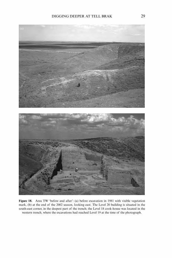
The most recent work at Brak has focused on pre- and proto-historiclevels, from which the results, although not as visually spectacular as theexcavations of the third- and second-millennium cities, have been instru-mental in altering presently held views concerning the rise of urban civil-isation in Mesopotamia. Such earlier levels have been excavated in twoparts of the site, Areas CH and TW. In CH, occupation of the fifth-millennium BC ‘Ubaid period has been reached (still some 12 m above theplain, implying a lengthy prehistory still unexplored, Oates 1987), butmaterial here had been much disturbed by the constant rebuilding of itsmonumental constructions. The discovery of comparably early levels inArea TW resulted from the chance identification of early third-millenniumoccupation beneath the foundations of massive second-millennium wallsfirst seen as a vegetation mark after an unusually wet winter in 1981 (Fig.18a, below; Oates et al. 1997, figs 165–6). The massive walls proved to besubstructures of what was almost certainly part of the outer defences ofthe second-millennium city, and their deep foundations had literallyremoved most of the underlying third-millennium occupation, thusproviding unexpected access to fourth-millennium levels normally deeply
Figure 9. Legal document recording an agreement made in the presence of the Mitanni kingTusratta, sealed with the dynastic seal of his ancestor Saustatar (translation in Eidem 1997, 41).
buried beneath the many metres still surviving from the great third-millennium city.
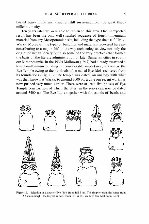
Ten years later we were able to return to this area. One unexpectedresult has been the only well-stratified sequence of fourth-millenniummaterial from any Mesopotamian site, including the type site itself, Uruk-Warka. Moreover, the types of buildings and materials recovered here arecontributing to a major shift in the way archaeologists view not only theorigins of urban society but also some of the very practices that formedthe basis of the literate administration of later Sumerian cities in south-ern Mesopotamia. In the 1930s Mallowan (1947) had already excavated afourth-millennium building of considerable importance, known as theEye Temple owing to the hundreds of so-called Eye Idols recovered fromits foundations (Fig. 10). The temple was dated, on analogy with whatwas then known at Warka, to around 3000 BC, a date our recent work hasnow pushed very much earlier. There were at least five phases of EyeTemple construction of which the latest in the series can now be datedaround 3400 BC. The Eye Idols together with thousands of beads and
DIGGING DEEPER AT TELL BRAK 15
Figure 10. Selection of alabaster Eye Idols from Tell Brak. The simpler examples range from 2–5 cm in height; the largest known, lower left, is 14.3 cm high (see Mallowan 1947).
16 Joan Oates
many stamp amulets had been deposited largely in the mortar of the evenearlier second phase of construction, a point to which I shall return.
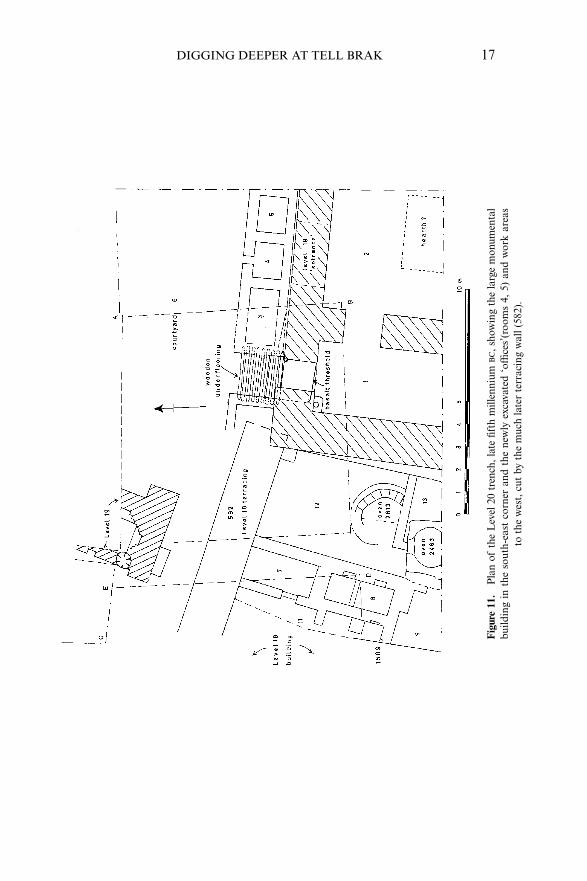
The 1991–3 seasons provided over seven metres of well-stratifiedmaterial. This came from sixteen actual construction levels dating fromthe early third back to the mid fourth millennium. In 1997 we returned tothis area, opened a second trench to the west, and discovered two veryunusual buildings in the earlier levels 18 and 20. The latter, and earlier ofthe two, has proved to be what may arguably be the earliest secular mon-umental building yet discovered in the Near East. Unfortunately, it wassituated in the deepest corner of the original trench, its floor some elevenmetres below the modern ground surface, and we have been able torecover only a small area of the plan (Figs 11, 18b). This includes a majorentrance, with walls a metre and a half thick and, within the wide door-way, a vast threshold stone consisting of a single piece of basalt measur-ing 1.85 � 1.52 metres in area and 29 centimetres thick (Oates and Oates1997, figs 3, 4). It has not been possible to establish the precise functionof this clearly monumental structure, but the plan does not conform tothat of contemporary ‘ritual’ buildings. There seems to have been a largefire installation in the middle of the south-east room but, in the area wewere able to excavate, the building was otherwise empty and samples fromthe floors have up to now proved uninformative.
Associated pottery recovered during the most recent field season(2004) now securely dates the building to the latter part of the fifthmillennium, to a phase referred to as Early Northern Uruk or LateChalcolithic 2 (c.4200–3900 BC).6 The most recent season has also pro-vided significant new information concerning this late fifth-millenniumoccupation. A series of small rooms was excavated, adjacent to but notbonded with the north wall of the monumental structure and enteredfrom the large open courtyard to the north (Fig. 11). The westernmost,adjacent to the gate, would have served as a guardroom, but the rest havevery much the appearance of the facilities one finds outside governmentoffices in the Near East today, a series of desks at which letter-writers andother clerks provide services for the benefit of those having business in the
6 For a more precise discussion of chronology, based on radiocarbon determinations, see Oates,forthcoming. For a recent assessment of radiocarbon determinations for the fourth millennium,see Wright and Rupley 2001, especially ‘beginning of Early Uruk’, p. 120. It should be noted thatthe reassessment of chronology in Oates, forthcoming, places the Level 20 building early in LateChalcolithic 2 (LC2), whereas in the recent Rothman volume (2001, 7, table 1) it would have beenattributed to late LC1. On the basis of the pottery the Level 20 Brak building is contemporarywith Tepe Gawra XI–A to XI.
DIGGING DEEPER AT TELL BRAK 17
Figu
re 1
1.P
lan
ofth
e L
evel
20
tren
ch,l
ate
fifth
mill
enni
um B
C,s
how
ing
the
larg
e m
onum
enta
lbu
ildin
g in
the
sou
th-e
ast
corn
er a
nd t
he n
ewly
exc
avat
ed ‘
offic
es’(
room
s 4,
5) a
nd w
ork
area
sto
the
wes
t,cu
t by
the
muc
h la
ter
terr
acin
g w
all (
582)
.

18 Joan Oates
building itself. A second possibility, that these might be a series of suq-likeshops, is perhaps supported by the discovery of a ‘craft area’ just to thewest of the building, with several ovens and large numbers of tools ofboth bone and ground stone. The small rooms north of the building wereregrettably empty. Like the third-millennium equid building in Area FS,this monumental TW building lies near the north gate of the city and, forthe moment, we favour the view that this too may have been some formof official ‘way station’. Certainly its function was ‘administrative’, not‘ritual’.
Much earlier formal buildings are of course known in Pre-PotteryNeolithic contexts in south-eastern Anatolia and throughout fifth-millennium ‘Ubaid Mesopotamia. Although these would seem to haveserved some ritual function, none is on the scale of the Brak complex andthe well-established Mesopotamian tripartite plan differs significantlyfrom that excavated in TW Level 20. The discovery of a large secularadministrative building securely dated before the end of the fifth millenniumsignificantly alters existing views of the complexity of Mesopotamiansociety at this time, especially that in northern Mesopotamia. There is atBrak, moreover, further evidence of increasing complexity in the presenceof a massive wall, two metres thick, some 400 metres distant along thenorth-west limits of the tell, possibly the wall of a large compound or con-ceivably even part of a city wall (Matthews 2003, 29–30). Contemporarypottery has been found in several parts of the tell and at satellite settle-ments just to the east and west of the main mound, clearly suggestingoccupation of considerable size as well as complexity already in the fifthmillennium (Fig. 22, below).
The second new building (Fig. 12) defines a later level (18), to be datedsometime around 3800 BC,7 and would appear to have been the original‘roadside café’. The southern portion consists of a roofed structure on theplan of a formal reception hall, that is, the early Mesopotamian tripartiteplan with its central chamber and side rooms that served both as a tem-ple and a house plan. (The daily needs of the gods were not dissimilar tothose of ordinary people.) To the north is a very large open courtyard,entered from the adjacent street. The façades of the southern courtyardbear decorative niches, another distinctive feature of public buildings(Oates and Oates 1997, fig. 17). Unfortunately much of this area wasbadly damaged by very large rubbish pits, dug by later inhabitants of thesite, which destroyed many of the walls, while the western side of the
7 LC3 or early ‘Middle Northern Uruk’.

building had virtually disappeared owing to the steep slope of the erodedtell (Emberling and McDonald 2001, figs 2,3). Indeed we lack altogetherthe eastern wall and the northern limits of the courtyard.
This complex remained in use over a long period during the LateChalcolithic 3 or ‘Northern Middle Uruk’ phase, very approximately the
DIGGING DEEPER AT TELL BRAK 19
Figure 12. Plan of the Northern Middle Uruk ‘cook-house’ or ‘feasting hall’, Area TW; builtin Level 18, in use during the first half of the fourth millennium BC.

20 Joan Oates
latter part of the first half of the fourth millennium. Within the courtyardwe have found a great variety of fire installations, including domed ovens,grills and open hearths which were periodically rebuilt or replaced (Fig.13). One of the most interesting features of this formal ‘cook-house’ is theevidence for the types of meal produced here, obviously on a very largescale. The speciality of the house seems to have been meat, though localriver fish were also served. The identified plant remains seem largely tohave come from the fuel used in the ovens, whether from the fuel itself orfrom animal dung, widely used as fuel. It seems likely that different kindsof food were produced in the different types of oven, only two of whichare shown on the plan. Mutton and beef were most in demand, but thereis evidence also for the roasting of pig, gazelle, fox, hare, birds and eitherdog or jackal. The larger animals seem to have been butchered elsewhere,while smaller animals and birds were baked intact. The bones of thelarger specimens were generally fragmented and burnt, suggesting a cook-ing technique involving the release of the fat in the bones (Weber 2003).That is, we believe that quantities of animal carcasses and plates of pre-pared food were brought here for roasting and baking. Indeed the majorfinds within the courtyard consisted of crudely made, mass-produced flatplates, perhaps the original paper plate! (up to 70 per cent of the surviv-
Figure 13. The southern domed oven in the courtyard of the Level 18 ‘cook-house’ (photograph,H. McDonald).

ing sherds in the courtyard itself).8 Again we know of no similar buildingof this date, anywhere, though ‘institutional’ domed ovens are also reportedin a contemporary level at Hamoukar, an important fourth-millennium site80 kilometres east of Brak (Gibson et al. 2002, 17).
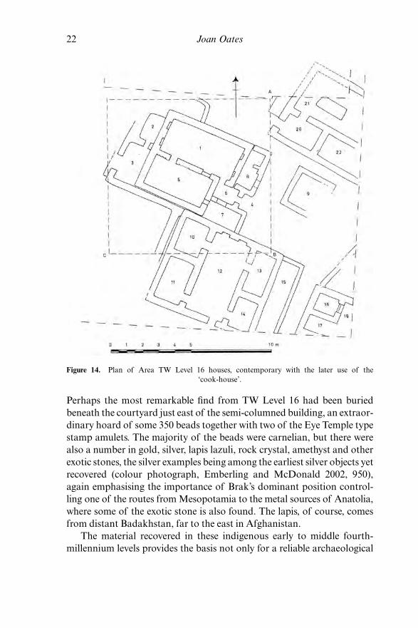
To the east of the Level 18 building, in the original trench, were sev-eral occupation levels containing tripartite houses which, although laterin construction, were certainly occupied during the period in which the‘cookhouse’ remained in use (TW Levels 17–15), possibly by peopleinvolved in the operation of the Level 18 building, though there is nodirect connection. Level 16 was heavily burnt, providing an unusuallyextensive repertoire of in situ pottery and other objects. Two buildingsprovide more or less complete plans (Fig. 14), the usual tripartite houseto the south with a much more unusual building in the north-west corner,of which at least one wall was ornamented with the earliest known exam-ples of mud-brick semi-columns, a type of architectural decoration well-known in later periods and reserved for buildings of importance (Oatesand Oates 1993, figs 26, 27). A number of heavily charred wooded objectswere recovered here, especially in room 1, including a large platter andthin segments of what may have formed some type of panelling or screen.Other objects from this building include, unusually, a large gold beadmade of sheet metal, two very beautifully crafted ivory objects, in shaperesembling long pen-holders, a very large stone ‘fruit-stand’ (Oates andOates 1993, fig. 50, no. 10) and a number of finely made ground stonetools. It was here also that the only in situ Eye Idols have been recovered.9
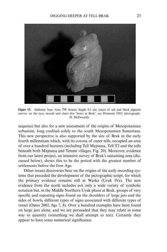
Another type of object, also known from the ‘Eye Idol’ level of the EyeTemple, is the charming alabaster bear seen in Figure 15 (Pittman 2002).
DIGGING DEEPER AT TELL BRAK 21
8 An example is illustrated in Oates and Oates 1993, fig. 54, no. 66; many are slightly flatter thanthe illustrated specimen.9 Although hundreds of alabaster Eye Idol fragments have been found in the recent series ofexcavations, most of these were from earlier soil used to make much later bricks. The two com-plete examples from Level 16, room 1, and probably another from Level 14, remain the onlycomplete, in situ examples (illustrated in Oates and Oates 2002, fig. 5). Part of a bone Eye Idol,one of only two examples in this material from Brak, was recovered from a Level 16 jar from thenorth courtyard of the ‘cookhouse’ (Emberling and McDonald 2003, fig. 11). These stratifiedexamples provide the sole evidence for dating the thousands of Eye Temple specimens recoveredfrom an early but otherwise undated phase of the Eye Temple foundations (see discussion inOates and Oates, 2002).
Until recently it was believed that the Eye Idols were unique to Brak, but in 1999 a numberof Eye Idols, in both bone and stone, were recovered from a pit excavated at Tell Hamoukar(Gibson et al. 2002, 17). Also found in this pit were many beads and some 90 stamp amulets ofthe type also well-known from the Brak Eye Temple, the latter now found in well-dated contextsat Brak (Area TW, Levels 16–17). Of great importance is the recent discovery of impressions ofsuch seals from the approximately contemporary burnt house at Hamoukar (Reichel 2002).
22 Joan Oates
Perhaps the most remarkable find from TW Level 16 had been buriedbeneath the courtyard just east of the semi-columned building, an extraor-dinary hoard of some 350 beads together with two of the Eye Temple typestamp amulets. The majority of the beads were carnelian, but there werealso a number in gold, silver, lapis lazuli, rock crystal, amethyst and otherexotic stones, the silver examples being among the earliest silver objects yetrecovered (colour photograph, Emberling and McDonald 2002, 950),again emphasising the importance of Brak’s dominant position control-ling one of the routes from Mesopotamia to the metal sources of Anatolia,where some of the exotic stone is also found. The lapis, of course, comesfrom distant Badakhstan, far to the east in Afghanistan.
The material recovered in these indigenous early to middle fourth-millennium levels provides the basis not only for a reliable archaeological
Figure 14. Plan of Area TW Level 16 houses, contemporary with the later use of the ‘cook-house’.
sequence but also for a new assessment of the origins of Mesopotamianurbanism, long credited solely to the south Mesopotamian Sumerians.This new perspective is also supported by the size of Brak in the earlyfourth millennium which, with its corona of outer tells, occupied an areaof over a hundred hectares (including Tell Majnuna, Tell T2 and the tellsbeneath both Majnuna and Temmi villages, Fig. 20). Moreover, evidencefrom our latest project, an intensive survey of Brak’s sustaining area (dis-cussed below), shows this to be the period with the greatest number ofsettlements before the Iron Age.
Other recent discoveries bear on the origins of the early recording sys-tems that preceded the development of the pictographic script, for whichthe primary evidence remains still at Warka (Uruk IVa). The newevidence from the north includes not only a wide variety of symbolicnotation but, in the Middle Northern Uruk phase at Brak, groups of veryspecific and repeating signs found on the shoulders of large jars and thesides of bowls, different types of signs associated with different types ofvessel (Oates 2002, figs 7, 8). Over a hundred examples have been foundon large jars alone, and we are persuaded that they may relate in someway to quantity (something we shall attempt to test). Certainly theyappear to have some numerical significance.
DIGGING DEEPER AT TELL BRAK 23
Figure 15. Alabaster bear, Area TW houses, height 8.2 cm; traces of red and black pigmentsurvive on the eyes, mouth and claws (for ‘bears at Brak’, see Pittmann 2002; photograph,
H. McDonald).
24 Joan Oates
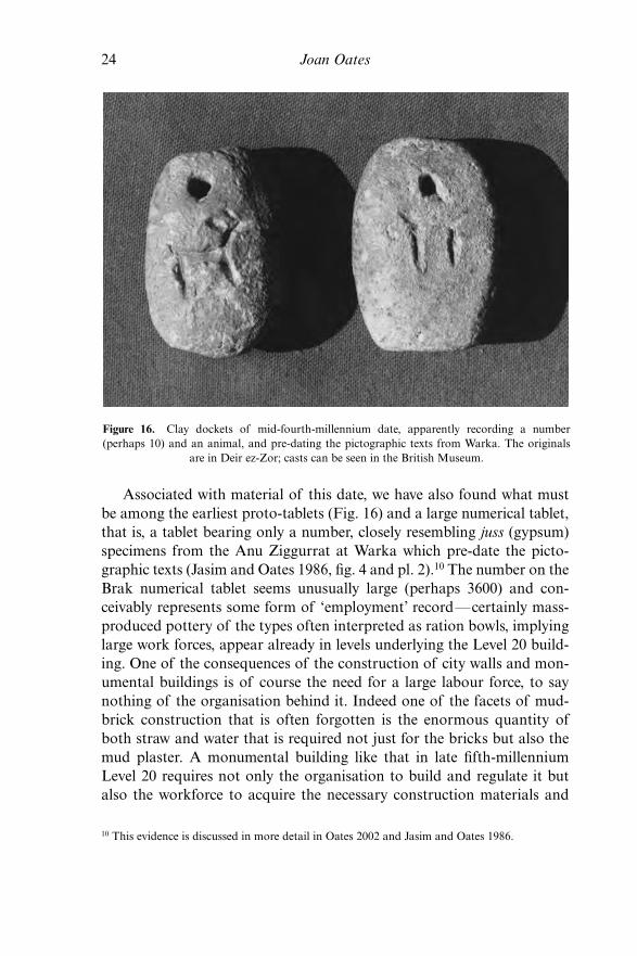
Associated with material of this date, we have also found what mustbe among the earliest proto-tablets (Fig. 16) and a large numerical tablet,that is, a tablet bearing only a number, closely resembling juss (gypsum)specimens from the Anu Ziggurrat at Warka which pre-date the picto-graphic texts (Jasim and Oates 1986, fig. 4 and pl. 2).10 The number on theBrak numerical tablet seems unusually large (perhaps 3600) and con-ceivably represents some form of ‘employment’ record—certainly mass-produced pottery of the types often interpreted as ration bowls, implyinglarge work forces, appear already in levels underlying the Level 20 build-ing. One of the consequences of the construction of city walls and mon-umental buildings is of course the need for a large labour force, to saynothing of the organisation behind it. Indeed one of the facets of mud-brick construction that is often forgotten is the enormous quantity ofboth straw and water that is required not just for the bricks but also themud plaster. A monumental building like that in late fifth-millenniumLevel 20 requires not only the organisation to build and regulate it butalso the workforce to acquire the necessary construction materials and
10 This evidence is discussed in more detail in Oates 2002 and Jasim and Oates 1986.
Figure 16. Clay dockets of mid-fourth-millennium date, apparently recording a number (perhaps 10) and an animal, and pre-dating the pictographic texts from Warka. The originals
are in Deir ez-Zor; casts can be seen in the British Museum.
actually to make the bricks. In a good season a hectare of barley willproduce roughly 500 kilos of straw, enough for approximately 800 mud-bricks, hardly a beginning for a building of this scale.
The extensive use of the stamp seal, a device for marking property andrecord-keeping, is also widely attested in the north at this time, anotheraspect of Sumerian administration that clearly originates not in Sumerbut in the north, where it is found at least as early as the seventh millen-nium BC, long before there is any evidence for such a practice in Sumer(Duistermaat 2000; Oates and Oates 2004, 183–4). Some of the earlieststratified impressions of cylinder as opposed to stamp seals come fromBrak, from Middle Northern Uruk levels, that is, associated with indige-nous northern materials (Felli 2003, 63; Oates and Oates 1993, 178).11 Ofthe other administrative features that develop at this time, the use of so-called counters or tokens is also well-illustrated at Brak, though at thistime these were confined to simple geometric shapes (Jasim and Oates1986, pl. 1c). Tokens of more complex shapes are all of Late Uruk date,at least at Brak, and closely resemble the probably slightly laterpictographs (inter alia, Oates and Oates 1997, fig. 15; Emberling andMcDonald 2003, fig. 5).
It is only in the latest level of this ‘Middle Uruk’ phase at Brak (TWLevel 13) that we find the first evidence of extensive fourth-millenniumcontact with Sumer, in the presence of large quantities of southern pot-tery. At Brak such southern material is found in clear association with thedistinctive Middle Northern Uruk assemblage described above. That is,although Sumerians from the south are almost certainly present, Brakhad not as yet become a southern ‘colony’ comparable with sites on theEuphrates such as Qraya and Shaikh Hassan.12 This Middle Uruk settle-ment at Brak appears, however, to have been completely replaced by atrue southern colony, in which both the buildings and the pottery are ofexclusively southern types. For the moment Brak is the only ‘colony site’so far identified in north-eastern Syria, though it seems likely that Nineveh,on the Tigris to the east, may also have been such a site. At Brak weremain uncertain what happened to the previously thriving and extensive
DIGGING DEEPER AT TELL BRAK 25
11 Recent evidence from nearby Hamoukar shows clearly the importance of the sealing of both packages and the doors of storerooms already at this time (Reichel 2002); door sealings arefound even earlier at the fifth-millennium ‘Ubaid colony site of Degirmentepe in south-eastern Anatolia (Oates and Oates 2004, 184).12 For more extensive discussion of the Middle and Late Uruk ‘colonies’, see most recentlyRothman (ed.) 2001; for a summary of the evidence from north-eastern Syria, see Oatesforthcoming.
26 Joan Oates
local population, of whom there is no visible trace on the tell itself. Onepossibility, of course, is that they were forced onto the outlying tells butwe have no specific evidence for their dispersal. The theory that the exclu-sively south Mesopotamian material culture at Brak represents no morethan acculturation seems highly unlikely, in the total absence of northerntraits.
The motivation for the establishment of such southern colonies, whichon current evidence were more common on the Upper Euphrates, remainsa matter of debate, but it is clear that the acquisition of types of rawmaterials absent in the south, in particular metals, is one major factor;certainly large copper pick-axes were being cast at Brak at this time(Oates and Oates 1997, fig. 16). Unusually, high percentages of sheep/goat characterise the Brak fauna throughout the fourth millennium (over90 per cent, Weber 2003), emphasising the value of wool in the localeconomy as well as in the colony period, while the weaving womendepicted on some Late Uruk seals suggest that local textiles may also havebeen an important commodity (see discussion and fig. 15.6 in Oates andOates 2004, 184–7). The value placed on specialised textiles is certainlyclear from the later cuneiform texts. By contrast, in the late fifth millen-nium, contemporary with the Level 20 monumental complex, the per-centage of sheep/goats was lower and more in line with the usual LateChalcolithic emphasis on cattle and pigs.13
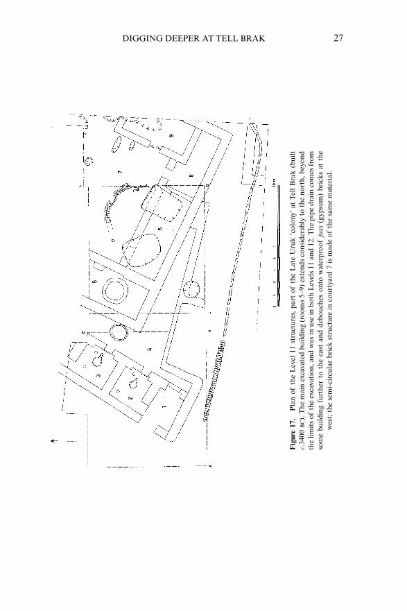
In Area TW the Late Uruk buildings consist of part of a large house (inthe eastern trench) and, to the west, a series of smaller rooms with the typ-ical southern ‘frying pan’ hearths and resembling small shops in a modernsuq, though their actual purpose remains unclear (Fig. 17). Room 6 was aflint-knapper’s workshop, producing both very large Canaanean blades andobsidian tools (Oates 1993, pl. 5). In a contemporary nearby house, just tothe north of Area TW, was found an extraordinary clay ‘blade-holder’,with several tiny projectile points still in situ, set into the holder while theclay was still plastic and demonstrating the continuing manufacture ofmicrolithic tools at this time (Wright 2002, fig. 1). One of the more inter-esting Late Uruk features in Area TW was the lengthy and unusually well-preserved pipe drain, which originated in some contemporary building eastof the excavated trench (Fig. 17; photograph in Emberling and McDonald2003, fig. 9).
13 I am indebted to Jill Weber for this information, based on the faunal material from the 2004season at Tell Brak.
DIGGING DEEPER AT TELL BRAK 27
Fig
ure
17.
Pla
n of
the
Lev
el 1
1 st
ruct
ures
,pa
rt o
fth
e L
ate
Uru
k ‘c
olon
y’at
Tel
l B
rak
(bui
ltc.
3400
BC
).T
he m
ain
exca
vate
d bu
ildin
g (r
oom
s 5–
9) e
xten
ds c
onsi
dera
bly
to t
he n
orth
,bey
ond
the
limit
s of
the
exca
vati
on,a
nd w
as in
use
in b
oth
Lev
els
11 a
nd 1
2.T
he p
ipe
drai
n co
mes
fro
mso
me
build
ing
furt
her
to t
he e
ast
and
debo
uche
s on
to w
ater
proo
fju
ss(g
ypsu
m)
bric
ks a
t th
ew
est;
the
sem
i-ci
rcul
ar b
rick
str
uctu
re in
cou
rtya
rd 7
is m
ade
ofth
e sa
me
mat
eria
l.
28 Joan Oates
The Late Uruk occupation of Brak ended with as much mystery as itbegan, with the occupants of the site apparently simply departing, leav-ing their belongings behind: fortunate for the archaeologist, but puzzling.Although contact with the south appears to cease at other colony sites,this is not the case at Brak, presumably a reflection of Brak’s geographi-cal position (Oates and Oates 1991; 1993). The late fifth- to end of fourth-millennium sequence at Brak remains for the moment unparalleled, bothin its length and in its evidence for early urban complexity. We have,moreover, in the large area now opened up, the possibility of extendingthis sequence still deeper into the fifth millennium, providing an evenlonger perspective on the growth of one of the world’s first complexsocieties (Fig. 18b).
The Brak Sustaining Area Survey
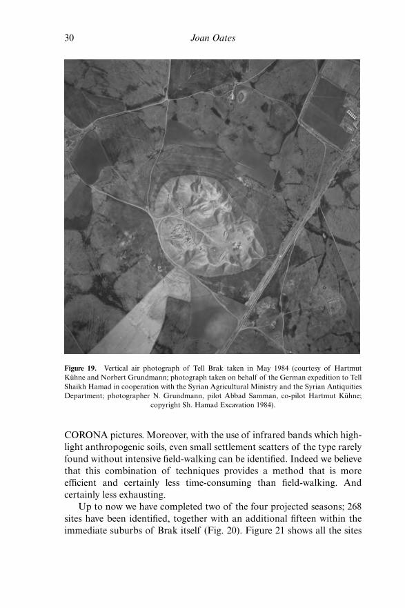
Our most recent project is an intensive, four-season survey, begun in 2003,of the sustaining area of Tell Brak up to a twenty kilometre radius from thesite, a total of over 1200 square kilometres (Fig. 1). The survey has beenmade feasible by the recent availability of LANDSAT data, GIS softwareand, most importantly, the cooperation of the Directorate-General inDamascus. We are also using 1960s CORONA satellite imagery, importantin representing a landscape pre-dating the very intensive, pump-assistedirrigation agriculture of recent years. Other important resources arephotographs taken in the vicinity of Brak by Père Poidebard in the 1920s(Poidebard 1934) and locally from a crop-spraying plane in 1984 (Fig.19). Not surprisingly, the sites themselves are best visible on the olderimages.
We are carrying out two different types of survey, one over the largerarea and based on the satellite images with a view to establishing chang-ing patterns of settlement from prehistory to the present. The objective isnot only a better understanding of the history of Brak itself but also tocontribute to wider studies of the northern landscape. The second is anintensive field-walking exercise in the immediate vicinity of the tell itself,with sherd collection in random ten metre squares. ERMapper is used tooverlay or ‘drape’ the older CORONA pictures, on which the sites aremore visible, onto the recent LANDSAT images which provide bothmodern detail and more accurate site coordinates. With these, usinghand-held GPS receivers, we can drive or walk to the sites visible on the
DIGGING DEEPER AT TELL BRAK 29
Figure 18. Area TW ‘before and after’: (a) before excavation in 1981 with visible vegetationmark, (b) at the end of the 2002 season, looking east. The Level 20 building is situated in thesouth-east corner, in the deepest part of the trench; the Level 18 cook-house was located in the
western trench, where the excavations had reached Level 19 at the time of the photograph.
(a)
(b)
30 Joan Oates
CORONA pictures. Moreover, with the use of infrared bands which high-light anthropogenic soils, even small settlement scatters of the type rarelyfound without intensive field-walking can be identified. Indeed we believethat this combination of techniques provides a method that is moreefficient and certainly less time-consuming than field-walking. Andcertainly less exhausting.
Up to now we have completed two of the four projected seasons; 268sites have been identified, together with an additional fifteen within theimmediate suburbs of Brak itself (Fig. 20). Figure 21 shows all the sites
Figure 19. Vertical air photograph of Tell Brak taken in May 1984 (courtesy of HartmutKühne and Norbert Grundmann; photograph taken on behalf of the German expedition to TellShaikh Hamad in cooperation with the Syrian Agricultural Ministry and the Syrian AntiquitiesDepartment; photographer N. Grundmann, pilot Abbad Samman, co-pilot Hartmut Kühne;
copyright Sh. Hamad Excavation 1984).

recorded up to now (268), with the exception of those immediatelyaround Brak. One of many sites of unusual interest is Tell Grazil (BKS220, the cluster near the top of the map due north of Brak), a large,important, yet previously unknown settlement of third- and second-millennium date.14 The earliest sites include Levallois flakes found ongravel knolls to the north-west of Brak and PPNB chipped stone fromBrak itself and from a small, completely levelled and also previously
DIGGING DEEPER AT TELL BRAK 31
14 This site appears as Zil Saghir, the second word meaning ‘small’, on the satellite map publishedin Ur 2003, fig. 9; ‘Umm Hijara’ is BKS 216.
Figure 20. Topographic plan of Tell Brak and surrounding area, one metre contour intervals(courtesy of G. Emberling, T. Skuldbøl and T. Larsen); this detailed plan is being extended inthe 2004 survey season, in order to include further late fifth/early fourth millennium settlementto the west of Majnuna village and the Roman castellum and surrounding Byzantine/Early
Islamic town to the north-east (partly visible to the upper right of the tell in Fig. 23).

32 Joan Oates
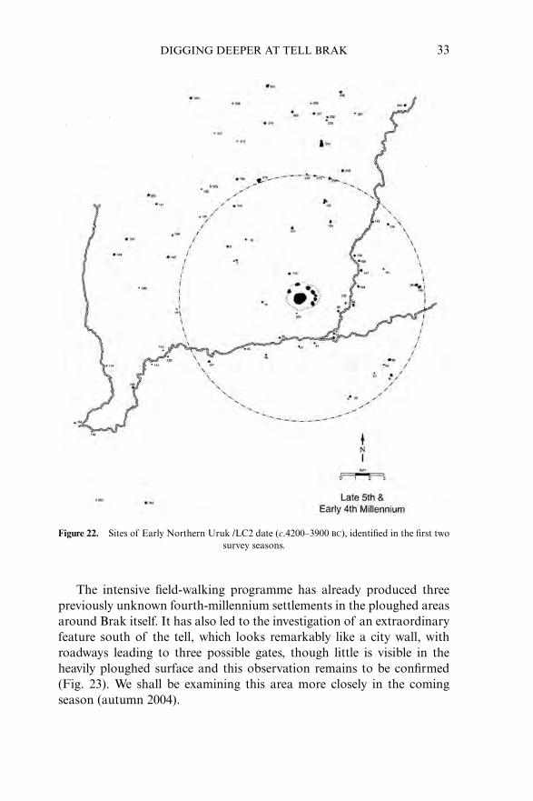
unknown site near Tell Barri. Perhaps not surprisingly, the largest num-ber of sites date to the Late Assyrian period (141 up to now), while beforethat time it is in the fourth millennium that both the site of Brak itselfand the surrounding countryside are most densely populated, an obser-vation not unrelated to the evidence for early urbanisation describedabove. Figure 22 illustrates both the unexpected concentration of popu-lation at Brak and the contemporary sites of late fifth-millennium, EarlyNorthern Uruk attribution, a total of 97. Over the same area Parthian-Roman sites total only 96, though some of the latter are of course larger.
Figure 21. Sites surveyed and recorded during the 2002 and 2003 seasons.
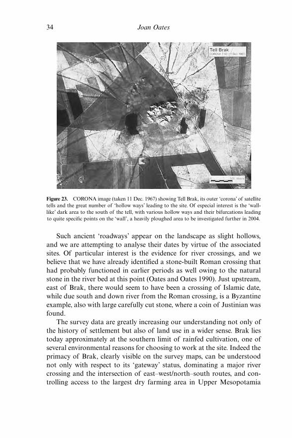
The intensive field-walking programme has already produced threepreviously unknown fourth-millennium settlements in the ploughed areasaround Brak itself. It has also led to the investigation of an extraordinaryfeature south of the tell, which looks remarkably like a city wall, withroadways leading to three possible gates, though little is visible in theheavily ploughed surface and this observation remains to be confirmed(Fig. 23). We shall be examining this area more closely in the comingseason (autumn 2004).
DIGGING DEEPER AT TELL BRAK 33
Figure 22. Sites of Early Northern Uruk /LC2 date (c.4200–3900 BC), identified in the first two survey seasons.
34 Joan Oates
Such ancient ‘roadways’ appear on the landscape as slight hollows,and we are attempting to analyse their dates by virtue of the associatedsites. Of particular interest is the evidence for river crossings, and webelieve that we have already identified a stone-built Roman crossing thathad probably functioned in earlier periods as well owing to the naturalstone in the river bed at this point (Oates and Oates 1990). Just upstream,east of Brak, there would seem to have been a crossing of Islamic date,while due south and down river from the Roman crossing, is a Byzantineexample, also with large carefully cut stone, where a coin of Justinian wasfound.
The survey data are greatly increasing our understanding not only ofthe history of settlement but also of land use in a wider sense. Brak liestoday approximately at the southern limit of rainfed cultivation, one ofseveral environmental reasons for choosing to work at the site. Indeed theprimacy of Brak, clearly visible on the survey maps, can be understoodnot only with respect to its ‘gateway’ status, dominating a major rivercrossing and the intersection of east–west/north–south routes, and con-trolling access to the largest dry farming area in Upper Mesopotamia
Figure 23. CORONA image (taken 11 Dec. 1967) showing Tell Brak, its outer ‘corona’ of satellitetells and the great number of ‘hollow ways’ leading to the site. Of especial interest is the ‘wall-like’ dark area to the south of the tell, with various hollow ways and their bifurcations leadingto quite specific points on the ‘wall’, a heavily ploughed area to be investigated further in 2004.
(Fig. 1), but the site may also have functioned as an interface between thewell-watered plain to the north and semi-nomadic pastoralism in the driersteppe to the south, an important source of the wool that was a basiccommodity in both the fourth and third millennia. At the same time theenormous body of archaeological data from Brak itself, including nowover four millennia of palaeobotanical, faunal, environmental, ceramic,lithic and other data provide an invaluable framework within which tounderstand the wider settlement patterns, and how—and we hopewhy—these changed over time.
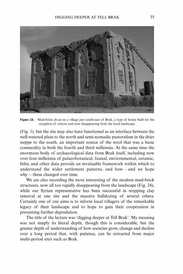
We are also recording the most interesting of the modern mud-brickstructures, now all too rapidly disappearing from the landscape (Fig. 24),while our Syrian representative has been successful in stopping clayremoval at one site and the massive bulldozing of several others.Certainly one of our aims is to inform local villagers of the remarkablelegacy of their landscape and to hope to gain their cooperation inpreventing further depredation.
The title of the lecture was ‘digging deeper at Tell Brak’. My meaningwas not simply its literal depth, though this is considerable, but thegreater depth of understanding of how societies grow, change and declineover a long period that, with patience, can be extracted from major multi-period sites such as Brak.
DIGGING DEEPER AT TELL BRAK 35
Figure 24. Mud-brick diwan in a village just south-east of Brak, a type of house built for thereception of visitors and now disappearing from the local landscape.
36 Joan Oates
Note. I would like especially to thank the various institutions that have supportedthe work at Brak over many years, in particular the British Academy, the BritishSchool of Archaeology in Iraq and the McDonald Institute for ArchaeologicalResearch. We are also grateful to the National Geographic Society, the BritishMuseum, the Metropolitan Museum of Art and the Humanities Research Board fortheir generous support. It is impossible to list the names of all the Syrian officials andstudents, the large number of specialists who have worked on the material from Brak,and the even greater number of site supervisors who have contributed immeasurablyto the success of the work. Their names can be found in both the preliminary and finalreports. Without them the project would not have been possible, and I am deeplygrateful to them all.
The preliminary reports on the new survey project have yet to appear in print. Iwish therefore to thank here, most warmly, those who are contributing to its success.We are especially grateful to Dr Tammam Fakouch, Director-General of Antiquitiesand Museums, and Dr Michel Al-Maqdissi, Director of Excavations, Damascus, fortheir friendly and unfailing assistance and support, not only on the survey but theexcavations as well. Throughout the first two survey seasons we were ably assisted bySd. Eyad Ganem, Representative of the Directorate-General; we are also grateful toSd. Abdul Messih al-Baghdo, Director of Antiquities in Hasake for his continuingefforts on our behalf. The survey is part of the wider Tell Brak Project under the direc-tion, until his death last spring, of Professor David Oates. I am the current ProjectDirector, with Professor Henry Wright, to whom I am especially grateful, as SurveyField Director. Throughout this project we have been ably assisted by Jason Ur andEric Rupley (2002, 2003) and, in 2003, by Helen McDonald, Philip Karsgaard andHarriet Martin together with Fahed Juma and Chris Martin who joined us for part ofthe season. In 2003 the very successful intensive survey in the immediate vicinity ofBrak was initiated by Jason Ur, with the assistance of Philip Karsgaard. The objectsfrom both the excavations and the survey remain, of course, in Syria and are now inthe Deir ez-Zor Museum.
Most of all, I wish to thank David, who has guided my archaeological effortsover many years and who not only initiated and directed the Brak project but wasresponsible for the excavation of the remarkable third and second millenniumbuildings together with the architectural drawings. We shall miss him.
References
Al-Gailani Werr, L., Curtis, J., Martin, H., McMahon, A., Oates, J. and Reade, J.(2002), Of Pots and Plans, Papers on the Archaeology and History of Mesopotamiaand Syria presented to David Oates in Honour of his 75th Birthday (London).
Algaze, G. (forthcoming), ‘The Sumerian Takeoff’ in Stone, E. (ed.), Settlement andSociety: Ecology, Urbanism, Trade, and Technology in Ancient Mesopotamia andBeyond. Festschrift in Honor of Robert McCormick Adams (Los Angeles).
Archi, A. (1998), ‘The Regional State of Nagar According to the Texts of Ebla’,Subartu, IV, 2: 1–15.
Biga, M. G. (1998), ‘The Marriage of Eblaite Princess Tagris-Damu with a Son ofNagar’s King’, Subartu, IV, 2: 17–22.
Catagnoti, A. (1997). ‘Les listes des HÚB.(KI) dans les textes administratifs d’Ébla etl’Onomastique de Nagar’ MARI, 8 (Paris), 563–96.
Charles, M. and Bogaard, A. (2001). ‘Third-millennium Charred Plant Remains fromTell Brak’, in Oates et al. 2001, 301–26.
Charpin, D. (1990), ‘A contribution to the geography and history of the kingdom ofKahat’, in Eichler, S., Wäfler, M. and Warburton, D. (eds.), Tell al-Hamidiya 2:67–85 (Fribourg).
Courty, M.-A. (2001), ‘Evidence at Tell Brak for the Late EDIII/Early Akkadian AirBlast Event (4 kyr BP)’, in Oates et al., 367–72.
Duistermaat, K. (2000), ‘A View on Late Neolithic Sealing Practices in the Near East:The Case of Tell Sabi Abyad, Syria’, in M. Perna (ed.), Administrative Documentsin the Aegean and their Near Eastern Counterparts (Rome), 13–31.
Eidem, J. (1997) (ed), ‘The Inscriptions’, in Oates et al. 1997, ch. 2.Emberling, G. and McDonald, H. (2002), ‘Recent Finds from the northern
Mesopotamian city of Tell Brak’, Antiquity, 76: 949–50.—— —— (2003), ‘Excavations at Tell Brak 2001–2002: Preliminary report’, Iraq, 65:
1–75.Felli, C. (2003), ‘Developing Complexity, Early to Middle Fourth-millennium
Investigations: the Northern Middle Uruk Period’, in Matthews (ed.), 53–94.Frayne, D. (1993), Sargonic and Gutian Periods (2334–2113 BC), The Royal Inscriptions
of Mesopotamia, Early Periods/Vol. 2 (Toronto).Gibson, M., Al-Azm, A., Reichel, C., Quntar, S., Franke, J., Khalidi, L., Hritz, C.,
Altaweel, M., Coyle, C., Colantoni, C., Tenney, J., Aziz, G. and Hartnell, T. (2002),‘Hamoukar: A Summary of Three Seasons of Excavation’, Akkadica, 123: 11–34.
Hansen, D. P. (2001), ‘The Reclining Human-faced Bison Sculpture from Area SS, inOates et al. (2001), 257–63.
Ismail, F., Sallaberger, W., Talon, P. & Van Lerberghe, K. (1996), ‘AdministrativeDocuments from Tell Beydar’, Subartu 11.
Jasim, S. A. and Oates, J. (1986), ‘Early tokens and tablets in Mesopotamia: newinformation from Tell Abada and Tell Brak’, World Archaeology, 17/3: 348–62.
Mallowan, M. E. L. M. (1947), ‘Excavations at Brak and Chagar Bazar’, Iraq, 9.Matthews, D. and Eidem, J. (1993), ‘Tell Brak and Nagar’, Iraq, 55: 201–7.Matthews, R. (2003) (ed.), Excavations at Tell Brak, vol. 4: Exploring an Upper
Mesopotamian regional centre (McDonald Institute Monograph).Matthiae, P., Pinnock, F. and Matthiae, G. S. (1995) (eds.), Ebla, Alle origini della
civiltà urbana (Milan).Michalowski, P. (1985), ‘Third millennium contacts: observations on the relationship
between Mari and Ebla’, Journal of the American Oriental Society, 105: 293–302.—— (2003), ‘Inscriptions from Tell Brak, 2000, 2001 and 2002’, in Emberling and
McDonald (2003), 54–60.Oates, D. (1968), Studies in the Ancient History of Northern Iraq (Oxford).—— (1982), ‘Excavations at Tell Brak, 1978–81’, Iraq, 44: 187–204.—— and Oates, J. (1990), ‘Aspects of Hellenistic and Roman Settlement in the
Khabur Basin’, in Matthiae, P., Van Loon, M. and Weiss, H. (eds.), Resurrectingthe Past, A Joint Tribute to Adnan Bounni (Leiden).
—— —— (1991), ‘Excavations at Tell Brak 1990–91’, Iraq, 53: 127–45.—— —— (1993), ‘Excavations at Tell Brak 1992–1993’, Iraq, 55: 155–99.
DIGGING DEEPER AT TELL BRAK 37

38 Joan Oates
Oates D., Oates, J. and McDonald, H. (1997), Excavations at Tell Brak, vol. 1: TheMitanni and Old Babylonian Periods (McDonald Institute Monograph).
—— —— —— (2001), Excavations at Tell Brak, vol. 2: Nagar in the third millenniumBC (McDonald Institute Monograph).
Oates, J. (1987), ‘A Note on ‘Ubaid and Mitanni Potery from Tell Brak’, Iraq, 49:193–8.
—— (1993), ‘Trade and Power in the fifth and fourth millennia BC: new evidencefrom Northern Mesopotamia’, World Archaeology, 24: 403–22.
—— (2002), ‘Tell Brak: the Fourth Millennium Sequence and its Implications’, in J. N. Postgate (ed.), Artefacts of Complexity, 111–22 (British School of Archaeologyin Iraq).
—— (2003), ‘A Note on the Early Evidence for Horses and the Riding of Equids inWestern Asia’, in Levine, M., Renfrew, C. and Boyle, K. (eds.), Prehistoric steppeadaptation and the horse (McDonald Institute Monograph).
—— (forthcoming), ‘The Proto-Urban (Uruk) Period in Northeast Syria’, inMatthiae, P., Al-Maqdissi, M. and Orthmann, W. (eds.), The Archaeology andHistory of Syria, vol. 1.
—— and Oates, D. (1997), ‘An Open Gate: Cities of the Fourth Millennium BC (TellBrak 1997)’, Cambridge Archaeological Journal, 7: 287–97.
—— —— (2002), ‘The Reattribution of Middle Uruk Materials at Brak’, in Ehrenberg, E.(ed.), Leaving No Stones Unturned, Essays on the Ancient Near East and Egypt inHonor of Donald P. Hansen (Winona Lake, IN), 145–54.
—— —— (2004), ‘The Role of Exchange Relations in the Origins of MesopotamianCivilization’, in Cherry, J., Scarre, C. and Shennan, S. (eds.), Explaining socialchange: studies in honour of Colin Renfrew (McDonald Institute Monographs),177–92.
—— —— (forthcoming), Excavations at Tell Brak, Vol 3, The ‘Ubaid and Uruk Peri-ods (McDonald Institute Monographs).
Pittmann, H. (2002), ‘Bears at Brak’, in Al-Gailani Werr et al. (eds.), 287–96.Poidebard, A. (1934), La Trace de Rome dans le désert de Syrie (Paris).Reichel, C. (2002), ‘Administrative Complexity in Syria during the 4th Millennium
BC—the Seals and Sealings from Hamoukar’, Akkadica, 123: 35–56.Rothman, M. (2001) (ed.), Uruk Mesopotamia and its Neighbors (Santa Fe).Sallaberger, W. (1996), ‘Grain Accounts: Personnel Lists and Expenditure Documents,
in Ismail et al. (eds.), 89–106.—— (1999), ‘Nagar in den frühdynastischen texten aus Beydar’, in Van Lerberghe, K.
and Voet, G. (eds.), At the Crossroads of Civilisations in the Syro-MesopotamianRealm, Proceedings of the 42nd RAI (Leuven), 393–407.
Ur, J. (2003), ‘Using CORONA Satellite Photographs to Study Ancient RoadNetworks: A Northeastern Syrian Case Study, Antiquity, 77: 102–15.
Van Lerberghe, K. (1996), ‘The Livestock’, in Ismail et al. (eds.), 107–17.Weber, J. (2003), ‘Animal processing in the fourth millennium BC at Tell Brak:
Preliminary Results’, in Emberling and McDonald (2003), 22–6.Weiss, H., Courty, M-A., Wetterstrom, W., Guichard, F., Senior, L., Meadow, R. and
Curnow, A. (1993), ‘The genesis and collapse of third-millennium northMesopotamian civilization’, Science, 261 (August 20), 995–1004.
Wilhelm, G. (1991), ‘A Hurrian Letter from Tell Brak’, Iraq, 53, 159–68.

Wilkinson, T. J. (2000), ‘Regional Approaches to Mesopotamian Archaeology: TheContribution of Archaeological Surveys’, Journal of Archaeological Research, 8:219–67.
Wright, H. T. (2002), ‘Arrows and Arrowheads in the Uruk World’, in Al-GailaniWerr et al. (eds.), 373–8.
—— and Rupley, E. (2001), ‘Calibrated Radiocarbon Age Determinations of Uruk-Related Assemblages’, in Rothman (ed.), 85–122.
DIGGING DEEPER AT TELL BRAK 39
Related Documents


![Brak 1 [1]](https://static.cupdf.com/doc/110x72/558bb7bed8b42a95628b45e3/brak-1-1.jpg)

