Report on Advance Archaeological Testing of the proposed Metro West Depot, Merryfalls, Ballymun, Co. Dublin. Document History Log Revision Report status Issue date Description Prepared Reviewed Approved 01 Draft 23/06/09 Advance Archaeological testing at Merryfalls, Co. Dublin LH RMcL RMcL 02 Final 23/07/09 Advance Archaeological testing at Merryfalls, Co. Dublin LH RMcL RMcL Project code: RPSM09 Client: Railway Procurement Agency Date: July 2009. Director: Liam Hackett. Author: Liam Hackett. Licence No: 09E0274 NGR: 313886/241869 O.D: 72.142

Welcome message from author
This document is posted to help you gain knowledge. Please leave a comment to let me know what you think about it! Share it to your friends and learn new things together.
Transcript

Report on Advance Archaeological Testing of the proposed Metro West Depot, Merryfalls, Ballymun, Co. Dublin. Document History Log
Revision Report status Issue date Description Prepared Reviewed Approved
01 Draft 23/06/09
Advance Archaeological
testing at Merryfalls, Co.
Dublin LH RMcL RMcL
02 Final 23/07/09
Advance Archaeological
testing at Merryfalls, Co.
Dublin LH RMcL RMcL Project code: RPSM09 Client: Railway Procurement Agency Date: July 2009. Director: Liam Hackett. Author: Liam Hackett. Licence No: 09E0274 NGR: 313886/241869 O.D: 72.142

Report on Advance Archaeological Testing of the proposed Metro West Depot, Merryfalls, Ballymun,
Co. Dublin.
Document History Log
Revision Report status Issue date Description Prepared Reviewed Approved
01 Draft 23/06/09
Advance Archaeological
testing at Merryfalls, Co.
Dublin LH RMcL RMcL
02 Final 23/07/09
Advance Archaeological
testing at Merryfalls, Co.
Dublin LH RMcL RMcL
Project code: RPSM09 Client: Railway Procurement Agency Date: July 2009. Director: Liam Hackett. Author: Liam Hackett. Licence No: 09E0274 NGR: 313886/241869 O.D: 72.142

Headland Archaeology (Ireland) Ltd, Advance Archaeological Testing, Metro West, Merryfalls, Ballymun, Co. Dublin
2
CONTENTS PAGE Summary 3
1. Introduction 4 2. Project Background
2(a) Archaeological and Historical Background 4 3. Methods 5 4. Results 6 5. Discussion 8 6. Mitigation 8
7. References 8 8. Appendices 9
Appendix 1: Trench record register 9 Appendix 2: Context register 9 Appendix 3: Photograph register 11 Appendix 4: Finds register 13
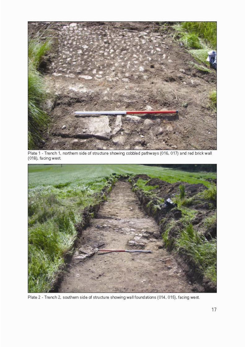
Figures: Figure 1: Metro West, Merryfalls Depot Option, Co. Dublin: 15 09E0274, Site location Figure 2: Metro West, Merryfalls Depot Option, Co. Dublin: 09E0274, Results of Testing programme overlaying 1st 16 edition Ordnance Survey map Plates: Plate 1: Trench 1, northern side of structure showing cobbled 17 pathways (016, 017), red brick wall (018), facing west. Plate 2: Trench 2, southern side of structure showing wall 17 foundations (014, 015), facing west. Plate 3: Trench 2, red brick pillar setting (013), facing northeast. 18 Plate 4: Trench 3, linear drain (012) under deposit (010), facing south 18

Headland Archaeology (Ireland) Ltd, Advance Archaeological Testing, Metro West, Merryfalls, Ballymun, Co. Dublin
3
SUMMARY Advance Archaeological testing was undertaken at the site of the proposed Metro West Depot in the townland of Merryfalls, Co. Dublin. Archaeological testing was undertaken in accordance with the conditions of Archaeological Testing Licence (09E0274), on the 9th June, 2009. Three trenches, totalling 116.19 linear meters, were excavated in targeted areas on the site of a now demolished late 18th/early 19th century structure annotated on cartographic sources as ʹthe Mad Houseʹ. The proposed scheme involves the construction of a depot in the townlands of Merryfalls and Sillogue, Ballymun, Co. Dublin, to serve the proposed Metro West. This programme of targeted trenching was required at this location in order to further inform the design process of the proposed depot. The testing programme revealed the demolished remains of a small structure, to the south of a field boundary also depicted on cartographic sources. The structure was at most a two room dwelling, with 9 inch running bond red brick walls, delineating a series of cobbled and slabbed surfaces, both interior and exterior to the walls. The lack of masonry on the site suggest that the structure was extensively “robbed out”, leaving only the broken fragments of red ceramic roof tiles and building material such as lime mortar and red brick fragments. No human remains or substantive features outside the structure were noted during the testing programme.

Headland Archaeology (Ireland) Ltd, Advance Archaeological Testing, Metro West, Merryfalls, Ballymun, Co. Dublin
4
1. INTRODUCTION This report presents the results of an advance archaeological test trenching programme (09E0274) at the site of the proposed Metro West Depot at Merryfalls, Ballymun Co. Dublin. Three test trenches were excavated across the site of a now demolished late 18th/early 19th century structure annotated on cartographic sources as ʹthe Mad Houseʹ. The testing programme was implemented to ascertain the nature and extent of the structure and to determine the presence of an associated burial ground within its environs. Three trenches were excavated on the site of the structure, which is visible today as a slightly raised platform of rough ground and grass cover on the northern side of a large corn field, abutting the field boundary to the north which has mature tree cover along its entire length (figure 1). A mature oak tree, in a sunken depression, stands approximately 20 metres to the south of the structure.
2. PROJECT BACKGROUND Headland Archaeology (Ireland) Ltd was contracted by the Railway Procurement Agency (RPA) to undertake advance archaeological testing at the site of the proposed Metro West Depot. Advance testing of the site is necessary to establish, where possible, the nature and extent‐of sub‐surface archaeological stratigraphy and to further inform the design process of the proposed scheme. Transport 21 provides for the delivery of a metro line from Tallaght to the Airport in west County Dublin, Metro West, representing a total length of approximately 30km. A preferred route corridor has been selected for the Metro West scheme which will be a surface light rail service development, segregated from traffic using tunnel, road median and green field construction environments. The proposed Metro West route will be an orbital route connecting the towns of Blanchardstown and Clondalkin to the proposed Metro North. For management purposes, the Metro West preferred route corridor has been sub‐divided into three areas (Areas 201, 202 and 203). The proposed depot will be located within Metro West Area 203. In 2007 a non‐invasive archaeological assessment including a walkover assessment of the site was undertaken (Turgel 2007). A number of above ground indications were noted at this location, suggestive of subsurface archaeological remains. 2(a). ARCHAEOLOGICAL AND HISTORICAL BACKGROUND The Archaeology Company carried out an Archaeological Assessment in the townlands of Silloge, Merryfalls and Dubber, Co. Dublin in September 2007 on behalf of the landowner:
Turgel, A. 2007. Archaeological Assessment at Silloge, Ballymun, Co. Dublin. Unpublished report produced by The Archaeology Company for Mr. Frank Connon.
The assessment was carried out in advance of potential development associated with the proposed Metro West and Luas Lucan Line F and identified an area of archaeological potential in Merryfalls townland. At this location a building is depicted on Taylor’s 1815 map of Dublin and referred to as a ‘Mad House’, possibly a private asylum. A field inspection carried out as part of the assessment identified above ground indications that suggested there may be significant subsurface remains extant at this location. Additionally the assessment noted the potential for associated burials to be present in the immediate environ

Headland Archaeology (Ireland) Ltd, Advance Archaeological Testing, Metro West, Merryfalls, Ballymun, Co. Dublin
5
The Environmental Impact Assessment for Metro West is ongoing. A Draft Archaeology Baseline Chapter has been prepared by Valerie J. Keeley Ltd for RPA. The townland of Merryfalls is in the barony of Coolock and the civil parish of St. Margaret’s, an area of land approximately 133 acres (Griffiths, 1837). During the time of the construction and use of ‘the Mad House’, the majority of lands belonged to the Protestant Barry and Catholic Plunkett families (Somerville‐Woodward 2002; Ball, 1920). It is unknown which of these families, if any, ordered the construction of the structure. The structure is first identified as ‘the Mad House‘ in Taylor’s map of the city of Dublin, 1816, and is depicted with an associated access road approaching from the west to the northern aspect of the structure. The plan of the building, depicted on the 1837‐43 1st edition Ordnance Survey of Ireland 6” (sheet 14), shows an elongated structure, oriented north/south with a small courtyard and possible entrance way to the south. The structure would have had two rooms and exterior walkways on the west and south aspects. Later depictions of the structure on the 1897‐1913 25” edition Ordnance Survey map show a demolished structure with little or no detail of the building itself. Roques map of County Dublin, produced in 1760, has no sign of the structure in the current location, which puts the date of construction of the building between 1760 and 1816. A possible reference to the structure states: “ A large tannery has existed at Finglas Wood for nearly two centuries, and is still carried on by J. Savage, Esq., one of the same family as the original proprietor: the residence is very ancient,…... This is a station for the city of Dublin police; and in the vicinity are three private lunatic structures.” (Lewis 1837).
A reference to the practice of private structures in the Finglas area of Dublin can be found in Andrew Roberts’ “The Lunacy Commission”, a study of the lunatic structures throughout the British Isles and Ireland,
Finglas, Dublin: ʺHere are likewise two lunatic structures, with gardens and pleasure‐grounds attached to each, ‐ Dr. Hartyʹs, which in 1829 had 22 patients; and Dr. Duncanʹs, reported at the same time as having 42ʺ
ʺIndependently of the structures for the insane already noticed, there are several in the vicinity of Dublin which are devoted to the accommodation of persons of fortune, one of these is established as Glasnevin. There is also one near Donnybrook, supported by the Society of Friends, and designed for patients of their own sect; this institution is, however, about to be enlarged, so as to admit those of all classes, and of every religious profession.
The results of the testing programme identified a small two room structure with associated pathways and surfaces corresponding to 1st edition OS cartographic depictions. This structure would be more consistent with a private enterprise, possibly a single patient with nurse or carer in residence.
One RMP lies approximately 400 metres to the east of the “Mad House” site. This is a possibly medieval field system (DU014‐021) in the townland of Sillogue, Co. Dublin. 3. METHODS A programme of advance test trenching with five trenches (trenches 1, 2, 3, 4, 5) around the structure was originally envisioned, however due to the small area involved, the four east/west orientated trenches (trenches 1, 3, 4, 5) were amalgamated into two trenches ( trenches 1, 3) extending across the entire structure and beyond ( see figure 2).

Headland Archaeology (Ireland) Ltd, Advance Archaeological Testing, Metro West, Merryfalls, Ballymun, Co. Dublin
6
The trenches were excavated by mechanical excavator with a 1.9 m in width toothless bucket under constant archaeological supervision, and were halted at the subsoil level or at the level of structural remains and surfaces, whichever was encountered first. The trenches were hand cleaned of overburden and recorded using standardised trench and feature recording sheets, and a digital survey was taken of the entire area using GPS. Structural remains were recorded using hand drawn plans and digital photography. Individual, subsoil cut features were sectioned and recorded in this method also. All finds were catalogued and removed to the offices of Headland Archaeology (Ireland) Ltd. for storage. 4. RESULTS The results of the testing programme are as follows: Trench 1(Figure 2)
This trench was excavated in an east/west orientation, on the northern side of the area under investigation and was 51.68 metres in length, with a maximum depth of 0.40 m and an average depth of 0.25 m. The topsoil comprised mid‐brown sandy silt with few inclusions, approximately 0.15 m in depth. The natural ground level on the western side of the trench is substantially lower than the east, and was artificially raised forming a platform to support the structure. On this lower level to the west was a gully/drain (007) running in a north/south orientation with gently sloping sides and a rounded base, 0.60 m in width, 1.9 m in available length and 0.18 m in depth. The gully was filled by light grey silty clay (006) with frequent inclusions of sub‐angular stones, red brick fragments and mortar. Structural remains in this trench began with a roughly cobbled north/south oriented exterior pathway (005), located 3.85 m to the east of gully (007). The pathway was 1.1 m in width and comprised rounded cobble stones laid between larger kerb stones at each side. This pathway was situated on the westernmost edge of the structural platform. Four metres to the west of the cobbled pathway (005) lay a north/south oriented double bond red brick wall (004), fixed with mortar which measured 0.40 m in width and 1.9 m in available length. The location of this wall corresponds to the western wall of the structure as depicted on the cartographic plan (Figure 2). A paved surface (003) was located 0.85 m to the west of the red brick wall (004). The surface comprised flat grey shale slabs with a mortar bonding, 1.2 m in width at the northern side, 0.8 m at the south, 1.9 m available length. This surface corresponded to an interior walkway on the northern side of the structure on the cartographic plan. A cobbled surface (016, plate 1) lay approximately 0.6 m to the west of the paved surface (003). This surface was well constructed with larger kerb cobble stones to the west. The surface (016) ran in a north/south orientation and was 1.7 m in length, and 1.9 m available width. The eastern side of the surface was delineated by a north/south oriented double bond red brick wall (018, plate 1). This wall (018) measured 0.35 m in width, which in turn delineated the western edge of another cobbled surface

Headland Archaeology (Ireland) Ltd, Advance Archaeological Testing, Metro West, Merryfalls, Ballymun, Co. Dublin
7
(017, plate 1). This surface (017) was well constructed with large kerb stones at the eastern edge, approximately 2 m in length and 1.9 m in available width. This surface (017) corresponds to the eastern limit of the structure. This surface was also found in Trench 2. The limits of the structure, from the evidence visible in this trench, suggests a 13.2 m in width building with simple red brick walls, interior paved surfaces and cobbled walkways on the north and east aspects of the building and an overall north/south orientation, as depicted on the cartographic illustration.
Trench 2 (Figure 2)
This trench was excavated approximately 8 metres to the southeast of Trench 1, across the southern aspect of the structure in an east/west orientation and measured 50.10 m in length. The topsoil comprised mid‐brown sandy silt with few inclusions, approximately 0.15 m in depth. The structural platform identified in Trench 1 was not as pronounced within Trench 2 due to a rise in the natural ground level. The structural remains in this trench, from west to east were a roughly constructed wall foundation (015, plate 2) running in a north/south orientation, 0.4 m in width, 1.9m available width and comprised natural stones set in a mortar bed (figure 2). This wall was on a similar orientation to the red brick wall (004) found in trench 1, but is of a different construction. On the eastern side of this wall foundation was a square buttress forming part of the construction of the wall. Approximately 0.60 m to the east of the wall foundation (015) lay a distinctly separate wall foundation (014, plate 2), in an east/west orientation and terminating approximately 0.65 m from the southern edge of the trench. The wall foundation was 0.45 m in width and comprised roughly cut masonry blocks and slabs. On the opposite side of the trench to the wall foundation (014) lay a red brick pillar setting (013, plate 3), roughly rectangular in shape with a central gap for a pillar or upright stanchion. The setting measured approximately 1.0 m east/west, 0.6 m north/south. The central gap measure 0.2 m by 0.3 m. A linear gap approximately 2.7 m in width, between the pillar setting (013) and the next surface (017) corresponds to an open area or entrance way in the cartographic depiction of the structure. The surface to the east was a roughly constructed cobbled walkway (017) which was 1.7 m in length and ran in a north/south orientation. This surface delineates the eastern limit of the structure. The surface was also found in Trench 1. One small refuse pit lay approximately 2.0 m to the east of the cobbled surface (017). This pit (009) had gently sloping sides and a rounded base and measured 1.06m in length, 0.84 m in width and 0.08 m in depth. It was filled by sticky grey clay (008) with frequent stones, red brick fragments and mortar inclusions. Twenty‐two sherds of post‐medieval pottery (09E0274:008:001‐022) were recovered from the fill of the pit. The limits of the structure within this trench measures 9.2 metres and corresponds to the southern aspect of the structure, with a possible entranceway or small enclosed courtyard to the south.
Trench 3 (Figure 2) This trench was excavated in a north/south orientation attached and perpendicular to trench 2, from the entrance way of the structure described above, to the sunken depression to the south, the location

Headland Archaeology (Ireland) Ltd, Advance Archaeological Testing, Metro West, Merryfalls, Ballymun, Co. Dublin
8
of the oak tree today. The trench measured 21.91 m in length. The topsoil comprised mid‐brown sandy silt with few inclusions, approximately 0.15 m in depth. A large deposit (010) of grey mortar and building refuse was deliberately dumped in this area to level the southern aspect of the structures supporting artificial platform. It was encountered approximately one metre to the south of the structural remains in trench 2. The deposit was approximately 0.95 m in depth in the section face of the trench. A north/south running linear feature (012, plate 4) was exposed underneath the deposit (010), at a depth of 1.10‐1.20 m below topsoil level, extending towards the sunken depression to the south. At this level, the water table was exposed and filled the trench rapidly. It is possible the linear feature may be associated with drainage or water supply for the structure. The linear feature (012) measured 1.2 m in width and approximately 4 metres of the feature was exposed. Due to the depth of the trench and the water table, no investigation could be carried out on this feature. No other features or deposits were exposed in this trench. 5. DISCUSSION The structural remains of an elongated north/south oriented late 18th/early 19th century building, with red brick walls and both paved and cobbled surfaces were exposed and recorded during this investigation. A number of finds were retrieved from the trenches which correspond to the date of the use of the building. Post‐medieval white, red and black ceramic pottery sherds, a glass bottle, an iron key, a weighing scale hook, ferrous items of indeterminate function and frequent fragments of red ceramic roofing tiles and red bricks were recovered from the investigation. The lack of any substantial masonry or other building materials would suggest that the building was extensively”robbed out” after demolition. The term ‘the Mad House’ as used on Taylor’s 1816 map may be slightly misleading. The size and layout of the structure would suggest a small two room building with a small porch to the south and cobbled walkways to the north and east. It is unlikely that a large number of patients could be housed here, and the structure may have been built privately, for a specific patient or infirm relative of the local ascendancy class, with a nurse or carer. 6. MITIGATION The site at Merryfalls retains only the footprint of the original building. Mitigation efforts in view of development should take in to consideration the results of this investigation in order to better inform the design process of the proposed depot. The structure recorded in this investigation will be directly impacted by the proposed scheme. It is recommended that avoidance through re‐design of proposed works be implemented. Should this prove non‐viable, the design process should take in to consideration a recording strategy of the structure prior to any further work being carried out. This recording will entail exposing the full extent of the structure, with the aim of producing a scaled plan drawing of the structure and its environs. This will require a mechanical excavator, a team of two to three archaeologists and an archaeological surveyor. The recording should take two to three days to complete. The structure can be preserved under a geotextile protective membrane or excavated pursuant of a licence being

Headland Archaeology (Ireland) Ltd, Advance Archaeological Testing, Metro West, Merryfalls, Ballymun, Co. Dublin
9
granted by the Department of the Environment, Heritage and Local Government, should the design process of the proposed scheme warrant such action. 7. REFERENCES: Ball, F.E. 1920 A history of the county of Dublin, Dublin, 6 volumes. Dublin Lewis, S. 1837. A Topographical Dictionary of Ireland, Vol 1, London. Roberts, A. 2002 “The Lunacy Commission, A study of its origin, emergence and character” London. Somerville‐Woodward, R. 2002, Ballymun‐A History, c. 1600‐1997, Synopsis. Vols 1 & 2. Dublin. Turgel, A. 2007. Archaeological Assessment at Silloge, Ballymun, Co. Dublin. Unpublished report produced by The Archaeology Company for Mr. Frank Connon. Cartographic Sources: 1837‐43 1st edition Ordnance Survey of Ireland 6” (sheet 14) 1897‐1913 edition Ordnance Survey of Ireland 25” (sheet 14)
Rocque, John. 1760 An actual survey of the county of Dublin on the same scale as those of Middlesex, Oxford, Barks and Buckinghamshire by John Rocque. (4 sheets) 1760.
Taylor, John. Taylorʹs map of the environs of Dublin extending 10 to 14 miles from the castle, by actual survey, on a scale of 2 inches to one mile. Dublin: Phoenix Maps, 1989. (single sheet facsimile of the two sheet edition of 1816). 8. APPENDICES (09E0274)
(1) Trench register
Trench no Length Width Depth (min) (max) Figure no1 51.68 m 1.9m 0.08 m – 0.40m 2 2 50.10 m 1.9m 0.30m – 0.50 m 2 3 21.91 m 1.9m 0.30m – 1.2 m 2
(2) Context register
Context no
Trench Length Width Depth Description
001 All N/A N/A 0.05‐0.4 Topsoil, loosely compacted mid brown sandy silt with few inclusions.

Headland Archaeology (Ireland) Ltd, Advance Archaeological Testing, Metro West, Merryfalls, Ballymun, Co. Dublin
10
Context no
Trench Length Width Depth Description
002 All N/A N/A 0.05‐0.1 Subsoil, moderately compact light brown sandy silt.
003 1 0.8‐1.1 1.9 (available)
N/A Shale paving slabbed surface, mortar bonded. Possible interior surface.
004 1 1.9 (available)
0.4 N/A Red brick double bond wall, north/south orientation. Western wall of structure.
005 1 1.1 1.9 (available)
N/A Roughly cobbled pathway, north/south orientation, possibly exterior walkway.
006 1 1.9 (available)
0.6 0.18 Fill of gully/drain (007), grey sticky clay with frequent stones, red brick fragments.
007 1 1.9 (available)
0.6 0.18 Cut of gully/drain, north/south orientation, gently sloping sides and a rounded base
008 2 1.06 0.84 0.08 Fill of oval shaped refuse pit (009), grey sticky clay with frequent stones, red brick fragments and 22 sherds of post‐medieval pottery.
009 2 1.06 0.84 0.08 Cut of oval shaped refuse pit with gently sloping sides and a rounded base.
010 3 N/A N/A 0.95 Wet grey mortar and lime deposit with occasional red brick fragments. Deliberately dumped to level structural platform, on southern side.
011 3 4.0 (available)
1.2 N/A not
investigated
Fill of north/south running possible drain (012). Under (010). Waterlogged. Not investigated due to depth and water inundation.
012 3 4.0 (available)
1.2 N/A not
investigated
Cut of north/south running possible drain. Under (010). Waterlogged.
013 2 1.0 0.6 N/A Rectangular red brick pillar setting, east/west oriented.
014 2 0.65 (available)
0.45 N/A Wall foundation, east/west oriented. Roughly cut masonry blocks and slabs.

Headland Archaeology (Ireland) Ltd, Advance Archaeological Testing, Metro West, Merryfalls, Ballymun, Co. Dublin
11
Context no
Trench Length Width Depth Description
015 2 1.9 (available)
0.4 N/A Wall foundation, east/west oriented. Comprised natural stones set in a mortar bed. Square butress on eastern side.
016 1 1.9 (available)
1.7 N/A Well constructed cobbled pathway, north/south orientation. Larger kerb stones on western side.
017 1 & 2 1.9 (available)
2.0 (maximum)
N/A Well constructed cobbled pathway, north/south orientation. Larger kerb stones on eastern side. Continues in trench 2
018 1 1.9 (available)
0.35 N/A Red brick double bond wall, north/south orientation. Dividing wall between cobbled pathways (016, 017)
(3) Photograph register.
Photo no Facing Description 1 N Pre ex shot of site 2 E Trench 1, paved surface (003) 3 E Trench 1, paved surface (003) 4 E Trench 1, red brick wall (004) 5 W Trench 1, cobbled pathway (005) 6 E Trench 1, gully/drain (007) 7 S Trench 1, cobbled pathway (016)
8 W Trench 1, cobbled pathway (016) and
paved surface (003)
9 W
Trench 1, cobbled pathway (017), red brick wall (018) and cobbled pathway
(016)
10 W Trench 1, red brick wall (018) and
cobbled pathways
11 N/A Trench 1, cobbles (016) and red brick
wall (018)
12 N/A Trench 1, cobbles (016) and red brick
wall (018) 13 N/A Trench 1, cobbles (017)

Headland Archaeology (Ireland) Ltd, Advance Archaeological Testing, Metro West, Merryfalls, Ballymun, Co. Dublin
12
Photo no Facing Description
14 W Trench 2, stone wall foundation and
buttress (015)
15 W Trench 2, stone wall foundation with
buttress (015) and wall foundation (014)
16 E Trench 2, stone wall foundation with
buttress (015) and wall foundation (014)
17 W Trench 2, stone wall foundation with
buttress (015) and wall foundation (014) 18 S Trench 2, wall foundation (014) 19 NE Trench 2, red brick pillar setting (013) 20 SW Trench 2, red brick pillar setting (013) 21 NE Trench 2, oval pit (009) half sectioned
22 NE Trench 2, oval pit (009) half sectioned
and trench 23 S Trench 3, mid ex. 24 S Trench 3, mid ex.
25 S Trench 3, possible linear drain (012)
under (010)
26 S Trench 3, possible linear drain (012)
under (010)
27 S Trench 3, possible linear drain (012)
under (010) 28 S Trench 3, post ex
29 E Trench 3, section face showing deposit
(010)
30 W Trench 3, section face showing deposit
(010)
31 E Trench 3, section face showing deposit
(010) 32 E Backfilling of trenches 33 W Backfilling of trenches 34 W Backfilling of trenches 35 S Backfilling of trenches 36 E Backfilling of trenches 37 W Backfilling of trenches 38 E Backfilling of trenches 39 W Backfilling of trenches 40 S Backfilling of trenches 41 N Backfilling of trenches 42 S Backfilling of trenches
Headland Archaeology (Ireland) Ltd, Advance Archaeological Testing, Metro West, Merryfalls, Ballymun, Co. Dublin
13
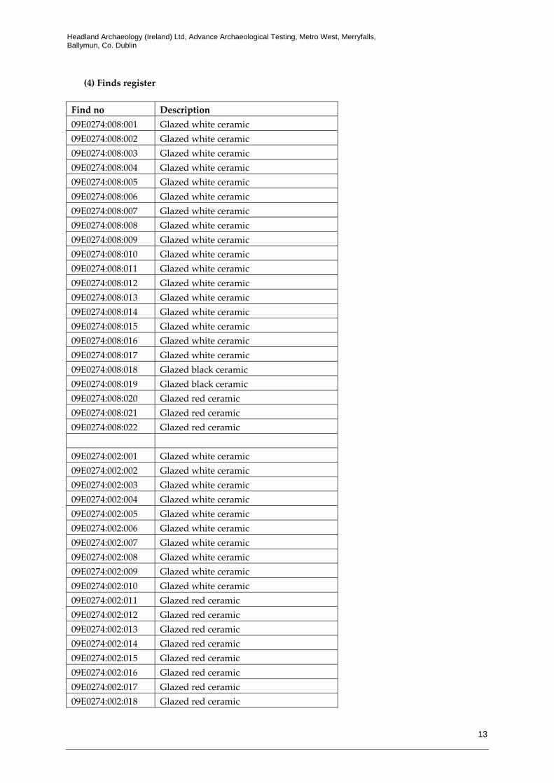
(4) Finds register Find no Description 09E0274:008:001 Glazed white ceramic 09E0274:008:002 Glazed white ceramic 09E0274:008:003 Glazed white ceramic 09E0274:008:004 Glazed white ceramic 09E0274:008:005 Glazed white ceramic 09E0274:008:006 Glazed white ceramic 09E0274:008:007 Glazed white ceramic 09E0274:008:008 Glazed white ceramic 09E0274:008:009 Glazed white ceramic 09E0274:008:010 Glazed white ceramic 09E0274:008:011 Glazed white ceramic 09E0274:008:012 Glazed white ceramic 09E0274:008:013 Glazed white ceramic 09E0274:008:014 Glazed white ceramic 09E0274:008:015 Glazed white ceramic 09E0274:008:016 Glazed white ceramic 09E0274:008:017 Glazed white ceramic 09E0274:008:018 Glazed black ceramic 09E0274:008:019 Glazed black ceramic 09E0274:008:020 Glazed red ceramic 09E0274:008:021 Glazed red ceramic 09E0274:008:022 Glazed red ceramic 09E0274:002:001 Glazed white ceramic 09E0274:002:002 Glazed white ceramic 09E0274:002:003 Glazed white ceramic 09E0274:002:004 Glazed white ceramic 09E0274:002:005 Glazed white ceramic 09E0274:002:006 Glazed white ceramic 09E0274:002:007 Glazed white ceramic 09E0274:002:008 Glazed white ceramic 09E0274:002:009 Glazed white ceramic 09E0274:002:010 Glazed white ceramic 09E0274:002:011 Glazed red ceramic 09E0274:002:012 Glazed red ceramic 09E0274:002:013 Glazed red ceramic 09E0274:002:014 Glazed red ceramic 09E0274:002:015 Glazed red ceramic 09E0274:002:016 Glazed red ceramic 09E0274:002:017 Glazed red ceramic 09E0274:002:018 Glazed red ceramic

Headland Archaeology (Ireland) Ltd, Advance Archaeological Testing, Metro West, Merryfalls, Ballymun, Co. Dublin
14
Find no Description 09E0274:002:019 Glazed black ceramic 09E0274:002:020 Glazed black ceramic 09E0274:002:021 Glazed black ceramic 09E0274:002:022 Glazed black ceramic 09E0274:002:023 Glazed black ceramic 09E0274:002:024 Glazed black ceramic 09E0274:002:025 Glazed black ceramic 09E0274:002:026 Glazed black ceramic 09E0274:002:027 Glazed black ceramic 09E0274:002:028 Glazed black ceramic 09E0274:002:029 Glazed black ceramic 09E0274:002:030 Glazed black ceramic 09E0274:002:031 Glazed black ceramic 09E0274:002:032 Glazed black ceramic 09E0274:002:033 Iron key 09E0274:002:034 Balance scale hook 09E0274:002:035 Blue pot lid 09E0274:002:036 Brass clock back face 09E0274:002:037 Red ceramic roofing tile 09E0274:002:038 Plough tine 09E0274:002:039 Iron handle 09E0274:002:040 Ferrous object 09E0274:002:041 Ferrous object 09E0274:002:042 Ferrous object


Related Documents