Archaeological Survey of Three Land Parcels and Shovel Testing of Four Sites at Camp Bowie, Brown County, Texas Center for Archaeological Research The University of Texas at San Antonio Archaeological Survey Report, No. 328 The Adjutant General’s Department of Texas Directorate of Facilities and Engineering Environmental Branch, Austin, Texas 2002 by Russell D. Greaves with contributions by Raymond P. Mauldin and Cory J. Broehm

Welcome message from author
This document is posted to help you gain knowledge. Please leave a comment to let me know what you think about it! Share it to your friends and learn new things together.
Transcript

Archaeological Survey of Three Land Parcels andShovel Testing of Four Sites at Camp Bowie,
Brown County, Texas
Center for Archaeological Research
The University of Texas at San Antonio
Archaeological Survey Report, No. 328
The Adjutant General’s Department of Texas
Directorate of Facilities and Engineering
Environmental Branch, Austin, Texas
2002
by
Russell D. Greaves
with contributions by
Raymond P. Mauldin and Cory J. Broehm
Archaeological Survey of Three Land Parcels andShovel Testing of Four Sites at Camp Bowie,
Brown County, Texas
by
Russell D. Greaves
with contributions by
Raymond P. Mauldin and Cory J. Broehm
Raymond P. MauldinPrincipal Investigator
Texas Antiquities Permit No. 2310
©copyright 2002
Prepared for:
Adjutant General’s Department of TexasDirectorate of Facilities and Engineering
Environmental Branch, Austin, Texashttp://www.agtx-ev.pollution.org
Prepared by:
Center for Archaeological ResearchThe University of Texas at San AntonioArchaeological Survey Report, No. 328
http://car.utsa.edu

The following information is provided in accordance with the General Rules of Practice and Procedure, Chapter41.11 (Investigative Reports), Texas Antiquities Committee:
1. Type of investigation: intensive survey and testing
2. Project name: Camp Bowie IV: survey of three land parcels and testing of four sites
3. County: Brown
4. Principal investigator: Raymond P. Mauldin
5. Name and location of sponsoring agency: Adjutant General’s Department of Texas, Environmental Division,AGTX-EV, P.O. Box 5218, Austin, Texas, 78763-5218
6. Texas Antiquities Permit No.: 2310
7. Published by the Center for Archaeological Research, The University of Texas at San Antonio, 6900 N. Loop1604 W., San Antonio, Texas 78249-0658, 2002
A list of publications offered by the Center for Archaeological Research is available. Call (210) 458-4378; writeto the Center for Archaeological Research, The University of Texas at San Antonio, 6900 N. Loop 1604 W., SanAntonio, Texas 78249-0658; e-mail to [email protected]; or visit CAR’s web site at http://car.utsa.edu.
i
Archaeological Survey and Testing at Camp Bowie Abstract
Abstract:Pedestrian survey and shovel testing of three land parcels and shovel testing of four previously identified archaeologicalsites in Camp Bowie, Brown County, Texas, was performed by the Center for Archaeological Research (CAR) at TheUniversity of Texas at San Antonio during October and November of 2001. This work, conducted under Texas AntiquitiesPermit No. 2310, was undertaken as a result of recommendations from Wormser and Sullo-Prewitt (2001) following theirarchaeological survey and site recording efforts.
Three areas of Camp Bowie were surveyed and shovel tested. Parcel 1 is 74 acres (30 ha) in extent and 46 shovel tests wereexcavated in this area. One new site (41BR522) was identified at the northern margin of this survey area. 41BR522 is a smallburned rock midden site. Seven additional shovel tests were excavated on this site. One Late Prehistoric projectile pointfragment was recovered during shovel testing of 41BR522. Excluding the units on 41BR522, only three shovel tests withinParcel 1 contained subsurface lithics. All of these artifacts represent isolated finds (IF). One additional shovel test had asingle animal bone that may not be cultural and is considered an IF. Parcel 2 covers 64 acres (26 ha) and 33 shovel tests wereplaced within this area. None of the shovel tests in Parcel 2 produced any subsurface archaeological material. Parcel 3 is 62acres (25 ha) and 43 shovel tests were excavated in this part of Camp Bowie. One shovel test produced two heat-fracturedlithics that are not unambiguously cultural in origin. 41BR522 is recommended for additional testing to determine its StateArcheological Landmark (SAL) and National Register of Historic Places (NRHP) eligibility. None of the other areas of thethree survey parcels contain cultural resources that are considered SAL or NRHP eligible. In the event of deep or extensiveexcavation of the alluvial soils in Parcel 1, archaeological monitoring is recommended to identify any potential impacts toresources below the 60 cm depth investigated by this project. Normal military use of this area may proceed without furtherconsultation with the Texas Historical Commission (THC).
In response to recommendations by Wormser and Sullo-Prewitt (2001), four previously recorded archaeological sites wererevisited (41BR248, 41BR467, 41BR469, and 41BR471). Site 41BR248 could not be relocated. No surface or subsurfaceartifacts were identified at the plotted site location. Four shovel tests were excavated within the identified site location, butno cultural materials were encountered. Either naturally fractured local chert has been mistaken for cultural artifacts or theplotted location is not correct for 41BR248. Four shovel tests were excavated in 41BR467, a low-density lithic scatter. Noartifacts were recovered from the shovel tests. Four bifaces and two cores were recovered from the surface of this site. Sixshovel tests were placed on 41BR469, a low-density lithic scatter. One shovel test contained a single subsurface flake.41BR471 is a small, relatively dense lithic scatter. Four shovel tests were excavated on this site. One shovel test containeda single lithic. There were no other indications of subsurface archaeological deposits. Surface artifacts included one LatePrehistoric projectile point. Surface visibility at these sites exceeded 30 percent and the number of shovel tests is consideredsufficient to determine the significance of these cultural resources. 41BR248 could not be identified at its previously plottedlocation, if this site still exists –it requires relocation and testing. Additional examination is recommended for 41BR471.Following re-examination and testing, no further characterization of 41BR467 and 41BR469 is considered necessary. Withthe exception of 41BR471 and 41BR248, no further archaeological work is recommended and scheduled use of this areamay proceed without further consultation with THC.
Two additional sites, re-examined in February of 2001 to determine their SAL and NRHP eligibility, are also included in thisreport (41BR392 and 41BR523). Two shovel tests were excavated in 41BR392 to examine a prehistoric burned rock middenat this previously identified historic site. One Middle Archaic Bulverde point was recovered from the surface of 41BR392.41BR523 is a World War II-era live grenade court. This site was described but no shovel tests were considered necessary.Further testing is recommended for the burned rock midden component of 41BR392. No additional archaeological work isconsidered necessary on 41BR523 and that location is recommended for archaeological clearance.
Recommendations from this project are that the SAL and NRHP eligibility of 41BR392, 41BR471, and 41BR522 is unclearin the absence of additional testing efforts. These sites should be protected and avoided until additional examination candetermine their SAL and NRHP eligibility status. 41BR248 could not be located with the information currently available.

ii
Abstract Archaeological Survey and Testing at Camp Bowie
Additional evaluation of this site is still required in relation to previous recommendations by THC. Sites 41BR467, 41BR469,and 41BR523 are considered ineligible as SAL or NRHP properties and no additional archaeological characterization isconsidered necessary. The three survey parcels examined during this survey and testing project do not contain any significantcultural properties (other than 41BR522 at the periphery of Parcel 1) detectable through shovel testing methods. Parcel 1 islocated on deep alluvial soil that could contain deeply buried archaeological deposits. Archaeological monitoring isrecommended to identify any potential cultural resources below the 60 cm depth investigated in Parcel 1 if significantexcavation of this area is planned. Normal military use of these areas may proceed without further consultation with THC.

iii
Archaeological Survey and Testing at Camp Bowie Table of Contents
Table of Contents:
Abstract ........................................................................................................................................................................ iFigures ........................................................................................................................................................................ ivTables ......................................................................................................................................................................... ivAcknowledgments ........................................................................................................................................................ vChapter 1: Introduction ................................................................................................................................................. 1
Report Organization .................................................................................................................................................. 1Chapter 2: Environmental Setting ................................................................................................................................. 3
The Region ............................................................................................................................................................... 3Camp Bowie ............................................................................................................................................................. 6The Survey Areas ...................................................................................................................................................... 6
Chapter 3: Prehistoric Cultural Background and Previous Research on Camp Bowie.....................................................11Paleoindian ..............................................................................................................................................................11Archaic ....................................................................................................................................................................11Late Prehistoric ....................................................................................................................................................... 13Previous Research in the Camp Bowie Area ............................................................................................................. 14
Chapter 4: Methodology ............................................................................................................................................. 15Field Methods ......................................................................................................................................................... 15Laboratory Methods ................................................................................................................................................ 15
Chapter 5: Survey Results ........................................................................................................................................... 17Parcel 1 .................................................................................................................................................................. 17Parcel 2 .................................................................................................................................................................. 21Parcel 3 .................................................................................................................................................................. 23Shovel Testing of 41BR248, 41BR467, 41BR469, and 41BR471 ............................................................................. 23Previous Investigations of 41BR392 and 41BR523 .................................................................................................. 30
Chapter 6: Project Summary and Recommendations .................................................................................................... 3741BR522 ................................................................................................................................................................ 3741BR471 ................................................................................................................................................................ 3741BR392 ................................................................................................................................................................ 3841BR248 ................................................................................................................................................................ 38
References Cited ........................................................................................................................................................ 39Appendix A: Shovel Test Data .................................................................................................................................... 46
iv
Table of Contents Archaeological Survey and Testing at Camp Bowie
Figure 1. General location of the project area. ............................................................................................................... 3Figure 2. Physiographic setting of the project area. ........................................................................................................ 4Figure 3. Vegetation map of the project area. ................................................................................................................. 5Figure 4. Soils on Camp Bowie with survey parcels identified. ...................................................................................... 7Figure 5. Locations of survey parcels within Camp Bowie. ............................................................................................ 8Figure 6. Location of 41BR522 and shovel tests on Parcel 1. ....................................................................................... 18Figure 7. Site 41BR522. ............................................................................................................................................. 19Figure 8. Locations of shovel tests in Parcel 2. ............................................................................................................ 22Figure 9. Locations of shovel tests in Parcel 3. ............................................................................................................ 24Figure 10. Site 41BR248. ........................................................................................................................................... 25Figure 11. Site 41BR467. ........................................................................................................................................... 27Figure 12. Site 41BR469. ........................................................................................................................................... 28Figure 13. Site 41BR471. ........................................................................................................................................... 29Figure 14. Site 41BR392. ........................................................................................................................................... 31Figure 15. Bulverde point recovered from site 41BR392 ............................................................................................. 32Figure 16. 41BR523, World War II-era range facility with grenade court. .................................................................... 33Figure 17. Grenade court, 41BR523. ........................................................................................................................... 34Figure 18. Berm in grenade court of 41BR523, looking northwest. .............................................................................. 35Figure 19. Unexploded World War II-era grenade observed on 41BR523. .................................................................... 35Figure 20. Grenade can lid found on 41BR523. ........................................................................................................... 35
Figures:
Tables:
Table 1. Artifacts recovered from Parcel 1 ................................................................................................................... 17Table 2. Results of shovel tests at 41BR522 ................................................................................................................ 20Table 3. Artifacts recovered from Parcel 3 ................................................................................................................... 23Table 4. Artifacts recovered from 41BR467 ................................................................................................................ 27Table 5. Artifacts recovered from 41BR471 ................................................................................................................ 29Table 6. Artifacts recovered from 41BR392 ................................................................................................................ 31Table A-1. Shovel test data for Survey Parcel 1 ........................................................................................................... 46Table A-2. Shovel test data for Survey Parcel 2 ........................................................................................................... 47Table A-3. Shovel test data for Survey Parcel 3 ........................................................................................................... 48Table A-4. Shovel test data for tested sites ................................................................................................................... 49
Map Supplement:
Site Location Map.
Archaeological Survey and Testing at Camp Bowie Acknowledgments
v
Acknowledgments:
Dr. Raymond Mauldin was the principal investigator for this work and provided crucial orientation, field assistance, andcommentary throughout this project. He also offered significant help during the laboratory work and writing of this report.The archaeological field crew consisted of Bruce Moses, Sylvia Reyna, Bryant Saner, Matthew Senn, and Jason Weston.Jason also served as a crew chief during a portion of the fieldwork. Laboratory processing was overseen byMarybeth Tomka. Laboratory staff included Leonard Kemp, Ruth Mathews, and Sylvia Reyna. Figures were prepared byRick Young and Bruce Moses. Editing by Johanna Hunziker and Maryanne King has significantly improved the quality ofthis report. Dr. Steve Tomka advised on many aspects of this project. Assistance at Camp Bowie was provided by severalstaff members of the Texas Army National Guard. Sergeant Major M. Pilkington and the Security Staff at Camp Bowie wereextremely helpful in all aspects of the work. Shellie Sullo-Prewitt of the Texas Army National Guard Environmental ResourcesManagement Branch provided invaluable support for this project

1
Archaeological Survey and Testing at Camp Bowie Chapter 1: Introduction
Chapter 1: Introduction
This report presents the results of the current project –anintensive survey of three areas and shovel testing of fourpreviously identified archaeological sites within CampBowie– as well as a previous project involving the re-examination of two sites in Camp Bowie.
Located in Brown County, Texas, on the Brownwood andIndian Creek USGS 7.5' quadrangles, Camp Bowie wasdeveloped by the Army as a training site just prior to WorldWar II. Currently, Camp Bowie is used as a training facilityfor the Texas Army National Guard.
Pedestrian survey and shovel testing of three land parcelsand shovel testing of four previously identifiedarchaeological sites in Camp Bowie was performed by theCenter for Archaeological Research (CAR) at The Universityof Texas at San Antonio during October and November 2001.These investigations were undertaken in compliance withrecommendations made in a previously completedarchaeological survey and site recording effort by Wormserand Sullo-Prewitt (2001).
One new site, 41BR522, was identified during the currentsurvey. This small burned rock midden site is recommendedfor additional testing to determine its State ArcheologicalLandmark (SAL) and National Register of Historic Places(NRHP) eligibility. Except for 41BR522, all other areas ofthe three survey parcels are considered to contain no culturalresources that will be impacted by normal military traininguse of these areas. Those activities may proceed withoutany further consultation with the Texas HistoricalCommission (THC). Because Parcel 1 is on deeper alluvialsediments, there is a possibility that archaeological resourcesmay exist below the depth effectively tested by the currentinvestigations (60 cm below the modern ground surface). Itis recommended that if extensive excavations or otheractivities are planned that may impact deeper sedimentsmonitoring of those disturbances by a professionalarchaeologist should be performed.
In response to recommendations by Wormser and Sullo-Prewitt (2001:38–45), revisitation of four previouslyidentified archaeological sites (41BR248, 41BR467,41BR469, and 41BR471) was also performed as part of
this field effort. Site 41BR248 was not relocated in itspreviously plotted location. Testing and surface inspectiondid not identify the site as described by Wormser and Sullo-Prewitt (2001:60). Further inspection of this site’s vicinitywill determine if it can be relocated, and if found subsequenttesting will confirm whether 41BR248 does indeed qualifyas a site. Also, additional testing is recommended for site41BR471. Following re-examination and testing, no furthercharacterization of sites 41BR467 and 41BR469 isconsidered necessary. With the exception of 41BR471 andthe necessary relocating of 41BR248, no furtherarchaeological work is considered necessary at these sitesand normal activities may proceed without furtherconsultation with THC.
Two additional sites, re-examined in February of 2001 todetermine their SAL and NRHP eligibility, are also includedin this report (41BR392 and 41BR523). Further testing isrecommended for the burned rock midden component of41BR392. No additional archaeological work is considerednecessary on 41BR523 and training use of that area mayproceed without additional consultation with THC.
All work was conducted under Texas Antiquities Permit No.2310, issued to Dr. Raymond P. Mauldin.
Report OrganizationThis report is composed of six chapters, an appendix, and amap supplement. Following this introductory chapter, theEnvironmental Setting chapter will discuss the generalphysical environment encountered within the project area.The third chapter, Prehistoric Cultural Background andPrevious Research on Camp Bowie, provides a brief overviewof the cultural prehistory of the region and previousarchaeological investigations in the Camp Bowie area.Chapter Four, Methodology, describes, in detail, the field andlaboratory methodologies employed during theseinvestigations and the curatorial requirements. Chapter Five,Survey Results, discusses results from the field and laboratoryinvestigations on a site-by-site basis. The final chapter, ProjectSummary and Recommendations, presents recommendationsfor further work and for SAL and NRHP eligibility wherewarranted. Appendix A presents the shovel test data from thethree survey parcels and the tested sites.

2
Chapter 1: Introduction Archaeological Survey and Testing at Camp Bowie
The Camp Bowie facility map with site locations (MapSupplement) is not included in the text of this report, but islocated in a pocket at the back. A copy of the map may beobtained by writing to AGTX-EV, Cultural Resources,P.O. Box 5218, Austin, TX 78763-5218.
3
Archaeological Survey and Testing at Camp Bowie Chapter 2: Environmental Setting
Figure 1. General location of the project area.
ProjectArea
Project Area
0 10 40 5020 30MN
CallahanEastland
Erath
Comanche
BrownColeman
McCullochSan Saba
Burnet
Lampasas
Mills
Hamilton
Coryell
Chapter 2: Environmental Setting
This chapter provides an introduction to the generalenvironment of the region and information on Camp Bowieand the particular survey areas. More detailed informationon the climate, geology, and soils can be found in Wormserand Sullo-Prewitt (2001), Nance and Wermund (1993), andGould (1975). Reviews of Paleoenvironmental data, whichare primarily available for areas farther to the south, can befound in Johnson and Goode (1994) and Bousman (1998).
The RegionCamp Bowie is located in north-central Texas, in BrownCounty, just south of the town of Brownwood (Figure 1).Brown County covers an area of roughly 615,000 acres
(Clower 1980). The major hydrological feature is PecanBayou, a river that enters the county from the northwestand cuts across the county, exiting southeast into theColorado River. The Colorado River forms the southernboundary of Brown county. Very shallow to deep, loamyand clayey soils cover the uplands of the county, while deeploamy and clayey soils cover the floodplains (Clower 1980).
Physiographically, the area is within the Rolling Plainssubdivision (Figure 2), with the Edwards Plateau locatedjust to the east, and the Llano Uplift located to the south(see Gould 1975; Nance and Wermund 1993). The terrainof the Rolling Plains is characterized as gently sloping tohilly as a result of varying erosion of primarily Paleozoic
4
Chapter 2: Environmental Setting Archaeological Survey and Testing at Camp Bowie
MN
0 20 40 60 80 100
Rolling Plains
Oak Woods and PrairiesLlano UpliftEdwards Plateau
Blackland Prairies
ProjectArea
Figure 2. Physiographic setting of the project area.
rock formations (Fenneman 1931:54). The Edwards Plateauhas a more rugged, stream-eroded topography, underlainby Cretaceous limestone. The Llano Uplift is essentially aneroded basin composed of Precambrian granitic andmetamorphic rock (Swanson 1995).
Characterized as subtropical sub-humid, the climate of thearea is one of hot summers and mild winters. The averageyearly temperature is 65 degrees F. The growing seasonaverages about 239 days a year, with the average first freezeoccurring on November 16 and the last freeze on March 21.Annual precipitation at Brownwood is approximately 26.1inches (66 cm). The highest annual rainfall was recorded in
1959 when 42.3 inches (107.4 cm) of precipitation fell. Thedriest year was 1954 with only 12.8 inches (32.5 cm)recorded. During the year, rainfall tends to be bimodal, withpeaks in May and September, while December and Januaryare, on average, the driest months (Nance and Wermund 1993).
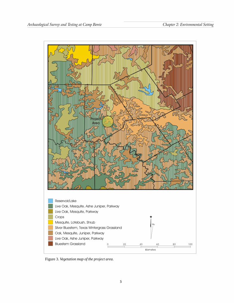
Figure 3 presents the regional, modern vegetation of thegeneral area. A Live Oak, Mesquite, Ashe Juniper Parkwaydominates the southwestern portion of the county, with anOak, Mesquite, Juniper Parkway bracketing the PecanBayou drainage area. Silver bluestem and Texas wintergrassare present along the eastern edge of the county. Much ofthe county has been cleared for crops and grazing.
5
Archaeological Survey and Testing at Camp Bowie Chapter 2: Environmental Setting
Figure 3. Vegetation map of the project area.
0 20 40 60 80 100
ProjectArea
Reservoir/LakeLive Oak, Mesquite, Ashe Juniper, Parkway
Live Oak, Mesquite, ParkwayCrops
Mesquite, Lotebush, ShrubSilver Bluestem, Texas Wintergrass Grassland
Oak, Mesquite, Juniper, ParkwayLive Oak, Ashe Juniper, Parkway
Bluestem Grassland
MN

6
Chapter 2: Environmental Setting Archaeological Survey and Testing at Camp Bowie
Camp BowieCamp Bowie covers an area of approximately 9,000 acres.Elevation within the Camp ranges from 1,290 feet (393 m)above mean sea level (AMSL) to just over 1,590 feet AMSL
(485 m). A major topographic feature of the area is anorthwest to southeast oriented high ridge of Cretaceousage deposits identified as the Travis Peak Formation(Wormser and Sullo-Prewitt 2001). This major sedimentarydeposit includes limestone, sandstone, and conglomerate.Underlying Permian and Pennsylvanian formations, referredto as the Strawn Group, are exposed at various points on thelandscape (Nance and Wermund 1993).
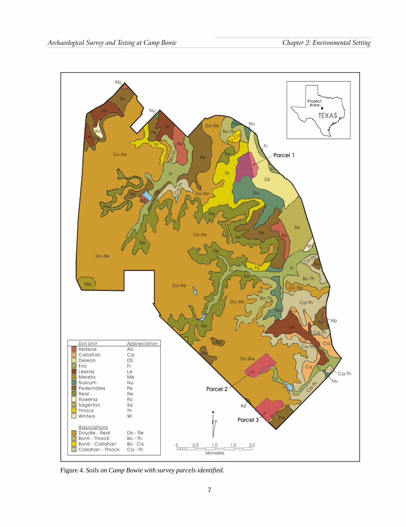
Soils of the Camp Bowie area are calcareous sandy loams,silty loams, and clay loams. Upland soils are thin and sandier,with low water-holding capacity. Lowland soils tend to bedominated by clay, with low permeability and high water-holding capacity (Nance and Wermund 1993; Wormser andSullo-Prewitt 2001). Wormser and Sullo-Prewitt (2001)classified the USDA soil units at Camp Bowie into threegeneral groups designed to monitor their potential to containburied, intact cultural deposits. The tripartite distinction wasbased on their evaluation of the soil age and formationhistory. They suggest that sites on or in the Deleon, Frio,Winters, and Nukrum soils have a moderate-to-high potentialfor buried archaeological material. Soils with low-to-moderate potential for buried, intact sites include Pedernalesfine sandy loam and Sagerton clay loam. The remaining soilshave a low probability for containing buried cultural depositswith integrity. The relationship of the three survey parcelsto soils at Camp Bowie is provided in Figure 4.
Streams in the Camp Bowie area make up a portion of theColorado River drainage basin and are small and seasonallyactive. Drainages to the west of the northwest-southeasttrending ridge that cuts through the center of the camp flowinto Lewis Creek and eventually into Pecan Bayou to thenorth, while on the east side of the dividing ridge, drainageis generally into Devils River.
A biological inventory of Camp Bowie, prepared by theTexas Parks and Wildlife Department (1994), provides anextended discussion of plants and animals observed, orexpected to be present, at Camp Bowie. The extant plantcommunities appear to have been altered by a variety ofland uses, including attempts to increase grass cover forlivestock. Much of the area can be characterized as a LiveOak-Mesquite-Ashe Juniper community. Major tree andshrub species present include a variety of oaks, ashe juniper,
mesquite, pecan, cedar elm, American elm, lotebush, andwhitebush. Grasses, including Texas grama and buffalograss, with a variety of cacti are also present. Majormammalian fauna include white-tailed deer, jackrabbit, andcottontail (Adjutant General’s Department of Texas 1992;Nature Conservancy of Texas 1996; Texas Parks andWildlife Department 1994).
The Survey AreasThe survey area consists of three parcels totalingapproximately 200 acres (Figure 5). These areas had beenpreviously surveyed (Wormser and Sullo-Prewitt 2001), butnone were shovel tested during that effort. Parcel 1 is locatedon deep, Nukrum soils on an alluvial terrace that has a highprobability of containing archaeological sites. The fourpreviously recorded sites (41BR248, 41BR467, 41BR469,and 41BR471; Wormser and Sullo-Prewitt 2001) were alsonot shovel tested during their initial identification andrecording.
Parcel 1 is located in the northeastern portion of CampBowie (Figures 4 and 5). This survey area is approximately74 acres (~30 ha) in size. It is situated at the western marginof the Pecan Bayou floodplain adjacent to the Cretaceousupland ridge. The soils in Parcel 1 are primarily Nukrum,deep silty clay soils. This alluvial plain is subject to floodingand vertical sedimentary accretion. Parcel 1 is currently usedas a tank range. The western two-thirds of this survey areahave been impacted by road construction, heavy vehiculartraffic, brush clearing, and firing range use. Parcel 1 isroughly triangular in shape and measures approximately630 m from west to east on the southern boundary. Thewestern margin is approximately 900 m long and the easternside 620 m long. This relatively level survey parcel rangesin elevation from 1,300 ft AMSL on the eastern side to lessthan 1,330 ft (396–405 m AMSL) on the western side. Mostof this parcel is situated between 1,300 ft and less than 1,310ft AMSL. During the survey, most of the ground surface wasobscured by thick grass cover. Portions of the western halfof this parcel have been extensively impacted by mechanicalremoval of mesquite trees and two large brush piles coverextensive areas. The eastern margin is sparsely wooded withvery thick grass cover.
Parcel 2 is located in the southern portion of Camp Bowie(Figures 4 and 5) and is approximately 64 acres (~26 ha) inarea. This survey area is situated on the Cretaceous upland.It is mantled by Doudle-Real association thin, immature
7
Archaeological Survey and Testing at Camp Bowie Chapter 2: Environmental Setting
Figure 4. Soils on Camp Bowie with survey parcels identified.
Soi l UnitAbileneCallahanDeleonFrioLeerayMeretaNukrumPedernalesRealRowenaSagertonThrockWinters
Doudle - RealBonti - ThrockBonti - CallahanCallahan - Throck
Associations
AbbreviationAbCaDSFrLeMeNuPeReRoSaThWi
Do - ReBo - ThBo - CaCa - Th
Project Area
MN
0 0.5
kilometers
1.0 1.5 2.0
Pe
Pe
Le
Le
LePe
Pe
Pe Pe
Nu
Nu Nu
Nu
Fr
Th
Th
Bo-Ca
Bo-Th
Fr
Fr
DS
Re
Re
Re
Re
Re
Do-Re
Do-Re
Do-Re
Do-Re
Do-Re
Me
Th
Re
ReFr
Re
Fr
Pe Ab
Sa
Wi
Pe
Ca
-Th
Ca-Th
Ca-Th
Ca-ThPe
Pe
Bo-T
h
Bo-Th
Nu
Nu
Ca-Th
Ca-ThFr
Fr
Ca
Ca
Ca
Ca
Le
Pe
Pe
Ca-Th
Pe Ab
Do-Re
Do-Re
Do-Re
Ab
Ro
Ab
Ab
Bo-ThDo-Re
Parcel 3
Parcel 2
Parcel 1

8
Chapter 2: Environmental Setting Archaeological Survey and Testing at Camp Bowie
Figure 5. Locations of survey parcels within Camp Bowie.
Project Area
MN
0 0.5
kilometers
1.0 1.5 2.0
Brownwood
Camp Bowie
Pecan Bayou
Parcel 3
Parcel 2
Parcel 1

9
Archaeological Survey and Testing at Camp Bowie Chapter 2: Environmental Setting
soils. This parcel is roughly rectangular and measuresapproximately 690 m southwest-northeast by 270–360 mnorthwest-southeast. The elevation of this unit ranges from1,420–1,470 ft AMSL (433–448 m). A seasonal stream formsthe southeastern boundary of Parcel 2. The vegetation isbroken woodland with many areas of open grass cover. Twoheavily used two-track roadways are adjacent to this area,one just outside of the northwestern boundary and onecrossing the northernmost corner of the survey area. Anunused cleared roadway still scars the western end ofParcel 2. A heavily impacted area is present around a stockpond near the center of this parcel. One previously recordedsite (41BR425) was reported within the survey unit(Wormser and Sullo-Prewitt 2001:100).
Parcel 3 is an area of approximately 62 acres (~25 ha)located in the southwestern-most portion of Camp Bowie(Figures 4 and 5). It is on the Cretaceous plateau betweenapproximately 1,410–1,455 ft AMSL (430–443 m). The entiresurvey unit is situated on the thin Doudle-Real associationsoils. This roughly rectangular survey area is bounded onthe northeastern side by a roadway. It is approximately 380m northwest-southeast by 390–600 m southwest-northeast.Much of the area is sparsely wooded with open areas ofgrass cover. The area southeast of Parcel 3 is a formerlyplowed field and the adjacent margin of this unit has beenplowed and impacted by construction of a stock pond.A two-track road runs along the western boundary of thisunit parallel to the fenceline boundary of Camp Bowie. Thereis an additional unused roadway within 50–100 m east ofthis fenceline.

11
Archaeological Survey and Testing at Camp Bowie Chapter 3: Cultural Background and Previous Research
Chapter 3: Prehistoric Cultural Background andPrevious Research on Camp Bowie
This chapter provides an overview of the archaeologicalrecord for the Brown County area, along with a summary ofprevious research conducted on Camp Bowie. While a briefsummary is provided of all prehistoric periods, the focus ofthe cultural background is on the Archaic and LatePrehistoric periods, the two time-frames represented by thearchaeological material recovered during the current project.On the current project, no historic material was recoveredwithin the survey parcels, and therefore the reader is referredto Wormser and Sullo-Prewitt (2001) and Leffler (2002) fordetailed summaries of the historic period on Camp Bowie.
The Brown County/Camp Bowie area falls in the northwestcorner of the Central Texas archaeological region (Collins1995; Turner and Hester 1993). The major cultural periodsdefined for this region are briefly described below.Additional information can be found in Collins (1995) andJohnson and Goode (1994).
PaleoindianThe Paleoindian period marks the first appearance of humansin the New World, although the exact date of their arrival isunclear. Traditionally, the Paleoindian period is first markedby the appearance of Clovis points in North America, which–in turn– are replaced by Folsom points. The laterPaleoindian period (10,000–8000 BP) is characterized by avariety of dart point types, including Plainview, Dalton,Angostura, Scottsbluff, and Golondrina (Black 1989a,1989b). Despite changes in these various projectile pointtypes through time, their geographic range is widespread.
Artifacts, particularly projectile points, are often onlyisolated finds, though camp, lithic procurement, kill, cache,ritual and burial sites are known (Collins 1995). EarlyPaleoindian peoples have generally been conceptualized ashunter-gatherers ranging over wide areas in pursuit of nowextinct megafauna, such as mammoth and Bison antiquus.This view of Paleoindian peoples, much like the dating ofthis period, is now being reassessed. While certainlyexploiting Late Pleistocene megafauna, these peoples areperhaps better characterized as more generalized hunter-gatherers. Certainly by the later Paleoindian time-frame, afterthe extinction of these megafauna, the hunting aspect ofsubsistence shifted to exploitation of large herbivores likedeer and Bison bison.
ArchaicThe Archaic period can be broadly defined by changes inprojectile point types, an increase in the number and typesof sites (including burned rock hearths and middens), andby an increase in the variety of artifact styles, with manyartifacts having more limited geographical distribution.While a number of finer subdivisions exist for the Archaic(e.g., Prewitt 1981; Weir 1976), this period can be broadlydivided into the Early, Middle, and Late Archaic.
Early Archaic
Collins (1995:383) dates the Early Archaic from 8800 to6000 BP in Central Texas with three divisions based onprojectile point types, while Hester (1995:436–438)identifies the Early Archaic with Early Corner Notched andEarly Basal Notched dart points roughly dating between7950 to 4450 BP. The Early Archaic on the Southern GreatPlains is approximated at 8000–5000 BP (Hofman 1989),although Johnson and Holliday (1986) offer more fine-grained dates of 8500–6400 BP for the Llano Estacado, basedon data from the Lubbock Lake site. The extinction of largeherds of megafauna and the changing climate at thebeginning of the Holocene appears to have stimulated abehavioral change by the Prehistoric inhabitants of Texas.While the basic hunter-gatherer adaptation probablyremained intact, an economic shift away from big gamehunting was necessary. In general, more intensiveexploitation of local resources in Central Texas, such as deer,fish, and plant bulbs is indicated by greater densities ofground stone artifacts, fire-cracked rock cooking features,and more specialized tools such as Clear Fork gouges andGuadalupe bifaces (Turner and Hester 1993:246, 256). Weir(1976) speculates that Early Archaic groups were small andhighly mobile, an inference based on the fact that EarlyArchaic sites are thinly distributed and that diagnosticprojectile point types are seen across a wide area, includingmost of Texas and northern Mexico. Hurt (1980) suggeststhat the decline in the number of bison on the plains forcedthe inhabitants to broaden their diets to pursue plants andanimals which would produce the same amount of caloriesand protein with the same or slightly more effort expended.Story (1985) suggests that population densities were lowduring this period, and that groups consisted of relatedindividuals in small bands with “few constraints on their
12
Chapter 3: Cultural Background and Previous Research Archaeological Survey and Testing at Camp Bowie
mobility” (Story 1985:39). Their economy was based ondiffuse utilization of a wide range of resources, especiallysuch year-round resources as prickly pear and lechugilla, aswell as rodents, rabbits, and deer (Story 1985:38).
Middle Archaic
Collins (1995:383) defines this intermediate interval of theArchaic as lasting from about 6000 to 4000 BP in CentralTexas, but Hester (1995:438–441) suggests that the periodbetween 4450 and 2350 BP more correctly reflects the MiddleArchaic in South Texas. The Southern Plains Middle Archaiccomplex, as derived from changes in climate andsubsistence, is recognized generally as the period between5000–3000 BP (Hofman 1989:45–47), and more specificallyas 6400–4500 BP on the Llano Estacado (Johnson andHolliday 1986:46). The Middle Archaic appears to havebeen a time of increased population, based on the largenumber of sites from this period in South and Central Texas(Story 1985:40; Weir 1976:125, 128). The reasons for thisincrease are not known, but the amelioration of a very dryperiod (Altithermal) during the Early Archaic is often seenas the prime mover (Story 1985:40). A wide variation inprojectile point styles at the Jonas Terrace site suggests “atime of ethnic and cultural variety, as well as groupmovement and immigration” (Johnson 1995:285). Hurt(1980) posits that the quantity of diversified game animalson the Southern Great Plains decreased, and thus led to anintensified, less broad diet. On the South Texas Plain,exploitation of widely scattered, year-round resources suchas prickly pear continued (Campbell and Campbell 1981:13–15), as did hunting deer and rabbit. However, a shift toconcentrated, seasonal nut harvests in the riverineenvironments of the Balcones Escarpment seems to haveoccurred (Black 1989a, 1989b). Weir (1976) believes thatan expansion of oak on the Edwards Plateau and BalconesEscarpment led to intensive plant gathering and acornprocessing. He also believes that the widely scattered bandsprevalent in the Early Archaic now began to coalesce, atleast during the acorn-gathering season, into larger groupswho shared the intensive work of gathering and processingthe acorn harvest (Weir 1976:126). Many researchers believeburned rock middens are a result of this endeavor (Creel1986; Prewitt 1991; Weir 1976). Other investigators doubtthis conclusion (Black et al. 1997; Goode 1991), but theexact processes that formed burned rock middens are still amatter of controversy (see Hester 1991; Leach and Bousman2001[1998]).
The common presence of deer remains in some burned rockmiddens encourages the view that deer processing took placeat burned rock midden sites (Black and McGraw 1985:278;Nickels et al. 2001[1998]; Weir 1976:125). Bison bone isencountered in archaeological sites in Central and SouthTexas, at least occasionally, during all but the earliest partof the Middle Archaic (Dillehay 1974). There has been atendency to equate presence of burned rock middens withabsence of bison (Prewitt 1981); however, examinations ofseveral recent faunal reports show that after about 4500 BP
bison and burned rock middens are contemporaneous,though not at the same sites, at least in the southern EdwardsPlateau and northern South Texas Plain (Meissner 1993).
Late Archaic
Collins (1995:384) dates the final interval of the Archaic inCentral Texas to approximately 4000–800 BP. Hesterbelieves the Late Archaic in South Texas may be betterdefined as between 2350–1250 BP, while Hofman’s(1989:45) synthesis of these data places the Late Archaicon the Southern Plains as 3000–2000 BP, and possibly later.Johnson and Holliday (1986:46) specify 4500–2000 BP asthe Late Archaic period on the Llano Estacado. Someresearchers believe populations increased throughout theLate Archaic (Prewitt 1985), while others feel populationsremained the same or fell during this period (Black 1989a).Prewitt (1981:80–81) asserts that the accumulation of burnedrock middens nearly ceased during the course of this period;however, excavations at a number of sites (e.g., Houk andLohse 1993:193–248; Johnson 1995) provide evidence thatlarge cooking features up to 15 meters in diameter werestill very much in use. Subsistence is assumed to havebecome less specialized during the Late Archaic (Black1989a:30). Hurt (1980) asserts that bison began returningto the Southern Great Plains area, and we see an increase inintensive processing of bison, as well as mussel shells duringthe Late Archaic. However, by about 1450 BP, bison hadagain disappeared (Dillehay 1974).
The proliferation of distinguishable human cemeteries hasbeen attributed to this period, with the earliest occurrencesdating to the South Texas Middle Archaic (Hester 1995:439–440). At Loma Sandia, these date between ca. 2550 and2750 BP (Taylor and Highley 1995). Story (1985:44–45)believes the presence of cemeteries at sites such as ErnestWitte (Hall 1981), Hitzfelder Cave (Givens 1968), andOlmos Dam (Lukowski 1988) indicates that Late Archaic
13
Archaeological Survey and Testing at Camp Bowie Chapter 3: Cultural Background and Previous Research
populations in Central and South Texas were increasing andbecoming more territorial.
Late Archaic points tend to be much smaller than MiddleArchaic points. The most common are Ensor and Frio types(Turner and Hester 1993:114, 122), both of which are short,triangular points with side notches. The Frio point type alsohas a notched base (Turner and Hester 1993:122). And interms of Late Archaic ceramics, although inhabitants of theSouth Texas Plain near Brownsville and Rockport had begunto make pottery by about 1750 BP, the northern part of theplain remained “pre-ceramic” until 1,000 years later (Story1985:45–47).
A late subperiod or interval of the Late Archaic is frequentlyreferred to as the Terminal Archaic or Transitional Archaic.Weir (1976) defines the Terminal Archaic as 1650–1150 BP, while Turner and Hester (1993) cite data placingthe Transitional Archaic as 2250–1250 BP. Although Hestermay lump current data into a Late Archaic period, he cautionsthat more evidence will likely result in what may be termedas a “Terminal Archaic” period during the latter part of theLate Archaic in South Texas. This Terminal Archaic periodis represented by diagnostics such as Ensor, Frio, andMatamoras points which appear to overlap the Late Archaicand the subsequent Late Prehistoric period (Hester1995:442). Weir (1976) believes this marked a transitionperiod to localized area sites, a disappearance of burnedrock middens and bison, and a reappearance of highly mobilehunters and gatherers. Others (Black and McGraw 1985;Skelton 1977) argue that in some locations burned rockmiddens did not disappear and sites were more intenselyoccupied during the Transitional Archaic period. During theEarly Neo-Indian period on the Southern Great Plains (ca.950–1450 BP), Hurt (1980) presents evidence for a decreasein bison processing. This decrease is consistent withDillehay’s (1974) contention that there were fewer bisonavailable in the area due to climatic changes.
Late PrehistoricThe term Late Prehistoric is commonly used to designatethe period following the Late Archaic in Central and SouthTexas. Collins (1995:385) recognizes that the commonlyused date of 1200 BP for the end of the Archaic and beginningof the Late Prehistoric in Central Texas is arbitrary, andHester (1995:442) acknowledges the problematic issue ofselected tools appearing at both Late Archaic and Late
Prehistoric sites. A series of distinctive traits marks the shiftfrom the Archaic to the Late Prehistoric period, includingthe technological shift to the bow and arrow and theintroduction of pottery to Central Texas and the northernSouth Texas Plain (Black 1989a:32; Story 1985:45–47). Twocomplexes following the Late Archaic in the Southern GreatPlains region are the Plains Woodland from about 2000–1150 BP, and the Plains Village from 1150–450 BP (Hofman1989:61–90). Most researchers agree the early LatePrehistoric period was a time of population decrease (Black1989a:32). Though small burned rock middens associatedwith Scallorn and Edwards points have been found (Goode1991:71; Houk and Lohse 1993:193–248), most researchersargue that they are rare. Settlement shifts into rockshelterssuch as Scorpion Cave in Medina County (Highley et al.1978) and Classen Rockshelter in northern Bexar County(Fox and Fox 1967) have been noted (Skinner 1981).Cemeteries from this period often reveal evidence of conflict(Black 1989a:32).
Beginning rather abruptly at about 650 BP, a shift intechnology occurred. This shift is characterized by theintroduction of blade technology, the first ceramics in CentralTexas (bone-tempered plainwares), the appearance of Perdizarrow points, and alternately beveled bifaces (Black1989a:32; Huebner 1991:346). Prewitt (1985) suggests thistechnology encroached from north-central Texas. Patterson(1988), however, notes the Perdiz point was first seen insoutheast Texas by about 1350 BP, and was introduced tothe west some 600–700 years later. Hester (1995:444)recognizes this phase as the “best documented LatePrehistoric pattern” throughout South Texas, with datesranging between ca. 650/700 to 300/350 BP.
Steele and Assad Hunter (1986) argue for the occurrence ofa distinct change in diet between the Late Archaic and theLate Prehistoric components in two sites in the ChokeCanyon Reservoir area in South Texas. Analysis of thenumber of identified specimens (NISP) shows a markedincrease in artiodactyl elements during the late LatePrehistoric, an increase largely due to the addition of bisonto the “menu” (Steele and Assad Hunter 1986:468). Huebner(1991) suggests that the sudden return of bison to Southand Central Texas resulted from a more xeric climate in theplains north of Texas, and increased grass in the Cross-Timbers and Post Oak Savannah in north-central Texas,forming a “bison corridor” into the South Texas Plain alongthe eastern edge of the Edwards Plateau (Huebner 1991:354–355). Sites from this period frequently have associated bison(Black 1986; Black and McGraw 1985; Prewitt 1974).

14
Chapter 3: Cultural Background and Previous Research Archaeological Survey and Testing at Camp Bowie
Previous Research in theCamp Bowie Area
A review of archaeological literature for the Camp Bowiearea produced limited results. Only a handful of excavationprojects have been conducted, and with the exception ofthe two recent surveys of Camp Bowie (Mauldin and Broehm2001; Wormser and Sullo-Prewitt 2001), few small surveyshave been carried out. Archaeological research in the BrownCounty area dates to the early portion of the twentieth centurywith the excavations of Pearce at the burned rock middensite of Pitman (41BR3) conducted in 1919 (Campbell 1952;Kirby and Moir 1976). Pearce trenched two middens, bothof which appeared to have been ring- or crescent-shaped.While both contained large quantities of charcoal and fire-cracked limestone and a few fragments of bone and shell, itappears that neither midden contained any artifacts(Campbell 1952).
From the early work of Pearce in 1919 until the 1970s, nosubstantial archaeological investigations seem to haveoccurred in Brown County. Beginning in the early 1970s, aseries of survey projects were conducted, including two byarchaeologists from Texas A&M University (Shafer et al.1975a, 1975b), a survey of Cordell and Camp Bowie CityPark Sites in Brownwood completed by Kegley and Black(1978), a survey by Southern Methodist University alongPecan Bayou north of Brownwood (Kirby and Moir 1976),and a survey by Prewitt and Associates for the City ofBrownwood sanitary landfill site (Prikryl 1983). All of thesesurveys consistently recorded lithic scatters and burned rockfeatures, including the presence of large ring and dome-shaped middens.
In 1979, the Texas Archeological Society Field School waslocated near Cross Cut in the far northwest corner of BrownCounty. Gearhart and Voellinger (1986) report that workwas conducted on both ring and mound burned rockmiddens. In addition, Howard (1991) references excavationsof three burned rock midden sites in Brown County(41BR72, 41BR105, and 41BR110). However, additionalinformation on these projects could not be located.
In 1986, Espey, Huston & Associates conducted testing at41BR313 and 41BR314 (Gearhart and Voellinger 1986),two sites originally documented by Prikryl (1983) as a resultof the sanitary landfill survey mentioned previously. A totalof four 1 x 1-m units were excavated at these two sites.Testing did not reveal stratified deposits, and no additionalwork was conducted.
Prior to the 1993–1997 inventory survey of Camp Bowie(Wormser and Sullo-Prewitt 2001), little systematic work hadbeen conducted on the installation. A portion of theBrownwood Laterals Watershed survey, conducted by TexasA&M University in 1975 (Shafer et al. 1975b), was acquiredby Texas Army National Guard (TXANG). Three sites(41BR65, 41BR66, and 41BR68) were incorporated intoCamp Bowie as a result of that acquisition. In addition,Wormser and Sullo-Prewitt (2001:13) reference small-scalesurvey work on the camp conducted by Briggs (1992), aswell as two TXANG staff reports (Wormser et al. 1994, 1997).
TXANG archaeologists conducted an inventory survey of98.5 percent of the total Camp Bowie area between 1993and 1997 (Wormser and Sullo-Prewitt 2001). A total of 186prehistoric and historic sites were recorded. A variety ofprehistoric site types were identified, including opencampsites, lithic workshops, lithic procurement sites, andburned rock midden sites. During this survey, an area of 90acres was under cultivation and not investigated at the time.Archaeological survey of the 90-acre area was performedin 2001 (Mauldin and Broehm 2001) and three prehistoricsites (41BR499, 41BR500, and 41BR501) were identified.Possible Late Archaic affiliation of 41BR500 is suggestedfrom a single point and this site was recommended foradditional testing. The other two Late Prehistoric sites werenot considered significant.
15
Archaeological Survey and Testing at Camp Bowie Chapter 4: Methodology
Chapter 4: Methodology
Field MethodsConsistent with the Specification for Services, standardmethods of pedestrian survey and shovel testing wereperformed during the archaeological survey at Camp Bowie.Fieldwork was performed by a crew of four archaeologistsfrom CAR during October and November 2001. Surveyexamined ground surfaces along transects spacedapproximately 30 m apart. Specific placement of shovel testsalong these transects was judgmental. There was nostratification to sampling of areas within each parcel. Thethree survey parcels were small enough that this form ofsampling resulted in relatively even coverage within eachparcel and is considered to be a representative spatialexamination of the subsurface in these areas. Each shoveltest measured 30 x 30 cm and was excavated in 10-cmarbitrary levels referenced to the current ground surface.All shovel tests were dug to 60 cm below the ground surface,if possible. The location of each shovel test was recordedusing a Trimble Geo Explorer II GPS unit. A total of 122shovel tests was excavated within the survey parcels. Forty-six were excavated in Parcel 1, 33 in Parcel 2, and 43 shoveltests were excavated in Parcel 3. An additional seven shoveltests were excavated on 41BR522, just on the outer marginof survey Parcel 1. All soils and sediments excavated werescreened through ¼-inch mesh hardware cloth. Standardshovel test forms were used to record observations on soiland sediment qualities, materials recovered, and otherpertinent information. Black and white photographs andcolor slides were taken of all archaeological sites examined.
A sediment susceptibility sample was collected from thefirst and final excavation level in every shovel test fromsurvey parcels. Sediment susceptibility, or magneticsusceptibility, samples were collected from every level inshovel tests dug on the archaeological sites. Magneticsusceptibility (MS) of sediments can be a useful analytictool for identifying past human activity. This method isespecially productive in soils that do not have readilyapparent stratigraphy and where the nature of potentialpalimpsest deposits is ambiguous. Signature values fromMS analyses are related to the organic content of sediments(Collins et al. 1994; McClean and Kean 1993; Singer andFine 1989) and the decay of those materials (Reynolds andKing 1995). Variance in values produced from analysis ofsamples provides relative information about the comparative
differences in past organic content of adjacent sampled areasof a site. This analysis can identify vertical and horizontalareas that have experienced organic enrichment. Thissampling and analysis has been productively used in previousinvestigations at Camp Bowie (Mauldin and Broehm 2001).
For the purpose of this survey, sites were defined as locationshaving at least five artifacts within a 30-m2 area, or as alocation containing a single cultural feature such as a hearth.All other artifacts were classified as isolated occurrences.When an artifact concentration was identified as a site, crewmembers established a datum consisting of a length of rebarhammered into the ground at the site’s center. Using GPSunits, CAR surveyors took readings from the site datum andfrom points along the perimeter to define the estimated siteboundary. A standardized form containing observationsconcerning types and degree of site disturbance, vegetation,estimated artifact counts by category (i.e., debitage, bifaces,unifaces), and observations on features was completed.Diagnostic artifacts were collected when found, and theirlocation recorded with a GPS unit. In addition, sketch maps,showing site boundaries, datum locations, shovel tests,collected items, features, areas of high artifact density, andphysical features on the landscape, were recorded. Archivalquality 35-mm black-and-white prints were made of all sitesand artifacts where appropriate. Texas site forms wereprepared for all new sites encountered on the project.
Laboratory MethodsAll cultural material collected during the survey wasprepared in accordance with federal regulation 36 CFR, part79, and in accordance with current guidelines of the TexasArcheological Research Laboratory (TARL). Artifactsprocessed in the laboratory at CAR were washed, air-dried,sorted into appropriate categories (e.g., debitage, projectilepoints, bifaces, unifaces, cores), analyzed, and stored inarchival-quality bags. Acid-free labels were placed in allartifact bags. Each label contained a provenience andcorresponding lot number. Tools were labeled withpermanent ink and covered by a clear coat of B72 acryloid.In addition, a small sample of unmodified debitage fromeach lot was labeled with the site and lot number. All artifactswere stored in acid-free boxes. Boxes were labeled withstandard labels. Field notes, forms, and drawings were
16
Chapter 4: Methodology Archaeological Survey and Testing at Camp Bowie
placed in acid-free, labeled file folders. Photographs, slides,and negatives were placed in archival-quality sleeves. Allmaterials were stored in acid-free boxes. Documents andforms were printed on acid-free paper. Upon completion ofthe project, all cultural materials and records will be sent toTARL for permanent storage.
Sediment susceptibility samples have not been processed fromthis survey and testing work. The previously identified sitesthat were tested during this effort had only thin soils and low-density subsurface artifact recovery, with 41BR522 servingas the only exception, no new archaeological sites wereidentified within the survey parcels. Magnetic susceptibilityof the sediment samples was not performed because recoveryprovided few comparative data for their interpretation. Thesesediment susceptibility samples have been curated forpotential future analyses.
17
Archaeological Survey and Testing at Camp Bowie Chapter 5: Survey Results
Chapter 5: Survey Results
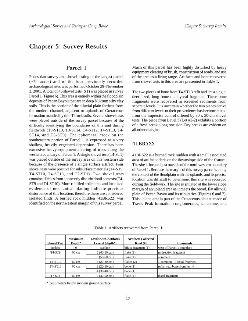
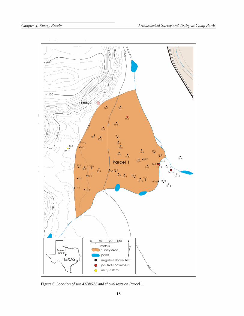
Parcel 1Pedestrian survey and shovel testing of the largest parcel(~74 acres) and of the four previously recordedarchaeological sites was performed October 29–November2, 2001. A total of 46 shovel tests (ST) was placed in surveyParcel 1 (Figure 6). This area is entirely within the floodplaindeposits of Pecan Bayou that are in deep Nukrum silty claysoils. This is the portion of the alluvial plain farthest fromthe modern channel, adjacent to uplands of Cretaceousformation mantled by thin Throck soils. Several shovel testswere placed outside of the survey parcel because of thedifficulty identifying the boundaries of this unit duringfieldwork (T3-ST13, T3-ST14, T4-ST12, T4-ST13, T4-ST14, and T5-ST9). The ephemeral creek on thesoutheastern portion of Parcel 1 is expressed as a veryshallow, heavily vegetated depression. There has beenextensive heavy equipment clearing of trees along thewestern boundary of Parcel 1. A single shovel test (T4-ST1)was placed outside of the survey area on this western sidebecause of the presence of a single surface artifact. Fourshovel tests were positive for subsurface materials (T4-ST9,T4-ST10, T4-ST13, and T7-ST1). Two shovel testscontained lithics from apparently disturbed soil contexts (T4-ST9 and T4-ST10). More rubified sediments and localizedevidence of mechanical blading indicate previousdisturbance of this location, therefore these are consideredisolated finds. A burned rock midden (41BR522) wasidentified on the northwestern margin of this survey parcel.
Much of this parcel has been highly disturbed by heavyequipment clearing of brush, construction of roads, and useof the area as a firing range. Artifacts and bone recoveredfrom shovel tests in this area are presented in Table 1.
The two pieces of bone from T4-ST13 refit and are a single,deer-sized, long bone diaphyseal fragment. These bonefragments were recovered in screened sediments fromseparate levels. It is uncertain whether the two pieces derivefrom different levels or their provenience has become mixedfrom the imprecise control offered by 30 x 30-cm shoveltests. The piece from Level 3 (Lot #2-2) exhibits a portionof a fresh break along one side. Dry breaks are evident onall other margins.
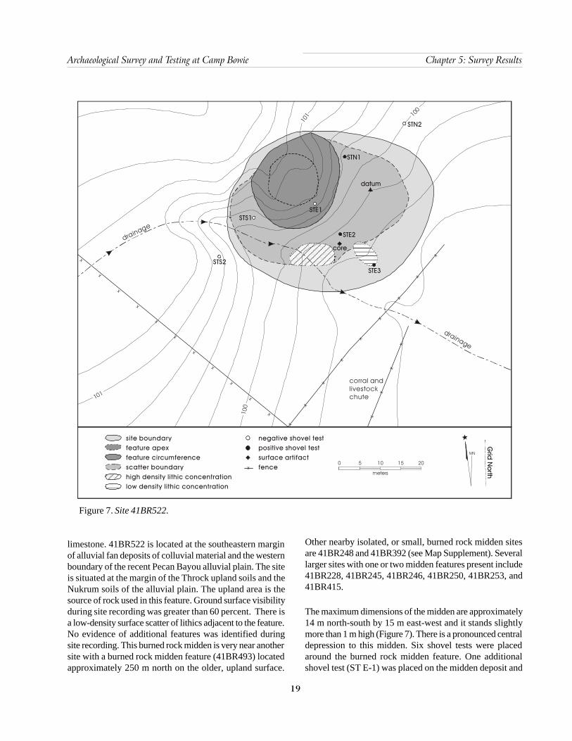
41BR522
41BR522 is a burned rock midden with a small associatedarea of artifact debris on the downslope side of the feature.The site is located just outside of the northwestern boundaryof Parcel 1. Because the margin of this survey parcel is alongthe contact of the floodplain with the uplands, and its preciselocation was difficult to determine, this site was recordedduring the fieldwork. The site is situated at the lower slopemargin of an upland area as it meets the broad, flat alluvialplain of Pecan Bayou and its tributaries (Figures 6 and 7).This upland area is part of the Cretaceous plateau made ofTravis Peak formation conglomerates, sandstone, and
Table 1. Artifacts recovered from Parcel 1
* centimeters below modern ground surface
Shovel TestMaximum
Depth*Levels with Artifacts
Level # (depth*)Artifacts Collected
Kind (#) Commentssurface 0 surface biface fragment (1) west of Parcel 1 boundary
5 (40-50 cm) flake (1) midsection fragment6 (50-60 cm) flake (1) complete
T4-ST10 60 cm 3 (20-30 cm) flakes (2) 1 complete; 1 distal fragment3 (20-30 cm) bone (1) refits with bone from lev. 44 (30-40 cm) bone (1)
T7-ST1 60 cm 5 (40-50 cm) flake (1) distal fragment
T4-ST9 60 cm
T4-ST13 60 cm
18
Chapter 5: Survey Results Archaeological Survey and Testing at Camp Bowie
Figure 6. Location of site 41BR522 and shovel tests on Parcel 1.
1300
1300
1400
1350
1450
1450
1400 1350
1350
Parcel 1
Project Area
MN
0
meters
60 120 180
BF1
T4-1 T4-3
T1-1T1-2
T2-1T2-2
T3-1T3-2
T3-3
T3-4 T3-5T3-6
T3-7 T3-8
T3-10
T3-9T3-11
T3-12 T3-13
T3-14
T4-14
T4-13
T4-12
T5-9T4-11
T4-10T4-8
T5-8
T4-7
T5-6
T4-5
T5-7
T4-6
T4-4
T5-4
T5-5
T5-3
T6-3
T7-1
T5-1
T6-2
T4-2
T6-1
T4-9
T8-2
T5-2
T8-1
19
Archaeological Survey and Testing at Camp Bowie Chapter 5: Survey Results
limestone. 41BR522 is located at the southeastern marginof alluvial fan deposits of colluvial material and the westernboundary of the recent Pecan Bayou alluvial plain. The siteis situated at the margin of the Throck upland soils and theNukrum soils of the alluvial plain. The upland area is thesource of rock used in this feature. Ground surface visibilityduring site recording was greater than 60 percent. There isa low-density surface scatter of lithics adjacent to the feature.No evidence of additional features was identified duringsite recording. This burned rock midden is very near anothersite with a burned rock midden feature (41BR493) locatedapproximately 250 m north on the older, upland surface.
Other nearby isolated, or small, burned rock midden sitesare 41BR248 and 41BR392 (see Map Supplement). Severallarger sites with one or two midden features present include41BR228, 41BR245, 41BR246, 41BR250, 41BR253, and41BR415.
The maximum dimensions of the midden are approximately14 m north-south by 15 m east-west and it stands slightlymore than 1 m high (Figure 7). There is a pronounced centraldepression to this midden. Six shovel tests were placedaround the burned rock midden feature. One additionalshovel test (ST E-1) was placed on the midden deposit and
Figure 7. Site 41BR522.
site boundaryfeature apexfeature circumferencescatter boundaryhigh density lithic concentrationlow density lithic concentration
Grid
Northmeters
0 5 10 15 20
MN
negative shovel testpositive surface artifactfence
shovel test
x
x
x
x
x
x
x
x
x
x
x
x
x
x
x
x
x
x
x
x
x
x
x
x
x
corral andlivestockchute
drainage
drainage
101
100
101 10
0
STS2
STS1STE1
STE2
STE3
core
STN1
STN2
datum

20
Chapter 5: Survey Results Archaeological Survey and Testing at Camp Bowie
terminated at 20 cm below surface (cm bs). No attempt wasmade to excavate this test unit deeply into the midden. Thesmall size of the shovel tests makes deeper excavation intothe dense fire-cracked rock logistically difficult, offers poorvertical control, and is a problematic sample for comparisonwith standard 1 x 1-m recovery units. Three of the shoveltests were positive (ST E-2, ST E-3, and ST N-1), the resultsare presented in Table 2.
The single shovel test in the midden (ST E-1) identifieddark, charcoal stained deposits. No further disturbance ofthe midden was considered useful. Five shovel tests wereexcavated to a depth of 60 cm bs. The sixth unit wasterminated because of the density of colluvial rock at50 cm bs. Sediment susceptibility samples were collectedfrom every excavation level in each of the shovel test units.The three positive shovel tests contained chipped lithics,two produced lithics as deep as 10–30 cm bs. A biface tipand one flake were recovered from ST E-3 at approximately20–30 cm bs. The biface fragment is the distal portion ofthe thin blade of a projectile point. This piece exhibitsserration of both edges from well-controlled pressureflaking. This finely made, serrated point is missing all ofthe proximal portion and cannot be typed. There is a lightscatter of lithics on the flat area to the south of the midden.Some mussel shell was associated with the lithics, but it is
unknown if this shell is cultural in origin. The area containingarchaeological debris does not extend far from the middenas artifacts were identified only within 5–8 m from themargin of the burned rock midden. The upslope side northof the midden had no artifacts outside of this feature.
Fire-cracked rock was not collected from the shovel tests.The amount encountered in each unit and the size of thepieces, however, were recorded although no weight datawere collected during this field effort. Much of the fire-cracked rock recovered from the single unit excavated inthe midden (ST E-1) was small, <2 cm in maximumdimension. Numerically, smaller fragments of fire-crackedrock (the majority were <4 cm in maximum dimension) werethe most commonly recovered artifacts from shovel tests.The mussel shell from ST N-1 is currently in three piecesthat refit. This valve was damaged during excavation butclearly represents a single, nearly complete shell. This isthe dorsal portion of a left valve. No species identificationhas been made on this specimen, and there is no evidenceof burning on this shell or other indicators of humanmodification. Additional mussel shell was also present inthe surface lithic concentration south of the midden. Twocharcoal samples were collected from outside of the midden(ST N-1), and although their context is questionable, theymay be useful for wood species identification.
* centimeters below modern ground surface
Table 2. Results of shovel tests at 41BR522
Shovel TestMaximum
Depth*Levels with Artifacts
Level # (depth*)Artifacts Collected
Kind (#)Fire-cracked Rock
(not collected)mapped 0 surface unidirectional core (1)
1 (0-10 cm) 0 >1502 (10-20 cm) 0 >1501 (0-10 cm) flakes (2); angular debris (1) 02 (10-20 cm) flakes (2) 1 (2-5 cm)1 (0-10 cm) 0 2 (2-5 cm)2 (10-20 cm) 0 2 (1=2-5 cm, 1=>10 cm)
3 (20-30 cm) flake (1); projectile point (1)surface 0 4 (~5 cm)
1 (0-10 cm) debitage (1) 842 (10-20 cm) 0 203 (20-30 cm) charcoal (1); mussel shell (3) 144 (30-40 cm) charcoal (1) 4
N-2 60 cm 0 0 01 (0-10 cm) 0 ~1002 (10-20 cm) 0 ~323 (20-30 cm) 0 ~20
S-2 60 cm 0 0 0
N-1 50 cm
S-1 60 cm
E-3 60 cm
E-1 20 cm
E-2 60 cm

21
Archaeological Survey and Testing at Camp Bowie Chapter 5: Survey Results
On-site disturbances appear to be minimal. Despite thepresence of a nearby corral and livestock chute, there areno visible indicators that this recent feature has impactedany archaeological deposits. There is a shallow, inciseddrainage along the southwestern side of the midden, but fewartifacts were visible in this ephemeral drainage and it hasnot affected the midden feature. This midden appears tohave been minimally disturbed following use. There is somecolluvial and alluvial redeposition of rock from the middenon the southwestern (maximally 5 m), southern (4 m), andespecially southeastern side (6 m) of the midden. The areacontaining artifacts adjacent to the feature is not extensive.These qualities provide no suggestion of multiple-use eventsassociated with this location and strongly suggest a singleoccupation episode. Shovel testing identified good-to-excellent potential for subsurface artifact deposits outsideof the earth oven feature.
The preliminary examination indicates that this site shouldreceive additional testing to determine its potential eligibilityas a State Archeological Landmark (SAL) or NationalRegister of Historic Places (NRHP) property. The stronglikelihood that this is a single component site provides aunique opportunity. At larger sites, it is unclear how a burnedrock feature may be associated with other portions of a site.It can be considered a central component to adjunct activitiesperformed away from the feature, or it could represent asite use unrelated to the other archaeological material aroundthe feature. If this feature is a relatively isolated event, itcan provide a critical view of the kinds of debris andpatterning uniquely associated with feature use. Excavationof additional shovel tests and several 1 x 1-m units arestrongly recommended for this site.
Except for the recommendations of protection, avoidance,and additional testing of 41BR522 discussed above, surveyand testing of the remainder of Parcel 1 did not produceany evidence of archaeological resources that would qualifyas SAL or NRHP eligible. Based on this assessment, normalproposed uses of this area may proceed without furtherconsultation with THC. It should be noted that Parcel 1 islocated on floodplain deposits of Pecan Bayou and proposedactivities or improvements that extend below the depth ofshovel testing may encounter more deeply buriedarchaeological remains. It is recommended that anysignificant and deep excavation activities in this area involvearchaeological monitoring of this location.
Parcel 2Pedestrian examination and shovel test survey wasconducted on Parcel 2 (~64 acres) during November17–18, 2001. Thirty-three shovel tests were excavated withinthis area and no subsurface artifacts were recovered fromthese units (Figure 8). Four isolated artifacts were recoveredfrom surface contexts within this parcel and all of these arebiface fragments. These artifacts were not associated withother surface artifacts nor did they appear to indicate anysubsurface archaeological sites.
A previously recorded archaeological site, 41BR425, wasreported to be within this survey parcel. An attempt torelocate this site, re-record it, and shovel test the locationwas not successful. There is a strong likelihood that the sitehas been mislocated to the north of an area with anambiguous archaeological manifestation. It also is possiblethat because this site was previously defined only from itssurface artifacts, one core and seven flakes (Wormser andSullo-Prewitt 2001:100), that there is no subsurfacecomponent to this ephemeral presence. The mapped locationof this site is very heavily vegetated with grass and sparseoaks and surface visibility is less than five percent. The areasouth of the previously identified location of 41BR425 hasgreater surface visibility (>40%). The description of thissite and its identification on the basis of apparent surfaceartifacts (Wormser and Sullo-Prewitt 2001:100) moreclosely resemble an area approximately 60 m southeast ofthe southeastern margin of the plotted location of 41BR425.Because re-evaluation of this site was not part of this researchdesign and budget, systematic shovel testing beyond thesurvey work was not performed. This investigation foundno subsurface archaeological material associated with thearea where the site was plotted nor the alternative locationmatching its description. A single surface artifact (IF3) wasthe only evidence of prehistoric activity in this vicinity.Shovel test intervals were slightly adjusted to place themadjacent to the isolated surface biface (IF3) and onpotentially more intact soils. Based on Wormser and Sullo-Prewitt’s site description (2001:100) and the presence of anisolated surface biface (IF3), the location of 41BR425 hasbeen updated on the TexSite form to this location south ofits previously plotted position. There was a relatively highdensity of naturally fractured chert visible on this slightlyeroding terrace margin. It is likely that the designation ofthis site as a “lithic workshop” (Wormser and Sullo-Prewitt
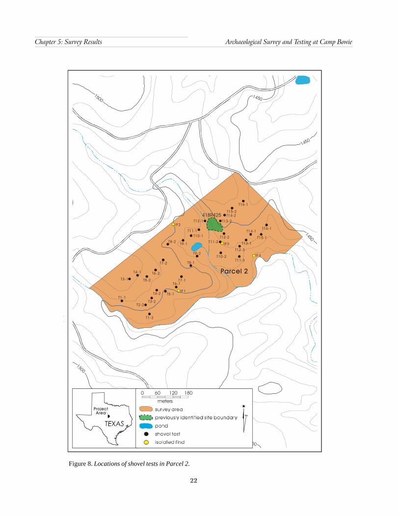
22
Chapter 5: Survey Results Archaeological Survey and Testing at Camp Bowie
Figure 8. Locations of shovel tests in Parcel 2.
1450
1500
1450
1450
14501500
1500
Project Area
MN
0
meters
60 120 180
IF4
IF3
IF2
IF1
Parcel 2
41BR425
T16-1
T15-2T14-2
T13-2
T12-2T11-2
T10-2
T12-1
T11-1T10-1
T9-1T8-2
T9-2
T7-1
T7-2
T6-2
T5-2
T4-1
T3-1
T4-2
T3-2T2-2
T5-1
T6-1
T1-2
T8-1T11-3
T12-3
T13-1
T14-1
T15-1
T16-1
T1-1
23
Archaeological Survey and Testing at Camp Bowie Chapter 5: Survey Results
2001:100) may be due to the identification of some of thesenaturally fractured cherts as primary flakes. Two efforts torelocate this site were made. An initial reconnaissanceintensively examined the plotted location and identified themore probable area matching the previous site description.No surface artifacts were identified during this examination.During the survey and testing, a more intensive surfacesurvey of this area with 10-m transect intervals betweensurveyors examined an area approximately 100 m northwest-southeast by 100 m southwest-northeast. Most of this areahad excellent surface visibility (>60%). A single early stagebiface (IF3) was recovered on the surface in this area. Nosurface flakes or other indications of an archaeological sitewere seen within the previously identified site area, thesuspected location of the materials identified by Wormserand Sullo-Prewitt, or the vicinity of the isolated biface (IF3).Shovel tests in the vicinity of the suspected location of41BR425 indicated no evidence of buried archaeologicaldeposits. This site has probably been misevaluated throughsurface definition and is much more ephemeral than theprevious description suggested.
No evidence of subsurface material was encountered in anyof the shovel tests in Parcel 2. The four isolated finds alsodo not indicate the presence of any significant culturalresources within this parcel. Re-evaluation of the veryephemeral archaeological expression of 41BR425 does notindicate that this is a SAL or NRHP eligible resource. Normalmilitary activities within this area should be allowed toproceed without further consultation with THC.
Parcel 3Parcel 3 is an area of approximately 62 acres that wassurveyed on November 14 and 16, 2001. A total of 43 shoveltest units was excavated within this survey parcel (Figure9). Several shovel tests were placed outside of the surveyparcel because of the difficulty identifying the boundariesof this unit during fieldwork. Only one shovel test (T2-ST1)
contained subsurface material (Table 3). Two pieces ofheated angular debris were recovered from Levels 1 and 2(0–20 cm bs) from this unit. Neither is unambiguouslycultural in origin. No surface artifacts were identified. Thereare no cultural resources identified within this parcel thatmay be SAL or NRHP eligible. No additional archaeologicalinvestigations are considered necessary within this parcel.Normal military use of this area may proceed without furtherconsultation with THC.
Shovel Testing of 41BR248,41BR467, 41BR469, and 41BR471
Re-examination of four previously recorded sites wasperformed at the recommendation of Wormser and Sullo-Prewitt (2001:38–45). Three of these sites were successfullyrelocated during the shovel testing effort. The location andarchaeological content of site 41BR248 could not beconfirmed.
41BR248
The mapped location of site 41BR248 was examined, butno evidence of surface artifacts was observed. Shovel testingproduced no subsurface evidence of a site at this location.It is likely that this site location has been misplotted, ornaturally fractured chert has been misidentified as culturaldebris. The physical description and mapped locationmatched the area investigated, but no surface artifacts orsubsurface prehistoric materials were encountered. Theoriginal description identified an area with 30–50 percentground surface visibility (Wormser and Sullo-Prewitt2001:60). The location matching the reported site positionand the original site description exhibits excellent groundvisibility (>40%). Adjacent areas are covered by dense grassand open oak forest. Two separate pedestrian examinationsof the plotted site location and adjacent areas wereperformed, but no surface indications of any prehistoric
* centimeters below modern ground surface
Table 3. Artifacts recovered from Parcel 3
Shovel TestMaximum
Depth*Levels with Artifacts
Level # (depth*)Artifacts Collected
Kind (#) Comments1 (0-10 cm) angular debris (1) heat spall2 (10-20 cm) angular debris (1) heat spall
T2-ST1 40cm
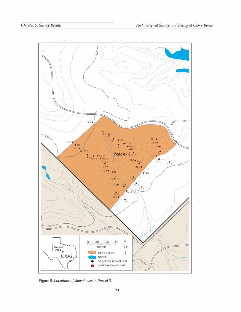
24
Chapter 5: Survey Results Archaeological Survey and Testing at Camp Bowie
Figure 9. Locations of shovel tests in Parcel 3.
1450
1450
1400
1400
1400
1400
Parcel 3
Project Area
M N
0
meters
60 120 180
T4-2
T5-2
T6-2T7-2
T8-2
T9-2T10-2
T11-2
T7-1
T6-1
T4-1
T5-1
T3-1
T2-1
T12-1
T13-1T14-1
T15-1T16-2
T19-2
T19-1T18-1
T17-1T16-1
T15-2 T13-2T14-2 T12-2
T11-1
T10-1
T9-1 T8-1
T7-3
T6-3 T5-3
T4-3T3-3
T2-3
T1-3
T1-2
T2-2
T3-2
T1-1

25
Archaeological Survey and Testing at Camp Bowie Chapter 5: Survey Results
1430
1440
1450
1460
1450
1440
1430
2-track r
oad
xx
xx
xx
xx
x
ST4
ST2ST3
ST1
datum
previously identified site boundarynegative positive fence
shovel testshovel test
MN
0 10 20 30 40 50
metersX
Figure 10. Site 41BR248.
remains were encountered. A few naturally fractured chertgravels were seen, but no culturally produced lithics wereevident. Four shovel tests were excavated at this location(Figure 10). Given the good-excellent surface visibility(>40%) this effort was considered sufficient to determineif, indeed, an archaeological site meeting Texas surveystandards exists at this location. Because 41BR248 waspreviously identified solely through a very ephemeral surfaceassemblage, three cores, two flakes, and one possible fire-cracked rock (Wormser and Sullo-Prewitt 2001:60), thereis a strong possibility that there is no site at this location orin the vicinity. The naturally fractured cherts may have beenmisidentified as artifacts during the initial sitecharacterization. Although the previously identified siteboundaries are indicated in this figure, there is no apparent
archaeological site at this location. No subsurface artifactsor suggestions of cultural features were encountered. A singlemussel shell fragment and one piece of oxidized ferric metalwere recovered from Level 4 of ST 1. Either natural chertfragments have been mistaken as artifacts, or this site ismuch more ephemeral than described, or the site locationfor 41BR248 has been misplotted. Several adjacent andlikely areas were also examined during the two relocationefforts to determine whether an archaeological site asdescribed in the initial recording by Wormser and Sullo-Prewitt (2001) could be identified nearby. Given the negativesurface and subsurface results, project schedule and budget,additional relocation effort was unjustified. The THCrecommendation that this site be tested may still need to bemet by further investigation. It is recommended that a further

26
Chapter 5: Survey Results Archaeological Survey and Testing at Camp Bowie
attempt to relocate this site be performed so that testing of41BR248 may be accomplished and its status as a definablearchaeological site clarified.
41BR467
Site 41BR467 is a low-density lithic scatter on a slopingupland ridge with moderate-to-heavy surface erosion. Thereis a sparse scatter of lithics present on the surface of thissite with low-density concentrations associated only withgood surface visibility in eroded areas (Figure 11). Bedrockis exposed on many parts of the surface and most soils arethin. Some areas clearly evidence colluvially redepositedsediments and artifacts. Wormser and Sullo-Prewitt(2001:118) indicate that this site had excellent surfacevisibility (70–100%) during the initial survey and very sparseartifact presence. Human disturbance from construction andmaintenance of a road has impacted the site. The siteboundaries identified during this survey are significantlylarger than the originally recorded dimensions ofapproximately 20 x 20 m (Wormser and Sullo-Prewitt2001:118). The current site dimensions are approximately110 m northeast-southwest and maximally 53 m north-south.Surface artifacts were evident along a 100 m-long portionof the existing road. The eastern end of the site extendsslightly downslope and exhibits severe erosion. Bedrock wasexposed at the surface over most of the western third of thesite, in the north-central portion, and along the southeasternboundary areas. The currently inferred site boundaries wererecorded with a GPS unit and four shovel tests wereexcavated on this site. Given that the ground surface visibilityexceeded 30 percent and the goal of this effort wassubsurface characterization, this represents a good sampleof the subsurface material at this site. Bedrock wasencountered between 8–19 cm in these units. Because ofthe excellent surface visibility, thin soils, and extensivebedrock exposure on this site, this was considered adequatetesting of the subsurface archaeological material present incompliance with the survey standards for Texas. No artifactswere recovered in these shovel tests. Two cores and fourbifaces were mapped and collected from the site surface(Figure 11, Table 4). Given the extensive evidence oferosion, colluvial transport of artifacts, and thin soils at thislocation, 41BR467 offers poor research potential to studyhuman use of this area. No additional archaeologicalcharacterization of this site is considered necessary.
41BR469
Site 41BR469 is a low density lithic scatter on very thinsoil on a southward sloping upland ridge (Figure 12).Bedrock is exposed on several parts of the site. There issignificant disturbance from the construction andmaintenance of two roads across this site. The originallyidentified site boundaries were retained followingexamination of the site. The site is approximately 195 mnorth-south by 155 m east-west. Previous site examinationidentified a Dalton or Angostura-like point base (Wormserand Sullo-Prewitt 2001:119).
Six shovel tests were excavated in areas that appeared tohave the deepest, most intact soils. Because the groundsurface visibility exceeded 30 percent and the goal of thiseffort was subsurface characterization, and not necessarilyredefinition of the site boundaries, these were considered asufficient test in compliance with the survey standards forTexas. Bedrock was encountered between 6 and 42 cm bs.Several units encountered weathered bedrock zonesindicating in situ soil development of an unknown age.Shovel tests ST 3, ST 4, and ST 6 were placed in areas ofsurface erosion (Figure 12). These locations did possessdeeper soils (determined through probing) than otherstabilized epipedons. Only one artifact was recoveredsubsurface; ST 5 contained a single flake from the firstexcavation level (0–10 cm bs). The very low density ofartifacts, relatively thin soils, evidence of surface erosion,and human impacts all suggest that 41BR469 has verylimited research potential. No further archaeologicalinvestigation is considered necessary on this site.
41BR471
Site 41BR471 is a moderate-to-high density lithic scatterthat was re-examined during the current project. Nodimensions of the site were reported previously (Wormserand Sullo-Prewitt 2001:120). Surface artifacts covered amaximum extent of approximately 95 m north-south by35 m east-west (Figure 13). Surface visibility was excellent,Wormser and Sullo-Prewitt (2001:120) estimated that 75–100 percent ground visibility characterizes this site. Althoughadjacent to an extensively modified stock tank, the identifiedarea of the site does not appear to have been affected bythat construction. One Late Prehistoric, side-notchedprojectile point was collected from the site surface. Two
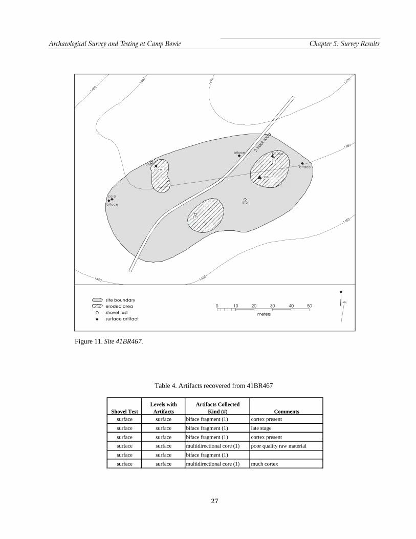
27
Archaeological Survey and Testing at Camp Bowie Chapter 5: Survey Results
2-tra
ck ro
ad
core
b i face
core
ST4ST1
b i face
ST2
datum
bi face
ST3
bi face
1450
1450
1460
1470
1460
1470
1450
1450
site boundaryeroded areashovel testsurface artifact
MN
0 10 20 30 40 50
meters
Figure 11. Site 41BR467.
Table 4. Artifacts recovered from 41BR467
Shovel TestLevels with
ArtifactsArtifacts Collected
Kind (#) Comments surface surface biface fragment (1) cortex present
surface surface biface fragment (1) late stage
surface surface biface fragment (1) cortex present
surface surface multidirectional core (1) poor quality raw material
surface surface biface fragment (1)
surface surface multidirectional core (1) much cortex
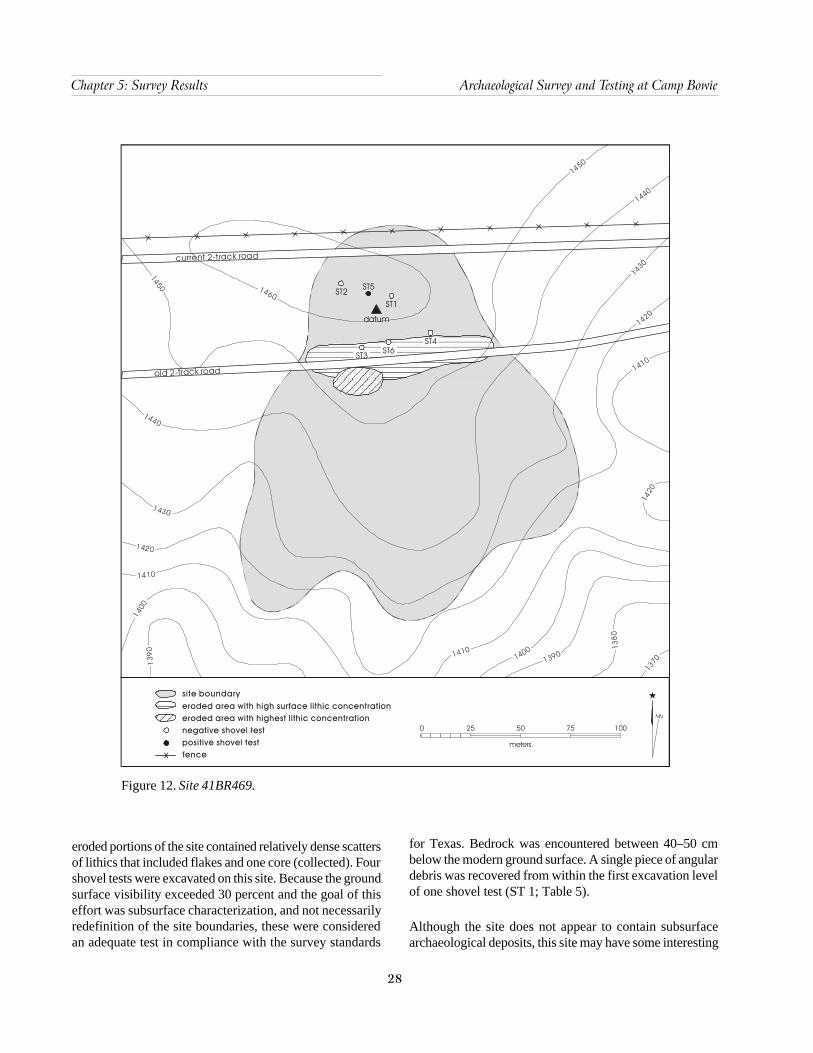
28
Chapter 5: Survey Results Archaeological Survey and Testing at Camp Bowie
0 25 50 75 100
meters
MN
site boundaryeroded area with high surface lithic concentrationeroded area with highest lithic concentrationnegative shovel testpositive fence
shovel testX
ST2 ST5
ST1
ST4ST6ST3
datum
1460
1450
1440
1430
1420
1410
1400
139
0
1450
1440
1430
1420
1420
1410
13901400 138
0
13701410
current 2-track road
old 2-track road
Figure 12. Site 41BR469.
eroded portions of the site contained relatively dense scattersof lithics that included flakes and one core (collected). Fourshovel tests were excavated on this site. Because the groundsurface visibility exceeded 30 percent and the goal of thiseffort was subsurface characterization, and not necessarilyredefinition of the site boundaries, these were consideredan adequate test in compliance with the survey standards
for Texas. Bedrock was encountered between 40–50 cmbelow the modern ground surface. A single piece of angulardebris was recovered from within the first excavation levelof one shovel test (ST 1; Table 5).
Although the site does not appear to contain subsurfacearchaeological deposits, this site may have some interesting
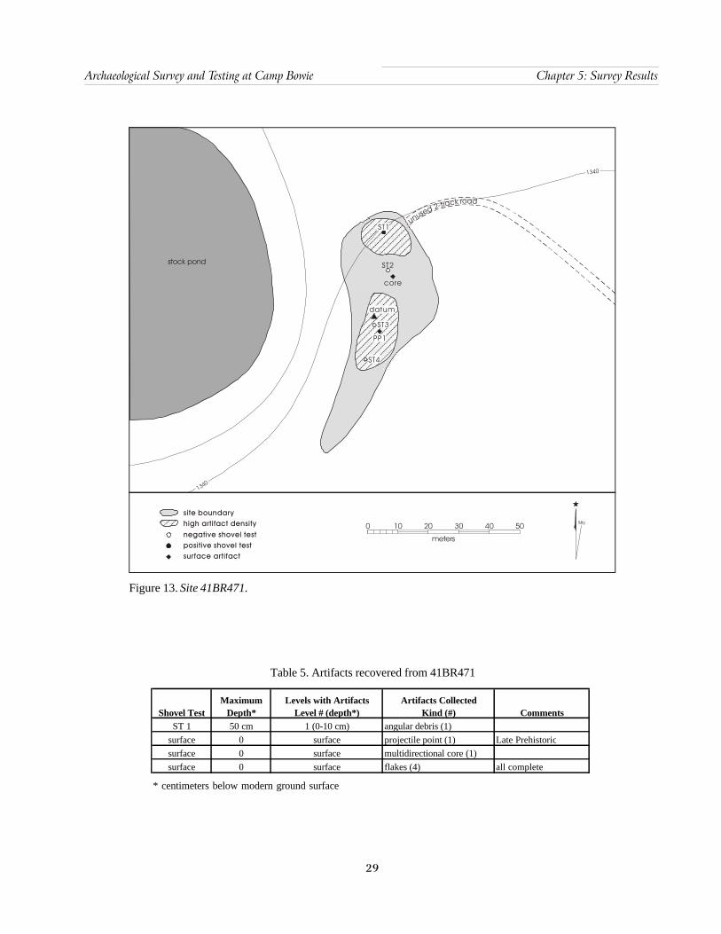
29
Archaeological Survey and Testing at Camp Bowie Chapter 5: Survey Results
Figure 13. Site 41BR471.
stock pond
unused 2-track road
ST1
ST2
core
datum
ST3
PP1
ST4
1340
1340
site boundaryhigh artifact densitynegative shovel testpositive surface artifact
shovel test
MN0 10 20 30 40 50
meters
* centimeters below modern ground surface
Table 5. Artifacts recovered from 41BR471
Shovel TestMaximum
Depth*Levels with Artifacts
Level # (depth*)Artifacts Collected
Kind (#) CommentsST 1 50 cm 1 (0-10 cm) angular debris (1)
surface 0 surface projectile point (1) Late Prehistoricsurface 0 surface multidirectional core (1)surface 0 surface flakes (4) all complete
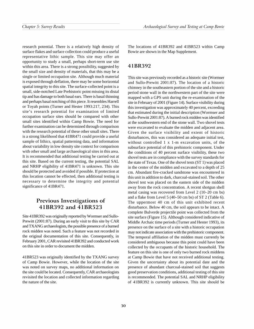
30
Chapter 5: Survey Results Archaeological Survey and Testing at Camp Bowie
research potential. There is a relatively high density ofsurface flakes and surface collection could produce a usefulrepresentative lithic sample. This site may offer anopportunity to study a small, perhaps short-term use sitewithin this area. There is a strong possibility, suggested bythe small size and density of materials, that this may be asingle or limited occupation site. Although much materialis exposed through deflation, there may be some horizontalspatial integrity to this site. The surface-collected point is asmall, side-notched Late Prehistoric point missing its distaltip and has damage to both basal ears. There is basal thinningand perhaps basal notching of this piece. It resembles Harrellor Toyah points (Turner and Hester 1993:217, 234). Thissite’s research potential for examination of limitedoccupation surface sites should be compared with othersmall sites identified within Camp Bowie. The need forfurther examination can be determined through comparisonwith the research potential of these other small sites. Thereis a strong likelihood that 41BR471 could provide a usefulsample of lithics, spatial patterning data, and informationabout variability in low density site context for comparisonwith other small and large archaeological sites in this area.It is recommended that additional testing be carried out atthis site. Based on the current testing, the potential SALand NRHP eligibility of 41BR471 is unknown. This siteshould be protected and avoided if possible. If protection atthis location cannot be effected, then additional testing isnecessary to determine the integrity and potentialsignificance of 41BR471.
Previous Investigations of41BR392 and 41BR523
Site 41BR392 was originally reported by Wormser and Sullo-Prewitt (2001:87). During an early visit to this site by CARand TXANG archaeologists, the possible presence of a burnedrock midden was noted. Such a feature was not recorded inthe original documentation of this site. Consequently, inFebruary 2001, CAR revisited 41BR392 and conducted workon this site in order to document the midden.
41BR523 was originally identified by the TXANG surveyof Camp Bowie. However, while the location of the sitewas noted on survey maps, no additional information onthe site could be located. Consequently, CAR archaeologistsrevisited the location and collected information regardingthe nature of the site.
The locations of 41BR392 and 41BR523 within CampBowie are shown in the Map Supplement.
41BR392
This site was previously recorded as a historic site (Wormserand Sullo-Prewitt 2001:87). The location of a historicchimney in the southeastern portion of the site and a historicperiod stone wall in the northwestern part of the site weremapped with a GPS unit during the re-examination of thesite in February of 2001 (Figure 14). Surface visibility duringthis investigation was approximately 40 percent, exceedingthat estimated during the initial description (Wormser andSullo-Prewitt 2001:87). A burned rock midden was identifiedat the southwestern end of the stone wall. Two shovel testswere excavated to evaluate the midden and adjacent area.Given the surface visibility and extent of historicdisturbances, this was considered an adequate initial test,without controlled 1 x 1-m excavation units, of thesubsurface potential of this prehistoric component. Underthe conditions of 40 percent surface visibility, these twoshovel tests are in compliance with the survey standards forthe state of Texas. One of the shovel tests (ST 1) was placedin the center of the midden and excavated to a depth of 25cm. Abundant fire-cracked sandstone was encountered inthis unit in addition to dark, charcoal-stained soil. The othershovel test was placed on the eastern side of the middenaway from the rock concentration. A recent shotgun shellmetal casing was recovered from Level 2 (10–20 cm bs)and a flake from Level 5 (40–50 cm bs) of ST 2 (Table 6).The uppermost 40 cm of this unit exhibited recentdisturbance. Below 40 cm, the soil appears to be intact. Acomplete Bulverde projectile point was collected from thesite surface (Figure 15). Although considered indicative ofMiddle Archaic time periods (Turner and Hester 1993), itspresence on the surface of a site with a historic occupationmay not indicate association with the prehistoric component.The temporal affiliation of the midden must currently beconsidered ambiguous because this point could have beencollected by the occupants of the historic household. Thefeature on this site is one of only two burned rock middensat Camp Bowie that have not received additional testing.Given the uncertainty about its potential date and thepresence of abundant charcoal-stained soil that suggestsgood preservation conditions, additional testing of this siteis recommended. The potential SAL and NRHP eligibilityof 41BR392 is currently unknown. This site should be

31
Archaeological Survey and Testing at Camp Bowie Chapter 5: Survey Results
* centimeters below modern ground surface
Table 6. Artifacts recovered from 41BR392
Shovel TestMaximum
Depth*Levels with Artifacts
Level # (depth*)Artifacts Collected
Kind (#) Commentssurface 0 surface projectile point (1) Bulverde (Middle Archaic)
2 (10-20 cm) shotgun shell casing (1) Winchester 5 (40-50cm ) flake (1) distal fragment
ST 2 50
Figure 14. Site 41BR392.
1340
1340
1330
1320
1330
eroded area
chimney
datum
projectilepoint
historicwall
stock pond
stockpond
ST2
ST1
negative shovel testpositive site boundaryburned rock midden
shovel test MN
meters
0 10 20 30 40 50
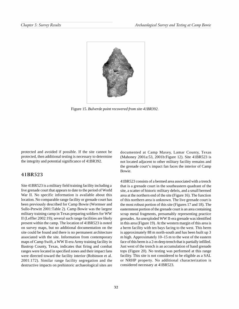
32
Chapter 5: Survey Results Archaeological Survey and Testing at Camp Bowie
protected and avoided if possible. If the site cannot beprotected, then additional testing is necessary to determinethe integrity and potential significance of 41BR392.
41BR523
Site 41BR523 is a military field training facility including alive grenade court that appears to date to the period of WorldWar II. No specific information is available about thislocation. No comparable range facility or grenade court hasbeen previously described for Camp Bowie (Wormser andSullo-Prewitt 2001:Table 2). Camp Bowie was the largestmilitary training camp in Texas preparing soldiers for WWII (Leffler 2002:19); several such range facilities are likelypresent within the camp. The location of 41BR523 is notedon survey maps, but no additional documentation on thesite could be found and there is no permanent architectureassociated with the site. Information from contemporarymaps of Camp Swift, a WW II-era Army training facility inBastrop County, Texas, indicates that firing and combatranges were located in specified zones and their impact fanswere directed toward the facility interior (Robinson et al.2001:172). Similar range facility segregation and thedestructive impacts on prehistoric archaeological sites are
documented at Camp Maxey, Lamar County, Texas(Mahoney 2001a:53, 2001b:Figure 12). Site 41BR523 isnot located adjacent to other military facility remains andthe grenade court’s impact fan faces the interior of CampBowie.
41BR523 consists of a bermed area associated with a trenchthat is a grenade court in the southeastern quadrant of thesite, a scatter of historic military debris, and a small bermedarea at the northern end of the site (Figure 16). The functionof this northern area is unknown. The live grenade court isthe most robust portion of this site (Figures 17 and 18). Theeasternmost portion of the grenade court is an area containingscrap metal fragments, presumably representing practicegrenades. An unexploded WW II-era grenade was identifiedin this area (Figure 19). At the western margin of this area isa berm facility with ten bays facing to the west. This bermis approximately 88 m north-south and has been built up 3m high. Approximately 10–15 m to the west of the easternface of this berm is a 2-m deep trench that is partially infilled.Just west of the trench is an accumulation of hand grenadetops (Figure 20). No testing was performed at this rangefacility. This site is not considered to be eligible as a SALor NRHP property. No additional characterization isconsidered necessary at 41BR523.
Figure 15. Bulverde point recovered from site 41BR392.

33
Archaeological Survey and Testing at Camp Bowie Chapter 5: Survey Results
Figure 16. Site 41BR523, World War II-era range facility with grenade court.
0 20 6040 80 100
meters
MN
site boundary
drainage
drainage
roa
d
l ivegrenadecourt
berm
road
1570
1560
1550
155 0
1540
1530
1520
1510
1520
1520
1530
1540
1550
1550
1560
1500
1520
1560
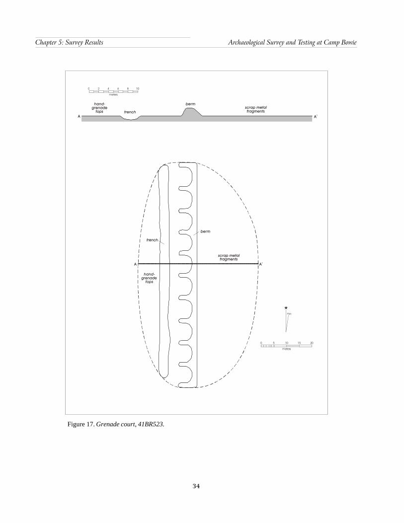
34
Chapter 5: Survey Results Archaeological Survey and Testing at Camp Bowie
Figure 17. Grenade court, 41BR523.
A A1
scrap metal fragments
hand-grenade
tops
trench
berm
berm
trenchscrap metal fragments
hand-grenade
topsA A1
mn
0 5 10 15
meters
20
0 10
meters
2 4 6 8
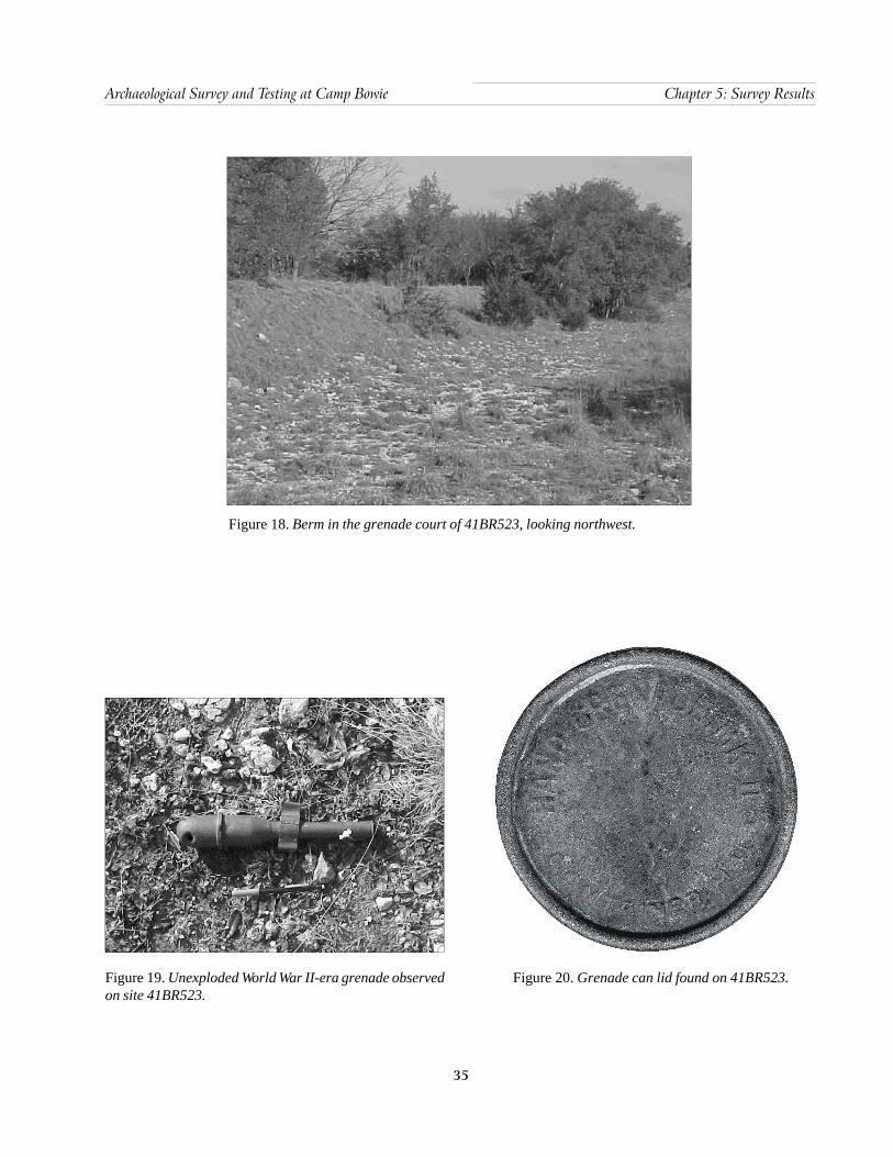
35
Archaeological Survey and Testing at Camp Bowie Chapter 5: Survey Results
Figure 18. Berm in the grenade court of 41BR523, looking northwest.
Figure 19. Unexploded World War II-era grenade observedon site 41BR523.
Figure 20. Grenade can lid found on 41BR523.

37
Archaeological Survey and Testing at Camp Bowie Chapter 6: Project Summary and Recommendations
Chapter 6: Project Summary and Recommendations
Based on the archaeological survey inventory conductedby CAR, it was determined that protection or additionalarchaeological work be recommended at sites 41BR522 and41BR471. The survey also determined that no areas ofParcels 1, 2, and 3 contained significant archaeologicalremains that could be identified during the course of thiseffort as the shovel testing methods employed did notevaluate sediments deeper than 60 cm below the modernground surface. Although, it should also be noted that theNukrum soils of Parcel 1 do have “high potential” to containburied archaeological deposits. Therefore, it isrecommended that any planned deep excavation effortswithin the alluvial soils of Parcel 1 involve archaeologicalmonitoring of those deposits. Normal military use of theseparcels will not affect any identified cultural resources (withthe noted exception of 41BR522). Use of these areas mayproceed with no further consultation with THC.
Re-evaluation of four previously recorded sites, 41BR248,41BR467, 41BR469, and 41BR471, indicate that just thelatter appears to have “high probability” to containsignificant research potential. Protection and avoidance of41BR471 is recommended and additional testing is highlydesirable to clarify its SAL and NRHP eligibility. Noadditional work is considered necessary at 41BR467 and41BR469. These sites are ineligible for nomination as SALor NRHP properties. No further consultation with THC isnecessary for 41BR467 and 41BR469. Site 41BR248 couldnot be relocated; either it is not an archaeological site, ismore ephemeral than previously indicated, or its previouslyplotted location is incorrect. Additional effort would berequired to further attempt to evaluate whether there is asite matching the initial description, or to relocate 41BR248in the vicinity of the misplotted location, and then performtesting to determine its potential SAL and NRHP eligibility.
Additional testing is recommended on site 41BR392previously recorded in February of 2001, while no furtherwork is considered necessary to document 41BR523, themilitary training facility area.
Specific recommendations for sites 41BR522, 41BR471,41BR392, and 41BR248 are provided in the following.
41BR522Additional testing of this site is strongly recommended. Theburned rock midden appears to be intact and the adjacentsediments are relatively undisturbed and have a strongpotential for buried archaeological material. The apparentassociation of only a small area containing archaeologicalmaterial and its position away from any larger, identifiedsite, offers a unique control opportunity at Camp Bowie.41BR522 provides an excellent case-study to examine thepatterning and material associations of a single-use episodeunassociated with palimpsest deposits from multipleactivities. Due to these characteristics, intensive testing ofthis site is recommended.
The placement of a 1 x 3-m excavation unit crossing thecenter of this feature and extending to the east would providea significant sample and profile of this midden. A single1 x 1-m or 1 x 2-m unit at the eastern margin would providea critical profile to examine the relationship of the featuremargin to a prehistoric soil surface. Additional shovel testingestablished on a grid, sampled at 5-m intervals, would aidin determining the spatial distribution of artifacts in relationto the burned rock midden feature. Based on results of thissurvey and testing of 41BR522, and contingent on the resultsof additional testing, judgment placement of two to three1 x 1-m units is critical to determine the significance andresearch value of this site. A significant sample of thesurrounding sediments can provide a very fine-scale viewof this potentially single-component feature. If feasible, someof these units should be contiguous to take advantage of thepotential for useful spatial analyses.
41BR471This is an extensive site with significant amounts of surfacematerial. There does not appear to be a strong probabilitythat subsurface deposits are deep or well-preserved,however, the relatively dense amount of surface materialmay provide a significant opportunity to obtain acomprehensive sample of artifacts from a small site. Theutility of this sample in comparison with other sites withinCamp Bowie could be extremely valuable. There is a strongpossibility that this site represents a short-term, perhapssingle occupation event. Additional testing employing a

38
Chapter 6: Project Summary and Recommendations Archaeological Survey and Testing at Camp Bowie
minimum of three to five 1 x 1-m units is recommended.These may help address whether a subsurface component ispresent on the site and its relationship to the surfacematerials. In addition, an intensive 100 percent surfacecollection of a minimum of ten 1 x 1-m collection areas isrecommended. A large assemblage obtained throughcontrolled surface collection may aid in understanding thedynamics of site reuse in this area. This additionalcharacterization is considered necessary to determine theSAL and NRHP eligibility of this site.
41BR392The burned rock midden at this site contains abundant darkstained sediment and may produce charcoal suitable fordating. This is one of only two burned rock middens onCamp Bowie that have not been tested beyond initial shoveltest examination. A minimum of three controlled 1 x 1-munits should be placed within the midden. Additional shoveltesting established on a grid, sampled at 5-m intervals, wouldhelp determine the spatial distribution of artifacts in relationto the burned rock midden feature. Based on shovel testresults, an additional two to three 1 x 1-m units should beplaced around this feature to determine whether prehistoricmaterials are associated with it.
41BR248No evidence of an archaeological site was identified duringtwo examinations of the previously recorded location of thissite. The physical description and mapped location matchedthe area investigated, but no surface artifacts or subsurfaceprehistoric materials were encountered. This site could notbe found at or near the vicinity of its plotted location. It ispossible that there may be no archaeological site at thislocation. An additional testing effort may be necessary tofind and test this site to determine its potential SAL andNRHP eligibility.
39
Archaeological Survey and Testing at Camp Bowie References Cited
References Cited
Adjutant General’s Department of Texas1992 Environmental Assessment, Camp Bowie Land Acquisition. Manuscript on file, Adjutant General’s Department
of Texas, Facilities and Engineering, Austin, Texas.
Black, S. L.1986 The Clemente and Herminia Hinojosa Site, 41JW8: A Toyah Horizon Campsite in Southern Texas. Special
Report No. 18. Center for Archaeological Research, The University of Texas at San Antonio.1989a Central Texas Plateau Prairie. In From the Gulf Coast to the Rio Grande: Human Adaptation in Central, South
and Lower Pecos Texas, by T. R. Hester, S. L. Black, D. G. Steele, B. W. Olive, A. A. Fox, K. J. Reinhard, and L.C. Bement, pp. 17–38. Research Series No. 33. Arkansas Archeological Survey, Fayetteville.
1989b South Texas Plain. In From the Gulf Coast to the Rio Grande: Human Adaptation in the Central, South, andLower Pecos Texas, by T. R. Hester, S. L. Black, D. G. Steele, B. W. Olive, A. A. Fox, K. J. Reinhard, and L. C.Bement, pp. 39–62. Research Series No. 33. Arkansas Archeological Survey, Fayetteville.
Black, S. L., and A. J. McGraw1985 The Panther Springs Creek Site: Cultural Change and Continuity in the Upper Salado Creek Drainage, South-
Central Texas. Archaeological Survey Report, No. 100. Center for Archaeological Research, The University ofTexas at San Antonio.
Black, S. L., L. W. Ellis, D. G. Creel, and G. T. Goode1997 Hot Rock Cooking on the Greater Edwards Plateau: Four Burned Rock Midden Sites in West Central Texas. 2
vols. Studies in Archeology 22, Texas Archeological Research Laboratory, The University of Texas at Austin;Archeology Studies Program, Report 2, Environmental Affairs Department, Texas Department of Transportation,Austin.
Bousman, C. B.1998 Paleoenvironmental Change in Central Texas: The Palynological Evidence. Plains Anthropologist (43)164:201–
219.
Briggs, A. K.1992 An Archaeological Survey of Sample Areas within the Proposed Camp Bowie Acquisition Area, near Brownwood,
Brown County, Texas. Manuscript on file, Texas Historical Commission, Austin, Texas.
Campbell, T. N.1952 Early Archaeological Investigations in the Vicinity of Brownwood, Texas. The Record 10(3):10–14.
Campbell, T. N., and T. J. Campbell1981 Historic Indians of the Choke Canyon Reservoir Surrounding Area, Southern Texas. Choke Canyon Series, No.
1. Center for Archaeological Research, The University of Texas at San Antonio.
Clower, D. F.1980 Soil Survey of Brown and Mills County, Texas. United States Department of Agriculture, Soil Conservation
Service and the Texas Agricultural Experimental Station.
Collins, M. B.1995 Forty Years of Archeology in Central Texas. Bulletin of the Texas Archeological Society 66:361–400.
40
References Cited Archaeological Survey and Testing at Camp Bowie
Collins, M. B., W. A. Gose, and S. Shaw1994 Preliminary Geomorphological Findings at Dust and Nearby Caves. Journal of Alabama Archaeology 40:35–
56.
Creel, D. G.1986 A Study of Prehistoric Burned Rock Middens in West Central Texas. Unpublished Ph.D. dissertation, The University
of Arizona, Tucson.
Dillehay, T.1974 Late Quaternary Bison Population Changes on the Southern Plains. Plains Anthropologist 19(64):180–196.
Fenneman, N.1931 Physiography of the Western United States. McGraw Hill, New York.
Fox, A. A., and D. E. Fox1967 The Classen Rockshelter, 41BX23. Manuscript on file, Center for Archaeological Research, The University of
Texas at San Antonio.
Gearhart, B., and M. W. Voellinger1986 Archaeological Testing on Sites 41BR313 and 41BR314, Brown County, Texas. Manuscript on file, Texas Historical
Commission, Austin, Texas.
Givens, R. D.1968 A Preliminary Report on Excavations at Hitzfelder Cave. Bulletin of the Texas Archeological Society 38:47–50.
Goode, G. T.1991 Late Prehistoric Burned Rock Middens in Central Texas. In The Burned Rock Middens of Texas: An Archaeological
Symposium, edited by T. R. Hester, pp. 71–93. Studies in Archeology 13. Texas Archeological Research Laboratory,The University of Texas at Austin.
Gould, F. W.1975 Texas Plants—A Checklist and Ecological Summary. Bulletin MP-585:5–14. Texas Agricultural Experimentation
Station, College Station.
Hall, G. D.1981 Allens Creek: A Study in the Cultural Prehistory of the Brazos River Valley, Texas. Research Report 61. Texas
Archeological Survey, The University of Texas at Austin.
Hester, T. R.1991 The Burned Rock Middens of Texas: An Archeological Symposium. Studies in Archeology 13. Texas Archeological
Research Laboratory, The University of Texas at Austin.1995 The Prehistory of South Texas. Bulletin of the Texas Archeological Society 66:427–459.
Highley, L., C. Graves, and G. Judson1978 Archeological Investigations at Scorpion Cave (41ME7), Medina County, Texas. Bulletin of the Texas
Archeological Society 49:139–194.
41
Archaeological Survey and Testing at Camp Bowie References Cited
Hofman, J. L.1989 Prehistoric Culture History–Hunters and Gatherers in the Southern Great Plains. In From Clovis to Comanchero:
Archeological Overview of the Southern Great Plains, by J. L. Hofman, R. L. Brooks, J. S. Hays, D. W. Owsley,R. L. Jantz, M. K. Marks, and M. H. Manhein, pp. 25–60. Research Series No. 35. Arkansas ArcheologicalSurvey, Fayetteville.
Houk, B. A., and J. C. Lohse1993 Archeological Investigations at the Mingo Site, Bandera County, Texas. Bulletin of the Texas Archeological
Society 61:193–247.
Howard, M. A.1991 Burned Rock Midden Excavations, Hearths and Botanical Remains. In The Burned Rock Middens of Texas: An
Archeological Symposium, edited by T. R. Hester, pp. 45–69. Studies in Archeology 13. Texas ArcheologicalResearch Laboratory, The University of Texas at Austin.
Huebner, J. A.1991 Late Prehistoric Bison Populations in Central and Southern Texas. Plains Anthropologist 36(137):343–358.
Hurt, R. D.1980 Archeological Investigations of Portions of the Middle Concho Valley. Unpublished Master’s Thesis, Texas Tech
University, Lubbock.
Johnson, E., and V. T. Holliday1986 The Archaic Record at Lubbock Lake. In Current Trends in Southern Plains Archeology, edited by
T. G. Baugh. Plains Anthropologist Memoir 22:7–54.
Johnson, L., Jr.1995 Past Cultures and Climates at Jonas Terrace, 41ME29, Medina County, Texas. Office of the State Archeologist,
Report 40. Texas Department of Transportation and Texas Historical Commission, Austin.
Johnson, L., and G. T. Goode1994 A New Try at Dating and Characterizing Holocene Climates, as well as Archaeological Periods, on the Eastern
Edwards Plateau. Bulletin of the Texas Archeological Society 65:1–51.
Kegley, G. P., and A. Black1978 An Archaeological Survey of Cordell and Camp Bowie City Park Sites, Brownwood, Texas. Texas Antiquities
Committee, Austin, Texas.
Kirby, F. E., and R. Moir1976 Brownwood Dam Modifications and Archaeological Assessment. Reports in Archaeology No. 95. Archaeology
Research Program, Southern Methodist University, Dallas, Texas.
Leach, J. D., and C. B. Bousman2001[1998] Cultural and Secondary Formation Processes: On the Dynamic Accumulation of Burned Rock Middens. In
Test Excavations at the Culebra Creek Site, 41BX126, Bexar County, Texas, by D. L. Nickels, C. B. Bousman, J.D. Leach, and D. A. Cargill, pp. 119–145. Archaeological Survey Report, No. 265, Center for ArchaeologicalResearch, The University of Texas at San Antonio; Archeology Studies Program, Report 3, Environmental AffairsDivision, Texas Department of Transportation, Austin.
42
References Cited Archaeological Survey and Testing at Camp Bowie
Leffler, J. J.2002 Ranchers, Farmers, Soldiers, and the CCC: The Background for Seven Historical Sites at Camp Bowie, Brown
County, Texas. Archaeological Survey Report, No. 325. Center for Archaeological Research, The University ofTexas at San Antonio.
Lukowski, P. D.1988 Archaeological Investigations at 41BX1, Bexar County, Texas. Archaeological Survey Report, No. 135. Center
for Archaeological Research, The University of Texas at San Antonio.
McClean, R. G., and W. F. Kean1993 Contributions of Wood Ash Magnetism to Archeomagnetic Properties of Fire Pits and Hearths. Earth and Planetary
Science Letters 119:387–394.
Mahoney, R. B.2001a Camp Maxey III, Archaeological Testing of 23 Prehistoric Sites, Lamar County, Texas. Archaeological Survey
Report, No. 314. Center for Archaeological Research, The University of Texas at San Antonio.2001b Camp Maxey III, Archaeological Testing of 23 Prehistoric Sites, Lamar County, Texas: Map Supplement.
Archaeological Survey Report, No. 314. Center for Archaeological Research, The University of Texas at SanAntonio.
Mauldin, R. P., and C. J. Broehm2001 An Archaeological Survey of 90 Acres at Camp Bowie, Brown County, Texas. Archaeological Survey Report, No.
319. Center for Archaeological Research, The University of Texas at San Antonio.
Meissner, B. A.1993 Where the Buffalo Roam: Archaeological Evidence of Bison Populations in South and Central Texas. Manuscript
on file, Center for Archaeological Research, The University of Texas at San Antonio.
Nance, H. S., and E. G. Wermund1993 Geological and Climatic Survey: Camp Bowie Military Reservation, Brownwood, Texas. Bureau of Economic
Geology, The University of Texas at Austin.
Nature Conservancy of Texas1996 Land Cover Analysis of Texas Army National Guard Training Sites. Report submitted to the Texas Adjutant
General’s Department, Austin.
Nickels, D. L., C. B. Bousman, J. D. Leach, and D. A. Cargill2001[1998] Test Excavations at the Culebra Creek Site, 41BX126, Bexar County, Texas. Archaeological Survey Report,
No. 265, Center for Archaeological Research, The University of Texas at San Antonio; Archeology StudiesProgram, Report 3, Environmental Affairs Division, Texas Department of Transportation, Austin.
Patterson, L. W.1988 Intergroup Conflict in Prehistoric Texas. Houston Archeological Society Journal 90:8–10.
Prewitt, E. R.1974 Archeological Investigations at the Loeve-Fox Site, Williams County, Texas. Research Report 49. Texas
Archeological Survey, The University of Texas at Austin.1981 Culture Chronology in Central Texas. Bulletin of the Texas Archeological Society 52:65–89.
43
Archaeological Survey and Testing at Camp Bowie References Cited
1985 From Circleville to Toyah: Comments on Central Texas Chronology. Bulletin of the Texas Archeological Society54:201–238.
1991 Burned Rock Middens: A Summary of Previous Investigations and Interpretations. In The Burned Rock Middensof Texas: An Archeological Symposium, edited T. R. Hester, pp. 25–32. Studies in Archeology 13. TexasArcheological Research Laboratory, The University of Texas at Austin.
Prikryl, D. J.1983 An Archaeological Survey of the City of Brownwood Proposed Sanitary Landfill Site, Brown County, Texas.
Prewitt and Associates, Austin, Texas.
Reynolds, R. L., and J. W. King1995 Magnetic Records of Climate Change. U.S. National Report to I.U.G.G., 1991-1994. American Geophysical
Union. <http://www.agu.ong/revgeophys/reyno100/reyno100.html> Accessed May 2001.
Robinson, D. G., T. M. Meade, L. H. Kay, L. Gassaway, and D. Kay2001 An Archaeological Inventory of Camp Swift, Bastrop County, Texas. Archaeological Survey Report, No. 316.
Center for Archaeological Research, The University of Texas at San Antonio.
Shafer, H. J., E. P. Baxter, and P. Dering1975a Upper Pecan Bayou Watershed, Brown County, Texas, An Archaeological Survey of Structure No. 30.
Archaeological Research Laboratory, Texas A&M University, College Station, Texas.1975b Brownwood Laterals Watershed, Brown County Texas: Archaeological Surveys of Floodwater Retarding Structures
1, Z24, 5, 18, 24 and 2. Report No. 13, Archaeological Research Laboratory, Texas A&M University, CollegeStation, Texas.
Singer, M. J., and P. Fine1989 Pedogenic Factors Affecting Magnetic Susceptibility of Northern California Soils. Soil Science of America Journal
53:1119–1127.
Skelton, D. W.1977 Archeological Investigations at the Fayette Power Project, Fayette County, Texas. Research Report 60. Texas
Archeological Survey, The University of Texas at Austin.
Skinner, S. A.1981 Aboriginal Demographic Changes in Central Texas. Plains Anthropologist 26(92):111–118.
Steele, D. G., and C. Assad Hunter1986 Analysis of Vertebrate Faunal Remains from 41MC222 and 41MC296, McMullen County, Texas. In The Prehistoric
Sites at Choke Canyon Reservoir, Southern Texas: Results of Phase II Archaeological Investigations, edited byG. D. Hall, T. R. Hester, and S. L. Black. Choke Canyon Series, No. 10. Center for Archaeological Research, TheUniversity of Texas at San Antonio.
Story, D. A.1985 Adaptive Strategies of Archaic Cultures of the West Gulf Coastal Plain. In Prehistoric Food Production in North
America, edited by R. I. Ford, pp. 19–56. Anthropological Papers No. 75. Museum of Anthropology, Universityof Michigan, Ann Arbor.
Swanson, E. R.1995 Geo-Texas. A Guide to the Earth Sciences. Texas A&M University Press, College Station, Texas.

44
References Cited Archaeological Survey and Testing at Camp Bowie
Taylor, A. J., and C. L. Highley1995 Archaeological Investigations at the Loma Sandia Site (41LK28): A Prehistoric Campsite in Live Oak County,
Texas. 2 vols. Studies in Archeology No. 20. Texas Archeological Research Laboratory, The University of Texasat Austin.
Texas Parks and Wildlife Department1994 Biological Inventory of Camp Bowie. Prepared for the Texas National Guard by the Texas Heritage Program
Resource Protection Division of the Texas Parks and Wildlife Department, Austin, Texas.
Turner, E. S., and T. R. Hester1993 A Field Guide to Stone Artifacts of Texas Indians. Gulf Publishing Company, Houston.
Weir, F. A.1976 The Central Texas Archaic. Unpublished Ph.D. dissertation. Anthropology Department, Washington State
University.
Wormser, A. J., and S. Sullo-Prewitt2001 Cultural Resources Inventory of Camp Bowie, Brownwood, Texas. Archaeological Survey Report, No 317. Center
for Archaeological Research, The University of Texas at San Antonio.
Wormser, A. J., G. P. Davis, and C. Leshley1994 Archaeological Investigation of Proposed Camp Bowie Firebreak, Brown County, Texas. Adjutant General’s
Department of Texas. Manuscript on file, Texas Historical Commission, Austin, Texas.
Wormser, A. J., D. M. Sullo, and S. C. Stringer1997 Archaeological Investigations of the Proposed Tank Training Area at Camp Bowie, Brown County, Texas. Adjutant
General’s Department of Texas. Manuscript on file, Texas Historical Commission, Austin, Texas.
Appendix A
Shovel Test Data

46
Appendix A: Shovel Test Data Archaeological Survey and Testing at Camp Bowie
Table A-1. Shovel test data for Survey Parcel 1
Parcel Shovel Test # Max. Depth Artifacts Lev. of Artifacts1 T1ST1 60 cm bs 01 T1ST2 60 cm bs 01 T2ST1 60 cm bs 01 T2ST2 60 cm bs 01 T3ST1 60 cm bs 01 T3ST2 60 cm bs 01 T3ST3 60 cm bs 01 T3ST4 60 cm bs 01 T3ST5 60 cm bs 01 T3ST6 60 cm bs 01 T3ST7 60 cm bs 01 T3ST8 50 cm bs 01 T3ST9 50 cm bs 01 T3ST10 50 cm bs 01 T3ST11 50 cm bs 01 T3ST12 50 cm bs 01 T3ST13 40 cm bs 01 T3ST14 50 cm bs 01 T4ST1 60 cm bs 01 T4ST2 52 cm bs 01 T4ST3 60 cm bs 01 T4ST4 60 cm bs 01 T4ST5 60 cm bs 01 T4ST6 60 cm bs 01 T4ST7 60 cm bs 01 T4ST8 60 cm bs 01 T4ST9 60 cm bs 1 debitage 5 (40-50 cm bs)1 T4ST10 60 cm bs 01 T4ST11 60 cm bs 01 T4ST12 60 cm bs 01 T4ST13 60 cm bs 1 bone fragment 3 (20-30 cm bs)1 T4ST13 60 cm bs 1 bone fragmnet 4 (30-40 cm bs)1 T4ST14 60 cm bs 01 T5ST1 60 cm bs 01 T5ST2 60 cm bs 01 T5ST3 60 cm bs 01 T5ST4 60 cm bs 01 T5ST5 60 cm bs 01 T5ST6 60 cm bs 01 T5ST7 60 cm bs 01 T5ST8 50 cm bs 01 T5ST9 60 cm bs 01 T6ST1 60 cm bs 01 T6ST2 60 cm bs 01 T6ST3 40 cm bs 01 T7ST1 70 cm bs 1 debitage 5 (40-50 cm bs)1 T8ST1 60 cm bs 01 T8ST2 60 cm bs 0

47
Archaeological Survey and Testing at Camp Bowie Appendix A: Shovel Test Data
Table A-2. Shovel test data for Survey Parcel 2
Parcel Shovel Test # Max. Depth Artifacts Lev. of Artifacts2 T1ST1 20 cm bs 02 T1ST2 18 cm bs 02 T2ST1 12 cm bs 02 T2ST2 27 cm bs 02 T3ST1 25 cm bs 02 T3ST2 40 cm bs 02 T4ST1 20 cm bs 02 T4ST2 50 cm bs 02 T5ST1 10 cm bs 02 T5ST2 20 cm bs 0 2 T6ST1 34 cm bs 02 T6ST2 41 cm bs 02 T7ST1 20 cm bs 02 T7ST2 35 cm bs 02 T8ST1 12 cm bs 02 T8ST2 60 cm bs 02 T9ST1 60 cm bs 02 T9ST2 60 cm bs 02 T10ST1 60 cm bs 02 T10ST2 60 cm bs 02 T11ST1 60 cm bs 02 T11ST2 10 cm bs 02 T11 ST3 31 cm bs 02 T12ST1 60 cm bs 02 T12ST2 30 cm bs 02 T12ST3 40 cm bs 02 T13ST1 30 cm bs 02 T13ST2 14 cm bs 02 T14ST1 30 cm bs 02 T14ST2 38 cm bs 02 T15ST1 5 cm bs 02 T15ST2 8 cm bs 02 T16ST1 50 cm bs 02 T16ST2 40 cm bs 0
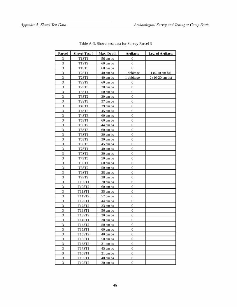
48
Appendix A: Shovel Test Data Archaeological Survey and Testing at Camp Bowie
Table A-3. Shovel test data for Survey Parcel 3
Parcel Shovel Test # Max. Depth Artifacts Lev. of Artifacts3 T1ST1 56 cm bs 03 T1ST2 60 cm bs 03 T1ST3 60 cm bs 03 T2ST1 40 cm bs 1 debitage 1 (0-10 cm bs)3 T2ST1 40 cm bs 1 debitage 2 (10-20 cm bs)3 T2ST2 60 cm bs 0 3 T2ST3 28 cm bs 03 T3ST1 50 cm bs 03 T3ST2 39 cm bs 03 T3ST3 27 cm bs 03 T4ST1 39 cm bs 03 T4ST2 45 cm bs 03 T4ST3 60 cm bs 03 T5ST1 60 cm bs 03 T5ST2 44 cm bs 03 T5ST3 60 cm bs 03 T6ST1 30 cm bs 03 T6ST2 30 cm bs 03 T6ST3 45 cm bs 03 T7ST1 40 cm bs 03 T7ST2 30 cm bs 03 T7ST3 50 cm bs 03 T8ST1 60 cm bs 03 T8ST2 50 cm bs 03 T9ST1 28 cm bs 03 T9ST2 38 cm bs 03 T10ST1 20 cm bs 03 T10ST2 60 cm bs 03 T11ST1 35 cm bs 03 T11ST2 57 cm bs 03 T12ST1 44 cm bs 03 T12ST2 23 cm bs 03 T13ST1 56 cm bs 03 T13ST2 20 cm bs 03 T14ST1 38 cm bs 03 T14ST2 50 cm bs 03 T15ST1 60 cm bs 03 T15ST2 40 cm bs 03 T16ST1 50 cm bs 03 T16ST2 31 cm bs 03 T17ST1 45 cm bs 03 T18ST1 21 cm bs 03 T19ST1 40 cm bs 03 T19ST2 20 cm bs 0

49
Archaeological Survey and Testing at Camp Bowie Appendix A: Shovel Test Data
Table A-4. Shovel test data for tested sites
Site Shovel Test # Max. Depth Artifacts Lev. of Artifacts41BR248 ST1 60 cm bs 041BR248 ST2 60 cm bs 041BR248 ST3 60 cm bs 041BR248 ST4 60 cm bs 0
41BR392 ST1 25 cm bs 041BR392 ST2 50 cm bs 1 shotgun shell cap 2 (10-20 cm bs)41BR392 ST2 50 cm bs 1 flake, 1 shell fragment 5 (40-50 cm bs)41BR392 surface coll. 0 1 projectile point 0
41BR467 ST1 8 cm bs 041BR467 ST2 15 cm bs 041BR467 ST3 13 cm bs 041BR467 ST4 19 cm bs 0
41BR469 ST1 42 cm bs 041BR469 ST2 11 cm bs 041BR469 ST3 26 cm bs 041BR469 ST4 24 cm bs 041BR469 ST5 30 cm bs 1 debitage 1 (0-10 cm bs)41BR469 ST6 14 cm bs 0
41BR471 ST1 46 cm bs 1 debitage 1 (0-10 cm bs)41BR471 ST2 60 cm bs 041BR471 ST3 51 cm bs 041BR471 ST4 38 cm bs 0
41BR522 E2 60 cm bs 3 debitage 1 (0-10 cm bs)41BR522 E2 60 cm bs 2 debitage 2 (10-20 cm bs)41BR522 E3 60 cm bs 1 debitage, 1 projectile point 3 (20-30 cm bs)41BR522 N1 50 cm bs 3 debitage 1 (0-10 cm bs)41BR522 N2 60 cm bs 041BR522 S1 60 cm bs 041BR522 S2 60 cm bs 0
Related Documents