Utah Rock Art, Volume 2, Page 51 Jesse E. Warner ARCHAEOASTRONOMY SITES IN INDIAN AND DAVIS CREEKS In the sandstone canyons of southeastern Utah there are two adjacent areas where ancient sun watchers used majestic for- mations as backdrops for their solar obser- vations. In Indian Creek there are several sites where rock art and ruins mark observa- tion posts. Toward the mouth of Davis Canyon there is a cluster of 13 masonry structures. Prior to the Utah Rock Art Research Association's survey of Indian- Davis Creeks these were not recorded on any state records or in the original survey of Nickens and Associates. Many of these sites are unique to the area. Some structures are built on mushroom-like pedestals, similar to those at nearby Pinnacle Village. The most impressive structures are those which have an axis aligned to where promi- nent astronomical observations have been documented. These archaeoastronomical ruins are extremely unique because they contain information about the ancient cosmological use of this area. This paper contains observation information of three solar events during 1982, where from a ruin or rock art panel the sun was observed to rise or set on the horizon, rather than interact with a rock art panel. These ruins will be described by the observations made first from summer solstice, second from fall equinox and third from winter solstice. The Davis Creek Solstice Village The first observation I made was a summer solstice sunrise from the South Observatory Ruin (42SA10695) (Figures 1-2). Because this ruin has its axis pointing toward the notch in South Six-shooter Peak my imme- diate impression, since this was an accurate solstice alignment, was that the main observation to be made from this ruin should be at winter solstice sunset. Up to this time no one had considered looking for a summer solstice sunrise through this observatory in a northeasterly direction. The observation I made on June 21 was unique since the Morning Star, the moon and the sun all rose at nearly the same place on the horizon. The successive risings of all these were visible by looking toward the northeast through the 38 foot corridor of the 8 to 10 foot wide structure. According to my calculation this would be a once in a lifetime observation, a very significant fact if the crescents and dots were derived from these multiple risings. In Indian Creek there are large numbers of moon-like crescents and dots. The unique rising of the moon and the morning star from the same point on the horizon may have a relationship with these crescents and dots (Brandt 1977). Many of the crescents in Indian Creek occur at solar observation sites. The Indian Creek crescents are very similar to those reported from Pleasant Creek, Utah (Wellmann 1976, 1979). Brandt (1977:36) and Brandt and William- son (1979:S7) state that crescents with dots are astronomical indicators and are relative- ly rare. Brandt (1977) also states that three crescents and dots occur in one panel in Fern Cave, Lava Beds National Monument, California. According to Brandt (1977) this represented 10% of all known sites with crescents and dots until we recorded those in Indian Creek. In Indian Creek there are

Welcome message from author
This document is posted to help you gain knowledge. Please leave a comment to let me know what you think about it! Share it to your friends and learn new things together.
Transcript
Utah Rock Art, Volume 2, Page 51
Jesse E. Warner
ARCHAEOASTRONOMY SITES IN INDIAN AND
DAVIS CREEKS
In the sandstone canyons of southeastern
Utah there are two adjacent areas where
ancient sun watchers used majestic for-
mations as backdrops for their solar obser-
vations. In Indian Creek there are several
sites where rock art and ruins mark observa-
tion posts. Toward the mouth of Davis
Canyon there is a cluster of 13 masonry
structures. Prior to the Utah Rock Art
Research Association's survey of Indian-
Davis Creeks these were not recorded on
any state records or in the original survey of
Nickens and Associates. Many of these
sites are unique to the area. Some structures
are built on mushroom-like pedestals,
similar to those at nearby Pinnacle Village.
The most impressive structures are those
which have an axis aligned to where promi-
nent astronomical observations have been
documented. These archaeoastronomical
ruins are extremely unique because they
contain information about the ancient
cosmological use of this area.
This paper contains observation information
of three solar events during 1982, where
from a ruin or rock art panel the sun was
observed to rise or set on the horizon, rather
than interact with a rock art panel. These
ruins will be described by the observations
made first from summer solstice, second
from fall equinox and third from winter
solstice.
The Davis Creek Solstice Village
The first observation I made was a summer
solstice sunrise from the South Observatory
Ruin (42SA10695) (Figures 1-2). Because
this ruin has its axis pointing toward the
notch in South Six-shooter Peak my imme-
diate impression, since this was an accurate
solstice alignment, was that the main
observation to be made from this ruin
should be at winter solstice sunset. Up to
this time no one had considered looking for
a summer solstice sunrise through this
observatory in a northeasterly direction.
The observation I made on June 21 was
unique since the Morning Star, the moon
and the sun all rose at nearly the same place
on the horizon. The successive risings of all
these were visible by looking toward the
northeast through the 38 foot corridor of the
8 to 10 foot wide structure. According to
my calculation this would be a once in a
lifetime observation, a very significant fact
if the crescents and dots were derived from
these multiple risings.
In Indian Creek there are large numbers of
moon-like crescents and dots. The unique
rising of the moon and the morning star
from the same point on the horizon may
have a relationship with these crescents and
dots (Brandt 1977). Many of the crescents
in Indian Creek occur at solar observation
sites. The Indian Creek crescents are very
similar to those reported from Pleasant
Creek, Utah (Wellmann 1976, 1979).
Brandt (1977:36) and Brandt and William-
son (1979:S7) state that crescents with dots
are astronomical indicators and are relative-
ly rare. Brandt (1977) also states that three
crescents and dots occur in one panel in
Fern Cave, Lava Beds National Monument,
California. According to Brandt (1977) this
represented 10% of all known sites with
crescents and dots until we recorded those
in Indian Creek. In Indian Creek there are

Jesse Warner, Archaeoastronomy Sites in Indian & Davis Creeks, Page 52
Figure 1
about 20 crescents and dots. There are also
several other sites in Utah where crescents
and dots occur.
The next observation during summer
solstice was a sunrise from the North
Observatory Ruin (42SA10692). At first,
this siting was felt to be unimportant, since
it was a diagonal alignment from the
southwest corner to the northeast corner of
the ruin (Figure 3). Another observation
was made by looking over the top of the
North Observatory from 42SA-10693. This
siting showed that these two ruins are in
Utah Rock Art, Volume 2, Page 53
exact alignment for a summer solstice
sunrise. The north ruin retains only a
fraction of its original height. When
occupied, it may have been high enough to
block the visibility of the horizon from
42SA10693 making the sun appear to rise
over the North Observatory.
On summer solstice from Boulder House
(42SA10696) the sun set in an arc until it
balanced on top of the large spire of North
Six-shooter Peak. Within the last decade a
large section of this spire was seen collaps-
ing. In spite of this last change in the spire
the sun still makes a precise contact with its
apex. To test whether this is the exact
location to see the sun in a balanced posi-
tion on top of the highest spire I moved
about 100 feet to the northeast. At this
point the sun was visible to the right and
would set to the north, completely missing
the top of the spire. By moving to the
southwest about 100 feet, the sun would
appear to set on the left talus (Figure 4).
Only at Boulder House would the sun be
balanced on the highest spire of North Six-
shooter Peak. The sun's setting in an arc
naturally moves off its balanced position
and continues its descent to the right of the
spire. Three sunrises and one sunset were
recorded from these sites for summer
solstice.
During sunrise on equinox, September 22,
1982, the sun rose directly through the
central corridor of the North Observatory.
With its orientation directly toward sunrise,
it establishes that this ruin served as an
equinox marker for those who built it. No
other structures in the immediate vicinity
were checked for equinox alignments.
One problem facing the modern day ethnog-
rapher is proving that a ruin was really an
observation post. The fact that the sun,
when viewed from a ruin, rises through a
notch on the horizon does not provide
sufficient evidence to prove that it was an
observation post. Only under circumstances
like Boulder House, where the structure was
placed so as to have a unique alignment
with such an impressive geological feature,
can its identification as an observation post
be assumed.
My first winter solstice observation was a
sunrise from the North Observatory.
Standing at the northwest corner of this ruin
the sun was seen to rise over the southeast-
ern corner of the building, an observation
that needs careful consideration to deter-
mine its full significance. It is interesting
that the ruin's alignment for summer and
winter solstice could possibly have deter-
mined both the width and the length of this
structure (Figure 3). No ruins for a sunrise
observation over North or South Six-shooter
Peaks were located in the immediate
vicinity. Some ruins in Canyonlands
National Park do have alignments with
these features but have not been checked.
It was originally assumed that since the
South Observatory was aligned with the
notch in South Six-shooter Peak that this
alignment also provided an orientation for a
solar observation. However, the trajectory
of the setting sun missed the notch in South
Six-shooter Peak and set into the left talus at
a point that would have been observable
through the tunnel of the South Observatory
if South Six-shooter was not there (Figure
5).
After making the above observations, I
realized that the purpose for the unusual
lengths of North and South Observations
was to fix points of sunrise on the horizon.
The length of the ruins was to provide the
tunnel effect to fix these points. At this
location the sun rises on the distant horizon
where no particularly unique geographical
feature exists. Therefore, the tunnel effect
is necessary to fix the sun's appearance
without question. Boulder House and the
ruin at site 42SA10693 had alignments with

Jesse Warner, Archaeoastronomy Sites in Indian & Davis Creeks, Page 54
Figures 2 - 5
North and South Six-shooter Peaks and also
the North Observatory and, therefore, did
not need the tunnel effect to isolate the
points of the sun's interaction.
We made two observations from these ruins
at the same time of the 1982 winter solstice.
This made a total of eight observations: four
See Page 41

Utah Rock Art, Volume 2, Page 55
at summer solstice, two at equinox and two
at winter solstice.
Indian Creek Sunrise Observations
Since the sun's rising and setting were so
important at the locations in Davis Canyon,
it seemed reasonable to assume that it had
the same importance in nearby Indian
Creek. In lower Indian Creek there is a
double-spiral that sets on top of a pedestal
of light during summer solstice. This event
is similar to the solstice sunsets from
Boulder House where the sun sets on top of
North and South Six-shooter Peaks. To test
the hypothesis that the rising and setting of
the sun at these three times of the year were
important, I searched the horizon for
prominent features. There are several
geological formations that should be
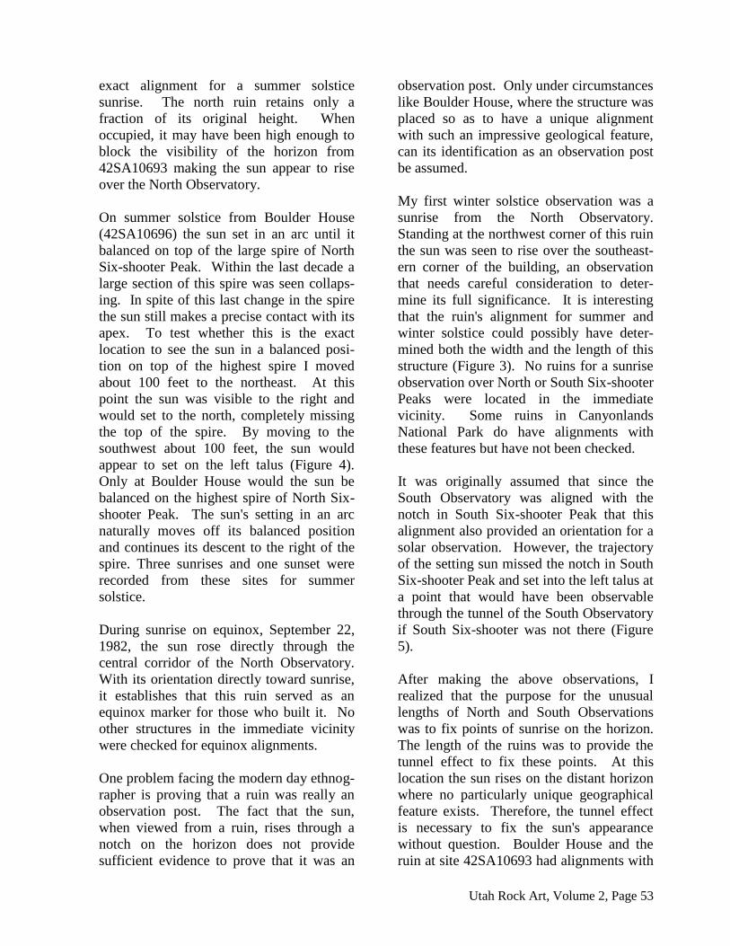
checked. Only sunrises over The Three
Sisters were recorded. The reason the Three
Sisters was elected was that they are the
most unique geological feature in that area.
During summer solstice a sunrise was
viewed over The Three Sisters from a
unique tongue-like projection of rock.
There are no ruins on that alignment. Also,
no cliffs suitable for rock art are present. In
short, there in nothing to indicate that this
spot was an actual observation post (Figure
6A).
Because of the lack of any associated
archaeology, some have doubts that this was
an actual observation post. To increase the
probability that this tongue-like rock was an
observation site I felt that an observation of
the sunrise over The Three Sisters for
equinox and winter solstice should also
have been observed. Hopefully, these sites
would have been marked. If they were
observed from locations where there were
either ruins or rock art with solar symbolism
that would provide more validity for the fact
that the tongue-like projection was actually
an observation post.
The Indian Creek location for observing
sunrise during equinox was determined
from a previously known red pictograph site
that has sets of concentric circles above a
small structure. At sunrise at that point the
sun rose over The Three Sisters making it
an equinox sunrise observatory (Figure 6B).
During the day the movement of the shad-
ows vertically bisected each concentric
circle without any interactions. These and
other similar sites in the canyon show that
not all rock art with solar symbolism was
intended to physically interact with light
and shadow. Instead, these may simply
mark locations where solar sittings can be
observed.
Winter solstice sunrise over The Three
Sisters was made from the Second Hand
Ruin (Figure 6C). There are four panels of
rock art in the immediate vicinity of this
structure. On the back wall the Second
Hand Ruin there are two negative hand
prints that give the ruin its name. On either
side of the ruin are complex petroglyph
panels.
The next observation was at the McCreery
Site where I viewed the sun's appearance
through a window during its most southern
sunrise (Figure 7A). As the sun appeared it
cast a rectangle of light on a lower ledge
(Figure 7B and C). As the sun continued to
rise the rectangle became a narrow dagger
of light that disappeared when it touched the
cliff face below a rising snake. In the
window is another snake rising upwards.
On a higher level between these two glyphs
are other glyphs assumed to be relevant to
solar observations. For more detailed
descriptions of this observation see McCre-
ery in this volume.
Jesse Warner, Archaeoastronomy Sites in Indian & Davis Creeks, Page 56
Figures 6 and 7
At the Indian Creek Barrier Canyon Site
during winter solstice it was noticed that the
sunrise would be visible through a man-
made notch over a point separating a side
canyon and Indian Creek. This same man-
made notch was observed to cast a cup-
shaped shadow around a dot-centered circle
during Equinox (Warner n.d.). To test if the
original position of the sunrise was im-
portant, I walked back along the cliff toward
the main canyon that I had already surveyed
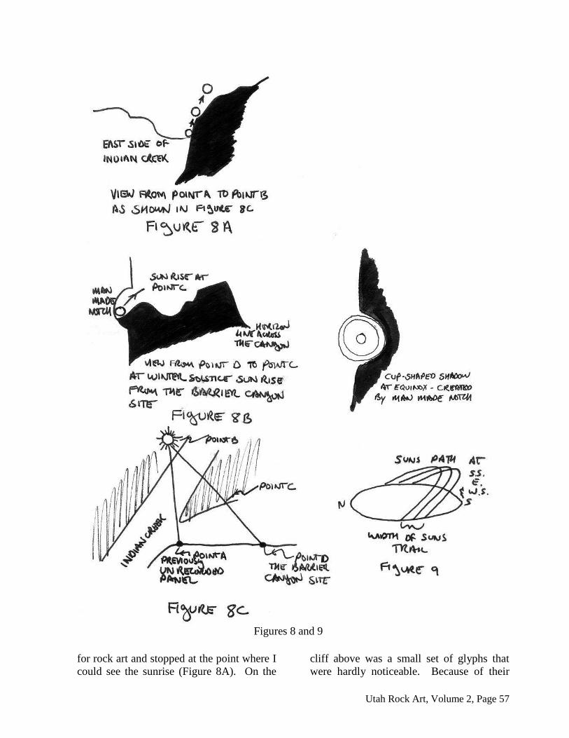
Utah Rock Art, Volume 2, Page 57
Figures 8 and 9
for rock art and stopped at the point where I
could see the sunrise (Figure 8A). On the
cliff above was a small set of glyphs that
were hardly noticeable. Because of their
Jesse Warner, Archaeoastronomy Sites in Indian & Davis Creeks, Page 58
elevation and indistinctness these glyphs
were missed at least twice by four different
rock art surveyors. This panel is centered in
at least four hundred yards of cliff that
contains no other rock art until the Barrier
Canyon Style rock art panel is reached. It
appears more than coincidental that this
panel would occur at the exact location
where the sunrise at winter solstice is
visible. A diamond-like grid in this panel is
identical to a large number of grids at the
Barrier Canyon Style Site. After recording
that unique finding I returned to the Barrier
Canyon Style panel in time to see the sun
rise through the man-made notch (Figure
8B). This sunrise was on the rim of the side
canyon opposite the Barrier Canyon panels
(Figure 8C).
CONCLUSIONS
The theoretical importance dealing with the
rising and setting of the sun in and out of
notches probably carries mythological
symbolism and was touched upon in a
previous paper (Warner 1983, n.d.). Here I
need to stress a few more points not consid-
ered in the earlier paper. Most present day
Pueblo structures have the concept of center
with the four cardinal directions encoded
into their structure. We as outsiders look at
this symbolism with an uninitiated indiffer-
ence. However, early ethnographers like
Lewis Henry Morgan (1881) noted that
architecture dichotomized and reinforced
roles in social structure. Modern ethnog-
raphers such as Eliade (1959) and
Nobokov (1982) explain the habitation and
shrine as an attempt to duplicate the original
world. Volumes have been written about
the Indian's concepts of society, habitation
and cosmos, the idea of emergence, of crea-
tion, of center, of direction and of maintain-
ing harmony. The observatories in Indian-
Davis Creeks, without doubt, contain the
essence of that spirit. They fill the land-
scape with a sense of sacred space and
places of power.
These observatories incorporate in their
architecture a symbolism of the world with
its center. The location of these observato-
ries is equidistant from the sun's position on
horizon at sunrise and sunset. Observations
from summer solstice through equinox to
winter solstice mark the limits of the sky
dome. The northern and southern extremes
delineate the width of the sun's trail.
Depending on the time of year, the sun will
rise north of east, east and south of east and
then move diagonally southward overhead.
At each position of rising and settling from
summer solstice onward the sun is observed
to rise at a lower angle farther to the south
as it marks its path along the sky dome.
Thus it travels the upper edge of this
reversed bowl.
This solar center makes up a microcosm, a
spiritual grid and consequently an observa-
tion center for worship and ritual as well.
By the location of the sun ancient astrono-
mers set the calendar for agriculture and
ceremony. When these locations were first
discovered by the ancient sun priests and
star gazers, they must have known its
potential and power. When the tunnel
observatories were laid out and raised rock
by rock, the ancient priests placed a wedge
of time into the primordial mass of cosmos.
This wedge, like the daggers of light and the
passing of shadows, marks time by provid-
ing a known reference for the sun's ritual
passage. The observance of the sun at
specific times also helped to maintain a
universal order and helped to avert chaos.
As one visualizes the concentration of
archaeoastronomical sites along Indian-
Davis Creeks, thoughts keep returning to
the question of why so many in what is
assumed to be an area of comparatively
sparse population as opposed to a center
like Chaco Canyon. Other than Fajada
Butte, that serves to mark solstice, equinox
and the lunar cycles, there are only a few
Utah Rock Art, Volume 2, Page 59
other known observatories in Chaco Can-
yon.
There can only be four answers to why
Indian-Davis Creeks have such a high
concentration of solar observatories. One,
not all of the observation sites in Chaco
Canyon and elsewhere have been located.
Two, a few sites were sufficient for the long
and extensive habitation at Chaco and other
areas. Three, the inhabitants of Indian-
Davis Creeks were far more concerned with
the sun worship and solar phenomena than
their counterparts in other locations. Or
four, there were many more people living in
the Indian-Davis Creeks area than is now
assumed. The final answer is probably
various degrees of the above.
With discoveries of new sites such as those
at Petrified National Forest, Arizona and
Waterflow, New Mexico it is felt that there
must be many sites yet to be found and
documented. Until all of the solar observa-
tion posts and rock art sites that remain to
be found at centers of concentrated Anasazi
habitation are documented, we will never be
able to determine that relative degree of
concern this culture had for the sun. Each
area has many such sites yet to be discov-
ered. Whether that number will approach
that of Indian-Davis Creeks will take
several years of research to determine.
The analogy of the solar observation sites in
Indian Creek to those of Chaco Canyon may
be an invalid comparison. Jennings (1963)
states that concentrated centers of habita-
tions like Pueblo Bonito are not representa-
tive of the Anasazi life way that a New
York skyscraper is of American life style.
The average Anasazi way of life is the small
ranchieras spread all over the Southwest,
not the large high density dwellings like
Pueblo Bonito. Indian Creek is a prime
example of the average type of Anasazi
habitation. To make an accurate compari-
son other areas that represent this average
population situation should be surveyed.
In Further Archaeological Investigations in
the Gibson Dome Study Area of Southeast-
ern Utah, by G. C. Tucker (under the
direction of Nickens and Associates)
archaeological sites in the Davis Canyon
area were further investigated after the
initial survey of Nickens and Associates.
One of the purposes of this later survey was
to locate and evaluate nine sites that were
recorded by the Utah Rock Art Research
Association. Their subsequent evaluation of
our assessment was that only one site was
significant and that six sites were non-
significant. The comments they made on
the North and South Observatories,
42SA10693, Boulder House and some of
their conclusions as presented below typify
the general attitude. Only comments on
those ruins in this complex that are now
known to have solar observations have been
included.
The North Observatory (42SA10692):
The solstice observatory hypothesis,
while plausible, is by no means the
only explanation for the function of
this site. We believe it more likely,
considering its location on a topo-
graphic eminence with a commanding
view of lower terrain to the north,
east, and south, may have served as a
defensive outpost or observation facil-
ity. We consider the site to be non-
significant and not likely to contribute
information important to a further
understanding of regional prehistory.
The site lies well above and west of
regional prehistory. The site along
the latter should have no direct, and
little indirect, impact upon it.
The Ridge Site (SA10693): The loca-
tions of the standing walls on the
south and east sides, where the struc-
ture is most visible from the lower

Jesse Warner, Archaeoastronomy Sites in Indian & Davis Creeks, Page 60
slopes, suggest that it may have func-
tioned as an observation post. This
function seems to us to be more like-
ly--given the information we now
available--than astronomical purpose
which has been postulated by Man-
ning and associates. We consider the
site to be non-significant since it is
not likely to yield additional infor-
mation important to an understanding
of regional prehistory.
The South Observatory (42SA10695):
The astronomical alignment hypothe-
sis advanced by Mr. Manning and his
associates is plausible but by no
means a foregone conclusion. The
structure on this site does indeed point
directly toward South Six-shooter
Peak and we cannot deny the latter
must have played an important role in
the everyday lives of the prehistoric
inhabitants. We cannot affirm, how-
ever, an astronomical purpose for this
alignment: it would be equally plau-
sible to posit mundane, less exotic
reasons for its construction. We con-
sider the site to be significant because
of its peculiar alignment but more
work is necessary to determine the
validity of the astronomical hy-
pothesis. The site's distance from
direct impact including so-called
"ground vibration" by heavy equip-
ment.
The Boulder House (42SA10796):
The purpose of the structures on this
site seem again to be primarily de-
fensive. The highest portions of the
standing walls on Room 1 are located
on that side of the ruin which faces
towards the small drainage valley to
the south; it is obscured by various
topographic features on the other
three sides. We consider this site to
be non-significant since it does not
appear to posses characteristics which
would further our understanding of
local prehistory (Tucker 1982:10).
While I maintain that one of the prime
functions of the Davis Creek ruins was for
solar observations, I do not contend that all
the ruins were, or that their only function
was, for solar observation. That other
mundane functions must have also occurred
in the immediate vicinity cannot be denied.
I am certain that there were quasi-perma-
nent habitations in the immediate vicinity.
The presence of corn in nearby granaries,
and in a cave, indicates that both horticul-
ture and gain storage were practiced in the
immediate area.
I feel that I, and others, have successfully
established reasonable doubt regarding the
credibility of Dr. Tucker's reassessment of
these sites as non-significant. It is interest-
ing that during the four to five day period
spent in the area during summer-winter
solstice and equinox no person affiliated
with any other survey group were seen in
the area checking for solar alignments.
However, there were some individuals from
environmental groups present for observa-
tions. We believe the foregoing evidence
establishes a firm case for a reassessment of
the importance and uniqueness of these
sites.
Upon request for the addendum under the
public information act we received a letter
from the Division of State History, dated
August 16, 1982, from the desk of Melvin
T. Smith, Director and State Historic
Preservation Officer. In this letter he stated:
These sites were originally recorded
by a para-professional archaeological
group, including the site recorder, Mr.
Steve Manning. Steve Manning as-
sessed eight of the nine sites in the
project area as of National Register
significance. The Assessment of sig-
nificance was based on their geo-

Utah Rock Art, Volume 2, Page 61
graphic location, being a complex of
unusual and important ruins which
they termed "Solstice Village", thus
relating them to an astronomical
alignment.
Of the total nine sites that Dr. Tucker
revisited, he reports two of the sites
not being found, (these are lithic scat-
ters) one was recommended for stabi-
lization, one was assessed of National
Register significance, and five were
reassessed as non-significant by Dr.
Tucker, an opinion which disagrees
with Mr. Manning's assessment of
significance.
Of the five sites Dr. Tucker and Mr.
Manning disagree on, with respect to
significance, there is a question of
significance concerning three of the
sites. These are 42SA10691, 10692
and 10696. As mentioned, these sites
were originally recorded by Mr. Man-
ning as part of an important complex
he designated "Solstice Village"
The three ruins, along with the as-
sessed significant site, 42SA10695,
are located in such a geographical lo-
cation that Dr. Tucker assessed them
as not part of the "Solstice Village",
an opinion he did not entirely aban-
don, but rather as "defense oriented
observation posts". Dr. Tucker as-
sessment of these sites as defense
oriented observation posts strengthens
rather than lessens the point of argu-
ment for National Register sig-
nificance of these sites.
To the Preservation Officer's and the
State Archaeologist, Dr. David Mad-
sen's knowledge, there has been little
or no work done in Utah studying
defense oriented observation outposts
of the Anasazi during any time of
their occupation in this southeastern
area of Utah.
Both singularly and as a group these
sites can yield important information
about the prehistoric practices of the
Anasazi...
Although the sites are in a state of
deterioration, information of their
function as either defense outposts or
as possible astronomical phenomenon
can be determined (Smith 1982).
Hopefully these sites will receive sufficient
attention before it is too late. Since the
announcement of these sites was made
public the western wall of the South Obser-
vatory has fallen or was pushed over.
REFERENCES
Brandt, John C.
1977 Pictographs and Petroglyphs of
the Southwest Indians. Technolo-
gy Review. 80(2):32-39.
Brandt, John C., and Ray A. Williamson
1979 The1054 Supernova and Native
American Rock Art. Archaeoas-
tronomy 1:S1-S38.
Eliade, Mircea
1959 The Sacred and the Profane. Har-
per Torchbooks. The Cloister Li-
brary. Harper and Row Publish-
ers, New York.
Jennings, Jesse
1964 Anthropology and the World of
Science. Bulletin of the Universi-
ty of Utah. Vol. 54. No. 18. Salt
Lake City.
Morgan, Lewis H.
1962 League of the Iroquois. Corinth
Books. Rochester, New York.
Jesse Warner, Archaeoastronomy Sites in Indian & Davis Creeks, Page 62
Nabohov, Peter
1982 American Indian Architecture and
Cosmology. Lecture sponsored
by the Museum of Natural Histo-
ry, University of Utah, Nov. 12.
Smith, Melvin T.
1982 Letter dated August 16, 1982,
from the Director and State His-
toric Preservation Officer.
Tucker, Gordon C. Jr.
1982 Further Archaeological Inves-
tigations in the Gibson Dome
Study Area in Southeastern Utah.
P. R. Nickens, Principle Investi-
gator. Nickens and Associates,
Montrose, Colorado.
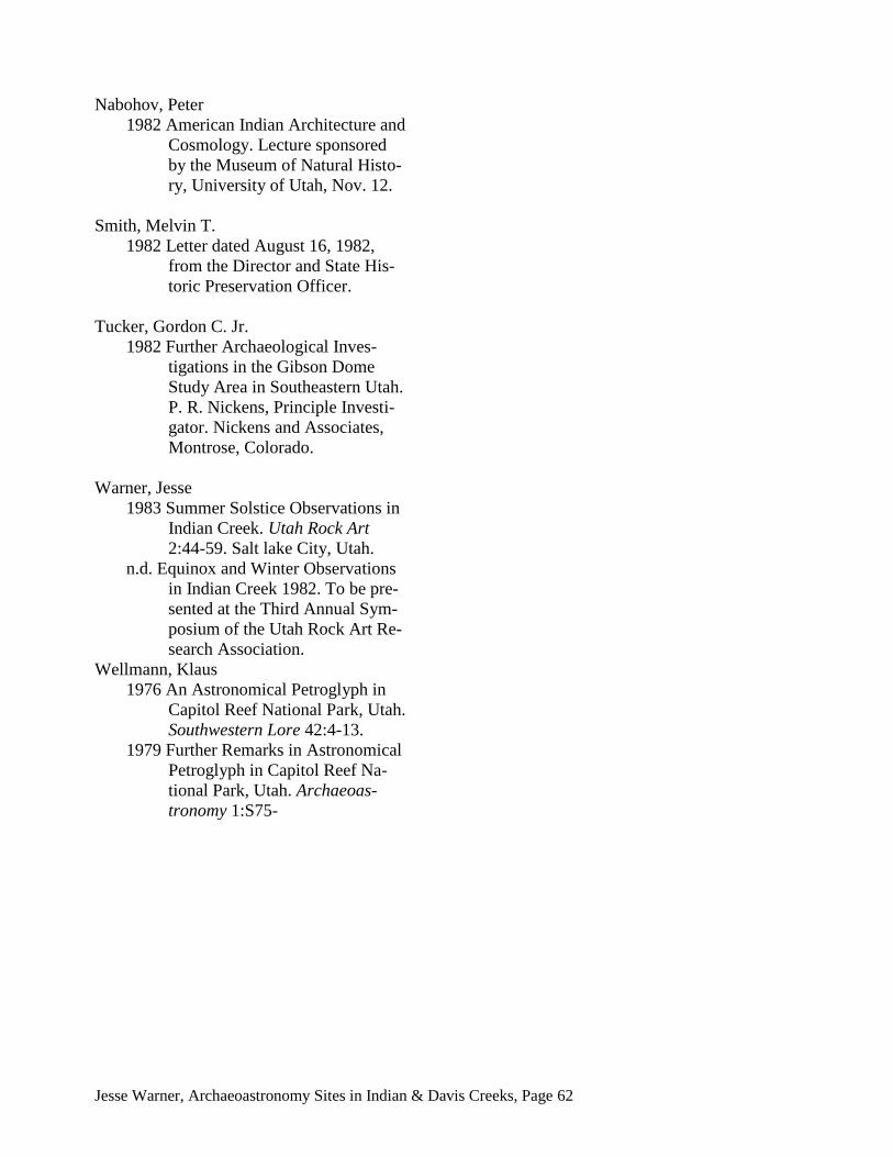
Warner, Jesse
1983 Summer Solstice Observations in
Indian Creek. Utah Rock Art
2:44-59. Salt lake City, Utah.
n.d. Equinox and Winter Observations
in Indian Creek 1982. To be pre-
sented at the Third Annual Sym-
posium of the Utah Rock Art Re-
search Association.
Wellmann, Klaus
1976 An Astronomical Petroglyph in
Capitol Reef National Park, Utah.
Southwestern Lore 42:4-13.
1979 Further Remarks in Astronomical
Petroglyph in Capitol Reef Na-
tional Park, Utah. Archaeoas-
tronomy 1:S75-
Related Documents