Arch: 383 Arch: 383 Introduction to Introduction to GIS GIS Week Week 1 1 Introduction to Introduction to GEOGRAPHIC INFORMATION SYSTEMS GEOGRAPHIC INFORMATION SYSTEMS Can Kara Can Kara Faculty of Architecture Spring 2014 [email protected] ARC 383 ARC 383

Arch: 383 Introduction to GIS Week 1 Introduction to GEOGRAPHIC INFORMATION SYSTEMS Can Kara Faculty of Architecture Spring 2014 [email protected] ARC.
Dec 26, 2015
Welcome message from author
This document is posted to help you gain knowledge. Please leave a comment to let me know what you think about it! Share it to your friends and learn new things together.
Transcript

Arch: 383 Arch: 383 Introduction toIntroduction to GIS GIS WeekWeek 1 1
Introduction to Introduction to GEOGRAPHIC INFORMATION SYSTEMSGEOGRAPHIC INFORMATION SYSTEMS
Can KaraCan KaraFaculty of Architecture
Spring 2014
ARC 383ARC 383

Introduction to GIS
Information systems What is GIS? Components of the modern GIS GIS applications Advantages of GIS

Information systems : Information systems : Some definitionsSome definitions
Data : Data : Facts, numbers, words, images, measurements of a set of variables.
Information SystemsInformation Systems : : A system of persons, data records and activities that process the data and information in an organization, and it includes the organization's manual and automated processes
Decision Support SystemDecision Support System (DSS) : (DSS) :A DSS is an interactive software-based system intended to help decision makers compile useful information from raw data, documents, personal knowledge, and/or business models to identify and solve problems and make decisions.

What is GIS?What is GIS?
G: Geographic: (Spatial data. Can I assign a coordinate x, y?)
I: Information: (Databases, MS Access/SQL, dBase, Oracle, even Excel)
S: Systems: (Computers, networks; bigger/faster the better!)

Geographic information systems Geographic information systems (GIS)(GIS)
In order to start solving problems, we will have to ask questions. A great majority of problems we encounter will have us ask the following question : what is? where?
Where ? Where ? The geographic location on earth;
What ?What ?Characteristics of attributes.A GIS helps us answer the question : “what is where?”

Geographic information systems Geographic information systems (GIS)(GIS)
With the use of GIS software, With the use of GIS software,
We create a conceptual and computerized model of the earth. The logical steps are :Collecting data;Organizing data;
Making abstractions (models) of real-life processes that interact with collected data; Analyzing model results; Making conclusions; Making decisions.

Geographic information systems Geographic information systems (GIS)(GIS)
Various ways of defining GIS :Various ways of defining GIS :
• A GIS is a computer system, which can collect, store and analyze spatial (geographic) data;
• GIS is a collection of computer hardware, software and users to make up a system, which collects, stores, manipulates and displays spatial information about the earth;
• “ A GIS is a computer based system that provides the following four sets of capabilities to handle geo referenced data: 1. input; 2. datamanagement (data storage and retrieval); 3. manipulation and analysis; 4. output “

Geographic information systems Geographic information systems (GIS)(GIS)
An integration of five basic componentsAn integration of five basic components

GIS concepts are not new!GIS concepts are not new!
London cholera epidemic 1854
Cholera deathCholera death
Water pumpWater pump
+

Software TypesSoftware Types
Two main categories for softwares :Two main categories for softwares :
Commercial softwareCommercial software
Open-source softwareOpen-source software
Some examples for commercial GIS softwares:Some examples for commercial GIS softwares:
Arc/Info(ESRI), Microstation(Intergraph), Arc/Info(ESRI), Microstation(Intergraph), MapInfo, Geomedia, CARIS, etc...MapInfo, Geomedia, CARIS, etc...
Some examples for open source GIS softwares:Some examples for open source GIS softwares:
Grass, Quantum GIS, uDig, openJUMP, etc...Grass, Quantum GIS, uDig, openJUMP, etc...

Commercial SoftwareCommercial Software
• Closed source; This is the traditional business model;
• Developed only one company or organization ;• Some many popular (and best?) software are
commercial software;• Professional-grade support is usually available
from the vendor;• The vendor has the last word on the development
strategies;

Commercial GIS softwares:Commercial GIS softwares:
ESRI: Environmental Systems Research ESRI: Environmental Systems Research InstituteInstitute (www.esri.com) (www.esri.com)

Commercial GIS softwares:Commercial GIS softwares:ESRI: Environmental Systems Research ESRI: Environmental Systems Research
InstituteInstitute (www.esri.com) (www.esri.com)

The ArcMap interface
Display
area
Display
area
Table of ContentsDockable
Context menu
Draw toolbarStatus bar
Standard toolbar Menu bar
Title bar
Tools toolbar Tear-off and dockable
Tools toolbar Tear-off and dockable

Open-Source SoftwareOpen-Source Software
• Free; Anyone can use it.• Comes with the source code. Anyone can modify it.• Relatively less complex software;• Support is usually available from the other users;• Users develop it collaboratively over the internet;• The development strategies are decided by the
users;• Integration with other similar software is seamless
thanks to open standards.

Open Source GIS softwaresOpen Source GIS softwares
OpenGIS: Quantum GIS (www.qgis.org)OpenGIS: Quantum GIS (www.qgis.org)

Open-Source SoftwareOpen-Source Software
Free Redistribution : The license shall not restrict any party from selling or giving away the software;
Source Code : The program must include source code, and must allow distribution in source code as well;
Derived Works : The license must allow modifications and derived works, and must allow them to be distributed under the same terms as the license of the original software;
No Discrimination Against Persons or Groups; No Discrimination Against Fields of Endeavor : The
license must not restrict anyone from making use of the program in a specific field of endeavor;
License Must Not Restrict Other Software : The license must not place restrictions on other software that is distributed along with the licensed software;
License Must Be Technology-Neutral.

Components of a GISComponents of a GIS
GIS Data (Spatial Data)GIS Data (Spatial Data)

Components of a GISComponents of a GIS
PlacenamePlacenameGrid co-ordinateGrid co-ordinate
PostcodePostcode
Distance & bearingDistance & bearingDescriptionDescription
Latitude / LongitudeLatitude / Longitude
What makes data spatial?What makes data spatial?

Components of a GISComponents of a GIS
GIS data have two important elements:
geographic (spatial) elements attribute (non-geographic) elements
GIS DataGIS Data

Components of a GISComponents of a GISGIS dataGIS data

Vector data (features)Vector data (features) Raster data (grids or cells)Raster data (grids or cells) Feature (point, line, polygon)Feature (point, line, polygon) LayerLayer Layer fileLayer file Data Model or Type or Format Data Model or Type or Format
(geodatabase, shapefile, etc.)(geodatabase, shapefile, etc.)
Components of a GISComponents of a GISGIS dataGIS data

Vector Vector
Components of a GISComponents of a GIS
RasterRaster
Example: Vegetation Example: Elevation
GIS dataGIS data

Vector
Raster
Data has
Representing geographic features
X,YX,Y
X,YX,Y X,Y
X,Y
X,Y
Row
Column
Behavior rulesBehavior rules
GeometryGeometry
AttributesAttributes

VectorVector
Common GIS Data Structures (cont.)Common GIS Data Structures (cont.)
Geographic features Geographic features are represented by are represented by points, lines, and points, lines, and polygonspolygons
Points, lines and Points, lines and polygons are defined polygons are defined by a set or sets of x,y by a set or sets of x,y coordinatescoordinates

VectorVector Feature typesFeature types
• PointPoint Single location Single location
having an x,y (and having an x,y (and sometimes z) sometimes z) coordinatecoordinate
Has no length or Has no length or areaarea
Common GIS Data Structures (cont.)Common GIS Data Structures (cont.)

VectorVector Feature typesFeature types
• LineLine A series of A series of
connecting verticesconnecting vertices Has length but no Has length but no
areaarea
Common GIS Data Structures (cont.)Common GIS Data Structures (cont.)

VectorVector Feature typesFeature types
• PolygonPolygon One or more One or more
connecting lines that connecting lines that form a single spatial form a single spatial featurefeature
Have both perimeter Have both perimeter and areaand area
Common GIS Data Structures (cont.)Common GIS Data Structures (cont.)

VectorVector Attribute tableAttribute table
• Contains information about and is linked to Contains information about and is linked to spatial featuresspatial features
• Each feature has one associated record Each feature has one associated record (row) in the attribute table(row) in the attribute table
Common GIS Data Structures (cont.)Common GIS Data Structures (cont.)

Raster:Raster: Spatial data are stored Spatial data are stored
in a two dimensional in a two dimensional matrix, much like a matrix, much like a checkerboardcheckerboard
Each grid, or cell, Each grid, or cell, contains a valuecontains a value
Common GIS Data Structures (cont.)Common GIS Data Structures (cont.)

Representing Spatial ElementsRepresenting Spatial Elements
• RASTERRASTER
• VECTORVECTOR
• Real WorldReal World

High-Resolution Satellite Data: Raster or Vector?

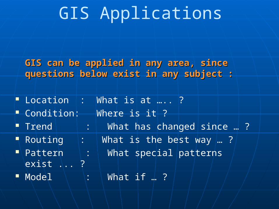
GIS Applications
GIS can be applied in any area, sinceGIS can be applied in any area, since questions below exist in any subject :questions below exist in any subject :
Location : What is at ….. ? Condition: Where is it ? Trend : What has changed since … ? Routing : What is the best way … ? Pattern : What special patterns exist ... ? Model : What if … ?

GIS Applications
Formal disciplines GIS are based on :Formal disciplines GIS are based on : Remote Sensing Geodesy Photogrammetry Surveying Cartography Computer science Mathematics Statistics

Examples - Site SelectionExamples - Site Selection

Examples - Visibility AnalysisExamples - Visibility Analysis
www.esri.com

Examples - Visibility AnalysisExamples - Visibility Analysis
www.esri.com

Examples – Digital Elevation Examples – Digital Elevation Model DevelopmentModel Development

Examples – Digital Elevation Examples – Digital Elevation Model DevelopmentModel Development
EMU Student ProjectEMU Student Project

Examples – Digital Elevation Examples – Digital Elevation Model + Building HeightModel + Building Height
Barrio Los Claveles, Maiquetia, Venezuela, seen in ArcGIS 3D Analyst.

Examples – Urban SimulationExamples – Urban Simulation
Esri CityEngine

Risk AssessmentRisk Assessment


GIS Applications
• Geodesy and geomatics
• Civil Engineering• Geology• Geophysics• Petroleum• Urban planning• Mining• Criminology
• Oceanography• Agriculture• Biology• Environmental sciences• Ecology• Geography• Sociology• Archaeology• Anthropology
Disciplines making use of GIS:Disciplines making use of GIS:

GIS Applications
Areas of application :Areas of application :• Business : GeoBusiness;• Census, elections;• Surveying and mapping;• Map and database publishing;• Public health and safety (hospital, police,
fire…);• Real estate information management;

GIS ApplicationsGIS Applications
Areas of application :Areas of application :• Municipal Applications (infrastructure,...);• Engineering Applications;• Forest Development and Management/Erosion
and deforestation;• Agriculture and land use, harvest prognoses;

GIS Applications
Areas of application :Areas of application :• Environmental applications
(vegetation, pollution, ...);• Hydrology, water pollution
(drainage patterns, water catchments, …);• Geology
(fault-line detection, mineral detection);• Transportation, vehicle tracking, navigation
systems, ...

GIS ApplicationsGIS Applications
Areas of application :Areas of application :• Regional development and planning;• Oil operations;• Military applications;• Archeology;• Education and research;

ArcGIS Software – licenses and ArcGIS Software – licenses and applications applications
Common GIS data structuresCommon GIS data structures
Data types supported by ArcGISData types supported by ArcGIS
ArcCatalog and ArcMap user ArcCatalog and ArcMap user interfacesinterfaces
ArcGIS Desktop Help systemArcGIS Desktop Help system
OverviewOverview

ArcCatalog: organize and manage ArcCatalog: organize and manage GIS dataGIS data
ArcMap: view, edit, and analyze ArcMap: view, edit, and analyze spatial data and create mapsspatial data and create maps
ArcGIS Desktop Software Suite – ArcGIS Desktop Software Suite – ApplicationsApplications

ArcToolboxArcToolbox• geoprocessing geoprocessing • data conversion data conversion • defining map projectionsdefining map projections
ArcGIS Desktop Software Suite – ArcGIS Desktop Software Suite – Applications (cont.)Applications (cont.)

Vector DataVector Data• ArcInfo CoverageArcInfo Coverage
• ArcView ShapefileArcView Shapefile
• ArcGIS GeodatabaseArcGIS Geodatabase
• CAD dataCAD data Microstation design files (.dgn)Microstation design files (.dgn) AutoCAD drawing files (.dwg)AutoCAD drawing files (.dwg) AutoCAD AutoCAD drawing interchange files (.dxf)drawing interchange files (.dxf)
Spatial Data Types Spatial Data Types Supported by ArcGISSupported by ArcGIS

Raster Data Raster Data • Images – e.g., DOQQ’s, DRG’s, Images – e.g., DOQQ’s, DRG’s,
(.tif, .bil, .jpg, .sid, etc.); can now be in (.tif, .bil, .jpg, .sid, etc.); can now be in geodatabasesgeodatabases
• ArcInfo Grid – e.g., DEM’sArcInfo Grid – e.g., DEM’s
Tabular DataTabular Data• Comma or tab delimited text (.txt)Comma or tab delimited text (.txt)• dBase (.dbf) file containing coordinate data dBase (.dbf) file containing coordinate data
(X,Y coordinate)(X,Y coordinate)
Spatial Data TypesSpatial Data TypesSupported by ArcGIS (cont.)Supported by ArcGIS (cont.)

ArcCatalogArcCatalog
The data management application The data management application of ArcGISof ArcGIS
• Import, export, and preview datasetsImport, export, and preview datasets
• Drag and drop data into ArcMapDrag and drop data into ArcMap
• Create new spatial datasetsCreate new spatial datasets
• View, create, and/or edit metadataView, create, and/or edit metadata

ArcCatalog InterfaceArcCatalog Interface
Data Exploring
Viewing Modes
Catalog Tree
Connect toFolder

ArcCatalog (cont.)ArcCatalog (cont.) Establish folder connections to access dataEstablish folder connections to access data

ArcCatalog (cont.)ArcCatalog (cont.) Create new spatial datasets, e.g., shapefilesCreate new spatial datasets, e.g., shapefiles

ArcCatalog (cont.)ArcCatalog (cont.) Preview spatial and tabular dataPreview spatial and tabular data

View, create and/or manage metadataView, create and/or manage metadata
ArcCatalog (cont.)ArcCatalog (cont.)

View, create and/or manage metadataView, create and/or manage metadata
ArcCatalog (cont.)ArcCatalog (cont.)

Metadata ContentMetadata Content• Identification InformationIdentification Information
• Data Quality InformationData Quality Information
• Spatial Data Organization InformationSpatial Data Organization Information
• Spatial Reference InformationSpatial Reference Information
• Entity and Attribute InformationEntity and Attribute Information
• Distribution Information Distribution Information
• Metadata Reference InformationMetadata Reference Information
ArcCatalog (cont.)ArcCatalog (cont.)

ArcCatalog (cont.)ArcCatalog (cont.) Launch ArcMap and open the ArcToolbox Launch ArcMap and open the ArcToolbox
windowwindow

ArcMapArcMap ArcGIS application used to ArcGIS application used to display, query, edit, display, query, edit,
create, and analyze geographic datacreate, and analyze geographic data

ArcMap InterfaceArcMap InterfaceStandard Toolbar
Status Bar
Table of Contents – Lists layers (stacking order; like a legend)
Data Frame (a groupof layers)
TOC Tabs – differentdisplay modes
Data Frame display modes –“Data” or “Layout”
ArcCatalogMap displayWindow(Data Frame)

Fundamental component of ArcMapFundamental component of ArcMap Collection of data layers (in data Collection of data layers (in data
frames) and a cartographic layoutframes) and a cartographic layout Stores references to the locations of Stores references to the locations of
the data sources (e.g., shapefiles, the data sources (e.g., shapefiles, coverages, image files, etc.) NOT the coverages, image files, etc.) NOT the data themselvesdata themselves
Has .mxd file extensionHas .mxd file extension
Map DocumentMap Document

Map Document (cont.)Map Document (cont.)

Map Document PropertiesMap Document Properties• Data Source OptionsData Source Options
Map Document (cont.)Map Document (cont.)

ArcMap ToolbarsArcMap Toolbars
ArcMap provides a ArcMap provides a number of other number of other toolbars:toolbars:• Draw Draw
• EditorEditor
• LayoutLayout
• Effects, etc. Effects, etc.

ToolsTools toolbar is always active and can be toolbar is always active and can be used in either the data or layout view used in either the data or layout view
StandardStandard toolbar contains buttons and tools toolbar contains buttons and tools that provide fast and easy access to many that provide fast and easy access to many operations, e.g., Save, Add Data, etc.operations, e.g., Save, Add Data, etc.
ArcMap Toolbars (cont.)ArcMap Toolbars (cont.)

Source tabSource tabDisplay tabDisplay tab
Data Data FrameFrame
Selection tab
ArcMap Table of ContentsArcMap Table of Contents

ArcMap Data ViewArcMap Data View
Browse, edit, and analyze the Browse, edit, and analyze the spatial data on a map spatial data on a map

Prepare finished maps for reports Prepare finished maps for reports and publicationsand publications
ArcMap Layout ViewArcMap Layout View

ArcMap Interface - CustomizedArcMap Interface - Customized

Coordinate Systems Coordinate Systems (Projections)(Projections)
Geographic Geographic – “lat long”, unprojected – “lat long”, unprojected

Coordinate SystemsCoordinate Systems Projected Projected – UTM, Lambert, Albers… – UTM, Lambert, Albers…

Data Frame Properties Data Frame Properties – Right Click!– Right Click!
Map units: Map units: horizontal measures horizontal measures in which distances are in which distances are calculated in a data calculated in a data frameframe• Feet, meters, etc.Feet, meters, etc.
Display units: Display units: horizontal measures horizontal measures in which distances are in which distances are actually displayed on actually displayed on the screenthe screen• Feet, meters, etc.Feet, meters, etc.

Data Frame Properties (cont.)Data Frame Properties (cont.) Map units are set when a coordinate system is Map units are set when a coordinate system is
specified for a data framespecified for a data frame

On-the-fly projection requires coordinate On-the-fly projection requires coordinate system definition (often stored in .prj file) system definition (often stored in .prj file)
Data Frame Properties (cont.)Data Frame Properties (cont.)

Map units can be set by user when coordinate Map units can be set by user when coordinate system is not specifiedsystem is not specified
Data Frame Properties (cont.)Data Frame Properties (cont.)

Includes tools for Includes tools for manipulating spatial manipulating spatial datadata
System Tool
Model
Toolset
Script
ArcToolboxArcToolbox

Context Sensitive Help Context Sensitive Help can be accessed with the can be accessed with the “What’s This?” Button“What’s This?” Button
Access ArcGIS Desktop Access ArcGIS Desktop Help system under the Help system under the Help menuHelp menu
Online HelpOnline Help

Online Help (cont.)Online Help (cont.) ArcGIS Desktop Help is organized by ArcGIS Desktop Help is organized by
topic and often by applicationtopic and often by application

Press the Press the F1F1 key to access key to access help about help about dialog box dialog box elementselements
Online Help (cont.)Online Help (cont.)

ESRI user forumsESRI user forums• http://support.esri.com/index.cfm?fa=forums.gatewayhttp://support.esri.com/index.cfm?fa=forums.gateway
Online Help (cont.)Online Help (cont.)

Related Documents