ArcGIS for Imagery GIS FOR A SUSTAINABLE WORLD 2018

Welcome message from author
This document is posted to help you gain knowledge. Please leave a comment to let me know what you think about it! Share it to your friends and learn new things together.
Transcript

ArcGIS for Imagery
GIS FOR A SUSTAINABLE WORLD 2018

Presentation TitleThank You to Our
Sponsors
Aerial Photos
High-Resolution SatellitesSmall Sats
ArcGIS | A Complete Imagery Platform
All Major Sensors
Dynamic Image Processing Server
Advanced Imagery Workstation
Classification
Change Analysis
Stereo View
Image Analysis
Image Space and Mensuration
DTM Generation Seamless
Orthophotos
Ortho Mapping
Drone Mapping
Drone2Map
NDVI Pro Imagery Tab
Powerful Analytics
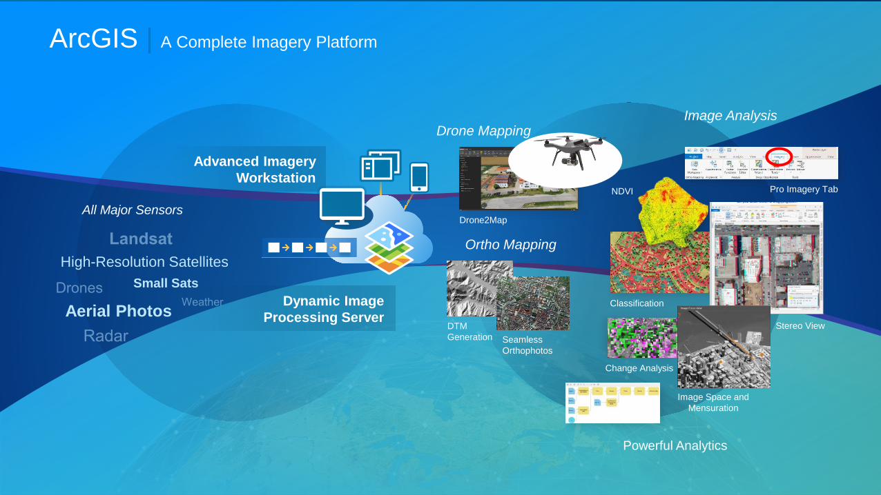
ArcGIS Imagery Content
• World Imagery• World Landsat• World Elevation• NAIP• HYCOM• Sentinel 2
Scientific
NAIP Multispectral
Landsat
World Elevation
Sentinel-2
World Imagery
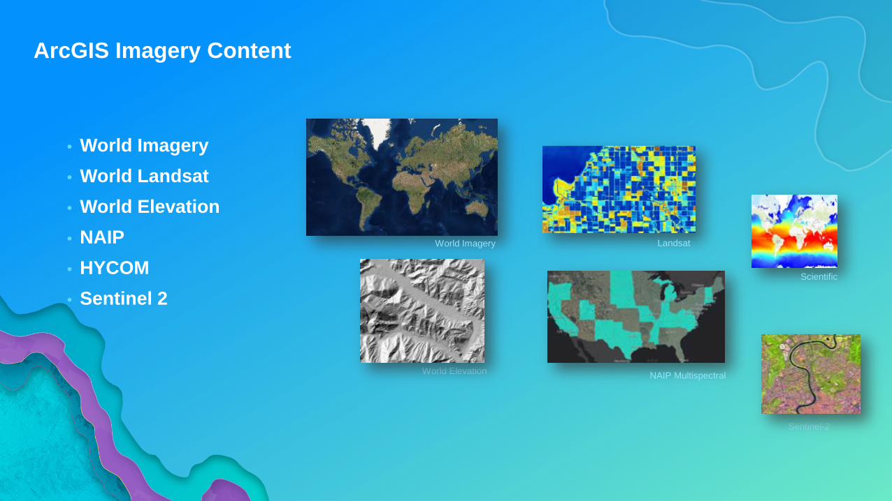
Professional Imagery & Geospatial Analysts
Enterprise
The ArcGIS PlatformIs a Comprehensive Imagery Platform
System of Record
Manage and processyour imagery
System of Insight
Extract Information
System ofEngagement
Share imagery products andinformation
Content from:ArcGIS Online, Partners, Your Org.
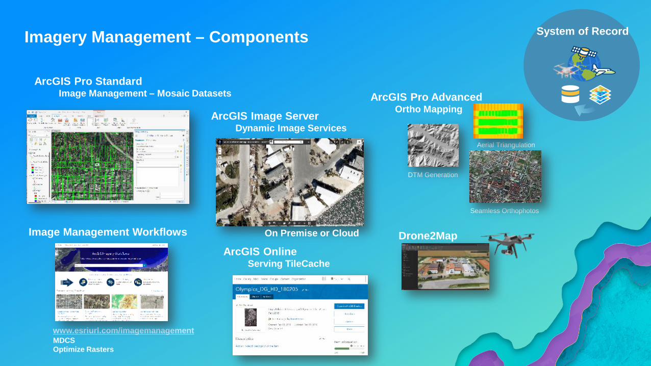
Imagery Management – Components System of Record
Aerial Triangulation
DTM Generation
Seamless Orthophotos
ArcGIS Pro StandardImage Management – Mosaic Datasets
Drone2Map
ArcGIS Image ServerDynamic Image Services
ArcGIS OnlineServing TileCache
Image Management Workflows
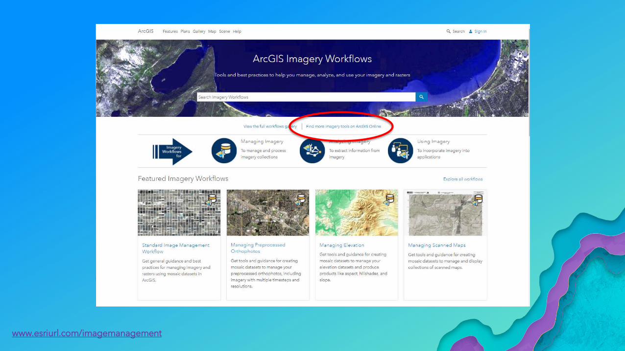
www.esriurl.com/imagemanagementMDCSOptimize Rasters
ArcGIS Pro AdvancedOrtho Mapping
On Premise or Cloud
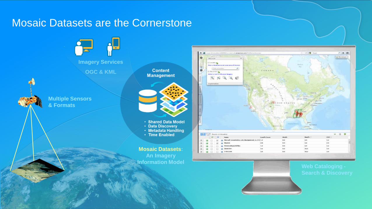
Mosaic Datasets are the Cornerstone
Imagery Services
OGC & KML
Mosaic Datasets: An Imagery
Information Model
Multiple Sensors & Formats
Web Cataloging -Search & Discovery
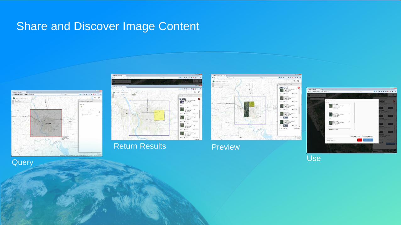
Share and Discover Image Content
Query
Return Results PreviewUse
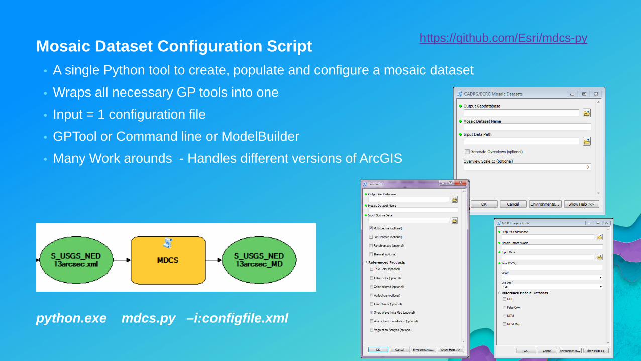
Mosaic Dataset Configuration Script• A single Python tool to create, populate and configure a mosaic dataset• Wraps all necessary GP tools into one • Input = 1 configuration file• GPTool or Command line or ModelBuilder• Many Work arounds - Handles different versions of ArcGIS
python.exe mdcs.py –i:configfile.xml
https://github.com/Esri/mdcs-py
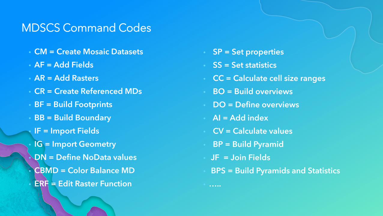
MDSCS Command Codes
• CM = Create Mosaic Datasets
• AF = Add Fields
• AR = Add Rasters
• CR = Create Referenced MDs
• BF = Build Footprints
• BB = Build Boundary
• IF = Import Fields
• IG = Import Geometry
• DN = Define NoData values
• CBMD = Color Balance MD
• ERF = Edit Raster Function
• SP = Set properties
• SS = Set statistics
• CC = Calculate cell size ranges
• BO = Build overviews
• DO = Define overviews
• AI = Add index
• CV = Calculate values
• BP = Build Pyramid
• JF = Join Fields
• BPS = Build Pyramids and Statistics
• …..
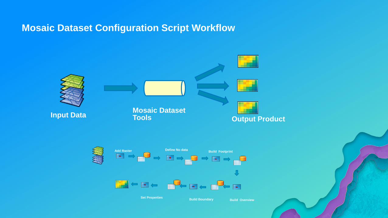
Input Data
Add Raster Build Footprint
Build Overview
Define No data
Build BoundarySet Properties
Mosaic DatasetTools Output Product
Mosaic Dataset Configuration Script Workflow

Demo
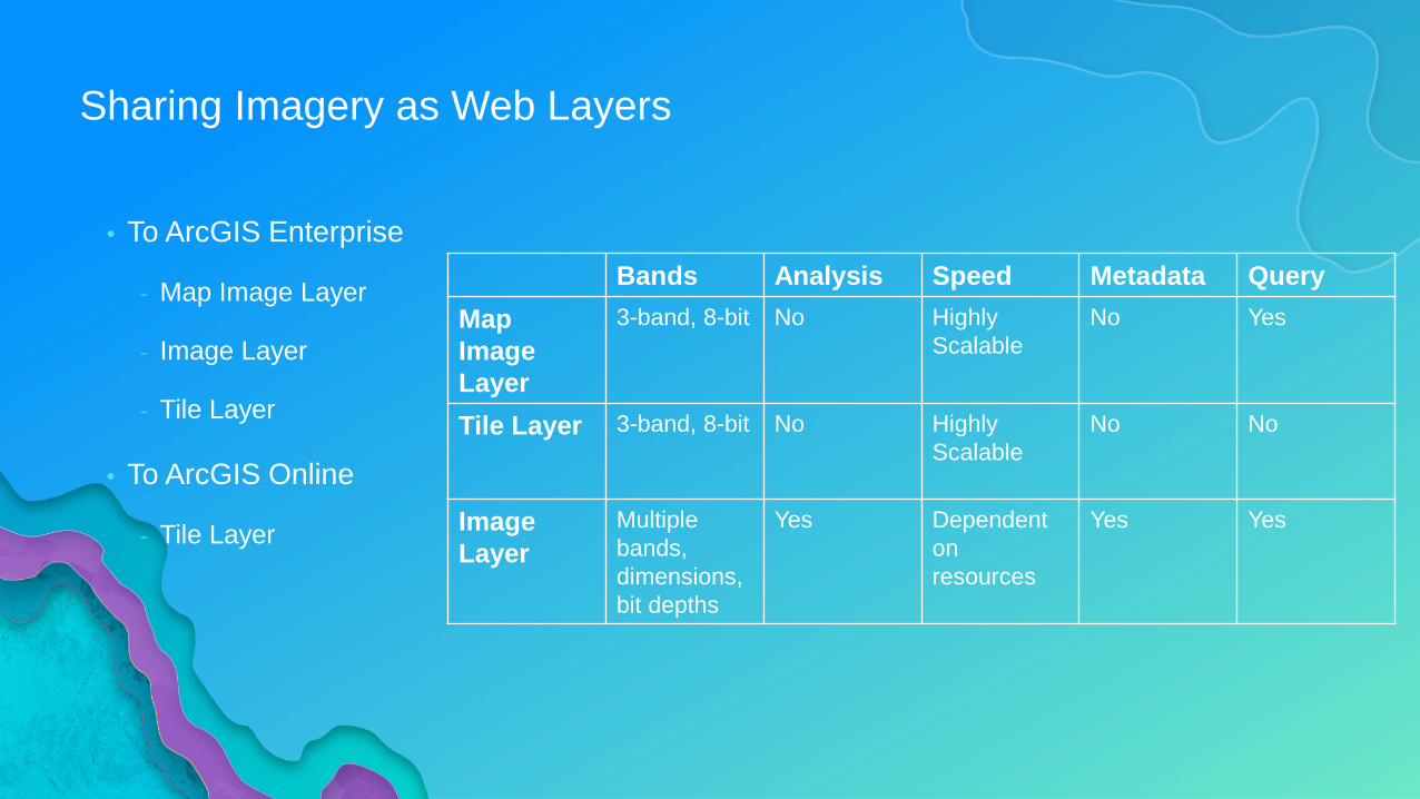
Sharing Imagery as Web Layers
• To ArcGIS Enterprise
- Map Image Layer
- Image Layer
- Tile Layer
• To ArcGIS Online
- Tile Layer
Bands Analysis Speed Metadata QueryMap Image Layer
3-band, 8-bit No Highly Scalable
No Yes
Tile Layer 3-band, 8-bit No Highly Scalable
No No
Image Layer
Multiple bands, dimensions, bit depths
Yes Dependent on resources
Yes Yes
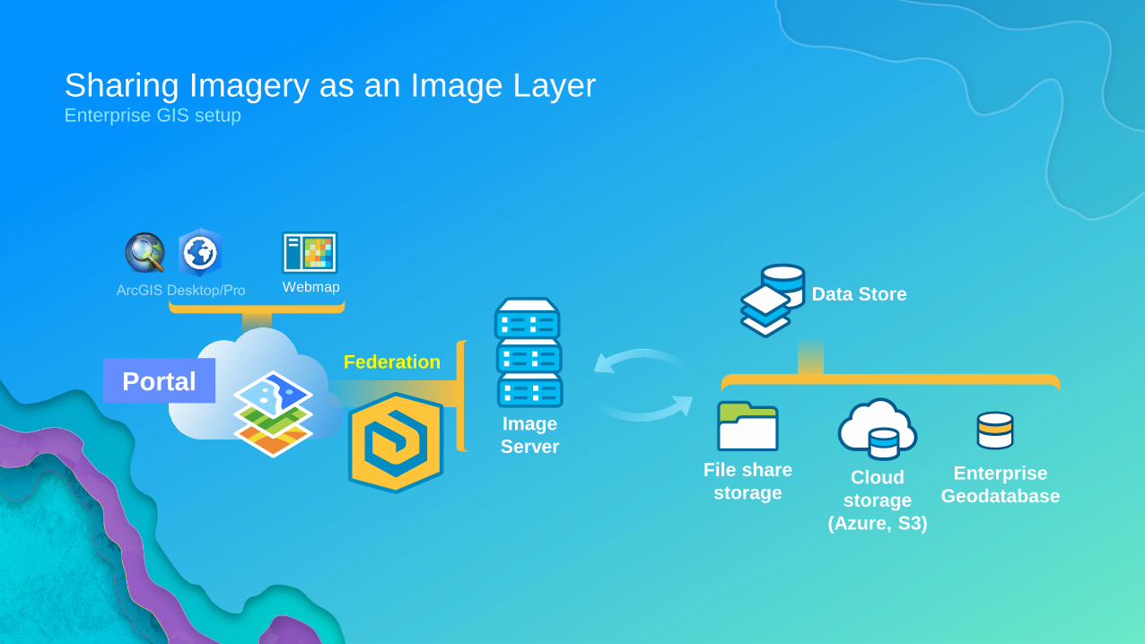
Sharing Imagery as an Image LayerEnterprise GIS setup
Portal
Webmap
Image Server
Cloud storage
(Azure, S3)
File share storage
Data Store
Federation
Enterprise Geodatabase
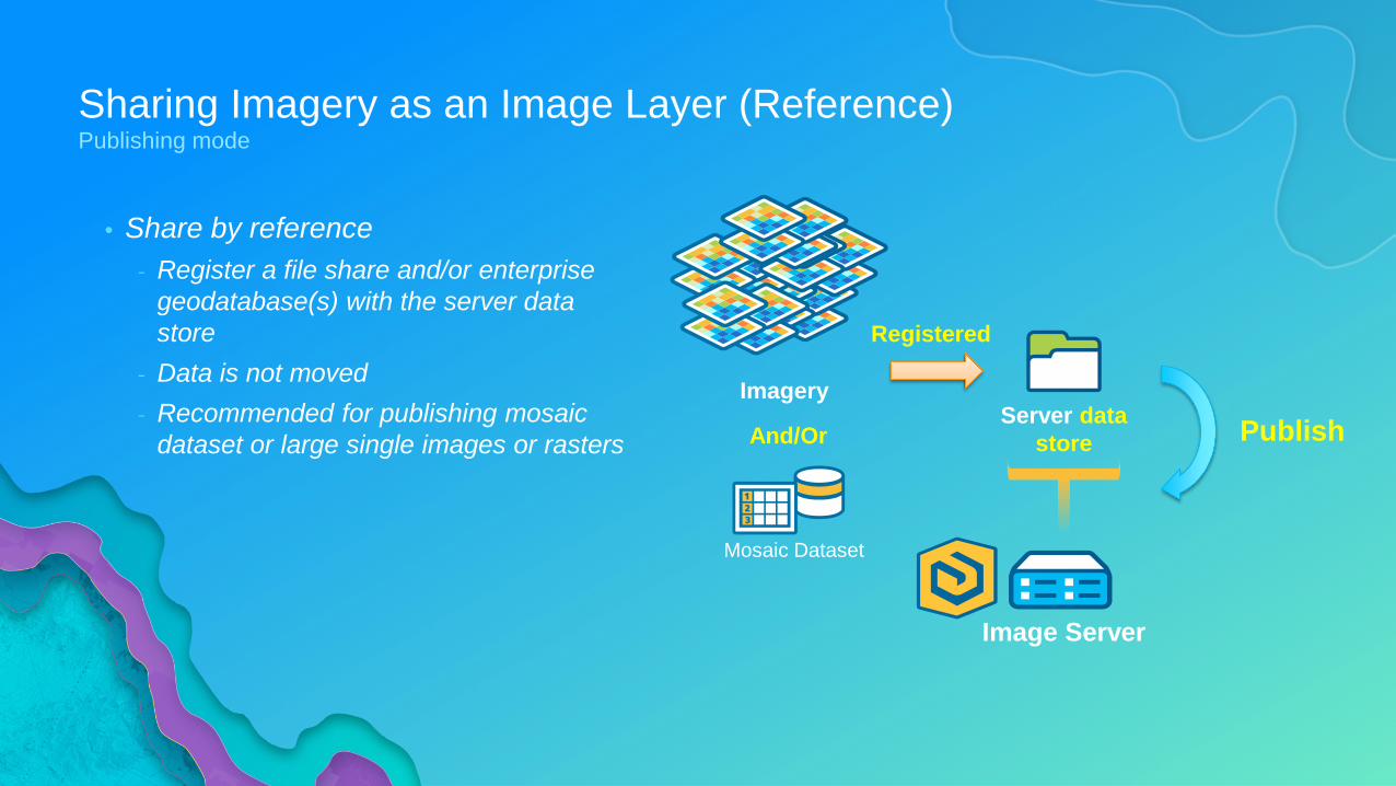
Sharing Imagery as an Image Layer (Reference)Publishing mode
• Share by reference- Register a file share and/or enterprise
geodatabase(s) with the server data store
- Data is not moved- Recommended for publishing mosaic
dataset or large single images or rasters
Mosaic Dataset
And/Or
Image Server
Server data store Publish
Registered
Imagery
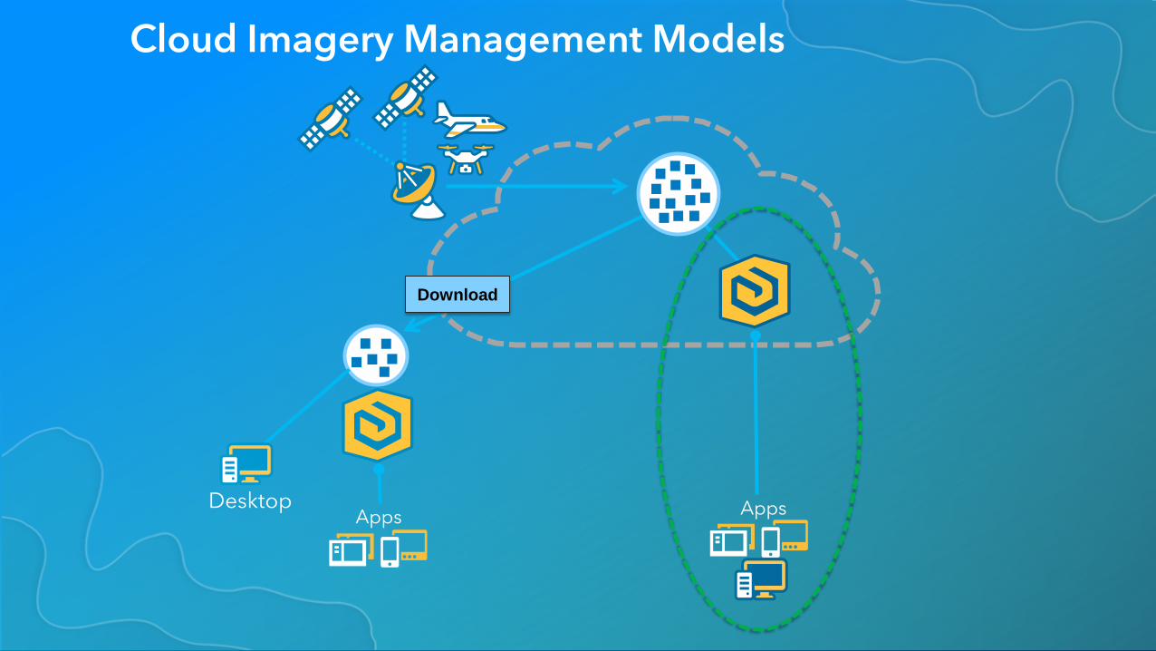
Cloud Imagery Management Models
Download
Apps AppsDesktop
Running ArcGIS Image Server in the Cloud
• Advantages- Lower cost resilient storage
- Lower cost enterprise compute
- Simpler install
- Simpler scalability
• Disadvantages- Data needs to be uploaded
- Different storage types
- Infrastructure changes
- Potential security concerns
- Potential for complex data access policies
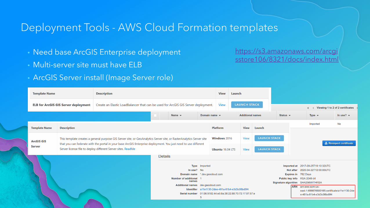
Deployment Tools - AWS Cloud Formation templates
• Need base ArcGIS Enterprise deployment
• Multi-server site must have ELB
• ArcGIS Server install (Image Server role)
https://s3.amazonaws.com/arcgisstore106/8321/docs/index.html
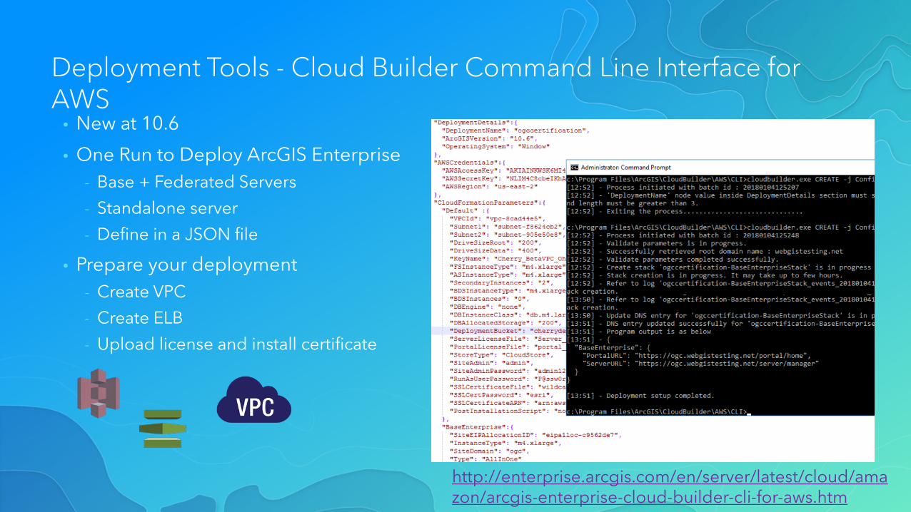
Deployment Tools - Cloud Builder Command Line Interface for AWS
• New at 10.6
• One Run to Deploy ArcGIS Enterprise- Base + Federated Servers
- Standalone server
- Define in a JSON file
• Prepare your deployment- Create VPC
- Create ELB
- Upload license and install certificate
http://enterprise.arcgis.com/en/server/latest/cloud/amazon/arcgis-enterprise-cloud-builder-cli-for-aws.htm
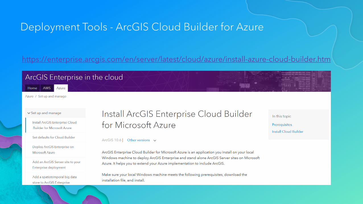
Deployment Tools - ArcGIS Cloud Builder for Azure
https://enterprise.arcgis.com/en/server/latest/cloud/azure/install-azure-cloud-builder.htm

Demo
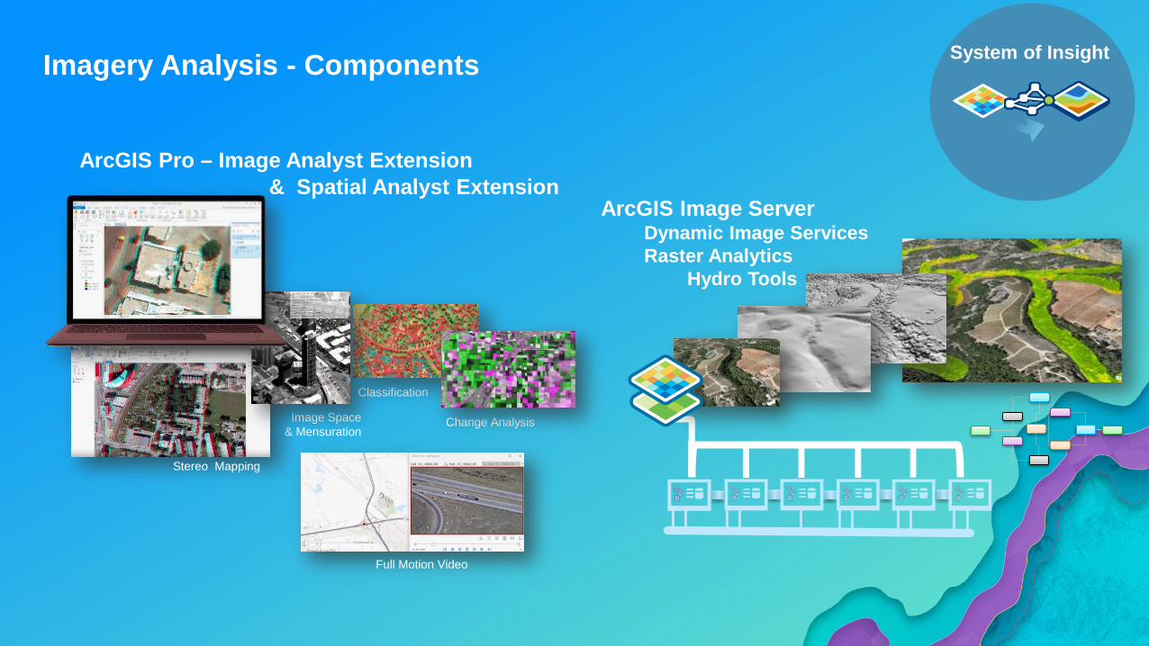
Imagery Analysis - Components System of Insight
ArcGIS Pro – Image Analyst Extension
ArcGIS Image ServerDynamic Image ServicesRaster Analytics
Hydro Tools
Image Space& Mensuration
Classification
Change Analysis
Stereo Mapping
& Spatial Analyst Extension
Full Motion Video
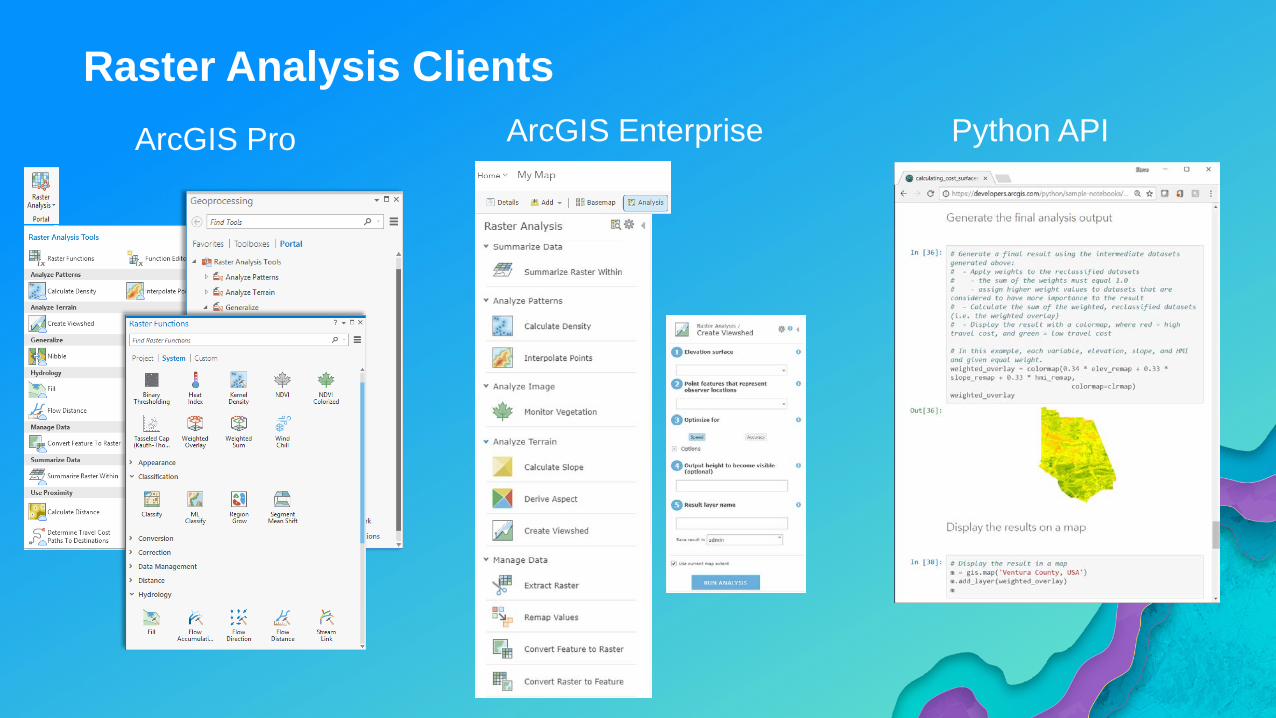
Raster Analysis ClientsArcGIS Pro ArcGIS Enterprise Python API
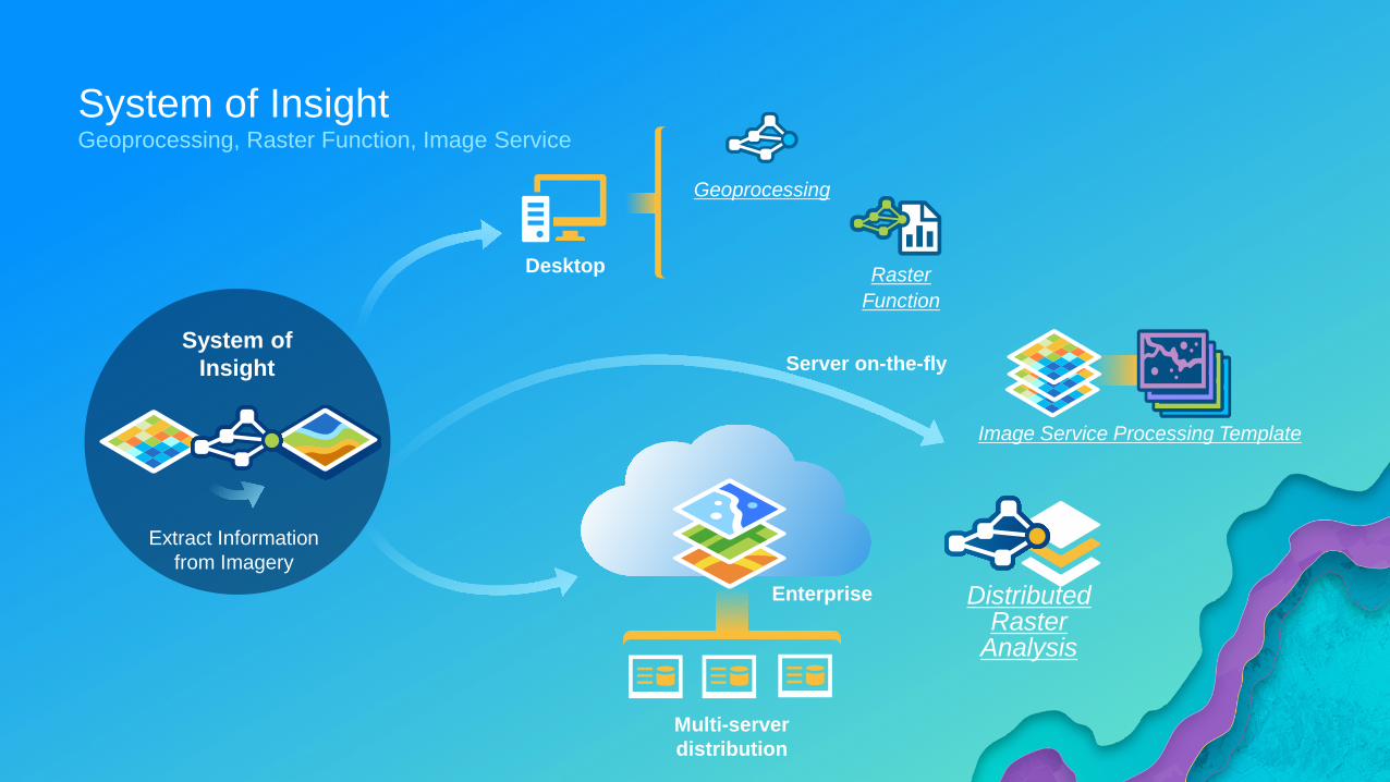
System of InsightGeoprocessing, Raster Function, Image Service
System ofInsight
Extract Informationfrom Imagery
Enterprise
Desktop
Image Service Processing Template
Geoprocessing
Raster Function
Distributed Raster
Analysis
Multi-server distribution
Server on-the-fly
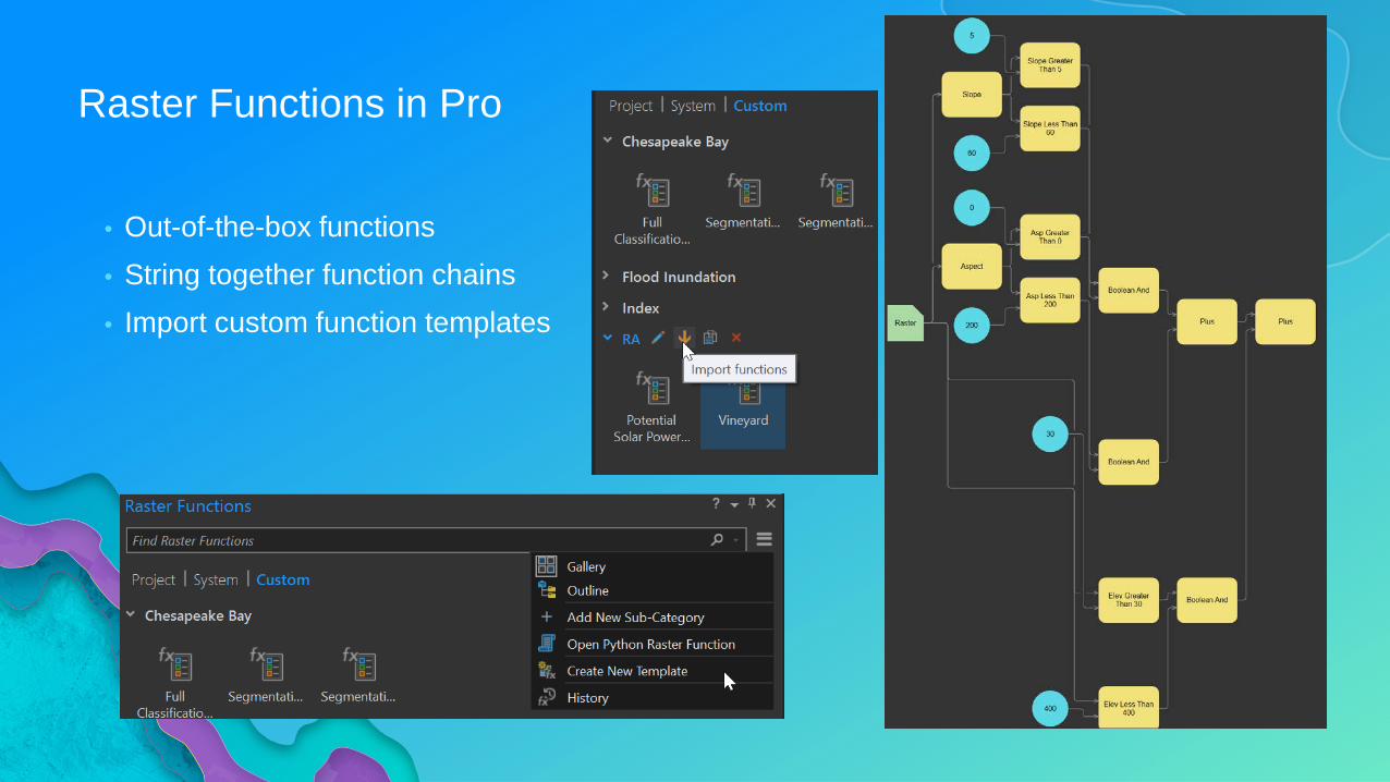
Raster Functions in Pro
• Out-of-the-box functions• String together function chains• Import custom function templates
Raster Function Chains
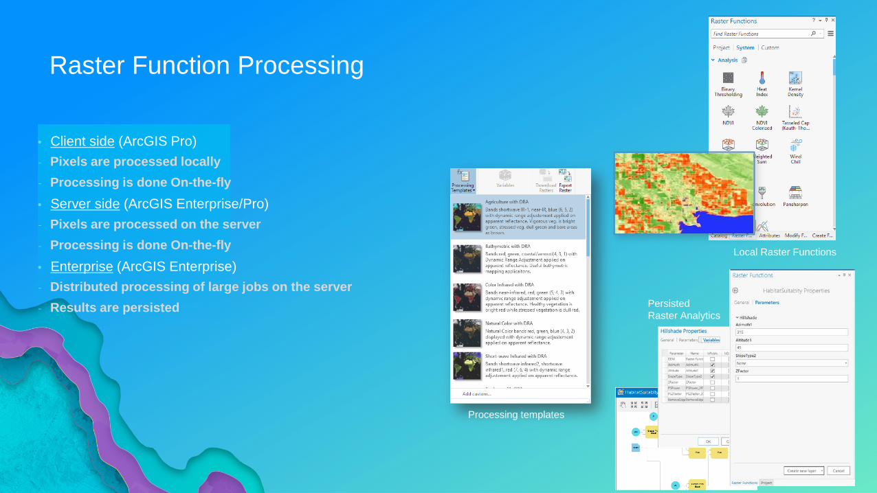
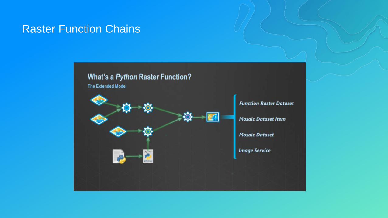
Raster Function Processing
• Client side (ArcGIS Pro)- Pixels are processed locally- Processing is done On-the-fly• Server side (ArcGIS Enterprise/Pro)- Pixels are processed on the server- Processing is done On-the-fly• Enterprise (ArcGIS Enterprise)- Distributed processing of large jobs on the server- Results are persisted
Processing templates
Local Raster Functions
PersistedRaster Analytics
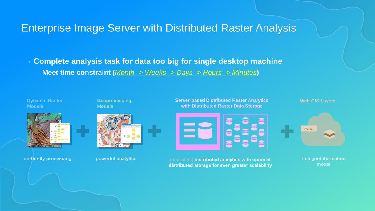
Enterprise Image Server with Distributed Raster Analysis
• Complete analysis task for data too big for single desktop machine- Meet time constraint (Month -> Weeks -> Days -> Hours -> Minutes)
Dynamic RasterModels
GeoprocessingModels
(persistent) distributed analytics with optional distributed storage for even greater scalability
Server-based Distributed Raster Analytics with Distributed Raster Data Storage
Portal
Web GIS Layers
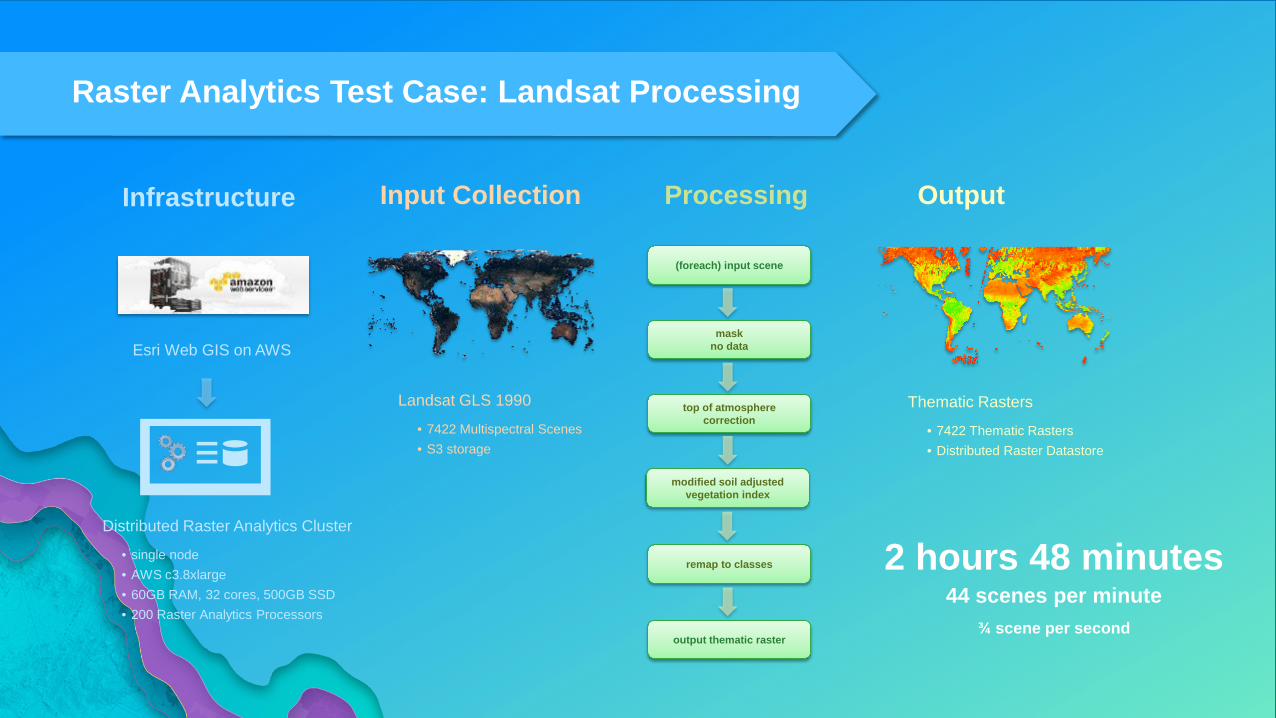
Raster Analytics Test Case: Landsat Processing
(foreach) input scene
top of atmospherecorrection
modified soil adjustedvegetation index
remap to classes
maskno data
output thematic raster
Esri Web GIS on AWS
Distributed Raster Analytics Cluster
• single node• AWS c3.8xlarge• 60GB RAM, 32 cores, 500GB SSD• 200 Raster Analytics Processors
Infrastructure ProcessingInput Collection Output
Landsat GLS 1990
• 7422 Multispectral Scenes• S3 storage
Thematic Rasters
• 7422 Thematic Rasters• Distributed Raster Datastore
2 hours 48 minutes44 scenes per minute
¾ scene per second
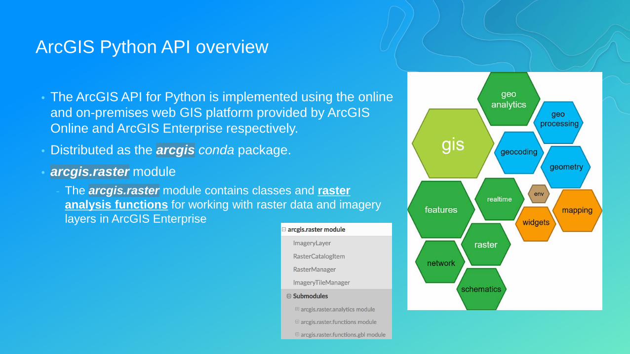
ArcGIS Python API overview
• The ArcGIS API for Python is implemented using the online and on-premises web GIS platform provided by ArcGIS Online and ArcGIS Enterprise respectively.
• Distributed as the arcgis conda package.• arcgis.raster module
- The arcgis.raster module contains classes and raster analysis functions for working with raster data and imagery layers in ArcGIS Enterprise
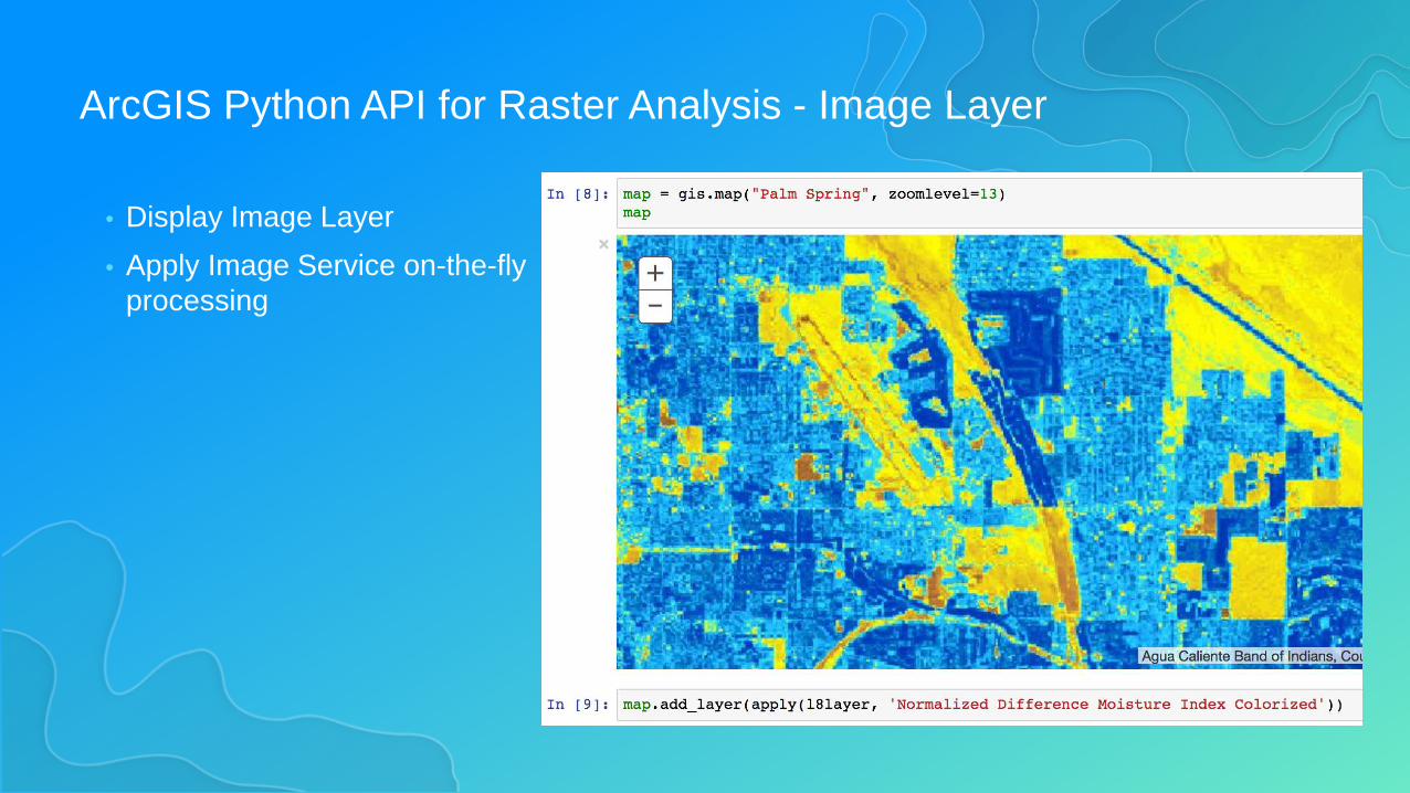
ArcGIS Python API for Raster Analysis - Image Layer
• Display Image Layer• Apply Image Service on-the-fly
processing
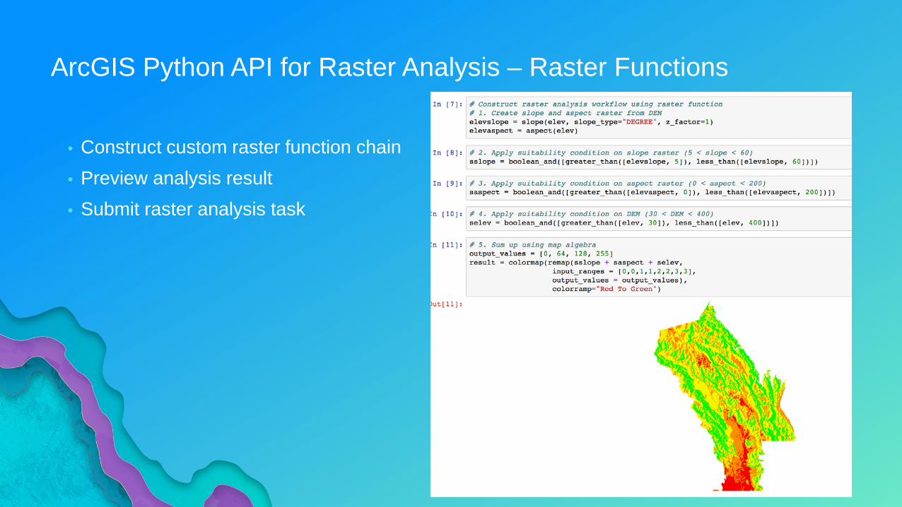
ArcGIS Python API for Raster Analysis – Raster Functions
• Construct custom raster function chain• Preview analysis result• Submit raster analysis task

Demo
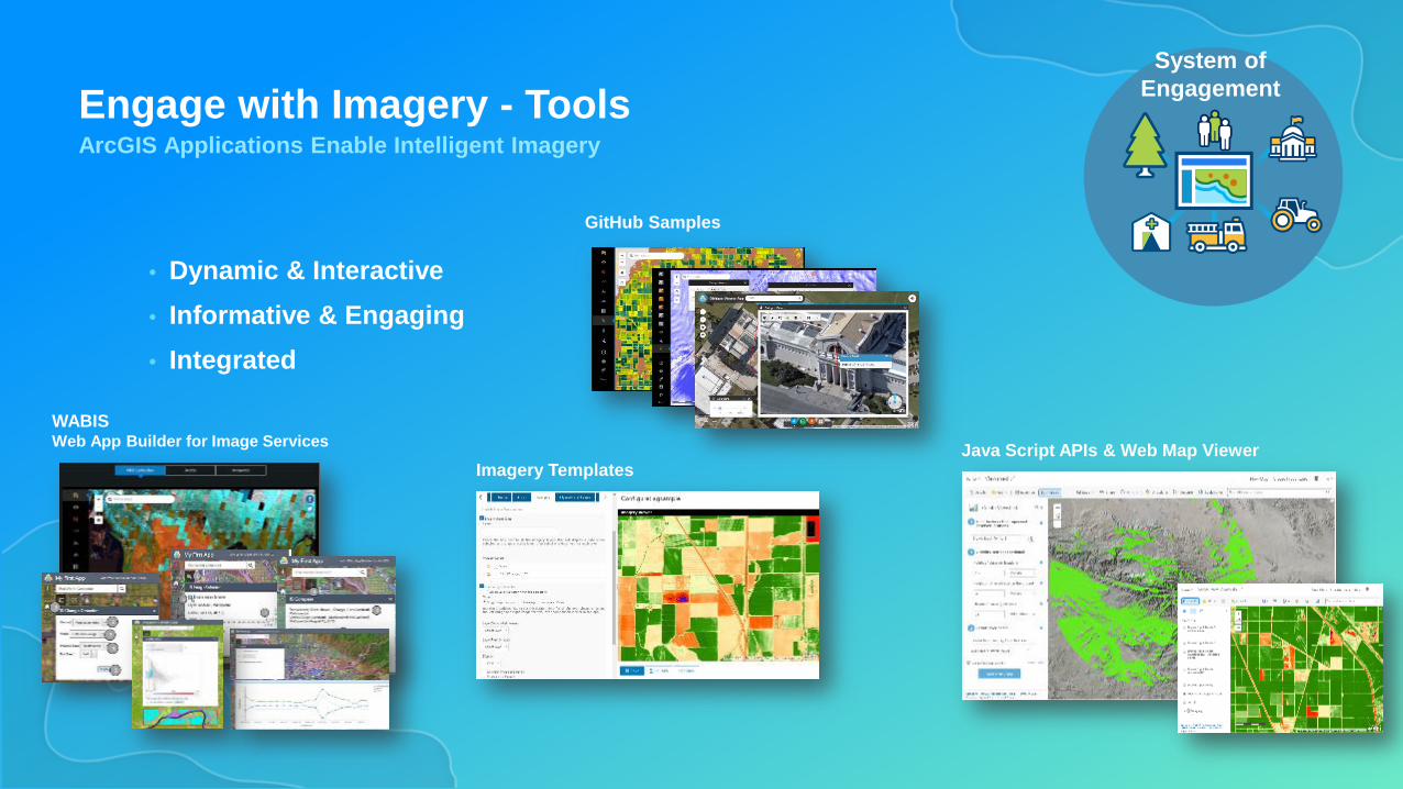
Engage with Imagery - ToolsArcGIS Applications Enable Intelligent Imagery
• Dynamic & Interactive• Informative & Engaging• Integrated
System ofEngagement
Java Script APIs & Web Map ViewerWABISWeb App Builder for Image Services
Imagery Templates
GitHub Samples
Related Documents