ArcGIS and Bing Maps—Better T ogether ESRI ® ArcGIS ™ customers understand the value of geographic information system (GIS) technology for integrating data with a spatial component, regardless of the source, so that it can be analyzed as a whole to make critical business and planning decisions. GIS can provide powerful information—not just about how things are, but how they will be in the future based on change. A key benet provided by GIS technology is data visualization— presenting GIS data in the context of location so you can better visualize it, understand it, and ultimately act on it. When data is plotted on a map, the big picture view makes the geospatial relationship between the data points more clear, and trends and patterns become more apparent. Addhigh-qualitybasemaplayerstoyourESRI ® ArcGIS ™ productswithMicrosoft ® Bing ™ MapsPlatform. UseBingMapsstr eetmapsandaerialimagerytovisuali zedatainthecontextofitslo cationforbetter decisionmaking.Becau seBingMapsisintegr atedasabuilt -inservicethroughouttheESRIAr cGIS9.3.1 System,youcanquicklytakeadvan tageofthebenetso ftheintegration. The Bing Maps Platform provides data visualization for augmented situational awareness. From a big picture view, you can drill down on a point of interest to better understand it within the context of its location and surroundings through high-resolution aerial imagery, street maps, and combined map and labeled aerial layers. And with the ArcGIS 9.3.1 System release, Bing Maps can be easily accessed by ArcGIS customers. Minneapolis-St Paul International Airport uses Bing Maps to provide airport noise data.

Welcome message from author
This document is posted to help you gain knowledge. Please leave a comment to let me know what you think about it! Share it to your friends and learn new things together.
Transcript
8/6/2019 ArcGIS Bing Maps Data Sheet
http://slidepdf.com/reader/full/arcgis-bing-maps-data-sheet 1/2
ArcGIS and Bing Maps—Better Together
ESRI® ArcGIS™ customers understand the value of
geographic information system (GIS) technology for integrating
data with a spatial component, regardless of the source, so that
it can be analyzed as a whole to make critical business and
planning decisions. GIS can provide powerful information—not
just about how things are, but how they will be in the future
based on change.
A key benet provided by GIS technology is data visualization—
presenting GIS data in the context of location so you can better
visualize it, understand it, and ultimately act on it. When data
is plotted on a map, the big picture view makes the geospatial
relationship between the data points more clear, and trends and
patterns become more apparent.
Addhigh-qualitybasemaplayerstoyourESRI®ArcGIS™productswithMicrosoft®Bing™MapsPlatform.
UseBingMapsstreetmapsandaerialimagerytovisualizedatainthecontextofitslocationforbetter
decisionmaking.BecauseBingMapsisintegratedasabuilt-inservicethroughouttheESRIArcGIS9.3.1
System,youcanquicklytakeadvantageofthebenetsoftheintegration.
The Bing Maps Platform provides data visualization
for augmented situational awareness. From a big picture view,
you can drill down on a point of interest to better understand
it within the context of its location and surroundings through
high-resolution aerial imagery, street maps, and combined map
and labeled aerial layers.
And with the ArcGIS 9.3.1 System release, Bing Maps canbe easily accessed by ArcGIS customers.
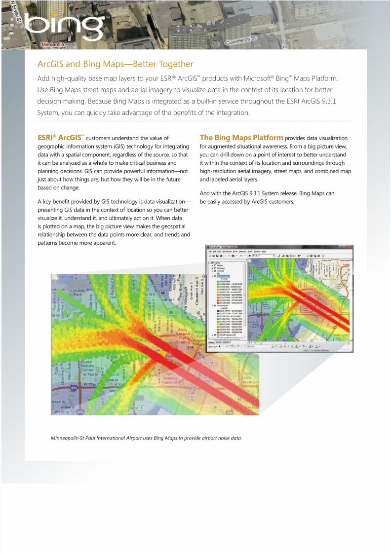
Minneapolis-St Paul International Airport uses Bing Maps to provide airport noise data.
8/6/2019 ArcGIS Bing Maps Data Sheet
http://slidepdf.com/reader/full/arcgis-bing-maps-data-sheet 2/2
Benets of the Integration
Create and publish rich maps fasterand more easily.Create, edit, and analyze custom GIS data supported by
geocoding services. With Bing Maps and ArcGIS Server 9.3.1,
you can create applications and publish data with Bing Maps
base layers with the convenience of built-in access. The tightintegration of the Bing Maps platform and the ArcGIS System
throughout the GIS workow yields faster development and
deployment times for more accurate and timely information
sharing. The ArcGIS Server Web Mapping APIs and the .NET
Web Application Development Framework all have seamless
access to Bing Maps base maps and geocoding.
Bring rich visualization and analysis to a broad range of
operational, commercial, and executive decision makers.
Bing Maps and ArcGIS provide a platform for a range of uses,
including making operational decisions, planning for emer-
gencies, managing sales territory performance, and providing
data to users in intuitive, easy-to-understand applications.
Benet from a comprehensive,enterprise-class platform.Because Microsoft and ESRI products work together, you
don’t need to allocate additional resources for systems
integration and interoperability. ESRI integrates with other
Microsoft products—including SQL Server® 2008,
SharePoint® Server 2007, and Microsoft Dynamics®—that
may be part of your Bing Maps solution. Together, Microsoft
and ESRI make it easier for you to nd, visualize, and act on
information from many sources.
Strengthen constituent and customer connections.Using Bing Maps and ArcGIS to publish your public
applications provides users with a high-quality, up-to-date,
recognizable multi-scale base map that can help give them
better insight into your data.
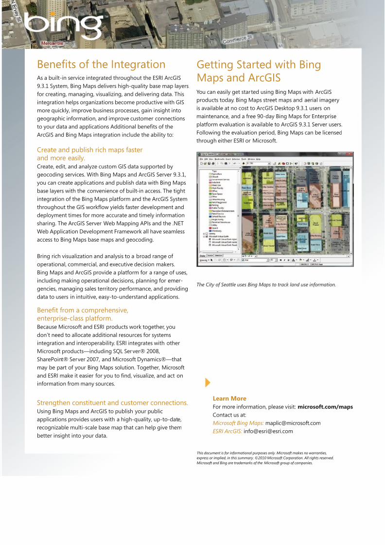
The City of Seattle uses Bing Maps to track land use information.
This document is for informational purposes only. Microsoft makes no warranties,
express or implied, in this summary. ©2010 Microsoft Corporation. All rights reserved.
Microsoft and Bing are trademarks of the Microsoft group of companies.
Learn More
For more information, please visit: microsoft.com/maps
Contact us at:
Microsoft Bing Maps: [email protected]
ESRI ArcGIS: info@[email protected]
As a built-in service integrated throughout the ESRI ArcGIS
9.3.1 System, Bing Maps delivers high-quality base map layers
for creating, managing, visualizing, and delivering data. Thisintegration helps organizations become productive with GIS
more quickly, improve business processes, gain insight into
geographic information, and improve customer connections
to your data and applications Additional benets of the
ArcGIS and Bing Maps integration include the ability to:
You can easily get started using Bing Maps with ArcGIS
products today. Bing Maps street maps and aerial imagery
is available at no cost to ArcGIS Desktop 9.3.1 users on
maintenance, and a free 90-day Bing Maps for Enterprise
platform evaluation is available to ArcGIS 9.3.1 Server users.
Following the evaluation period, Bing Maps can be licensed
through either ESRI or Microsoft.
Getting Started with BingMaps and ArcGIS
Related Documents