ArcGIS 10.0 File Geodatabase – FEATURE CLASSES *File unchanged from February 2012 export August 2012 Data Export Feature Class Description Animal_ACD_Aug12 Animal Conservation Database Animal_Observations_Aug 12 Online Animal Observations Griz_Caribou* Grizzly/Caribou EO/recovery areas Jul_07_Fish* July 2007 Fish EOs Plant_EO_allAug12 ALL Plant Element Occurrences Plant_PCD_LinesAug12 Plant Conservation Database Lines Plant_PCD_PointsAug12 Plant Conservation Database Points Plant_PCD_PolysAug12 Plant Conservation Database Polys SageGrouseLeks_2012 Greater-sage Grouse Leks 2012 SharpTailedGrouseLeks_2 Sharp-tailed Grouse Leks 2012

ArcGIS 10.0 File Geodatabase – FEATURE CLASSES * File unchanged from February 2012 export Feature ClassDescription Animal_ACD_Aug12Animal Conservation.
Dec 22, 2015
Welcome message from author
This document is posted to help you gain knowledge. Please leave a comment to let me know what you think about it! Share it to your friends and learn new things together.
Transcript

ArcGIS 10.0 File Geodatabase – FEATURE CLASSES
*File unchanged from February 2012 export
August 2012 Data Export
Feature Class DescriptionAnimal_ACD_Aug12 Animal Conservation Database
Animal_Observations_Aug12 Online Animal Observations
Griz_Caribou* Grizzly/Caribou EO/recovery areas
Jul_07_Fish* July 2007 Fish EOs
Plant_EO_allAug12 ALL Plant Element Occurrences
Plant_PCD_LinesAug12 Plant Conservation Database Lines
Plant_PCD_PointsAug12 Plant Conservation Database Points
Plant_PCD_PolysAug12 Plant Conservation Database Polys
SageGrouseLeks_2012 Greater-sage Grouse Leks 2012
SharpTailedGrouseLeks_2012 Sharp-tailed Grouse Leks 2012
WolfActivity2011* Wolf Activity 2011

ArcGIS 10.0 File Geodatabase - TABLES
Additional information to plant observationOnly associated with PCD points, lines, and
polygons
August 2012 Data Export
Plant Tables Descriptiontbl_PLANT_PCD_AssociatedSpecies Associated Plant Species
tbl_PLANT_PCD_DisturbanceThreats Plant Disturbances and/or Threats
tbl_PLANT_PCD_LookaLikeSpecies Look a like species in area
tbl_PLANT_PCD_ObservationDetails Plant observation details

ArcGIS 10.0 File Geodatabase – RELATES
There are 12 relates, 4 relates per PCD feature class
Each relate establishes a connection between the PCD points, lines, and polygon feature classes to the 4 PCD tables.
August 2012 Data Export
Relate name per feature class
Description
Arel_PCD####_2_AssocSpecies Relates PCD feature class to the Associated Species table
Arel_PCD####_2_DisturbanceThrts Relates PCD feature class to the Disturbance and/or Threats table
Arel_PCD####_2_LookALike Relates PCD feature class to the Look a Like Species table
Arel_PCD####_2_ObservationDetails Relates PCD feature class to the Observation Details table

ArcGIS 10.0 –LAYER FILES
* same files sent February 2012
August 2012 Data Export
Layer File Name DescriptionAnimal Conservation Database August 2012.lyr Animal Conservation Database
Animal Observations—from Online Submissions—August 2012.lyr Online Animal Observations
Plant Conservation Database (PCD) August 2012.lyr groups PCD point, lines, and polys
Plant Element Occurrences (PCD) August 2012.lyr All Plant Element Occurrences
Sharp-tailed Grouse Leks 2012.lyr Sharp-tailed grouse leks 2012
Greater Sage-grouse Leks 2012.lyr Greater-sage Grouse Leks 2012
Grizzly and Caribou Recovery Areas.lyr* Griz and Caribou recovery areas
Wolf Activity 2011.lyr* Wolf activity

Since February 2012, incorporated more than 400 observations, more than 500 in the last year.
80 EOs were added or updated since February 2012, almost 100 in the last year.
What is new for Plants (PCD)

1 Astragalus anserinus Goose Creek Milkvetch
2 Astragalus conjunctus Stiff Milkvetch
3 Astragalus cusickii var. packardiae Packard's Milkvetch
4 Astragalus cusickii var. sterilis Barren Milkvetch
5 Astragalus mulfordiae Mulford's Milkvetch
6 Astragalus purshii var. ophiogenes Snake River Milkvetch
7 Astragalus yoder-williamsii Mud Flat Milkvetch
8 Castilleja christii Christ's Indian Paintbrush
9 Chaenactis cusickii Cusick's False Yarrow
10 Dimeresia howellii Dimeresia
11 Eatonella nivea White Eatonella
12 Eriogonum prociduum var. mystrium Pueblo Mountains buckwheat
13 Eriogonum shockleyi var. packardiae Packard's Buckwheat
14 Glyptopleura marginata White-margined Wax Plant
15 Haplopappus uniflorus var. howellii One-flowered Goldenweed
16 Howellia aquatilis Water Howellia
17 Lepidium papilliferum Slickspot Peppergrass
18 Lomatium packardiae Packard's Desert-parsley
19 Mentzelia mollis Smooth Stickleaf
20 Mirabilis macfarlanei Macfarlane's Four-o'clock
21 Penstemon janishiae Janish's Penstemon
22 Phacelia lutea var. calva Malheur Yellow Phacelia
23 Silene spaldingii Spalding’s Silene
24 Spiranthes diluvialis Ute Ladies' Tresses
25 Trifolium owyheense Owyhee Clover
Plant EOs updated in 201225 species updated
Federally ListedSW Idaho, BLM
priority
EOs are a product, updated from content within the PCD
Are there more you need to have updated?

Added almost 10,000 additional animal observations since February, almost 12,500 in the last year.
Big datasets worked on in the last 6 months:Idaho Waterbird SurveyGolden Eagle and Raptor InventoryUpdated existing locations-Columbia Spotted
Frog, pop. 3 (Rana luteiventris pop. 3) Southern Idaho Ground Squirrel
(Spermophilus brunneus endemicus)
What is new for Animals (ACD)

What is new for Observations
Sent as a feature class in current export
Online submission draft ‘teaser’ export
Minimal attributes, just over 400 observations
https://fishandgame.idaho.gov/ifwis/observations/

[EO_ID ] = unique identifier for plant EOs in our database system (different than EO #)
[EO_Num] (EO #) = unique identifier for that plant species. These numbers will remain the same through time. Are assigned to an occurrence when created and can only change if it merges with another or is dropped.
Field [OldEO_ID] in 2012 exports was previously EO_ID prior to January 2012. (assigned in a previous and obsolete database system)
Tip: Fields EO_ID and EO_NUM Plant EOs

TIP: view PCD related records in GIS
IdentifyThrough the attribute table
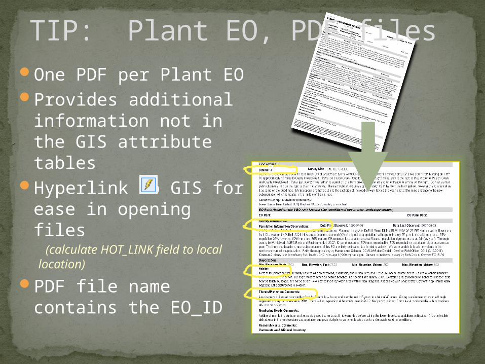
TIP: Plant EO, PDF files
0
One PDF per Plant EOProvides additional
information not in the GIS attribute tables
Hyperlink to GIS for ease in opening files (calculate HOT_LINK field to local location)
PDF file name contains the EO_ID

Example EO update – original mapping- Mirabilis macfarlanei , EO 002

Example EO update – new data Mirabilis macfarlanei , EO 002

Example EO update – new EO boundaryMirabilis macfarlanei , EO 002
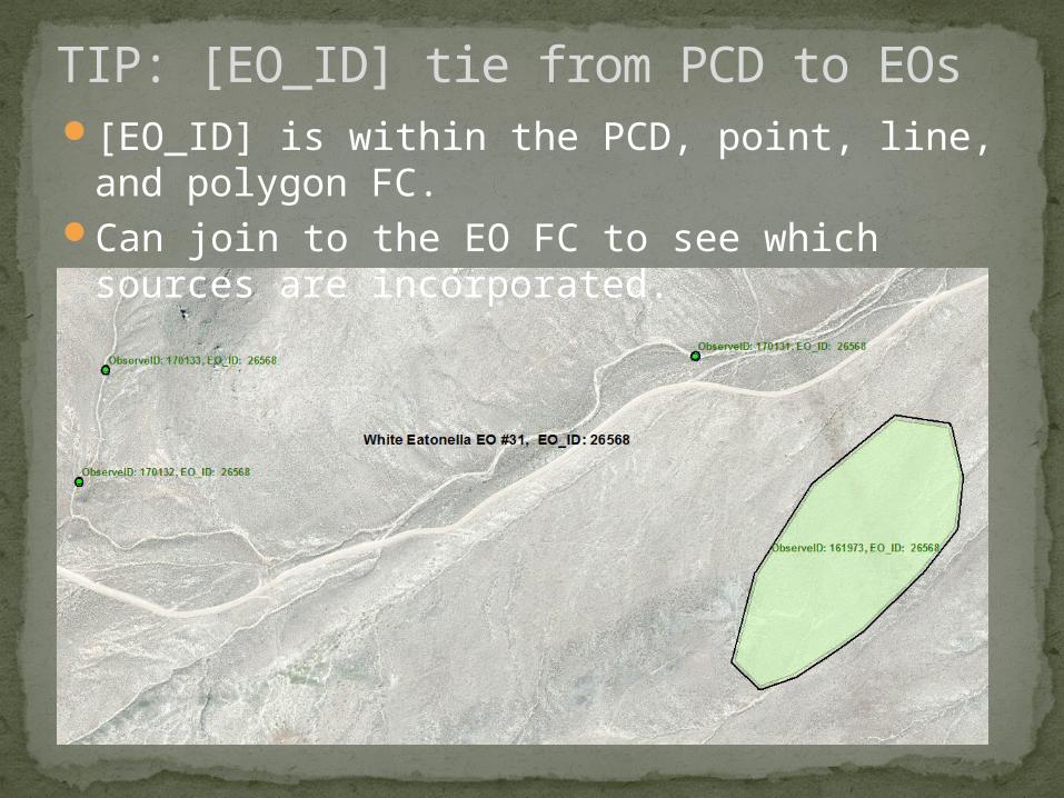
TIP: [EO_ID] tie from PCD to EOs[EO_ID] is within the PCD, point, line, and
polygon FC.Can join to the EO FC to see which sources
are incorporated.

Caveat to [EO_ID] tieNot all PCD features will have a tie to EO_ID at this time
Observations to create EOs within the Biotics system are not within PCD.
Not all EOs have been updated based on the observations within PCD.

Tip: Filtering records beyond species name
PCD fields[Confid] – Confidence of species identification [OBS_BACK] -Observer Background as known
to IFWIS[LOC_ACC] – Location Accuracy[HabitatRank] – Rank of habitat within
observation

ACD Fields[DTA_TYPE]-Observation Type – specimen,
observed (seen), vocalization, examined in hand, etc.
[OBS_BACK]-Observer Background as known to IFWIS
[LOC_ACC]-Location Accuracy[COUNTACC]-Accuracy of count; Absolute,
Minimum, Estimate[OBSCONFD] – Confidence of species
identification
Tip: Filtering records beyond species name

Contacts
Portal: http://ifwis.org/ General IFWIS data related questions.
[email protected] Nikki Wade, Zoology Data Coordinator
[email protected] Jim Strickland, Botany Data Coordinator
[email protected] Angie Schmidt, GIS Analyst [email protected] Bart Butterfield, IFWIS Manager
[email protected] Ben Studer, GIS Analyst Sr. – Observations developer
Related Documents