AR SPKINI: AUGMENTED REALITY FOR TOURISM (MUZIUM ARKEOLOGI LEMBAH BUJANG) MOHAMAD HUZAINI BIN MOHAMAD YUSRI BACHELOR OF INFORMATION TECHNOLOGY INFORMATICS MEDIA WITH HONOURS UNIVERSITI SULTAN ZAINAL ABIDIN 2021

Welcome message from author
This document is posted to help you gain knowledge. Please leave a comment to let me know what you think about it! Share it to your friends and learn new things together.
Transcript
AR SPKINI: AUGMENTED REALITY FOR TOURISM
(MUZIUM ARKEOLOGI LEMBAH BUJANG)
MOHAMAD HUZAINI BIN MOHAMAD YUSRI
BACHELOR OF INFORMATION TECHNOLOGY
INFORMATICS MEDIA WITH HONOURS
UNIVERSITI SULTAN ZAINAL ABIDIN
2021

AR SPKINI : AUGMENTED REALITY APPS FOR TOURISM
(MUZIUM ARKEOLOGI LEMBAH BUJANG)
MOHAMAD HUZAINI BIN MOHAMAD YUSRI
BACHELOR OF INFORMATION TECHNOLOGY
INFORMATICS MEDIA WITH HONOURS
Universiti Sultan Zainal Abidin
2021
i
DECLARATION
I hereby declare that the report is based on my original work except for quotations and
citations, which have been duly acknowledged. I also declare that it has not been
previously or concurrently submitted for any other degree at Universiti Sultan Zainal
Abidin or other institutions.
_______________________________
Name: Mohamad Huzaini bin
Mohamad Yusri
Date:

ii
CONFIRMATION
This is to confirm that:
The research conducted and the writing of this report were under my supervision.
_______________________________
Name: En Sufian bin Mat Deris
Date:
iii
DEDICATION
In the Name of Allah, the Most Gracious and the Most Merciful.
Alhamdulillah, I thank God for His grace and grace, I can prepare and complete this
report successfully.
First of all, I would like to thank my supervisor, En Sufian bin Mat Deris because with
guidance, the advice, and the thoughtful ideas are given me the opportunity to prepare
this report successfully.
Besides, my gratitude is also to my colleagues who share ideas, opinions, knowledge,
and reminders. They helped me answer every question that was important to me in
completing this report.
Thanks also to my beloved mother and father always support and motivated me to
prepare for this report for Final Year Project.
I would like to take the opportunity to thank all lecturers of the Informatics and
Computing Faculty for their attention, guidance, and advice in helping and sharing ideas
and opinions in making this report successful.
May Allah SWT bless all the efforts that have been given in completing this
report.
Thank you.
iv
ABSTRACT
AR SPKini is developed for those focused on the tourism sector. This application is
specially developed for tourists and locals in the Kuala Muda Area. This project is
based on two main things namely multiumedia and programming. Users need to use a
mobile phone to gain access to this application. This AR SPKini application project is
intended to make it easy for users to access and study at historical places, namely at
the Lembah Bujang Archaeological Museum. With just a piece of map and mobile
phone, users will experience an amazing 3D view of the historic building. Information
and audio are also included in this application. The ADDIE method is divided into
five main parts namely the beginning of the analysis phase, the design phase, the
development phase, the implementation phase and the evaluation phase. The use of
ADDIE method can ensure the development of the system runs smoothly and in
accordance with the planning that has been set.
v
ABSTRAK
AR SPKini dibangunkan untuk yang tertumpu kepada sektor pelancongan. Aplikasi ini
dibangunkan khas untuk pelancong dan penduduk setempat di Kawasan Kuala Muda.
Projek ini berdasarkan dua perkara utama iaitu multiumedia dan pengaturcaraan.
Pengguna perlu menggunakan telefon bimbit untuk mendapatkan akses aplikasi ini.
Projek aplikasi AR SPKini ini adalah bertujuan untuk membuat pengguna senang untuk
mengakses dan membuat kajian di tempat bersejarah iaitu di Muzium Arkeologi
Lembah Bujang. Dengan hanya memerlukan sekeping peta dan telefon bimbit,
pengguna akan merasai pengalaman yang menakjubkan dengan pemandangan 3D
berkenaan bangunan bersejarah tersebut. Maklumat dan audio juga turut disertakan
dalam aplikasi ini. Kaedah ADDIE dibahagikan kepada lima bahagian utama iaitu
permulaan fasa analisis, fasa reka bentuk, fasa pembangunan, fasa pelaksanaan dan
fasa penilaian. Penggunaan kaedah ADDIE dapat memastikan pembangunan sistem
berjalan lancar dan mengikut perancangan yang telah ditetapkan.
vi
CONTENTS
PAGE
DECLARATION i
CONFIRMATION ii
DEDICATION iii
ABSTRACT iv
ABSTRAK v
CONTENTS vi
LIST OF TABLES vii
LIST OF FIGURES viii
LIST OF ABBREVIATIONS ix
CHAPTER 1 INTRODUCTION 1
1.1 Introduction 1
1.2 Project Background 2
1.3 Problem Statement 2
1.4 Objectives 3
1.5 Scope 3
1.6 Limitation of Work 3
1.7 Expected Result 3
1.8 Activities, Milestones (Gantt Chart) 4
1.9 Summary of the Chapter 5
CHAPTER 2 LITERATURE REVIEW 6
2.1 Introduction 6
2.2 Previous Research on The Application 7
2.2.1 Augmented Maps : The Capture by Small Video Camera to
Visualization An Analogue Map. 7
2.2.2 Smartphone Augmented Reality Application for Tourism 12
2.2.3 AR Mapp – Augmented Reality Map Barcelona 13
2.2.4 AR Map World Peak 15
2.3 Comparison of Article 17
2.4 Comparison Existing Product 19
CHAPTER 3 METHODOLOGY 21
3.1 Introduction 21
3.2 ADDIE Model 22
3.3 Methodology Phase 23
3.3.1 Analysis 23
3.3.2 Design 25
3.3.3 Development 30
3.3.4 Implementation 30
3.3.5 Evaluation 31
3.4 Framework 31
3.5 Hardware and Software 33
3.5.1 Software Requirement 33
3.5.2 Hardware Requirement 34
3.6 Summary of The Chapter 35
REFERENCES 36
vii
LIST OF TABLES
Table No. Title Page
Table 1.1 Gantt Chart 4
Table 2.1 Comparison of Article 17
Table 2.2 Comparison Existing Product 19
Table 3.1 Storyboard application 27
Table 3.2 List of Software Requirement 33
Table 3.4 List of Hardware Requirement 34
viii
LIST OF FIGURES
Figure No. Title Page
Figure 2.1 Milgram’s Reality-Virtuality Continum 7
Figure 2.2 Working method of ARToolKit 8
Figure 2.3 Camera and HMD in see-through-mode 8
Figure 2.4 Layout of augmented map 9
Figure 2.5 Overlay with 3D-TIN 10
Figure 2.6 Augmented switch 10
Figure 2.7 Augmented pointer 11
Figure 2.8 AR view in commercial smartphone application 12
Figure 2.9 Augmented Reality Map Barcelona 13
Figure 2.10 AR Model on the Map 14
Figure 2.11 View from the smartphone 14
Figure 2.12 AR Map World Peaks Interface 15
Figure 2.13 Google Map View on Application 16
Figure 3.1 ADDIE model 22
Figure 3.2 Analysis Phase 24
Figure 3.3 Flowchart 26
Figure 3.4 Framework 31
ix
LIST OF ABBREVIATIONS
POI Point of Interest
AR Augmented Reality
3D 3 Dimensional
HMD Head Mounted Display
AV Augmented Virtuality
1
CHAPTER 1
INTRODUCTION
Technology is a necessity in this day and age. The use of technology is not just for play
alone. But, it is a necessity in channeling information related to something you are
looking for. There are various developments in the world of technology and it has its
own branch. With the current state of affairs being plagued by the Covid-19 pandemic
that is forcing us to stay at home. Certainly the use of technology becomes very high
because we need to keep in touch and continue the work that hasrus completed. In
connection with this project, augmented reality technology was chosen to conduct
research and its effectiveness on a place. This technology is very easy to find and use
because it only uses smartphones that on average everyone already owns a smartphone.
This study will be conducted in a selected place.
1.1 Introduction
AR SPKini is an augmented reality application that involves interacting with users or
using electronic devices such as smartphones. AR SPKini involves 3D models designed
by themselves based on the place of study. Looking at the current modernization,
technology has grown rapidly and most people or an organization needs to transform
into the use of technology as soon as possible. So, one of them is the use of augmented
reality in a place. The use of this augmented reality can give an idea of the object
displayed in 3D. Consumers will feel different and sometimes it can save money to go
to a place.
2
1.2 Project Background
Tourism is one of the most important service industries for a country. The tourism
industry has become a smart investment field that can drive the growth of related
industries which all serve as drivers in the development of developed countries in this
century. Thus, it can be said that the tourism sector is a sector that has great potential to
contribute to the national economy and bring huge profits in the form of foreign
exchange. For example, Kedah is one of the states that contributes to the tourism sector
in Malaysia. Lots of interesting and historic places to visit and do questionnaires.
Due to increasing the population and tourist in Kuala Muda, Kedah, technology
plays a very important role nowadays to further boost the tourism sector. Therefore, we
must take action by making a plan and building something creative for the tourism
sector.
1.3 Problem Statement
First problem statement is lack of tourist attraction because there is no change in
strategy in attracting local and foreign tourist. Secondly, lack of emphasis on tourism
activities in the area. If there is an emphasis on the tourism sector in the area, it will
definitely be more advanced. Third, the use of technology still less prominent as one
of the tourist attractions in the area.
3
1.4 Objectives
The goal of this project is to make augmented reality that can be used on smartphone.
This project will mainly focus on the following objectives. To design augmented reality
mobile application related to Muzium Arkeologi Lembah Bujang. • To develop 3D
models based on interesting places in Muzium Arkeologi Lembah Bujang to help
further enhance the tourism sector in the district. To test the effectiveness of the AR
SPKini application so that it can be developed carefully and successfully.
1.5 Scope
A chapter may show which target user that my project aim. This project is aimed for
public usage such as tourist and local residents. In the application developed is a
prototype which can be implemented. The prototype is include some historic buildings.
The AR card will be use for scanning image on the flashcard. Then, its will display the
AR application with animation and few place on the map.
1.6 Limitation of Work
Limitation work of my project is this project is Android smartphone based. The user
needs a smartphone (Android only) and flash card which called map. The application
provides four type of model only.
1.7 Expected Result
The user will be able to improve and gain their knowledge about AR Technology.
Mode of building map flashcard using AR technology will completely develop. Only
android user can access this application.
4
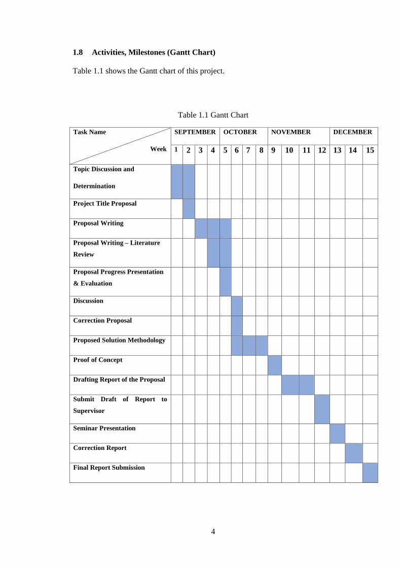
1.8 Activities, Milestones (Gantt Chart)
Table 1.1 shows the Gantt chart of this project.
Table 1.1 Gantt Chart
Task Name
Week
SEPTEMBER OCTOBER NOVEMBER DECEMBER
1 2 3 4 5 6 7 8 9 10 11 12 13 14 15
Topic Discussion and
Determination
Project Title Proposal
Proposal Writing
Proposal Writing – Literature
Review
Proposal Progress Presentation
& Evaluation
Discussion
Correction Proposal
Proposed Solution Methodology
Proof of Concept
Drafting Report of the Proposal
Submit Draft of Report to
Supervisor
Seminar Presentation
Correction Report
Final Report Submission
5
1.9 Summary of the Chapter
Thesis structure is a summary of the whole project that divided into 5 chapters. This
thesis described the entire process of developing Augemented Reality (AR SPKini) for
the purpose of using tourism activities in the district and the locals.
Chapter 1 : Introduction
This chapter contains explanation of this project including background studies, problem
statement, objectives, and project scope.
Chapter 2 : Literature Review
This chapter focuses the literature study on augmented reality implementation for
tourism activities purposely that could be used for this project. All the study regarding
this topic are observed and analyzed to purpose for better improvement for tourism
activities.
Chapter 3 : Methodology
This chapter discussed about the steps or methodology being used while developing the
Augemented Reality (AR SPKini) for Tourism Activities.
6
CHAPTER 2
LITERATURE REVIEW
This chapter is to present related literature review to ensure the quality in order to
improve this project. This chapter also explains of literature review carried out on the
articles and existing application that used a references in developing this application.
Previous research or existing application also been discussed in the session for
identifiying the weakness or lacking to related literature review source. Therefore, the
purpose of the literature review is to study and analyze the literature or any works or
studies related to this application. It is important to well understand all information to
be considered and related before developing this application. Some research has been
studied to implement in the AR SPKini application.
2.1 Introduction
In this chapter, all of reading, surveying and analyzing has been done to make
sure development of this AR mobile applications follow to user requirements and
system specification. There were three journals that have been selected as reference
towards their system development and implementation in order to develop better and
innovative system.
7
2.2 Previous Research on The Application
2.2.1 Augmented Maps : The Capture by Small Video Camera to Visualization An
Analogue Map.
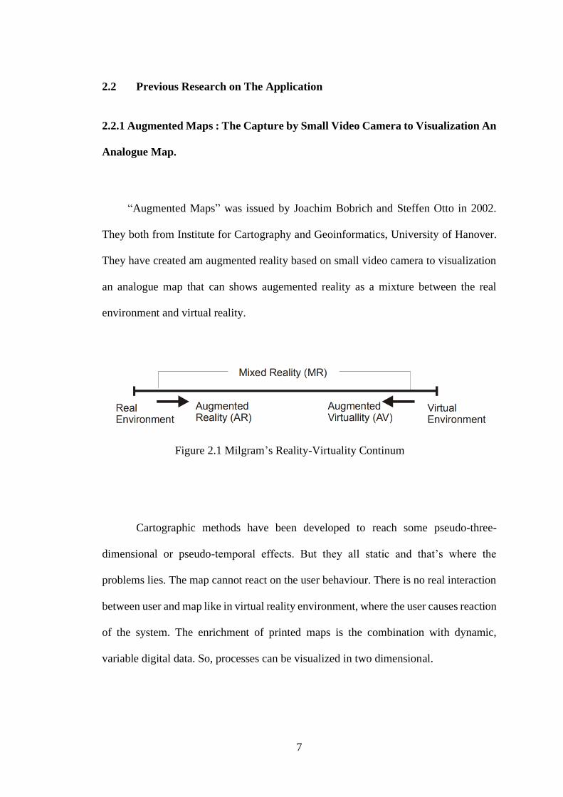
“Augmented Maps” was issued by Joachim Bobrich and Steffen Otto in 2002.
They both from Institute for Cartography and Geoinformatics, University of Hanover.
They have created am augmented reality based on small video camera to visualization
an analogue map that can shows augemented reality as a mixture between the real
environment and virtual reality.
Figure 2.1 Milgram’s Reality-Virtuality Continum
Cartographic methods have been developed to reach some pseudo-three-
dimensional or pseudo-temporal effects. But they all static and that’s where the
problems lies. The map cannot react on the user behaviour. There is no real interaction
between user and map like in virtual reality environment, where the user causes reaction
of the system. The enrichment of printed maps is the combination with dynamic,
variable digital data. So, processes can be visualized in two dimensional.
8
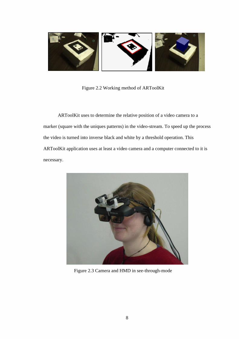
Figure 2.2 Working method of ARToolKit
ARToolKit uses to determine the relative position of a video camera to a
marker (square with the uniques patterns) in the video-stream. To speed up the process
the video is turned into inverse black and white by a threshold operation. This
ARToolKit application uses at least a video camera and a computer connected to it is
necessary.
Figure 2.3 Camera and HMD in see-through-mode
9
By using a head mounted display (HMD) a more immersive experience will be created.
So, video capture and video and VR-object output are done in the same place. HMDs
can be used in opaque or transparent/see-through-mode. In opaque mode only the virtual
objects are shown and the user can see the virtual object overlaid the real environment.
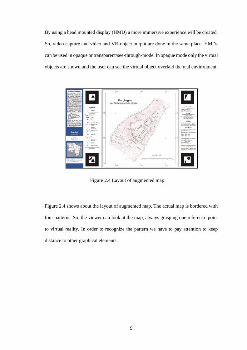
Figure 2.4 Layout of augmented map
Figure 2.4 shows about the layout of augmented map. The actual map is bordered with
four patterns. So, the viewer can look at the map, always grasping one reference point
to virtual reality. In order to recognize the pattern we have to pay attention to keep
distance to other graphical elements.
10
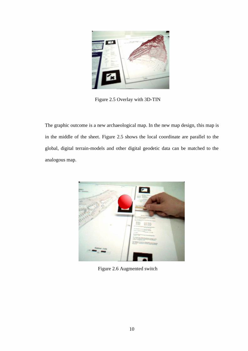
Figure 2.5 Overlay with 3D-TIN
The graphic outcome is a new archaeological map. In the new map design, this map is
in the middle of the sheet. Figure 2.5 shows the local coordinate are parallel to the
global, digital terrain-models and other digital geodetic data can be matched to the
analogous map.
Figure 2.6 Augmented switch
11
Figure 2.6 shows the augmented switch which is it can be switched on or off and
symbolization of virtual map object can be changed. Repeated recognition of the pattern
on the disc will on the one hand change the appearance of sphere on it and on the other
hand alter the virtual theme on the AR-map.
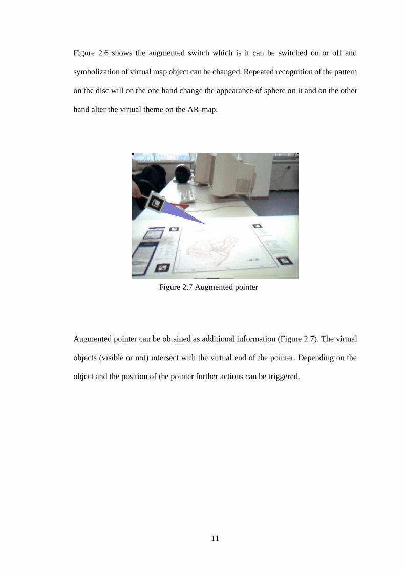
Figure 2.7 Augmented pointer
Augmented pointer can be obtained as additional information (Figure 2.7). The virtual
objects (visible or not) intersect with the virtual end of the pointer. Depending on the
object and the position of the pointer further actions can be triggered.
12
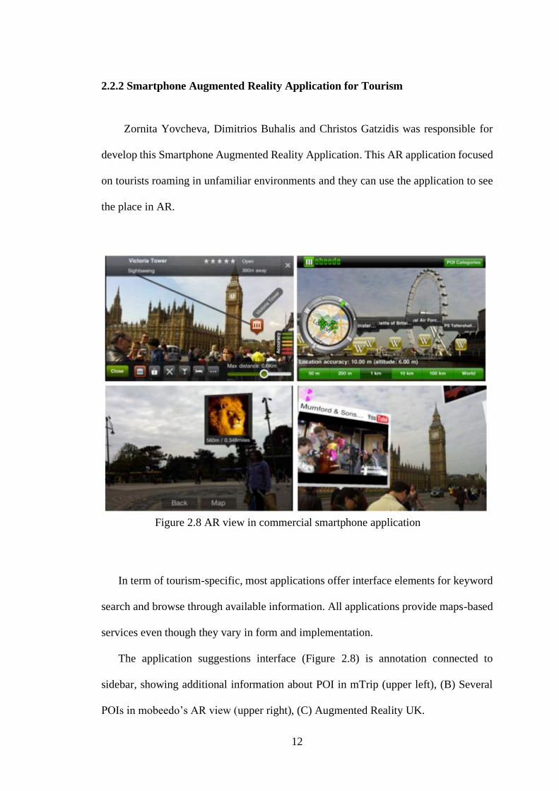
2.2.2 Smartphone Augmented Reality Application for Tourism
Zornita Yovcheva, Dimitrios Buhalis and Christos Gatzidis was responsible for
develop this Smartphone Augmented Reality Application. This AR application focused
on tourists roaming in unfamiliar environments and they can use the application to see
the place in AR.
Figure 2.8 AR view in commercial smartphone application
In term of tourism-specific, most applications offer interface elements for keyword
search and browse through available information. All applications provide maps-based
services even though they vary in form and implementation.
The application suggestions interface (Figure 2.8) is annotation connected to
sidebar, showing additional information about POI in mTrip (upper left), (B) Several
POIs in mobeedo’s AR view (upper right), (C) Augmented Reality UK.
13
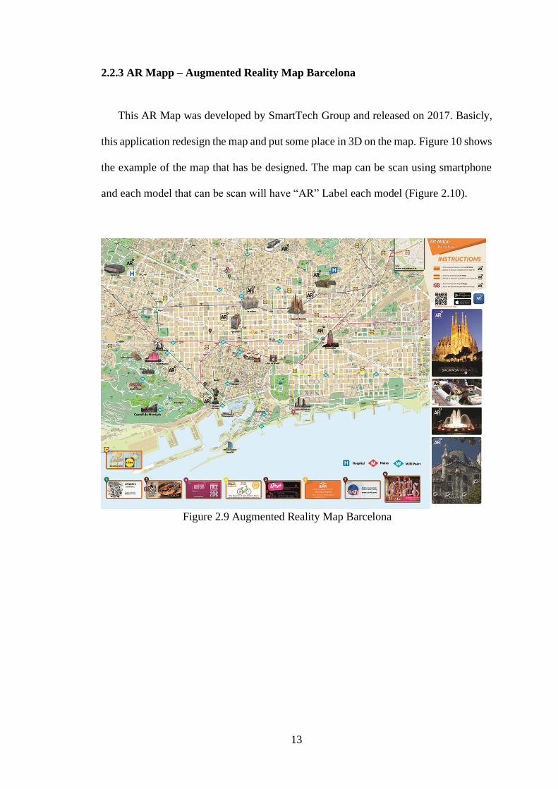
2.2.3 AR Mapp – Augmented Reality Map Barcelona
This AR Map was developed by SmartTech Group and released on 2017. Basicly,
this application redesign the map and put some place in 3D on the map. Figure 10 shows
the example of the map that has be designed. The map can be scan using smartphone
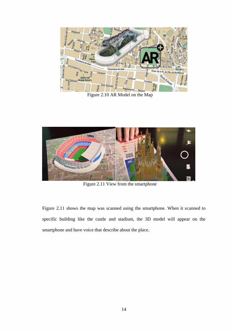
and each model that can be scan will have “AR” Label each model (Figure 2.10).
Figure 2.9 Augmented Reality Map Barcelona
14
Figure 2.10 AR Model on the Map
Figure 2.11 View from the smartphone
Figure 2.11 shows the map was scanned using the smartphone. When it scanned to
specific building like the castle and stadium, the 3D model will appear on the
smartphone and have voice that describe about the place.
15
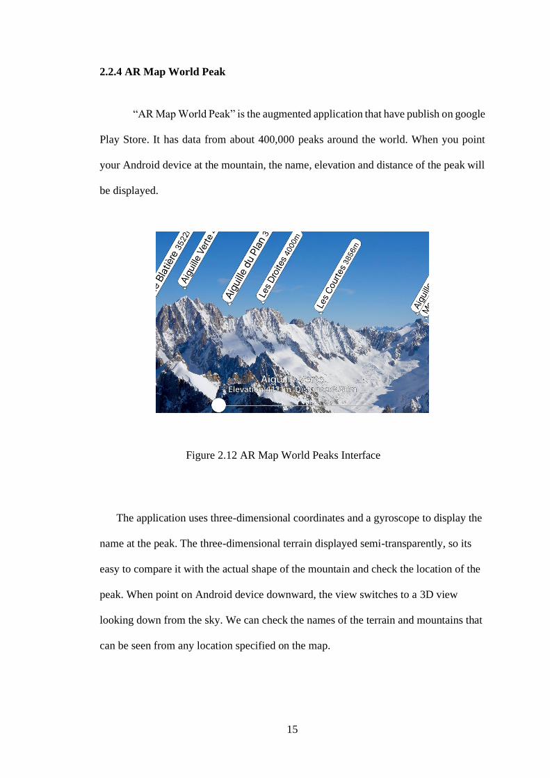
2.2.4 AR Map World Peak
“AR Map World Peak” is the augmented application that have publish on google
Play Store. It has data from about 400,000 peaks around the world. When you point
your Android device at the mountain, the name, elevation and distance of the peak will
be displayed.
Figure 2.12 AR Map World Peaks Interface
The application uses three-dimensional coordinates and a gyroscope to display the
name at the peak. The three-dimensional terrain displayed semi-transparently, so its
easy to compare it with the actual shape of the mountain and check the location of the
peak. When point on Android device downward, the view switches to a 3D view
looking down from the sky. We can check the names of the terrain and mountains that
can be seen from any location specified on the map.
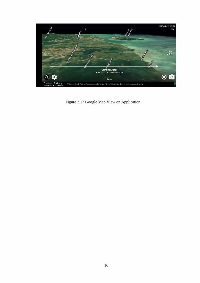
16
Figure 2.13 Google Map View on Application

17
2.3 Comparison of Article
Table 2.1 Comparison of Article
TITLE PURPOSE TYPE
MARKED-
BASED
AR
CATEGORIES
ADVANTAGES DISADVANTAGES
Augmented
Maps – An
AR
application
to visualize
map
To scan
image using
small video
camera and
HMD
computer
generated
onto real
world
Yes Education Have instruction
how to use
Need to use some
items to use it like
video camera and
computer to
visualize
Mobeedo –
Smartphone
Augmented
Reality
Application
for Tourism
This AR
application
focused on
tourist
roaming in
unfamiliar
environment.
Yes Tourist -Show the POI
name and distance
from our position
- Shows the details
of place and make
the tourist roaming
in unfamiliar
environment
It may cause
cognitive overload
and hard to
understand the apps
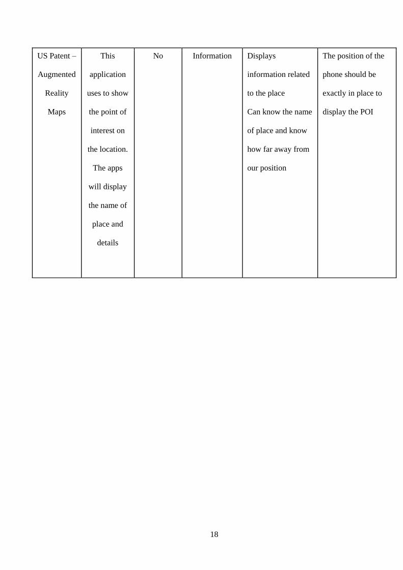
18
US Patent –
Augmented
Reality
Maps
This
application
uses to show
the point of
interest on
the location.
The apps
will display
the name of
place and
details
No Information Displays
information related
to the place
Can know the name
of place and know
how far away from
our position
The position of the
phone should be
exactly in place to
display the POI
19
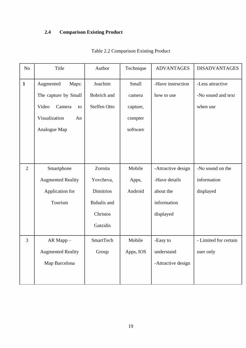
2.4 Comparison Existing Product
Table 2.2 Comparison Existing Product
No Title Author Technique ADVANTAGES DISADVANTAGES
1 Augmented Maps:
The capture by Small
Video Camera to
Visualization An
Analogue Map
Joachim
Bobrich and
Steffen Otto
Small
camera
capture,
compter
software
-Have instruction
how to use
-Less attractive
-No sound and text
when use
2 Smartphone
Augmented Reality
Application for
Tourism
Zornita
Yovcheva,
Dimitrios
Buhalis and
Christos
Gatzidis
Mobile
Apps,
Android
-Attractive design
-Have details
about the
information
displayed
-No sound on the
information
displayed
3 AR Mapp –
Augmented Reality
Map Barcelona
SmartTech
Group
Mobile
Apps, IOS
-Easy to
understand
-Attractive design
- Limited for certain
user only
20
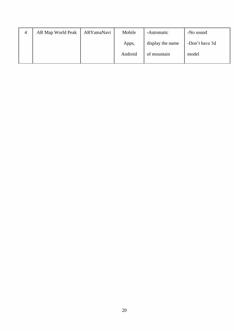
4 AR Map World Peak ARYamaNavi Mobile
Apps,
Android
-Automatic
display the name
of mountain
-No sound
-Don’t have 3d
model
21
CHAPTER 3
METHODOLOGY
3.1 Introduction
This chapter will explain the details of the methodology being used in this project.
The project methodology should systematically solve all the problems appear in the
system analysis to make sure this project complete and working. It is an important
step of development since it will guide the researcher through software development.
After the application has been completely develop, it should be tested to make sure all
the objective requirement of the project achieved. Then, the ADDIE model method
has been used for AR SPKini app based on phase for each development process.
22
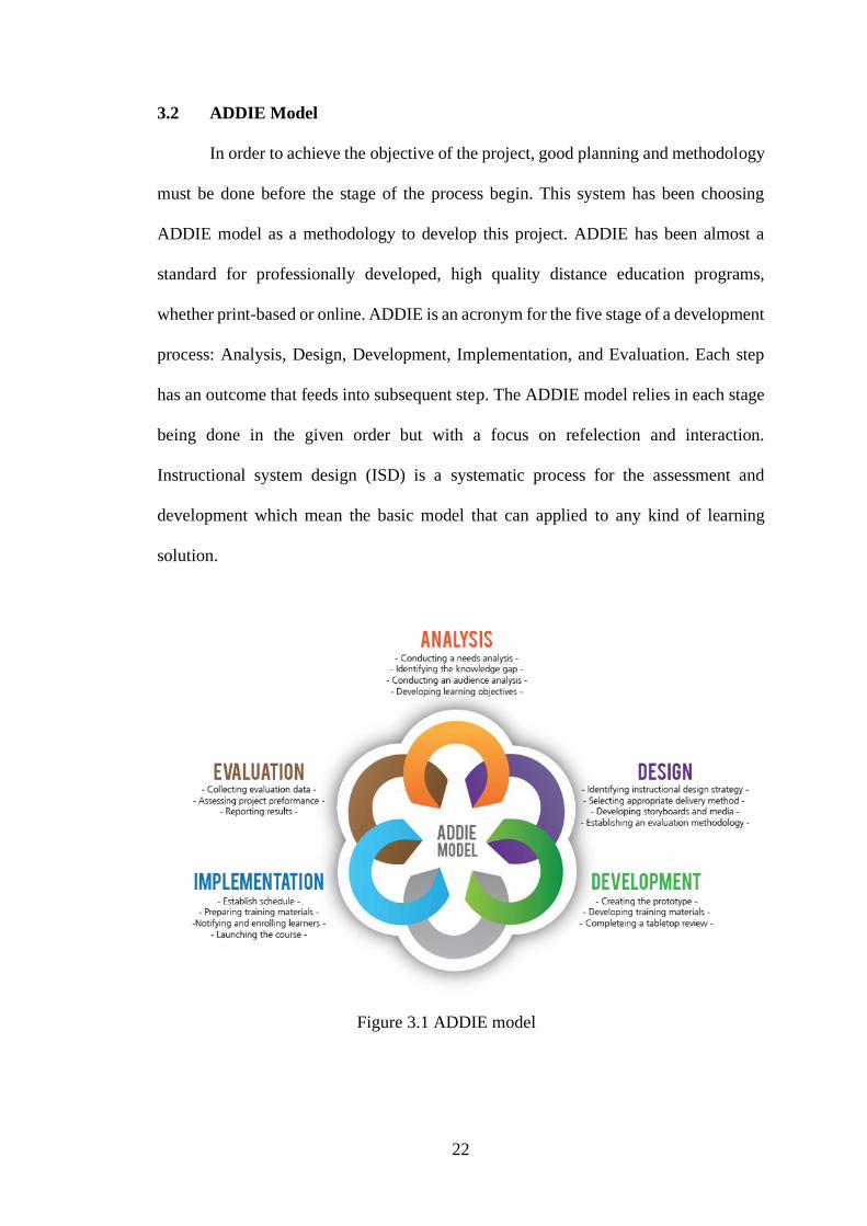
3.2 ADDIE Model
In order to achieve the objective of the project, good planning and methodology
must be done before the stage of the process begin. This system has been choosing
ADDIE model as a methodology to develop this project. ADDIE has been almost a
standard for professionally developed, high quality distance education programs,
whether print-based or online. ADDIE is an acronym for the five stage of a development
process: Analysis, Design, Development, Implementation, and Evaluation. Each step
has an outcome that feeds into subsequent step. The ADDIE model relies in each stage
being done in the given order but with a focus on refelection and interaction.
Instructional system design (ISD) is a systematic process for the assessment and
development which mean the basic model that can applied to any kind of learning
solution.
Figure 3.1 ADDIE model
23
3.3 Methodology Phase
Five phases in ADDIE model are described as below:
3.3.1 Analysis
The first phrase in the ADDIE model of instructional design is the anlaysis
phases. This phase can be considered as the “Goal-Setting Stage”. In this phase, the
developer need to make observation and identify the main problems encountered as a
whole and state objective of project. To identify the problems, developer should be done
through the search of article material and go to the place of study. But, with the current
pandemic outbreak, this will inevitably hamper efforts to go to the study site. So, the
developer can contact the place of study to request information related to the study
made. Besides, the problem statement, objective and existing application on any
standards platforms are searched to compare several current application about
Augmented Reality for tourism. This phase will help the project gain more idea about
the objective of application development.

24
This analysis phase is based on research and existing application to get the problem,
objectives, target user, content, strategy, and requirement to develop this project. The
structure of analysis important to ensure the project is complete. The research by few
article and existing application to study about the pros and cons for each. Besides, to
gain knowledge about element of multimedia to applied in this project.
Problems
• Lack of emphasis on tourism activities in the area
• The use of technology is still less prominent as one of the tourist attractions in the area
Objectives
•To design and develop augmented reality application for tourism uses.
•To evaluate the functionality of augmented reality application for tourists.
Target User
•Tourists
•Local Resident
Content
• Image Marker
• Image building use to Augmented Reality technology
Strategy
•Used 3D modeling to create the object.
•Used Augmented Reality technology.
Requirement
•Software- Unity 3D- Vuforia- Autodesk Maya
•Local Resident- Laptop- Mobile Phone (Android)
Figure 3.2 Analysis Phase
25
3.3.2 Design
The second phase for ADDIE model is to design the idea for the AR SPKini
project. The idea get from the analysis phase to plan strategy for developing the
instruction. This phase should be systematic and specific. Systematic means a logical,
ordely method of identifiying and evaluating a set of planned strategies targeted for
attaining the projects goals. Flowchart and storyboard were developed to create a visual
map clearly about the project. The feasibility of developing the application on all mobile
platforms determined based on information gathered during the analysis phase is
reviewed and compiled.
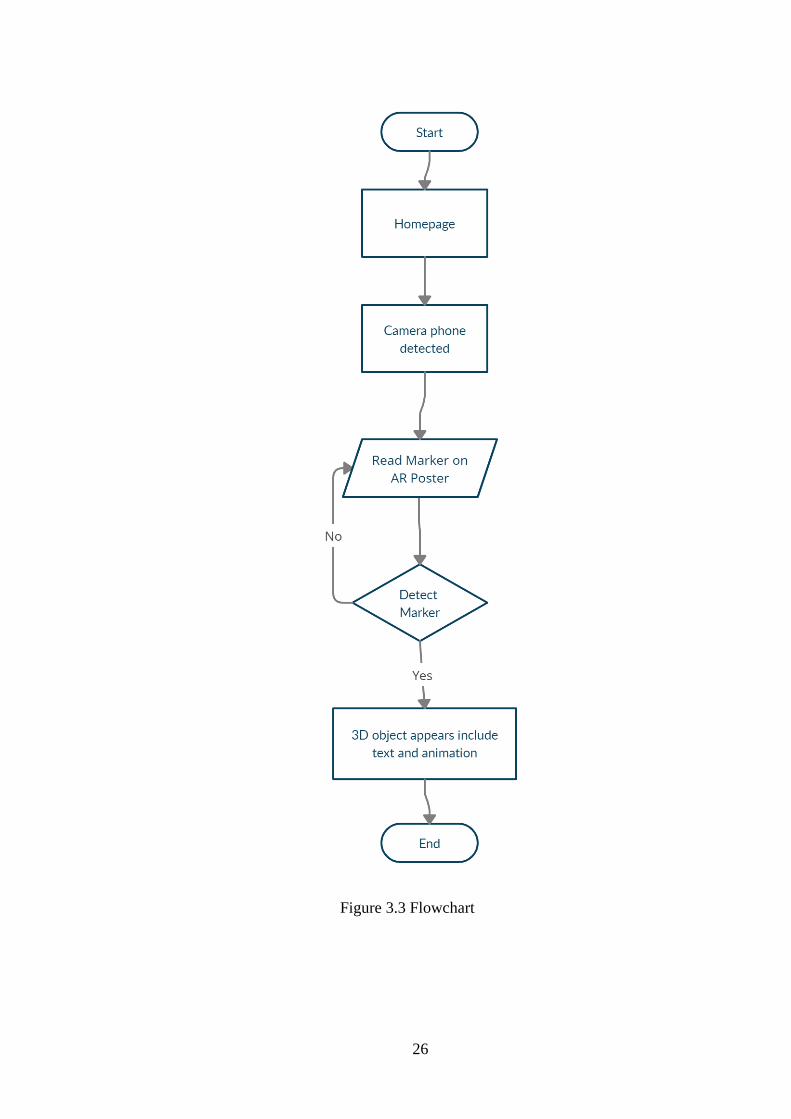
a) Flowchart
A flowchart is a type of diagram that represent the workflow of the application
(figure 3.3). The purpose is to provide user with a common language or
reference when dealing with a project. The main interface start with the start
button to enter the application. The interface will display few button which is
AR Map, Instruction, Credit and Exit. When choose AR Map, the button will
automatically direct to user camera phone. The users will scan an image in the
AR Map. Then, it will detect and display the 3D object an animation. User also
can read the information about the model when its appear.
26
Figure 3.3 Flowchart
27
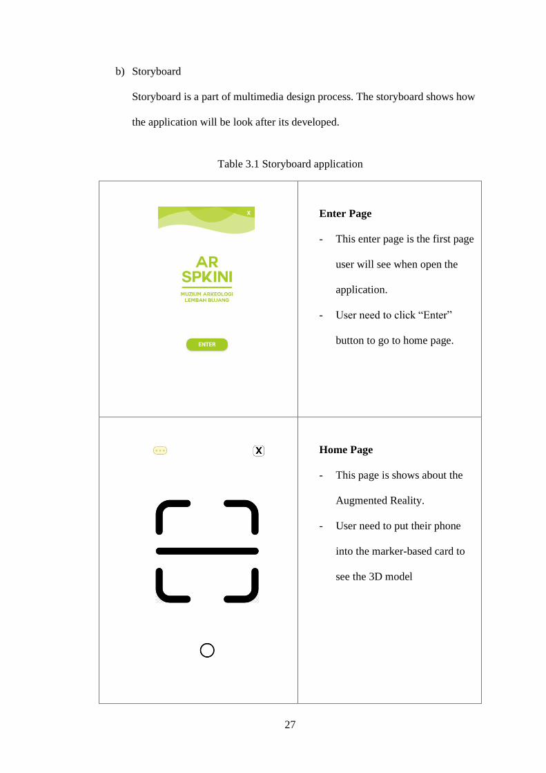
b) Storyboard
Storyboard is a part of multimedia design process. The storyboard shows how
the application will be look after its developed.
Table 3.1 Storyboard application
Enter Page
- This enter page is the first page
user will see when open the
application.
- User need to click “Enter”
button to go to home page.
Home Page
- This page is shows about the
Augmented Reality.
- User need to put their phone
into the marker-based card to
see the 3D model
28
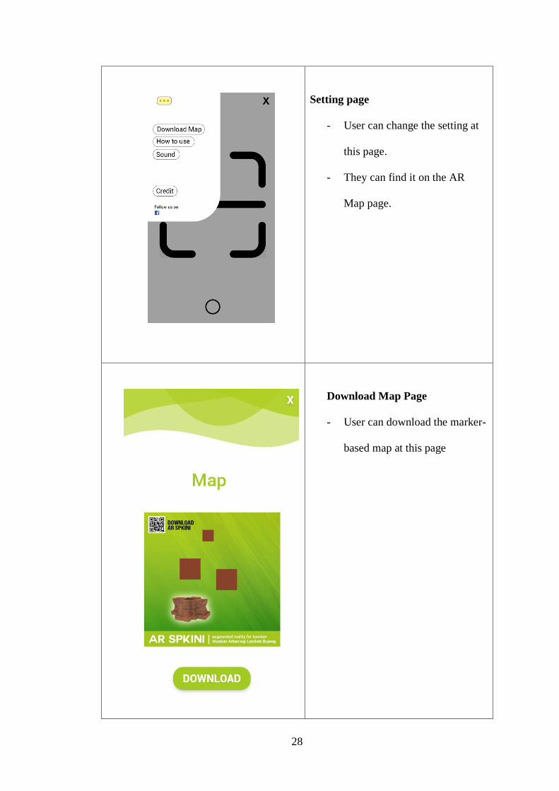
Setting page
- User can change the setting at
this page.
- They can find it on the AR
Map page.
Download Map Page
- User can download the marker-
based map at this page

29
Instruction Page
- The instruction has 4 page for
all.
- The instruction show step by
step for each page.
Credit Page
- This is the credit page that
shows who involved in this
project
3.3.3 Development
Development phase is the process for develop the application. This phase builds
on both the analysis phase and design phase. All the modules will be implemented
on this phase. This phase will develop the instruction, 3D modeling, application and
any supporting module will go through in this phase. This may include software and
hardware.
i) Create Marker-Based
ii) Create 3D Model
iii) Store Markers Database in Vuforia
iv) Create AR application use 3D Unity
3.3.4 Implementation
This phase is about process strategies and plan of project into action in order to
accomplish strategic instruction. This phase also known as testing phase. When the
application already develop, the application will be test first before publish to public.
Testing performed is ensure that the project can be used and running accordingly and
to understanding the application and the objective achieved.
• Test Run Project
• User Test Run
3.3.5 Evaluation
This phase is to determine if the objective has been achieved or not based on the
instruction. Evaluation phase should occur throughout the entire instructional design
process-within phase, between phases and after implementation. It is the process of
getting feedback from supervisor on content, graphic, audio, animation and interface.
This is to ensure that the application meet all the requirement that user needed. After all
the process done and passed, the project will be released to end user.
a) Debug
b) Final Product
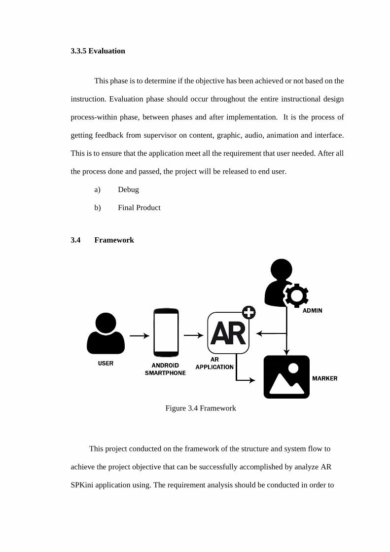
3.4 Framework
Figure 3.4 Framework
This project conducted on the framework of the structure and system flow to
achieve the project objective that can be successfully accomplished by analyze AR
SPKini application using. The requirement analysis should be conducted in order to
run the project and the project framework can be created to see and understand the
process flow.
In this section will cover a general overview and a specific overview for this chapter’s
augmented reality framework. The general overview will give you an idea of the key
feature of the augmented reality framework and the specific overview discusses
features of the augmented reality framework in specific terms and tells you how you
might be able to modify framework for your own custom needs.
Based on the framework, user must use android smartphone to install the application
and able to choose any button in application. The user needs to scan any image object
from th marker map to display 3D object and press info button to show the description
of object. For admin can update the application to add new information or new design.
Admin also available view the response feedback. Unity 3D used to create Augmented
Reality application and overall project environment. Vuforia use to create image
marker. The Vuforia detects and tract the features that are naturally found in the image
itself by comparing these natural against a known target resource database. Once the
Image Target detected, Vuforia engine will track the image as long as it is at least
partially in the camera field of view.
3.5 Hardware and Software
This section will show that all hardware and software involve in the development
process. All of these elements are important in development process of the application.
List of hardware and software are shown as below:
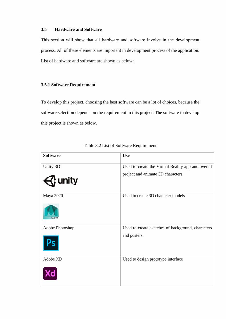
3.5.1 Software Requirement
To develop this project, choosing the best software can be a lot of choices, because the
software selection depends on the requirement in this project. The software to develop
this project is shown as below.
Table 3.2 List of Software Requirement
Software Use
Unity 3D
Used to create the Virtual Reality app and overall
project and animate 3D characters
Maya 2020
Used to create 3D character models
Adobe Photoshop
Used to create sketches of background, characters
and posters.
Adobe XD
Used to design prototype interface
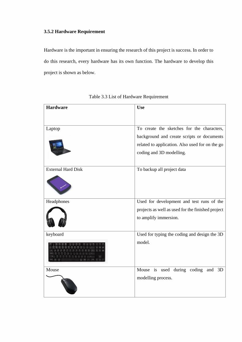
3.5.2 Hardware Requirement
Hardware is the important in ensuring the research of this project is success. In order to
do this research, every hardware has its own function. The hardware to develop this
project is shown as below.
Table 3.3 List of Hardware Requirement
Hardware Use
Laptop
To create the sketches for the characters,
background and create scripts or documents
related to application. Also used for on the go
coding and 3D modelling.
External Hard Disk
To backup all project data
Headphones
Used for development and test runs of the
projects as well as used for the finished project
to amplify immersion.
keyboard
Used for typing the coding and design the 3D
model.
Mouse
Mouse is used during coding and 3D
modelling process.
3.6 Summary of The Chapter
Methodology is very important in app development. It helps the author to
ensure the application develop correctly from phases to phases. Hardware and
software compatibility are also play important role to ensure performance is working
well.
REFERENCES
Joachim Bobrich, Steffen Otto. Augmented Maps (2002). Institue for Catrography and
Geoinformatics, University of Hanover
Zornita Yovcheva, Dimitrios Buhalis, Christos Gatzidis. Mabeedo. Shool of Tourism,
Bournemouth University, UK & Shool of Design, Engineering and Computing,
Bournemouth University, UK
Rahmi Fahriana. Strategi pengelolaan kawasan pelancongan di sungai petani.
Universiti Utara Malaysia
Arthur Arzumanyan. AR Solar System obtained from
https://play.google.com/store/apps/details?id=com.guidapasquale.solarsystemar&hl=e
n&gl=US
ARYamaNavi. AR Map World Peak. Obtained from
https://play.google.com/store/apps/details?id=com.chuna0.ARYamaNaviU&hl=en&gl
=US
Related Documents
![State of Augmented Reality, Virtual Reality and Mixed Reality · State of Augmented Reality, Virtual Reality and Mixed Reality [Microsoft Hololen] [Ready Player One] Augmented Reality](https://static.cupdf.com/doc/110x72/5f82ab6da2d89130b90d78c7/state-of-augmented-reality-virtual-reality-and-mixed-reality-state-of-augmented.jpg)