Version: 30.1.2014 [30.1.2014] This version is not published under the Legislation Revision and Publication Act 2002 1 South Australia Aquaculture (Zones—Lower Eyre Peninsula) Policy 2013 under the Aquaculture Act 2001 Contents Part 1—Preliminary 1 Short title 2 Interpretation 3 Object of policy 4 Prescription of criteria does not limit matters that may be taken into account 5 Certain amendments may be made by Gazette notice only Part 2—Boston Bay aquaculture zone 6 Identification of aquaculture zone 6A Designation of aquaculture zone as public call area 7 Class of permitted aquaculture 8 Prescribed criteria Part 3—Buffalo Reef aquaculture exclusion zone 9 Identification of aquaculture exclusion zone Part 4—Lincoln aquaculture exclusion zone 10 Identification of aquaculture exclusion zone Part 5—Lincoln aquaculture zone 11 Lincoln aquaculture zone 11A Designation of part of aquaculture zone as public call area 12 Class of permitted aquaculture 13 Prescribed criteria Part 6—Louth Bay aquaculture zone 14 Identification of aquaculture zone 14A Designation of aquaculture zone as public call area 15 Class of permitted aquaculture 16 Prescribed criteria Part 7—Murray Point aquaculture zone 17 Identification of aquaculture zone 17A Designation of aquaculture zone as public call area 18 Class of permitted aquaculture 19 Prescribed criteria

Welcome message from author
This document is posted to help you gain knowledge. Please leave a comment to let me know what you think about it! Share it to your friends and learn new things together.
Transcript

Version: 30.1.2014
[30.1.2014] This version is not published under the Legislation Revision and Publication Act 2002 1
South Australia
Aquaculture (Zones—Lower Eyre Peninsula) Policy 2013 under the Aquaculture Act 2001
Contents Part 1—Preliminary 1 Short title 2 Interpretation 3 Object of policy 4 Prescription of criteria does not limit matters that may be taken into account 5 Certain amendments may be made by Gazette notice only
Part 2—Boston Bay aquaculture zone 6 Identification of aquaculture zone 6A Designation of aquaculture zone as public call area 7 Class of permitted aquaculture 8 Prescribed criteria
Part 3—Buffalo Reef aquaculture exclusion zone 9 Identification of aquaculture exclusion zone
Part 4—Lincoln aquaculture exclusion zone 10 Identification of aquaculture exclusion zone
Part 5—Lincoln aquaculture zone 11 Lincoln aquaculture zone 11A Designation of part of aquaculture zone as public call area 12 Class of permitted aquaculture 13 Prescribed criteria
Part 6—Louth Bay aquaculture zone 14 Identification of aquaculture zone 14A Designation of aquaculture zone as public call area 15 Class of permitted aquaculture 16 Prescribed criteria
Part 7—Murray Point aquaculture zone 17 Identification of aquaculture zone 17A Designation of aquaculture zone as public call area 18 Class of permitted aquaculture 19 Prescribed criteria
Aquaculture (Zones—Lower Eyre Peninsula) Policy 2013—30.1.2014 Contents
2 This version is not published under the Legislation Revision and Publication Act 2002 [30.1.2014]
Part 8—Proper Bay aquaculture zone 20 Identification of aquaculture zone 20A Designation of aquaculture zone as public call area 21 Class of permitted aquaculture 22 Prescribed criteria
Part 9—Sir Joseph Banks aquaculture exclusion zone 23 Sir Joseph Banks aquaculture exclusion zone
Part 10—Tod River aquaculture zone 24 Identification of aquaculture zone 24A Designation of aquaculture zone as public call area 25 Class of permitted aquaculture 26 Prescribed criteria
Part 11—Miscellaneous 27 Prescribed criteria for all aquaculture zones 28 Variation or revocation of Gazette notice
Schedule 1—Descriptions of zones 1 Description of Boston Bay aquaculture zone 2 Description of Buffalo Reef aquaculture exclusion zone 3 Description of Lincoln aquaculture exclusion zone 4 Description of Lincoln aquaculture zone 5 Description of Louth Bay aquaculture zone 6 Description of Murray Point aquaculture zone 7 Description of Proper Bay aquaculture zone 8 Description of Sir Joseph Banks aquaculture exclusion zone 9 Description of Tod River aquaculture zone
Schedule 2—Maps of zones
Schedule 3—Amendment of policy by Gazette notice 1 Amendment of clause 2(1)—Interpretation 2 Substitution of Part 6
Part 6—Louth Bay aquaculture zone 13 Identification of aquaculture zone 14 Class of permitted aquaculture 15 Prescribed criteria
3 Amendment of Schedule 1—Descriptions of zones 5 Description of Louth Bay aquaculture zone
4 Amendment of Schedule 2—Maps of zones
Legislative history
30.1.2014—Aquaculture (Zones—Lower Eyre Peninsula) Policy 2013
Preliminary—Part 1
[30.1.2014] This version is not published under the Legislation Revision and Publication Act 2002 3
Part 1—Preliminary 1—Short title
This policy may be cited as the Aquaculture (Zones—Lower Eyre Peninsula) Policy 2013.
2—Interpretation (1) In this policy, unless the contrary intention appears—
Act means the Aquaculture Act 2001;
algae means eukaryotic macroalgae;
Bicker Isles sector means the area within the Boston Bay aquaculture zone described in Schedule 1 clause 1(a);
bivalve molluscs includes clams, cockles, mussels, oysters, pipis and scallops;
Boston Bay sector means the area within the Boston Bay aquaculture zone described in Schedule 1 clause 1(b);
Boston Island (east) sector means the area within the Boston Bay aquaculture zone described in Schedule 1 clause 1(c);
conservation park has the same meaning as in the National Parks and Wildlife Act 1972;
finfish means all members of the classes Actinopterygii, Elasmobranchii and Myxini;
leased area, in an aquaculture zone or a sector in an aquaculture zone, means the total area in the zone or sector subject to lease;
Lincoln (inner) sector means the area within the Lincoln aquaculture zone described in Schedule 1 clause 4(a);
Lincoln (outer) sector means the area within the Lincoln aquaculture zone described in Schedule 1 clause 4(b);
national park has the same meaning as in the National Parks and Wildlife Act 1972;
prescribed wild caught tuna means members of the genera Allothunnus, Auxis, Euthunnus, Katsuwonus, and Thunnus that have been taken from the wild.
(2) For the purposes of the descriptions of aquaculture zones or aquaculture exclusion zones in this policy, unless the contrary intention appears, all lines are geodesics based on the Geocentric Datum of Australia 1994 (GDA94) as defined in the Commonwealth of Australia Gazette GN35 of 6 September 1995 and all co-ordinates are expressed in terms of GDA94.
(3) The point references given in a description identifying an aquaculture zone or aquaculture exclusion zone in Schedule 1 are references to the corresponding points in the map of that zone in Schedule 2.
Note—
Unless the contrary intention appears, terms used in this policy that are defined in the Act have the respective meanings assigned to those terms by the Act.

Aquaculture (Zones—Lower Eyre Peninsula) Policy 2013—30.1.2014 Part 1—Preliminary
4 This version is not published under the Legislation Revision and Publication Act 2002 [30.1.2014]
3—Object of policy Pursuant to section 11 of the Act, this policy—
(a) identifies aquaculture zones and aquaculture exclusion zones; and
(ab) designates aquaculture zones or parts of aquaculture zones as public call areas; and
(b) specifies for an aquaculture zone—
(i) the classes of aquaculture permitted in the zone; and
(ii) prescribed criteria to be taken into account in the determination of applications for licences or in the making of other decisions under the Act in relation to the zone.
4—Prescription of criteria does not limit matters that may be taken into account
This policy does not limit the matters that may be taken into account in the determination of applications for licences or in the making of other decisions under the Act.
5—Certain amendments may be made by Gazette notice only Pursuant to section 14 of the Act, the Minister may, by notice in the Gazette, amend this policy as prescribed in Schedule 3.
Part 2—Boston Bay aquaculture zone 6—Identification of aquaculture zone
The Boston Bay aquaculture zone (consisting of the Bicker Isles sector, the Boston Bay sector and the Boston Island (east) sector) comprises the State waters described in Schedule 1 clause 1.
6A—Designation of aquaculture zone as public call area The Boston Bay aquaculture zone is designated as a public call area.
7—Class of permitted aquaculture The classes of aquaculture permitted in the Boston Bay aquaculture zone are—
(a) the farming of aquatic animals in a manner that involves regular feeding; and
(b) the farming of bivalve molluscs; and
(c) the farming of algae.
8—Prescribed criteria (1) In the determination of applications for licences and in the making of other decisions
under the Act in relation to the Boston Bay aquaculture zone, the following prescribed criteria must be taken into account:
(a) the biomass of the aquatic animals (other than prescribed wild caught tuna) being farmed in the zone in a manner that involves regular feeding must not exceed—

30.1.2014—Aquaculture (Zones—Lower Eyre Peninsula) Policy 2013
Boston Bay aquaculture zone—Part 2
[30.1.2014] This version is not published under the Legislation Revision and Publication Act 2002 5
(i) an amount that would, in the opinion of the Minister, have an environmental impact on the zone equivalent to the environmental impact that 1 750 tonnes of finfish would have on the zone; or
(ii) if some other amount is specified by the Minister by notice in the Gazette, that other amount;
(b) the leased area in the Boston Bay sector and the Boston Island (east) sector (when combined) must not exceed 308 hectares;
(c) in the Boston Bay sector—
(i) prescribed wild caught tuna must not be farmed other than for the purposes of—
(A) research; or
(B) a business constituted of education; or
(C) a business constituted of tourism; and
(ii) the biomass of prescribed wild caught tuna being farmed must not exceed 38 tonnes or, if some other amount is specified by the Minister by notice in the Gazette, that other amount; and
(iii) the area for the farming of bivalve molluscs must not exceed 149 hectares or, if some other area is specified by the Minister by notice in the Gazette, that other area; and
(iv) the biomass of bivalve molluscs being farmed must not exceed 2 980 tonnes or, if some other amount is specified by the Minister by notice in the Gazette, that other amount;
(d) in the Boston Island (east) sector—
(i) the biomass of prescribed wild caught tuna being farmed must not exceed 360 tonnes or, if some other amount is specified by the Minister by notice in the Gazette, that other amount; and
(ii) the area for the farming of bivalve molluscs must not exceed 20 hectares or, if some other area is specified by the Minister by notice in the Gazette, that other area; and
(iii) the biomass of bivalve molluscs being farmed must not exceed 400 tonnes, or, if some other amount is specified by the Minister by notice in the Gazette, that other amount;
(e) in the Bicker Isles sector—
(i) the leased area must not exceed 60 hectares; and
(ii) the area for the farming of bivalve molluscs must not exceed 20 hectares or, if some other area is specified by the Minister by notice in the Gazette, that other area; and
(iii) the biomass of bivalve molluscs being farmed must not exceed 400 tonnes, or, if some other amount is specified by the Minister by notice in the Gazette, that other amount; and
(iv) prescribed wild caught tuna must not be farmed.
Aquaculture (Zones—Lower Eyre Peninsula) Policy 2013—30.1.2014 Part 2—Boston Bay aquaculture zone
6 This version is not published under the Legislation Revision and Publication Act 2002 [30.1.2014]
(2) However, a notice under subclause (1) must not increase the biomass of bivalve molluscs that may be farmed in a sector unless the Minister is satisfied that the increase would not compromise the overall productivity of the bivalve mollusc industry being carried on in the sector.
Part 3—Buffalo Reef aquaculture exclusion zone 9—Identification of aquaculture exclusion zone
The Buffalo Reef aquaculture exclusion zone comprises the State waters described in Schedule 1 clause 2.
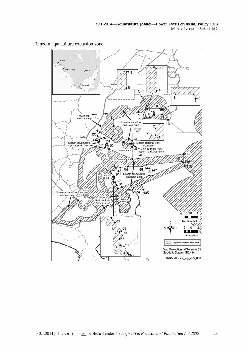
Part 4—Lincoln aquaculture exclusion zone 10—Identification of aquaculture exclusion zone
The Lincoln aquaculture exclusion zone comprises the State waters described in Schedule 1 clause 3.
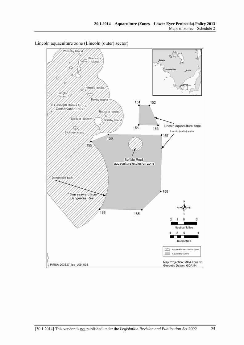
Part 5—Lincoln aquaculture zone 11—Lincoln aquaculture zone
The Lincoln aquaculture zone (consisting of the Lincoln (inner) sector and the Lincoln (outer) sector) comprises the State waters described in Schedule 1 clause 4.
11A—Designation of part of aquaculture zone as public call area That part of the Lincoln aquaculture zone consisting of the Lincoln (outer) sector is designated as a public call area.
12—Class of permitted aquaculture The classes of aquaculture permitted in the Lincoln aquaculture zone are—
(a) the farming of prescribed wild caught tuna; and
(b) the farming of algae.
13—Prescribed criteria In the determination of applications for licences and in the making of other decisions under the Act in relation to the Lincoln aquaculture zone, the following prescribed criteria must be taken into account:
(a) in the Lincoln (inner) sector—
(i) the leased area must not exceed 1 825 hectares; and
(ii) the biomass of prescribed wild caught tuna being farmed must not exceed 10 500 tonnes, or, if some other amount is specified by the Minister by notice in the Gazette, that other amount;
(b) in the Lincoln (outer) sector—
(i) the leased area must not exceed 5 000 hectares; and

30.1.2014—Aquaculture (Zones—Lower Eyre Peninsula) Policy 2013
Lincoln aquaculture zone—Part 5
[30.1.2014] This version is not published under the Legislation Revision and Publication Act 2002 7
(ii) the biomass of prescribed wild caught tuna being farmed must not exceed 14 000 tonnes or, if some other amount is specified by the Minister by notice in the Gazette, that other amount.
Part 6—Louth Bay aquaculture zone 14—Identification of aquaculture zone
The Louth Bay aquaculture zone comprises the State waters described in Schedule 1 clause 5.
14A—Designation of aquaculture zone as public call area The Louth Bay aquaculture zone is designated as a public call area.
15—Class of permitted aquaculture The classes of aquaculture permitted in the Louth Bay aquaculture zone are—
(a) the farming of aquatic animals (other than prescribed wild caught tuna) in a manner that involves regular feeding; and
(b) the farming of bivalve molluscs; and
(c) the farming of algae.
16—Prescribed criteria (1) In the determination of applications for licences and in the making of other decisions
under the Act in relation to the Louth Bay aquaculture zone, the following prescribed criteria must be taken into account:
(a) the leased area in the zone must not exceed 270 hectares;
(b) the biomass of the aquatic animals being farmed in the zone in a manner that involves regular feeding must not exceed—
(i) an amount that would, in the opinion of the Minister, have an environmental impact on the zone equivalent to the environmental impact that 1 020 tonnes of finfish would have on the zone; or
(ii) if some other amount is specified by the Minister by notice in the Gazette, that other amount;
(c) the area in the zone for the farming of bivalve molluscs must not exceed 155 hectares;
(d) the biomass of bivalve molluscs being farmed in the zone must not exceed 3 100 tonnes, or, if some other amount is specified by the Minister by notice in the Gazette, that other amount.
(2) However, a notice under subclause (1)(d) must not increase the biomass of bivalve molluscs that may be farmed in the zone unless the Minister is satisfied that the increase would not compromise the overall productivity of the bivalve mollusc industry being carried on in the zone.

Aquaculture (Zones—Lower Eyre Peninsula) Policy 2013—30.1.2014 Part 7—Murray Point aquaculture zone
8 This version is not published under the Legislation Revision and Publication Act 2002 [30.1.2014]
Part 7—Murray Point aquaculture zone 17—Identification of aquaculture zone
The Murray Point aquaculture zone comprises the State waters described in Schedule 1 clause 6.
17A—Designation of aquaculture zone as public call area The Murray Point aquaculture zone is designated as a public call area.
18—Class of permitted aquaculture The class of aquaculture permitted in the Murray Point aquaculture zone is the farming of bivalve molluscs other than mussels.
19—Prescribed criteria In the determination of applications for licences and in the making of other decisions under the Act in relation to the Murray Point aquaculture zone it must be taken into account that the leased area in the zone must not exceed 2 hectares.
Part 8—Proper Bay aquaculture zone 20—Identification of aquaculture zone
The Proper Bay aquaculture zone comprises the State waters described in Schedule 1 clause 7.
20A—Designation of aquaculture zone as public call area The Proper Bay aquaculture zone is designated as a public call area.
21—Class of permitted aquaculture The classes of aquaculture permitted in the Proper Bay aquaculture zone are—
(a) the farming of bivalve molluscs; and
(b) the farming of algae.
22—Prescribed criteria (1) In the determination of applications for licences and in the making of other decisions
under the Act in relation to the Proper Bay aquaculture zone, the following prescribed criteria must be taken into account:
(a) the area in the zone for the farming of bivalve molluscs must not exceed 60 hectares;
(b) the biomass of bivalve molluscs being farmed in the zone must not exceed 1 200 tonnes or, if some other amount is specified by the Minister by notice in the Gazette, that other amount.
(2) However, a notice under subclause (1)(b) must not increase the biomass of bivalve molluscs that may be farmed in the zone unless the Minister is satisfied that the increase would not compromise the overall productivity of the bivalve mollusc industry being carried on in the zone.

30.1.2014—Aquaculture (Zones—Lower Eyre Peninsula) Policy 2013
Sir Joseph Banks aquaculture exclusion zone—Part 9
[30.1.2014] This version is not published under the Legislation Revision and Publication Act 2002 9
Part 9—Sir Joseph Banks aquaculture exclusion zone 23—Sir Joseph Banks aquaculture exclusion zone
The Sir Joseph Banks aquaculture exclusion zone comprises the State waters described in Schedule 1 clause 8.
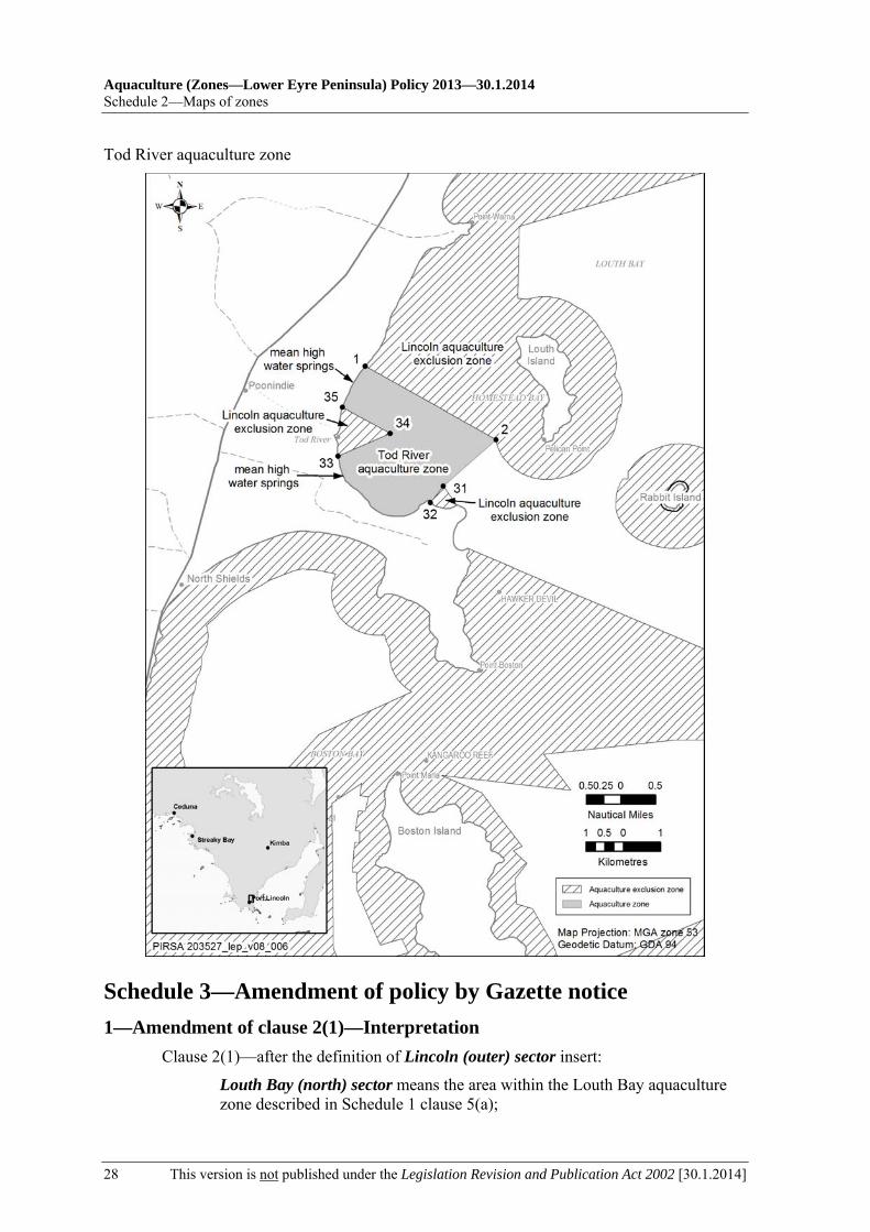
Part 10—Tod River aquaculture zone 24—Identification of aquaculture zone
The Tod River aquaculture zone comprises the State waters described in Schedule 1 clause 9.
24A—Designation of aquaculture zone as public call area The Tod River aquaculture zone is designated as a public call area.
25—Class of permitted aquaculture The class of aquaculture permitted in the Tod River aquaculture zone is the farming of bivalve molluscs other than mussels.
26—Prescribed criteria In the determination of applications for licences and in the making of other decisions under the Act in relation to the Tod River aquaculture zone it must be taken into account that the leased area in the zone must not exceed 38 hectares.
Part 11—Miscellaneous 27—Prescribed criteria for all aquaculture zones
In the determination of applications for licences and in the making of other decisions under the Act in relation to the aquaculture zones in this policy, it must be taken into account that of the aggregated area leased or available for lease in those zones, at least 13 hectares must be used or available for use for the farming of aquatic organisms for the purposes of research or for the purposes of a business constituted of education.
28—Variation or revocation of Gazette notice (1) The Minister may vary or revoke a notice in the Gazette made under this policy by
subsequent notice in the Gazette.
(2) The power to vary or revoke a notice under subclause (1) is exercisable in the same way, and subject to the same conditions, as the power to make the earlier notice.
Aquaculture (Zones—Lower Eyre Peninsula) Policy 2013—30.1.2014 Schedule 1—Descriptions of zones
10 This version is not published under the Legislation Revision and Publication Act 2002 [30.1.2014]
Schedule 1—Descriptions of zones 1—Description of Boston Bay aquaculture zone
The Boston Bay aquaculture zone is, for the purposes of this policy, comprised of sectors identified as follows:
(a) the Bicker Isles sector, comprising the State waters contained within and bounded by a line commencing at 34°44′40.75″ South, 135°56′13.15″ East (Point 106), then north-easterly to 34°43′58.74″ South, 135°57′53.88″ East (Point 107), then south-easterly to 34°44′22.03″ South, 135°58′08.58″ East (Point 108), then south-westerly to 34°44′54.03″ South, 135°57′32.51″ East (Point 109), then north-westerly to a location on the line 250 metres seaward of Lincoln National Park boundary closest to 34°44′44.02″ South, 135°57′26.64″ East (Point 110), then beginning north-easterly following a line 250 metres seaward of Lincoln National Park boundary to the location closest to 34°44′42.37″ South, 135°57′14.30″ East (Point 111), then south-westerly to 34°45′18.85″ South, 135°56′37.79″ East (Point 112), then north-westerly to the point of commencement;
(b) the Boston Bay sector, comprising the State waters contained within and bounded by—
(i) a line commencing at mean high water springs closest to 34°43′59.17″ South, 135°55′46.93″ East (Point 98), then beginning northerly following the line of mean high water springs to the location closest to 34°43′33.98″ South, 135°56′57.45″ East (Point 95), then south-westerly to 34°43′36.08″ South, 135°56′55.13″ East (Point 96), then south-westerly to 34°43′59.73″ South, 135°55′47.16″ East (Point 97), then northerly to the point of commencement; and

30.1.2014—Aquaculture (Zones—Lower Eyre Peninsula) Policy 2013
Descriptions of zones—Schedule 1
[30.1.2014] This version is not published under the Legislation Revision and Publication Act 2002 11
(ii) a line commencing at 34°40′50.79″ South, 135°54′05.03″ East (Point 71), then north-easterly to 34°40′33.71″ South, 135°54′30.67″ East (Point 72), then southerly to 34°40′44.25″ South, 135°54′29.03″ East (Point 73), then easterly to 34°40′45.37″ South, 135°54′36.86″ East (Point 74), then southerly to 34°40′58.02″ South, 135°54′33.73″ East (Point 75), then westerly to 34°40′57.22″ South, 135°54′28.01″ East (Point 76), then southerly to 34°41′15.06″ South, 135°54′25.16″ East (Point 77), then easterly to 34°41′15.04″ South, 135°54′28.81″ East (Point 78), then southerly to 34°41′24.72″ South, 135°54′28.91″ East (Point 79), then westerly to 34°41′24.76″ South, 135°54′24.83″ East (Point 80), then southerly to 34°41′50.6″ South, 135°54′22.53″ East (Point 130), then easterly to 34°41′50.58″ South, 135°54′26.22″ East (Point 131), then southerly to 34°42′05.43″ South, 135°54′26.38″ East (Point 132), then south-easterly to 34°42′53.59″ South, 135°54′46.91″ East (Point 81), then north-easterly to 34°42′48.19″ South, 135°55′05.49″ East (Point 82), then south-easterly to 34°43′00.19″ South, 135°55′11.20″ East (Point 83), then south-westerly to 34°43′05.72″ South, 135°54′52.74″ East (Point 84), then south-easterly to 34°43′19.32″ South, 135°54′59.28″ East (Point 85), then south-easterly to 34°43′32.04″ South, 135°55′04.86″ East (Point 86), then south-easterly to 34°43′37.84″ South, 135°55′09.11″ East (Point 87), then north-easterly to 34°43′37.27″ South, 135°55′11.02″ East (Point 88), then north-easterly to 34°43′31.39″ South, 135°55′29.20″ East (Point 89), then south-easterly to 34°43′43.35″ South, 135°55′34.96″ East (Point 90), then south-westerly to 34°43′45.04″ South, 135°55′29.72″ East (Point 91), then south-easterly to 34°43′56.23″ South, 135°55′36.12″ East (Point 92), then north-westerly to 34°43′31.84″ South, 135°54′22.36″ East (Point 93), then north-westerly to 34°42′56.91″ South, 135°54′06.40″ East (Point 94), then northerly to the point of commencement; and
(iii) a line commencing at a location on the line 1 100 metres seaward of mean high water springs closest to 34°39′14.32″ South, 135°55′14.24″ East (Point 44), then south-westerly to 34°39′51.14″ South, 135°53′53.70″ East (Point 45), then south-westerly to 34°40′10.09″ South, 135°53′36.50″ East (Point 46), then south-westerly to 34°40′51.28″ South, 135°52′59.11″ East (Point 47), then south-westerly to 34°41′56.83″ South, 135°52′25.80″ East (Point 48), then westerly to a location on the line 1 100 metres seaward of mean high water springs closest to 34°42′01.12″ South, 135°51′55.95″ East (Point 49), then beginning northerly following a line 1 100 metres seaward of mean high water springs to the point of commencement;
Aquaculture (Zones—Lower Eyre Peninsula) Policy 2013—30.1.2014 Schedule 1—Descriptions of zones
12 This version is not published under the Legislation Revision and Publication Act 2002 [30.1.2014]
(c) the Boston Island (east) sector, comprising the State waters contained within and bounded by a line commencing at 34°40′26.7″ South, 135°55′39.98″ East (Point 50), then south-easterly to 34°40′39.6″ South, 135°57′32.24″ East (Point 51), then north-westerly to 34°40′08.52″ South, 135°57′08.45″ East (Point 52), then north-easterly to 34°40′03.72″ South, 135°57′51.28″ East (Point 53), then southerly to 34°41′55.04″ South, 135°57′46.77″ East (Point 133), then south-westerly to 34°42′07.46″ South, 135°57′21.41″ East (Point 134), then south-easterly to 34°42′18.63″ South, 135°57′29.43″ East (Point 135), then north-easterly to 34°42′06.21″ South, 135°57′54.79″ East (Point 136), then south-easterly to 34°43′06.25″ South, 135°58′04.48″ East (Point 61), then south-westerly to 34°43′21.79″ South, 135°57′27.22″ East (Point 62), then north-westerly to 34°42′52.67″ South, 135°57′16.6″ East (Point 63), then north-westerly to 34°42′46.69″ South, 135°57′12.92″ East (Point 64), then north-westerly to 34°42′22″ South, 135°56′59″ East (Point 138), then north-westerly to 34°42′18″ South, 135°56′45″ East (Point 137), then northerly to 34°41′56″ South, 135°56′44″ East (Point 65), then north-easterly to 34°41′43″ South, 135°56′54″ East (Point 66), then north-westerly to 34°41′31.95″ South, 135°56′42.22″ East (Point 67), then north-easterly to 34°41′28.21″ South, 135°56′49.84″ East (Point 68), then north-westerly to 34°40′58.37″ South, 135°56′26.99″ East (Point 69), then north-westerly to 34°40′41.71″ South, 135°56′14.78″ East (Point 70), then north-westerly to the point of commencement.
2—Description of Buffalo Reef aquaculture exclusion zone The Buffalo Reef aquaculture exclusion zone comprises the State waters contained within and bounded by circle of radius 2 000 metres centred on a point near Buffalo Reef closest to 34°43′07.01″ South, 136°27′37.57″ East (Point 164).
30.1.2014—Aquaculture (Zones—Lower Eyre Peninsula) Policy 2013
Descriptions of zones—Schedule 1
[30.1.2014] This version is not published under the Legislation Revision and Publication Act 2002 13
3—Description of Lincoln aquaculture exclusion zone The Lincoln aquaculture exclusion zone comprises the State waters contained within and bounded by—
(a) a line commencing at mean high water springs closest to 34°34′32.27″ South, 135°54′34.09″ East (Point 1), then south-easterly to a location on the line 1 100 metres seaward of mean high water springs closest to 34°35′35.65″ South, 135°56′27.38″ East (Point 2), then beginning south-easterly following a line 1 100 metres seaward of mean high water springs (Louth Island) to the location closest to 34°33′33.50″ South, 135°56′46.06″ East (Point 3), then northerly to 34°32′30.95″ South, 135°56′47.36″ East (Point 4), then north-easterly to a location on the line 1 100 metres seaward of mean high water springs closest to 34°31′22.32″ South, 136°00′41.74″ East (Point 5), then beginning south-easterly following a line 1 100 metres seaward of mean high water springs to the location closest to 34°30′56.42″ South, 136°02′04.56″ East (Point 6), then northerly to 34°30′55.16″ South, 136°02′04.55″ East (Point 7), then easterly to 34°30′55.16″ South, 136°02′04.67″ East (Point 8), then northerly to 34°30′50.41″ South, 136°02′04.50″ East (Point 9), then easterly to 34°30′49.07″ South, 136°03′59.40″ East (Point 10), then generally south-easterly following a line 1 100 metres seaward of mean high water springs to the location closest to 34°30′58.18″ South, 136°04′18.89″ East (Point 11), then easterly to 34°30′58.19″ South, 136°04′23.11″ East (Point 12), then south-easterly to a line 1 100 metres seaward of mean high water springs closest to 34°30′59.06″ South, 136°04′23.69″ East (Point 13), then beginning south-easterly following a line 1 100 metres seaward of mean high water springs to the location closest to 34°31′47.90″ South, 136°04′22.44″ East (Point 14), then westerly to 34°31′50.34″ South, 136°03′06.21″ East (Point 15), then south-westerly to 34°32′10.79″ South, 136°02′26.28″ East (Point 16), then westerly to 34°32′11.96″ South, 136°01′55.69″ East (Point 17), then south-westerly to 34°32′20″ South, 136°01′33.24″ East (Point 18), then easterly to the location on mean high water springs closest to 34°32′37.77″ South, 136°05′20.17″ East (Point 19), then beginning north-westerly following the line of mean high water springs to the point of commencement; and
(b) a line commencing at mean high water springs closest to 34°35′07.64″ South, 135°54′14.16″ East (Point 35), then south-easterly to 34°35′30.20″ South, 135°54′55.68″ East (Point 34), then south-westerly to the location on mean high water springs closest to 34°35′49.87″ South, 135°54′10.56″ East (Point 33), then generally northerly following the line of mean high water springs to the point of commencement; and
(c) a line commencing at mean high water springs closest to 34°36′32.82″ South, 135°55′53.56″ East (Point 30), then north-westerly to 34°36′16.12″ South, 135°55′41.83″ East (Point 31), then south-westerly to the location on mean high water springs closest to 34°36′30.29″ South, 135°55′30.58″ East (Point 32), then generally easterly following the line of mean high water springs to the point of commencement; and

Aquaculture (Zones—Lower Eyre Peninsula) Policy 2013—30.1.2014 Schedule 1—Descriptions of zones
14 This version is not published under the Legislation Revision and Publication Act 2002 [30.1.2014]
(d) a line commencing 1 000 metres seaward of Lincoln National Park boundary closest to 34°35′52.46″ South, 135°59′41.63″ East (Point 22), then beginning north-westerly following a line 1 000 metres seaward of the national park boundary to the location closest to 34°36′03.21″ South, 135°58′21.77″ East (Point 23), then southerly to 34°36′09.87″ South, 135°58′21.85″ East (Point 24), then westerly to a location on the line 1 000 metres seaward of national park boundary closest to 34°36′09.90″ South, 135°58′16.99″ East (Point 25), then beginning southerly following a line 1 000 metres seaward of national park boundary to the location closest to 34°36′51.12″ South, 135°59′42.15″ East (Point 26), then beginning north-easterly following a line 1 000 metres seaward of the national park boundary to the point of commencement; and
(e) a line commencing at mean high water springs closest to 34°37′10.35″ South, 135°56′03.44″ East (Point 29), then south-easterly to 34°38′44.20″ South, 135°59′44.44″ East (Point 141), then easterly to 34°38′38.60″ South, 136°00′39.96″ East (Point 42), then easterly to a location on the line 1 000 metres seaward of Sir Joseph Banks Group Conservation Park boundary closest to 34°37′56.19″ South, 136°07′47.93″ East (Point 142), then generally southerly following a line 1 000 metres seaward of the conservation park boundary to the location closest to 34°39′50.74″ South, 136°07′57.77″ East (Point 148), then south-westerly to 34°42′43.38″ South, 136°01′09.28″ East (Point 99), then south-easterly to 34°43′32.15″ South, 136°01′29.10″ East (Point 105), then westerly to the location on mean high water springs closest to 34°43′31.66″ South, 135°59′43.61″ East (Point 124), then beginning westerly following the line of mean high water springs to the point of commencement,
but does not include—
(f) the aquaculture zones identified in this policy; or
(g) the areas that are subject to the leases that have, at the commencement of this policy, the following registration numbers:
(i) DL00018;
(ii) LA00179;
(iii) AL00306;
(iv) AL00337,
(while those areas remain subject to lease, regardless of whether any of the leases are given a different registration number following division or amalgamation of the lease areas).
4—Description of Lincoln aquaculture zone The Lincoln aquaculture zone is, for the purposes of this policy, comprised of sectors identified as follows:
(a) the Lincoln (inner) sector, comprising the State waters contained within and bounded by—

30.1.2014—Aquaculture (Zones—Lower Eyre Peninsula) Policy 2013
Descriptions of zones—Schedule 1
[30.1.2014] This version is not published under the Legislation Revision and Publication Act 2002 15
(i) a line commencing at 34°34′41.03″ South, 135°59′40.92″ East (Point 21), then easterly to 34°34′36.82″ South, 136°07′44.95″ East (Point 20), then easterly to a location on the line 1 000 metres seaward of Sir Joseph Banks Group Conservation Park boundary closest to 34°34′35.86″ South, 136°10′03.17″ East (Point 143), then beginning south-easterly following a line 1 000 metres seaward of the conservation park boundary to the location closest to 34°37′56.19″ South, 136°07′47.93″ East (Point 142), then south-westerly to 34°38′38.60″ South, 136°00′39.96″ East (Point 42), then south-westerly to 34°38′44.20″ South, 135°59′44.44″ East (Point 141), then northerly to a location on the line 1 000 metres seaward of Lincoln National Park boundary closest to 34°36′51.12″ South, 135°59′42.15″ East (Point 26), then beginning north-easterly following a line 1 000 metres seaward of the national park boundary to the location closest to 34°35′52.46″ South, 135°59′41.63″ East (Point 22), then northerly to the point of commencement; and
(ii) a line commencing at 34°40′03.72″ South, 135°57′51.28″ East (Point 53), then easterly to 34°39′55.92″ South, 135°59′00.99″ East (Point 54), then easterly to 34°39′54.84″ South, 136°01′17.03″ East (Point 55), then north-easterly to 34°39′38.14″ South, 136°01′59.66″ East (Point 144), then easterly to 34°39′06.65″ South, 136°07′27.21″ East (Point 145), then south-easterly to 34°39′14.04″ South, 136°07′37.61″ East (Point 146), then south-westerly to 34°41′16.46″ South, 136°02′55.78″ East (Point 147), then westerly to 34°41′19.07″ South, 136°02′21.13″ East (Point 60), then south-westerly to 34°43′06.25″ South, 135°58′04.48″ East (Point 61), then north-westerly to 34°42′06.21″ South, 135°57′54.79″ East (Point 136), then south-westerly to 34°42′18.63″ South, 135°57′29.43″ East (Point 135), then north-westerly to 34°42′07.46″ South, 135°57′21.41″ East (Point 134), then north-easterly to 34°41′55.04″ South, 135°57′46.77″ East (Point 133), then northerly to the point of commencement; and
(iii) a line commencing at 34°42′43.38″ South, 136°01′09.28″ East (Point 99), then north-easterly to a location on the line 1 000 metres seaward of Sir Joseph Banks Group Conservation Park boundary closest to 34°39′50.74″ South, 136°07′57.77″ East (Point 148), then beginning south-easterly following a line 1 000 metres seaward of the conservation park boundary to the location closest to 34°41′14.92″ South, 136°09′36.26″ East (Point 149), then generally south-westerly following a line 15 000 metres seaward from a point closest to 34°48′54.67″ South, 136°12′44.23″ East (Dangerous Reef) to the location closest to 34°43′30.53″ South, 136°05′28.69″ East (Point 150), then westerly to 34°43′32.15″ South, 136°01′29.10″ East (Point 105), then north-westerly to the point of commencement;
(b) the Lincoln (outer) sector, comprising the State waters contained within and bounded by—
Aquaculture (Zones—Lower Eyre Peninsula) Policy 2013—30.1.2014 Schedule 1—Descriptions of zones
16 This version is not published under the Legislation Revision and Publication Act 2002 [30.1.2014]
(i) a line commencing at 34°37′06″ South, 136°28′12″ East (Point 151), then easterly to 34°37′06″ South, 136°30′08″ East (Point 152), then south-easterly to 34°40′09″ South, 136°31′49″ East (Point 153), then westerly to 34°40′08″ South, 136°28′12″ East (Point 154), then northerly to the point of commencement; and
(ii) a line commencing at a location on the line 15 000 metres seaward from a point closest to 34°48′54.67″ South, 136°12′44.23″ East (Dangerous Reef) closest to 34°42′49.26″ South, 136°19′16.76″ East (Point 155), then north-easterly to 34°41′42.08″ South, 136°22′32.72″ East (Point 156), then easterly to 34°41′39″ South, 136°32′32″ East (Point 157), then southerly to 34°50′26″ South, 136°32′32″ East (Point 158), then south-westerly to 34°53′17″ South, 136°29′00″ East (Point 165), then westerly to a line 15 000 metres seaward from a point closest to 34°48′54.67″ South, 136°12′44.23″ East (Dangerous Reef) to the location closest to 34°53′17″ South, 136°21′05.84″ East (Point 166), then beginning north-easterly following a line 15 000 metres seaward from a point closest to 34°48′54.67″ South, 136°12′44.23″ East (Dangerous Reef) to the point of commencement,
(but excluding the Buffalo Reef aquaculture exclusion zone).

30.1.2014—Aquaculture (Zones—Lower Eyre Peninsula) Policy 2013
Descriptions of zones—Schedule 1
[30.1.2014] This version is not published under the Legislation Revision and Publication Act 2002 17
5—Description of Louth Bay aquaculture zone The Louth Bay aquaculture zone comprises the State waters contained within and bounded by a line commencing at a location on the line 1 100 metres seaward of mean high water springs closest to 34°35′35.65″ South, 135°56′27.38″ East (Point 2), then beginning south-easterly following a line 1 100 metres seaward of mean high water springs (Louth Island) to the location closest to 34°33′33.50″ South, 135°56′46.06″ East (Point 3), then northerly to 34°32′30.95″ South, 135°56′47.36″ East (Point 4), then north-easterly to a location on the line 1 100 metres seaward of mean high water springs closest to 34°31′22.32″ South, 136°00′41.74″ East (Point 5), then beginning south-easterly following a line 1 100 metres seaward of mean high water springs to the location closest to 34°30′56.42″ South, 136°02′04.56″ East (Point 6), then northerly to 34°30′55.16″ South, 136°02′04.55″ East (Point 7), then easterly to 34°30′55.16″ South, 136°02′04.67″ East (Point 8), then northerly to 34°30′50.41″ South, 136°02′04.50″ East (Point 9), then easterly to a line 1 100 metres seaward of mean high water springs closest to 34°30′49.07″ South, 136°03′59.40″ East (Point 10), then generally south-easterly following a line 1 100 metres seaward of mean high water springs to the location closest to 34°30′58.18″ South, 136°04′18.89″ East (Point 11), then easterly to 34°30′58.19″ South, 136°04′23.11″ East (Point 12), then south-easterly to a location on the line 1 100 metres seaward of mean high water springs closest to 34°30′59.06″ South, 136°04′23.69″ East (Point 13), then beginning south-easterly following a line 1 100 metres seaward of mean high water springs to the location closest to 34°31′47.90″ South, 136°04′22.44″ East (Point 14), then westerly to 34°31′50.34″ South, 136°03′06.21″ East (Point 15), then south-westerly to 34°32′10.79″ South, 136°02′26.28″ East (Point 16), then westerly to 34°32′11.96″ South, 136°01′55.69″ East (Point 17), then south-westerly to 34°32′20″ South, 136°01′33.24″ East (Point 18), then easterly to the location on mean high water springs closest to 34°32′37.77″ South, 136°05′20.17″ East (Point 19), then south-easterly to 34°34′36.82″ South, 136°07′44.95″ East (Point 20), then westerly to 34°34′41.03″ South, 135°59′40.92″ East (Point 21), then southerly to a location on the line 1 000 metres seaward of National Park boundary closest to 34°35′52.46″ South, 135°59′41.63″ East (Point 22), then beginning north-westerly following a line 1 000 metres seaward of National Park boundary to the location closest to 34°36′03.21″ South, 135°58′21.77″ East (Point 23), then southerly to 34°36′09.87″ South, 135°58′21.85″ East (Point 24), then westerly to a location on the line 1 000 metres seaward of National Park boundary closest to 34°36′09.90″ South, 135°58′16.99″ East (Point 25), then beginning south-westerly following a line 1 000 metres seaward of National Park boundary to the location closest to 34°36′51.12″ South, 135°59′42.15″ East (Point 26), then southerly to 34°38′44.20″ South, 135°59′44.44″ East (Point 141), then north-westerly to the location on mean high water springs closest to 34°37′10.35″ South, 135°56′03.44″ East (Point 29), then beginning south-westerly following the line of mean high water springs to the location closest to 34°36′32.82″ South, 135°55′53.56″ East (Point 30), then north-westerly to 34°36′16.12″ South, 135°55′41.83″ East (Point 31), then north-easterly to the point of commencement.
Aquaculture (Zones—Lower Eyre Peninsula) Policy 2013—30.1.2014 Schedule 1—Descriptions of zones
18 This version is not published under the Legislation Revision and Publication Act 2002 [30.1.2014]
6—Description of Murray Point aquaculture zone The Murray Point aquaculture zone comprises the State waters contained within and bounded by a line commencing at mean high water springs closest to 34°45′06.04″ South, 135°50′55.23″ East (Point 113), then south-easterly to 34°45′37.46″ South, 135°51′16.26″ East (Point 114), then easterly to the location on mean high water springs closest to 34°45′36.89″ South, 135°51′49.77″ East (Point 115), then southerly following the line of mean high water springs to the location closest to 34°45′41.94″ South, 135°51′49.74″ East (Point 116), then westerly to a line 700 metres seaward of mean high water springs closest to 34°45′42.40″ South, 135°51′19.68″ East (Point 117), then westerly to 34°45′44″ South, 135°50′58.06″ East (Point 122), then north-westerly to the location on mean high water springs closest to 34°45′14.12″ South, 135°50′38.16″ East (Point 123), then generally north-easterly following the line of mean high water springs to the point of commencement.
7—Description of Proper Bay aquaculture zone The Proper Bay aquaculture zone comprises the State waters contained within and bounded by a line commencing at a location on the line 700 metres seaward of mean high water springs closest to 34°45′42.40″ South, 135°51′19.68″ East (Point 117), then beginning southerly following a line 700 metres seaward of mean high water springs to the location on mean high water springs (Grantham Island) closest to 34°46′22.74″ South, 135°52′22.51″ East (Point 118), then beginning southerly following the line of mean high water springs (Grantham Island) to the location closest to 34°46′09.34″ South, 135°52′40.17″ East (Point 119), then north-easterly to 34°45′49.68″ South, 135°53′27.89″ East (Point 120), then south-easterly to a location on the line 1 100 metres seaward of mean high water springs closest to 34°46′41.32″ South, 135°54′16.90″ East (Point 121), then beginning south-westerly following a line 1 000 metres seaward of Lincoln National Park boundary to the location closest to 34°48′11.98″ South, 135°48′22.48″ East (Point 125), then beginning north-easterly following a line 1 100 metres seaward of mean high water springs to the location closest to 34°45′44″ South, 135°50′58.06″ East (Point 122), then easterly to the point of commencement.
8—Description of Sir Joseph Banks aquaculture exclusion zone The Sir Joseph Banks aquaculture exclusion zone comprises the State waters contained within and bounded by a line commencing at a location on the line 15 000 metres seaward from a point closest to 34°48′54.67″ South, 136°12′44.23″ East (Dangerous Reef) closest to 34°44′32.83″ South, 136°04′31.29″ East (Point 163), then generally north-easterly following a line 15 000 metres seaward from a point closest to 34°48′54.67″ South, 136°12′44.23″ East (Dangerous Reef) closest to 34°41′14.92″ South, 136°09′36.26″ East (Point 149), then beginning north-westerly following a line 1 000 metres seaward of Sir Joseph Banks Group Conservation Park boundary to the location closest to 34°42′40.69″ South, 136°19′04.68″ East (Point 161), then beginning south-easterly following a line 15 000 metres seaward from a point closest to 34°48′54.67″ South, 136°12′44.23″ East (Dangerous Reef) to a point closest to 34°56′18.77″ South, 136°16′51.13″ East (Point 162), then north-westerly to the point of commencement.

30.1.2014—Aquaculture (Zones—Lower Eyre Peninsula) Policy 2013
Descriptions of zones—Schedule 1
[30.1.2014] This version is not published under the Legislation Revision and Publication Act 2002 19
9—Description of Tod River aquaculture zone The Tod River aquaculture zone comprises the State waters contained within and bounded by a line commencing at mean high water springs closest to 34°34′32.27″ South, 135°54′34.09″ East (Point 1), then south-easterly to a line 1 100 metres seaward of mean high water springs closest to 34°35′35.65″ South, 135°56′27.38″ East (Point 2), then south-westerly to 34°36′16.12″ South, 135°55′41.83″ East (Point 31), then south-westerly to the location on mean high water springs closest to 34°36′30.29″ South, 135°55′30.58″ East (Point 32), then beginning westerly following the line of mean high water springs to the location closest to 34°35′49.87″ South, 135°54′10.56″ East (Point 33), then north-easterly to 34°35′30.20″ South, 135°54′55.68″ East (Point 34), then north-westerly to the location on mean high water springs closest to 34°35′07.64″ South, 135°54′14.16″ East (Point 35), then generally north-easterly following the line of mean high water springs to the point of commencement.

Aquaculture (Zones—Lower Eyre Peninsula) Policy 2013—30.1.2014 Schedule 2—Maps of zones
20 This version is not published under the Legislation Revision and Publication Act 2002 [30.1.2014]
Schedule 2—Maps of zones The maps in this Schedule are provided for convenience of reference only.
Overview

30.1.2014—Aquaculture (Zones—Lower Eyre Peninsula) Policy 2013
Maps of zones—Schedule 2
[30.1.2014] This version is not published under the Legislation Revision and Publication Act 2002 21
Boston Bay aquaculture zone

Aquaculture (Zones—Lower Eyre Peninsula) Policy 2013—30.1.2014 Schedule 2—Maps of zones
22 This version is not published under the Legislation Revision and Publication Act 2002 [30.1.2014]
Buffalo Reef aquaculture exclusion zone and Sir Joseph Banks aquaculture exclusion zone
30.1.2014—Aquaculture (Zones—Lower Eyre Peninsula) Policy 2013
Maps of zones—Schedule 2
[30.1.2014] This version is not published under the Legislation Revision and Publication Act 2002 23
Lincoln aquaculture exclusion zone

Aquaculture (Zones—Lower Eyre Peninsula) Policy 2013—30.1.2014 Schedule 2—Maps of zones
24 This version is not published under the Legislation Revision and Publication Act 2002 [30.1.2014]
Lincoln aquaculture zone (Lincoln (inner) sector)
30.1.2014—Aquaculture (Zones—Lower Eyre Peninsula) Policy 2013
Maps of zones—Schedule 2
[30.1.2014] This version is not published under the Legislation Revision and Publication Act 2002 25
Lincoln aquaculture zone (Lincoln (outer) sector)

Aquaculture (Zones—Lower Eyre Peninsula) Policy 2013—30.1.2014 Schedule 2—Maps of zones
26 This version is not published under the Legislation Revision and Publication Act 2002 [30.1.2014]
Louth Bay aquaculture zone

30.1.2014—Aquaculture (Zones—Lower Eyre Peninsula) Policy 2013
Maps of zones—Schedule 2
[30.1.2014] This version is not published under the Legislation Revision and Publication Act 2002 27
Murray Point aquaculture zone and Proper Bay aquaculture zone
Aquaculture (Zones—Lower Eyre Peninsula) Policy 2013—30.1.2014 Schedule 2—Maps of zones
28 This version is not published under the Legislation Revision and Publication Act 2002 [30.1.2014]
Tod River aquaculture zone
Schedule 3—Amendment of policy by Gazette notice 1—Amendment of clause 2(1)—Interpretation
Clause 2(1)—after the definition of Lincoln (outer) sector insert:
Louth Bay (north) sector means the area within the Louth Bay aquaculture zone described in Schedule 1 clause 5(a);

30.1.2014—Aquaculture (Zones—Lower Eyre Peninsula) Policy 2013
Amendment of policy by Gazette notice—Schedule 3
[30.1.2014] This version is not published under the Legislation Revision and Publication Act 2002 29
Louth Bay (south) sector means the area within the Louth Bay aquaculture zone described in Schedule 1 clause 5(b);
2—Substitution of Part 6 Delete Part 6 and substitute:
Part 6—Louth Bay aquaculture zone 13—Identification of aquaculture zone
The Louth Bay aquaculture zone (consisting of the Louth Bay (north) sector and the Louth Bay (south) sector) comprises the State waters described in Schedule 1 clause 5.
14—Class of permitted aquaculture The classes of aquaculture permitted in the Louth Bay aquaculture zone are—
(a) the farming of aquatic animals (other than prescribed wild caught tuna) in a manner that involves regular feeding; and
(b) the farming of bivalve molluscs; and
(c) the farming of algae.
15—Prescribed criteria (1) In the determination of applications for licences and in the making of
other decisions under the Act in relation to the Louth Bay aquaculture zone, the following prescribed criteria must be taken into account:
(a) the biomass of the aquatic animals being farmed in the zone in a manner that involves regular feeding must not exceed—
(i) an amount that would, in the opinion of the Minister, have an environmental impact on the zone equivalent to the environmental impact that 4 000 tonnes of finfish would have on the zone; or
(ii) if some other amount is specified by the Minister by notice in the Gazette, that other amount;
(b) the area in the zone for the farming of aquatic animals in a manner that involves regular feeding must not exceed 265 hectares;
(c) in the Louth Bay (north) sector—
(i) the leased area must not exceed 360 hectares; and
(ii) the biomass of the aquatic animals being farmed in a manner that involves regular feeding must not exceed 2 880 tonnes, or, if some other amount is specified by the Minister by notice in the Gazette, that other amount; and
Aquaculture (Zones—Lower Eyre Peninsula) Policy 2013—30.1.2014 Schedule 3—Amendment of policy by Gazette notice
30 This version is not published under the Legislation Revision and Publication Act 2002 [30.1.2014]
(iii) the biomass of the bivalve molluscs being farmed in the zone must not exceed 4 464 tonnes, or, if some other amount is specified by the Minister by notice in the Gazette, that other amount;
(d) in the Louth Bay (south) sector—
(i) the leased area must not exceed 140 hectares; and
(ii) the biomass of the aquatic animals being farmed in a manner that involves regular feeding must not exceed 1 120 tonnes, or, if some other amount is specified by the Minister by notice in the Gazette, that other amount; and
(iii) the biomass of the bivalve molluscs being farmed in the zone must not exceed 1 736 tonnes, or, if some other amount is specified by the Minister by notice in the Gazette, that other amount.
(2) However, a notice under subclause (1) must not increase the biomass of bivalve molluscs that may be farmed in the zone unless the Minister is satisfied that the increase would not compromise the overall productivity of the bivalve mollusc industry being carried on in the zone.

30.1.2014—Aquaculture (Zones—Lower Eyre Peninsula) Policy 2013
Amendment of policy by Gazette notice—Schedule 3
[30.1.2014] This version is not published under the Legislation Revision and Publication Act 2002 31
3—Amendment of Schedule 1—Descriptions of zones Schedule 1 clause 5—delete clause 5 and substitute:
5—Description of Louth Bay aquaculture zone The Louth Bay aquaculture zone is, for the purposes of this policy, comprised of sectors identified as follows:

Aquaculture (Zones—Lower Eyre Peninsula) Policy 2013—30.1.2014 Schedule 3—Amendment of policy by Gazette notice
32 This version is not published under the Legislation Revision and Publication Act 2002 [30.1.2014]
(a) the Louth Bay (north) sector, comprising the State waters contained within and bounded by a line commencing at 34°32′30.95″ South, 135°56′47.36″ East (Point 4), then north-easterly to a location on the line 1 100 metres seaward of mean high water springs closest to 34°31′22.32″ South, 136°00′41.74″ East (Point 5), then beginning south-easterly following a line 1 100 metres seaward of mean high water springs to the location closest to 34°30′56.42″ South, 136°02′04.56″ East (Point 6), then northerly to 34°30′55.16″ South, 136°02′04.55″ East (Point 7), then easterly to 34°30′55.16″ South, 136°02′04.67″ East (Point 8), then northerly to 34°30′50.41″ South, 136°02′04.50″ East (Point 9), then easterly to a line 1 100 metres seaward of mean high water springs closest to 34°30′49.07″ South, 136°03′59.40″ East (Point 10), then generally south-easterly following a line 1 100 metres seaward of mean high water springs to the location closest to 34°30′58.18″ South, 136°04′18.89″ East (Point 11), then easterly to 34°30′58.19″ South, 136°04′23.11″ East (Point 12), then south-easterly to a location on the line 1 100 metres seaward of mean high water springs closest to 34°30′59.06″ South, 136°04′23.69″ East (Point 13), then beginning south-easterly following a line 1 100 metres seaward of mean high water springs to the location closest to 34°31′47.90″ South, 136°04′22.44″ East (Point 14), then westerly to 34°31′50.34″ South, 136°03′06.21″ East (Point 15), then south-westerly to 34°32′10.79″ South, 136°02′26.28″ East (Point 16), then westerly to 34°32′11.96″ South, 136°01′55.69″ East (Point 17), then south-westerly to 34°32′20″ South, 136°01′33.24″ East (Point 18), then easterly to the location on mean high water springs closest to 34°32′37.77″ South, 136°05′20.17″ East (Point 19), then south-easterly to 34°34′36.82″ South, 136°07′44.95″ East (Point 20), then westerly to 34°34′41.03″ South, 135°59′40.92″ East (Point 21), then southerly to a location on the line 1 000 metres seaward of Lincoln National Park boundary closest to 34°35′52.46″ South, 135°59′41.63″ East (Point 22), then beginning north-westerly following a line 1 000 metres seaward of the national park boundary to the location closest to 34°35′47.67″ South, 135°58′37.71″ East (Point 140), then north-westerly to a location on the line 1 100 metres seaward of mean high water springs (Louth Island) closest to 34°35′23.30″ South, 135°58′11.17″ East (Point 139), then beginning northerly following a line 1 100 metres seaward of mean high water springs (Louth Island) to the location closest to 34°33′33.50″ South, 135°56′46.06″ East (Point 3), then northerly to the point of commencement;

30.1.2014—Aquaculture (Zones—Lower Eyre Peninsula) Policy 2013
Amendment of policy by Gazette notice—Schedule 3
[30.1.2014] This version is not published under the Legislation Revision and Publication Act 2002 33
(b) the Louth Bay (south) sector, comprising the State waters contained within and bounded by a line commencing at a location on the line 1 100 metres seaward of mean high water springs closest to 34°35′35.65″ South, 135°56′27.38″ East (Point 2), then beginning south-easterly following a line 1 100 metres seaward of mean high water springs (Louth Island) to the location closest to 34°35′23.30″ South, 135°58′11.17″ East (Point 139), then south-easterly to a location on the line 1 000 metres seaward of Lincoln National Park boundary closest to 34°35′47.67″ South, 135°58′37.71″ East (Point 140), then generally south-westerly following a line 1 000 metres seaward of the national park boundary to the location closest to 34°36′03.21″ South, 135°58′21.77″ East (Point 23), then southerly to 34°36′09.87″ South, 135°58′21.85″ East (Point 24), then westerly to a location on the line 1 000 metres seaward of the national park boundary closest to 34°36′09.90″ South, 135°58′16.99″ East (Point 25), then beginning south-westerly following a line 1 000 metres seaward of the national park boundary to the location closest to 34°36′51.12″ South, 135°59′42.15″ East (Point 26), then southerly to 34°38′44.20″ South, 135°59′44.44″ East (Point 141), then north-westerly to the location on mean high water springs closest to 34°37′10.35″ South, 135°56′03.44″ East (Point 29), then beginning south-westerly following the line of mean high water springs to the location closest to 34°36′32.82″ South, 135°55′53.56″ East (Point 30), then north-westerly to 34°36′16.12″ South, 135°55′41.83″ East (Point 31), then north-easterly to the point of commencement.
Aquaculture (Zones—Lower Eyre Peninsula) Policy 2013—30.1.2014 Schedule 3—Amendment of policy by Gazette notice
34 This version is not published under the Legislation Revision and Publication Act 2002 [30.1.2014]
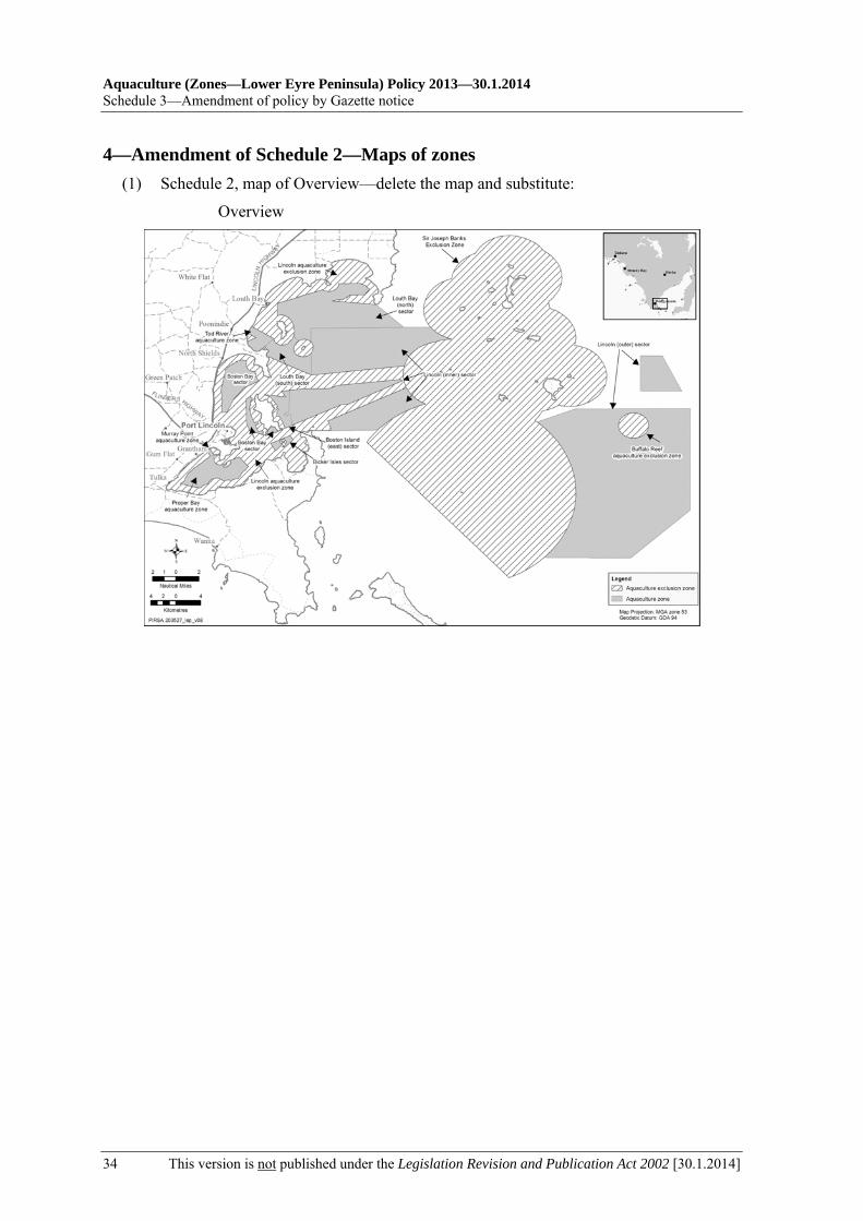
4—Amendment of Schedule 2—Maps of zones (1) Schedule 2, map of Overview—delete the map and substitute:
Overview

30.1.2014—Aquaculture (Zones—Lower Eyre Peninsula) Policy 2013
Amendment of policy by Gazette notice—Schedule 3
[30.1.2014] This version is not published under the Legislation Revision and Publication Act 2002 35
(2) Schedule 2, map of Louth Bay aquaculture zone—delete the map and substitute:
Louth Bay aquaculture zone

Aquaculture (Zones—Lower Eyre Peninsula) Policy 2013—30.1.2014 Legislative history
36 This version is not published under the Legislation Revision and Publication Act 2002 [30.1.2014]
Legislative history
Notes
• For further information relating to the Act and subordinate legislation made under the Act see the Index of South Australian Statutes or www.legislation.sa.gov.au.
Legislation revoked by principal policy
The Aquaculture (Zones—Lower Eyre Peninsula) Policy 2013 revoked the following:
Aquaculture (Zones—Lower Eyre Peninsula No 2) Policy 2007
Principal policy and amendments
New entries appear in bold. Notice Provision under
which notice is made
Publication of policy in Gazette
Commencement
Gazette 14.2.2013 p345 s 12 Gazette 14.2.2013 p346 14.2.2013 Gazette 30.1.2014 p412 s 14 — 30.1.2014: cl 2
Provisions amended
New entries appear in bold.
Entries that relate to provisions that have been deleted appear in italics. Provision How varied Commencement Pt 1
cl 3 varied by 30.1.2014 p412 cl 26 30.1.2014 Pt 2
cl 6A inserted by 30.1.2014 p412 cl 27 30.1.2014 Pt 5
cl 11A inserted by 30.1.2014 p412 cl 28 30.1.2014 Pt 6
cl 14A inserted by 30.1.2014 p412 cl 29 30.1.2014 Pt 7
cl 17A inserted by 30.1.2014 p412 cl 30 30.1.2014 Pt 8
cl 20A inserted by 30.1.2014 p412 cl 31 30.1.2014 Pt 10
cl 24A inserted by 30.1.2014 p412 cl 32 30.1.2014 Sch 4 omitted under Legislation Revision and
Publication Act 2002 30.1.2014
Related Documents


