" ARCADIS AppendixD Level 1 Hydrology Protocol Results for D Drainage

Welcome message from author
This document is posted to help you gain knowledge. Please leave a comment to let me know what you think about it! Share it to your friends and learn new things together.
Transcript

" ARCADIS
AppendixD
Level 1 Hydrology Protocol Results
for D Drainage

Cover Sheet Hydrology Protocol Use Attainability Analysis
for an Ephemeral Stream1
Stream Name: Basin: 8-dlgit HUC:
D1-Drainage I Mimbres 113030202
Reach Description: Upstream tat/long: Downstream tat/long:
See additional comments section 132-7506/-108.11491 132-74073/-108.12476
CurrentWQS Assessment Unit ID:
~ Unclassified 20.6.4.98 or 99 NMAC D Classified 20.6.4. __ NMAC 1 DH, D1-2
Reach Evaluation {How homogeneity of reach hydrology was verified)
Methods Used: Aerial photos "ground truthing", drainage profiles, reconnaissance
Reasoning: Why is the stream homogeneous? See re_port section 4.2.1
Hydrology Protocol Results Notes
D1-1 (lat/long): 32.7506/-108.11491 [gl eph D int D per Final score: 1, see field form and photos for additional information
D1-2 (!at/long): 32.74073/-108.12476 ~eph Oint Dper Final score: 1, see field form and photos for additional information
D Additional location results attached.
Hydroclimatic Conditions If "yes" please describe.
Drought (SPI Value < -1.5) Dyes ~no
Recent Rainfall (within 48 hours) Dyes ~no
Gauge data available? Dyes ~no
If yes for any of above, please explain why these conditions do not impact the UM conclusion that natural, ephemeral, intermittent or low flow conditions or water levels prevent the attainment of the use:
Hydrologic and Other Modifications If ''yes" please describe.
Dam/diversion Dyes ~no
Channelization/roads Dyes ~no
Groundwater pumping Dyes ~no
Agricultural return flows Dyes ~no
Existing point source discharge Dyes ~no
1 This form is designed for the expedited UM process for ephemeral waters described in Subsection C of 20.6-4.15 NMAC.

H_ydrolog!_c and Other Modifications If "yes" please describe.
Planned point source discharge Dyes [gl no
Other modifications Dyes [gl no
Please explain hydrologic impact
e.g., land use practices
If yes for any of above, please explain why these modifications do not alter the uses supported by the natural flow regime:
Current Uses Observed If "yes" please describe.
Macroinvertebrates Dyes [gl no
Fish Dyes [gl no
Recreation (contact use) Dyes [gl no
If yes for any of the above, please explain why these observed uses are consistent with the UM conclusion that 101(a)(2) aquatic life and recreational uses are not feasible:
Additional Comments:
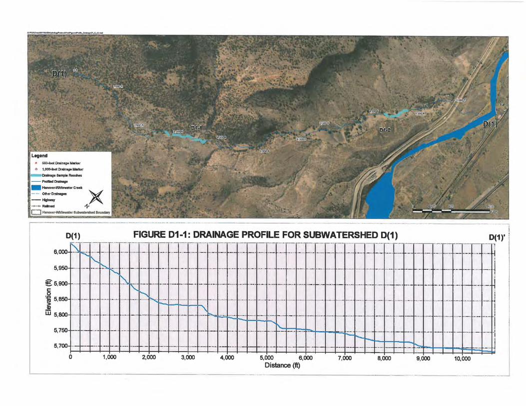
Two assessment units were identified within sub-watershed D1 (Figure 01-1). Starting at the upstream end, these assessment units are identified as 01-1 and 01-2. The most upstream assessment unit (D 1-1) was selected to represent the headwater portions of this sub-watershed but also placed downgradient of a significant reduction in basin slope. The downstream assessment unit (D 1-2) was located near the outlet of sub-watershed D 1 as representative of the hydrologic processes of the entire drainage area.
As shown in the plan and profile plots for sub-watershed D 1 (Figure D 1-1) the basin slope progressively decreases, as expected, in the downstream direction. Similarly, the degree of valley confinement decreases in the downstream direction. These trends in channel slope and confmement are typical and represent the relative dominance of colluvial versus alluvial channel forming processes and are reflected in the composition of the channel bed itself. That is, the upstream reaches of sub-watershed D1 (01-1) are bedrock and cobble dominated stream channels indicative hill slope processes (Photos 01-1 and 01-2) whereas the downstream assessment unit (01-2) are a mixture of sand/gravel/cobble (PhotosD1-2-1 and 01-2-2) and reflect the dominance of riverine processes. However, despite the influence of riverine processes within the lower assessment unit we observed very little difference between the "riparian" and upland vegetation. Furthermore, at both assessment units we observed that rooted upland plants occurred, with varying degrees of density, throughout the stream channel. The weight of evidence clearly indicates that sub-watershed D1 is an ephemeral channel that flows only in direct response to significant rainfall events.
ATTACHMENTS:
[gl Map and Photos (required) [gl Hydrology Protocol Field Sheets for all locations (required) 0 Level 2 Analysis (optional) [gl Additional sites and/or documentation (drainage profile and plan view)
CONCLUSION:
This UM concludes that the stream reach identified above is ephemeral and that Clean Water Act Section 101(a)(2) aquatic life and recreational uses are neither existing nor attainable due to the factor identified in 40
CFR 131.10(g)(2): natural, ephemeral, intermittent or low flow conditions or water levels prevent the attainment of the use, unless these conditions may be compensated for by the discharge of sufficient volume of effluent. Based on this conclusion, we recommend that the designated uses and criteria identified in 20.6.4.97 NMAC be applied to this stream reach in accordance with the expedited UM process set forth in Subsection C of 20.6.4.15 NMAC.
Submitted~ ~I.JA Date: t(jl-s I l ~I'Z-Signed: f
Surface Water Quality Bureau concurs with recommendation. Oves 0No
If no, see attached reasons.
Signed: Date:
EPA Region 6 techmcal approval granted. Oves 0No
If no, see attached reasons.
Signed: Date:
• 500-foot Drainage Marl<ar
·~ 1 ,000-foot Drainage Marker
~ 1.---.omlnAoA Sample Reaches
-- Profiled Drainage
- Hanover-Whitewater Creek
-- OtherDrainagea V --Highway A., -+-+- Railroad ~
0 Hanover-Whitewater Subwatershed Boundary
~--· 0(1) FIGURE 01-1: DRAINAGE PROFILE FOR SUBWATERSHED 0(1) !
0(1)' j ··· -------. ..,..-- r ·--r--··r·--y·---,........,- y---·.-··r- -,----T·---,-.,. .. -r··-r -.,----..,--
::~~~ ~~Tl::~~~=~~~~~~==~==~: :· ···~-. ·----- -·--. --··- ... --~- -~ .... -i
.. --·--·i--~~-'t--- +-··. -.--- ..... - ..... ... . --.--.. ·1 I
---·t---· ---· I ._ ...... __ ,.,i I
15. 9001 -~---- - -~· -- ----. _.. . -- .. --· ·r·· --- ...... --! 5,850 ................ _ ..... ~
iii 5 800 -.-. • .... . -·-·h··~·-- .. '
·-t-·- ·- · ·-·- - ..... · ·· -· ·- · •---·-•-~i-· + · i · · ·I ··- ·•- · ... · ·
- -·• --·~----t--.. +-.. ·+--···I· ··~·1·-·--·1--··t··· -"·+ ·--+-~--1---~l-----1· --·+----- ..... ---·--·•- .. --~ ------..
5, 750+-;--+ .. +·--·--
5, 700+--r-t··- ·--· ··--+---1--.. f--+--· --·-······-----.. ··•---·--1--t-·--+·"-0 1,000 2,000 3,000 4,000 5,000 6,000 7,000 8,000 9,000 10,000
Distance (ft) I ..... _ .. _ ... . ,, __________ _ _ ·--------·---.. ·------- - -------· _. ___ , __ .,.,..,.u, _ _. • .,,~ , , . .,,.,.,..,.~·•·"•--·---·-··•· · -·~•m
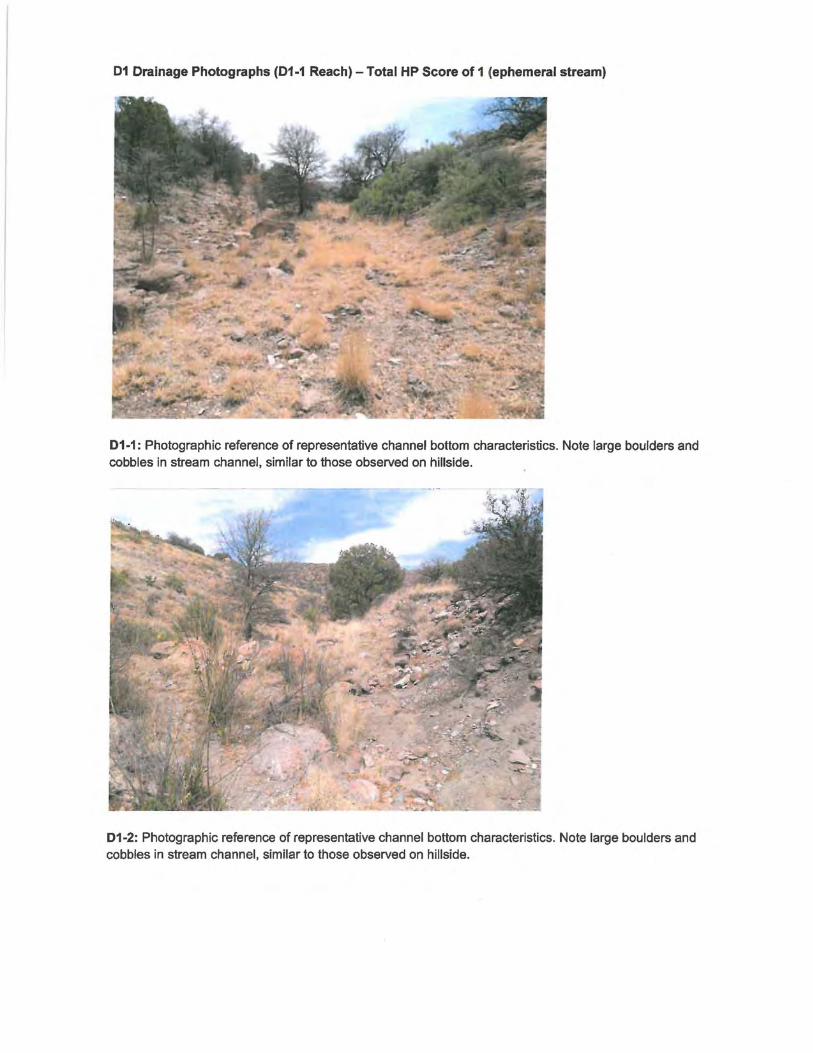
01 Drainage Photographs (01-1 Reach) -Total HP Score of 1 (ephemeral stream)
01-1: Photographic reference of representative channel bottom characteristics. Note large boulders and cobbles in stream channel, similar to those observed on hillside.
01-2: Photographic reference of representative channel bottom characteristics. Note large boulders and cobbles in stream channel, similar to those observed on hillside.

01 Drainage Photographs (01-1 Reach) - Total HP Score of 1 (ephemeral stream)
01-3 Photographic reference for indicator 1.1 through 1.6. Typical view of stream bed and banks. Indicator 1.6 scored as 1 - rooted plants are prevalent and consistently dispersed in the streambed. No water or biotic indicators of water observed along survey reach.
01-4: Photographic reference for indicator 1.5. Photograph of typical vegetation in the upland region of the survey reach. Indicator 1.5 scored as 0. Upland vegetation composition and density similar to stream and stream banks shown in previous photograph.

01 Drainage Photographs (01-1 Reach) - Total HP Score of 1 (ephemeral stream)
01-5: Photographic reference for indicators 1.5 and 1.6. Photographs of stream bed, the bank/upland area and rooted in channel vegetation. Upland vegetation composition and density similar to stream and stream banks. Rooted plants are prevalent and consistently dispersed in the streambed.

01 Drainage Photographs (01-2 Reach)- Total HP Score of 1 (ephemeral stream)
01-2-1: Photographic reference for indicator 1.1 through 1.6. Indicator 1.6 scored as 0. Rooted plants present in the channel bed and are prevalent at similar density as the upslope area. No water or biotic indicators of water observed along survey reach.
01-2-2: Photographic reference of representative channel bottom characteristics. Note sand/gravel channel bottom with prevalent rooted upland plants throughout.
01 Drainage Photographs (01-2 Reach) - Total HP Score of 1 (ephemeral stream)
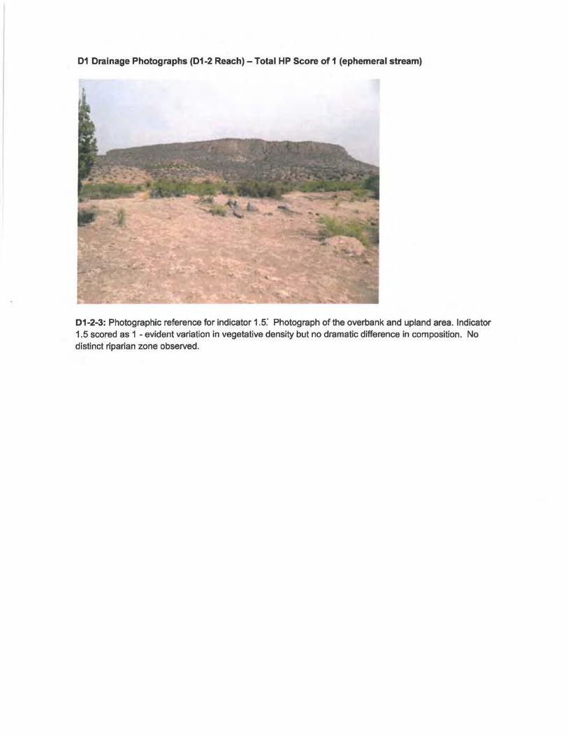
01-2-3: Photographic reference for indicator 1.5: Photograph of the overbank and upland area. Indicator 1.5 scored as 1 - evident variation in vegetative density but no dramatic difference in composition. No distinct riparian zone observed.

01 Drainage Photographs (01-2 Reach)- Total HP Score of 1 (ephemeral stream)
01-2-4: Photographic reference for indicators 1.5 and 1.6. Photographs of stream bed, the bank/upland area and rooted in channel vegetation. There is an evident variation in vegetative density but no dramatic difference in composition. Rooted plants present in the channel bed and are prevalent at similar density as the upslope area.

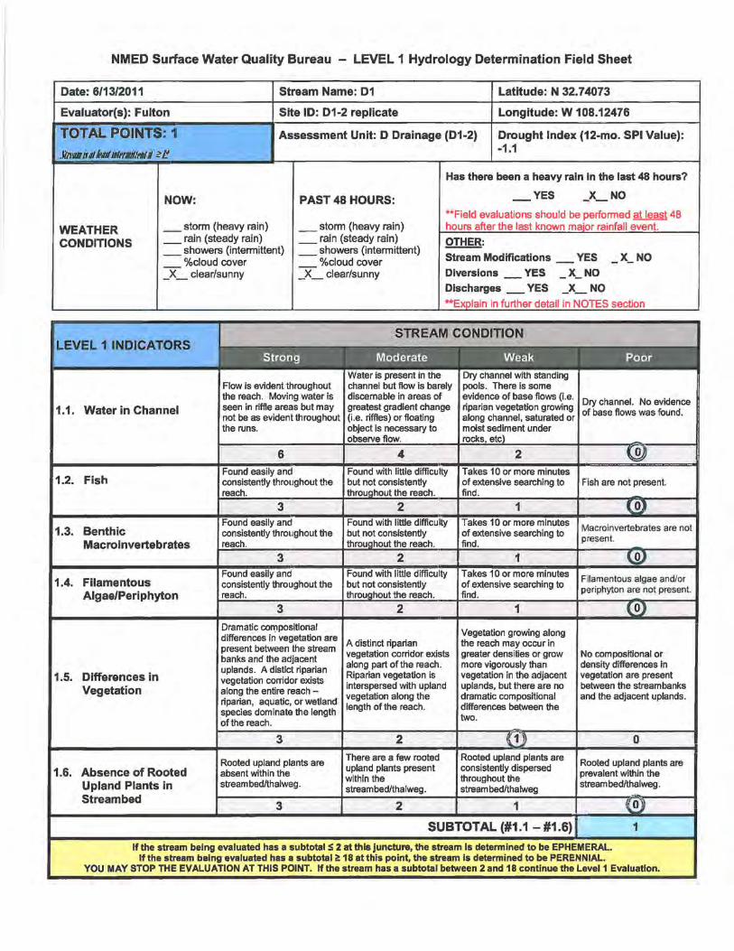
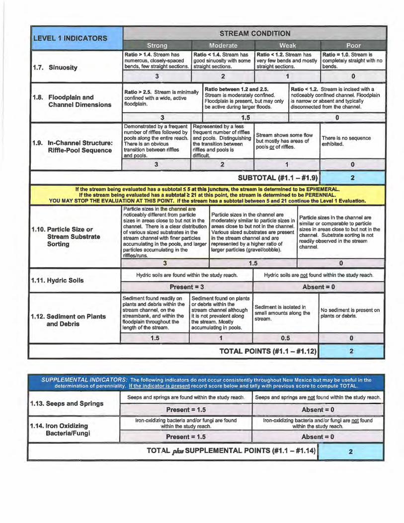
NMED Surface Water Quality Bureau - LEVEL 1 Hydrology Determination Field Sheet
Date: 6/13/2011 Stream Name: 01 Latitude: N 32.75060
Evaluator(s): Fulton/Barry Site ID: D-1 Longitude: W 108.11491
TOTAL POINTS: 1 Assessment Unit: D Drainage (D-1) Drought Index (12-mo. SPI Value}:
flnw iulltrJ/Illli'I'I#Gif'lll il ~I! -1.1
Has there been a heavy rain in the last 48 hours?
NOW: PAST 48 HOURS: - YES _x_ NO
**Field evaluations should be performed at least 48
WEATHER _storm {heavy rain) _storm (heavy rain) hours after the last known major rainfall event.
CONDITIONS _rain (steady rain) _ rain (steady rain) OTHER: _showers (intermittent) _showers (intermittent)
Stream Modifications YES _x_ NO %cloud cover %cloud cover -- -_X_ clear/sunny _X_ clear/sunny Diversions - YES _X - NO
Discharges _YES _x_ NO
LE:VEL 1 INDICATORS
1.1. Water in Channel
1.2. Fish
1.3. Benthic Macroinvertebrates
1.4. Filamentous Algae/Periphyton
1.5. Differences in Vegetation
1.6. Absence of Rooted Upland Plants in Streambed
Flow is evident throughout the reach. Moving water is seen in riffle areas but may not be as evident throughout the runs.
Found easily and consistently throughout the reach.
Dramatic compositional differences in vegetation are present between the stream banks and the adjacent uplands. A distict riparian vegetation corridor exists along the entire reach -riparian, aquatic, or wetland species dominate the length of the reach.
Rooted upland plants are absent within the streambed/thalweg.
**Explain in further detail in NOTES section
Water is present in channel but flow is barely discernable in areas of greatest gradient change (i.e. riffles) or floating object is necessary to
Found with little difficulty but not consistently
the reach.
A distinct riparian vegetation corridor exists along part ofthe reach. Riparian vegetation is interspersed with upland vegetation along the length of the reach.
There are a few rooted upland plants present within the streambecllthalweg.
Dry channel with standing pools. There is some evidence of base flows (i.e. riparian vegetation growing along channel, saturated or moist sediment under
Takes 10 or more minutes of extensive searching to find.
Takes 10 or more of extensive searching to find.
Vegetation growing along the reach may occur in greater densities or grow more vigorously than vegetation in the adjacent uplands, but there are no dramatic compositional differences between the two.
Rooted upland plants are consistently dispersed throughout the stream I"'A~Ittr""w••n
SUBTOTAL (#1.1 - #1.6) I
Dry channel. No evidence of base flows was found.
Fish are not present.
Macro invertebrates are not present.
No compositional or density differences in vegetation are present between the stream banks and the adjacent uplands.
Rooted upland plants are prevalent within the streambed/thalweg.
1
If the stream being evaluated has a subtotal !!! 2 at this juncture, the stream is determined to be EPHEMERAL. If the stream being evaluated has a subtotal i!: 18 at this point, the stream is determined to be PERENNIAL.
YOU MAY STOP THE EVALUATION AT THIS POINT. lfthe stream has a subtotal between 2 and 18 continue the Level1 Evaluation.

LEVEL 11.NDICATORS
1.7. Sinuosity
1.8. Floodplain and Channel Dimensions
1.9. In-Channel Structure: Riffle-Pool Sequence
3
Ratio > 2.5. Stream is minimally confined with a wide, active floodplain.
Demonstrated by a frequent number of riffles followed by pools along the entire reach. There is an obvious transition between riffles
3
2
Ratio between 1.2 and 2.5. Stream is moderately confined. Floodplain is present, but may only be active during larger floods.
1
Ratio = 1.0. Stream is completely straight with no bends.
0
Ratio < 1.2. Stream is incised with a noticeably confined channel. Floodplain is narrow or absent and typically disconnected from the channel.
Stream shows some flow but mostly has areas of pools .Q!: of riffles.
There is no sequence exhibited.
2 1 0
SUBTOTAL (#1.1 - #1.9) 1
If the stream being evaluated has a subtotal :S 5 at this juncture, the stream is determined to be EPHEMERAL. If the stream being evaluated has a subtotal ~ 21 at this point, the stream is determined to be PERENNIAL.
YOU MAY STOP THE EVALUATION AT THIS POINT. If the stream has a subtotal between 5 and 21 continue the Level1 Evaluation.
1.10. Particle Size or Stream Substrate Sorting
1.11. Hydric Soils
1.12. Sediment on Plants and Debris
sizes in the channel are noticeably different from particle sizes in areas close to but not in the channel. There is a clear distribution of various sized substrates in the stream channel with finer particles accumulating in the pools, and larger
accumulating in the
Particle sizes in the channel are moderately similar to particle sizes in areas close to but not in the channel. Various sized substrates are present in the stream channel and are represented by a higher ratio of larger particles (gravel/cobble).
Particle sizes in the channel are similar or comparable to particle sizes in areas close to but not in the channel. Substrate sorting is not readily observed in the stream channel.
Hydric soils are found within the study reach. Hydric soils are not found within the study reach.
Present= 3
Sediment found readily on plants and debris within the stream channel, on the stream bank, and within the floodplain throughout the length of the stream.
1.5
Sediment found on plants or debris within the stream channel although it is not prevalent along the stream. Mostly accumulating in pools.
1
Absent= 0
Sediment is isolated in small amounts along the stream.
0.5
No sediment is present on plants or debris.
0
TOTAL POINTS (#1.1-#1.12) 1
SUPPLEMENTAL INDICATORS: The following indicators do not occur consistently throughout New Mexico but may be useful in the determination of perennlality. ~record score below and tally with previous score to compute TOTAL.
Seeps and springs are found within the study reach. Seeps and springs are not found within the study reach. 1.13. Seeps and Springs
Present = 1.5 Absent= 0
Iron-oxidizing bacteria and/or fungi are found Iron-oxidizing bacteria and/or fungi are not found 1.14.1ron Oxidizing within the study reach. within the study reach.
Bacteria/Fungi Present = 1.5 Absent= 0
TOTALpluaSUPPLEMENTAL POINTS (#1.1-#1.14)1 1
NMED Surface Water Quality Bureau - LEVEL 1 Hydrology Determination Field Sheet
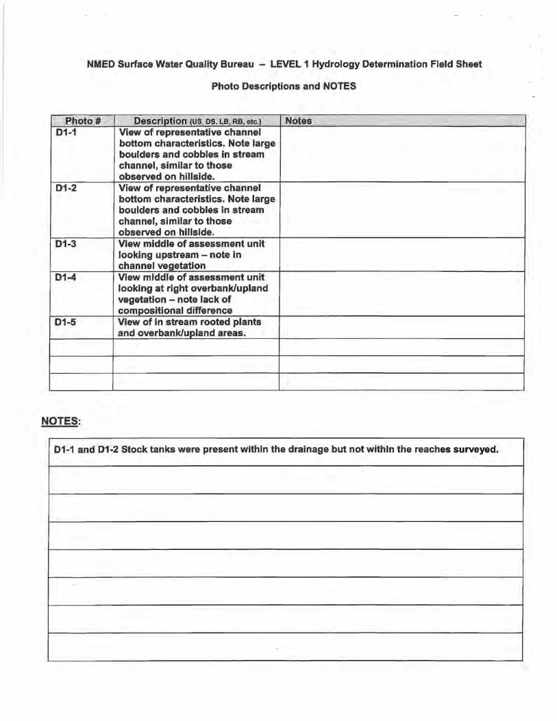
Photo Descriptions and NOTES
Photo#· Description (US, OS. LB, RB, etc.) · Notes D1-1 View of representative channel
bottom characteristics. Note large boulders and cobbles in stream channel, similar to those observed on hillside.
D1-2 View of representative channel bottom characteristics. Note large boulders and cobbles in stream channel, similar to those observed on hillside.
D1-3 View middle of assessment unit looking upstream- note in channel vegetation
D1-4 View middle of assessment unit looking at right overbank/upland vegetation - note lack of compositional difference
D1-5 View of in stream rooted plants and overbank/upland areas.
NOTES:
D1-1 and D1-2 Stock tanks were present within the drainage but not within the reaches surveyed.

NMED Surface Water Quality Bureau - LEVEL 1 Hydrology Determination Field Sheet
Date: 6/13/2011 Stream Name: D1 Latitude: N 32.74073
Evaluator(s}: Barry Site ID: D1-2 Longitude: W 108.12476
TOTAL POINTS: 1 Assessment Unit: D Drainage (D1-2} Drought Index (12-mo. SPI Value}:
Jlffilll iUIIt!liJttilhWilit!llff i? I! -1.1
Has there been a heavy rain in the last 48 hours?
NOW: PAST 48 HOURS: - YES _x_ NO
**Field evaluations should be performed at least 48
WEATHER _storm (heavy rain) _storm (heavy rain) hours after the last known major rainfall event.
CONDITIONS _rain (steady rain) _rain (steady rain) OTHER: _showers (intermittent) _showers (intermittent)
Stream Modifications YES X_ NO %cloud cover %cloud cover - -- - Diversions YES X_ NO _X_ clear/sunny _X_ clear/sunny - -
LEVEL 11NDICATORS
1.1. Water in Channel
1.2. Fish
1.3. Benthic Macro invertebrates
1.4. Filamentous Algae/Periphyton
1.5. Differences in Vegetation
1.6. Absence of Rooted Upland Plants in Streambed
Flow is evident throughout the reach. Moving water is seen in riffle areas but may not be as evident throughout the runs.
6
Found easily and consistently throughout the reach.
Dramatic compositional differences in vegetation are present between the stream banks and the adjacent uplands. A distict riparian vegetation corridor exists along the entire reach -riparian, aquatic, or wetland species dominate the length of the reach.
Rooted upland plants are absent within the streambed/thalweg.
Discharges _YES _X_ NO **Explain in further detail in NOTES section
Water is present in the channel but flow is barely discemable in areas of greatest gradient change (i.e. riffles) or floating object is necessary to observe flow.
A distinct riparian vegetation corridor exists along part of the reach. Riparian vegetation is interspersed with upland vegetation along the length of the reach.
There are a few rooted upland plants present within the stream bed/thalweg.
Dry with standing pools. There is some evidence of base flows (i.e. riparian vegetation growing along channel, saturated or moist sediment under
Vegetation growing along the reach may occur in greater densities or grow more vigorously than vegetation in the adjacent uplands, but there are no dramatic compositional differences between the two.
Rooted upland plants are consistently dispersed throughout the streambed/thalweg
SUBTOTAL (#1.1 - #1.6) ·
Dry channel. No evidence of base flows was found.
Fish are not present.
Macroinvertebrates are not present.
No compositional or density differences in vegetation are present between the streambanks and the adjacent uplands.
Rooted upland plants are prevalent within the streambed/thalweg.
1
If the stream being evaluated has a subtotal :!i 2 at this juncture, the stream is determined to be EPHEMERAL. If the stream being evaluated has a subtotal~ 18 at this point, the stream Is determined to be PERENNIAL.
YOU MAY STOP THE EVALUATION AT THIS POINT. lfthe stream has a subtotal between 2 and 18 continue the Level1 Evaluation.

LEVEL 1 INDICATORS
1.7. Sinuosity
1.8. Floodplain and Channel Dimensions
1.9. In-Channel Structure: Riffle-Pool Sequence
3 2 1
Ratio = 1.0. Stream is completely straight with no bends.
0
Ratio > 2.5. Stream is minimally confined with a wide, active floodplain.
Ratio between 1.2 and 2.5. Stream is moderately confined. Floodplain is present, but may only be active during larger floods.
Ratio < 1.2. Stream is incised with a noticeably confined channel. Floodplain is narrow or absent and typically disconnected from the channel.
number of riffles followed by pools along the entire reach. There is an obvious transition between riffles and
3
number of riffles and pools. Distinguishing the transition between riffles and pools is difficult.
2
Stream shows some flow but mostly has areas of pools .Q! of riffles.
1
SUBTOTAL (#1.1 - #1.9) I
There is no sequence exhibited.
0
1
If the stream being evaluated has a subtotalS 5 at this juncture, the stream is determined to be EPHEMERAL. If the stream being evaluated has a subtotal it 21 at this point, the stream is determined to be PERENNIAL.
YOU MAY STOP THE EVALUATION AT THIS POINT. If the stream has a subtotal between 5 and 21 continue the Level1 Evaluation.
1.10. Particle Size or Stream Substrate Sorting
1.11. Hydric Soils
1.12. Sediment on Plants and Debris
are noticeably different from particle sizes in areas close to but not in the channel. There is a clear distribution of various sized substrates in the stream channel with finer particles accumulating in the pools, and larger particles accumulating in the
Particle sizes in the channel are moderately similar to particle sizes in areas close to but not in the channel. Various sized substrates are present in the stream channel and are represented by a higher ratio of larger particles (gravel/cobble).
Particle sizes in the channel are similar or comparable to particle sizes in areas close to but not in the channel. Substrate sorting is not readily observed in the stream channel.
Hydric soils are found within the study reach. Hydric soils are not found within the study reach.
Present= 3
Sediment found readily on plants and debris within the stream channel, on the stream bank, and within the floodplain throughout the length of the stream.
1.5
Sediment found on plants or debris within the stream channel although it is not prevalent along the stream. Mostly accumulating in pools.
1
Absent= 0
Sediment is isolated in small amounts along the stream.
0.5
No sediment is present on plants or debris.
0
TOTAL POINTS (#1.1- #1.12) 1
SUPPLEMENTAL INDICATORS: The following indicators do not occur consistently throughout New Mexico but may be useful in the determination of perenniality. ~record score below and tally with previous score to compute TOTAL.
Seeps and sprir1gs are found within the study reach . Seeps and springs are not found within the study reach. 1.13. Seeps and Springs
Present = 1.5 Absent= 0
Iron-oxidizing bacteria and/or fungi are found Iron-oxidizing bacteria and/or fungi are not found 1.14. Iron Oxidizing within the study reach. within the study reach.
Bacteria/Fungi Present = 1.5 Absent =0
TOTAL plus SUPPLEMENTAL POINTS (#1.1- #1.14) I 1

NMED Surface Water Quality Bureau - LEVEL 1 Hydrology Determination Field Sheet
Photo Descriptions and NOTES
Photo# · Description (US, DS, LB, RB, etc.) Notes D1-2-1 View upstream extent of
assessment unit looking downstream- note prevalent In channel vegetation
D1-2-2 View of representative channel bottom characteristics. Note sand/gravel channel bottom with prevalent rooted upland plants throughout.
D1-2-3 View from downstream extent of assessment unit looking to right overbank
D1-2-4 View of in stream rooted plants and overbank/upland areas.
NOTES:
D1-1 and D1-2 Stock tanks were present within the drainage but not within the reaches surveyed.
NMED Surface Water Quality Bureau - LEVEL 1 Hydrology Determination Field Sheet
Date: 6/13/2011 Stream Name: D1 Latitude: N 32.74073
Evaluator(s): Fulton Site ID: D1-2 replicate Longitude: W 108.12476
TOTAL POINTS: 1 Assessment Unit: D Drainage (D1-2) Drought Index (12-mo. SPI Value):
.flii'Ji iJ ll1irtJJt illn.fl/1'111 Jl'? ~ -1.1
Has there been a heavy rain in the last 48 hours?
NOW: PAST 48 HOURS: - YES _x_ NO
**Field evaluations should be performed at least 48
WEATHER _storm (heavy rain) _storm (heavy rain) hours after the last known major rainfall event.
CONDITIONS _rain (steady rain) _ rain (steady rain) OTHER: _showers (intermittent) _showers (intermittent)
Stream Modifications YES X_ NO %cloud cover %cloud cover - -- -_X_ clear/sunny _X_ clear/sunny Diversions - YES - X_ NO
LEVEL 1 INDICATOR'S
1.1. Water in Channel
1.2. Fish
1.3. Benthic Macroinvertebrates
1.4. Filamentous Algae/Periphyton
1.5. Differences in Vegetation
1.6. Absence of Rooted Upland Plants in Streambed
Flow is evident throughout the reach. Moving water is seen in riffle areas but may not be as evident throughout the runs.
Dramatic COn:Jpositional differences in vegetation are present between the stream banks and the adjacent uplands. A distict riparian vegetation corridor exists along the entire reach -riparian, aquatic, or wetland species dominate the length of the reach.
Rooted upland plants are absent within the streambed/thalweg.
Discharges _YES _x_ NO **Explain in further detail in NOTES section
A distinct riparian vegetation corridor exists along part of the reach. Riparian vegetation is interspersed with upland vegetation along the length of the reach.
There are a few rooted upland plants present within the streambed/thalweg.
Vegetation growing along the reach may occur in greater densities or grow more vigorously than vegetation in the adjacent uplands, but there are no dramatic compositional differences between the two.
Rooted upland plants are consistently dispersed throughout the stream bed/thalweg
SUBTOTAL (#1.1 - #1.6)
Macroinvertebrates are not present.
No compositional or density differences in vegetation are present between the streambanks and the adjacent uplands.
Rooted upland plants are prevalent within the stream bed/thalweg.
1
If the stream being evaluated has a subtotal ~ 2 at this juncture, the stream is determined to be EPHEMERAL. If the stream being evaluated has a subtotal:!: 18 at this point, the stream is determined to be PERENNIAL.
YOU MAY STOP THE EVALUATION AT THIS POINT. If the stream has a subtotal between 2 and 18 continue the Level1 Evaluation.
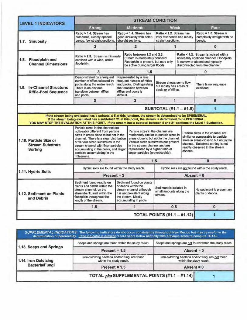
LEVEL 1 INDICATORS
1.7. Sinuosity
1.8. Floodplain and Channel Dimensions
1.9. In-Channel Structure: Riffle-Pool Sequence
3 2 1
Ratio = 1.0. Stream is completely straight with no bends.
0
Ratio > 2.5. Stream is minimally confined with a wide, active floodplain.
Ratio between 1.2 and 2.5. Stream is moderately confined. Floodplain is present, but may only be active during larger floods.
Ratio < 1.2. Stream is incised with a noticeably confined channel. Floodplain is narrow or absent and typically disconnected from the channel.
Demonstrated by a number of riffles followed by pools along the entire reach. There is an obvious transition between riffles
3
Represented by a less frequent number of riffles and pools. Distinguishing the transition between riffles and pools is
2
Stream shows some flow but mostly has areas of pools QJ: of riffles.
1
SUBTOTAL (#1.1-#1.9)
There is no sequence exhibited.
0
1
If the stream being evaluated has a subtotal :S 5 at this juncture, the stream is determined to be EPHEMERAL. If the stream being evaluated has a subtotal 0!: 21 at this point, the stream is determined to be PERENNIAL.
YOU MAY STOP THE EVALUATION AT THIS POINT. If the stream has a subtotal between 5 and 21 continue the Level1 Evaluation.
1.10. Particle Size or Stream Substrate Sorting
1.11. Hydric Soils
1.12. Sediment on Plants and Debris
Particle sizes in the channel are noticeably different from particle sizes in areas close to but not in the channel. There is a clear distribution ofvarious sized substrates in the stream channel with finer particles accumulating in the pools, and larger particles accumulating in the riffles/runs.
Particle sizes in the channel are moderately similar to particle sizes in areas close to but not in the channel. Various sized substrates are present in the stream channel and are represented by a higher ratio of larger particles (gravel/cobble).
Particle sizes in the channel are similar or comparable to particle sizes in areas close to but not in the channel. Substrate sorting is not readily observed in the stream channel.
Hydric soils are found within the study reach. Hydric soils are not found within the study reach.
Present= 3
Sediment found readily on plants and debris within the stream channel, on the streambank, and within the floodplain throughout the length of the stream.
1.5
Sediment found on plants or debris within the stream channel although it is not prevalent along the stream. Mostly accumulating in pools.
1
Absent= 0
Sediment is isolated in small amounts along the stream.
0.5
No sediment is present on plants or debris.
0
TOTAL POINTS (#1.1-#1.12) 1
SUPPLEMENTAL INDICATORS: The following indicators do not occur consistently throughout New Mexico but may be useful in the determination of perennia1ity. ~record score below and tally with previous score to compute TOTAL.
Seeps and springs are found within the study re~ch. Seeps and springs are not found within the study reach. 1.13. Seeps and Springs
Present = 1.5 Absent= 0
Iron-oxidizing bacteria and/or fungi are found Iron-oxidizing bacteria and/or fungi are not found 1.14.1ron Oxidizing within the study reach. within the study reach.
Bacteria/Fungi Present = 1.5 Absent= 0
TOTALplusSUPPLEMENTAL POINTS (#1.1-#1.14)1 1

NMED Surface Water Quality Bureau - LEVEL 1 Hydrology Determination Field Sheet
Photo Descriptions and NOTES
Photo# Description (US, DS, LB, RB, etc.) Notes ··- -··-
D1-2-1 VIew upstream extent of assessment unit looking downstream - note prevalent in channel vegetation
D1-2-2 VIew of representative channel bottom characteristics. Note sand/gravel channel bottom with prevalent rooted upland plants throughout.
D1-2-3 View from downstream extent of assessment unit looking to right overbank
D1-2-4 VIew of in stream rooted plants and overbank/upland areas.
NOTES:
D1-1 and D1-2 Stock tanks were present within the drainage but not within the reaches surveyed.

Cover Sheet Hydrology Protocol Use Attainability Analysis
for an Ephemeral Stream 1
Stream Name: Basin: 8-dlglt HUC:
D2-Drainage I Mimbres 113030202
Reach Description: Upstream fat/long: Downstream fat/long:
See additional comments section 132-71882/-108.11478 132-71835/-108.11639
CurrentWQS Assessment Unit ID:
[gl Unclassified 20.6.4.98 or 99 NMAC D Classified 20.6.4. __ NMAC l D2-3
Reach Evaluation ( How homogeneity of reach hydrology was verified)
Methods Used: Aerial photos, "ground truthing", drainage profiles, reconnaissance
Reasoning: Why is the stream homogeneous? See report section 4.2.1
Hydrology Protocol Results Notes
D2-3 (!at/long): 32.71882/-108.11478 [gl eph D int D per Final score: 2, see field form and photos for additional information
D Additional location results attached.
Hydroclimatic Conditions If "yes" please describe.
Drought (SPI Value< -1.5) Dyes [gl no
Recent Rainfall (within 48 hours) Dyes [81 no
Gauge data available? Dyes [gl no
If yes for any of above, please explain why these conditions do not impact the UAA conclusion that natural, ephemeral, intermittent or low flow conditions or water levels prevent the attainment of the use:
Hydrologic and Other Modifications If "yes" please describe.
Dam/diversion Dyes §no
Channelization/roads Dyes [gl no
Groundwater pumping Dyes [gl no
Agricultural return flows Dyes [gl no
Existing point source discharge Dyes [gl no
Planned point source discharge Dyes [gl no
Other modifications Dyes [gl no
Please explain hydrologic impact
e.g., land use practices
1 This form is designed for the expedited UAA process for ephemeral waters described in Subsection C of 20.6.4.15 NMAC.
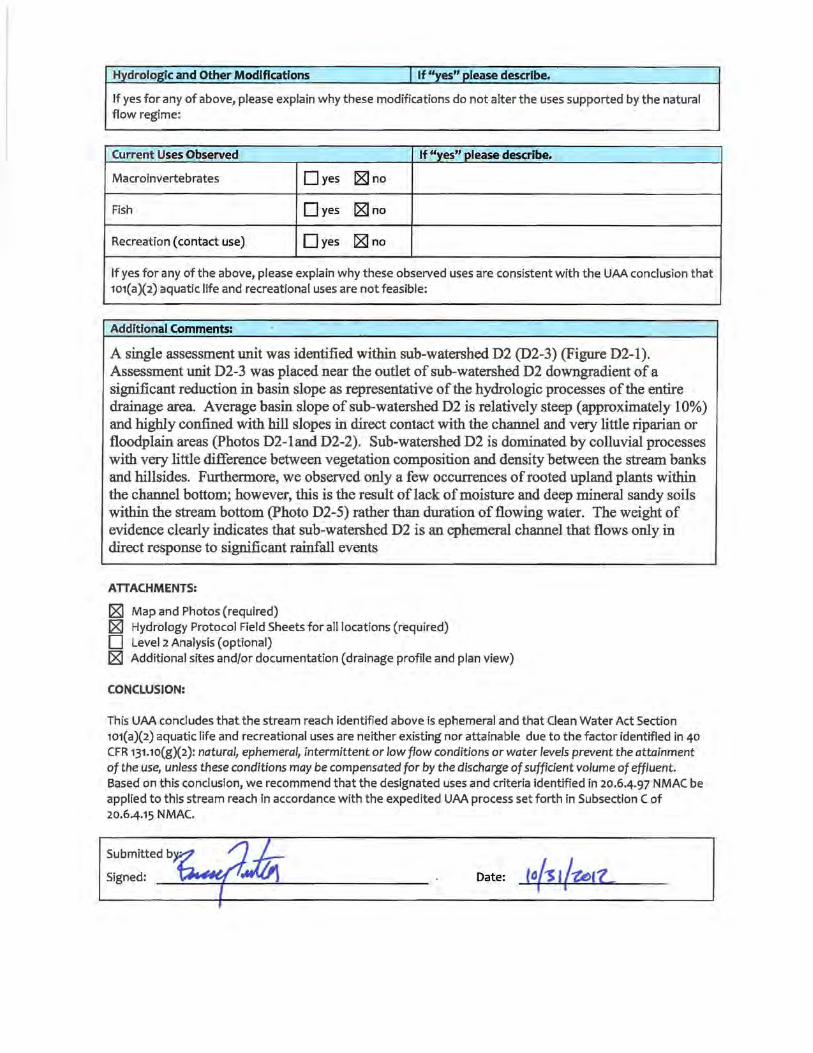
H_ydrologic and Other Modifications I If "yes" please describe.
If yes for any of above, please explain why these modifications do not alter the uses supported by the natural flow regime:
Current Uses Observed If "yes" please describe.
Macroinvertebrates Dyes IZJ no
Fish Dyes IZJ no
Recreation (contact use) Dyes IZJ no
If yes for any of the above, please explain why these observed uses are consistent with the UAA conclusion that 101(a)(2) aquatic life and recreational uses are not feasible:
Additional Comments:
A single assessment unit was identified within sub-watershed D2 (D2-3) (Figure D2-l). Assessment unit D2-3 was placed near the outlet of sub-watershed D2 downgradient of a significant reduction in basin slope as representative of the hydrologic processes of the entire drainage area. Average basin slope of sub-watershed D2 is relatively steep (approximately 10%) and highly confined with hill slopes in direct contact with the channel and very little riparian or floodplain areas (Photos D2-land D2-2). Sub-watershed D2 is dominated by colluvial processes with very little difference between vegetation composition and density between the stream banks and hillsides. Furthermore, we observed only a few occurrences of rooted upland plants within the channel bottom; however, this is the result of lack of moisture and deep mineral sandy soils within the stream bottom (Photo D2-5) rather than duration of flowing water. The weight of evidence clearly indicates that sub-watershed D2 is an ephemeral channel that flows only in direct response to significant rainfall events
ATTACHMENTS:
IZJ Map and Photos (required) IZJ Hydrology Protocol Field Sheets for all locations (required) D Level 2 Analysis (optional) IZJ Additional sites and/or documentation (drainage profile and plan view)
CONCLUSION:
This UAA concludes that the stream reach identified above is ephemeral and that Clean Water Act Section 101(a)(2) aquatic life and recreational uses are neither existing nor attainable due to the factor identified in 40 CFR 131.10(g)(2): natural, ephemeral, intermittent or low flow conditions or water levels prevent the attainment of the use, unless these conditions may be compensated for by the discharge of sufficient volume of effluent. Based on this conclusion, we recommend that the designated uses and criteria identified in 20.6-4.97 NMAC be applied to this stream reach in accordance with the expedited UAA process set forth in Subsection C of 20.6-4.15 NMAC.
Date: to{s 1/~11..

Surface Water Quality Bureau concurs with recommendation. DYes D No
If no, see attached reasons.
Signed:
EPA Region 6 technical approval granted. DYes D No
If no, see attached reasons.
Signed:
Date:
Date:

M SOO.foot Drainage Marker
~i) 1,000-foot Drainage Marker
~Drainage Sample Reaches ~ -- Prolled D111lnage ~4 - - · other Draklages
Hanovar-WhHewaler Subwatershed Boundary
0(2) FIGURE 02-1: DRAINAGE PROFILE FOR SUBWATERSHED 0(2) 0(2)'
6.500 ;f-~T-- .:rJ· ·n·--__ .:::-J:.:r-::_r:=t·_..:."-:-r:::- :::·::: .:. ·:-.r:::: =-:r::--=,:.:c_ --~-- -- _____ ·:-.-:-:-:: ·=---=='== :-. -=- ~- :-: = 6,400 •·• -- -~- ·-:;.t·· ·-l· -- .... ·--- _, ··· ··· ··· ···· ··· -·-·--· .. ~ ··- -- .. ·~- · . -· ~ .. -· ~ ·-·~ - ~, .... ··~ ~ .. - -~ ·~ .... .. ~ ... I
- 6,300 .. . . ·- ... --- ... . ... ·- ·-·r: ~ -· ... _ ·-····f·-·· -·· ... - -·.. ... . .. ... ... .. - -- ... - -··- -· . . .. ···- ... .. --- -- . - -- . .. .. ... -.... ... ~ ... .... ... - -.. . ... - .... ;
~::~: -~~ - .. -. ~-- -~- ~-- ·: ~: = -~ ~~:=~ -~ ·:-... . :~- ~-- = ~:. -·-~:···- -~ -~-~:-. =-~=---- ~ ----~~ -- ~ -~- -~ ~- = ~- -~-- = --~---· ·.·. --~~ --~ -~- --~ ~-- ~~- -~- j ~ ~ ~ I g! 6,000 ...... -· .... ·- . ·-- -- ..... · - - ....... ·- - - ... --- .. --- ........ -~-- .. ·'"'F=-' ....... -· -·- .... ... - · ...... " - I-··. - ... -· - ... ·-· ..... , -- -- -· ... i ~ 5,900 ··- ....... ----- ..... ~ . ·- ~ ........... - - ....... ···- -·- ·- ... ··-- .. - ·- ·- ... --~ .. ·-·· ... ~'-=f";l=::r=:,:h ........ ···!--- O-' • --- . .... ··- ......... - - - - • - -· ..... --;
::: = ": ... . ~ ~ ~~ : ~ :. -~ ~ -~ ~~ = -~ :_ --~ :: :: .. :. : ~- ~ ·:· -~~= :j: __ :~~~~~"~ ~ : =- :· :: .: ·:: -~ ~J 1--t
5,60Q-f ·- l - 1· .. ·1- 1·-- ·. . ......... ~ · · · ' I ~ -....... , .• ..._ ... ... .
0 1,000 2,000 3,000 4,000 5,000 6,000 7,000 8,000 9,000 10,000 11,000 12,000 13,000 Distance (ft)
-----------------------· ---·---.. -----~-----· ··--·---· .. ·----· ·· , ______ , _______ _
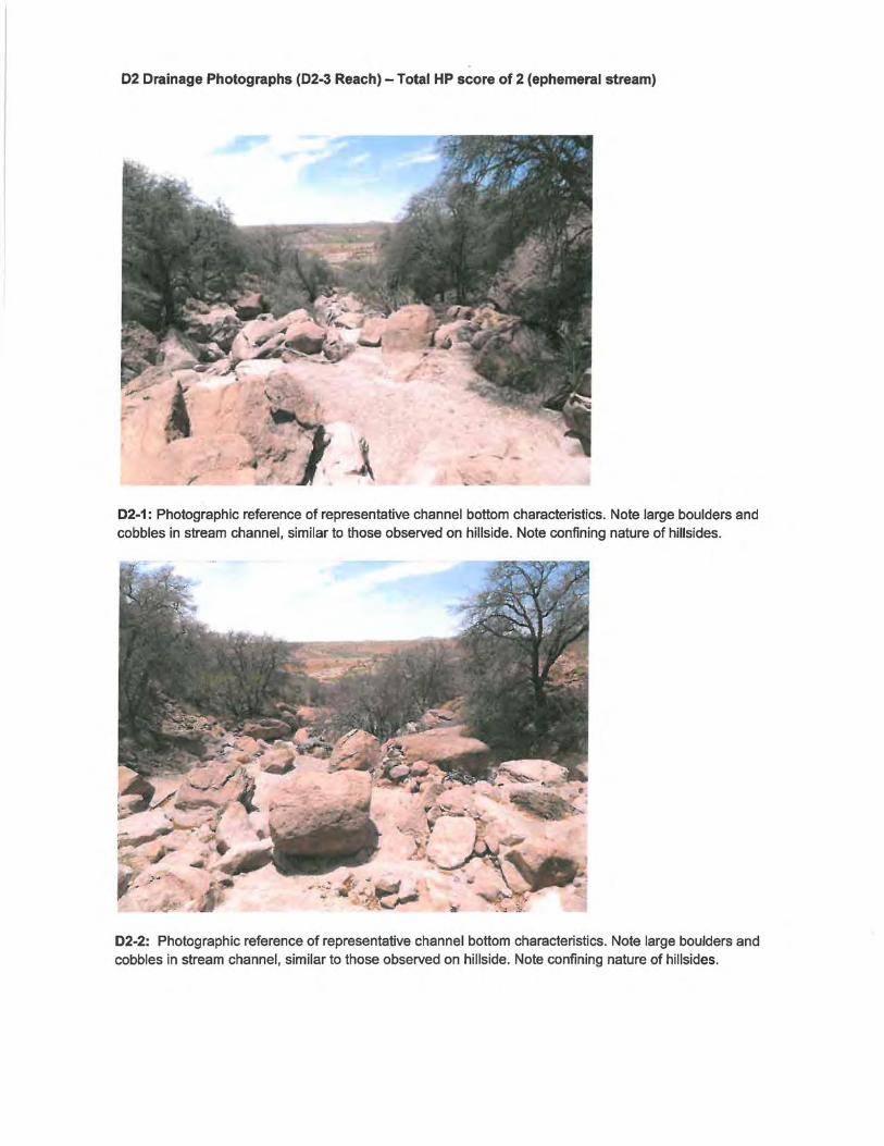
02 Drainage Photographs (02-3 Reach) - Total HP score of 2 (ephemeral stream)
02-1: Photographic reference of representative channel bottom characteristics. Note large boulders and cobbles in stream channel, similar to those observed on hillside. Note confining nature of hillsides.
02-2: Photographic reference of representative channel bottom characteristics. Note large boulders and cobbles in stream channel, similar to those observed on hillside. Note confining nature of hillsides.
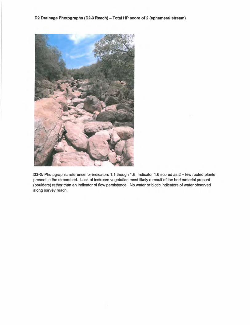
02 Drainage Photographs (02-3 Reach) -Total HP score of 2 (ephemeral stream)
02-3: Photographic reference for indicators 1.1 though 1.6. Indicator 1.6 scored as 2 - few rooted plants present in the streambed. Lack of instream vegetation most likely a result of the bed material present (boulders) rather than an indicator of flow persistence. No water or biotic indicators of water observed along survey reach.

02 Drainage Photographs (02-3 Reach) - Total HP score of 2 (ephemeral stream)
02-4: Photographic reference for indicator 1.5. Photograph of bank vegetation (also observable in previous photograph) and the upland vegetation. Indicator 1.5 scored as 0. No vegetative compositional or density differences observed between the banks and the upland area.
02-5: Photographic reference for indicator 1.6. Lack of instream vegetation indicative of coarse mineral sediments and complete lack of moisture. Assessment unit representative of channel bottom characteristics. Note dry material sand sediments within channel.
02 Drainage Photographs (02-3 Reach) -Total HP score of 2 (ephemeral stream)
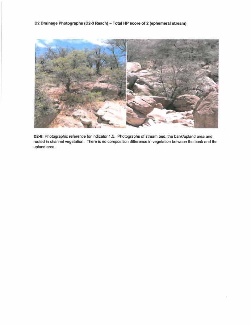
02-6: Photographic reference for indicator 1.5. Photographs of stream bed, the bank/upland area and rooted in channel vegetation. There is no composition difference in vegetation between the bank and the upland area.

NMED Surface Water Quality Bureau - LEVEL 1 Hydrology Determination Field Sheet
Date: 6/13/2011 Stream Name: D2 Latitude: N 32.71882
Evaluator(s): Fulton/Barry Site ID: D2-3 Longitude: W 108.11478
TOTAL POINTS: 2 Assessment Unit: D Drainage (D2-3) Drought Index (12-mo. SPI Value):
Jt,. iul !nJJJ illfi'JJI/h'llfl2 L~ -1 .1
Has there been a heavy rain in the last 48 hours?
NOW: PAST 48 HOURS: - YES _x_ NO
**Field evaluations should be performed ~ 48 WEATHER _storm (heavy rain) _storm (heavy rain) hours after the last known major rainfall event.
CONDITIONS _rain (steady rain) _rain (steady rain) OTHER: _showers (intermittent) _showers (intermittent)
Stream Modifications YES _x_ NO %cloud cover %cloud cover -- -_X_ clear/sunny _X_ clear/sunny Diversions - YES _x - NO
LEVEL 11NDICATORS
1.1. Water in Channel
1.2. Fish
1.3. Benthic Macroinvertebrates
1.4. Filamentous Algae/Periphyton
1.5. Differences in Vegetation
1.6. Absence of Rooted Upland Plants in Streambed
Flow is evident throughout the reach. Moving water is seen in riffle areas but may not be as evident throughout the runs.
Dramatic compositional differences in vegetation are present between the stream banks and the adjacent uplands. A distict riparian vegetation corridor exists along the entire reach -riparian, aquatic, or wetland species dominate the length ofthe reach.
Rooted upland plants are absent within the streambed/thalweg.
Discharges _YES _x_ NO **Explain in further detail in NOTES section
Water Is present in the channel but flow is barely discemable in areas of greatest gradient change (I.e. riffles) or floating object is necessary to observe flow.
A distinct riparian vegetation corridor exists along part of the reach. Riparian vegetation is interspersed with upland vegetation along the length of the reach.
There are a few rooted upland plants present within the streambed/thalweg.
Dry channel with standing pools. There Is some evidence of base flows (i.e. riparian vegetation growing along channel, saturated or moist sediment under
Vegetation growing along the reach may occur in greater densities or grow more vigorously than vegetation In the adjacent uplands, but there are no dramatic compositional differences between the two.
Rooted upland plants are consistently dispersed throughout the streambed/thalweg
SUBTOTAL (#1.1 - #1.6)
Dry channel. No evidence of base flows was found.
Fish are not present.
Macroinvertebrates are not present.
No compositional or density differences in vegetation are present between the streambanks and the adjacent uplands.
Rooted upland plants are prevalent within the stream bed/thalweg.
2
If the stream being evaluated has a subtotal :S 2 at this juncture, the stream is determined to be EPHEMERAL. If the stream being evaluated has a subtotal<!: 18 at this point, the stream is determined to be PERENNIAL.
YOU MAY STOP THE EVALUATION AT THIS POINT. If the stream has a subtotal between 2 and 18 continue the Level1 Evaluation.

LEVEL 1 INDICATORS
1.7. Sinuosity
1.8. Floodplain and Channel Dimensions
1.9. In-Channel Structure: Riffle-Pool Sequence
3
Ratio > 2.5. Stream is minimally confined with a wide, active floodplain.
3
2
Ratio between 1.2 and 2.5. Stream is moderately confined. Floodplain is present, but may only be active during larger floods.
1
Ratio = 1.0. Stream is completely straight with no bends.
0
Ratio < 1.2. Stream is incised with a noticeably confined channel. Floodplain is narrow or absent and typically disconnected from the channel.
Stream shows some flow but mostly has areas of pools Qr of riffles.
There is no sequence exhibited.
2 1 0
SUBTOTAL {#1.1 - #1.9) 2
If the stream being evaluated has a subtotal S 5 at this juncture, the stream is determined to be EPHEMERAL. If the stream being evaluated has a subtotal i!: 21 at this point, the stream is determined to be PERENNIAL.
YOU MAY STOP THE EVALUATION AT THIS POINT. If the stream has a subtotal between 5 and 21 continue the Level1 Evaluation.
1.10. Particle Size or Stream Substrate Sorting
1.11. Hydric Soils
1.12. Sediment on Plants and Debris
are noticeably different from particle sizes in areas close to but not in the channel. There is a clear distribution of various sized substrates in the stream channel with finer particles accumulating in the pools, and larger particles accumulating in the
Particle sizes in the channel are moderately similar to particle sizes in areas close to but not in the channel. Various sized substrates are present in the stream channel and are represented by a higher ratio of larger particles (gravel/cobble}.
Particle sizes in the channel are similar or comparable to particle sizes in areas close to but not in the channel. Substrate sorting is not readily observed in the stream channel.
Hydric soils are found within the study reach. Hydric soils are not found within the study reach.
Present= 3
Sediment found readily on plants and debris within the stream channel, on the streambank, and within the floodplain throughout the length of the stream.
1.5
Sediment found on plants or debris within the stream channel although it is not prevalent along the stream. Mostly accumulating in pools.
1
Absent= 0
Sediment is isolated in small amounts along the stream.
0.5
No sediment is present on plants or debris.
0
TOTAL POINTS {#1.1 - #1.12) 2
SUPPLEMENTAL INDICATORS: The following indicators do not occur consistently throughout New Mexico but may be useful in the determination of perenniality. ~record score below and tally with previous score to compute TOTAL.
Seeps and springs are found within the study reach. Seeps and springs are not found within the study reach. 1.13. Seeps and Springs
Present = 1.5 Absent= 0
Iron-oxidizing bacteria and/or fungi are found Iron-oxidizing bacteria and/or fungi are !!.Q1 found 1.14.1ron Oxidizing within the study reach. within the study reach.
Bacteria/Fungi Present = 1.5 Absent = 0
TOTALpluaSUPPLEMENTAL POINTS (#1.1-#1.14}~ 2

NMED Surface Water Quality Bureau - LEVEL 1 Hydrology Determination Field Sheet
Photo Descriptions and NOTES
Photo# Description (US, DS, LB, RB. etc.) Notes ·-·· - ~. -· ~ -~
D2-1 View of representative channel bottom characteristics. Note large boulders and cobbles in stream channel.
D2-2 View of representative channel bottom characteristics. Note large boulders and cobbles in stream channel.
D2-3 View upstream within assessment unit
D2-4 View of left bank upslope vegetation
D2-5 View of representative channel bottom, lack of in stream vegetation. Note dry material sand sediments within channel.
D2-6 View of in stream rooted plants and overbank/upland areas.
NOTES:

Cover Sheet Hydrology Protocol Use Attainability Analysis
for an Ephemeral Stream 1
Stream Name: Basin: 8-digit HUC:
D3-Drainage I Mimbres 113030202
Reach Description: Upstream lat/long: Downstream !at/long:
See additional comments section 132.70307/-108.11088 132.702662/-108.111866
CurrentWQS Assessment Unit ID:
[gl Unclassified 20.6.4.98 or 99 NMAC D Classified 20.6.4. __ NMAC I D3-23
Reach Evaluation ·How homogeneity of reach hydrology was verified)
Methods Used: Aerial photos, 11ground truthing", drainage profiles, reconnaissance
Reasoning: Why is the stream homogeneous? See report section 4.2.1
Hydrology Protocol Results Notes
D3-23 (lat/long): 32.70307/-108.11088 [gl eph D int D per Final score: 2, see field form and photos for additional information
D Additional location results attached.
Hydroclimatic Conditions If "yes" please describe.
Drought (SPI Value< -1.5) Dyes [gl no
Recent Rainfall (within 48 hours) Dyes [gl no
Gauge data available? Dyes [gl no
If yes for any of above, please explain why these conditions do not impact the UAA conclusion that natural, ephemeral, intermittent or low flow conditions or water levels prevent the attainment of the use:
Hydrologic and Other Modifications If "yes" please describe.
Dam/diversion Dyes [gl no
Channelization/roads Dyes [gl no
Groundwater pumping Dyes [gl no
Agricultural return flows Dyes [gl no
Existing point source discharge Dyes [gl no
Planned point source discharge Dyes [gl no
'This form is designed for the expedited UAA process for ephemeral waters described in Subsection C of 20.6.4.15 NMAC.

Hydrologic and Other Modifications If "yes" please describe. other modifications I Dyes (gl no
Please explain hydrologic impact
e.g., land use practices
If yes for any of above, please explain why these modifications do not alter the uses supported by the natural flow regime:
Current Uses Observed If "yes" please describe.
Macroinvertebrates Dyes (gl no
Fish Dyes (gl no
Recreation (contact use) Dyes [gl no
If yes for any of the above, please explain why these observed uses are consistent with the UAA conclusion that 101(a)(2) aquatic life and recreational uses are not feasible:
Additional Comments: A single assessment unit was identified within sub-watershed D3 (D3-23) (Figure D3-l). Assessment unit D3-23 was placed near the outlet of sub-watershed 3 downgradient of a significant reduction in basin slope as representative of the hydrologic progesses of the entire drainage area. Similar to sub-watershed D2, average basin slope of sub-watershed D3 is relatively steep (approximately 6%) and highly confined with hill slopes in direct contact with the channel and very little riparian or floodplain areas (Photos D3-1 and D3-2). As with subwatershed D2, sub-watershed D3 is dominated by colluvial processes with very little difference between vegetation composition and density between the stream banks and hillsides. Furthermore, we observed only a few occurrences of rooted upland plants within the channel bottom; however, this is the result of lack of moisture and deep mineral sandy soils within the stream bottom (Photo D3-3) rather than duration of flowing water. The weight of evidence clearly indicates that sub-watershed D3 is an ephemeral channel that flows only in direct response to significant rainfall events.
AITACHMENTS:
(gl Map and Photos (required) (gl Hydrology Protocol Field Sheets for all locations (required) D Level 2 Analysis (optional) (gl Additional sites and/or documentation (drainage profile and plan view)
CONCLUSION:
This UAA concludes that the stream reach identified above is ephemeral and that Clean Water Act Section 101(a)(2) aquatic life and recreational uses are neither existing nor attainable due to the factor identified in 40 CFR 131.1o(g)(2): natural, ephemeral, intermittent or low flow conditions or water levels prevent the attainment of the use, unless these conditions may be compensated for by the discharge of sufficient volume of effluent. Based on this conclusion, we recommend that the designated uses and criteria identified in 20.6.4.97 NMAC be applied to this stream reach in accordance with the expedited UAA process set forth in Subsection C of 20.6-4.15 NMAC.
Date:

Surface Water Quality Bureau concurs with recommendation. 0 Yes 0 No
If no, see attached reasons.
Signed:
EPA Region 6 technical approval granted. DYes D No
If no, see attached reasons.
Signed:
Date:
Date:

0(3) FIGURE 03-1: DRAINAGE PROFILE FOR SUBWATERSHED 0(3) 0(3)'
w~~~~g~~~~~~~~~~~~~~~~~22~SS~~t2~S~~~ I I I o 5oo 1,ooo
l _____ _ 1,500 2,000 2,500
Distance (ft) 3,000 3,500 4,000
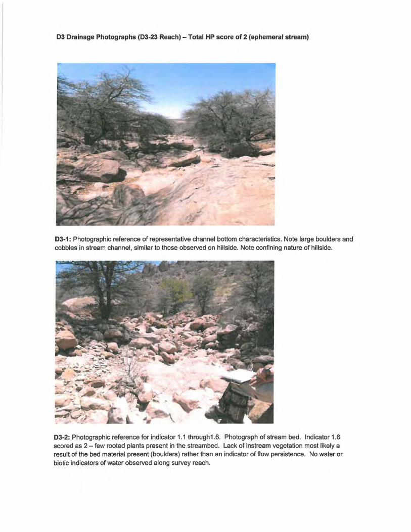
03 Drainage Photographs (03-23 Reach) - Total HP score of 2 (ephemeral stream)
03-1 : Photographic reference of representative channel bottom characteristics. Note large boulders and cobbles in stream channel, similar to those observed on hillside. Note confining nature of hillside.
03-2: Photographic reference for indicator 1.1 through1.6. Photograph of stream bed. Indicator 1.6 scored as 2 -few rooted plants present in the streambed. Lack of instream vegetation most likely a result of the bed material present (boulders) rather than an indicator of flow persistence. No water or biotic indicators of water observed along survey reach.
03 Drainage Photographs (03-23 Reach) - Total HP score of 2 (ephemeral stream)
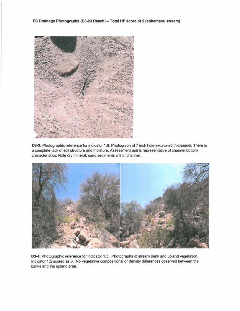
03-3: Photographic reference for indicator 1.6. Photograph of 7 inch hole excavated in-channel. There is a complete lack of soil structure and moisture. Assessment unit is representative of channel bottom characteristics. Note dry mineral, sand sediments within channel.
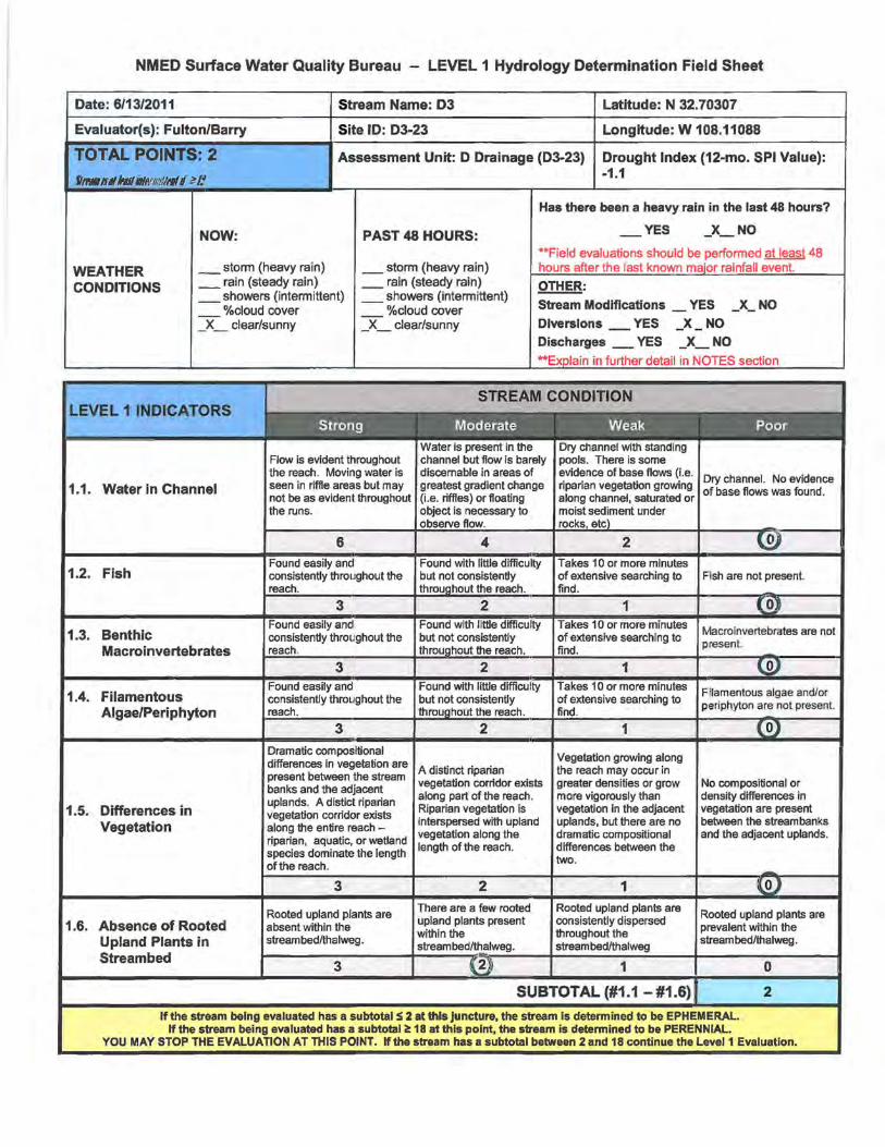
03-4: Photographic reference for indicator 1.5. Photographs of stream bank and upland vegetation. Indicator 1 .5 scored as 0. No vegetative compositional or density differences observed between the banks and the upland area.
NMED Surface Water Quality Bureau - LEVEL 1 Hydrology Determination Field Sheet
Date: 6/13/2011 Stream Name: 03 Latitude: N 32.70307
Evaluator(s): Fulton/Barry Site ID: D3-23 Longitude: W 108.11088
TOTAL POINTS: 2 Assessment Unit: D Drainage (D3-23) Drought Index (12-mo. SPI Value):
fii'MIIJ ~ ltwJJ llllftl!iif/1'111 !l z I! -1.1
Has there been a heavy rain in the last 48 hours?
NOW: PAST 48 HOURS: - YES _x_ NO
**Field evaluations should be perfonned at least 48
WEATHER _ stonn {heavy rain) _ stonn (heavy rain) hours after the last known major rainfall event.
CONDITIONS _rain (steady rain) _ rain (steady rain) OTHER: _showers (intennittent) _showers (intennittent)
Stream Modifications YES _x_ NO %cloud cover %cloud cover -- -_X_ clear/sunny _X_ clear/sunny Diversions - YES _x - NO
LEVEL1 INDICATORS
1.1. Water in Channel
1.2. Fish
1.3. Benthic Macro invertebrates
1.4. Filamentous Algae/Periphyton
1.5. Differences in Vegetation
1.6. Absence of Rooted Upland Plants in Streambed
Flow is evident throughout the reach. Moving water is seen in riffle areas but may not be as evident throughout the runs.
Dramatic compositional differences in vegetation are present between the stream banks and the adjacent uplands. A distict riparian vegetation corridor exists along the entire reach -riparian, aquatic, or wetland species dominate the length of the reach.
Rooted upland plants are absent within the streambed/thalweg.
Discharges _YES _x_ NO **Explain in further detail in NOTES section
Water is present in the channel but flow is barely dlscemable In areas of greatest gradient change (i.e. riffles) or floating object Is necessary to
flow.
A distinct riparian vegetation corridor exists along part of the reach. Riparian vegetation is Interspersed with upland vegetation along the length of the reach.
There are a few rooted upland plants present within the streambed/thalweg.
Dry channel with standing pools. There is some evidence of base flows (i.e. riparian vegetation growing along channel, saturated or moist sediment under
Vegetation growing along the reach may occur in greater densities or grow more vigorously than vegetation In the adjacent uplands, but there are no dramatic compositional differences between the two.
Rooted upland plants are consistently dispersed throughout the streambed/thalweg
SUBTOTAL (#1.1 -#1.6)
Dry channel. No evidence of base flows was found.
Fish are not present.
Macroinvertebrates are not present
No compositional or density differences in vegetation are present between the stream banks and the adjacent uplands.
Rooted upland plants are prevalent within the stream bed/thalweg.
2
If the stream being evaluated has a subtotal :!i 2 at this juncture, the stream is determined to be EPHEMERAL. If the stream being evaluated has a subtotal i!: 18 at this point, the stream is determined to be PERENNIAL.
YOU MAY STOP THE EVALUATION AT THIS POINT. If the stream has a subtotal between 2 and 18 continue the Level1 Evaluation.
LEVEL 11NDICATORS
1. 7. Sinuosity
1.8. Floodplain and Channel Dimensions
1.9. In-Channel Structure: Riffle-Pool Sequence
3 2 1
Ratio= 1.0. Stream is completely straight with no bends.
0
Ratio > 2.5. Stream is minimally confined with a wide, active floodplain.
Ratio between 1.2 and 2.5. Stream is moderately confined. Floodplain is present, but may only be active during larger floods.
Ratio < 1.2. Stream is incised with a noticeably confined channel. Floodplain is narrow or absent and typically disconnected from the channel.
3
Represented by a less frequent number of riffles and pools. Distinguishing the transition between riffles and pools is
2
Stream shows some flow but mostly has areas of pools Q[ of riffles.
1
SUBTOTAL (#1.1 -#1.9)
There is no sequence exhibited.
0
2
If the stream being evaluated has a subtotal !> 5 at this juncture, the stream Is determined to be EPHEMERAL. If the stream being evaluated has a subtotal i!: 21 at this point, the stream is determined to be PERENNIAL.
YOU MAY STOP THE EVALUATION AT THIS POINT. If the stream has a subtotal between 5 and 21 continue the Level1 Evaluation.
1.10. Particle Size or Stream Substrate Sorting
1.11. Hydric Soils
1.12. Sediment on Plants and Debris
sizes in the channel are noticeably different from particle sizes in areas close to but not In the channel. There is a clear distribution of various sized substrates in the stream channel with finer particles accumulating in the pools, and larger particles accumulating in the
Particle sizes in the channel are moderately similar to particle sizes in areas close to but not in the channel. Various sized substrates are present in the stream channel and are represented by a higher ratio of larger particles (gravel/cobble).
Particle sizes in the channel are similar or comparable to particle sizes in areas close to but not in the channel. Substrate sorting is not readily observed in the stream channel.
Hydric soils are found within the study reach. Hydric soils are D.Q1 found within the study reach.
Present= 3
Sediment found readily on plants and debris within the stream channel, on the streambank, and within the floodplain throughout the length of the stream.
1.5
Sediment found on plants or debris within the stream channel although it is not prevalent along the stream. Mostly accumulating in pools.
1
Absent= 0
Sediment is isolated in small amounts along the stream.
0.5
No sediment is present on plants or debris.
0
TOTAL POINTS (#1.1-#1.12) 2
SUPPLEMENTAL INDICATORS: The following indicators do not occur consistently throughout New Mexico but may be useful in the determination of perennlality. ~record score below and tally with previous score to compute TOTAL.
Seeps and springs are found within the study reach. Seeps and springs are not found within the study reach. 1.13. Seeps and Springs
Present = 1.5 Absent= 0 --
Iron-oxidizing bacteria and/or fungi are found lron-oxldlzlng bacteria and/or fungi are JlQ1 found 1.14.1ron Oxidizing within the study reach. within the study reach.
Bacteria/Fungi Present = 1.5 Absent= 0
TOTAL pl118SUPPLEMENTAL POINTS (#1.1- #1.14}~ 2
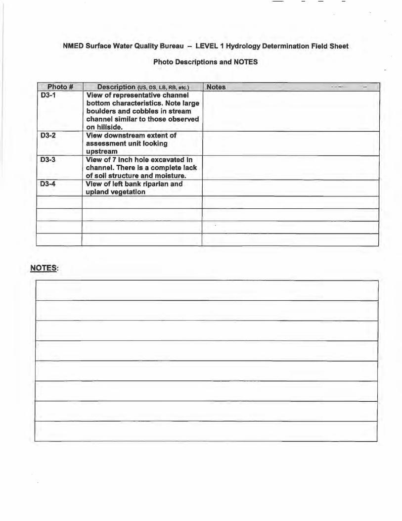
NMED Surface Water Quality Bureau - LEVEL 1 Hydrology Determination Field Sheet
Photo Descriptions and NOTES
· Photo# Description (US. DS, LB, RB, etc.) Notes oh •• ·-~ 0 ·-D3-1 View of representative channel
bottom characteristics. Note large boulders and cobbles in stream channel similar to those observed on hillside.
D3-2 View downstream extent of assessment unit looking upstream
D3-3 View of 7 inch hole excavated in channel. There is a complete lack of soil structure and moisture.
D3-4 View of left bank riparian and upland vegetation
NOTES:
Related Documents


![[Hydrology] groundwater hydrology david k. todd (2005)](https://static.cupdf.com/doc/110x72/55a8e6001a28ab6c2f8b4687/hydrology-groundwater-hydrology-david-k-todd-2005-55b0d9a792c06.jpg)


