Manchester City Council Item No. 14 Planning and Highways Committee 9 March 2017 Item 14 – Page 1 Application Number 113617/FO/2016 Date of Appln 24th Nov 2016 Committee Date 9 th March 2017 Ward City Centre Ward Proposal Erection of a four storey building to form 24 residential apartments (Use Class C3) with associated hard and soft landscaping and ancillary development thereto. Location Plot G Slate Wharf, Castlefield, Manchester Applicant Waterside Developments Limited, C/o Agent Agent Miss Louisa Fielden, HOW Planning LLP, 40 Peter Street, Manchester, M2 5GP, Description The proposal relates to an irregular shaped, vacant site within Castlefield Canal Basin, which measures approximately 0.1 hectares. The site is bounded by the Bridgewater Canal and an associated tow path/canal side area. This links the footbridge over the canal down to the canal side, running immediately adjacent to the site. Immediately to the north and west of the site are the Slate Wharf residential apartment blocks, which are three storey red brick buildings with pitched slate roofs, built in the 1990s. The Wharf Public House, built soon after the Slate Wharf apartments and in a similar style, lies to the south of the site, with a surface level car park to the rear and an outdoor seating area to the front adjacent to the canal. Beyond that building is the six storey Grade II listed Middle Warehouse (Castle Quay). On the opposite side of the canal to the east of the site is the Grade II listed Merchants Warehouse building, which is a four storey red brick building with a pitched slate roof. The surrounding area is characterised by the following uses: *residential properties, notably within Slate Wharf, Worsley Mills and City Gate to the west, and Castlegate and Middle Warehouse to the south east/south; * office and food and drink uses to the east of the site in the buildings on Castle Street and within Artingstalls Chapel; * food and drink uses in buildings around the canal basin. The site is within Castlefield Conservation Area and is one of the few gaps in the enclosure of the basin. The following listed buildings are nearby:- - Merchants' Warehouse, Grade II, on the west side of Castle Street to the east of the site; - Middle Warehouse, Grade II, to the south of the site; - The former congregational chapel, Grade II, to the east of the site at the far end of the canal basin; - The railway viaduct running from Knott Mill to Water Street, Grade II, to the north beyond Slate Wharf and the canal;

Welcome message from author
This document is posted to help you gain knowledge. Please leave a comment to let me know what you think about it! Share it to your friends and learn new things together.
Transcript

Manchester City Council Item No. 14Planning and Highways Committee 9 March 2017
Item 14 – Page 1
Application Number113617/FO/2016
Date of Appln24th Nov 2016
Committee Date9th March 2017
WardCity Centre Ward
Proposal Erection of a four storey building to form 24 residential apartments (UseClass C3) with associated hard and soft landscaping and ancillarydevelopment thereto.
Location Plot G Slate Wharf, Castlefield, Manchester
Applicant Waterside Developments Limited, C/o Agent
Agent Miss Louisa Fielden, HOW Planning LLP, 40 Peter Street, Manchester,M2 5GP,
Description
The proposal relates to an irregular shaped, vacant site within Castlefield CanalBasin, which measures approximately 0.1 hectares. The site is bounded by theBridgewater Canal and an associated tow path/canal side area. This links thefootbridge over the canal down to the canal side, running immediately adjacent to thesite. Immediately to the north and west of the site are the Slate Wharf residentialapartment blocks, which are three storey red brick buildings with pitched slate roofs,built in the 1990s. The Wharf Public House, built soon after the Slate Wharfapartments and in a similar style, lies to the south of the site, with a surface level carpark to the rear and an outdoor seating area to the front adjacent to the canal.Beyond that building is the six storey Grade II listed Middle Warehouse (CastleQuay). On the opposite side of the canal to the east of the site is the Grade II listedMerchants Warehouse building, which is a four storey red brick building with apitched slate roof.
The surrounding area is characterised by the following uses:
*residential properties, notably within Slate Wharf, Worsley Mills and City Gate to thewest, and Castlegate and Middle Warehouse to the south east/south;* office and food and drink uses to the east of the site in the buildings on CastleStreet and within Artingstalls Chapel;* food and drink uses in buildings around the canal basin.
The site is within Castlefield Conservation Area and is one of the few gaps in theenclosure of the basin. The following listed buildings are nearby:-
- Merchants' Warehouse, Grade II, on the west side of Castle Street to the eastof the site;- Middle Warehouse, Grade II, to the south of the site;- The former congregational chapel, Grade II, to the east of the site at the farend of the canal basin;- The railway viaduct running from Knott Mill to Water Street, Grade II, to thenorth beyond Slate Wharf and the canal;

Manchester City Council Item No. 14Planning and Highways Committee 9 March 2017
Item 14 – Page 2
- Castlefield Railway Viaduct from G-Mex to Dawson Street, Grade II, to thenorth of the site beyond Slate Wharf and the canal; and- Rochdale Canal Lock Number 92 and Castle Street Bridge, Grade II, to thenorth east of the site.
Several planning permissions have been granted on this site in the past as follows:
Date
059352/FO/CITY3/00 - Residential development comprising 45 units with associatedparking and landscaping. Approved 18/06/2002.
053575/FO/CITY3/98 - New build development comprising lower ground floor carpark, ground floor bar & restaurant with hotel accommodation over. Approved16/04/1998.
051791/FO/CITY3/97 - Erection of a part 5/part 6 storey 56 bedroom hotel withancillary internal lower ground floor car park and an upper ground floorbar/restaurant. Approved 05/06/1997.
049838/FO/CITY3/96 - Erection of a building to form a café bar and/or retail space,either with ancillary gallery use, studio offices and 2no. self-contained residentialunits. Approved 11/07/1996.
043477/DF/CMDC/93 - Erection of 102 dwellings comprising 70 No. 1 bed apts and32 No. 2 bed apartments. Approved 30/06/1994
Proposal
The proposal is to erect a four-storey building comprising 24 apartments. Therewould be 11 one-bedroom, 10 two-bedroom, and three three-bedroom apartments.
The apartment sizes proposed range from 50sqm up to 125sqm. The ground floor ofthe building would accommodate a secure bin and cycle store with access fromBlantyre Street. The bin store would have 3 x general waste 1100L Euro Bins, 2 xpulpable recycling 1100L Euro Bins, 2 x co-mingled recycling 1100L Euro bins, and 1x organic food waste 360L wheelie bin. Internal access for residents would beprovided with a lobby to prevent odours from entering the apartments. Eachapartment would have space to segregate waste and residents would take theirwaste and recycling to the bin store. The building management team would arrangefor bins to be taken to and from a collection point on Blantyre Street on collectionday. The secure cycle store would accommodate 24 cycle spaces, i.e.one for eachapartment or half a space per bedroom.
Manchester City Council Item No. 14Planning and Highways Committee 9 March 2017
Item 14 – Page 3
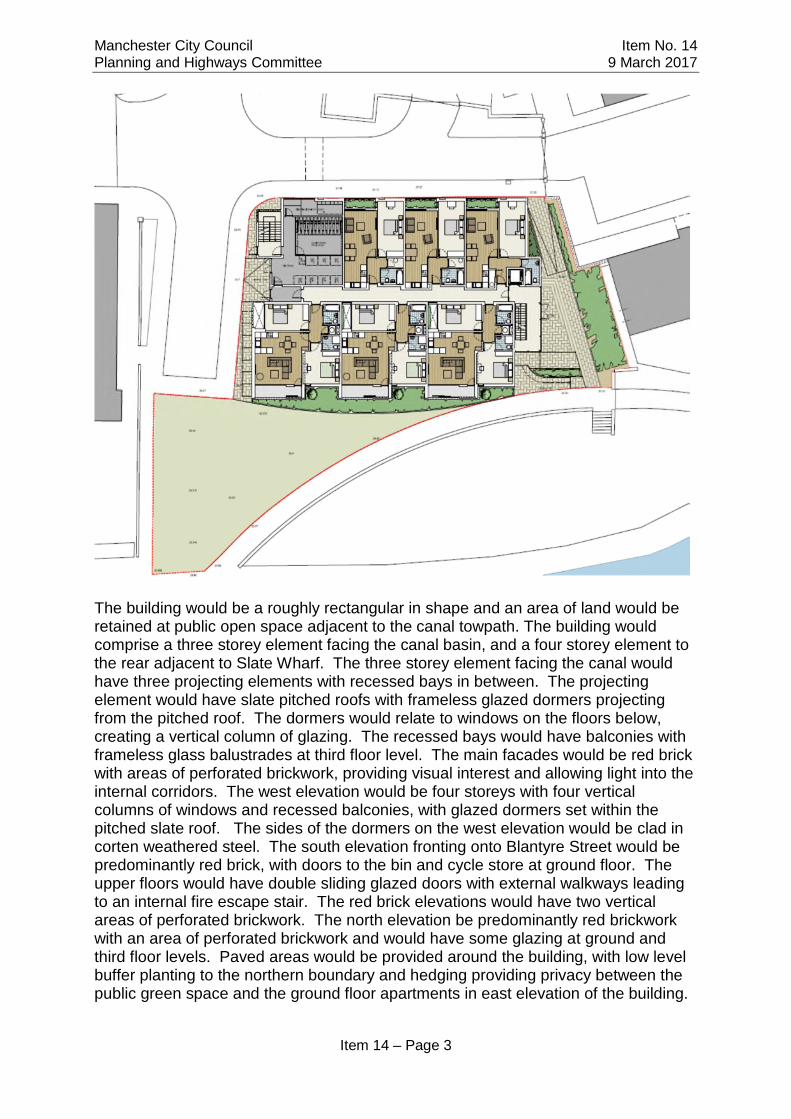
The building would be a roughly rectangular in shape and an area of land would beretained at public open space adjacent to the canal towpath. The building wouldcomprise a three storey element facing the canal basin, and a four storey element tothe rear adjacent to Slate Wharf. The three storey element facing the canal wouldhave three projecting elements with recessed bays in between. The projectingelement would have slate pitched roofs with frameless glazed dormers projectingfrom the pitched roof. The dormers would relate to windows on the floors below,creating a vertical column of glazing. The recessed bays would have balconies withframeless glass balustrades at third floor level. The main facades would be red brickwith areas of perforated brickwork, providing visual interest and allowing light into theinternal corridors. The west elevation would be four storeys with four verticalcolumns of windows and recessed balconies, with glazed dormers set within thepitched slate roof. The sides of the dormers on the west elevation would be clad incorten weathered steel. The south elevation fronting onto Blantyre Street would bepredominantly red brick, with doors to the bin and cycle store at ground floor. Theupper floors would have double sliding glazed doors with external walkways leadingto an internal fire escape stair. The red brick elevations would have two verticalareas of perforated brickwork. The north elevation be predominantly red brickworkwith an area of perforated brickwork and would have some glazing at ground andthird floor levels. Paved areas would be provided around the building, with low levelbuffer planting to the northern boundary and hedging providing privacy between thepublic green space and the ground floor apartments in east elevation of the building.

Manchester City Council Item No. 14Planning and Highways Committee 9 March 2017
Item 14 – Page 4
Publicity
The application has been advertised in the Manchester Evening News as: a majordevelopment; affecting the setting of listed buildings; affecting a conservation area;and affecting a public right of way. Site notices have been displayed and theoccupiers of nearby properties have been consulted.
Castlefield Forum has submitted an objection signed by 50 members. They believethe site should be retained as public open space and urge the City Council to acquireand landscape Plot G as a key part of the city centre’s green and blue infrastructure,just as, 20 years ago, public money was used to acquire and landscape CatalanSquare in front of Barca. This would be consistent with the first objective of theCouncil’s Green and Blue Infrastructure Strategy for Manchester and support theoverarching vision of the Strategy.
They raise no objections on planning grounds to the current application, provided theissues raised in Section 3.1 of the Crime Impact Statement are satisfactorilyaddressed, namely:• removal/treatment of vulnerable ground floor balconies;
• removal of perforated brickwork features that may form a climbing aid up to firstfloor balconies;
• secure access controls/postal delivery arrangements to main entrance.
They suggest that Waterside Developments (the owners of Plot G), Peel Holdings(owners of Merchants Bridge and the Bridgewater Canal towpaths) and the Councilcould work together collaboratively to replace the existing wall beside the approachto Merchants Bridge at the front of Plot G with curving steps down to the currently‘dead’ area of setts by the canal. The effect would be to animate the sett area andextend the public open space in front of the new Plot G development down to thewater’s edge.
Forty nine neighbour objections have been received making the following comments:
Manchester City Council Item No. 14Planning and Highways Committee 9 March 2017
Item 14 – Page 5
Loss of open green space - Plot G is one of the last few green spaces in and aroundManchester city centre and one of the most picturesque green spaces in Manchester.Except for a period of weeks in the 1980s, Plot G has been open space since the1840s for more than 175 years. It was originally marketed by the developers of SlateWharf as a public open space/sculpture park and there is a note on one residents’lease stating ‘save/site [?] for public/semi-public use, building – interim use as privateopen space’, which is one of the reasons some residents chose to purchaseapartments overlooking it. It brings in tourists, has been used by the local residentsover the course of the past 20 years (most of whom do not have a garden) and isused by numerous organised groups such as The Manchester Road Runners, dogwalking groups and fitness classes. The small patch of grass proposed to beretained to the front of the building is not big enough and would not have the samepull of people to the area (especially if it will be in shade). The other nearest opengreen spaces are: St Johns Gardens which is heavily enclosed, lacks surveillanceand does not feel safe for young females on their own; and the Roman Gardens,which is not in the heart of Castlefield Basin close to bars and restaurants and freefrom traffic noise.
Development of the site would change forever the balance between built form andopen space in the canal basin so that buildings would predominate.
Contrary to Policy EN1, which states that wherever possible the opportunity shouldbe realised to "enhance existing and provide new areas of meaningful open space",and to the seven principles of urban design set out in that policy.
Contrary to Policy EN10, which states that the Council will seek to retain openspaces and only allow development in certain circumstances.
The Core Strategy recognises the importance of Green Infrastructure, the definitionof which includes informal open spaces, such as Plot G (Paragraph 12.1). Thedevelopment would have a detrimental impact on the quality of place contrary toparagraph 12.2 of the Core Strategy.
Community Right to Bid for the site - The community (two independent applications)have already asked the council to grant them a Community Right to Bid on the site todesignate it as an Asset of Community Value, which should be considered during thisapplication.
Manchester City Council should purchase the site and turn it into a public park.
Public Right of Way - Google Maps currently lists Plot G as having a path through itand thus presumably a public right of way.
Overcrowding – would result in too high a density of residential properties in such asmall area. Given this and the massive amount of new residential developmentalready approved and submitted for planning permission in the immediate area, theretention of Plot G as a vital "green lung" becomes more important.
Contrary to Policy CC10 as would lead to a lack of accessibility in the area due toovercrowding, and does not comply with the emphasis on.
Manchester City Council Item No. 14Planning and Highways Committee 9 March 2017
Item 14 – Page 6
Design – the design is bland, uninspiring and out of keeping with the surroundingarchitecture, particularly the glass frontages.
Overdevelopment – Four stories is too tall and out of keeping with surroundings.
Conservation Area – The Heritage Statement incorrectly states that the site makesno positive contribution to the architectural or historic interest of the conservationarea and that it does not contribute to the quality of recognisable spaces includingexteriors or open spaces with a complex of public buildings. The application form(section 13) incorrectly states that Plot G does not have any features of anygeological or conservation importance. However, Plot G is part of the character ofthe area, accentuating the outstanding beauty of the area. It is also a recognisablefeature of the area with images of it featuring, over the last year alone, in hundreds ofmarketing materials produced for Manchester, and in national images and videos ofPlot G (eg Bulmers 2015 TV advert, BT 2015/16 billboard and TV campaign with AlecBaldwin and the current Covonia cough syrup TV advert). The development willhave a negative effect on the conservation area through the loss of this open greenspace, by enclosing the open feel of the basin and by blocking views of the canal andthe bridges.
Access/Traffic/Lack of Parking – It is unrealistic to think that residents of thedevelopment would not have cars and the lack of parking will result in people parkingon the road. Access to Plot G is by one road leading off Blantyre Street, which isalready busy and likely to become more congested with parking and cars waitingoutside the development, causing traffic blockages to existing residents’ main gatesand road safety issues. Access to Blantyre Street is often blocked during eventssuch as the Marathon. The increase in the number of pedestrians and lack of clearsight around the area will result in a higher risk of accidents.
Question where site parking would be during construction and where vehicles andmaterials would be stored. The area marked 'secondary entrance' on the proposeddrawings is currently a loading bay and turning circle, not a public access road.
Lack of cycle parking – There is a discrepancy between the application documents,with the D&A Statement showing 20 spaces and the Bin Store Layout showing 24.
Noise – Increase in noise from extra traffic and construction noise, which will beamplified by the site being within a ‘basin’, added to the existing noise from bars,restaurants, trains and trams.
Crime and Security – The development will add to the increasing crime rate in thearea, particularly regarding car break-ins. Security of the construction site will be anissue as there have been several violent incidents involving homeless groupsrecently in the area.
Waste and Drainage – Concern regarding the contamination risk of the site andquestion how the applicant intends to prevent run-off into the canal and the potentialthreat to fish, geese, swans and other wildlife.
Manchester City Council Item No. 14Planning and Highways Committee 9 March 2017
Item 14 – Page 7
The applicant states that the site is not a flood risk. This needs to be investigatedfurther as the canal did flood less than a year ago
Overlooking and loss of privacy - Residents of Ship Canal House will be particularlyoverlooked, particularly those apartments with gardens, and additional storey to therear of the proposed building is unnecessary and will allow even more overlooking.There are already privacy problems with the high footfall across the bridge, whichwould increase with this development, and frequently get drones and photographerson Plot G taking photographs or video footage without permission.
Loss of light – Particularly to apartments in Ship Canal House.
Loss of views – Will block views from existing apartments, particularly in Ship CanalHouse, as well as general views of the canal basin.
Construction noise, disturbance and congestion - How would this be controlled?Concern regarding the parking/waiting of construction vehicles and the potential forthem to block access ways and the road.
Application form incorrectly states that there are no trees on the site.
Loss of wildlife – Plot G is a place where wild geese frequently feed, which is one ofthe draws to Castefield Basin. Removing that grass will remove the wildlife.
Contrary to Policy (not mentioned above) - Policy CC6 states that high densitydevelopment will not always be appropriate and that new development will beexpected to provide a high quality environment for City Centre residents, visitors andworkers.
Policy CC8 states that the scale of development envisaged for the City Centrerequires large sites, and cannot be accommodated through development that merelyfills available gaps.
Contrary to the Greater Manchester Spatial Framework Draft Consultation, whichstates it will ‘Set out how we enhance and protect the quality of the naturalenvironment’.
Negative impact on property values
The proposed development would place a strain on hyper-local amenities.
The foundations will have to be very deep to ensure that the canal is not damaged -and by doing that it may damage elsewhere.
More housing is unnecessary – there are plenty of large development sites moreappropriate for housing than this one.
Consultations
Manchester City Council Item No. 14Planning and Highways Committee 9 March 2017
Item 14 – Page 8
Highway Services - The site is highly accessible by sustainable transport modesand with good pedestrian and cycling infrastructure. There is a car club locationnearby and residents would have the opportunity to purchase a C1/C2 residentsparking permit which can be used in nearby Pay-and-Display bays. Cycle parkingand refuse and servicing arrangements are all considered to be acceptable. Detailsof construction management should be provided and a condition requiring a full travelplan should be attached. felt that the design had been well considered in terms ofmaterials and scale and would result in the successful infilling of the site withoutdamaging the character of the site and basin. They also felt that these low risebuildings would be framed by the larger ones.
Environmental Health - Recommend conditions relating to noise (to protect theresidential accommodation from external sources of noise and from any externalequipment); the implementation of the waste management strategy; andcontaminated land.
MCC Flood Risk Management - Evidence of allocation of space for the proposed53m3 surface water attenuation is needed and conditions regarding SuDS should beattached to any permission.
Housing Strategy - This is not a location where Strategic Housing would be lookingfor affordable housing, so any affordable housing contribution, subject to a financialviability assessment, should be in the form of commuted sums.
Canal & River Trust - Whilst the proposed development is not on the Trustswaterway it is a prominent site visible from the junction between the Rochdale Canaland the Bridgewater Canal at Lock 92. Whilst the detailing of the building isinteresting and not without detailed quality it is considered that the proposeddevelopment does not does not make the most of its setting on the basin, and morecould be done to integrate the development with the waterway.
Greater Manchester Police - GMP support the application if the proposeddevelopment is designed and constructed in accordance with the recommendationscontained within section 3.3 of the submitted Crime Impact Statement dated(05/09/2016 - URN: 2016/0620/CIS/01 Version A) and a planning condition should beadded to reflect the physical security specification listed within sections 4 & 5 of theappendices within the submitted Crime Impact Statement.
Historic England (North West) - The application should be determined inaccordance with national and local policy guidance, and on the basis of the localplanning authority's (LPA's) specialist conservation advice.
Transport For Greater Manchester - No comments to make.
United Utilities Water PLC - No objection subject to conditions regarding separatedrainage systems for foul and surface water, SuDS and requirements for thedeveloper due to a public sewer crossing the site.

Manchester City Council Item No. 14Planning and Highways Committee 9 March 2017
Item 14 – Page 9
Greater Manchester Archaeological Advisory Service - Recommends anappropriate scheme of archaeological mitigation is undertaken on the site as there isthe possibility of Roman remains.
Manchester Conservation Areas and Historic Buildings Panel –felt that the design had been well considered in terms of materials and scale andwould result in the successful infilling of the site without damaging the character ofthe site and basin. They also felt that these low rise buildings would be framed by thelarger ones.
The Panel welcomed the depth shown in the elevations and observed that the designseemed to suggest townhouses rather than apartments. The Panel questioned theuse of Corten and suggested that the metal work found in the area was typically ofmaterials such as cast iron.The Panel would like to ensure that the detailed designand materials are followed through to the highest quality as suggested by theimages, including detailing around windows and flashings.
Issues
Relevant National Policy
The National Planning Policy Framework sets out Government planning policies forEngland and how these are expected to apply. The NPPF seeks to achievesustainable development and states that sustainable development has an economic,social and environmental role (paragraphs 6 & 7). Paragraphs 11, 12, 13 and 14 ofthe NPPF outline a "presumption in favour of sustainable development". This meansapproving development, without delay, where it accords with the development plan.Paragraph 12 states that:
"Proposed development that accords with an up-to-date Local Plan should beapproved and proposed development that conflicts should be refused unless othermaterial considerations indicate otherwise."
The proposed development is considered to be consistent with sections 1, 2, 4, 6, 7,8, 10, 11 and 12 of the NPPF for the reasons outlined below.
Section 1 Building a strong and competitive economy - The proposal would provide ahigh-quality development in the area. It would create jobs during construction andwould support the existing community and the local economy through the use offacilities and services.
Section 2 Ensuring the Vitality of Town Centres - The proposal would help to create aneighbourhood that would attract and retain residents. A strong and diverse labourmarket is essential to Greater Manchester's growth objectives which require newhomes to meet the demands of a growing economy and population. It would be closeto the City Centre in a location that is well connected and would therefore help topromote sustained economic growth.
Section 4 Promoting Sustainable Transport - The proposal is in an accessiblelocation close to the Deansgate tram and train interchanges as well as buses. This is

Manchester City Council Item No. 14Planning and Highways Committee 9 March 2017
Item 14 – Page 10
a sustainable location and development here would contribute to wider sustainabilityand health objectives and give people a choice about how they travel.
Section 6 (Delivering a wide choice of high quality homes) - The scheme wouldprovide an efficient development and bring 24 homes to a sustainable location. Thescheme would provide a range of accommodation sizes and tenures and help tocreate a sustainable, inclusive and mixed community. Significant investment inhousing is required in appropriate locations within Manchester as the City grows. TheCity Centre is the biggest source of jobs in the region and the proposal would providesuitable homes to support the growing economy and help to create a vibrant, thrivingand active community.
Section 7 Requiring Good Design - The proposed scheme has been the subject ofsignificant design consideration, consultation and evolution. The buildings and publicrealm would be of a high quality and would help to raise the standard of design moregenerally in the area. The proposal would retain public open space adjacent to thecanal.
Section 8 Promoting healthy communities - The development would facilitate socialinteraction and help to create a healthy, inclusive community. The developmentwould help to integrate the site into the locality and increase levels of naturalsurveillance. An area of open space would be retained adjacent to the canal thatcould be used by the community.
Section 10 Meeting the challenge of climate change, flooding and coastal change -The site is in a highly sustainable location and an Environmental StandardsStatement has demonstrated that the development would accord with a wide rangeof principles intended to promote the responsible development of energy efficientbuildings and would meet Level 4 of Code for Sustainable Homes.
The majority of the site is within Flood Zone 1 with some in Flood Zone 2, whichcovers the canal and canalside area. A Flood Risk Assessment has been carried outwhich assesses the risks of flooding as low and recommends measures for drainage.This is discussed in more detail below.
Section 11 Conserving and enhancing the natural environment - The documentssubmitted with this application have considered issues such as ground conditions,noise and lighting, and the impact on ecology and demonstrate that the proposalwould not have any significant adverse impacts in respect of the natural environment.
Section 12 Conserving and Enhancing the Historic Environment - This sets out thecriteria that should be taken into account when assessing the impact of developmenton heritage assets. Any harm caused to a heritage asset has to be justified in termsof the social and economic benefits of the proposal.
The scheme has been designed to complement and respect the character andappearance of the Castlefield Conservation Area and the nearby heritage assets andit is considered that the proposed works are in general accordance with therequirements of the NPPF. The impact on the settings of the listed buildings and theconservation areas is considered in detail later in this report.
Manchester City Council Item No. 14Planning and Highways Committee 9 March 2017
Item 14 – Page 11
Core Strategy
The proposals are considered to be consistent with Core Strategy Policies SP1, CC3,H1, H8, CC5, CC6, CC8, CC9, CC10, T1, T2, EN1, EN3, EN4, EN6, EN8, EN9,EN14, EN15, EN16, EN17, EN18, EN19, DM1 and PA1.
The Core Strategy Development Plan Document 2012 -2027 was adopted in 2012and is the key document in Manchester's Local Development Framework setting outlong term strategic planning policies for Manchester. A number of UDP policies havebeen saved until replaced by further development plan documents. Planningapplications in Manchester must be decided in accordance with the Core Strategy,saved UDP policies and other Local Development Documents.
The adopted Core Strategy contains a number of Strategic Spatial Objectives thatform the basis of the policies contained therein, as follows:
SO1 Spatial Principles - The development would be in a highly accessible locationand reduce the need to travel by private car and therefore support the sustainabledevelopment of the City and help to halt climate change.
SO2 Economy - The scheme would provide new jobs during construction. Thedevelopment would provide housing near to employment opportunities and thereforehelp to support the City's economic performance, reduce economic, environmentaland social disparities, and help to create inclusive sustainable communities.
S03 Housing - The scheme would provide 24 homes in a highly accessible locationand would meet demand for housing, near to employment opportunities, in asustainable location. It would address demographic needs and support economicgrowth. The growing economy requires well located housing to provide an attractiveplace for prospective workers to live and allow them to contribute positively to theeconomy.
S05 Transport - The development would be highly accessible reducing the need totravel by private car and make the most effective use of public transport. This wouldhelp to improve physical connectivity through sustainable transport networks andhelp to enhance the functioning and competitiveness of the city and provide accessto jobs, education, services, retail, leisure and recreation.
S06 Environment - The development would provide a high quality environmentprotecting and enhancing the natural and built environment and ensuring thesustainable use of natural resources.
Policy SP 1 (Spatial Principles) - The development would be highly sustainable andprovide high quality residential accommodation. It would be close to sustainabletransport provision, maximise the potential of the City's transport infrastructure andmake a positive contribution to neighbourhoods of choice by enhancing the built andnatural environment, creating a well designed place that would enhance and createcharacter, re-use previously developed land and reduce the need to travel.
Manchester City Council Item No. 14Planning and Highways Committee 9 March 2017
Item 14 – Page 12
Policy CC3 Housing - It is expected that a minimum of 16,500 new homes will beprovided in the City Centre up to 2027. The development would be located within anarea identified as a key location for residential development and thus wouldcontribute to meeting the overall housing targets identified for the City Centre withinthe Core Strategy.
Policy CC5 Transport - The proposal would help to improve air quality by beingaccessible by a variety of modes of transport.
Policy CC6 City Centre High Density Development - The proposals would be a highdensity development and involve an efficient use of land.
Policy CC8 Change and Renewal - The proposal would make a significantcontribution to the City Centre's role in terms of employment and improve theaccessibility and legibility of the Centre.
Policy CC9 Design and Heritage - The proposed new building would have a highstandard of design appropriate to the City Centre context. It would have an impact onthe character and appearance of Castlefield Conservation Area and on the settingsof a number of nearby listed buildings, and this is set out in more detail later in thereport.
Policy CC10 A Place for Everyone - The flats would be a mix of one, two and threebedroom apartments which would appeal to a wide range of people from singleprofessionals and young families to older singles and couples. The building would beaccessible.
Policy H1 Overall Housing Provision - The development would provide new homes inthe City Centre, consistent with regeneration objectives, and help to create a mixeduse community. It would contribute to the ambition of building 90% of new housing onbrownfield sites.
Policy H8 - Affordable Housing - A Viability Appraisal has been submitted regardingthe provision of affordable housing. The appraisal demonstrates that the proposedscheme is viable and capable of being delivered. The applicant has agreed to makea financial contribution towards affordable housing, which it is considered should beprovided off-site.
Policy T1 Sustainable Transport - The development would encourage a modal shiftaway from car travel to more sustainable alternatives. It would improve pedestrianroutes within the area and the pedestrian environment.
Policy T2 Accessible Areas of Opportunity and Need - The proposed developmentwould be easily accessible by a variety of sustainable transport modes and wouldhelp to connect residents to jobs, local facilities and open space.
Policy EN1 Design Principles and Strategic Character Areas - The proposal involvesa good quality design, and the development would enhance the character of the areaand the overall image of Manchester. The positive aspects of the design arediscussed in more detail below.
Manchester City Council Item No. 14Planning and Highways Committee 9 March 2017
Item 14 – Page 13
Policy EN3 Heritage - The site is a vacant gap site with Castlefield Basin and theproposed development presents an opportunity to enhance the architectural andurban qualities of it. The proposed buildings would have an impact on the characterand appearance of Castlefield Conservation Area and on the settings of the nearbylisted buildings and this is discussed in more detail below.
Policy EN4 Reducing CO2 Emissions by Enabling Low and Zero CarbonDevelopment - The proposed development would follow the principle of the EnergyHierarchy to reduce CO2 emissions.
Policy EN6 Target Framework for CO2 reductions from low or zero carbon energysupplies - The development would comply with the CO2 emission reduction targetsset out in this policy.
Policy EN 8 Adaptation to Climate Change - The proposed energy statement for thescheme sets out how the building has been designed to consider adaptability inrelation to climate change.
Policy EN9 Green Infrastructure - The proposed development includes a publicgreenspace and soft landscaping.
Policy EN14 Flood Risk - A Flood Risk Assessment has been prepared whichassesses the flood risk as low. This is discussed in more detail below.
EN15 Biodiversity and Geological Conservation - The redevelopment of the sitewould provide an opportunity to secure ecological enhancement for fauna typicallyassociated with residential areas such as breeding birds and roosting bats, as well asfor the river.
Policy EN 16 Air Quality - The proposal would be highly accessible by all forms ofpublic transport and reduce reliance on cars and therefore minimise emissions fromtraffic generated by the development.
Policy EN 17 Water Quality - The development would not have an adverse impact onwater quality. Surface water run-off and grounds water contamination would beminimised.
Policy EN 18 Contaminated Land and Ground Stability - A contaminated land report,which identifies possible risks arising from ground contamination, has been prepared.
Policy EN19 Waste - The development would be consistent with the principles ofwaste hierarchy. In addition the application is accompanied by a Waste ManagementStrategy.
Policy DM 1 Development Management - This policy sets out the requirements fordevelopments and outlines a range of general issues that all development shouldhave regard to. Of these the following issues are or relevance to this proposal:
• appropriate siting, layout, scale, form, massing, materials and detail;• design for health;
Manchester City Council Item No. 14Planning and Highways Committee 9 March 2017
Item 14 – Page 14
• adequacy of internal accommodation and amenity space.• impact on the surrounding areas in terms of the design, scale and appearance
of the proposed development;• that development should have regard to the character of the surrounding area;• effects on amenity, including privacy, light, noise, vibration, air quality and
road safety and traffic generation;• accessibility to buildings, neighbourhoods and sustainable transport modes;• impact on safety, crime prevention and health; adequacy of internal
accommodation , external amenity space, refuse storage and collection,vehicular access and car parking; and
• impact on biodiversity, landscape, archaeological or built heritage, greenInfrastructure and flood risk and drainage.
The application is considered in detail in relation to the above issues within this reportand is considered to be in accordance with this policy.
Policy PA1 Developer Contributions - This is discussed in the section on Viability andAffordable Housing Provision below.
Saved Unitary Development Plan Policies
DC18.1 Conservation Areas - It is considered that the proposal would have an impacton the character and appearance of the nearby Castlefield Conservation Area. Thisis discussed in more detail later in the report.
DC19.1 Listed Buildings - It is considered that the proposal would have an impact onthe settings of the nearby listed buildings. This is discussed in more detail later in thereport.
Policy DC20 Archaeology - The site has an archaeological interest from Romantimes and a scheme of investigation is proposed.
DC26.1 and DC26.5 Development and Noise - The application is supported byacoustic assessments and it is considered that the proposal would not have adetrimental impact on the amenity of surrounding occupiers through noise and that itcan be adequately insulated to protect the amenity of occupiers of the development.This is discussed in more detail later on in this report.
Manchester Green and Blue Infrastructure Strategy 2015
The Manchester Green and Blue Infrastructure Strategy (G&BIS) sets out objectivesfor environmental improvements within the City within the context of objectives forgrowth and development. The existing trees on the site, which would be lost as aresult of the development, contribute to existing tree canopy coverage within the CityCentre but are not considered to be of notably high quality. Given that theapplication site has for some time been identified as a development site and that thetrees are not of high quality, the loss of trees is considered acceptable in order tomeet the City’s growth objectives. The loss of trees would be compensated by newtree planting. The proposal would have a positive impact on the blue infrastructure of

Manchester City Council Item No. 14Planning and Highways Committee 9 March 2017
Item 14 – Page 15
the city, improving the environment adjacent to the canal and providing high qualityaccommodation adjacent to the canal.
Guide to Development in Manchester Supplementary Planning Document andPlanning Guidance (April 2007)
This Supplementary Planning Document supplements guidance within the AdoptedCore Strategy with advice on development principles including on design,accessibility, design for health and promotion of a safer environment. The proposalscomply with these principles where relevant.
Strategic Plan for Manchester City Centre 2015-2018
The Strategic Plan 2015-2018 updates the 2009-2012 plan and seeks to shape theactivity that will ensure the City Centre continues to consolidate its role as a majoreconomic and cultural asset for Greater Manchester and the North of England. It setsout the strategic action required to work towards achieving this over the period of theplan, updates the vision for the City Centre within the current economic and strategiccontext, outlines the direction of travel and key priorities over the next few years ineach of the city centre neighbourhoods and describes the partnerships in place todeliver those priorities.
The application site falls within the area designated as Castlefield, which the Planrecognises as having a unique identity and individualistic landscape. Castlefieldoffers an attractive residential location, a variety of popular visitor attractions, and acollection of vibrant restaurants and bars. The relevant key priority for this area isensuring residential developments are balanced with the needs of the area.The proposed development would be consistent with achieving this priority.
Central Manchester Strategic Regeneration Framework
This Strategic Regeneration Framework sets a spatial framework for CentralManchester within which investment can be planned and guided in order to make thegreatest possible contribution to the City's social, economic and other objectives.One of the key priorities it identifies for Castlefield is to ensure residentialdevelopments are balanced with the needs of the area. It is considered that theapplication proposals will contribute significantly to achieving several of the keyobjectives that are set out in the Framework, including creating a renewed urbanenvironment and making Central Manchester an attractive place for employerinvestment.
Stronger Together: Greater Manchester Strategy 2013 (GM Strategy)
The sustainable community strategy for the Greater Manchester City Region wasprepared in 2009 as a response to the Manchester Independent Economic Review(MIER). MIER identified Manchester as the best placed city outside London toincrease its long term growth rate based on its size and productive potential. It setsout a vision for Greater Manchester where by 2020, the City Region will havepioneered a new model for sustainable economic growth based around a more
Manchester City Council Item No. 14Planning and Highways Committee 9 March 2017
Item 14 – Page 16
connected, talented and greener City Region, where all its residents are able tocontribute to and benefit from sustained prosperity and a high quality of life.The proposed residential development of the application site will clearly support andalign with the overarching programmes being promoted by the City Region via theGM Strategy.
Castlefield Conservation Area Declaration
Designated in October 1979, the conservation area's boundary follows the RiverIrwell, New Quay Street, Quay Street, Lower Byrom Street, Culvercliff Walk, CampStreet, Deansgate, Bridgewater Viaduct, Chester Road, Arundel Street, EllesmereStreet, Egerton Street, Dawson Street and Regent Road. The area was extended inJune 1985 by the addition of land bounded by Ellesmere Street, Hulme Hall Roadand the River Irwell.
The Castlefield area has evolved over many years and the elevated railway viaducts,canals and rivers create a multi-level environment. It has a mixture of buildings fromsmall scale houses to large warehouses and modern buildings. There are a variety ofbuilding materials, which tend to be urban and industrial in character.
Further development can take place that respects the character of the area, andthere is room for more commercial property. Ideally, new development shouldincorporate a mix of uses. The height and scale, the colour, form, massing andmaterials of new buildings should relate to the existing high-quality structures andcomplement them. This approach leaves scope for innovation, provided that newproposals enhance the area. The diversity of form and style found in existingstructures in Castlefield offers flexibility to designers.
Legislative requirements
Section 66 of the Listed Building Act 1990 provides that in considering whether togrant planning permission for development that affects a listed building or its settingthe local planning authority shall have special regard to the desirability of preservingthe building or its setting or any features of special architectural or historic interestwhich it possesses.
Section 72 of the Listed Building Act provides that in the exercise of the power todetermine planning applications for land or buildings within a conservation area,special attention shall be paid to the desirability of preserving or enhancing thecharacter or appearance of that area.
S149 Equality Act 2010 provides that in the exercise of all its functions the Councilmust have regard to the need to eliminate discrimination, advance equality ofopportunity and foster good relations between person who share a relevant protectedcharacteristic and those who do not. This includes taking steps to minimisedisadvantages suffered by persons sharing a protect characteristic and to encouragethat group to participate in public life. Disability is a protected characteristic.

Manchester City Council Item No. 14Planning and Highways Committee 9 March 2017
Item 14 – Page 17
S17 Crime and Disorder Act 1998 provides that in the exercise of its planningfunctions the Council shall have regard to the need to do all that it reasonably can toprevent crime and disorder.
Principle of the Proposed Uses and the Scheme’s Contribution to Regeneration
The contribution that a scheme would make to regeneration is an importantconsideration. The City Centre is the primary economic driver in the Region and iscrucial to its longer term economic success. There is a link between economicgrowth, regeneration and the provision of residential development and furtherhousing provision is essential as the City moves into its next phase of economicgrowth.
Whilst neighbours have objected to the application on the grounds of the loss of openspace, it should be noted that the site is not designated public open space but isprivately owned land that has long been held as a brownfield development site with ahistory of planning permissions for redevelopment. The activities that have beendescribed by residents can still continue within the basin area even with thedevelopment of this site, and the proposal would retain part of the site adjacent to thecanal side as open green space. The development would continue the regenerationof this part of Castlefield, which for many years had been dominated by industrialtype activity. The creation of a high quality residential scheme would improve theperception and image of the area and the City in general.
The proposal would deliver a range of good quality apartments, complementing theexisting residential community in Castlefield. Manchester’s population is expected toincrease by 100,000 by 2030, and this, together with trends and changes inhousehold formation, requires additional housing. Sixty thousand new homes arerequired over the next 20 years (3,000 per annum) and the proposed developmentwould contribute to this need within the City Centre.
Residential development would be consistent with a number of key growth prioritiesin the Greater Manchester Strategy. It would deliver homes to meet the demands of agrowing economy and population, in a well-connected location, within a majoremployment centre and would promote sustained economic growth within the City. Itwould regenerate a previously developed brownfield site and would be in keepingwith the aspirations of the emerging Residential Growth Prospectus.
In view of the above, the development would be in keeping with the objectives of theCity Centre Strategic Plan, the Greater Manchester Strategy, and would complementand build upon Manchester City Council's current and planned regenerationinitiatives. As such, it would be consistent with sections 1 and 2 of the NationalPlanning Policy Framework, and Core Strategy policies SP1, CC8, CC10, EN1 andDM1.
Viability and Affordable Housing Provision
The NPPG provides guidance for applicants and Councils stating that decision-takingdoes not normally require consideration of viability. However, where the deliverability

Manchester City Council Item No. 14Planning and Highways Committee 9 March 2017
Item 14 – Page 18
of the development may be compromised by the scale of planning obligations andother costs, a viability assessment may be necessary.
The NPPG sets out in relation to brownfield sites, that Local Planning Authoritiesshould seek to work with interested parties to promote their redevelopment. Toincentivise the bringing back into use of brownfield sites, Local Planning Authoritiesshould:
- Consider the different funding mechanisms available to them to cover potentialcosts of bringing such sites back into use; and
- Take a flexible approach in seeking levels of planning obligations and othercontributions to ensure that the combined total impact does not make a siteunviable.
Core Strategy Policy PA1 considers the City Council's specific policy requirements inrelation to Planning Obligations. It states that where needs arise as a result ofdevelopment, the Council will seek to secure planning obligations. It outlines therange of provisions that such obligations may require and advises that this should beassessed on a site by site basis. Of relevance to this application could be provision ofaffordable housing, community facilities, the provision of green infrastructureincluding open space, public realm improvements, protection or enhancement ofenvironmental value and climate change mitigation/adaptation. However indetermining the nature and scale of a planning obligation, it is necessary to take intoaccount specific site conditions and other material considerations including viability,redevelopment of previously developed land and mitigation of contamination.
There is a city wide requirement that on all residential developments of 0.3 hectaresand above, or where 15 or more units are proposed, a contribution should be madeto the City-wide target for 20% of new housing provision to be affordable. There areexemptions where either a financial viability assessment is conducted thatdemonstrates that it is not viable to deliver affordable housing; or where materialconsiderations indicate that intermediate or social rented housing would beinappropriate.
The applicant has provided a viability appraisal for the site and the proposeddevelopment, which has been assessed and demonstrates that the proposedscheme is viable, in its current form, and is capable of being delivered. A high qualityresidential development in this key regeneration area with units of various sizeswould assist in diversifying the housing market in the City Centre. Whilst this is not asite where the provision of on-site affordable housing is considered to be appropriate,it should be considered whether a financial contribution should be made for off-siteprovision. The scheme would deliver benefits on the site through the provision of abuilding of a high design specification and high quality materials, as well as areas ofhigh quality public realm, and the applicant has agreed that they would provide afinancial contribution, which it is considered should go towards the provision of off-site affordable housing.
Heritage Impact

Manchester City Council Item No. 14Planning and Highways Committee 9 March 2017
Item 14 – Page 19
A Heritage Statement has been prepared which provides an assessment of thepotential impacts of the development on built heritage on and around the site. Thesite is within the Castlefield Conservation Area and would affect the settings of anumber of listed buildings, namely Grade II listed buildings at Merchants’Warehouse, Middle Warehouse, Rochdale Canal Lock Number 92 and Castle StreetBridge, and the railway viaducts.
Castlefield Conservation Area has numerous distinct character areas within it. Thisparticular part of the conservation area is self-contained and is a small component ofthe designated area, which was historically used for bulk storage and warehousing. Itis now enclosed by late-C20th commercial and residential development, thesubstantial railway viaducts and the canal basin and the historic refurbishedwarehouse buildings of Merchants’ Warehouse and Middle Warehouse. It is thesefactors which should influence the materiality, scale and proportion of the site’sdevelopment. The amount of development that has occurred over the past 25 yearsthrough the driving force of regeneration initiatives by both the public and privatesectors has changed the area dramatically. This investment has produced anattractive environment, made it easier for the public to walk through it, and hasintroduced a positive mix of uses, none of which was possible in the area's historicheyday when it served only as an area linking canal, road and rail networks toservice the industrialisation of Manchester.
The historic layout of this part of the conservation area contained large rectangularwarehouses irregularly spaced with a functional relationship to the waterways. Somemore modern developments on adjacent sites have introduced different relationships.In an appeal decision in 2008, the inspector considered that development of anadjacent site should allow the frontage of the Middle Warehouse to be seen from thenorth without another building intruding in the view and this principle has beenmaintained in this proposal.
Plot G has no clear definition or heritage value and does not contribute to the settingsof the nearby heritage assets. It is the relatively tightly grained building group,

Manchester City Council Item No. 14Planning and Highways Committee 9 March 2017
Item 14 – Page 20
opening out onto the canal edge, as well as the historical layout which helps to definethe particular character of the place and thus should influence how the gap-siteshould be developed. The building would be located to the rear of the site,maintaining the open edge to the canal and reflecting the historic spatialarrangements of Slate Wharf and the edge of the canal basin. The site waspreviously occupied by a series of substantial storage warehouses and thedevelopment would therefore facilitate the restoration of the enclosure of the canalbasin, reflecting the robust forms of the remaining listed warehouse buildings and thespatial characteristics of the canal side area.
The design has been informed by the surrounding context of the site, with the scaleand massing and materials of the building reflecting both the 20th century buildingsadjacent to the site and the nearby listed warehouses. Whilst the building would becontemporary in appearance, it would reflect the characteristics of the surroundingbuilt environment.
Given the above, it is considered that the proposed development would enhance thecharacter and appearance of Castlefield Conservation Area and the settings of thenearby listed buildings, and would be consistent with Sections 7 and 12 of the NPPFand Core Strategy Policies SP1, CC9, EN1, EN3 and DM1.
Design
The proposal would be a roughly rectangular block parallel to the canal basin and itsscale and massing would help to recreate a warehouse type relationship that ischaracteristic of this part of the canal basin. The proposal responds to the geometryof the canal basin and reflects the scale of the existing buildings around the site.Whilst clearly contemporary in design, the building would incorporate features thatreflect the historic environment and surrounding buildings, such as pitched slate roofsand vertically proportioned glazing, as well as the use of materials characteristic ofthe area, such as red brick and slate. Overall it is considered that the proposed
Manchester City Council Item No. 14Planning and Highways Committee 9 March 2017
Item 14 – Page 21
building is well composed and the use of high quality materials would ensure that thebuildings have a positive impact on the street scene and the views within the area.
Archaeology
Policies EN3 and DM1 of the Core Strategy require that the new developmentsshould take account of heritage assets and possible preservation. Extant policyDC20 of the UDP states that, where remains cannot be kept in place, properrecording shall be made. A desk based archaeology statement has been prepared insupport of this planning application. This concludes that some archaeologicalremains could exist on the site, most notably from Roman times, and a conditionrequiring further investigation of these should be attached to any permission.
Amenity
The proposal is acceptable in principle but the impact it may have on amenity interms of noise, overlooking and overshadowing should be considered. The amenityof future occupiers of the proposed building should also be considered. The mainsources of noise would be from road traffic, trams and heavy rail as well as generalCity Centre activity. Acoustic insulation would be required to mitigate against anyundue harm as a consequence of these noise sources. Consideration needs to begiven to the specification for the ventilation and glazing specification to achieve therequired noise levels within the apartments. An acoustic report outlines how thepremises would be acoustically insulated to provide acceptable noise levels withinthe accommodation and to prevent unacceptable levels of noise breakout from anyplant and equipment, and this should be controlled through a condition. Given theabove, it is considered that the proposal would not have an adverse impact throughnoise and vibration.
A Daylight and Sunlight Study assesses the impact of the in relation to BREGuidelines 'Site Layout Planning for Daylight and Sunlight 2011: A Guide to GoodPractice' (2011). The BRE Guide is generally accepted as the industry standard andis used by local planning authorities to consider these impacts. The guide is notpolicy and aims to help rather than constrain designers. The guidance is advisory,and there is a need to take account of locational circumstances, such as a site beingwithin a town or city centre where higher density development is expected andobstruction of natural light to existing buildings is sometimes inevitable. The resultsof the study confirm that the vast majority of neighbouring windows pass the BREdaylight tests and that all pass the direct sunlight tests. The windows that would beaffected in terms of daylight are two windows in the southern gable end of Ship CanalHouse, which is directly to the north of the site. It is to be expected that some loss oflight would be apparent to rooms within this building, given that it is currently situatednext to an undeveloped open plot of land. However, the affected windows serve dualaspect rooms that also have another window in the east elevation looking out overthe canal, which would not be affected by the development, so the impact isminimised. The study concludes that overall impact on daylight to these rooms isconsidered to be acceptable.
The study also tested three garden areas located to the rear of Ship Canal House.The garden located closest to the development would have a small reduction (3%) in
Manchester City Council Item No. 14Planning and Highways Committee 9 March 2017
Item 14 – Page 22
sunlight availability, but would still well exceed the BRE requirement for sunlight togarden areas (it would still be capable of enjoying at least two hours of direct sunlightover 88 per cent of its area on 21 March 2016). The other two garden areas wouldsuffer no loss of sunlight due to the development.
Given the above, it is considered that the proposed development would have a verylow impact in terms of daylight and sunlight on the neighbouring properties.
The proposed building would not have windows to habitable rooms in its northelevation, which is the only elevation that would directly face a neighbouringresidential property (Ship Canal House), and the distances between the proposedbuilding and neighbouring buildings would be adequate. It is considered thereforethat the proposed building would not have a detrimental impact on the privacy ofexisting residents or future residents of the proposed development.
Given the above, it is considered that the proposal would be in accordance withpolicy DM1 of the Core Strategy, saved policy DC26 of the UDP and the NPPF.
Highways
The site is in a sustainable location and does not provide car parking. It is withinwalking distance of Deansgate Station and Metrolink services at Deansgate-Castlefield, as well as local bus routes. The opportunity for sustainable travel isenhanced further by the site’s location with good pedestrian and cycle links to thewider city centre. There are no highway objections. It is considered therefore that thesite is in an optimum location for sustainable transport links and the developmentwould be supported by a Travel Plan. The proposal therefore accords with policiesSP1, T1, T2 and DM1 of the Core Strategy.
Flood Risk/surface drainage
The Environment Agency flood maps show that the proposed building would belocated within Flood Zone 1 (low probability of flooding) and would be adjacent toFlood Zone 2, which encompasses the Bridgewater Canal and the canal side area.The site therefore has a low probability of river flooding (less than 1 in 1000 annualprobability). Comments from the Environment Agency are awaited and will bereported to committee.
Removing the wall that separates Plot G from the canal side and integrating the sitemore into the canal side area, as has been suggested by the Castlefield Forum andthe Canal and Rivers Trust, would result in lowering the levels of the development,which would exacerbate the extent of the flood risk, putting the development atgreater risk of flooding. It is considered therefore that the wall should be retained.
Surface water would be discharged into the Bridgewater Canal with an attenuationtank below the site. Conditions requiring surface water drainage works to beimplemented and maintained should be attached to any permission.

Manchester City Council Item No. 14Planning and Highways Committee 9 March 2017
Item 14 – Page 23
Given the above, it is considered that the development would be consistent withsection 10 of the National Planning Policy Framework and Core Strategy policiesEN14 and EN17.
Sustainability and energy efficiency
The application site is in a highly sustainable location and an EnvironmentalStandards Statement has demonstrated that the development would accord with awide range of principles intended to promote the responsible development of energyefficient buildings and would meet Level 4 of Code for Sustainable Homes. It isconsidered therefore that there would be an overall reduction in emissions as set outin policy EN6 of the Core Strategy.
Crime and Disorder
The development would provide natural surveillance of the public realm. Theapplication is supported by a Crime Impact Statement (CIS) carried out by GreaterManchester Police. The statement considered that the proposal is generallyacceptable subject to the recommendations contained in the report beingimplemented. The proposal has been amended to incorporate thoserecommendations and it is recommended that a condition be attached which requiresthe development to achieve ‘Secured by Design’ accreditation.
In view of the above the proposals are consistent with section 8 of the NationalPlanning Policy Framework, and policies SP1 and DM1 of the Core Strategy.
Ground conditions
A Geo-Environmental Site Assessment report has assessed the possible risks ofcontamination to water sources. The site has an historical industrial land use, whichmay have led to elevated concentrations of contamination in the ground, which couldpose a risk to controlled waters. As some contamination may exist on the site, it isrecommended that a condition be attached to any permission, requiring a siteinvestigation.
In view of the above, the proposals would be consistent with section 11 of theNational Planning Policy Framework and policy EN18 of the Core Strategy.
Waste
The application includes a waste management strategy and the building would haveits own dedicated refuse store, including re-cycling facilities, which would be securelyaccessible by residents internally. The bin store would have 3 x general waste1100L Euro Bins, 2 x pulpable recycling 1100L Euro Bins, 2 x co-mingled recycling1100L Euro bins, and 1 x organic food waste 360L wheelie bin. Internal access forresidents would be provided with a lobby to prevent odours from entering theapartments. Each apartment would have space to segregate waste and residentswould take their sorted household waste and recycling to the bin store. The buildingmanagement team would take bins to and from an agreed collection point onBlantyre Street for collection by the City Council. The waste management strategy is
Manchester City Council Item No. 14Planning and Highways Committee 9 March 2017
Item 14 – Page 24
considered to be acceptable and the proposal would therefore be in accordance withpolicies DM1 and EN19 of the Core Strategy.
Air Quality
The development is in a highly sustainable location close to public transport links andcar parking is not proposed. Therefore, the development would not have adetrimental impact on air quality through vehicular emissions. The constructionprocess would produce dust and increased emissions but any adverse impactsduring construction are likely to be temporary and controlled using mitigationmeasures included within best practice guidance. A condition requiring aConstruction Environmental Management Plan (CEMP) should be attached to anyapproval to ensure that mitigation measures are carried out.
Ecology and Biodiversity
An ecological appraisal assesses the potential impact of the development on localecology and nature conservation. The proposal would have no adverse effect onstatutory or non-statutory designated sites and there is little ecological interest on thesite. The proposal provides an opportunity to secure ecological enhancement forfauna such as breeding birds and roosting bats through the installation of bat accesspanels and/or bat boxes and bird boxes and the details of these should beconditioned. The site has three young rowan trees, which are proposed to beremoved. It is accepted that these trees within the site can be removed but theyshould be replaced on a 3:1 basis. A condition should be attached to any permissionrequiring further replacement tree planting. It would be necessary to ensure thatappropriate precautions are taken during construction works to avoid any pollution ofthe Canal and a condition requiring this should be attached to any permission.
In view of the above the proposals are considered to be consistent with section 11 ofthe National Planning Policy Framework, and policies DM1, EN9 and EN15 CoreStrategy.
Full access and Inclusive Design
The proposal would provide level access into and throughout the building. Theproposals would therefore be consistent with sections 7 and 8 of the NationalPlanning Policy Framework and policies SP1, DM1 and CC10 of Core Strategy.
Response to Neighbour Comments
It is considered that the majority of the grounds of objection have been addressed inthe main body of this report. However, those that have not, or ones requiring furtherclarification, are dealt with below:
Community Right to Bid for the site - The nomination made to designate the site asan Asset of Community Value (ACV) under the Community Right to Bid was deemedunsuccessful by Manchester City Council on 2 February 2017.

Manchester City Council Item No. 14Planning and Highways Committee 9 March 2017
Item 14 – Page 25
Public Right of Way – Whilst an informal track has been trodden across the site, thisis not a Public Right of Way. The scheme’s design incorporates public access fromthe canal side through to Slate Wharf at the northern end of the site.
Overcrowding – The proposal is relatively low density for a City Centre location andwould be consistent with a number of key growth priorities in the Greater ManchesterStrategy.
Loss of views – The loss of a view has to be balanced as part of the evaluation ofamenity. The nature of development in urban areas is such that views do and willchange. The scheme has been designed so as to maintain a view down BlantyreStreet to the canal basin.
Loss of wildlife – The ecology report submitted with the application has not raisedany concerns regarding the loss of wildlife and part of the site would remain openand landscaped.
Negative impact on property values – This is not a material planning consideration.
Conclusion
It is considered that a residential development of the scale proposed would beacceptable in relation to national and local planning policy, and would promote aquality neighbourhood, economic development and sustainable travel patterns. Theproposal would be well designed and of a high quality, fulfilling an important role inproviding residential accommodation within the City Centre, for which there is a need.
The site's planning history has established the principle of a residential use. It wouldbe consistent with a number of the GM Strategy's key growth priorities through thedelivery of housing to meet the demands of a growing economy and population, in awell-connected location within a major employment centre. It would therefore assistin the promotion of sustained economic growth within the City.
The proposal would bring this vacant piece of land back into use and would create adevelopment that would enclose the canal basin with a contemporary design thatwould complement the architectural ethos of the nearby historic buildings and woulduse high quality materials. It is considered that the proposal would enhance thecharacter and appearance of Castlefield Conservation Area and the settings of thenearby listed buildings. The development would have an acceptable impact in termsof overlooking and loss of sunlight and daylight. The proposal would regenerate anundeveloped site, improve the public realm and maximise the potential of the site inan acceptable manner.
Given the above, it is considered that the proposal is in accordance with the City ofManchester's planning policies and regeneration priorities including the AdoptedCore Strategy, the relevant Strategic Regeneration Frameworks and the CommunityStrategy, as well as the national planning policies contained within the NationalPlanning Policy Framework and should be approved.

Manchester City Council Item No. 14Planning and Highways Committee 9 March 2017
Item 14 – Page 26
Human Rights Act 1998 considerations – This application needs to be consideredagainst the provisions of the Human Rights Act 1998. Under Article 6, the applicants(and those third parties, including local residents, who have made representations)have the right to a fair hearing and to this end the Committee must give fullconsideration to their comments.
Protocol 1 Article 1, and Article 8 where appropriate, confer(s) a right of respect for aperson’s home, other land and business assets. In taking account of all materialconsiderations, including Council policy as set out in the Core Strategy and savedpolices of the Unitary Development Plan, the Head of Planning, Building Control &Licensing has concluded that some rights conferred by these articles on theapplicant(s)/objector(s)/resident(s) and other occupiers and owners of nearby landthat might be affected may be interfered with but that that interference is inaccordance with the law and justified by being in the public interest and on the basisof the planning merits of the development proposal. She believes that any restrictionon these rights posed by the of the application is proportionate to the wider benefitsof and that such a decision falls within the margin of discretion afforded to theCouncil under the Town and Country Planning Acts.
Recommendation – MINDED TO APPROVE subject to a S106 agreement for afinancial contribution towards affordable housing.
Article 35 Declaration
Officers have worked with the applicant in a positive and pro-active manner to seeksolutions to problems arising in relation to dealing with the planning application. Thishas included discussions about the form and design of the development, cycleparking and public realm.
Conditions to be attached to the decision
1) The development must be begun not later than the expiration of three yearsbeginning with the date of this permission.
Reason - Required to be imposed pursuant to Section 91 of the Town and CountryPlanning Act 1990.
2) The development hereby approved shall be carried out in accordance with thefollowing drawings and documents:
Site Location Plan L0001A; Proposed Basement Level -3 Plan L1000; ProposedBasement Level -2 Plan L1001; Proposed Basement Level -1 Plan L1002;Proposed Ground Floor Plan L1003, Proposed Level 01 Plan L1004; ProposedLevel 02 - 05 Plan L1005; L1009 Proposed Level 06 Plan L1009; Proposed Level 07Plan L1010: Proposed Level 08 - 09 Plan L1011: Proposed Level 10 Plan L1013:Proposed Level 11 Plan L1014: Proposed Level 12 - 18 Plan L1015; Proposed Level19 Plan L1022; Proposed Level 20 Plan L1023: Proposed Roof Plan L1024A andL1050 Proposed Refuse Strategy; Proposed Elevation A - Chester Road L1600B;Proposed Elevation B - Castlefield Basin L1601C; Proposed Elevation C - NEElevation L1602A, Proposed Elevation D - SW Elevation L1603B; Proposed
Manchester City Council Item No. 14Planning and Highways Committee 9 March 2017
Item 14 – Page 27
Elevation E - Block B SW Elevation L1604; Proposed Elevation F - Block A NEElevation L1605; Car Park Ramp Sections L1535A, Archway Entrance DetailSection L1536; Elevation Detail Study 1 - Typical Bay L1620, Elevation Detail Study2 - Balconies L1621; Elevation Detail Study 3 - Block B Penthouse L1622A;Elevation Detail Study 4 - Block A Penthouse L1623A, Elevation Detail Study 5 -Plinth Elevation L1624A; Elevation Detail Study 6 - Plinth Terrace L1625; ElevationDetail Study 7 - Podium Cladding L1626A; L1627A Elevation Detail Study 8 - PodiumEntrance L1627A; Elevation Detail Study 9 - North Staircase to Basin L1628; L1629Elevation Detail Study 10 - Viaduct Arches Parking Entrance L1629; Elevation DetailStudy 11 - Chester Road Stone Wall L1630;Z1-TPM-G710-P1-XX-2291 101 P3 Landscape Layout;Tree Survey of 24/08/2016 Z1-TPM-G710-PI-XX-2291-102 P1;Tree Retention, Removal and Protection Drawing Z1-TPM-G710-PI-XX-2291-103P2;Z1-TPM-G710-P1-XX-2291 201 P2 - Landscape Layout;Z1-TPM-G710-P1-XX-2291 301 P2 - Landscape Sections;Design and Access Statement, including Waste Management Strategy, by OMIArchitects;Landscape Design Statement by TPM Landscape Ltd dated September 2016;Ventilation Strategy Report by DM Design Consultants Ltd dated June 2016 Revision1;Television Desk Study Assessment and Baseline Survey by Pager Power dated July2016;Environmental Standards Statement by Element Sustainability dated August 2016;Ecological Survey and Assessment by Erap Ltd dated December 2015;Residential Management Strategy by Castlefield Developments (Manchester) Ltd;Crime Impact Statement by Greater Manchester Police, Version A: 01/07/16;Archaeological Desk-Based Assessment by Oxford Archaeology North;Archaeological Evaluation - Written Scheme of Investigation Version 1.0 by SalfordArchaeology dated 11/07/2016;Phase I Desk Study and Preliminary Contaminated Land Risk Assessment byGeoAssist Limited dated October 2015;Phase II Contaminated Land Risk Assessment by GeoAssist Limited dated March2016;Phase III Ground Investigation - Geotechnical Report by GeoAssist Limited datedMarch 2016;Drainage and Flood Risk Strategy by Booth King Partnership Ltd 12703 Rev P6;Volume 1 Environmental Statement by Deloitte LLP;Construction Methodology & Programme by Castlefield Developments (Manchester)Ltd;Noise Impact Assessment by Resource & Environmental Consultants (REC) Ltddated 15 February 2016;Transport Assessment by SK Transport Planning;Technical Note by SK Transport Planning dated 12 September 2016;Technical Note by SK Transport Planning dated 23 November 2016;Framework Travel Plan by SK Transport Planning;Wind Microclimate Study by BMT Fluid Mechanics;
Reason - To ensure that the development is carried out in accordance with theapproved plans, pursuant to policies SP1 and DM1 of the Core Strategy.

Manchester City Council Item No. 14Planning and Highways Committee 9 March 2017
Item 14 – Page 28
3) Prior to development commencing a local labour agreement, relating to theconstruction phase of development, shall be submitted to and agreed in writing withthe City Council as local planning authority. The approved scheme shall be in placeprior to the commencement of the development, and shall be kept in place thereafter.
Reason - To safeguard local employment opportunities, pursuant to pursuant topolicies EC1 of the Core Strategy for Manchester.
4) No development shall take place until the applicant or their agents or theirsuccessors in title has secured the implementation of a programme of archaeologicalworks to be undertaken in accordance with a Written Scheme of Investigation (WSI),prepared by the appointed archaeological contractor. The WSI should be submittedto and approved in writing by the local planning authority. The development shall notbe occupied until the site investigation has been completed in accordance with theapproved WSI. The WSI shall cover the following:
(a) A phased programme and methodology of site investigation and recording toinclude:
- targeted field evaluation trenching- (depending upon the evaluation results) a strip map and record exercise- targeted open area excavation
(b) A programme for post investigation assessment to include:
- analysis of the site investigation records and finds- production of a final report on the significance of the archaeological and historical
interest represented.
(c) Provision for publication and dissemination of the analysis and report on the siteinvestigation.
(d) Provision for archive deposition of the report, finds and records of the siteinvestigation.
(e) Nomination of a competent person or persons/organisation to undertake theworks set out within the approved WSI.
Reason - To investigate the archaeological interest of the site and record andpreserve any remains of archaeological interest, pursuant to saved policy DC20.1 ofthe Unitary Development Plan for the City of Manchester and guidance in Section 12,Paragraph 141 of the National Planning Policy Framework.
5) The development hereby approved shall not commence unless and until aConstruction Environmental Management Plan (CEMP), including details of thefollowing, has been submitted to and approved in writing by the City Council as localplanning authority:
*Hours of site opening/operation;
Manchester City Council Item No. 14Planning and Highways Committee 9 March 2017
Item 14 – Page 29
*Community Consultation Strategy, which should include details of how and whenlocal businesses and residents would be consulted on matters such as out of hoursworks;* A Site Waste Management Plan,* Air Quality Plan;*A plan layout showing areas of public highway agreed with the Highway Authority foruse in association with the development during construction;*The parking of vehicles of site operatives and visitors;*Loading and unloading of plant and materials;*Storage of plant and materials used in constructing the development;*The erection and maintenance of security hoarding;*Measures to control the emission of dust and dirt during construction;*A scheme for recycling/disposing of waste resulting from construction works;*Details of and position of any proposed cranes to be used on the site and anylighting;*A detailed programme of the works and risk assessments;*Temporary traffic management measures to address any necessary bus re-routingand bus stop closures.*Details on the timing of construction of scaffolding,*A Human Impact Management Plan.
The construction of the development shall take place in accordance with theapproved details.
Reason - To ensure that the appearance of the development is acceptable and in theinterests of the amenity of the area, pursuant to policies EN15, EN16, EN17 andEN18 of the Core Strategy and Guide to Development 2 (SPG).
6) Prior to the commencement of development, a programme for the issue ofsamples and specifications of all materials to be used on all external elevations andwithin all external hard landscaped areas of the development shall be submitted toand approved in writing by the City Council, as local planning authority. Samples andspecifications of all materials to be used within all external hard landscaped areasand on all external elevations of the development, including jointing and fixing details,details of the drips to be used to prevent staining and a strategy for quality controlmanagement, shall then be submitted to and approved in writing by the City Councilas local planning authority in accordance with the programme as agreed above. Thedevelopment shall be carried out in accordance with the approved details.
Reason - To ensure that the appearance of the development is acceptable to the CityCouncil as local planning authority in the interests of the visual amenity of the areawithin which the site is located, as specified in policies SP1 and DM1 of the CoreStrategy.
7) Prior to the commencement of development a programme for the submission offinal details of the landscape and public realm works shall be submitted andapproved in writing by the City Council as Local Planning Authority. The programmeshall include submission and implementation timeframes for the following details:

Manchester City Council Item No. 14Planning and Highways Committee 9 March 2017
Item 14 – Page 30
(a) The proposed hard landscape materials, including the materials to be used for thefootpaths and for the areas between the pavement and the line of the proposedbuilding;
(b) Any external lighting;(c) A strategy providing details of replacement tree planting, including details of
overall numbers, size, species and planting specification, constraints to furtherplanting and details of on-going maintenance;
(d) Details of the proposed tree species within the public realm including proposedsize, species and planting specification including tree pits and design;(e) Details of measures to create potential opportunities to enhance and create new
biodiversity within the development to include bat boxes and brick, bird boxes andappropriate planting;
The above details shall then be submitted to and approved in writing by the CityCouncil as local planning authority and fully implemented in accordance with theapproved timeframes.
If within a period of 5 years from the date of the planting of any tree or shrub, thattree or shrub or any tree or shrub planted in replacement for it, is removed, uprootedor destroyed or dies, or becomes, in the opinion of the local planning authority,seriously damaged or defective, another tree or shrub of the same species and sizeas that originally planted shall be planted at the same place,
Reason - To ensure that a satisfactory landscaping scheme for the development iscarried out that respects the character and visual amenities of the area, inaccordance with policies R1.1, I3.1, T3.1, S1.1, E2.5, E3.7 and RC4 of the UnitaryDevelopment Plan for the City of Manchester and policies SP1, DM1, EN1, EN9EN14 and EN15 of the emerging Core Strategy.
8) Before the development hereby approved commences, a scheme to protect thewater quality of the Bridgewater Canal during development and construction worksshall be submitted to and approved in writing by the City Council as local planningauthority. The details submitted shall indicate how the water and towpaths are to beprotected from contamination from construction or other materials during thedevelopment and construction periods relating to the application proposal, how thescheme will be implemented, and how it will be managed throughout thedevelopment period.
Reason - In the interests of amenity and to protect the water environment, pursuantto policy DM1 of the Core Strategy.
9) The wheels of contractors' vehicles leaving the site shall be cleaned and theaccess roads leading to the site swept daily in accordance with a managementscheme submitted to and approved in writing by the City Council as local planningauthority prior to any works commencing on site.
Reason - In the interest of pedestrian and highway safety, as specified in policiesSP1 and DM1 of Core Strategy.

Manchester City Council Item No. 14Planning and Highways Committee 9 March 2017
Item 14 – Page 31
10) The details of an emergency telephone contact number for the site managershall be displayed in a publicly accessible location on the site from thecommencement of development until construction works are complete.
Reason - To prevent detrimental impact on the amenity of nearby residents and inthe interests of local amenity in order to comply with policies SP1 and DM1 of theCore Strategy.
11) a) The development hereby approved shall not commence unless and until ascheme for the investigation of the site and the identification of remediationmeasures (the Site Investigation Proposal) has been submitted to and approved inwriting by the City Council as local planning authority.
The measures for investigating the site identified in the Site Investigation Proposalshall be carried out, before the development commences and a report preparedoutlining what measures, if any, are required to remediate the land (the SiteInvestigation Report and/or Remediation Strategy) which shall be submitted to andapproved in writing by the City Council as local planning authority.
b) When the development commences, the development shall be carried out inaccordance with the previously agreed Remediation Strategy and, on completion ofthe development and before the development is first occupied, aCompletion/Verification Report shall be submitted to and approved in writing by theCity Council as local planning authority.
In the event that ground contamination, groundwater contamination and/or groundgas, not previously identified, are found to be present on the site at any time beforethe development is occupied, then development shall cease and/or the developmentshall not be occupied until, a report outlining what measures, if any, are required toremediate the land (the Revised Remediation Strategy) is submitted to and approvedin writing by the City Council as local planning authority and the development shall becarried out in accordance with the Revised Remediation Strategy, which shall takeprecedence over any Remediation Strategy or earlier Revised Remediation Strategy.
Reason - To ensure that the presence of or the potential for any contaminated landand/or groundwater is detected and appropriate remedial action is taken in theinterests of public safety, pursuant to policies DM1 and EN18 of the Core Strategy.
12) Before first occupation of any part of the development, a Travel Plan includingdetails of how the plan will be funded, implemented and monitored for effectiveness,shall be submitted to and approved in writing by the City Council as local planningauthority. The strategy shall outline procedures and policies that the developer andoccupants of the site will adopt to secure the objectives of the overall site's TravelPlan Strategy. Additionally, the strategy shall outline the monitoring procedures andreview mechanisms that are to be put in place to ensure that the strategy and itsimplementation remain effective. The results of the monitoring and review processesshall be submitted in writing to the local planning authority and any measures that areidentified that can improve the effectiveness of the Travel Plan Strategy shall beadopted and implemented. The Travel Plan shall be fully implemented, prior to firstoccupation of the building, and shall be kept in operation at all times thereafter.
Manchester City Council Item No. 14Planning and Highways Committee 9 March 2017
Item 14 – Page 32
Reason - In accordance with the provisions contained within planning policyguidance and in order to promote a choice of means of transport, pursuant to policiesT2 and EN16 of the Core Strategy.
13) No loading or unloading shall be carried out on the site outside the hours of:
07:30 to 20:00, Monday to Saturday,10:00 to 18:00, Sunday/Bank Holiday.
Reason - In order to protect the amenity of local residents and in accordance withpolicies SP1 and DM1 of the Core Strategy.
14) The apartments hereby approved shall be used only as private dwellings (whichdescription shall not include serviced apartments/apart hotels or similar uses wheresleeping accommodation (with or without other services) is provided by way of tradefor money or money's worth and occupied by the same person for less than ninetyconsecutive nights) and for no other purpose (including any other purpose in ClassC3 of the Schedule to the Town and Country Planning (Use Classes) Order 1995, orany provision equivalent to that Class in any statutory instrument revoking and re-enacting that Order with or without modification).
Reason - To safeguard the amenities of the neighbourhood by ensuring that otheruses which could cause a loss of amenity such as serviced apartments/apart hotelsdo not commence without prior approval pursuant to Core Strategy policies SP1 andDM1 and to ensure the permanent retention of the accommodation for normalresidential purposes.
16) The details of the approved scheme for the storage and disposal of refuse shallbe implemented as part of the development and shall remain in situ whilst the use ordevelopment is in operation.
Reason - In the interests of amenity and public health, pursuant to policy DM1 of theCore Strategy for the City of Manchester.
17) Before the development commences a scheme for acoustically insulating theresidential accommodation against noise from Chester Road, nearby transportnetworks and any other actual or potential sources of noise that require considerationon or near the site, including any local commercial/industrial premises, shall besubmitted to and approved in writing by the City Council as local planning authority.The approved noise insulation scheme shall be completed before any of the dwellingunits are first occupied.
Reason - To secure a reduction in noise from the main roads and surrounding roadnetworks and any other potential sources of noise, in order to protect future residentsfrom noise nuisance, pursuant to policies SP1, H1 and DM1 of the Core Strategy.
18) Before first occupation of the development the building, together with anyexternally mounted ancillary equipment, shall be acoustically insulated in accordancewith a scheme submitted to and approved in writing by the City Council as local

Manchester City Council Item No. 14Planning and Highways Committee 9 March 2017
Item 14 – Page 33
planning authority in order to secure a reduction in the level of noise emanating fromthe equipment.
Reason - To safeguard the amenities of the occupiers of nearby residentialaccommodation, pursuant to policies SP1 and DM1 of the Core Strategy.
19) No development shall take place until surface water drainage works have beenimplemented in accordance with SuDS National Standards and details that havebeen submitted to and approved in writing by the local planning authority.
In order to discharge the above drainage condition the following additionalinformation shall be provided:
" Surface water drainageo Details of surface water attenuation that offers a reduction in surface waterrunoff rate in line with the Manchester Trafford and Salford Strategic Flood RiskAssessment, i.e. at least a 50% reduction in runoff rate compared to the existingrates, as the site is located within Conurbation Core Critical Drainage Area;o Runoff volume in the 1 in 100 year, 6 hours rainfall shall be constrained to avalue as close as is reasonable practicable to the greenfield runoff volume for thesame event, but never to exceed the runoff volume from the development site prior toredevelopment;o Evidence that the drainage system has been designed (unless an area isdesignated to hold and/or convey water as part of the design) so that flooding doesnot occur during a 1 in 100 year rainfall event in any part of a building;o Assessment of overland flow routes for extreme events that is diverted awayfrom buildings (including basements). Capacity of inlet structures to deal with flashflood storm events and convey them into the on site attenuation should be assessed;o Hydraulic calculation of the proposed drainage system for 1 in 1, 1 in 30, 1 in100 and 1 in 100 year plus 40% Climate Change.
Reason - To prevent the increased risk of flooding, to improve and protect waterquality and ensure future maintenance of the surface water drainage systempursuant to policies EN14 and EN17 of the Core Strategy.
20) No development hereby permitted shall be occupied until details of theimplementation, maintenance and management of the sustainable drainage schemehave been submitted to and approved by the local planning authority. The schemeshall be implemented and thereafter managed and maintained in accordance with theapproved details. Those details shall include:o Verification report providing photographic evidence of construction as perdesign drawings;o As built construction drawings if different from design construction drawings;o Management and maintenance plan for the lifetime of the development whichshall include the arrangements for adoption by any public body or statutoryundertaker, or any other arrangements to secure the operation of the sustainabledrainage scheme throughout its lifetime.

Manchester City Council Item No. 14Planning and Highways Committee 9 March 2017
Item 14 – Page 34
Reason - To prevent the increased risk of flooding, to improve and protect waterquality and ensure future maintenance of the surface water drainage systempursuant to policies EN14 and EN17 of the Core Strategy.
21) Foul and surface water shall be drained on separate systems.
Reason - To secure proper drainage and to manage the risk of flooding and pollution,pursuant to Section 10 of the National Planning Policy Framework and Policy EN14of the Core Strategy.
22) The development hereby approved shall not be occupied or used until the CityCouncil as local planning authority has acknowledged in writing that it has receivedwritten confirmation that the development has been built in with therecommendations contained within section 3.3 of the attached Crime ImpactStatement dated (09/03/2016 - URN: 2015/0490/CIS/01 Version C) and the CityCouncil as local planning authority has acknowledged in writing that it has receivedwritten confirmation of a secured by design accreditation.
Reason - To reduce the risk of crime pursuant to policies SP1 and DM1 of the CoreStrategy and to reflect the guidance contained in the National Planning PolicyFramework.
23) No part of the development shall be occupied until space and facilities for bicycleparking have been provided in accordance with the plans hereby approved. Theapproved spaces and facilities shall then be retained and permanently reserved formotorcycle and bicycle parking.
Reason - To ensure that adequate provision is made for bicycle parking so thatpersons occupying or visiting the development have a range of options in relation totransport mode, pursuant to policy T1 of the City of Manchester Core Strategy.
Local Government (Access to Information) Act 1985
The documents referred to in the course of this report are either contained in thefile(s) relating to application ref: 113617/FO/2016 held by planning or are City Councilplanning policies, the Unitary Development Plan for the City of Manchester, nationalplanning guidance documents, or relevant decisions on other applications or appeals,copies of which are held by the Planning Division.
The following residents, businesses and other third parties in the area wereconsulted/notified on the application:
Highway ServicesEnvironmental HealthCorporate PropertyMCC Flood Risk ManagementEnvironment & Operations (Refuse & Sustainability)Travel Change TeamHousing Strategy DivisionUnited Utilities Water PLC

Manchester City Council Item No. 14Planning and Highways Committee 9 March 2017
Item 14 – Page 35
Canal & River TrustGreater Manchester PoliceHistoric England (North West)Transport For Greater ManchesterGreater Manchester Archaeological Advisory ServiceGreater Manchester Pedestrians Society
A map showing the neighbours notified of the application is attached at the end of thereport.
Representations were received from the following third parties:
Highway ServicesEnvironmental HealthMCC Flood Risk ManagementHousing Strategy DivisionCanal & River TrustGreater Manchester PoliceHistoric England (North West)Transport For Greater ManchesterGreater Manchester Archaeological Advisory Service
Address Not SuppliedFlat 7 Rochdale House, Slate Wharf, Manchester, M15 4SXFlat 2, Ship Canal House, Slate Wharf, Manchester, M15 4SX18 Sark Road, Chorlton-cum-Hardy, Manchester, M21 9NTAddress Not SuppliedAddress Not SuppliedFlat 282,, Citygate., Castlefield, M15 4JJApartment 203,, City Gate 2, 3 Blantyre Street, Manchester, M15 4EG20 Cloughfield Avenue, Salford, Greater Manchester, M5 3PTAddress Not Supplied48 Chevassut Street, Hulme, Manchester, BS32 8ED115 Burton place, manchester, m15 4lr116 Park Lane, Liverpool, L301RwApt 14, 2 Waterfront, Openshaw, Manchester, M11 4AFApartment 184, 3 Blantyre Street, Manchester, M15 4EGApt 174, City Gate 2, 3 Blantyre Street, Manchester, M15 4EG215 City Gate, 3 Blantyre Street, Manchester, M15 4EG73 Worsley Mill,, 10 Blantyre Street, Manchester, M15 4LG6 Bridgewater House, Slate Wharf, Manchester, M154SWSt Georges Island, Manchester, M15 4GS132, Citygate 2, 3 Blantyre Street, Castlefield, Manchester, M15 4EB45 Worsley Mill, 10 Blantyre Street, Manchester, M15 4lg21 Rockdove Avenue, Manchester, M15 5EHKnockaphunta, Westport Rd, Castlebar, Co Mayo, Ireland, F23D237Apartment 1102, 1 Kelso Place, Manchester, M15 4LE418 Timber Wharf, Manchester, m154nyApartment 108, Castlegate Apartments, 2 Chester Road, Manchester, M15 4QGFlat 11, Medlock House, Slate Wharf, Manchester, M15 4SWFlat 8, Ship Canal House, Slate Wharf, Manchester, M15 4SX

Manchester City Council Item No. 14Planning and Highways Committee 9 March 2017
Item 14 – Page 36
Flat 3, Ship Canal House, Slate Wharf, Manchester, M15 4SXFlat 1, Ashton House, Slate Wharf, Manchester, M15 4SXFlat 12, Ashton House, Slate Wharf, Manchester, M15 4SXFlat 13, Ship Canal House, Slate Wharf, Manchester, M15 4SXFlat 17, Ship Canal House, Slate Wharf, Manchester, M15 4SXFlat 7, Ship Canal House, Slate Wharf, Manchester, M15 4SXFlat 15, Ship Canal House, Slate Wharf, Manchester, M15 4SXFlat 13, Ashton House, Slate Wharf, Manchester, M15 4SXFlat 14, Bridgewater House, Slate Wharf, Manchester, M15 4SWFlat 14, Egerton House, 2 Slate Wharf, Manchester, M15 4SYFlat 2, Ship Canal House, Slate Wharf, Manchester, M15 4SXFlat 4, Ship Canal House, Slate Wharf, Manchester, M15 4SXFlat 1, Rochdale House, Slate Wharf, Manchester, M15 4SXFlat 5, Bridgewater House, Slate Wharf, Manchester, M15 4SWFlat 13, Medlock House, Slate Wharf, Manchester, M15 4SWFlat 3, Ashton House, 21 Slate Wharf, Manchester, M15 4SX21 Rockdove Avenue, Hulme, Manchester, M155EHFlat 6 ship canal house, 25 Slate Wharf, Manchester, M15 4SX224 City Gate 3, Castlefield, Manchester, M154JJ6 Whalley Avenue, Sale, M33 2BP
Relevant Contact Officer : Lucy HarrisonTelephone number : 0161 234 5795Email : [email protected]

Manchester City Council Item No. 14Planning and Highways Committee 9 March 2017
Item 14 – Page 37
Application site boundary Neighbour notification© Crown copyright and database rights 2017. Ordnance Survey 100019568
Related Documents