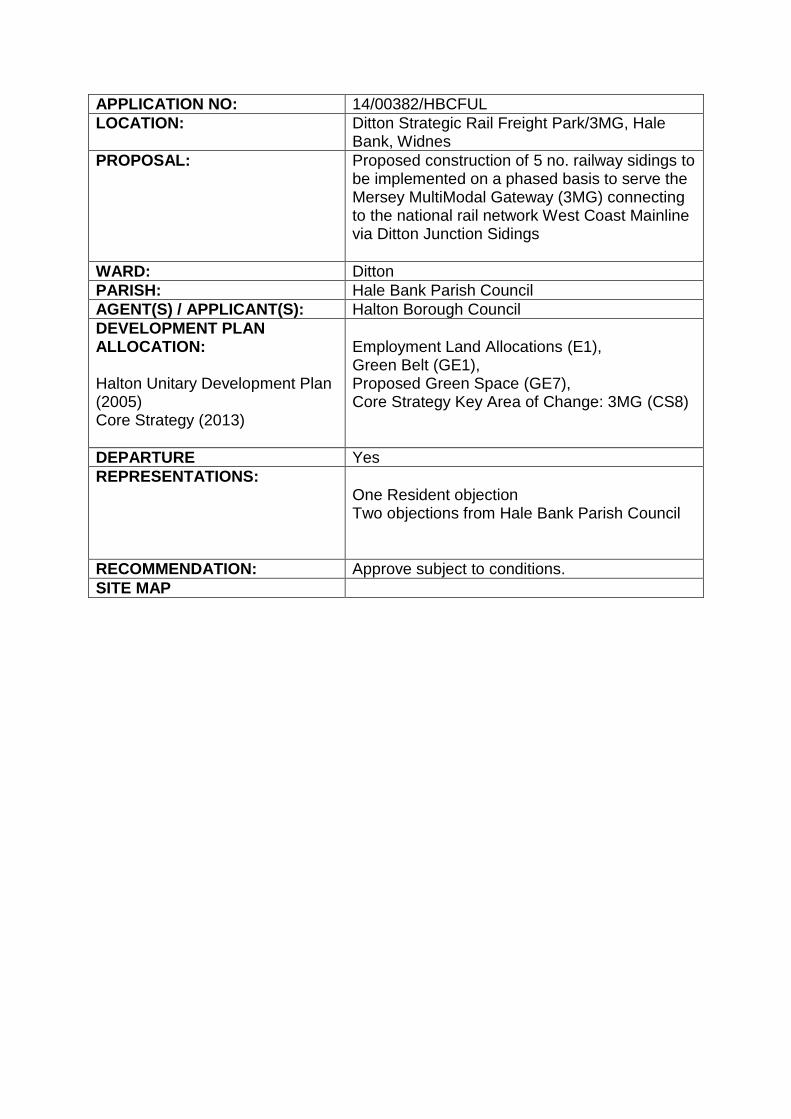
APPLICATION NO: 14/00382/HBCFUL LOCATION: Ditton Strategic Rail Freight Park/3MG, Hale Bank, Widnes PROPOSAL: Proposed construction of 5 no. railway sidings to be implemented on a phased basis to serve the Mersey MultiModal Gateway (3MG) connecting to the national rail network West Coast Mainline via Ditton Junction Sidings WARD: Ditton PARISH: Hale Bank Parish Council AGENT(S) / APPLICANT(S): Halton Borough Council DEVELOPMENT PLAN ALLOCATION: Halton Unitary Development Plan (2005) Core Strategy (2013) Employment Land Allocations (E1), Green Belt (GE1), Proposed Green Space (GE7), Core Strategy Key Area of Change: 3MG (CS8) DEPARTURE Yes REPRESENTATIONS: One Resident objection Two objections from Hale Bank Parish Council RECOMMENDATION: Approve subject to conditions. SITE MAP

Welcome message from author
This document is posted to help you gain knowledge. Please leave a comment to let me know what you think about it! Share it to your friends and learn new things together.
Transcript
APPLICATION NO: 14/00382/HBCFUL
LOCATION: Ditton Strategic Rail Freight Park/3MG, Hale Bank, Widnes
PROPOSAL: Proposed construction of 5 no. railway sidings to be implemented on a phased basis to serve the Mersey MultiModal Gateway (3MG) connecting to the national rail network West Coast Mainline via Ditton Junction Sidings
WARD: Ditton
PARISH: Hale Bank Parish Council
AGENT(S) / APPLICANT(S): Halton Borough Council
DEVELOPMENT PLAN ALLOCATION: Halton Unitary Development Plan (2005) Core Strategy (2013)
Employment Land Allocations (E1), Green Belt (GE1), Proposed Green Space (GE7), Core Strategy Key Area of Change: 3MG (CS8)
DEPARTURE Yes
REPRESENTATIONS: One Resident objection Two objections from Hale Bank Parish Council
RECOMMENDATION: Approve subject to conditions.
SITE MAP

BACKGROUND The Site and Surroundings This application relates to a site area of approximately 3.6 Ha mostly on land known as HBC Field. The site lies to the south of the Liverpool Branch of the West Coast Main Line (WCML). The site is predominantly under the ownership of Halton Borough Council, however, it includes land to the east under the ownership of Network Rail, and this land is to provide the new turnout to the proposed sidings and to undertake modifications as necessary to the existing rail network.
Part of the site is identified as sites 253 and 256 in the Halton Unitary Development Plan and, together with surrounding land, is defined by the Halton UDP as within the Potential Extent of the Ditton Strategic Rail Freight Park now known as Mersey MultiModal Gateway (3MG). The site is now included in the adopted Core Strategy (2013) in Policy CS8 with the A562 Speke Road and West Coast Main Line to the north, Halebank Road to the south, Halebank residential areas to the east and wider agricultural land and Green Belt to the west.
Planning History

Planning permission has been previously permitted (07/00362/FUL) for the construction and installation of 4 No. new railway sidings consisting of 4 no. 550m length tracks at the site. That permission was renewed in 2010 (10/00411/S73). Development has commenced on site and related conditions discharged and the latter planning permission is therefore extant. Planning permission for a rail served storage and distribution unit of approximately 1 million sq. ft was submitted to the Council in July 2011 (ref. 11/00269/FULEIA). The application was approved by the Council in September 2011 but that decision was quashed by the High Court in July 2012. The application was subsequently returned to the Council for determination with permission granted on 9th September 2014.
The Local Planning Authority has approved a separate application (15/00549/FULEIA) for the proposed construction of a purpose built transport and technology facility (Use Class B2) in three phases with associated development. THE APPLICATION
Proposal Description The construction and installation of 5 new railway sidings will comprise 5 x approximately 700m length tracks together with head shunts to allow locomotive release and ‘run-round’ operations.
The sidings outside of Network Rail’s land will be private sidings. The Council will appoint a suitably qualified and competent operator to construct the sidings and connection. This will be managed under a Rail Operator’s agreement. The proposed rail sidings will provide an extension to the existing Ditton Reception Sidings and would operate 24 hours a day. It’s proposed that the sidings will be implemented on a phased basis as demand increases.
This application as originally submitted in 2014 has been amended. The application site red line boundary has been extended to include land in Network Rail’s ownership. Plans have also been amended to reflect revision to the sidings layout and removal of high level lighting which has been deemed to be no longer required for the scheme. Overhead Line Equipment originally shown on the plans are located within Network Rail land only and not proposed within the new sidings. These have been removed from the plans for the avoidance of confusion. In respect of the updated and additional documents provided:
- The Lighting Assessment and Noise Assessment have been updated; - The Planning Statement and Design & Access Statement have been updated to reflect the approved scheme at HBC Field (ref. 11/00269/FULEIA) and also the approved HBC Field scheme (ref. 15/00549/FULEIA); - An updated Ecology Technical Note has been provided to address relevant surveys provided in the 2015 HBC Fields application together with subsequent 2016 Great Crested Newt Survey Report; - The 2015 Flood Risk Assessment (FRA) for the HBC Field application has also been provided as this also covers a consideration of the sidings site. The

application has been advertised as a departure with respect to the updated application and required consultation has been undertaken.
The new sidings will be connected to the national railway network via the existing Ditton Junction sidings. The new sidings will broadly follow and run parallel to the south side of the West Coast Main Line (WCML) Liverpool Branch. The sidings will broadly occupy a corridor measuring 650m x 50m, excluding Network Rail land. The works to connect the new sidings to the existing railway network is also included within the application as it is no longer considered that these will be constructed under permitted development rights enjoyed by Network Rail.
Construction and operational access to the site would be restricted to Lovel’s Way
via the A562/ A5300 Knowsley Expressway. It is considered that this can be secured by suitably worded planning condition.
Documentation
The application is also supported by a Design and Access Statement, Planning Statement, Flood Risk Assessment, Ecological Report including Addendum, Site Investigation, Lighting Assessment, Contamination and Noise Assessment. Environmental Statement Chapters from the adjoining HBC Field application (ref. 15/00549/FULEIA) have also been supplied to support the application.
POLICY CONTEXT The development plan for Halton consists of the Halton Core Strategy and the remaining saved policies from the Halton Unitary Development Plan (UDP) together with the Joint Merseyside and Halton Waste Local Plan. The application site is identified as lying within a Key Area of Change within the Core Strategy (Policy CS8) and the UDP Proposals Map has not been superseded in this location save for removal of reference to deleted policies. The site covers various areas of land allocated as proposed Employment, proposed Greenspace and is partly in the Green Belt but all falling within the Potential Extent of the Ditton Strategic Rail Freight Park as defined by the Halton Unitary Development Plan. The site also falls entirely within the 3MG Key Area of Change as defined by Core Strategy Policy CS8. Policy E1 allocates the site as a Strategic Rail Freight Park. There is a Scheduled Ancient Monument (Policies CS20 and BE4) located in the triangle of Green Belt to the north across the railway line. The following Core Strategy and Unitary Development Plan policies and other policy documents are of particular relevance: - Halton Core Strategy (2013)
CS1 Halton’s Spatial Strategy CS2 Presumption in Favour of Sustainable Development CS4 Employment Land and Locational Priorities CS6 Green Belt

CS8 3MG CS18 High Quality Design CS20 Natural and Historic Environment CS23 Managing Pollution and Risk
NOTE: CS1 identifies the key areas of change, 3MG being one of these. CS2 repeats the advice given in NPPF in relation to the presumption in favour of Sustainable Development. CS4 seeks to identify criteria for the retention of outstanding (UDP) allocations to allow a full review of deliverability and suitability towards meeting the borough’s employment development requirements to 2028. The application site is within the employment land supply referred to in this policy. CS18 The proposal will be well integrated and connected to the existing development and complies with this policy.
The other policies listed above are dealt with elsewhere in the report. Joint Waste Local Plan 2013 WM8 Waste Prevention and Resource Management
NOTE: WM8 requires construction methods/ materials to be considered. A condition is to be included to meet the policy requirements. Halton Unitary Development Plan (UDP) (2005) BE1 General Requirements for Development BE2 Quality of Design BE4 Scheduled Ancient Monuments BE6 Archaeological Evaluations GE1 Control of Development in the Green Belt GE7 Proposed Greenspace Designations GE18, 19, 20 and 21 Protection of sites of nature conservation interests GE25 Protection of ponds GE28 The Mersey Forest PR1 Air Quality PR2 Noise Nuisance PR4 Light Pollution and Nuisance PR5 Water Quality PR6 Land Quality PR14 Contaminated Land PR15 Groundwater PR16 Development and Flood Risk TP13 Freight, E1 Local and Regional Employment Land Allocations NOTE:
BE1 and BE2 require the proposal to consider design and the amenity issues but are principally aimed at buildings. The proposal will be well integrated and connected to the existing development and complies with these policies. The other policies listed above are dealt with elsewhere in the report. Supplementary Planning Documents
3MG Supplementary Planning Document The Council developed a 3MG Supplementary Planning Document (SPD), which was adopted in August 2009. The principal policies in the UDP that the 3MG Mersey Multimodal Gateway SPD was intended to ‘supplement’, namely E7 and S20, have subsequently been deleted with the adoption of the Core Strategy. Whilst the Council have not formally withdrawn the SPD, the weight that can be afforded to the SPD, is therefore, considered limited as policy E7 and S20 have been deleted. Nonetheless, the SPD does list a number of remaining ‘saved’ UDP policies as being relevant to the application site, namely E1, RG5, GE28, PR14, BE1, BE2, BE3, BE4, TP1, TP13, which are considered to be dealt with elsewhere within this report. The SPD also sets out a total of 17 Development Principles to guide the development of the site. These are considered to be adequately addressed elsewhere in the report.
Other Documents
None directly relevant CONSULTATIONS
Surrounding premises/ properties have been consulted along with ward councillors. The application was also advertised by means of a departure site and press notice. Consultation was also undertaken with a wide range of internal and external, statutory and non-statutory consultees.
Responses to the consultation were as follows:
United Utilities – No Objection
Environment agency – No Objection
Network Rail – Original holding objection removed
CWAC Archaeology – No response has been received to date.
Merseyside Environmental Advisory Service – No objection.
Halton Borough Council:
Open Spaces Service – No Objection
Environmental Health Service– No Objection
Contaminated Land Service – No Objection
Highways Service – No Objection
Hale Bank Parish Council – Object (see following summary under ‘Representations’ section below)

REPRESENTATIONS A total of 3 letters of objection have been received. These are outlined below.
One letter was received from a local resident in relation to the application as originally submitted. The submitted letter includes the following: That the building of the railway sidings “will increase the noise that I am already exposed to as I have to sleep with the windows open due to breathing problems. I also believe that this will devalue my property, plus the landscaping works at the back of my property meant I had a number of large excavators working from 7 till 7 including a 35 ton bulldozer working 5 feet from my back garden. You have now left me with a 10 foot high hill which people on a daily basis walk past my garden looking down and in, I now have no privacy so do not do anymore work that will cause me more suffering”. Two letters have also been received from an agent acting on behalf of Hale Bank Parish Council. The first related to the application as originally submitted and stated that:
“HBPC thus strongly object to the application for the sidings because, as currently presented, there is not and cannot be any link between the railway and the proposed warehouse on the HBC Field Site”. Those comments are considered to have been somewhat superseded by the subsequent application for the HBC Field site (ref. 15/00549/FULEIA) and by the update of this planning application and subsequent re-consultation. In that regard, further comments have been received as follows: This letter is written on behalf of Hale Bank Parish Council. They wish to object to the above application. Given that approval has previously been granted in 2007 for four sidings on more or less the same site, the Parish Council’s concern is limited to a matter of detail, namely the lighting proposals which do not appear to have been included in the 2007 scheme. Nor were they the subject of any condition on that planning permission. The consultation on the current scheme (which was originally submitted in 2014) seems to have been triggered by the submission of amended plans and documents. However, we have been unable to find any information which specifies exactly what the amendments are. The lighting scheme assessment says that the first phase will be two sidings with only low level ground lighting, and that implementation was due to start in 2015. We are thus concerned that the assessment has not been updated for the current amended scheme. The relevant information on the application form states that the application proposal includes "Minimal low level rail safety standard lighting only. Lighting column shown on planning drawing is for future space planning purposes" (whatever that means).

However, this is contradicted by the assessment report which specifies that the second phase will be the remaining three sidings, lit by with 20 metre tall lighting columns. These will be in two rows at 35 metre spacing, using 600 watt floodlights with wide asymmetric beam. To this end, 20 metre columns are shown on the plans. Confusingly, we are also advised in the assessment that "the lighting intensity may be reduced at the next stage in the design process and therefore a lighting scheme up to the assessed level may never be installed". Exactly what the lighting proposal comprises is therefore far from clear. In the assessment, we are advised that views by existing residents near the site boundary are "now well screened by existing vegetation and the earth mounds" and that the approved warehouse (presumably the Prologis scheme which, of course, appears unlikely to be built) will provide additional screening. Nevertheless, the assessment accepts that the 20 metre high floodlights may still be visible, in particular from the third floor of properties in Clapgate Crescent, whilst road users on Newstead Road, Lovel Way and Hale Bank Road may also see the new high mast lighting columns, particularly in winter. We are advised in the assessment that the general principles of mitigation include the use of "sufficient lighting units .... to avoid the need for tall, wide beam lighting units to illuminate large areas" . Yet, tall, wide beam lighting is exactly what appears to be currently proposed. To summarise, the lighting assessment is out of date. It contradicts itself by proposing 20 metre columns whilst elsewhere the application says that none are proposed. Another contradiction is the proposal to use 20 metre high wide beam lights in the face of mitigation measures which include the avoidance of this type of lighting. Hale Bank Parish Council thus objects to the Council’s proposal on the grounds that, either:-
1. The lighting scheme is unnecessarily intrusive and ignores its own consultant’s mitigation measures, or
2. The lighting scheme is unspecified, therefore neither the Parish Council nor any local resident (or the Local Planning Authority, for that matter) is able to make a proper assessment of the implications of the application proposals.”
This issue is addressed later under the Lighting section of this report. The following has been sent to the Parish Council (including the relevant reports):
I write further to your attached comments and can now confirm the following: With respect to your query regarding the nature of the amendments within the updated submission relative to the earlier 2014 submission I can confirm that the application site red line boundary was extended to include land in Network Rail’s ownership and the sidings layout was also revised within the site.

In respect of the updated and additional documents provided: - The Lighting Assessment and Noise Assessment were updated; - The Planning Statement and Design & Access Statement were updated to reflect the approved scheme at HBC Field (ref. 11/00269/FULEIA) and also the proposed HBC Field scheme (ref. 15/00549FULEIA); - An updated Ecology Technical Note was also provided to address relevant surveys provided in the 2015 HBC Fields application - The 2015 FRA for the HBC Field application was also provided as this also covers a consideration of the sidings site. These explain the amendments within the updated submission upon which HBPC were consulted and on which your submitted attached comments are based. The lighting assessment referred to above was based on a scheme including high level lighting and based on a worst case scenario whereby the lighting levels required may have been reduced and this is set out in the submitted lighting assessment. The only discrepancy therefore appears to have been the reference which you highlight in the form. That lighting assessment based on that higher level of lighting concluded that, whilst sensitive receptors would experience a view of the additional high mast, lighting effects such as glare and sky glow would be minimised through adequate lighting design and landscaped screening so as not to pose a material constraint to the proposed development. Since that time however the applicant has reviewed the lighting requirements. They have now confirmed that the scheme only requires low level lighting for health and safety purposes and I attach a photo of typical bollard lighting proposed. The high level lighting element has therefore been withdrawn. Overhead Line Equipment originally shown on the section plan is reported to be located within Network Rail land only and not proposed within the new sidings and has therefore been removed for clarity. The cross section plan has been amended accordingly as attached. The only other significant update with respect to the application is that the results of detailed Great Crested Newt Surveys of the HBC Fied Site have been supplied confirming no evidence of Great Crested Newt. I also attach a copy of that report for information. I trust this now satisfies the concerns of the Parish Council but would be happy to receive any further comments as they see fit. Please be aware that the application is expected to be reported to the Council’s Development Control Committee on 6th June 2016.”
ASSESSMENT Principle of Development Permission is sought for the construction and installation of new railway siding facilities on land currently owned by the Council and including land under the operational control of Network Rail. The sidings will be served via existing but altered rail sidings at Ditton Junction, Widnes. The connection will be shared with that

proposed for the development of HBC Field, now approved by Planning Application 15/00549/FULEIA. The new sidings will be connected to the national railway network via the existing Ditton Junction sidings. The new sidings will follow and run parallel to the south side of the West Coast Main Line (WCML) Liverpool Branch. The sidings will occupy a corridor measuring 650m x 50m, excluding Network Rail land. The works to connect the new sidings to the existing railway network is also included within the application as it is no longer considered that these will be constructed under permitted development rights enjoyed by Network Rail. All road connection to the site is shown to be via the recently constructed Lovel’s Way to the A5300/ A562, thereby minimising traffic on the local highway network. According to the submitted Rail Report, the new sidings are identified as an integral part of the wider Mersey MultiModal Gateway (3MG) development. The overall design concept/vision for the 3MG area is to provide modern distribution buildings located alongside rail terminal facilities which will be served by the strategic highway network. This will create of up to 5,000 good quality jobs in an area of “employment need” and regenerate sites which are currently derelict and suffer from industrial contamination. The installation of new infrastructure off Ditton reception sidings will provide the capacity to significantly increase the output of these sidings which currently run at 6 trains in/ out a day, to a maximum of 16 freight train services a day. The report identifies a number of significant constraints of the existing sidings at Ditton with respect to the length of the current sidings as follows: · Goods Reception No1 Siding: 350m · Goods Reception No 2 Siding: 310m · Goods Reception No3 Siding: 290m Combination of Reception No1 Siding & Head shunt used as one siding: 560m Until recently, it is suggested that the standard maximum length of an intermodal train operating on the national network has been between 520m and 540m. On this basis, only one siding can be used to facilitate trains of this length, and that is Ditton Reception No1 sidings in combination with the Head Shunt. Train lengths have now been extended through the introduction of more powerful locomotives to allow 30 wagons to be hauled instead of 24, which, with one locomotive, has a length of 640 to 660 metres. Therefore, due to the limited length and configuration of Ditton sidings, once a locomotive has drawn up to the head buffer stops it is ‘locked in’ and it is neither possible to receive or dispatch other full length trains from 3MG. The function of the sidings is further reported to be restricted by wider use by other trains on the network. The new sidings will not form part of the national 'Network Rail' track infrastructure. Instead, the sidings will be managed by a 3MG approved Plant Operators Licence Management Company. The approved company will manage the day to day maintenance and running of the new sidings in conjunction with Network Rail through their normal private siding arrangements. The proposed sidings are designed to increase capacity within the sidings to accommodate full trains at their

new extended length and also increase the number of trains which can be handled within the facility. Whilst the submitted Rail Report is based on the earlier approved warehouse development and associated dedicated siding arrangement the application has been amended to provide standalone independent sidings with separate branch to the HBC Field development site. The constraints of the exiting sidings are not believed to have been radically altered and the provisions of the scheme are considered to be sufficiently similar to explain the scheme rationale and justification. The westernmost portion of the application site is allocated as Green Belt in the UDP, where policies GE1 – Control of Development in the Green Belt and CS6 – Green Belt apply. The latter is mainly concerned with the need for a future Green Belt review so the former provides the main policy requirements. This area is also designated as Proposed Greenspace for which UDP Policy GE7 applies. National and local policy seeks to control inappropriate development within the Green Belt. NPPF Para. 90 provides that: “Certain other forms of development are also not inappropriate in Green Belt provided they preserve the openness of the Green Belt and do not conflict with the purposes of including land in Green Belt. These are: ● mineral extraction; ● engineering operations; ● local transport infrastructure which can demonstrate a requirement for a Green Belt location; ● the re-use of buildings provided that the buildings are of permanent and substantial construction; and ● development brought forward under a Community Right to Build Order.” The development of rail sidings and associated drainage are engineering operations and therefore are considered not to be inappropriate development. Openness is preserved and there is no conflict with including land in the Green Belt. As such, the development is appropriate development in the Green Belt. The area of Green Belt within the application site is substantially shielded from the wider Green Belt to the West by a new road and associated landscape embankments which connects the site to the A5300. The proposals therefore comply with NPPF paragraph 90 as being appropriate development within the Green Belt. UDP policy GE1 Para 2 states: “Planning permission will not be given to proposals for development conspicuous from the Green Belt that would harm its visual amenity by reason of their siting, materials, design.” This element of UDP Policy GE1 relates to development which is not in the Green Belt but which is conspicuous from the Green Belt and would harm its visual amenity. The principal of development of this kind was endorsed by the Inspector at the UDP inquiry had there been a problem with UDP policy GE1 in this context it would have negated the accepted principal that this type of development was acceptable. The development is not significantly conspicuous from the Green Belt it is not considered that it would cause harm to the visual amenity of the Green Belt or to conflict with the purposes of its designation as proposed Greenspace.

The site also falls entirely within the 3MG Key Area of Change as defined by Core Strategy Policy CS8. The site benefits from planning permission (10/00411/S73) which is considered to remain extant and the principle of development is therefore considered to have been established. The extension to the boundary of this application site is considered to relate to land to the east within the allocated site and Network Rail Operational Land. UDP Policy GE28 This policy makes provision for the on-going investigation of opportunities for creating new woodland planting through development as part of the Mersey Forest. The supporting map (Map 7 in the UDP) indicates target planting densities across sites allocated for development elsewhere in the UDP. For the application site, GE28 indicates provision for potential woodland cover of 20%+ for the application site and surrounding area with targeted planting for transport routes “where appropriate”. The policy also acknowledges that such figures are for guidance purposes only and not intended to be prescriptive for any unit of land. As such, it is considered that provision is made for a balance between the Mersey Forest aspirations and the site allocation for development. Potential for woodland planting within the development site and land up to the West Coast Main Line is restricted by the operational requirements of such a facility and the need to secure access up to the rail line through dedicated rail sidings. It is considered that provision has been made for substantial woodland planting to surrounding landscaped mounds implemented as advance structural planting. Efforts have been made, as far as practical within the wider HBC Field development, to include woodland and complimentary planting through the scheme and it is therefore considered that, given the allocation of the site for such development, the requirements of Policy GE28 have been adequately met within the scheme. Ecology The application reports that an extended Phase 1 habitat survey and detailed species surveys has been undertaken as part of the Ecological Impact Assessment for the HBC Field site located immediately to the south of this site. These studies also covered the application site, and the submitted Ecological Appraisal draws upon that information. The proposed development site lies approximately 1.3km from the Mersey Estuary which is designated as a Ramsar Site, a Special Protection Area and a Site of Special Scientific Interest. With the adoption of appropriate mitigation, those sites will not be affected by the proposed development. There are three local nature reserves within 2km of the proposed development site. It is reported that these reserves will not be affected by the proposed development site as a result of the distances between the proposed development site and each of the reserves and there being no hydrological link. Habitats within the proposed development site are reported to be predominantly bare, disturbed ground with species-poor grassland but including three waterbodies. All are reported to be of no more than local nature conservation interest and no

potentially significant effects are predicted as a result of their loss. Although one of the waterbodies has been identified as supporting an aquatic invertebrate fauna of local nature conservation value, the loss of this pond will be mitigated as part of the HBC Field development. It is considered that this can be secured by appropriately worded planning condition. On this basis, it is suggested that no significant ecological impacts are predicted as a result of the proposed development during either the construction or operational phase of the development. Mitigation measures have been recommended to ensure compliance with wildlife legislation, and best practice in respect of pollution prevention. Surveys for great crested newts in the ponds on site have, until 2014, demonstrated absence of the species. However, in 2015, survey data by eDNA sampling methods supplied in support of an unrelated planning application in the area had indicated that great crested newts (GCN) began to colonise the large balancing pond (Pond A) to the south of the site. As a result of the 2015 positive eDNA result and previous planning application 15/00549/FULEIA, additional Great Crested Newt Surveys have been undertaken as advised by the Council’s retained advisers on ecology issues. Four GCN survey visits have been undertaken, in accordance with Natural England Best Practice guidance, with respect to all ponds and further samples taken for eDNA from Pond A. Those surveys have confirmed no evidence of GCN at the site. The eDNA result has also returned a negative result. GCN are, therefore, no longer considered an impediment to development and a GCN licence from Natural England to facilitate mitigation will not be required. The Council’s retained adviser, on ecology, has reviewed the application along with all supporting information. It has confirmed that the conclusions of the submission are accepted. With respect to the 2016 GCN survey results, they confirm that “the report states that no evidence of Great crested newt was found. The Council does not need to consider the proposals against the three tests (Habitats Regulations) or consult Natural England with regards to Great crested newt.” It also advises that, subject to submission of a Construction Environmental Management Plan (CEMP) the conclusions of Habitat Regulations Assessment report (HRA) for the adjacent HBC Fields application (ref. 11/00269/FULEIA) of “no likely significant effects”, remain relevant to this application. Submission and agreement of a CEMP can be secured by appropriately worded planning condition. A condition relating to protection of breeding birds is recommended, however, this is considered to be adequately controlled through alternative legislation and best dealt with by means of informative. On that basis, it is considered that the proposals accord with the development plan having particular regard to UDP Policies relating to The Green Environment (GE18, GE19, GE20, GE21, GE25 and Core Strategy Policy CS20. Lighting
The application was supported by a detailed lighting assessment. That lighting assessment was based on a scheme including high level lighting of columns up to

20m and based on a worst case scenario, whereby, the lighting levels required may have been reduced and this is set out in the submitted lighting assessment. Such an approach is considered wholly appropriate to allow detailed lighting design to ensure compliance with legislation outside the planning process. The lighting assessment, based on that higher level of lighting, concluded that, whilst sensitive receptors would experience a view of the additional high masts, lighting effects such as glare and sky glow would be minimised through adequate lighting design and landscaped screening so as not to pose a material constraint to the proposed development. Hale Bank Parish Council, in its objection, identified a discrepancy in the application. The only discrepancy appears to be between the submitted application form (which refers to low level lighting) and the lighting reports submitted that assess the proposal showing high level lighting. Following receipt of Hale Bank Parish Council’s objection, the applicant reviewed the lighting requirements for the scheme. The applicant has now confirmed that the scheme only requires low level lighting for health and safety purposes; this would include bollard lighting. The high level lighting element of the scheme has therefore been withdrawn. On that basis it is considered that the concerns of Hale Bank Parish Council have been sufficiently met, in that the lighting scheme will not be intrusive. It is considered that details of the proposed low level lighting scheme can be secured by appropriately worded planning condition. On that basis, it is considered that no objection could be sustained with respect to impacts resulting from lighting from the scheme. It is considered that the proposals accord with the development plan having particular regard to UDP Policy PR4. Noise and Air Quality The potential noise impacts resulting from the installation of the proposed rail sidings has been assessed as part of the application. A sound monitoring survey was undertaken at a similar operational rail sidings development in order to quantify the source sound levels for the sound propagation model. The submitted report confirms that the current proposals could be defined as Low Impact for all noise sensitive receptors. The submission has been complicated by an analysis of the possible additional levels of mitigation which could be applied, including the possible instillation of a 6m high acoustic fence. It is acknowledged within the submission that the sound emanating from the proposed rail sidings was determined to be Low Impact without the fence and that the fence is only discussed with respect to reducing the rating level further. It is, however, considered that such additional mitigation cannot be justified when measured against the six tests for use of planning conditions as defined by Planning Practice Guidance. Potential effects associated with the proposed railway siding have been also been considered with respect to air quality. It is acknowledged that some sections of railway network in the UK are heavily used by diesel engine trains and have been found to result in higher than background concentrations of NO2 within 30 m of the railway line. Short-term effects may also be of concern in areas where trains are likely to be idling for more than 15 minutes. Assessment of the proposed

development suggests that there is no relevant public exposure near to the proposed sidings. As the closest receptors are located more than 200 m from the sidings, an assessment has not, therefore, been undertaken. The submission has been reviewed by the Council’s Environmental Health Officer. The Council’s Environmental Health Officer confirms that the consultant has measured the background noise at the residential receptors in the area and calculated the predicted noise levels at these locations once the proposed development is in operation. The noise levels at the proposed development were calculated from measurements taken at a similar facility. It is confirmed that they take into account the noise levels produced by the movement of trains and this includes the ‘squealing’ of the wheels on the track and shunting of the trains. The consultant did not, however, include noise from the sirens as they state: “sirens are not essential for the successful operation of the proposed rail sidings.” The methodology employed in compiling the report has been confirmed as acceptable as an accepted standard applied correctly. The applicant has calculated the difference between the existing noise levels and the predicted noise levels for night-time only as this is when existing noise levels are at their lowest and is considered the worst case scenario. This demonstrates that the noise levels created by the movement of trains will be below the existing noise levels. The noise report does not consider noise from the construction phase of the development, however, any impact can be mitigated by restricting the hours that construction is be permitted to daytime only and weekend working is restricted. It is considered that these issues can be suitably addressed by condition and submission and agreement of a Construction Environmental Management Plan (CEMP) also to be secured by condition. With respect to air quality considerations for the operational phase, these have been scoped out by the applicant as the sensitive receptors are over 200m away. This is considered an acceptable and proportionate approach, as it is acknowledged that levels of pollutants drop to background levels 50m from the source. The report acknowledges that the construction of the site will result in emissions of fugitive dust. It is considered that measures for dust control can be secured within a suitable CEMP. On this basis, the Council’s Environmental Health Officer has confirmed that it raises no objection, subject to conditions restricting working hours, use of sirens and the submission and agreement of a CEMP. It is considered that the proposals accord with the development plan having particular regard to UDP Policies PR1 and PR2.

Archaeology and the Historic Environment The HBC Field Environmental Statement (ref. 15/00549/FULEIA) included a chapter on the Historic Environment which, in turn, included an assessment of the potential impacts on the historic environment associated with the rail sidings site. This chapter has now been submitted in support of this application. The potential impacts of the proposed development on archaeological remains have been assessed through a desk-based assessment, a geophysical survey and targeted evaluation trial trenching, and are reviewed and summarised as part of this historic environment chapter. There is one Scheduled Monument located outside the proposed development site boundary, but within the study area. This is Lovel’s Hall moated site and fishpond. It is stated that no specific mitigation is recommended for Lovel’s Hall Scheduled Ancient Monument. Halebank Conservation Area lies to the south-west of the HBC Field, situated along Hale Bank Road. Landscaping areas and landscape bunds have been provided in the south of the HBC Field site in order to provide screening for the development. The remainder of HBC Field to the south is identified for future development and, as such, no further mitigation is recommended for the rail sidings scheme. Accordingly, it is considered that the level of any potential harm would be less than “substantial” as defined by NPPF. Notwithstanding this, through the submitted Environmental Statement chapter there is a recognised potential in the wider area for prehistoric, Roman and medieval remains. With respect to that earlier application (ref. 15/00549/FULEIA), the Council’s retained adviser on archaeology raised no objection, subject to the submission and agreement of a written scheme of investigation. This is in line with Polices BE4 and BE6 of the UDP and CS20 of the Core Strategy. Whilst detailed comments are awaited with respect to the current scheme, it is considered that the same appropriately worded planning condition would be satisfactory. Members will be updated if the Council’s retained adviser suggests otherwise. Flooding and Drainage The eastern end of the site is shown on the Environment Agency website flood risk map to lie partially within Flood Risk Zone 3. The source of fluvial flood risk is the Ditton Brook and the source of tidal flood risk is the River Mersey. The flood risk assessment for HBC Field development to the south (ref 15/00549/FULEIA) covers the proposed rail sidings site. Based on the assessment of flood risk, it is concluded that the site is not at risk of flooding for the 1 in 100 year fluvial event or 1 in 200 year tidal event, and the site is considered appropriate for the development in terms of flood risk. The site is also not considered to be at risk from flooding from fluvial events in Ditton Brook. So, on this basis, no compensatory storage would be required. The proposed surface water drainage scheme is shown to include the use of new culverts, flow control, attenuation provision, environmental protection including oil

interceptors and proposed connections to an existing culvert to discharge to the watercourse system that flows to the north beneath the WCML and, ultimately, to Ditton Brook. Provision for all existing drainage connections/routes from the south, the proposed outfall from the balancing pond, highways drainage and the proposed HBC Field development to the south are also proposed to be allowed for within the sidings drainage scheme. The Environment Agency has confirmed that no objections are raised subject to conditions requiring submission and agreement of a scheme to limit surface run-off. Whilst detailed comments are awaited from the Council’s Highways Engineer acting as Lead Local Flood Authority (LLFA), it is considered that no objection could be sustained and any outstanding issues can be dealt with by condition. Members will be updated accordingly. On that basis, it is considered that the proposals accord with the development plan having particular regard to UDP Policies PR5, PR15, PR16 and Policy CS23 of the Core Strategy. Contaminated Land Detailed assessment of potential land contamination impacts has been undertaken for the site using a desk study and intrusive investigation. The assessment has identified no significant likely impacts with respect to sensitive ecological receptors, ground water or as a result of land contamination through either the construction or operational phases of the development. No formal mitigation is recommended subject to good working practices. Submission and agreement of a CEMP will be required by condition which will allow the Planning Authority to further ensure that appropriate consideration is given to minimising potential construction impacts. Japanese knotweed and animal carcasses have previously been found on the HBC Field site. The Japanese Knotweed was originally identified within an area now forming the landscape mounds to the south of the site, constructed under planning permissions 05/00948/FUL and 07/00336/HBCFUL. That area is outside any land identified for redevelopment under this submission and Halton Borough Council has advised that its treatment was carried out by contractor’s working for United Utilities under their previous scheme for sludge main re-routing. The applicant has confirmed by update report that a subsequent walkover survey in February 2015 identified no signs of knotweed. The applicant has confirmed that the animal carcasses have now been removed in accordance with current legislation and inspection by government vet. It is considered that validation of the removal process can be confirmed by appropriate planning condition. Land within Network Rail control but now included within the application site has been identified as having potential hydrocarbon impacts. That land has not been subject to detailed investigation at this stage. It is considered that detailed investigation of this area and appropriate mitigation as required can be secured by appropriate planning condition prior to development commencing in this defined area.

The application and detailed submission have been reviewed by the Council’s Contaminated Land Officer. In summary, given the history of the site and the nature of the proposed use the development is considered to have limited potentially adverse impacts from a land contamination perspective. On this basis, the Council’s Contaminated Land Officer has confirmed that no objections are raised to the proposals, but would recommend that any approval is conditioned to require the submission of the detailed CEMP and a verification report that details the treatment and/or disposal of the animal remains and any contamination identified during the course of the development, including the animal remains. It is considered that the proposals accord with the development plan having particular regard to UDP Policies PR5, PR15, PR16 and Policy CS23 of the Core Strategy. Summary and Conclusion Permission is sought for the construction and installation of new railway siding facilities on land currently owned by the Council and including land under the operational control of Network Rail. The new sidings will be connected to the national railway network via the existing Ditton Junction sidings and accessed by road from the roundabout of the A562 with the A5300 Knowsley Expressway over the West Coast Main Line (WCML). The installation of new infrastructure off Ditton sidings will provide the capacity to significantly increase the output of these sidings which currently run at 6 trains in/ out a day, to a maximum of 16 freight train services in/ out a day. As such, the proposals are considered an integral part of the growth of 3MG in accordance with adopted Core Strategy Policy CS8. It also supports and promotes sustainable transportation of freight as set out in TP13 of the UDP. Issues associated with encroachment within areas of Green Belt and proposed Greenspace are considered to be dealt with in this report. Impacts with respect to ancillary development including lighting are considered to have adequately assessed and are not considered to impact unduly so as to justify refusal of planning permission. Whilst originally advertised as a departure from the development plan, through the detailed assessment of the scheme the proposals are considered to represent sustainable development in compliance with local and national planning policy and therefore do not represent a departure. The site benefits from planning permission (10/00411/S73), which is considered to remain extant, and the principle of rail siding development is, therefore, considered to have been established. Any extension to the application site (as compared with planning permission 10/00411/S73) is considered to relate to land to the east within the allocated site and Network Rail Operational Land. The application has been assessed with respect to the key impacts of the development, having particular regard to potential impacts on local residents. Issues

originally raised by Hale Bank Parish Council are considered to have been addressed through the withdrawal of high level lighting from the scheme. RECOMMENDATIONS Approve subject to the following conditions:-
1. Standard 3 year permission (BE1) 2. Specifying Approved and Amended Plans and documents and requiring
development be carried out as approved (BE1) 3. Condition requiring submission and approval of a Construction Environmental
Management Plan including wheel wash facilities and scheme of dust management. (BE1)
4. Condition restricting routeing of construction and delivery traffic to Lovel’s Way (BE1)
5. Conditions requiring construction and delivery hours to be adhered to throughout the course of the development. (BE1)
6. Condition securing a programme of archaeological work in accordance with a written scheme of investigation (BE6)
7. Environment Agency condition relating to submission and agreement of a scheme to limit surface water runoff (PR16)
8. Condition securing a scheme of site investigation and remediation within specified area of site (PR14)
9. Condition relating to discovery of unidentified contamination (PR14) 10. Condition restricting audible warning devices from being used within the site
(PR2) 11. Condition requiring submission and agreement of verification report for the
removal of animal remains (PR14) 12. Condition restricting outside storage (BE1) 13. Condition requiring submission and agreement of details of low level lighting
(PR4) 14. Condition requiring submission and agreement of a scheme of mitigation.
Sustainability Statement As required by: • Paragraph 186 – 187 of the National Planning Policy Framework; • The Town and Country Planning (Development Management Procedure)
(England) (Amendment No.2) Order 2012; and • The Planning (Listed Buildings and Conservation Areas) (Amendment)
(England) Regulations 2012. This statement confirms that the local planning authority has worked proactively with the applicant to secure developments that improve the economic, social and environmental conditions of Halton.
Related Documents