©JBS&G Australia Pty Ltd | 52234/117,720 (Rev 0) Appendix R Results of Gamma Logging Survey

Welcome message from author
This document is posted to help you gain knowledge. Please leave a comment to let me know what you think about it! Share it to your friends and learn new things together.
Transcript

©JBS&G Australia Pty Ltd | 52234/117,720 (Rev 0)
Appendix R Results of Gamma Logging Survey

©JBS&G Australia Pty Ltd |
Appendix R Gamma Logging
R1. Geophysical Logging (Gamma Ray)
Geophysical logging was undertaken between 29/09/2017 and 19/10/2017 at 67 existing groundwater monitoring wells across the investigation area using a 43mm natural gamma sonde (NGRS).
A gamma log is created by lowering a gamma sonde down a groundwater well and measuring gamma radiation variation with depth. The radiation is emitted from naturally occurring isotopes of potassium, thorium and uranium. The gamma response was recoded in counts per second (cps). Variation in gamma response is used to indicate changes in the geological profile.
The gamma sonde was lowered into the well and logging recorded from both top to bottom and bottom to top for quality assurance purposes. The data was acquired at 1cm intervals at a rate less than 4m/min to ensure suitable data resolution. The tool and cable were decontaminated between each logging location.
The gamma logging data was compiled into 5cm composite logs. An interpretive graphical colour scale (clay index) was developed, based on recorded cps values and corresponding indicated clay content (low cps values corresponding with higher permeability formations reflected by yellow scale bright colours, higher cps values corresponding with lower permeability formations reflected by darker brown colours). The graphical colour scale was used to create cross sections on a transect south to north and west to east across the site. The transects were chosen based on the greatest data density (distribution of groundwater monitoring wells) with the intent to identify potential trends in lithological distribution within the shallow Quaternary sequences across the site.
A number of iterations of the clay index scale were constructed and cross sections reviewed for identifiable trend in lithologies such as lateral extent of low clay aquifer sequences, potential preferential pathways for interaction between the Quaternary aquifer units, and extent of high clay content aquitards between aquifer systems. Low cps values corresponding with higher permeability formations reflected by yellow scale bright colours and higher cps values corresponding with lower permeability formations reflected by darker brown colours.
The sections have been adjusted to relative Australian Height Datum (AHD) levels for the vertical scale but are not to horizontal scale due to the size of the site and distance between monitoring wells. The groundwater monitoring well locations at which gamma logging was undertaken are listed in Table R.1.
Table R.1: List of Groundwater Wells in which geophysical logging was undertaken
Well ID EASTING (MGA 94)
NORTHING (MGA 94)
ELEVATION (AHD)
RAAF Base - Onsite/Offsite
Primary Investigation Area
Aquifer
EDMW04 282771.879 6156117.22 17.181 Onsite P1 Q1
GW0008 282826.507 6157777.781 20.062 Onsite P4 Q1
GW0027 283424.93 6157227.056 19.26 Onsite P6 Q1
GW0192 282780.404 6157762.164 19.577 Onsite P4 Q1
GW0193 282783.462 6157813.591 19.725 Onsite P4 Q1
GW0197 282881.486 6157804.67 19.614 Onsite P4 Q1
GW0302 282715.218 6157679.882 18.61 Onsite P5 - Adjacent Q1
GW0304 282683.104 6157657.915 18.693 Onsite P5 Q1

©JBS&G Australia Pty Ltd |
Well ID EASTING (MGA 94)
NORTHING (MGA 94)
ELEVATION (AHD)
RAAF Base - Onsite/Offsite
Primary Investigation Area
Aquifer
GW0315 281414.23 6157689.875 15.506 Onsite P8 - Adjacent Q1
GW0321 282765.25 6157734.774 18.718 Onsite P4 Q1
GW0322 282740.411 6157807.835 18.953 Onsite P4 Q1
GW0330 281994.955 6157401.56 16.923 Onsite P7 Q1
GW0340 284435.398 6156091.226 20.245 Onsite Q1
GW0342 284593.738 6156484.845 19.544 Onsite Q1
GW0359 284065.413 6156147.908 19.436 Onsite P26 - Adjacent Q1
GW0368 283044.737 6155978.13 17.67 Onsite Q1
GW0369 283035.864 6155946.068 17.706 Onsite Q1
GW0430 281238.737 6155690.356 14.352 Onsite Airside - Southern Runway
Q1
GW0431 282222.8412 6154694.306 Onsite Q1
GW2100 280376.01 6153457.65 10.703 Offsite Q1
GW2101 281051.12 6153645.1 12.909 Offsite Q1
GW2102 281420.71 6154104.68 13.025 Offsite Q1
GW2104 281874.86 6154481.06 14.175 Offsite Q1
GW2105 282319.97 6154585.73 16.06 Offsite Q1
GW2106 281041.13 6154649.91 13.283 Offsite Q1
GW2107 281273.81 6155152.71 14.235 Offsite Q1
GW2108 281515.15 6155302.91 15.579 Onsite P10 Q1
GW2110 280754.66 6156265.16 13.951 Onsite P23 Q1
GW2111 280467.3 6156119.96 12.435 Offsite Q1
GW2112 281741.031 6155529.325 15.877 Onsite P10 Q1
GW2114 282634.947 6156088.193 17.697 Onsite P1 Q1
GW2115 282978.414 6156184.274 17.571 Onsite P3 Q1
GW2116 282474.473 6156425.192 16.978 Onsite P11 Q1
GW2117 282234.282 6156769.14 16.161 Onsite P12b Q1
GW2118 282064.224 6156965.741 17.329 Onsite P12a Q1
GW2119 282676.214 6156779.982 18.152 Onsite P16 Q1
GW2120 282550.211 6156915.876 18.18 Onsite P16 Q1
GW2121 281227.91 6157610.12 15.617 Onsite P8 Q1
GW2122 281167.53 6157482.79 15.618 Onsite P8 Q1
GW2124 283493.163 6157112.401 19.054 Onsite P6 Q1
GW2126 282821.694 6157773.259 20.151 Onsite P4 Q2
GW2127 282899.61 6159197.28 22.097 Offsite Q1
GW2129 281293.3 6157743.13 15.881 Onsite P8 - Adjacent Q1
GW2131 282917.551 6156051.529 18.058 Onsite P3 Q1
GW2132 282724.579 6156107.052 17.812 Onsite P1 Q1
GW2133 283338.585 6155944.449 18.88 Onsite P19 Q1
GW2135 284303.65 6156860.304 20.504 Onsite P17 Q1
GW2136 281381.86 6155386.53 14.442 Offsite P22 Q1
GW2137 281577.14 6155206.08 15.791 Onsite P10 Q1
GW2138 281437.05 6155405.71 14.771 Onsite P10 Q1
GW2139 281632.57 6158438.41 18.653 Onsite Northern end of runway - Runtrack
Q1
GW2141 281740.99 6154912.4 13.123 Offsite Q1
GW2142 280391.33 6156519.74 12.434 Offsite Q1
GW2143 281393.67 6154742.55 13.627 Offsite Q1
GW2144 281513.168 6155305.967 15.608 Onsite P10 Q2
GW2146 282215.0134 6154699.343 Onsite S4 Q2
GW2147 285389.86 6156626.77 22.178 Offsite Q1
GW2148 282016.563 6155826.88 16.49 Onsite P9 Q1
GW2149 281927.977 6155729.841 16.626 Onsite P15a Q1
GW2150 281434.777 6155891.215 14.873 Onsite P24 Q1
GW2152 281960.469 6156017.629 15.633 Onsite P21 Q1

©JBS&G Australia Pty Ltd |
Well ID EASTING (MGA 94)
NORTHING (MGA 94)
ELEVATION (AHD)
RAAF Base - Onsite/Offsite
Primary Investigation Area
Aquifer
GW2153 283613.433 6157637.773 20.073 Onsite P13 Q1
GW2154 281837.054 6157254.133 16.492 Onsite P14 Q1
GW2155 283685.38 6156320.652 18.961 Onsite P25 Q1
GW2156 284182.736 6156137.788 19.773 Onsite P26 Q1
GW2157 282722.366 6156108.631 17.777 Onsite P1 Q2
GW2158 282018.71 6155826.137 16.498 Onsite P9 Q2
Gamma Logging results The individual gamma traces for the groundwater monitoring wells are presented as attachments to this summary. The interpretation from the graphical cross sections is described below and the cross sections are provided in appended Figures R1 and R2.
Cross Section West to East Lower clay content formations (up to 0.5m thick) indicative of higher permeability are inferred below the initial water strike in the adjacent grouping of groundwater wells GW2121, GW2154 and GW2118. This grouping is spaced over 500m starting on the western boundary of the RAAF Base and continues to the eastern side of the main runway. Higher clay content (lower permeability aquitard) is inferred above the initial water strike in adjacent groundwater wells groupings of GW2117, GW2116 and GW2119 located in the central portion of the site and GW2155, GW359 and GW2156 located in the eastern portion of the site. Several thin lenses of low clay sediments are inferred at intervals between the Q1 and Q2 aquifers in GW2157 representing potential preferential pathways for interconnectivity between aquifer systems.
Cross section South to North Thin, lower clay content formations (between 0.05-0.1m) indicative of higher permeability, are inferred below the initial water cut in a number of the Q1 groundwater monitoring wells including;
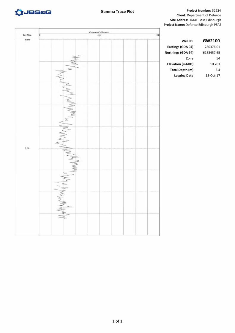
• GW2100 and GW2101 located offsite within Kaurna Park;
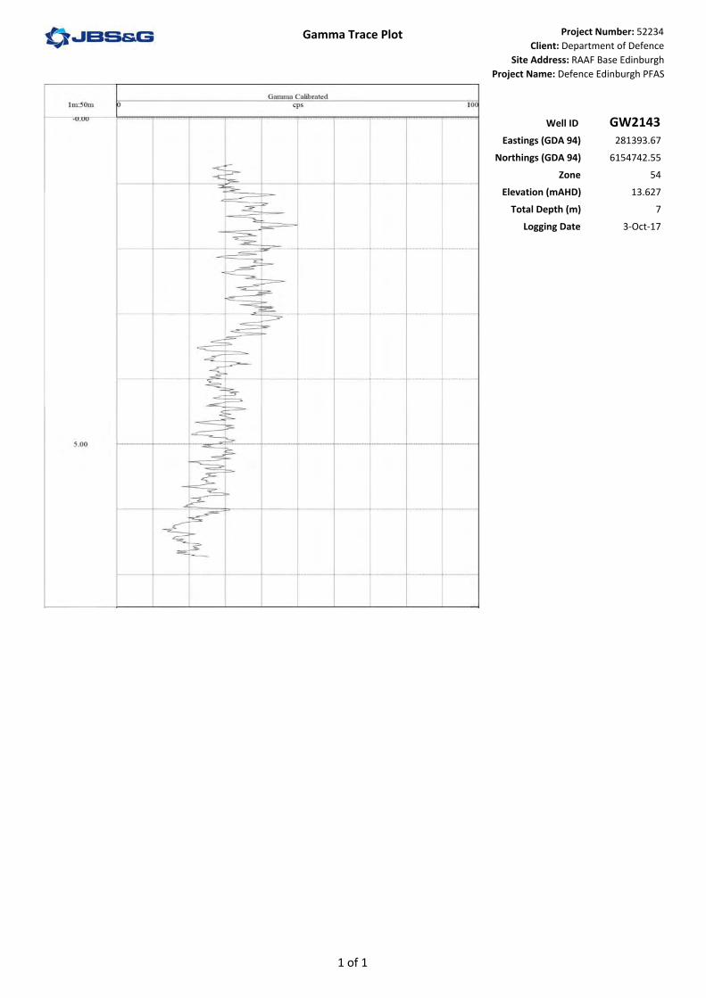
• In GW2143 located offsite adjacent to the southern boundary;
• Onsite adjacent to the southern boundary in GW2112, GW2149 and GW2148 within thepotential source area P15;
• In GW2116 adjacent to the Air Traffic Control Tower; and
• GW2153 located in the Northern Paddock.
Higher clay content lithologies indicative of lower permeability are inferred below the initial water strike in
• The Q1 groundwater well GW2102 located offsite on Diment Road;
• In GW2108 located onsite adjacent to the southern boundary;
• In GW2152 located on taxiway Bravo adjacent source area P15; and
• The Q2 groundwater wells GW2144 adjacent to the southern boundary in P10 and GW2158located within source area P15.
Moderate sequences of higher clay content formations indicative of lower permeability are inferred between the bottom of the Q1 aquifer and the top of the Q2 aquifer identified in the Q2 groundwater wells GW2144 and GW2158.

©JBS&G Australia Pty Ltd |
A thick sequence of lower clay formation is inferred below the water strike in GW2120 within source area P11. Higher clay content (lower permeability aquitard) is inferred in clays above the initial water strike in GW2102, GW2143, GW2108, GW2112, GW2148, GW2152, GW2116 and GW2153.
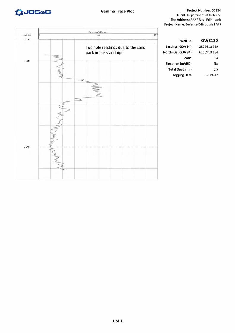
Bentonite influence on Gamma results A minimum 0.5m bentonite plug was installed at the top of the sand pack (0.5m above the screened interval) within every groundwater monitoring well installed by JBS&G. Bentonite as a clay mineral can have high potassium content and can lead to a higher gamma response from the sonde over this interval. This is evident on the gamma trace recorded for GW2120 with a significant shift in recorded cps value over the section corresponding to the bentonite plug. Correlation of the increase in cps values with drilling logs was used as a verification of the location of bentonite seals within the constructed wells.
Conclusions/outcomes of the gamma logging The gamma logging data confirmed that the shallow Quaternary aquifer sequence (Q1) across the site is comprised of predominantly low permeability clay, silt and sandy sediments interspersed with a broad variety of medium to high permeability sequences of sands and gravels irregularly distributed across the site. This confirmed previous observations and assumptions that groundwater within the more permeable aquifer sequences is likely to be semi confined. This highly irregular sequence of laterally discontinuous aquifers and identified interspersed highly permeable sandy and gravelly sequences suggests substantial variations in hydraulic conductivity across the site and between different Quaternary aquifer sequences.
The heterogeneity identified in the quaternary geological sequences inferred by the gamma logging identified a need to increase the quality of representative geological samples collected going forward above that of solid auger drilling technique used in the Stage 2A assessment. For the Stage 2B assessment, collection of a push tube core was adopted for shallow Q1 drilling installations and sonic drilling was adopted for the deeper quaternary aquifers (Q2 plus) due to the ability to collect continuous cores and isolate aquifer formations while drilling.
The gamma logging identified lenses of more permeable, low clay content sediments at intervals between the Q1 and Q2 sequences. These lenses provide potential preferential pathways for interconnectivity between aquifer systems. A number of these sandy and gravelly lenses were identified during Q2 monitoring well installation in cores using the sonic drilling method, confirming previous assumptions.
Interpretation of the gamma logging data identified a concern regarding the practicality and potential value of the development of a 3D hydrogeological model for the whole of the investigation area site due to the discontinuous nature of aquifer units and lithological heterogeneity of the identified Quaternary aquifers. The development of 3D models for individual source areas may be a more practical approach where sufficient data is available to achieve value from the modelling.

&<
&<
&<
&<
&<
&<
&<
&<
&<
&<
&<
&<
&<
&<
A
A'
GW2153
GW2152
GW2149GW2143
GW2120
GW2116
GW2112
GW2108
GW2102
GW2101
GW2100
GW2158
GW2144GW2148
Z
Job No: 52234
Client: Department of Defence
Version: Rev 0
Drawn By: AS
Date: 05-Dec‐2018
Checked By: MC
Scale at A3
Coord. Sys. GDA 1994 MGA Zone 54
APPENDIX R.1
0 800
metres
Document Path: S:\Projects JBSG\Adelaide\52234_Defence_Edinburgh_PFAS\ArcGIS\Maps\Reports\DSI\Figure XX_Geological Cross Section N‐S.mxdImage Reference: www.nearmap.com© ‐ Imagery Date: 26 February 2018 & Source: Esri, DigitalGlobe, GeoEye, Earthstar Geographics, CNES/Airbus DS, USDA, USGS, AeroGRID, IGN, and the GIS User Community
RAAF Base Edinburgh, South AustraliaEnvironmental Investigation of PFAS
GEOLOGICAL GAMMA LOGGING‐ NORTH TO SOUTH
1:20,000
Disclaimer: While all reasonable care has been taken to ensure the information contained on this map is up to date and accurate, no guarantee is given that the information portrayed is free from error or omission. Please verify the accuracy of all information prior to use.
Legend: RAAF Base Edinburgh BoundaryRefined Investigation AreaStormwater Drainage
Groundwater Monitoring Well&< Q1 Aquifer&< Q2 Aquifer&< Q3 Aquifer
SWL July 2017
Initial Water Strike
A A’
GW21
4310
15
GW21
00
GW21
01
GW21
44 GW21
58
GW21
02
GW21
08
GW21
12 GW21
49
GW21
48
GW21
52
GW21
16
GW21
20
GW21
53
5
20
0
‐5
10
15
5
20
0
‐5
m AHD
m AHD
SANDS: silty and clayey sands with varying gravel inclusions.Varying interbedded silty and sandy clays with varying gravel inclusions.CLAYS: silty clays with varying gravelinclusions.
Clay Index
Likely influenceof bentonite
on gamma trace.

&<
&<
&<
&<
&<
&<
&<
&<
&< &<
&<
A'
A
GW2156GW2155
GW2154
GW2132
GW2118
GW2117
GW2116
GW2114
GW0359
GW2121
GW2157
Z
Job No: 52234
Client: Department of Defence
Version: Rev 0
Drawn By: AS
Date: 05-Dec‐2018
Checked By: MC
Scale at A3
Coord. Sys. GDA 1994 MGA Zone 54
APPENDIX R.2
0 980
metres
Document Path: S:\Projects JBSG\Adelaide\52234_Defence_Edinburgh_PFAS\ArcGIS\Maps\Reports\DSI\Figure XX_Geological Cross Section E‐W.mxdImage Reference: www.nearmap.com© ‐ Imagery Date: 26 February 2018 & Source: Esri, DigitalGlobe, GeoEye, Earthstar Geographics, CNES/Airbus DS, USDA, USGS, AeroGRID, IGN, and the GIS User Community
RAAF Base Edinburgh, South AustraliaEnvironmental Investigation of PFAS
GEOLOGICAL GAMMA LOGGING‐ WEST TO EAST
1:25,000
Disclaimer: While all reasonable care has been taken to ensure the information contained on this map is up to date and accurate, no guarantee is given that the information portrayed is free from error or omission. Please verify the accuracy of all information prior to use.
Legend: RAAF Base Edinburgh BoundaryRefined Investigation AreaStormwater Drainage
Groundwater Monitoring Well&< Q1 Aquifer&< Q2 Aquifer&< Q3 Aquifer
m AHD
m AHD
SANDS: silty and clayey sands with varying gravel inclusions.Varying interbedded silty and sandy clays with varying gravel inclusions.CLAYS: silty clays with varying gravelinclusions.
Clay Index
SWL July 2017Initial Water Strike
A A’
10
15
5
20
0
10
15
5
20
0
GW
2114
GW21
19
GW21
55 GW03
59
GW
2156
GW21
16
GW21
18 GW21
32
GW
2121
GW21
54
GW2
117
GW
2157
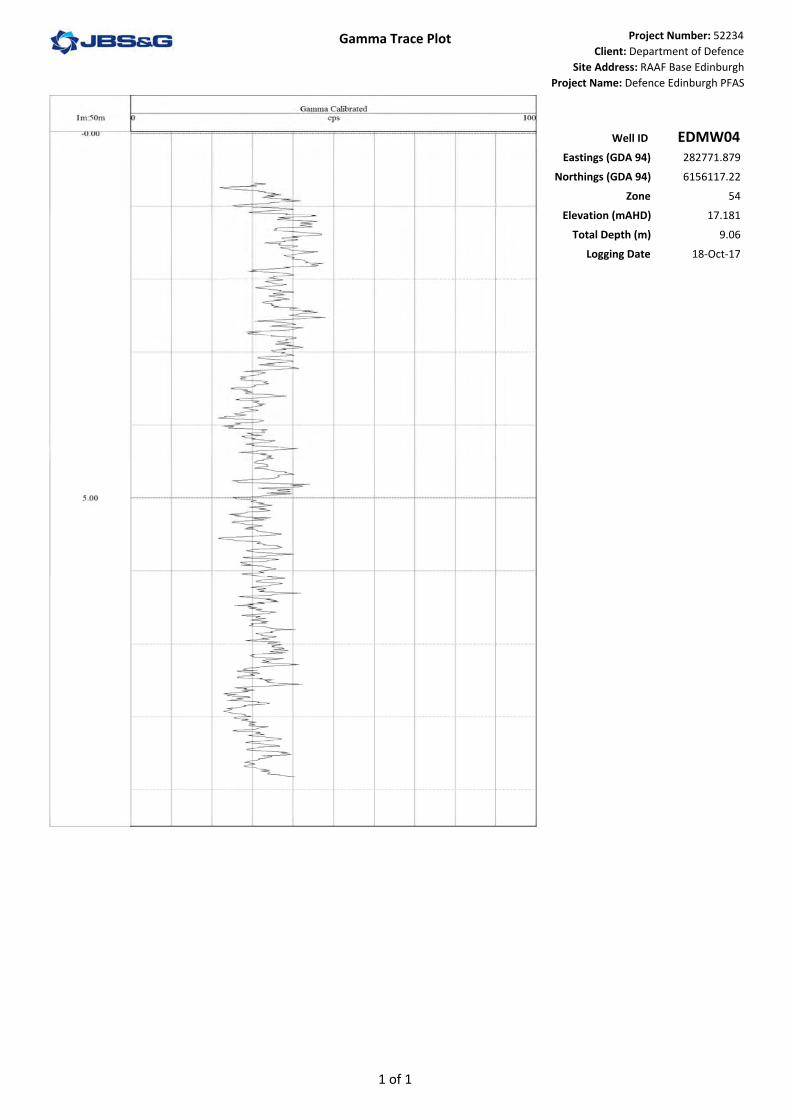
Gamma Trace Plot Project Number: 52234Client: Department of Defence
Site Address: RAAF Base EdinburghProject Name: Defence Edinburgh PFAS
Well ID EDMW04Eastings (GDA 94) 282771.879
Northings (GDA 94) 6156117.22Zone 54
Elevation (mAHD) 17.181Total Depth (m) 9.06
Logging Date 18‐Oct‐17
1 of 1

Gamma Trace Plot Project Number: 52234Client: Department of Defence
Site Address: RAAF Base EdinburghProject Name: Defence Edinburgh PFAS
Well ID GW0008Eastings (GDA 94) 282826.507
Northings (GDA 94) 6157777.781Zone 54
Elevation (mAHD) 20.062Total Depth (m) 11.01
Logging Date 10‐Oct‐17
1 of 1

Gamma Trace Plot Project Number: 52234
Client: Department of Defence
Site Address: RAAF Base Edinburgh
Project Name: Defence Edinburgh PFAS
Well ID GW0027Eastings (GDA 94) 283424.93
Northings (GDA 94) 6157227.056
Zone 54
Elevation (mAHD) 19.26
Total Depth (m) 5.8
Logging Date 16-Oct-17
4.2
Top hole reading from sand pack in the standpipe
0.2
1 of 1

Gamma Trace Plot Project Number: 52234Client: Department of Defence
Site Address: RAAF Base EdinburghProject Name: Defence Edinburgh PFAS
Well ID GW0192Eastings (GDA 94) 282780.404
Northings (GDA 94) 6157762.164Zone 54
Elevation (mAHD) 19.577Total Depth (m) 10.832
Logging Date 10‐Oct‐17
1 of 1

Gamma Trace Plot Project Number: 52234
Client: Department of Defence
Site Address: RAAF Base Edinburgh
Project Name: Defence Edinburgh PFAS
Well ID GW0193Eastings (GDA 94) 282783.462
Northings (GDA 94) 6157813.591
Zone 54
Elevation (mAHD) 19.725
Total Depth (m) 10.6
Logging Date 10-Oct-17
9.2
4.2
0.2
Top hole reading from sandpack in the standpipe
1 of 1

Gamma Trace Plot Project Number: 52234Client: Department of Defence
Site Address: RAAF Base EdinburghProject Name: Defence Edinburgh PFAS
Well ID GW0197Eastings (GDA 94) 282881.486
Northings (GDA 94) 6157804.67Zone 54
Elevation (mAHD) 19.614Total Depth (m) 9.5
Logging Date 19‐Oct‐17
1 of 1

Gamma Trace Plot Project Number: 52234Client: Department of Defence
Site Address: RAAF Base EdinburghProject Name: Defence Edinburgh PFAS
Well ID GW0302Eastings (GDA 94) 282715.218
Northings (GDA 94) 6157679.882Zone 54
Elevation (mAHD) 18.61Total Depth (m) 11.97
Logging Date 10‐Oct‐17
1 of 1

Gamma Trace Plot Project Number: 52234
Client: Department of Defence
Site Address: RAAF Base Edinburgh
Project Name: Defence Edinburgh PFAS
Well ID GW0304Eastings (GDA 94) 282683.104
Northings (GDA 94) 6157657.915
Zone 54
Elevation (mAHD) 18.693
Total Depth (m) 12.06
Logging Date 10-Oct-17
1 of 1
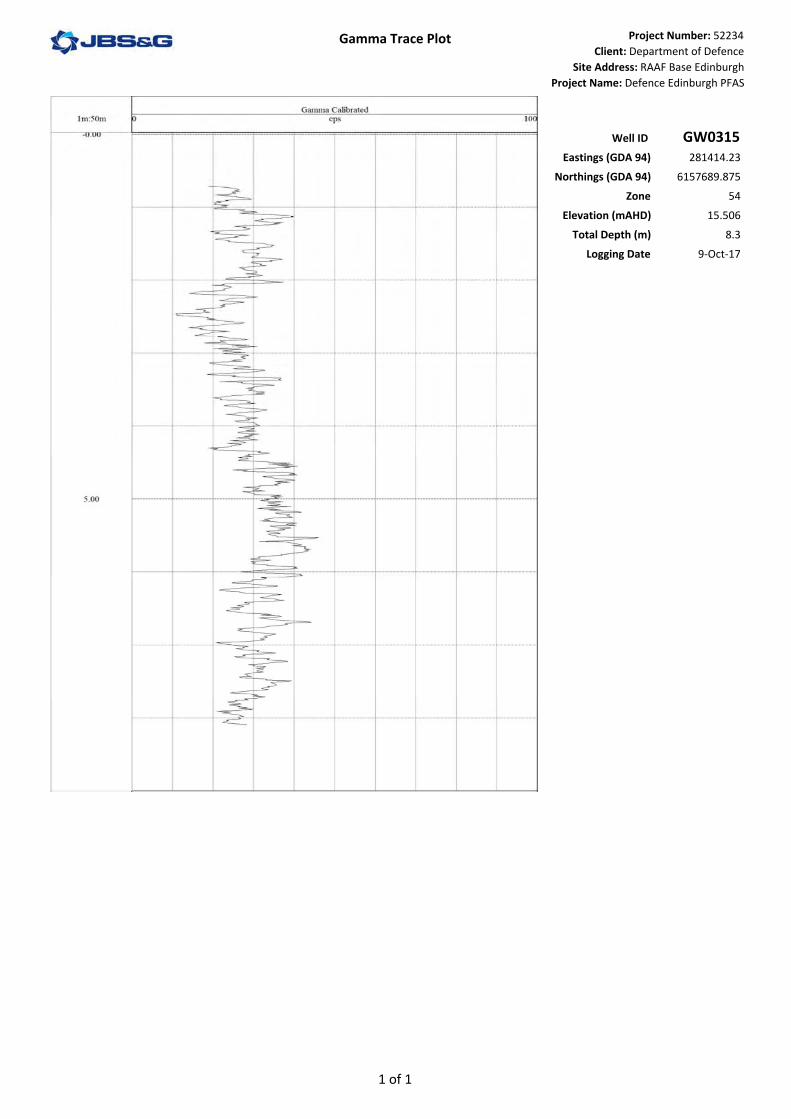
Gamma Trace Plot Project Number: 52234Client: Department of Defence
Site Address: RAAF Base EdinburghProject Name: Defence Edinburgh PFAS
Well ID GW0315Eastings (GDA 94) 281414.23
Northings (GDA 94) 6157689.875Zone 54
Elevation (mAHD) 15.506Total Depth (m) 8.3
Logging Date 9‐Oct‐17
1 of 1
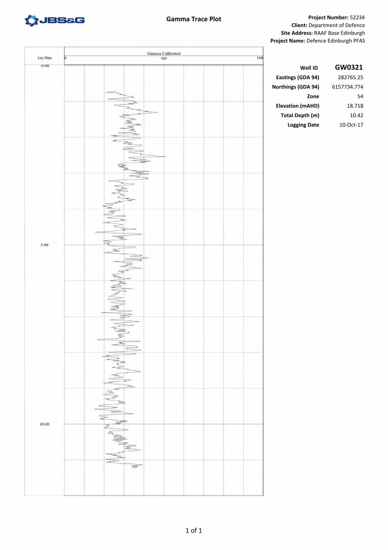
Gamma Trace Plot Project Number: 52234Client: Department of Defence
Site Address: RAAF Base EdinburghProject Name: Defence Edinburgh PFAS
Well ID GW0321Eastings (GDA 94) 282765.25
Northings (GDA 94) 6157734.774Zone 54
Elevation (mAHD) 18.718Total Depth (m) 10.42
Logging Date 10‐Oct‐17
1 of 1
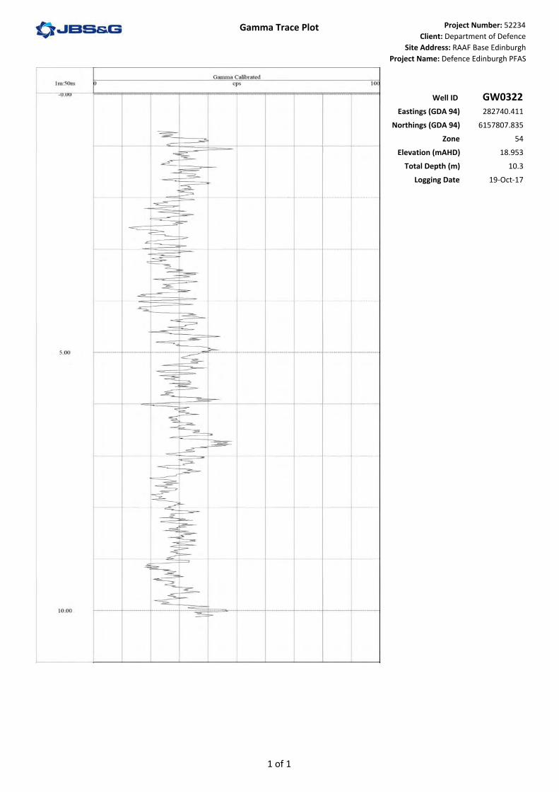
Gamma Trace Plot Project Number: 52234Client: Department of Defence
Site Address: RAAF Base EdinburghProject Name: Defence Edinburgh PFAS
Well ID GW0322Eastings (GDA 94) 282740.411
Northings (GDA 94) 6157807.835Zone 54
Elevation (mAHD) 18.953Total Depth (m) 10.3
Logging Date 19‐Oct‐17
1 of 1

Gamma Trace Plot Project Number: 52234Client: Department of Defence
Site Address: RAAF Base EdinburghProject Name: Defence Edinburgh PFAS
Well ID GW0330Eastings (GDA 94) 281994.955
Northings (GDA 94) 6157401.56Zone 54
Elevation (mAHD) 16.923Total Depth (m) 11.09
Logging Date 9‐Oct‐17
1 of 1

Gamma Trace Plot Project Number: 52234Client: Department of Defence
Site Address: RAAF Base EdinburghProject Name: Defence Edinburgh PFAS
Well ID GW0340Eastings (GDA 94) 284435.398
Northings (GDA 94) 6156091.226Zone 54
Elevation (mAHD) 20.245Total Depth (m) 15.34
Logging Date 11‐Oct‐17
1 of 2

Gamma Trace Plot Project Number: 52234Client: Department of Defence
Site Address: RAAF Base EdinburghProject Name: Defence Edinburgh PFAS
Well ID GW0340Eastings (GDA 94) 284435.398
Northings (GDA 94) 6156091.226Zone 54
Elevation (mAHD) 20.245Total Depth (m) 15.34
Logging Date 11‐Oct‐17
2 of 2

Gamma Trace Plot Project Number: 52234Client: Department of Defence
Site Address: RAAF Base EdinburghProject Name: Defence Edinburgh PFAS
Well ID GW0342Eastings (GDA 94) 284593.738
Northings (GDA 94) 6156484.845Zone 54
Elevation (mAHD) 19.544Total Depth (m) 8.83
Logging Date 16‐Oct‐17
1 of 1

Gamma Trace Plot Project Number: 52234Client: Department of Defence
Site Address: RAAF Base EdinburghProject Name: Defence Edinburgh PFAS
Well ID GW0359Eastings (GDA 94) 284065.413
Northings (GDA 94) 6156147.908Zone 54
Elevation (mAHD) 19.436Total Depth (m) 9.53
Logging Date 11‐Oct‐17
1 of 1

Gamma Trace Plot Project Number: 52234Client: Department of Defence
Site Address: RAAF Base EdinburghProject Name: Defence Edinburgh PFAS
Well ID GW0368Eastings (GDA 94) 283047.4758
Northings (GDA 94) 6155978.244Zone 54
Elevation (mAHD) NATotal Depth (m) 11.485
Logging Date 12‐Oct‐17
1 of 1

Gamma Trace Plot Project Number: 52234Client: Department of Defence
Site Address: RAAF Base EdinburghProject Name: Defence Edinburgh PFAS
Well ID GW0369Eastings (GDA 94) 283035.864
Northings (GDA 94) 6155946.068Zone 54
Elevation (mAHD) 17.706Total Depth (m) 10.8
Logging Date 11‐Oct‐17
1 of 1

Gamma Trace Plot Project Number: 52234Client: Department of Defence
Site Address: RAAF Base EdinburghProject Name: Defence Edinburgh PFAS
Well ID GW0430Eastings (GDA 94) 281238.737
Northings (GDA 94) 6155690.356Zone 54
Elevation (mAHD) 14.352Total Depth (m) 8.6
Logging Date 19‐Oct‐17
1 of 1

Gamma Trace Plot Project Number: 52234
Client: Department of Defence
Site Address: RAAF Base Edinburgh
Project Name: Defence Edinburgh PFAS
Well ID GW0431Eastings (GDA 94) 282222.8412
Northings (GDA 94) 6154694.306
Zone 54
Elevation (mAHD) 0
Total Depth (m) 10
Logging Date 12-Oct-17
0.2
4.2
9.2
Top hole reading from sandpack in the standpipe
1 of 1
Gamma Trace Plot Project Number: 52234Client: Department of Defence
Site Address: RAAF Base EdinburghProject Name: Defence Edinburgh PFAS
Well ID GW2100Eastings (GDA 94) 280376.01
Northings (GDA 94) 6153457.65Zone 54
Elevation (mAHD) 10.703Total Depth (m) 8.4
Logging Date 18‐Oct‐17
1 of 1

Gamma Trace Plot Project Number: 52234Client: Department of Defence
Site Address: RAAF Base EdinburghProject Name: Defence Edinburgh PFAS
Well ID GW2101Eastings (GDA 94) 281051.12
Northings (GDA 94) 6153645.1Zone 54
Elevation (mAHD) 12.909Total Depth (m) 9.5
Logging Date 18‐Oct‐17
1 of 1

Gamma Trace Plot Project Number: 52234Client: Department of Defence
Site Address: RAAF Base EdinburghProject Name: Defence Edinburgh PFAS
Well ID GW2102Eastings (GDA 94) 281420.71
Northings (GDA 94) 6154104.68Zone 54
Elevation (mAHD) 13.025Total Depth (m) 9.5
Logging Date 17‐Oct‐17
1 of 1

Gamma Trace Plot Project Number: 52234Client: Department of Defence
Site Address: RAAF Base EdinburghProject Name: Defence Edinburgh PFAS
Well ID GW2104Eastings (GDA 94) 281874.86
Northings (GDA 94) 6154481.06Zone 54
Elevation (mAHD) 14.175Total Depth (m) 7.6
Logging Date 17‐Oct‐17
1 of 1
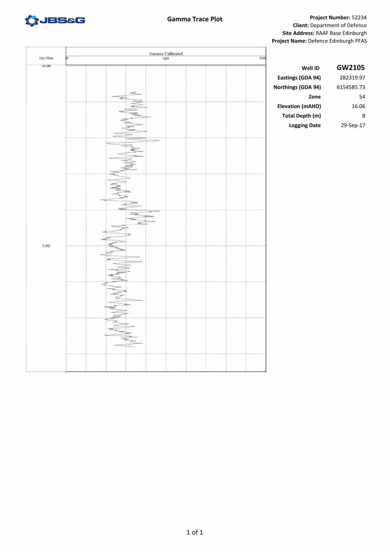
Gamma Trace Plot Project Number: 52234Client: Department of Defence
Site Address: RAAF Base EdinburghProject Name: Defence Edinburgh PFAS
Well ID GW2105Eastings (GDA 94) 282319.97
Northings (GDA 94) 6154585.73Zone 54
Elevation (mAHD) 16.06Total Depth (m) 8
Logging Date 29‐Sep‐17
1 of 1
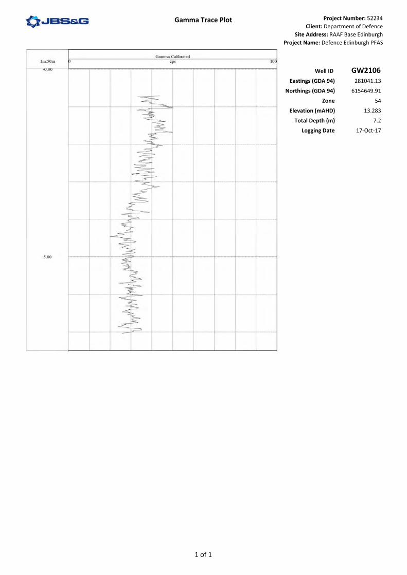
Gamma Trace Plot Project Number: 52234Client: Department of Defence
Site Address: RAAF Base EdinburghProject Name: Defence Edinburgh PFAS
Well ID GW2106Eastings (GDA 94) 281041.13
Northings (GDA 94) 6154649.91Zone 54
Elevation (mAHD) 13.283Total Depth (m) 7.2
Logging Date 17‐Oct‐17
1 of 1
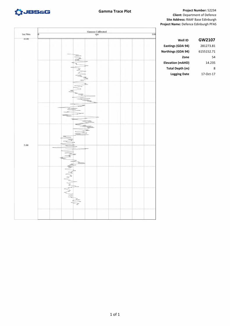
Gamma Trace Plot Project Number: 52234Client: Department of Defence
Site Address: RAAF Base EdinburghProject Name: Defence Edinburgh PFAS
Well ID GW2107Eastings (GDA 94) 281273.81
Northings (GDA 94) 6155152.71Zone 54
Elevation (mAHD) 14.235Total Depth (m) 8
Logging Date 17‐Oct‐17
1 of 1

Gamma Trace Plot Project Number: 52234
Client: Department of Defence
Site Address: RAAF Base Edinburgh
Project Name: Defence Edinburgh PFAS
Well ID GW2108Eastings (GDA 94) 281515.15
Northings (GDA 94) 6155302.91
Zone 54
Elevation (mAHD) 15.579
Total Depth (m) 7.5
Logging Date 5-Oct-17
3.95
0.95
Top hole reading from sand pack in the standpipe
1 of 1

Gamma Trace Plot Project Number: 52234
Client: Department of Defence
Site Address: RAAF Base Edinburgh
Project Name: Defence Edinburgh PFAS
Well ID GW2110Eastings (GDA 94) 280754.66
Northings (GDA 94) 6156265.16
Zone 54
Elevation (mAHD) 13.951
Total Depth (m) 6
Logging Date 6/Oct/17
4.05
0.05
Top hole readings due to the sand pack in the standpipe
1 of 1

Gamma Trace Plot Project Number: 52234Client: Department of Defence
Site Address: RAAF Base EdinburghProject Name: Defence Edinburgh PFAS
Well ID GW2111Eastings (GDA 94) 280467.3
Northings (GDA 94) 6156119.96Zone 54
Elevation (mAHD) 12.435Total Depth (m) 7.2
Logging Date 3‐Oct‐17
1 of 1

Gamma Trace Plot Project Number: 52234
Client: Department of Defence
Site Address: RAAF Base Edinburgh
Project Name: Defence Edinburgh PFAS
Well ID GW2112Eastings (GDA 94) 281748.991
Northings (GDA 94) 6155513.534
Zone 54
Elevation (mAHD) NA
Total Depth (m) 7.5
Logging Date 18-Oct-17
4.1
0.1
Top hole reading from sand pack in the standpipe
1 of 1

Gamma Trace Plot Project Number: 52234
Client: Department of Defence
Site Address: RAAF Base Edinburgh
Project Name: Defence Edinburgh PFAS
Well ID GW2114Eastings (GDA 94) 282634.7273
Northings (GDA 94) 6156088.85
Zone 54
Elevation (mAHD) NA
Total Depth (m) 8
Logging Date 4-Oct-17
4.0
0.0
1 of 1

Gamma Trace Plot Project Number: 52234Client: Department of Defence
Site Address: RAAF Base EdinburghProject Name: Defence Edinburgh PFAS
Well ID GW2115Eastings (GDA 94) 282983.978
Northings (GDA 94) 6156180.528Zone 54
Elevation (mAHD) NATotal Depth (m) 9
Logging Date 4‐Oct‐17
1 of 1

Gamma Trace Plot Project Number: 52234Client: Department of Defence
Site Address: RAAF Base EdinburghProject Name: Defence Edinburgh PFAS
Well ID GW2116Eastings (GDA 94) 282480.1442
Northings (GDA 94) 6156429.237Zone 54
Elevation (mAHD) NATotal Depth (m) 9
Logging Date 13‐Oct‐17
1 of 1

Gamma Trace Plot Project Number: 52234Client: Department of Defence
Site Address: RAAF Base EdinburghProject Name: Defence Edinburgh PFAS
Well ID GW2117Eastings (GDA 94) 282235.6026
Northings (GDA 94) 6156767.11Zone 54
Elevation (mAHD) NATotal Depth (m) 7
Logging Date 9‐Oct‐17
1 of 1

Gamma Trace Plot Project Number: 52234
Client: Department of Defence
Site Address: RAAF Base Edinburgh
Project Name: Defence Edinburgh PFAS
Well ID GW2118Eastings (GDA 94) 282065.0783
Northings (GDA 94) 6156968.062
Zone 54
Elevation (mAHD) NA
Total Depth (m) 8
Logging Date 9-Oct-17
3.9
0.9
Top hole reading from sand pack in the standpipe
1 of 1

Gamma Trace Plot Project Number: 52234
Client: Department of Defence
Site Address: RAAF Base Edinburgh
Project Name: Defence Edinburgh PFAS
Well ID GW2119Eastings (GDA 94) 282678.9128
Northings (GDA 94) 6156779.215
Zone 54
Elevation (mAHD) NA
Total Depth (m) 7
Logging Date 18-Oct-17
4.05
0.05
Top hole reading from sand pack in the standpipe
1 of 1
Gamma Trace Plot Project Number: 52234
Client: Department of Defence
Site Address: RAAF Base Edinburgh
Project Name: Defence Edinburgh PFAS
Well ID GW2120Eastings (GDA 94) 282541.6599
Northings (GDA 94) 6156910.184
Zone 54
Elevation (mAHD) NA
Total Depth (m) 5.5
Logging Date 5-Oct-17
4.05
0.05
Top hole readings due to the sand pack in the standpipe
1 of 1

Gamma Trace Plot Project Number: 52234
Client: Department of Defence
Site Address: RAAF Base Edinburgh
Project Name: Defence Edinburgh PFAS
Well ID GW2121Eastings (GDA 94) 281227.91
Northings (GDA 94) 6157610.12
Zone 54
Elevation (mAHD) 15.617
Total Depth (m) 6.5
Logging Date 6-Oct-17
4.0
0.0
Top hole readings from the sand pack in the standpipe
1 of 1

Gamma Trace Plot Project Number: 52234
Client: Department of Defence
Site Address: RAAF Base Edinburgh
Project Name: Defence Edinburgh PFAS
Well ID GW2122Eastings (GDA 94) 281167.53
Northings (GDA 94) 6157482.79
Zone 54
Elevation (mAHD) 15.618
Total Depth (m) 6.7
Logging Date 19-Oct-17
4.0
0.0
Top hole reading due to the sand pack in the standpipe
1 of 1

Gamma Trace Plot Project Number: 52234
Client: Department of Defence
Site Address: RAAF Base Edinburgh
Project Name: Defence Edinburgh PFAS
Well ID GW2124Eastings (GDA 94) 283496.4769
Northings (GDA 94) 6157108.821
Zone 54
Elevation (mAHD) NA
Total Depth (m) 7.5
Logging Date 16-Oct-17
3.95
0.95
Top hole readings due to the sand pack in the standpipe
1 of 1

Gamma Trace Plot Project Number: 52234Client: Department of Defence
Site Address: RAAF Base EdinburghProject Name: Defence Edinburgh PFAS
Well ID GW2126Eastings (GDA 94) 282821.8657
Northings (GDA 94) 6157773.307Zone 54
Elevation (mAHD) NATotal Depth (m) 17.28
Logging Date 13‐Oct‐17
1 of 2

Gamma Trace Plot Project Number: 52234Client: Department of Defence
Site Address: RAAF Base EdinburghProject Name: Defence Edinburgh PFAS
Well ID GW2126Eastings (GDA 94) 282821.8657
Northings (GDA 94) 6157773.307Zone 54
Elevation (mAHD) NATotal Depth (m) 17.28
Logging Date 13‐Oct‐17
2 of 2

Gamma Trace Plot Project Number: 52234Client: Department of Defence
Site Address: RAAF Base EdinburghProject Name: Defence Edinburgh PFAS
Well ID GW2127Eastings (GDA 94) 282899.61
Northings (GDA 94) 6159197.28Zone 54
Elevation (mAHD) 22.097Total Depth (m) 13.5
Logging Date 17‐Oct‐17
1 of 1

Gamma Trace Plot Project Number: 52234
Client: Department of Defence
Site Address: RAAF Base Edinburgh
Project Name: Defence Edinburgh PFAS
Well ID GW2129Eastings (GDA 94) 281293.3
Northings (GDA 94) 6157743.13
Zone 54
Elevation (mAHD) 15.881
Total Depth (m) 5.5
Logging Date 6-Oct-17
4.0
0.0
Top hole readings due to the sand pack in the standpipe
1 of 1

Gamma Trace Plot Project Number: 52234
Client: Department of Defence
Site Address: RAAF Base Edinburgh
Project Name: Defence Edinburgh PFAS
Well ID GW2131Eastings (GDA 94) 282927.1255
Northings (GDA 94) 6156050.915
Zone 54
Elevation (mAHD) NA
Total Depth (m) 7.5
Logging Date 4-Oct-17
4.0
0.0
1 of 1

Gamma Trace Plot Project Number: 52234
Client: Department of Defence
Site Address: RAAF Base Edinburgh
Project Name: Defence Edinburgh PFAS
Well ID GW2132Eastings (GDA 94) 282723.5282
Northings (GDA 94) 6156110.049
Zone 54
Elevation (mAHD) NA
Total Depth (m) 8
Logging Date 4-Oct-17
4.0
0.0
Top hole readings due to the sand pack in the standpipe
1 of 1

Gamma Trace Plot Project Number: 52234
Client: Department of Defence
Site Address: RAAF Base Edinburgh
Project Name: Defence Edinburgh PFAS
Well ID GW2133Eastings (GDA 94) 283367.7568
Northings (GDA 94) 6155913.851
Zone 54
Elevation (mAHD) NA
Total Depth (m) 9
Logging Date 11-Oct-17
4.0
0.0
Top hole readings due to the sand pack in the standpipe
9.0
1 of 1

Gamma Trace Plot Project Number: 52234
Client: Department of Defence
Site Address: RAAF Base Edinburgh
Project Name: Defence Edinburgh PFAS
Well ID GW2135Eastings (GDA 94) 284305.0716
Northings (GDA 94) 6156865.295
Zone 54
Elevation (mAHD) NA
Total Depth (m) 10
Logging Date 16-Oct-17
4.0
0.0
9.0
Top hole readings due to sand pack in the standpipe
1 of 1

Gamma Trace Plot Project Number: 52234Client: Department of Defence
Site Address: RAAF Base EdinburghProject Name: Defence Edinburgh PFAS
Well ID GW2136Eastings (GDA 94) 281381.86
Northings (GDA 94) 6155386.53Zone 54
Elevation (mAHD) 14.442Total Depth (m) 8
Logging Date 29‐Sep‐17
1 of 1

Gamma Trace Plot Project Number: 52234
Client: Department of Defence
Site Address: RAAF Base Edinburgh
Project Name: Defence Edinburgh PFAS
Well ID GW2137Eastings (GDA 94) 281577.14
Northings (GDA 94) 6155206.08
Zone 54
Elevation (mAHD) 15.791
Total Depth (m) 7.5
Logging Date 18-Oct-17
4.1
0.1
Top hole readings due to the sand pack in the standpipe
1 of 1

Gamma Trace Plot Project Number: 52234
Client: Department of Defence
Site Address: RAAF Base Edinburgh
Project Name: Defence Edinburgh PFAS
Well ID GW2138Eastings (GDA 94) 281437.05
Northings (GDA 94) 6155405.71
Zone 54
Elevation (mAHD) 14.771
Total Depth (m) 5.5
Logging Date 6-Oct-17
4.05
0.05
Top hole readings due to the sand pack in the standpipe
1 of 1

Gamma Trace Plot Project Number: 52234
Client: Department of Defence
Site Address: RAAF Base Edinburgh
Project Name: Defence Edinburgh PFAS
Well ID GW2139Eastings (GDA 94) 281632.57
Northings (GDA 94) 6158438.41
Zone 54
Elevation (mAHD) 18.653
Total Depth (m) 10.5
Logging Date 9-Oct-17
4.0
0.0
9.0
Top hole readings due to the sand pack in the standpipe
1 of 1
Gamma Trace Plot Project Number: 52234Client: Department of Defence
Site Address: RAAF Base EdinburghProject Name: Defence Edinburgh PFAS
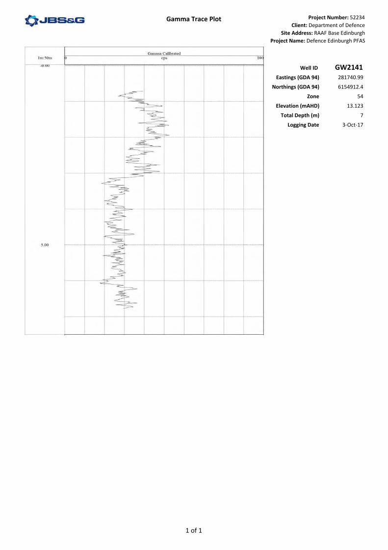
Well ID GW2141Eastings (GDA 94) 281740.99
Northings (GDA 94) 6154912.4Zone 54
Elevation (mAHD) 13.123Total Depth (m) 7
Logging Date 3‐Oct‐17
1 of 1
Gamma Trace Plot Project Number: 52234Client: Department of Defence
Site Address: RAAF Base EdinburghProject Name: Defence Edinburgh PFAS
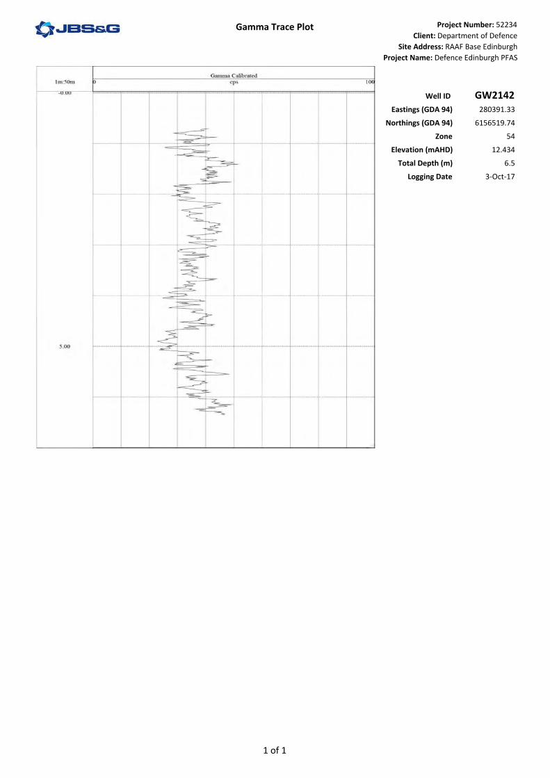
Well ID GW2142Eastings (GDA 94) 280391.33
Northings (GDA 94) 6156519.74Zone 54
Elevation (mAHD) 12.434Total Depth (m) 6.5
Logging Date 3‐Oct‐17
1 of 1
Gamma Trace Plot Project Number: 52234Client: Department of Defence
Site Address: RAAF Base EdinburghProject Name: Defence Edinburgh PFAS
Well ID GW2143Eastings (GDA 94) 281393.67
Northings (GDA 94) 6154742.55Zone 54
Elevation (mAHD) 13.627Total Depth (m) 7
Logging Date 3‐Oct‐17
1 of 1

Gamma Trace Plot Project Number: 52234
Client: Department of Defence
Site Address: RAAF Base Edinburgh
Project Name: Defence Edinburgh PFAS
Well ID GW2144Eastings (GDA 94) 281496.5038
Northings (GDA 94) 6155327.403
Zone 54
Elevation (mAHD) NA
Total Depth (m) 16
Logging Date 6-Oct-17
8.95
3.95
0.95
Top hole reading due to the sand pack in the standpipe
1 of 2

Gamma Trace Plot Project Number: 52234
Client: Department of Defence
Site Address: RAAF Base Edinburgh
Project Name: Defence Edinburgh PFAS
Well ID GW2144Eastings (GDA 94) 281496.5038
Northings (GDA 94) 6155327.403
Zone 54
Elevation (mAHD) NA
Total Depth (m) 16
Logging Date 6-Oct-17
13.95
2 of 2

Gamma Trace Plot Project Number: 52234
Client: Department of Defence
Site Address: RAAF Base Edinburgh
Project Name: Defence Edinburgh PFAS
Well ID GW2146Eastings (GDA 94) 282215.0134
Northings (GDA 94) 6154699.343
Zone 54
Elevation (mAHD) NA
Total Depth (m) 18.5
Logging Date 3-Oct-17
3.9
0.9
8.9
Top hole readings due to the sand pack in the standpipe
1 of 2

Gamma Trace Plot Project Number: 52234
Client: Department of Defence
Site Address: RAAF Base Edinburgh
Project Name: Defence Edinburgh PFAS
Well ID GW2146Eastings (GDA 94) 282215.0134
Northings (GDA 94) 6154699.343
Zone 54
Elevation (mAHD) NA
Total Depth (m) 18.5
Logging Date 3-Oct-17
13.9
18.9
2 of 2

Gamma Trace Plot Project Number: 52234Client: Department of Defence
Site Address: RAAF Base EdinburghProject Name: Defence Edinburgh PFAS
Well ID GW2147Eastings (GDA 94) 285389.86
Northings (GDA 94) 6156626.77Zone 54
Elevation (mAHD) 22.178Total Depth (m) 7.5
Logging Date 3‐Oct‐17
1 of 1

Gamma Trace Plot Project Number: 52234
Client: Department of Defence
Site Address: RAAF Base Edinburgh
Project Name: Defence Edinburgh PFAS
Well ID GW2148Eastings (GDA 94) 282014.1926
Northings (GDA 94) 6155827.331
Zone 54
Elevation (mAHD) NA
Total Depth (m) 9.5
Logging Date 5-Oct-17
4.0
0.0
9.0
Top hole readings due to the sandpack in the standpipe
1 of 1

Gamma Trace Plot Project Number: 52234
Client: Department of Defence
Site Address: RAAF Base Edinburgh
Project Name: Defence Edinburgh PFAS
Well ID GW2149Eastings (GDA 94) 281925.5916
Northings (GDA 94) 6155729.81
Zone 54
Elevation (mAHD) NA
Total Depth (m) 6.5
Logging Date 5-Oct-17
4.05
0.05
Top hole readings from the sand pack in the standpipe
1 of 1
Gamma Trace Plot Project Number: 52234Client: Department of Defence
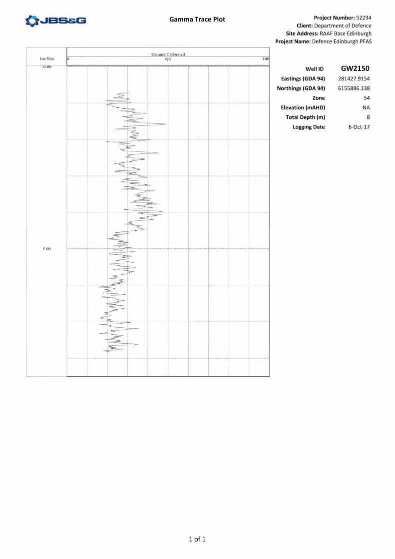
Site Address: RAAF Base EdinburghProject Name: Defence Edinburgh PFAS
Well ID GW2150Eastings (GDA 94) 281427.9154
Northings (GDA 94) 6155886.138Zone 54
Elevation (mAHD) NATotal Depth (m) 8
Logging Date 6‐Oct‐17
1 of 1
Gamma Trace Plot Project Number: 52234Client: Department of Defence
Site Address: RAAF Base EdinburghProject Name: Defence Edinburgh PFAS
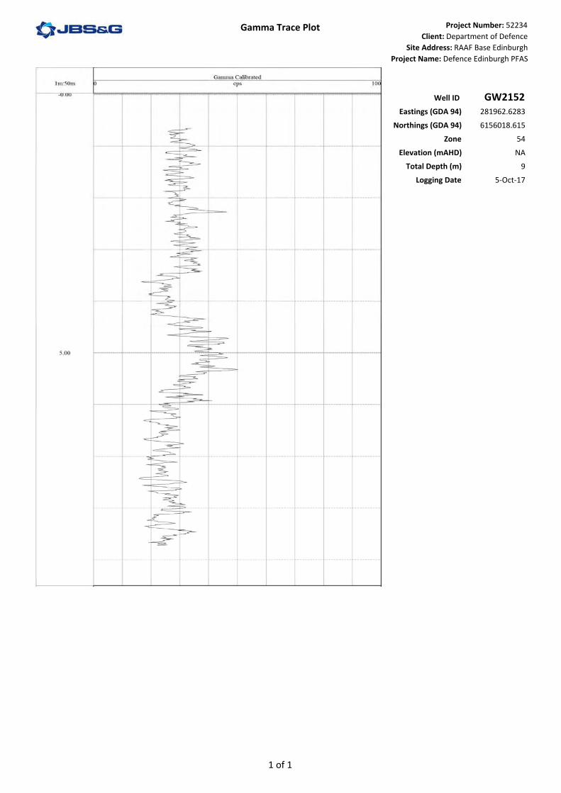
Well ID GW2152Eastings (GDA 94) 281962.6283
Northings (GDA 94) 6156018.615Zone 54
Elevation (mAHD) NATotal Depth (m) 9
Logging Date 5‐Oct‐17
1 of 1

Gamma Trace Plot Project Number: 52234
Client: Department of Defence
Site Address: RAAF Base Edinburgh
Project Name: Defence Edinburgh PFAS
Well ID GW2153Eastings (GDA 94) 283639.0197
Northings (GDA 94) 6157614.566
Zone 54
Elevation (mAHD) NA
Total Depth (m) 9.5
Logging Date 16-Oct-17
4.0
9.0
Top hole readings due to the sand in the standpipe
1 of 1

Gamma Trace Plot Project Number: 52234Client: Department of Defence
Site Address: RAAF Base EdinburghProject Name: Defence Edinburgh PFAS
Well ID GW2154Eastings (GDA 94) 281834.0096
Northings (GDA 94) 6157259.114Zone 54
Elevation (mAHD) NATotal Depth (m) 7
Logging Date 9‐Oct‐17
1 of 1
Gamma Trace Plot Project Number: 52234Client: Department of Defence
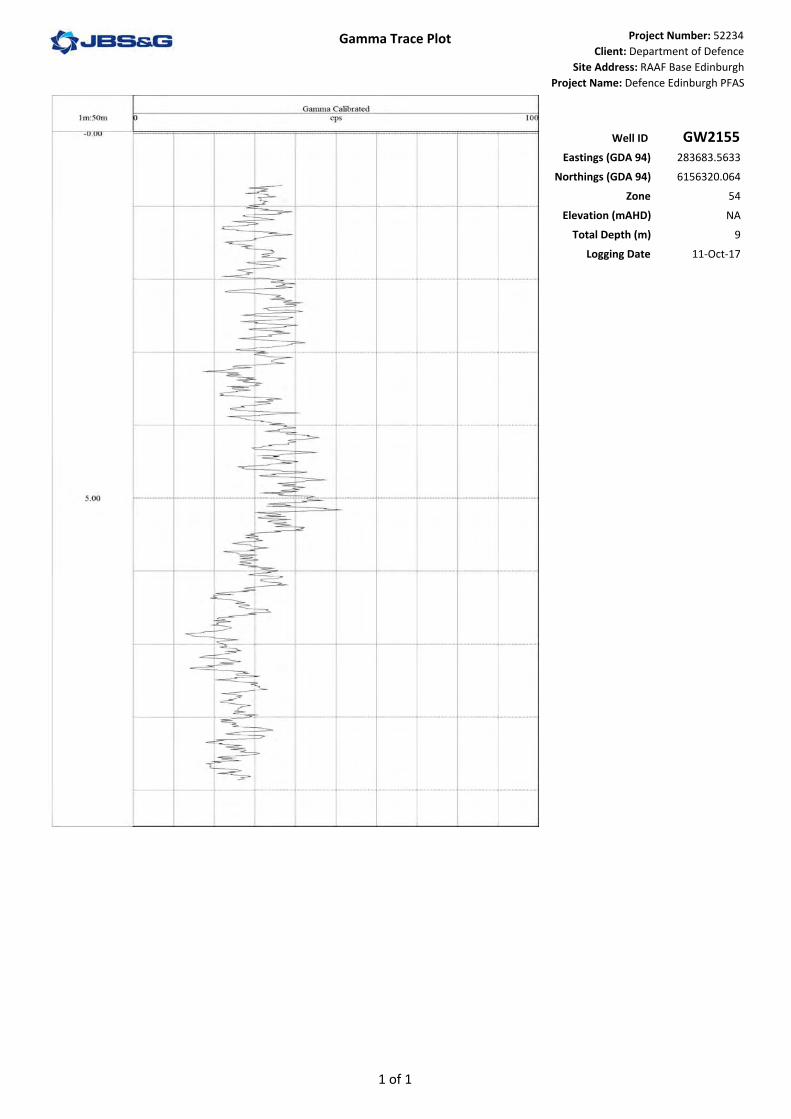
Site Address: RAAF Base EdinburghProject Name: Defence Edinburgh PFAS
Well ID GW2155Eastings (GDA 94) 283683.5633
Northings (GDA 94) 6156320.064Zone 54
Elevation (mAHD) NATotal Depth (m) 9
Logging Date 11‐Oct‐17
1 of 1

Gamma Trace Plot Project Number: 52234Client: Department of Defence
Site Address: RAAF Base EdinburghProject Name: Defence Edinburgh PFAS
Well ID GW2156Eastings (GDA 94) 284174.9722
Northings (GDA 94) 6156142.825Zone 54
Elevation (mAHD) NATotal Depth (m) 9
Logging Date 11‐Oct‐17
1 of 1

Gamma Trace Plot Project Number: 52234
Client: Department of Defence
Site Address: RAAF Base Edinburgh
Project Name: Defence Edinburgh PFAS
Well ID GW2157Eastings (GDA 94) 282714.5542
Northings (GDA 94) 6156121.941
Zone 54
Elevation (mAHD) NA
Total Depth (m) 17.5
Logging Date 4-Oct-17
4.1
0.1
9.1
1 of 2

Gamma Trace Plot Project Number: 52234
Client: Department of Defence
Site Address: RAAF Base Edinburgh
Project Name: Defence Edinburgh PFAS
Well ID GW2157Eastings (GDA 94) 282714.5542
Northings (GDA 94) 6156121.941
Zone 54
Elevation (mAHD) NA
Total Depth (m) 17.5
Logging Date 4-Oct-17
14.1
2 of 2

Gamma Trace Plot Project Number: 52234
Client: Department of Defence
Site Address: RAAF Base Edinburgh
Project Name: Defence Edinburgh PFAS
Well ID GW2158Eastings (GDA 94) 282015.8721
Northings (GDA 94) 6155827.232
Zone 54
Elevation (mAHD) NA
Total Depth (m) 17
Logging Date 5-Oct-17
4.0
0.0
9.0
Top hole readings due to the sand pack in the standpipe
1 of 2

Gamma Trace Plot Project Number: 52234
Client: Department of Defence
Site Address: RAAF Base Edinburgh
Project Name: Defence Edinburgh PFAS
Well ID GW2158Eastings (GDA 94) 282015.8721
Northings (GDA 94) 6155827.232
Zone 54
Elevation (mAHD) NA
Total Depth (m) 17
Logging Date 5-Oct-17
14.0
2 of 2
Related Documents