Appendix K: Pedestrian Wind Assessment

Welcome message from author
This document is posted to help you gain knowledge. Please leave a comment to let me know what you think about it! Share it to your friends and learn new things together.
Transcript

Appendix K: Pedestrian Wind Assessment

SUBMITTED TO: Nancy DoonAKRF, Inc.
James BrownHDR
SUBMITTED BY: Rowan Williams Davies & Irwin Inc.Consulting Engineers & Scientists650 Woodlawn Road WestGuelph, Ontario N1K 1B8
P: (519) 823-1311F: (519) 823-1316
Technical Coordinator: Rachel ThomsonProject Engineer: Anthony Akomah, M.E.Sc., P.Eng.Senior Specialist: Hanqing Wu, Ph.D., P.Eng.Project Manager: Analene Belanger, P.Eng.,PMPProject Director: Bill Waechter, C.E.T.
REPORT
PEDESTRIAN WIND ASSESSMENTWESTERN RAIL YARD DEVELOPMENTNEW YORK, NEW YORK
Project Number: #0940081 May 12, 2009

Pedestrian Wind AssessmentWestern Rail Yard – May 12, 2009Project #0940081
Page 1 of 21
EXECUTIVE SUMMARY
Issue: The objective of this assessment was to evaluate the anticipated pedestrian windconditions, specifically wind safety, on and around the study site of the proposed Western RailYard development.
Approach: A qualitative assessment of the pedestrian wind conditions was conducted by RWDIusing the proposed building massing and computer-based wind simulation techniques combinedwith the regional wind climate. A review of wind data, quantitative wind tunnel test results forother developments studied by RWDI, and our extensive experience were used to characterizethe predicted wind conditions relative to other locations in Manhattan.
Existing Conditions: The existing low-rise buildings on the Western Rail Yard site do notsignificantly influence the wind patterns on the site, resulting in a low potential for exceeding thewind safety criterion.
No-Build Configuration: The addition of the future development east of 11th Avenue and otherfuture buildings will have minimal effect on the wind patterns on the Western Rail Yard site forthe prevailing wind directions, resulting in a low potential for the wind safety criterion beingexceeded on the site.
Full-Build Configuration: An increase in wind activity on the Western Rail Yard site willoccur with the addition of the proposed Western Rail Yard development, resulting in a potentialfor exceeding the wind safety criterion for several on-site areas. This potential ranges from lowto high, depending on the nature of the local wind flows. These areas are described in detail inSection 5 of this report. Overall, the wind safety conditions are comparable to, and within therange of other similar developments along West Manhattan due to the same exposure to theprevailing northwest winds. The proposed development’s slender building masses with openspaces towards the site’s west edge are positive design concepts for wind effects at grade.
Mitigation: Mitigation has been recommended and is described as concepts that range frombuilding massing changes to the provision of hard and soft landscaping features. The potentiallevel of exceeding the wind safety criterion dictated the degree of mitigation required. Thesemitigation concepts have been described in Section 5 and summarized in Section 6 of this report.

Pedestrian Wind AssessmentWestern Rail Yard – May 12, 2009Project #0940081
Page 2 of 21
1. INTRODUCTION
Rowan Williams Davies & Irwin Inc. (RWDI) was retained by AKRF, Inc. to conduct a
Pedestrian Wind Assessment for the proposed Western Rail Yard development in New York,
New York. The objective of this qualitative analysis is to estimate the pedestrian wind
conditions on and around the proposed development in terms of wind safety. Using building
massing information provided by AKRF, Inc. and received by RWDI on March 18, March 23
and April 1, 2009, the current assessment is based on:
• review of regional long-term meteorological data and site and surrounding information;
• our extensive experience of wind tunnel modeling of similar developments;
• our knowledge of wind flows around buildings and engineering judgment;
• use of a program developed by RWDI (WindEstimator1,2) for estimating the potential
wind conditions around generalized building forms;
• use of VirtualwindTM, proprietary Computational Fluid Dynamics (CFD) software for
visualizing wind flow patterns; and,
• reviewing RWDI wind tunnel test results for various projects, including sites in New
York.
In the absence of wind tunnel testing, this screening-level modeling approach identifies areas of
accelerated wind speeds and areas of relative calm that can be used for an initial qualitative
estimate of pedestrian wind conditions (i.e., comfort and safety). Physical scale model testing in
a boundary-layer wind tunnel can be conducted to quantify these estimates and to develop wind
control measures should the wind activity warrant. Wind tunnel testing would be appropriate for
a more advanced design stage of the building concepts.
1 H. Wu., C.J. Williams, H.A. Baker and W.F. Waechter (2004). “Knowledge-based Desk-Top Analysis ofPedestrian Wind Conditions”. ASCE Structure Congress 2004. Nashville, Tennessee.
2 C.J. Williams, H. Wu., W.F. Waechter and H.A. Baker (1999). “Experience with Remedial Solutions toControl Pedestrian Wind Problems”. 10th International Conference on Wind Engineering. Copenhagen, Denmark.

Pedestrian Wind AssessmentWestern Rail Yard – May 12, 2009Project #0940081
Page 3 of 21
This assessment was conducted for the following three configurations:
• Existing: The existing buildings on and around the Western Rail Yard site;
• No-Build: The existing buildings on-site and off-site, with future surrounding
developments in place; and,
• Full-Build: The existing and future surroundings, with the proposed Western Rail
Yard development in place.
2. SITE INFORMATION
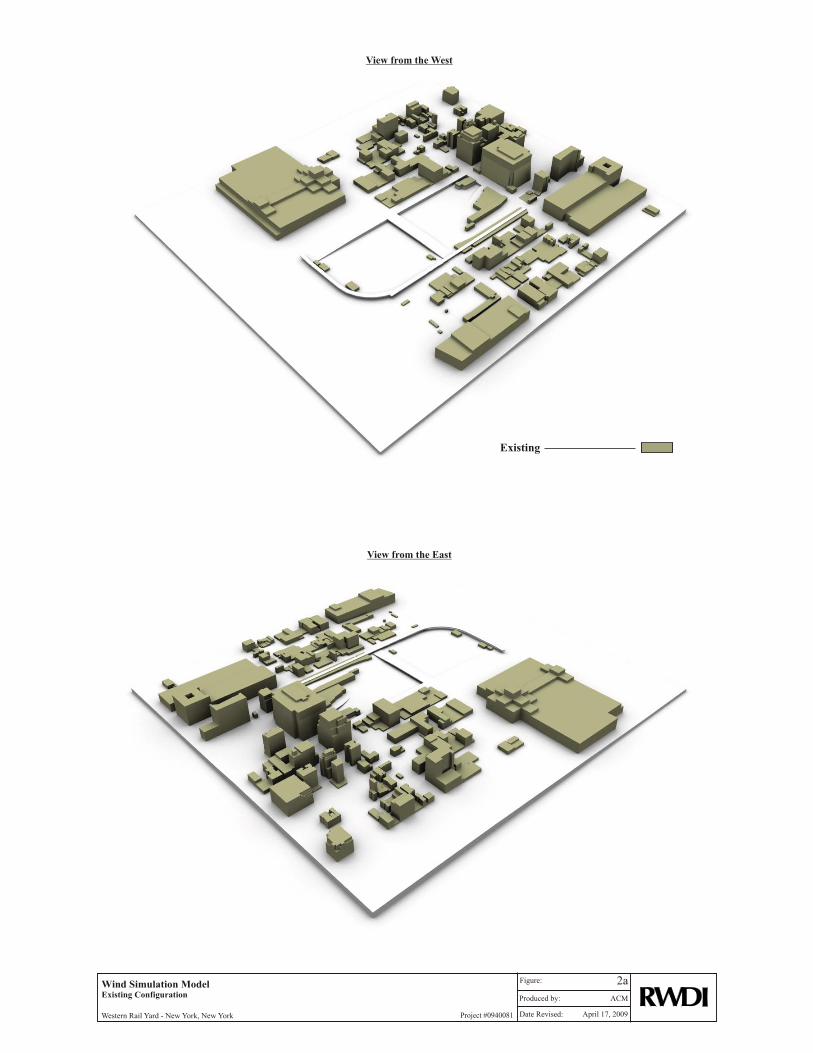
An orientation plan of the study area is included in Figure 1 for the Full-Build Configuration.
The proposed development is bordered by 11th Avenue and 12th Avenue to the east and west, and
by W 30th Street and W 33rd Street to the south and north, and is located along the east side of the
Hudson River. The development consists of multiple mid and high-rise towers as illustrated in
the Orientation Plan (Figure 1). The general surroundings further afield include tall, dense
buildings located to the east, southeast and northeast (Manhattan) with suburban areas well
beyond, and also mid-rise to high-rise to the south.
In the following discussion, references to building locations relate to “Project North” as shown in
Figure 1, while the wind directions are referenced to “True North”. These differ by
approximately 30E. Figures 2a through 2c show the 3-D models of the Existing, No-Build and
Full-Build Configurations used in the computer-based wind simulations.
3. APPROACH
This section highlights the main components involved in the approach to estimate the wind
safety conditions around the proposed Western Rail Yard. It was necessary to first determine the
critical wind directions for this region as they apply to the location of the study site in
Manhattan. The focus of this qualitative assessment was on pedestrian wind safety; hence,
emphasis was placed on identifying and evaluating conditions associated with strong winds,
versus considering all wind speeds. The latter approach is used during detailed, quantitative
wind tunnel studies of pedestrian wind conditions. With the critical test directions identified,

Pedestrian Wind AssessmentWestern Rail Yard – May 12, 2009Project #0940081
Page 4 of 21
Computational Fluid Dynamics techniques (using Virtualwind™) were applied to analyse the
flows from these wind directions and identify areas where accelerated wind flows would occur.
To augment locating the critical wind speed areas, a proprietary modeling tool (WindEstimator)
was used to assess the buildings in simplified block forms for all wind directions. A final
determination of the expected wind conditions around the site with respect to wind safety
criterion was based on a review of these analyses and applying RWDI’s 35+ years of experience
in wind tunnel testing over 1500 projects for pedestrian wind comfort and safety, with over 30
sites located on Manhattan. A characterization of the Western Rail Yard’s predicted wind
conditions in comparison to other recognizable locations on Manhattan was made based on our
past experience and knowledge of the general wind flow patterns at this area of Manhattan. The
various qualitative analysis methods and tools available to assess wind conditions ultimately
guide the professional whose interpretation through practical experience in building
aerodynamics is the most essential part of the analysis.
3.1 Meteorological Data
Three long-term sources of hourly wind data for the New York City area were obtained from the
National Weather Service for analysis and consideration in this assessment. These sites include
wind recording stations at the John F. Kennedy, Newark and LaGuardia International Airports
between 1948 and 2005. The position of the study site relative to these three airports is shown in
Figure 3. Newark Airport is located approximately 10 miles to the southwest of the Western
Rail Yard, La Guardia Airport is approximately 7 miles to the east-northeast and JFK Airport is
approximately 14 miles to the southeast. Wind roses for strong winds (exceeding 20 mph at the
airport anemometer) that occur on an annual basis for each of the three airports are shown in
Figure 4. Strong winds are emphasized in view of this assessment’s focus on pedestrian wind
safety, and it is the stronger wind speeds that have the greatest potential to cause wind safety
problems at grade.

Pedestrian Wind AssessmentWestern Rail Yard – May 12, 2009Project #0940081
Page 5 of 21
The top left wind rose (Newark) indicates that strong winds from all directions occur for 7.6% of
the time annually. Wind from the northwest occurs nearly 2% of the time at Newark Airport.
The northwest winds also occur most frequently at La Guardia (top right wind rose) and JFK
(bottom wind rose). The purpose of these wind roses is to illustrate the “regional” trend in the
wind directions associated most often with strong wind speeds. Overall, the topography in the
overall region is not significant enough to influence the general wind patterns or trends.
However, there would be local speed up effects in areas on the east side of the Hudson River,
where the terrain rises quickly above the height of the river, such as encountered further north on
the west shore of Manhattan. The overall trend of strong winds in this region is that they
originate from the west through northwest. La Guardia data indicates increased occurrence of
northeast and south winds while JFK data exhibits a stronger focus on wind from the south.
Considering the distance and varied make-up of building heights and terrain that lie between the
study site and these historical wind data sites, no single airport was considered to provide wind
conditions (i.e., speed, direction and exposure) that would be representative of the study site.
Similar to techniques commonly used in wind tunnel studies to determine wind loads for
buildings in Manhattan, the wind records from the three airport weather stations were combined
to provide a composite set of wind data for this region.
The composite wind data were further analysed for the “summer” (May through October) and
“winter” (November through April) seasons. Figure 5 graphically depicts the distribution of
wind frequency and directionality for these two “six month” seasons, which are aligned with the
pedestrian wind criteria used for two decades by RWDI. The upper-left wind rose identifies the
summer wind data when considering all wind speeds. Overall, wind from the south and
southwest prevails in this season. The lower-left wind rose shows the winter data, indicating the
predominant winds from the northwest through west directions during this season. Calm winds
occur 2.1% of the time in the summer and 1.8% of the time in the winter. These wind roses
reflect the prevailing winds or those people experience a majority of the time throughout the
year.

Pedestrian Wind AssessmentWestern Rail Yard – May 12, 2009Project #0940081
Page 6 of 21
Figure 5 also depicts the directionality of strong winds using the composite data set. Strong
winds occur for 5.3% and 15.2% of the time during the summer and winter seasons, respectively.
In this region, strong winds from the northwest and south directions occur often during the
summer, while northwest, west-northwest and west directions are more evident during the
winter. Considering that strong winds occur approximately three times more frequently during
the winter (i.e., 15.2% vs. 5.3%) emphasis in this assessment was placed on winds blowing from
the northwest quadrant, followed by southerly (summertime) winds. The winds approaching the
west side of Manhattan, across the Hudson River will be generally similar, resulting in
comparable wind conditions along the length of the shore due to exposure to these winds.
Changes in local wind patterns from site-to-site are primarily due to the influence of building
massing.
3.2 Computer Wind Flow Simulations
To determine where accelerated wind flows could be expected around the proposed Western Rail
Yard for the strong wind directions, VirtualwindTM, a computational fluid dynamics (CFD)
technique was used to analyze wind flows from the northwest, west and south directions. The
west-northwest wind direction was not tested as wind conditions can be inferred through
interpretation and comparison of the wind simulations for the west and northwest winds. For a
qualitative assessment of wind conditions at a master planning level, it is appropriate to test a
limited number of key wind directions with emphasis on the strongest and/or prevailing winds.
Once detailed quantitative results are required, then wind tunnel testing methods using 36 wind
angles is essential.
The results of the computer wind flow analyses are summarized as contours of wind speed at the
pedestrian-level around the development, and represent the average wind speed for the selected
directions. The simulation technique accounts for the fluctuation of turbulent flow similar to the
atmospheric boundary-layer, which is also a requirement of the American Society of Civil
Engineers (ASCE) for wind tunnel testing of physical scale models. Computer modeling of wind
flows around substantive areas does not account for all the intricacies of wind flows derived
through wind tunnel testing. However, the flow patterns and wind conditions obtained through
boundary-layer computer modeling techniques do provide significant insight into areas of
accelerated winds or relative calm, and also identify the nature of the wind flows associated with

Pedestrian Wind AssessmentWestern Rail Yard – May 12, 2009Project #0940081
Page 7 of 21
those conditions. This detailed flow information also provides guidance into appropriate
conceptual forms of mitigation.
The computer wind simulation results illustrated in Figures 6, 7 and 8 will be discussed in the
results section. However, to assist in understanding this stage of the assessment approach, the
color of dark or light blue in these figures represents low wind speed areas, green indicates
moderate wind speeds, and yellow and red regions are associated with high wind speeds, as
indicated on the color legend in the figures. The presence of red, and especially in specific areas
for more than one wind direction, would indicate a high potential of the wind safety criterion
being exceeded.
3.3 Characterization of Predicted Wind Conditions
Over the years, pedestrian wind conditions around buildings have been studied extensively
through wind-tunnel testing3. These studies have created a broad knowledge base of wind
conditions around different building forms. In many situations, the knowledge and experience,
together with literature information, allow for a reliable estimation of pedestrian wind conditions
without wind-tunnel testing4. RWDI has developed a program (WindEstimator) for qualitative
screening-level pedestrian wind assessments. The program consists of a large data base of wind
speed formulae as functions of building dimensions, orientations, spacing and surroundings.
Predictions for general building forms are derived by combining predicted wind speeds with
statistical models of local wind climate. This wind estimating tool served as a guide during the
review of the computer wind flow simulations to estimate the relative potential of the wind
safety criterion, described in Section 4, being exceed.
3 ASCE Task Committee on Outdoor Human Comfort (2004). Outdoor Human Comfort and Its Assessment,68 pages, American Society of Civil Engineers, Reston, Virginia, USA.4 T. Stathopolis, H. Wu and C. Bedard (1992). “Wind Environment around Buildings: A Knowledge-basedApproach”, Journal of Wind Engineering & Industrial Aerodynamics. 41-44, 2377-2388.

Pedestrian Wind AssessmentWestern Rail Yard – May 12, 2009Project #0940081
Page 8 of 21
Based on our past experience in wind tunnel testing and knowledge of building and wind flow
interactions, the wind conditions predicted for the Western Rail Yards were characterized, or
compared to, what could be expected at other locations on Manhattan. To assist in identifying
locations with wind conditions that may be comparable, aerial imagery was reviewed to
determine locations that exhibit similar characteristics to the study area such as wind exposure,
building massing/form and also the general surroundings.
4. RWDI WIND CRITERIA - WIND SAFETY
The wind conditions around the study site have been assessed by considering the wind safety
criterion developed at RWDI. The criteria, developed by RWDI through research and consulting
practice since 1974, have been published in numerous academic journals and conference
proceedings. They have been widely accepted by municipal authorities as well as by the
building design and city planning community. RWDI’s criteria have in the past been extensively
used by several major cities around the world to supplement their environmental planning
guidelines.
The RWDI criteria deal with pedestrian safety, as it relates to the force of the wind. In this
assessment, the focus is on the wind safety where gust wind speeds in excess of 55 mph can
adversely affect a pedestrian’s balance and footing. If winds of this magnitude occur more than
three times per year the conditions would not meet the safety criterion and wind mitigation in
most situations should be considered.
This assessment is qualitative in nature and thus the number of events that exceed the wind
safety criterion cannot be quantified. However, experienced interpretation of the results of the
computer simulations will guide the identification of the areas where severe winds can be
expected, and the form of wind control measures needed. A comparison to the results of RWDI
studies of other projects tested in the wind tunnel, including sites in Manhattan, also served as a
guide in this assessment.

Pedestrian Wind AssessmentWestern Rail Yard – May 12, 2009Project #0940081
Page 9 of 21
The table below presents a general classification of the severe wind events expected on the study
site and surroundings based on the computer simulations and RWDI’s experience in wind tunnel
testing of developments for wind comfort and wind safety. This classification is used in the
results section of this report.
Table 1 – Potential of Exceeding Wind Safety Criterion
Potential Events Mitigation
Low < 3 None
Moderate 3-7
Localized wind control featuresand/or
Building massing changes
High > 7 Building massing changes

Pedestrian Wind AssessmentWestern Rail Yard – May 12, 2009Project #0940081
Page 10 of 21
5. PEDESTRIAN WIND ASSESSMENT - RESULTS
5.1 General
In our discussion of anticipated wind conditions, reference will be made to the following
generalized wind flows. Large buildings tend to intercept the stronger winds at higher elevations
and redirect them down to the ground level. Such as Downwashing Flow (shown in Image 1)
around tall buildings is often the main cause for wind acceleration at the pedestrian level. Also,
when two buildings are situated side by side, wind flow tends to accelerate through the gap
between the buildings due to the Channeling Effect (shown in Image 2). If these building/wind
combinations occur for prevailing winds and especially for strong winds, there is an increased
potential for the accelerated winds to create wind safety issues for pedestrians.
Image 1 - Downwashing Flows Image 2 - Channeling Flows
The following describes the anticipated pedestrian wind conditions at notable pedestrian areas on
and around the proposed Western Rail Yard development. As described in Section 3
(Approach), these estimates are based on the results of WindEstimator and VirtualwindTM
simulations and our experience in testing, interpreting and understanding building aerodynamics.

Pedestrian Wind AssessmentWestern Rail Yard – May 12, 2009Project #0940081
Page 11 of 21
Wind conditions on and around the Western Rail Yard site will be influenced by the many
surrounding buildings, including the proposed Western Rail Yard development, the Eastern Rail
Yard development and other nearby future developments. To reduce wind gusts at pedestrian-
level around the Western Rail Yard site, potential solution concepts (including suggestions for
massing changes and added wind control features) have been noted, where appropriate, for future
consideration by the design team. However, as the wind patterns and resultant conditions are
caused by the interaction of wind flow around multiple buildings, it is important to understand
that mitigation may not be possible by changing or adding features to just one building.
One of the dominant issues controlling wind conditions at this site is the open exposure to strong
winds from the northwest quadrant. There are no existing buildings to the west to shelter the
development site. In our opinion, it would require significant building height reductions across
the site, on the order of 50%, to appreciably change the expected conditions. A 10% or 20%
reduction in building heights will unlikely cause a significant reduction in ground-level wind
activity. Hence, building height reductions were not considered a practical mitigation concept
for the current development site.
5.2 Predicted Wind Conditions - Existing Configuration
There are a number of existing low-rise buildings on the Western Rail Yard site (Figure 2a).
While the site is exposed to the prevailing westerly and northwesterly winds, minimal ground-
level wind acceleration occurs as the existing buildings do not significantly influence the wind
patterns on the site (Figure 6). This results in a low potential for the wind safety criterion being
exceeded on the existing Western Rail Yard site.
To characterize the wind conditions at the existing Western Rail Yard site, we anticipate that
conditions would be similar to other open areas east of the Hudson River, such as Riverbank
State Park (vicinity of Riverside Drive and West 138th to 145th Streets). This park has a
comparable open exposure to wind approaching across the Hudson from the west through
northwest directions. The sports field located beyond the west end of West Houston Street
appears to be another site that exhibits similar site characteristics to the existing Western Rail
Yard site. This location and Riverbank State Park both project into the Hudson River beyond the
shoreline, which increases their wind exposure, but would generally serve as relatively

Pedestrian Wind AssessmentWestern Rail Yard – May 12, 2009Project #0940081
Page 12 of 21
comparable sites. We anticipate that these locations would be rated with a low potential to
exceed the wind safety criterion.
Finally, in the Robert F Wagner Jr. Park near the Statue of Liberty Ferry Terminal, the water’s
edge of the promenade facing Liberty Island is a good example of a location at the south end of
Manhattan that is highly exposed to the west and northwest winds. However, this location is also
completely exposed to southerly winds, thus the wind conditions experienced at this location
would be more severe than those experienced at the existing Western Rail Yard site, especially in
the summer. Because of the increased exposure to many wind directions, the potential for winds
to exceed the wind safety criterion would be low to moderate.
5.3 Predicted Wind Conditions - No-Build Configuration
The addition of the high-rise towers east of 11th Avenue as well as other future buildings (Figure
2b) will have a minimal effect on the wind conditions on the Western Rail Yard site (Figures 7a
and 7b). These future buildings are mainly downwind of the study site for the prevailing
westerly through northwesterly directions. Overall, a low potential for winds to exceed the wind
safety criterion is predicted on the Western Rail Yard site for the No-Build Configuration. The
wind conditions on the Western Rail Yard site for the No-Build Configuration can generally be
characterized by the same locations described for the Existing Configuration.
5.4 Predicted Wind Conditions - Full-Build Configuration
The Western Rail Yard development includes building massing comprised of eight mid to high-
rise towers. The prevailing westerly through northwesterly winds will be intercepted at higher
levels by the exposed portions of the towers and channeled and/or re-directed towards grade-
level, resulting in wind acceleration in several areas on site (see Figures 8a, 8b and 8c). Based
on our assessment that considered all wind directions, several areas across the site have been
identified as having the potential to exceed the criterion. The slenderness and open spacing of
the towers on the western portion of the site are generally positive design concepts with respect
to wind effects at grade. Figure 9 shows a site plan with shading that represents areas where
there is a potential to exceed the criterion due to increased wind activity. The identified areas
are discussed in the following section for each building on the Western Rail Yard site. A general

Pedestrian Wind AssessmentWestern Rail Yard – May 12, 2009Project #0940081
Page 13 of 21
description of the wind patterns around each building and recommendations of concepts for
mitigation and wind control have been provided for each building mass.
To help characterize the range of wind conditions expected at the Western Rail Yards Full-Build
Configuration, 3D aerial images of Manhattan were reviewed in conjunction with the wind roses
and application of our experience and knowledge in building aerodynamics. Given the
orientation, massing and spacing of buildings along the west side of Manhattan, in, for example,
the general vicinity of the World Financial Center, the potential exists for the downwashing wind
flow (Image 1) and the channeling wind flow (Image 2) to occur for buildings with long facades
oriented north/south. Where these wind flows can readily occur for west through northwest
winds, experience suggests that a high potential to exceed the wind safety criterion could
develop. A review of 3D aerial imagery also helped identify another area where similar
increased wind activity may be expected. Buildings along the east side of Riverside Boulevard,
between West 63rd and West 72nd Streets, for example are well exposed to the northwest
quadrant winds. The site exposure and general massing of buildings in this area are attributes
associated with a high potential to exceed the wind safety criterion.
Overall, the results of the wind flow simulations for the Western Rail Yard exhibit comparable
wind conditions found in other sites along West Manhattan, and include a similar range of wind
safety events due to the same exposure to the prevailing northwest winds.

Pedestrian Wind AssessmentWestern Rail Yard – May 12, 2009Project #0940081
Page 14 of 21
Image 3 – Corner chamfer
WR-7 and WR-6
Towers WR-7 and WR-6, located at the corner of 12th Avenue and West 33rd Street, are exposed
to the prevailing westerly through northwesterly winds. These winds will be intercepted by the
towers and downwashed toward grade, accelerating around the northwest corner of WR-7 and
the northeast corner of WR-6 (Figures 8a, 8b and 8c). Westerly through northwesterly winds are
also expected to downwash off WR-6, then channel between WR-6 and WC-1. A moderate
potential for the wind safety criterion being exceeded is expected for these areas (Locations A, B
and C in Figure 9).
There are several options that can be considered
to reduce wind acceleration in Area A. These
include shifting the WR-7 Tower further
eastward, to create a podium on the west side of
the building. This podium will help to re-direct
the strong wind flows before they reach grade.
Alternatively, the design team may consider a
chamfer (see Image 3) or notch feature on the
tower’s northwest corner. This feature could
extend from grade or from the podium level and
should extend a minimum of five storeys in
height. The chamfered building corner will help
dissipate wind flows as they travel down the building facade towards grade. The addition of a
canopy or colonnade may also be considered along the west and north facade of the tower, to
provide a sheltered area for pedestrians on windy days.

Pedestrian Wind AssessmentWestern Rail Yard – May 12, 2009Project #0940081
Page 15 of 21
Potential solution options that may be considered for Area B include increasing the height of the
central section of the podium between WR-6 and WR-7, by several storeys. The design team
may also consider “terracing” the north and south sides of the podium (see Image 4). The
“terracing” should range from the present podium height at the north and south edges to about 6
to 8 storeys above the podium. This measure will act to disrupt the channeling and
downwashing of westerly winds. Another measure that would have a similar effect would be to
modify the WR-6 Tower into an “L” shape, by extending several bays of the west façade near
West 33rd Street along to the west. With an increased podium height and/or an “L” shaped tower
floor plate, wind flows will continue to downwash from the WR-6 Tower, but will be disrupted
atop the podium and dissipate before reaching grade-level.
Similar measures may be investigated for Area C. The addition of a podium at the south end of
the WR-6 Tower will reduce gusts at grade. This could be accomplished with the “L” shape
design concept described in the preceding paragraph. Another option would be to include a
chamfer or notch feature on the southeast corner of the tower, from the podium by approximately
five storeys. Alternatively, a canopy or colonnade (see Image 5) wrapping around the south and
east facade of the WR-6 Tower may also be considered to deflect wind flows from grade and
provide a sheltered alternative route for pedestrians on windy days.
Image 4 – Terracing with Colonnade Image 5 – Canopy/Colonnade

Pedestrian Wind AssessmentWestern Rail Yard – May 12, 2009Project #0940081
Page 16 of 21
Image 6 – Glass Windscreens
WR-5
WR-5, located to the south of WR-6, is oriented such that the west facade is approximatelyperpendicular to the prevailing westerly winds. This results in a significant downwashing flow,which then accelerates around the west corner of the tower at grade. The proximity of this towerrelative to WR-6 plus its exposure, creates a channeling effect. A high potential for the windsafety criterion being exceeded is therefore expected in this area (Area D in Figure 9).
Potential design solution concepts to be considered include the addition of a podium wrappingaround the west facade of WR-5, which will help to deflect downwashing winds away fromgrade, and increasing the distance between the WR-5 and WR-6 Towers (e.g., shifting the WR-6Tower northward on the podium in the “L” shape discussed previously) would help reduce thechanneling effect.
WR-4 The orientation and shape of the WR-4 Tower is a positive aerodynamic design, as the smallwindward face on this wind exposed tower, minimizes the downwashing effect. A channelingeffect is expected to occur between the WR-4 and WR-5 Towers for the northwest winds,resulting in a high potential for the wind safety criterion being exceeded at Area E (Figure 9).Northwesterly winds will also accelerate around WR-4 causing increased wind activity to thesouthwest corner of the WR-4 Tower. A moderate potential for the wind safety criterion notbeing met is predicted for this area (Area F in Figure 9).
To reduce the channeling effect between WR-4 and WR-5, thedistance between the towers would need to be increased. However, itis expected that re-locating WR-5 would increase the potential forwind acceleration in other areas of the site. Instead, the design teammay consider a horizontal feature (e.g., trellis, podium) connectingWR-4 and WR-5, to keep higher wind speeds above the plaza.Another option to reduce the channeling effect would be to considerhard and/or soft landscape features (e.g., windscreens, trees thatretain their leaves in the winter, etc.) throughout this area. Anexample of glazed windscreens is shown in Image 6.

Pedestrian Wind AssessmentWestern Rail Yard – May 12, 2009Project #0940081
Page 17 of 21
Image 7 – Landscape Buffer
Reducing the wind acceleration around the southwest
corner of WR-4 is challenging to accomplish using
building massing changes given the complexity of the site
in this area. The tower is well shaped for the wind and a
massing change, such as a podium would not be overly
effective. Instead, a combination of hard and soft
landscaping may be considered in the future, and can
include features such as windscreens, coniferous
landscaping (Image 7), etc. to help shelter pedestrians
using the sidewalks south of the tower.
WR-2 and WR-3
The prevailing westerly through northwesterly winds will be intercepted by WR-3 and will tend
to downwash towards grade. This is expected to result in a moderate potential for exceeding the
wind safety criterion (Area G in Figure 9). Additionally, westerly winds will downwash from
the proposed building across 11th Avenue (ER-2) and channel between WR-2 and ER-2,
resulting in a low to moderate potential for exceeding the wind safety criterion in Area H.
Shifting the WR-3 Tower toward the east to create a podium on the west side of the tower will
reduce the downwashing effect by deflecting winds away from grade. A large canopy, a
colonnade or extending the podium along the west facade may also be considered as possible
concepts. Another alternative to be considered would be to create a slot or 2nd to 4th floor
undercut on the west facade, which will help to interrupt and disperse the downwashing flow.

Pedestrian Wind AssessmentWestern Rail Yard – May 12, 2009Project #0940081
Page 18 of 21
Image 8 – Glass windscreen and canopy
Image 9 – Angled Flow
To reduce the potential for wind safety failures in
Area H, massing changes for ER-2 will also be
necessary and may, include the addition of a podium.
Additionally, creating a colonnade feature along the
east facade of WR-2, or landscape elements (e.g., a
wind screen with protective canopy shown in Image
8) between the sidewalk and the street will provide a
sheltered area for pedestrians on windy days. The
design team may also consider chamfering the
southeast corner of the WR-2 podium.
WR-1
Prevailing westerly through northwesterly winds will be intercepted by the WR-1 Tower and will
downwash toward grade, resulting in a moderate potential for the wind safety criterion to the
west of the tower being exceeded (Area I in Figure 9). Shifting the tower towards the east on the
podium will increase the podium area to the west of the tower, or rotating the tower
approximately 60° clockwise would help keep gusting winds above grade
WC-1
Wind activity in this area is strongly influenced by
several buildings, including WC-1, ER-3/EH-1, and
the future development on the east side of 11th Avenue
to the north of the Eastern Rail Yard. ER-3/EH-1 and
the future developments create a large blockage
(represented conceptually as one block in Image 9),
having a significant effect on the overall wind flows in
the area. Winds are intercepted by the future developments and ER-3/EH-1, and then downwash
toward grade. This effect is amplified by the addition of WC-1, which causes the re-directed
flow to channel along 11th Avenue, adding to the downwashing effect. The result is a large area
along 11th Avenue and on the Eastern Rail Yard site having a high potential for the wind safety
criterion being exceeded (Area J in Figure 9).

Pedestrian Wind AssessmentWestern Rail Yard – May 12, 2009Project #0940081
Page 19 of 21
Mitigation of the high wind speeds in the area will be challenging without modification of theoff-site buildings. However, the following options can be considered for reducing severe windevents locally on the Western Rail Yard site. Extending the podium along the east side of theWC-1 Tower to the north adding a podium along the north face and/or shifting the tower to thesouth will help to deflect some of the downwashing wind flows away from grade. Additionaldesign measures are also suggested and may include for example, a colonnade, windbreaks, etc.,along the east facade of WC-1. At present, the 3D model indicates the location of an entranceplaza at the notched northeast corner of WC-1. Due to the potential of high wind gusts in thisarea, it is expected that hard and/or soft landscape elements in addition to the massing changes,must be considered during the schematic design of this building. An alternative location for theplaza would be near the southeast corner of the tower.
6. MITIGATION
The following conceptual measures are recommended for consideration by the design team toreduce wind activity in and around the Western Rail Yard development. The various conceptsidentified are intended to serve as a design guide during future refinement of building masses toimprove upon the buildings’ aerodynamic performance. Thus in reviewing the listed conceptspresented for each building, it is important to understand that one or more of the concepts mayapply, as described in the detailed discussions (Section 5). However, during the future schematicdesign of the proposed massings, the decision of which concept(s) to apply will also beinfluenced by other factors (e.g., views, aesthetics, marketability, etc.). Refer to Figure 9 for thelocation of the lettered reference areas.

Pedestrian Wind AssessmentWestern Rail Yard – May 12, 2009Project #0940081
Page 20 of 21
WR-7 and WR-6
• Create a podium on the west side of the building by shifting WR-7 toward the east (Area
A).
• Add a chamfer to the northwest tower corner, extending from grade or from the podium
level, a minimum of 3 storeys in height (Area A).
• Add a colonnade along the west and north facade of WR-7 (Area A)
• Increase the height of the center of the podium (Area B).
• Re-design the WR-6 Tower into an “L” shape (Area B).
• Add a chamfer or notch feature on the southeast corner of the WR-6 Tower (Area C).
• Add a canopy or colonnade wrapping around the south and east facade of the WR-6
Tower (Area C).
WR-5
• Add a podium wrapping around the west facade of WR-5 (Area D).
• Increase the distance between WR-5 and WR-6 by shifting the WR-6 Tower northward
on the podium (Area D).
WR-4
• Create a podium connecting WR-4 and WR-5 (Area E).
• Install a series of tall wind screens between WR-4 and WR-5 (Area E).
• Utilize a combination of hard and soft landscaping including wind screens and coniferous
landscaping for Area F.

Pedestrian Wind AssessmentWestern Rail Yard – May 12, 2009Project #0940081
Page 21 of 21
WR-2 and WR-3
• Shift the WR-3 Tower toward the east to create a podium on the west side of the tower
(Area G).
• Add a canopy, colonnade or undercut along the west facade of the WR-3 Tower (Area
G).
• Add a colonnade along the east facade of the WR-2 Tower or add a wind screen with
overhead canopy between the sidewalk and the street along the east side of WR-2 (Area
H).
WR-1
• Shift the tower toward the east on the podium to increase the podium area to the west of
the tower (Area I).
• Rotate the tower approximately 60° clockwise.
WC-1
• Extend the podium along the east side of the WC-1 Tower to the north
• Shift the tower to the south (Area J).
• Add a podium along the north face (Area J).
• Add a colonnade, wind breaks, etc., along the east facade of WC-1 (Area J).

FIGURES


SUMMER WINDS EXCEEDING 20 mphALL SUMMER WINDS
WINTER WINDS EXCEEDING 20 mphALL WINTER WINDS
Directional Distribution (%) of Winds (Blowing From)New York City Combined (JFK, Laguardia and Newark), NY (1948 - 2005)Station:
Date: May 7, 20090940081Project #:Western Rail Yard - New York, New York
5
0%
3%
6%
9%
12%
15%N
NNE
NE
ENE
E
ESE
SE
SSES
SSW
SW
WSW
W
WNW
NW
NNW
2.1% CALM
0%
3%
6%
9%
12%
15%N
NNE
NE
ENE
E
ESE
SE
SSES
SSW
SW
WSW
W
WNW
NW
NNW
1.8% CALM
0.0%
1.0%
2.0%
3.0%
4.0%N
NNE
NE
ENE
E
ESE
SE
SSES
SSW
SW
WSW
W
WNW
NW
NNW
15.2% OF TIME
0.0%
1.0%
2.0%
3.0%
4.0%N
NNE
NE
ENE
E
ESE
SE
SSES
SSW
SW
WSW
W
WNW
NW
NNW
5.3% OF TIME
Figure:


Related Documents


