Lots 5 & 6 Great Northern Highway, Bullsbrook Brikmakers APPENDIX F – DUST MANAGEMENT PLAN

Welcome message from author
This document is posted to help you gain knowledge. Please leave a comment to let me know what you think about it! Share it to your friends and learn new things together.
Transcript
Lots 5 & 6 Great Northern Highway, Bullsbrook Brikmakers
APPENDIX F – DUST MANAGEMENT PLAN
DUST MANAGEMENT PLAN FOR SAND AND CLAY EXTRACTION
LOTS 5 & 6 (NO. 1728) GREAT NORTHERN HIGHWAY, BULLSBROOK, CITY OF SWAN
DECEMBER 2017
PREPARED FOR: BRIKMAKERS 260 KALAMUNDA ROAD SOUTH GUILDFORD, WA, 6055
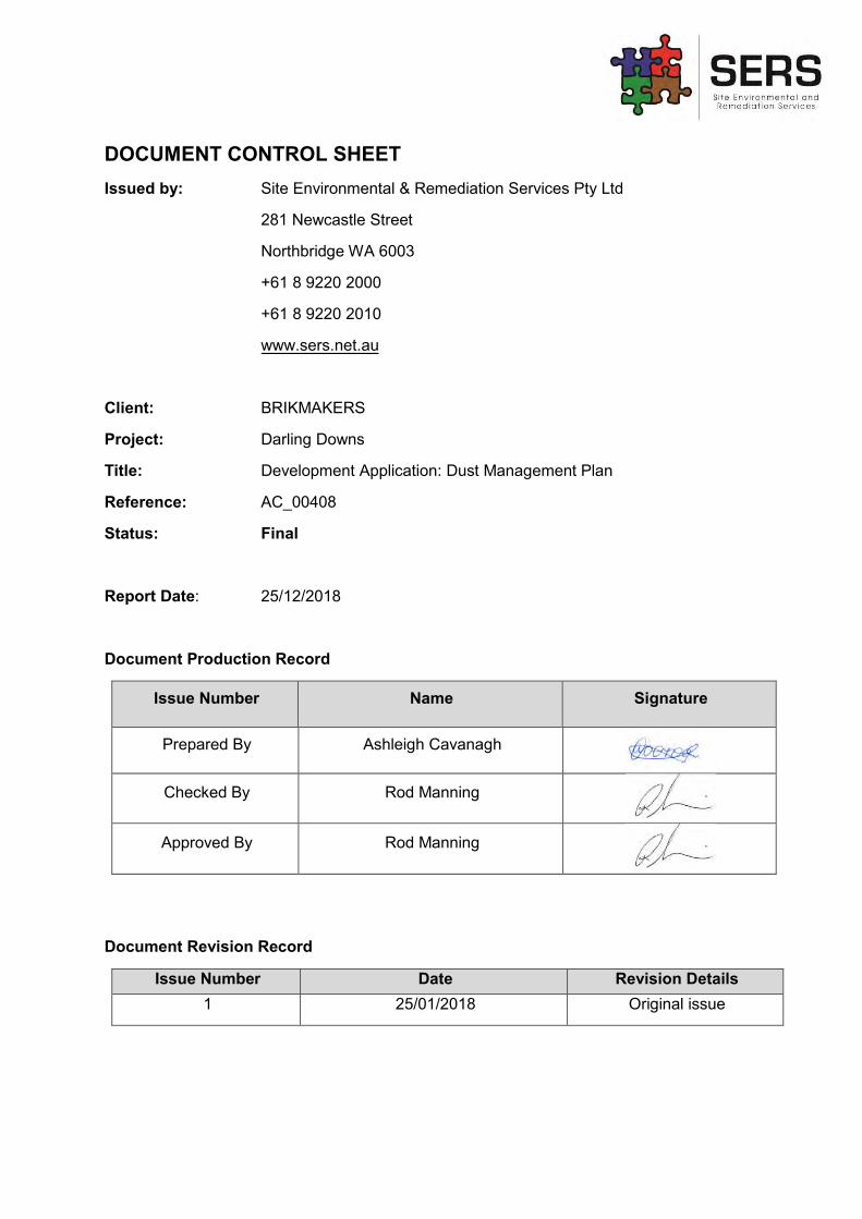
DOCUMENT CONTROL SHEET Issued by:
Client:
Project:
Title:
Reference:
Status:
Report Date:
Site Environmental & Remediation Services Pty Ltd
281 Newcastle Street
Northbridge WA 6003
+61 8 9220 2000
+61 8 9220 2010
www.sers.net.au
BRIKMAKERS
Darling Downs
Development Application: Dust Management Plan
AC_00408
Final
25/12/2018
Document Production Record
Issue Number Name Signature
Prepared By Ashleigh Cavanagh
Checked By Rod Manning
Approved By Rod Manning
Document Revision Record
Issue Number Date Revision Details 1 25/01/2018 Original issue
CONTENTS EXECUTIVE SUMMARY ...................................................................................................... v 1 INTRODUCTION ........................................................................................................... 1
1.1 PURPOSE .............................................................................................................. 1 1.2 EPA OBJECTIVE .................................................................................................... 1 1.3 RELEVANT LEGISLATION, POLICY AND GUIDELINES ....................................... 1
2 SITE BACKGROUND .................................................................................................... 2 2.1 SITE HISTORY ....................................................................................................... 2 2.2 SOILS ..................................................................................................................... 2 2.3 CLIMATE ................................................................................................................ 2 2.4 TOPOGRAPHY ...................................................................................................... 4 2.5 SENSITIVE RECEPTORS ...................................................................................... 5
3 PROPOSED WORKS AND POTENTIAL IMPACTS ...................................................... 6 3.1 SOURCES OF DUST ............................................................................................. 6 3.2 POTENTIAL IMPACTS OF DUST ........................................................................... 6 3.3 ASPECT AND IMPACT ANALYSIS ........................................................................ 8
4 DUST MONITORING PROGRAM ................................................................................ 10 4.1 MONITORING METHODS .................................................................................... 10 4.2 PERFORMANCE CRITERIA ................................................................................ 10
5 DUST MANAGEMENT PROGRAM ............................................................................. 12 5.1 SUMMARY OF DUST MANAGEMENT REQUIREMENTS ................................... 12 5.2 SUMMARY OF DUST MANAGEMENT CONTROLS ............................................ 16 5.3 RELEVANT STAKEHOLDERS ............................................................................. 16 5.4 ROLES AND RESPONSIBILITIES ........................................................................ 16 5.5 COMPLAINTS MANAGEMENT ............................................................................ 17
6 CONCLUSION ............................................................................................................. 17 7 REFERENCES ............................................................................................................ 17 Figure 2 – Site Location ...................................................................................................... 19 Figure 3 – Surrounding Land Uses ...................................................................................... 20 Figure 4 – Site Layout ......................................................................................................... 21 Figure 5 – Sensitive Receptors and Buffer Distances ......................................................... 22 APPENDIX A - Risk Matrix .................................................................................................. 23
Risk Treatment Table ...................................................................................................... 25 APPENDIX B – Wind Roses for Summer and Winter .......................................................... 26 APPENDIX C – Dust Incident Register ............................................................................... 27
ABBREVIATIONS:
ABS Australian Bureau of Statistics
SERS Site Environmental Remediation Services Pty Ltd
DEC Department of Environment and Conservation
DER Department of Environmental Regulation
DMP Dust Management Plan
EPA Environmental Protection Authority
NEPC National Environmental Protection Council
NEPM National Environmental Protection (Ambient Air Quality) Measure
DMIRS Department of Mines, Industry Regulation and Safety
PM Particulate Matter
EXECUTIVE SUMMARY
This Dust Management Plan has been generated in support of an application to approve the extraction of Sand and Clay from 1729 (Lots 5 & 6) Great Northern Highway, Bullsbrook. The proponent, Brikmakers, are leasing the site and seek relevant permissions and approvals to extract the abundant sand and clay resource from the site.
This application examines the aspects and impacts of the proposed extraction operations in relation to dust generation.
The site is located in a rural location beyond the suburban fringe of the Perth Metropolitan Area. The site is not presently used for an active rural purpose and there is no residential dwelling currently within the property.
There are eight sensitive receptors in a 500m radius of the site boundary. Two of these receptors are categorised as caretaker’s residences’ due to the nature of the premise.
SERS has provided Brikmakers with a series of management methods that aim to reduce the generation of dust to an acceptable limit, following standards outlined in the Environmental Protection Act 1986.

Lots 5 & 6 (No. 1728) Great Northern Highway - Dust Management Plan 1
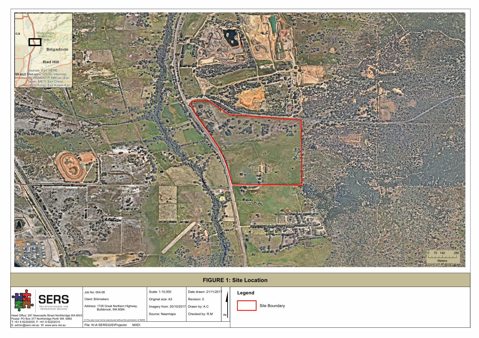
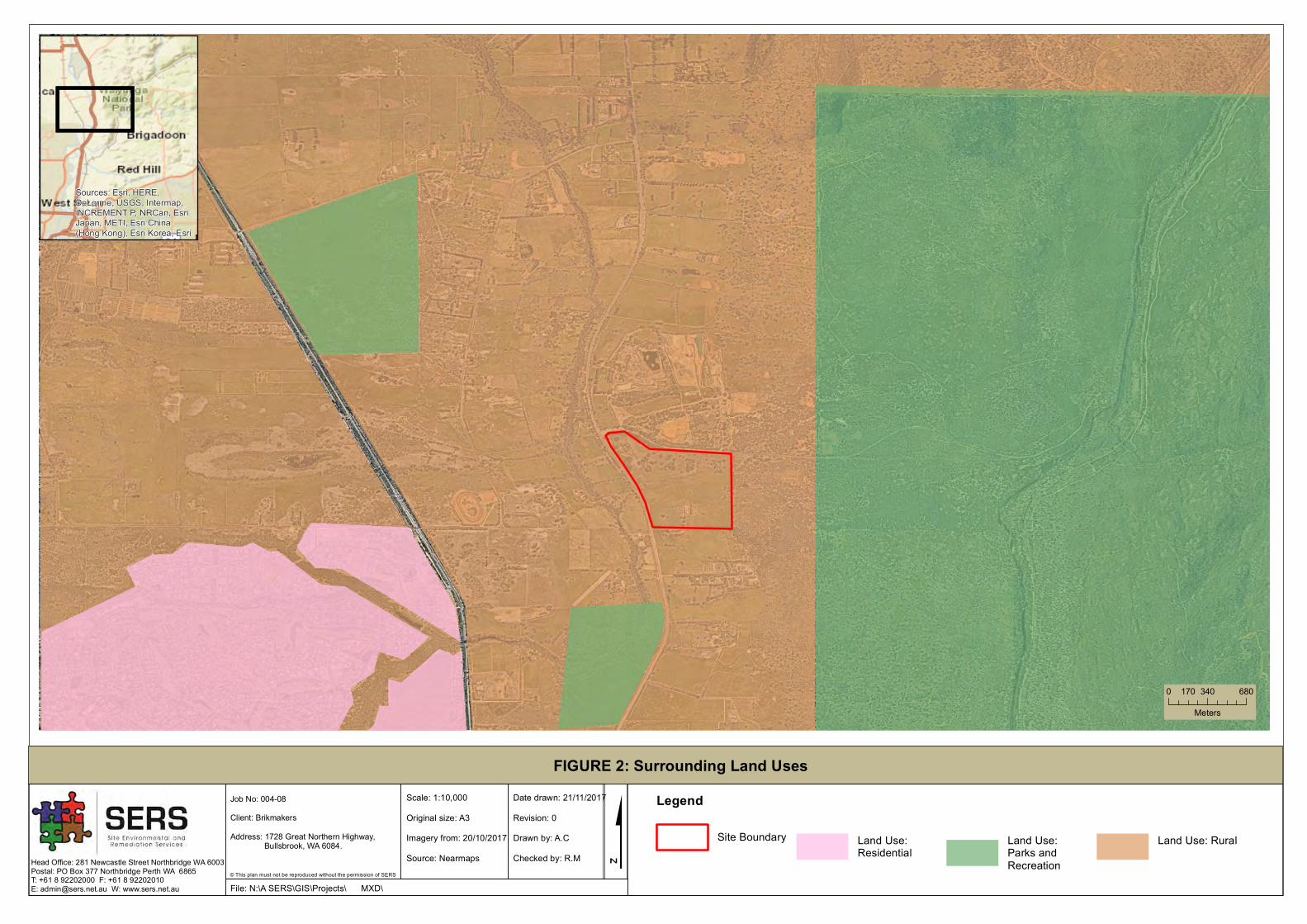
1 INTRODUCTION 1.1 PURPOSE This Dust management plan has been generated by Site Environmental and Remediation Services (SERS) on behalf of Brikmakers Pty ltd in support of the development application to approve sand and clay extraction on Lots 5 & 6 (1728) Great Northern Highway, Bullsbrook (Figure 2). The site and surrounding areas have been historically cleared, and are classified as ‘rural’ under the Metropolitan Regional Scheme (MRS) (refer to Figure 3 for MRS zoning).
Brikmakers are a major brick manufacturer in the Perth Metropolitan area. The use of resource from this site will provide a portion of the required resources to facilitate ongoing brick manufacturing. The site will be managed in accordance with Brikmakers management procedures used on similar sites and to industry best practises.
The standard Brikmakers process comprises the periodic excavation of material which is then appropriately stockpiled onsite. Sand that is extracted from the site will not be stockpiled and instead, carted out to immediate projects. Brikmakers is applying for License and Planning approval for sand and clay extraction for a period of 10 years.
The proposed extraction area is included in the Western Australian Planning Commissions (WAPC) Statement of Planning Policy No.10. Basic Raw Materials, as a Priority Resource Location.
This document outlines the proposed works, risks associated and the dust management controls to be implemented in conjunction with this project.
1.2 EPA OBJECTIVE The EPA’s environmental objective for the factor Air Quality is: “To maintain air quality and minimise emissions so that environmental values are protected” (EPA, 2016).
1.3 RELEVANT LEGISLATION, POLICY AND GUIDELINES Relevant Legislation, guidelines and policies to the Dust Management Plan are as follows:
Legislation:
- National Environmental Protection (Ambient Air Quality) Measure 1994- Environmental Protection Act 1986
Guideline:
- A Guideline for Managing the Impacts of Dust and Associated Contaminants from LandDevelopment Sites, Contaminated Sites Remediation and Other Related Activities(DEC, 2011)
- Environmental Factor Guideline – Air Quality (2016)Policy:
- Formerly the Shire of Swan (currently the City of Swan) By-law Relating to ExtractiveIndustries (1982)
Lots 5 & 6 (No. 1728) Great Northern Highway - Dust Management Plan 2
2 SITE BACKGROUND 2.1 SITE HISTORY
The site is located approximately 30 kilometres from the Perth CBD and is bounded by Walyunga Road to the north and Great Northern Highway to the west. Vehicle access to the site is via Great Northern Highway and Walyunga Road (Figure 4).
The site was historically used for the grazing of cattle. Therefore, the majority of the site has been previously cleared of vegetation. Several stands of native trees are located mostly to the west of Lot 5 and to the north of Lot 6. The remainder of the site consists of cleared paddock (grassed) areas. Several trees have been planted in the southern portion of the site. One small dam is located near the western boundary of the site. However, this dam does not contain surface water and will not be used as part of the project activities. There is a shed with a building attached which is located in the southern part of the site. The shed and building will be retained for use by a caretaker (Figure 4).
2.2 SOILS The site is located within the Pinjarra Zone (Map Unit 213) (DPIRD, 2017). The Pinjarra Zone consists of alluvial deposits between the Bassendean Dunes Zone and the Darling Scarp, colluvial and shelf deposits adjacent to the Darling Scarp. Soils of the Pinjarra Zone are often described as clayey to sandy alluvial soils with wet areas (DPIRD, 2017).
Soils in the project area are part of the Forrestfield System (Map Unit 213Fo) (DPIRD, 2017). The Forrestfield System is described as undulating foot slopes of the Darling and Whicher Scarps. The soils of the project area are described as duplex, sandy gravels, pale deep sands and grey, deep sandy duplexes (DPIRD, 2017). These soils are sometimes considered to be alkaline (DPIRD, 2017). Soils in the project area may also be described as semi-wet to wet soils, with grey deep or pale deep sands and loams (DPIRD, 2017). As the majority of the overlying soils are sandy and free-draining, there is an extremely low probability of occurrence of acid sulphate soils (CSIRO, 2017).
Landforms of the Bullsbrook area are described as coastal plain with swamps and low slopes of <10% gradient (DPIRD, 2017). The geology of the site consists of unconsolidated sediments over sedimentary rocks (DPIRD, 2017).
2.3 CLIMATE The distribution and frequency of dust emissions is dependent on climate and wind conditions of the area. Perth weather is described as a Mediterranean climate, experiencing cold, wet winters and hot, dry summers (ABS, 2012). Dust lift is known to be more prevalent in hot, dry conditions.
Pearce RAAF base (site number 009053) is the closest BOM weather station, and sits approximately 8km north-east from the site. The site has been recording data from 1937. Annual recorded rainfall ranges between 348.2mm and 985.2mm (BoM, 2017). The mean annual rainfall over the duration of the data collection (1937-2017) is 653.1mm (BoM, 2017).
The mean 9am wind speed annually is 14.2km/h, highest wind speeds are seen in the summer months from November – March (Refer to Figure 1A) (BoM, 2017). The mean 3pm wind speed
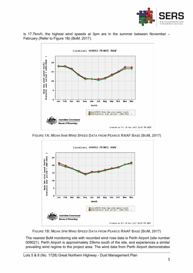
Lots 5 & 6 (No. 1728) Great Northern Highway - Dust Management Plan 3
is 17.7km/h, the highest wind speeds at 3pm are in the summer between November – February (Refer to Figure 1B) (BoM, 2017).
FIGURE 1A: MEAN 9AM WIND SPEED DATA FROM PEARCE RAAF BASE (BOM, 2017)
FIGURE 1B: MEAN 3PM WIND SPEED DATA FROM PEARCE RAAF BASE (BOM, 2017)
The nearest BoM monitoring site with recorded wind rose data is Perth Airport (site number 009021). Perth Airport is approximately 25kms south of the site, and experiences a similar prevailing wind regime to the project area. The wind data from Perth Airport demonstrates
Lots 5 & 6 (No. 1728) Great Northern Highway - Dust Management Plan 4
the differences in wind speed and direction during winter and summer. Summer and winter wind roses were compiled from BoM data recorded during the period 1944 to 2016. The data presents morning (9am) and afternoon (3pm) wind conditions (Appendix B).
Summer:
Summer mornings (9am) generally have strong winds (>20km/h but <40km/h) in an easterly direction (BoM, 2016). Winds from the south had an approximate wind speed >10km/h and <20km/h (BoM, 2016). Winds from the north, north-west and west occur less frequently and reach speeds between 0km/h and <20km/h (BoM, 2016). Wind roses, as supplied by BoM, are shown in Appendix B.
Summer afternoons (3pm) generally have strong winds (>20km/h and <40km/h) from the south-west (BoM, 2016). Winds from the west had an approximate wind speed >20km/h and <40km/h (BoM, 2016). Winds from the north, north east, north-west, south and south-east occur less frequently and reach speeds between >10km/h and <30km/h (BoM, 2016). Wind roses, as supplied by BoM, are shown in Appendix B.
Winter:
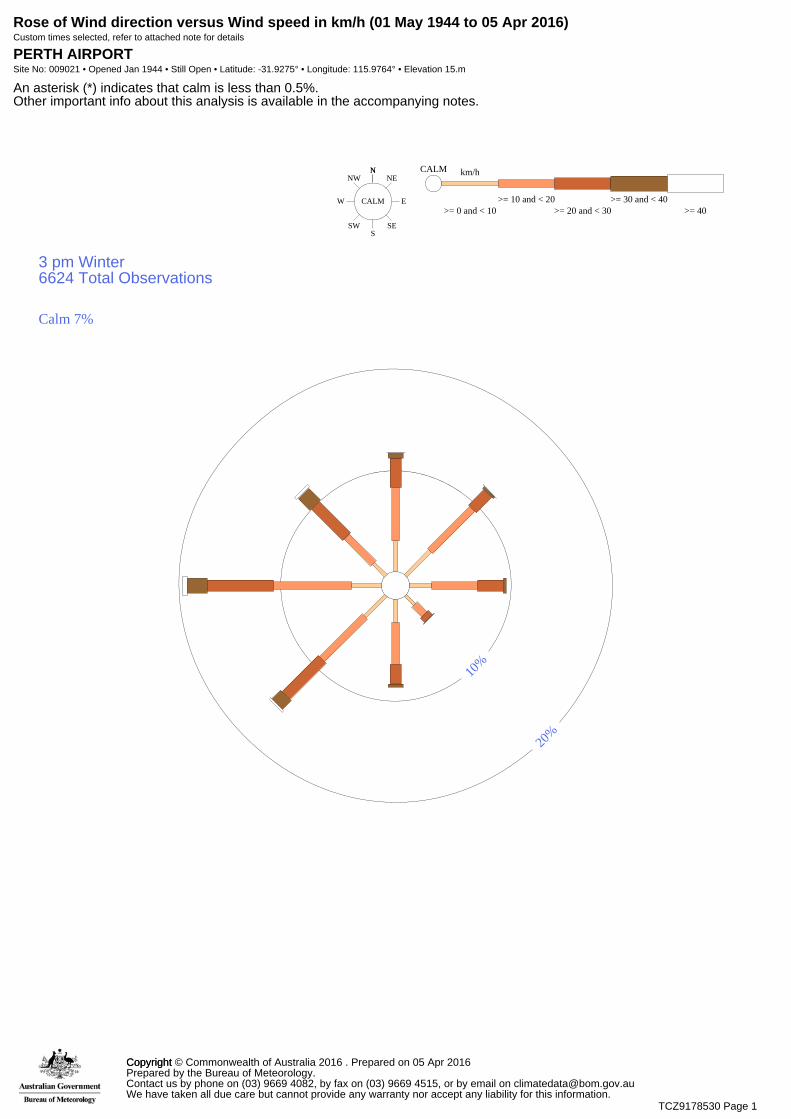
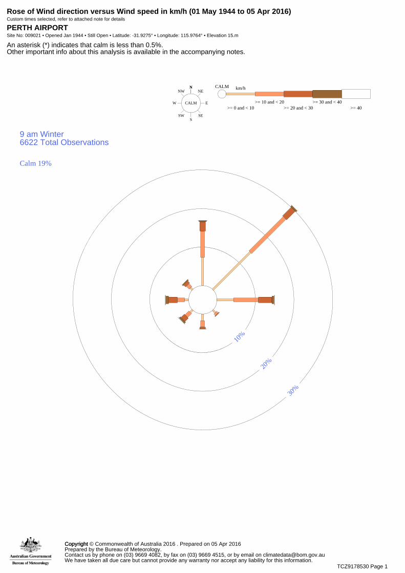
Winter mornings (9am) generally have moderate winds (>10km/h and <20km/h) from the north-east (BoM, 2016). Winds from the north and east has an approximate wind speed >10km/h and <30km/h (BoM, 2016). Winds from the south-east, south, south-west, west andnorth-west occur less frequently and reach speeds between >10km/h and <30km/h (BoM,2016). Wind roses, as supplied by BoM, are shown in Appendix B.
Winter afternoons (3pm) generally have moderate winds (>10km/h and <30km/h) from the west (BoM, 2016). Winds from the north, north-east, east, south, south-west and north-west had an approximate wind speed >10km/h and <30km/h (BoM, 2016). Winds from the south-east occur less frequently and had an approximate wind speed >10km/h and < 20km/h (BoM, 2016). Wind roses, as supplied by BoM, are shown in Appendix B.
Summary of Wind Conditions
Winds are stronger during summer, having higher gust strengths in comparison to winter. Summer morning winds are received primarily from the east, while afternoon winds are received primarily from the south-west (BoM, 2016). Winter morning winds are received primarily from the north-east, while afternoon winds are variable in direction (BoM, 2016). Dust will have to be managed more strenuously in summer due to higher wind speeds (BoM, 2016).
2.4 TOPOGRAPHY The site slopes naturally downwards towards the west. The highest point being in the south-eastern corner of the site.The lowest point is on the western boundary near Great Northern Highway.
The site currently has an elevation of approximately 60 metres AHD on the eastern side of the site (Lot 6) to an elevation of approximately 25 metres AHD on the western side of the site (Lot 5).The highest elevation is on the south-eastern corner.
Lots 5 & 6 (No. 1728) Great Northern Highway - Dust Management Plan 5
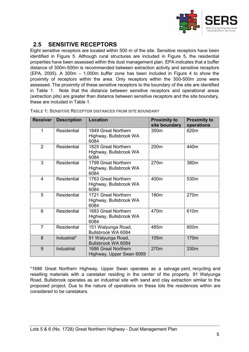
2.5 SENSITIVE RECEPTORS Eight sensitive receptors are located within 500 m of the site. Sensitive receptors have been identified in Figure 5. Although rural structures are included in Figure 5, the residential properties have been assessed within this dust management plan. EPA indicates that a buffer distance of 300m-500m is recommended between extraction activity and sensitive receptors (EPA, 2005). A 300m – 1,000m buffer zone has been included in Figure 4 to show the proximity of receptors within the area. Only receptors within the 300-500m zone were assessed. The proximity of these sensitive receptors to the boundary of the site are identified in Table 1. Note that the distance between sensitive receptors and operational areas (extraction pits) are greater than distance between sensitive receptors and the site boundary, these are included in Table 1.
TABLE 1: SENSITIVE RECEPTOR DISTANCES FROM SITE BOUNDARY
Receiver Description Location Proximity to site boundary
Proximity to operations
1 Residential 1849 Great Northern Highway, Bullsbrook WA 6084
350m 620m
2 Residential 1825 Great Northern Highway, Bullsbrook WA 6084
200m 440m
3 Residential 1799 Great Northern Highway, Bullsbrook WA 6084
270m 380m
4 Residential 1763 Great Northern Highway, Bullsbrook WA 6084
400m 530m
5 Residential 1721 Great Northern Highway, Bullsbrook WA 6084
180m 270m
6 Residential 1683 Great Northern Highway, Bullsbrook WA 6084
470m 610m
7 Residential 151 Walyunga Road, Bullsbrook WA 6084
485m 650m
8 Industrial* 91 Walyunga Road, Bullsbrook WA 6084
105m 170m
9 Industrial 1686 Great Northern Highway, Upper Swan 6069
270m 330m
*1686 Great Northern Highway, Upper Swan operates as a salvage yard, recycling and reselling materials with a caretaker residing in the center of the property. 91 Walyunga Road, Bullsbrook operates as an industrial site with sand and clay extraction similar to the proposed project. Due to the nature of operations on these lots the residences within are considered to be caretakers.
Lots 5 & 6 (No. 1728) Great Northern Highway - Dust Management Plan 6
3 PROPOSED WORKS AND POTENTIAL IMPACTS 3.1 SOURCES OF DUST Dust is a term used to describe solid airborne particles generated and dispersed into the air through processes such as handling organic materials and stockpiling of materials and windblown dust (DEC, 2011). Airborne particles are classified by size defined below as Particulate Matter (PM), PM10, PM2.5 and Total Suspended Particles (TSP).
- PM10: Dust particles/particulate matter with an equivalent aerodynamic diameter of upto 10 µg/m3
- PM2.5: Dust particles/particulate matter with an equivalent aerodynamic diameter of upto 2.5 µg/m3
- TSP: All particles suspended in the atmosphere including fine, respirable particles(PM10 and PM2.5) and larger size particles settling out of the air causing nuisanceimpacts, usually measured as having an aerodynamic diameter of 50 µg/m3
(Source: EPA, 2008)
Dust and PM is a sub-factor pollutant to air quality and requires monitoring and management (EPA 2008). There are many anthropogenic sources of dust. The sources of dust in relation to the excavation and screening of materials are listed but not limited to;
- Earthmoving such as land clearing and construction activities;- Stockpiling materials (clay);- Vehicle movements on unsealed;- Quarrying activities;- Handling extraction materials;- Material extraction, transfer, storage (loading) and transportation.
(Source: DEC, 2011)
3.2 POTENTIAL IMPACTS OF DUST Dust has the potential to impact local amenity and cause nuisance to surrounding land users. Nuisance dust has a larger particle size causing it to settle out of the air (EPA 2008). Generally, nuisance dust has an aerodynamic diameter is >50µm (EPA 2008). It is possible that dust can impact visual amenity of effected locations through suspension in the air influencing visibility. Dust is reliant on climate for dispersal, particularly wind factors. Wind can cause dust to disperse into the surrounding environment and cause environmental and health impacts.
Dust can impact the environment through settling on flora and influencing its photosynthesis, transpiration and respiration potential (Farmer, 1993). A particles effect on flora and fauna is dependent on its chemical composition. Exposure of large quantities of PM to ecosystems may deplete the nutrients in soil, influence nutrient concentration within water bodies and may influence the diversity of ecosystems (EPA, 2016).
PM2.5 to PM10 are inhaled in the upmost part of the airways and lungs. PM2.5 and smaller are inhaled more deeply and can lodge in the alveolar region, particles of this size are deemed respirable dust (DEC, 2011). The World Health Organisation (WHO) and United States Environmental Protection Agency (USEPA) have identified increased respiratory symptoms to be a potential human health impact of dust exposure. The National Environmental Protection Council (NEPC) has developed the following regulation standards for pollutant particulate
Lots 5 & 6 (No. 1728) Great Northern Highway - Dust Management Plan 7
matter concentrations within the National Environmental Protection (Ambient Air Quality) Measure (NEPM):
TABLE 2: NEPM EXCEEDANCE CRITERIA FOR PM10 AND PM2.5
Pollutant Averaging Period Maximum concentration standard
Maximum allowable exceedances
PM10 1 day 1 year
50 µg/m3
25 µg/m3 None None
PM2.5 1 day 1 year
25 µg/m3 8 µg/m3
None None
(Source: DEPC, 2016)
Lots 5 & 6 (No. 1728) Great Northern Highway - Dust Management Plan 8
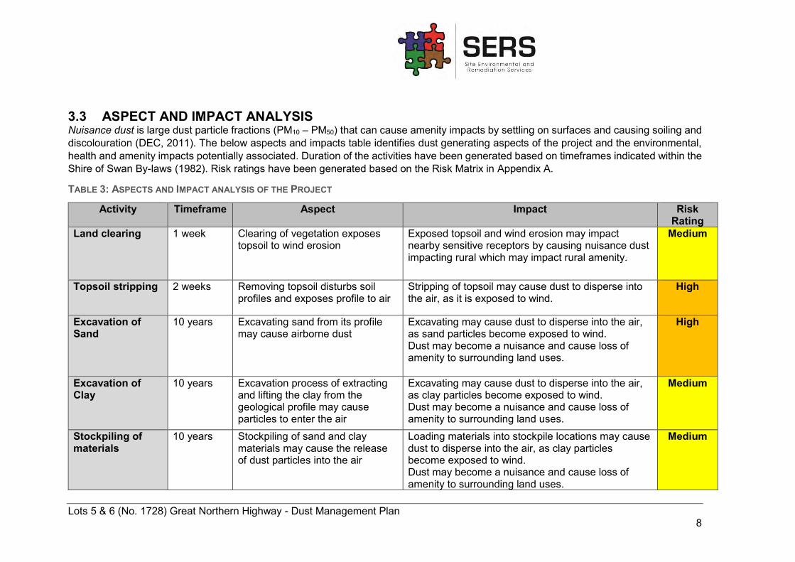
3.3 ASPECT AND IMPACT ANALYSIS Nuisance dust is large dust particle fractions (PM10 – PM50) that can cause amenity impacts by settling on surfaces and causing soiling and discolouration (DEC, 2011). The below aspects and impacts table identifies dust generating aspects of the project and the environmental, health and amenity impacts potentially associated. Duration of the activities have been generated based on timeframes indicated within the Shire of Swan By-laws (1982). Risk ratings have been generated based on the Risk Matrix in Appendix A.
TABLE 3: ASPECTS AND IMPACT ANALYSIS OF THE PROJECT
Activity Timeframe Aspect Impact Risk Rating
Land clearing 1 week
Clearing of vegetation exposes topsoil to wind erosion
Exposed topsoil and wind erosion may impact nearby sensitive receptors by causing nuisance dust impacting rural which may impact rural amenity.
Medium
Topsoil stripping 2 weeks
Removing topsoil disturbs soil profiles and exposes profile to air
Stripping of topsoil may cause dust to disperse into the air, as it is exposed to wind.
High
Excavation of Sand
10 years
Excavating sand from its profile may cause airborne dust
Excavating may cause dust to disperse into the air, as sand particles become exposed to wind. Dust may become a nuisance and cause loss of amenity to surrounding land uses.
High
Excavation of Clay
10 years Excavation process of extracting and lifting the clay from the geological profile may cause particles to enter the air
Excavating may cause dust to disperse into the air, as clay particles become exposed to wind. Dust may become a nuisance and cause loss of amenity to surrounding land uses.
Medium
Stockpiling of materials
10 years Stockpiling of sand and clay materials may cause the release of dust particles into the air
Loading materials into stockpile locations may cause dust to disperse into the air, as clay particles become exposed to wind. Dust may become a nuisance and cause loss of amenity to surrounding land uses.
Medium
Lots 5 & 6 (No. 1728) Great Northern Highway - Dust Management Plan 9
Loading of excavated materials
Intermittent Loading the sand and clay into trucks may cause dust particles to become airborne
Loading materials into vehicles may cause dust to disperse into the air, as sand and clay materials become exposed to wind. Dust may become a nuisance and cause loss of amenity to surrounding land uses.
High
Transport of excavated materials
Intermittent Transport of sand and clay on unsealed roads within the site may cause dust particles to become airborne
Tyre movement on unsealed roads may cause dust to disperse into the air. Dust may become a nuisance and cause loss of amenity to surrounding land uses.
High
Remediation of campaigns
Progressive Recontouring the earth from previous excavation campaign may cause disturbance and generate airborne particles to be released
Recontouring and earthworks may cause dust to disperse into the air. Dust may become a nuisance and cause loss of amenity to surrounding land uses.
Medium
Fill material being unloaded to the site releases dust particles into the air
Unloading of fill materials may cause dust to disperse into the air. Dust may become a nuisance and cause loss of amenity to surrounding land uses.
Medium
Lots 5 & 6 (No. 1728) Great Northern Highway - Dust Management Plan 10
4 DUST MONITORING PROGRAM 4.1 MONITORING METHODS It is a requirement within the NEPM to monitor, assess and report particles as PM2.5 or PM10 in accordance with the outlined protocol within the measure. Visual monitoring will be completed by all employees on site. When airborne dust has the potential to cause a nuisance by decreasing visibility on site, or clearly extending over the site boundary, employees will notify the site manager. The site manager will either cease works or implement more strenuous dust management methods depending on the severity of the dust incident.
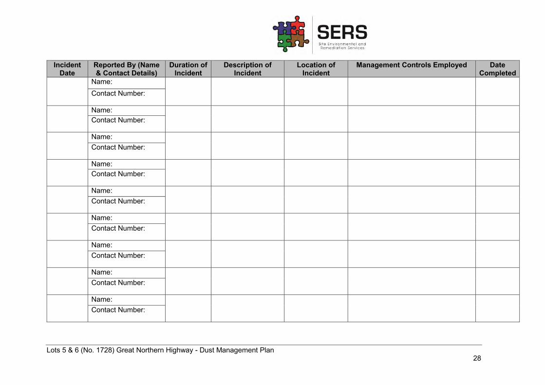
Supervisors on shift are additionally responsible for identifying nuisance dust and notifying the site manager to implement management methods. Site employees will be required to identify and record any excessive dust as a result of their works and notify the site manager to ensure remediation of dust is immediate. The site manager will be responsible for recording details of all nuisance dust events in the Dust Incident Register located in the site office.
As meteorological conditions have a direct influence on dust generation, meteorological data will be monitored daily by accessing the BoM website. Wind direction and strength will be taken into consideration, in addition to temperature and rainfall conditions. If combined conditions look to be unfavourable for works, operations will cease for a recommended period of time.
In the event that a nuisance dust occurrence takes place, the following information will be recorded and stored within the Dust Incident Register located in the site office data base:
- Frequency of nuisance dust occurrence - Intensity of occurrence (quantity of dust) - Duration of dust nuisance occurrence (date and time) - Location of dust nuisance occurrence - Mitigation strategies implemented
(Refer to Appendix C for Dust Incident Form)
Registers of these events will provide indication of developing trends associated with the time and works, in addition to ensuring that the dust remedial methods remain effective. This will ensure remediation techniques are implemented at the best possible time.
In the event that several community concerns have been raised and the project operations have caused a nuisance to surrounding land uses, there is potential to install dust monitors within the site. If this is the case, the City of Swan (CoS) will be contacted regarding the additional monitoring and management strategies.
4.2 PERFORMANCE CRITERIA The proponent will ensure that best practice measures are implemented to prevent or minimise the generation of dust throughout the duration of the project. The effectiveness of the Dust Management Plan will be reviewed against the following criteria:
- Compliance with the relevant legislation (Refer to section 1.3) - Number of complaints received in relation dust - Number of dust incidents recorded
Lots 5 & 6 (No. 1728) Great Northern Highway - Dust Management Plan 11
- No airborne dust being dispersed from internal access roads - Absence of nuisance dust originating from cleared works area - Level of impact on haul roads, access tracks and works area.
Continuous review of dust management procedures and controls will be implemented following the above performance criteria to ensure dust is managed within and outside the project area.
Lots 5 & 6 (No. 1728) Great Northern Highway - Dust Management Plan 12
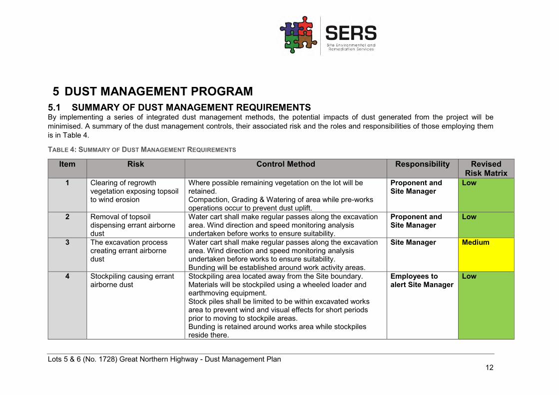
5 DUST MANAGEMENT PROGRAM 5.1 SUMMARY OF DUST MANAGEMENT REQUIREMENTS By implementing a series of integrated dust management methods, the potential impacts of dust generated from the project will be minimised. A summary of the dust management controls, their associated risk and the roles and responsibilities of those employing them is in Table 4.
TABLE 4: SUMMARY OF DUST MANAGEMENT REQUIREMENTS
Item Risk Control Method Responsibility Revised Risk Matrix
1 Clearing of regrowth vegetation exposing topsoil to wind erosion
Where possible remaining vegetation on the lot will be retained. Compaction, Grading & Watering of area while pre-works operations occur to prevent dust uplift.
Proponent and Site Manager
Low
2 Removal of topsoil dispensing errant airborne dust
Water cart shall make regular passes along the excavation area. Wind direction and speed monitoring analysis undertaken before works to ensure suitability.
Proponent and Site Manager
Low
3 The excavation process creating errant airborne dust
Water cart shall make regular passes along the excavation area. Wind direction and speed monitoring analysis undertaken before works to ensure suitability. Bunding will be established around work activity areas.
Site Manager Medium
4 Stockpiling causing errant airborne dust
Stockpiling area located away from the Site boundary. Materials will be stockpiled using a wheeled loader and earthmoving equipment. Stock piles shall be limited to be within excavated works area to prevent wind and visual effects for short periods prior to moving to stockpile areas. Bunding is retained around works area while stockpiles reside there.
Employees to alert Site Manager
Low
Lots 5 & 6 (No. 1728) Great Northern Highway - Dust Management Plan 13
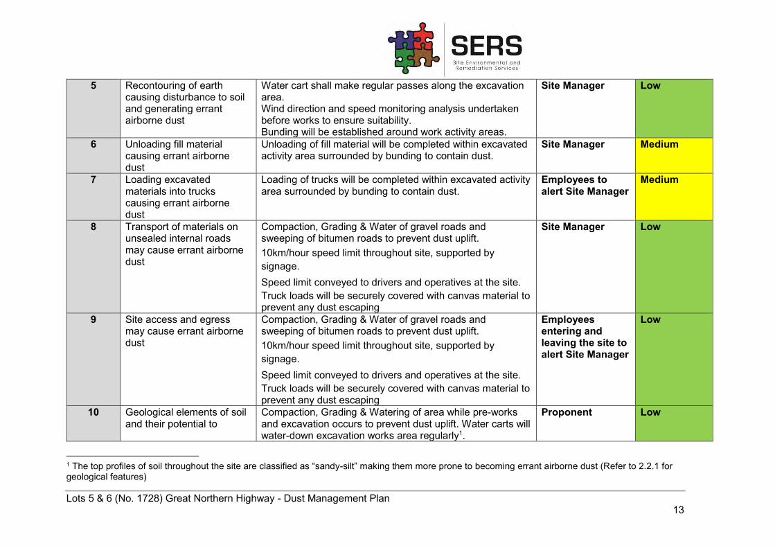
5 Recontouring of earth causing disturbance to soil and generating errant airborne dust
Water cart shall make regular passes along the excavation area. Wind direction and speed monitoring analysis undertaken before works to ensure suitability. Bunding will be established around work activity areas.
Site Manager Low
6 Unloading fill material causing errant airborne dust
Unloading of fill material will be completed within excavated activity area surrounded by bunding to contain dust.
Site Manager Medium
7 Loading excavated materials into trucks causing errant airborne dust
Loading of trucks will be completed within excavated activity area surrounded by bunding to contain dust.
Employees to alert Site Manager
Medium
8 Transport of materials on unsealed internal roads may cause errant airborne dust
Compaction, Grading & Water of gravel roads and sweeping of bitumen roads to prevent dust uplift. 10km/hour speed limit throughout site, supported by signage. Speed limit conveyed to drivers and operatives at the site. Truck loads will be securely covered with canvas material to prevent any dust escaping
Site Manager Low
9 Site access and egress may cause errant airborne dust
Compaction, Grading & Water of gravel roads and sweeping of bitumen roads to prevent dust uplift. 10km/hour speed limit throughout site, supported by signage. Speed limit conveyed to drivers and operatives at the site. Truck loads will be securely covered with canvas material to prevent any dust escaping
Employees entering and leaving the site to alert Site Manager
Low
10 Geological elements of soil and their potential to
Compaction, Grading & Watering of area while pre-works and excavation occurs to prevent dust uplift. Water carts will water-down excavation works area regularly1.
Proponent Low
1 The top profiles of soil throughout the site are classified as “sandy-silt” making them more prone to becoming errant airborne dust (Refer to 2.2.1 for geological features)
Lots 5 & 6 (No. 1728) Great Northern Highway - Dust Management Plan 14
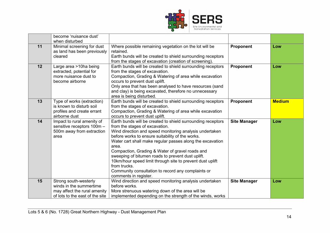
become ‘nuisance dust’ when disturbed
11 Minimal screening for dust as land has been previously cleared
Where possible remaining vegetation on the lot will be retained. Earth bunds will be created to shield surrounding receptors from the stages of excavation (creation of screening).
Proponent Low
12 Large area >10ha being extracted, potential for more nuisance dust to become airborne
Earth bunds will be created to shield surrounding receptors from the stages of excavation. Compaction, Grading & Watering of area while excavation occurs to prevent dust uplift. Only area that has been analysed to have resources (sand and clay) is being excavated, therefore no unnecessary area is being disturbed.
Proponent Low
13 Type of works (extraction) is known to disturb soil profiles and create errant airborne dust
Earth bunds will be created to shield surrounding receptors from the stages of excavation. Compaction, Grading & Watering of area while excavation occurs to prevent dust uplift.
Proponent Medium
14 Impact to rural amenity of sensitive receptors 100m – 500m away from extraction area
Earth bunds will be created to shield surrounding receptors from the stages of excavation. Wind direction and speed monitoring analysis undertaken before works to ensure suitability of the works. Water cart shall make regular passes along the excavation area. Compaction, Grading & Water of gravel roads and sweeping of bitumen roads to prevent dust uplift. 10km/hour speed limit through site to prevent dust uplift from trucks. Community consultation to record any complaints or comments in register.
Site Manager Low
15 Strong south-westerly winds in the summertime may affect the rural amenity of lots to the east of the site
Wind direction and speed monitoring analysis undertaken before works. More strenuous watering down of the area will be implemented depending on the strength of the winds, works
Site Manager Low
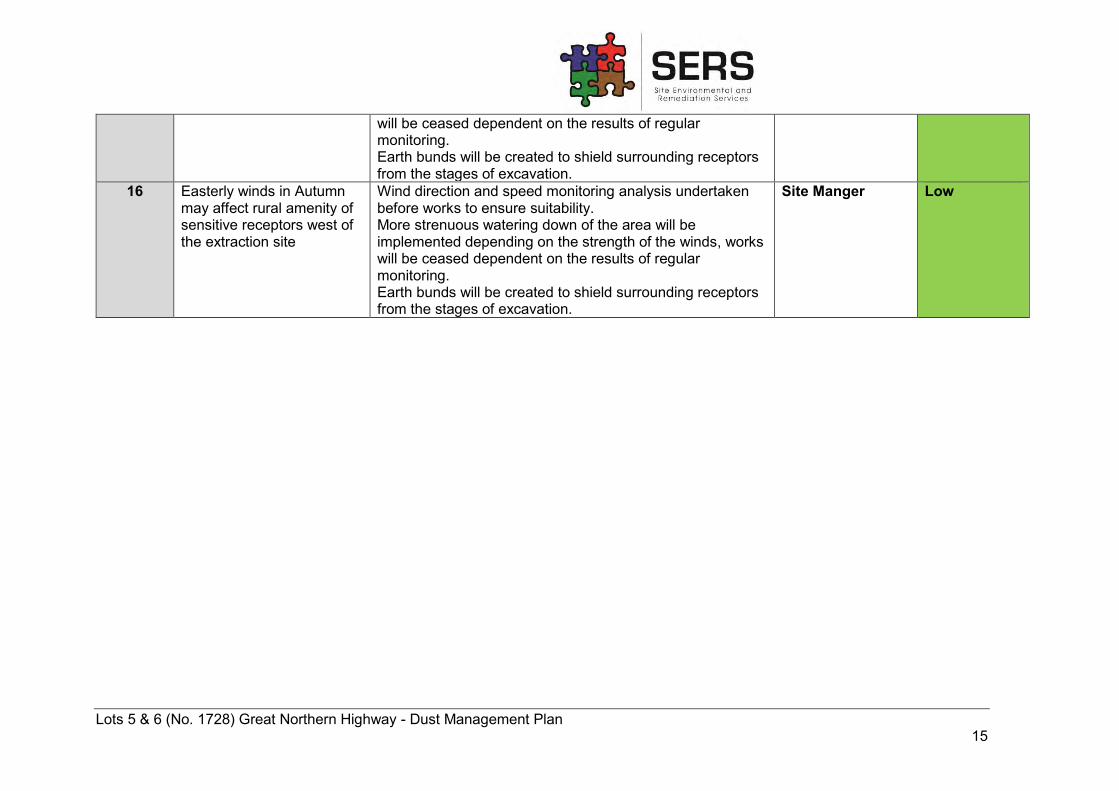
Lots 5 & 6 (No. 1728) Great Northern Highway - Dust Management Plan 15
will be ceased dependent on the results of regular monitoring. Earth bunds will be created to shield surrounding receptors from the stages of excavation.
16 Easterly winds in Autumn may affect rural amenity of sensitive receptors west of the extraction site
Wind direction and speed monitoring analysis undertaken before works to ensure suitability. More strenuous watering down of the area will be implemented depending on the strength of the winds, works will be ceased dependent on the results of regular monitoring. Earth bunds will be created to shield surrounding receptors from the stages of excavation.
Site Manger Low
Lots 5 & 6 (No. 1728) Great Northern Highway - Dust Management Plan 16
5.2 SUMMARY OF DUST MANAGEMENT CONTROLS In order for dust to be successfully mitigated onsite and offsite the following controls will need to be implemented:
- Retaining vegetation where possible; - Limiting areas of exposed soil; - Compacting and grading of soil for internal access roads; - Applying water to increase moisture in soil and prevent dust uplift (Water carts); - Minimising distance of works to site egress route; - Timing of earthworks in relation to wind speed, wind strength, rainfall and temperature
(daily and seasonally); - Consideration of wind direction and strengths during excavation; - Appropriate implementation of earthworks (bunding appropriate to shielding sensitive
receptors).
Water needed for dust suppression will be sourced from the adjacent water retention pit located at Lot 5 (91) Walyunga Road, Bullsbrook. Brikmakers have an agreement with the landowner at the adjacent site to utilise excess water located in the retention basin. As there is a copious water source and availability of watercarts, it is expected that dust will be supressed in the associated processes. In the event that dust monitors are required and installed (refer to 4.1 for conditions), the NEPM air quality standards will be followed and reports will be generated in regard to the exceedance criteria for PM10 and PM2.5.
5.3 RELEVANT STAKEHOLDERS Stakeholders are all parties who have an interest in the project. It is a requirement of formerly Department of Environment Regulation (DER), currently Department of Water and Environment Regulation, for proponents to carry out community engagement for sites that pose a risk to human health, the environment, environmental values, or potentially impact sensitive off-site receptors (DER, 2014). The relevant stakeholders of this project include:
- Sensitive receptors within 500m of the project area - Residents of the Bullsbrook area - Indirectly affected members of the public - City of Swan - Government Departments (e.g. DWER, DoH)
The Council may forward notice onto landowners and occupiers within 500m of the site boundary, which will advise of the proposed excavation and specify that they may object to or make representations in writing in respect of the issue of a License by the Council (Shire of Swan, 1982).
5.4 ROLES AND RESPONSIBILITIES The roles and responsibilities associated with the implementation of dust management controls have been outlined within the Table 4 in section 5.1
Lots 5 & 6 (No. 1728) Great Northern Highway - Dust Management Plan 17
5.5 COMPLAINTS MANAGEMENT Information regarding any complaints of nuisance dust events from community members or employees and contractors must be documented and passed onto the site manager for review and action as soon as possible. A record of complaints will be kept within a register in the site office. Refer to Dust Incident database in Appendix C.
6 CONCLUSION It is the opinion of SERS, in consultation with Brikmakers, that the implementation of control measures outlined in this document, when implemented, will successfully mitigate dust generation on-site. The Dust Management Plan is subject to ongoing review, and it is the aim of Brikmakers to achieve continuous improvement in this area of operation. Implementation of the controls discussed in this report shall reduce the risk of dust onsite.
7 REFERENCES Australian Bureau of Statistics (2012) Year Book Australia Geography and Climate ACT
Canberra Accessed from http://www.abs.gov.au/ausstats/[email protected]/Lookup/by%20Subject/1301.0~2012~Main%20Features~Australia's%20climate~143 on 04/2017
Bureau of Meteorology (2016) Wind speed and direction rose – Summer 9am ACT Canberra Accessed from http://www.bom.gov.au/cgi-bin/climate/cgi_bin_scripts/windrose_selector.cgi?period=Summer&type=9&location=09021&Submit=Get+Rose on 01/12/2017
Bureau of Meteorology (2016) Wind speed and direction rose – Summer 3pm ACT Canberra Accessed from http://www.bom.gov.au/cgi-bin/climate/cgi_bin_scripts/windrose_selector.cgi?period=Summer&type=3&location=09021&Submit=Get+Rose on 01/12/2017
Bureau of Meteorology (2016) Wind speed and direction rose – Winter 9am ACT Canberra. Accessed from: http://www.bom.gov.au/cgi-bin/climate/cgi_bin_scripts/windrose_selector.cgi?period=Winter&type=9&location=09021&Submit=Get+Rose on 01/12/2017
Bureau of Meteorology (2016) Wind speed and direction rose – Winter 3pm ACT Canberra Accessed from http://www.bom.gov.au/cgi-bin/climate/cgi_bin_scripts/windrose_selector.cgi?period=Winter&type=3&location=09021&Submit=Get+Rose on 01/12/2017
Bureau of Meteorology (2017) Climate Statistics for Australian Locations – Monthly Climate Statistics Pearce RAAF Base ACT Canberra Accessed from http://www.bom.gov.au/climate/averages/tables/cw_009053.shtml on 24/11/2017
Lots 5 & 6 (No. 1728) Great Northern Highway - Dust Management Plan 18
CSIRO (2017) CSIRO Land and Water, Australian Soil Resource Information System (ASRIS), Commonwealth Government, Canberra Australian Capital Territory. Retrieved from: http://www.asris.csiro.au/mapping/viewer.htm on 6 December 2017.
Department of Environment and Conservation (2011) Guideline for managing the impacts of dust and associated contaminants from land development sites, contaminated sites remediation and other related activities Government of Western Australia.
Department of Environment Regulation (2014) Contaminated sites guidelines: Assessment and management of contaminated sites Community Engagement Government of Western Australia 83-86.
Department of Environment Regulation (2017) Guidance Statement: Risk Assessments Part V Division 3 Environmental Protection Act 1986 Government of Western Australia Accessed from https://www.der.wa.gov.au/images/documents/our-work/licences-and-works-approvals/GS_Risk_Assessments.pdf on 05/12/2017
Department of Mines, Industry Regulation and Safety (2017) Interactive Geological Map Government of Western Australia Accessed from https://geoview.dmp.wa.gov.au/GeoViews/?Viewer=GeoVIEW on 01/12/2017
DPIRD (2017) Department of Primary Industries and Regional Development, (Agriculture and Food Division), Perth Western Australia. Retrieved from https://maps.agric.wa.gov.au/nrm-info/ on 7 December 2017.
Environmental Protection Agency (2016) Particulate Matter (PM) Pollution – Health and Environmental Effected of Particulate Matter (PM) United States EPA Accessed from https://www.epa.gov/pm-pollution/health-and-environmental-effects-particulate-matter-pm on 06/12/2017
Environmental Protection Authority (2008) Environmental Guidance for Planning and Development Guidance Statement No.33 EPA Western Australia
Environmental Protection Authority (2016) Environmental Factor Guideline: Air Quality, EPA, Western Australia Accessed from http://www.epa.wa.gov.au/sites/default/files/Policies_and_Guidance/Guideline-Air-Quality-131216_2.pdf on 04/12/2017
Farmer, A M (1993) The Effects of Dust on Vegetation – a Review. Environmental Pollution 79:1 63-75 Accessed from http://www.sciencedirect.com/science/article/pii/026974919390179R on 07/12/2017
National Environmental Protection Council (2016) National Environment Protection (Ambient Air Quality) Measure, ACT Canberra.
Shire of Swan. (1982). By-law Relating to Extractive Industries. Government Gazette, Western Australia.
Lots 5 & 6 (No. 1728) Great Northern Highway - Dust Management Plan 19
FIGURE 2 – SITE LOCATION
0 140 28070
Meters
Sources: Esri, HERE,DeLorme, USGS, Intermap,INCREMENT P, NRCan, EsriJapan, METI, Esri China(Hong Kong), Esri Korea, Esri
Job No: 004-08
Client: Brikmakers
Address: 1728 Great Northern Highway, Bullsbrook, WA 6084.
File: N:\A SERS\GIS\Projects\ MXD\
Date drawn: 21/11/2017
Revision: 0
Drawn by: A.C
Checked by: R.M
Scale: 1:10,000
Original size: A3
Imagery from: 20/10/2017
Source: Nearmaps $© This plan must not be reproduced without the permission of SERS
Head Office: 281 Newcastle Street Northbridge WA 6003Postal: PO Box 377 Northbridge Perth WA 6865T: +61 8 92202000 F: +61 8 92202010E: [email protected] W: www.sers.net.au
FIGURE 1: Site Location
Legend
Site Boundary
Lots 5 & 6 (No. 1728) Great Northern Highway - Dust Management Plan 20
FIGURE 3 – SURROUNDING LAND USES
0 340 680170
Meters
Sources: Esri, HERE,DeLorme, USGS, Intermap,INCREMENT P, NRCan, EsriJapan, METI, Esri China(Hong Kong), Esri Korea, Esri
Job No: 004-08
Client: Brikmakers
Address: 1728 Great Northern Highway, Bullsbrook, WA 6084.
File: N:\A SERS\GIS\Projects\ MXD\
Date drawn: 21/11/2017
Revision: 0
Drawn by: A.C
Checked by: R.M
Scale: 1:10,000
Original size: A3
Imagery from: 20/10/2017
Source: Nearmaps $© This plan must not be reproduced without the permission of SERS
Head Office: 281 Newcastle Street Northbridge WA 6003Postal: PO Box 377 Northbridge Perth WA 6865T: +61 8 92202000 F: +61 8 92202010E: [email protected] W: www.sers.net.au
FIGURE 2: Surrounding Land Uses
Legend
Site Boundary Land Use:Residential
Land Use:Parks andRecreation
Land Use: Rural
Lots 5 & 6 (No. 1728) Great Northern Highway - Dust Management Plan 21
FIGURE 4 – SITE LAYOUT
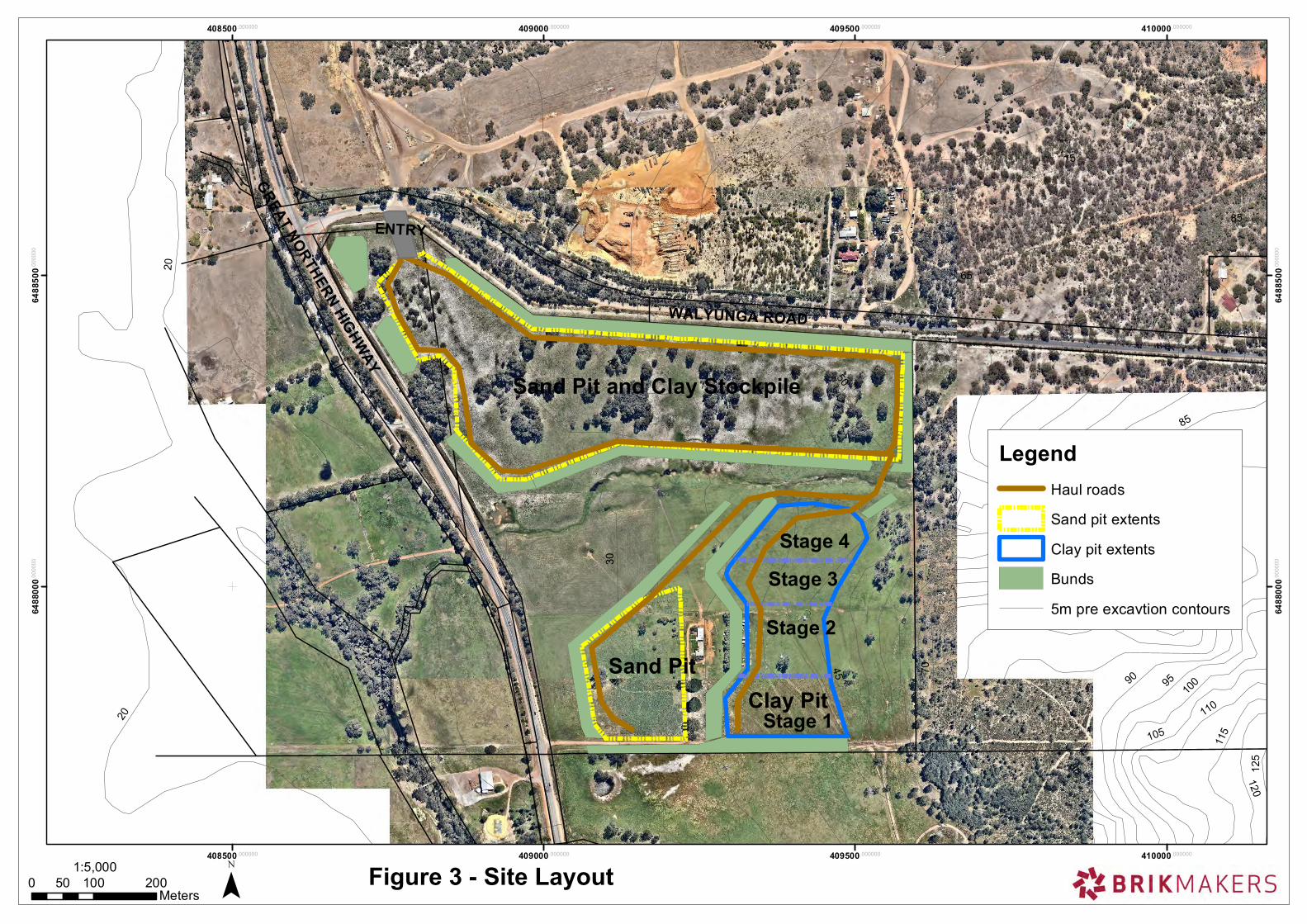
GREAT NORTHERN HIGHWAY
WALYUNGA ROAD
New stockpile area
Sand Pit and Clay Stockpile
ENTRY
Clay Pit Sand Pit
Stage 1
Stage 2
Stage 3
Stage 4
95
90
30
35
25
20
40
4550
55
80
75
60
70
65
85
90
15
9510
0
105
110
115
120
125
85
20
408500.000000
408500.000000
409000.000000
409000.000000
409500.000000
409500.000000
410000.000000
410000.000000
6488
000.0
0000
0
6488
000.0
0000
0
6488
500.0
0000
0
6488
500.0
0000
0
¯0 100 20050Meters
1:5,000 Figure 3 - Site Layout
LegendHaul roads
Sand pit extents
Clay pit extents
Bunds
5m pre excavtion contours
Lots 5 & 6 (No. 1728) Great Northern Highway - Dust Management Plan 22
FIGURE 5 – SENSITIVE RECEPTORS AND BUFFER DISTANCES
1
2
3
4
5
6
7
8
9
0 160 32080
Meters
Sources: Esri, HERE,DeLorme, USGS, Intermap,INCREMENT P, NRCan, EsriJapan, METI, Esri China(Hong Kong), Esri Korea, Esri
Job No: 004-08
Client: Brikmakers
Address: 1728 Great Northern Highway, Bullsbrook, WA 6084.
File: N:\A SERS\GIS\Projects\ MXD\
Date drawn: 12/12/2017
Revision: 0
Drawn by: A.C
Checked by: R.M
Scale: 1:12,500
Original size: A3
Imagery from: 03/12/2017
Source: Nearmaps $© This plan must not be reproduced without the permission of SERS
Head Office: 281 Newcastle Street Northbridge WA 6003Postal: PO Box 377 Northbridge Perth WA 6865T: +61 8 92202000 F: +61 8 92202010E: [email protected] W: www.sers.net.au
FIGURE 5: Buffer Zones for Sensitive Receptors Legend
Residential
SiteBoundary
300m Buffer
500m Buffer
1,000mBuffer
Rural

Lots 5 & 6 (No. 1728) Great Northern Highway - Dust Management Plan 23
APPENDIX A - RISK MATRIX
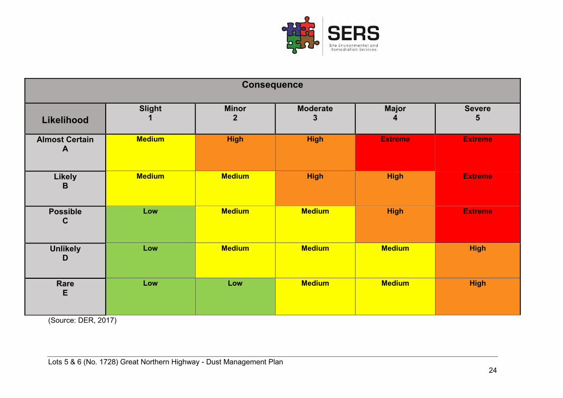
Lots 5 & 6 (No. 1728) Great Northern Highway - Dust Management Plan 24
(Source: DER, 2017)
Consequence
Likelihood
Slight 1
Minor 2
Moderate 3
Major 4
Severe 5
Almost Certain A
Medium
High High Extreme Extreme
Likely B
Medium Medium High High Extreme
Possible C
Low Medium Medium High Extreme
Unlikely D
Low Medium Medium Medium High
Rare E
Low Low Medium Medium High
Lots 5 & 6 (No. 1728) Great Northern Highway - Dust Management Plan 25
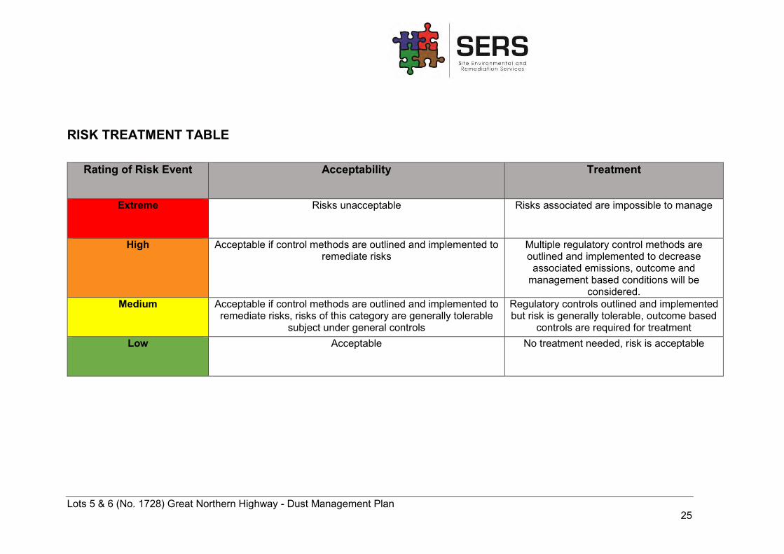
RISK TREATMENT TABLE
Rating of Risk Event Acceptability Treatment
Extreme Risks unacceptable Risks associated are impossible to manage
High Acceptable if control methods are outlined and implemented to remediate risks
Multiple regulatory control methods are outlined and implemented to decrease associated emissions, outcome and
management based conditions will be considered.
Medium Acceptable if control methods are outlined and implemented to remediate risks, risks of this category are generally tolerable
subject under general controls
Regulatory controls outlined and implemented but risk is generally tolerable, outcome based
controls are required for treatment Low Acceptable No treatment needed, risk is acceptable
Lots 5 & 6 (No. 1728) Great Northern Highway - Dust Management Plan 26
APPENDIX B – WIND ROSES FOR SUMMER AND WINTER
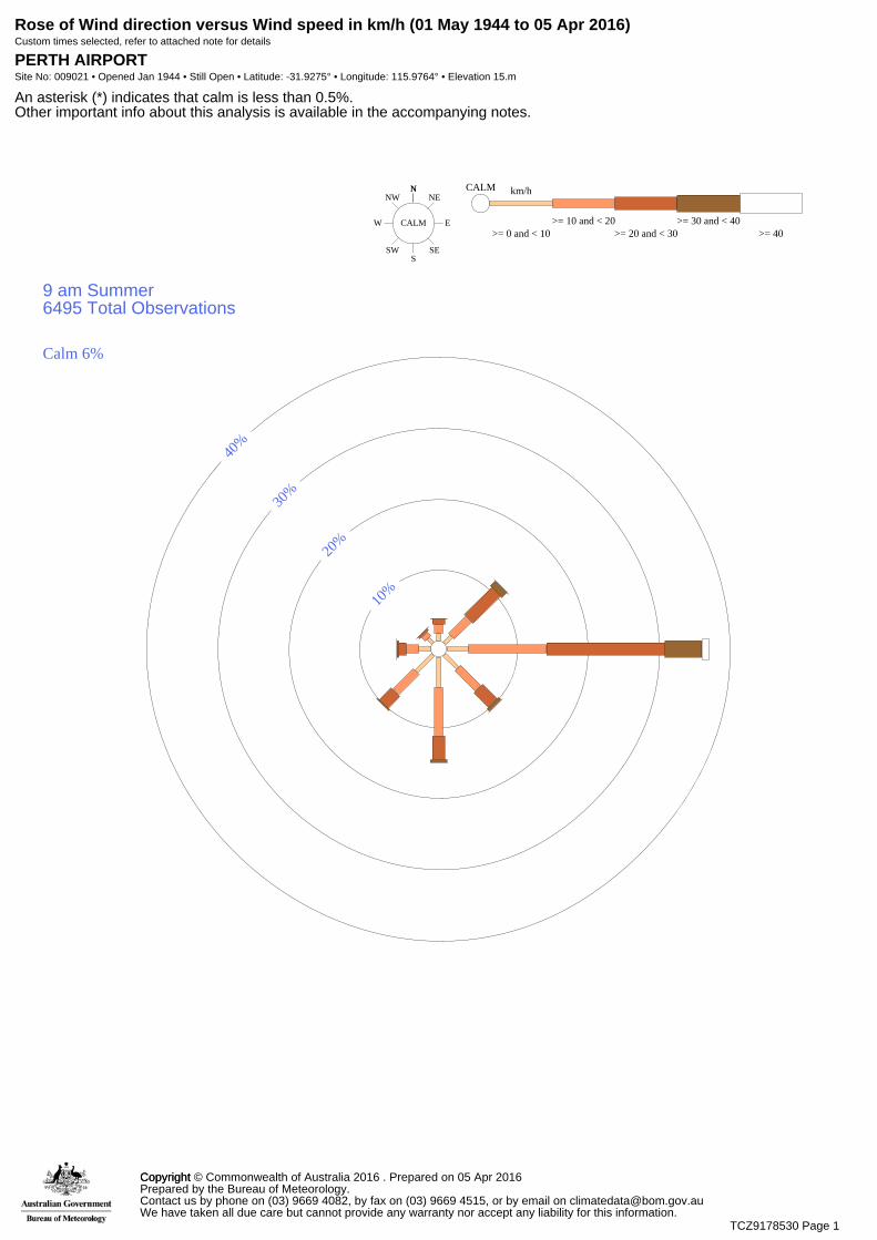
Rose of Wind direction versus Wind speed in km/h (01 May 1944 to 05 Apr 2016)Custom times selected, refer to attached note for details
PERTH AIRPORTSite No: 009021 • Opened Jan 1944 • Still Open • Latitude: -31.9275° • Longitude: 115.9764° • Elevation 15.m
An asterisk (*) indicates that calm is less than 0.5%.Other important info about this analysis is available in the accompanying notes.
NNE
E
SES
SW
W
NWN
CALM>= 0 and < 10
km/hCALM
>= 10 and < 20>= 20 and < 30
>= 30 and < 40>= 40
9 am Summer6495 Total Observations
10%
20%
30%
40%
Calm 6%
CopyrightCopyright © Commonwealth of Australia 2016 . Prepared on 05 Apr 2016Prepared by the Bureau of Meteorology.Contact us by phone on (03) 9669 4082, by fax on (03) 9669 4515, or by email on [email protected] have taken all due care but cannot provide any warranty nor accept any liability for this information.
TCZ9178530 Page 1
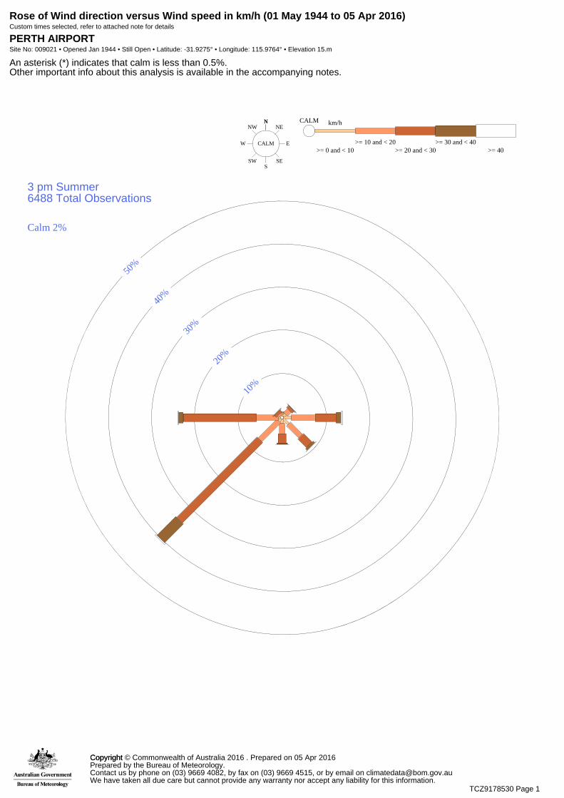
Rose of Wind direction versus Wind speed in km/h (01 May 1944 to 05 Apr 2016)Custom times selected, refer to attached note for details
PERTH AIRPORTSite No: 009021 • Opened Jan 1944 • Still Open • Latitude: -31.9275° • Longitude: 115.9764° • Elevation 15.m
An asterisk (*) indicates that calm is less than 0.5%.Other important info about this analysis is available in the accompanying notes.
NNE
E
SES
SW
W
NWN
CALM>= 0 and < 10
km/hCALM
>= 10 and < 20>= 20 and < 30
>= 30 and < 40>= 40
3 pm Summer6488 Total Observations
10%
20%
30%
40%
50%
Calm 2%
CopyrightCopyright © Commonwealth of Australia 2016 . Prepared on 05 Apr 2016Prepared by the Bureau of Meteorology.Contact us by phone on (03) 9669 4082, by fax on (03) 9669 4515, or by email on [email protected] have taken all due care but cannot provide any warranty nor accept any liability for this information.
TCZ9178530 Page 1
Rose of Wind direction versus Wind speed in km/h (01 May 1944 to 05 Apr 2016)Custom times selected, refer to attached note for details
PERTH AIRPORTSite No: 009021 • Opened Jan 1944 • Still Open • Latitude: -31.9275° • Longitude: 115.9764° • Elevation 15.m
An asterisk (*) indicates that calm is less than 0.5%.Other important info about this analysis is available in the accompanying notes.
NNE
E
SES
SW
W
NWN
CALM>= 0 and < 10
km/hCALM
>= 10 and < 20>= 20 and < 30
>= 30 and < 40>= 40
3 pm Winter6624 Total Observations
10%
20%
Calm 7%
CopyrightCopyright © Commonwealth of Australia 2016 . Prepared on 05 Apr 2016Prepared by the Bureau of Meteorology.Contact us by phone on (03) 9669 4082, by fax on (03) 9669 4515, or by email on [email protected] have taken all due care but cannot provide any warranty nor accept any liability for this information.
TCZ9178530 Page 1
Rose of Wind direction versus Wind speed in km/h (01 May 1944 to 05 Apr 2016)Custom times selected, refer to attached note for details
PERTH AIRPORTSite No: 009021 • Opened Jan 1944 • Still Open • Latitude: -31.9275° • Longitude: 115.9764° • Elevation 15.m
An asterisk (*) indicates that calm is less than 0.5%.Other important info about this analysis is available in the accompanying notes.
NNE
E
SES
SW
W
NWN
CALM>= 0 and < 10
km/hCALM
>= 10 and < 20>= 20 and < 30
>= 30 and < 40>= 40
9 am Winter6622 Total Observations
10%
20%
30%
Calm 19%
CopyrightCopyright © Commonwealth of Australia 2016 . Prepared on 05 Apr 2016Prepared by the Bureau of Meteorology.Contact us by phone on (03) 9669 4082, by fax on (03) 9669 4515, or by email on [email protected] have taken all due care but cannot provide any warranty nor accept any liability for this information.
TCZ9178530 Page 1

Lots 5 & 6 (No. 1728) Great Northern Highway - Dust Management Plan 27
APPENDIX C – DUST INCIDENT REGISTER
Lots 5 & 6 (No. 1728) Great Northern Highway - Dust Management Plan 28
Incident Date
Reported By (Name & Contact Details)
Duration of Incident
Description of Incident
Location of Incident
Management Controls Employed Date Completed
Name: Contact Number:
Name: Contact Number:
Name: Contact Number:
Name: Contact Number:
Name: Contact Number:
Name: Contact Number:
Name: Contact Number:
Name: Contact Number:
Name: Contact Number:
Related Documents