Appendices APPENDIX D: Western Albuquerque Land Holdings Bernalillo County Sector Plan Westland Sector Development Plan EXHIBIT A: PROPOSED LAND USE AMENDED MAY 2016 2016 AMENDMENT Prepared for WESTERN ALBUQUERQUE LAND HOLDINGS LLC Prepared by Consensus Planning, Inc. Tierra Ladera Petroglyph National Monument 118th Street N.W. AMAFCA Pond Easement Arroyo Vista N.W. Arroyo Vista N.W. Drive Pintada N.W. Interstate 40 ABCWUA Reservoir SD-W-RL ±114 ac. PDA ±215 ac. TC ±23 ac. SD-W-O-1 ±90 ac. SD-W-M-1 ±94 ac. SD-W-OS ±28 ac. SD-W-RM ±122 ac. SD-W-RM ±63 ac. SD-W-RM ±73 ac. SD-W-RM ±61 ac. R-5.5 ±103 ac. R-5.5 ±36 ac. R-5.5 ±52 ac. R-5.5 ±40 ac. R-5.5 ±119 ac. R-5.5 ±26 ac. SD-W-RH ±8 ac. PDA ±93 ac. R-4 ±75 ac. SD-W-C-1 ±13 ac. SD-W-C-1 ±13 ac. SD-W-C-1 ±16 ac. SD-W-C-1 ±12 ac. TC ±63 ac. SD-W- C-2 ±17 ac. TCV ±55 ac. SD-W-M-1 ±84 ac. SD-W-OS ±23 ac. SD-W-OS ±31 ac. SD-W-OS ±8 ac. SD-W-OS ±10 ac. SD-W-OS ±21 ac. SD-W-OS ±20 ac. SD-W-OS ±13 ac. SD-W-OS ±68 ac. SD-W-OS ±57 ac. OS ±90 ac. OS ±40 ac. OS ±28 ac. SD-W-OS ±13 ac. OS ±13 ac. OS ±10 ac. OS ±17 ac. Atrisco Terrace / Open Space Atrisco Terrace / Open Space Atrisco Terrace / Open Space TCV ±5 ac. Regional Park ±81 ac. TC ±61 ac. OS ±28 ac. SD-W-RH ±25 ac. SD-W-C-1 ±55 ac. Education ±110 ac. Athletic Complex ±110 ac. TCV ±26 ac. Atrisco Terrace / Open Space SD-W-OS ±7 ac. SD-W-OS ±14 ac. OS ±6 ac. Ladera Drive Atrisco Vista Boulevard N.W. Shamrock Way Tempur-Pedic Parkway Cordero Road Cord ero Mesa Paseo Del Volcan (Proposed Regional Arterial Post 2040) Proposed Minor Arterial Post 2040 Proposed Community Arterial Post 2040 Reservoir Road SD-W-M-1 ±60 ac. SD-W-M-1 ±31 ac. SD-W-M-1 ±46 ac. SD-W-C-2 ±40 ac. SD-W-RM ±54 ac. SD-W-RM ±48 ac. SD-W-RM ±57 ac. SD-W-RM ±46 ac. SD-W-RM ±83 ac. SD-W-RM ±112 ac. SD-W-RM ±91 ac. SD-W-RM ±171 ac. SD-W-RM ±72 ac. SD-W-C-LI ±50 ac. SD-W-C-LI ±82 ac. SD-W-C-LI ±54 ac. SD-W-C-LI ±62 ac. SD-W-C-LI ±132 ac. SD-W-RM ±277 ac. SD-W-RM ±180 ac. SD-W-RM ±194 ac. SD-W-RM ±50 ac. SD-W-RM ±47 ac. SD-W-RL ±55 ac. SD-W-RM ±67 ac. SD-W-RM ±46 ac. SD-W-OS ±18 ac. SD-W-OS ±27 ac. R-2.5 ±8 ac. 98th Street N.W. Central Ave SW Atrisco Vista Boulevard N.W. SD-W-M-1 454 ac. Proposed Minor Arterial Post 2040 Proposed Community Arterial Post 2040 Neighborhood Access To Petroglyph National Monument Neighborhood Access To Petroglyph National Monument Neighborhood Access To Petroglyph National Monument NORTH 2000 1000 500 0 4000 FEET 25 ACRES 100 ACRES Master Plan Boundary Legend City Limits City of Albuquerque Residential 2.5 du/ac average Residential 15 du/ac average Neighborhood Commercial Highway Commercial Corporate Office Commercial/Light Industrial Open Space Major Public Open Space Residential 4 du/ac average Industrial Park Proposed Master Plan Boundary Extension Note: Roadway alignments are conceptual, final rights-of-way and alignments shall be determined with future platting actions. This corridor is restricted to utilities, drainage, and trails.

Welcome message from author
This document is posted to help you gain knowledge. Please leave a comment to let me know what you think about it! Share it to your friends and learn new things together.
Transcript
Appendices
APPENDIX D: Western Albuquerque Land Holdings Bernalillo County Sector Plan
Westland Sector Development Plan
EXHIBIT A: PROPOSED LAND USEAMENDED MAY 2016
2016 AMENDMENT
Prepared forWESTERN ALBUQUERQUE LAND HOLDINGS LLC
Prepared byConsensus Planning, Inc.
Tierra
Ladera
Petroglyph National Monument
118th Street N.W.
AMAFCA Pond Easement
Arroyo Vista N.W
.
Arroyo Vista N.W.
Drive
Pintad
aN.W
.
Interstate 40
ABCWUAReservoir
SD-W-RL±114 ac.
PDA±215 ac.
TC±23 ac.
SD-W-O-1±90 ac.
SD-W-M-1±94 ac.
SD-W-OS±28 ac.
SD-W-RM±122 ac.
SD-W-RM±63 ac.
SD-W-RM±73 ac.
SD-W-RM±61 ac.
R-5.5±103 ac.
R-5.5±36 ac.
R-5.5±52 ac.
R-5.5±40 ac.
R-5.5±119 ac.
R-5.5±26 ac.
SD-W-RH±8 ac.
PDA±93 ac.
R-4±75 ac.
SD-W-C-1±13 ac.
SD-W-C-1±13 ac.
SD-W-C-1±16 ac.
SD-W-C-1±12 ac.
TC±63 ac.
SD-W-C-2
±17 ac.
TCV±55 ac.
SD-W-M-1±84 ac.
SD-W-OS±23 ac.
SD-W-OS±31 ac.
SD-W-OS±8 ac.
SD-W-OS±10 ac.
SD-W-OS±21 ac.
SD-W-OS±20 ac.SD-W-OS
±13 ac.
SD-W-OS±68 ac.
SD-W-OS±57 ac.
OS±90 ac.
OS±40 ac.
OS±28 ac.
SD-W-OS±13 ac.
OS±13 ac.
OS±10 ac.
OS±17 ac.Atrisco Terrace /
Open Space
Atrisco Terrace /Open Space
Atrisco Terrace /Open Space
TCV±5 ac.
Regional Park±81 ac.
TC±61 ac.
OS±28 ac.
SD-W-RH±25 ac.
SD-W-C-1±55 ac.
Education±110 ac.
Athletic Complex±110 ac.
TCV±26 ac.
Atrisco Terrace /Open Space
SD-W-OS±7 ac.
SD-W-OS±14 ac.
OS±6 ac.
Ladera Drive
Atrisco Vista Boulevard N.W.
Shamrock W
ay
Tempur-Pedic Parkway
Cordero Road
CorderoMesa
Paseo Del Volcan (Proposed R
egional Arterial Post 2040)
Proposed Minor Arterial Post 2040
Proposed Community Arterial Post 2040
Reservoir Road
SD-W-M-1±60 ac.
SD-W-M-1±31 ac.
SD-W-M-1±46 ac.
SD-W-C-2±40 ac.
SD-W-RM±54 ac.
SD-W-RM±48 ac.
SD-W-RM±57 ac.
SD-W-RM±46 ac.
SD-W-RM±83 ac.
SD-W-RM±112 ac.
SD-W-RM±91 ac.
SD-W-RM±171 ac.
SD-W-RM±72 ac.
SD-W-C-LI±50 ac.
SD-W-C-LI±82 ac.
SD-W-C-LI±54 ac.
SD-W-C-LI±62 ac.
SD-W-C-LI±132 ac.
SD-W-RM±277 ac.
SD-W-RM±180 ac.
SD-W-RM±194 ac.
SD-W-RM±50 ac.
SD-W-RM±47 ac.
SD-W-RL±55 ac.
SD-W-RM±67 ac.
SD-W-RM±46 ac.
SD-W-OS±18 ac.
SD-W-OS±27 ac.
R-2.5±8 ac.
98th Street N.W
.
Central Ave SW
Atris
co V
ista
Boul
evar
d N.
W.
SD-W-M-1454 ac.
Proposed Minor Arterial Post 2040
Proposed Community Arterial Post 2040
Neighborhood AccessTo Petroglyph National
Monument
Neighborhood AccessTo Petroglyph National
Monument
Neighborhood AccessTo Petroglyph National
Monument
NORTH 20001000500 0 4000
FEE
T
WESTERN ALBUQUERQUE LAND HOLDINGS LLC
LAND USE/ZONING PLANAMENDED APRIL, 2016
Western Albuquerque LandHoldings Master Plan
25ACRES
100ACRES
Prepared For
Prepared By
CONSENSUS
PLA
NN
ING
Consensus Planning, Inc.
Master Plan Boundary
Legend
City Limits
Residential 2.5 du/ac average
Residential 15 du/ac average
Neighborhood Commercial
Highway Commercial
Corporate Office
Commercial/Light Industrial
Open Space
Major Public Open Space
Residential 4 du/ac average
Industrial Park
Proposed Master Plan Boundary Extension
Note: Roadway alignments are conceptual, final rights-of-way andalignments shall be determined with future platting actions.
City ofAlbuquerque
This corridor is restricted to utilities, drainage, andtrails.

Appendices
APPENDIX D: Western Albuquerque Land Holdings Bernalillo County Sector Plan
ZoningThis section proposes zoning regulations, which will apply to the Westland Sector Development Plan (SDP) area in the Unincorporated Bernalillo County. Where the Master and Sector Plan are silent, the Bernalillo County Zoning Code shall prevail and unless otherwise stated, all terms will be defined in accordance with Bernalillo County Zoning Code Section 5.
All conditional uses shall be filed with the Zoning Administrator on a form and accompanied by such data and information as he/she may prescribe. Additionally, the overall gross residential density in the Unincorporated Bernalillo County shall not exceed 3.0 dwelling units per acre in accordance with the Albuquerque/Bernalillo County Comprehensive Plan.
Furthermore, the following zones created by this Sector Plan will be adopted by ordinance in Bernalillo County in conjunction with the adoption of this Rank III Westland Master Plan section and may be summarized as follows:
SD-W-O-1 (Corporate Office Zone) This zone provides sites suitable for office, service, institutional, and dwelling uses. All regulations guiding the development within the SD-W-O-1 zone (for permissive and conditional uses) are as defined within the O-1 Zone in the Bernalillo County Comprehensive Zoning Code.
SD-W-C-1 (Neighborhood Commercial Center Zone)This zone provides suitable sites for office, service, institution and limited commercial uses to satisfy the day-to-day needs of residential areas. All regulations guiding the development within the SD-W-C-1 zone (for permissive and conditional uses) are as defined within the C-1 Zone in the Bernalillo County Comprehensive Zoning Code.
SD-W-C-2 (Highway Commercial Zone)This zone provides suitable sites for commercial activities and certain specified outside storage. All regulations guiding the development within the SD-W-C-2 zone (for permissive and conditional uses) are as defined within the C-2 Zone in the Bernalillo County Comprehensive Zoning Code.
SD-W-M-1 (Industrial Park Zone)This zone provides suitable sites for a wide range of industrial and commercial uses. All regulations guiding the development within the SD-W-M-1 zone (for permissive and conditional uses) are regulated by the M-1 Zone in the Bernalillo County Comprehensive Zoning Code with the following additions:
(A) Permissive uses. The following uses are permissive in the SD-W-M-1 Zone:
(1) Data center(2) Temporary drainage pond(3) Active or passive recreation
SD-W-C-LI (Commercial/Light Industrial Zone)This zone provides suitable sites for a wide range of community commercial uses, light manufacturing, light fabricating, warehousing, and wholesale distribution uses with ready access to arterial highways or railroads. All regulations guiding the development within the SD-W-C-LI zone (for permissive and conditional uses) are as defined within the C-LI Zone in the Bernalillo County Comprehensive Zoning Code with the following additions:
(A) Permissive uses. The following uses are permissive in the SD-W-CL-I Zone:
(1) Passive or active recreation
SD-W-OS (Open Space Zone)The purpose of the Open Space Zone is to protect and preserve those WMP area open land areas, parks, trails, undevelopable land, and areas with valuable environmental qualities to ensure the continued health,
safety, and welfare of the community and to provide a location for recreational activities. Gardening, cultural events, and recreational type uses are permitted. The Bernalillo County Zoning Administrator, Parks and Recreation, and Public Works Departments shall review and approve all SD-W-OS applications.
(A) Permissive uses. The following uses are permissive in the SD-W-OS Zone:
(1) Passive and active recreation(2) Trails.
(a) Wherever possible, trails shall be designed for multi-use and accommodate pedestrians, runners, and bicyclists, except, where due to soil conditions and erosion potential, multi-use trails are not allowed.
(b) Connections shall be made from individual neighborhoods to the community trail system via trails and/or sidewalks as determined in the subdivision phase.
(c) Trails shall use Barrier-Free Design to accommodate physically challenged individuals as trail users, where feasible.
(d) All private trails shall be concrete, asphalt, or stabilized crusher fines and have a minimum width of 8 feet.
(e) Pedestrian crossings shall be clearly demarcated with colored, textured paving where crossing vehicular entrances and streets.
(3) Kiosks and signage(a) Size. Kiosks and signage shall be a
maximum of 6 feet tall, 8 square feet of sign face area.
(b) Frequency. One per ¼ mile radius.(c) Illumination. Allowed to be illuminated
so long as the sign or kiosk is a minimum 25 foot distance from residential zoned property, and only the lettering on the sign is illuminated.

Appendices
APPENDIX D: Western Albuquerque Land Holdings Bernalillo County Sector Plan
(d) Free-standing signs shall not contain any external bracing, angle-iron supports, guy wires or similar devices.
(e) No signage is allowed that uses moving parts, makes audible sounds, or has blinking or flashing lights.
(f) Off-premise signs. Signs with reader boards, and electronic signs are prohibited.
(g) Signs shall not overhang into the public right-of-way or extend above any structure roof line.
(4) Outdoor cultural, educational, and civic facilities(a) Setbacks. Buildings or structures, whether
temporary or permanent, must be set back from all property lines a minimum of the following, whichever is greater:
1. 1 foot for each foot of building height if; or
2. 50 feet from abutting residential zoned properties if illuminated; or
3. 25 feet if not illuminated and abutting residential zoned properties.
4. 0 feet from abutting residential zoned properties in which school uses exist.
(5) Other uses customary to parks, open space, and recreation(a) Allowed temporary uses. Athletic events,
parades, and public assemblies, occurring on or within the public rights-of-way or other publicly owned property.
(b) Access. The site shall be provided with convenient and safe access for the ingress and egress of pedestrian and bicycle traffic.
(c) Illumination. Shall be provided at night, to protect the safety of the people at the outdoor event. The grounds shall be adequately lighted, but shall not unreasonably reflect beyond the assembly area boundaries.
(1) Height of luminaires shall not exceed 20 feet.
(2) Light fixtures shall throw light downward and have baffles, hoods or diffusers so that any light point source is not directly visible from a distance greater than 1000 feet.
(6) Community Center, Multigenerational Center, or Aquatic Center
(B) Accessory uses. The following uses shall be permissive accessory uses in a SD-W-OS Zone:
(1) Gardening and other horticultural uses(2) Other uses incidental to parks, open space,
and recreation in addition to Section A.7.a of this zone designation.
(C) Conditional uses. Wireless Telecommunications Facilities, subject to Section 22.5 of the Bernalillo County Zoning Code for Concealed, roof mounted, or antennas placed on an existing vertical structure or a public utility structure.
SD-W-ATOS (Atrisco Terrace Open Space Zone)The purpose of the ATOS Zone is to protect the Atrisco Terrace Major Public Open Space, which is indefinitely set aside for land preservation. Preserving the Westland Master Plan area’s natural landscape and its character is contingent on assuring the intent of this zone is executed. Similar to the SD-W-OP (Open Space Zone), this zone should be used for recreation and natural areas only. The Bernalillo County Zoning Administrator, Parks and Recreation, and and Public Works Departments shall review and approve all developments that occur within the SD-W-ATOS zone.
(A) Permissive uses. (1) Passive recreation(2) Kiosks and trail signage (3) Trails (soft and hard surfaced)
(B) Please refer to design guidelines section for additional “sensitive area” standards.
SD-W-RL (Low Density Residential - 2.5 du/acre gross area + 3.0 du/acre net area)This zone provides suitable sites for single family homes as regulated by the R-1 zone of the Bernalillo County Zoning Ordinance with the following exceptions and additions:
(A) Prohibited Uses(1) The open storage of inoperative vehicles or auto
parts(2) The open storage of trash or junk(3) The open storage of large appliances(4) Agricultural animal keeping is not permitted (5) Mobile home in addition to a single family
dwelling as provided in 3.l of the R-1 zone(6) Community Garden (7) Farmer’s Market (8) Any use not designated a permissive use or
conditional use in this zone or(9) Any use not recognized as customarily
incidental to a permitted use in the zoning ordinance
(B) Permissive Uses(1) One single-family dwelling or H.U.D. Zone
Code II manufactured house, one per lot(2) Accessory use:
(a) Parking of a noncommercial vehicle incidental to other uses permitted in this zone
(b) Trailer parking as follows: 1. Inside parking2. Outside parking in the side yard or
the rear yard of any trailer of less than 2,500 pounds carrying capacity.
(3) Growing noncommercial plants(4) Public or private park including incidental
active and passive uses.

Appendices
APPENDIX D: Western Albuquerque Land Holdings Bernalillo County Sector Plan
(5) Public or private school which serves to provide basic education to children as is provided in public schools in grades K-12 and excluding all other private schools
(6) Recreational facility (nonprofit) such as swimming pools or tennis clubs on sites containing not less than one acre
(7) Telecommunications facility provided it is concealed or located on a public utility structure. Refer to Section 22.5 of the Bernalillo County Code of Ordinances for more specific criteria
(8) Walls, fences, and retaining walls in front setback area no more than four feet tall. (9) Temporary Drainage Pond
(C) Conditional Uses. Any Conditional Use permitted in the Bernalillo County R-1 Residential Zone with the following additions:
(1) Permanent shade structure in the required rear yard setback area no more than 25% of the rear yard area
(2) Accessory living quarters(3) Cluster Housing
(a) Conditional Use request shall be reviewed by Bernalillo County Zoning Administrator and Public Works prior to approval.
(b) Refer to definitions and Design Guidelines sections for more information and standards.
(D) Lot Size. Minimum lot area shall be 10,000 square feet. Minimum lot width shall be 55 feet measured as the shortest distance between side lot lines in the minimum front yard setback and maintained throughout the depth of the lot at least as far as necessary to meet the minimum lot area.
(E) Setback. The following regulations apply:(1) There shall be a front yard setback of not less
than 20 feet
(2) On a corner lot, the side-yard setback adjacent to the side of the street shall be as follows: (a) If the rear yard abuts the front yard of a
residentially-zoned lot, not less than 20 feet(b) If (2) (a) does not apply, not less than ten feet
(3) Side-yard setbacks which are interior, i.e., measured from side lot lines which are not adjacent to streets, shall be no less than five feet on each side
(4) There shall be a rear-yard setback of not less than 20 feet
SD-W-RM (Medium Density Residential -5.5 du/acre gross) This zone provides suitable sites for houses, townhouses, and compatible uses.
(A) Prohibited Uses(1) Trailer, recreational vehicle, and boat parking(2) Uses prohibited in the SD-W_RL Zone
(B) Permissive Uses(1) Uses permissive in the SD-W-RL zone(2) Townhouses, provided:
(a) There shall be only one dwelling unit per lot(b) No more than eight dwelling units shall
be in a building
(C) Conditional Uses(1) Uses conditional in the SD-W-RL zone(2) Single-family detached housing on lots
smaller than 4,500 square feet provided that the overall gross density does not exceed 8 du/acre for all Sector Plan SD-W-RM areas.
(D) Lot size(1) For townhouse minimum lot area shall be 2,400
square feet; minimum lot width shall be 24 feet(2) For a townhouse on a lot with vehicle access
only to the rear yard from an alley, minimum lot area shall be 2,560 square feet; minimum lot width shall be 20 feet
(3) For a house, minimum lot area shall be 4,500 square feet. Minimum lot width shall be 45 feet
(E) Setback(1) There shall be a front yard setback of no less
than 15 feet, except driveways shall not be less than 20 feet
(2) There shall be no required side-yard setback, except:(a) There shall be five feet on lots where
dwelling units are detached;(b) There shall be ten feet on the street side of
corner lots; and(c) There shall be five feet from a side lot that
separates the SD-W-RM zone from another zone
(3) There shall be a rear-yard setback of: (a) No less than 15 feet
(4) There shall be a distance of not less than ten feet between residential buildings
(F) Usable Open Space. Usable open space shall be required only for townhouse developments and be provided on-site at 800 square feet per townhouse dwelling unit
SD-W-RH (High Density Residential -15 du/acre gross)
(A) Prohibited Uses(1) Uses prohibited in the SD-W-RM Zone
(B) Permissive Uses(1) Uses permissive in the SD-W-RM zone(2) Accessory living quarters(3) Apartments(4) Multiple single family dwellings
(C) Conditional Uses(1) Uses conditional in the SD-W-RL zone(2) Emergency shelter

Appendices
APPENDIX D: Western Albuquerque Land Holdings Bernalillo County Sector Plan
(3) Apartments at a density above 15 du/ gross acre but not to exceed 50 du/ gross acre.
(D) Height. Structures may exceed 26 feet in height, but any portion of a structure which exceeds 26 feet in height may not exceed a plane drawn at a 45 degree angle from the horizontal from the ground level of land zoned for low or medium residential or open space.
(E) Lot Size(1) Minimum lot area for lots developed with
apartments other than townhouses shall be 6,000 square feet. Minimum lot width for lots developed with apartments other than townhouses shall be 60 feet
(2) Minimum lot area and width for lots developed only with houses and townhouses shall be provided in the SD-W-RM zone
(F) Setback(1) There shall be a front-yard setback of not less
than 15 feet, except driveways shall not be less than 20 feet long
(2) There shall be a side-yard setback of not less than five feet, except:(a) There shall be ten feet of the street side of
corner lots; and (b) There is no required side-yard setback from
internal lot lines for townhouses(3) There shall be a rear-yard setback of not less
than 15 feet(4) There shall be a separation between
apartment buildings other than townhouses, and single-family dwellings and off-street parking and vehicular circulation areas of not less than ten feet
(5) There shall be a distance of not less than ten feet between residential buildings.
(G) Density(a) 15 du/acre permissively or up to 50 du/
acre with conditional use approval
(H) Usable Open Space(1) Usable open space shall be provided on-site in
an amount equal to 400 square feet for every efficiency or one-bedroom dwelling unit, 500 square feet for each two-bedroom dwelling unit, and 600 square feet for each dwelling unit containing three or more bedrooms
(2) Where an aggregate of two or more dwelling units is constructed on any given lot, the development shall include landscaping of the ground-level usable open space
DefinitionsDefinitions provided in this section of the Westland Sector Development Plan shall only apply to the Westland Sector Development Plan area.
(C) (1) Cluster Housing. Allows homes to be
grouped together while the remaining land is reserved for open space. Cluster Housing allows for view and open space preservation. The pattern may allow for growth, but also preserves land and infrastructure. Developers are allowed to develop at a higher density as an incentive to develop cluster communities. Clustering also allows the developer to save on the cost of streets, water and sewer lines and other infrastructure because of the reduced distances between structures and lots. Cluster housing may require homeowners association formation or other strategies to manage the open space or other common areas.
(D) (1) Data Center. Real and personal property
consisting of buildings or structures
specifically designed or modified to house networked computers and data and transaction processing equipment and related infrastructure support equipment, including, without limitation, power and cooling equipment, used primarily to provide, as a service to persons other than the company operating the data center, data and transaction processing services, outsource information technology services and computer equipment collocation services, or, used primarily to provide, to a single user, including the user’s affiliates, customers, lessees, vendors and other persons authorized by the user, data and transaction processing services (“Data Center”).
(E)(1) Emergency Shelter. A facility which provides
sleeping accommodations to six or more persons for a period not normally exceeding 30 consecutive days, with no charge or a charge substantially less than market value; it may provide meals and social services.
(H)(1) Height, Residential. When applied to a
building, means the vertical distance above the grade at each facade of the building, considered separately, to the highest point of the coping of a flat roof; to the deck line of a mansard roof; or to the average height between the plate and the ridge of a gable, hip, or gambrel roof. The height of a stepped or sloped building means the maximum height above grade of any distinct segment of the building, which segment constitutes at least 10% of the gross floor area of the building. (This definition applies to height regulations found in a specific zone only).

Appendices
APPENDIX D: Western Albuquerque Land Holdings Bernalillo County Sector Plan
(L)(1) Large Scale Commercial Development. A
single tenant structure with at least 75,000 square feet of net leasable area for the purpose of retailing.
(2) Long, Uninterrupted Exterior Wall. Considered longer than 50 feet if the building is less than 75,000 square feet and 100 feet if the building is more than 75,000 square feet.
(N)(1) Noncommercial Vehicle. A motor vehicle used
to conduct normal daily activities, which has a gross vehicle weight rating of not more than 10,000 pounds and can be lawfully parked in a standard 8.5 feet by 20 feet parking space. The term includes motor vehicles commonly called motorcycles, automobiles, vans, sport utility vehicles, light trucks or pick-ups.
(R)(1) Recreation, Active. Recreational activities
requiring extensive facilities or development that have an impact on the recreational site such as organized sports, playground activities, and the use of motorized vehicles.
(2) Recreation, Passive. Recreational activities that do not require a developed site. Offers constructive, restorative, and pleasurable human benefits and fosters appreciation and understanding of open space and its purpose, such as hiking trails, picnic areas, and scenic overlooks.
(T)(1) Temporary Drainage Pond. An interim facility
that will be reclaimed once the permanent facilities are constructed as required by a Grading and Drainage Plan approved by Bernalillo County Public Works. A temporary drainage pond shall not be considered a public utility facility.
Existing Development There are a number of existing developments within the Sector Plan boundaries. These include existing Special Use Permits and developments within the M-1 and A-1 zones. These projects are approved and acknowledged as such, nothing in the proposed Sector Plan shall change these existing approvals. Future amendments to these projects will be reviewed through the existing Bernalillo County process.
Special Use Permits Existing Special Use Permits, as mentioned above, will remain and shall be regulated by the Zoning Code.
Additional Special Use Permits, after receipt of a recommendation from the Bernalillo County Planning Commission, the Board of County Commissioners may authorize uses in any zone in which they are not permitted in this SDP or the BCZO. See Bernalillo County Code of Ordinances Zoning Section 18 - Special Use Permits for regulation, procedure, and uses. The Westland Sector Plan hereby references Section 18 of the BCZO with the following exceptions:
(A) Prohibited Uses:(1) Airport(2) Asphalt and batching plant(3) Automobile dismantling yard or similar use(4) Contractor’s yard, Contractor’s equipment
storage(5) Drilling, Production, or refining of petroleum,
gas or hydrocarbons(6) Feedlot(7) Industrial Park(8) Mining, excavating, removing, processing,
stockpiling, or distribution of rock, sand, gravel, clay, pumice, scoria, decomposed granite, or similar materials, or batching plant
(9) Ore reduction, smelting(10) Pet Cemetery(11) Storage facility for hazardous waste materials
(B) Additional Special Uses which may be permitted:
(1) Winery, with or without an associated on-site vineyard
(2) Hospital for humans(3) Hospital for animals
(C) Special Uses Specific to Zones. In addition to the list previously provided, the following base zones also allow special use permit applications for uses permitted in the below zones:
(1) Current Zoning: SD-W-RL (Low Density Residential), SD-W-RM (Medium Density Residential), SD-W-RH (High Density Residential): Allowed to apply for any of the specific uses set forth in: SD-W-O-1 (Corporate Office Zone), SD-W-C-1 (Neighborhood Commercial Center Zone), SD-W-C-LI (Commercial/Light Industrial Zone)
(2) Current Zoning: SD-W-O-1 (Corporate Office Zone), SD-W-C-1 (Neighborhood Commercial Center Zone), SD-W-C-2 (Highway Commercial Zone): Allowed to apply for any of the specific uses set forth in: SD-W-M-1 (Industrial Park Zone), SD-W-C-LI (Commercial/Light Industrial Zone)
Additional Design Guidelines The Westland Sector Plan recognizes the importance of creating design guidelines that promote and foster a sense of cohesiveness within the community while remaining consistent with affordable housing efforts. The purpose of these design guidelines is to supplement and amend some of the flexible community design framework in the Westland Master Plan while still encouraging innovative and creative design solutions. Where the design guidelines in the Westland Master Plan and Sector Development Plan conflict, the Sector Development Plan shall prevail. The following list will supplement the Master Plan Design Guidelines found on page 75.

Appendices
APPENDIX D: Western Albuquerque Land Holdings Bernalillo County Sector Plan
The Design Guidelines shall apply to the following development types in the following order: Letters (A) through (F) apply to all development types. Letters (G) through (K) apply to commercial, industrial, and non-residential development types. Letters (L) through (M) apply to residential development types, not including cluster housing. Letter (N) applies to cluster housing development only. Letter (O) applies to only the “Sensitive Area,” which is, for the purposes of this Sector Plan, considered the buffer area between development and the Atrisco Terrace Open Space and Petroglyph National Monument.
(A) Exterior Building Materials. (1) Applies to all development types(2) Shall be stucco (or similar material such
as dryvit), natural stone or stone veneer, split face, CMU, horizontal lap siding, or brick or brick veneer so long as siding is in accordance with the standard below: Warm Desert Earth Tones.
(B) Warm Desert Earth Tones.(1) These colors may be a range of orange, red,
copper, brown, or beige. (C) Walls.
(1) To soften the horizontal mass of any continuous wall, in all development types, the wall is required to be set back from the adjacent sidewalk with space left between the wall and sidewalk for landscaping, but is required to be set back five feet or more. Minimum and maximum height should be followed by development type.
(D) Undesirable Design Elements not permitted:(1) Large, blank, unarticulated wall surfaces(2) Large, block like buildings(3) Chain link fencing parallel to a public street or
in the front yard setback(4) Concertina or barbed wire fencing(5) Metal or aluminum siding(6) Highly reflective materials and finishes
(7) Exposed, untreated precision block walls within street view
(8) Roofs that are illuminated or have highly reflective surfaces
(E) Additional Parking Requirements(1) Reference Bernalillo County Zoning Code
Section 21. (F) Water Conservation Ordinance.
(1) For additional requirements see Bernalillo County Code of Ordinances Article VII.
(G) Off-street Parking. Screening height shall be at least three feet tall in commercial and industrial areas. Solid screening can be fencing or landscaping material allowed in Master Plan.
(H) Parking lot and Building Exterior Lighting. (1) Maximum height 30 feet in industrial areas(2) Maximum height 20 feet in any other area
(I) Large Scale Commercial Development.(1) Required to provide parking lot landscape
strips of up to 15 feet wide with 6 foot sidewalks.
(J) Commercial and Industrial Exterior Walls.(1) Staggering long, exterior wall planes should
be at least every 50 feet if the building is less than 75,000 square feet and 100 feet if the building is more than 75,000 square feet.
(2) Staggering should be at least 18 inches in depth from wall to wall
(3) Additional design elements that should be used to provide articulation are doors, windows, and regular changes in wall material.
(K) Mechanical Equipment. (1) If mounted on the ground, mechanical
equipment must be screened from street view with landscaping or fencing materials, and shall not be taller than the primary structure.
(L) Residential Second Story Structures.(1) Must include at least an 18-inch set back
from the front facade of the first story to eliminate the appearances of a two story wall.
(M) Residential Entryway Signage. (1) Not allowed in ROW(2) May not be larger than 20 square feet or five
feet tall. (N) Cluster Housing Development (CHD).
(1) Allowed for lots with a minimum of 2 acres.(2) Minimum lot size requirements for CHD shall
be the same as the underlying zone.(3) Conditionally allowed in all residential zones if
sewer is available. (4) The number of dwelling units permitted in a
CHD is determined by dividing the site area by the minimum lot size permitted rounded to the nearest whole number. However, the number of dwellings in a CHD may not be more than 50.
(5) The dwelling units may be houses or townhouses or any combination thereof.
(6) The minimum setbacks are as follows in all residential zones:(a) Front – 15 feet except driveways shall not
be less than 20 feet long.(b) Rear – 15 feet for houses and townhouses
unless adjoining another residential zone, in which case the setback for townhouses shall be 25 feet.
(c) Side – 10 feet minimum setback required between houses and for all side yards contiguous with the CHD boundary.
(d) Townhome - No required side-yard setback.
(7) Height. Height shall be regulated by the base zone.
(8) Open space. (a) A minimum of 30% of the gross area of a
CHD shall be set aside as Open Space.(b) No buildings or structures are permitted
in the open space for CHD except those necessary for the operation and maintenance of the CHD and will not require a new Conditional Use approval.

Appendices
APPENDIX D: Western Albuquerque Land Holdings Bernalillo County Sector Plan
1. Structure sizes shall be limited to 2% of entire open space area or not to exceed 600 square feet, whichever is less.
(9) The CHD may be used for agriculture, landscaping, recreation, open space or any combination thereof. It may be composed of separate tracts but each shall have a minimum length and width of 35 feet and shall be visible from a public right-of-way. Land used for streets, driveways, parking, sidewalks and private yards may not be counted as part of a CHD. No buildings or structures are permitted in a CHD except those necessary for the operation and maintenance of the CHD. The CHD shall be set aside by the developer either as a Private or Public CHD. A Private CHD shall be created, subject to a finding of suitability by the Zoning Administrator, through a land use easement acceptable to the Zoning Administrator. A Public CHD may be created by dedication of land to the County.
(O) Sensitive Area Standards. The edge treatment adjacent to the Atrisco Terrace Major Public Open Space (ATOS) and the Petroglyph National Monument (PNM) is intended to provide for a transition between the natural and the built environments, to minimize the development impact to the escarpment, and to preserve public and private views into the escarpment from above. For the purposes of this section both the ATOS and PNM are titled the “sensitive area,” as shown in Exhibit D.
(1) A primarily single-loaded local street shall run along the shared edge with the Atrisco Terrace and Petroglyph National Monument. Where there is no single-loaded street, there shall be at least a 50 foot buffer between the sensitive area and residential lots.
(2) Residential lots shall not abut more than 30% of the sensitive area boundary (see Exhibit D).
(3) The typical sensitive area road section will include a 10-foot meandering trail within a landscaped area adjacent to either PNM or ATOS and a single-loaded paved roadway.
(4) The Major Public Open Space shall be designed to connect with adjacent public or private open space and to be visually integrated with the open space system.
(5) No grade change is allowed within the sensitive area other than that which is required for roads, trails, and other utilities.
(6) Lighting. Applicable to adjacent single-loaded streets and adjacent residential development. (a) Height of luminaires shall not exceed
20’0”. (b) Light fixtures shall throw light downward
and have baffles, hoods or diffusers so that any light point source is not directly visible from a distance greater than 1000 feet.
(7) Landscaping. Native vegetation adjacent to the open space is required. Native landscaping plant guidelines are found in Appendix D of the Northwest Mesa Escarpment plan (1987).
(8) Kiosks and Trail Signage. Shall conform to Kiosks and signage section in the SD-W-OS zone.
Transportation, Utilities, and Infrastructure
Transportation The Westland Master Plan and Sector Development Plan are governed by several sets of guidelines and regulations. Of these guidelines, The 2040 Metropolitan Transportation Plan (MTP) is adopted by member jurisdictions of the
Mid Region Council of Governments, including Bernaillo County. It is the County’s long-range transportation plan similar to the role of the Comprehensive Plan guiding future land use decisions. It provides guidance for the build-out of the roadway network and indicates that most future roadways will be privately funded. The MTP network and Long Range Transportation System (LRTS) guidelines provide a layered maps network, which include the Long Range Roadway System (LRRS), Long Range Bikeway System (LRBS), and the Long Range Conceptual Transit System (LRCTS). These plans accompanied by the guidelines in this plan will provide the development framework for the future transportation network in the Master Plan area.
UtilitiesAll water and wastewater will be installed and available in accordance with the approved ABCWUA Development Agreement.
Access ManagementAll regional principal and minor arterials and all roadways owned by NMDOT shall follow the State Access Management Manual (SAMM) for intersection and driveway spacing standards. Access from local roadways must comply with Bernalillo County Code.
Grading and DrainageAll sites within this Master Plan must comply with provisions of EPA-issued MS4 Permitting, latest Water Conservation Ordinances, and AMAFCA’s West I-40 Drainage Management Plan. Land will be dedicated for proposed AMAFCA drainage facilities as indicated in the West I-40 Drainage Management Plan (DMP) Update.
Roads and ROWAll roads, in the Unincorporated Areas of Bernalillo County, must be constructed to Bernalillo County’s Standards. If ROW has not been created, a plat will be required to dedicate ROW prior to road construction. ROW requirements will be based on road classification.d.

Appendices
APPENDIX D: Western Albuquerque Land Holdings Bernalillo County Sector Plan
(A) Minimum Suburban Arterial Width Standards.(1) Landscape Buffer shall be a minimum of 6
feet.(2) Sidewalk shall be a minimum of 6 feet.(3) Building Shy Zone shall be a minimum of 2
feet.(4) Paved Multi-Use Path shall be a minimum of
10 feet on one side(5) Bike Lanes on roadways greater than 40 mph
shall be a minimum of 7 feet with 3 foot striped buffer outside gutter pan.
WaterThe Westland Master Plan and Sector Plan area shall comply with the Bernalilo County Water Conservation Ordinance and with the provisions of the EPA-issued MS4 Watershed storm water permit.
Albuquerque Bernalillo County Water Utility Authority Agreement Several industrial developments currently exist and operate in the unincorporated Bernalillo County Westland Master Plan and Sector Plan area. The Albuquerque Bernalillo County Water Utility Authority (ABCWUA) serves these and any future developments with sufficient and timely water and sewer service.
Due to the many beneficial impacts additional jobs and housing development on the west side has on both Albuquerque and Bernaillo County, a Development Agreement between Westland Devco (now WALH) and ABCWUA was contracted in 2007. This agreement details facility and infrastructure system requirements; includes the ABCWUA Water and Wastewater System Expansion Ordinance; and states that a logical, efficient, and rational progress of utility service development is required in order to develop in the individual pressure zones. Both parties have agreed to all terms of this agreement.
In 2012, ABCWUA confirmed that WALH satisfied their original milestone requirement to obtain final plat approval for at least 70 percent of the lands zoned for residential in Pressure Zones 2W, 3WR, and 4W, and therefore agreed to provide water and wastewater services to properties in Pressure Zones 5W, 6W, and 7W. WALH has worked with the ABCWUA and Bernalillo County to construct the necessary pump station, line extension, and reservoirs to support the expansion. These facilities are complete and operational. These changed conditions not only warrant new land use and zoning regulations, but require them to ensure continued quality and similar development character in the WMP area and on the west side.

Appendices
APPENDIX D: Western Albuquerque Land Holdings Bernalillo County Sector Plan
Westland Sector Development Plan
EXHIBIT B: PROPOSED COMMUNITY FACILITIES
AMENDED MAY 2016
2016 AMENDMENT
Prepared forWESTERN ALBUQUERQUE LAND HOLDINGS LLC
Prepared byConsensus Planning, Inc.
Tierra
Ladera
Petroglyph National Monument
118th Street N.W.
AMAFCA Pond Easement
Arroyo Vista N.W
.
Arroyo Vista N.W.
Drive
Pintad
aN.W
.
ABCWUAReservoir
Atrisco Terrace /Open Space
Atrisco Terrace /Open Space
Atrisco Terrace /Open Space
Atrisco Terrace /Open Space
Ladera Drive
Atrisco Vista Boulevard N.W.
Shamrock W
ay
Tempur-Pedic Parkway
Cordero Road
CorderoMesa
Interstate 40
98th Street N.W
.
Central Ave SW
Atris
co V
ista
Boul
evar
d N.
W.
± 110 ac.
± 81 ac.
± 40 ac.
± 20 ac.
Paseo Del Volcan (Proposed R
egional Arterial Post 2040)
Proposed Minor Arterial Post 2040
Proposed Community Arterial Post 2040
Reservoir Road
Proposed Minor Arterial Post 2040
Proposed Community Arterial Post 2040
Neighborhood AccessTo Petroglyph National
Monument
Neighborhood AccessTo Petroglyph National
Monument
Neighborhood AccessTo Petroglyph National
Monument
NORTH 20001000500 0 4000
FEE
T
WESTERN ALBUQUERQUE LAND HOLDINGS LLC
COMMUNITY FACILITIESPLAN
AMENDED APRIL, 2016
Western Albuquerque LandHoldings Master Plan
25ACRES
100ACRES
Prepared For
Prepared By
CONSENSUS
PLA
NN
ING
Consensus Planning, Inc.
Master Plan Boundary
Legend
City Limits
General Location for
Elementary School
General Location for
Middle School
General Location for
High School
General Location for
Neighborhood Park
General Location for
Community/Regional Park
General Location for
Trail Network
General Location for
Library
General Location for
County Sheriff / Police
General Location for
Fire Station
Note: These access points are generally consistent with thePetroglyph National Monument General Management Plan. Thenon-vehicular access points will be via the Atrisco Terrace MajorPublic Open Space from 98th Street. Responsibility for building,maintaining , and operating this facility shall be arranged betweenthe Open Space Division, Bernalillo County, and the National ParkService. Western Albuquerque Land holdings LLC. will bear noresponsibility for construction, maintenance, operation, nor use ofthis facility.
General Location for
APS Athletic Complex& StadiumGeneral Location for
Community/AquaticCenter
City ofAlbuquerque
Tierra
Ladera
Petroglyph National Monument
118th Street N.W.
AMAFCA Pond Easement
Arroyo Vista N.W
.
Arroyo Vista N.W.
Drive
Pintad
aN.W
.
ABCWUAReservoir
Atrisco Terrace /Open Space
Atrisco Terrace /Open Space
Atrisco Terrace /Open Space
Atrisco Terrace /Open Space
Ladera Drive
Atrisco Vista Boulevard N.W.
Shamrock W
ay
Tempur-Pedic Parkway
Cordero Road
CorderoMesa
Interstate 40
98th Street N.W
.
Central Ave SW
Atris
co V
ista
Boul
evar
d N.
W.
± 110 ac.
± 81 ac.
± 40 ac.
± 20 ac.
Paseo Del Volcan (Proposed R
egional Arterial Post 2040)
Proposed Minor Arterial Post 2040
Proposed Community Arterial Post 2040
Reservoir Road
Proposed Minor Arterial Post 2040
Proposed Community Arterial Post 2040
Neighborhood AccessTo Petroglyph National
Monument
Neighborhood AccessTo Petroglyph National
Monument
Neighborhood AccessTo Petroglyph National
Monument
NORTH 20001000500 0 4000
FEE
T
WESTERN ALBUQUERQUE LAND HOLDINGS LLC
COMMUNITY FACILITIESPLAN
AMENDED APRIL, 2016
Western Albuquerque LandHoldings Master Plan
25ACRES
100ACRES
Prepared For
Prepared By
CONSENSUS
PLA
NN
ING
Consensus Planning, Inc.
Master Plan Boundary
Legend
City Limits
General Location for
Elementary School
General Location for
Middle School
General Location for
High School
General Location for
Neighborhood Park
General Location for
Community/Regional Park
General Location for
Trail Network
General Location for
Library
General Location for
County Sheriff / Police
General Location for
Fire Station
Note: These access points are generally consistent with thePetroglyph National Monument General Management Plan. Thenon-vehicular access points will be via the Atrisco Terrace MajorPublic Open Space from 98th Street. Responsibility for building,maintaining , and operating this facility shall be arranged betweenthe Open Space Division, Bernalillo County, and the National ParkService. Western Albuquerque Land holdings LLC. will bear noresponsibility for construction, maintenance, operation, nor use ofthis facility.
General Location for
APS Athletic Complex& StadiumGeneral Location for
Community/AquaticCenter
Note: WALH is not required to finance or build any of the identified facilities.
Appendices
APPENDIX D: Western Albuquerque Land Holdings Bernalillo County Sector Plan
Westland Sector Development Plan
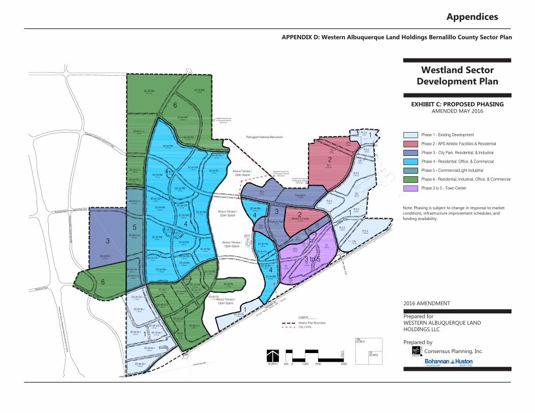
EXHIBIT C: PROPOSED PHASINGAMENDED MAY 2016
2016 AMENDMENT
Prepared forWESTERN ALBUQUERQUE LAND HOLDINGS LLC
Prepared byConsensus Planning, Inc.
Tierra
Ladera
Petroglyph National Monument
118th Street N.W.
AMAFCA Pond Easement
Arroyo Vista N.W.
Drive
Pintad
aN.W
.
ABCWUAReservoir
R-4±215 ac.
TC±23 ac.
SD-W-O-1±90 ac.
SD-W-OS±28 ac.
SD-W-RM±63 ac.
SD-W-RM±73 ac.
SD-W-RM±61 ac.
R-5.5±103 ac.
R-5.5±36 ac.
R-5.5±52 ac.
R-5.5±40 ac.
R-5.5±119 ac.
R-5.5±26 ac.
SD-W-RH±8 ac.
R-4±93 ac.
R-4±75 ac.
SD-W-C-1±13 ac.
SD-W-C-1±13 ac.
SD-W-C-1±16 ac.
SD-W-C-1±12 ac.
TC±63 ac.
TCV±55 ac.
SD-W-OS±23 ac.
SD-W-OS±31 ac.
SD-W-OS±8 ac.
SD-W-OS±10 ac.
SD-W-OS±21 ac.
SD-W-OS±20 ac.SD-W-OS
±13 ac.
OS±28 ac.
SD-W-OS±13 ac.
OS±13 ac.
OS±10 ac.
OS±17 ac.Atrisco Terrace /
Open Space
Atrisco Terrace /Open Space
Atrisco Terrace /Open Space
TCV±5 ac.
Regional Park±81 ac.
TC±61 ac.
Education±110 ac.
Athletic Complex±110 ac.
TCV±26 ac.
Atrisco Terrace /Open Space
SD-W-OS±7 ac.
SD-W-OS±14 ac.
OS±6 ac.
Ladera Drive
Atrisco Vista Boulevard N.W.
Shamrock W
ay
Tempur-Pedic Parkway
Cordero Road
CorderoMesa
SD-W-RM±48 ac.
SD-W-RM±57 ac.
SD-W-RM±46 ac.
SD-W-RM±91 ac.
SD-W-RM±171 ac.
SD-W-RM±180 ac.
SD-W-RM±194 ac.
SD-W-RM±50 ac.
SD-W-RM±46 ac.
SD-W-OS±18 ac.
SD-W-OS±27 ac.
SD-W-M-1454 ac.
4
6
1
6
4
2
2
1
1
3
3 to 5
1
4
5
3
6
Arroyo Vista N.W
.
Interstate 40
SD-W-RL±114 ac.
SD-W-M-1±94 ac.
SD-W-RM±122 ac.
SD-W-C-2
±17 ac.
SD-W-M-1±84 ac.
SD-W-RH±25 ac.
SD-W-C-1±55 ac.
SD-W-M-1±60 ac.
SD-W-M-1±31 ac.
SD-W-M-1±46 ac.
SD-W-C-2±40 ac.
SD-W-RM±54 ac.
SD-W-RM±83 ac.
SD-W-RM±112 ac.
SD-W-C-LI±50 ac.
SD-W-C-LI±82 ac.
SD-W-C-LI±54 ac.
SD-W-C-LI±62 ac.
SD-W-C-LI±132 ac.
SD-W-RM±277 ac.
SD-W-RM±47 ac.
SD-W-RL±55 ac.
SD-W-RM±67 ac.
R-2.5±8 ac.
98th Street N.W
.
Central Ave SW
Atris
co V
ista
Boul
evar
d N.
W.
SD-W-RM±72 ac.
SD-W-OS±68 ac.
SD-W-OS±57 ac.
OS±90 ac.
OS±40 ac.
OS±28 ac.
Paseo Del Volcan (Proposed R
egional Arterial Post 2040)
Proposed Minor Arterial Post 2040
Proposed Community Arterial Post 2040
Reservoir Road
Proposed Minor Arterial Post 2040
Proposed Community Arterial Post 2040
Neighborhood AccessTo Petroglyph National
Monument
Neighborhood AccessTo Petroglyph National
Monument
Neighborhood AccessTo Petroglyph National
Monument
NORTH 20001000500 0 4000
FEE
T
WESTERN ALBUQUERQUE LAND HOLDINGS LLC
PHASING PLANAMENDED APRIL, 2016
Western Albuquerque LandHoldings Master Plan
25ACRES
100ACRES
Prepared For
Prepared By
CONSENSUS
PLA
NN
ING
Consensus Planning, Inc.
Master Plan Boundary
Legend
City Limits
Phase 1 - Existing Development
Phase 2 - APS Athletic Facilities & Residential
Phase 3 - City Park, Residential, & Industrial
Phase 4 - Residential, Office, & Commercial
Phase 5 - Commercial/Light Industrial
Phase 6 - Residential, Industrial, Office, & Commercial
Phase 3 to 5 - Town Center
Note: Phasing is subject to change in response to market conditions,infrastructure improvement schedules, and funding availability.
Note: Phasing is subject to change in response to market conditions, infrastructure improvement schedules, and funding availability.

Appendices
APPENDIX D: Western Albuquerque Land Holdings Bernalillo County Sector Plan
Westland Sector Development Plan
EXHIBIT D: PROPOSED SENSITIVE AREA BOUNDARYAMENDED MAY 2016
2016 AMENDMENT
Prepared forWESTERN ALBUQUERQUE LAND HOLDINGS LLC
Prepared byConsensus Planning, Inc.
Tierra
Ladera
Petroglyph National Monument
118th Street N.W.
AMAFCA Pond Easement
Arroyo Vista N.W
.
Arroyo Vista N.W.
Drive
Pintad
aN.W
.
Interstate 40
ABCWUAReservoir
SD-W-RL±114 ac.
PDA±215 ac.
TC±23 ac.
SD-W-O-1±90 ac.
SD-W-M-1±94 ac.
SD-W-OS±28 ac.
SD-W-RM±122 ac.
SD-W-RM±63 ac.
SD-W-RM±73 ac.
SD-W-RM±61 ac.
R-5.5±103 ac.
R-5.5±36 ac.
R-5.5±52 ac.
R-5.5±40 ac.
R-5.5±119 ac.
R-5.5±26 ac.
SD-W-RH±8 ac.
PDA±93 ac.
R-4±75 ac.
SD-W-C-1±13 ac.
SD-W-C-1±13 ac.
SD-W-C-1±16 ac.
SD-W-C-1±12 ac.
TC±63 ac.
SD-W-C-2
±17 ac.
TCV±55 ac.
SD-W-M-1±84 ac.
SD-W-OS±23 ac.
SD-W-OS±31 ac.
SD-W-OS±8 ac.
SD-W-OS±10 ac.
SD-W-OS±21 ac.
SD-W-OS±20 ac.SD-W-OS
±13 ac.
SD-W-OS±68 ac.
SD-W-OS±57 ac.
OS±90 ac.
OS±40 ac.
OS±28 ac.
SD-W-OS±13 ac.
OS±13 ac.
OS±10 ac.
OS±17 ac.Atrisco Terrace /
Open Space
Atrisco Terrace /Open Space
Atrisco Terrace /Open Space
TCV±5 ac.
Regional Park±81 ac.
TC±61 ac.
OS±28 ac.
SD-W-RH±25 ac.
SD-W-C-1±55 ac.
Education±110 ac.
Athletic Complex±110 ac.
TCV±26 ac.
Atrisco Terrace /Open Space
SD-W-OS±7 ac.
SD-W-OS±14 ac.
OS±6 ac.
Ladera Drive
Atrisco Vista Boulevard N.W.
Shamrock W
ay
Tempur-Pedic Parkway
Cordero Road
Cord ore Mesa
Paseo Del Volcan (Proposed R
egional Arterial Post 2040)
Proposed Minor Arterial Post 2040
Proposed Community Arterial Post 2040
Reservoir Road
SD-W-M-1±60 ac.
SD-W-M-1±31 ac.
SD-W-M-1±46 ac.
SD-W-C-2±40 ac.
SD-W-RM±54 ac.
SD-W-RM±48 ac.
SD-W-RM±57 ac.
SD-W-RM±46 ac.
SD-W-RM±83 ac.
SD-W-RM±112 ac.
SD-W-RM±91 ac.
SD-W-RM±171 ac.
SD-W-RM±72 ac.
SD-W-C-LI±50 ac.
SD-W-C-LI±82 ac.
SD-W-C-LI±54 ac.
SD-W-C-LI±62 ac.
SD-W-C-LI±132 ac.
SD-W-RM±277 ac.
SD-W-RM±180 ac.
SD-W-RM±194 ac.
SD-W-RM±50 ac.
SD-W-RM±47 ac.
SD-W-RL±55 ac.
SD-W-RM±67 ac.
SD-W-RM±46 ac.
SD-W-OS±18 ac.
SD-W-OS±27 ac.
R-2.5±8 ac.
98th Street N.W
.
Central Ave SW
Atris
co V
ista
Boul
evar
d N.
W.
SD-W-M-1454 ac.
Proposed Minor Arterial Post 2040
Proposed Community Arterial Post 2040
Neighborhood AccessTo Petroglyph National
Monument
Neighborhood AccessTo Petroglyph National
Monument
Neighborhood AccessTo Petroglyph National
Monument
NORTH 20001000500 0 4000
FEET
WESTERN ALBUQUERQUE LAND HOLDINGS LLC
LAND USE/ZONING PLANAMENDED MAY, 2016
Western Albuquerque LandHoldings Master Plan
25ACRES
100ACRES
Prepared For
Prepared By
CONSENSUS
PLA
NN
ING
Consensus Planning, Inc.
Master Plan Boundary
Legend
City Limits
Residential 2.5 du/ac average
Residential 15 du/ac average
Neighborhood Commercial
Highway Commercial
Corporate O�ce
Commercial/Light Industrial
Open Space
Major Public Open Space
Residential 4 du/ac average
Industrial Park
Proposed Master Plan Boundary Extension
Note: Roadway alignments are conceptual, �nal rights-of-way andalignments shall be determined with future platting actions.
City ofAlbuquerque
This corridor is restricted to utilities, drainage, andtrails.
Single-loaded street required along the entire edge
Required 50’ bu�er or single-loaded street. (bu�er can only be 30% of the ATOS/PNM edge)
Required 50’ buffer or single-loaded street. (buffer can only be 30% of the ATOS/PNM edge)
Single-loaded street required along the entire edge
Tierra
Ladera
Petroglyph National Monument
118th Street N.W.
AMAFCA Pond Easement
Arroyo Vista N.W
.
Arroyo Vista N.W.
Drive
Pintad
aN.W
.
Interstate 40
ABCWUAReservoir
SD-W-RL±114 ac.
PDA±215 ac.
TC±23 ac.
SD-W-O-1±90 ac.
SD-W-M-1±94 ac.
SD-W-OS±28 ac.
SD-W-RM±122 ac.
SD-W-RM±63 ac.
SD-W-RM±73 ac.
SD-W-RM±61 ac.
R-5.5±103 ac.
R-5.5±36 ac.
R-5.5±52 ac.
R-5.5±40 ac.
R-5.5±119 ac.
R-5.5±26 ac.
SD-W-RH±8 ac.
PDA±93 ac.
R-4±75 ac.
SD-W-C-1±13 ac.
SD-W-C-1±13 ac.
SD-W-C-1±16 ac.
SD-W-C-1±12 ac.
TC±63 ac.
SD-W-C-2
±17 ac.
TCV±55 ac.
SD-W-M-1±84 ac.
SD-W-OS±23 ac.
SD-W-OS±31 ac.
SD-W-OS±8 ac.
SD-W-OS±10 ac.
SD-W-OS±21 ac.
SD-W-OS±20 ac.SD-W-OS
±13 ac.
SD-W-OS±68 ac.
SD-W-OS±57 ac.
OS±90 ac.
OS±40 ac.
OS±28 ac.
SD-W-OS±13 ac.
OS±13 ac.
OS±10 ac.
OS±17 ac.Atrisco Terrace /
Open Space
Atrisco Terrace /Open Space
Atrisco Terrace /Open Space
TCV±5 ac.
Regional Park±81 ac.
TC±61 ac.
OS±28 ac.
SD-W-RH±25 ac.
SD-W-C-1±55 ac.
Education±110 ac.
Athletic Complex±110 ac.
TCV±26 ac.
Atrisco Terrace /Open Space
SD-W-OS±7 ac.
SD-W-OS±14 ac.
OS±6 ac.
Ladera Drive
Atrisco Vista Boulevard N.W.
Shamrock W
ay
Tempur-Pedic Parkway
Cordero Road
Cord ore Mesa
Paseo Del Volcan (Proposed R
egional Arterial Post 2040)
Proposed Minor Arterial Post 2040
Proposed Community Arterial Post 2040
Reservoir Road
SD-W-M-1±60 ac.
SD-W-M-1±31 ac.
SD-W-M-1±46 ac.
SD-W-C-2±40 ac.
SD-W-RM±54 ac.
SD-W-RM±48 ac.
SD-W-RM±57 ac.
SD-W-RM±46 ac.
SD-W-RM±83 ac.
SD-W-RM±112 ac.
SD-W-RM±91 ac.
SD-W-RM±171 ac.
SD-W-RM±72 ac.
SD-W-C-LI±50 ac.
SD-W-C-LI±82 ac.
SD-W-C-LI±54 ac.
SD-W-C-LI±62 ac.
SD-W-C-LI±132 ac.
SD-W-RM±277 ac.
SD-W-RM±180 ac.
SD-W-RM±194 ac.
SD-W-RM±50 ac.
SD-W-RM±47 ac.
SD-W-RL±55 ac.
SD-W-RM±67 ac.
SD-W-RM±46 ac.
SD-W-OS±18 ac.
SD-W-OS±27 ac.
R-2.5±8 ac.
98th Street N.W
.
Central Ave SW
Atris
co V
ista
Boul
evar
d N.
W.
SD-W-M-1454 ac.
Proposed Minor Arterial Post 2040
Proposed Community Arterial Post 2040
Neighborhood AccessTo Petroglyph National
Monument
Neighborhood AccessTo Petroglyph National
Monument
Neighborhood AccessTo Petroglyph National
Monument
NORTH 20001000500 0 4000
FEET
WESTERN ALBUQUERQUE LAND HOLDINGS LLC
LAND USE/ZONING PLANAMENDED MAY, 2016
Western Albuquerque LandHoldings Master Plan
25ACRES
100ACRES
Prepared For
Prepared By
CONSENSUS
PLA
NN
ING
Consensus Planning, Inc.
Master Plan Boundary
Legend
City Limits
Residential 2.5 du/ac average
Residential 15 du/ac average
Neighborhood Commercial
Highway Commercial
Corporate O�ce
Commercial/Light Industrial
Open Space
Major Public Open Space
Residential 4 du/ac average
Industrial Park
Proposed Master Plan Boundary Extension
Note: Roadway alignments are conceptual, �nal rights-of-way andalignments shall be determined with future platting actions.
City ofAlbuquerque
This corridor is restricted to utilities, drainage, andtrails.
Single-loaded street required along the entire edge
Required 50’ bu�er or single-loaded street. (bu�er can only be 30% of the ATOS/PNM edge)
Single-loaded street required along the entire edge
Required 50’ buffer or single-loaded street. (buffer can only be 30% of the ATOS/PNM edge)

SPR2016-0004 Additional Questions/Comments:
- SD-W-M-1
Introduction should read: … Bernalillo County Comprehensive Zoning Code with the following
additions:. –Addressed in SDP
- SD-W-OS
(A)(4)(a)(4) Should read: 0 feet from abutting residential zoned properties in which school uses exist. –
Addressed in SDP
(A)(2)(b)
- SD-W-RL
(B)(6) Use same language as listed in the BC Zoning Code for Conditional Uses under the R-1 Zone
(Section 9.3.i) –Addressed in SDP
- Definitions
(H)(1) The following language should be removed or specific zone shall be specified: (This definition
applies to height regulations found in a specific zone only). –Addressed in SDP
- Special Use Permits
Put prohibited uses in alphabetical order –Addressed in SDP
- Additional Design Guidelines
(N)(7) What is the minimum lots size requirement for a CHD? If the same as the underlying zone, then
(N)(7) 100% requirement is not necessary. Please specify minimum individual lot sizes (not minimum lot
area) for houses in the CHD. If the same as the underlying zone, then (N)(7) 100% requirement is not
necessary. –Addressed in SDP
(N)(7)(b)(1) NTE should be spelled out: Not to exceed –Addressed in SDP
(N)(5) This section shall include language regarding zero/no required side-yard setback for townhomes.
–Addressed in SDP
(N)(5)(c) In other zones in the SDP a minimum 10 foot distance between houses is required; if a
minimum of 5 feet is required in CHD developments as stated in the previous revisions, additional
requirements such as fire rating of walls and limitations on ingress/egress will be required at the time of
construction. –Amended setback to 10 feet
- General questions
What is the difference between passive/active recreation and community/regional park and
neighborhood park? –The difference between community, regional, and neighborhood park is size and
purpose as defined by the Bernalillo County Parks, Recreation, and Open Space Master Plan. Passive and
active recreation are incidental to parks. A provision was added to the RL zone to clarify active and
passive uses are incidental to public and private parks.
On the Community Facilities Plan, a community/regional park is shown in an M-1 zone, however
parks or passive/active recreation are not permissive uses in the M-1 zone. –Added provision to
M-1 zone
In the Community Facilities Plan, neighborhood parks are shown in the RL and RM zones. Is
Public or Private Park the same as a neighborhood park? –See explanation above.
Related Documents