Bolivia Hill Hewlett Hunter Pty Ltd (02) 6775 2452 24 Community 6: Carex Fen PCT: 582 - Sedgeland fens wetland of impeded drainage of the Nandewar Bioregion and New England Tablelands Bioregion. Keith: Montane Bogs and Fens. TEC Type: Carex Sedgelands of the New England Tableland, Nandewar, Brigalow Belt South and NSW North Coast Bioregions - Endangered Ecological Community TSC Act http://www.environment.nsw.gov.au/determinations/carexsedgelandFD.htm Montane peatlands and swamps of the New England Tableland, NSW North Coast, Sydney Basin, South East Corner, South Eastern Highlands and Australian Alps Bioregions - Endangered Ecological Community TSC Act. http://www.environment.nsw.gov.au/determinations/MontanePeatlandsEndSpLi sting.htm Full floristic sample sites (4): BH122, BH127, BH140 & FEN53 (Hunter & Bell 2009). Rapid sample sites (3): BHR15, BHR16, BHR22. No. of taxa: 47 Area mapped: 6.9 ha Good: 0 ha Moderate: 5.3 ha Poor: 1.6 ha TEC: 6.9 ha

Welcome message from author
This document is posted to help you gain knowledge. Please leave a comment to let me know what you think about it! Share it to your friends and learn new things together.
Transcript

Bolivia Hill
Hewlett Hunter Pty Ltd (02) 6775 2452
24
Community 6: Carex Fen
PCT: 582 - Sedgeland fens wetland of impeded drainage of the Nandewar Bioregion and New England Tablelands Bioregion. Keith: Montane Bogs and Fens. TEC Type:
Carex Sedgelands of the New England Tableland, Nandewar, Brigalow Belt South and NSW North Coast Bioregions - Endangered Ecological Community TSC Act http://www.environment.nsw.gov.au/determinations/carexsedgelandFD.htm Montane peatlands and swamps of the New England Tableland, NSW North Coast, Sydney Basin, South East Corner, South Eastern Highlands and Australian Alps Bioregions - Endangered Ecological Community TSC Act. http://www.environment.nsw.gov.au/determinations/MontanePeatlandsEndSpListing.htm
Full floristic sample sites (4): BH122, BH127, BH140 & FEN53 (Hunter & Bell 2009). Rapid sample sites (3): BHR15, BHR16, BHR22. No. of taxa: 47 Area mapped: 6.9 ha Good: 0 ha Moderate: 5.3 ha Poor: 1.6 ha TEC: 6.9 ha

Bolivia Hill
Hewlett Hunter Pty Ltd (02) 6775 2452
25Most common natives: listed in order of decreasing summed cover scores (fidelity x cover). Trees: none apparent. Shrubs: none apparent. Climbers & trailers: none apparent. Ground cover: Carex gaudichaudiana, Carex appressa, Glyceria australis, Carex sp.
undetermined, Epilobium billardierianum, Stellaria angustifolia, Lythrum salicaria, Juncus usitatus, Haloragis heterophylla, Juncus vaginatus, Juncus prismatocarpus, Isachne globosa, Cyperus sphaeroideus, Carex fascicularis, Pratia purpurascens, Pennisetum alopecuroides, Lomandra multiflora, Juncus pauciflorus, Hypericum japonicum, Eleocharis gracilis, Baumea rubiginosa, Schoenoplectus validus, Ranunculus lappaceus, Oxalis perennans, Lomandra longifolia, Lachnagrostis filiformis.
Introduced taxa: Paspalum dilatatum, Cirsium vulgare, Holcus lanatus, Medicago polymorpha, Hypochaeris radicata, Verbena bonariensis, Plantago lanceolata, Festuca elatior, Briza minor, Vicia sativa, Trifolium repens, Rubus anglocandicans, Prunella vulgaris, Lolium perenne, Bromus brevis, Anthoxanthum odoratum, Taraxacum officinale, Andropogon virginicus, Ammi majus.
Notes: found associated with areas of impeded drainage throughout the study area both in upland and lowland areas. There may be difficulty in determining which threatened ecological community this assemblage falls within without further on-ground work. Carex Sedgelands that are largely dominated by Carex gaudichaudiana and which may form a peaty subsurface layer will fall into the Montane Peatlands and Swamps TEC, however those sedgelands dominated by Carex appressa or co-dominated by Carex appressa are more likely to be placed within the Carex Sedgelands of the Northern Tablelands TEC. Across the regional landscape, fens are most commonly found on the lowest parts of broad drainage depressions or in more or less narrow bands along creeks. Fens also occur in less predictable situations such as on the beds of closed basin wetlands. Keith (2004) infers that fens are more common on basalts and shales, and bogs on acidic substrates such as leucomonzogranites and sandstones. Hunter and Bell (2007 & 2009) indicate that substrate is less important as a driver of community patterns than variables such as rainfall, altitude and the origin of nutrients entering the system. Fens are sensitive to small changes in groundwater flow (Van Diggelen 2006). In the New England Tablelands Bioregion many of the largest fens have been significantly altered, reduced in size or completely destroyed by drains and dams; these activities still continue today. Sites that may have once contained Carex fens are now grasslands. On some soil types Pennisetum grassland rather than Carex fen are present in open depressions, suggesting that changes in moisture relationships could drive fen communities towards these and other grasslands. Recurrent fires may also cause degradation of the thin layers of peat or change its water holding capacity. One of the dominant Carex species found within these fens has not been found within the state before (Hunter & Bell 2009) and as yet it is undetermined whether the species is a new species or a new native invasive species. It is unlikely that confirmation will occur in the near future.

Bolivia Hill
Hewlett Hunter Pty Ltd (02) 6775 2452
26
Community 7: Broad-leaved Stringybark – Rough-barked Apple – Blakely’s Red Gum Woodland
PCT: 1331 – Yellow Box – Broad-leaved Stringybark Shrubby Open Forest of the New England Tableland Bioregion. Keith: New England Grassy Woodlands. TEC Type: in part.
White Box Yellow Box Blakely’s Red Gum grassy woodlands - Endangered Ecological Community under TSC Act http://www.environment.nsw.gov.au/ThreatenedSpeciesApp/profile.aspx?id=10837 White Box Yellow Box Blakely’s Red Gum grassy woodlands and derived native grasslands –Critically Endangered Ecological Community under EPBC Act http://www.environment.gov.au/cgi-bin/sprat/public/publicshowcommunity.pl?id=43&status=Critically+Endangered
Full floristic sample sites (33): BH36, BH50, BH51, BH52, BH53, BH56, BH57, BH58, BH59, BH60, BH61, BH62, BH63, BH64, BH66, BH68, BH69, BH71, BH73, BH74, BH75, BH80, BH81, BH82, BH84, BH86, BH87, BH109, BH110, BH129, BH135, BH136, BH137. Rapid sample sites (10): BHR01, BHR02, BHR03, BHR04, BHR05, BHR06, BHR10, BHR17, BHR18, BHR21. No. of taxa: 208. Area mapped: 200.1 ha Good: 82.4 ha Moderate: 81.58 ha Poor: 36.7 ha TEC: 11.9 ha
Bolivia Hill
Hewlett Hunter Pty Ltd (02) 6775 2452
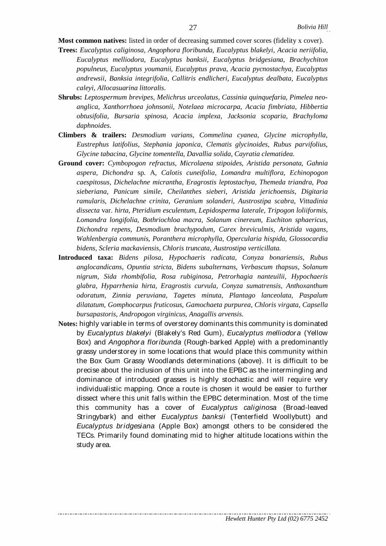
27Most common natives: listed in order of decreasing summed cover scores (fidelity x cover). Trees: Eucalyptus caliginosa, Angophora floribunda, Eucalyptus blakelyi, Acacia neriifolia,
Eucalyptus melliodora, Eucalyptus banksii, Eucalyptus bridgesiana, Brachychiton populneus, Eucalyptus youmanii, Eucalyptus prava, Acacia pycnostachya, Eucalyptus andrewsii, Banksia integrifolia, Callitris endlicheri, Eucalyptus dealbata, Eucalyptus caleyi, Allocasuarina littoralis.
Shrubs: Leptospermum brevipes, Melichrus urceolatus, Cassinia quinquefaria, Pimelea neo-anglica, Xanthorrhoea johnsonii, Notelaea microcarpa, Acacia fimbriata, Hibbertia obtusifolia, Bursaria spinosa, Acacia implexa, Jacksonia scoparia, Brachyloma daphnoides.
Climbers & trailers: Desmodium varians, Commelina cyanea, Glycine microphylla, Eustrephus latifolius, Stephania japonica, Clematis glycinoides, Rubus parvifolius, Glycine tabacina, Glycine tomentella, Davallia solida, Cayratia clematidea.
Ground cover: Cymbopogon refractus, Microlaena stipoides, Aristida personata, Gahnia aspera, Dichondra sp. A, Calotis cuneifolia, Lomandra multiflora, Echinopogon caespitosus, Dichelachne micrantha, Eragrostis leptostachya, Themeda triandra, Poa sieberiana, Panicum simile, Cheilanthes sieberi, Aristida jerichoensis, Digitaria ramularis, Dichelachne crinita, Geranium solanderi, Austrostipa scabra, Vittadinia dissecta var. hirta, Pteridium esculentum, Lepidosperma laterale, Tripogon loliiformis, Lomandra longifolia, Bothriochloa macra, Solanum cinereum, Euchiton sphaericus, Dichondra repens, Desmodium brachypodum, Carex breviculmis, Aristida vagans, Wahlenbergia communis, Poranthera microphylla, Opercularia hispida, Glossocardia bidens, Scleria mackaviensis, Chloris truncata, Austrostipa verticillata.
Introduced taxa: Bidens pilosa, Hypochaeris radicata, Conyza bonariensis, Rubus anglocandicans, Opuntia stricta, Bidens subalternans, Verbascum thapsus, Solanum nigrum, Sida rhombifolia, Rosa rubiginosa, Petrorhagia nanteuilii, Hypochaeris glabra, Hyparrhenia hirta, Eragrostis curvula, Conyza sumatrensis, Anthoxanthum odoratum, Zinnia peruviana, Tagetes minuta, Plantago lanceolata, Paspalum dilatatum, Gomphocarpus fruticosus, Gamochaeta purpurea, Chloris virgata, Capsella bursapastoris, Andropogon virginicus, Anagallis arvensis.
Notes: highly variable in terms of overstorey dominants this community is dominated by Eucalyptus blakelyi (Blakely’s Red Gum), Eucalyptus melliodora (Yellow Box) and Angophora floribunda (Rough-barked Apple) with a predominantly grassy understorey in some locations that would place this community within the Box Gum Grassy Woodlands determinations (above). It is difficult to be precise about the inclusion of this unit into the EPBC as the intermingling and dominance of introduced grasses is highly stochastic and will require very individualistic mapping. Once a route is chosen it would be easier to further dissect where this unit falls within the EPBC determination. Most of the time this community has a cover of Eucalyptus caliginosa (Broad-leaved Stringybark) and either Eucalyptus banksii (Tenterfield Woollybutt) and Eucalyptus bridgesiana (Apple Box) amongst others to be considered the TECs. Primarily found dominating mid to higher altitude locations within the study area.
Bolivia Hill
Hewlett Hunter Pty Ltd (02) 6775 2452
28
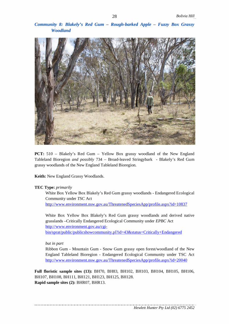
Community 8: Blakely’s Red Gum – Rough-barked Apple – Fuzzy Box Grassy Woodland
PCT: 510 – Blakely’s Red Gum – Yellow Box grassy woodland of the New England Tableland Bioregion and possibly 734 – Broad-leaved Stringybark - Blakely’s Red Gum grassy woodlands of the New England Tableland Bioregion. Keith: New England Grassy Woodlands. TEC Type: primarily
White Box Yellow Box Blakely’s Red Gum grassy woodlands - Endangered Ecological Community under TSC Act http://www.environment.nsw.gov.au/ThreatenedSpeciesApp/profile.aspx?id=10837 White Box Yellow Box Blakely’s Red Gum grassy woodlands and derived native grasslands –Critically Endangered Ecological Community under EPBC Act http://www.environment.gov.au/cgi-bin/sprat/public/publicshowcommunity.pl?id=43&status=Critically+Endangered but in part Ribbon Gum - Mountain Gum - Snow Gum grassy open forest/woodland of the New England Tableland Bioregion - Endangered Ecological Community under TSC Act http://www.environment.nsw.gov.au/ThreatenedSpeciesApp/profile.aspx?id=20040
Full floristic sample sites (13): BH70, BH83, BH102, BH103, BH104, BH105, BH106, BH107, BH108, BH111, BH121, BH123, BH125, BH128. Rapid sample sites (2): BHR07, BHR13.

Bolivia Hill
Hewlett Hunter Pty Ltd (02) 6775 2452
29No. of taxa: 137. Area mapped: 42.2 ha Good: 24.58 ha Moderate: 17.3 ha Poor: 0.3 ha TEC: 39.25 ha Most common natives: listed in order of decreasing summed cover scores (fidelity x cover). Trees: Eucalyptus blakelyi, Angophora floribunda, Eucalyptus conica, Eucalyptus caliginosa,
Eucalyptus viminalis, Eucalyptus bridgesiana, Eucalyptus melliodora, Acacia pycnostachya.
Shrubs: Acacia implexa, Pimelea neo-anglica, Melichrus urceolatus, Leptospermum brevipes, Cassinia quinquefaria, Notelaea microcarpa, Bursaria spinosa, Acacia fimbriata, Pimelea curviflora subsp. divergens.
Climbers & trailers: Desmodium varians, Rubus parviflorus, Commelina cyanea. Ground cover: Microlaena stipoides, Cymbopogon refractus, Aristida personata,
Echinopogon caespitosus, Eragrostis leptostachya, Dichondra sp. A, Dichelachne micrantha, Calotis cuneifolia, Themeda triandra, Scleranthus biflorus, Geranium solanderi, Carex inversa, Poa sieberiana, Oxalis perennans, Cheilanthes sieberi, Lomandra filiformis, Aristida jerichoensis, Wahlenbergia communis, Tricoryne elatior, Schoenus apogon, Calotis lappulacea, Juncus remotiflorus, Schenkia spicata, Lomandra multiflora, Imperata cylindrica, Echinopogon ovatus, Dichelachne crinita, Desmodium brachypodum, Vittadinia dissecta, Veronica calycina, Dianella caerulea, Asperula conferta, Wahlenbergia planiflora, Sorghum leiocladum, Rumex brownii, Luzula flaccida, Juncus pauciflorus, Juncus fockei, Hypericum gramineum, Hydrocotyle laxiflora, Haloragis heterophylla, Euchiton sphaericus, Entolasia stricta, Dichondra repens, Dianella revoluta, Crassula sieberiana, Coronidium scorpioides, Chrysocephalum semipapposum, Aristida vagans.
Introduced taxa: Eragrostis curvula, Conyza bonariensis, Hypochaeris radicata, Hyparrhenia hirta, Plantago lanceolata, Trifolium dubium, Rosa rubiginosa, Medicago polymorpha, Verbena bonariensis, Bidens pilosa, Acetosella vulgaris, Vulpia bromoides, Solanum nigrum, Hypochaeris glabra, Rubus anglocandicans, Paronychia brasiliana, Cirsium vulgare, Andropogon virginicus, Setaria pumila, Opuntia stricta, Guileminea densa, Bromus brevis, Briza minor, Arenaria leptoclados, Anagallis arvensis.
Notes: most of this community would be included within the Box – Gum Grassy Woodlands TECs (see above). Furthermore most of the area mapped as this community is of very high quality and are some of the better examples of this threatened type of community. The occasional single individual of Acacia pycnostachya was found scattered through this community type. Primarily found in intermediate altitude zones within the study area, above the low land flats dominated by Communities 1 and 2 and below Community 7 and 9. Some areas grade into the low land areas dominated by Community 2 and some of the dominants such as Eucalyptus viminalis (Manna Gum) and Eucalyptus conica (Fuzzy Box) are also found merging into this assemblage. Small open patches within the intact mosaic are dominated by Eragrostis curvula (African Lovegrass). Care should be taken not to spread this invasive species that is listed as a Key Threatening Process (Invasion by Perennial Exotic Grasses).

Bolivia Hill
Hewlett Hunter Pty Ltd (02) 6775 2452
30
Community 9: Broad-leaved Stringybark – Mountain Banksia – Apple Box Shrubby Woodland and Forest
PCT: possibly 508 Blakely’s Red Gum – Stringybark - Rough-barked Apple open forest of the Nandewar Bioregion and western New England Tablelands Bioregion or 991 – New England Blackbutt – Youmans Stringybark grassy open forest of the western New England Tableland Bioregion. Keith: Northern Tableland Dry Sclerophyll Forest. TEC Type: in part
Ribbon Gum - Mountain Gum - Snow Gum grassy open forest/woodland of the New England Tableland Bioregion - Endangered Ecological Community under TSC Act http://www.environment.nsw.gov.au/ThreatenedSpeciesApp/profile.aspx?id=20040
Full floristic sample sites (12): BH85, BH92, BH100, BH101, BH112, BH113, BH114, BH115, BH131, BH134, BH138, BH139. Rapid sample sites (0): none placed. No. of taxa: 151. Area mapped: 49.7 ha Good: 24.7 ha Moderate: 10.8 ha Poor: 13.1 ha TEC: 4.2 ha Most common natives: listed in order of decreasing summed cover scores (fidelity x cover). Trees: Eucalyptus caliginosa, Banksia integrifolia, Eucalyptus bridgesiana, Angophora
floribunda, Allocasuarina torulosa, Eucalyptus viminalis, Eucalyptus banksii, Eucalyptus andrewsii, Eucalyptus prava, Eucalyptus caleyi, Brachychiton populneus.
Shrubs: Acacia fimbriata, Bursaria spinosa, Jacksonia scoparia, Melichrus urceolatus, Xanthorrhoea johnsonii, Leptospermum brevipes, Notelaea microcarpa, Maytenus
Bolivia Hill
Hewlett Hunter Pty Ltd (02) 6775 2452
31silvestris, Pimelea venosa, Pimelea neo-anglica, Hibbertia obtusifolia, Cassinia quinquefaria, Acacia implexa, Acacia filicifolia.
Climbers & trailers: Rubus parvifolius, Desmodium varians, Eustrephus latifolius, Clematis glycinoides, Pyrrosia rupestris, Glycine tomentella, Glycine clandestina, Davallia solida, Billardiera scandens.
Ground cover: Poa sieberiana, Microlaena stipoides, Echinopogon caespitosus, Imperata cylindrica, Cymbopogon refractus, Lomandra longifolia, Pteridium esculentum, Lomandra multiflora, Wahlenbergia communis, Themeda triandra, Dichondra sp. A, Rytidosperma pallidum, Geranium solanderi, Calotis cuneifolia, Oxalis perennans, Entolasia stricta, Aristida personata, Pratia purpurascens, Dianella revoluta, Lomandra filiformis, Gahnia aspera, Dichelachne micrantha, Adiantum hispidulum, Poranthera microphylla, Lepidosperma laterale, Juncus pauciflorus, Haloragis heterophylla, Arthropodium milleflorum, Acaena novae-zelandiae, Wahlenbergia planiflora, Veronica calycina, Scleranthus biflorus, Plectranthus graveolens, Luzula flaccida, Lomandra confertifolia, Euchiton sphaericus, Carex inversa, Austrostipa rudis.
Introduced taxa: Hypochaeris radicata, Conyza bonariensis, Eragrostis curvula, Cirsium vulgare, Verbena bonariensis, Rubus anglocandicans, Hyparrhenia hirta, Verbascum virgatum, Verbascum thapsus, Solanum nigrum, Rosa rubiginosa, Bidens subalternans, Bidens pilosa, Andropogon virginicus, Acetosella vulgaris.
Notes: found at higher altitudes in more protected locations than Community 8. Usually on steeper eastern to south eastern facing slopes. This assemblage is closer in resemblance to those that occur further to the east such as the northern Butterleaf and western Gibraltar Range areas and probably occurs here due to the high altitudes and only in more protected locations. Much of this assemblage has been cleared within the study area though a reasonable area remains in very good condition. It is within this community that the extant population of the Endangered Pimelea venosa was found.

Bolivia Hill
Hewlett Hunter Pty Ltd (02) 6775 2452
32
Community 10: Black Pine – Caley’s Ironbark – Kurrajong Shrubland, Shrubby Woodland & Dry Rainforest
PCT: 502 – Black Cypress Pine – Orange Gum – Tumbledown Red Gum shrubby woodland on granites of the Nandewar Bioregion and the New England Tableland Bioregion 609 - Black Cypress Pine – Caley’s Ironbark – Tumbledown Red Gum shrubby woodland on Mole Granite of the Torrington area of the New England Tableland Bioregion. 1124 – Rusty Fig – Wild Quince – Native Olive dry rainforest of rocky areas of the Nandewar Bioregion. Keith: Dry Rainforests & Northern Tableland Dry Sclerophyll Forests & Northern Montane Heaths. TEC Type: none applicable. Full floristic sample sites (10): BH67, BH76, BH77, BH78, BH79, BH89, BH90, BH130, BH132, BH133. Rapid sample sites (2): BHR19, BHR20. No. of taxa: 132. Area mapped: 19.2 ha Good: 7.5 ha Moderate: 7.4 ha Poor: 4.0 ha TEC: 0 ha Most common natives: listed in order of decreasing summed cover scores (fidelity x cover). Trees: Callitris endlicheri, Eucalyptus caleyi, Brachychiton populneus, Eucalyptus dealbata,
Eucalyptus prava, Eucalyptus bridgesiana, Eucalyptus blakelyi, Acacia pycnostachya, Eucalyptus macrorhyncha.
Shrubs: Notelaea microcarpa, Leptospermum brevipes, Ficus rubiginosa, Bursaria spinosa, Pimelea neo-anglica, Cassinia quinquefaria, Melichrus urceolatus, Xanthorrhoea

Bolivia Hill
Hewlett Hunter Pty Ltd (02) 6775 2452
33johnsonii, Zieria cytisoides, Leptospermum polygalifolium, Acacia fimbriata, Olearia ramulosa, Hibbertia cistoidea, Dodonaea triquetra.
Climbers & trailers: Pyrrosia rupestris, Stephania japonica, Eustrephus latifolius, Davallia solida, Dockrillia linguiformis.
Ground cover: Lomandra longifolia, Entolasia stricta, Plectranthus graveolens, Lepidosperma laterale, Rytidosperma pallidum, Lomandra multiflora, Oplismenus aemulus, Cheilanthes sieberi, Entolasia marginate, Tripogon loliiformis, Dendrobium speciosum, Microlaena stipoides, Lepidosperma gunnii, Digitaria ramularis, Dichelachne micrantha, Cymbopogon refractus, Aristida personata, Stypandra glauca, Rytidosperma longifolium, Rytidosperma bipartitum, Opercularia hispida, Grammitis billardieri, Gahnia aspera, Eragrostis leptostachya, Einadia nutans, Dianella revoluta, Calotis cuneifolia, Adiantum hispidulum, Viola hederacea, Urtica incisa, Senecio diaschides, Scleria mackaviensis, Rytidosperma caespitosum, Pomax umbellata, Eriochilus cucullatus, Doodia caudate, Dichondra sp. A, Dianella longifolia, Carex appressa, Aristida vagans, Aristida jerichoensis.
Introduced taxa: Rubus anglocandicans, Opuntia stricta, Eragrostis curvula, Conyza bonariensis, Hypochaeris radicata, Bidens pilosa, Anagallis arvensis, Solanum nigrum, Gamochaeta purpurea, Cirsium vulgare, Briza maxima, Bidens subalternans, Andropogon virginicus.
Notes: this assemblage type is highly variable in both structure and dominants but share a shallow rocky habitat. Structurally this community can be present as a woodland, shrubby woodland, shrubland and at times herbfield. Despite these structural differences there are a large number of shared taxa. The threatened Acacia pycnostachya (Bolivia Hill Wattle) is more commonly found in this community than any other and at times forms a dominant overstorey on some rocky slopes. The bare rocky slopes are described within assemblage 8: Western New England Shrublands and Herbfields of Hunter & Clarke (1998) and in the strictest sense are restricted to rocky outcrop areas here and at Bluff River Nature Reserve. Within the rocky creek lines some disjunct species not normally found this far west can be found such as Grammitis billardieri which is more normally associated with rocks in locations such as rainforest within Gibraltar Range. Similarly Dendrobium speciosum (Rock Orchid) and Platycerium bifurcatum (Elkhorn) are also normally found in wetter communities further east. Four mapping sub-associations have delineated that are definable in the full dendrogram at a lower dissociation measure. These additional mapping units are:
10a:Rock Outcrop Shrubland.
10b: Black Pine – Caley’s Ironbark. Main image. Found on exposed sites around dissected boulders.

Bolivia Hill
Hewlett Hunter Pty Ltd (02) 6775 2452
3410c: Dry Rainforest. Found around protected slopes and larger boulders often at the base of bare granite slopes with greater runoff.
10d: Rocky Creek-line. Found along a single highly dissected creek line.

Bolivia Hill
Hewlett Hunter Pty Ltd (02) 6775 2452
35
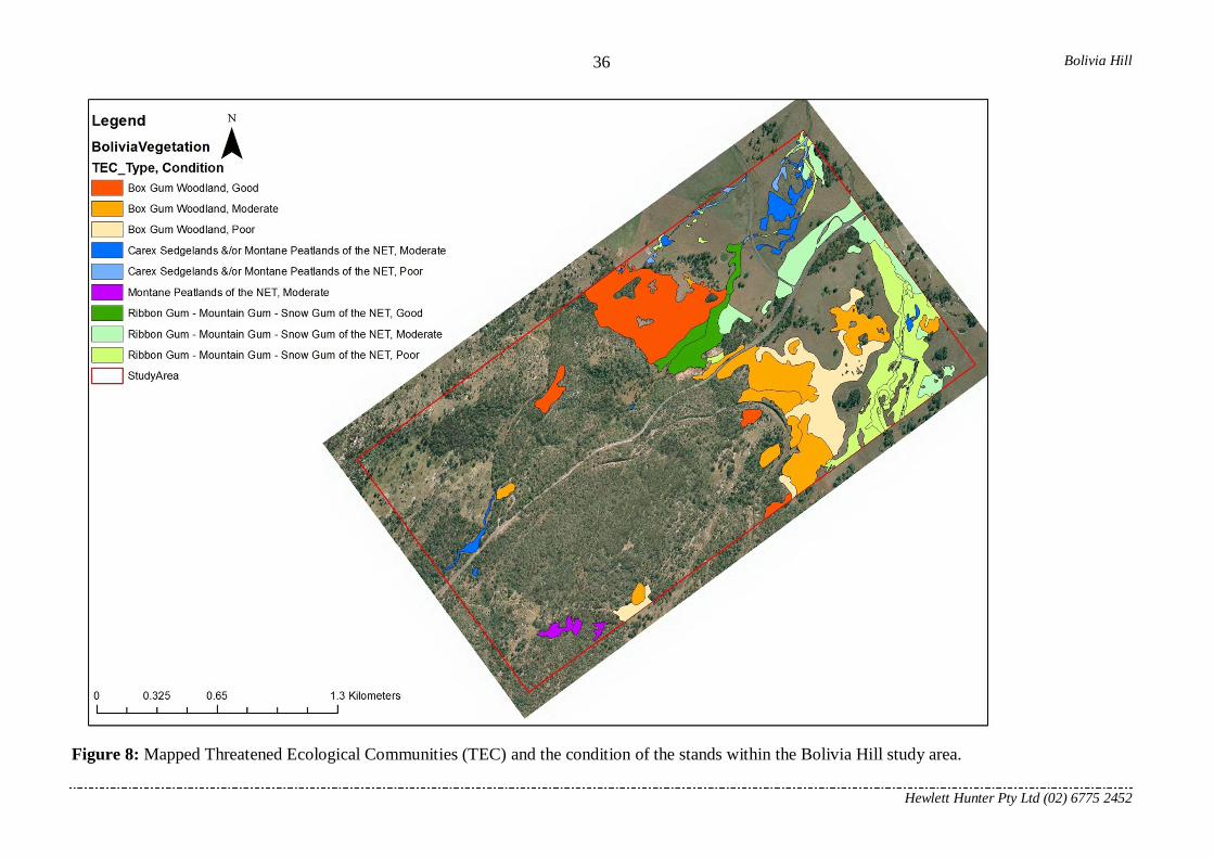
2.5 Communities and taxa of conservation significance 2.5.1 Communities found within the study area Four listed communities on the EPBC or TSC Acts were found within the designated study area at Bolivia Hill. The specific determinations and website links are given within each community description in the previous section. These combined account for total of 112.7 ha (23.4% of the total area mapped) (Table 1). Of particular note is that 30.2 ha (27%) of these listed threatened communities are in good condition. It should be noted that it was not always clear which threatened ecological community (TEC) that the Carex Fen (Community 6) may belong too as this depends on the overall cover of Carex gaudichaudiana, which is highly variable at this locality. However to simplify the situation most occurrences are likely to fall within the Carex Sedgelands of the Northern England Tablelands and Nandewar Bioregion. Furthermore, allocating grassland types to Box Gum Grassy Woodland TEC types, Ribbon Gum – Mountain Gum – Snow Gum or neither, is somewhat arbitrary and based on evidence found on ground such as remnant trees, seedlings, landscape features and experience of the surveyor. Areas that may have contained a TEC but which have no remaining native overstorey and have a predominantly introduced understorey have not been mapped as a TEC. As not every location was visited, it is likely that some addition areas may be of the latter type and could be excluded from the current TEC mapping. It should also be noted that a property on the south western corner did not allow a flora assessment to be conducted and as such, the mapping here is purely based on remote imagery analysis. It should be noted that the condition codings given are only a very general rating based on an anecdotal observations made by the surveyor during the field inspections and not based on any analytical data. As areas that would not fall within the determinations have already been excluded from the mapping due to no overstorey and largely introduced understorey the areas mapped as poor would still likely fall within the TEC criteria. Table 1: Condition and area of threatened ecological communities within the Bolivia Hill Road Re-alignment study area.
TEC Condition in Ha
Good Moderate Poor Total Box Gum Woodland (TSC & EPBC Acts) 23.1 24.5 14.8 62.3 Carex Sedgelands &/or Montane Peatlands of the NET (TSC Act)
5.3 1.5 6.9
Montane Peatlands of the NET (TSC Act)
1.5
1.5 Ribbon Gum - Mountain Gum - Snow Gum of the NET (TSC Act)
7.1 13.3 21.6 42.0
Total 30.2 44.6 37.9 112.7
Bolivia Hill
Hewlett Hunter Pty Ltd (02) 6775 2452
36
Figure 8: Mapped Threatened Ecological Communities (TEC) and the condition of the stands within the Bolivia Hill study area.

Bolivia Hill
Hewlett Hunter Pty Ltd (02) 6775 2452
37
2.5.2 Communities within close proximity to the study area New England Peppermint (Eucalyptus nova-anglica) Grassy Woodlands http://www.environment.gov.au/cgi-bin/sprat/public/publicshowcommunity.pl?id=83&status=Critically+Endangered
New England Peppermint communities are known within the local area and are found between Deepwater and the southern slopes of the Bolivia Range. A small occurrence is mapped within the Bolivia Hill Nature Reserve (Hunter 2002). No occurrences have been found within the study area or within close proximity to the study area boundary.
Upland wetlands of the Drainage Divide of the New England Tablelands Bioregion http://www.environment.nsw.gov.au/threatenedSpeciesApp/profile.aspx?id=10824 http://www.environment.gov.au/cgi-bin/sprat/public/publicshowcommunity.pl?id=39&status=Endangered
Though known to occur within the general region, this community type has been thoroughly searched for and locations described within Bell et al. (2007) and none are known from the study area or nearby the study area boundary. These wetland types only occur on basalts at the top of the Great Dividing Range and would not be found in the landscapes known from the study area.

Bolivia Hill
Hewlett Hunter Pty Ltd (02) 6775 2452
38
2.5.3 Threatened species found within the Study Region 3.5.3.1 Acacia pycnostachya F.Muell. (Bolivia Hill Wattle) Current Conservation Status
TSC Act Status: Vulnerable. http://www.environment.nsw.gov.au/threatenedSpeciesApp/profile.aspx?id=10025 EPB&C Act Status: Vulnerable. http://www.environment.gov.au/cgi-bin/sprat/public/publicspecies.pl?taxon_id=13415
Taxonomy
Publication: Plants Indigenous to the Colony of Victoria 2: 33 (1863). Synonym: none. Type: from New England, Stuart (holo: MEL). Affinities: Acacia pubifolia; Acacia williamsiana. Etymology: in reference to the flattened stems. Form: variable from low spreading shrub to erect low tree up to 10 m tall. May be very long lived. Flowers in spring and fruits in summer.
Previous known distribution and population
Restricted to the Northern Tablelands of New South Wales in three highly disjunct locations (Fig. 9); Bolivia Hill, Bluff River and Back Creek (north west of Tenterfield). The more resent searches in the Donnybrook area have failed to relocate this species. An erroneous collection from the Macintyre Falls area (G.P.Guymer, 9.4.1977) was re-determined to be Acacia williamsiana. Searches conducted over the Bolivia Range by Hunter and Earl (1999), Hunter (2000) and Hunter (2002) found the population size extensive and potentially in order of 20,000 individuals. Within the Bluff River Nature Reserve and surrounding areas Acacia pycnostachya was found to be a significant component of most of the Nature Reserve with populations likely to be in excess of 30,000 individuals.

Bolivia Hill
Hewlett Hunter Pty Ltd (02) 6775 2452
39
Fig 9: Location of previously known locations of Acacia pycnostachya.

Bolivia Hill
Hewlett Hunter Pty Ltd (02) 6775 2452
40
Life History & Habitat
Dispersal: elaiosome; seed drop.
Pollination: probably entomophilous.
Flowering: September to November.
Fruiting: November to January.
Little known about Acacia pycnostachya, unpublished surveys on Bluff Rock south of Tenterfield by Hunter & Croft (1995) found that the species could regenerate on mass after wildfire and seedling densities were found to be as high as 200 per 0.1 ha. The species seems to occur within a wide range of habitats where it does occur and was found to be within 12 vegetation communities described by Hunter (2002). However, the species appears to occur mainly on shallow to skeletal soils. The species has been found to grow to 1.5 m and flower within 3 years (primary juvenile period) and profusely flower within 5 years (Quinn et al. 1995) and to sporadically germinate in the absence of fire.
Threatening processes
This species is possibly affected by: Agricultural clearing. Under-scrubbing for fire reduction and grazing purposes. Inappropriate fire regimes. Small number of known locations. Grazing by domestic stock. Browsing by goats, deer and rabbits. Combination of drought and fire (Croft et al. 2007; 2010).
Locations found within the Study Area
Acacia pycnostachya was found within six of the floristic survey plots placed within the study area (BH53; BH63; BH78; BH79; BH108; BH111). In most instances the observations were only of scattered individuals. However, on a large and exposed granite slab adjoining the southern side of the current highway (BH78 & BH79), a large and significant population of this species was surveyed which was found to encompass at least 235 individuals (Fig. 10). Permission was not given to search some locations within the study area.

Bolivia Hill
Hewlett Hunter Pty Ltd (02) 6775 2452
41
Fig 10: Acacia pycnostachya locations within the study area.

Bolivia Hill
Hewlett Hunter Pty Ltd (02) 6775 2452
42
Plate 1: Acacia pycnostachya flowering stem.

Bolivia Hill
Hewlett Hunter Pty Ltd (02) 6775 2452
43
Plate 2: Seedling of Acacia pycnostachya above and suckering stems in a rock
crevice within the study area appearing drought stressed and browsed by goats.
Bolivia Hill
Hewlett Hunter Pty Ltd (02) 6775 2452
44
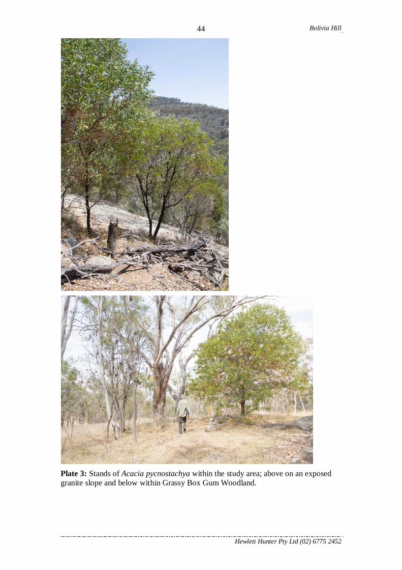
Plate 3: Stands of Acacia pycnostachya within the study area; above on an exposed granite slope and below within Grassy Box Gum Woodland.

Bolivia Hill
Hewlett Hunter Pty Ltd (02) 6775 2452
45
2.5.3.2 Pimelea venosa Threlfall (Bolivia Riceflower) Current Conservation Status
TSC Act Status: Endangered. http://www.environment.nsw.gov.au/threatenedSpeciesApp/profile.aspx?id=10633 EPB&C Act Status: Endangered. http://www.environment.gov.au/cgi-bin/sprat/public/publicspecies.pl?taxon_id=16385
Taxonomy
Publication: Brunonia 5: 196 (1983). Synonym: none. Type: Bolivia, Betche 4.ix.1886 (holo: NSW). Affinities: unknown. Etymology: in reference to the prominent veinage. Form: straggly primarily upright to lax shrub with leaves densely covered with whitish, soft and spreading hairs.
Previous known distribution and population
The species has only been recorded from the Bolivia Hill area. A review of collections by Hunter & Earl (1999) found that though several locations appeared on various databases around Bolivia and the Bolivia Range these appeared to be due to the vague original collection locality being entered several times by different authors who used different more specific location points. Thus, most records are due to one or a few individual collections. The species has rarely been seen since its original collection and none have been seen in the last 15 years despite several searches being conducted for this species (Hunter & Earl 1999; Hunter 2002). A single specimen beside an access track was last seen in 1999 but it was missing when a search was conducted a few weeks later by one of the original people to see it at that location. The largest recorded population appears to have been around 13 plants.
Life History & Habitat
Dispersal: unknown.
Pollination: probably entomophilous.
Flowering: Spring.
Fruiting: Spring to Summer.
Almost nothing is known about this species and the previous known locations are largely based on collections from last century. Since that time, this species has only been found very rarely and usually as individuals within a high disturbed agricultural landscape.

Bolivia Hill
Hewlett Hunter Pty Ltd (02) 6775 2452
46
Threatening processes
This species is possibly affected by: Agricultural clearing. Under-scrubbing for fire reduction and grazing purposes. Inappropriate fire regimes. Small number of known locations. Grazing by domestic stock. Trampling. Browsing by goats, deer, rabbits and native macrofauna.
Location found within the Study Area
Pimelea venosa was found within a single location on private property (site BH139). At this location at total of 46 plants ranging from 0.2 to 2.1 m in height were found within an area of approximately 50 x 30 m. The populations was restricted to a small area of large boulders and small outcropping that was both difficult for stock to enter and also protected from recurrent fires. Individuals found on the margins of this habitat which were more accessible by native and exotic animals had been browsed. This is currently the only known extant population. The plants were found within the cadastral boundary of the Stadtmiller family. It is possible that the species may exist in the neighbouring property however permission for a flora investigation was not given for this property.

Bolivia Hill
Hewlett Hunter Pty Ltd (02) 6775 2452
47
Fig 11: Pimelea venosa location within the study area.

Bolivia Hill
Hewlett Hunter Pty Ltd (02) 6775 2452
48
Plate 4: Pimelea venosa leaf and habitat from the location within the study area.

Bolivia Hill
Hewlett Hunter Pty Ltd (02) 6775 2452
49
2.5.4 Threatened species within close proximity but not found within the Study Region 2.5.4.1 Boronia boliviensis J.B.Williams & J.T.Hunter
http://www.environment.nsw.gov.au/threatenedSpeciesApp/profile.aspx?id=10096 Boronia boliviensis is an endangered species (TSC Act) known only from the Bolivia Range and is known from between 900 to 1200 m altitude in low shrublands and heaths on granite outcrops and within the woodlands immediately adjacent to these. The current population estimate is around 3,000 individuals in 12 discrete populations (Hunter & Earl 1999; Williams & Hunter 2006) all of which are within the southern slopes of the Bolivia Range within the Bolivia Hill Nature Reserve (Fig. 12). No populations of this species were found within the study area. The habitats contained within the study area are unlikely to contain this species based on the known habitat of the species. It is highly likely that the current botanist would have found the species if it was present. While the presence of this species cannot be completely ruled out, it is of the opinion of the author that no further investigations for this species are required.

Bolivia Hill
Hewlett Hunter Pty Ltd (02) 6775 2452
50
Plate 5: Photograph of Boronia boliviensis.
Fig 12: Known locations for Boronia boliviensis which is currently only known from
Bolivia Hill NR. Red boundary is the Bolivia Hill NR.
392000.00 393000.00 394000.00 395000.00 396000.00 397000.00 398000.00 399000.006751000.00
6752000.00
6753000.00
6754000.00
6755000.00
6756000.00
6757000.00

Bolivia Hill
Hewlett Hunter Pty Ltd (02) 6775 2452
51
2.5.4.2 Eucalyptus boliviana J.B.Williams & K.D.Hill http://www.environment.nsw.gov.au/threatenedSpeciesApp/profile.aspx?id=10285 Eucalyptus boliviana is vulnerable species (TSC Act) that is currently only known from three locations within the Bolivia Hill Nature Reserve. These locations are restricted to the higher altitude areas at the crest of the Bolivia Range and on the southern slopes. The species is highly distinctive and should not be confused with any others within the district. If this species was present it is highly likely that it would have been found, however none were found within the study area. It is of the opinion of the author that no further searches within the study area are required for this species.
Plate 6: Photographs of the buds and fruit of Eucalyptus boliviana.
Fig 13: Known distribution of Eucalyptus boliviana. Boundary is the Bolivia Hill NR.
392000.00 393000.00 394000.00 395000.00 396000.00 397000.00 398000.00 399000.006751000.00
6752000.00
6753000.00
6754000.00
6755000.00
6756000.00
6757000.00
Bolivia Hill
Hewlett Hunter Pty Ltd (02) 6775 2452
52
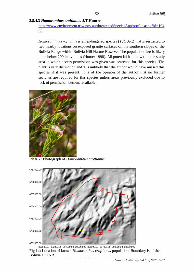
2.5.4.3 Homoranthus croftianus J.T.Hunter http://www.environment.nsw.gov.au/threatenedSpeciesApp/profile.aspx?id=10408 Homoranthus croftianus is an endangered species (TSC Act) that is restricted to two nearby locations on exposed granite surfaces on the southern slopes of the Bolivia Range within Bolivia Hill Nature Reserve. The population size is likely to be below 200 individuals (Hunter 1998). All potential habitat within the study area in which access permission was given was searched for this species. The plant is very distinction and it is unlikely that the author would have missed this species if it was present. It is of the opinion of the author that no further searches are required for this species unless areas previously excluded due to lack of permission become available.
Plate 7: Photograph of Homoranthus croftianus.
Fig 14: Location of known Homoranthus croftianus population. Boundary is of the Bolivia Hill NR.
392000.00 393000.00 394000.00 395000.00 396000.00 397000.00 398000.00 399000.006751000.00
6752000.00
6753000.00
6754000.00
6755000.00
6756000.00
6757000.00

Bolivia Hill
Hewlett Hunter Pty Ltd (02) 6775 2452
53
2.5.4.4 Thesium australe R.Br. http://www.environment.nsw.gov.au/threatenedSpeciesApp/profile.aspx?id=10802 http://www.environment.gov.au/cgi-bin/sprat/public/publicspecies.pl?taxon_id=15202 Thesium australe is a cryptic hemi-parasitic herb of native and introduced grasses. It has a very widespread distribution and has been found in grassy woodlands throughout their distribution in South-eastern Australia on various rock types except sandstone. The species can have a sporadic boom and bust visible population and it does die back after frosts and may not be seen for a number of years. A single population of approximately 20 individuals was found growing within the rail reserve amongst and over the rail tracks on the southern fall of the Bolivia Range. This population has not re-occurred in recent years. While this species was not found during the current investigation its cryptic nature, sporadic occurrence and the extent of potential habitat means that the presence of this species cannot be ruled out.
Plate 8: Photograph of Thesium australe.
Fig 15: Known distribution of Thesium australe within the Bolivia Range. The boundary represents the Bolivia Hill Nature Reserve.
392000.00 393000.00 394000.00 395000.00 396000.00 397000.00 398000.00 399000.006751000.00
6752000.00
6753000.00
6754000.00
6755000.00
6756000.00
6757000.00

Bolivia Hill
Hewlett Hunter Pty Ltd (02) 6775 2452
54
3.6 Key Threatening processes A number of listed key threatening process may need to be taken into consideration during the deliberation of the potential development. Alteration to the natural flow regimes of rivers and streams and their floodplains and wetlands http://www.environment.nsw.gov.au/threatenedSpeciesApp/profile.aspx?id=20002 Bushrock removal http://www.environment.nsw.gov.au/threatenedSpeciesApp/profile.aspx?id=20006 Clearing of native vegetation http://www.environment.nsw.gov.au/threatenedSpeciesApp/profile.aspx?id=20023 Infection of native plants by Phytophthora cinnamomi http://www.environment.nsw.gov.au/threatenedSpeciesApp/profile.aspx?id=20026 Invasion of native plant communities by exotic perennial grasses http://www.environment.nsw.gov.au/threatenedSpeciesApp/profile.aspx?id=20018
A number of the key species listed under this threatening process occur abundantly within the study area, in particular Eragrostis curvula (African Lovegrass), Andropogon virginicus (Whiskey Grass) and Hyparrhenia hirta (Coolatai Grass). All of these species are particularly prevalent and dominant along the edges of the current highway and are easily spread by vehicles.
Invasion and establishment of exotic vines and scramblers http://www.environment.nsw.gov.au/threatenedSpeciesApp/profile.aspx?id=20052
Dolichandra unguis-cati has been found beside the current highway within the study area. This species is one of those listed within this determination. It is easily spread by machinery.
Loss of Hollow-bearing trees http://www.environment.nsw.gov.au/threatenedSpeciesApp/profile.aspx?id=20079 Removal of dead wood and dead trees http://www.environment.nsw.gov.au/threatenedSpeciesApp/profile.aspx?id=20011

Bolivia Hill
Hewlett Hunter Pty Ltd (02) 6775 2452
55
References Bell, D.M., Hunter, J.T. & Haworth, R.J. (2008) Montane lagoons of the New
England Tablelands Bioregion: vegetation, landuse and dynamics. Cunninghamia 10: 475-492.
Croft, P.J., Hunter, J.T. & Reid, N. (2010) Threat of frequent fire and dought for the rare wattle Acacia williamsiana J.T.Hunter: an experimental burn highlights implications for fire management. Ecological Management and Restoration 11: 217-220.
Croft, P.J., Hunter, J.T. & Reid, N. (2007) Depletion of regenerative bud resources during cyclic drought. What are the implications for fire management? Ecological Management and Restoration 8: 187-192.
Hunter, J.T. (2010) Eucalypts of the Northern Tablelands. Northern Rivers Catchment Management Authority & J.T.Hunter. (155 Pages).
Hunter, J.T. (2005) Geographic variation in plant species richness patterns within temperate eucalypt woodlands of eastern Australia. Ecography 28: 505-514.
Hunter, J.T. (2005) Floristics and distribution of Wattle Dry Sclerophyll Forests and Scrubs of north eastern New South Wales. Cunninghamia 9: 317-323.
Hunter, J.T. (2002) ‘Vegetation and Floristics of the Tenterfield Nature Reserves’. Unpublished report to the New South Wales National Parks and Wildlife Service
Hunter, J.T. (2000) Flora of the Bolivia Hill Rail Easement. Unpublished report to Rail Services Australia.
Hunter, J.T. (1998) Two new species of Homoranthus (Myrtaceae) for northern New South Wales. Telopea 8: 35-40.
Hunter, J.T. (1995) Multi-species Recovery Plan for Bolivia Hill & Backwater. Report to the NSW NPWS Northern Zone.
Hunter, J.T. & Bell, D. (2009) The Carex Fen vegetation of northern New South Wales. Cunninghamia 11 (1): 49-65.
Hunter, J.T. & Bell, (2007) Vegetation of montane bogs in east-flowing catchments of northern New England, New South Wales. Cunninghamia 10: 77-92.
Hunter, J.T. & Clarke, P.J. (1998) The vegetation of granitic outcrop communities on the New England Batholith of eastern Australia. Cunninghamia 5: 547-618.
Hunter, J.T. & Earl, J. (1999) ‘Targeted Survey for Pimelea venosa’ Report to the NSW, National Parks and Wildlife Service.
Quinn, F.C., Williams, J.B., Gross, C.L. & Bruhl, J.J. (1995) Report on Rare and Threatened Plants of North-eastern NSW. Unpublished report to the NSW NPWS.
Van Diggelen R, Middleton B, Bakker J, Grootjans A & Wassen M. (2006) Fens and floodplains of the temperate zone: Present status, threats, conservation and restoration. Applied Vegetation Science 9: 157–162.
Williams, J.B. & Hunter, J.T. (2006) Boronia boliviensis (Rutaceae series Erianthae), a new rare granite outcrop endemic from north-eastern New South Wales. Telopea 11 (3): 260-264.
Bolivia Hill
Hewlett Hunter Pty Ltd (02) 6775 2452
56
Appendix A: Site Record Forms. Site Name:
Altitude: Assessor(s):
Date: Aspect:
AMG Zone: GPS Datum:
Site Location E: ........................................... N: ...........................................
Slope:
% litter/dead branches: % bare soil/small rocks: % cryptogams: % large rock/boulder:
Topography: (Circle as appropriate). Slope Flat (0o) Gentle (1-4 o) Moderate (5-14 o) Undulating (Highly
Variable) Steep ( 15 o)
Landform Ridge-top
Upper Slope
Mid Slope Lower Slope
Open Plain River Flat Creek Line Valley Floor
Gully
Geology Sand-stone
Alluvial /Colluvial
Basalt Meta-sediment
Granite Shale Sedi-mentary
Volcanic Conglo-merate
Meta-morphic
Soil Colour
Soil Texture Sand Sandy Loam
Loam Sandy Clay
Loamy Clay
Gravelly Loam
Gravelly Clay
Clayey Loam
Clay Gravel
Depth Skeletal (<10cm): Shallow (10-50cm): Deep(>50cm):
Drainage Poorly drained: Moderately drained: Well Drained:
Tenure Private Private - Reserve Public - Reserve Public - TSR Other: ...............................................
Current land use: Logging Grazing Dryland cropping Irrigated Cropping
Rural residential Urban / Industrial
Clearing /Logging Nil Light Moderate Moderately Extensive Extensive Unknown
Grazing: Nil Light Moderate Intermittently Heavy
Sustained Heavy Unknown
Planted Vegetation: Nil Endemic trees, shrubs and/or groundcover
Native non-endemic trees and/or shrubs
Exotic trees and/or shrubs
Improved Pasture / Pasture
Cropping
Crop / Exotic Pasture
Weed Cover: Nil Very Low < 5%
Moderate 5-33%
High 34-66%
Very High >66% Unknown
Fire history: Never burnt Rarely burnt (>50yrs)
Infrequently burnt (20-50yrs)
Moderately burnt (6-19yrs)
Frequently burnt (1-5yrs)
Unknown
Age structure Early regen Advanced regen Uneven age Mature age Old growth
Mistletoes None Occasional Common Abundant
Regenerating Trees None Occasional Common Abundant
Shrubs None Occasional Common Abundant
Stumps None Occasional Common Abundant
Fallen hollow logs (>10cm dbh): None Occasional Common Abundant
Fallen logs (>10cm dbh) Length in Meters: :
Permanent water on-site: Spring Creek River Farm dam Bore drain Irrigation channel
Permanent water near-by: River < 5km: .................................................. Creek <2km: ...................................................
Temporary water on-site: Soak / Leaking dam Ephemeral Creek Ephemeral River
Surface rock / Rock slabs Caves/rock fissures on site Caves/rock fissures < 5km
Loose barked trees Known nest/roost trees Soil cracks

Bolivia Hill
Hewlett Hunter Pty Ltd (02) 6775 2452
57
Canopy species greater than 10 cm DBH and above Breast Height All stems over 10 cm DBH recorded separately as for example (10, 15, 22) Taxon Distance DBH Height Hollows Central
1:
2:
3:
4:
5:
6:
7:
8:
9:
10:
11:
12:
13:
14:
15:
16:
17:
18:
19:
20:
21:
22:

Bolivia Hill
Hewlett Hunter Pty Ltd (02) 6775 2452
58
Appendix A: Site Record Forms. Floristic Composition: Site No:
No. Species C/A Canopy Spp
Data No. Species C/A Canopy Spp Data
1 31 2 32 3 33 4 34 5 35 6 36 7 37 8 38 9 39 10 40 11 41 12 42 13 43 14 44 15 45 16 46 17 47 18 48 19 49 20 50 21 51 22 52 23 53 24 54 25 55
C/A: Cover Abundance Scale -Modified Braun Blanquet Data: to be marked when entered into computer database 1 = cover less than 5% of site and uncommon 2 = cover less than 5% of site and common 3 = cover of 6-20% of site 4 = cover of 21-50% of site 5 = cover of 51-75% of site 6 = cover of 76-100% of site

Bolivia Hill
Hewlett Hunter Pty Ltd (02) 6775 2452
59
Appendix B: Taxon list with recognised authorities and common names.
Flora Species Found within the Bolivia Hill Road Re-alignment Study Area (Dr John T. Hunter)
Fern & Fern Allies Adiantaceae Adiantum atroviride Bostock .......................................................................Maidenhair Fern Adiantum hispidulum Sw. ............................................................................Rough Maidenhair Cheilanthes distans (R.Br.) Mett. .................................................................Hairy Rock Fern Cheilanthes sieberi Kunze
subsp. sieberi .................................................................................Narrow Rock Fern Aspleniaceae Asplenium flabellifolium Cav. ......................................................................Necklace Fern Blechnaceae Blechnum cartilagineum Sweet ....................................................................Gristle Fern Doodia aspera R.Br. ....................................................................................Prickly Rasp Fern Doodia caudate (Cav.) R.Br. .......................................................................Small Rasp Fern Cyatheaceae Cyathea australis (R.Br.) Domin .................................................................Black Tree Fern Davalliaceae Davallia solida
var. pyxidata (Cav.) Noot. ..............................................................Hare's Foot Fern Dennstaedtiaceae Calochlaena dubia (R.Br.) M.D.Turner & R.A.White ..................................Common Ground Fern Pteridium esculentum (G.Forst.) Cockayne ..................................................Bracken Fern Polypodiaceae Grammitis billardieri Willd. ........................................................................Finger Fern Platycerium bifurcatum (Cav.) C.Chr.
subsp. bifurcatum ...........................................................................Elkhorn Pyrrosia rupestris (R.Br.) Ching ..................................................................Rock Felt Fern Psilotaceae Psilotum nudum (L.) P.Beauv. .....................................................................Skeleton Fork Fern Gymnosperm Cupressaceae Callitris endlicheri (Parl.) F.M.Bailey ..........................................................Black Cypress Pine Monocotyledon Anthericaceae Arthropodium milleflorum (DC.) J.F.Macbr. ................................................Vanilla Lily Dichopogon fimbriatus (R.Br.) J.F.Macbr. ...................................................Nodding Chocolate Lily

Bolivia Hill
Hewlett Hunter Pty Ltd (02) 6775 2452
60
Thysanotus tuberosus R.Br. subsp. tuberosus.............................................................................Common Fringe-lily
Tricoryne elatior R.Br. ................................................................................Yellow Autumn-lily Asphodelaceae Bulbine bulbosa (R.Br.) Haw. ......................................................................Golden Lily Commelinaceae Commelina cyanea R.Br. .............................................................................Scurvy Weed Murdannia graminea (R.Br.) G.Bruckn........................................................Chocolate Lily Cyperaceae Baumea rubiginosa (Forst.) Boeck. ..............................................................Twig-rush Bulbostylis densa (Wall.) Hand.-Mazz. ........................................................Club-rush Carex appressa R.Br. ..................................................................................Sedge Carex breviculmis R.Br. ..............................................................................Sedge Carex fascicularis Sol. ex Boott ...................................................................Sedge Carex gaudichaudiana Kunth ......................................................................Sedge Carex inversa R.Br. .....................................................................................Knob Sedge Carex sp. nov. .............................................................................................Sedge Cyperus flaccidus R.Br. ...............................................................................Sedge Cyperus fulvus R.Br. ....................................................................................Sticky Sedge Cyperus gracilis R.Br. .................................................................................Sedge Cyperus nervulosus (Kuk.) S.T.Blake ..........................................................Sedge Cyperus sanguinolentus Vahl .......................................................................Flat Sedge
*Cyperus sesquiflorus (Torrey) Mattf. & Kuk. ................................................Sedge Cyperus sphaeroideus L.A.S.Johnson & O.D.Evans .....................................Globe Kyllinga Eleocharis gracilis R.Br. .............................................................................Spike Rush Fimbristylis cinnamometorum (Vahl) Kunth ................................................Fringe Rush Fimbristylis dichotoma (L.) Vahl .................................................................Common Fringe Rush Gahnia aspera (R.Br.) Spreng......................................................................Rough Saw Sedge Lepidosperma gunnii Boeck.........................................................................Little Sword Sedge Lepidosperma laterale R.Br. ........................................................................Variable Saw Sedge Ptilothrix deusta (R.Br.) K.L.Wilson ............................................................Ptilothrix Rhynchospora brownii Roem. & Schult. ......................................................Grassy Beak Rush Schoenoplectus validus (Vahl) A. & D.Love ................................................River Club-rush Schoenus apogon Roem. & Schult. ..............................................................Common Bog Rush Scleria mackaviensis Boeck. ........................................................................White Head Sedge Juncaceae Juncus aridicola L.A.S.Johnson ...................................................................Tussock Rush Juncus falcatus E.Mey. ................................................................................Rush Juncus fockei Buchenau ...............................................................................Rush Juncus pauciflorus R.Br...............................................................................Rush Juncus prismatocarpus R.Br. .......................................................................Branching Rush Juncus remotiflorus L.A.S.Johnson ..............................................................Rush Juncus usitatus L.A.S.Johnson .....................................................................Common Rush Juncus vaginatus R.Br. ................................................................................Rush Luzula densiflora (H.Nordensk.) Edgar ........................................................Grass Rush Luzula flaccida (Buchenau) Edgar ...............................................................Grass Rush Lomandraceae

Bolivia Hill
Hewlett Hunter Pty Ltd (02) 6775 2452
61
Lomandra confertifolia subsp. pallida A.T.Lee ...................................................................Mat-rush
Lomandra filiformis subsp. flavior A.T.Lee ....................................................................Wattle Mat-rush
Lomandra filiformis(Thunb.) Britten subsp. filiformis .............................................................................Wattle-leaved Mat-rush
Lomandra longifolia Labill. .........................................................................Spiny-headed Mat-rush Lomandra multiflora (R.Br.) Britten
subsp. multiflora ............................................................................Many-flowered Mat-rush Luzuriagaceae Eustrephus latifolius R.Br. ex Ker Gawl. ......................................................Wombat Berry Orchidaceae Cymbidium canaliculatum R.Br. ..................................................................Tiger Orchid Dendrobium speciosum
var. hillii Mast. ..............................................................................Rock Lily Dockrillia linguiformis (Sw.) Brieger ...........................................................Tongue Orchid Eriochilus cucullatus (Labill.) Rchb.f. ..........................................................Parson's Band Spiranthes sinensis
subsp. australis (R.Br.) Kitam. .......................................................Ladies' Tresses Phormiaceae Dianella caerulea Sims ...............................................................................Rough Flax Lily Dianella longifolia R.Br.
var. longifolia ................................................................................Pale Flax Lily Dianella revoluta R.Br.
var. revoluta ..................................................................................Spreading Flax Lily Stypandra glauca R.Br. ...............................................................................Nodding Blue Lily Thelionema caespitosum (R.Br.) R.J.F.Hend. ...............................................Tufted Blue Lily Poaceae
*Agrostis capillaris L. ....................................................................................Browntop Bent *Aira cupaniana Guss. ...................................................................................Silvery Hairgrass *Andropogon virginicus L. .............................................................................Whiskey Grass *Anthoxanthum odoratum L. ..........................................................................Sweet Vernal Grass
Aristida calycina R.Br. var. calycina ..................................................................................Kerosene Grass
Aristida jerichoensis subsp. subspinulifera Henrard ........................................................Jericho Wiregrass
Aristida jerichoensis (Domin) Henrard var. jerichoensis .............................................................................Jericho Wiregrass
Aristida personata Henrard ..........................................................................Purple Wiregrass Aristida vagans Cav.....................................................................................Threeawn Speargrass Austrofestuca eriopoda (Vickery) S.W.L.Jacobs ..........................................Snow Fescue Austrostipa rudis
subsp. nervosa (Vickery) S.W.L.Jacobs & J.Everett........................Speargrass Austrostipa scabra (Lindl.) S.W.L.Jacobs & J.Everett
subsp. scabra .................................................................................Rough Speargrass Austrostipa verticillata (Nees ex Spreng.) S.W.L.Jacobs & J.Everett ............Slender Bamboo Grass Bothriochloa decipiens (Hack.) C.E.Hubb. ...................................................Pitted Bluegrass Bothriochloa macra (Steud.) S.T.Blake ........................................................Red Grass

Bolivia Hill
Hewlett Hunter Pty Ltd (02) 6775 2452
62
*Briza maxima L. ...........................................................................................Quaking Grass *Briza minor L. ..............................................................................................Shivery Grass *Bromus brevis Steud. ....................................................................................Brome
Chloris truncata R.Br. .................................................................................Windmill Grass *Chloris virgata Sw. ......................................................................................Feathertop Rhodes Grass
Cymbopogon refractus (R.Br.) A.Camus ......................................................Barbed Wire Grass Cynodon dactylon (L.) Pers. .........................................................................Couch, Bermuda Grass Deyeuxia parviseta Vickery
var. parviseta .................................................................................Bent Dichelachne crinita (L.f.) Hook.f. ................................................................Longhair Plumegrass Dichelachne micrantha (Cav.) Domin ..........................................................Short-haired Plumegrass Digitaria breviglumis (Domin) Henrard .......................................................Finger Panic Grass Digitaria ramularis (Trin.) Henrard .............................................................Finger Panic Grass Echinopogon caespitosus C.E.Hubb.
var. caespitosus ..............................................................................Tufted Hedgehog Grass Echinopogon mckiei C.E.Hubb. ...................................................................Hedgehog Grass Echinopogon ovatus (G.Forst.) P.Beauv. ......................................................Forest Hedgehog Grass Entolasia marginata (R.Br.) Hughes ............................................................Bordered Panic Entolasia stricta (R.Br.) Hughes ..................................................................Wiry Panic Eragrostis brownii (Kunth) Nees .................................................................Brown's Lovegrass
*Eragrostis curvula (Schrad.) Nees ................................................................African Lovegrass Eragrostis elongata (Willd.) J.Jacq. .............................................................Clustered Lovegrass Eragrostis leptostachya Steud. .....................................................................Paddock Lovegrass Eragrostis molybdea Vickery .......................................................................Granite Lovegrass
*Festuca elatior L. .........................................................................................Tall Fescue Glyceria australis C.E.Hubb. .......................................................................Australian Sweetgrass
*Holcus lanatus L. .........................................................................................Yorkshire Fog *Hyparrhenia hirta (L.) Stapf .........................................................................Coolatai Grass
Imperata cylindrica var. major (Nees) C.E.Hubb ...........................................................Blady Grass
Isachne globosa (Thunb.) Kuntze.................................................................Swamp Millet Lachnagrostis filiformis (Forst.) Trinius .......................................................Blown Grass
*Lolium perenne L. ........................................................................................Perennial Ryegrass Microlaena stipoides (Labill.) Druce
var. stipoides ..................................................................................Weeping Meadow Grass Oplismenus imbecillis (R.Br.) Roem. & Schult. ............................................Small Beard Grass Panicum simile Domin.................................................................................Two Colour Panic
*Paspalum dilatatum Poir. .............................................................................Paspalum Pennisetum alopecuroides (L.) Spreng. ........................................................Swamp Foxtail
*Phalaris arundinacea var. arundinacea L. ........................................................................Reed Canary Grass
Poa sieberiana Spreng. ................................................................................Snow Grass Rytidosperma bipartitum (Link) A.M.Humphreys & H.P.Linder...................Wallaby Grass Rytidosperma caespitosum (Gaudich.) Connor & Edgar ...............................Ringed Wallaby Grass Rytidosperma longifolium (R.Br.) Connor & Edgar .................................. Long-leaved Wallaby Grass Rytidosperma pallidum (R.Br.) A.M.Humphreys & H.P.Linder ....................Silvertop Wallaby Grass Rytidosperma racemosum
var. obtusatum (Benth.) Connor & Edgar ........................................Wallaby Grass Rytidosperma racemosum (R.Br.) Connor & Edgar
var. racemosum ..............................................................................Wallaby Grass Sacciolepis indica (L.) Chase .......................................................................Indian Cupscale Grass
*Setaria pumila (Poir.) Roem. & Schult. .........................................................Pale Pigeon Grass

Bolivia Hill
Hewlett Hunter Pty Ltd (02) 6775 2452
63
Sorghum leiocladum (Hack.) C.E.Hubb........................................................Wild Sorghum Sporobolus creber De Nardi ........................................................................Slender Rat's Tail Grass Themeda triandra Forssk. ............................................................................Kangaroo Grass Tripogon loliiformis (F.Muell.) C.E.Hubb. ...................................................Five Minute Grass
*Vulpia bromoides (L.) Gray ..........................................................................Squirrel Tail Fescue Restionaceae Empodisma minus (Hook.f.) L.A.S.Johnson & D.F.Cutler ............................Rush Lepyrodia leptocaulis L.A.S.Johnson & O.D.Evans......................................Scale Rush Xanthorrhoeaceae Xanthorrhoea johnsonii A.T.Lee ..................................................................Grasstree Xyridaceae Xyris complanata R.Br. ...............................................................................Xyris Dicotyledon Amaranthaceae Alternanthera nana R.Br..............................................................................Hairy Joyweed
*Alternanthera pungens Kunth .......................................................................Khaki-weed *Guileminea densa (Schult.) Mog. ..................................................................Small Mat-weed
Apiaceae
*Ammi majus L. .............................................................................................Bishop's Weed *Ciclospermum leptophyllum (Pers.) Sprague .................................................Slender Celery
Hydrocotyle laxiflora DC.............................................................................Stinking Pennywort Hydrocotyle peduncularis R.Br. ex A.Rich. ..................................................Small-leaved Pennywort Trachymene incisa Rudge
subsp. incisa ..................................................................................Native Parsnip Xanthosia pilosa Rudge ...............................................................................Hairy Xanthosia Apocynaceae Parsonsia eucalyptophylla F.Muell. .............................................................Gargaloo Araliaceae Polyscias sambucifolia
subsp. decomposita ........................................................................Ferny Panax Asclepiadaceae
*Gomphocarpus fruticosus (L.) R.Br. ......................................................... Narrow-leaved Cotton Bush Asteraceae
*Bidens pilosa L.............................................................................................Cobbler's Pegs, Pitchforks *Bidens subalternans DC. ..............................................................................Greater Beggar's Ticks
Brachyscome stuartii Benth. ........................................................................Granite Daisy Calotis cuneifolia R.Br. ...............................................................................Purple Burr-daisy Calotis lappulacea Benth. ............................................................................Yellow Burr-daisy Cassinia hewsoniae Orchard ........................................................................Cough Bush Cassinia quinquefaria R.Br..........................................................................Rosemary Cassinia Cassinia straminea (Benth.) Orchard ...........................................................Cassinia Chrysocephalum semipapposum (Labill.) Steetz ...........................................Yellow Buttons
Bolivia Hill
Hewlett Hunter Pty Ltd (02) 6775 2452
64
*Cirsium vulgare (Savi) Ten...........................................................................Spear Thistle *Conyza bonariensis (L.) Cronq. ....................................................................Flaxleaf Fleabane *Conyza sumatrensis (Retz.) E.Walker ...........................................................Tall Fleabane
Coronidium scorpioides (Labill.) Paul G.Wilson ..........................................Button Everlasting Euchiton gymnocephalus (DC.) Holub .........................................................Creeping Cudweed Euchiton sphaericus (Willd.) Holub .............................................................Cudweed
*Gamochaeta purpurea (L.) Cabrera ..............................................................Cudweed Glossocardia bidens (Redtz.) Veldkamp. .....................................................Cobbler's Tack
*Hypochaeris glabra L. ..................................................................................Smooth Catsear *Hypochaeris radicata L. ...............................................................................Catsear, Flatweed
Lagenophora stipitata (Labill.) Druce ..........................................................Blue Bottle-daisy Leptorhynchos squamatus (Labill.) Less
subsp. squamatus ...........................................................................Scaly Buttons Olearia ramulosa (Labill.) Benth. ................................................................Daisy Bush Senecio diaschides Drury .............................................................................Fireweed
*Senecio madagascariensis Poir. ....................................................................Fireweed Senecio quadridentatus Labill. .....................................................................Cotton Fireweed Sigesbeckia orientalis L.
subsp. orientalis .............................................................................Indian Weed Solenogyne bellioides Cass. .........................................................................Solenogyne
*Tagetes minuta L. .........................................................................................Stinking Roger *Taraxacum officinale Weber .........................................................................Dandelion
Vernonia cinerea (L.) Less. var. cinerea ....................................................................................Vernonia
Vittadinia cuneata var. hirsuta N.T.Burb. ....................................................................Fuzzweed
Vittadinia cuneata DC. var. cuneata ...................................................................................Fuzzweed
Vittadinia dissecta var. hirta N.T.Burb. .......................................................................New Holland Daisy
Vittadinia muelleri N.T.Burb. ......................................................................Fuzzweed Vittadinia sulcata N.T.Burb. ........................................................................Fuzzweed
*Zinnia peruviana (L.) L. ...............................................................................Zinnia Bignoniaceae
*Dolichandra unguis-cati (L.) L.G.Lohmann ..................................................Cats Claw Creeper Pandorea pandorana (Andrews) Steenis ......................................................Wonga Wonga Vine Boraginaceae Cynoglossum australe R.Br..........................................................................Austral Hounds Tongue Brassicaceae
*Capsella bursapastoris (L.) Medikus ............................................................Shepherd's Purse Cactaceae
*Opuntia stricta (Haw.) Haw. var. stricta .....................................................................................Common Prickly Pear
Campanulaceae Wahlenbergia ceracea Loth. ........................................................................Waxy Bluebell Wahlenbergia communis Carolin .................................................................Tufted Bluebell
Bolivia Hill
Hewlett Hunter Pty Ltd (02) 6775 2452
65
Wahlenbergia planiflora subsp. longipila Carolin ex P.J.Sm. ................................................Bluebell
Wahlenbergia stricta (R.Br.) Sweet subsp. stricta ..................................................................................Tall Bluebell
Caryophyllaceae
*Arenaria leptoclados (Rchb.) Guss. ..............................................................Arenaria *Cerastium glomeratum Thuill. ......................................................................Mouse-ear Chickweed *Paronychia brasiliana DC. ...........................................................................Brazilian Whitlow *Petrorhagia nanteuilii (Burnat) P.W.Ball & Heywood ..................................Proliferous Pink
Scleranthus biflorus (G.Forst. & Forst.f.) Hook.f. .........................................Knawel Stellaria angustifolia Hook. .........................................................................Swamp Starwort Stellaria flaccida Hook. ...............................................................................Chickweed Casuarinaceae Allocasuarina littoralis (Salisb.) L.A.S.Johnson ...........................................Black She-oak Allocasuarina torulosa (Aiton) L.A.S.Johnson .............................................Forest She-oak Celastraceae Maytenus silvestris Lander & L.A.S.Johnson ........................................... Narrow-leaved Orangebark Chenopodiaceae Chenopodium carinatum R.Br......................................................................Crowned Goosefoot Einadia hastata (R.Br.) A.J.Scott .................................................................Berry Saltbush Einadia nutans (R.Br.) A.J.Scott
subsp. nutans .................................................................................Climbing Saltbush Clusiaceae Hypericum gramineum Forst.f......................................................................Small St. John's Wort Hypericum japonicum Thunb. ......................................................................St. John's Wort Convolvulaceae Convolvulus angustissimus
subsp. fililobus (Wawra) R.W.Johnson ...........................................Bindweed Dichondra repens Forst. & Forst.f................................................................Kidney Weed Dichondra sp. A ..........................................................................................Kidney Weed Crassulaceae Crassula sieberiana (Schult. & Schult.f.) Druce ...........................................Australian Stonecrop Cucurbitaceae
*Citrullus lanatus (Thunb.) Matsum. & Nakai ................................................Bitter Melon Dilleniaceae Hibbertia cistoidea (Hook.) C.T.White ........................................................Guinea Flower Hibbertia obtusifolia DC. ............................................................................Grey Guinea Flower Droseraceae Drosera burmannii Vahl ..............................................................................Burman's Sundew Epacridaceae

Bolivia Hill
Hewlett Hunter Pty Ltd (02) 6775 2452
66
Brachyloma daphnoides subsp. glabrum (Blakely) J.T.Hunter .......................................... Red-Flowered Daphne Heath
Epacris microphylla R.Br. var. microphylla .............................................................................Coral Heath
Leucopogon melaleucoides A.Cunn. ex DC. .................................................Melaleuca Beard Heath Lissanthe strigosa
subsp. subulata (R.Br.) J.Powell .....................................................Peach Heath Melichrus urceolatus R.Br. ..........................................................................Urn Heath Euphorbiaceae Breynia cernua (Poir.) Muell.Arg. ...............................................................Coffee Bush Chamaesyce dallachyana Baillon.................................................................Caustic Weed Chamaesyce drummondii (Boiss.) D.C.Hassall .............................................Caustic Weed Poranthera microphylla Brongn. .................................................................Small Poranthera Fabaceae Acacia adunca A.Cunn. ex G.Don. ..............................................................Wallangarra Wattle Acacia filicifolia Cheel & M.B.Welch ..........................................................Fern-leaved Wattle Acacia fimbriata A.Cunn. ex G.Don. ...........................................................Fringed Wattle Acacia implexa Benth. .................................................................................Hickory Wattle Acacia neriifolia A.Cunn. ex Benth. .............................................................Silver Wattle Acacia pycnostachya Benth. ........................................................................Bolivia Wattle Aotus subglauca
var. filiformis Blakely & McKie .....................................................Aotus Aotus subglauca Blakely & McKie
var. subglauca................................................................................Aotus Desmodium brachypodum A.Gray ...............................................................Large Tick Trefoil Desmodium varians (Labill.) Endl................................................................Slender Tick Trefoil Glycine clandestina Wendl. .........................................................................Twining Glycine Glycine microphylla (Benth.) Tindale ..........................................................Small-leaved Glycine Glycine tabacina (Labill.) Benth. .................................................................Variable Glycine Glycine tomentella Hayata ...........................................................................Woolly Glycine Hardenbergia violacea (Schneev.) Stearn ....................................................False Sarsaparilla Hovea linearis (Sm.) R.Br. ..........................................................................Hovea Indigofera australis Willd. ...........................................................................Australian Indigo Jacksonia scoparia R.Br. .............................................................................Dogwood Lespedeza juncea
subsp. sericea (Thunb.) Steenis ......................................................Lespedeza Lotus cruentus Court ...................................................................................Red-flowered Lotus
*Medicago polymorpha L. ..............................................................................Burr Medic *Trifolium campestre Schreb. .........................................................................Hop Clover *Trifolium dubium Sibth. ................................................................................Yellow Suckling Clover *Trifolium repens L. .......................................................................................White Clover *Vicia sativa L. ..............................................................................................Vetch *Vicia villosa Roth
subsp. villosa .................................................................................Russian Vetch Gentianaceae Schenkia spicata (L.) G.Mans. .....................................................................Spike Centaury Geraniaceae
Bolivia Hill
Hewlett Hunter Pty Ltd (02) 6775 2452
67
Geranium solanderi Carolin var. solanderi .................................................................................Native Geranium
Goodeniaceae Goodenia bellidifolia Sm.
subsp. bellidifolia ...........................................................................Goodenia Goodenia gracilis R.Br. ...............................................................................Slender Goodenia Haloragaceae Gonocarpus micranthus
subsp. ramosissimus Orchard .........................................................Swamp Raspwort Gonocarpus micranthus Thunb.
subsp. micranthus ..........................................................................Swamp Raspwort Gonocarpus tetragynus Labill. .....................................................................Poverty Raspwort Gonocarpus teucrioides DC. ........................................................................Raspwort Haloragis heterophylla Brongn. ...................................................................Variable Haloragis Lamiaceae Ajuga australis R.Br. ...................................................................................Australian Bugal Mentha diemenica Spreng. ...........................................................................Pennyroyal Mint Plectranthus graveolens R.Br. .....................................................................Cockspur Flower
*Prunella vulgaris L. .....................................................................................Self-heal Scutellaria humilis R.Br...............................................................................Dwarf Skullcap Lentibulariaceae Utricularia dichotoma Labill. ......................................................................Fairy Aprons Linaceae Linum marginale A.Cunn. ex Planchon ........................................................Native Flax Lobeliaceae Pratia purpurascens (R.Br.) F.Wimmer .......................................................Whiteroot Loranthaceae Amyema miquelii (Lehm. ex Miq.) Tiegh. ....................................................Drooping Mistletoe Amyema pendulum
subsp. longifolium (Hook.) Barlow .................................................Drooping Mistletoe Amyema pendulum (Sieber ex Spreng.) Tiegh.
subsp. pendulum ............................................................................Drooping Mistletoe Muellerina celastroides (Sieber ex Schult. & Schult.f.) Tiegh. ......................Mistletoe Lythraceae Lythrum salicaria L. ....................................................................................Purple Loosestrife Malvaceae Malvastrum coromandelianum (L.) Garcke ..................................................Prickly Malvestrum
*Sida rhombifolia L........................................................................................Sida Menispermaceae Stephania japonica
var. discolor (Blume) Forman ........................................................Snake Vine
Bolivia Hill
Hewlett Hunter Pty Ltd (02) 6775 2452
68
Moraceae Ficus rubiginosa Desf. ex Vent. ...................................................................Port Jackson Fig Myrsinaceae Myrsine variabilis R.Br. ..............................................................................Muttonwood Myrtaceae Angophora floribunda (Sm.) Sweet ..............................................................Rough-barked Apple Callistemon pungens Lumley & R.D.Spencer ...............................................Pungent Bottlebrush Eucalyptus andrewsii Maiden ......................................................................New England Blackbutt Eucalyptus banksii Maiden ..........................................................................Tenterfield Woollybutt Eucalyptus blakelyi Maiden .........................................................................Blakely's Red Gum Eucalyptus bridgesiana R.Baker ..................................................................Apple Box Eucalyptus caleyi Maiden
subsp. caleyi ..................................................................................Caley's Ironbark Eucalyptus caliginosa Blakely & McKie ......................................................Broad-leaved Stringybark Eucalyptus campanulata R.T.Baker & H.G.Sm. ...........................................New England Blackbutt Eucalyptus conica H.Deane & Maiden .........................................................Fuzzy Box Eucalyptus dalrympleana
subsp. heptantha L.A.S.Johnson .....................................................Mountain Gum Eucalyptus dealbata A.Cunn. ex Schauer .....................................................Tumbledown Red Gum Eucalyptus macrorhyncha F.Muell. ex Benth. ..............................................Red Stringybark Eucalyptus melliodora A.Cunn. ex Schauer ..................................................Yellow Box Eucalyptus prava L.A.S.Johnson & K.D.Hill ...............................................Orange Gum Eucalyptus viminalis Labill. .........................................................................Manna Gum, Ribbon Gum Eucalyptus youmanii Blakely & McKie........................................................Youman's Stringybark Leptospermum arachnoides Gaertn. .............................................................Spider Tea-tree Leptospermum brevipes F.Muell. .................................................................Grey Tea-tree Leptospermum gregarium Joy Thomps. .......................................................Swamp Tea-tree Leptospermum minutifolium C.T.White ........................................................Small-leaved Tea-tree Leptospermum novae-angliae Joy Thomps. ..................................................New England Tea-tree Leptospermum polygalifolium
subsp. montanum Joy Thomps. .......................................................Creek Tea-tree Leptospermum polygalifolium
subsp. transmontanum Joy Thomps. ...............................................Creek Tea-tree Oleaceae Notelaea microcarpa R.Br.
var. microcarpa .............................................................................Native Olive Onagraceae Epilobium billardierianum
subsp. hydrophilum Raven & Engelhorn .........................................Variable Willow Herb Epilobium billardierianum Ser.
subsp. billardierianum ...................................................................Variable Willow Herb Oxalidaceae Oxalis chnoodes Lourteig ............................................................................Wood Sorrel Oxalis perennans Haw. ................................................................................Wood Sorrel Pittosporaceae

Bolivia Hill
Hewlett Hunter Pty Ltd (02) 6775 2452
69
Billardiera scandens Sm. var. scandens .................................................................................Apple Dumplings
Bursaria spinosa Cav. .................................................................................Native Blackthorn Plantaginaceae Plantago debilis R.Br. .................................................................................Small Plantain
*Plantago lanceolata L. .................................................................................Lamb's Tongues, Plantain Plantago varia R.Br. ...................................................................................Variable Plantain Polygalaceae Polygala japonica Houtt. .............................................................................Polygala Polygonaceae
*Acetosella vulgaris Fourr. .............................................................................Sheep Sorrel Persicaria prostrata (R.Br.) Sojak ...............................................................Creeping Knotweed
*Polygonum aviculare L.................................................................................Wireweed Rumex brownii Campd.................................................................................Swamp Dock Primulaceae
*Anagallis arvensis L. ....................................................................................Scarlet or Blue Pimpernel Proteaceae Banksia integrifolia
subsp. monticola K.R.Thiele ..........................................................Mountain Banksia Hakea microcarpa R.Br. ..............................................................................Small-fruited Hakea Lomatia silaifolia (Sm.) R.Br. ......................................................................Crinkle Bush Persoonia oleoides L.A.S.Johnson & P.H.Weston ........................................Geebung Ranunculaceae Clematis glycinoides DC.
var. glycinoides ..............................................................................Forest Clematis Ranunculus lappaceus Sm. ..........................................................................Common Buttercup Rhamnaceae Cryptandra amara Sm.
var. amara .....................................................................................Common Cryptandra Pomaderris argyrophylla N.A.Wakef.
subsp. argyrophylla........................................................................Pomaderris Pomaderris eriocephala N.A.Wakef. ...........................................................Pomaderris Rosaceae Acaena novae-zelandiae Kirk ......................................................................Bidgee Widgee
*Rosa rubiginosa L. .......................................................................................Sweet Briar *Rubus anglocandicans A.Newton .................................................................Blackberry
Rubus parvifolius L. ....................................................................................Small-leaved Bramble Rubiaceae Asperula conferta Hook.f. ............................................................................Common Woodruff Galium gaudichaudii DC. ............................................................................Rough Bedstraw Galium migrans Ehrend. & McGillivray ......................................................Bedstraw Opercularia aspera Gaertn. .........................................................................Coarse Stinkweed Opercularia hispida Spreng. ........................................................................Hairy Stinkweed
Bolivia Hill
Hewlett Hunter Pty Ltd (02) 6775 2452
70
Pomax umbellata (Gaertn.) Sol. ex A.Rich. ..................................................Pomax Rutaceae Boronia parviflora Sm. ................................................................................Swamp Boronia Correa reflexa (Labill.) Vent.
var. reflexa.....................................................................................Green Correa Zieria cytisoides Sm. ...................................................................................Downy Zieria Santalaceae Exocarpos cupressiformis Labill. .................................................................Cherry Ballart Sapindaceae Dodonaea triquetra J.C.Wendl. ...................................................................Hop Bush Dodonaea viscosa
subsp. angustifolia (L.f.) J.G.West .................................................Hop Bush Scrophulariaceae Gratiola peruviana L. ..................................................................................Brooklime
*Verbascum thapsus L. subsp. thapsus ................................................................................Aaron's Rod
*Verbascum virgatum Stokes..........................................................................Twiggy Mullein Veronica calycina R.Br. ...............................................................................Hairy Speedwell Solanaceae Solanum brownii Dunal ...............................................................................Violet Nightshade Solanum campanulatum R.Br.......................................................................Nightshide Solanum cinereum R.Br. ..............................................................................Narrawa Burr
*Solanum nigrum L. .......................................................................................Black-berry Nightshade Solanum parvifolium R.Br. ..........................................................................Nightshade
*Solanum triflorum Nutt. ............................................................................ Three-flowered Nightshade Stackhousiaceae Stackhousia viminea Sm. .............................................................................Slender Stackhousia Sterculiaceae Brachychiton populneus (Schott & Endl.) R.Br.
subsp. populneus ............................................................................Kurrajong Thymelaeaceae Pimelea curviflora
subsp. divergens Threlfall ..............................................................Curved Rice Flower Pimelea linifolia Sm. ...................................................................................Rice Flower Pimelea neo-anglica Threlfall ......................................................................New England Rice Flower Pimelea venosa Threlfall .............................................................................Boliva Rice Flower Ulmaceae Trema tomentosa
var. aspera (Brongn.) Hewson ........................................................Trema Urticaceae Urtica incisa Poir. .......................................................................................Stinging Nettle

Bolivia Hill
Hewlett Hunter Pty Ltd (02) 6775 2452
71
Verbenaceae *Verbena bonariensis L. .................................................................................Purpletop
Violaceae Viola betonicifolia Sm. ................................................................................Long-leaf Violet Viola hederacea Labill. ................................................................................Ivy-leaf Violet Vitaceae Cayratia clematidea (F.Muell.) Domin ........................................................Slender Grape

Bolivia Hill
Hewlett Hunter Pty Ltd (02) 6775 2452
72
Appendix C: Locality and site information. Plot Type Site Date Surveyed Site Size Zone Datum Easting Northing Altitude Notes Community Allocation BH 100 18/10/2012 20x20 56 94 396,061.00 6,756,806.00 825 BH9 BH 101 18/10/2012 20x20 56 94 395,990.00 6,756,814.00 825 BH9 BH 102 18/10/2012 20x20 56 94 395,976.00 6,756,902.00 837 BH8 BH 103 18/10/2012 20x20 56 94 396,243.00 6,756,881.00 826 BH8 BH 104 18/10/2012 20x20 56 94 396,213.00 6,756,956.00 824 BH8 BH 105 18/10/2012 20x20 56 94 396,054.00 6,757,091.00 845 Pig damage. BH8 BH 106 18/10/2012 20x20 56 94 395,869.00 6,757,156.00 851 BH8 BH 107 18/10/2012 20x20 56 94 395,672.00 6,757,210.00 854 BH8 BH 108 18/10/2012 20x20 56 94 395,583.00 6,757,072.00 862 BH8 BH 109 18/10/2012 20x20 56 94 395,444.00 6,756,983.00 879 BH7 BH 110 18/10/2012 20x20 56 94 395,569.00 6,756,918.00 878 BH7 BH 111 18/10/2012 20x20 56 94 395,845.00 6,757,032.00 900 BH8 BH 112 18/10/2012 20x20 56 94 394,613.00 6,755,577.00 947 BH9 BH 113 18/10/2012 20x20 56 94 394,587.00 6,755,688.00 950 BH9 BH 114 18/10/2012 20x20 56 94 394,684.00 6,755,793.00 957 BH9 BH 115 18/10/2012 20x20 56 94 394,802.00 6,755,821.00 942 BH9 BH 116 23/11/2012 20x20 56 94 396,873.00 6,756,529.00 830 BH1 BH 117 23/11/2012 20x20 56 94 396,831.00 6,756,577.00 842 BH4 BH 118 23/11/2012 20x20 56 94 397,014.00 6,756,562.00 828 BH4 BH 119 23/11/2012 20x20 56 94 397,349.00 6,756,786.00 830 BH1 BH 120 23/11/2012 20x20 56 94 397,311.00 6,756,799.00 827 BH4 BH 121 23/11/2012 20x20 56 94 397,290.00 6,756,899.00 828 BH8 BH 122 23/11/2012 20x20 56 94 397,207.00 6,756,930.00 822 BH6 BH 123 23/11/2012 20x20 56 94 396,781.00 6,756,225.00 846 BH8

Bolivia Hill
Hewlett Hunter Pty Ltd (02) 6775 2452
73
Plot Type Site Date Surveyed Site Size Zone Datum Easting Northing Altitude Notes Community Allocation BH 124 23/11/2012 20x20 56 94 396,757.00 6,756,162.00 849 BH4 BH 125 23/11/2012 20x20 56 94 396,922.00 6,756,955.00 836 BH8 BH 126 23/11/2012 20x20 56 94 396,767.00 6,757,742.00 812 BH1 BH 127 23/11/2012 20x20 56 94 396,624.00 6,757,736.00 808 BH6 BH 128 23/11/2012 20x20 56 94 396,258.00 6,756,738.00 836 BH8 BH 129 23/11/2012 20x20 56 94 396,198.00 6,756,554.00 876 BH7 BH 130 26/11/2012 20x20 56 94 395,091.00 6,756,135.00 925 BH10 BH 131 26/11/2012 20x20 56 94 395,192.00 6,756,156.00 947 BH9 BH 132 26/11/2012 20x20 56 94 395,172.00 6,756,236.00 922 BH10 BH 133 26/11/2012 20x20 56 94 395,238.00 6,756,287.00 908 BH10 BH 134 26/11/2012 20x20 56 94 395,156.00 6,756,268.00 927 BH9 BH 135 26/11/2012 20x20 56 94 395,167.00 6,756,651.00 987 BH7 BH 136 26/11/2012 20x20 56 94 395,022.00 6,756,751.00 996 BH7 BH 137 26/11/2012 20x20 56 94 394,981.00 6,756,636.00 1,024.00 BH7 BH 138 26/11/2012 20x20 56 94 394,895.00 6,756,497.00 1,036.00 BH9
BH 139 26/11/2012 20x20 56 94 394,928.00 6,756,506.00 1,028.00 Pimelea venosa site 46 in total. BH9
BH 140 26/11/2012 20x20 56 94 394,922.00 6,755,865.00 933 BH6
BH 19 16/02/2001 20x20 56 66 395,745.00 6,755,356.00 1,010.00 No recent evidence of fire. Some logging. Soil loam, light brown.
BH1
BH 20 16/02/2001 20x20 56 66 395,455.00 6,755,418.00 990 Fire c. 3 yrs previous. Some clearing. Soil peaty, black.
BH3
BH 36 5/03/2001 20x20 56 66 396,243.00 6,756,333.00 980 Fire c. 5-8 yrs previous. Some erosion. Soil loamy course sand,
BH7

Bolivia Hill
Hewlett Hunter Pty Ltd (02) 6775 2452
74
Plot Type Site Date Surveyed Site Size Zone Datum Easting Northing Altitude Notes Community Allocation yellow brown.
BH 37 5/03/2001 20x20 56 66 395,289.00 6,755,307.00 980 Fire c. 5 yrs previous. Soil peaty, black. BH3
BH 50 15/10/2012 20x20 56 94 394,832.00 6,755,416.00 960 Rabbits BH7 BH 51 15/10/2012 20x20 56 94 395,052.00 6,755,427.00 969 Pigs. BH7 BH 52 15/10/2012 20x20 56 94 395,113.00 6,755,242.00 977 Pigs. BH7 BH 53 15/10/2012 20x20 56 94 395,207.00 6,755,123.00 991 BH7 BH 54 15/10/2012 20x20 56 94 395,164.00 6,755,362.00 977 BH4 BH 55 15/10/2012 20x20 56 94 395,410.00 6,755,331.00 997 BH3 BH 56 15/10/2012 20x20 56 94 395,725.00 6,755,338.00 1,013.00 BH7 BH 57 15/10/2012 20x20 56 94 396,151.00 6,755,805.00 974 BH7 BH 58 15/10/2012 20x20 56 94 396,000.00 6,755,859.00 985 BH7 BH 59 15/10/2012 20x20 56 94 395,889.00 6,755,901.00 969 BH7 BH 60 15/10/2012 20x20 56 94 395,868.00 6,756,101.00 948 BH7 BH 61 15/10/2012 20x20 56 94 395,728.00 6,756,187.00 930 BH7 BH 62 15/10/2012 20x20 56 94 395,596.00 6,756,147.00 948 BH7 BH 63 15/10/2012 20x20 56 94 395,484.00 6,756,055.00 949 BH7 BH 64 17/10/2012 20x20 56 94 395,550.00 6,755,768.00 981 BH7 BH 65 17/10/2012 20x20 56 94 395,641.00 6,755,617.00 992 BH3 BH 66 17/10/2012 20x20 56 94 395,938.00 6,755,638.00 900 BH7 BH 67 17/10/2012 20x20 56 94 396,343.00 6,756,241.00 958 BH10 BH 68 17/10/2012 20x20 56 94 396,447.00 6,756,354.00 930 BH7 BH 69 17/10/2012 20x20 56 94 396,430.00 6,756,061.00 884 BH7 BH 70 17/10/2012 20x20 56 94 396,560.00 6,756,150.00 880 BH8 BH 71 17/10/2012 20x20 56 94 396,469.00 6,756,550.00 904 BH7 BH 72 17/10/2012 20x20 56 94 396,427.00 6,756,532.00 914 BH5
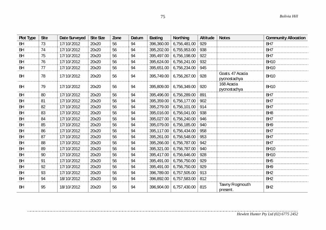
Bolivia Hill
Hewlett Hunter Pty Ltd (02) 6775 2452
75
Plot Type Site Date Surveyed Site Size Zone Datum Easting Northing Altitude Notes Community Allocation BH 73 17/10/2012 20x20 56 94 396,360.00 6,756,481.00 929 BH7 BH 74 17/10/2012 20x20 56 94 395,202.00 6,755,953.00 938 BH7 BH 75 17/10/2012 20x20 56 94 395,497.00 6,756,198.00 922 BH7 BH 76 17/10/2012 20x20 56 94 395,624.00 6,756,241.00 932 BH10 BH 77 17/10/2012 20x20 56 94 395,651.00 6,756,234.00 945 BH10
BH 78 17/10/2012 20x20 56 94 395,749.00 6,756,267.00 928 Goats. 47 Acacia pycnostachya BH10
BH 79 17/10/2012 20x20 56 94 395,809.00 6,756,349.00 920 168 Acacia pycnostachya BH10
BH 80 17/10/2012 20x20 56 94 395,496.00 6,756,289.00 891 BH7 BH 81 17/10/2012 20x20 56 94 395,359.00 6,756,177.00 902 BH7 BH 82 17/10/2012 20x20 56 94 395,279.00 6,756,101.00 914 BH7 BH 83 17/10/2012 20x20 56 94 395,016.00 6,756,041.00 938 BH8 BH 84 17/10/2012 20x20 56 94 395,027.00 6,756,240.00 946 BH7 BH 85 17/10/2012 20x20 56 94 395,079.00 6,756,185.00 940 BH9 BH 86 17/10/2012 20x20 56 94 395,117.00 6,756,434.00 958 BH7 BH 87 17/10/2012 20x20 56 94 395,261.00 6,756,548.00 953 BH7 BH 88 17/10/2012 20x20 56 94 395,266.00 6,756,787.00 942 BH7 BH 89 17/10/2012 20x20 56 94 395,321.00 6,756,787.00 940 BH10 BH 90 17/10/2012 20x20 56 94 395,417.00 6,756,646.00 928 BH10 BH 91 17/10/2012 20x20 56 94 395,491.00 6,756,750.00 929 BH5 BH 92 17/10/2012 20x20 56 94 395,491.00 6,756,750.00 929 BH9 BH 93 17/10/2012 20x20 56 94 396,789.00 6,757,505.00 913 BH2 BH 94 18/10/2012 20x20 56 94 396,892.00 6,757,583.00 812 BH2
BH 95 18/10/2012 20x20 56 94 396,904.00 6,757,430.00 815 Tawny Frogmouth present. BH2
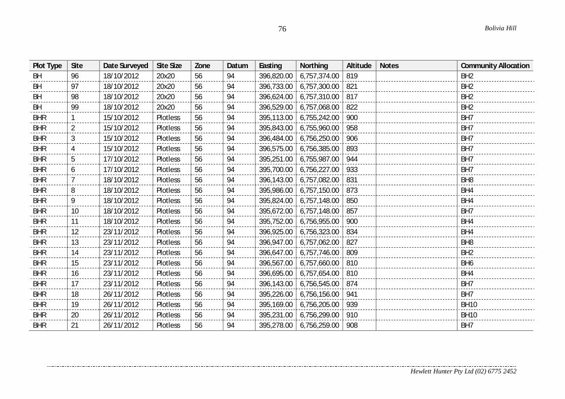
Bolivia Hill
Hewlett Hunter Pty Ltd (02) 6775 2452
76
Plot Type Site Date Surveyed Site Size Zone Datum Easting Northing Altitude Notes Community Allocation BH 96 18/10/2012 20x20 56 94 396,820.00 6,757,374.00 819 BH2 BH 97 18/10/2012 20x20 56 94 396,733.00 6,757,300.00 821 BH2 BH 98 18/10/2012 20x20 56 94 396,624.00 6,757,310.00 817 BH2 BH 99 18/10/2012 20x20 56 94 396,529.00 6,757,068.00 822 BH2 BHR 1 15/10/2012 Plotless 56 94 395,113.00 6,755,242.00 900 BH7 BHR 2 15/10/2012 Plotless 56 94 395,843.00 6,755,960.00 958 BH7 BHR 3 15/10/2012 Plotless 56 94 396,484.00 6,756,250.00 906 BH7 BHR 4 15/10/2012 Plotless 56 94 396,575.00 6,756,385.00 893 BH7 BHR 5 17/10/2012 Plotless 56 94 395,251.00 6,755,987.00 944 BH7 BHR 6 17/10/2012 Plotless 56 94 395,700.00 6,756,227.00 933 BH7 BHR 7 18/10/2012 Plotless 56 94 396,143.00 6,757,082.00 831 BH8 BHR 8 18/10/2012 Plotless 56 94 395,986.00 6,757,150.00 873 BH4 BHR 9 18/10/2012 Plotless 56 94 395,824.00 6,757,148.00 850 BH4 BHR 10 18/10/2012 Plotless 56 94 395,672.00 6,757,148.00 857 BH7 BHR 11 18/10/2012 Plotless 56 94 395,752.00 6,756,955.00 900 BH4 BHR 12 23/11/2012 Plotless 56 94 396,925.00 6,756,323.00 834 BH4 BHR 13 23/11/2012 Plotless 56 94 396,947.00 6,757,062.00 827 BH8 BHR 14 23/11/2012 Plotless 56 94 396,647.00 6,757,746.00 809 BH2 BHR 15 23/11/2012 Plotless 56 94 396,567.00 6,757,660.00 810 BH6 BHR 16 23/11/2012 Plotless 56 94 396,695.00 6,757,654.00 810 BH4 BHR 17 23/11/2012 Plotless 56 94 396,143.00 6,756,545.00 874 BH7 BHR 18 26/11/2012 Plotless 56 94 395,226.00 6,756,156.00 941 BH7 BHR 19 26/11/2012 Plotless 56 94 395,169.00 6,756,205.00 939 BH10 BHR 20 26/11/2012 Plotless 56 94 395,231.00 6,756,299.00 910 BH10 BHR 21 26/11/2012 Plotless 56 94 395,278.00 6,756,259.00 908 BH7

Bolivia Hill
Hewlett Hunter Pty Ltd (02) 6775 2452
77
Plot Type Site Date Surveyed Site Size Zone Datum Easting Northing Altitude Notes Community Allocation BHR 22 26/11/2012 Plotless 56 94 394,984.00 6,756,087.00 930 BH6
FEN 53 4/02/2007 20x20 56 96 394,794.00 6,755,549.00 1,000.00
Soil peaty with sand underneath. E. banksii, Banksia integrifolia, Acacia neriifolia.
BH6

Bolivia Hill
Hewlett Hunter Pty Ltd (02) 6775 2452
78
Acknowledgements Thanks to Graham Lightbody the ranger for Bolivia Hill Nature Reserve for information provided. Thank you to Trish Stadtmiller for assistance on her property. Thanks to Zak Growns and Vanessa Hunter for assistance in the field.

Biodiversity Impact Assessment
APPENDIX
B Fauna Habitat Assessment Proforma

BASIC SITE INFORMATION
LOCATION
VEGETATION
SITE INFORMATION
Plot Centre zone: easting: northing:
Datum: AGD84 GDA94 (WGS84) Location derivation:
Accuracy:
Altitude: Altitude accuracy: Altitude derivation:
Locality description:
Reserve or Property Name:Tenure: Reserve number:
Map number:
Bioregion:
Subregion:Map name: Parish:
Habitat Description:
Broad veg group:Regional Ecosystem (mapped)
General Site comments:
LANDFORM
SOIL
GEOLOGY
SITE PHOTOS
Situation:* Pattern:*Element:*Slope Position:* Slope Aspect:Slope Degree:
Depth:* Colour: Texture:. / Munsell? (y/n):
Soil notes:
Source:
Photo No./sNorth: South:
East: West:
Other photo numbers and notes:
(no need to fill this section out if revisiting an established site)
Current Site visit comments:
m
Road: zone: easting: northing:
(GPS reference)
OTHER:
Regional Ecosystem (obs):
DATE: / /Surveynums:..........................................................................
Entered:............... Checked:............. Corrected:............
OFFICE USE ONLY SITEID:
PROJECT:
SITE ALIAS (field code):
OBSERVERS
Photo No./s
Geology unitCode: Map / Cutting / Core / Outcrop Notes:
Dominant/characteristic speciesLayer^ Species Species Layer^ Species Layer^
^Layer: Emergent (E), T1, T2, T3, S1, S2, Ground (G)
(top soil)
m
Version 1.0 26/07/2012 Biodiversity and Ecosystem Sciences, Mt Coot-tha Rd, Toowong

BASIC SITE INFORMATION CONT......
Disturbance Type
Severity 0 - 3 (0=nil, 3= severe)
Date of last event (range
ok)
^Observation type: 1= visual estimate; 2 = records; 3 = informant
Wildfire
Logging
Grazing
Clearing
Other (specify):
DISTURBANCE:
Weeds
Erosion
Notes:
Prescribed Burn
Treatment
mean fire scar ht (m)
Storm
Code DescriptionAGPS Averaged GPS fix (5 min)ARCGIS ArcView Map
DGPSDifferential / RTCM corrected GPS
ESTEstimate from known position
GPS00 GPS - type unspecifiedGPS04 GPS - 4 stationGPS08 GPS - 6 to 8 station
GPS12Multichannel GPS (12 station)
KNOKnown position, eg surveyed point
MAP Map - scale unspecifiedMP012 Map - 1:12 500 scaleMP025 Map - 1:25 000 scaleMP050 Map - 1:50 000 scaleMP100 Map - 1:100 000 scaleMP250 Map - 1:250 000 scaleSGPS GPS survey system
Location derivation
CODESLocation accuracy
Code DescriptionA +/- 0.0 mB +/- 0-10 mC +/- 11-50mD +/- 51-100mE +/- 101-300mF +/- 301-500mG +/- 501-1000mH +/- 1001-3000mI >3000m
Code DescriptionALT AltimeterDEM Digital elevation modelEST Estimate from known heightGPS Global positioning systemKNO Known heightOTH OtherTOP Topographic map
Altitude derivation
Code Description
A Not otherwise specified, flat gentle slopes; undulating terrainB Alluvial plain or flat, alluvium, flood plain
UClaypan, Playa or Salina(including inland lakes), Salt Flat(inland).
V Tidal Flat (coastal), Salt Flat (coastal).
C Banks of lake, river, stream, watercourse, leveesD Gully, drainage line, ravine gorge, outwashE Channel Bed, distributaries of inland streams
F Slope or Hill not specified
LCliff (steep rocky faces), rocky ledge, rocky outcrop, scarp, crevice
N Coastal rocky headlandK Top, crest of mountain or ridgeQ Jump Up (Cuesta) and Mesa, Tableland, Plateau,
R Recent Coastal Dune (low dune less than about 15m) and S Fossil Coastal Dune (High Dune greater than about 15m)T Inland Dune.
W Swamp or Marsh.X Fresh Water Aquatic.Y Salt Water Aquatic.Z Melon Holes, Gilgai, Depressions in Soil, Sink Holes.
Water
Streams, Lakes
Plains
Hills, Mountains, Tablelands
Dunes
SituationCode Description Code Description Code Description
HCR Hillcrest DUS Duneslope STF Supratidal flat
SUS Summit Surface BRK Breakaway FIL Fill-topDUC Dunecrest CFS Cliff-foot slope REF Feef flatTOR Tor SFS Scarp-foot Slope ALC AlcoveTUM Tumulus BEN Bench GUL GullyDUN Dune BER Berm CIR Cirque
CON Cone PED Pediment DDEDrainage depression
MOU Mound FOO Footslope STC Stream channelLEV Levee TAL Talus STB Stream bedBAR Bar PLA Plain TDC Tidal creekSCR Scroll RFL Rock flat EST EstuaryPST Prior stream RPL Rock platform SWP SwampFOR Foredune COS Cut-over surface SWL SwaleLUN Lunette SCD Scald TRE TrenchBRI Beach ridge FAN Fan LAK LakeEMB Embankment VLF Valley flat PLY PlayaDAM Dam TEF Terrace flat DOL DolineCLI Cliff CBE Channel bench OXB Ox-bowSCA Scarp BKP Backplain LAG LagoonHSL Hillslope SRP Scroll plain BOU Blow-outCUT Cut face FLD Flood-out MAA MaarLDS Landslide TEP Terrace plain CRA CraterBAN (Stream) Bank TDF Tidal flat PIT PitBEA Beach ITF Intertidal flat
ElementCode DescriptionRM Rolling mountainsSM Steep mountainsVM Very steep mountainsPM Precipitous mountainsUH Undulating hillsRH Rolling hillsSH Steep hillsVH Very steep hillsPH Precipitous hillsUL Undulating low hillsRL Rolling low hillsSL Steep low hillsVL Very steep low hillsB BadlandsGR Gently undulating risesUR Undulating risesRR Rolling risesSR Steep risesLP Level plainGP Gently undulating plainUP Undulating plainRP Rolling plain
PatternCode Description
C CrestD Closed DepressionF FlatG GullyH HillockL Lower-SlopeM Mid-SlopeP PlateauR RidgeU Upper-SlopeV Open DepressionW Wetland
Slope Position
Code DescriptionD DeepS ShallowX Skeletal
Soil Depth
Obs type^ (e.g. Info on prior events, treatment type, % of site impacted, clearing technique, weed species, erosion type)
Characteristic Abundance(0-7)^
HABITAT CHARACTERISTICS - ABUNDANCE:
Hollows in trees & stags
Fallen logs (>10cm diam.)
Decorticating bark
Course litter (>2cm diam.)
Fine litter (<2cm diameter)
Bare ground
Grass
Soil cracks
Stones (20-60cm)
Boulders (61cm-2m)
Large boulders (>2m)
Rock crevices
Exfoliating rock
Notes:(Add others as required)
^Abundance Key:0 = Nil1 = Rare2 = Rare to Occasional3 = Occasional
4 = Occasional to common5 = Common6 = Common to Abundant7 = Abundant
Version 1.0 26/07/2012 Biodiversity and Ecosystem Sciences, Mt Coot-tha Rd, Toowong
Biodiversity Impact Assessment
APPENDIX
C List of fauna species recorded within the Study Area

APPENDIX C List of fauna species recorded within the Study Area
TSC Act EPBC Act C2 C3 C7 C8 C9
Acanthizidae Gerygone albogularis White-throated Gerygone - - X X X XAccipitridae Elanus axillaris Black-shouldered Kite - - X XAccipitridae Hieraaetus morphnoides Little Eagle V - XAnatidae Chenonetta jubata Australian Wood Duck - - X XAnatidae Anas superciliosa Pacific Black Duck - - X XArtamidae Artamus cyanopterus Dusky Woodswallow - - XArtamidae Cracticus nigrogularis Pied Butcherbird - - X X X XArtamidae Strepera graculina Pied Currawong - - X X X XCacatuidae Cacatua roseicapilla Galah - - X X XCacatuidae Cacatua galerita Sulphur-crested Cockatoo - - X XCacatuidae Calyptorhynchus funereus Yellow-tailed Black-Cockatoo - - X X X XCampephagidae Coracina novaehollandiae Black-faced Cuckoo-shrike - - X X X XCharadriidae Vanellus miles Masked Lapwing - - X XClimacteridae Climacteris picumnus Brown Treecreeper V - X XClimacteridae Cormobates leucophaea White-throated Treecreeper - - X X X XColumbidae Phaps chalcoptera Common Bronzewing - - XColumbidae Ocyphaps lophotes Crested Pigeon - - X XColumbidae Geopelia striata Peaceful Dove - - X X XColumbidae Streptopelia chinensis Spotted Dove * * X X X XCoraciidae Eurystomus orientalis Dollarbird - - X X X XCorvidae Corvus coronoides Australian Raven - - X X X XCracticidae Cracticus tibicen Australian Magpie - - X X X XCuculidae Cacomantis variolosus Brush Cuckoo - - XCuculidae Scythrops novaehollandiae Channel-billed Cuckoo - - X X X XCuculidae Eudynamys scolopacea Eastern Koel - - X X X XCuculidae Cacomantis flabelliformis Fan-tailed Cuckoo - - X XCuculidae Centropus phasianinus Pheasant Coucal - - X X XDicruridae Dicrurus bracteatus Spangled Drongo - - X XEstrildidae Stagonopleura guttata Diamond Firetail V - XEstrildidae Taeniopygia bichenovii Double-barred Finch - - XEstrildidae Neochmia temporalis Red-browed Finch - - X XFalconidae Falco berigora Brown Falcon - - XFalconidae Falco cenchroides Nankeen Kestrel - - X X X XHalcyonidae Todiramphus macleayii Forest Kingfisher - - X XHalcyonidae Dacelo novaeguineae Laughing Kookaburra - - X X X XHalcyonidae Todiramphus sanctus Sacred Kingfisher - - XMaluridae Malurus cyaneus Superb Fairy-wren - - X X X XMeliphagidae Acanthorhynchus tenuirostris Eastern Spinebill - - XMeliphagidae Philemon corniculatus Noisy Friarbird - - X XMeliphagidae Manorina melanocephala Noisy Miner - - X X X XMeliphagidae Phylidonyris niger White-cheeked Honeyeater - - X XMeliphagidae Lichenostomus chrysops Yellow-faced Honeyeater - - X XMonarchidae Grallina cyanoleuca Magpie-lark - - X X X XOriolidae Oriolus sagittatus Olive-backed Oriole - - X XPachycephalidae Colluricincla harmonica Grey Shrike-thrush - - X X X XPachycephalidae Pachycephala rufiventris Rufous Whistler - - X X X XPardalotidae Acanthiza reguloides Buff-rumped Thornbill - - X X X XPardalotidae Pardalotus striatus Striated Pardalote - - XPardalotidae Acanthiza lineata Striated Thornbill - - X X XPhasianidae Coturnix ypsilophora Brown Quail - - XPsittaculidae Alisterus scapularis Australian King-Parrot - - X XPsittaculidae Platycercus elegans Crimson Rosella - - X XPsittaculidae Trichoglossus haematodus Rainbow Lorikeet - - X X X XPsittaculidae Aprosmictus erythropterus Red-winged Parrot - - X X X XRhipiduridae Rhipidura albiscapa Grey Fantail - - X X X XRhipiduridae Rhipidura leucophrys Willie Wagtail - - X X X XStrigidae Ninox novaeseelandia Southern Boobook - - XThreskiornithidae Threskiornis spinicollis Straw-necked Ibis - - X X XZosteropidae Zosterops lateralis Silvereye - - X
31 0 34 45 48
Vegetation Community Type
Native Bird richness by vegetation community
BirdsFamily Scientific Name Common Name
Status^
Page 1 of 2

APPENDIX C List of fauna species recorded within the Study Area
TSC Act EPBC Act C2 C3 C7 C8 C9
Vegetation Community Type
BirdsFamily Scientific Name Common Name
Status^
Bovidae Capra hircus Goat * * X XCanidae Canis lupus Dog * * X X X XCanidae Vulpes vulpes Red Fox * * XDasyuridae Dasyurus maculatus Spot-tailed Quoll V E XDasyuridae Antechinus flavipes Yellow-footed Antechinus - - X XDasyuridae Antechinus swainsonii Dusky Antechinus - XEmballonuridae Saccolaimus flaviventris Yellow-bellied Pouched Bat V - X X X XFelidae Felis catus Cat * * XLeporidae Oryctolagus cuniculus European Rabbit * * X X X XMacropodidae Macropus giganteus Eastern Grey Kangaroo - - X X X XMacropodidae Macropus robustus Euro - - XMacropodidae Macropus rufogriseus Red-necked Wallaby - - X X XMacropodidae Wallabia bicolor Swamp Wallaby - - X XMolossidae Tadarida australis White-striped Freetail Bat - - X X XMolossidae Austronomus australis White-striped Freetail Bat - - X X X XMolossidae Mormopterus beccarii# Beccari's Freetail Bat V - X XMolossidae Mormopterus ridei Eastern Little Free-tailed Bat - - X X X XMolossidae Mormopterus sp4/sp3 - - X X X XMuridae Hydromys chrysogaster Water Rat - - XMuridae Rattus rattus Black Rat * * X XMuridae Mus musculus House Mouse * * XPhalangeridae Trichosurus vulpecula Common Brushtail Possum - - X XPseudocheiridae Pseudocheirus peregrinus Common Ringtail Possum - - XRhinolophidae Rhinolophus megaphyllus Southern Horeshoe Bat - - X X XSuidae Sus scrofa Feral Pig * * X X X XTachyglossidae Tachyglossus aculeatus Short-beaked Echidna - - X XVespertilionidae Chalinolobus gouldii Gould's Wattle Bat - - X X X XVespertilionidae Chalinolobus morio Chocolate Wattle Bat - - X X X XVespertilionidae Falsistrellus tasmaniensis# Eastern False Pipistrelle V - X X X XVespertilionidae Nycophilus sp. - - X X X XVespertilionidae Scrotorepens greyii/ sp. Little Broad-nosed Bat - - X X X XVespertilionidae Scrotorepens orion# Eastern Broad-nosed Bat - - X X X XVespertilionidae Vespadelus darlingtoni Large Forest Bat - - X X X XVespertilionidae Vespadelus pumilus Eastern Forest Bat - - X X X XVespertilionidae Vespadelus regulus Southern Forest Bat - - X X X XVespertilionidae Vespadelus vulturnus Little Forest Bat - - X X X XVespertilionidae Miniopterus orianae oceanensis Eastern Bent-winged Bat V - X X X X
25 0 24 27 31
Agamidae Amphibolurus nobbi Nobbi Dragon - - X XAgamidae Pogona barbata Bearded Dragon (juv.) - - XAgamidae Physignathus lesueurii Water Dragon - - X XElapidae Pseudechis porphyriacus Red-bellied Black Snake - - X XScincidae Cryptoblepharus plagiocephalus A Skink - - X X XScincidae Cryptoblepharus virgatus A Skink - - X X X XScincidae Lampropholis delicata Garden Sunskink - - X X X XScincidae Ctenotus robustus Eastern Striped Skink - - X XVaranidae Varanus varius Lace Monitor - - X X
4 0 2 7 9
Bufonidae Bufo marinus Cane Toad * * X XHylidae Litoria fallax Dwarf Green Treefrog - - X XHylidae Litoria dentata Keferstein's Tree Frog - - X XHylidae Litoria peronii Peron's Tree Frog - - X XHylidae Litoria rubella Red Tree Frog - - X XHylidae Litoria latopalmata Broad-palmed Rocketfrog - - X XLimnodynastidae Platyplectrum ornatum Ornate Burrowing frog - - X XLimnodynastidae Limnodynastes peronii Striped Marsh Frog - - X XMyobatachidae Pseudophryne bibronii Bibron's Toadlet - - X X
1 7 9 0 1
Parastacidae Euastacus suttoni New England Crayfish - - X X61 7 69 79 89
Note: ^ - E=Endangered; V=Vulnerable; *=Introduced. # - Species possibly occurs, definite identification not possible through echolocation call only
Native fauna richness by vegetation community
Mammals
Reptiles
Amphibians
Crustaceans
Native Mammal richness by vegetation community
Native Reptile richness by vegetation community
Native Amphibian richness by vegetation community
Page 2 of 2

Biodiversity Impact Assessment
APPENDIX
D Balance Environmental Microbat Call Identification Report

Microbat Call Identification Report
Prepared for (“Client”): CARDNO-Chenoweth
Survey location/project name: Bolivia Hill, NSW
Survey dates: December, 2012
Client project reference: David Wassman
Job no.: CARD1301
Report date: 1 February 2013
DISCLAIMER:
© Copyright – Balance! Environmental, ABN 75 795 804 356. This document and its content arecopyright and may not be copied, reproduced or distributed (in whole or part) without the prior writtenpermission of Balance! Environmental other than by the Client for the purposes authorised byBalance! Environmental (“Intended Purpose”). To the extent that the Intended Purpose requires thedisclosure of this document and/or its content to a third party, the Client must procure suchagreements, acknowledgements and undertakings as may be necessary to ensure that the third partydoes not copy, reproduce, or distribute this document and its content other than for the IntendedPurpose. This disclaimer does not limit any rights Balance! Environmental may have under theCopyright Act 1968 (Cth).
The Client acknowledges that the Final Report is intended for the sole use of the Client, and only to be
used for the Intended Purpose. Any representation or recommendation contained in the Final Report
is made only to the Client. Balance! Environmental will not be liable for any loss or damage
whatsoever arising from the use and/or reliance on the Final Report by any third party.
CARD1301_Bolivia Hill_Dec2012_batcall analysis.docx1/02/2013 Page 2 of 12
Methods
Data receipt and processing
Bat calls were recorded over eight nights, using four Song Meter detectors (Wildlife Acoustics,
Concord MA, USA). Data were retrieved from the detectors by the client and saved as full-spectrum
sound files (.wav format). Some 4,200 WAV files were submitted to Balance Environmental for further
processing and analysis. A small amount of data (10 files) recorded on an Anabat detector (Titley
Scientific, Brisbane) was also received for analysis.
Data conversion and zero-crossing analysis
The WAV files were converted to Anabat sequence files (zero-crossing analysis format) using Wildlife
Acoustics’ Kaleidoscope program. A total of 3,275 sequence files were thus generated from the four
detectors.
Sonograms for all sequence files were viewed in AnalookW (Corben 2009) and a subset of files
representative of call types observed for each night on each detector was selected for analysis.
Species identification was achieved manually by viewing all calls in the selected subset and
comparing them with reference calls from southern Queensland and northern New South Wales,
and/or with published call descriptions (Reinhold et al 2001; Pennay et al. 2004).
Determination of species' identity was refined by considering probability of occurrence based on
published distributional information (e.g. Churchill 2008; van Dyck & Strahan 2008) and/or on-line
fauna database records (e.g. Atlas of Living Australia http://www.ala.org.au/).
Reporting standard
The format and content of this report follows Australasian Bat Society standards for the interpretation
and reporting of bat call data (Reardon 2003), available on-line at http://www.ausbats.org.au/.
Species nomenclature follows Churchill (2008).
Results
Data quality and reliability of call identification
The data recorded from this survey included a high proportion of good quality call sequences, which
resulted in reliable identification for most species. The known or expected presence of a number of
species that have similar call characteristics meant that some calls could only be attributed to a
species group (e.g. Vespadelus spp., Falsistrellus tasmaniensis / Scotorepens spp.). Where-ever
possible, however, some species from these groups were split out based on characteristics of good
quality calls. Further detail on these groups and probability of each species being present is provided
in the Discussion.
Species recorded
Tables 1-4 provide a detailed breakdown of species recorded on each night by each of the Song
Meter detectors.

CARD1301_Bolivia Hill_Dec2012_batcall analysis.docx1/02/2013 Page 3 of 12
At least twelve species were recorded: Rhinolophus megaphyllus; Chalinolobus gouldii; Chalinolobus
morio; Nyctophilus species; Scotorepens greyii; Vespadelus darlingtoni; Vespadelus vulturnus;
Miniopterus orianae oceanensis; Austronomus australis; Mormopterus ridei; Mormopterus sp.4; and
Saccolaimus flaviventris.
Up to six additional species were recorded but could not be reliably identified due to similarities
between their calls and those of other species. These included: Falsistrellus tasmaniensis;
Scotorepens orion; Vespadelus pumilus; Vespadelus regulus; Mormopterus beccarii; and
Mormopterus sp. 3.
The 10 files submitted from the Anabat detector were all recorded between about 7:00-7:30pm on the
night of 16/12/2012. These few files included just two call types, representing the following species:
Mormopterus ridei; and
Vespadelus regulus or Miniopterus orianae oceanensis.
Discussion
Many calls were reliably attributed to known species, but some species that are likely to occur in the
study area can be difficult to distinguish using call data. The number of such species is particularly
high for this data set because the study area lies in an overlap zone of species with predominantly
coast or range distributions and those with more westerly distributions. Species groupings for these
difficult calls are discussed below, including an indication of the likelihood of various group members
being present in the study area.
Chalinolobus gouldii and Mormopterus species
These bats have calls with characteristic frequency (Fc) in the range 28-35 kHz. Chalinolobus gouldii
generally produces calls with steep, curved pulses that alternate in characteristic frequency; however,
low-quality, fragmented calls often lack the steep initial frequency sweep and can look very like the
calls of Mormopterus species.
Four Mormopterus species that call in this frequency range potentially occur in the study area,
including: M. norfolkensis; M. ridei; M. species 4; and M. species 3. Some calls were positively
attributed to M. ridei based on Fc>32 kHz; but the majority of Mormopterus calls had Fc of 28-30 kHz
and could have been from either M. species 4 or M. species 3.
Calls from M. norfolkensis often have clear frequency alternation between successive pulses; and
since there was no evidence of this call pattern in the data set, M. norfolkensis was excluded from
consideration.
Chalinolobus morio and Vespadelus spp.
Calls from C. morio have similar shape and frequency to several Vespadelus species. Calls were
positively attributed to C. morio if they had the short, flattish pulse body with downward-sweeping tail
that distinguishes this species from the Vespadelus spp., which generally have no tail or cup-shaped
pulse body with upward-sweeping tail. A number of calls were weak and/or fragmented and/or
contained pulses with intermediate characteristics and could not be reliably attributed either way.

CARD1301_Bolivia Hill_Dec2012_batcall analysis.docx1/02/2013 Page 4 of 12
Falsistrellus tasmaniensis and Scotorepens spp.
The Atlas of Living Australia has records of F. tasmaniensis and S. orion within 10km of Bolivia Hill,
and these species’ calls are very difficult to differentiate. Furthermore, it is possible that both little
broad-nosed bat (S. greyii) and central-eastern broad-nosed bat (Scotorepens sp.) are also present.
These latter two species cannot be distinguished from each other and their calls overlap significantly
with those of F. tasmaniensis and S. orion.
A few calls with relatively short duration pulses, steep, curved bodies with upward-sweeping tails and
Fc around 37-38 kHz were positively attributed to Scotorepens sp./S. greyii. Similarly, many calls with
longer-duration pulses, more gradual curvature, no tails or down-swept tails and Fc around 34.5-36
kHz were attributed to F. tasmaniensis/S. orion but could not be further differentiated. In some calls,
intermediate pulse shapes and frequencies resulted in identity being possibly attributable to any of
these four species.
Nyctophilus spp.
These species’ calls are readily distinguished from those of other bats; however, the species within the
genus Nyctophilus cannot be reliably differentiated from each other. Three Nyctophilus species
potentially occur in the study area, including N. bifax, N. geoffroyi and N. gouldi and any or all of them
could have been responsible for the recorded calls.
Vespadelus spp.
Up to four Vespadelus species potentially occur in the study area, some of which can be difficult to
differentiate. Identification for these species was based largely on characteristic frequency differential,
as follows:
V. darlingtoni (Fc=41-43 kHz);
V. darlingtoni / V. regulus (Fc=43-44 kHz);
V. regulus (Fc=44-46 kHz)
V. regulus / V. vulturnus (Fc=46-47 kHz);
V. vulturnus (Fc=47-50 kHz);
V. vulturnus / V. pumilus (50-53 kHz); and
V. pumilus (Fc>53 kHz).
In most cases, calls were allocated to one of the species pairs due to significant variation in frequency
within the sequence. Consequently, most of the Vespadelus species are only shown as “Possible” for
the majority of detection sessions (Tables 1-4).
Miniopterus orianae oceanensis
This species overlaps in frequency with V. darlingtoni and V. regulus, but can sometimes be
distinguished by its longer duration pulses with more angled body shape. It was positively identified
for many sessions, but in some cases only calls with intermediate pulse characteristics were available.
Mormopterus beccarii
A few calls had pulses similar to those produced by this species (steep and curved with Fc=24-26
kHz); however, it is possible also that these pulses came from Mormopterus species 4.

CARD1301_Bolivia Hill_Dec2012_batcall analysis.docx1/02/2013 Page 5 of 12
References
Churchill, S. (2008). Australian Bats. Jacana Books, Allen & Unwin; Sydney.
Corben, C. (2009). AnalookW Version 3.7w. Software for bat call analysis using ZCA data.
Pennay, M., Law, B. and Reinhold, L. (2004). Bat Calls of New South Wales. Department of
Environment and Conservation, Hurstville.
Reardon, T. (2003). Standards in bat detector based surveys. Australasian Bat Society Newsletter
20, 41-43.
Reinhold, L., Law, B., Ford, G. and Pennay, M. (2001). Key to the bat calls of south-east Queensland
and north-east New South Wales. Department of Natural Resources and Mines, Brisbane.
van Dyck, S. and Strahan, R. (ed.) (2008). The Mammals of Australia (Third Edition). New Holland;
Sydney.

CARD1301_Bolivia Hill_Dec2012_batcall analysis.docx1/02/2013 Page 6 of 12
Table 1. Microbat species recorded during the Bolivia Hill surveys, December 2012 – Detector # 009616.
♦ = species positively identified from call data; □ = species possibly present, but not reliably identified
Date: 18-Dec 19-Dec 20-Dec 21-Dec 22-Dec
SPECIES
Rhinolophus megaphyllus
Chalinolobus gouldii ♦ ♦ ♦ ♦ ♦
Chalinolobus morio ♦ ♦ ♦ ♦ ♦
Falsistrellus tasmaniensis □ □ □ □ □
Nyctophilus species ♦ ♦ ♦ ♦
Scotorepens greyii / Scotorepens sp. □ □
Scotorepens orion □ □ □ □ □
Vespadelus darlingtoni □ □ □
Vespadelus pumilus ♦ □ □
Vespadelus regulus ♦ □ □ □
Vespadelus vulturnus ♦ □ □
Miniopterus orianae oceanensis ♦ ♦ ♦
Austronomus australis ♦ ♦ ♦ ♦
Mormopterus beccarii
Mormopterus ridei ♦ ♦
Mormopterus species 4 / species 3 ♦ ♦
Saccolaimus flaviventris ♦ ♦

CARD1301_Bolivia Hill_Dec2012_batcall analysis.docx1/02/2013 Page 7 of 12
Table 2. Microbat species recorded during the Bolivia Hill surveys, December 2012 – Detector # 011037.
♦ = species positively identified from call data; □ = species possibly present, but not reliably identified
Date: 16-Dec 17-Dec 18-Dec 19-Dec 20-Dec 21-Dec 22-Dec 23-Dec
SPECIES
Rhinolophus megaphyllus ♦ ♦
Chalinolobus gouldii ♦ ♦ ♦ ♦ ♦ ♦ □
Chalinolobus morio ♦ ♦ ♦ ♦ ♦ □ ♦
Falsistrellus tasmaniensis □ □ □ □ □ □
Nyctophilus species ♦ ♦ ♦ ♦ ♦
Scotorepens greyii/ Scotorepens sp. □ ♦ □ □
Scotorepens orion □ □ □ □ □ □
Vespadelus darlingtoni ♦ □ □ □ □ □ □
Vespadelus pumilus □ □ □ □ □ □ □
Vespadelus regulus □ □ □ □ □ □ □
Vespadelus vulturnus ♦ ♦ ♦ ♦ ♦ ♦ ♦ □
Miniopterus orianae oceanensis ♦ □ □ ♦ ♦ □ ♦
Austronomus australis ♦ ♦ ♦ ♦ ♦
Mormopterus beccarii
Mormopterus ridei □ ♦ □ ♦ ♦ ♦ ♦ □
Mormopterus species 4 / species 3 ♦ ♦ ♦ □ ♦ ♦ □
Saccolaimus flaviventris ♦ ♦ ♦

CARD1301_Bolivia Hill_Dec2012_batcall analysis.docx1/02/2013 Page 8 of 12
Table 3. Microbat species recorded during the Bolivia Hill surveys, December 2012 – Detector # 011046.
♦ = species positively identified from call data; □ = species possibly present, but not reliably identified
Date: 16-Dec 17-Dec 18-Dec 19-Dec 20-Dec 21-Dec 22-Dec 23-Dec
SPECIES
Rhinolophus megaphyllus ♦
Chalinolobus gouldii □ ♦ □ ♦ ♦ ♦ ♦
Chalinolobus morio ♦ □ ♦ ♦ ♦ ♦ ♦
Falsistrellus tasmaniensis □ □ □ □ □ □
Nyctophilus species ♦ ♦ ♦ ♦ ♦
Scotorepens greyii/ Scotorepens sp. ♦ □
Scotorepens orion □ □ □ □ □ □
Vespadelus darlingtoni □ □ □ ♦ □
Vespadelus pumilus □ □ □ □ □ □ □
Vespadelus regulus □ □ □ □ □ ♦ □
Vespadelus vulturnus ♦ □ □ □ □ □ □
Miniopterus orianae oceanensis □ □ □ ♦ ♦ ♦
Austronomus australis ♦ ♦ ♦ ♦ ♦ ♦ ♦
Mormopterus beccarii □
Mormopterus ridei ♦ ♦ ♦ ♦ ♦ ♦
Mormopterus species 4 / species 3 ♦ ♦ ♦ ♦ ♦
Saccolaimus flaviventris ♦ ♦ ♦ ♦

CARD1301_Bolivia Hill_Dec2012_batcall analysis.docx1/02/2013 Page 9 of 12
Table 4. Microbat species recorded during the Bolivia Hill surveys, December 2012 – Detector # 011213.
♦ = species positively identified from call data; □ = species possibly present, but not reliably identified
Date: 16-Dec 17-Dec 18-Dec 19-Dec 20-Dec 21-Dec 22-Dec 23-Dec
SPECIES
Rhinolophus megaphyllus
Chalinolobus gouldii ♦ ♦ ♦ □
Chalinolobus morio ♦ ♦ ♦ ♦ ♦ ♦
Falsistrellus tasmaniensis □ □ □ □
Nyctophilus species ♦
Scotorepens greyii/ Scotorepens sp. □ □
Scotorepens orion □ □ □ □
Vespadelus darlingtoni ♦ ♦ ♦ ♦
Vespadelus pumilus □ □
Vespadelus regulus □ □ □ □
Vespadelus vulturnus □ ♦ ♦ □ ♦ ♦
Miniopterus orianae oceanensis ♦ ♦ □ ♦ ♦
Austronomus australis ♦ ♦ ♦ ♦
Mormopterus beccarii □
Mormopterus ridei ♦ □ □ □ ♦
Mormopterus species 4 / species 3 ♦ □ □ □ ♦ □
Saccolaimus flaviventris ♦ ♦
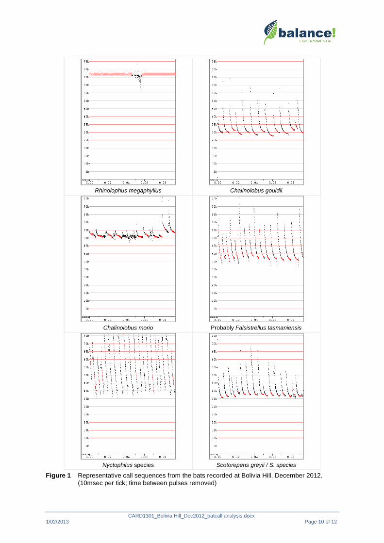
CARD1301_Bolivia Hill_Dec2012_batcall analysis.docx1/02/2013 Page 10 of 12
Rhinolophus megaphyllus Chalinolobus gouldii
Chalinolobus morio Probably Falsistrellus tasmaniensis
Nyctophilus species Scotorepens greyii / S. species
Figure 1 Representative call sequences from the bats recorded at Bolivia Hill, December 2012.(10msec per tick; time between pulses removed)
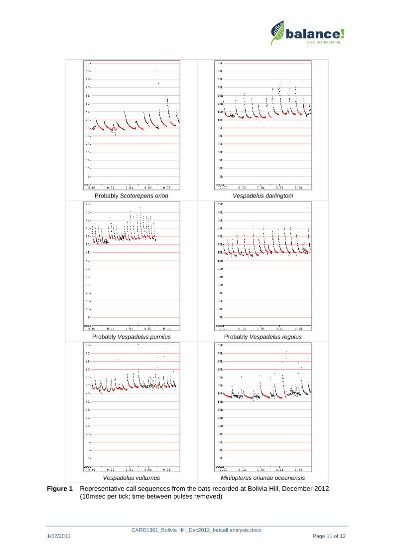
CARD1301_Bolivia Hill_Dec2012_batcall analysis.docx1/02/2013 Page 11 of 12
Probably Scotorepens orion Vespadelus darlingtoni
Probably Vespadelus pumilus Probably Vespadelus regulus
Vespadelus vulturnus Miniopterus orianae oceanensis
Figure 1 Representative call sequences from the bats recorded at Bolivia Hill, December 2012.(10msec per tick; time between pulses removed)

CARD1301_Bolivia Hill_Dec2012_batcall analysis.docx1/02/2013 Page 12 of 12
Austronomus australis Possibly Mormopterus beccarii
Mormopterus ridei Mormopterus sp. 4 or M. sp. 3
Saccolaimus flaviventris
Figure 1 Representative call sequences from the bats recorded at Bolivia Hill, December 2012.(10msec per tick; time between pulses removed)
Related Documents